text - home - gannawarra shire · pdf fileand environments, ... linkages with this broader...
TRANSCRIPT

text

Introduction
This is our Integrated Community Plan. How does it work? It brings together all of our priorities for all of our communities. It brings together the key provisions of our Planning Scheme with the aspirations of our communities. It establishes a common management and review framework for our community planning program. It links local projects to strategic and regional priorities. This is our Integrated Community Plan.
A Framework for Sustainable Change… This Plan is an expression of how the communities of the Shire of Gannawarra will work together to deliver a sustainable and vibrant future. It establishes the priorities for community development and planning activity via a coherent framework which links local project activity to broader strategic and regional objectives.
Broadly speaking, the sustainability of a community is a function of how successfully it operates as a place in which to live, work and play. In order to remain competitive and sustainable, communities need to face up to a series of challenges and pressures – environmental, economic and societal. Each community is defined by a set of unique characteristics (e.g. demography, environment, location, history etc.) which combine to create a unique ‘sense of place’.
As a concept, ‘sense of place’ is important as it hints at those facets of a place (both tangible and intangible) which define it – both in the minds of its residents and visitors. Of course, these factors can be negative as well as positive – and, in enhancing the sustainability of communities, it is important to harness the strengths as well as address the weaknesses. Communities need to be resilient and enterprising – and they need to be honest and agile enough to embrace change and respond to new challenges and opportunities.
No community – or place – operates in a vacuum. Increasingly, external pressures and developments are factors in how communities function – and this is reflected in the acknowledgment in Gannawarra 2025 (the Strategic Community Plan for the Shire) that, despite being perceived as a peripheral district, regional and global connectivity will be a key driver of change in Gannawarra.
Maintaining and enhancing the sustainability of our communities is a long term priority in the Gannawarra Shire. Council has a critical role to fulfil on behalf of the local community by creating the right conditions for stability and growth – both socially and economically. The Shire must be widely perceived as an attractive and competitive place in which to live, work and play. Creating the right conditions for individuals, businesses and organisations to make positive decisions about the Shire (i.e. whether to live, visit or work and invest there) is critical in building the sustainability of our communities.
This Plan complements other adopted policy guidance – particularly Gannawarra 2025 – in setting a framework for sustainable change. It reflects the aspirations and priorities of our communities – and, for the first time, it draws them together to provide an integrated community response to the challenges and opportunities facing the Shire.

Introduction
Community Planning in the Gannawarra Shire
Gannawarra Shire Council has supported the establishment of Community Planning Groups in key settlements/areas of the Shire since 2006. The primary purpose of the community planning program has been to engage meaningfully with local communities, identify priorities for action and build capacity to drive change.
As with any program which encompasses diverse communities and environments, the experience of the Gannawarra community planning program has been mixed. There have been notable successes in some areas whereas, in some settlements, it has been more challenging to introduce and embed the community planning ethos.
Program Evaluation
In April 2011, an independent evaluation of the Gannawarra Shire Community Planning program was completed. Whilst noting the various successes of the program to date, the evaluation exercise also identified some critical weaknesses in the program and proposed twelve recommendations for change, as follows:
1. Further develop guiding policy and procedures to support the overall functioning and roles of Community Planning Groups (CPGs).
2. Review the current CPG structures across the Shire to determine the best fit for each locality.
3. Provide CPGs with training and resources to support community consultation and engagement techniques.
4. Promote Community Planning and the CPG to the wider community.
5. Share timelines and regular progress updates for all long term projects to CPGs and the wider community.
6. Develop Community Planning decision-making processes that support both long and shorter timeframes for funding applications.
7. Provide extra resources to CPGs to support the process of reviewing and writing Community Plans.
8. Provide targeted support to the larger centres of Kerang and Cohuna to combat the challenges of conducting community planning activities in larger centres.
9. Celebrate Community Planning achievements. 10. Recognise and celebrate the contribution of volunteers
on the CPG. 11. Link the ten CPGs across Gannawarra Shire through
shared training and a yearly shared event. 12. Adopt and implement evaluation processes.
The production of this Plan provides an opportunity to respond to and embed the above recommendations in Council processes, as they relate to community planning and development activity. Progress towards addressing the recommendations of the independent program evaluation is outlined later in this Plan.
Realising our Strategic Vision
Gannawarra Shire Council is committed to the realisation of the long-term objectives set out in its overarching Vision, Gannawarra 2025 – a strategic community plan for Gannawarra Shire which has been subject to significant community consultation. This strategic plan is intended to guide community development activity over a fifteen year period – it provides a robust baseline analysis for future program and project development. The Council Plan (2013 – 2017) is consistent with the objectives of Gannawarra 2025, and future iterations of the Council Plan will also be able to demonstrate linkages with this broader community strategy.
It is critical that community planning projects and activities develop explicit linkages to the strategic priorities promoted in Gannawarra 2025, which promotes six strategy ‘platform’s as a focus for activity:
x Reverse decline in working population
x Revitalize our towns into vibrant places
x Foster economic prosperity through diversity
x Embrace environmental sustainability
x Focus education and lifelong learning
x Facilitate local, regional and global connectivity
The framework provided by these platforms is rational and coherent – and, within the timeframe set by the Strategy, real progress is achievable. The activities promoted on each platform are interrelated – delivery across all platforms is required if the communities of Gannawarra Shire are to remain sustainable and increase in vibrancy and vitality.
All local level community plans/instruments where the Shire is a key stakeholder are required to reference Gannawarra 2025, and demonstrate linkages between proposed local project activity and broader strategic objectives. In turn, Gannawarra 2025 provides direct functional linkages to State and regional strategy and policy guidance. This continuum from local activity to state level policy, with Gannawarra 2025 as the fulcrum, ensures consistency in approach and effort from all agencies and organisations involved in community planning and development.

Introduction
Integrating Community Planning
The Gannawarra Shire Community Planning program has delivered broad benefits to a range of communities during its years of operation. However, in view of strategic regional initiatives, policy shifts and emerging local trends, it is now necessary to transition the program to deliver sustainable and far-reaching benefits.
In order to embed the principles of strategic community planning into Council’s core business, it is prudent to consider opportunities for aligning community activity with other statutory functions. In this connection, it is apparent that there are significant areas of overlap between the stated community aspirations for development and investment and the provisions which guide the statutory and strategic planning process in the Shire.
An opportunity has been identified to adopt an innovative approach to integrated community and strategic planning, which will align community priorities with adopted and emerging planning policy. The benefits of such an approach are as follows:
x Alignment of community priorities with statutory and strategic planning functions will strengthen and legitimise the role of the community in setting the long-term development framework for the Shire.
x Awareness of community projects will help in the informed review and revision of the Planning Scheme and other strategic planning tools, establishing a supportive policy context for community-focussed development proposals.
x The integration of community and strategic/statutory planning functions will assist in establishing a dedicated and experienced resource and personnel base for the future development of the program. Developing a robust basis (aligned with statutory functions) for the long-term development of the program is important in building community confidence and insulating community planning activity against negative policy shifts.
x Embedding/reflecting community projects and development priorities in strategic planning guidance will assist in demonstrating a consistent policy base which can be used to leverage funding support for key projects.
x Referencing community priorities in strategic planning guidance will assist in the development of public/private development vehicles and build confidence among investors and developers for key projects.
In view of the above, and whilst cognisant of the statutory role and function of the Planning Scheme and other strategic planning tools, this Plan will highlight and illustrate opportunities for the closer integration of the community planning program with the strategic planning system.
To this end, the 2013 Community Plans will include commentary which will describe relevant key provisions of the Planning Scheme which may impact upon the delivery of community projects. As a tool to highlight synergies between the community and strategic planning regimes, a series of plans are also referenced in this document which graphically illustrate priorities for development and investment. This mapping exercise is useful in identifying issues that might impact upon the nature and direction of settlement growth and consolidation in the future.


Context and Interpretation
Adapting to
Change
The Community Planning Program in the Gannawarra Shire has been operating against the backdrop of the economic, societal and environmental changes that are identified in Gannawarra 2025.
It is recognised, both by Council and community, that coordinated and focused effort is required to address the challenges and opportunities that face the Shire in the future. Importantly, Gannawarra 2025 and other strategic guidance documents provide a realistic ‘road map’ towards positive and sustainable change for the communities of the Shire.
The resilience of our communities is not in question. The people of the Shire have a track record of working together to realise opportunities and pull together in times of difficulty. This spirit and ‘pride of place’ is a fundamental building block of strong and healthy communities.
The purpose of this Integrated Community Plan is to harness and focus the energies of Council and community to deliver the ‘step change’ that is necessary to ensure the long-term wellbeing of the Shire.
What is the ‘Step Change’?
‘Step Change’ is defined as follows:
“a significant change in policy or attitude, especially one that results in an improvement or increase.”
In the context of community development, the ‘step change’ relates to an aspirational shift in expectations, performance and outcomes. For the Gannawarra Shire, this shift is articulated in Gannawarra 2025 – which provides a framework for activity and investment. Substantial delivery against the strategic platforms identified in Gannawarra 2025 will help to deliver measurable, appreciable and sustainable benefits for our communities – the ‘step change’.
How do we make the change?
To date, and as described elsewhere in this Plan, the Gannawarra Shire community planning program has delivered significant local benefits. The challenge for the program is now to transition into a sustainable model which will focus on those projects and initiatives that address the key priorities and opportunities in our communities.
This Integrated Community Plan promotes an approach that connects individual projects (often across different settlements) into larger initiatives that will make an appreciable positive impact against the priorities identified in strategic and regional policy guidance. Through encouraging these connections, informed decisions on where to prioritise activity and investment can be made by Council, community and partner organisations.
A Supportive Framework for Change
This section of the Plan summarises the key policy and strategy documents that will be used to guide community planning and development activity during the Plan period (2013 – 2017). These strategic policies come together to provide a supportive framework for change – they are complementary in their goals and they are progressive in their vision for the Shire.
The key policy documents discussed in this section are as follows:
x Gannawarra 2025 – the key strategic community plan for the Shire, which establishes the rationale and broad focus for planning and development activity over the long term.
x Loddon Mallee Regional Strategic Plan (North) – the Plan which identifies key strategic opportunities for development and investment across the wider Loddon Mallee region.
x Loddon Mallee Regional Growth Plan – the Growth Plan provides the means whereby the land use and strategic infrastructure recommendations of the Strategic Plan can be implemented.
x The Gannawarra Shire Planning Scheme – the Planning Scheme controls land use and development within the Shire, and is the key local government tool in determining the nature of settlement growth and development.
x Other Plans and Strategies – a range of supporting strategies focusing on key issues and topics have been adopted by Council, and these are helpful in identifying specific local priorities and providing a rationale for investment and activity.
Later sections of the Plan discuss arrangements for the review of this strategic context – including an acknowledgment that priority projects and activities may be revised in light of changing circumstances (both in terms of policy revisions and community priorities).
This section of the Plan concludes with guidance on how to read and work with the individual Community Plans, which are detailed in the following section.

Context and Interpretation
Gannawarra Shire
Planning Scheme What is the Gannawarra Planning Scheme?
The Gannawarra Planning Scheme is a statutory document, administered under the Planning and Environment Act 1987, which controls land use and development within the Shire. It contains State Planning Policies, Local Planning Policies, zones, overlays and other provisions that affect how land can be used and developed.
The Gannawarra Planning Scheme indicates if a planning permit is required to change the use of land, or to construct a building or make other changes to the land.
What information is in the Gannawarra Planning Scheme?
There are two types of information in the Gannawarra Planning Scheme: a set of planning scheme maps that show the zones and overlays that apply to land covered by the scheme, and an ordinance which sets out the written requirements of the scheme including local policies and the type of use or development which needs a permit.
What is a Planning Policy?
A Planning Policy is a statement outlining how a planning decision will be made. The Gannawarra Planning Scheme includes both State and Local Planning Policies.
While the State Planning Policy Framework contains general principles for land use and development in Victoria and specific policies dealing with settlement, housing, economic development, environmental and landscape values, infrastructure, transport, environmental risk, natural resource management and built environment and heritage, the Local Planning Policy Framework sets a local and regional strategic policy context for the Gannawarra Shire.
Council must take into account both State and Local Planning Policies when making a planning decision.
What is a zone?
A zone controls land use and development. Each zone listed in the Gannawarra Planning Scheme includes a description of its purpose and the requirements that apply regarding land use, subdivision, and the construction and carrying out of buildings and works.
Each zone in the Gannawarra Planning Scheme lists land uses in three sections:
x Section 1 Uses that do not require a permit x Section 2 Uses that require a permit x Section 3 Uses that are prohibited It is important to note that uses that are not specifically mentioned are covered by a reference to ‘any other use’. This is usually found in Section 2, but is occasionally found in Section 3.
Sometimes a use in Section 1 or Section 2 must meet specific conditions. If these are not met, the use may require a permit or may be prohibited.
What is an Overlay? In addition to the requirements of the zone, further planning provisions may apply to a site or area through the application of an overlay. Overlays affect subdivisions, buildings and works and generally concern landscape, environmental, built form, heritage, and land and site management issues.
What are Particular Provisions?
Other planning requirements may apply to particular uses or development. These may be car parking, advertising signs or specified types of use. Such requirements are listed under the Particular Provisions section of the Gannawarra Planning Scheme.
What are the General Provisions?
x In effect the general provisions provide information on:
x The administration of the Gannawarra Planning Scheme
x Uses, buildings, works, subdivisions and demolition not requiring a permit.
x The operation of existing uses and land used for more than one use
x Matters that Council must consider before deciding on a proposal under the scheme
What are Schedules?
Schedules are used to identify the needs, circumstances and requirements of individual municipalities in specific circumstances.
In the Gannawarra Planning Scheme schedules are occasionally used to supplement the basic provisions of State-standard clauses, zones and overlays.
What is the Definitions Section of the Planning Scheme?
The definitions section of Gannawarra Planning Scheme sets out the meaning of terms used or defined in the scheme.
What are Incorporated Documents?
Planning schemes may apply, adopt or incorporate any document that relates to the use, development or protection of land. This allows a connection between the planning scheme and external documents that may inform the planning scheme, guide decision-making or affect the operation of the scheme. This includes a range of codes, strategies, guidelines, plans or similar documents.
A number of codes, plans, guidelines, strategies and similar documents are incorporated into the Gannawarra Planning Scheme.

Context and Interpretation
Gannawarra
2025 Introduction to Gannawarra 2025
Developed in 2010, Gannawarra 2025 Taking Up The Challenge is a 15 year Strategic Community Plan for the Gannawarra Shire which presents a vision for the future, outlines how Gannawarra will cope with challenges ahead regarding demographics, the economy, water and climate change, provides guidance to Council on infrastructure investment and integrates and provides guidance to all plans relating to the Shire across all tiers of government.
Gannawarra 2025 was written for the community to guide its citizens, local community, businesses, professional, sporting and social clubs; and service organisations into the future.
Community Aspirations
The following section outlines the specific aspirations for improving life in Gannawarra as was articulated by stakeholders during the stakeholder engagement process:
1. To have an education system that offers state of the art facilities and a breadth of learning options.
2. To provide career pathways that keep our young people working locally in rewarding jobs.
3. To encourage the young professionals who have left the area to come back to raise their families.
4. To prevent chronic illness and deliver improved respite care and allied health care services for all citizens, especially those who are disadvantaged.
5. To have transport services that give our younger and older residents greater independence.
6. To achieve population growth and diversity, but without compromising our ‘small town’ values.
7. To have streetscapes, bridges and roads that are safe as well as attractive.
8. To build a tourism industry that creates jobs and infrastructure and allows us to proudly show our visitors the beauty of our natural environment and the depth of our aboriginal heritage.
9. To improve entertainment options, particularly for our youth.
10. To foster new ways of best practice farming in response to a low water future.
11. To support our entrepreneurs and thinkers, celebrate their successes and help them lead us into new industries and initiatives.
12. To be able to enjoy the same richness of food, street life, lifestyle and culture that other Victorians enjoy.
13. To keep our smaller towns alive through social and sporting initiatives driven by the passion of community volunteers.
14. To recover our sense of optimism and self-confidence.
Aspirational Statement
The following section sets out the 2025 Aspirational Statement:
It is 2025 and Gannawarra is once again an energetic and confident community.
Agriculture remains the backbone of the economy and boasts state-of-the-art, sustainable water management systems and leads the state in best practice land management. The economic base is now more balanced with new industries such as environmental remediation, renewable energy, carbon management and eco-tourism. The youth of the town are enthused by local employment prospects these sectors offer and educators are able to tailor their education accordingly. As a result, the community values education because it builds pathways to success. The shire recognises this, making a point of celebrating the achievements of it citizens.
High-speed broadband Internet seamlessly connects Gannawarra with the rest of the world, creating new paradigms for business, education, social engagement and health care.
Gannawarra is renowned as the home of Victoria’s wetlands. As well as playing a critical role in natural resources management, the wetlands and waterways are a valuable tourism resource because of the range of passive and active water activities they make possible. The rich indigenous heritage of the area and its strong bond with the environment is a further asset of which all citizens are proud. Likewise, the heritage of our pioneers is preserved and celebrated.
The sporting and community clubs are the pulse of each township. They provide a social link, improve our health outcomes and teach our children a variety of life skills.
The towns within the shire are vibrant, offering an affordable quality of life in a healthy, sunny climate, as well as support services and well maintained infrastructure. They are safe, tolerant and community-spirited. As a consequence, young families of all ethnicities from bigger centres are attracted here seeking a better future. The hospitality and entertainment offering develops rapidly in response to this population swell and the cultural influence of new residents.
The waterbirds look magnificent in full flight. They represent our soaring optimism.
We feel good about the future.
Strategic Directions for Gannawarra 2025
The following section outlines the six strategy platforms that have been constructed to achieve the aforementioned aspirations.
1. Reverse decline in working population 2. Revitalise our towns into vibrant places 3. Foster economic prosperity through diversity 4. Embrace environmental sustainability 5. Focus education and lifelong learning 6. Facilitate local, regional and global connectivity

Context and Interpretation
Loddon Mallee
Regional Strategic Plan
Introduction to the Loddon Mallee Regional Strategic Plan:
Developed in 2010 the Loddon Mallee North Regional Strategic Plan identifies the regions most important issues and presents a framework for federal, state and local governments, community organisations and key industries to work together as a region to maximise opportunities and manage future growth and change in a way that strengthens the regions economy, helps people to thrive and protects the regions rich natural and cultural heritage.
Aspirations:
The Loddon Mallee North Regional Strategic Plan identified regional stakeholders’ aspirations for regional development and long term strategic planning in the Loddon Mallee North region. The goals identified in the Loddon Mallee North Regional Strategic Plan for regional development and long term strategic planning focused around:
x Sustainable, water efficient farming; x Resilient and connected communities; x A diverse and robust economy, and x Enhanced natural and cultural heritage Strategic Directions:
The Loddon Mallee North Regional Strategic Plan also set out seven strategic land use and infrastructure directions to help address the challenges and embrace the opportunities presented in the Plan. Each strategic direction included agreed priority actions and key initiatives. The strategic directions in the Loddon Mallee North Regional Strategic Plan are:
x Balance our irrigation, amenity and environmental water needs;
x Strengthen our settlements and communities, especially our small towns;
x Strengthen and diversify our economy; x Improve our infrastructure; x Improve education and training outcomes; x Protect and enhance our natural environment, and x Resolve our cross-border issues Regional Change Strategies:
In order to deliver on the broad objectives of the Loddon Mallee Regional Strategic Plan Northern Region and the Loddon Mallee Regional Strategic Plan Southern Region five Regional Change Strategies are currently being developed. The five regional strategies are Transformative Towns, Railing Ahead, Bendigo – Our Networked Regional City, Solar and Renewable Energy and Ports of the Murray.
The following section outlines the aim of each Regional Change Strategy:
x Railing Ahead aims to improve the Loddon Mallee regions extensive but disjointed rail network in order to provide highly efficient, low carbon passenger and freight transport.
x Transformative Towns aims to create shared understanding of the changing nature of small towns and settlements, and how they can best change to meet their future needs.
x Solar and Renewable Energy Industry aims to advance the development of a ‘big’ solar and renewables industry through collaborative regional action.
x Ports of the Murray provides a regional response to the opportunities of transforming people’s knowledge and awareness of the river and opportunities to engage with river assets, environs and communities.
x Bendigo – Our Networked Regional City aims to develop opportunities to deliver on Bendigo’s regional role of being a great regional city and resource.
Implications for Gannawarra Shire:
Since the launch of the Loddon Mallee Regional Strategic Plan Northern Region in September 2010 real progress has been made in the Gannawarra Shire to achieve the priority actions and strategic initiatives outlined in the Loddon Mallee Regional Strategic Plan Northern Region. Key projects undertaken to date include:
x Completion of the Gannawarra Rural Land Use Planning Project (RLUPP), ‘Impacts of Sales of Permanent Water Entitlements and Land Use Planning Options for New Dryland.’
x $240,000 grant provided for Trails of the Gannawarra.
x State funding of $17.9 million was allocated in the 2011-2012 State Budget to redevelop Kerang District Health’s residential aged care facility. The project has also attracted Commonwealth funding worth $18.4 million.
x Ongoing contribution to the development of the Loddon Mallee North Regional Growth Plan
x Gannawarra Youth Partnerships project commenced.
x Gannawarra Shire participated in the 2012 Regional Victoria Living Expo.
x The Murray River Group of Councils, which includes the Gannawarra Shire Council, hosted a two day conference in July 2012 to improve the understanding of opportunities and challenges facing the region.
x Representatives of the Gannawarra Shire Council and the Murray River Group of Councils travelled to Canberra in 2012 to meet with parliamentarians and officials to advocate for a balanced outcome in the revised Murray Darling Basin Plan. The Murray River Group of Councils, in conjunction with the Shire of Strathbogie and City of Greater Shepparton, also prepared a joint submission on the draft Murray-Darling Basin Plan.
x The Murray River Group of Councils led the way in advocating for the Koondrook Wharf feasibility study.

Context and Interpretation
Loddon Mallee
Regional Growth Plan
Introduction to the Loddon Mallee North Regional Growth Plan:
The development of the Loddon Mallee North Regional Growth Plan provides an opportunity to implement the strategic land use and infrastructure directions set out in the Loddon Mallee Regional Strategic Plan 2010 from a land use and planning perspective for the next 30 years.
The Loddon Mallee North Regional Growth Plan has been prepared in partnership with the municipalities of Gannawarra, Campaspe, Buloke, Swan Hill and Mildura and the State Government.
The final Loddon Mallee North Regional Growth Plan is expected to be developed by August-September 2013.
What will the Loddon Mallee North Regional Growth Plan do?
The Loddon Mallee North Regional Growth Plan will broadly identify preferred locations for particular land uses or development in both rural and urban areas across the region. In particular the Loddon Mallee North Regional Growth Plan will: x Create a framework for strategic land use and settlement
planning that can sustainably accommodate growth; x Identify opportunities for supporting regional level
infrastructure, providing an essential contribution to the long-term sustainability of the region;
x Provide direction for accommodating growth and change including residential, employment, industrial, commercial, agricultural and other rural activities;
x Identify important economic, environmental, social and cultural resources to be preserved, maintained or developed and
x Ascertain which areas of land can accommodate growth and which are to be maintained.
Draft Loddon Mallee North Regional Growth Plan
The draft Loddon Mallee North Regional Growth Plan has been developed and was made available for stakeholders and the community to consider and provide feedback on during June and July 2013.
The comment period for the draft Loddon Mallee North Regional Growth Plan concluded on the 26th July 2013.
Submissions received during the consultation period are now being considered.
The draft Loddon Mallee North Regional Growth Plan will be reviewed taking into account submissions received.
Once the draft Loddon Mallee North Regional Growth Plan has been updated the region’s councils will be requested to endorse the updated plan.
After the region’s councils have endorsed the Loddon Mallee North Regional Growth Plan the regional growth plan will be submitted to the Minister for Planning for consideration and inclusion into the Planning Scheme.
Vision:
The following section sets out the vision for land use in the Loddon Mallee North region over the next 30 years:
In 2041, Loddon Mallee North has built on its strengths to become a thriving Australian region. It has cultivated its environmental credentials to emerge as a prosperous place of choice for people to live, work, visit and invest. It has become renowned for:
x Its produce and innovation in areas such as renewable energy;
x Custodianship of its distinctive natural and cultural heritage assets, and
x Being a key contributor to national pride in a healthy, iconic and celebrated Murray River.
Principles for Growth:
The following section sets out the principles to guide the Loddon Mallee North Regional Growth Plan:
1. Align population and economic growth
2. Realise opportunities to strengthen and diversify the regional economy
3. Be custodians of our region’s environmental and cultural heritage assets and minimise the region’s exposure to natural hazards.
4. Support and manage our rural landscapes
5. Develop a living network of towns
6. Protect and provide a local sense of place
7. Enable healthy lifestyles
8. Strategically retain, renew and build infrastructure to support growth and enable healthy and supportive communities.
Loddon Mallee North Regional Growth Map:
The following plan provides direction on where growth should occur in the Loddon Mallee North region over the next 30 years.
Image Source: Department of Transport, Planning and Local Infrastructure (2013) Draft Loddon Mallee North Regional Growth Plan, Department of Transport, Planning and Local Infrastructure, Melbourne, Victoria.
Context and Interpretation
Other Plans
and Strategies Gannawarra Shire Environmental Sustainability Strategy 2013-2016
Developed in 2013, the Gannawarra Shire Environmental Sustainability Strategy identifies priorities and actions that will balance the environmental, economic and social needs of the Shire.
The Environmental Sustainability Strategy builds upon the achievements of Council to date in improving environmental sustainability outcomes and provides a cohesive, consistent and prioritised approach to decision making and activity implementation to attain environmental sustainability outcomes.
Gannawarra Shire Community Safety Plan 2012-2015
Developed in 2012, the Gannawarra Community Safety Plan outlines the activities and results of a range of community safety planning and research activities aimed at producing an informed, collaborative and strategic framework for addressing actual and perceived community safety concerns in the Shire between 2012 and 2025.
The Gannawarra Community Safety Plan also provides strategies to enhance and protect what is working well with respect to people being and feeling safe and secure in the Shire.
Gannawarra Shire Positive Ageing Strategy 2012-2015
Developed in 2012, the Gannawarra Shire Council Positive Ageing Strategy 2012-2015 provides direction to Council by identifying priority issues and will assist Council to ensure that older people in the community live independent and active lives and enjoy high levels of health and wellbeing; are recognised for their valuable contribution to the community; have a range of facilities and programs and choices that provide opportunities relevant to their needs and interests; and are socially connected and highly engaged in community decision making processes. Gannawarra Shire Disability Action Plan 2012-2015
Developed in 2012, the Gannawarra Shire Disability Action Plan sets out Council’s objectives in providing and improving accessibility, infrastructure, support and services to people with a disability.
The Gannawarra Shire Disability Action Plan includes a range of strategies and actions to remove barriers that face people with a disability. Implementation of the Disability Action Plan will be carried out over four years to 2015.
Gannawarra Shire Recreation Reserves Master Plan 2011
Developed in 2011 the Gannawarra Shire Recreation Reserve Master Plans have been prepared to provide the communities of Kerang, Koondrook, Cohuna, Leitchville and Macorna with a blueprint for the future needs and development of their respective Recreation Reserves.
Gannawarra Shire Economic Development Strategy 2011 – 2015
Developed in 2010, the Gannawarra Shire Economic Development Strategy 2011 – 2015 is a four year Strategic Plan which sets out a vision for the Gannawarra economy and provides guidance for Council and key stakeholders in relation to economic development in the Shire of Gannawarra.
The following section sets out the seven strategic directions that have been constructed to guide future economic development in the Gannawarra Shire:
1. Develop a progressive dairy industry 2. Drive population growth through lifestyle and employment
attraction 3. Maximise productivity from agricultural land 4. Enhance township vitality through developing vibrant retail
and manufacturing sectors 5. Facilitate the development of Gannawarra Shire as an
environmental leader 6. Develop the tourism sector through improvements in product
and infrastructure 7. Build the skill profile of Gannawarra Shire’s residents. Gannawarra Youth Strategy Document 2010-2014
Developed in 2010, the Gannawarra Shire Youth Strategic Plan is an umbrella document that expresses the community’s ‘big picture’ vision towards Youth Engagement and Development over the next 3 years.
The Gannawarra Shire Youth Strategic Plan articulates Council’s role in service and infrastructure provision, advocacy, planning and community development for young people and enables Council to make more informed decisions; develop and better assess youth services, activities and facilities delivered by different Council departments; maximise resources and undertake long-term planning for young people aged 12-24 years.
Gannawarra Shire Council Volunteer Management Plan
The Gannawarra Shire Council Managing Volunteers in Emergencies Plan was formally adopted by Council, as a sub-plan of the Municipal Emergency Management Plan (MEMP), on 26 June 2013.
The Managing Volunteers in Emergencies Plan aims to ensure proper coordination of volunteers, particularly spontaneous volunteers, in the preparedness, response and recovery phases of an emergency event.
Gannawarra Tourism Strategy 2008
Developed in 2008, the Gannawarra Tourism Strategy seeks to enhance and support tourism activity within the Gannawarra Shire.
Arts, Culture and Cultural Heritage Plan
Although currently under review, the Arts, Culture and Cultural Heritage Plan outlines how Council will support and encourage the arts, culture and cultural heritage in the Gannawarra Shire.
The new Arts, Culture and Cultural Heritage Plan (2013 – 2017) will identify priority actions across key areas to help us work together to become a truly vibrant and creative regional centre.

Context and Interpretation
Interpreting
the Community Plans The following pages in this section constitute the individual Community Plans for 2013 – 2017. Each Plan is comprised of Profile, Project and Plan Sheets. These components detail the following:
x Profile Sheets – key community/settlement information, relevant Planning Scheme provisions, progress to date and key opportunities.
x Project Sheet – key project priorities, along with indicative key benefits, plan and policy linkages
x Plan Sheet – place-based projects identified in the Project Sheet are illustrated in plan form, along with relevant Planning Scheme provisions. It should be noted that these plans are indicative, and the precise boundaries for proposed activities may vary upon detailed project development.
Gannawarra 2025 Linkages
As described earlier in this document, one of the key functions of this Plan is to align local project activity with the strategic direction provided by Gannawarra 2025. This alignment will increase the competitiveness of individual projects for external funding support and will ensure that project activity is coordinated to deliver targeted, key community benefits that address the longer-term structural issues identified in Gannawarra 2025. It is only through addressing these underlying themes that community vitality and viability can be enhanced in a sustainable manner.
In view of the primary role of Gannawarra 2025 in informing future investment and development decisions, the Project Sheets for each community identify the linkages between specific local projects and the six key strategic platforms of Gannawarra 2025. These linkages are illustrated by a series of icons, which are set out and explained in below:
Reverse decline in working population
Projects which enhance the appeal and competitiveness of communities as places to live and work – including the provision of better services and facilities for families, new employment and training initiatives, improved choice in the housing market etc.
Revitalise our towns into vibrant places
Projects which assist in boosting the vitality and viability of towns – including new development and townscape enhancements, events and activities, public art and cultural initiatives, support for mixed uses and improved access to key assets etc.
Foster economic prosperity through diversity
Projects which assist in diversifying and strengthening the economic base of the region – including innovations to support key sectors, activities and incentives to encourage new business start-up and growth, support for entrepreneurs and community enterprise.
Embrace environmental sustainability
Projects which balance and promote environmental interests and sustainability – including resource conservation, energy efficiency, waste management and integrated planning. the protection of heritage assets and the raising of environmental awareness etc.
Focus education & lifelong learning
Projects which encourage the development of new skills and broaden access to learning opportunities – including the development of new educational courses and facilities, the promotion of services to facilitate easier access to learning , vocational training etc.
Facilitate local, regional & global connectivity
Projects which address marginalisation and lack of access to opportunity through enhanced connectivity – including new physical and social infrastructure/networks, innovative service delivery models and the development of outreach services etc.

Context and Interpretation

Kerang
Murrabit and District
Lakes District
Macorna and District
Dingwall and Lake MeranQuambatook
Lalbert
Cohuna
Leitchville
Koondrook
Gannawarra Shire district map showing locations of Community Planning Groups
Kerang
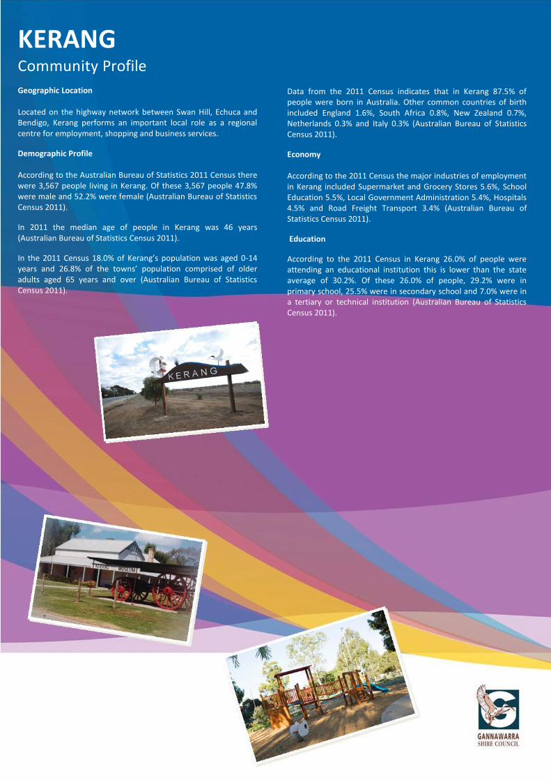
KERANG Community Profile
Geographic Location Located on the highway network between Swan Hill, Echuca and Bendigo, Kerang performs an important local role as a regional centre for employment, shopping and business services.
Demographic Profile According to the Australian Bureau of Statistics 2011 Census there were 3,567 people living in Kerang. Of these 3,567 people 47.8% were male and 52.2% were female (Australian Bureau of Statistics Census 2011).
In 2011 the median age of people in Kerang was 46 years (Australian Bureau of Statistics Census 2011).
In the 2011 Census 18.0% of Kerang’s population was aged 0-14 years and 26.8% of the towns’ population comprised of older adults aged 65 years and over (Australian Bureau of Statistics Census 2011).
Data from the 2011 Census indicates that in Kerang 87.5% of people were born in Australia. Other common countries of birth included England 1.6%, South Africa 0.8%, New Zealand 0.7%, Netherlands 0.3% and Italy 0.3% (Australian Bureau of Statistics Census 2011).
Economy According to the 2011 Census the major industries of employment in Kerang included Supermarket and Grocery Stores 5.6%, School Education 5.5%, Local Government Administration 5.4%, Hospitals 4.5% and Road Freight Transport 3.4% (Australian Bureau of Statistics Census 2011).
Education
According to the 2011 Census in Kerang 26.0% of people were attending an educational institution this is lower than the state average of 30.2%. Of these 26.0% of people, 29.2% were in primary school, 25.5% were in secondary school and 7.0% were in a tertiary or technical institution (Australian Bureau of Statistics Census 2011).

Kerang
Key Planning Scheme
Provisions
The following section outlines relevant key provisions of the Gannawarra Planning Scheme which may impact upon the delivery of community projects.
State Planning Policy Framework (SPPF) The following section outlines key State planning policies relevant to Kerang’s Community Plan:
x Open space planning (Clause 11.03-1) x Regional planning strategies and principles (Clause 11.05-4) x Urban design principles (Clause 15.01-2) x Design for safety (Clause 15.01-4) x Heritage conservation (Clause 15.03-1) x Business (Clause 17.01-1) x Industrial land development (Clause 17.02-1) x Facilitating tourism (Clause 17.03-1) x Cultural facilities (Clause 19.02-3)
Local Planning Policy Framework (LPPF) The following section outlines key objectives and strategies contained in the LPPF: x ‘Provide for planned development and physical
improvements in the retail centres of Kerang, Cohuna and Koondrook that is integrated with existing centres and is based on good urban design principles to maximise levels of competition, service and tourist visitation and trade.’
x ‘Support and enhance the growth of industry.’ x ‘To maintain and enhance existing recreational facilities and
open space networks.’ x ‘Urban development is to be generally consistent with the
Kerang Structure Plan.’ x ‘Urban development is to consolidate and strengthen
Kerang’s important regional role.’ x ‘Well sited and designed tourist developments are to be
encouraged adjacent to the Murray Valley Highway at the entrances to Kerang.’
x ‘Development in the Kerang Town Centre is to be generally consistent with the Kerang CBD Structure Plan.’
x Development in the Kerang Town centre that promotes a compact town centre, retains the existing scale and shopper amenity of the centre and increases opportunities to strengthen Kerang’s regional role will be encouraged.’
x One of the key strategies for Kerang pursuant to Clause 21.04-3 states ‘New development is to be attracted to assist in the generation of employment and economic activity.’
x ‘Expansion of tourist facilities, recreational activities and accommodation facilities.’
x ‘Retention of existing, and the provision of new services and facilities to support the viability and role of towns in the Shire.’
x It is policy that ‘Council will promote the protection and enhancement of historic buildings, objects and sites within the Shire and to encourage their restoration, renovation and re-use as appropriate.’
x It is policy that the following issues be taken into account when considering applications for use and development at the entrances and streetscapes of towns: ‘The presentation and design of town entrances will be considered in the design of buildings and works.’
Zones A variety of zoning controls apply to the sites identified in Kerang Community Plan. Some of the zoning controls relevant to Kerang’s Community Plan protect and conserve the natural environment and natural processes for their historic, scientific, landscape, habitat or cultural values, identify significant existing roads, create vibrant mixed use commercial centres for retail, office, business, entertainment and community uses, recognises public land use for public utility and community services and facilities, recognises areas for public recreation and open space, provide for areas to be used by private educational and religious institutions and provide for residential development at a range of densities with a variety of dwellings to meet the housing needs of all households. Overlays Some of the sites identified in Kerang’s Community Plan are affected by overlays. Some of the overlay controls relevant to the Community Plan identify areas where the development of land may be affected by environmental constraints, identify waterways, major floodpaths, drainage depressions and high hazard areas which have the greatest risk and frequency of being affected by flooding, conserve and enhance heritage places of natural or cultural significance, assist in shielding people from the impact of aircraft noise by requiring appropriate noise attenuation measures in new dwellings and other noise sensitive buildings and identify areas which are affected by specific requirements relating to the design and built form of new development. Particular Provisions One of the Particular Provisions relevant to Kerang’s Community Plan is Clause 52.05 Advertising Signs. Clause 52.05 seeks to regulate the display of signs and associated structures.
General Provisions Clauses 62.02-1 and 62.02-2 of the Gannawarra Planning Scheme set out exemptions from permit requirements relating to the construction of a building or the construction or carrying out of works. It is important to note that these exemptions do not apply to the removal, destruction or lopping of trees and the removal vegetation. Exemptions for vegetation removal are set out in Clause 62.02-3.
Please Note: For more specific information relating to how the planning provisions may impact upon the delivery of community projects please refer to the Gannawarra Planning Scheme.

Kerang
KG1 Master Plan Implementation Implementation of the Recreation Reserve Masterplan, as it relates to Atkinson Park, and support investment and new facilities at other key sports reserves.
Recreation Reserve Master Plan, Community Safety Plan, Youth Strategy
KG2 Economic Development Initiatives
Develop inward investment marketing and branding strategies and investigate opportunities to attract new business (manufacturing and retail) to the town, including incentive packages. Provide targeted support to key employers/sectors.
Tourism Strategy, Economic Development Strategy
KG3 Tourism Building upon natural, indigenous and heritage assets, develop the local tourism infrastructure (including targeted marketing/branding, the provision of tourist information, new signage/interpretation items etc).
Tourism Strategy, Economic Development Strategy, Arts and Culture Plan
KG4 Recreation and Leisure Assets
Improve access to formal and informal leisure and recreation opportunities – including new cycling tracks (e.g. Kerang – Koondrook Rail Trail), new canoe trails, walking tracks, investment around the swimming pool (Sir John Gorton Precinct) and new play facilities
LMRSP, Tourism Strategy, Economic Development Strategy, Sir John Gorton Precinct Master Plan
KG5 Community Infrastructure
Identify priorities for investment and improvement – including footpaths, amenities, pedestrian crossings and other public realm works (consistent with the recommendations of the Kerang CBD and Sir John Gorton Precinct Master Plans).
Kerang CBD and Sir John Gorton Precinct Master Plans,
KG6 Town Beautification Development of the township to increase its appeal to residents and visitors and preserve historic features –for example new Christmas decorations, town entrance/gateway enhancements and public art.
LMRSP, Kerang CBD Master Plan, Tourism Strategy
KG7 Events Support existing local events (e.g. Kerang Market) and consider opportunities for new events which have the capacity to support local economic and social development.
Arts and Culture Plan, Kerang CBD Master Plan, Tourism Strategy, Economic Development Strategy
KG8 Education and Learning Support the work of training and education providers – including positive consideration of new facilities and services to offer diversified/improved learning opportunities within the community
LMRSP, Youth Strategy, Positive Ageing Strategy
KG9 Community Connectivity
Increase the connectivity of the community (including outlying areas) by advocating for the installation of Natural Gas, National Broad Band Network infrastructure, improved rail services and sustained community transport services.
LMRSP, Economic Development Strategy
KG10 Public Entertainment Identify and support new initiatives that introduce public entertainment to the town – for example, movie nights, public performance, arts and culture activities etc.
Volunteer Management Plan
KG11 Community Safety
Work towards the implementation of the Community Safety Plan, addressing key priorities including improved pedestrian safety, elderly gopher access, appropriate lighting of public spaces and works to key sites (e.g. Kerang Station)
Tourism Strategy, Arts and Culture Plan
Kerang Project Description Policy Linkages Gannawarra
2025 Linkages

Kerang
Applicable Planning Controls
Community Planning Projects
Please note; for specific information relating to applicable planning controls please refer to Gannawarra Planning Scheme
Heritage Overlay
KG4
KG1
KG1
KG8
KG8
KG8
KG8
KG8
KG5
KG6
KG6
KG1
KG4
KG5
MURRAY VALLEY HW
Y
KG4
KG6
KG11
HO7HO4
HO3HO5 HO1
KG11KG11
HO2
KG5KG1

Cohuna
Cohuna Community Profile
Geographic Location Situated on the Murray Valley Highway between Echuca and Kerang, Cohuna performs an important service centre role for the south eastern half of t he Shire. Cohuna provides a local centre for shopping, employment and business services.
Landscape Assets Cohuna is the main gateway to the vast red gum and box forest covered Gunbower Island, which lies between Gunbower Creek and the Murray River, and is home to diverse native birdlife, kangaroos and emus.
Demographic Profile According to the Australian Bureau of Statistics 2011 Census there were 1,818 people living in Cohuna. Of these 1,818 people 47.2% were male and 52.8% were female (Australian Bureau of Statistics Census 2011).
In 2011 the median age of people in Cohuna was 54 years (Australian Bureau of Statistics Census 2011).
In the 2011 Census 15.9% of Cohuna’s population was aged 0-14 years and 33.1% of the towns’ population comprised of older adults aged 65 years and over (Australian Bureau of Statistics Census 2011).
Data from the 2011 Census indicates that in Cohuna 90.2% of people were born in Australia. Other common countries of birth included England 1.7%, Netherlands 0.8%, New Zealand 0.5%, Germany 0.4% and Scotland 0.3% (Australian Bureau of Statistics Census 2011).
Economy According to the 2011 Census the major industries of employment in Cohuna included School Education 7.4%, Dairy Cattle Farming 6.0%, Hospitals 4.6%, Residential Care Services 3.8% and Heavy and Civil Engineering Construction 3.5% (Australian Bureau of Statistics Census 2011).
Education
According to the 2011 Census in Cohuna 22.9% of people were attending an educational institution this is lower than the state average of 30.2%. Of these 22.9% of people, 26.2% were in primary school, 24.5% were in secondary school and 7.7% were in a tertiary or technical institution (Australian Bureau of Statistics Census 2011).
Cohuna
Key Planning Scheme
Provisions
The following section outlines relevant key provisions of the Gannawarra Planning Scheme which may impact upon the delivery of community projects.
State Planning Policy Framework (SPPF) The following section outlines key State planning policies relevant to Cohuna’s Community Plan: x Open space planning (Clause 11.03-1) x Urban design principles (Clause 15.01-2) x Heritage conservation (Clause 15.03-1)
Local Planning Policy Framework (LPPF) The following section outlines key objectives and strategies contained in the LPPF: x ‘To maintain and enhance existing recreational facilities
and open space networks.’ x ‘Development of Cohuna as a tourist stopover destination
will be encouraged by streetscape enhancement of the town centre precinct adjacent to the riverside park, establishing the Gunbower walking trail, identifying tourist development sites near Gunbower Creek and the town centre, and improving the visual image of highway entrances.’
x ‘Encouraging high quality tourist development that is compatible with the protection of natural, built and cultural attributes of the area.’
x ‘To protect and maintain the Shire’s local heritage, including Aboriginal and European sites, places and objects.’
x It is policy that the following issues be taken into account when considering applications for use and development at the entrances and streetscapes of towns: ‘The presentation and design of town entrances will be considered in the design of buildings and works.’
x Zones A variety of zoning controls apply to the sites identified in Cohuna’s Community Plan. Some of the zoning controls relevant to Cohuna’s Community Plan provide for residential development at a range of densities with a variety of dwellings to meet the housing needs of all households, recognise public land use for public utility and community services and facilities, recognise areas for public recreation and open space, protect and conserve the natural environment and natural processes for their historic, scientific, landscape, habitat or cultural values, identify significant existing roads and create vibrant mixed use commercial areas for retail, office, business, entertainment and community uses.
Overlays
Some of the sites identified in Cohuna’s Community Plan are affected by overlays. Some of the overlay controls relevant to the Community Plan identify areas where the development of land may be affected by environmental constraints, identify land in a flood storage or flood fringe area affected by the 1 in 100 year flood or any other area determined by the floodplain management authority, protect remnant native vegetation and habitat, including the understorey, and facilitate natural revegetation and conserve and enhance heritage places of natural or cultural significance.
Particular Provisions: One of the Particular Provisions relevant to Cohuna’s Community Plan is Clause 52.05 Advertising Signs. Clause 52.05 seeks to regulate the display of signs and associated structures.
General Provisions: Clauses 62.02-1 and 62.02-2 of the Gannawarra Planning Scheme set out exemptions from permit requirements relating to the construction of a building or the construction or carrying out of works. It is important to note that these exemptions do not apply to the removal, destruction or lopping of trees and the removal vegetation. Exemptions for vegetation removal are set out in Clause 62.02-3.
Please Note: For more specific information relating to how the planning provisions may impact upon the delivery of community projects please refer to the Gannawarra Planning Scheme.

CO1 Aquatic Facilities Consider options for the maintenance and redevelopment of local community swimming pool, to improve access and participation through broadening community benefit.
Recreation Reserve Master Plan, Tourism Strategy
CO2 Child Care Facilities Advocate for provision of adequate child care facilities in Cohuna to assist with residential and economic growth.
Economic Development Strategy
CO3 Tracks and Trails
Completion and further development of current and new walking and cycling tracks and trails including the installation of; outdoor exercise equipment, wildlife observation platforms, bridges to create linkages and heritage signage.
LMRSP, Tourism Strategy, Economic Development Strategy, Environmental Sustainability Strategy
CO4 Nature Based Tourism Development of local natural assets to maximise tourism opportunities; i.e. Gunbower Creek Nature Boat, Ski Run Facilities and Gunbower Forest.
LMRSP, Tourism Strategy, Economic Development Strategy, Environmental Sustainability Strategy
CO5 Master Plan Implementation Implementation of the Cohuna Recreation Reserve Masterplan. Recreation Reserve Master Plan, Community Safety Plan, Youth Strategy
CO6 Garden and Apex Parks Creation of new and maintenance of current infrastructure in Garden and Apex Parks, Cohuna to increase their appeal, accessibility and useability for residents and visitors.
Tourism Strategy
CO7 Town Beautification Development of the township to increase its appeal and preserve historic features ie new Christmas decorations, outdoor art, town entrance development and heritage listing of local buildings.
LMRSP, Tourism Strategy
CO8 Community Connectivity Increase the connectivity of the community (including outlying areas) by advocating for the installation of Natural Gas and National Broad Band Network infrastructure.
LMRSP, Economic Development Strategy
CO9 Cohuna Education and Community Activity (ECA) Centre
Develop a plan for the future management and use of the Cohuna ECA Centre facility to maximise its potential as a community asset.
Volunteer Management Plan, Disability Action Plan, Positive Ageing Strategy
CO10 Cohuna Memorial Hall Provision of new fixtures in the hall including tables, chairs, sound system and power infrastructure to increase the useability and accessibility of the hall.
Volunteer Management Plan, Disability Action Plan, Positive Ageing Strategy
CO11 RV Friendly Tourism Creation of RV Friendly Township through the installation of a dump point and provision of areas for both short term and long term camping.
Tourism Strategy, Economic Development Strategy
Cohuna Project Description Policy Linkages Gannawarra
2025 Linkages

Cohuna
CO5
CO10
CO7
CO9
CO1
CO11
CO3
CO4
CO11
CO4
CO7
CO6
CO6
KING GEORGE ST
MURRAY VALLEY HWYMcMILLANS RD
SAMPSON ST
CO7
Applicable Planning Controls
Community Planning Projects
Please note; for specific information relating to applicable planning controls please refer to Gannawarra Planning Scheme
HO19
Heritage Overlay

Koondrook
Koondrook Community Profile
Geographic Location: Located in the north-eastern part of the Shire on the Victorian side of the Murray Rive, Koondrook performs the role of a tourist, heritage, retiree and rural retreat town.
Landscape Assets: Koondrook is the Gateway to the northern end of Gunbower Island.
The Murray River is also another landscape asset for the Koondrook Township. It is important to ensure that the historic river town character of Koondrook is preserved as this will provide opportunities for increased tourism potential.
Demographic Profile: According to the Australian Bureau of Statistics 2011 Census there were 769 people living in Koondrook. Of these 769 people 50.5% were male and 49.5% were female (Australian Bureau of Statistics Census 2011).
In 2011 the median age of people in Koondrook was 53 years (Australian Bureau of Statistics Census 2011).
In the 2011 Census 13.9% of Koondrook’s population was aged 0-14 years and 29.2% of the towns’ population comprised of older adults aged 65 years and over (Australian Bureau of Statistics Census 2011).
Data from the 2011 Census indicates that in Koondrook 89.8% of people were born in Australia. Other common countries of birth included England 2.1%, Kenya 0.7%, Netherlands 0.7%, Germany 0.4% and Malta 0.4% (Australian Bureau of Statistics Census 2011).
Economy: According to the 2011 Census the major industries of employment in Koondrook included Cafes, Restaurants and Takeaway Food Services 5.6%, Accommodation 4.3%, Local Government Administration 4.3%, Supermarket and Grocery Stores 3.6% and School Education 3.6% (Australian Bureau of Statistics Census 2011).
Education
According to the 2011 Census in Koondrook 25.0% of people were attending an educational institution this is lower than the state average of 30.2%. Of these 25.0% of people, 25.0% were in primary school, 20.8% were in secondary school and 4.2% were in a tertiary or technical institution (Australian Bureau of Statistics Census 2011).

Koondrook
Key Planning Scheme
Provisions
The following section outlines relevant key provisions of the Gannawarra Planning Scheme which may impact upon the delivery of community projects.
State Planning Policy Framework (SPPF) The following section outlines key State planning policies relevant to Koondrook’s Community Plan: x Open space planning (Clause 11.03-1) x Regional planning strategies and principles (Clause 11.05-
4) x Urban design principles (Clause 15.01-2 )
Local Planning Policy Framework (LPPF) The following section outlines key objectives and strategies contained in the LPPF: x ‘To maintain and enhance existing recreational facilities
and open space networks.’ x ‘Protection and enhancement of Koondrook Wharf and
environs.’ x ‘Ensuring that new development complements the
historic and architectural integrity, character and appearance of surrounding buildings, sites and landscapes.’
x ‘Encouraging high quality tourist development that is compatible with the protection of natural, built and cultural attributes of the area.’
x ‘Retention of existing, and the provision of new services and facilities to support the viability and role of towns in the Shire.’
x ‘Council will promote the protection and enhancement of historic buildings, objects and sites within the Shire and to encourage their restoration, renovation and re-use as appropriate.’
x Clause 22.05 applies specifically to Koondrook’s historic township centre and riverbank.
x Clause 22.06 refers to the role of the Murray River Corridor reserve for tourism, nature conservation and recreation and for the protection of the Murray River.
x It is policy that the following issues be taken into account when considering applications for use and development at the entrances and streetscapes of towns ‘The presentation and design of town entrances will be considered in the design of buildings and works.’
Zones A variety of zoning controls apply to the sites identified in Koondrook’s Community Plan. Some of the zoning controls relevant to Koondrook’s Community Plan provide for residential development at a range of densities with a variety of dwellings to meet the housing needs of all households, create vibrant mixed use commercial areas for retail, office, business, entertainment and community uses, identify significant existing roads, protect and conserve the natural environment and natural processes for their historic, scientific, landscape, habitat or cultural values, recognise areas for public recreation and open space, recognise public land use for public utility and community services and facilities and to recognise and provide for the use and development of land for tourism facilities including the Koondrook Caravan Park.
Overlays: Some of the sites identified in Koondrook’s Community Plan are affected by overlays. Some of the overlay controls relevant to the Community Plan identify areas where the development of land may be affected by environmental constraints, identify land in a flood storage or flood fringe area affected by the 1 in 100 year flood or any other area determined by the floodplain management authority, and conserve and enhance heritage places of natural or cultural significance. Particular Provisions One of the Particular Provisions relevant to Koondrook’s Community Plan is Clause 52.05 Advertising Signs. Clause 52.05 seeks to regulate the display of signs and associated structures.
General Provisions Clauses 62.02-1 and 62.02-2 of the Gannawarra Planning Scheme set out exemptions from permit requirements relating to the construction of a building or the construction or carrying out of works. It is important to note that these exemptions do not apply to the removal, destruction or lopping of trees and the removal vegetation. Exemptions for vegetation removal are set out in Clause 62.02-3.
Please Note: For more specific information relating to how the planning provisions may impact upon the delivery of community projects please refer to the Gannawarra Planning Scheme.

KD1 Town Gateways
Townscape and environmental upgrades to key gateways - consider a range of interventions including outdoor art/sculpture, town entrance features, highways works and general townscape upgrades.
Tourism Strategy, Arts and Culture Plan, Economic Development Strategy
KD2 Community Connectivity Increase the connectivity of the community including outlying areas by advocating for the installation of Natural Gas and National Broad Band Network infrastructure.
LMRSP, Economic Development Strategy
KD3 Key Community Services Encourage ongoing investment and support for Koondrook Primary School and local health services/practitioners. Consider new methods of service delivery (e.g. outreach, home care etc)
Positive Ageing Strategy, Disability Action Plan
KD4 Koondrook Wharf Precinct
Work with partner/agency organisations to assemble funding and deliver the strategic development of Koondrook Wharf and associated facilities.
LMRSP, Tourism Strategy, Economic Development Strategy, Environmental Sustainability Strategy
KD5 Heritage Assets
Continue to support the future development of Koondrook Memorial Hall, Historical Society and Sawmill precinct in collaboration with all key partners. Identify uses and opportunities for sustainable use and development of these key facilities.
Tourism Strategy, Economic Development Strategy, Environmental Sustainability Strategy
KD6 Tourism Infrastructure
Building upon natural, indigenous and heritage assets, develop the local tourism infrastructure (including targeted marketing/branding, the provision of tourist information, new signage/interpretation items and establishment of the Kerang – Koondrook Rail Trail).
LMRSP, Tourism Strategy, Economic Development Strategy
KD7 Master Plan Implementation Implementation of the Koondrook Recreation Reserve Masterplan.
Recreation Reserves Master Plan
KD8 Leisure and Recreation
To complement investment in the local tourism infrastructure, identify opportunities for improved access to key natural assets (e.g. Gunbower Creek and Forest, Murray River and tracks and trails network) to encourage increased usage.
LMRSP, Economic Development Strategy, Tourism Strategy, Environmental Sustainability Strategy
KD9 Town Centre Initiatives
Support proposals which enhance the vitality and viability of town centre uses, including new developments, public realm works, and business infrastructure improvements.
LMRSP, Economic Development Strategy
KD10 Events
Support existing local events (e.g. Farmers Market) and consider opportunities for new events which have the capacity to support local economic and social development.
Arts and Culture Plan, Tourism Strategy, Economic Development Strategy
KD11 Community Initiatives and Assets Support community lead initiatives and volunteering programs which invest in the maintenance and improvement of key community assets (e.g. swimming pool, Apex Park and other key public spaces).
Volunteer Management Plan
Koondrook Project Description Policy Linkages Gannawarra 2025 Linkages

Koondrook
KD6
KD11
KD3
KD4
KD11
KD11
KD5KD7
KD8
KD6
KD8MAIN ST
GRI
GG
RD
HeritageOverlay
KD1
Applicable Planning Controls
Community Planning Projects
Please note; for specific information relating to applicable planning controls please refer to Gannawarra Planning Scheme
KD9KD11
KD8

Leitchville
Leitchville Community Profile
Geographic Location
Sited in the far south-eastern part of the Shire, Leitchville performs the role of an employment and residential centre based on value adding to the dairy industry and piggeries.
Demographic Profile
According to the Australian Bureau of Statistics 2011 Census there were 247 people living in Leitchville. Of these 247 people 52.2% were male and 47.8% were female (Australian Bureau of Statistics Census 2011).
In 2011 the median age of people in Leitchville was 50 years (Australian Bureau of Statistics Census 2011).
In the 2011 Census 13.3% of Leitchville’s population was aged 0-14 years and 31.0% of the towns’ population comprised of older adults aged 65 years and over (Australian Bureau of Statistics Census 2011).
Data from the 2011 Census indicates that in Leitchville 88.3% of people were born in Australia. Other common countries of birth included England 1.6%, Denmark 1.2%, Germany 1.2% and New Zealand 1.2% (Australian Bureau of Statistics Census 2011).
Economy
According to the 2011 Census the major industries of employment in Leitchville included Hospitals 10.8%, Residential Care Services 9.8%, Supermarket and Grocery Stores 6.9%, Dairy Cattle Farming 4.9% and Road Freight Transport 4.9% (Australian Bureau of Statistics Census 2011).
Education
According to the 2011 Census in Leitchville 25.4% of people were attending an educational institution this is lower than the state average of 30.2%. Of these 25.4% of people, 15.2% were in primary school, 22.7% were in secondary school and 19.7% were in a tertiary or technical institution (Australian Bureau of Statistics Census 2011).

Leitchville
Key Planning Scheme
Provisions
The following section outlines relevant key provisions of the Gannawarra Planning Scheme which may impact upon the delivery of community projects.
State Planning Policy Framework (SPPF) The following section outlines key State planning policies relevant to Leitchville’s Community Plan: x Open space planning (Clause 11.03-1) x Regional planning strategies and principles (Clause 11.05-4) x Urban design principles (Clause 15.01-2) x Heritage conservation (Clause 15.03-1) x Business (Clause 17.01-1) Local Planning Policy Framework (LPPF) The following section outlines key objectives and strategies contained in the LPPF: x ‘To maintain and enhance existing recreational facilities and
open space networks.’ x ‘Urban development is to be generally consistent with the
Leitchville Structure Plan.’ x ‘Future residential development (10 to 15 years) is to be
strongly encouraged at locations north of the Cohuna/Leitchville Road and to the south of the town identified in the Structure Plan.’
x ‘New retail and business development is encouraged to cluster with existing town centre facilities.’
x ‘Protection and maintenance of the Shire’s local heritage.’ x ‘Encouraging high quality tourist development that is
compatible with the protection of natural, built and cultural attributes of the area.’
x It is policy that ‘Council will promote the protection and enhancement of historic buildings, objects and sites within the Shire and to encourage their restoration, renovation and re-use as appropriate.’
x It is policy that the following issues be taken into account when considering applications for use and development at the entrances and streetscapes of towns ‘The presentation and design of town entrances will be considered in the design of buildings and works.’
Zones A variety of zoning controls apply to the sites identified in Leitchville’s Community Plan. Some of the zoning controls relevant to Leitchville’s Community Plan provide for residential development and a range of commercial, industrial and other uses in small towns and identify significant existing roads.
Overlays Some of the sites identified in Leitchville’s Community Plan are affected by overlays. Some of the overlay controls relevant to the Community Plan identify areas where the development of land may be affected by environmental constraints.
Particular Provisions Some of the Particular Provisions relevant to Leitchville’s Community Plan include Clause 52.05 – Advertising Signs, Clause 54 – One Dwelling on a Lot, Clause 55 – Two or more Dwellings on a Lot and Residential Buildings and Clause 56 Residential Subdivisions.
x Clause 52.05 seeks to regulate the display of signs and associated structures
x Clause 54 seeks to encourage residential development that provides reasonable standards of amenity for existing and new residents.
x Clause 55 seeks to encourage residential development that is responsive to the site and the neighbourhood.
x Clause 56 seeks to create liveable and sustainable neighbourhoods and urban places with character and identity.
General Provisions Clauses 62.02-1 and 62.02-2 of the Gannawarra Planning Scheme set out exemptions from permit requirements relating to the construction of a building or the construction or carrying out of works. It is important to note that these exemptions do not apply to the removal, destruction or lopping of trees and the removal vegetation. Exemptions for vegetation removal are set out in Clause 62.02-3.
Please Note: For more specific information relating to how the planning provisions may impact upon the delivery of community projects please refer to the Gannawarra Planning Scheme.
Lakes District

Leitchville
LV1 Tourism Development
Creation of linkages to Gunbower State Forest, Kow Swamp and Mount Hope. Investigate feasibility of Leitchville Rural Transaction Centre becoming an information hub.
Tourism Strategy, Arts and Culture Plan, Economic Development Strategy
LV2 Master Plan Implementation Implementation of the Leitchville Recreation Reserve Masterplan. Recreation Reserves Master Plan
LV3 Leitchville Beautification Upgrades and beautification of Rural Transaction Centre and Leitchville streetscape. Including public space artworks.
LMRSP
LV4 Economic Development Develop marketing and branding strategies (Including new town signage) and investigate opportunities to attract new business (manufacturing and retail) to the town.
LMRSP, Tourism Strategy, Economic Development Strategy,
LV5 Residential Development Encourage residential development including new subdivisions to assist town expansion.
Gannawarra Shire Planning Scheme, Environmental Sustainability Strategy
LV6 Heritage Preservation of key local buildings, signage and gardens etc to preserve the towns history.
LMRSP, Tourism Strategy, Economic Development Strategy, Environmental Sustainability Strategy
LV7 Road Infrastructure Advocate for improved highway infrastructure to increase road safety and strengthen transport links.
LMRSP, Community Safety Plan
LV8 Community Assets Ensuring the ongoing maintenance and development of key community assets including the Leitchville Swimming Pool and walking/cycling tracks and trails.
LMRSP, Economic Development Strategy, Tourism Strategy, Environmental Sustainability Strategy
LV9 Community Connectivity Increase the connectivity of the community including outlying areas through the provision of community transport, the National Broadband Network and Natural Gas.
LMRSP, Economic Development Strategy
Leitchville Project Description Policy Linkages Gannawarra 2025 Linkages

Leitchville
LV4
LV5
LV6
LV1
LV8LV7
LV1
LV2
LV1LV3
LV8
Residential Expansion
Potential
Residential Expansion Potential
LEIT
CHV
ILLE
SO
UTH
RD
KING GEORGE ST
Applicable Planning Controls
Community Planning Projects
Please note; for specific information relating to applicable planning controls please refer to Gannawarra Planning Scheme

Murrabit and District
Murrabit & District Community Profile
Geographic Location Situated in the northern part of the Shire the Benjeroop, Murrabit and Myall community consists of a wide variety of land uses including agricultural enterprises, residential use, limited commercial and industrial operations and recreational uses.
Demographics According to the Australian Bureau of Statistics 2011 Census there were 330 people living in the Benjeroop and Murrabit district. Of these 330 people 50.0% were male and 50.0% were female (Australian Bureau of Statistics Census 2011).
In 2011 the median age of people in the Benjeroop and Murrabit district was 48 years (Australian Bureau of Statistics Census 2011).
In the 2011 Census 17.0% of the Benjeroop and Murrabit district population were aged 0-14 years and 15.8% of the districts population comprised of older adults aged 65 years and over (Australian Bureau of Statistics Census 2011).
Data from the 2011 Census indicates that in the Benjeroop and Murrabit district 89.0% of people were born in Australia. The only other responses for country of birth were England 2.4%, China (excludes SARs and Taiwan) 1.2%, Malta 0.9% and Scotland 0.9% (Australian Bureau of Statistics Census 2011).
Economy
According to the 2011 Census the major industries of employment in the Benjeroop and Murrabit district included Dairy Cattle Farming 19.9%, Sheep, Beef Cattle and Grain Farming 11.9%, School Education 9.9%, Road Freight Transport 7.3% and Fruit and Tree Nut Growing 4.6% (Australian Bureau of Statistics Census 2011).
Education
According to the 2011 Census in the Benjeroop and Murrabit district 19.6% of people were attending an educational institution this is lower than the state average of 30.2%. Of these 19.6% of people, 44.3% were in primary school, 19.7% were in secondary school and 6.6% were in a tertiary or technical institution (Australian Bureau of Statistics Census 2011).
Please Note: For the purpose of this community profile the Benjeroop and Murrabit district includes the localities of Benjeroop, Murrabit, Murrabit West and Gonn Crossing. As the 2011 Census did not release data for gazetted localities, Myall’s population data was combined with the following localities Koondrook, Capels Crossing and Westby. As the Myall’s population data is combined with Koondrook’s, Capels Crossing’s and Westby’s it is difficult to produce exact population figures for the Myall community.

Murrabit and District
Key Planning Scheme
Provisions
The following section outlines relevant key provisions of the Gannawarra Planning Scheme which may impact upon the delivery of community projects.
State Planning Policy Framework (SPPF) The following section outlines key State planning policies relevant to the Murrabit and District Community Plan: x Open space planning (Clause 11.03-1) x Regional planning strategies and principles (Clause 11.05-4) x Urban design principles (Clause 15.01-2) x Facilitating tourism (Clause 17.03-1) x Cultural facilities (Clause 19.02-3)
Local Planning Policy Framework (LPPF) The following section outlines key objectives and strategies contained in the LPPF: x ‘To maintain and enhance existing recreational facilities
and open space networks.’ x ‘Urban development is to be generally consistent with the
Murrabit Structure Plan.’ x One of the key strategies for Murrabit pursuant to Clause
21.04-3 states ‘Future sewered residential or low-density residential development is to be focused on land designated as future residential areas with low flood risk located to the north-west, north and east of the town centre, subject to a Cultural Heritage Management Plan.’
x ‘Encouraging high quality tourist development that is compatible with the protection of natural, built and cultural attributes of the area.’
x It is policy that ‘Council will promote the protection and enhancement of historic buildings, objects and sites within the Shire and to encourage their restoration, renovation and re-use as appropriate.’
x Clause 22.06 refers to the role of the Murray River Corridor reserve for tourism, nature conservation and recreation and for the protection of the Murray River.
x It is policy that the following issues be taken into account when considering applications for use and development at the entrances and streetscapes of towns ‘The presentation and design of town entrances will be considered in the design of buildings and works.’
Zones A variety of zoning controls apply to the sites identified in the Murrabit and District Community Plan. Some of the zoning controls relevant to the Murrabit and District Community Plan provide for residential development and a range of commercial, industrial and other uses in small towns, protect and enhance natural resources and the biodiversity of the area, identify significant existing roads, protect and conserve the natural environment and natural processes for their historic, scientific, landscape, habitat or cultural values, recognises public land use for public utility and community services and facilities, provide for areas to be used for a golf
course and associated uses and recognise areas for public recreation and open space.
Overlays Some of the sites identified in the Murrabit and District Community Plan are affected by overlays. Some of the overlay controls relevant to the Community Plan identify land in a flood storage or flood fringe area affected by the 1 in 100 year flood or any other area determined by the floodplain management authority, identify areas where the development of land may be affected by environmental constraints and identify waterways, major floodpaths, drainage depressions and high hazard areas which have the greatest risk and frequency of being affected by flooding.
Particular Provisions Some of the Particular Provisions relevant to the Murrabit and District Community Plan include Clause 52.05 – Advertising Signs, Clause 54 – One Dwelling on a Lot, Clause 55 – Two or more Dwellings on a Lot and Residential Buildings and Clause 56 Residential Subdivisions. x Clause 52.05 seeks to regulate the display of signs and
associated structures x Clause 54 seeks to encourage residential development that
provides reasonable standards of amenity for existing and new residents.
x Clause 55 seeks to encourage residential development that is responsive to the site and the neighbourhood.
x Clause 56 seeks to create liveable and sustainable neighbourhoods and urban places with character and identity.
General Provisions Clauses 62.02-1 and 62.02-2 of the Gannawarra Planning Scheme set out exemptions from permit requirements relating to the construction of a building or the construction or carrying out of works. It is important to note that these exemptions do not apply to the removal, destruction or lopping of trees and the removal vegetation. Exemptions for vegetation removal are set out in Clause 62.02-3.
Please Note: For more specific information relating to how the planning provisions may impact upon the delivery of community projects please refer to the Gannawarra Planning Scheme.
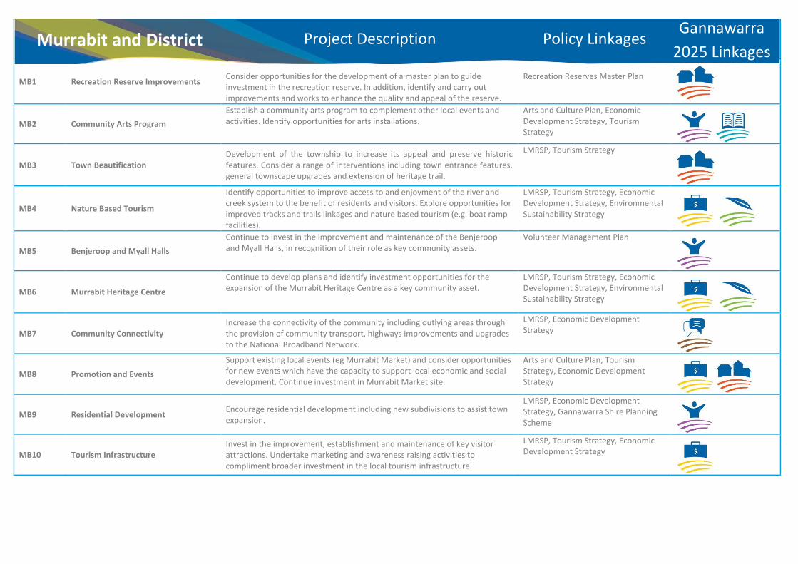
MB1 Recreation Reserve Improvements
Consider opportunities for the development of a master plan to guide investment in the recreation reserve. In addition, identify and carry out improvements and works to enhance the quality and appeal of the reserve.
Recreation Reserves Master Plan
MB2 Community Arts Program Establish a community arts program to complement other local events and activities. Identify opportunities for arts installations.
Arts and Culture Plan, Economic Development Strategy, Tourism Strategy
MB3 Town Beautification Development of the township to increase its appeal and preserve historic features. Consider a range of interventions including town entrance features, general townscape upgrades and extension of heritage trail.
LMRSP, Tourism Strategy
MB4 Nature Based Tourism
Identify opportunities to improve access to and enjoyment of the river and creek system to the benefit of residents and visitors. Explore opportunities for improved tracks and trails linkages and nature based tourism (e.g. boat ramp facilities).
LMRSP, Tourism Strategy, Economic Development Strategy, Environmental Sustainability Strategy
MB5 Benjeroop and Myall Halls Continue to invest in the improvement and maintenance of the Benjeroop and Myall Halls, in recognition of their role as key community assets.
Volunteer Management Plan
MB6 Murrabit Heritage Centre
Continue to develop plans and identify investment opportunities for the expansion of the Murrabit Heritage Centre as a key community asset.
LMRSP, Tourism Strategy, Economic Development Strategy, Environmental Sustainability Strategy
MB7 Community Connectivity Increase the connectivity of the community including outlying areas through the provision of community transport, highways improvements and upgrades to the National Broadband Network.
LMRSP, Economic Development Strategy
MB8 Promotion and Events
Support existing local events (eg Murrabit Market) and consider opportunities for new events which have the capacity to support local economic and social development. Continue investment in Murrabit Market site.
Arts and Culture Plan, Tourism Strategy, Economic Development Strategy
MB9 Residential Development Encourage residential development including new subdivisions to assist town expansion.
LMRSP, Economic Development Strategy, Gannawarra Shire Planning Scheme
MB10 Tourism Infrastructure Invest in the improvement, establishment and maintenance of key visitor attractions. Undertake marketing and awareness raising activities to compliment broader investment in the local tourism infrastructure.
LMRSP, Tourism Strategy, Economic Development Strategy
Murrabit and District Project Description Policy Linkages Gannawarra 2025 Linkages

Murrabit and District
MB9
MB1
MB4MB10
MB4
MB10
MB5
MB5
MB3
MB10MB6
MB10
MB3
MB3
MURRABIT RD
TO MYALL
TO BENJEROOP
Extent of TownshipArea
Applicable Planning Controls
Community Planning Projects
Please note; for specific information relating to applicable planning controls please refer to Gannawarra Planning Scheme
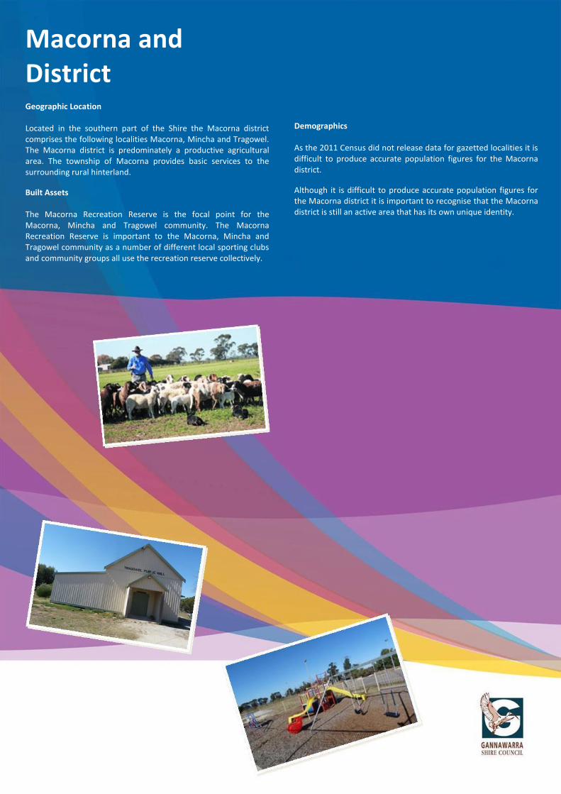
Macorna and District
Macorna and District Geographic Location Located in the southern part of the Shire the Macorna district comprises the following localities Macorna, Mincha and Tragowel. The Macorna district is predominately a productive agricultural area. The township of Macorna provides basic services to the surrounding rural hinterland.
Built Assets The Macorna Recreation Reserve is the focal point for the Macorna, Mincha and Tragowel community. The Macorna Recreation Reserve is important to the Macorna, Mincha and Tragowel community as a number of different local sporting clubs and community groups all use the recreation reserve collectively.
Demographics As the 2011 Census did not release data for gazetted localities it is difficult to produce accurate population figures for the Macorna district.
Although it is difficult to produce accurate population figures for the Macorna district it is important to recognise that the Macorna district is still an active area that has its own unique identity.

Macorna and District
Key Planning Scheme
Provisions
The following section outlines relevant key provisions of the Gannawarra Planning Scheme which may impact upon the delivery of community projects.
State Planning Policy Framework (SPPF) The following section outlines key State planning policies relevant to the Macorna and District Community Plan: x Open space planning (Clause 11.03-1) x Regional planning strategies and principles (Clause 11.05-4) x Urban design principles (Clause 15.01-2) x Cultural facilities (Clause 19.02-3)
Local Planning Policy Framework (LPPF) The following section outlines key objectives and strategies contained in the LPPF: x ‘To maintain and enhance existing recreational facilities and
open space networks.’ x ‘Retention of existing, and the provision of new services and
facilities to support the viability and role of towns in the Shire.’ x It is policy that the following issues be taken into account when
considering applications for use and development at the entrances and streetscapes of towns ‘The presentation and design of town entrances will be considered in the design of buildings and works.’
x It is policy that the following issues be taken into account when considering applications for use and development at the entrances and streetscapes of towns ‘Development will take into account that the tree species used are consistent with the landscape of the township.’
Zones A variety of zoning controls apply to the sites identified in the Macorna and District Community Plan. Some of the zoning controls relevant to the Macorna and District Community Plan recognise areas for public recreation and open space, provide for residential development and a range of commercial, industrial and other uses in small towns, ensure that non-agricultural uses, particularly dwellings, do not adversely affect the use of land for agriculture and recognise public land use for public utility and community services and facilities. Overlays Some of the sites identified in the Macorna and District Community Plan are affected by overlays. Some of the overlay controls relevant to the Community Plan identify areas where the development of land may be affected by environmental constraints and conserve and enhance heritage places of natural or cultural significance.
Particular Provisions One of the Particular Provisions relevant to the Macorna and District Community Plan is Clause 52.05 Advertising Signs. Clause 52.05 seeks to regulate the display of signs and associated structures.
General Provisions Clauses 62.02-1 and 62.02-2 of the Gannawarra Planning Scheme set out exemptions from permit requirements relating to the construction of a building or the construction or carrying out of works. It is important to note that these exemptions do not apply to the removal, destruction or lopping of trees and the removal vegetation. Exemptions for vegetation removal are set out in Clause 62.02-3.
Please Note: For more specific information relating to how the planning provisions may impact upon the delivery of community projects please refer to the Gannawarra Planning Scheme.

MC1 Master Plan Implementation In recognition of its role as the primary community asset in the district, work
towards the implementation of the Macorna Recreation Reserve Masterplan.
Recreation Reserves Master Plan
MC2
Environmental Enhancements Carry out new landscaping and planting to improve the amenity of the area and also to compliment investment in the recreation reserve.
Recreation Reserves Master Plan, Environmental Sustainability Strategy
MC3
Training, Volunteering and Mentoring Identify training opportunities to support local clubs and initiatives. Develop opportunities for increased volunteer involvement in community activities and identify mentoring opportunities for community members.
Volunteer Management Plan, Youth Strategy, Positive Ageing Strategy
MC4
Amenity Upgrades Identify opportunities for new signage, lighting, interpretation and public art initiatives to compliment community activities.
Arts and Culture Plan
MC5
Tragowel Hall Continue to invest in the improvement and maintenance of the Tragowel Hall, in recognition of its role as a key community asset.
Volunteer Management Plan
MC6
Recreational Sports and Leisure In connection with investment at the Recreation Reserve, identify initiatives and opportunities to support existing sports clubs and explore opportunities for new recreational and leisure infrastructure.
LMRSP, Tourism Strategy, Economic Development Strategy, Environmental Sustainability Strategy
MC7
Community Connectivity Increase the connectivity of the community including outlying areas through the provision of community transport, highways improvements and upgrades to the National Broadband Network.
LMRSP, Economic Development Strategy
MC8
Events Support existing local events (e.g. Working Dog Trials) and consider opportunities for new events which have the capacity to support local economic and social development.
Arts and Culture Plan, Tourism Strategy, Economic Development Strategy
Macorna and District Project Description Policy Linkages Gannawarra 2025 Linkages

Macorna and District
MC5
MC1MC2MC4MC6
MC2MC4
KERA
NG
-MA
CORN
A R
D
TRAGOWEL RD
Applicable Planning Controls
Community Planning Projects
Please note; for specific information relating to applicable planning controls please refer to Gannawarra Planning Scheme

Dingwall and Lake Meran District
.
Dingwall and Lake Meran District Community Profile
Geographic Location Sited in the south-western part of the Shire, the Dingwall and Lake Meran district comprises the following localities Dingwall, Lake Meran and Normanville. The Dingwall and Lake Meran district is predominately a productive agricultural area.
Landscape Assets Located along the Kerang-Boort Road, Lake Meran is a natural lake prone to seasonal fluctuations. Lake Meran is a popular spot over summer for camping, boating, swimming, water skiing and picnicking.
Leaghur State Park is also another landscape asset for the Dingwall and Lake Meran district. Located on the Loddon River floodplain, halfway between Kerang and Boort, Leaghur State Park protects one of the best Black Box forests in Victoria.
Built Assets The Dingwall and Lake Meran community halls are focal points for the Dingwall and Lake Meran district. The community halls are believed to be integral parts of the community and provide facilities for socialising. The maintenance and retention of these halls is important to the identification of the Dingwall and Lake Meran district.
Demographics As the 2011 Census did note release data for gazetted localities it is difficult to produce accurate population figures for the Dingwall and Lake Meran district.
Although it is difficult to produce accurate population figures for the Dingwall and Lake Meran district it is important to recognise that the Dingwall and Lake Meran district is still an active area that has its own unique identity

Dingwall and Lake Meran District
Planning Scheme
Provisions
The following section outlines relevant key provisions of the Gannawarra Planning Scheme which may impact upon the delivery of community projects.
State Planning Policy Framework (SPPF) The following section outlines key State planning policies relevant to the Dingwall and Lake Meran District Community Plan: x Open space planning (Clause 11.03-1) x Regional planning strategies and principles (Clause 11.05-
4) x Protection of habitat (Clause 12.01-1) x Urban design principles (Clause 15.01-2)
Local Planning Policy Framework (LPPF) The following section outlines key objectives and strategies contained in the LPPF: x ‘Management of public land (State Forests and Parks, river
and stream reserves, wetlands and lakes) that provide for a range of opportunities including nature conservation, recreation and tourism.’
x ‘Maintain and enhance recreational facilities and open space networks.’
x ‘To ensure that use and development of land and water takes into account impacts on the quality and quantity of natural resources and management of nutrients and pollutants.’
x ‘To recognise that wetland areas in the Gannawarra Shire provide important functions including: flora and fauna habitat; recreation area; landscape features; water filtration; and water storage and water drainage.’
x ‘To protect remaining wetlands within the Gannawarra Shire.’
x ‘Vegetation removal will be avoided and, if avoidance is not possible, minimised on roadsides that are identified as having high or medium conservation value.’ (Note: In view of the expressed community desire to remove pest species, it should be noted that this provision of the LPPF would not prevent the removal of invasive, non-native species – it seeks to protect native vegetation of conservation value).
Zones A variety of zoning controls apply to the sites identified in the Dingwall and Lake Meran District Community Plan. Some of the zoning controls relevant to the Dingwall and Lake Meran District Community Plan protect and conserve the natural environment and natural processes for their historic, scientific, landscape, habitat or cultural values, identify significant existing roads and ensure that non-agricultural uses, particularly dwellings, do not adversely affect the use of land for agriculture.
Overlays Some of the sites identified in the Dingwall and Lake Meran District Community Plan are affected by overlays. Some of the overlay controls relevant to the Community Plan identify areas where the development of land may be affected by environmental constraints, identify waterways, major floodpaths, drainage depressions and high hazard areas which have the greatest risk and frequency of being affected by flooding, ensure that development minimises loss of vegetation and identify land in a flood storage or flood fringe area affected by the 1 in 100 year flood or any other area determined by the floodplain management authority.
General Provisions Clauses 62.02-1 and 62.02-2 of the Gannawarra Planning Scheme set out exemptions from permit requirements relating to the construction of a building or the construction or carrying out of works. It is important to note that these exemptions do not apply to the removal, destruction or lopping of trees and the removal vegetation. Exemptions for vegetation removal are set out in Clause 62.02-3.
Please Note: For more specific information relating to how the planning provisions may impact upon the delivery of community projects please refer to the Gannawarra Planning Scheme.

DL1 Lake Meran Foreshore
Invest in the management, maintenance and upkeep of the Lake Meran Foreshore (including pest species control), and develop new attractions as appropriate. Provide support to local management groups to ensure ongoing community involvement and ownership.
Tourism Strategy, Economic Development Strategy, Environmental Sustainability Strategy
DL2 Water Based Tourism and Recreation
With specific regard to Lake Meran and nearby water bodies, explore opportunities for new aquatic attractions (e.g. canoe trails, boat ramps, fishing platforms, interpretive facilities etc).
Tourism Strategy, Economic Development Strategy, Environmental Sustainability Strategy
DL3 Community Hubs Invest in the maintenance, upkeep and improvement of the Dingwall and Lake Meran Halls, in recognition of their role as community hubs. Identify opportunities for new activities to support the wider community.
LMRSP, Tourism Strategy, Economic Development Strategy
DL4 Community Connectivity Increase the connectivity of the community including outlying areas by advocating for the installation of National Broad Band Network and improvement to local highways, tracks/trails and cycle route infrastructure.
LMRSP, Economic Development Strategy
DL5 District Beautification Identify projects which have the capacity to enhance the vitality and viability of the district centres including signage, interpretation/public art, landscaping and works to key buildings and spaces.
LMRSP, Tourism Strategy, Economic Development Strategy
DL6 Events Support existing local events and consider opportunities for new events which have the capacity to support local economic and social development.
Tourism Strategy, Arts and Culture Plan
DL7 Volunteer Support Provide a supportive framework that actively encourages, values and recognises the contribution of volunteers to key community projects.
Volunteer Management Plan, Positive Ageing Strategy
DL8 Community Initiatives and Assets
Support community lead initiatives and volunteering programs which invest in the maintenance and improvement of key community assets (e.g. Lake Meran Tennis Club and other key public spaces).
Volunteer Management Plan
Dingwall and Lake Meran District Project Description Policy Linkages Gannawarra
2025 Linkages

Dingwall and Lake Meran District
DL3
DL3 DL8
DL5
DL5
DL1DL2
LAKE MERAN
BOORT-KERANG RD
BOORT-KERANG RD
Applicable Planning Controls
Community Planning Projects
Please note; for specific information relating to applicable planning controls please refer to Gannawarra Planning Scheme

Lakes District
Lakes District Community Profile
Geographic Location Located in the north-western part of the Shire, the Lakes District comprises the localities of Kangaroo Lake, Lake Charm and Mystic Park. The Lakes District consists of a wide variety of land uses including agricultural operations, residential use, commercial operations and recreational/tourism-related uses.
Demographic Profile According to the Australian Bureau of Statistics 2011 Census, there were 311 people living in the Lake Charm district and 183 people living in the Mystic Park locality. Of the 311 people living in the Lake Charm district 55.0% were male and 45.0% were female and of the 183 people living in the Mystic Park locality 48.6% were male and 51.4% were female (Australian Bureau of Statistics Census 2011).
In 2011, the median age of people in the Lake Charm district was 41 years and the median age of people in the Mystic Park district was 45 years (Australian Bureau of Statistics Census 2011).
In the 2011 Census 23.0% of the Lake Charm district population were aged 0-14 years and 12.1% of the district population comprised of older adults aged 65 years and over. In addition, in the 2011 Census, 18.9% of the Mystic Park district population were aged 0-14years and 20.0% of the population was comprised of older adults aged 65 years and over (Australian Bureau of Statistics Census 2011).
Data from the 2011 Census indicates that in the Lake Charm district 90.4% of people were born in Australia. Other countries of birth included England (1.6%), Italy (1.3%), Germany (1.0%), Malta (1.0%) and New Zealand (1.0%). Data from the 2011 Census also indicates that in the Mystic Park district 91.9% of people were born in Australia. The only other responses for country of birth were England (2.7%), New Zealand (2.2%) and Malta (1.6%) (Australian Bureau of Statistics Census 2011).
Economy According to the 2011 Census the major industries of employment in the Lake Charm district included Sheep, Beef Cattle and Grain Farming (30.0%), Local Government Administration (6.0%), School Education (4.0%), Other Food Product Manufacturing (3.3%) and Hospitals (3.3%). Also according to the 2011 Census the major industries of employment in the Mystic Park district included Sheep, Beef Cattle and Grain Farming (7.6%), Beverage Manufacturing (7.6%), Legal and Accounting Services (7.6%), Fruit and Tree Nut Growing (6.1%) and Poultry Farming (6.1%) (Australian Bureau of Statistics Census 2011).
Education According to the 2011 Census in the Lake Charm district 31.8% of people were attending an educational institution this is higher than the state average of 30.2%. Of these 31.8% of people, 27.7% were in primary school, 39.6% were in secondary school and 8.9% were in a tertiary or technical institution. Data from the 2011 Census also indicates that in the Mystic Park district 25.4% of people were attending an educational institution this is lower than the state average of 30.2%. Of these 25.4% of people, 47.9% were in primary school, 14.6% were in secondary school and 0.0% were in a tertiary or technical institution (Australian Bureau of Statistics Census 2011).
Please Note: For the purpose of this community profile the Lake Charm district includes the localities of Lake Charm, Wandella, Reedy Lake, Fairley and Bael Bael.

Lakes District
Key Planning Scheme
Provisions
The following section outlines relevant key provisions of the Gannawarra Planning Scheme which may impact upon the delivery of community projects.
State Planning Policy Framework (SPPF) The following section outlines key State planning policies relevant to the Lakes District Community Plan: x Open space planning (Clause 11.03-1) x Regional planning strategies and principles (Clause 11.05-4) x Protection of habitat (Clause 12.01-1) x Water conservation (Clause 14.02-3) x Urban design principles (Clause 15.01-2) x Facilitating tourism (Clause 17.03-1).
Local Planning Policy Framework (LPPF) The following section outlines key objectives and strategies contained in the LPPF: x ‘Management of public land (State Forests and Parks, river
and stream reserves, wetlands and lakes) that provide for a range of opportunities including nature conservation, recreation and tourism.’
x ‘To maintain and enhance existing recreational facilities and open space networks.’
x ‘Future low-density residential development is to be consolidated with existing development on the west side of Kangaroo Lake, subject to the provision of suitable wastewater management system, access to services and the maintenance of environmental and landscapes values and rural aesthetics.’
x ‘Future rural living development could be provided on the east side of Kangaroo Lake, subject to the provision of a suitable wastewater management system and the maintenance of environmental and landscape values and rural aesthetics.’
x ‘Future low-density residential development or rural living development could be provided on the east side of Lake Charm, subject to demand, the provision of a suitable wastewater management system and the maintenance of environmental and landscape values and rural aesthetics.’
x ‘Encouraging high quality tourist development that is compatible with the protection of natural, built and cultural attributes of the area.’
x ‘To ensure that the use and development of land and water takes into account the impacts on the quality and quantity of natural resources and management of nutrients and pollutants.’
x ‘To protect and maintain the Shire’s local heritage, including Aboriginal and European sites, places and objects.’
x ‘To recognise that wetland areas in the Gannawarra Shire provide important functions including: flora and fauna habitat; recreation area; landscape features water filtration; and water storage and drainage.’
x ‘To protect remaining wetlands within the Gannawarra Shire.’
x ‘To ensure that all development has regard to the design,
siting and landscaping qualities in towns, town entrances and town boundaries.’
Zones A variety of zoning controls apply to the sites identified in the Lakes District Community Plan. Some of the zoning controls relevant to the Lakes District Community Plan provide for residential development and a range of commercial, industrial and other uses in small towns. Other zones identify significant existing roads, protect and conserve the natural environment and natural processes for their historic, scientific, landscape, habitat or cultural values and encourage use and development of land based on comprehensive and sustainable land management practices and infrastructure provision.
Overlays Some of the sites identified in the Lakes District Community Plan are affected by overlays. Some of the overlay controls relevant to the Community Plan identify areas where the development of land may be affected by environmental constraints, identify land in a flood storage or flood fringe area affected by the 1 in 100 year flood or any other area determined by the floodplain management authority. Overlays also identify waterways, major floodpaths, drainage depressions and high hazard areas which have the greatest risk and frequency of being affected by flooding, conserve and enhance heritage places of natural or cultural significance and ensure that development minimises the loss of vegetation.
General Provisions Clauses 62.02-1 and 62.02-2 of the Gannawarra Planning Scheme set out exemptions from permit requirements relating to the construction of a building or the construction or carrying out of works. It is important to note that these exemptions do not apply to the removal, destruction or lopping of trees and the removal vegetation. Exemptions for vegetation removal are set out in Clause 62.02-3.
Please Note: For more specific information relating to how the planning provisions may impact upon the delivery of community projects please refer to the Gannawarra Planning Scheme

LK1 Tourism Infrastructure Identify and develop initiatives which maximise the local economic and social benefit of key natural and tourism assets (e.g. Kerang Lakes, Ibis Rookery etc).
LMRSP, Tourism Strategy, Economic Development Strategy, Environmental Sustainability Strategy
LK2 Public Art
Identify opportunities for arts installation and community arts projects to drive economic development.
Tourism Strategy, Arts and Culture Plan
LK3 Community Facilities and Services Identify measures to sustain and improve key local services and facilities, including new methods of delivery and improved accessibility.
Positive Ageing Strategy, Volunteer Management Plan, Disability Action Plan, Youth Strategy
LK4 Community Connectivity Increase the connectivity of the community including outlying areas by advocating for the installation of National Broad Band Network and improvement to local highways, tracks/trails and cycle route infrastructure.
LMRSP, Economic Development Strategy
LK5 Water Based Tourism
With specific regard to the Kerang Lakes Wetland system, explore opportunities for new aquatic attractions (e.g. canoe trails, boat ramps, fishing platforms, interpretive facilities etc).
Tourism Strategy, Economic Development Strategy, Environmental Sustainability Strategy
LK6 Marketing, Branding and Promotion Building on the unique place based characteristics of the area, develop a strong branding and marketing identity to raise awareness of the area and its assets to a wider audience.
Economic Development Strategy
LK7 District Beautification Identify projects which have the capacity to enhance the vitality and viability of the district centres, including public art, landscaping and works to key buildings and spaces.
LMRSP, Tourism Strategy, Economic Development Strategy
LK8 Mystic Park Recreation Reserve
Develop a framework for the long-term maintenance and investment in the Mystic Park Recreation Reserve, identifying opportunities to increase usage.
Recreation Reserve Master Plan
LK9 Water Security
In partnership, develop initiatives which will preserve and secure local potable and recreational water supplies.
Environmental Sustainability Strategy
LK10 Volunteer Support
Provide a supportive framework that actively encourages, values and recognises the contribution of volunteers to key community projects.
Volunteer Management Plan
LK11 Events Support existing local events (e.g. Ski Racing Victoria Championships) and consider opportunities for new events which have the capacity to support local economic and social development.
Tourism Strategy, Arts and Culture Plan
LK12 Land Use Planning Work with the existing and emerging land use planning framework to advocate for new developments which will support residential and tourism activities.
Gannawarra Planning Scheme, Regional Growth Plan, LMRSP
Lakes District Project Description Policy Linkages Gannawarra 2025 Linkages

Lakes District
LK7
LK11
LK7
LK7
LK7
LK1
LK1
LK5
LK1LK5
LK1LK5
LK1LK5
LK1LK5
LK3 LK3
KANGAROO
LAKE
LAKE
CHARM
LITTLE LAKE CHARM
RACECOURSE LAKE
MURRAY VALLEY HWY
MURRAY VALLEY HWY
Applicable Planning Controls
Community Planning Projects
Please note; for specific information relating to applicable planning controls please refer to Gannawarra Planning Scheme
Potentiale elop ent
ea Potentiale elop ent
ea
LK8

Lalbert
Lalbert Community Profile
Geographic Location Located 50kms west of Kerang in the heart of the Mallee wheat growing area, Lalbert is a small township that provides basic services to the surrounding rural hinterland.
Demographic Profile According to the Australian Bureau of Statistics 2011 Census there were 224 people living in the Lalbert district. Of these 224 people 50.0% were male and 50.0% were female (Australian Bureau of Statistics Census 2011).
In 2011 the median age of people in the Lalbert district was 43 years (Australian Bureau of Statistics Census 2011).
In the 2011 Census 22.6% of Lalbert’s district population was aged 0-14 years and 16.4% of the districts’ population comprised of older adults aged 65 years and over (Australian Bureau of Statistics Census 2011).
Data from the 2011 Census indicates that in the Lalbert district 93.8% of people were born in Australia. The only other responses for country of birth were England 1.8%, Germany 1.3% and New Zealand 1.3% (Australian Bureau of Statistics Census 2011).
Economy According to the 2011 Census the major industries of employment in the Lalbert district included Sheep, Beef Cattle and Grain Farming 57.6%, Supermarket and Grocery Stores 5.4%, Road Freight Transport 5.4%, Local Government Administration 5.4% and School Education (Australian Bureau of Statistics Census 2011).
Education
According to the 2011 Census in the Lalbert district 22.8% of people were attending an education institution this is lower than the state average of 30.2%. Of these 22.8% of people, 36.5% were in primary school, 28.8% were in secondary school and 11.5% were in a tertiary or technical institution (Australian Bureau of Statistics Census 2011).
Please Note: For the purpose of this community profile the Lalbert district includes the localities of Lalbert, Connie, Tittybong, Beauchamp. Budgerum East and Sandhill Lake.

Lalbert
Key Planning Scheme
Provisions
The following section outlines relevant key provisions of the Gannawarra Planning Scheme which may impact upon the delivery of community projects.
State Planning Policy Framework (SPPF) The following section outlines key State planning policies relevant to the Lalbert’s Community Plan: x Open space planning (Clause 11.03-1) x Urban design principles (Clause 15.01-2) x Energy and resource efficiency (Clause 15.02-1) x Telecommunications (Clause 19.03-4)
Local Planning Policy Framework (LPPF) The following section outlines key objectives and strategies contained in the LPPF: x ‘To maintain and enhance existing recreational facilities
and open space networks.’ x ‘Vegetation removal will be avoided, and if avoidance is not
possible, minimised on roadsides that are identified as having high or medium conservation value.’
x ‘Council will promote the protection and enhancement of historic buildings, objects and sites within the Shire and to encourage their restoration, renovation and re-use as appropriate.’
x It is policy that the following issues be taken into account when considering applications for use and development at the entrances and streetscapes of towns ‘The presentation and design of town entrances will be considered in the design of buildings and works.’
Zones A variety of zoning controls apply to the sites identified in Lalbert’s Community Plan. Some of the zoning controls relevant to Lalbert’s Community Plan protect and conserve the natural environment and natural processes for their historic, scientific, landscape, habitat or cultural values, ensure that non-agricultural uses, particularly dwellings, do not adversely affect the use of land for agriculture, identify significant existing roads, provide for residential development and a range of commercial, industrial and other uses in small towns and recognise public land use for public utility and community services and facilities. Overlays Some of the sites identified in Lalbert’s Community Plan are affected by overlays. Some of the overlay controls relevant to the Community Plan identify areas where the development of land may be affected by environmental constraints, identify land in a flood storage or flood fringe area affected by the 1 in 100 year flood or any other area determined by the floodplain management authority and identify waterways, major floodpaths, drainage depressions and high hazard areas which
have the greatest risk and frequency of being affected by flooding. Particular Provisions: Some of the Particular Provisions relevant to Lalbert’s Community Plan include Clause 52.05 – Advertising Signs and Clause 52.17 – Native Vegetation x Clause 52.05 seeks to regulate the display of signs and
associated structures x Clause 52.17 seeks to achieve the following objectives - To avoid the removal of native vegetation - If the removal of native vegetation cannot be avoided, to
minimise the removal of native vegetation through appropriate planning and design.
- To appropriately offset the loss of native vegetation. General Provisions: Clauses 62.02-1 and 62.02-2 of the Gannawarra Planning Scheme set out exemptions from permit requirements relating to the construction of a building or the construction or carrying out of works. It is important to note that these exemptions do not apply to the removal, destruction or lopping of trees and the removal vegetation. Exemptions for vegetation removal are set out in Clause 62.02-3.
Please Note: For more specific information relating to how the planning provisions may impact upon the delivery of community projects please refer to the Gannawarra Planning Scheme

LA1 Lake Lalbert / Lalbert Golf Club Upgrade of amenities in the Lalbert Golf Club/ Lake Lalbert precinct including toilets and bbq and picnic facilities.
Tourism Strategy
LA2 Heritage Signage Development of Heritage Signage for areas/buildings of historical significance to ensure the preservation of community history.
Environmental Sustainability Strategy
LA3 Overnight Stopover Creation of an overnight stop over to encourage tourism in the town and transport linkages.
Tourism Strategy
LA4 Landscaping Landscaping of Lalbert streetscape including tree planting and roadside vegetation clearance.
LMRSP, Tourism Strategy, Economic Development Strategy, Environmental Sustainability Strategy
LA5 Recreation Reserve Master Plan Develop a master plan for the Lalbert Recreation Reserve to assist with the identification of priority projects including the upgrade of existing lighting at the oval.
Recreation Reserve Master Plan
LA6 Power Infrastructure Upgrade Investigate options for the upgrade of power infrastructure, including renewable energy.
LMRSP, Economic Development Strategy, Environmental Sustainability Strategy
LA7 Telecom Networks Investigate options for the improvement of the mobile phone coverage in the area.
LMRSP, Economic Development Strategy
LA8 Community Cooperative/ Hub Explore opportunities to reinvigorate and revitalise the local Hotel and Shop to create a community cooperative / hub.
Arts and Culture Plan, Tourism Strategy, Economic Development Strategy
LA9 Networking Local Clubs Explore opportunities for local clubs/groups to participate in joint events with surrounding districts.
LMRSP, Economic Development Strategy, Gannawarra Shire Planning Scheme
LA10 Lalbert Community Complex Invest in the upkeep and carry out fabric repairs to the Lalbert Community Complex and identify opportunities for complementary and diversified events and activities.
LMRSP, Tourism Strategy, Economic Development Strategy
Lalbert Project Description Policy Linkages Gannawarra 2025 Linkages

Lalbert
LA8
LA9
LA2
LA2
LA5LA2
LA1
LA4
LA3
DONALD-SW
AN HILL
RD LALBERT-KERANG RD
Applicable Planning Controls
Community Planning Projects
Please note; for specific information relating to applicable planning controls please refer to Gannawarra Planning Scheme

Quambatook
Quambatook Community Profile
Geographic Location Located in the south-western part of the Shire on the Avoca River, Quambatook performs the role of a local community centre for the surrounding farming community. The town and community are dependent on larger regional centres for most services.
Demographic Profile According to the Australian Bureau of Statistics 2011 Census there were 213 people living in Quambatook. Of these 213 people 46.9% were male and 53.1% were female (Australian Bureau of Statistics Census 2011).
In 2011 the median age of people in Quambatook was 53 years (Australian Bureau of Statistics Census 2011).
In the 2011 Census 21.8% of Quambatook’s population was aged 0-14 years and 26.1% of the towns’ population comprised of older adults aged 65 years and over (Australian Bureau of Statistics Census 2011).
Data from the 2011 Census indicates that in Quambatook 93.8% of people were born in Australia. Other common countries of birth included England 2.8%, New Zealand 1.9% and United States of America 1.4% (Australian Bureau of Statistics Census 2011).
Economy According to the 2011 Census the major industries of employment in Quambatook included Sheep, Beef Cattle and Grain Farming 20.3%, Warehousing and Storage Services 9.4%, Market Research and Statistical Services 7.8%, Local Government Administration 7.8% and Other Livestock Farming 6.2% (Australian Bureau of Statistics Census 2011).
Education
According to the 2011 Census in Quambatook 23.1% of people were attending an educational institution this is lower than the state average of 30.2%. Of these 23.1% of people, 55.8% were in primary school, 20.9% were in secondary school and 0.0% were in a tertiary or technical institution (Australian Bureau of Statistics Census 2011).

Quambatook
Key Planning Scheme
Provisions
The following section outlines relevant key provisions of the Gannawarra Planning Scheme which may impact upon the delivery of community projects.
State Planning Policy Framework (SPPF) The following section outlines key State planning policies relevant to the Quambatook’s Community Plan: x Open space planning (Clause 11.03-1) x Regional planning strategies and principles (Clause 11.05-4 ) x Urban design principles (Clause 15.01-2) x Heritage conservation (Clause 15.03-1) x Housing diversity (Clause 16.01-4)
Local Planning Policy Framework (LPPF) The following section outlines key objectives and strategies contained in the LPPF: x ‘To maintain and enhance existing recreational facilities
and open space networks.’ x ‘Urban development is to be generally consistent with the
Quambatook Structure Plan.’ x ‘Development that complements and enhances
Quambatook’s rural character and townscape will be strongly encouraged.’
x ‘Protection and maintenance of the Shire’s local heritage.’ x ‘Retention of existing, and the provision of new services and
facilities to support the viability and role of towns in the Shire.’
x It is policy that ‘Council will promote the protection and enhancement of historic buildings, objects and sites within the Shire and to encourage their restoration, renovation and re-use as appropriate.’
x It is policy that the following issues be taken into account when considering applications for use and development at the entrances and streetscapes of towns, ‘Streetscape character will be taken into account in the design of buildings and works.’
Zones A variety of zoning controls apply to the sites identified in Quambatook’s Community Plan. Some of the zoning controls relevant to Quambatook’s Community Plan recognise areas for public recreation and open space, protect and conserve the natural environment and natural processes for their historic, scientific, landscape, habitat or cultural values, provide for residential development and a range of commercial, industrial and other uses in small towns, identify significant existing roads, recognise public land use for public utility and community services and facilities and ensure that non-agricultural uses, particularly dwellings, do not adversely affect the use of land for agriculture. Overlays Some of the sites identified in Quambatook’s Community Plan are affected by overlays. Some of the overlay controls relevant to the Community Plan identify areas where the
development of land may be affected by environmental constraints, identify land in a flood storage or flood fringe area affected by the 1 in 100 year flood or any other area determined by the floodplain management authority, identify waterways, major floodpaths, drainage depressions and high hazard areas which have the greatest risk and frequency of being affected by flooding and ensure that potentially contaminated land is suitable for a use which could be significantly adversely affected by any contamination. General Provisions Clauses 62.02-1 and 62.02-2 of the Gannawarra Planning Scheme set out exemptions from permit requirements relating to the construction of a building or the construction or carrying out of works. It is important to note that these exemptions do not apply to the removal, destruction or lopping of trees and the removal vegetation. Exemptions for vegetation removal are set out in Clause 62.02-3.
Please Note: For more specific information relating to how the planning provisions may impact upon the delivery of community projects please refer to the Gannawarra Planning Scheme
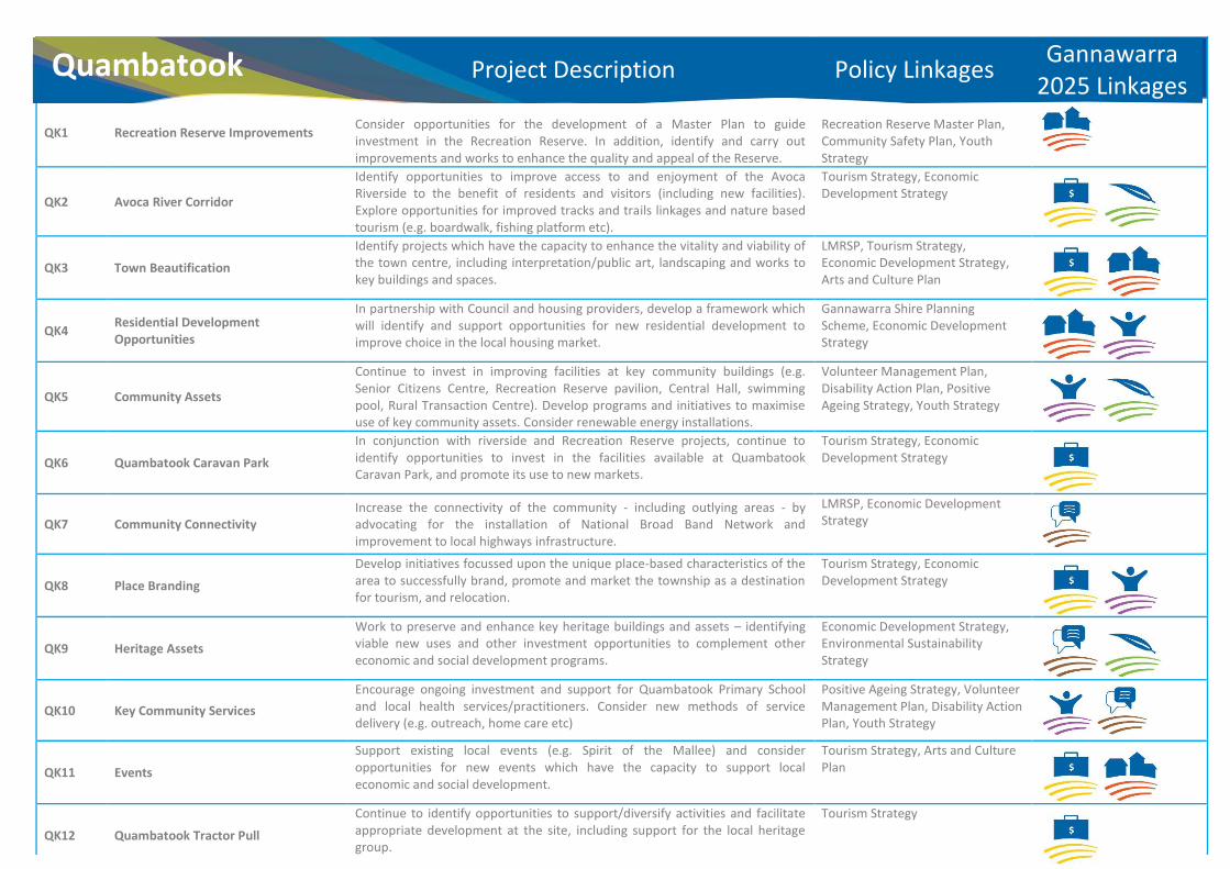
QK1 Recreation Reserve Improvements
Consider opportunities for the development of a Master Plan to guide investment in the Recreation Reserve. In addition, identify and carry out improvements and works to enhance the quality and appeal of the Reserve.
Recreation Reserve Master Plan, Community Safety Plan, Youth Strategy
QK2 Avoca River Corridor
Identify opportunities to improve access to and enjoyment of the Avoca Riverside to the benefit of residents and visitors (including new facilities). Explore opportunities for improved tracks and trails linkages and nature based tourism (e.g. boardwalk, fishing platform etc).
Tourism Strategy, Economic Development Strategy
QK3 Town Beautification Identify projects which have the capacity to enhance the vitality and viability of the town centre, including interpretation/public art, landscaping and works to key buildings and spaces.
LMRSP, Tourism Strategy, Economic Development Strategy, Arts and Culture Plan
QK4 Residential Development Opportunities
In partnership with Council and housing providers, develop a framework which will identify and support opportunities for new residential development to improve choice in the local housing market.
Gannawarra Shire Planning Scheme, Economic Development Strategy
QK5 Community Assets
Continue to invest in improving facilities at key community buildings (e.g. Senior Citizens Centre, Recreation Reserve pavilion, Central Hall, swimming pool, Rural Transaction Centre). Develop programs and initiatives to maximise use of key community assets. Consider renewable energy installations.
Volunteer Management Plan, Disability Action Plan, Positive Ageing Strategy, Youth Strategy
QK6 Quambatook Caravan Park
In conjunction with riverside and Recreation Reserve projects, continue to identify opportunities to invest in the facilities available at Quambatook Caravan Park, and promote its use to new markets.
Tourism Strategy, Economic Development Strategy
QK7 Community Connectivity Increase the connectivity of the community - including outlying areas - by advocating for the installation of National Broad Band Network and improvement to local highways infrastructure.
LMRSP, Economic Development Strategy
QK8 Place Branding
Develop initiatives focussed upon the unique place-based characteristics of the area to successfully brand, promote and market the township as a destination for tourism, and relocation.
Tourism Strategy, Economic Development Strategy
QK9 Heritage Assets Work to preserve and enhance key heritage buildings and assets – identifying viable new uses and other investment opportunities to complement other economic and social development programs.
Economic Development Strategy, Environmental Sustainability Strategy
QK10 Key Community Services Encourage ongoing investment and support for Quambatook Primary School and local health services/practitioners. Consider new methods of service delivery (e.g. outreach, home care etc)
Positive Ageing Strategy, Volunteer Management Plan, Disability Action Plan, Youth Strategy
QK11 Events
Support existing local events (e.g. Spirit of the Mallee) and consider opportunities for new events which have the capacity to support local economic and social development.
Tourism Strategy, Arts and Culture Plan
QK12 Quambatook Tractor Pull
Continue to identify opportunities to support/diversify activities and facilitate appropriate development at the site, including support for the local heritage group.
Tourism Strategy
Quambatook Project Description Policy Linkages Gannawarra 2025 Linkages

Quambatook
QK5QK5
QK10
QK5
QK5
QK2
QK1
QK12
QK9
QK3QK4
QK6QUAMBATOOK BOORT RD
Extent of Township
Area
Applicable Planning Controls
Community Planning Projects
Please note; for specific information relating to applicable planning controls please refer to Gannawarra Planning Scheme


Engagement and Management
Evaluation
Recommendations In adopting this Integrated Community Plan, Council has been mindful of the recommendations of the independent evaluation of the Shire community planning program conducted in 2011. It is recognised that closer integration between individual groups and better coordination of resources will assist in the sustained delivery of community priorities. Aligning the aspirations of the community with the strategic guidance provided in Council’s Planning Scheme will give confidence to those looking to develop community infrastructure and invest in key initiatives. Program Evaluation
The way in which this new Integrated Community Plan responds to the recommendations of the program evaluation is as follows:
1. Further develop guiding policy and procedures to support the overall functioning and roles of Community Planning Groups (CPGs) – this Plan draws together ten individual community plans to promote a coherent approach to activity across the Shire. The Plan is also complemented by a streamlined, simplified Community Grants Program which better responds to community issues.
2. Review the current CPG structures across the Shire to determine the best fit for each locality – this process has been completed, with many Community Planning Groups now successfully integrated with established local bodies (e.g. Progress Associations, Development Committees etc.)
3. Provide CPGs with training and resources to support community consultation and engagement techniques – Council will continue to identify and support training opportunities for groups, in this respect many groups have already participated in such events (i.e. Koondrook and Quambatook engagement in RDA ‘Transitioning Towns’ project).
4. Promote Community Planning and the CPG to the wider community – the activities of the community planning groups, or those bodies that host them (e.g. Progress Associations), are regularly celebrated through Council and community media releases and promotional activity. Details of community groups are contained in Council’s ‘Community Register’, which is available in hard copy or electronically.
5. Share timelines and regular progress updates for all long term projects to CPGs and the wider community – as part of the new management structure for the community planning program, Council will ensure that groups are supported by key officers and, where specific projects are under consideration, Council will coordinate the inputs of all relevant departments to ensure successful delivery.
6. Develop Community Planning decision-making processes that support both long and shorter timeframes for funding applications – to accompany this Plan, Council is launching a revised Community Grants Program, which will reduce the administrative and financial burden on participating community groups. The decision-making process will be streamlined and will also be transparent and accountable. It will be important for applicants to demonstrate the ability of their projects to meet the short and long term objectives identified in this Plan
7. Provide extra resources to CPGs to support the process of reviewing and writing Community Plans – Council has provided dedicated personnel resource to liaise with community groups and coordinate the production of this Plan. Council will identify the costs associated with the sustained delivery of the community planning program – and the benefits it will bring – in future budget and annual report documents.
8. Provide targeted support to the larger centres of Kerang and Cohuna to combat the challenges of conducting community planning activities in larger centres – Council has supported the establishment of the Kerang Progress Association in 2012, and engaged consultancy support to identify local priorities for action (which are presented in the Kerang Plan in this document. Council has also supported the Cohuna Progress Association in becoming the ‘host’ body for community planning – aiding the sustainable development of the program in Cohuna.
9. Celebrate Community Planning achievements – major achievements have been recognised and celebrated at local events and functions. Council has provided ‘good practice’ examples to RDA to inform the development of the ‘Transitioning Towns Toolbox’ – a directory of project ideas to help small towns across the Loddon Mallee region.
10. Recognise and celebrate the contribution of volunteers on the CPG – Council has collaborated in the production of a Volunteer Management Plan (2012), which recognises the support that volunteers require in order to contribute to improving community resilience. Council will continue to recognise, support and value the contribution of volunteers to community development initiatives.
11. Link the ten CPGs across Gannawarra Shire through shared training and a yearly shared event – Council has signalled its intent to achieve closer integration in the community planning program through the adoption of this Plan which, for the first time, aligns the strategic priorities of all local groups with each other and references state and regional policy frameworks. Council will support an annual Gannawarra Shire Community Planning Forum – which will be held for the first time in 2014.
12. Adopt and implement evaluation processes – this Plan provides the basis for the future review and development of the community planning program.
Moving Forward
From the above, it is apparent that significant progress has been made in responding to all recommendations of the 2011 independent evaluation of the community planning program. The production of this Integrated Community Plan and accompanying revisions to the Community Grants Program will help to embed important structural changes in the community planning program in the Shire. The following chapters identify the measures and processes that Council will implement in order to ensure sustained delivery of the program – and that it remains relevant and fully reflective of community priorities.

Engagement and Management
Program
Management To complement the production and adoption of this Plan – which signals a new direction for community planning in the Gannawarra Shire – Council will adopt new mechanisms for community engagement. The principles that will underpin the basis on which Council will engage with the community will reflect the core values identified in its 2013 – 2017 Council Plan:
x Collaborative – we recognise that we deliver better solutions in partnership.
x Flexible – we need to be agile enough to respond to the needs of our communities.
x Resourceful – we need to maximise the benefits of the funds and resources that we commit to development activity.
x Innovative – we need to be creative and enterprising in designing projects and initiatives.
Council will measure its success against these indicators, and those priorities identified in the Council Plan. The successful implementation of the Council Plan will represent another important step towards delivering the overarching Vision set out in Gannawarra 2025.
Fit for Purpose
In order to ‘shape up’ for the challenges of delivering the new community planning program (within its wider range of services), Council has adopted a new structure that will facilitate efficient program management. As of July 2013, Council has brought together the following functions under the ‘umbrella’ of its new Strategic Development Division:
• Community Sustainability
• Planning, Building and Environmental Health
• Economic Development
• Arts and Culture
This structure – along with established links to the Infrastructure Services and Community Wellbeing Divisions – will ensure that Council is able to provide a holistic and ‘joined up’ response to community development priorities. The Division brings together the requisite skills to take projects from inception through to implementation. The focus on strategic initiatives – as articulated in the Council Plan – will help communities to design and deliver significant project that will boost their vitality and viability.
Council will review and monitor its performance in the field of community development against identified indicators. This will ensure that the delivery of key priorities remains in focus – and that resources are deployed in an equitable and transparent manner.
Council’s Commitment
The Gannawarra Shire is committed to implementing a sustained program of support and capacity building within its communities. In this respect, the community planning program has been transitioned from a process that was wholly grant-dependent (via support from the Victorian State Government) to an area of ‘core activity’ for Council. The delivery of community planning objectives will be the responsibility of a number of Council Officers, with overall program management responsibility vested in the Executive Manager Strategic Development, with support from the Community Development Officer.
Council’s commitment to the community planning program is articulated as follows:
x Strategy – Council will develop and review its guiding plans and policies to ensure that they effectively link local priorities to regional frameworks, ensuring that our communities remain competitive and aligned to strategic initiatives.
x Resource – Council will provide a level of support to community planning groups proportionate to their need, and will deploy specialist resources as required to aid the development and delivery of specific projects.
x Accountability – Council will document its dealings with community planning groups to ensure that key actions are progressed and that decision-making processes are inclusive and transparent.
x Values – Council recognises and respect the different values, characteristics and make-up of our communities. At all times, officers will conduct themselves with respect for our community members and observe the principles outlined in Council’s Diversity Statement.
Council will endeavour to resource community planning groups and attend their meetings wherever possible. However, it is the ultimate aim of the program to develop community capacity to the extent that Council support and attendance is not always necessary as a precursor to progress. Accordingly, Council will work with groups to understand their particular developmental needs and allocate its resources accordingly.
Disclaimer
Whilst community planning is not a statutory function of Council – and it is not, therefore, obliged by legislation to run such a program – it does take its commitment to its communities very seriously. Council is committed to strengthening and deepening its partnership with its communities – however it must also be recognised that, on occasion, the aspirations of community members in connection with individual initiatives may not intersect with Council’s interests or values. In such circumstances, Council must reserve the right not to support or promote the initiative in question.
Under the circumstances described above, Council will clarify its position for the avoidance of doubt. Such clarification will be made in writing to the appropriate body/group, and will establish the reason(s) why Council is not able to support or promote the initiative at that time.


Review
Program
Review
This Plan has been produced and adopted in Spring 2013, following community consultation and strategy development which commenced in 2012. It incorporates and references priorities from other strategic plans, and it also reflects community aspirations at this point in time.
For the Plan to remain a relevant and useful tool, it must continue to reflect the aspirations of the community within the changing economic and social context of the day. With this in mind, Council is committed to supporting the periodic review of this Plan. This process will enable new and emerging priorities to be identified – and it will also help to track progress against the objectives set out in this initial version of the Plan.
This Plan is intended to guide community planning activity over the same period as the recently-adopted Council Plan – 2013 – 2017. In order to ensure its ongoing relevance, the following review program has been identified:
x December 2013 – Assess uptake from Community Grants Round One (October 2013), and carry out any necessary revisions to program terms, conditions and eligibility criteria prior to Round Two (March 2014)
x June 2014 – Evaluate progress in connection with projects supported in Rounds One and Two of the Community Grants Program. Publish full list of projects supported, along with update information.
x July 2014 – On the basis of previous year’s take-up, successful delivery and Council budget priorities, allocate funds for Rounds Three and Four of the Community Grants Program. (Note: this step will be replicated in July 2015 and 2016, with terms, conditions, eligibility and available funds reviewed as required).
x July 2014 – Commence formal consultation with all Community Planning Groups to establish the scope of revisions (if any) to the Integrated Community Plan.
x September 2014 – Report to Council on Year One progress in implementing the Plan, along with any recommendations for revisions. (Note: this step will be replicated in September 2015 and 2016).
x November 2014 – Following Review Reporting (September), adopt any revisions and circulate updated Plan. (Note: this step will be replicated in November 2015 and 2016, as required).
x March 2015 – Conduct Assessment of 2014 Planning Scheme Review, and note any revisions for incorporation in Integrated Community Plan (to be reported and incorporated in September and November 2015 – as per steps identified above).
x June 2015 – Hold first Gannawarra Shire Community Planning Forum to review and celebrate progress towards realisation of the Integrated Community Plan objectives.
x December 2015 – Commission independent evaluation of Community Planning Program, and report recommendations to Council and community at appropriate juncture.
x November 2016 – Commence formal review of Plan and draft new 2017 – 2021 Plan, to coincide with and reflect new Council Plan for the period.
x June 2017 – Hold second Gannawarra Shire Community Planning Forum to review and celebrate progress towards realisation of the Integrated Community Plan objectives.
x August 2017 – Adopt Integrated Community Plan 2017 – 2021, identifying new review program and milestones.
Addressing Future Strategies
In addition to the review process and program set out above, Council will be cognisant of any changes to existing policy – or any emerging strategic priorities – that will need to be reflected in the Integrated Community Plan.
Where new strategic or regional priorities/opportunities are identified, Council will liaise with the relevant agencies and all affected communities to ensure that the Plan is kept up to date and reflects new and emerging policy.
Emergency Planning
In the event of natural disaster – or any other event which requires an emergency planning response – Council will identify and adopt any necessary changes to its project management and review program for this Plan in consultation with the community, and with regard to the principles set out in the Municipal Emergency Management Plan and its sub-plans.

Review
This is our Integrated Community Plan.
It will help us to work better.
Our communities will be better connected.
Our energies will be better focused.
Our resources will be better directed.
Our people and places can look to a better future.
This is our Integrated Community Plan.
It will help us to work for the better.