texas coastal management program...onsite sewage facilities. pag. permitting assistance group. pcbs....
TRANSCRIPT
T E X A S C O A S TA L M A N A G E M E N T P R O G R A MB I E N N I A L R E P O R T
2013 - 2014
December 2014

CONTENTSList of Acronyms 1
Introduction 2
Program Goals 4
Program Map 5
Coordinating Partnerships 6
Highlights & Significant Events 8
Program Budget 10
Program Overview 11
Local Consistency Review 11
State Consistency Review 12
Federal Consistency Review 13
Permit Service Center 15
Texas Coastal Nonpoint Source Pollution Control Program 16
Program Changes 17
Grants 18
Funding Breakdown 18
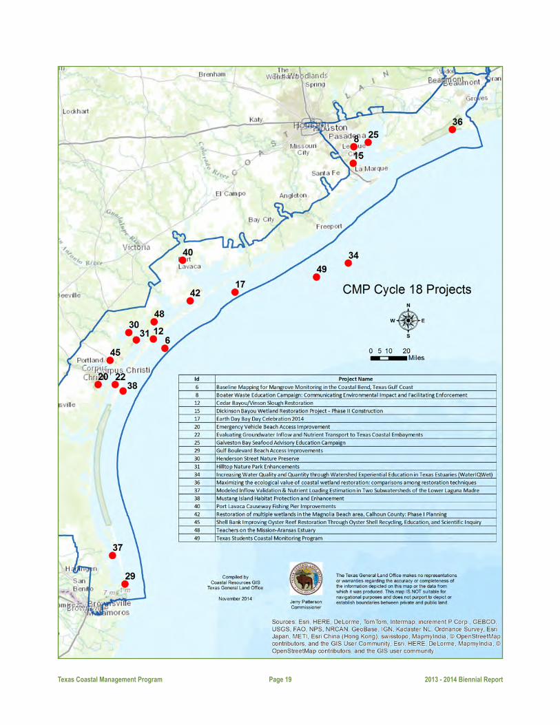
Cycle 18 Projects 19
Cycle 19 Projects 28
Performance Measures 39
Education and Outreach 58
Coastal Demographics 60

Texas Coastal Management Program Page 1 2013 - 2014 Biennial Report
ABNCArmand Bayou Nature Center
BEGThe University of Texas
Bureau of Economic Geology
CBBFCoastal Bend Bays Foundation
CCACoastal Coordination Act
CCACCoastal Coordination Advisory
Committee
CELCPCoastal and Estuarine Land
Conservation Program
CITsCoastal Issue Teams
CMPTexas Coastal Management
Program
CMSPCoastal and Marine Spatial
Planning
CNRAsCoastal Natural Resource Areas
CorpsU.S. Army Corps of Engineers
CouncilCoastal Coordination Council
CZMACoastal Zone Management Act
CZMPCoastal Zone Management Program
CZMAPMSCoastal Zone Management Act
Performance Measurement System
FYFiscal Year
GBFGalveston Bay Foundation
GLOTexas General Land Office
JPAFJoint Permit Application Form
Land Commissioner Texas Land Commissioner
NDZ No Discharge Zone
NERRSNational Estuarine Research
Reserve System
NOAANational Oceanic and Atmospheric
Administration
NPSNonpoint Source
OBATexas Open Beaches Act
OCRMOffice of Ocean and Coastal
Resource Management
OSSFsOnsite Sewage Facilities
PAGPermitting Assistance Group
PCBsPolychlorinated Biphenyls
PSCPermit Service Center
PSMProjects of Special Merit
SACTexas Sunset Advisory Commission
SSCNSpanish & Science Club Network
TACTechnical Advisory Committee
TAMUCCTexas A&M University
-Corpus Christi
TCEQTexas Commission onEnvironmental Quality
TSSWCBTexas State Soil and Water
Conservation Board
USFWSU.S. Fish and Wildlife Service
ACRONYMS

Texas Coastal Management Program Page 2 2013 - 2014 Biennial Report
The Texas coast and adjoining waters support a wealth of economic activities, such as maritime transportation,
oil and gas drilling, commercial fisheries, the development of offshore and renewable energy, and recreational
boating, bird watching and fishing. As a powerful economic engine and an invaluable environmental treasure, the
Texas coast is vital for the success of the state and nation. But our shores face challenges from storms, land loss,
population growth and a number of other forces.
Coastal Zone Management ProgramIn 1972, the U.S. Congress passed the Coastal Zone Management Act (CZMA), which established the federal
Coastal Zone Management Program (CZMP). The CZMP is a federal-state partnership that provides a basis for
protecting, restoring and responsibly developing the nation’s diverse coastal communities and resources.
Coastal Coordination Act In 1991, the Texas Legislature passed the Coastal Coordination Act (CCA). This addressed the need for a unified and
comprehensive approach to the management of coastal natural resources and other complex coastal issues. The
CCA called for the development of a program based on previously existing statutes and regulations and directed
the Texas General Land Office (GLO) to develop a long-range, comprehensive plan for managing coastal natural
resource areas (CNRAs) in cooperation with federal and state agencies, local governments and coastal citizens.
The CCA also (1) set the boundaries of the state’s coastal zone to include all or part of 18 coastal counties and
more than 8 million acres of land and water; (2) established the framework for a federally approved coastal
management program; and (3) created the Coastal Coordination Council (Council) to establish rules for certification
of consistency with the goals and policies of the CMP, and to approve CMP funded projects.
In 2010, the Council underwent review by the Texas Sunset Advisory Commission (SAC). The SAC determined that
while the state benefits from maintaining a federally approved Coastal Management Program, the Council was no
longer needed to administer it. In response to the SAC review, the 82nd Texas Legislature passed, and the Governor
signed into law, a bill which abolished the Council and transferred duties to the Texas Land Commissioner (Land
Commissioner). This authorized the Land Commissioner to make consistency determinations as required by federal
law. The bill also required the Land Commissioner to establish a Coastal Coordination Advisory Committee (CCAC)
with representatives from the networked agencies and public members appointed by the Land Commissioner.
Texas Coastal Management ProgramThe Texas Coastal Management Program (CMP) was finalized in 1997 and accepted into the CZMP by the National
Oceanic and Atmospheric Administration (NOAA). The CMP is a networked program that links existing regulations,
programs and local, state and federal entities that manage various aspects of coastal resource use. The CMP’s
mission is to improve the management of the state’s CNRAs designated to be of particular concern to the state and
INTRODUCTION

Texas Coastal Management Program Page 3 2013 - 2014 Biennial Report
ensure the long-term ecological and economic productivity of the Texas coast.
Coastal Coordination Advisory CommitteeThe Coastal Coordination Advisory Committee (CCAC) is comprised of eight members representing state agencies
and four members representing local government and citizens. The state agencies represented include: the Texas
General Land Office, Railroad Commission of Texas, Texas Department of Transportation, Texas Commission on
Environmental Quality, Texas Parks and Wildlife Department, Texas State Soil and Water Conservation Board, Texas
Water Development Board and the Texas A&M Sea Grant College Program. The Land Commissioner-appointed
citizen members represent agriculture, coastal businesses, coastal governments and coastal residents.
In addition to the CCAC members who advise the Land Commissioner on consistency issues when they arise,
the Coastal Issue Teams (CITs) were formed to meet on selected subject matter as cross-agency issues arise. CIT
members coordinate on issues related to: (1) water quality; (2) CMP grants; (3) CMP coastal long-term planning;
and (4) regulatory/permitting. The water quality-CIT is working toward approval of the non-point source program
and currently is focusing on several of the four remaining non-point source conditions pending NOAA approval.
The CMP grants CIT continues to provide comments on grant pre-proposals and reviews and scores final grant
applications for each grant cycle. The coastal long-term planning CIT members participated in the Resource
Management Code (RMC) update and GIS decision support tool development as members of the Data Standards
Committee. The regulatory/permitting CIT focuses on federal consistency issues and information exchange on
consistency reviews. The CCAC will continue to handle elevated coastal issues that concern multiple CITs and
consistency issues that may arise, however, no meetings have been held. The CCAC secretary sends an update to
members quarterly.
Coastal Coordination Advisory Committee
Commissioner-appointed committee members include a coastal resident representative,coastal business representative, agriculture representative and a local elected official.

Texas Coastal Management Program Page 4 2013 - 2014 Biennial Report
Texas Coastal Management Program Goalsu to protect, preserve, restore and enhance the diversity, quality, quantity, functions and values of coastal
natural resource areas;
u to ensure sound management of all coastal resources by allowing for compatible economic development and multiple human uses of the coastal zone;
u to minimize loss of human life and property due to the impairment and loss of protective features of coastal natural resource areas;
u to ensure and enhance planned public access to and enjoyment of the coastal zone in a manner that is compatible with private property rights and other uses of the coastal zone;
u to balance the benefits from economic development and multiple human uses of the coastal zone; the benefits from protecting, preserving, restoring and enhancing coastal natural resource areas; the benefits from minimizing loss of human life and property; and the benefits from public access to and enjoyment of
the coastal zone;
u to coordinate agency and subdivision decision-making affecting coastal natural resource areas by establishing clear, objective policies for the management of coastal natural resource areas;
u to make agency and subdivision decision-making affecting coastal natural resource areas efficient by identifying and addressing duplication and conflicts among local, state and federal regulatory and other
programs for the management of coastal natural resource areas;
u to make agency and subdivision decision-making affecting coastal natural resource areas more effective by employing the most comprehensive, accurate and reliable information and scientific data available and by developing, distributing for public comment, and maintaining a coordinated, publicly accessible geographic information system of maps of the coastal zone and coastal natural resource areas at the earliest possible
date;
u to make coastal management processes visible, coherent, accessible and accountable to the people of Texas by providing for public participation in the ongoing development and implementation of the Texas CMP;
and
u to educate the public about the principal coastal problems of state concern and technology available for the protection and improved management of coastal natural resource areas.
PROGRAM GOALS

PROGRAM MAP
Texas Coastal Management Program Page 5 2013 - 2014 Biennial Report

The CMP serves as an umbrella for the management of coastal resources along the Texas coast. Through network-
ing with the state natural resource agencies and other entities, effective protection, restoration and enhancement
of CNRAs can be accomplished. Below are examples of CMP partnerships with other programs throughout the
Texas coastal zone.
Coastal Impact Assistance ProgramThe Energy Policy Act of 2005 authorized the Coastal Impact Assistance Program (CIAP), which is administered
by the U.S. Fish and Wildlife Service and the GLO. CIAP is funded with $109,269,690 of federal royalties from
offshore oil and gas leases to assist states that have either supported or been impacted by oil and gas exploration
and development along the Outer Continental Shelf (OCS). CIAP funds are used for projects and activities for the
conservation, protection or restoration of coastal areas, including wetlands; mitigation of damage to fish, wildlife
or natural resources; planning assistance and administrative costs; implementation of a federally approved marine,
coastal or comprehensive conservation management plan; and mitigation of the impact of OCS activities through
funding of onshore infrastructure project and public service needs.
Coastal Erosion Planning and Response Act ProgramIn 1999, the Texas Legislature established the Coastal Erosion Planning and Response Act (CEPRA) program to
reduce and minimize erosion impacts to public beaches and dunes, wetlands, the Gulf Intracoastal Waterway,
homes, businesses and public infrastructure, thereby protecting the state’s natural resources and economic future.
As a cost-sharing program, CEPRA provides funding to leverage federal, state, local and private resources. The
CEPRA program contributes up to 75 percent of the funding for Texas beach nourishment and dune restoration
projects, and 60 percent for wetland and
habitat restoration projects, shoreline
protection projects and erosion studies.
Beach and Dune ProgramThe Beach and Dune Protection Program
enforces the Open Beaches Act, Dune
Protection Act and related administrative
rules to ensure protection of CNRAs and
accessibility for all beach users.
Texas BeachWatch ProgramThe Texas BeachWatch Program is funded
by the U.S. Environmental Protection
Agency (EPA) to monitor water quality at
COORDINATINGPARTNERSHIPS
Texas Coastal Management Program Page 6 2013 - 2014 Biennial Report
Texas Coastal Management Program Page 7 2013 - 2014 Biennial Report
Texas recreational beaches. Results of water sampling and advisories are posted on the Texas BeachWatch website
at www.TexasBeachWatch.com.
Texas Coastal Ocean Observation NetworkIn partnership with the U.S. Army Corps of Engineers (USACE) and the Texas Water Development Board (TWDB),
the GLO contracts with Texas A&M University–Corpus Christi to maintain and operate a state-of-the-art electronic
water level monitoring network. The information collected assists coastal communities in preparing for hurricanes
and tropical storms, and assists the GLO in determining state-owned lands and for modeling tides and currents
during oil spills.
Gulf of Mexico Energy Security Act Program To enhance the OCS oil and gas leasing activities and revenue sharing in the Gulf of Mexico, the Gulf of Mexico
Energy Security Act (GOMESA) was signed into law in 2006. Alabama, Louisiana, Mississippi and Texas share
lease revenues for coastal restoration and conservation projects, as well as for hurricane protection. The GLO
administers the Texas funds for projects along the Texas coast.
One example of a large partnership success story is the Cedar Bayou/Vinson Slough Restoration project. This
project was a partnership with the Texas Parks and Wildlife Department, Coastal Conservation Association and
Aransas County to straighten Cedar Bayou and connect it with a channel from Vinson Slough near the beach of
San Jose Island. This project re-establishes the hydraulic connection between the Gulf of Mexico and the Aransas/
Mesquite bay system and the life-cycle migration route for a variety of marine species as well as the tidal flow to
thousands of acres of tidal wetlands adjacent to Cedar Bayou and Vinson Slough.
Interagency Coordination TeamsThe Interagency Coordination Team (ICT) concept was originally developed by USACE in the early 1990s as part of
the Houston-Galveston Navigation Channel (HGNC) Expansion Project which involved deepening and widening
the Houston Ship Channel and finding beneficial uses for the dredged material. The HGNC ICT, which consisted of
state and federal resources agencies and the Port of Houston Authority, was created to address key environmental
issues and concerns associated with the project. Other non-governmental organizations such as the Galveston
Bay Foundation and special interests including local residents, commercial fishermen and recreational boaters
participated in ICT meetings by providing advice and feedback. In order to find solutions to key issues associated
with the HGNC Project, the ICT formed several subcommittees, composed of ICT members with scientific
expertise in different environmental disciplines. Subcommittees include the Beneficial Uses Group (BUG), Oyster
Committee, Cumulative Impacts Group and Benthic Recovery Group, among others. The BUG continues to meet
as needed to monitor the progress of marsh restoration sites created from material dredged from the navigation
project.
The success of the HGNC ICT led USACE to form additional ICTs for other large and potentially controversial
projects such as: the Gulf Intracoastal Waterway (GIWW) Laguna Madre maintenance dredging; GIWW
Welder Flats-Aransas National Wildlife Refuge whooping crane habitat protection; Corpus Christi Ship Channel
Improvement Project; Sabine-Neches Waterway Improvement Project; and Sabine Pass to San Luis Pass Shoreline
Erosion Project.

CMP 312 ReviewIn 2014, the CMP underwent the periodic NOAA Section 312 review that covered the period from 2007 through
2014 and involved reviews of the program, successes, challenges and future planning efforts. The review involved
several meetings held through Web-based interviews with coastal partners, face-to-face meetings, and a public
meeting in Corpus Christi. The GLO is waiting for the final findings document from NOAA. Preliminary conversations
with NOAA have been positive regarding the review.
CMP Rule RevisionsGLO staff members have made significant progress revising and updating the CMP rules and procedures in Title
31 of the Texas Administrative Code (TAC), Chapters 501-506, to reflect the abolition of the Coastal Coordination
Council and transfer of Council functions to the GLO and the Land Commissioner. Draft rule changes to 31 TAC
Chapters 501-505 have been circulated within the agency for review and discussion, and the draft rule changes
were further reviewed in the summer of 2014 and discussed by members of the CCAC. The GLO published the
proposed rule changes to Chapters 501-505 for public review and comment in the Texas Register. GLO staff
members continue to work on proposed revisions to the federal consistency procedures in 31 TAC Chapter 506,
and plan to complete draft rule changes to Chapter 506 over the course of the next year in consultation with
NOAA.
83rd Legislature (2013)HB 3459, relating to access to and protection of certain coastal areas, established provisions governing the
determination of the boundaries of public beaches and the enforcement of the law governing access to them.
This bill amended the OBA to allow the Land Commissioner by order to suspend action on conducting a line of
vegetation determination for a period of up to three years from the date the order is issued if the Land Commissioner
determines that the line of vegetation was obliterated as a result of a meteorological event. During the moratorium,
the landward boundary of the public beach will be set at 200 feet from mean low tide. Following the expiration of
the moratorium, the Land Commissioner will determine the location of the line of vegetation, taking into account
any effect of the storm on the line of vegetation, and may consult with the Bureau of Economic Geology of the
University of Texas and consider other factors regarding the natural erosion rate for the affected area when making
the line of vegetation determination. HB 3459 also clarified that the line of vegetation for an area of public beach
in which there is no clearly marked line of vegetation is dynamic and may move landward or seaward due to the
forces of erosion or natural accretion. Finally, the bill added to the list of artificial changes to natural vegetation
that do not affect the line of vegetation of a public beach.
HB 2623, relating to the authority of certain counties and the GLO to temporarily close a beach or beach access
point, established health and safety provisions for beaches in proximity to a space launch site. The bill applies
only to a county bordering on the Gulf of Mexico or its tidewater limits that contains a launch site approved by the
Federal Aviation Administration. HB 2623 amended the OBA to grant the GLO the authority to allow the county
Texas Coastal Management Program Page 8 2013 - 2014 Biennial Report
HIGHLIGHTS &SIGNIFICANT EVENTS

Texas Coastal Management Program Page 9 2013 - 2014 Biennial Report
commissioners court to close a beach and beach access points during space flight activities to protect public health
and safety. The legislation requires GLO approval before the county commissioners court may close a beach or
beach access point on a primary launch date that falls on certain holidays or weekends.
HB 1044, relating to the operation of all-terrain vehicles and recreational off-highway vehicles, established
provisions governing the operation of such vehicles on public and private beaches along the seaward shore of the
Gulf of Mexico. This bill amended the OBA and certain sections of the Transportation Code to authorize the use of
an all-terrain vehicle, commonly referred to as an “ATV” or “four wheeler,” or a recreational off-highway vehicle,
commonly referred to as “utility type vehicles” or “UTVs,” if the vehicle is registered and the operator possesses
the proper license. The legislation also authorizes the Texas Department of Transportation (TxDOT) or a county
or municipality to prohibit the operation of an all-terrain vehicle on a beach if TxDOT or the governing body
determines that the prohibition is necessary in the interest of safety.
HB 622, relating to the report by the GLO to the Legislature on the effectiveness of the CMP, amended the Coastal
Coordination Act to change the annual report that was required to be submitted to the Legislature to a biennial
report.
Upcoming: 84th Legislature (2015)The 84th session of the Texas Legislature will begin on January 13, 2015. At this time, the GLO is not anticipating
any significant legislation relating to the OBA, DPA, or Coastal Coordination Act.
Government Accountability Office ReviewA fiscal year 2013 congressional appropriations committee report mandated the Government Accountability
Office (GAO) to review NOAA’s implementation of the CZMA. The review examined (1) how states allocated
CZMP funds awarded in fiscal years 2008 through 2013 and (2) how NOAA’s primary performance assessment
tools have changed since the GAO’s 2008 report and the extent to which NOAA uses performance information
in managing the CZMP. The GAO reviewed laws,
guidance and performance-related reports; analyzed
CZMP funding data for fiscal years 2008-2013; and
interviewed NOAA officials and a sample of officials
from seven states selected for receiving the most
fiscal year 2012 funding in each of NOAA’s regions.
Texas was one of the states visited. GLO staff took
GAO staff to visit successful projects along the Texas
coast. The GAO was very impressed and appreciative
of GLO efforts.
The GLO continues to work on making changes
to the Texas Administrative Code (TAC) to reflect
the abolition of the Coastal Coordination Advisory
Council. The GLO staff is writing the new language
that needs to be incorporated and has looked at how
other states have crafted their administrative rules.

Each year, the GLO receives approximately $2.5 million under the CZMA to implement the state’s coastal program.
The CZMA provides funding for three programs: the coastal resource improvement program (§306/§306A), the
program enhancement program (§309), and the state’s coastal nonpoint source pollution (NPS) control program
(§310). The state is required to match the §306/§306A and §310 funds at a 1:1 ratio; however, a match is not
required for §309.
The state received $2,327,500 of §306/306A and §309 funding from NOAA in FY 2013 and $2,512,000 in FY
2014 to administer the CMP. Approximately 90 percent ($3,347,513) of the §306/§306A funding ($3,868,500)
was awarded to eligible entities for coastal projects through a competitive grant process. Grant subrecipients were
required to match 50 percent of the amount requested; however, the state provided 10 percent of that match to
lower the subrecipient match to 40 percent. The state retained approximately 10 percent ($520,987) for program
administration, matching this amount with salaries, fringe benefits and indirect costs.
PROGRAM BUDGET
Texas Coastal Management Program Page 10 2013 - 2014 Biennial Report
FY 2013 §306/§306A State Subrecipients Total
Federal Amount Awarded $250,127 $1,626,373 $1,876,500
State/Subrecipient Match $610,089 $1,266,411 $1,876,500
Subtotal $860,216 $2,892,784 $3,753,000
Federal Amount Awarded $451,000 $0 $451,000
§309 State Subrecipients Total
FY 2014 §306/§306A State Subrecipients Total
Federal Amount Awarded $270,860 $1,721,140 $1,992,000
State/Subrecipient Match $693,692 $1,298,308 $1,992,000
Subtotal $964,552 $3,019,448 $3,984,000
Federal Amount Awarded $520,000 $0 $520,000
§309 State Subrecipients Total

The CZMA provides for states to operate their coastal management
programs through a single permitting agency or by coordinating
existing regulatory authorities through a networked program. Tex-
as chose to combine existing regulatory authorities and build on
the strength of those authorities utilizing the networked program
approach.
CMP is intended to make coastal decision-making processes more
effective and efficient. Each networked agency ensures its proposed
actions that may adversely affect CNRAs are consistent with the
goals and policies of the CMP, through the exercise of statutory au-
thorities. The CCA requires networked agencies and subdivisions
to comply with a uniform set of program goals and policies when
conducting activities in the coastal zone.
Consistency Review The consistency review process ensures the actions of state and fed-
eral agencies and limited local government actions are consistent
with the goals and policies of the CMP. Three consistency review
components exist in the CMP: local consistency, state consistency
and federal consistency.
Local Consistency Review The issuance of dune protection permits and beachfront construc-
tion certificates are the only local government actions that may
adversely affect CNRAs. Local government beach/dune permitting
authorities that have certified or conditionally certified dune pro-
tection and beach access plans are responsible for issuing dune
protection permits and beachfront construction certificates for con-
struction activities in the beach/dune system.
The Land Office reviews all dune protection permits and beachfront
construction certificate applications to ensure compliance with the
Texas Open Beaches Act, Dune Protection Act, and the GLO Beach
Access and Dune Protection Rules. Permitted construction activities
must be consistent with the goals and policies of the CMP. For dune
PROGRAM OVERVIEW
Texas Coastal Management Program Page 11 2013 - 2014 Biennial Report

protection permits, local governments must certify that the proposed activity will not materially weaken any dune,
materially damage any dune vegetation, or reduce the effectiveness of any dune as a means of protection against
erosion and high wind and water. For beachfront construction certificates, local governments must certify that the
proposed activity is consistent with the beach access portion of the approved dune protection and beach access
plan and determine that the activity does not interfere with or otherwise restrict the public’s right to have access to
and from the gulf beach.
The GLO reviewed 418 permits in FY 2013 and 411 permits in FY 2014.
State Consistency Review The CMP provides interagency coordination on significant policy issues and major coastal development projects,
allowing the networked agencies to manage their own programs on a day-to-day basis. Certification of an agency’s
rules is the primary tool for ensuring a networked agency’s rules governing actions subject to the CMP are consis-
tent with the program. Because an agency must comply with its own rules, incorporating the goals and policies
into agency rules helps ensure the agency will exercise its networked authorities consistent with the CMP. If an
agency’s rules are consistent, then its activities should be consistent.
Once an agency’s rules are certified, the agency can adopt consistency review thresholds limiting the CMP’s au-
thority to review its actions. The agencies are responsible for enforcing the provisions of the CMP and are autho-
rized to enforce the permits or authorizations issued.
Networked agencies are those with activities or rules that affect or protect CNRAs. The affected state agencies
include the GLO, the Public Utility Commission of Texas (PUC), the Texas Historical Commission (THC), the Texas
State Soil and Water Conservation Board (TSSWCB), the Railroad Commission of Texas (RRC), the Texas Com-
mission on Environmental Quality (TCEQ),
the Texas Department of Transportation (Tx-
DOT), and the Texas Parks and Wildlife De-
partment (TPWD).
During FY 2013 and FY 2014, the GLO re-
ceived quarterly reports from the networked
state agencies for permitting actions,
rulemakings and enforcement actions.
FY 2013 In FY 2013, the reporting state agencies re-
ceived 1,864 permitting applications. 1,049
were approved without conditions, and 250
were approved with conditions during this
time period. The state agencies submitted
and adopted 18 rulemakings. In addition,
the state agencies reported undertaking 590
enforcement actions.
Texas Coastal Management Program Page 12 2013 - 2014 Biennial Report

Texas Coastal Management Program Page 13 2013 - 2014 Biennial Report
FY 2014During FY 2014, the GLO received quarterly reports from the networked state agencies for permitting actions,
rulemakings and enforcement actions. The reporting state agencies received 2,297 permitting applications of
which 1,765 were approved without conditions, and 99 were approved with conditions. The state agencies sub-
mitted and adopted 20 rulemakings. In addition, the state agencies reported undertaking 427 enforcement actions.
Federal Consistency Review Approval of the CMP gave Texas the authority to review proposed federal actions and activities that are located in
or may affect land and water resources in the Texas coastal zone. This process, called federal consistency review,
ensures the state’s interest is fairly represented and allows the state the opportunity to provide input into policies,
procedures, or actions and activities that may affect the management of coastal areas, including:
u Projects requiring a federal license or permit, u Direct activities proposed by federal agencies, and u Federal financial assistance to state and local governments.
Federal actions and activities within or outside the Texas coastal zone that affect CNRAs must be consistent with
enforceable policies of the CMP to the maximum extent practicable. If the state finds a given action or activity to
be inconsistent, with a few exceptions the action cannot be undertaken.
Federal actions and activities are evaluated for potential impacts to CNRAs. During FY 2013 and FY 2014, all of
the proposed federal agency actions, activities or financial assistance projects reviewed by staff and considered by
the Land Commissioner were deemed consistent with CMP goals and policies.
Through the consistency and regulatory permitting Coastal Issue Team (CIT), calls were held on the application of
Revesser, LLC, for a U.S. Army Corps of Engineers (USACE) Section 10 Rivers and Harbors Act permit (SWG-2005-
00552) for a canal subdivision on Mustang Island, submitted in January 2014. The CIT had concerns regarding the
project, which resulted in three Coastal Coordination Advisory Committee (CCAC) members referring this project
to the Land Commissioner for further consistency review and a final consistency determination. A hearing for the
consistency review was set for June 10, 2014. However, approximately one week before the hearing, the USACE
determined that additional wetlands existed at the site and that the project would have to be reevaluated under
Section 404 of the Clean Water Act. The USACE suspended review of the project pending additional information
from the applicant. The applicant withdrew its CMP consistency statement and the hearing was canceled.
The public is encouraged to participate in the consistency review process using the Texas Register notification sys-
tem and through the GLO’s Internet site at http://www.glo.texas.gov/GLO/public-notices/index.html.
Federal Agency ActionsA federal agency action is a federal license or permit issued by a federal agency that represents the proposed fed-
eral authorization, approval or certification needed by the applicant to begin an action. For example, a USACE
permit for construction of a pier or boat dock is considered a federal action. During federal FY 2013 (October 2012
- September 2013), the GLO reviewed a total of 253 actions requiring a federal license or permit. During federal FY
2014 (October 2013 - September 2014), a total of 294 actions requiring a federal license or permit were reviewed.

Texas Coastal Management Program Page 14 2013 - 2014 Biennial Report
Federal Agency Activities and Development ProjectsA federal agency activity is a function performed by or for a federal agency in exercise of its statutory responsibility.
This includes the planning, construction, modification, or removal of a public work, facility, or any other structure,
and the acquisition, use or disposal of land or water resources. For example, maintenance dredging of a navigation
channel or changes in federal permitting processes are considered federal activities. The GLO reviewed 14 federal
activities for consistency during FY 2013 and four federal activities for consistency during FY 2014.
Federal Funding AssistanceFinancial assistance projects are state or local projects that receive federal funding in the form of grants, contractual
agreements or loans. For example, a request for funding for a flood control project is considered a request for finan-
cial assistance. Federal agencies may not grant federal assistance until the state CMP concurs. The GLO reviewed
285 financial assistance projects in FY 2013 and 649 financial assistance projects in FY 2014.
Permitting AssistancePermit Service Center (PSC) staff, along with state and federal resource agency representatives, routinely attend
monthly Joint Evaluation Meetings (JEMs) sponsored by the USACE. These meetings are designed to provide guid-
ance to applicants on CMP policies and agency permitting requirements.
Permitting Assistance Group The Permitting Assistance Group (PAG) was formed to: identify and address permitting obstacles; encourage inter-
agency cooperation; offer the public a one-stop-shop for project-specific advice while navigating the permit appli-
cation process; and serve as a liaison to the CCAC on permitting issues. The PAG is comprised of CCAC members
and representatives of federal and state agencies that participate in the permitting process as applicants, permitting
entities or commenters.
The PAG did not meet in FY 2013 or 2014. Follow-
ing the abolition of the Council and transfer of its
functions to the Land Commissioner, the regulatory
and permitting Coastal Issue Team met and deemed
that no changes should be made. It should continue
to address requests for preliminary consistency de-
terminations. However, a regulatory work group was
established and has met as needed to discuss various
issues, such as jurisdictional issues, CMP determina-
tions for larger projects that are structures only (no
fill), etc.
Joint Permit Application Form Overlapping jurisdiction between the USACE and
state agencies resulted in redundancies that created
a complicated application process for common proj-
ects, such as residential piers or placement of fill ma-
terial to construct a building. To mediate the prob-

Texas Coastal Management Program Page 15 2013 - 2014 Biennial Report
lem, Joint Permit Application Forms (JPAFs) were created
to obtain permits/authorizations from multiple agencies.
JPAFs reduce confusion among applicants regarding what
permits are necessary for a project, speed the permitting
process by serving as a clearinghouse for coastal permit-
ting activities, and simplify the process by providing a
consolidated permit application to be simultaneously
distributed to the authorizing agencies complete.
Permit Service Center Permit Service Center (PSC) staff, acting as the point of
contact for the Individual and Small Business Permitting
Assistance Program, assists applicants in submitting ad-
ministratively complete applications and improves the
efficiency of the permitting process by troubleshooting
applications before submission to the regulatory agen-
cies. This has allowed permitting authorities to reduce processing time and ensure more efficient review of permits.
The number of JPAFs can be attributed to the continuation and expansion of the Structure Registration/General
Permit (SR/GP) agreement between the USACE Regulatory Branch and the GLO’s Professional Services Division.
During the FY 2013 reporting period, the PSC assisted with 151 JPAFs and 127 JPFAs in FY 2014. The processing time
per application averaged 2.5 days and included logging information, reviewing the application for completeness,
and forwarding it to the appropriate state/federal agency for formal permit evaluation. The processing time per
application has been reduced from previous years.
FY 2013 and 2014
JPAFs Received(by Quarter)
Quarter FY 2013 FY 2014
1 35 21
2 33 36
3 36 30
4 47 40
Total 151 127
Permit Service Center Locations and Contact Information
Permit Service Center (Upper Coast)
Texas A&M University-Galveston
Powell MERC Bldg., 3027, Suite 135
P.O. Box 1675
Galveston, TX 77553-1675
Toll-free: (866) 894-7664
Phone: (409) 741-4057
Fax : (409) 741-4010
Permit Service Center (Lower Coast)
Texas A&M University-Corpus Christi
6300 Ocean Drive, TAMU-CC
Carlos F. Truan Natural Resources Center, Ste 2800
Corpus Christi, TX 78412-5848
Toll-free: (866) 894-3578
Phone: (361) 825-3050
Fax: (361) 825-3040

Texas Coastal Management Program Page 16 2013 - 2014 Biennial Report
Texas Coastal Nonpoint Source Pollution Control ProgramThe Texas Coastal Nonpoint Source Pollution Control Program is required as part of having a federally approved
Coastal Management Program. The purpose of the program is to identify sources of coastal nonpoint source (NPS)
pollution and develop recommendations for preventing it. The program was conditionally approved by the NOAA
and EPA, as four outstanding management measures remain to be approved.
These management measures are: u New and on-site development; u Watershed protection and existing development; u New and operating onsite disposal systems; and u Roads, highways, and bridges
The Coastal Management Program and networked water quality agencies continue working to achieve full
implementation and approval of the program with existing resources, though federal funding for this program
has not been made available. In 2013, a grant project was awarded through the Coastal Management Program’s
Coastal Impact Assistance Program to the University of Texas at Austin’s Center for Research in Water Resources to
facilitate effective implementation of coastal stormwater best management practices (BMP) for off-system roadways
and urban development. A BMP technical guidance document was developed and implementation outreach, such
as stakeholder training and planning assistance, was provided.
The project identified jurisdictions responsible for managing coastal roadways and urban stormwater systems,
conducted outreach targeting the identified coastal jurisdictions, developed an inventory of existing management
practices and watershed characteristics, and provided technical guidance, training and planning assistance to
these jurisdictions. The project is in its final phase and will be completed by June 2015. Further information and
the stormwater BMP guidance document can be found on the project website at txcoastalbmp.org.

Texas Coastal Management Program Page 17 2013 - 2014 Biennial Report
Staff is meeting regularly with the water quality CIT
to move forward on the “new and operating onsite
disposal system” condition. A draft scope of work to
identify all septic systems along the coast and to be-
gin prioritizing inspections was submitted to the EPA
and NOAA for an informal review as an effort to begin
working more closely on this initiative.
Program ChangesOn December 6, 2013, the GLO formally submitted
routine program changes to NOAA’s Office of Ocean
and Coastal Resource Management (OCRM) that in-
cluded particular statutory and rule revisions enacted
and adopted during the period of January 1, 1997 –
December 31, 2011. Concurrent with notifying and
submitting the routine program changes to OCRM, the
GLO provided notice of the submittal to the general
public and affected parties (including local govern-
ments, state agencies and federal agencies) by posting
a public notice on the GLO’s website, emailing stake-
holders and publishing a public notice in the December 6, 2013, issue of the Texas Register. All public notices in-
cluded the program change document or referenced its location on the GLO’s website at http://www.glo.texas.gov/
what-we-do/caring-for-the-coast/grants-funding/cmp/ to allow agencies, stakeholders and members of the public
to review the changes and provide comments.
On January 27, 2014, the OCRM formally concurred with the GLO’s routine program changes determination and
approved the incorporation of particular changes as enforceable and non-enforceable policies of the CMP. OCRM
also recognized the incorporation of changes to various statutes that the GLO included in the program change doc-
ument. A comprehensive list of the approved program changes, which was an enclosure to OCRM’s concurrence
letter, was published with the public notice of OCRM’s approval in the March 7, 2014 issue of the Texas Register.
The notice of OCRM’s approval and enclosure to its concurrence letter was also posted to the GLO’s website.

Texas Coastal Management Program Page 18 2013 - 2014 Biennial Report
GRANTS
Funding Breakdown County Cycle 18/FY13 Cycle 19/FY14 Total
Aransas $248,804.00 $94,924.00 $343,728.00
Brazoria $0 $0 $0
Calhoun $117,630.00 $0 $117,630.00
Cameron $398,440.00 $627,385.00 $1,025,825.00
Chambers $0 $0 $0
Galveston $268,330.00 $182,946.00 $451,276.00
Harris $0 $225,148.00 $225,148.00
Jackson $0 $0 $0
Jefferson $0 $0 $0
Kenedy $0 $0 $0
Kleberg $0 $76,801.00 $76,801.00
Matagorda $0 $0 $0
Nueces $257,678.00 $198,483.00 $456,161.00
Orange $0 $0 $0
Refugio $0 $0 $0
San Patricio $0 $0 $0
Victoria $0 $0 $0
Willacy $0 $0 $0
Coastwide $161,834.00 $197,596.00 $359,430.00
Lower Coast $69,567.00 $117,857.00 $187,424.00
Upper Coast $104,090.00 $0 $104,090.00
Total $1,626,373.00 $1,721,140.00 $3,347,513.00
Texas Coastal Management Program Page 19 2013 - 2014 Biennial Report
Texas Coastal Management Program Page 20 2013 - 2014 Biennial Report
Cycle 18 ProjectsAransas CountyCedar Bayou/Vinson Slough RestorationAransas County will straighten Cedar Bayou and connect it with a channel from Vinson Slough near the beach of
San Jose Island. The combined flow of a single channel will add velocity to the last leg of the bayou as it empties
into the gulf. This will re-establish the hydraulic connection between the Gulf of Mexico and the Aransas/Mesquite
bay system and re-establish the life-cycle migration route for a variety of marine species, as well as enhance tidal
flow to thousands of acres of tidal wetlands adjacent to Cedar Bayou and Vinson Slough.
CMP Funded: $200,000
Match: $133,333
Total Project: $333,333
Contact: David Reid
1931 FM 2165
Rockport, Texas 78382
361.790.0152
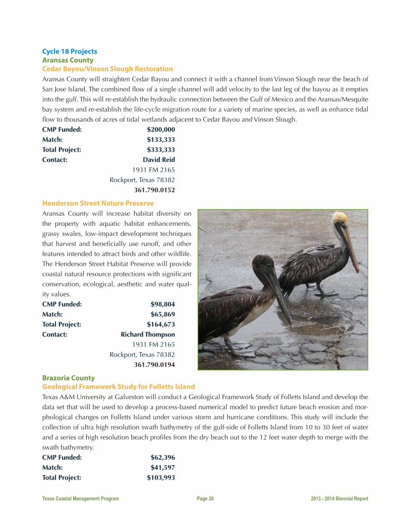
Henderson Street Nature PreserveAransas County will increase habitat diversity on
the property with aquatic habitat enhancements,
grassy swales, low-impact development techniques
that harvest and beneficially use runoff, and other
features intended to attract birds and other wildlife.
The Henderson Street Habitat Preserve will provide
coastal natural resource protections with significant
conservation, ecological, aesthetic and water qual-
ity values.
CMP Funded: $98,804
Match: $65,869
Total Project: $164,673
Contact: Richard Thompson
1931 FM 2165
Rockport, Texas 78382
361.790.0194
Brazoria CountyGeological Framework Study for Folletts IslandTexas A&M University at Galveston will conduct a Geological Framework Study of Folletts Island and develop the
data set that will be used to develop a process-based numerical model to predict future beach erosion and mor-
phological changes on Folletts Island under various storm and hurricane conditions. This study will include the
collection of ultra high resolution swath bathymetry of the gulf-side of Folletts Island from 10 to 30 feet of water
and a series of high resolution beach profiles from the dry beach out to the 12 feet water depth to merge with the
swath bathymetry.
CMP Funded: $62,396
Match: $41,597
Total Project: $103,993

Texas Coastal Management Program Page 21 2013 - 2014 Biennial Report
Contact: Timothy Dellapenna
P. O. Box 1675
Galveston, Texas 77554
409.740.4952
Calhoun CountyPort Lavaca Causeway Fishing Pier ImprovementsCity of Port Lavaca will complete the last phase of the reconstruction of the Port Lavaca Causeway Fishing Pier at
Lighthouse Beach by constructing a lighted, 500-square-foot T-head at the bay end of the pier. This project will
mark the final “pier partnership” between the Texas CMP and the City that began in Cycle 8 and continued each
year through Cycle 15 ultimately constructing 904 linear feet of 10-foot-wide replacement fishing pier.
CMP Funded: $60,000
Match: $40,000
Total Project: $100,000
Contact: Darren Gurley
202 N. Virginia Street
Port Lavaca, Texas 77979
361.552.3347
Restoration of Multiple Wetlands in the Magnolia Beach Area, Calhoun County: Phase I PlanningTexas AgriLife Research will produce a shovel-ready construction and financing plan for restoration in the inter-
connected wetlands in Calhoun County, Texas. A large expanse of degraded wetlands stretches from Magnolia
Beach to Indianola in Calhoun County. The wetlands are hydrologically connected, yet suffer due to a lack of tidal
flow at various points in the tidal channel network. The wetlands extend across multiple properties, agencies and
jurisdictions, and thus restoration will require a concerted effort that involves all of the parties.
CMP Funded: $57,630
Match: $38,394
Total Project: $96,024
Contact: Rusty Feagin
1500 Research Pkwy., Ste. B223
College Station, Texas 77845
979.862.2612
Cameron CountyEmergency Vehicle Beach Access ImprovementCity of South Padre Island will install a permanent structure to
support emergency vehicles access to eliminate the low eleva-
tion caused by the vehicular traffic thus eliminating another vul-
nerable point in the City’s continuous dune line to storm surge.
These improvements will reduce the threat to private property
and public infrastructure which is the main component of its Ero-
sion Response Plan.
CMP Funded: $150,000
Match: $150,000
Total Project: $300,000

Texas Coastal Management Program Page 22 2013 - 2014 Biennial Report
Contact: Reuben Trevino
4601 Padre Blvd
South Padre Island, Texas 78597
956.761.3035
Gulf Boulevard Beach Access ImprovementsCity of South Padre Island will increase the number of public parking spaces immediately adjacent to the beach by
maximizing the use of the entire 75-foot right-of-way, which has not been completely utilized in the past. This will
help the City to provide a parking space for every 15 linear feet of closed beach as required in TAC §15.7(h)(1)(A).
CMP Funded: $150,000
Match: $171,886
Total Project: $321,886
Contact: Reuben Trevino
4601 Padre Blvd
South Padre Island, Texas 78597
956.761.3035
Modeled Inflow Validation & Nutrient Loading Estimation in Two Subwatersheds of the LowerLaguna MadreUniversity of Texas - Pan American will characterize nutrient loading rates into the Lower Laguna Madre for subwa-
tersheds by monitoring stream flow and water quality (particularly total nitrogen and phosphorus). This information
will be used to evaluate Texas Rainfall-Runoff model performance in estimating ungaged inflows and to establish a
relationship between ungaged inflows and nutrient loading regimes to the Lower Laguna Madre.
CMP Funded: $98,440
Match: $111,104
Total Project: $209,544
Contact: Hudson DeYoe
Dept Biology, UTPA, 1201 W. University Dr.
Edinburg, Texas 78539
956.665.3538
CoastwideEvaluating Groundwater Inflow and Nutrient Transport to Texas Coastal EmbaymentsTexas A&M University - Corpus Christi will conduct a se-
ries of attainable objectives that will improve understand-
ing of groundwater contributions to water quality and
habitat degradation in relevant embayments of the South
Texas coast. Objectives are: (1) map groundwater dis-
charge and groundwater-surface water interaction zones,
(2) quantify the spatial-temporal distribution of ground-
water contaminant (nutrients, organic matter) transport
and discharge, (3) evaluate the role of groundwater nu-
trients in system-wide nutrient budgets (i.e., inputs-out-
puts), and (4) evaluate hypoxia and phytoplankton (red

Texas Coastal Management Program Page 23 2013 - 2014 Biennial Report
and brown tide) trends in relation to groundwater flow and nutrient discharge.
CMP Funded: $85,686
Match: $57,973
Total Project: $143,659
Contact: Dorina Murgulet
6300 Ocean Drive, Unit 5850
Corpus Christi, Texas 78412
361.825.2309
Texas Students Coastal Monitoring ProgramBureau of Economic Geology, The University of Texas at Austin will teach students how to monitor selected beach-
es over a period of one year. Students will measure shore-normal beach and dune topographic profiles and make
observations on weather conditions, sea state,
longshore current and dune vegetation at one
to three sites during three field trips spaced
throughout the academic year. The data collect-
ed by the students will be analyzed by scientists
at the BEG and the students themselves, will
compare their data to data collected by students
in previous years.
CMP Funded: $76,148
Match: $52,751
Total Project: $128,899
Contact: Tiffany Caudle
University Station, Box X
Austin, Texas 78713
512.475.95728
GalvestonBoater Waste Education Campaign: Communicating Environmental Impact and Facilitating EnforcementGalveston Bay Foundation will maintain the previously developed efforts, but more importantly, continue to evolve
and expand the Boater Waste Education Campaign (BWEC) based on lessons learned. GBF will develop, launch
and promote the use of a mobile application that facilitates public environmental reporting and tracking behavior
change, to quantify the potential impact that boater waste contributes to overall bacteria levels in Galveston Bay
in order to gain buy in for behavior change, to expand the BWEC to include communication with the commercial
boating industry, and to address language barriers in the outreach materials.
CMP Funded: $60,000
Match: $40,001
Total Project: $100,001
Contact: Charlene Bohanon
17330 Highway 3
Webster, Texas 77598
281.332.3381 ext. 216

Texas Coastal Management Program Page 24 2013 - 2014 Biennial Report
Increasing Water Quality and Quantity through Watershed Experiential Education in Texas Estuaries (WaterIQWet)The Artist Boat, Inc. will engage 2,000 students, 80 classrooms and 40 teachers in experiential learning that results
in formal understanding of water quality and water quantity issues facing estuarine environments on the Texas
coast in the context of multiple issues regarding human use and behaviors that impact water quality creating mul-
tiple educators with experiences and outreach tools to promote attitudinal and behavioral changes among their
community members.
CMP Funded: $91,720
Match: $72,594
Total Project: $164,314
Contact: LuAnne Ashley
2415 Avenue
Galveston, Texas 77550
409.770.0722
Dickinson Bayou Wetland Restoration Project - Phase II ConstructionTexas Parks and Wildlife Department will restore 10 acres and enhance and protect 17.7 acres of intertidal emer-
gent marsh. This restoration project will enhance water quality by increasing circulation and reducing nutrients in
the water column of an impaired water body. Additional benefits of the restored marsh will be increased fish and
shellfish production, enhanced recreational fishing opportunities, enhanced bird and wildlife watching opportuni-
ties, and erosion protection for existing wetland habitats that are integral to the Texas Gulf Coast and the Galveston
Bay estuarine ecosystem.
CMP Funded: $116,610
Match: $77,740
Total Project: $194,350
Contact: Jan Culbertson
1502 FM 517 East
Dickinson, Texas 77539
281.534.0111
Lower CoastEarth Day Bay Day Celebration 2014Coastal Bend Bays Foundation will host the 2014 Earth Day Bay Day Celebration to promote and implement the
educational goals and objectives of the Coastal Bend Bays Plan, and promote a general awareness of the Coastal
Bend’s unique coastal natural resources and its native habitats and wildlife.
CMP Funded: $41,000
Match: $26,850
Total Project: $67,850
Contact: Daniel Lucio
1231 Agnes Street, Suite 100
Corpus Christi, Texas 78401
361.882.3439
Teachers on the Mission-Aransas EstuaryThe University of Texas at Austin will help teachers educate students about the diversity, quality, quantity, functions
and values of coastal natural resource areas, how humans impact these areas, and the benefits inherent in pro-

Texas Coastal Management Program Page 25 2013 - 2014 Biennial Report
tecting them. The goal will be achieved by providing hands-on, field-based, professional development training for
teachers at four sites within the Mission-Aransas National Estuarine Research Reserve.
CMP Funded: $29,798
Match: $19,946
Total Project: $49,744
Contact: Sally Morehead
750 Channel View Drive
Port Aransas, Texas 78373
361.749.3046
Nueces CountyBaseline Mapping for Mangrove Monitoring in the Coastal Bend, Texas Gulf CoastThe University of Texas at Austin, Bureau of Economic Geology will conduct a study to (1) provide a baseline from
which to monitor the spread of mangroves in the Texas Coastal Bend; (2) establish methods and procedures for
mangrove mapping through the automatic classification of hyperspectral imagery; and (3) expand upon previous
wetland status and trends studies, funded through the Coastal Management Program, to analyze historical changes
in the location and amount of mangrove in the coastal bend.
CMP Funded: $38,450
Match: $25,632
Total Project: $64,082
Contact: Thomas Tremblay
University Station, Box X
Austin, Texas 78713
512.475.9537
Hilltop Nature Park EnhancementsNueces County will connect areas within Hilltop Nature Park by constructing a 1,500- linear-foot nature trail, a
100-cubic-yard (6-foot deep) wetland pond adjacent to an existing creek with an ADA crossover 20-foot x 5-foot
timber boardwalk that connect to the nature trail; and construct a 70-foot x 10-foot ADA nature overlook timber
structure to encourage and perpetuate the observation of wildlife.
CMP Funded: $60,000
Match: $40,000
Total Project: $100,000
Contact: Roxana Sandoval
901 Leopard Street, Room 501
Corpus Christi, Texas 78401
361.888.0225

Texas Coastal Management Program Page 26 2013 - 2014 Biennial Report
Mustang Island Habitat Protection and EnhancementCoastal Bend Bays & Estuaries Program will (1) repair existing and install new bollards and cable to protect the
entire ~1,200-acre Mollie Beattie and Kate’s Hole preserves by limiting access to certain areas within the preserves;
(2) make improvements to existing driveways and parking areas to allow for safe public access; (3) remove debris
such as large concrete blocks from wetlands near the driveways and parking areas within the preserves to provide
more functioning coastal marsh and tidal flat habitat.
CMP Funded: $60,000
Match: $40,000
Total Project: $100,000
Contact: Dustin Cravey
1305 N Shoreline Blvd, Suite 205
Corpus Christi, Texas 78401
361.885.6162
Shell Bank Improving Oyster Reef Restoration Through Oyster Shell Recycling, Education, and Scientific InquiryTexas A&M University - Corpus Christi will continue to reclaim oyster shells from coastal bend restaurants/whole-
salers for restoring degraded reefs; establish a community-based shell recycling program to promote community
drop off locations for shucked oyster shells; create interactive educational modules as part of a Web-based curric-
ulum and Internet-based kiosk to be placed within one of the partner restaurants; and perform habitat assessments
to understand how well restored systems replace the important habitat functions provided by natural reefs.
CMP Funded: $99,228
Match: $66,731
Total Project: $165,959
Contact: Jennifer Pollack
6300 Ocean Drive, Unit 5800
Corpus Christi, Texas 78412
361.825.2041
Upper CoastMaximizing the Ecological Value of Coastal Wetland Restoration: Comparisons Among Restoration TechniquesTexas A&M University at Galveston will expand its ex-
isting monitoring program to encompass several other
restoration projects, including newly (less than 5 years
old) created BUDM sites; a subset of these sites were
planted with marsh vegetation, and others were left
unvegetated. Additional engineered sites will be in-
cluded as well; all sites will be compared to natural
reference sites. Comparisons of the ecological values
provided by the engineered and BUDM construction
techniques will help to identify the most ecologically
effective restoration approaches and enhance future
restoration projects along the Texas coast.

Texas Coastal Management Program Page 27 2013 - 2014 Biennial Report
CMP Funded: $100,000
Match: $66,891
Total Project: $166,891
Contact: Anna Armitage
200 Seawolf Parkway
Galveston, Texas 77553
409.740.4842
Galveston Bay Seafood Advisory Education CampaignGalveston Bay Foundation will implement an important follow-up project to the CMP Cycle 15 “Harris County
Seafood Consumption Advisory Public Education Campaign,” which was successful in educating fishermen and
crabbers with the placement of 112 signs at 56 locations that had been impacted by multiple seafood consumption
advisories. Given the effectiveness of reaching people where they fish, funds will be expended on placing addi-
tional pairs of English and Spanish signs at other priority locations.
CMP Funded: $4,090
Match: $2,727
Total Project: $6,817
Contact: Scott Jones
17330 Highway 3
Webster, Texas 77598
281.332.3381 ext. 209

Texas Coastal Management Program Page 28 2013 - 2014 Biennial Report

Texas Coastal Management Program Page 29 2013 - 2014 Biennial Report
Cycle 19 ProjectsAransas CountyEvaluating Groundwater/Freshwater Inflows and Nutrient Transport to Texas Coastal Embayments, Phase IITexas A&M University-Corpus Christi (TAMU-CC) will conduct a study to advance understanding of groundwater
inflows and nutrient transport to bay systems in South Texas for improved environmental flow recommendations
and nutrient criteria. TAMU-CC will accomplish this by explicitly incorporating groundwater discharge into the
freshwater inflow needs and nutrient budgets. The objectives are to: map groundwater discharge and groundwa-
ter-surface water interaction zones; quantify the spatial-temporal distribution of groundwater and surface water
contaminant (nutrients, organic matter) transport and discharge; evaluate nitrogen sources (i.e., anthropogenic vs.
natural; agricultural vs. alternative); and evaluate the role of groundwater nutrients in system-wide nutrient budgets
(i.e., inputs-outputs). To fulfill these objectives, TAMU-CC will quantify groundwater discharge on a seasonal basis
to Aransas Mission Estuary and will quantify contaminants within the groundwater that may contribute to water
quality degradation.
CMP Funded: $94,924
Match: $63,418
Total Project: $158,342
Contact: Dr. Dorina Murgulet
6300 Ocean Drive, Unit 5850
Corpus Christi, Texas 78412
361.825.2309
Cameron County Cameron County Public Beach Access #4 – EnhancementsCameron County Parks and Recreation will improve Beach Access #4 in Cameron County to provide beach visitors
with safe access to the beach. A 240-foot x 7-foot ADA-compliant dune walkover will be constructed to provide
proper access from the parking lot to the beach and protect the dune system. The walkover will be furnished with
a rinse station. This project will also include the installation of water, sewer and electrical connections for future
constructions of restrooms and showers.
CMP Funded: $96,000
Match: $64,000
Total Project: $160,000
Contact: Joe Vega
33174 State Park Road 100-South
South Padre Island, Texas 78597
956.761.3700
Tracking Long-Term Trends in Seagrass Cover and Condition in Texas Coastal Waters The University of Texas at Austin (UT) will examine the long-term health of seagrasses in the Lower Laguna Madre,
following protocols that evaluate seagrass condition based on landscape-scale dynamics. UT will focus on “Tier-
2” monitoring (Neckles et al., 2011) that includes annual rapid assessment and sampling at 567 stations along the
Texas coast. This project contributes to a broader statewide monitoring effort by the University of Texas Marine
Science Institute to assess seagrass condition and distribution, which began in summer 2011 and is currently in its
third consecutive year. UTMSI’s sampling effort will serve as a database of existing Texas seagrass resources avail-
able for various local, state and national groups.

Texas Coastal Management Program Page 30 2013 - 2014 Biennial Report
CMP Funded: $89,810
Match: $60,244
Total Project: $150,054
Contact: Dr. Kenneth Dunton
750 Channel View Dr.
Port Aransas, Texas 78373
361.749.6744
South Padre Island Dune Restoration Volunteer Program The City of South Padre Island will continue dune
restoration projects along the entire length of
City beach. The City experiences variable erosion
rates, averaging 10 feet per year in some areas.
The City will identify low-lying areas and gaps in
dune elevation for volunteer restoration planting events. The City will use aerial photography to identify gaps and
low-lying areas in the dune line and install native plants in the dunes to promote their growth.
CMP Funded: $86,075
Match: $58,716
Total Project: $144,791
Contact: Reuben Trevino
4601 Padre Blvd.
South Padre Island, Texas 78597
956.761.8111
Gulf Boulevard Beach Access Improvements Phase 3The City of South Padre Island is moving forward with a solution to maximize the use of the entire 75-foot right-of-
way (ROW) of Gulf Boulevard which has not been completely utilized in the past. The number one safety concern
for the City is public safety. The current conditions along Gulf Boulevard provide a dangerous environment for
vehicular and pedestrian traffic. The City will improve 15 percent of the entire length of Gulf Boulevard by utilizing
the 75-foot ROW to maximize public safety while also providing clear access to avoid private property damage
and destruction of the dune system.
CMP Funded: $150,000
Match: $173,583
Total Project: $323,583
Contact: Reuben Trevino
4601 Padre Blvd.
South Padre Island, Texas 78597
956.761.8111
Seaside Beach Access ImprovementsThe City of South Padre Island seeks to enhance public beach access for residents and tourists. The City will con-
struct an ADA-compliant public dune walkover and install plumbing to irrigate the surrounding dunes at Seaside
Circle (Access Point #6). The existing dune walkover is too narrow and does not provide adequate height over the
dune to allow sunlight to reach the vegetation underneath. The proposed walkover will accommodate the area’s

Texas Coastal Management Program Page 31 2013 - 2014 Biennial Report
high public use and keep the dune system strong and free of weak points that lead to gaps and washovers.
CMP Funded: $55,500
Match: $37,000
Total Project: $92,500
Contact: Reuben Trevino
4601 Padre Blvd.
South Padre Island, Texas 78597
956.761.8111
Walkover at The Pearl Beach AccessThe City of South Padre Island will improve the existing public beach access easements located on the island for
residents and tourists. The City will improve one easement located on the northern side of The Pearl Hotel. This
beach access begins as a 40-foot public ingress/egress easement at the Park Rd 100 frontage and becomes a 10-
foot pedestrian access 301.11 feet west of the toe of the existing retaining wall. The City will install a 10-foot
wide ADA-compliant walkover from the existing retaining wall to the line of vegetation. The walkover will provide
public access and provide protection to the dune system.
CMP Funded: $150,000
Match: $173,583
Total Project: $323,583
Contact: Reuben Trevino
4601 Padre Blvd.
South Padre Island, Texas 78597
956.761.8111
Coastwide GIS Analysis and Modeling of Texas Rookery Island Erosion Risk Along the GIWW Audubon Texas will assemble GIS data and build a spatial, habitat-based model to predict the risk of islands along
the GIWW becoming unusable for nesting due to poor habitat or erosion damage. GIS data will be gathered on
select sample sites and a model will be built to predict the sites’
longevity as a nesting area based on physical parameters. The
model will predict which sites are most at-risk of becoming too
damaged for bird nesting and each site’s probability of becom-
ing unusable for nesting. Data from the island-risk model will
be compared to the Texas Colonial Waterbird Society’s database
to identify specific waterbird species most likely to be impacted
by habitat/island loss in each bay system. Historical habitat data
will be compared to current data to anticipate waterbird species’
movements due to habitat/island loss.
CMP Funded: $120,848
Match: $77,526
Total Project: $198,374
Contact: Amanda Hackney
4702 HWY 146N
Texas City, Texas 77590
936.554.9033

Texas Coastal Management Program Page 32 2013 - 2014 Biennial Report
Texas High School Coastal Monitoring ProgramThe University of Texas at Austin, Bureau of Economic Geology
(BEG) will conduct The Texas High School Coastal Monitoring
Program (THSCMP). The THSCMP engages students and teachers
who live along the coast in the study of their natural environment.
Middle and high school students, teachers, and scientists work to-
gether to gain a better understanding of dune and beach dynamics
on the Texas coast. Scientists from the BEG provide the tools and
training needed for scientific investigation. Students and teachers
learn how to measure the topography, recognize and map the veg-
etation line and shoreline, and observe weather and wave condi-
tions. By participating in an actual research project, the students
obtain an enhanced science education.
CMP Funded: $76,749
Match: $52,922
Total Project: $129,671
Contact: Tiffany Caudle
University Station, Box X
Austin, Texas 78713
512.475.9572
Galveston CountyAutomated Detection of Harmful (and/or Toxic) Algae Blooms (HABs) in Galveston Bay Texas A&M University-Galveston (TAMUG) will use an Imaging FlowCytobot, to continuously monitor algal pop-
ulations, and to act as an early warning system, alerting scientists, state and federal agency personnel of Harmful
Algal Blooms that may enter the bay. The Imaging FlowCytobot will allow TAMUG: to identify phytoplankton
blooms – their timing, magnitude and duration; follow blooms and observe changes in species composition; an-
alyze the distribution of species in real time; and allow the development of predictive abilities to forecast subse-
quent blooms. The unit is portable and can be moved in response to blooms.
CMP Funded: $75,997
Match: $50,950
Total Project: $126,947
Contact: Dr. Antonietta Quigg
200 Seawolf Parkway
Galveston, Texas 77553
409.740.4990
Boater Waste Education Campaign: Communicating Environmental Impact and Facilitating EnforcementThe Galveston Bay Foundation (GBF) will continue the Boater Waste Education Campaign (BWEC). GBF will main-
tain previously developed efforts including: marketing and advertising efforts to spread the BWEC message; the
Clean Water Partnership program that helps marina staff and boaters work together to carry out BWEC projects and
workshops; as well as GBF’s Water Monitoring Team, Dockwalkers, AquaKids Classes, and the College Research
Experience. GBF will continue to refine the BWEC based on lessons learned and track program improvements.
GBF will make improvements to the Galveston Bay Action Network mobile app that facilitates public environmen-

Texas Coastal Management Program Page 33 2013 - 2014 Biennial Report
tal reporting, continue to quantify the potential impact that boater waste contributes to overall bacteria levels in
Galveston Bay, continue to expand the BWEC to include communication with the commercial boating industry,
and continue to address language barriers through educational outreach.
CMP Funded: $60,000
Match: $40,000
Total Project: $100,000
Contact: Charlene Bohanon
17330 Highway 3
Webster, Texas 77598
281.332.3381 ext. 216
Cease the Grease CampaignThe Galveston Bay Foundation (GBF) will coordinate and launch a regional Cease the Grease campaign (CtG) by:
working in cooperation with a stakeholder workgroup; developing marketing and outreach materials; creating a
distribution plan; and tracking campaign progress. Sanitary sewer overflows (SSOs) from fats, oil and grease (FOG)
are a source of concern for fecal bacteria found in Galveston Bay (TCEQ, 2008*) and as such, can be a public
health risk for oyster consumption in restricted harvest zones, as well as for contact recreation where localized
bacteria levels are heightened due to raw sewage being discharged near the shore. Aging infrastructure, combined
with improper disposal of FOG in single and multi-family homes, can lead to costly problems for both local gov-
ernments and citizens in terms of sewer line and home plumbing repairs, and environmental remediation.
CMP Funded: $46,950
Match: $31,299
Total Project: $78,249
Contact: Charlene Bohanon
17330 Highway 3
Webster, Texas 77598
281.332.3381 ext. 216
Harris CountyGalveston Bay Oyster Shell Recycling Program The Galveston Bay Foundation (GBF) will continue its oyster shell recycling program. GBF reclaims discarded
oyster shell from restaurant partners for future use in restoration projects. GBF will expand oyster shell collection
efforts and educate restaurant patrons of the
important ecosystem services oysters provide
for water quality and the importance of recy-
cling a valuable coastal natural resource. Shell
obtained from the continuation and expansion
of the Galveston Bay Oyster Shell Recycling
Program will be used for projects that benefit
ecosystem services of Galveston Bay and the
health and sustainability of the native oyster
population.
CMP Funded: $36,000
Match: $24,000
Total Project: $60,000

Texas Coastal Management Program Page 34 2013 - 2014 Biennial Report
Contact: Matthew Abernathy
17330 Highway 3
Webster, Texas 77598
281.332.3381 ext. 203
Tabbs Bay Enhancement Project The City of Baytown will remove and dispose of approximately 450 submerged and partially submerged pilings
from derelict drilling rigs, defunct derrick platforms and damaged service docks/piers from Tabbs Bay. The removals
will take place near Goose Creek, along State Highway 146 near Missouri Street, east of the Fred Hartman (Bay-
town/LaPorte) Bridge, and on the northern shore of the
Houston Ship Channel, in Harris County. The USGS
Quad reference map is: Morgan’s Point, Texas. The
project supports public access and enjoyment of the
coastal zone, improves navigability to the public boat
ramp and provides a safer waterfront area for recre-
ational activities such as boating, fishing and jet skiing.
CMP Funded: $99,600
Match: $66,400
Total Project: $166,000
Contact: Scott Johnson
2401 Market Street
Baytown, Texas 77520
281.420.6599
WaterSmart Landscaping: Protecting the Future of Freshwater Inflows for Galveston Bay Texas A&M AgriLife Extension Service, through the
Texas Coastal Watershed Program and WaterSmart
Program will promote resilient, water-conserving,
low-polluting landscapes by providing hands-on
demonstration projects, workshops and various forms
of educational outreach. The WaterSmart Program of
the Texas Coastal Watershed Program has shown that resilient, water-conserving, low-polluting landscapes can be
both very beautiful and functional. The WaterSmart Program will use an integrated, targeted approach to include:
installation of a minimum of three demonstration landscapes in highly visible locations; conducting a minimum
of two hands-on workshops to accompany at least two of the installations–one will be aimed at an audience of
critical decision makers who can influence local and regional policy and the other will focus on non-profession-
als, including homeowners; create a series of unique, innovative videos prepared for YouTube that will illustrate
aspects of WaterSmart, eco-friendly landscaping such as lawn reduction, alternatives to turf grasses, soil prepara-
tion, plant selection and landscape maintenance; and develop interpretive signs located at the demonstration sites,
educational materials, brochures and fact sheets. Additional information will appear on the WaterSmart website at
http://watersmart.tamu.edu to provide continued education; and through various forms of social media to promote
community engagement and audience building, keeping critical information and support timely and up to date
while reaching an even larger audience.
CMP Funded: $89,548
Texas Coastal Management Program Page 35 2013 - 2014 Biennial Report
Match: $60,007
Total Project: $149,555
Contact: Dr. John Jacob
1250 Bay Area Blvd. Suite C
Houston, Texas 77058
281.218.0565
Kleberg CountyBaffin Bay Volunteer Water Quality Study: Data collection and Outreach to Address Water Quality Concerns Texas A&M University-Corpus Christi (TAMU-CC) will continue its water quality monitoring program in Baffin
Bay. TAMU-CC recently initiated a spatially, temporally intensive volunteer water quality monitoring program in
Baffin Bay. The primary objective of this program is to generate data necessary to determine “when” and “where”
symptoms of water quality degradation are most pronounced. To accomplish this, water quality surveys are
conducted monthly and following rain events, with samples collected at nine sites throughout Baffin Bay for a suite
of water quality parameters. TAMU-CC will continue this program as well as conduct nutrient addition bioassays,
which will aid in determination of whether nitrogen or phosphorus is primarily responsible for the excessive algal
growth.
CMP Funded: $76,801
Match: $51,853
Total Project: $128,654
Contact: Dr. Michael Wetz
6300 Ocean Dr., Unit 5892
Corpus Christi, Texas 78412
361.825.2132
Lower CoastPrioritization of Critical Marsh Conservation and Restoration Areas Based on Future Sea Level Rise Scenarios The Nature Conservancy (TNC) will produce new Sea
Level Affecting Marsh Models (SLAMM) scenario mod-
els of the project site based on the results of the Bureau
of Economic Geology’s new Lidar acquisitions and oth-
er available datasets. TNC will integrate high-resolution
Lidar data into SLAMM models and identify priority
restoration/conservation areas. High- and low-resolu-
tion SLAMM models will be compared. Economic and
ecological indices and maps will be created. Project
results will be disseminated through two stakeholder
workshops and all project data and deliverables will be
published online.
CMP Funded: $62,857
Match: $41,905
Total Project: $104,762

Texas Coastal Management Program Page 36 2013 - 2014 Biennial Report
Contact: Jorge Brenner
205 N. Carrizo St.
Corpus Christi, Texas 78401
361.882.3584
High-resolution Lidar Observations of Rookery Islands in the Upper Laguna Madre to Define a Monitoring Benchmark The Harte Research Institute at Texas A&M University-Corpus Christi will obtain the results of an airborne light
detection and ranging (Lidar) survey of islands within the Upper Laguna Madre and provide analyses of rookery
island vulnerability. The survey will target the chain of islands near the JFK causeway and along the Intracoastal
Waterway from Corpus Christi bay south to the land bridge below Baffin Bay. This project will provide baseline
topographic data for resource managers to effectively characterize nesting habitat of the rookery islands.
CMP Funded: $82,198
Match: $54,949
Total Project: $137,147
Contact: Dr. Michael Starek
6300 Ocean Dr. #5869
Corpus Christi, Texas 78412
361.825.3978
Nueces CountyHilltop Nature Park Enhancements, Phase II Nueces County will continue improvements to the Hilltop Nature Park to provide enhanced ecological awareness
and preserve the park’s natural resources. The County will construct an 1,800-linear foot-nature trail to connect
the existing trail to an underutilized area of the park. The nature trail will provide amenities for a sitting area and
nature overlook. A small foot bridge will be constructed to cross over a low-lying area, which occasionally runs
with water during heavy rain events. Interpretive signage (migrant and resident birds/animals, native plants) will be
installed to educate patrons and promote conservation awareness.
CMP Funded: $60,000
Match: $40,000
Total Project: $100,000
Contact: Roxana Sandoval
901 Leopard Street, Room 501
Corpus Christi, Texas 78401
361.888.0225
Nueces Bay Public Access Improvements The Coastal Bend Bays and Estuaries Program (CBBEP)
will initiate public access improvements to Nueces Bay
adjacent to the Nueces Bay Marsh Restoration Project
site. The CBBEP owns a 33-acre parcel of land along
the southbound side of Highway 181 bordering the
northeast portion of Nueces Bay that will be dedicated
to public access to Nueces Bay. CBBEP will create a
parking and staging area for fisherman and paddle craft
Texas Coastal Management Program Page 37 2013 - 2014 Biennial Report
users and install a bollard and cable perimeter to keep vehicles in the approved parking areas and out of sensitive
wetland habitat. An ADA-accessible elevated platform and informational kiosk will also overlook the adjacent
CBBEP Marsh Restoration Site.
CMP Funded: $39,000
Match: $26,000
Total Project: $65,000
Contact: Jake Herring
1305 N. Shoreline Blvd. Ste 205
Corpus Christi, Texas 78401
361.885.6209
Shell Bank: Oyster Shell Recycling, Teacher Engagement, Environmental Stewardship, and Scientific Inquiry The Harte Research Institute (HRI) at Texas A&M University-Corpus Christi will continue its oyster shell recycling
program, the Shell Bank. HRI developed its program to reclaim discarded oyster shell from local area restaurants,
seafood wholesalers and festivals to return shells to Coastal Bend bays to restore degraded habitat. HRI will expand
oyster shell collection, host community-based restoration events, provide training to local school teachers, and
monitor the success of alternative reef restoration materials used at current restoration sites.
CMP Funded: $99,483
Match: $66,331
Total Project: $165,814
Contact: Dr. Jennifer Pollack
6300 Ocean Drive, Unit 5800
Corpus Christi, Texas 78412
361.825.2041
Coastal Zone Enhancement Grants Program – Long-term Planning InitiativeSection 309 of the CZMA allocates funds to encourage states to develop projects that will affect program
enhancements in one or more of the following eight enhancement areas:
u Wetlands
u Public Access u Coastal Hazards u Cumulative and Secondary Impacts u Energy and Government Facility Siting u Marine Debris u Ocean Resources u Aquaculture
Under the Coastal Management Program’s Section 309 Coastal Zone Enhancement Grants Program, the Texas
General Land Office is pursuing a long-term coastwide planning initiative and development of Geographic
Information System (GIS) based tools. The goal is to identify key resources along the coast to balance economic
growth with the protection of critical habitats and ecosystems.
To launch the planning initiative, the Texas General Land Office teamed up with coastal experts to evaluate the

Texas Coastal Management Program Page 38 2013 - 2014 Biennial Report
pressing threats in each coastal region and established a baseline of the primary issues of concern along the Texas
coast. The GLO released an overview report, “The Texas Coast: Shoring Up Our Future,” which highlights the
ecological and economic features along the Texas coast, and identifies the primary issues of concern threatening
its sustainability.
Next, staff presented the issues of concern to local elected officials in the coastal regions for verification and local
input regarding priority critical areas to address through planning and coordination.
The GLO, in partnership with the Harte Research Institute, completed a comprehensive review and update of the
Resource Management Codes (RMCs) for inclusion on a newly developed GIS viewer. The RMCs are assigned
to state-owned tracts in Texas bays and gulf waters, and promote best management practices for activities within
the tracts to minimize adverse impacts to sensitive natural resource areas. Last fall, a workgroup made up of
representatives from the CMP-networked resource agencies, federal agencies, GLO Energy Resources and GLO
GIS Teams, routinely met to examine and redefine 35 codes, identify and compile 141 data sets applicable to
each code, and develop the data driven code-assigning criteria for integration into a GIS viewer. The RMC viewer
provides assistance to resource managers, planners and industry with the permitting process and coastal resource
management decisions by promoting best management practices for activities within the state-owned land tracts
to minimize adverse impacts to sensitive natural resource areas.
Building on the outreach and awareness strategies, resiliency forums were held in December 2014 with local
elected officials and city and county planners to start a dialogue between the Texas General Land Office and local
decision makers, and to focus on crafting solutions to better prepare and respond to the threats facing our shorelines.
Coastal experts also were in attendance to showcase planning tools, which helped identify risks associated with
those threats. Through the CMP Section 309 grant funding, the GLO will continue to support and engage coastal
communities in their resiliency planning to better prepare for future storms and coastal vulnerabilities. This will
help ensure a strong Texas coast, both for business and the environment, for generations to come.
CMP Funded: $451,000
Total Project: $451,000
Contact: Kate Zultner
P.O. Box 12873
Austin, Texas 78711-2873
512.936.9581

NOAA uses performance measures to assess how well the National Coastal Zone Management Program and
National Estuarine Research Reserve System are achieving the goals of the Coastal Zone Management Act (CZMA).
NOAA has used expert panels, collaborative work groups and studies involving Coastal Management Programs
(CMP) and Reserves to develop performance measures that accommodate varying management structures and
differing coastal priorities across coastal states. Performance measures include the following components:
u Performance Indicators
u Units of Measure u Baseline Information
Long-term monitoring and data collection of performance measures establish a baseline and identify trends in
coastal resource management outcomes. With appropriate support, it becomes a powerful tool for management
of the nation’s coastal zone and for demonstrating the success of the CZMA in preserving, protecting and restoring
coastal resources and sustaining coastal communities throughout the United States for this and future generations.
CZMA Performance Measurement SystemThe CZMA Performance Measurement System tracks national indicators of the effectiveness of CMP and National
Estuarine Research Reserves (NERR) in achieving CZMA and strategic objectives. The system consists of contextual
indicators to provide information on environmental and socioeconomic factors influencing program actions and
performance measures to assess how well states are achieving CZMA program objectives.
The Office of Ocean and Coastal Resource Management (OCRM) collaborated with CMPs and NERRs to develop
a performance measurement system that provides flexibility and accommodates varying management structures
and differing coastal priorities across coastal states. Quantification of management outcomes directly responds
to congressional requests for performance measures to assess the national impact of CZMA programs and to the
Office of Management and Budget recommendations that CZMA programs develop outcome-oriented performance
measures to demonstrate program effectiveness. The CZMA performance measurement system also facilitates
adaptive management, enhanced communication, and informed planning and resource allocation decisions by
federal and state coastal managers.
National Coastal Zone Management Program Performance MeasuresThe CZMA Program has five categories of performance measures:
Government Coordination and Decision-MakingThe goal is to improve coordination and participation in the implementation of the CZM Program and improve
government decision making through technical assistance and consultation on projects affecting the coastal zone.
PERFORMANCEMEASURES
Texas Coastal Management Program Page 39 2013 - 2014 Biennial Report

Texas Coastal Management Program Page 40 2013 - 2014 Biennial Report
The CZM Program provides a framework under the CZMA federal consistency provisions to effect change through
state policies in support of national priorities, to provide technical assistance and dedicated staff resources in the
review of coastal zone projects, and to achieve regulatory efficiencies through a coordinated, predictable project
approval process. The CZM Program balances the need for economic development with resource protection
through implementation of state regulatory programs to avoid, minimize, or if necessary, mitigate the loss of coastal
habitats. The CZM Program is a federal-state partnership that supports comprehensive planning, coordinated
decision-making, and public participation in coastal management.
Public AccessThe goal is to create or enhance public access sites over the next five years. The CZM Program protects, creates
and enhances public access to the coast through regulatory programs, acquiring new public access sites, and
enhancing recreational facilities such as boardwalks and piers.
Coastal HabitatsThe goals are to protect coastal habitat through acquisition or easement, to restore coastal habitat, and to remove
marine debris from coastal habitats. The CZM Program uses funding and expertise to protect and restore coastal
habitat and develops and coordinates local partnerships to engage citizen stewards. The CZM Program works with
local communities to reduce marine debris reaching our oceans, Great Lakes and beaches.
Coastal HazardsThe goal is to increase the percentage of coastal communities implementing management practices to improve
resilience and increase public awareness of hazards. Through its partnerships, the CZM Program engages states
and communities to become more resilient by comprehensive planning, managing development to minimize
damage to communities and coastal habitats, increasing preparedness, and responding to coastal hazards.
Coastal Dependent Uses and Community DevelopmentThe goal is to increase the percentage of communities in the coastal zone implementing sustainable coastal
management practices and revitalizing port and waterfront areas. The CZM Program gives funding and expertise to
help coastal communities sustain their economies, human health, environment and coastal character.
Implementation of the performance measures is conducted collaboratively with the 33 states and territory
coastal management programs. A 3-year phased approach completed in 2008 resulted in a core set of measures
representing shared national priorities with feasible and consistent reporting standards.
The CZMA Program is also developing approaches to communicate the results of the performance measures and
nationally collected contextual indicators. Recommendations for communicating the results were developed by
a group of representatives from the Coastal States Organization, coastal management programs and the OCRM.
The information is reported to OCRM annually for performance measures and every five years for the contextual
indicators. Contextual indicators are submitted as part of the program’s §309 Assessment and Strategy Report,
which is described in detail later in this report.
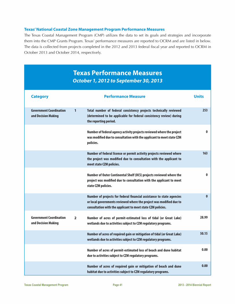
Texas Coastal Management Program Page 41 2013 - 2014 Biennial Report
Texas’ National Coastal Zone Management Program Performance Measures The Texas Coastal Management Program (CMP) utilizes the data to set its goals and strategies and incorporate
them into the CMP Grants Program. Texas’ performance measures are reported to OCRM and are listed in below.
The data is collected from projects completed in the 2012 and 2013 federal fiscal year and reported to OCRM in
October 2013 and October 2014, respectively.
Texas Performance MeasuresOctober 1, 2012 to September 30, 2013
Category Performance Measure Units
1
2
Government Coordination and Decision Making
Government Coordination and Decision Making
Total number of federal consistency projects technically reviewed (determined to be applicable for federal consistency review) during the reporting period.
Number of federal agency activity projects reviewed where the project was modified due to consultation with the applicant to meet state CZM policies.
Number of federal license or permit activity projects reviewed where the project was modified due to consultation with the applicant to meet state CZM policies.
Number of Outer Continental Shelf (OCS) projects reviewed where the project was modified due to consultation with the applicant to meet state CZM policies.
Number of projects for federal financial assistance to state agencies or local governments reviewed where the project was modified due to consultation with the applicant to meet state CZM policies. Number of acres of permit-estimated loss of tidal (or Great Lake) wetlands due to activities subject to CZM regulatory programs.
Number of acres of required gain or mitigation of tidal (or Great Lake) wetlands due to activities subject to CZM regulatory programs.
Number of acres of permit-estimated loss of beach and dune habitat due to activities subject to CZM regulatory programs.
Number of acres of required gain or mitigation of beach and dune habitat due to activities subject to CZM regulatory programs.
253
0
163
0
0
28.99
50.15
0.00
0.00

Texas Coastal Management Program Page 42 2013 - 2014 Biennial Report
Texas Performance MeasuresOctober 1, 2012 to September 30, 2013
Category Performance Measure Units
3Government Coordination and Decision Making
Number of acres of permit-estimated loss of nearshore habitat (intertidal, subtidal, submerged) due to activities subject to CZM regulatory programs.
Number of acres of required gain or mitigation of nearshore habitat (intertidal, subtidal, submerged) due to activities subject to CZM regulatory programs.
Number of acres of permit-estimated loss of other habitat types due to activities subject to CZM regulatory programs.
Number of acres of required gain or mitigation of other habitat types due to activities subject to CZM regulatory programs.
Number of coordination events related to Government Coordination offered by the CZM Program
Number of stakeholder groups participating in coordination events related to Government Coordination offered by the CZM Program.
Number of coordination events related to Public Access offered by the CZM Program.
Number of stakeholder groups participating in coordination events related to Public Access offered by the CZM Program.
Number of coordination events related to Coastal Habitat offered by the CZM Program.
Number of stakeholder groups participating in coordination events related to Coastal Habitat offered by the CZM Program.
Number of coordination events related to Coastal Hazards offered by the CZM Program.
Number of stakeholder groups participating in coordination events related to Coastal Hazards offered by the CZM Program.
165.41
45.32
15.47
60.59
9
238
0
0
0
0
0
0
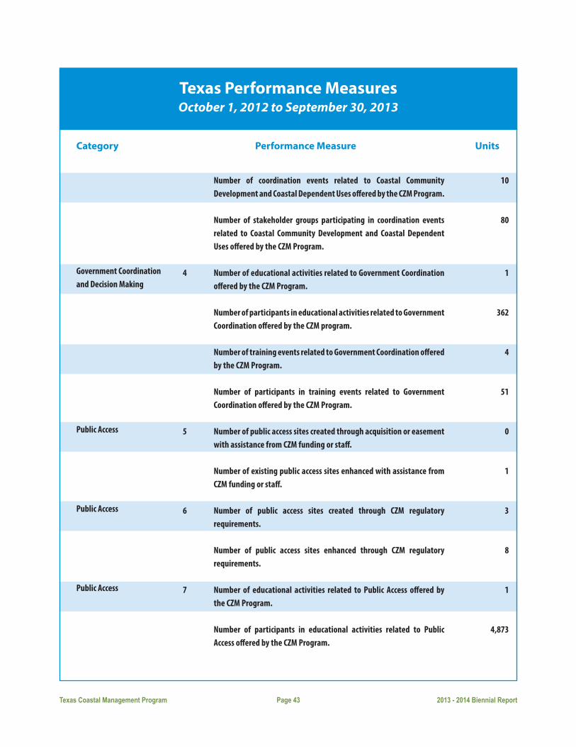
Texas Coastal Management Program Page 43 2013 - 2014 Biennial Report
Texas Performance MeasuresOctober 1, 2012 to September 30, 2013
Category Performance Measure Units
4
5
6
7
Government Coordination and Decision Making
Public Access
Public Access
Public Access
Number of coordination events related to Coastal Community Development and Coastal Dependent Uses offered by the CZM Program.
Number of stakeholder groups participating in coordination events related to Coastal Community Development and Coastal Dependent Uses offered by the CZM Program.
Number of educational activities related to Government Coordination offered by the CZM Program.
Number of participants in educational activities related to Government Coordination offered by the CZM program.
Number of training events related to Government Coordination offered by the CZM Program.
Number of participants in training events related to Government Coordination offered by the CZM Program.
Number of public access sites created through acquisition or easement with assistance from CZM funding or staff.
Number of existing public access sites enhanced with assistance from CZM funding or staff.
Number of public access sites created through CZM regulatory requirements.
Number of public access sites enhanced through CZM regulatory requirements.
Number of educational activities related to Public Access offered by the CZM Program.
Number of participants in educational activities related to Public Access offered by the CZM Program.
10
80
1
362
4
51
0
1
3
8
1
4,873
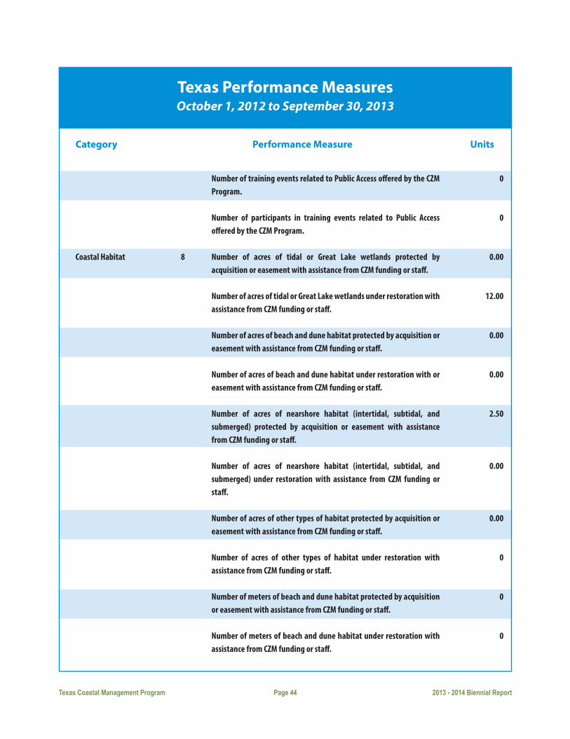
Texas Coastal Management Program Page 44 2013 - 2014 Biennial Report
Texas Performance MeasuresOctober 1, 2012 to September 30, 2013
Category Performance Measure Units
8Coastal Habitat
Number of training events related to Public Access offered by the CZM Program.
Number of participants in training events related to Public Access offered by the CZM Program.
Number of acres of tidal or Great Lake wetlands protected by acquisition or easement with assistance from CZM funding or staff.
Number of acres of tidal or Great Lake wetlands under restoration with assistance from CZM funding or staff.
Number of acres of beach and dune habitat protected by acquisition or easement with assistance from CZM funding or staff.
Number of acres of beach and dune habitat under restoration with or easement with assistance from CZM funding or staff.
Number of acres of nearshore habitat (intertidal, subtidal, and submerged) protected by acquisition or easement with assistance from CZM funding or staff.
Number of acres of nearshore habitat (intertidal, subtidal, and submerged) under restoration with assistance from CZM funding or staff.
Number of acres of other types of habitat protected by acquisition or easement with assistance from CZM funding or staff.
Number of acres of other types of habitat under restoration with assistance from CZM funding or staff.
Number of meters of beach and dune habitat protected by acquisition or easement with assistance from CZM funding or staff.
Number of meters of beach and dune habitat under restoration with assistance from CZM funding or staff.
0
0
0.00
12.00
0.00
0.00
2.50
0.00
0.00
0
0
0

Texas Coastal Management Program Page 45 2013 - 2014 Biennial Report
Texas Performance MeasuresOctober 1, 2012 to September 30, 2013
Category Performance Measure Units
9
10
11
Coastal Habitat
Coastal Habitat
Coastal Hazards
Number of meters of nearshore habitat (intertidal, subtidal, and submerged) protected by acquisition or easement with assistance from CZM funding or staff.
Number of meters of nearshore habitat (intertidal, subtidal, and submerged) under restoration with assistance from CZM funding or staff.
Number of meters of other types of habitat protected by acquisition or easement with assistance from CZM funding or staff.
Number of meters of other types of habitat under restoration with assistance from CZM funding or staff.
Number of marine debris removal activities completed with assistance from CZM funding or staff.
Estimated number of pounds of debris removed by the above reported marine debris removal activities.
Number of educational activities related to Coastal Habitat offered by the CZM Program.
Number of participants in educational activities related to Coastal Habitat offered by the CZM Program.
Number of training events related to Coastal Habitat offered by the CZM Program.
Number of participants in training events related to Coastal Habitat offered by the CZM Program.
Number of communities that completed a project to reduce future damage from hazards with assistance from CZM funding or staff.
Number of communities that completed a project to increase public awareness of hazards with assistance from CZM funding or staff.
0
0
0
0
6
943,654
16
768
17
164
1
7

Texas Coastal Management Program Page 46 2013 - 2014 Biennial Report
Texas Performance MeasuresOctober 1, 2012 to September 30, 2013
Category Performance Measure Units
12
13
14
15
Coastal Hazards
Coastal Dependent Uses & Community Development
Coastal Dependent Uses & Community Development
Coastal Dependent Uses & Community Development
Number of educational activities related to Coastal Hazards offered by the CZM Program.
Number of participants in educational activities related to Coastal Hazards offered by the CZM Program.
Number of training events related to Coastal Hazards offered by the CZM Program.
Number of participants in training events related to Coastal Hazards offered by the CZM Program.
Number of coastal communities that developed or updated sustainable development ordinances, policies, and plans with assistance from CZM funding or staff.
Number of coastal communities that completed a project to implement a sustainable development plan with assistance from CZM funding or staff.
Number of coastal communities that developed or updated port or waterfront redevelopment ordinances, policies, and plans with assistance from CZM funding or staff.
Number of coastal communities that completed a project to implement a port or waterfront redevelopment plan with assistance from CZM funding or staff.
Number of coastal communities that developed or updated polluted runoff management ordinances, policies, and plans with assistance from CZM funding or staff.
Number of coastal communities that completed projects to implement polluted runoff management plans with assistance from CZM funding or staff.
Number of educational activities related to Coastal Dependent Uses and Community Development offered by the CZM Program.
18
620
4
58
0
7
0
0
0
0
21

Texas Coastal Management Program Page 47 2013 - 2014 Biennial Report
Texas Performance MeasuresOctober 1, 2012 to September 30, 2013
Category Performance Measure Units
16
17
Financial Measures
Financial Measures
Number of participants in educational activities related to coastal dependent uses and community development offered by the CZM Program.
Number of training events related to Coastal Dependent Uses and Community Development offered by the CZM Program.
Number of participants in training events related to Coastal Dependent Uses and Community Development offered by the CZM Program.
Number of CZM federal and matching dollars spent on Government Coordination.
Number of CZM federal and matching dollars spent on Public Access.
Number of CZM federal and matching dollars spent on Coastal Habitat.
Number of CZM federal and matching dollars spent on Coastal Hazards.
Number of CZM federal and matching dollars spent on Coastal Dependent Uses and Community Development.
Number of dollars leveraged by CZM funds for Government Coordination.
Number of dollars leveraged by CZM funds for Public Access.
Number of dollars leveraged by CZM funds for Coastal Habitat Activities.
Number of dollars leveraged by CZM funds for Coastal Hazards. Number of dollars leveraged by CZM funds for Coastal Dependent Uses and community Development.
Number of CZM federal and matching dollars spent on technical assistance to local governments for Government Coordination.
289,426
29
988
$740,295
$136,781
$291,426
$532,247
$235,148
$16,725
$500,000
$0
$50,000
$28,200
$1,374,292

Texas Coastal Management Program Page 48 2013 - 2014 Biennial Report
Texas Performance MeasuresOctober 1, 2012 to September 30, 2013
Category Performance Measure Units
Number of CZM federal and matching dollars spent on technical assistance to local governments for Public Access.
Number of CZM federal and matching dollars spent on technical assistance to local governments for Coastal Habitat.
Number of CZM federal and matching dollars spent on technical assistance to local governments for Coastal Hazards
Number of CZM federal and matching dollars spent on technical assistance to local governments for Coastal Dependent Uses and Community Development.
Number of CZM federal and matching dollars provided as financial assistance to local governments for Government Coordination.
Number of CZM federal and matching dollars provided as financial assistance to local governments for Public Access.
Number of CZM federal and matching dollars provided as financial assistance to local governments for Coastal Habitat.
Number of CZM federal and matching dollars provided as financial assistance to local governments for Coastal Hazards.
Number of CZM federal and matching dollars provided as financial assistance to local governments for Coastal Dependent Uses and Community Development.
$0
$0
$0
$2,000
$0
$0
$0
$0
$0

Texas Coastal Management Program Page 49 2013 - 2014 Biennial Report
Texas Performance MeasuresOctober 1, 2013 to September 30, 2014
Category Performance Measure Units
1
2
Government Coordination and Decision Making
Government Coordination and Decision Making
Total number of federal consistency projects technically reviewed (determined to be applicable for federal consistency review) during the reporting period.
Number of federal agency activity projects reviewed where the project was modified due to consultation with the applicant to meet state CZM policies.
Number of federal license or permit activity projects reviewed where the project was modified due to consultation with the applicant to meet state CZM policies.
Number of Outer Continental Shelf (OCS) projects reviewed where 0 the project was modified due to consultation with the applicant to meet state CZM policies.
Number of projects for federal financial assistance to state agencies or local governments reviewed where the project was modified due to consultation with the applicant to meet state CZM policies.
Number of acres of permit-estimated loss of tidal (or Great Lake) wetlands due to activities subject to CZM regulatory programs.
Number of acres of required gain or mitigation of tidal (or Great Lake) wetlands due to activities subject to CZM regulatory programs.
Number of acres of permit-estimated loss of beach and dune habitat due to activities subject to CZM regulatory programs.
Number of acres of required gain or mitigation of beach and dune habitat due to activities subject to CZM regulatory programs.
Number of acres of permit-estimated loss of nearshore habitat (intertidal, subtidal, submerged) due to activities subject to CZM regulatory programs.
294
0
79
0
0
15.09
29.23
0.00
0.00
2,022.50
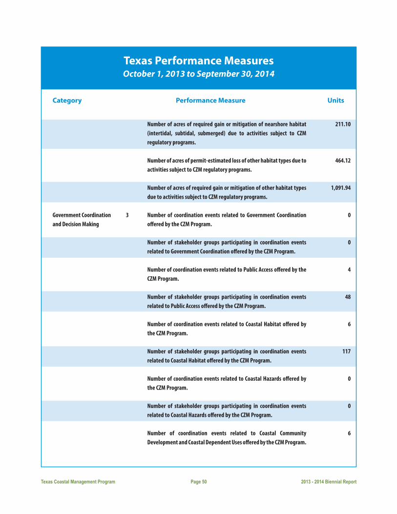
Texas Coastal Management Program Page 50 2013 - 2014 Biennial Report
Texas Performance MeasuresOctober 1, 2013 to September 30, 2014
Category Performance Measure Units
3Government Coordination and Decision Making
Number of acres of required gain or mitigation of nearshore habitat (intertidal, subtidal, submerged) due to activities subject to CZM regulatory programs.
Number of acres of permit-estimated loss of other habitat types due to activities subject to CZM regulatory programs.
Number of acres of required gain or mitigation of other habitat types due to activities subject to CZM regulatory programs.
Number of coordination events related to Government Coordination offered by the CZM Program.
Number of stakeholder groups participating in coordination events related to Government Coordination offered by the CZM Program.
Number of coordination events related to Public Access offered by the CZM Program.
Number of stakeholder groups participating in coordination events related to Public Access offered by the CZM Program. Number of coordination events related to Coastal Habitat offered by the CZM Program.
Number of stakeholder groups participating in coordination events related to Coastal Habitat offered by the CZM Program. Number of coordination events related to Coastal Hazards offered by the CZM Program.
Number of stakeholder groups participating in coordination events related to Coastal Hazards offered by the CZM Program. Number of coordination events related to Coastal Community Development and Coastal Dependent Uses offered by the CZM Program.
211.10
464.12
1,091.94
0
0
4
48
6
117
0
0
6

Texas Coastal Management Program Page 51 2013 - 2014 Biennial Report
Texas Performance MeasuresOctober 1, 2013 to September 30, 2014
Category Performance Measure Units
4
5
6
7
Government Coordination and Decision Making
Public Access
Public Access
Public Access
Number of stakeholder groups participating in coordination events related to Coastal Community Development and Coastal Dependent Uses offered by the CZM Program.
Number of educational activities related to Government Coordination offered by the CZM Program.
Number of participants in educational activities related to Government Coordination offered by the CZM program. Number of training events related to Government Coordination offered by the CZM Program.
Number of participants in training events related to Government Coordination offered by the CZM Program.
Number of public access sites created through acquisition or easement with assistance from CZM funding or staff.
Number of existing public access sites enhanced with assistance from CZM funding or staff.
Number of public access sites created through CZM regulatory requirements.
Number of public access sites enhanced through CZM regulatory requirements.
Number of educational activities related to Public Access offered by the CZM Program.
Number of participants in educational activities related to Public Access offered by the CZM Program.
Number of training events related to Public Access offered by the CZM Program.
57
5
36
0
0
0
3
2
2
2
300
0

Texas Coastal Management Program Page 52 2013 - 2014 Biennial Report
Texas Performance MeasuresOctober 1, 2013 to September 30, 2014
Category Performance Measure Units
8Coastal Habitat
Number of participants in training events related to Public Access offered by the CZM Program.
Number of acres of tidal or Great Lake wetlands protected by acquisition or easement with assistance from CZM funding or staff.
Number of acres of tidal or Great Lake wetlands under restoration with assistance from CZM funding or staff.
Number of acres of beach and dune habitat protected by acquisition or easement with assistance from CZM funding or staff.
Number of acres of beach and dune habitat under restoration with or easement with assistance from CZM funding or staff.
Number of acres of nearshore habitat (intertidal, subtidal, and submerged) protected by acquisition or easement with assistance from CZM funding or staff.
Number of acres of nearshore habitat (intertidal, subtidal, and submerged) under restoration with assistance from CZM funding or staff.
Number of acres of other types of habitat protected by acquisition or easement with assistance from CZM funding or staff.
Number of acres of other types of habitat under restoration with assistance from CZM funding or staff.
Number of meters of beach and dune habitat protected by acquisition or easement with assistance from CZM funding or staff.
Number of meters of beach and dune habitat under restoration with assistance from CZM funding or staff.
Number of meters of nearshore habitat (intertidal, subtidal, and submerged) protected by acquisition or easement with assistance from CZM funding or staff.
0
0.00
3.00
0.00
5.67
0.00
34.00
40.00
1,225.31
0
0
0

Texas Coastal Management Program Page 53 2013 - 2014 Biennial Report
Texas Performance MeasuresOctober 1, 2013 to September 30, 2014
Category Performance Measure Units
9
10
11
Coastal Habitat
Coastal Habitat
Coastal Habitat
Number of meters of nearshore habitat (intertidal, subtidal, and submerged) under restoration with assistance from CZM funding or staff.
Number of meters of other types of habitat protected by acquisition or easement with assistance from CZM funding or staff.
Number of meters of other types of habitat under restoration with assistance from CZM funding or staff.
Number of marine debris removal activities completed with assistance from CZM funding or staff.
Estimated number of pounds of debris removed by the above reported marine debris removal activities.
Number of educational activities related to Coastal Habitat offered by the CZM Program. Number of participants in educational activities related to Coastal Habitat offered by the CZM Program.
Number of training events related to Coastal Habitat offered by the CZM Program.
Number of participants in training events related to Coastal Habitat offered by the CZM Program.
Number of communities that completed a project to reduce future damage from hazards with assistance from CZM funding or staff.
Number of communities that completed a project to increase public awareness of hazards with assistance from CZM funding or staff.
Number of educational activities related to Coastal Hazards offered by the CZM Program.
0
0
0
4
521,887
39
15,354
2
21
0
7
9
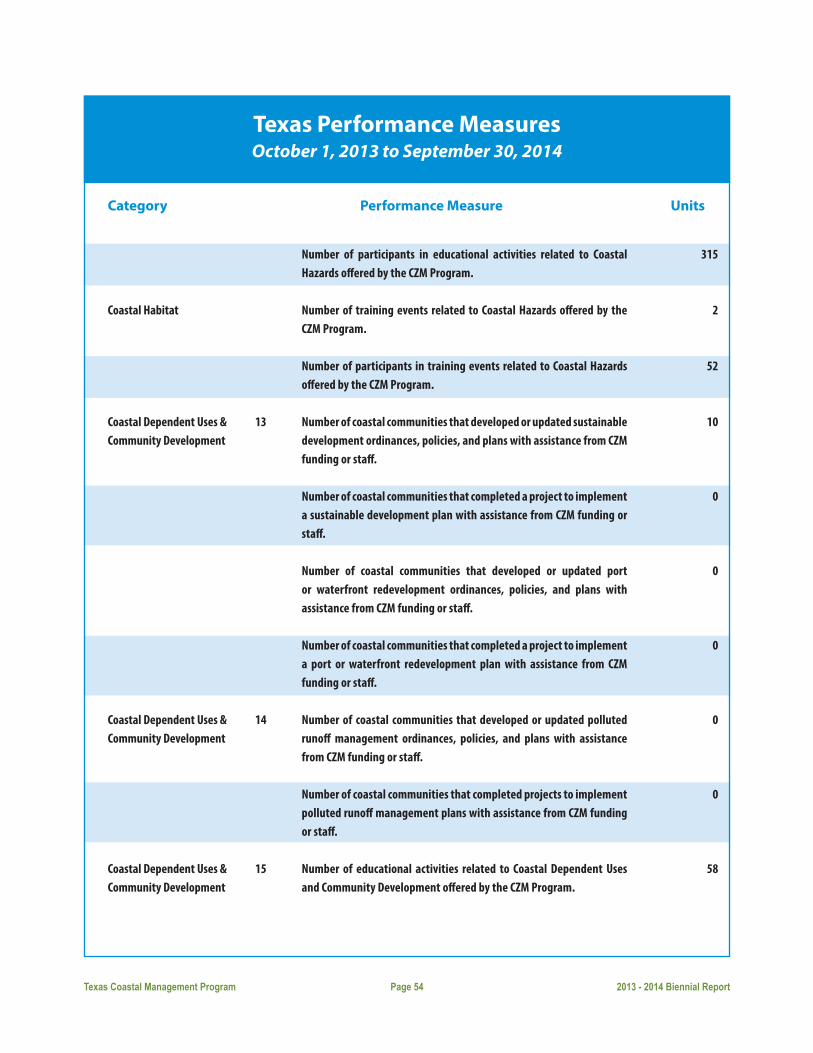
Texas Coastal Management Program Page 54 2013 - 2014 Biennial Report
Texas Performance MeasuresOctober 1, 2013 to September 30, 2014
Category Performance Measure Units
13
14
15
Coastal Habitat
Coastal Dependent Uses & Community Development
Coastal Dependent Uses & Community Development
Coastal Dependent Uses & Community Development
Number of participants in educational activities related to Coastal Hazards offered by the CZM Program.
Number of training events related to Coastal Hazards offered by the CZM Program.
Number of participants in training events related to Coastal Hazards offered by the CZM Program.
Number of coastal communities that developed or updated sustainable development ordinances, policies, and plans with assistance from CZM funding or staff.
Number of coastal communities that completed a project to implement a sustainable development plan with assistance from CZM funding or staff.
Number of coastal communities that developed or updated port or waterfront redevelopment ordinances, policies, and plans with assistance from CZM funding or staff.
Number of coastal communities that completed a project to implement a port or waterfront redevelopment plan with assistance from CZM funding or staff.
Number of coastal communities that developed or updated polluted runoff management ordinances, policies, and plans with assistance from CZM funding or staff.
Number of coastal communities that completed projects to implement polluted runoff management plans with assistance from CZM funding or staff.
Number of educational activities related to Coastal Dependent Uses and Community Development offered by the CZM Program.
315
2
52
10
0
0
0
0
0
58

Texas Coastal Management Program Page 55 2013 - 2014 Biennial Report
Texas Performance MeasuresOctober 1, 2013 to September 30, 2014
Category Performance Measure Units
16
17
Financial Measures
Financial Measures
Number of participants in educational activities related to coastal dependent uses and community development offered by the CZM Program.
Number of training events related to Coastal Dependent Uses and Community Development offered by the CZM Program.
Number of participants in training events related to Coastal Dependent Uses and Community Development offered by the CZM Program.
Number of CZM federal and matching dollars spent on Government Coordination.
Number of CZM federal and matching dollars spent on Public Access.
Number of CZM federal and matching dollars spent on Coastal Habitat.
Number of CZM federal and matching dollars spent on Coastal Hazards.
Number of CZM federal and matching dollars spent on Coastal Dependent Uses and Community Development.
Number of dollars leveraged by CZM funds for Government Coordination.
Number of dollars leveraged by CZM funds for Public Access. Number of dollars leveraged by CZM funds for Coastal Habitat Activities.
Number of dollars leveraged by CZM funds for Coastal Hazards. Number of dollars leveraged by CZM funds for Coastal Dependent Uses and community Development.
Number of CZM federal and matching dollars spent on technical assistance to local governments for Government Coordination.
210,054
32
377
$795,524
$294,524
$1,782,566
$258,373
$322,570
$777,755
$117,859
$256,536
$0
$25,000
$0
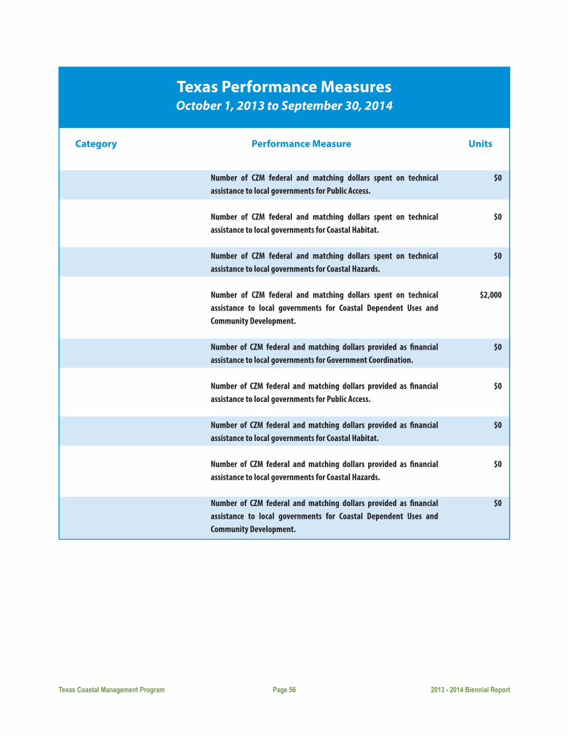
Texas Coastal Management Program Page 56 2013 - 2014 Biennial Report
Texas Performance MeasuresOctober 1, 2013 to September 30, 2014
Category Performance Measure Units
Number of CZM federal and matching dollars spent on technical assistance to local governments for Public Access.
Number of CZM federal and matching dollars spent on technical assistance to local governments for Coastal Habitat.
Number of CZM federal and matching dollars spent on technical assistance to local governments for Coastal Hazards.
Number of CZM federal and matching dollars spent on technical assistance to local governments for Coastal Dependent Uses and Community Development.
Number of CZM federal and matching dollars provided as financial assistance to local governments for Government Coordination.
Number of CZM federal and matching dollars provided as financial assistance to local governments for Public Access.
Number of CZM federal and matching dollars provided as financial assistance to local governments for Coastal Habitat.
Number of CZM federal and matching dollars provided as financial assistance to local governments for Coastal Hazards.
Number of CZM federal and matching dollars provided as financial assistance to local governments for Coastal Dependent Uses and Community Development.
$0
$0
$0
$2,000
$0
$0
$0
$0
$0

Since the inception of the Texas Coastal Management Program various publications have been created and dis-
tributed to fulfill the CMP goal of educating the public about the principal coastal problems of state concern and
technology available for the protection and improved management of the CNRAs. Publications are evaluated on
a regular basis to determine gaps in needed materials, to provide updates on already available publications, and
to reflect current areas of focus on the coast. Publications listed below reflect those that were created over the last
year as well as those that are considered current publications and are distributed to the public. Past publications
can be found on our website at www.TexasCoastalConnection.com.
ReportsTexas Coastal Management Program 2013-2014 Biennial Report: A biennial report published by the Council
for the Legislature that includes yearly program initiatives, updates on the total number of consistency reviews
conducted, Permit Service Center activities and reports on the annual grant program. Demographics on the Texas
coast are provided in the report on a biennial schedule.
Coastal Erosion Planning and Response Act (CEPRA): Report to the 83nd Texas Legislature, April 2013: A biennial
report to the Legislature that provides the information specified by CEPRA (Natural Resources Code §33.608) and
highlights both the progress and the challenges of the CEPRA program over the fist seven biennial cycles of its
implementation.
Guidebooks, Manuals, Brochures, etc.Beach Watch: An informational brochure describing the Beach Watch program and how to access the website to
check on the water quality of beaches. August 2011.
Texas Homeowner’s Handbook to Prepare for Coastal Natural Hazards, developed in cooperation with the Texas
Sea Grant College Program, offers advice on how to protect yourself and your family from natural disasters, how
to storm-harden your home, the importance of flood insurance and useful Web links and disaster preparation
checklists. March 2013.
The Texas Coast: Shoring Up Our Future, An overview report that highlights the environmental and industrial
features along the Texas coast, and identifies the primary issues of concern threatening its sustainability. April
2013.
Websites ShoringUpTexas.org, currently a website that will raise awareness of how important the coast is to Texans and the
entire nation by featuring coastal values, threats, resiliency efforts, planning tools and opportunities to get involved
in enhancing the Texas coast.
Texas Coastal Management Program Page 57 2013 - 2014 Biennial Report
EDUCATIONAND OUTREACH

Texas Coastal Management Program Page 58 2013 - 2014 Biennial Report
TCOON: http://www.cbi.tamucc.edu/TCOON/
Resource Management Codes: development guidelines for activities on state-owned submerged land tracts. http://
www.glo.texas.gov/what-we-do/energy-and-minerals/resource-management-codes/index.html.
Aerial Photography: http://www.glo.texas.gov/GLO/agency-administration/gis/index.html
Geographic Information System (GIS) Data: http://www.glo.texas.gov/GLO/agency-administration/gis/gis-data.
html

Texas Coastal Management Program Page 59 2013 - 2014 Biennial Report
County Population/Projections
County 2010 2020 2030 2040 Census Projection Projection Projection
Upper Coast
Brazoria 313,166 339,245 361,915 380,301
Chambers 35,096 37,464 39,732 40,398
Galveston 291,309 308,347 320,723 325,644
Harris 4,092,459 4,532,775 4,882,019 5,169,611
Jefferson 252,273 267,930 292,192 324,658
Orange 81,837 85,262 87,620 88,058
Middle Coast
Calhoun 21,381 22,682 23,856 24,675
Jackson 14,075 14,851 15,663 16,268
Matagorda 36,702 39,042 41,079 42,654
Refugio 7,383 7,753 8,133 8,418
Victoria 86,793 94,032 100,490 105,766
Coastal Bend
Aransas 23,158 23,016 22,510 22,017
Kleberg 32,061 35,537 38,918 42,479
Nueces 340,223 362,319 381,137 392,834
San Patricio 64,804 70,651 76,679 81,828
Lower Coast
Cameron 406,220 465,569 531,850 599,356
Kenedy 416 462 496 506
Willacy 22,134 24,595 27,020 29,355
State Totals 25,145,561 27,373,633 29,289,940 30,823,109
Source: Office of the State Demographer and the Texas State Data Center in the Institute for Demographic and Socioeconomic Research at the University of Texas at San Antonio (November 2012)
COASTALDEMOGRAPHICS

Texas Coastal Management Program Page 60 2013 - 2014 Biennial Report
Water Usage/Projections
County Municipal Manuf. Mining Steam Livestock Irrigation Total Electric
Upper CoastBrazoria
2020 53,510 247,938 968 0 1,650 109,803 413,869
2030 60,713 267,567 1,189 0 1,650 109,803 440,922
2040 67,332 287,195 1,389 0 1,650 109,803 467,369
2050 74,809 306,824 1,609 0 1,650 109,803 494,695
2060 83,472 326,452 1,833 0 1,650 109,803 523,210
Chambers
2020 7,313 11,043 5,621 3,536 554 84,266 112,333
2030 8,692 11,919 5,621 4,134 554 84,266 115,186
2040 10,151 12,792 5,621 4,863 554 84,266 118,247
2050 11,772 13,577 5,621 5,751 554 84,266 121,541
2060 13,557 14,591 5,621 6,834 554 84,266 125,423
Galveston
2020 57,184 56,394 381 0 254 6,300 120,513
2030 61,095 57,522 408 0 254 6,300 125,579
2040 64,234 58,672 450 0 254 6,300 129,910
2050 67,441 59,846 486 0 254 6,300 134,327
2060 70,382 61,042 520 0 254 6,300 138,498
Harris
2020 819,722 424,761 3,273 23,556 1,667 7,240 1,280,219
2030 862,133 449,218 3,252 27,540 1,667 7,240 1,351,050
2040 903,668 470,881 3,194 32,396 1,667 7,240 1,419,046
2050 948,449 487,094 3,159 38,316 1,667 7,240 1,485,925
2060 998,117 478,957 3,132 45,532 1,667 7,240 1,534,645
Jefferson
2020 60,097 423,258 194 13,426 943 161,952 659,870
2030 62,065 603,321 216 15,696 943 171,165 853,406
2040 64,251 629,171 244 18,464 943 177,490 890,563
2050 67,481 655,034 294 21,838 943 179,735 925,325
2060 71,441 680,914 329 25,951 943 177,394 956,972

Texas Coastal Management Program Page 61 2013 - 2014 Biennial Report
Water Usage/Projections
County Municipal Manuf. Mining Steam Livestock Irrigation Total Electric
Orange
2020 10,643 64,461 309 4,966 208 3,730 84,317
2030 10,691 70,439 314 5,805 208 3,983 91,440
2040 10,818 76,399 313 6,829 208 4,156 98,723
2050 10,963 81,690 314 8,077 208 4,218 105,470
2060 11,099 87,641 319 9,598 208 4,153 113,018
Middle CoastCalhoun
2020 2,980 54,857 52 0 344 13,472 71,705
2030 3,204 59,235 55 0 344 11,935 74,773
2040 3,445 63,575 41 0 344 10,894 78,299
2050 3,708 67,406 30 0 344 10,148 81,636
2060 3,998 72,238 19 0 344 9,453 86,052
Matagorda
2020 5,123 16,253 96 105,000 1,503 209,087 337,062
2030 5,193 16,991 100 105,000 1,503 203,382 332,169
2040 5,202 17,686 75 105,000 1,503 197,830 327,296
2050 5,831 18,259 55 105,000 1,503 192,428 323,076
2060 5,259 19,267 35 105,000 1,503 187,171 318,235
Jackson
2020 1,855 670 70 0 1,034 59,801 63,430
2030 1,849 690 73 0 1,034 59,801 63,447
2040 1,820 709 55 0 1,034 59,801 63,419
2050 1,813 725 40 0 1,034 59,801 63,413
2060 1,820 771 26 0 1,034 59,801 63,452
Refugio
2020 1,682 0 66 0 636 652 3,036
2030 1,681 0 69 0 636 652 3,038
2040 1,649 0 51 0 636 652 2,988
2050 1,665 0 38 0 636 652 2,991
2060 1,195 0 24 0 636 652 2,507

Texas Coastal Management Program Page 62 2013 - 2014 Biennial Report
Water Usage/Projections
County Municipal Manuf. Mining Steam Livestock Irrigation Total Electric
Victoria
2020 20,160 30,977 72 5,530 1,165 21,215 79,119
2030 21,089 33,815 75 30,802 1,165 21,215 108,161
2040 21,805 36,640 56 38,202 1,165 21,215 119,083
2050 22,552 39,165 41 54,623 1,165 21,215 138,761
2060 23,278 42,005 27 71,720 1,165 21,215 159,410
Coastal BendAransas
2020 3,511 137 10 0 44 0 3,702
2030 3,482 142 7 0 44 0 3,675
2040 3,395 147 5 0 44 0 3,591
2050 3,376 151 5 0 44 0 3,576
2060 3,367 161 5 0 44 0 3,577
Kleberg
2020 5,174 0 357 0 1,276 600 7,407
2030 5,481 0 360 0 1,276 630 7,747
2040 5,799 0 340 0 1,276 662 8,077
2050 6,158 0 324 0 1,276 695 8,453
2060 6,539 0 308 0 1,276 729 8,852
Nueces
2020 73,171 50,276 724 15,038 315 439 139,963
2030 77,719 53,425 853 17,582 315 461 150,355
2040 80,303 56,500 947 20,681 315 484 159,230
2050 81,882 59,150 1,021 24,461 315 508 167,337
2060 83,417 63,313 1,130 29,067 315 534 177,776
San Patricio
2020 10,145 39,737 372 0 406 11,085 61,745
2030 10,323 43,098 421 0 406 12,244 66,492
2040 10,391 46,416 440 0 406 13,525 71,178
2050 10,489 49,338 460 0 406 14,940 75,633
2060 10,598 53,027 492 0 406 16,504 81,027
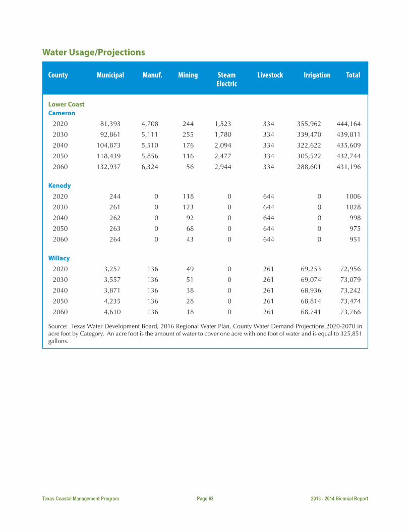
Texas Coastal Management Program Page 63 2013 - 2014 Biennial Report
Water Usage/Projections
County Municipal Manuf. Mining Steam Livestock Irrigation Total Electric
Lower CoastCameron
2020 81,393 4,708 244 1,523 334 355,962 444,164
2030 92,861 5,111 255 1,780 334 339,470 439,811
2040 104,873 5,510 176 2,094 334 322,622 435,609
2050 118,439 5,856 116 2,477 334 305,522 432,744
2060 132,937 6,324 56 2,944 334 288,601 431,196
Kenedy
2020 244 0 118 0 644 0 1006
2030 261 0 123 0 644 0 1028
2040 262 0 92 0 644 0 998
2050 263 0 68 0 644 0 975
2060 264 0 43 0 644 0 951
Willacy
2020 3,257 136 49 0 261 69,253 72,956
2030 3,557 136 51 0 261 69,074 73,079
2040 3,871 136 38 0 261 68,936 73,242
2050 4,235 136 28 0 261 68,814 73,474
2060 4,610 136 18 0 261 68,741 73,766
Source: Texas Water Development Board, 2016 Regional Water Plan, County Water Demand Projections 2020-2070 in acre foot by Category. An acre foot is the amount of water to cover one acre with one foot of water and is equal to 325,851 gallons.
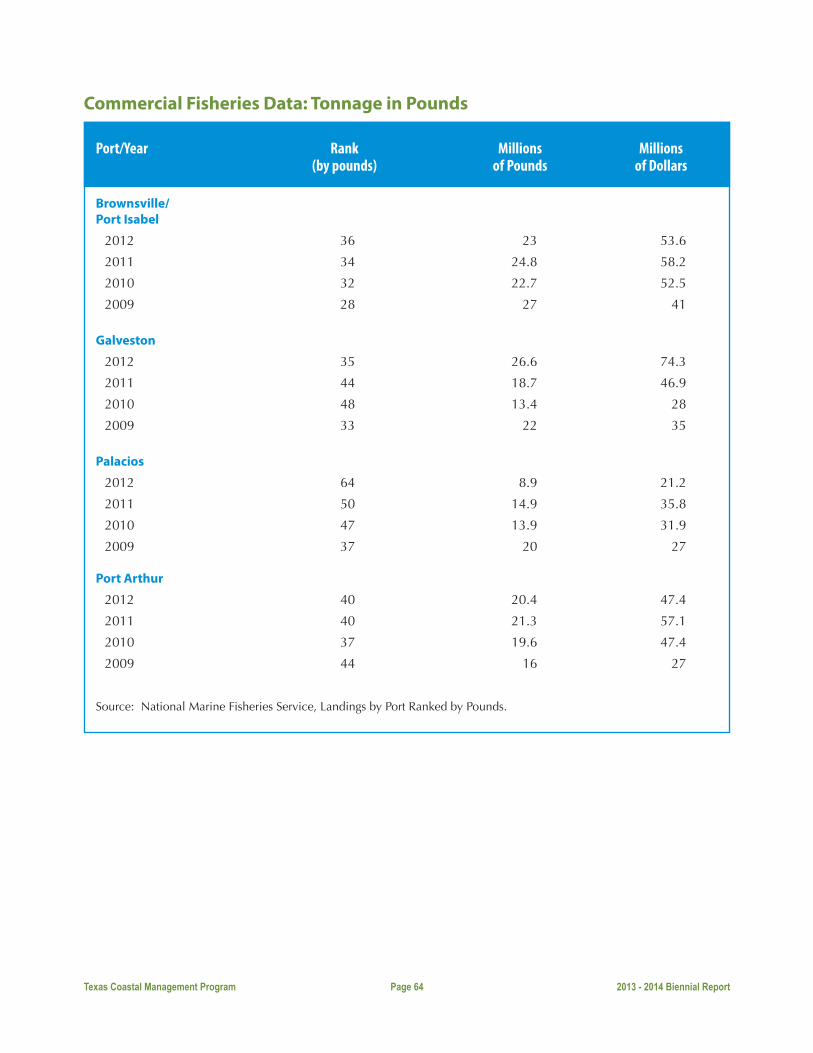
Texas Coastal Management Program Page 64 2013 - 2014 Biennial Report
Commercial Fisheries Data: Tonnage in Pounds
Port/Year Rank Millions Millions (by pounds) of Pounds of Dollars
Brownsville/Port Isabel
2012 36 23 53.6
2011 34 24.8 58.2
2010 32 22.7 52.5
2009 28 27 41
Galveston
2012 35 26.6 74.3
2011 44 18.7 46.9
2010 48 13.4 28
2009 33 22 35
Palacios
2012 64 8.9 21.2
2011 50 14.9 35.8
2010 47 13.9 31.9
2009 37 20 27
Port Arthur
2012 40 20.4 47.4
2011 40 21.3 57.1
2010 37 19.6 47.4
2009 44 16 27
Source: National Marine Fisheries Service, Landings by Port Ranked by Pounds.

Texas Coastal Management Program Page 65 2013 - 2014 Biennial Report
County Onshore Oil and Gas Production
County Oil Casinghead GW Gas Condensate (BBL) (MCF) (MCF) (BBL)
Upper CoastBrazoria
2013 2,897,805 1,701,309 9,741,427 241,802
2012 2,961,744 2,122,371 12,652,549 310,891
2011 1,389,409 2,120,977 20,140,216 624,232
2010 1,709,268 2,487,189 26,111,418 731,173
Chambers
2013 3,161,938 974,363 2,966,630 106,307
2012 2,627,284 846,189 4,334,418 183,949
2011 1,064,074 1,232,031 4,548,382 169,448
2010 1,994,919 1,511,519 8,791,275 211,824
Galveston
2013 369,683 307,877 2,243,711 90,488
2012 409,709 677,820 5,337,574 175,316
2011 530,684 663,346 5,970,221 333,582
2010 547,583 848,338 8,328,118 494,411
Harris
2013 1,093,789 593,837 11,358,443 178,586
2012 1,236,823 783,262 15,098,935 239,677
2011 1,161,900 947,316 19,396,508 326,613
2010 1,178,527 1,120,028 21,577,227 369,712
Jefferson
2013 774,644 894,586 15,661,096 897,673
2012 856,075 933,143 32,453,852 1,582,363
2011 828,773 1,536,991 58,404,241 3,522,769
2010 895,823 1,669,920 115,494,525 7,074,385
Orange
2013 445,922 992,535 6,407,832 432,535
2012 617,525 1,322,467 10,450,202 649,384
2011 849,765 1,797,714 17,957,385 986,633
2010 472,053 1,119,867 11,699,153 746,835

Texas Coastal Management Program Page 66 2013 - 2014 Biennial Report
County Onshore Oil and Gas Production
County Oil Casinghead GW Gas Condensate (BBL) (MCF) (MCF) (BBL)
Middle CoastCalhoun
2013 121,585 234,424 3,662,348 107,064
2012 171,747 410,246 4,453,789 144,425
2011 149,166 153,013 4,882,697 145,646
2010 166,967 191,612 6,557,183 171,838
Jackson
2013 657,470 828,649 5,833,630 197,746
2012 693,772 931,787 6,308,222 250,506
2011 663,110 1,036,665 9,098,950 283,509
2010 702,867 1,075,633 13,073,986 319,000
Matagorda
2013 203,825 358,914 19,021,965 349,488
2012 274,774 523,529 19,076,377 394,513
2011 365,949 1,127,186 24,412,179 576,590
2010 400,786 1,122,291 29,177,065 615,277
Refugio
2013 2,830,843 11,733,414 2,497,726 78,915
2012 3,313,975 13,368,239 3,093,560 101,891
2011 3,512,195 12,455,662 5,645,660 123,427
2010 3,736,173 16,586,706 7,954,267 180,192
Victoria
2013 568,814 661,933 4,166,940 65,453
2012 541,641 542,184 5,517,921 59,809
2011 564,539 472,486 7,675,935 75,427
2010 617,949 739,523 8,937,017 91,253
Coastal BendAransas
2013 54,311 376,689 5,694,046 164,941
2012 84,122 348,054 4,458,873 103,731
2011 96,301 244,636 5,237,123 134,401
2010 50,489 262,295 6,757,353 189,898

Texas Coastal Management Program Page 67 2013 - 2014 Biennial Report
County Onshore Oil and Gas Production
County Oil Casinghead GW Gas Condensate (BBL) (MCF) (MCF) (BBL)
Kleberg
2013 226,569 583,220 11,266,453 99,280
2012 248,542 839,817 16,083,672 200,260
2011 322,539 360,196 18,642,568 124,465
2010 159,181 153,421 17,505,012 174,320
Nueces
2013 296,357 619,037 12,455,419 310,828
2012 398,230 826,801 18,680,916 445,825
2011 515,863 1,200,578 30,951,967 341,560
2010 496,786 1,292,523 28,501,367 546,480
San Patricio
2013 384,547 639,505 11,899,375 467,987
2012 416,107 802,048 11,084,523 493,290
2011 446,361 771,102 11,026,643 381,067
2010 405,413 755,570 17,112,218 647,239
Lower CoastCameron
2013 0 0 299,207 410
2012 0 0 552,507 572
2011 425 3 1,025,290 3,515
2010 610 156 133,086 155
Kenedy
2013 72,764 260,686 24,632,186 162,550
2012 62,313 240,322 21,846,392 93,579
2011 51,808 312,847 38,025,194 233,658
2010 72,751 797,426 47,380,132 293,500
Willacy
2013 245,737 138,314 7,730,112 93,448
2012 292,136 207,688 8,889,143 125,617
2011 338,318 323,092 17,388,729 274,445
2010 339,712 399,276 24,152,092 426,599
Source: Railroad Commission of Texas
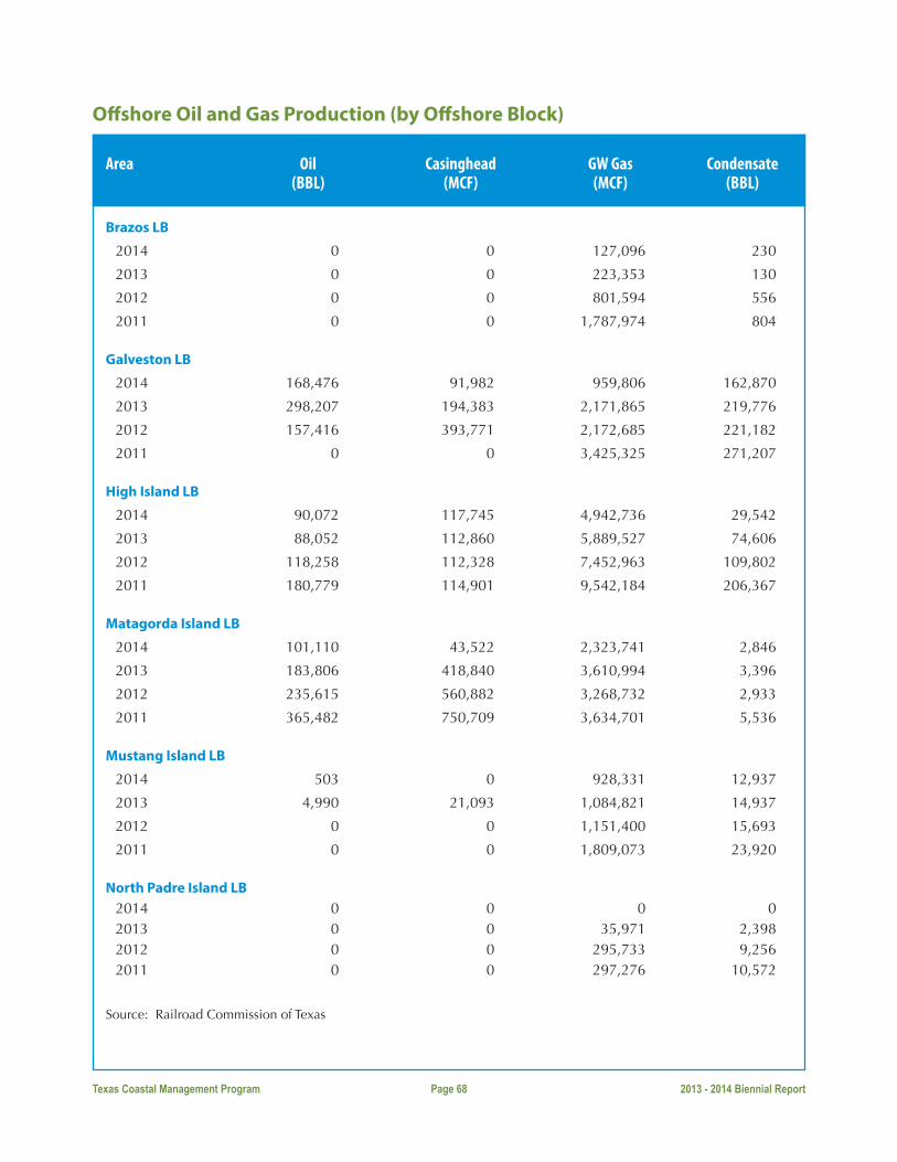
Texas Coastal Management Program Page 68 2013 - 2014 Biennial Report
Offshore Oil and Gas Production (by Offshore Block)
Area Oil Casinghead GW Gas Condensate (BBL) (MCF) (MCF) (BBL)
Brazos LB
2014 0 0 127,096 230
2013 0 0 223,353 130
2012 0 0 801,594 556
2011 0 0 1,787,974 804
Galveston LB
2014 168,476 91,982 959,806 162,870
2013 298,207 194,383 2,171,865 219,776
2012 157,416 393,771 2,172,685 221,182
2011 0 0 3,425,325 271,207
High Island LB
2014 90,072 117,745 4,942,736 29,542
2013 88,052 112,860 5,889,527 74,606
2012 118,258 112,328 7,452,963 109,802
2011 180,779 114,901 9,542,184 206,367
Matagorda Island LB
2014 101,110 43,522 2,323,741 2,846
2013 183,806 418,840 3,610,994 3,396
2012 235,615 560,882 3,268,732 2,933
2011 365,482 750,709 3,634,701 5,536
Mustang Island LB
2014 503 0 928,331 12,937
2013 4,990 21,093 1,084,821 14,937
2012 0 0 1,151,400 15,693
2011 0 0 1,809,073 23,920
North Padre Island LB 2014 0 0 0 0 2013 0 0 35,971 2,398 2012 0 0 295,733 9,256 2011 0 0 297,276 10,572
Source: Railroad Commission of Texas

Texas Coastal Management Program Page 69 2013 - 2014 Biennial Report
Per Capita Personal Income by County
County 2009 2010 2011 2012
Upper Coast
Brazoria 36,355 37,081 36,677 40,351
Chambers 42,035 45,681 48,969 51,897
Galveston 41,654 41,876 43,444 45,433
Harris 43,866 45,991 48,935 52,805
Jefferson 35,006 36,752 38,712 38,357
Orange 34,547 36,328 38,163 38,871
Middle Coast
Calhoun 29,357 30,964 32,413 35,177
Jackson 28,944 31,178 33,937 36,406
Matagorda 30,336 31,564 33,287 33,696
Refugio 32,177 35,686 39,958 44,770
Victoria 37,719 39,488 42,452 44,630
Coastal Bend
Aransas 38,439 40,411 42,512 43,581
Kleberg 30,195 31,464 33,734 35,884
Nueces 34,439 36,545 38,441 40,918
San Patricio 33,135 35,885 38,087 39,137
Lower Coast
Cameron 21,570 22,557 23,236 23,909
Kenedy 37,811 42,945 51,037 59,278
Willacy 22,499 24,900 26,462 26,731
Source: Bureau of Economic Analysis (Last updated May 30, 2014)

Texas Coastal Management Program Page 70 2013 - 2014 Biennial Report
Per Capita Personal Income by County
County 2010 2020 2030 2040 Census Projection Projection Projection
Upper Coast
Brazoria 313,166 339,245 361,915 380,301
Chambers 35,096 37,464 39,732 40,398
Galveston 291,309 308,347 320,723 325,644
Harris 4,092,459 4,532,775 4,882,019 5,169,611
Jefferson 252,273 267,930 292,192 324,658
Orange 81,837 85,262 87,620 88,058
Middle Coast
Calhoun 21,381 22,682 23,856 24,675
Jackson 14,075 14,851 15,663 16,268
Matagorda 36,702 39,042 41,079 42,654
Refugio 7,383 7,753 8,133 8,418
Victoria 86,793 94,032 100,490 105,766
Coastal Bend
Aransas 23,158 23,016 22,510 22,017
Kleberg 32,061 35,537 38,918 42,479
Nueces 340,223 362,319 381,137 392,834
San Patricio 64,804 70,651 76,679 81,828 Lower Coast
Cameron 406,220 465,569 531,850 599,356
Kenedy 416 462 496 506
Willacy 22,134 24,595 27,020 29,355
State Totals 25,145,561 27,373,633 29,289,940 30,823,109
Source: Office of the State Demographer and the Texas State Data Center in the Institute for Demographic and Socioeconomic Research at the University of Texas at San Antonio (November 2012)

Texas Coastal Management Program Page 71 2013 - 2014 Biennial Report
Tonnage for Texas Ports
Port Rank Domestic Foreign Imports Exports Total
Houston
2012 2 75,742,260 162,443,322 83,816,269 78,627,053 238,185,582
2011 2 70,721,272 167,077,367 88,889,008 78,188,359 237,798,639
2010 2 67,572,638 159,560,593 88,507,605 71,052,988 227,133,231
2009 2 63,371,521 147,969,451 84,629,722 63,339,729 211,340,972
2008 2 65,808,295 146,399,626 92,018,956 54,380,670 212,207,921
Corpus Christi
2012 7 23,300,339 45,701,018 30,878,967 14,822,051 69,001,357
2011 8 17,603,975 52,933,757 36,354,382 16,579,375 70,537,732
2010 6 18,840,615 54,822,817 41,654,989 13,167,828 73,663,432
2009 6 17,435,654 50,508,314 39,673,722 11,130,592 68,239,968
2008 6 21,430,962 55,355,211 43,373,738 11,981,473 76,786,173
Beaumont
2012 5 28,830,962 49,684,048 40,615,037 9,069,011 78,515,010
2011 6 25,841,403 47,830,666 38,854,187 8,976,479 73,672,069
2010 4 25,176,606 51,781,986 44,309,994 7,471,992 76,958,592
2009 7 67,715,469 24,428,821 43,286,648 36,873,234 6,413,414
2008 7 22,687,915 46,795,624 41,167,853 5,627,771 69,483,539
Texas City
2012 11 20,761,770 35,959,857 27,660,191 8,299,666 56,721,627
2011 12 18,867,032 38,890,500 30,510,237 8,380,263 57,757,532
2010 10 16,515,074 40,075,782 32,553,419 7,522,363 56,590,856
2009 10 16,156,660 36,475,801 31,701,199 4,774,602 52,632,461
2008 13 13,895,595 38,710,432 33,926,630 4,783,805 52,606,030
Port Arthur
2012 23 10,745,809 19,872,314 10,694,732 9,177,582 30,618,123
2011 24 10,205,058 20,069,678 11,936,521 8,133,157 30,274,736
2010 25 10,766,872 19,464,914 10,782,699 8,682,215 30,231,786
2009 19 9,418,964 24,385,235 14,440,672 9,944,563 33,804,199
2008 25 10,004,521 21,748,221 14,834,711 6,913,510 31,752,742
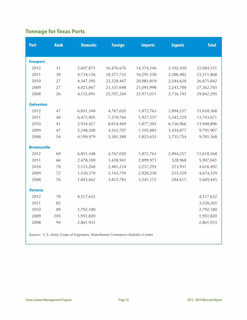
Texas Coastal Management Program Page 72 2013 - 2014 Biennial Report
Tonnage for Texas Ports
Port Rank Domestic Foreign Imports Exports Total
Freeport
2012 31 5,607,875 16,476,676 14,374,246 2,102,430 22,084,551
2011 30 4,734,136 18,577,732 16,291,250 2,286,482 23,311,868
2010 27 4,347,395 22,328,447 20,083,819 2,244,628 26,675,842
2009 27 4,025,067 23,337,698 21,093,998 2,243,700 27,362,765
2008 26 4,135,091 25,707,204 22,971,011 2,736,193 29,842,295
Galveston
2012 47 6,851,348 4,767,020 1,872,763 2,894,257 11,618,368
2011 40 6,472,905 7,270,766 1,927,537 5,343,229 13,743,671
2010 41 5,934,427 8,014,469 1,877,503 6,136,966 13,948,896
2009 47 5,248,200 4,543,707 1,105,885 3,434,877 9,791,907
2008 54 4,199,979 5,581,389 1,825,635 3,755,754 9,781,368
Brownsville
2012 69 6,851,348 4,767,020 1,872,763 2,894,257 11,618,368
2011 66 2,478,100 3,428,941 2,899,973 528,968 5,907,041
2010 78 2,135,268 2,481,224 2,257,293 223,931 4,616,492
2009 72 1,530,570 3,143,759 2,928,230 215,529 4,674,329
2008 76 1,843,662 3,825,783 3,541,172 284,611 5,669,445
Victoria
2012 78 4,517,632 4,517,632
2011 82 3,528,265
2010 89 2,792,180 2,792,180
2009 105 1,951,820 1,951,820
2008 94 2,861,933 2,861,933
Source: U.S. Army Corps of Engineers, Waterborne Commerce Statistics Center

Texas Coastal Management ProgramP.O. Box 12873 | Austin, Texas 78711-2873
800.998.4GLO | 512.936.6447 | 512.475.0680 (Fax)
glo.texas.gov
For more information on permitting assistance1.866.894.3578 (Lower Coast Office)
1.866.894.7664 (Upper Coast Office)
[email protected]/what-we-do/caring-for-the-coast/permit-assistance/html
A publication of the Texas General Land Office. Funded by a grant from the U.S. Department of Commerce,National Oceanic and Atmospheric Administration (NOAA) pursuant to award No. NA14NOS4190139.
Photos courtesy of Texas Parks and Wildlife Department, Texas Department of Transportation,South Padre Island Convention and Visitors Bureau and Vadim Troshkin, Galveston.com.
The Texas General Land Office does not discriminate on the basis of race, color, national origin, sex, sexual orientation, religion, age or disability in employment or the provision of services. To request an accessible format, call the ADA Coordinator at 412-463-5330 or contact us through RELAY Texas at 1-800-735-2988 or mail your request to P.O. Box 12873, Austin, Texas, 78711-2873.