terms, people, and places - mr. saadia's...
TRANSCRIPT

Five Themes of Geography:
Three Kinds of Maps:
Natural Resources:
Land Terms:
Water Terms:
Terms, People, and Places

• Explain how geography impacts human development
• Analyze how human activity impacts our natural world
• Identify key terms and themes of geography
Lesson Objectives

The study of geography helps us understand its impacts on human development. Human activity
greatly impacts the natural world we live in.
Summary “Geography and Its Impacts”

Aim #1b: How does geography impact us?

What is geography?
•
•

Why study geography?
•
•

Checkpoint Why is geography important in studying
the world?

Kinds of Maps •
•
•
•

Features of a Map
• Title
• Compass Rose
• Colors/Symbols
• Key/Legend
• Scale
• Grid: Longitude/Latitude

Checkpoint What are the different types of maps and
what purpose does each serve?

Five Themes of Geography
Tools to analyze geographic information given in photographs, charts, & maps


Checkpoint How are humans impacting and are being
impacted by the environment?

Developing a Sense of Place…
• Circle every mentioned geographic feature
• Think about how that feature might impact the region it is next to.

Developing a Sense of Place… Continents & Oceans
• Geographers divided land masses of world into separate areas called continents 7 continents in order of size: Asia,
Africa, North America, South America, Antarctica, Europe, & Australia
• N. America, S. America, & part of Antarctica make up Western Hemisphere
• Asia, Africa, Europe, Australia, & part of Antarctica make up Eastern Hemisphere
• Most of Earth's surface is covered by water ocean; extremely large body of
salt water 4 oceans: Atlantic, Pacific, lndian,
Arctic

North America • 3rd largest continent • bordered by 3 oceans: Atlantic,
Pacific, & Arctic • S. of Mexico, land narrows into
C. America, strip of land that connects to S. America
• Impact of Geography: much of history, N. America's
location separated it from civilizations of Africa, Asia, & Europe
Bec. of its large size, N. America has wide range of climates. To N. is extremely cold in winter, while to S., climate is generally hot
Fertile plains & protection of oceans helped the U.S. to develop a prosperous democracy in the past 200+ years
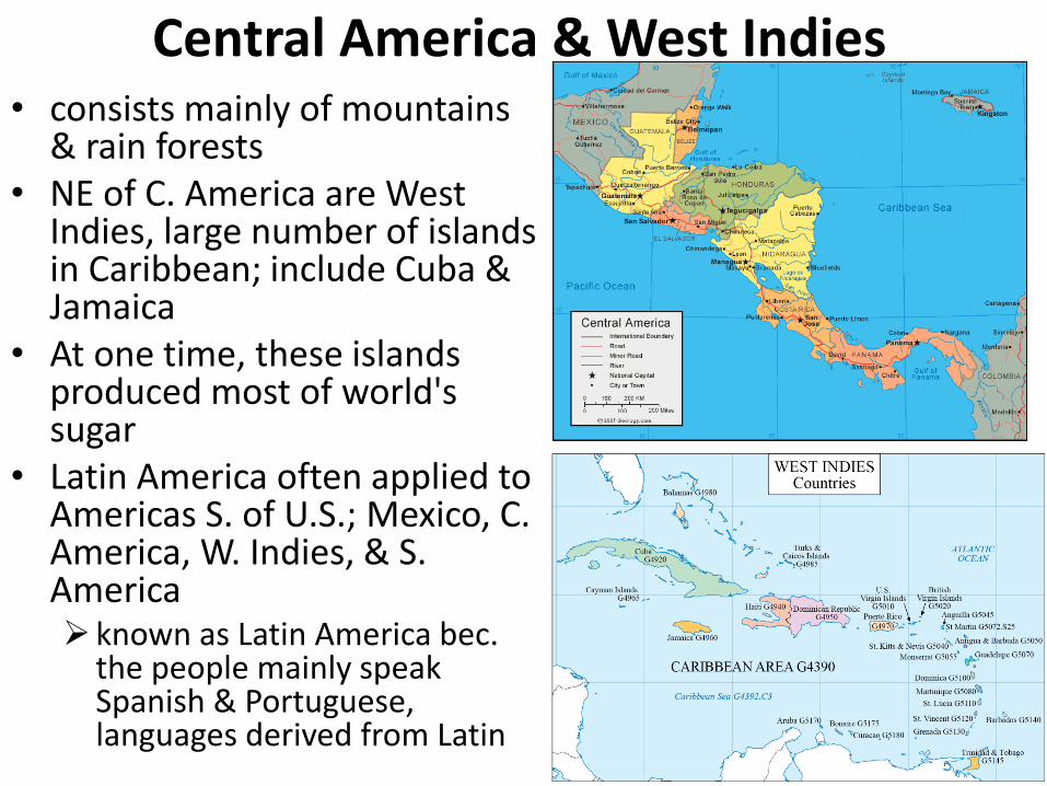
Central America & West Indies • consists mainly of mountains
& rain forests • NE of C. America are West
Indies, large number of islands in Caribbean; include Cuba & Jamaica
• At one time, these islands produced most of world's sugar
• Latin America often applied to Americas S. of U.S.; Mexico, C. America, W. Indies, & S. America known as Latin America bec.
the people mainly speak Spanish & Portuguese, languages derived from Latin

South America • surrounded by Pacific & Atlantic
Oceans, & connected to C. America by Panama
• Impact of Geography: Much of S. America is warm bec. of
location near equator Amazon, most important river & 2nd
longest river on earth world's largest rain forest, Amazon
rain forest, occupies most of NE S. America
Andes Mountains run along W. side of S. America & are among highest mountains on earth
Mountains, rain forests, & poor soils = S. America's land unproductive
2 important exceptions; pampas & Llanos, large grassy, treeless plains in SE & NE
Most S. Americans live along coast or on these fertile plains

Africa • 2nd largest continent; 50+
countries • Most of Africa is a plateau
w/ a narrow coastline • divided into 2 separate
regions: North Africa & sub-Saharan Africa
• North Africa: mainly ppl of Arab descent & Muslims more closely tied to Middle
East than to rest of Africa
• Sub-Saharan Africa: area S. of Sahara Desert w/ very diff. climate & topography from N. Africa W/ its non-Arab population,
sometimes viewed as a separate & distinct region

Africa; Impact of Geography • N. Africa - warm & dry climate • On N. border is Mediterranean Sea • Sahara, world's largest desert, takes
up most N. Africa; For centuries, acted as barrier separating ppls N. & S. of it
• Nile, world's longest river, flows through N. Africa; made possible rise of ancient Egypt
• large part of sub-Saharan Africa is savanna; provides best land in Africa for growing crops & raising livestock
• In E. Africa, Great Rift Valley runs through highlands of Ethiopia & Kenya
• Africa's mountains, deserts, lakes, & rivers have kept diff. groups apart, causing them to develop separate cultures = tribalism
• nearness to ME & Europe led to spread of lslam & Christianity, slave trade & imperialism

Europe • Europe & Asia share
same land mass; so large, geographers divided it into 2 continents
• dividing line bet. Europe & Asia runs through center of Russia, along Ural Mountains & Ural River into Caspian Sea & SW to Black Sea
• Europe is further bordered by Baltic, North Sea, & Arctic Ocean to N., Atlantic Ocean to W., & Mediterranean Sea to S.

Europe; Impact of Geography • Mountain ranges - Pyrenees
& Alps separated Europeans, causing development of diff. cultures
• location close to N. Africa & ME-borrow from those cultures
• major rivers, Rhine, Danube, Seine, Elbe, & Vistula enabled trade w/ each other
• Much of Europe consists of broad fertile plain, allowed development of prosperous farmlands
• To NE, this flat plain w/ few defensible frontiers, made constant shift of borders of Russia, Poland, & Germany
• Due to dense population, many cultures & diff. ethnic groups live close to one another = frequent warfare

Asia • largest continent • Today, home to 2/3 of world's population • Bec. of its immense size & diverse cultures, geographers
usually think of Asia as consisting of several distinct cultural regions

Asia: Middle East • located in SW Asia • "crossroads of 3
continents” • Some consider N. Africa
as part of M. East • Impact of Geography:
climate is very hot Much of region is
desert & lacks plentiful water
greatest population density is near coast & along major rivers-water supplies & growing crops
2 major rivers; Tigris & Euphrates
Today, ME provides about half of world's oil supply

Asia: Northern • occupied by Russia, stretches from E.
Europe east to Pacific Ocean • world's largest country • Although ¾ of population, farmland, &
industry are located in Europe, most of Russia's land area is in Asia
• Siberia, in NE Russia, is a cold region w/ forests, oil & gas deposits, diamonds, gold, & other precious metals
• Impact of Geography: Most of Russia has long, cold winters &
short mild summers Northernmost Russia is tundra, ground
frozen much of year Arctic Ocean, N. of Russia, also frozen
most of time To the S., Russia is landlocked (access to
sea is blocked by other countries) need for ice-free port has been a major
problem in its history, causing rulers to expand southward & westward
Bec. of Russia's great distance from W. Europe, its culture developed independently

Asia: Central • consists of a vast corridor south of Russia & north of Iran, India, & China • mainly an area of deserts & treeless grasslands known as steppes • Impact of Geography:
has long been crossroads for overland trade routes bet. China, India, Middle East, & Europe
Bec. steppes of C. Asia provided excellent grazing land, its people became herders & excelled at horsemanship
Throughout much of history, warriors on horseback from steppes occasionally emerged to conquer peoples in neighboring lands

East Asia • once known as "Far
East" bec. of its great distance from Europe
• includes 3 important countries: China, Korea, & Japan
• China, one of world's most ancient civilizations, is third largest country
• Today, China is world's most populous nation
• Korea, a peninsula extending from NE coast of China Situated bet. China &
Japan, has been invaded & influenced by both

East Asia: China-Impact of Geography • southern & western borders
are ringed by some of world's highest & most rugged mountains-Himalayan, Kunlun, & Tianjin protected & isolated China
from outside world
• Gobi Desert to N. & Pacific Ocean to E. have further separated China
• E. China consists of a vast plain w/ fertile river valleys-most of population settled in this area
• mountains, deserts, & seas surrounding China permitted it to develop a uniform culture in isolation from other centers of civilization
• isolation encouraged a centralization of power & concentration of resources, made China one of world's most advanced civilizations for thousands of years

East Asia: Japan • lies east of Asian mainland,
separated by Sea of Japan • Archipelago- 4 main islands
& thousands of smaller ones, extending 1,500 miles
• Impact of Geography: small country with 85% of
land covered by mountains high population density has
led to a social closeness & promoted ability of its people to work together
lacks many important natural resources necessary for modern industry- caused Japanese to seek raw materials from other nations, either through peaceful trade or aggressive military conquest

South Asia • Indian subcontinent forms a
triangle about half size of U.S., which juts out into Indian Ocean
• contains India, Pakistan, Bangladesh, & several smaller nations
• India has world's second largest population
• Impact of Geography: Himalayan Mountains, highest in
world, separate Indian subcontinent from rest of Asia
S. of Himalayas are fertile river valleys & coastal plains, w/ a warm & humid climate
main rivers, Indus & Ganges, gave rise to some of world's earliest civilizations
subcontinent's location close to Middle East led to later spread of Islam throughout much of region

Southeast Asia • consists of large
peninsula on SE corner of Asian mainland together w/ a large number of islands
• Some of major countries; Thailand, Vietnam, Indonesia, Malaysia, & Philippines
• Mekong, Salween, Irrawaddy Rivers run through region

Southeast Asia: Impact of Geography • surrounded by Pacific & Indian
Oceans bec. shortest water route bet. 2
oceans runs through SE Asia, region has been heavily affected by large mix of peoples
• islands of SE Asia, once known as East Indies, export important spices In earlier times, these spices were
highly prized in Europe & the ME bec. they provided preservation of food
• monsoons, most important feature of climate of South & SE Asia seasonal winds bring heavy
summer rains-waters crops & supports life
but if monsoons bring too much rain-flooding, destruction, & death
Bec. of warm climate & humidity, much of region is rain forest

37

38
archipelago An archipelago is a group or chain of islands clustered together in a sea or ocean.
bay A bay is a body of water that is partly enclosed by land (and is usually smaller than a gulf).
canyon A canyon is a deep valley with very steep sides - often carved from the Earth by a river.
cape A cape is a pointed piece of land that sticks out into a sea, ocean, lake, or river.
cave A cave is a large hole in the ground or in the side of a hill or mountain.

39
channel A channel is a body of water that connects two larger bodies of water (like the English Channel). A channel is also a part of a river or harbor that is deep enough to let ships sail through.
cliff A cliff is a steep face of rock and soil.
continent The land mass on Earth is divided into continents. The seven current continents are Africa, Antarctica, Asia, Australia, Europe, North America, and South America.
cove A cove is small, horseshoe-shaped body of water along the coast; the water is surrounded by land formed of soft rock. delta A delta is a low, watery land formed at the mouth of a river. It is formed from the silt, sand and small rocks that flow downstream in the river and are deposited in the delta. A delta is often (but not always) shaped like a triangle (hence its name, delta, a Greek letter that is shaped like a triangle).

40
desert A desert is a very dry area.
equator The equator is an imaginary circle around the earth, halfway between the north and south poles.
estuary An estuary is where a river meets the sea or ocean.
glacier A glacier is a slowly moving river of ice.
gulf A gulf is a part of the ocean (or sea) that is partly surrounded by land (it is usually larger than a bay).

41
hill A hill is a raised area or mound of land.
island An island is a piece of land that is surrounded by water.
isthmus An isthmus is a narrow strip of land connecting two larger landmasses. An isthmus has water on two sides. lagoon A lagoon is a shallow body of water that is located alongside a coast.
lake A lake is a large body of water surrounded by land on all sides. Really huge lakes are often called seas.

42
latitude Latitude is the angular distance north or south from the equator to a particular location. The equator has a latitude of zero degrees. The North Pole has a latitude of 90 degrees North; the South Pole has a latitude of 90 degrees South.
longitude Longitude is the angular distance east or west from the north-south line that passes through Greenwich, England, to a particular location. Greenwich, England has a longitude of zero degrees. The farther east or west of Greenwich you are, the greater your longitude. Midway Islands (in the Pacific Ocean) have a longitude of 180 degrees (they are on the opposite side of the globe from Greenwich).
mountain A mountain is a very tall high, natural place on Earth - higher than a hill. The tallest mountain on Earth is Mt. Everest.
ocean An ocean is a large body of salt water that surrounds a continent. Oceans cover more the two-thirds of the Earth's surface

43
peninsula A peninsula is a body of land that is surrounded by water on three sides. pond A pond is a small body of water surrounded by land. A pond is smaller than a lake. plain Plains are flat lands that have only small changes in elevation. plateau A plateau is a large, flat area of land that is higher than the surrounding land.
prairie A prairie is a wide, relatively flat area of land that has grasses and only a few trees.
river A river is a large, flowing body of water that usually empties into a sea or ocean.
sea A sea is a large body of salty water that is often connected to an ocean. A sea may be partly or completely surrounded by land.

44
strait A strait is a narrow body of water that connects two larger bodies of water.
swamp A swamp is a type of freshwater wetland that has spongy, muddly land and a lot of water. Many trees and shrubs grow in swamps.
valley A valley is a low place between mountains.
volcano A volcano is a mountainous vent in the Earth's crust. When a volcano erupts, it spews out lava, ashes, and hot gases from deep inside the Earth.
waterfall When a river falls off steeply, there is a waterfall.


