tennessee archaeology - tn.gov · courtesy, aaron deter-wolf. ... michael c. moore, tennessee...
TRANSCRIPT
TTEENNNNEESSSSEEEE AARRCCHHAAEEOOLLOOGGYY
VVoolluummee 55 FFaallll 22001111 NNuummbbeerr 22
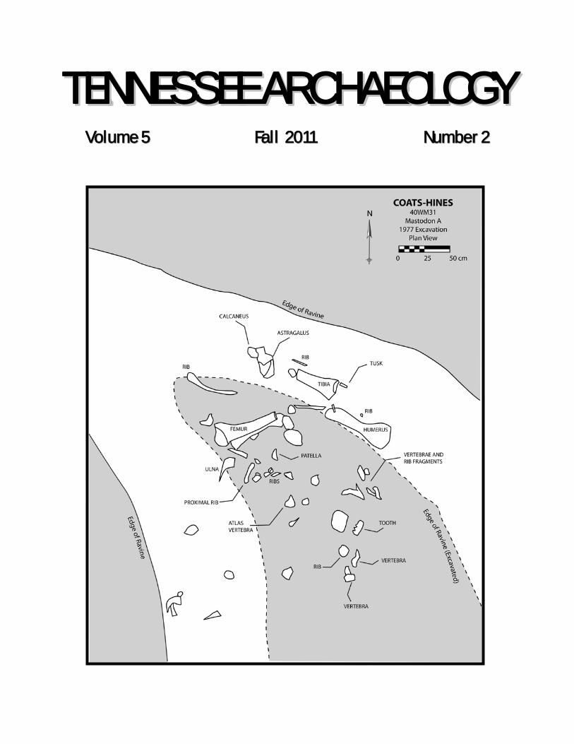
On the Cover: Coats-Hines Mastodon A, Courtesy, Aaron Deter-Wolf
EDITORIAL COORDINATORS
Michael C. Moore Tennessee Division of Archaeology
Kevin E. Smith Middle Tennessee State University
EDITORIAL ADVISORY COMMITTEE
Patrick Cummins Alliance for Native American Indian Rights
Aaron Deter-Wolf
Tennessee Division of Archaeology
Jay Franklin East Tennessee State University
Phillip Hodge
Tennessee Department of Transportation
Nicholas Honerkamp University of Tennessee
Zada Law
Middle Tennessee State University
Larry R. McKee TRC, Inc.
Tanya M. Peres
Middle Tennessee State University
Sarah Sherwood University of the South
Lynne Sullivan
Frank H. McClung Museum
Guy Weaver Weaver and Associates LLC
Tennessee Archaeology is published semi-annually in electronic print format by the Tennessee Council for Professional Archaeology. Correspondence about manuscripts for the journal should be addressed to Michael C. Moore, Tennessee Division of Archaeology, Cole Building #3, 1216 Foster Avenue, Nashville TN 37243. The Tennessee Council for Professional Archaeology disclaims responsibility for statements, whether fact or of opinion, made by contributors.
TTEENNNNEESSSSEEEE AARRCCHHAAEEOOLLOOGGYY
VOLUME 5 Fall 2011 NUMBER 2
127 EDITORS CORNER
ARTICLES 131 Pests in the Garden: Testing the Garden-
Hunting Model at the Rutherford-Kizer Site, Sumner County, Tennessee
JENNIFER M. CLINTON AND TANYA M. PERES 142 Excavations and Dating of Late Pleistocene
and Paleoindian Deposits at the Coats-Hines Site, Williamson County, Tennessee
AARON DETER-WOLF, JESSE W. TUNE, AND JOHN B. BROSTER
157 The Ames Site (40FY7): A Very Unobtrusive
Mississippian Settlement Located in Southwestern Tennessee
ANDREW M. MICHELSON AND ERIC GODDARD 173 Recovery and Reburial of the Remains of an
Unknown Civil War Soldier, Franklin, Tennessee
SAMUEL D. SMITH AND LARRY R. MCKEE
127
EDITORS CORNER Welcome to the tenth issue of Tennessee Archaeology, with articles ranging from mastodons and Paleoindians, Mississippian settlements in West and Middle Tennessee, and the recovery and reinterment of an unknown Civil War soldier. As always, we extend our thanks to the contributing authors and to the scholars who assist with reviews of submitted articles. This journal would not be possible without their support. We have several updates of note since our last Editors Corner. First, with mixed feelings we report the retirement of Samuel D. Smith from the Tennessee Division of Archaeology in July of this year. While his dedicated and skillful service as State Historical Archaeologist will be missed, we congratulate him on his retirement. Sam is a native Tennessean, attended public schools in Carthage, and received an undergraduate degree from Middle Tennessee State College in 1964. He worked as a science teacher in Savannah, Georgia and as a Peace Corps Volunteer in Brazil before attending the University of Florida, where he received his M.A. in 1971 under the tutelage of Charles Fairbanks. From 1972 to 1974 he worked as an archaeologist in Jonesboro with the Arkansas Archeological Survey. Sam started his thirty-seven year career with the Tennessee Division of Archaeology in 1974 and made substantial contributions to the development of "Historical Archaeology" in Tennessee and the southeastern United States. Sam's joint interests in history and archaeology undoubtedly came from his late father Ervin Smith of Carthage, who was an active leader of the Smith County chapter of the Tennessee Archaeological Society in the 1960s. Sam's publications, beginning in the Florida Anthropologist, are too numerous to list in their entirety, but cover an extraordinary diversity of topics in historical archaeology (with a bit of prehistory here and there). Sam's work in the mid-1970s on slave cabins at the Hermitage and Wynnewood was pioneering - his 1976 report and 1977 Tennessee Anthropologist article on "Plantation Archaeology at the Hermitage: Some Suggested Patterns" have been cited countless times. Sam was perhaps the first to note the consistent association of blue beads with the residences of enslaved African-Americans. From very early in his career, Sam focused much of his interest on developing the methods of thematic context studies for historic sites, primarily in partnership with the Tennessee Historical Commission using Historic Preservation Fund
Tennessee Archaeology 5(2) Fall 2011
128
matching grants. Over the past thirty years, Sam directed at least 15 separate site survey projects of this type, including frontier stations, historic potteries, abandoned towns, iron industry sites, gunmaker shops, early federal military sites, Revolutionary War and War of 1812 sites, Civil War sites, World War II sites, and the Trail of Tears. Over the course of those surveys, Sam has overseen the recording of nearly 2500 archaeological sites. Sam's 1990 article outlining his methods for thematic context surveys in the journal Historical Archaeology - "Site Survey as a Method of Determining Historic Site Significance" -- has stood the test of time as a national model for historical archaeology. Recently (January 2010), Sam was honored with a Lifetime Achievement Award by the Tennessee Council for Professional Archaeology. We are pleased to have the opportunity to again acknowledge Sam's many years of
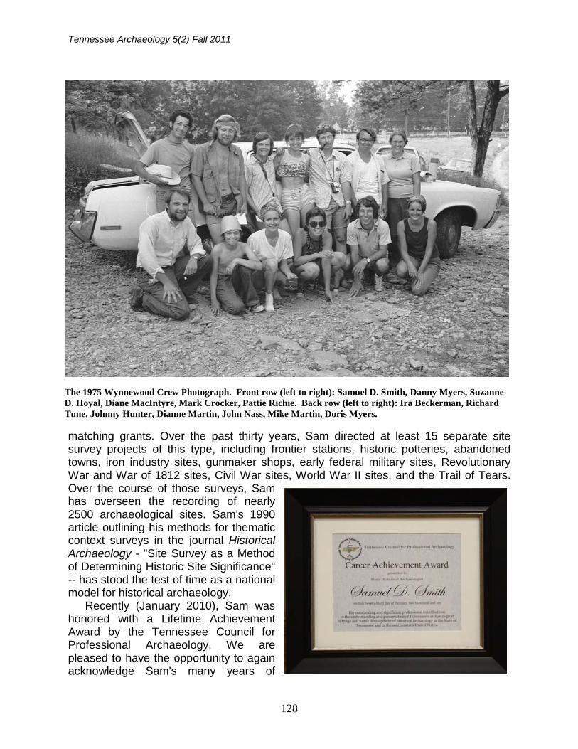
The 1975 Wynnewood Crew Photograph. Front row (left to right): Samuel D. Smith, Danny Myers, Suzanne D. Hoyal, Diane MacIntyre, Mark Crocker, Pattie Richie. Back row (left to right): Ira Beckerman, Richard Tune, Johnny Hunter, Dianne Martin, John Nass, Mike Martin, Doris Myers.
Editors Corner
129
devoted service to Tennessee archaeology -- and his on-going contributions as reflected in his co-authored article with Larry McKee in this issue. On a sadder note, we observe the passing of Mr. Raymond Earl Falkenberry, Sr. (June 25, 1923 - March 11, 2011), a noted avocational archaeologist of Middle Tennessee at the age of 87. Son of the late Frank and Bettie Gunn Falkenberry of Huntsville, Alabama, he was preceded in death by Ruth, the love of his life and wife of 60 years, and by his sister Dorothy and brother Michael. He is survived by three children: Beth Wright, Ray (Janice) Falkenberry, Jr., and Phyllis (Kerry) Dye; three grandchildren: Chris Wright, Andrea Falkenberry, and Jeremy Falkenberry; three brothers: Frank, Gene, and Jimmy; sister-in-law Billie Atrip; brother-in-law Herbie Hobbs and numerous beloved nieces, nephews, grand nieces and nephews. During World War II, Raymond served as an Army Staff Sergeant Squad Leader with replacements to the 106th Infantry in Europe. After graduating from George Peabody College in Nashville, he taught in Metro Nashville Public Schools until his retirement in 1982. He was a member of the First Baptist Church in Donelson for over 50 years. Raymond is interred in Mount Olivet Cemetery.
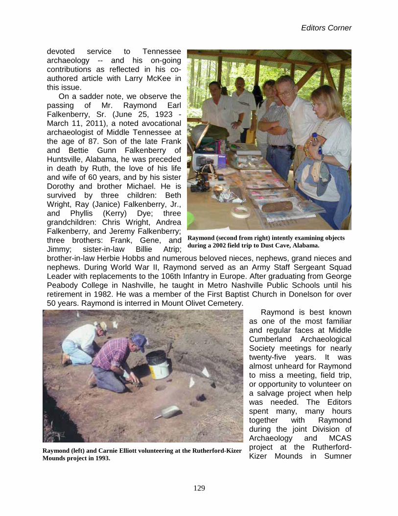
Raymond is best known as one of the most familiar and regular faces at Middle Cumberland Archaeological Society meetings for nearly twenty-five years. It was almost unheard for Raymond to miss a meeting, field trip, or opportunity to volunteer on a salvage project when help was needed. The Editors spent many, many hours together with Raymond during the joint Division of Archaeology and MCAS project at the Rutherford-Kizer Mounds in Sumner
Raymond (second from right) intently examining objects during a 2002 field trip to Dust Cave, Alabama.
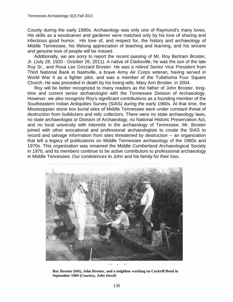
Raymond (left) and Carnie Elliott volunteering at the Rutherford-Kizer Mounds project in 1993.
Tennessee Archaeology 5(2) Fall 2011
130
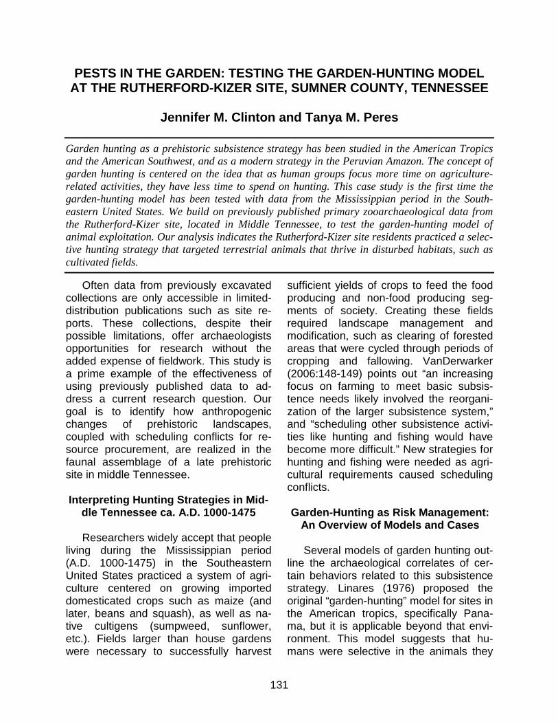
County during the early 1990s. Archaeology was only one of Raymond's many loves. His skills as a woodcarver and gardener were matched only by his love of sharing and infectious good humor. His love of, and respect for, the history and archaeology of Middle Tennessee, his lifelong appreciation of teaching and learning, and his sincere and genuine love of people will be missed. Additionally, we are sorry to report the recent passing of Mr. Roy Bertram Broster, Jr. (July 28, 1920 - October 26, 2011). A native of Clarksville, he was the son of the late Roy Sr., and Rosa Lee Grizzard Broster. He was a retired Senior Vice President from Third National Bank in Nashville, a brave Army Air Corps veteran, having served in World War II as a fighter pilot, and was a member of the Tullahoma Four Square Church. He was preceded in death by his loving wife, Mary Ann Broster, in 2004. Roy will be better recognized to many readers as the father of John Broster, long-time and current senior archaeologist with the Tennessee Division of Archaeology. However, we also recognize Roy's significant contributions as a founding member of the Southeastern Indian Antiquities Survey (SIAS) during the early 1960s. At that time, the Mississippian stone box burial sites of Middle Tennessee were under constant threat of destruction from bulldozers and relic collectors. There were no state archaeology laws, no state archaeologist or Division of Archaeology, no National Historic Preservation Act, and no local university with interests in the archaeology of Tennessee. Mr. Broster joined with other avocational and professional archaeologists to create the SIAS to record and salvage information from sites threatened by destruction -- an organization that left a legacy of publications on Middle Tennessee archaeology of the 1960s and 1970s. This organization was renamed the Middle Cumberland Archaeological Society in 1976, and its members continue to be active contributors to professional archaeology in Middle Tennessee. Our condolences to John and his family for their loss.
Roy Broster (left), John Broster, and a neighbor working on Cockrill Bend in September 1969 (Courtesy, John Dowd)
131
PESTS IN THE GARDEN: TESTING THE GARDEN-HUNTING MODEL AT THE RUTHERFORD-KIZER SITE, SUMNER COUNTY, TENNESSEE
Jennifer M. Clinton and Tanya M. Peres
Garden hunting as a prehistoric subsistence strategy has been studied in the American Tropics and the American Southwest, and as a modern strategy in the Peruvian Amazon. The concept of garden hunting is centered on the idea that as human groups focus more time on agriculture-related activities, they have less time to spend on hunting. This case study is the first time the garden-hunting model has been tested with data from the Mississippian period in the South-eastern United States. We build on previously published primary zooarchaeological data from the Rutherford-Kizer site, located in Middle Tennessee, to test the garden-hunting model of animal exploitation. Our analysis indicates the Rutherford-Kizer site residents practiced a selec-tive hunting strategy that targeted terrestrial animals that thrive in disturbed habitats, such as cultivated fields.
Often data from previously excavated collections are only accessible in limited-distribution publications such as site re-ports. These collections, despite their possible limitations, offer archaeologists opportunities for research without the added expense of fieldwork. This study is a prime example of the effectiveness of using previously published data to ad-dress a current research question. Our goal is to identify how anthropogenic changes of prehistoric landscapes, coupled with scheduling conflicts for re-source procurement, are realized in the faunal assemblage of a late prehistoric site in middle Tennessee.
Interpreting Hunting Strategies in Mid-
dle Tennessee ca. A.D. 1000-1475
Researchers widely accept that people living during the Mississippian period (A.D. 1000-1475) in the Southeastern United States practiced a system of agri-culture centered on growing imported domesticated crops such as maize (and later, beans and squash), as well as na-tive cultigens (sumpweed, sunflower, etc.). Fields larger than house gardens were necessary to successfully harvest
sufficient yields of crops to feed the food producing and non-food producing seg-ments of society. Creating these fields required landscape management and modification, such as clearing of forested areas that were cycled through periods of cropping and fallowing. VanDerwarker (2006:148-149) points out “an increasing focus on farming to meet basic subsis-tence needs likely involved the reorgani-zation of the larger subsistence system,” and “scheduling other subsistence activi-ties like hunting and fishing would have become more difficult.” New strategies for hunting and fishing were needed as agri-cultural requirements caused scheduling conflicts.
Garden-Hunting as Risk Management:
An Overview of Models and Cases
Several models of garden hunting out-line the archaeological correlates of cer-tain behaviors related to this subsistence strategy. Linares (1976) proposed the original “garden-hunting” model for sites in the American tropics, specifically Pana-ma, but it is applicable beyond that envi-ronment. This model suggests that hu-mans were selective in the animals they
Tennessee Archaeology 5(2) Fall 2011
132
targeted, specifically larger mammals. Human populations focused nearly exclu-sively on a few big game animals while they were abundant. The shift in focus to these large mammals, especially in areas where the dietary tradition included aqua-tic fauna, would lead to a shift in dietary focus (i.e., to the near exclusion of the aquatic taxa) (Linares 1976). More recent-ly, however, ethnographic studies have shown that large game populations, if hunted exclusively in and around agricul-tural fields and gardens, were easily over-exploited (e.g., VanDerwarker 2006). To identify Linares’ selective garden-hunting strategy we can turn to the site-specific zooarchaeological data. According to this strategy, the faunal remains will consist of animal taxa that travel in small numbers over small ranges, tend to be passive, and are conducive to living in edge envi-ronments. These animals are easy to catch in traps and favor cultivated crops for their diets. Game populations can withstand heavy predation and recover quickly. The faunal assemblage will in-clude predominantly larger terrestrial animals versus small mammals and aqua-tic fauna (Linares 1976).
Neusius (2008), building on Linares’ work, proposed a revised model of garden hunting designed for the Dolores Anasazi in the American Southwest. The Neusius model suggests humans were more op-portunistic and non-selective, and would hunt any animal that was available. This model relies on the assumption that culti-vated fields contain a high diversity of plants and would therefore have a corres-ponding high diversity of animals. Archae-ologically, the faunal assemblage will contain high species diversity in compari-son with the species diversity of natural spaces, and the represented species will be the most able to tolerate cultivation changes (Neusius 2008). This model is
also supported by the fact that cultivation places further constraints on time. Local human groups would have had little time for hunting so they merely gathered game when and where they could (Neusius 2008). A non-selective garden hunting strategy clearly addresses the scheduling conflicts created by agricultural activities.
A third case study of the garden-hunting model is an interpretation of gar-den hunting in relationship to the Olmec of Mesoamerica (VanDerwarker 2006). This model is similar to the others, except VanDerwarker argues this sort of diversi-fication represents risk management. The “entire premise of the garden-hunting strategy is the economy of resources,” and that local human groups chose a “selective or opportunistic approach de-pending on availability” (VanDerwarker 2006:151). There is an organic continuum between selective or opportunistic within this model as well. Archaeologically, the model is much the same as the Linares and Neusius models. Farmers could be more selective in the animals hunted when crop harvests were good, and con-versely, when crops failed farmers may have used a “take what you can get” approach to hunting animals in and around their fields (VanDerwarker 2006:151). This more opportunistic strat-egy would result in zooarchaeological assemblages with high species diversity.
VanDerwarker uses data from two Ol-mec sites, La Joya and Bezuapan, to test the garden-hunting model. At La Joya, people selectively hunted specific ani-mals, as evidenced by the high number of large terrestrial “disturbance” mammals in the assemblage from the Early through Late Formative periods. VanDerwarker (2006:164) interprets this as an indication that “farming had become a more de-pendable and less risky venture.” Howev-er, during the Terminal Formative period
Garden Hunting
133
at La Joya, inhabitants of the site ex-panded their hunting territory by exploiting animals from aquatic and primary forest environments. VanDerwarker (2006:165) suggests that the people living at La Joya during the Terminal Formative were deal-ing with some degree of dietary stress that was likely related to “local environ-mental catastrophe (volcanic eruptions and ashfall).”
The Bezuapan faunal assemblage pat-terns are slightly different. Hunting of large terrestrial mammals was common early in the site’s occupation, leading to overexploitation of these prey species. Later people had to diversify and hunt a wider range of smaller taxa to supplement their diets. This increase in the range of animals being exploited is suggested to reflect management of subsistence-related risk as the residents of Bezuapan invested increased amounts of resources (both time and labor) into agriculture (VanDerwarker 2006:177-178).
In addition to archaeological samples, modern ethnographic research supports several aspects of the garden-hunting model. Naughton-Treves et al. (2003: 1112) conducted research in the Peruvian Amazon that showed “shortly after maize was planted, wildlife visits to the disturbed areas peaked and was statistically higher than the amount of wildlife that visited fallow fields or forests.” This research also showed areas that were too intensively managed did not attract the number of animals necessary to balance crop losses with protein gains (Naughton-Treves et al. 200l:1107). Therefore, this subsistence strategy is best employed in areas of low human population density. Ethnographic and ethnohistoric evidence supports that both selective and non-selective strate-gies are employed (Neusius 2008:300). The choice depends on the reliability of the agricultural yields (VanDerwarker
2006:150). In areas where agricultural yields are predictable and high, agricultu-ralists are more likely to hunt with increas-ing selectiveness.
Cultivation is an intensive strategy for food production and requires considerable time and energy. As humans cleared more land in the past, they provided the opportunity for an increase in the abun-dance of high-quality edible vegetation. This led to an increase in animals at-tracted to these cleared areas with edible cultivated crops (VanDerwarker 2006:148). By adopting a garden-hunting scheme, populations would be able to hunt in cultivated fields and home gardens with no special preparation as was re-quired for hunting parties. Such hunting was far less time consuming because it happened while performing other cultiva-tion requirements. Garden hunting was also low risk as it often involved traps and snares (VanDerwarker 2006:149-150), and the need for long-distance hunting trips during critical agricultural activities was reduced. Also, killing the larger pests that destroy crops reduced the competi-tion for farmer’s resources. And finally, garden hunting provided easy access to readily exploitable sources of protein.
Animals attracted to gardens have a special set of characteristics. Certain animals (white-tailed deer and turkey) are drawn to disturbed environments such as home gardens or forest edges because of the concentration of crops and weedy plants (Eaton 1992; Neusius 1996; Nowak and Paradiso 1983; VanDerwarker 2006). Linares (1976:347) refers to these ani-mals as commensals, while VanDerwark-er (2006:149) and others refer to them as crop pests. They usually travel in small packs and therefore need smaller home territories. For example, white-tailed deer need a home range size of about 49-120 hectares (Tierson et al. 1985). Converse-
Tennessee Archaeology 5(2) Fall 2011
134
ly, animals not considered crop pests, such as black bears, have home ranges up to 26,000 hectares (Garshelis and Pelton 1981). Crop pests (such as deer and rabbits) lack an overly aggressive nature, and also can recover quickly from overexploitation and other population pressures. The best example of this cha-racteristic comes from research at Cerro Brujo in Panama where the inhabitants relied on collared peccary rather than white-lipped peccary since the white-lipped peccary pack sizes are large and dangerous to hunters without guns (Li-nares 1976:347).
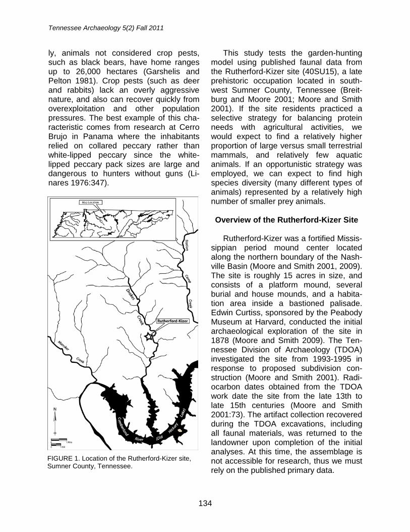
This study tests the garden-hunting model using published faunal data from the Rutherford-Kizer site (40SU15), a late prehistoric occupation located in south-west Sumner County, Tennessee (Breit-burg and Moore 2001; Moore and Smith 2001). If the site residents practiced a selective strategy for balancing protein needs with agricultural activities, we would expect to find a relatively higher proportion of large versus small terrestrial mammals, and relatively few aquatic animals. If an opportunistic strategy was employed, we can expect to find high species diversity (many different types of animals) represented by a relatively high number of smaller prey animals.
Overview of the Rutherford-Kizer Site
Rutherford-Kizer was a fortified Missis-
sippian period mound center located along the northern boundary of the Nash-ville Basin (Moore and Smith 2001, 2009). The site is roughly 15 acres in size, and consists of a platform mound, several burial and house mounds, and a habita-tion area inside a bastioned palisade. Edwin Curtiss, sponsored by the Peabody Museum at Harvard, conducted the initial archaeological exploration of the site in 1878 (Moore and Smith 2009). The Ten-nessee Division of Archaeology (TDOA) investigated the site from 1993-1995 in response to proposed subdivision con-struction (Moore and Smith 2001). Radi-ocarbon dates obtained from the TDOA work date the site from the late 13th to late 15th centuries (Moore and Smith 2001:73). The artifact collection recovered during the TDOA excavations, including all faunal materials, was returned to the landowner upon completion of the initial analyses. At this time, the assemblage is not accessible for research, thus we must rely on the published primary data.
FIGURE 1. Location of the Rutherford-Kizer site, Sumner County, Tennessee.
Garden Hunting
135
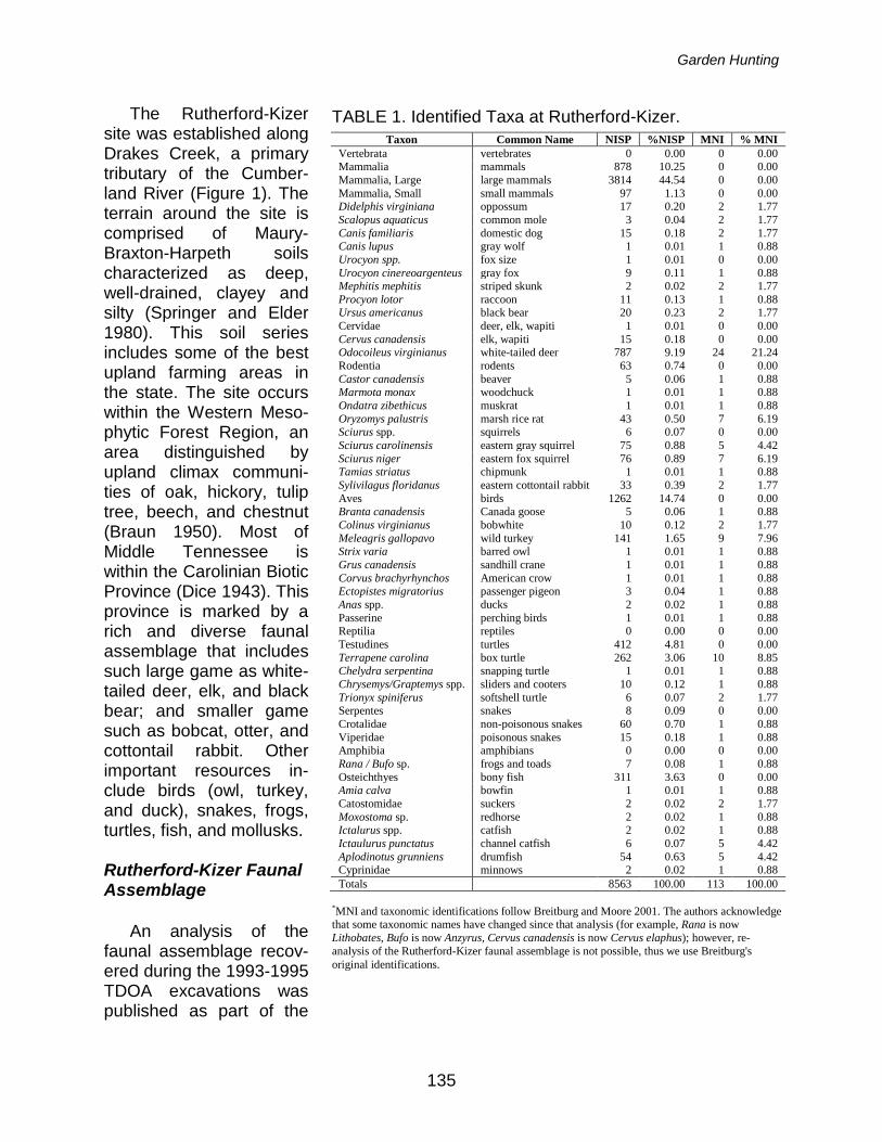
TABLE 1. Identified Taxa at Rutherford-Kizer. Taxon Common Name NISP %NISP MNI % MNI
Vertebrata vertebrates 0 0.00 0 0.00 Mammalia mammals 878 10.25 0 0.00 Mammalia, Large large mammals 3814 44.54 0 0.00 Mammalia, Small small mammals 97 1.13 0 0.00 Didelphis virginiana oppossum 17 0.20 2 1.77 Scalopus aquaticus common mole 3 0.04 2 1.77 Canis familiaris domestic dog 15 0.18 2 1.77 Canis lupus gray wolf 1 0.01 1 0.88 Urocyon spp. fox size 1 0.01 0 0.00 Urocyon cinereoargenteus gray fox 9 0.11 1 0.88 Mephitis mephitis striped skunk 2 0.02 2 1.77 Procyon lotor raccoon 11 0.13 1 0.88 Ursus americanus black bear 20 0.23 2 1.77 Cervidae deer, elk, wapiti 1 0.01 0 0.00 Cervus canadensis elk, wapiti 15 0.18 0 0.00 Odocoileus virginianus white-tailed deer 787 9.19 24 21.24 Rodentia rodents 63 0.74 0 0.00 Castor canadensis beaver 5 0.06 1 0.88 Marmota monax woodchuck 1 0.01 1 0.88 Ondatra zibethicus muskrat 1 0.01 1 0.88 Oryzomys palustris marsh rice rat 43 0.50 7 6.19 Sciurus spp. squirrels 6 0.07 0 0.00 Sciurus carolinensis eastern gray squirrel 75 0.88 5 4.42 Sciurus niger eastern fox squirrel 76 0.89 7 6.19 Tamias striatus chipmunk 1 0.01 1 0.88 Sylivilagus floridanus eastern cottontail rabbit 33 0.39 2 1.77 Aves birds 1262 14.74 0 0.00 Branta canadensis Canada goose 5 0.06 1 0.88 Colinus virginianus bobwhite 10 0.12 2 1.77 Meleagris gallopavo wild turkey 141 1.65 9 7.96 Strix varia barred owl 1 0.01 1 0.88 Grus canadensis sandhill crane 1 0.01 1 0.88 Corvus brachyrhynchos American crow 1 0.01 1 0.88 Ectopistes migratorius passenger pigeon 3 0.04 1 0.88 Anas spp. ducks 2 0.02 1 0.88 Passerine perching birds 1 0.01 1 0.88 Reptilia reptiles 0 0.00 0 0.00 Testudines turtles 412 4.81 0 0.00 Terrapene carolina box turtle 262 3.06 10 8.85 Chelydra serpentina snapping turtle 1 0.01 1 0.88 Chrysemys/Graptemys spp. sliders and cooters 10 0.12 1 0.88 Trionyx spiniferus softshell turtle 6 0.07 2 1.77 Serpentes snakes 8 0.09 0 0.00 Crotalidae non-poisonous snakes 60 0.70 1 0.88 Viperidae poisonous snakes 15 0.18 1 0.88 Amphibia amphibians 0 0.00 0 0.00 Rana / Bufo sp. frogs and toads 7 0.08 1 0.88 Osteichthyes bony fish 311 3.63 0 0.00 Amia calva bowfin 1 0.01 1 0.88 Catostomidae suckers 2 0.02 2 1.77 Moxostoma sp. redhorse 2 0.02 1 0.88 Ictalurus spp. catfish 2 0.02 1 0.88 Ictaulurus punctatus channel catfish 6 0.07 5 4.42 Aplodinotus grunniens drumfish 54 0.63 5 4.42 Cyprinidae minnows 2 0.02 1 0.88 Totals 8563 100.00 113 100.00
*MNI and taxonomic identifications follow Breitburg and Moore 2001. The authors acknowledge that some taxonomic names have changed since that analysis (for example, Rana is now Lithobates, Bufo is now Anzyrus, Cervus canadensis is now Cervus elaphus); however, re-analysis of the Rutherford-Kizer faunal assemblage is not possible, thus we use Breitburg's original identifications.
The Rutherford-Kizer site was established along Drakes Creek, a primary tributary of the Cumber-land River (Figure 1). The terrain around the site is comprised of Maury-Braxton-Harpeth soils characterized as deep, well-drained, clayey and silty (Springer and Elder 1980). This soil series includes some of the best upland farming areas in the state. The site occurs within the Western Meso-phytic Forest Region, an area distinguished by upland climax communi-ties of oak, hickory, tulip tree, beech, and chestnut (Braun 1950). Most of Middle Tennessee is within the Carolinian Biotic Province (Dice 1943). This province is marked by a rich and diverse faunal assemblage that includes such large game as white-tailed deer, elk, and black bear; and smaller game such as bobcat, otter, and cottontail rabbit. Other important resources in-clude birds (owl, turkey, and duck), snakes, frogs, turtles, fish, and mollusks.
Rutherford-Kizer Faunal Assemblage
An analysis of the
faunal assemblage recov-ered during the 1993-1995 TDOA excavations was published as part of the
Tennessee Archaeology 5(2) Fall 2011
136
site monograph (Breitburg and Moore 2001). That analysis provides the base data for our model testing.
The faunal assemblage from Ruther-ford-Kizer consists of 8,563 specimens, represented by 38 taxa (Table 1). Mam-mals comprised the majority of the as-semblage at 71% (n=6,709), followed by birds at 16.7% (n=1,427), reptiles at 9% (n=774), fish at 4.4% (n=380), and am-phibians composing <1% (n=7). Just over 20% of the assemblage was identifiable to at least family (n=1,726). White-tailed deer (Odocoileus virginianus) represented the majority of the identified fauna (n=787, nearly 46%), followed by the eastern box turtle (Terrapene carolina) with 15% (n=262) and wild turkey (Meleagris gallo-pavo) with 8% (n=141). The general sub-sistence trend at Rutherford-Kizer showed a reliance on white-tailed deer, wild tur-key, and box turtle. This result was not unexpected based on previous zoo-archaeological research from Middle Cumberland Mississippian period sites (Breitburg 2000; Moore et al. 2006; Peres 2006, 2010a; Romanoski 1984; Sichler and Moore 2005; Smith 1992; Smith and Moore 1994).
Species Diversity
The first component of the analysis is
the diversity of species within the Ruther-ford-Kizer assemblage. Assemblage di-versity and equitability were addressed using the Shannon-Weaver Index (see Peres 2010b:29-30; Reitz and Wing 2008:110-113). Assemblages with an even distribution of abundance between taxa have a higher relative diversity than samples with the same number of taxa, but with disproportionately high abun-
dance of a few taxa. Samples that have a high number of taxonomic categories and a similar degree of equitability have greater diversity values (Reitz and Wing 2008:110-113). In order to understand whether an assemblage has richness and evenness we should examine the s and V’ values, where the value of s represents the number of different categories within the sample and the value of V’ represents the Equitability Index or how the sample is distributed amongst the categories. We used Minimum Number of Individuals (MNI) estimates for identifiable taxa from Breitburg and Moore (2001:132). The Shannon-Weaver Index indicates that the Rutherford-Kizer faunal assemblage, while relatively rich (s=38 taxa), is neither diverse (H’=0.38) nor equitable (V’=0.105) (Pielou 1966; Shannon and Weaver 1949). This means that the faunal assem-blage is dominated by one taxa, specifi-cally white-tailed deer (MNI=24, or 21% of the total MNI) (Table 2). Overall, the di-versity and equitability values suggest that the Rutherford-Kizer residents, while exploiting animals that preferred disturbed and forest-edge environments, were doing so selectively.
Terrestrial vs. Aquatic Animals
Linares’ (1976) garden-hunting model
indicates that fully agricultural groups would be more dependent on terrestrial animals than aquatic animals. While Li-nares makes this argument from a dia-chronic stance, the level of data analysis that exists for Rutherford-Kizer does not allow us to follow suit. Instead, we look at the relative MNI quantities of terrestrial vs. aquatic animals to test this portion of the garden-hunting model.
Garden Hunting
137
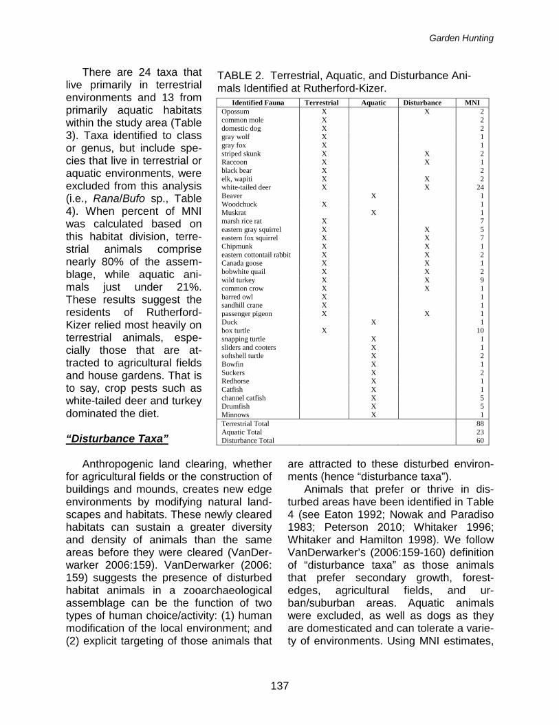
TABLE 2. Terrestrial, Aquatic, and Disturbance Ani-mals Identified at Rutherford-Kizer.
Identified Fauna Terrestrial Aquatic Disturbance MNI Opossum X X 2 common mole X 2 domestic dog X 2 gray wolf X 1 gray fox X 1 striped skunk X X 2 Raccoon X X 1 black bear X 2 elk, wapiti X X 2 white-tailed deer X X 24 Beaver X 1 Woodchuck X 1 Muskrat X 1 marsh rice rat X 7 eastern gray squirrel X X 5 eastern fox squirrel X X 7 Chipmunk X X 1 eastern cottontail rabbit X X 2 Canada goose X X 1 bobwhite quail X X 2 wild turkey X X 9 common crow X X 1 barred owl X 1 sandhill crane X 1 passenger pigeon X X 1 Duck X 1 box turtle X 10 snapping turtle X 1 sliders and cooters X 1 softshell turtle X 2 Bowfin X 1 Suckers X 2 Redhorse X 1 Catfish X 1 channel catfish X 5 Drumfish X 5 Minnows X 1 Terrestrial Total 88 Aquatic Total 23 Disturbance Total 60
There are 24 taxa that live primarily in terrestrial environments and 13 from primarily aquatic habitats within the study area (Table 3). Taxa identified to class or genus, but include spe-cies that live in terrestrial or aquatic environments, were excluded from this analysis (i.e., Rana/Bufo sp., Table 4). When percent of MNI was calculated based on this habitat division, terre-strial animals comprise nearly 80% of the assem-blage, while aquatic ani-mals just under 21%. These results suggest the residents of Rutherford-Kizer relied most heavily on terrestrial animals, espe-cially those that are at-tracted to agricultural fields and house gardens. That is to say, crop pests such as white-tailed deer and turkey dominated the diet.
“Disturbance Taxa”
Anthropogenic land clearing, whether
for agricultural fields or the construction of buildings and mounds, creates new edge environments by modifying natural land-scapes and habitats. These newly cleared habitats can sustain a greater diversity and density of animals than the same areas before they were cleared (VanDer-warker 2006:159). VanDerwarker (2006: 159) suggests the presence of disturbed habitat animals in a zooarchaeological assemblage can be the function of two types of human choice/activity: (1) human modification of the local environment; and (2) explicit targeting of those animals that
are attracted to these disturbed environ-ments (hence “disturbance taxa”).
Animals that prefer or thrive in dis-turbed areas have been identified in Table 4 (see Eaton 1992; Nowak and Paradiso 1983; Peterson 2010; Whitaker 1996; Whitaker and Hamilton 1998). We follow VanDerwarker’s (2006:159-160) definition of “disturbance taxa” as those animals that prefer secondary growth, forest-edges, agricultural fields, and ur-ban/suburban areas. Aquatic animals were excluded, as well as dogs as they are domesticated and can tolerate a varie-ty of environments. Using MNI estimates,
Tennessee Archaeology 5(2) Fall 2011
138
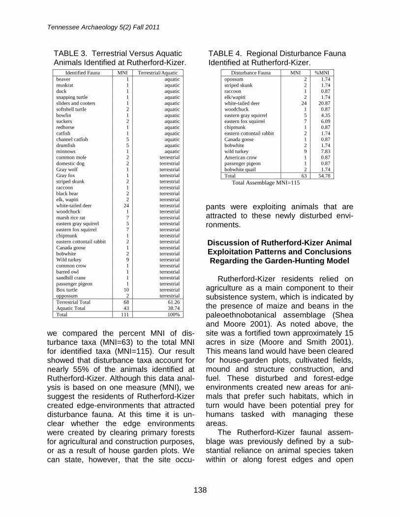
TABLE 3. Terrestrial Versus Aquatic Animals Identified at Rutherford-Kizer.
Identified Fauna MNI Terrestrial/Aquatic beaver 1 aquatic muskrat 1 aquatic duck 1 aquatic snapping turtle 1 aquatic sliders and cooters 1 aquatic softshell turtle 2 aquatic bowfin 1 aquatic suckers 2 aquatic redhorse 1 aquatic catfish 1 aquatic channel catfish 5 aquatic drumfish 5 aquatic minnows 1 aquatic common mole 2 terrestrial domestic dog 2 terrestrial Gray wolf 1 terrestrial Gray fox 1 terrestrial striped skunk 2 terrestrial raccoon 1 terrestrial black bear 2 terrestrial elk, wapiti 2 terrestrial white-tailed deer 24 terrestrial woodchuck 1 terrestrial marsh rice rat 7 terrestrial eastern gray squirrel 5 terrestrial eastern fox squirrel 7 terrestrial chipmunk 1 terrestrial eastern cottontail rabbit 2 terrestrial Canada goose 1 terrestrial bobwhite 2 terrestrial Wild turkey 9 terrestrial common crow 1 terrestrial barred owl 1 terrestrial sandhill crane 1 terrestrial passenger pigeon 1 terrestrial Box turtle 10 terrestrial oppossum 2 terrestrial Terrestrial Total 68 61.26 Aquatic Total 43 38.74 Total 111 100%
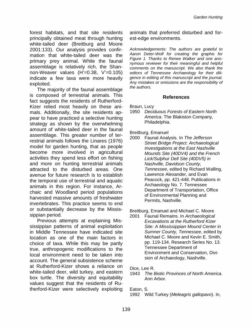
we compared the percent MNI of dis-turbance taxa (MNI=63) to the total MNI for identified taxa (MNI=115). Our result showed that disturbance taxa account for nearly 55% of the animals identified at Rutherford-Kizer. Although this data anal-ysis is based on one measure (MNI), we suggest the residents of Rutherford-Kizer created edge-environments that attracted disturbance fauna. At this time it is un-clear whether the edge environments were created by clearing primary forests for agricultural and construction purposes, or as a result of house garden plots. We can state, however, that the site occu-
pants were exploiting animals that are attracted to these newly disturbed envi-ronments.
Discussion of Rutherford-Kizer Animal Exploitation Patterns and Conclusions Regarding the Garden-Hunting Model
Rutherford-Kizer residents relied on
agriculture as a main component to their subsistence system, which is indicated by the presence of maize and beans in the paleoethnobotanical assemblage (Shea and Moore 2001). As noted above, the site was a fortified town approximately 15 acres in size (Moore and Smith 2001). This means land would have been cleared for house-garden plots, cultivated fields, mound and structure construction, and fuel. These disturbed and forest-edge environments created new areas for ani-mals that prefer such habitats, which in turn would have been potential prey for humans tasked with managing these areas.
The Rutherford-Kizer faunal assem-blage was previously defined by a sub-stantial reliance on animal species taken within or along forest edges and open
TABLE 4. Regional Disturbance Fauna Identified at Rutherford-Kizer.
Disturbance Fauna MNI %MNI opossum 2 1.74 striped skunk 2 1.74 raccoon 1 0.87 elk/wapiti 2 1.74 white-tailed deer 24 20.87 woodchuck 1 0.87 eastern gray squirrel 5 4.35 eastern fox squirrel 7 6.09 chipmunk 1 0.87 eastern cottontail rabbit 2 1.74 Canada goose 1 0.87 bobwhite 2 1.74 wild turkey 9 7.83 American crow 1 0.87 passenger pigeon 1 0.87 bobwhite quail 2 1.74 Total 63 54.78
Total Assemblage MNI=115
Garden Hunting
139
forest habitats, and that site residents principally obtained meat through hunting white-tailed deer (Breitburg and Moore 2001:133). Our analysis provides confir-mation that white-tailed deer was the primary prey animal. While the faunal assemblage is relatively rich, the Shan-non-Weaver values (H’=0.38, V’=0.105) indicate a few taxa were more heavily exploited.
The majority of the faunal assemblage is composed of terrestrial animals. This fact suggests the residents of Rutherford-Kizer relied most heavily on these ani-mals. Additionally, the site residents ap-pear to have practiced a selective hunting strategy as shown by the overwhelming amount of white-tailed deer in the faunal assemblage. This greater number of ter-restrial animals follows the Linares (1976) model for garden hunting, that as people become more involved in agricultural activities they spend less effort on fishing and more on hunting terrestrial animals attracted to the disturbed areas. One avenue for future research is to establish the temporal use of terrestrial and aquatic animals in this region. For instance, Ar-chaic and Woodland period populations harvested massive amounts of freshwater invertebrates. This practice seems to end or substantially decrease by the Missis-sippian period.
Previous attempts at explaining Mis-sissippian patterns of animal exploitation in Middle Tennessee have indicated site location as one of the main factors in choice of taxa. While this may be partly true, anthropogenic modifications to the local environment need to be taken into account. The general subsistence scheme at Rutherford-Kizer shows a reliance on white-tailed deer, wild turkey, and eastern box turtle. The diversity and equitability values suggest that the residents of Ru-therford-Kizer were selectively exploiting
animals that preferred disturbed and for-est-edge environments. Acknowledgements: The authors are grateful to Aaron Deter-Wolf for creating the graphic for Figure 1. Thanks to Renee Walker and one ano-nymous reviewer for their meaningful and helpful comments on the manuscript. We also thank the editors of Tennessee Archaeology for their dili-gence in editing of this manuscript and the journal. Any mistakes or omissions are the responsibility of the authors.
References
Braun, Lucy 1950 Deciduous Forests of Eastern North
America. The Blakiston Company, Philadelphia.
Breitburg, Emanuel 2000 Faunal Analysis. In The Jefferson
Street Bridge Project: Archaeological Investigations at the East Nashville Mounds Site (40DV4) and the French Lick/Sulphur Dell Site (40DV5) in Nashville, Davidson County,
Tennessee, edited by Richard Walling, Lawrence Alexander, and Evan
Peacock, pp. 421-448. Publications in Archaeology No. 7. Tennessee
Department of Transportation, Office of Environmental Planning and
Permits, Nashville. Breitburg, Emanuel and Michael C. Moore 2001 Faunal Remains. In Archaeological
Excavations at the Rutherford Kizer Site: A Mississippian Mound Center in Sumner County, Tennessee, edited by Michael C. Moore and Kevin E. Smith, pp. 119-134. Research Series No. 13. Tennessee Department of
Environment and Conservation, Divi-sion of Archaeology, Nashville.
Dice, Lee R. 1943 The Biotic Provinces of North America.
Ann Arbor. Eaton, S. 1992 Wild Turkey (Meleagris gallopavo). In,
Tennessee Archaeology 5(2) Fall 2011
140
The Birds of North America, Volume 22, edited by P. Stettenheim and F. Gill, pp. 1-28. The Academy of Natural Sciences; Washington, DC.
Garshelis, David L., and Michael R. Pelton 1981 Movements of Black Bears in the
Great Smoky Mountains National Park. The Journal of Wildlife
Management 45 (4): 912-925. Linares, Olga F. 1976 “Garden Hunting” in the American
Tropics. Human Ecology (4) 4: 331-349.
Moore, Michael C. and Kevin E. Smith 2001 Archaeological Excavations at the
Rutherford Kizer Site: A Mississippian Mound Center in Sumner County, Tennessee. Research Series No. 13. Tennessee Department of
Environment and Conservation, Division of Archaeology, Nashville. 2009 Archaeological Explorations of the
Peabody Museum in Middle Tennessee, 1877-1884. Research
Series No. 16. Tennessee Department of Environment and Conservation,
Division of Archaeology, Nashville. Moore, Michael C., Emanuel Breitburg, Kevin
E. Smith, and Mary Beth Trubitt 2006 One Hundred Years of Archaeology at
Gordontown: A Fortified Mississippian Town in Middle Tennessee.
Southeastern Archaeology 25(1):89-109.
Naughton-Treves, Lisa, Jose Luis Mena,
Adrain Treves, Nora Alvarez, and Volker Christian Radeloff
2003 Wildlife Survival Beyond Park Boundaries: The Impact of Slash-and-
Burn Agriculture and Hunting on Mammals in Tambopata, Peru. Con-servation Biology (17) 4: 1106-1117
Neusius, Sarah W. 2008 Game Procurement among Temperate
Horticulturists: The Case for Garden
Hunting by the Dolores Anasazi. In Case Studies in Environmental
Archaeology, 2nd edition, edited by Elizabeth J. Reitz, C. Margaret Scarry and Sylvia J. Scudder, pp. 297-314. Springer, New York.
Nowak, R.M. and J.L. Paradiso 1983 Walker's Mammals of the World, 4th
edition. John Hopkins University Press, Baltimore.
Peres, Tanya M. 2006 Mississippian Animal Exploitation in
Middle Tennessee: A Case Study from the Castalian Springs Site (40SU14). Paper presented at the 63rd Annual Meeting of the Southeastern
Archaeological Conference, Little Rock, Arkansas.
2010a Zooarchaeological Remains from the 1998 Fewkes Site Excavations, Wil-liamson County, Tennessee. Tennes-see Archaeology 5(1):100-125.
2010b Methodological Issues in Zooarchaeology. In Integrating
Zooarchaeology and Paleo-ethnobotany: A Consideration of Is-sues, Methods, and Cases, edited by A. M. VanDerwarker and T. M. Peres, pp. 15-36. Springer Press, New York.
Peres, Tanya M., R. Matt Byron, and Alison
M. Hadley 2005 Analysis of Zooarchaeological Remains from the Fewkes Site
(40WM1), Tennessee. Technical Report No. 549, Program for Archaeological Research, University of
Kentucky, Lexington. Peterson, Roger T. 2010 Peterson Field Guide to Birds of Eastern and Central North America,
Sixth Edition. Houghton Mifflin Harcourt, New York. Pielou, E. C. 1966 Shannon’s Formula as a Measure of
Specific Diversity: Its Uses and Misuses. American Naturalist 100
Garden Hunting
141
(914): 463-465. Reitz, Elizabeth J. and Elizabeth S. Wing 2008 Zooarchaeology, 2nd ed. Cambridge
University Press, Cambridge, United Kingdom.
Romanoski, Stephanie M. 1984 Analysis of the Faunal Remains from
the Averbuch Site. In Averbuch: A Late Mississippian Manisfestation in the Nashville Basin, Volume I, edited by Walter E. Klippel and William M. Bass, pp. 13.1-13.27. Report
submitted to the National Park Service in accordance with the provisions of Contract CX 5000-9-5943 between the University of Tennessee and the
National Park Service. Copy on file, Tennessee Department of
Environment and Conservation, Division of Archaeology, Nashville. Shannon, C. E. and W. Weaver 1949 The Mathematical Theory of Communication. University Press of
Illinois, Urbana. Shea, Andrea B. and Michael C. Moore 2001 Floral Remains. In Archaeological
Excavations at the Rutherford Kizer Site: A Mississippian Mound Center in Sumner County, Tennessee, edited by Michael C. Moore and Kevin E. Smith, pp. 135-140. Research Series No. 13. Tennessee Department of
Environment and Conservation, Division of Archaeology, Nashville. Sichler, Judith and Michael C. Moore 2005 Faunal Remains. In The Brentwood
Library Site: A Mississippian Town on the Little Harpeth River, Williamson County, Tennessee, edited by Michael C. Moore, pp. 199-208. Research
Series No. 15. Tennessee Department of Environment and Conservation, Di-vision of Archaeology, Nashville.
Smith, Kevin E. 1992 The Middle Cumberland Region:
Mississippian Archaeology in North Central Tennessee. Unpublished Ph.D. dissertation, Vanderbilt
University, Nashville. Smith, Kevin E. and Michael C. Moore 1994 The Brandywine Pointe Site
(40DV247): A Mississippian Farmstead in North Central
Tennessee. Midcontinental Journal of Archaeology 19(2):198-222.
Springer, M.E. and J.A. Elder 1980 Soils of Tennessee. University of
Tennessee Agricultural Experimental Station, Knoxville and United States Department of Agriculture, Soil
Conservation Service, Bulletin No. 596.
Tierson, William C., George F. Mattfeld, Richard W. Sage, Jr., and Donald F.
Behrend 1985 Seasonal Movements and Home
Ranges of White-Tailed Deer in the Adirondacks. The Journal of Wildlife Management 49 (3): 760-769.
VanDerwarker, Amber M. 2006 Farming, Hunting, and Fishing in the
Olmec World. University of Texas Press, Austin.
Whitaker, Jr., John O. 1996 The Audubon Society Field Guide to
North American Mammals. Alfred A. Knopf, New York.
Whitaker, J.O., Jr. and W.J. Hamilton, Jr. 1998 Mammals of the Eastern United
States. Third Edition. Cornell Universi-ty Press, Ithaca.
Jennifer M. Clinton Department of Sociology and Anthropology Middle Tennessee State University Murfreesboro, Tennessee 37132 Tanya M. Peres Department of Sociology and Anthropology Middle Tennessee State University Murfreesboro, Tennessee 37132
142
EXCAVATIONS AND DATING OF LATE PLEISTOCENE AND PALEOINDIAN DEPOSITS AT THE COATS-HINES SITE,
WILLIAMSON COUNTY, TENNESSEE
Aaron Deter-Wolf, Jesse W. Tune, and John B. Broster The Coats-Hines archaeological site (40WM31) consists of a Paleoindian butchering site and Pleistocene bone bed located in northern Williamson County, Tennessee. Archaeological examinations since 1977 have documented the presence of various Pleistocene species, and recovered Paleoindian artifacts in direct association with those remains. The authors directed excavations in October 2010 designed to evaluate archaeological integrity and assess the eligibility of the site for inclusion in the National Register of Historic Places. These investigations resulted in the recovery of Pleistocene faunal material, Paleoindian stone tools, and radiocarbon samples. As a result of the excavations, the Coats-Hines site was added to the National Register in July 2011. This article provides a summary of work conducted at the site to date, presents previously unreported Paleoindian artifacts and radiocarbon dates from earlier excavations, and discusses the significance of the Coats-Hines site.
The Coats-Hines site was initially recorded by the Tennessee Division of Archaeology (TDOA) in 1977 when mastodon bones were identified during golf course construction in northern Williamson County, Tennessee. Periodic excavations and collections since that time have recovered remains from at least three American mastodons (Mammut americanum), and various other late Pleistocene faunal species. Paleoindian artifacts recovered in direct association with two mastodon skeletons and the identification of butchering marks (Breitburg et al. 1996) provide direct evidence for human-mastodon interaction. Excavations in 1994 also resulted in the recovery of both radiocarbon and oxidizable carbon ratio (OCR) dates which have not been previously published.
In October of 2010, the authors directed excavations at Coats-Hines to determine if additional late Pleistocene faunal remains or evidence of Paleoindian activity remained, and assess the eligibility of the site for inclusion in the National Register of Historic Places
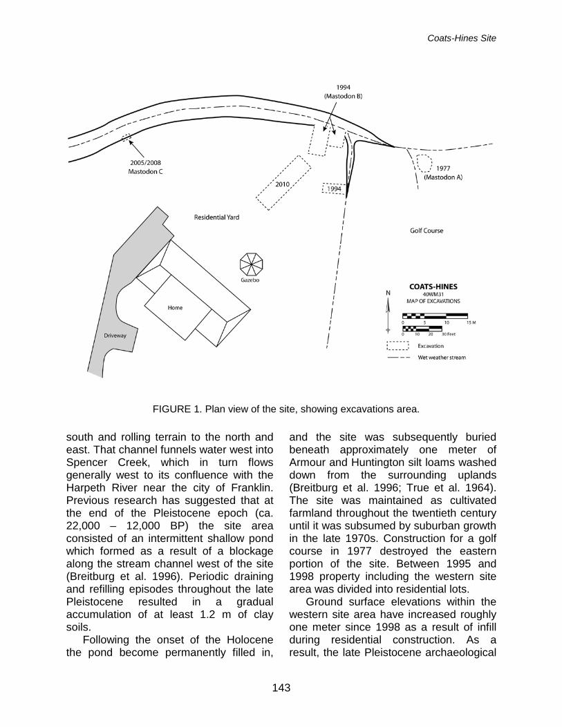
(NRHP). These investigations determined that archaeological deposits including both Pleistocene faunal material and Paleoindian stone tools are still present at the site, approximately 2.6-3.1 meters below modern ground surface in a residential backyard (Figure 1).
Environmental Setting
The Coats Hines site is presently
situated approximately 230 m (755 feet) above mean sea level (AMSL) near the convergence of the Central Basin and Western Highland Rim physiographic provinces of Middle Tennessee (Miller 1979). Both the site area and gently rolling terrain to the north and west belong to the Central Basin province. Knob formations to the south of the site crest at approximately 335 m (1100 feet) AMSL and belong to the Western Highland Rim province.
The site area is bounded to the north by the headwaters of an unnamed, deeply-incised wet-weather drainage which collects runoff from uplands to the
Coats-Hines Site
143
south and rolling terrain to the north and east. That channel funnels water west into Spencer Creek, which in turn flows generally west to its confluence with the Harpeth River near the city of Franklin. Previous research has suggested that at the end of the Pleistocene epoch (ca. 22,000 – 12,000 BP) the site area consisted of an intermittent shallow pond which formed as a result of a blockage along the stream channel west of the site (Breitburg et al. 1996). Periodic draining and refilling episodes throughout the late Pleistocene resulted in a gradual accumulation of at least 1.2 m of clay soils.
Following the onset of the Holocene the pond become permanently filled in,
and the site was subsequently buried beneath approximately one meter of Armour and Huntington silt loams washed down from the surrounding uplands (Breitburg et al. 1996; True et al. 1964). The site was maintained as cultivated farmland throughout the twentieth century until it was subsumed by suburban growth in the late 1970s. Construction for a golf course in 1977 destroyed the eastern portion of the site. Between 1995 and 1998 property including the western site area was divided into residential lots.
Ground surface elevations within the western site area have increased roughly one meter since 1998 as a result of infill during residential construction. As a result, the late Pleistocene archaeological
FIGURE 1. Plan view of the site, showing excavations area.
Tennessee Archaeology 5(2) Fall 2011
144
deposits at Coats-Hines are presently situated approximately 2.6 m below modern ground surface. Groundcover within the site boundaries consists of a residential yard, the wooded banks of the stream drainage, and understory growth along the edge of a golf course.
Site History
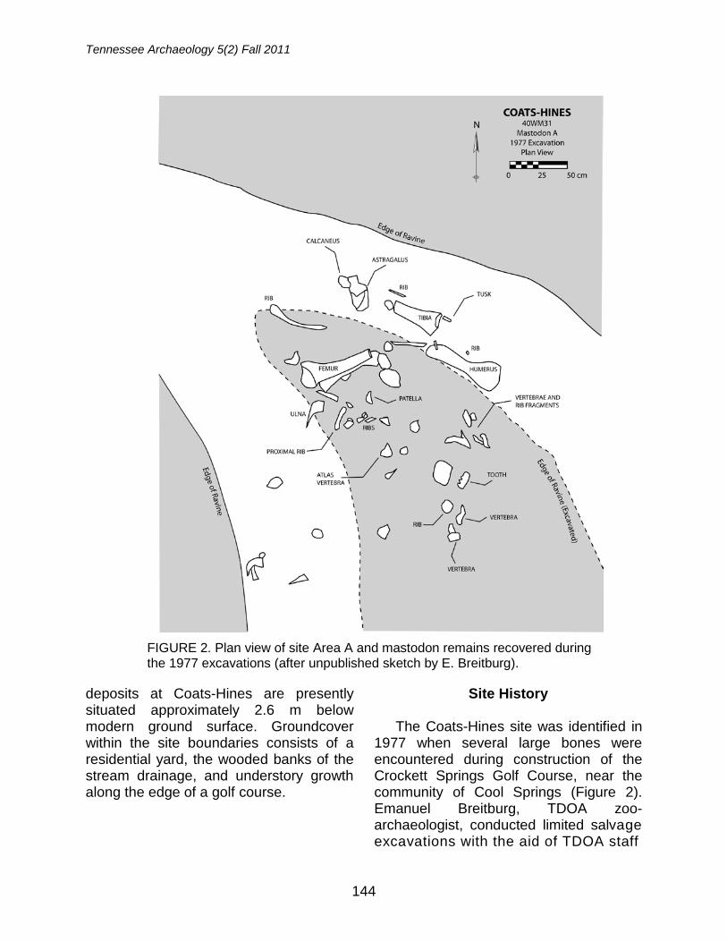
The Coats-Hines site was identified in 1977 when several large bones were encountered during construction of the Crockett Springs Golf Course, near the community of Cool Springs (Figure 2). Emanuel Breitburg, TDOA zoo-archaeologist, conducted limited salvage excavations with the aid of TDOA staff
FIGURE 2. Plan view of site Area A and mastodon remains recovered during the 1977 excavations (after unpublished sketch by E. Breitburg).

Coats-Hines Site
145
FIGURE 4. View of exposed bone bed following 1994 excavations, facing south.
FIGURE 3. View of initial finds in Site Area B, including mastodon tusk eroding from the stream bank.
Tennessee Archaeology 5(2) Fall 2011
146
member Patricia Coats. Their excavation recovered the partial skeleton of a single mature female mastodon, which was later identified as “Mastodon A.” No description of this excavation or the skeletal material was ever published, and the area that contained the remains was subsequently destroyed by earthmoving along the 13th hole of the golf course (Corgan and Breitburg 1996).
During the spring of 1994, Breitburg and TDOA archaeologist John Broster conducted a reconnaissance of the stream drainage west of the golf course in anticipation of planned subdivision construction. During that inspection they identified a vertebra, ribs, and tusk of a second mastodon (“Mastodon B”) eroding from the south bank of the stream drainage, 18 m west of Mastodon A (Breitburg and Broster 1995) (Figure 3; see Figure 1). Breitburg and Broster
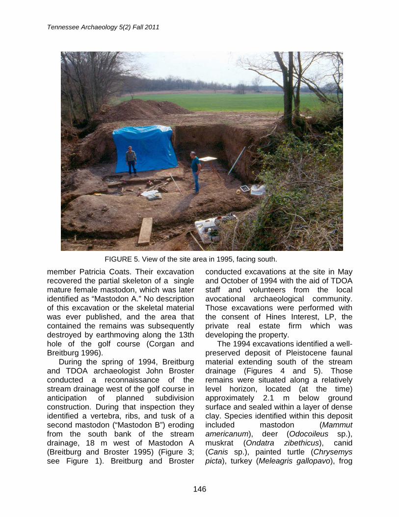
conducted excavations at the site in May and October of 1994 with the aid of TDOA staff and volunteers from the local avocational archaeological community. Those excavations were performed with the consent of Hines Interest, LP, the private real estate firm which was developing the property.
The 1994 excavations identified a well-preserved deposit of Pleistocene faunal material extending south of the stream drainage (Figures 4 and 5). Those remains were situated along a relatively level horizon, located (at the time) approximately 2.1 m below ground surface and sealed within a layer of dense clay. Species identified within this deposit included mastodon (Mammut americanum), deer (Odocoileus sp.), muskrat (Ondatra zibethicus), canid (Canis sp.), painted turtle (Chrysemys picta), turkey (Meleagris gallopavo), frog
FIGURE 5. View of the site area in 1995, facing south.
Coats-Hines Site
147
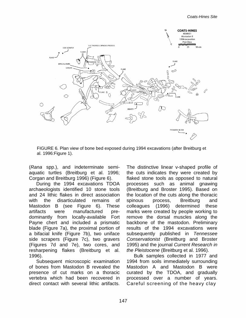
(Rana spp.), and indeterminate semi-aquatic turtles (Breitburg et al. 1996; Corgan and Breitburg 1996) (Figure 6).
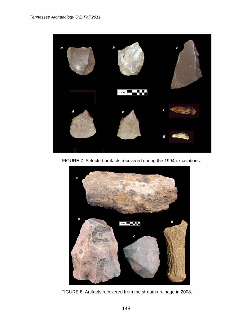
During the 1994 excavations TDOA archaeologists identified 10 stone tools and 24 lithic flakes in direct association with the disarticulated remains of Mastodon B (see Figure 6). These artifacts were manufactured pre-dominantly from locally-available Fort Payne chert and included a prismatic blade (Figure 7a), the proximal portion of a bifacial knife (Figure 7b), two uniface side scrapers (Figure 7c), two gravers (Figures 7d and 7e), two cores, and resharpening flakes (Breitburg et al. 1996).
Subsequent microscopic examination of bones from Mastodon B revealed the presence of cut marks on a thoracic vertebra which had been recovered in direct contact with several lithic artifacts.
The distinctive linear v-shaped profile of the cuts indicates they were created by flaked stone tools as opposed to natural processes such as animal gnawing (Breitburg and Broster 1995). Based on the location of the cuts along the thoracic spinous process, Breitburg and colleagues (1996) determined these marks were created by people working to remove the dorsal muscles along the backbone of the mastodon. Preliminary results of the 1994 excavations were subsequently published in Tennessee Conservationist (Breitburg and Broster 1995) and the journal Current Research in the Pleistocene (Breitburg et al. 1996).
Bulk samples collected in 1977 and 1994 from soils immediately surrounding Mastodon A and Mastodon B were curated by the TDOA, and gradually processed over a number of years. Careful screening of the heavy clay
FIGURE 6. Plan view of bone bed exposed during 1994 excavations (after Breitburg et al. 1996:Figure 1).
Tennessee Archaeology 5(2) Fall 2011
148
FIGURE 7. Selected artifacts recovered during the 1994 excavations.
FIGURE 8. Artifacts recovered from the stream drainage in 2008.
Coats-Hines Site
149
encasing the bones from Mastodon A resulted in the recovery of four previously undocumented resharpening flakes. Samples collected around the ribs of Mastodon B yielded the broken tip of a possible bone point (Figure 7f), the tip of an antler tine pressure flaker (Figure 7g), and additional lithic debitage. All of these artifacts were recovered following the 1996 Current Research in the Pleistocene article, and have not been formally described or published to date.
All stone, antler, and bone tools recovered from the Coats-Hines site prior to 2010 are permanently curated with the Smithsonian Institution in Washington, D.C. Casts of these artifacts are housed at the TDOA along with the collection of resharpening flakes. Faunal remains from the 1977 and 1994 excavations are also housed at the TDOA. Finally, the thoracic vertebra with cut marks from Mastodon B is on display at the Frank H. McClung Museum in Knoxville as part of their exhibit “Archaeology & the Native Peoples of Tennessee.”
Although no additional excavations were conducted at the site between 1994 and 2008, TDOA staff continued to periodically inspect the drainage. During the spring of 1995, visual inspections of the stream channel by Breitburg and Broster identified additional fragmentary Pleistocene faunal remains eroding from the bank line approximately 47 m west of Mastodon B (see Figure 1). These bones were highly fragmentary and not excavated at the time, although they were identified as probably being from an additional mastodon (“Mastodon C”) based solely on their size.
During the summer of 2008, additional large bone fragments were identified eroding from the south bank of the stream channel in the vicinity of Mastodon C (see Figure 1). The authors performed limited
excavations into the stream bank approximately 1.5 m below ground surface in order to recover several heavily fragmented bones (Figure 8a). The preservation quality of these bones was extremely poor, and although the remains appeared to be those of a large Pleistocene vertebrate, no conclusive identification could be reached regarding the animal’s species (Tune and Deter-Wolf 2009).
Additional site inspections of the stream channel that same year resulted in the recovery of a blade core (see Figure 8b), a bifacial tool (Figure 8c), and a highly mineralized fragment of deer antler (see Figure 8d). These artifacts had been eroded from their original context and could not be conclusively associated with the archaeological deposits at Coats-Hines. However, consultations with staff from the East Tennessee State University and General Shale Brick Natural History Museum determined that the antler fragment exhibited an extreme level of mineralization suggesting at least a late Pleistocene origin (Tune and Deter-Wolf 2009).
October 2010 Archaeological Testing
In 2010, TDOA archaeologists Aaron
Deter-Wolf and John Broster were awarded a Historic Preservation Grant through the Tennessee Historical Commission and National Park Service to conduct additional archaeological testing at the Coats-Hines site. The authors conducted excavations in October of that year with the aid of Dr. Tanya Peres and upper-level zooarchaeology students from Middle Tennessee State University (Figure 9). The goals of these excavations were to determine if the site contained sufficient archaeological integrity to merit listing on the National Register of Historic
Tennessee Archaeology 5(2) Fall 2011
150
Places (NRHP) under Criterion D of 36 CFR 60.4, and to recover data that could be used to address research questions regarding human subsistence practices during the late Pleistocene.
During the initial stage of the 2010 excavations, a backhoe equipped with a flat-edged bucket was used to remove the uppermost archaeologically-sterile soils from a trench measuring 14 m long. The trench was stepped to comply with safety standards, and a central window measuring 2-m wide by 6-m long was mechanically excavated into Pleistocene soils, approximately 2.6 m below ground surface. The trench was situated approximately 4.5 m south of the modern stream drainage and to the southwest of
the 1994 excavations (see Figure 1). The location and orientation were selected based on analysis of the modern landform and data from previous excavations.
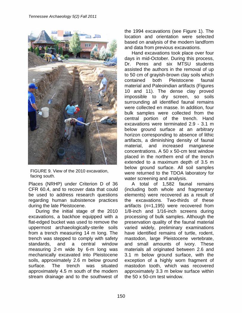
Hand excavations took place over four days in mid-October. During this process, Dr. Peres and six MTSU students assisted the authors in the removal of up to 50 cm of grayish-brown clay soils which contained both Pleistocene faunal material and Paleoindian artifacts (Figures 10 and 11). The dense clay proved impossible to dry screen, so soils surrounding all identified faunal remains were collected en masse. In addition, four bulk samples were collected from the central portion of the trench. Hand excavations were terminated 2.9 - 3.1 m below ground surface at an arbitrary horizon corresponding to absence of lithic artifacts, a diminishing density of faunal material, and increased manganese concentrations. A 50 x 50-cm test window placed in the northern end of the trench extended to a maximum depth of 3.5 m below ground surface. All soil samples were returned to the TDOA laboratory for water screening and analysis.
A total of 1,582 faunal remains (including both whole and fragmentary elements) were recovered as a result of the excavations. Two-thirds of these artifacts (n=1,195) were recovered from 1/8-inch and 1/16-inch screens during processing of bulk samples. Although the preservation quality of the faunal material varied widely, preliminary examinations have identified remains of turtle, rodent, mastodon, large Pleistocene vertebrate, and small amounts of ivory. These materials all originated between 2.6 and 3.1 m below ground surface, with the exception of a highly worn fragment of mastodon tooth, which was recovered approximately 3.3 m below surface within the 50 x 50-cm test window.
FIGURE 9. View of the 2010 excavation, facing south.
Coats-Hines Site
151
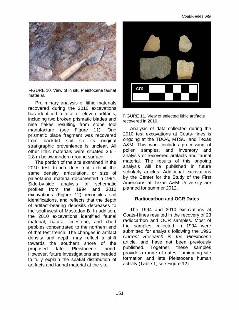
Preliminary analysis of lithic materials recovered during the 2010 excavations has identified a total of eleven artifacts, including two broken prismatic blades and nine flakes resulting from stone tool manufacture (see Figure 11). One prismatic blade fragment was recovered from backdirt soil so its original stratigraphic provenience is unclear. All other lithic materials were situated 2.6 - 2.8 m below modern ground surface.
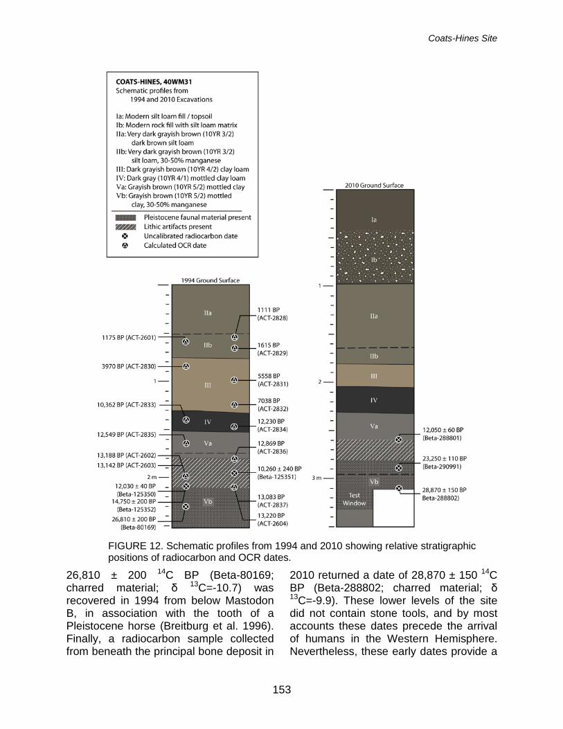
The portion of the site examined in the 2010 test trench does not exhibit the same density, articulation, or size of paleofaunal material documented in 1994. Side-by-side analysis of schematic profiles from the 1994 and 2010 excavations (Figure 12) reconciles soil identifications, and reflects that the depth of artifact-bearing deposits decreases to the southwest of Mastodon B. In addition, the 2010 excavations identified faunal material, natural limestone, and chert pebbles concentrated to the northern end of that test trench. The changes in artifact density and depth may reflect a shift towards the southern shore of the proposed late Pleistocene pond. However, future investigations are needed to fully explain the spatial distribution of artifacts and faunal material at the site.
Analysis of data collected during the 2010 test excavations at Coats-Hines is ongoing at the TDOA, MTSU, and Texas A&M. This work includes processing of pollen samples, and inventory and analysis of recovered artifacts and faunal material. The results of this ongoing analysis will be published in future scholarly articles. Additional excavations by the Center for the Study of the First Americans at Texas A&M University are planned for summer 2012.
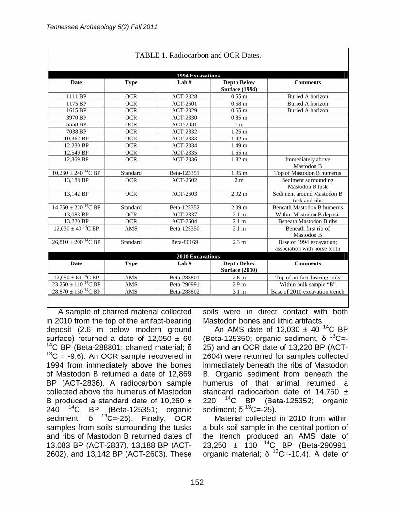
Radiocarbon and OCR Dates
The 1994 and 2010 excavations at
Coats-Hines resulted in the recovery of 23 radiocarbon and OCR samples. Most of the samples collected in 1994 were submitted for analysis following the 1996 Current Research in the Pleistocene article, and have not been previously published. Together, these samples provide a range of dates illuminating site formation and late Pleistocene human activity (Table 1; see Figure 12).
FIGURE 10. View of in situ Pleistocene faunal material.
FIGURE 11. View of selected lithic artifacts recovered in 2010.
Tennessee Archaeology 5(2) Fall 2011
152
A sample of charred material collected in 2010 from the top of the artifact-bearing deposit (2.6 m below modern ground surface) returned a date of 12,050 ± 60 14C BP (Beta-288801; charred material; δ 13C = -9.6). An OCR sample recovered in 1994 from immediately above the bones of Mastodon B returned a date of 12,869 BP (ACT-2836). A radiocarbon sample collected above the humerus of Mastodon B produced a standard date of 10,260 ± 240 14C BP (Beta-125351; organic sediment, δ 13C=-25). Finally, OCR samples from soils surrounding the tusks and ribs of Mastodon B returned dates of 13,083 BP (ACT-2837), 13,188 BP (ACT-2602), and 13,142 BP (ACT-2603). These
soils were in direct contact with both Mastodon bones and lithic artifacts.
An AMS date of 12,030 ± 40 14C BP (Beta-125350; organic sediment, δ 13C=-25) and an OCR date of 13,220 BP (ACT-2604) were returned for samples collected immediately beneath the ribs of Mastodon B. Organic sediment from beneath the humerus of that animal returned a standard radiocarbon date of 14,750 ± 220 14C BP (Beta-125352; organic sediment; δ 13C=-25).
Material collected in 2010 from within a bulk soil sample in the central portion of the trench produced an AMS date of 23,250 ± 110 14C BP (Beta-290991; organic material; δ 13C=-10.4). A date of
TABLE 1. Radiocarbon and OCR Dates.
1994 Excavations Date Type Lab # Depth Below
Surface (1994) Comments
1111 BP OCR ACT-2828 0.55 m Buried A horizon 1175 BP OCR ACT-2601 0.58 m Buried A horizon 1615 BP OCR ACT-2829 0.65 m Buried A horizon 3970 BP OCR ACT-2830 0.85 m 5558 BP OCR ACT-2831 1 m 7038 BP OCR ACT-2832 1.25 m
10,362 BP OCR ACT-2833 1.42 m 12,230 BP OCR ACT-2834 1.49 m 12,549 BP OCR ACT-2835 1.65 m 12,869 BP OCR ACT-2836 1.82 m Immediately above
Mastodon B 10,260 ± 240 14C BP Standard Beta-125351 1.95 m Top of Mastodon B humerus
13,188 BP OCR ACT-2602 2 m Sediment surrounding Mastodon B tusk
13,142 BP OCR ACT-2603 2.02 m Sediment around Mastodon B tusk and ribs
14,750 ± 220 14C BP Standard Beta-125352 2.09 m Beneath Mastodon B humerus 13,083 BP OCR ACT-2837 2.1 m Within Mastodon B deposit 13,220 BP OCR ACT-2604 2.1 m Beneath Mastodon B ribs
12,030 ± 40 14C BP AMS Beta-125350 2.1 m Beneath first rib of Mastodon B
26,810 ± 200 14C BP Standard Beta-80169 2.3 m Base of 1994 excavation; association with horse tooth
2010 Excavations Date Type Lab # Depth Below
Surface (2010) Comments
12,050 ± 60 14C BP AMS Beta-288801 2.6 m Top of artifact-bearing soils 23,250 ± 110 14C BP AMS Beta-290991 2.9 m Within bulk sample “B” 28,870 ± 150 14C BP AMS Beta-288802 3.1 m Base of 2010 excavation trench
Coats-Hines Site
153
26,810 ± 200 14C BP (Beta-80169; charred material; δ 13C=-10.7) was recovered in 1994 from below Mastodon B, in association with the tooth of a Pleistocene horse (Breitburg et al. 1996). Finally, a radiocarbon sample collected from beneath the principal bone deposit in
2010 returned a date of 28,870 ± 150 14C BP (Beta-288802; charred material; δ 13C=-9.9). These lower levels of the site did not contain stone tools, and by most accounts these dates precede the arrival of humans in the Western Hemisphere. Nevertheless, these early dates provide a
FIGURE 12. Schematic profiles from 1994 and 2010 showing relative stratigraphic positions of radiocarbon and OCR dates.
Tennessee Archaeology 5(2) Fall 2011
154
glimpse into the broad time span during which the site was visited by Pleistocene animals.
Two dates from samples collected during the 1994 and 2010 excavations are not included in Table 1 or Figure 12. Organic sediment recovered around the dental cusp of Mastodon B in 1994 returned a date of 6530 +/- 70 BP (Beta-75403; organic sediment; δ 13C=-24.9), which was initially reported by Breitburg et al. (1996). The 2010 excavation recovered a sample from 2.89 m below modern ground surface, which returned an AMS date of 2000 +/- 30 BP (Beta – 290990; organic material; δ 13C=-27.5). These dates are inconsistent with the radiocarbon and OCR site chronology.
Conclusions
Paleoindians have traditionally been
regarded as big-game hunters who weathered the end of the Pleistocene epoch relying on a diet principally consisting of large animal species such as mastodon and mammoth (e.g., G. Haynes 2002, 2007; V. Haynes 1966, 1980; Kelly and Todd 1988, Waguespack and Surovell 2003). This is due, in large part, to the archaeological research from the North American Plains and Southwest. However, the diverse ecological regions that exist in North America undoubtedly led to diverse subsistence economies. In recent decades a new understanding of Paleoindian subsistence has emerged in which regional variations have been proposed, and the importance of megafaunal species has been downplayed in favor of a broad spectrum economy (e.g. Byers and Ugan 2005; Cannon and Meltzer 2008; Hill 2007). Some researchers have gone further, suggesting that large game and proboscidea in particular played little or no
role in the diets of Paleoindian populations of the Eastern United States (Cannon and Meltzer 2004, 2008; Grayson and Meltzer 2002).
One principal reason for the demotion of megafaunal species within regional Paleoindian diets is a lack of archaeological evidence. In addition to Coats-Hines, only a handful of sites have been identified in the Eastern United States which provide incontrovertible evidence of humans hunting megafauna. Investigations at Coats-Hines have identified the remains of at least three and possibly four mastodons, one of which (Mastodon B) shows unequivocal association with human activity in the form of butchering marks. It is possible that the Pleistocene pond deposits at Coats-Hines contain additional evidence of human predation of megafaunal species.
In addition to mastodon, excavations at Coats-Hines have yielded remains from a variety of smaller fauna such as turtle, muskrat, and deer. While none of these remains have yet been directly linked to human activity at the site, there is a high probability that Paleoindian people who camped near the Pleistocene pond at Coats-Hines engaged in opportunistic hunting of small game attracted to the water source, as well as of aquatic and semi-aquatic species which inhabited that environment. Future research regarding these species could provide an invaluable window into the broad spectrum of Paleoindian subsistence and hunting strategies.
The dates returned for radiocarbon samples recovered during the 1994 and 2010 excavations are remarkable in their similarity. The radiocarbon assay of 12,030 ± 40 14C BP (Beta-125350) recovered in direct association with a mastodon rib fragment is nearly identical to the date of 12,050 ± 60 14C BP (Beta-
Coats-Hines Site
155
288801) recovered from the top of the bone bed during the 2010 excavation. Together, these dates indicate that the butchering of Mastodon B likely took place several-hundred years prior to the accepted beginning of the Clovis horizon (Haynes et al. 2007; Waters and Stafford 2007), and suggest that the site holds potential to address technological shifts coinciding with the advent of Clovis culture in the Southeast.
The site is also significant because of its role in Tennessee and Nashville-area prehistory. Only one other archaeological site in Tennessee has produced radiocarbon dates greater than 11,000 14C BP that are definitively associated with human activity (Barker and Broster 1996). Coats-Hines is therefore one of the two oldest human activity areas presently documented in the state, and in this regard is extremely important to our understanding of both Tennessee and the Nashville area’s ancient past.
The Coats-Hines site has not been widely published to date, and consequently the integrity of the site and its potential to yield significant data on the lifeways of the earliest Americans have been largely overlooked by Paleoindian scholars. However, archaeological testing in October 2010 reaffirmed the site contains intact deposits in the form of both Pleistocene faunal remains and Paleoindian artifacts. These deposits are sealed beneath more than 2.5 m of archaeologically-sterile overburden, and have been securely dated through a combination of radiocarbon and OCR analysis. Coats-Hines maintains its preservation, context, and ability to contribute important archaeological data.
References
Barker, Gary, and John B. Broster 1996 The Johnson Site (40Dv400): A Dated
Paleoindian and Early Archaic Occupation in Tennessee's Central Basin. Journal of Alabama Archaeology 42(2):97-153.
Byers, David A. and Andrew Ugan 2005 Should We Expect Large Game
Specialization in the Late Pleistocene? An Optimal Foraging Perspective on Early Paleoindian Prey Choice. Journal of Archaeological Science 32:1624-1640.
Breitburg, Emanuel and John B. Broster 1995 A Hunt for Big Game: Does Coats-
Hines Site Confirm Human/Mastodon Contact? The Tennessee Conservationist 61 (4):18–26
Breitburg, Emanuel, John B. Broster, Arthur L.
Reesman, and Richard G. Sterns 1996 The Coats-Hines Site: Tennessee's
First Paleoindian-Mastodon Association. Current Research in the Pleistocene 13:6-8.
Cannon, Michael D. and David J. Meltzer 2004 Early Paleoindian Foraging: Exam-
ining the Faunal Evidence for Large Mammal Specializations and Regional Variability in Prey Choice. Quaternary Science Review 23:1955-1987.
2008 Explaining Variability in Early Paleoindian Foraging. Quaternary International 191:5-17.
Corgan, James X. and Emanuel Breitburg 1996 Tennessee’s Prehistoric Vertebrates.
Tennessee Division of Geology Bulletin 84, Tennessee Department of Environment and Conservation, Division of Geology, Nashville.
Grayson, Donald K. and David J. Meltzer 2002 Clovis Hunting and Large Mammal
Extinction: A Critical Review of the Evidence. Journal of World Prehistory 16(4):313-359.
Haynes, Vance C. 1966 Elephant Hunting in North America.
Tennessee Archaeology 5(2) Fall 2011
156
Scientific American 214:104-112. 1980 The Clovis Culture. Canadian Journal
of Anthropology 1:115-121. Haynes, Gary 2002 The Early Settlement of North
America: The Clovis Era. Cambridge University Press, Cambridge.
2007 A Review of Some Attacks on the Overkill Hypothesis, with Special Attention to Misrepresentations and Doubletalk. Quaternary International 169-170:84-94.
Haynes, Gary, David G. Anderson, C. Reid
Ferring, Stuart J. Fiedel, Donald K. Grayson, C. Vance Haynes, Jr., Vance T. Holliday, Bruce B. Huckell, Marcel Kornfeld, David J. Meltzer, Julie Morrow, Todd Surovell, Nicole M. Waguespack, Peter Wigand, and Robert M. Yohe II
2007 Comment on “Redefining the Age of Clovis: Implications for the Peopling of the Americas.” Science 317(5836): 320.
Hill, Matthew E., Jr. 2007 A Moveable Feast: Variation in Faunal
Resource Use Among Central and Western North American Paleoindian Sites. American Antiquity 72(3):417-438.
Kelly, Robert L. and Lawrence C. Todd 1988 Coming into the Country: Early
Paleoindian Hunting and Mobility. American Antiquity 53:231-244.
Miller, Robert A. 1979 The Geologic History of Tennessee.
Tennessee Department of Conservation, Division of Geology, Bulletin 74, Nashville.
True, J.C., E.P. Davis, O.G. Sprouse, Jr., J.F.
Brasfield, and I.D. Howell 1964 Soil Survey, Williamson County,
Tennessee. United States Department of Agriculture Soil Conservation Service, Washington, D.C.
Tune, Jesse W. and Aaron Deter-Wolf 2009 New Finds of Old Bones at the Coats-
Hines Site (40WM31). Paper presented at the 21st Current Research in Tennessee Archaeology meeting, Nashville.
Waguespack, Nicole M. and Todd A. Surovell 2003 Clovis Hunting Strategies, or How to
Make Out on Plentiful Resources. American Antiquity 68:333-352.
Waters, Michael R. and Thomas W. Stafford,
Jr. 2007 Redefining the Age of Clovis:
Implications for the Peopling of the Americas. Science 315:1122-1125.
Aaron Deter-Wolf Tennessee Division of Archaeology 1216 Foster Ave., Cole Building #3 Nashville TN 37243 Jesse W. Tune Department of Anthropology 4352 TAMU College Station, Texas 77843-4352 John B. Broster Tennessee Division of Archaeology 1216 Foster Ave., Cole Building #3 Nashville TN 37243
157
THE AMES SITE (40FY7): A VERY UNOBTRUSIVE MISSISSIPPIAN SETTLEMENT LOCATED IN SOUTHWESTERN TENNESSEE
Andrew M. Mickelson and Eric Goddard
Research at the Ames Mound and Settlement Complex (40FY7), located at the headwaters of the North Fork of the Wolf River, utilized a magnetometry survey, controlled surface collections, test-pits, and large scale excavation to examine prehistoric landuse ca. A.D. 1000-1200. The study resulted in the discovery of a large palisaded settlement associated with a small mound complex. Although the mound complex has been known to archaeologists for over half a century, the town remained undiscovered until recently. Our research demonstrates that in the Loess Plains of West Tennessee, discovery methods such as shovel testing and controlled surface collecting can produce results that underestimate the significance of buried archaeological deposits to the point that large settlements are being missed. The implication is that west Tennessee probably had several small mound complexes with associated towns during the Early Mississippian period.
Archaeologists now routinely employ geophysical and remote sensing techniques to questions of prehistoric landuse at the landscape scale of analysis (e.g., Kvamme 2003). Geophysical techniques allow for a rapid assessment of the buried archaeological record without having to excavate. As Kvamme observes (2003:435), "space can be viewed in terms of tens of hectares as opposed to the tens of square meters typical of archaeological excavations." In particular, magnetometry surveys have produced rather remarkable views of the spatial patterning of past human behavior.
However, archaeologists should not abandon their shovels and trowels just yet. Geophysical and other datasets, such as surface-collected artifacts, are complimentary to one another because they are the residues of different types of human activity and can easily be integrated via Geographic Information Systems (GIS). The research summarized here demonstrates the benefits of integrating geophysical data, surface collected artifacts, and large-scale excavation in understanding past human settlement patterns in the loess hills of
western Tennessee. However, before prehistoric landuse patterns can be understood, formation processes governing the creation of the archaeological record in the region need to be addressed.
Environmental Background
The western Tennessee region can
readily be defined on the basis of hydrology in that it lies between the Mississippi River to the west and the Tennessee River to the east (Figure 1). A second defining feature of the region is its soils, which in the western portion of the study area are predominately loess deposits ranging from upwards of 30 m (100 feet) deep along the bluffs of the Mississippi to less than 1 m (3 feet) to the east in the vicinity of the Ames Mound and Settlement Complex (40FY7). In the eastern half of the study area soils are predominately derived from Gulf Coastal Plains deposits. Ames is located in Fayette County at the headwaters of the North Fork of the Wolf River which feeds into the Mississippi River at Memphis. Essentially, the site is located along the
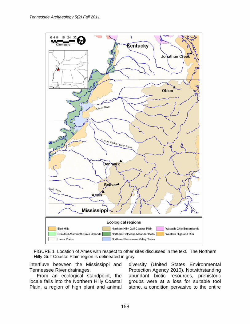
Tennessee Archaeology 5(2) Fall 2011
158
interfluve between the Mississippi and Tennessee River drainages.
From an ecological standpoint, the locale falls into the Northern Hilly Coastal Plain, a region of high plant and animal
diversity (United States Environmental Protection Agency 2010). Notwithstanding abundant biotic resources, prehistoric groups were at a loss for suitable tool stone, a condition pervasive to the entire
FIGURE 1. Location of Ames with respect to other sites discussed in the text. The Northern Hilly Gulf Coastal Plain region is delineated in gray.
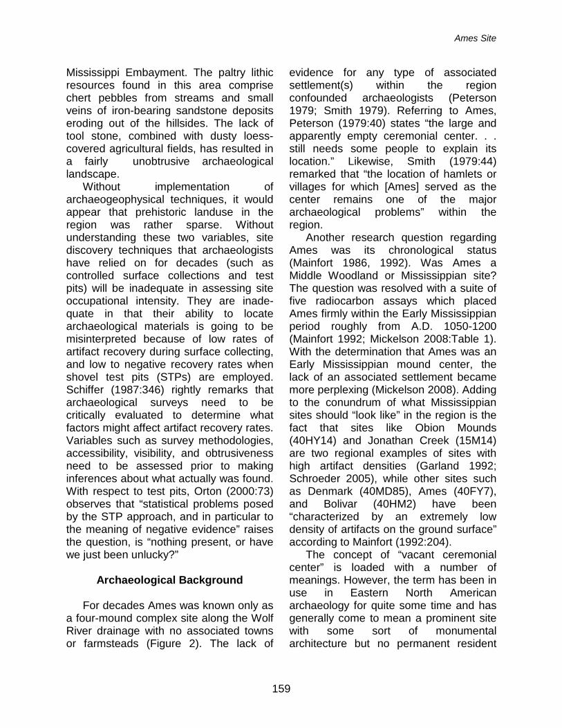
Ames Site
159
Mississippi Embayment. The paltry lithic resources found in this area comprise chert pebbles from streams and small veins of iron-bearing sandstone deposits eroding out of the hillsides. The lack of tool stone, combined with dusty loess-covered agricultural fields, has resulted in a fairly unobtrusive archaeological landscape.
Without implementation of archaeogeophysical techniques, it would appear that prehistoric landuse in the region was rather sparse. Without understanding these two variables, site discovery techniques that archaeologists have relied on for decades (such as controlled surface collections and test pits) will be inadequate in assessing site occupational intensity. They are inade-quate in that their ability to locate archaeological materials is going to be misinterpreted because of low rates of artifact recovery during surface collecting, and low to negative recovery rates when shovel test pits (STPs) are employed. Schiffer (1987:346) rightly remarks that archaeological surveys need to be critically evaluated to determine what factors might affect artifact recovery rates. Variables such as survey methodologies, accessibility, visibility, and obtrusiveness need to be assessed prior to making inferences about what actually was found. With respect to test pits, Orton (2000:73) observes that “statistical problems posed by the STP approach, and in particular to the meaning of negative evidence” raises the question, is “nothing present, or have we just been unlucky?”
Archaeological Background
For decades Ames was known only as
a four-mound complex site along the Wolf River drainage with no associated towns or farmsteads (Figure 2). The lack of
evidence for any type of associated settlement(s) within the region confounded archaeologists (Peterson 1979; Smith 1979). Referring to Ames, Peterson (1979:40) states “the large and apparently empty ceremonial center. . . still needs some people to explain its location.” Likewise, Smith (1979:44) remarked that “the location of hamlets or villages for which [Ames] served as the center remains one of the major archaeological problems” within the region.
Another research question regarding Ames was its chronological status (Mainfort 1986, 1992). Was Ames a Middle Woodland or Mississippian site? The question was resolved with a suite of five radiocarbon assays which placed Ames firmly within the Early Mississippian period roughly from A.D. 1050-1200 (Mainfort 1992; Mickelson 2008:Table 1). With the determination that Ames was an Early Mississippian mound center, the lack of an associated settlement became more perplexing (Mickelson 2008). Adding to the conundrum of what Mississippian sites should “look like” in the region is the fact that sites like Obion Mounds (40HY14) and Jonathan Creek (15M14) are two regional examples of sites with high artifact densities (Garland 1992; Schroeder 2005), while other sites such as Denmark (40MD85), Ames (40FY7), and Bolivar (40HM2) have been “characterized by an extremely low density of artifacts on the ground surface” according to Mainfort (1992:204).
The concept of “vacant ceremonial center” is loaded with a number of meanings. However, the term has been in use in Eastern North American archaeology for quite some time and has generally come to mean a prominent site with some sort of monumental architecture but no permanent resident
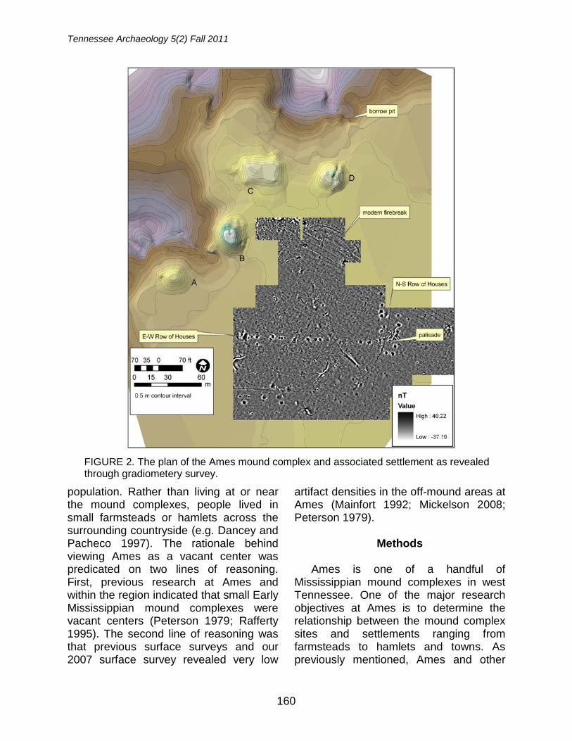
Tennessee Archaeology 5(2) Fall 2011
160
population. Rather than living at or near the mound complexes, people lived in small farmsteads or hamlets across the surrounding countryside (e.g. Dancey and Pacheco 1997). The rationale behind viewing Ames as a vacant center was predicated on two lines of reasoning. First, previous research at Ames and within the region indicated that small Early Mississippian mound complexes were vacant centers (Peterson 1979; Rafferty 1995). The second line of reasoning was that previous surface surveys and our 2007 surface survey revealed very low
artifact densities in the off-mound areas at Ames (Mainfort 1992; Mickelson 2008; Peterson 1979).
Methods
Ames is one of a handful of
Mississippian mound complexes in west Tennessee. One of the major research objectives at Ames is to determine the relationship between the mound complex sites and settlements ranging from farmsteads to hamlets and towns. As previously mentioned, Ames and other
FIGURE 2. The plan of the Ames mound complex and associated settlement as revealed through gradiometery survey.
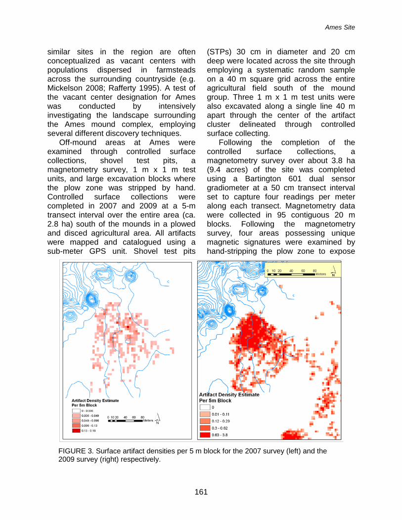
Ames Site
161
similar sites in the region are often conceptualized as vacant centers with populations dispersed in farmsteads across the surrounding countryside (e.g. Mickelson 2008; Rafferty 1995). A test of the vacant center designation for Ames was conducted by intensively investigating the landscape surrounding the Ames mound complex, employing several different discovery techniques.
Off-mound areas at Ames were examined through controlled surface collections, shovel test pits, a magnetometry survey, 1 m x 1 m test units, and large excavation blocks where the plow zone was stripped by hand. Controlled surface collections were completed in 2007 and 2009 at a 5-m transect interval over the entire area (ca. 2.8 ha) south of the mounds in a plowed and disced agricultural area. All artifacts were mapped and catalogued using a sub-meter GPS unit. Shovel test pits
(STPs) 30 cm in diameter and 20 cm deep were located across the site through employing a systematic random sample on a 40 m square grid across the entire agricultural field south of the mound group. Three 1 m x 1 m test units were also excavated along a single line 40 m apart through the center of the artifact cluster delineated through controlled surface collecting.
Following the completion of the controlled surface collections, a magnetometry survey over about 3.8 ha (9.4 acres) of the site was completed using a Bartington 601 dual sensor gradiometer at a 50 cm transect interval set to capture four readings per meter along each transect. Magnetometry data were collected in 95 contiguous 20 m blocks. Following the magnetometry survey, four areas possessing unique magnetic signatures were examined by hand-stripping the plow zone to expose
FIGURE 3. Surface artifact densities per 5 m block for the 2007 survey (left) and the 2009 survey (right) respectively.
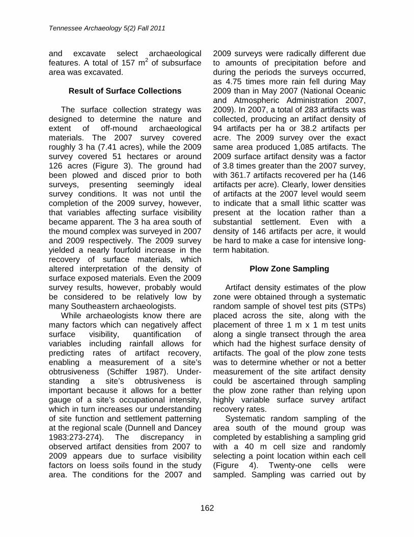
Tennessee Archaeology 5(2) Fall 2011
162
and excavate select archaeological features. A total of 157 m2 of subsurface area was excavated.
Result of Surface Collections
The surface collection strategy was
designed to determine the nature and extent of off-mound archaeological materials. The 2007 survey covered roughly 3 ha (7.41 acres), while the 2009 survey covered 51 hectares or around 126 acres (Figure 3). The ground had been plowed and disced prior to both surveys, presenting seemingly ideal survey conditions. It was not until the completion of the 2009 survey, however, that variables affecting surface visibility became apparent. The 3 ha area south of the mound complex was surveyed in 2007 and 2009 respectively. The 2009 survey yielded a nearly fourfold increase in the recovery of surface materials, which altered interpretation of the density of surface exposed materials. Even the 2009 survey results, however, probably would be considered to be relatively low by many Southeastern archaeologists.
While archaeologists know there are many factors which can negatively affect surface visibility, quantification of variables including rainfall allows for predicting rates of artifact recovery, enabling a measurement of a site’s obtrusiveness (Schiffer 1987). Under-standing a site’s obtrusiveness is important because it allows for a better gauge of a site’s occupational intensity, which in turn increases our understanding of site function and settlement patterning at the regional scale (Dunnell and Dancey 1983:273-274). The discrepancy in observed artifact densities from 2007 to 2009 appears due to surface visibility factors on loess soils found in the study area. The conditions for the 2007 and
2009 surveys were radically different due to amounts of precipitation before and during the periods the surveys occurred, as 4.75 times more rain fell during May 2009 than in May 2007 (National Oceanic and Atmospheric Administration 2007, 2009). In 2007, a total of 283 artifacts was collected, producing an artifact density of 94 artifacts per ha or 38.2 artifacts per acre. The 2009 survey over the exact same area produced 1,085 artifacts. The 2009 surface artifact density was a factor of 3.8 times greater than the 2007 survey, with 361.7 artifacts recovered per ha (146 artifacts per acre). Clearly, lower densities of artifacts at the 2007 level would seem to indicate that a small lithic scatter was present at the location rather than a substantial settlement. Even with a density of 146 artifacts per acre, it would be hard to make a case for intensive long-term habitation.
Plow Zone Sampling
Artifact density estimates of the plow
zone were obtained through a systematic random sample of shovel test pits (STPs) placed across the site, along with the placement of three 1 m x 1 m test units along a single transect through the area which had the highest surface density of artifacts. The goal of the plow zone tests was to determine whether or not a better measurement of the site artifact density could be ascertained through sampling the plow zone rather than relying upon highly variable surface survey artifact recovery rates.
Systematic random sampling of the area south of the mound group was completed by establishing a sampling grid with a 40 m cell size and randomly selecting a point location within each cell (Figure 4). Twenty-one cells were sampled. Sampling was carried out by
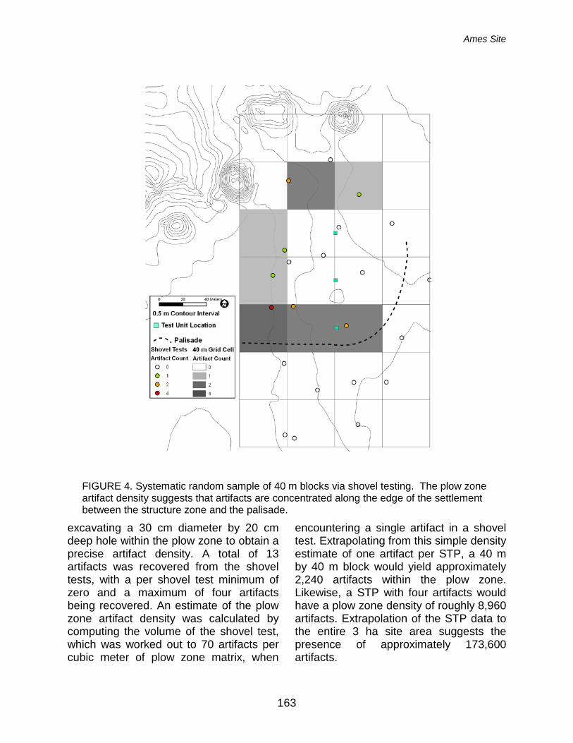
Ames Site
163
excavating a 30 cm diameter by 20 cm deep hole within the plow zone to obtain a precise artifact density. A total of 13 artifacts was recovered from the shovel tests, with a per shovel test minimum of zero and a maximum of four artifacts being recovered. An estimate of the plow zone artifact density was calculated by computing the volume of the shovel test, which was worked out to 70 artifacts per cubic meter of plow zone matrix, when
encountering a single artifact in a shovel test. Extrapolating from this simple density estimate of one artifact per STP, a 40 m by 40 m block would yield approximately 2,240 artifacts within the plow zone. Likewise, a STP with four artifacts would have a plow zone density of roughly 8,960 artifacts. Extrapolation of the STP data to the entire 3 ha site area suggests the presence of approximately 173,600 artifacts.
FIGURE 4. Systematic random sample of 40 m blocks via shovel testing. The plow zone artifact density suggests that artifacts are concentrated along the edge of the settlement between the structure zone and the palisade.
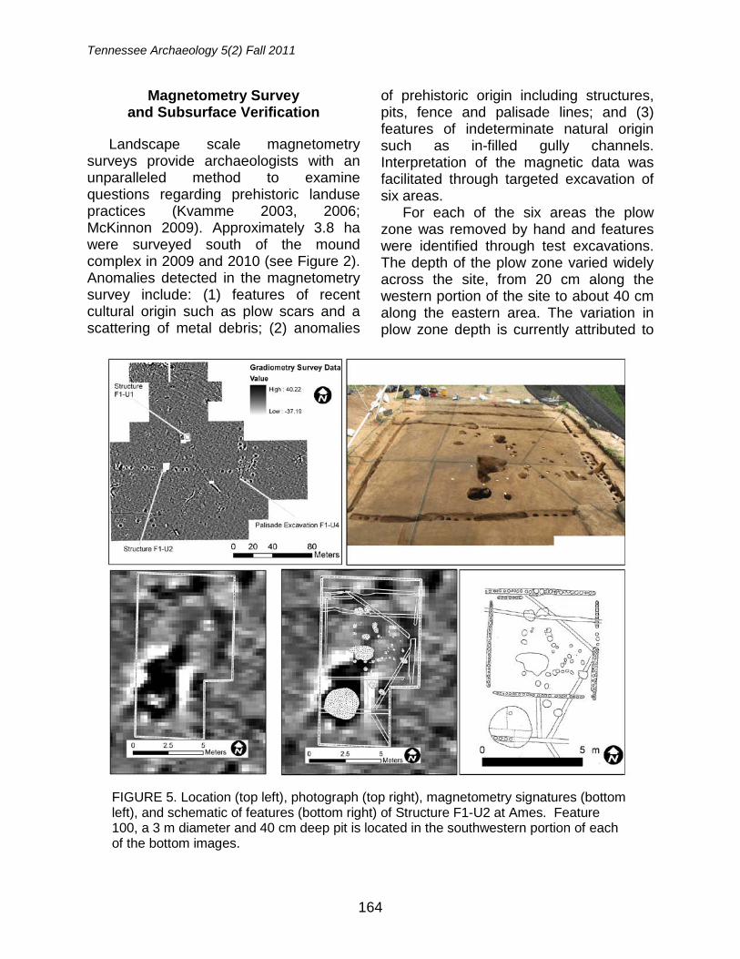
Tennessee Archaeology 5(2) Fall 2011
164
Magnetometry Survey and Subsurface Verification
Landscape scale magnetometry
surveys provide archaeologists with an unparalleled method to examine questions regarding prehistoric landuse practices (Kvamme 2003, 2006; McKinnon 2009). Approximately 3.8 ha were surveyed south of the mound complex in 2009 and 2010 (see Figure 2). Anomalies detected in the magnetometry survey include: (1) features of recent cultural origin such as plow scars and a scattering of metal debris; (2) anomalies
of prehistoric origin including structures, pits, fence and palisade lines; and (3) features of indeterminate natural origin such as in-filled gully channels. Interpretation of the magnetic data was facilitated through targeted excavation of six areas.
For each of the six areas the plow zone was removed by hand and features were identified through test excavations. The depth of the plow zone varied widely across the site, from 20 cm along the western portion of the site to about 40 cm along the eastern area. The variation in plow zone depth is currently attributed to
FIGURE 5. Location (top left), photograph (top right), magnetometry signatures (bottom left), and schematic of features (bottom right) of Structure F1-U2 at Ames. Feature 100, a 3 m diameter and 40 cm deep pit is located in the southwestern portion of each of the bottom images.
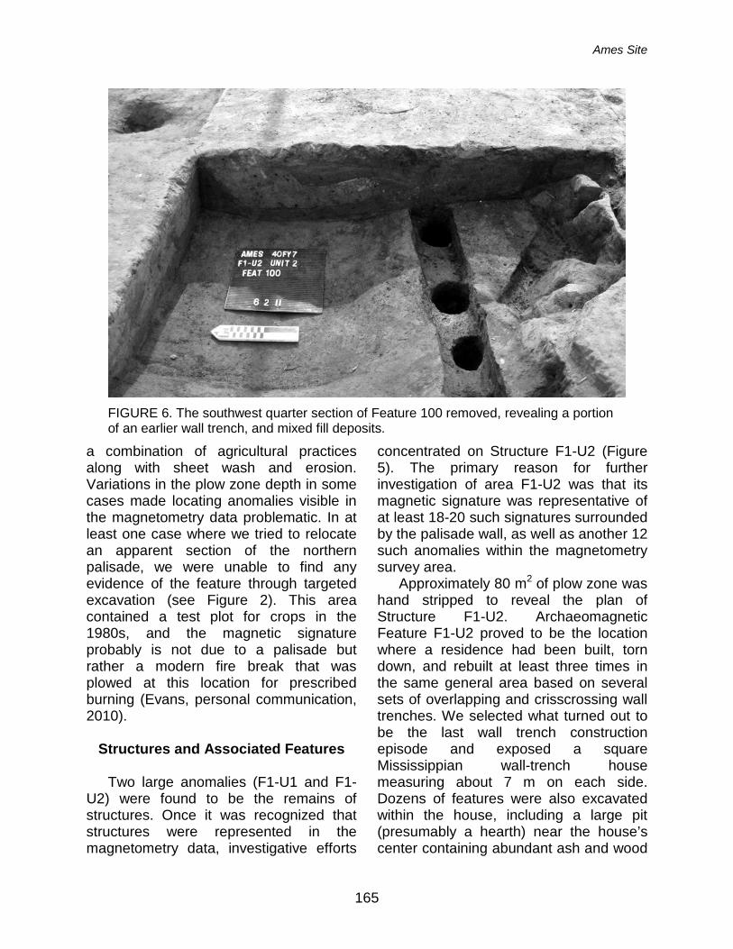
Ames Site
165
a combination of agricultural practices along with sheet wash and erosion. Variations in the plow zone depth in some cases made locating anomalies visible in the magnetometry data problematic. In at least one case where we tried to relocate an apparent section of the northern palisade, we were unable to find any evidence of the feature through targeted excavation (see Figure 2). This area contained a test plot for crops in the 1980s, and the magnetic signature probably is not due to a palisade but rather a modern fire break that was plowed at this location for prescribed burning (Evans, personal communication, 2010).
Structures and Associated Features
Two large anomalies (F1-U1 and F1-
U2) were found to be the remains of structures. Once it was recognized that structures were represented in the magnetometry data, investigative efforts
concentrated on Structure F1-U2 (Figure 5). The primary reason for further investigation of area F1-U2 was that its magnetic signature was representative of at least 18-20 such signatures surrounded by the palisade wall, as well as another 12 such anomalies within the magnetometry survey area.
Approximately 80 m2 of plow zone was hand stripped to reveal the plan of Structure F1-U2. Archaeomagnetic Feature F1-U2 proved to be the location where a residence had been built, torn down, and rebuilt at least three times in the same general area based on several sets of overlapping and crisscrossing wall trenches. We selected what turned out to be the last wall trench construction episode and exposed a square Mississippian wall-trench house measuring about 7 m on each side. Dozens of features were also excavated within the house, including a large pit (presumably a hearth) near the house’s center containing abundant ash and wood
FIGURE 6. The southwest quarter section of Feature 100 removed, revealing a portion of an earlier wall trench, and mixed fill deposits.
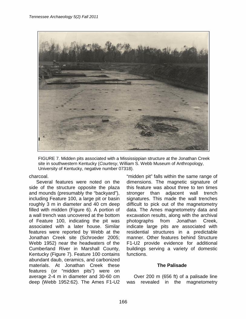
Tennessee Archaeology 5(2) Fall 2011
166
charcoal. Several features were noted on the
side of the structure opposite the plaza and mounds (presumably the “backyard”), including Feature 100, a large pit or basin roughly 3 m in diameter and 40 cm deep filled with midden (Figure 6). A portion of a wall trench was uncovered at the bottom of Feature 100, indicating the pit was associated with a later house. Similar features were reported by Webb at the Jonathan Creek site (Schroeder 2005; Webb 1952) near the headwaters of the Cumberland River in Marshall County, Kentucky (Figure 7). Feature 100 contains abundant daub, ceramics, and carbonized materials. At Jonathan Creek these features (or “midden pits”) were on average 2-4 m in diameter and 30-60 cm deep (Webb 1952:62). The Ames F1-U2
“midden pit” falls within the same range of dimensions. The magnetic signature of this feature was about three to ten times stronger than adjacent wall trench signatures. This made the wall trenches difficult to pick out of the magnetometry data. The Ames magnetometry data and excavation results, along with the archival photographs from Jonathan Creek, indicate large pits are associated with residential structures in a predictable manner. Other features behind Structure F1-U2 provide evidence for additional buildings serving a variety of domestic functions.
The Palisade
Over 200 m (656 ft) of a palisade line
was revealed in the magnetometry
FIGURE 7. Midden pits associated with a Mississippian structure at the Jonathan Creek site in southwestern Kentucky (Courtesy, William S. Webb Museum of Anthropology, University of Kentucky, negative number 07318).
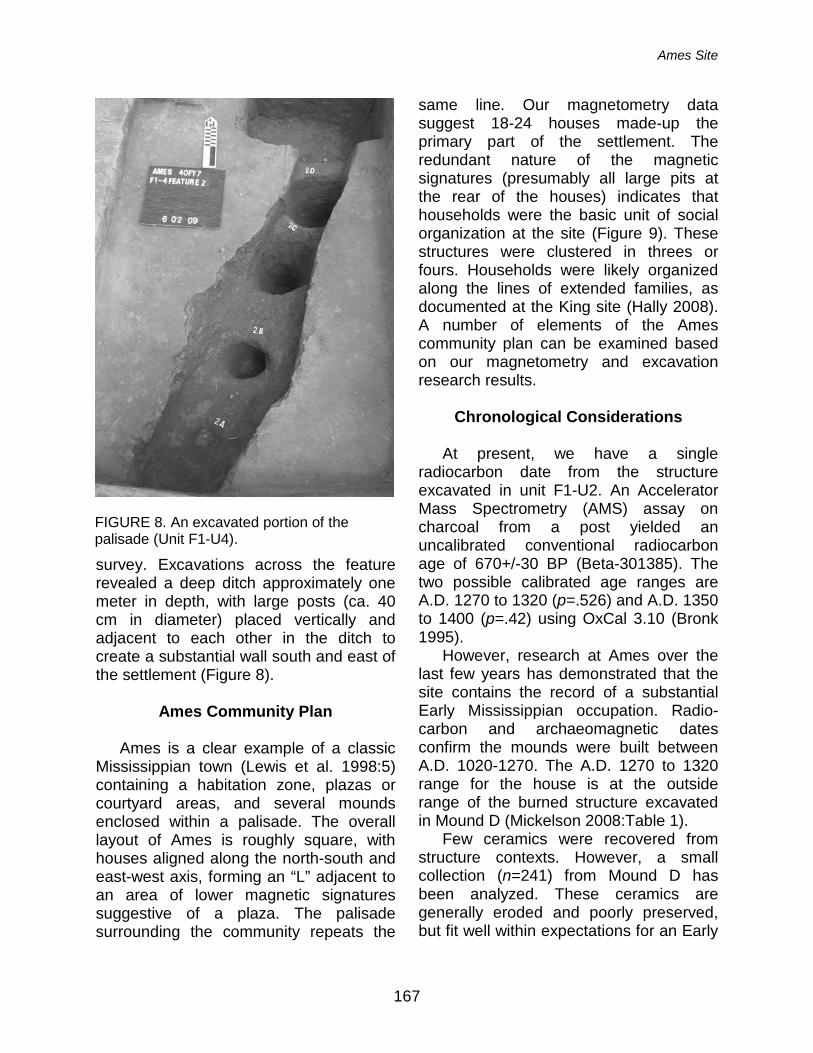
Ames Site
167
survey. Excavations across the feature revealed a deep ditch approximately one meter in depth, with large posts (ca. 40 cm in diameter) placed vertically and adjacent to each other in the ditch to create a substantial wall south and east of the settlement (Figure 8).
Ames Community Plan
Ames is a clear example of a classic
Mississippian town (Lewis et al. 1998:5) containing a habitation zone, plazas or courtyard areas, and several mounds enclosed within a palisade. The overall layout of Ames is roughly square, with houses aligned along the north-south and east-west axis, forming an “L” adjacent to an area of lower magnetic signatures suggestive of a plaza. The palisade surrounding the community repeats the
same line. Our magnetometry data suggest 18-24 houses made-up the primary part of the settlement. The redundant nature of the magnetic signatures (presumably all large pits at the rear of the houses) indicates that households were the basic unit of social organization at the site (Figure 9). These structures were clustered in threes or fours. Households were likely organized along the lines of extended families, as documented at the King site (Hally 2008). A number of elements of the Ames community plan can be examined based on our magnetometry and excavation research results.
Chronological Considerations
At present, we have a single
radiocarbon date from the structure excavated in unit F1-U2. An Accelerator Mass Spectrometry (AMS) assay on charcoal from a post yielded an uncalibrated conventional radiocarbon age of 670+/-30 BP (Beta-301385). The two possible calibrated age ranges are A.D. 1270 to 1320 (p=.526) and A.D. 1350 to 1400 (p=.42) using OxCal 3.10 (Bronk 1995).
However, research at Ames over the last few years has demonstrated that the site contains the record of a substantial Early Mississippian occupation. Radio-carbon and archaeomagnetic dates confirm the mounds were built between A.D. 1020-1270. The A.D. 1270 to 1320 range for the house is at the outside range of the burned structure excavated in Mound D (Mickelson 2008:Table 1).
Few ceramics were recovered from structure contexts. However, a small collection (n=241) from Mound D has been analyzed. These ceramics are generally eroded and poorly preserved, but fit well within expectations for an Early
FIGURE 8. An excavated portion of the palisade (Unit F1-U4).
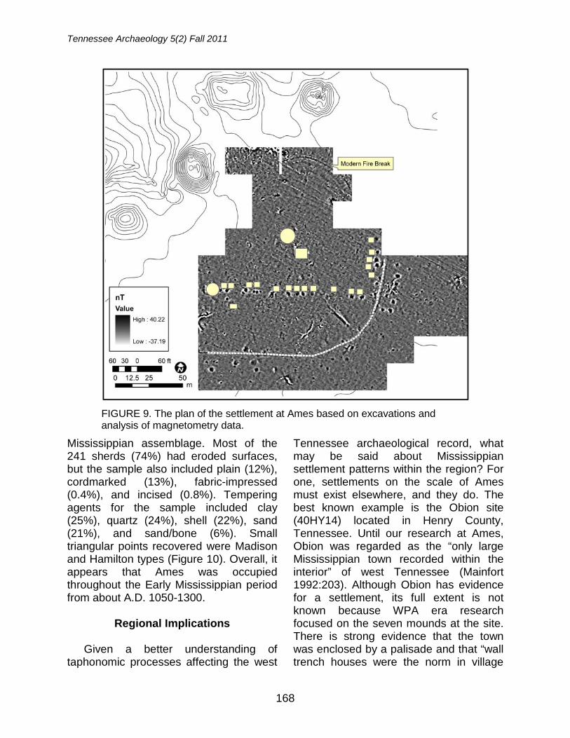
Tennessee Archaeology 5(2) Fall 2011
168
Mississippian assemblage. Most of the 241 sherds (74%) had eroded surfaces, but the sample also included plain (12%), cordmarked (13%), fabric-impressed (0.4%), and incised (0.8%). Tempering agents for the sample included clay (25%), quartz (24%), shell (22%), sand (21%), and sand/bone (6%). Small triangular points recovered were Madison and Hamilton types (Figure 10). Overall, it appears that Ames was occupied throughout the Early Mississippian period from about A.D. 1050-1300.
Regional Implications
Given a better understanding of
taphonomic processes affecting the west
Tennessee archaeological record, what may be said about Mississippian settlement patterns within the region? For one, settlements on the scale of Ames must exist elsewhere, and they do. The best known example is the Obion site (40HY14) located in Henry County, Tennessee. Until our research at Ames, Obion was regarded as the “only large Mississippian town recorded within the interior” of west Tennessee (Mainfort 1992:203). Although Obion has evidence for a settlement, its full extent is not known because WPA era research focused on the seven mounds at the site. There is strong evidence that the town was enclosed by a palisade and that “wall trench houses were the norm in village
FIGURE 9. The plan of the settlement at Ames based on excavations and analysis of magnetometry data.
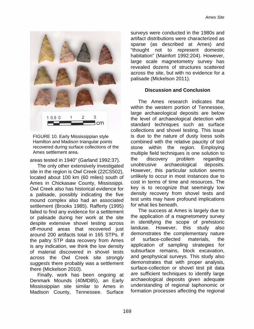
Ames Site
169
areas tested in 1940” (Garland 1992:37). The only other extensively investigated
site in the region is Owl Creek (22CS502), located about 100 km (60 miles) south of Ames in Chickasaw County, Mississippi. Owl Creek also has historical evidence for a palisade, possibly indicating the five mound complex also had an associated settlement (Brooks 1985). Rafferty (1995) failed to find any evidence for a settlement or palisade during her work at the site despite extensive shovel testing across off-mound areas that recovered just around 200 artifacts total in 165 STPs. If the paltry STP data recovery from Ames is any indication, we think the low density of material discovered in shovel tests across the Owl Creek site strongly suggests there probably was a settlement there (Mickelson 2010).
Finally, work has been ongoing at Denmark Mounds (40MD85), an Early Mississippian site similar to Ames in Madison County, Tennessee. Surface
surveys were conducted in the 1980s and artifact distributions were characterized as sparse (as described at Ames) and “thought not to represent domestic habitation” (Mainfort 1992:204). However, large scale magnetometry survey has revealed dozens of structures scattered across the site, but with no evidence for a palisade (Mickelson 2011).
Discussion and Conclusion
The Ames research indicates that
within the western portion of Tennessee, large archaeological deposits are below the level of archaeological detection with standard techniques such as surface collections and shovel testing. This issue is due to the nature of dusty loess soils combined with the relative paucity of tool stone within the region. Employing multiple field techniques is one solution to the discovery problem regarding unobtrusive archaeological deposits. However, this particular solution seems unlikely to occur in most instances due to cost in terms of time and resources. The key is to recognize that seemingly low density recovery from shovel tests and test units may have profound implications for what lies beneath.
The success at Ames is largely due to the application of a magnetometry survey in identifying the scope of prehistoric landuse. However, this study also demonstrates the complementary nature of surface-collected materials, the application of sampling strategies for subsurface remains, block excavation, and geophysical surveys. This study also demonstrates that with proper analysis, surface-collection or shovel test pit data are sufficient techniques to identify large archaeological deposits given adequate understanding of regional taphonomic or formation processes affecting the regional
FIGURE 10. Early Mississippian style Hamilton and Madison triangular points recovered during surface collections of the Ames settlement area.
Tennessee Archaeology 5(2) Fall 2011
170
archaeological record in west Tennessee. Research at Ames has revealed an
entire settlement consisting of four mounds and dozens of structures surrounded by a palisade. The discovery of the town in an area of seemingly low artifact density attests to the necessity of landscape scale magnetometry surveys, as sites apparently occupied for perhaps a generation or more (as indicated by rebuilt structures) can go undetected. Negative evidence of occupation in the area then affects our view of settlement patterns.
Ames is not only important for what has been discovered there, but also for regional implications for Early Mississippian period human landuse. The new view is that the region unquestionably had a number of small settlements or towns containing perhaps two dozen houses and three or more mounds. What this research points to is a dynamic settlement system in the hinterlands, far away from any major river.
Acknowledgements: This paper was first presented at the 75th Annual Meetings of the Society for American Archaeology in a symposium in honor of William S. Dancey. We would like to thank the 2009-2011 Ames University of Memphis field school participants, especially Scott Hadley, Lee Owens, Lee Anderson, Justin Shavers, Christian Roesler, August Marshall, Laura Meyer, Wade Jones, and Philip Geary. Jamie Evans and Rick Carlisle have generously supported our work at Ames over the last four years. The lead author would like to thank Katherine Mickelson, for her sharp critique of the vacant center model, support in and out of the field, and for aiding in the drafting of this paper. David Dye assisted with a problematic graphic. David Hally, Robert Mainfort, and Charles McNutt gave very thoughtful comments on earlier manuscript versions. We would also like to thank Shawn Chapman for completing the initial analysis of the ceramics from Mound D. Comments from two anonymous reviewers also greatly helped improve this paper. Research at Ames received financial support from the University of Memphis Office for Research Support Services, the College of Arts and
Sciences, and the Department of Earth Sciences.
References
Brookes, Samuel O. 1985 The Owl Creek Site. In Anthology of
Mississippi Archaeology, Pat K. Galloway, editor, pp. 225-245. Mississippi Department of Archives
and History, Jackson. Bronk, Ramsey C. 1995 Radiocarbon Calibration and Analysis
of Stratigraphy: The OxCal Program. Radiocarbon 37:425-430.
Dancey, William S. and Paul Pacheco 1997 A Community Model of Ohio Hopewell
Settlement. In Ohio Hopewell Community Organization, edited by
William S. Dancey and Paul Pacheco, pp. 3-40. The Kent State University Press. Kent, Ohio.
Dunnell, Robert C. and William S. Dancey 1983 The Siteless Survey: A Regional Scale
Data Collection Strategy. In Advances in Archaeological Method and Theory, Volume 6, edited by M. Schiffer, pp. 267-287. Academic Press, New York.
Garland, Elizabeth Baldwin 1992 The Obion Site: An Early Mississippian Center in Western Tennessee. Report of Investigations 7,
Cobb Institute of Archaeology, Mississippi State University.
Hally, David J. 2008 King: The Social Archaeology of a
Late Mississippian Town in Northwestern Georgia. University of
Alabama Press. Tuscaloosa. Kvamme, Kenneth 2003 Geophysical Surveys as Landscape
Archaeology. American Antiquity 68(3):435-457.
2006 Magnetometry: Nature’s Gift to Archaeology. In Remote Sensing in
Archaeology, Jay K. Johnson, editor,
Ames Site
171
pp.205-234. University of Alabama Press, Tuscaloosa.
Lewis, R. Barry, Charles Stout, and Cameron
B. Wesson 1998 The Design of Mississippian Towns. In
Mississippian Towns and Sacred Spaces: Searching for an Architectural Grammar, edited by R. Lewis Barry and Charles Stout, pp. 1-21. The
University of Alabama Press, Tuscaloosa. Mainfort, Robert C., Jr. 1986 Pinson Mounds: a Middle Woodland
Ceremonial Site. .Research Series No. 7, Tennessee Department of Conservation, Division of Archaeology, Nashville.
1992 The Mississippian Period in the West Tennessee Interior. In The Obion Site. An Early Mississippian Center in Western Tennessee, by Elizabeth Baldwin Garland pp. 203-207. Report of Investigations 7, Cobb Institute of Archaeology, Mississippi State University.
McKinnon, Duncan P. 2009 Exploring Settlement Patterning at a
Premier Caddo Mound Site in the Red River Great Bend Region. South-eastern Archaeology 28(2): 248-258.
Mickelson, Andrew M. 2008 Recent research at the Ames Mound
Complex. An Early Mississippian Site in Southwest Tennessee. Tennessee Archaeology 3(2):201-218. Electronic document accessed October 31, 2011. http://www.mtsu.edu/~kesmith/TNARCH/tennesseearchaeology.html.
2010 The Unobtrusive Mississippian Village: Rethinking Late Prehistoric Settlement Patterns in Western Tennessee.
Paper presented at the 75th Annual Society for American Archaeology Meetings, St. Louis, Missouri.
2011 Magnetometry and the Mississippian Period Landscape in Western Tennessee. Paper presented at the
23rd Current Research in Tennessee Archaeology Conference, Nashville,
Tennessee. National Oceanic and Atmospheric
Administration 2007 Climatological Data. Tennessee. May
2007 112:5. National Climactic Data Center Accessed April 20, 2010. http://www4.ncdc.noaa.gov/cgi-win/wwcgi.dll?wwDI~StnSrch~StnID~20018044#ONLINE.
2009 Climatological Data. Tennessee. May 2009 112:5. National Climactic Data Center. Accessed April 20, 2010. http://www4.ncdc.noaa.gov/cgiwin/wwcgi.dll?wwDI~StnSrch~StnID~20018044#ONLINE.
Orton, Clive 2000 Sampling in Archaeology. Cambridge
University Press, London. Peterson, Drexel A. 1979 An Archaeological Assessment of the
Wolf River Watershed. Prepared for the United States Department of
Agriculture, Soil Conservation Service. Contract No. 53-4741-9-28. Copy on file at the C. H. Nash Museum Library, Memphis.
Rafferty, Janet 1995 Owl Creek Mounds: Test Excavations
at a Vacant Mississippian Mound Center. Prepared for United States
Department of Agriculture, Forest Service, National Forests of Mississippi. Report of Investigations 7.
Cobb Institute of Archaeology, Mississippi State University. Schiffer, Michael 1987 Formation Processes of the Archaeological Record. University of
Utah Press. Salt Lake City. Schroeder, Sissel 2005 Reclaiming New Deal Era Civic
Archaeology: Exploring the Legacy of William S. Webb and the Jonathan
Tennessee Archaeology 5(2) Fall 2011
172
Creek Site. CRM: The Journal of Heritage Stewardship 2(1):1-17. Smith, Gerald P. 1979 Ceramics from the Wolf River
Drainage Area. In An Archaeological Assessment of the Wolf River Watershed, Drexel A. Peterson, editor,
pp.41-44. Prepared for the United States Department of Agriculture, Soil Conservation Service. Contract No. 53-4741-9-28. Copy on file at the C. H. Nash Museum Library, Memphis.
United States Environmental Protection
Agency 2010 IV Ecoregions of EPA Region 4.
Electronic Document Accessed 20 August 2010. ftp.epa.gov/wed/ecoregions/reg4/reg4_eco_l4.zip.
Webb, William S. 1952 The Jonathan Creek Village. The
University of Kentucky, Reports on Anthropology VIII(1). Department of Anthropology. University of Kentucky Press, Lexington.
Andrew M. Mickelson Department of Earth Sciences Johnson Hall University of Memphis Memphis, TN 38152 Eric Goddard Department of Earth Sciences Johnson Hall University of Memphis Memphis, TN 38152
173
RECOVERY AND REBURIAL OF THE REMAINS OF AN UNKNOWN CIVIL WAR SOLDIER, FRANKLIN, TENNESSEE
Samuel D. Smith and Larry R. McKee
In May of 2009, backhoe trenching on a commercial development project on the southern outskirts of Franklin, Tennessee uncovered the remains of a Civil War soldier. Archaeological investigation of the find resulted in the recovery of all disturbed remains and full exposure and recovery of the undisturbed portion of the skeletal remains. The work also confirmed this was an isolated grave rather than the location of an undocumented cemetery. Forensic analysis of the remains found no evidence of cause of death but did determine that the individual was a male in his early twenties, with dental characteristics suggesting he had both European and Native American genetic heritage. Buttons found in association with the remains indicate the man was buried in military clothing but do not make certain which side of the war he fought on. Following the removal and study of the remains, Franklin residents arranged for the soldier to receive a formal funeral followed by reburial in the historic town cemetery.
On May 14, 2009 a contractor working for Wolfe Fields Development, LLC discovered an unmarked burial while digging a utility line trench with a backhoe. The work site was in Williamson County on the south edge of Franklin, Tennessee, and the property that was being developed is defined as Lot 5 of “Through the Green Subdivision” (shown on Plat Book 50, p. 49 and Plat Book 52, p. 62, Registers Office, Williamson County, Tennessee). This lot was later assigned Tennessee Archaeological Site Number 40WM429. Prior to the start of the development project, the area had been the site of an undistinguished mid-twentieth century dwelling, with its paved driveway likely covering the burial spot. The burial lay approximately 2.5 feet below what had been ground surface around the house.
The burial was noticed when the machine operator was dumping a backhoe bucket load of soil and saw what appeared to be pieces from a human skull and mandible. The operator dutifully contacted the Franklin City Police who came to the site, determined that it was probably not a recent interment, and
contacted Michael C. Moore, State Archaeologist and Director of the Division of Archaeology. A few hours after the discovery, Moore and Samuel D. Smith (Historical Archaeologist for the Division) arrived at the site to help assess the nature of the reported find.
By the time Moore and Smith arrived, the backhoe pile had been picked over, and the police were holding some bones and four brass buttons. The buttons were obviously Civil War era military buttons, and it was immediately assumed this was one of the many unmarked burials that resulted from Civil War fighting in and around Franklin, especially following the November 30, 1864 Battle of Franklin. However, as the burial location is 1.5 miles south of the main Federal defense line at the time of the Battle of Franklin, it also seemed possible the remains could be those of a soldier killed during other actions that occurred in the general area both before and after that battle.
While it was obvious the backhoe had removed the upper portion of a skeleton, actual orientation of the grave was not clear, nor was it known if this was an isolated burial or part of some larger
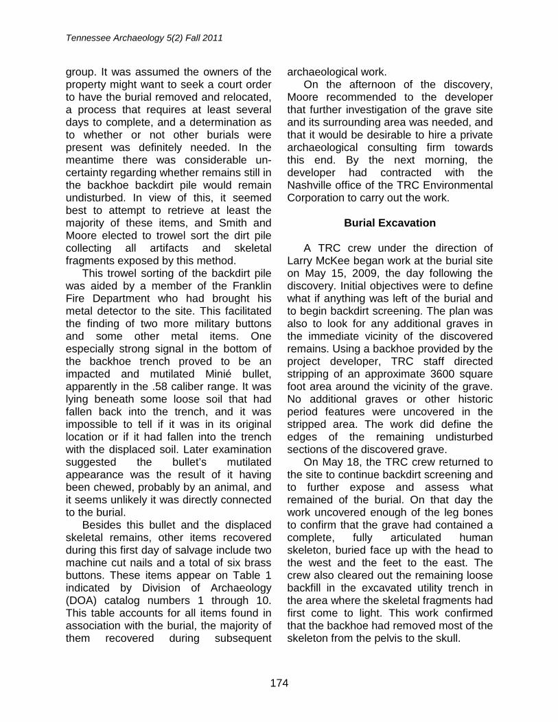
Tennessee Archaeology 5(2) Fall 2011
174
group. It was assumed the owners of the property might want to seek a court order to have the burial removed and relocated, a process that requires at least several days to complete, and a determination as to whether or not other burials were present was definitely needed. In the meantime there was considerable un-certainty regarding whether remains still in the backhoe backdirt pile would remain undisturbed. In view of this, it seemed best to attempt to retrieve at least the majority of these items, and Smith and Moore elected to trowel sort the dirt pile collecting all artifacts and skeletal fragments exposed by this method.
This trowel sorting of the backdirt pile was aided by a member of the Franklin Fire Department who had brought his metal detector to the site. This facilitated the finding of two more military buttons and some other metal items. One especially strong signal in the bottom of the backhoe trench proved to be an impacted and mutilated Minié bullet, apparently in the .58 caliber range. It was lying beneath some loose soil that had fallen back into the trench, and it was impossible to tell if it was in its original location or if it had fallen into the trench with the displaced soil. Later examination suggested the bullet’s mutilated appearance was the result of it having been chewed, probably by an animal, and it seems unlikely it was directly connected to the burial.
Besides this bullet and the displaced skeletal remains, other items recovered during this first day of salvage include two machine cut nails and a total of six brass buttons. These items appear on Table 1 indicated by Division of Archaeology (DOA) catalog numbers 1 through 10. This table accounts for all items found in association with the burial, the majority of them recovered during subsequent
archaeological work. On the afternoon of the discovery,
Moore recommended to the developer that further investigation of the grave site and its surrounding area was needed, and that it would be desirable to hire a private archaeological consulting firm towards this end. By the next morning, the developer had contracted with the Nashville office of the TRC Environmental Corporation to carry out the work.
Burial Excavation
A TRC crew under the direction of
Larry McKee began work at the burial site on May 15, 2009, the day following the discovery. Initial objectives were to define what if anything was left of the burial and to begin backdirt screening. The plan was also to look for any additional graves in the immediate vicinity of the discovered remains. Using a backhoe provided by the project developer, TRC staff directed stripping of an approximate 3600 square foot area around the vicinity of the grave. No additional graves or other historic period features were uncovered in the stripped area. The work did define the edges of the remaining undisturbed sections of the discovered grave.
On May 18, the TRC crew returned to the site to continue backdirt screening and to further expose and assess what remained of the burial. On that day the work uncovered enough of the leg bones to confirm that the grave had contained a complete, fully articulated human skeleton, buried face up with the head to the west and the feet to the east. The crew also cleared out the remaining loose backfill in the excavated utility trench in the area where the skeletal fragments had first come to light. This work confirmed that the backhoe had removed most of the skeleton from the pelvis to the skull.
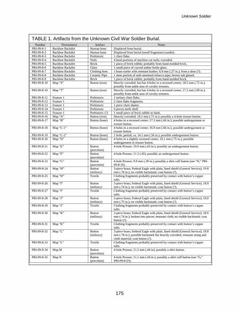
Unknown Soldier
175
TABLE 1. Artifacts from the Unknown Civil War Soldier Burial.
Number Provenience Artifact Notes PRI-09-8-1 Backhoe Backdirt Human bone Displaced from burial. PRI-09-8-2 Backhoe Backdirt Human bone Displaced from burial (small fragments/crumbs). PRI-09-8-3 Backhoe Backdirt Prehistoric 1 chert flake. PRI-09-8-4 Backhoe Backdirt Nails 4 head portions of machine cut nails; corroded. PRI-09-8-5 Backhoe Backdirt Brick 1 piece of brick rubble; probably from hand-molded brick. PRI-09-8-6 Backhoe Backdirt Glass 1 small piece of curved amber bottle glass. PRI-09-8-7 Backhoe Backdirt Clothing Item 1 brass eyelet with remnant leather; 6.9 mm (.27 in.); from a shoe (?). PRI-09-8-8 Backhoe Backdirt Ceramic Pipe 1 stem portion of stub-stemmed tobacco pipe; brown salt glazed. PRI-09-8-9 Backhoe Backdirt Brick 1 piece of brick rubble; probably from hand-molded brick. PRI-09-8-10 Map “S” Button (iron) Heavily corroded, but has 4 holes in a recessed center; 18.5 mm (.72 in.);
possibly from ankle area of cavalry trousers. PRI-09-8-10 Map “T” Button (iron) Heavily corroded, but has 4 holes in a recessed center; 17.2 mm (.68 in.);
possibly from ankle area of cavalry trousers. PRI-09-8-11 Feature 1 Prehistoric 1 tertiary chert flake. PRI-09-8-12 Feature 1 Prehistoric 2 chert flake fragments. PRI-09-8-13 Feature 1 Prehistoric 1 piece chert shatter. PRI-09-8-14 Feature 1 Prehistoric 6 pieces turtle shell. PRI-09-8-15 Feature 1 Prehistoric (?) 1 small piece of brick rubble or daub. PRI-09-8-16 Map “A” Button (iron) Heavily corroded; 18.2 mm (.71 in.); possibly a 4-hole trouser button. PRI-09-8-17 Map “B” Button (bone) 4 holes in a recessed center; 17.3 mm (.66 in.); possible undergarment or
trouser button. PRI-09-8-18 Map “C-1” Button (bone) 4 holes in a recessed center; 16.9 mm (.66 in.); possible undergarment or
trouser button. PRI-09-8-19 Map “C-2” Button (bone) 1-hole; partial; ca. 14.1 mm (.56 in.); possible undergarment button. PRI-09-8-20 Map “D” Button (bone) 4 holes in a slightly recessed center; 19.1 mm (.75 in.); possible
undergarment or trouser button. PRI-09-8-21 Map “E” Button
(porcelain) 4-hole Prosser; 10.9 mm (.43 in.); possibly an undergarment button.
PRI-09-8-22 Map “F” Button (porcelain)
4-hole Prosser; 11.3 (.45); possibly an undergarment button.
PRI-09-8-23 Map “G” Button (porcelain)
4-hole Prosser; 9.9 mm (.39 in.); possibly a shirt cuff button (see “N,” PRI-09-8-35).
PRI-09-8-24 Map “H” Button (military)
3-piece brass; Federal Eagle with plain, lined shield (General Service); 19.8 mm (.78 in.); no visible backmark; coat button (?).
PRI-09-8-25 Map “H” Textile Clothing fragments probably preserved by contact with button’s copper salts.
PRI-09-8-26 Map “I” Button (military)
3-piece brass; Federal Eagle with plain, lined shield (General Service); 18.9 mm (.74 in.); no visible backmark; coat button (?).
PRI-09-8-27 Map “I” Textile Clothing fragments probably preserved by contact with button’s copper salts.
PRI-09-8-28 Map “J” Button (military)
3-piece brass; Federal Eagle with plain, lined shield (General Service); 19.0 mm (.75 in.); no visible backmark; coat button (?).
PRI-09-8-29 Map “J” Textile Clothing fragments probably preserved by contact with button’s copper salts.
PRI-09-8-30 Map “K” Button (military)
3-piece brass; Federal Eagle with plain, lined shield (General Service); 18.6 mm (.74 in.); broken into pieces; remnant cloth; no visible backmark; coat button (?).
PRI-09-8-31 Map “K” Textile Clothing fragments probably preserved by contact with button’s copper salts.
PRI-09-8-32 Map “L” Button (military)
3-piece brass; Federal Eagle with plain, lined shield (General Service); 19.8 mm (.78 in.); possible backmark but heavily corroded; remnant string and cloth material; coat button (?).
PRI-09-8-33 Map “L” Textile Clothing fragments probably preserved by contact with button’s copper salts.
PRI-09-8-34 Map M Button (porcelain)
4-hole Prosser; 11.3 mm (.44 in); possibly a shirt button.
PRI-09-8-35 Map N Button (porcelain)
4-hole Prosser; 11.1 mm (.44 in.); possibly a shirt cuff button (see “G,” PRI-09-8-23).
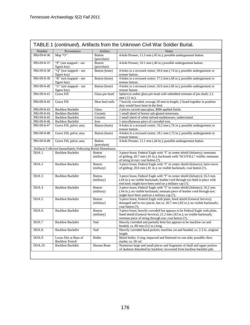
Tennessee Archaeology 5(2) Fall 2011
176
TABLE 1 (continued). Artifacts from the Unknown Civil War Soldier Burial. Number Provenience Artifact Notes
PRI-09-8-36 Map “O” Button (porcelain)
4-hole Prosser; 11.3 mm (.45 in.); possible undergarment button.
PRI-09-8-37 “P” (not mapped – see figure key)
Button (porcelain)
4-hole Prosser; 10.1 mm (.40 in.) possible undergarment button.
PRI-09-8-38 “Q” (not mapped – see figure key)
Button (bone) 4 holes in a recessed center; 18.6 mm (.74 in.); possible undergarment or trouser button.
PRI-09-8-39 “R” (not mapped – see figure key)
Button (bone) 4 holes in a recessed center; 17.3 mm (.68 in.); possible undergarment or trouser button.
PRI-09-8-40 “U” (not mapped – see figure key)
Button (bone) 4 holes in a recessed center; 16.9 mm (.66 in.); possible undergarment or trouser button
PRI-09-8-41 Grave Fill Glass pin head Spherical amber glass pin head with imbedded remnant of pin shaft; 3.2 mm (.11 in.).
PRI-09-8-42 Grave Fill Shoe heel nails 7 heavily corroded; average 20 mm in length; 2 fused together in position they would have been in the heel.
PRI-09-8-43 Backhoe Backdirt Glass 2 pieces curved aqua glass, BIM applied finish. PRI-09-8-44 Backhoe Backdirt Ceramic 1 small sherd of brown salt-glazed stoneware. PRI-09-8-45 Backhoe Backdirt Ceramic 1 small sherd of white refined earthenware, undecorated. PRI-09-8-46 Backhoe Backdirt Iron 1 miscellaneous piece of corroded iron. PRI-09-8-47 Grave Fill, pelvic area Button (bone) 4-holes in a recessed center; 19.2 mm (.76 in.); possible undergarment or
trouser button. PRI-09-8-48 Grave Fill, pelvic area Button (bone) 4-holes in a recessed center; 19.1 mm (.75 in.); possible undergarment or
trouser button. PRI-09-8-49 Grave Fill, pelvic area Button
(porcelain) 4-hole Prosser; 11.1 mm (.44 in.); possible undergarment button.
Artifacts Collected Immediately Following Burial Disturbance. DOA 1 Backhoe Backdirt Button
(military) 3-piece brass; Federal Eagle with “I” in center shield (Infantry); remnants of gilding; 20.7 mm (.81 in.); backmark with “SCOVILL” visible; remnants of string in eye; coat button (?).
DOA 2 Backhoe Backdirt Button (military)
3-piece brass; Federal Eagle with “I” in center shield (Infantry); faint traces of gilding; 20.6 mm (.81 in.); no visible backmark; coat button (?)..
DOA 3 Backhoe Backdirt Button (military)
3-piece brass; Federal Eagle with “I” in center shield (Infantry); 16.3 mm (.64 in.); no visible backmark; leather cord through eye held in place with end knot; might have been used on a military cap (?).
DOA 4 Backhoe Backdirt Button (military)
3-piece brass; Federal Eagle with “I” in center shield (Infantry); 16.2 mm (.64 in.); no visible backmark; remnant piece of leather cord through eye; might have been used on a military cap (?).
DOA 5 Backhoe Backdirt Button (military)
3-piece brass; Federal Eagle with plain, lined shield (General Service); damaged and in two pieces, but ca. 20.7 mm (.82 in.); no visible backmark;; coat button (?).
DOA 6 Backhoe Backdirt Button (military)
3-piece brass; heavily corroded but appears to be Federal Eagle with plain, lined shield (General Service); 21.2 mm (.83 in.); no visible backmark; remnant piece of string through eye; coat button (?).
DOA 7 Backhoe Backdirt Nail Heavily corroded and partially bent but appears to be machine cut and headed, ca. 80 mm (3.2 in.) long.
DOA 8 Backhoe Backdirt Nail Heavily corroded head portion; machine cut and headed; ca. 2-3 in. original length.
DOA 9 Loose Dirt at Base of Backhoe Trench
Bullet Minié bullet; 3-ring; impacted and flattened on one side; possible chew marks; ca. 58 cal.
DOA 10 Backhoe Backdirt Human Bone Numerous large and small pieces and fragments of skull and upper portion of skeleton disturbed by backhoe; recovered from backhoe backdirt pile.
Unknown Soldier
177
Screening of the backdirt from the utility trench found additional bone and a few other artifacts possibly related to the burial, including a fragment of a ceramic “elbow-style” tobacco pipe. At the end of work on May 18, TRC staff partially backfilled the grave with loose soil and covered it with a tarp. Additional work was dependant on a decision concerning whether to leave the burial in place or, following Tennessee state law regarding abandoned grave sites, to seek a court order allowing removal of the remains.
In the next few weeks the City of Franklin and several local preservation groups developed a plan to rebury the remains in Rest Haven Cemetery, a city-owned historic burial ground on the outskirts of downtown Franklin. This plan was formalized through a court order authorizing burial removal issued by the
Williamson County chancery court on June 5, 2009.
On June 15, 2009, a TRC crew returned to the site to complete the exposure and removal of the remains (Figure 1). Above the pelvis, the only bones remaining in place were a few poorly preserved lower vertebrae, the bones of the left arm from just below the shoulder to just above the wrist, and a bit of the back of the skull (Figure 2). There were also some poorly preserved bones from both the right and left hand centered over the pelvic area, suggesting the individual’s hands had been arranged at this spot when the body was put in the grave. The pelvis was poorly preserved, but the leg and ankle bones were in place and in relatively good shape.
During the initial investigation on May 15, two highly corroded cut nails were
FIGURE 1. View of excavation area during removal operation. Group at left is working on the grave. Facing east, with Columbia Pike running across photo in background.
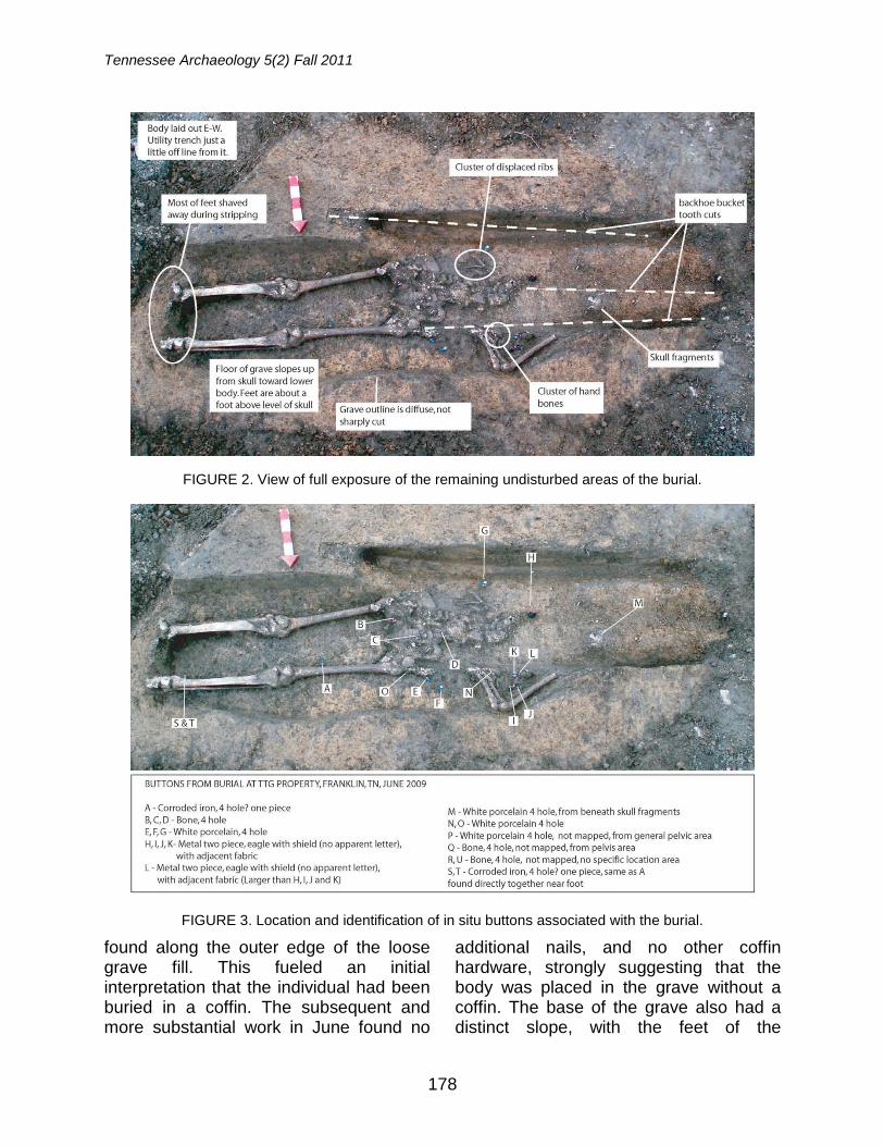
Tennessee Archaeology 5(2) Fall 2011
178
found along the outer edge of the loose grave fill. This fueled an initial interpretation that the individual had been buried in a coffin. The subsequent and more substantial work in June found no
additional nails, and no other coffin hardware, strongly suggesting that the body was placed in the grave without a coffin. The base of the grave also had a distinct slope, with the feet of the
FIGURE 2. View of full exposure of the remaining undisturbed areas of the burial.
FIGURE 3. Location and identification of in situ buttons associated with the burial.
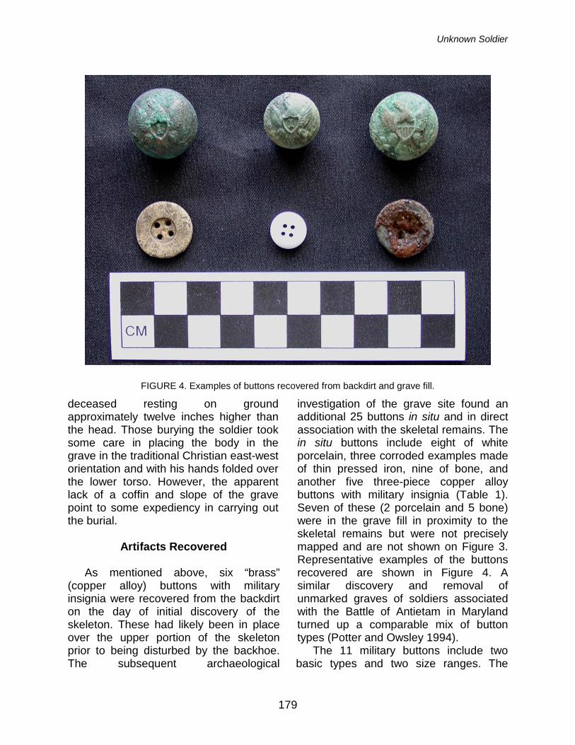
Unknown Soldier
179
deceased resting on ground approximately twelve inches higher than the head. Those burying the soldier took some care in placing the body in the grave in the traditional Christian east-west orientation and with his hands folded over the lower torso. However, the apparent lack of a coffin and slope of the grave point to some expediency in carrying out the burial.
Artifacts Recovered
As mentioned above, six “brass”
(copper alloy) buttons with military insignia were recovered from the backdirt on the day of initial discovery of the skeleton. These had likely been in place over the upper portion of the skeleton prior to being disturbed by the backhoe. The subsequent archaeological
investigation of the grave site found an additional 25 buttons in situ and in direct association with the skeletal remains. The in situ buttons include eight of white porcelain, three corroded examples made of thin pressed iron, nine of bone, and another five three-piece copper alloy buttons with military insignia (Table 1). Seven of these (2 porcelain and 5 bone) were in the grave fill in proximity to the skeletal remains but were not precisely mapped and are not shown on Figure 3. Representative examples of the buttons recovered are shown in Figure 4. A similar discovery and removal of unmarked graves of soldiers associated with the Battle of Antietam in Maryland turned up a comparable mix of button types (Potter and Owsley 1994).
The 11 military buttons include two basic types and two size ranges. The
FIGURE 4. Examples of buttons recovered from backdirt and grave fill.
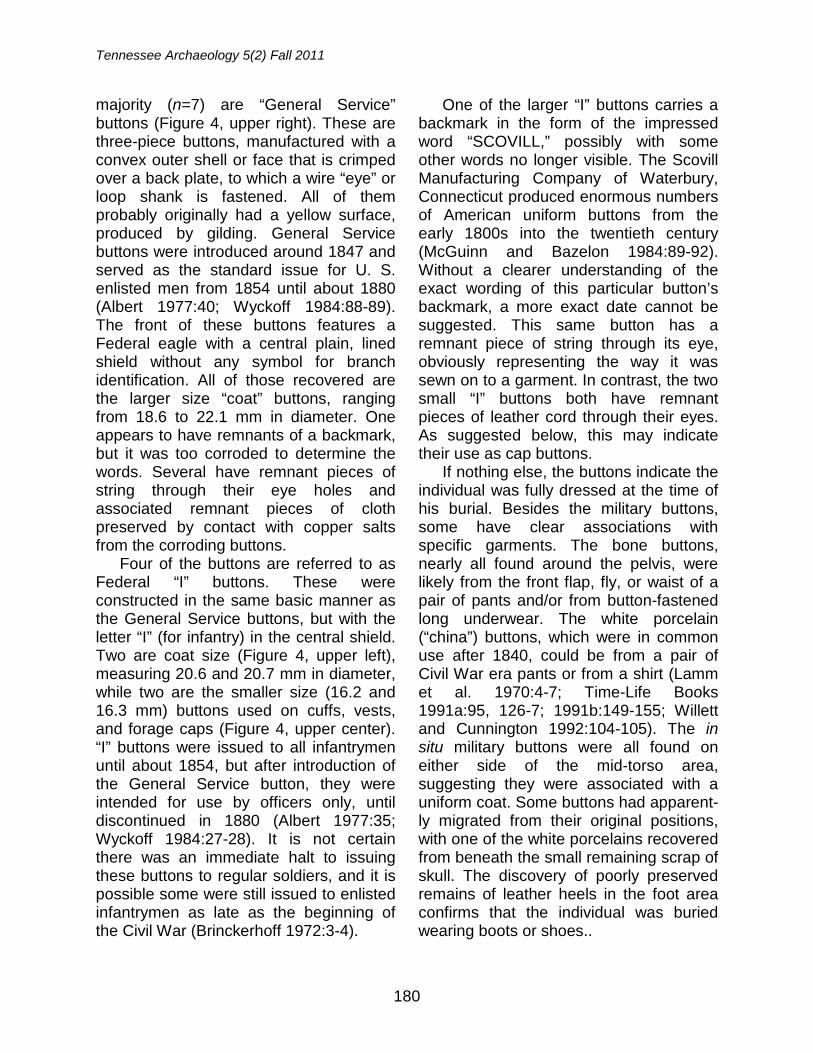
Tennessee Archaeology 5(2) Fall 2011
180
majority (n=7) are “General Service” buttons (Figure 4, upper right). These are three-piece buttons, manufactured with a convex outer shell or face that is crimped over a back plate, to which a wire “eye” or loop shank is fastened. All of them probably originally had a yellow surface, produced by gilding. General Service buttons were introduced around 1847 and served as the standard issue for U. S. enlisted men from 1854 until about 1880 (Albert 1977:40; Wyckoff 1984:88-89). The front of these buttons features a Federal eagle with a central plain, lined shield without any symbol for branch identification. All of those recovered are the larger size “coat” buttons, ranging from 18.6 to 22.1 mm in diameter. One appears to have remnants of a backmark, but it was too corroded to determine the words. Several have remnant pieces of string through their eye holes and associated remnant pieces of cloth preserved by contact with copper salts from the corroding buttons.
Four of the buttons are referred to as Federal “I” buttons. These were constructed in the same basic manner as the General Service buttons, but with the letter “I” (for infantry) in the central shield. Two are coat size (Figure 4, upper left), measuring 20.6 and 20.7 mm in diameter, while two are the smaller size (16.2 and 16.3 mm) buttons used on cuffs, vests, and forage caps (Figure 4, upper center). “I” buttons were issued to all infantrymen until about 1854, but after introduction of the General Service button, they were intended for use by officers only, until discontinued in 1880 (Albert 1977:35; Wyckoff 1984:27-28). It is not certain there was an immediate halt to issuing these buttons to regular soldiers, and it is possible some were still issued to enlisted infantrymen as late as the beginning of the Civil War (Brinckerhoff 1972:3-4).
One of the larger “I” buttons carries a backmark in the form of the impressed word “SCOVILL,” possibly with some other words no longer visible. The Scovill Manufacturing Company of Waterbury, Connecticut produced enormous numbers of American uniform buttons from the early 1800s into the twentieth century (McGuinn and Bazelon 1984:89-92). Without a clearer understanding of the exact wording of this particular button’s backmark, a more exact date cannot be suggested. This same button has a remnant piece of string through its eye, obviously representing the way it was sewn on to a garment. In contrast, the two small “I” buttons both have remnant pieces of leather cord through their eyes. As suggested below, this may indicate their use as cap buttons.
If nothing else, the buttons indicate the individual was fully dressed at the time of his burial. Besides the military buttons, some have clear associations with specific garments. The bone buttons, nearly all found around the pelvis, were likely from the front flap, fly, or waist of a pair of pants and/or from button-fastened long underwear. The white porcelain (“china”) buttons, which were in common use after 1840, could be from a pair of Civil War era pants or from a shirt (Lamm et al. 1970:4-7; Time-Life Books 1991a:95, 126-7; 1991b:149-155; Willett and Cunnington 1992:104-105). The in situ military buttons were all found on either side of the mid-torso area, suggesting they were associated with a uniform coat. Some buttons had apparent-ly migrated from their original positions, with one of the white porcelains recovered from beneath the small remaining scrap of skull. The discovery of poorly preserved remains of leather heels in the foot area confirms that the individual was buried wearing boots or shoes..
Unknown Soldier
181
Table 1 provides a full listing of all artifacts recovered during the investigation of the grave and its vicinity. Beyond the 25 buttons, the only artifacts found in direct association with the burial are the pieces of cloth (n=5) preserved by contact with brass buttons, some shoe heel nails (n=7), and a glass pin head with remnant pin shaft. Other than the six military buttons, the remaining items recovered from the backhoe backdirt, such as nails and glass, are unlikely to have been associated with the burial and probably relate to the residence that once stood on this lot.
Historical Information for Interpreting
the Burial
Part of the difficulty for determining the exact meaning of the burial discovered is that it was found well south of where most of the intense Civil War fighting in Franklin is known to have occurred. As stated above, it was 1.5 miles south of the location of the 1864 Battle of Franklin’s main Federal defensive line, which at the time was on the south edge of Franklin. The burial’s position on the west side of the major route leading south from Franklin, in the 1860s called the Columbia Turnpike, does suggest a number of possible explanations for a rapid interment. These possibilities are best viewed in the context of events that occurred in and around Franklin during the Civil War.
After Tennessee joined the Confederacy, on June 8, 1861, war actions in Middle Tennessee quickly accelerated. Initial activity focused on organizing the “Army of Tennessee,” which became the main Confederate Army west of the Appalachian Mountains. This was soon developed into a force of about 55,000 troops. Confederate control
of Middle Tennessee was, however, relatively short lived. The February 1862 Federal capture of Forts Henry and Donelson opened a direct route for the occupation of Nashville, which soon became the main Federal war materials depot and staging area for actions in the Western Theater. Federal garrisoning of Nashville soon led to attempts to secure the surrounding towns of strategic importance, including Franklin, 18 miles to the south (Horn 1955; Hoobler 1986:18-19; Smith et al. 1990:6).
Perhaps the first mention of Federal troops at Franklin is a May 8, 1862 entry in the diary of resident Sallie F. McEwen. She recorded that “a good number of soldiers and wagons passed through here today on their way south; they were Yankee wagons.” On May 16, 1862 she wrote “the Yankee picketts [sic] were fired upon last night and there was great excitement here in consequence thereof” (McEwen 1862).
During the summer of 1862 Federal activity in the general Franklin area was focused on protecting the railroads by constructing stockades and redoubts at key points. Much of the labor for this work was provided by conscripted slaves. The rail lines were especially vulnerable where wooden trestles supported the tracts at stream crossings, and several locations were of concern at Franklin, where the north-south Tennessee and Alabama rail line (Figure 5) ran along the east edge of town (Nance 2005:15; Smith and Nance 2003:45). On July 18, 1861 Federal General James S. Negley, headquartered at Columbia informed his commander that the railroad bridges between Franklin and Columbia had been attacked the previous night, so he had reinforced the guard at every bridge (War of the Rebellion, Official Records of the Union and Confederate Armies [hereinafter cited as

Tennessee Archaeology 5(2) Fall 2011
182
OR], Series I, Vol. XVI, Part 2, p. 178). By early August 1862 two companies of the 74th Ohio Regiment were stationed in Franklin to guard the bridges, especially at the crossing of the Harpeth River (OR, Series I, Vol. XVI, Part 2, p. 261).
In late August of 1862, the Confederate Army under General Braxton Bragg left its base of operations in Chattanooga and began a move north that ended with the Battle of Perryville in Kentucky. Counter moves by the Federal forces commanded by General Don Carlos Buell resulted in a temporary
abandonment of Franklin, which soon returned to Confederate control (Smith and Nance 2010:13-14). On December 12 fighting occurred on the north side of Franklin, when Union cavalry commanded by General David Stanley skirmished with the occupying Confederates. Stanley captured flour and horses from a mill on the Harpeth River and destroyed the mill’s machinery before retreating back towards Nashville (OR, Series I, Vol. XX, Part 1, pp. 76-78).
Following the Battle of Stones River at Murfreesboro (December 31, 1862 to January 2, 1863), the Confederate Army of Tennessee withdrew to take up a defensive position along the Duck River (Connelly 1994:61-65). In February General Charles Gilbert reestablished Union control of Franklin with orders to “intrench (sic) himself strongly” (OR, Series I, Vol. XXIII, Part 1, p. 63 and Part 2, p. 71). William Merrill,
Chief Engineer for the Department of the Cumberland, was placed in charge of constructing Franklin’s defenses, including Fort Granger on a bluff overlooking the town, the fortified signal station called Roper’s Knob, and several other detached artillery positions, all on the north side of Franklin and the Harpeth River (Nance 2005:23-25).
In early 1863 there were several encounters between Confederate and Union forces that could account for the hasty burial of a soldier on the south side
FIGURE 5. Middle Tennessee portion of a map used to illustrate Civil War era towns and railway lines (from Smith and Nance 2003:33 and 45); No. 11 is the Tennessee- Alabama Railroad (also called the Nashville-Decatur Railroad).
Unknown Soldier
183
of Franklin. In early March there were two episodes of fighting at Thompson’s Station, about 12 miles south of Franklin. On March 4 Federal troops commanded by Colonel John Coburn began a reconnaissance move to the south and soon skirmished with the Confederates. The next day Coburn met a large Confederate force commanded by General Earl Van Dorn at Thompson’s Station. In this encounter the Federals lost about 1,446 men, most of them captured, but some of the dead or wounded who later died might have been buried along the route back to Franklin. Another Union force, this one under General Clay Smith, again skirmished with Van Dorn’s troops near Thompson’s Station on March 9 (OR, Series I, Vol. XXIII, Part 1, pp. 73-118 and 142-144; Smith and Nance 2010:14).
On April 10, 1863 General Van Dorn, believing the Federals had withdrawn from Franklin, sent a sizable recon-naissance force there. The Confederates encountered stiff resistance from the Federals now commanded by General Gordon Granger. Once Van Dorn realized the Federal’s still occupied the town, he ordered a retreat back to the south. Casualties on both sides were reported to be light. By June 4 General Van Dorn was deceased and had been replaced by General Nathan Bedford Forrest. In a move similar to the April 10 episode, Forrest believed the Federals were leaving Franklin and proceeded to move his forces against the place. Like before, the Confederates met stiff resistance, especially long range artillery fire, and Forrest was soon forced to retreat (OR, Series I, Vol. XXIII, Part 1, pp. 177-193 and 222-227; Wills 1992:107-109).
Shortly after these events activity shifted away from Franklin. General William S. Rosecrans led the Union Army
in a successful move against General Bragg’s Confederate forces, forcing them out of their Duck River defenses and out of Middle Tennessee. Aside from occasional Confederate raids, the Franklin area remained relatively secure, and the Union troops present returned to focusing on guarding the railroads (Nance 2005:20-21).
War returned to Franklin on November 30, 1864 with the much described Battle of Franklin. Here the Confederate Army of Tennessee, now with about 38,000 men commanded by General John Bell Hood, attempted a direct frontal assault on an entrenched Federal force of about 22,000 commanded by General John Schofield. The result was an estimated 9,000 to 10,000 soldiers killed, wounded, or cap-tured, with perhaps 7,000 of these being Confederate losses (Cox 1897; Mc-Donough and Connelly 1983; Sword 1992). While the Confederate staging area preceding the battle was in the vici-nity of Winstead Hill, which is a short distance south of where the unknown soldier burial was found, this area is one mile south of where the first battle en-counters took place. The heaviest fighting was in the vicinity of the Carter House, 1.5 miles north of the unknown burial (Smith and Nance 2010:13-24). After the battle, dead soldiers were initially buried in trenches excavated near where they lay, with most of the Union dead placed in their entrenchment ditches and the parapet walls pulled down over them (Sword 1992:261). Later, the remains of an estimated 1,481 soldiers were dug up and removed to what became known as the Confederate Cemetery at nearby Carnton Plantation (http://www.carnton. org/cemetery.htm).
One possibility for explaining the presence of the unknown soldier burial is that it seems to have been near a
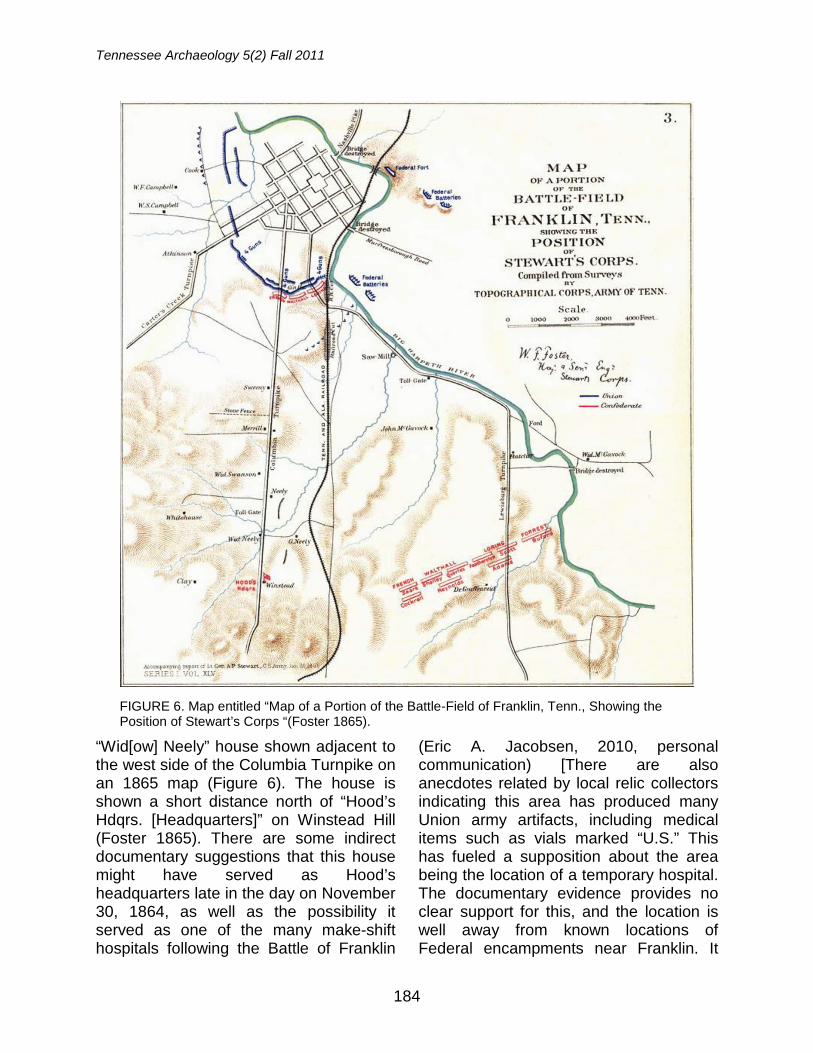
Tennessee Archaeology 5(2) Fall 2011
184
“Wid[ow] Neely” house shown adjacent to the west side of the Columbia Turnpike on an 1865 map (Figure 6). The house is shown a short distance north of “Hood’s Hdqrs. [Headquarters]” on Winstead Hill (Foster 1865). There are some indirect documentary suggestions that this house might have served as Hood’s headquarters late in the day on November 30, 1864, as well as the possibility it served as one of the many make-shift hospitals following the Battle of Franklin
(Eric A. Jacobsen, 2010, personal communication) [There are also anecdotes related by local relic collectors indicating this area has produced many Union army artifacts, including medical items such as vials marked “U.S.” This has fueled a supposition about the area being the location of a temporary hospital. The documentary evidence provides no clear support for this, and the location is well away from known locations of Federal encampments near Franklin. It
FIGURE 6. Map entitled “Map of a Portion of the Battle-Field of Franklin, Tenn., Showing the Position of Stewart’s Corps “(Foster 1865).
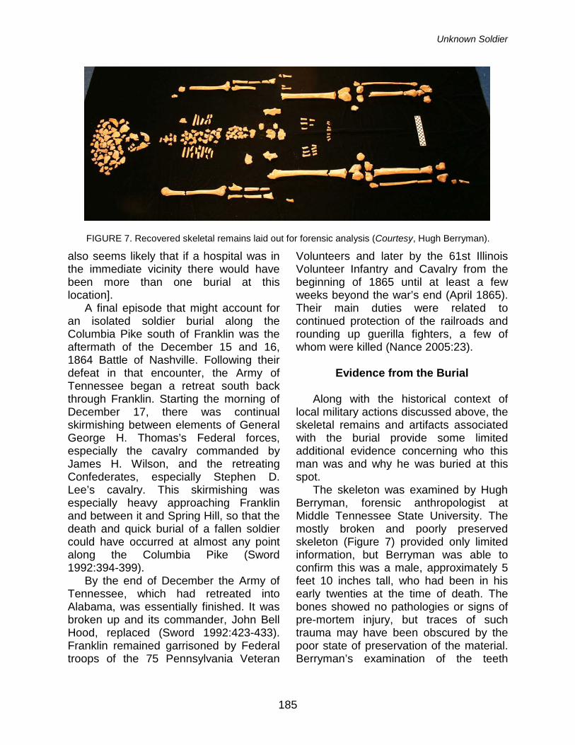
Unknown Soldier
185
also seems likely that if a hospital was in the immediate vicinity there would have been more than one burial at this location].
A final episode that might account for an isolated soldier burial along the Columbia Pike south of Franklin was the aftermath of the December 15 and 16, 1864 Battle of Nashville. Following their defeat in that encounter, the Army of Tennessee began a retreat south back through Franklin. Starting the morning of December 17, there was continual skirmishing between elements of General George H. Thomas’s Federal forces, especially the cavalry commanded by James H. Wilson, and the retreating Confederates, especially Stephen D. Lee’s cavalry. This skirmishing was especially heavy approaching Franklin and between it and Spring Hill, so that the death and quick burial of a fallen soldier could have occurred at almost any point along the Columbia Pike (Sword 1992:394-399).
By the end of December the Army of Tennessee, which had retreated into Alabama, was essentially finished. It was broken up and its commander, John Bell Hood, replaced (Sword 1992:423-433). Franklin remained garrisoned by Federal troops of the 75 Pennsylvania Veteran
Volunteers and later by the 61st Illinois Volunteer Infantry and Cavalry from the beginning of 1865 until at least a few weeks beyond the war’s end (April 1865). Their main duties were related to continued protection of the railroads and rounding up guerilla fighters, a few of whom were killed (Nance 2005:23).
Evidence from the Burial
Along with the historical context of
local military actions discussed above, the skeletal remains and artifacts associated with the burial provide some limited additional evidence concerning who this man was and why he was buried at this spot.
The skeleton was examined by Hugh Berryman, forensic anthropologist at Middle Tennessee State University. The mostly broken and poorly preserved skeleton (Figure 7) provided only limited information, but Berryman was able to confirm this was a male, approximately 5 feet 10 inches tall, who had been in his early twenties at the time of death. The bones showed no pathologies or signs of pre-mortem injury, but traces of such trauma may have been obscured by the poor state of preservation of the material. Berryman’s examination of the teeth
FIGURE 7. Recovered skeletal remains laid out for forensic analysis (Courtesy, Hugh Berryman).
Tennessee Archaeology 5(2) Fall 2011
186
noted that the individual had a Carabelli’s cusp on one molar, a trait associated with European ancestry. The recovered teeth also included four with untreated cavities. Berryman also found that the individual’s incisors were mildly “shovel-shaped,” a genetic trait commonly found among those of Asian and Native American descent.
An obvious question of interest about this individual is whether he was a Union or Confederate soldier. As discussed above, the location of the burial is along Columbia Turnpike, a major nineteenth-century road corridor that during the Civil War commonly saw military traffic as well as occasional skirmishing between Union and Confederate forces. This frequency of action along the road discourages attempts to link the grave location to specific engagements or formal or informal encampments during the conflict.
Artifacts from the burial, in particular buttons, provide clues concerning the soldier’s military affiliation, but these too are not unambiguous. On first glance, the fact that all the military buttons have Federal insignia would seem to point conclusively to this being a Union soldier. This is discounted by the fact that Confederate forces made extensive use of Federal buttons through confiscation of supply stockpiles in the South at the start of the war and as the result of capture of supplies during the war. Many who fought with the South bore at least some Federal buttons on their uniforms. Buttons with Confederate insignia were made and used during the war, and finding a single such button with the burial would have been clear evidence this man fought for
the South. Two of the buttons recovered from the
backhoe trench backdirt are smaller Federal military types marked with an “I” for infantry. These were intended for use on caps, vests, and coat sleeves. The discovery of only two such small military buttons, displaced from the upper body portion of the skeleton, suggests the individual may have been buried wearing a forage cap (or “French kipi”). Uniform vests had many more buttons, and when buttons were present on coat sleeves there was usually a total of four or more. The forage cap was a common head gear worn by both Union and Confederate soldiers, often with a leather band (a chin strap) across the front, secured by a small button at each end (examples in Time-Life Books 1991a and 1991b). This kind of forage cap was designed for official use by the Federal Army starting in 1858 (Howell 1975:12-17). A further suggestion that these two small buttons may have been used on a forage cap is that while only remnant portions of string were found in the eyes of some of the large military buttons, both of the small “I” buttons retained pieces of leather cord in their eyes. If these buttons do represent a Federal forage cap, this could be an important clue. As a colleague familiar with some similar unknown soldier burials pointed out, it was not uncommon for Confederate soldiers to be wearing Union jackets or coats late in the war, but for a Confederate soldier to be wearing a union hat “would increase the chances of being mistaken as Union by your own forces and shot” (Potter 2010).
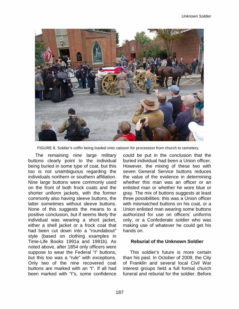
Unknown Soldier
187
The remaining nine large military buttons clearly point to the individual being buried in some type of coat, but this too is not unambiguous regarding the individuals northern or southern affiliation. Nine large buttons were commonly used on the front of both frock coats and the shorter uniform jackets, with the former commonly also having sleeve buttons, the latter sometimes without sleeve buttons. None of this suggests the means to a positive conclusion, but if seems likely the individual was wearing a short jacket, either a shell jacket or a frock coat that had been cut down into a “roundabout” style (based on clothing examples in Time-Life Books 1991a and 1991b). As noted above, after 1854 only officers were suppose to wear the Federal “I” buttons, but this too was a “rule” with exceptions. Only two of the nine recovered coat buttons are marked with an “I”. If all had been marked with “I”s, some confidence
could be put in the conclusion that the buried individual had been a Union officer. However, the mixing of these two with seven General Service buttons reduces the value of the evidence in determining whether this man was an officer or an enlisted man or whether he wore blue or gray. The mix of buttons suggests at least three possibilities: this was a Union officer with mismatched buttons on his coat, or a Union enlisted man wearing some buttons authorized for use on officers’ uniforms only, or a Confederate soldier who was making use of whatever he could get his hands on.
Reburial of the Unknown Soldier This soldier’s future is more certain
than his past. In October of 2009, the City of Franklin and several local Civil War interest groups held a full formal church funeral and reburial for the soldier. Before
FIGURE 8. Soldier’s coffin being loaded onto caisson for procession from church to cemetery.
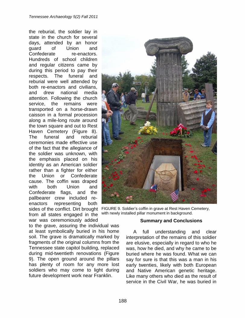
Tennessee Archaeology 5(2) Fall 2011
188
the reburial, the soldier lay in state in the church for several days, attended by an honor guard of Union and Confederate re-enactors. Hundreds of school children and regular citizens came by during this period to pay their respects. The funeral and reburial were well attended by both re-enactors and civilians, and drew national media attention. Following the church service, the remains were transported on a horse-drawn caisson in a formal procession along a mile-long route around the town square and out to Rest Haven Cemetery (Figure 8). The funeral and reburial ceremonies made effective use of the fact that the allegiance of the soldier was unknown, with the emphasis placed on his identity as an American soldier rather than a fighter for either the Union or Confederate cause. The coffin was draped with both Union and Confederate flags, and the pallbearer crew included re-enactors representing both sides of the conflict. Dirt brought from all states engaged in the war was ceremoniously added to the grave, assuring the individual was at least symbolically buried in his home soil. The grave is dramatically marked by fragments of the original columns from the Tennessee state capitol building, replaced during mid-twentieth renovations (Figure 9). The open ground around the pillars has plenty of room for any more lost soldiers who may come to light during future development work near Franklin.
Summary and Conclusions A full understanding and clear
interpretation of the remains of this soldier are elusive, especially in regard to who he was, how he died, and why he came to be buried where he was found. What we can say for sure is that this was a man in his early twenties, likely with both European and Native American genetic heritage. Like many others who died as the result of service in the Civil War, he was buried in
FIGURE 9. Soldier’s coffin in grave at Rest Haven Cemetery, with newly installed pillar monument in background.
Unknown Soldier
189
a forgotten and probably unmarked grave. He was originally interred with some care, though apparently in some haste, being laid out in traditional Christian fashion with his head to the west, still wearing his uniform and boots, but not buried in a coffin. His uniform bore Federal-issue buttons, but the mixed nature of these suggests they could have been on either a Union or Confederate uniform. Given this, it is impossible to say with certainty which side he fought with during the war, though the implied presence of what might have been a Union forage cap possibly tilts the argument slightly in that direction. The skeletal remains were fragmented and poorly preserved, and yielded no signs of gunshot wounds or other trauma. Thus, nothing can be said about the specifics of his death. In terms of placement of the grave, it is well away from any documented sites of encampments or facilities clearly associated with either Federal or Confederate troops. He may have been laid to rest here following a skirmish or during a time of troop movement as a matter of expediency, with the idea that this would only be a temporary grave.
Beyond the details of the archae-ological investigation of the remains, the specific and general responses to the discovery of the grave are of interest as well. In most ways, from start to finish the handling of the discovery proceeded smoothly, in following the legal require-ments, in applying appropriate archae-ological techniques, and in being attentive to community customs and standards. From the moment that the backhoe hit the grave, the property developer and his contractors took full responsibility for the discovery, despite the associated costs and scheduling delays. Once notified, Franklin police, city officials, and the staff of the State of Tennessee Division of
Archaeology took immediate action to secure the location and assure it was safe from further disturbance or looting. From there, the city, the state, and the developer closely followed the legal procedures defined in the relevant state burial laws, assuring that a plan was in place for the removal and reburial of the remains. The removal was a joint effort of government, private sector, and academic archaeologists and forensic anthropolo-gists. The archaeological investigation was done under unhurried circumstances using proper techniques, followed by careful documentation and analysis of the remains and associated artifacts. From there, Franklin’s government, preservation community, and private citizens defined a plan to put this individual back to rest in proper and very memorable fashion. The elaborate reburial ceremonies both commemorated this forgotten individual and publicly displayed and reinforced the strong interest and pride of the community in its association with the Civil War. The events surrounding the discovery of the Franklin soldier’s remains should serve as a model for the next time a Civil War grave is accidently uncovered.
Acknowledgements: Don McCartney, Vice President of Wolfe Fields Development, LLC; Collin Miller of Miller Contracting; Hugh Berryman, Director of the Forensic Institute for Research and Education, Middle Tennessee State University; Eric A. Jacobson, Director of Operations, The Battle of Franklin Trust; David Fraley, former acting director, the Carter House; Michael C. Moore, Director and State Archaeologist, Tennessee Division of Archaeology; Fred M. Prouty, Director of Programs for the Tennessee Wars Commission; Stephen R. Potter, National Capital Regional Archaeologist, National Park Service. From TRC, staff members Kelly Hockersmith, Ted Karpynec, Jeremy Galbraith, Josh Tuschl, Meghan Cook, Jared Barrett, and Matt Logan conducted the excavation work and aided in processing the finds and preparing materials for this report.
Tennessee Archaeology 5(2) Fall 2011
190
References
Albert, Alphaeus H. 1977 Record of American Uniform and
Historical Buttons, Bicentennial Edition. Boyentown Publishing Company, Boyentown, Pennsylvania.
Brinckerhoff, Sidney B. 1972 Metal Uniform Insignia of the Frontier
U. S. Army 1846-1902. Museum Monograph No. 3, Arizona Historical Society, Tucson.
Connelly, Thomas L. 1994 Civil War Tennessee, Battles and
Leaders. The University of Tennessee Press, Knoxville.
Cox, Jacob D. 1897 The Battle of Franklin, Tennessee.
Charles Scribner's Sons (1983 reprint by Morningside House, Inc., Dayton, Ohio).
Foster, W. F. 1865 Map of a Portion of the Battle-Field of
Franklin, Tenn., Showing the Position of Stewart’s Corps (labeling at the bottom reads: Accompanying report of Lt. Gen. A. P. Stewart, C.S. Army, Jan. 29, 1865). In The Official Military Atlas of the Civil War, by Major George B. Davis, Leslie J. Perry, and Joseph W. Kirkley, 1891, Plate 73, No. 3. Government Printing Office, Washington, D.C.
Hoobler, James A. 1986 Cities Under the Gun, Images of
Occupied Nashville and Chattanooga. Rutledge Hill Press, Nashville, Tennessee.
Horn, Stanley F. 1955 The Army of Tennessee. University of
Oklahoma Press, Norman. Howell, Edgar M. 1975 United States Army Headgear 1855-
1902. The Smithsonian Institution, Washington, DC.
Lamm, Ruth, Beatrice and Lester Lorah, and
Helen W. Schuler 1970 Guidelines for Collecting China
Buttons. The National Button Society of America. Eastwood, Kentucky.
McDonough, James Lee and Thomas L.
Connelly 1983 Five Tragic Hours: The Battle of
Franklin. The University of Tennessee Press, Knoxville.
McEwen, Sallie F. 1862 “Diary of Sallie Florence McEwen.”
Miscellaneous Papers of the Tennessee Historical Society, Microfilm No. 824, Box 9, Folder 1. Tennessee State Library and Archives, Nashville.
McGuinn, William F. and Bruce S. Bazelon 1984 American Military Button Makers and
Dealers: Their Backmarks & Dates. BookCrafters, Inc., Chelsea, Michigan.
Nance, Benjamin C. 2005 Test Excavations on Roper’s Knob: A
Fortified Union Signal Station in Franklin, Tennessee. Report of Investigations No. 10, Tennessee Division of Archaeology, Nashville.
OR (1880-1901)
The War of the Rebellion: A Compilation of the Official Records of the Union and Confederate Armies. Government Printing Office, Washington, D.C.
Potter, Stephen R. 2010 E-mail letter from S. Potter to S. Smith
(March 24, 2010) discussing probable meanings of the unknown-soldier burial found south of Franklin, Tennessee. Copy on file, Tennessee Department of Environment and Conservation, Division of Archaeology, Nashville.
Unknown Soldier
191
Potter, Stephen R. and Douglas W. Owsley 1994 An Irishman Dies at Antietam: An
Archaeology of the Individual. In Archaeological Perspective on the American Civil War, pp. 56-72, Clarence R. Geier and Stephen R. Potter, editors. University of Florida Press, Gainesville.
Smith, Samuel D. and Benjamin C. Nance 2003 A Survey of Civil War Era Military
Sites in Tennessee. Research Series No. 14, Tennessee Division of Archaeology, Nashville.
2010 Archaeological Investigations at the Carter House State Historic Site, Franklin, Tennessee. Report of Investigations No. 14, Tennessee Division of Archaeology, Nashville.
Smith, Samuel D., Fred M. Prouty, and
Benjamin C. Nance 1990 A Survey of Civil War Period Military
Sites in Middle Tennessee. Report of Investigations No. 7, Tennessee Division of Archaeology, Nashville.
Sword, Wiley 1992 Embrace An Angry Wind - The
Confederacy's Last Hurrah: Spring Hill, Franklin, and Nashville. Harper Collins Publishers, New York.
Time-Life Books 1991a Echoes of Glory, Arms and Equipment
of the Union. Time-Life Books, The Time Inc. Book Company, Alexandria, Virginia.
1991b Echoes of Glory, Arms and Equipment of the Confederacy. Time-Life Books, The Time Inc. Book Company, Alexandria, Virginia.
Willett, C. and Phillis Cunnington 1992 The History of Underclothes. Dover
Publications, Inc., New York. Wills, Brian Steel 1992 A Battle from the Start: The Life of
Nathan Bedford Forrest. Harper Collins Publishers, New York.
Wyckoff, Martin A. 1984 United States Military Buttons of the
Land Services, 1787–1902. McLean County Historical Society, Bloomington, Illinois.
Samuel D. Smith Tennessee Division of Archaeology 1216 Foster Ave., Cole Building #3 Nashville, Tennessee 37243 Larry R. McKee TRC Inc. 1865 Air Lane Drive, Suite 9 Nashville, Tennessee 37210