template - fig congress 2010 · continuous earth mound made up of turf squares with the ... william...
TRANSCRIPT

THE DISTANCE SLABS OF THE ANTONINE WALL:
The Surveyors’ Record Carved in Stone!
John F. Brock
Keywords: Emperor Antoninus Pius, Roman Britannia, The Wall, The Vallum, Roman
Surveying, Surveyors Written Instructions (Corpus Agrimensorum, Romanum), Vallum
Antonini, International Borders, Distance Slabs.
ABSTRACT
“There is nothing permanent except change.” – Heraclitus (535-475 BC)
It is
uncanny what unknown amazing details of history I have discovered while researching other
Fig. 1 A section of the Antonine Wall in north England showing its general layout on the terrain.
AANNTTOONNIINNEE WWAALLLL
The Distance Slabs of the Antonine Wall: The Surveyors' Record Carved in Stone. (9217)
John Brock (Australia)
FIG Congress 2018
Embracing our smart world where the continents connect: enhancing the geospatial maturity of societies
Istanbul, Turkey, May 6–11, 2018

sites and topics. This is exactly the case with regard to the fascinating collection of heirlooms
unearthed along the Antonine Wall during hundreds of years of archaeological investigation
of this little cousin of the more substantial and well known Hadrian’s Wall erected earlier to
the south. During various periods a continuous set of distance slabs have been dug up which
accurately record on ornamental stone tablets precisely the lengths of segments of wall
surveyed and built as well as naming the legion responsible for the construction of that
portion. As soon as I read the words “distance” and “accurate” to me there could be only one
group of the Roman legions who could have provided the data required to nominate the right
length for these sections of the Wall – the mensors (surveyors) of the elite squad known as the
immunes. Along the way I was also delighted to find out that one of my favourite Scottish
surveyors, William Roy, had re-surveyed the remains of this ancient earthen rampart during
1755 before he became Surveyor-General in 1765.
INTRODUCTION
“I am not afraid of an army of lions led by a sheep;
I am afraid of an army of sheep led by a lion.”
- Alexander the Great (356-323 BC)
Although only representing the northern borderline of Rome’s western
colony of Britannia for a handful of years at around 20 from 138 AD to
158 AD the lesser known boundary (limes) built by Emperor Antoninus
Pius could not negate the passionate aggression of the battle hardened highlanders. In the true
traditions of the regulated Roman nation this new boundary line to supersede the more famous
Wall of Hadrian was called The Vallum Antonini because that is exactly what it was – a
continuous earth mound made up of turf squares with the adjoining trench to the North.
Within the collection of writings of the Roman Land Surveyors (Corpus Agrimensorum
Romanum) the specification to construct a boundary demarcation along a line separating
Roman lands from those of a different inhabitant was called a limes which took the form of a
vallum (literally “earthmound”). (see my paper “Hadrian’s Wall: Boundary Monument for the
Northern Frontier of Roman Britannia!” for more extensive background information on the
evolution of the Vallum as the required form of demarcation of such an international
boundary limit). Punctuated with timber forts and look out towers during its era of adoption
the remains of this border marking was later surveyed again by famed Scottish surveyor
William Roy in the middle 1700’s, whose excellent work will also be covered in this paper.
WHY WAS THE ANTONINE WALL ERECTED?
“Great empires are not maintained by timidity.” - Tacitus (58-117 AD)
The Distance Slabs of the Antonine Wall: The Surveyors' Record Carved in Stone. (9217)
John Brock (Australia)
FIG Congress 2018
Embracing our smart world where the continents connect: enhancing the geospatial maturity of societies
Istanbul, Turkey, May 6–11, 2018

Fig. 2 Roman Emperor Antoninus Pius
Born in Lanuvium, Latium in 86 AD with the name
Titus Aurelius Fulvius Boionius Arrius Antoninus when
this adopted son of Hadrian assumed control in 138
upon the death of his stepfather he concocted the bulky
appellation Caesar Titus Aelius Hadrianus Antoninus
Augustus later to have Pius added to this lengthy titulary
after he had persuaded a reluctant Senate to deify his
predecessor. Despite being tagged as one of the “Good
Emperors” congeniality did not equate to acceptance as
a Roman ruler so Antoninus Pius felt obligated to
demonstrate to his peace ridden generals in the far off
colonies that he would not tolerate insurgency by those
foreign clans he had wished to subjugate. What better
way to invigorate morale amongst his battle hungry
legions than to move his territorial front forward through incursions into hostile lands giving
the troops some combat action as well as providing extensive capital works to install a new
boundary demarcation for the new northernmost limit of his western colony. Unfortunately
desire can often fall well short of the prevailing circumstances thus the fierce resistance of the
northern highlanders presented a greater foe than had been anticipated resulting in the retreat
of the regiments back behind the Wall erected by the predecessor of Antoninus Pius a mere
twenty years after its establishment.
Despite this smoldering disquiet in the distant colonies the reign of the Five Good Emperors
from 96 to 180 was remembered as a period of internal peace and prosperity thus receiving
this accolade embellished in their description of goodwill.
WALL LOCATION: SURVEYING, DESIGN & CONSTRUCTION
“As we know from the Roman empire, big empires go down if the
borders are not well protected.” – Mark Rutte, Dutch politician
If the name
pre-assigned
to the new
territory
limit as Vallum Antonini was not
proof enough that the delineation
of this new boundary 100 miles
(160 kms) further to the north
was to be a Vallum then the final
construction certainly
Fig. 3 Typical view of the design of the Antonine Wall showing the
rampart, berm and ditch as it crosses the countryside.
The Distance Slabs of the Antonine Wall: The Surveyors' Record Carved in Stone. (9217)
John Brock (Australia)
FIG Congress 2018
Embracing our smart world where the continents connect: enhancing the geospatial maturity of societies
Istanbul, Turkey, May 6–11, 2018

demonstrated it beyond doubt. The relocated territory limit was installed as a Vallum i.e.
earth mound with a trench adjoining to the North.
The rampart-mound was made up of turf bricks placed upon a foundation of stones laid down
for more solid support with a wall height of 9-10 feet (2.7-3 m) with a V-shaped ditch on the
northern side varying in depth from 6-13 feet (2-4 m) at a width between 20-40 feet (6 and 12
metres) divided by a berm at from 30-40 feet (9-12 m).. Excess earth from the ditch was
placed along the northern lip of the ditch exaggerating the depth. Timber watch towers and
bastions were erected on top of the rampart-mound. At various positions forts were
constructed to house the regiments from where they could prepare for combat when required.
As was the case with Hadrian’s Wall the same three legions responsible for this prior project
were also the builders of the earthen Wall of Antoninus, they being II Augustus, VI Victrix
and XX Valeria Victrix.
With a pre-existing presence for many years past the limits of Hadrian’s Wall as well as
forays further north to test the climate of hostility and formidability of the occupying tribes
the short span between the Firth of Forth and Firth of Clyde would have been well known to
the Roman planners. With a total distance of 37.6 Roman miles (36.5 miles – 58.4 kms) the
proposed construction length was less than half of the more southern frontier limit which
spanned 80 Roman miles (77.6 miles - 124 kms). Therefore the completion time would have
been much more rapid and without including any grandiose stone wall to be placed the overall
time to finish placing this new territory demarcation was achieved much more expediently
than its counterpart, said to be 2-5 years from between 138-143 AD. With the ramparts,
watchtowers and forts erected using timber being faster to complete they presented a less fire
resistant target for any marauding tribes of assailants. One feature was certain in the scheme
being the Vallum – the continuous mound of earth with its adjoining trench – thus complying
strictly with the directions furnished to the Roman military surveyors to construct such a
Vallum along the new territory limit dividing this extended Roman occupation to the south
Fig. 5 Antoninus Pius coin (138-161 AD) for Komama in
Pisidia showing the monarch ploughing the first
furrow like his antecedents Augustus and Hadrian.
Fig. 4 Antonine Wall & forts
The Distance Slabs of the Antonine Wall: The Surveyors' Record Carved in Stone. (9217)
John Brock (Australia)
FIG Congress 2018
Embracing our smart world where the continents connect: enhancing the geospatial maturity of societies
Istanbul, Turkey, May 6–11, 2018

from the foreign lands to north (a
translation of the 5th century notes
Corpus Agrimensorum Romanum
by Brian Campbell in the year 2000
provides this instruction – see
Bibliography number 5/). Having
rebadged himself by adding
“Hadrianus and Augustus” onto his
extended title it is not surprising
that this new leader was to fervently
incorporate the traditional historic
elements in the placement of his
new territorial line demarcation. Along with his idol Augustus and mentor Hadrian he was
not going to be one to miss the occasion of having himself depicted on the reverse of a coin
ploughing the sulcus primigenius just as his two forerunners had done before him. (see my
paper on Hadrian’s Wall). Among all other interlocutory features which tie these three heads
of Rome together it appears to me that this one simple depiction of each of themselves on a
coin over two hundred years apart partaking in this traditional ancient ritual of ploughing the
first furrow just like Romulus had done at the birth of Rome more than any other tangible link
clearly exhibits the proud sense of heritage and recognition of history which was a foremost
trait in their characters.
The remains of this Roman earth rampart run across central Scotland from Old Kilpatrick in
the west to Bo’ness in the east running through the land of five modern day local authorities
being East Dunbartonshire, Falkirk, Glasgow, North Lanarkshire and West Dunbartonshire.
Since 2008 it has been registered on the UNESCO World Heritage List and many museums,
walking paths and sites for inspection of the existing vestiges of the Roman presence are
available for all interested visitors.
DISTANCE SLABS OF THE WALL
“Every new beginning comes from
some other beginning’s end.”
- Marcus Annaeus Seneca (54 BC-39 AD)
As a testimony to their hard work and achievements each Legion
decided to carve memorials in stone now referred to as distance
slabs which listed their Emperor along with their own name
followed by the accurate length of the section of the Wall for which they had been
Fig. 6 Antonine Wall Cross Sectional Detail.
The Distance Slabs of the Antonine Wall: The Surveyors' Record Carved in Stone. (9217)
John Brock (Australia)
FIG Congress 2018
Embracing our smart world where the continents connect: enhancing the geospatial maturity of societies
Istanbul, Turkey, May 6–11, 2018

responsible. It is theorised that there may
have been four such memorials for each
section of wall consisting of fifteen (15)
sections in all separately acknowledged by its
respective building legion being two at each
end of the section on opposite sides of the
structure probably fastened to the fabric of
the nearest timber member of the walls
features. This postulation is supported by the
number of slabs which appear to memorialise
the same portion of the overall construction
in the westernmost part of the overall
construction. To date twenty (20) such stone
slabs have been recovered from what it is
surmised there may have been forty (40) or
possibility sixty (60) under another likely
scenario. Should the former model turn out to be an accurate assessment of the likely total
number of distance slabs this 50 % recovery of the hoard is a remarkable portion of the full
corpus of carvings seeing that most remains in areas of former Roman occupation have only
yielded from 1-5 per cent of a complete subscription of inscribed artefacts. The largest
amount of recovered stone inscriptions from expected estimates previous to this amazing rate
of rediscovery along the Antonine Wall was a 6.5 % yield along Hadrian’s Wall so this
volume of material is the most amazing ever collected. It gives us a brilliant set of
commemorative tablets to the work carried out by the nominated legions as well as the
cumulative total of construction lengths achieved.
Therefore this far greater average of salvaged items is by far the most unique amount of a
Roman stocktake ever uncovered to provide a solid reflection of the pride which the Roman
legions held in their achievements on behalf of their empire along with the culture of
monumentation which has been able to allow us this personal insight into the bonded
regimentalism existing within the great army with particular emphasis on its section of
immunes which included the Surveyors. Having been erected by the same three Roman
legions who were responsible for the monumental Hadrian’s Wall project some of the
distance slabs bore the symbols of the relevant regiment who had carried out the designated
part of the building which were a boar for the XX Victorious Valerian Legion and Capricorn
(half-goat/half-fish) or Pegasus (the flying horse) for the II Augustan Legion.
Each distance slab follows a relatively standard pattern starting with the Emperor’s name
followed by the name of the Legion responsible for the portion of wall erection for which the
accurate length is quoted in either Roman feet (for the shorter sections) or paces and Roman
feet for those parts of greater expanse. Two of the recovered stone tablets, being Numbers 11
and 14 as can be seen in Appendix B in this work, also add the words “Opus Valli” which is
quoted by Keppie in his excellent collation of all of the inscribed Roman stonework along the
Fig. 7 Distance Slab No. 16 from Old Kilpatrick.
The Distance Slabs of the Antonine Wall: The Surveyors' Record Carved in Stone. (9217)
John Brock (Australia)
FIG Congress 2018
Embracing our smart world where the continents connect: enhancing the geospatial maturity of societies
Istanbul, Turkey, May 6–11, 2018

Antonine Wall to be “the works of the rampart-mound”, going on further to suggest that it is
simpler to include all of the features of the wall design as being inclusive within this phrase.
My input to this interpretation is that “Opus Valli” literally means the work of building the
Vallum with all of the extraneous inclusions of timber additions being supplementary to the
principal feature of the earthen mound along with the ditch. Clearly the resultant ditch (up to
5 metres – 17 Imp. feet deep) in front of the earth mound served as a further obstacle to
raiding parties whose progress had to be reduced when faced with crossing such an
impediment. As I have previously stated in my paper on Hadrian’s Wall just as many
international border lines have an identifiable width containing a clear zone of no man’s land
this first century forerunner for such a line of division was also made up of a set of defining
features all of which made up the separation between Rome and its independent neighbours.
The total spread of the Antonine Wall from Old Kilpatrick to Bo’ness (Borrowstounness) has
been measured to be 39,726 Roman paces or 36 miles 620 yards in Imperial distance. It was
reported to have been of turf taken from local pastures with gravel from the adjacent ditch
being placed upon a bed of stones quarried locally. Capitolinus, who was the author nearest
to the date of commemoration of the wall, told us that the rampart was of turf, and that it was
a fresh one: “Britannus – vicit, alto muro cespiticio – ducto.” (Anton. Pius.5.)
The full recitation of Julius Capitolinus is translated to be: “He (Antoninus Pius) conquered
the Britons through his legate Lollius Urbicus, another wall of turf being built after the
barbarians had been driven back …”, Life of Antoninus Pius (V.iv) translated by Anthony
Birley. This contemporary citation gives us an indicator of when the wall was erected
because Urbicus as the Roman legate in Britannia appointed in 139 AD served as Governor
until 142 AD. He quelled an uprising by the Brigantes around 140 AD, this victory being
commemorated on a series of Roman coins (possibly dating to 141-143 AD) which bore the
standing figure of Britannia on the reverse, the personification of this province, as well as the
acclamation of Antoninus as Imperator being the only time he was ever recognized with this
honour. Seeing as the distance slabs were also emblazoned with this designation of the
Emperor as Imperator it is a reasonable proposition to estimate that this wall was constructed
from 139-140 to 142-143 AD.
Fig. 8 Distance Slabs 8
and 9 respectively by
Legion XX Valeria Victrix
both attributed to the
same
Eastern end of the wall
section at Hutcheson Hill
each claiming a distance
of 3000 feet.
The Distance Slabs of the Antonine Wall: The Surveyors' Record Carved in Stone. (9217)
John Brock (Australia)
FIG Congress 2018
Embracing our smart world where the continents connect: enhancing the geospatial maturity of societies
Istanbul, Turkey, May 6–11, 2018
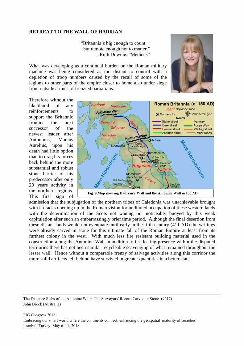
RETREAT TO THE WALL OF HADRIAN
“Britannia’s big enough to count,
but remote enough not to matter.”
- Ruth Downie, “Medicus”
What was developing as a continual burden on the Roman military
machine was being considered as too distant to control with a
depletion of troop numbers caused by the recall of some of the
legions to other parts of the empire closer to home also under siege
from outside armies of frenzied barbarians.
Therefore without the
likelihood of any
reinforcements to
support the Britannic
frontier the next
successor of the
newest leader after
Antoninus, Marcus
Aurelius, upon his
death had little option
than to drag his forces
back behind the more
substantial and robust
stone barrier of his
predecessor after only
20 years activity in
the northern regions.
This first sign of
admission that the subjugation of the northern tribes of Caledonia was unachievable brought
with it cracks opening up in the Roman vision for undiluted occupation of these western lands
with the determination of the Scots not waning but noticeably buoyed by this weak
capitulation after such an embarrassingly brief time period. Although the final desertion from
these distant lands would not eventuate until early in the fifth century (411 AD) the writings
were already carved in stone for this ultimate fall of the Roman Empire at least from its
furthest colony in the west. With much less fire resistant building material used in the
construction along the Antonine Wall in addition to its fleeting presence within the disputed
territories there has not been similar recycleable scavenging of what remained throughout the
lesser wall. Hence without a comparable frenzy of salvage activities along this corridor the
more solid artifacts left behind have survived in greater quantities in a better state.
Fig. 9 Map showing Hadrian’s Wall and the Antonine Wall in 150 AD.
The Distance Slabs of the Antonine Wall: The Surveyors' Record Carved in Stone. (9217)
John Brock (Australia)
FIG Congress 2018
Embracing our smart world where the continents connect: enhancing the geospatial maturity of societies
Istanbul, Turkey, May 6–11, 2018

WILLIAM ROY’S RE-SURVEY OF THE ANTONINE WALL VESTIGES.
Described as “the finest map in the Military Antiquities …” this map was of the entire
Antonine Wall together with detail plans of the individual forts along this border line
structure. Carried out by the iconic Scotsman William Roy it was completed in 1755 calling
this construction “Grime’s Dyke” or “Graham’s Dyke” after Robert Graham who was alleged
to have overrun it in about 500 AD. However the actual retreat back to Hadrian’s Wall is
attributed to a northern uprising in 158 AD which brought the Antonine occupation to an
abrupt end relegating it backwards behind its former limit south of Hadrian’s Wall. Although
it appears that a quick retreat would have been desirable evidence indicates that the complete
withdrawal from the Antonine Wall took place gradually up to 161 AD when the evacuation
became absolute.
The first recorded rediscovery of
artifacts from the Antonine Wall came
on 12 April 1565 when Queen Mary
sent correspondence concerning a
recently found inscribed stone altar
from Inveresk at Midlothian (RIB
2132). In George Buchanan’s 1582
edition of Rerum Scoticarum Historia
he makes mention of inscribed walls
relevant to the Antonine Wall then the
landmark publication of Britannia in
Latin by William Camden in 1585
became the dominant authority on
Roman epigraphy with the 1607 version
recording five inscribed stones, in 1695
there were seven while in 1789 the
number had swelled to 30. Now the
Hunterian Museum at Glasgow
University holds the single largest
collection of Roman etched stones
certainly possessing 17 of the twenty
(20) rediscovered distance slabs.
Roy was a career military surveyor performing his Military Survey of Scotland from 1747 to
1755. Subsequently he founded what would become the Ordnance Survey of Great Britain
after he had been appointed Surveyor-General in 1765 also having a lifelong interest in
Roman antiquities often revisiting many of the Roman sites in Scotland when off duty. He
was active during a period of great resurgence in the discovery of artifacts along with general
and professional curiosity in the history of Roman occupation and activity in Britain. Thus
his professional endeavours were not only driven by the academic demands for accurate maps
Fig. 10 Detail of Ardoch fort by Roy.
The Distance Slabs of the Antonine Wall: The Surveyors' Record Carved in Stone. (9217)
John Brock (Australia)
FIG Congress 2018
Embracing our smart world where the continents connect: enhancing the geospatial maturity of societies
Istanbul, Turkey, May 6–11, 2018

of what remained of the Roman presence in his land but also by his own personal obsession
with this era in his country’s
evolution. His surveying and
mapping was to encompass
the whole of Scotland and
some of the northern areas of
England amongst which the
Romans had inhabited. Part
of his collection of charts
included a map of all the sites
known to him which was the
only one published during his
lifetime in 1773. The
remainder of his work was
issued posthumously in 1793
which contained his plan of
the entire length of the
Antonine Wall with adjoining
forts and Roman stations such
as those at Rough Castle,
Auchendavy, Ardoch,
Camelon, Eldon Hills, Brown
Cather-Thun, Castle Dykes, Chew Green, Cleghorn and Inch-Stuthill. The work also
contained sketches of some features like Arthur’s O’on and Duntocher Bridge together with
long and cross sectional diagrams of certain areas he had mapped. To appreciate the major
contribution of Roy to the archival record of the Antonine Wall combined with its log of
many sites which have either disappeared through the effects of weather or have even been
destroyed by acts of wanton carelessness since the time of his collation of these most accurate
and thorough details of a world lost in oblivion to mankind. Construction of the Forth/Clyde
Canal which was opened in 1790 to provide for water bound vessels to travel along these low
lying lands of Scotland caused considerable destruction to the remaining traces of the Roman
wall occupations to further accentuate the invaluable work done by Roy in charting these
areas of heritage for the referral of future generations as well as having an accurate record of
all of those sites which no longer exist after the completion of this major public works project.
The fact that this man was a great surveyor AND Scottish just adds to my personal admiration
of another individual who obviously treasured the vestiges left behind from an ancient period
of glamour, warfare and extravagance but more importantly eminent for the great value
placed by the Romans upon their Surveyors both legionary and in the areas of private and
public land creation and adjudication.
Fig. 11 Sketch of Arthur’s O’on by Roy.
The Distance Slabs of the Antonine Wall: The Surveyors' Record Carved in Stone. (9217)
John Brock (Australia)
FIG Congress 2018
Embracing our smart world where the continents connect: enhancing the geospatial maturity of societies
Istanbul, Turkey, May 6–11, 2018

WILLIAM ROY’S BRILLIANT MAP OF THE ANTONINE WALL
Figs. 12 & 13 William Roy’s Map of the Entire Antonine Wall published posthumously in 1793 as
“Military Antiquities of the Romans in North Britain.”
The Distance Slabs of the Antonine Wall: The Surveyors' Record Carved in Stone. (9217)
John Brock (Australia)
FIG Congress 2018
Embracing our smart world where the continents connect: enhancing the geospatial maturity of societies
Istanbul, Turkey, May 6–11, 2018

THE HUNTERIAN MUSEUM
The Hunterian Museum within the University of Glasgow was opened in 1807 now being
Scotland’s oldest public museum. Containing the largest collection of inscribed Roman
stonework anywhere in the world it boasts 17 of the original distance slabs with also two
plaster casts of the remaining slabs
held at two other institutions. Up
until very recently (2 months ago in
fact) all of the full collection of these
artifacts were on display within a
gallery called “The Antonine Wall:
Rome’s Final Frontier” but the
premises are currently closed for
around two years for refurbishment
action. Only closing on the day after
I had just concluded my reconnoiter
to the closest verges of occupation
near Hadrian’s Wall itself near the
town of Wall (almost completely
built from stones rummaged from the
enormous supply of material from
the lengthy edifice as my strong
disappointment loomed large that I
would not be able to inspect this
collection of legendary stone
iconography by the famed Roman
legionary surveyors for at least two
more years when the make-over is
scheduled for completion.
The Antonine Wall may not be as substantial or as lengthy as Hadrian’s Wall but it does
evoke intense feelings of passion amongst the highlanders of the former Caledonia as the
vestiges of this boundary monument as entirely contained within Scotland unlike the latter
construction which wholly situated now within English sovereign soil. Thus the Scottish are
fiercely protective of this Roman signature of presence within their territory which only
represented a mere 20 odd years before the fanatical patriotism of the upper tribes dealt out a
humiliating repulsion against the might of the Roman legions. At least the surveyors left us
some inscribed stone treasures as a demonstration of pride in their work and testimony of their
skills.
Fig. 14 Map showing Vallum Antonini and Vallum Hadriani
along with the Roman names for England (Britannia),
Scotland (Caledonia) and Ireland (Hibernia).
The Distance Slabs of the Antonine Wall: The Surveyors' Record Carved in Stone. (9217)
John Brock (Australia)
FIG Congress 2018
Embracing our smart world where the continents connect: enhancing the geospatial maturity of societies
Istanbul, Turkey, May 6–11, 2018

ROMAN SURVEYORS RULE – AGAIN!
“Rome has grown since its humble beginnings
that it is now overwhelmed by its greatness.”
– Titus Livius (59 BC- 17 AD)
It is a scenario repeated time after time throughout history that
civilisations grow too large and amorphous resulting in their
administrations being stretched too thin on the land and over-
governed to a level of dysfunctionality ultimately leading to their
implosion providing a soft target prime to be readily overrun by a stronger less burdened
opponent just lingering in wait for the ponderous giant to topple.
Despite the progressive decline of its culture there is no doubt that the Roman surveyors
maintained an elevated status in society and their work was continuously utilised in the affairs
of the government and community settlement. However as soon as the words “distance” and
“accurate” are uttered I immediately seize another opportunity to assure all who will listen
that there can be but only one recognition which can come to mind which obviously is
Surveyors! Roman surveyors are among those many eminent individuals throughout history
who emulate the qualities, traditions and skills with which surveyors from all over the world
can be identified. Men of undoubted ability, congeniality and technical excellence it is fully
understandable just how highly esteemed these men of judgment and adjudication had
become. Enriching the status already attained by the land surveyors of Rome during the
mightiest era of the imperious nation it is not surprising that I am compelled to once again cite
the erudite and astute Roman official Cassiodorus who referred to the agrimensore (land
surveyor) in the following way:
“He walks not as other men walk!”
As I continue to direct readers of this paper to see the entire quotation of this very wise and
eloquent man please look up my previous paper “Four Surveyors of Caesar: Mapping the
World” to get a full appreciation for just how well regarded Roman surveyors as well as the
awe with which their activities were held in Roman society. An allusion to the surveyor as
some sort of madman rummaging amongst the thickets for evidence of marks of boundary
marking or occupation by the residents seems to cast a mysterious and even somewhat
mystical apparition of our Roman predecessors rather akin to the times of our country training
when our master surveyor would find ancient marks in rarely visited bushland or the last
traces of boundary trenches or remains of pegs after scratching the surface of similar ground.
The Distance Slabs of the Antonine Wall: The Surveyors' Record Carved in Stone. (9217)
John Brock (Australia)
FIG Congress 2018
Embracing our smart world where the continents connect: enhancing the geospatial maturity of societies
Istanbul, Turkey, May 6–11, 2018

CONCLUSION
Despite its lesser historical profile than its more formidable southern icon Hadrian’s Wall the
Antonine Wall is still significant from a Surveyor’s perspective due to the unparalleled
production of this magnificent series of distance slabs to once again demonstrate in stone just
how skilled the Roman surveyors were. The other most noteworthy feature of this earthen
construction was as an even clearer demonstration that its principal function was as a
boundary demarcation monument which designated the limit of the territory for which Rome
claimed jurisdiction and control while being built with symbolic recognition for the traditional
formation adopted by the mighty Empire for the limits of its cities and lands from the very
first sulcus primigenius marked out by the Founder of Rome (known as The Pomerium in its
context as the outer perimeter of the Eternal City) which included such a first furrow or trench
adjoining the earthen mound known as the Vallum being the actual boundary of the limes or
International Border Line of the Roman Colony Britannia. In a final note concerning the
construction of the Antonine Wall it is most interesting that the same three Roman Legions
responsible for the monumental project of erecting Hadrian’s Wall were also entrusted with
the task of making this less imposing border protection line along Rome’s northernmost
territorial limit deep within Caledonia – Second Augustan Legion (Legio II Augusta), Sixth
Legion (Legio VI Victrix) and Twentieth Legion (Legio XX Valeria Victrix).
Figs. 15 & 16 Busts of Emperors Antoninus Pius and Hadrian.
The Distance Slabs of the Antonine Wall: The Surveyors' Record Carved in Stone. (9217)
John Brock (Australia)
FIG Congress 2018
Embracing our smart world where the continents connect: enhancing the geospatial maturity of societies
Istanbul, Turkey, May 6–11, 2018

DEDICATION AND APPRECIATION
May I take this opportunity to dedicate this paper and presentation to my favourite Roman
Emperor Hadrian with whom I have developed an appreciated affinity and admiration for his
style, affiliation with tradition and history along with an obvious warm association with his
excellent corpus of Roman legionary surveyors.
APPENDIX A
List of Roman Emperors during the Period from The Five Good Emperors to the
abandonment of the Antonine Wall in 163 AD (also covering the Antonine Dynasty).
The Five Good Emperors 96 – 180 AD
Nerva 96 – 98 AD
Trajan 98 -117 AD
Hadrian 117 – 138 AD
Antoninus Pius 138 – 161 AD
Marcus Aurelius 161 – 180 AD
Antonine Dynasty 138 – 193 AD
Antoninus Pius 138 – 161 AD
Marcus Aurelius 161 – 180 AD
with Lucius Verus 161 – 169 AD
Commodus 177 – 192 AD
with Marcus Aurelius 177 – 180 AD
Pertinax 193 AD
Didius Julianus 193 AD
Pescennius Niger 194 AD
(From the Department of Greek and Roman Art, The Metropolitan Museum of Art, October
2004).
APPENDIX B
Table of Roman Standards of Distance Measurement
1 Roman inch = uncia = 0.97 Imp. inch = 24.6 mm
1 Roman foot = pes = 0.97 Imp. foot = 0.296 metre
1 pace (passus) = 5 Roman feet = 4.854 Imp. feet = 1.48 metres
1/8 Roman mile = 125 paces = a stadium = 625 Roman feet = 607 Imp. ft (185m)
1 Roman mile = 1000 paces = a miliarium = 5000 Roman feet = 4854 Imp. feet
= 1479.5 metres
1500 paces = a lewa = 7500 Roman feet = 7281 Imp. feet = 2219 metres
The Distance Slabs of the Antonine Wall: The Surveyors' Record Carved in Stone. (9217)
John Brock (Australia)
FIG Congress 2018
Embracing our smart world where the continents connect: enhancing the geospatial maturity of societies
Istanbul, Turkey, May 6–11, 2018

Author’s note: When Gary Reed took us on a personal tour of parts of Hadrian’s Wall his
career in the marines gave him a first hand knowledge of regimental behaviour and training
such that his explanation as to how the pacing of Roman soldiers could be so reliable was a
total revelation to me and those who have thought just how the paces of different sized human
beings could be so accurately determined. He said that it does not matter how tall or short the
marching soldiers are they never get out of time or left behind the others when making their
paces to the level of a dependable and repeatable step length which could be transferred into
their reconnaissance of proposed locations for various features or for just a reliable estimate
for the amount of building materials which would be required for any future project such as
the erection of a boundary wall along with the various turrets, fortlets and major forts to be
placed.
Fig. 18 Recreation of the timber
watchtower and wooden bastion on the Antonine
Wall at
Vindolanda along Hadrian’s Wall.
Fig. 17 Artist’s impression of the timber
structures on the Antonine Wall.
The Distance Slabs of the Antonine Wall: The Surveyors' Record Carved in Stone. (9217)
John Brock (Australia)
FIG Congress 2018
Embracing our smart world where the continents connect: enhancing the geospatial maturity of societies
Istanbul, Turkey, May 6–11, 2018

APPENDIX C
Distance Slabs recovered from the excavations along the Antonine Wall.
The Distance Slabs of the Antonine Wall: The Surveyors' Record Carved in Stone. (9217)
John Brock (Australia)
FIG Congress 2018
Embracing our smart world where the continents connect: enhancing the geospatial maturity of societies
Istanbul, Turkey, May 6–11, 2018

Size of stone: H. 0.87 m;
W. 0.97 m; D. 0.105 m
Material – Buff sandstone
Inscription: Imp(eratori) Caesari /
T(ito) Aelio/ Hadri/ ano Antonino/
Aug(usto) Pio p(atri) p(atriae)/
vexillatio/ Leg(ionis) XX Val(eriae)
Vic(tricis) f(ecit)/ per mil(lia)
p(assuum) III. “For the emperor
Caesar Titus Aelius Hadrianus
Antoninus Augustus Pius, Father of
his Country, a detachment of the
Twentieth Valiant Victorious Legion
built (this) over a distance of 3000
paces”.
Stone size:
H. 0.77 m W. 1.59 m
D. 0.165 m Material – Gritty buff
sandstone Inscription:
Imp(eratori) Caesari
T(ito)/ Aelio
Hadriano/ Antonino
Aug(usto)/ Pio p(atri)
p(atriae) vexilla(tio)/
Leg(ionis) VI
Vic(tricis) p(iae)
f(idelis)/ per m(illia)
p(assuum) …. “For
the emperor Caesar
Titus Aelius
Hadrianus Antoninus
Augustus Pius,
Father of his
Country, a
detachment of the Twentieth Valiant and Victorious Legion built (this) over a distance of ----
paces”. Note the nominated length is absent so it may have been buried in a time of hasty
withdrawal.
Fig. 20 Distance Slab No. 1 from unknown place starting with
the acclamation of “IMP” which means Imperator. This
addition to the Emperor’s titulary is only used for a
brief period at the start of the reign of Antoninus Pius.
Fig. 21 Distance Slab No. 2 from Eastermains, Kirkintilloch, Dunbartonshire.
IMP is seen as for DS No. 1
Fig. 19
The Distance Slabs of the Antonine Wall: The Surveyors' Record Carved in Stone. (9217)
John Brock (Australia)
FIG Congress 2018
Embracing our smart world where the continents connect: enhancing the geospatial maturity of societies
Istanbul, Turkey, May 6–11, 2018

Size of stone:
H.0.44m;W.0.59
m; D.0.38m
Material – Buff
sandstone
Inscription:
Leg(ionis) XX/
V(aleriae)
V(ictrix) fec(it)/
m(illia)
p(assuum) III
p(edum)/
IIICCCIV. “The
Twentieth Valiant
and Victorious
Legion built
3,000 paces,
3,304 feet”.
Size of stone: H. 0.63 m
W. 0.93 m; D. 0.175 m
Material – Buff
sandstoneInscription:
Imp(eratori) Caes(ari) Tito
Aelio/ Hadriano Antonino/
Aug(usto) Pio p(atri) p(atriae)/
Leg(ionis) II Aug(usta)/ per
m(illia) p(assuum) IIIDCLXVIS.
“For the emperor Caesar Titus
Aelius Hadrianus Antoninus
Augustus Pius, Father of his
Country, the Second Augustan
Legion (built this) over a
distance of 3,666 1/2 paces”.
Fig. 22 Distance Slab No. 3 from Eastermains, Kirkintilloch.
Fig. 23 Distance Slab No. 4 from Cawder, Bishopbriggs, Glasgow.
The Distance Slabs of the Antonine Wall: The Surveyors' Record Carved in Stone. (9217)
John Brock (Australia)
FIG Congress 2018
Embracing our smart world where the continents connect: enhancing the geospatial maturity of societies
Istanbul, Turkey, May 6–11, 2018

Size of stone: H. 0.6 m;
W. 1.34 m;
D. 0.14 m
Material –
Buff sandstne
Inscription Imp(eratori)
Caes(ari) Tito Aelio/
Hadriano Antonino/
Aug(usto)/ Pio p(atri)
p(atriae) vexilla(tio)/
Leg(ionis) II/ Aug(usta) pep(?) m(illia) p(assuum) IIIDC/ LXVIS .“For the emperor Caesar
Titus Aelius Hadrianus Antoninus Augustus Pius, Father of his Country, the Second Augustan
Legion built (this) over a distance of 3,666 1/2 paces”.
Size of stone: H. 0.76 m;
W. 1.49 m;
D. 0.18 m
Material – Gritty
buff sandstone
Inscription: Imp(eratori)
Caesar(i) T(ito) Aelio/
Hadriano Antonino/ Aug(usto) Pio p(atri) p(atriae) vexillatio/ Leg(ionis) VI Victr(ix) p(iae)
f(idelis)/ per m(illia) p(assuum) IIIDCLXVIS .“For the emperor Caesar Titus Aelius Hadrianus
Antoninus Augustus Pius, Father of his Country, the Sixth Victorious Loyal and Faithful
Legion built (this) over a distance of 3,666 1/2 paces”.
Fig. 25 Distance Slab
No. 6 from
Castlehill,
Dunbartonshire.
Fig. 24 Distance Slab
No. 5 from
Summerston.
Glasgow.
The Distance Slabs of the Antonine Wall: The Surveyors' Record Carved in Stone. (9217)
John Brock (Australia)
FIG Congress 2018
Embracing our smart world where the continents connect: enhancing the geospatial maturity of societies
Istanbul, Turkey, May 6–11, 2018

Size of stone:
H. 0.72 m; W. 0.82 m;
D. 0.13 m
Material –
Buff sandstone
Inscription: Imp(eratori)
C(aesari)/ T(ito) Aelio/
Hadriano/ Antonino/ Aug(usto)
Pio p(atri) p(atriae)/ vex(illatio)
Leg(ionis) XX V(aleriae)
[V(icitris)]/ f(ecit) p(er)
p(edum) III. “For the emperor
Caesar Titus Aelius Hadrianus Antoninus Augustus Pius, Father of his Country, a detachment
of the Twentieth Valiant and Victorious Legion built (this) over distance of 3000 feet”.
Stone size: H. 0.67m; W.
0.85m; D. 0.12m Material –
Local yellowish buff sandstone. Inscription: Imp(eratori) C(aesari) T(ito)/ Ael(io) Hadr/ iano
An/ tonino Aug(usto)/ Pio p(atri) p(atriae) vex(illatio)/ Leg(ionis) XX V(aleriae) V(ictricis)/
fec(it)/ p(er) p(edum) III. “For the emperor Caesar Titus Aelius Hadrianus Antoninus
Augustus Pius, Father of his Country, the Twentieth Valiant and Victprious Legion completed
(the work) over a distance of 3,000 feet”.
Fig. 26 Distance Slab No. 7
from Castlehill,
Dunbartonshire.
Fig. 27 Distance Slab No. 8 from Hutcheson Hill, Dunbartonshire.
The Distance Slabs of the Antonine Wall: The Surveyors' Record Carved in Stone. (9217)
John Brock (Australia)
FIG Congress 2018
Embracing our smart world where the continents connect: enhancing the geospatial maturity of societies
Istanbul, Turkey, May 6–11, 2018
Size of stone:
H. 0.72 m; W. 0.82 m;
D. 0.13 m
Material – Yellowish
Buff sandstone
Inscription: Imp(eratori)
C(aesari)/ T(ito)/ Ael(io)/
Hadri/ ano/ Anto/ nino/
Aug(usto)/ Pio p(atri)
p(atriae)/ vex(illatio)
Leg(ionis)/ XX V(aleriae)
V(ictricis)/ fec(it)/ p(er)
p(edum) III. “For the emperor Caesar Titus Aelius Hadrianus Antoninus Augustus Pius,
Father of his Country, the Twentieth Valiant and Victorious Legion built (this) over a distance
of 3,000 feet”.
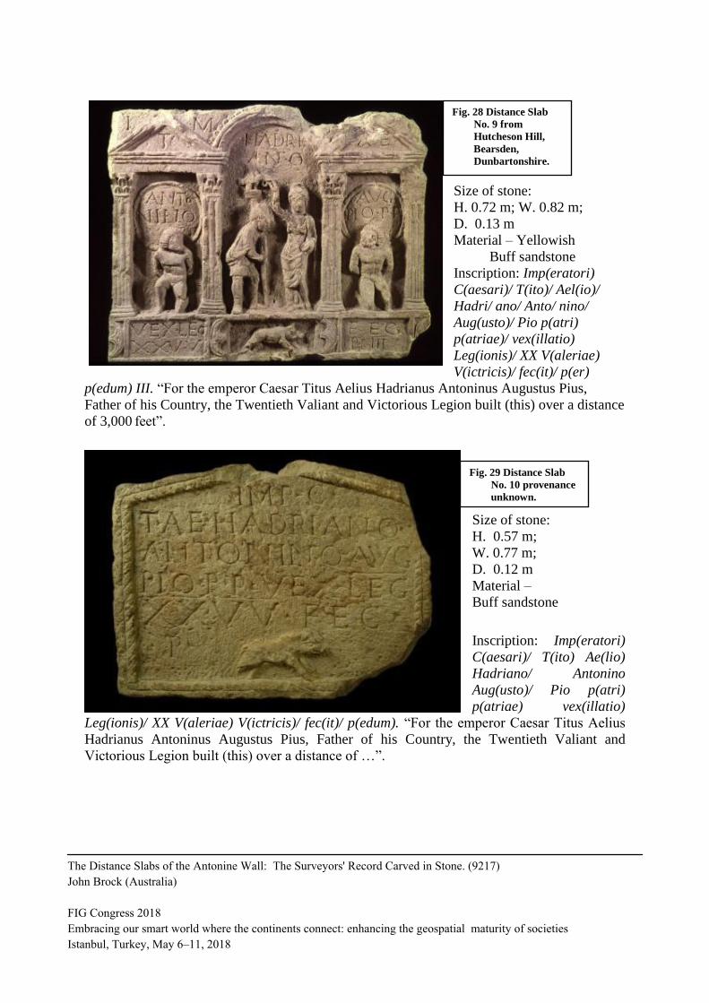
Size of stone: H. 0.57 m;
W. 0.77 m;
D. 0.12 m
Material –
Buff sandstone
Inscription: Imp(eratori)
C(aesari)/ T(ito) Ae(lio)
Hadriano/ Antonino
Aug(usto)/ Pio p(atri)
p(atriae) vex(illatio)
Leg(ionis)/ XX V(aleriae) V(ictricis)/ fec(it)/ p(edum). “For the emperor Caesar Titus Aelius
Hadrianus Antoninus Augustus Pius, Father of his Country, the Twentieth Valiant and
Victorious Legion built (this) over a distance of …”.
Fig. 29 Distance Slab
No. 10 provenance
unknown.
Fig. 28 Distance Slab
No. 9 from
Hutcheson Hill,
Bearsden,
Dunbartonshire.
The Distance Slabs of the Antonine Wall: The Surveyors' Record Carved in Stone. (9217)
John Brock (Australia)
FIG Congress 2018
Embracing our smart world where the continents connect: enhancing the geospatial maturity of societies
Istanbul, Turkey, May 6–11, 2018

Size of stone:
H. 0.765 m; W. 1.19 m;
D. 0.17 m
Material – Whitish
buff sandstone
Inscription: Imp(eratori)
C(aesari) T(ito) Aelio Hadr/
iano Antonino Aug(usto)/
p(atri) p(atriae)
vex(illation) Leg(ionis) VI/ Victric<i>s) p(iae) f(idelis)/ opus valli p(edum)/ MMM CCXL
f(ecit). “For the emperor Caesar Titus Aelius Hadrianus Antoninus Augustus Pius, Father of
his Country, a detachment of the Sixth Victorious Loyal and Faithful Legion built the work of
the wall (vallum by me) over a distance of 3,240 feet”.
Size of stone: H. 0.5 m; W. 0.73 m;
D. 0.19 m
Material –
Buff sandstone
Inscription: Leg(ionis)/ II/
Aug(usta) fec(it)/ p(edum)
IIII CXL. “The Second
Augustan Legion built
4,140 feet”.
Fig. 30 Distance Slab
No. 11 from
Braidfield,
Duntocher,
Dunbartonshire.
Fig. 31 Distance Slab
No. 12 from
Duntocher,
Dunbartonshire.
The Distance Slabs of the Antonine Wall: The Surveyors' Record Carved in Stone. (9217)
John Brock (Australia)
FIG Congress 2018
Embracing our smart world where the continents connect: enhancing the geospatial maturity of societies
Istanbul, Turkey, May 6–11, 2018

Size of stone: H. 0.55 m; W. 0.68 m;
D. 0.16 m
Material –
Buff sandstone
Inscription: Imp(eratori)
Antonino/ Aug(usto) Pio/
p(atri) p(atriae)/
Leg(ionis)/ II/ Aug(usta)/
fec(it)/ p(edum)
IIICCLXXI. “For the
emperor Antoninus
Augustus Pius, Father of
his Country, The Second Augustan Legion built 3,271 feet”.
Size of stone: H. 0.53 m; W. 0.83 m;
D. 0.18 m
Material –
Greyish sandstone
Inscription: Imp(eratori)
C(aesari) T(ito) Aelio/
Hadriano Anto/ nino
Aug(usto) p(atri)
p(atriae)/ vex(illatio) Leg(ionis) VI Vic(tricis)/ p(iae) f(idelis) opus valli/ p(edum)/ MMMMC
XLI f(ecit). “For the emperor Caesar Titus Aelius Hadrianus Antoninus Augustus Pius, Father
of his Country, a detachment of the Sixth Victorious, Loyal and Faithful Legion (built) the
work of the wall (vallum by me) over a distance of 4,141 feet”.
Fig. 32 Distance Slab
No. 13 from
Carleith,
Dunbartonshire.
Fig. 33 Distance Slab
No. 14 from
Old Kilpatrick,
Dunbartonshire.
The Distance Slabs of the Antonine Wall: The Surveyors' Record Carved in Stone. (9217)
John Brock (Australia)
FIG Congress 2018
Embracing our smart world where the continents connect: enhancing the geospatial maturity of societies
Istanbul, Turkey, May 6–11, 2018

Size of stone (fragment only):
H. 0.66 m; W. 0.62 m; D. 0.1 m
Material – Yellowish buff sandstone.
Inscription: [I]mp(eratori) C(aesari) T(ito)
Ae(lio)/ [H]adriano/ [A]ntonino/ [A]ug(usto)
Pio p(atri) p(atriae)/ [vex(illatio) L]eg(ionis)/
XX V(aleriae) V(ictricis)/ [p(er) p(edum) III
C]DXI/ [fec(it)]. “For the emperor Caesar Titus
Aelius Hadrianus Antoninus Augustus Pius,
father of his Country, a detachment of the
Twentieth Valiant and Victorious Legion built
(this) over a distance of 4,411 feet”.
Size of stone: H. 0.69 m;
W. 0.73 m; D. 0.12 m
Material – Buff sandstone
Inscription: Imp(eratori)
C(aesari)/ T(ito) Ae(lio)
Hadria/ no Antonino
Aug(usto) Pio p(atri)
p(atriae)/ vexilla(tio)/
Leg(ionis) XX V(aleriae)
V(ictricis) fec(it)/ p(er)
p(edum) IIIICDXI. “For
the emperor Caesar Titus
Aelius Hadrianus
Antoninus Augustus Pius,
Father of his Country, a
detachment of the
Twentieth Valiant and
Victorious Legion built
(this) over a distance of
4,411 feet”.
Fig. 34 Distance Slab No. 15 from
Old Kilpatrick, Dunbartonshire.
Fig. 35 Distance Slab No. 16 from Old Kilpatrick, Dunbartonshire.
The Distance Slabs of the Antonine Wall: The Surveyors' Record Carved in Stone. (9217)
John Brock (Australia)
FIG Congress 2018
Embracing our smart world where the continents connect: enhancing the geospatial maturity of societies
Istanbul, Turkey, May 6–11, 2018

Note: All information relating to the details of the distance slabs from the Hunterian Museum
inclusive of location of find, stone size and type combined with the interpreted full Latin text
of the inscriptions followed by their English translation are taken from the fine publication
Roman Inscribed and Sculptured Stones in the Hunterian Museum, University of
Glasgow by Lawrence Keppie (1998) (see reference 9/ in the following Bibliography)
Approx. size of stone: H. 0.84 m; W. 2.89 m.
Material – Buff sandstone Inscription: Imp(eratori) Caes(ari) Tito Aelio/ Hadrian(o) Antonino/ Aug(usto) Pio p(atri)
p(atriae) Leg(ionis) II/ Aug(usta)/ per m(illia) p(assuum) IIIIDCLII fec(it). “For the emperor
Caesar Tito Aelio Hadrianus Antoninus Augustus Pius, Father of his Country, The Second
Augustan Legion (built) this 4,652 paces”. (translated by me)
Fig. 36 Two images of Distance Slab RIB 2139 from Bridgeness, West Lothian.
The Distance Slabs of the Antonine Wall: The Surveyors' Record Carved in Stone. (9217)
John Brock (Australia)
FIG Congress 2018
Embracing our smart world where the continents connect: enhancing the geospatial maturity of societies
Istanbul, Turkey, May 6–11, 2018

Approx. size of
stone: H. 0.75
m; W. 1.5 m.
Material – Buff
sandstone
Inscription:
Imp(eratori)
Caes(ari)
T(ito)/ Aelio
Hadri(ano)/
Antonino
Aug(usto)/ Pio
p(atri)
p(atriae)
vexilla(tio)/
Leg(ionis) VI Vic(tricis) p(iae) f(idelis)/ per m(illia) p(assuum) IIIDCLXVIs. “For the emperor
Caesar Tito Aelio Hadrianus Antoninus Augustus Pius, Father of his Country, The Sixth
Victorious, Loyal and faithful Legion (built this) 3,666 1/2 paces”. (translated by me)
Fig. 38 Hand drawn sketch of Distance Slab RIB 2194 from Millichen, in the vicinity of
Summerston near Balmuidy Fort.
Fig. 37 Distance Slab RIB 2194 from Millichen, in the area of Summerston near Balmuidy Fort.
The Distance Slabs of the Antonine Wall: The Surveyors' Record Carved in Stone. (9217)
John Brock (Australia)
FIG Congress 2018
Embracing our smart world where the continents connect: enhancing the geospatial maturity of societies
Istanbul, Turkey, May 6–11, 2018

MIXED USE OF MEASUREMENT UNITS ON THE DISTANCE SLABS
(Additional notes since paper first written)
For the very astute it will have already been observed that the distance slabs found have units
in either Roman feet or paces or in the case of Slab 3 both are stated. In addition to this fact
there is also the denser occurrence at the western end of the Wall where it is obvious that the
three legions responsible for its erection took charge of their assigned sections which were
much shorter than the first nine components of the project starting at Bridgeness at the eastern
extremity (see Figure 39 on this page as well as Figure 7 for an enlargement of the western
end). Along these longer sections which were built first the units adopted to record the length
of their contribution were the longer unit of a pace (passus) which is five (5) Roman feet with
slab 3 utilising both paces and feet to list the distance of their piece of the achieved structure.
Although Section 9 is one of the longer sections Slab 7 is recorded in feet while Slab 6
adjacent to where this stone inscription was discovered is in paces. It is not surprising that
Slab 8 is in feet as it may be associated with the shorter lengths which commenced at this
point. Using the smaller distance unit is logical along those sections less than 1000 paces
(5000 Roman feet = one Roman mile) which is certainly the case along the far western
corridor of the Wall while along the lengthier portions paces were employed with one slab
Fig. 39 Map showing distribution of distance slabs along the Antonine Wall with the number
of the Roman Legion responsible for the erection of the nominated section attributed
to the section shown (some attributions are not precisely known as indicated).
The Distance Slabs of the Antonine Wall: The Surveyors' Record Carved in Stone. (9217)
John Brock (Australia)
FIG Congress 2018
Embracing our smart world where the continents connect: enhancing the geospatial maturity of societies
Istanbul, Turkey, May 6–11, 2018

bearing both units to list its total section work as before mentioned. Why the sections were
reduced so substantially is not fully understood but one theory espoused by the web site
www.antoninewall.co.uk is worth mentioning here. A brief note says that the shorter portions
are a result of construction resuming after a significant delay thus requiring the building time
needed being less for its completion resulting in reduced sections to construct. RIB 2194 was
found near the site of Balmuidy Fort in the centre of Section 8 and thus being a longer line the
distance is stated in paces (36661/2) – see Figure 38.
BIBLIOGRAPHY
1/ Bailey, G.B., The Antonine Wall: Rome’s Northern Frontier, (Falkirk, 2003).
2/ Breeze, David, The Antonine Wall, (Birlinn Ltd., UK, 2009).
3/ Brock, John F., “Four Surveyors of Caesar: Mapping the World”,
FIG History Symposium, (FIG Working Week 2012, Rome, Italy).
4/ Brock, John F., “Hadrian’s Wall: Boundary Monument for the Northern Frontier of
Roman Britannia”, FIG History Symposium, (FIG Working
Week 2017, Helsinki, Finland).
5/ Campbell, Brian, The Writings of the Roman Land Surveyors; Introduction,
Text and Commentary, (Society for the Promotion of Roman
Studies, London, 2000).
6/ Hanson, W.S., The Antonine Wall, (Edinburgh, 1986).
7/ Hassall, M., “The building of the Antonine Wall”, Britannia 14 (1983) pp. 262-4
8/ Hodgkin, Thomas, The Letters of Cassiodorus, (Oxford University Press, 1886).
9/ Keppie, Lawrence, Roman Inscribed and Sculptured Stones in the Hunterian
Museum, University of Glasgow,
(Society for the Promotion of Roman Studies, London, 1998).
10/ Keppie, Lawrence, The Antiquarian Rediscovery of the Antonine Wall,
(Society of Antiquaries of Scotland, Edinburgh, 2012).
11/ Keppie, Lawrence, The Antonine Wall: Handbook to the Surviving Remains,
(Glasgow, 2001).
12/ Moorhead, Sam and Stuttard, David, The Romans Who Shaped Britain,
(Thames & Hudson Ltd., London, 2012).
13/ Poulter, John, Surveying Roman Military Landscapes Across Northern
Britain: The Planning of Roman Dere Street, Hadrian’s Wall
and the Vallum, and the Antonine Wall in Scotland,
(Archaeopress and John Poulter, 2009).
14/ Robertson, Anne S., The Antonine Wall: A handbook to the Roman Wall
between Forth and Clyde and a guide to its surviving
remains, (Glasgow Archaeological Society, 1968).
15/ Roy, William, Military Antiquities of the Romans in North Britain,
(London, 1793).
16/ Shotter, David C.A., The Roman Frontier in Britain: Hadrian’s Wall, the
Antonine Wall and Roman Policy in Scotland, (Carnegie Pub., 1996).
The Distance Slabs of the Antonine Wall: The Surveyors' Record Carved in Stone. (9217)
John Brock (Australia)
FIG Congress 2018
Embracing our smart world where the continents connect: enhancing the geospatial maturity of societies
Istanbul, Turkey, May 6–11, 2018

On the net:
1/ www.antoninewall.co.uk
BIOGRAPHY
Private land surveyor since 1973, Bachelor of Surveying (UNSW 1978), MA (Egyptology)
from Macquarie Uni., Sydney (2000), Registered Surveyor NSW 1981. Now Director of
Brock Surveys at Parramatta (near Sydney). Papers presented on six continents including
Brunei, Nigeria, Morocco, Papua New Guinea, Hawaii, Bulgaria, Finland, Colombia and all
states/territories of Australia as well as Norfolk Island. Stalwart of FIG International
Institution for the History of Surveying & Measurement awarded FIG Article of the Month
March 2005, January 2012, June 2014 & April 2017. Institution of Surveyors NSW
Awards – Halloran Award 1996 for Contributions to Surveying History, Fellow ISNSW
1990 & 2002 Professional Surveyor of the Year. First international Life Member of the
Surveyors Historical Society (USA), Rundle Foundation for Egyptian Archaeology &
Parramatta Historical Society, Foundation Member Australian National Maritime Museum
& Friends of National Museum of Australia. Member of Bradman Crest, International Map
Collectors Society, Royal Australian Historical Society, Hills District Historical Society,
Prospect Heritage Trust, Friend of Fossils (Canowindra), Friends of May’s Hill Cemetery
and St. John’s Cemetery.
CONTACTS
John Francis Brock
P.O. Box 9159,
HARRIS PARK NSW 2150, AUSTRALIA
Tel: +61(0)414 910 898
Email: [email protected]
The Distance Slabs of the Antonine Wall: The Surveyors' Record Carved in Stone. (9217)
John Brock (Australia)
FIG Congress 2018
Embracing our smart world where the continents connect: enhancing the geospatial maturity of societies
Istanbul, Turkey, May 6–11, 2018