tectonic evolution of the himalayas and tibet || palaeomagnetic constraints on himalayan--tibetan...
TRANSCRIPT
Palaeomagnetic Constraints on Himalayan--Tibetan Tectonic EvolutionAuthor(s): J. Lin and D. R. WattsSource: Philosophical Transactions of the Royal Society of London. Series A, Mathematical andPhysical Sciences, Vol. 326, No. 1589, Tectonic Evolution of the Himalayas and Tibet (Sep. 1,1988), pp. 177-188Published by: The Royal SocietyStable URL: http://www.jstor.org/stable/38119 .
Accessed: 02/05/2014 06:02
Your use of the JSTOR archive indicates your acceptance of the Terms & Conditions of Use, available at .http://www.jstor.org/page/info/about/policies/terms.jsp
.JSTOR is a not-for-profit service that helps scholars, researchers, and students discover, use, and build upon a wide range ofcontent in a trusted digital archive. We use information technology and tools to increase productivity and facilitate new formsof scholarship. For more information about JSTOR, please contact [email protected].
.
The Royal Society is collaborating with JSTOR to digitize, preserve and extend access to PhilosophicalTransactions of the Royal Society of London. Series A, Mathematical and Physical Sciences.
http://www.jstor.org
This content downloaded from 130.132.123.28 on Fri, 2 May 2014 06:02:21 AMAll use subject to JSTOR Terms and Conditions
Phil. Trans. R. Soc. Lond. A 326, 177-188 (1988) [177 ] Printed in Great Britain
Palaeomagnetic constraints on Himalayan-Tibetan tectonic evolution
BY J. LIN' AND D. R. WATTS2
lInstitute of Geology, Academia Sinica, Beijing, People's Republic of China 2Department of Geology, University of Glasgow, Glasgow G12 8QQ, U.K.
Palaeomagnetic data from the Lhasa, Qiangtang and Kunlun Terranes of the Tibetan Plateau are used with data from stable Eurasia, eastern China and Indochina, to test different models of crustal thickening in the Tibetan Plateau, to attempt a Carboniferous palaeogeographic reconstruction, and to calculate the relative motion between the South China Block and the Indochina Block. The data suggest that since the onset of the India-Eurasia collision, the Lhasa Terrane has moved 2000 + 800 km north with respect to stable Eurasia. This indicates that strong internal defomation must have taken place in southern Eurasia since the collision, and thus challenges the model of large-scale underthrusting of the Indian subcontinent beneath the Tibetan Plateau as the mechanism for crustal thickening in Tibet. Palaeomagnetic results from the Kunlun Terrane show that it was at 22? south latitude during the Carboniferous. A Carboniferous reconstruction is presented in which the Kunlun and Qiangtang Terranes, several Indochina terranes, and the North and South China Blocks are grouped together. These units of continental crust all share the specific tropical and subtropical Cathaysian flora, and the group is therefore called the Cathaysian composite continent. To test the model of propagating extrusion tectonics, we have used newly available palaeomagnetic results from South China and Indochina to calculate probable displacements. This exercise suggests a rotation of about 8? of Indochina with respect to the South China Block that is smaller than the predicted rotation of 40?. A large eastward translation of the South China Block relative to the Indochina Block of about 1500 km is consistent with the palaeomagnetic data.
INTRODUCTION
Before the 1985 Tibetan Geotraverse, palaeomagnetic data from the Himalayan-Tibetan area were confined to the Himalayan belt, in the areas of Nepal, Kashmir and the Western
Himalaya Syntaxis (Klootwijk et al985, 986 a, aand southern Tibet (Achache et al. 1984; Besse et al. I984). Klootwijk et al.:(1985, 1986a, b) demonstrated that the palaeomagnetic results show a consistent pattern of rotations of the Himalayan Arc relative to the Indian Shield, varying from 450 clockwise in the northwestern Himalayas to slightly counterclockwise in the Lhasa region, indicating that the Himalayan Arc formed through oroclinal bending. Based on their study of the mid-Cretaceous Takena Formation and the Lower Tertiary Linzizong volcanics of the Lhasa Terrane, Achache et al. (1984) determined crustal shortening of 1900 ? 850 km north of the Lhasa Terrane and 1400 1200 km south of this area since the onset of the India-Eurasia collision. Further palaeomagnetic data collected during the 1985 Tibetan Geotraverse (Lin & Watts I988) enable us to refine calculations of crustal shortening and extend this calculation to the central Tibetan Plateau. All palaeomagnetic data used in this
paper from the Tibetan Plateau are summarized in table 1.
Vol. 326. A I2
This content downloaded from 130.132.123.28 on Fri, 2 May 2014 06:02:21 AMAll use subject to JSTOR Terms and Conditions
J. LIN AND D. R. WATTS
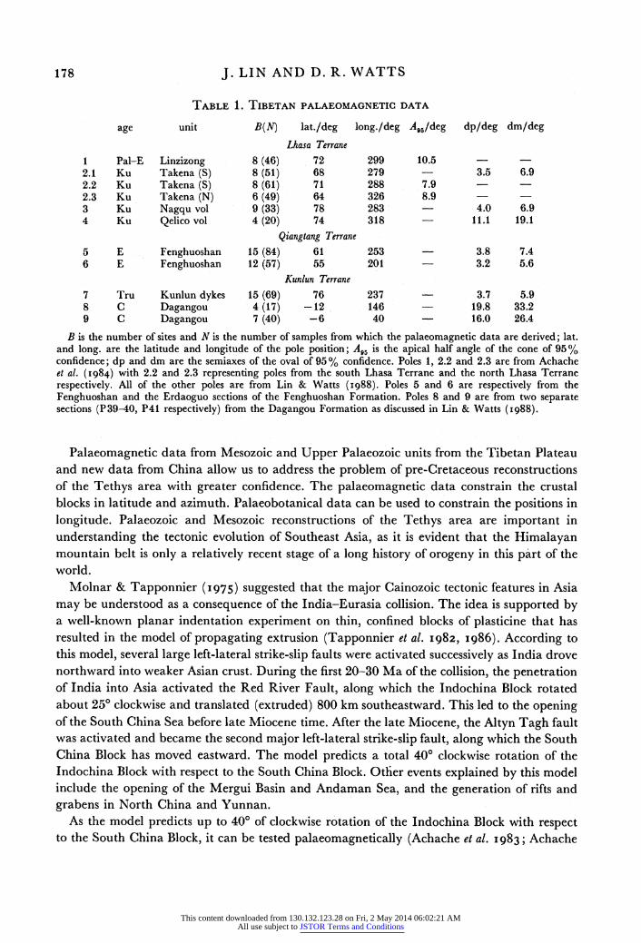
TABLE 1. TIBETAN PALAEOMAGNETIC DATA
age unit B(N) lat./deg long./deg A,s/deg dp/deg dm/deg
Lhasa Terrane
1 Pal-E Linzizong 8 (46) 72 299 10.5 2.1 Ku Takena (S) 8 (51) 68 279 3.5 6.9 2.2 Ku Takena (S) 8 (61) 71 288 7.9 2.3 Ku Takena (N) 6 (49) 64 326 8.9 3 Ku Nagqu vol 9 (33) 78 283 - 4.0 6.9 4 Ku Qelico vol 4 (20) 74 318 11.1 19.1
Qiangtang Terrane
5 E Fenghuoshan 15 (84) 61 253 3.8 7.4 6 E Fenghuoshan 12 (57) 55 201 3.2 5.6
Kunlun Terrane
7 Tru Kunlun dykes 15 (69) 76 237 3.7 5.9 8 C Dagangou 4 (17) -12 146 19.8 33.2 9 C Dagangou 7 (40) -6 40 - 16.0 26.4
B is the number of sites and N is the number of samples from which the palaeomagnetic data are derived; lat. and long. are the latitude and longitude of the pole position; A,, is the apical half angle of the cone of 95% confidence; dp and dm are the semiaxes of the oval of 95% confidence. Poles 1, 2.2 and 2.3 are from Achache et al. (I984) with 2.2 and 2.3 representing poles from the south Lhasa Terrane and the north Lhasa Terrane respectively. All of the other poles are from Lin & Watts (I988). Poles 5 and 6 are respectively from the Fenghuoshan and the Erdaoguo sections of the Fenghuoshan Formation. Poles 8 and 9 are from two separate sections (P39-40, P41 respectively) from the Dagangou Formation as discussed in Lin & Watts (1988).
Palaeomagnetic data from Mesozoic and Upper Palaeozoic units from the Tibetan Plateau and new data from China allow us to address the problem of pre-Cretaceous reconstructions of the Tethys area with greater confidence. The palaeomagnetic data constrain the crustal blocks in latitude and azimuth. Palaeobotanical data can be used to constrain the positions in
longitude. Palaeozoic and Mesozoic reconstructions of the Tethys area are important in
understanding the tectonic evolution of Southeast Asia, as it is evident that the Himalayan mountain belt is only a relatively recent stage of a long history of orogeny in this part of the world.
Molnar & Tapponnier (1975) suggested that the major Cainozoic tectonic features in Asia
may be understood as a consequence of the India-Eurasia collision. The idea is supported by a well-known planar indentation experiment on thin, confined blocks of plasticine that has resulted in the model of propagating extrusion (Tapponnier et al. 1982, 1986). According to this model, several large left-lateral strike-slip faults were activated successively as India drove northward into weaker Asian crust. During the first 20-30 Ma of the collision, the penetration of India into Asia activated the Red River Fault, along which the Indochina Block rotated about 250 clockwise and translated (extruded) 800 km southeastward. This led to the opening of the South China Sea before late Miocene time. After the late Miocene, the Altyn Tagh fault was activated and became the second major left-lateral strike-slip fault, along which the South China Block has moved eastward. The model predicts a total 400 clockwise rotation of the Indochina Block with respect to the South China Block. Other events explained by this model include the opening of the Mergui Basin and Andaman Sea, and the generation of rifts and grabens in North China and Yunnan.
As the model predicts up to 40? of clockwise rotation of the Indochina Block with respect to the South China Block, it can be tested palaeomagnetically (Achache et al. 1983; Achache
178
This content downloaded from 130.132.123.28 on Fri, 2 May 2014 06:02:21 AMAll use subject to JSTOR Terms and Conditions
PALAEOMAGNETIC CONSTRAINTS 179
& Courtillot I985; Maranate & Vella I986). Further inquiry into this problem is possible with recently available data from the South China Block (Lin et al. I985; Lin I987a, b) and a re- examination of the data from the Indochina Block.
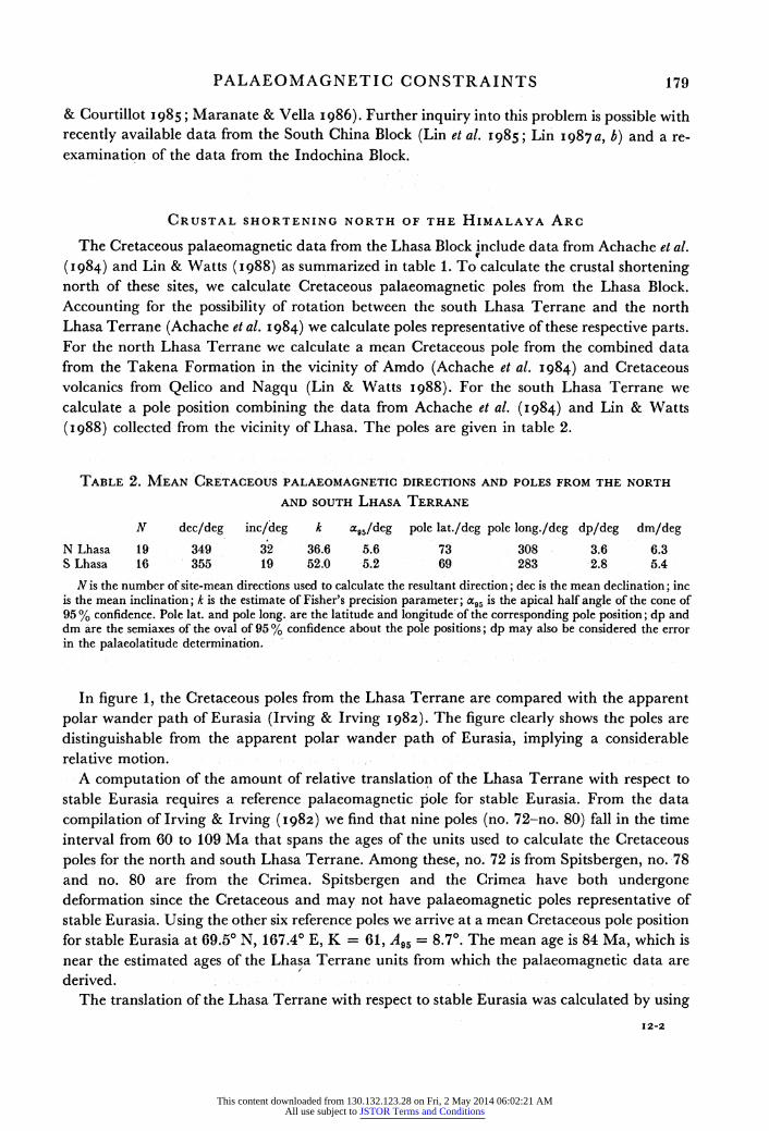
CRUSTAL SHORTENING NORTH OF THE HIMALAYA ARC
The Cretaceous palaeomagnetic data from the Lhasa Block include data from Achache et al. (I984) and Lin & Watts (1988) as summarized in table 1. To calculate the crustal shortening north of these sites, we calculate Cretaceous palaeomagnetic poles from the Lhasa Block. Accounting for the possibility of rotation between the south Lhasa Terrane and the north Lhasa Terrane (Achache et al. 1984) we calculate poles representative of these respective parts. For the north Lhasa Terrane we calculate a mean Cretaceous pole from the combined data from the Takena Formation in the vicinity of Amdo (Achache et al. 1984) and Cretaceous volcanics from Qelico and Nagqu (Lin & Watts 1988). For the south Lhasa Terrane we calculate a pole position combining the data from Achache et al. (I984) and Lin & Watts
(I988) collected from the vicinity of Lhasa. The poles are given in table 2.
TABLE 2. MEAN CRETACEOUS PALAEOMAGNETIC DIRECTIONS AND POLES FROM THE NORTH
AND SOUTH LHASA TERRANE
N dec/deg inc/deg k a,5/deg pole lat./deg pole long./deg dp/deg dm/deg N Lhasa 19 349 32 36.6 5.6 73 308 3.6 6.3 S Lhasa 16 355 19 52.0 5.2 69 283 2.8 5.4
N is the number of site-mean directions used to calculate the resultant direction; dec is the mean declination; inc is the mean inclination; k is the estimate of Fisher's precision parameter; aXcz is the apical half angle of the cone of 95 % confidence. Pole lat. and pole long. are the latitude and longitude of the corresponding pole position; dp and dm are the semiaxes of the oval of 95 % confidence about the pole positions; dp may also be considered the error in the palaeolatitude determination.
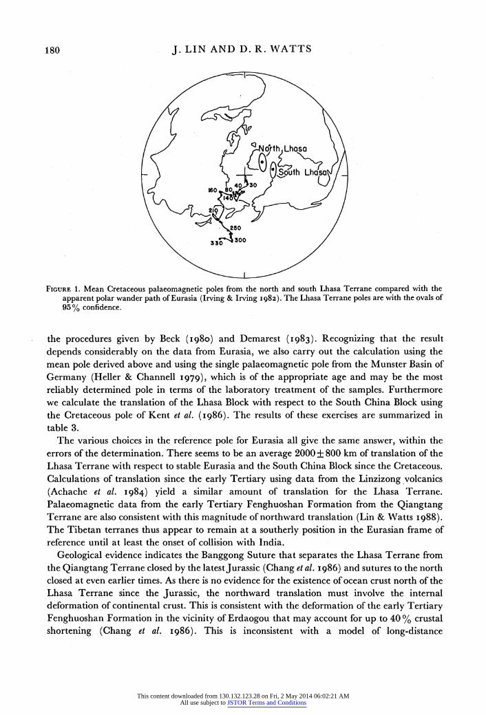
In figure 1, the Cretaceous poles from the Lhasa Terrane are compared with the apparent polar wander path of Eurasia (Irving & Irving 1982). The figure clearly shows the poles are
distinguishable from the apparent polar wander path of Eurasia, implying a considerable relative motion.
A computation of the amount of relative translation of the Lhasa Terrane with respect to stable Eurasia requires a reference palaeomagnetic pole for stable Eurasia. From the data
compilation of Irving & Irving (1982) we find that nine poles (no. 72-no. 80) fall in the time interval from 60 to 109 Ma that spans the ages of the units used to calculate the Cretaceous
poles for the north and south Lhasa Terrane. Among these, no. 72 is from Spitsbergen, no. 78 and no. 80 are from the Crimea. Spitsbergen and the Crimea have both undergone deformation since the Cretaceous and may not have palaeomagnetic poles representative of stable Eurasia. Using the other six reference poles we arrive at a mean Cretaceous pole position for stable Eurasia at 69.50 N, 167.40 E, K = 61, A95 = 8.7?. The mean age is 84 Ma, which is near the estimated ages of the Lhasa Terrane units from which the palaeomagnetic data are derived.
The translation of the Lhasa Terrane with respect to stable Eurasia was calculated by using
12-2
This content downloaded from 130.132.123.28 on Fri, 2 May 2014 06:02:21 AMAll use subject to JSTOR Terms and Conditions
J. LIN AND D. R. WATTS
FIGURE 1. Mean Cretaceous palaeomagnetic poles from the north and south Lhasa Terrane compared with the apparent polar wander path of Eurasia (Irving & Irving I982). The Lhasa Terrane poles are with the ovals of 95% confidence.
the procedures given by Beck (1980) and Demarest (I983). Recognizing that the result
depends considerably on the data from Eurasia, we also carry out the calculation using the mean pole derived above and using the single palaeomagnetic pole from the Munster Basin of
Germany (Heller & Channell 1979), which is of the appropriate age and may be the most
reliably determined pole in terms of the laboratory treatment of the samples. Furthermore we calculate the translation of the Lhasa Block with respect to the South China Block using the Cretaceous pole of Kent et al. (1986). The results of these exercises are summarized in table 3.
The various choices in the reference pole for Eurasia all give the same answer, within the errors of the determination. There seems to be an average 2000 + 800 km of translation of the Lhasa Terrane with respect to stable Eurasia and the South China Block since the Cretaceous. Calculations of translation since the early Tertiary using data from the Linzizong volcanics
(Achache et al. 1984) yield a similar amount of translation for the Lhasa Terrane.
Palaeomagnetic data from the early Tertiary Fenghuoshan Formation from the Qiangtang Terrane are also consistent with this magnitude of northward translation (Lin & Watts I988). The Tibetan terranes thus appear to remain at a southerly position in the Eurasian frame of reference until at least the onset of collision with India.
Geological evidence indicates the Banggong Suture that separates the Lhasa Terrane from the Qiangtang Terrane closed by the latestJurassic (Chang et al. 1986) and sutures to the north closed at even earlier times. As there is no evidence for the existence of ocean crust north of the Lhasa Terrane since the Jurassic, the northward translation must involve the internal deformation of continental crust. This is consistent with the deformation of the early Tertiary Fenghuoshan Formation in the vicinity of Erdaogou that may account for up to 40 % crustal
shortening (Chang et al. 1986). This is inconsistent with a model of long-distance
180
This content downloaded from 130.132.123.28 on Fri, 2 May 2014 06:02:21 AMAll use subject to JSTOR Terms and Conditions
PALAEOMAGNETIC CONSTRAINTS 181
TABLE 3. TRANSLATION OF THE LHASA TERRANE RELATIVE TO EURASIA SINCE
THE LATE CRETACEOUS
Eurasian reference pole at 69.5? N, 167.4? E, A5 = 8.7?, N = 6 obs. lat./deg pred. lat./deg Alat./deg 4/km
N Lhasa 17.4+2.8 34.3?6.8 16.9?7.3 1860?810 S Lhasa 9.8 +2.2 32.7 ?6.8 22.9 7.1 2520 +790
Eurasian reference pole at 75.8? N, 181.1? E, A95 = 3.8?, N= 11 (Heller & Channell 1979)
obs. lat./deg pred. lat./deg Alat./deg A/km
N Lhasa 17.4?2.8 30.6?3.0 13.3?4.1 1460?450 S Lhasa 9.8?2.2 28.9+3.0 19.2 3.7 2110+410
South China reference pole at 76.3? N, 172.6? E, A95 = 10.3, N = 11 (Kent et al. I986)
obs. lat./deg pred. lat./deg Alat./deg A/km N Lhasa 17.4+2.8 32.7+8.1 15.4?8.6 1690+950 S Lhasa 9.8 + 2.2 31.0+ 8.3 21.2 + 8.4 2340 930
The obs. lat. and pred. lat. are the latitude of the terrane inferred from palaeomagnetic data and the latitude predicted from the reference pole, respectively; A lat. is the difference between the observed and predicted latitude; A is the minimum crustal shortening (in kilometres) with respect to the Eurasian or South China reference frame. The reference site is chosen at 31.6? N, 91.5? E for the north Lhasa Terrane, and at 29.9? N, 91.25? E for the south Lhasa Terrane.
underthrusting of the Indian continental crust beneath a passive Tibet (Holmes 1965; Barazangi & Ni 1982), as there is no prediction of relative motion of the observed magnitude between southern Tibet and Eurasia.
A CARBONIFEROUS RECONSTRUCTION
Many Asian terranes could not be accurately positioned in previously published Carboniferous reconstructions (Ziegler et al. 1979; Smith et al. I98I) because of the lack of
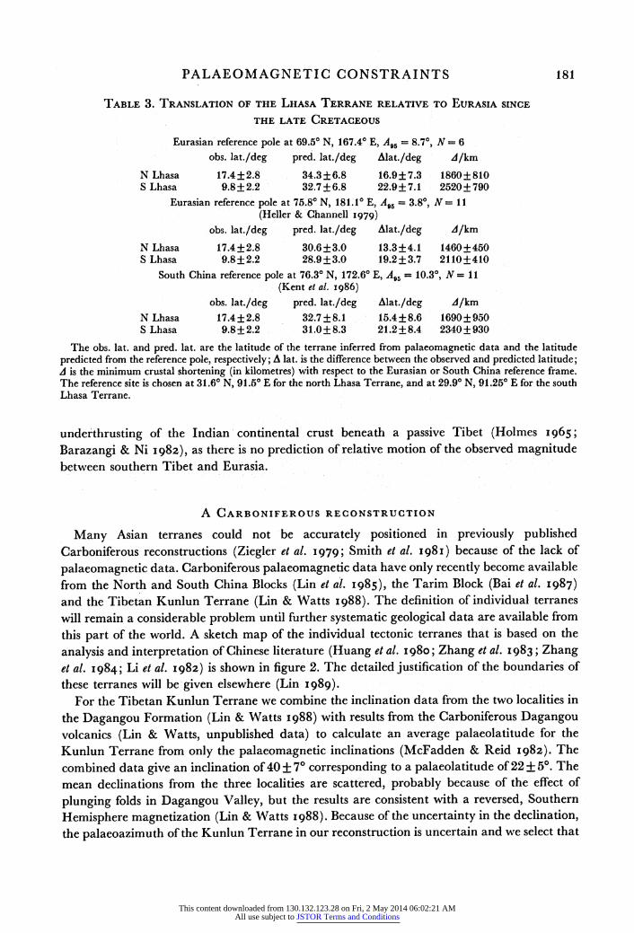
palaeomagnetic data. Carboniferous palaeomagnetic data have only recently become available from the North and South China Blocks (Lin et al. 1985), the Tarim Block (Bai et al. 1987) and the Tibetan Kunlun Terrane (Lin & Watts 1988). The definition of individual terranes will remain a considerable problem until further systematic geological data are available from this part of the world. A sketch map of the individual tectonic terranes that is based on the
analysis and interpretation of Chinese literature (Huang et al. I980; Zhang et al. I983; Zhang et al. 1984; Li et al. i982) is shown in figure 2. The detailed justification of the boundaries of these terranes will be given elsewhere (Lin I989).
For the Tibetan Kunlun Terrane we combine the inclination data from the two localities in the Dagangou Formation (Lin & Watts I988) with results from the Carboniferous Dagangou volcanics (Lin & Watts, unpublished data) to calculate an average palaeolatitude for the Kunlun Terrane from only the palaeomagnetic inclinations (McFadden & Reid 1982). The combined data give an inclination of 40 + 70 corresponding to a palaeolatitude of 22 + 50. The mean declinations from the three localities are scattered, probably because of the effect of
plunging folds in Dagangou Valley, but the results are consistent with a reversed, Southern
Hemisphere magnetization (Lin & Watts I988). Because of the uncertainty in the declination, the palaeoazimuth of the Kunlun Terrane in our reconstruction is uncertain and we select that
This content downloaded from 130.132.123.28 on Fri, 2 May 2014 06:02:21 AMAll use subject to JSTOR Terms and Conditions
J. LIN AND D. R. WATTS
7 80 900 100 l' .- 0 1220 130 140
FIGURE 2. Tectonic units in China and its environs. The abbreviations of the terranes are: AFG, Afghanistan Terrane; IC, Indochina Terrane; KL, Kunlun Terrane; KR, Karakoram Terrane; KZ, Kazakhstan Terrane; LS, Lhasa Terrane; NBC, North China Block; NEC, Northeast China Terrane; QD, Qaidam Terrane; QT, Qiangtang Terrane; SCB, South China Block; TM, Thai-Malay Terrane; WB, West Burma Terrane. A Mercator projection is used.
indicated by the data from the Dagangou Formation, locality P39-40, only because it is based on the most samples.
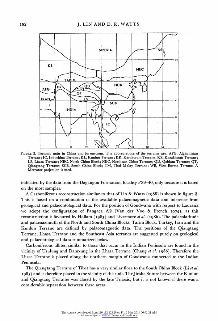
A Carboniferous reconstruction similar to that of Lin & Watts (1988) is shown in figure 3. This is based on a combination of the available palaeomagnetic data and inference from
geological and palaeontological data. For the position of Gondwana with respect to Laurasia we adopt the configuration of Pangaea A2 (Van der Voo & French I974), as this reconstruction is favoured by Hallam (I983) and Livermore et al. (I986). The palaeolatitude and palaeoazimuth of the North and South China Blocks, Tarim Block, Turkey, Iran and the Kunlun Terrane are defined by palaeomagnetic data. The positions of the Qiangtang Terrane, Lhasa Terrane and the Southeast Asia terranes are suggested purely on geological and palaeontological data summarized below.
Carboniferous tillites, similar to those that occur in the Indian Peninsula are found in the
vicinity of Urulung and Damxung in the Lhasa Terrane (Chang et al. I986). Therefore the Lhasa Terrane is placed along the northern margin of Gondwana connected to the Indian Peninsula.
The Qiangtang Tierrane ofTibet has a very similar flora to the Southe China Block (Li et al.
I985) and is therefore placed in the vicinity of this unit. TheJinsha Suture between the Kunlun and Qiangtang Terranes was closed by the late Triassic, but it is not known if there was a considerable separation between these areas.
182
This content downloaded from 130.132.123.28 on Fri, 2 May 2014 06:02:21 AMAll use subject to JSTOR Terms and Conditions
PALAEOMAGNETIC CONSTRAINTS 183
.' ?,
K^~~ ~GONDWANA
,, 1 (ANGARA
30N EUR
equidistant projection is used.I
Our division of the Southeast Asian area follows that of Hamilton (979) d includes the
90S
FIGURE 3. A global reconstruction for the Carboniferous. The abbreviations, in addition to those of figure 2 are: AF, Africa; AUS, Australia; EUR, Europe; NA, North America; SA, South America; T, Tarim. The approximate boundaries of the Angaran, Euramerian, Cathaysian and Gondwana floras are delineated. A cylindrical equidistant projection is used.
Indochina Block, the Thai-Malay Terrane and the West Burma Terranes. The former two contain a typical Cathaysian flora and were therefore likely connected with the South China Block in the late Palaeozoic. A preliminary palaeomagnetic result from the Baoshan area
(25.0 ?N, 99.2 oE) of western Yunnan yields a late Carboniferous palaeolatitude of 34.1 ?S (Zhang & Zhang 1986). The Baoshan area and the Shan State Plateau of Burma belong geologically to the Thai-Malay Terrane as shown in figures 2 and 3. This new result is therefore consistent with our reconstruction. However, the provenance of the West Burma Terrane is uncertain. It may have been connected with the South China Block together with the Indochina Block and the Thai-Malay Terrane as shown in figure 3, or it may have been associated with northwestern Australia until the mid-Jurassic. The mid-Jurassic magnetic anomalies (M 22-M 25) offshore of northwestern Australia (Norton & Sclater I979) imply that the continental crust moved northwest away from Australia at this time.
The late Carboniferous palaeomagnetic data from the Tarim, Kazakhstan and Siberian Blocks suggest that this assemblage may have come together by this time, as we show in figure 3. However, Zonenshain et al. (1984) indicate that Kazakhstan had first collided with the East
European Block by the late Carboniferous, and that it was in the late Permian that the Siberian Block joined the combined East European-Kazakhstan Block.
The reconstruction in figure 3 differs from previous reconstructions in that what was
previously a large triangular void between the Indian-Australian northern margin of Gondwana and the southern Asian margin of Laurasia contains a considerable amount of
This content downloaded from 130.132.123.28 on Fri, 2 May 2014 06:02:21 AMAll use subject to JSTOR Terms and Conditions
J. LIN AND D. R. WATTS
continental crust. This assemblage of tectonic units was spread in tropical and subtropical areas and is characterized by the Cathaysian flora, which is distinct from the Gondwanan and
Angaran floras, but contains a few elements of the Euramerian flora (Chaloner & Meyen
I973). We propose to call this specific assemblage of terranes the Cathaysian composite continent, distinct from Gondwana, Angara and Laurasia. In our reconstruction, the four
supercontinents explain the distribution of the four flora provinces: Angaran, Gondwanan, Euramerian and Cathaysian. The four supercontinents met in western Tethys, the area which contains Turkey, Iran and the Arabian Peninsula. These are the places where mixed
Cathaysian and Gondwana flora elements are known. Our reconstruction resembles the Jurassic Cimmerian continent proposed by Sengor (I979,
I984). However, we emphasize that our reconstruction is limited by our palaeomagnetic data base to the Carboniferous. It will be of considerable interest to determine if a similar reconstruction is valid for the Jurassic.
RELATIVE MOTION BETWEEN SOUTH CHINA AND INDOCHINA
The propagating extrusion model of Tapponnier et al. (I982, 1986) predicts up to 40? of clockwise rotation between South China and Indochina. Previous discussions of this problem (Achache et al. I983; Achache & Courtillot I985; Maranate & Vella 1986) could not be conclusive because the appropriate data base from South China was not available. Here we consider the propagating extrusion model in the light of the t data from China now available
(Lin et al. 985; Lin I987a, b) and the data from Indochina (Bunopas I98I; Achache & Courtillot 1985; Maranate & Vella I986).
The entire data set from Indochina is derived from the Khorat Group of the Khorat Plateau, Thailand. The Khorat Group consists of lacustrine and fluvial sediments over 5000 m thick
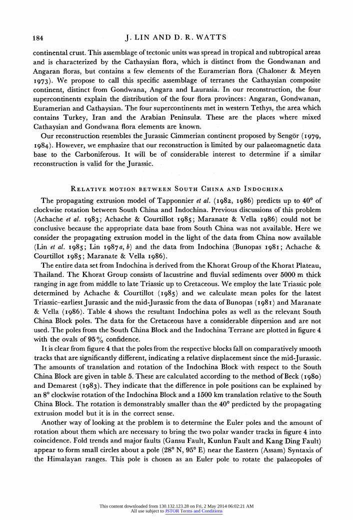
ranging in age from middle to late Triassic up to Cretaceous. We employ the late Triassic pole determined by Achache & Courtillot (I985) and we calculate mean poles for the latest Triassic-earliest Jurassic and the mid-Jurassic from the data of Bunopas ( I981) and Maranate & Vella (1986). Table 4 shows the resultant Indochina poles as well as the relevant South China Block poles. The data for the Cretaceous have a considerable dispersion and are not used. The poles from the South China Block and the Indochina Terrane are plotted in figure 4 with the ovals of 95 % confidence.
It is clear from figure 4 that the poles from the respective blocks fall on comparatively smooth tracks that are significantly different, indicating a relative displacement since the mid-Jurassic. The amounts of translation and rotation of the Indochina Block with respect to the South China Block are given in table 5. These are calculated according to the method of Beck (1980) and Demarest (I983). They indicate that the difference in pole positions can be explained by an 80 clockwise rotation of the Indochina Block and a 1500 km translation relative to the South China Block. The rotation is demonstrably smaller than the 400 predicted by the propagating extrusion model but it is in the correct sense.
Another way of looking at the problem is to determine the Euler poles and the amount of rotation about them which are necessary to bring the two polar wander tracks in figure 4 into coincidence. Fold trends and major faults (Gansu Fault, Kunlun Fault and KangDing Fault) appear to form small circles about a pole (280 N, 950 E) near the Eastern (Assam) Syntaxis of the Himalayan ranges. This pole is chosen as an Euler pole to rotate the palaeopoles of
184
This content downloaded from 130.132.123.28 on Fri, 2 May 2014 06:02:21 AMAll use subject to JSTOR Terms and Conditions
PALAEOMAGNETIC CONSTRAINTS 185
'TruI
Tr Tru-
FIGURE 4. Palacomagnetic poles from the South China Block (shown as open circles) and from the Indochina Terrane (shown as closed circles). The cross labelled P shows the first Euler pole near.the Assam Syntaxis. Also shown are the positions of the Khorat Plateau of Thailand (T) and the South China Block (SC). The ages of the palaeomagnetic poles are abbreviated as follows: Jm, mid-Jurassic; Tru-J1, latest Triassic to earliest Jurassic; Tru, late Triassic; Trm, mid-Triassic; Trl, early Triassic. The approximate apical half angles of 95 % confidence are shown for each of the pole positions.
TABLE 4. PALAEOMAGNETIC POLES FOR SOUTH CHINA AND INDOCHINA
Indochina
age . N(B) lat./deg long./deg K A,5/deg reference
Jm 3 (44) 62.1 178.5 260 7.7 3,4, e Tru-Jl 4 (48) 57.4 181.6 334 5.0 5,6,f,g Tru 1 (39) 49.0 172.0 106 7.0 h
South China
Jm 6 71.5 201.0 135 5.8 Lin (I987a) Tru-Jl (5) 60.3 207.2 6.0 interpolated Tru (5) 57.5 208.8 6.0 interpolated Trm 1 (2) 54.6 209.7 95 5.7 Lin (I987a) Trl 3 (22) 48.8 214.4 198 8.8 Lin (I987b)
Age is the likely age of the palaeomagnetic pole. N is the number of independent studies from which the mean is determined. B is the number of sites; lat. and long. are the latitude and longitude of the palaeomagnetic poles. K is the estimate of Fisher's precision parameter. A,5 is the apical half angle of the cone of confidence around the pole position. For the Indochina poles, the numbers and letters in the reference column give the labels of the poles in table 1 and table 2 of Maranate & Vella (I986), which include results from Bunopas (I98I). The Tru-Jl and Tru South China poles are interpolated between the Jm and Trm poles.
TABLE 5. TRANSLATION AND ROTATION OF INDOCHINA WITH RESPECT TO SOUTH CHINA
obs. lat. pred. lat. Alat. obs. dec. pred. dec.
age deg deg deg A/km deg deK rot./deg
Jm 21+4.0 13+4.5 8?6.0 900+670 29+7.3 19?4.6 10+8.7 Tru-Jl 20+2.5 7+4.6 12+5.3 1370+580 34+4.7 29?4.7 5+6.6 Tru 26?4.4 5?4.6 20+6.4 2240+700 43_7.8 31+4.6 12+9.1
Age is the age of the units from which the palaeomagnetic results are derived. The observed latitude is determined from the palaeomagnetic data from Indochina. The predicted latitude is what would be expected if Indochina had remained stationary in the South China reference frame since the Triassic. Alat. is the difference between them and is the amount of relative translation between the two blocks since the age of the palaeomagnetic poles. A is the amount of translation in kilometres. The obs. dec. is the observed palaeomagnetic declination of Indochina, and pred. dec. is the predicted declination if Indochina was stationary in the South China reference frame. The difference between these is the amount of relative rotation which is given in the rot. column. These rotations are in a clockwise sense. The reference site for the calculation is 16.50 N, 102.50 E in Thailand.
This content downloaded from 130.132.123.28 on Fri, 2 May 2014 06:02:21 AMAll use subject to JSTOR Terms and Conditions
J. LIN AND D. R. WATTS
Indochina so as to bring them into agreement with the corresponding palaeopoles from the South China Block. However, a rotation about the Euler pole near Assam can only bring the latitudes of the palaeomagnetic poles into agreement. To bring the longitudes into agreement a rotation of the Indochina poles about the present geographic pole by about 20? is required, as shown in the summary of this exercise in table 6. To reconcile the Upper Triassic poles a rather larger rotation (360) is required, but this may be an artefact of the larger error associated with these particular poles of this age.
TABLE 6. EULER POLES (DEGREES) FOR ROTATION OF INDOCHINA POLES INTO THE
SOUTH CHINA FRAME OF REFERENCE
Indochina Euler rotated Euler rotated S China pole rotation 1 pole rotation 2 pole pole
age lat. long. lat. long. 0 lat. long. lat. long. 0 lat. long. lat. long.
Jm 62 179 28 95 8 69 181 90 0 20 69 201 72 201 Tru-Jl 57 182 28 95 8 65 185 90 0 20 64 205 60 207 Tru 49 172 28 95 8 56 173 90 0 36 56 210 58 209
The age and position of the Indochina poles are given in the first three columns. The third to fifth columns (Euler rotation 1) give the first (Assam Syntaxis) Euler pole and amount of rotation 0 (positive for a counterclockwise rotation) for rotating the Indochina poles into the South China frame of reference with the resulting pole given in the sixth and seventh columns (rotated pole). The second Euler pole is the present geographic pole and 0 is the amount of this second rotation required to bring the Indochina and South China poles into agreement. The final result of the rotation of the Indochina poles can be compared with the South China poles of equivalent age.
We emphasize that the Euler poles selected are not unique because the two segments of the
apparent polar wander paths are too short. But these rotations seem straightforward in view of the fact that relative movement between these two blocks must have involved movements on the major faults in the region. Also, as reliable, unscattered Cretaceous and Tertiary palaeomagnetic data are still not available for the Indochina Block, the timing of the relative movement is not well constrained.
The palaeomagnetic data are consistent with a smaller rotation of the Indochina Block and a larger translation of the South China Block than predicted by the plasticine experiments. However, we note that the placticine experiments also seemingly fail to account for the
apparent present dextral sense of movement on the Red River Fault, as discussed by Tapponnier et al. (1982), or apparent reversal of the sense of movement along this fault
(Tapponnier et al. 1986). Various combinations, in time, of the 8? rotation of Indochina and the translation of the South China Block could produce a dextral movement on the Red River
Fault, or even a reversal of the sense of movement across this structure. It has been pointed out that the published experiment considerably simplified the collision process between India and Eurasia (Achache et al. I983, I984). For example, the Indian Plate was rotating counterclockwise as it moved northward, colliding with Eurasia. This may have resulted in
competing senses of motion for the extruded blocks: counterclockwise rotation in sympathy with India against southeastward extrusion and clockwise rotation. Achache et al. (1983) have suggested that a rotating indenter be used in future experiments.
186
This content downloaded from 130.132.123.28 on Fri, 2 May 2014 06:02:21 AMAll use subject to JSTOR Terms and Conditions
PALAEOMAGNETIC CONSTRAINTS 187
CONCLUSIONS
The Mesozoic and Cainozoic palaeomagnetic results from the Lhasa and Qiangtang Terranes in the Tibetan Plateau are discordant with those of stable Eurasia and the South China Block. The data are consistent with 2000 ? 800 km of northward translation of the Lhasa Terrane with respect to stable Eurasia since the India-Eurasian collision began. The palaeomagnetic data support the internal deformation within the Eurasian continental crust as a principal mechanism of crustal thickening. The model of long-distance underthrusting of the Indian subcontinent beneath a passive Tibetan Plateau does not predict the 2000 km of northward convergence of continental crust north of the Himalaya Arc as indicated by the palaeomagnetic data. This conclusion is also consistent with a result obtained from numerical analysis of a thin viscous sheet (England & Houseman 1986).
Palaeomagnetic data indicate that the North China Block, South China Block, Kunlun Terrane and Thai-Malay Terrane were in equatorial or low latitudes during the Carboniferous. Combining palaeomagnetic results with geological and palaeontological data, we propose a reconstruction showing that the traditional wedge-shaped Tethys was divided into two halves by a Cathaysian composite continent consisting of the above terranes as well as the Indochina Block. These terranes all contain elements of the Cathaysian flora. The southern supercontinent Gondwana and the northern supercontinents Laurasia and Angara may have been loosely connected via the Cathaysian composite continent. If the Tibetan Terranes could be restored to their original sizes, taking into account crustal shortening, both the northern and southern halves of Tethys would approach epicontinental seas in size. This would resolve the Tethys paradox, i.e. why all attempts to find relics of the vast Palaeotethys proposed to have existed during the late Palaeozoic have failed (Carey 1976; Stocklin I984). In our reconstruction, such an ocean never existed.
To interpret the difference between the Mesozoic palaeomagnetic poles from South China and from Indochina, we propose that following the India-Eurasia collision, the Indochina Block rotated 80 clockwise about a pole within the Assam Syntaxis, and the South China Block extruded over 1500 km eastward. If the rotation dominated the earlier phases of movement, the sense of movement on the Red River Fault would have been left lateral. If the extrusion of the South China Block dominated the relative movement at some point, the sense of movement on the Red River Fault would be right-lateral. Hence the observed apparent reversal of sense of movement on this fault could be explained by the dominance of one or other
components of motion. This retains the salient features of the extrusion model of Tapponnier et al. (1982) but would suggest that initial conditions of the collision other than that originally used would be appropriate, e.g. a rotating indenter as proposed by Achache et al. (1983).
We thank all participants in the Academia Sinica-Royal Society Geotraverse for many discussions. ProfessorJ. C. Briden and Dr E. McClellan kindly provided laboratory facilities at the University of Leeds. Dr A. G. Smith of Cambridge University allowed us use of his ATLAS
program and assisted with the mechanics of palaeogeographic reconstruction. J.L. thanks Professor R. Shackleton, F.R.S., Professor J. Dewey, F.R.S., and Professor B. Windley for the invitation to attend the Royal Society Discussion on the evolution of the Himalaya and Tibet. D.R. W. acknowledges support from the Natural Environment Research Council. Professor K. Hsu commented on an early draft of this paper.
This content downloaded from 130.132.123.28 on Fri, 2 May 2014 06:02:21 AMAll use subject to JSTOR Terms and Conditions
188 J. LIN AND D. R. WATTS
REFERENCES
Achache, J. & Courtillot, V. I985 Earth planet. Sci. Lett. 73, 147-157. Achache, J., Courtillot, V. & Besse, J. 1983 Earth planet. Sci. Lett. 63, 123-136. Achache, J., Courtillot, V. & Zou, Y. X. 1984 J. geophys. Res. 89, 10311-10339. Bai, Y., Cheng, G., Sun, Q., Sun, Y., Li, Y., Dong, Y. & Sun, D. I987 Tectonophysics 139, 145-153. Barazangi, M. & Ni, J. 982 Geology 10, 179-185. Beck, M. E. Jr I980 J. geophys. Res. 85, 7115-7131. Besse, J., Courtillot, V., Pozzi, J. P., Westphal, M. & Zhou, Y. X. 1984 Nature, Lond. 311, 621-626. Bunopas, S. 198I Ph.D. thesis, Victoria University of Wellington, New Zealand. Carey, W. 1976 The expanding Earth. Amsterdam: Elsevier. Chaloner, W. G. & Meyen, S. V. 1973 In Atlas of paleogeography (ed. A. Hallam). Amsterdam: Elsevier. Chang Chengfa et al. 1986 Nature, Lond. 323, 501-507. Demarest, H. H.Jr 1983 J. geophys. Res. 88, 4321-4328. England, P. C. & Houseman, G. I986 J. geophys. Res. 91, 3664-3676. Hallam, A. 1983 Nature, Lond. 301, 499-502. Hamilton, W. 1979 Tectonics of the Indonesian region. U.S. Geol. Surv. Prof. Paper no. 1078. Heller, F. & Channell, J. E. T. I979 J. Geophys. 46, 413-427. Holmes, A. I965 Principles of physical geology. 2nd edn. London: Thomas Nelson Ltd. Huang, J., Ren, J., Jiang, Ch, Zhang, Zh. & Qin, D. 1980 The geotectonic evolution of China. Beijing: Science
Press. Irving, E. & Irving, G. A. 1982 Geophys. Surv. 5, 141-188. Kent, D. V., Xu, G., Huang, K., Zhang, W. Y. & Opdyke, N. D. 1986 Earth planet. Sci. Lett. 79, 179-184. Klootwijk, C. T., Conaghan, P.J. & Powell, C. McA. I985 Earth planet. Sci. Lett. 75, 167-183. Klootwijk, C. T., Nazirullah, R. & de Jong, A. 1986a Earth planet. Sci. Lett. 80, 394-414. Klootwijk, C. T., Sharma, M. L., Gergan, J., Shah, S. K. & Gupta, B. K. 1986b Earth planet. Sci. Lett. 80,
375-393. Li, Ch., Wang, Q., Liu, X. & Tang, Y. I982 Tectonic map of Asia (scale 1:8,000,000). Beijing: Cartographic
Publishing House. Li, X. X. et al. 1985 Acta paleont. sin. 24, 150-170. Lin, J. 987a Scientia geol. sin. 2, 182-187. Lin, J. L. I987b Scientia geol. sin. 4, 295-305. Lin, J. L. 1989 (In preparation.) Lin, J. L., Fuller, M. & Zhang, W. Y. 1985 Nature, Lond. 313, 444-449. Lin, J. L. & Watts, D. R. 1988 Phil. Trans. R. Soc. Lond. A. (In the press.) Livermore, R. A., Smith, A. G. & Vine, F.J. I986 Nature, Lond. 322, 162-165. Maranate, S. & Vella, P. 1986 J. southeast Asian Earth Sci. 1, 23-31. McFadden, P. L. & Reid, A. B. 1982 Geophys. Jl R. astr. Soc. 69, 307-319. Molnar, P. & Tapponnier, P. 1975 Science, Wash. 189, 419-426. Norton, I. O. & Sclater, J. G. 1979 J. geophys. Res. 84, 6803-6830. Seng6r, A. M. C. I979 Nature, Lond. 279, 590-593. Sengbr, A. M. C. i984 The Cimmeride orogenic system and the tectonics of Eurasia. Geol. Soc. Am. Spec. Paper no.
195. Smith, A. G., Hurley, A. M. & Briden, J. C. 198I Phanerozoic paleocontinental world maps. Cambridge University
Press. Stocklin, J. 1984 In Plate reconstruction from Paleozoic paleomagnetism (ed. R. Van der Voo, C. R. Scotese and
N. Bonhommet), Geodynamics Series vol. 12, pp. 27-28. Washington, D.C.: American Geophysical Union. Tapponnier, P., Peltzer, G., Le Dain, A. Y., Armijo, R. & Cobbold, P. 1982 Geology 10, 611-616. Tapponnier, P., Peltzer, G. & Armijo, R. I986 In Collision tectonics (ed. M. P. Coward & A. C. Ries), pp. 115-157.
Geological Society Publication no. 19. London: Geological Society. Van der Voo, R. & French, R. B. 1974 Earth Sci. Rev. 10, 99-119. Zhang, W. Y. et al. 1983 The marine and continental tectonic map of China and its environs (scale 1 :5,000,000). Beijing:
Science Press. Zhang, Zh. M., Liou, J. G. & Coleman, R. G. 1984 Bull. geol. Soc. Am. 95, 925-312. Zhang, Zhengkun & Zhang, Jingxin 1986 Bull. Inst. Geol. Chin. Acad. geol. Sci. 15, 183-189. Ziegler, A. M., Scotese, C. R., McKerrow, W. S., Johnson, M. E. & Bambach, R. K. 1979 A. Rev. Earth planet. Sci.
7, 473-502. Zonenshain, L. P., Korinevsky, V. G., Kazmin, V. G., Pechersky, D. M., Khain, V. V. & Matveenkov, V. V. 1984
Tectonophysics 109, 95-135.
This content downloaded from 130.132.123.28 on Fri, 2 May 2014 06:02:21 AMAll use subject to JSTOR Terms and Conditions