tectonic and climatic infl uence on the evolution of the ... · b (lagoe et al., 1993). glacial...
TRANSCRIPT

830 For permission to copy, contact [email protected]© 2011 Geological Society of America
Tectonic and climatic infl uence on the evolution of the Surveyor Fan and Channel system, Gulf of Alaska
Robert S. Reece1, Sean P. S. Gulick1, Brian K. Horton1, Gail L. Christeson1, and Lindsay L. Worthington2
1Jackson School of Geosciences, The University of Texas at Austin, J.J. Pickle Research Campus, Building 196, 10100 Burnet Road, Austin, Texas 78758-4445, USA2Department of Geology and Geophysics, Halbouty Building, Texas A&M University, College Station, Texas 77843, USA
Geosphere; August 2011; v. 7; no. 4; p. 830–844; doi:10.1130/GES00654.1; 15 fi gures; 1 table.
ABSTRACT
Present-day seafl oor morphology and sedi-ment distribution in the deep-water Surveyor Fan, Gulf of Alaska, is dominated by the >700-km-long Surveyor Channel, an anomaly in a system with no major fl uvial input or shelf canyons. The sediment supply instead has been provided by glacial erosion in the still-active Chugach–St. Elias orogen, and glacial transport across the shelf. Glaciation has peri-odically increased in the St. Elias Range since the Miocene, but began dominating erosion and spurred enhanced exhumation since the mid-Pleistocene transition, at ~1 Ma. Ice asso-ciated with this glacial intensifi cation carved cross-shelf sea valleys that connect the St. Elias Range to the Surveyor Fan. The direct deposition of newly increased terrigenous sed-iment fl ux into the fan triggered the formation of the Surveyor Channel and its growth across the Surveyor Fan. Through the formation of the Surveyor Channel, climate events created three major differentiable sequences across the Surveyor Fan that we mapped using seismic-refl ection profi les. The change in morphology observed throughout the sequences allows us to characterize the infl uence that a glaci-ated orogen can have in shaping margin pro-cesses and the sediment pathway from source to sink. We show that the large variation in sediment fl ux between glacial- interglacial cycles together with sea valley formation leads to a glacial shelf transport process not typical of a fl uvial system. This glacial shelf transport along with the channel terminus in the Aleutian Trench makes the Surveyor Fan and Channel morphologically one of the most unique systems in the world.
INTRODUCTION
Many studies have used accumulation rates and sediment provenance derived from subma-rine fan sediment cores worldwide to describe the tectonic growth and erosion on land that provided the source material for the marine record (e.g., Figueiredo et al., 2009; Hebbeln et al., 2007; Rea and Snoeckx, 1995; Ullrich, 2010). The terrigenous component of marine sediment accumulation rates serves as a proxy for changes in erosion rates on land, and there-fore changes in either orogenic exhumation rates or climate. Burbank et al. (2003) showed that Himalayan erosion is dominated by tec-tonic uplift in spite of large variations in pre-cipitation, but other studies demonstrate that climate can dominate erosion in glacial orogens at glacial maxima (Berger et al., 2008; Hebbeln et al., 2007).
Much work has been done to constrain the relationship between tectonics and climate in the glacial St. Elias orogen in southern Alaska (Berger et al., 2008; Rea and Snoeckx, 1995), but this study fi lls in a key additional compo-nent. The proximity of the St. Elias Mountains to the coastline assures that the majority of gla-cially eroded sediment is deposited in the Gulf of Alaska, much of it in the deep-water Surveyor Fan. A long-offset 2D seismic-refl ection study, acquired in 2008, linked to previous studies of Surveyor Fan sediment cores yields information on margin processes, erosion, climate events, orogenesis, and exhumation. The results of this study will add to the existing body of work on climate-dominated tectonic systems, and dem-onstrate how such a system cannot only trans-form the orogen, but also the entire margin from source to sink.
BACKGROUND
Tectonic and Climatic Setting
The Yakutat terrane in the northern Gulf of Alaska is a 15–25-km-thick mafi c terrane that originated as an oceanic plateau (Christeson et al., 2010; Eberhart-Philips et al., 2006). At least 600 km of Yakutat terrane has subducted at a low angle beneath North America since ~10 Ma (Fig. 1) (Eberhart-Philips et al., 2006; Gulick et al., 2007; Plafker et al., 1994; Rea and Snoeckx, 1995). This fl at-slab subduction has resulted in the still-active Chugach–St. Elias orogen, which exhibits the highest coastal relief and greatest glacial infl uence of any active orogen globally (Pavlis et al., 2004). Varying degrees of glacial erosion and rock exhumation in the St. Elias Range since the Miocene (Enkelmann et al., 2010; Lagoe et al., 1993; Rea and Snoeckx, 1995; Spotila and Berger, 2010) have distrib-uted sediment into the Gulf of Alaska, leading to periodic signifi cant increases in growth of the Surveyor Fan (Lagoe et al., 1993; Rea and Snoeckx, 1995; Stevenson and Embley, 1987), the terrigenous outwash body that comprises the majority of the Alaska Abyssal Plain (Fig. 1). Fan sediment as old as ~20 Ma varies in provenance, quantity, and content as a result of changes in onshore exhumation rates and glacial extent (Berger et al., 2008; Enkelmann et al., 2010; Ingle, 1973; Spotila and Berger, 2010). These changes are likely represented in fan stratigraphy, morphology, and shifts in acoustic character (Ness and Kulm, 1973; Stevenson and Embley, 1987).
The fi rst appearance of Gulf of Alaska ice-rafted debris appeared in the now uplifted and exposed marine Yakataga Formation at ~5.5 Ma.
Exploring the Deep Sea and Beyond themed issue

Surveyor Fan and Channel
Geosphere, August 2011 831
This alpine glaciation event is referred to as glacial interval A (Lagoe et al., 1993). Glacial activity was diminished during the mid-Pliocene warm interval, but returned during the onset of Northern Hemisphere glaciation at 2.9–2.4 Ma (Raymo, 1994), referred to as glacial interval B (Lagoe et al., 1993). Glacial interval B pro-vided the fi rst ice-rafted debris observed in the distal fan at Ocean Drilling Program (ODP) site 887 (Fig. 2) (Rea and Snoeckx, 1995). A fur-ther intensifi cation of glacial activity, glacial interval C, occurred at ~1 Ma, and could have been a regional response to the mid-Pleistocene transition (MPT) (Berger et al., 2008), a change in glacial-interglacial cycles from 40 k.y. to 100 k.y. (Clark et al., 2006).
Terrigenous sediment fl ux in the Gulf of Alaska at ODP 887 doubled at each of the three glacial intervals (Rea and Snoeckx, 1995),
with the increase at the MPT being the largest on record. Additionally, Berger et al. (2008) showed a major increase in St. Elias orogen exhumation rates associated with glacial inter-val C and proposed that the glacially carved Bering Trough (Figs. 1 and 2) fi rst reached the shelf edge near the time of the MPT, providing a sediment delivery pathway from exhumed orogen to shelf edge. Ultimately, due to erosion of sediment during repeated glacial advances across the shelf, the Surveyor Fan may be the most robust long-term record of onshore exhu-mation and climate events.
Surveyor Fan and Channel
Terrigenous turbidites, mudstone, and clay-stone of the Surveyor Fan overlie marine chalk and a basaltic basement of the Pacifi c plate
crust (Shipboard Scientifi c Party, 1973). Pre-vious studies divided the Surveyor Fan into two major sequences (Ness and Kulm, 1973; Stevenson and Embley, 1987; von Huene and Kulm, 1973). These sequences were termed upper and lower and were based on sedimen-tation rates and differences in acoustic facies imaged in 2-D seismic-refl ection profi les. The boundary between the two sequences represents a shift from a lower coarser grained facies to an upper fi ner grained facies possibly associated with Surveyor Channel inception and its control on fan sediment distribution during deposition of the upper sequence (Ness and Kulm, 1973; Stevenson and Embley, 1987).
The Chirikof and Surveyor Channel systems (Fig. 1) dominate present-day Surveyor Fan morphology and sediment distribution (Carl-son et al., 1996; Stevenson and Embley, 1987),
Chirikof Channel
BT
ASV
YSV
KT
Surveyor Fan
Yakutat Bay
Malaspina Glacier
Bering Glacier
Aleutian TrenchN
Gulf of Alaska
Alaska
Surveyor Channel
Pacific plate53 mm/yr
Yakutat terrane50 mm/yr
North America plate
P a t t o n - M u r r a y S e a m o u n t C h a i n
K o d i a k - B o w i e S e a m o u n t C h a i n
Transition Fault
Icy Bay
138°
57′
35′
′ W
150°
50′
8′′
W15
0° 5
7′ 5
7′′ W
138°
47′
34′
′ W
61° 6′ 25′′ N
53° 19′ 41′′ N53° 18′ 3′′ N
61° 7′ 51′′ N
Alsek LegYakutat LegIcy W
est Leg
Icy East Leg
GS
150 km0
PS
Figure 1. Three-dimensional perspective view of the bathymetry and topography of the southern Alaska continental margin, showing tectonic boundaries, and the Surveyor Fan in high-resolution bathymetry. ASV—Alsek Sea Valley; BT—Bering Trough; GS—Giacomini Seamount; KT—Kayak Trough; PS—Pamplona Spur; YSV—Yakutat Sea Valley. Plate boundaries adapted from Gulick et al. (2007); high-resolution bathymetry (Gardner et al., 2006); remaining bathymetry (Smith and Sandwell, 1997); Yakutat terrane motion relative to North America (Elliott et al., 2010); Pacifi c plate motion (Kreemer et al., 2003).

Reece et al.
832 Geosphere, August 2011
but unlike other large deep-sea channels, the Chirikof and Surveyor Channels are not associ-ated with a major fl uvial system or submarine canyon (Ness and Kulm, 1973). The Surveyor Channel is >700 km long with three major trib-utaries (Carlson et al., 1996; Ness and Kulm, 1973; Stevenson and Embley, 1987). The main channel has an average width of ~7 km, but is as wide as 27 km in some locations and up to 500 m deep at its distal section (Carlson et al., 1996; Stevenson and Embley, 1987). Ness and Kulm (1973) divided the channel into three sec-tions (Fig. 2) based on differences in channel relief, axial gradient, deposition, and erosivity. The two upstream sections, the upper and mid-dle channel, divide the channel length between the base of slope and the Kodiak-Bowie Sea-mount Chain. The last section, the lower chan-nel, begins past the Giacomini Seamount and extends to the Aleutian Trench. Ness and Kulm (1973) interpret the upper, middle, and lower sections as being dominantly depositional, transportational, and erosional, respectively.
This Study
The interaction between changes in orogenic exhumation rates and glacial erosion are all recorded in Surveyor Fan sediment (Berger et al., 2008; Lagoe et al., 1993; Rea et al., 1993; Rea and Snoeckx, 1995). Correlating stratigraphic changes revealed in new seismic data provides supporting information about relative timing of climatic and tectonic events, their infl uence on each other, and is the key to understanding major changes in sedimentation and fan morphology through time. We regionally analyze the upper-lower sequence boundary across the Surveyor Fan and introduce additional boundaries and interpretations using new and existing seismic-refl ection data. By correlating sequences across the entire fan, we show that they are regionally extensive deposits related to increases in exhu-mation on land and regional response to global changes in climate. A detailed understanding of Surveyor Fan stratigraphy provides an analogue for marine systems globally that record the com-
plex interactions between climate and tectonics in glacially dominated systems.
DATA
2D Seismic-Refl ection Data
A recent high-quality, multichannel seis-mic (MCS) data set was acquired in 2008 aboard the R/V Marcus G. Langseth as part of the National Science Foundation (NSF)– Continental Dynamics St. Elias Erosion/tec-tonics Project (STEEP). This survey provided ~1250 km of MCS data recorded on an 8 km streamer with 640 channels. The source was composed of 36 bolt airguns in four linear arrays with 6600 in3 total air volume. To date, this STEEP survey has been used for studies of shelfal, Yakutat terrane-related tectonics, deformation, and stratigraphy (i.e., Christeson et al., 2010; Worthington et al., 2010).
A high-resolution MCS data set was also col-lected in 2004 on the R/V Maurice Ewing as
140°
23′
56′
′ W
153°
53′
12′
′ W15
4° 8
′ 11′
′ W
140°
8′ 1
8′′ W
61° 0′ 5′′ N
52° 2′ 0′′ N52° 59′ 40′′ N
61° 3′ 32′′ N
N
ODP 887Patton-Murray Seamount Chain
Kodiak-Bowie Seamount Chain
TF
Aleutian Trench
150 km0
Fig. 4Fig. 13b
Fig. 13a
Fig. 10
Fig. 12
Fig. 9
Fig. 7
Fig. 14a
Fig. 14b
BTKT
North America plate
Pacific plate
Middle channel
Lower channel
Upper channel
YAK
YSV
Gulf of Alaska
Alaska
Surveyor Channel GS
DSDP 178
Figure 2. Three-dimensional perspective view showing tracklines of 2D seismic-refl ection surveys and deep-ocean drill sites used in this study. BT—Bering Trough; DSDP—Deep Sea Drilling Project; GS—Giacomini Seamount; KT—Kayak Trough; ODP—Ocean Drilling Program; TF—Transition fault; YAK—Yakutat terrane; YSV—Yakutat Sea Valley. High-resolution bathymetry from Gardner et al. (2006); remaining bathymetry from Smith and Sandwell (1997).

Surveyor Fan and Channel
Geosphere, August 2011 833
part of an Integrated Ocean Drilling Program (IODP) site survey. This MCS survey utilized two 105/105 in3 generator-injector airguns that provide ~5 m vertical resolution. Data from this survey were used in studies of deformation, stra-tigraphy, and glacial history (i.e., Berger et al., 2008; Cowan et al., 2010; Gulick et al., 2007; Worthington et al., 2008).
Three additional MCS surveys were collected by the U.S. Geological Survey (USGS) in the 1970s. The fi rst of these, G175, was collected in 1975 with a 22-airgun, 1200 in3 array and a 2.4 km, 48-channel streamer. Surveys L378 and L677 utilized a 5-airgun, 1326 in3 array and a 2.4 km, 24-channel streamer. These data were used primarily in Yakutat terrane-related tecton-ics and fault mapping studies (e.g., Bruns, 1982, 1985; Bruns and Carlson, 1987; Gulick et al., 2007; Pavlis et al., 2004; Worthington et al., 2010). Four remaining single-channel seismic surveys (F689, F988, F186, and F789) were collected by the USGS in the 1980s in conjunc-
tion with the GLORIA sidescan sonar mapping of the newly expanded United States Exclusive Economic Zone.
Core Data
We use two drill sites for control on depth, lithology, age, and accumulation rates. Site 178 of Deep Sea Drilling Project (DSDP) Leg 18 was drilled in the Surveyor Fan in 1973 ~55 km northwest of Giacomini Seamount in the Kodiak-Bowie seamount chain (Fig. 2) (Shipboard Scientifi c Party, 1973). DSDP 178 provides limited age control using magnetic polarity stratigraphy (von Huene et al., 1973) and 40Ar/39Ar dating of volcanic ash layers (Hogan et al., 1978). DSDP 178 is the only source of information on depth, lithology, and age control (Fig. 3) for sequences observed in seismic-refl ection data presented here. The main limitation of DSDP 178 as a data source is the poor core recovery rate, which resulted in
many missing and damaged sequences (Ship-board Scientifi c Party, 1973).
Site 887 of ODP Leg 145 was drilled in the extreme distal part of the Surveyor Fan on the Patton-Murray seamounts in 1992 (Fig. 2) (Rea et al., 1993). In spite of the distal location, ODP 887 provides the best control within the fan for identifying relative changes in sedimentation rates and timing of climatic and tectonic events (Rea and Snoeckx, 1995).
Bathymetry
Multibeam bathymetry data with 100 m2 resolution were obtained in 2005 for the United Nations Convention on Law of the Sea (Figs. 1 and 2) (Gardner et al., 2006). Use of these data has been related to shelf-proximal studies of the Yakutat-Pacifi c plate boundary, the Transition fault (Gulick et al., 2007), and the Yakutat–North America deformation front, the Pamplona Zone (Worthington et al., 2008, 2010).
0 m
100 m
200 m
300 m
400 m
500 m
600 m
700 m
800 m
ash beddiamictite
SandstoneVolcanic rockMudrock,diatomaceous ooze
First appearance of IRD
Magnetic polarity
stratigraphy
Sequence III
Sequence II
Sequence I
Basement
Ash bedDiamictite
Bru
hnes
Ja
OI 1.95 Ma
1.07 Ma0.99 Ma0.78 Ma
3.1 ± 0.1 Ma
4.9 ± 0.1 Ma
6.5 ± 0.1 Ma
DSDP 178 Drilled
Thickness
40A
r/ 39
Ar
ages
Line 13Survey F689
(Fig. 4)
6.5 s
6.0 s
Mat
uyam
a
PLI
OC
EN
EP
LEIS
TOC
EN
EM
IOC
EN
E
5.5 Ma
GI A
Glacialintervals
1 Ma
GI C
4.2 Ma
MP
W
3 Ma
GI B
Figure 3. Lithology and age control for Deep Sea Drilling Project (DSDP) Site 178. Modifi ed from Lagoe et al. (1993). Partial seismic section from line 13 of 1989 U.S. Geological Survey survey F689 (Fig. 4); seismic data in two-way travel time. IRD—ice-rafted debris; Ja—Jaramillo; Ol—Olduvai. 40Ar/39Ar ages from Hogan et al. (1978). Magnetic polarity stratigraphy from von Huene et al. (1973).

Reece et al.
834 Geosphere, August 2011
METHODS
This study builds on previous work with identifi cation of additional sequences and boundaries, so new nomenclature is necessary. We renamed the traditional lower and upper sequences I and II, respectively, and added a new sequence, III. We interpreted the sequences and boundaries based on observations of 2D seismic-refl ection data and ordered them from oldest to youngest, with I directly overlying the basement, and III situated at the seafl oor. The sequences are regionally correlative and present on the majority of seismic images in the region of Surveyor Channel infl uence. Sequence I is the least commonly observed sequence based on poor acoustic energy penetration on the older surveys, but is present in enough survey lines for reasonable correlation across the study area.
We interpret the Surveyor and Chirikof Chan-nel systems to be genetically similar in character and morphology upstream of the Kodiak-Bowie Seamount Chain. Additionally, both comprise the Surveyor Fan and have been infl uenced by the same tectonic and climate events that fed the Yakutat shelf. Keeping that in mind, we choose to focus on the Surveyor Channel system for the purposes of this study.
Sequence boundaries defi ned in this study were correlated to DSDP 178 using line 13 from USGS survey F689 located 10 km away (Figs. 2–4). DSDP 178 and line 13 are not sepa-rated by signifi cant morphological or tectonic boundaries, and are well correlated in terms of seismic facies to lithologic descriptions. DSDP 178 is the only drill site that can be correlated with available seismic data within the Surveyor Fan. We depth converted seismic line 13 using
DSDP 178 projected ~9 km from east
Sequence III
Sequence II
Sequence I
Basement
Onlap
Downlap
Fig. 8A
Fig. 8C
Fig. 8B
25 km0~35:1 VE
Sequence IIISequence IIISequence III
Sequence IISequence IISequence II
Sequence ISequence ISequence I6.5 s
6.0 s
5.5 s
BasemeBasementBasement
OnlapOnlapOnlap
DownlapDownlapDownlap
Fig. 8AFig. 8AFig. 8A
Fig. 8CFig. 8CFig. 8C
Fig. 8BFig. 8BFig. 8B
25 km25 km0 25 km0
NESW
~35:1 VE~35:1 VE~35:1 VE
Figure 4. Seismic-refl ection line 13 from 1989 U.S. Geological Survey survey F689 showing sequences newly defi ned by this study and approximate correlation to Deep Sea Drilling Project (DSDP) Site 178. See Figure 2 for line location. Vertical axis is in two-way travel time. Vertical exaggeration (VE) is ~35:1 assuming a 2000 m/s sediment acoustic velocity. ODP—Ocean Drilling Program.
400
600
800
200
0
60° N60° N60° N60° N
BTKT
50kilometers
100kilometers
140° W
BA
C D
BA
C D
140° W145° W145° W
145° W 145° W
6060° N N60° N
6060° N N60° N
140° W
140° W
YSV
ASV
BTKT
YSV
ASV
BTKT
YSV
ASV
100 Vertical timethickness (ms)
1000
1200
1400
200
55°
N
ODP 887
DSDP 178
N
Figure 5. Two-way travel-time thickness maps of (A) sequence I, Pacifi c plate formation to ~5.5 Ma; (B) sequence II, ~5.5–1 Ma; and (C) sequence III, ~1 Ma–present. Seismic-refl ection data tracklines used in calculation are shown in (D). ASV—Alsek Sea Valley; BT—Bering Trough; DSDP—Deep Sea Drilling Proj-ect; KT—Kayak Trough; YSV—Yakutat Sea Valley.
velocities published in von Huene et al. (1973) based on lithology in recovered cores from DSDP 178. ODP 887, located ~310 km SW of DSDP 178, is too distal from land and seismic data locations to directly correlate stratigraphy and ages, but it does provide the record and timing of signifi cant changes in terrigenous sediment fl ux vital to understanding onshore
changes in exhumation and glacial extent. We correlate such distal fl ux “benchmarks” to the seismic record in the proximal fan by correlat-ing sequences to glacial intervals A–C (Berger et al., 2008; Lagoe et al., 1993).
Processing of the 1970s USGS data used in this study included bandpass fi ltering, muting, normal move-out correction, and stacking. The
Surveyor Fan and Channel
Geosphere, August 2011 835
1980s USGS data processing included trace editing and balancing, muting, and bandpass fi ltering. Processing of the 2004 and 2008 seismic-refl ection data included trace regu-larization, normal move-out correction, band-pass fi ltering, muting, frequency–wavenumber fi ltering, stacking, water-bottom muting, and fi nite-difference time migration using Para-digm Geophysical’s FOCUS software (Berger et al., 2008; Christeson et al., 2010; Gulick et al., 2007; Worthington et al., 2010). All seismic data were interpreted in time using Geoframe,
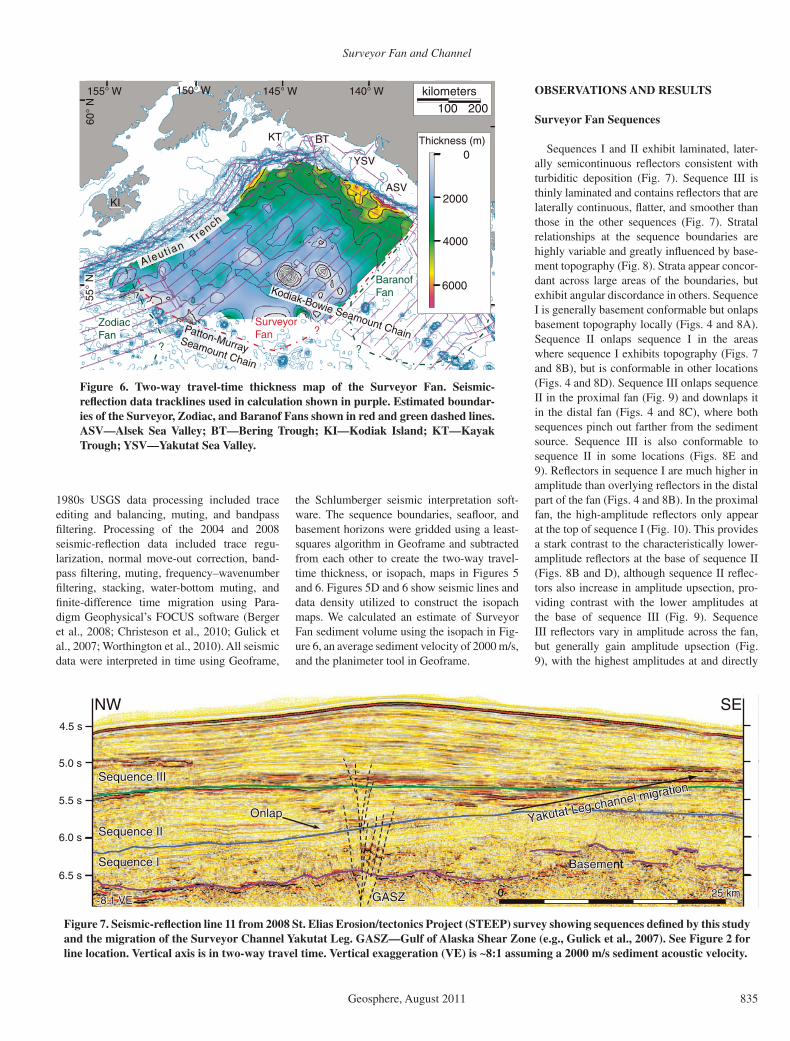
the Schlumberger seismic interpretation soft-ware. The sequence boundaries, seafl oor, and basement horizons were gridded using a least-squares algorithm in Geoframe and subtracted from each other to create the two-way travel-time thickness, or isopach, maps in Figures 5 and 6. Figures 5D and 6 show seismic lines and data density utilized to construct the isopach maps. We calculated an estimate of Surveyor Fan sediment volume using the isopach in Fig-ure 6, an average sediment velocity of 2000 m/s, and the planimeter tool in Geoframe.
KT
155° W 140° W 135° W145° W150° W
KI
SurveyorFan
100 200kilometers
60°
N
??
?
?
YSV
55°
N
Trench
Aleut ian
Patton-Murray Seamount Chain
Zodiac Fan
BaranofFan
?
Kodiak-Bowie Seamount Chain
4000
6000
2000
0Thickness (m)
ASV
BT
Figure 6. Two-way travel-time thickness map of the Surveyor Fan. Seismic- refl ection data tracklines used in calculation shown in purple. Estimated boundar-ies of the Surveyor, Zodiac, and Baranof Fans shown in red and green dashed lines. ASV—Alsek Sea Valley; BT—Bering Trough; KI—Kodiak Island; KT—Kayak Trough; YSV—Yakutat Sea Valley.
OBSERVATIONS AND RESULTS
Surveyor Fan Sequences
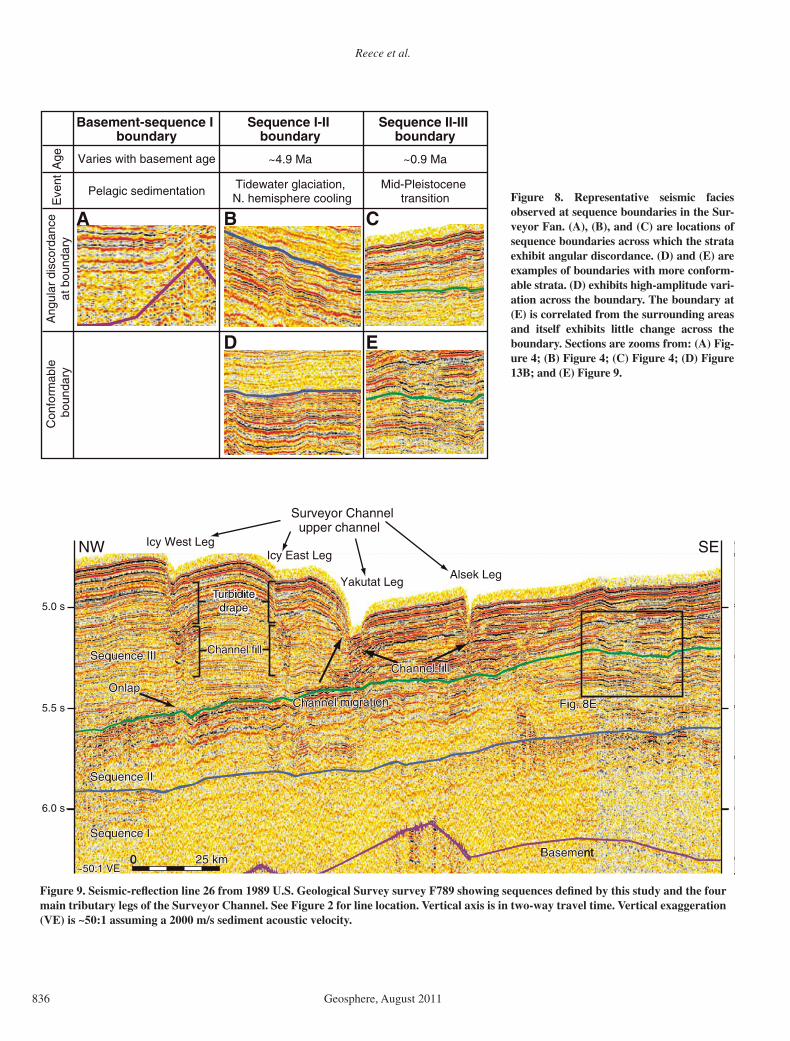
Sequences I and II exhibit laminated, later-ally semicontinuous refl ectors consistent with turbiditic deposition (Fig. 7). Sequence III is thinly laminated and contains refl ectors that are laterally continuous, fl atter, and smoother than those in the other sequences (Fig. 7). Stratal relationships at the sequence boundaries are highly variable and greatly infl uenced by base-ment topography (Fig. 8). Strata appear concor-dant across large areas of the boundaries, but exhibit angular discordance in others. Sequence I is generally basement conformable but onlaps basement topography locally (Figs. 4 and 8A). Sequence II onlaps sequence I in the areas where sequence I exhibits topography (Figs. 7 and 8B), but is conformable in other locations (Figs. 4 and 8D). Sequence III onlaps sequence II in the proximal fan (Fig. 9) and downlaps it in the distal fan (Figs. 4 and 8C), where both sequences pinch out farther from the sediment source. Sequence III is also conformable to sequence II in some locations (Figs. 8E and 9). Refl ectors in sequence I are much higher in amplitude than overlying refl ectors in the distal part of the fan (Figs. 4 and 8B). In the proximal fan, the high-amplitude refl ectors only appear at the top of sequence I (Fig. 10). This provides a stark contrast to the characteristically lower-amplitude refl ectors at the base of sequence II (Figs. 8B and D), although sequence II refl ec-tors also increase in amplitude upsection, pro-viding contrast with the lower amplitudes at the base of sequence III (Fig. 9). Sequence III refl ectors vary in amplitude across the fan, but generally gain amplitude upsection (Fig. 9), with the highest amplitudes at and directly
SE
BasemeBasementBasement
Sequence IIISequence IIISequence III
Sequence IISequence IISequence II
Sequence ISequence ISequence I
Yakutat Leg channel migration
Yakutat Leg channel migration
Yakutat Leg channel migration
6.5 s
6.0 s
5.0 s
5.5 s
4.5 s
OnlapOnlapOnlap
25 km25 km0 25 km0
NW
GASZGASZGASZ~8:1 VE~8:1 VE~8:1 VE
Figure 7. Seismic-refl ection line 11 from 2008 St. Elias Erosion/tectonics Project (STEEP) survey showing sequences defi ned by this study and the migration of the Surveyor Channel Yakutat Leg. GASZ—Gulf of Alaska Shear Zone (e.g., Gulick et al., 2007). See Figure 2 for line location. Vertical axis is in two-way travel time. Vertical exaggeration (VE) is ~8:1 assuming a 2000 m/s sediment acoustic velocity.
Reece et al.
836 Geosphere, August 2011
Con
form
able
bo
unda
ryA
ngul
ar d
isco
rdan
ceat
bou
ndar
y
Sequence I-II boundary
Sequence II-III boundary
Basement-sequence I boundary
ED
B CA
Age ~0.9 Ma~4.9 Ma
Eve
nt Mid-Pleistocene transition
Tidewater glaciation, N. hemisphere cooling
Varies with basement age
Pelagic sedimentation Figure 8. Representative seismic facies observed at sequence boundaries in the Sur-veyor Fan. (A), (B), and (C) are locations of sequence boundaries across which the strata exhibit angular discordance. (D) and (E) are examples of boundaries with more conform-able strata. (D) exhibits high-amplitude vari-ation across the boundary. The boundary at (E) is correlated from the surrounding areas and itself exhibits little change across the boundary. Sections are zooms from: (A) Fig-ure 4; (B) Figure 4; (C) Figure 4; (D) Figure 13B; and (E) Figure 9.
Alsek LegYakutat Leg
Surveyor Channel
BasemeBasementBasement
Sequence IIISequence III
Sequence IISequence II
Sequence ISequence I
Turbidite Turbidite drapedrape
OnlapOnlap
Sequence III
Sequence II
Sequence I
Icy West LegIcy East Leg
6.0 s
5.0 s
5.5 s Channel migration
Channel fillChannel fillChannel fill
Channel migrationChannel migrationChannel migration
upper channel
Turbidite Turbidite drapedrape
Turbidite drape
Channel fillChannel fillChannel fill
OnlapFig. 8EFig. 8EFig. 8E
25 km25 km0 25 km0
NW SE
~50:1 VE~50:1 VE~50:1 VE
Figure 9. Seismic-refl ection line 26 from 1989 U.S. Geological Survey survey F789 showing sequences defi ned by this study and the four main tributary legs of the Surveyor Channel. See Figure 2 for line location. Vertical axis is in two-way travel time. Vertical exaggeration (VE) is ~50:1 assuming a 2000 m/s sediment acoustic velocity.
Surveyor Fan and Channel
Geosphere, August 2011 837
below the seafl oor. In general, sequence III con-tains the highest amplitude refl ectors between the basement and seafl oor.
Two-way travel-time thickness, or isopach, maps (Fig. 5) for the three sequences show a varying depositional history in the Surveyor Fan. Depocenters for sequence I are distrib-uted in the topographic lows between basement highs. Sequence I sediment distribution shows no signifi cant spatial variation, but merely depocenters that infi ll Pacifi c plate topogra-phy. Deposits of sequences II and III are more organized, with shelf proximal depocenters that thicken into the Yakutat slope (Figs. 5B and
C). The depocenters are positioned in the same locations for sequences II and III, but they are greater in thickness and cover a much larger area in sequence III.
Correlation of seismic stratigraphy to DSDP 178 (Figs. 3 and 4) places the I-II sequence boundary at ~5 Ma, near the beginning of gla-cial interval A, based on 40Ar/39Ar dating of ash layers (Hogan et al., 1978) (Fig. 3). The sequence I-II boundary occurs at ~330 m depth in the DSDP 178 core within a section of fi ne-grained sand to silty turbidites and interbed-ded diatomaceous ooze and mud with increas-ing diamictite upsection (Shipboard Scientifi c
Channel migration
Channel migration
Channel migration
E
6.5 s
6.0 s
5.0 s
5.5 s
Alsek LegYakutat Leg
Surveyor Channel
BasemeBasementBasement
Sequence IIISequence III
Sequence IISequence II
Sequence ISequence I
Sequence III
Sequence II
Sequence I
upper channel
25 km25 km0 25 km0
W
~20:1 VE~20:1 VE~20:1 VE
Figure 10. Seismic-refl ection line 972 from 1978 U.S. Geological Survey survey L378 show-ing sequences defi ned by this study and the migration of the Yakutat Leg of the Surveyor Channel. See Figure 2 for line location. Vertical axis is in two-way travel time. Vertical exag-geration (VE) is ~20:1 assuming a 2000 m/s sediment acoustic velocity.
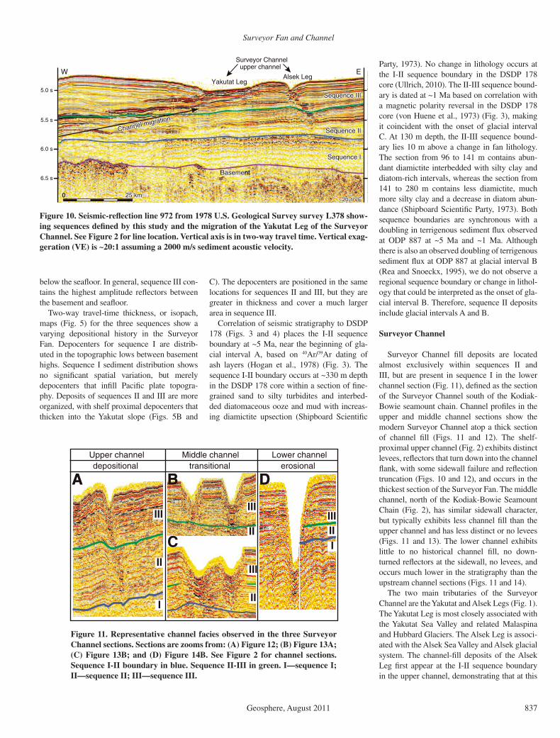
Party, 1973). No change in lithology occurs at the I-II sequence boundary in the DSDP 178 core (Ullrich, 2010). The II-III sequence bound-ary is dated at ~1 Ma based on correlation with a magnetic polarity reversal in the DSDP 178 core (von Huene et al., 1973) (Fig. 3), making it coincident with the onset of glacial interval C. At 130 m depth, the II-III sequence bound-ary lies 10 m above a change in fan lithology. The section from 96 to 141 m contains abun-dant diamictite interbedded with silty clay and diatom-rich intervals, whereas the section from 141 to 280 m contains less diamictite, much more silty clay and a decrease in diatom abun-dance (Shipboard Scientifi c Party, 1973). Both sequence boundaries are synchronous with a doubling in terrigenous sediment fl ux observed at ODP 887 at ~5 Ma and ~1 Ma. Although there is also an observed doubling of terrigenous sediment fl ux at ODP 887 at glacial interval B (Rea and Snoeckx, 1995), we do not observe a regional sequence boundary or change in lithol-ogy that could be interpreted as the onset of gla-cial interval B. Therefore, sequence II deposits include glacial intervals A and B.
Surveyor Channel
Surveyor Channel fi ll deposits are located almost exclusively within sequences II and III, but are present in sequence I in the lower channel section (Fig. 11), defi ned as the section of the Surveyor Channel south of the Kodiak-Bowie seamount chain. Channel profi les in the upper and middle channel sections show the modern Surveyor Channel atop a thick section of channel fi ll (Figs. 11 and 12). The shelf-proximal upper channel (Fig. 2) exhibits distinct levees, refl ectors that turn down into the channel fl ank, with some sidewall failure and refl ection truncation (Figs. 10 and 12), and occurs in the thickest section of the Surveyor Fan. The middle channel, north of the Kodiak-Bowie Seamount Chain (Fig. 2), has similar sidewall character, but typically exhibits less channel fi ll than the upper channel and has less distinct or no levees (Figs. 11 and 13). The lower channel exhibits little to no historical channel fi ll, no down-turned refl ectors at the sidewall, no levees, and occurs much lower in the stratigraphy than the upstream channel sections (Figs. 11 and 14).
The two main tributaries of the Surveyor Channel are the Yakutat and Alsek Legs (Fig. 1). The Yakutat Leg is most closely associated with the Yakutat Sea Valley and related Malaspina and Hubbard Glaciers. The Alsek Leg is associ-ated with the Alsek Sea Valley and Alsek glacial system. The channel-fi ll deposits of the Alsek Leg fi rst appear at the I-II sequence boundary in the upper channel, demonstrating that at this
CCC
Middle channel Lower channelUpper channeltransitional erosionaldepositional
IIIIII
IIIII
II
IIIII
I
III
DBA DBA
Figure 11. Representative channel facies observed in the three Surveyor Channel sections. Sections are zooms from: (A) Figure 12; (B) Figure 13A; (C) Figure 13B; and (D) Figure 14B. See Figure 2 for channel sections. Sequence I-II boundary in blue. Sequence II-III in green. I—sequence I; II—sequence II; III—sequence III.

Reece et al.
838 Geosphere, August 2011
location a leveed channel has been in place since the onset of sequence II deposition (Fig. 12); however, downstream of the Alsek Leg in the middle channel where the Alsek and Yaku-tat Legs have merged to form the main trunk, the channel-fi ll deposits fi rst appear at the II-III boundary (Fig. 13A).
The Yakutat Leg is the wider of the two main channel legs and is the only section of the Sur-veyor Channel that exhibits signifi cant historic
lateral movement. The channel-fi ll deposits beneath the Yakutat Leg exhibit the same or greater width than the present-day channel, and migrate a maximum of 35 km to the southeast upsection (Figs. 7, 9, and 10). The migration of the Yakutat Leg occurs directly to the east of a substantial basement high (Fig. 12). The base-ment high underlies a large bathymetric ridge formed by a sediment wedge that has aggraded and grown to the southeast. The Yakutat Leg
migration corresponds to depocenter growth observed on the two-way travel-time thickness maps for sequences II and III (Fig. 5). The main levee depocenter in sequence III (Fig. 5C) is sig-nifi cantly larger than the depocenter in sequence II (Fig. 5B), with growth toward the southeast. All other observed channel legs sit atop an aggradational stack of channel-fi ll deposits and evidence no signifi cant lateral movement. The Icy East and West Legs (Fig. 1) are associated
SEAlsek LegYakutat Leg
Surveyor Channel
BasemeBasementBasement
upper channel
Surveyor Channelupper channel
Icy East Leg
Channel migration
Channel migration
Channel migration
6.0 s
5.5 s
4.5 s
5.0 s
6.5 s
Sequence IIISequence III
Sequence IISequence II
Sequence ISequence I
Sequence III
Sequence II
Sequence I
BasemeBasement hight highBasement high
Fig. 11AFig. 11AFig. 11A
50 km50 km0 50 km0
NW
GASZGASZGASZ
~35:1 VE~35:1 VE
Icy West Leg
Figure 12. Seismic-refl ection line 30 from 1989 U.S. Geological Survey survey F689 showing sequences defi ned by this study and the four main tributary legs of the Surveyor Channel. Also evident is the basement high and sediment wedge that infl uenced the migra-tion of the Yakutat Leg of the Surveyor Channel. GASZ—Gulf of Alaska Shear Zone (e.g., Gulick et al., 2007). See Figure 2 for line location. Vertical axis is in two-way travel time. Vertical exaggeration (VE) is ~35:1 assuming a 2000 m/s sediment acoustic velocity.
NE
Sequence IIISequence III
Sequence IISequence II
Sequence ISequence I
Sequence III
Sequence II
Sequence I6.0 s
5.0 s
5.5 s
6.5 s
5.5 s
6.0 s
B
A
Sequence IIISequence III
Sequence IISequence II
Sequence ISequence I
Sequence III
Sequence II
Sequence I
Main trunk
Surveyor Channelmiddle channel
Main trunk
Surveyor Channelmiddle channel
DownlapDownlapDownlap
Fig. 8DFig. 8D
Fig. 11CFig. 11C
Fig. 8D
Fig. 11C
Fig. 11BFig. 11BFig. 11B
50 km50 km0 50 km0
25 km25 km0 25 km0
SW
NESW~70:1 VE~70:1 VE~70:1 VE
~35:1 VE~35:1 VE~35:1 VE
Figure 13. Seismic-refl ection lines (A) 17 and (B) 15 from 1989 U.S. Geological Survey survey F689 showing sequences defi ned by this study and the main trunk in the middle chan-nel section of the Surveyor Channel. See Figure 2 for line loca-tions. Vertical axis is in two-way travel time. Vertical exag-geration (VE) is (A) ~35:1 and (B) ~70:1 assuming a 2000 m/s sediment acoustic velocity.
Surveyor Fan and Channel
Geosphere, August 2011 839
with partially buried sea valleys between Icy Bay and the Pamplona Spur, with some input from the Bering Trough and Glacier. The Icy East and West Legs exhibit a major change in depositional history, with typical high-ampli-tude channel fi ll capped by a turbidite drape that is laterally continuous with the surrounding refl ectors below the seafl oor (Fig. 9).
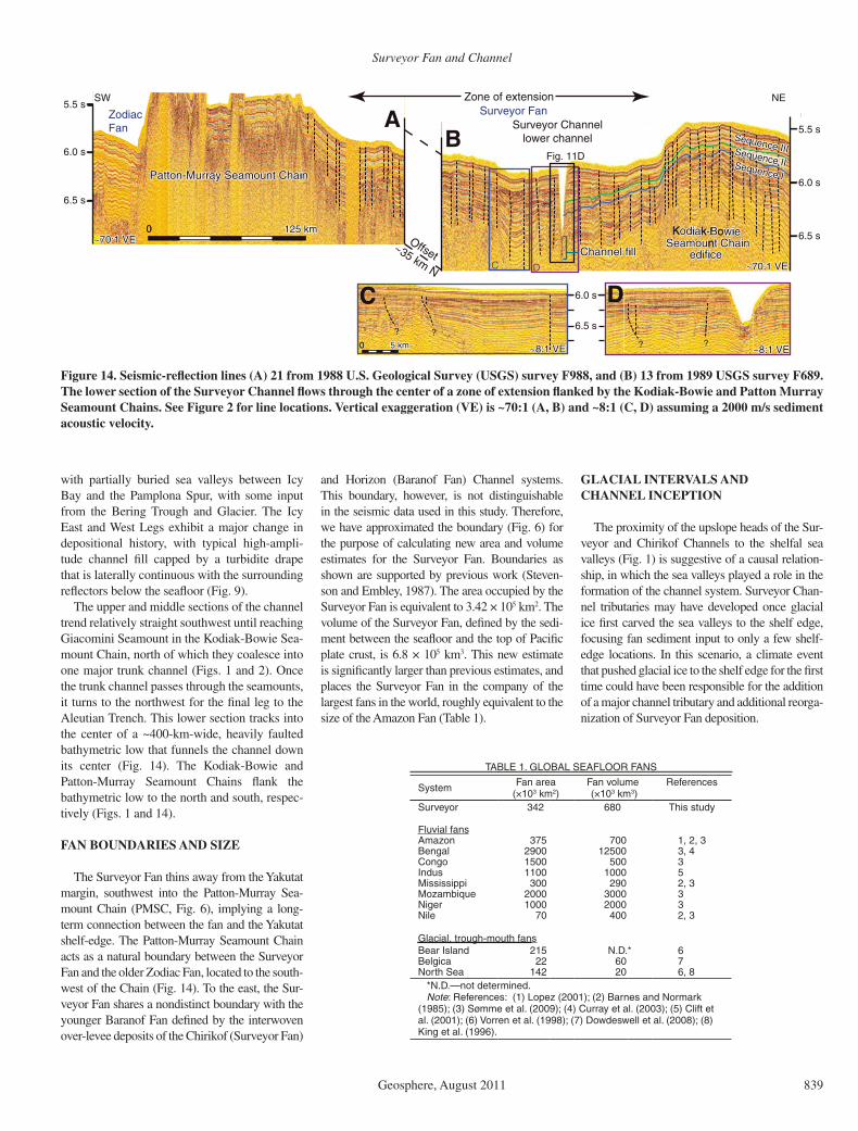
The upper and middle sections of the channel trend relatively straight southwest until reaching Giacomini Seamount in the Kodiak-Bowie Sea-mount Chain, north of which they coalesce into one major trunk channel (Figs. 1 and 2). Once the trunk channel passes through the seamounts, it turns to the northwest for the fi nal leg to the Aleutian Trench. This lower section tracks into the center of a ~400-km-wide, heavily faulted bathymetric low that funnels the channel down its center (Fig. 14). The Kodiak-Bowie and Patton-Murray Seamount Chains fl ank the bathymetric low to the north and south, respec-tively (Figs. 1 and 14).
FAN BOUNDARIES AND SIZE
The Surveyor Fan thins away from the Yakutat margin, southwest into the Patton-Murray Sea-mount Chain (PMSC, Fig. 6), implying a long-term connection between the fan and the Yakutat shelf-edge. The Patton-Murray Seamount Chain acts as a natural boundary between the Surveyor Fan and the older Zodiac Fan, located to the south-west of the Chain (Fig. 14). To the east, the Sur-veyor Fan shares a nondistinct boundary with the younger Baranof Fan defi ned by the interwoven over- levee deposits of the Chirikof (Surveyor Fan)
6.5 s
6.0 s
5.5 s
6.5 s
6.0 s
5.5 s
Kodiaodiak-B-Bowie wie SeamouSeamount Chain t Chain
edificeedifice
Kodiak-Bowie Seamount Chain
edificeChannel fillChannel fillChannel fill
Patton-Murray Seamount ChainPatton-Murray Seamount ChainPatton-Murray Seamount Chain
Surveyor Channellower channel Sequence III
Sequence IIISequence IISequence IISequence ISequence I
Sequence IIISequence IIFig. 11D
Sequence I
125 km125 km0 125 km0
NESW Zone of extension
Offset~35 km N
ZodiacFan
Surveyor Fan
~70:1 VE~70:1 VE~70:1 VE
6.5 s
6.0 s
~8:1 VE~8:1 VE~8:1 VE~8:1 VE ~8:1 VE5 km5 km0 5 km0
CC DD
BA
C D
????
~70:1 VE~70:1 VE~70:1 VE
~8:1 VE
Figure 14. Seismic-refl ection lines (A) 21 from 1988 U.S. Geological Survey (USGS) survey F988, and (B) 13 from 1989 USGS survey F689. The lower section of the Surveyor Channel fl ows through the center of a zone of extension fl anked by the Kodiak-Bowie and Patton Murray Seamount Chains. See Figure 2 for line locations. Vertical exaggeration (VE) is ~70:1 (A, B) and ~8:1 (C, D) assuming a 2000 m/s sediment acoustic velocity.
and Horizon (Baranof Fan) Channel systems. This boundary, however, is not distinguishable in the seismic data used in this study. Therefore, we have approximated the boundary (Fig. 6) for the purpose of calculating new area and volume estimates for the Surveyor Fan. Boundaries as shown are supported by previous work (Steven-son and Embley, 1987). The area occupied by the Surveyor Fan is equivalent to 3.42 × 10⁵ km2. The volume of the Surveyor Fan, defi ned by the sedi-ment between the seafl oor and the top of Pacifi c plate crust, is 6.8 × 10⁵ km3. This new estimate is signifi cantly larger than previous estimates, and places the Surveyor Fan in the company of the largest fans in the world, roughly equivalent to the size of the Amazon Fan (Table 1).
GLACIAL INTERVALS AND CHANNEL INCEPTION
The proximity of the upslope heads of the Sur-veyor and Chirikof Channels to the shelfal sea valleys (Fig. 1) is suggestive of a causal relation-ship, in which the sea valleys played a role in the formation of the channel system. Surveyor Chan-nel tributaries may have developed once glacial ice fi rst carved the sea valleys to the shelf edge, focusing fan sediment input to only a few shelf-edge locations. In this scenario, a climate event that pushed glacial ice to the shelf edge for the fi rst time could have been responsible for the addition of a major channel tributary and additional reorga-nization of Surveyor Fan deposition.
TABLE 1. GLOBAL SEAFLOOR FANS
System Fan area (×103 km2)
Fan volume (×103 km3)
References
Surveyor 342 680 This study
Fluvial fansAmazon 375 700 1, 2, 3Bengal 2900 12500 3, 4Congo 1500 500 3Indus 1100 1000 5Mississippi 300 290 2, 3Mozambique 2000 3000 3Niger 1000 2000 3Nile 70 400 2, 3
Glacial, trough- mouth fansBear Island 215 N.D.*Belgica 22 60 7
6
North Sea 142 20 6, 8*N.D.—not determined.Note: References: (1) Lopez (2001); (2) Barnes and Normark
(1985); (3) Sømme et al. (2009); (4) Curray et al. (2003); (5) Clift et al. (2001); (6) Vorren et al. (1998); (7) Dowdeswell et al. (2008); (8) King et al. (1996).

Reece et al.
840 Geosphere, August 2011
Glacial Interval A
The Alsek Leg originates at the mouth of the Alsek Sea Valley, supporting an apparent connection to the historic Alsek glacial system where the modern day Alsek River is present. However, considering the movement of the Yakutat terrane and Pacifi c plate to the north-west along the Fairweather fault over the past ~5 Myr (Elliott et al., 2010; Kreemer et al., 2003), the glacial interval A sediment source to the Alsek Sea Valley area of the Yakutat shelf was likely not the St. Elias Range, but the Coast Ranges farther to the south (Fig. 15B).
The Alsek Leg of the Surveyor Channel appears to originate at the I-II sequence bound-ary based on the lower termination of the chan-nel-fi ll deposit at that boundary in the upper channel section (Fig. 11A). This relationship could indicate that Alsek Sea Valley was the fi rst carved across the entire shelf, and trig-gered channel formation in the Surveyor Fan during glacial interval A. However, we sug-gest that glacial interval A may not have been suffi ciently severe to drive glaciers across the entire shelf. The early Alsek Leg was only pres-ent in the shelf proximal fan, and a sea valley may not have been necessary to form this rela-tively minor precursor to the modern Surveyor Channel (Figs. 15A and 15B). The I-II sequence boundary does not correlate to any change in lithology at DSDP 178, further evidence that glacial interval A exerted the greatest infl uence on the proximal Surveyor Fan. Strata across the I-II boundary do exhibit angular discordance and a large change in seismic amplitude; these characteristics may be associated with changes in sediment distribution caused by the genesis of the shelf-proximal proto–Surveyor Channel, demonstrated by the shift in depocenters from Figures 5A to 5B.
The sequence I-II boundary is interpreted based on changes in acoustic character and dated at ~5 Ma based on correlation with an ash layer at DSDP 178 (Fig. 3). However, Glacial Interval A is dated at ~5.5 MA based on the fi rst appearance of ice-rafted debris at ODP 887 and in the Yakataga Formation. We regard that Gla-cial Interval A created the regional sequence I-II boundary sometime between ~5.5 and 5 Ma and that the discrepancy in dating may be explained in part by only partial core recovery at DSDP 178 as well as the additional time that may have been necessary for Glacial Interval A to affect the more distal region of the Surveyor Fan.
Glacial Interval C
Berger et al. (2008) showed that the Bering Glacier made its fi rst full shelf transit in the
mid-Pleistocene based on a preserved erosional unconformity beneath the present-day Bering Trough. All tributary leg channel-fi ll deposits except for the Alsek fi rst appear in the sedi-ment record near the sequence II-III boundary (Fig. 9) in the upper channel, and the Alsek Leg appears at II-III sequence boundary in all but the most shelf-proximal seismic lines (Figs. 10 and 12). We interpret this pattern to indicate that glacial interval C was the impetus for fur-ther channel growth and change of the sediment distribution network across the Surveyor Fan (Fig. 15C). The increased sedimentation associ-ated with the MPT was quite extreme, shifting from ~750 to 2000 mg/(cm2k.y.) in the distal fan (Rea and Snoeckx, 1995). The increased sediment fl ux resulted in downstream migration of the main channel legs (Figs. 15B and 15C) and pronounced aggradation and progradation of the channel levees in sequence III (Figs. 5B and 5C). This interpretation is supported by an observed change in elemental, magnetic, and mineralogical composition from more variable below the II-III sequence boundary, to more uni-form above the II-III sequence boundary in the DSDP 178 core (Ullrich, 2010). The transition in composition could represent focusing of sedi-ment pathways (Ullrich, 2010) (i.e., sea valley and Surveyor Channel formation) that occurred in conjunction with glacial intensifi cation and potential ice-stream erosion associated with the MPT (Berger et al., 2008). We speculate based on the degree of increased sediment fl ux and the proximity of channel-fi ll origins to the II-III sequence boundary, that the majority of shelf sea valleys made their fi rst full shelf transit as a result of glacial interval C. However, seismic evidence on the shelf to support this interpreta-tion is limited by sparse data and glacial erosion.
Necessity of Shelf-Edge Glaciation
Since we do not observe a regional sequence associated with glacial interval B, we suggest that sediment distribution during glacial inter-val B was not signifi cantly different than that of glacial interval A. That is, the increase in sedi-mentation alone was not substantial enough to spur a major change in fan sediment distribu-tion, such as that observed in conjunction with glacial interval C. This observation stands as further evidence for the necessity of shelf-edge glaciation for major channel formation in the Surveyor Fan, fi rst occurring at the onset of gla-cial interval C.
The channel fi ll of the Icy Legs exhibits a major change in acoustic character, from high-amplitude channel-fi ll deposits to later-ally continuous turbidite drapes in the chan-nel bathymetric low (Fig. 9). We interpret the
boundary between the two as a “shutting off” of the Icy East and West Legs. The sea valleys at the upslope heads of these legs are the Pam-plona Troughs, which surround the Pamplona Spur, a tectonically controlled basement high (Carlson et al., 1982). The Pamplona Troughs are the smallest observed sea valleys on the shelf, a maximum of 20 km long and focused at the shelf edge. The small size is mostly due to slump infi lling and tectonic deformation associ-ated with the Pamplona Zone, the deformation front for Yakutat terrane subduction beneath North America (Worthington et al., 2008). In our interpretation, the glacial system associated with the Pamplona Troughs became extinct or merged with the Bering or Malaspina systems at some point after the onset of glacial interval C. Turbidites have since draped the channel legs, which were signifi cantly large bathymetric lows to maintain the appearance of channels on the modern-day seafl oor. The shutting off of the Icy Legs due to the loss of shelf-edge glaciers fur-ther supports the necessity of shelf-edge glaciers to begin and maintain the Surveyor Channel.
GLACIAL VERSUS FLUVIAL
Fan and Channel
In an attempt to classify the Surveyor Fan, we compared its features and morphology to other well-studied fans globally. Although Sur-veyor Fan sediment is glacially sourced, Table 1 shows that the Surveyor Fan ranks better with fl uvial fans by size than with glacial trough-mouth fans (TMFs). However, the Surveyor Fan, as described in this study, contrasts with the established TMF model. On the Norwe-gian, Greenland, and Antarctic margins, TMFs formed at the mouths of glacial sea valleys on the shelf as a result of glacial erosion. Most of these fans remain as single entities with occa-sional channels formed between and are stud-ied as such (Dowdeswell et al., 2008; King et al., 1996; Ó Cofaigh et al., 2006; Vorren et al., 1998). The Surveyor Fan covered the Alaska Abyssal Plain before sea valleys were carved. Once the sea valleys reached the shelf edge, any resulting TMF did not retain individual identity within the Surveyor Fan, possibly a result of sea valley proximity combined with the high mag-nitude of sediment fl ux provided to the Yakutat margin by glacial interval C.
The terrigenous sediment fl ux into the Surveyor Fan and Channel system has been periodic due to the glacial-interglacial cycle, leaving large portions of the system essen-tially inactive during interglacial periods. This can also be said for other glacially infl uenced channel systems, such as the Inbis and Lofoten

Surveyor Fan and Channel
Geosphere, August 2011 841
Gla
cial
inte
rval
A:
tidew
ater
gla
ciat
ion
~ 5
.5 M
a
Gla
cial
inte
rval
C:
glac
ial i
nten
sific
atio
n ~
1 M
aIn
terg
laci
al:
LGM
- p
rese
nt d
ay
Firs
t ter
rigen
ous
sedi
men
t de
posi
tion
~ 2
0 M
a -
Gla
cial
inte
rval
A ~
5.5
Ma
coas
tlinecoas
tline
NNN
N
stline
stlin
Paci
fic p
late
NA
YAK
NA
AT
Con
tinen
tal s
helf
Con
tinen
tal s
lope
Iceb
erg
Zod
iac
Fan?
Sur
veyo
rFa
n
Coa
stlin
e
IRD
TF
FW
F
PS
C
Co
ast
Ran
ge
Chu
gach
/St.
Elia
s M
ts.
*Pa
cific
pla
te
NA
YAK
NA
AT
Con
tinen
tal s
helf
Con
tinen
tal s
lope
Zod
iac
Fan?
Sur
veyo
rFa
n
Coa
stlin
e
TF
FW
F
Co
ast
Ran
ge
Chu
gach
/St.
Elia
s M
ts. *
Paci
fic p
late
NA
YAK
NA
AT
Con
tinen
tal s
helf
Con
tinen
tal s
lope
Coa
stlin
e
FW
F
Co
ast
Ran
ge
Chu
gach
/St.
Elia
s M
ts.
Chi
rikof
Cha
nnel
Sur
veyo
rFa
n*
IRD
FWF
oastl
in
oas
Chi
rikof
Cha
nnel
Sur
veyo
rFa
n
lin tlin
Paci
fic p
late
NA
YAK
NA
AT
Con
tinen
tal s
helf
Con
tinen
tal s
lope
Bar
anof
Fan
Coa
stlin
e
FW
F
Co
ast
Ran
ge
Chu
gach
/St.
Elia
s M
ts.
FWF
*TF
Sea
val
ley
?
Bar
anof
Fan
?
TF
TF
TF
FWF
FWF
Sur
veyo
r C
hann
elS
urve
yor
Cha
nnel
AB
CD
Fig
ure
15. S
chem
atic
illu
stra
tion
of
Surv
eyor
Fan
and
sou
ther
n A
lask
a m
argi
n se
dim
enta
ry e
volu
tion
ove
r th
e pa
st ~
20 M
yr. T
he a
rea
in b
row
n on
th
e se
afl o
or r
epre
sent
s th
e gr
owth
and
evo
luti
on o
f the
Sur
veyo
r F
an b
y ch
anne
l-re
late
d pr
oces
ses.
Red
ast
eris
k de
note
s th
e ap
prox
imat
e lo
cati
on o
f A
lsek
Sea
Val
ley
thro
ugh
tim
e. A
T—
Ale
utia
n T
renc
h; F
WF
—F
airw
eath
er fa
ult;
IR
D—
ice-
raft
ed d
ebri
s; L
GM
—la
st g
laci
al m
axim
um; N
A—
Nor
th
Am
eric
a; P
SC—
prot
o–Su
rvey
or C
hann
el; T
F—
Tra
nsit
ion
faul
t; Y
AK
—Y
akut
at t
erra
ne.

Reece et al.
842 Geosphere, August 2011
Channels on the Norwegian margin, with which the Surveyor Channel shares many characteris-tics. These systems are also constructional, with low sinuosity and tendency to avulse, and long-lived distributaries (Ó Cofaigh et al., 2006; Vor-ren et al., 1998). Differences also abound, with most of the North Sea channels being laterally restricted by submarine landslide deposits or TMFs and containing various levels of braid-ing in the lower channel sections. Perhaps the most signifi cant difference is that the Surveyor Channel stretches more than twice the length of other glacial channels and empties into the Aleutian Trench.
Given enough accumulated active time, all glacial channel systems may eventually achieve morphology similar to a fl uvially infl uenced channel system. For this to be true, sediment fl ux and time, but not method of sediment deliv-ery to the shelf edge, play a critical role in the development of deep-sea morphology. Alterna-tively, method of sediment delivery to the shelf edge is important for deep-sea fan and channel morphology, and glacial systems are able to maintain unique fan and channel systems indefi -nitely. Yet another possibility, the Surveyor Channel may be entirely unique because of its drainage into the Aleutian Trench. Most seafl oor channels empty onto the abyssal plain. Deposi-tion may eventually block the main channel, triggering an avulsion upstream, and the deposi-tion of a new lateral lobe or area of the fan. The increase in gradient and accommodation cre-ated at the end of the Surveyor Channel by the Aleutian Trench may preclude the necessity of major channel avulsion, allowing the channel to maintain the same pathway as long as it remains in contact with the sediment source and trench.
Sea Valleys
The sea valleys and troughs are a remnant of cross-shelf glacial transit, and reveal that at some point in the past, glaciers delivered sedi-ment directly to the slope at a glacial maximum. In spite of their location and ability to bypass sediment to the slope, the glacial sea valleys may not be a direct proxy for fl uvially infl u-enced shelf canyons. During glacial maxima, glaciers can potentially reach the shelf edge and supply sediment directly to the slope like a shelf-edge river delta (e.g., Carvajal and Steel, 2009). During interglacial periods, the sea val-leys have the potential to act as conduits for sediment to bypass the shelf, much like a fl u-vial canyon during highstand (e.g., Covault and Graham, 2010). However, in glacial systems, sediment fl ux is greatly reduced during intergla-cial periods compared to that at glacial maxima, whereas a fl uvial system could have a relatively
constant sediment fl ux from highstand to low-stand (Covault and Graham, 2010). We suggest that while sea valleys may bypass some sedi-ment during interglacial times, overall they pro-vide increased shelf accommodation space, as shown in the Bering Trough by Worthington et al. (2010). Maximum sediment delivery to the fan only occurs during glacial maxima due to the associated increase in glacial erosion. How-ever, once the sea valleys were formed, glacial periods that did not achieve glacial shelf transit could utilize the sea valleys for shelf bypass of sediment, possibly analogous to a mid to high-stand fl uvial system. Therefore, the Surveyor system after glacial interval A has been built by periodic sediment pulses associated with glacial maxima, and has a shorter “active” life than a fl uvial system with a coeval origin.
TECTONIC CONTROL ON CHANNEL POSITION
Yakutat Leg
The basement high just to the west of the Yakutat Leg is collocated and possibly associ-ated with activity at the Gulf of Alaska Shear Zone (e.g., Gulick et al., 2007) (Figs. 7 and 12). We suggest that the eastward direction of growth of the overlying sediment wedge and lateral movement of the Yakutat Leg may have been caused by continuous uplift and deformation of the basement at this location through time. We interpret the Yakutat Leg migration as an anomaly infl uenced by tec-tonics, with all other channel legs and sec-tions exhibiting signifi cantly less to no lateral migration since inception.
Lower Surveyor Channel
The bathymetric low that contains the major-ity of the lower Surveyor Channel is heavily faulted and regionally extensive (Figs. 1 and 14). We interpret this low as a northeast to southwest zone of extension fl anked by basaltic edifi ces of the Kodiak-Bowie Seamount Chain to the north and the Patton-Murray Seamount Chain to the south. The zone of extension is a suffi cient bathymetric low to divert the Surveyor Channel down its center to the west. The change in gradient as the Surveyor Channel travels from near the outer trench swell, through the zone of extension, and into the Aleutian Trench gives the lower channel section the highest axial gra-dient of any Surveyor Channel section (Ness and Kulm, 1973). Some channel fi ll is recorded in the erosional lower section of the Surveyor Channel (Figs. 11D and 14). This deposition could be evidence for a sediment pulse driven
by glacial-interglacial cycling. Transport in the lower channel may only have the power to incise at peak fl ow conditions during glacial maxima. The channel fi ll in the lower section could be representative of sediment deposition between glacial maxima, whether from ter-rigenous sources or channel sidewall failures upstream. The current channel fi ll therefore could be an accumulation of fi ll since the last glacial event, or represent an amalgamation of interglacial deposits that were not fully eroded during glacial maxima.
CONCLUSIONS
(1) The I-II sequence boundary was created by the onset of glacial interval A at ~5.5 Ma, and sequence II consists of deposits from glacial intervals A and B. The II-III sequence boundary was created by the onset of glacial interval C at ~1 Ma, and sequence III contains deposits from glacial interval C to present day.
(2) The thickening of sequences II and III into the Yakutat terrane continental slope is evidence of the long-term connection of the Surveyor Fan to the Yakutat shelf. Due to Pacifi c plate and Yakutat terrane motion past North America on the Fairweather fault, Surveyor Fan prove-nance likely varies from southern Coast Range sources in older fan sediment to St. Elias Range in younger fan sediment.
(3) Glacial interval A reorganized fan sedi-ment distribution by spurring Surveyor Chan-nel genesis. The early Surveyor Channel shifted sediment depocenters to shelf-proximal areas at the base of the Yakutat slope. Glacial interval C built onto this, and by pushing glaciers to the shelf edge and increasing the sediment fl ux to unprecedented levels, extended the Surveyor Channel across the Alaskan Abyssal Plain.
(4) Correlation of glacial interval C and the MPT to the II-III sequence boundary supports the Berger et al. (2008) hypothesis that the MPT was a threshold where climate, compared to exhumation, started dominating erosion in the St. Elias orogen via glacial intensifi cation.
(5) The Surveyor Channel system is a unique deep-water sediment delivery pathway because of its glacial source and trench terminus, both of which may contribute to the Surveyor’s long-term ability to maintain a major channel and evade avulsion over long periods of time.
(6) Glacially carved cross-shelf sea valleys are not direct proxies for fl uvial canyons, but do share some characteristics. During interglacial periods, the valleys serve mostly to accommo-date sediment rather than bypass the continental shelf due to a greatly decreased sediment fl ux. During glacial maxima, deposition by shelf-edge glaciers may be comparable to that of a

Surveyor Fan and Channel
Geosphere, August 2011 843
shelf-edge river delta, albeit with more effi cient sediment transport. Sea valleys may also be analogous to fl uvial canyons during glacial peri-ods that exhibit a limited shelf transit but still provide increased erosion and sediment fl ux.
(7) A NE-SW zone of extension between the Kodiak-Bowie and Patton-Murray Seamount Chains creates a regional bathymetric low that funnels the lower Surveyor Channel to the Aleu-tian Trench.
ACKNOWLEDGMENTS
The authors thank the crew and science party of R/V Marcus G. Langseth cruise MGL0814 for acquisition of the 2008 MCS data set, and the USGS for assistance with open-source seismic data. This manuscript ben-efi tted signifi cantly from discussion with John Jaeger, Ron Steel, David Mohrig, and Julia Schneider and reviews by Roland von Huene and Andy Stevenson. This project was funded by NSF grant EAR-0408584 to The University of Texas at Austin. Reece received partial support from the University of Texas Institute for Geophysics (UTIG) Ewing-Worzel Fellowship, Consortium for Ocean Leadership grant SA8-03, and a Marathon Oil Company Fellowship. This is UTIG Contribution #2346.
REFERENCES CITED
Barnes, N.E., and Normark, W.R., 1985, Diagnostic parame-ters for comparing modern submarine fans and ancient turbidite systems, in Bouma, A.H., Normark, W.R., and Barnes, N.E., eds., Submarine Fans and Related Turbi-dite Systems: Springer-Verlag, New York.
Berger, A.L., Gulick, S.P.S., Spotilla, J.A., Upton, P., Jaeger, J.M., Chapman, J.B., Worthington, L.A., Pavlis, T.L., Ridgeway, K.D., Willems, B.A., and McAleer, R.J., 2008, Quaternary tectonic response to intensifi ed gla-cial erosion in an orogenic wedge: Nature Geoscience, v. 1, p. 793–799, doi:10.1038/ngeo334.
Bruns, T.R., 1982, Structure and petroleum potential of the continental margin between Cross Sound and Icy Bay, northern Gulf of Alaska: U.S. Geological Survey Open-File Report 82-929.
Bruns, T.R., 1985, Tectonics of the Yakutat Block, an alloch-thonous terrane in the northern Gulf of Alaska: U.S. Geological Survey Open-File Report 85-13.
Bruns, T.R., and Carlson, P.R., 1987, Geology and petro-leum potential of the southeast Alaska continental margin in Scholl, D.W., Grantz, A., and Vedder, J.G., eds., Geology and Resource Potential of the Continental Margin of Western North America and Adjacent Ocean Basins, Volume 6: Houston, Texas, Circum-Pacifi c Council for Energy and Mineral Resources, p. 269–282.
Burbank, D.W., Blythe, A.E., Putkonen, J., Pratt-Sitaula, B., Gabet, E., Oskin, M., Barros, A., and Ojha, T.P., 2003, Decoupling of erosion and precipitation in the Himala-yas: Nature, v. 426, no. 6967, p. 652–655, doi:10.1038/nature02187.
Carlson, P.R., Bruns, T.R., Molnia, B.F., and Schwab, W.C., 1982, Submarine valleys in the northeastern Gulf of Alaska—Characteristics and probable origin: Marine Geology, v. 47, no. 3–4, p. 217–242, doi:10.1016/0025-3227(82)90070-6.
Carlson, P.R., Stevenson, A.J., Bruns, T.R., Mann, D.M., and Huggett, Q., 1996, Sediment pathways in the Gulf of Alaska from beach to abyssal plain, in Gardner, J.V., Field, M.E., and Twichell, eds., Geology of the United States Seafl oor: The View from GLORIA: Cambridge, Cambridge University, p. 255–277.
Carvajal, C., and Steel, R., 2009, Shelf-edge architecture and bypass of sand to deep water: infl uence of shelf-edge processes, sea level and sediment supply: Journal
of Sedimentary Research, v. 79, no. 9–10, p. 652–672, doi:10.2110/jsr.2009.074.
Christeson, G.L., Gulick, S.P.S., van Avendonk, H., Reece, R.S., and Worthington, L.L., 2010, The Yakutat ter-rane: Dramatic change in crustal thickness across the Transition fault, Alaska: Geology, v. 38, no. 10, p. 895–898, doi:10.1130/G31170.1.
Clark, P.U., Archer, D., Pollard, D., Blum, J.D., Rial, J.A., Brovkin, V., Mix, A.C., Pisias, N.G., and Roy, M., 2006, The middle Pleistocene transition: Character-istics, mechanisms, and implications for long-term changes in atmospheric PCO2: Quaternary Science Reviews, v. 25, no. 23–24, p. 3150–3184, doi:10.1016/j.quascirev.2006.07.008.
Clift, P.D., Shimizu, N., Layne, G.D., Blusztajn, J.S., Gaedicke, C., Schluter, H.U., Clark, M.K., and Amjad, S., 2001, Development of the Indus Fan and its signifi -cance for the erosional history of the Western Himalaya and Karakoram: Geological Society of America Bul-letin, v. 113, no. 8, p. 1039–1051, doi:10.1130/0016-7606(2001)113<1039:DOTIFA>2.0.CO;2.
Covault, J.A., and Graham, S.A., 2010, Submarine fans at all sea-level stands: Tectono-morphologic and climatic controls on terrigenous sediment delivery to the deep sea: Geology, v. 38, no. 10, p. 939–942, doi:10.1130/G31081.1.
Cowan, E.A., Seramur, K.C., Powell, R.D., Willems, B.A., Gulick, S.P.S., and Jaeger, J.M., 2010, Fjords as tem-porary sediment traps: History of glacial erosion and deposition in Muir Inlet, Glacier Bay National Park, southeastern Alaska: Geological Society of America Bulletin, v. 122, no. 7–8, p. 1067–1080, doi:10.1130/B26595.1.
Curray, J.R., Emmel, F.J., and Moore, D.G., 2003, The Ben-gal Fan: Morphology, geometry, stratigraphy, history and processes: Marine and Petroleum Geology, v. 19, p. 1191–1223, doi:10.1016/S0264-8172(03)00035-7.
Dowdeswell, J.A., Ó Cofaigh, C., Noormets, R., Larter, R.D., Hillenbrand, C.D., Benetti, S., Evans, J., and Pudsey, C.J., 2008, A major trough-mouth fan on the continen-tal margin of the Bellingshausen Sea, West Antarctica: The Belgica Fan: Marine Geology, v. 252, no. 3–4, p. 129–140, doi:10.1016/j.margeo.2008.03.017.
Eberhart-Philips, D., Christensen, D.H., Brocher, T.M., Hansen, R., Ruppert, N.A., Haeussler, P.J., and Abers, G.A., 2006, Imaging the transition from Aleutian sub-duction to Yakutat collision in central Alaska, with local earthquakes and active source data: Journal of Geophysical Research-Solid Earth, v. 111, no. B11, p. 31, doi:B1130310.1029/2005jb004240.
Elliott, J.L., Larsen, C.F., Freymueller, J.T., and Motyka, R.J., 2010, Tectonic block motion and glacial isostatic adjustment in southeast Alaska and adjacent Canada constrained by GPS measurements: Journal of Geo-physical Research, v. 115, doi:10.1029/2009JB007139.
Enkelmann, E., Zeitler, P.K., Garver, J.I., Pavlis, T.L., and Hooks, B.P., 2010, The thermochronological record of tectonic and surface process interaction at the Yaku-tat–North American collision zone in southeast Alaska: American Journal of Science, v. 310, no. 4, p. 231–260, doi:10.2475/04.2010.01.
Figueiredo, J., Hoorn, C., van der Ven, P., and Soares, E., 2009, Late Miocene onset of the Amazon River and the Amazon deep-sea fan: Evidence from the Foz do Amazonas Basin: Geology, v. 37, no. 7, p. 619–622, doi:10.1130/G25567A.1.
Gardner, J.V., Mayer, L.A., and Armstrong, A., 2006, Map-ping supports potential submission to U.N. Law of the Sea: Eos (Transactions, American Geophysical Union), v. 87, p. 157–160, doi:10.1029/2006EO160002.
Gulick, S.P.S., Lowe, L.A., Pavlis, T. L., Gardner, J. V., and Mayer, L. A., 2007, Geophysical insights into the Tran-sition fault debate: Propagating strike slip in response to stalling Yakutat block subduction in the Gulf of Alaska: Geology, v. 35, no. 8, p. 763–766, doi:10.1130/g23585a.
Hebbeln, D., Lamy, F., Mohtadi, M., and Echtler, H., 2007, Tracing the impact of glacial-interglacial climate vari-ability on erosion of the southern Andes: Geology, v. 35, no. 2, p. 131–134, doi:10.1130/G23243A.1.
Hogan, L.G., Scheidegger, K.F., Kulm, L.D., Dymond, J., and Mikkelsen, N., 1978, Biostratigraphic and tectonic implications of 40Ar-39Ar dates of ash lay-
ers from northeast Gulf of Alaska: Geological Soci-ety of America Bulletin, v. 89, no. 8, p. 1259–1264, doi:10.1130/0016-7606(1978)89<1259:BATIOA>2.0.CO;2.
Ingle, J.C., 1973, Neogene foraminifera from the northeast-ern Pacifi c Ocean, Leg 18, Deep Sea Drilling Proj-ect, in Kulm, L.D., and von Huene, R., eds., Initial reports of the Deep Sea Drilling Project, Volume 18: Washington, D.C., U.S. Government Printing Offi ce, p. 517–567.
King, E.L., Sejrup, H.P., Hafl idason, H., Elverhøi, A., and Aarseth, I., 1996, Quaternary seismic stratigra-phy of the North Sea Fan: Glacially-fed gravity fl ow aprons, hemipelagic sediments, and large submarine slides: Marine Geology, v. 130, no. 3–4, p. 293–315, doi:10.1016/0025-3227(95)00168-9.
Kreemer, C., Holt, W.E., and Haines, A.J., 2003, An inte-grated global model of present-day plate motions and plate boundary deformation: Geophysical Journal International, v. 154, no. 1, p. 8–34, doi:10.1046/j.1365-246X.2003.01917.x.
Lagoe, M.B., Eyles, C.H., Eyles, N., and Hale, C., 1993, Timing of Late Cenozoic tidewater glaciation in the far North Pacifi c: Geological Society of America Bul-letin, v. 105, no. 12, p. 1542–1560, doi:10.1130/0016-7606(1993)105<1542:TOLCTG>2.3.CO;2.
Lopez, M., 2001, Architecture and depositional pattern of the Quaternary deep-sea fan of the Amazon: Marine and Petroleum Geology, v. 18, no. 4, p. 479–486, doi:10.1016/S0264-8172(00)00071-4.
Ness, G.E., and Kulm, L.D., 1973, Origin and develop-ment of Surveyor deep-sea channel: Geological Society of America Bulletin, v. 84, p. 3339–3354, doi:10.1130/0016-7606(1973)84<3339:OADOSD>2.0.CO;2.
Ó Cofaigh, C., Dowdeswell, J. A., and Kenyon, N. H., 2006, Geophysical investigations of a high-latitude subma-rine channel system and associated channel-mouth lobe in the Lofoten Basin, Polar North Atlantic: Marine Geology, v. 226, no. 1–2, p. 41–50, doi:10.1016/j.margeo.2005.09.014.
Pavlis, T.L., Picornell, C., Serpa, L., Bruhn, R.L., and Plafker, G., 2004, Tectonic processes during oblique collision: Insights from the St. Elias orogen, northern North American Cordillera: Tectonics, v. 23, no. 3, doi:Tc300110.1029/2003tc001557.
Plafker, G., Moore, J.C., and Winkler, G.R., 1994, Geol-ogy of the southern Alaska margin, in Plafker, G., and Berg, H.C., eds., The Geology of Alaska, Volume G-1: Boulder, Colorado, Geological Society of America, p. 389–449.
Raymo, M.E., 1994, The initiation of Northern Hemisphere glaciation: Annual Review of Earth and Planetary Sciences, v. 22, p. 353–383, doi:10.1146/annurev.ea.22.050194.002033.
Rea, D.K., and Snoeckx, H., 1995, Sediment fl uxes in the Gulf of Alaska: Paleoceanographic record from site 887 on the Patton-Murray seamount platform, in Rea, D.K., Basov, I.A., Scholl, D.W., and Allan, J.F., eds., Proceedings of the Ocean Drilling Program, Scientifi c results, Volume 145: College Station, Texas, Ocean Drilling Program, p. 247–256.
Rea, D.K., Basov, I.A., et al., 1993, Initial reports, Ocean Drilling Program, Leg 145, College Station, Texas, Ocean Drilling Program.
Shipboard Scientifi c Party, 1973, Site 178, in Kulm, L.D., and von Huene, R., eds., Initial Reports of the Deep Sea Drilling Project, Leg 18, Volume 18: Washington, D.C., U.S. Government Printing Offi ce, p. 287–376.
Smith, W.H.F., and Sandwell, D.T., 1997, Global sea fl oor topography from satellite altimetry and ship depth soundings: Science, v. 277, no. 5334, p. 1956–1962, doi:10.1126/science.277.5334.1956.
Sømme, T.O., Helland-Hansen, W., Martinsen, O.J., and Thurmond, J.B., 2009, Relationships between mor-phological and sedimentological parameters in source-to-sink systems: A basis for predicting semi-quan-titative characteristics in subsurface systems: Basin Research, v. 21, no. 4, p. 361–387, doi:10.1111/j.1365-2117.2009.00397.x.
Spotila, J.A., and Berger, A.L., 2010, Exhumation at oro-genic indentor corners under long-term glacial con-ditions: Example of the St. Elias orogen, southern
Reece et al.
844 Geosphere, August 2011
Alaska: Tectonophysics, v. 490, no. 3–4, p. 241–256, doi:10.1016/j.tecto.2010.05.015.
Stevenson, A.J., and Embley, R., 1987, Deep-sea fan bod-ies, terrigenous turbidite sedimentation, and petroleum geology, Gulf of Alaska, in Scholl, D.W., Grantz, A., and Vedder, J., eds., Geology and Resource Potential of the Continental Margin of Western North America and Adjacent Ocean Basins, Volume 6: Houston, Texas, Circum-Pacifi c Council for Energy and Mate-rial Resources, p. 503–522.
Ullrich, A., 2010, Geochemical, mineralogical, and rock magnetic provenance variation in Alaskan Abyssal Plain sediments, Gulf of Alaska [M.S. thesis]: Univer-sity of Florida, 98 p.
von Huene, R., and Kulm, L.D., 1973, Tectonic summary of Leg 18, in Kulm, L.D., and von Huene, R., eds., Initial Reports of the Deep Sea Drilling Project, Volume 18:
Washington, D.C., U.S. Government Printing Offi ce, p. 961–976.
von Huene, R., Larson, E., and Crouch, J., 1973, Prelimi-nary study of ice-rafted erratics as indicators of glacial advances in the Gulf of Alaska, in Kulm, L.D., and von Huene, R., eds., Initial Reports of the Deep Sea Drill-ing Project, Volume 18: Washington, D.C., U.S. Gov-ernment Printing Offi ce, p. 835–842.
Vorren, T.O., Laberg, J.S., Blaume, F., Dowdeswell, J.A., Kenyon, N.H., Mienert, J.R., Rumohr, J.A.N., and Werner, F., 1998, The Norwegian–Greenland Sea con-tinental margins: Morphology and late Quaternary sed-imentary processes and environment: Quaternary Sci-ence Reviews, v. 17, no. 1–3, p. 273–302, doi:10.1016/S0277-3791(97)00072-3.
Worthington, L., Gulick, S., and Pavlis, T., 2008, Identify-ing active structures in the Kayak and Pamplona zones:
Implications for offshore tectonics of the Yakutat microplate, Gulf of Alaska, in Freymueller, J.T., Hae-ussler, P.J., Wesson, R., and Ekstrom, G., eds., Active Tectonics and Seismic Potential of Alaska, Volume 179: Washington, D.C., American Geophysical Union, p. 257–268.
Worthington, L., Gulick, S., and Pavlis, T., 2010, Cou-pled stratigraphic and structural evolution of a glaciated orogenic wedge, offshore St. Elias oro-gen, Alaska: Tectonics, v. 29, no. TC6013, p. 27, doi:10.1029/2010TC002723.
MANUSCRIPT RECEIVED 28 OCTOBER 2010REVISED MANUSCRIPT RECEIVED 16 MARCH 2010MANUSCRIPT ACCEPTED 01 APRIL 2010