technologies and approaches on...
TRANSCRIPT

1
TECHNOLOGIES AND APPROACHES
on Sustainable Land Management
in Central Asia

2
This publication has been composed with support of the Project “Knowledge Management” in
Central Asian Countries Initiative for Land Management (CACILM) phase II, International Center
for Agricultural Research in the Dry Areas (ICARDA) in Cental Asia and the Caucasus.
Partners:
Research Institute of Soil Science and Agrochemistry
(Tashkent)
Kyrgyzstan Institute of Irrigation
Kyrgyzstan Ministry of Agriculture and Melioration
Kazakhstan Research Institute of Soil Science and
Agrochemistry named after U.U.Uspanov
South-Western research institute of livestock and plant
science (Kazakhstan)
Turkmenistan Academy of Science
Tajikistan Academy of Agricultural Science
Tajikistan Research Institute of Farming, TAAS

3
Contents
1. Increase of soil fertility ..................................................................................................... 6
1.1. The use of waste products from biogas production to increase soil fertility .......................... 7 1.2. Increasing fertility of non-saline typical gray and gray-meadow soils by enriching them with
organic matter ......................................................................................................................... 9 1.3. Increasing fertility and preventing secondary salinization on slightly saline irrigated soils . 11 1.4. Organic-mineral fertilizers on the basis of secondary resources and their use for
recultivation of low-fertile soils ............................................................................................. 14 1.5. Technology of compost production (composting) ................................................................ 16 1.6. The use of poultry dung as type of organic fertilizers (an alternative to manure) ............... 18 1.7. Fertigation for optimization of nutritional regime ................................................................ 20 1.8. Land amelioration by growing Glycyrrhiza glabra L. (licorice) .............................................. 22 1.9. Nano-agroameliorative techniques to improve soil fertility and crop productivity ............. 24 1.10. Increasing fertility of alkaline and solonets soils ................................................................... 26 1.11. Growing sainfoin in mountain farming – Suusamyr valley .................................................... 28 1.12. Technology of production and application of biohumus (vermicompost) ............................ 30 1.13. Integrated management of productivity of saline and gypsum soils .................................... 32 1.14. Cultivation of cotton in combined plantations with mung beans mulching in ridge system of
furrows ................................................................................................................................... 34 1.15. Cultivation of indigo to restore saline degraded lands.......................................................... 36 2. Improving methods of sowing / planting crops and soil tillage ........................................ 38
2.1. Soil mulching with transparent polyethylene film (sowing under the film) .......................... 39 2.2. Technology of non-seedling cultivation of solanaceous crops .............................................. 41 2.3. Cultivation of winter wheat in the soil cracks ....................................................................... 43 2.4. Sowing of cotton in the bottom of irrigation furrows ........................................................... 45 2.5. Technology of cultivation of own-rooted seedlings of fruit crops and grapes ..................... 47 2.6. Sowing watermelons in rainfed land into deeply loosened strips ........................................ 49 2.7. Pre-sowing soil processing preventing earth crusting during cotton cultivation .................. 51 2.8. Sowing of cotton along the ridges formed above the bottom of the leaching furrows ....... 53 2.9. Technology of planting crops along the ridges ...................................................................... 55 2.10. Winter wheat planting into the inter-rows of cotton ............................................................ 57 2.11. Raised-bed – zero planting technology of crop cultivation ................................................... 59 2.12. Holistic conservation agriculture (zero tillage technology of Kazakhstan) ........................... 61 2.13. Direct seeding of alfalfa under rainfed and irrigated agriculture in southern Kazakhstan ... 63 2.14. Minimum soil tillage for cultivation of grain crops ................................................................ 65 2.15. Growing crops on shallow rocky soils .................................................................................... 67 2.16. Cultivation of melons (watermelon) under plastic films ....................................................... 69 2.17. Greenhouse in the ground (greenhouse-thermos) ............................................................... 71 2.18. Cultivation of drought-resistant oilseed and forage crop - safflower in rainfed areas of
Tajikistan ................................................................................................................................ 73 3. Agroforestry-amelioration, agroforestry, reforestation / improvement of soil vegetation
cover .............................................................................................................................. 76
3.1. Establishment of agroforestry-amelioration strips by a diagonal-grouping method ............ 77 3.2. Improvement of land in arid conditions through the cultivation of high-quality pistachio
plantations ............................................................................................................................. 79 3.3. Agroforestry amelioration for rehabilitation of degraded irrigated land ............................. 81

4
3.4. Cultivation of giant reed (Arundo donax L.) to establish shelterbelts around the estates to protect from hot winds and for other economic purposes .................................................. 83
3.5. Fixating moving sands around settlements in the Karakum desert and reforestation ........ 85 3.6. Agroforestry based on establishment of gardens ................................................................. 87 3.7. Transition from pasture land to fruit and fodder plots ......................................................... 89 3.8. Perennial herbaceous forage crops for pristine forest cover ............................................... 91 3.9. Tree planting on hummocky sands ....................................................................................... 93 3.10. Afforestation on takyrs .......................................................................................................... 95 3.11. Community forestry in Karakalpakstan ................................................................................. 97 3.12. Forest field-protecting shelterbelts on rainfed land ............................................................. 99 3.13. Growing poplar trees on saline and waterlogged land ....................................................... 101 3.14. Bio-drainage – an alternative method of reclamation of waterlogged land ...................... 103 3.15. Management of tugai forests through village committees ................................................ 105 3.16. Joint forest management .................................................................................................... 107 3.17. Forest shelterbelts from oleaster (Elaeagnus) to protect irrigated fields........................... 109 4. Cultivation of slopes, erosion prevention ...................................................................... 111
4.1. Improving cotton irrigation on areas damaged by irrigational erosion .............................. 112 4.2. The use of anti-erosion preparation to enhance soil stability to erosion ........................... 114 4.3. Cross-processing of sloping land ......................................................................................... 116 4.4. Irrigation of crops sown in furrows ..................................................................................... 118 4.5. Integrated scheme of preparation of irrigation field .......................................................... 120 4.6. Improved elements of technique and technology of surface irrigation on land with steep
slopes ................................................................................................................................... 122 4.7. Contour irrigation ................................................................................................................ 124 4.8. Cultivation of forest plantations in hill slopes using moisture-accumulating trenches ...... 126 4.9. Drainage ditches on the steep slopes of arable land .......................................................... 128 4.10. Applying mulching for rainfed vineyards on terraces located on loessal hilly landscapes . 130 4.11. Technology of improvement of "hanging gardens" on foothill – low-hill slopes ............... 132 4.12. Joint initiative of land users ................................................................................................. 134 4.13. Choice of SLM technologies to reduce risk of natural disasters ......................................... 136 4.14. Establishing fences from stone walls and poplar trees around the perimeter of fields ..... 138 5. Management of water demand (improvement of furrow irrigation and resource-saving
irrigation technologies) ................................................................................................. 140
5.1. Cotton irrigation by furrows screened by perforated polyethylene film............................ 141 5.2. Cultivation of wheat using mini-strips for irrigation ........................................................... 143 5.3. Innovative technology of furrow irrigation – alternating irrigation furrows and newly
formed furrows in place of the ridges ................................................................................. 145 5.4. Improved furrow irrigation method on flat land ................................................................ 147 5.5. Subsoil irrigation system with near-root humidifiers for horticultural crops ..................... 149 5.6. Localized irrigation system for irrigation of gardens in extreme conditions ...................... 151 5.7. Drip irrigation with the use of polyethylene film ................................................................ 153 5.8. Reclamative-moisture enhancing irrigation system (sub-irrigation) .................................. 155 5.9. Multi-layered furrow irrigation ........................................................................................... 157 5.10. Terraced creek "oshtonakdzhuybor"1 ................................................................................. 159 5.11. Irrigation using polyethylene bottles .................................................................................. 161 6. Improving rangeland / fodder production ..................................................................... 163
6.1. Technology of remote sensing and ground monitoring of ecological and ameliorative conditions of pastures ......................................................................................................... 164
6.2. Rotation of pastures in desert regions of Uzbekistan ......................................................... 166

5
6.3. Use of artesian mineralized water for irrigated agriculture in Kyzylkum ............................ 168 6.4. Establishing seed farming plot of perennial grasses ........................................................... 170 6.5. Autumn and early spring irrigation as a mechanism to improve pastures in conditions of
climate change in Southern Kazakhstan .............................................................................. 172 6.6. Monitoring of pasture conditions ........................................................................................ 174 6.7. Pasture management through rehabilitation of a system of pasturing animal husbandry
and radical improvement of pastures.................................................................................. 176 6.8. Joint planning of pasture use ............................................................................................... 178 6.9. Mapping for pasture use development plan ....................................................................... 180 7. Increasing capacity of land users / environmental education ........................................ 182
7.1. Farmer Field Schools in the irrigated zone .......................................................................... 183 7.2. Farmer Field Schools ............................................................................................................ 185 7.3. Establishment of rural schools for farmers and support ..................................................... 187 7.4. Sub-district (jamoat level) support of sustainable land management ................................ 189 7.5. Development of an agro-ameliorative passport - one of the ways to increase the
knowledge of land users ...................................................................................................... 191 7.6. Establishing a school forestry for the involvement of young people in environmental
activities ............................................................................................................................... 193

6
1. Increase of soil fertility

7
1.1. The use of waste products from biogas production to increase soil fertility
UZBEKISTAN
Definition of technology:
The technology is based on the use of biogas waste products as highly effective environmentally friendly organic fertilizer for farmers’ fields.
Brief summary of technology:
The raw materials used for biogas production represent any easily decomposed organic matter substances found in nature and farming such as manure or poultry dung of various origins, straw of grain crops, cotton stems, tree leaves, etc. During the process of fermentation of the organic substances formation of biogas takes place together with a valuable, highly concentrated organic fertilizer without nitrites, weed seeds, causative organisms. Thus, organic part of the resulting product contains 2-4 times more basic nutrients than conventional organic fertilizers. In addition, obtained organic matter contains higher amounts of humic acids, plant growth stimulators, vitamins, amino-acids and others. Such fertilizers allow increasing soil productivity, supply plants with easily accessible nutrients and decrease application rates of mineral fertilizers.
Place of technology application:
The technology for production of energy resources and highly concentrated organic fertilizers is tested in the farms Milk- Agro and G. Abdullayev in the Zangiota district, Uzbekistan by the company Co LTD "Ekoravnak". The organic fertilizer was tested in field conditions under cotton production during three years (2007-2009). The obtained positive results help to improve soil fertility and increase crop yields.
Location: G.Abdullaev area, Zangiota dis-trict, Tashkent Province.
Area of technology application: 10 ha.
Stage of intervention: alleviation/reduction of land degradation.
Main land use issues and the main causes of land degradation:
Low soil fertility, inadequate supply of nutrients and organic matter (humus). Main reason – low contents of organic fertilizers, removal of crop residues from fields and poor crop rotation.
Main technical features of technology:
Improving ground cover with biomass, increasing or-ganic matter contents, optimizing favorable nutrient contents for plants.
Type of land use Conservation measures
Arable land. Cultivation of annual crops - Во(Ca).
Agronomic measures: A2: Organic matter / soil fertility.

8
Environment
Habitat Anthropogenic environment
Average annual rainfall: 250-500 mm and up to 750 mm. Altitude (meter above sea level): 100-500 m. Landscape: plains, valley. Slope (%): 0-2%, 2-5%, 5-8%.
Soil fertility: average. Humus content in arable horizon: 1-3%. Natural soil drainage/infiltration: average.
Size of land area (ha): 10 ha. Landholder: farmer, households. Land ownership: long term lease. Water use rights: through WUAs and organizations re-sponsible for management of irrigation systems. Market orientation: State Order.
Assessment
Impact of technology
Main advantages:
- increasing yield of crops and farmers’ incomes by
20%;
- reducing expenditures by 15%;
- increasing biomass and improving soil surface by
15%;
- replenishing nutrients and organic matter by 20%;
- reducing soil compaction by 15%.
Main disadvantages:
- transportation of liquid fertilizers over long distances
is not economically rational.
Acceptance/adoption of technology: biogas production is not developed in the scale that would allow to obtain
waste byproducts to use as fertilizers.
Reference(s): Catalogue of the 5th
Republican fair of innovative ideas, Technologies and Projects, Tashkent - 2012. Technol-ogy of M. Tashkuziev, National Research Institute for Soil Science and Agrochemistry.
Name of person(s) collected this description: Prof. Maruf Tashkuziev, National Research Institute of Soil Science & Agro-chemistry. Address: 3, Kamarniso str.,Tashkent, Uzbekistan. Tel.: +99871 2271399; Mob.: +99890 9975784. E-mail: [email protected]

9
1.2. Increasing fertility of non-saline typical gray and gray-meadow soils by enriching them with organic matter
UZBEKISTAN
Definition of technology:
The complex of agro-technical measures, including excessive ap-
plication norms of organic fertilizers and alternation of crops
(with introduction of repeated and intermediate crops) and use
of crop residues as organic fertilizers provides an increase of soil
fertility and balanced crop nutrition.
Brief summary of technology:
In recent years, soil studies have revealed a tendency of reduc-
tion in the fertility of irrigated soils due to reduction of organic
matter and essential nutrient contents. This reduction is mainly
due to a long term cultivation of cotton monoculture, non-
observance of scientifically tested practices of crop rotation and
alternation of crop types. Therefore, it is important to develop
agro-technologies directed towards enriching soil with organic
matter. To increase the organic matter in accordance with the
technology, application of higher quantities of manure (30-40
t/ha) and crop diversification are envisaged during the initial
years. In the cotton-winter wheat production system, this tech-
nology includes a successive alternation of these crops with re-
peated leguminous and intermediate crops such as oats, rape,
perco used as green manure. This technology is modified by ap-
plying a compost of crop residues, prepared in the specially dug
pits, instead of manure. A compost is applied into the soil during
autumn ploughing with the amount of 15-20 t/ha.
Location: “Saidovul” farm, Srednochirchik
district, Tashkent province.
Area of technology application: 35 ha.
Location: “Husniddin Jura bobo”farm, Yak-
kabog district, Kashkadarya Province.
Area of technology application: 5 ha.
Stage of intervention: alleviation / reduc-
tion of land degradation.
Main land use issues and the main causes of land
degradation:
Low soil fertility, inadequate supply of nutrients and organic matter (humus). Main reason – low contents of organic fertilizers, removal of crop residues from fields and poor crop rotation.
Main technical features of technology:
Improving ground cover with biomass, increasing or-ganic matter contents, optimizing favorable nutrient contents for plants.
Type of land use Conservation measures
Arable land.
Production of annual crops - Во(Са).
Agronomic measures:
А2: Organic matter / soil fertility.

10
Environment
Habitat Anthropogenic environment
Average annual rainfall: 500-750 mm. Altitude (meter above sea level): 100-500 m. Landscape: plains, valley. Slope (%): 0-2%, 2-5%. Soil fertility: average. Humus content in arable horizon: 1-3% (1-1.5%). Natural soil drainage/infiltration: average.
Size of land area (ha): 40 ha. Landholder: farmer, households. Land ownership: long term lease. Water use rights: through WUAs and organizations re-sponsible for management of irrigation systems. Market orientation: State Order, mixed farming (sub-sistence and commercial).
Assessment
Impact of technology
Main advantages:
- saving mineral fertilizers by 30-40%; - increasing yield of crops and farmers’ incomes by
15-20%; - additional farm income by selling repeated crop
yields.
Main disadvantages:
- difficulties in subsequent crop production related to additional costs of labor and water application.
Acceptance/adoption of technology: Due to the difficulties in subsequent crop production and insufficient amounts of applied organic fertilizers (manure, dung, etc) this technology is used by farmers only from place to place, not everywhere.
Reference(s):
1. M.M. Tashkuziev. Influence of agricultural technology of organic matter management on fertility of irrigated typical sierozem soils. The materials of the International Scientific Conference on "State and prospects of Soil Science". Almaty-2005, p. 99-100;
2. M.M. Tashkuziev, A.A. Sherbekov. Increase of soil fertility by agro-technology directed towards enriching soils with or-ganic matter. “Agrarian science – to agriculture”. 2
nd International scientific-practical conference, Barnaul, 2007;
3. Consolidated report of the innovative project I-2010-6, entitled: “Introduction of agro-technologies, directed towards increase of soil fertility in irrigated agriculture in farming. Project leader – prof. M.M. Tashkuziev.
Name of person(s) collected this description: Prof. Maruf Tashkuziev, National Research Institute of Soil Science & Agro-chemistry. Address: 3, Kamarniso str.,Tashkent, Uzbekistan. Tel.: +99871 2271399; Mob.: +99890 9975784. E-mail: [email protected]

11
1.3. Increasing fertility and preventing secondary salinization on slightly saline irrigated soils
UZBEKISTAN
Definition of technology:
The complex of agro-technical measures, including excessive ap-
plication norms of organic fertilizers, diversification of crops in
cotton-wheat system and the use of crop residues as organic fer-
tilizers prevents secondary salinization processes and provides
increase of soil fertility.
Brief summary of technology:
An increase of land degradation in Uzbekistan in recent years is
mainly due to increased rates of the secondary salinization and
decrease of soil organic matter contents. For several years, the
cropping pattern in the farmland consisted of cotton – cotton or
wheat – wheat rotation, or wheat is cultivated following cotton.
Consequently, from June – the time of wheat harvest, field is left
uncultivated. Bare soil is left unprotected from summer heat, and
as a result it severely dries, looses structure and thus, tolerance
to erosion. In soils that are prone to salinization the salts reach
and accumulate in the root zone of plants. Salts have toxic effect
on plants and destroy soil structure, deteriorate agronomic and
water-physical soil properties. When dried, structureless soils
harden and become denser, and when wetted they quickly be-
come saturated and poorly hold moisture, which is negatively
reflected in the productivity potential.
The system of measures suggested in this technology in the first
place includes leaching, which should be conducted in autumn
under adequately functioning drainage network, then application
of increased rates of organic fertilizers (manure or manure-
mineral composts of 30-40 t/ha or bio-humus of 5 t/ha). Cotton is
planted in spring. Crop diversification in the cropping pattern
“cotton-wheat” suggests cultivation of other crops in the follow-
ing sequence: “cotton-wheat-leguminous (mung bean)-green
manure crops-cotton”. Reaching final cotton cultivation, this cy-
cle is repeated. The topsoil is covered with vegetation all year
round, which prevents capillary uplifting of salts with groundwa-
ter to the upper soil profiles. Plant residues, left in fields serve as
a source of humus. For the next three years the soil leaching is
not required and thus, water saving takes place. Accumulation of
organic matter leads to the development of highly productive
soils with good structure, which creates favorable conditions for
formation of high yields.
Location: “Garasha” farm, U.Yusupov area,
Bayavut district, Sirdarya Province.
Area of technology application: 30 ha.
Location: “Bahtiyor Narzulla” farm, Angor
district, Surkhandarya Province.
Area of technology application: 5 hа.
Stage of intervention: allevia-
tion/reduction of land degradation.

12
Main land use issues and the main causes of land degradation:
Low soil fertility, inadequate supply of nutrients and organic matter (humus). Transition from automorphic to hydromorphic regime due to rising groundwater closer to the land surface, salinization.
Main reasons – soils are prone to salinization due to unfavorable natural conditions and inappropriate irri-gation management practices, low application rates of organic fertilizers, removal of crop residues from fields and poor crop rotation.
Main technical features of technology:
Improving ground cover with biomass, increasing or-ganic matter contents and nutrients, prevention of secondary soil salinization.
Type of land use Conservation measures
Arable land.
Production of annual crops – Во(Са).
Agronomic measures:
А2: Organic matter / soil fertility.
Environment
Habitat Anthropogenic environment
Average annual rainfall: 250-500 mm. Altitude (meter above sea level): 100-500 m. Landscape: plains. Slope (%): flat, gentle slope, 1-3%. Soil fertility: low, average. Humus content in arable horizon: 0.5-1%. Natural soil drainage/infiltration: average.
Size of land area (ha): 35 ha. Landholder: farmer, households. Land ownership: long term lease. Water use rights: through WUAs and organizations re-sponsible for management of irrigation systems. Market orientation: State Order, mixed farming (sub-sistence and commercial).
Assessment
Impact of technology
Main advantages:
- prevention of secondary salinization processes;
- increasing crop yields;
- saving irrigation water;
- lower application rates of mineral fertilizers;
- additional farm income by selling repeated crop
yields.
Main disadvantages:
- difficulties in consequent crop production related to
additional costs of labour and water application.
Acceptance/adoption of technology: Due to the difficulties in subsequent crop production and inssuficient
amounts of applied organic fertilizers (manure, dung, etc) this technology is used by farmers only from place to
place, not everywhere.
Reference(s):
1. Scientific report of the applied project: «Мирзачўл воҳа суғориладиган тупроқларининг унумдорлигини ошириш, мелиоратив ҳолатини яхшилашга йўналтирилган самарадор агротехнологик ечимларни ишлаб чиқиш». Project leader: Professor Tashkuziev M.M.;
2. M.M. Tashkuziev, A.A. Sherbekov, J.M. Reymbaev, T.T. Berdiev. Techniques of improving the amelioration status and fertility of soils subjected to salinity on light gray soils / / Agricultural science to agriculture, VIII International scientific-practical conference dedicated to the 70th Anniversary of the Altai State Agrarian University. Book 2, Barnaul, 2013;
3. Summary Report on mega project K-7-012: “Узбекистон республикаси суғориладиган ерларининг тупроқ қопламини комплекс ўрганиш, тупроқ экологик-мелиоратив ҳолатини яхшилаш ҳамда унумдорлигини тиклаш, баҳолаш ва бошқаришнинг самарадор технологияларини ишлаб чиқиш” Project leader, Professor R.K. Kuziev.

13
4. Tashkuziev M.M., Berdiev T.T. Application of agricultural technologies to improve soil fertility conditions in the desert zone of Uzbekistan // “Agricultural science to Agriculture” VII International Scientific Conference, Barnaul 2012.
Name of person(s) collected this description: Prof. Ma`ruf Tashkuziev, National Research Institute of Soil Science & Agro-chemistry. Address: 3, Kamarniso str.,Tashkent, Uzbekistan. Tel.: +99871 2271399; Mob.: +99890 9975784. E-mail: [email protected]

14
1.4. Organic-mineral fertilizers on the basis of secondary resources and their use for recultivation of low-fertile soils
UZBEKISTAN
Definition of technology:
New organic-mineral fertilizers produced on the basis of the sec-
ondary resources (glauconite, low-quality phosphorites and
phosphorite flour) by composting with manure, as well as bio-
humus with an addition of minerals are used for optimization of
properties of low-productive soils.
Brief summary of technology:
At present, the use of local sources of nutritional elements for
agricultural crops plays an important role in conditions of intensi-
fying tendency of decreasing contents of organic matter in soils
and insufficiency of mineral fertilizers and manure. There are
secondary resources in the country (low-quality phosphorites,
non-traditional agro-ores, diverse organic wastes), which can be
used for this purpose. By using manure and low-quality phospho-
rites of Tashkura or brown coal from Angren and phosphorite
flour from central Kyzilkum desert, the biotechnological methods
allows producing new organic-mineral fertilizers. The technology
of production of manure-based glauconitic fertilizer is the same
as of phosphorite–manure fertilizers. Fertilizers are produced by
a composting method during four months under the ratio of ma-
nure and secondary resources components 9:1. Bio-humus is
produced by the traditional technology by processing of ver-
micompost wastes of animal and poultry husbandry with addition
of serpentinite minerals. New organic fertilizer based on second-
ary resources and manure should be applied before sowing cere-
als (full annual rate), in autumn for cotton under plowing – 70%
and the rest in the spring before planting at the application rate
of 20 t/ha. Vermicompost with the addition of serpentinite
should be applied in spring ploughing under cotton (70%), the
rest - in the budding stage. The vermicompost under grain crops
should be applied twice in equal proportions - before sowing and
during the first feeding. The application of these fertilizers is most
effective in soils with fertility below average (less than 40 bonitet
score).
Place of technology application:
Fertilizers were tested in the farms of the Tashkent province. The
results of the experiments were increased yields of raw cotton by
0.3-0.5 t/ha and winter wheat by 10-12 t/ha.
Location: "Saidovul" farm, Kim Pen Hva ar-
ea, Srednochirchik district and "Dzhasur
agro business" farm, Ohangaran district,
Tashkent province.
Area of technology application: 10 ha.
Stage of intervention: alleviation / reduc-
tion of land degradation.
Main land use issues and the main causes of land
degradation:
Low soil fertility, inadequate supply of nutrients and organic matter (humus). Inappropriate land and crop management, anthropogenic pollution of the soil (in-fluence of cement-production factories).
Main technical features of technology:
Improving ground cover with biomass, increasing or-ganic matter contents, optimizing favorable nutrient contents for plants, reducing the need for mineral fer-tilizers.

15
Type of land use Conservation measures
Arable land.
Production of cotton, winter wheat - Во(Ca).
Agronomic measures:
А2: Organic matter / soil fertility.
Environment
Habitat Anthropogenic environment
Average annual rainfall: 250-750 mm. Altitude (meter above sea level): 500-1000 m. Landscape: plains and piedmont slopes. Slope (%): 0-2%, 2-5%, 5-8%. Soil fertility: low.
Humus content in arable horizon: 1%. Natural soil drainage/infiltration: average.
Size of land area (ha): 10, 20 and 200 ha. Landholder: farmer, households. Land ownership: long term lease. Water use rights: through WUAs and organizations re-sponsible for management of irrigation systems. Market orientation: State Order, mixed farming (sub-sistence and commercial).
Assessment
Impact of technology
Main advantages:
- increase of crop yields and of biomass by 20%;
- reduction of mineral fertilizer application by 30-40%
and organic fertilizers by 3-4 times.
Main disadvantages:
Acceptance/adoption of technology: Application of this technology by farmers in a large scale is limited by
availability of organic fertilizers (manure), most farmers have access to the industrial wastes (low-grade phos-
phorites and other).
Reference(s):
1. M.M. Tashkuziev, S.K. Ochilov, T.T. Berdiyev, A.A. Sherbekov // Agrotechnologies to improve soil fertility and productivi-ty of crops // Agricultural science to agriculture, VIII International scientific-practical conference dedicated to the 70th Anniversary of the Altai State Agrarian University. Barnaul, 2013;
2. Catalogue of the VI Republican fair of innovative ideas, technologies and projects, Tashkent - 2013. Technology of M. Tashkuziev, National Research Institute for Soil Science and Agrochemistry.
Name of person(s) collected this description: Prof. Maruf Tashkuziev, National Research Institute of Soil Science & Agro-chemistry. Address: 3, Kamarniso str.,Tashkent, Uzbekistan. Tel.: +99871 2271399; Mob.: +99890 9975784. E-mail: [email protected]

16
1.5. Technology of compost production (composting)
TAJIKISTAN
Definition of technology:
Composting of organic wastes and other materials during the
process of microbiologial decomposition of organic matter allows
obtaining economically viable, ecologically clean organic fertilizer,
containing main nutritional elements and microelements essen-
tial for plant growth.
Brief summary of technology:
Compost is a valuable organic fertilizer that can be applied for any agricultural crops both in topsoil and in subsoil. It can also be used as mulch. The compost contains 1.4-2% of nitrogen, 0.6-1.0% of phosphorus, 1.0-1.5% of potassium, 3.0-4.0% calcium, 2-4% of humus, 60-70% of organic matter, microelements and mi-croorganisms, which increase the biological soil activity.
Production of compost does not require much investments and allows recycling of organic wastes that originate during agricul-tural process. Such wastes can be freshly mowed grass, old straw, decayed hay, tree leaves, weeds from fields and pastures, plant tops from gardens, milled barks and branches of trees, reeds and maize spadices, domestic waste (garbage, ash, paper, carton, wastes of cotton goods). Addition of fresh manure, manure slush, liquid poultry dung increases its quality and speeds up the pro-duction process.
Composting can be done in heaps, special boxes, shallow trench-es. The size of compost heap can differ: the height – till 2 m, width - 3 m and length may be unlimited.
Upon accumulation, these waste products are stored in a shaded place in a heap on a preliminarily prepared layer of tree branch-es, vines, twigs with a height of approximately 10 cm, to allow air access from the bottom. This heap is covered from top by earth (it is possible to make a shallow depression for watering with liq-uid manure). To maintain the required moisture (60-70%), the compost heap is watered during dry summer period once a week at the rate of 2-3 buckets of water on 1 m3. To reduce the evapo-ration in a heap after each watering, this heap is covered with a plastic wrap, but not tightly to ensure a good air flow. Holes must be present at the top and bottom of the heap.
Under these conditions, the temperature inside the heap can
reach 80°C, contributing to the rapid decomposition of organic
residues, destruction of pathogens and weed seeds. To improve
access of the air inside the heap the compost is shoveled twice a
month. With an onset of cold weather, the compost heap is cov-
ered with a 10-15 cm earth layer. The period of composting usu-
ally lasts 6-12 months.
Location: Tursun-Zade and Vakhdat dis-
tricts, Central Tadjikistan.
Area of technology application: 1 hа – in the Tangai village Vakhdat district;
0.3 га – in the Gayrat village, Tursun-Zade
district.
Stage of intervention: alleviation / reduc-
tion of land degradation.
Main land use issues and the main causes of land
degradation:
Low natural soil fertility, aggravated by heavily inap-propriate anthropogenic practices. Improper man-agement, insufficient fertilizer application to enrich soil nutrients extracted by crops.
Main technical features of technology:
- increasing organic matter contents and nutrient
contents; - increasing biomass (yields); - improving physical-chemical soil properties.

17
Type of land use Conservation measures
Arable irrigated and dry-farming land. Cultivation of annual agricultural crops - Во(Ca); Cultivation of trees and shrubs - Вд(Ct).
Mixed type land use. Mixed land use Agroforestry: arable land and trees - Сл(Mf).
Agronomic measures: A1: Vegetation and soil cover; A2: Organic matter / soil fertility.
Environment
Habitat Anthropogenic environment
Average annual rainfall: 500-750 mm. Altitude (meter above sea level): 500-1500 m. Landscape: plains and piedmont slopes. Slope (%): 2-16%. Soil fertility: low and average. Humus content in arable horizon: 1-1.5%. Natural soil drainage/infiltration: good.
Size of land area (ha): 0.3-1 ha. Landholder: individual households, small and medium size land users. Land ownership: long term lease from the govern-ment. Water use rights: from government. Market orientation: mixed farming (subsistence and commercial).
Assessment
Impact of technology
Main advantages:
- ecologically sound fertilizer as all wastes are utilized; - economically sound as it is a costless fertilizer pro-
duced from wastes; - increased crop yields compared to the manure appli-
cation by 30% (potato); - increased farmers’ incomes, increased soil fertility
and humus contents; - improved soil structure.
Main disadvantages:
- not much organic wastes left in villages as most of them is used for animal feeding, fire burning, etc.;
- low awareness of population about methods of compost production and their advantages.
Acceptance/adoption of technology: This technology did not gain an acceptance in the level of the entire coun-try, but it is used by private farmers living close to the cities and towns, and owners of country houses. It is nec-essary to raise awareness of land users.
Reference(s): Reports and recommendations of the soil biology department of the Soil Science Institute, TAAS.
Name of person(s) collected this description: Kurbonaly Salimov, Head of the soil biology department of the Soil Science Institute TAAS. Address: 21а, Rudaki avenue, Dushanbe. Tel: +992904404098. E-mail: [email protected] Gulniso Nekushoeva. E-mail: [email protected]

18
1.6. The use of poultry dung as type of organic fertilizers (an alternative to manure)
TAJIKISTAN
Definition of technology:
Various methods of processing poultry dung allow to convert it
into a valuable and highly-nutritional fertilizer that can be used
under any crops both as a main fertilizer and as extranutrition.
Brief summary of technology:
Poultry dung is a strong and fast-response organic fertilizer, which is highly toxic when fresh and can cause burns and death in plants. Raw chicken dung contains 1.5-2.5% of nitrogen, 1-2% of phosphorus and about 1% of potassium. By chemical composi-tion, it is 3-4 times richer than cattle manure.
An effect of the poultry dung is close to that of mineral fertilizers, but because of the high concentration of organic components and their gradual release, the effect on crop yields can be traced during the next 2-3 years. High cost of mineral fertilizers and lack of manure, which is often used as fuel rather than fertilizer in ru-ral areas, poultry dung can serve as an alternative to a manure.
In many districts of Tajikistan poultry farming is restored after 15-16 years of inactivity. During the 5-6 years of effective perfor-mance of the poultry farms sufficient quantities of poultry dung were accumulated (one chicken gives 6-7 kg of dung a year, a duck – 7-9 kg and goose – 10-12 kg).
Many farmers do not apply this dung because of the lack of knowledge how to properly used it as fertilizer.
When stored in large piles poultry dung warms up and emits ammonia, which quickly disappears. Within 2-3 months losses of nitrogen may reach 30-50%. To reduce loss of nutrients during storage of the manure, different processing methods are used.
Composting:
Dung is mixed with straw or peat and during warm weather de-cays already within one or one and half months. Autumn is the best time to prepare such compost. Application of dung during early spring causes a risk to enhance the growth of the vegetative mass at the expense of the formation of the reproductive organs in plants.
Application of additions during storage:
Chopped straw or sawdust from industrial factories can be a reli-able technique of nitrogen conservation in manure. Addition of the 6-10% of superphosphate or about 20-30% of the earth to the manure before storing allows to prevent the loss of nitrogen. It should be kept in a dry place to reduce losses.
Use:
Poultry dung is used as a main fertilizer and as an extranutrition. The application rate of raw dung in the main fertilizer is 4-10 t/ha, underlying manure (or compost) - 10-20 t/ha. Main fertilizer is applied in the fall, uniformly distributed within a field and immediately buried in the soil to avoid nitrogen losses. Liquid extranutrition is carried out during the crop growing sea-son immediately after the appearance of leaves (except for root
Location: Fayzabad district, Central Tajiki-
stan.
Area of technology application: 1 hа.
Stage of intervention: alleviation / reduc-
tion of land degradation and restoration of
fertility.

19
vegetables) directly to the holes or furrows in the early morning or evening.
Extract for extranutrition:
1 kg of dung is mixed with 10 liters of water and left for 5 days for fermentation while occasionally stirring. Fermented infusion is diluted with water (10 liters of water into 1 liter of infusion).
Main land use issues and the main causes of land
degradation:
Reduction and depletion of soil fertility and crop yields due to improper land management. Inadequate use of fertilizers to replenish soil nutrients elements re-moved from the soil with crop yields.
Main technical features of technology:
- increasing organic matter contents and nutrients; - increasing biomass (yields); - improving physical-chemical soil properties (im-
proving soil structure, increasing moisture holding capacity, humus contents, etc).
Type of land use Conservation measures
Arable land. Cultivation of annual agricultural crops - Во(Ca).
Mixed type land use. Agroforestry - Сл(Mf).
Agronomic measures: А2: Organic matter / soil fertility.
Environment
Habitat Anthropogenic environment
Average annual rainfall: 800 mm and more. Altitude (meter above sea level): 400-2000 m. Landscape: plains, valley mountainous and piedmont slopes. Slope (%): 0-16%. Soil fertility: low and average.
Humus content in arable horizon: 1%, 1-3%. Natural soil drainage/infiltration: average.
Size of land area (ha): 0.5 till 50 ha.. Landholder: individual households, small, medium and large size land users. Land ownership: long term lease from the govern-ment. Water use rights: by contact with government. Market orientation: mixed farming (subsistence and commercial).
Assessment
Impact of technology
Main advantages:
- fully organic fertilizer not inferior to mineral fertiliz-ers by nutritional contents;
- ecologically clean, easily accessible in every farm (or poultry farms), inexpensive fertilizer.
Main disadvantages:
- the use without special preparation and treatment can harm (cause burns and even death of plants);
- application in a raw form under potato and other root vegetables can deteriorate flavor. It is better to apply it in autumn in the form of compost.
Acceptance/adoption of technology: This is a moderate tendency to accept this technology and its large scale implementation mainly in arable land under grain and tilled crops. It is necessary to raise awareness and knowledge of land users.
Reference(s): Personal communications with farmers, and online resource - http://www.okade.ru/agrohimiya/978-ptichiy-pomet-chast-1.html; http://www.okade.ru/agrohimiya/978-ptichiy-pomet-chast-2.html.
Name of person(s) collected this description: Dr. Gulniso Nekushoeva, Soil Research Institute, TAAS. Address: 21, Rudaki avenue, Dushanbe, Tajiksitan. Tel.: +992 919009246. E-mail: [email protected]

20
1.7. Fertigation for optimization of nutritional regime
KYRGYZSTAN
Definition of technology:
Application of mineral fertilizers (nitrogen, phosphorus and po-tassium) and weed / pest-killer chemicals in a liquid state, com-bining with irrigations, substantially enhances their efficacy.
Brief summary of technology:
Crop yields on irrigated land depend on the efficiency of fertiliz-
ers, chemical ameliorants, pesticides, herbicides. Fertilizing in liq-
uid form substantially reduces unproductive losses of active sub-
stances (due to complete digestibility by plants) and enhances
land and water productivity. A method of application of liquid
fertilizers (nitrogen, phosphorus, potassium, trace elements),
herbicides and pesticides was named fertigation, and combina-
tion of irrigation (irrigation with fertilizer application) is named
irrigational fertigation due to complex effects on soil processes.
In principle, fertigation method with irrigational fertigation ex-
cludes the negative impact of chemicals on the environment al-
ready in the initial stage. Low-concentration nutritional solution
(0.1-0.3%) accumulates in the root zone and is absorbed by plants
up to 99% (compared to 60% absorption when dry mineral ferti-
lizers are applied).
Advanced technology of integrated soil wetting has advantages of
applying irrigational fertigation because it contributes to a more
productive use of irrigation water and nutrients per unit of crop
yields. The technology eliminates the removal of nutrients be-
yond the irrigated areas into the drainage network, as well as into
the low-lying areas or into deeper soil layers.
Location: “Kenenbay” farm, Sokuluk dis-trict, Chuy province. Area of technology application: 10 ha.
Stage of intervention: alleviation / reduc-tion of land degradation, management of fertility regime.
Main land use issues and the main causes of land degradation:
Low efficiency of mineral fertilizer use and environ-mental pollution.
Main technical features of technology:
Prevention of loss of the active elements in mineral fertilizers, improving soil nutrient regime.
Type of land use Conservation measures
Irrigated arable land.
Cultivation of annual crops - Во(Ca).
Agronomic and irrigation measures.

21
Environment
Habitat Anthropogenic environment
Average annual rainfall: 422-616 mm. Altitude (meter above sea level): 800-1200 m. Landscape: foothill slopes. Slope (%): 7-15%. Soil fertility: average. Humus content in arable horizon: 1.5%. Natural soil drainage/infiltration: average.
Size of land area (ha): 2-5 ha. Landholder: small/medium-sized, mixed. Land ownership: arable land - 75%, individual land - 25%, grassland belongs to government. Water use rights: through water user associations (WUA), and state manage the irrigation systems on rel-evant payment. Market orientation: subsistence economy (self-support), free market.
Assessment
Impact of technology
Main advantages:
- excludes unproductive losses of mineral fertilizers; - preserves environment from pollution; - improves fertilizer digestion by plants; - improves soil productivity; - there is no need to use machinery to broadcast ferti-
lizers; - mechanization of all operations for fertilizer applica-
tion.
Main disadvantages:
- in addition, preparation of the nutrient solutions, and tanks with measuring feeder is required.
Acceptance/adoption of technology:
Reference(s): WOCAT and reports of Kyrgyzstan scientific RI of irrigation.
Name of person(s) collected this description: Naloychenko A., Leading researcher; A.Atakanov, Head of the laboratory of irrigation and soil-erosion studies. Kyrgyz Scientific RI of Irrigation. 4A, Toktonalieva, Bishkek, Kyrgyzstan. Tel.: +996 (312) 541 171. Email: [email protected]

22
1.8. Land amelioration by growing Glycyrrhiza glabra L. (licorice)
UZBEKISTAN
Definition of technology:
Licorice (Glycyrrhiza glabra L.) possesses high environment-optimizing function, enriching soil with organic matter and im-proving physical and chemical properties and biological activity of the soil, provides the basis for sustainable reproduction of fertili-ty of degraded saline soils.
Brief summary of technology:
In Uzbekistan, 49% of irrigated land is affected by salinity and there are many degraded, abandoned areas. An alternative to the modern practice of land desalinization, which requires the use of irrigation water in high quantities and in turn aggravation of soil properties, can be a biological method of restoring fertility by growing licorice.
Licorice increases the contents of agronomically valuable water-resistant soil aggregates by 70-80%, reduces the bulk density to optimal (1.3-1.4 g/cm3). The roots penetrating to a depth of 3.5-4 m, transpire huge amounts of saline groundwater, lowering their levels and contributing to land desalinization till slightly saline degree. Humus content increases from 0.7% to 1.5-1.64% (de-pending on the plant age), and enriching soil with nutrients through the accumulation of nitrogen (in leaves), phosphorus (in stems) and potassium (in seeds).
Licorice is planted by a vegetative method (rhizomes) on degrad-ed or low-productive land, where the production of other crops is unprofitable. Crop management is minimal (fertilizer, cultivation, irrigation). Licorice wins a competition with weeds, including reeds. In one place licorice can grow for more than ten years. At the end of the crop rotation, the rhizomes are removed and the field is prepared for cultivation of the other crops. Removing the strong rhizomes that penetrate to a great depth is difficult.
Accompanying benefits of growing licorice for ameliorative pur-poses is to make profit from selling the roots and aboveground biomass, which possess medicinal properties, valuable fodder qualities for feeding animals. With proper care, the roots can be harvested already on the third year, the harvest will be equal to 10 t/ha. Profit may be ca. 11 million Uzbek soum from 1 ha.
Location: “Galaba farm”, Syrdarya prov-ince.
Area of technology application: 100 ha.
Stage of intervention: alleviation / reduc-tion of land degradation.
Main land use issues and the main causes of land degradation:
One of the main causes of land degradation is saliniza-tion and waterlogging of the soil, loss of organic mat-ter, compaction, destruction of the structure due to the use of outdated agricultural technologies and methods of irrigation, water scarcity, etc. Restoration of fertility is accompanied by a considerable expendi-ture of labor and material resources and are not al-
Main technical features of technology:
Decrease of soil bulk density, land desalinization, low-ering the groundwater levels, increase of the humus contents and nutrients, improve soil structure and its biological activity.

23
ways environmentally friendly.
Type of land use Conservation measures
Fully irrigated arable land. Cultivation of perennial (non-forest) crops - Вм(Cp).
Vegetative measures: В2: Grass and perennial herbaceous plants.
Environment
Habitat Anthropogenic environment
Average annual rainfall: 200-400 mm. Altitude (meter above sea level): 100-350 m. Landscape: valley, flat. Slope (%):1-5%. Soil fertility: low and very low. Humus content in arable horizon: less than 1%. Natural soil drainage/infiltration: average.
Size of land area (ha): 30-55 ha. Landholder: farmer and dehkhans. Land ownership: land lease (farmers), private owner-ship (dehkhans). Water use rights: through water user associations (WUA), and state manage the irrigation systems on rel-evant payment. Market orientation: subsistence economy (self-support), free market.
Assessment
Impact of technology
Main advantages:
- restoration of degraded land fertility; - high cost recovery; - valuable medicinal properties; - multi-purpose use in various industries; - potential for use in animal husbandry and beekeep-
ing; - environmental benefits; - economic attractiveness; - demand in the world market.
Main disadvantages:
- difficulty of preparing soil for other crops after the licorice rotation due to regrowth of licorice roots and contamination of crops.
Acceptance/adoption of technology: In the Soviet era licorice was commercially grown in large areas in Uzbeki-stan, Kazakhstan, Turkmenistan, in the association “Soyuzlakritsa”. Currently grown in Karakalpakstan. In Syrdar-ya region licorice cultivation is implemented on 105 ha in the frame of the ADB "bright spots" project.
Reference(s): Based on materials of the workshop on land reclamation by growing licorice in 19.11.2014 (prof. Kushiev H., prof. R. Kurvantaev, prof. L. Gafurova, Z.Gafurov Dr. I.Rudenko, Platonov, D.Mahkamova).
Name of person(s) collected this description: Tatyana Hamzina, Chief specialist on soil reclamation studies and irrigation regime. UZGIP LTD. Address: 44, Navoi str., Tashkent, Uzbekistan. Tel.: +998 90 9945654, Email: [email protected]

24
1.9. Nano-agroameliorative techniques to improve soil fertility and crop productivity
KAZAKHSTAN
Definition of technology:
Increased sustainability of plants to extreme environmental con-ditions based on low-volume products-adaptogens with specified multifunctional properties according to ST TOO 15118730-01-2006.
Brief summary of technology:
Phytomelioration of the degraded soils by applying nano-agromeliorative techniques to increase bioenergy and ecological sustainability of agricultural crops to extreme conditions (salinity, alkalinity of soils, pesticides, unfavorable meteorological condi-tions, etc).
Products-adaptogens are of low volume (consumption of these adaptogens varies from 5 to 170 g/ha) and are universal bi-ostimulants of growth and development of crops. At present, the technology is developed for 33 crops (corn, wheat, soybeans, rice, cucumber, tomato, etc.). The technology consists of pre-planting processing of agricultural plant seeds in optimal techno-logical conditions (concentration of working solutions of adap-togens, timing of seeds soaking), as well as spraying vegetating plants from 3 to 9 times during the growing season. Adaptogens increase vigor and seed germination, vegetative mass, productive tillering and biological productivity of agricultural plants.
Improvement of the soil fertility is due to higher accumulation of organic matter in the soil (increase of root mass). The use of adaptogens to increase crop productivity is very beneficial for agricultural producers, as manufacturing costs and application do not exceed 4%.
Location: Districts: Enbekshikazakh, Ka-rasay, Balkhash; Almaty province
Area of technology application: 600 ha.
Stage of intervention: alleviation / reduc-tion of land degradation.
Main land use issues and the main causes of land degradation:
Progressive secondary soil salinization, water and wind erosion, caused by violation of agronomic and agrotechnical rules and regulations.
Main technical features of technology:
Improving sustainability of crops to extreme condi-tions, increase humus by increasing the mass of roots and crop residues.
Type of land use Conservation measures
Rainfed and irrigated arable land. Cultivation of annual crops - Во(Ca).
Agronomic measures:
A2: Organic matter / soil fertility; A5: other (pre-planting treatment of seeds, spraying of vegetative organs).

25
Environment
Habitat Anthropogenic environment
Average annual rainfall: <250 mm. Altitude (meter above sea level): 500-1000 m. Landscape: foothill slopes, valleys. Slope (%): 2-16%. Soil fertility: The technology is used on soils with me-dium, low and very low fertility. Humus content in arable horizon: 1-2.5%. Natural soil drainage/infiltration: average.
Size of land area (ha): vegetables - 15-50 ha, other - 50-100 ha. Landholder: cooperatives, medium and large land us-ers, mixed. Land ownership: land lease (from government), lease. Water use rights: through water user associations (WUA), and state manage the irrigation systems on rel-evant payment. Market orientation: mixed farming (subsistence and commercial).
Assessment
Impact of technology
Main advantages:
- adaptogens are of low volume (consumption rate is 5 to 170 g/ha) and low-cost (production and use does not exceed 4% of the cost of crop cultivation);
- increasing the resistance of plants to extreme condi-tions prevents possible crop losses due to salinity, unfavorable agro-meteorological conditions and others.
Main disadvantages:
- higher awareness of land users about the possibili-ties of this technology is required.
Acceptance/adoption of technology: New technology was introduced in the Enbekshikazakh district of the Al-maty province (LLP "NurAgro"); In the Panfilov district of the Almaty province (LLP "KoktalAgro") and the territo-ry of the Shaulder irrigation massif in the "Kurmash" and "Ak Jol" farms of the South Kazakhstan province.
Reference(s): Research findings, results of many years of research (1980-2007) of the Soil Science and Agricultural Chemis-try of KazNII named after U.U.Uspanov.
Name of person(s) collected this description: Mamonov A.G., Leading researcher of LLP "Kazakh Research Institute of Soil Science and Agricultural Chemistry named after U.U.Uspanov". Address: 75, Al-Farabi Avenue, 050060 Almaty. Tel./Fax: +7 727 2694733. Mob.: +7 701 3526195; +7 701 5052446. Е-mail: [email protected]

26
1.10. Increasing fertility of alkaline and solonets soils
KAZAKHSTAN
Definition of technology:
The technology is based on the use of phosphogypsum to im-
prove the physical-chemical soil properties
Brief summary of technology:
This technology is found effective in the southern regions of Ka-zakhstan, where irrigated lands are characterized as alkaline and solonets. Currently, there are many known methods of chemical amelioration of alkaline soils by adding materials containing cal-cium, which displaces exchangeable magnesium and sodium from the soil-absorbing complex and replaces it with calcium.
In Southern Kazakhstan, phosphogypsum is the most affordable and cheap chemical ameliorant. It belongs to acidic ameliorants and is therefore better soluble in alkaline medium and provides a substantial improvement of the physico-chemical properties of alkaline and solonets soils: it increases calcium contents of the absorbed bases, acts as a bio-chemical barrier (coagulator of salts), increases the rate of water absorption by 30-35%, acceler-ates plant growth and development, improve the water supply to plants and reduces water consumption per unit of production. Soil fertility and productivity of crops increase twice.
Efficiency of the ameliorants depends on the application methods
and timing. Currently, surface application of phosphogypsum dur-
ing plowing until massive precipitation or snow in autumn-winter
is the most profitable, because under this method the cost of the
acquisition and application of phosphogypsum is repaid in 1-2
years. The use of advanced technology of phosphogypsum appli-
cation ensures sustainable development of irrigated agriculture,
reduction of the cost of chemical amelioration to 30% and in-
crease of the farm incomes to 50%.
Figure 1. Phosphogypsum application.
Figure 2. Plant conditions on alkaline soils.
Figure 3. General view of the field with ap-plied phosphogypsum.
Location: Jambil and South Kazakhstan
provinces.
Area of technology application: 10-100 ha.
Stage of intervention: alleviation / reduc-
tion of land degradation.
Main land use issues and the main causes of land
degradation:
Intensive salinization, alkalinization and solonets of soil due to natural factors and inappropriate agro-nomic and agrotechnical practices, leading to a dete-rioration of water-salt and nutrient balances, reduc-tion of soil fertility and crop yields.
Main technical features of technology:
Displacement of harmful for plants magnesium and sodium elements from the absorbed bases and replac-ing them with calcium, improving soil structure, water and salt and nutrient regime.

27
Type of land use Conservation measures
Irrigated arable land. Cultivation of annual crops - Во(Ca).
Agronomic measures: A5: Application of ameliorants.
Environment
Habitat Anthropogenic environment
Average annual rainfall: 250-500 mm. Altitude (meter above sea level): 500-1000 m. Landscape: Plateau/flat, valleys. Slope (%): 0-2%. Soil fertility: low, average. Humus content in arable horizon: <1%; 1-3%. Natural soil drainage/infiltration: average, poor.
Size of land area (ha): 50-100 ha. Landholder: cooperatives, medium land users. Land ownership: land lease. Water use rights: through water user associations (WUA), and state manage the irrigation systems on rel-evant payment. Market orientation: mixed farming (subsistence and commercial).
Assessment
Impact of technology
Main advantages:
- increase of crop yield (small 5-20% to 1.8 t/ha, later
2.8-3.3 t/ha);
- reduction of demand for irrigation water (5-20%) to
4500 m3/ha after 3200 m3);
- reduction of costs for inputs (average 20-50% for fer-
tilizers and seeds);
- increasing farm incomes (average 20-50% due to
yield up to 500 USD/ha);
- reduction of workload (average 20-50% reduction in
labor costs).
Main disadvantages:
- high costs of transportation of phosphogypsum from
factory to irrigated land.
Acceptance/adoption of technology: 5 land user households implemented the technology with the help of ex-ternal financial support in Zhambyl and South Kazakhstan provinces. There is a tendency of spontaneous adop-tion of technology.
Reference(s):
1. Introduction of technology to improve fertility of solonets irrigated soils by adding phosphogypsum // Final Report. -Taraz, 2008. -107 p.
2. Recommendations for improving the technology of the use of chemical ameliorants to enhance crop yields in the merged soils (alkaline, alkaline). - Taraz, 2007. - 22 p.
Name of person(s) collected this description: Bekbaev R.K., Head of department of amelioration and ecology of the irrigat-ed areas, KazNII of water resources management. Address: 12, K.Koygeldy st., 800003, Taraz. Теl.: +7 726 2426836, Моb.: +7 775 1009995, Е-mail: [email protected]

28
1.11. Growing sainfoin in mountain farming – Suusamyr valley
KYRGYZSTAN - Central Asian Countries Initiative for Land Management (CACILM)
Definition of technology:
Soil fertility conservation through cultivation of sainfoin.
Brief summary of technology:
Agriculture of the Suusamyr Valley is based on animal husbandry. During warm season, animals are kept in pastures; and farmers grow cereals (mainly barley) for laying-in of fodder for winter. As a result, cultivation of cereal monoculture has led to deteriora-tion of soils, number of pests increased, and soil fertility reduced. To restore soil fertility, it is proposed to introduce a crop rotation with alternation of barley and perennial grass – sainfoin. Sainfoin can grow at an altitude of 700 to 3400 m above sea level, accu-mulate a large biomass (up to 237-333 kg/ha), fix free nitrogen from the atmosphere by root nodule bacteria (up to 194-178 kg/ha) and improve soil structure. In addition, sainfoin is a good honey plant (providing up to 150 kg/ha of honey per season).
Duration of the proposed rotation is 5 years (1st year – fallow land, 2nd year – barley and 3rd – 5th year – sainfoin). Fallow land "rests", weeds are destroyed. During the second year the field is used for grain production, in the third year, after the grain har-vesting sainfoin is sown. Farmers of the valley experienced shortage of sainfoin seeds. To solve this problem, farmer Azimzhan Ibraimov started growing sainfoin on an area of 25 ha. He had sufficient resources to keep the field from animal grazing, harvest the yield, transport and clean the seeds. Grown varieties of sainfoin (Belek), barley (Kylym) were bred in the Kyrgyz Research Institute of Agriculture.
In 2009, the UNDP/GEF project entitled: "Demonstrating Sustain-able Mountain Pasture Management" bought seeds of sainfoin and covered the cost of ploughing and sowing. The project also provided training to farmers on the cultivation technology of grain and forage crops. Azimzhan Ibraimov grows and distributes seeds to farmers at a price favorable to himself, but below com-mercial. Other farmers began to support rotation.
Figure 1. View of the field in the second year of sainfoin production after applica-tion of the technology (photo: Abdybek Asanaliev).
Figure 2. Prior to application of the tech-nology: before the start of crop cultivation the field was not ploughed for more than 10 years (photo: Azimzhan Ibraimov)
Location: Djayıl district, Chuy province.
Area of technology application: 24 ha.
Stage of intervention: alleviation / reduc-tion of land degradation.
Main land use issues and the main causes of land degradation:
Lack of a unified concept of preservation of agricultur-al land, including protection of fertility of the arable land, lack of knowledge among farmers on proper ag-ricultural management, poor development of exten-sion services are responsible for reduction of soil fer-tility.
Main technical features of technology:
Improving soil structure, increasing organic matter, nutrients (nitrogen).

29
Type of land use Conservation measures
Arable land. Growing of perennial (non-forest) crops - Вм(Cp).
Mixed land. Agropastoralizm (cropland and grazing land) - Сп(Mp).
Agronomic measures: A1: Vegetation / soil cover; A3: Processing of the topsoil.
Environment
Habitat Anthropogenic environment
Average annual rainfall: 500-750 mm. Altitude (meter above sea level): 1500-2000 m. Landscape: hill slopes. Slope (%): 5-16%. Soil fertility: average. Humus content in arable horizon: 1-3%. Natural soil drainage/infiltration: good.
Size of land area (ha): 15-50 ha. Landholder: farmer households. Land ownership: lease from government, private. Water use rights: through WUAs and organizations re-sponsible for management of irrigation systems. Market orientation: mixed farming (subsistence and commercial).
Assessment
Impact of technology
Main advantages:
- sainfoin is a very productive crop, Rizo species de-velops large biomass;
- sainfoin accumulates nitrogen in soil and thus im-proves its fertility;
- provides additional income, as farmers harvest seeds and sell hay;
- protects the soil surface from erosion.
Main disadvantages:
- certified seeds of sainfoin are relatively expensive and so are not affordable to every farmer;
- keeping the field fallow is unprofitable for most farmers. Only wealth farmers can afford this;
- farmers need specialized knowledge to produce seeds;
- lack of an effective system of credits to implement technologies for soil and water conservation by farmers.
Acceptance/adoption of technology: There is a small upward trend of spontaneous adoption of this technology.
Reference(s): WOCAT Database. Code of the technology: T_KYR004ru. Compiled by: Abdybek Asanaliev, Kyrgyz National Agrarian University, CACILM MSEC. Date: 14.01. 2011. Contact: Baibek Usubaliev. Address: room 212, 4a, Toktonalieva str., Bishkek, Kyrgyzstan. Tel.: +996 (312) 566 318, E-mail: [email protected]
Name of person(s) collected this description: Tatyana Hamzina, Chief specialist on soil reclamation studies and irrigation regime. UZGIP LTD. Address: 44, Navoi str., Tashkent, Uzbekistan. Tel.: +998 90 9945654, Email: [email protected]

30
1.12. Technology of production and application of biohumus (vermicompost)
KYRGYZSTAN
Definition of technology:
Biohumus or caprolit is obtained by processing of fresh manure
by red California worms in the special trench.
Brief summary of technology:
As a valuable organic fertilizer, vermicompost is used to increase soil fertility and crop yields. Technology of vermicompost produc-tion was proposed by the public fund (PF) group "CAMP-Alatoo" under the leadership of Kalmurat Kosaliev.
To process manure by Californian worms and to obtain a ver-micompost, a trench is dug with a length of 3 m, width of 1.2 m and depth of 1.5; sides (but not bottom) of the trench are cased with concrete. The trench sides are enclosed with fence to pro-tect the worms from poultry eating.
In spring (in May) fresh manure with a height of 30 cm was load-ed in the trench, to which 5 kg of Californian worms were re-leased. Worms eat the organic manure and actively process it. Manure mass should be moist, and therefore during the hot sea-son it should be watered once a week, keeping the humidity at 60-70%. Due to raising temperature inside the pile of manure, weed seeds lose germination ability.
The worms process the fresh manure within 20-25 days, and dur-ing this period it acquires a dark color and crumbly texture. Worms are separated from the vermicompost through a metal mesh and are moved to the other end of trench, while free part of the trench is filled with a fresh manure with a height of 50 cm. This cycle is repeated every 20-25 days before the onset of cold weather. With the onset of cold weather trench surface is cov-ered with straw, leaves with a height of 30 cm, to prevent it from freezing. In the spring production process of the vermicompost is resumed. When the worms are excessively multiplied they are separated to the other production sites.
The farmer applies the processed mass of vermicompost as or-
ganic fertilizer under potatoes, carrots, tomatoes. Vermicompost
application rate is 2.5-5 t/ha. Systematic application of ver-
micompost causes significant improvement of the soil structure
of the fields.
Figure 1. Farmer Koshaliev K. describes the technology of vermicompost production (photo: A.J. Asanalieva).
Figure 2. The garden plot of the farmer fer-tilized by vermicompost after harvest of potato (photo: A.J. Asanalieva).
Figure 3. Technical scheme of the trench
Location: Sokuluk district, Chuy province,
Kyrgyz Republic.
Area of technology application: 0.2 ha.
Stage of intervention: alleviation / reduc-
tion of land degradation.

31
Main land use issues and the main causes of land degradation:
Increased prices for fertilizers, pesticides, seeds and land degradation.
Main technical features of technology:
Improving soil structure, increasing organic matter, nutrients (nitrogen).
Type of land use Conservation measures
Arable land. Growing of perennial (non-forest) crops - Вм(Cp).
Mixed land. Agropastoralizm (cropland and pasture land) - Сп(Mp).
Agronomic measures: A1: Vegetation / soil cover; A2: Organic matter / soil fertility.
Environment
Habitat Anthropogenic environment
Average annual rainfall: 250-500 mm. Altitude (meter above sea level): 1500-2000 m. Landscape: hill slopes. Slope (%): 5-8%. Soil fertility: average. Humus content in arable horizon: 1-3% Natural soil drainage/infiltration: good.
Size of land area (ha): 10 ha. Landholder: farmer households. Land ownership: private. Water use rights: through water user associations (WUA), and state manage the irrigation systems on rel-evant payment. Market orientation: mixed farming (subsistence and commercial).
Assessment
Impact of technology
Main advantages:
- the technology is simple to use; - the technology provides ecologically clean organic
fertilizer; - vermicompost gives a high effect to improve soil
structure and its fertility; - increases crop yields.
Main disadvantages:
- the technology requires skills; - sustaining vermicompost production takes time,
which households do not have.
Acceptance/adoption of technology: There are 30 sites (households) in the village. Two out of 30 households have applied this technology in the area of 0.20 ha (0.10 + 0.10 ha) from possible 10 ha.
Reference(s): WOCAT database. Code of the technology: T_KYR006ru. Compiled by: Abdybek Asanaliev, Kyrgyz National Agrarian University, CACILM MSEC. Date: 27.12. 2011. Contact: Abdybek Asanaliev, Kyrgyz National Agrarian University. Address: Mederova str. 68, Bishkek, Kyrgyzstan. Email: [email protected]
Name of person(s) collected this description: Tatyana Hamzina, Chief specialist on soil reclamation studies and irrigation regime. UZGIP LTD. Address: 44, Navoi str., Tashkent, Uzbekistan. Tel.: +998 90 9945654, Email: [email protected]

32
1.13. Integrated management of productivity of saline and gypsum soils
UZBEKISTAN
Definition of technology:
The technology includes a set of technical, agronomic and institu-tional measures aimed at enhancing the productive functions of irrigated land.
Brief summary of technology:
The technology of integrated soil management is based on a clear regulation of a set of measures:
1) Technical measures:
- loosening the soil to a depth of 60-70 cm; - improved field leveling; - improved drainage (maintenance, cleaning) as required.
2) Ameriorative measures:
- leaching of salts from the root zone; - irrigation regime with leaching fraction in the growing season.
3) Agronomic measures:
- balanced plant nutrition (10 t/ha of manure and fertilizers in accordance with cultivated crops and soil fertility level);
- crop rotation: cotton (April-October) - winter wheat (October-June) - legumes (July-October) - grass for green manure (Oc-tober-March);
- enriching soil with plant residues after harvest; - caring for crops (timely inter-row cultivation, biological meth-
ods of plant protection). 4) Institutional arrangements:
- improving knowledge of farmers through FFS approaches FAO.
Profit margins on a demonstration plot was 400-600 USD/ha from cotton and 240-295 USD/ha from wheat, which is 2.5 times high-er than in neighboring farms. Integrated management is an at-tractive technology of increasing the soil productivity that can be adopted by farmers without significant increase of costs.
The photo shows the individual compo-
nents of a set of measures for integrated
management
Figure 1. Deep soil ploughing.
Figure 2. Cleaning a collector.
Figure 3. Training of farmers.
Location: Syrdarya and Kashkadarya Prov-inces, South Karakalpakstan.
Area of technology application: 30 ha and 54.5 ha.
Stage of intervention: mitigation / reduc-tion of land degradation.
Main land use issues and the main causes of land degradation:
Widespread violation of farming techniques and land cultivation has led to the destruction of soil structure, soil compaction, poor ventilation and moisture trans-fer. Over the past decade bonitet fertility decreased by 5-6 points.
Main technical features of technology:
Reduced salinity, improved water-physical properties, soil structure and its biological activity.

33
Type of land use Conservation measures
Arable land.
Cotton production - Во(Ca).
Agronomic measures:
A2: Organic matter / soil fertility;
A3: Processing of topsoil;
A4: Processing of subsoil.
Environment
Habitat Anthropogenic environment
Average annual rainfall: 200-400 mm. Altitude (meter above sea level): 100-350 m. Landscape: valley. Slope (%): 0-2% (flat); 2-5% (steep). Soil fertility: low. Humus content in arable horizon: <1%. Natural soil drainage/infiltration: low.
Size of land area (ha): 30-55 ha. Landholder: farmer and dehkhan households. Land ownership: lease (farmers); private property (dehkhan households). Water use rights: through WUAs and organizations re-sponsible for management of irrigation systems. Market orientation: mixed farming (subsistence), free market.
Assessment
Impact of technology
Main advantages:
- low-cost, low-risk way to improve land productivity; - affordable to farmers as it includes a set of
measures that have been used in the past and are currently in use;
- possibility to gain experience on a "farmer to farmer" principle;
- possibility to reproduce in another region with mi-nor adaptation.
Main disadvantages:
- this practice is not fully consistent with the principles of soil conservation farming;
- lack of agricultural inputs, machinery and equipment (mechanisms for deep ploughing, leveling) limit wide-spread use.
Acceptance/adoption of technology: The practice was introduced on demonstration plots in Syrdarya and Kash-kadarya provinces, adapted to the conditions of the South Karakalpakstan through the WB project "Reconstruc-tion of the irrigation and drainage infrastructure and restoration of wetlands" (2005-2009). Some farmers trained in the FFS, began to use this technology in their practice.
Reference(s):
1. Integrated management for sustainable use of saline and gypsiferous soils in Uzbekistan. Final Report. The project FAO / TCP / UZB / 2901 (2005).
2. "Reconstruction of irrigation and drainage infrastructure and restoration of wetlands" WB project. Final Report (2009).
Name of person(s) collected this description: Tatyana Hamzina, Chief specialist on soil reclamation studies and irrigation regime. UZGIP LTD. Address: 44, Navoi str., Tashkent, Uzbekistan. Tel.: +998 90 9945654, Email: [email protected]

34
1.14. Cultivation of cotton in combined planta-tions with mung beans mulching in ridge system of furrows
ADB Project, CACILM, SLM Research
Definition of technology:
Technology offers the combined cultivation of technical crop -
cotton and food crop - mung bean using resource-saving technol-
ogies of soil processing.
Brief summary of technology:
The combination of cotton and mung bean cultivation was made possible by a new seeding-machine of the Dasmesh company that performs several agricultural activities in one pass: forms ridges, furrows, plants seeds into loosened soil and applies fertilizers.
This agro-method allowed to harvest 2 crops - cotton and mung bean. Mung bean enriches the soil with nitrogen, contributing to the maintenance of soil fertility and biological activity.
The experiment provided the elimination of inter-row processing and reduction of evaporation from soil by mulching irrigation fur-rows with dark perforated polyethylene film.
Cost-effectiveness of combined "raised bed planting of cotton
and with mung bean + mulching" is higher compared to only cot-
ton planting: - under the row spacing of 90 cm above the profita-
bility is higher by 90.9%, and under 60 cm row spacing - by 71.7%.
Location: “Esanbay ota” farm, Pakhtakor district, Jizzakh Province.
Area of technology application: 30 ha.
Stage of intervention: mitigation / reduc-tion of land degradation.
Main land use issues and the main causes of land degradation:
Farmers use outdated cultivation methods, lack of modern agricultural machinery and equipment leads to low productive capacity of the land.
Main technical features of technology:
Reduction soil tillage times, irrigation water saving, improvement of soil properties and increase of the profitability of crop production.
Type of land use Conservation measures
Arable land. Production of annual crops - Во(Са).
Agronomic measures: А2: Organic matter / soil fertility; A3: Topsoil processing.
Environment
Habitat Anthropogenic environment
Average annual rainfall: 200-400 mm. Altitude (meter above sea level): 100-350 m. Landscape: valley. Slope (%): 0-2% (flat); 2-5% (steep). Soil fertility: low. Humus content in arable horizon: <1%.
Size of land area (ha): 30-55 ha. Landholder: farmer and dehkhan households. Land ownership: lease (farmers); private property (dehkhan households). Water use rights: through WUAs and organizations re-sponsible for management of irrigation systems.

35
Natural soil drainage/infiltration: low. Market orientation: subsistence farming (self-sufficiency), free market.
Assessment
Impact of technology
Main advantages:
- obtaining two crop yields from one area; - high profitability; - possibility to improve soil in the absence of crop ro-
tation.
Main disadvantages:
- high cost of a seeder; - the need for polyethylene film and of its recycling; - there is no experience in a combined cultivation of
various crops.
Acceptance/adoption of technology:
Reference(s): Demonstrations and experiments of the SLM project - CACILM research in Uzbekistan. The ADB project TA 6357, CACILM SLM - Research. ICARDA.
Name of person(s) collected this description: Tatyana Hamzina, Chief specialist on soil reclamation studies and irrigation regime. UZGIP LTD. Address: 44, Navoi str., Tashkent, Uzbekistan. Tel.: +998 90 9945654, Email: [email protected]

36
1.15. Cultivation of indigo to restore saline degraded lands
ADB project, CACILM, SLM Research
Definition of technology:
Indigofera (Indigofera tinctoria) contributes to the restoration of
degraded saline land and synthesizes a natural dye, which is in
high demand in the global market.
Brief summary of technology:
Place of technology application:
One of the ways to restore degraded (marginal) land, which is not used due to the high salinization, is the cultivation of alternative crops. Research studies within the Bonn (Germany)/UrSU (Uzbek-istan) ZEF/UNESCO project demonstrated that leguminous crop Indigofera tinctoria can quite successfully be cultivated in saline conditions of degraded lands. This crop has many useful proper-ties such as:
(A) due to the crop fixes free nitrogen from the air and enrich soil because of the presence of the root nodule bacteria, located on the roots; (B) it grows well on saline degraded land; (C) is a green manure and a good predecessor for other crops, (g) synthesizes natural indigo dye in the above-ground part; (D) some species are edible by animals.
Within the frame of the ZEF/UNESCO project, a new variety of indigo entitled "Feruz-1" (Author: A.Ergashev et al.) was created, which passed ecological tests in the fields of Khorezm, Syrdarya, Tashkent regions and in Karakalpakstan, with convincing results. Under the conditions of Karakalpakstan, the yield of green bio-mass was 35 t/ha, from which about 110 kg of pasta with natural dyes – indigo can be extracted. In the European market, the price of 1 kg of indigo powder is estimated at 200-240 Euro. That means, a farmer can receive an income of about 20,000 euro or 30,000 US dollars from each ha of low-productive land. There-fore, due to attractiveness of indigo cultivation, farmers can sub-stitute cultivation of crops with less useful for soil conservation characteristics to indigo. After extraction of dye material from biomass, crop residues may be used as a nitrogen-rich "green manure" or as animal feed.
Already now, any farmer wishing to grow indigo to recover its
land and receive income can buy indigo seeds and get advice on
proper growing of indigo. Contact phone number for the pur-
chase of seeds: +998 90 650 22 46; +998 94 650 22 46 (Mr. Ab-
dukadir Ergashev).
Figure 1. Indigofera (Indigofera tinctoria)
Figure 2. Harvest of green biomass of indi-go species "Feruz-1" in Karakalpakstan.
Figure 3. The extract of indigo biomass is used as a natural dye.
Location: Karakalpakstan.
Area of technology application: 30-55 ha.
Stage of intervention: mitigation / reduc-
tion of land degradation.
Main land use issues and the main causes of land degradation:
Natural prerequisites and mismanagement of land and water have led to the development of secondary soil salinization and land abandonment from agricul-tural use. Restoration of saline marginal land by con-ventional methods of leaching is difficult and costly.
Main technical features of technology:
Improvement of ground cover, increase of organic matter, nutrients, soil fertility restoration.

37
Type of land use Conservation measures
Irrigated arable land. Production of annual crops - Во(Са).
Vegetative measures: В2: Grass and perennial grass plants.
Environment
Habitat Anthropogenic environment
Average annual rainfall: 200-400 mm. Altitude (meter above sea level): 100-350 m. Landscape: valley. Slope (%): 0-2% (flat); 2-5% (steep). Soil fertility: low. Humus content in arable horizon: <1%. Natural soil drainage/infiltration: low.
Size of land area (ha): 30-55 ha. Landholder: farmer and dehkhan households. Land ownership: lease (farmers); private property (dehkhan households). Water use rights: through WUAs and organizations re-sponsible for management of irrigation systems. Market orientation: mixed farming (subsistence), free market.
Assessment
Impact of technology
Main advantages:
- saving mineral fertilizers by 30-40%;
- increasing yield of crops and farmers’ incomes by
15-20%;
- additional farm income by selling repeated crop
yields.
Main disadvantages:
- difficulties in subsequent crop production related to
additional costs of labor and water application.
Acceptance/adoption of technology:
Reference(s): Materials from the site http://sgp.uz/news/577. Ergashev Abdukodir, Ph.D., professor, consultant of the UNESCO Office in Uzbekistan, the author and supervisor of the project - "The introduction of indigo to grow biomass on degraded lands and breeding of seed variety "Feruz-1".
Name of person(s) collected this description: Tatyana Hamzina, Chief specialist on soil reclamation studies and irrigation regime. UZGIP LTD. Address: 44, Navoi str., Tashkent, Uzbekistan. Tel.: +998 90 9945654, Email: [email protected]

38
2. Improving methods of sowing / planting crops and soil tillage

39
2.1. Soil mulching with transparent polyethylene film (sowing under the film)
UZBEKISTAN
Definition of technology:
Soil mulching with transparent plastic film for growing cotton is a method of heat amelioration, which regulates the temperature of the root zone, and has an integrated and a positive effect on the water-physical soil properties, water regime and microbiological environment.
Brief summary of technology:
One of the ways to improve the energy regime of the soil root zone and near-surface air is soil mulching (any surface shading: stubble, manure, humus, compost, straw, sawdust, leaves, poly-mer films of different colors and thicknesses, and others). Proper-ties of the mulching materials are very different and their impact on plants and the environment is also diverse.
Technology of soil mulching with plastic film is as follows: under cotton cultivation with 60 cm row spacing, every two planted rows (skipping one row-spacing) are covered with a film of 90 cm width and 70-100 microns thick. Approximately 8-10 cm from each side of the film are buried into the soil. After the emergence of plant shoots, the film is cut in every plant location by a blade to allow plants to grow. The soil under the film is not processed during the growing season. Mulching with transparent film is a highly efficient agro-technical practice having an integrated effect on water-physical properties and thermal regulatory regime. This approach helps to preserve the moisture in the root zone and the accumulation of a sufficient amount of heat to obtain an early and full-value cotton shoots. Mulching with plastic film allows gradual increase of active soil temperature from spring to sum-mer, peaking in June, followed by a gradual decline.
Regardless of soil and climatic conditions, 85-95% of cotton balls
burst until late September (vs. 60-70% in control plots). In the
traditional method, adverse conditions often force to reseed cot-
ton, thus disrupting the development cycle, leading to delay of
crop ripening and lower yields. Soil mulching softens the extreme
weather conditions of sharply continental climate, creates opti-
mal conditions for the crop development, positively influencing
not only the crop yield, but also its quality.
Location: Yangiyul district, Tashkent prov-ince, irrigated meadow soil and irrigated typical gray soil.
Area of technology application: 30 hа.
Stage of intervention: alleviation / reduc-tion of land degradation.
Main land use issues and the main causes of land
degradation:
Very hot summers and cool nights during spring peri-ods, frequent protracted and rainy springs with lower daily average temperature are a limiting factor for the development of thermophilic crops such as cotton.
Main technical features of technology:
Regulation of temperature and water regime in the root zone, improvement of water-physical properties
and structure of soil, optimization of conditions for
plant growth.
Type of land use Conservation measures
Arable land. Cultivation of annual crops (cotton) - Во(Ca).
Agronomic measures: А1: Vegetation / soil cover.

40
Environment
Habitat Anthropogenic environment
Average annual rainfall: 250-500 and above 700 mm. Altitude (meter above sea level): 100-500 m. Landscape: plains, valley. Slope (%): 0-2% (10); 2-5%, 5-8%.
Soil fertility: average.
Humus content in arable horizon: 0.5-1%; 1-3%.
Natural soil drainage/infiltration: average.
Size of land area (ha): 30 ha. Landholder: farmer households. Land ownership: long term lease. Water use rights: through WUAs and organizations re-sponsible for management of irrigation systems.
Market orientation: mixed farming (subsistence and
commercial).
Assessment
Impact of technology
Main advantages:
- regulation of the thermal soil regime; - reduction of physical evaporation, preventing crust-
ing; - reducing volume of work by 50%; - reducing costs by 20-25% (inter-row cultivation, irri-
gation and fertilizing are conducted through the beds).
Main disadvantages:
High cost of polymer film, the process of removing the film from the field is not mechanized as well as the need to conduct spring works of cutting the film over each plant nest, the need for disposal of used film, lack of study of the effect of long-term soil film cover on the soil fertility due to violation of gas exchange with the atmosphere.
Acceptance/adoption of technology: external financial support is required.
Reference(s): Traditional knowledge and scientific experiments of Professor Turapov I., Tashkent State Agrarian University.
Name of person(s) collected this description: Prof. Ma`ruf Tashkuziev, State Scientific-Research Institute of Soil Science & Agrochemistry. Address: 3, Kamarniso str.,Tashkent, Uzbekistan. Tel.: +99871 2271399, +99890 9975784. E-mail: [email protected]

41
2.2. Technology of non-seedling cultivation of solanaceous crops
UZBEKISTAN
Definition of technology:
Mulching beds with black polyethylene film and nested seeding of tomato, pepper, eggplant and other crops into holes allows cultivating solanaceous crops by a non-seedling method.
Brief summary of technology:
In Uzbekistan, despite long frost-free periods, Solanaceae crops (tomatoes, peppers, eggplant) are cultivated by transplanting seedlings. The main disadvantages of this method are firstly the cost of production of seedlings, and secondly the oppression of the root system of plants due to breakage of filamentary tips of the taproot as a result of picking and hauling seedlings. Account-ing for the soil and climatic conditions of Uzbekistan, a more promising technology of non-seedling planting is developed. The technology is as follows: phosphate fertilizers (ammonium phosphate) are applied in the form of band and incorporated into the soil of a carefully prepared field, and a mulch of black polyethylene film with a width of 50 cm is laid on the surface of the field. The film edges with 10 cm on each side are buried into a soil, the open parts of the film are punctured along the axes in increments of 25-30 cm and a diameter of 2-2.5 cm, in which the seeds are sown to a depth of 1.5-2 cm. After planting, irrigation furrows are made.
Implementation of the non-seedling technology of cultivation of solanaceous crops compared with a seedling technology will re-duce the need for the construction and heating of greenhouses, manual labor for transplanting, and water consumption for irri-gation. As a result, the number of agro-technology operations is reduced (by 3-4 operations), which in turn will reduce the cost of diesel fuel by 51.3 l/ha, of machine labor by 9.2 person/day, and for workers by 669.8 person/day.
Location: Agro-firm “Tashtulabiy”, Zangiota district, Tashkent province.
Area of technology application: 15-20 ha.
Stage of intervention: alleviation / reduc-tion of land degradation.
Main land use issues and the main causes of land deg-radation:
The conventional transplanting method causes soil compaction, deterioration of water-physical properties due to multiple irrigation and agro-technical activities.
Main technical features of technology:
Land cover improvement, prevention of soil crust, compaction, water conservation in the soil, increase of biomass.

42
Type of land use Conservation measures
Arable land. Production of annual crops - Во(Са).
Agronomic measures:
А1: Vegetation / soil cover; А3: Processing of the soil surface.
Environment
Habitat Anthropogenic environment
Average annual rainfall: 250-500 and higher till 750 mm. Altitude (meter above sea level): 100-500 m. Landscape: plains, valley. Slope (%): 0-2%, 2-5%.
Soil fertility: average.
Humus content in arable horizon: 1-3%
Natural soil drainage/infiltration: average.
Size of land area (ha): 15-20 ha. Landholder: farmer households. Land ownership: long term lease. Water use rights: through WUAs and organizations responsible for management of irrigation systems.
Market orientation: mixed farming (subsistence and
commercial).
Assessment
Impact of technology
Main advantages:
- reduced number of farming operations and costs of manual labor;
- saves fuel and lubricants; - there is no need for greenhouses for growing seed-
lings.
Main disadvantages:
- the need for large quantities of film; - disposal of used film.
Acceptance/adoption of technology: external financial support is required.
Reference(s): Catalog V of the Republican fair of innovative ideas, technologies and projects, Tashkent 2012. UzNII of veg-etables and watermelon crops and potatoes.
Name of person(s) collected this description: Prof. Ma`ruf Tashkuziev, State Scientific-Research Institute of Soil Science & Agrochemistry. Address: 3, Kamarniso str.,Tashkent, Uzbekistan. Tel.: +99871 2271399, +99890 9975784. E-mail: [email protected]

43
2.3. Cultivation of winter wheat in the soil cracks
TURKMENISTAN
Definition of technology:
Sowing of wheat in the bottom of the soil cracks, which are made using crack-making machinery, contributes to the accumulation of precipitation and efficient use of soil moisture, providing mul-tiple sprouts, protects against dry winds in the early stages of de-velopment, eliminates freezing in cold seasons, improves soil tex-ture and water - air regime of soils.
Brief summary of technology:
The technology of wheat cultivation in the cracks is as follows: during early autumn, moisture-raising irrigation event with a norm of 1600 m3/ha is conducted. With help of crack-making ma-chinery-seeder, cracks are made with a depth of 12-14 cm and a width of 6-8 cm between the inter-rows of 15 cm with simultane-ous sowing of the seeds in the center of the crack bottom to a depth of 4-5 cm.
An optimum amount of moisture is accumulated at a depth of seeding, and a seed, falling into a well-moistened soil layer, gives multiple shoots. Inside cracks, the seeds are protected from pests (insects and birds), which ensures the preservation of the neces-sary plant density. Cracks protect plants from dry winds and high temperature, reducing the physical evaporation. Moisture from precipitation accumulates in these cracks and during the cool au-tumn nights moisture condensation takes place in the bottom of the cracks, which favors crop tillering. In winter, the plants do not freeze, because roots are protected from frost lying at a depth of 0.6-0.7 cm, where the soil temperature does not fall below zero. After grass becomes dense, conditioned moisture accumulates in the cracks during cool nights in early spring, which has a positive effect on the development of plants. In the phase of earing, wheat stands inside the cracks are steady, do not lodge, providing a harvest of yield without loss. Post-harvest stubble – strong parts of the stems with a height of 12-14 cm from the surface, are left in the field. When ploughing, they are mixed with the soil and improve the texture and the water-air regime of the soil.
Location: Dashogus, Akhal, Mary and Lebap provinces.
Area of technology application: 2-5 ha of experimental plots and small farms.
Stage of intervention: alleviation / reduc-tion of land degradation.
Main land use issues and the main causes of land degradation:
Irrigation water deficit and hot dry climate. Mold-board plowing, traditionally used in the cultivation of crops, leads to a deterioration of water-physical soil properties, formation of a hard pan, carbon emissions from the soil into the atmosphere.
Main technical features of technology:
Prevention of soil erosion, improved surface coverage by vegetation.
Type of land use Conservation measures
Arable land. Annual crops - Во(Ca).
Agronomic measures:
A3: Processing of the soil surface; A4: Processing of the subsurface soil layer.

44
Environment
Habitat Anthropogenic environment
Average annual rainfall: 290-400 mm. Altitude (meter above sea level): 595-860 m. Landscape: valley and mountains. Slope (%): 1-8%. Soil fertility: average and below average. Humus content in arable horizon: 0.4-1.5%. Natural soil drainage/infiltration: average.
Size of land area (ha): 1-10 ha. Landholder: farmers and tenants. Land ownership: permanent use. Water use rights: state use. Market orientation: market oriented.
Assessment
Impact of technology
Main advantages:
Improving conditions for growth and development of wheat: the seeds fall into the moist soil layers, cracks protect wheat from frost, hot winds.
Main disadvantages:
Not applicable on sandy and very light soils.
Acceptance/adoption of technology: State Association "Turkmengallaonumleri" and tenants have recognized the applicability of this technology in production. The technology is already in use in the mountains of Turkmeni-stan.
Reference(s): Reports and recommendations of the Academy of Sciences of Turkmenistan.
Name of person(s) collected this description: A.S. Saparmyradov, Chief expert of the Department of Agriculture, the Acad-emy of Sciences of Turkmenistan. Address: 15, Bitarap avenue, Ashgabat744000, Turkmenistan. Tel.: +993 12 94-30-60; Mob.: +993 65 63-71-15; E-mail: [email protected]

45
2.4. Sowing of cotton in the bottom of irrigation furrows
TURKMENISTAN
Definition of technology:
Cotton is sown into the bottom of the original furrow, irrigation applications are carried out by alternating irrigation furrows with newly created furrows in place of the ridges.
Brief summary of technology:
Under furrow irrigation of moderately saline soils, salinization of the crests takes place due to capillary uplift of salts from furrows to the crests. The bottom of the furrow remain non-saline. The technology offers the use of the leached bottom of the furrows by sowing seeds in their bottoms, which allows saving water needed for leaching.
During the budding stage of plants, irrigation furrows are made in place of the ridges leading to a creation of the ridges with two crests in place of the former furrow. For easy passage of the tractor wheels and to facilitate the planting in the furrows, the following furrow cross-sections are recommended (see Fig. 1.). Furrow cross-sections of different depths are created by setting furrow-making machinery at 45 cm at different levels from the top of the plow layer. The distance between the deep furrows is 90 cm. After making the cross-sections, moisture-replenishing irrigations are conducted in deep furrows (16-18 cm). After the soil in the furrows is ripened, harrowing is carried out using a special harrow for furrows. Tractor wheels move along the small furrows, and harrows move in deep furrows. After a harrowing is performed, cotton is sowed in the bottom of the irrigation fur-rows.
When the furrow-making machinery moves along the furrow ridges, the ridges with two crests are formed due to the earth thrown on both sides of the furrow-maker. The cotton plants are located between these newly formed ridges. The bottom of the furrows is located in 5-7 cm below the upper limit of the arable layer. In this regard, the applied irrigation water is close to the root system of cotton. Moisture coming to plant roots evapo-rates less, since the root system is covered with a soil from the ridge.
Because the location of the bottom of the irrigation furrow is above the root zone, water flows to the roots under the influ-ence of gravitational forces, thereby reducing the duration of watering by 28-31% as well as the water losses by 13-15%. If the soil moisture is sufficient, it is possible to conduct cotton sowing simultaneously with the primary cutting of the furrows. Further farming practices do not differ from the traditional ones.
Location: Lebap and Balkan provinces.
Area of technology application: 10-100 ha.
Stage of intervention: alleviation / reduction of land degradation, saving of irrigation wa-ter.
Main land use issues and the main causes of land
degradation:
High irrigation water losses and low coefficient of fer-tilizer use. Soil compaction in the bottom of the irriga-tion furrow.
Main technical features of technology:
Improvement of water-salt regime of soils, efficient use of fertilizers.

46
Type of land use Conservation measures
Arable land. Annual crops - Во(Ca).
Agronomic measures: A3: Processing of the soil surface.
Environment
Habitat Anthropogenic environment
Average annual rainfall: 190-310 mm. Altitude (meter above sea level): 470-790 m. Landscape: valleys and mountains. Slope (%): 1-4%. Soil fertility: average. Humus content in arable horizon: 0.5-1.5%. Natural soil drainage/infiltration: average.
Size of land area (ha): 3-40 ha. Landholder: farmers and tenants. Land ownership: own users. Water use rights: State water use. Market orientation: Market orientation.
Assessment
Impact of technology
Main advantages:
Irrigated fields are ecologically clean (not salinized).
Irrigation water absorbs into the soil more intensively,
thereby increasing utilization of water.
Main disadvantages:
Not applicable for solonchak soils.
Acceptance/adoption of technology: This technology is used in Iran.
Reference(s): Reports and recommendations of the Turkmenistan Academy of Sciences.
Name of person(s) collected this description: A.S. Saparmyradov, Chief expert of the Department of Agriculture, the Acad-emy of Sciences of Turkmenistan. Address: 15, Bitarap avenue, Ashgabat744000, Turkmenistan. Tel.: +993 12 94-30-60; Mob.: +993 65 63-71-15; E-mail: [email protected]

47
2.5. Technology of cultivation of own-rooted seedlings of fruit crops and grapes
TURKMENISTAN
Definition of technology:
A special irrigation system with the holes in the irrigation pipes, into which the prepared cuttings of fruit crops and grapes are directly planted, is used for the cultivation of high-quality stand-ard seedlings.
Brief summary of technology:
The technology includes a special scheme of the irrigation sys-tem, preparation of soil and cuttings.
The irrigation system consists of a divisional plastic pipe (1), the distribution pipe (2) connected through a valve (3). Polyethylene irrigation pipes (4) are connected to the distribution pipeline (2). Holes are drilled at the top of the irrigation pipes (5). Fixers are installed on tops of the irrigation pipelines for stability in the cracks (6). Cuttings of fruit crops and grape (7) with 3-5 buds are planted by hand in the holes of plastic irrigation pipes laid in the cracks. Valves (8) or corks to create pressure are installed at the end of each irrigation pipeline. Cleaning of the pipeline is done by opening the cork (see. Fig. 1-3). Fig. 4 shows the last devel-opment stage of the seedlings. Middle furrows (10) are not irri-gated, and so the number of tillage is reduced to a minimum.
Preparation of cuttings. Before planting the cuttings, it is rec-ommended to smash the lower end of the cuttings, then cut them into straight slices of 2.0-2.5 cm pieces until the first eye, after which the cuttings are planted into the holes of the irriga-tion pipe.
Soil preparation involves applying 8-45 t/ha of manure, soil plowing in spring to a depth of 30-35 cm, harrowing and cutting cracks to a depth of 7-8 cm at a distance of 60 or 90 cm. At the same time, an irrigation system is installed. Cuttings are planted into the holes of the irrigated pipelines laid to cracks of 7.8 cm deep, and cover with soil. During covering with soil, the early spring weeds are destroyed.
Irrigations in growing season are carried out by pipelines, and thus the lower part of the cuttings before the first eye is located in water for a long time. Irrigation is applied with the rates of 300-533 m3/ha. This approach allows growing plants also on sa-line soils, as the conditions of "purification" of soil from salts are created.
Experience of growing cuttings using the proposed method was developed on the experimental site of the "Gun" Institute of Academy of Sciences of Turkmenistan. Survival rate of pome-granate cuttings was 87.2%, of figs 82.4% and grapes 88.7%. The standard saplings of pomegranate were 72.1%, figs 65.8% and grapes 71.9%. Cuttings were planted at the 5-12 of March and dug out at 15-24 of November, 2011.
Irrigation application is carried out only by irrigation pipelines, so pollution between the ridges in the furrows is substantially reduced, morbidity and infestation with pests of fruit crops is also reduced.
Location: Magtimguli etrap (district) of the Balkan province.
Area of technology application: 1-8 ha.
Stage of intervention: alleviation / reduc-tion of land degradation, saving of irrigation water.

48
Main land use issues and the main causes of land deg-
radation:
In the traditional technology for growing seedlings, up to 20-23 irrigations are conducted. Thus the soil is over-irrigated and so, the irrigation water is ineffective-ly lost. Growth performance of the seedlings is low.
Main technical features of technology:
Irrigation water saving, cultivation of standard seed-lings with a good survival rate, maintenance of eco-logical soil conditions.
Type of land use Conservation measures
Arable land. Cultivation of annual seedlings - Во(Ca).
Agronomic measures: A3: Processing of the soil surface, irrigations.
Environment
Habitat Anthropogenic environment
Average annual rainfall: 195-310 mm. Altitude (meter above sea level): 450-590 m. Landscape: valleys and mountains. Slope (%): 1-9%. Soil fertility: average. Humus content in arable horizon: 0.6-1.8%. Natural soil drainage/infiltration: average.
Size of land area (ha): 1-4 ha. Landholder: farmer households. Land ownership: private use. Water use rights: state use. Market orientation: market orientation.
Assessment
Impact of technology
Main advantages:
Operational processes of the proposed irrigation system are very simple, productivity of the work of irrigators is 4-5 times more efficient. System is portable, easy to as-semble and disassemble, pays off already during the first year of operation depending on the value of culti-vated crop varieties. There is a possibility of applying the technology in saline soils. Water consumption for irrigation is reduced, soil processing is reduced to a min-imum, soil quality is maintained, there is a good result of receiving standard seedlings.
Main disadvantages:
Additional costs for the procurement of materials needed for irrigation systems.
Acceptance/adoption of technology: Farmers that grow seedlings of fruit crops and vineyards, use this technol-ogy on their own sites.
Reference(s): Reports and recommendations of the Turkmenistan Academy of Sciences.
Name of person(s) collected this description: A.S. Saparmyradov, Chief expert of the Department of Agriculture, the Acad-emy of Sciences of Turkmenistan. Address: 15, Bitarap avenue, Ashgabat744000, Turkmenistan. Tel.: +993 12 94-30-60; Mob.: +993 65 63-71-15; E-mail: [email protected]

49
2.6. Sowing watermelons in rainfed land into deeply loosened strips
TURKMENISTAN
Definition of technology:
Sowing melon crops is conducted in the middle of the soil strips of the required width, loosened to a certain depth for a better accumulation of precipitation and its use by the root system of plants.
Brief summary of technology:
In the spring, as the soil ripens, the field is harrowed, the soil is loosened along the strips to the desired depth and width in compliance with the established inter-rows. Together with soil loosening, the mineral fertilizers are applied along the strips. Melon crops are sown in the center of the loosened strip. For efficient use of soil moisture, a narrow soil strip is loosened along the edges at a certain distance from the seed strip (see scheme).
This technology is used in the rainfed land to grow melon crops (Balkan province, Serdar district). This method of preparing the soil for planting provides multiple shoots, better conditions for the development and distribution of plant roots. The roots pene-trating into the deeper moist soil layers use accumulated soil moisture and fertilizers more effectively.
Scheme of growing melon crops in loosened soil strips.
Location: Ahal and Balkan provinces.
Area of technology application: 5-100 ha.
Stage of intervention: prevention / mitiga-tion of land degradation.
Main land use issues and the main causes of land degradation:
The lack of measures to preserve moisture causes a lack of moisture in the root zone, exacerbated by arid climate, which leads to a strong desiccation of the topsoil, development of deflation – wind erosion.
Main technical features of technology:
Improving infiltration and accumulation of precipita-tion, preventing wind erosion, improving vegetation cover.
Type of land use Conservation measures
Rainfed arable land. Production of annual crops - Во(Ca).
Agronomic measures: A3: Processing of the soil surface; A4: Processing of the subsurface soil layer.
Environment
Habitat Anthropogenic environment
Average annual rainfall: 210-370 mm. Altitude (meter above sea level): 460-740 m. Landscape: plains and mountains. Slope (%): 2-9.5%. Soil fertility: average. Humus content in arable horizon: 0.5-1.9%. Natural soil drainage/infiltration: average.
Size of land area (ha): 1-60 ha. Landholder: farmer households Land ownership: private use Water use rights: private use Market orientation: Market orientation

50
Assessment
Impact of technology
Main advantages:
- the technology is easy to use; - rainfed land becomes more productive without any
additional investments; - precipitation and fertilizer are used by plants more
efficiently.
Main disadvantages:
- unprofitable in very drought years.
Acceptance/adoption of technology: Area of application of this technology for cultivation of melon crops on rainfed areas increases every year.
Reference(s): Reports and recommendations of the Turkmenistan Academy of Sciences.
Name of person(s) collected this description: A.S. Saparmyradov, Chief expert of the Department of Agriculture, the Acad-emy of Sciences of Turkmenistan. Address: 15, Bitarap avenue, Ashgabat744000, Turkmenistan. Tel.: +993 12 94-30-60; Mob.: +993 65 63-71-15; E-mail: [email protected]

51
2.7. Pre-sowing soil processing preventing earth crusting during cotton cultivation
TURKMENISTAN
Definition of technology:
Soil preparation using a special form of the roller allows prevent-ing soil crusting and avoid cotton replanting.
Brief summary of technology:
Cotton sowing by the proposed technology is made on a leveled field, where soil compaction over the planting area is made us-ing a special roller, with which seeders are equipped.
The roller is a form of a cylinder and a half cone, joined together, that gives a shape of a roller to the soil surface. Profile of the compacted soil over the seeding strip consists of the following elements: a semi-oval (7), a sharp slice (5) and semi-horizontal element (6). The surface of compacted soil with a sharp slice creates conditions for uneven soil moisture by precipitation - in semi-oval part the moisture is absorbed less, and in part semi-horizontal - more. That is, non-uniform conditions for the evapo-ration of moisture from the compacted soil surface are created over the germinating seeds. Due to the uneven wetting, cracking occurs along the abrupt slice line. The figure shows the cracks over germinating seeds of cotton (9). Cracks create conditions for the access of water, air and heat – the main factors of plant life. Evaporation of moisture from the surface of semi-oval part of compacted soil is more intense, it is more exposed to solar radiation and wind, and therefore dries faster, begins to de-crease in volume and cracks along a sharp slice line. After the formation of cracks, semi-oval portion is moved back from the line of fracture. Cracking promotes further germination, and also provides optimal water, heat and air modes, not allowing seeds to rot after rain. Soil processing with a roller of a new design prevents crusting over seed strip of cotton, reseeding is elimi-nated, saving seeds, labor and fuel.
Location: Ahal, Balkan, Mary and Lebap provinces.
Area of technology application: 2-1000 ha.
Stage of intervention: prevention / mitiga-tion of land degradation.
Main land use issues and the main causes of land degradation:
In spring, after cotton planting, the soil crusting takes place because of the precipitation that leads to com-paction of the topsoil. As a result, rotting of seeds in the soil takes place, which forces replanting, in turn causing a considerable damage to the farm.
Main technical features of technology:
Prevents crusting, creates optimal conditions for seed germination, improves vegetation cover.
Type of land use Conservation measures
Irrigated arable land. Production of annual crops - Во(Ca).
Agronomic measures: A3: Processing of the soil surface.

52
Environment
Habitat Anthropogenic environment
Average annual rainfall: 120-200 mm. Altitude (meter above sea level): 420-780 m. Landscape: valley and mountainous areas. Slope (%): 1-7.5% Soil fertility: average. Humus content in arable horizon: 0.4-1.85%. Natural soil drainage/infiltration: good.
Size of land area (ha): 10-1000 ha. Landholder: farmers and tenants. Land ownership: private use. Water use rights: private use. Market orientation: market oriented.
Assessment
Impact of technology
Main advantages:
- the technology is easy to use; - does not require tangible investments; - prevents crusting and reseeding; - saves seeds, labor and fuel.
Main disadvantages:
Acceptance/adoption of technology: Heads of cotton farms started to implement this technology into current practice.
Reference(s): Reports and recommendations of the Turkmenistan Academy of Sciences.
Name of person(s) collected this description: A.S. Saparmyradov, Chief expert of the Department of Agriculture, the Acad-emy of Sciences of Turkmenistan. Address: 15, Bitarap avenue, Ashgabat744000, Turkmenistan. Tel.: +993 12 94-30-60; Mob.: +993 65 63-71-15; E-mail: [email protected]

53
2.8. Sowing of cotton along the ridges formed above the bottom of the leaching furrows
TURKMENISTAN
Definition of technology:
The proposed technology of the field preparation and sowing of cotton along the ridges formed over the bottom of the leaching furrows, provides plants with favorable water-salt regime through the use of better leached areas in the bottom of the leached furrows.
Brief summary of technology:
The goal of this technology is to use the leached part of the soil in the bottom of the furrows on saline land, save irrigation wa-ter, provide favorable conditions for root development and for-mation of high yield.
Leaching of salts on sloping irrigated land is carried out in fur-rows. In this case, the soil between the ridges in the bottom of the furrows is well leached from salts. After leaching and soil ripening, manure (12.8 t/ha) is applied into the furrows, then new ridges with two vertices are formed in place of the former furrows. Simultaneously with their formation, cotton is sown in the center of the ridge between the peaks (Fig. 1). The height of the ridges varies between 14-16 cm from the top of the plough layer. During sowing, the rollers pass between two peaks quickly and easily, there is no need for cutting the ridge tops.
In the process of creating ridges the soil is thrown on both sides, the former ridges are removed, and an improvement of air, heat and nutrient regime of plants takes place, early weed sprouts are destroyed. After the formation of new ridges in place of the former furrows, intensive evaporation from the soil surface is excluded, whereby water use efficiency in the field is increased to 0,79-0,88.
During the formation of new irrigation furrows with a height of 12-14 cm, saline upper soil part of the former ridges is located close to the irrigation furrows, and leach a loosened soil be-tween the tops, where the cotton seeds are sown. The cotton roots intensively develop in the soft soil and reach leached soil parts before budding. The bulk of the roots is at the lower depths than the newly created irrigation furrows, and because of this the irrigation water is absorbed faster, the watering time is reduced by 4-6 hours.
In the proposed technology, after creating a new furrow, a ma-nure is applied directly under the roots of cotton into a 24-26 cm soil layer, mineral fertilizers are applied into the root zone, which promotes their more efficient use, and leads to increased yield of cotton by 20-22%.
Location: Akbugday district, Ahal province.
Area of technology application: 2-40 ha.
Stage of intervention: prevention / mitiga-tion of land degradation.
Main land use issues and the main causes of land degradation:
Failure to comply with the agro-technical require-ments and scientifically based irrigation regime. Irriga-tion rates during growing seasons are enormous, re-sulting in unacceptably shallow groundwater levels, which in turn leads to soil salinization.
Main technical features of technology:
Improvement of water-salt regime in the root zone of plants, improvement of vegetation cover.

54
Type of land use Conservation measures
Irrigated arable land. Production of annual crops - Во(Ca).
Agronomic measures: A3: Processing of the soil surface; A4: Processing of the subsurface soil layer.
Environment
Habitat Anthropogenic environment
Average annual rainfall: 155-280 mm. Altitude (meter above sea level): 470-860 m. Landscape: valleys and mountains. Slope (%): 4-10%.
Soil fertility: below average.
Humus content in arable horizon: 0.3-0.8%.
Natural soil drainage/infiltration: average.
Size of land area (ha): 2-40 ha. Landholder: farmers and tenants. Land ownership: private users. Water use rights: state water use.
Market orientation: market orientation.
Assessment
Impact of technology
Main advantages:
- simple to use; - sloping saline land is used more efficiently; - saving irrigation water and fertilizers due to more ef-
ficient use of them by plants.
Main disadvantages:
- additional costs of labor and means to eliminate the initial irrigation furrows and making of ridges.
Acceptance/adoption of technology: The technology allows a more productive use of saline land, so the manag-
ers of the cotton farms recognized its usefulness. The technology was implemented in 40 ha of cotton fields of
the Dehkan association named after Niyazov in the Akbugday district.
Reference(s): Reports and recommendations of the Turkmenistan Academy of Sciences.
Name of person(s) collected this description: A.S. Saparmyradov, Chief expert of the Department of Agriculture, the Acad-emy of Sciences of Turkmenistan. Address: 15, Bitarap avenue, Ashgabat744000, Turkmenistan. Tel.: +993 12 94-30-60; Mob.: +993 65 63-71-15; E-mail: [email protected]

55
2.9. Technology of planting crops along the ridges
KYRGYZSTAN
Definition of technology:
Crop planting in ridges is carried out by a special seeder, which simultaneously forms ridges, plants along and between the ridges, makes furrows for irrigation, stimulating a reduction in irrigation erosion and reduction of irrigation water use.
Brief summary of technology:
Ridge planting technology is applied in the CIS countries (Ka-zakhstan, Kyrgyzstan, Azerbaijan, Tajikistan etc.) for the cultiva-tion of cereals, legumes, vegetables, technical and oilseed crops. Ridge sowing of the grain crops can be done on almost all gray soils, gray-brown soils with medium and light texture. Width be-tween ridges is 60-70 cm.
It is possible to sow 2-3 rows of crops with a distance of 15 cm on the ridge. The seed rate of grain crops is 100-150 kg/ha in-stead of 200-250 kg/ha with traditional method of seeding. Raised bed planting technology creates an optimal water-air and thermal regimes for agricultural crops, provides high efficiency of furrow irrigation, water saving by 25-30% and increase of the yield of winter wheat from 5 to 8.3 t/ha.
To implement this technology in Kyrgyzstan, a SBP - 2.8 seeder made in Turkey has been used, which allows forming ridges, planting seeds and at the same time forming furrows for irriga-tion between ridges. Bed planting technology was tested in the Chuy Valley within the frame of the ICARDA project on "Sustain-able Land Management", where an Indian «Deshmesh» seeder was used.
Location: Sokuluk and Kant districts, Chuy province.
Area of technology application: 10 ha.
Stage of intervention: reduction of land degradation.
Main land use issues and the main causes of land degradation:
The terrain has a flat and gently sloping landscape. In this zone, there are waterlogged and saline areas. As a result of over-irrigation, irrigation water and ground-water merge, leading to soil salinization, waterlogging.
Main technical features of technology:
Improvement of surface structure, water-air and thermal regime of soils.
Type of land use Conservation measures
Irrigated arable land. Production of annual crops - Во(Ca).
Agronomic measures: A3: Processing of the soil surface.

56
Environment
Habitat Anthropogenic environment
Average annual rainfall: 400-500 mm. Altitude (meter above sea level): 500-1000 m. Landscape: plains, valley. Slope (%): 2-6% (moderate, plains). Soil fertility: average. Humus content in arable horizon: 1.5%. Natural soil drainage/infiltration: average.
Size of land area (ha): 2-5 ha. Landholder: small/moderate, mixed. Land ownership: 75% of the individual and the state, 25% of arable land; state-owned pastures. Water use rights: through WUAs and organizations re-sponsible for management of irrigation systems on rel-evant payment. Market orientation: subsistence farming (self suffi-ciency), free market.
Assessment
Impact of technology
Main advantages:
- promotes adaptation of crop production to climate change through the use of new highly productive crop varieties;
- creates conditions for the application of integrated plant protection methods;
- saving seeds and irrigation water.
Main disadvantages:
- relatively high price for raised bed seeder for farm-ers;
- powerful tractors with over 100 horsepower is re-quired for the operation of raised bed seeder;
- difficulty of combine harvester movement along the sliced furrows.
Acceptance/adoption of technology: In Kyrgyzstan, raised bed planting technology was originally implemented with the support of the «Sida» and «Support seed industry of Kyrgyzstan" projects. Further dissemination of this method has been done by the Seed Farming Association of Kyrgyzstan (SAK) under the CACILM project.
Reference(s): WOCAT, Report of ICARDA/CACILM.
Name of person(s) collected this description: Malik Bekenov, Ministry of Agriculture and Land Reclamation of the Kyrgyz Republic. Address: 96-a, Kiev str., Bishkek, Kyrgyz Republic. Tel.: +996 55 1207889. E-mail: [email protected]

57
2.10. Winter wheat planting into the inter-rows of cotton
UZBEKISTAN
Definition of technology:
Without waiting for the final harvest of raw cotton from the fields, sowing of winter wheat is conducted in the inter-rows of cotton without primary soil tillage.
Brief summary of technology:
The need for a new technology of winter wheat cultivation has arisen in connection with the late harvest of cotton, which does not allow meeting the optimum sowing time (no later than Oc-tober 20-25).
Wheat is sown in the inter-rows of cotton, using inter-row culti-vation and harrowing with a special harrow. After this operation, the technology does not differ from the traditional.
Sowing into the inter-rows minimizes the number of soil treat-ments in preparation for planting that has a number of benefits, both for nature and for the farmer - reduced number of traffic of agricultural machinery, reduced risk of soil compaction, reduced CO2 emissions into the atmosphere, savings on fuel and depreci-ation.
In the current conditions due to lack of special seeders, crop density is uneven. To make the planting system more effective, it is necessary to obtain seeders of better quality.
Improving sowing into the inter-rows of cotton:
The Uzbek Research Institute of Mechanization and Electrifica-tion of Agriculture has developed a comprehensive soil pro-cessing aggregate KM-3.6, which combines soil loosening, sow-ing in the inter-rows of cotton, making furrows, applying fertiliz-ers and shredding stalks in a single pass, which reduces twice the number of used machinery, fuel and energy consumption by 2.35 times, increase of yields by 1.24 times.
Increase of crop yields is due to the fact that sowing is carried out into the soil loosened by grubbing paw on the crest part of the row, creating optimal conditions for seed germination and plant development. Shredded mass is broadcasted on the field that corresponds to the principle of organic farming – a return of crop residues to the soil.
Figure 1. General view of a field of winter wheat sown in the inter-rows of cotton.
Figure 2. Complex aggregate KM-3, which combines soil tillage, sowing of wheat in the inter-rows of cotton, applying of fertilizers, chopping stems and making furrows.
Location: Srednechirchik district, Tashkent province.
Area of technology application: 300-500 ha.
Stage of intervention: prevention of land degradation.
Main land use issues and the main causes of land degradation:
In many cotton-growing areas of Uzbekistan late har-vesting of cotton causes delays of winter wheat plant-ing. Late sowing does not allow plants to go into the winter sleeping in the tillering phase, which reduces the future productivity of winter wheat.
Main technical features of technology:
Improving of soil surface structure, enhancing organic matter contents.
Type of land use Conservation measures
Irrigated arable land.
Production of annual crops - Во(Ca).
Agronomic measures:
A3: Processing of the soil surface.

58
Environment
Habitat Anthropogenic environment
Average annual rainfall: 200-350 mm. Altitude (meter above sea level): 200-400 m. Landscape: plains, valley. Slope (%): 0-2% till 8-16% (from moderate to gentle steep). Soil fertility: average. Humus content in arable horizon: 0.5-1.5%. Natural soil drainage/infiltration: average.
Size of land area (ha): 30-50 ha. Landholder: farmer households. Land ownership: long term lease. Water use rights: through WUAs and organizations re-sponsible for management of irrigation systems. Market orientation: State Order.
Assessment
Impact of technology
Main advantages:
- when sowing winter wheat into inter-rows of stand-ing cotton, optimum time of sowing is achieved;
- chopping cotton stalks and mulching provide an ad-ditional amount of organic matter in the soil;
- minimization of processing reduces the need for the costs of growing wheat.
Main disadvantages:
- the need for better management control and better equipment levels;
- the seeder of better quality is required; - the effect of mulching of cotton residues can lead to
problems of wheat disease.
Acceptance/adoption of technology: The technology is used by farmers everywhere, where there is a delay of cotton harvest, retarding the beginning of winter wheat sowing in optimal time.
Reference(s): traditional farming practice.
Name of person(s) collected this description: Tatyana Hamzina, Chief specialist on soil reclamation studies and irrigation regime. UZGIP LTD. Address: 44, Navoi str., Tashkent, Uzbekistan. Tel.: +998 90 9945654, Email: [email protected]

59
2.11. Raised-bed – zero planting technology of crop cultivation
KAZAKHSTAN
Definition of technology:
Raised-bed - zero technology is a combination of the technology of growing crops on ridges with zero (minimum) tillage, ie crop-ping in "permanent ridges and furrows".
Brief summary of technology:
Under the raised-bed – zero cultivation technology, some agri-cultural operations such as plowing, planking, chiseling, harrow-ing are excluded. Sowing is conducted in ridges formed during the previous growing season, with simultaneous application of mineral fertilizers.
This technology is carried out using specialized seeders, which allows to combine several farming operations (sowing, fertiliz-ing, forming ridges and furrows).
Introduction of resource-saving raised-bed – zero cultivation technology is aimed at increasing crop yields, reducing the cost of tillage, saving of irrigation water, planting materials, preserva-tion of soil fertility, providing balanced nutrient, water and air modes of soil favorable for the growth and development of plants.
Figure 1. Sowing in the formed constants ridges (a), general view of the field (b)
Figure 2. Specialized seeder for raised-bed - zero planting technology
Location: Jambil district, Jambil province.
Area of technology application: 10-100 ha.
Stage of intervention: mitigation / reduc-tion of land degradation.
Main land use issues and the main causes of land degradation:
Under the traditional technology of crop cultivation, a large number of soil processing measures is per-formed, which leads to its compaction and formation of "hand pan", reducing absorption and permeability of the soil, uneven distribution of water during irriga-tion.
Main technical features of technology:
Retention/capture of surface runoff, increase of or-ganic matter contents, nutrients, water retention in the soil.
Type of land use Conservation measures
Irrigated arable land. Production of annual crops - Во(Ca).
Agronomic measures: A3: Minimal, processing of the soil surface; A5: Other – forming of constant ridges.

60
Environment
Habitat Anthropogenic environment
Average annual rainfall: 250-300 mm. Altitude (meter above sea level): 500-600 m. Landscape: plains, plateau/valleys. Slope (%): 0-2% (flat, smooth). Soil fertility: low, average. Humus content in arable horizon: 1-3%, (moderate). Natural soil drainage/infiltration: average.
Size of land area (ha): 100-5000 ha. Landholder: cooperatives, medium land users. Land ownership: individual with the right of owner-ship, lease. Water use rights: water is a state property, used after payment according to local tariffs. Market orientation: Mixed farming (subsistence and commercial).
Assessment
Impact of technology
Main advantages:
- reducing the cost of agricultural expenses; - reduction of labor workload: reduced costs for labor; - reducing soil compaction; - improvement of the soil surface and reduced surface
runoff; - reduced demand for irrigation water; - improving crop yields and farm incomes.
Main disadvantages:
- the need for expensive special equipment; - limitations of applicability (shallow, stony, clay soil
and sandy soil because of the impossibility of form-ing ridges);
- areas with very steep slopes (0.01-0.008) due to large losses of surface water flow.
Acceptance/adoption of technology: 5 land user households implemented this technology with an external fi-nancial support.
Reference(s):
1. Ibatullin S.R., Paramonov A.I., Kwan R.A., S.M. Kaldarov. Prospects for the development of irrigated agriculture in the south: collection of scientific works. Proceedings of KazNIIVH. - Taraz, 2006. - V.43, no.2. - P. 15-30.
2. Recommendations for the efficient use of water for irrigation of agricultural crops in agricultural companies (for the southern region). Taraz, 2005. - 43 p.
3. M.K. Suleimenov, Akshalov K.A. The interaction of crop rotation and the level of agricultural techniques of cultivation of field crops: Proceedings of Intern. Conf. - Astana-Shortandi, 2009. - P. 252-258.
4. Karabayev M., J. Vasko, Matyushkov M. et al. Zero tillage technologies and direct seeding for the cultivation of crops in the northern Kazakhstan. - Almaty-Astana, 2005. - 64 p.
5. Kaskarbaev Z.A. Minimum and zero tillage technology as one of the main areas of resource saving in agriculture: Pro-ceedings of Intern. Conf. - Astana-Shortandi, 2009. - P. 56-68.
6. Kiyas A.A., Begen T.A., Akhmetova A.K. Assessment of crop rotations under minimum tillage: Proceedings. Intern. Conf. - Astana-Shortandi, 2009. - 299 pp.
7. "No-Till" in Australia: excerpts from articles of the Australian farmers // Agrovestnik Astana. - 2009. - № 1 (5). Rattan Lal, USA. How to ensure the application of techniques of RSH in developing and low-income countries: Proceedings. Intern. Conf. - Astana-Shortandi, 2009. - P. 9-11.
8. Patrick C. Wall. Conservation agriculture and the need for innovation systems // Know-Till and crop rotation - the ba-sis of the agrarian policy to support resource-saving agriculture for intensive sustainable production: Proceedings. Intern. Conf. - Astana-Shortandi, 2009. - P. 19.
9. M.K. Suleimenov. The transition from soil conservation to resource-saving farming systems of northern Kazakhstan // No-Till and crop rotation - the basis of the agrarian policy to support resource-saving agriculture for intensive sus-tainable production: Proceedings. Intern. Conf. - Astana-Shortandi, 2009. - P. 48-55.
10. Develop water saving technology of crop irrigation of continuous planting of crops sown on furrows, which provides high productivity of irrigated land: research report (final) / KazNIIVH Fund. - Taraz, 2005. - 45 p.
11. Kalashnikov A.A., Kwan R.A. Zoning, irrigation regime and irrigation technique in raised-bed methods of winter wheat sowing // Research on Amelioration and Water Management: collection of scientific works. Proceedings - Taraz, 2004.
Name of person (s) collected this description: P.A. Kalashnikov, Head of department of technique and technology of irriga-tion, KazNII of Water Resources. Address: 12, K.Koygeldy str., Taraz, 080003 Kazakhstan. Tel.: +7 726 2425540; +7 726 2426071; +7 726 2525333. Е-mail: [email protected]; [email protected]; [email protected]

61
2.12. Holistic conservation agriculture (zero till-age technology of Kazakhstan)
KAZAKHSTAN
Definition of technology:
Zero-tillage technology is the process of growing crops without soil cultivation and harvesting of residues of previous crops.
Brief summary of technology:
Zero-tillage technology involves the abandonment of land till-age. The main principle is to use the natural processes that occur in the soil. Untilled field has billions of capillaries within a 1-2 m soil horizon, left after penetration of the roots of annual plants or formed as a result of the activity of soil organisms. Moisture moving along these thin deep channels saturates the soil and freezes in winter, tearing these channels apart. This is a natural process of the soil loosening. Seeding in stubble allows accumu-lating soil carbon, which in traditional technology escapes into the atmosphere during plowing and cultivation.
Rules of crop cultivation in the system of a holistic conservation agriculture (zero tillage) are as follows:
1. Harvesting is carried out by combine harvesters with chop-pers, which chop and broadcast crop residues from thrashing within the entire width of the working range of harvester;
2. After the harvest, the soil is not processed by any mechanical tools. Incorporation of mulch into the soil is prohibited. The soil should have a permanent mulch cover;
3. Before sowing, the field is treated with herbicides - glypho-sate against weeds$
4. Seeding is done in a narrow strip of 2 cm width by anchor or disc coulters depending on the soil texture.
Figure 1. (a) directly seeding seeder; and (b) a general view of the field with a holistic conservation farming.
Location: Kostanay province.
Area of technology application: 1-100 000 ha.
Stage of intervention: prevention of land degradation.
Main land use issues and the main causes of land degradation:
Traditional methods of soil tillage, including plowing and numerous cultivations lead to the degradation of soil properties, destroy soil structure, causing the de-velopment of degradation processes (compaction, wind erosion, etc.).
Main technical features of technology:
Improving soil structure, moisture retention, increase of the humus and nutrients, improving vegetation cover, preserving carbon storage in the soil and re-duced CO2 emissions.
Type of land use Conservation measures
Rainfed arable land. Production of annual crops - Во(Ca).
Agronomic measures: A1: Vegetation / soil cover.
Management measures: У2: Change of management /level of intensity.

62
Environment
Habitat Anthropogenic environment
Average annual rainfall: 300-350 mm. Altitude (meter above sea level): 183-188 m. Landscape: plains, valley. Slope (%): 0-2%. Soil fertility: average. Humus content in arable horizon: 1-2%. Natural soil drainage/infiltration: average.
Size of land area (ha): 100 000 ha. Landholder: large-scale land users. Land ownership: state. Water use rights: rainfer. Market orientation: subsistence farming (self suffi-ciency); mixed farming (subsistence and commercial).
Assessment
Impact of technology
Main advantages:
- helps to reduce production costs; - saves fuel and reduces emissions of greenhouse
gases in the atmosphere; - improves soil properties, increasing the fertility and
productivity; - retains soil moisture due to mulching the surface.
Main disadvantages:
- require the use of herbicides; - the risk of problems with pests and diseases.
Acceptance/adoption of technology:
This technology is used in the farms of Kostanai province: - TOO "Karken" of the Mendykarin district (v. Kharkov); - TOO "Agrofirm Dievskaya" of the Auliekol district (v. Myrzakol); - LLP "Experimental Farm Zarechnoe" of the Kostanai district (v. Zarechnyi).
Reference(s):
1. Diploma of the VIII Republican contest "Shapagat-2011" in the category "Inventor of the Year" awarded by the Minister of Justice, Minister of Industry and New Technologies, the Minister of Education and Science.
2. Dvurechensky V.I. Moisture and resources saving agriculture in arid steppe districts of Kazakhstan. http://zarechnoe.ucoz.kz/HTML_docyments/nashi_ststyi/vlagoresursosberegajushhee_zemledelie.htm 3. Dvurechensky V.I., Gilevich S.I. The application of resource-saving technologies in the steppe and dry steppe regions of Kazakhstan // Soil and agrochemistry.2010. #1. S. 31-38.
3. Dzhalankuzov T.D. Current state of soil fertility in the chernozem zone of Kazakhstan. // Soil Science and Agricultural Chemistry. 2011. # 4. S. 73-80.
4. Dzhalankuzov T.D., Akhmanova A.U. Some features of southern chernozems of Northern Kazakhstan. // Soil Science and Agricultural Chemistry. 2013. №4. S. 21-23.
Name of person(s) collected this description: V.I. Dvurechensky – Director- General of "Kostanai Agricultural Research Institute." Address: 12, Ubileynaya str., Zarechnoe district, Kostanay province. E-mail: [email protected] Dr. T.D. Dzhalankuzov, Chief Scientific Officer of LLP "Kazakh Research Institute of Soil Science and Agricultural Chemistry na med after U.U.Uspanov. Address: 75b, Al-Farabi avenue, 050060 Almaty. Tel./Fax: 2-69-47-33. E-mail: [email protected]

63
2.13. Direct seeding of alfalfa under rainfed and irrigated agriculture in southern Kazakhstan
KAZAKHSTAN
Definition of technology:
Direct seeding of alfalfa on rain-fed and irrigated lands of south-ern Kazakhstan using domestic and foreign seeders.
Brief summary of technology:
In the context of the southern Kazakhstan, alfalfa can be culti-vated by a direct seeding with a traditional grain seeder SZ-3.6, without plowing, with the use of herbicides against weeds.
Direct seeding of alfalfa in the South-Kazakhstan provinces is conducted not later than in the first half of March. The seeding depth is 1-1.5 cm with a rate of 12-13 kg/ha and a row spacing of 45 cm. Depending on the species composition of weeds, alfalfa must be treated with Pivot, 10% v.d.g. herbicide with a dose of 0.8 l/ha and water application at the rate of 300 l/ha:
- In the 1st year – during plant development of 1st mowing; - In the 2nd and 3rd years – after the first mowing.
Under direct seeding, the number of mechanical soil tillage is reduced (plowing, planking, harrowing) and saving of fuel reach-es 30%, energy consumption – up to 10%. It is possible to obtain higher yields of alfalfa hay till 5.4-6.1 t/ha in irrigated conditions and till 2-3 t/ha in the rainfed conditions already in the 1st year of cultivation.
Direct planting of alfalfa promotes preservation of soil structure and moisture within 1 m soil layer, which leads to reduction of the irrigation water till 590-650 m3/ha.
After harvesting of directly sown crops, the indicators of bulk and specific density were the lowest and constituted 1,51-1,52 and 2,58-2,61 g/cm3 in the irrigated fields, and 1,39-1,40 and 2,37-2,46 g/cm3 in the rainfed fields.
Location: provinces of south and south-east Kazakhstan.
Area of technology application: 1000 ha.
Stage of intervention: alleviation/reduction of land degradation.
Main land use issues and the main causes of land degradation:
Reduced agricultural productivity, deterioration of water-physical properties and soil fertility (humus loss by 20-25%). The main reasons: water and wind ero-sion, a gross violation of agricultural technologies of cultivation of agricultural crops.
Main technical features of technology:
- accumulation of root residues and organic matter; - increase of soil fertility, improve water and soil-
physical soil properties; - protection of soil from erosion, improving the ecol-
ogy of the environment.
Type of land use Conservation measures
Irrigated и rainfed arable land. Production of annual crops - Во(Ca): Cultivation of perennial (non-forest) crops - Вм(Cp).
Agronomic measures: A5: direct sowing of alfalfa, minimal soil tillage.

64
Environment
Habitat Anthropogenic environment
Average annual rainfall: rainfed with sufficient precip-itation: >600 mm; semi-sufficient precipitation: 300-600 mm; insufficient: 200-300 mm. Altitude (meter above sea level): rainfed located at sufficient height 600-1500 m; semi-sufficient 350-600 m; insufficient 200-300 m. Landscape: piedmont, desert-steppe zone. Slope (%): 2-5% (gentle slope); 5-8% (moderate).
Soil fertility: low.
Humus content in arable horizon: rainfed with suffi-
cient humus 1.2-1.8%, semi-sufficient 1.0-1.2%; insuffi-
cient 0.8-1.0%.
Natural soil drainage/infiltration: average.
Size of land area (ha): 1,089 ha. Landholder: farmer households and various forms of agricultural firms. Land ownership: long private and state, lease. Water use rights: payment for irrigation water.
Market orientation: agrarian sector of Kazakhstan’s
economy is market-oriented.
Assessment
Impact of technology
Main advantages:
- simple and accessible for any form of business enti-ties;
- reduction of the direct costs by 17-23%; - reduction of a need for fuel by 13-18%; - reduction of production costs by 35-52%; - increase profits till up to 50%; - increase profitability of hay production by 40%; - improvement of soil fertility.
Main disadvantages:
Acceptance/adoption of technology: in the current market conditions, farmers recognize the technology of di-rect seeding as important in order to save money when growing alfalfa.
Reference(s):
1. Karabalaeva A.D., Sydyk D.A. Effect of alfalfa cultivation technology on the dynamics of moisture and water-physical properties of soil // Proceedings of the international conference, October 19-20, 2012, Kyzylorda. Publisher "Akmeshіt Baspa Uiy" ZHSHS, p.332-333.
2. Sydykov M.A., Sydyk D.A. Cost-effectiveness of alfalfa cultivation technology // Proceedings of the international confer-ence, October 19-20, 2012, Kyzylorda. Ed .: "Akmeshіt Baspa Uiy" ZHSHS, p.360-362.
3. Sydyk D.A., Karabalaeva A.D., Sydykov M.A., G.R. Tastanbekova, Zhamalbekov M.N., Medeubaev R. Recommendation on the implementation and development of short crop rotations in a southern Kazakhstan, Ed. "Zhebe design", Shymkent, 2012, p.30.
4. Sydyk D.A., Karabalaeva A.D., Sydykov M.A., G.R. Tastanbekova, Zhamalbekov M.N. South Қazaқstanda kөktemgі gave zhұmystaryn zhүrgіzu. "Zhebe design" Baspasy, Shymkent, 2012. P. 30.
5. Sydyk D.A., M.A. Sydykov, Karabalaeva A.D., A.T. Kazybaeva. South Қazaқstanda zhoңyshқa daқylyn үnemdі agrotehnologiyalyқ zhүyemen өsіrudің ғylymi negіzі. "Zhebe design" Baspasy, Shymkent, 2013.
6. D.A. Sydyk., M.A. Sydykov., Jyman E.T., Kabulova G.M. South Kazakhstan suarmaly zherlerіnde topyraқty өңdemey zhoңyshқa daқylyn bүrkemelі arpamen tіkeley egіp өsіrudің zhүyesі (ұsynys). Shymkent, 2014, P.17.
7. Sydyk D.A., Sydykov M.A., Karabalaeva A.D., Kazybaev A.T. Water and soil physical properties, depending on the alfalfa cultivation technology in conditions of South Kazakhstan // International scientific-practical conference, 27-28 June 2014. pp.128-130.
8. Sydyk D.A., Sydykov M.A., A.T. Kazybaev. Cost-effectiveness of alfalfa depending on the technology of their cultivation // International scientific-practical conference, 27-28 June 2014. pp.472-474.
Name of person(s) collected this description: D.A. Sydyk, Head of department "Crop", Southwest Research Institute of livestock and crop production. Address: 3, Al-Farabi avenue, Shymkent, South Kazakhstan province. Tel.: +7 725 255 4013; +7019 121460. E-mail: [email protected]

65
2.14. Minimum soil tillage for cultivation of grain crops
KYRGYZSTAN
Definition of technology:
Minimum soil tillage with discs to a depth of 10-12 cm creates a loose soil layer, ensures the preservation of productive moisture before planting crops, and prevents soil compaction.
Brief summary of technology:
Minimum tillage for growing cereal crops allows reducing energy costs by reducing the number of treatments and the depth of the treated surface of the field. Allows saving labor, equipment and the cost of fuel and lubricants.
Conventional moldboard plowing to the same depth (20-25 cm) for many years in loamy and clay soils causes a creation of a dense layer, the so-called "hard pan ", which cuts off the capil-lary rise of moisture from the underlying horizons, hampers ab-sorption of precipitation, and contributes to the development of water erosion. This hard pan has to be periodically destroyed by conducting a deep plow. This increases the load on the tractor and thus costs for fuel. The traditional system of plowing with a soil turnover violates the vital activity of soil biota, which plays an important role in maintaining the health of the soil.
Under minimum tillage technology, the soil is loosened by discs to a depth of 12-15 cm, followed by harrowing. When loosening with disks there is no need for planking. All other activities relat-ed to crop management are similar to the conventional tillage.
Disking reduces water losses for evaporation and by the time of sowing the moisture reserves at a depth of seeding are 30% higher than after a conventional tillage. Using discs for soil pro-cessing increases crop germination. Under minimum soil pro-cessing, the fuel consumption is 15-20 l/ha, whereas plowing with a K-700 tractor with moldboard plow increases the con-sumption to 25-30 l/ha. Under moldboard plowing, the CO2 emissions into the atmosphere are much higher than with mini-mal processing.
Figure 1. Disking and harrowing of soil be-fore sowing wheat (Photo: Asanaliev A.Z.)
Figure 2. Winter wheat after minimum till-age (Photo: Asanaliev A.Z.)
Location: Chuy province.
Area of technology application: 200 ha.
Stage of intervention: alleviation / reduc-tion of land degradation.
Main land use issues and the main causes of land degradation:
Absence of a unified concept of agricultural land con-servation, including the protection of arable land fer-tility. The law on "the use of agricultural land" needs to be improved. There is no special government body for the protection of soil fertility. Extension services are poorly developed.
Main technical features of technology:
Improving soil structure, preventing soil compaction, moisture retention, improving the absorption of rain-fall.
Type of land use Conservation measures
Arable land. Production of annual crops - Во(Ca).
Agronomic measures: A3: Processing of the soil surface.

66
Environment
Habitat Anthropogenic environment
Average annual rainfall: 250-500 mm. Altitude (meter above sea level): 500-1000 m. Landscape: valley. Slope (%): gentle (2-5%).
Soil fertility: average.
Humus content in arable horizon: average (1-3%).
Natural soil drainage/infiltration: average.
Size of land area (ha): 5-15 ha. Landholder: farmers. Land ownership: State, long term lease. Water use rights: through WUAs and organizations re-sponsible for management of irrigation systems on rel-evant payment.
Market orientation: mixed farming (subsistence and
commercial).
Assessment
Impact of technology
Main advantages:
- savings in fuel costs, equipment and labor; - improving the livelihood of aerobic soil microflora
and microfauna; - reduces the formation of a hard pan of subsoil; - reduction of CO2 emissions into the atmosphere.
Main disadvantages:
- in the first year of application of technology pollu-tion of the fields can increase;
- soil pests that are destroyed by conventional tillage may increase.
Acceptance/adoption of technology: positively received by local farmers, 30 farmers have adopted the technol-ogy after visiting the demonstration site.
Reference(s): WOCAT database. Code of the technology: T_KYR003ru. CACILM MSEC. Date: 29.09.2011. Contact person: Abdybek Asanaliev, Kyrgyz National Agrarian University. Address: 68, Mederova str., Bishkek. Tel.: +996 (312) 543 793.
Name of person(s) collected this description: Tatyana Hamzina, Chief specialist on soil reclamation studies and irrigation regime. UZGIP LTD. Address: 44, Navoi str., Tashkent, Uzbekistan. Tel.: +998 90 9945654, Email: [email protected]

67
2.15. Growing crops on shallow rocky soils
KYRGYZSTAN
Definition of technology:
In conditions of shallow highly stony-sandy soils, fruit trees are planted in the holes filled with imported fertile soil or sapropels – organic sediments of lakes, ponds and reservoirs.
Brief summary of technology:
A proper treatment of shallow soils plays an important role in ob-taining high stable yields on such soils. The conventional mold-board plowing does not provide a high level of productivity of land use. One of the effective methods is the cultivation of fruit crops in the holes filled with fertile soil. This method is suitable for vegetable crops (tomato, eggplant, potato, etc.).
Growing fruit trees. Planting should be done in spring or autumn. At first, the seedlings are purchased, a scheme of the future gar-den and space for planting each tree is determined.
To conduct planting, holes with a diameter of 1-1.5 m and a depth of 50-80 cm are dug. It is recommended to use a mechanical dig-ger. Planting holes should be prepared in advance (no later than 2 weeks before planting so that the fertile soil laid in the hole has had sufficient time to settle down well).
It is better to take out an infertile rocky land and to use fertile soil for tree planting. A mixture of fertile soil, humus or compost is prepared for future planting.
A mound of fertile mixture is placed to the bottom of the hole and the roots of seedlings are carefully laid on it. It is more convenient to perform planting with an assistant. One gardener holds a sap-ling at the desired height, spreads its roots, kneads lumps of earth, shakes a sapling so that the earth lays down close to the roots, checks there is no void between the roots in the soil, and the other fills the soil into the hole.
First, a hole is filled with fertile soil, then with less fertile one. To-gether with filling the roots with earth, the soil is tamped, first by hand and in the last stage gently by foot to prevent damage to the roots.
Immediately after planting the holes are irrigated. A small depres-sion is made around the planted trees and a couple of buckets of water is poured into it.
The main care of plantings is watering them during dry hot weather (preferably with drip irrigation).
Figure 1. Planting seedlings into the hole filled with fertile soil.
Location: Batken and Kadamjay districts of Batken province, western region of Issyk-Kul province.
Area of technology application: 5 ha.
Stage of intervention: restoration / im-provement of bare land.
Main land use issues and the main causes of land degradation:
Consequences of moldboard plowing of shallow stony soils with the shift of position of the lower stony lay-ers lead to the destruction - dehumification, dissipa-tion of soil particles and as a result, the development of water erosion processes and loss of fertility. Crop yields are low because of inappropriate technology of
Main technical features of technology:
Land cover improvement, improvement of soil fertili-ty.

68
the main processing of shallow stony soils.
Type of land use Conservation measures
Mixed land. Unused and arable irrigated land.
Agronomic measures: A2: Organic matter / soil fertility.
Environment
Habitat Anthropogenic environment
Average annual rainfall: 200-300 mm. Altitude (meter above sea level): 500-1000 m. Landscape: mountain and foothill slopes, arable land. Slope (%): gentle sloping and undulating, >25%. Soil fertility: very low. Humus content in arable horizon: low, <1.0%. Natural soil drainage/infiltration: average.
Size of land area (ha): 0.5-1 ha. Landholder: small/medium-sized, mixed. Land ownership: 75% of the individual and the state and 25% of arable land. Water use rights: through water user associations (WUA), and state manage the irrigation systems on rel-evant payment. Market orientation: subsistence farming (self-sufficiency), free market.
Assessment
Impact of technology
Main advantages:
- the use of rocky, unused land for growing trees, shrubs and vegetables;
- reinforcing of sloping land from erosion; - improves crop yields under the deficiency of irriga-
tion water.
Main disadvantages:
- additional costs for delivery of fertile soil to fill the planting holes.
Acceptance/adoption of technology: Growing fruit trees (apricots) on rocky low-fertility land in the holes filled with fertile soil is widespread among the local community.
Reference(s): Guide of the Center for training, consultation and innovation: Basics of crop irrigation in Kyrgyzstan. www.taic.kg
Name of person (s) collected this description: Malik Bekenov, Head of Department, Ministry of Agriculture and Land Rec-lamation of the Kyrgyz Republic. Address: 96-a, Kievskaya str., Bishkek. Tel.: +996 (551) 20 78 89. E-mail: [email protected]

69
2.16. Cultivation of melons (watermelon) under plastic films
KYRGYZSTAN
Definition of technology:
Cultivation of watermelons under a plastic film protects seedlings from spring frosts, creates an optimum temperature for devel-opment of plants and ensures early, high yields.
Brief summary of technology:
Transparent polyethylene film with a width of 1.0-1.2 m (thick-ness of 35-50 micrometers) is stretched along the furrows over planted watermelon seedlings. The film is filled with the earth from outside of the furrow so that it does not touch the seed-lings. Then arcs (metal rod, plastics, wood rods et al.) with the length of 150-160 cm are installed over the furrows at a distance of 1.5-2.0 m from each other and are covered with polyethylene film of 140 cm width. The edges of the film are filled with earth. In 8-10 days, when grown watermelon plants begin to touch the film, the frame cover is lifted from one side and cuts of 8-10 cm long over the plants are made in the first layer of the film. These cut places of the film above the plants are filled with earth. The film laid on the bottom of the furrow plays a role of mulch. The frame is then covered again with previously removed film.
When the air temperature exceeds + 28°C in the middle of the tunnel cover, the film is lifted from the sides for the purpose of ventilation. To care for the plants, the film in one side of the frame is lifted. Following a stable daily average temperature of above 18-20°C the frame and the film are removed. A compulsory tempering of the plants is carried out 5-7 days before removing the cover.
Caring for plants. During the growing season, soil loosening is conducted in the wide inter-rows: first to a depth of 12-14 cm, second to a depth of 8-10 cm, third and subsequent to a depth of 5-6 cm (if necessary). The width of the protection zone from the edge of the furrow is 8-10 cm. Weeding in rows is not conducted; the weeds are removed manually from the film holes made to release watermelons.
First application of mineral fertilizers is carried out 7-10 days af-ter planting with N15P15. The field is treated against diseases and weeds with special preparations, which meet mandatory compli-ance with the rules and dates of use. Mulching film shelter and polymeric irrigation tapes (in conditions of drip irrigation) are removed from the field after harvest of yields. In order to use the film for several years, it is stored in a plastic bag in the moist earth, where it is not exposed to direct sunlight.
Figure 1. Covering with a transparent, dou-
ble polyethylene film (thermos)
(Photo: M. Bekenov)
Figure 2. Early watermelons, top film is re-
moved (photo: M. Bekenov)
Location: Studencheskoe, Frenzenskoe, Stepnoe villages, Sokuluk district, Chuy province.
Area of technology application: 300 ha.
Stage of intervention: alleviation / reduc-tion of land degradation.

70
Main land use issues and the main causes of land degradation:
Because of underestimation of temperature condi-tions effect achieved by creating of the optimal water and nutrient regimes of soils is often lost. Though Northern Kyrgyzstan is rich in thermal resources, ex-tremely uneven distribution of these thermal re-sources throughout the day and in the whole season creates a lot of negative effects on crops, especially melons.
Main technical features of technology:
Improving the thermal regime of crops, reducing evaporation from the soil.
Type of land use Conservation measures
Arable land. Production of annual crops - Во(Ca).
Agronomic measures: А5: Surface coverage with film (mulching).
Environment
Habitat Anthropogenic environment
Average annual rainfall: 400-500 mm. Altitude (meter above sea level): 500-1000 m. Landscape: plains. Slope (%): 6% (moderate). Soil fertility: average. Humus content in arable horizon: average 1.5%. Natural soil drainage/infiltration: average.
Size of land area (ha): 2-5 ha. Landholder: small / medium-sized, mixed. Land ownership: 75% of the individual and the state and 25% of arable land. Water use rights: through water user associations (WUA), and state manage the irrigation systems on rel-evant payment. Market orientation: subsistence farming (self suffi-ciency), free market.
Assessment
Impact of technology
Main advantages:
- the heat flow in the soil is increased by more than 1.5-2.0 times;
- crop growing period is reduced by 12-15 days; - moisture loss through evaporation is reduced by 70-
80%; - the number of irrigations is reduced by two; - crop yields are increased twice - due to earlier ripening, the products are sold in the
market at a higher price.
Main disadvantages:
Additional costs are required for:
- field leveling; - purchasing and laying of the film; - recycling the film at the end of the growing season.
Acceptance/adoption of technology: Land users voluntarily began to cultivate early melons in the northern re-gions of the country and in recent years have begun to introduce mulching of watermelon crops with a double film.
Reference(s): Guide of the Center for training, consultation and innovation: Basics of crop irrigation in Kyrgyzstan. www.taic.kg
Name of person (s) collected this description: Malik Bekenov, Head of Department, Ministry of Agriculture and Land Rec-lamation of the Kyrgyz Republic. Address: 96-a, Kievskaya str., Bishkek. Tel.: +996 (551) 20 78 89. E-mail: [email protected]

71
2.17. Greenhouse in the ground (greenhouse-thermos)
UZBEKISTAN
Definition of technology:
Using the constant temperature of the earth at a certain depth inside the greenhouses allows saving costs for heating during cold seasons, facilitates maintenance, and creates a more stable climate.
Brief summary of technology:
The technology of greenhouse-thermos is known since long. In Tsarist Russia, deep greenhouses allowed harvesting pineapples that merchants exported to Europe for sale. However, due to some reasons the practice of construction of these greenhouses was forgotten.
1. Preparation of the pit
The main portion of the greenhouse is set into the ground, so a pit with a depth of at least 2 m must be dug. The length of the underground portion of the greenhouse can vary, but the width should not be more than 5 m. If this size is exceed, the heating and light reflection will be weaker. Underground greenhouses should be oriented from east to west, so that one of the sides face south. In this position, the plants will receive the maximum amount of solar energy.
2. Walls and roof
A greenhouse foundation should be built or construction blocks installed along the perimeter of the pit. The foundation is the basis for the walls and frame of the greenhouse. The walls are best constructed from a material with good thermal insulation characteristics, such as thermal blocks. Roof frame is often make from wood, using bars impregnated with antiseptic materials. The roof structure is usually made straight, gable. Honeycombed polycarbonate, a popular modern material is best suited as the roof cover. The distance between the rafters in the construction is customized accounting for the width of polycarbonate sheets. Coating is obtained with a small number of joints as the sheets are typically produced with a length of 12 m. For a good insula-tion, the roof is sometimes made with a double polycarbonate layer. Although in this case the transparency is reduced by about 10%, this disadvantage is overcome by excellent thermal insula-tion characteristics.
3. Warming
Inner side of the walls should be covered with a special thermo-insulating film, which will keep the heat inside the greenhouse. For the purpose of heating, local people use dung heaps placed in the corners of the greenhouse.
The general interior illumination is not lost by burial of the greenhouse into the ground, it may seem strange, but in some cases, light saturation is even higher than that of the classical greenhouses.
Figure 1. Appearance of the greenhouse -
thermos (Photo: Khudaybergenova S.)
Figure 2. The inner space of the greenhouse:
a) photo by Khudaybergenova S.;
b) photo from internet.
Location: Farish district, Jizzakh province.
Area of technology application: 160 m2.

72
Main land use issues and the main causes of land degradation:
Conventional ground-based greenhouse requires a lot of energy for heating, which is more expensive and harder to heat compared to that of the underground greenhouse.
Main technical features of technology:
Financial savings by growing crops in the ground.
Assessment
Impact of technology
Main advantages:
- saving on energy for heating; - saving on illumination; - microclimate in deep-ground greenhouse during
winter is favorable for plants, there is an excellent condition for heat-loving plants;
- seedlings strike roots easily; - greenhouse ensures a stable, high yield all year
round.
Main disadvantages:
- excavation work is labor intensive, but investments in greenhouse - thermos are justified.
Acceptance/adoption of technology: The population of Uzbekistan uses this method of growing crops in deep greenhouses in different regions on its own initiative on the basis of traditional experience.
Reference(s): Information provided by the specialists of ICARDA-CAC (Project on Knowledge Management in CACILM II) from personal observations. The information was obtained from the site: http://www.nazemle.org/hozyaistvo/rasteniyevodstvo/44-zaglublennaya-teplica-termos.html; http://vasha-teplitsa.ru/karkas/teplica-termos.html
Name of person(s) collected this description: Tatyana Hamzina, Chief specialist on soil reclamation studies and irrigation regime. UZGIP LTD. Address: 44, Navoi str., Tashkent, Uzbekistan. Tel.: +998 90 9945654, Email: [email protected]

73
2.18. Cultivation of drought-resistant oilseed and forage crop - safflower in rainfed areas of Tajikistan
TAJIKISTAN
Definition of technology:
Safflower (Carthamus tinctorius L.) is a drought- and heat-resistant crop, the biological characteristics of which and its adaptive capacity correspond most to the rigid climatic condi-tions of Tajikistan. Safflower is a multi-purpose crop (oil is used for food and industrial purposes, stems - as livestock feed, seeds are a food for poultry).
Brief summary of technology:
Safflower is an annual herbaceous plant with a height of 90-120 cm, densely covered with spikes, has a deep highly branched root system. Seeds contain 30 to 44% of oil. Farmers of some districts of Tajikistan grow safflower already for 5-6 years, and consider this plant as very profitable, low-cost crop. The technology of saf-flower cultivation does not consider any special agricultural activ-ities, so it fits easily into the existing farming system. Main activi-ties include: spring plowing to a depth of 22-25 cm, planting with spacing of 45-60 cm to a depth of 4-5 cm, seeding rate of 20-25 kg/ha.
The seeds germinate at a soil temperature of +2... +3°C, shootings appear in 8-10 days after sowing, and are able to withstand frost of up to -3 ... -6°C. Flowering occurs within 65-70 days and lasts about a month. The period from flowering to seed maturation is 35-40 days. Harvesting is carried out by grain harvesters after the plants are fully dried (because it is not possible to manually mow safflower due to the presence of spikes). Weight of 1000 seeds can range from 35 to 50 g. The average seed yield of safflower in Tajikistan is 12-15 kg/ha. In addition, the farmers receive up to 2 t/ha of the top thin twigs, which can serve as cattle feed in win-ter, and up to 2 t/ha non-edible lower thicker stems, which can be used as fuel. 100 kg of cake after oil extraction contains 55 feed units and 13.3 kg of digestible protein. Safflower seeds are a good food for poultry. Another property of this plant is, safflower is a moderate honey plant, which contributes to the development of beekeeping.
Safflower does not require certain soil conditions to grow, but the maintenance of crop rotation is very important. Cropping is conducted after harvesting winter crops, maize (unacceptable to grow after sunflower). Diseases and pests exert almost no dam-age to the plant, so pesticides are not used.
Farmers also not apply mineral fertilizers, so safflower oil and cake are environmentally friendly.
Due to the growing interest to this crop, domestic breeders are working to develop more productive and adapted varieties. A "Shifo" variety was bred for sufficient and semi-sufficient condi-tions of rainfed agricultural system.
The growing season lasts 105-120 days when sowing in the spring (March-April) and 175-185 days when sowing in the autumn (No-vember). To increase the yield, application of mineral fertilizers is
Figure 1. General view of the plant
Figure 2. Safflower in the flowering stage
Figure 3. Harvesting safflower with har-vester
Location: Muminobod district South-western Tajikistan; Faysabad district, Cen-tral Tajikistan.
Area of technology application: 30 ha.
Stage of intervention: alleviation / reduc-tion of land degradation.

74
recommended at a rate of N80P70K60, the variety also responds well to irrigation.
Main land use issues and the main causes of land degradation:
Agro-depletion of soil - reduced fertility and crop yields due to improper land management, non-observance of crop rotations. Severe infestation of crops. Strong drying of soil in rainfed conditions during summer season.
Main technical features of technology:
Increasing biomass (yield); prevention of water (irriga-tional) and wind erosion; adaptation to climate change.
Type of land use Conservation measures
Rainfed arable land. Production of annual crops - Во(Ca).
Agronomic measures:
A1: Vegetation and soil cover.
Management measures:
Y5: Control / change of species composition.
Environment
Habitat Anthropogenic environment
Average annual rainfall: 400-800 mm. Altitude (meter above sea level): 600-1000 m. Landscape: Valleys, plateaus \ plain, piedmont slopes. Slope (%): 2-8%. Soil fertility: low, average. Humus content in arable horizon: <1%; 1-3%. Natural soil drainage/infiltration: low and average.
Size of land area (ha): from 1 to 30-50 ha. Landholder: medium and large scale farms. Land ownership: long-term lease from the state. Water use rights: state. Market orientation: mixed farming (subsistence and commercial).
Assessment
Impact of technology
Main advantages:
- increased drought tolerance, does not require spe-cial soil conditions;
- prevention of irrigational erosion because the crop is cultivated without irrigation;
- increase of household income; - growing safflower is profitable, highly cost-effective,
cultivation technology is simple, with relatively low production costs;
- a high-quality environmentally friendly vegetable oil and at the same time high energy, environmentally friendly animal feed;
- coarse stems are used for fuel; - plants are spiky and so are not exposed to cattle eat-
ing - no need for fence and protection; - the petals are good colors-dyes and can be used for
food purpose (yellow substitute of saffron) and for dyeing tissues and wool (red);
- safflower is ideal for sharp continental arid climate: mature plant can withstand extreme heat and lack of water, and safflower seedlings can withstand short frosts below - 4-6°C.
Main disadvantages:
- cannot grow in waterlogged soils with a high water table;
- safflower leaves are densely covered with spikes, it is impossible to mow manually, and so combine har-vester is required that not all dehkhans possess;
- lack of awareness amongst farmers about agro-techniques of this crop cultivation.

75
Acceptance/adoption of technology: This technology is increasingly being implemented voluntarily (without fi-nancial support) by farmers of Kulyab and Hissar natural-economic zones.
Reference(s):
1. Norov M.S. Scientific substantiation of technology of growing safflower in rainfed conditions of Central Tajikistan: Ab-stract for the degree of doctor of agricultural sciences: 06.01.09. - Moscow, 2006. - 273 p .: ill. RSL OD, 71 06-6 / 83.
2. Norov M.S., J. Shomurodov. Recommendations for the cultivation of safflower in Tajikistan. Dushanbe, 2011. – Reports, Institute of Agriculture TAAS. 3. Internet resource - http://selhozyajstvo.ru/saflor.html, and private communication with the farmer, Dzhahonbek Boev, Faizabad district.
The contact details of the employee completing this template: Tosh Narzulloev, Institute of Agriculture, Deputy director of Science. Email: [email protected] Gulniso Nekushoeva, Senior researcher at the Institute of Soil Science TAAS. Address: 21a., Rudaki ave., Dushanbe. Tel.: +992 919 00 92 46; E-mail: [email protected]

76
3. Agroforestry-amelioration, agroforestry, re-forestation / improvement of soil vegetation
cover

77
3.1. Establishment of agroforestry-amelioration strips by a diagonal-grouping method
KAZAKHSTAN
Definition of technology:
The diagonal-grouping way of creation of agroforestry-ameliorative strips forms an effective design of plantings and considerably reduces expenses on creation and the maintenance of a forest belt.
Brief summary of technology:
Field-protecting agroforestry is carried out on farmlands for the purpose of their protection from influence of the adverse natural phenomena (dry winds, droughts, soil erosion) and anthropogen-ic factors. Forest belts turn agrarian landscape in forest-agrarian, create microclimate, improve land condition, promote formation of a favorable water mode and preservation of soil fertility, and positively influence efficiency of cattle production, working con-ditions of farmers and dehkhans. Replacement of open agricul-tural landscape by the forest-agrarian forms a qualitatively new ecological environment.
Field-protecting forest production are organized in various zones and thus, an agro-technology of cultivation, viability and stability of plantings vary.
The scheme of creation of 6-row diagonal-grouping agroforestry-ameliorative plantings is shown in the Fig. 2. The distance be-tween rows in a strip is 1.5 m, the distance between trees is 10 m. Locations in each row are displaced by 5 м to create a diago-nal form of the plantation.
Preparation for planting of saplings includes partial processing of the soil along the future rows, exact placement of planting plac-es. Fig. 3 shows the scheme of soil processing in 6-row grouped planting, allowing to considerably reduce expenses on creation and maintenance of the protective plantings in comparison with the traditional scheme of forest belts, and also provides an effec-tive design of a forest strip for many years without measures for maintenance. Establishment and maintenance of a 1 ha of the agroforest-ameliorative strips by diagonal-grouping way is 1,5-2,0 times more economical compared with the traditional schemes.
Figure 1. The agroforestry-ameliorative strip from a Siberian larch, created by the diagonal-grouping way.
Figure 2. The scheme of placement of planting locations (bio-groups) under 6-row diagonal - group forest planting.
Location: Burabay district, Akmola prov-ince.
Area of technology application: 100 ha.
Stage of intervention: allevia-tion/reduction of land degradation.
Main land use issues and the main causes of land degradation:
The agricultural areas left without protection of forest belts, are exposed to harmful effects of dry winds, a water and wind erosion, rapidly evaporate moisture, strengthening a soil drought that leads to losses of the crop yields.
Main technical features of technology:
Protection, preservation and improvement of an soil cover, sequestration of carbon dioxide in a biomass and the soil.

78
Type of land use Conservation measures
Rainfed arable land. Cultivation of annual agricultural crops- Во(Ca).
Vegetation measures: В1: Coverage with trees and bushes.
Environment
Habitat Anthropogenic environment
Average annual rainfall: 250-500 mm. Altitude (meter above sea level): 100-500 m. Landscape: plateaus/plains. Slope (%): 0-2%. Soil fertility: moderate. Humus content in arable horizon: 1-3% (moderate). Natural soil drainage/infiltration: moderate.
Size of land area (ha): 100-1000 ha. Landholder: large scale land users. Land ownership: the state, communal (organized) rights. Water use rights: irrigation is not applied when plant-ings created and maintained. Market orientation: Mixed farming (subsistence and commercial).
Assessment
Impact of technology
Main advantages:
- more economic in comparison with a traditional technology of forest belt schemes;
- creates favorable micro-climate on fields, provides an increase of crop productivity and animal hus-bandry production;
- protects soil from degradation (reduces evaporation,
prevents a wind erosion).
Main disadvantages:
- none.
Acceptance/adoption of technology: this technology of establishment of agroforestry-ameliorative strips is used in RGP "Zhasyl Aymak" to establish artificial plantations of a green zone of the Astana city and agroforestry-ameliorative plantations in the areas of the agricultural enterprises of the Northern region.
Reference(s):
1. The Ministry of Agriculture of the Republic of Kazakhstan, “KazAgroInnovation” Joint-stock company, LLP “Kazakh re-search institute of forestry”, «Recommendations on increase of efficiency, stability and durability of agroforestry-ameliorative and protective-decorative plantations on low-fertile soils of Northern and Western Kazakhstan», Almaty, “Bastau” Publishing House LLP, 2011, 28 p.
2. The Ministry of Agriculture of the Republic of Kazakhstan, JSC “KazAgroInnovation”, Kazakh research institute of forest-ry”, LLP, «Actions for establishment and formation of sustainable and effective agroforestry landscapes – agro-ecosystems in Northern and Western Kazakhstan», “Bastau” Publishing House LLP, Almaty, 2009, 22 p.
Name of person (s) collected this description: A.M. Shishkin, Research fellow of the department of reproduction of forests and forestry, KAZNII of forestry and agroforestry, LLP. Address: 17a, Ozernaya str., Almaty. Tel.: +7 716 3641153. E-mail: [email protected]

79
3.2. Improvement of land in arid conditions through the cultivation of high-quality pista-chio plantations
UZBEKISTAN
Definition of technology:
Establishment of pistachio plantations on gentle slopes to in-crease soil productive functions, prevention of degradation and productivity restoration of landscapes in foothill arid zone.
Brief summary of technology:
The land with slopes in Uzbekistan occupies about 400.000 ha and is used as pasture or for rainfed agriculture. Because of low precipitation, the productivity of the rainfed land does not always compensate investment expenses, and pastures are over-grazed and degraded. Landscape restoration in foothill and low-mountainous arid zone is possible by establishing of pistachio plantations capable to grow and produce yields in extremely dry conditions.
A pistachio cultivation technology traditionally begins with a soil preparation (plowing, chiseling). Planting is preceded by an instal-lation of pegs on planting locations by a 6х8 m scheme (planting density of 208 trees/ha). For prevention of eating saplings by an-imals, a plantation is fenced with a barbed wire with planting of dogrose trees. In 2-3 years the dogrose itself becomes a spiky ob-stacle, and the wire is used in other sites. Post-planting irrigation is carried out at the rate of 1.5-2 l per 1 plant, and during the three summer months irrigations are carried out 3-5 times per month in the primitive dripping way from plastic bottles. A plan-tation located in the rainfed zone with semi-sufficient provision of precipitation (300-500 mm/year), the irrigation is carried out only during the first 2 years. During the first 8 years tilled drought-resistant crops such as saflor, peas, lucerne are grown in the inter-rows of the plantation, which compensates initial in-vestments to a certain degree. Mineral fertilizers are applied: 290 kg/ha of ammoniac saltpeter (N of 33-34.5 %) and 220 kg/ha of superphosphate (P of 45 %). In the 3rd – 4th years after planting inoculation of pistachios by the chosen variety is carried out for acceleration of fructification.
Long-term pistachio gardening is very favorable as productivity of a garden pistachio is ca. 1 t/ha, and life expectancy is more than 1000 years.
The dogrose planted along a fence fructifies within 20-25 years, and is also an additional source of income.
Figure 1. Laying of a pistachio plantation on part of a rainfed field. Pegs indicate places of planting of saplings (photo: A.Volkov)
Figure 2. Irrigation of saplings from a plas-tic bottle. In 2 years the irrigations are stopped and trees consume natural mois-ture (photo: A.Volkov)
Location: Farish district, Dzhizak province.
Area of technology application: 42 ha.
Stage of intervention: mitigation / reduc-
tion of land degradation.
Main land use issues and the main causes of land degradation:
Low sufficiency of moisture from natural precipitation, lack of the surface water sources, increasing anthro-pogenic burden and improper land use management with violation of ecological norms promote desertifi-cation of the foothill areas.
Main technical features of technology:
Improvement of soil cover, increase of organic matter, nutritious elements and soil fertility.

80
Type of land use Conservation measures
Mixed land. Agropastoralizm - arable land and pasture land - Сп(Mp).
Vegetation measures: В1: Coverage with trees and bushes.
Management measures: У1: Change of land use type.
Environment
Habitat Anthropogenic environment
Average annual rainfall: 250-500 mm. Altitude (meter above sea level): 100-500 m. Landscape: slopes. Slope (%): 8-16%. Soil fertility: low. Humus content in arable horizon: low (<1%). Natural soil drainage/infiltration: moderate.
Size of land area (ha): 15-50 ha. Landholder: farmers. Land ownership: state, lease. Water use rights: - Market orientation: mixed farming (subsistence and commercial).
Assessment
Impact of technology
Main advantages:
- high profitability (500-600% in 18 years of exist-ence), i.e. a profit is 5-6 soum per each invested soum;
- pistachio gardening is more acceptable form of land use than animal husbandry and rainfed arable land from the point of view of stability of ecosystems of the dry foothills of Uzbekistan;
- investments made in a pistachio plantation, give
profit during all life of the farmer and his descend-
ants - life expectancy of a pistachio is more than
1000 years.
Main disadvantages:
- duration of the benefit expectation period (up to 10 years);
- insufficient economic level of the farmers to invest in long-term prospects.
Acceptance/adoption of technology: The technology was introduced in the frame of the Project of the Small Grants Program and was positively accepted by farmers. A financial support is needed for the wide dissemina-tion as financial weakness does not allow farmers to invest in long-term prospects. Another probable constrain is the fact that the land is not private, but rented.
Reference(s): WOCAT Database . Technology code: T_UZB001ru. Compiled by: T. Hamzina, CACILM MSEC. Date: 12.09.2011. Contact person: Alexey Volkov, UNDP. Address: 4, T.Shevchenko str., Tashkent 100029, Uzbekistan. Tel.: (+998 71) 120-34-50; 120-61-67 (inner. 145); Fax: (+998 71) 120-34-85. E-mail: [email protected]
Name of person (s) collected this description: Tatyana Hamzina, Chief specialist on soil reclamation studies and irrigation regime. UZGIP LTD. Address: 44, Navoi str., Tashkent, Uzbekistan. Tel.: +998 90 9945654, Email: [email protected]

81
3.3. Agroforestry amelioration for rehabilitation of degraded irrigated land
UZBEKISTAN
Definition of technology:
Plantation of salt-tolerant tree species, mainly with nitrogen-fixation and high bio-drainage capacities is established on arable areas unused due to a strong salinization and waterlogging.
Brief summary of technology:
There are many sites of the degraded arable land in Uzbekistan, the use of which is unprofitable for production of the main crops. Planting of multi-purpose tree species on such land promotes restoration of soil fertility and their use for agricultural produc-tion. Abandoned land starts to bring benefits, providing the popu-lation with fuel and construction wood, cattle with a deciduous forage, etc. The well-considered selection of tree species pro-vides ecological services, such as decrease of waterlogging through a biodrainage and control of soil salinization; nitrogen-fixation capacity of certain species enriches the soil with nitrogen, and litter from leaves with humus. These sites can again be turned to a category of an arable land or to continue to use them for wood production in a long-term perspective.
The selection of multi-purpose tree species for set of criteria, main of which are salt and drought resistance, biodrainage and nitrogen-fixation capacity is the main considerations to establish forest plantations on marginal land. For conditions of the Khorezm province, nitrogen-fixation species such as Russian olive (Elaeagnus angustifolia), fast-growing species Asiatic poplar (Populus euphratica) and long life species Siberian elm (Ulmus pumila) are recommended.
The land preparation is traditional (planning, plowing, leaching). Saplings of various species are planted in clean rows by a 1х1.75 m scheme, with alternation of species in each 5-7 rows. Dense tree stand allows to collect a biomass for fuel and a forage by a thinning. When the width of inter-row increases to 3-5 m, the biomass is received by rational by dehorning. Irrigations are car-ried out within the first 2 years with reduced rates (by 10-30%), a later the trees get nutrition at the expense of groundwater.
Figure 1. General view of the marginal sa-line land in the Khorezm province for which the agroforestry amelioration is recom-mended (photo: Hamzina A.)
Figure 2. Forest plantation after 7 years of afforestation: crowns were closed, leaf fall and young growth are visible under the trees (photo: Hamzina A.)
Location: Yangibazar district, Khorezm province; Beruniy district, Karakalpakstan.
Area of technology application: 4 ha.
Stage of intervention: rehabilitation / res-toration of the degraded land.
Main land use issues and the main causes of land degradation:
Natural preconditions and land and water misman-agement caused waterlogging and a secondary soil salinization and land abandonment from agricultural production. Restoration of the saline marginal land with traditional methods of leaching is difficult and expensive.
Main technical features of technology:
Improvement of an soil cover, increase of organic mat-ter, nutritious elements, restoration of soil fertility; a sequestration of carbon dioxide in a biomass and the soil.

82
Type of land use Conservation measures
Arable land. Cultivation of annual agricultural crops- Во(Ca).
Vegetation measures: В1: Coverage with trees and bushes.
Management measures: У1: Change of land use type.
Environment
Habitat Anthropogenic environment
Average annual rainfall: <250 mm. Altitude (meter above sea level): 100-500 m. Landscape: plain. Slope (%): 0-2% (flat, smooth). Soil fertility: low. Humus content in arable horizon: low (<1%). Natural soil drainage/infiltration: moderate.
Size of land area (ha): 15-50 ha. Landholder: farmers. Land ownership: state, lease. Water use rights: through Water Consumers Associa-tions and management of irrigational systems. Market orientation: Mixed farming (subsistence and commercial).
Assessment
Impact of technology
Main advantages:
- restoration of the abandoned land by a simple method;
- the technology is based on traditional methods of cultivation of tree crops (local tree species are used);
- tree plantations are established with little irrigation rates;
- provides cheap and ecologically clean means of cop-ing with waterlogging through biodrainage;
- multi-purpose orientation: ecological benefits are: a carbon sequestration, improvement of soil quality, economic: source of fuel and construction wood, additional source of fodder to cattle.
Main disadvantages:
- long duration of the expectation period of benefits;
- insufficiency of interests/motives at farmers;
- there are no free finance sources for an investment in long-term prospect.
Acceptance/adoption of technology: The technology is implemented within ZEF/UNESCO/UrSU Project. Finan-tial support is required for the wide dissemination. Probably, land leasing does not stimulate farmers to invest in long-term prospect. Farmers do not have sufficient understanding that abandoned land can bring benefits in a near future, already during the first 3-5 years. Promotion of this method is necessary.
Reference(s): WOCAT Database . Technology code: T_UZB004ru. Compiled by: Ibragimov R., CACILM MSEC. Date: 29.09.2011. Contact person: Asya Hamzina, ZEF/UNESCO/UrSU Project. Address: 3, Valter Flex-strasse, V-53113 Bonn, Germany. Tel.: +49-(0)228-73-1795; Факс. +49-(0)228-73-1889 Е-mail: [email protected]
Name of person (s) collected this description: Tatyana Hamzina, Chief specialist on soil reclamation studies and irrigation regime. UZGIP LTD. Address: 44, Navoi str., Tashkent, Uzbekistan. Tel.: +998 90 9945654, Email: [email protected]

83
3.4. Cultivation of giant reed (Arundo donax L.) to establish shelterbelts around the estates to protect from hot winds and for other eco-nomic purposes
UZBEKISTAN
Definition of technology:
Agrotechnology of cultivation of giant reed (Arundo donax) for protection of households against winds and dust, and the various economic purposes.
Brief summary of technology:
Planting of giant reed (Arundo donax) in the extremely hot condi-tions of Karakum desert provides protection of households against dry winds and a dust, improves ecological living condi-tions of local population. Giant reed is a cereal perennial plant, which reaches a height of 3-4 m, and the yield of stalks is 200 t/ha. The plant is cultivated by rhizomes.
To plant, the rhizomes are dug out and are cut by secateurs into pieces so that each rhizome has one bud. Planting around house-holds is carried out in strips with width of 3-8 m.
During the autumn and winter period a site is fenced with an earth shaft of 25х25 cm and filled with water. Preplanting actions include site planning, soil tilling to a depth of 20 cm, a harrowing and making of planting furrows to a depth of 15 cm in every 60 cm. The prepared rhizomes plant on furrows perpendicularly in planting holes in 0.4 m and are covered with soil. Shootings from buds appear in spring. Irrigations are carried out in the first year in 8 days, and the next years in 15 days.
The site is fenced from animals. Planting will serve the farmer for at least 60 years without additional expenses.
The Bokurdak settlement was a pilot study area for the GIA pro-ject. Planting was carried out in several stages: 1) establishment of public committee during a meeting of inhabitants of the vil-lage; 2) carrying out a seminar for training and demonstration of giant reed cultivation approaches; 3) rendering of financial sup-port to 5 households, who wished to grow giant reed for propa-ganda purposes and demonstration of the effect of technology.
Figure 1. Protective strips from giant reed around households (photo by Nikolay Zverev)
Figure 2. Annual shoots of giant reed pro-tect a personal plot (photo by Nikolay Zverev)
Figure 3. Technical scheme Giant reed (Arundo donax) planting in fur-rows (photo by Nikolay Zverev)
Location: Rukhabad district, Akhal prov-ince.
Area of technology application: 1 ha.
Stage of intervention: rehabilitation / res-toration of forest-free land.

84
Main land use issues and the main causes of land degradation:
Shortage of irrigation water, high temperatures in summer and low in winter, dry winds, dusty storms, heavy clayey and loamy soils with low contents of or-ganic matter. Vegetation around settlements is cut down that led to desertification and formation of bar-chan sands.
Main technical features of technology:
Improvement of land cover, increase of biomass, de-crease of wind speed, increase of biodiversity.
Type of land use Conservation measures
Pasture land . Extensive Pasture land – Пэ(Ge).
Vegetation measures: В1: Coverage with trees and bushes.
Environment
Habitat Anthropogenic environment
Average annual rainfall: <250 mm. Altitude (meter above sea level): 100-500 m. Landscape: plain. Slope (%): flat, smooth 0-2%. Soil fertility: low. Humus content in arable horizon: <1% (low). Natural soil drainage/infiltration: low and average.
Size of land area (ha): 0.25-0.3 ha. Landholder: households. Land ownership: state, lease, private. Water use rights: through WUAs Market orientation: mixed farming (subsistence and commercial).
Assessment
Impact of technology
Main advantages:
- technology of giant reed cultivation is simple; - demands a little irrigation (irrigations of sites near
Аrundo will be sufficient for the plant to spread in this site);
- the plant is unpretentious and does not demand caring;
- long life of planting (till 60 years); - interest of farmers in cultivation of Аrundo.
Main disadvantages:
- this technology demands some irrigation water, which is very highly deficient in settlements.
Acceptance/adoption of technology: widely accepted by local farmers. A limiting factor is a severe shortage of water.
Reference(s): WOCAT Database. Technology code: T T_TUM002ru. Compiled by: Nikolay Zverev, CACILM MSEC. 10.11.2011. WOCAT database reference: Contact person: Kakabay Baysakha-tov. The farmer of the Bokurdak settlement growing Аrundo. Tel.: 24-74-06
Name of person (s) collected this description: Tatyana Hamzina, Chief specialist on soil reclamation studies and irrigation regime. UZGIP LTD. Address: 44, Navoi str., Tashkent, Uzbekistan. Tel.: +998 90 9945654, Email: [email protected]

85
3.5. Fixating moving sands around settlements in the Karakum desert and reforestation
TURKMENISTAN
Definition of technology:
Stabilization of moving sand by standing mechanical protection and planting of bushes around settlements in the Central Kara-kum.
Brief summary of technology:
Sandy barchans threatening houses and social buildings were formed around the Bokurdok village as a result of pasture over-grazing in a radius of 2-3 km.
The problem can be solved by implementing a technology of fix-ating of the moving sand consisting of an installation of standing mechanical protection (SMZ) from reed stalks and planting desert plants between them.
Reed stalks with a diameter of 2-3 cm and length of 1-1.2 m are collected in a bunch, bent in half (0.5 m) and buried vertically into sand to a depth of 25-30 cm, thus forming cages with a height of 25 cm. The optimum size of cages depends on local dominating winds and conditions of sand transfer.
When the certain wind direction prevail SMZ is established by rows perpendicular to the wind direction at a distance of 2 m from each other.
Stabilization of a sandy surface amplifies by planting of local psammophyte tree and shrubby plants and their further self-renewal. To achieve a successful stabilization of a sandy surface without irrigations, it is necessary to plant 3500-4000 plants per ha, with 3 times of irrigations planting density during the first year is 1200-1300 plants per ha (distance between individual plants is 2 m and inter-row spacings are 4 m). Planting is con-ducted after a sand is wetted by precipitation to a depth of 30-40 cm under positive air temperature in January-February.
The GTZ project entitled «Participation of local population in management of natural resources in three biogeographical prov-inces of Turkmenistan » financed activities for fixing of sand in the Bukordak settlement. Seven interested families from the set-tlement participated in the sand fixing works on 7 ha. At present, 50 ha of the mobile sand near the settlement threatening to hos-pital, to the central road and households are fixed.
Figure 1. The established cellular mechani-cal protection with the planted seedlings of Haloxylon persicum (photo by Nikolay Zverev)
Figure 2. The restored psammofit vegeta-tion in place of the fixed moving sand (photo by Nikolay Zverev)
Figure 3. Technical scheme: Installation of mechanical protection on sand and vegeta-tion planting in intercellular space (Nikolay Zverev).
Location: Rukhabad district, Akhal prov-ince.
Area of technology application: 50 ha.
Stage of intervention: rehabilitation / res-toration of bare land.

86
Main land use issues and the main causes of land degradation:
Arid climate, intensive use of pastures in excess of ca-pacity, cutting down of wood and shrubby vegetation led to desertification and formation of movig sand.
Main technical features of technology:
Improvement of soil cover, increase of biomass, de-crease of wind speed, increase of biodiversity.
Type of land use Conservation measures
Pasture land. Extensive Pasture land - Пэ(Ge).
Vegetation measures: В1: Coverage with trees and bushes.
Environment
Habitat Anthropogenic environment
Average annual rainfall: <250 mm. Altitude (meter above sea level): <100 m. Landscape: plain. Slope (%): 0-2%, (flat, smooth). Soil fertility: very low. Humus content in arable horizon: <1%. Natural soil drainage/infiltration: good.
Size of land area (ha): 50 ha. Landholder: farmers. Land ownership: state, lease. Water use rights: state water use. Market orientation: mixed farming (subsistence and commercial).
Assessment
Impact of technology
Main advantages:
- the barchan sand without vegetation close to the households turn into a pasturable site;
- seedlings can be used as a source of seeds in 2-3 years;
- exerts effective protection of households (a wind speed decreases by 20-25%, dust transfer decreas-es, life conditions improve that is positively reflect-ed in human health).
Main disadvantages:
- technology of fixing of sand is expensive and labor-consuming;
- there is no mechanism of protection of fixed sites from animals.
Acceptance/adoption of technology: it is positively accepted by local farmers. A limiting factor is a severe short-age of water. Considering that the technology requires considerable investments, the population applies it joint-ly in desperate cases, for example, to protect houses on the suburbs of settlements, school, hospital, the road between settlements.
Reference(s): WOCAT Database. Technology code: T_TUM001ru. Compiled by: Nikolay Zverev, CACILM MSEC. Date: 15.09.2011. Contact person: Sultan Veysov, National institute of deserts, flora and fauna of the Nature protection ministry. Ashkhabad, Bitarap St. 15.
Name of person (s) collected this description: Tatyana Hamzina, Chief specialist on soil reclamation studies and irrigation regime. UZGIP LTD. Address: 44, Navoi str., Tashkent, Uzbekistan. Tel.: +998 90 9945654, Email: [email protected]

87
3.6. Agroforestry based on establishment of gardens
TAJIKISTAN
Definition of technology:
It is an agroforestry system in which leguminous and cereal crops
plant in inter-rows of fruit trees, providing both production of
fruits and at the same time soil conservation.
Brief summary of technology:
Dekhkans of the Fayzabad district of Tajikistan traditionally culti-vated leguminous crops and wheat in combination with fruit trees. In 1980th, during the Soviet period it had a form of non-systematic agroforestry. To increase fruit production, terraces were built on land with surface slopes of more than 20%, in-creased density of the tree and established only orchards.
After independence, the dekhkans reduced the number of trees and released areas for planting of annual crops, and established new gardens by the same model. The distance between rows in-creased from 5 to 10 m, and between trees inside a row from 2 to 4 m.
The dekhkans-leaseholders combined planting with inclusion of wheat, and dekhkans-owners of land introduced crop rotation (1st year leguminous, the next two years - wheat).
This agroforestry system provides protection of annual crops against strong winds, decreases a water erosion of the soil due to the better soil coverage with vegetation, raises humus contents and nitrogen (ca. three quarters of the vegetation residues re-main in the soil, and haricot fixates up to 60-80 kg/ha a year of nitrogen from the atmosphere and accumulates it in a root zone). As root system of apple-trees extends within a radius of 1-1.5 m from the tree, the competition for nutrients is not a problem. Be-cause leaves from the fruit trees fall down after harvesting, there are also no problems with a shade.
Figure 1-2. A usual example of combination of fruit trees with wheat crops (photo by: Hanspeter, Liniger).
Figure 3. Technical scheme: Combination of fruit trees with wheat/haricot. Trees are planted in a "compromise" situation between the direc-tion of a dominating wind and a slope (Matts Günter).
Location: Fayzabad district.
Area of technology application: 45 km2.
Stage of intervention: : prevention of land degradation.

88
Main land use issues and the main causes of land degradation:
As a rule, precipitation in late autumn - beginning of spring is accompanied by strong winds. During this period, a topsoil that has no vegetation cover is ex-posed to strong erosion. The intensive system of gar-dening during the Soviet period, which excluded culti-vation of grass crops in the inter-rows, caused de-crease of productive land capacity.
Main technical features of technology:
Improvement of soil cover, increase in nutrients and humus in the soil, increase of fertility, decrease of wind speed, increase of biodiversity, prevention of gully erosion.
Type of land use Conservation measures
Mixed land. Agroforestry - arable land and trees - Сл(Mf).
Agronomic measures: A1: Vegetation / soil cover.
Vegetation measures: В1: Coverage with trees and bushes.
Structural measures: С1: Terraces (a slope with a terrace base <6%).
Environment
Habitat Anthropogenic environment
Average annual rainfall: 500-750 mm. Altitude (meter above sea level): 1000-1500 m. Landscape: mountainous slopes. Slope (%): hilly (16-30%), steep (30-60%). Soil fertility: low. Humus content in arable horizon: <1%. Natural soil drainage/infiltration: good.
Size of land area (ha): 1-2, 2-5 ha. Landholder: dehkhans. Land ownership: state, lease, private. Water use rights: - Market orientation: mixed farming (subsistence and commercial).
Assessment
Impact of technology
Main advantages:
- gardens can be easily reconstructed; - provides work places (largely self employment) and
increase of self-sufficiency; - improvement of soil fertility, organic matter con-
tents and nutrients (nitrogen); - considerable reduction of soil erosion.
Main disadvantages:
Acceptance/adoption of technology: there is clear tendency of increase of independent implementation of this technology: 3500 households in the region which rented gardens, made reorganization to the new model inde-pendently, without any support.
Reference(s): WOCAT Database . Technology code: T_TAJ003ru. Date: 17.01.2011. Contact person: Sangiboy Sanginov, Tajik institute of soil science. Email: [email protected]
Name of person (s) collected this description: Tatyana Hamzina, Chief specialist on soil reclamation studies and irrigation regime. UZGIP LTD. Address: 44, Navoi str., Tashkent, Uzbekistan. Tel.: +998 90 9945654, Email: [email protected]

89
3.7. Transition from pasture land to fruit and fodder plots
TAJIKISTAN
Definition of technology:
The site of the pasture on hills degraded as a result of a over-grazing is fenced and prepared for cultivation of grapes, fruits and herbs by an establishment of terraces, application of manure, planting of trees and irrigation.
Brief summary of technology:
The areas in the Varzob valley of Tajikistan with steep slopes of ca. 30% represent the degraded pastures. The soil surface, which has been almost deprived of vegetation, is compacted and is subject to erosion. In 1982, a landholder-innovator planted grapes and fruit trees on 0.5 ha and above this site prepared another site for grass cultivation on hay on his own initiative. In five years the de-graded site turned into a site of sustainable land use.
The first stage of site preparation is an establishment of protec-tion from animals. The scrap metal and other materials were used for a fencing construction of a height of 1.5 m. To collect water from the above, sloping land, narrow terraces of a back-slope with a water-retaining ditch along a contour were constructed. During the first stage the terraces collected water in quantities insuffi-cient for an establishment of saplings and therefore, an additional irrigation was applied. Water was delivered in old car chambers with the use of donkey force. Manure from above located pas-tures was delivered to improve soil fertility. Some 3 t/ha of ma-nure was used within 20 years. Ca. 40% of saplings were estab-lished.
This experience was used by others households and currently around 15 ha of the degraded land of the Varzob valley were turned into gardens. The innovator cultivates grapes, apricots, al-monds, plums, mulberry, pomegranate and cherry. Fruits are used for personal consumption, and in good production years, he sells table grapes and apricots in the market. The yiled of hay from naturally reborn grass on the site and in the inter-rows areas of a garden is ca. 0.2 t/ha. Prined grape branches are used as fuel.
Figure 1. Narrow terraces with a water-retaining ditch (a vineyard in the fore-ground) (photo by: Bettina Volfgramm)
Figure 2. The agroforestry site surrounded with overgrazed pasture and serious deg-radation (photo by: Hanspeter Liniger)
Figure 3. Technical scheme: The isolated system of an agroforestry area on abrupt slopes. (Manz Günter) Location: Fayzabad district .
Area of technology application: 15 ha.
Stage of intervention: rehabilitation / res-toration of land degradation.

90
Main land use issues and the main causes of land degradation:
Overgrazing, low natural soil fertility, abrupt slopes cause an erosion and degradation of sloping land.
Main technical features of technology:
Improvement of soil cover, increase of nutritious ele-ments and humus in soil, fertility increase, catching of surface runoff, erosion prevention.
Type of land use Conservation measures
Mixed land. Agro-silvopastoralism: arable land, pasture land and trees - Са(Ma).
Agronomic measures: A1: Vegetation / soil cover.
Vegetation measures: В1: Coverage with trees and bushes.
Structural measures: С1: Terraces (a slope with the terrace base <6 %).
Management measures: У1: Change of land use type .
Environment
Habitat Anthropogenic environment
Average annual rainfall: 750-1000 mm. Altitude (meter above sea level): 1000-1500 m. Landscape: hillsides. Slope (%): 16-30% (hilly). Soil fertility: very low. Humus content in arable horizon: <1%. Natural soil drainage/infiltration: good.
Size of land area (ha): 15 hа. Landholder: dehkhans. Land ownership: state, lease, private. Water use rights: - Market orientation: Mixed farming (subsistence and commercial).
Assessment
Impact of technology
Main advantages:
- restoration of degraded sites, reduction of soil ero-sion;
- increase in productivity: good harvest of fruits, hay; - increase in self-sufficiency.
Main disadvantages:
- water delivery for additional irrigation of a garden is labor-consuming;
- in general, the capacious labor is required.
Acceptance/adoption of technology: introduction was independent in all cases, there are signs of further distri-bution.
Reference(s): WOCAT Database. Technology code: T_TAJ004ru. Compiled by: Murod Ergashev. Date: 17.01.2011. Contact person: Murod Ergashev, Tajik institute of soil science. E-mail: [email protected]
Name of person (s) collected this description: Tatyana Hamzina, Chief specialist on soil reclamation studies and irrigation regime. UZGIP LTD. Address: 44, Navoi str., Tashkent, Uzbekistan. Tel.: +998 90 9945654, Email: [email protected]

91
3.8. Perennial herbaceous forage crops for pris-tine forest cover
TAJIKISTAN
Definition of technology:
Cultivation of perennial herbs to improve unproductive arable land and as permanent crops to increase forage production.
Brief summary of technology:
Esparcet and alfalfa are cultivated in the abrupt slopes unsuitable for production of annual crops, and in low-productive arable are-as as green fertilizer. These crops can grow from 6 to 10 years without soil cultivation.
Both crops belong to the family of leguminous crops and are ca-pable to fix nitrogen from the atmosphere and thus to enrich the soil with nitrogen.
When crop productivity starts to decrease in 4-6 years after the beginning of cultivation, dehkhans compensate yield reduction by additional planting. Esparcet and alfalfa produce yield of hay twice a year (in case of an irrigation, 3-4 yields of hay).
Various examples show that these perennial fodder herbs can be cultivated at slopes steepness of 60%, but with bigger sowing of seeds for compensation of losses, which can arise due to washout of seeds downhill before they germinate. Esparcet and alfalfa fix soil surface by a powerful, well-developed root system and there-fore are very effective in coping against soil erosion.
Figure 1. Cultivation of alfalfa (on the left) and esparcet (on the right) as forage on an abrupt slope (photo by: Eric Bukhelmann)
Figure 2. Esparcet fixes soil surface and provides with forage (the height of espar-cet before the first harvest should be 80-100 cm) (photo by: Eric Bukhelmann)
Location: Fayzabad district.
Area of technology application: 10 ha.
Stage of intervention: allevia-tion/reduction of land degradation.
Main land use issues and the main causes of land degradation:
Overgrazing, low natural soil fertility, abrupt slopes cause an erosion and degradation of sloping land.
Main technical features of technology:
Improvement of soil cover, increase of nutritious ele-ments and humus in soil, fertility increase, catching of surface runoff, erosion prevention.

92
Type of land use Conservation measures
Forests / forest land. Natural forest: forest consisting of natural trees, not planted by human - Ле(Fn).
Agronomic measures: A1: Vegetation / soil cover.
Environment
Habitat Anthropogenic environment
Average annual rainfall: 750-1000 mm. Altitude (meter above sea level): 1000-1500 m. Landscape: hillsides, intermountain valleys. Slope (%): sloping (8-16%), hilly (16-30%). Soil fertility: moderate. Humus content in arable horizon: <1% (low). Natural soil drainage/infiltration: good.
Size of land area (ha): 1-2, 2-5 ha. Landholder: dehkhans. Land ownership: state, lease, private. Water use rights: - Market orientation: Mixed farming (subsistence and commercial).
Assessment
Impact of technology
Main advantages:
- inexpensive, there are practically no works for plant caring;
- increased agricultural productivity of high quality forage;
- reduction of soil erosion by means of a complete soil cover all year round;
- there is no need for soil processing during 6-10 years.
Main disadvantages:
Acceptance/adoption of technology: There is a trend of increase of spontaneous implementation of the tech-nology.
Reference(s): WOCAT Database. Technology code: T_TAJ009ru. Compiled by: Erik Bühlmann, CDE Centre for Development and Environment. Date: 11.03. 2011. Contact person: Volfgram Bettina, NCCR North-South, CDE University of Bern, Switzerland. Е-mail: [email protected]
Name of person (s) collected this description: Tatyana Hamzina, Chief specialist on soil reclamation studies and irrigation regime. UZGIP LTD. Address: 44, Navoi str., Tashkent, Uzbekistan. Tel.: +998 90 9945654, Email: [email protected]
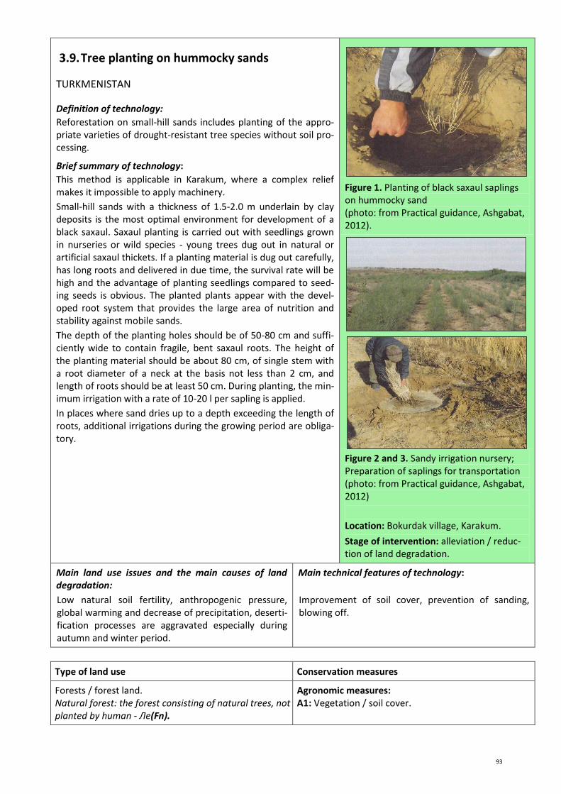
93
3.9. Tree planting on hummocky sands
TURKMENISTAN
Definition of technology:
Reforestation on small-hill sands includes planting of the appro-priate varieties of drought-resistant tree species without soil pro-cessing.
Brief summary of technology:
This method is applicable in Karakum, where a complex relief makes it impossible to apply machinery.
Small-hill sands with a thickness of 1.5-2.0 m underlain by clay deposits is the most optimal environment for development of a black saxaul. Saxaul planting is carried out with seedlings grown in nurseries or wild species - young trees dug out in natural or artificial saxaul thickets. If a planting material is dug out carefully, has long roots and delivered in due time, the survival rate will be high and the advantage of planting seedlings compared to seed-ing seeds is obvious. The planted plants appear with the devel-oped root system that provides the large area of nutrition and stability against mobile sands.
The depth of the planting holes should be of 50-80 cm and suffi-ciently wide to contain fragile, bent saxaul roots. The height of the planting material should be about 80 cm, of single stem with a root diameter of a neck at the basis not less than 2 cm, and length of roots should be at least 50 cm. During planting, the min-imum irrigation with a rate of 10-20 l per sapling is applied.
In places where sand dries up to a depth exceeding the length of roots, additional irrigations during the growing period are obliga-tory.
Figure 1. Planting of black saxaul saplings on hummocky sand (photo: from Practical guidance, Ashgabat, 2012).
Figure 2 and 3. Sandy irrigation nursery; Preparation of saplings for transportation (photo: from Practical guidance, Ashgabat, 2012)
Location: Bokurdak village, Karakum.
Stage of intervention: alleviation / reduc-tion of land degradation.
Main land use issues and the main causes of land degradation:
Low natural soil fertility, anthropogenic pressure, global warming and decrease of precipitation, deserti-fication processes are aggravated especially during autumn and winter period.
Main technical features of technology:
Improvement of soil cover, prevention of sanding, blowing off.
Type of land use Conservation measures
Forests / forest land. Natural forest: the forest consisting of natural trees, not planted by human - Ле(Fn).
Agronomic measures: A1: Vegetation / soil cover.

94
Environment
Habitat Anthropogenic environment
Average annual rainfall: <250 mm. Altitude (meter above sea level): <100 m. Landscape: flat. Slope (%): 0-2%. Soil fertility: low. Humus content in arable horizon: <1% (low). Natural soil drainage/infiltration: good.
Size of land area (ha): 1-2, 2-5 ha. Landholder: dehkhan associations, farmers. Land ownership: state, lease. Water use rights: - Market orientation: Mixed farming (subsistence and commercial).
Assessment
Impact of technology
Main advantages:
- planting without soil processing reduces expenses; - absence of soil processing reduces risk of develop-
ment of a wind erosion; - minimal irrigation only in the first 2-3 years; - advantage of plantings over sowing is in the best
survival rate.
Main disadvantages:
- quite labor-consuming manual work; - there is a requirement for careful observance of
standards for a good survival rate of saplings.
Acceptance/adoption of technology: Within the frame of the project three plans of local communities on sus-tainable management of forest resources for the period of 2011-2020 are developed.
Reference(s): The GIZ project “Sustainable management of forest resources in Turkmenistan”. Practical guidance of “Sustainable forest management in desert and mountain ecosystems of Turkmenistan” for users, Ash-gabat, 2012.
Name of person (s) collected this description: Tatyana Hamzina, Chief specialist on soil reclamation studies and irrigation regime. UZGIP LTD. Address: 44, Navoi str., Tashkent, Uzbekistan. Tel.: +998 90 9945654, Email: [email protected]

95
3.10. Afforestation on takyrs
TURKMENISTAN
Definition of technology:
Reforestation of takyrs is conducted by sowing seeds on a
ploughed soil strip and in places where it is impossible to use a
tractor, by saplings without soil processing.
Brief summary of technology:
When seeds sowing is conducted, it is recommended to plough a soil strip to a depth of 25-30 cm in two tractor passes under width of the strips of 2.8-3.0 m with an interval of 4-5 m. To avoid wind erosion, the strips are ploughed perpendicular to the domi-nating wind direction. It is better to plough soil during winter or early spring and at the same time sow seeds. Before sowing, har-rowing of the strips in 1-2 traces is conducted.
Optimum sowing dates are corrected so that when temperature passes over 50оС, it should be possible to receive more than 50% of shoots (shoots appear in 10 days after sowing). Norm of saxaul sowing is 8 kg/ha. The earlier the sowing is conducted, the higher the sowing rate should be accounting for destruction of seeds by rodents, birds, wind blowing, etc. Sowing depth of seeds is 3-5 cm. In case the germination rate is less than 25% resowing is car-ried out in the next year, at the germination rate of 25-85% - ad-ditional sowing.
Planting by saplings is carried out in areas where it is impossible to use a tractor. Before planting, forest pathological assessment is carried out to establish existence of rodents, gnawing insects, larvae of which damage roots and surface parts of forest saplings, with a purpose to define measures against them.
Holes are dug to a depth of not less than 80 cm, wide enough to
locate sufficient amounts of a mixture of humus and sand in
them. Distances between these planting holes are 4-5 m. The
holes are prepared in autumn to accumulate moisture and salt
leaching. A minimum irrigation is conducted during planting with
a rate of 10-20 l per plant (it is possible to use brackish water
from local wells). Irrigations are stopped in three years.
Figure 1. Planting of black saxaul saplings
on takyr soils
(photo: from Practical guidance, Ashgabat,
2012)
Figure 2. The young saxaul trees, which
have been grown by sowing seeds
(photo: from Practical guidance, Ashgabat,
2012)
Location: Bokurdak village, Karakum.
Stage of intervention: alleviation / reduc-tion of land degradation.
Main land use issues and the main causes of land degradation:
Low natural soil fertility, anthropogenic pressure, global warming and decrease of precipitation, deserti-fication processes are aggravated especially during autumn and winter period.
Main technical features of technology:
Improvement of soil cover, prevention of sanding, blowing off.
Type of land use Conservation measures
Forests / forest land. Natural forest: the forest consisting of natural trees, not planted by human- Ле(Fn).
Agronomic measures: A1: Vegetation / soil cover.

96
Environment
Habitat Anthropogenic environment
Average annual rainfall: <250 mm. Altitude (meter above sea level): <100 m. Landscape: flat. Slope (%): 0-2%. Soil fertility: low. Humus content in arable horizon: <1% (low). Natural soil drainage/infiltration: good.
Size of land area (ha): 1-2, 2-5 ha. Landholder: dehkhan associations, farmers. Land ownership: state, lease. Water use rights: - Market orientation: Mixed farming (subsistence and commercial).
Assessment
Impact of technology
Main advantages:
- planting saplings gives a good survival rate; - minimal irrigation only in the first 2-3 years (when
sowing seeds); - sowing seeds under natural soil moisture (without
irrigation).
Main disadvantages:
- afforestation by saplings is quite labor-consuming way demanding careful observance of standards for a good survival of saplings;
- afforestation by seed sowing gives low germination, resowing/additional sowing is often required.
Acceptance/adoption of technology: Within the frame of the project three plans of local communities on sustainable management of forest resources for the period of 2011-2020 are developed
Reference(s): The GIZ project “Sustainable management of forest resources in Turkmenistan”. Practical guidance of “Sustainable forest management in desert and mountain ecosystems of Turkmenistan” for users, Ash-gabat, 2012.
Name of person (s) collected this description: Tatyana Hamzina, Chief specialist on soil reclamation studies and irrigation regime. UZGIP LTD. Address: 44, Navoi str., Tashkent, Uzbekistan. Tel.: +998 90 9945654, Email: [email protected]

97
3.11. Community forestry in Karakalpakstan
UZBEKISTAN
Definition of approach:
Tenants – local inhabitants in cooperation with district forest management agencies did reforestation works in the degraded forest sites on mutually advantageous conditions.
Brief description of approach:
Within the frame of the Project of the Government of the Repub-lic of Karakalpakstan, UNDP/GEF, entitled: «Preservation of the tugai forests and strengthening of protected territory systems in the Amu Darya River delta in Karakalpakstan», local population was involved in reforestation by transfer of the degraded forest sites for leasing for a period of 5 years on the basis of the con-tract with forestry department. In case of successful fulfilment of all contract provisions the term of rent extends till 10 years. The tenants carry out planting of trees, look after plantings, grow vegetables and forage crops in inter-row spacings and owning yields as compensation, and forest production is equally shared between the tenants and forestry agencies.
Project consultants together with the representatives of territori-al forestry department and with the assistance of local govern-ment bodies determined the degraded forest sites, assessed problems and held information-training seminars within the frame of a project component. The degraded forest sites were transferred to local inhabitants for lease on the contract basis.
For ensuring observance of contract provisions with both parties, Councils of communal forestry with members - representatives of local community, district administration, local government, na-ture protection organizations were established created and char-ters were approved. Councils work on a voluntary basis and take part in discussion and decision-making on communal reforesta-tion.
Figure 1. Tenants of communal forestry, inhabitants from near-tugai auls (villages), install pump for organization of irrigation of saplings (photo by: Aybergenov B.)
Figure 2. Appearance of the degraded for-estry site on the third year after restoration by a tenant (photo by: Ibragimov R.)
Location: Beruniy, Amudarya, and Kanlykul districts, Karakalpakstan.,.
Area of technology application: 87 ha.
Main land use issues and the main causes of land degradation:
Shortage of funds at forestry agencies (owners of land) for reforestation. The population is not interest-ed in forest restoration and preservation in the ab-sence of a private property on land.
Purpose of the approach:
Communal forestry management is aimed at im-provement of conditions of forest resources, decrease of the state expenses on reforestation through the involvement of local population in the management process.

98
Assessment
Impact of technology
Main advantages:
- possibility of obtaining quick benefit due to the use of inter-row spacings;
- a source of the stable income, improvement of fi-nancial conditions of the families participating in communal reforestation;
- there is no need for high investments; - state budget funds for restoration and protection
are saved (the restored forest on tenants’ land is not needed to be protected by the employees of forestry department);
- formation of individual and public responsibility for good forest conditions in local inhabitants;
- ensuring self-employment of local inhabitants by in-volving them in communal reforestation;
- mutual benefit of the agreement of interested par-ties;
- strengthening of social communications (between people, economy and state policy).
Main disadvantages:
- responsibility of interested parties are not defined; - forestry department are not ready yet for decentrali-
zation of management; - transfer of the forestry sites to rent to local people is
not legalized; - uncertainty in stability of the new relations.
Acceptance/adoption of technology: This approach was applied for the first time in 2004 within the UNDP and RoU Project entitled: «Creation of Nuratau-Kyzylkum biospheric reserve» on 75 ha area. The project «Preserva-tion of the tugai forest and strengthening the systems of protected territories in the Amu Darya River delta in Karakalpakstan» in 2007 repeated this approach on the 87 ha area. Land is state-owned (in this case in a property of forestry departments). According to the law «On the forests», only the degraded land of the State forest fund can be a subject to rent. State administration of the forestry de-partments usually concludes short-term contracts only (for 1 year) on rent of land with individuals and commer-cial organizations with an obligation to pay 70% of the income (in a monetary and natural form) to the state. The problem can only be solved by amending the law on land ownership.
Reference(s): WOCAT Database. Approach code: A_UZB002ru. Compiled by: Tatyana Hamzina. Date: 15.12.2011. Tel.: +998 61 2242935, Email: [email protected]
Name of person(s) collected this description: Tatyana Hamzina, Chief specialist on soil reclamation studies and irrigation re-gime. UZGIP LTD. Address: 44, Navoi str., Tashkent, Uzbekistan. Tel.: +998 90 9945654, Email: [email protected]

99
3.12. Forest field-protecting shelterbelts on rain-fed land
KAZAKHSTAN
Definition of technology:
Establishing forest field-protecting windbreaks provides optimum protection of soils and rainfed cropland from drought, dry winds and wind erosion, increases their productivity.
Brief summary of technology:
The head of a household established forest field-protecting windbreaks from a balsam poplar around the fields with spring wheat. Increase of productivity of spring wheat took place due to mitigation of climate dryness, preservation of the soil moisture and reduction of a wind erosion.
Planting of strips on non-irrigated farmland was made in early spring when root-forming capacity of plants is the highest, and there were favorable conditions such as optimum soil moisture, air and soil temperature.
The farmer used 1-2 years poplar saplings with a length of root system 25-27 cm for planting of forest strips. planting was done by special silvicultural machinery and manually. The planting ma-terial was obtained from neighboring forest field-protecting windbreaks during a period of loosing of plantings.
Strips were allocated in two mutually perpendicular directions. The main strips were oriented perpendicular to the prevailing wind direction, and auxiliary strips perpendicular to the main strips with the purpose of reducing the influence of winds of oth-er directions. Three rows of the main strips and two rows of the auxiliary strips with 3 m inter-row spacings at a distance of 2 m from an edge of the arable land were established. The farmer carried out 5-6 times of cultivation during the first growing period in inter-row spacings and 2-3 times of manual weeding, and dur-ing the next years the number of these measures was reduced.
The productivity of spring wheat was increased by 0.15 t/ha due to the established three-row forest strips, with yields of 1-1.2 t/ha.
Establishing forest field-protecting windbreaks is possible also from other tree species (maple ash, elm).
Figure 1. Scheme of forestry field-protecting windbreaks.
Location: Zelenobor village, Akmola prov-
ince.
Area of technology application: 300 ha.
Stage of intervention: alleviation / reduc-
tion of land degradation.
Main land use issues and the main causes of land degradation:
Low productivity of a rainfed arable land is caused by insufficiency of natural precipitation. Wind activity promotes development of a wind erosion. Soil mois-ture preservation and crop protection against dry winds is the main problem of the rainfed agriculture.
Main technical features of technology:
Improvement of soil cover, increase of soil fertility, decrease of soil erosion.
Type of land use Conservation measures
Rainfed arable land. Cultivation of annual agricultural crops - Во(Ca).
Vegetation measures: В1: Covered by trees and bushes (forest belts).

100
Environment
Habitat Anthropogenic environment
Average annual rainfall: 250-300 mm. Altitude (meter above sea level): 250-350 m. Landscape: plain. Slope (%): 2-5% (gentle). Soil fertility: moderate. Humus content in arable horizon: 2-3%. Natural soil drainage/infiltration: moderate.
Size of land area (ha): 300 ha. Landholder: middle/large size farms. Land ownership: individual and state. Water use rights: - Market orientation: subsistence farming (self suffi-ciency), free market.
Assessment
Impact of technology
Main advantages:
- technology is simple to implement; - low cost; - prevents a wind erosion; - preserves soil moisture; - increase of spring wheat productivity at 0.15 t/ha.
Main disadvantages:
Acceptance/adoption of technology: The technology of forest field-protecting windbreak can be used in the Central Asian regions where there is a serious issue of preservation of agricultural land from wind erosion.
Reference(s): Traditional knowledge in the field of land and water use. The information collection, Dushanbe, 2006. Pub-lished by the “Fund of support of civil initiatives” non-governmental organization of the Republic of Tajikistan, which was the member of the international network of NGO on coping against desertification (a RIOD network) and the coordinator of the RIOD network on implementation of KBO provisions in Tajikistan.
Contact information of the “Fund of support of civil initiatives” non-governmental organization: 73a-19, Shotemur str., Du-shanbe, 734002 Republic of Tajikistan. Tel./Fax: +992 (37) 2215857. Email: [email protected] www.fsci.freenet.tj
Name of person (s) collected this description: Tatyana Hamzina, Chief specialist on soil reclamation studies and irrigation regime. UZGIP LTD. Address: 44, Navoi str., Tashkent, Uzbekistan. Tel.: +998 90 9945654, Email: [email protected]

101
3.13. Growing poplar trees on saline and waterlogged land
KYRGYZSTAN
Definition of technology:
Establishing of forest strips from salt-tolerant poplar species in a complex with construction of a small drainage network for dis-posal of groundwater provides decrease of waterlogging and soil salinization.
Brief summary of technology:
The technology is developed by the forestry chair of the Kirghiz Agrarian University based on earlier existing technologies and was applied for the first time in the conditions of soil secondary salinization and waterlogging. The farmer established poplar plantations, which are tolerant to soil salinization, and used inter-row spacings for cultivation of forage crops.
The contents of activities for organization of planting is as fol-lows:
Site preparation. Drainage ditches along the field edges and in the middle of the waterlogged sites were made at a distance of 50 m from each other in the entire field length to discharge ex-cessive groundwater into the depression areas. Drainage ditches were made using ditch-maker KZU-05 on a base of the MTZ-80 tractor. Depth of ditches is 0.5 m.
Preparation of saplings. During autumn, after drying of an arable layer, soil was plowed to a depth of 30-35 cm. In early spring af-ter soil drying, harrowing of ploughed soil and furrow making in a distance of 70 cm was conducted, in which poplar cuttings were planted at a distance of 10-15 cm so that 1-2 buds remained above topsoil. Moderate-rate irrigations were carried out in case of a decrease of soil moisture.
Poplar planting. The next year poplar saplings were planted in the prepared site by strips 3-5 m wide, with 1 m distance be-tween rows in a strip and 0.5-1.0 m between the saplings. The distance between poplar strips was 10 to 15 m, and was used for alfalfa cultivation. It is assumed that the soil will be salt free and becomes suitable for crop production in 10-12 years. 3200 sap-lings were planted on 1 ha of the land, which were produced in 0.1 ha. In total 11200 poplar saplings were planted.
Figure 1. Scheme of poplar planting
Location: Besh-Teren village, Moscow dis-trict.
Area of technology application: 5-15 ha.
Stage of intervention: alleviation / reduc-tion of land degradation.
Main land use issues and the main causes of land degradation:
Secondary land salinization and waterlogging because of poor maintenance of drainage systems. Drainage ditches are filled with silt, overgrew with weeds and reed and function at substantially reduced capacity. Crop productivity is decreased by more than 50%, and costs of production increased twice
Main technical features of technology:
Improvement of soil cover, increase of soil fertility, decrease of waterlogging and salinization, increase of biodiversity.
Type of land use Conservation measures
Mixed land. Agroforestry: arable land and trees - Сл(Mf).
Vegetation measures: В1: Covered by trees and bushes (forest belts).

102
Environment
Habitat Anthropogenic environment
Average annual rainfall: 380-430 mm. Altitude (meter above sea level): 500 m. Landscape: plain. Slope (%): gentle (2-5%). Soil fertility: moderate. Humus content in arable horizon: low, <1%. Natural soil drainage/infiltration: moderate.
Size of land area (ha): 5-15 ha. Landholder: moderate / small scale farmers. Land ownership: individual and state. Water use rights: through WUAs and organizations re-sponsible for management of irrigation systems on rel-evant payment. Market orientation: subsistence farming (self sufficien-cy), free market.
Assessment
Impact of technology
Main advantages:
- technology is simple to implement, low cost; - reduces land salinization and waterlogging; - increases productivity; - construction material are produced, additional ben-
efits can be obtained.
Main disadvantages:
Acceptance/adoption of technology: is positively accepted by farmers and households. There is a spontaneous appli-cation of technology.
Reference(s): Traditional knowledge in the field of land and water use. The information collection, Dushanbe, 2006. Pub-lished by the “Fund of support of civil initiatives” non-governmental organization of the Republic of Tajikistan, which was the member of the international network of NGO on coping against desertification (a RIOD network) and the coordinator of the RIOD network on implementation of KBO provisions in Tajikistan.
Contact information of the “Fund of support of civil initiatives” non-governmental organization: 73a-19, Shotemur str., Du-shanbe, 734002 Republic of Tajikistan. Tel./Fax: +992 (37) 2215857. Email: [email protected] www.fsci.freenet.tj
Name of person (s) collected this description: Tatyana Hamzina, Chief specialist on soil reclamation studies and irrigation regime. UZGIP LTD. Address: 44, Navoi str., Tashkent, Uzbekistan. Tel.: +998 90 9945654, Email: [email protected]

103
3.14. Bio-drainage – an alternative method of rec-lamation of waterlogged land
TAJIKISTAN
Definition of technology:
An approach to lower groundwater levels by means of forest
plantations, which intercept infiltration water and groundwater
by roots and spend them for transpiration.
Brief summary of technology:
A high biodraining ability of a poplar to lower groundwater levels and prevent soil waterlogging is used in this technology.
In this approach land preparation for poplar planting includes: plowing to a depth of 35-40 cm, harrowing, removing roots of perrenial weeds and field leveling. After field leveling planting is carried out in late autumn or early spring in March - April. Dis-tance between the trees and the rows is 1 m. The distance be-tween the strips is 1 km.
For the best growth and development of saplings it is recom-mended to apply an organic-mineral mixture into the planting holes at the rate of 1-2 kg per hole. An additional extranutrition of nitric fertilizers with the rate of 30 kg/ha is carried out in July. Inter-row processing - a hoeing is necessary to carry out during the period of growth and development of saplings to destroy weeds. Pruning is conducted in the early spring of the next year. Grain and leguminous mixtures are grown in the inter-row spac-ings of poplar plantations.
As a result of biodrainage activity, a 50-60% increase of produc-
tivity of inter-strip spaces is observed in a radius of 1 km. This
technology is ecologically and economically profitable. The poplar
is a source of household fuel and a construction material. Cost of
establishing biodrainage is low being 500-1000 somoni (USD 150-
300) per ha.
Figure 1. Poplar.
Location: farm named after Nuriddinov, Bohtar district, Hatlon province.
Area of technology application: 5-15 ha.
Stage of intervention: allevia-tion/reduction of land degradation.
Main land use issues and the main causes of land degradation:
Low efficiency of the horizontal drainage network, un-acceptably shallow, mineralized groundwater levels, high cost of operation of a vertical pump drainage.
Main technical features of technology:
Improvement of soil cover, increase of soil fertility, decrease of waterlogging, increase of biodiversity.
Type of land use Conservation measures
Mixed land. Agroforestry: arable land and trees - Сл(Mf).
Vegetation measures: В1: Covered by trees and bushes (forest belts).

104
Environment
Habitat Anthropogenic environment
Average annual rainfall: 200-300 mm. Altitude (meter above sea level): 430 m. Landscape: plain. Slope (%): 2-5%, (gentle). Soil fertility: moderate. Humus content in arable horizon: low (<1%). Natural soil drainage/infiltration: moderate.
Size of land area (ha): 5-15 ha. Landholder: moderate/small scale farmers. Land ownership: long term lease from government. Water use rights: state. Market orientation: subsistence farming (self suffi-ciency), free market.
Assessment
Impact of technology
Main advantages:
- improvement of properties of waterlogged land; - source of household fuel and construction material; - increase of efficiency of inter-row spaces in a radius
of 1 km by 50-60%.
Main disadvantages:
Acceptance/adoption of technology: This technology is developed by the scientific research institute of Soil Sci-ences within the project of the International Center of Agricultural Research (ICARDA) and is now widely applied in the areas of waterlogged land.
Reference(s): Traditional knowledge in the field of land and water use. The information collection, Dushanbe, 2006. Pub-lished by the “Fund of support of civil initiatives” non-governmental organization of the Republic of Tajikistan, which was the member of the international network of NGO on coping against desertification (a RIOD network) and the coordinator of the RIOD network on implementation of KBO provisions in Tajikistan.
Contact information of the “Fund of support of civil initiatives” non-governmental organization: 73a-19, Shotemur str., Du-shanbe, 734002 Republic of Tajikistan. Tel./Fax: +992 (37) 2215857. Email: [email protected] www.fsci.freenet.tj
Name of person (s) collected this description: Tatyana Hamzina, Chief specialist on soil reclamation studies and irrigation regime. UZGIP LTD. Address: 44, Navoi str., Tashkent, Uzbekistan. Tel.: +998 90 9945654, Email: [email protected]

105
3.15. Management of tugai forests through village committees
TAJIKISTAN
Definition of approach:
The described approach promotes establishing of the contractual relations between rural committees and local authorities with a purpose of implementation of the decentralized management of the tugai forest on state stock lands.
Brief description of approach:
The inundated forests are subject to the overexploitation due to deforestation and cattle pasture.
Protection of the tugai forest and involvement of local land users for assistance in protection of the forest were priority tasks of the UNDP Project entitled «Demonstration of local approaches to cope with land degradation and improvement of sustainable management of land resources in the southwest of Tajikistan».
Realization stages:
1) Representatives of the UNDP project carried out discussions with local users of the tugaI forest concerning establishment of communal committee of forest management. Three rural Committees were established
2) Following the initiative of UNDP communal committees con-cluded agreements with Hukumat (local authority at regional level) on rent of 126 ha for a period of five years for the pur-pose of protection and effective use of accurately defined for-est sites of the state stock.
3) UNDP together with jamoat (local authority at municipal level) obtained permission from Hukumat to carry out the sanitary thinning of trees. The cut wood material was provided to schools and hospitals as fuel.
According to the Contract, the Rural Committee pays US$ 1.73 a year per ha to the region for a rent as a tax, which is raised from members of the committee for each cattle head grazed in a rate of US$ 1 per month (the territory is used as a pasture only 3-4 months a year).
Tasks of interested parties: Rural committees are headed by the representative responsible for control of access to the forest sites. Local jamoats control of activity of rural committees. UNDP renders consulting services in process of establishment of the contractual relations between rural committees and local author-ities, and carries out monitoring of forest management.
Figure 1. Representative of rural commit-tee on his site of the tugai forest (photo by: Zeringer Julia)
Figure 2. Ecosystem of the coastal tugai forest (photo by: Zeringer Julia)
Location: Nouri Vakhsh Dzhamoat (village), Hatlon.
Area of approach application: 1,26 km2.
Stage of intervention: alleviation / reduc-tion of land degradation.
Main land use issues and the main causes of land degradation:
Uncontrollable access to the tugai forest caused deg-radation, pasture overgrazing, cutting down of trees due to the lack of fuel resources.
Purpose of the approach:
Improvement of conditions of the tugai forest through involvement of local population in the process of management and use.

106
Assessment
Impact of technology
Main advantages:
- formation of individual and public responsibility at local population for a condition of the forest;
- strengthening of social communications (between people, economy and state policy);
- improved quality of pastures on forest sites; - ensuring sustainable management of natural re-
sources.
Main disadvantages:
- there is no guarantee of owning and using this land as the government can sell the land any time.
Acceptance/adoption of technology: The approach has not yet received a wide implementation
Reference(s): WOCAT Database. Approach code: TAJ025r. Compiled by: Roziya Kirgizbekova. Date: 02.02.2011.
Name of person (s) collected this description: Tatyana Hamzina, Chief specialist on soil reclamation studies and irrigation regime. UZGIP LTD. Address: 44, Navoi str., Tashkent, Uzbekistan. Tel.: +998 90 9945654, Email: [email protected]

107
3.16. Joint forest management
TAJIKISTAN
Definition of approach:
Protection and restoration of the state forest based on joint long-term agreements between the State forestry committee and local forest users.
Brief description of approach:
The joint management of the forest means participation of non-governmental organizations and local users in management of forestry on the basis of the contract with a duration of 20 years in the frame of the Tajik legislation. As the first step, a protection from cattle over-grazing should be constructed.
Realization stages: 1) meeting with representatives of villages; 2) oganizing information seminar; 3) receiving consent of all community; 4) selection of tenants and division of sites; 5) signing of contracts with individual tenants; 6) development of management plans and annual plans for each
tenant; and 7) control of annual plans.
Role of interested parties: the annual plan is based on the 5-year management plan for the corresponding site. It defines amount of works which the tenant should execute, and also crop yields and their shares which will be received by the tenant from the used area. The lease contract, the management plan, and the an-nual plan are mutually coordinated by the forest tenant and for-estry committee. The state forestry committee is responsible for control and technical consultation.
Figure 1. The local user of the forest re-ceives the legal contract (Photo by: Anke Gaude)
Figure 2. A seminar on a joint forest man-agement (Photo by: Anke Gaude)
Location: Ishkoshim, Roshkala, Shugnon, Gorno-Badakhshan Autonomous Province (GBAO).
Area of application подхода: 20 km2.
Stage of intervention: alleviation / reduc-tion of land degradation.
Main land use issues and the main causes of land degradation:
The limited management and control capacity of the State forestry committee, together with accruing need for firewood brought to uncontrollable „open access“ in the inundated forest of GBAO. Local people use for-est resources unsustainably, including uncontrollable deforestation and overgrazing. This led to large-scale
Purpose of the approach:
Protection and restoration of the state forest on the basis of long-term contracts between the State forest-ry committee and local users of the forest.

108
degradation of resources of the inundated forest.
Assessment
Impact of the approach
Main advantages:
- formation of individual and public responsibility at local population for a condition of the forest;
- benefit from a legal access to forest production (firewood, construction materials, fruits, etc.);
- ensuring sustainable management of natural re-
sources.
Main disadvantages:
- it is impossible to implement this approach without initial financial support;
- during the initial stage of rent the benefits received from the use of the forest are insignificant (especial-ly firewood).
Acceptance/adoption of technology: The approach has not yet received a wide implementation.
Reference(s): WOCAT Database . Approach code: TAJ 015r. Compiled by: Firdavs Fayzulloyev. Date: 27.04.2011.
Name of person (s) collected this description: Tatyana Hamzina, Chief specialist on soil reclamation studies and irrigation regime. UZGIP LTD. Address: 44, Navoi str., Tashkent, Uzbekistan. Tel.: +998 90 9945654, Email: [email protected]

109
3.17. Forest shelterbelts from oleaster (Elaeagnus) to protect irrigated fields
TAJIKISTAN
Definition of technology:
Strips from oleaster plantations serve as protection of irrigated
land against strong winds.
Brief summary of technology:
Strong winds blowing in the Shaartuz region erode topsoil layer, which settles in the neighboring fields in the form of deposits. Sandy storms damage not only crops, they fill up the irrigation ca-nals, roads, gardens and streets in rural areas. The solution of this problem is planting of protective forest belts around fields to de-crease wind speed and prevention of an erosion of an arable soil layer. In Soviet period, protective strips were planted in collective farms by the state forestry enterprises based on contracts. After disintegration of the USSR and before the establishment of dekhkan farms, the land users were not interested in investment into establishment of protective strips.
In 1992, a dekhkan together with the son, the graduate of agricul-tural institute, initiated planting of a protective strip from various tree species. In 2010, the UNDP project rendered assistance to them by providing saplings for expansion of the protective strip area. Oleaster was considered as the best species for the organi-zation of forest shelterbelt as it is salt tolerant, growing on saline land. This tree reaches height of 12 m in 10-12 years and provides protection of a field against strong winds. Besides, the oleaster has nitrogen-fixing capacity and enriches the soil with nitrogen, improves soil fertility. The trees fructify, are a fuel material for households.
Plantations consist of three rows along the border of a site and irrigation canals (distance between trees is 1 m, between rows 6 m). 30 people participated in planting activities by a “hashar” method (the voluntary neighbour's help). 10 000 pieces of saplings were planted within a month. During the first three years saplings were looked after, regularly irrigated, sanitary processing carried out. One of problems of establishing of protective strips is an or-ganization of protection from damages by animals and from cut-ting by local population.
11 dekhkan farms were involved in the project; planting of protec-
tive strips proceeded within two years (2009-2010).
Figure 1. A protective strip from various tree species planted in 1992/1993 (before implementation of the project) (Photo by: Julia Zakhringer).
Figure 2. A protective strip of the oleander planted in 2010 with support of UNDP (Photo by: Julia Zakhringer)
Technical scheme. Protective strip (Julia Zakhringer)
Location: Shaartuz, Hatlon.
Area of technology application: 9 ha.
Stage of intervention: alleviation / reduc-tion of land degradation; rehabilitation / improvement of bare land.

110
Main land use issues and the main causes of land
degradation:
Strong wind activity and lack of the relevant activities are the causes of soil erosion and decrease of fertility.
Main technical features of technology:
Soil stabilization, reduction of wind speed.
Type of land use Conservation measures
Mixed land. Agroforestry - arable land and trees - Сл(Mf).
Vegetation measures: В1: Coverage with trees and bushes.
Environment
Habitat Anthropogenic environment
Average annual rainfall: <250 mm. Altitude (meter above sea level): 100-500 m. Landscape: plain. Slope (%): 0-2% (flat, smooth). Soil fertility: very low. Humus content in arable horizon: <1% (low). Natural soil drainage/infiltration: good.
Size of land area (ha): 9 ha. Landholder: individuals/ households, average land us-ers, ordinary / average land users. Land ownership: individual with the ownership rights. Water use rights: - Market orientation: Mixed farming (subsistence and commercial).
Assessment
Impact of technology
Main advantages:
- Oleander is tolerant to drought and is able to survive
in soils with the low nutrient contents; - provides edible fruits, vitamin-rich; - increase of soil productivity.
Main disadvantages:
- forest belts should be protected from damages by
local population which use forest as fuel.
Acceptance/adoption of technology: There is a growth tendency.
Reference(s): WOCAT Database . Code of technology: TAJ110r. Compiled by: Fayzulloyev Firdavs, UNDP Tajikistan. Date: 15.04.2011.
Contact person: Fayzulloyev Firdavs, UNDP, Regional manager. Address: Shaartuz office, Ziodaliyev str. 2, Shaartuz, Tajiki-stan. Tel.: +992-918 79 52 78. E-mail: [email protected]
Name of person (s) collected this description: Tatyana Hamzina, Chief specialist on soil reclamation studies and irrigation regime. UZGIP LTD. Address: 44, Navoi str., Tashkent, Uzbekistan. Tel.: +998 90 9945654, Email: [email protected]
111
4. Cultivation of slopes, erosion prevention

112
4.1. Improving cotton irrigation on areas dam-aged by irrigational erosion
UZBEKISTAN
Definition of technology:
To decrease an irrigational erosion in the tail-end parts of furrows, winter wheat straws are applied, which serve as sort of a brake for moving water, thereby reducing surface discharge and leaching of nutrients.
Brief summary of technology:
Irrigation of cotton in a foothill cotton-growing zones is accom-panied by an irrigational erosion. Mineral fertilizers and pestici-des are leached out from fields together with soil, which reduces soil fertility and worsens ecology.
In a foothill zone, cotton is usually cultivated with a distance of 60 cm between the rows. Therefore, two groups of furrows, with compacted and not compacted soil are formed in the cotton field. Long-term research of UZNIIH showed that irrigations of cotton in narrow rows are appropriate to carry out in every other furrow with water supply to wheel furrows. To reduce irrigational erosion, it is recommended to apply straw at the rate of 0.1 kg per running meter in a tail part of a furrow equal to 0.15 of ist length. Straw acts as a brake to water movement, essentially re-duces water losses from the fields and leahing of nutrients, pre-serves moisture after irrigation events. As a result, both soil mo-isture and cotton ageing become homogeneous along length of furrows.
Straw can be applied in a cotton field from tractor carts at the beginning of cotton budding.
Application of technology provides reduction of irrigational erosi-on to standard norms (no more than 2.5 g/ha in the growing pe-riod), saving of irrigating water by 15-20%, increase of cotton productivity by 5-10%.
Location: Tashkent, Syrdarya, and Dzhizak provinces.
Area of technology application: 4 ha.
Stage of intervention: Prevention of land degradation.
Main land use issues and the main causes of land de-
gradation:
The irrigational erosion, accompanied by leaching of a fine soil materials from fields, mineral fertilizers, pes-ticides with water. Absence of anti-erosion activities in the current farmer practice.
Main technical features of technology:
Prevention of an irrigational erosion, improvement of a soil cover, increase of organic matter and nutrients.
Type of land use Conservation measures
Irrigated arable land. Land used for cultivation of agricultural crops (field crops) - Во(Са).
Agronomic measures: А2: organic matter / soil fertility; А3: processing of soil surface.

113
Environment
Habitat Anthropogenic environment
Average annual rainfall: >400 mm. Altitude (meter above sea level): 420 m. Landscape: foothill zone. Slope (%): sloping, steep sloping. Soil fertility: low. Humus content in arable horizon: 0.8-0.9%. Natural soil drainage/infiltration: moderate.
Size of land area (ha): 200 thousand ha. Landholder: farm. Land ownership: state, long term lease. Water use rights: through WUAs and irrigation ma-nagement bodies. Market orientation: Mixed farming (subsistence and commercial).
Assessment
Impact of technology
Main advantages:
- reduction of an irrigational erosion to 2.5 g/ha during growing period;
- reduction of surface runoff by 15-20%; - uniform soil moisture distribution along the furrow
lengths, increase of soil moisture by 5-10%; - the annual plowing of straw into the soil raises the
organic matter contents by 5-10%.
Main disadvantages:
- higher expenses for straw cutting and applying into an inter-row of tilled crops.
Acceptance/adoption of technology: support of private enterprises is required.
Reference(s):
1. The patent of Uzbekistan for the invention of “A way of uniform soil moisture distribution along the length of furrows” No. IAP 04404, bulletin No. 9, 30.09.2011
2. Bezborodov N. A. Resource-saving technology of irrigation under soil mulching. “Agrosanoat ahborotu”, Tashkent, 1999, 176 p.
Name of person(s) collected this description: Ma`ruf Tashkuziyev, State research institute of Soil Science and Agrochemis-try. Address: 3, Kamarniso str.,Tashkent, Uzbekistan. Tel.: +998 71-227 13 99; +998 90-997 57 84, E-mail: [email protected]

114
4.2. The use of anti-erosion preparation to enhance soil stability to erosion
UZBEKISTAN
Definition of technology:
The technology of soil protection from irrigational erosion based on use of anti-erosive preparation.
Brief summary of technology:
The irrigational erosion in Uzbekistan covers the area of 686 thousand ha, only in the Tashkent province there are 138 thousand ha of irrigated land demanding anti-erosion measures.
Irrigational erosion causes an average annual leaching of 100-150 t/ha of soil elements in gray soils, and 0.5-0.8 t/ha of humus, 100-150 kg/ha of nitrogen and 75-100 kg/ha of phosphorus are thus lost. This in turn causes a reduction of thickness of the humus layer, loss of plant nutrients, decrease of productive moisture, worsening of water-physical, agrochemical and biological soil properties. Erosion processes in the agricultural areas of the country cause annual losses of more than 200 thousand tons of raw cotton. Long-term experiments showed that application of K-9 preparation, chlorella and green manure promotes increase of anti-erosion stability of irrigated eroded soils and improvement of their water-physical properties. The increase of cotton raw yields is 0.3-0.5 t/ha.
Application of an anti-erosive preparation into irrigation furrows is mechanized by adaptation to a cotton cultivator PHP - 1.
Based on research, recommendations on the effective application of the new agrotechnical approaches, which prevent irrigational soil erosion, are developed.
Location: Tashkent province.
Area of technology application: 30 ha.
Stage of intervention: prevention of land degradation.
Main land use issues and the main causes of land de-gradation:
Irrigational erosion accompanied by leaching of a fine soil materials, mineral fertilizers, pesticides with wa-ter. Absence of anti-erosion measures in the current farmer practice.
Main technical features of technology:
Prevention of an irrigational erosion, improvement of a soil cover, increase of organic matter and nutrients.
Type of land use Conservation measures
Irrigated arable land. Land used for cultivation of agricultural crops - Во(Са).
Agronomic measures: А3: processing of soil surface.
Environment
Habitat Anthropogenic environment
Average annual rainfall: 250-500 mm. Altitude (meter above sea level): 100-500 m. Landscape: foothill slopes. Slope (%): gentle slope, steep slope. Soil fertility: moderate. Humus content in arable horizon: 1-3%. Natural soil drainage/infiltration: moderate.
Size of land area (ha): 30 ha. Landholder: farm. Land ownership: state, long term lease. Water use rights: through WUAs and irrigation ma-nagement bodies. Market orientation: mixed farming (subsistence and commercial).

115
Assessment
Impact of technology
Main advantages:
- elimination of irrigational erosion; - improvement of water-physical soil properties (den-
sity, water penetration); - increase of crop productivity.
Main disadvantages:
Acceptance/adoption of technology: external financial support is required.
Reference(s): Catalog III of Republican fair of innovative ideas, technologies and projects, Tashkent 2010. O.E. Hakberdiyev's technology, State research institute of Soil Science and Agrochemistry.
Name of person (s) collected this description: Prof. Ma`ruf Tashkuziyev, State research institute of Soil Science and Agro-chemistry. Address: 3, Kamarniso str.,Tashkent, Uzbekistan. Tel.: +998 71-227 13 99; +998 90-997 57 84, E-mail: [email protected]

116
4.3. Cross-processing of sloping land
KYRGYZSTAN
Definition of technology:
The complex of agro-technical measures for soil processing on steep slopes promotes an increase of absorption and accumulati-on of moisture in soil, thereby reducing surface runoff and pre-venting erosion of sloping land.
Brief summary of technology:
Research showed that the maximum increase of volume of soil water capacity by increase in porosity and speed of infiltration is the basis of coping with water erosion.
To achieve it, autumn plowing across a slope and a soil chapping is recommended. These measures are carried out immediately after removing plant residues of the previous production to inter-cept abundant precipitation during winter and spring period.
Soil plowing and loosening is recommended only across a slope under soil moisture not less than 65% from the field capacity. Re-search showed that cross-sectional autumn plowing of the soil allows increasing the absorption speed of precipitation from 7.3 cm/hour in a control site to 18.2 cm/hour in an experimental site. These measures promoted an increase of water holding capacity in the 80 cm soil layer by 725 m3/ha, and soil moisture at the le-vel of the smallest field capacity was accumulated only by atmo-spheric precipitation. Moisture accumulation in the soil to the total optimal capacity allowed to postpone the start of the first irrigations by 20-26 days.
Location: “Zhantay-Tush“ WUA, Sokuluk district, Chuy province.
Area of technology application: ca. 10 ha.
Stage of intervention: reduction of land degradation, creation of optimum soil moisture.
Main land use issues and the main causes of land de-
gradation:
Soils of a foothill zone of the Chuy valley differ from flat soils by a lack of water-stable agregates and when wet they are subject to surface erosion and landslides.
Main technical features of technology:
Increase of infiltration, soil water-holding capacity, decrease of surface runoff and accumulation of a win-ter and spring precipitation
Type of land use Conservation measures
Irrigated arable land. Production of annual crops - Во(Ca).
Agronomic measures: A3: processing of soil surface; A4: processing of soil sub-surface.
Environment
Habitat Anthropogenic environment
Average annual rainfall: 422-616 mm. Altitude (meter above sea level): 800-1200 m. Landscape: foothill. Slope (%): 7-15%. Soil fertility: moderate. Humus content in arable horizon: ca. 1.5%. Natural soil drainage/infiltration: reduced.
Size of land area (ha): 2-5 ha. Landholder: small/middle sized, mixed. Land ownership: arable land - 75% individual and 25% state; state pastures. Water use rights: through WUAs and organizations responsible for management of irrigation systems on relevant payment. Market orientation: subsistence farming (self suffi-ciency), free market.

117
Assessment
Impact of technology
Main advantages:
- decrease of a surface runoff; - soil moisture accumulation at the level of the smal-
lest moisture holding capacity; - saving of irrigating water because of the shift of the
first irrigation by 20-26 days; - increase of agricultural crop yields; - increase of the income of farms.
Main disadvantages:
- capital leveling is required.
Acceptance/adoption of technology: a trend of increase of implementation of this technology is observed.
Reference(s): WOCAT Database and reports of the Kyrgyz Scientific Research Institute of Irrigation.
Name of person(s) collected this description: A. Naloychenko, leading research associate; A. Atakanov, head of lab of irrigation and soil - erosive research. Kyrgyz Scientific Research Institute of Irrigation. Address: 4А, Toktonaliyev str., Bishkek, Kyrgyzstan. Tel.: +996 (312) 541 171. E-mail: [email protected]

118
4.4. Irrigation of crops sown in furrows
KYRGYZSTAN
Definition of technology:
Irrigation of narrow-row crops and continuous crops (wheat, alfal-fa, annual herbs, etc.) by sowing furrows considerably reduces (or completely prevents) soil erosion on slopes.
Brief summary of technology:
Irrigations on steep slopes (i> 0.007) strengthen erosive processes due to the moving speed of an irrigation stream along a furrow. Single irrigation causes soil erosion of 29.6 t/ha.
To reduce/prevent erosion processes and productive use of irriga-ted arable land on steep slopes it is recommended to irrigate narrow-row and continuous crops along the sowing furrows. Such irrigation differs from traditional bulk water discharge by making furrows simultaneously with crop sowing. For this purpose, a number of plowshare bones are removed from grain-fertilizer seeder SZS-3.6 and are replaced by furrow-makers with seed-providers through a certain distance of inter-rows. That is, the ag-gregate is assembled from a production seeder SZS-3.6 or SKON-4.2 and the re-equipped cultivator – furrow-maker KOR-5.6.
In case it is impossible to re-equip a seeder, sowing furrows (with a distance of 60-70 cm) are made by a secondary pass of the furrow-maker KOR-5.6 immediately after seed sowing by SZS-3.6 or SKON-4.2 seeders. In this case seeds are buried into the soil mainly on slopes by a perimeter of the furrow. It was noted that this approach accelerates germination by better contact of seeds and the soil.
The plant root system strongly tightens shallow soils by a perime-ter of irrigation furrows, creates an additional roughness that considerably reduces the speed of water movement during irriga-tion events and counteracts an erosion.
By the time of first irrigation which in foothill zones is carried out at the end of May, the root system develops so that it can already strongly counteract erosive processes during irrigations on steep slopes (up to i = 0.10 … 0.15). Irrigation is supplied by the increa-sed amount up to 1.0 l/sec into each furrow.
Location: "Kenenbay" farm, Sokuluk dis-trict, Chuy province.
Area of technology application: 10 ha.
Stage of intervention: prevention / mitiga-tion of land degradation.
Main land use issues and the main causes of land de-gradation:
Erosive processes under irrigations on steep slopes.
Main technical features of technology:
Decrease in moving speed of water in furrows and soil leaching.
Type of land use Conservation measures
Irrigated arable land. Production of annual crops - Во(Ca).
Agronomic measures: А1: improvement of surface soil structure, vegetative cover.
119
Environment
Habitat Anthropogenic environment
Average annual rainfall: 422-616 mm. Altitude (meter above sea level): 800-1200 m. Landscape: foothill. Slope (%): 7-15%. Soil fertility: moderate. Humus content in arable horizon: in average 1.5%. Natural soil drainage/infiltration: lower.
Size of land area (ha): 2-5 ha. Landholder: small/middle sized, mixed. Land ownership: arable land – 75% individual and 25% state; state pastures. Water use rights: through WUAs and organizations responsible for management of irrigation systems on relevant payment. Market orientation: subsistence farming (self suffi-ciency), free market.
Assessment
Impact of technology
Main advantages:
- preservation of soil structure; - prevention of erosive processes; - saving of irrigating water (up to 30%); - increase of uniformity of soil moisture during irriga-
tion to 90-95%; - ensuring application of technical means of small-
scale mechanization; - improvement of operating conditions of irrigators
and increase of work productivity.
Main disadvantages:
- capital leveling is required; - additional costs for alteration of seeder.
Acceptance/adoption of technology: a trend of increase of implementation of this technology is observed.
Reference(s): WOCAT Database and reports of the Kyrgyz Scientific Research Institute of Irrigation.
Name of person(s) collected this description A. Naloychenko, leading research associate; A. Atakanov, head of lab of irrigation and soil - erosive research. Kyrgyz Scientific Research Institute of Irrigation. Address: 4А, Toktonaliyev str., Bishkek, Kyrgyzstan. Tel.: +996 (312) 541 171. E-mail: [email protected]

120
4.5. Integrated scheme of preparation of irrigation field
KYRGYZSTAN
Definition of technology:
Integrated preparation of an irrigated field including the contour and ameliorative organization of the territory, field leveling or micro-leveling, soil plowing and processing across a slope accu-mulates a winter and spring precipitation and prevents horizontal leaching of the top fertile layer.
Brief summary of technology:
Integrated system of preparation of an irrigated field considers soil and topographic features of watersheds, allowing for effecti-ve use of land resources with soil protection against erosion. The contour and ameliorative organization of the territory defines an arrangement of all ameliorative elements and agrotechnical mea-sures of soil processing and accumulation of soil moisture.
The contour and ameliorative organization of the territory con-sists of combining longitudinal field borders with routes of water-retaining or water-discharging ditches or shafts. These borders are fixed by constant constructions. The best form of a site from the viewpoint of soil processing and irrigation is rectangular with a ratio of length and width 2:1 or 3:1.
Water is retained and discharged into the existing water-collecting ditches or specially arranged turf water streams, artifi-cial beams and ravines by a system of cross-sectional construc-tions. Water can also be discharged into this network in case of network failure.
During the division of the massif into micro-rotational irrigation sites the direction of irrigation furrows or strips is defined in ad-vance. Whenever possible, the direction of planting should coin-cide with the direction of irrigation. The arrangement of irrigation canals should be coordinated with micro-crop rotation borders.
All irrigation furrows or strips are located in parallel. After making furrows, discharging furrows across the direction are made with furrow-makers and then temporary irrigation ditch is prepared in the distances corresponding to the traditional length of furrows.
To prevent water erosion on land with a slope steeper than 0.01, all the complex of soil processing should be carried out only across a slope; or, as a last resort, at a certain angle to domina-ting slope starting from careful leveling or micro-leveling.
Autumn plowing is carried out immediately after harvesting of the predecessor crop to create conditions for retention and ac-cumulation of a precipitation.
Location: „Kenenbay“ farm, Sokuluk dis-trict, Chuy province.
Area of technology application: 10 ha.
Stage of intervention: management of a water regime and erosive processes.
Main land use issues and the main causes of land de-gradation:
The irrigated areas in conditions of Kyrgyzstan have steep slopes, the irrigation water is used inefficiently, and often irrigations provoke development of erosion processes.
Main technical features of technology:
Improvement of absorption of precipitation, decrease of surface runoff and soil leaching during irrigation.

121
Type of land use Conservation measures
Irrigated arable land. Production of annual crops - Во(Ca).
Agronomic measures: A3: Processing of soil surface.
Environment
Habitat Anthropogenic environment
Average annual rainfall: 422-616 mm. Altitude (meter above sea level): 800-1200 m. Landscape: foothill. Slope (%): 7-15%. Soil fertility: moderate. Humus content in arable horizon: on average 1.5%. Natural soil drainage/infiltration: lower.
Size of land area (ha): 2-5 ha. Landholder: small/middle sized, mixed. Land ownership: arable land - 75% individual and 25% state; state pastures. Water use rights: through WUAs and organizations responsible for management of irrigation systems on relevant payment. Market orientation: subsistence farming (self suffi-ciency), free market.
Assessment
Impact of technology
Main advantages:
- reduces discharge of irrigation water and surface soil leaching;
- stops erosion processes; - achieves uniform moisture distribution along the
length of furrows; - raises productivity of agricultural crops.
Main disadvantages:
Required: - field leveling; - construction of water metering constructions; - reinforcing of furrow heads.
Acceptance/adoption of technology: a trend of increase of implementation of this technology is observed.
Reference(s): WOCAT Database and reports of the Kyrgyz Scientific Research Institute of Irrigation.
Name of person(s) collected this description: A. Naloychenko, leading research associate; A. Atakanov, head of lab of irrigation and soil - erosive research. Kyrgyz Scientific Research Institute of Irrigation. Address: 4А, Toktonaliyev str., Bishkek, Kyrgyzstan. Tel.: +996 (312) 541 171. E-mail: [email protected]

122
4.6. Improved elements of technique and technology of surface irrigation on land with steep slopes
KYRGYZSTAN
Definition of technology:
The rational setup of discharging irrigation furrows and tempora-ry sprinklers, and the improved technology of surface irrigation provide high uniformity of soil moisture distribution along the length of furrows and high efficiency of irrigation without erosi-on.
Brief summary of technology:
The surface irrigation (by furrows, strip irrigation) in Kyrgyzstan is the most widespread. But on steep slopes (0.008 … 0.10) this irri-gation approach is extremely dangerous due to the development of erosion processes. On steep slopes, the concentrated irrigation stream gathers considerable speed (>0.4 m/sec) and thoroughly destroys a surface soil layer, washing away up to 20 … 50 t/ha of the fertile soil.
To solve a problem of sloping land irrigation, it is recommended to make irrigation furrows with a depth of 20 … 25 cm with a certain erosion-safe slope (close to the field border, i.e. across dominating slope) within 0.005 … 0.007. The length of a furrow can be up to 80 m, and the irrigation water discharge into a furrow can thus be up to 0.3 l/sec.
After completing of all agrotechnical measures on irrigated fields, planned works of preparation of irrigating network to irrigation are carried out, distribution channels and temporary irrigation ditches are prepared, discharging and irrigation furrows are ma-de.
Recommendations of the rational setup of discharging, irrigation furrows and temporary irrigation ditches, and improved techno-logy of surface irrigation include: irrigation on sowing furrows; irrigation on closed-end furrows; discrete-impulse irrigation and improvement of strip irrigation by the regulated strips.
Location: “Kenenbay“ farm, Sokuluk dis-trict, Chuy province.
Area of technology application: 10 ha.
Stage of intervention: prevention / mitiga-tion of land degradation.
Main land use issues and the main causes of land de-gradation:
During irrigation of sloping land huge irrigation water losses for runoff, erosive processes are developed that causes soil degradation.
Main technical features of technology:
Decrease in surface runoff and soil leaching during irrigation, erosion prevention.
Type of land use Conservation measures
Irrigated arable land. Production of annual crops - Во(Ca).
Agronomic measures: A1: Vegetation / soil cover; A3: Processing of soil surface.

123
Environment
Habitat Anthropogenic environment
Average annual rainfall: 422-616 mm. Altitude (meter above sea level): 800-1200 m. Landscape: foothill. Slope (%): 7-15%. Soil fertility: moderate. Humus content in arable horizon: in average 1.5%. Natural soil drainage/infiltration: lower.
Size of land area (ha): 2-5 ha. Landholder: small/middle sized, mixed. Land ownership: arable land - 75% individual and 25% state; state pastures. Water use rights: through WUAs and organizations responsible for management of irrigation systems on relevant payment. Market orientation: subsistence farming (self suffi-ciency), free market.
Assessment
Impact of technology
Main advantages:
- reduction of erosive processes; - saving of irrigating water; - increase of productivity of agricultural crops.
Main disadvantages:
- additional expenses (leveling, installation of water measuring constructions, reinforcing of furrow heads) are required.
Acceptance/adoption of technology: a trend of increase of implementation of this technology is observed.
Reference(s): WOCAT Database and reports of the Kyrgyz Scientific Research Institute of Irrigation.
Name of person(s) collected this description: Naloychenko A., leading research associate; Atakanov A., head of lab of irrigation and soil - erosive research. Kyrgyz Scientific Research Institute of Irrigation. Address: 4А, Toktonaliyev str., Bishkek, Kyrgyzstan. Tel.: +996 (312) 541 171. E-mail: [email protected]

124
4.7. Contour irrigation
KYRGYZSTAN
Definition of technology:
Irrigation by furrows cut with small slope to the land horizontals (contour irrigation) reduces risk of soil erosion by reducing the speed of water flow in irrigation furrows.
Brief summary of technology:
Prior to making of contour furrows it is necessary to draw or de-signate the contour lines with a defined slope with landmarks using geodetic devices or simple tools (protractor, A-shaped fra-me). The irrigation network for contour irrigation consists of a distribution plastic tray with openings in the bottom of the tray for water supply into each furrow.
Before installation of the plastic tray, contour irrigation furrows are cut. After making of contour irrigation furrows the distributi-on plastic trays with bottom openings for water supply into each furrow are set. The tray is established in the area of the highest slope, and water supply from an irrigation source into the tray is regulated by a simple flat gate.
During an irrigation event, water is supplied into a plastic tray and from regulating openings in the bottom of the tray flows into the irrigation contour furrows. Duration of water supply is regula-ted according to a irrigation regime of the corresponding crop.
The contour irrigation was applied for irrigation of corn and soya crops on the areas with a slope of more than 25% (0.25). Sowing of soya was carried out by a bed seeder.
Location: „Kenenbay“ farm, Sokuluk dis-trict, Chuy province.
Area of technology application: 3.5 ha.
Stage of intervention: coping with erosion.
Main land use issues and the main causes of land de-gradation:
Soil erosion is one of the main causes of destruction of a fertile soil layer. It occurs mainly because of the so-called "agroindustrial" agriculture: soils are plowed in large areas, following which the fertile layer is subject to wind or water erosion.
Main technical features of technology:
Managing of dissipating surface runoff / reduction of speed of water flow.
Type of land use Conservation measures
Irrigated arable land. Production of annual crops - Во(Ca).
Agronomic and irrigation methods.
Environment
Habitat Anthropogenic environment
Average annual rainfall: 200-300 mm. Altitude (meter above sea level): 500-1000 m. Landscape: mountain and foothill slopes. Slope (%):>25% (hilly). Soil fertility: very low. Humus content in arable horizon: 2.5% (moderate). Natural soil drainage/infiltration: moderate.
Size of land area (ha): 2-5 ha. Landholder: small/middle sized, mixed. Land ownership: 75% of arable land is individual and 25% - state. Water use rights: through WUAs and organizations responsible for management of irrigation systems on relevant payment. Market orientation: subsistence farming (self suffi-ciency), free market.

125
Assessment
Impact of technology
Main advantages:
- reduces irrigational erosion to 70%; - preserves soil fertility.
Main disadvantages:
- additional costs of purchase and installation of plas-tic trays;
- additional works for cutting of furrows along a con-tour.
Acceptance/adoption of technology: a trend of increase of implementation of this technology is observed.
Reference(s): Reports of ICARDA/CACILM and of the Kyrgyz Scientific Research Institute of irrigation.
Name of person(s) collected this description: A. Naloychenko, leading research associate; A. Atakanov, head of lab of irrigation and soil - erosive research. Kyrgyz Scientific Research Institute of Irrigation. Address: 4А, Toktonaliyev str., Bishkek, Kyrgyzstan. Tel.: +996 (312) 541 171. E-mail: [email protected]

126
4.8. Cultivation of forest plantations in hill slopes using moisture-accumulating trenches
TURKMENISTAN
Definition of technology:
Collecting an atmospheric precipitation by means of establishing of artificial trenches on slopes of mountains and hills for creation moisture storages in the soil around root system of the crops planted in a bottom of trenches.
Brief summary of technology:
Moisture storage trenches are used for restoration of the forest on mountainous slopes in rainfed conditions of poor sufficiency of precipitation. High survival of saplings is observed without irri-gation, and even in years with little atmospheric precipitation.
The moisture storage trench is made by an single-blade plow (soil is excavated in the direction of the surface slope) or a mounted plough (the top crest of the excavated soil from trench is trans-ferred to the bottom slope). The trench has a triangular form in a cross-section (depth 0.4 m, width of top 0.7 m). A small-length embankment is made on the trench ends at an angle in the slope direction for removal of surplus water. Marking of location of trenches is done perpendicular to the slope. This provides uni-formity of water distribution in the trenches. When soil coverage with a grassy vegetation is 60-100% and slope does not exceed 16º, the trenches are cut at a distance of 12 m from each other. Saplings are planted in a trench bottom in the planting holes at a distance of 5 m. The height of saplings should be not less than 50 cm. Saplings are provided with the moisture accumulated in a trench from atmospheric precipitation. Local (Turkmen juniper, Turkmen maple, ordinary almonds) and introduced (eldar pine, western thuja, juniper bush) tree species are used for reforestati-on.
With a financial support of the project entitled: „Coping with land degradation in three regions of Turkmenistan“ (2002-2007, GIZ-CCD/NIPRZHM) and with help of the project consultants the group of public foresters of local activists was established for res-toration of forest sites around the settlement. All population of the settlement participated in planting of forest trees on 4 ha of the Konegumbez village.
Figure 1. Cutting of trenches on a slope (photo: Nikolay Zverev)
Figure 2. A trench filled with water from atmospheric precipitation (photo by: Nikolay Zverev).
Figure 3. Technical scheme Water-storage trenches on slopes (Nikolay Zverev).
Location: Konegumbez village, Bakharlinsky district, Akhal province.
Area of technology application: 4 ha.
Stage of intervention: rehabilitation / im-provement of bare land.
Main land use issues and the main causes of land de-gradation:
Overgrazing of pastures, cutting down of forest and shrub vegetation for fuel and construction led to de-crease of water flow in springs and small rivers, in-crease of mud streams and soil erosion on slopes.
Main technical features of technology:
Managing dissipating surface runoff/reduction of speed of water flow, increase of soil moisture absorp-tion, increase of soil surface cover by vegetation, in-crease of biodiversity.

127
Type of land use Conservation measures
Pasture land . Extensive pasture land - Пэ(Ge).
Vegetation measures: В1: Coverage with trees and bushes.
Structural measures: С5: Horizontal ditches/pits.
Environment
Habitat Anthropogenic environment
Average annual rainfall: 250-500 mm. Altitude (meter above sea level): 1000-1500 m. Landscape: hillsides. Slope (%): >25% (hilly). Soil fertility: moderate. Humus content in arable horizon: 2.5% (moderate). Natural soil drainage/infiltration: moderate.
Size of land area (ha): 2-5 ha. Landholder: small/middle sized, mixed. Land ownership: individual 75% and state 25% arable land. Water use rights: through WUAs and organizations responsible for management of irrigation systems on relevant payment. Market orientation: subsistence farming (self suffi-ciency), free market.
Assessment
Impact of technology
Main advantages:
- can be used for restoration of forest areas in rainfed conditions with risky agriculture;
- no need of irrigation of saplings; - a high survival rate of plants even in drought years
(up to 85%).
Main disadvantages:
- the area of plantings demands protection for 4 years;
- ban on cattle pasture in plantation territories is not beneficial for farmers.
Acceptance/adoption of technology: The technology gained recognition among local population. Three farmers applied this technology for gardening of their households. Some farmers used similar technology (the distance between cutting of furrows is changed) for gardening or planting of almonds near households.
Reference(s): WOCAT Database. Technology code: T_TUM003ru. Compiled by: Nikolay Zverev. CACILM MSEC. Date: 02.02.2012 Contact person: Abdurakhmanov Kurbanmukhammed. Address: Konegumbez village, Bakharlin district. Tel.: +80013136413.
Name of person(s) collected this description: Tatyana Hamzina, Chief specialist on soil reclamation studies and irrigation regime. UZGIP LTD. Address: 44, Navoi str., Tashkent, Uzbekistan. Tel.: +998 90 9945654, Email: [email protected]

128
4.9. Drainage ditches on the steep slopes of arable land
TAJIKISTAN
Definition of technology:
Drainage ditches on the arable land located on abrupt slopes are
made for the purpose of disposal of rain water and prevention of
soil erosion.
Brief summary of technology:
The dekhkans of the Fayzabad district make drainage ditches to reduce erosion on the wheat fields located on abrupt slopes. Dis-tance between the ditches is 5-10 m, average depth 15 cm, width 30 cm. Ditches are made with a slope of 10-20% for better dispo-sal of the surplus rainwater. Intercepting channel with a width of 50 cm and depth of 50 cm, which intercepts a part of surface runoff is made in the upper part of a field. The intercepting chan-nel constructed in the upper part, stably provides the drainage discharge within 5 years. Small drainage ditches in the field are made annually after the soil and crop cultivation. Excavated soil is spread below a ditch to reduce risk of its damage.
Majority of the dekhkans of Fayzabad district make 1-3 ditches in their sites located on abrupt slopes. The technology of construc-tion does not take much time and does not demand heavy finan-cial expenses. The need for labor does not exceed 3 man-days per ha. However, maintenance of the upland and drainage ditches is required to ensure effective functioning (regular deepening and cleaning after each heavy rain).
Technical Figure (Eric Byukhlmann): intercepting channel above a field and drainage ditch in an arable site of an abrupt slope.
Figure 1. General view of a field: strip drai-nage and intercepting ditches in the upper part of a field (photo by: Eric Byukhlmann)
Figure 2. A drainage ditch on the wheat field located on an abrupt slope (photo by: Eric Byukhlmann).
Location: Fayzabad district.
Stage of intervention: alleviation / reduc-
tion of land degradation.
Main land use issues and the main causes of land de-gradation:
Absence of adequate anti-erosion protection causes leaching of the top fertile soil layer and seeds down-hill, development of a serious water erosion and de-crease of fertility of sloping land.
Main technical features of technology:
Managing of dissipating surface runoff, erosion pre-vention.
Type of land use Conservation measures
Arable land. Cultivation of annual agricultural crops - Во(Ca).
Structural measures: С5: Horizontal ditches / pits.

129
Environment
Habitat Anthropogenic environment
Average annual rainfall: 750-1000 mm. Altitude (meter above sea level): 1500-2500 m. Landscape: hillsides. Slope (%): 16-30% (hilly). Soil fertility: moderate. Humus content in arable horizon: <1% (low). Natural soil drainage/infiltration: good.
Size of land area (ha): 1-2, 2-5 ha. Landholder: small/middle sized, mixed. Land ownership: state and lease. Water use rights: - Market orientation: subsistence farming (self suffi-ciency), free market.
Assessment
Impact of technology
Main advantages:
- inexpensive and not difficult measure;
- reduces soil erosion.
Main disadvantages:
- inefficient in the absence of regular service; - breakage of drainage ditches can create serious
problems on arable sites; - does not provide for 100% erosion prevention (com-
bination with other measures (grass strips, agrofo-restry, etc. is recommended).
Acceptance/adoption of technology: There is a small increasing tendency of independent acceptance of techno-logy. However, many dekhkans who implemented this technology do not perform service of ditches at an ap-propriate level.
Reference(s): : WOCAT Database. Technology code: T_TAJ010ru. Compiled by: Byukhlmann Eric, Center for development and environment. Date: 08.03.2011. Contact person: Bettina Volfgramm. Center for development and environment, University of Bern. Address: Hallerstrasse 10, Bern, CH-3012 Switzerland. E-mail: [email protected] www.nccr.north-south.ch
Name of person(s) collected this description: Tatyana Hamzina, Chief specialist on soil reclamation studies and irrigation regime. UZGIP LTD. Address: 44, Navoi str., Tashkent, Uzbekistan. Tel.: +998 90 9945654, Email: [email protected]

130
4.10. Applying mulching for rainfed vineyards on terraces located on loessal hilly landscapes
TAJIKISTAN
Definition of technology:
Covering of surface of terraces with a mowed grass prevents soil
from erosion, preserves moisture, improves soil properties.
Brief summary of technology:
Terraces on land with a slope of 12° were established in 1968 in
the Fayzabad district (Tajikistan) on the research station area of
Institute of Soil Science, where previously there was a communal
pasture. Bulldozers were used for preparation of the terraces,
then they were plowed and local grapes varieties were planted
(1300 trees per ha). Natural herbs grown in the research station
were mown and used as mulch between vineyard rows. Later this
activity was continued by farmers and the soil fertilized by this
grass, improved over the period of last 10 years. The mulch layer
prevents water erosion, raises organic matter contents in the soil
and provides accumulation of soil moisture that is very important
for rainfed land. An analysis on humus contents in the soils was
conducted in 2011. Results showed that within 0-15 cm soil layer
1.3% of humus was accumulated under mulch, while only 0.4% in
the uncovered soil.
Technical figure (Ibragimov Hussein).
Figure 1. A mulch from a dry grass (photo by: Sebastian Ruppen)
Figure 2. Mulch from moved grass on a ter-race in vineyard inter-rows (photo by: Kobil Shokirov)
Location: Fayzabad district.
Area of technology application:
Stage of intervention: prevention of land degradation.
Main land use issues and the main causes of land de-gradation:
Absence of adequate anti-erosion protection causes wind and water erosion, decrease of contents of bio-genic substances in the soil and its productivity.
Main technical features of technology:
Managing of dissipating surface runoff, improvement of surface cover, prevention of erosion, increase of a humus and nutritious elements, moisture preservati-on.
Type of land use Conservation measures
Mixed land. Agroforestry: arable land and trees - Сл(Mf).
Agronomic measures: A1: Vegetation / soil cover.

131
Environment
Habitat Anthropogenic environment
Average annual rainfall: 500-750 mm. Altitude (meter above sea level): 1000-1500 m. Landscape: hillsides. Slope (%): 16-30% (hilly). Soil fertility: moderate. Humus content in arable horizon: 1-3% (moderate) and <1% (low). Natural soil drainage/infiltration: low.
Size of land area (ha): 2-5 ha. Landholder: small/middle sized, mixed. Land ownership: state and lease. Water use rights: - Market orientation: subsistence farming (self suffi-ciency), free market.
Assessment
Impact of technology
Main advantages:
- creates protection of soil against degradation; - very practical and easy-to-introduce in villages with
grass plantations.
Main disadvantages:
- it is possible to apply the technology only on a small site as the grass in each household is used as a fora-ge for cattle.
Acceptance/adoption of technology: Implemented independently by dekhkans on limited areas because of defi-ciency of a grass.
Reference(s): WOCAT Database. Technology code T_TAJ105ru. Compiled by: Shokirov Kobil. Date: 22.08.2011 Contact person: Kobil Shokirov, Swiss Program of the scientific research. NCCR North-South. Address: 31, 131 quarter, Rudaki Ave., Dushanbe 734003, Tajikstan. Tel.: +992 90 435 0555. Email: [email protected]
Name of person(s) collected this description: Tatyana Hamzina, Chief specialist on soil reclamation studies and irrigation regime. UZGIP LTD. Address: 44, Navoi str., Tashkent, Uzbekistan. Tel.: +998 90 9945654, Email: [email protected]

132
4.11. Technology of improvement of "hanging gardens" on foothill – low-hill slopes
TAJIKISTAN
Definition of technology:
Applying fine earth deposits rich with silty fractions into the soil
under gardens on hillsides improves fertility of stony soils and
increases productivity of „hanging gardens“.
Brief summary of technology:
The essence of the method of root-zone soil amelioration con-sists of applying of fine earth deposits from the Isfara river during planting of the saplings, which contain many nutritious elements so necessary for growth and development of fruit and crops.
In early spring a pit with the size of 1х1 m is dug, filled with fine earth deposits mixed with over-rotted manure, and planting of saplings into it is conducted. The applied amount per pit is 100-200 kg of soil and 20 kg of over-rotted manure. To preserve mo-isture mulch is applied around the soil or barley is sown.
This technology is simple and does not demand high financial in-vestments. Cost of carrying out land amelioration of planting pits usually does not exceed 500-600 somoni per ha.
Figure 1. General view of a garden on a foothill slope.
Location: H. Ajlo village, Isfara district, Sugd province.
Area of technology application: 10 ha.
Stage of intervention: alleviation / reduc-tion of land degradation.
Main land use issues and the main causes of land de-gradation:
Lack of land and shortage of irrigation water, low na-tural fertility of sloping gray-brown stony soils, strong erosion, bad survival rate of saplings of fruit crops, low productivity.
Main technical features of technology:
Improvement of soil cover, increase of soil fertility.
Type of land use Conservation measures
Rainfed arable land. Production of perennial (non-forest) crops - Вм(Cp).
Agronomic measures: A2: Organic matter/ Soil fertility.
Environment
Habitat Anthropogenic environment
Average annual rainfall: 300-500 mm. Altitude (meter above sea level): 1800-1900 m. Landscape: mountain and foothill slopes. Slope (%): 16-30%, (hilly). Soil fertility: low. Humus content in arable horizon: low, <1.0%. Natural soil drainage/infiltration: moderate.
Size of land area (ha): <0.5 ha. Landholder: small scale. Land ownership: individual and state. Water use rights: -. Market orientation: subsistence farming (self suffi-ciency), free market.
Assessment
Impact of technology
Main advantages:
- technology is simple in application, low cost; - prevents erosion and leaching of nutritious elements
from the soil;
Main disadvantages:
- labor-consuming method; - impossibility of use of machinery.

133
- saves irrigation water by 3-5 times; - increases crop productivity in the short period (3-4
years).
Acceptance/adoption of technology: The technology is applied in Tajikistan since 2001 in several farms in the area of 10 ha.
Reference(s): Traditional knowledge of the land use and water use. Information collection, Dushanbe, 2006. Published by non-governmental organization of the Republic of Tajikistan – “Fund of support of civil initiatives”, the member of the in-ternational network of NGO on coping against desertification (RIOD network) and the coordinator of RIOD network on im-plementation of KBO provisions in Tajikistan. Contact information of “Fund of support of civil initiatives” NGO: 73a-19, Shotemur str., Dushanbe, 734002, Republic of Tajikistan. Tel./Fax: +992 (37) 2215857. Email: [email protected] www.fsci.freenet.tj Name of person(s) collected this description: Tatyana Hamzina, Chief specialist on soil reclamation studies and irrigation regime. UZGIP LTD. Address: 44, Navoi str., Tashkent, Uzbekistan. Tel.: +998 90 9945654, Email: [email protected]

134
4.12. Joint initiative of land users
TAJIKISTAN
Definition of approach:
Joint initiative of neighboring land users to prevent soil erosion of the arable land located on abrupt slopes.
Brief description of approach:
When pasture land was transformed to agricultural land, it was decided to leave an unprocessed strip of land on border between the land users sites located up- and down-slope. This strip was a buffer strip of the arable land with natural grassland preventing a development of a sloping erosion.
Farmers decided to make an equal contribution to implementati-on of this technology. For this purpose, they secured with an oral arrangement between neighboring land users concerning mea-sures that could be realized in collaboration. As this measure pre-vented soil erosion on arable land located on abrupt slopes, this decision was favorable to all. According to the involved farmers, there is no reason for rejection of this approach by other farmers as everybody considers it as a big advantage. Nevertheless, it is not excluded that some farmers can refuse to donate a strip of their land for these purposes.
Dekhkans specified that the site which has been allocated for grass creates the only inconvenience. However, the strip grass-land only reduces but does not completely prevent soil erosion, and therefore, it is necessary to combine this method with other technologies of soil and water resources protection such as construction of drainage ditches, terraces and/or agroforestry patches.
Figure 1. View of the field (Photo by: Eric Byukhelmann)
Figure 2. A grass strip in the middle of an arable site on an abrupt slope (Photo by: Eric Byukhelmann)
Location: Fayzabad, RRP.
Stage of intervention: alleviation / reduc-tion of land degradation.
Main land use issues and the main causes of land de-gradation:
Erosion on abrupt slopes results from land use wit-hout application of anti-erosion measures.
Purpose of the approach:
Decrease in soil erosion and leaching of seeds down-hill, assistance to prevention of disputes between neighboring land users about practices and measures of sustainable management of land resources.
Assessment
Impact of technology
Main advantages:
- joint initiatives help to avoid emergence of disputes between neighboring land users;
- production expenses are not required; - possibility of joint division of land losses between far-
mers; - promotes development of relations at the community
level.
Main disadvantages:
Not beneficial for poor farmers who rent land from the state. The area occupied by a grass strip is clas-sified as arable and so is more expensive than pas-tures.
Acceptance/adoption of technology: This approach is poorly disseminated.

135
Reference(s): WOCAT Database. Approach code: A_TAJ006ru. Compiled by: Erik Bühlmann, CDE Centre for Development and Environment. Date: 09.07.2011 Contact person: Bettina Volfgram, NCCR North-South, CDE University of Bern, Switzerland. E-mail: [email protected]
Name of person(s) collected this description: Tatyana Hamzina, Chief specialist on soil reclamation studies and irrigation regime. UZGIP LTD. Address: 44, Navoi str., Tashkent, Uzbekistan. Tel.: +998 90 9945654, Email: [email protected]

136
4.13. Choice of SLM technologies to reduce risk of natural disasters
TAJIKISTAN
Definition of approach:
Seminars on risk management of emergence of natural disasters by community for definition of places of realization of SLM tech-nologies.
Brief description of approach:
Assessment of risk of emergence of the natural disasters inclu-ding natural and human factors, which can promote emergence of certain natural disasters and establishment of category of risk on the basis of criteria is carried out by means of systematic se-minars. Assessment repeats with the assumption of performance of SLM in order to define whether the risk of emergence of natu-ral disasters will be reduced. Several methodologies are used in this approach including: demonstration of posters and photo-graphs, watching of documentary films, carrying out training ga-mes, distribution of brochures for education of communities about the reasons and consequences of natural disasters so that they could finish systematic process of risk assessment.
It was carried out by skilled teachers together with use of educa-tional modules of interactive participation. As soon as the decisi-on on technology is made, the demand form is filled, and copies are presented to financial institutions and local authorities. The memorandum of mutual understanding is signed with local au-thorities for the purpose of the approval of an approach and any subsequent actions for implementation. Suggestions are checked by experts for modification and approval for the purpose of pro-viding with the best practice and sustainable results.
Introduction stages: Communities are selected depending on sta-tistics of emergence of natural disasters, and the seminar is held on natural disasters for twenty community members. In the end of a seminar the community members provide some suggestions on realization of SLM technologies, which will allow to reduce risk of emergence of concrete natural disasters. The suggestions are considered by experts from soil science and gardening institute to provide a practicality of technologies, viability and efficiency be-fore final presentation to donors for financing.
Figure 1. Seminars on risk management of emergence of natural disasters (Photo by: Mirzo Pochoyev)
Figure 2. Map of dangerous village sites with the indication of the main information and sites of the increased risk of emergence of natural disasters. (Photo by: Kukhiston's CAMP)
Location: Nurabad, RRP.
Stage of intervention: alleviation / reduc-
tion of land degradation.
Main land use issues and the main causes of land de-
gradation:
Erosion on abrupt slopes occurs because of land use without application of anti-erosion measures. It in-creases the degree of risk of emergence of natural di-sasters (mudflow, landslides and avalanches).
Purpose of the approach:
Decrease of the degree of risk of emergence of natu-ral disasters.
137
Assessment
Impact of technology
Main advantages:
- the approach helped to connect prevention of natu-ral disaster with SLM practice;
- the approach included an element of training of community members, the benefits from which recei-ved by not only land users;
- the approach included mobilization of local authori-ties and community participation.
Main disadvantages:
The approach covers only one year, therefore, if diffi-culties with SLM technology appear, the owner of land probably cannot solve the issue accounting for his fi-nancial situation.
Acceptance/adoption of technology: Two institutes got financial support for an assessment and quality check of the work done. Local CAMP NGO received support from international donors for realization of this approach.
Reference(s): WOCAT Database. Approach code: A_TAJ020ru. Compiled by: Shane Stevenson. Date: 09.02.2011. Contact person: Mirzo Pochoyev, Kukhiston's CAMP. Address: quarter 31 Rudaki 131, Dushanbe. Email: [email protected]
Name of person(s) collected this description: Tatyana Hamzina, Chief specialist on soil reclamation studies and irrigation regime. UZGIP LTD. Address: 44, Navoi str., Tashkent, Uzbekistan. Tel.: +998 90 9945654, Email: [email protected]

138
4.14. Establishing fences from stone walls and poplar trees around the perimeter of fields
TAJIKISTAN
Definition of technology:
The site located at a foot of a narrow valley was cleared of sto-nes, protected by a stone wall along the perimeter and surroun-ded with poplars for protection of a site.
Brief summary of technology:
The site full of stones was originally deprived of vegetation. Cleaning of stones provided possibility to grow annual vegetable crops, grass and tree species. Irrigation was provided from a constant spring by means of a polyethylene pipe of small diame-ter.
A protective wall was built from the stones of the site along a pe-rimeter of ca. 1.5 m height. Then this protection was enhanced by an internal strip from fast-growing poplars.
Cleaning of stones and creation of a wall strengthen an initiative of sustainable land management. The wall is important means of protection against animals which can come into this rich vegeta-tive site (not only sheep, goats, but also wild boars). Cleaning of stones "creates" the soil which is very important for vegetation. Currently, the site is expanded practically twice and covers 2-3 ha. Though the technology was financed by the dekhkan himself, and carried out slowly and carefully, it therefore did not render notable financial burden to the household. Stone wall was constructed by 3-4 workers during a year for a low payment.
Figure 1. View from within the protected site (Photo by: Des Makgerri)
Figure 2. Appearance of an agroforestry site. Stones were cleaned from the site, thus, the land was cleared, the soil depth increased; the stones also served as a ma-terial for protection (Photo by: Des Makgerri)
Location: Kushon, Romit, Vakhdat, Central district of Tajikistan.
Area of technology application: 2 ha.
Stage of intervention: rehabilitation / im-provement of bare land.
Main land use issues and the main causes of land de-
gradation:
95 % of the land are covered with stones, and without their removal it is impossible to be engaged in agricul-ture. Even after cleaning of stones the soil layer remains small (<20 cm) and irrigation application is required to provide development and growth of plants in summer months.
Main technical features of technology:
Improvement of soil cover, structure of the top soil layer, increase of infiltration and water preservation in the soil, increase of biomass.
Type of land use Conservation measures
Non-used land. very stony pastures (before); land/production of fora-ges, fruit-trees, construction wood and fruit (after).
Agronomic measures: A1: Vegetation / soil cover.
Vegetation measures: В1: Covered by trees and bushes.
Structural measures: С9: Other – cleaning of stones.
Management measures: У1: Change of land use type ;

139
У2: Change of management/level of intensity
Environment
Habitat Anthropogenic environment
Average annual rainfall: 250-500 mm. Altitude (meter above sea level): 1000-1500 m. Landscape: intermountain valley. Slope (%):30-60% (abrupt). Soil fertility: low. Humus content in arable horizon: <1% (low). Natural soil drainage/infiltration: low.
Size of land area (ha): 2 ha. Landholder: small scale. Land ownership: state. Water use rights: - Market orientation: subsistence farming (self suffi-ciency), free market.
Assessment
Impact of technology
Main advantages:
A variety of crops on a site (trees, perennial grass and vegetables) guarantees a stable provision of a family and a livestock with food and forage all year round.
Main disadvantages:
Very hard and laborious work on cleaning of stones and wall construction.
Acceptance/adoption of technology: There is a small tendency of spontaneous acceptance of technology. There are several fenced sites in the region.
Reference(s): WOCAT Database. A technology code - TAJ376. Compiled by: Habib Kamoliddinov, ADB Tajikistan. Date: 04.05.2011, updated 12.06.2011. Contact person: Des McGarry. GITEC/ABR/GEF//DMC Project of Development of Rural areas, Institute of land resources management. Address: Giprozem 15, Dushanbe, Tajikistan. Email: [email protected]
Name of person(s) collected this description: Tatyana Hamzina, Chief specialist on soil reclamation studies and irrigation regime. UZGIP LTD. Address: 44, Navoi str., Tashkent, Uzbekistan. Tel.: +998 90 9945654, Email: [email protected]

140
5. Management of water demand (improvement of furrow irrigation and resource-saving irrigation technologies)

141
5.1. Cotton irrigation by furrows screened by perforated polyethylene film
UZBEKISTAN
Definition of technology:
Irrigation of cotton by furrows, screened by the perforated po-lyethylene film, essentially reduces water losses through evapo-ration, gaseous losses of nitrogen from mineral fertilizers and prevents development of weed vegetation.
Brief summary of technology:
A black polyethylene film with a thickness of 10-12 microns is laid during a cotton budding phase by a film-laying machinery along the width of inter-row spaces into every other inter-row spacing. Openings for water outflow are made with a diameter of 6-7 mm with a step of 1 m along a film axis simultaneously with laying and burying of the film edges.
The film is produced by “Dzhizakplastmassa” LTD. An experimen-tal batch of the film-laying machinery (10 units) were made by “Chirchikselmash” production plant. Screening of furrows re-duces moisture evaporation by 30-40% and gaseous losses of nit-rogen from mineral fertilizers by 10-15%.
Weed vegetation does not develop under a black film and there-fore the need for carrying out inter-row processing is eliminated. This reduces fuel consumption by 20-30% and emission of green-house gases into the atmosphere. Reduction of tillage passes of a tractor protects the soil from compaction, preserving optimal wa-ter-physical soil properties, reduces losses of carbon.
Location: administrative provinces of Uz-bekistan.
Area of technology application: 50 ha in 2013, 45000 ha in 2014.
Stage of intervention: mitigation of land degradation.
Main land use issues and the main causes of land de-
gradation:
Irrigational erosion, secondary soil salinization, de-crease of fertility
Main technical features of technology:
Reduction of water losses through evaporation and gaseous nitrogen, decrease of greenhouse gas emissi-on and carbon emissions from the soil into the atmo-sphere.
Type of land use Conservation measures
Irrigated arable land. Production of cotton - Во(Ca).
Agronomic measures: А1: Vegetation / soil cover.
Environment
Habitat Anthropogenic environment
Average annual rainfall: 200-420 mm. Altitude (meter above sea level): 300-400 m. Landscape: plain. Slope (%): 0-2% (10). Soil fertility: low, moderate. Humus content in arable horizon: 0.8-1.5%. Natural soil drainage/infiltration: moderate.
Size of land area (ha): 40-50 ha. Landholder: farm. Land ownership: long term lease. Water use rights: through WUAs and irrigation ma-nagement bodies. Market orientation: Mixed farming (subsistence and commercial).

142
Assessment
Influence of technology
Main advantages:
- irrigating water saving by 30-40%; - prevention of irrigational erosion; - improvement of water physical soil properties; - reduction of appearance of soil crusts / compaction
by 50-70%; - productivity increase by 10-20% and farm income by
15-20%; - reduction of costs by 5-10%; - reduction of work load by 15-20%; - increase of soil moisture by 10-15%; - decrease of loss of soil carbon by 15-20%.
Main disadvantages:
- high expenditure of polymeric film; - process of removing a film from a field is not me-
chanized; - need for utilization of the used film; - lack of knowledge of a long term influence of a film
covering of the soil on soil fertility due to a violation of the gas exchange with the atmosphere.
Acceptance/adoption of technology: The technology was included into the State programs of the Republic of Uzbekistan on water saving, support of private enterprises is required.
Reference(s):
1. The patent of Uzbekistan No. 3458, 1995 “Method of crop irrigation”.
2. Bezborodov G. A., Bezborodov N. A. Influence of soil mulching in cotton inter-row spacing on agrocenosis elements of cot-ton field//AGRO ILM, No.2, 2009, p. 10-12.
3. Bezborodov N. A. 1999. Resource-saving technology of irrigation under soil mulching. “Agrosanoat ahboroti”, Tashkent, 1999, 176 p.
Name of person(s) collected this description: Prof. Ma`ruf Tashkuziyev, State research institute of Soil Science and Agro-chemistry. Address: 3, Kamarniso str., Tashkent. Tel.: +998 71-227 13 99; +998 90-997 57 84. E-mail: [email protected]

143
5.2. Cultivation of wheat using mini-strips for irrigation
TURKMENISTAN
Definition of technology:
Establishing mini strips during wheat sowing improves field le-veling and allows to carry out vegetative irrigations only along the mini strips, providing uniformity of soil moisture and saving of irrigation water.
Brief summary of technology:
The purpose of creation of mini strips is economical use of irriga-tion water and atmospheric precipitation by achieving a uniform distribution of soil moisture along the width of a mini strip. This approach of wheat sowing is recommended on sloping irrigated land. Special adaptations are developed for carrying out crop so-wing.
Sowing of wheat is carried out in autumn after irrigation for ac-cumulation of soil moisture on a leveled field with simultaneous shallow plowing and creation of mini strips for vegetative irrigati-on.
The advantage of the suggested approach compared to the tradi-tional ways is:
1. Fields are leveled simultaneously with sowing. New types of irrigation mini-strips with a zero slope along the width in ir-rigated fields are created;
2. Sowing is carried out at the same time with a shallow plo-wing to a depth of 12-14 cm, the sowing depth is 9-11 cm from a surface of an arable layer after cutting topsoil. Deep sowing of seeds into moist soil layers promotes stable supply of wheat with soil moisture, especially during the first pha-ses of crop development;
3. Irrigation water and atmospheric precipitation are evenly distributed along the width of the irrigation mini strips and are used by plants economically.
Depending on soil type, vegetative irrigations are carried out only on mini strips by a norm of 600-900 m3/ha.
Location: Balkan province.
Area of technology application: 1-4 ha.
Stage of intervention: alleviation / reduc-tion of land degradation.
Main land use issues and the main causes of land de-
gradation:
Leveling of irrigated fields is poorly carried out, which leads to losses of 35 % (from gross irrigation) of supp-lied irrigation water for infiltration.
Main technical features of technology:
Improvement of soil leveling, better uniformity of mo-isture distribution, effective use of water by plants.
Type of land use Conservation measures
Irrigated arable land. Annual crops - Во(Ca)
Agronomic measures: A3: Processing of soil surface.

144
Environment
Habitat Anthropogenic environment
Average annual rainfall: 190-350 mm. Altitude (meter above sea level): 495-780 m. Landscape: plains and mountains. Slope (%): 0.9-3%. Soil fertility: below average and average. Humus content in arable horizon: 0.5-2.0%. Natural soil drainage/infiltration: moderate.
Size of land area (ha): 5-10 ha. Landholder: farmers and tenants. Land ownership: private use, rent. Water use rights: state water use. Market orientation: market orientation.
Assessment
Impact of technology
Main advantages:
- the field is well leveled during formation of mini strips;
- saving of irrigation water by 15-20%; - increase of coefficient of soil moisture uniformity
along the length of mini strips.
Main disadvantages:
- this technology is not applicable in sandy and stony soils.
Acceptance/adoption of technology: the technology successfully passed experimental tests and is approved by farmers. Implementation of this technology in farms during the next years is expected
Reference(s): Reports and recommendations of Academy of Sciences of Turkmenistan
Name of person(s) collected this description: A.S. Saparmyradov, Chief expert of department of agriculture, Turkmenistan Academy of Sciences. Address: 15, Bitarap Turkmenistan Avenue, 744000 Ashkhabad. Tel.: +993 12 94-30-60; Mob.: +993 65 63-71-15. E-mail: [email protected]

145
5.3. Innovative technology of furrow irrigation – alternating irrigation furrows and newly formed furrows in place of the ridges
TURKMENISTAN
Definition of technology:
Vegetative irrigations are carried out by changing furrows and
ridges (alternation of irrigation furrows and newly created
furrows in place of ridges). Thus irrigating water is rationally used
and water use efficiency in the field increases.
Brief summary of technology:
The technology is realized in the following order. Sowing of a cotton is carried out on a leveled field (Fig. 1). After the cotton enters into a budding phase, furrows with a depth of 18-20 cm are made (Fig. 2). First irrigation is carried out by a tra-ditional technology. After the inter-row soil processing and befo-re the second irrigation, an irrigation furrow is filled up with the soil and the ridges are liquidated with help of single- and double-blade hiller. A ridge is created in place of an irrigation furrow, and irrigation furrows are created in a place of ridges with plants in the center (the Fig. 3). The second irrigation is carried out along the newly created irrigation furrows by flooding of cotton roots. Under such irrigation, the root zone is better saturated with mo-isture and salts are leached. When the soil moisture level in the ridges reaches field capacity, a cotton is moulded up anew. During this process the initial profiles of irrigation furrows are restored. During moulding the area located above the plant roots becomes covered by a moist soil from an irrigation furrow, which promotes long preservation of moisture in a root zone. The inter-irrigation period increases by 18-20 days, the number of vegetati-ve irrigations is reduced from four to three, and water saving reaches 2000-2500 m3/ha. Losses of soil moisture for filtration are almost excluded, and surface runoff decreases to 5-7%.
When crop roots are flooded, adverse conditions for activity of plant pests (scoop, black rot) are created, they leave root zone, and during soil moulding and moving from one side to another they are physically destroyed.
In Turkmenistan, implementation of this innovative technology into production will allow to save annually on average 1 billion 210 million m3 of irrigation water, which can be used for irrigati-on of additional 134,444 ha that will allow receiving 268,888 tons of raw cotton with an estimated productivity of 2 t/ha.
This approach also promotes an effective use of fertilizers. The
fertilizers are applied from above directly over cotton roots whe-
re they are quickly dissolved and become well available. Saving of
mineral fertilizers reaches 30-35%, of irrigating water 35-40%.
Water evaporation during irrigation along the length of a furrow
reduces to a minimum as the irrigation is carried out in shadow
under cotton leaves. The water use efficiency increases to 0.85-
0.90.
Figure 1. Cotton planting is carried out on a
leveled field (1st stage)
Figure 2. Furrows with a depth of 18-20 cm
are made (2nd stage)
Figure 3. Ridges are made in place of an
irrigation furrow, and in place of ridges irri-
gation furrows are created in the center of
which plants are sown (3rd stage)
Location: Lebap province.
Area of technology application: 1-8 ha.
Stage of intervention: alleviation / reduc-tion of land degradation.

146
Main land use issues and the main causes of land de-gradation:
Vegetative irrigations are carried out only along the constant irrigation furrows. As a result, salts and pests appear at the top of the furrow ridges around the plants, and soil compaction takes place. Losses of irri-gation water reach 45 %, and under-harvest of raw cot-ton by 30%.
Main technical features of technology:
Improvement of a soil cover by vegetation, reduction of water losses, effective use of fertilizers.
Type of land use Conservation measures
Irrigated arable land. Annual crops - Во(Ca).
Agronomic measures: A3: processing of soil surface.
Environment
Habitat Anthropogenic environment
Average annual rainfall: 190-220 mm. Altitude (meter above sea level): 680 m. Landscape: plains. Slope (%): 4-9%. Soil fertility: below average and average. Humus content in arable horizon: 0.5-1.8%. Natural soil drainage/infiltration: average.
Size of land area (ha): 2-100 000 ha. Landholder: farmers and tenants. Land ownership: own users, rent. Water use rights: state water use. Market orientation: market orientation .
Assessment
Impact of technology
Main advantages:
- practical; - irrigation water and fertilizers are saved; - productivity gain.
Main disadvantages:
- not applicable on sandy and very light soils.
Acceptance/adoption of technology: Managers of the Lebap province plan to introduce this technology in cot-ton cultivation.
Reference(s): Reports and recommendations of Academy of Sciences of Turkmenistan.
Name of person(s) collected this description: A.S. Saparmyradov, Chief expert of department of agriculture, Turkmenistan Academy of Sciences. Address: 15, Bitarap Turkmenistan Avenue, 744000 Ashkhabad. Tel.: +993 12 94-30-60; Mob.: +993 65 63-71-15. E-mail: [email protected]

147
5.4. Improved furrow irrigation method on flat land
TURKMENISTAN
Definition of technology:
Irrigation begins along the compacted furrows (into every second furrow). As the ends of irrigation furrows are closed, irrigation streams unite at the end of an irrigated field and overflow of irri-gation water occurs automatically from more compacted to less compacted furrows located between the compacted furrows.
Brief summary of technology:
During soil processing with inter-row spaces of 90 cm, tractor wheels pass along the three furrows: big wheels along the farthest furrows and a small wheel between them. Thus two ty-pes of furrows differing on the degree of compaction are formed. Speed of irrigation water movement along these furrows also dif-fers. Time of irrigation stream movement up to the end of the furrow on the less compacted furrow is 1.2-1.5 times higher than on the compacted.
According to the suggested technology, an irrigation stream is first supplied into the compacted furrows. Upon reaching the end of the furrows, two irrigation streams unite increasing 1.1-1.3 times in volume, and automatically flow back along the less com-pacted furrows located between the compacted ones. Thus, irri-gation begins on the compacted furrows and finishes when the united irrigation streams having flown back, reach the beginning of the furrow (Fig. 1).
Irrigators monitor only a uniformity of water distribution in furrows in the beginning of a field being irrigated. Labor produc-tivity increases 1.8-2.0 times as there is no need to check reaching water streams the end of a furrow, and additionally to connect irrigation streams into newly irrigated furrows. The irri-gation norm is evenly distributed over an irrigated field, and coef-ficient of uniformity of soil moisture distribution increase to 0.76-0.82, water use efficiency in the field to 0.79-0.87. Deep filtration during irrigation decreases by 17-28%.
In the suggested technology, it is recommended to irrigate only along the compacted furrows (into every second furrow) at an inter-row spacing of 60 cm (Fig. 2). Loose furrows are left dry. Because of a short distance with the compacted irrigation furrows, loose furrows are also wetted and therefore cotton roots do not suffer from a lack of moisture.
The suggested technology was tested on slopeless fields of the Dashoguz province. In the absence of slope, water movement of takes place due to a hydraulic pressure of water in a furrow. In gentle and slopeless furrows soil breaking does not occur and therefore the optimal rates of water can be higher.
Figure 1. Irrigation begins on the compac-ted furrows and finishes when united irri-gation streams come back reaching the be-ginning of the furrow
Figure 2. It is recommended to irrigate only along the compacted furrows (into every second furrow) at an inter-row spacing of 60 cm
Location: Dashoguz province.
Area of technology application: 2-100 ha.
Stage of intervention: Prevention / mitiga-tion of land degradation, improvement of vegetative cover.
Main land use issues and the main causes of land de-gradation:
Non-observance of optimal elements of technique and technology of furrow irrigation leads to high water losses in the irrigation fields, to shallow groundwater levels, soil salinization and deterioration of ameliora-
Main technical features of technology:
Decrease of unproductive water losses during irrigati-on, saving of irrigation water, increased uniformity of soil moisture, improvement of a vegetative soil cover, increase of water use efficiency.

148
tive land conditions.
Type of land use Conservation measures
Irrigated arable land. Annual crops - Во(Ca).
Agronomic measures: A3: Processing of soil surface.
Environme nt
Habitat Anthropogenic environment
Average annual rainfall: 170-290 mm. Altitude (meter above sea level): 390 m. Landscape: flat, desert. Slope (%): 0.2-0.4%. Soil fertility: below average and average. Humus content in arable horizon: 0.4-1.1%. Natural soil drainage/infiltration: good.
Size of land area (ha): 1-10 ha. Landholder: farmers and tenants. Land ownership: own use, rent. Water use rights: state water use. Market orientation: market orientation.
Assessment
Impact of technology
Main advantages:
- reduces expenses and increases labor productivity of irrigators;
- reduces water losses during irrigation; - improves soil moisture uniformity along the field
length; - increases water use efficiency.
Main disadvantages:
- this technology is applicable only on slopeless irriga-ted land.
Acceptance/adoption of technology: farmers and tenants recognized usefulness of this technology, and there-fore the area of its application in farms increases every year.
Reference(s): Reports and recommendations of Academy of Sciences of Turkmenistan.
Name of person(s) collected this description: A.S. Saparmyradov, Chief expert of department of agriculture, Turkmenistan Academy of Sciences. Address: 15, Bitarap Turkmenistan Avenue, 744000 Ashkhabad. Tel.: +993 12 94-30-60; Mob.: +993 65 63-71-15. E-mail: [email protected]

149
5.5. Subsoil irrigation system with near-root humidifiers for horticultural crops
TURKMENISTAN
Definition of technology:
Water is supplied a defined soil layer from the humidifiers estab-lished in a zone of bulk of crop roots (in the depth of 50-70 cm), which provides stable optimal soil moisture replenishment during the whole irrigation period.
Brief summary of technology:
The near-root moisture providing system operates by a principle of subsoil irrigation system based on absorbing ability of the soil.
The system consists of the distributive pipeline of Ø 70-120 mm and branch pipes with a step equal to the inter-row spacing, which are connected with polyethylene irrigation tubes of Ø 16-32 mm. Humidifiers are placed directly under the trees in a depth of 50-70 cm, in a zone of the bulk of roots. Water from the irriga-tion tubes is supplied to the humidifiers through small tubes of Ø 6-8 cm and further to the soil through openings of Ø 1,5-2,1 mm. Humidifiers are wrapped up with filters to avoid clogging of ope-nings.
The near-root moisture providing system almost completely excludes evaporation from the soil surface. Humidifiers saturate the soil with moisture, and therefore the optimum moisture of the soil during the inter-irrigation period is easily supported. And the near-root moist soil layer is completely leaching of harmful salts.
The suggested near-root moisture system is used for irrigation of fruit crops on saline land of the Balkan province. The system is completely mechanized and automated. In comparison with other irrigation techniques best conditions for effective operation of agricultural machinery are created due to the absence of irri-gation network on the soil surface. Labor inputs during irrigation are minimized, water losses for evaporation are almost excluded, water use efficiency reaches 0.95, and careful leveling of the soil surface is not required.
Location: Balkan, Akhal, Lebap and Mary provinces.
Area of technology application: 100 ha.
Stage of intervention: preventi-on/mitigation of land degradation.
Main land use issues and the main causes of land de-gradation:
Because of non-observance of agrotechnical actions and non-compliance of optimum irrigation regime of garden crops, the ecological and ameliorative land conditions worsen, productivity falls, pests causing a significant damage to gardeners increase.
Main technical features of technology:
Optimal water-salt regime of a root zone, improve-ment of a vegetative cover, saving of irrigation water.
Type of land use Conservation measures
Irrigated perennial crops. Production of trees and bushes - Вд(Ct).
Water saving.

150
Environment
Habitat Anthropogenic environment
Average annual rainfall: 210-320 mm. Altitude (meter above sea level): 460-590 m. Landscape: flat and mountainous. Slope (%): 1-8%. Soil fertility: below average and average. Humus content in arable horizon: 0.5-1.6%. Natural soil drainage/infiltration: average.
Size of land area (ha): 2-50 ha. Landholder: farmers and tenants. Land ownership: own use, rent. Water use rights: state water use. Market orientation: free market orientation.
Assessment
Impact of technology
Main advantages:
- applicable even in strongly saline land under high water deficit;
- Labor inputs during irrigation are minimized; - water losses for evaporation are almost excluded; - water use efficiency reaches 0.95; - careful land leveling is not required; - ecologically pure system; - durable in operation; - absence of irrigation network on field surface crea-
tes conditions for effective operation of agricultural machinery.
Main disadvantages:
- the investment of additional resources is required.
Acceptance/adoption of technology: farmers started to apply this system to irrigate gardens in places where it is impossible to produce other agricultural crops because of deficit of irrigation water.
Reference(s): Reports and recommendations of Academy of Sciences of Turkmenistan.
Name of person(s) collected this description: A.S. Saparmyradov, Chief expert of department of agriculture, Turkmenistan Academy of Sciences. Address: 15, Bitarap Turkmenistan Avenue, 744000 Ashkhabad. Tel.: +993 12 94-30-60; Mob.: +993 65 63-71-15. E-mail: [email protected]

151
5.6. Localized irrigation system for irrigation of gardens in extreme conditions
TURKMENISTAN
Definition of technology:
Garden crops are irrigated from a local irrigation installation lo-cated in a zone of distribution of root system, which is periodical-ly filled by imported water.
Brief summary of technology:
The irrigation installation of a cylindrical form in diameter of 150-300 mm and height of 1 m with openings in diameter of 2 mm is established in a distribution zone of root system of garden crops. To meet water requirements of garden crops, the installation is filled with water twice during the crop growing period by the wa-ter carriers. The suggested irrigation technology allows to use land resources where there is no source of irrigation water.
Research studies of this technology showed positive results. When using the local installation there is no need for irrigation hoses, land leveling, water purification, work of irrigators, soil processing and salt leaching.
Local irrigation installation has a wide range of application in de-sert and mountain conditions where it is possible to plant trees. It is durable, is made from any pipes with a diameter of 150-300 mm. The pipe is cut into pieces of 1 m, lower part of the pipe is closed and openings of the diameter of 2 mm in the side are dril-led. The number of openings is defined depending on soil texture.
Location: Southwest subzone of Turk-menistan.
Area of technology application: 10-1000 ha. Stage of intervention: prevention of land degradation.
Main land use issues and the main causes of land de-
gradation:
Lack of irrigation water sources and poor atmospheric precipitation does not allow to develop irrigated agri-culture. Natural vegetative cover is scant because of poor moisture deposits, does not provide protection of the soil surface against degradation - erosion, defla-tions.
Main technical features of technology:
Creation of a favorable water regime in a root zone of tree plantations, improvement of a vegetative cover.
Type of land use Conservation measures
Non-irrigated virgin land . Production of trees and bushes - Вд(Ct).
Agronomic measures: А1: Vegetation / soil cover.
Environment
Habitat Anthropogenic environment
Average annual rainfall: 100-150 mm. Altitude (meter above sea level): 460-590 m. Landscape: desert and foothill. Slope (%): <1%; 1-3%. Soil fertility: low, average. Humus content in arable horizon: <1%. Natural soil drainage/infiltration: high, average.
Size of land area (ha): 10-1 000 hа. Landholder: farmers and tenants. Land ownership: own use, rent. Water use rights: own use. Market orientation: market orientation.

152
Assessment
Impact of technology
Main advantages:
- installation is durable and simple to produce, irriga-tion hoses, land leveling, water purification, work of irrigators, soil processing and salt leaching are not required;
- allows for productive use of the land suffering from a
lack of natural moisture deposits and lack of source
of irrigation water.
Main disadvantages:
- water delivery by a water carrier is required.
Acceptance/adoption of technology: Local irrigation installation is used for irrigation of subtropical crops in the Southwest subzone where there is no irrigation water.
Reference(s): Reports and recommendations of Academy of Sciences of Turkmenistan.
Name of person(s) collected this description: A.S. Saparmyradov, Chief expert of department of agriculture, Turkmenistan Academy of Sciences. Address: 15, Bitarap Turkmenistan Avenue, 744000 Ashkhabad. Tel.: +993 12 94-30-60; Mob.: +993 65 63-71-15. E-mail: [email protected]

153
5.7. Drip irrigation with the use of polyethylene film
TAJIKISTAN
Definition of technology:
A primitive method of drip irrigation provides water supply under each plant by means of the gauze cord, which takes water from the water-filled inter-row spacing covered by a polyethylene film.
Brief summary of technology:
Drip irrigation technology with use of a polyethylene film is an invention of land users, who searched for solution of the problem of irrigation water deficiency.
The surface of beds is shielded by a polyethylene film, filled with water and is covered from above with one more layer – a po-lyethylene "cover". By its design, the setting reminds of a small pool or "hot-water bottle". Water supply to each plant is provi-ded by means of rag or gauze cords. Under such irrigation me-thod a surface runoff, erosion of the topsoil layer and infiltration below the root zone are completely excluded. Unproductive los-ses of moisture for evaporation from a soil surface are minimized.
The technology of land preparation for crop production is traditi-onal: plowing, chiseling, making ridges and planting of vegetable crops. Then inter-row spaces are covered with a polyethylene film and filled with water. To prevent evaporation from the water surface the beds are covered from above with one more layer of a polyethylene film. Laces are laid before each sapling by which water drips are supplied under each plant (Figures 1 and 2).
Water in the southern districts of Hatlon is generally used for cot-ton irrigation and is severely short for other crops. Land users reserved precipitation water in reservoirs to use for drip irrigati-on.
The main objective of this technology is economical use of water, reduction of evaporation of soil moisture, erosion prevention.
The polyethylene film and rag cords are necessary for implemen-tation of this technology.
The technology is applicable for cultivation of crops in conditions of extremely drought climate and severe shortage of irrigation water.
Figure 1. Drip irrigation technology with the use of polyethylene film (Photo by: R. Kalandarov)
Figure 2. Water is supplied under each plant by a gauze cord (Photo by: Kalandarov R.)
Location: N. Husrav district, Hatlon.
Area of technology application: 10 ha.
Stage of intervention: prevention / mitiga-tion of land degradation.
Main land use issues and the main causes of land de-
gradation:
Problems are caused by irrigation water deficiency, water erosion and soil salinity.
Main technical features of technology:
Decrease of evaporation from soil surface, saving of irrigation water, increase of irrigation efficiency.
Type of land use Conservation measures
Irrigated arable land. Production of annual crops - Во(Ca).
Agronomic and irrigation methods.

154
Environment
Habitat Anthropogenic environment
Average annual rainfall: <250 mm. Altitude (meter above sea level): 100-500 m. Landscape: intermountain valley. Slope (%): 2-5% (gentle). Soil fertility: low. Humus content in arable horizon: <1%. Natural soil drainage/infiltration: moderate.
Size of land area (ha): 10 ha. Landholder: dehkhan farms. Land ownership: private. Water use rights: through WUAs and irrigation ma-nagement bodies. Market orientation: subsistence farming (self suffi-ciency), free market.
Assessment
Impact of technology
Main advantages:
- technology is simple, inexpensive and not labor-consuming;
- can be used in greenhouses, in extremely drought conditions and under high deficiency of irrigation water;
- high water saving.
Main disadvantages:
- not suitable to use in open areas with high tempera-ture.
Acceptance/adoption of technology: The technology is initiated and applied at the initiative of land users.
Reference(s) WOCAT Database. Technology code: T_TAJ372ru. Compiled by: Rustam Kalandarov. Youth Ecological Center. Date: 03.05.2011. Contact person: Rustam Kalandarov, Youth Ecological Center. Address: 3, Herzen str., Dushanbe. Tel.: +992 227-81-18. Email: [email protected]
Name of person(s) collected this description: Tatyana Hamzina, Chief specialist on soil reclamation studies and irrigation re-gime. UZGIP LTD. Address: 44, Navoi str., Tashkent, Uzbekistan. Tel.: +998 90 9945654, Email: [email protected]

155
5.8. Reclamative-moisture enhancing irrigation system (sub-irrigation)
KYRGYZSTAN
Definition of technology:
Reclamative - moisture enhancing, bilaterally functioning system provides irrigation of areas by a method of sub-irrigation.
Brief summary of technology:
Sub-irrigation is a way of moisture enhancing of the active root zone of plants through soil capillaries on areas with shallow, non-saline groundwater.
Reclamative - moisture enhancing bilaterally functioning system provides timely removal of surplus water from a vadose zone during over-saturation (outside of plant growing period), and fills the mo-isture shortage during the drought period by a combination of re-gulation of a drainage discharge with moisture-replenishing irriga-tions (sprinkle or furrow irrigation) with small irrigation norms - within 100-200 m3/ha.
During sub-irrigation, wetting of aeration zone to 70-80% is reached by a capillary rise from groundwater at the established optimum level, and the lack of moisture (20-30%) is filled by applying moisture-replenishing surface irrigation.
Thus, the reclamative - moisture enhancing bilaterally functioning system provides planned redistribution of natural moisture storage in the soil irrespective of weather conditions. Such systems allow to most fully operate water, air and food regimes of soils according to crop re-quirements.
Location: "Kainda" base site, Panfilov dis-trict.
Area of technology application: 100 ha.
Stage of intervention: alleviation / reduc-tion of land degradation.
Main land use issues and the main causes of land de-gradation:
Non-uniform distribution of precipitation and high evapotranspiration rates during growing period on the reclamation sites creates unstable soil water regime, which limits the reception of high and stable yield of crops.
Main technical features of technology:
Regulation of a water-air regime.
Type of land use Conservation measures
Irrigated arable land. Production of annual crops - Во(Ca).
Agronomic and irrigation methods.
Environment
Habitat Anthropogenic environment
Average annual rainfall: 350-400 mm. Altitude (meter above sea level): 800 m. Landscape: typical for a thinning zone and shallow groundwater level. Slope (%): 3%. Soil fertility: high. Humus content in arable horizon: 1.8-4.0%. Natural soil drainage/infiltration: good.
Size of land area (ha): 2-5 hа. Landholder: small/middle sized, mixed. Land ownership: arable land – 75% individual and 25% state; state pastures. Water use rights: through WUAs and organizations responsible for management of irrigation systems on relevant payment. Market orientation: subsistence farming (self suffi-

156
ciency), free market.
Assessment
Impact of technology
Main advantages:
- reduction of expenses to conduct surface irrigations; - saving of irrigation water to 2558 m3/ha; - 1.4-1.8 times increase of productivity; - soil moisture enhancement by capillary rise.
Main disadvantages:
Limitations of application: - in conditions of naturally shallow groundwater level; - in conditions of good water penetration and soil
drainage on flat relief; - lack of local saliferous lenses and existence of non-
saline soils.
Acceptance/adoption of technology: the technology successfully passed experimental tests and is approved by farmers. Implementation of this technology in farms during the next years is expected.
Reference(s): WOCAT Database and reports of the Kyrgyz Scientific Research Institute of irrigation.
Name of person(s) collected this description: A. Naloychenko, Leading research associate; A. Atakanov, Head of lab of irrigation and soil - erosive research. Kyrgyz Scientific Research Institute of Irrigation. Address: 4А, Toktonaliyev str,. Bishkek, Kyrgyzstan. Tel.: +996 (312) 541 171. E-mail: [email protected]

157
5.9. Multi-layered furrow irrigation
UZBEKISTAN
Definition of technology:
Multilevel irrigation allows for consistent use of runoff from the upstream irrigation sites for irrigation of downstream sites and only runoff from furrows of the last level discharged out of the area.
Brief summary of technology:
Multilevel irrigation is an improvement of irrigation by a constant stream with the use of short-distance furrows. The irrigation site is divided into temporary longitudinal and cross-sectional irrigati-on ditches into several levels of irrigation furrows depending on soil conditions. The distance between levels is defined by the length of furrows. As a rule, short furrows are 40-70 m in length (Figure 1). There are several schemes of the organization of irri-gation on levels. The most widespread scheme is the one, where lateral, “shokh”-ditches are made along the center of irrigation sites. Irrigation by short, 40-70 m long furrows begins from the top level. Surface runoff from the end parts of the top level is col-lected by an intercepting ditch – “ok-aryk”, made across furrows. At the same time, water for irrigation of the next level is supplied into this ok-aryk. The volume of this water is reduced by a value of runoff from the first level. The runoff from the second level is collected by the next ok-aryk, which was made similar to the first one. Additional water to this ok-aryk is supplied from the shokh-aryk, which was made parallel to the furrows. The runoff from only the last level is not used for irrigation and discharged out of the area.
Water-saving effect is seen in reduction of water losses as surface runoff by 15-20% (from water supply) as unused surface runoff in the irrigated area is formed only in the last level. In a zone of mo-derate and steep slopes under multilevel arrangement of fields and irrigation ditches the surface runoff from upstream fields is directed to downstream irrigation ditches. Water use efficiency under the multilevel scheme of irrigation in the areas of large-scale agricultural enterprises is close to 1.
Figure 1. The scheme of multilevel irrigati-on with a reuse of upstream runoff.
Figure 2. Ok-aryk, collecting and discharging water to a downstream level
Location: Postdargom district, Samarkand province.
Area of technology application: 10 ha.
Stage of intervention: prevention / mitiga-tion of land degradation.
Main land use issues and the main causes of land de-
gradation:
In the current conditions, considerable part of the irri-gation water supplied to the field is used irrationally, "gross" norms substantially exceed the norms of wa-ter consumption of agricultural crops, huge losses of surface runoff out of irrigated fields and for infiltration below plant root zone are observed everywhere.
Main technical features of technology:
Interception of surface runoff during irrigation, creati-on of optimal soil moisture in the fields, increase of irrigation efficiency.

158
Type of land use Conservation measures
Irrigated arable land. Production of annual crops - Во(Ca).
Agronomic and irrigation methods.
Environment
Habitat Anthropogenic environment
Average annual rainfall: 200-420 mm. Altitude (meter above sea level): 300-400 m. Landscape: foothills, plains. Slope (%): 2% (10). Soil fertility: from 40 to 90 points of bonitet. Humus content in arable horizon: 0.8-1.5%. Natural soil drainage/infiltration: moderate.
Size of land area (ha): 30-50 ha. Landholder: farm. Land ownership: long term lease. Water use rights: through WUAs and irrigation ma-nagement bodies. Market orientation: Mixed farming (subsistence and commercial).
Assessment
Impact of technology
Main advantages:
- water saving does not demand additional capital in-vestments;
- reduction of unproductive water losses during irriga-tion;
- saving of irrigation water by 15-20%; - increase of water use efficiency in the areas of large-
scale enterprises close to 1.
Main disadvantages:
- demands skills or higher qualification of an irrigator.
Acceptance/adoption of technology: the technology is applied by more experienced farmers. For wider imple-mentation of the technology increased awareness and training are necessary.
Reference(s):
1. Recommendations on the optimum combination of elements of irrigation technique along furrows for various conditions of the Fergana Valley. The project "IWRM - Fergana" - "Improvement of water use efficiency in the field level" - "WPI-PL" A.A. Abirov, V.G. Nasonov.
2. Water-saving technologies in farms. Project " IWRM - Fergana", Tashkent, 2009. M.G. Horst, S.A. Nerozin.
Name of person(s) collected this description: Tatyana Hamzina, Chief specialist on soil reclamation studies and irrigation re-gime. UZGIP LTD. Address: 44, Navoi str., Tashkent, Uzbekistan. Tel.: +998 90 9945654, Email: [email protected]

159
5.10. Terraced creek "oshtonakdzhuybor" 1
Oshtonakdzhuybor (tajik) is a local term. In this case it is a terraced stream (comment of the translator).
TAJIKISTAN
Definition of technology:
The traditional method of ancestors, called "oshtonakdzhuybor" is a downhill water movement by means of construction of a stream from a hillside, allowing to do gardening on abrupt slopes in conditions of lack of productive land.
Brief summary of technology:
A local farmer dug a small channel with a length of 200 m, depth of 50 cm and a width 60 cm on a foothill slope with the loose stony soil. The soil which has been taken out during construction of the channel, was placed on both sides of the channel and mixed with semi-rotten litter. Starting from the end of a slope and further up along the channel bed, the farmer placed stone plates one after another on a bottom of the channel, fixing them from both sides by big stones. The stones served as a barrier for descending water and prevented destruction of a stream, thus preventing a formation of a mud stream. The farmer used the soil mixed with semi-rotten litter along the edges of "os-htonakdzhuybor", which served as cementing material for fixing of big stones. Afterwards, he planted poplar seedlings with the length of 15 cm at a distance of 20 cm from each other (if the length of seedlings exceeds 15 cm, they can dry out) into the mo-ved soil along the stream edges.
All «oshtanak» construction works were carried out manually. it is preferable not to let much water into a stream to avoid washing away of "oshtonakdzhuybor" edges.
This technology allowed the farmer to use abrupt slopes for culti-vation of such crops as poplar, apple, nut, jeddah, mulberry etc in conditions of lack of productive land. This way he increased pro-duction of fruits and provided a household with a construction material. He began to receive profit by selling of a production surplus.
Figure 1. Oshtonakdzhuybor laid out from both sides by stones and surrounded with poplars.
Figure 2. The farmer who applied a method of ancestors.
Location: Shamtuch djamoat, Aynin dis-trict, Sogd province.
Area of technology application: <0.5 ha.
Stage of intervention: rehabilitation / im-provement of bare land.
Main land use issues and the main causes of land de-
gradation:
The problem is a shortage of the irrigated areas. In total there are 30 ha of land that is possible to irrigate and 10 ha of gardens in the village. There are 0.02 ha of all areas per each inhabitant of the village. The steepness of hillsides does not allow to develop these areas for agricultural production.
Main technical features of technology:
Improvement of soil cover, increase of soil fertility.
Type of land use Conservation measures
Mixed land. Unused and arable irrigated land.
Structural measures: С4: Terraced ditches / waterways (for drainage and wa-ter transfer).

160
Environment
Habitat Anthropogenic environment
Average annual rainfall: 300-500 mm. Altitude (meter above sea level): 1800-1900 m. Landscape: mountain and foothill slopes. Slope (%):30-60% (steep). Soil fertility: low. Humus content in arable horizon: less than 1.0% (low). Natural soil drainage/infiltration: moderate.
Size of land area (ha): <0.5 ha. Landholder: small scale. Land ownership: individual and state. Water use rights: - Market orientation: subsistence farming (self suffi-ciency), free market.
Assessment
Impact of technology
Main advantages:
- allows to use abrupt slopes for gardening and forest-ry production;
- provides additional income for the household.
Main disadvantages:
- very labor-consuming method; - impossibility to use machinery.
Acceptance/adoption of technology: The traditional method of ancestors started to be revived due enterprising spirit of the local farmer. Currently, many people from nearby settlements come to study the experience of "os-htonakdzhuybor" construction to apply this method in their areas.
Reference(s): Traditional knowledge in the field of land and water use. The information collection, Dushanbe, 2006. Published by the „Fund of support of civil initiatives“ non-governmental organization of the Republic of Tajikistan, which was the member of the international network of NGO on coping against desertification (a RIOD network) and the coordina-tor of the RIOD network on implementation of KBO provisions in Tajikistan.
Contact information of the „Fund of support of civil initiatives“ non-governmental organization: 73a-19, Shotemur str., Dushanbe, 734002, Republic of Tajikistan. Tel./Fax: +992 (37) 2215857. Email: [email protected] www.fsci.freenet.tj
Name of person(s) collected this description: Tatyana Hamzina, Chief specialist on soil reclamation studies and irrigation regime. UZGIP LTD. Address: 44, Navoi str., Tashkent, Uzbekistan. Tel.: +998 90 9945654, Email: [email protected]
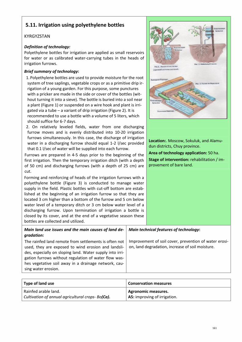
161
5.11. Irrigation using polyethylene bottles
KYRGYZSTAN
Definition of technology:
Polyethylene bottles for irrigation are applied as small reservoirs for water or as calibrated water-carrying tubes in the heads of irrigation furrows.
Brief summary of technology:
1. Polyethylene bottles are used to provide moisture for the root system of tree saplings, vegetable crops or as a primitive drip ir-rigation of a young garden. For this purpose, some punctures with a pricker are made in the side or cover of the bottles (wit-hout turning it into a sieve). The bottle is buried into a soil near a plant (Figure 1) or suspended on a wire hook and plant is irri-gated via a tube – a variant of drip irrigation (Figure 2). It is recommended to use a bottle with a volume of 5 liters, which should suffice for 6-7 days.
2. On relatively leveled fields, water from one discharging furrow moves and is evenly distributed into 10-20 irrigation furrows simultaneously. In this case, the discharge of irrigation water in a discharging furrow should equal 1-2 l/sec provided that 0.1 l/sec of water will be supplied into each furrow.
Furrows are prepared in 4-5 days prior to the beginning of the first irrigation. Then the temporary irrigation ditch (with a depth of 50 cm) and discharging furrows (with a depth of 25 cm) are cut.
Forming and reinforcing of heads of the irrigation furrows with a polyethylene bottle (Figure 3) is conducted to manage water supply in the field. Plastic bottles with cut-off bottom are estab-lished at the beginning of an irrigation furrow so that they are located 3 cm higher than a bottom of the furrow and 5 cm below water level of a temporary ditch or 3 cm below water level of a discharging furrow. Upon termination of irrigation a bottle is closed by its cover, and at the end of a vegetative season these bottles are collected and utilized.
Location:. Moscow, Sokuluk, and Alamu-dun districts, Chuy province.
Area of technology application: 50 ha.
Stage of intervention: rehabilitation / im-provement of bare land.
Main land use issues and the main causes of land de-
gradation:
The rainfed land remote from settlements is often not used, they are exposed to wind erosion and landsli-des, especially on sloping land. Water supply into irri-gation furrows without regulation of water flow was-hes vegetative soil away in a drainage network, cau-sing water erosion.
Main technical features of technology:
Improvement of soil cover, prevention of water erosi-on, land degradation, increase of soil moisture.
Type of land use Conservation measures
Rainfed arable land. Cultivation of annual agricultural crops- Во(Ca).
Agronomic measures. А5: improving of irrigation.

162
Environment
Habitat Anthropogenic environment
Average annual rainfall: 200-300 mm. Altitude (meter above sea level): 500-1000 m. Landscape: mountain and foothill slopes. Slope (%): >25% (hilly). Soil fertility: very low. Humus content in arable horizon: <1%. Natural soil drainage/infiltration: moderate.
Size of land area (ha): 0.5-1 ha. Landholder: small/middle sized, mixed. Land ownership: 75% individual, 25% state arable land. Water use rights: through WUAs and organizations responsible for management of irrigation systems on relevant payment. Market orientation: subsistence farming (self suffi-ciency), free market.
Assessment
Impact of technology
Main advantages:
- use of sloping, non-used land for cultivation of trees and bushes;
- reinforcing of sloping land to prevent erosion and delay of development of erosive processes;
- - increase of crop productivity under deficiency of ir-rigation water.
Main disadvantages:
- continuous tracking of remaining water in the bottles and refilling;
- additional labor costs for installation of bottles and their utilization at the end of the vegetative period.
Acceptance/adoption of technology: A method of use of plastic bottles is used wider in connection with develo-pment of unused and sloping land with lack of irrigation water.
Reference (s): Management of the Center of training, consultation and innovation: Bases of crop irrigation in Kyrgyzstan. www.taic.kg Name of person (s) of collected this description: Malik Bekenov, Head of department, Ministry of Agriculture and Land Im-provements of Kyrgyzstan. Address: 96-a, Kiyevskaya str., Bishkek. Tel.: +996 (551) 20 78 89. E-mail: [email protected]

163
6.Improving rangeland / fodder production

164
6.1. Technology of remote sensing and ground monitoring of ecological and ameliorative conditions of pastures
KAZAKHSTAN
Definition of technology:
Use of aerospace images and ground monitoring for assessment of ecological and reclamation conditions of pasture areas and operative decision-making.
Brief summary of technology:
Insufficient sustainability of desert forage complexes, especially under the influence of anthropogenic factors, necessitates a sys-tematic or periodic monitoring of desert rangelands, receiving operative information about the direction and scale of changes. Application of remote sensing methods for monitoring of vegeta-tion of desert areas is mostly related to the inaccessibility of the-se areas. Aerospace pictures are informative and have a considerable visibility, therefore allow assessing the situation ob-jectively and taking effective measures to conserve natural forage pastures and use them rationally.
Location: Moyunkum district, Zhambyl province.
Area of technology application: 14700 ha.
Stage of intervention: prevention of land degradation.
Main land use issues and the main causes of land de-
gradation:
Low productivity of the pastures due to inefficient use of fodder resources; pasture degradation due to water deficits and overgrazing near existing wells and sett-lements. Difficulty of ground inspection of condition and assessment of fodder capacity of pastures compli-cates operative decision-making.
Main technical features of technology:
Spatial regulation of the usage of fodder resources and ability to manage productivity of pastures.

165
Type of land use Conservation measures
Pasture land. Extensive Pasture land - Пэ(Ge).
Management measures:
У1: changing the type of pasture use - open pastures, cultivated pastures, including enclosures;
У3: planning according to natural and human needs;
У5: change in rotational sequence, control and diversifi-cation of species composition.
Environment
Habitat Anthropogenic environment
Average annual rainfall: 250-500 mm. Altitude (meter above sea level): 100-500 m. Landscape: plains. Slope (%): 0-2% (flat, smooth). Soil fertility: low. Humus content in arable horizon: not more than 1%. Natural soil drainage/infiltration: moderate, less than moderate.
Size of land area (ha): 1 000-10 000 ha. Landholder: small holders. Land ownership: state; long term lease. Water use rights: rental agreements for water use. Market orientation: Mixed farming (subsistence and commercial).
Assessment
Impact of technology
Main advantages:
- increasing operative decision making on improving conditions of pastures;
- reducing production costs; - increasing plant diversity, livestock production and
farm income.
Main disadvantages:
- complexity of mapping of pasture land in the initial phase.
Acceptance/adoption of technology: The technology has been tested and recommended for use
Reference(s):
1. Bekmuhamedov N. Method of determining the productivity of natural grassland on the satelite polygons of Kazakhstan. [Electronic resource]. http://agro.snauka.ru/2012/07/467. Access date: May 28, 2013.
2. Use of geographic information technologies in agricultural management. [Electronic resource]. http://isei-iii.communityhost.ru/thread/?thread__mid=128012681. Access date: July 03, 2013.
3. Myachina K., Malakhov D. Experience in the application of remote sensing data to medium spatial resolution for selec-ting objects in a technologically oxide modified landscape (example of the Orenburg province). // The Samara Scientific Center.
4. Project "Sustainable Rangeland Management for Rural Livelihood and Environmental Integrity." [Electronic resource]. http://www.zhailau.kz/. Access date: September 18, 2012.
5. Map of grazelands of the Kazakh SSR (1:1500000, 1976).
6. Vegetation map of Kazakhstan and Central Asia (within the desert provinces) (1:2500000, St. Petersburg, 1995).
Name of person(s) collected this description: T.Ustabaev, Junior Researcher at the Department of Water Resources Ma-nagement, KazRI of Water Resources. Address: 12, Koygeldy K. str., Taraz, 080003, Kazakhstan. Tel.: +7 726 2425540; +7 726 2426071; +7 726 2525333. E-mail: [email protected], [email protected] N. Bekmuhamedov Head of Laboratory “Remote Monitoring of agricultural production", JSC" NTSKIT "National Center of Space Research and Technology. Address: 15, Shevchenko str., 050010, Almaty. Теl./Fax: +7 727 2944554. Е-mail: [email protected]

166
6.2. Rotation of pastures in desert regions of Uzbekistan
UZBEKISTAN
Definition of technology:
Improvement of the scheme of cattle grazing provides restorati-on of pastoral vegetation and observance of a normative load on pastures.
Brief summary of technology:
In Uzbekistan, pastureland is transferred to shirkats on an unli-mited basis or to farms for a long-term rent. The population uses shirkat pastures for grazing of personal cattle, the number of which sometimes exceeds the number of a shirkat flock. The catt-le is grazed in the same pastures all year round and degradation occurs because of an overgrazing and passage of cattle along the same routes.
Based on traditional approaches, the technology pursues the aim to mitigate the degradation of pastures and to create conditions for self-restoration of pasture vegetation. For this purpose, each flock of 800 heads is provided with two sources of drinking water. The area of 7850 ha around a water source is divided into 2 sec-tors by diameter. Each sector is divided into 3 rotational sites. Under the existing productivity of pastures, one sector provides 800 heads of sheep with sterns during 90 days, the entire spring period. In summer the flock is overtaken to the second sector, and in the autumn to the second water well where the sheep grazing on rotational sites is done in the same sequence: in the first sector in autumn, in the second in winter. The rotational gra-zing provides a planned rest and a chance to plants to replenish energy and growth.
Private owners unite adult animals by 120-150 heads and young animals by 150-200 heads for grazing in the pastures allocated with the consent of the commission of pasture users. The com-mission regulates relationship of cattle owners with shirkat and local authorities (khokimiyat), conducts monitoring and estimates feed capacity of the pastures. On the basis of monitoring results the possible number of cattle grazing is corrected every season with the purpose of prevention of overgrazing. In the initial stage the commission of pasture users functions according to the in-structions of the Rural Gathering of Citizens, and later financing is provided at the expense of contributions of cattle owners.
Figure 1. A flock of sheep on the allocated site of a near-village pasture (Photo by: U. Nazarkulov)
Figure 2. Scheme of a rotational pasture of a flock (U. Nazarkulov)
Location: Bukhara province, Romitan district .
Area of technology application: 157 km2.
Stage of intervention: mitigation / reduc-tion of land degradation.
Main land use issues and the main causes of land de-gradation:
Vulnerability of desert ecosystems caused by natural-climatic factors, and irrational use of pastures, absen-ce pasture rotation, all-year-round cattle pasture in the limited area without accounting for feed capacity of the pastures and permissible load, cause develop-ment of land degradation processes.
Main technical features of technology:
Improvement of land cover, increase of biodiversity.

167
Type of land use Conservation measures
Pasture land.
Extensive Pasture land - Пэ(Ge).
Management measures: У2: Change of management/level of intensity.
Environment
Habitat Anthropogenic environment
Average annual rainfall: <250 mm. Altitude (meter above sea level): 100-500 m. Landscape: plains. Slope (%): 0-2% (flat). Soil fertility: low. Humus content in arable horizon: <1%. Natural soil drainage/infiltration: good.
Size of land area (ha): 100-5000 ha. Landholder: shirkats and farms. Land ownership: state; long term lease. Water use rights: through WUAs. Market orientation: Mixed farming (subsistence and commercial).
Assessment
Impact of technology
Main advantages:
- provides balance between requirements of local community of cattle-farmers and requirements of pastures for self-restoration;
- based on experience of local cattle-farmers, a local manpower is used - the shepherds owning the tech-niques of flock grazing according to rotation rules and available infrastructure - wells for drinking wa-ter;
- does not require very big investments in implemen-tation and is easily adapted with support of local au-thorities;
- animals satisfy need for food, passing a shorter way that reduces energy consumption of both animals and shepherds;
- provides a gain of animal weight.
Main disadvantages:
- demands primary investments for restoration of wells of drinking water;
- insufficient level of awareness and knowledge about prime causes of land degradation and insufficient level of ecological education of the population;
- lack of knowledge to make a scheme of pasture ro-tation.
Acceptance/adoption of technology: The technology is developed by the Project entitled: “Achievement of eco-system stability on degraded land in Karakalpakstan and the KyzylKum Desert” (UNDP-GEF and the Government of Uzbekistan) in 2008-2011. within the frame of CACILM. It is positively accepted by local population as it is di-rected towards the solution of problems of fodder balance for livestock in conditions of limited natural re-sources.
Reference(s): WOCAT Database. Technology code: T_UZB002ru. Compiled by: T. Hamzina, CACILM MSEC Date: 02.09.2011. Contact person: Irina Bekmirzayeva. Address: 21, Katartal str., 8 quarter, Chilanzar, 100113, Tashkent. Tel.: +998 (71) 273 90 89. E-mail: [email protected]
Name of person(s) collected this description: Tatyana Hamzina, Chief specialist on soil reclamation studies and irrigation re-gime. UZGIP LTD. Address: 44, Navoi str., Tashkent, Uzbekistan. Tel.: +998 90 9945654, Email: [email protected]

168
6.3. Use of artesian mineralized water for irrigated agriculture in Kyzylkum
UZBEKISTAN
Definition of technology:
Cultivation of fodder and a number of food crops in the Kyzyl Kum Desert on the basis of irrigation with mineralized water from a self-streaming artesian well.
Brief summary of technology:
The pasture animal husbandry of Uzbekistan is generally based on unproductive pastures of the Kyzyl Kum Desert, where defi-ciency of forages in spring is 20%, and in winter 35-40%. For the purpose of income increase, the local population increases a number of cattle livestock without accounting for the area and conditions of pastureland that leads to excess of standard load exerted to pastures and threatens biodiversity. Therefore, orga-nization of fodder production and creation of an insurance fora-ge stock is a pressing task.
Fodder production in the Kyzyl Kum Desert is organized on the basis of available artesian wells. Considering water mineralizati-on (Ec=5.6-8.3 ds/m), irrigated agriculture is possible only in light texture desert soils in crop rotation with halophytes, which extract up to 40% of salts from the soil. Agro-techniques and ir-rigation are traditionally applied in irrigated agriculture.
The following types of forage crops are tested: “Movlono” win-ter barley, “Kirghiz-1” rye, “Prague silvery” triticale, “kroshka” wheat; "White teeth" corn, “Aip-13150” African millet, “Oq juho-ri” and “Venichnoye" sorghum, Sudanese grass; "Tashkent", “Eu-reca”, “D-1”, “D-2” alfalfa, licorice naked and fodder halophytes - kokhiya coronal K. scoparia (L.) Schrad, bassiya issopolistny Bassia hyssopifolia (Pallas) O. Kuntze, sea blite S. altissima, and klimakoptera woolly Climacoptera lanata.
The technology allows to receive 3-5 t/ha of straw and 1.5-2.0 t/ha of winter wheat grains, 48-78 t/ha of silage mass of corn, sorghum and millet, 14.4-15.0 t/ha of alfalfa hay, 23 t/ha of hay from above-ground biomass of licorice, 5.0-10.0 t/ha of halo-phyte hay. The net profit from irrigated agriculture on minerali-zed artesian water in Kyzylkum desert is 1.5 million soum/ha. Potential area of implementation can be 25,000 ha.
Figure 1. A general view of an artesian well and a water intake for irrigation (Photo by: A. Rabbimov)
Figure 2. Technical scheme: (water from a self-streaming well flows by gravity along the irrigation ditch or a modular polyethyle-ne tray from which it is distributed into irri-gation furrows)
Location: Kanimekh district, Navoiy pro-vince.
Area of technology application: 30 ha.
Stage of intervention: mitigation / reduc-tion of land degradation.
Main land use issues and the main causes of land de-gradation:
Vulnerability of desert ecosystems caused by natural-climatic factors, aggravated by irrational use of pastu-res, absence of pasture rotation, excess of permissible load and overgrazing, are the causes of land degrada-tion.
Main technical features of technology:
Preservation of the topsoil layer, restoration of vege-tative cover, increase of biodiversity, nutritious ele-ments and organic matter in the soil.
Type of land use Conservation measures
Pasture land. Extensive Pasture land - Пэ(Ge).
Agronomic measures: A1: Vegetation / soil cover; A3: Processing of soil surface.

169
Management measures: У1: Change of land use type; У2: Change of management / level of intensity.
Environment
Habitat Anthropogenic environment
Average annual rainfall: <250 mm. Altitude (meter above sea level): 100-500 m. Landscape: plains. Slope (%): 0-2% (flat). Soil fertility: low. Humus content in arable horizon: <1%. Natural soil drainage/infiltration: good.
Size of land area (ha): 100-5000 ha. Landholder: shirkats and farms. Land ownership: state; long term lease. Water use rights: through WUAs. Market orientation: mixed farming (subsistence and commercial).
Assessment
Impact of technology
Main advantages:
- does not demand special investments for implemen-tation;
- possible to quickly receive high income: up to 1.5 million soum of net profit from each ha;
- available local resources and materials can be used; - existence of the guaranteed source of water for irri-
gation provides stability of production; - creates workplaces and increases employment and
production increase.
Main disadvantages:
- lack of equipment, experience and farming stan-dards at the local population, which traditionally do cattle breeding.
Acceptance/adoption of technology: The technology is developed at the Uzbek research institute of astrakhan sheep breeding and ecology of deserts. It is positively accepted by local population, there is a tendency of spon-taneous acceptance of the technology, but absence of experience and farming standards at local population which does cattle breeding is an obstacle.
Reference(s): WOCAT Database. Technology code: T_UZB003ru. Compiled by: R. Ibragimov, CACILM MSEC. Date: 15.09.2011. Contact person: Tolib Mukimov, Uzbek research institute of astrakhan sheep breeding and ecology of deserts. Samarkand. Tel.: +998 (66) 92 95 40. E-mail: [email protected]
Name of person(s) collected this description: Tatyana Hamzina, Chief specialist on soil reclamation studies and irrigation re-gime. UZGIP LTD. Address: 44, Navoi str., Tashkent, Uzbekistan. Tel.: +998 90 9945654, Email: [email protected]

170
6.4. Establishing seed farming plot of perennial grasses
KAZAKHSTAN
Definition of technology:
Improvement of pastures by establishing of seed farming sites and additional sowing of perennial bean and cereal herbs.
Brief summary of technology:
Excess of load exerted on pastures and absence of pasture rota-tion caused overgrazing and degradation of pastures adjacent to the Katon-Karagay village.
A technology of pasture improvement by additional sowing of perennial bean and cereal fodder herbs (esparcet, alfalfa, Eas-tern catgut, rump, cocksfoot) and their mixture is developed within the frame of the GEF/PMG project on „The organization of management of pasture land of the Katon-Karagay village“ for minimization of land degradation.
The main components of the technology are:
1. A site protection for prevention of crop damage by livestock;
2. Soil preparation - plowing to a depth of 25-27 cm with soil moving, harrowing and alignment;
3. Spring sowing of cover annual crops (barley, oats) to a depth of 5-10 cm;
4. Sowing of perennial herbs and cereals (brome, couch grass, esparcet, sweet clover, three-fork-grass) to a depth of 2-3 cm across plantations of annual crops;
5. Harvesting of annual crops and perennial herbs for forage (once a year in autumn);
6. Collecting seeds is carried out for the third year after sowing.
As herbs are perennial, only periodic application of nitric fertili-zers is carried out.
In the first two years before development of turf, the land is not used as pastures. Besides actual restoration of pastures, the seed material from a site is used for restoration of pastures in other rural districts.
Figure 1. Mowed herbs on a seed farming site (Photo by: K.M. Pachikin)
Figure 2. Sowing of perennial herbs seeds on plowed and harrowed site (Photo by: K.M. Pachikin)
Location: East-Kazakhstan/Katon-Karagay district.
Area of technology application: 80 ha.
Stage of intervention: prevention of degra-dation, mitigation / reduction of land de-gradation.
Main land use issues and the main causes of land de-gradation:
Land degradation because of irrational use of pastures (increase of livestock without considering fodder availability and a permissible load), absence of pasture rotation, overgrazing near settlements, absence of regenerative measures).
Main technical features of technology:
Improvement of land cover, increase of biomass and biodiversity, improvement of soil structure.
Type of land use Conservation measures
Pasture land. Extensive Pasture land - Пэ(Ge).
Vegetation measures: В2: Grass and perennial grass plants.

171
Environment
Habitat Anthropogenic environment
Average annual rainfall: 400-500 mm. Altitude (meter above sea level): 1000 m. Landscape: intermountain valley. Slope (%): 2-5% (gentle). Soil fertility: high. Humus content in arable horizon: >3%. Natural soil drainage/infiltration: good.
Size of land area (ha): 2-5 ha. Landholder: smallholder land users. Land ownership: state; long term lease. Water use rights: rent agreements on water use. Market orientation: mixed farming (subsistence and commercial).

172
6.5. Autumn and early spring irrigation as a mechanism to improve pastures in conditions of climate change in Southern Kazakhstan
KAZAKHSTAN
Definition of technology:
Early irrigation of fields and pastures for the purpose of creation of moisture storages in the soil for a dry season in the Southern Kazakhstan.
Brief summary of technology:
The technology is implemented in the Sadu Shakirov village (Talas district, Dzhambyl province). During the Soviet period 2,105 ha of arable land and 66,408 ha of hay mowing in the vil-lage were irrigated from the Talas River by the Sharuashlyk channel. Increase of water intake in the upstream of the river led to falling water levels in the Talas River and in the channel. As a result, irrigated agricultural production became impossible, and arable land was used for all-year-round pasture of cattle. Chan-nel maintenance stopped and it became unfit for use. A situation was aggravated by a climate change (decrease of precipitation, increase of temperature and summer droughts). Reduction of forage crops negatively affected animal husbandry and welfare of local population. Public association „Kogal of Sadu Shakirov village“ restored 12 km of the channel and 5 sluices with the purpose of carrying out autumn and winter moisture-replenishing irrigations during the period when the majority of water users upstream do not use water. The autumn and winter moisture-replenishing irrigations create moisture stocks in the 1.5-2 m soil layer, which are used by crops in spring and begin-ning of summer. Therefore, dates of the beginning of vegetative irrigations are postponed and their number is reduced.
Out of 90 ha of the irrigated fallow land, 60 ha were sowed by alfalfa to create fodder stocks for winter, and the remaining area was used for the natural hay land. As a result, productivity in-creased from 0.35 to 0.5 t/ha.
The purpose of technology consists of reduction of processes of land degradation and desertification through moisture accumu-lation in a crop root zone during autumn, winter and early-spring periods.
Figure 1. Reconstruction of irrigation canal by local community for autumn and early-spring irrigation of alfalfa from the Talas Ri-ver (Photo by: Gulnara Bekturova)
Figure 2. Spring irrigation of alfalfa in OO "Kogal" (Photo by: Ospanbek Anuarbek)
Location: Talas district, Zhambyl province.
Area of technology application: 560 ha.
Stage of intervention: mitigation / reduc-tion of land degradation.
Main land use issues and the main causes of land de-
gradation:
Land degradation due to lack of surface water re-sources and aggravation of climate dryness
Main technical features of technology:
Increase of soil moisture accumulation, irrigation, im-provement of soil cover, increase of biomass and bio-diversity.

173
Type of land use Conservation measures
Pasture land. Extensive Pasture land - Пэ(Ge).
Agronomic measures: A5: Irrigation.
Vegetation measures: В2: Grass and perennial grass plants.
Environment
Habitat Anthropogenic environment
Average annual rainfall: 250-500 mm. Altitude (meter above sea level): 100-500 m. Landscape: intermountain valley and plain. Slope (%): 2-5% (gentle) and 5-8% (moderate). Soil fertility: low. Humus content in arable horizon: in average 1-3%. Natural soil drainage/infiltration: good.
Size of land area (ha): 100-500 ha. Landholder: communities, small and moderate scall land users. Land ownership: state; rent for 49 years. Water use rights: a rental fee is collected for the use of water during irrigation season. Market orientation: mixed farming (subsistence and commercial).
Assessment
Impact of technology
Main advantages:
- reduction of soil degradation (wind and water erosi-on, loss of humus, etc.);
- application of winter irrigations allows to restore al-falfa crops which considerably improves soil quality;
- adaptation of local population to climate change; - improvement of institutional communications and
unity of local community.
Main disadvantages:
- possible water deficiency in the Talas River for irriga-tion;
- there is a probability of shortage of means at land users for technology realization.
Acceptance/adoption of technology: A tendency of growing acceptance of this technology cannot be considered as significant since many inhabitants are still afraid of a reduction of water availability in the Talas River because of high withdrawal of water by the upstream consumers.
Reference(s): WOCAT Database . Technology code: T_KAZ008ru. Compiled by: A. Eschanova. CACILM MSEC. Date: 17.09. 2011. Contact person: Anuarbek Ospanbek, Chairman of OO "Kogal". Address: 21, Konayev str., Shakirov village, Sadu, Talas dis-trict, Zhambyl Region, Kazakhstan. Tel./Fax: +7 (726) 413 62 38.
Name of person(s) collected this description: Tatyana Hamzina, Chief specialist on soil reclamation studies and irrigation re-gime. UZGIP LTD. Address: 44, Navoi str., Tashkent, Uzbekistan. Tel.: +998 90 9945654, Email: [email protected]

174
6.6. Monitoring of pasture conditions
KYRGYZSTAN
Definition of technology:
Systematic assessment of pastures for timely identification of changes of conditions and productivity under the influence of both anthropogenic and climatic factors, and elimination of nega-tive processes.
Brief summary of technology:
Monitoring of a condition of pasture vegetation is a basis for ma-king a plan of pasture use. Responsibility for carrying out the mo-nitoring is assigned to Pasture committees according to the Law of Kyrgyzstan „On pastures“. Considering that this kind of activity is new for Pasture committees, demanding special knowledge, a simple technique of assessment of pasture conditions was deve-loped. It includes:
1. Choice of a site: set up a frame of 1 m2 for productivity deter-mination, note coordinates of the chosen site in the map with help of GPS.
2. Specify the site name and information on a pasture condition (erosion, soil salinization, etc.).
3. Take a picture of the site for visual comparison of vegetation development within a year.
4. Estimate a vegetative cover inside a frame and measure vege-tation height by a ruler. Define plant species in a square and divide them into eatable and not eatable. Spread out plants by sacks, write notes about a place of plants withdrawal and note withdrawal date (use pencil).
5. A grass from 1 m2 is mown in 5 replications for determination of productivity of surveyed land (frame is moved sequentially along a diagonal by 5 m from a corner of each control point). A height of mowing in hay land is 7-8 cm, in short grassland pas-tures - 4-6 cm, in tall grassland pastures - 6-7 cm.
6. Weigh samples in raw form and after drying with division into eatable and not eatable and calculate productivity for each ty-pe of pastures.
Figure 1. Selection and taking photo of a typical site for carrying out monitoring (Photo by: archive of CAMP Alatoo)
Figure 2 Technical scheme. Calculation example of capacity of the pas-ture site (Stefanie Bussler)
Location: ail districts - Zhergetal, Minbulak and Onarcha, Narin district, Narin province.
Area of technology application: 10-100 km2.
Stage of intervention: mitigation / reduc-tion of land degradation.
Main land use issues and the main causes of land de-
gradation:
Absence of financing of pasture monitoring led to ab-sence of estimation during the last 20 years and respectively, no adequate measures for prevention of their degradation were taken.
Main technical features of technology:
Improvement of soil cover, increase of biomass and biodiversity.
Type of land use Conservation measures
Pasture land. Extensive Pasture land - Пэ(Ge).
Management measures: У2: Change of management/level of intensity.

175
Environment
Habitat Anthropogenic environment
Average annual rainfall: 250-500 mm. Altitude (meter above sea level): 2000-3000 m. Landscape: mountain and foothill slopes. Slope (%):16-30% (hilly). Soil fertility: average. Humus content in arable horizon: 1-3%. Natural soil drainage/infiltration: good.
Size of land area (ha): 15-50 ha. Landholder: communities, small and moderate scale land users. Land ownership: communal, private. Water use rights: a rental fee is collected for the use of water during irrigation season. Market orientation: mixed farming (subsistence and commercial).
Assessment
Impact of technology
Main advantages:
- annual monitoring of pastures will allow to track dy-namics of a condition, productivity of pastures and to plan their use.
Main disadvantages:
- it is necessary to have certain skills and knowledge for carrying out monitoring of pastures;
- features of local mentality - attitude to pastures as natural never-ending gift in a combination with a loss of traditional care.
Acceptance/adoption of technology: after training of pasture committees, this approach is used by all ail dis-tricts as development of the pasture use plan is their function.
Reference(s): WOCAT Database. Technology code: T_KYR007ru. Compiled by: Azamat Isakov. CACILM MSEC. Date: 13.02.2013. Contact person: Azamat Isakov, CAMP Alatoo. Address: 3, Ufim Lane, Bishkek.
Name of person(s) collected this description: Tatyana Hamzina, Chief specialist on soil reclamation studies and irrigation re-gime. UZGIP LTD. Address: 44, Navoi str., Tashkent, Uzbekistan. Tel.: +998 90 9945654, Email: [email protected]

176
6.7. Pasture management through rehabilitation of a system of pasturing animal husbandry and radical improvement of pastures
KAZAKHSTAN
Definition of approach:
Restoration of the degraded pastures and increase of their effi-
ciency by the organization of pasturing animal husbandry and int-
roduction of pasture rotation.
Brief description of approach:
The system of pasturing animal husbandry was organized for re-ducing the load of near-aul (near-village) pastures within the fra-me of the GEF/PMG project "Preservation and sustainable use of biodiversity of Kazakh part of Altai - Sayansk eco-region".
The group of GEF/UNDP project consultants established the public association "Mametek". A contract on joint activity was signed between rural akimat, OO "Mametek" and "Atameken" farm according to which the akimat provided near-aul pastures to "Atameken" farm for a short-term rent (for 5 years).
The high-mountainous pasture located 40 km from the Katon-
Karagay village was prepared for pasture rotation. Enclosing of
night corrals, repair of the road to a pasture, purchasing of
equipment for cattle breeders (yurta, tent, solar batteries) was
carried out by local inhabitants and financed by the GEF/PMG
project. Plan for restoration of the pastures adjacent to the
Katon-Karagay national natural park was developed, norms of
pasture load were established and the scheme of pasture rotati-
on was developed after inspection of these pastures. All pasture
sites were fenced. Livestock of all local inhabitants was organized
in herds and a cowboy was employed at the expense of the
GEF/PMG project. OO "Mametek" conducts direct organization of
works, control of pasture order in sites, norm of pasture and loa-
ding.
Figure 1. A pasture site included in the pas-ture rotation scheme (Photo by: K.M. Pachikin)
Figure 2. Monitoring of cattle pasture by an initiative group (Photo by: K.M. Pachikin)
Location: Katon-Karagay district, East-
Kazakhstan.
Area of technology application: 1500 ha.
Main land use issues and the main causes of land de-gradation:
A considerable increase of a livestock is observed in the district in recent years. As a result, all cattle is con-centrated round settlements, there is an unsystematic use of pastures that leads to loss of herbage and land degradation.
Purpose of the approach:
Main objective is restoration of the degraded pastures by renewal of a traditional way (seasonal nomadic animal husbandry) with introduction of pasture rota-tion and regulated loading with wide involvement of local population.
Assessment
Impact of technology
Main advantages:
- restoration of the degraded pastures and increase of their productivity;
- the steady interconnected scheme Akimat - OO Mametek – Atameken farm is developed, which al-
Main disadvantages:
- the land does not belong to land users, and is pro-vided for a short-term rent. It is unknown whether the rent will be prolonged.

177
lowed to introduce this approach (state and econo-mic structures, local community);
- despite rather high initial expenses, the subsequent
current expenses are insignificant.
Acceptance/adoption of technology: The example of the land users participating in realization of the approach induces a part of villagers to join and expand activity.
Reference(s):


179
Assessment
Impact of technology
Main advantages:
- participation of local community in planning of pas-ture use increases their responsibility for pastures;
- achievement of the stable income from animal hus-bandry.
Main disadvantages:
- realization of an approach demands certain skills and potential that not always available to Pasture com-mittees;
- base materials and base data for approach realizati-on are required (for example: information on pastu-re area, maps of pastures, etc.).
Acceptance/adoption of technology: The pasture use plan is a part of the pasture management plan. The fun-ding mechanism of pasture management plan is provided by the legislation of Kyrgyzstan, which is based on payments of pasture users for cattle grazing in these pastures. These payments form the budget of Pasture committee. Total amount of the budget depends on the plan of pasture use and planned actions for improve-ment of infrastructure and pasture conditions. Thus, sustainability of this approach is provided.
Reference(s): WOCAT Database . Technology code T_KYR007ru. Compiled by: Azamat Isakov. CACILM MSEC. Date: 13.02.2013. Contact person: Azamat Isakov, CAMP Alatoo. Address: 3, Ufim Lane, Bishkek. Name of person(s) collected this description: Tatyana Hamzina, Chief specialist on soil reclamation studies and irrigation re-gime. UZGIP LTD. Address: 44, Navoi str., Tashkent, Uzbekistan. Tel.: +998 90 9945654, Email: [email protected]

180
6.9. Mapping for pasture use development plan
KYRGYZSTAN
Definition of approach:
Mapping (development of maps of pasture sites) of pasture use as a basis for the balanced distribution of livestock depending on capacity of the pastures and seasonality of their use, with partici-pation of all interested parties.
Brief description of approach:
Realization of the approach begins with collecting cartographic materials of the aul district. Then digitizing of geo-botanical maps of the pastures (in ArcGIS 9 program) is conducted with indication of vegetation types in the table of attributes, the gross efficiency, eatable efficiency and recommendations for the seasonal use of pastures are developed.
Pasture committees define external borders of the pastures, u-sing old maps from the Soviet period. Newly established borders of pastures are coordinated with the neighboring aul districts. A consensus is reached on disputable territories. Further, the Pas-ture committees define internal borders of pasture sites, which are usually represented by natural barriers (rivers, ridges, rocks, etc). The borders of pasture sites defined by Pasture committee are placed in the geo-botanical maps. The final map, which re-flects the types of pastures in various pasture sites, forms a basis of calculation of capacity of each pasture site. Capacities of pas-ture sites during various seasons are obtained by multiplication of the general capacity to coefficients for every season which are provided by Kyrgyzgiprozem. The results are transferred to four simple maps representing the potential capacity of the pasture sites during spring, summer, autumn and winter periods. These maps are used by the Pasture committee for development of plans of pasture use.
Figure 1. Members of the Pasture commit-tee define external and internal borders of pasture sites (Photo: PF CAMP Alatoo's archive)
Figure 2. Map of capacity of near-aul pas-tures of the Zhergetal aul district for the spring period (Photo by: Azamat Isakov)
Location: Naryn district.
Area of implementation: 2500 km2.
Main land use issues and the main causes of land de-gradation:
Absence of accurately outlined both external and in-ternal borders of pastures leads to different problems during the use and management of pastures - to the conflicts both between the neighboring Pasture com-mittees and between pasture users. Lack of cartogra-phic materials with borders of pastures at Pasture committee complicates an assessment of a condition and planning of pasture use.
Purpose of the approach:
Reduction/prevention of degradation of pastures by a mapping of pasture sites for development of plans of their use; Providing the Pasture committees with skills on deve-lopment of cartographic materials for high-level per-formance of functions on the use of pastures.

181
Assessment
Impact of technology
Main advantages:
- participation of local community in planning the use of pastures increases their responsibility for pastur-es;
- increase of capacity of Pasture committee; - providing Pasture committees with consulting ser-
vices (eg, through rural consulting services); - achievement of the stable income from animal hus-
bandry.
Main disadvantages:
This approach demands: - special skills and software, such as GIS; - increase of potential of GIS experts; - providing with required maps of pastures; - training of pasture users.
Acceptance/adoption of technology: The plan of pasture use is a part of the pasture management plan. The funding mechanism of the pasture management plan is provided by the legislation of Kyrgyzstan, which is based on payments by pasture users for grazing of their livestock. These payments form the budget of the Pasture committee. Total amount of the budget depends on the plan of pasture use and planned actions for improve-ment of infrastructure and condition of pastures. Thus, sustainability of this approach is provided. However, rea-lization of the approach also demands certain skills for mapping that can be reached through training of mem-bers of the Pasture committees.
Reference(s): WOCAT Database . Technology code T_KYR007ru. Compiled by: Azamat Isakov. CACILM MSEC. Date: 13.02.2013. Contact person: Azamat Isakov, CAMP Alatoo. Address: 3, Ufim Lane, Bishkek. Name of person(s) collected this description: Tatyana Hamzina, Chief specialist on soil reclamation studies and irrigation re-gime. UZGIP LTD. Address: 44, Navoi str., Tashkent, Uzbekistan. Tel.: +998 90 9945654, Email: [email protected]

182
7. Increasing capacity of land users / environmental education

183
7.1. Farmer Field Schools in the irrigated zone
UZBEKISTAN
Definition of approach:
Training of agrotechnical and ameliorative methods of soil impro-vement and increase of their productive capacity to farmers by specially prepared instructors (from local experts) within the fra-me of Field farmer schools (FFS).
Brief description of approach.
Stages of FFS establishment:
I. Development of the curriculum. During a 3-day seminar, natio-nal scientists, agriculture and water management experts, advan-ced farmers under the direction of the international FAO consul-tant developed the training program, approved subject and con-tents of training modules.
II. Preparation of teachers. The specialists of Scientific Research Institute and the project consultants prepared the teachers for FFS during 3 weeks at the educational seminar

184
Assessment
Impact of technology
Main advantages:
- PPS provide the chance to train farmers on the job during time convenient for them;
- PPS provide mass training of farmers; - special educational institutions and high financial in-
vestments are not required; - farmers have a possibility to exchange experience, to
discuss problems and ways to solve with each other during training in PPS.
Main disadvantages:
- though PPS is an informal organization, it demands support of local authorities in the organization and financial support of the state authorities during the first stage is required.
Acceptance/adoption of technology: 300 farmers were trained within the frame of the FAO TCP/UZB/2903 pro-ject, 690 farmers were trained within the frame of the WB project on „Reconstruction of irrigational and draina-ge infrastructure and restoration of wetlands“ (2005-2009) in PPS of the South Karakalpakstan; 152 farmers gai-ned experience on selected measures of the best practices, participating in the field days organized for the far-mers living in the neighborhood to demonstration sites, who were not PPS listeners. Training of farmers with use of the FAO PPS approach is an integral part of many investment projects in agriculture in Uzbekistan.
Reference(s): WOCAT Database . Approach code: A_UZB003ru. Compiled by: Rustam Ibragimov, CACILM MSEC. Date: 24.12.2011.
Name of person(s) collected this description: Tatyana Hamzina, Chief specialist on soil reclamation studies and irrigation regime. UZGIP LTD. Address: 44, Navoi str., Tashkent, Uzbekistan. Tel.: +998 90 9945654, Email: [email protected]

185
7.2. Farmer Field Schools
TAJIKISTAN
Definition of approach:
Farmer field schools (PPS) are organized with the purpose of completion of gaps in knowledge of farmers of implementation of sustainable agricultural agro-technologies, irrigation water and prevention of land degradation.
Brief description of approach. Stages of PPS formation:
Farmer field schools are a part of the UNDP-GEF project on „De-monstration of response actions to cope with land degradation and improvement of sustainable management of land resources in the southwest of Tajikistan“.
Prior to the formation of PPS, 4 local agronomists were employed by UNDP from target jamoats and are sent to Russia for training. Upon return, they started to provide PPS classes in each of the 4 jamoats.
Prior to the beginning of PPS work, the needs for training were identified after meetings with local farmers, according to which the training program and the schedule of classes coordinated with participating farmers was prepared.
Every year four groups of farmers by 10-20 farmers in each group are formed in 4 different jamoats. Training includes studies in classes and practical work in the fields. The contents of the stu-dies is effectively adapted according to a season and crops.
Training in PPS is voluntary and is focused on effective use of irri-gation water, integrated crop management, management of wa-terlogging by means of bio-drainage, prevention of formation of ravines, pest control, etc. The field (0.5 ha) where the PPS parti-cipants study the best practices and agro-technologies was provi-ded to PPS by one of farmers.
Figure 1. Field demonstration measures for the farmers attending field schools (Photo: UNDP, Shaartuz)
Organogramm of PPS 4 local agronomists employed by UNDP, after training in Russia began to work as teachers in PPS (Figure by: July Zaringer)
Location: Shaartuz village, Hatlon province.
Main land use issues and the main causes of land de-
gradation:
Majority of collective farms were disbanded following disintegration of the Soviet Union dekhkan farms were established as a result of land reforms. People without agricultural education and experience became farmers. However, lack of knowledge and experience often led to inappropriate land use practices that promoted its degradation.
Purpose of approach:
Field farmer schools are aimed at increase of far-mers’ potential and introduction of the best practices of land and water use in irrigated agriculture.

186
Assessment
Impact of technology
Main advantages:
- PPS provide the chance to train farmers on the job during time convenient for them;
- PPS provide mass training of farmers; - special educational institutions and high financial in-
vestments are not required; - farmers have a possibility to exchange experience, to
discuss problems and ways to solve with each other during training in PPS.
Main disadvantages:
The training in PPS was free of charge as financial support was provided by the project; however to sustain continuity of work of field schools the farmers should pay for the studies. Moreover, in order to pay, the farmers should realize the importance and need of PPS.
Acceptance/adoption of technology: As local farmers passed the corresponding training, they can be available as consultants to provide training at farmer field schools. If the mechanism of granting micro loans and repay-ment continues to work, financing will be available to ensuring continuation of schools.
Reference(s): WOCAT Database. Approach code: A_TAJ018ru. Compiled by: Firdavs Fayzulloyev, UNDP Tajikistan. Date: 15.04.2011. Contact person: Firdavs Fayzulloyev, UNDP, Regional manager. Address: 2, Ziodaliyev str., Shaartuz office, Shaartuz, Tajikis-tan. Tel.: +992-918 79 52 78. E-mail: [email protected]
Name of person(s) collected this description: Tatyana Hamzina, Chief specialist on soil reclamation studies and irrigation regime. UZGIP LTD. Address: 44, Navoi str., Tashkent, Uzbekistan. Tel.: +998 90 9945654, Email: [email protected]

187
7.3. Establishment of rural schools for farmers and support
TAJIKISTAN
Definition of approach:
Carrying out tender process on implementation of the corres-ponding SLM practice.
Brief description of approach:
Seminars for communities and local authorities were held with the purpose of realization of the approach. Project employees trained active community members in the proper methods of the land resources management and preparing competitive offers for consideration by their selection commission. Degraded land was officially provided to the school for the period of twenty years by the awarded grants.
Introduction stages:
INPO Welthungerhilfe declared competition among local popula-tion on design propositions to the solution of environmental problems.
Local authorities involved in the project provided the list of com-munities for participation in the competition. Seminars were held among communities on development of propositions of sustainable land management with support of local agronomists. The community members presented the design propositions un-der the guidance of teachers for receiving support in WHH reali-zation.
According to terms of the competition, the winner project will receive a site for land restoration and part of financing (up to 50% from the total cost) in the form of fuel, equipment, fence protection, etc. As the end of the competition the degraded land was given to school for the period of twenty years. Local commu-nity was mobilized for the project implementation by means of „khashar“ collective work and the school took up responsibility for the site on completion of works.
Figure 1. School teachers create and check various barriers (Photo by: Daler Domullodzhonov)
Location: Dorobi, , Hovalin district, Hatlon province.
Main land use issues and the main causes of land de-gradation:
Poor practice of land resources management, shorta-ge of knowledge and means led to sustainable land degradation and loss of fertility.
Purpose of approach:
Ecological restoration with involvement of communi-ty, increase of potential of the village inhabitants and young generation for environmental protection and effective use of natural resources.

188
Assessment
Impact of technology
Main advantages:
- inexpensive, holistic approach with involvement of all community members through rural school;
- approach provides school with a source of income and a training place for children.
Main disadvantages:
- the degraded site does not bring income and be-nefits during initial years.
Acceptance/adoption of technology:
Reference(s): WOCAT Database. Approach code: A_TAJ022ru. Compiled by: Domullodzhonov Daler. Date: 09.12.2011. Contact person: Daler Domullodzhonov. Address: 77, office in Temurmalik, H.Zarif str., Hatlon region, Welthungerhilfe, So-viet village, Temurmalik district, Tajikistan. Tel.: +992 918 248084. E-mail: [email protected]
Name of person(s) collected this description: Tatyana Hamzina, Chief specialist on soil reclamation studies and irrigation regime. UZGIP LTD. Address: 44, Navoi str., Tashkent, Uzbekistan. Tel.: +998 90 9945654, Email: [email protected]

189
7.4. Sub-district (jamoat level) support of sustainable land management
TAJIKISTAN
Definition of approach:
The use of the sub-district level organizations for providing more effective, transparent and accountable services to farmers during the course of the project.
Brief description of approach:
Thirty-nine Committees for jamoat (CJ, sub-district) development worked in four design sites. They acted as NGO, had the chosen officials and helped with the organization of 43,000 households into groups for carrying out 4,000 investments into agricultural production, including various SLM technologies in 42 kishlaks (vil-lages). CJ disposed of the sum of $7.4 million in the form of small grants. Use of CJ was based on existing initiatives on strengthen-ing of local management. CJ cooperated and received support from project management Groups (PMG) appointed by the government, field project coordination Groups (FPCG) and four supporting organizations (SO), with which the contract was sig-ned.
Introduction stages:
Experts of CJ, SO and PMG carried out the following activities:
1) preparation of joint Plans of activity of community (PAC), which joined the proposed investments into agricultural pro-duction and formation of Groups of common interests (GCI);
2) participation in sub-district and design study of a watershed and the approval of propositions on the agricultural produc-tion received from GCI for the purpose of ensuring economic, ecological and social feasibility;
3) management and delivery of grants of the PMG GCI; 4) monitoring of official investment agreements with participa-
ting GCI; 5) monitoring, assessment and preparation of reports; and 6) establishment of contacts with other kishlaks and the approp-
riate state authorities for support of delivery of permissions, resources use, signings of agreements, certificates on the right for land use, etc.
Figure 1. Thirty nine Committees on jamoat development with the chosen officials pro-vide important financial and technical sup-port to more than 3,500 Groups of com-mon interests for ensuring agricultural production.
Scheme 1. Organization of the project im-plementation on communal agriculture and watershed management (department of the project Management).
Location: 39 sub-districts and 7 districts, Sugd, Hatlon, RRP, GBAO.
Main land use issues and the main causes of land de-gradation:
Limitation of financial and technical resources for ag-ricultural farming in the mountainous areas because of concentration of government’s attention on cotton yields. Remoteness limits access to available re-sources.
Purpose of approach:
Effective and trust inspiring institutional arrangements in the frame of the express project for assistance to farmers living in the mountain districts in use of the skills promoting increase of the agricultural producti-vity taking into account ecological rationality.

190
Assessment
Impact of technology
Main advantages:
- volume and scale of the CJ mandate is effective for service provision to farmers in mountainous, often remote districts;
- collective processes help to provide effective work of the organizations of CJ type with state authorities in the issues of presentation of technical and financial resources to farmers.
Main disadvantages:
- uncertain financial stability of CJ after the project termination in absence of donor financing.
Acceptance/adoption of technology: Project assessment in general showed that about 80 % of the investments executed with support of CJ and other partners in the project, in combination with other types of design activity, were successful.
Reference(s): WOCAT Database. Approach code: A_TAJ047ru. Compiled by: Nandita Jain, World bank. Date: 09.08.2011. Contact person: Zhessika Mmott. E-mail: [email protected]
Name of person(s) collected this description: Tatyana Hamzina, Chief specialist on soil reclamation studies and irrigation regime. UZGIP LTD. Address: 44, Navoi str., Tashkent, Uzbekistan. Tel.: +998 90 9945654, Email: [email protected]

191
7.5. Development of an agro-ameliorative pass-port - one of the ways to increase the knowledge of land users
UZBEKISTAN
Definition of approach:
Agro-ameliorative passport of farmer's field, including full infor-mation on soil ameliorative and climatic conditions of the field, topography, nutrients, salinity, etc, is a demonstration tool for decision-making for efficient agricultural production.
Brief description of approach:
Agricultural reforms in Uzbekistan contributed to the formation of many small farm entities. Owners of the land were the re-presentatives of different professions, often not associated with agricultural production. This largely explains failures and mistakes of the farmers, leading to a decrease of crop yields and decline of soil fertility.
One of the forms of increased knowledge of land users is the de-velopment of Agro-ameliorative passport (AMPP) of the field (farm). AMPP is a generalization of agronomic information and contains main agronomic documentation of the specific site, as well as some reference data, regulatory materials and recom-mendations that are needed in agriculture and crop production. AMPP contains 18 pages and includes the following main im-portant information:
- Areal assessment of the field (gross, net, unused land, areas under roads, collector-drainage networks, irrigation network);
- cropping pattern and levels of their productivity;
- main agronomic characteristics of soils;
- average annual climatic data;
- topography (planar and spatial representation of the field ge-ometry);
- cartograms of availability of soil humus, nitrogen, phosphorus, potassium, salinity and texture of the 1-m soil layer by hori-zons; etc. Fragments of AMPP are presented in Figure 1-2.
Most of the information is presented in a graphical form that clearly reflects field characteristics. Cartograms allow observing specific parts of the field that require leaching, leveling, differen-tial fertilizer applications, etc. Annual inclusion of a new informa-tion extends AMPP service to 10 years. The passport allows far-mers to choose the right decisions during implementation of the technological works, to carry out an objective analysis of the dy-namics of agricultural production and improve farming.
Fragments of agro-ameliorative passport of a field
Main field characteristics Soil type – light serozem; Texture – medium loam; Slope – 0.003; Groundwater level - 2.8 m (winter), 1.9 m (summer); History of irrigation – since 1967; Period of tenance – since 2000.
Figure 1. Irrigation scheme (a) existing, b) recommended
Figure 2. N-NH4 contents in soil
Location: Syrdarya, Tashkent, Djizak pro-vinces. Area of application approach: 23000 ha.
Stage of intervention: alleviation / reduc-tion of land degradation.
а)
б)
Color Provision Contents,
mg/kg Application rate, kg/ha
Very low <20 270
Low 20-30 230
Moderate 30-50 200

192
Main land use issues and the main causes of land de-
gradation:
Insufficient level of consulting services, lack of know-ledge in most of the land users, poor access to infor-mation about the current agricultural situation, mo-dern technologies and methods of production in spe-cific natural, soil-amelioration conditions contribute to loss of crop yields, reduction of soil fertility and deve-lopment of degradation processes.
Purpose of approach:
Raising knowledge of land users, helping farmers to
choose the right decisions when performing the tech-
nological works, carrying out an objective analysis of
the dynamics of agricultural production and improve
the culture of farming.
Assessment
Impact of technology
Main advantages:
- provides main information about soil of the field and recommendations for actions to be followed by a farmer;
- spatial representation of the field characteristics al-lows differentiating system of recommendations, thus saving finantial resources, equipment and labor costs;
- increasing land productivity by application of scienti-fic recommendations;
- provides land users with possibility to improve their potential and knowledge for agricultural practices.
Main disadvantages:
- additional financial costs for a more detailed field studies, in contrast with annually conducted salini-ty assessments and periodic refinement of soil bo-nitet.
Acceptance/adoption of technology: Certification was conducted in 23,000 ha of farmland in Tashkent, Jizzakh and Syrdarya provinces of Uzbekistan.
References: Main information on Agro-ameliorative certification of the fields is taken from the brochure prepared by a consultant-agronomist SA Nerozin based of the project activities on "Improving water and land productivity at the farm level" within the framework of the "IWRM-Fergana" (Project Director V.A. Dukhovny, Regional Project Manager V. Sokolov, activity leader Sh. Mukhamedzhanov).
Contact information: Tatyana Hamzina, Chief specialist on soil reclamation studies and irrigation regime. UZGIP LTD. Ad-dress: 44, Navoi str., Tashkent, Uzbekistan. Tel.: +998 90 9945654, Email: [email protected]

193
7.6. Establishing a school forestry for the involve-ment of young people in environmental activi-ties
KAZAKHSTAN
Definition of approach:
Establishment and activity of school forestry areas based on fo-restry enterprises and comprehensive schools for youth involve-ment in nature protection activity.
Brief description of approach:
School forest areas (SFA) is a tradition of the Soviet period. SFA are self-governing organizations, the duties among its members are distributed in the same way as in forestry departments. Elec-ted pupil-forest warden and forestry Council manages work acti-vities.
Work consists of training of school students to the basics of fo-restry, practice of monitoring and protection of forest, participa-tion in a state program "Zhasyl El", in republican and internatio-nal conferences and meetings. The legislative base of the right for land ownership guarantees stability of the approach at the state level and promotes realization of this approach.
Four SFA were established in the Katon-Karagay district on the basis of 5 high schools.
Implementation stages:
1. The initiative of establishment of SFA belongs to the ma-nagement of Berel forestry enterprise, department of eco-education of Katon-Karagay GNPP, and the director of Uryl secondary school;
2. Joint discussion and coordination of a role of the parties; 3. The conclusion of the Agreement on cooperation between
the Management of Katon-Karagay GNPP, secondary school of the Uryl village and youth public association «Ecologo-turist center "TEK";
4. Carrying out training seminars for trainers and school stu-dents of "Cedar" SFA;
5. Dissemination of practice and establishment of 3 more SFA in the Katon-Karagay district of the East Kazakhstan province.
Figure 1. Cedar nursery where the mem-bers of a school forestry help to conduct planting and monitoring (Photo by: Renat Eskazyula, Oleg Chugunkov)
Figure 2. Children from school forestry in lessons in the nursery of tree species (Photo by: Eskazyula Renat, Chugunkov Oleg) Location: Katon-Karagay / Uryl village, Eas-tern Kazakhstan / Kazakhstan.
Area of technology application: 1500 ha.
Main land use issues and the main causes of land de-gradation:
Increase of the number of forest fires, diseases and pests of forest plants, illegal forest cutting, lack of theoretical and practical knowledge and young quali-fied specialists.
Purpose of the approach: Ecological education, involvement of younger genera-tion to preservation, restoration and studying of the unique forests of the Kazakhstan Altai region, vocatio-nal orientation of schoolboys and initial training of fo-restry specialists.

194
Assessment
Impact of technology
Main advantages:
- support of ecological education and research; - relatively sustainable material-technical base; - training of forestry specialists for future sustainable
development of forestry and forest conservation department;
- increase of knowledge and outlook of schoolboys; - youth involvement in useful business and crime pre-
vention; - reduction of outflow of youth to the cities;
- preparation of local personnel for forestry enterpri-
ses with profound knowledge about local natural
features.
Main disadvantages:
- in the absence of material support this initiative cannot continue;
- after finishing school the schoolboys not always can enter higher education institutions of the corres-ponding profile;
- not too high percent of school forestry members choose an ecological profile;
- there is no material stimulation of teachers; - there is no official document confirming study in a
school forest area, helping in entering the higher education institutions.
Acceptance/adoption of technology: Dissemination of the approach through creation and involvement in pro-motion of nature protection activity of youth of other 3 school forest areas in the Katon-Karagay district - "Or Altay", "Ular" (since 2006 in the basis of nursery of the Medved forestry of the Katon-Karagay national park), "Zheruyyk" (since 2008 in the basis of the Zhambyl high school). In general, more than 20 SFA in the East Kazakh-stan province were created and act on bases of Katon-Karagay GNPP, "Semey Ormani", and the West Altay re-serve.
Reference(s): WOCAT Database. Code of the approach: A_KAZ009ru. Compiled by: Azhar Eschanova, Institute of geography. Date: 8.12.2011. Contact person: Renat Eskazyuli, Specialist of department of eco-education and tourism of the Katon-Karagay national park. E-mail: [email protected]
Name of person(s) collected this description: Tatyana Hamzina, Chief specialist on soil reclamation studies and irrigation regime. UZGIP LTD. Address: 44, Navoi str., Tashkent, Uzbekistan. Tel.: +998 90 9945654, Email: [email protected]

195
About ICARDA In 1972, the CGIAR commissioned a team of experts to study the potential
threats of food shortages and loss of natural resources in the dry areas.
The team recommended that an internationally supported, research
center be set up to serve developing countries with large dry areas. The
proposed center would focus on sub-tropical (temperate) zones.
ICARDA’s founding charter was signed in 1975, with three United Nations
agencies (the Food and Agriculture Organization, the UN Development
Program and the World Bank) as co-sponsors, and Canada's International
Development Research Centre as the executing agency. The government
of Syria provided a 948-hectare site the following year, and operations
began in 1977.
To contribute to the improvement of livelihoods of the resource-poor in
dry areas by enhancing food security and alleviating poverty through re-
search and partnerships to achieve sustainable increases in agricultural
productivity and income, while ensuring the efficient and more equitable
use and conservation of natural resources.

196