techniques and approaches to data field guidebalr/flag/web_data/... · a major emphasis during the...
TRANSCRIPT

FLAG 2014 BEINNIAL Meeting
Techniques and approaches to data
collection within fluvial archives
2-6 September 2014
Almeria Region, SE Spain
AB
STR
AC
TS &
FIE
LD G
UID
E

1
FLAG Biennial Meeting
Conference Papers: Mojacar 2-3 September 2014
Field Excursion: Sorbas and Tabernas Basins 4-6 September 2014
Techniques and approaches to data collection within
fluvial archives
Organised by Plymouth University (UK) and Universidad
Nacional de Educación a Distancia (Spain)
ABSTRACTS and FIELD GUIDE
Edited by Anne Mather and Martin Stokes (Plymouth, UK)
2
CONTENTS
Section 1 Introduction p3 Section 2 Conference Programme p5
Section 3 Abstracts p7 Section 4 Post Conference Field Guide p26 Regional Overview p27 Introduction to the Sorbas Basin p36
Day 1 p40 Day 2 p44 Introduction to the Tabernas Basin p48
Day 3 p54 References p60

3
1. Introduction
The Fluvial Archives Group (FLAG) is an informal international group of geomorphologists,
geologists, Quaternary scientists and archaeologists with a broad interest in river activity
during the recent geological record (Late Cenozoic). A key focus of FLAG research is river
terrace landforms and associated fluvial archives. This research primarily uses the spatial
and temporal distribution of river terrace landforms and information derived from the
sediment, soil, fossil and archaeological data contained within them as archives of
environmental changes and landscape development.
FLAG began in 1996 as an affiliate to the UK Quaternary Research Association and the
broader international Quaternary science community of INQUA. Since the inception of FLAG
it has held regular biennial meetings in locations throughout Europe (Table 1). The meetings
have provided an opportunity for scientists and research students to present their latest
ideas on fluvial landscape research in a relaxed and informal setting that many of the larger,
established congresses do not necessarily allow. Each meeting showcases the fluvial
landscape of the host country by a short fieldtrip enabling lively and informative debates
about the interpretation of key field sections, the techniques used to describe / quantify
fluvial records and many of the broader issues concerning controls on fluvial landscape
development.
Year Location
1996 Durham, UK
1997 Arcen, The Netherlands
1998 Cheltenham, UK
2000 Mainz, Germany
2002 Clermont-Ferrand, France
2004 Sienna, Italy
2006 Izmir, Turkey
2008 Budapest, Hungary
2010 Vila Velha de Ródão, Portugal
2012 Remich, Luxembourg
2014 Mojacar, Spain
Table 1 FLAG meetings.
It is with great pleasure that the 11th Biennial FLAG meeting comes to Spain for the first
time. Unlike most of the previous FLAG meetings, the fluvial systems in SE Spain are small
and do not form part of any of Europe’s major rivers. The rivers have evolved within the
Betic Cordillera mountain range, a tectonically active and highly complex plate boundary
setting between North Africa and the Iberian continental margin. The region is one of
Europe’s driest, with the modern fluvial systems operating as ephemeral flash flood entities.
The drainage evolution in this setting offers a unique opportunity to investigate long term
fluvial landscape development with the origins of the modern drainage network being

4
traced back into the Pliocene. Spatially and temporally variable differential uplift and
climatic changes have been major drivers for fluvial system development, often triggering
major basin scale thresholds changes where river captures have resulted in significant fluvial
system re-organisations. The fieldtrip from 4-6 September in the Sorbas and Tabernas areas
will provide an opportunity to explore these driving factors and to trace fluvial system
development. A major emphasis during the fieldtrip will be on the techniques and
approaches used to collect data for fluvial archives. To prepare for the fieldtrip the
conference part of the FLAG 2014 meeting has a series of oral presentations that have been
organised into techniques related themes in order to generate some debate within the FLAG
community. We hope you enjoy the meeting and the fieldtrip! Welcome to Spain.
Anne Mather (Plymouth UK)
Martin Stokes (Plymouth UK)
Loreto Anton (UNED, Spain)
5
2. Conference programme
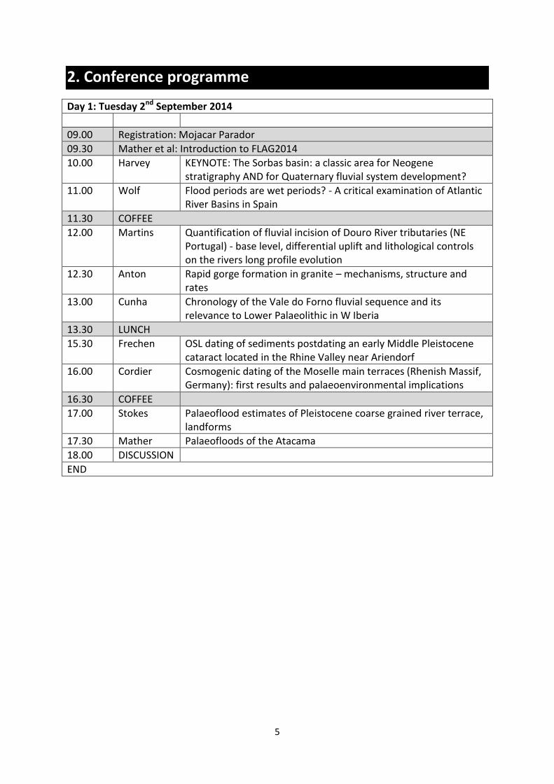
Day 1: Tuesday 2nd September 2014
09.00 Registration: Mojacar Parador
09.30 Mather et al: Introduction to FLAG2014
10.00 Harvey KEYNOTE: The Sorbas basin: a classic area for Neogene stratigraphy AND for Quaternary fluvial system development?
11.00 Wolf Flood periods are wet periods? - A critical examination of Atlantic River Basins in Spain
11.30 COFFEE
12.00 Martins Quantification of fluvial incision of Douro River tributaries (NE Portugal) - base level, differential uplift and lithological controls on the rivers long profile evolution
12.30 Anton Rapid gorge formation in granite – mechanisms, structure and rates
13.00 Cunha Chronology of the Vale do Forno fluvial sequence and its relevance to Lower Palaeolithic in W Iberia
13.30 LUNCH
15.30 Frechen OSL dating of sediments postdating an early Middle Pleistocene cataract located in the Rhine Valley near Ariendorf
16.00 Cordier Cosmogenic dating of the Moselle main terraces (Rhenish Massif, Germany): first results and palaeoenvironmental implications
16.30 COFFEE
17.00 Stokes Palaeoflood estimates of Pleistocene coarse grained river terrace, landforms
17.30 Mather Palaeofloods of the Atacama
18.00 DISCUSSION
END
6
Day 2: Wednesday 3rd September 2014
08.55 Mather et al: Introduction
09.00 Bridgland Britain’s third river: Quaternary fluvial archives from the River Trent
09.30 Gomes Fluvial staircases of Douro and Sabor rivers, Iberian Peninsula: similarities and differences of the Douro exhoreic system.
10.00 Vandenberghe The drainage pattern at the end of the last glacial: new data from the Tisza river in Serbia
10.30 COFFEE
11.00 Briant Changing fieldwork practice to enable effective archive-model comparison - a suggested framework
11.30 Maddy Modelling 50,000 years of landscape evolution in the Upper Thames Valley, UK: Preliminary results from PARALLEM
12.00 van Balen Numerical modelling of terrace staircase formation of the southern Pyrenees, Ebro basin, NE Iberia
12.30 Geach An integrated field and numerical modelling study of controls on Late Quaternary fluvial landscape development (Tabernas, SE Spain)
13.00 DISCUSSION
13.30 LUNCH
15.30 FLAG Business Meeting (open)
17.00 FLAG Geotourism - arid zone boat trip and conference dinner

7
ABSTRACTS
8
RAPID GORGE FORMATION IN GRANITE – MECHANISMS, STRUCTURE AND RATES
1Anton, L., 2Mather, A.E., 2Stokes, M., 3Muñoz Martín, A. Lead author email address: [email protected] 1Faculty of Sciences, UNED, Senda del Rey 9. 28040 Madrid, Spain 2School of Geography, Earth and Environmental Sciences, University of Plymouth, Plymouth, Devon, PL4 8AA. 3 Departamento de geodinamica. Universidad Complutensed de Madrid. 28040 Madrid. Spain. Quantifying patterns and rates of fluvial erosion into bedrock is essential for understanding linkages between rock strength/structure and discharge, and their relationships to landscape evolution driving mechanisms. However, bedrock erosion mechanisms and the rate at which they occur are difficult to establish over long term timescales. Whilst fluvial landscape erosion may appear transient it could hide long hiatuses that separate incision intervals and this has important implication for the fidelity of bedrock river incision as a recorder of external climatic and tectonic forcing (Finnegan et al, 2014). Numerous studies have examined rates of gorge formation and the controls on those rates via bedrock erodibility, the effectiveness of bedrock erosion mechanisms and the role of hillslope processes. Most findings are based on conceptual / empirical models or long term landscape analysis typically using dating techniques and flood reconstruction (e.g. Lamb and Fonstad, 2010; Schildgen et al. 2010). However, studies of recent quantifiable events are rare and highly valuable. Here we present unprecedented eye witness account and quantitative survey of large and rapid fluvial erosion events that occurred over an artificially created waterfall at a spillway mouth. A ~270 m long, ~100 m deep and ~100 to 160 m wide canyon was carved in 6 years, and ~1.58 x10⁶ m3 of granite bedrock was eroded. Flood reconstruction indicates that the erosion took place under unremarkable flood discharge conditions. The analysis of historic topographic maps enables the reconstruction of the former topography and for the successive years during the erosion events, and allow the quantification of bedrock erosion amounts (rates and directions). Field work examined bedrock erodibility and discontinuity patterns and demonstrates that the bedrock is mechanically strong, but that structural pre-conditioning through fracture density and orientation interactions played an important role in the gorge development. The presented case provides a unique opportunity for studying the evolution process of a bedrock canyon and to precisely measure the rate and distribution of bedrock channel erosion over a six year period with a greater degree of certainity than is usual in such examples. Results illustrate the highly episodic nature of the erosion and highlight several key observations for the adjustability of bedrock rivers. The observations have implications for the efficiency of bedrock erosion and raise important questions about incision rates, driving mechanisms and timescale assumptions’ in models of landscape change.
Finnegan, N. J., Schumer, R. & Finnegan, S. 2014. A signature of transience in bedrock river incision rates over timescales of 104-107 years. Nature 505, 391-394.
Lamb, M. P. & Fonstad, M. A. 2010. Rapid formation of a modern bedrock canyon by a single flood event. Nature Geosci 3, 477-481.
Schildgen, T. F., Balco, G. & Shuster, D. L. 2010. Canyon incision and knickpoint propagation recorded by apatite 4He/3He thermochronometry. Earth Planet Sc Lett 293, 377-387.

9
CHANGING FIELDWORK PRACTICE TO ENABLE EFFECTIVE ARCHIVE-MODEL COMPARISON - A SUGGESTED FRAMEWORK
1Briant, R.M., 2Cohen, K.M., 3Cordier, S. 4Demoulin, A., 5Macklin, M.G., 6Maddy, D., 7Rixhon, G., 8Veldkamp, A., 9Wainwright, 10Whittaker, A. Lead author email address: [email protected] 1Department of Geography, Environment and Development Studies, Birkbeck, University of London, Malet Street, London, WC1E 7HX, UK; 2Dept. Fysische Geografie, Fac. Geowetenschappen, Univ. Utrecht, Postbus 80.115, 3508 TC UTRECHT, The Netherlands; 3 Département de Géographie et UMR 8591 CNRS- Université Paris 1-Université Paris Est Créteil, Créteil Cedex, France; 4Dept of Physical Geography and Quaternary, University of Liège, Sart Tilman, B11 - 4000 Liège, Belgium; 5Institute of Geography and Earth Sciences, University of Wales, Aberystwyth, Ceredigion, SY23 3DB, U.K.; 6School of Geography, Politics and Sociology, Newcastle University, Newcastle upon Tyne, NE1 7RU, UK; 7University of Cologne, Institute for Geography, Albertus-Magnus-Platz, 50923 Köln, Germany; 8ITC, Faculty of Geo-Information Science and Earth Observation of the University of Twente, PO Box 217, 7500 AE Enschede, The Netherlands; 9Durham University, Department of Geography, Lower Mountjoy, South Road, Durham, DH1 3LE, UK; 10Department of Earth Science and Engineering, Imperial College London, South Kensington Campus, London SW7 2AZ, U.K. Comparison of field-based fluvial data with landscape modelling output of various types and at different time-scales is not simple due to mismatches in the types of data generated. For example, field work generates detailed site-specific field data with significant and uncertain time gaps even with the most robust chronologies compared with continuous three-dimensional model data which often lacks detail. Also, time-series outputs at the catchment outflow are the simplest output to produce from models, but not available from field data except in rare situations when a system drains into a closed basin. There may also be a different focus required when assessing tectonic or climatic drivers. Fine-tuning of both field data collection and model outputs can do much to ensure greater comparability, and thus improve our understanding of how systems operate. These issues were addressed in December 2013 by a group of European specialists in both numerical modelling and field investigation of fluvial systems at a workshop in Twente in the Netherlands. Following this meeting, two workgroups were convened to deliver the objectives listed below: Workgroup 1:
We will prepare a research proposal which aims to benchmark and document a wide-range of Landscape Evolution Models.
We will prepare an outline framework for rigorous model testing. Workgroup 2:
We will prepare an outline framework for the comprehensive recording and reporting of field based observations targeted for model-data comparison.
We will establish a robust set of ‘real-world’ model testing datasets.

10
This paper reports on the outline framework from Workgroup 2 as it has been developed so far, and provides an opportunity for us to seek feedback on it from the wider fluvial archives community. The framework suggests changes to both site-based and catchment-scale observations, to provide data for both initial model conditions and evaluation of model outputs. Key points are the importance of chronologies – both at-a-site (as is standard practice) but also catchment-wide (addressing the importance of sampling strategies); recording more three-dimensional field data and recording field data on hillslopes as well as fluvial landforms / sediments – i.e. the whole catchment, as is modelled. We stress also the need to generate field data that better facilitates the evaluation of model output using pattern-matching – i.e. looking for similar emergent properties from model output to the field data rather than an exact match. The pattern-matching approach enables the stochastic properties of both natural and modelled systems to be accommodated.
11
BRITAIN’S THIRD RIVER: QUATERNARY FLUVIAL ARCHIVES FROM THE RIVER TRENT
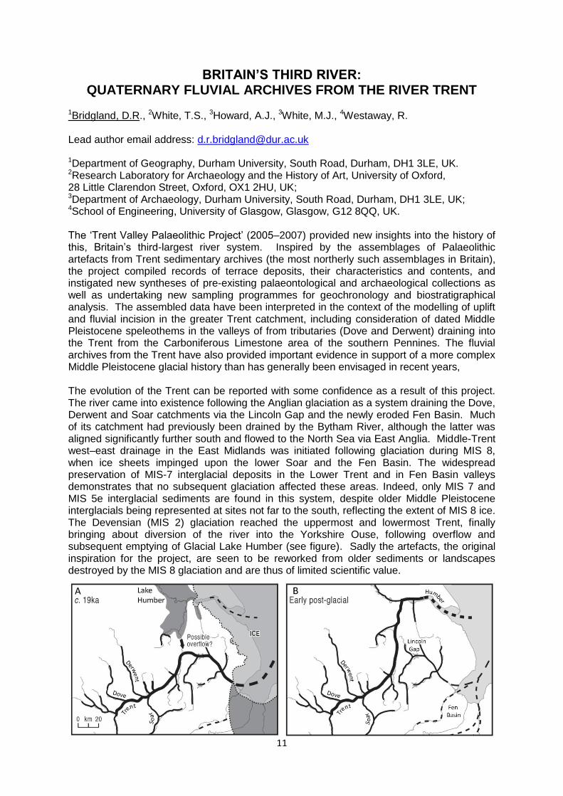
1Bridgland, D.R., 2White, T.S., 3Howard, A.J., 3White, M.J., 4Westaway, R. Lead author email address: [email protected] 1Department of Geography, Durham University, South Road, Durham, DH1 3LE, UK. 2Research Laboratory for Archaeology and the History of Art, University of Oxford, 28 Little Clarendon Street, Oxford, OX1 2HU, UK; 3Department of Archaeology, Durham University, South Road, Durham, DH1 3LE, UK; 4School of Engineering, University of Glasgow, Glasgow, G12 8QQ, UK. The ‘Trent Valley Palaeolithic Project’ (2005–2007) provided new insights into the history of this, Britain’s third-largest river system. Inspired by the assemblages of Palaeolithic artefacts from Trent sedimentary archives (the most northerly such assemblages in Britain), the project compiled records of terrace deposits, their characteristics and contents, and instigated new syntheses of pre-existing palaeontological and archaeological collections as well as undertaking new sampling programmes for geochronology and biostratigraphical analysis. The assembled data have been interpreted in the context of the modelling of uplift and fluvial incision in the greater Trent catchment, including consideration of dated Middle Pleistocene speleothems in the valleys of from tributaries (Dove and Derwent) draining into the Trent from the Carboniferous Limestone area of the southern Pennines. The fluvial archives from the Trent have also provided important evidence in support of a more complex Middle Pleistocene glacial history than has generally been envisaged in recent years, The evolution of the Trent can be reported with some confidence as a result of this project. The river came into existence following the Anglian glaciation as a system draining the Dove, Derwent and Soar catchments via the Lincoln Gap and the newly eroded Fen Basin. Much of its catchment had previously been drained by the Bytham River, although the latter was aligned significantly further south and flowed to the North Sea via East Anglia. Middle-Trent west–east drainage in the East Midlands was initiated following glaciation during MIS 8, when ice sheets impinged upon the lower Soar and the Fen Basin. The widespread preservation of MIS-7 interglacial deposits in the Lower Trent and in Fen Basin valleys demonstrates that no subsequent glaciation affected these areas. Indeed, only MIS 7 and MIS 5e interglacial sediments are found in this system, despite older Middle Pleistocene interglacials being represented at sites not far to the south, reflecting the extent of MIS 8 ice. The Devensian (MIS 2) glaciation reached the uppermost and lowermost Trent, finally bringing about diversion of the river into the Yorkshire Ouse, following overflow and subsequent emptying of Glacial Lake Humber (see figure). Sadly the artefacts, the original inspiration for the project, are seen to be reworked from older sediments or landscapes destroyed by the MIS 8 glaciation and are thus of limited scientific value.

12
COSMOGENIC DATING OF THE MOSELLE MAIN TERRACES (RHENISH MASSIF, GERMANY): FIRST RESULTS AND
PALAEOENVIRONMENTAL IMPLICATIONS 1Cordier S, 2Rixhon G., 2Brückner H., 2Kelterbaum D., 2May S.M., 3Dunai T., 3Binnie S.
1Département de géographie, Université Paris Est Créteil, Créteil, France. 2Institute of Geography, University of Cologne, Cologne, Germany 3Institute of Geology, University of Cologne, Cologne, Germany Lead author email address: [email protected] The fluvial terraces of the Moselle River have been largely investigated in France, Luxembourg and Germany during the last decade. Multi-proxy research made it possible to provide an initial reconstruction for the Middle and Upper Pleistocene valley evolution. Eight “middle and lower” terraces have been recognized at less than 100 m relative height. These terraces were correlated from the Vosges Massif to the Rhenish Massif on the basis of sedimentological evidences and, for the younger terraces, of OSL dating. Located at higher elevations on the valley sides of the Rhenish Massif, the well preserved “main terraces”, are characterized by a constant absolute elevation in the 150 km-long reach between the Lower Sarre/Trier area and Cochem. Despite that various hypotheses have been proposed to explain this horizontality (updoming, faulting...), all studies assumed an age of ca. 800 ka for the YMT, mainly based on the questionable extrapolation of palaeomagnetic data obtained in the Rhine valley. As a consequence, older terraces of the lower Moselle, in particular the main terraces complex, still lack a reliable chronological framework. In this study, we apply cosmogenic nuclide dating (10Be/26Al) to fluvial sediments of to the Main Terrace complex along the German Moselle valley. Several sites were sampled following two distinct sampling strategies: (i) depth profiles where the original terrace (palaeo-)surface is well preserved and did not experience much postdepositional burial (e.g., loess cover); and (ii) the isochron technique where the sediment thickness exceeds 3 m. Cosmogenic nuclide ages recently obtained for three rivers in the Meuse catchment in the western Rhenish Massif demonstrated that the Main Terraces were younger than expected and their abandonment was diachronic along the hydrographic network (Rixhon et al., 2011). These results are consistent with the reconstruction proposed for the Middle and Lower Terraces of the Moselle (Cordier et al., 2006). This presentation aims to expose the first results obtained for the Wintrich key section and their implications to unravel the Pleistocene evolution of the German Moselle valley. References
Cordier, S., Harmand, D., Frechen, M., Beiner, M., 2006. Fluvial system response to Middle and Upper Pleistocene climate change in the Meurthe and Moselle valleys (Eastern Paris Basin and Rhenish Massif). Quaternary Science Reviews 25, 1460–1474.
Rixhon, G., Braucher, R., Bourlès, D., Siame, L., Bovy, B., Demoulin, A., 2011. Quaternary river incision in NE Ardennes (Belgium) – Insights from 10Be/26Al dating of river terraces. Quaternary Geochronology 6, 273–284.

13
A MIDDLE PLEISTOCENE CATARACT IN THE RHINE VALLEY NEAR ARIENDORF
1Frechen, M., 1Techmer, A.
Lead author email address: [email protected]
1Leibniz Institute for Applied Geophysics (LIAG), Geochronology and Isotope Hydrology, Stilleweg 2, 30655 Hannover, Germany
During the Pleistocene, the Rhine River acted as a major south – north transport medium from the Swiss Alps into the North Sea Basin. A detailed review of the Pliocene and Quaternary fluvial sediment archive and the terrace stratigraphy of the Middle Rhine Valley and the Lower Rhine area was given by Boenigk & Frechen (2006). The sediment successions of the sand and gravel pit “Fa. Karl Schneider” located about 28 km south of the city Bonn have been investigated for more than 40 years and are famous for its loess/paleosol sequence, small and large mammal remains and artefacts. The loess/plaeosol sequence includes at least four interglacial/glacial cycles as evidenced by loess and palaeosols as well as intercalated tephra layers from the East Eifel Volcanic Field. About 30 m of fluvial deposits are exposed in the section under study correlating to the “Middle Middle Terrace” of the River Rhine. In order to determine the age of the cataract, post-IR IRSL of potassium-rich feldspar is applied to fluvial sands taken out of a gully into the Devonian bedrock and postdating the cataract. The potassium-rich feldspar of two fluvial sand samples was separated for OSL-dating using the pIRIR290 method. The applicability of the pIRIR290 protocol was tested by dose recovery, residual dose and fading measurements. The methods had to be tested against independent numerical age control, which was provided by 40Ar/39Ar single grain dating, as the present study includes the investigation of the upper dating limit for fluvial sediments from the Middle Rhine area. The OSL dating indicates that the sediments covering the cataract are older than 400 ka.
References Boenigk, W. & Frechen, M. 2006. The Pliocene and Quaternary fluvial archives of the Rhine
system. Quaternary Science Reviews, 25, 550-574.
Schmidt, E.D., Tsukamoto, S., Frechen, M. & Murray, A.S. 2014. Elevated temperature IRSL dating of loess sections in the East Eifel region of Germany. Quaternary International, 334-335, 141-154.

14
AN INTEGRATED FIELD AND NUMERICAL MODELLING STUDY OF
CONTROLS ON LATE QUATERNARY FLUVIAL LANDSCAPE
DEVELOPMENT (TABERNAS, SE SPAIN)
1Geach M, 1Mather A.E., 1Stokes M., 1Telfer M., 2Viveen W., 3Thomsen K.
1School of Geography, Earth and Environmental Sciences, Plymouth University, Drake
Circus, Plymouth, Devon, PL4 8AA, UK; [email protected] 2School of Earth and Ocean Sciences, Cardiff University, Main building, Park Place, Cardiff,
CF10 3AT, UK 3Center for Nuclear Technologies, Technical University of Denmark, Risø Campus, Denmark
Lead author email address: [email protected]
The variability of Quaternary landforms preserved in the Tabernas basin of SE Spain
highlights the complex interactions of external (e.g. tectonics and / or climate) and internal
controls in the evolution of the basin-wide fluvial system over late Quaternary timescales. In
this study, we apply the FLUVER2 numerical model to investigate the significance of these
landscape controls upon patterns of landscape evolution across the basin. The outcomes of
the modelling exercise are compared with extensive field mapping results of fluvial terraces,
their sedimentary architecture and optically stimulated luminescence dating of the terraces in
order to validate the significance of individual landscape drivers throughout the Quaternary.
Four terrace levels were defined across the Tabernas basin, based on terrace groupings that
share common mean surface elevations and incisional depths. Although laterally variable,
these levels typically occur at ~80m (terrace level 1), ~50m (terrace level 2), 30m-10m
(terrace level 2) and <5m (terrace level 2) above the current drainage. Terraces were
typically dominated by strath forms for all levels; however, substantial fill deposits were
recorded in the basin centres for terrace level 3. OSL dating using single-grain quartz SAR
methods derived age estimates of 14 ±1 ka – 41 ka (minimum age) for terrace level 3, and
2.2 ± 0.3 ka – 0.2 ± 0.1 ka for terrace level 4. Unfortunately, no age estimates were derived
from terrace levels 1 or 2 due to low saturation limits in most samples (e.g. quartz
saturations < 50 gy).
The outputs from FLUVER2 highlight the significance of non-linear rates of flexural uplift
towards the west of the basin which have controlled base levels throughout the Quaternary.
Periods of modelled terrace aggradation fit well for the early to mid-Quaternary (terrace
levels 2 and 3) and further demonstrate the importance of climate cycles upon river terrace
formation. Basin-wide aggradation events were modelled during the transition from MIS
Stage 6 to 5 and the Last Glacial Maximum (LGM) as supported by field evidence and OSL
estimates. This aggradational pattern supports the regional hypothesis of terrace formation
during glacial cycles and cold-to-warm stage transitions. Model outcomes did not correlate
with field records for Holocene records across the basin. This disparity identifies either non-
uniform rates of anthropogenic forcing, the crossing of fluvial system geomorphic thresholds,
or the limitations of the FLUVER2 model based on the assumptions made in the input
datasets (e.g. averaging out short duration climatic fluctuations when converting SST to
precipitation records over 250 ka).
15
TERRACE STAIRCASES OF THE DOURO AND SABOR RIVERS (NE OF PORTUGAL, IBERIA): CHARACTERIZING THE LAST STAGES
OF THE DOURO EXHOREIC SYSTEM 1Gomes A., 2 Martins A.A., 3Cunha P.P. 1CEGOT, Dep. of Geography, University of Porto, Portugal, 2Centro de Geofísica, Dep. of Geosciences, University of Évora, Portugal 3IMAR-CMA, Dep. of Earth Sciences, University of Coimbra, Portugal Lead author email address: [email protected] In the Iberia Peninsula, the process leading to the fini-Cenozóic exoreic discharge of the Douro basin remains a major geomorphological challenge (Pereira et al, 2010; Anton et al, 2012), particularly, understanding the connection between the geomorphological evolution of the trunk river and its tributaries in the Portuguese sector with the Douro Cenozoic basin in Spain. Good geomorphological and sedimentological data available to interpret the process refers to the last stages of incision and enlargement of the valleys leading to the formation of fill and rocky terraces (Cunha et al., 2010), which are well individualized at confined areas of the Douro and Sabor valleys, as well as on other tributaries rivers of the Portuguese basin. The main objective is to present the research that is being done about the terrace levels present in the valleys of these rivers (Sabor is the second and longest tributary of the exoreic sector), and compare the fluvial staircases of those rivers located at the interface between the endorheic to the exoreic basin. Furthermore, it is interpreted the tectonic conditioning of the areas where the staircases are well preserved. This research is based on the analysis of altimetric and hydrographic data available from the Portuguese Military Maps (scale 1: 25,000), the analysis of detailed geological maps (scale 1: 50000), the analysis of digital terrain models and on the fieldwork performed on the area. The fluvial staircases of both rivers are similar for de first fill terrace above the actual alluvial plain (T1=±10/15m), which is composed mainly by sandy-silt deposits that have Upper Pleistocene/Holocene age and conserve archaeological remains from the Bronze Age (Gaspar et al., 2014). For the upper levels there are big differences in the fill terraces, more levels for the Douro (4-5 levels at Quinta da Canameira site) than for Sabor (2 at Quinta de Barrais), and huge differences in the sedimentary architecture. The second fluvial terrace above actual alluvial plain (T2), tend to be coarser and was explored by the Romans to extract mineral. The differences of the preserved fluvial staircases on the four main sites, Quinta da Canameira and Barca D’Alva sectors for the Douro River, and Quinta de Barrais and Quinta de Crestelos sectors for the Sabor River, despite of local geological/geomorphological conditions, seems to reflect regional tectonic conditioning, since these fill terraces are well preserved in small elongated depressions with NNE-SSW direction. The faults that bound these depressions are also responsible for the conservation on the area of Mio-Pliocene sediments along small sinistral strike-slip basins, which support the hypothesis of a reactivation of old strike-slip faults that are well impressed on the relief of the area. References
Antón, L., Rodés, A., De Vicente, G., Pallàs, R., Garcia-Castellanos, D., Stuart, F.M., Braucher, R., Bourlès, D. 2012. Quantification of fluvial incision in the Duero Basin (NW Iberia) from longitudinal profile analysis and terrestrial cosmogenic nuclide concentrations. Geomorphology, 165-166, 50-61
Cunha, P.P., Lopes, F.C., Gomes, A., Pereira, D.I., Cabral, J., De Vicente, G., Martins, A. 2000. Os terraços do Rio Douro como indicadores de desnivelamentos tectónicos e

16
do soerguimento crustal (área do Pocinho, zona de falha da Vilariça). 1ª Reunión Ibérica sobre Fallas Activas y Paleosismología, Sigüenza, España, 45-48
Gaspar, R., Carrondo, J., Nobre, L., Rodrigues, Z., Donoso, G. 2014. Espaço para a morte. O terraço da foz do Medal (vale do Sabor, nordeste de Portugal) durante a Idade do Bronze. Estudos do Quaternário, 10, 59-72
Pereira, D., Alves, M., Araújo, M., Cunha, P. 2000. Estratigrafia e interpretação paleogeográfica do Cenozóico continental do N de Portugal. Ciências da Terra, 14, 73-84

17
KEYNOTE TALK
THE SORBAS BASIN: A CLASSIC AREA FOR NEOGENE STRATIGRAPHY AND FOR QUATERNARY FLUVIAL SYSTEM
DEVELOPMENT? 1Harvey A.M.
1School of Environmental Sciences/Geography, University of Liverpool, PO Box 147, Liverpool L69 3BX, UK. Lead author email address: [email protected] Over the last 25 years of the 20th century, the Almeria region in general and the Sorbas sedimentary basin in particular had become a classic area for Neogene stratigraphy, mainly as a result of work by Dutch and Spanish scientists. There is a complete sedimentary sequence from the Serravallian (mid-Miocene) to the late Pliocene-Early Pleistocene, involving an enormous variety of sedimentary rocks. Little was known of the Quaternary sequence, apart from the coastal sequence of raised shoreline sediments. Sustained epeirogenic uplift since the Pliocene caused a switch, first from a marine to a continental environment, then from a depositional to an erosional one. The uplift was differential between the various sedimentary basins resulting in different rates of incision by the developing drainage network. During the Pleistocene the incision was not continuous, but punctuated by climatically generated phases of aggradation, resulting in the formation of a suite of river terraces. Furthermore, drainage changes by river capture resulted in rerouting sediment pathways, but also in radical changes in incision rates and to the developing geomorphology. One such capture event took place in the Sorbas basin at about 70 ka, whereby previous north-south drainage into the neighbouring Almeria basin (the Aguas/Feos system) was captured by the east-flowing lower Aguas towards the Vera basin. In addition to these trends, of regional significance, ongoing tectonic deformation along individual structures caused local modifications to the sequence. Also, but limited to the coastal areas, the mid-late Pleistocene glacio-eustatic sea-level sequence caused further complications. As a result of the interplay between these controls, both regional and local, the area can be regarded as a classic for the Pleistocene fluvial system development.

18
MODELLING 50,000 YEARS OF LANDSCAPE EVOLUTION IN THE
UPPER THAMES VALLEY, UK: PRELIMINARY RESULTS FROM
PARALLEM
1Maddy D., 2Wainwright J., 3McGough, A.S, 2Trueman A., 4Briant R.M. 1Stemerdink C.
Lead author email address: [email protected]
1School of Geography, Politics and Sociology, Newcastle University, Newcastle upon Tyne, NE1 7RU, UK 2Department of Geography, Durham University, Lower Mountjoy, South Road, Durham, DH1 3LE, UK 3School of Engineering and Computing Sciences, Durham University, Lower Mountjoy, South Road, Durham, DH1 3LE, UK 4Department of Geography, Environment and Development Studies, Birkbeck, University of London, Malet Street, London, WC1E 7HX, UK
The last glacial-interglacial fluvial archive of the Upper Thames catchment, UK has received
much attention over the past 50 years. Extensive exposures within the Pleistocene
sequence have yielded a vast array of field observations, constrained by a substantive, but
still inadequate, geochronological dataset. This catchment was not glaciated during this
period, lying well beyond the Devensian (MIS2) ice margin, and thus landscape
morphological evolution progressed largely in response to variation in fluvial and slope
processes forced primarily by climate-driven hydrological and vegetation change.
Furthermore, there is no evidence to support any significant tectonic-driven change, albeit
fluvial system evolution progressed within the context of long-term regional uplift. The
relative simplicity of process interactions within this catchment over the timeframe of interest,
taken together with its comprehensive sedimentary record, makes the Upper Thames
archive a good candidate for comparison with landscape evolution model outputs.
In this paper we present a ‘first look’ at the performance of PARALLEM, a new, parallel-
coded, landscape evolution model, with results presented from an initial 50,000-year
simulation. In this instance PARALLEM was deployed in annual, steady-flow mode. The
model is driven by changing precipitation and temperatures. A pre-determined precipitation
input data series was used, based upon a simple transfer function which utilises an up-
sampled North Atlantic SST record, together with a modified temperature series based upon
palaeoecological data. PARALLEM explicitly models mass-movement processes (i.e. creep,
gelifluction) and surface erosion by flowing water (i.e. diffuse and concentrated erosion)
using formulae derived from empirical modern-day process data. The model also deploys a
simple logistic growth/die-back model for vegetation driven by hydrological and temperature
change. Sediment transport is modelled using a modified transport-distance approach.
Comparison of the two datasets is problematical as there are few, if any, attributes that can
directly be compared. As a consequence we will discuss some of the obstacles which limit
comparison of the field and model data and suggest how some of these might be overcome.
19
QUANTIFICATION OF FLUVIAL INCISION OF DOURO RIVER TRIBUTARIES (NE PORTUGAL) - BASE LEVEL, DIFFERENTIAL
UPLIFT AND LITHOLOGICAL CONTROLS ON THE RIVERS LONG PROFILE EVOLUTION
1Martins A.A., 2Gomes A., 3Cunha P.P., 4Cabral J. Lead author email address: [email protected] 1Departamento de Geociências, Centro de Geofísica, Univ. Évora, Portugal 2Departamento de Geografia da Universidade do Porto, CEGOT, Portugal 3Dep. of Earth Sciences, IMAR-CMA, University of Coimbra, Portugal 4IDL, Faculty of Science, Lisbon University, Portugal This study analyses the long profiles of the Águeda, Côa, Távora and Paiva rivers, and of other lower order tributaries of the Douro River. The Águeda and Côa rivers flow inset into the regional planation surface that characterizes the morphology of the Hesperian Massif (the Iberian Meseta), while the Távora and Paiva rivers flow through higher relief, uplifted blocks, located west of the Vilariça fault zone (VFZ). These streams flow through a landscape strongly influenced by variations in bedrock lithology (granites and metasediments), fault structures that promoted differential uplift, and significant base-level changes. The longitudinal profiles of the Douro tributaries commonly display concavities separated by knickpoints/knickzones. The most upstream concavity reflects a relict graded profile of probable Piacenzian – Gelasian age, testifying an Atlantic exoreic drainage coeval of a high sea-level. Downstream concavities reflect the on-going transmission of several incision waves, linked to the Pleistocene - present stage of fluvial incision. In downstream concavities, the stream is graded to transient forms of the river profile with respect to the lithology, structure and base level history. They alternate with convexities (knickzones) developed where the incision waves were delayed, pinned to granite contacts. The amount of incision that postdates the relict graded profile, obtained by downstream extrapolation of the relict concave reach to the confluence with the trunk river, varies from ca. 400-450 m in the Iberian Meseta (east of the VFZ) to more than 600-650 m in the more uplifted blocks at the west. However, east of the VFZ, the amount of incision inferred by this procedure overestimates the incision measured from the surface of Meseta which is here located below the extrapolated relict long profiles by an amount that reaches ca. 120 m at the River Côa mouth. This overestimation supports: a) a northwards tilting of the Iberia Meseta in this area since the Late Miocene; b) the differential uplift along the VFZ, resulting from a northwards increase of the relative downthrowing of the eastern block of this fault; c) the exhumation of the Iberian Meseta by removal of a Cenozoic cover, whose thickness would be equivalent to the difference in height between the projected relict profile and the Meseta surface. The larger incision (525 and 477 m) inferred at the Águeda and Aguiar stream mouths is associated with long term enhanced uplift of the Iberian Meseta. For the last ca. 2 Ma (beginning of the incision stage?) incision rates can range from 0.2 mm/yr in the less uplifted compartments to 0.6 mm/yr in the more uplifted blocks (west of the VFZ). This work is in the scope of proj. PTDC/GEO-GEO/2860/2012

20
CHRONOLOGY OF THE VALE DO FORNO FLUVIAL SEQUENCE AND ITS RELEVANCE TO LOWER PALAEOLITHIC IN W IBERIA
1Martins A. A., 2Cunha P.P., 3,4Buylaert J-P., 4Murray A.S., 5Raposo L., 6Mozzi P., 7Stokes M. Lead author email address: [email protected] 1Centro de Geofísica, Dep. Geociências, Évora University, Portugal 2Department of Earth Sciences, IMAR-CMA, University of Coimbra, Portugal 3Centre for Nuclear Technologies, Techni. Univ. of Denmark, Risø Campus, DK 4Nordic Laboratory for Luminescence Dating, Aarhus University, Risø DTU, DK 5Museu Nacional de Arqueologia, Portugal 6Department of Geosciences – University of Padova, Italy 7School of Geography, Earth and Environmental Sciences, University of Plymouth, UK The Vale do Forno archaeological sites (Alpiarça, central Portugal) document the earliest human occupation in the River Tejo lower valley, well established in geomorphological and environmental terms, within the Middle Pleistocene. In a staircase of six fluvial terraces, the Palaeolithic sites were found on the T4 terrace that comprises a Lower Gravels basal unit (LG) and an overlying Upper Sands unit (US). Geomorphological mapping, coupled with lithostratigraphy, sedimentology and luminescence dating (quartz-OSL and K-feldspar post-IRIR290) were used in this study. The oldest artefacts found in the LG unit show crude bifacial forms that can be attributed to the Early Acheulian. In contrast, the US unit has archaeological sites documenting the Middle and Late Acheulian. Luminescence dating and correlation with the Marine Isotopic Stages suggest that the LG unit has a probable age of 340 to 330 ka and the US unit an age of ca. 330 to 160 ka. This discards previous interpretations ascribing this terrace (and its associated lithic industries) to the Last interglacial and early phases of the Last glacial. Only the VF3 site (Milharós), containing “Micoquian” (Final Acheulian) industries (with fine and elaborated bifaces) found in a level between the T4 terrace and a colluvium associated with Late Pleistocene aeolian sands, can still be attributed to the Last interglacial episode or even later, being probably coeval with the T5 terrace deposition (ca. 135 to 78 ka). This work is in the scope of proj. PTDC/GEO-GEO/2860/2012
21
PALAEOFLOODS OF THE ATACAMA 1Mather A.E., 2Hartley A.J., 3Evenstar L.A., Griffths J.S. & 4Stuart F.M. Lead author email address: [email protected] 1School of Geography, Earth and Environmental Sciences, University of Plymouth, Plymouth, Devon, PL4 8AA, UK 2Department of Geology & Petroleum Geology, University of Aberdeen, Aberdeen, UK.
3School of Earth Sciences, University of Bristol, Wills Memorial Building, Queen’s Road, Bristol BS8 1RJ, UK 4Isotope Geoscience Unit, Scottish Universities Environmental Research Center, East Kilbride, Glasgow, G75 0QF, UK In arid fluvial environments flash floods are a significant hazard and are often the dominant flow events. These events typically result from infrequent but intense rainfall which activates a catchment area, with even very short duration (one/two hour), low intensity (<4 mm/hr) rainfall events capable of activating surfaces with catastrophic effects. Studies of flash flood events in hyper-arid environments highlight the transport limited nature of such settings, dominated by flows hyperconcentrated with sediment. As direct measurement of such events is extremely rare due to scarcity of monitoring and the physical difficulties of measuring such extreme phenomena here we use geomorphological and sedimentological records together with an engineering approach (Clarke 1996) to reconstruct the Quaternary palaeofloods. We will examine the rheology and magnitude of extreme flow events recorded in the fluvial archives of the Atacama desert in Northern Chile from a selection of hyperarid catchments in a transect from the Coastal Cordillera inland to the PreCordillera. The Atacama desert of northern Chile covers a range of elevations from sea level to more than 4000m above sea level, with annual rainfall ranging from 0.15mm pa in the Central Depression to around 150mm pa in the higher elevations. All the catchments which source the flows in this study are developed on the western side of the Western Cordillera (the active volcanic arc). Although the source areas are located in the relatively wetter, higher elevation parts of the Atacama, the depositional areas lie at lower, more arid elevations. The sedimentology of the deposits suggest transport by hyperconcentrated through to cohesive debris flow and extremely bimodal mudflows capable of transporting extreme outsize clasts over large distances (>20 km) on low slopes (<4 degrees). Within channelized areas the hyperconcentrated flows represent extremely high discharges of water and sediment capable of generating gravel anti-dune bedforms. Extensive boulder fields are present which imply that some of these flood events were capable of transporting >81,000 kg boulders more than 30 km from their source area. The age of the flows is uncertain but preliminary Cosmogenic radionuclide (CRN) 21Ne dates suggest Pleistocene exposure ages.
Clarke, A.O. 1996, Estimating probable maximum floods in the Upper Santa Ana basin, Southern California, from stream boulder size: Environmental & Engineering Geoscience, v. 2, pp. 165-182

22
PALAEOFLOOD ESTIMATES FROM PLEISTOCENE COARSE GRAINED RIVER TERRACE LANDFORMS:
IS IT POSSIBLE AND IS IT WORTH IT? 1Stokes M., 1Griffiths J.S., 1Mather A.E. 1School of Geography, Earth and Environmental Sciences, University of Plymouth, Drake Circus, Plymouth, Devon, PL4 8AA, UK Lead author email address: [email protected] We explore the application of a series of palaeoflood estimation techniques to an inset sequence of Middle to Late Pleistocene river terrace landforms associated with the Río Almanzora, SE Spain. The study area is a 7 km-long transverse reach, where 4 terrace levels (Level 1=highest and oldest, Level 4=lowest and youngest) document some 200 m of incision across an uplifted basement block during the Pleistocene. For the broader region, river terrace aggradation is attributed to increased sediment supply during glacial to interglacial transitions (Level 1=Marine oxygen isotope stages [MOIS] 12/11, L2=10/9, L3=8/7 and L4=6/5). Within the transverse reach, terrace Levels 2, 3 and 4 are characterised by coarse boulder-rich gravels (Dmax=2.5 m) organised into 3-5 m-high cross-beds. Level 4 is characterised by a series of km-scale abandoned meander loops, with Levels 2 and 3 showing evidence for similar degraded high sinuosity forms. The fluvial setting is interpreted as a braided river environment, with lateral and longitudinal gravel barforms. Using field-derived sedimentary (boulder size etc) and morphological (width, slope etc) features, flow competence and regime-based methods were applied. Palaeoflood estimates varied from 40 to 2859m3/s, with mean maximum discharges showing an increase through time (L2=278, L3=413, L4=1361m3/s). Palaeoflood estimates were compared to flood events associated with the ephemeral modern Río Almanzora (catchment=2500 km2) to establish whether palaeoflood values were reasonable estimations. A 46-year (1963-2009) modern flood gauge record shows infrequent flood events with discharges typically <40 m3/s. A rare flood event in 1973 (5680 m3/s) provides an upper value for comparison with the palaeoflood estimates. Although estimates appear reasonable they should be considered as minimum values due to 1) some disparities between flow depths derived from the palaeoflood equations (0.7-4m) and field-based evidence (3-5 m-high cross-beds); 2) issues related to field sampling of boulders from sections, and 3) uncertainties as to the relationship between flood hydrology and transportation of boulders, formation of 3-5 m-high cross-beds and the position of the terrace remnants in the river valley. The palaeoflood estimates suggest that relatively large discharges occurred during valley floor aggradation in the glacial/interglacial transitions, periods characterised by low vegetation cover and high sediment yield. Discharge increases through time can be explained by the long-term drainage evolution of the Río Almanzora, characterised by an expanding catchment area linked to river capture, driven by regional uplift patterns. The 3.5-times larger discharge estimates recorded in terrace Level 4 are coeval with large and rapid changes in precipitation or elevated seasonal discharge linked to the MOIS 6/5 glacial interglacial climate transition. Overall, within tectonically active regions affected by river capture, fluvial systems could be responding to loss or expansion of catchment areas. Long-term palaeoflood records from inset flights of river terraces could store such signals and may mask/complicate any climate-palaeoflood relationships. So, is it possible? Yes, but 1) the approach has quite specific and important geomorphological and sedimentological requirements, 2) it is sensible to apply a range of palaeoflood techniques and 3) some verification is needed with a long modern flood gauge record. Is it worth it? Yes, as it provides a quantitative dataset that helps interpret fluvial landscape dynamics but flood estimates should only be considered as minimum values.

23
NUMERICAL MODELLING OF TERRACE STAIRCASE FORMATION OF THE SOUTHERN PYRENEES, EBRO BASIN, NE IBERIA
1Van Balen R.T., 1Stange K.M., 2Garcia-Castellanos D. Lead author email address: [email protected] 1Earth Sciences Department, VrijeUniversiteit Amsterdam, the Netherlands 2CSIC, Instituto de Ciencias de la Tierra Jaume Almera,Barcelona, Spain The southern foreland basin of the Pyrenees (Ebro basin) is an exorheic drainage basin since Late Miocene times. Remnants of an early exorheic drainage system are not preserved, but the Ebro basin morphology provides evidence for the Pliocene–Quaternary drainage development. The incision history of the Ebro system is denoted by (i) extensive pediments associated with the denudation of the southern Pyrenean piedmont around the Pliocene–Quaternary transition, and (ii) deeply entrenched Quaternary river valleys. The Ebro basin pediments indicate a smooth, low-gradient palaeo-topography. During the Middle–Late Pleistocene fluvial incision intensified involving the formation of extensive terrace staircases in the southern Pyrenees foreland. Terrace exposure dating in tributary rivers of the Ebro indicates climate-triggered terrace formation in response to glacial–interglacial cycles in the Pyrenean headwaters. The overall (semi)parallel longitudinal terrace profiles argue for progressive base level lowering for the whole Ebro drainage network. We use a landscape evolution model, TISC, to evaluate different climatic, tectonic, and base level scenarios for terrace staircase formation in the Ebro drainage system. Model simulations are compared with morpho-climatic, tectonic and chronologic data. Results show that climate and sea-level fluctuations can trigger terrace formation, but the modelled incision magnitudes and convergent terrace profiles are not consistent with the (semi)parallel terraces in the Ebro basin. A scenario involving a potential Pliocene uplift event in the Ebro drainage basin results in rapid erosion along the fluvial network, little Middle–Late Pleistocene incision magnitudes and downstream convergent terraces, which are not in agreement with observations. In contrast, a model with continuous Quaternary uplift affecting the Pyrenees and the foreland basins produces (semi)parallel terrace staircases in the southern Pyrenean tributary rivers, being consistent with the Middle–Late Pleistocene incision magnitudes as inferred from the Ebro basin morphology and the drainage outlet in the Catalan coastal ranges. Forward model simulations indicate that the present Ebro drainage system is actively incising, providing further evidence for uplift.
24
THE DRAINAGE PATTERN AT THE END OF THE LAST GLACIAL:
NEW DATA FROM THE TISZA RIVER IN SERBIA
1Vandenberghe J., 2Popov D., 1Kasse, C., 2Marković S.B., 3Vandenberghe, D.A.G. 1Inst. of Earth Sciences, VU University, Amsterdam, The Netherlands 2Dept. of Geography, University of Novi Sad, Serbian Republic 3Dept. of Geography, University of Ghent, Belgium Lead author email address: [email protected]
The change in channel planform from braided towards large-scale meandering has been observed traditionally at the Pleniglacial-Lateglacial boundary in many river systems ranging from Poland (Wartha valley) to NW Europe (Dutch-Belgian systems). It has been commonly related to climatic warming at the onset of the Lateglacial and the associated increase in vegetation cover, higher bank stability, decreased sediment supply and more regular discharges. It has been stated before that in the middle Tisza (Tisa, Theis) valley this change to large-scale meandering occurred earlier than in the north (Kasse et al., 2010). The latter results were, however, seriously obstructed by dating problems caused by large scattering of the radiocarbon dates and inexplicable ages in the Tisza deposits. Recent research in the lower Tisza enabled to confirm and specify in more detail the morphological evolution of the Tisza valley in post-LGM times and, even more important, to obtain new dating results by OSL on one particular meandering system (Popov et al., 2012). The present topography shows a series of systems of large, well-expressed pointbars and abandoned channels dissecting remnants of a braided system of probably of LGM-age. The sediments underlying a pointbar at one particular site (Mužlja) were OSL-dated by a series of samples. The deposits are very finely and horizontally laminated fine-grained sands, occasionally silty and cross-laminated. Some rare pebbles of a few mm in diameter occur. Measurements by IRSL on K-feldspar provide an age of 15,3-15,6 ka for the deposition of the pointbars of that specific meander system. These results confirm the opinion put forward by Kasse et al in 2010 that the change from a braided to a large-scale meandering system in the Tisza valley occurred earlier than in NW and North-Central Europe. To further detail the exact evolution of the meandering drainage also the other systems have to be dated by OSL. Provisional summary of the drainage pattern evolution in the Tisza valley is that a braided pattern persisted during LGM-times, shortly after that followed by at least 4 generations of very large to large meanders. The second one of these generations is the meander of Mužlja, now reliably OSL-dated at 15,3-15,6 ka by Popov et al. (2012). The last one is probably of Lateglacial age. The reason for the difference in the timing of the pattern change between the Tisza valley in Central Europe and the more northern and northwestern systems in Europe is still the previously stated hypothesis of the response to the different vegetation cover in both regions: a better developed vegetation cover in the former region as opposed to the more barren surface in the latter region (Kasse et al., 2010). References
Kasse, C., Bohncke, S.J.P., Vandenberghe, J. and Gabris, G. 2010 Fluvial style changes during the last glacial - interglacial transition in the middle Tisza valley (Hungary). Proceedings of the Geologists' Association 121, 180-194.
Popov,D., Vandenberghe, D.A.G. and Marković, S.B. 2012 Luminescence dating of fluvial deposits in Vojvodina, N Serbia: First results. Quaternary Geochronology 13, 42-51.

25
Flood periods are wet periods? - A critical examination of
Atlantic River Basins in Spain.
Wolf, D., Faust, D.
Lead author email address: [email protected]
Institute of Geography, Technical University of Dresden, Helmholtzstr. 10, 01062 Dresden.
In the Mediterranean realm, environmental changes and related effects on landscape
dynamics during the Holocene attracted the interest of research for a long time now.
Especially in view of the high fragility of numerous Mediterranean landscape units, the
interrelation between certain climate changes and triggering of geomorphological systems
gains particular importance. However, the reaction of river systems on climatic variations is
still a subject of controversy. In this context, periods of observed high flood activity on the
Iberian Peninsula are frequently correlated with more humid climate conditions.
A basic assumption for our contribution to this issue is that floodplain dynamics of
appropriate river systems may be suitable to indicate landscape dynamics on catchment
scale. Therefore, we investigated fluvial sediment successions of different river systems in
Spain in order to work out periods of floodplain/landscape activity and floodplain/landscape
stability. Activity periods are characterized by the occurrence of high floods as well as
overbank sedimentation of cohesive flood loams, which in turn, provides information on the
intensity of catchment erosion. The correlation with numerous comparative studies on
terrestrial archives of regional significance revealed that periods of floodplain sedimentation
may be linked to phases of climatic aridification. As arid periods are generally accompanied
by increased rainfall variability, runoff may be generated by extreme precipitation events on
the one hand and by diminishing of vegetation leading to reduced infiltration and increased
slope erosion on the other hand.
The spatio-temporal distribution of fluvial dynamic phases over SW and Central Spain as
well as a comparison with marine coring along the Iberian Margin strengthen this assumption
of a climate-driven occurrence of high-flood events.
Thus, we expect that high-flood events that are recorded in floodplain records can be
attributed to heavy precipitation events, but not in a sense of humid periods; instead high
rainfall variability under more arid climatic conditions may be crucial.

26
Field Guide
27
Regional Field Trip Overview The aim of the 3 day field excursion element of this conference is to develop some of the themes highlighted via discussions during the 2 days of oral presentations within a practical field context. The aim is to visit 2 adjacent contrasting sedimentary: the Sorbas Basin and Tabernas Basin. Day 1: Sorbas Basin – An overview of the fluvial archives of the Sorbas Basin (Pliocene and Pleistocene) that allow long term fluvial landscape reconstruction, the context for contrasting long term Quaternary incision and river terrace record development (basin fill to terrace, river terrace staircases, gorges) Day 2 Sorbas Basin – base level changes associated with Pleistocene river capture and its impact on the fluvial system (landslides, gorges and terrace records) Day 3 : Tabernas Basin – contrasting incision and depositional styles of a Quaternary fluvial archive (includes fluvial, travertine and ‘lake’ deposits) with localised tectonic and trunk river incision base level controls.
Harvey 2007
28

29
Regional Context The Almería region comprises a basin and range topography. The faulting which defines much of the area encompasses a series of major left-lateral strike-slip faults with vertical component, part of the trans-Alboran shear zone, developed essentially since the late Miocene. The main mountain groups are composed dominantly of metamorphic rocks of the Nevado-Filábride series and the Alpujárride nappe of the Interior Zone of the Betic Cordillera, that resulted from the Cenozoic collision of the African and European plates. To the south-east of the Carboneras fault zone, the low mountains of the Cabo de Gata ranges are of Late Miocene (Tortonian) volcanic rocks. The intervening intra-montane basins comprise Neogene to Quaternary sedimentary rocks, initially dominantly marine then of terrestrial origin. By the Tortonian, the gross tectonic framework had been created by the uplift of the Sierra de los Filabres, south of which lay one large sedimentary basin. The early Messinian saw the emergence of the Sierras Alhamilla/Cabrera separating the northern basins from the Almería basin to the south, and the deposition of shallow marine sediments in a sequence, more or less common to all the basins, involving sandstones, then reefs at the basin margins and marls in the basin centres. The Messinian salinity crisis interrupted this sequence. The crisis was a period when sea levels fell within the Mediterranean causing erosion, then rose as the Mediterranean was reflooded via the Straits of Gibralter. Gypsum formed in the Sorbas basin and extended west into the Tabernas basin and south into the northern part of the Almería basin. Finally at the end of the Messinian, marine conditions were re-established in the basins. Marine withdrawal then ensued and by the early Pliocene, marine conditions were restricted to the Vera and Almería basins, with the exception of a short-lived marine phase that affected the Sorbas basin. By the early Pleistocene, the shoreline had retreated more or less to the position of the present coast except in the western part of the Almería basin.
Harvey et al 2014
30
Neotectonic activity The post-Pliocene sequence of emergence reflects differential epeirogenic uplift of the mountain blocks and basins. The pattern of uplift can be determined from modern elevations of early Pliocene shoreline sediments reveals differential basin and range uplift. This created tectonically induced regional gradients which in turn influenced the patterns of the developing consequent. In addition to the spatial patterns of differential uplift, there has also been ongoing neotectonic deformation during the Quaternary, localised along individual structures. Some of this has been sufficient to directly influence the evolving geomorphology. These structures include the main regional fault systems, the Palomares, Carboneras, and Alhamilla fault systems, and secondary faults, especially in the western part of the Tabernas basin. Also important are blind faults in the underlying basement causing the development of growth folds in the Neogene cover.
Harvey et al 2014

31
Harvey 2007.
32
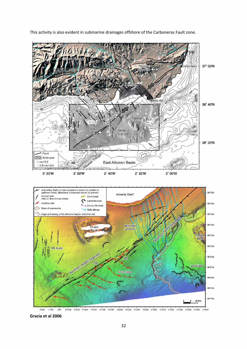
This activity is also evident in submarine drainages offshore of the Carboneras Fault zone.
Gracia et al 2006

33
Climate Quaternary climatic cycles have modified run-off and sediment production, affecting critical stream power and thus aggradation or incision of the river systems. Quaternary glacial periods were generally associated with aggradation and interglacials with incision though there is recent evidence of aggradation being especially important during glacial-to-interglacial transitions. The major valleys show climatically generated sequences of river terraces set into the overall epeirogenically driven incisional development of the valley systems themselves. Quaternary climatic cycles also controlled regional base levels through their influence on eustatic sea levels of the Mediterranean, affecting the distal portions of the fluvial systems, and acting counter to the climatically driven sediment signal, with incision associated with glacial period low sea levels.
River Capture Local base levels have also been modified by river capture associated with major drainage re-organisation.
Harvey 2007

34
These factors have led to the development of a regionally distinctive drainage network
Harvey 2007

35
A simple model can be proposed, summarising the major changes that could be expected to take place in the transformation of marine sedimentary basins into dissecting fluvial systems. As regional epeirogenic uplift takes place and sediment input to the marine basins increases, the last phases of marine sedimentation might involve fan-delta deposition. On emergence and marine retreat, these would be replaced by aggrading alluvial fans. This may be in the context of an enclosed basin with internal drainage or of an open externally drained basin. Dissection may be induced proximally by fan trenching or distally by headwards erosion from a neighbouring basin or in relation to lowered regional base levels. In both cases, aggradation is transformed into dissection by an incising through drainage. Local complications to this sequence may be brought about, for example, through tectonic activity or through drainage reorganisation by river capture.
Harvey et al 2014
36
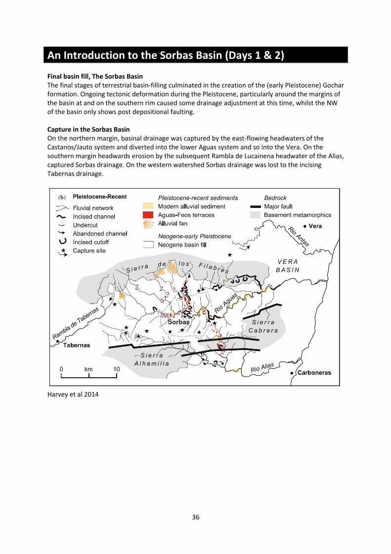
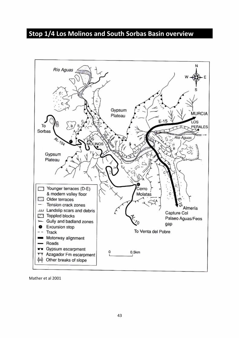
An Introduction to the Sorbas Basin (Days 1 & 2) Final basin fill, The Sorbas Basin The final stages of terrestrial basin-filling culminated in the creation of the (early Pleistocene) Gochar formation. Ongoing tectonic deformation during the Pleistocene, particularly around the margins of the basin at and on the southern rim caused some drainage adjustment at this time, whilst the NW of the basin only shows post depositional faulting. Capture in the Sorbas Basin On the northern margin, basinal drainage was captured by the east-flowing headwaters of the Castanos/Jauto system and diverted into the lower Aguas system and so into the Vera. On the southern margin headwards erosion by the subsequent Rambla de Lucainena headwater of the Alias, captured Sorbas drainage. On the western watershed Sorbas drainage was lost to the incising Tabernas drainage.
Harvey et al 2014

37
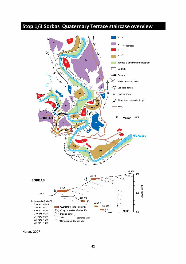
Quaternary terrace record During the early–middle Pleistocene, a major change took place, the switch from basin-centre aggradation to dissection, presumably uplift-related, creating the incising river valley of the master Aguas/Feos river. The evolution of this river system was marked by three mid–late Pleistocene inset gravel terraces (labelled A, B, C). These can be traced throughout the Sorbas basin and through the gap across the Sierras Alhamilla/Cabrera into the northern end of the Almería basin. The dates on these terrace sediments that have been obtained so far indicate that, as in many other areas in the Mediterranean region, terrace aggradation took place during global glacials, perhaps especially during glacial-to-interglacial transitions. During glacials, presumably effective frost action in the mountain source areas increased sediment supply beyond the threshold of critical stream power resulting in sustained aggradation. Terrace C, the youngest terrace that can be traced through the sierras into the Almería basin, was aggrading until 60–68 ka, during MIS4. Terrace B appears to date from MIS 6 or 8 and Terrace A from some earlier unspecified date. During the intervening interglacials, incision took place. During Terrace C aggradation, a major event took place that radically altered the fluvial systems of the Sorbas basin and the neighbouring Vera and Almería basins.
Harvey 2007
38
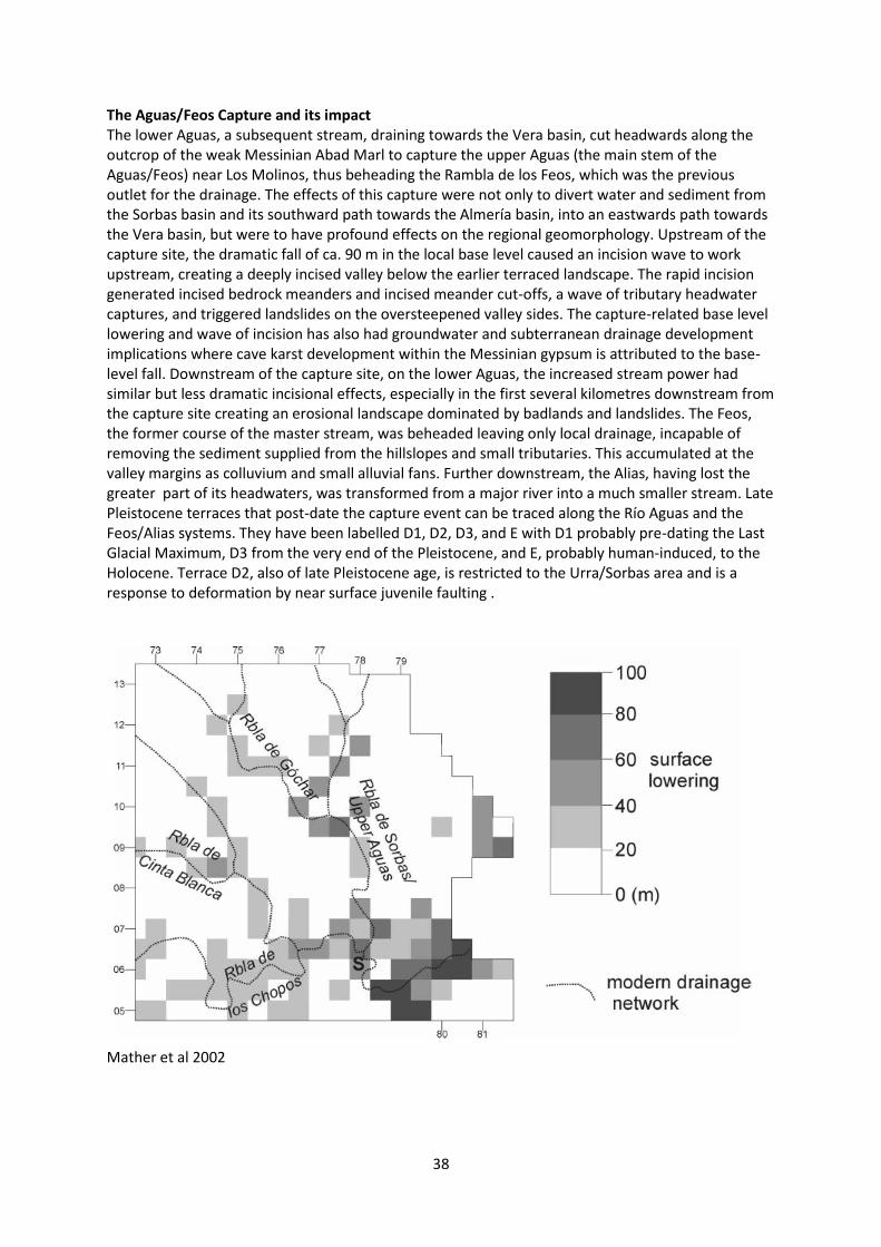
The Aguas/Feos Capture and its impact The lower Aguas, a subsequent stream, draining towards the Vera basin, cut headwards along the outcrop of the weak Messinian Abad Marl to capture the upper Aguas (the main stem of the Aguas/Feos) near Los Molinos, thus beheading the Rambla de los Feos, which was the previous outlet for the drainage. The effects of this capture were not only to divert water and sediment from the Sorbas basin and its southward path towards the Almería basin, into an eastwards path towards the Vera basin, but were to have profound effects on the regional geomorphology. Upstream of the capture site, the dramatic fall of ca. 90 m in the local base level caused an incision wave to work upstream, creating a deeply incised valley below the earlier terraced landscape. The rapid incision generated incised bedrock meanders and incised meander cut-offs, a wave of tributary headwater captures, and triggered landslides on the oversteepened valley sides. The capture-related base level lowering and wave of incision has also had groundwater and subterranean drainage development implications where cave karst development within the Messinian gypsum is attributed to the base-level fall. Downstream of the capture site, on the lower Aguas, the increased stream power had similar but less dramatic incisional effects, especially in the first several kilometres downstream from the capture site creating an erosional landscape dominated by badlands and landslides. The Feos, the former course of the master stream, was beheaded leaving only local drainage, incapable of removing the sediment supplied from the hillslopes and small tributaries. This accumulated at the valley margins as colluvium and small alluvial fans. Further downstream, the Alias, having lost the greater part of its headwaters, was transformed from a major river into a much smaller stream. Late Pleistocene terraces that post-date the capture event can be traced along the Río Aguas and the Feos/Alias systems. They have been labelled D1, D2, D3, and E with D1 probably pre-dating the Last Glacial Maximum, D3 from the very end of the Pleistocene, and E, probably human-induced, to the Holocene. Terrace D2, also of late Pleistocene age, is restricted to the Urra/Sorbas area and is a response to deformation by near surface juvenile faulting .
Mather et al 2002

39
Mather et al 2002
Mather et al 2002
40
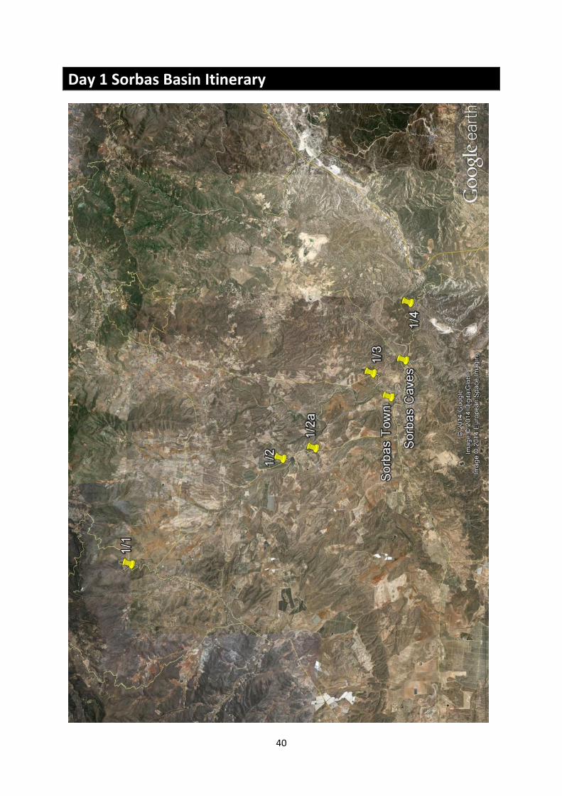
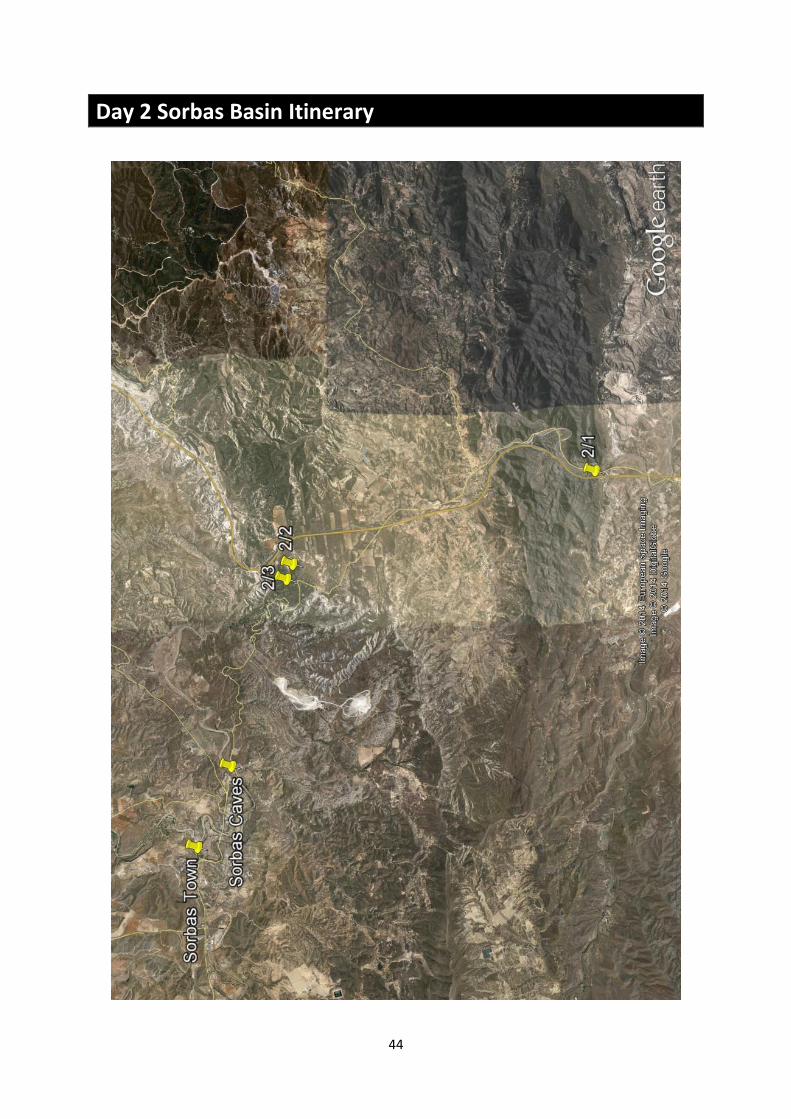
Day 1 Sorbas Basin Itinerary

41
Stop 1/1 Viewpoint above Uleila Vista across the Sorbas basin, from North to South
Stop 1/2 The Final Basin Fill : Gochar Formation
Harvey et al 2014
42
Stop 1/3 Sorbas Quaternary Terrace staircase overview
Harvey 2007
43
Stop 1/4 Los Molinos and South Sorbas Basin overview
Mather et al 2001
44
Day 2 Sorbas Basin Itinerary

45
Stop 2/1 Quaternary Terraces, Feos River System
Mather et al 2001

46
Stop 2/2 View over Aguas/Feos capture site
Mather et al 2001

47
Stop 2/3 The Carassco landslide
Hart 2004
Stop 2/4 Sorbas Town Geostroll

48
An Introduction to the Tabernas Basin In the Tabernas Basin by the Pliocene the bulk of the basin was exposed, with a large depositional fluvial system in the western part of the basin, fed by the Rio Andarax to which the Tabernas system was a tributary. This system was incised into the uplifted Neogene basin-fill of Tortonian marls and turbidites. It fed a large fan delta extending from the south-west corner of the basin into the throat of the Rioja corridor linking the Tabernas with the Almería basin. The steep tectonically induced gradients and the high uplift rate, together with the erodible nature of the Tortonian basin-fill created a dominantly erosional landscape in the centre of the basin through the majority of the Pleistocene.
Villalobos et al 2003

49
The dissectional trend was punctuated by the development of hillslope pediments and a series of fragmentary river terraces. The oldest and highest of the pediments and the terraces now form calcreted gravel-capped mesas and the younger ones form fragmentary terraces within the developing valley of the Rambla de Tabernas. Whether these are related to tectonic pulses or to the Quaternary climatic sequence is currently uncertain but we can be certain that there is more direct evidence for deformation within the Quaternary sequence of the Tabernas basin, particularly in the west of the basin. The dissection has lead to the development of a highly contrasting Quaternary record dominated by erosion in the west and alluvial fan deposition in the east. Geach et al in press

50
Harvey et al 2014
51
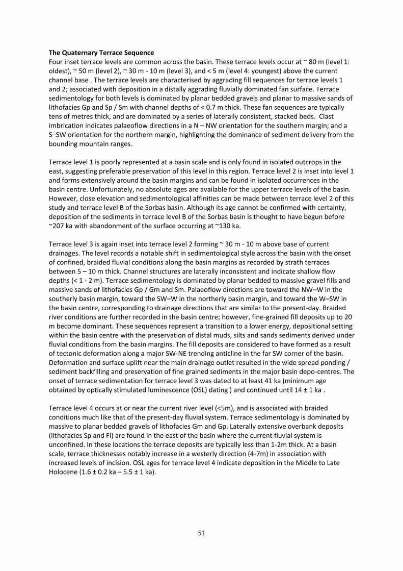
The Quaternary Terrace Sequence Four inset terrace levels are common across the basin. These terrace levels occur at ~ 80 m (level 1: oldest), ~ 50 m (level 2), ~ 30 m - 10 m (level 3), and < 5 m (level 4: youngest) above the current channel base . The terrace levels are characterised by aggrading fill sequences for terrace levels 1 and 2; associated with deposition in a distally aggrading fluvially dominated fan surface. Terrace sedimentology for both levels is dominated by planar bedded gravels and planar to massive sands of lithofacies Gp and Sp / Sm with channel depths of < 0.7 m thick. These fan sequences are typically tens of metres thick, and are dominated by a series of laterally consistent, stacked beds. Clast imbrication indicates palaeoflow directions in a N – NW orientation for the southern margin; and a S–SW orientation for the northern margin, highlighting the dominance of sediment delivery from the bounding mountain ranges. Terrace level 1 is poorly represented at a basin scale and is only found in isolated outcrops in the east, suggesting preferable preservation of this level in this region. Terrace level 2 is inset into level 1 and forms extensively around the basin margins and can be found in isolated occurrences in the basin centre. Unfortunately, no absolute ages are available for the upper terrace levels of the basin. However, close elevation and sedimentological affinities can be made between terrace level 2 of this study and terrace level B of the Sorbas basin. Although its age cannot be confirmed with certainty, deposition of the sediments in terrace level B of the Sorbas basin is thought to have begun before ~207 ka with abandonment of the surface occurring at ~130 ka. Terrace level 3 is again inset into terrace level 2 forming ~ 30 m - 10 m above base of current drainages. The level records a notable shift in sedimentological style across the basin with the onset of confined, braided fluvial conditions along the basin margins as recorded by strath terraces between 5 – 10 m thick. Channel structures are laterally inconsistent and indicate shallow flow depths (< 1 - 2 m). Terrace sedimentology is dominated by planar bedded to massive gravel fills and massive sands of lithofacies Gp / Gm and Sm. Palaeoflow directions are toward the NW–W in the southerly basin margin, toward the SW–W in the northerly basin margin, and toward the W–SW in the basin centre, corresponding to drainage directions that are similar to the present-day. Braided river conditions are further recorded in the basin centre; however, fine-grained fill deposits up to 20 m become dominant. These sequences represent a transition to a lower energy, depositional setting within the basin centre with the preservation of distal muds, silts and sands sediments derived under fluvial conditions from the basin margins. The fill deposits are considered to have formed as a result of tectonic deformation along a major SW-NE trending anticline in the far SW corner of the basin. Deformation and surface uplift near the main drainage outlet resulted in the wide spread ponding / sediment backfilling and preservation of fine grained sediments in the major basin depo-centres. The onset of terrace sedimentation for terrace level 3 was dated to at least 41 ka (minimum age obtained by optically stimulated luminescence (OSL) dating ) and continued until 14 ± 1 ka . Terrace level 4 occurs at or near the current river level (<5m), and is associated with braided conditions much like that of the present-day fluvial system. Terrace sedimentology is dominated by massive to planar bedded gravels of lithofacies Gm and Gp. Laterally extensive overbank deposits (lithofacies Sp and Fl) are found in the east of the basin where the current fluvial system is unconfined. In these locations the terrace deposits are typically less than 1-2m thick. At a basin scale, terrace thicknesses notably increase in a westerly direction (4-7m) in association with increased levels of incision. OSL ages for terrace level 4 indicate deposition in the Middle to Late Holocene (1.6 ± 0.2 ka – 5.5 ± 1 ka).

52
Geach et al in press

53
Tectonic activity The basin is the most tectonically active, with major E– W trending thrust faults along the southern margin. Most important is a NW trending growth fold in the west centre of the basin that has been intermittently active since the late Miocene. A major pulse of uplift occurred on this structure during the mid-Pleistocene, coincident with tectonic activity recognised in the Andarax valley. Uplift on this structure caused ponding of the drainage and the accumulation of a linear body of lacustrine and palustrine sediments filling the ENE–WSW valley of the Rambla de Tabernas through the centre of the basin. Once the barrier caused by the growth fold had been breached after c 20 ka, the Rambla de Tabernas rapidly incised, triggering the development of the modern Tabernas badlands on the lower slopes of the western part of the Tabernas basin. The high rates of erosion on these badland slopes may have been accentuated by human impact. By headwards erosion, the incision created a deep canyon linking the eastern and western parts of the basin. This process, however, is ongoing. Full coupling between the mountain source areas in the upper eastern part of the basin and the main drainage is not yet complete. The dissection has reached fans issuing from the Sierra Alhamilla, is imminent for the small fans issuing from the Serrata del Marchante, but has yet to reach the large Filabres fans

54
Day 3 Tabernas Basin Itinerary

55
Stop 3/1 Tabernas Castle Overview
Las Salinas

56
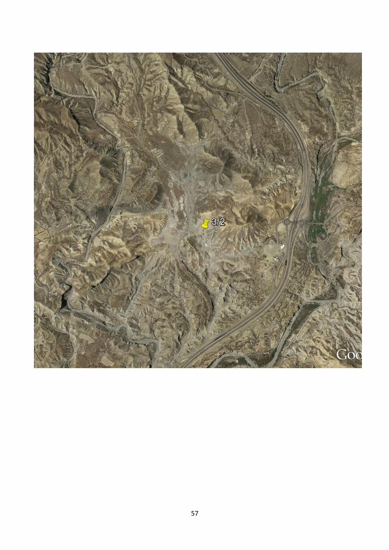
Stop 3/2 Las Salinas
Mather & Stokes in Villalobos et al 2003 View looking north up the abandoned meander and towards the travertine site (also a fairly significant movie locality!). Middle view approximately 0.5km across.
57
58
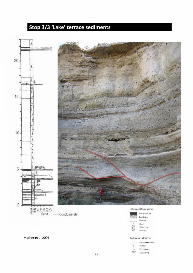
Stop 3/3 ‘Lake’ terrace sediments
Mather et al 2001
59
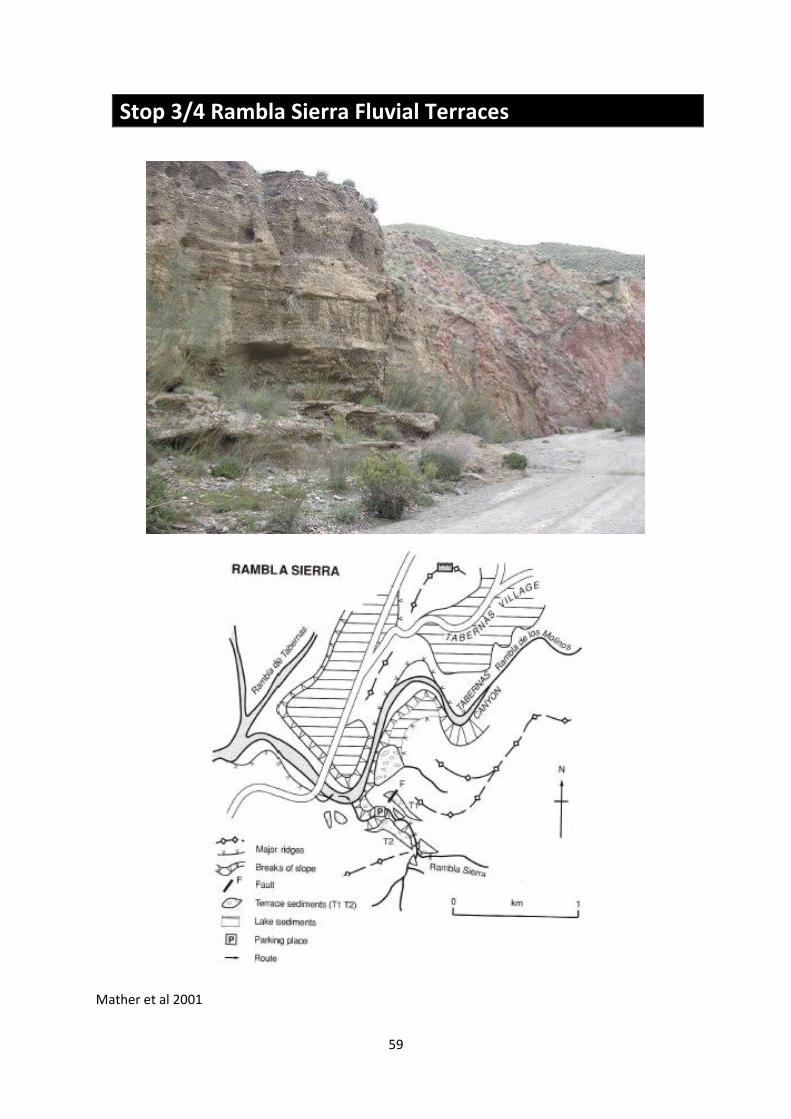
Stop 3/4 Rambla Sierra Fluvial Terraces
Mather et al 2001

60
References Note that most of these references, along with other literature pertinent to the area is included on your Conference Pen USB Flash Drive, along with the KML locations of the stops visited. Geach, M., Viveen, W., Mather, A.E. , Telfer, M.W., Fletcher, W.J., Stokes, M. In Press. An integrated field and numerical modelling study of controls on Late Quaternary fluvial landscape development (Tabernas, SE Spain). ESPL. Gracia, E., Pallas, R., Soto, JI ., Comas, M., Moreno, X.,; Masana, E., Santanach, P., Diez, S., Garcia, M., Danobeitia, J. 2006. Active faulting offshore SE Spain (Alboran Sea): Implications for earthquake hazard assessment in the Southern Iberian Margin. Earth and Planetary Science Letters : 241, 734-749 Hart, A.B. 2004. Landslide Investigation in the Rio Aguas Catchment, SE Spain. Unpublished PhD Thesis, University of Plymouth. 456p Harvey AM. 2007. High sinuosity bedrock channels: response to rapid incision - examples in SE Spain. Revista C&G 21: 21-47 Harvey, AM., Whitfield (nee Maher),E., Stokes,M. & Mather, A. 2014. The Late Neogene to Quaternary Drainage Evolution of the Uplifted Neogene Sedimentary Basins of Almerıa, Betic Chain. In F. Gutiérrez and M. Gutiérrez (eds.), Landscapes and Landforms of Spain, World Geomorphological Landscapes,Springer Mather, A.E., Martin, J.M., Harvey, A.M. & Braga, J.C. (Editors) 2001. A Field guide to the Neogene sedimentary basins of the Almeria Province, South-east Spain: International Association of Sedimentologists Field Guide. Blackwell Science. 350pp Available via Wiley as an Ebook. Mather AE, Stokes M, Griffiths JS. 2002. Quaternary Landscape Evolution: A Framework for Understading Contemporary Erosion, SE Spain. Land Degradation & Development 13: 89-109 Villalobos, M. 2003. Geology of the Arid Zone of Almeria, SE Spain: an educational field guide. pp163

61

62