technical report for the tungsten … · technical report for the tungsten resource update of the...
TRANSCRIPT

TECHNICAL REPORT FOR THE
TUNGSTEN RESOURCE UPDATE OF THE
JERSEY‐EMERALD PROPERTY, SALMO, BC
Nelson Mining Division, British Columbia Mapsheets: 82F.004, 82F.005, 82F.014, 82F.015
Latitude 49.11°N, Longitude 117.22°E UTM NAD83 Zone 11: 5439500 N, 484000 E
For
Margaux Resources Ltd. 1600‐510 5th Street Calgary, Alberta
T2P 3S2 By
Gary Giroux, P.Eng, MASc Giroux Consultants Ltd.
Perry Grunenberg, P.Geo.
Consulting Geologist
Vivian Park, P.Geo. Consulting Geologist
Report Date: March 15, 2015
Effective Date: February 4, 2015

i
TABLE OF CONTENTS 1 Summary .............................................................................................................................................. 5
1.1 Introduction .................................................................................................................................. 5 1.2 Project Background ....................................................................................................................... 5 1.3 Geology and Mineralization .......................................................................................................... 5 1.4 Mineral Resource Estimates ......................................................................................................... 6
1.4.1 Tungsten (2015) .................................................................................................................... 6 1.4.2 Molybdenum (2006) ............................................................................................................. 6 1.4.3 Zinc and Lead (2010) ............................................................................................................. 6 1.4.4 Summary ............................................................................................................................... 7
1.5 Recommendations ........................................................................................................................ 7 2 Introduction and Terms of Reference .................................................................................................. 9 3 Reliance on Other Experts .................................................................................................................. 10 4 Property Description and Location .................................................................................................... 11
4.1 Description and Location ............................................................................................................ 11 4.2 Claim Status ................................................................................................................................ 11 4.3 Option Agreement ...................................................................................................................... 15 4.4 Environmental Status .................................................................................................................. 15 4.1 Permitting ................................................................................................................................... 16 4.2 Other Factors .............................................................................................................................. 16
5 Accessibility, Climate, Local Resources, Infrastructure and Physiography ........................................ 17 5.1 Access .......................................................................................................................................... 17 5.2 Physiography and Vegetation ..................................................................................................... 17 5.3 Climate ........................................................................................................................................ 17 5.4 Infrastructure and Local Resources ............................................................................................ 17
6 History ................................................................................................................................................ 19 6.1 Early Exploration and Development ........................................................................................... 19 6.2 Canadian Exploration Ltd. ........................................................................................................... 19 6.3 Mentor Exploration Ltd. .............................................................................................................. 19 6.4 Nu‐Dawn Resources Inc., LLoyd Addie, and Bob Bourdon ......................................................... 20 6.5 Sultan Minerals Inc. ..................................................................................................................... 20 6.6 Mineral Resource Estimates ....................................................................................................... 20
6.6.1 Tungsten and Molybdenum (2006) .................................................................................... 20 6.6.2 Tungsten (2009) .................................................................................................................. 21 6.6.3 Zinc and Lead (2010) ........................................................................................................... 21
7 Geological Setting and Mineralization ............................................................................................... 22 7.1 Regional Geology ........................................................................................................................ 22 7.2 Local and Property Geology ........................................................................................................ 22 7.3 Mineralization ............................................................................................................................. 25
7.3.1 Lead and Zinc Zones ............................................................................................................ 25 7.3.2 Tungsten Zones ................................................................................................................... 25 7.3.3 Molybdenum Zones ............................................................................................................ 27 7.3.4 Gold Zones .......................................................................................................................... 28
8 Deposit Types ..................................................................................................................................... 30 8.1 Lead and Zinc Deposits ............................................................................................................... 30 8.2 Tungsten Deposits ....................................................................................................................... 30

ii
8.3 Gold Deposition .......................................................................................................................... 30 8.4 Molybdenum Porphyry ............................................................................................................... 30
9 Exploration ......................................................................................................................................... 31 10 Drilling ................................................................................................................................................ 32
10.1 Introduction ................................................................................................................................ 32 10.2 Drilling ......................................................................................................................................... 32
10.2.1 Units of Measurement ........................................................................................................ 36 10.2.2 Conversions ......................................................................................................................... 36
10.3 East Emerald Tungsten Zone ....................................................................................................... 36 10.4 Protocols ..................................................................................................................................... 39
10.4.1 Downhole Survey Methodology ......................................................................................... 39 10.4.2 Collar Survey Methodology ................................................................................................. 40 10.4.3 Drill Core Protocols ............................................................................................................. 40 10.4.4 Data Management .............................................................................................................. 40
11 Sample Preparation, Analyses and Security ....................................................................................... 42 11.1 Sample Collection........................................................................................................................ 42
11.1.1 Soil Samples ........................................................................................................................ 42 11.1.2 Rock Samples ...................................................................................................................... 42 11.1.3 Core Samples ....................................................................................................................... 42
11.2 Preparation and Analyses ........................................................................................................... 42 11.2.1 Quality Assurance Protocols ............................................................................................... 43
11.3 Security ....................................................................................................................................... 45 11.4 Conclusions ................................................................................................................................. 45
12 Data Verification................................................................................................................................. 46 12.1 Field Verification ......................................................................................................................... 46 12.2 Assay Results Verification ........................................................................................................... 47
12.2.1 Quality Assurance Protocols ............................................................................................... 47 12.2.2 Quality Assurance Discussion .............................................................................................. 47
13 Mineral Processing and Metallurgical Testing ................................................................................... 51 14 Mineral Resource Estimate ................................................................................................................ 52
14.1 Introduction ................................................................................................................................ 52 14.2 Geologic Interpretation and Topography ................................................................................... 52 14.3 Statistics and Grade Capping ...................................................................................................... 53 14.4 Compositing ................................................................................................................................ 55 14.5 Variography ................................................................................................................................. 55 14.6 Block Model ................................................................................................................................ 56 14.7 Grade Interpolation .................................................................................................................... 56 14.8 Bulk Density ................................................................................................................................ 57 14.9 Classification ............................................................................................................................... 57 14.10 Results ......................................................................................................................................... 58
14.10.1 Model Verification .............................................................................................................. 60 14.11 Summary of All Mineral Resources ............................................................................................. 60
14.11.1 Tungsten (2015) .................................................................................................................. 60 14.11.2 Molybdenum (2006) ........................................................................................................... 66 14.11.3 Zinc and Lead (2010) ........................................................................................................... 66
15 Through 22 are not applicable to this Technical Report .................................................................... 68

iii
23 Adjacent Properties ............................................................................................................................ 69 23.1 HB ................................................................................................................................................ 69 23.2 Molly ........................................................................................................................................... 71 23.3 Summit, Ore Hill, and Bonanza ................................................................................................... 72
24 Other Relevant Data and Information ............................................................................................... 74 24.1 2007 Wardrop Scoping Study – Tungsten ................................................................................... 74
24.1.1 Discussion ............................................................................................................................ 75 25 Interpretation and Conclusions .......................................................................................................... 76 26 Recommendations ............................................................................................................................. 78
26.1 Exploration .................................................................................................................................. 78 26.1.1 Tungsten .............................................................................................................................. 78 26.1.2 Zinc and Lead ...................................................................................................................... 79
26.2 Data ............................................................................................................................................. 79 26.2.1 Survey Transformation ........................................................................................................ 79 26.2.2 Data Mining ......................................................................................................................... 80 26.2.3 Mine Workings Model ......................................................................................................... 80
26.3 Preliminary Economic Assessment ............................................................................................. 80 26.4 Total Recommended Project Cost .............................................................................................. 81
27 References .......................................................................................................................................... 82 Glossary ....................................................................................................................................................... 84 Signature Page ............................................................................................................................................ 87 Certificate of Qualifications for Gary Giroux .............................................................................................. 88 Certificate of Qualifications for Perry Grunenberg ..................................................................................... 89 Certificate of Qualifications for Vivian Park ................................................................................................ 90 Appendix 1: Tungsten Composites for 2014 Drilling .................................................................................. 91 Appendix 2: List of Drillholes Used for the 2015 East Emerald Tungsten Resource Estimation ................ 96 Appendix 3: Semi‐Variograms for WO3 ....................................................................................................... 99 LIST OF FIGURES Figure 1: Location map ................................................................................................................................ 13 Figure 2: Jersey‐Emerald property (Margaux option) ................................................................................. 14 Figure 3: Regional geology .......................................................................................................................... 23 Figure 4: Local geology ................................................................................................................................ 24 Figure 5: Drillhole location map – Jersey‐Emerald Property ...................................................................... 34 Figure 6: Drillhole location map – East Emerald Zone ................................................................................ 35 Figure 7: Control chart for standard W4 ..................................................................................................... 49 Figure 8: Control chart for blanks ............................................................................................................... 49 Figure 9: XY chart for field duplicates ......................................................................................................... 50 Figure 10: Precision chart for field duplicates ............................................................................................ 50 Figure 11: View looking SE showing mineralized solids in red, underground workings in green, surface topography in grey, and drillhole traces in light green ............................................................................... 52 Figure 12: View looking NE showing mineralized solids in red, underground workings in green, surface topography in grey, and drillhole traces in light green ............................................................................... 53 Figure 13: Lognormal cumulative frequency plot for WO3 at East Emerald ............................................... 54 Figure 14: 4260‐level plan showing estimated WO3 blocks ........................................................................ 61 Figure 15: 4160‐level plan showing estimated WO3 blocks ........................................................................ 62

iv
Figure 16: 4060‐level plan showing estimated WO3 blocks ........................................................................ 63 Figure 17: 3960‐level plan showing estimated WO3 blocks ........................................................................ 64 Figure 18: 3860‐level plan showing estimated WO3 blocks ........................................................................ 65 Figure 19: Minfile occurrences in property area ........................................................................................ 70 LIST OF TABLES Table 1: Summary of mineral resources ....................................................................................................... 7 Table 2: List of mineral claims ..................................................................................................................... 11 Table 3: List of crown grants ....................................................................................................................... 12 Table 4: Summary of 2014 drilling .............................................................................................................. 32 Table 5: Analytical procedures by laboratory ............................................................................................. 43 Table 6: Summary of sample types by drillhole .......................................................................................... 43 Table 7: Standards used during the 2014 program .................................................................................... 47 Table 8: Summary of drilling program samples .......................................................................................... 47 Table 9: Rules for evaluating quality control samples ................................................................................ 48 Table 10: Statistics for WO3 grades in East Emerald solids ......................................................................... 54 Table 11: Statistics for capped WO3 grades for East Emerald .................................................................... 54 Table 12: Statistics for 10 ft composites for East Emerald ......................................................................... 55 Table 13: Semivariogram parameters for East Emerald ............................................................................. 55 Table 14: Block model parameters ............................................................................................................. 56 Table 15: Kriging search strategy for WO3 East Emerald ........................................................................... 56 Table 16: Summary of specific gravity determinations in East Emerald..................................................... 57 Table 17: East Emerald indicated resource within mineralized solids ........................................................ 59 Table 18: East Emerald inferred resource within mineralized solids .......................................................... 59 Table 19: Summary of all tungsten resources............................................................................................. 60 Table 20: Mineral resources for Jersey‐Emerald property ......................................................................... 66

5
1 SUMMARY
1.1 INTRODUCTION
Gary Giroux, P. Eng, of Giroux Consultants Limited (Giroux), in Vancouver, British Columbia (BC) was retained by Margaux Resources Limited (Margaux), headquartered in Calgary, Alberta, to estimate the updated tungsten resource of the Jersey‐Emerald property.
The new tungsten resource estimate included the results of 35 drillholes completed in the East Emerald zone by Margaux in 2014. The update to the East Emerald tungsten resource estimation is the subject of this report.
The tungsten resource estimate was prepared according to the Canadian Institute of Mining, Metallurgy and Petroleum (CIM) best practice guidelines and standards.
This report is to comply with disclosure and reporting requirements set forth in National Instrument 43‐101 (NI 43‐101), “Standards of Disclosure for Mineral Projects”, and in accordance with Form 43‐101F1, “Technical Report”.
Mr. Giroux, Perry Grunenberg, P. Geo, in Kamloops, BC, and Vivian Park, P. Geo, in Kamloops, BC, prepared this technical report. Mr. Giroux, Mr. Grunenberg, and Ms. Park are qualified persons as defined in NI 43‐101 and are independent of Margaux.
In order to accommodate the historical data set, the minerals resources are reported using imperial measurements. Monetary values are expressed as Canadian dollars.
1.2 PROJECT BACKGROUND
The Jersey‐Emerald property, located within the Nelson Mining Division is centered at a latitude and longitude of 49 degrees (°) 06 minutes (’) North (N), 117°13' East (E), within map sheets 82F.004, 82F.005, 82F.014, and 82F.015. The property consists of 105 mineral claims over 15,024.58 hectares (ha) (Table 1), and 44 crown grants over 660.56 ha (Table 2).
In November 2013, Margaux entered into an option agreement with Sultan Minerals Incorporated (Sultan). The agreement, which has a term of three years ending November 8, 2016, allows Margaux to acquire the property by spending 6,000,000 dollars ($) in expenditures and staged payments. Sultan will retain a 1.5 percent (%) net smelter return (NSR); Margaux may purchase 50% of the NSR for $5,000,000 after certain conditions are met.
1.3 GEOLOGY AND MINERALIZATION
The property geology comprises the Cambrian Laib Formation (Fm) and the Ordovician Active Fm. The Laib Fm comprises mixed carbonates and pelites.
Small plugs, dykes, and sills of Cretaceous granite that intruded the sedimentary sequence created rocks ranging from marble to garnet‐pyroxene skarn.

6
The main structure on the property is a major north‐northeast (NNE) trending anticline known locally as the Jersey anticline.
Two narrow, NNE‐trending elongate dyke‐like bodies of Cretaceous biotite granite, locally known as the Emerald and Dodger ridges, flare from the underlying intrusive into the sediments of the Jersey anticline. Some of the mineralized bodies formed along the margins of these ridges.
Past mining produced zinc (Zn) and lead (Pb), and tungsten (W). The property hosts areas with elevated molybdenum (Mo), gold (Au), bismuth (Bi), arsenic (As), copper (Cu), silver (Ag), cadmium (Cd), and barium (Ba).
1.4 MINERAL RESOURCE ESTIMATES
1.4.1 TUNGSTEN (2015)
In 2014, Margaux drilled 35 drillholes, for 6,318.6 m, in the East Emerald zone in order to improve the tungsten resource in that area. The area had been previously under‐explored, and the tungsten resource estimate was small.
On March 2, 2015, Margaux released the results of a tungsten resource estimate for the property, which incorporated the updated estimation for the East Emerald zone. The estimates for the tungsten resources for all other zones (Emerald, Invincible, and Dodger) were not changed.
The East Emerald zone has an estimated indicated tungsten resource of 561,000 tons (t) averaging 0.201% tungsten trioxide (WO3), and an inferred tungsten resource of 3.560 million tons (Mt) averaging 0.217% WO3, using a 0.15% WO3 cut‐off.
For the property, a weighted average of the 2006, 2009, and 2015 tungsten resource estimates, using a 0.15% WO3 cut‐off grade, yields a total measured and indicated (M+I) resource of 3.071 Mt averaging 0.341% WO3, and an inferred resource of 5.480 Mt averaging 0.273% WO3.
The tungsten resource classified as M+I experienced a 6% increase in contained pounds of WO3, and the inferred resource showed an 84% increase in contained pounds of WO3.
1.4.2 MOLYBDENUM (2006)
In 2006, an initial estimate of molybdenum in the Dodger 4200 zone, using a 0.05% Mo cut‐off grade, yielded an indicated resource of 28,000 t averaging 0.098% Mo, and an inferred resource of 481,000 t averaging 0.103% Mo.
1.4.3 ZINC AND LEAD (2010)
In 2010, an estimate of the zinc and lead for the Jersey mine area yielded an indicated resource of 5.32 Mt averaging 2.60% Zn and 1.04% Pb, and an inferred resource of 16.93 Mt averaging 2.18% Zn and 1.04% Pb, at a cut‐off grade of 1.5% combined Zn‐Pb.

7
Using a 3.5% combined Zn‐Pb cut‐off grade, there is an indicated resource of 1.9 Mt averaging 4.10% Zn and 1.96% Pb, and an inferred resource of 4.98 Mt averaging 3.37% Zn and 1.95% Pb.
1.4.4 SUMMARY
In 2015, the tungsten resource estimate for the East Emerald zone included the results from the 2014 drilling. For all other zones, there has been no additional drilling; therefore, the authors consider the previously estimated mineral resources to be current.
A summary of the Jersey‐Emerald property resources is presented in Table 1.
Table 1: Summary of mineral resources
Year Item Deposit Classification Cut‐off (%)
Tons>Cut‐off (t)
Grade (%)
Pounds (lb)
2006
WO3
Dodger
East Dodger Invincible
Measured
0.15
1,200,000 0.379 9,096,000
Indicated 1,310,000 0.365 9,563,000
Measured + Indicated 2,510,000 0.372 18,659,000
Inferred 1,210,000 0.397 9,607,000
2009 Emerald Inferred 710,000 0.346 4,913,200
2015 East Emerald Indicated 561,000 0.201 2,255,220
Inferred 3,560,000 0.217 15,450,400
2006+2009+2015 Combined Measured + Indicated 3,071,000 0.341 20,914,220
Inferred 5,480,000 0.273 29,970,600
2006 Mo
Dodger 4200 Indicated 0.05
28,000 0.098 54,880
Inferred 481,000 0.103 990,860
2010 Zn
Jersey Indicated
3.50 Zn+Pb
1,900,000 4.100 155,900,000
Inferred 4,980,000 3.370 335,600,000
Pb Indicated 1,900,000 1.960 74,600,000
Inferred 4,980,000 1.950 194,500,000
1.5 RECOMMENDATIONS
The completion of 7,000 metres (m) of surface and underground drilling, trenching, and support for tungsten and zinc‐lead mineralization on the property is estimated at a cost of $1,075,000.
The historic work on the Jersey‐Emerald property has utilized a local mine grid coordinate system, which has created difficulties when modern equipment, such as global positioning systems (GPS) and software is utilized. The authors recommend that the property data be converted to metric Universal Transmercator (UTM) coordinates for work moving forward. The cost for surveying and data conversion is estimated at $7,000.
Much of the historic data for the Jersey‐Emerald project, such as sample locations and assay results, exists only as paper copies at Margaux’s and Sultan’s offices. Additionally, the digital datasets contain small issues that need to be resolved

8
permanently before moving forward. The data compiled and corrected to ensure a robust, complete, and portable dataset for the property. An estimated cost for this work is $70,000.
A preliminary economic assessment (PEA) for all resources on the property should be completed. Based on review of similar studies, the cost will range between $150,000 and $300,000. Work by Wardrop Engineering Inc. (Wardrop) in 2007 may provide a base for a new combined‐resource economic assessment.
The total cost to complete all recommended programs is $1.7 million.

9
2 INTRODUCTION AND TERMS OF REFERENCE
Margaux Resources Limited (Ltd), headquartered in Calgary, Alberta, retained Gary Giroux, P. Eng, of Giroux Consultants Ltd., in Vancouver, BC, to estimate the tungsten resource of the Jersey‐Emerald property, by updating the tungsten resource estimate of the East Emerald zone.
Mr. Giroux, Perry Grunenberg, P. Geo, in Kamloops, BC, and Vivian Park, P. Geo, in Kamloops, BC, prepared this technical report. Mr. Giroux, Mr. Grunenberg, and Ms. Park are qualified persons as defined in NI 43‐101, and are independent of Margaux.
This report is to comply with disclosure and reporting requirements set forth in NI 43‐101, “Standards of Disclosure for Mineral Projects”, and in accordance with Form 43‐101F1, “Technical Report”.
The property hosts several mineral deposits with different mineralization types. Commodities include tungsten, molybdenum, and zinc and lead. The property is the subject of one technical report prepared for Margaux (Giroux and Grunenberg, 2014), and of three technical reports prepared for Sultan (Giroux and Grunenberg, 2006, 2009, and 2010). All reports are available on the System for Electronic Document Analysis and Retrieval (SEDAR).
In 2014, Margaux completed 35 drillholes in the previously under‐explored East Emerald zone, in order to improve the tungsten resource for that zone, and for the property. The mineral resource estimates for all other zones are unchanged, and are considered by the authors to be current mineral resources.
Mr. Giroux estimated the mineral resources; he is responsible for Chapter 14. Mr. Grunenberg is responsible for Chapter 26. Ms. Park is responsible for all remaining portions of the report, and performed the final edit. All authors have reviewed the report in its entirety.
Mr. Grunenberg managed the 2014 drilling program on behalf of Margaux, and spent several days on the property between August 7, 2014 and December 2, 2014. Ms. Park assisted with the 2014 drilling program, and spent several days on the property between August 25, 2014 and December 2, 2014. Mr. Giroux completed a site visit to examine drill core and underground workings on February 19 and February 20, 2009.
The sources of information for the tungsten resource estimation included historic and current data compilations, observations made during site visits, unpublished material, personal communications, and professional opinions. Public sources such as public company websites, the Assessment Report Indexing System (ARIS), and SEDAR also provided information. The authors have created all the tables, maps, charts, and graphics included in the report.
In order to accommodate the historical data set, the estimated mineral resources are reported using imperial measurements. Monetary values are expressed as Canadian dollars.

10
3 RELIANCE ON OTHER EXPERTS
The authors have reviewed and analyzed data provided by Margaux, its consultants, and earlier operators of the property, and have drawn their own conclusions, augmented by direct observation.
While exercising all reasonable diligence in checking, confirming, and testing, the authors have relied on Margaux’s presentation of the data for the Jersey‐Emerald project in formulating their opinions and estimates.
For information pertaining to legalities around ownership of claims on the property, and the option agreement between Sultan and Margaux, the authors have relied on information provided by Margaux.
The descriptions of geology, mineralization, and exploration methodology were based on direct field observation, and on information obtained from published and unpublished reports provided by Margaux.

11
4 PROPERTY DESCRIPTION AND LOCATION
4.1 DESCRIPTION AND LOCATION
The Jersey‐Emerald property, located within the Nelson Mining Division, BC, is centered at a latitude and longitude of 49° 06 ' N, 117° 13' E UTM North American Datum 1983 (NAD83) Zone 11: 5439500 N, 484000 E), within map sheets 82F.004, 82F.005, 82F.014, and 82F.015 (Figure 1), approximately 10 kilometres (km) southeast of the town of Salmo. Salmo is 41 km south of Nelson.
4.2 CLAIM STATUS
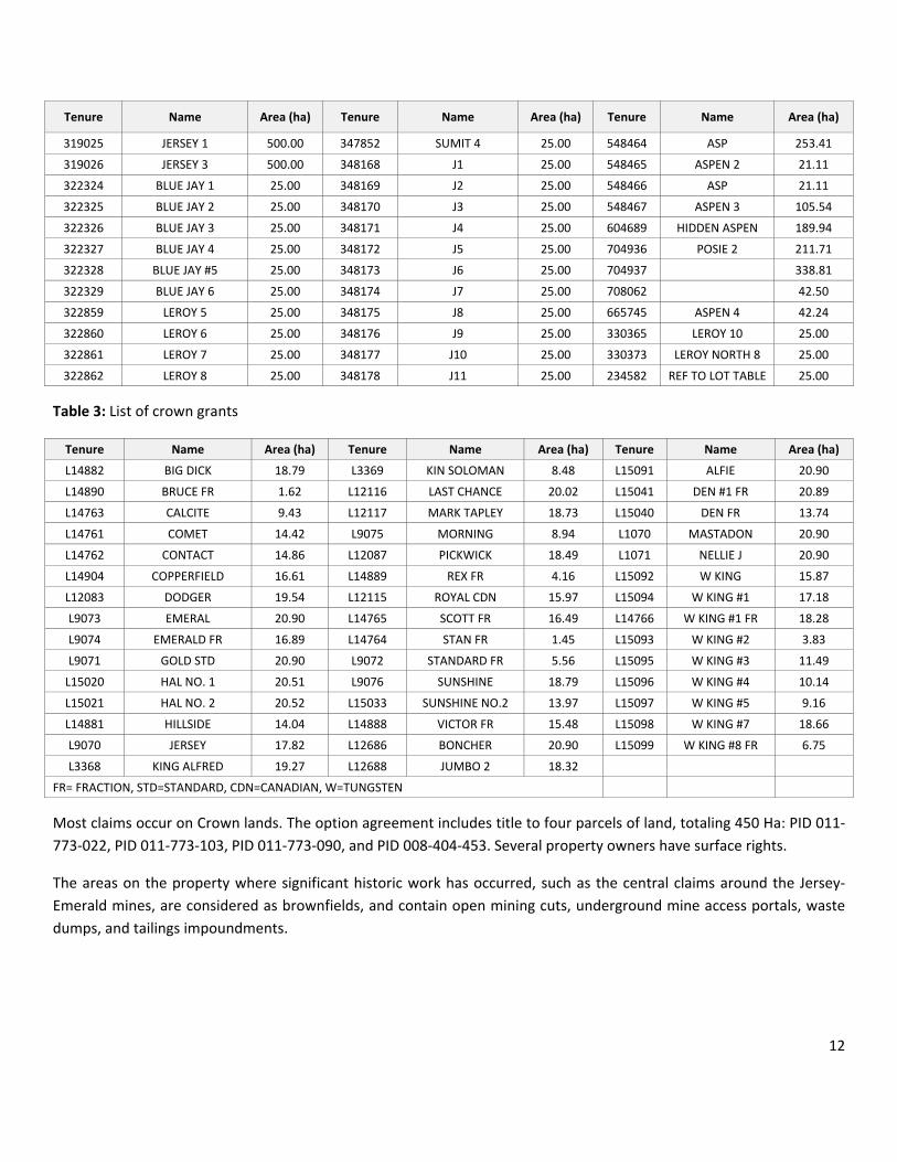
The property consists of 105 mineral claims over 15,024.58 ha (Table 2), and 44 crown grants over 660.56 ha (Table 3). Figure 2 shows the claims graphically.
The claims are in good standing until December 20, 2021. Crown grants require annual tax payments.
Table 2: List of mineral claims
Tenure Name Area (ha) Tenure Name Area (ha) Tenure Name Area (ha)
1030297 ZINC‐1 42.33 324439 LOST GOLD 225.00 348179 J12 25.00
1030298 ZINC‐2 148.19 325259 MV 1 25.00 348180 JERSEY 9 400.00
1030299 ZINC‐3 127.08 325260 MV 2 25.00 348181 JERSEY 10 500.00
1030300 ZINC‐4 148.27 325261 MV 3 25.00 348182 JERSEY 11 500.00
602733 SPURLIN 1 381.33 325262 MV 4 25.00 348183 JERSEY 12 450.00
603544 SPURLIN 2 296.56 325269 JERSEY 5 500.00 349449 J‐13 25.00
604337 JASON 1 232.92 325270 JERSEY 6 300.00 349450 J‐14 25.00
604347 JASON 4 402.25 329070 POSIE 1 500.00 349451 J‐15 25.00
604358 JASON 10 423.77 330364 LEROY 9 25.00 349452 J‐16 25.00
604359 JASON 11 339.04 330366 LEROY NORTH 1 25.00 349453 J‐17 25.00
604385 JASON 12 84.73 330367 LEROY NORTH 2 25.00 349901 JERSEY 13 450.00
604676 FAYE 1 337.64 330368 LEROY NORTH 3 25.00 349902 JERSEY 14 450.00
604677 FAYE 2 421.98 330369 LEROY NORTH 4 25.00 349903 J 18 25.00
604678 FAYE 3 464.20 330370 LEROY NORTH 5 25.00 349904 J 19 25.00
233462 REF TO LOT TABLE 25.00 330371 LEROY NORTH 6 25.00 349905 J 20 25.00
233677 REF TO LOT TABLE 25.00 330372 LEROY NORTH 7 25.00 349906 J 21 25.00
233693 REF TO LOT TABLE 25.00 331985 HANGOVER 25.00 349907 J 22 25.00
233694 REF TO LOT TABLE 25.00 331986 GULLY 25.00 349908 J 23 25.00
233695 REF TO LOT TABLE 25.00 342202 JERSEY #7 500.00 518176 ART 1 84.54
233696 REF TO LOT TABLE 25.00 342203 JERSEY #8 400.00 550768 SULTAN 528.70
233697 REF TO LOT TABLE 25.00 347849 SUMIT 1 25.00 550769 SULTAN2 296.17
318816 JERSEY #4 500.00 347850 SUMIT 2 25.00 603742 1‐May 296.30
318817 JERSEY #2 500.00 347851 SUMIT 3 25.00 548440 ASP 42.22
12
Tenure Name Area (ha) Tenure Name Area (ha) Tenure Name Area (ha)
319025 JERSEY 1 500.00 347852 SUMIT 4 25.00 548464 ASP 253.41
319026 JERSEY 3 500.00 348168 J1 25.00 548465 ASPEN 2 21.11
322324 BLUE JAY 1 25.00 348169 J2 25.00 548466 ASP 21.11
322325 BLUE JAY 2 25.00 348170 J3 25.00 548467 ASPEN 3 105.54
322326 BLUE JAY 3 25.00 348171 J4 25.00 604689 HIDDEN ASPEN 189.94
322327 BLUE JAY 4 25.00 348172 J5 25.00 704936 POSIE 2 211.71
322328 BLUE JAY #5 25.00 348173 J6 25.00 704937 338.81
322329 BLUE JAY 6 25.00 348174 J7 25.00 708062 42.50
322859 LEROY 5 25.00 348175 J8 25.00 665745 ASPEN 4 42.24
322860 LEROY 6 25.00 348176 J9 25.00 330365 LEROY 10 25.00
322861 LEROY 7 25.00 348177 J10 25.00 330373 LEROY NORTH 8 25.00
322862 LEROY 8 25.00 348178 J11 25.00 234582 REF TO LOT TABLE 25.00
Table 3: List of crown grants
Tenure Name Area (ha) Tenure Name Area (ha) Tenure Name Area (ha)
L14882 BIG DICK 18.79 L3369 KIN SOLOMAN 8.48 L15091 ALFIE 20.90
L14890 BRUCE FR 1.62 L12116 LAST CHANCE 20.02 L15041 DEN #1 FR 20.89
L14763 CALCITE 9.43 L12117 MARK TAPLEY 18.73 L15040 DEN FR 13.74
L14761 COMET 14.42 L9075 MORNING 8.94 L1070 MASTADON 20.90
L14762 CONTACT 14.86 L12087 PICKWICK 18.49 L1071 NELLIE J 20.90
L14904 COPPERFIELD 16.61 L14889 REX FR 4.16 L15092 W KING 15.87
L12083 DODGER 19.54 L12115 ROYAL CDN 15.97 L15094 W KING #1 17.18
L9073 EMERAL 20.90 L14765 SCOTT FR 16.49 L14766 W KING #1 FR 18.28
L9074 EMERALD FR 16.89 L14764 STAN FR 1.45 L15093 W KING #2 3.83
L9071 GOLD STD 20.90 L9072 STANDARD FR 5.56 L15095 W KING #3 11.49
L15020 HAL NO. 1 20.51 L9076 SUNSHINE 18.79 L15096 W KING #4 10.14
L15021 HAL NO. 2 20.52 L15033 SUNSHINE NO.2 13.97 L15097 W KING #5 9.16
L14881 HILLSIDE 14.04 L14888 VICTOR FR 15.48 L15098 W KING #7 18.66
L9070 JERSEY 17.82 L12686 BONCHER 20.90 L15099 W KING #8 FR 6.75
L3368 KING ALFRED 19.27 L12688 JUMBO 2 18.32
FR= FRACTION, STD=STANDARD, CDN=CANADIAN, W=TUNGSTEN
Most claims occur on Crown lands. The option agreement includes title to four parcels of land, totaling 450 Ha: PID 011‐773‐022, PID 011‐773‐103, PID 011‐773‐090, and PID 008‐404‐453. Several property owners have surface rights.
The areas on the property where significant historic work has occurred, such as the central claims around the Jersey‐Emerald mines, are considered as brownfields, and contain open mining cuts, underground mine access portals, waste dumps, and tailings impoundments.

13
Figure 1: Location map

14
Figure 2: Jersey‐Emerald property (Margaux option)

15
4.3 OPTION AGREEMENT
Margaux entered into an option agreement with Sultan dated November 8, 2013. On March 11, 2015, Margaux and Sultan reached an agreement to amend the option agreement. Under the terms of the amending agreement, Margaux will have the exclusive option to acquire the property by:
1. making payments to Sultan of an aggregate $4.0 million, paid in several installments on or before November 8, 2016 as follows:
2. an initial deposit of $50,000 paid previously; 3. within ten business days of execution of the option agreement, a cash payment of $450,000 4. on or before the first anniversary of the execution of the option agreement, a cash payment of $400,000; 5. on or before July 31, 2015, a cash payment of $350,000; 6. on or before the second anniversary of the execution of the option agreement, a cash payment of $1,250,000;
and 7. on or before the third anniversary of the execution of the option agreement, a cash payment of $1,500,000; and 8. incurring not less than $2,000,000 in expenditures on the property on or before the third anniversary of the
execution of the option agreement.
Margaux will use its best efforts to incur expenditures of $6,000,000 on the property on or prior to the third anniversary of the execution of the option agreement.
Sultan will retain a 1.5% NSR on the property. For a period of 60 days following the earlier of (a) the commencement of commercial production on the property, or (b) the completion of a feasibility study on the property, Margaux may purchase 50% of the NSR (a 0.75% NSR) from Sultan for a payment to Sultan of $5.0 million.
Pursuant to the option agreement, Margaux will assume all existing royalties on the property.
Margaux will manage and direct the exploration programs during the term of the option agreement.
4.4 ENVIRONMENTAL STATUS
The areas on the property where significant historic work has occurred, such as the central claims around the Jersey‐Emerald mines, are considered as brownfields, and contain open mining cuts, underground mine access portals, waste dumps , and tailings impoundments.
Margaux has restricted public access to the portals and other potentially dangerous workings with signs, rock barriers, and locked gates.
As with Sultan prior, Margaux has reclaimed and/or applied anti‐erosion measures to the disturbed sites and trails where appropriate. Most 2014 work was conducted on existing features, and no new disturbance was created.
The historic infrastructure, such as town site buildings, was dismantled after the mine was decommissioned. For reasons of historic preservation, the community of Salmo has requested that the community swimming pool from the historic town site be left intact.

16
It is the authors’ understanding that due to the historic nature of the more prevalent mine working surface materials, and as long as no work is to take place that might affect the current placement of those materials, Margaux has been absolved of any environmental liability that might be connected to these past disturbances.
4.1 PERMITTING
There have never been problems with obtaining permits to do year‐round work on the property. Margaux obtained a work permit prior to commencing work in 2014.
4.2 OTHER FACTORS
To the best of the authors’ knowledge, there are no significant factors that would affect access, title, or the right or ability to perform work on the property.

17
5 ACCESSIBILITY, CLIMATE, LOCAL RESOURCES, INFRASTRUCTURE AND PHYSIOGRAPHY
5.1 ACCESS
The Jersey‐Emerald property is approximately 10 km southeast of the town of Salmo. Salmo is 41 km south of Nelson.
From Salmo, the access to the property is south via Airport Road (Rd), and east along Emerald Mine Rd. Access from the Nelson‐Nelway Highway (Highway 6) is east via Bellmond Rd, between Salmo and the Crowsnest Highway (Highway 3) junction to Creston, north on Airport Rd, and east on Emerald Mine Rd.
A network of good quality gravel roads provides excellent all‐season access to the centre of the property. If surface work is performed during winter, then the roads require snow removal and maintenance.
5.2 PHYSIOGRAPHY AND VEGETATION
The property is situated in the rugged mountainous physiographic division known as the Selkirk Mountains. Near the claims, relief is about 1200 m between Salmo Creek in the valley bottom at 600 m and the crest of Nevada Mountain at 1860 m. Slopes vary from rolling within the centre of the claims to moderately steep along the east and west margins. The topography provides numerous areas for development of infrastructure required for mining and milling within the claims.
Much of the area has been logged or previously burned, resulting in vegetation consisting of small diameter stands of larch, balsam, fir, jackpine, and mountain alder. In many areas, second growth vegetation is extremely dense, making movement through the forest difficult.
Several areas of extensive outcroppings occur over and immediately north of the Jersey mine site, but a veneer of glacial till covers much of the property. The till cover varies in thickness, from less than 1 m on the slopes to more than 20 m in valley bottoms.
5.3 CLIMATE
The property enjoys a pleasant summer climate with August temperatures averaging 25 degrees Celsius (oC) with moderate precipitation. Winter temperatures average ‐10oC in January with moderate snowfall. Total annual precipitation is about 750 millimetres (mm) of moisture, with much of this falling during the rainy season from April to June. The property is not in a heavy snow belt but up to 1.2 m of snow may fall during the winter months. Snow‐free conditions at higher elevations arrive from late April to early November.
It is possible to perform surface work on the property at all times of the year.
5.4 INFRASTRUCTURE AND LOCAL RESOURCES
The Highway 6 corridor carries a power line and a natural gas line.

18
Teck Resources Ltd.’s (Teck) Trail Operations, located about 40 km from the property, includes a zinc‐lead smelter and refinery, and the Waneta hydroelectric dam and transmission system. The metallurgical operations also produce a variety of precious and specialty metals.
Crew lodgings are available in Nelson or Salmo. A skilled labour force for mining and exploration is available in Nelson, Salmo, Trail, and Castlegar. Trail, Nelson, and Castlegar are major supply and service centers for resource industries.

19
6 HISTORY
6.1 EARLY EXPLORATION AND DEVELOPMENT
The earliest record of exploration in the area dates to 1895 when gossanous outcrops on the south side of Iron Mountain attracted the attention of prospectors. Initially, the area was explored for gold. The 1896 Minister of Mines Report states that assay results as high as $70.00/t in gold (about 3.5 ounces per ton (oz/t) or 100 grams per tonne (g/T)) were obtained from the area.
In 1906, prospecting discovered lead mineralization on the Emerald claims. Several small, high‐grade ore shipments were made. In 1910, Iron Mountain Ltd. (Iron Mountain) was formed by Pacific Coast Steel of San Francisco in order to develop the property. A 25 t mill, erected in 1919, operated until 1926 when low metal prices forced closure. In 1934, a major forest fire destroyed the mill.
In 1938, tungsten and molybdenite mineralization was discovered in skarn bands at the site of the long abandoned gold workings on the Emeral, Emerald Fraction, and Gold Standard claims. In 1942, Wartime Metals Corporation (Corp), a federal government agency, put the Emerald Tungsten Mine into production for the war effort. In 1943, the war demand for tungsten eased and operations were suspended.
6.2 CANADIAN EXPLORATION LTD.
The property remained inactive until 1947 when Canadian Exploration Ltd. (Canex), purchased the properties of Iron Mountain.
Tungsten production from the Emerald, Feeney, and Dodger deposits occurred between 1947 and 1949, and 1951 to 1958. In 1952, Canex purchased the government‐held tungsten reserves and tungsten mill. Tungsten production from the Invincible, and East Dodger deposits occurred from 1970 until 1973, when the mine closed due to low metal prices.
Over the mine life 1,597,802 t of tungsten ore grading 0.76% WO3 were mined and milled.
Zinc‐lead production from occurred between 1949 and 1970. The Jersey deposit produced 7,968,080 t of zinc‐lead (Zn‐Pb) ore grading 3.83% Zn and 1.95% Pb.
6.3 MENTOR EXPLORATION LTD.
In 1979, Mentor Exploration Ltd. (Mentor) performed a drilling program to explore the south extension of the Emerald Shaft tungsten zone. This work encountered favourable geology but the target was too deep and too narrow to be adequately tested by surface drilling.
In 1981, Mentor drilled five holes, for 1,070 m, to test for molybdenum mineralization in the Emerald stock area. This work, which was the deepest testing to date, provided valuable information on the nature of the intrusive; however, no economic zones of molybdenite were encountered.

20
6.4 NU‐DAWN RESOURCES INC., LLOYD ADDIE, AND BOB BOURDON
In 1990, the property was sold to Nu‐Dawn Resources Incorporated (Inc). In 1993, Lloyd Addie and Bob Bourdon, from Nelson, acquired the property, and discovered that fine particles of free gold could be panned from the tungsten tailings. A prospecting and rock sampling program conducted over the known tungsten zones led to the discovery of significant bedrock gold values near the Jersey and Emerald zones.
6.5 SULTAN MINERALS INC.
In October of 1993, the property was optioned by Sultan, which undertook an exploration program of ground and airborne geophysical surveys, prospecting, and rock chip sampling that led to the identification of several targets with the potential for gold mineralization.
During the winter of 1994‐1995, Sultan followed up on the results from earlier work by completing 1,324 m of core drilling in 11 holes, which resulted in the discovery of several gold‐bearing zones near both the Jersey Zn‐Pb and the Emerald W deposits. The drilling also intersected a Zn‐Pb zone 55 m below the former Jersey Zn‐Pb deposit.
In 1996, the exploration program included soil and silt sampling, geological mapping, prospecting, rock sampling, and core drilling designed to better delineate the mineralized areas identified by Sultan. Three underground and 13 surface drill holes, for a total of 1,707 m, intended to test the gold potential of the Bismuth‐Gold, Emerald Gold, and Leroy Gold zones, and the lower Zn‐Pb horizon were completed. The East Ridge zone, a multi‐element anomaly to the east of the mine workings, identified through surface geochemical sampling, was tested with three drill holes.
Exploration on the claims was inactive until 2005 when market values for molybdenum increased dramatically, which prompted Sultan to explore in the Dodger Mine area where historic mine records indicated the presence of molybdenite. Additionally, an assessment of the potential tungsten resources was undertaken which led to the identification of target areas surrounding the historic Dodger, Emerald, and Invincible tungsten mines.
From 2006 to 2009 exploration on the property continued in an effort to expand the molybdenum mineralization in the Dodger mine area, to expand the tungsten mineralization in areas of the Invincible and Emerald mines, and to continue to test for lead‐zinc resources through trenching and drilling.
6.6 MINERAL RESOURCE ESTIMATES
Between 2006 and 2010, resources for tungsten, molybdenum, and zinc and lead were estimated. As no further work was completed prior to 2014, these estimates were considered current at the time the property was acquired by Margaux.
6.6.1 TUNGSTEN AND MOLYBDENUM (2006)
In 2006, an initial mineral resource of tungsten in the Invincible and Dodger zones, and of molybdenum in the Dodger 4200 zone, was estimated.

21
At a 0.15% WO3 cut‐off, the M+I tungsten resource for the Dodger and Invincible zones is 2.51 Mt averaging 0.37% WO3.
An additional 1.21 Mt averaging 0.40% WO3 is classified as inferred.
The indicated molybdenum resource in the Dodger 4200 zone, at 0.05% Mo cut‐off grade, is 28,000 tons averaging 0.098% Mo. A further 481,000 t averaging 0.103% Mo is classified as inferred.
6.6.2 TUNGSTEN (2009)
In 2009, an initial mineral resource of tungsten in the East Emerald zone and Emerald Mine was estimated.
There is an indicated tungsten resource of 256,000 t averaging 0.19% WO3 using a 0.15% WO3 cut‐off grade, or 18,000 t averaging of 0.28% WO3 at a 0.24% WO3 cut‐off grade. The inferred resource is 1,122,000 t averaging 0.28% WO3 at a 0.15% WO3 cut‐off grade, or 430,000 t averaging 0.45% WO3 at a cut‐off grade of 0.24% WO3.
A weighted average of the 2006 and 2009 tungsten resource estimates using a 0.15% WO3 cut‐off grade, yields a total M+I resource of 2.766 Mt averaging 0.36% WO3, and an inferred resource of 2.43 Mt averaging 0.34% WO3.
6.6.3 ZINC AND LEAD (2010)
In 2010, the zinc and lead mineral resource for the Jersey Mine area was estimated. The estimation used data from 5,042 drillholes, and digital wireframes that represented Zn‐Pb mineralization, and the underground and surface mine workings.
Indicated Zn‐Pb resources of 5.32 Mt averaging 2.60% Zn and 1.04% Pb, and inferred resources of 16.93 Mt averaging 2.18% Zn and 1.00% Pb, at a cut‐off grade of 1.5% combined Zn‐Pb were estimated for the Jersey deposit. Using a 3.5% combined Zn‐Pb cut‐off grade, an indicated resource of 1.9 Mt averaging 4.10% Zn and 1.96% Pb, and an inferred resource of 4.98 Mt averaging 3.37% Zn and 1.95% Pb was estimated.

22
7 GEOLOGICAL SETTING AND MINERALIZATION
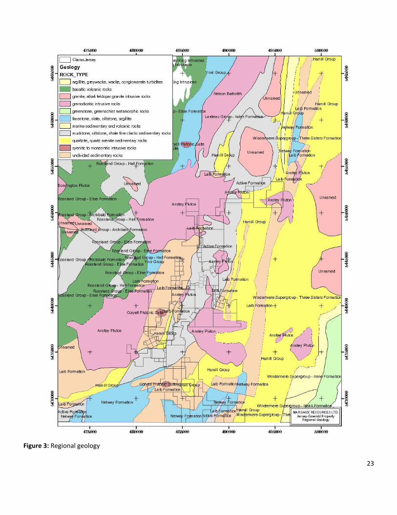
7.1 REGIONAL GEOLOGY
The Jersey‐Emerald property lies near the south end of the Kootenay Arc, and comprises rocks of the Cambrian Laib Fm and the Ordovician Active Fm. The Laib Fm comprises mixed carbonates and pelites, subdivided into Truman Member (Mbr) brown argillite, Emerald Mbr black argillite, and Reeves Mbr limestone.
The eastern part of the property was mapped as the younger Active Fm argillite; however, work by Sultan indicated that the contact may be conformable, and that the Active Fm appears to be geochemically identical to the Emerald Mbr of the Laib Fm.
Granitic dykes, sills, and igneous bodies of Cretaceous age intrude the sedimentary units (Hoy and Dunne, 1997).
7.2 LOCAL AND PROPERTY GEOLOGY
The property (Figures 3 and 4) consists of rocks of the Laib Fm, a sequence of transitional rocks comprising mixed carbonates and pelites (Little, 1960). Near the property, the Truman Member of the Laib Fm comprises interbedded, thin, grey and white, locally dolomitic limestone and the Emerald Member is a black argillite unit. The Upper Laib Fm comprises green phyllite and micaceous quartzite.
Small plugs, dykes, and sills of Cretaceous granite intrude the sedimentary rocks, resulting in re‐crystallized coarse‐grained marble to garnet‐pyroxene skarn within the sedimentary rocks near the contacts.
The Laib Fm has been deformed by three phases of folding, each of local significance. The dominant structure within the property is a major NNE‐ trending anticline known locally as the Jersey anticline.
Potassium‐argon (K‐Ar) age dates obtained from biotite from the Late Jurassic Dodger stock give a date of 100.0 ± 3.0 million years (Ma). One kilometre west of the Jersey mine, the Laib sediments are intruded by the Salmo River stock, a small circular body of Tertiary augite monzonite. Biotite from this stock gave a K‐Ar age of 50.6 ± 1.5 Ma.
Two narrow, NNE‐trending elongate dyke‐like bodies of Cretaceous biotite granite, locally known as the Emerald and Dodger ridges, flare from the underlying intrusive into the sediments of the Jersey anticline. Some of the mineralized bodies formed along the margins of these ridges.
23
Figure 3: Regional geology

24
Figure 4: Local geology
MARGAUX RESOURCES LTD.

25
7.3 MINERALIZATION
Mineralization on the Jersey‐Emerald property is associated with the east limb of a complex major anticlinal structure, locally known as the Jersey anticline, and regionally as the Salmo River anticline. The HB Pb‐Zn mine 4 km to the north, and the Reeves MacDonald Pb‐Zn mine 10 km to the south, are also associated with this major structure.
Several zones of significant mineralization exist on the property. Past mining produced lead and zinc, and tungsten. The property hosts areas of elevated molybdenum, gold, bismuth, arsenic, copper, silver, cadmium, and barium.
7.3.1 LEAD AND ZINC ZONES
Jersey Zinc‐Lead Deposit
The Jersey Zn‐Pb deposit occurs in dolomite near the base of the Reeves Member limestone. Five ore bands, ranging in thickness from 30 centimetres (cm) to 9 m, were mined. These bands in order of stratigraphic sequence were: 1) upper Pb band, 2) upper Zn band, 3) middle Zn band, 4) lower Zn band, and 5) lower Pb band. These bands were very close together, and were mined as a unit up to 24 m thick in the A zone. Ore mineralization consisted of fine‐grained sphalerite (Sp) and galena (Ga) with pyrite (Py), pyrrhotite (Po), and minor arsenopyrite (Asp). Cadmium is associated with sphalerite, and silver with galena. Iron content of the sphalerite is low ‐ about 6%. The overall grade for the 7,968,080 t milled averaged 3.83% Zn and 1.95% Pb. Mining ceased in 1970, leaving un‐mined reserves of 106,000 t grading 3.10% Zn and 0.80% Pb.
Emerald Lead‐Zinc Deposit
The Emerald Pb‐Zn deposit, equivalent to the lower Pb band of the A zone of the Jersey Zn‐Pb deposit, is located immediately to the north of the Jersey Zn‐Pb deposit. Mineralization consists of stratabound lead and zinc bands within banded limestone and dolomite of the Reeves Member.
7.3.2 TUNGSTEN ZONES
Skarn‐type tungsten mineralization occurs where the Cretaceous intrusions are in contact with calcareous sediments of the Truman or Reeves members. Tungsten was mined from two distinct areas on the property: the Dodger zone, comprising the Dodger and East Dodger deposits, located along the east side of the Jersey Zn‐Pb deposit; and the Emerald zone comprising the Emerald, Feeney, and Invincible deposits, located west of the Jersey Zn‐Pb deposit.
Dodger Tungsten Deposits
The Dodger tungsten skarn deposits comprise three zones with finely disseminated scheelite (sch) grains in light brown to green garnet‐diopside skarn. The conformable deposit occurs in a skarnified limestone unit near the top of the Truman Mbr. The Dodger deposits are separated by the Dodger ridge, an elongate, NNE‐trending dyke‐like flare from the underlying Dodger stock.
Scheelite is accompanied by pyrrhotite, biotite, quartz, molybdenite, and minor powellite. The ore zones range from 2 to 9 m in width and average 3 m.

26
The Dodger tungsten zone was mined intermittently from 1951 to 1973 and averaged 0.56% WO3 for 521,023 t of production. Production ceased in 1973 leaving un‐mined reserves of 42,500 t grading 0.45% WO3. During the final year of operation, extensive reserves of low grade mineralization were found to the north and south of the East Dodger deposit. These reserves were not developed due to low tungsten prices.
Emerald Tungsten Deposit
The Emerald tungsten deposit occurs along the contact between the Reeves limestone and the Emerald argillite, along the west side of the Emerald stock. Four distinct types of mineralization occur: skarn, sulphide, greisen, and quartz. Skarn‐type mineralization occurs mainly along or near the limestone argillite contact. It consists of garnet, diopside, calcite and quartz with lesser amounts of pyrrhotite, pyrite, scheelite, and molybdenite. Sulphide‐type of mineralization, consisting of pyrrhotite, calcite, biotite and scheelite, is often spatially associated with skarn mineralization and consists of irregularly shaped replacement bodies in limestone and dolomite. Locally quartz, pyrite, molybdenite and chalcopyrite may be present. Greisen‐type mineralization occurs in altered granite and extends up to 12 m into the granite from the limestone contact. The mineralized zone consists of potassium feldspar ‐ in some places completely kaolinized, abundant quartz, sericite, pyrite, tourmaline, and scheelite. Locally, calcite, ankerite, apatite, pyrrhotite, or molybdenite may be present. In many places, quartz‐type mineralization grades into greisen. It consists of silicified limestone cut by numerous veins of quartz with ankerite, scheelite, minor molybdenite, and apatite. The veins are enveloped by disseminated scheelite, pyrite, pyrrhotite, and tremolite.
Scheelite is the main tungsten mineral, but minor powellite and wolframite was also recovered. Most of the scheelite was recovered from lenticular skarn zones developed along the contact between the Emerald argillite and the Reeves limestone.
Intermittent mining between 1943 and 1958 produced 1,076,799 t of material averaging 0.86% WO3. When mining ceased due to low metal prices, there recoverable reserves of 34,800 t grading 0.73% WO3 remained. There is potential for additional resources in the adjacent areas.
East Emerald Tungsten Deposit
The East Emerald zone is located east of the Emerald deposit. It has never been exploited.
Historic drilling indicated tungsten‐skarn mineralization adjacent to or distal from the granitic contact, similar to that historically mined from the Dodger deposit to the east. In 2006, Sultan drilled four holes in order to verify the historic mineralization.
In 2104, Margaux drilled 35 holes that were successful in helping to define persistent tungsten mineralization striking NNE for a distance of 1,300 m.
Mineralization occurs in a sequence of parallel skarn bands that dip moderately to the east. The bands range in thickness from one to 20 m, with most averaging between 5 and 10 m. Up to 10 bands may occurs on a drill section; however, their occurrence is best identified in areas with less sparse drilling. The interpretation suggests that these bands will ultimately terminate in the underlying granite.

27
Skarnification of argillite or limestone creates mm‐ to decimeter (dm)‐scale garnet‐diopside bands. Tungsten occurs as stratabound flecks to dense concentrations of scheelite. Pyrrhotite and lesser pyrite are common accessory sulphides.
Assays returned WO3 results up to 2.47%; however, most values were between 0.10 and 0.30% WO3.
Invincible Tungsten Deposit
The Invincible Tungsten deposit is adjacent to the western margin of the Dodger ridge where it transects flat‐lying beds of the Reeves limestone. The deposit lies 1,500 m northeast and along strike from the Emerald tungsten deposit, on the west side of the Emerald ridge.
The deposit is bounded above by the skarnified Truman pelite, and below by the Emerald argillite. Most of the scheelite occurs in lenticular zones that extend at a high angle from the granitic stock, approximately conformable with layering of the host rocks. The scheelite occurs as fine, disseminated grains within garnet‐diopside skarn and is accompanied by pyrite, pyrrhotite, minor powellite, and traces of molybdenite and wolframite. Quartz is common in zones of mineralized granite.
The mineralized zone occurs along the contact of the sediments to the ridge, and extends up to 24 m to the west, perpendicular to the stock, along favourable horizons in the Reeves limestone. It may be more than 3 m thick in places. The zone lies about 260 m below surface and produced 256,480 t of 0.65% WO3 from 1970 to 1973 (Geology, Exploration and Mining in British Columbia, 1973). The northern extension of the Invincible mine remains untested.
Feeney Tungsten Deposit
The Feeney Tungsten deposit is located on the east side of the Emerald granitic stock along strike to the north of the Emerald mine, and south of the Invincible mine. It forms a relatively shallow mineralized body within the Laib Fm along the granite‐limestone contact between the Reeves limestone and Emerald argillite.
The mineralization consists of scheelite with minor powellite, rare wolframite, and traces of molybdenite in a green and brown garnet‐diopside skarn containing augite, actinolite, epidote, pyrrhotite, and quartz. Most of the scheelite occurs as fine, disseminated grains in lenticular skarn zones that extend from the granite contact out into the limestone‐argillite country rock conformable with bedding. The skarn zones are up to 6 m long and average about 2 m in width. Grades are about 0.5 to 1.5% WO3. The Feeney mine, which operated between 1951 and 1955, produced about 54,000 t of ore averaging 0.92% WO3 (Bulletin 41, page 119).
7.3.3 MOLYBDENUM ZONES
Molybdenum mineralization was noted in several areas within the historic Jersey, Dodger, Invincible, Emerald, and Feeney mine workings. Follow‐up work during the 2000 to 2005 field seasons indicated that the most readily accessible area for molybdenum exploration is within the 4200 level of the Dodger mine workings, which were in good condition where access drifts were completed during the historic tungsten mining. Mapping of the drifts indicated that the granitic rock that underlies the Dodger‐type skarn tungsten mineralization contains porphyry‐style quartz veining with molybdenite mineralization.

28
Exploration of the porphyry system, along the margin of the historic Dodger East Tungsten zone, revealed a stockwork of quartz veining and fractures with molybdenite. The cross‐cutting fractures and quartz veins are oriented north‐south and east‐west, with steep dips. Several high‐grade molybdenite zones were intersected, including 1% to 3% Mo over short widths of 90 cm to 1.5 m. Twenty holes drilled during 2005 indicated the potential for larger volumes of lower‐grade molybdenum that includes short sections of higher‐grade material.
7.3.4 GOLD ZONES
Bismuth‐Gold Zone
The Bismuth‐Gold zone, known in the underground workings as part of the F zone, is located along the east side of the Jersey Zn‐Pb deposit at the contact between the limestone and the underlying dolomite of the Reeves Member. The gold mineralization, believed to be skarn‐related, occurs in a silicified horizon with Py, Po, Asp, stibnite, and native Bi. Underground samples have returned assay results up to 8 g/T Au across widths of 96 cm. Descriptions in Placer Dome’s drill logs suggest that this siliceous zone, intersected in four surface drill holes along a strike length of 300 m, may be 20 m or more in thickness.
#1 Zone
The #1 zone, represented by a 300 m long series of trenches and small to large pits, is located along the contact of the Reeves limestone and the Emerald argillite where they trend south from the Emerald Tungsten open pit mine. In the workings, rusty‐banded sulphide mineralization occurs with iron oxides (limonite and goethite) and coarsely recrystallized limestone. Sulphide mineralization occurs as massive Po bands, which return high values for As, Cu, and Zn, with minor Au, Ag, and Mb.
Emerald Gold Zone
The Emerald Gold zone, first recognized in 1895, may be coincident with the Emerald tungsten zone. It was prospected for gold from 1895 to 1906, returning assay results of up to 3.5 oz/t (100 g/t); however, little work was done after the discovery of Pb‐Zn mineralization elsewhere on the property. In 1993, Sultan found that free gold could be panned from the tungsten tailings. Gold mineralization is associated with the quartz‐ and pyrrhotite‐rich sections of the skarn and sulphide‐type tungsten zones.
The Emerald Gold zone occurs along the contact with the Reeves limestone and Emerald argillite, and trends from the Emerald Tungsten deposit towards the #1 zone. These three areas may actually represent mineral zonation, grading away from the Emerald stock.
Leroy Gold Zone
The Leroy Gold zone is located approximately 1 km north of the Emerald gold and tungsten zones. Gold mineralization was discovered in the late 1890, and the zone was explored with a series of pits, adits, and hand trenches along an 800 m strike length. Gold exploration ceased with the discovery of Pb‐Zn in 1906.

29
Mineralization in the Leroy Gold zone is associated with Po, Py, and native Bi in a silicified horizon at the contact between the Reeves limestone and the Emerald argillite. Recent sampling of this zone gave gold grades up to 0.898 oz/t (25.5 g/t) from grab samples and up to 0.174 oz /t (4.8 g /t) across a true width of 3.0 m for chip samples.
ABC Zone
The ABC zone occurs just to the east of the Jersey and Dodger underground workings along the Iron Mountain Fault, a major structure that represents the contact of the OA argillites with the Reeves limestones.
Samples that returned anomalous values were collected from slices of pyritic garnet‐diopside skarn bands entirely within OA argillite, but adjacent to the Reeves limestone. Rusty, limonitic, decomposed argillite with minor quartz stockworking occurs on the west side of the skarn banding. Sulphide mineralization consists of pyrite within the skarn bands, with limonite occurring adjacent. Assays indicate elevated As values, along with minor Au, Mb, and Pb values.

30
8 DEPOSIT TYPES
8.1 LEAD AND ZINC DEPOSITS
Simandl and Paradis (Paper 2009‐1) describe the lead‐zinc deposits on the property as hosted by fine‐grained, poorly layered to massive dolomite of the Reeves Member. The Zn‐Pb mineralization occurs near the base of the Reeves Member and varies in thickness from 8 to 30 m. The Truman Member forms the footwall rocks.
Five dolomite‐hosted bands of Zn‐Pb occur within the mine. Sulphide mineralization consists of fine‐grained sphalerite and galena, with pyrite, pyrrhotite, and minor arsenopyrite.
The dolomites are texturally distinct from the medium‐grained well‐banded grey and white Reeves limestone. The deposits, their dolomitic envelopes, and the limestone host rock generally lie within secondary isoclinal folds along the limbs of regional anticlinal structures. They form stratiform, tabular, and lens‐shaped concentrations of pyrite, sphalerite, and galena in dolomitized zones. Brecciated zones are common within the more massive sulphide mineralization. Age dating indicates that the Zn‐Pb deposition is of Ordovician to Devonian age, which suggests that the deposits may be classified as Mississippi Valley Type, emplaced during rifting along the continental margin with increased igneous activity along the deposition belt.
8.2 TUNGSTEN DEPOSITS
Tungsten mineralization occurs in two distinct environments: skarn‐style mineralization at granite limestone contacts, and stratabound disseminated mineralization in favourable zones within the Truman Member.
8.3 GOLD DEPOSITION
Gold occurs in areas that were historically mined for tungsten. Work by Sultan indicated that the gold is skarn‐related, occurring in silicified horizons with pyrite, pyrrhotite, arsenopyrite, stibnite, and native bismuth.
8.4 MOLYBDENUM PORPHYRY
Exploration and development of Zn‐Pb and tungsten deposits on the property, quartz stockwork and alteration zones have suggested the potential for gold mineralization within the granites underlying the previously mined areas.
Mapping of underground headings, and sampling of drill core during mining operations, indicated the presence of molybdenite within these porphyry‐style veined zones.

31
9 EXPLORATION
Margaux has not undertaken any exploration work, other than core drilling, since acquiring the property.
A summary of past exploration work is provided in “Technical Report for the Jersey‐Emerald Property, Salmo, BC, March 28, 2014” by Giroux and Grunenberg (2014).

32
10 DRILLING
10.1 INTRODUCTION
In March 2014, Margaux reported the current mineral resources on the property. The tungsten resource mostly consisted of remnant mineralization near previously mined areas. However, the un‐exploited tungsten resource defined as the East Emerald zone was constrained due to the limited amount of drilling.
Margaux’s 2014 work program was designed to expand the tungsten resource in both the strike and dip directions by drilling into areas that were previously under‐explored.
Giroux and Grunenberg (2014) provide a summary of past drilling in “Technical Report for the Jersey‐Emerald Property, Salmo, BC, March 28, 2014”.
10.2 DRILLING
Margaux conducted a two‐phase drilling program on the East Emerald target area that produced 6,318.6 m of core in 35 drillholes (Figures 5 and 6). The location and collar orientation for each drillhole is listed in Table 4.
Phase 1, which spanned August 12, 2014 to October 17, 2014, included 32 drillholes for 5,739.8 m. During Phase 1, the focus was on intersecting tungsten mineralization. Phase 2 drilling between November 21, 2014 and November 29, 2014, produced 578.8 m in three drillholes. Phase 2 was focused on both tungsten and gold mineralization, as follow‐up to results from Phase 1.
Table 4: Summary of 2014 drilling
Phase HoleID Easting* Northing* Elevation Length (m) Azimuth Dip Start End
1 E1401 483937 5440009 1330 251.0 111.5 ‐80 12‐Aug‐14 18‐Aug‐14
1 E1402 483937 5440009 1330 263.0 108.2 ‐60 14‐Aug‐14 17‐Aug‐14
1 E1403 483912 5439952 1328 152.0 180.1 ‐89 19‐Aug‐14 20‐Aug‐14
1 E1404 483912 5439952 1328 212.0 106.9 ‐63 20‐Aug‐14 22‐Aug‐14
1 E1405 483866 5439876 1325 161.2 118 ‐60 22‐Aug‐14 24‐Aug‐14
1 E1406 483697 5439494 1352 77.0 164.8 ‐90 24‐Aug‐14 25‐Aug‐14
1 E1407 483697 5439494 1352 134.0 113.9 ‐60 25‐Aug‐14 26‐Aug‐14
1 E1408 483697 5439494 1352 56.0 290.4 ‐59 26‐Aug‐14 27‐Aug‐14
1 E1409 483728 5439530 1357 149.0 101.9 ‐69 27‐Aug‐14 28‐Aug‐14
1 E1410 483728 5439530 1357 323.0 102.4 ‐55 28‐Aug‐14 31‐Aug‐14
1 E1411 483954 5439795 1389 191.0 105 ‐89 01‐Sep‐14 03‐Sep‐14
1 E1412 483941 5439795 1389 325.0 22.2 ‐70 03‐Sep‐14 06‐Sep‐14
1 E1413 483914 5439723 1395 282.1 131.5 ‐89 06‐Sep‐14 09‐Sep‐14
1 E1414 483850 5439665 1390 227.0 134.6 ‐89 09‐Sep‐14 12‐Sep‐14
1 E1415 483794 5439600 1375 148.5 82.5 ‐89 12‐Sep‐14 14‐Sep‐14

33
Phase HoleID Easting* Northing* Elevation Length (m) Azimuth Dip Start End
1 E1416 483794 5439600 1375 184.0 37.2 ‐80 14‐Sep‐14 16‐Sep‐14
1 E1417 483680 5439436 1369 69.0 283.9 ‐89 16‐Sep‐14 16‐Sep‐14
1 E1418 483680 5439436 1369 122.0 111.9 ‐55 17‐Sep‐14 18‐Sep‐14
1 E1419 483845 5439568 1424 296.0 111.5 ‐79 19‐Sep‐14 22‐Sep‐14
1 E1420 483845 5439568 1424 15.5 111.5 ‐65 22‐Sep‐14 22‐Sep‐14
1 E1421 483851 5439632 1416 191 117 ‐66 22‐Sep‐14 24‐Sep‐14
1 E1422 483851 5439632 1416 245 271.4 ‐89 24‐Sep‐14 26‐Sep‐14
1 E1423 483807 5439502 1426 251.5 137 ‐81 26‐Sep‐14 28‐Sep‐14
1 E1424 483762 5439436 1422 191 229.8 ‐89 28‐Sep‐14 30‐Sep‐14
1 E1425 483762 5439436 1422 209 181.4 ‐61 30‐Sep‐14 01‐Oct‐14
1 E1426 483670 5439671 1373 75 243.2 ‐90 01‐Oct‐14 02‐Oct‐14
1 E1427 483670 5439671 1373 70.7 290.6 ‐69 02‐Oct‐14 03‐Oct‐14
1 E1428 483670 5439671 1373 104 112.5 ‐65 03‐Oct‐14 04‐Oct‐14
1 E1429 483674 5439243 1384 95 369.3 ‐90 04‐Oct‐14 05‐Oct‐14
1 E1430 483674 5439243 1384 251 115.5 ‐48 05‐Oct‐14 07‐Oct‐14
1 E1431 483674 5439243 1384 131.3 137.7 ‐66 13‐Oct‐14 14‐Oct‐14
1 E1432 483850 5439665 1390 287 114.1 ‐60 14‐Oct‐14 17‐Oct‐14
2 E1433 483989 5439776 1402 197 303.2 ‐72 21‐Nov‐14 23‐Nov‐14
2 E1434 483989 5439776 1402 194 307.6 ‐72 21‐Nov‐14 25‐Nov‐14
2 E1435 483914 5439723 1395 187.8 33.9 ‐59 26‐Nov‐14 29‐Nov‐14
*UTM NAD83 Zone 11, by handheld GPS unit 6318.6
Drilling was performed by Westcore Drilling Ltd. from Salmo, BC, using a Multi‐Power Discovery 1 or a Hydracore 2000 rig, using metric 3‐m rods. The BTW (48.5 mm) diameter core was not oriented.
The drillholes ranged in length from 15.5 to 325.0 m, and reached a maximum vertical depth of 304.3 m from surface. The end target for most drillholes was a coarse‐grained granite body that occurs beneath the tungsten‐bearing metasedimentary rocks, and which generally serves as a base to tungsten mineralization.
The drilling rates averaged 61.3 m per day, including teardown, moving, and setup times.
For 2014 drilling, the average recovery of good quality core was 98%, with 100% recovery in 93% of the runs. Cased runs, and weathered or faulted poorer recovery.
The un‐lidded boxes of core from the 2014 drilling programs are stored on open timber racks at a fenced core facility located on the property.

34
Figure 5: Drillhole location map – Jersey‐Emerald Property

35
Figure 6: Drillhole location map – East Emerald Zone

36
10.2.1 UNITS OF MEASUREMENT
An imperial local grid coordinate system used for drilling at Jersey‐Emerald. Historic collar locations were converted to UTM NAD83, Zone 11 for the purposes of reporting. Drillhole collars for 2014 were collected in UTM using a handheld global positioning system (GPS) unit. Drilling and logging was performed using metric units that were converted to imperial for inclusion in the historical dataset.
The magnetic declination for mid‐2014 of +15.2° was determined using the calculator on the Natural Resources Canada website. Drilling was oriented perpendicular to the trend of mineralization at 100° to 120° azimuth, with several vertical holes, and a few variably oriented holes.
10.2.2 CONVERSIONS
The following conversions were used for work and reporting.
WO3 = W x 1.2611 lb = 0.453592 kg MoS2 = Mo x 1.6681 kg = 2.20462 lbs g/T = ppm ton = 2000 lbs % = 10,000 ppm tonne = 1000 kg ft = 0.3048 m ton = 0.90718474 tonnes m = 3.28084 ft tonne = 1.10231 tons
10.3 EAST EMERALD TUNGSTEN ZONE
Drilling was on sections oriented at 110° spaced at approximately 40 to 100 m apart over a strike distance of 825 m. Drill pads were positioned on existing trails in a best‐fit manner; therefore, the section spacing was slightly irregular. One to three drillholes with varying orientations were collared at each pad.
Appendix 3 is a list of all the tungsten composites for all holes. The true thickness of intercepts is usually less than the drilled length of the intercept.
Several historic holes passed through the East Emerald zone with the intent to intersect the deep Invincible zone mineralization; therefore, many skarn bands were not sampled. All skarn intervals from the 2014 drilling were sampled.
The directions described in section 6.3 are relative to drill section orientation; therefore, south means toward 220, and east means toward 110.
Drillholes E1401 and E1402 were the most northerly of those drilled in 2014. They were drilled toward the east from a common pad as infill in a fan of historic holes drilled from the same location. The historic holes were selectively sampled; therefore, the results from the 2014 drillholes fill assay data gaps. The drillholes passed through argillite, with several tungsten‐bearing skarn zones, and then a thick limestone sequence. E1402, the farthest to the east, bottomed in granite with a mineralized skarn bed in sediments at the contact. Significant intercepts included 0.23% WO3 over 8.65 m (123.55‐132.20 m depth) in E1402.
37
Drillholes E1403 and E1404 were drilled vertically and toward the east from a single pad 65 m south of E1401 and E1402, within the areas with past drilling. The drillholes passed through argillite, with several tungsten‐bearing skarn zones, and then a thick limestone sequence. E1404, the farthest to the east, bottomed in granite. The bottom of E1412, with a mineralized skarn bed in sediments at the contact, similar to that in E1402, falls just a few metres to the east. Significant intercepts included 0.49% WO3 over 2.75 m (143.25‐146.00 m depth) in E1404 and 0.59% WO3 over 2.65 m (302.35‐305.00 m depth) in E1412.
Drillhole E1412 was drilled toward the north from the same pad as E1411, so the majority of its length is seen on the section 45 m south of E1403 and E1404. This hole occurs mostly in argillite with several tungsten‐bearing skarn bands and a few thin limestone beds. A typical intercept includes 0.14% WO3 over 10.40 m (223.70‐234.10 m depth).
Several drillholes fall on the section 90 to 120 m south from E1403 and E1404, with E1405 mostly directly south. The results of E1412 are discussed above. The vertical drillhole E1411 intersected an unexpected granitic body at 113 m, after passing through interbedded argillite and argillite with several skarns bands. The drillhole hosted 24.98 g/T Au over 10.20 m (116.80‐127.00 m depth) in silicified granite with coarse bismuthinite or brecciated skarn.
Drillholes E1433 and E1434 were drilled toward the west, at slightly differing orientations, from a pad upslope to the east of E1411 in an attempt to expand on its gold results. A value of 68.3 g/T Au returned from a 0.65 m wide sample of granite‐skarn breccia in E1433 may correlate with the gold‐bearing structure of E1411. E1434 was not successful in intersecting additional gold mineralization, and the orientation of the gold‐bearing structure was not resolved. E1435, drilled to the north from the collar location of E1413, intersected a barren granitic unit; however, it is uncertain if it is the same body encountered in E1411. All three holes intersected meter‐scale zones of tungsten‐bearing skarn. Significant intercepts include 3.65 g/T Au and 0.14% WO3 over 0.6 m (151.50‐152.10 m depth) in E1433, 2.81 g/T Au and 0.18% WO3 over 0.90 m (159.6‐160.50 m depth) in E1434, and 3.43 g/T Au over 1.00 m (161.90‐162.90 m depth) in E1435.
Drillhole E1413 was drilled 80 m south of E1411, E1412, and E1433 to E1435. The vertical hole intersected broad sections of argillite with skarn beds, and short sections of limestone. After the argillite, E1413 passed through a thick sequence of limestone, intersected a short faulted lamprophyre dyke, and ended in granite. This same sequence occurs in each historic drillhole of an underground fan that E1413 passes through. An example of mineralization includes 0.22% WO3 over 6.71 m (219.73‐226.44 m depth).
Drillholes E1414 and E1432 were drilled from the same pad 80 m south of E1413. The vertical drillhole E1414 intersected broad sequences of argillite with thinner limestone beds. Weakly mineralized skarnification occurred in both units. As E1413, the drillhole intersected a thin lamprophyre dyke before entering granite. Significant intercepts include 0.35 WO3 over 4.00 m (207.90‐211.90 m depth).
Drillhole E1432 passed through argillite and limestone beds, with several skarn beds, often with very strong tungsten mineralization. Unlike E1414, E1432 intersected several granite dykes or dykelets, did not pass through lamprophyre before entering granite, and contained a strongly mineralized skarn bed within the granite. The skarn bands contained significant to near‐massive quantities of pyrrhotite. Significant intercepts in E1432 include 0.47% WO3 over 5.15 m (123.25‐128.40 m depth) in, and 1.14% WO3 and 1.56 g/T Au over 2.00 m (267.00‐269.00 m depth).

38
Drillholes E1421 and E1422 were collared from the same pad on a section 55 m south of E1414 and E1432. Portions of E1416, located 45 m to the south, fell on this section. The lithology of vertical drillhole E1422 is similar to the east‐dipping E1421, and with E1414 to the north, consisting of alternating, similar thickness beds of argillite and limestone with weak skarnification. E1421 ended early in a relatively think granite unit that likely correlates to the zone of dykes and dykelets in E1432 to the north, and which does not represent the terminal granite. E1422 and E1416 both pass through a thin lamprophyre dyke a few metres above the argillite‐granite contact. Typical intercepts include 0.12 WO3 over 3.10 m (131.00‐134.10 m depth) in E1416, and 0.13 WO3 over 4.7 m (222.30‐227.00 m depth) in E1422. There were no significant intercepts in E1421.
Drillholes E1415, E1416, E1419, and E1420 were drilled on the section 45 m to the south of E1421 and E1422. The lithology and mineralization of E1415 is the same as for E1416, discussed above. E1416 was a re‐drill of E1415, which was lost in the faulted lamprophyre dyke just before the terminal granite unit.
Drillholes E1419 and E1420 were drilled from the same pad upslope from E1415 and E1416. The upper portions of both passed through the dolomite associated with the Emerald lead‐zinc, and returned elevated values of lead and zinc from sulphidic zones. E1420 was lost in a stope at 15.5 m, and E1419 passed through the stope with only a small loss in recovery. The lower portions of E1419 intersected skarn beds with moderate tungsten mineralization. The drillhole ended in granite, marked with lamprophyre at and near the contact. Significant intercepts from E1419 include 0.33% WO3 over 6.45 m (243.85‐250.3 m depth).
Drillholes E1409 and E1410 were drilled to the east from the same pad on a section 85 m south of E1415 and E1416. Both holes intersected a broad sequence of argillite with a thinner bed of limestone near the collar. E1409 ended in granite at 129.4 m and E1410 at 304.4 m. The intercepts from these and the historic drillholes indicate that the granite contact on the west side dips steeply to daylight, and occurs closer to surface this section southward.
Drillhole E1409 intersected one wide skarn band with some higher‐grade intercepts just above the granite contact. E1410 intersected several skarn bands with moderate to strong tungsten mineralization. Significant intercepts include: 0.18 WO3 over 34.45 m (91.80‐126.25 m depth), including 0.50% WO3 over 4.50 m (97.25‐101.75 m depth) in E1409; and 0.19 WO3 over 10.25 m (162.35‐172.60 m depth), and 0.52% WO3 over 3.35 m (304.50‐308.10 m depth) in E1410.
Drillholes E1406 to E1408 were drilled in a fan from the same pad 40 m south of E1409 and E1410. Drillhole E1423 was drilled toward the east on the same section from a pad upslope. E1423 begins with same limestone and dolomite units as E1419 and E1420, and intersects argillite with skarn beds throughout its length. Drillholes E1406 to E1408 intersect the same thin limestone beds as in E1409 and E1410 before entering a sequence of argillite, with some skarn beds. All holes on this section ended in granite, representing a steep contact rising to daylight on the west.
Drillholes E1406 and E1408 lacked significant tungsten mineralization. Drillholes E1407 and E1423 share an east‐dipping skarn band. Significant results from this skarns unit include 0.15% WO3 over 20.95 m (89.00‐109.95 m depth), including 0.30% WO3 over 4.00 m (92.10‐96.10 m depth) in E1407; and 0.27% WO3 over 7.05 m (198.75‐205.80 m depth), including 0.39% WO3 over 1.15 m (24.65‐205.80 m depth) in E1423.
Drillholes E1424 and E1425 were drilled from the same pad 75 m south of E1423. E1424 was a vertical hole lithological and mineralogically similar to E1423, with a one major tungsten‐bearing skarn band right above the granite contact. The

39
bottom of E1407, landed a few metres from the bottom of E1424, and both drillholes showed a lamprophyre dyke at the granite‐sediments contact. Most of E1425, drilled to the south, fell on the sections to the south. Significant intercepts from E1424 include 0.23% WO3 over 11.8 m (164.20‐176.00 m depth).
Drillholes E1417 and E1418 were drilled from the same pad 60 m south of E1406 to E1408, and show the same sedimentary sequences with weak tungsten mineralization. E1418 returned 0.23% WO3 over 1.85 m (14.00‐15.85 m depth).
The mineralized intercept from drillhole E1425 occurred on a section 100 m south of the collar. E1425 passed through sequences of limestone, dolomite, and argillite with skarn beds. The best tungsten mineralization occurred near the bottom of the drillhole. The hole ended with the same lamprophyre at the argillite‐granite contact, as seen in several of the drillholes already described. E1425 intercepted 0.42% WO3 over 1.50 m (181.70‐183.20 m depth).
Drillholes E1426 to E1428 were drilled in a fan from a common pad 90 m south of E1417 and E1418.These drillholes intersected thick sequences of limestone, a mafic sill, several faults or breccia bands, and thin sections of skarnified argillite. All drillholes end in granite, faulted at its upper contact, closer to surface, indicating that the granite is has locally risen, but still retains the sharp westerly rise toward daylight. Significant intercepts include 0.42% WO3 over 0.70 m (33.85‐34.55 m depth) in E1427.
Drillholes E1429 to E1431 were drilled in a fan toward the east and southeast from a common pad 90 m south of drillholes E1426 to E1428. Vertical drillhole E1429 and southeast dipping E1431 passed through similar lithology of a long argillite sequence above limestone, before ending in granite with a faulted upper contact. Drillhole E1430 passed through long sequences of limestone and argillite before ending in faulted rock that might have indicated proximity to the granite. All drillholes intersected weakly mineralized skarn. Hole E1429 returned 0.20% WO3 over 6.15 m (68.40‐74.55 m depth), including 0.49% WO3 over 2.15 m (68.40‐70.55 m depth).
The 2014 drilling program was successful in identifying additional tungsten mineralization. The tungsten‐bearing zones consist of mostly persistent parallel skarn bands in argillite or limestone beds that dip moderately to the east. The drilling also identified a significant gold occurrence of undefined extent or orientation centered on E1411.
10.4 PROTOCOLS
The following protocols refer specifically to those used in 2014; however, there have been few changes in methodology throughout all phases of work at Jersey‐Emerald.
10.4.1 DOWNHOLE SURVEY METHODOLOGY
Downhole surveys were performed by the driller, during drilling, using a Reflex EZ‐Shot survey tool. Readings were taken every 50 m, with the first reading taken 6 m below the casing. The driller recorded the readings onto paper slips that were provided to the geologist daily. The geologist entered the data into a spreadsheet, and the azimuth reading was converted from magnetic to true. The original paper slips were retained.
40
10.4.2 COLLAR SURVEY METHODOLOGY
The geologist located each drill using a compass and tight chain, navigating from known locations. The collar location was marked with a ribbon or picket, and foresight and backsight markers were placed when necessary. In 2014, drilling occurred on existing trails so very little earthwork was required.
When the drillhole was completed, the hole was marked with a flagged wooden post bearing a metal tag with drillhole information. If the marker fell in the middle of an active trail, then a picket with drillhole information was affixed to the roadcut wall.
A local contractor accurately surveyed the drillhole collar location into local grid coordinates. The geologist recorded the metric UTM coordinates using a handheld Garmin 60Cx GPS unit.
10.4.3 DRILL CORE PROTOCOLS
Drill core was placed into 4‐foot four row wooden boxes by the driller’s helper. The boxes were marked with the drillhole number, and the box number. Open boxes were trucked from the drill to the core facility by the drill supervisor or the geologist at least once per day.
The boxes were placed on tables, in order, and the core was washed, when necessary, to remove drilling products. The distance markers were reviewed for accuracy, and corrected when required. Each box was labeled with start and end distances, as measured from the nearest distance marker. A metal tag, inscribed with the drillhole number, box number, and start and end distances was stapled to the left end of each box.
The geologist who performed geotechnical and geological logging, collected measurements for density, marked samples, prepared tag books, and entered all data directly into a spreadsheet.
A simple geotechnical log included measurements of core recovery, rock quality designation (RQD), and a count of fractures.
The geological log included a rock code, and a detailed description of lithology, structure, alteration, and mineralization. The core was first inspected using an ultraviolet (UV) lamp to locate potential tungsten mineralization.
The densities of several 10 cm samples from various rock units in each drillhole were determined using the Archimedes method.
The core was photographed both wet and dry, in sets of three boxes at a time. The digital photographs were renamed with the HoleID and from‐to information.
A geotechnician affixed sample tags to the box, and then split and bagged the core.
10.4.4 DATA MANAGEMENT
Data from the 2014 program was imported from the data entry spreadsheet into the MS Access‐format (Access) project database for portability, querying, reporting, and for direct use with geological modeling programs. Both Imperial and

41
metric units are retained in the database; however, in order to mesh with the historic data, the primary units are Imperial.
Assay results were vetted in real‐time using database queries.

42
11 SAMPLE PREPARATION, ANALYSES AND SECURITY
11.1 SAMPLE COLLECTION
The sample collection procedures employed by Margaux meet or exceed industry best practice guidelines. This report describes the methodologies employed by Margaux during 2014.
A summary of sample preparation, analyses, and security for programs prior to 2014 is provided in “Technical Report for the Jersey‐Emerald Property, Salmo, BC, March 28, 2014” by Giroux and Grunenberg (2014).
11.1.1 SOIL SAMPLES
Margaux did not collect any soil samples in 2014.
11.1.2 ROCK SAMPLES
Margaux did not collect any rock samples in 2014.
11.1.3 CORE SAMPLES
Core was split using a standard manual core splitter. Half of the core was placed into a labeled sample bag, along with a sample tag. The remaining half of the core was returned to the core box, where sample intervals were marked with a sample tag.
Core was continuously sampled along selected intervals, honouring lithological, alteration, and mineralization boundaries.
11.2 PREPARATION AND ANALYSES
Samples were analyzed at Acme Analytical Laboratories Ltd. (AcmeLabs) or ALS Global (ALS), in Vancouver, BC. Samples analyzed at ALS were prepared in Kamloops, BC. Both laboratories are independent of Margaux.
HoleID LabID Count (including QC samples)
E1401‐ E1432 AcmeLabs 2657
E1433‐E1435 ALS 349
AcmeLabs implements a quality system compliant with the International Standards Organization (ISO) 9001 Model for Quality Assurance and ISO/IEC 17025 General Requirements for the competence of testing and calibration laboratories.
ALS has laboratories on every continent that are accredited to ISO/IEC 17025:2005 for specific procedures, while the majority of the laboratories have attained ISO 9001:2008 certification. The ALS quality program includes monitoring sample preparation and analytical quality control data generated by laboratories, inter‐laboratory test programs, and regular internal audits.
43
Each laboratory had slightly different preparation and analytical techniques; however, typically core samples were crushed, pulverized, and split. A 1 g sample was submitted for multi‐element ICP‐MS, with over‐grade samples analyzed by ICP‐ES. For precious metals, a 30 g sample was submitted for fire assay with a gravimetric finish or a 25 g sample was submitted for ICP‐MS. The procedures used at each laboratory are listed in Table 5. A full description of each procedure can be viewed on each laboratory’s website.
Table 5: Analytical procedures by laboratory
LabID LabCode Description
AcmeLabs
PRP70‐250 AQ251 KP300‐W MA370 FA530
Crush, split and pulverize 250g rock to 200 mesh 1:1:1 Aqua regia digestion Ultratrace ICP‐MS analysis for 37 element Phosphoric acid leach, ICP‐ES analysis for overgrade W 4‐acid Digestion ICP‐ES finish for overgrade Mp, Pb, Zn Lead collection fire assay 30 g fusion – Gravimetric finish for overgrade Au, Ag
ALS
CRU‐31, PUL‐31 ME‐MS41 Au‐ST43
Au‐AROR43
Fine crushing – 70% <2 mm, Pulverize split to 85%<75 µm Aqua Regia digestion, ICP‐MS analysis for 51 elements Aqua Regia digestion (25 g), ICP‐MS analysis for gold Aqua Regia digestion (25 g), ICP‐MS analysis for overgrade gold
In all cases, an over‐grade assay result has precedence over the original ICP result.
Pulps and rejects were discarded by the laboratories after 90 days.
11.2.1 QUALITY ASSURANCE PROTOCOLS
Margaux implemented a rigorous quality assurance program that included the blind insertion of commercial certified reference materials (standards), field blanks, and field duplicates into the sample stream.
One tungsten standard (Phases 1 and 2) and one gold standard (Phase 1) were used to monitor the accuracy of the laboratory. The samples were purchased CDN Resource Laboratories Ltd. (CDNLabs) in Langley, BC. Standards were inserted into the sample stream at a ratio of 20:1.
Blanks, which were used to monitor contamination and sample mix‐ups, were inserted into the sample stream at a ratio of 20:1. Blank material consisted of whole or crushed material from a local facing stone supplier.
Field duplicates were used to measure the precision and reproducibly of the analytical result of the core. They were created by halving the halved core at a ratio of 1:20, and submitting each quarter as a unique sample.
Table 6 lists the types of samples by drillhole.
Table 6: Summary of sample types by drillhole
Count
HoleID All (including QC) Core SRM FB FD
E1401 75 67 3 3 2
44
Count
HoleID All (including QC) Core SRM FB FD
E1402 116 97 7 5 7
E1403 76 65 4 4 3
E1404 71 62 3 4 2
E1405 86 73 5 4 4
E1406 16 14 0 1 1
E1407 46 37 3 2 4
E1408 25 21 1 1 2
E1409 92 76 5 5 6
E1410 256 218 13 12 13
E1411 81 69 4 4 4
E1412 151 128 7 8 8
E1413 146 124 8 7 7
E1414 116 98 6 6 6
E1415 93 78 5 5 5
E1416 70 61 4 3 2
E1417 20 17 1 1 1
E1418 44 39 2 2 1
E1419 147 126 8 6 7
E1420 15 12 1 1 1
E1421 55 48 2 3 2
E1422 126 108 6 6 6
E1423 151 130 7 8 6
E1424 64 54 4 3 3
E1425 111 95 6 5 5
E1426 8 6 1 0 1
E1427 22 19 1 1 1
E1428 18 15 1 1 1
E1429 46 40 1 3 2
E1430 77 65 1 7 4
E1431 53 45 1 4 3
E1432 184 157 4 14 9
E1433 122 102 6 6 8
E1434 113 96 6 5 6
E1435 114 98 5 6 5
All 3006 2560 142 156 148
There were no quality control issues for the 2014 assay data. A detailed analysis of the 2014 quality assurance program is provided in Chapter 12, Data Verification.

45
11.3 SECURITY
Core logging, splitting, and sampling was conducted within a secure core facility situated on the property. Access to this facility was restricted to Margaux personnel.
All core samples were prepared for shipment within the core facility. Samples were placed into fibre bags that were sealed with a numbered plastic locking tag, and stored at the facility. The contents of each bag were recorded. Every few days Margaux personnel delivered a shipment to the Westcore yard in Salmo. Overland West Freight Lines, from Castlegar, retrieved the samples and delivered them directly to the AcmeLabs or ALS facilities in Vancouver or Kamloops. Margaux personnel delivered two shipments directly to the preparation laboratory in Kamloops.
There were no reported incidences of tampering or damage to the samples. The laboratories employed high‐quality preparation, quality assurance, and security protocols after the samples were in their possession.
11.4 CONCLUSIONS
It is the opinion of the authors that the sampling protocols, analytical and quality assurance procedures, and security measures used by Margaux at the Jersey‐Emerald project meet or exceed best practice guidelines.

46
12 DATA VERIFICATION
Data used in the preparation of this report were generated by Margaux during 2014, and by Sultan during past exploration programs. All physical and/or digital data is stored in Margaux’s office in Salmo, or in Sultan’s offices in Vancouver and Salmo.
Mr. Grunenberg has managed or otherwise participated in most of the work programs since 1993. Ms. Park participated during the 2014 drilling program, during which time she implemented and managed rigorous real‐time data verification. Mr. Giroux has estimated mineral resources for the property on several occasions since 2006, and consistently performed data checks to ensure he was working with suitable data.
There is no reason to doubt the accuracy or veracity of the geological exploration data that is presented as written material and as illustrations on maps, sections, or diagrams.
Giroux and Grunenberg (2014) provide a summary of data verification used prior to 2014 in “Technical Report for the Jersey‐Emerald Property, Salmo, BC, March 28, 2014”.
12.1 FIELD VERIFICATION
Verification activities conducted during the 2014 drilling program included:
• Observation and review of core storage, core splitting, core sampling, and sample shipping
• Observation and review of geological logging, geotechnical logging, and density measurement procedures
• Confirmation of drillhole collar locations
• Verification of downhole survey records
• Evaluation of quality assurance program
The data verification for the purposes of this report was of the work completed by Margaux in 2014. In all cases, errors were corrected as they were found.
Overall, it is the opinion of the author that Margaux has applied industry‐standard practices, and that the information used for resource estimation meets or exceeds CIM best practice guidelines.

47
12.2 ASSAY RESULTS VERIFICATION
12.2.1 QUALITY ASSURANCE PROTOCOLS
Margaux implemented a quality assurance program that included the blind insertion of certified standards, blanks, and field duplicates into the sample stream.
Standards
One tungsten standard, CDN‐W‐4 (W4), was used for all phases of drilling. Gold standard CDN‐GS‐4E (GS4E) was used during the second phase of drilling. The standards (Table 7) were used to monitor the accuracy of the laboratories. The samples were purchased from CDN Resource Laboratories Ltd. in Langley, BC. The insertion rate was 1:20.
Table 7: Standards used during the 2014 program
Standard ID Tungsten (%) Copper (%) Molybdenum (%) Gold (ppm)
Mean SD Mean SD Mean SD Mean SD
CDN‐W‐4 0.366 0.012 0.139 0.004 0.110 0.004 0.319* 0.020*
CDN‐GS‐4E 4.190 0.095
*Provision value (RSD=6.4%); therefore, cannot be used to monitor accuracy
Blanks
Blanks, which were used to monitor contamination and sample mix‐ups, were inserted into the sample stream at a ratio of 20:1. Blank material consisted of facing stone that was purchased from a local facility.
Field Duplicates
Field duplicates were used to measure the precision and reproducibly of the analytical result of the core. They were created by halving the halved core approximately every 20 samples, and submitting each quarter as a sample.
12.2.2 QUALITY ASSURANCE DISCUSSION
In 2014, Margaux submitted 3,006 core samples, including 446 quality control samples, for assay (Table 8). AcmeLabs and ALS run rigorous internal quality control programs that incorporate the use of standards, blanks, and preparation and pulp duplicates. The results of the laboratories’ QC programs are not discussed in this report.
Table 8: Summary of drilling program samples
Sample Code Sample Type Count Percentage of Total
1‐ORG Original core sample (1/2 split) 2,412 80.2
1‐OFD Original core sample (1/4 split) 148 4.9
2‐FDU Duplicate core sample (1/4 split) 148 4.9
BLK Blank 156 5.2
SRM_W4 Standard 134 4.5
48
Sample Code Sample Type Count Percentage of Total
SRM_GS4E Standard 8 0.3
Total 3,006 100.00
Control samples were vetted immediately after the results were received from the laboratories by using a database query that employed the rules described in Table 9.
Table 9: Rules for evaluating quality control samples
Sample Type Rules
Standard
Failures: 1. If a result falls outside of three standard deviations from the mean value of the standard, it has failed. The samples
between the nearest control samples with valid results must be re‐assayed.
2. If the results of two consecutive samples fall outside of two standard deviations from the mean value of the standard, on the same side of the mean, then they have failed. The samples between the nearest control samples with valid results must be re‐assayed.
Exceptions: 1. If the failure is due to a sample mix‐up, then the error must be corrected, but no new assay is required. 2. If the failure occurs within a batch of insignificant results, then the samples do not necessarily need to be re‐assayed.
Blank Warning: If a result is greater than ten times the lower detection level for the element, then is a warning. The cause for the warning must be investigated, and corrective action taken if required.
Field Duplicate If a duplicate pair deviates widely from the ideal, then the reason must be investigated, and corrected if necessary.
Standards
The results for standard W4 were vetted for tungsten, copper, and molybdenum. There were no failures for copper and molybdenum. Two failures for tungsten did not occur within significantly mineralized rock; therefore, no corrective actions were taken.
Standard W4 (Figure 7) showed a slight positive bias with a moderate positive trend.
There were no analytical failures for standard GS4E. Due to the small sample set, the results were not charted.

49
Figure 7: Control chart for standard W4
Blanks
The results for most blanks fell within acceptable levels (Figure 8); however, there were a few outliers. There were no signs of contamination or mix‐ups.
The facing stone used as a blank had not been tested or certified; therefore, there might have been some intrinsic tungsten that has affected the results.
Figure 8: Control chart for blanks
0.325
0.345
0.365
0.385
0.405
0 20 40 60 80 100 120
Concentration W (%
)
Sequence
Standard W4
W Mean +3SD ‐2SD ‐2SD ‐3SD Linear (W)
‐5
0
5
10
15
20
25
30
35
0 20 40 60 80 100 120 140
Concentration W (ppm
)
Sequence
Field Duplicates
W Warning

50
Field Duplicates
The XY chart (Figure 9) comparing the original versus the field duplicate value shows appropriate scatter about an idealized trend but there is a minimal positive bias for the original when compared to the duplicate.
A study of the mean value versus the percent absolute difference (Figure 10) between paired values indicates an overall degree of precision of about 10% between field duplicate pairs, with more variability at lower concentrations.
Figure 9: XY chart for field duplicates
Figure 10: Precision chart for field duplicates
R² = 0.9248
0
1000
2000
3000
4000
5000
6000
7000
8000
0 1000 2000 3000 4000 5000 6000 7000 8000
Duplicate Concentration
Original Concentration
Field DuplicateTungsten (ppm)
W Ideal Linear (W)
0102030405060708090
100
0 1000 2000 3000 4000 5000 6000 7000
Absolute Difference (%
)
Mean (ppm)
Field DuplicateMean v. Percent Absolute Difference (Tungsten ppm)
W 20 per. Mov. Avg. (W)

51
13 MINERAL PROCESSING AND METALLURGICAL TESTING
Margaux has not undertaken any mineral processing or metallurgical testing since acquiring the property.
Giroux and Grunenberg (2014) provide a summary of mineral processing or metallurgical testing undertaken by previous operators in “Technical Report for the Jersey‐Emerald Property, Salmo, BC, March 28, 2014”.

52
14 MINERAL RESOURCE ESTIMATE
14.1 INTRODUCTION
At the request of Margaux, Gary Giroux, P. Eng, of Giroux Consultants Ltd. in Vancouver, BC, has prepared an updated tungsten resource estimate for the Jersey‐Emerald property.
This tungsten resource comprises several different discrete tungsten‐bearing bodies: Invincible, Dodger, and East Dodger zones, which were estimated in 2006 (Giroux and Grunenberg, 2006); and the Emerald, and East Emerald, which were estimated in 2009 (Giroux and Grunenberg, 2009).
The East Emerald resource, the subject of this report, was updated to reflect the results of Margaux’s 2014 drill program in that area.
14.2 GEOLOGIC INTERPRETATION AND TOPOGRAPHY
Margaux provided a set of 22 three‐dimensional (3D) wireframes that represented the maximum limits of tungsten mineralization in the East Emerald zone (Figures 11 and 12), the topographic surface, and the underground workings.
Figure 11: View looking SE showing mineralized solids in red, underground workings in green, surface topography in grey, and drillhole traces in light green

53
Figure 12: View looking NE showing mineralized solids in red, underground workings in green, surface topography in grey, and drillhole traces in light green
Gemcom GEMS 6.0 Desktop (GEMS, now GEOVIA GEMS) was used for interpretation and modeling. Polylines were created on sections spaced 150 ft apart, and were snapped to drillhole assay intercepts. Supplemental work was performed using Gemcom Surpac (Surpac, now GEOVIA Surpac).
The topographic surface used for the estimation was from the 1:20,000 topography maps as provided by the BC Government Terrain Resource Management mapping program.
14.3 STATISTICS AND GRADE CAPPING
Margaux provided a database that contained basic collar, survey, assay, lithological, and density data for 5,077 drillholes, for approximately 623,900 ft, within the Jersey‐Emerald property. Margaux is responsible for all data management.
Drillholes were passed through the solids that represented tungsten mineralization (solids). Sample intervals were tagged with a code indicating if they were inside or outside a solid. Of the records provided in the database, 102 drillholes, for 50,076 ft, intersected the solids (Appendix 2).
Of the samples assayed for WO3 a lesser number were tested for MoS2 and Au. Samples not assayed for MoS2 and Au were left blank for these variables. Gaps between assayed intervals were replaced with a nominal 0.0001% WO3, taking the total number of WO3results within the East Emerald solids to 1,725. Assay results for WO3, MoS2, and Au reported as ‐99 were replaced with 0.0001% WO3, 0.0001% MoS2 and 0.0001 g/T Au.

The s
Table
Numb
Mean
Stand
Minim
Maxim
Coeffi
Logn
For Wthe devenWO3
Figur
A sim
The e
Table
statistics for a
e 10: Statistic
ber of Assayed V
ard Deviation
mum Value
mum Value
cient of Variatio
ormal cumula
WO3, four ovedata with a mt, and populaassays.
re 13: Lognor
milar methodo
effects of cap
e 11: Statistic
assay results w
cs for WO3 gra
Values
on
ative frequen
erlapping logmean of 2.73ations 4 repr
mal cumulati
ology was use
pping, adjuste
cs for capped
within the Ea
ades in East E
ncy plots were
gnormal popu% WO3 is coesents intern
ive frequency
ed to cap six M
ed the mean g
WO3 grades f
ast Emerald so
Emerald solid
e produced fo
ulations werensidered erranal waste and
y plot for WO
MoS2 results
grade and coe
for East Emer
olids are tabu
s
WO3 (%)
1,725
0.124
0.216
0.0001
4.210
1.740
or each variab
e observed (Fatic high gradd gaps in the
3 at East Eme
at 0.50%, and
efficient of va
rald
ulated below
M
ble within the
igure 13). Pode, populatioassay results
erald
d seven gold r
ariation slight
(Table 10).
MoS2 (%)
1,372
0.017
0.061
0.0001
0.929
3.680
e East Emeral
opulation 1, wons 2 and 3 rs. A level of 1
results at 12 g
tly downward
A
0
6
1
ld mineralized
which represerepresent the1.6 % was use
g/T.
d (Table 11).
54
Au (g/T)
1,139
0.421
4.279
0.0001
69.900
10.160
d solids.
ents 0.31% oe mineralizinged to cap five
4
of g e

55
WO3 (%) MoS2 (%) Au (g/T)
Number of Assayed Values 1,725 1,372 1,138
Mean 0.121 0.016 0.178
Standard Deviation 0.184 0.050 1.068
Minimum Value 0.000 0.000 0.000
Maximum Value 1.600 0.500 12.000
Coefficient of Variation 1.520 3.160 5.990
14.4 COMPOSITING
Downhole composites with a length of 10 ft were produced for the segments of drill holes within the solids. A composite with less than 5 ft left at the end of holes was joined with the adjoining sample to produce a uniform support of composites 10 ± 5 ft.
For intervals of holes with missing assay results, a nominal 0.0001% WO3 was inserted. Statistics for 10 ft composites are shown in Table 12.
Table 12: Statistics for 10 ft composites for East Emerald
WO3 (%) MoS2 (%) Au (g/T)
Number of Composites 875 676 547
Mean 0.098 0.015 0.116
Standard Deviation 0.114 0.038 0.692
Minimum Value 0.000 0.000 0.000
Maximum Value 0.988 0.500 12.000
Coefficient of Variation 1.160 2.580 5.990
14.5 VARIOGRAPHY
The 10 ft composites within the East Emerald zone were examined using pairwise relative semivariograms. Nested anisotropic spherical models were fitted along the strike and down dip of the solids for all variables. The maximum continuity of 150 ft for tungsten mineralization within the East Emerald zone was along azimuth 115° and dip ‐30°. The semivariogram parameters are summarized in Table 3 and the models are shown in Appendix 3.
Table 13: Semivariogram parameters for East Emerald
Zone Variable Azimuth Dip Nugget Effect Short Structure Long Structure Short Range (f )
Long Range (f )
East Emerald
WO3
25 0
0.38 0.18 0.29
30 60
295 ‐60 30 70
115 ‐30 15 150
MoS2
25 0
0.35 0.22 0.25
40 70
295 ‐60 45 70
115 ‐30 30 60

56
Zone Variable Azimuth Dip Nugget Effect Short Structure Long Structure Short Range (f )
Long Range (f )
Au
25 0
0.33 0.4 0.42
40 60
295 ‐60 30 50
115 ‐30 15 20
14.6 BLOCK MODEL
A block model with block dimensions 25 x 25 x 25 ft were placed over all solids with the proportion of each block below the topographic surface and inside the solid recorded. The block model parameters are listed in Table 14.
Table 14: Block model parameters
Parameter Local Coordinate Row/Column/Level Size (ft) Row/Column/Level Count
Lower Left Corner Easting 6525 E 25 106
Lower Left Corner Northing 6260 N 25 170
Top of Model Elevation 5175 25 64
Rotation No rotation
For each block, the percentage within underground workings was also recorded. If there were some underground workings within an estimated block, the percentage of underground workings was always assumed to be within the mineralized solid and was subtracted out.
14.7 GRADE INTERPOLATION
Grades for WO3, MoS2 and Au were interpolated into the block model by Ordinary Kriging. Search ellipses to constrain the kriging runs were based on the ranges of the semivariograms along the three principal directions of anisotropy.
A minimum of four composites were required to estimate a block with a maximum of three allowed from any single drillhole. A maximum of 12 composites were allowed, and if more than 12 composites were found, the closest 12 were used.
The blocks were estimated in a series of runs or passes (Table 15), with the search ellipse for Pass 1 set at one quarter (¼) the ranges of the semivariogram. For blocks not estimated during Pass 1, the search ellipse was expanded to one half (½) the ranges of the semivariogram and the kriging exercise was repeated. For blocks still not estimated the search ellipse was expanded to the full range of the semivariogram. Finally, a fourth pass using dimensions of the search ellipse equal to twice the semivariogram range was used to fill in blocks still not estimated.
Table 15: Kriging search strategy for WO3 East Emerald
Variable Pass Direction Distance (ft) Direction Distance (ft) Direction Distance (ft)
WO3
1 Az 25 Dip 0 15 Az 295 Dip ‐60 17.5 Az 115 Dip ‐30 37.5
2 Az 25 Dip 0 30 Az 295 Dip ‐60 35 Az 115 Dip ‐30 75
3 Az 25 Dip 0 60 Az 295 Dip ‐60 70 Az 115 Dip ‐30 150

57
Variable Pass Direction Distance (ft) Direction Distance (ft) Direction Distance (ft)
4 Az 25 Dip 0 120 Az 295 Dip ‐60 140 Az 115 Dip ‐30 300
14.8 BULK DENSITY
During 2008, the specific gravity (SG) of 100 pieces of core from drillholes from the East Emerald zone was determined at site using the Archimedes method. During 2014, 501 SG of samples representing a variety of grade ranges, lithologies, and locations were determined using the same method. The specific gravity for each sample was calculated using the formula: SG = (Mass in Air) ÷ (Mass in Air – Mass in Water).
The East Emerald tungsten mineralization consists of bands of fine, disseminated scheelite grains in garnet‐diopside skarn containing varying amounts of pyrrhotite. Each density measurement was assigned to a WO3 result. Where multiple measurements were taken from the same sample interval, the results were averaged. This resulted in 456 WO3 assay results with specific gravity values.
The results of density samples taken from both mineralized and un‐mineralized sections of core within the skarn zone were sorted in four WO3 grade ranges (Table 16).
Table 16: Summary of specific gravity determinations in East Emerald
WO3 Grade Range (%) Count Minimum SG Maximum SG Average SG
> 0.0 < 0.10 99 1.87 5.66 3.22
≥ 0.10 <0.30 87 2.71 4.72 3.31
≥ 0.30 32 2.82 6.56 3.36
Outside Mineralized Solids 238 1.61 4.92 2.98
Bulk density is a function of the tungsten grade within a sample. This increase in SG is also the result of increased garnet and diopside content with increased scheelite.
Blocks within the mineralized zone, but with grades less than 0.10% WO3, were assigned an average SG of 3.22 (tonnage factor of 9.95 ft³/t). Blocks with grades from 0.1 to 0.3% WO3 were assigned a specific gravity of 3.31 (tonnage factor of 9.95 cubic feet per ton (ft³/t)). Blocks with grades greater than 0.3% WO3 were assigned a value of 3.36 (tonnage factor of 9.54 ft³/t). The parts of blocks in the waste surrounding the skarn zone were assigned a value of 2.98 (tonnage factor of 10.76 ft³/t).
14.9 CLASSIFICATION
The delineated mineralization in the East emerald zone was classified as a mineral resource according to CIM Definition Standards on Mineral Resources and Mineral Reserves (CIM, 2014) and NI 43‐101.
58
14.10 RESULTS
Geologic continuity of the East Emerald tungsten zones has been established through core drilling. Grade continuity has been quantified through the use of the semivariograms.
Within the East Emerald zone, the blocks are classified as indicated and inferred based on grade continuity. Blocks estimated in Passes 1 to 3, using search ellipse dimensions of up to the full range of the semivariogram were classified as indicated. The remaining blocks estimated were classified as inferred.
Ongoing economic evaluation of the property since 2009, and specifically for the East Emerald deposit, indicate that operating costs may be considerably lower than for most underground mines of similar size. The encouraging factors are:
• The mineralized zone dimensions are suited to mechanized mining; • there is continuity of mineralization; • there are good ground conditions; • and mine development is by large drift from surface (no shaft).
There are existing underground access drifts available for further exploration and for future development. The project is located in a well‐developed area with ample reliable power, natural gas, communications, and transportation services. Well‐established infrastructure such as homes, schools, and medical service is also available. The location offers a moderate climate and moderate topography. There has been a positive response from members of the community and surrounding areas where historical mining has been conducted. There are few environmental or cultural issues.
These factors result in advantageous capital and operating costs comparative to other locations. Therefore, a lower cut‐off than used in previous resource reports for the entire property is indicated.
The following grade‐tonnage tables (Tables 17 and 18) outline the results at a series of WO3 cut‐off grades if mining to the limits of the mineralization solids could be accomplished. No edge dilution has been included. A cut‐off of 0.15 % WO3 has been highlighted as a possible underground cut‐off.
The results for the East Emerald zone within the solids representing tungsten mineralization provide an indicated resource of 561,000 t averaging 0.20% WO3 at a 0.15% cut‐off. The inferred resource is 3,560,000 t with average grade of 0.22% WO3 at 0.15% cut‐off.

59
Table 17: East Emerald indicated resource within mineralized solids
Cut‐off (% WO3)
Tonnage > Cut‐off (t)
Grade > Cut‐off (% WO3)
Grade > Cut‐off (% MoS2)
Grade > Cut‐off (g/T Au)
Pounds WO3 (lb)
0.02 3,103,000 0.099 0.014 0.09 6,143,940
0.04 2,664,000 0.111 0.014 0.07 5,914,080
0.06 2,143,000 0.126 0.014 0.06 5,400,360
0.08 1,736,000 0.139 0.014 0.06 4,826,080
0.1 1,259,000 0.157 0.014 0.06 3,953,260
0.12 903,000 0.176 0.015 0.06 3,178,560
0.14 672,000 0.192 0.015 0.05 2,580,480
0.15 561,000 0.201 0.014 0.05 2,255,220 0.16 495,000 0.207 0.014 0.04 2,049,300
0.18 349,000 0.223 0.013 0.03 1,556,540
0.2 230,000 0.24 0.013 0.03 1,104,000
0.22 124,000 0.266 0.011 0.03 659,680
0.24 70,000 0.295 0.012 0.03 413,000
0.26 51,000 0.312 0.013 0.01 318,240
0.28 36,000 0.33 0.014 0.01 237,600
0.3 25,000 0.347 0.013 0.01 173,500
Table 18: East Emerald inferred resource within mineralized solids
Cut‐off (% WO3)
Tonnage > Cut‐off (t)
Grade > Cut‐off (% WO3)
Grade > Cut‐off (% MoS2)
Grade > Cut‐off (g/T Au)
Pounds WO3 (lb)
0.02 18,690,000 0.108 0.016 0.07 40,370,400
0.04 16,630,000 0.118 0.016 0.06 39,246,800
0.06 14,260,000 0.129 0.017 0.06 36,790,800
0.08 11,480,000 0.144 0.017 0.07 33,062,400
0.1 8,640,000 0.161 0.017 0.08 27,820,800
0.12 6,350,000 0.18 0.018 0.09 22,860,000
0.14 4,310,000 0.204 0.018 0.1 17,584,800
0.15 3,560,000 0.217 0.018 0.1 15,450,400 0.16 2,980,000 0.229 0.017 0.1 13,648,400
0.18 1,980,000 0.26 0.016 0.09 10,296,000
0.2 1,330,000 0.294 0.015 0.11 7,820,400
0.22 916,000 0.333 0.015 0.12 6,100,560
0.24 783,000 0.35 0.014 0.13 5,481,000
0.26 693,000 0.363 0.013 0.14 5,031,180
0.28 617,000 0.375 0.013 0.16 4,627,500
0.3 519,000 0.391 0.013 0.18 4,058,580

60
Table 19: Summary of all tungsten resources
Year Item Deposit Classification Cut‐off (%)
Tons>Cut‐off (t)
Grade (%)
Pounds (lb)
2006
WO3
Dodger
East Dodger Invincible
Measured
0.15
1,200,000 0.379 9,096,000
Indicated 1,310,000 0.365 9,563,000
Measured + Indicated 2,510,000 0.372 18,659,000
Inferred 1,210,000 0.397 9,607,000
2009 Emerald Inferred 710,000 0.346 4,913,200
2015 East Emerald Indicated 561,000 0.201 2,255,220
Inferred 3,560,000 0.217 15,450,400
2006+2009+2015 Combined Measured + Indicated 3,071,000 0.341 20,914,220
Inferred 5,480,000 0.273 29,970,600
Note: Ongoing economic evaluation indicates that the operating cost for the East Emerald deposit will be significantly lower than for the other deposits, resulting in a lower cut‐off grade for the East Emerald than is shown above.
14.10.1 MODEL VERIFICATION
The block model was verified by comparing the estimated block grades to composite grades on a series of level plans through the East Emerald zone. Example plots are shown on 100 ft spacing from elevation 4260 down to 3860 in Figures 7 to 11. There was good agreement with no bias indicated.
14.11 SUMMARY OF ALL MINERAL RESOURCES
The update to the tungsten resource of the East Emerald zone was the subject of this technical report. However, the mineral resources for the entire Jersey‐Emerald property are summarized below (Table 20).
14.11.1 TUNGSTEN (2015)
On March 2, 2015, Margaux reported the results of a tungsten resource estimate for the property, which incorporated the updated estimation for the East Emerald zone. The estimates for the tungsten resources for all other zones (Emerald, Invincible, and Dodger) were not changed.
The East Emerald zone has an estimated indicated tungsten resource of 561,000 t averaging 0.201% WO3, and an inferred tungsten resource of 3.560 Mt averaging 0.217% WO3, using a 0.15% WO3cut‐off.
For the property, a weighted average of the 2006, 2009, and 2015 tungsten resource estimates, using a 0.15% WO3 cut‐off grade, yields a total M+I resource of 3.071 Mt averaging 0.341% WO3, and an inferred resource of 5.480 Mt averaging 0.273% WO3.

61
Figure 14: 4260‐level plan showing estimated WO3 blocks
7000E
7000E 7500E
7500E 8000E
8000E 8500E
8500E
650
0N
650
0N
700
0N
700
0N
750
0N
750
0N
800
0N
800
0N
850
0N
850
0N
900
0N
900
0N
950
0N
950
0N
100
00N
100
00N
0.0058
0.0067 0.0066 0.0065
0.0061 0.0056 0.0058 0.0054
0.0061 0.0054 0.0054
0.0059 0.0022 0.0022
0.0022 0.0022
0.0022 0.0022 0.0022
0.0022 0.0022
0.0078
0.0002 0.0002
0.0002 0.0002
0.0002
0.0071 0.0006 0.0006 0.0006 0.0006
0.0071 0.0006 0.0006 0.0006 0.0008 0.0008 0.0008 0.0007
0.0071 0.0007 0.0009 0.0009
0.0071
0.0071
0.0099
0.0009 0.0009
0.0011 0.0009 0.0009 0.0009 0.0009
0.0009 0.0009 0.0009 0.0009 0.0011 0.0009
0.0007 0.0071
0.0092 0.0092 0.0092
0.0118
0.0118
0.0483
0.0456 0.0389
0.0405 0.0402 0.0450 0.0461
0.0433 0.0431 0.0498
0.0433
0.0249 0.0249
0.0249 0.0249 0.0249 0.0249
0.0249 0.0249 0.0249 0.0249
0.0249 0.0249 0.0249 0.0249
0.0433 0.0404 0.0372 0.0249 0.0249 0.0249
0.0433 0.0404 0.0443 0.0440 0.0249 0.0249
0.0433 0.0481 0.0443 0.0441 0.0370 0.0376
0.0433 0.0404 0.0404 0.0404
0.0433 0.0433 0.0433
0.0259
0.0467 0.0467
0.0467 0.0467 0.0467 0.0433
0.0434 0.0435
0.0498 0.0465 0.0465 0.0465
0.0465 0.0466 0.0468
0.0472 0.0220
0.0438 0.0207
0.0410 0.0183
0.0436 0.0197
0.0425 0.0381 0.0319
0.0499 0.0499
0.0428 0.0428 0.0428 0.0499
0.0428 0.0428 0.0499
0.0428 0.0428
0.0499
0.0331 0.0308 0.0294 0.0294 0.0238 0.0234 0.0230
0.0431 0.0370 0.0288 0.0241 0.0285 0.0285 0.0308 0.0239 0.0111
0.0358 0.0467 0.0424 0.0376 0.0371 0.0314 0.0289 0.0241 0.0285 0.0285 0.0191 0.0102
0.0421 0.0499 0.0457 0.0363 0.0316 0.0241 0.0241 0.0285 0.0157 0.0217 0.0111
0.0381 0.0417 0.0458 0.0448 0.0390 0.0373 0.0473 0.0315 0.0151 0.0224 0.0158 0.0191
0.0304 0.0350 0.0185 0.0290 0.0341 0.0453 0.0446 0.0393 0.0392 0.0280 0.0280 0.0326
0.0461 0.0304 0.0333 0.0183 0.0310 0.0346 0.0344 0.0413 0.0423 0.0473 0.0474 0.0403 0.0317 0.0459 0.0327
0.0427 0.0361 0.0356 0.0486 0.0333 0.0333 0.0315 0.0438 0.0217 0.0230 0.0407 0.0470 0.0474 0.0474 0.0463 0.0435 0.0327 0.0327
0.0466 0.0482 0.0292 0.0356 0.0287 0.0225 0.0343 0.0269 0.0294 0.0412 0.0231 0.0313 0.0476 0.0478 0.0476 0.0474 0.0400 0.0274 0.0327
0.0391 0.0231 0.0285 0.0285 0.0279 0.0284 0.0372 0.0294 0.0205 0.0328 0.0319 0.0313 0.0489 0.0481 0.0478 0.0242 0.0242 0.0370
0.0200 0.0204 0.0206 0.0275 0.0275 0.0282 0.0284 0.0372 0.0221 0.0194 0.0430 0.0222 0.0337 0.0291 0.0249 0.0242 0.0242 0.0333
0.0457 0.0199 0.0200 0.0282 0.0274 0.0274 0.0343 0.0354 0.0284 0.0388 0.0374 0.0346 0.0335 0.0242 0.0333 0.0333 0.0333
0.0466 0.0288 0.0199 0.0199 0.0274 0.0274 0.0370 0.0497 0.0398 0.0472 0.0468 0.0444 0.0333 0.0333 0.0333
0.0199 0.0199 0.0199 0.0199 0.0199 0.0431 0.0439
0.0191
0.0481 0.0481 0.0481 0.0485
0.0481 0.0481 0.0483
0.0481 0.0482
0.0481 0.0481 0.0481 0.0481 0.0480
0.0481 0.0481 0.0481 0.0481 0.0477
0.0481 0.0481 0.0481 0.0481 0.0268 0.0268 0.0268
0.0481 0.0481 0.0361
0.0267 0.0271 0.0280 0.0283
0.0276 0.0284
0.0217 0.0294
0.0236 0.0271 0.0275
0.0268
0.0295
0.0450 0.0263
0.0403 0.0280
0.0371 0.0361
0.0397
0.0369
0.0482 0.0482 0.0482
0.0482 0.0482 0.0482 0.0482
0.0482 0.0482 0.0482 0.0206
0.0482 0.0482 0.0482 0.0482 0.0494
0.0482 0.0482 0.0482 0.0482
0.0482 0.0376 0.0376 0.0320
0.0292 0.0292 0.0246
0.0293 0.0299 0.0308
0.0298 0.0419 0.0407 0.0420
0.0259 0.0329 0.0348 0.0416 0.0422 0.0408
0.0241 0.0233 0.0246 0.0304 0.0334 0.0400 0.0394 0.0269
0.0467 0.0406 0.0194 0.0221 0.0209 0.0317 0.0411 0.0282 0.0293
0.0396 0.0340 0.0234 0.0253 0.0280 0.0280 0.0166 0.0167 0.0202
0.0256 0.0260 0.0278 0.0159 0.0152 0.0157 0.0201 0.0193 0.0190 0.0196 0.0158
0.0259 0.0245 0.0142 0.0120 0.0136 0.0198 0.0202 0.0199 0.0153 0.0151
0.0140 0.0138 0.0150 0.0164 0.0162 0.0217 0.0142 0.0134 0.0137
0.0287 0.0289 0.0318 0.0315 0.0328 0.0196 0.0121 0.0122 0.0261 0.0298
0.0307 0.0325 0.0344 0.0301 0.0150 0.0138 0.0266 0.0295 0.0313
0.0303 0.0271 0.0303 0.0308 0.0314 0.0315
0.0332 0.0315 0.0315 0.0315
0.0331 0.0258
0.0539
0.0502 0.0586
0.0586 0.0586 0.0809
0.0647
0.0549 0.0647
0.0695 0.0590 0.0671 0.0671 0.0954
0.0716 0.0671 0.0671 0.0707 0.0675 0.0955 0.0649
0.0550 0.0955 0.0649
0.0823 0.0959 0.0649
0.0961 0.0649
0.0957 0.0649
0.0916 0.0753 0.0649
0.0800
0.0885
0.0957 0.0557
0.0557
0.0512
0.0578 0.0507 0.0525 0.0795 0.0835
0.0578 0.0560 0.0637 0.0567 0.0567 0.0684
0.0586 0.0531 0.0626 0.0503 0.0692 0.0539 0.0755
0.0536 0.0540 0.0672 0.0577 0.0638 0.0593 0.0724 0.0897 0.0815
0.0590 0.0581 0.0514 0.0595 0.0877 0.0604 0.0935 0.0730 0.0713
0.0647 0.0697 0.0708 0.0708
0.0821 0.0995 0.0914 0.0788 0.0987 0.0708
0.0971
0.0828 0.0941 0.0991 0.0983
0.0923 0.0935 0.0935 0.0935 0.0935 0.0718 0.0718
0.0933 0.0757 0.0639 0.0638 0.0638
0.0994 0.0699 0.0641 0.0638
0.0970 0.0638
0.0718
0.0691 0.0616 0.0519
0.0686 0.0688 0.0928 0.0984 0.0616
0.0726 0.0699 0.0915 0.0731 0.0771
0.0850 0.0673 0.0753 0.0543 0.0552
0.0865 0.0803 0.0612 0.0548
0.0764 0.0529 0.0544 0.0590 0.0605
0.0594 0.0574 0.0540
0.0640 0.0676 0.0652 0.0560 0.0509 0.0560
0.0754 0.0812 0.0641
0.0897 0.0743
0.0741 0.0661
0.0517 0.0515 0.0525
0.0512
0.0520 0.0548
0.0586
0.0708 0.0726 0.0704 0.0674 0.0683
0.0760 0.0749 0.0743 0.0740 0.0749
0.0760 0.0733 0.0733 0.0889 0.0889 0.0889
0.0770 0.0733 0.0733 0.0733 0.0889 0.0889
0.0733 0.0733 0.0733 0.0733
0.0580 0.0733 0.0733 0.0733
0.0760 0.0733
0.0503 0.0545 0.0580
0.0501 0.0557 0.0923
0.0505 0.0715 0.0983
0.0993 0.0885 0.0938 0.0970
0.0744 0.0780 0.0827 0.0816 0.0965
0.0619 0.0663 0.0730 0.0782 0.0827 0.0829 0.0978 0.0827 0.0827 0.0610 0.0610
0.0647 0.0502 0.0663 0.0663 0.0636 0.0721 0.0837 0.0962 0.0812 0.0803 0.0827 0.0827 0.0827 0.0504 0.0504 0.0610
0.0502 0.0502 0.0663 0.0663 0.0615 0.0855 0.0827 0.0764 0.0769 0.0769
0.0662 0.0529 0.0794 0.0794 0.0794 0.0981 0.0611 0.0706 0.0688 0.0614 0.0768 0.0769
0.0662 0.0529 0.0751 0.0794 0.0846 0.0658 0.0619 0.0894
0.0628 0.0628 0.0610
0.0801
0.0910 0.0929 0.0990
0.0911 0.0913 0.0925 0.0935
0.0766 0.0759 0.0918 0.0920 0.0917
0.0766 0.0639 0.0639 0.0760 0.0845 0.0733 0.0796 0.0815 0.0855 0.0916
0.0672 0.0858 0.0858 0.0967 0.0916 0.0860 0.0864 0.0915
0.0905 0.0884 0.0881 0.0819 0.0984
0.0936 0.0836 0.0819 0.0789 0.0641 0.0822 0.0595
0.0926 0.0815 0.0793 0.0644 0.0519
0.0930 0.0828 0.0822 0.0822 0.0633
0.0935 0.0799 0.0797 0.0524 0.0564
0.0936 0.0884 0.0824 0.0736 0.0721 0.0554 0.0604 0.0502
0.0936 0.0824 0.0807 0.0556 0.0559 0.0519 0.0569 0.0568
0.0858 0.0858 0.0851 0.0688 0.0679 0.0604 0.0592
0.0858 0.0858 0.0851 0.0871 0.0807 0.0749
0.0858 0.0858 0.0745 0.0728 0.0753 0.0881 0.0776 0.0662 0.0941
0.0555 0.0555 0.0822 0.0566 0.0755 0.0843 0.0849 0.0940 0.0794
0.0531 0.0555 0.0555 0.0797 0.0941 0.0877 0.0813 0.0748 0.0747 0.0857
0.0994 0.0676 0.0683 0.0796 0.0882
0.0683 0.0703 0.0882
0.0820 0.0832 0.0972
0.0818 0.0825 0.0995 0.0987 0.0882 0.0857
0.0546 0.0727 0.0727 0.0961 0.0791
0.0546 0.0727 0.0727 0.0547
0.0547
0.0547
0.0721 0.0983
0.0564
0.0879
0.0776 0.0776 0.0776
0.0776 0.0776 0.0776 0.0776
0.0670 0.0776 0.0776 0.0776 0.0776 0.0776
0.0705 0.0631 0.0631 0.0631 0.0776 0.0776 0.0776 0.0611
0.0631 0.0631 0.0631 0.0776 0.0776 0.0747 0.0621 0.0611
0.0776 0.0776 0.0776 0.0667 0.0621
0.1261
0.1410 0.1321 0.1210
0.1321 0.1321 0.1321 0.1321 0.1077 0.1151
0.1321 0.1322 0.1186 0.1086 0.1062 0.1116
0.1215 0.1149 0.1118 0.1090 0.1066 0.1116 0.1064
0.1077 0.1410 0.1410 0.1307 0.1273 0.1263 0.1297 0.1225 0.1132 0.1072 0.1222 0.1064 0.1064
0.1077 0.1077 0.1410 0.1317 0.1287 0.1270 0.1233 0.1436 0.1361 0.1217 0.1109 0.1116 0.1064 0.1064
0.1077 0.1077 0.1410 0.1321 0.1318 0.1308 0.1325 0.1277 0.1195 0.1112 0.1053 0.1064 0.1064 0.1064
0.1077 0.1077 0.1410 0.1321 0.1321 0.1322 0.1195 0.1077 0.1116 0.1064 0.1064 0.1064
0.1077 0.1077 0.1410 0.1321 0.1321 0.1321 0.1239
0.1077 0.1410
0.1219 0.1213
0.1234 0.1232 0.1229 0.1229
0.1235 0.1235 0.1234
0.1235 0.1173
0.1235
0.1459
0.1488 0.1390 0.1356
0.1335 0.1293 0.1187 0.1213 0.1265
0.1327 0.1370 0.1345 0.1022 0.1153
0.1442 0.1327 0.1126 0.1268 0.1346 0.1178 0.1207 0.1263
0.1291 0.1284 0.1430 0.1246 0.1208 0.1067
0.1437 0.1281 0.1281 0.1282 0.1256 0.1256 0.1014
0.1283 0.1283 0.1283 0.1283 0.1256 0.1090
0.1295 0.1295 0.1295
0.1295 0.1295 0.1295 0.1295 0.1295 0.1295 0.1295 0.1469
0.1176 0.1296 0.1296 0.1303 0.1307 0.1300 0.1295 0.1295 0.1295 0.1295
0.1172 0.1176 0.1179 0.1222 0.1448 0.1368 0.1304 0.1295 0.1295 0.1295
0.1162 0.1172 0.1181 0.1267 0.1478 0.1089 0.1063 0.1408 0.1306 0.1295 0.1295 0.1469 0.1169
0.1161 0.1161 0.1219 0.1421 0.1192 0.1085 0.1343 0.1296 0.1295 0.1295
0.1084 0.1099 0.1173 0.1296 0.1295 0.1295
0.1020 0.1156 0.1215 0.1235 0.1295 0.1295
0.1194 0.1358 0.1046 0.1150 0.1172 0.1176 0.1295 0.1295
0.1034 0.1317 0.1172 0.1172 0.1295
0.1090 0.1282 0.1063 0.1220 0.1295 0.1145
0.1045 0.1038 0.1214 0.1318
0.1019 0.1031 0.1223 0.1155 0.1057
0.1446 0.1428 0.1250 0.1197
0.1008
0.1490
0.1381 0.1492 0.1254 0.1014
0.1230 0.1047 0.1014 0.1021
0.1051 0.1390 0.1256 0.1119 0.1008 0.1008
0.1033 0.1147 0.1146 0.1141 0.1262 0.1119 0.1007
0.1208 0.1208 0.1208
0.1093
0.1067 0.1077
0.1020
0.1026
0.1353 0.1290
0.1306
0.1158 0.1266
0.1263 0.1472 0.1185 0.1218 0.1000
0.1475 0.1219 0.1198 0.1155 0.1198 0.1330
0.1372 0.1321 0.1329 0.1499 0.1145 0.1136 0.1198 0.1198 0.1198 0.1263
0.1100 0.1261 0.1294 0.1390 0.1408 0.1129 0.1008 0.1265 0.1385 0.1064
0.1357 0.1265 0.1154 0.1294 0.1382 0.1438
0.1214 0.1265 0.1154 0.1290 0.1376 0.1264 0.1429
0.1413 0.1265 0.1282 0.1305 0.1099 0.1411 0.1474
0.1334 0.1470 0.1111
0.1162 0.1085
0.1116 0.1006 0.1023 0.1025
0.1209
0.1097 0.1139
0.1087
0.1009 0.1009 0.1105
0.1468 0.1465 0.1166
0.1446 0.1448 0.1440
0.1068 0.1440 0.1373 0.1463
0.1072 0.1464 0.1465 0.1469 0.1008 0.1023 0.1016
0.1073 0.1470 0.1470 0.1085
0.1094 0.1338
0.1084
0.1083
0.1187 0.1187
0.1525
0.1998 0.1969
0.1996 0.1943 0.1853 0.1780
0.1970 0.1772
0.1938
0.1947 0.1947
0.1947 0.1947 0.1947 0.1947
0.1947 0.1947 0.1947 0.1947 0.1843
0.1856 0.1830 0.1821 0.1793
0.1643 0.1609 0.1609 0.1602 0.1605 0.1598
0.1789 0.1643 0.1643 0.1609 0.1606 0.1604 0.1601
0.1773 0.1791 0.1547 0.1588
0.1716 0.1551
0.1577
0.1741 0.1741
0.1525
0.1697 0.1741
0.1505 0.1741
0.1741
0.1847
0.1586
0.1525 0.1578
0.1538 0.1519
0.1604 0.1529 0.1535 0.1839 0.1768
0.1590 0.1729 0.1513 0.1879 0.1919 0.1852
0.1883 0.1703 0.1775 0.1871 0.1636
0.1543
0.1526
0.1543 0.1543
0.1786 0.1543 0.1543 0.1543
0.1738 0.1752 0.1752 0.1960
0.1564 0.1856 0.1900 0.1517
0.1979
0.1941 0.1971
0.1815 0.1670 0.1670 0.1728 0.1728
0.1670 0.1670 0.1866 0.1681
0.1634 0.1646 0.1710
0.1519 0.1623
0.1852
0.1786
0.1711
0.1787 0.1730
0.1659 0.1787
0.1659 0.1659
0.1659 0.1657
0.1672
0.3022 0.3022 0.3178
0.3022 0.3178 0.2348
0.4473
0.4614 0.4459
0.4358 0.4317 0.4189 0.4090
0.4113 0.4118 0.4092 0.4070 0.3000
0.4067 0.3000 0.3000 0.3000 0.3000
0.3000 0.3000 0.3000 0.3000
0.3000 0.2004 0.2004
0.2003
0.2525
0.2041
0.2222 0.3025
0.3025 0.3025
0.3025 0.3025
0.3310
0.3312 0.3312
0.3312 0.3312 0.3312
0.3082 0.3082
0.2459
0.2458 0.2458 0.2458
0.2458 0.2458
0.2388 0.2458
0.2406
0.3174 0.3265 0.3320 0.2867
0.2897 0.3204 0.3281 0.2844 0.2844 0.3512
0.2283 0.2576 0.3198 0.3279 0.2844 0.2844 0.2844 0.2699
0.3262 0.3283 0.2844 0.2844 0.2844 0.3201
0.2844 0.2218 0.2087
0.3483 0.2087
0.2440 0.2409 0.2844 0.2123
0.4558 0.4558 0.4558 0.4558 0.2733 0.2020
0.3686 0.3481
EAST EMERALD 4260 LEVEL - WO3 ︵% ︶
LEGEND
WO3 > 0.0 < 0.01 %WO3 >= 0.01 < 0.05 %WO3 >= 0.05 < 0.10 %WO3 >= 0.10 < 0.15 %WO3 >= 0.15 < 0.20 %WO3 >= 0.20 %
Composites from 20 ft.below to 20 ft abovebench

62
Figure 15: 4160‐level plan showing estimated WO3 blocks
7000E
7000E 7500E
7500E 8000E
8000E 8500E
8500E
650
0N
650
0N
700
0N
700
0N
750
0N
750
0N
800
0N
800
0N
850
0N
850
0N
900
0N
900
0N
950
0N
950
0N
100
00N
100
00N
0.0058
0.0058 0.0058 0.0058
0.0051 0.0073
0.0092
0.0099
0.0085 0.0086
0.0072 0.0074
0.0073
0.0009
0.0009
0.0027
0.0036 0.0024 0.0028
0.0055 0.0036 0.0024 0.0028
0.0029 0.0031
0.0052 0.0070 0.0083
0.0051 0.0047 0.0045 0.0051 0.0070 0.0087
0.0045 0.0043 0.0054 0.0063 0.0061
0.0047 0.0047 0.0050 0.0057 0.0057
0.0050 0.0050 0.0050 0.0057 0.0050 0.0049 0.0067
0.0051 0.0051 0.0046 0.0021 0.0021
0.0016 0.0021 0.0021 0.0021
0.0016 0.0021 0.0021 0.0021
0.0016 0.0021 0.0021 0.0021 0.0021
0.0016 0.0023 0.0021 0.0021 0.0021 0.0021
0.0005
0.0041 0.0041 0.0005 0.0002
0.0054 0.0077 0.0079
0.0079 0.0079 0.0074 0.0069
0.0077 0.0063 0.0085
0.0074 0.0048 0.0048 0.0070 0.0096
0.0024 0.0069 0.0072 0.0088 0.0094 0.0089
0.0070 0.0076 0.0080 0.0080 0.0076 0.0092
0.0071 0.0072 0.0092 0.0071 0.0077
0.0071 0.0071 0.0071
0.0206 0.0334
0.0164 0.0164 0.0164 0.0206
0.0164 0.0164 0.0164
0.0164 0.0164 0.0164
0.0164 0.0164 0.0206
0.0164
0.0164
0.0467 0.0467
0.0390 0.0467 0.0467
0.0467 0.0467 0.0467 0.0467
0.0467 0.0467 0.0382 0.0384
0.0413 0.0409 0.0395 0.0367 0.0434
0.0350 0.0416 0.0401 0.0355 0.0387 0.0444 0.0436
0.0447 0.0362 0.0343 0.0405 0.0404 0.0466 0.0467
0.0443 0.0440 0.0300 0.0318 0.0431 0.0459
0.0482 0.0473 0.0470 0.0356 0.0456
0.0495 0.0429 0.0416 0.0498 0.0120
0.0442 0.0448 0.0464 0.0416 0.0498 0.0121
0.0459 0.0447 0.0492 0.0440
0.0484 0.0465 0.0416
0.0462 0.0490 0.0497 0.0401
0.0492 0.0373 0.0251
0.0496
0.0406 0.0474 0.0221 0.0224
0.0407 0.0250 0.0224 0.0249 0.0219 0.0217 0.0194
0.0311 0.0417 0.0404 0.0441 0.0105 0.0333 0.0237 0.0237 0.0247 0.0248 0.0265
0.0337 0.0365 0.0335 0.0361 0.0347 0.0410 0.0108 0.0160 0.0232 0.0332 0.0324 0.0224 0.0224 0.0242 0.0247 0.0265
0.0232 0.0179 0.0179 0.0204 0.0204 0.0191 0.0188 0.0341 0.0341 0.0213 0.0238 0.0164 0.0245 0.0249 0.0216 0.0231 0.0263 0.0264 0.0277
0.0200 0.0199 0.0200 0.0289 0.0271 0.0191 0.0368 0.0352 0.0360 0.0360 0.0205 0.0180 0.0259 0.0269 0.0218 0.0175 0.0263 0.0264 0.0264
0.0215 0.0204 0.0204 0.0287 0.0191 0.0191 0.0352 0.0352 0.0291 0.0432 0.0323 0.0231 0.0194 0.0313 0.0343 0.0211 0.0264 0.0264 0.0323 0.0267
0.0215 0.0234 0.0287 0.0199 0.0191 0.0273 0.0357 0.0295 0.0483 0.0319 0.0458 0.0414 0.0463 0.0419 0.0461 0.0348 0.0476 0.0265 0.0333
0.0287 0.0199 0.0191 0.0191 0.0357 0.0357 0.0385 0.0427 0.0405 0.0339 0.0344 0.0288 0.0333
0.0199 0.0191 0.0191 0.0246 0.0357 0.0360 0.0454
0.0191 0.0390 0.0346 0.0343 0.0414 0.0491
0.0199 0.0199 0.0449 0.0305 0.0395 0.0346 0.0346 0.0413
0.0191 0.0449 0.0449 0.0146 0.0385 0.0345
0.0452 0.0223
0.0481 0.0481 0.0478
0.0481 0.0481 0.0480 0.0469 0.0448 0.0378 0.0291 0.0364
0.0481 0.0481 0.0479 0.0456 0.0407 0.0325
0.0427 0.0326
0.0367
0.0451
0.0451
0.0316 0.0267
0.0267
0.0443 0.0498
0.0308 0.0492 0.0291
0.0291 0.0443
0.0463
0.0395 0.0417
0.0430 0.0377 0.0389
0.0384 0.0325
0.0123 0.0129
0.0123 0.0129
0.0119 0.0129
0.0129 0.0248
0.0312 0.0287 0.0252
0.0376 0.0377 0.0293 0.0241
0.0322 0.0242 0.0204 0.0234
0.0359 0.0374 0.0337 0.0190 0.0224 0.0231 0.0267
0.0420 0.0435 0.0296 0.0363 0.0215 0.0239 0.0259 0.0301
0.0315 0.0414 0.0414 0.0228 0.0240 0.0277 0.0311 0.0275 0.0278 0.0293 0.0217 0.0156 0.0156 0.0315 0.0315
0.0221 0.0404 0.0393 0.0178 0.0254 0.0280 0.0235 0.0253 0.0283 0.0282 0.0218 0.0156 0.0315 0.0315 0.0315
0.0368 0.0205 0.0184 0.0242 0.0281 0.0296 0.0278 0.0315 0.0315 0.0315
0.0315 0.0315
0.0164 0.0237 0.0315
0.0164 0.0394 0.0394 0.0295
0.0175 0.0164 0.0240 0.0469 0.0272 0.0277 0.0260
0.0221 0.0469 0.0105 0.0106
0.0479 0.0106
0.0429
0.0823 0.0832
0.0550 0.0832
0.0971 0.0971 0.0971
0.0533 0.0971 0.0971 0.0971
0.0782 0.0783 0.0783
0.0753 0.0767 0.0781
0.0752 0.0697
0.0535
0.0535 0.0501 0.0862 0.0994
0.0524 0.0947
0.0596 0.0575 0.0535 0.0535
0.0799 0.0678 0.0767 0.0507 0.0719
0.0573 0.0703 0.0868 0.0863 0.0781 0.0848 0.0813 0.0798
0.0865 0.0920 0.0861 0.0849 0.0875 0.0843 0.0752 0.0913 0.0953 0.0564
0.0886 0.0854 0.0919 0.0714 0.0905 0.0960 0.0870
0.0792 0.0855 0.0803 0.0791 0.0775 0.0512
0.0921 0.0940 0.0871
0.0940 0.0892
0.0936 0.0885 0.0971
0.0893 0.0948 0.0901
0.0967 0.0945
0.0773 0.0863 0.0873 0.0957
0.0633 0.0802 0.0772 0.0970 0.0799 0.0771
0.0729 0.0781 0.0520 0.0843 0.0664 0.0635
0.0806 0.0843 0.0550 0.0634
0.0595 0.0712 0.0821 0.0624
0.0720 0.0762 0.0944
0.0559 0.0579 0.0662 0.0629 0.0793
0.0546 0.0587 0.0569 0.0704 0.0662 0.0615 0.0694 0.0805 0.0759 0.0790
0.0871 0.0775 0.0768 0.0707 0.0757 0.0936 0.0752 0.0900 0.0889
0.0540 0.0701 0.0707 0.0727 0.0824 0.0889 0.0889 0.0889
0.0642 0.0733 0.0807 0.0807 0.0889 0.0889
0.0910 0.0910 0.0807 0.0807 0.0889
0.0910 0.0905
0.0909
0.0557
0.0797
0.0592
0.0999
0.0862 0.0876 0.0999 0.0999
0.0656 0.0719 0.0835 0.0818 0.0876 0.0875 0.0876
0.0610 0.0749 0.0680 0.0820 0.0991 0.0986 0.0941 0.0873 0.0875
0.0547 0.0504 0.0610 0.0575 0.0635 0.0590 0.0870 0.0837 0.0953 0.0956 0.0936 0.0874 0.0876 0.0919
0.0567 0.0576 0.0590 0.0505 0.0596 0.0598 0.0757 0.0729 0.0977 0.0938 0.0875 0.0876 0.0765 0.0814
0.0518 0.0533 0.0622 0.0507 0.0899 0.0720 0.0582 0.0664 0.0585 0.0656 0.0754 0.0685 0.0878 0.0876 0.0876 0.0679 0.0658 0.0846
0.0653 0.0806 0.0898 0.0867 0.0823 0.0507 0.0661 0.0638 0.0591 0.0580 0.0915 0.0879 0.0795 0.0804 0.0923 0.0698 0.0998 0.0996
0.0578 0.0614 0.0701 0.0594 0.0973 0.0818 0.0758 0.0742 0.0768 0.0915 0.0848 0.0796 0.0880 0.0911 0.0914
0.0567 0.0731 0.0735 0.0706 0.0949 0.0970 0.0723 0.0774 0.0780 0.0806 0.0681 0.0740 0.0943 0.0979 0.0990 0.0947 0.0914
0.0567 0.0531 0.0569 0.0756 0.0871 0.0984 0.0984 0.0929 0.0863 0.0859 0.0950
0.0530 0.0567 0.0567 0.0651 0.0946 0.0939 0.0952 0.0959 0.0960 0.0981
0.0986 0.0989 0.0965 0.0953 0.0908 0.0846 0.0948
0.1000 0.0993 0.0968 0.0921 0.0954 0.0932
0.0867 0.0901 0.0779 0.0916
0.0730 0.0772 0.0928 0.0942 0.0826
0.0699 0.0629 0.0683 0.0792 0.0897 0.0870 0.0817 0.0990 0.0973
0.0799 0.0851 0.0824 0.0800 0.0699 0.0882 0.0903 0.0764 0.0715 0.0770 0.0524
0.0805 0.0854 0.0949 0.0731 0.0669 0.0780 0.0731 0.0744 0.0658
0.0685 0.0676 0.0776 0.0875 0.0857 0.0728 0.0834 0.0674 0.0674 0.0819 0.0745 0.0967
0.0814 0.0812 0.0817 0.0822 0.0533 0.0724 0.0721 0.0920 0.0876 0.0713 0.0900 0.0666 0.0745
0.0583 0.0531 0.0588 0.0941 0.0920 0.0774 0.0660 0.0933 0.0666 0.0666
0.0734 0.0674 0.0830 0.0828 0.0899 0.0667 0.0945 0.0666
0.0795 0.0737 0.0750 0.0754 0.0839 0.0985 0.0961 0.0836
0.0718 0.0741 0.0750 0.0744 0.0822 0.0915 0.0869 0.0857 0.0861 0.0616
0.0740 0.0870 0.0831 0.0734 0.0848 0.0832 0.0771 0.0788 0.0853
0.0718 0.0718 0.0852 0.0889 0.0916 0.0835 0.0862 0.0833 0.0780 0.0924 0.0862 0.0813 0.0710 0.0720
0.0718 0.0909 0.0909 0.0984 0.0903 0.0797 0.0872 0.0881 0.0807 0.0743 0.0702 0.0515 0.0654 0.0712 0.0800 0.0986 0.0816 0.0735 0.0654 0.0681 0.0957 0.0809
0.0843 0.0957 0.0957 0.0859 0.0839 0.0872 0.0919 0.0834 0.0767 0.0693 0.0551 0.0537 0.0736 0.0954 0.0812 0.0599 0.0695 0.0596 0.0673
0.0799 0.0814 0.0757 0.0867 0.0810 0.0723 0.0691 0.0550 0.0554 0.0762 0.0765 0.0834 0.0787 0.0947
0.0976 0.0969 0.0800 0.0810 0.0747 0.0645 0.0596 0.0792 0.0984 0.0692 0.0775 0.0812 0.0995
0.0976 0.0976 0.0874 0.0533 0.0536 0.0799 0.0763 0.0931 0.0932 0.0994 0.0872 0.0912 0.0897 0.0953
0.0976 0.0670 0.0710 0.0579 0.0960 0.0909 0.0898 0.0953 0.0999
0.0670 0.0670 0.0834 0.0922 0.0830 0.0859
0.0504 0.0644 0.0834 0.0969
0.0702 0.0827 0.0907 0.0802 0.0901
0.0999 0.0749 0.0992 0.0723 0.0815 0.0902 0.0855 0.0967 0.0888
0.0749 0.0749 0.0845 0.0616 0.0831 0.0810 0.0889 0.0885 0.0835
0.0567 0.0591 0.0602 0.0618 0.0791 0.0887
0.0552 0.0709 0.0791
0.0836 0.0898
0.0840 0.0898 0.0898
0.0848 0.0904
0.0547
0.0505 0.0553
0.0753 0.0756
0.0705 0.0631 0.0631 0.0644 0.0680 0.0865 0.0803 0.0773 0.0518 0.0505
0.0705 0.0631 0.0631 0.0630 0.0646 0.0715 0.0826 0.0996 0.0705 0.0583 0.0519
0.0506 0.0631 0.0631 0.0625 0.0615 0.0654 0.0760 0.0883 0.0892 0.0873 0.0887 0.0701
0.0506 0.0631 0.0629 0.0606 0.0590 0.0620 0.0914 0.0988 0.0988
0.0630 0.0624 0.0605 0.0593 0.0606 0.0669 0.0994 0.0980 0.0857
0.0626 0.0653 0.0656 0.0639 0.0998 0.0996 0.0790 0.0600
0.0658 0.0658 0.0658 0.0818 0.0993 0.0961 0.0751 0.0741 0.0706
0.0506 0.0895 0.0738 0.0870 0.0838 0.0623 0.0679 0.0676 0.0799 0.0804
0.0634 0.0519 0.0557 0.0525 0.0575 0.0684 0.0684 0.0697 0.0504
0.0732 0.0525 0.0772 0.0684 0.0684
0.0934 0.0529 0.0529
0.0594 0.0529 0.0529
0.0594 0.0529 0.0529
0.0935 0.0935 0.0776 0.0776
0.0935 0.0935
0.1077 0.1077
0.1077 0.1077 0.1077 0.1077 0.1077 0.1077
0.1077 0.1077 0.1077 0.1077 0.1410 0.1410 0.1410 0.1410 0.1321
0.1080 0.1092 0.1418 0.1406 0.1314 0.1320 0.1321 0.1321 0.1321
0.1122 0.1412 0.1356 0.1253 0.1273 0.1311 0.1321 0.1321 0.1321
0.1339 0.1202 0.1211 0.1271 0.1317 0.1321 0.1321
0.1239 0.1222 0.1265 0.1311 0.1321 0.1321 0.1321
0.1290 0.1301 0.1318 0.1321 0.1321 0.1321
0.1321 0.1321 0.1321 0.1321 0.1321 0.1210
0.1410 0.1321 0.1321 0.1187
0.1239
0.1416 0.1062
0.1453 0.1359 0.1278 0.1265 0.1268 0.1304 0.1481 0.1481
0.1254 0.1486 0.1283 0.1266 0.1267
0.1286 0.1267
0.1408 0.1288 0.1168
0.1413
0.1429 0.1429 0.1429 0.1005
0.1429 0.1499 0.1293 0.1293 0.1293 0.1293 0.1499 0.1429
0.1499 0.1290 0.1278 0.1270 0.1280 0.1292 0.1293 0.1293 0.1499
0.1262 0.1177 0.1100 0.1110 0.1197 0.1277 0.1293 0.1293 0.1499
0.1171 0.1280 0.1293 0.1293 0.1212
0.1116 0.1254 0.1292 0.1293 0.1499
0.1202 0.1271 0.1293 0.1293 0.1212 0.1489
0.1292 0.1293 0.1499 0.1429 0.1161
0.1076 0.1499 0.1212 0.1005 0.1489
0.1113 0.1128 0.1489
0.1020 0.1070 0.1143
0.1006 0.1306 0.1145 0.1134 0.1255
0.1182 0.1367 0.1214 0.1025 0.1312 0.1275 0.1159 0.1345 0.1334 0.1208 0.1208 0.1208 0.1262 0.1066
0.1304 0.1014 0.1233 0.1132 0.1102 0.1032 0.1335 0.1208 0.1262 0.1119 0.1007 0.1007 0.1007
0.1163 0.1051 0.1358 0.1355 0.1273 0.1284 0.1078 0.1007 0.1303 0.1027 0.1027 0.1027 0.1101 0.1008 0.1007 0.1007 0.1007
0.1132 0.1356 0.1462 0.1350 0.1242 0.1000 0.1172 0.1364 0.1043 0.1043 0.1138 0.1134 0.1095 0.1019 0.1010 0.1007 0.1007 0.1007
0.1245 0.1407 0.1146 0.1271 0.1111 0.1305 0.1078 0.1078 0.1138 0.1139 0.1133 0.1113 0.1123 0.1071 0.1010 0.1007 0.1007 0.1119
0.1218 0.1383 0.1271 0.1013 0.1141 0.1144 0.1132 0.1087 0.1026 0.1064 0.1012 0.1119 0.1119 0.1262
0.1125 0.1133 0.1141 0.1114 0.1097 0.1152 0.1093 0.1101 0.1262 0.1208
0.1130 0.1145 0.1134 0.1131 0.1041 0.1027 0.1208 0.1208
0.1140 0.1140 0.1138 0.1138 0.1031 0.1208 0.1208
0.1138 0.1138 0.1043 0.1027 0.1208 0.1208
0.1390
0.1406 0.1334
0.1385
0.1268
0.1107 0.1476
0.1117 0.1051 0.1089 0.1026 0.1077 0.1084
0.1106 0.1139 0.1077 0.1077 0.1419
0.1149 0.1117 0.1118 0.1196 0.1172 0.1114 0.1347 0.1244 0.1184 0.1226 0.1189 0.1077 0.1419
0.1285 0.1363 0.1429 0.1191 0.1152 0.1269 0.1292 0.1346 0.1298 0.1381 0.1048 0.1102 0.1290
0.1157 0.1197 0.1308 0.1458 0.1245 0.1332 0.1196 0.1288 0.1371 0.1288 0.1184 0.1187
0.1076 0.1318 0.1442 0.1412 0.1217 0.1174 0.1363 0.1345 0.1054 0.1246 0.1205 0.1256 0.1122
0.1023 0.1072 0.1438 0.1225 0.1336 0.1156 0.1073 0.1203 0.1381 0.1131 0.1231 0.1122 0.1011
0.1177 0.1384 0.1057 0.1006 0.1200 0.1340 0.1330 0.1390 0.1245 0.1081 0.1144
0.1457 0.1044 0.1129 0.1182 0.1210 0.1126 0.1146
0.1052 0.1029 0.1128 0.1312 0.1315 0.1002
0.1054 0.1126 0.1178 0.1191 0.1422 0.1365 0.1336
0.1189 0.1251 0.1456 0.1403 0.1393
0.1460 0.1358 0.1422 0.1371
0.1100 0.1208
0.1044 0.1010 0.1300 0.1439 0.1251
0.1148 0.1008 0.1075 0.1436 0.1120 0.1221
0.1094 0.1096 0.1199 0.1478 0.1413 0.1034 0.1490
0.1394 0.1489 0.1374 0.1438 0.1442 0.1425
0.1070 0.1065 0.1023
0.1019 0.1092
0.1120 0.1260 0.1395 0.1425 0.1436 0.1264 0.1453
0.1015 0.1040 0.1034 0.1048 0.1025 0.1063 0.1395 0.1342 0.1322
0.1085 0.1053 0.1105 0.1399 0.1356 0.1340 0.1329 0.1460
0.1055 0.1041 0.1007 0.1480 0.1327 0.1481 0.1329
0.1057 0.1054 0.1465 0.1400 0.1453 0.1154
0.1029 0.1474 0.1245 0.1484 0.1442 0.1474
0.1034 0.1023 0.1153 0.1115 0.1306 0.1419
0.1426 0.1132 0.1064 0.1116 0.1476 0.1452 0.1481
0.1101 0.1215
0.1217
0.1237 0.1295
0.1296
0.1037
0.1481
0.1150
0.1001
0.1228 0.1200 0.1157 0.1083
0.1209 0.1196 0.1123
0.1133 0.1059
0.1226 0.1098
0.1161 0.1250
0.1161 0.1250
0.1525
0.1525
0.1910
0.1986 0.1904
0.1920 0.1888
0.1972 0.1940 0.1897 0.1880 0.1884
0.1844 0.1817 0.1826 0.1862
0.1763 0.1751 0.1800
0.1775 0.1844 0.1876 0.1880
0.1868
0.1665
0.1665 0.1665 0.1670
0.1682 0.1660 0.1834 0.1834
0.1835 0.1756 0.1734 0.1755 0.1818
0.1574 0.1504 0.1756 0.1852 0.1852
0.1501 0.1513 0.1513 0.1531
0.1658 0.1807 0.1528 0.1529 0.1543 0.1531 0.1531
0.1843
0.1529
0.1668 0.1612
0.1672 0.1514
0.1608 0.1826 0.1708
0.1748 0.1829
0.1577 0.1894
0.1770
0.1951
0.1752 0.1752 0.1814
0.1752 0.1752 0.1751 0.1750 0.1751
0.1754 0.1732 0.1714 0.1715 0.1734
0.1656 0.1636 0.1672 0.1777
0.1584 0.1627 0.1692
0.1679 0.1708 0.1798
0.1743 0.1811
0.1547
0.1560
0.1666
0.1924 0.1881
0.1879 0.1614
0.1734 0.1755
0.1606
0.1556 0.1643
0.1783 0.1861 0.1741 0.1502 0.1627
0.1746 0.1688 0.1857 0.1836
0.1733 0.1882
0.1606 0.1783 0.1513
0.1536 0.1536 0.1594 0.1981
0.1532 0.1532 0.1532 0.1532 0.1519 0.1898
0.1537 0.1537 0.1533 0.1532 0.1898 0.1898
0.1533 0.1517 0.1897 0.1898
0.1709 0.1837 0.1893 0.1932 0.1824 0.1898 0.1898 0.1594
0.1579 0.1587 0.1558 0.1667 0.1662 0.1884 0.1835
0.1759 0.1587 0.1587 0.1531 0.1638 0.1700 0.1696 0.1689 0.1850 0.1850
0.1534 0.1704 0.1671 0.1583 0.1587
0.1621 0.1728 0.1505 0.1556
0.1603 0.1522 0.1954 0.1687 0.1650
0.1523
0.1522 0.1501
0.1527 0.1623 0.1677 0.1714 0.1749
0.1623 0.1938 0.1722
0.1716
0.1906 0.1866 0.1890 0.1973
0.1944 0.1804 0.1807 0.1876
0.1944 0.1944
0.1911 0.1903
0.1513
0.2747 0.2747
0.4067 0.4067
0.4067 0.4067 0.4067 0.4067
0.4067 0.4067 0.4067 0.4066
0.4059 0.4024 0.3986 0.3991
0.3909 0.3742 0.3699 0.2841
0.2842 0.2736 0.2779
0.2853 0.2828 0.2012
0.2035
0.2268 0.2270 0.2270
0.2252 0.2122 0.2116
0.2102 0.2445
0.2449
0.2319
0.2035
0.2000 0.2029 0.2850
0.2917 0.2315 0.2130 0.2335 0.3076 0.3000 0.3030
0.3040 0.2674 0.2053 0.2372 0.2943 0.3355 0.2788 0.2346 0.3170 0.3163 0.3197
0.3114 0.3060 0.2852 0.2589 0.2734 0.3218 0.3855 0.3509 0.3318 0.3237 0.3235 0.3235 0.3236
0.3025 0.3256 0.3711 0.3602 0.3802 0.3115 0.3236 0.3236
0.3051 0.2640 0.3397 0.3255
0.3158 0.3023 0.2996
0.2922 0.2922 0.2922 0.3082 0.2363
0.2854 0.2854 0.2854 0.2728 0.2039
0.2854 0.2852 0.2845 0.2846
0.2134
0.2558
0.2018
0.2099
0.2022
0.2010 0.2154
0.2261 0.2139 0.2146
0.2080 0.2098 0.2049 0.2042
0.2066 0.2052
0.3070 0.3289 0.4919
0.2680 0.2820 0.2936 0.4596 0.3384 0.3429 0.3734 0.3898 0.4973
0.2921 0.2964 0.3016 0.3035 0.3121 0.3382 0.3958 0.4415 0.3348 0.3156 0.2341 0.2308
0.2017 0.2939 0.3601 0.3603 0.3034 0.3034 0.3037 0.3124 0.3787 0.5008 0.3027 0.2346 0.2154 0.2308 0.2293 0.2220
0.2289 0.2097
0.2117
0.2868 0.2146 0.2117 0.2116
0.2868 0.2866 0.2131
EAST EMERALD 4160 LEVEL - WO3 ︵% ︶
LEGEND
WO3 > 0.0 < 0.01 %WO3 >= 0.01 < 0.05 %WO3 >= 0.05 < 0.10 %WO3 >= 0.10 < 0.15 %WO3 >= 0.15 < 0.20 %WO3 >= 0.20 %
Composites from 20 ft.below to 20 ft abovebench

63
Figure 16: 4060‐level plan showing estimated WO3 blocks
7000E
7000E 7500E
7500E 8000E
8000E 8500E
8500E
650
0N
650
0N
700
0N
700
0N
750
0N
750
0N
800
0N
800
0N
850
0N
850
0N
900
0N
900
0N
950
0N
950
0N
100
00N
100
00N
0.0042 0.0042 0.0042
0.0027 0.0077
0.0003
0.0003 0.0009
0.0098 0.0009
0.0027 0.0007 0.0002 0.0009 0.0008
0.0095 0.0053 0.0053 0.0007 0.0009 0.0008
0.0027 0.0027 0.0053 0.0053 0.0027 0.0007 0.0009 0.0009 0.0009 0.0008 0.0007
0.0007 0.0007 0.0027 0.0007 0.0009 0.0009 0.0009 0.0010 0.0010 0.0009
0.0002 0.0009 0.0009 0.0010 0.0010 0.0010 0.0009
0.0027
0.0009 0.0007 0.0007 0.0095
0.0009 0.0007 0.0007 0.0013 0.0012
0.0009 0.0007 0.0007 0.0019 0.0010 0.0009
0.0012 0.0007 0.0007 0.0007 0.0015 0.0011 0.0014
0.0008 0.0007 0.0006 0.0007 0.0012 0.0012 0.0011 0.0009
0.0008 0.0007 0.0006 0.0007 0.0008 0.0010 0.0010 0.0012
0.0010 0.0007 0.0007 0.0007 0.0007 0.0007 0.0007 0.0014
0.0012 0.0009 0.0009 0.0007 0.0007 0.0007 0.0007 0.0009
0.0012 0.0010 0.0009 0.0009 0.0009 0.0009
0.0043 0.0050 0.0053
0.0021 0.0040 0.0041 0.0050 0.0054
0.0053 0.0050 0.0049 0.0021 0.0044 0.0046 0.0055 0.0046
0.0050 0.0050 0.0049 0.0049 0.0038 0.0041
0.0040 0.0038 0.0038
0.0021 0.0050 0.0050 0.0050 0.0050 0.0038 0.0018
0.0021 0.0021 0.0021 0.0017 0.0018 0.0019 0.0069
0.0022 0.0022 0.0023 0.0094
0.0016 0.0016 0.0023 0.0094
0.0016 0.0016 0.0023 0.0095
0.0016 0.0016 0.0023 0.0095
0.0016 0.0016 0.0016 0.0016 0.0016
0.0064 0.0064 0.0076
0.0078 0.0058 0.0066
0.0084
0.0092
0.0067 0.0092
0.0033 0.0029 0.0085 0.0086
0.0058 0.0038 0.0028 0.0025 0.0071
0.0043 0.0037 0.0026 0.0019 0.0021 0.0027 0.0071 0.0077
0.0040 0.0034 0.0023 0.0027 0.0031
0.0030 0.0032
0.0071
0.0285 0.0285 0.0285 0.0285
0.0285 0.0285 0.0285 0.0284 0.0203 0.0190
0.0285 0.0285 0.0205 0.0190 0.0199 0.0201
0.0191 0.0197 0.0261 0.0251 0.0213 0.0184
0.0180 0.0203 0.0221 0.0222 0.0187 0.0169 0.0183
0.0181 0.0181 0.0174 0.0166 0.0183 0.0285
0.0165 0.0164 0.0183 0.0199 0.0285 0.0285
0.0285 0.0285 0.0285 0.0285 0.0285
0.0285 0.0285
0.0498
0.0477
0.0405
0.0494
0.0371 0.0372
0.0371 0.0331
0.0337 0.0115 0.0183 0.0145 0.0237
0.0334 0.0351 0.0360 0.0388 0.0212 0.0339 0.0317 0.0458 0.0229 0.0251
0.0246 0.0257 0.0237 0.0273 0.0409 0.0315 0.0329 0.0329 0.0329 0.0441
0.0168 0.0201 0.0270 0.0276 0.0315 0.0243 0.0420 0.0352 0.0398 0.0402 0.0403 0.0403 0.0403 0.0408
0.0190 0.0212 0.0236 0.0269 0.0267 0.0243 0.0406 0.0427 0.0377 0.0258 0.0410 0.0408 0.0409 0.0417
0.0113 0.0142 0.0416 0.0401 0.0172 0.0327 0.0391 0.0427 0.0416 0.0406 0.0448
0.0326 0.0444
0.0431
0.0431 0.0431
0.0431 0.0431
0.0472
0.0480
0.0367 0.0409
0.0486 0.0443 0.0409
0.0410
0.0317 0.0487 0.0465 0.0406
0.0402
0.0350 0.0280 0.0399 0.0447
0.0316 0.0246 0.0460 0.0470
0.0316 0.0267 0.0224
0.0350 0.0287 0.0269 0.0232 0.0476 0.0472 0.0451
0.0316 0.0272 0.0287 0.0492 0.0430 0.0382
0.0317 0.0281 0.0469 0.0455
0.0316 0.0274 0.0480
0.0350 0.0287 0.0230 0.0438 0.0259 0.0452
0.0350 0.0367 0.0344 0.0437 0.0273 0.0457 0.0484 0.0463
0.0197 0.0489 0.0393 0.0303 0.0277 0.0329 0.0368 0.0380 0.0388 0.0383 0.0383
0.0416 0.0432 0.0372 0.0202 0.0465 0.0477 0.0480
0.0434 0.0460 0.0401 0.0484 0.0409 0.0425
0.0492
0.0421
0.0304 0.0421
0.0304 0.0464
0.0462
0.0486
0.0494 0.0467 0.0474
0.0323 0.0318 0.0278
0.0456 0.0312 0.0280
0.0273 0.0273 0.0194 0.0329 0.0397
0.0315 0.0442 0.0439
0.0130 0.0266 0.0437 0.0152 0.0152 0.0163
0.0153 0.0147 0.0145 0.0394 0.0125 0.0133 0.0145 0.0149
0.0171 0.0127 0.0157 0.0188 0.0229 0.0179 0.0218 0.0171 0.0139 0.0152
0.0249 0.0151 0.0139 0.0146 0.0132 0.0194 0.0212 0.0138 0.0157 0.0162 0.0362 0.0362 0.0362
0.0241 0.0141 0.0133 0.0157 0.0171 0.0203 0.0223 0.0273 0.0164 0.0405 0.0362 0.0362 0.0362 0.0362 0.0362
0.0243 0.0150 0.0147 0.0157 0.0314 0.0499 0.0410 0.0362 0.0362 0.0431 0.0431 0.0362 0.0362 0.0362
0.0251 0.0250 0.0162 0.0249 0.0326 0.0326 0.0427 0.0430 0.0431 0.0431 0.0431 0.0362 0.0362
0.0252 0.0252 0.0300 0.0326 0.0326 0.0346 0.0414 0.0426 0.0431 0.0431 0.0411 0.0411
0.0361 0.0288 0.0334 0.0334 0.0342 0.0188 0.0264 0.0265 0.0265 0.0265 0.0281 0.0280
0.0230 0.0230 0.0230 0.0230 0.0315 0.0234 0.0234
0.0176 0.0176 0.0190 0.0230 0.0487 0.0234
0.0221 0.0151 0.0129 0.0101 0.0234
0.0221 0.0443 0.0484 0.0108 0.0321 0.0301 0.0386
0.0164 0.0394 0.0393 0.0462 0.0240 0.0321 0.0273 0.0273
0.0175 0.0240 0.0390 0.0374 0.0463 0.0451 0.0106 0.0129 0.0216 0.0240
0.0374 0.0341 0.0450 0.0490 0.0467 0.0407 0.0272 0.0111 0.0133 0.0133 0.0240 0.0247 0.0247 0.0247
0.0319 0.0483 0.0264 0.0219 0.0133 0.0120 0.0239 0.0247 0.0275
0.0283 0.0268 0.0250 0.0228 0.0217 0.0119 0.0119 0.0239
0.0272 0.0219 0.0203 0.0119 0.0107
0.0258 0.0106 0.0100
0.0423
0.0156
0.0226 0.0124
0.0226 0.0157
0.0832
0.0832
0.0769 0.0907 0.0907
0.0687 0.0687 0.0718 0.0752
0.0696 0.0717 0.0827 0.0826
0.0588 0.0530 0.0529 0.0502
0.0614 0.0526 0.0548 0.0541 0.0534 0.0678
0.0518 0.0522 0.0555 0.0543 0.0552 0.0684 0.0627
0.0520 0.0525 0.0614 0.0685 0.0576 0.0605 0.0917
0.0513 0.0513 0.0656 0.0540 0.0535 0.0535 0.0612 0.0917 0.0771
0.0533 0.0533 0.0533 0.0676 0.0676 0.0771 0.0682
0.0555 0.0547 0.0811 0.0985 0.0771 0.0682 0.0682
0.0673 0.0588 0.0676 0.0617 0.0617 0.0652 0.0771
0.0629 0.0705 0.0699 0.0699 0.0699 0.0721 0.0721 0.0681 0.0681
0.0783 0.0699 0.0699 0.0699 0.0707 0.0721 0.0721
0.0783 0.0699 0.0536 0.0551 0.0581 0.0615 0.0614 0.0721 0.0622
0.0653 0.0611 0.0541 0.0552 0.0574 0.0586 0.0573 0.0721 0.0734
0.0653 0.0897 0.0721
0.0975
0.0711 0.0892 0.0506 0.0975
0.0712 0.0778 0.0893 0.0900 0.0729 0.0647
0.0723 0.0778 0.0984 0.0879 0.0848 0.0929
0.0711 0.0778 0.0778 0.0984 0.0739 0.0669 0.0928 0.0944
0.0711 0.0778 0.0910 0.0672 0.0610 0.0737 0.0808 0.0990 0.0982
0.0589 0.0592 0.0652 0.0673 0.0682 0.0759
0.0535 0.0503 0.0546 0.0673 0.0644
0.0651 0.0742
0.0503 0.0680 0.0702
0.0655 0.0716 0.0895
0.0672 0.0716 0.0895 0.0845 0.0845
0.0586 0.0895 0.0845 0.0845 0.0807
0.0634 0.0607 0.0605 0.0608 0.0849 0.0807 0.0807
0.0964 0.0624 0.0831 0.0812 0.0807 0.0901
0.0646 0.0516 0.0982 0.0978 0.0901
0.0926
0.0981
0.0957 0.0840 0.0558
0.0673 0.0673 0.0686 0.0795 0.0808 0.0815 0.0822 0.0608 0.0779 0.0608 0.0632
0.0688 0.0688 0.0617 0.0758 0.0987 0.0920 0.0920 0.0920 0.0585 0.0585 0.0779 0.0608 0.0985
0.0878 0.0649 0.0688 0.0688 0.0584 0.0842 0.0839 0.0836 0.0585 0.0608 0.0545 0.0846
0.0925 0.0878 0.0878 0.0742 0.0891 0.0809 0.0818 0.0844 0.0675 0.0557 0.0545 0.0545
0.0645 0.0621 0.0625 0.0598 0.0671 0.0972 0.0948 0.0744 0.0559 0.0545
0.0541 0.0645 0.0729 0.0630 0.0682 0.0937 0.0983 0.0920 0.0861 0.0666 0.0525 0.0581 0.0507
0.0577 0.0670 0.0752 0.0764 0.0942 0.0811 0.0889 0.0526 0.0561
0.0643 0.0662 0.0948 0.0937 0.0981 0.0971 0.0729 0.0541 0.0735 0.0776 0.0790
0.0538 0.0652 0.0666 0.0576 0.0715 0.0915 0.0950 0.0844 0.0723 0.0723 0.0705 0.0571 0.0805 0.0899 0.0937 0.0937
0.0604 0.0625 0.0510 0.0546 0.0617 0.0703 0.0872 0.0890 0.0863 0.0979 0.0889 0.0720 0.0624 0.0568 0.0566 0.0887 0.0934
0.0528 0.0610 0.0672 0.0599 0.0537 0.0591 0.0650 0.0782 0.0724
0.0895 0.0978 0.0804 0.0584 0.0503 0.0530 0.0688 0.0801 0.0621 0.0533
0.1000 0.0890 0.0518 0.0576 0.0530 0.0534 0.0616 0.0647 0.0671 0.0552 0.0531
0.0897 0.0869 0.0874 0.0515 0.0515 0.0608 0.0822 0.0630 0.0647 0.0524
0.0755 0.0813 0.0580 0.0592 0.0691 0.0524
0.0522 0.0510 0.0502 0.0592 0.0682
0.0517 0.0533 0.0724 0.0774 0.0984 0.0706 0.0615 0.0598 0.0854 0.0812 0.0812 0.0812 0.0864 0.0941
0.0515 0.0560 0.0770 0.0815 0.0902 0.0646 0.0995 0.0844 0.0876 0.0602 0.0942 0.0961 0.0961 0.0855 0.0855 0.0855 0.0855 0.0855 0.0864
0.0510 0.0508 0.0505 0.0516 0.0595 0.0565 0.0718 0.0827 0.0761 0.0987 0.0996 0.0993 0.0892 0.0961 0.0961 0.0856 0.0857 0.0855 0.0855 0.0855 0.0855
0.0572 0.0565 0.0753 0.0619 0.0629 0.0740 0.0651 0.0819 0.0804 0.0778 0.0792 0.0998 0.0891 0.0961 0.0878 0.0871 0.0859 0.0855 0.0855 0.0855
0.0572 0.0839 0.0852 0.0758 0.0853 0.0736 0.0744 0.0849 0.0981 0.0852 0.0689 0.0695 0.0870 0.0609 0.0768 0.0777 0.0873 0.0858 0.0855 0.0855 0.0790
0.0664 0.0793 0.0888 0.0838 0.0736 0.0739 0.0920 0.0985 0.0971 0.0804 0.0832 0.0680 0.0896 0.0855 0.0899 0.0875 0.0617 0.0602 0.0703 0.0729 0.0868 0.0868 0.0951
0.0520 0.0864 0.0802 0.0745 0.0888 0.0830 0.0878 0.0917 0.0986 0.0857 0.0826 0.0970 0.0963 0.0792 0.0767 0.0868 0.0951 0.0951
0.0936 0.0815 0.0825 0.0998 0.0992 0.0904 0.0855 0.0935 0.0853 0.0851 0.0931 0.0996 0.0862 0.0818 0.0615 0.0616 0.0543
0.0936 0.0829 0.0852 0.0944 0.0976 0.0974 0.0916 0.0877 0.0923 0.0900 0.0831 0.0902 0.0758 0.0900 0.0941 0.0883 0.0883 0.0616 0.0616 0.0616
0.0976 0.0980 0.0899 0.0889 0.0865 0.0910 0.0877 0.0903 0.0988 0.0919 0.0719 0.0731 0.0616 0.0616 0.0699
0.0883 0.0975 0.0932 0.0934 0.0939 0.0916 0.0729 0.0929 0.0974 0.0991 0.0856 0.0862 0.0884 0.0795 0.0616 0.0679
0.0949 0.0833 0.0972 0.0968 0.0977 0.0958 0.0967 0.0929 0.0896 0.0845 0.0626 0.0575 0.0951
0.0880 0.0973 0.0917 0.0918 0.0976 0.0986 0.0628 0.0699 0.0866 0.0869 0.0964 0.0959
0.0991 0.0948 0.0508 0.0651 0.0627 0.0694 0.0891
0.0787 0.0786 0.0544 0.0976 0.0791 0.0996
0.0862 0.0809 0.0570 0.0542 0.0542 0.0503 0.0872 0.0983
0.0565 0.0568 0.0506 0.0547 0.0859 0.0966 0.0909 0.0986 0.0913
0.0700 0.0870 0.0893 0.0600 0.0899 0.0998
0.0607 0.0686 0.0721 0.0762 0.0806
0.0640 0.0861 0.0831
0.0622 0.0815
0.0533
0.0777
0.0646 0.0561 0.0894
0.0645 0.0544 0.0573 0.0556 0.0720
0.0966 0.0846 0.0846 0.0846 0.0504
0.0919 0.0930 0.0968
0.0742 0.0718 0.0508
0.0506 0.0631 0.0631 0.0631 0.0764 0.0666 0.0758 0.0749 0.0749 0.0747 0.0744 0.0508
0.0705 0.0631 0.0631 0.0510 0.0551 0.0626 0.0666 0.0772 0.0676 0.0744 0.0744 0.0508
0.0506 0.0705 0.0629 0.0624 0.0536 0.0506 0.0598 0.0591 0.0635 0.0654 0.0626 0.0557
0.0511 0.0607 0.0596 0.0709 0.0675 0.0594 0.0651 0.0664 0.0676 0.0502 0.0642 0.0759 0.0593
0.0804 0.0828 0.0964 0.0590 0.0745 0.0589 0.0645 0.0604 0.0787 0.0674 0.0509
0.0568 0.0626 0.0743 0.0867 0.0728 0.0555 0.0630 0.0620
0.0600 0.0636 0.0562 0.0767 0.0987 0.0978 0.0963 0.0534 0.0591 0.0556
0.0739 0.0640 0.0970 0.0957
0.0970
0.0968
0.0803
0.0780 0.0802
0.0891 0.0788 0.0546 0.0539
0.0913 0.0819 0.0596 0.0597
0.0949
0.0949 0.0949
0.1402
0.1409 0.1402 0.1402
0.1403 0.1402
0.1402 0.1402 0.1430 0.1430
0.1430 0.1217 0.1306
0.1342
0.1311
0.1289
0.1072
0.1239 0.1239
0.1017
0.1010
0.1125
0.1095 0.1125 0.1125
0.1184 0.1125
0.1184 0.1184 0.1125 0.1125
0.1272 0.1257
0.1226 0.1196
0.1054 0.1083 0.1081 0.1159 0.1252 0.1043 0.1031 0.1027 0.1208 0.1208
0.1268 0.1279 0.1184 0.1096 0.1116 0.1180 0.1294 0.1254 0.1062 0.1064 0.1067 0.1138 0.1138 0.1043 0.1027 0.1208 0.1208
0.1170 0.1137 0.1116 0.1146 0.1188 0.1309 0.1294 0.1121 0.1062 0.1017 0.1048 0.1115 0.1115 0.1138 0.1138 0.1031 0.1208
0.1346 0.1313 0.1370 0.1417 0.1330 0.1321 0.1451 0.1033 0.1108 0.1127 0.1118 0.1138 0.1138 0.1043
0.1435 0.1472 0.1434 0.1421 0.1151 0.1051 0.1096 0.1138 0.1138 0.1031 0.1208
0.1479 0.1454 0.1323 0.1151 0.1044 0.1201 0.1048 0.1033 0.1096 0.1138
0.1105 0.1212 0.1047 0.1046 0.1098 0.1135 0.1094
0.1174 0.1089 0.1111 0.1115 0.1067
0.1160 0.1094 0.1115 0.1067 0.1064
0.1202 0.1049 0.1302 0.1040 0.1062
0.1040 0.1062
0.1004
0.1172 0.1129
0.1105 0.1224 0.1127 0.1129 0.1471
0.1301 0.1265 0.1323 0.1127 0.1129 0.1134 0.1235 0.1338 0.1256
0.1105 0.1323 0.1323 0.1127 0.1131 0.1139 0.1280 0.1341 0.1256
0.1105 0.1294 0.1323 0.1323 0.1127 0.1130 0.1235 0.1341
0.1105 0.1294 0.1323 0.1323 0.1127 0.1129 0.1343 0.1223 0.1341
0.1301 0.1105 0.1302 0.1127 0.1127 0.1205 0.1019
0.1105 0.1105 0.1253 0.1020
0.1172 0.1172 0.1172 0.1205
0.1268 0.1268 0.1268
0.1268 0.1268 0.1268 0.1268 0.1268 0.1270 0.1400
0.1262 0.1261 0.1264 0.1268 0.1273 0.1229 0.1346 0.1446
0.1149 0.1258 0.1276 0.1263 0.1413 0.1442 0.1495
0.1054 0.1214 0.1034 0.1438
0.1248 0.1415 0.1156 0.1113 0.1040 0.1067 0.1110 0.1341 0.1488
0.1180 0.1079 0.1122 0.1096 0.1108 0.1113 0.1270 0.1400
0.1010 0.1010 0.1121 0.1062 0.1085 0.1427
0.1425
0.1248 0.1267 0.1267 0.1242 0.1266 0.1065
0.1279 0.1226 0.1129
0.1044 0.1159 0.1084 0.1084
0.1015
0.1122 0.1032
0.1064 0.1193
0.1197 0.1067
0.1005 0.1063 0.1062 0.1166 0.1344
0.1079 0.1236 0.1176 0.1060 0.1165 0.1337 0.1245
0.1142 0.1001 0.1027 0.1236 0.1223
0.1036 0.1120 0.1002 0.1065
0.1058 0.1028 0.1021 0.1012 0.1054 0.1097 0.1147
0.1068 0.1004 0.1027 0.1208 0.1361 0.1361 0.1361 0.1361 0.1490
0.1195 0.1427 0.1433 0.1440 0.1442 0.1442 0.1442
0.1096 0.1291 0.1344 0.1442 0.1442
0.1031 0.1018 0.1430 0.1037
0.1029 0.1412 0.1243 0.1251 0.1479
0.1084 0.1067 0.1104 0.1248 0.1275 0.1249 0.1452 0.1191
0.1001 0.1081 0.1033 0.1111 0.1358 0.1424 0.1024
0.1004 0.1267 0.1146 0.1111 0.1027 0.1024 0.1024
0.1069 0.1267 0.1254 0.1263 0.1168 0.1193 0.1151 0.1107 0.1128
0.1055 0.1027 0.1086 0.1047
0.1019 0.1030 0.1375 0.1484 0.1484
0.1165
0.1022
0.1077
0.1053 0.1087 0.1037
0.1107
0.1201 0.1041
0.1007 0.1236 0.1082
0.1034 0.1002 0.1163
0.1230 0.1047 0.1044
0.1044 0.1044
0.1204 0.1116
0.1116 0.1149 0.1061
0.1172 0.1294 0.1452 0.1472 0.1102
0.1380
0.1887
0.1887 0.1880
0.1880 0.1880
0.1880 0.1880 0.1880
0.1880 0.1892
0.1698 0.1896
0.1896 0.1867
0.1949 0.1653
0.1918 0.1789 0.1653 0.1653 0.1653
0.1506
0.1681 0.1680 0.1673 0.1594 0.1616 0.1957
0.1663 0.1659 0.1638 0.1956
0.1908 0.1667 0.1599
0.1508 0.1951 0.1589
0.1587 0.1550 0.1550
0.1685 0.1683 0.1689
0.1597 0.1586 0.1578
0.1523
0.1890 0.1807
0.1944 0.1898
0.1924
0.1769
0.1779
0.1514 0.1791
0.1771 0.1757
0.1753 0.1752 0.1752
0.1668 0.1752 0.1752 0.1752
0.1541
0.1526
0.1544 0.1585 0.1594 0.1594
0.1520 0.1538 0.1532 0.1532 0.1532 0.1831
0.1745 0.1526 0.1735 0.1532 0.1532 0.1532
0.1613 0.1532 0.1898
0.1510 0.1574 0.1664 0.1624 0.1898
0.1713 0.1539 0.1527 0.1521 0.1692 0.1888
0.1519 0.1556 0.1521 0.1528
0.1575 0.1767 0.1589 0.1800
0.1508 0.1990
0.1990
0.1861 0.1946
0.1839 0.1908
0.1591 0.1957
0.1526 0.1834 0.1817
0.1556
0.2221 0.2252 0.2255 0.2143
0.2043 0.2238 0.2354 0.2324 0.2262 0.2171
0.2354 0.2384 0.2291 0.2292 0.2215
0.2314 0.2274 0.2218 0.2156 0.2041 0.2063
0.2175 0.2243 0.2003 0.2049 0.2080
0.2245 0.2172 0.2014 0.2068
0.2211 0.2046
0.2049 0.2048 0.2038 0.2021
0.2291
0.2158 0.2695 0.2585
0.2155 0.2279 0.2070 0.2508 0.2292 0.2323
0.2822 0.2840 0.3114 0.2593 0.2381 0.2265 0.2442
0.3244 0.3194 0.3288 0.3422 0.2903 0.2919 0.3029
0.3461 0.3465 0.3479 0.2904 0.2390 0.3139
0.3482 0.3482 0.3482 0.3482 0.2817 0.2489 0.2489 0.3358 0.3358
0.3482 0.3482 0.3482 0.3482 0.2489 0.3358 0.3358 0.3358 0.3358 0.3358
0.3358 0.3358 0.3358 0.3358 0.3358
0.2854 0.2560
0.2189
0.2022
0.2119 0.2253 0.2022
0.2117 0.2038
0.2065
0.2355
0.2587 0.2184
0.2167 0.2184 0.2184 0.2184
0.2257 0.2258 0.2257 0.2184 0.2184
0.3026 0.3021 0.3009 0.3532 0.4597 0.4902 0.4558
0.3021 0.3532 0.4597 0.4902 0.4558 0.4558
0.3035 0.4597 0.4597 0.4558 0.4558 0.4558
0.4594 0.4558 0.4558 0.3058 0.2585 0.2577
0.2323 0.2323 0.2585 0.2585
0.2442 0.2277
0.2670 0.3229 0.3229
0.2867 0.4150 0.4150 0.2905 0.2457
0.2695 0.2834 0.2205
EAST EMERALD 4060 LEVEL - WO3 ︵% ︶
LEGEND
WO3 > 0.0 < 0.01 %WO3 >= 0.01 < 0.05 %WO3 >= 0.05 < 0.10 %WO3 >= 0.10 < 0.15 %WO3 >= 0.15 < 0.20 %WO3 >= 0.20 %
Composites from 20 ft.below to 20 ft abovebench

64
Figure 17: 3960‐level plan showing estimated WO3 blocks
7000E
7000E 7500E
7500E 8000E
8000E 8500E
8500E
650
0N
650
0N
700
0N
700
0N
750
0N
750
0N
800
0N
800
0N
850
0N
850
0N
900
0N
900
0N
950
0N
950
0N
100
00N
100
00N
0.0003 0.0003 0.0003 0.0003
0.0009 0.0009 0.0009
0.0009
0.0009 0.0009
0.0005
0.0005
0.0084 0.0084 0.0014
0.0092 0.0017 0.0015
0.0015 0.0019 0.0021 0.0001
0.0021 0.0025
0.0023
0.0023 0.0022 0.0021
0.0024 0.0022 0.0021 0.0009
0.0021 0.0022 0.0022 0.0069 0.0008
0.0069
0.0098
0.0008
0.0083
0.0006
0.0033 0.0006 0.0001
0.0033 0.0003
0.0071 0.0001
0.0071 0.0001
0.0001 0.0001
0.0001
0.0001
0.0285 0.0285 0.0285
0.0285 0.0285 0.0285 0.0285
0.0285 0.0285 0.0285 0.0285
0.0285 0.0285 0.0285
0.0285 0.0285
0.0209
0.0471 0.0471 0.0192
0.0471 0.0471 0.0192
0.0471 0.0471 0.0192
0.0471
0.0361
0.0361
0.0242 0.0364
0.0489
0.0489
0.0391 0.0292 0.0453
0.0370 0.0234 0.0345 0.0490
0.0326 0.0238
0.0254 0.0328 0.0324 0.0383
0.0292 0.0349 0.0342 0.0479
0.0480 0.0478 0.0466 0.0447
0.0386 0.0353 0.0353 0.0265 0.0209 0.0239 0.0355
0.0399 0.0414 0.0320 0.0236 0.0298
0.0322 0.0366 0.0217 0.0242 0.0234 0.0399 0.0340 0.0445
0.0246 0.0236 0.0122 0.0161 0.0434
0.0231 0.0275 0.0126 0.0409 0.0418 0.0220
0.0252 0.0334 0.0427 0.0492 0.0319 0.0207
0.0481
0.0357 0.0488 0.0468 0.0425
0.0397
0.0460 0.0459
0.0459 0.0459 0.0459
0.0251 0.0251 0.0275 0.0345 0.0345
0.0248 0.0247 0.0250 0.0255 0.0416
0.0362 0.0420 0.0471 0.0279 0.0280
0.0272 0.0355 0.0371 0.0360 0.0449 0.0450 0.0455 0.0494 0.0454 0.0422 0.0354 0.0340 0.0462 0.0454
0.0454 0.0383 0.0440 0.0440 0.0444 0.0440 0.0430 0.0441 0.0347 0.0347 0.0412 0.0314
0.0183 0.0440 0.0437 0.0424 0.0354 0.0409 0.0208 0.0204 0.0265 0.0195 0.0424
0.0244 0.0261 0.0338 0.0397 0.0204 0.0213 0.0279 0.0253 0.0217 0.0462 0.0421
0.0241 0.0292 0.0175 0.0235 0.0468 0.0262 0.0313 0.0242 0.0237
0.0125 0.0162 0.0172 0.0167 0.0273 0.0408 0.0322
0.0152 0.0153 0.0153 0.0152 0.0298 0.0344 0.0114 0.0114 0.0114
0.0214 0.0214 0.0214 0.0212 0.0309 0.0114 0.0114 0.0114
0.0214 0.0214 0.0214 0.0240 0.0167 0.0333
0.0334 0.0334 0.0334 0.0334
0.0469 0.0469 0.0469 0.0334 0.0334
0.0258
0.0200 0.0286 0.0483 0.0477 0.0447
0.0286 0.0286 0.0427
0.0466
0.0416 0.0368
0.0403 0.0416
0.0268 0.0268 0.0110
0.0268 0.0268 0.0266 0.0110
0.0267 0.0268 0.0226
0.0165 0.0226
0.0194 0.0110
0.0259
0.0379
0.0979
0.0660
0.0605
0.0996 0.0598 0.0688 0.0688 0.0627 0.0605
0.0975 0.0974 0.0641 0.0583 0.0688 0.0688 0.0688 0.0688 0.0576
0.0658 0.0502 0.0506 0.0653 0.0603 0.0688 0.0688 0.0688 0.0688
0.0669 0.0681 0.0555 0.0510 0.0701 0.0690 0.0688 0.0688 0.0688
0.0640 0.0669 0.0731 0.0720 0.0699 0.0689 0.0688 0.0688 0.0688
0.0721 0.0728 0.0717 0.0700 0.0689 0.0688 0.0688 0.0614 0.0929
0.0795 0.0699 0.0698 0.0692 0.0792 0.0625 0.0696 0.0652
0.0818 0.0958 0.0749 0.0749
0.0952 0.0952 0.0952 0.0952
0.0967 0.0968 0.0871
0.0989 0.0974 0.0956 0.0838
0.0949 0.0949 0.0949
0.0949 0.0949
0.0711
0.0919 0.0608 0.0952
0.0608
0.0546
0.0546
0.0758 0.0886 0.0886 0.0883 0.0674
0.0928 0.0886 0.0886 0.0886 0.0886 0.0886
0.0928 0.0886 0.0886 0.0886 0.0886 0.0886 0.0886
0.0895 0.0891 0.0887 0.0886 0.0886 0.0829
0.0903 0.0958 0.0955 0.0983
0.0889 0.0909 0.0963 0.0996 0.0942 0.0900 0.0889
0.0959 0.0959 0.0959 0.0969 0.0988 0.0928 0.0961 0.0959 0.0959
0.0959 0.0959 0.0959 0.0960 0.0963 0.0965 0.0962
0.0750 0.0959 0.0959 0.0959 0.0959 0.0948 0.0948 0.0948 0.0852 0.0717 0.0776 0.0707
0.0750 0.0755 0.0998 0.0914 0.0957 0.0752 0.0776 0.0776 0.0707 0.0846
0.0597 0.0619 0.0501 0.0619 0.0625 0.0626 0.0937 0.0959 0.0848 0.0847 0.0752 0.0751 0.0772 0.0770 0.0982
0.0940 0.0812 0.0812 0.0763 0.0720 0.0707 0.0913 0.0995 0.0852 0.0847 0.0730 0.0735 0.0880 0.0772
0.0940 0.0812 0.0662 0.0729 0.0724 0.0705 0.0899 0.0820 0.0924 0.0999 0.0698 0.0677 0.0862
0.0516 0.0509 0.0526 0.0906 0.0886 0.0927 0.0943 0.0825 0.0847 0.0825 0.0750
0.0616 0.0710 0.0911 0.0877 0.0804 0.0846 0.0969
0.0547 0.0735 0.0798 0.0936 0.0945 0.0941 0.0814
0.0651 0.0648 0.0588 0.0913 0.0970 0.0640 0.0846 0.0985
0.0515 0.0511 0.0603 0.0767 0.0775 0.0962 0.0970
0.0543 0.0535 0.0619 0.0703
0.0512 0.0916 0.0919 0.0945 0.0937
0.0642 0.0731 0.0782 0.0717 0.0821 0.0921 0.0919
0.0571 0.0533
0.0504 0.0617 0.0766 0.0851 0.0964 0.0996
0.0514 0.0824 0.0791 0.0801
0.0548 0.0531 0.0641 0.0573 0.0717 0.0801 0.0801 0.0910
0.0628 0.0806 0.0691 0.0599 0.0545 0.0544 0.0592 0.0606 0.0666 0.0644 0.0788 0.0717 0.0924 0.0911
0.0537 0.0620 0.0737 0.0695 0.0649 0.0657 0.0603 0.0728 0.0856 0.0887 0.0908 0.0837 0.0806 0.0959
0.0639 0.0691 0.0678 0.0834 0.0806 0.0779 0.0850 0.0895 0.0895 0.0803 0.0851 0.0841 0.0824 0.0941 0.0941 0.0941 0.0676
0.0648 0.0696 0.0761 0.0785 0.0751 0.0763 0.0760 0.0780 0.0929 0.0887 0.0885 0.0941 0.0941 0.0676
0.0587 0.0854 0.0854 0.0953 0.0921 0.0926 0.0962 0.0948 0.0984 0.0990 0.0882 0.0895 0.0889 0.0604 0.0604
0.0971 0.0941 0.0961 0.0984 0.0984 0.0863 0.0865 0.0982
0.0907 0.0877 0.0856 0.0832 0.0874 0.0923 0.0948 0.0955 0.0955 0.0855 0.0855 0.0855 0.0977 0.0977
0.0861 0.0840 0.0872 0.0965 0.0950 0.0959 0.0960 0.0956 0.0855 0.0977 0.0977 0.0977
0.0912 0.0996 0.0896 0.0927 0.0927 0.0927
0.0996 0.0990 0.0987 0.0949 0.0936 0.0849 0.0849
0.0918 0.0924 0.0691 0.0970 0.0848 0.0848 0.0849 0.0809
0.0956 0.0993 0.0933 0.0643 0.0970 0.0848 0.0848 0.0848 0.0811
0.0777 0.0677 0.0542 0.0849 0.0851 0.0853 0.0813
0.0535 0.0534 0.0620 0.0868 0.0885 0.0881 0.0826
0.0625 0.0892 0.0849
0.0803 0.0843 0.0816 0.0760 0.0741 0.0628
0.0549 0.0630 0.0551 0.0557 0.0539 0.0740 0.0735 0.0560
0.0563
0.0511 0.0536 0.0627
0.0608 0.0717 0.0785 0.0873 0.0876
0.0690 0.0816 0.0714
0.0613 0.0577
0.0675 0.0629 0.0647 0.0643 0.0660
0.0668 0.0690 0.0667 0.0650 0.0656 0.0706 0.0999
0.0752 0.0701 0.0651 0.0650 0.0697 0.0775
0.0647 0.0763 0.0870 0.0884
0.0846 0.0805
0.0724
0.0777 0.0819
0.0897 0.0952 0.0720 0.0848 0.0852 0.0981 0.0975 0.0975
0.0697 0.0717 0.0649 0.0852 0.0877 0.0910 0.0717 0.0966 0.0963 0.0618 0.0688
0.0806 0.0844 0.0646 0.0658 0.0882 0.0679 0.0733
0.0888 0.0831 0.0981 0.0660
0.0978 0.0959 0.0871 0.0851
0.0861 0.0844 0.0840 0.0844 0.0854
0.0746 0.0781 0.0807 0.0908 0.0947 0.0555
0.0961 0.0673 0.0667 0.0642
0.0644 0.0644 0.0621 0.0792
0.0521 0.0638 0.0825 0.0831 0.0882
0.0847 0.0912 0.0904
0.0789
0.1000 0.0957
0.0927
0.1303
0.1267 0.1053
0.1339 0.1053
0.1339 0.1099
0.1254 0.1263
0.1258 0.1256 0.1259 0.1264 0.1267
0.1266 0.1267
0.1253
0.1499 0.1383 0.1253
0.1496 0.1497 0.1480
0.1306 0.1351 0.1351 0.1269 0.1269 0.1480
0.1416 0.1082 0.1218 0.1224 0.1351
0.1210 0.1095
0.1095 0.1095
0.1113
0.1291 0.1291
0.1296 0.1066 0.1066 0.1291 0.1291 0.1291
0.1043 0.1334 0.1334 0.1291 0.1291 0.1291 0.1291
0.1473 0.1331 0.1334 0.1334 0.1291 0.1291
0.1327 0.1334 0.1334 0.1079
0.1079
0.1079
0.1470 0.1282 0.1079 0.1062 0.1062 0.1062
0.1430 0.1443 0.1440 0.1427 0.1079 0.1415 0.1230 0.1114 0.1114 0.1114 0.1114 0.1017 0.1040 0.1062
0.1422 0.1422 0.1422 0.1082 0.1478 0.1474 0.1473 0.1276 0.1302 0.1302 0.1290 0.1062
0.1494 0.1494 0.1494 0.1302 0.1290 0.1062
0.1479 0.1107 0.1040 0.1062
0.1363 0.1352 0.1276 0.1040
0.1448 0.1336 0.1181 0.1114 0.1268
0.1418
0.1074
0.1074
0.1205
0.1395
0.1396 0.1396 0.1396 0.1396 0.1157
0.1396 0.1396 0.1396 0.1401 0.1293 0.1285 0.1278 0.1246 0.1237 0.1246 0.1434 0.1434 0.1450 0.1242 0.1341 0.1102
0.1284 0.1396 0.1396 0.1403 0.1313 0.1330 0.1340 0.1308 0.1252 0.1228 0.1474 0.1184 0.1037
0.1396 0.1396 0.1397 0.1415 0.1337 0.1338 0.1308 0.1271 0.1234 0.1210 0.1202 0.1210 0.1019
0.1393 0.1396 0.1396 0.1397 0.1407 0.1298 0.1300 0.1250 0.1231 0.1241 0.1042 0.1110 0.1100 0.1248 0.1220
0.1393 0.1396 0.1396 0.1396 0.1397 0.1397 0.1396 0.1396 0.1044 0.1146 0.1045 0.1205 0.1205
0.1396 0.1396 0.1396 0.1396 0.1396 0.1396 0.1499 0.1235 0.1007 0.1410 0.1410 0.1191
0.1393 0.1396 0.1396 0.1396 0.1396 0.1425 0.1410 0.1410
0.1226 0.1226 0.1226
0.1298 0.1038 0.1102 0.1102
0.1109 0.1022 0.1231 0.1231 0.1050 0.1065 0.1102
0.1075 0.1268 0.1268 0.1268
0.1061 0.1079 0.1235 0.1264 0.1268 0.1268 0.1268
0.1003 0.1017 0.1103 0.1147 0.1232 0.1265 0.1268 0.1268 0.1268
0.1036 0.1361 0.1213 0.1260 0.1268 0.1268 0.1268 0.1486
0.1059 0.1089 0.1080 0.1034 0.1265 0.1268 0.1268 0.1268 0.1486
0.1317 0.1133 0.1266 0.1333 0.1340 0.1357 0.1268 0.1268 0.1268 0.1427
0.1132 0.1043 0.1050 0.1271 0.1210 0.1189
0.1170 0.1149 0.1099 0.1106 0.1060 0.1121 0.1250
0.1085 0.1155 0.1097 0.1099 0.1140 0.1260 0.1376 0.1243 0.1002 0.1177 0.1302
0.1159 0.1499 0.1362
0.1299 0.1280 0.1229 0.1273
0.1333 0.1275 0.1079 0.1015 0.1015
0.1005 0.1075
0.1071 0.1044 0.1000
0.1343 0.1399 0.1138
0.1027 0.1034 0.1034 0.1274 0.1203 0.1441 0.1042
0.1016 0.1140 0.1145 0.1121 0.1449 0.1278 0.1156 0.1153 0.1186 0.1203
0.1017 0.1137 0.1018 0.1019 0.1122 0.1159 0.1156 0.1070
0.1029 0.1194 0.1043 0.1036 0.1031 0.1073 0.1110
0.1189
0.1006 0.1008 0.1009 0.1360 0.1490
0.1004 0.1361 0.1490
0.1018 0.1038
0.1024 0.1361
0.1318 0.1084
0.1105
0.1257 0.1236 0.1168
0.1257
0.1381
0.1167
0.1031
0.1223
0.1010 0.1165 0.1355
0.1263 0.1356
0.1422
0.1162 0.1215
0.1298 0.1156
0.1300 0.1156 0.1156 0.1075
0.1021
0.1144 0.1159 0.1068
0.1161 0.1126 0.1150 0.1028
0.1081 0.1099 0.1102 0.1027 0.1025
0.1013
0.1024
0.1202 0.1090 0.1120
0.1129 0.1298
0.1106
0.1114 0.1012 0.1207
0.1674 0.1674 0.1602
0.1858 0.1858 0.1858 0.1674 0.1674
0.1858 0.1858 0.1856 0.1851 0.1847 0.1674
0.1857 0.1843 0.1805 0.1771 0.1776 0.1813
0.1766 0.1642 0.1631 0.1710 0.1535
0.1710 0.1609 0.1648
0.1767 0.1767
0.1767 0.1767 0.1767 0.1548 0.1868 0.1681
0.1548 0.1868 0.1868 0.1673 0.1656
0.1687 0.1532 0.1679 0.1658 0.1603 0.1546
0.1692 0.1692 0.1683 0.1677 0.1621 0.1681
0.1692 0.1533 0.1692 0.1679 0.1616 0.1538 0.1525 0.1597
0.1533 0.1690 0.1682 0.1653 0.1632 0.1646 0.1674 0.1590
0.1692 0.1681 0.1681 0.1827
0.1692 0.1692
0.1521
0.1620
0.1620
0.1567 0.1610 0.1595 0.1587
0.1620 0.1621 0.1629 0.1623 0.1577 0.1516 0.1509
0.1624 0.1665 0.1712 0.1681 0.1547 0.1504 0.1519 0.1620 0.1620
0.1621 0.1658 0.1741 0.1791 0.1737 0.1616 0.1574 0.1592 0.1617 0.1620
0.1881 0.1542 0.1571 0.1620 0.1620
0.1620
0.1970
0.1758 0.1531 0.1798 0.1674 0.1802 0.1750 0.1971 0.1959 0.2000 0.1905 0.1837
0.1867 0.1797 0.1860 0.1913 0.1945 0.2000 0.1905
0.1576 0.1764 0.1891 0.1799 0.2000 0.1905
0.1593 0.1709 0.1621 0.1826 0.1780 0.1623
0.1757 0.1632 0.1620 0.1875 0.1925 0.1887 0.1853 0.1915
0.1808 0.1801 0.1621 0.1731 0.1609 0.1949 0.1920 0.1832 0.1843
0.1555 0.1956 0.1920 0.1546 0.1943
0.1911 0.1911 0.1832 0.1585
0.1585 0.1911 0.1789 0.1771
0.1576
0.1501
0.1816 0.1663 0.1506 0.1506
0.1501 0.1502 0.1506 0.1506 0.1505
0.1504 0.1506 0.1506 0.1506
0.1506 0.1506 0.1506 0.1506
0.1507 0.1507
0.1501 0.1575
0.1563 0.1515
0.1541
0.1683
0.1549
0.1526
0.1530
0.1655 0.1666 0.1667
0.1657 0.1667
0.1631
0.1665 0.1662
0.1548 0.1532 0.1531 0.1531
0.1894
0.2011 0.2011
0.2049
0.2049
0.2049
0.2049
0.4522 0.4522 0.4522
0.4522 0.4522 0.4503 0.4403 0.4273
0.4521 0.4472 0.4222 0.3804 0.3543 0.3798
0.4499 0.4276 0.3816 0.3253 0.3118 0.3858 0.4306
0.4522 0.3943 0.3823 0.4013 0.4323 0.4497 0.4522
0.4398 0.4474 0.4518 0.4522
0.4522 0.4522 0.4602
0.2111 0.2179 0.2179
0.2170 0.2102 0.2069 0.2230 0.2103
0.2217 0.2193 0.2124 0.2201
0.2291
0.2088 0.2231 0.2239 0.2240
0.2070 0.2002
0.2744 0.4150 0.4150
0.2744 0.3069 0.2734 0.2734
0.2057 0.2019 0.2005 0.2003 0.2003
EAST EMERALD 3960 LEVEL - WO3 ︵% ︶
LEGEND
WO3 > 0.0 < 0.01 %WO3 >= 0.01 < 0.05 %WO3 >= 0.05 < 0.10 %WO3 >= 0.10 < 0.15 %WO3 >= 0.15 < 0.20 %WO3 >= 0.20 %
Composites from 20 ft.below to 20 ft abovebench

65
Figure 18: 3860‐level plan showing estimated WO3 blocks
7000E
7000E 7500E
7500E 8000E
8000E 8500E
8500E
650
0N
650
0N
700
0N
700
0N
750
0N
750
0N
800
0N
800
0N
850
0N
850
0N
900
0N
900
0N
950
0N
950
0N
100
00N
100
00N
0.0468
0.0361
0.0361
0.0252
0.0368 0.0310
0.0367 0.0368 0.0367 0.0310
0.0357 0.0354 0.0220
0.0256
0.0205 0.0206
0.0190 0.0194 0.0202 0.0206
0.0173 0.0174 0.0187 0.0202 0.0206
0.0183
0.0206 0.0206
0.0206 0.0206
0.0206 0.0206
0.0337
0.0300 0.0378
0.0267 0.0442 0.0406 0.0394
0.0238 0.0468 0.0406 0.0196
0.0234 0.0164 0.0459 0.0406
0.0256 0.0256 0.0456
0.0254 0.0244 0.0312
0.0235 0.0473 0.0465
0.0304
0.0431
0.0448
0.0448
0.0937
0.0946 0.0818 0.0818 0.0818
0.0818 0.0600 0.0600 0.0818
0.0600 0.0600 0.0600 0.0818
0.0600 0.0600 0.0818
0.0818 0.0818 0.0818
0.0818 0.0818 0.0818
0.0818
0.0984 0.0848
0.0959 0.0959 0.0959 0.0959 0.0959 0.0959
0.0969 0.0972 0.0967 0.0960 0.0959 0.0959
0.0995 0.0967 0.0959 0.0959 0.0959
0.0959 0.0960 0.0970 0.0990 0.0963 0.0959 0.0959 0.0960
0.0750 0.0959 0.0951 0.0919 0.0883 0.0959 0.0959 0.0959 0.0750 0.0772
0.0956 0.0910 0.0827 0.0764 0.0782 0.0821 0.0969 0.0969 0.0969
0.0910 0.0857 0.0671 0.0730 0.0773 0.0989 0.0969 0.0969 0.0969 0.0969 0.0717 0.0898
0.0756 0.0987 0.0960 0.0969 0.0700 0.0752 0.0752 0.0776
0.0732 0.0991 0.0961 0.0960 0.0958 0.0848 0.0750 0.0752 0.0752
0.0869 0.0982 0.0756 0.0745 0.0752 0.0752
0.0745 0.0747 0.0752 0.0776 0.0776
0.0755 0.0745 0.0752 0.0752 0.0776 0.0707
0.0776 0.0707
0.0987 0.0805 0.0892 0.0847 0.0848
0.0866 0.0846 0.0882 0.0958
0.0956 0.0957 0.0957 0.0958 0.0675 0.0676 0.0676
0.0835 0.0600 0.0675 0.0676 0.0676 0.0676 0.0676
0.0836 0.0840 0.0840 0.0740 0.0676 0.0676 0.0676 0.0676
0.0854 0.0880 0.0895 0.0792 0.0765 0.0941
0.0930 0.0919 0.0914
0.0972 0.0952 0.0941 0.0676
0.0997 0.0974 0.0676 0.0676 0.0676
0.0962 0.0960 0.0851 0.0941 0.0676 0.0676
0.0967 0.0857 0.0676 0.0941 0.0795
0.0676 0.0676 0.0676
0.0970
0.0848
0.0950
0.0989 0.0739 0.0740 0.0744 0.0800
0.0746 0.0800 0.0800 0.0800 0.0800
0.0659 0.0652 0.0608 0.0606 0.0531 0.0893 0.0907 0.0876
0.0528 0.0548 0.0895 0.0876 0.0876 0.0876 0.0876
0.0876 0.0876 0.0876
0.0691 0.0876 0.0876
0.0593 0.0655 0.0689
0.0728 0.0776 0.0696
0.0813 0.0824 0.0826 0.0852 0.0995 0.0994 0.0994 0.0994
0.0994 0.0993 0.0989
0.0976 0.0938
0.0735 0.0765 0.0768 0.0847 0.0847
0.0806 0.0768 0.0847 0.0847 0.0847
0.0711 0.0807 0.0847 0.0847
0.0632 0.0718 0.0907 0.0850
0.0552 0.0519 0.0657 0.0665 0.0834
0.0613 0.0852 0.0728 0.0821 0.0884 0.0952 0.0965
0.0706 0.0815 0.0733 0.0670 0.0710 0.0983 0.0999 0.0923 0.0971 0.0941
0.0524 0.0783 0.0816 0.0810 0.0687 0.0640 0.0961 0.0776 0.0864 0.0944 0.0890
0.0571 0.0687 0.0712 0.0940 0.0642 0.0924 0.0821 0.0776 0.0864 0.0864 0.0537 0.0664 0.0589
0.0694 0.0687 0.0912 0.0864 0.0772 0.0926 0.0821 0.0757 0.0570 0.0537 0.0589 0.0589 0.0589
0.0785 0.0823 0.0867 0.0774 0.0839 0.0681 0.0530 0.0559 0.0569 0.0589 0.0589 0.0589 0.0532
0.0503 0.0700 0.0643 0.0827 0.0858 0.0762 0.0846 0.0540 0.0587 0.0589 0.0589 0.0785
0.0543 0.0758 0.0962 0.0933 0.0762 0.0648 0.0634 0.0637 0.0637 0.0785 0.0677
0.0543 0.0549 0.0797 0.0956 0.0718 0.0817 0.0787 0.0785 0.0785 0.0785 0.0554
0.0681 0.0705 0.0751 0.0825 0.0802 0.0787 0.0785 0.0785
0.0775 0.0923 0.0704 0.0799 0.0785 0.0785 0.0785 0.0785
0.0787 0.0785 0.0785 0.0787 0.0912
0.1015 0.1481
0.1032 0.1097 0.1459 0.1032
0.1097 0.1097 0.1459 0.1459 0.1459 0.1459 0.1370 0.1032
0.1459 0.1459 0.1454 0.1436 0.1420 0.1459 0.1459 0.1032
0.1459 0.1458 0.1439 0.1379 0.1305 0.1294 0.1459 0.1370 0.1032
0.1097 0.1459 0.1443 0.1371 0.1256 0.1113 0.1232 0.1355 0.1032
0.1459 0.1457 0.1426 0.1354 0.1283 0.1277 0.1356 0.1428 0.1457 0.1032
0.1459 0.1458 0.1445 0.1419 0.1408 0.1424 0.1449 0.1459
0.1459 0.1459 0.1458 0.1458
0.1097
0.1455
0.1288
0.1481
0.1449 0.1342
0.1449 0.1342
0.1196
0.1392
0.1393 0.1393 0.1393
0.1395 0.1396 0.1396 0.1284
0.1403 0.1397 0.1396 0.1284 0.1358 0.1358 0.1410 0.1410 0.1410 0.1410
0.1406 0.1396 0.1396 0.1285 0.1362 0.1358 0.1410 0.1410 0.1070 0.1410
0.1402 0.1397 0.1284 0.1424 0.1424
0.1284 0.1393 0.1424 0.1424 0.1424
0.1424 0.1424 0.1424 0.1030 0.1025
0.1172 0.1035 0.1020
0.1311
0.1025 0.1029 0.1058 0.1129 0.1129 0.1311
0.1129 0.1300 0.1301 0.1314 0.1218
0.1142 0.1125 0.1263 0.1257 0.1297 0.1226 0.1196
0.1145 0.1248 0.1208 0.1221 0.1262 0.1201 0.1171
0.1155 0.1195 0.1237 0.1239 0.1298 0.1230 0.1188
0.1132 0.1197 0.1281 0.1295 0.1229 0.1457 0.1122
0.1310 0.1310 0.1478 0.1406 0.1227 0.1227
0.1124
0.1111 0.1040 0.1059
0.1118 0.1201 0.1199
0.1224 0.1078 0.1218 0.1120 0.1100
0.1100
0.1142
0.1157 0.1157
0.1096 0.1099 0.1106 0.1106
0.1083 0.1106 0.1106
0.1106 0.1106
0.1102 0.1132 0.1106 0.1106
0.1026 0.1153 0.1134 0.1105 0.1106 0.1037
0.1009 0.1105 0.1106 0.1106 0.1037 0.1037
0.1106 0.1106 0.1106 0.1037
0.1106 0.1106 0.1026
0.1162 0.1034
0.1458 0.1458
0.1458 0.1458 0.1458 0.1318
0.1458 0.1458 0.1318 0.1319 0.1318
0.1458 0.1458 0.1318 0.1325 0.1333 0.1322 0.1300 0.1318 0.1188
0.1458 0.1319 0.1340 0.1367 0.1343 0.1282 0.1252
0.1335 0.1373 0.1374 0.1247 0.1139 0.1065
0.1319 0.1340 0.1353 0.1322 0.1261 0.1239 0.1072
0.1318 0.1322
0.1111 0.1112 0.1128
0.1111 0.1111
0.1022
0.1022 0.1022
0.1446
0.1149 0.1071 0.1225 0.1376
0.1149 0.1149 0.1071 0.1191
0.1275 0.1276 0.1149 0.1149 0.1071 0.1328
0.1273 0.1149 0.1149 0.1377 0.1271
0.1136 0.1131 0.1038
0.1056 0.1078
0.1039
0.1218
0.1102
0.1098 0.1113 0.1125
0.1103
0.1081
0.1427
0.1742 0.1767
0.1810 0.1554
0.1554
0.1554
0.1554
0.1763 0.1661 0.1692
0.1763 0.1763 0.1763 0.1763 0.1661 0.1692 0.1692 0.1692 0.1692
0.1763 0.1763 0.1763 0.1763 0.1763 0.1692 0.1692 0.1692 0.1692 0.1692
0.1763 0.1763 0.1763 0.1693 0.1697 0.1698 0.1694 0.1692 0.1692 0.1692
0.1692 0.1699 0.1730 0.1753 0.1743 0.1712 0.1533 0.1692 0.1692
0.1746 0.1795 0.1800 0.1759 0.1710 0.1693 0.1692 0.1692
0.1778 0.1758 0.1717 0.1694 0.1692 0.1692 0.1692
0.1709 0.1699 0.1693 0.1692 0.1692 0.1692
0.1692 0.1692 0.1692 0.1692 0.1692
0.1683 0.1683 0.1683 0.1620
0.1683
0.1555 0.1747 0.1747
0.1620 0.1620 0.1620 0.1620
0.1620 0.1620 0.1620 0.1620
0.1629 0.1620 0.1620 0.1620 0.1620
0.1635 0.1620 0.1620 0.1620 0.1797
0.1622 0.1620 0.1747
0.1797 0.1797
0.1957 0.1996 0.1874
0.1946 0.1813 0.1813 0.1709 0.1863 0.1766
0.1899 0.1986 0.1946 0.1955 0.1813 0.1863 0.1863
0.1824 0.1979 0.1968 0.1987 0.1960 0.1883 0.1883 0.1883
0.1943 0.1958 0.1853 0.1917 0.1983 0.1811 0.1868 0.1868
0.1624 0.1709 0.1653 0.1934 0.1868 0.1914
0.1584 0.1531 0.1654 0.1937 0.1990
0.1820 0.1970
0.1954
0.1888 0.1961
0.1937 0.1932
0.1971 0.1605
0.1605
0.1501 0.1501 0.1501 0.1501 0.1816
0.1540 0.1540 0.1501 0.1501 0.1816
0.1540 0.1501 0.1816
0.1540
0.1535 0.1549 0.1554
0.1523 0.1524 0.1554 0.1554 0.1555
0.1525 0.1525 0.1747 0.1555 0.1555 0.1555 0.1555
0.1576 0.1589
0.1607
0.1515
0.1515
0.1515
0.1570
0.1954
0.2114
0.4522 0.4522 0.4522 0.4522 0.4522
0.4522 0.4522 0.4522 0.4522 0.4522 0.4522
0.4522 0.4532 0.4574 0.4581 0.4535 0.4522 0.4522 0.4522 0.4522
0.4522 0.4525 0.4602 0.4826 0.5048 0.5048 0.4602 0.4523 0.4522 0.4522 0.4522
0.4625 0.4980 0.5511 0.6019 0.5383 0.4522 0.4522 0.4522
0.3654 0.4777 0.5196 0.5568 0.5572 0.5024 0.4662 0.4522
0.4370 0.4691 0.4873 0.4916 0.4774 0.4597 0.4525
0.4555 0.4545 0.4526 0.4522 0.4522
0.3794 0.4522 0.4522 0.4522
0.4522
0.2040
0.2003
0.2054 0.2239 0.2158
0.2180 0.2152
0.2037 0.2152
0.2258 0.2234 0.2470 0.2285
0.2126 0.2267 0.2453 0.2185 0.2278
0.2203 0.3346 0.2456 0.2432 0.2123 0.2060 0.2129 0.2054 0.2043
0.2327 0.2166 0.2523 0.2610 0.2060 0.2129 0.2106 0.2106 0.2106
0.2697 0.2141 0.2104 0.2250 0.2106 0.2106 0.2106 0.2106 0.2043
0.2179 0.2075 0.2059 0.2042 0.2082 0.2105 0.2106 0.2106 0.2106 0.2043
0.2000 0.2076 0.2105 0.2106 0.2106 0.2106
0.2049 0.2106
0.2076 0.2101
0.2106 0.2106
0.2413
0.2133 0.2132 0.2132 0.2132
0.2134 0.2133 0.2132 0.2132 0.2132
0.2132 0.2132
0.2145
EAST EMERALD 3860 LEVEL - WO3 ︵% ︶
LEGEND
WO3 > 0.0 < 0.01 %WO3 >= 0.01 < 0.05 %WO3 >= 0.05 < 0.10 %WO3 >= 0.10 < 0.15 %WO3 >= 0.15 < 0.20 %WO3 >= 0.20 %
Composites from 20 ft.below to 20 ft abovebench

66
The details of past tungsten resource estimation work are provided in “Technical Report for the Jersey‐Emerald
Property, Salmo, BC, March 28, 2014” by Giroux and Grunenberg (2014), “Summary Report and Preliminary Resource Calculations for the Dodger 4200 Molybdenum Zone, and Tungsten Zones, Jersey‐Emerald Property, British Columbia “ by Giroux and Grunenberg (2006), and “Summary Report and Preliminary Resource Calculations for the East Emerald and Emerald Mine Tungsten Zones, Jersey‐Emerald Property, BC” by Giroux and Grunenberg (2009).
14.11.2 MOLYBDENUM (2006)
In 2006, an initial estimate of molybdenum in the Dodger 4200 zone, using a 0.05% Mo cut‐off grade, yielded an indicated resource of 28,000 t averaging 0.098% Mo, and an inferred resource of 481,000 t averaging 0.103% Mo.
The details of past molybdenum resource estimation work is provided in “Technical Report for the Jersey‐Emerald Property, Salmo, BC, March 28, 2014” by Giroux and Grunenberg (2014), and “Summary Report and Preliminary Resource Calculations for the Dodger 4200 Molybdenum Zone, and Tungsten Zones, Jersey‐Emerald Property, British Columbia “ by Giroux and Grunenberg (2006).
14.11.3 ZINC AND LEAD (2010)
In 2010, an estimate of the zinc and lead for the Jersey mine area yielded an indicated resource of 5.32 Mt averaging 2.60% Zn and 1.04% Pb, and an inferred resource of 16.93 Mt averaging 2.18% Zn and 1.04% Pb, at a cut‐off grade of 1.5% combined Zn‐Pb.
The details of past zinc and lead resource estimation work is provided in “Technical Report for the Jersey‐Emerald
Property, Salmo, BC, March 28, 2014” by Giroux and Grunenberg (2014), and “Resource Estimation for the Jersey Lead Zinc Deposit, Jersey‐Emerald Property, BC “ by Giroux and Grunenberg (2010).
Table 20: Mineral resources for Jersey‐Emerald property
Year Item Deposit Classification Cut‐off (%)
Tons>Cut‐off (t)
Grade (%)
Pounds (lb)
2006
WO3
Dodger
East Dodger Invincible
Measured
0.15
1,200,000 0.379 9,096,000
Indicated 1,310,000 0.365 9,563,000
Measured + Indicated 2,510,000 0.372 18,659,000
Inferred 1,210,000 0.397 9,607,000
2009 Emerald Inferred 710,000 0.346 4,913,200
2015 East Emerald Indicated 561,000 0.201 2,255,220
Inferred 3,560,000 0.217 15,450,400
2006+2009+2015 Combined Measured + Indicated 3,071,000 0.341 20,914,220
Inferred 5,480,000 0.273 29,970,600
2006 Mo
Dodger 4200 Indicated 0.05
28,000 0.098 54,880
Inferred 481,000 0.103 990,860
2010 Zn
Jersey Indicated 3.50 Zn+Pb
1,900,000 4.100 155,900,000
Inferred 4,980,000 3.370 335,600,000
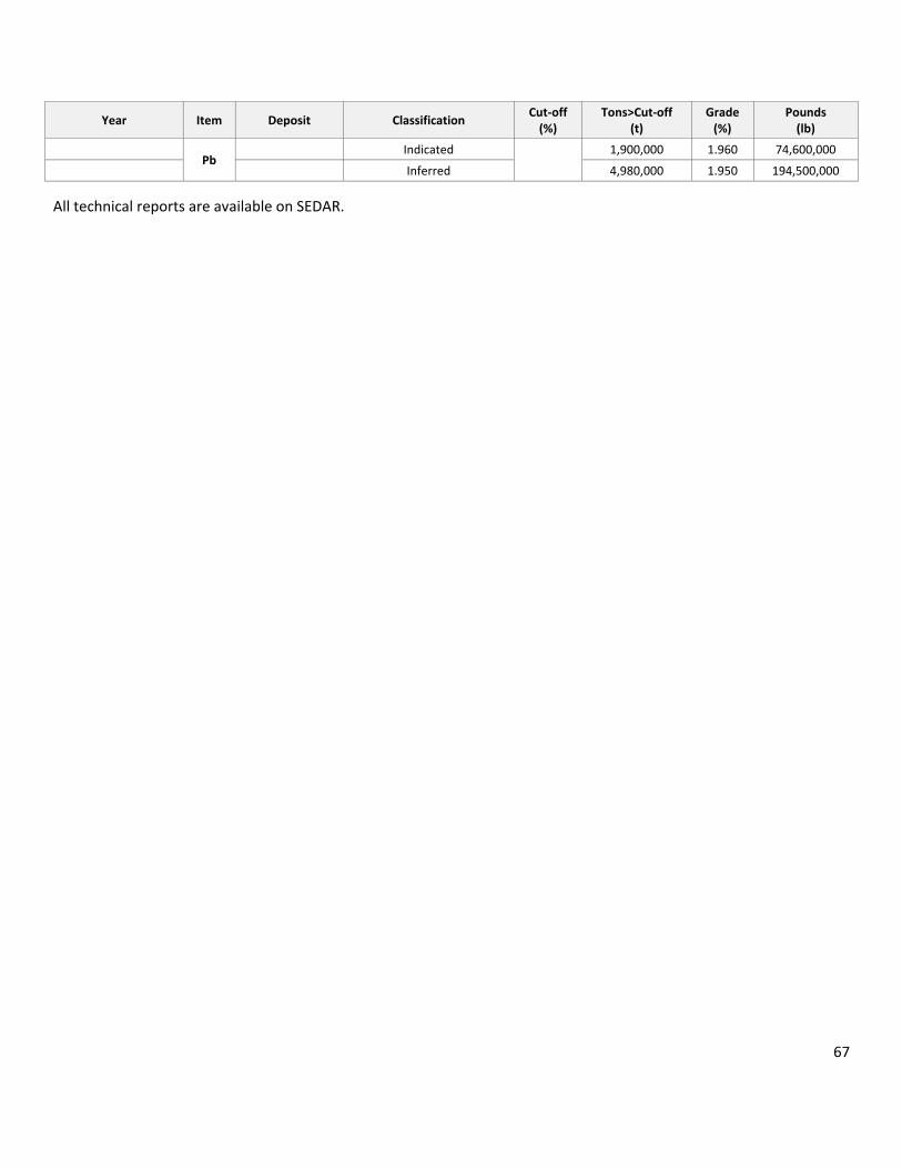
67
Year Item Deposit Classification Cut‐off (%)
Tons>Cut‐off (t)
Grade (%)
Pounds (lb)
Pb Indicated 1,900,000 1.960 74,600,000
Inferred 4,980,000 1.950 194,500,000
All technical reports are available on SEDAR.

68
15 THROUGH 22 ARE NOT APPLICABLE TO THIS TECHNICAL REPORT
Items 15 through 22 as outlined below are not applicable to this technical report.
Item 15: Mineral Reserve Estimates Item 16: Mining Methods Item 17: Recovery Methods Item 18: Project Infrastructure Item 19: Market Studies and Contracts Item 20: Environmental Studies, Permitting and Social or Community Impact Item 21: Capital and Operating Costs Item 22: Economic Analysis

69
23 ADJACENT PROPERTIES
The area around the Jersey‐Emerald property has undergone extensive historic exploration and development. A listing of MINFILE occurrences obtained via the BC Ministry of Energy and Mines website indicates numerous showings and past producers proximal to the Jersey‐Emerald property (Figure 19).
The information presented is not necessarily indicative of the mineralization on the Jersey‐Emerald property.
23.1 HB
The HB property is located on Aspen Creek, a tributary of Sheep Creek, directly north of the Jersey‐Emerald property. The north end of the No. 1 ore body outcropped at an elevation of 1219 m, west of Aspen Creek, and almost 1.6 km north of Sheep Creek.
The Consolidated Mining and Smelting Company of Canada (CMSC, which became Cominco Ltd. (Cominco)) optioned the claims in 1911. The No. 2 level crosscut was driven during the winter but results were disappointing and the option was dropped in 1912. On the expiry of the lease, the entire property was optioned to a Spokane syndicate operating under the name Hudson Bay Zinc Company. The low‐level No. 7 crosscut at the 3,100 level began in 1915, and reached a completed length of 579 m in 1916. Drilling from the crosscut failed to find ore and the option was given up in 1917. All exploration work was done in the heavily oxidized zone at the north, and on No. 1 ore body where the flat‐plunging ore was exposed on surface.
CMSC returned in 1927. From 1946, geological investigations led to an intensive drilling program that began in 1948. The drilling indicated large bodies of low‐grade disseminated sulphides gently plunging south from the oxidized ore body. In 1951, construction of a 1,000 ton per day concentrator began and the new No. 8 adit was driven 823 m to the north from the Sheep Creek valley mill site to the ore zone.
David Minerals Ltd., by an agreement dated May 8, 1981, purchased the mine, mill, and adjacent properties from Cominco. The HB mill was renovated to include a flotation circuit to custom‐mill gold‐bearing sulphide ores, and a second circuit to treat molybdenite‐gold ore from the company's Rossland properties. A gold circuit was put into operation for a short period in December 1981 to process ore from the Gold Belt property.
The HB ore bodies are thought to be Kootenay Arc‐type carbonate‐hosted sedimentary exhalative deposits. They are located within dolomitized limestone of the Reeves Member of the Lower Cambrian Laib Fm. The east boundary of the Laib Fm is in faulted contact with argillites of the Lower to Middle OA Fm. The OA rocks were thrust from the east over the Reeves rocks.

70
Figure 19: Minfile occurrences in property area

71
There are two distinct calcareous layers of the Reeves Member. The upper 110 m thick unit is separated from a lower 12 m thick member by 15 to 30 m of micaceous brown limey argillite.
Near the HB mine, the beds form a broad synclinorium. The limestone layers in the mine are on the west limb of this structure.
The HB ore bodies occur within a hundred m or so to the west of the thrust fault. The mineralization may be related to granitic stocks of the Middle to Late Jurassic Nelson Intrusions, with the nearest outcropping about 1 km away from the mine. The only intrusives present in the mine are post‐ore dykes up to 3 m thick.
The principal ore zones consisted of three steeply dipping, parallel zones extending as pencil‐like shoots for about 900 m along the gentle south plunge of the controlling structures. The largest, easternmost ore zone has a maximum height of about 140 m and a maximum width of 30 m. Steeply dipping discontinuous ore stringers with a Pb:Zn ratio of 1:5 occur with these zones. Evidence indicates that ore deposition was controlled by shear zones within the folded limestone;, with the best concentrations occurring at the junctions between steeply dipping shears (the pencil‐like ore bodies) and flat lying shears (the flat‐lying brecciated ore bodies).
The northern portion of these bodies, which is exposed at surface, near the original HB claim, is oxidized to a depth of 100 m. The HB deposits were mined from underground; however, a smaller orebody southwest of the HB mine, known as the Garnet zone, was mined from a small open pit.
The mineralogy of the ore is relatively simple with pyrite, sphalerite, and galena, and with minor pyrrhotite locally.
The HB mine produced 6,656,101 t of ore in 29 years between 1912 and 1978. The metals recovered included 29,425,521 g of Ag, 49,511,536 kg of Pb, 260,431,646 kg of Zn, 2,019,586 kg of Cd, 105,412 kg of Cu, and 6,159 g of Au. Measured and indicated reserves published December 31, 1978 by Canadian Pacific Ltd. were given as approximately 36,287 t grading 0.1% Pb and 4.1% Zn (Energy, Mines and Resources Canada Mineral Bulletin MR 198, page 209).
23.2 MOLLY
The Molly molybdenum property is located at about 1219 m elevation on the south side of Lost Creek, 12.8 km south‐southeast of Salmo. The Bromyrite King, Bromyrite, Molybdenite, and Molybdenum No.1 claims formed the property. In 1914, Molly was leased for to the Bell brothers of Salmo for six months, and molybdenum ore from open cuts and pits was shipped to Denver, Colorado. Early in 1915, B.C. Molybdenite Company Ltd. leased the property, and additional ore was shipped to Denver. In 1916, the property was under lease to International Molybdenum Company Ltd., which shipped about 90 t of ore to their plant at Renfrew, Ontario. The original owners resumed work on the property in 1917 and shipped about 45 t of ore to the Mines Branch, Ottawa.

72
The property was re‐staked as the Molly and Molly 1‐9 claims. The CMSC purchased the property in 1926, and followed with a small amount of underground work and diamond drilling the next year. The claims were Crown‐granted to the company in 1930. The workings at that time included about 30 m of drifts and crosscuts, an 18‐m raise, and a winze.
In 1942, Joe Gollow, of Howser, BC, discovered scheelite on the Molly 4 claim, about 305 m southeast and 122 m above the molybdenum showing. The company carried out considerable exploration for scheelite that same year. Further work by the company on the molybdenum showing during the period July 1942 to February 1943 included 35 m of crosscut, 21 m of drift, and a 5‐m raise. A small tonnage of ore was mined, but not shipped.
The Molly mine is hosted the Lost Creek granite stock of the Middle to Late Jurassic Nelson Intrusions, which intruded a sequence of argillites and limy argillites of the OA Fm. The quartz‐rich granite appears to have a 2 m thick upper aplitic chilled zone or border capping. The aplite is sparsely impregnated with molybdenum.
The main molybdenum ore occurs below the capping within a zone about 3 m thick, which contains numerous joints parallel to the intrusive contact. The best mineralization within this sheeted zone occurs where the intrusive contact dips at low angles and/or where there are prominent intersecting fractures. Molybdenite occurs as selvages on the joint planes, or as disseminated specks between the joints. The massive granite below the sheeted zone hosts low concentrations of molybdenite. Tungsten, as scheelite, occurs locally disseminated in skarn zones of small size.
Records indicate that the Molly mine produced at least 171 t of ore that carried 3.5 to 5.88% MoS2. From 1914 to 1917, 11,366 kg of molybdenum were produced. Minor pyrite, pyrrhotite, and uraninite are also associated with the deposit. A sample assayed 0.13% uranium equivalent (Geological Survey of Canada, Economic Geology #16).
23.3 SUMMIT, ORE HILL, AND BONANZA
A series of historic mines that produced silver, gold, lead, and zinc are located to the northeast of the Jersey‐Emerald property. Generally, these quartz vein‐hosted occurrences cut the Lower Cambrian Laib formation limestone and schist.
The Summit occurrence is a quartz‐siderite vein deposit that contains erratically distributed pyrite, galena, and sphalerite within a narrow fault zone striking 55° and dipping southeast. Most of the mine production was from a 20 m long "Glory Hole". Production from 1906 to 1938 was 1094 t, which contained 27,059 g of Au, 37,883 g of Ag, 13,728 kg of Pb, and 12,988 kg of Zn.
The Ore Hill vein deposit includes several adits with over 1000 m of underground development. Between 1906 and 1940, 2,241 t of ore contained 88,612 g of Au, 168,424 g of Ag, 80,257 kg of Pb, and 75,651 kg of Zn was mined.

73
South of the adits, limestone in fault contact with schist was exposed in a trench. The fault strikes 050° and dips 75° southeast. A 1 m wide lamprophyre dyke is injected along the fault and there is about 30 cm of fine‐grained galena, sphalerite, pyrrhotite, and pyrite on the footwall side, within highly altered limestones. North of this exposure, in the adits, the vein is about 45 cm wide within quartzite but narrows along strike as it crosscuts argillites. No mineralization in the quartzite section was reported.
The Bonanza North and South veins were developed by four adits on the Dip claim. About 17 t were shipped in 1910, but the value of the shipment was not reported (Minister of Mines Annual Report 1910, page 110). In 1963, 14 tonnes were mined, from which 124 g of Au, 2,861 g of Ag, and 118 kg of lead were recovered.
Sampling from 1982 indicated a mineralized shoot above and below the second level on the North vein. Potential was indicated at a depth where the productive horizon was projected to below an elevation of 914 m. In 1983, 2720 t of proven and possible ore at a grade of 18.86 g/T Au was outlined on the North Bonanza vein (Assessment Report 11249). A later estimate of the resource on the property was reported to be 14,254 t grading 10.28 g/T Au (George Cross News Letter No.217, November 12, 1987).

74
24 OTHER RELEVANT DATA AND INFORMATION
The Jersey‐Emerald property has undergone historic mining for a variety of commodities, over a significant span of time. Both underground and surface mining methods were utilized in the extraction of ore. Remnants of this historic work, including open cuts and pits, portals to underground access, waste dumps, and mill tailings exist on the property surface. The zones of mineralization discussed in this report are primarily within or adjacent to the previously mined areas; therefore, these areas would are considered as brownfields.
Brownfields exploration may allow for more readily available permitting and advancement of continued work, and for eventual development of resources on the property. However, further consideration is required to ascertain the level of liability attached to the disturbed areas from historic mining. Margaux has continued baseline environmental data collection on the property, including stream water sampling, and sampling of the waters draining from underground workings.
24.1 2007 WARDROP SCOPING STUDY – TUNGSTEN
In 2007, Wardrop completed a scoping study for the Jersey‐Emerald property. The work involved developing conceptual design of all aspects of the project, including mine design, mineral processing, tailings disposal, concentrate transportation, and economic evaluation.
The Wardrop report was based on the findings of the initial resource estimate on the Dodger and Invincible tungsten zones (Giroux and Grunenberg, 2006). Wardrop recognized other zones that could be developed to benefit economic production on the property.
In 2007, Wardrop estimated an initial capital cost for mining and milling of $85.3 million. Operating expenditure was averaged for the expected life of project at $70.92/t of ore based upon annual ore production of 1100 t per day and 365 days of operation. Mine closure costs were estimated at $10.25 million. Reclamation costs were estimated at $5.0 million. Payback time for investment was estimated at 4 to 4.5 years.
The Jersey‐Emerald property would produce two scheelite concentrate products: a gravity concentrate with a grade of 75% WO3; and a flotation concentrate with a grade of 65% WO3.
The Wardrop report concluded that that the Jersey‐Emerald is a marginally positive project. A number of opportunities to make the project more robust and potentially improve the value of the property need to be investigated. These include:
• Processing the existing tailings dam materials
• Further exploration of tungsten deposits
• Recovery of lead/zinc pillars
• Further exploration of lead and zinc deposits.

75
Optimizing the scheduling of ore from each of the various sources would be necessary to minimize initial capital and maximize early cash flow for the project. Utilizing existing infrastructure would be critical in achieving this goal.
The mill could be designed to process the following materials:
• Tungsten
• Molybdenum
• Lead/zinc
The different ores could be batched through the mill and treated individually.
24.1.1 DISCUSSION
The authors of this report recognize that the Wardrop scoping study may be out‐of‐date. However, some of the concepts expressed in the scoping report could be considered currently valid. Startup and operating costs may have inflated since 2007; however, the metal pricing has in some cases doubled over that time, from approximately $200 per metric tonne unit (MTU) for tungsten concentrate in 2006, to over $350 per MTU today. Tungsten is one of the few metals that have withstood the recent metals bear market.
Tungsten prices are generally based on MTU of ammonium paratungstate (APT), a more refined downstream product. A MTU of APT is 10 kg, which contains 6.95 kg of W. The price of W is calculated by first dividing the price per kilogram of APT by 6.95 to get the price in dollars per kg, and then dividing by 2.2 to get the price in dollars per lb.
Scheelite concentrate is sold through private sale contracts, rather than on the open market. The concentrate pricing for the financial evaluation in the study was based on free market values for APT as listed on the London Metal Exchange.

76
25 INTERPRETATION AND CONCLUSIONS
Margaux and previous operators have tested several mineralized areas on the Jersey‐Emerald property. The East Emerald tungsten zone, which had been previously under‐explored, was the target for the most recent and the subject of the subsequent tungsten estimate update.
In 2014, Margaux added 35 drillholes in the East Emerald zone in order to improve the tungsten resource. The drilling was successful in achieving this goals.
Tungsten mineralization in the East Emerald zone is being hosted within a series of parallel skarn bodies that dip moderately to the east. Mineralization extended for 1,300 m along strike, and up to 300 m down dip.
On March 2, 2015, Margaux released the results of a tungsten resource estimate for the property, which incorporated the updated estimation for the East Emerald zone. The estimates for the tungsten resources for all other zones (Emerald, Invincible, and Dodger) were not changed.
The East Emerald zone has an estimated indicated tungsten resource of 561,000 t averaging 0.201% WO3, and an inferred tungsten resource of 3.560 Mt averaging 0.217% WO3, using a 0.15% WO3cut‐off.
For the property, a weighted average of the 2006, 2009, and 2015 tungsten resource estimates, using a 0.15% WO3 cut‐off grade, yields a total M+I resource of 3.071 Mt averaging 0.341% WO3, and an inferred resource of 5.480 Mt averaging 0.273% WO3.
The major difference between the two estimations occurs in the inferred resource category. In 2015, based on the results from the 2014 drilling, the East Emerald zone model was extended well beyond the existing model.
When comparing the current tungsten estimate to the 2014 variant, the resource classified as M+I experienced a 6% increase in contained pounds of WO3, and the inferred resource showed an 84% increase in contained pounds of WO3.
The drilling in the East Emerald was widely spaced. There were some indications that the better tungsten values occurred further down dip, and were only intersected by a few holes. However, generally, the skarns were continuous throughout the zone, and the overall tungsten values remained constant. There is potential for improving the overall grade by targeting the potentially higher‐grade sections.
Drillhole E1411 intersected 10.2 m of 24.98 g/T Au in altered, brecciated granite, just below the argillite granite contact. This intercept signifies the potential for significant gold mineralization within or proximal to tungsten mineralization.

77
It is the opinion of the authors that the goals of Margaux’s 2014 drilling program were met and were successful in expanding the tungsten resource estimate. Further work at the Jersey‐Emerald property is warranted.

78
26 RECOMMENDATIONS
26.1 EXPLORATION
In the following recommendations and calculations for the cost of diamond drilling are based on a broad average of underground and surface drilling utilizing either a Discovery‐1 drill capable of drilling BTW sized core, or an A5 B20 drill capable of drilling NQ2 sized core.
Total drilling cost estimated in each section is presented as a total of all expenses, as summarized below:
• Drill coring at $100/m
• Mobilization, water pumping, drilling additives at $5/m
• Sample assaying average of 1 per 10 m at $30/sample, or $3/m
• Geology and sampling at $15/m to $20/m
• Road preparation, maintenance, and reclamation at $15/m.
• An additional $5/m to $10/m might be added for underground work, requiring a shift boss and other safety measures.
26.1.1 TUNGSTEN
The objective of continuing exploration for tungsten would be to elevate portions of the resource from inferred to measured and indicated categories, as well as to further test areas where higher grade tungsten is predicted. The East Emerald mineralization can be approached from both surface and underground for drilling for definition. Drillhole density of 25 to 50 m is recommended. Further exploration of the higher‐grade Dodger mineralization can be approached from existing, accessible underground workings.
Completion of 4,000 m of surface and underground diamond drilling for tungsten mineralization is estimated to cost $615,000.
Dewatering of the Invincible Mine workings and access rehabilitation/stabilization is estimated to cost $250,000, but would be highly variable depending upon volumes of water currently in place as well as recharge into the mine from the surrounding capture area. To consider are:
• Pumping rates of pumps used in mine dewatering;
• Dynamic water levels in underground workings;
• Discharge of groundwater into mine (from fractures);
• Water quality of groundwater collected in the mine;
• Water quality of mine water discharged from the mine; and
• Groundwater levels in potential local bedrock aquifer(s) influenced by mine dewatering.
79
The estimated cost for dewatering provided above is calculated for 150 days of pumping at a rate of 0.2 m³/minute. Cost is for pump and power supply rental ($500/day), installation, and qualified persons ($800/day) to set and maintain pumps, hoses, and discharge areas. Monitoring of water quality for the safety of people and the environment would also be required as part of the process.
26.1.2 ZINC AND LEAD
Based on the results of this resource estimation, further work is recommended to better define the Zinc‐lead resource. There are two primary areas of concern for future work: 1) the resource blocks need to be verified by current drilling to quantify size and grade, and to increase the confidence in the estimate, and 2) the underground workings need to be more accurately modeled to define pockets where predicted mineralization may have been extracted from historic mining.
Diamond drilling is required to verify intercepts reported in the historic drilling used to obtain inferred resources in the Jersey lead‐zinc mine. Availability of access to the underground workings to reach resource blocks that indicate the best combination of grade and tonnage will determine which areas are to be tested. An initial program of 30 short drill holes (up to 35 m each) in two or three different areas of the mine will provide initial feedback of the remnant resource potential.
In conjunction with underground drilling for lead/zinc resources, a surface drilling program should be designed to further explore intercepts of zinc encountered during the 2014 drilling program. These intercepts are located along the west limb of the Jersey lead/zinc mine, on a heading toward the north from the existing mine.
Specific gravity determinations should be made on all grade ranges of mineralization to better establish a tonnage factor for resource estimation. A 3,000 m drillhole program is proposed, approximately 1,000 m from underground stations and 2,000 m from surface.
The cost estimate for this phase is estimated $460,000.
26.2 DATA
26.2.1 SURVEY TRANSFORMATION
Surveying: The Jersey‐Emerald project data (digital and physical) uses Imperial units on a local grid. There is not a good conversion from local grid to real world coordinates, and past attempts based on limited control points have produced an imperfect translation. The project data should be converted to metric for all future work.
In order to create a good translation, several points spread throughout the property should be accurately surveyed into local grid and real world coordinates. Additionally, the underground workings in the areas of interest should be surveyed in order to more accurately estimate what amount of
80
material has been removed, and to assist with future mine planning. Several companies offer this service.
The cost for surveying and data conversion is estimated at $7,000.
26.2.2 DATA MINING
Much of the historic data for the Jersey‐Emerald project has been stored in paper copies at Margaux’s and Sultan’s offices. Margaux and Sultan have advanced the project by entering data into digital form for greater transportability and for use in modern software applications.
However, there is still much data that could be extracted from the maps and files in storage, which would elevate the planning for future work to a much higher confidence level. Properly compiled information is a major exploration and mine planning tool.
All of Margaux’s work has been properly captured digitally and is now in the project database. However, some of the work completed by Sultan has yet to be entered or compiled into a modern format. Much of the sample locations and assay results data remain on printed format. These should be re‐entered for portability. This work could include:
• Collect all existing data (drilling, soil, rock, and geophysical, plus metadata) into a single relational database, using a simple portable database management system such as Microsoft Access that most off‐the‐shelf and custom modeling and GIS software packages can read directly. This will be the project’s only database, and will supersede all other data sources. Correct existing database errors, such as sample numbers, before adding other information such as the historic ICP results.
An estimated cost for this work is $70,000 (100 days work of qualified professional).
26.2.3 MINE WORKINGS MODEL
The second part of continued exploration of the historic lead‐zinc workings should address the accuracy of the modeled underground workings. These flat‐lying room and pillar style lead and zinc mine workings are quite complex. The historic paper plans and sections provide rudimentary data for modeling the mine workings in 3D software. It is recommended that more accurate surveys be conducted underground in three areas that are determined for follow‐up drilling due to readily available access and significant resource estimation. The size of the area to be covered and the methodology of survey will dictate the cost. A rough estimate of $150,000 is proposed to survey areas determined for future drilling, and to update the resource model with the accurate survey data.
26.3 PRELIMINARY ECONOMIC ASSESSMENT
The tungsten and zinc resources on the Jersey property suggest significant mining potential. However, without economic assessment that potential is unknown, and cannot be reported. It is recommended
81
that a preliminary economic assessment for all resources on the property be completed by the company at this stage. This will eventually provide Margaux with approximate tonnages and grades of each of the resources for feasibility, and will add to and update the scoping study completed by Wardrop in 2007 for tungsten alone. The study for the combined resources will include:
1. Preparation of a complex mine plan. 2. Design and costing of surface facilities. 3. Implementation and completion of environmental studies. 4. Review of ore transport options. 5. Review of tailings disposal options. 6. Review wastewater disposal alternatives. 7. Review historic metallurgy and conduct further metallurgical testing.
Costing for completion of the preliminary economic assessment will vary depending upon the level of work required at the site. Based on review of similar studies, the cost associated will range between $150,000 and $300,000. However, previous work on the property by Wardrop in 2007, directed towards tungsten alone, may provide a base for a new combined‐resource economic assessment, and possibly decrease the cost to under $150,000.
26.4 TOTAL RECOMMENDED PROJECT COST
The estimated cost to complete all of the recommended project components is at $1,702,000.

82
27 REFERENCES
Fyles, J.T. and Hewlett, C.G., 1959; Stratigraphy and Structure of the Salmo Lead Zinc Area: B.C.D.M., Bulletin No. 41.
Grunenberg, P.B. and Giroux, G., 2006; Summary Report and Preliminary Resource Calculations for the Dodger 4200 Molybdenum Zone, and Tungsten Zones, Jersey‐Emerald Property, British Columbia, 43‐101 report, 67pp.
Grunenberg, P.B. and Giroux, G., 2009; Summary Report and Preliminary Resource Calculations for the East Emerald and Emerald Mine Tungsten Zones, Jersey‐Emerald Property, British Columbia, 43‐101 report, 72pp.
Grunenberg, P.B. and Giroux, G., 2010; Resource Estimation for the Jersey Lead Zinc Deposit, , Jersey‐Emerald Property, British Columbia, 43‐101 report, 48pp.
Grunenberg, P.B. and Giroux, G., 2014; Technical Report for the Jersey‐Emerald Property, British Columbia, 43‐101 report, 99pp.
Hoy, T. and Andrew, K.P.E., 1989; The Rossland Group, Nelson Map Area, Southeastern British Columbia: BC Ministry of Energy, Mines and Petroleum Resources, Geological Fieldwork, 1988, Paper 1989‐1.
Hoy, T. and Dunne, K.P.E., 1997; Early Jurassic Rossland Group – Part I Stratigraphy and Tectonics: BC Ministry of Energy and Mines, Bulletin 102.
Hoy, T. and Dunne, K.P.E., 1998; Geological Compilation of the Trail Map‐Area: BC Ministry of Energy and Mines, Geoscience Map 1998‐1.
Lawrence, E.A., 1974; A Summary Report of the Production History and Geology of the Salmo Division, Canex Placer Limited: Unpublished Internal Report for Canex Placer Limited.
Lawrence, E.A. (2005) Jersey Molybdenum Potential; Private Report for Sultan Minerals.
Little, H.W., 1960; Nelson Map Area, West Half, B.C.: Geological Survey of Canada, Memoir 308.
MacDonald, A.S., 1970; The Salmo Lead‐Zinc Deposits: A Study of Their Deformation and Metamorphic Features: Unpublished PhD. Thesis, University of British Columbia.
Minfile, 1991; Emerald Tungsten Property, Minfile Nos. 082FSW009 and 082FSW010: Ministry of Energy, Mines and Petroleum Resources, Mineral Resources Division, Minfile Master Report 1991, p.19‐21.
83
Minister of Mines Annual Reports for 1896, 1948 ‐ 1970: British Columbia Department of Mines.
Ray, G.E., 1996; Characteristics of Gold Skarns: Presentation Notes for Short Course on New Mineral Deposit Models of the Cordillera.
Simandl, G.J. and Paradis, S., 2009; Carbonate‐Hosted, NonSulphide, Zinc‐Lead Deoposits in the Southern Kootenay Arc, British Columbia (NTS 082F/03), GSC Geological Fieldwork 2008, Paper 2009‐1.
Wardrop Engineering Inc., 2008; Jersey‐Emerald Mine Environmental Baseline Study 2007‐2008, 70pp.
WEBSITES: • BC Ministry of Energy and Mines Minfile Website http://minfile.gov.bc.ca • Mineral Titles Online http://www.empr.gov.bc.ca/TITLES/MINERALTITLES/MTO • SULTAN MINERALS INC: www.sultanminerals.com • CIM: http://web.cim.org/UserFiles/File/CIM_DEFINITON_STANDARDS_Nov_2010.pdf

84
GLOSSARY
Symbols and Units of Measurement
Centimetre……..………………………………………………………………………………………………..………….…………………….…cmCubic feet…………………………………………………………………………………………………………………………………..…………..ft3
Cubic metre………………………………………………………………………………………………………………………………..…………..m3
Decimetre………………………………………………………………………………………………………………………………………..…….dmDegrees………………………………………………………………………………………………..…………………………………………...….…°Degrees Celsius……………………………………………………………………..…………………………………………………………….…°CEqual to……………………………………………………………………………………………………………………………………………………=Foot or feet……………………………………………………………………………………………………………………………………..……..ftGram………………………………………………………………………………………………………………………………………..…………..…gGrams per tonne………………………………………………………………………………………………………………………….…….…g/TGreater than……………………………………………………………………………………………………………………………………..….…>Hectare……………………………………………………………………………………………………………………………………………….…haKilogram..………………………………………………………………………………………………………………………………..………….…kgKilometre..………………………………………………………………………………………………………………………………………….…kmLess than……………………………………………………………………………………………………………………………………………….…<Metre…………………………………………………………………………………………………………………………………….…………….…mMicron.………………………………………………………………………………………………………………………………………..……….…µMillimeter.……………………………….…………………………………………………………………………………..………….……….…mmMillion years………………………………………………………………………………………………………………………………………...MaMillion tons…………………………………………………………………………………………………………………………………………..MtMinus…………………………………………………………………………………………………………………………………………………….…‐One half …………………………………………………………………………………………………………………..………………………….…½ One quarter …………………………………………………………………………………………………………………….………………….…¼ Ounce………………………………………………………………………………………………………………………………………………….…ozParts per billion……………………………………………………………………………………………………….……………………….…ppbParts per million……………………………………………………………………………………………………..……………………….…ppmPercent………………………………………………………………………………………………………………………………….…………….…%Plus ……………………………………………………………………………………………………………………………………….….………….…+Plus or minus………………………………………………………………………………………………………….…………………………….…±Square kilometre………………………………………………………………………………………………………………………..…….…km²Ton……………………………………………………………………………………………………………………………………………………….…tTonne………………………………………………………………………………………………………………………………………………………T
Abbreviations and Acronyms
Acme Analytical Laboratories Ltd. ……………………………………………………………………………………………………AcmeAmmonium Paratungstate…………………………………………………………………………………………………………………APTArsenic………………………………………………………………………………………………………………………………………………….AsArsenopyrite……………………………………………………………………………………………………………………………………….AspAssessment Reporting Indexing System…………………………………………………………………………………………….ARISAtomic absorption………………………………………………………………………………………………………………….………….…AABarium…………………………………………………………………………………………………………………………………………………..BaBismuth………………………………………………………………………………………………………………………………………………….BiBritish Columbia ………………………………………………………………………………………………………………….…………….…BC

85
British Columbia Geological Survey……………………………………………………………………………………………………BCGSCadmium……………………………………………………………………………………………………………………………………………….CdCertified reference material …………………….…………………………………………………………………………….…standardsCanadian Institute of Mining, Metallurgy and Petroleum……………………………………………………………………CIMCopper…………………………………………………………………………………………………………………………………………………..CuCorrelation coefficient …………………………………….…………………………………………………………………………………..…r East……………………………………………………………………………………………………………………………………………………….…EFire assay ……………………………………………………………………………………………………………………….………………….…FA Formation…………………………………………………………………………………………………………………………………………….FmGalena…………………………………………………………………………………………………………………………………………………..GaGeological Survey of Canada …………………………………………………………………………………..……………………….…GSCGiroux Consultants Ltd. …………………………………………………………………………………….……..………………….…GirouxGold……………………………………………………………………………………………………………………………………………..…….…AuGroup………………………………………………………………………………..……………………………………………………………….…GpHighway……………………………………………………………………………………………….………………………………………….…HwyIncorporated…………………………………………………………………………………..…………………………………………………..Inc.Induced Polarization ………………………………………………………………………………………..………………………………….…IPInductively coupled plasma mass spectrometry …………………………………………………………………….………ICP‐MSInductively Coupled Plasma Emission Spectrometer………………………………………………………………..……..ICP‐ESIron Mountain Ltd………………………………………………………………………………………………..…………….Iron MountainLaboratory…………………………………………………………………………………………………………………………………………….labLead ……………………………………………………………………………………………………………….………………………………….…PbLead‐Zinc …………………………………………………………………………………………………………………………………………Pb‐ZnLimited………………………………………………………………………………………………………………………..……………..…….…Ltd.Measured plus indicated (M+I) …………………………………………………………………………………………………….…….M+IMentor Exploration Ltd………………………………………………………………………………………………………………….MentorMetric Tonne Unit…………………………………..…………………………………………………………………………………………MTUMicrosoft Excel ……………………………………………………………………………………………………..……………………….…Excel Margaux Resources Ltd.……………………………………………..………………………………………………….……………MargauxMississippi Valley Type……………………………………………………………………………………………………………………...MVTMolybdenite…………………………………………………………………………………………………………………………………………MbMolybdenum…………………………………………………………………………………………………………………………………….…MoMolybdenum disulphide…………………………………………………………………………………………………………………...MoS2
National Instrument 43‐101 ……………………………………………………………………………..…………………….…NI 43‐101Nu‐Dawn Resources Inc……………………………………………………………………………………………………………..Nu‐DawnNorth…………………………………………………………………………..……………………………………………………………………….…NNorth‐Northwest ……………………………………………………………………………………………………………………………….NNENQ‐diameter …………………………………………………………………………………………………………………………………….…NQOrdovician Active…………………………………………………………………………………………………….…………………………..OAPotassium ……………………………………………………………………………………………………….………………………………..….…KPotassium‐Argon…………………………………………………………………………………………………………………………..……K‐ArPotassium feldspar ………………………………………………………………………………………………..……………….…K‐feldsparPotassium oxide ……………………………………………………………………………………………………………………………….…K₂OProfessional Engineer……………………………………………………………………………………………………………..……….P. EngProfessional Geoscientist…………………………………………………………………………………………………………..…..P. GeoPreliminary Economic Assessment………………………………………………………………………………………………………PEAPyrite…………………………………………………………………………………………………………………………………………………..…PyQuality assurance………………………………………………………………………………………………………………………………….QA

86
Quality control ……………………………………………………………………………………………………………………….………….…QC Rock Quality Designation ………………………………………………………………………………………….…………………….…RQD Sphalerite………………………………………………………………………………………………………………………………………………SpSilver……………………………………………………………………………………………………………………………………………………..AgSouth…………………………………………………………………………………………………………………………………………………….…SSpecific gravity…………………………………………………………………………………………………………………..……………….…SGStandard deviation………………………………………………………………………………………………………………………………..SDSultan Minerals Inc.…………………………………………………………………………………………………………..........….…SultanSystem for Electronic Document Analysis and Retrieval……………………………………………………………….…SEDARTerrain Resource Information Management……………………………………………………………………………..……..TRIMThorium ……………………………………………………………………………………………………….…………………………………….…ThTungsten………………………………………………………………………………………………………………………………………………..WTungsten Trioxide (or Tungsten (VI) oxide) .……………………………………………………………………………………….WO3
Universal Transverse Mercator ………………………………………………………………………………..…………………….…UTM Very low frequency electromagnetics ……………………………………………………………………………………….…VLF‐EMWardrop Engineering Inc…………………………………………………………………………………..………………………..WardropZinc …………………………………………………………………………………………………………………………………………………….…Zn

87
SIGNATURE PAGE
Report To:
Margaux Resources Inc. 1600‐510 5th Street Calgary, Alberta T2P 3S2
Technical Report for the Jersey‐Emerald Property, Salmo, BC
Report Date: March 15, 2015 Effective Date: February 4, 2015
Prepared by: “Gary Giroux” (signed by) Date: March 15, 2015
Gary Giroux, P.Eng, MASc Prepared by: “Perry Grunenberg” (signed by) Date: March 15, 2015
Perry Grunenberg, P.Geo Prepared by: “Vivian Park” (signed by) Date: March 15, 2015
Vivian Park, P.Geo

88
CERTIFICATE OF QUALIFICATIONS FOR GARY GIROUX
I, G.H. Giroux, of 982 Broadview Drive, North Vancouver, British Columbia, do hereby certify that:
1) I am a consulting geological engineer with an office at #1215 ‐ 675 West Hastings Street, Vancouver, British Columbia.
2) I am a graduate of the University of British Columbia in 1970 with a B.A. Sc., and in 1984 with a M.A. Sc., both in Geological Engineering.
3) I am a member in good standing of the Association of Professional Engineers and Geoscientists of the Province of British Columbia.
4) I have practiced my profession continuously since 1970. I have had over 30 years experience calculating mineral resources. I have previously completed resource estimations on a wide variety of deposits many similar to the Jersey deposit.
5) I have read the definition of “qualified person” set out in NI 43‐101 and certify that by reason of education, experience, independence and affiliation with a professional association, I meet the requirements of an Independent Qualified Person.
6) This report titled “Technical Report for the Tungsten Resource Update for the Jersey‐Emerald Property, Salmo, BC” dated March 15, 2015, is based on a study of the data and literature available on the Jersey‐Emerald Project. I am responsible for the resource estimations shown in Item 14 and completed in Vancouver from 2006 through 2014. I visited the property on February 19 and 20, 2009 to examine drill core and underground workings.
7) I have previously completed resource estimates for the Dodger 4200 Molybdenum Zone and the Tungsten Zone on the Jersey‐Emerald Property in 2006, the Emerald and East Emerald Tungsten Zone in 2009, and the Jersey Pb‐Zn Zone in 2010.
8) As of the date of this certificate, to the best of my knowledge, information, and belief, the technical report contains all scientific and technical information that is required to be disclosed to make the technical report not misleading.
9) I am independent of the issuer applying all of the tests in section 1.5 of NI 43‐101.
10) I have read National Instrument 43‐101 and Form 43‐101F1, and the Technical Report has been prepared in compliance with that instrument and form.
Dated this 15th day of March 2015, in Vancouver, BC.
“G. H. Giroux” (signed by)
G. H. Giroux, P.Eng, MASc

89
CERTIFICATE OF QUALIFICATIONS FOR PERRY GRUNENBERG
I, Perry Grunenberg, of 2016 High Country Boulevard, Kamloops, BC, do hereby certify that:
1. I am a consulting Geoscientist with PBG Geoscience having an office at 2016 High Country Blvd, Kamloops, British Columbia, V2E 1L1.
2. This certificate applies to the report titled “Technical Report for the Jersey‐Emerald Property, Salmo, BC” dated March 15, 2015.
3. I am a graduate of the University of British Columbia with the degree of Bachelor of Science in Geology (1982).
4. I am a member of the Association of Professional Engineers and Geoscientists of British Columbia (Registration No. 19246)
5. I have practiced my profession in North America since 1982, having worked as an employee and consultant for major mining corporations, junior resource companies, and BC government ministries.
6. As a result of my experience and qualification I am a Qualified Person as defined in NI 43‐101. 7. I managed exploration programs on the Jersey‐Emerald property, including drilling programs for
the exploration of molybdenum, gold and tungsten within the property and surrounding claims. 8. I assisted in the preparation of the report titled “Technical Report for the Tungsten Resource
Update for the Jersey‐Emerald Property, Salmo, BC”. I prepared Item 26, and have reviewed all sections of the report.
9. I am independent of the company Margaux Resources Inc. as described in section 1.5 of NI 43‐101.
10. I have read NI 43‐101 and Form 43‐101F1, and the Technical Report has been prepared in compliance with that instrument and form.
11. As of the date of the certificate, I am not aware of any material fact or material change with respect to the subject matter of this technical report that is not reflected in this report, the omission to disclose which would make this report misleading.
Dated this 15th day of March 2015, in Kamloops, BC.
Perry Grunenberg, P.Geo.
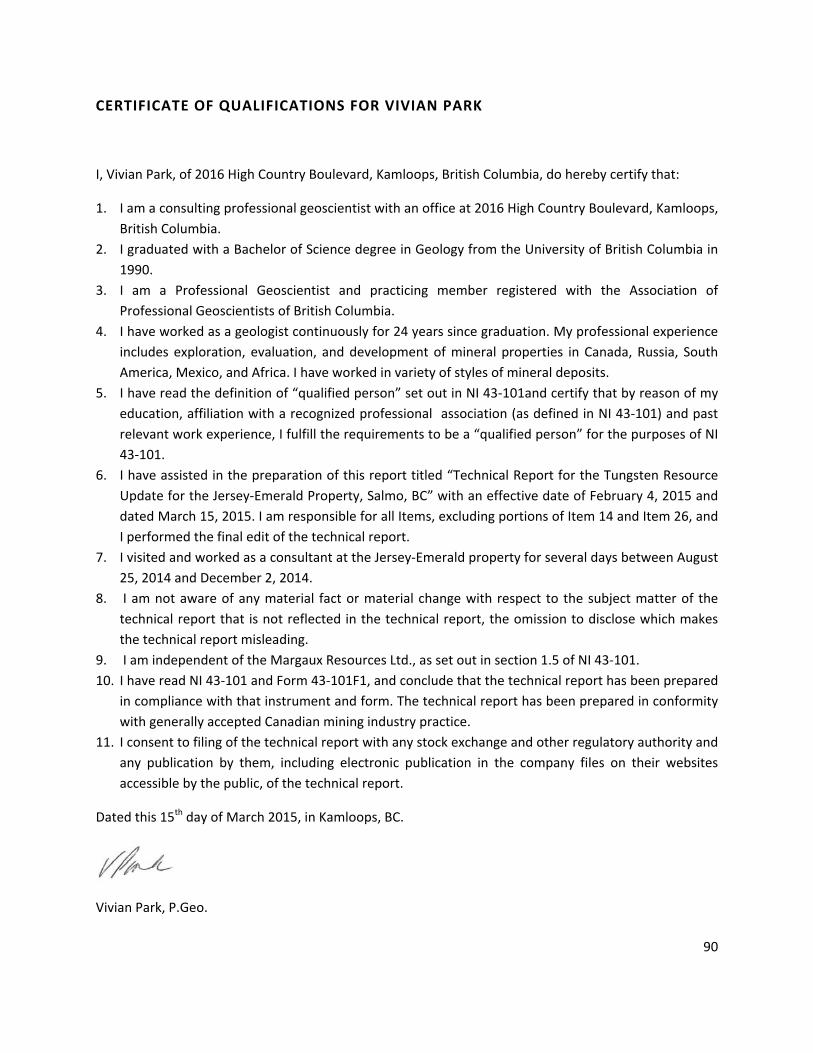
90
CERTIFICATE OF QUALIFICATIONS FOR VIVIAN PARK
I, Vivian Park, of 2016 High Country Boulevard, Kamloops, British Columbia, do hereby certify that:
1. I am a consulting professional geoscientist with an office at 2016 High Country Boulevard, Kamloops, British Columbia.
2. I graduated with a Bachelor of Science degree in Geology from the University of British Columbia in 1990.
3. I am a Professional Geoscientist and practicing member registered with the Association of Professional Geoscientists of British Columbia.
4. I have worked as a geologist continuously for 24 years since graduation. My professional experience includes exploration, evaluation, and development of mineral properties in Canada, Russia, South America, Mexico, and Africa. I have worked in variety of styles of mineral deposits.
5. I have read the definition of “qualified person” set out in NI 43‐101and certify that by reason of my education, affiliation with a recognized professional association (as defined in NI 43‐101) and past relevant work experience, I fulfill the requirements to be a “qualified person” for the purposes of NI 43‐101.
6. I have assisted in the preparation of this report titled “Technical Report for the Tungsten Resource Update for the Jersey‐Emerald Property, Salmo, BC” with an effective date of February 4, 2015 and dated March 15, 2015. I am responsible for all Items, excluding portions of Item 14 and Item 26, and I performed the final edit of the technical report.
7. I visited and worked as a consultant at the Jersey‐Emerald property for several days between August 25, 2014 and December 2, 2014.
8. I am not aware of any material fact or material change with respect to the subject matter of the technical report that is not reflected in the technical report, the omission to disclose which makes the technical report misleading.
9. I am independent of the Margaux Resources Ltd., as set out in section 1.5 of NI 43‐101. 10. I have read NI 43‐101 and Form 43‐101F1, and conclude that the technical report has been prepared
in compliance with that instrument and form. The technical report has been prepared in conformity with generally accepted Canadian mining industry practice.
11. I consent to filing of the technical report with any stock exchange and other regulatory authority and any publication by them, including electronic publication in the company files on their websites accessible by the public, of the technical report.
Dated this 15th day of March 2015, in Kamloops, BC.
Vivian Park, P.Geo.

91
APPENDIX 1: TUNGSTEN COMPOSITES FOR 2014 DRILLING HoleID UTMX UTMY Z Az Dip From To Length* WO3 (%)** Au (ppm)
*Drilled length, **WO3 calculated as W x 1.2611
E1401 483937 5440009 1330 112 ‐80 • 36.90 58.60 21.70 0.10
Incl 38.00 44.00 6.00 0.18
Incl 46.32 47.07 0.75 0.20
Incl 49.00 51.00 2.00 0.15
E1402 483937 5440009 1330 108 ‐60 • 50.42 54.40 3.98 0.14
• 60.00 80.86 20.86 0.11
Incl 60.00 60.70 0.70 0.21
Incl 62.21 67.60 5.39 0.14
Incl 62.21 71.00 8.79 0.12
• 76.20 79.24 3.04 0.24
• 123.55 132.20 8.65 0.23
Incl 127.00 132.20 5.20 0.30
• 153.00 160.70 7.70 0.17
Incl 157.95 160.70 2.75 0.29
• 228.65 235.65 7.00 0.26
Incl 228.65 231.65 3.00 0.47
E1403 483912 5439952 1328 180 ‐89 • 33.50 46.85 13.35 0.10
Incl 35.00 38.50 3.50 0.17
Incl 44.50 45.50 1.00 0.27
• 76.10 95.00 18.90 0.13
Incl 83.33 93.00 9.67 0.20
E1404 483912 5439952 1328 107 ‐63 • 47.35 51.15 3.80 0.13
Incl 50.00 51.15 1.15 0.23
• 115.00 119.20 4.20 0.16
• 143.25 146.00 2.75 0.49
E1405 483866 5439876 1325 118 ‐60 • 44.90 49.70 4.80 0.12
• 59.25 67.20 7.95 0.10
Incl 59.25 60.85 1.60 0.17
Incl 61.70 62.45 0.75 0.32
• 95.80 110.00 14.20 0.10
Incl 97.00 100.50 3.50 0.18
Incl 107.80 110.00 2.20 0.25
• 117.50 119.40 1.90 0.32
• 134.50 145.40 10.90 0.19
Incl 134.50 135.40 0.90 0.86
Incl 140.10 143.80 3.70 0.34
E1406 483697 5439494 1352 165 ‐90 No significant results
E1407 483697 5439494 1352 114 ‐60 • 89.00 109.95 20.95 0.15
Incl 92.10 96.10 4.00 0.30
Incl 102.90 109.95 7.05 0.22

92
HoleID UTMX UTMY Z Az Dip From To Length* WO3 (%)** Au (ppm)
*Drilled length, **WO3 calculated as W x 1.2611
E1408 483697 5439494 1352 290 ‐59 No significant results
E1409 483728 5439530 1357 102 ‐69 • 91.80 126.25 34.45 0.18
Incl 95.25 96.40 1.15 0.25
Incl 97.25 101.75 4.50 0.50
Incl 116.65 117.35 0.70 0.28
Incl 118.55 119.05 0.50 0.24
Incl 122.00 125.30 3.30 0.51
E1410 483728 5439530 1357 102 ‐55 • 162.35 172.60 10.25 0.19
Incl 164.65 169.20 4.55 0.30
Incl 170.90 172.60 1.70 0.29
• 205.95 211.05 5.10 0.13
Incl 205.95 209.40 3.45 0.14
• 258.45 276.40 17.95 0.12
Incl 258.45 259.80 1.35 0.29
Incl 262.25 263.10 0.85 0.21
Incl 265.40 266.60 1.20 0.31
Incl 272.00 274.00 2.00 0.26
• 307.50 310.85 3.35 0.52
Incl 307.50 308.10 0.60 2.48
E1411 483954 5439795 1389 ‐90 • 116.80 127.00 10.20 24.98
Incl 118.20 118.80 0.60 0.46 55.40
Incl 120.70 122.40 1.70 63.71
Incl 123.10 125.00 1.90 58.74
E1412 483941 5439795 1389 022 ‐70 • 95.45 96.90 1.45 0.22
• 154.55 161.35 6.80 0.17
Incl 156.00 157.00 1.00 0.34
• 168.80 169.20 0.40 0.13
• 208.40 213.00 4.60 0.14
• 223.70 225.80 2.10 0.12
• 223.70 234.10 10.40 0.14
Incl 230.65 233.35 2.70 0.29
• 302.35 305.00 2.65 0.59
• 309.00 314.00 5.00 0.10
E1413 483914 5439723 1395 132 ‐89 • 92.95 94.35 1.40 0.10
• 96.10 99.05 2.95 0.21
Incl 96.10 96.90 0.80 0.47
Incl 98.40 99.05 0.65 0.35
• 127.40 129.53 2.13 0.25
Incl 128.50 129.53 1.03 0.46
• 142.20 143.77 1.57 0.18
• 148.70 152.37 3.67 0.24

93
HoleID UTMX UTMY Z Az Dip From To Length* WO3 (%)** Au (ppm)
*Drilled length, **WO3 calculated as W x 1.2611
Incl 148.70 149.92 1.22 0.35
• 172.70 173.20 0.50 0.18
• 176.85 185.75 8.90 0.15
Incl 176.85 178.03 1.18 0.27
Incl 181.10 182.00 0.90 0.33
Incl 184.00 184.30 0.30 0.76
Incl 185.05 185.75 0.70 0.29
• 196.10 200.65 4.55 0.11
Incl 199.75 200.65 0.90 0.23
• 205.55 209.15 3.60 0.18
Incl 205.55 206.00 0.45 0.33
Incl 205.55 209.15 3.60 0.18
• 219.73 226.44 6.71 0.22
• 236.13 239.42 3.29 0.20
Incl 236.13 237.43 1.30 0.24
Incl 238.25 239.42 1.17 0.29
E1414 483850 5439665 1390 135 ‐89 • 26.00 28.00 2.00 0.10
• 53.90 54.40 0.50 0.15
• 136.90 139.30 2.40 0.21
• 151.30 152.30 1.00 0.38
• 158.50 159.25 0.75 0.17
• 174.10 180.80 6.70 0.11
Incl 178.80 180.80 2.00 0.23
• 194.50 199.80 5.30 0.13
Incl 194.50 195.70 1.20 0.26
Incl 198.80 199.80 1.00 0.23
• 207.90 211.90 4.00 0.35
Incl 207.90 208.90 1.00 0.79
Incl 210.89 211.90 1.01 0.52
E1415 483794 5439600 1375 83 ‐89 • 112.80 113.53 0.73 0.09
• 115.50 116.30 0.80 0.26
• 126.07 127.80 1.73 0.18
Incl 126.07 127.08 1.01 0.27
E1416 483794 5439600 1375 037 ‐80 • 119.90 121.60 1.70 0.10
• 131.00 134.10 3.10 0.12
E1417 483680 5439436 1369 284 ‐89 No significant results
E1418 483680 5439436 1369 112 ‐55 • 14.00 15.85 1.85 0.23
E1419 483845 5439568 1424 112 ‐79 • 26.62 26.93 0.31 0.12
• 198.65 203.53 4.88 0.21
Incl 199.50 200.10 0.60 0.57
• 218.51 220.10 1.59 0.14

94
HoleID UTMX UTMY Z Az Dip From To Length* WO3 (%)** Au (ppm)
*Drilled length, **WO3 calculated as W x 1.2611
• 243.85 250.30 6.45 0.33
Incl 246.00 248.85 2.85 0.62
• 252.98 256.20 3.22 0.22
Incl 254.95 256.20 1.25 0.46
• 266.20 266.92 0.72 0.13
E1420 483845 5439568 1424 112 ‐65 Hole lost in workings before target
E1421 483851 5439632 1416 117 ‐66 No significant results
E1422 483851 5439632 1416 271 ‐89 • 67.90 71.05 3.15 0.15
Incl 70.40 71.05 0.65 0.29
• 170.65 171.75 1.10 0.10
• 189.95 191.40 1.45 0.28
• 208.60 211.35 2.75 0.11
Incl 208.60 209.00 0.40 0.29
• 219.10 219.85 0.75 0.17
• 222.30 227.00 4.70 0.13
Incl 225.50 226.40 0.90 0.34
E1423 483807 5439502 1426 137 ‐81 • 97.05 97.60 0.55 0.47
• 108.05 108.80 0.75 0.19
• 198.75 205.80 7.05 0.27
Incl 198.75 201.80 3.05 0.33
Incl 204.65 205.80 1.15 0.39
E1424 483762 5439436 1422 230 ‐89 • 164.20 176.00 11.80 0.23
Incl 165.50 172.10 6.60 0.32
E1425 483762 5439436 1422 181 ‐61 • 147.50 150.80 3.30 0.31
• 157.90 160.80 2.90 0.31
• 181.70 183.20 1.50 0.42
E1427 483670 5439671 1373 291 ‐69 • 33.85 34.55 0.70 0.42
E1429 483674 5439243 1384 0 ‐90 • 68.40 74.55 6.15 0.20
Incl 68.40 70.55 2.15 0.49
E1430 483674 5439243 1384 116 ‐48 • 207.05 208.05 1.00 0.37
Incl 207.05 207.55 0.50 0.67 0.45
E1432 483850 5439665 1390 114 ‐60 • 72.35 73.55 1.20 0.22 2.18
• 107.05 109.65 2.60 0.43
Incl 109.10 109.65 0.55 0.86
• 123.25 128.40 5.15 0.47 0.26
Incl 124.55 125.52 0.97 0.69 0.94
• 267.00 272.25 5.25 0.84 1.23
Incl 267.00 269.00 2.00 1.56
E1433 483989 5439776 1402 303 ‐72 • 150.85 151.50 0.65 0.00 68.30
• 151.50 152.10 0.60 0.14 3.65
• 153.10 154.60 1.50 0.22 1.55
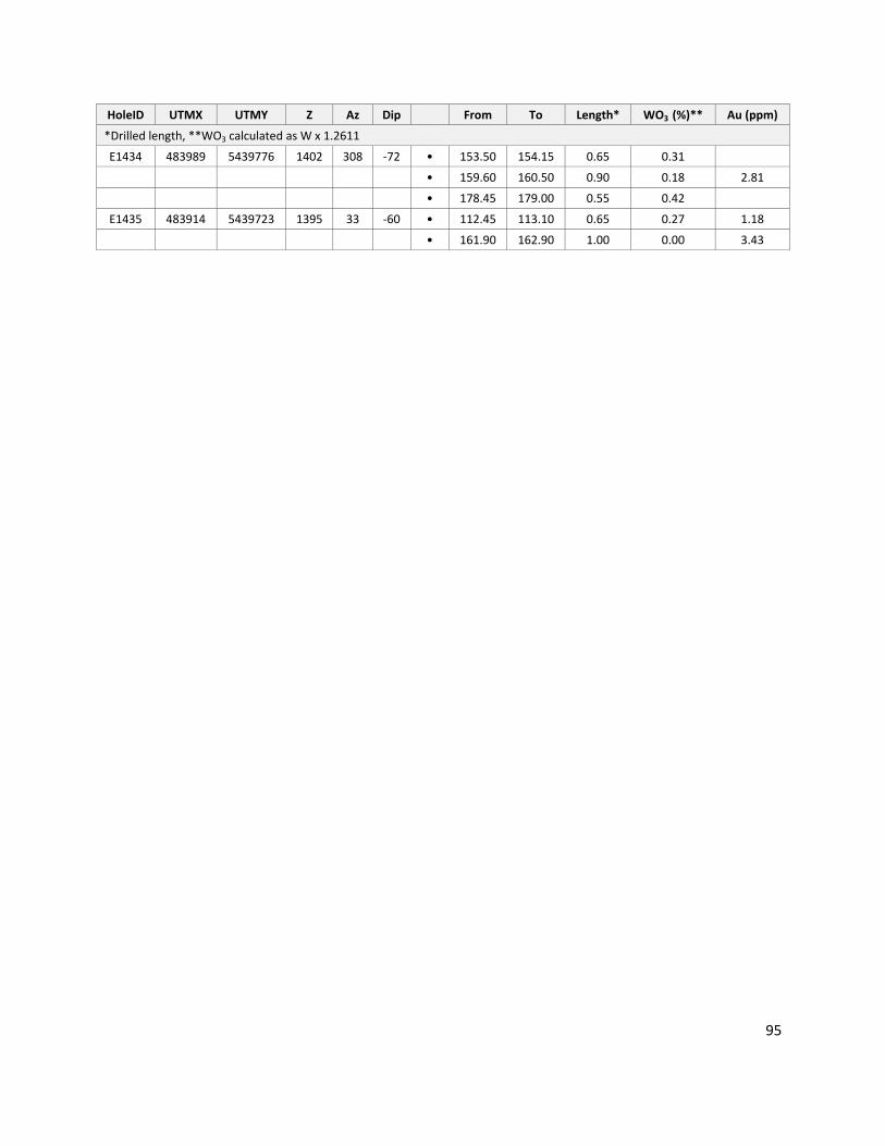
95
HoleID UTMX UTMY Z Az Dip From To Length* WO3 (%)** Au (ppm)
*Drilled length, **WO3 calculated as W x 1.2611
E1434 483989 5439776 1402 308 ‐72 • 153.50 154.15 0.65 0.31
• 159.60 160.50 0.90 0.18 2.81
• 178.45 179.00 0.55 0.42
E1435 483914 5439723 1395 33 ‐60 • 112.45 113.10 0.65 0.27 1.18
• 161.90 162.90 1.00 0.00 3.43

96
APPENDIX 2: LIST OF DRILLHOLES USED FOR THE 2015 EAST EMERALD TUNGSTEN RESOURCE ESTIMATION
HOLE‐ID LOCATIONX LOCATIONY LOCATIONZ LENGTH (ft)
DU623 7187.6 7335.4 4207.7 90
E0601 7397 8434 4345 403
E0602 7305 8190 4370 533
E0603 7350 8206 4370 293
E0604 7420 8590 4332 185
E0605 7872 9243 4341 457
E0606 7870 9244 4341 847
E0607 7760 9305 4240 287
E0608 7757 9306 4240 327
E1401 7876.83 9208.59 4337.91 823.5
E1402 7876.83 9208.59 4337.91 862.9
E1403 7794.1 9021.63 4333 498.7
E1404 7794.1 9021.63 4333 695.5
E1405 7629.32 8777.49 4322.74 528.9
E1407 7115.8 7542.94 4496 439.6
E1409 7186.66 7659.72 4512.25 488.8
E1410 7186.66 7659.72 4512.25 1059.7
E1411 7910.09 8548.91 4612.08 626.6
E1412 7899.73 8534.92 4613.84 1066.3
E1413 7798.54 8300.92 4633.54 925.5
E1414 7588.87 8104.47 4610.93 744.8
E1415 7384.41 7870.9 4570.09 487.2
E1416 7384.41 7870.9 4570.09 603.7
E1418 7048.99 7340.03 4530.9 400.3
E1419 7564.84 7774.34 4710.88 971.1
E1422 7607.93 7908.5 4686.56 803.8
E1423 7441.68 7570.52 4716.81 825.1
E1424 7297.7 7357.18 4707.76 626.6
E1425 7297.7 7357.18 4707.76 685.7
E1426 7002.14 7035.03 4557.52 246.1
E1427 7002.14 7035.03 4557.52 232
E1428 7002.14 7035.03 4557.52 341.2
E1429 6998.16 6744.26 4584.83 311.7
E1430 6998.16 6744.26 4584.83 823.5
E1431 6998.16 6744.26 4584.83 430.8
E1432 7588.87 8104.47 4610.93 941.6
E1433 8039 8451 4693 646.3

97
HOLE‐ID LOCATIONX LOCATIONY LOCATIONZ LENGTH (ft)
E1434 8039 8451 4693 636.5
E1435 7798 8300 4633 616.1
ES0802 7990 9543 4352 727
ES0803 8756 10122 4380 617
ES0804 8520 9982 4380 895.5
ES0805 8525 9985 4380 656
ES0806 8250 9865 4355 479
ES0807 8250 9865 4355 848
ES0808 8062 9658 4345 518
ES0809 7952 9425 4330 379
ES0810 7903 9718 4260 217
ES0811 7775 9465 4244 108
ES0812 7775 9465 4244 87
ES0813 7710 9230 4258 155.5
ES0814 7635 9000 4265 105
JS0730 8650 9165 4665 1116
JS0733 8662 10058 4380 658
JS0734 8660 10059 4380 507
JS0736 8193 9784 4352 568
JS0737 8191 9784 4352 598
JS0738 8197 9784 4352 551
JS0739 8195 9784 4352 750
JS0740 7990 9543 4339 498
JS0741 7986 9543 4339 558
JS0742 7987 9542 4339 863
JS0743 7096 7792 4427 280
JS0744 7092 7794 4427 270
JS0745 7100 7791 4427 580
JS0746 7792 9066 4334 458
JS0747 7789 9067 4334 557
S1 7215.91 8082.94 4391.16 141
S10 7351 8248 4407 202
S11 7351 8248 4407 178
S12 7354 8292 4391 191
S13 7375 8341 4382 198
S14 7374 8341 4381 190
S16 7388 8386 4377 188
S2 7215.81 8082.94 4391.16 121
S20 7472.5 8480.5 4363 202

98
HOLE‐ID LOCATIONX LOCATIONY LOCATIONZ LENGTH (ft)
S21 7445 8527 4358 164
S22 7445 8527 4358 154
S23 7445 8527 4358 162
S24 7462 8574 4360 160
S3 7215.8 8082.94 4391.16 132
S4 7268.68 8114.25 4385.73 121
S5 7283.7 8166.14 4405.95 151
S6 7285.7 8166.14 4405.95 133
S7 7287.7 8166 4403 150
S8 7318.04 8208.5 4403 157
S9 7351 8247.6 4409.3 192
V1 8623.01 10247.91 4281.55 698
V13 7905.87 9283.63 4341.4 789
V15 7908 9283.13 4341.3 853
V18 7907.94 9283.13 4341.3 844
V19 7386.7 8465.1 4327.46 904
V20 7668.88 8827.56 4329.18 850
V26 8403.04 9898.89 4377.47 1151
V32 7678.5 8603 4408.58 969
VU12 7706.5 8345.3 3625.6 341
VU14 7842.1 8450.5 3613 273
VU18 7840.2 8451.2 3613.5 290
VU2 7706.1 8345.3 3625.6 332
VU3 7706.1 8344.9 3625.2 377
VU6 7707.4 8344.8 3624.4 360
VU8 7706.6 8344.9 3624.8 342

99
APPENDIX 3: SEMI‐VARIOGRAMS FOR WO3