technical note: implementation of a geodatabase of ... · pdf filetechnical note:...
TRANSCRIPT
Nat. Hazards Earth Syst. Sci., 10, 865–873, 2010www.nat-hazards-earth-syst-sci.net/10/865/2010/© Author(s) 2010. This work is distributed underthe Creative Commons Attribution 3.0 License.
Natural Hazardsand Earth
System Sciences
Technical Note: Implementation of a geodatabase of published andunpublished data on the catastrophic Vaiont landslide
L. Superchi1, M. Floris1, M. Ghirotti 2, R. Genevois1, M. Jaboyedoff3, and D. Stead4
1Dept. of Geosciences, University of Padova, Italy2Dept. of Earth and Geo-Environmental Sciences, University of Bologna, Italy3Institute of Geomatics and Risk Analysis (IGAR), University of Lausanne, Switzerland4Dept. of Earth Sciences, Simon Fraser University, Burnaby, Canada
Received: 9 November 2009 – Revised: 5 March 2010 – Accepted: 23 March 2010 – Published: 20 April 2010
Abstract. On 9 October 1963 a catastrophic landslide sud-denly occurred on the southern slope of the Vaiont dam reser-voir. A mass of approximately 270 million m3 collapsed intothe reservoir generating a wave that overtopped the dam andhit the town of Longarone and other villages nearby. Severalinvestigations and interpretations of the slope collapse havebeen carried out during the last 45 years, however, a compre-hensive explanation of both the triggering and the dynamicsof the phenomenon has yet to be provided.
In order to re-evaluate the currently existing informationon the slide, an electronic bibliographic database and anESRI-geodatabase have been developed. The chronology ofthe collected documentation showed that most of the stud-ies for re-evaluating the failure mechanisms were conductedin the last decade, as a consequence of knowledge, methodsand techniques recently acquired. The current contents of thegeodatabase will improve definition of the structural settingthat influenced the slide and led to the the propagation of thedisplaced rock mass.
The objectives, structure and contents of the e-bibliography and Geodatabase are indicated, together witha brief description on the possible use of the alphanumericand spatial contents of the databases.
Correspondence to:L. Superchi([email protected])
1 Introduction
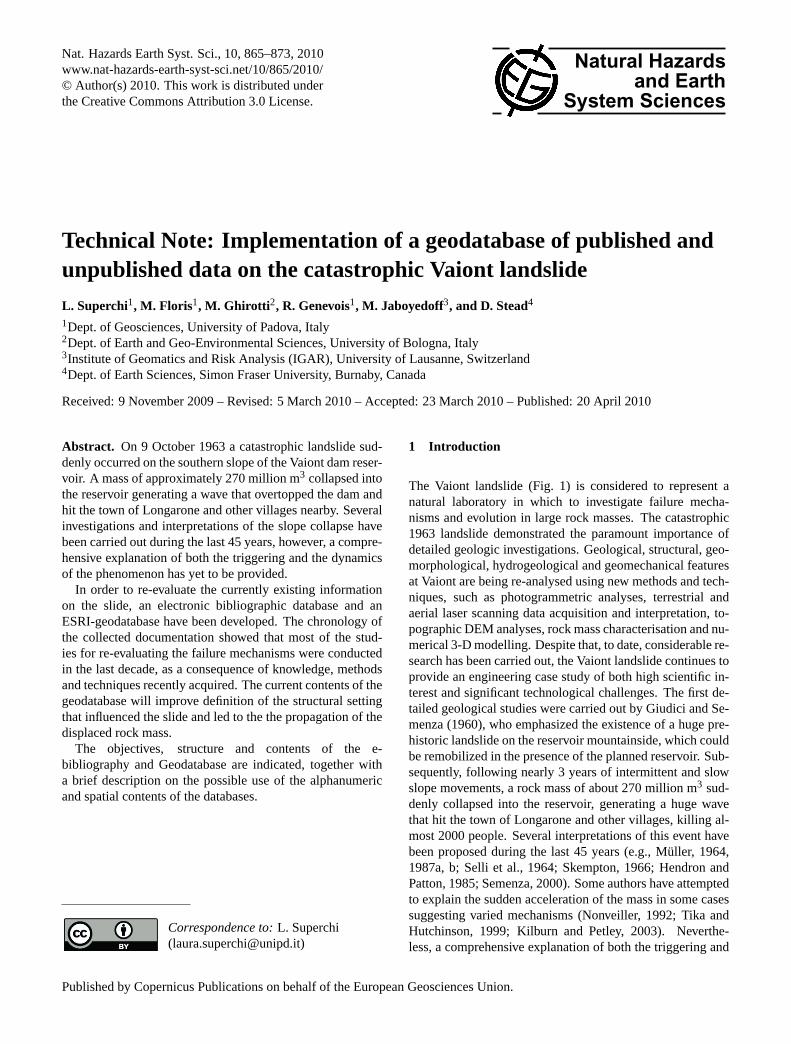
The Vaiont landslide (Fig. 1) is considered to represent anatural laboratory in which to investigate failure mecha-nisms and evolution in large rock masses. The catastrophic1963 landslide demonstrated the paramount importance ofdetailed geologic investigations. Geological, structural, geo-morphological, hydrogeological and geomechanical featuresat Vaiont are being re-analysed using new methods and tech-niques, such as photogrammetric analyses, terrestrial andaerial laser scanning data acquisition and interpretation, to-pographic DEM analyses, rock mass characterisation and nu-merical 3-D modelling. Despite that, to date, considerable re-search has been carried out, the Vaiont landslide continues toprovide an engineering case study of both high scientific in-terest and significant technological challenges. The first de-tailed geological studies were carried out by Giudici and Se-menza (1960), who emphasized the existence of a huge pre-historic landslide on the reservoir mountainside, which couldbe remobilized in the presence of the planned reservoir. Sub-sequently, following nearly 3 years of intermittent and slowslope movements, a rock mass of about 270 million m3 sud-denly collapsed into the reservoir, generating a huge wavethat hit the town of Longarone and other villages, killing al-most 2000 people. Several interpretations of this event havebeen proposed during the last 45 years (e.g., Muller, 1964,1987a, b; Selli et al., 1964; Skempton, 1966; Hendron andPatton, 1985; Semenza, 2000). Some authors have attemptedto explain the sudden acceleration of the mass in some casessuggesting varied mechanisms (Nonveiller, 1992; Tika andHutchinson, 1999; Kilburn and Petley, 2003). Neverthe-less, a comprehensive explanation of both the triggering and
Published by Copernicus Publications on behalf of the European Geosciences Union.
866 L. Superchi et al.: Geodatabase on the catastrophic Vaiont landslide
11
Fig.1. Panoramic view of the slip surface of the Vaiont landslide that occurred on October 9th 1963.
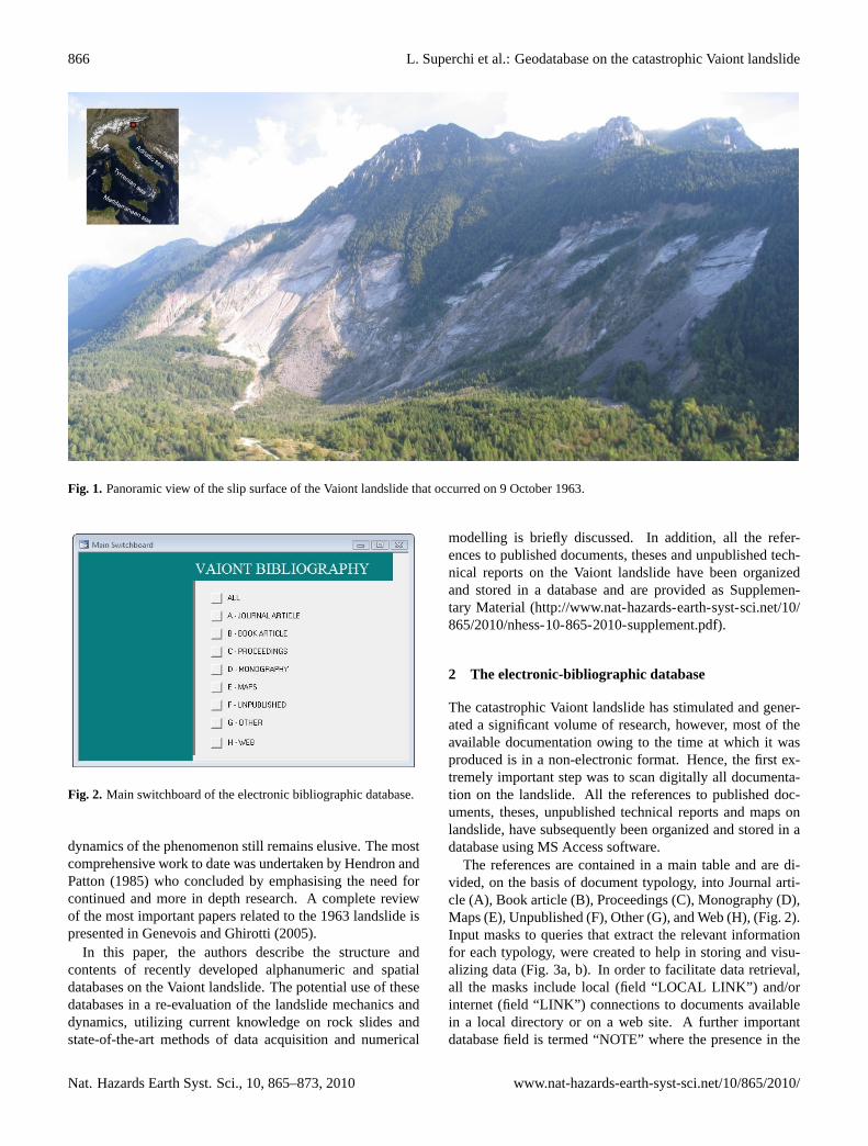
Fig. 2. Main switchboard of the electronic bibliographic database.
Fig. 1. Panoramic view of the slip surface of the Vaiont landslide that occurred on 9 October 1963.
11
Fig.1. Panoramic view of the slip surface of the Vaiont landslide that occurred on October 9th 1963.
Fig. 2. Main switchboard of the electronic bibliographic database.
Fig. 2. Main switchboard of the electronic bibliographic database.
dynamics of the phenomenon still remains elusive. The mostcomprehensive work to date was undertaken by Hendron andPatton (1985) who concluded by emphasising the need forcontinued and more in depth research. A complete reviewof the most important papers related to the 1963 landslide ispresented in Genevois and Ghirotti (2005).
In this paper, the authors describe the structure andcontents of recently developed alphanumeric and spatialdatabases on the Vaiont landslide. The potential use of thesedatabases in a re-evaluation of the landslide mechanics anddynamics, utilizing current knowledge on rock slides andstate-of-the-art methods of data acquisition and numerical
modelling is briefly discussed. In addition, all the refer-ences to published documents, theses and unpublished tech-nical reports on the Vaiont landslide have been organizedand stored in a database and are provided as Supplemen-tary Material (http://www.nat-hazards-earth-syst-sci.net/10/865/2010/nhess-10-865-2010-supplement.pdf).
2 The electronic-bibliographic database
The catastrophic Vaiont landslide has stimulated and gener-ated a significant volume of research, however, most of theavailable documentation owing to the time at which it wasproduced is in a non-electronic format. Hence, the first ex-tremely important step was to scan digitally all documenta-tion on the landslide. All the references to published doc-uments, theses, unpublished technical reports and maps onlandslide, have subsequently been organized and stored in adatabase using MS Access software.
The references are contained in a main table and are di-vided, on the basis of document typology, into Journal arti-cle (A), Book article (B), Proceedings (C), Monography (D),Maps (E), Unpublished (F), Other (G), and Web (H), (Fig. 2).Input masks to queries that extract the relevant informationfor each typology, were created to help in storing and visu-alizing data (Fig. 3a, b). In order to facilitate data retrieval,all the masks include local (field “LOCAL LINK”) and/orinternet (field “LINK”) connections to documents availablein a local directory or on a web site. A further importantdatabase field is termed “NOTE” where the presence in the
Nat. Hazards Earth Syst. Sci., 10, 865–873, 2010 www.nat-hazards-earth-syst-sci.net/10/865/2010/

L. Superchi et al.: Geodatabase on the catastrophic Vaiont landslide 867
12
Fig. 3a. Input masks created for inserting and visualizing references to journal articles (A), Book
articles (B), Proceedings (C). Input mask of Monographs (D) is similar to that for Book article (B).
Fig. 3a. Input masks created for inserting and visualizing references to journal articles (A), Book articles (B), Proceedings (C). Input maskof Monographs (D) is similar to that for Book article (B).
www.nat-hazards-earth-syst-sci.net/10/865/2010/ Nat. Hazards Earth Syst. Sci., 10, 865–873, 2010

868 L. Superchi et al.: Geodatabase on the catastrophic Vaiont landslide
13
Fig.3b. Input masks created for inserting and visualizing references to maps (E) and web site (H).
Input mask of unpublished reports (F) and other (newspaper articles, conference presentations and
relevant material) (G) are similar to that for maps (E).
Fig. 3b. Input masks created for inserting and visualizing references to maps (E) and web site (H). Input mask of unpublished reports (F)and other (newspaper articles, conference presentations and relevant material) (G) are similar to that for maps (E).
document of data from geological and geomechanical sur-veys, geotechnical data from laboratory tests and scientificcontents, is reported (Fig. 4).
The database currently contains references to 80 journalarticles, 5 book articles, 51 monographs, 6 thematic maps,30 conference proceedings, 5 unpublished reports, 25 websites and 13 documents classified as “Other” (newspaper ar-ticles, conference presentations and relevant material). Thechronology of the documentation shows a relatively high pro-duction immediately after the landslide (Fig. 5). After a pe-riod (1970–1979) of apparent decreasing interest, the docu-mentation increased during 1980–1999, in a large part dueto an International Conference on the Vaiont landslide, or-ganized by E. Semenza at the University of Ferrara (Italy)on September 1986. Of note is that most of the documenta-tion, especially journal articles and monographs, have beenproduced in the last 10 years, as a consequence of both newmethods and techniques available for numerical analyses and
of the large increase in the electronic tools available for pub-lishing and sharing scientific papers.
3 Structure and contents of the geodatabase
A geodatabase is a database designed to store, query, and ma-nipulate geographic information and spatial data. Differenttypes of spatial data, such as vector and raster datasets, andtheir attributes and location can be stored. In addition, tablesand relationships between data can be included. The geo-database forms the first step in implementing a GeographicInformation System (GIS) organized to allow data collection,management and visualization of large slope instabilities andcontributing factors (Chacon et al., 2006; Giardino et al.,2004). Vector datasets consist of geometrical primitives suchas points, lines, curves and shapes or polygon(s), which areall based on mathematical equations and represent territorial
Nat. Hazards Earth Syst. Sci., 10, 865–873, 2010 www.nat-hazards-earth-syst-sci.net/10/865/2010/

L. Superchi et al.: Geodatabase on the catastrophic Vaiont landslide 869
14
Fig. 4. Example of data and interpretations reported in the field NOTE of the e-bibliography.
Sketches from Hendron and Patton (1986).
Fig. 4. Example of data and interpretations reported in the field NOTE of the e-bibliography. Sketches from Hendron and Patton (1986).
15
Fig. 5. Chronology of the documentation on the Vaiont landslide.
0
4
8
12
16
20
24
28
32
36
No
. o
f p
ub
lica
tio
ns
an
d r
ep
ort
s
Period
Journal
Book
Monographs
Maps
Proceedings
Other
Unpublished
Fig. 5. Chronology of the documentation on the Vaiont landslide.
data (geomechanical stations, faults, lithology, etc.). A rasterdataset is a data structure representing a generally rectangulargrid of pixels, or points of colour. In the GIS, raster datasetsof varying formats are usually used to represent continuous
territorial data (DEM, slope, etc.) and to perform simple tocomplex analyses.
The Vaiont geodatabase was implemented using ESRI Ar-cGIS Desktop 9.3 software and comprises:
1. Feature classesare homogeneous collections of com-mon features, each having the same spatial representa-tion, such as points, lines or polygons.
2. Feature datasetsare objects that allow to group togetherrelated feature classes.
3. Tablesare data collection of rows (records) and columns(attributes) used to store non-spatial data.
4. Relationship classesmanage associations between ob-jects in one table and objects in another. Rules to relatefeature to feature (spatial relationships), row to row (nonspatial relationships), and feature to row (spatial to nonspatial relationships), are stored.
5. Raster datasetsare grid-based representations of spatialdata.
www.nat-hazards-earth-syst-sci.net/10/865/2010/ Nat. Hazards Earth Syst. Sci., 10, 865–873, 2010

870 L. Superchi et al.: Geodatabase on the catastrophic Vaiont landslide
6. Raster cataloguesare objects that allow efficient stor-age and management of multiple spatially-related rasterdatasets.
7. Terrain datasetsare surfaces that represent three-dimensional space. They use measurements (storedas feature classes) and rules to generate triangular ir-regular network (TIN) pyramids to represent elevation.From the terrain dataset, it is possible to obtain botha vectorial-based elevation model (TIN) and a raster-based Digital Elevation Model (DEM).
Currently, the Vaiont geodatabase contains the followingdata.
– Vector datasets representing the attitude of strata, faults,lithology, and geological sections; digitized from pre-and post-landslide geological maps at 1:5000 scale(Rossi and Semenza, 1965).
– Vector datasets representing geognostic boreholes fromBroili (1959) and geophysical investigation from Caloi(1960), and their attributes (type, depth, stratigraphy).
– Vector dataset representing geomechanical stationsfrom past and recent surveys. Related attributes con-sist of rock and rock mass properties (discontinuities at-tributes such as orientation, size, aperture, roughness,etc., Schmidt Hammer testing, Geological Strength In-dex, Point Load Test, etc.) (see Table 1 for an example).
– Vector datasets representing elevation points and con-tour lines digitized from pre- and post-landslide topo-graphic maps, official regional maps (CTR, RegioneFriuli Venezia Giulia) and LiDAR survey.
– Raster datasets representing the Digital ElevationModel (DEM) of the area before and after the landslide.DEMs were calculated from the above mentioned topo-graphic data.
– Raster datasets organized in a Raster Catalog, represent-ing the aerial photos of the area before the landslide(1960).
In addition, the geodatabase contains tables of geotechni-cal and geomechanical properties of the rock mass insideand outside the landslide area, extracted both from the e-bibliography and from current author’s field surveys and lab-oratory tests. From simple to complex rules, stored in theRelationships classes, join and relate records in the tables tothe location of the collected samples and of the geomechani-cal stations.
4 Using the databases
Modern techniques, such as photogrammetric analyses,ground-based and airborne LiDAR will greatly contribute
to geometric and geomechanical rock mass characterisation.DEM-based structural analysis, performed by COLTOP-3Dsoftware (Derron et al., 2005), on available data before andafter the landslide, is an important tool in identifying thestructural setting that led to the failure and controlled the di-rection of the movement. COLTOP-3D uses a colour repre-sentation merging slope aspect and slope angle in order toobtain a unique colour code for each orientation of a topo-graphical element (Jaboyedoff et al., 2007, 2009). Simpleanalysis of DEMs allow rapid identification of structural fea-tures (joints, lineaments, faults) affecting the slope (Derronet al., 2005). The 3-D surface reconstruction is extremelyuseful as it enables easy identification of the main morpho-structural features from which joint set orientations and per-sistence relevant to the area of interest can be detected. Fur-thermore, these desktop analysis allow us to explore the areaunder investigation and thereby provide an aid in planningthe field work and the mapping of structural data in inacces-sible areas.
Seven main joint sets were detected in the pre- andpost-Vaiont landslide slope using the colour coding ofCOLTOP-3D (Fig. 6). The joint surface pole ori-entations have been measured directly on the DEMs:J1(160◦/40◦), J2(238◦/45◦), J3(300◦/50◦), J4(345◦/30◦),J5(50◦/20◦), J6(50◦/70◦), J7(70◦/45◦). Figure 6a–b showsthat one of the most important sets forming the morpho-structure is J4 (light-blue), dipping northward and corre-sponding to the orientation of the sliding plane. The data,obtained by using COLTOP-3D, agree reasonably well withthe field measurements despite the present limited number offield data (Fig. 6e).
5 Concluding remarks
The e-bibliography and the geodatabase represent a powerfultool to extract and select experimental data and scientific con-tents from the extensive documentation on the Vaiont land-slide. The e-bibliography provides an important input forfurther scientific research not only on the Vaiont landslidebut also on large rock landslides in general. Data collectedin the electronic bibliographic database show that the major-ity of the research publications have been authored in the lastdecade, probably due to recent advances in both the body ofknowledge on rock slides and the developments in methodsand techniques for rock mass data collection and numericalanalyses.
The key objective of the generated geodatabase is to store,manage, visualize and update a large number of differenttypes of data in a central location and to make them avail-able to the scientific community.
3-D geological, hydrogeological and geomechanical re-construction of rock slope instabilities, such as the Vaiont1963 event, will be more accurate and comprehensive as itwill now be possible to apply new or advanced relationships
Nat. Hazards Earth Syst. Sci., 10, 865–873, 2010 www.nat-hazards-earth-syst-sci.net/10/865/2010/

L. Superchi et al.: Geodatabase on the catastrophic Vaiont landslide 871
16
Fig 6. COLTOP 3D analysis for the Vaiont area. In the pre- and post-landslide 3D representation
different colors in the same area show different orientations of the structural features (faults and
lineaments) (a-b). Seven morpho-structural sets were detected by COLTOP 3D, evaluated by means
of the corresponding Schmidt-Lambert projection (c) and plotted using usual software (d). Obtained
results were validated by comparison with the field data (e).
a b
e
c
d
a
b
a
b
Fig. 6. COLTOP 3D analysis for the Vaiont area. In the pre- and post-landslide 3-D representation, different colours in the same area showdifferent orientations of the structural features (faults and lineaments)(a–b). Seven morpho-structural sets were detected by COLTOP 3D,evaluated by means of the corresponding Schmidt-Lambert projection(c) and plotted using usual software(d). Obtained results werevalidated by comparison with the field data(e).
to collected data, to develop new methods of viewing theavailable information assets in a interrogative and discrimi-natory fashion; in summary, this will allow the leverage of allthe collected data in order to optimize their potential for un-derstanding rock slope failure mechanisms. Detailed exami-nation of the the geodatabase can provide important data re-quired for numerical modelling of rock slopes i.e.: i) the ge-ological, structural and hydrogeological characteristics prior
to the landslide; ii) the geomechanical characterisation of theinvolved rock masses; iii) the complete definition of the dis-placement field prior, during and after the landsliding event.
At this stage, the Vaiont geodatabase remains largely in-complete: collected data to date relating mainly to the geo-logical setting, whereas hydrogeological and geomechanicaldata are somewhat limited, scanty or absent. An exampleof both the potential of the geodatabase and of its current
www.nat-hazards-earth-syst-sci.net/10/865/2010/ Nat. Hazards Earth Syst. Sci., 10, 865–873, 2010

872 L. Superchi et al.: Geodatabase on the catastrophic Vaiont landslide
Table 1. Geomechanical properties of the material involved in the slide, from past and current surveys. The slip surface has been placedat the bottom of theCalcare di Soccher formation (Semenza, 1965). Volumetric Joint Count (Jv), Block Size Index (Ib), Joint RoughnessCoefficient (JRC), Joint Compression Strength (JCS), Geological Strength Index (GSI).
Formation Lithology Statistics Jv Ib JRC JCS (MPa) GSI
Calcare di Soccher
Red and green limestones and marls with red cherts. No. stations 7 7 7 7 7No. of data 3 3 4 4 2Minimum 35 3.9 3 44 47Maximum 73 11.8 6 104 52
Fine-grained limestones with various colored cherts. No. stations 18 18 18 18 18No. of data 3 3 17 17 2Minimum 22.8 4.3 1 29 47Maximum 99.3 8.8 10 180 62
Red marly, silty limestones interbedded with No. stations 8 8 8 8 8conglomerate and limestones. No. of data 1 1 8 8 1
Minimum 58 6.4 2 30 40Maximum 10 150
Compact beds of gray limestones that alternated with No. stations 17 17 17 17 17a sequence of less resistant thin layers of greenish No. of data 2 2 16 14 2limestones and calcareous marls Minimum 43 3.2 2 54 52
Maximum 44.5 8 10 165 52
conglomerate with pinkish or gray cement No. stations 3 3 3 3No. of data 3 3Minimum 4 48Maximum 9 130
Micrites and e marley-micrites from light green to No. stations 8 8 8 8 8reddish with red cherts No. of data 3 3 7 5 2
Minimum 58.3 4.11 1 40 40Maximum 66.5 9.9 8 125 62
Amm. Rosso
Fonzaso
Red or nodular micrite, locally containing cherts No. stations 1 1 1 1 1No. of data 1 1 1 1Minimum 46.8 7.36 5 57Maximum 8
Micrites and calcarenites containing cherts, with No. stations 3 3 3 3 3interbeds of green clay No. of data 2 2
Minimum 2 44Maximum 6 96
Gray cherty limestones with black cherts, which can benodular
Calcare del Vaiont Oolitic and crystalline limestones
No. stations 5 5 5 5 5No. of data 3 3 4 4 3Minimum 20 3.5 1 53 42Maximum 89 14 6 140 50
limitation in available data is given in Table 1. Values andrelationships between distinctive properties, such as the Vol-umetric Joint Count (Jv) and Block Size Index (Ib) (Cai et al.,2004; Kalenchuk et al., 2006; Palmstrom, 1996, 2005), canaid in defining lithotechnical units, while the Joint Rough-ness Coefficient (JRC), the Joint Compressive Strength (JCS)and the Geological Strength Index (GSI) are necessary for
continuum or discontinuum modelling of the rock slope.However, the number of data available for each geologicalformation are insufficient to obtain spatial distributions at astatistically significant level, thus, making it currently impos-sible to subdivide the rock masses involved in the event intorealistic geomechanical units.
Nat. Hazards Earth Syst. Sci., 10, 865–873, 2010 www.nat-hazards-earth-syst-sci.net/10/865/2010/

L. Superchi et al.: Geodatabase on the catastrophic Vaiont landslide 873
A re-evaluation of the failure mechanism of the Vaiontlandslide requires further research on still poorly constrainedfeatures of the area with a collection of additional spatialdata. Field surveys, tests and analyses are in progress inorder to improve the geodatabase. Field investigations arebeing extended into areas peripheral to the landslide, in or-der to provide a more comprehensive characterisation of therock masses in the pre- and post-event conditions; this willform the foundation for 2-D/3-D numerical simulation usingcontinuum and discontinuum numerical codes.
Surface based techniques, such as the comparison of pre-and post-event DEMs, and acquisition of deep level seismictomography, to investigate the 3-D distribution of differentrock masses, will allow improved definition of the displace-ment field of the landslide body.
Completing the geodatabase and performing the re-evaluation of the Vaiont landslide will represent an importantcontribution to a more comprehensive understanding of largerock slope instabilities.
Acknowledgements.This research was financially supported by theUniversity of Padova, research projects CPDA085240 (Principalinvestigator: Mario Floris, Department of Geosciences) and GEO-RISKS (Principal investigator: Rinaldo Genevois, Department ofGeosciences).
Edited by: D. GiordanReviewed by: F. M. Guadagno and another anonymous referee
References
Broili, L.: New knowledge on the geomorphology of the VaiontSlide slip surfaces. Rock Mechanics & Eng. Geol., J. Int. Soc.Rock Mechanics., V(1), 38–88, 1967.
Cai, M., Kaiser, P. K., Uno, H., Tasaka, Y., and Minami, M.: Esti-mation of rock mass deformation modulus and strength of jointedhard rock masses using the GSI system. Int. J. Rock Mech. Min-ing Sci., 41, 3–19, 2004.
Caloi, P.: L’evento del Vajont nei suoi aspetti geodinamici, Ist. Naz.Geofisica, Roma, 1966.
Chacon, J., Irigaray, C., Fernandez, T., and El Hamdouni, R.: Engi-neering geology maps: landslides and geographical informationsystems, B. Eng. Geol. Environ., 65, 341–411, 2006.
Derron, M.-H., Jaboyedoff, M., and Blikra, L. H.: Preliminary as-sessment of rockslide and rockfall hazards using a DEM (Opp-stadhornet, Norway), Nat. Hazards Earth Syst. Sci., 5, 285–292,2005,http://www.nat-hazards-earth-syst-sci.net/5/285/2005/.
Genevois, R. and Ghirotti, M.: The 1963 Vaiont Landslide – Gior-nale di Geologia Applicata, I, 41–53, 2005.
Giardino, M., Giordan, D., and Ambrogio, S.: G.I.S. technologiesfor data collection, management and visualization of large slopeinstabilities: two applications in the Western Italian Alps, Nat.Hazards Earth Syst. Sci., 4, 197–211, 2004,http://www.nat-hazards-earth-syst-sci.net/4/197/2004/.
Giudici, F. and Semenza, E.: Studio geologico del serbatoio delVajoint. Unpublished report for S.A.D.E., Part A: 21 pp, text,Part B: 68 photos with discussions, 42 pp, Venezia, Italy, 1960.
Hendron, A. J. and Patton, F. D.: The Vaiont Slide, a Geotechni-cal Analysis Based on New Geologic Observations of the FailureSurface. I, II, Technical Report GL-85-5, US Army Eng. Water-ways Experiment Station, Vicksburg, MS, 1985.
Hendron, A. J. and Patton, F. D.: A geotechnical analysis of thabehavior of the Vaiont slide, Civil Engineering Practice Fall, 65–130, 1986.
Jaboyedoff, M., Metzger, R., Oppikofer, T., Couture, R., Derron,M.-H., Locat, J., and Turmel, D.: New insight techniques to ana-lyze rock-slope relief using DEM and 3D-imaging cloud points:COLTOP-3D, Rock mechanics Vol. 1: Meetings Society’s Chal-lenges and demands, chap. 7, 61–68, edited by: Eberhardt, E.,Stead, D., and Morrison, T., 2007.
Jaboyedoff, M., Couture, R., and Locat, P.: Structural analysis ofTurtle Mountain (Alberta) using digital elevation model: towarda progressive failure, Geomorphology, 103, 5–16, 2009.
Kalenchuk, K. S., Diederichs, M. S., and McKinnon, S.: Character-izing block geometry in jointed rock masses, Int. J. Rock Mech.Mining Sci., 43(8), 1212–1225, 2006.
Kilburn, C. R. J. and Petley, D. N.: Forecasting giant, catastrophicslope collapse: lessons from Vajont, Northern Italy, Geomor-phology, 54(1–2), 21–32, 2003.
Muller, L.: The Rock Slide in the Vaiont Valley, Rock Mech. Eng.Geol., 2, 148–212, 1964.
Muller, L.: The Vaiont catastrophe - A personal review, in: DamFailures, edited by: Leonards, G. A., Eng. Geol., 24(1–4), 423–444, 1987a.
Muller, L.: The Vaiont Slide, in: Dam Failures, edited by:Leonards, G. A., Eng. Geol., 24(1–4), 513–523, 1987b.
Nonveiller, E.: Vaiont Slide – Influence of Frictional Heat on SlipVelocity, in: Proceedings of the meeting on the 1963 Vaiont land-slide, edited by: Semenza, E. and Melidoro, G., IAEG ItalianSection, University of Ferrara, Ferrara 1986, 1, 187–197, 1992.
Palmstrom, A.: Characterizing rock masses by the RMi for use inpractical rock engineering, Tunn. Undergr. Sp. Tech., 11(2), 175–188, 1996.
Palmstrom, A.: Measurements of and correlations between blocksize and rock quality designation (RQD), Tunn. Undergr. Sp.Tech., 20, 362–377, 2005.
Rossi, D. and Semenza, E.: Carte geologiche del versante setten-trionale del M. Toc e zone limitrofe, prima e dopo il fenomenodi scivolamento del 9 ottobre 1963, Scala 1:5000, Ist. GeologiaUniversita di Ferrara, 2 Maps, 1965.
Selli, R., Trevisan, L., Carloni, C. G., Mazzanti, R., and Cia-batti, M.: La Frana del Vajont, Giornale di Geologia, serie 20,XXXII(I), 1–154, 1964.
Semenza, E.: Sintesi degli studi geologici sulla frana del Vaiont dal1959 al 1964, Mem. Museo Tridentino Sc. Nat., 16, 1–52, 1965.
Semenza, E.: La storia del Vaiont raccontata dal geologo che hascoperto la frana. Tecomproject Ed., Ferrara, Italy, 2000.
Semenza, E. and Ghirotti, M.: History of 1963 Vaiont Slide. Theimportance of the geological factors to recognise the ancientlandslide, B. Eng. Geol. Env., 59, 87–97, 2000.
Skempton, A. W.: Bedding-plane slip, residual strength and theVaiont Landslide, Geotechnique, XVI(1), 82–84, 1966.
Tika, Th. E. and Hutchinson, J. N.: Ring shear tests on soil from theVaiont landslide slip surface, Geotechnique, 49(1), 59–74, 1999.
www.nat-hazards-earth-syst-sci.net/10/865/2010/ Nat. Hazards Earth Syst. Sci., 10, 865–873, 2010