technical justification for a request to reclassify the ... justification for a request to...
TRANSCRIPT

Technical Justification for a Request to Reclassify the Former CCC/USDA Facility at Canada, Kansas
ANL/EVS/AGEM/TR-07-01
Environmental Science Division
Work sponsored by Commodity Credit Corporation, United States Department of Agriculture
United States Department of Agriculture

Availability of This ReportThis report is available, at no cost, at http://www.osti.gov/bridge. It is also available on paper to the U.S. Department of Energy and its contractors, for a processing fee, from:
U.S. Department of Energy
OfficeofScientificandTechnicalInformation
P.O. Box 62
Oak Ridge, TN 37831-0062
phone (865) 576-8401
fax (865) 576-5728
Disclaimer
This report was prepared as an account of work sponsored by an agency of the United States Government. Reference herein to any
specificcommercialproduct,process,orservicebytradename,trademark,manufacturer,orotherwise,doesnotnecessarilyconstitute
or imply its endorsement, recommendation, or favoring by the United States Government or any agency thereof. The views and opinions
ofdocumentauthorsexpressedhereindonotnecessarilystateorreflectthoseoftheUnitedStatesGovernmentoranyagencythereof,
Argonne National Laboratory, or UChicago Argonne, LLC.
About Argonne National Laboratory Argonne is a U.S. Department of Energy laboratory managed by UChicago Argonne, LLC under contract DE-AC02-06CH11357. The Laboratory’s main facility is outside Chicago, at 9700 South Cass Avenue, Argonne, Illinois 60439. For information about Argonne, see www.anl.gov.

Technical Justification for a Request to Reclassify the Former CCC/USDA Facility at Canada, Kansas
ANL/EVS/AGEM/TR-07-01
by Applied Geosciences and Environmental Management SectionEnvironmental Science Division, Argonne National Laboratory
August 2007
Work sponsored by Commodity Credit Corporation, United States Department of Agriculture
United States Department of Agriculture

Canada, Kansas, Technical Justification for Request to Reclassify Version 01, 08/17/07
ii
Contents
Notation.................................................................................................................................... v
Executive Summary ................................................................................................................. ES-1
1 Introduction ........................................................................................................................ 1-1
2 Background ........................................................................................................................ 2-1
2.1 Site Location and Description ................................................................................... 2-1 2.2 Grain Storage Operations and Property History ....................................................... 2-2
3 Carbon Tetrachloride Contamination at Canada................................................................ 3-1
3.1 Identification of Contamination and Removal Action .............................................. 3-1 3.2 Contaminant History and Previous Investigations .................................................... 3-2
4 Conclusions ........................................................................................................................ 4-1
5 References .......................................................................................................................... 5-1
Apendix A: Well Registration Forms and Drilling Records for Canada Area Wells .......... A-1
Appendix B: Geology of the Canada Area, Marion County.................................................. B-1
Appendix C: Property Records Related to the Former CCC/USDA Facility at Canada ........ C-1
Figures
2.1 Location of Canada, Kansas............................................................................................ 2-5
2.2 Plat of Canada, Kansas.................................................................................................... 2-6
2.3 Grain storage structures at Canada in 1956, with property boundaries .......................... 2-7
2.4 Grain storage structures at Canada in 1991, with locations of 1956 structures shown in Figure 2.3 and property boundaries ............................................................................ 2-8
2.5 Current configuration of the Canada site ........................................................................ 2-9

Canada, Kansas, Technical Justification for Request to Reclassify Version 01, 08/17/07
iii
3.1 Analytical results for carbon tetrachloride in groundwater samples collected in 2007............................................................................................................................. 3-13
3.2 Analytical results for soil samples collected in November 1999 .................................... 3-14
3.3 Structures at the Canada site, 2007 groundwater elevations with interpreted flow direction, and approximate locations of KDHE monitoring wells and private wells with 2007 monitoring results........................................................................................... 3-15
3.4 Structures at the Canada site, 2005 groundwater elevations with interpreted flow direction, and approximate locations of KDHE monitoring wells and private wells with 2005 monitoring results........................................................................................... 3-16
3.5 Structures at the Canada site, 2003 groundwater elevations with interpreted flow direction, and approximate locations of KDHE monitoring wells and private wells with 2003 monitoring results........................................................................................... 3-17
3.6 Structures at the Canada site, 2001 groundwater elevations with interpreted flow direction, and approximate locations of KDHE monitoring wells and private wells with 2001 monitoring results........................................................................................... 3-18
A.1 Locations of registered wells in the Canada area............................................................ A-2
B.1 Stratigraphic units that crop out in Marion County, Kansas, and the construction materials of each.............................................................................................................. B-7
B.2 Generalized surface geologic map of Marion County, showing the location of the town of Canada................................................................................................................ B-9
B.3 Location of geologic cross section A-A' in central Marion County................................ B-10
B.4 Interpretive west-to-east geologic cross section A-A', Marion County, Kansas............. B-11
C.1 CCC/USDA lease, 1954 to 1964..................................................................................... C-2
C.2 CCC/USDA lease, 1964 to 1974..................................................................................... C-4
C.3 Sale of property by Burkholder to Canada Grain Co., 1965........................................... C-6
C.4 Foreclosure on Canada Grain Co., 1976 ......................................................................... C-8
C.5 Warranty deed, D&R Grain to Countryside Grain, 1978................................................ C-10
C.6 Warranty deed, Janzen Farm Service to Cooperative Grain and Supply, 1991.............. C-11

Canada, Kansas, Technical Justification for Request to Reclassify Version 01, 08/17/07
iv
Tables
3.1 Chronological history of groundwater sampling and analysis at Canada ....................... 3-5
3.2 Water Level data for the Canada site .............................................................................. 3-8
3.3 Survey data for the Canada site....................................................................................... 3-9
3.4 Historical results of groundwater sampling and analysis for individual wells at Canada ......................................................................................................................... 3-10

Canada, Kansas, Technical Justification for Request to Reclassify Version 01, 08/17/07
v
Notation
AMSL above mean sea level
BER Bureau of Environmental Remediation (KDHE)
BGL below ground level
CCC Commodity Credit Corporation
CERCLIS Comprehensive Environmental Response, Compensation, and Liability Information
System
CGS Cooperative Grain and Supply
DCA 1,1-dichloroethane
EDB ethylene dibromide
ft foot (feet)
FSA Farm Service Agency
gpm gallon(s) per minute
IGA Intergovernmental Agreement
ISL Identified Sites List (KDHE)
KDHE Kansas Department of Health and Environment
KGS Kansas Geological Survey
μg/kg microgram(s) per kilogram
μg/L microgram(s) per liter
MCL maximum contaminant level
mg/L milligram(s) per liter
mi mile(s)
MTBE methyl tert-butyl ether
RWD Rural Water District
USACE U.S. Army Corps of Engineers
USDA U.S. Department of Agriculture
USGS U.S. Geological Survey
WWC-5 water well record form

Canada, Kansas, Technical Justification for Request to Reclassify ES-1 Version 01, 08/17/07
Technical Justification for a Request to Reclassify the Former CCC/USDA Facility at Canada, Kansas
Executive Summary
Contamination in groundwater at Canada, Kansas, was discovered in 1997, during limited
private well sampling near former grain storage facilities of the Commodity Credit Corporation,
U.S. Department of Agriculture (CCC/USDA). Subsequent investigations by the Kansas
Department of Health and Environment (KDHE) confirmed carbon tetrachloride and nitrate
concentrations in groundwater above the respective maximum contaminant levels (MCLs) of
5.0 μg/L and 10.0 mg/L. The KDHE investigations identified both the former CCC/USDA grain
storage facility and a private grain storage facility as likely sources for the carbon tetrachloride
contamination. The CCC/USDA funded extension of a rural water district line to provide a
permanent alternate water supply, and the KDHE has conducted long-term monitoring under the
State Water Plan.
This document presents an analysis of the available information for the Canada site,
acquired in previous investigations and the long-term KDHE monitoring. This analysis forms the
technical justification for a request to reclassify the former CCC/USDA grain storage facility at
Canada as a site requiring no further action under the Intergovernmental Agreement (IGA)
between the KDHE and the USDA’s Farm Service Agency.
The KDHE’s long-term water level monitoring results indicate a consistent groundwater
flow direction to the east-southeast. Consequently, the wells with the highest overall
concentrations of carbon tetrachloride are downgradient from the private grain storage facility
but not downgradient from the former CCC/USDA facility.
The KDHE criterion for reclassification of a site is that contamination there should not
pose an unacceptable risk, on the basis of analytical results for four consecutive, equally timed,
sequenced sampling episodes over a period of no less than two years. In seven KDHE sampling
events over a period of six years (2001-2007), the concentrations of carbon tetrachloride in the
monitoring well on the former CCC/USDA property at Canada have ranged from 0.63 μg/L to
2.9 μg/L. These seven results are all below the MCL of 5.0 μg/L, and they demonstrate that
groundwater on the former CCC/USDA property has met the standard for carbon tetrachloride in
drinking water since 2001 and does not pose a significant human health threat. Except for a two-
year interval between sampling events in December 2003 and December 2005, the monitoring

Canada, Kansas, Technical Justification for Request to Reclassify ES-2 Version 01, 08/17/07
occurred at approximately annual intervals. The results warrant a request for reclassification of
the Canada site to Resolved status on the KDHE’s Identified Sites List, under Section III (Other
Considerations) of KDHE policy BER-RS-024, Rev. 2001.

Canada, Kansas, Technical Justification for Request to Reclassify 1-1 Version 01, 08/17/07
1 Introduction
Contamination at the grain storage facility formerly operated by the Commodity Credit
Corporation of the U.S. Department of Agriculture (CCC/USDA) at Canada, Kansas, was
discovered in October 1997, during limited private well sampling in conjunction with an
inventory of such facilities. The Kansas Department of Health and Environment (KDHE)
conducted investigations at Canada in 1998–2001 and confirmed carbon tetrachloride and nitrate
concentrations in groundwater above the respective maximum contaminant levels (MCLs) of
5.0 μg/L and 10 mg/L. The affected private lawn and garden wells are no longer used to supply
drinking water, and carbon tetrachloride impacts above the MCL are localized.
The KDHE investigations identified both the former CCC/USDA grain bin location and a
private grain storage facility as likely sources of the carbon tetrachloride contamination. After
the identification of carbon tetrachloride and nitrate contamination at concentrations above the
respective MCLs, the CCC/USDA funded extension of the Marion Rural Water District (RWD)
#4 line to provide a permanent alternate water supply to affected residents.
Because of the limited exposure risk, the KDHE assigned the Canada site to long-term
monitoring status under the State Water Plan. The site is presently classified under the
Intergovernmental Agreement (IGA) between the USDA’s Farm Service Agency (FSA) and the
KDHE as a site that the FSA considers to require no further action on its part, but for which the
KDHE has not yet made a determination.
This report presents an analysis of long-term monitoring results for 2001–2007 (KDHE
2007a) and results of prior site investigations. The analysis indicates that the former CCC/USDA
grain storage facility in the southern portion of town is not the most plausible source of the
carbon tetrachloride contamination at levels above the MCL. Rather, the analytical data and the
associated groundwater flow direction data indicate that the private grain storage locations in the
northern portion of town are the more likely source of the downgradient carbon tetrachloride
contamination. The information presented here forms the technical justification for a request to
reclassify the former CCC/USDA grain storage facility at Canada as a site requiring no further
action under the IGA.

Canada, Kansas, Technical Justification for Request to Reclassify 2-1 Version 01, 08/17/07
2 Background
2.1 Site Location and Description
Canada, Kansas, is a small, unincorporated rural community in Marion County, in central
Kansas (Figure 2.1). Canada is located near U.S. Highway 56, approximately 5 mi east of
Hillsboro (population 2,704) and 5 mi west of Marion (population 1,906). Wichita is about 40 mi
to the south. Canada lies within Section 33, Township 19 South, Range 3 East, at approximate
latitude 38°21′16″ North and longitude 97°06′41″ West (USGS 1985).
Canada has a population of approximately 24. The Canada facility of Cooperative Grain
and Supply (CGS), Hillsboro, Kansas, currently occupies the co-op property in the central
portion of the community and provides seasonal grain storage for area farmers (Figure 2.2). A
spur of the Atchison, Topeka, and Santa Fe Railroad (now removed) was formerly located north
of the co-op. The CCC/USDA formerly operated a grain storage facility on what is now the
southern portion of the co-op property. Ten homes are adjacent to the co-op, to the east and west.
A gasoline station and bait shop are west of the co-op.
Canada lies within the Cottonwood River drainage basin (Figure 2.1), approximately 1 mi
west of the confluence of the North Cottonwood River (north of town) and the South
Cottonwood River (south of town). An intermittent stream flows south-southeast through the
town, discharging into the South Cottonwood River. No surface water targets were identified
within the 15-mi downstream target distance limit (KDHE 1999a). Until the construction of
Marion Lake, approximately 1 mi north of Canada, the town was within the 100-year floodplain
of the river.
At Canada, screened intervals of domestic wells for which records are available
(Appendix A) are in the range of 45–65 ft BGL (below ground level). One well (DW24
[Schroeder] Figure 2.2) is also screened in an upper zone at 25–35 ft BGL. Water is potentially
produced from solution joints in the limestone units of the Permian Nolans Formation. The
screened depths suggest that multiple water-bearing zones are present at Canada. A review of the
geology of Marion County, Kansas, in the Canada area, is in Appendix B.
Evidence gathered from earlier interviews with local residents suggested a groundwater
flow direction to the east-southeast (KDHE 1998). This flow direction is consistent with data

Canada, Kansas, Technical Justification for Request to Reclassify 2-2 Version 01, 08/17/07
collected during the KDHE’s long-term monitoring (2001-2007), as discussed in detail in
Section 3.2. Topographic features in the area also support this interpretation. For example, a
local flow direction to the southeast is consistent with the erosion by the South Cottonwood
River of Permian rocks 1.25 mi southeast of Canada. Downcutting by the river extends to about
40–50 ft below the typical elevation of the ground surface at Canada. Another factor contributing
to the southeasterly groundwater flow direction would be potential mounding of groundwater
1 mi north of Canada due to increased recharge from Marion Lake (Figure 2.1; Appendix B).
2.2 Grain Storage Operations and Property History
Grain storage operations at Canada have changed considerably since the CCC/USDA
facility was in operation, in 1954 to 1974 (Figures 2.3, 2.4, and 2.5). Harry Helmer of Hillsboro,
Kansas, purchased the CCC/USDA bins in 1974 and removed them to begin a private grain
storage business elsewhere (FSA 1997). Subsequently, the co-op expanded southward and
installed the storage structures now located on the former CCC/USDA property. Other co-op
grain storage structures (now removed) were north of the former CCC/USDA facility.
Understanding grain storage operations at Canada before and after the CCC/USDA’s period of
operation (1954-1974) is critical to evaluating the potential source areas for the carbon
tetrachloride contamination. The available leases for the former CCC/USDA property are
reproduced in Appendix C.
In 1954, to supplement the co-op’s available grain storage capacity to the north, the
CCC/USDA leased approximately 1 acre of land in the southern portion of the town from Aaron
Burkholder. The leased property included Lots 7–18 on Block 11 (Figure 2.2; Figure C.1 in
Appendix C). Fifteen circular steel bins with cement floors were erected (Figure 2.3). Each bin
had a storage capacity of 3,200 bushels, for a total storage capacity of 48,000 bushels. This initial
1954 CCC/USDA lease of the property was for a period of ten years. In 1964 the lease was
extended until 1974 (Figure C.2 in Appendix C).
In 1965, early in the second lease period, Burkholder sold the leased property on which
the CCC/USDA was operating its facility to Canada Grain Company of Marion, Kansas
(Figure C.3 in Appendix C). In the absence of a lease termination agreement (which has not been
found), the CCC/USDA is assumed to have continued its operation on the leased property until
1974, when Harry Helmer purchased and removed the CCC/USDA bins.

Canada, Kansas, Technical Justification for Request to Reclassify 2-3 Version 01, 08/17/07
With its 1965 purchase from Burkholder, the property owned by Canada Grain Company
expanded to include the following (Figure 2.2):
• Block 3: Lots 1–6
• Block 4: Lots 1–6
• Block 6: Lots 1–2, Lots 7–12, the western half of Lots 13–15, Lots 16–18
• Block 11: Lots 7–18 (the former CCC/USDA facility)
Except for the eastern half of Lots 13–15 on Block 6, occupied by the Mueller residence garage,
this land sale gave the Canada Grain Company title to the central portion of Canada, from Third
Street north to the Atchison, Topeka, and Santa Fe Railroad spur. The capacity of the grain
storage facility currently at this location is 416,811 bushels (CGS 2007).
Ownership of the grain storage operation changed several times in the years that
followed. Ownership history for the property cited by the KDHE as part of its pre-CERCLIS site
reconnaissance and evaluation (KDHE 1998) includes the following:
• Canada Grain — 1965–1977 (Figure C.3 in Appendix C)
• Cooperative Grain and Supply, Hillsboro — January 1977–May 1978
(Figure C.4 in Appendix C; property transferred included the former
CCC/USDA facility)
• D&R Trucking/D&R Grain, Hillsboro — May 1978–October 1978
(Figure C.5 in Appendix C)
• Countryside Grain — October 1978–September 1985 (Figure C.5 in
Appendix C)
• Daniel P. Janzen/Janzen Farm Service — September 1985–January 1991
(Figure C.6 in Appendix C)

Canada, Kansas, Technical Justification for Request to Reclassify 2-4 Version 01, 08/17/07
• Cooperative Grain and Supply, Hillsboro — 1991–present (Figure C.6 in
Appendix C)
Aerial photos showing the changing grain storage structures over the decades are as
follows:
• A 1956 aerial photo (Figure 2.3) shows the former CCC/USDA grain storage
facility as consisting of 15 circular bins in the southern portion of town. Large
storage structures of unknown use are visible on the co-op property, just north
of the former CCC/USDA facility. Wooden grain elevators are visible in the
northern portion of the co-op property, immediately south of the former
railroad.
• A 1991 aerial photo (Figure 2.4) shows co-op structures on the former
CCC/USDA property (which the CCC/USDA vacated in 1974). Changes are
also evident in 1991 (Figure 2.4) on the central portion of the co-op property.
Two large storage structures of unknown use appearing just north of the
former CCC/USDA property in 1956 (peach highlights in Figure 2.4) are
absent in 1991 (compare to gray highlights in Figure 2.4). One circular storage
bin and one circular bin foundation are visible in the 1991 photo (gray
highlights in Figure 2.4) on the co-op property, just north of the former
CCC/USDA property. The foundation of a flat storage building is seen farther
north. The door of the flat storage building appears to have been at the
southern end of the building. The photographs in Figures 2.3 and 2.4
demonstrate that this flat storage building was installed after 1956 and
removed before 1991.
• The 2002 aerial photograph (Figure 2.5) shows the current configuration of
the grain storage operations at Canada. Most of the structures visible in the
1991 photograph (Figure 2.4) remain.

Canada, Kansas, Technical Justification for Request to Reclassify 2-5 Version 01, 08/17/07
Nebraska
Kansas
Missouri
Butler
Chase
Dickinson
Harvey
MarionCANADA
McPherson
MorrisSaline
Okl
ahom
a Ka
nsas
and
Tex
as
Hillsboro
Wichita
Canada
NorthCottonwood
River
Atchison Topeka and Santa Fe
MarionLake
Marion
100000 5000
Feet
56
Marion
Dam
South Cottonwood River
Inte
rmitt
ent S
tream
Mud Creek
French Creek
56
Cottonwood River
FIGURE 2.1 Location of Canada, Kansas.

Canada, K
ansas, Technical Justification for R
equest to Reclassify
2-6 V
ersion 01, 08/17/07
1st Street
Atchison Topeka and Santa Fe (Now Removed)
2nd Street
FormerCCC/USDA Facility
Wes
t Stre
et
Mai
n S
treet
Eas
t Stre
et(V
acat
ed -
curr
ently
agr
icul
tura
l use
)
Mueller
Peters
Sandwell
US 561/2 Mile
Farris
Jacobson
Co-opOffice
Kirkby
Schroeder
BaitShop
Kruetziger
Solomon
Bernhardt123456 123456
1
2
3
4
5
6 7
8
9
10
11
12 1
2
3
4
5
6 13
14
15
16
17
18 1
2
3
4
5
6
1234567891011127
89
101112131415
1718
16
3 2 1123123456789
4
13
14
15
17
18
16
1
2
3
4
5
6
123456789101112
1
2
3
4
5
6 789
101112131415
1718
16
1
2
3
4
5
6 7
8
9
10
11
12
9
5
12 11 10
86 7
Mueller (Garage)
Not to Scale
Private property
Co-op property
Former CCC/USDA Facility (1954-1974)
Block Number
Lot Number
55
LEGEND
FIGURE 2.2 Plat of Canada, Kansas. Sources of data: State of Kansas (1883), KDHE (1998).

Canada, Kansas, Technical Justification for Request to Reclassify 2-7 Version 01, 08/17/07
1956 Aerial
2000 100
Feet
Wooden elevators
NorthernCo-op Site
CentralCo-op
Site
Southern Co-op Site(Former CCC/USDA
Facility)
Co-op property
Former CCC/USDA property, 1954-1974
1956 structure
FIGURE 2.3 Grain storage structures at Canada in 1956, with property boundaries. Source of photograph: USDA (1956).

Canada, Kansas, Technical Justification for Request to Reclassify 2-8 Version 01, 08/17/07
1991 Aerial
Bin foundation
FlatStorageBuilding
Foundation
Wooden elevators
CentralCo-op
Site
Southern Co-op Site(Former CCC/USDA
Facility)
NorthernCo-op Site
2000 100
Feet
Co-op property
Former CCC/USDA property, 1954-1974
1956 structure
1991 structure
FIGURE 2.4 Grain storage structures at Canada in 1991, with locations of 1956 structures shown in Figure 2.3 and property boundaries. Source of photograph: USGS (1991).

Canada, K
ansas, Technical Justification for R
equest to Reclassify
2-9 V
ersion 01, 08/17/07
2002 Aerial Photo
MuellerGarage
CentralCo-op
Site
Southern Co-op Site(Former CCC/USDA
Facility)
NorthernCo-op Site
Kruetziger(?)
Kirkby
Schroeder
Jacobson
Bernhardt
Peters
Mueller
Farris(?)
Solomon
Sandwell
Co-op Office Well*
MW2
MW3
MW6
MW4
MW5
MW1
MW7
MW9
MW8
0 150 300
Feet
Co-op property
Former CCC/USDA property,1954-1974
Monitoring well
Domestic well
* Location based on information from the KDHE (1999a).
FIGURE 2.5 Current configuration of the Canada site. Source of photograph: USDA (2002).

Canada, Kansas, Technical Justification for Request to Reclassify 3-1 Version 01, 08/17/07
3 Carbon Tetrachloride Contamination at Canada
3.1 Identification of Contamination and Removal Action
Carbon tetrachloride contamination was initially identified at Canada in October 1997
(KDHE 1997), in conjunction with the private well sampling program conducted by the KDHE
at former CCC/USDA facilities. Contamination was detected in two of the four wells sampled
(24.2 μg/L in the Mueller private well and 1.1 μg/L in the Cooperative Grain and Supply well;
Table 3.1). In subsequent KDHE investigations, including a site reconnaissance and evaluation
in 1997–1998 (KDHE 1998) and a preliminary assessment/screening site inspection in 1999
(KDHE 1999a), all private wells in Canada were sampled.
The Mueller well has continued to exhibit carbon tetrachloride at levels above the MCL
of 5.0 μg/L. The Peters wells has also contained levels of carbon tetrachloride near and above the
MCL. Both the Mueller and Peters wells are to the east of the co-op property. The results of the
most recent sampling are in Figure 3.1.
In addition to the carbon tetrachloride contamination, pervasive nitrate contamination
above the MCL of 10 mg/L has been present (Table 3.1). The nitrate contamination is not
associated with activities of the CCC/USDA.
All residents of Canada formerly obtained their water from private wells. On the basis of
the 1997–1999 KDHE results, the CCC/USDA instituted two removal actions to provide affected
residents with alternate water supplies:
• The CCC/USDA provided a temporary alternate water supply of bottled water
to the Mueller and Peters residences after the 1998 site reconnaissance and
evaluation (KDHE 1999a). This action was in response to the detection of
carbon tetrachloride in these residences’ wells at concentrations above the
MCL of 5.0 μg/L for drinking water.
• The Marion RWD #4 line was extended into Canada as a permanent whole-
house alternate water supply in April 1999. The CCC/USDA provided
funding to connect the Mueller residence to the RWD supply line (Shewey

Canada, Kansas, Technical Justification for Request to Reclassify 3-2 Version 01, 08/17/07
1999). Mr. Peters elected to pay for the connection of his residence to the
RWD water supply line.
The KDHE concluded in its preliminary removal site evaluation (KDHE 1999b) that no
further removal site evaluation, removal response, or removal action in Canada was warranted, in
view of the provision of the permanent alternate water supply.
3.2 Contaminant History and Previous Investigations
In 1999, the KDHE (1999a,c) conducted soil sampling to identify the source of the
carbon tetrachloride contamination at Canada. Figure 3.2 shows the soil sample locations, plotted
by using (x, y) measurements reported by the KDHE (1999a).
Samples collected at four of seven locations north of the former CCC/USDA bins
contained carbon tetrachloride at 0.2 μg/kg (at location SP7), 0.3 μg/kg (at SP4 and SP8), and
0.9 μg/kg (at SP12) (Figure 3.2). Carbon tetrachloride was not detected at SP3, SP9, and SP10,
also north of the former CCC/USDA bins. In contrast, carbon tetrachloride was found in only
one of five soil samples collected between and adjacent to the former CCC/USDA bins
(0.2 μg/kg at SP6); the contaminant was not detected in samples from locations SP1, SP2, SP5,
and SP11, in this same area. This finding is significant, because contamination resulting from
CCC/USDA activities would be most likely in the doorways and around foundations of
CCC/USDA bins. Contamination elsewhere on the former CCC/USDA property could have
resulted from either CCC/USDA or co-op activities. The co-op has occupied the property since
at least 1974.
During a comprehensive investigation completed in 2001 (KDHE 2001), the KDHE
installed nine monitoring wells. Since that time, the KDHE has conducted long-term monitoring
of these wells and four private wells. A chronological summary of the analytical results for
groundwater sampling at Canada is in Table 3.1. The carbon tetrachloride results for the KDHE’s
2007 monitoring are displayed in Figure 3.1.
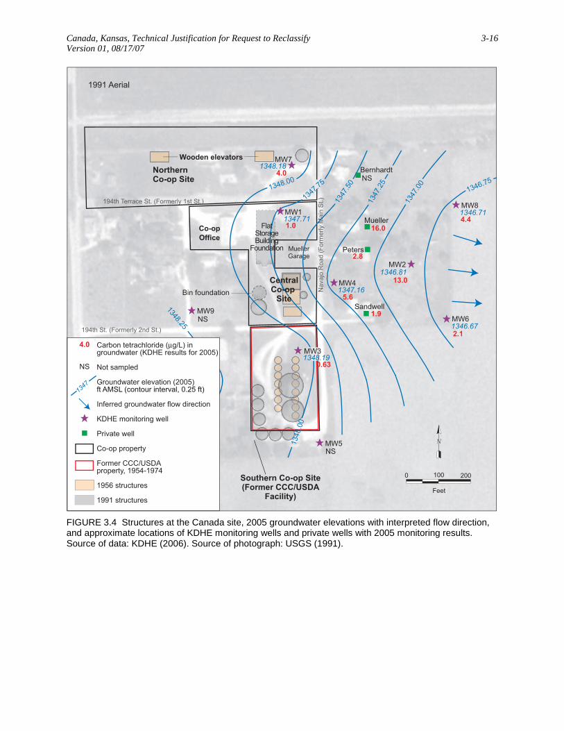
The KDHE’s long-term water level measurements (Table 3.2) and reported survey
coordinates (Table 3.3) were used to generate the maps of groundwater flow direction in
Canada, Kansas, Technical Justification for Request to Reclassify 3-3 Version 01, 08/17/07
Figures 3.3–3.6. These figures indicate a consistent groundwater flow direction to the east or
east-southeast during the 2001–2007 monitoring, though the water levels have fluctuated.
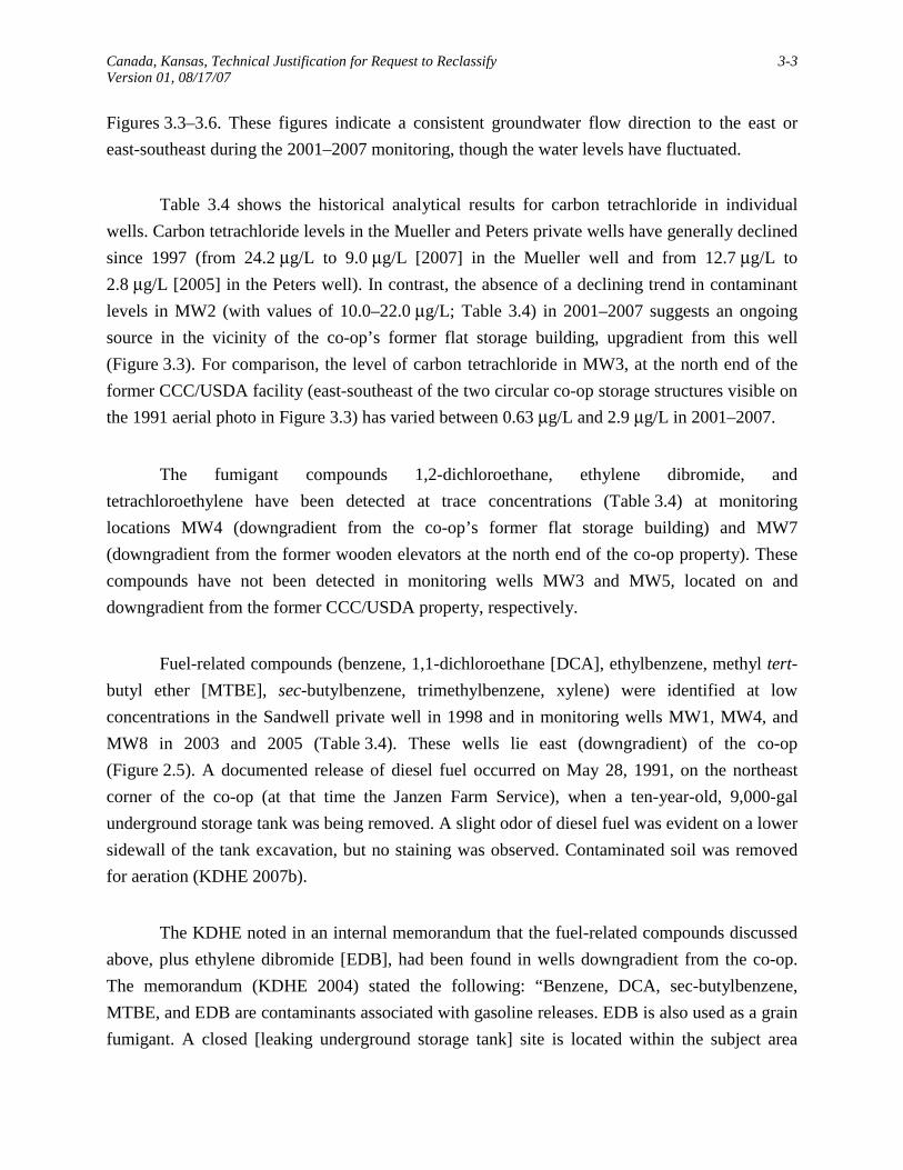
Table 3.4 shows the historical analytical results for carbon tetrachloride in individual
wells. Carbon tetrachloride levels in the Mueller and Peters private wells have generally declined
since 1997 (from 24.2 μg/L to 9.0 μg/L [2007] in the Mueller well and from 12.7 μg/L to
2.8 μg/L [2005] in the Peters well). In contrast, the absence of a declining trend in contaminant
levels in MW2 (with values of 10.0–22.0 μg/L; Table 3.4) in 2001–2007 suggests an ongoing
source in the vicinity of the co-op’s former flat storage building, upgradient from this well
(Figure 3.3). For comparison, the level of carbon tetrachloride in MW3, at the north end of the
former CCC/USDA facility (east-southeast of the two circular co-op storage structures visible on
the 1991 aerial photo in Figure 3.3) has varied between 0.63 μg/L and 2.9 μg/L in 2001–2007.
The fumigant compounds 1,2-dichloroethane, ethylene dibromide, and
tetrachloroethylene have been detected at trace concentrations (Table 3.4) at monitoring
locations MW4 (downgradient from the co-op’s former flat storage building) and MW7
(downgradient from the former wooden elevators at the north end of the co-op property). These
compounds have not been detected in monitoring wells MW3 and MW5, located on and
downgradient from the former CCC/USDA property, respectively.
Fuel-related compounds (benzene, 1,1-dichloroethane [DCA], ethylbenzene, methyl tert-
butyl ether [MTBE], sec-butylbenzene, trimethylbenzene, xylene) were identified at low
concentrations in the Sandwell private well in 1998 and in monitoring wells MW1, MW4, and
MW8 in 2003 and 2005 (Table 3.4). These wells lie east (downgradient) of the co-op
(Figure 2.5). A documented release of diesel fuel occurred on May 28, 1991, on the northeast
corner of the co-op (at that time the Janzen Farm Service), when a ten-year-old, 9,000-gal
underground storage tank was being removed. A slight odor of diesel fuel was evident on a lower
sidewall of the tank excavation, but no staining was observed. Contaminated soil was removed
for aeration (KDHE 2007b).
The KDHE noted in an internal memorandum that the fuel-related compounds discussed
above, plus ethylene dibromide [EDB], had been found in wells downgradient from the co-op.
The memorandum (KDHE 2004) stated the following: “Benzene, DCA, sec-butylbenzene,
MTBE, and EDB are contaminants associated with gasoline releases. EDB is also used as a grain
fumigant. A closed [leaking underground storage tank] site is located within the subject area
Canada, Kansas, Technical Justification for Request to Reclassify 3-4 Version 01, 08/17/07
[where long-term monitoring is being conducted] and EDB was detected downgradient of current
and former grain storage locations; however, reported impacts associated with these
contaminants appear to be highly localized, do not affect private wells, and do not exceed
MCLs.” The 2003 results for ethylene dibromide to which the KDHE memorandum referred are
in Table 3.4. None of the compounds mentioned have been detected in monitoring wells MW3
and MW5, located on and downgradient from the former CCC/USDA property, respectively.

Canada, Kansas, Technical Justification for Request to Reclassify 3-5 Version 01, 08/17/07
TABLE 3.1 Chronological history of groundwater sampling and analysis at Canada.a
Concentration (μg/L)
Date Location
Carbon Tetra-
chloride Chloro-
form 1,2-Dichloro-
ethane Ethylene
Dibromide
Nitrate Concentration
(mg/L) Other
VOCsb 10/21/97 Carr < 0.5 < 0.5 < 0.5 < 0.01 NAc Co-op 1.1 < 0.5 < 0.5 < 0.01 NA Mueller 24.2 4.7 < 0.5 < 0.01 NA Schroeder < 0.5 < 0.5 < 0.5 < 0.01 NA 11/14/97 Bernhardt 2.5 0.7 < 0.5 < 0.01 NA Mueller 21.8 3.9 < 0.5 < 0.01 NA 12/03/97 Farris < 0.5 < 0.5 < 0.5 < 0.01 14.26 Jacobson < 0.5 < 0.5 < 0.5 < 0.01 11.48 Kirby < 0.5 < 0.5 < 0.5 < 0.01 12.42 Peters 12.7 8.2 0.5 < 0.01 66.8 Sandwell 1.7 < 0.5 < 0.5 < 0.01 15.79 Solomon < 0.5 < 0.5 < 0.5 < 0.01 13.01 04/21/98 Sandwell 2.0 0.6 < 0.5 < 0.01 NA A 02/08/99 Bernhardt < 0.5 < 0.5 < 0.5 < 0.01 19.1 Mueller 10.7 1.4 < 0.5 < 0.01 29.38 Peters 14.0 7.0 < 0.5 < 0.01 52.13 01/05/01 MW1 < 1.0 < 1.0 < 1.0 < 1.0 NSd MW2 10.0 3.8 < 1.0 < 1.0 NS MW3 1.6 < 1.0 < 1.0 < 1.0 NS 03/20/01 MW1 2.6 < 1.0 < 1.0 < 1.0 NS MW2 22.0 6.4 < 1.0 < 1.0 NS MW3 1.4 < 1.0 < 1.0 < 1.0 NS 10/25/01 MW1 < 1.2 < 0.5 < 0.5 < 0.5 NS MW2 15.0 5.1 < 0.5 < 0.5 NS MW3 1.9 < 0.5 < 0.5 < 0.5 NS MW4 3.8 1.9 0.57 < 0.5 NS MW5 1.3 < 0.5 < 0.5 < 0.5 NS MW6 4.3 0.63 < 0.5 < 0.5 NS MW7 8.1 1.7 0.58 < 0.5 NS MW8 7.0 1.7 < 0.5 < 0.5 NS MW9 < 1.2 < 0.5 < 0.5 < 0.5 NS 12/12/02 MW1 < 0.5 NRe NR NR NS MW2 21.0 NR NR NR NS MW3 2.9 NR NR NR NS MW4 7.6 NR NR NR NS MW5 NS NS NS NS NS MW6 4.0 NR NR NR NS MW7 8.2 NR NR NR NS MW8 8.3 NR NR NR NS MW9 NS NS NS NS NS Mueller 11.0 NR NR NR NS Peters 4.3 NR NR NR NS

Canada, Kansas, Technical Justification for Request to Reclassify 3-6 Version 01, 08/17/07
TABLE 3.1 (Cont.)
Concentration (μg/L)
Date Location
Carbon Tetra-
chloride Chloro-
form 1,2-Dichloro-
ethane Ethylene
Dibromide
Nitrate Concentration
(mg/L) Other
VOCsb 12/29/03 MW1 < 0.5 < 0.5 < 0.5 < 0.01 NS B MW2 15.0 5.5 < 0.5 < 0.01 NS C MW3 1.9 < 0.5 < 0.5 < 0.01 NS MW4 4.4 4.3 2.2 < 0.01 NS D MW5 1.3 < 0.5 < 0.5 < 0.01 NS MW6 3.7 < 0.5 < 0.5 < 0.01 NS E MW7 8.0 1.4 < 0.5 0.022 NS F MW8 6.9 1.5 < 0.5 < 0.01 NS G MW9 NS NS NS NS NS Bernhardt 2.0 < 0.5 < 0.5 < 0.01 12.0 H Mueller 10.0 1.0 < 0.5 < 0.01 19.0 Peters 4.7 0.84 < 0.5 < 0.01 20.0 Sandwell 1.1 < 0.5 < 0.5 < 0.01 16.0 12/02/05 MW1 1.0 < 0.5 < 0.5 < 0.01 NS MW2 13.0 4.4 < 0.5 < 0.01 NS MW3 0.63 < 0.5 < 0.5 < 0.01 NS MW4 5.6 2.0 1.4 < 0.01 NS I MW5 NS NS NS NS NS MW6 2.1 < 0.5 < 0.5 < 0.01 NS MW7 4.0 0.92 < 0.5 0.022 NS MW8 4.4 1.4 < 0.5 < 0.01 NS J MW9 NS NS NS NS NS Bernhardt NS NS NS NS NS Mueller 16.0 3.2 < 0.5 < 0.01 28 Peters 2.8 1.0 < 0.5 < 0.01 22.0 Sandwell 1.9 0.57 < 0.5 < 0.01 13.0 02/20/07 MW1 < 0.5 < 0.5 < 0.5 < 0.01 NS MW2 18 6.4 0.62 < 0.01 NS MW3 1.1 < 0.5 < 0.5 < 0.01 NS MW4 2.8 1.1 1.6 < 0.01 NS MW5 NS NS NS NS NS MW6 4.7 0.62 < 0.5 < 0.01 NS MW7 6.2 1.0 < 0.5 < 0.01 NS MW8 6.3 1.5 < 0.5 < 0.01 NS MW9 NS NS NS NS NS Bernhardt 2.1 0.71 < 0.5 < 0.01 12 K Mueller 9.0 1.9 < 0.5 < 0.01 20 Peters NS NS NS NS NS Sandwell 0.6 < 0.5 < 0.5 < 0.01 16

Canada, Kansas, Technical Justification for Request to Reclassify 3-7 Version 01, 08/17/07
TABLE 3.1 (Cont.)
a Results are from off-site laboratories. Sources of data: Dallen 1998, 1999; KDHE 1997, 1998, 1999a, 2001, 2004, 2006, 2007a.
b Codes for other volatile organic compounds (concentrations in μg/L): A: 04/21/98, Sandwell: ethylbenzene = 1.0; xylene = 3.9; 1,3,5-trimethylbenzene = 0.5;
1,2,4-trimethylbenzene = 0.7. B: 12/29/03, MW1: chloromethane = 12; sec-butylbenzene = 8.3; methyl tert-butyl ether = 6.4. C: 12/29/03, MW2: chloromethane = 5.8; 1,1-dichloroethane = 0.75. D: 12/29/03, MW4: benzene = 1.7; tetrachloroethylene = 0.57; chloromethane = 4.3. E: 12/29/03, MW6: chloromethane = 1.6. F: 12/29/03, MW7: chloromethane = 14. G: 12/29/03, MW8: chloromethane = 7.5. H: 12/29/03, Bernhardt: chloromethane = 0.72. I: 12/02/05, MW4: benzene = 0.51. J: 12/02/05, MW8: 1,1-dichloroethane = 0.52. K: 02/20/07, Bernhardt: chloromethane = 0.71.
c NA, not analyzed for this constituent. d NS, monitoring location not sampled for this constituent in this event. e NR, result not reported in the investigation reports on file.

Canada, K
ansas, Technical Justification for R
equest to Reclassify
3-8 V
ersion 01, 08/17/07
TABLE 3.2 Water Level data for the Canada site. Source of data: KDHE (2001, 2004, 2006, 2007a).
Water Surface Depth or Elevation in Year Indicated
2007
2005 2003 2001
Well
Top of Casing Elevation (ft AMSL)
Depth (ft
BGL) Elevation (ft AMSL)
Depth (ft BGL)
Elevation (ft AMSL)
Depth (ft BGL)
Elevation (ft AMSL)
Depth (ft BGL)
Elevation (ft AMSL)
MW1 1363.05 20.85 1342.2 15.34 1347.71 17.71 1345.34 17.10 1345.95 MW2 1361.55 19.71 1341.84 14.74 1346.81 16.84 1344.71 16.18 1345.37 MW3 1360.33 18.13 1342.2 12.14 1348.19 15.04 1345.29 14.31 1346.02 MW4 1362.44 20.45 1341.99 15.28 1347.16 17.55 1344.89 16.88 1345.56
MW5 1360.65 NSa NS NSa 15.33 1345.32 14.65 1346.00 MW6 1360.32 18.5 1341.82 13.65 1346.67 15.65 1344.67 15.00 1345.32 MW7 1364.54 21.55 1342.99 16.36 1348.18 18.44 1346.10 17.87 1346.67 MW8 1361.01 19.2 1341.81 14.30 1346.71 16.36 1344.65 15.67 1345.34 MW9 1358.01 NS NS NS NS 11.00 1347.01 a NS, not sampled.

Canada, Kansas, Technical Justification for Request to Reclassify 3-9 Version 01, 08/17/07
TABLE 3.3 Survey data for the Canada site. Source of data: KDHE (2001).
Location Northa Westa Latitudeb Longitudeb
MW1 2348.84 4707.25 38-21-17 97-06-42 MW2 2235.35 4306.89 38-21-15 97-06-38 MW3 1953.59 4665.80 38-21-12 97-06-41 MW4 2174.83 4575.79 38-21-15 97-06-39 MW5 1659.27 4601.71 38-21-10 97-06-39 MW6 2035.95 4239.72 38-21-14 97-06-36 MW7 2509.07 4672.34 38-21-18 97-06-41 MW8 2400.49 4207.03 38-21-16 97-06-36 MW9 2059.19 4971.87 38-21-15 97-06-44
a The Canada site is located in Section 33, Township 19 South, Range 3 East of
the Sixth Principal Meridian, Marion County, Kansas. The southeast corner of Section 33 was assigned coordinates of 00.00 North and 00.00 West.
b Latitude and longitude were scaled from a 7.5-minute quadrangle map (USGS
1985).

Canada, Kansas, Technical Justification for Request to Reclassify 3-10 Version 01, 08/17/07
TABLE 3.4 Historical results of groundwater sampling and analysis for individual wells at Canada.a
Concentration (μg/L)
Location Date
Carbon Tetra-
chloride Chloro-
form 1,2-Dichloro-
ethane Ethylene
Dibromide
Nitrate Concentration
(mg/L) Other
VOCsb Bernhardt 11/14/97 2.5 0.7 < 0.5 < 0.01 NAc 02/08/99 < 0.5 < 0.5 < 0.5 < 0.01 19.1 12/29/03 2.0 < 0.5 < 0.5 < 0.01 12.0 A 12/02/05 NSd NS NS NS NS 02/20/07 2.1 0.71 < 0.5 < 0.01 12 B Carr 10/21/97 < 0.5 < 0.5 < 0.5 < 0.01 NA Co-op 10/21/97 1.1 < 0.5 < 0.5 < 0.01 NA Farris 12/03/97 < 0.5 < 0.5 < 0.5 < 0.01 14.26 Jacobson 12/03/97 < 0.5 < 0.5 < 0.5 < 0.01 11.48 Kirby 12/03/97 < 0.5 < 0.5 < 0.5 < 0.01 12.42 Mueller 10/21/97 24.2 4.7 < 0.5 < 0.01 NA 11/14/97 21.8 3.9 < 0.5 < 0.01 NA 02/08/99 10.7 1.4 < 0.5 < 0.01 29.38 12/12/02 11.0 NRe NR NR NS 12/29/03 10.0 1.0 < 0.5 < 0.01 19.0 12/02/05 16.0 3.2 < 0.5 < 0.01 28 02/20/07 9.0 1.9 < 0.5 < 0.01 20 Peters 12/03/97 12.7 8.2 0.5 < 0.01 66.8 02/08/99 14.0 7.0 < 0.5 < 0.01 52.13 12/12/02 4.3 NR NR NR NS 12/29/03 4.7 0.84 < 0.5 < 0.01 20.0 12/02/05 2.8 1.0 < 0.5 < 0.01 22.0 02/20/07 NS NS NS NS NS Sandwell 12/03/97 1.7 < 0.5 < 0.5 < 0.01 15.79 04/21/98 2.0 0.6 < 0.5 < 0.01 NA C 12/29/03 1.1 < 0.5 < 0.5 < 0.01 16.0 12/02/05 1.9 0.57 < 0.5 < 0.01 13.0 02/20/07 0.6 < 0.5 < 0.5 < 0.01 16 Schroeder 10/21/97 < 0.5 < 0.5 < 0.5 < 0.01 NA Solomon 12/03/97 < 0.5 < 0.5 < 0.5 < 0.01 13.01 MW1 01/05/01 < 1.0 < 1.0 < 1.0 < 1.0 NS 03/20/01 2.6 < 1.0 < 1.0 < 1.0 NS 10/25/01 < 1.2 < 0.5 < 0.5 < 0.5 NS 12/12/02 < 0.5 NR NR NR NS 12/29/03 < 0.5 < 0.5 < 0.5 < 0.01 NS D 12/02/05 1.0 < 0.5 < 0.5 < 0.01 NS 02/20/07 < 0.5 < 0.5 < 0.5 < 0.01 NS

Canada, Kansas, Technical Justification for Request to Reclassify 3-11 Version 01, 08/17/07
TABLE 3.4 (Cont.)
Concentration (μg/L)
Location Date
Carbon Tetra-
chloride Chloro-
form 1,2-Dichloro-
ethane Ethylene
Dibromide
Nitrate Concentration
(mg/L) Other
VOCsb
MW2 01/05/01 10.0 3.8 < 1.0 < 1.0 NS 03/20/01 22.0 6.4 < 1.0 < 1.0 NS 10/25/01 15.0 5.1 < 0.5 < 0.5 NS 12/12/02 21.0 NR NR NR NS 12/29/03 15.0 5.5 < 0.5 < 0.01 NS E 12/02/05 13.0 4.4 < 0.5 < 0.01 NS 02/20/07 18.0 6.4 0.62 < 0.01 NS MW3 01/05/01 1.6 < 1.0 < 1.0 < 1.0 NS 03/20/01 1.4 < 1.0 < 1.0 < 1.0 NS 10/25/01 1.9 < 0.5 < 0.5 < 0.5 NS 12/12/02 2.9 NR NR NR NS 12/29/03 1.9 < 0.5 < 0.5 < 0.01 NS 12/02/05 0.63 < 0.5 < 0.5 < 0.01 NS 02/20/07 1.1 < 0.5 < 0.5 < 0.01 NS MW4 10/25/01 3.8 1.9 0.57 < 0.5 NS 12/12/02 7.6 NR NR NR NS 12/29/03 4.4 4.3 2.2 < 0.01 NS F 12/02/05 5.6 2.0 1.4 < 0.01 NS G 02/20/07 2.8 1.1 1.6 < 0.01 NS MW5 10/25/01 1.3 < 0.5 < 0.5 < 0.5 NS 12/12/02 NS NS NS NS NS 12/29/03 1.3 < 0.5 < 0.5 < 0.01 NS 12/02/05 NS NS NS NS NS 02/20/07 NS NS NS NS NS MW6 10/25/01 4.3 0.63 < 0.5 < 0.5 NS 12/12/02 4.0 NR NR NR NS 12/29/03 3.7 < 0.5 < 0.5 < 0.01 NS H 12/02/05 2.1 < 0.5 < 0.5 < 0.01 NS 02/20/07 4.7 0.62 < 0.5 < 0.01 NS MW7 10/25/01 8.1 1.7 0.58 < 0.5 NS 12/12/02 8.2 NR NR NR NS 12/29/03 8.0 1.4 < 0.5 0.022 NS I 12/02/05 4.0 0.92 < 0.5 0.022 NS 02/20/07 6.2 1.0 < 0.5 < 0.01 NS MW8 10/25/01 7.0 1.7 < 0.5 < 0.5 NS 12/12/02 8.3 NR NR NR NS 12/29/03 6.9 1.5 < 0.5 < 0.01 NS J 12/02/05 4.4 1.4 < 0.5 < 0.01 NS K 02/20/07 6.3 1.5 < 0.5 < 0.01 NS MW9 10/25/01 < 1.2 < 0.5 < 0.5 < 0.5 NS 12/12/02 NS NS NS NS NS 12/29/03 NS NS NS NS NS 12/02/05 NS NS NS NS NS 02/20/07 NS NS NS NS NS

Canada, Kansas, Technical Justification for Request to Reclassify 3-12 Version 01, 08/17/07
TABLE 3.4 (Cont.)
a Results are from off-site laboratories. Sources of data: Dallen 1998, 1999; KDHE 1997, 1998, 1999a, 2001,
2004, 2006, 2007a. b Codes for other volatile organic compounds (concentrations in μg/L):
A: 12/29/03, Bernhardt: chloromethane = 0.72. B: 02/20/07, Bernhardt: chloromethane = 0.71. C: 04/21/98, Sandwell: ethylbenzene = 1.0; xylene = 3.9; 1,3,5-trimethylbenzene = 0.5;
1,2,4-trimethylbenzene = 0.7. D: 12/29/03, MW1: chloromethane = 12; sec-butylbenzene = 8.3; methyl tert-butyl ether = 6.4. E: 12/29/03, MW2: chloromethane = 5.8; 1,1-dichloroethane = 0.75. F: 12/29/03, MW4: benzene = 1.7; tetrachloroethylene = 0.57; chloromethane = 4.3. G: 12/02/05, MW4: benzene = 0.51. H: 12/29/03, MW6: chloromethane = 1.6. I: 12/29/03, MW7: chloromethane = 14. J: 12/29/03, MW8: chloromethane = 7.5. K: 12/02/05, MW8: 1,1-dichloroethane = 0.52.
c NA, not analyzed for this constituent. d NS, monitoring location not sampled for this constituent in this event. e NR, result not reported in the investigation reports on file.

Canada, K
ansas, Technical Justification for R
equest to Reclassify
3-13 V
ersion 01, 08/17/07
2002 Aerial Photo
MuellerGarage
CentralCo-op
Site
Southern Co-op Site(Former CCC/USDA
Facility)
NorthernCo-op Site
Kruetziger(?)
Kirkby
Schroeder
Jacobson
Bernhardt
Peters
Mueller
Farris(?)
Solomon
Sandwell
MW2
MW3
MW6
MW4
MW5
MW1
MW7
MW9
MW8
6.2
2.1
6.3<0.5
9.0
18.0NS
2.8
0.64.7
1.1
NS
NS
NS
NS
NS
NS
NS
0 150 300
Feet
Carbon tetrachloride (μg/L) in groundwater(KDHE results for 2007)
Not sampled
Co-op property
Former CCC/USDA property,1954-1974
Monitoring well
Domestic well
NS
6.2
FIGURE 3.1 Analytical results for carbon tetrachloride in groundwater samples collected in 2007. Well locations are approximate. Source of data: KDHE (2007a). Source of photograph: USDA (2002).
Canada, Kansas, Technical Justification for Request to Reclassify 3-14 Version 01, 08/17/07
1991 Aerial
Southern Co-op Site(Former CCC/USDA
Facility)
NorthernCo-op Site
CentralCo-op
Site
Co-op Office
Bin foundation
FlatStorageBuilding
Foundation
Wooden elevators
MuellerGarage
194th Terrace St. (Formerly 1st St.)
194th St. (Formerly 2nd St.)N
avaj
o R
oad
(For
mer
ly M
ain
St.)
SP3ND
SP1ND
SP2NDSP5
ND
SP40.3
SP120.9
SP9ND
0.3SP8SP7
0.2
SP10ND
SP60.2
SP11ND
2000 100
Feet
Carbon tetrachloride (μg/kg) concentration in 1999
Not detected
Soil sample location
Inferred groundwater flow direction
Co-op property
Former CCC/USDA property, 1954-1974
1956 structure
1991 structure
0.2
ND
FIGURE 3.2 Analytical results for soil samples collected in November 1999. Source of data: KDHE (1999c). Source of photograph: USGS (1991).

Canada, Kansas, Technical Justification for Request to Reclassify 3-15 Version 01, 08/17/07
1991 Aerial
1341.81
1341.84
1341.82
1341.99
1342.20
1342.99
1342.20
1342.5
1342
.5 1342
FlatStorageBuilding
Foundation
CentralCo-op
Site
Southern Co-op Site(Former CCC/USDA
Facility)
NorthernCo-op Site
Co-op Office
MuellerGarage
Wooden elevators
Bin foundation
194th Terrace St. (Formerly 1st St.)
194th St. (Formerly 2nd St.)N
avaj
o R
oad
(For
mer
ly M
ain
St.)
Bernhardt
Mueller
Peters
Sandwell
MW3
MW7
MW1
MW4
MW2
MW8
MW6MW9
MW5
6.2
2.8
4.7
6.39.0
2.8
0.6
1.1
18.0
NS
NS
<0.5
2.1
2000 100
Feet
1342
Carbon tetrachloride (μg/L) in groundwater (KDHE results for 2007)
Not sampled
Groundwater elevation (2007)ft AMSL (contour interval, 0.25 ft)
Inferred groundwater flow direction
KDHE monitoring well
Private well
1956 structures
1991 structures
6.2
NS
FIGURE 3.3 Structures at the Canada site, 2007 groundwater elevations with interpreted flow direction, and approximate locations of KDHE monitoring wells and private wells with 2007 monitoring results. Source of data: KDHE (2007a). Source of photograph: USGS (1991).
Canada, Kansas, Technical Justification for Request to Reclassify 3-16 Version 01, 08/17/07
1991 Aerial
Southern Co-op Site(Former CCC/USDA
Facility)
NorthernCo-op Site
Co-op Office
MuellerGarage
Wooden elevators
Bin foundation
194th Terrace St. (Formerly 1st St.)
194th St. (Formerly 2nd St.)N
avaj
o R
oad
(For
mer
ly M
ain
St.)
1346.75
1346.71
1346.81
1346.67
1347.16
1347.71
1348.18
1347
.00
1347
.25
1347
.50
1347
.751348.00
1348
.00
1348.19
1348.25
CentralCo-op
Site
FlatStorageBuilding
Foundation
Bernhardt
Mueller
Peters
Sandwell
MW3
MW7
MW1
MW4
MW2
MW8
MW6MW9
MW5
4.0
5.6
2.1
4.416.0
2.8
1.9
0.63
13.0
NS
NS
NS
1.0
2000 100
Feet
1347
Carbon tetrachloride (μg/L) in groundwater (KDHE results for 2005)
Not sampled
Groundwater elevation (2005)ft AMSL (contour interval, 0.25 ft)
Inferred groundwater flow direction
KDHE monitoring well
Private well
Co-op property
Former CCC/USDA property, 1954-1974
1956 structures
1991 structures
4.0
NS
FIGURE 3.4 Structures at the Canada site, 2005 groundwater elevations with interpreted flow direction, and approximate locations of KDHE monitoring wells and private wells with 2005 monitoring results. Source of data: KDHE (2006). Source of photograph: USGS (1991).

Canada, Kansas, Technical Justification for Request to Reclassify 3-17 Version 01, 08/17/07
1991 Aerial
FlatStorageBuilding
Foundation
Mueller
Peters
Sandwell
SouthernCo-op Site
(FormerCCC/USDA
Facility)
NorthernCo-op Site
CentralCo-op
Site
Co-op Office
MuellerGarage
Wooden elevators
Bin foundation
194th Terrace St. (Formerly 1st St.)
194th St. (Formerly 2nd St.)N
avaj
o R
oad
(For
mer
ly M
ain
St.)
1344.75
1344.65
1344.71
1344.67
1345.32
1345.29
1344.89
1345.34
1346.1
1345.501345.75
1345
.00
1345
.25
1345
.00
1344.75
1345
.25
Bernhardt
MW5
MW3
MW7
MW1
MW4
MW2
MW8
MW6MW9
1.3
1.9
4.4
3.7
15.0
6.9<0.5
8.0
1.1
4.7
10.0
2.0
NS
2000 100
Feet
Carbon tetrachloride (μg/L) ingroundwater (KDHE results for 2003)
Not sampled
Groundwater elevation (2003)ft AMSL (contour interval, 0.25 ft)
KDHE monitoring well
Private well
Co-op property
Former CCC/USDA property, 1954-1974
1956 structures
1991 structures
1345
NS
8.0
FIGURE 3.5 Structures at the Canada site, 2003 groundwater elevations with interpreted flow direction, and approximate locations of KDHE monitoring wells and private wells with 2003 monitoring results. Source of data: KDHE (2004). Source of photograph: USGS (1991).

Canada, Kansas, Technical Justification for Request to Reclassify 3-18 Version 01, 08/17/07
1991 Aerial
FlatStorageBuilding
FoundationMueller
Peters
SouthernCo-op Site
(FormerCCC/USDA
Facility)
NorthernCo-op Site
Co-op Office
MuellerGarage
Wooden elevators
Bin foundation
194th Terrace St. (Formerly 1st St.)
194th St. (Formerly 2nd St.)N
avaj
o R
oad
(
Form
erly
Mai
n S
t.)
1345
.50
1345
.75
1346
.00
1346
.25
1346
.50 1346.25
1346.00
1345
.75
1345
.50
1345.34
1345.37
1345.32
1346.00
1346.02
1347.01
1345.56
1345.95
1346.67
1346
.75
1347
.00
MW5
MW3
MW9
MW7
MW1
MW4
MW2
MW8
MW6
CentralCo-op
Site
8.1
<1.2
<1.2
3.8
15.0
7.0
4.3
1.9
1.3
11.0
4.3
2000 100
Feet
Carbon tetrachloride (μg/L) ingroundwater (KDHE results for 2001)
Groundwater elevation (2001)ft AMSL (contour interval, 0.25 ft)
KDHE monitoring well
Private well
1956 structures
1991 structures
1346
8.1Co-op property
Former CCC/USDA property, 1954-1974
FIGURE 3.6 Structures at the Canada site, 2001 groundwater elevations with interpreted flow direction, and approximate locations of KDHE monitoring wells and private wells with 2001 monitoring results. Source of data: KDHE (2001). Source of photograph: USGS (1991).

Canada, Kansas, Technical Justification for Request to Reclassify 4-1 Version 01, 08/17/07
4 Conclusions
This evaluation of the KDHE’s long-term monitoring data for the period 2001–2007,
along with prior investigational data, indicates that the former CCC/USDA facility is an unlikely
source for the carbon tetrachloride contamination persistently detected at levels above the MCL
at the Canada site. This conclusion is based on the following findings:
• The groundwater flow direction has been persistently measured by the KDHE
(2001-2007) as being to the east or east-southeast. This flow direction places
the wells with the overall highest concentrations of carbon tetrachloride (e.g.,
the Mueller and Peters private wells and monitoring wells MW2, MW7, and
MW8) downgradient from the northern and central co-op sites, but not
downgradient from the former CCC/USDA property. (See Figures 3.3-3.6.)
• During the KDHE's six-year monitoring period (2001–2007), the contaminant
level in MW3 (on the former CCC/USDA property) remained well below the
MCL of 5.0 μg/L, with a concentration of 1.1 μg/L measured in the most
recent sampling in February 2007.
• In KDHE soil sampling in 1999, carbon tetrachloride was detected in only one
of five soil samples collected between and next to the rows of former
CCC/USDA grain bins, at the very low level of 0.2 μg/kg (the method
detection limit). Contamination around bin doorways and foundations would
most likely be due to CCC/USDA activities. The absence of such a
contamination pattern suggests a different source. Carbon tetrachloride was
identified with greater frequency (in four of seven samples) and at higher
levels (0.2, 0.3, 0.3, and 0.9 μg/kg) in soil samples collected north of the
former CCC/USDA grain bin array. The co-op has occupied the property to
the north of the former CCC/USDA property for an extended period and has
occupied the former CCC/USDA property since at least 1974.
• The relatively stable levels of carbon tetrachloride in monitoring wells MW2,
MW4, and MW8, downgradient from the flat storage building formerly on the
co-op property, suggest the presence of a soil source in the vicinity of that
building.

Canada, Kansas, Technical Justification for Request to Reclassify 4-2 Version 01, 08/17/07
• The fumigant compounds 1,2-dichloroethane, ethylene dibromide, and
tetrachloroethylene were detected in wells downgradient from the central
co-op grain storage structures (specifically the now-demolished flat storage
building), but not on or downgradient from the former CCC/USDA property.
The distribution of these compounds is consistent with a contaminant source
other than the former CCC/USDA facility.
• The unique detection of the fumigant compound ethylene dibromide, found
only in well MW7 in the KDHE’s 2003 and 2005 sampling (Table 3.4), is a
potentially significant finding. Well MW7 is downgradient from the former
wooden elevators on the northern co-op site, but it is not downgradient from
the co-op’s former flat storage building or from the former CCC/USDA
property (Figures 3.3-3.6). The relatively stable levels of carbon tetrachloride
at MW7 (Table 3.4) suggest the presence of a soil source in the vicinity of the
former wooden elevators. The presence of ethylene dibromide at only this
location further suggests that a different fumigant mixture was used at the
former wooden elevators than was used subsequently at the former flat storage
building.
• Fuel-related compounds identified at trace levels in the Sandwell private well
in 1998 and in monitoring wells MW1, MW4, and MW7 in 2003 and 2005
could be related to a documented release from an underground storage tank at
the co-op in 1991 (KDHE 2004, 2007b). Such a connection would
demonstrate the viability of a contaminant migration pathway from the co-op
to wells to the east.
• KDHE policy BER-RS-024, Rev. 2001, Section I (Groundwater and Surface
Water Criteria), indicates the following: “Status reclassification may be
granted after monitoring demonstrates cleanup goals have been achieved and
maintained for four (4) consecutive, equally time-sequenced sampling
episodes conducted under KDHE oversight over a period of no less than two
(2) years. . . .” The KDHE policy, Section III (Other Considerations), further
provides the following: “If the above six (6) criteria do not apply to a site, the
PRP may elect to submit to KDHE/BER a Reclassification Petition, including
a Reclassification Report as outlined below, that identifies and justifies a

Canada, Kansas, Technical Justification for Request to Reclassify 4-3 Version 01, 08/17/07
rationale for reclassifying the site to Resolved status on the ISL despite failure
to satisfy the criteria identified above. KDHE will make the final
determination concerning reclassification of the site on the ISL and will
document that decision accordingly.”
The KDHE has conducted seven sampling events at the Canada site over a
period of six years, at approximately annual intervals (except for the two-year
gap between the December 2003 and December 2005 events). In this KDHE
sampling, monitoring well MW3, on the former CCC/USDA property, has
exhibited the following carbon tetrachloride concentrations:
1.6 μg/L (January 5, 2001)
1.4 μg/L (March 20, 2001)
1.9 μg/L (October 25, 2001)
2.9 μg/L (December 12, 2002)
1.9 μg/L (December 29, 2003)
0.63 μg/L (December 2, 2005)
1.1 μg/L (February 20, 2007)
These results, which are all well below the MCL of 5.0 μg/L, demonstrate that
groundwater on the former CCC/USDA property at Canada has met the
standard for carbon tetrachloride in drinking water since 2001 and does not
pose a significant human health threat. The results warrant a request for
reclassification of the Canada site to Resolved status on the KDHE’s
Identified Sites List, under Section III (Other Considerations) of KDHE policy
BER-RS-024, Rev. 2001.

Canada, Kansas, Technical Justification for Request to Reclassify 5-1 Version 01, 08/17/07
5 References
CGS, 2007, Canada, Cooperative Grain and Supply, Hillsboro, Kansas, http://www.cgsmc.com/
locations/canada.html, January 26.
Byrne, F.E., C.P. Walters, J.L. Hill, and L. Riseman, 1959, “Geology and Construction-Material
Resources of Marion County, Kansas,” Chapter B (pp. 63-95) in Geology and Construction
Materials of Part of Northeast Kansas, U.S. Geological Survey Bulletin 1060, U.S. Government
Printing Office, Washington, D.C.
Chaffee. P., 1988, Effects of Water-Well Construction on Temporal Variability of Ground-Water
Quality in Lincolnville, Marion County, Kansas, Kansas Geological Survey Open-File
Report 88-26.
Dallen, F., 1998, memorandum from Dallen (Environmental Technician) to R. Brown (Pre-
Remedial Unit Chief, Pre-Remedial Unit/Remedial Section, Bureau of Environmental
Remediation, Kansas Department of Health and Environment, Topeka, Kansas), regarding a trip
report for private well sampling conducted on December 3, 1997, for the KDHE’s Pre-CERCLIS
site reconnaissance and evaluation of the former CCC/USDA grain bin site in Canada, Kansas,
February 12.
Dallen, F., 1999, memorandum from Dallen (Environmental Technician) to R. Brown (Pre-
Remedial Unit Chief, Pre-Remedial Unit/Remedial Section, Bureau of Environmental
Remediation, Kansas Department of Health and Environment, Topeka, Kansas), regarding a trip
report for subsurface soil and private well sampling conducted on February 23–24, 1999, for the
KDHE’s preliminary assessment/screening site inspection of the former CCC/USDA grain bin
site in Canada, Kansas, March 11.
FSA, 1997, Former CCC Grain Bin Storage Facilities Survey — January 1997, completed for
the Canada Site by B. Harmon (Marion, Kansas), Farm Services Administration,
U.S. Department of Agriculture, January 29.
Jordan, P.R., and R.J Hart, 1985, Transit Losses and Travel Times for Water-Supply Releases
from Marion Lake during Drought Conditions, Cottonwood River, East-Central Kansas, Water
Resources Investigations Report 85-4263, U.S. Geological Survey.

Canada, Kansas, Technical Justification for Request to Reclassify 5-2 Version 01, 08/17/07
KDHE, 1997, record of sampling conducted on October 21, 1997, by S. Lang and H. Debauche,
for the CCC/USDA private well sampling program, Bureau of Environmental Remediation,
Kansas Department of Health and Environment, Topeka, Kansas.
KDHE, 1998, Pre-CERCLIS Site Reconnaissance and Evaluation: Canada Former USDA/CCC
Grain Bin Site, Canada, Marion County, Kansas, KDHE ID P505770601, Bureau of
Environmental Remediation, Kansas Department of Health and Environment, Topeka, Kansas,
March.
KDHE, 1999a, Preliminary Assessment/Screening Site Inspection: Canada Former USDA/CCC
Grain Bin Site, Canada, Marion County, Kansas. CERCLIS Identification Number
KSSFN0703499, Bureau of Environmental Remediation, Kansas Department of Health and
Environment, Topeka, Kansas, April.
KDHE, 1999b, Preliminary Removal Site Evaluation/Removal Preliminary Assessment Form:
Canada Former USDA/CCC Grain Bin Site, Canada, Marion County, Kansas. CERCLIS
Identification Number KSSFN0703499, completed by R.L. Brown (Unit Chief, Site Assessment
Unit, Bureau of Environmental Remediation, Kansas Department of Health and Environment,
Topeka, Kansas), April 19; reviewed by R.L. Bean (Section Chief, Remedial Section, Bureau of
Environmental Remediation, Kansas Department of Health and Environment, Topeka, Kansas),
June 22.
KDHE, 1999c, Supplemental Sampling Assessment: Canada Former USDA/CCC Grain Bin Site,
Canada, Marion County, Kansas, KDHE ID P5-057-70601, completed by F. Dallen (Site
Assessment Unit, Bureau of Environmental Remediation, Kansas Department of Health and
Environment, Topeka, Kansas), November.
KDHE, 2001, Final Report: Comprehensive Investigation: Canada USDA/CCC Grain Bin Site,
Canada, Kansas, prepared by Geotechnical Services, Inc., Wichita, Kansas, for Kansas
Department of Health and Environment, Topeka, Kansas, December.
KDHE, 2004, 2003 State Water Plan Long Term Monitoring Results: Canada Carbon
Tetrachloride Site, Canada, Marion County, memorandum from B. Conrad to B. Wilson, Kansas
Department of Health and Environment, Topeka, Kansas, March 5.

Canada, Kansas, Technical Justification for Request to Reclassify 5-3 Version 01, 08/17/07
KDHE, 2006, 2005 State Water Plan Long Term Monitoring Results: Canada Carbon
Tetrachloride Site, Canada, Marion County, memorandum from B. Wilson to Canada Site File,
Kansas Department of Health and Environment, Topeka, Kansas, January 5.
KDHE, 2007a, Memorandum from J. Vopta to D. Doubek for Canada Carbon Tetrachloride Site
File, Bureau of Environmental Remediation, Kansas Department of Health and Environment,
Topeka, Kansas, March 9.
KDHE, 2007b, Assessed Storage Tank Facilities, Storage Tank Section, Kansas Department of
Health and Environment, Topeka, Kansas, updated March 5, 2007, http://www.kdheks.
gov/tanks/download/astf_db.xls, accessed August 9, 2007.
O’Connor, H.G., and P.K. Chaffee, 1992, A Time-Series Water Quality Study, Lincolnville,
Pilsen, and Ramona, Marion County, Kansas, Open-File Report 92-56, Kansas Geological
Survey.
Shewey, C., 1999, record of telephone conversation involving Shewey (Marion County Rural
Water District, Hillsboro, Kansas), regarding Rural Water District connection to Canada, Kansas,
residences, July 21.
State of Kansas, 1883, plat survey of Canada, Kansas, recorded with the State of Kansas, Marion
County, 4:00 p.m., December 15.
Terman, M.R., and J.S. Aber, 1994, Fall Field Trip in Marion County, Central Kansas, Kansas
Academy of Science Multidisciplinary Guidebook 7, Kansas Geological Survey Open-File
Report 94-33.
USACE 1974, Final Environmental Statement, Marion, Kansas, Local Protection Project,
U.S. Army Corps of Engineers, Tulsa District.
USDA, 1956, aerial photograph AYG-2R-203D-1W, U.S. Department of Agriculture,
Washington, D.C., June 12.
USDA, 2002, Orthophoto Mosaic for Marion County, Kansas, Natural Resources Conservation
Service, U.S. Department of Agriculture, Washington, D.C.

Canada, Kansas, Technical Justification for Request to Reclassify 5-4 Version 01, 08/17/07
USGS, 1985, Canada Quadrangle, Marion County, Kansas, U.S. Geological Survey 7.5-Minute
Topographic Map Series, U.S. Government Printing Office, Washington, D.C.
USGS, 1991, Digital Orthophoto Quarter Quadrangle, U.S. Geological Survey, Washington,
D.C., obtained from Kansas Data Access and Support Center, Kansas Geological Survey,
University of Kansas, Lawrence, Kansas.

Canada, Kansas, Technical Justification for Request to Reclassify A-1 Version 00, 05/09/07
Appendix A:
Well Registration Forms and Drilling Records for Canada Area Wells

C
anada, Kansas, Technical Justification for Request to Reclassify
A-2 Version 00, 05/09/07
DW67
DW63
DW30
DW28
DW27 DW99
DW98
DW22/DW23/DW24
MW1DW95
Okl
ahom
a K
ansa
s an
d Te
xas
Hillsboro
Wichita
Canada
North Cottonwood River
Atchison Topeka and Santa Fe
MarionLake
Marion
100000 5000
Feet
5656
Marion
Dam
South Cottonwood River
Mud CreekFrench Creek
Inte
rmitt
ent S
tream
Cottonwood River
FIGURE A.1 Locations of registered wells in the Canada area.

Canada, Kansas, Technical Justification for Request to Reclassify A-3 Version 00, 05/09/07

Canada, Kansas, Technical Justification for Request to Reclassify A-4 Version 00, 05/09/07

Canada, Kansas, Technical Justification for Request to Reclassify A-5 Version 00, 05/09/07

Canada, Kansas, Technical Justification for Request to Reclassify A-6 Version 00, 05/09/07

Canada, Kansas, Technical Justification for Request to Reclassify A-7 Version 00, 05/09/07

Canada, Kansas, Technical Justification for Request to Reclassify A-8 Version 00, 05/09/07

Canada, Kansas, Technical Justification for Request to Reclassify A-9 Version 00, 05/09/07

Canada, Kansas, Technical Justification for Request to Reclassify A-10 Version 00, 05/09/07

Canada, Kansas, Technical Justification for Request to Reclassify A-11 Version 00, 05/09/07

Canada, Kansas, Technical Justification for Request to Reclassify A-12 Version 00, 05/09/07

Canada, Kansas, Technical Justification for Request to Reclassify A-13 Version 00, 05/09/07

Canada, Kansas, Technical Justification for Request to Reclassify A-14 Version 00, 05/09/07

Canada, Kansas, Technical Justification for Request to Reclassify A-15 Version 00, 05/09/07

Canada, Kansas, Technical Justification for Request to Reclassify B-1 Version 00, 05/09/07
Appendix B:
Geology of the Canada Area, Marion County

Canada, Kansas, Technical Justification for Request to Reclassify B-2 Version 00, 05/09/07
Appendix B:
Geology of the Canada Area, Marion County
B.1 Geologic Data
Subsurface geologic data are generally sought from well registration forms and drilling records of test holes and irrigation, domestic, monitoring, and municipal wells. Irrigation is not a general farming practice in the region, and the Kansas Geologic Survey (KGS) has not drilled test holes in the study area. Therefore, the only available lithologic logs are in records of domestic, municipal, and monitoring wells. The water well record (WWC-5 form) is a standard form that all licensed water well contractors are required to complete for each water well drilled in Kansas. The available water well log data were examined critically for completeness and consistency. Most log descriptions were too brief to determine the lithologic units accurately. Although several lithologic logs from WWC-5 forms exist for water wells in Canada and the surrounding area, their inconsistent quality makes interpretation and correlation of the geologic units difficult, if not impossible. A lack of consistency in the quality of lithologic logs in Marion County is a recognized problem (Chaffee 1988). In addition, well locations are described in general terms (township and range) and persistenty identify the individual domestic wells within the town inadequately. No well records exist for most domestic wells, and the names and addresses of the original listed owners frequently do not match those of any current well owner.
Documents consulted include reports published by the U.S. Geological Survey (USGS) and the USDA Soil Conservation Service, open-file reports of the KGS, and an environmental impact statement from the U.S. Army Corps of Engineers (USACE). Information on the regional geology and physiography was also obtained directly from the KGS World Wide Web site at http://www.kgs.ukans.edu. Because of the absence of reliable geologic logs of boreholes in central Marion County, the surface geologic maps generated by the USGS (Byrne et al. 1959) provided the only reliable source of geologic data. This information was used to extrapolate the subsurface geology. The established stratigraphic column (giving the sequence and thicknesses of the shales and limestones) was extrapolated from the nearest outcropping geologic sequence by using a regional dip and strike computed from the intersection of the contact with the topography. The computed apparent dip in the direction of each segment of the cross section was then used to extend the surface outcrop section to the location and depth of the drillers’ logs. Because the log descriptions bear little resemblance to the actual lithologies, validation of the
Canada, Kansas, Technical Justification for Request to Reclassify B-3 Version 00, 05/09/07
interpretive geologic sections relied on correlation between (1) the locations of changes in major lithologic type as described in the drillers’ logs and (2) the locations of stratigraphic contacts predicted from the USGS surface geology (Figure B.1; Byrne et al. 1959).
B.2 Geologic Setting
Marion County is largely within the Flint Hills region of east central Kansas. The county includes a small area of the Smoky Hills region in the northwest and the Wellington-McPherson Lowlands in the southwest. The eastern portion of the county is characteristic of the Flint Hills region, with well-dissected topography, deeply incised valleys, thin soils, and many limestone outcrops. The western part of the county is predominantly shale beds containing a few relatively thin, soft limestones. Such units tend to form a gently rolling to nearly flat topography that is amenable to agriculture. Few good natural rock outcrops are present in this area. The major drainage from Marion County is southeastward via the Cottonwood River, forming the upper reaches of the Neosho River drainage basin. The Cottonwood River was dammed in 1968 to form Marion Lake in the central part of the county (for location see Figure B.2). The 10,800-acre lake is used for flood control, water quality control, water supply, recreation, and fish and wildlife conservation (Jordan and Hart 1985).
The surface geology of Marion County has been described by Byrne et al. (1959). Figure B.2 illustrates the generalized surface geology. The bedrock of Marion County is largely Lower Permian shale with interbedded chalky and cherty limestone. These beds dip gently westward with a slope of about 15-20 ft/mi (O’Connor and Chaffee 1992). Limestones and shales of the Chase Group, exposed throughout the eastern part of the county, are the oldest Lower Permian rocks present. In Marion County, the Chase Group is overlain by about 450 ft of Wellington Formation shales, part of the Lower Permian Sumner Group. Lower Cretaceous shale and sandstone unconformably overlie Permian strata in the northwest corner of the county. Unconsolidated Cenozoic sediments of late Tertiary and Pleistocene age also unconformably overlie the Permian beds in the southwest part of the county (Figure B.2).
The oldest rocks that outcrop in the central part of Marion County in the vicinity of Canada are from the Lower Permian Chase Group, made up of about 300 ft of limestone and dolomitic limestone alternating with shale in repetitive sequences called cyclotherms (Terman and Aber 1994). These cyclotherms are the products of repeated transgressions and regressions by shallow seas over a nearly flat depositional surface in the early Permian. Younger Wellington

Canada, Kansas, Technical Justification for Request to Reclassify B-4 Version 00, 05/09/07
Formation shales of the Sumner Group conformably overlie the Chase Group and outcrop throughout the central and western region of the county, including the area surrounding the town of Canada. These rocks represent a change to more continental, extremely arid conditions during the Permian. The shale is variously colored gray, green, and red and contains thin beds of limestone and gypsum.
The Quaternary system is represented in the vicinity of Canada by scattered thin silt and sand deposits that may be erosional remnants of an eastward extension of the Early Pleistocene McPherson valley alluvium. Byrne et al. (1959) called these deposits the Sanborn Formation. Younger Pleistocene terrace deposits occur along major streams, and the valley floors are filled with Recent alluvium. Alluvial deposits are thickest in the valleys of the larger streams and are known to exceed a thickness of 30 ft on the Cottonwood River at the town of Marion (USACE 1974). Soils in the central part of the county are derived from the weathering of limestone, cherty limestone, calcareous and noncalcareous shale, alluvium, and colluvium.
The location of an interpretive regional cross section passing through Canada is shown in Figure B.3. Stratigraphic relationships within the shallow bedrock, the elevation of the ground surface, and relief on the bedrock surface are illustrated schematically in west-to-east section A-A′ (Figure B.4). Copies of the drillers’ logs from which this section was constructed are in Appendix A.
Cross section A-A′ (Figure B.4) shows that the Permian formations dip from east to west. The strike and dip can be computed by transposing the geologic contacts from the geologic map (Byrne et al. 1959) to the 1:24,000-scale topographic base (USGS 1985) and measuring the elevation of a single stratigraphic horizon at three locations. On the basis of the intersection of the top of the Nolans limestone with the topography, the beds strike N 30° W and dip S 60° W at an angle of 0.2° (about 17 ft/mi) in central Marion County. Note that the vertical exaggeration of the cross section (1) makes the westward slope of the bedrock strata appear to be far steeper than the shallow angle actually observed in the field and (2) enhances subtle changes in the surface topography. This reconstruction indicates that the shallow geologic section at Canada should be composed of soil 2-3 ft thick, developed from loess and weathered shale at the surface and overlying weathered Wellington shale. The shale weathers to clay that has been variously recorded in drillers’ logs to depths of 11-42 ft BGL. The top of the Nolans Formation (Herington limestone member) is projected to occur at a depth of approximately 25 ft BGL. This unit is routinely described as “blue shale” in drillers’ logs at this depth. However, the KDHE reported

Canada, Kansas, Technical Justification for Request to Reclassify B-5 Version 00, 05/09/07
refusal of the conductivity probe at a hard layer postulated to be limestone at 13 ft BGL (KDHE 1999a). The stratigraphic data available suggest that this postulated limestone might be one of the relatively thin dolomitic limestones known to occur within the Pearl shale member at the base of the Wellington Formation. The top of the underlying Odell shale, projected from outcrop and drill holes to the east, should occur at about 65 ft BGL.
B.3 Hydrogeology
The principal aquifers in the Flint Hills are the Nolans, Winfield, and Barneston limestones of the Lower Permian Chase Group. The Nolans and Winfield limestones are shown on cross section A-A′ (Figure B.4). Sinkholes are common where these limestones crop out in the uplands, and springs emerge where the aquifers are exposed in valleys and stream channels. Most wells produce from 10 to 100 gpm, with some producing as much as 500 gpm (Terman and Aber 1994). Relatively impermeable shale units separate the bedrock aquifers, setting up confined conditions in which each aquifer might have a different hydraulic head.
Where the Wellington Formation overlies the Chase Group limestones to the west of the Flint Hills, groundwater is also produced from fractured shale and several thin beds of impure limestone within the Wellington. The formation yields small quantities of highly mineralized water to many stock and domestic wells. Moderately large water supplies of highly mineralized but usable groundwater are available from solution zones in gypsum beds.
Groundwater generally flows from east to west in the limestone aquifers. Recharge takes place where the aquifers outcrop to the east, and water moves down the regional bedrock dip toward the west. However, local variations in the regional groundwater flow direction are common because of lowering of the potentiometric surface in the limestone aquifers by seepage along valleys and stream channels (O’Connor and Chaffee 1992). The multiple aquifers, the absence of monitoring wells, and the many local topographic effects preclude construction of meaningful regional potentiometric surfaces from available data for any of the identifiable aquifers. The KGS hydrogeologic database as of 1999 contained no water levels for Marion County.
At Canada, screened intervals for domestic wells for which records are available are 45-60 ft BGL and 54-64 ft BGL in DW22 and DW23, respectively, and an upper zone at 25-35 ft

Canada, Kansas, Technical Justification for Request to Reclassify B-6 Version 00, 05/09/07
BGL and a lower zone at 50-64 ft BGL in DW24 (Figure B.4). Logs for DW22, DW23, and DW24 are in Appendix A. Water is generally produced from solution-jointed limestone units of the Nolans Formation, and the screened depths suggest that more than one of these water-bearing zones are present at Canada. Anecdotal evidence gathered from interviews with local residents suggests that groundwater flows to the east-southeast (KDHE 1998). Topographic features in the area support this conclusion. For example, a local flow direction to the southeast is consistent with the fact that the South Cottonwood River has eroded the Permian rocks to a level of about 1,310–1,320 ft above mean sea level (AMSL) 1.25 mi southeast of Canada, 40–50 ft below the elevation of the ground at Canada. Static water levels recorded when the wells were installed in 1978 and 1979 were 15–18 ft BGL (1,345–1,343 ft AMSL), substantially above the base level (1,310–1,320 ft AMSL) at the South Cottonwood River. Another factor contributing to the southeasterly groundwater flow direction would be mounding of groundwater 1 mi to the north of Canada due to recharge from Marion Lake.

C
anada, Kansas, Technical Justification for Request to Reclassify
B-7Version 00, 05/09/07
FIGURE B.1 Stratigraphic units that crop out in Marion County, Kansas, and the construction materials of each. Source: Byrne et al. (1959).

Canada, K
ansas, Technical Justification for Request to Reclassify B-8
Version 00, 05/09/07
FIGURE B.1 (Cont.)

CaVersi
nada, Kansas, Technical Justification for Request to Reclassify B-9 on 00, 05/09/07
MarionLake
CanadaCanada
MarionLake
T17S
R 1 E R 2 E R 3 E R 4 E
R 5 E
T18S
T19S
T20S
T21S
T22S
Lake/Rivers/Creeks
Cenozoic
Alluvium
Loess
Delmore Formation
Cretaceous
Dakota Sandstone Formation
Kiowa Shale Formation
Permian
Sumner Group - Wellington Formation
Chase Group
Miles
2 4 60
Cottonwood
River
Cottonwood
River
South Cottonwood RiverSouth Cottonwood River
FIGURE B.2 Generalized surface geologic map of Marion County, showing the location of the town of Canada. Source: Byrne et al. (1959).

Canada, K
ansas, Technical Justification for Request to Reclassify B-10
Version 00, 05/09/07
DW67
DW63
DW30
DW28
DW27 DW99
DW98
DW22/DW23/DW24
MW1DW95
A A'
Okl
ahom
a K
ansa
s an
d Te
xas
Hillsboro
Wichita
Canada
North Cottonwood River
Atchison Topeka and Santa Fe
MarionLake
Marion
100000 5000
Feet
5656
Marion
Dam
South Cottonwood River
Mud CreekFrench Creek
Inte
rmitt
ent S
tream
Cottonwood River
FIGURE B.3 Location of geologic cross section A-A′ in central Marion County.

Canada, Kansas, Technical Justification for Request to Reclassify B-11 Version 00, 05/09/07
West
A
Hillsboro Canada Marion
East
A'
Feet
(AM
SL)
1200
1175
1150
1225
1250
1275
1300
1325
1350
1375
1400
1425
1450
1475
1500
1200
1175
1150
1225
1250
1275
1300
1325
1350
1375
1400
1425
1450
1475
1500
DW67EL: 1420'
DW63EL: 1405'
Pwe Qs Pwe Qs Qs
Pw
e
Pw
eQ
s
PoQs
Sou
th C
otto
nwoo
d R
iver
Cot
tonw
ood
Riv
er
Mud
Cre
ek
Pwe Qs Pwe Qs Qt Pn Qt Pw
DW30EL: 1375'
DW22/DW23/DW24
EL: 1365'
DW28EL: 1340'
DW27EL: 1350'
DW99EL: 1320'
DW95EL: 1350'
MW1EL: 1350'
DW98EL: 1310'
0 5000 10000
Feet
Well Screen
Depth of weathering
Geologic contact from Byrne et al. (1959)
Quaternary
Terrace Deposits (Qt) ⎯ clayey silt, lenses of sand and gravel
Sanborn (Qs) ⎯ silt and clay, lenses of sand and gravel
Permian
Wellington Shale (Pwe) ⎯ shale, calcareous shale, minor dolomitic limestone
Nolans Limestone (Pn) ⎯ dolomitic limestone, calcareous shale, and clayey limestone
Odell Shale (Po) ⎯ silty and clayey shale
Winfield Limestone (Pw) ⎯ dolomitic limestone, calcareous shale, and cherty limestone
Doyle Shale (Pd) ⎯ calcareous shale, clayey and silty shale, and limestone
Pwe Qs
WellingtonShale
NolansLimestone
OdellShale Winfield
Limestone
DoyleShale
FIGURE B.4 Interpretive west-to-east geologic cross section A-A′ (vertically exaggerated), Marion County, Kansas. Source of geologic contacts: Byrne et al. (1959).

Canada, Kansas, Technical Justification for Request to Reclassify C-1 Version 00, 05/09/07
Appendix C:
Property Records Related to the Former CCC/USDA Facility at Canada

Canada, Kansas, Technical Justification for Request to Reclassify C-2 Version 00, 05/09/07
FIGURE C.1 CCC/USDA lease, 1954 to 1964.

Canada, Kansas, Technical Justification for Request to Reclassify C-3 Version 00, 05/09/07
FIGURE C.1 (Cont.)

Canada, Kansas, Technical Justification for Request to Reclassify C-4 Version 00, 05/09/07
FIGURE C.2 CCC/USDA lease, 1964 to 1974.

Canada, Kansas, Technical Justification for Request to Reclassify C-5 Version 00, 05/09/07
FIGURE C.2 (Cont.)

Canada, Kansas, Technical Justification for Request to Reclassify C-6 Version 00, 05/09/07
FIGURE C.3 Sale of property by Burkholder to Canada Grain Co., 1965.

Canada, Kansas, Technical Justification for Request to Reclassify C-7 Version 00, 05/09/07
FIGURE C.3 (Cont.)
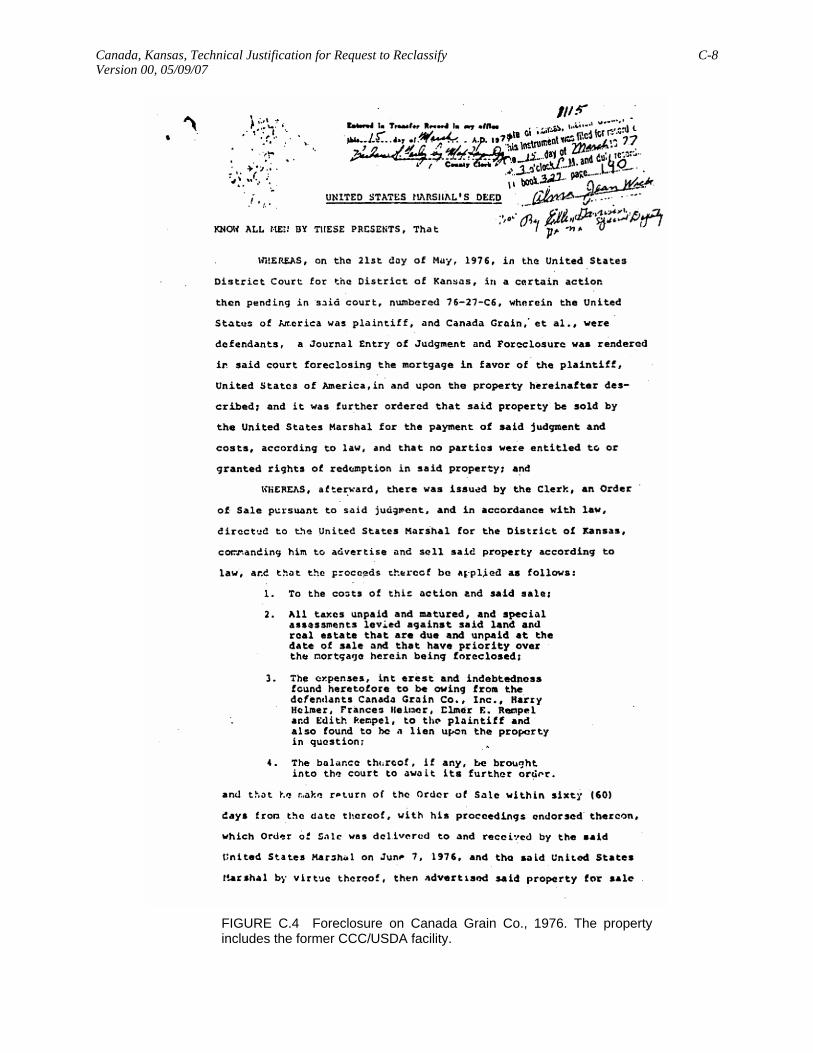
Canada, Kansas, Technical Justification for Request to Reclassify C-8 Version 00, 05/09/07
FIGURE C.4 Foreclosure on Canada Grain Co., 1976. The property includes the former CCC/USDA facility.

Canada, Kansas, Technical Justification for Request to Reclassify C-9 Version 00, 05/09/07
FIGURE C.4 (Cont.)
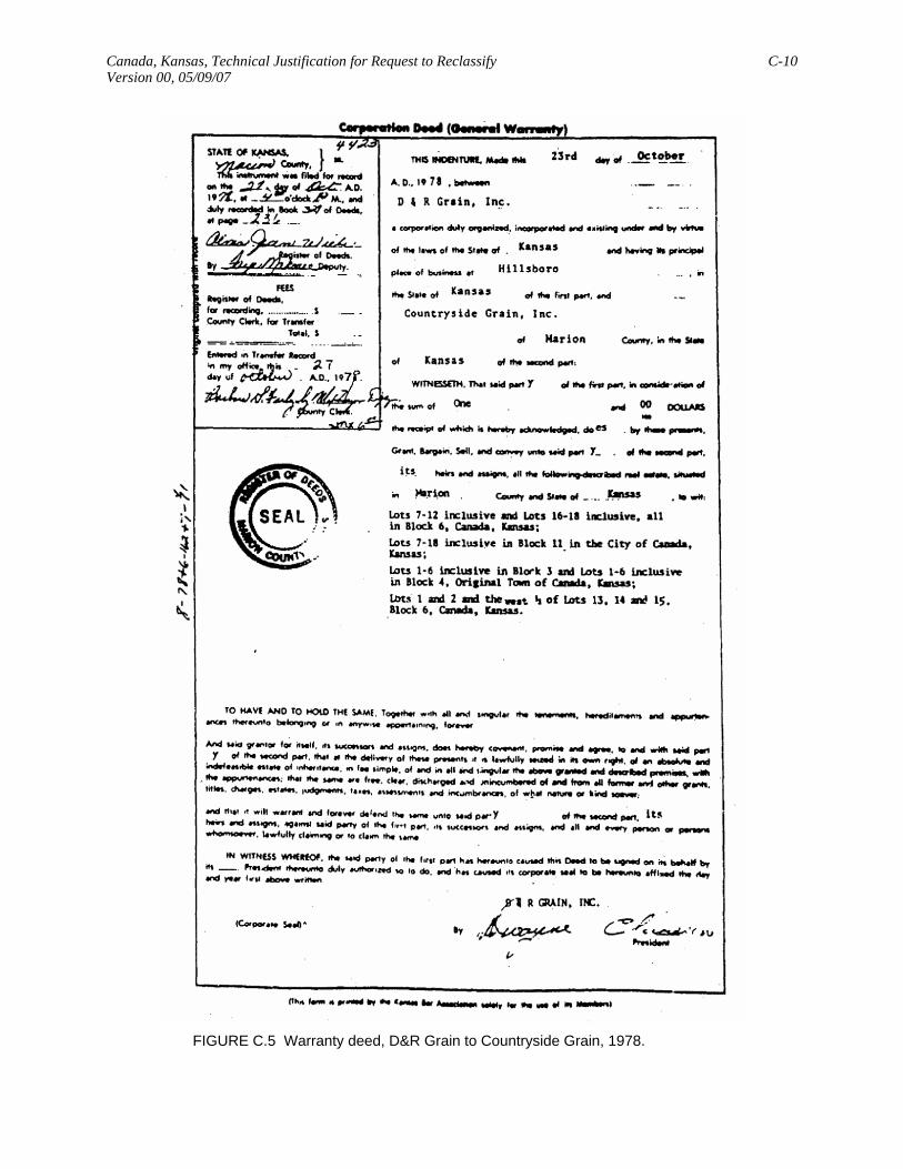
Canada, Kansas, Technical Justification for Request to Reclassify C-10 Version 00, 05/09/07
FIGURE C.5 Warranty deed, D&R Grain to Countryside Grain, 1978.

Canada, Kansas, Technical Justification for Request to Reclassify C-11 Version 00, 05/09/07
FIGURE C.6 Warranty deed, Janzen Farm Service to Cooperative Grain and Supply, 1991.

A U.S. Department of Energy laboratory managed by UChicago Argonne, LLC
Environmental Science DivisionArgonne National Laboratory9700 South Cass Avenue, Bldg. 203 Argonne, IL 60439-4843www.anl.gov