task 3 report land use and spatial planning assessment … · 2017-03-27 · task 3 report land use...
TRANSCRIPT

Task 3 Report Land Use and
Spatial Planning Needs
Assessment
Support Services for Land Use Planning, District Readiness,
Strategic Environmental Assessment and
Related Preparatory Activities for the Green
Prosperity Project in Indonesia
Contract # GS10F0086K
Final Report for MCC
Review and Comment
30 November 2013
Prepared for: Millennium Challenge
Corporation 875 15th St., NW
Washington, D.C. 20005
Submitted by: Abt Associates Inc.
4550 Montgomery Avenue
Suite 800 North Bethesda, MD 20814
In Partnership with: ICRAF, Indonesia URDI, Indonesia
T

Second Draft Task 3 Report Contract # GS10F0086K
Abt Associates Inc. i
Table of Contents
Abbreviations, Acronyms and Indonesian Terms ............................................................................. iv
1. Introduction .................................................................................................................................... 1
1.1 Background ................................................................................................................................ 1
1.2 Objectives .................................................................................................................................. 2
1.2.1 Assessment of Land Use and Spatial Planning .................................................................. 2
1.2.2 Community Participation ................................................................................................... 4
2. Methodology.................................................................................................................................... 4
2.1 Review of Relevant Literature and Other Documents ............................................................... 4
2.2 Focus Group Discussions (FGDs) ............................................................................................. 5
2.3 In-depth Interviews .................................................................................................................... 5
2.4 Participant Observation ............................................................................................................. 6
2.5 Land Use Assessment Analysis ................................................................................................. 6
3. National-Level Assessment of Land Use and Spatial Planning .................................................. 8
3.1 Spatial Planning Process ............................................................................................................ 8
3.2 Community Participation in Spatial Planning ......................................................................... 11
3.3 Key Issues in PLUP and Land Use Planning ........................................................................... 13
4. District-Level Assessment of Land Use and Spatial Planning .................................................. 15
4.1 Law, Regulations and Spatial Planning Process ...................................................................... 15
4.1.1 Merangin .......................................................................................................................... 16
4.1.2 Muaro Jambi .................................................................................................................... 17
4.1.3 Mamuju ............................................................................................................................ 19
4.1.4 Mamasa ............................................................................................................................ 20
4.2 Data for Spatial Planning ......................................................................................................... 21
4.2.1 Existing Land and Land Use Data ................................................................................... 21
4.2.2 Data Integration ............................................................................................................... 26
4.3 Capacity for Spatial Planning .................................................................................................. 28
4.4 Land Use Assessment .............................................................................................................. 30
4.4.1 Muaro Jambi .................................................................................................................... 30
4.4.2 Merangin .......................................................................................................................... 34
4.4.3 Mamuju ............................................................................................................................ 39
4.4.4 Mamasa ............................................................................................................................ 44
5. District-Level Assessment of Community Consultation in Spatial Planning .......................... 49
5.1.1 Jambi ................................................................................................................................ 49
5.1.2 West Sulawesi .................................................................................................................. 49

Second Draft Task 3 Report Contract # GS10F0086K
Abt Associates Inc. ii
6. Recommendations ........................................................................................................................ 50
6.1 Strategic Engagement with related Initiatives ......................................................................... 50
6.2 Cooordination with Existing Efforts on Regional Spatial Planning Process ........................... 51
6.3 Engagement with Initiatives and Stakeholders ........................................................................ 52
6.4 Capacity of Local Government ................................................................................................ 53
6.5 Village Boundary Setting and PLUP ....................................................................................... 59
6.6 Community Consultation ......................................................................................................... 59
6.7 Data Management and Integration for Permits ........................................................................ 60
6.8 Potential Areas for GP Investment .......................................................................................... 61
Appendix A Laws and Regulations Governing Spatial Planning ................................................. 644

Second Draft Task 3 Report Contract # GS10F0086K
Abt Associates Inc. iii
List of Exhibits
Exhibit 1. District spatial planning procedure ..................................................................................................... 9
Exhibit 2. Rights, obligations and role of community in spatial planning process under Law No. 26 of 2007 .............................................................................................................................. 12
Exhibit 3. Spatial pattern of Merangin District Spatial Plan, 2011-2031 .......................................................... 17
Exhibit 5. Comparison between SEA Pattern and Draft RTRWK for Mamuju ................................................ 19
Exhibit 6. Comparison between SEA pattern and draft RTRWK for Mamasa ................................................. 21
Exhibit 7. Existing Land and Land Use Data of PLUP of Four Starter Districts (Merangin, Muaro Jambi, Mamasa and Mamuju) ............................................................................................ 23
Exhibit 8. Overlapping concessions and permits in Muaro Jambi District ....................................................... 31
Exhibit 9. Land Based Investment in Muaro Jambi District ............................................................................. 34
Exhibit 10. Overlapping concessions in Merangin District .............................................................................. 37
Exhibit 11. Land Based Investment in Merangin District ................................................................................. 39
Exhibit 12. Land cover in Mamuju District ...................................................................................................... 41
Exhibit 13. Overlapping concessions in Mamuju District ................................................................................ 42
Exhibit 14. Land based investment in Mamuju District .................................................................................... 43
Exhibit 15. TGHK and HTI Concession of PT. Amal Nusantara (SK 302/Menhut-VI/2009).......................... 46
Exhibit 16. Overlay map of land designation and licensing in Mamasa ........................................................... 47
Exhibit 17. Land based investment in Mamasa District .................................................................................... 48
The maps in this report have been created with the highest degree of accuracy possible. However, Abt Associates, nor any of its contractors or suppliers can be held responsible for any damages due to errors or omissions in this product. Depiction of boundaries is not authorative.
List of Appendices
Appendix A: Relevant Laws and Regulations

Second Draft Task 3 Report Contract # GS10F0086K
Abt Associates Inc. iv
Abbreviations, Acronyms and Indonesian Terms
AMDAL Analisis Mengenai Dampak Lingkungan – Environmental Impact Assessment
ANDAL Analisis Dampak Lingkungan – Environmental Impact Statement
APKASINDO Asosiasi Petani Kelapa Sawit Indonesia – the Association of Oil Palm Growers of Indonesia
APL Area Penggunaan Lain – Non Forest Land Use
BAPLAN Badan Planologi/Dirjen Planologi Kehutanan – Directorate General of Planology at Ministry of Forestry
Bappeda Badan Perencanaan dan Pembangunan Daerah – Provincial/District Planning and Development Agency
BIG Badan Informasi Geospatial – Geospatial Information Agency
BKPRN Badan Koordinasi Penataan Ruang Nasional – the National Coordinating Agency for Spatial Planning
BPN Badan Pertanahan Nasional – National Land Administration Agency
BPS Badan Pusat Statistik – National Statistics Bureau
BRWA Badan Registrasi Wilayah Adat – Customary Area Registration Initiative
CBFM Community Based Forest Management
CDC Cocoa Development Center
CGGC China Gezhouba Group Corporation
CVC Cocoa Village Center
CPO Crude Palm Oil
DAS Daerah Aliran Sungai – Watershed Areas
DPCLS Dampak Penting dengan Cakupan Luas dan Strategis – Significant and Wide-Ranging Impact with Strategic Value
DPRD Dewan Perwakilan Rakyat - Council of Regional Representatives
DRA District Readiness Assessment
EIA Environmental Impact Assessment – AMDAL
ERM Environmental Resource Management
ERR Economic Rates of Return
ESMS Environmental and Social Management System
FFB Fresh Fruit Brunch
FGD Focused Group Discussion
FMU Forest Management Unit – Kesatuan Pengelolaan Hutan (KPH)
FPIC Free Prior Informed Consent
GEM Gender Empowerment Measurement
GOI Government of Indonesia

Second Draft Task 3 Report Contract # GS10F0086K
Abt Associates Inc. v
GRDP Gross Regional Domestic Product
GP Green Prosperity
HD Hutan Desa – Village Forest
HDI Human Development Index
HL Hutan Lindung – Protected Forest
HKM Hutan Kemasyarakatan – Community Forest
HGU Hak Guna Usaha – Land Use Permits for Business Purpose
HP Hutan Produksi – Production Forest
HPT Hutan Produksi Terbatas – Limited Production Forest
HTI Hutan Tanaman Industri – Timber Plantation Concession
HTR Hutan Tanaman Rakyat – Community Based Timber Plantation Concession
Hutan Adat Customary Forest
Hutan Desa Village Forest
ICRAF World Agroforestry Center
ISPO Indonesia Sustainable Palm Oil
IUP Ijin Usaha Pertambangan – Mining Concession Permit
IUUPHK-HPH Ijin Usaha Pemanfaatan Hak Pengelolahan Hutan – Licence for Business Utilization of Concession Forest Utilization
IUUPHK-HTI Ijin Usaha Pemanfaatan Hutan Tanaman Industri – Licence for Business Utilization of Industrial Plantation Forest
KLHS Kajian Lingkungan Hidup Strategis – Strategic Environmental Assessment
KPA Kawasan Perlindungan Alam – Nature Conservation Area
KPH Kesatuan Pengelolaan Hutan - Forest Management Unit (FMU)
KPHP Kesatuan Pengelolaan Hutan Produksi – Production FMU
KPHL Kesatuan Pengelolaan Hutan Lindung – Protected FMU
KSA Kawasan Suaka Alam – Nature Sanctuary
KSK Kawasan Strategis Kabupaten – District Strategic Area
KW Kilowatt
LULUCF Land Use and Land Use Change in Forestry
LUWES Land Use Planning for Low Emission Development Strategy
M&E Monitoring and Evaluation
MCA-I Millennium Challenge Account – Indonesia
MCC Millennium Challenge Corporation
MHP Micro Hydro Power Plant
MoU Memorandum of Understanding
MP3EI Master Plan untuk Percepatan dan Perluasan Ekonomi Indonesia – Master Plan for Acceleration and Expansion of Economy of Indonesia
MSF Multi-Stakeholder Forum

Second Draft Task 3 Report Contract # GS10F0086K
Abt Associates Inc. vi
Musrenbang
MW Megawatt
NGOs Non Governmental Organizations
NP National Park
NRM Natural Resource Management
NTFP Non Timber Forest Product
PAD Pendapatan Asli Daerah – Regional Revenue
PBK Penggerek Buah Kakao - Cocoa Pod Borer caused by Conopomorpha cramerella
Perda Peraturan Daerah – Regional Regulation
PKL Pusat Kegiatan Lokal – Local Development Center
PKW Pusat Kegiatan Wilayah – Regional Development Center
PKWP Pusat Kegiatan Wilayah Promosi – Activity Center for Regional Promotion
PLN Perusahaan Listrik Negara – State Electricity Company
PLTD Pembangkit Listrik Tenaga Diesel – Diesel Power Plant
PLTA Pembangkit Listrik Tenaga Air – Hydro Power Plant
PLTMH Pembangkit Listrik Tenaga Mikro Hidro – Micro Hydro Power Plant
PLTS Pembangkit Listrik Tenaga Surya – Solar Power Plant
PLUP Participatory Land Use Planning
PNPM Program Nasional Pemberdayaan Masyarakat – National Community Empowerment Program
PNPM-MP Program Nasional Pemberdayaan Masyarakat-Mandiri Pedesaan – National Community Empowerment Program-Self Reliant Village
PODES Potensi Desa – Village Potential Statistics
PP Peraturan Pemerintah – Government Regulation
PPP Policy, Plan and Program
PPTSP Pelayanan Perizinan Terpadu Satu Pintu – Integrated One-stop Licensing Service
PT Perseroan Terbatas – Limited Company
PV Photovoltaic
RAD-GRK Rencana Aksi Daerah Penurunan Emisi Gas-gas Rumah Kaca – Regional Action Plan on Greenhouse Gases Emission Reduction
RAKORBANGDA Rapat Koordinasi Pembangunan Daerah – Regional Development Coordination Consultation
RAN-GRK Rencana Aksi Nasional Penurunan Gas-gas Rumah Kaca – National Action Plan on Greenhouse Gases Emission Reduction
RDTR Rencana Detail Tata Ruang – Detailed Spatial Plan
RE Renewable Energy
REDD+ Reduce Emission from Deforestation and Forest Degradation in

Second Draft Task 3 Report Contract # GS10F0086K
Abt Associates Inc. vii
Developing Countries
RKL Rencana Kelola Lingkungan – Environmental Management Plan
RKPD Rencana Kerja Pemerintah Daerah – Local Government Annual Work Plan
RPJMD Rencana Pembangunan Jangka Menengah Daerah – Regional Medium-term Development Plan
RPL Rencana Pemantauan Lingkungan – Environmental Monitoring Plan
RSPO Roundtable Sustainable Palm Oil
RTRW Rencana Tata Ruang Wilayah – Regional Spatial Plan
RTRWK Rencana Tata Ruang Wilayah Kabupaten – District Spatial Plan
RTRWP Rencana Tata Ruang Wilayah Provinsi – Provincial Spatial Plan
SEA Strategic Environmental Assessment – Kajian Lingkungan Hidup Strategis (KLHS)
SNRM Sustainable Natural Resources Management
SUTM Saluran Udara Tegangan Menengah – Medium Voltage Network
Tahura Taman Hutan Raya – Forest Park
TIMDU Tim Terpadu untuk Telaah Perubahan Kawasan Hutan dalam Usulan Perencanaan Tata Ruang Wilayah – Integrated Team for Assessment of Forest Area Reclassification in Proposal for Provincial Spatial Plan
TN Taman Nasional – National Park
TNB Taman Nasional Berbak – Berbak National Park
TNKS Taman Nasional Kerinci Seblat – Kerinci Seblat National Park
TNP2K Tim Nasional Program Pengentasan Kemiskinan – National Team for Poverty Alleviation Program
UKL Usaha Kelola Lingkungan – Environmental Management Effort
UKP4 Unit Kerja Presiden untuk Pengawasan dan Pengendalian Pembangunan – Presidential Working Unit for the Supervision and Management of Development
UPL Usaha Pemantauan Lingkungan – Environmental Monitoring Effort
UPT BPKH Unit Pelaksanaan Teknis Balai Pemantapan Kawasan Hutan – Regional Technical Implementation Unit of the Directorate General of Forestry Planning at the Ministry of Forestry
UUPPLH Undang-undang Perlindungan dan Pengelolaan Lingkungan Hidup No 32 Tahun 2009 – the Environmental Protection and Management Law No 32 of 2009
VSD Vascular Streak Dieback
WARSI Komunitas Konservasi Indonesia – Indonesia Conservation Community

Second Draft Task 3 Report Contract # GS10F0086K
Abt Associates Inc. 1
1. Introduction
1.1 Background
This report presents the results of the participatory land use planning (PLUP) activity – Task 3 – under the District Readiness Assessment (DRA) for the Green Prosperity (GP) Project in Indonesia. PLUP consists of activities to develop and encourage participatory approaches in spatial land use planning and land use inventory. It aims to develop a more integrated and transparent process for natural resource management licensing policies that can be publicly accessed, and to support compliance with environmental and social safeguards. This task involves an assessment of land use and spatial planning, and the role of community participation in this process in the four DRA ‘starter’ districts - Merangin and Muaro Jambi in Jambi province, and Mamuju and Mamasa in West Sulawesi province - to identify the gaps and develop recommendations.
The GP Project, which is part of the Millennium Challenge Corporation (MCC) Compact with Indonesia, is intended to promote economic growth with environmentally sustainable, low carbon development plans as outlined in the medium- and long-term (RPJM1 and RPJP2) National Government Action Plan on Greenhouse Gases (RAN - GRK3), Spatial Planning (RTRW4) and other planning instruments. Therefore, the assessment on land use and spatial planning is critical for the GP Project as the basis for preparing and providing technical and financial assistance to achieve the project goals.
The purpose of the Participatory Land Use Planning (PLUP) activity is to ensure that projects funded by the GP Facility are designed on the basis of accurate and appropriate spatial and land use data and adhere to and reinforce the applicable national laws, regulations and plans. The PLUP activity also will help strengthen the capacity of local communities and district government agencies to manage their own land and resources. More specifically, GP aims to foster equitable spatial certainty through improved spatial plans including village locations, community-based land management, and transparent natural resource utilization permits and licensing. Establishing spatial certainty before and during investment is one of the defining and distinguishing features of GP, which envisages economic growth and environmental management not in opposition to each other (as too often perceived) but inextricably and positively linked. A second no less important element of GP is that achieving spatial certainty and equity does not require policy reform but the appropriate prioritization of existing policies. PLUP also plays a critical role in ensuring low carbon development takes place through improved land use and land use change in forestry.
The above initiating spatial actions represent necessary but not sufficient conditions needed to achieve PLUP that underpins and sustains GP investments in renewable energy and natural
1 Rencana Pembangunan Jangka Menengah or Medium-Term Development Plan 2 Rencana Pembangunan Jangka Panjang or Long-Term Development Plan 3 Rencana Aksi Nasional tentang Gas-gas Rumah Kaca, with Presidential Decree No. 61 of 2011 as its legal basis
4 Rencana Tata Ruang Wilayah

Second Draft Task 3 Report Contract # GS10F0086K
Abt Associates Inc. 2
resource management during the implementation phase of GP. To sustain these investments, not only should there be safeguards against environmentally-damaging and competing legal land uses, there should also be interventions to help local communities better manage their own natural resources. During the implementation phase of GP, PLUP will include empowerment for obtaining community rights in Forest Areas (Kawasan Hutan), notably, Village Forests (Hutan Desa), Community Based Timber Plantations (Hutan Tanaman Rakyat), People’s Forests (Hutan Rakyat), and Community Based Forests (Hutan Kemasyarakatan). For people living inside conservation areas, a community forest scheme can be developed within the Utilization and/or Traditional Use Zones (Zona Pemanfaatan Tradisional/Zona Pemanfaatan), while for those living outside Forest Areas, Customary Forests (Hutan Adat) represent the appropriate avenue for this purpose.
The strategic challenges of incorporating spatial factors into GP development must also take into account the wider context of regional trends, where there is increasing concern about the unnecessary and dangerous divide between environmental and economic imperatives brought about in part by lack of sufficient coordination required by Regional Autonomy Law 32 of 2004, both horizontally across jurisdictions and vertically among the national, provincial, district and village levels.
1.2 Objectives
The chief purpose of the land use and spatial planning assessment at the district level in the DRA is to assess the available data and institutional capacity related to land use management and spatial planning in each of the four starter districts in order to (a) identify critical land use issues to be considered in early investment decisions (such as missing or inaccurate data, potential conflict areas, and potential areas for investment), (b) inform relevant aspects of the DRA, and (c) make recommendations for future PLUP activities.
The assessment of the spatial planning process was carried out in all four starter districts (Merangin, Muaro Jambi, Mamasa, and Mamuju). The assessment drew together an understanding of the following two broad areas- (1) Assessment of Land Use and Spatial Planning and the (2) Community Consultation. These assessments were first done at the national-level to assess regulations and procedures that might impact the district spatial planning process. More detailed district-level assessments and recommendations were completed. The sections below provide more detail on the specific objectives across the two broad areas.
1.2.1 Assessment of Land Use and Spatial Planning
The more detailed district-level assessments and recommendations included assessments
of:
• Law and Regulations: Under this, we assess (i) the current effectiveness of land
administration, and (ii) legal and regulatory procedures for decision-making on land
use, as well as policy and procedures for community involvement in the utilization of
spatial planning. The assessment focuses on identification of existing spatial
allocations (both planned and used) and legal and regulatory procedures for land
administration at the district office. The analysis identified technical assistance on

Second Draft Task 3 Report Contract # GS10F0086K
Abt Associates Inc. 3
financing facilities for GP activities that can contribute to improved land
administration, including in the licensing process. Specifically, incorporation of
spatial planning impacts of the recent Constitutional court Ruling 35/2013 related to
adat community forest rights. Key questions in the assessment include: (1) whether
the relevant policy is available (i.e. complete and clear), (2) whether there is a subject
that still needs to be regulated (i.e. a policy vacuum), and (3) whether there is any
policy overlap (i.e. a discrepancy in policy concept and objectives).
• Spatial Planning Process: The assessment focuses on the quality and implementation
of the spatial planning in each of the four starter districts. For the strategic
implementation of land-based investment and low carbon development, the quality of
spatial planning design needs to be narrowed at the level of community involvement,
and the potency of the Land Use Planning for Low Emission Development Strategy
(LUWES) concept needs to be employed, especially in Merangin District. Under this,
status of district spatial plan is also assessed.
• Data for Spatial Planning: Description of existing land and land use data at the
Bappeda/ Bupati offices of the various GoI agencies in the starter districts and
assessment of developing a model for integrating existing land information and maps
on licenses, permits etc. to form the district level land use inventories.
• Capacity for Spatial Planning: Spatial planning capacity at the BAPPEDA and Bupati
in each of the starter districts detailed recommendations of what is needed and should
be financed by PLUP.
• Land Use Assessment: Land use is assessed in each starter district in order to identify
and obtain insights on the following issues:
− To what extent land use, rights and claims may differ between women and men, and the extent of variances in priority and land use patterns
− Type, source, location and intensity of existing land conflicts, and licensing/permit overlaps
− Identification of critical land that is underutilized, including damaged areas that can be utilized by investors
− Estimating land classification data that is inconsistent, especially peat lands and primary forests, and areas with overlapping licenses/concessions and other usage rights
− Plan for the development of a geo-referenced map of overlapping licenses and permits in the starter districts
− Analysis of the status and utility of the One-Stop-Shop for permitting
• Potential Areas for GP Investment: Finally, based on the land use assessment we
identify the potential areas for GP investment that are in the strategic areas, do not
have any concessions or overlapping permits, and are free of disputes.

Second Draft Task 3 Report Contract # GS10F0086K
Abt Associates Inc. 4
1.2.2 Community Participation
Another important objective of the task was to assess the existing regulations and implementation of these regulations for public (community) consultation on land use and land-based investment, including lessons learned for involving women and vulnerable groups. This analysis is essential for engendering a sense of local ownership and ensuring a transparent process from the outset that is participatory, accountable, and timely. The collection of data and information allows us to analyze the current district spatial planning (RTRWK) process and identify whether the public consultation process has been conducted.
The next section (Section 2) presents the methodology of achieving the objectives; Section
3 presents the national-level assessment of land use and spatial planning, and the role of
community participation. Section 4 presents the detailed district-level assessment on
spatial planning. Section 5 presents the assessment of community consultation and
Section 6 presents the recommendations.
2. Methodology
The first step in completing district spatial planning assessment was the review of existing literature and documents. Informed by this desk review we conducted focus group discussion (FGDs), in-depth interviews and participant observation in close collaboration with local governments, NGOs and other organizations working in the starter districts. Rapid Agrarian Tenure Assessment (RATA) tools were used to describe and understand tenure-related claim issues. To conduct analysis of land use arrangements and identifying potential area of investments, a land use assessment analysis was conducted. These approaches are described in more detail below.
2.1 Review of Relevant Literature and Other Documents
The review of relevant literature, documents and other forms of secondary data was used to build a knowledge-based context on the five key areas of the PLUP assessment mentioned above. These secondary data were compiled from visits to and discussions with government agencies in the starter districts. They included published reports, internal reports, regulations, presentation materials, tabular data from the Central Bureau of Statistics (BPS), and other related publications (see bibliography and footnotes). Key official documents particularly relevant to the PLUP assessment included the Long/Medium Term Development Plan (RPJP/M) and the Master Plan for the Acceleration of the Economic Growth of Indonesia (MP3EI). Both Jambi and West Sulawesi are considered as important corridors and sub-corridors for the MP3EI initiative.
The results of this review were presented and discussed at the district FGDs using guided questions in order to obtain additional information and relevant secondary data. It was considered effective to present the initial data at the FGD in order to get further primary and secondary data, followed by in-depth interviews.

Second Draft Task 3 Report Contract # GS10F0086K
Abt Associates Inc. 5
2.2 Focus Group Discussions (FGDs)
The objective of holding FGDs is to assess unresolved issues in the spatial planning process that require further examination. The FGDs at the district level were conducted in collaboration with the Bappeda (District Development Planning Agency) office in the four starter districts (Merangin, Muaro Jambi, Mamasa and Mamuju). The FGD aims to better understand the context of the overall project so that stakeholders are able to actively identify the problems and methods for resolving them from their own perspectives.
An FGD was held in the capital city of the starter district by inviting district line agencies, NGOs, Community Self-Financing Groups, private companies, and community leaders. Having a diverse range of stakeholders at the FGD helped the team to get an initial indication of past and current processes in the revision of district spatial planning, along with an overview from stakeholders of their understanding of the ongoing process. The FGD also aimed to identify key informants who could become resource persons for in-depth interviews.
In order to obtain feedback from a broader range of stakeholders, the results of the FGDs were consulted at a wider forum, namely the Multi-Stakeholder Forum (MSF).
2.3 In-depth Interviews
In-depth interviews were held to clarify issues arising from the district FGDs. The in-depth interviews and visits to key stakeholders were a means of collecting secondary spatial data and other relevant information. The in-depth interviews were carried out from the village level up to the district, provincial and national level. The interviews with key informants and key actors were done in those areas that had already done village mapping or customary land mapping in order to get an overview of policy overlap, allocation and licensing with respect to forest, village and customary areas. The same approach was used for key informants and actors involved in the spatial planning and Musrenbang process, from the village level up to the district level.
In-depth interviews were held with relevant district government agencies and national and provincial governments, including Bappeda, the Land Administration Agency (BPN), Environmental Management Agencies, Forestry Offices, Agriculture and Plantation Estate Offices, Energy and Mineral Resources (ESDM), and Public Works. In-depth interviews were also held with representatives of NGOs, private companies, and universities. In Jambi, an interview was held with the Regional Technical Implementation Unit of the Directorate General of Forestry Planning at the Ministry of Forestry (UPT BPKH or Balai Pemantapan Kawasan Hutan), Region XII, Pangkal Pinang.
These interviews covered five key topics that were the focus of the PLUP assessment:
• Policy setting that governs spatial planning and its bottom-up planning
• Implementation of district spatial planning as part of the PLUP
• Implementation of bottom-up planning
• Prevailing land administration system

Second Draft Task 3 Report Contract # GS10F0086K
Abt Associates Inc. 6
• Data integration for regional planning.
2.4 Participant Observation
Participant observation was conducted when the team observed the bottom-up planning process of the Development Planning Consultation Forum (Musrenbang), from village level to the sub-district and district level. Participant observation is a form of sociological research methodology in which the researcher takes on a role in the social situation under observation, in this case the Musrenbang. The researcher is immersed in the Musrenbang order to (i) experience events in the manner in which the subjects under study experience these events, and (ii) discover the nature of social reality by understanding the actor's perception, understanding and interpretation of that social setting. The Task 3 team assigned an expert based in Bungo (Muaro Bungo) with prior experience of participant observation in the Musrenbang process. This approach was only used in the Jambi starter districts, since the timeframe of the work in West Sulawesi did not match the schedule of the local Musrenbang process.
2.5 Land Use Assessment Analysis
Land use assessments involve land status analysis and analysis of potential area for land based investment. The land status indicates the likelihood of overlapping permits and licensing, and serves as a reference for analyzing land based investment potential for GP.
Land Status Analysis
There were two main categories of data used in the analysis: the District Spatial Plan (RTRWK), and land-based concessions (i.e. forest, plantation estate, and mining concessions). These were collected from the Jambi Province Bappeda and provincial agencies. The data categories for the land-based concessions are shown in the table below.
Land Status Description
Definitive Permit Concession area with a definitive permit
Exploration/Reserve Permit Potential concession area with an exploration/reserve permit
No data No concession area
The land status analysis looked at from overlap of concession areas for land-based concessions. In this study, land status was divided into four categories, as follows:
Land Status Description
Overlapping concession areas Two or more definitive permits exist
Potential for boundary conflict One definitive permit and/or two or more exploration/reserve permits exist
Single concession (no overlap of concession areas)
One definitive permit exists
No concession areas No permits for either definitive or reserve concessions

Second Draft Task 3 Report Contract # GS10F0086K
Abt Associates Inc. 7
Analysis of Potential Area for Land Based Investment
Potential data for land-based investments were obtained from the results of the land status analysis overlaid with the spatial pattern of the RTRWK, namely protected areas and cultivation areas. A cultivation area is a target for the development of land-based investment outside the forestry sector, while a protected area can be utilized for land-based investment as long as it complies with the forestry regulations.
The spatial assessment results were presented using the spatial scale of the sub-district administration, based on a digital map of the administrative boundaries. The digital map data for the administrative boundaries was obtained from BPS (Podes Map). In processing the tabulated data into the Podes digital map, an assessment using the sub-district scale helps to reduce the uncertainties that arise at the village administrative scale. This is because most village boundaries and administrative boundaries are actually imaginary boundaries for illustrative purposes.
Potential areas for land-based investments are divided into three types of status:
Land Status Description
Potential area for investment in non-forestry activities
Areas that can be used (no concessions or overlapping areas) and are located in the cultivation area
Not a potential area for investment in non-forestry activities
Areas that cannot be used because one or more permits exist or they are located in protected or cultivated areas.
Potential area for investment in forestry activities
Areas that can be used for land based investment development for forestry activities, located in a protected forest.
The status of these potential areas was presented at the FGD to obtain feedback from stakeholders on their opinions about the purpose of implementing a ‘Green Economy’. The Green Economy assessment requires analysis of the medium-term local development plan (RPJMD) in order to understand the vision and mission of the current administration, and an assessment of how relevant the vision and mission are to Green Economy goals.
Particular emphasis was placed on reviewing the Regional Action Plans on Greenhouse Gases (Rencana Aksi Daerah untuk Gas-gas Rumah Kaca/RAD-GRK) for Jambi and West Sulawesi Provinces in order to understand the regional trajectory of greenhouse gas (GHG) emission cuts from land-based sectors, with the aim of contributing to the 2020 national target of GHG emission reductions of 26% under a business-as-usual scenario, or 41% with international support, while maintaining economic growth at 7%5.
Despite its vague legal basis, the National REDD+ Strategy is another important
document to review in order to understand the GHG (particularly CO2) emission
5 This is a commitment made by the President of the Republic of Indonesia at the G20 Summit in Pittsburgh, September 2010, aims to invite international support for efforts to governance reform of land-based investment to support Indonesia’s engagement with several the global climate change mitigation initiatives.

Second Draft Task 3 Report Contract # GS10F0086K
Abt Associates Inc. 8
reductions from the perspective of land use and land use change in forestry (LULUCF),
and to avoid a deforestation approach across administrative regions
3. National-Level Assessment of Land Use and Spatial Planning
In Indonesia, recent regulatory developments have opened up opportunities for more active participation by communities in the planning and decision-making processes relating to land use, which promise improvements in land governance at the various levels of the regional administration. Active community participation in decision-making on land use can become part of a bottom-up process in determining the direction of development, in general and at the sub-district, district and provincial levels.
The national government has enacted numerous laws and regulations on land use and spatial planning (see Appendix A for a description of these laws and regulations) that relate to the scope of the PLUP assessment – covering spatial data, spatial planning process, community consultation in spatial planning, data integration, and land based investment potentials.
3.1 Spatial Planning Process
The general plan for land use is provided by the spatial planning instrument, which is constructed using a hierarchical approach from the national level (Rencana Tata Ruang Wilayah Nasional/RTRWN) down to the island (Rencana Tata Ruang Pulau/RTRP), province (Rencana Tata Ruang Wilayah Provinsi/RTRWP), and district (Rencana Tata Ruang Wilayah Kabupaten/RTRWK)6 levels. Once the RTRWK has been ratified, a detailed spatial plan can be developed at the sub-district (Kecamatan) level (Rencana Detail Tata Ruang/RDTR). Although Law No. 26 of 2007 regulates a top-down approach to spatial planning, it also provides room for district governments to accommodate the diversity of characteristics of a region’s social-cultural and natural resources. The general process of spatial planning is illustrated in Exhibit 1.
6 Law No. 26 of 2007 regarding Spatial Use Arrangement

Second Draft Task 3 Report Contract # GS10F0086K
Abt Associates Inc. 9
Exhibit 1. District spatial planning procedure
Based on Minister Home Affairs Regulation No. 50 of 2009 on Guidelines for Coordination of Regional Spatial Planning, the Bupati (district head) is obliged to develop an RTRWK. The district agencies usually involved in the spatial planning process are the forestry, agriculture, plantation, mineral and energy, public works, and transportation agencies along with the District Land Office. These agencies will be organized under a team of the District Spatial Planning Coordination Agency (Badan Koordinasi Penataan Ruang Daerah/BKPRD). The Bupati determines the composition of the BKPRD, as well as the budget needed to finalize and ratify the draft spatial plan proposed by BKPRD together with Bappeda.
The most relevant regulation, which serves as an umbrella for ministerial decrees and regulations together with their derivative stipulations (e.g. decisions at Directorate General or Directorate level), is Government Regulation No, 15 of 2010 regarding Implementation of Spatial Use Arrangements (GR 15). This regulation provides guidance for provincial and district governments to proceed with spatial planning, and also provides a set of requirements that can later be used by BKPRN as a checklist to evaluate compliance of the spatial planning technical documents and the Perda bill submitted by the provincial and district/city governments, to obtain substantive approval.
The RTRWP should have been established within three years after the enactment of Law No. 26 of 2007. However, when the deadline passed in December 2009, only a few provinces had submitted their final draft RTRWP and Perda Bill to BKPRN. One important factor behind this delay was confusion among provincial governments regarding the Forest Areas designated under the Agreed

Second Draft Task 3 Report Contract # GS10F0086K
Abt Associates Inc. 10
Forest Land Use (Tata Guna Hutan Kesepakatan/TGHK) in their administrative areas. In most cases, the THGK area does not reflect the reality of land use on the ground. Most proposals submitted by the provincial governments sought the release of a Forest Area that they considered no longer appropriate to become a Non-Forest Land Use Area (Areal Penggunaan Lain/APL) so as to provide the province with a relatively larger APL area for regional economic development.
Minister of Forestry has established an integrated research team (Tim Terpadu/TIMDU) to verify and recommend a change in legal status for some TGHK-based Forest Areas, so that the provincial governments could proceed with proper spatial planning processes. The key criterion used by TIMDU to recommend further steps to approve a change in Forest Area function and designation is a Significant and Wide-Ranging Impact with Strategic Value (Dampak Penting dengan Cakupan Luas dan Strategis/DPCLS) relating to Forest Areas with conservation and protection functions, such as Nature Sanctuaries (Kawasan Suaka Alam/KSA) and Nature Conservation Areas (Kawasan Perlindungan Alam/KPA). Converting Forest Area with conservation and protection functions into APL is seen as creating a bad precedent in the provincial spatial planning process. A Forest Area that is considered to be DPCLS requires approval from the Minister of Forestry, whilst a non-DPCLS area can be approved by national parliament (DPR).
The long negotiation process to agree on the percentage of APL and Forest Areas, even with TIMDU involvement, is a common cause of delays, particularly in provinces where Forest Areas have long been used for other purposes such as expansion of government and commercial facilities and settlements. The provincial government makes its proposal based on the fact that some Forest Areas are no longer consistent with the TGHK map7. Meanwhile, the Ministry of Forestry insists that at least 30% of the administrative area should be Forest Area, as stipulated by the Forestry Law (Law No. 41 of 1999). This issue is always a hot topic of debate at BKPRN meetings.
These legal foundations (Articles 1 and 2 of Law No. 41 of 1999) facilitate the settlement mechanism for forestry status, as stated in the RTRWK revision. There are two other regulations which can facilitate a change in function and allocation of a Forest Area, namely GR 10 (discussed earlier) and Minister of Forestry Regulation No. 36 of 2010 regarding the Integrated Research Team to Change the Utilization and Function of Forest Areas). Under GR 10, a change in the function of a Forest Area can only be made at the administrative area of the province or a partial location. There are several factors that influence the process of Forest Area change in the RTRWK, and they usually take up a considerable amount of time. This often leads to late submission of the report and recommendations. Recommendations for changes in forest area utilization that could have a significant and wide-ranging impact as well as strategic value (DPCLS) will require a Strategic Environmental Assessment (SEA) and approval from the Minister of Forestry for their adoption.
7 Although TIMDU is established by a Minister of Forestry Decree, the financing of its work comes out of the provincial budget (APBD Provinsi).

Second Draft Task 3 Report Contract # GS10F0086K
Abt Associates Inc. 11
3.2 Community Participation in Spatial Planning
Community participation in the process of the planning, utilization and control of spatial planning is regulated by GR 68 of 2010, on Forms and Procedures of the Public’s Role in Spatial Planning. In addition, under Article 15 of Minister of Home Affairs Regulation No. 50 of 2009, community participation is allowed by Bupati decree. The supporting regulations to implement GR 68 are not yet available, and the legislative process for their enactment has not even begun. In the absence of this regulation, national government and local authorities are responsible for providing guidance and supervision for the implementation of spatial planning involving community participation.
The main substance of the guidance or preferably “community empowerment” provided by the government is a direct meeting between the government and the community in order to obtain inputs from various interest groups.8
Government Regulation No. 15, which gives guidelines for preparing the spatial plan, also has guidance on assistance provided to the community for the purposes of:
• Coordinating the implementation of spatial planning
• Socializing the regulations related to spatial planning
• Providing guidance, supervision and consultation on spatial planning implementation
• Training and education
• Communication and information system development for spatial planning
• Dissemination of information on spatial planning to the community
• Increasing community awareness and responsibility on spatial planning.
• Using consultations meeting and electronic devices to disseminate information
• Providing supervision, guidance and explanations to stakeholders in spatial planning
implementation
• Holding training on program development and application system certification
• Providing basic data, spatial planning information, and developing an electronic
network
• Providing publications on various aspects of spatial planning through media that can
easily reach the community
• Providing mentoring, public debates, establishing community groups, and
introducing an information/complaints unit.
Furthermore, as shown in Exhibit 2, Law No. 26 also has a stipulation on community participation.
8 The term “guidance” actually has bad connotations for the community, suggesting a paternalistic and unequal relationship. This term is no longer used following wide-ranging political reforms in 1998, having been replaced by the term “empowerment” (as in community empowerment).

Second Draft Task 3 Report Contract # GS10F0086K
Abt Associates Inc. 12
Exhibit 2. Rights, obligations and role of community in spatial planning process
under Law No. 26 of 2007
Article 60 Article 61 Articles 65 and 66
Rights Obligations Role
a. Aware of spatial plan
b. Obtain added value as result of spatial planning
c. Obtain adequate compensation for losses upon implementation of development activities based on the spatial plan
d. File an objection to government officials over any development activity that is not in line with the spatial plan
e. File a claim for cancelation of a license and development that is not in line with the spatial plan
f. File a lawsuit for compensation with the government and/or any institution/individual that holds the license where the development activity is not in line with spatial planning and causes losses.
a. Comply with spatial plan that is established
b. Avoid the following prohibited activities:
• Utilizing land without a permit from the authorized government official
• Violating the provisions set out in the spatial planning licensing
• Obstructing access to water resources, coastal areas, and areas that have been declared by law to be public spaces.
a. Participate in spatial planning process
b. Participate in space utilization
c. Participate in monitoring space utilization
While the existing regulations recommend and support community involvement, they lack comprehensive rules on how to effectively involve communities, and on how to capture the opinions and encourage community participation in the various social group layers.
Legislative policy on land tenure and natural resources has not yet been settled, in either statutory or customary terms. The ongoing spatial planning processes at the provincial and district/city levels still ignore the reality that there are always two types of governance on the ground – statutory and customary – and this issue that needs to be addressed to ensure more effective community participation in the spatial planning process.
Putting this legalistic perspective to one side, Indonesia’s Community Mapping Network (Jaringan Kerja Pemetaan Partisipatif/JKPP) has been now working for more than 15 years to influence the spatial planning processes at provincial and district levels throughout the country. JKPP seeks to represent the rights of indigenous communities that lack advocacy and legal representation.
Boundary mapping of traditional communities with an informal tenure system is a key component of this work. The primary objective is to identify existing community land use and occupancy areas and formalize adat rights vis-à-vis government land claims and exploitation permits, by defining areas with customary and non-certified land tenure areas with informal access and use rights. This is accomplished through Community Boundary Demarcation and Mapping with local input, and through programmatic initiatives at the national, provincial and district levels. The goal is to develop local capacity for this work.

Second Draft Task 3 Report Contract # GS10F0086K
Abt Associates Inc. 13
The change in Indonesia’s development paradigm, as manifested in Law No. 25 of 2004, emphasizes participatory methods in the development planning process, specifically a series of Development Planning Consultations (Musyawarah Perencanaan Pembangunan or Musrenbang) conducted from the village level up to the sub-district, city/district, provincial and national level. At the Musrenbang, the community and all parties/related stakeholders at the village level have the opportunity to express their aspirations and participate in producing development plan documents.
The guideline and derivative legislation explain that participants in the village Musrenbang are representatives of women, youth groups, community organizations, employers, school committees, farmers’ groups and fishermen. Village representatives will then be selected to attend Musrenbang at the higher level (sub-district, district and province). Compared to community participation in spatial planning, the Musrenbang is more advanced in terms of providing space for the local community to become actively involved in the decision making process.
3.3 Key Issues in PLUP and Land Use Planning
The biggest and most fundamental challenge to implementing PLUP effectively arises from spatial and land policies that are not conducive to the broad diversity of tenure and land use patterns in Indonesia. One known challenge is rooted in the national directives of the spatial plan, which are disconnected with reality on the ground, being heavily influenced by macroeconomic policy. The strong degree of influence of the national economy on investment policy has led to the spatial planning process being top-down. In addition, the approach used to set economic growth targets does not yet rely on geospatial data and information. Rather, it focuses on natural resource exploitation potentials, referring to national and regional statistics.
Local capacity in spatial planning in the four starter districts includes the local government capacity to develop and oversee the spatial planning works by the consultants, and how they manage geospatial data and information, the legal formal process. On completion of the RTRWP, it is submitted to the Local Parliament (DPRD) The DPRD is the primary body, to produce the regional regulation (PERDA) as the basis for implementation of the spatial plan, and involvement by stakeholders in the planning process and monitoring implementation of the plan.
With regards to capacity of the local government to develop and oversee the spatial planning process, they rely heavily on consultants. In most cases, the local governments contract consulting firms to complete the entire process of spatial planning, in line with Minister of Public Works Regulation No. 16 of 2009, which could also be in form of technical assistance provided by the Ministry of Public Works through Konsultan Manajemen Regional (KMR), . This means that funding is not actually an issue. While Government Regulation (GR) No. 15 of 2010 comprehensively sets out the entire process of the spatial plan, the operational guidelines in the relevant ministerial regulations of the respective agencies tend to focus on how the local government can organize a third party contractor to comply with GR 15 but with limited measures related to quality of the plan. GR 15 of 2010 is treated more as administrative requirement.
This is a common issue faced by local governments in Indonesia, and tends to be more acute in newly established districts. Capacity should also include awareness among government officials of

Second Draft Task 3 Report Contract # GS10F0086K
Abt Associates Inc. 14
the need for effective participation by the local community. As part of the contract, most consulting firms organize socialization event to introduce the draft technical document and draft Perda to selected audiences. The only role played by the local government agency (usually Bappeda) is to provide the letter of invitation and list of potential participants.
Insufficient geospatial data and information for effective land use and spatial planning, particularly for district/city planning processes. This also includes an incompatible map system and incompatible mapping across development sectors. A current national level initiative is to establish a One Map policy. This is being driven by the climate change mitigation initiative, and should be very beneficial. To date, the One Map process has coordinated data custodians from the various sectors that intensively use maps.
Ineffective participation in formal spatial planning process, demonstrated by considerable numbers of disputes and social tension. Learning from the experience of JKPP, the guidelines and procedures for land use and spatial planning fail to accommodate either a highly diverse social and cultural context, or economic and political contexts. In terms of local government capacity and awareness of land use and spatial planning, particularly in relation to community participation, the guideline and procedure are merely being used for administrative compliance, with a consulting firm contracted to work on the spatial planning process. Perspective and awareness of the significance of community participation in land use and spatial planning is not yet in place. Although the technical guidance is sufficient, as mentioned earlier, the need to create balance of the use of private contractors and the need for involvement by broader set of stakeholders is deemed critical, since it will build credibility to the plan. For a comparison, the spatial planning process for a district carried out by a consulting firm – from assessment to document writing and public consultation – generally takes a fiscal year, whereas JKPP spent almost two years in implementing its participatory spatial planning only for a subdistrict in West Kalimantan. Therefore, political will of implementing bottom-up process may contribute to this problem as shown by the budget.
Ineffective boundary demarcation between Forest Areas and APL creates confusion and disputes between local governments and the Ministry of Forestry, becoming a key factor that delays the ratification of spatial plans that is needed to guarantee spatial certainty. Most provinces of Indonesia failed to meet the deadline for ratification of their RTRWP by December 2009, three years after Law No. 26 of 2007 was enacted. Hindrances included the lengthy harmonization and synchronization process between Forest Areas and APL. This has created confusion and uncertainty among the community and other stakeholders. Some land disputes observed in the starter districts arose from a lack of awareness within the community about the legal status of the land.
These are the key enabling conditions for effective PLUP implementation. Since GP is not an initiative specifically working on land tenure and land use issues, other initiatives may need to be engaged that specialize in these critical matters.

Second Draft Task 3 Report Contract # GS10F0086K
Abt Associates Inc. 15
4. District-Level Assessment of Land Use and Spatial Planning
4.1 Law, Regulations and Spatial Planning Process
This section presents the status of the district spatial plans (DSP) and the implementation of the spatial plans. If the DSP is complete, it assesses whether the district spatial plans are compatible with other planning documents. The following table presents a comparative overview of the spatial planning process and procedures for each GP starter district.
Stage of Activity Merangin Muaro Jambi Mamuju Mamasa
Preparation Phase Complete Complete Complete Complete
Data Collection Assisted by Technical Assistance from Ministry of Public Works
Assisted by Technical Assistance from Ministry of Public Works
Assisted by Technical Assistance from Ministry of Public Works
Assisted by Technical Assistance from Ministry of Public Works
Data Management and Analysis
BKPRD team assisted by acceleration team from Ministry of Public Works and third party (University of Jambi)
BKPRD team assisted by acceleration team from Ministry of Public Works and third party (University of Jambi)
BKPRD team assisted by acceleration team from Ministry of Public Works and third party (University of Hasanuddin)
BKPRD team assisted by acceleration team from Ministry of Public Works and third party (Cikarsa Consulindo)
Formulate District Spatial Plan Concept
BKPRD team assisted by acceleration team from Ministry of Public Works and third party (University of Jambi)
BKPRD team assisted by acceleration team from Ministry of Public Works and third party (University of Jambi)
BKPRD team assisted by acceleration team from Ministry of Public Works and third party (University of Hasanuddin)
BKPRD team assisted by acceleration team from Ministry of Public Works and third party (Cikarsa Consulindo)
Preparation of District Spatial Plan Bill
In process In process In process In process
The next table presents the process for developing district spatial plans.
Procedure Merangin Muaro Jambi Mamuju Mamasa
Formed Team SK Bupati SK No. 727 of 2012
SK Bupati SK Bupati SK Bupati
Preparation BKPRD team BKPRD team BKPRD team BKPRD

Second Draft Task 3 Report Contract # GS10F0086K
Abt Associates Inc. 16
Procedure Merangin Muaro Jambi Mamuju Mamasa assisted by Ministry of Public Works and third party (University of Jambi)
assisted by Ministry of Public Works and third party (University of Jambi)
assisted by Ministry of Public Works and third party (University of Hassanudin)
team assisted by Ministry of Public Works and third party (Cikarsa Consulindo)
Community involvement at District Level in Spatial Plan Process
Not Done Not Done Not Done Not Done
Discussion on Spatial Plan Bill
Ongoing Ongoing Ongoing Ongoing
Barriers to the spatial planning procedure in each district generally occur at the preparatory stage, as well as during the process of community involvement at the district level. In the implementation phase, the types of barriers experienced are generally associated with:
• Difficulties in coordination among agencies, BKPRD team, and BPN, as well as concerning data and information derived from technical ministries that is still centralized and treated as confidential, especially those related to the aspects of land ownership.
• Coordination with the Minister of Forestry on designated area and boundary determination by the Regional Forest Area Consolidation Agency or BPKH (Balai Pemantapan Kawasan Hutan) where there are many areas which have yet to complete the boundaries process (Permenhut P.44/2012). It should be noted that this process should also involve the community meaningfully. The current policy and practices of forest gazettement tends to treat local community as mere guides or porters in surveying, not as key stakeholder in forest delineation. The community is only represented by village heads in forest delineation committee (Panitia Tata Batas), which is chaired by bupati and has membership from district government agencies related to forestry sector.
The spatial plans in Merangin and Muaro Jambi have not been completed. Therefore for these districts the status of DSP is presented along with the planned implementation process. For Mamuju, we present a comparison of DSP with other planning documents. Based on the recent status (September 2013), development of spatial plan in four starter districts. Our assessment also found that there is limited budget to support the preparation of the DSP in all four GP starter districts. The following sections present the status of DSP in each district.
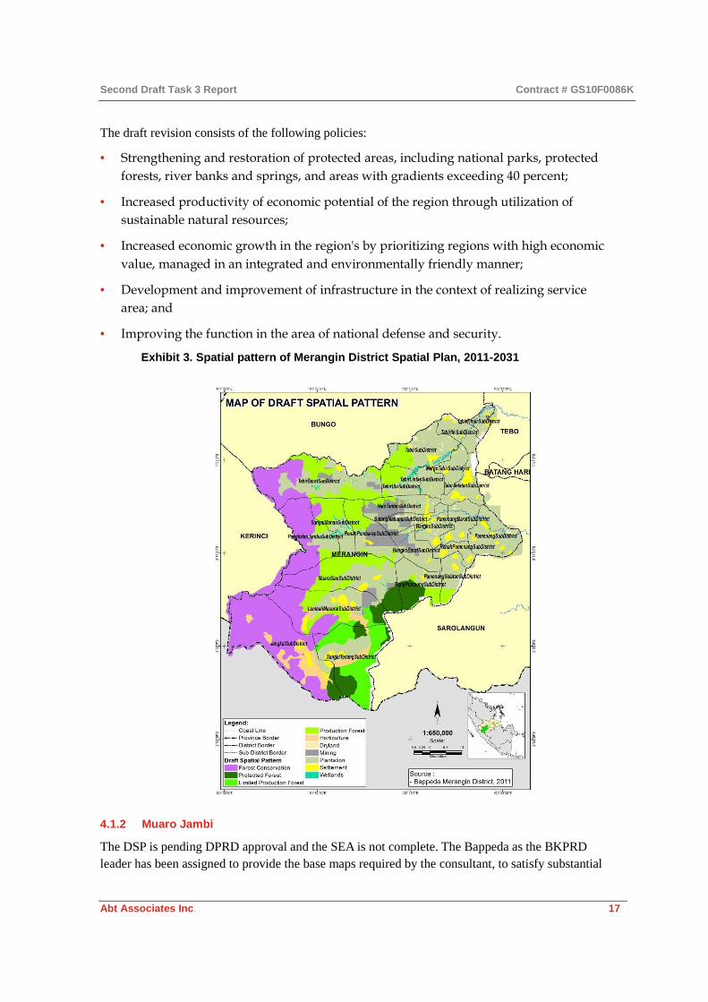
4.1.1 Merangin
The District Spatial Plan (DSP) of Merangin District (2011–2031) is still pending mutual agreement between the Local Parliament (DPRD) and the District Head (Bupati). Local spatial planning development is being developed by a third party consultant, and the related Strategic Environmental Assessment (SEA), has not yet been done in Merangin District. Instead, Merangin District referred to the Provincial SEA. The draft revision of the District Spatial Plan was made by the BKPRD based on Bupati Decree No. 39/Bappeda/2012 (see Exhibit 3 for draft spatial plan).
Second Draft Task 3 Report Contract # GS10F0086K
Abt Associates Inc. 17
The draft revision consists of the following policies:
• Strengthening and restoration of protected areas, including national parks, protected
forests, river banks and springs, and areas with gradients exceeding 40 percent;
• Increased productivity of economic potential of the region through utilization of
sustainable natural resources;
• Increased economic growth in the region's by prioritizing regions with high economic
value, managed in an integrated and environmentally friendly manner;
• Development and improvement of infrastructure in the context of realizing service
area; and
• Improving the function in the area of national defense and security.
Exhibit 3. Spatial pattern of Merangin District Spatial Plan, 2011-2031
4.1.2 Muaro Jambi
The DSP is pending DPRD approval and the SEA is not complete. The Bappeda as the BKPRD leader has been assigned to provide the base maps required by the consultant, to satisfy substantial

Second Draft Task 3 Report Contract # GS10F0086K
Abt Associates Inc. 18
planning and development requirements, to supervise the consultant’s performance of the work, and to coordinate those district agencies that are BKPRD members. The draft RTRWK for Muaro Jambi contains seven policies on spatial use arrangements:
• Development of modern agriculture which is based on the processing industry and
agricultural product marketing
• Urban and village development in support of regional economic development
• Integrated and balanced regional infrastructure development at every production
center, activity center, growth center and service center
• Establishment of protected forest in support of sustainable development
• Industry development of agriculture and plantation processing products
• Strategic area development in support of regional development
• Improvement of functional areas for the purpose of national defense and security
Exhibit 4. Spatial pattern of RTRWK for Muaro Jambi

Second Draft Task 3 Report Contract # GS10F0086K
Abt Associates Inc. 19
4.1.3 Mamuju
The Mamuju DSP preparation process led to a new regional spatial plan draft in 2012, referring to the Long-term Development Plan of West Sulawesi and the SEA for the Province. As of 2013, it was still in the process of obtaining approval from the Government with respect to the forestry aspects. The development process used the West Sulawesi Spatial Plan pursuant to Law No. 26 of 2007. The Mamuju District Government has prepared the necessary documents for an SEA and completed spatial layout, with both items completed simultaneously in July 2012. Accordingly, in preparing its Regional Spatial Plan, Mamuju District referred to the SEA documents as the basis for the development policy, planning, and program in Mamuju District for the next 20 years. In the absence of the regional spatial and planning coordination not being finalized for Mamuju, the spatial planning process is currently run by Bappeda in coordination and synchronization with other government agencies.
The Spatial Structure Plan of Mamuju District was prepared for a period of 20 years (2012-2032) and covers the development of activity centers, a major infrastructure network (transportation system), and other infrastructure networks (energy network, telecommunications network, and water resources system). The activity centers in Mamuju District are the nodes of social, cultural, economic, and/or public administration services in the district.
Since the spatial plan is in process, no other land use decisions were reported as of this assessment, such as forestry and others. But in order to understand the consistency between the spatial plans with other planning documents, we assessed the consistency between the spatial plan and other related documents, especially SEA and RPJMD. The figure below presents the variation between the two. The key results of this assessment are as follows:
• Classification of forest area is consistent between the Mamuju DSP and SEA-RMTDP
document.
• There is variation between the SEA and RMTDP for Ganda Dewata National Park and
the Kalumpang Wildlife Area, which is described as protected forest in the DSP, but
not in the SEA and RMTDP plan.
• The Rice Field–Crops Development Area is larger in the SEA (2.99%) than in the DSP
(1.43%) because the SEA includes areas where conditions are right for cultivation.
Exhibit 5. Comparison between SEA Pattern and Draft RTRWK for Mamuju
Spatial Pattern Plan SEA (ha)
SEA (%)
Spatial Plan (ha)
Spatial Plan (%)
Ganda Dewata National Park 90,979 18.75 - -
HL 64,433 13.28 233,573 48.15
HP 19,131 3.94 20,474 4.22
HPK 15,694 3.24 12,688 2.62
HPT 124,570 25.68 127,495 26.28

Second Draft Task 3 Report Contract # GS10F0086K
Abt Associates Inc. 20
Spatial Pattern Plan SEA (ha)
SEA (%)
Spatial Plan (ha)
Spatial Plan (%)
Riparian/River Protected - - 871 0.18
Kal. Fauna Conservation 77,429 15.96 - -
Not Suitable 4,710 0.97 - -
Plantation Plan 73,646 15.18 72,279 14.9
Rice Land – Palawija 14,522 2.99 6,935 1.43
Settlement Development - - 7,803 1.61
Prone to Natural Disasters - - 1,979 0.41
Fishery - - 1,016 0.21
TOTAL 485,115 100 485,115 100
Source: Results of digitizing spatial pattern map for West Sulawesi, SEA, and RPJMD of West Sulawesi Bappeda and calculating in Projection UTM zone 50 s, 1984 WGS Datum
4.1.4 Mamasa
The process of spatial planning in Mamasa District was completed in 2009, in tandem with the spatial planning for West Sulawesi Province. However, at the time it did not include the SEA. The SEA was completed in June 2012 but most of its substance was derived from the provincial SEA.
The district spatial planning should refer to the province’s spatial plan, but this has not been implemented properly. In addition, the Perda for the West Sulawesi RTRWP has still not been legalized yet, as the status of its forestry aspects is still under consideration. The draft RTRWK and Perda for Mamasa are now being discussed by the Mamasa DPRD.
The Directorate General of Spatial Planning at the Ministry of Public Works provided technical assistance to complete the substance of the Mamasa district spatial plan. The Mamasa RTRWK Technical Document and RTRWK PERDA draft have both been discussed at the Mamasa DPRD. However, there have been no consultative processes involving the community, entrepreneurs, academics, NGOs, or other community leaders to enrich the substance of spatial plan. Although the multi-stakeholder consultation process has not yet been done, the draft Mamasa district spatial plan was received by BKPRN in early 2013 for discussion on its substance. With the technical assistance provided by the Ministry of Public Works, Mamasa Bappeda contracted Cikarsa Consulindo Makassar to be the consultant responsible for technical implementation of spatial draft preparations at the district area. The tasks of the consultant were to prepare the maps needed for the spatial plan drafts, prepare the technical documents, and the draft Perda. Bappeda, serving as BKPRD, was in charge of coordinating other technical line agencies in the preparation of the draft RTRWK and Perda.
Exhibit 6 presents the differences in the spatial plan between the SEA and the draft RTRWK for Mamasa.

Second Draft Task 3 Report Contract # GS10F0086K
Abt Associates Inc. 21
Exhibit 6. Comparison between SEA pattern and draft RTRWK for Mamasa
Spatial Pattern Type SEA (ha) SEA (%) Spatial Plan (ha) Spatial Plan (%)
Ganda Dewata National Park
66,534 21.88
-
-
HL 88,409 29.07 151,996 49.97
HPK 273 0.09 40,224 13.23
HPT 54,297 17.85 77,540 25.49
Not Suitable for Commodities
71,319 23.45
-
-
Plantation Plan 4,791 1.58 24,994 8.22
Rice Land – Horticulture 18,528 6.09 9,103 2.99
Settlement Development Plan
-
-
294 0.1
Total 304,150 100 304,150 100
Source: Digitization results from Space Pattern Planning Map of West Sulawesi Province, West Sulawesi Province Bappeda
4.2 Data for Spatial Planning
Data that are needed for spatial planning includes:
• Spatial Planning Document (national, province, and district), including:
− Spatial pattern that distinguishes the category of cultivated/protected area,
− Designation as a strategic area, and
− Spatial structure, particularly with regard to the availability of a supporting infrastructure network (road, electricity transmission network, and accessibility to a growth center or regional/local activity/business center).
• Land status/land concession, which is determined based on a Definitive Permit,
Exploration/ Reserve Permit, and an area which is free from permit/an area which is
not a concession area. The following institutions are officially issuing these licenses:
Ministry of Forestry, National Land Agency, and Ministry of Energy and Mineral
Resources.
The next section presents the district-level availability of land and land use data needed for spatial planning. In addition to availability of data, there is a need to integrate all the data for efficient analysis as is laid out in the sections which follow on the need and options for data integration.
4.2.1 Existing Land and Land Use Data
The two main sources for map-based land information for all districts is Ministry of Forestry and ICRAF. In Jambi Province, the ICRAF map includes information provided by the Ministry of

Second Draft Task 3 Report Contract # GS10F0086K
Abt Associates Inc. 22
Forestry, Bakosurtanal, Jambi Province Bappeda, and Merangin and Muaro Jambi District Bappeda. This map includes information on land status for overlapping allotments and licenses. For Merangin and Muaro Jambi, there are seven types of land status, namely: overlapping permits, potential overlapping permits, forest concessions, mining concessions, plantation concessions, conservation areas, and no concessions. In all four districts there is no geo spatial data available in minimum scale 1:50.000. And the available data is not standardized. There also exist several gaps in the available data. For example, in Mamasa, the planned delineation of each area, its position and size were not available yet. The position and size of the area are needed for a compatibility analysis against actual conditions. Disaster Prone Areas (RBAs), susceptible to earthquakes, tsunami, landslides or flood were not clear. This issue could not be resolved, although the spatial analysis of landslide areas and flood areas could be supported if the necessary data and information were available. There is no interactive institution managing spatial data and information; all data are still stored at the related SKDP.
The table in Exhibit 7 which follows presents the availability of data across the four starter
districts.

Second Draft Task 3 Report Contract # GS10F0086K
Abt Associates Inc. 23
Exhibit 7. Existing Land and Land Use Data of PLUP of Four Starter Districts (Merangin, Muaro Jambi, Mamasa and Mamuju)
Item Source District Remarks
Merangin Muaro Jambi
Mamuju Mamasa
Villages Map BPS, 2010 √ √ √ √ There is no exact delineation of village boundary, there is available on indicative data (sketch) only
Spatial Structure Bappeda-RTRWK, 2012
√ √ √ √ For Mamasa and Mamuju, it used basic map, with its map scale is 1:50,000 (source from BIG). For Merangin and Muaro Jambi, it used 1:250,000 map scale (source from BIG)
Spatial Pattern Bappeda-RTRWK, 2012
√ √ √ √ For Mamasa and Mamuju, it used basic map, with its map scale is 1:50,000 (source from BIG). For Merangin and Muaro Jambi, it used 1:250,000 map scale (source from BIG)
Strategic Areas Bappeda-RTRWK, 2012
√ √ √ √ For Mamasa and Mamuju, it used basic map, with its map scale is 1:50,000 (source from BIG). For Merangin and Muaro Jambi, it used 1:250,000 map scale (source from BIG)
Land Cover Ministry of Forest, 2011 √ √ √ √ It used webgis data of Ministry of Forestry of 2011 with accuracy of map scale is 1:50,000
Forest Classification
Jambi --> MOF 2012, West Sulawesi --> Draft RTRWP 2013
√ √ √ √

Second Draft Task 3 Report Contract # GS10F0086K
Abt Associates Inc. 24
Item Source District Remarks
Merangin Muaro Jambi
Mamuju Mamasa
Forest Concession
Hutan Desa √ ≠ ≠ ≠ Digitation result from GIS staff of Abt from ICRAF Report
HKM WebGIS MOF √ √ √ √ No available on accuracy of spatial data
HTR WebGIS MOF √ √ √ √ No available on accuracy of spatial data
IUPHK-HPH West Sulbar --> MOF ≠ ≠ √ √ This has been re-drawing from HPH map of Sulawesi Barat of 2007 with its map scale is 1:250,000
IUPHK-HTI WebGIS MOF √ √ √ √ No available on accuracy of data spatial
Plantation
HGU Muaro Jambi --> BPN and Bappeda, 2009 Merangin --> BPN and Bappeda, 2006
√ √ ≠ ≠ No available on accuracy of data spatial
Mining
IUP WebGIS Ministry of Mineral and Natural Resources
√ √ √ √ 1. No available on accuracy of spatial data (IUP)

Second Draft Task 3 Report Contract # GS10F0086K
Abt Associates Inc. 25
Item Source District Remarks
Merangin Muaro Jambi
Mamuju Mamasa
2. The accuracy of the bloc in the map is not necessarily describing the actual of total area (width), because the bloc itself was made as indicative. In addition, no verification activity was conducted in the field
Adat Territory/ Customary Territory
Hutan Adat Bappeda 2011 √ ≠ ≠ ≠ A digitation results from GIS staff of Abt. It used basic map of RTRWK draft, with its map scale is 1:250,000
Forest Management Unit (Kesatuan Pengelola Hutan/KPH)
BAPLAN 2011-->Spatial BAPLAN 2013-->Tabular
√ √ √ √ No available on accuracy of data spatial
Key to symbols:
√ Available
≠ Not available

Second Draft Task 3 Report Contract # GS10F0086K
Abt Associates Inc. 26
4.2.2 Data Integration
Data integration in spatial planning institutions can reduce duplication of spatial data and improve the government’s planning process. However, spatial data integration is a complicated issue in Indonesia because integration must be carried out on the base and thematic maps, which may be derived from various sources and data custodians, at national, provincial or district level. Institutions and organizations making spatial data tend to use the data to their own standards, without considering whether the data would be useful to other institutions in order to avoid duplication, or whether it could be combined with other data to produce useful data and information needed in spatial planning. Several technical issues must be addressed when performing spatial data integration:
• Differences in the spatial reference system
• Differences in the scale of data sources
• Differences in the definition of a feature or object
• Differences in data quality due to different spatial resolution or method of data
acquisition
• Differences in the attributes of the spatial data (geometry, feature names, attributes,
land type, topology, etc.)
In terms of developing accountable geospatial information, Law No. 4 of 2011 on
Geospatial Information presents an opportunity to develop and manage a national
mapping system that can integrate data needs from the district to the provincial and
national level. At the national level, data integration can be done by establishing a One
Map and One Gate System, while at the provincial and district level; several constraints
were identified, as follows:
• JDSN has not yet been established, as mandated by Presidential Regulation No. 85 of
2007.
• No organization or data unit/center has been established yet that has the legal
authority needed to improve coordination among district agencies whose background
is land based, such as Forestry, Agriculture and Plantations, Energy and Mineral
Resources, and Public Works agencies, and BPN.
• Coordination in gathering Thematic Geospatial Information (Informasi Geospatial
Thematik/IGT) from different sectors is still challenging, even though they are all part
of the BKPRD team.
• There is a lack of institutional capacity in data handling, particularly for geospatial
information. This might be due to:
− The structure of the organization: There is no specific unit for geospatial information management in the district government line agencies, BPN or Bappeda
− The job descriptions of government officials: There is no specific personnel policy to focus on the management of geospatial information that will prevent skilled officials from being

Second Draft Task 3 Report Contract # GS10F0086K
Abt Associates Inc. 27
transferred to positions that bear no relation to spatial planning and geospatial information management. This includes the absence of specific career paths for those with skills in geospatial data and information management, or spatial analysis, or even for GIS technicians.
− Merangin District has not yet complied with Law No. 4 of 2011 on Geospatial Information, particularly on the provision of programs and special services in data management, public service, and collaboration with stakeholders.
The following are some data gaps and inconsistencies in spatial data integration in Merangin and Muaro Jambi:
• Each responsible institution or organization makes its own spatial data for its own
purposes, using its own standards and does not share it to avoid duplication or
integration.
• Development of district spatial plan was not done exclusively by the district
government (in this case Bappeda) due to a lack of resources and capacity, but was
supported by a third party spatial planning consultant. This led to the district
government relying on the consultant to create and update the data, and to make
revisions to the district spatial plan.
• Some spatial data were held by the consultant, preventing users (government and
non-government) from accessing and updating the data in a transparent way.
• Land tenure problems in the field had an impact on the clarity of the administrative
boundaries of villages, sub-districts, and districts.
• Data updates and synchronization among district government agencies were difficult
to realize due to a lack of coordination and no defined mechanism for data sharing
and integration.
• There were no dedicated staff managing the spatial database as data keeper at the
district level, linking it to the spatial database at province and national levels
West Sulawesi: Gaps in Data Integration in Mamasa and Mamuju
The process of data exchange from West Sulawesi Province to the District and vice versa in terms of data integration is coordinated entirely by Bappeda, and is generally in the form of tabular data submitted from each line sector agency, without its accuracy being verified. The data is then handed over to the provincial BPS office to become official data. Spatial data comes from a third party in JPG format, as does the data used to implement spatial planning in Mamuju District. In West Sulawesi, the quality of spatial data information and administration found in Mamuju and Mamasa was generally similar, particularly in relation to land status. Technical issues with spatial data management in Mamuju follow:
• Lack of data integration among local government agencies
• Poor data sharing between district and provincial government

Second Draft Task 3 Report Contract # GS10F0086K
Abt Associates Inc. 28
• Data from third party was in JPG format, which could not be re-formatted for further
analysis
• Lack of integration and synchronization of textual and spatial data
• Lack of funds and human resources in textual and spatial data management
• Regular staff rotation was one of the main obstacles to integrating data
Technical issues with spatial data management in Mamasa were as follows:
• The arrangement of the main data in Mamasa District is fundamental for formulating,
implementing and controlling the development process. The data did not meet the
standards regulated in Government Regulation (GR) No. 8 of 2003 on RTRW map
accuracy
• For the data exchange process between West Sulawesi Province and the district, data
integration was coordinated by Bappeda using tabular data provided by each SKPD,
without an accurate verification process
• Spatial and textual data were available in Shape and JPG files. For the district
administrative area, the scale was 1:100,000, while for the atlas the scale was 1:50,000
• Forestry Agency of Mamasa District used spatial data standardization mandated in
the IG Law. However, processing the spatial data into a Forestry Master Plan was
done by a third party (Central Forestry and Bakosurtanal officials). Mamasa District
Forestry Human Resources were unable to process the spatial data, and had limited
hardware and software available to them.
• The boundaries of Mamasa District cooperated with West Sulawesi Tomdam do not
use the RBI maps published by Bakosurtanal. According to the IG Law, RBI maps
should be the standardized mapping reference.
• The Mamasa District RTRW does not refer to the provincial KLHS drafts, causing
major deviations.
4.3 Capacity for Spatial Planning
A lack of capacity in human resources is one of the main hurdles in spatial data management in all the starter districts. Lack of human resources especially in spatial plan is facing by all 4 districts. There is a lack of capacity to analyze data and information, as well as spatial data management. Given the lack of capacity, consultants and university staff have helped in the process.9 However, this consultation has not resulted in either building capacity in the government or in the transfer of
9 Technical assistance for spatial planning process in Merangin and Muaro Jambi by University of Jambi (UNJA); technical assistance for spatial planning in Mamuju by University of Hasanuddin Makasar (UNHAS); technical assistance for spatial planning in Mamasa by Cikarsa Consulindo consultants in Makassar

Second Draft Task 3 Report Contract # GS10F0086K
Abt Associates Inc. 29
data and knowledge to the local staff. Furthermore, the data has become assets of these third parties. The contexts of lack of human resources are:
• Capacity of human resources to analyze data and information, both textual and spatial
data. This is a result of limited human resources in Merangin District, Muaro Jambi
District, Mamuju District and Mamasa District, especially where those involved in
BKPRD team should have formal education and sufficient analytical capacity to
analyze data and information needed. Based on Government Rule no. 15/2010 article
32, the minimum skill of data management and analysis are:
− Analysis techniques and carrying capacity of the environment is determined by the Strategic Environmental Assessment (SEA), and
− Technical analysis of inter-regional linkages district.
• The limited number of personnel who were deployed to support District Spatial Plan
process. In addition to low capacity levels, additional manpower is needed to
complete the spatial plans, thus creating a vicious circle which leads to the use of third
parties to provide a short-term solution.
• Limited capacity of human resources skills, especially in spatial data processing. The
supporters team has vital role in the preparation of thematic maps for developmental
planning needs, including various thematic data that must be prepare in spatial plan
documents. Human resources capacity in each district in the processing of spatial data
is still very limited
In the findings reported by the team, both Merangin and Muaro Jambi District had the following issues with capacity of Bappeda and Bupati offices:
• Incompatibility of the education background of local government officials with needs
for geospatial data and information management. For instance, Merangin District
Bappeda has only two staff that manage geospatial data and information.
• Lack of capacity building for staff in spatial data.
• Lack of supporting infrastructure such as up-to-date computers, GIS, software, spatial
data information system (integrated network).
• Merangin District Bappeda has only two staff that manage geospatial data and
information.
• Few opportunities for individual capacity building through vocational training in
geospatial data and information management.
• Lack of learning support facilities and instruments, such as specialized computers,
GPS, and appropriate GIS software. For instance, Merangin Bappeda still uses ArcGIS
version 9.3, while the current version is 10.2.

Second Draft Task 3 Report Contract # GS10F0086K
Abt Associates Inc. 30
4.4 Land Use Assessment
Under this assessment we present the existing strategic areas in each district, the permit overlaps, and the potential for GP investment. There are three key aspects: data preparation; analysis of land use status and concessions; and determining potential locations for investment. The third element requires good data quality issued by licensors. Based on the analysis of the starter districts, overlapping permits and land use are likely to occur as a result of poor quality data, and weak inter-agency coordination. The spatial pattern developed for the planning process was insufficient for use as an input to ensure suitability and compatibility of land use with the GP investment objective.
There is a need to conduct on-the-ground assessments of land use and status, particularly in areas with potential for GP investment. This is particularly related to the inadequate quality of the available data on land use and land cover. It is important for GP to work closely with the local government in preparing the Detailed Spatial Plan (RDTR), especially in defining zoning and ensuring sustainability with GP investment objectives. The following sections present the results of our land use assessment in the four starter districts.
4.4.1 Muaro Jambi
Land Status Analysis: Muaro Jambi has formally established national, provincial and district strategic areas. These strategic areas aim to support district economic growth, and areas are described below.
• National strategic area, which refers to the functional interest and ecological carrying
capacity, is Berbak National Park.
• Provincial Strategic Area in the district consists of:
− In terms of economic interest, the provincial strategic area is Muaro Bulian–Jambi City and the surrounding area.
− In terms of social and cultural interest, the provincial strategic area is Integrated Historical Tourism at Muaro Sebo Sub-District.
• From an economic interest/perspective, the district strategic areas are:
− Sengeti, City of Jambi and surrounding area;
− Agropolitan area at Muaro Sebo Sub-District, Kumpeh Ulu and Sungai Gelam Sub-District;
− Minapolitan area at Jambi Luar Kota Sub-District; and
− Tourism area of Muaro Jambi temple.
Part of the area of Muaro Jambi District is burdened with plantation and mining licenses and a conservation area. Overlapping permits occur in every sub-district, and there are very few areas not burdened by such licenses. The analysis of land status in Muaro Jambi District has been through the process of super-imposing of maps of land-based concessions, consisting of:
• Permits/licenses for utilization of forest area:
− Forest Park (Taman Hutan Rakyat/Tahura) in Kumpeh Sub-District

Second Draft Task 3 Report Contract # GS10F0086K
Abt Associates Inc. 31
− Community based timber plantation (HTR) in Sungai Gelam Sub-District
− Timber Plantation Concessions (HTI) of PT. Wira Karya Sakti in Sekernan, Maro Sebo, and Taman Rajo Sub-Districts; PT. WKS in Kumpeh Sub-District, PT. Rimba Hutani Mas in Sakernan Sub-District; and PT. Dyera Hutani Lestari in Kumpeh Sub-District
− Forest Management Units (KPH), consisting of four units, namely: Unit XI in Sakernan Sub-District; Unit XII in Kumpeh, Taman Rajo and Sungai Gelam Sub-Districts; Unit XIV in Sakernan, Muaro Sebo and Taman Rajo Sub-Districts; and Unit XV in Sakernan Sub-District
• Permits for mining (Mining Concession Permits), in every sub-district except Kumpeh
and Muaro Sebo
• Commercial Land Utilization Right (HGU) for palm oil plantations in every sub-
district, with the biggest concession being in Sungai Bahar Sub-District.
Exhibit 8. Overlapping concessions and permits in Muaro Jambi District
The analysis identified four land-based groups:

Second Draft Task 3 Report Contract # GS10F0086K
Abt Associates Inc. 32
Land Status Description Legend (map)
Overlapping area One or more than two definitive permits
Concession overlap 3 Licenses (1)
Concession overlap 2 Licenses (2)
Potential conflict on boundary One definitive permit, and two or more exploration/reserved permits
Forest Production Area (5)
Single concession (no overlapping area)
One definitive permit only Mining Concession (3)
Estate Concession (4) Industrial Plantation Concession (6) Forest Management Unit (8)
No concession area Definitive or reserved concession permit not available
No Concession (11)
Exhibit 8 shows the overlapping area of reserved and permits from the plantation, forestry and mining sectors; as well as potential overlapping areas and areas which are free from the overlapping
Most of the concession area in Muaro Jambi District is designated for HGU for palm oil plantations. One HGU overlap is with a mining concession in Sungai Bahar Sub-District. The other HGU overlap is for utilization of a forest concession area, specifically, an industrial forest plantation (HTI) in Sakernan, Muaro Sabo and Taman Rajo Sub-Districts. The HTI concession of PT WKS is in Taman Rajo and Kumpeh Sub-Districts, and this concession surrounds the area of Londerang protected forest and goes up to Tanjung Jabung Timur District. The Londerang protected forest area is peat land forest with a soil depth of 1-5 meters.
Based on data obtained from the SEA for Jambi Province 2011–2031, social conflict on land tenure claims in Muaro Jambi District exists only in Sungai Bahar Selatan Sub-District. This social conflict is actually in Bejubang Sub-District, Batang Hari District, which borders Sungai Bahar Selatan and Sungai Bahar Sub-Districts. The social conflict in Bejubang Sub-District is due to a land tenure claim from a local tribe (Suku Anak Dalam) over the plantation concession of PT Asiatic Persada. The conflict first arose in 2010 and has never been resolved.
Potential Areas for GP Investment in Muaro Jambi: Based on just a review of areas with no concessions or no overlapping and is status for use as non-forest or forest, the potential area for land-based investments:
Status of Potential Area Description Potential Area for the Land-Based Investment
Potential area for investment in non-forestry activity
Area that can be utilized (no concession or overlapping) and is located in a cultivated area
• Suitable areas for land investment:
• Food crops
• Plantation Area

Second Draft Task 3 Report Contract # GS10F0086K
Abt Associates Inc. 33
Potential area for investment in forest activity
Area that can be utilized for developing land-based investment for forest activities located in a cultivated area
Production Forest
Non-potential area for investment in non-forestry activity
Area that cannot be utilized because there are one or more licenses and/or it is located in a protected forest and cultivated area
Not a suitable area
The area suitable for land-based investment in Muaro Jambi District is a cultivated area intended for developing horticulture (wet or dry). The area for horticulture development is spread across Kumpeh, Kumpeh Ulu and Taman Rajo Sub-Districts, while plantations are spread across every sub-district.
Another suitable area is for forestry activity, namely production forest development located in the area of KPH Unit XII, in the Sub-Districts of Kumpeh and Taman Rajo. Based on strategic area directives, part of Berbak National Park has a strategic position that needs to be maintained, namely to support agricultural activity and contribute a greater role to the economic development of the local community, as well as to protect the peat land function of Berbak National Park. It is important that development of dry/wet land-based agriculture be maintained in the peat land area. Without proper maintenance and management of agriculture activity in the peat land area (swamp forest), ecological disasters could follow, including drought, flooding, forest fires, carbon emissions, loss of biodiversity, harvest failure, and poverty).
Based on the GP investment objective, which emphasizes improving community welfare and reducing carbon emissions, the results of the geospatial analysis in line with potential areas of GP investment are: (i) a potential area for investment in non-forestry activity; and (ii) a potential area for investment in forest activity. This area is located in Berbak National Park. GP investment is expected to reduce ecological pressure while benefitting economic development in the local community.

Second Draft Task 3 Report Contract # GS10F0086K
Abt Associates Inc. 34
Exhibit 9. Land Based Investment in Muaro Jambi District
4.4.2 Merangin
Land Status Analysis: Merangin District has established three types of strategic areas, as set out in the Draft RTRWK for Merangin, – National Strategic Areas, Provincial Strategic Areas, and District Strategic Areas, as follows:
• National Strategic Area in Merangin District is Kerinci Seblat National Park (Taman
Nasional Kerinci Seblat/TNKS), covering approximately 166,609 hectares in Jangkat,
Sungai Tenang, Lembah Masurai, Muaro Siau, Pangkalan Jambu, Sungai Manau and
Tabir Barat Sub-Districts. TNKS is a nature conservation area with a unique ecosystem
and high values of biodiversity in terms of flora and fauna. The TNKS Forest
ecosystem serves as a catchment area for the Watershed (Daerah Aliran Sungai/DAS)
of Batang Hari and Air Dikit, covering an area in Jambi and Bengkulu Provinces.
• The area of Bangko-Sarolangun is a Provincial Strategic Area. This strategic area is
expected to become a major growth center in the central region of Jambi Province that
is able to push the hinterland to grow more rapidly. The leading sectors in the
strategic area of Bangko-Sarolangun are forestry, plantations, farming, mining and
tourism.

Second Draft Task 3 Report Contract # GS10F0086K
Abt Associates Inc. 35
• Bangko Urban Area is a District Strategic Area, which is an activity center for services
and trade, administrative center, settlements, education and tourism. Bangko is
designated to serve as the Activity Center for Regional Promotion (Pusat Kegiatan
Wilayah Promosi/PKWP).
• The areas of natural and cultural tourism include Arboretum Rio Alip Bangko
Tourism Forest, Bangko Tiung Bird Park Hill, heritage site of Old House of Rantau
Panjang and Batu Bertulis Karang Berahi site. The Batu Larung sites are Dusun Tuo
and Nilo Dingin in Lembah Masurai Sub-District, Lubuk Mentilin in Jangkat Sub-
District, and Gedang Village in Sungai Tenang Sub-District.
• The agropolitan area of Lembah Jang Tenang consists of Lembah Masurai, Jangkat
and Sungai Tenang Sub-Districts, and has potential for the development of
horticulture agriculture and plantations, especially potatoes, vegetables, patchouli and
coffee.
• The agroindustry area consists of the areas of Pamenang Barat, Bangko Barat, Batang
Masumai, Nalo Tantan and Tabir Lintas Sub-Districts. It aims to support the
optimization of agriculture and plantation potential in Merangin District, and to
encourage the growth of other sectors.
• The Geopark area is an area that has unique rocks and fossils that are millions of years
old, located in Bangko Barat and Renah Pembarap Sub-Districts.
• The area of geothermal energy is located in Jangkat and Sungai Tenang Sub-Districts.
The geothermal potential has not yet been explored.
Minister of Forestry Decree No. 727 of 2012, which is a revision of Minister of Forestry Decree No. 421 of 1999, is the basis for the preparation of the RTRWK of Merangin. Forest Areas in Merangin include TNKS, Protected Forest, Production Forest, and Limited Production Forest. Merangin District has already established four Customary Forests (Hutan Adat), namely:
• Rimbo Penghulu Depati Gento Rajo Customary Forest
• Guguk Customary Forest
• Desa Baru Customary Forest
• Bukit Pintu Koto Customary Forest
By way of an overview of land status in Merangin District, most areas in Merangin District have been burdened by estate/plantation licenses and conservation areas (TNKS). The analysis of land status through overlay maps of land-based concessions includes:
• Licenses for forest area utilization, consisting of:
− Hutan Desa: Sub-districts of Pangkalan Jambu (1), Muara Siau (3), Lembah Mesurai (3), Sungai Tenang (9), and Jangkat (1)

Second Draft Task 3 Report Contract # GS10F0086K
Abt Associates Inc. 36
− Community-based Timber Plantation Forest (Hutan Tanaman Rakyat/HTR) in Muaro Siau Sub-District
− Timber Plantation Forest Concession (Hutan Tanaman Industri/HTI): PT. Duta Alam Makmur in Lembah Masurai and Sungai Tenang Sub-Districts, PT. Jebus Maju in Sungai Manau and Renah Pembarap Sub-Districts, and PT. Mugitriman International in Tabir and Tabir Ulu Sub-Districts
− Forest Management Units (KPH), consisting of Units III, IV, V, VI and VII
• Licenses for mining (Izin Usaha Pertambangan/IUP) comprising 12 IUPs
• Commercial Land Utilization Rights (Hak Guna Usaha/HGU) for oil palm plantations
• Customary Forests (Hutan Adat) in four Sub-Districts, namely, Pangkalan Jambu,
Tabir Barat, Renah Pembarap, and Jangkat
The results of the spatial analysis show that in several areas there are indications of overlapping licenses, with concessions for forest utilization, plantation utilization right, and mining permits. But there are many other areas which have potential for land-based investment, namely in areas that do not overlap (single concessions) and areas where concessions are unclear.
Land status Description Map legend
Overlapping area One or more than two definitive permits
• Concession overlap – 3 Licenses (1) • Concession overlap – 2 Licenses (2)
Potential conflict on boundary
One definitive permit, and two or more exploration/ reserved permits
Forest Production Area (5)
Single concession (no overlapping area)
One definitive permit only
• Mining Concession (3) • Estate Concession (4) • Industrial Plantation Concession (6) • Community Plantation Forest (7) • Forest Management Unit (8) • Village Forest (9) • Customary Forest (10)
No concession area No concession permit, either definitive or reserved, is available
No Concession (11)

Second Draft Task 3 Report Contract # GS10F0086K
Abt Associates Inc. 37
Exhibit 10. Overlapping concessions in Merangin District
Potential Areas for GP Investments in Merangin: Potential areas for land-based investment were decided by super-imposing the Map of Spatial Pattern/Strategic Areas, and by analyzing the land status. The consideration of spatial patterns derived from the land status analysis will provide direction for future land utilization, especially for areas that support land-based investment activities. At the same time, the consideration of strategic areas will provide intensive development for the area concerned. Opportunities to develop synergy among investment projects through the government's development program in the development of strategic areas can be integrated.

Second Draft Task 3 Report Contract # GS10F0086K
Abt Associates Inc. 38
No. Potential Area Status Description Potential Area for Land-Based Investment
1 Potential area for investment in non-forestry activity
Area that can be utilized (no concession or overlapping) and located in a cultivated area
Suitable area for land Investment:
- Food crops - Plantation Area
2 Potential area for investment in forest activity
Area that can be utilized for developing land-based investment for forest activities located in a cultivated area
Production Forest
3 Non-potential area for investment in non-forestry activity
Area that cannot be utilized because there are one or more licenses and or it is located in a protected forest and cultivated.
Non-suitable area
As mentioned earlier, the district strategic area of Lembah Jang Tenang in Lembah Mesurai, Jangkat and Sungai Tenang Sub-Districts aims to develop into an agropolitan area. The spatial structure that supports the development of these sub-districts comprises:
• A transportation network from the capital of Bangko to the capitals of Lembah Masurai, Jangkat and Sungai Tenang Sub-Districts is connected by a main road. The quality of the current road is good.
• The urban area of Pasar Masurai in Lembah Masurai Sub-District serves as an administrative center and transportation node. The capitals of Jangkat (Muara Madras) and Sungai Tenang (Rantau Suli) function as Centers for the Services Area.
• For the electricity transmission network, Jangkat Sub-District aims to become a Power Station/Base, while Lembah Masurai and Sungai Tenang Sub-Districts will be connected through a Medium Voltage Network (Saluran Udara Tegangan Menengah/SUTM) with a capacity of 50kVA.
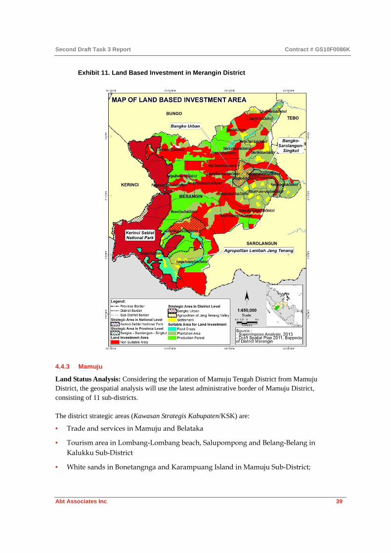
Second Draft Task 3 Report Contract # GS10F0086K
Abt Associates Inc. 39
Exhibit 11. Land Based Investment in Merangin District
4.4.3 Mamuju
Land Status Analysis: Considering the separation of Mamuju Tengah District from Mamuju District, the geospatial analysis will use the latest administrative border of Mamuju District, consisting of 11 sub-districts.
The district strategic areas (Kawasan Strategis Kabupaten/KSK) are:
• Trade and services in Mamuju and Belataka
• Tourism area in Lombang-Lombang beach, Salupompong and Belang-Belang in
Kalukku Sub-District
• White sands in Bonetangnga and Karampuang Island in Mamuju Sub-District;

Second Draft Task 3 Report Contract # GS10F0086K
Abt Associates Inc. 40
• Kalukku Agropolitan area, which includes Kalukku, Simboro, Tapalang and Tapalang
Barat sub-districts
• Mamuju Minapolitan area, which includes Mamuju, Kalukku, Papalang, Simboro,
Tapalang and Tapalang Barat sub-districts
• Iron ore mining area in Kalumpang, Topoyo, Karossa, Tapalang and Simboro sub-
districts
Changes in the function and designation of the Forest Area of Mamuju District began in 1996 in the form of HPH and HTI. Through Minister of Forestry Decree No. 799 of 2009, West Sulawesi has 13 Regional Forest Management Units covering 1,099,827 ha. consisting of Production Forest Management Units (FMU) (KPHP) covering 379,153 ha. and Protected FMU (KPHL) covering 720,674 ha.
The issuance of Minister of Forestry Decree No. 726 of 2012 on Amendment of the Designation of Forest Areas to become APL, covering approximately 64,261 ha, and Changes in Forest Area Function covering approximately 251,600 ha in West Sulawesi Province, resulted in almost all KPHP and KPHL regions established by Minister of Forestry Decree No. 799 of 2009 having their status changed under Minister of Forestry Decree No. 441 of 2012, namely, KPHL Unit XII (Ganda Dewata) and KPHL XIII (Kalumpang). These areas are currently the subject of a proposal to rezone the FMU in West Sulawesi Province based on the Governor of West Sulawesi Decree No. 522 of 2013 dated July 10, 2013. The proposal asks the Ministry of Forestry to convert the protected forest in the KPHL area to become APL. The following are the results of the re-zoning:
• Protected Forest in KPHL Unit XII (Ganda Dewata) of approximately 157,598 ha has
been changed to a Conservation Area of 103,314 ha (65.56%)
• Protected Forest in KPHL Unit XIII (Kalumpang) of approximately 79,738 ha has been
changed to a Conservation Area of 67,191 ha (84.26%)
The existing forest concessions in Mamuju District are as follows:
• HPH PT Inhutani I Mamuju (Decree No. 350/Kpts-II/1996) covering 29,750 ha
• HPH PT Intan Hutani Lestari (Decree No. 256/Kpts-II/1998) in Mamuju District
(10,930 ha) and Central Mamuju District (2,108 ha)
• HTI PT Amal Nusantara (Decree No. 302/Menhut-VI/2009) in Mamasa District, while
according to the spatial data analysis, some parts are located in Mamuju District, but
only 15 ha, and this is still part of secondary forest vegetation cover
• HPH PT Rante Mario (Decree No. 532/Menhut-II/2009) in North Mamuju, Central
Mamuju and Mamuju Districts (covering only 4,897 ha)

Second Draft Task 3 Report Contract # GS10F0086K
Abt Associates Inc. 41
Exhibit 12. Land cover in Mamuju District
Mamuju District has also mineral potentials, and there is a long list of mining concessions (IUP) operating there, as shown in the accompanying table.
Company Status of mining permits
Commodity Extent (Ha) Sub-district
PT. Aneka Tambang Tbk Exploration -- 10000 Kalumpang
PT. Anugerah Abadi Semesta Permit Stage Coal 8500 Sampaga
PT. Anugerah Abadi Sentosa Permit Stage Coal 8500 Kalumpang
PT. Bonehau Prima Coal Exploration Coal 98 Bonehau
PT. Debbia Mining Permit Stage Gold 9000 Kalumpang
PT. Debbia Mining Permit Stage Gold 9000 Bonehau
PT. Kutama Mining Indonesia Permit Stage Coal 3239 Bonehau
PT. Merapi Raya Permai Permit Stage Gold 2400 Sampaga
PT. Samudera Rejeki Perkasa Exploration Coal 4000 Bonehau
Source: ESDM Agency, West Sulawesi Province 2013
Based on this information, the distribution of permits and licensing of land-based investment in Mamuju District is as illustrated in Exhibit 13.

Second Draft Task 3 Report Contract # GS10F0086K
Abt Associates Inc. 42
Exhibit 13. Overlapping concessions in Mamuju District
There are four types of land status: Land Status Description Map Legend
Overlapping area Consisting of two or more definitive licenses
• Concession overlap 4 Licenses (1)
• Concession overlap 3 Licenses (2) • Concession overlap 2 Licenses (3)
Potential border conflict
Consisting of one definitive license and two or more exploration/reserved licenses
• Non Forest Area (potential overlap with mining) (6)
• Forest Production Area (potential overlap) (7)
One concession (not an overlap area)
Consisting of one definitive license
• Mining Concession (4)
• Logging Concession (5) • Industrial Plantation Concession (8) • Community plantation forest (9) • Forest Management Unit (10)
No concession area No definitive concession licensed or reserved
No Concession (11)

Second Draft Task 3 Report Contract # GS10F0086K
Abt Associates Inc. 43
Exhibit 13 shows overlapping areas of reserved and licensed plantations, forestry and mining sectors, potential overlap areas, and no overlap areas. Most concessions in Mamuju are intended for mining, and are distributed among almost all sub-districts in Mamuju. Overlaps in mining licensing, HTI and KPH mostly occur in Tomo, Kalumpang sub-district, and Tapalang sub-districts. A mining license (IUP) overlap with HPH Inhutani occurs in Papalang, Kaluku, and Bonehau sub-districts. An overlap of an IUP with HPH Rante Mario occurs in Tomo sub-district.
Potential Areas for GP Invesment in Mamuju: Based on the analysis of geospatial data and other relevant supporting data, three categories of potential areas for GP investment in Mamuju have been identified:
Key Status of Potential Area Description Explanation
A Potential Investment area in Non-Forestry Activities
Area that can be used (no concessions or overlapping areas) and is located in a cultivation area
Potential area, especially for cacao plantation
B Non-Potential Investment area in Non-Forestry Activities
Area that cannot be used because it already has one or more licenses and or is located in a cultivation area
Big and spread among most sub-districts
C Potential Investment area in Forestry Activities
Area that can be used for land based investment. Located in cultivating/ protected area
Area development based on KPH purposes
Exhibit 14. Land based investment in Mamuju District

Second Draft Task 3 Report Contract # GS10F0086K
Abt Associates Inc. 44
Most areas appropriate for investment have potential for forest development, especially in Kalumpang and Bonehau sub-districts, and for plantations (especially cacao) in some parts of Bonehau, Kaluku, Papalang, and Tomo sub-districts. While investment in horticulture products can mostly be implemented in the plateau region of Tomo and Tapalang sub-districts.
The spatial structure plan supporting the directive for land based investment potentials is as follows:
• Road development plan in the RTRW for Mamuju District 2012–2032 focuses on development of a national strategic main road connecting provincial cities in Sulawesi. The road in Mamuju is still undergoing improvements, especially the road connecting Mamuju District to Tana Toraja. The provincial road is also still undergoing improvements, especially between Bonehau and Kalumpang, where the quality needs to be improved.
• As yet, the electricity transmission network still cannot serve most villages, especially in Bonehau and Kalumpang sub-districts, which are highly dependent on micro-hydro power.
4.4.4 Mamasa
Land Status Analysis: The provincial spatial planning structure is the framework for the district spatial structure, which is built upon a constellation of activity centers connected to each other by district infrastructure networks, especially the transportation network.
The district infrastructure transportation system, especially roads, will require improvements, and the construction of new road networks, in order to improve the quality of services among PPK within the district and among districts. The transportation system plans are as follows:
• Constructions of connecting roads to main roads over activity centers and other cities
in sub-districts
• Construction of a new road from Mehalaan village to Pasembuk village in
Ratebulahan Timur sub-district in order to provide access between Botteng village
and Salubanua village, which were previously oriented to the Polewali Mandar area
(Mappili and Matangnga sub-districts)
• Develop and accelerate construction of C terminal in Mamasa and Tawalian
• Enhance and construct supporting terminals in Tawalian, Sumarorong, Randuk Kalua
and Mambi to improve the regional transportation system.
The spatial utilization pattern includes the location and distribution of settlement activities, work places, industries and warehouses, agricultural and plantation activities, forests, socio-cultural and socio-economic facilities, and transportation. Policy to develop protected areas in Mamasa involves designing a protected area will provide protection for downstream areas, local streams, the surrounding water system, and disaster-prone areas.
Based on the draft RTRWK for Mamasa, the direction of developments in spatial planning are primarily for:

Second Draft Task 3 Report Contract # GS10F0086K
Abt Associates Inc. 45
• Plantation Sector Development: Development policy focuses on increasing plantation
production and quality, and on re-planting, especially for seed crops like coffee and
cocoa in Mamasa District, and the development of agribusiness plantations and large-
scale industrial commodities.
• Development of Mining Area: Policy on mining area in Balla, Messawa and
Sumarorong districts aims to improve community welfare without damaging the
environment.
• Agriculture Sector Development.
Regarding forest management and forestry land status in Mamasa District, through Minister of Forestry Decree No. 441 of 2012, in the status of the Protected Forest Management Unit (Kesatuan Pengelolaan Hutan Lindung/KPHL) of Mamasa Tengah within the BP Sadang watershed was upgraded to become Ganda Dewata National Park (TNGD). The extent of TNGD is about 157,777 ha. TNGD straddles Mamasa District and Mamuju District. The area of the TNGD within Mamasa District is about 71,806 ha, while about 85,971 ha are in Mamuju District.
The KPHP Model for Mamasa Barat, established by Minister of Forestry Decree No. 341 of 2011, overlaps with the HTI of PT. Amal Nusantara. The area of the KPHP Model in Mamasa Barat, which covers an area of 53,555 ha, consists of Protected Forest (Hutan Lindung/HL) of 17,352 ha, and Limited Production Forest (Hutan Produksi Terbatas/HPT) of 36,203 ha.
Mamasa District is divided into two area management units: (a) the BP Sadang Watershed, covering Mesawa, Sumarorong, Tandukkalua, Balla, Tawalian, Sespa, Mamasa, Nosu, Pana and Tabang sub-districts, also known as Mamasa Timur KPHL; and (b) the BP Lariang Mamasa Sub-Watershed, covering the sub-districts of East Rantebulahan, Melahan, Mambi, Arale, Bambang, Buntu Melaka and Tabulahan, also known as Mamasa Barat KPHP.
Establishment of Mamasa Timur KPHL, some of whose sections are also part of Mamuju District, was based on a proposal submitted by the Governor of West Sulawesi, No. 522 of 2012 regarding Gazetting of Forest Area as National Park or Wildlife Sanctuary. The Ministry of Forestry responded to the proposal by officially establishing Mamasa Timur KPHL and Mamasa Tengah KPHL covering an area of 157,777 ha, as conservation forest based on Minister of Forestry Decree No. 441 of 2012. The plan is to upgrade the conservation forest area to become Ganda Dewata National Park (TNGD).
Vegetation cover in Mamasa Barat KPHP consists of Secondary Dry Land Forest of 32,210 ha. (69.2%), dry land rice mixed with scrub covering 6,244 ha. (13.43%), primary forest of 1,670 ha. (3.5%), with the remainder consisting of settlements, dry land farming and rice fields.
The Timber Plantation Concession (HTI) in Tabulahan subdistrict is managed by PT. Amal Nusantara based on two decrees of the Minister of Forestry. The first is the decree for the allocation of forest areaNo. 80/Menhut-VI/2009 (dated March 5, 2009), and the second is the first degree approval No. 302/Menhut-VI/2009 (dated April 21, 2009). The latter entails the approval of the application and, at the same time, an obligation of the company to conduct environmental impact

Second Draft Task 3 Report Contract # GS10F0086K
Abt Associates Inc. 46
assessment (EIA) and prepare scheduled comprehensive forest inventory (Inventarisasi Hutan Menyeluruh Berkala). To obtain full license for the concession of the total area of 9,842 ha, PT. Amal Nusantara needs to have its EIA documents approved by the Minister of Forestry and get a designated working area from the MoF’s Directorate General of Forestry Planning. To date, the company has not yet obtained MoF’s decree on approved EIA, let alone decree on final approval for operation.
Exhibit 15. TGHK and HTI Concession of PT. Amal Nusantara (SK 302/Menhut-VI/2009)
TGHK LULC 2012 Area (ha) %
APL Dry field rice mixed with scrub 247 2.51
APL Dry field rice 12 0.12
APL Scrublands 15 0.15
HL Dry field rice mixed with scrub 10 0.1
HPT River 1 0.01
HPT Dry field rice mixed with scrub 901 9.16
HPT Scrubland 1,180 11.99
HPT Secondary dry land forest 7,408 75.28
HPT Settlement 2 0.02
HPT Paddy fields 64 0.65
TOTAL 9,842 100
Source: Calculated from 2012 spatial data on land cover to TGHK in HTI boundary
PT. Amal Nusantara proposed to the Minister of Forestry that its working area covering 9,842 ha should be converted into HPT of 9,556 ha, HL of 10 ha, and APL of 274 ha. The land cover is dominated by secondary dry land forest (7,408 ha), with scrubland of 1,180 ha, and cultivated land of 1,158 ha (Exhibit 15). The physical condition of the HTI area analyzed from the secondary data (RBI scale 1:50,000, land cover in 2009 and satellite imagery from 2012) concluded that 5,587 ha. is on slopes with a gradient exceeding 40%, which are vulnerable to erosion and landslides, and not recommended for logging. From the proposed size of the concession, which is 9,842 ha, it is estimated that only 3,560 ha is land suitable to be managed as HTI.
Within proposed HTI concession area, there is an old hamlet namely Pangandaran village. The settlement pattern of the community in Pangandaran follows the flow of the Pangandaran river. Intensive land use is found in the river basin, with a slope of 0-15%. In this landscape, besides settlements, there are also rice fields and horticulture. The slopes above 15% are cultivated with plantation crops such as cocoa, coffee, and hazelnut.

Second Draft Task 3 Report Contract # GS10F0086K
Abt Associates Inc. 47
Exhibit 16. Overlay map of land designation and licensing in Mamasa
The analysis identified four types of land status:
Land Status Description Map legend
Overlap area Consists of two or more definitive licenses
• Concession overlap 3 Licenses (1)
• Concession overlap 2 Licenses (2)
Potential border conflict Consist of one definitive license and two or more exploration/reserved licenses
Forest Production Area (Potential
overlap) (4)
One concession (not an overlap area)
Consists of one definitive license
• Mining Concession (3)
• Industrial Plantation Concession (5) • Community plantation forest (6) • Forest Management Unit (7)
No concession area No definitive concession licensed or reserved
No Concession (8)
Exhibit 16 shows that overlap of reserved and licensed land is mostly absent between different sectors. Overlap only occurs within the forestry sector, between reserved KPH and HTI and HTR. However, this overlap is not contrary.

Second Draft Task 3 Report Contract # GS10F0086K
Abt Associates Inc. 48
Potential Areas for GP Investment in Mamasa: Based on the analysis of geospatial data and other relevant supporting data, three categories of potential areas for GP investment in Mamasa can be identified, as follows:
Key Status of Potential Area Description Explanation A Potential Investment area in Non-
Forestry Activities Area that can be used (no concessions or overlapping areas) and is located in a cultivation area
Potential area, especially for cacao plantation
B Non-Potential Investment area in Non-Forestry Activities
Area that cannot be used because it already has one or more licenses and or is located in a cultivation area
Big and spread among most sub-districts
C Potential Investment area in Forestry Activities
Area that can be used for land based investment. Located in cultivating/ protected area
Area development based on KPH purposes
Exhibit 17. Land based investment in Mamasa District

Second Draft Task 3 Report Contract # GS10F0086K
Abt Associates Inc. 49
5. District-Level Assessment of Community Consultation in Spatial Planning
Regional policy on public participation, in terms of Bupati Decrees and Local Regulations (Perda), in the four starter districts is yet to regulate technical aspects of public participation in detail. Regional policy is necessary for the district government to carry out public participation, is also a guarantee that the district government will encourage in public participation, and it the reference for the budget allocation for public participation. The realization of public participation involves creating an ‘invited space’ for various interest groups (by social class and gender) as well as a space built by civic society (‘created space’). By utilizing the existing regional policy on public participation, a wide range of social groups can be invited and gender-balance representation can be realized.
The assessment found almost an absence of community participation in spatial planning process or other public consultation. Potentially, there could be two causes of this. First, due to previous experience of the community in how their contributions were limited, there is little faith about the sincerity of whatever processes exist. Secondly, government is unwilling to invite community because of the perception that there is a lack of community to contribute in the process or hindering the possibility to change the material they have prepared.
This lack of consultation has resulted in further reducing understanding within the community about their roles and responsibilities in spatial planning and other development programs.
With a sufficient legal basis for effective community participation and consultation in spatial planning, an effective and more concrete participation by the community in spatial planning is now being carried out by JKPP. This is also relevant to village boundary setting purposes.
5.1.1 Jambi
The development of the spatial planning documents for Merangin and Muaro Jambi Districts is underway. The implementation of community consultation process in spatial planning in Merangin and Muaro Jambi Districts has been done through socialization conducted by a third party consultant. A rigorous process of community involvement has not yet been achieved. For instance, permanent vehicle for the community to give their inputs (voices) has not yet been created, and the instrument of local regulations on community consultation in spatial planning is not yet available. However, both Districts have incorporated community participation/involvement in their draft RTRWK.
5.1.2 West Sulawesi
The development of the RTRW in Mamuju District has been done with assistance from the National Government, through the Ministry of Public Works under a program known as Bantuan Teknis (Bantek) or Technical Assistance. Bappeda and the District Public Works Office are the main local agencies that prepared the RTRWK, guided by the ministry. However, the concept for the RTRWK development was prepared by the third party consultant. Coordination among the agencies on systems for data sharing (collection) was very poor. This was because the BKPRD team

Second Draft Task 3 Report Contract # GS10F0086K
Abt Associates Inc. 50
working on the RTRWK did not perform optimally. Furthermore, no community representative has yet been incorporated in the BKPRD team structure.
Nor has there been much public consultation in the RTRWK preparation, considering that it is the community that will be directly affected by implementation of the RTRWK in the future. The community is not aware of the process of RTRWK development, but it aware of the Musrenbang process at the village level.
In addition, the district government has not yet issued yet regulations on the minimum standards of service for dissemination of information on local development through the RTRWK. The RTRWK has not been properly socialized at the village and sub-district levels. Instead, it is the district government that has disseminated information on local development, specifically on development projects such as the Karama Minihydro Development (PLTA Karama).
6. Recommendations
PLUP plays a critical role in sustainability of GP investment facility grants and loans by serving as the foundation for the required spatial land use planning elements, including efforts to improve land use (spatial certainty) for communities in the districts selected for GP investment. PLUP should also play a critical role in ensuring that low carbon development is in place through improved land use and land use change in forestry, while also ensuring there is a more integrated and transparent process of natural resource management licensing policies that can be publicly accessed, and supporting compliance with environmental and social safeguards that are in place.
Based on the assessment of spatial planning process at the national and district level, the following sections describe the key recommendations for GP.
6.1 Strategic Engagement with related Initiatives
Since GP is not an initiative specifically working on land tenure and land uses, the first higher-level recommendation is that the project should coordinate and engage with other initiatives specializing in these matters through a series of workshops to inform the progress of PLUP activities and share issues which need to be addressed. These workshops should be collaboratively organized by GP for the purpose of developing action plans which are mutually beneficial. It is recommended the workshops be held in Jambi and Mamuju where the local government agencies will be part of the action planning processes. The timeframe of the workshops would depend on the PLUP work plan, but the workshops are suggested to take place once the pilots are started in the four starter districts. The recommended initiatives and stakeholders to be engaged with respect to low carbon development and poverty reduction include, among others:
• MP3EI and all sectors involved, particularly its infrastructure priorities in the current
starter districts and regions targeted for GP rollout;
• KPH initiatives of the Ministry of Forestry, Bappenas and Ministry of Home Affairs,
which aim to support the role of KPH as the forest management unit at the site level;

Second Draft Task 3 Report Contract # GS10F0086K
Abt Associates Inc. 51
• The coming REDD+ Agency with its One Map policy initiative; and
• PNPM under the National Team for the Poverty Alleviation Program (Tim Nasional
Program Pengentasan Kemiskinan or TNP2K), which comes under the Secretariat of the
Vice President.
6.2 Coordination with Existing Efforts on Regional Spatial Planning Process
It is recommended that GP support current initiatives that complement ongoing regional
spatial planning processes, with the aim of bridging the top-down spatial directives with
existing land use on the ground, particularly as it relates to rural communities and
indigenous peoples. It is suggested that GP PLUP grants would be the best way to
strengthen the following initiatives and stakeholders for their current activities
particularly those in the four GP starter districts. Recommended initiatives and
stakeholders to be engaged in respect of low carbon development and poverty reduction
include, among others:
• AMAN, which works to build constituencies in relation to the execution of
Constitutional Court Ruling No 35 of 2013, which urged the Ministry of Forestry to
accelerate establishment of Forest Area boundary demarcation. Overall, PLUP needs
to assess the opportunity from the enactment of the Constitutional Court No 35 of
2013 in terms of institutionalization of PLUP and VBS as a way to showcase
implementation of effective and credible spatial planning. There are several initiatives
addressing similar issues such as Climate and Land Use Alliance (CLUA), Forest and
People Programme (FPP), and HuMa. These initiatives support the efforts by AMAN.
The Constitutional Court Ruling No 35 of 2013 is a strong foundation from the
perspective of spatial certainty and spatial equity.10 GP PLUP can fund the ongoing
socialization processes carried out by AMAN to encourage district governments to
adopt the Constitutional Court Decree No 25 of 2013 and to urge the Ministry of
Forestry to clarify the boundaries of Forest Areas. This initiative will be helpful for the
district governments to gear up the spatial planning processes, particularly in terms of
clarity of allotment between the Forest Area and Non-Forest Land Use (APL).
• JKPP, which assists rural communities and indigenous peoples in boundary setting,
particularly in the current starter districts and regions targeted for GP rollout. Some of
10 In order to execute and enforce the Constitutional Court Ruling No 35 of 2013, the Constitutional Court urged to the Ministry of Forestry to establish clean and clear boundaries of the State Forest and for villages to demarcate their community forest lands. The participatory VBS/CM activity of the GP PLUP, and in particular the task of mapping critical natural and cultural resource areas, provides a unique opportunity to facilitate compliance with this court decision and to identify, sustainably use, and protect community forest resources. More detailed discussion of the linkage between the Court Ruling and the VBS/CM process is found in Task #4 Report.

Second Draft Task 3 Report Contract # GS10F0086K
Abt Associates Inc. 52
the areas being assisted by JKPP are indigenous peoples’ territory claimed through
AMAN initiatives under the Customary Area Registration Initiative (Badan Registrasi
Wilayah Adat or BRWA). GP PLP can fund JKPP Capacity Building Program, e.g.,
Mapping Facilitators Training and Training for Mapping Trainers, in order to produce
capable local mapping facilitators at villages level that can help implementation of GP
PLUP in the project sites;
• Various initiatives related to the establishment of Hutan Desa (HD), Hutan
Kemasyarakatan (HKM), and Hutan Tanaman Rakyat (HTR) in the current starter
districts and regions targeted for GP rollout. One such initiative is from the
Partnership for Governance Reform in Indonesia (PGRI), while another is run by GIZ.
This particularly relates to the GP facility to support renewable energy and
sustainable natural resource management. GP PLUP can fund the above groups to
carry out a series of workshops to inform the district governments and other
stakeholders in the starter districts on the significances of the community-based forest
management, like Hutan Desa, HTR, and HKM, to build broader constituents, that
potentially would encourge PLUP to better engagement in the RDTR process; and
• Engaging potential private sector parties in the current starter districts and regions
targeted for GP rollout to clarify concession boundaries as key conditions for
involvement in GP facilities, as well as to build synergy with those not directly
involved with GP. The potential engagement by GP would be a direct technical
assistance in boundary setting.
6.3 Engagement with Initiatives and Stakeholders
Recommended initiatives and stakeholders to be engaged in respect of low carbon
development and poverty reduction include, among others:
• Directorate General of Spatial Planning at the Ministry of Public Works, particularly
related to the Regional Technical Assistance Program (Program Bantuan Teknis Daerah),
as stipulated by Minister of Public Works Regulation No. 16 of 2010, which is relevant
to regions targeted for GP rollout. GP PLUP should engage the Regional Directorates
of the Ministry of Public Works relevant to the starter districts (Regional 1 for
Sumatera and Regional 2 for Sulawesi), to inform the necessity to incorporate PLUP
and VBS into their Technical Assistance Programs with respect to low carbon
development and poverty reduction. Particular emphasis might be in the process of
RDTR at sub-district levels. Using ICRAF’s LUWES approach might be one of the
options;
• Directorate of Spatial Planning and Environmental Affairs at the Directorate General
for Regional Development in the Ministry of Home Affairs, particularly in relation to
the need to pursue effective community participation in the spatial planning process.
Potential engagement by GP PLUP should be in terms of facilitation for the directorate

Second Draft Task 3 Report Contract # GS10F0086K
Abt Associates Inc. 53
to be involved in the development of PLUP pilots in the starter districts which will
strengthen implementation of the existing Minister of Home Affairs Regulation No 76
of 2012 regarding Guidelines for Establishment of Administrative Boundary;
• BKPRN, particularly in relation to the need to monitor the current status of spatial
plans in districts targeted for GP rollout. GP PLUP should engage BKPRN to inform
the new districts how the GP rolls would contribute to the national program on low
carbon development and poverty reduction, where substantive approval by BKPRN
for districts’ spatial plan is the key enabling factor to encourage the district spatial
planning process with contributions by PLUP and VBS; and
• The coming REDD+ Agency and JDSN, chaired by BIG, particularly in relation to
assessing capacity building needs of local government personnel and institutions in
the current starter districts and districts targeted for GP rollout, in terms of data
integration in line with the national One Map policy. For the GP districts located in
the twelve priority provinces of the National REDD+ Strategy, GP PLUP should be
actively engaged in the One Map initiatives. Chaired by BIG, One Map regular
technical and coordination meetings should be informing the data custodians of the
necessity for incorporating PLUP and VBS to be part of their activities.
6.4 Capacity of Local Government
Capacity of local governments to conduct spatial planning, manage and analyze the
geospatial data, and conduct community participation, is important for achieving and
maintaining spatial certainty and success of GP investments. First and foremost, there is a
need to assist the respective local government agencies to assess and prioritize their
capacity building needs, especially in relation to the quality of geospatial data and
information management and analysis, through the provision of technical assistance and
with particular emphasis on geospatial data and supporting equipment and facilities.
Referred to findings of PLUP and land use issues in the four starter districts, as described
in Section 3.3, the following are general recommendations to build this capacity:
• Develop a unit within Bappeda in charge of data management and analysis for spatial
planning.
• Conduct training or hire to build capacity in storing and managing geospatial data
and coordinating with existing national agencies that house these data or One-Stop
Shop if that is established.
• Develop staff capacity in analyzing spatial data, especially for digital image analysis,
which is sorely needed to analyze land cover and land use, as well as Spatial Analysis
and Spatial Modeling.
• Conduct training on how to use computers for special purposes, GPS equipment,
supporting programs (software).

Second Draft Task 3 Report Contract # GS10F0086K
Abt Associates Inc. 54
• With regards to Government Regulation no.15/2010 on spatial planning process and
the problem that the starter districts have, GP could contribute in improving the
spatial planning process in the starter district as outlined in the table below:
Type of Spatial Plan Assistance
Responsibility
Possible MCAI Supporting Activities National
Government
Provincial Government
District
Government
Coordination of Spatial Planning Process N P D
GP PLUP to facilitate the planning process through a series of MSF, by providing technical assistance to design and organize the forum with focus on informing the significance of incorporating PLUP and VBS for feeding district spatial planning and RDTR processes across key provincial and district government agencies involved in the SetDa’s BKPRD;
Dissemination on Spatial Planning Regulation and Technical Guidelines
N P D
Assistance, supervise and consult the spatial planning process
N P D
GP PLUP to assist the SetDa’s BKPRD and/or Bappeda to,
• Develop Terms of Reference (ToR) for hiring the consulting firm;
• Advice in the evaluation and selection of the consulting firm;
• Advice in the supervision of the spatial planning process by the selected consulting firm;
Training and education
N
GP PLUP to establish a learning network among decision makers on land use and spatial planning through:
• Regular thematic seminar related to the importance of PLUP and VBS by presenting credible and respectable international and national experts and/or resource persons;
• Cross visits among the districts supported by GP with particular focus on One Map System and efforts in strengthening PPTSP (see Section 6.7 below);
• Facilitate a Spatial Knowledge Forum, under the MCA-I Green Knowledge, to encourage sharing

Second Draft Task 3 Report Contract # GS10F0086K
Abt Associates Inc. 55
Type of Spatial Plan Assistance
Responsibility
Possible MCAI Supporting Activities National
Government
Provincial Government
District
Government
and documenting of lessons learned to be published in MCA-I web portal and books.
Develop system information management and communication on spatial planning N P
• GP PLUP to assist SetDa’s BKPRD
and/or Bappeda to develop spatial
use grievance mechanism by
identifying existing and/or likely
disputes that hindering the spatial
planning;
• GP PLUP to assist BPN’s Land
Conflict Division to solicit and store
data and information on existing
disputes;
Dissemination of spatial planning to community D
GP PLUP to assist SetDa’s BKPRD and/or Bappeda in establishing a multi-stakeholder learning network at district level on land use and spatial planning through:
• Regular FGD related to the
significances of PLUP and VBS in GP
investment;
• Regular seminar and workshop to
inform stakeholders of progress of
GP PLUP activities in relation with
district spatial planning and RDTR
processes;
Increase community awareness and responsibilities
D
Specifically on GP PLUP investments, it is recommended that GP PLUP to support the
strengthening capacity of the district government related to the Spatial Data
Infrastructure (SDI), the relevant base collection of technologies, policies and institutional
arrangements that facilitate the availability of and access to spatial data. The potential
benefits of SDI supporting spatial planning are reducing duplication in data production,
thereby reducing cost, facilitating platforms for better-informed decision making, and
improving data availability and accessibility. The following are table of recommendations
to strengthen SDI of district governments, supported by findings in the field regarding
issues on spatial planning and PLUP in the four starter districts:

Second Draft Task 3 Report Contract # GS10F0086K
Abt Associates Inc. 56
Capacity issue Recommendations Human resources • Limited capacity of human resources
skills, especially in spatial data processing, particularly in the preparation of thematic maps that must be prepare in spatial plan documents, as mandated by Government Regulation (GR) No 15 of 2010.
• GP PLUP to advise Bappeda and/or BKPRD of the significance of hiring additional technical staff that have capacity in analyzing data and information of spatial planning process which include:
• Prioritizing candidates with relevant academic background, such as geography, geodesy and cartography, archive and library, and information and communication technology (ICT);
• Analysis techniques and carrying capacity of the environment is determined by SEA, and
• Technical analysis of inter-regional linkages district.
• GP PLUP to assist the district governments of
the starter districts and rolled out districts to design and organize a series of training for line/sector agencies (Forestry, Agriculture and Plantations, Energy and Mineral Resources, and Public Works) to develop and manage geospatial data. In order to do so, GP PLUP should hire a capacity building service provider, such as Lembaga Alam Tropika Indonesia (LATIN), REFOFTC, and others, to design a series of training that,
• will focus on spatial planning skill
such as spatial planning data analysis,
mapping and GIS, community
facilitation, social analysis, and other
relevant skills;
• will develop a continuous learning
agenda through assignments and
monitoring of progress related to the
ongoing district spatial planning
and/or RDTR processes;

Second Draft Task 3 Report Contract # GS10F0086K
Abt Associates Inc. 57
Capacity issue Recommendations • Few opportunities for individual capacity
building through vocational training in geospatial data and information management
• GP PLUP to assist Bappeda and/or BKPRD to engage and access the existing capacity building programs run by other development projects, universities, NGOs, and research institutions in the aforementioned skills;
Supporting infrastructures • Lack of supporting infrastructure such as
up-to-date computers, GIS, software, spatial data information system (integrated network).
• GP PLUP to assist SetDa’s BKPRD and/or Bappeda to provide technical assistance in developing planning support system (PSS), which include SDI that facilitate the exchange and sharing of large-scale spatial data through provision of integrated network of SDI centered at SetDa’s BKPRD and/or Bappeda, which require, at minimum:
• Optimum server: RAID-0 (Redundant Array of Inexpensive Disc) server that mirroring facility for data backup, with 10TB capacity installed with latest version of ArcGIS Server, which supported by minimum bandwidth of 300mbps internet provider, possible to explore using V-Sat;
• Latest minimum computer requirement: Desktop computers with Windows 7 platform and minimum specifications of CORE-I7, 8GB DDR4;
• Latest version of a GIS software: ArcGIS 10.1 or later (which is user friendly and has more features in spatial analysis);
• Backup system: Adding to the existing facility at server, it still requires external hard-drive with capacity of 10TB;
• Other equipment required to support SDI are,
• Differential Global Positioning System (GPS), with recommended brand of Trimble (should consider to setup a GPS base station for differential correction);
• GPS rover, recommended brand of

Second Draft Task 3 Report Contract # GS10F0086K
Abt Associates Inc. 58
Capacity issue Recommendations Trimble;
• Plotter, recommended brand of Hewlett Packard DesignJet 620 (A0+);
• Other supporting facilities:
• Room with 24-7 air-conditioning;
• Uninterrupted Power Supply (UPS);
• SDI personnel:
• Relevant geo-data management skills.
Quality and updated geospatial data • Some spatial data were held by the
consultant, preventing users (government and non-government) from accessing and updating the data in a transparent way.
• As mentioned earlier, GP PLUP to assist the SetDa’s BKPRD and/or Bappeda to,
• develop Terms of Reference (ToR) for hiring the consulting firm;
• advice in the evaluation and selection of the consulting firm;
• advice in the supervision of the spatial planning process by the selected consulting firm;
• advice in developing a letter of agreement with the consulting firm requiring all data and information must be stored into the SDI at SetDa’s BKPRD and/or Bappeda.
• Specifically in the case of Mamasa, the boundaries of Mamasa District cooperated with West Sulawesi has not used yet the RBI maps published by BIG. According to the IG Law, RBI maps should be the standardized mapping reference.
GP PLUP to assist specifically Bappeda of Mamasa to provide standardized and geo-referenced base map from BIG as required by the applicable law and regulations: • Law No. 4 of 2011 on details roles and
responsibilities of provincial and district/city in Ina-SDI (Indonesian Spatial Data Infrastructure)
• President Regulation No. 85 of 2007 regarding JDSN

Second Draft Task 3 Report Contract # GS10F0086K
Abt Associates Inc. 59
6.5 Village Boundary Setting and PLUP
The Bupati in each district participating in GP should issue a decree to order the Division of the Empowerment of Community and Village Administration to set a panel to ensure that participatory VBS/CM be incorporated into the RDTR processes.
In order to ensure that implementation of PLUP activities are properly integrated with GP land-based investment assessment, it is recommended that GP investment assessment should focus on villages within the respective landscapes that have already confirmed or are in the process of confirming their boundaries and mapping their critical natural and cultural resource areas. Priority action related to GP investments is to provide a legal basis for a) Protection of land use designated for perennial food crops11 and b) adoption of village mapping, as an essential element of PLUP, in the RDTR of the sub-districts within GP project landscapes. It is important for GP to urge the Bupati of each starter district to issue a decree. This decree should instruct the Governance Division to implement Article 6(e) of GR No 15 of 2010 to improve community participation in spatial planning according to the Memorandum of Understanding (MoU) signed between MCA-I and the four starter districts, by implementing PLUP. In particular, this decree should stipulate the use of the MCA-I GP PLUP participatory VBS/CM methodology and guidelines (being developed by MCA-I with input from DRA Task #4 findings and recommendations) which are based on the Ministry of Home Affairs Regulation No. 27 of 2006. This Bupati decree can serve as the official basis to form the Village Border Setting Team that will supervise the implementation of the VBS/CM process at the district level.
6.6 Community Consultation
Free-prior and informed consultation is generally about rights to be consulted related to any initiatives by the government and private enterprises that would likely have an effect on access to land, land ownership, and the existing land use. The community or the rights holder should be informed of both the benefit and inevitable loss due to implementation of the overall stages of the initiatives, e.g., planning, land acquisition, construction, and implementation of the business. In the PLUP process, FPI-Consultation should be part of the project development process and project implementation. It is recommended for GP to hire a consultant or experienced organization to develop a guideline for FPI-Consultation and conduct consultation as per guidance in the starter districts as a way for showing the path for the remaining GP districts.
There are several groups of NGOs experienced in free-prior and informed consultation (as well as the consent one), such as Yayasan Pusaka, Hukum dan Masyarakat (HuMa), Sawit Watch, Yayasan Puter Indonesia, and many local NGOs, including the one in Jambi, like WARSI and CAPPA. These NGOs can serve as a resource of both developing the guidelines and implementing PLUP in the starter districts.
11 In the case of a sub-district that already has a draft RDTR, GP’s PLUP should recommend including protection of this land use in the draft. In the case of a sub-district that has not yet developed its RDTR, GP’s PLUP should provide assistance to the sub-district in developing an RDTR that incorporates protection of such land use.

Second Draft Task 3 Report Contract # GS10F0086K
Abt Associates Inc. 60
6.7 Data Management and Integration for Permits
There is already a One Stop and Integrated Service Agency (Pusat Pelayanan Terpadu Satu Pintu or PPTSP) at the district level as set out in Minister of Home Affairs Regulation No 24 of 2006. The PPTSP role in licensing is to facilitate the relevant government agencies for the issuance of permits and monitoring and evaluation with the technical team, in accordance with the permit issued. The task of the technical team is to give consideration and review of the permit into PPTSP. Authority and types of licensing at PPTSP currently include mining licenses, principle consent permits, interference permits, site permits, plantation business permits, building permits, business licenses, industrial business licenses, warehouse registration certificate, business registration certificate, and industrial list signs. At the end of 2013, the agency planned to take care of 42 types of licensing. While these are obligatory functions for PPTSP, the districts vary greatly as to the level to which these functions have been operationalized. In the case of the starter districts, the PPTSP is operating well only in Muaro Jambi. The other starter districts have yet to develop their PPTSP systems to be fully functional. One of the reasons for not having fully functional PPTRDP units is because there were many permits in process before the regulation was enacted. There is movement in the direction of One Stop Service such as in Merangin where the RPJMD of Merangin set targets of type of permits, particularly related to development in Distrit Strategic Area (Kawasan Strategis Kabupaten or KSK).
However, currently the process and the issuance of permits are not based on spatial planning. Most of the recommended permits and licenses submitted by Bupatis to the respective sector agencies at national levels are based on the proposal submitted by private sectors. This provides opportunities for overlapped licensing between business activities. Spatial plans often clash with the legislation concerning a particular field or sector. Cultivation Area Setting in Law No 26 of 2007 and its derivatives do not explain how the business plan and the businesses of each sector should be integrated. A number of sectoral laws such as Law Number 4 of 2009 on Mineral and Coal Law, Law Number 41 of 1999 on Forestry, Law Number 18 of 2004 on Plantations, and Law Number 41 of 2009 on Protection of Sustainable Agricultural Land, do not explicitly explain the relationship in determining the locations permitted by Law Number 26/2007. PPTSP has not yet functioned as expected as the capacity in terms of verification of the site permits is absent.
The key recommendation is, GP PLUP to strengthen the existing PPTSP by providing
technical assistance to encourage the need to issue a regulation regarding technical
guidelines to implement President Regulation No. 85 of 2007 regarding National Spatial
Data Network (Jaringan Data Spasial Nasional or JDSN) and Law No. 4 of 2011 regarding
Geospatial Information. This will establish clearly delineated and detailed roles and
responsibilities of provincial and district/city in Ina-SDI (Indonesian Spatial Data
Infrastructure), serving as a solid foundation for the following recommendations;
• As specified in Section 6.4 above, work closely with the provincial governments of
Jambi and West Sulawesi with involvement by key agencies, such as
• Provincial Secretariat (SetDa);

Second Draft Task 3 Report Contract # GS10F0086K
Abt Associates Inc. 61
• Bappeda;
• Provincial Office of National Land Administration Agency (Badan Pertanahan
Nasional or BPN);
• and Regional Investment Coordinating Agency (Badan Koordinasi Penanaman
Modal Daerah or BKPMD)
• Work closely with governments of the four starter districts to engage in the effort to
develop the One Map System at the district level as the foundation for the
development of a guideline on verification of the site permits for PPTSP. The
guideline will include a procedure to monitor and update the land status, permits,
and licenses by considering the integrity of protected areas and indigenous territory
boundaries, along with the likelihood of disputes. This will require a support from an
SDI, which constitutes a dedicated GIS operation under a geospatial data center at
district level with updated geospatial data and/or tabular data of permits and licenses
from other sector agencies, such as forestry, energy and mineral resources, agriculture
and plantation (see Section 6.4 above). The following are recommended geospatial
data to be provided by GP PLUP to support both data integration related to spatial
planning and strengthening of PPTSP:
• Land cover with minimum scale of 1:50,000 (existing 1:250,000 Forestry);
• Land use and land status with minimum scale of 1:50,000 (digitized from the latest
and the optimum coverage of Landsat);
• Topographical/Elevation map with minimum scale of 1:50,000 (can be obtained
from Distop TNI AD);
• Existing soil and geological maps with minimum scale of 1:250,000 (BIG);
• Village boundaries map with minimum scale of 1:10,000 (digitized from the latest
and the optimum coverage of Landsat);
• River and watershed with minimum scale of 1:50,000 (BIG);
• GP PLUP to facilitate the dialogue related to permits and licensing overlaps a series of
MSF, by providing technical assistance to design and organize the forum. This will
include:
• FGD with specific issue, such as boundaries of permits and licenses;
• Free-and-Prior-Informed Consultation with the communities that reside in the
borderline with the concession areas; MSF to facilitate.
6.8 Potential Areas for GP Investment
Implementation of PLUP in one sub-district in each district is considering locations with
the lowest potential for boundary disputes and high potential for investment under the

Second Draft Task 3 Report Contract # GS10F0086K
Abt Associates Inc. 62
GP program. These areas are those that do not have any concessions, have not
overlapping, and are located in strategic areas. The implementation of PLUP in relation to
GP investment should refer to the Methodology described in Section 2.5. Whilst, Section
4.4 provides maps of the potential areas for GP investment within each district, drawing
from a variety of official open sources to compile the overlapping concession maps
included in the Task 3 Report. In addition, the team undertook selected analysis in the
starter districts to further confirm the overlaps, while also comparing the results with the
latest BIG Map. This process helps us to better understand the potential for GP
investment, as well as analyze areas for possible technical assistance on data integration
and coordination across One-Stop-Shop licensing, the One Map policy initiative, and any
geo-referencing that might be required. Although as outlined earlier, the maps were
compiled from various sources so their final accuracy is dependent on those inputs, the
following data points/sources were utilized and verified:
1. Merangin District:
1. Map of Forest Status --> Source: Ministry of Forestry Degree No. 727/ 2012 2. Map of Forest Village --> Source : Redraw from ICRAF Report 3. Map of Community Plantation Forests --> Source : Ministry of Forestry Degree
No.223/II/2010 - WebGIS Ministry of Forestry, 2013 4. Map of Industrial Plantation Forest --> Source : WebGIS Ministry of Forestry, 2013 5. Map of Plantation Estate --> Source : National Land Agency in Merangin District,
2006 6. Map of Mining Concession --> Source : WebGIS Ministry of Energy and Mineral
Resources, 2013 7. Map of Customary Forest --> Source : Bappeda of Merangin District, 2011 8. Map of Forest Management Unit (KPH) --> Source : WebGIS Ministry of Forestry,
2013 (No.522/167/1/Dishut/2010)
2. Muaro Jambi District :
1. Map of Forest Status --> Source: Ministry of Forestry Degree No. 727/ 2012 2. Map of Community Plantation Forests --> Source : Ministry of Forestry Degree
No.394/II/2008 - WebGIS Ministry of Forestry, 2013 3. Map of Industrial Plantation Forest --> Source : WebGIS Ministry of Forestry, 2013 4. Map of Plantation Estate --> Source : National Land Agency in Muaro Jambi
District, 2007 5. Map of Mining Concession --> Source : WebGIS Ministry of Energy and Mineral
Resources, 2013 6. Map of Forest Management Unit (KPH) --> Source : WebGIS Ministry of Forestry,
2013 (No.522/167/1/Dishut/2010)
3. Mamuju District :
1. Map of Forest Status --> Source: Ministry of Forestry Degree No. 726/ 2012

Second Draft Task 3 Report Contract # GS10F0086K
Abt Associates Inc. 63
2. Map of Community Plantation Forests --> Source : Ministry of Forestry Degree No.720/II/2009 - WebGIS Ministry of Forestry, 2013
3. Map of Industrial Plantation Forest --> Source : WebGIS Ministry of Forestry, 2013 4. Map of Logging Concession (Active) --> Source : Redraw from HPH Map in West
Sulawesi Province, 2008 5. Map of Mining Concession --> Source : WebGIS Ministry of Energy and Mineral
Resources, 2013 6. Map of Forest Management Unit (KPH) --> Source : Ministry of Forestry Degree
No.799/II/2009 - WebGIS Ministry of Forestry, 2013
4. Mamasa District :
1. Map of Forest Status --> Source: Ministry of Forestry Degree No. 726/ 2012 2. Map of Community Plantation Forests --> Source : Ministry of Forestry Degree
No.403/II/2009 - WebGIS Ministry of Forestry, 2013 3. Map of Industrial Plantation Forest --> Source : WebGIS Ministry of Forestry, 2013 4. Map of Mining Concession --> Source : WebGIS Ministry of Energy and Mineral
Resources, 2013 5. Map of Forest Management Unit (KPH) --> Source : Ministry of Forestry Degree
No.799/II/2009 - WebGIS Ministry of Forestry, 2013

Second Draft Task 3 Report Contract # GS10F0086K
Abt Associates Inc. 64
Appendix A Laws and Regulations Governing Spatial Planning
Legal basis Brief description of relevance to land use and spatial planning
Laws
1. Law No. 5 of 1960 on Basic Provisions on Agrarian Affairs (Basic Agrarian Law)
Stipulates on land tenure and state institutions that stipulate agrarian sources
2. Law No. 2 of 1960 on Revenue Sharing Stipulates revenue sharing system for agriculture sector and land availability matters
3. Law No. 41 of 1999 on Forestry Stipulates designated Forest Areas
4. Law No. 25 of 2004 on National Development Planning System
Stipulates bottom-up development planning consultation, or Musyawarah Perencanaan Pembangunan (Musrenbang)
5. Law No. 26 of 2007 on Spatial Planning (Spatial Planning Law)
Stipulates a hierarchical system of spatial use arrangements, including RTRWN, RTRP, RTRWP, RTRWK and RDTR
6. Law No. 4 of 2009 on Coal and Mineral Resources
Stipulates on permits and licensing for coal and mineral resource utilization
7. Law No. 32 of 2009 on Environment Protection and Management
Stipulates on development and spatial use arrangements to meet sustainable development goals
8. Law No. 7 of 2012 on Social Conflict Intervention
Stipulates on intervention in social conflict arising from disputes over boundaries and permit allocations
9. Law No. 17 of 2013 on Farmer/Peasant Protection
Collateral allocation of land for family farming business in rural areas
Government Regulations (PP)
1. Government Regulation No. 27 of 1999 on Environmental Impact Assessment
Stipulates a systematic assessment of major and important impacts as an implication of project implementation, where spatial plans and community participation are among the considerations used to evaluate the project impact.
2. Government Regulation No. 16 of 2003 on Land Tenure Management
(1) Regulating the control, use and utilization of land for various development activities that suit the needs of the Spatial Plan; (2) realizing the control, use and utilization of land to match the land area function under the Spatial Plan; and, (3) achieving mastery of orderly land cover and land use, including maintenance and utilization of land, and land use control.
3. Government Regulation No. 26 of 2008 on National Plan for Spatial Planning
Provides a macro policy and directives for patterns and structures of national spatial use arrangements as a reference for spatial planning processes at the level of islands and provinces.

Second Draft Task 3 Report Contract # GS10F0086K
Abt Associates Inc. 65
Legal basis Brief description of relevance to land use and spatial planning
4. Government Regulation No. 15 of 2010 on Implementation of Spatial Planning
Regulates compliance with spatial use arrangements, planning and control, and monitoring for provincial and district/city governments
5. Government Regulation No. 68 of 2010 on Forms and Procedures for Community Participation in Spatial Use Arrangements
Regulates the form and procedures for community participation in the stages of spatial planning, space utilization, and control of land use at the national, provincial, and/or district/city level
6. Government Regulation No. 40 of 2006 on HGU, HGB and Land Use Rights
Stipulates the origin of HGB, HGU and Rights of Use over State Land
7. Government Regulation No 10 of 2010 on Forms and Procedures for Changing the Utilization and Function of Forest Areas
Stipulates the procedures for submitting a proposal to change the designation and function of a Forest Area for development purposes
8. Government Regulation No. 16 of 2004 on Land Use Administration
This technical regulation relates to the Basic Agrarian Law, the Spatial Planning Law and other sectoral laws
9. Government Regulation No. 24 of 1997 on XX
Stipulates requirements for land to be registered with BPN
Presidential Regulations (PerPres)
1. Presidential Regulation No. 36 of 2005 on Land Procurement for Implementation of Development in the Public Interest
Stipulates land acquisition for the development of public facilities, regulating the relinquishment and revocation of rights over land.
2. Presidential Regulation No. 13 of 2012 on Spatial Planning for Sumatra Island
Provides directives on spatial patterns and structures in Sumatra Island.
Presidential Decrees (KepPres)
Presidential Decree No. 4 of 2009 on National Spatial Planning Coordinating Board
Establishes the role of BKPRN in facilitation and oversight of the implementation of the Spatial Planning Law, particularly the provincial and district/city spatial planning process
Presidential Instructions (InPres)
1. Presidential Instruction No. 6 of 2013 on the extension of the Moratorium on Forest and Peat land Permits
Prohibits the issuance of large-scale permits in the areas described in the moratorium map for two more years
2. Presidential Instruction No. 2 of 2013 on Domestic Security Disturbance Management
Encourages districts to actively establish conflict management institutions
Ministerial Regulations (PerMen)
1. State Minister of Land Administration Regulation No. 5 of 1999 on Guidelines for Settlement of Communal Land Issues of Indigenous Communities
Provides justification for the guidelines for the settlement of communal land issues related to indigenous communities and overlaps with legal commercial use rights in terms of forestry,

Second Draft Task 3 Report Contract # GS10F0086K
Abt Associates Inc. 66
Legal basis Brief description of relevance to land use and spatial planning
plantation, mining, and other concessions
2. Minister of Public Works Regulation No. 22 of 2007 on Spatial Planning Guidelines for Landslide Prone Regions
Contains guidelines on spatial planning in landslide-prone areas, with the aim of realizing operational spatial plans for the province and district/city that protect the public from the threat of landslides
3. Minister of Public Works Regulation No. 40 of 2007 on Spatial Planning Guidelines for Coastal Reclamation Areas
These guidelines aim to create spatial plans for coastal reclamation areas that fit with spatial planning in the district/city
4. Minister of Public Works Regulation No. 15 of 2009 on Guidelines for the Formulation of Provincial Spatial Planning
These guidelines are intended as a reference for provincial spatial planning activities of the provincial government and other stakeholders to comply with the Spatial Planning Law
5. Minister of Public Works Regulation No. 16 of 2009 on Guidelines for the Formulation of District Spatial Planning
These guidelines are intended as a reference for spatial planning activities of the district/city government and other stakeholders to comply with the Spatial Planning Law
6. Minister of Home Affairs Regulation No. 50 of 2009 on Guidelines for Coordination of Regional Spatial Planning
Arrangements to harmonize and build synergies in the area of spatial planning through coordination and synchronization among government agencies
7. Minister of Agriculture Regulation No. 26 of 2007 on Licensing Guidelines for Plantation Business
A guide for providing licensing services and undertaking plantation business, related to land acquisition and land administration arrangement
8. Minister of Forestry Regulation No. 36 of 2010 on the Integrated Research Team for Changing the Utilization and Function of Forest Areas
Legal basis for the establishment of TIMDU to resolve designated Forest Areas for provincial spatial planning purposes