tallgrass prairie region - oklahoma department of wildlife
TRANSCRIPT
51
Tallgrass Prairie Region
Tallgrass Prairie Region
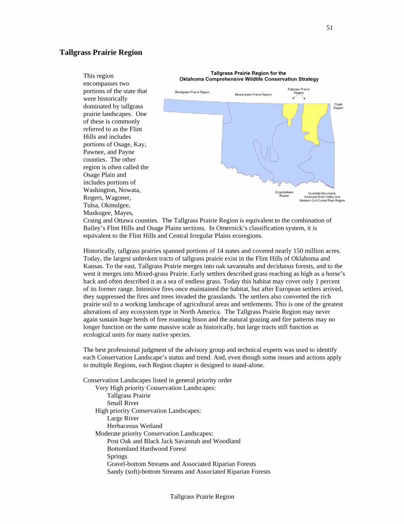
This region encompasses two portions of the state that were historically dominated by tallgrass prairie landscapes. One of these is commonly referred to as the Flint Hills and includes portions of Osage, Kay, Pawnee, and Payne counties. The other region is often called the Osage Plain and includes portions of Washington, Nowata, Rogers, Wagoner, Tulsa, Okmulgee, Muskogee, Mayes, Craing and Ottawa counties. The Tallgrass Prairie Region is equivalent to the combination of Bailey’s Flint Hills and Osage Plains sections. In Omernick’s classification system, it is equivalent to the Flint Hills and Central Irregular Plains ecoregions. Historically, tallgrass prairies spanned portions of 14 states and covered nearly 150 million acres. Today, the largest unbroken tracts of tallgrass prairie exist in the Flint Hills of Oklahoma and Kansas. To the east, Tallgrass Prairie merges into oak savannahs and deciduous forests, and to the west it merges into Mixed-grass Prairie. Early settlers described grass reaching as high as a horse’s back and often described it as a sea of endless grass. Today this habitat may cover only 1 percent of its former range. Intensive fires once maintained the habitat, but after European settlers arrived, they suppressed the fires and trees invaded the grasslands. The settlers also converted the rich prairie soil to a working landscape of agricultural areas and settlements. This is one of the greatest alterations of any ecosystem type in North America. The Tallgrass Prairie Region may never again sustain huge herds of free roaming bison and the natural grazing and fire patterns may no longer function on the same massive scale as historically, but large tracts still function as ecological units for many native species. The best professional judgment of the advisory group and technical experts was used to identify each Conservation Landscape’s status and trend. And, even though some issues and actions apply to multiple Regions, each Region chapter is designed to stand-alone. Conservation Landscapes listed in general priority order
Very High priority Conservation Landscapes: Tallgrass Prairie Small River
High priority Conservation Landscapes: Large River Herbaceous Wetland
Moderate priority Conservation Landscapes: Post Oak and Black Jack Savannah and Woodland Bottomland Hardwood Forest Springs Gravel-bottom Streams and Associated Riparian Forests Sandy (soft)-bottom Streams and Associated Riparian Forests
52
Tallgrass Prairie Region – Tallgrass Prairie
Conservation Landscape: Tallgrass Prairie
Relative condition of Tallgrass Prairie habitat is currently good with a declining trend. Tallgrass Prairies are herbaceous plant communities dominated by four common, tall grass species: Big Bluestem (Andropogon gerardi), Indian Grass (Sorghastrum nutans), Switchgrass (Panicum virgatum) and Little Bluestem (Schizachyrium scoparium). The structure of this habitat type is maintained by the occurrence of natural fires that limit the growth of woody plant species and favor grasses and some forbs. All four of the dominant grass species are present in most Tallgrass Prairie sites; however Big Bluestem and Indian Grass tend to be most prevalent in mesic sites, while Big Bluestem and Little Bluestem are most common on drier sites. In mesic loamy soils such as those found in floodplains and bottomlands, Switchgrass and Big Bluestem are often the dominant grasses. Other widespread or common grasses include Prairie Dropseed (Sporobolus hetrolepis), Sideoats Grama (Bouteloua curttipendula), and Eastern Gamagrass (Tripsacum dactyloides). Common forbs include Rosinweed (Silphium integrifolium), Compass Plant (Silphium laciniatum), Lead Plant (Amorpha canescens), Wild Alfalfa/Scurf Pea (Psoralea tenuifolia), Illinois Bundleflower (Desmanthus illinoensis), Blazing Star (Liatris sp.), Goldenrod (Solidago sp.), Roundhead Lespedeza (Lespedeza capitata), Indian Paintbrush (Castillega coccinea) and Maximillian Sunflower (Helianthus maximilliani). Prairie Cordgrass (Spartina pectinata) is often the dominant grass in wet prairie sites which we discuss as a wetland type covered in the herbaceous wetland habitat type. Tallgrass Prairie is the most abundant and widespread habitat type in the Tallgrass Prairie Region. Tallgrass Prairie habitat remains widespread in the Flint Hills section of this Region, where the shallow rocky soils are unsuitable for conversion to crop agriculture and ranching is the most common land use. The Flint Hills Section in Oklahoma and Kansas is one of the largest remaining concentrations of Tallgrass Prairie habitat in the country. In contrast, much of the native prairie in the Osage Plains Section has been converted to crop production or to Fescue (Festuca sp.) pasture. The extent of remnant prairies is unknown, but most tracts of native prairie appear to be scattered and relatively small. Where prairie habitat remains, decades of continuous grazing, fire suppression and encroachment of native and non-native plants has resulted in changes in the plant community composition and structure. These changes include greater woody plant cover, increased proportions of exotic grasses and decreased abundance of native forbs. Recognized plant associations within this habitat type include:
Big Bluestem – Switchgrass Grassland Big Bluestem – Little Bluestem – Indian Grass Grassland Switchgrass – Eastern Gamagrass Grassland Little Bluestem – Indian Grass Grassland Little Bluestem – Big Bluestem Grassland
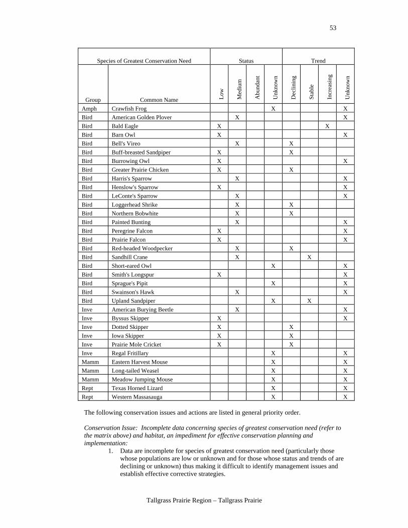
The species of greatest conservation need found in this habitat are listed in the following table. The population abundance (status and trend) of each species is described in relative terms. The best professional judgment of the advisory group and technical experts was used to identify each species status and trend. Species are sorted alphabetically within groups of amphibians (Amph), birds, fish, invertebrates (Inve), mammals (Mamm), and reptiles (Rept) for easy reference. Species status definitions: Low – species is rare, has a small population size, and/or occurs in only a small portion of the Region. Medium – species is uncommon and occurs over a large portion of the Region or species is common but occurs in only a small part of the Region. Abundant – species is common and widespread within the Region in appropriate habitat. Unknown – the status of this species is not known.
53
Tallgrass Prairie Region – Tallgrass Prairie
Species of Greatest Conservation Need Status Trend
Group Common Name Low
Med
ium
Abu
ndan
t
Unk
now
n
Dec
linin
g
Stab
le
Incr
easi
ng
Unk
now
n
Amph Crawfish Frog X X Bird American Golden Plover X X Bird Bald Eagle X X Bird Barn Owl X X Bird Bell's Vireo X X Bird Buff-breasted Sandpiper X X Bird Burrowing Owl X X Bird Greater Prairie Chicken X X Bird Harris's Sparrow X X Bird Henslow's Sparrow X X Bird LeConte's Sparrow X X Bird Loggerhead Shrike X X Bird Northern Bobwhite X X Bird Painted Bunting X X Bird Peregrine Falcon X X Bird Prairie Falcon X X Bird Red-headed Woodpecker X X Bird Sandhill Crane X X Bird Short-eared Owl X X Bird Smith's Longspur X X Bird Sprague's Pipit X X Bird Swainson's Hawk X X Bird Upland Sandpiper X X Inve American Burying Beetle X X Inve Byssus Skipper X X Inve Dotted Skipper X X Inve Iowa Skipper X X Inve Prairie Mole Cricket X X Inve Regal Fritillary X X Mamm Eastern Harvest Mouse X X Mamm Long-tailed Weasel X X Mamm Meadow Jumping Mouse X X Rept Texas Horned Lizard X X Rept Western Massasauga X X
The following conservation issues and actions are listed in general priority order. Conservation Issue: Incomplete data concerning species of greatest conservation need (refer to the matrix above) and habitat, an impediment for effective conservation planning and implementation:
1. Data are incomplete for species of greatest conservation need (particularly those whose populations are low or unknown and for those whose status and trends of are declining or unknown) thus making it difficult to identify management issues and establish effective corrective strategies.
54
Tallgrass Prairie Region – Tallgrass Prairie
Conservation Actions: • Focus research efforts on identifying the primary population reducing factors and
what can be done to reduce, stop, and reverse these impacts to the populations. • Conduct research to determine why species of greatest conservation need are low or
declining. • Conduct research on species of greatest conservation need to establish baseline
population data/information. • Verify existing data. • Use surveys, workshops and data acquisition to update the Comprehensive Wildlife
Conservation Strategy. • Create a long-term statewide systematic and scientifically proven resource
monitoring system. Use representative habitats and begin taking photo points to create a database of historical pictures. Locate existing historic photographs and their exact location of every type of habitat in Oklahoma and use those sites as the continuing long-term photo sites for resource monitoring.
Conservation Issue: Habitat loss and fragmentation from land management practices:
2. Incomplete data, information, and inappropriate federal cost-share programs lead to the loss of habitat diversity. Special concerns are intact blocks of native prairie where cost-share programs should not add to landscape fragmentation or degradation of native species diversity.
3. Fragmentation of the habitat by actions such as oil and gas production, highways, wind farms, agriculture conversion, utilities, private land ownership, decreasing tract size, and hay biomass production.
4. Encroachment through urban sprawl. 5. Herbicide applications that harm wildlife. 6. Conversion of native Tallgrass Prairie to non-native pasture grasses and Bermuda
grass and Fescue. 7. Inappropriate fire and grazing regimes that harm wildlife.
Conservation Actions: • Actions for addressing incomplete data and information, and inappropriate federal
cost-share programs: o Encourage accountability for Farm Bill conservation practices. o Update Best Management Practices for many practices. o Conduct management pilot studies to determine successful management
strategies including: Develop fire-grazing management programs that promote
landscape heterogeneity (i.e., habitat diversity) such as patch-burning, rather than the common past practices that promoted landscape homogeneity (e.g., uniformity or evenness of use and thus low natural diversity).
Discourage practices and programs that fragment native landscapes and cause negative impacts to native grassland species (e.g., fencing, aerial application of herbicides, wildlife food plots, and tree planting).
All cost-share programs should carefully consider native biodiversity conservation.
o Improve the knowledge needed to deliver appropriate fire programs. o Provide burning information to land managers. o Subsidize burn schools for cooperatives and contractors in many locations.
• Provide tax reform to keep people on the land and to be able to pass land between generations.
55
Tallgrass Prairie Region – Tallgrass Prairie
• Support tax shelters for ranch businesses like other businesses are currently receiving.
• Acquire public land through perpetual easements. • Encourage private acquisition by livestock organizations, land trusts, and non-
governmental organizations such as The Nature Conservancy with Best Management Practices applied.
• Increase funding for the Conservation Reserve and Grassland Reserve Programs from the subsidy side of the Farm Bill.
• Identify and remove federal and state involvement in projects that cause fragmentation.
• Use impact fees and tax disincentives for harmful practices that cause fragmentation. • Encourage complete implementation of Best Management Practices. • Support the Natural Resources Conservation Service in its implementation of non-
subsidy programs. • Support ranch diversification for lower grazing and off set by lease hunting, fishing
access, and ecotourism viewing. • Restore native Tallgrass Prairie whenever and wherever possible, especially by
converting Fescue pastures back to native warm season grasses and forbs. • Develop a targeting process that primarily focuses upon protecting the vast, intact
Tallgrass Prairie landscapes that can still be found in Kay, Osage, Washington, Nowata, and Craig Counties.
• Actions for addressing encroachment through urban sprawl: o Support and fund regional planning organizations to address agricultural
land, fragmentation, urban sprawl, open space and watershed protection. o Develop regional landowner organizations that provide a forum for working
partnerships between ranchers and conservationists to address issues that threaten both the ranching culture and the natural heritage on privately owned landscapes.
o Work with the Council of Governments and use existing ecoregional plans to provide ecological and sustainability information and knowledge to their private and public clients.
o Encourage the placement of wind farms outside of intact native prairie landscape using the effective tax credits and other incentives, as the species of greatest conservation need seem to be detrimentally affected by the windmills, disturbance and infrastructure.
o Acquire conservation easements on both public and private land. o Acquire fee title to essential land and habitat for species of greatest
conservation need protection and restoration. o Use new urban development (i.e., sustainable development) techniques that
minimize impacts such as cluster development that integrate and protect open space.
o Encourage the statewide development of regulations and development guidelines to redirect development efforts in existing developments and place more value on open, unfragmented space.
o Encourage and support the development of partnership models in Oklahoma like the Tallgrass Legacy Alliance of the Kansas Flint Hills and the Nebraska Sand Hills.
• Actions for addressing the development and implementation of Best Management Practices for pesticide applications:
o Provide alternatives to herbicide application through outreach education to landowners and farm organizations.
o Provide information comparing the economic benefits vs. losses due to the use of herbicides.
o Identify and remove or alter federal subsidies for inappropriate spraying methods.
56
Tallgrass Prairie Region – Tallgrass Prairie
o Encourage ecologically correct methods and market them to landowners. o Support the study of economic analysis and nutritional analysis of forage
production in ranching and herbicide use. o Encourage better uses of herbicide by rights-of-way managers.
• Actions for addressing the conversion of native Tallgrass Prairie to non-native pasture grasses, Bermuda grass, and Fescue:
o Create farm/ranch tax credits for maintaining or restoring native grasses. o Use conservation easements to maintain native landscapes.
• Actions for addressing inappropriate fire and grazing regimes that harm wildlife: o Modify fire laws to allow the fire management needed to protect species of
greatest conservation need and restore habitat. o Support fire management cooperatives with education, laws, subsidies and
organizational skills. o Encourage private for-profit fire management contractors to increase
capacity and local economies. o Reduce liability for fire responsible contractors so that they do not have to
hold all of the inherent risk. o Encourage or cost share the development of a demonstration site showing
and describing grazing and fire regimes for counties or regions using profitability and biodiversity. (e.g., Oklahoma State University Agriculture Extension and state and federal land managers).
o Encourage an economic study for profitability and nutrition of diverse forbs pasture.
o Encourage and support ranch diversification for lower grazing and off set by lease hunting, fishing access, and ecotourism viewing.
o Evaluate the policy implications of lease hunting, hunting cooperatives, diversification, ecotourism, and uniform hunting seasons to game and species of greatest conservation need and their habitat and develop a strategic direction for the state of Oklahoma and the Oklahoma Department of Wildlife Conservation.
o If present, remove hurdles to lease hunting and hunting cooperatives. o Evaluate hunting seasons to provide for a more uniform distribution of
seasons to enhance the profitability of lease hunting for private landowners. o Promote diversification, ecotourism and lease hunting. o Support education components for ranch diversification. o Facilitate the return of fire by supporting fire management burn schools for
cooperatives and contractors in many locations. o Develop incentives for fire-grazing management that promotes landscape
heterogeneity (i.e., habitat diversity), such as patch-burning. o Develop rancher-conservationist partnerships like in Osage/Kay and
Nowata/Craig Counties to restore viable populations of the Greater Prairie Chicken.
Conservation Issue: Invasive and exotic plants and animals that are detrimental to species of greatest conservation need:
8. Invasive and exotic plants and animals change community structure in a way that is harmful to native wildlife.
9. Invasive native woody species displace natural habitat for wildlife.
Conservation Actions: • Develop grant program that cost shares for education about invasive species
problems and control measures that are preventative, not reactionary (e.g., low density as well as high density invasive species infestations would qualify for grant assistance).
• Conduct management pilot studies to determine successful management strategies and develop alternatives to aerial spraying.
57
Tallgrass Prairie Region – Tallgrass Prairie
• Create incentives to avoid riparian zones with spraying. • Remove federal subsidies for programs that genetically design new invasive species
of Bermuda grass and turf from other countries and promote invasive species. • Promote certified hay programs exotic free and special use for people in sensitive
areas. • Change the way hay is graded to discourage the distribution of exotic grasses and
pests. • Require roadside re-vegetation with native species following construction. • Develop programs to assist start-up of spot-spray businesses. • Support Congressional action and lobbying of U.S. Department of Agriculture to
reclassify Sericia lespedeza as a noxious species in the Southern Tallgrass Prairie Region of the United States (e.g., Oklahoma, Kansas, Nebraska, Missouri, and Arkansas) where it is the greatest invasive and/exotic threat to native rangelands.
• Support additional Congressional funding for control research, including biocontrols which Animal and Plant Health Inspection Service will not currently sanction due to Sericia’s status as a U.S. Department of Agriculture crop species.
• Encourage rights-of-way managers to manage invasive species. • Use patch burning and cattle rotation around large pastures rather than additional
fencing to create smaller pastures, as additional fences fragment prairie habitats and encourage the growth of trees across the prairie.
• Increase cost share for tree clipping and change ranking factors. • Use tax incentives and tax relief for maintaining good quality prairie.
Potential indicators for monitoring the effectiveness of the conservation actions:
• Acres burned/treated. • Aerial spray acreage. • Animal populations and vegetation response to management; focusing on species
declining outside Oklahoma but still common here. • Changes in acreage/coverage of exotic vegetation. • Acres of native plant communities (species composition) restored. • Number and acres protected, purchased, or easements secured.
58
Tallgrass Prairie Region – Small River
Conservation Landscape: Small River
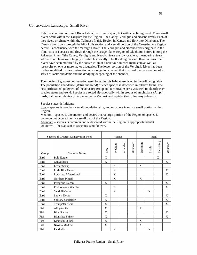
Relative condition of Small River habitat is currently good, but with a declining trend. Three small rivers occur within the Tallgrass Prairie Region - the Caney, Verdigris and Neosho rivers. Each of thee rivers originate within the Tallgrass Prairie Region in Kansas and flow into Oklahoma. The Caney River flows through the Flint Hills section and a small portion of the Crosstimbers Region before its confluence with the Verdigris River. The Verdigris and Neosho rivers originate in the Flint Hills of Kanasas and flows through the Osage Plains Region of Oklahoma before joining the Arkansas River. Tthe Caney, Verdigris and Neosho rivers are low-gradient, meandering rivers whose floodplains were largely forested historically. The flood regimes and flow patterns of all rivers have been modified by the construction of a reservoir on each main stem as well as reservoirs on one or more major tributaries. The lower portion of the Verdigris River has been further modified by the construction of a navigation channel that involved the construction of a series of locks and dams and the dredging/deepening of the channel.
The species of greatest conservation need found in this habitat are listed in the following table. The population abundance (status and trend) of each species is described in relative terms. The best professional judgment of the advisory group and technical experts was used to identify each species status and trend. Species are sorted alphabetically within groups of amphibians (Amph), birds, fish, invertebrates (Inve), mammals (Mamm), and reptiles (Rept) for easy reference. Species status definitions: Low – species is rare, has a small population size, and/or occurs in only a small portion of the Region. Medium – species is uncommon and occurs over a large portion of the Region or species is common but occurs in only a small part of the Region. Abundant – species is common and widespread within the Region in appropriate habitat. Unknown – the status of this species is not known.
Species of Greatest Conservation Need Status Trend
Group Common Name Low
Med
ium
Abu
ndan
t
Unk
now
n
Dec
linin
g
Stab
le
Incr
easi
ng
Unk
now
n
Bird Bald Eagle X X Bird Canvasback X X Bird Lesser Scaup X X Bird Little Blue Heron X X Bird Louisiana Waterthrush X X Bird Northern Pintail X X Bird Peregrine Falcon X X Bird Prothonotary Warbler X X Bird Sandhill Crane X X Bird Snowy Plover X X Bird Solitary Sandpiper X X Bird Trumpeter Swan X X Fish Alligator Gar X X Fish Blue Sucker X X Fish Bluntface Shiner X X Fish Kiamichi Shiner X X Fish Neosho Madtom X X Fish Paddlefish X X
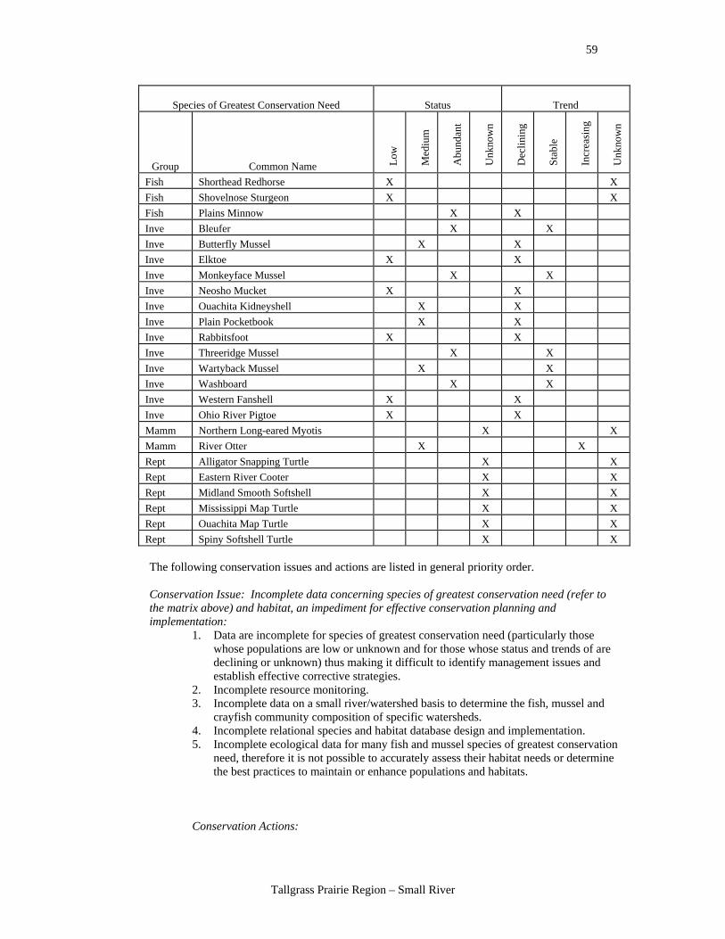
59
Tallgrass Prairie Region – Small River
Species of Greatest Conservation Need Status Trend
Group Common Name Low
Med
ium
Abu
ndan
t
Unk
now
n
Dec
linin
g
Stab
le
Incr
easi
ng
Unk
now
n
Fish Shorthead Redhorse X X Fish Shovelnose Sturgeon X X Fish Plains Minnow X X Inve Bleufer X X Inve Butterfly Mussel X X Inve Elktoe X X Inve Monkeyface Mussel X X Inve Neosho Mucket X X Inve Ouachita Kidneyshell X X Inve Plain Pocketbook X X Inve Rabbitsfoot X X Inve Threeridge Mussel X X Inve Wartyback Mussel X X Inve Washboard X X Inve Western Fanshell X X Inve Ohio River Pigtoe X X Mamm Northern Long-eared Myotis X X Mamm River Otter X X Rept Alligator Snapping Turtle X X Rept Eastern River Cooter X X Rept Midland Smooth Softshell X X Rept Mississippi Map Turtle X X Rept Ouachita Map Turtle X X Rept Spiny Softshell Turtle X X
The following conservation issues and actions are listed in general priority order. Conservation Issue: Incomplete data concerning species of greatest conservation need (refer to the matrix above) and habitat, an impediment for effective conservation planning and implementation:
1. Data are incomplete for species of greatest conservation need (particularly those whose populations are low or unknown and for those whose status and trends of are declining or unknown) thus making it difficult to identify management issues and establish effective corrective strategies.
2. Incomplete resource monitoring. 3. Incomplete data on a small river/watershed basis to determine the fish, mussel and
crayfish community composition of specific watersheds. 4. Incomplete relational species and habitat database design and implementation. 5. Incomplete ecological data for many fish and mussel species of greatest conservation
need, therefore it is not possible to accurately assess their habitat needs or determine the best practices to maintain or enhance populations and habitats.
Conservation Actions:
60
Tallgrass Prairie Region – Small River
• Conduct research should determine why species of greatest conservation need are low and/or declining.
• Conduct research on species of greatest conservation need to determine why populations are low and/or declining.
• Conduct research on species of greatest conservation need to establish baseline population data/information.
• Verify existing species and habitat data. • Use surveys, workshops and data acquisition to update the Comprehensive Wildlife
Conservation Strategy. • Develop a monitoring program to track habitat condition/quality and status of species
of greatest conservation need.
Conservation Issue: Altered patterns of water flow that negatively affect both habitat and species: 6. Water diversions and withdraws – especially water regime changes (e.g., patterns of
flow, lack of channel maintenance flow, sedimentation and erosion) often have detrimental effects on species of greatest conservation need.
7. Reservoir construction and management has detrimental effects of species of greatest conservation need.
8. Addition of nutrients from fertilizers and livestock waste in storm water runoff degrades water quality.
9. Lack of headwaters protection of critical surface water sources harms species of greatest conservation need.
10. Removal of riparian vegetation is detrimental the species of greatest conservation need.
11. Geomorphic instability, disconnection of riparian vegetation with the water table, and erosion of banks are detrimental to species of greatest conservation need.
12. Invasive-exotic aquatic plants and animals make communities unstable. 13. Loss of shading affects water temperatures with negative effects on species of
greatest conservation need. 14. In-stream sand or gravel mining changes the hydraulic of the in-stream flow. 15. There is a loss of temporary wetlands in floodplains which serve as breeding areas
for amphibians and foraging areas for shorebirds, waterfowl and herons. 16. Livestock in channels and floodplains are detrimental to small river water quality
and species of greatest conservation need. 17. Endocrine disruptors related to agricultural runoff/discharge (e.g., poultry, cattle, and
use on plants) pose threats to species of greatest conservation need and humans. 18. Recreational use of rivers such as the overuse of floating and all terrain vehicles may
affect species of greatest conservation need. 19. Commercial mussel harvest may harm species of greatest conservation need. 20. There is heavy metal contamination in the Neosho River from abandoned lead and
zinc mining.
Conservation Actions: • Acquire land and use conservation easements, leases, etc. to protect headwaters and
banks, and provide recreational opportunities. • Modify pond/reservoir management to ensure minimum in-stream flow, hydro
periods, and more natural water regimes. • Develop a monitoring program to track habitat condition/quality and status of species
of greatest conservation need. • Provide results of ecological studies to of water use planners and encourage their
incorporation into water management plans and permits. • Conduct management pilot studies to determine successful management strategies
and use a demonstration sites. • Develop local watershed councils, citizen’s groups or river teams to address local
concerns and to monitor wildlife populations.
61
Tallgrass Prairie Region – Small River
• Provide alternative water sources for livestock to get them out of small rivers and remove ponds constructed on small rivers that restrict movement of species of greatest conservation need.
• Work collaboratively with landowners to protect riparian areas from grazing. • Restore riparian zone, channels and plant buffer strips. • Develop exotic and invasive species management plans and implement them. • Provide for better cost sharing, and more acceptable landowner incentives to reduce
nutrient inputs, and other Best Management Practices in the watershed to reduce nutrient inputs (i.e., point and non-point sources).
• Manage phosphorous on the watershed and support state land application limits. • Encourage no-till/low-till farming to keep water on the lands. • Support the Conservation Reserve Program, Conservation Reserve Enhancement
Program and Grassland Reserve Program in the Farm Bill. • Promote erosion control incentives, like the stream buffer program in Natural
Resources Conservation Service. • Educate landowners about watershed concepts, riparian habitat, Best Management
Practices, existing Farm Bill type programs and Best Management Practices for grazing.
• Work collaboratively with public and private landowners to remove structures that block the passage of aquatic species of greatest conservation need.
• Educate landowners, the general public and students about ecology, water quality and quantity.
• Improve landowner knowledge of and access to Farm Bill incentive and cost-share programs to protect water quality and riparian habitat.
• Ensure long-term funding for relational database design, implementation and maintenance.
• Develop an accurate assessment/description of what small river habitat used to look like – to define the conservation target condition.
• Educate fishermen and bait producers about exotic bait, and the ecological and recreational ramifications.
• Work collaboratively with public managers to strengthen the confined cattle operations regulations for limits of waste on the land.
• Work collaboratively with public managers to enforce water quality standards.
Potential indicators for monitoring the effectiveness of the conservation actions: • Number of new local conservation groups and their effectiveness. • Degraded and restored river miles of habitat. • Number of acres acquired or proportion of acres protected/acquired within a given
watershed. • Number of acres under easements or conservation practices. • Number of landowners participating in conservation practices. • Population trends of fish and wildlife species, with emphasis on species of greatest
conservation need. • Pubic opinion toward conservation actions. • River flow and habitat quality - measure return of river flow with range of natural
variation. • U.S. Geological Survey monitoring stations. • Water quality parameters
62
Tallgrass Prairie Region – Large River
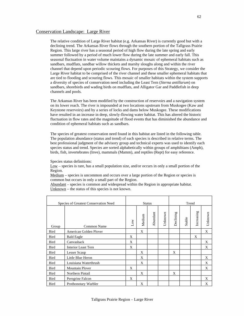
Conservation Landscape: Large River
The relative condition of Large River habitat (e.g. Arkansas River) is currently good but with a declining trend. The Arkansas River flows through the southern portion of the Tallgrass Prairie Region. This large river has a seasonal period of high flow during the late spring and early summer followed by a period of much lower flow during the late summer and early fall. This seasonal fluctuation in water volume maintains a dynamic mosaic of ephemeral habitats such as sandbars, mudflats, sandbar willow thickets and marshy sloughs along and within the river channel that depend upon periodic scouring flows. For purposes of this Strategy, we consider the Large River habitat to be comprised of the river channel and these smaller ephemeral habitats that are tied to flooding and scouring flows. This mosaic of smaller habitats within the system supports a diversity of species of conservation need including the Least Tern (Sterna antillarum) on sandbars, shorebirds and wading birds on mudflats, and Alligator Gar and Paddlefish in deep channels and pools. The Arkansas River has been modified by the construction of reservoirs and a navigation system on its lower reach. The river is impounded at two locations upstream from Muskogee (Kaw and Keystone reservoirs) and by a series of locks and dams below Muskogee. These modifications have resulted in an increase in deep, slowly-flowing water habitat. This has altered the historic fluctuation in flow rates and the magnitude of flood events that has diminished the abundance and condition of ephemeral habitats such as sandbars.
The species of greatest conservation need found in this habitat are listed in the following table. The population abundance (status and trend) of each species is described in relative terms. The best professional judgment of the advisory group and technical experts was used to identify each species status and trend. Species are sorted alphabetically within groups of amphibians (Amph), birds, fish, invertebrates (Inve), mammals (Mamm), and reptiles (Rept) for easy reference. Species status definitions: Low – species is rare, has a small population size, and/or occurs in only a small portion of the Region. Medium – species is uncommon and occurs over a large portion of the Region or species is common but occurs in only a small part of the Region. Abundant – species is common and widespread within the Region in appropriate habitat. Unknown – the status of this species is not known.
Species of Greatest Conservation Need Status Trend
Group Common Name Low
Med
ium
Abu
ndan
t
Unk
now
n
Dec
linin
g
Stab
le
Incr
easi
ng
Unk
now
n
Bird American Golden Plover X X Bird Bald Eagle X X Bird Canvasback X X Bird Interior Least Tern X X Bird Lesser Scaup X X Bird Little Blue Heron X X Bird Louisiana Waterthrush X X Bird Mountain Plover X X Bird Northern Pintail X X Bird Peregrine Falcon X X Bird Prothonotary Warbler X X
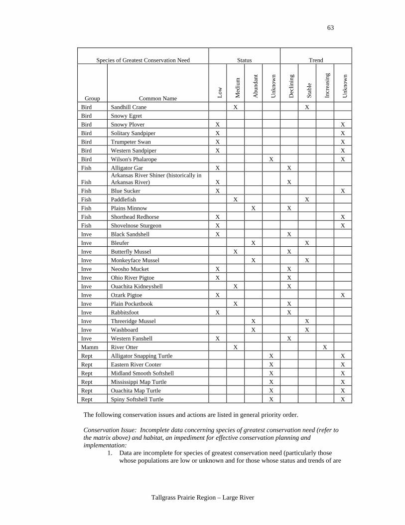
63
Tallgrass Prairie Region – Large River
Species of Greatest Conservation Need Status Trend
Group Common Name Low
Med
ium
Abu
ndan
t
Unk
now
n
Dec
linin
g
Stab
le
Incr
easi
ng
Unk
now
n
Bird Sandhill Crane X X Bird Snowy Egret Bird Snowy Plover X X Bird Solitary Sandpiper X X Bird Trumpeter Swan X X Bird Western Sandpiper X X Bird Wilson's Phalarope X X Fish Alligator Gar X X
Fish Arkansas River Shiner (historically in Arkansas River) X X
Fish Blue Sucker X X Fish Paddlefish X X Fish Plains Minnow X X Fish Shorthead Redhorse X X Fish Shovelnose Sturgeon X X Inve Black Sandshell X X Inve Bleufer X X Inve Butterfly Mussel X X Inve Monkeyface Mussel X X Inve Neosho Mucket X X Inve Ohio River Pigtoe X X Inve Ouachita Kidneyshell X X Inve Ozark Pigtoe X X Inve Plain Pocketbook X X Inve Rabbitsfoot X X Inve Threeridge Mussel X X Inve Washboard X X Inve Western Fanshell X X Mamm River Otter X X Rept Alligator Snapping Turtle X X Rept Eastern River Cooter X X Rept Midland Smooth Softshell X X Rept Mississippi Map Turtle X X Rept Ouachita Map Turtle X X Rept Spiny Softshell Turtle X X
The following conservation issues and actions are listed in general priority order. Conservation Issue: Incomplete data concerning species of greatest conservation need (refer to the matrix above) and habitat, an impediment for effective conservation planning and implementation:
1. Data are incomplete for species of greatest conservation need (particularly those whose populations are low or unknown and for those whose status and trends of are
64
Tallgrass Prairie Region – Large River
declining or unknown) thus making it difficult to identify management issues and establish effective corrective strategies.
Conservation Actions: • Establish adequate allocation of Oklahoma Department of Wildlife Conservation
resources to acquire needed information to become more effective and efficient in providing protection and restoration of species of greatest conservation need.
• Conduct research to determine why species of greatest conservation need are low and/or declining.
• Conduct research on species of greatest conservation need to determine why populations are low and/or declining.
• Conduct research on species of greatest conservation need to establish baseline population data/information.
• Verify that existing data are still applicable. • Use surveys, workshops and data acquisition to update the Comprehensive Wildlife
Conservation Strategy. • Conduct management pilot studies to determine successful management strategies. • Monitor response of wildlife populations to various land management practices. • Research the presettlement river status of Oklahoma rivers. • Communicate about the species of greatest conservation need needs and knowledge
with the U.S. Army Corps of Engineers and biologists about their priorities and the effects of their operations.
• Develop a monitoring program to track habitat condition/quality and status of species of greatest conservation need
Conservation Issue: Altered patterns of water flow that negatively affect both habitat and species:
2. Clearing of riparian zone negatively affects species of greatest conservation need and their habitat.
3. Use impact fees and tax disincentives for harmful practices that cause negative impacts on habitat and species.
4. Dredging and sand mining change flow and water quality. 5. Flood control management affects species of greatest conservation need. 6. Altered in-stream flows due to reservoir impoundment, resulting in altered flood
patterns and low base flows, and the need to restore sandbars eliminated due to reservoir construction and operation.
7. Inter-basin introductions of aquatic species (e.g., accidental introduction of Red River Pupfish from the Red River system to the Canadian River) that compete with native wildlife.
Conservation Actions: • Acquire land (e.g., fee title, conservation easements, leases) to protect headwaters. • Modify reservoir management plans to protect and manage for species of greatest
conservation need. • Remove structures that block the passage of fish and or alter the presettlement
pattern of water flow and flooding. • Work with the U.S. Army Corps of Engineers to normalize in-stream flow to more
natural flow patterns; check on the applicability of an 1135 project. • Establish minimum in-stream flows below reservoirs. • Raise the importance of recreation and alternative flow patterns. • Support congressional reprioritizing of the U.S. Army Corps of Engineers projects to
include fish, wildlife and recreation as beneficial uses. • Cost share with U.S. Army Corps of Engineers for important priorities. • Promote a better working relationship with the U.S. Army Corps of Engineers in
economic, social and political arenas.

65
Tallgrass Prairie Region – Large River
• Research the applicability and use of the Ecologically Sustainable Water Management Model.
• Research the use of mitigation to fund and support fish and wildlife protection and management from hydropower projects and U.S. Army Corps of Engineers impoundment project agreements.
• Change the scope of hydropower and U.S. Army Corps of Engineers projects through legislation to recognize the beneficial uses of wildlife.
• Research ways to discourage building in the floodplain, including tax incentives. • Work within U.S. Army Corps of Engineers authorities to change management
operations to benefit species of greatest conservation need. • Research alternative methods of flood control such as levee removal and floodplain
mitigation as wetland banks. • Identify spawning areas potentially impacted by dredging. • Implement mitigation and reimbursement for fish losses due to entrainment and
stranding. • Use the Fish and Wildlife Coordination Act between the U.S. Fish and Wildlife
Service and the U.S. Army Corps of Engineers to bring more attention to requirements of threatened and endangered species and species of greatest conservation need.
Conservation Issue: Water quality changes which negatively affect both habitat and species of greatest conservation need:
8. Water quality issues (e.g., herbicides, nitrates, metals, and oil pollution). 9. Degradation of river banks by trampling and grazing of cattle.
Conservation Actions: • Reduce nutrient inputs (i.e., point and non-point sources) and provide cost sharing
that is more acceptable to landowners in order to reduce inputs and increase implementation of Best Management Practices in watersheds.
• Implement and standardize water quality requirements and levels below dams. • Acquire land and conservation easements, leases, etc. to protect headwaters. • Provide alternative water sources for livestock to get them out of the water to reduce
water quality issues and disruption to the streams.
Conservation Issue: Invasive and exotic plants and animals that are detrimental to species of greatest conservation need:
10. Invasive species create unstable ecological conditions for native species.
Conservation Actions: • Increase public education about the potential problems with releases of bait fish into
rivers. • Develop exotic and invasive species management plans. • Develop grant program that cost shares for the education of invasive species issues
and control measures that are preventative, not reactionary (e.g., low density as well as high density invasive species infestations would qualify for grant assistance).
Conservation Issue: Commercial harvest practices that negatively affect species of greatest conservation need:
11. Commercial harvest of minnows and mussels may be detrimental to habitat and species of greatest conservation need.
Conservation Actions: • Study the effects of commercial harvest on species of greatest conservation need and
implement appropriate resource management. • Study the effects of introduced minnows into wetlands.
66
Tallgrass Prairie Region – Large River
Conservation Issue: Habitat loss or damage caused by heavy recreational use that negatively affects species of greatest conservation need:
12. Increased recreational use of rivers and river beds by off-road vehicles adversely impact both habitat and wildlife.
Conservation Action: • Develop and share understanding of the effects of recreation on species of greatest
conservation need life requirements, habitat, water quality, and water hydrology.
Potential indicators for monitoring the effectiveness of the conservation actions: • Acres of riparian forest with diverse structure. • Amount, periodicity, value and kinds of recreation uses of rivers. • GIS – habitat change analysis. • Identify and monitor indicator species. • Number of citizen’s groups formed. • Number of enhanced or restored acres of quality habitat. • Number of reservoir management plans that take into account hydro period of the
forests. • Number of river miles degraded or improved to measure change. • Population trends of indicator species or species of greatest conservation need. • Acreage of quality habitat annually available. • Stream and spring flow relational data base. • U.S. Army Corps of Engineers reservoirs with management plans protecting tail
waters, riparian land, bottom hardwood forests, sandbars and enhancing fish populations.
• Water quality parameters.
67
Tallgrass Prairie Region – Herbaceous Wetland
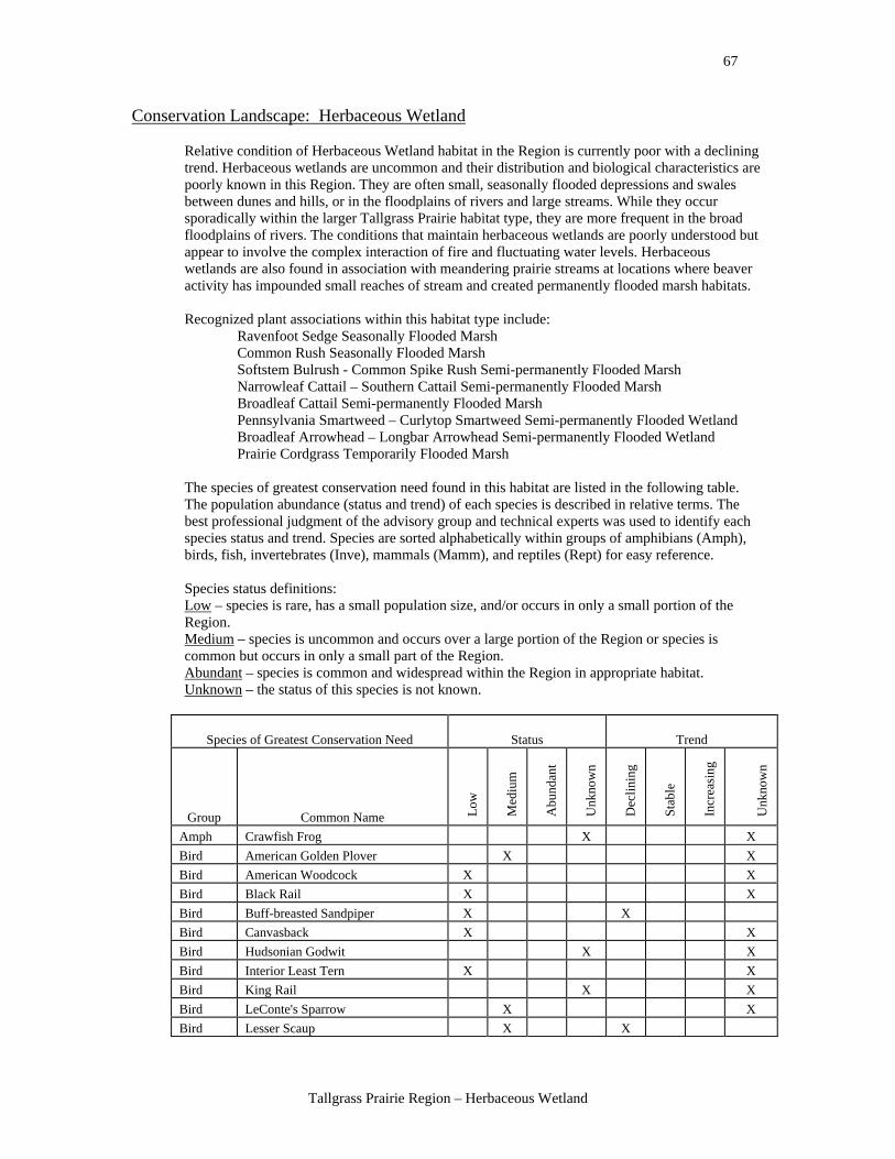
Conservation Landscape: Herbaceous Wetland
Relative condition of Herbaceous Wetland habitat in the Region is currently poor with a declining trend. Herbaceous wetlands are uncommon and their distribution and biological characteristics are poorly known in this Region. They are often small, seasonally flooded depressions and swales between dunes and hills, or in the floodplains of rivers and large streams. While they occur sporadically within the larger Tallgrass Prairie habitat type, they are more frequent in the broad floodplains of rivers. The conditions that maintain herbaceous wetlands are poorly understood but appear to involve the complex interaction of fire and fluctuating water levels. Herbaceous wetlands are also found in association with meandering prairie streams at locations where beaver activity has impounded small reaches of stream and created permanently flooded marsh habitats. Recognized plant associations within this habitat type include:
Ravenfoot Sedge Seasonally Flooded Marsh Common Rush Seasonally Flooded Marsh Softstem Bulrush - Common Spike Rush Semi-permanently Flooded Marsh Narrowleaf Cattail – Southern Cattail Semi-permanently Flooded Marsh Broadleaf Cattail Semi-permanently Flooded Marsh Pennsylvania Smartweed – Curlytop Smartweed Semi-permanently Flooded Wetland Broadleaf Arrowhead – Longbar Arrowhead Semi-permanently Flooded Wetland Prairie Cordgrass Temporarily Flooded Marsh
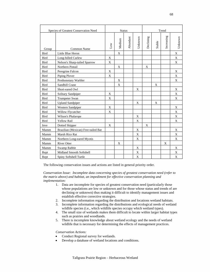
The species of greatest conservation need found in this habitat are listed in the following table. The population abundance (status and trend) of each species is described in relative terms. The best professional judgment of the advisory group and technical experts was used to identify each species status and trend. Species are sorted alphabetically within groups of amphibians (Amph), birds, fish, invertebrates (Inve), mammals (Mamm), and reptiles (Rept) for easy reference. Species status definitions: Low – species is rare, has a small population size, and/or occurs in only a small portion of the Region. Medium – species is uncommon and occurs over a large portion of the Region or species is common but occurs in only a small part of the Region. Abundant – species is common and widespread within the Region in appropriate habitat. Unknown – the status of this species is not known.
Species of Greatest Conservation Need Status Trend
Group Common Name Low
Med
ium
Abu
ndan
t
Unk
now
n
Dec
linin
g
Stab
le
Incr
easi
ng
Unk
now
n
Amph Crawfish Frog X X Bird American Golden Plover X X Bird American Woodcock X X Bird Black Rail X X Bird Buff-breasted Sandpiper X X Bird Canvasback X X Bird Hudsonian Godwit X X Bird Interior Least Tern X X Bird King Rail X X Bird LeConte's Sparrow X X Bird Lesser Scaup X X
68
Tallgrass Prairie Region – Herbaceous Wetland
Species of Greatest Conservation Need Status Trend
Group Common Name Low
Med
ium
Abu
ndan
t
Unk
now
n
Dec
linin
g
Stab
le
Incr
easi
ng
Unk
now
n
Bird Little Blue Heron X X Bird Long-billed Curlew X X Bird Nelson's Sharp-tailed Sparrow X X Bird Northern Pintail X X Bird Peregrine Falcon X X Bird Piping Plover X X Bird Prothonotary Warbler X X Bird Sandhill Crane X X Bird Short-eared Owl X X Bird Solitary Sandpiper X X Bird Trumpeter Swan X X Bird Upland Sandpiper X X Bird Western Sandpiper X X Bird Willow Flycatcher X X Bird Wilson's Phalarope X X Bird Yellow Rail X X Inve Dotted Skipper X X Mamm Brazilian (Mexican) Free-tailed Bat X X Mamm Marsh Rice Rat X X Mamm Northern Long-eared Myotis X X Mamm River Otter X X Mamm Swamp Rabbit X X Rept Midland Smooth Softshell X X Rept Spiny Softshell Turtle X X
The following conservation issues and actions are listed in general priority order. Conservation Issue: Incomplete data concerning species of greatest conservation need (refer to the matrix above) and habitat, an impediment for effective conservation planning and implementation:
1. Data are incomplete for species of greatest conservation need (particularly those whose populations are low or unknown and for those whose status and trends of are declining or unknown) thus making it difficult to identify management issues and establish effective corrective strategies.
2. Incomplete information regarding the distribution and locations wetland habitats. 3. Incomplete information regarding the distributions and ecological needs of wetland
wildlife species (i.e., which wildlife species occupy which wetland types). 4. The small size of wetlands makes them difficult to locate within larger habitat types
such as prairies and woodlands. 5. There is incomplete knowledge about wetland ecology and the needs of wetland
wildlife that is necessary for determining the effects of management practices.
Conservation Actions: • Conduct Regional survey for wetlands. • Develop a database of wetland locations and conditions.
69
Tallgrass Prairie Region – Herbaceous Wetland
• Conduct biological inventories of wetlands to determine plant community composition and the distribution and abundance of wildlife species of conservation need.
• Conduct studies to determine the ecological needs of wetland wildlife species (e.g., types of plant communities and the timing and duration of flooding needed for each wildlife species).
• Produce and distribute educational information for landowners and state and federal conservation agency staff regarding the ecology of herbaceous wetlands by region and wetland type.
• Develop descriptions of quality wetland habitats to serve as the target conditions for wetland restoration and enhancement efforts.
• Use surveys, workshops and data acquisition to update the Comprehensive Wildlife Conservation Strategy.
• Update of the National Wetlands Inventory data and enumerate losses and gains of wetlands.
Conservation Issue: Altered patterns of water flow that negatively affect both habitat and species:
6. Wetlands are drained or filled to convert these lands to residential, agricultural or industrial uses.
7. Water may be pumped from wetlands for irrigation which may lower the water table in some areas and alter the time during which the soil is saturated.
8. Some wetlands are dredged or deepened to create ponds to hold irrigation water, to store water for cattle or to create ponds for fishing, resulting in a loss of shallow water habitat and may result in the introduction and establishment of predatory fish.
Conservation Actions: • Provide cost-share funding or grants to restore farmed wetlands. • Provide information to landowners and the public regarding the ecological values of
wetlands, especially seasonal wetlands. • Improve the technology of irrigation to conserve groundwater and reduce
groundwater withdrawals. • In locations with shallow water tables (e.g., where wetlands are connected to
groundwater deposits) manage the pumping and withdrawal of groundwater around wetlands to minimize local lowering of the water table and draw down of wetlands.
• Use land acquisition and conservation easement programs to place herbaceous wetlands under conservation ownership or stewardship.
• Conduct management pilot studies to determine successful management strategies. • Work collaboratively with Oklahoma Water Resources Board to manage surface and
groundwater so that wetlands, springs and headwaters of streams are protected for species of greatest conservation need.
• Acquire former wetlands and restore them. • Improve the economic incentives, access to, and knowledge of the Wetland Reserve
Program. • Improve landowner understanding of the value of wetlands and species of greatest
conservation need to them and the community. • Develop tax breaks for landowners that maintain wetlands. • Connect wetland owners with entities seeking wetland mitigation credits. • Provide funding or incentives to cover the costs of maintaining wetlands. • Provide assistance and biological data to the Natural Resources Conservation
Service for its wetland conservation planning and allocation process.
70
Tallgrass Prairie Region – Herbaceous Wetland
Conservation Issue: Water quality changes which negatively affect both habitat and species of greatest conservation need:
9. Feedlots, dairies, hog farms and chicken houses are often located near wetlands, and animal wastes from these operations collects in wetlands basins and closed depressions.
10. Land application of animal wastes often occurs on fields near wetlands or that drain into wetlands where nutrients, hormones, pesticides and other waste products collect.
11. Many wetlands lack buffer vegetation around them to control the movement of sediment, pesticides and nutrients into the wetlands through storm water runoff from pastures, crop fields and residential areas.
12. Endocrine disrupters from animal hormones, pesticides and agricultural chemicals enter wetlands in storm water runoff which affect the growth, reproduction and survival of amphibians, fish and invertebrates.
13. Increased nutrient inputs due to crop/pasture fertilizers and land application of animal waste result in increased algae and bacteria in wetlands.
14. Grazing of wetlands by cattle increases nutrient inputs and alters the structure and diversity of wetland vegetation.
Conservation Actions: • Increase the knowledge of and utilization of Farm Bill programs that improve water
quality and protect wetlands (e.g., Wetland Reserve Program, planting of buffer strips, and buffer vegetation).
• Provide cost-share funding to landowners to construct fencing around wetlands to control access by cattle.
• Restore/plant native vegetation around wetlands to serve as a filter for storm water runoff to aid in the removal of sediment and nutrients in storm water runoff.
• Develop certification programs to recognize conservationists and land stewards of wetlands.
• Improve small landowner access to and use of existing cost-share programs. • Develop new or update existing Best Management Practices for controlling nutrients
and sediment around wetlands.
Conservation Issue: Invasive and exotic plants and animals that are detrimental to species of greatest conservation need:
15. Invasive and exotic plant species become established in wetlands and compete with native vegetation.
16. Exotic plant species can dominate wetlands and reduce overall plant diversity and structural diversity reducing the wetlands' value as wildlife habitat.
Conservation Actions: • Develop management plans to control exotic plants and reduce their abundances and
distributions. • Remove exotic wetland plants and restore native plant communities. • Conduct management pilot studies to determine successful management strategies. • Monitor response of wildlife populations to new control practices.
Conservation Issue: Habitat loss and fragmentation from land management practices:
17. Woody plants such as willows and salt cedar encroach on and dominate herbaceous wetlands because of fire suppression and/or past overgrazing.
18. Heavy grazing of wetlands by cattle removes plant cover for wildlife, reduces the abundance of some wetland plants and can lower overall plant diversity.
19. Seasonal wetlands are plowed/cropped which reduces perennial vegetation and alters plant community composition and structure.
71
Tallgrass Prairie Region – Herbaceous Wetland
Conservation Actions: • Use fire or mechanical cutting to remove woody vegetation that has encroached upon
herbaceous wetlands. • Provide cost-share funding or grants to construct fencing around wetlands to control
the access to this habitat by cattle. • Acquire land, perpetual easements or non-development easements to place wetlands
into conservation ownership or stewardship. • Acquire wetlands or purchase conservation easements on cropped wetlands and
restore them. • Provide funding to preserve or enhance wetlands. • Improve the economic incentive to retain wetlands in agricultural areas. • Improve the incentives for Wetland Reserve Program enrollments. • Provide incentives or funding to cover the costs of maintaining wetlands. • Conduct management pilot studies to determine successful management strategies. • Monitor response of wildlife populations to new management practices.
Potential indicators for monitoring the effectiveness of the conservation actions:
• Acres in conservation programs. • Acres of buffer strips in place. • Assess the number of acres and the distribution of wetlands using GIS datasets. • Measure the value of education with landowners, farmers, ranchers and the students. • Number of reservoir management plans. • Population trends of wetland dependent species of greatest conservation need. • National Wetlands Inventory
72
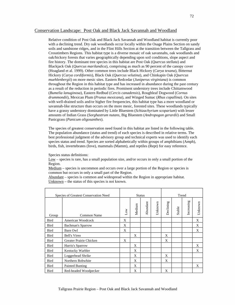
Tallgrass Prairie Region – Post Oak and Black Jack Savannah and Woodland
Conservation Landscape: Post Oak and Black Jack Savannah and Woodland Relative condition of Post Oak and Black Jack Savannah and Woodland habitat is currently poor with a declining trend. Dry oak woodlands occur locally within the Osage Plains Section on sandy soils and sandstone ridges, and in the Flint Hills Section at the transition between the Tallgrass and Crosstimbers Regions. This habitat type is a diverse mosaic of oak savannahs, oak woodlands and oak/hickory forests that varies geographically depending upon soil conditions, slope aspect and fire history. The dominant tree species in this habitat are Post Oak (Quercus stellata) and Blackjack Oak (Quercus marilandica), comprising as much as 90 percent of the canopy cover (Hoagland et al. 1999). Other common trees include Black Hickory (Carya texana), Bitternut Hickory (Carya cordiformis), Black Oak (Quercus velutina), and Chinkapin Oak (Quercus muehlenbergii) on more mesic sites. Eastern Redcedar (Juniperus virginiana) is common throughout the Region in this habitat type and has increased in abundance during the past century as a result of the reduction in periodic fires. Prominent understory trees include Chittamwood (Bumelia lanuginosa), Eastern Redbud (Cercis canadensis), Roughleaf Dogwood (Cornus drummondii), Mexican Plum (Prunus mexicana), and Winged Sumac (Rhus copallina). On sites with well-drained soils and/or higher fire frequencies, this habitat type has a more woodland or savannah-like structure than occurs on the more mesic, forested sites. These woodlands typically have a grassy understory dominated by Little Bluestem (Schizachyrium scoparium) with lesser amounts of Indian Grass (Sorghastrum nutans, Big Bluestem (Andropogon gerardii) and Small Panicgrass (Panicum oligosanthes).
The species of greatest conservation need found in this habitat are listed in the following table. The population abundance (status and trend) of each species is described in relative terms. The best professional judgment of the advisory group and technical experts was used to identify each species status and trend. Species are sorted alphabetically within groups of amphibians (Amph), birds, fish, invertebrates (Inve), mammals (Mamm), and reptiles (Rept) for easy reference. Species status definitions: Low – species is rare, has a small population size, and/or occurs in only a small portion of the Region. Medium – species is uncommon and occurs over a large portion of the Region or species is common but occurs in only a small part of the Region. Abundant – species is common and widespread within the Region in appropriate habitat. Unknown – the status of this species is not known.
Species of Greatest Conservation Need Status Trend
Group Common Name Low
Med
ium
Abu
ndan
t
Unk
now
n
Dec
linin
g
Stab
le
Incr
easi
ng
Unk
now
n
Bird American Woodcock X X Bird Bachman's Sparrow X X Bird Barn Owl X X Bird Bell's Vireo X X Bird Greater Prairie Chicken X X Bird Harris's Sparrow X X Bird Kentucky Warbler X X Bird Loggerhead Shrike X X Bird Northern Bobwhite X X Bird Painted Bunting X X Bird Red-headed Woodpecker X X
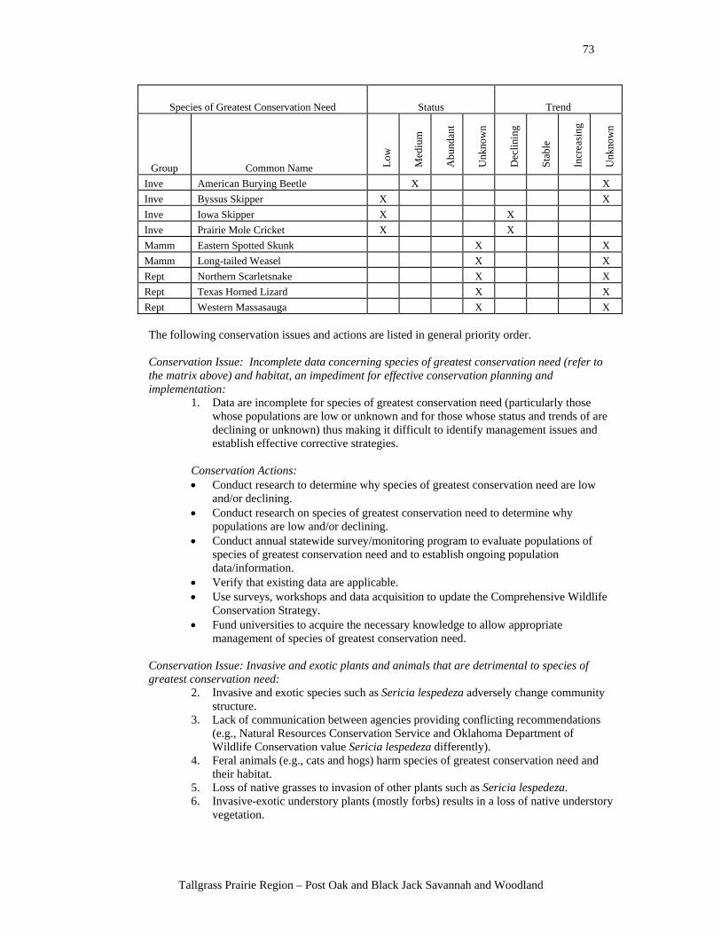
73
Tallgrass Prairie Region – Post Oak and Black Jack Savannah and Woodland
Species of Greatest Conservation Need Status Trend
Group Common Name Low
Med
ium
Abu
ndan
t
Unk
now
n
Dec
linin
g
Stab
le
Incr
easi
ng
Unk
now
n
Inve American Burying Beetle X X Inve Byssus Skipper X X Inve Iowa Skipper X X Inve Prairie Mole Cricket X X Mamm Eastern Spotted Skunk X X Mamm Long-tailed Weasel X X Rept Northern Scarletsnake X X Rept Texas Horned Lizard X X Rept Western Massasauga X X
The following conservation issues and actions are listed in general priority order. Conservation Issue: Incomplete data concerning species of greatest conservation need (refer to the matrix above) and habitat, an impediment for effective conservation planning and implementation:
1. Data are incomplete for species of greatest conservation need (particularly those whose populations are low or unknown and for those whose status and trends of are declining or unknown) thus making it difficult to identify management issues and establish effective corrective strategies.
Conservation Actions: • Conduct research to determine why species of greatest conservation need are low
and/or declining. • Conduct research on species of greatest conservation need to determine why
populations are low and/or declining. • Conduct annual statewide survey/monitoring program to evaluate populations of
species of greatest conservation need and to establish ongoing population data/information.
• Verify that existing data are applicable. • Use surveys, workshops and data acquisition to update the Comprehensive Wildlife
Conservation Strategy. • Fund universities to acquire the necessary knowledge to allow appropriate
management of species of greatest conservation need.
Conservation Issue: Invasive and exotic plants and animals that are detrimental to species of greatest conservation need:
2. Invasive and exotic species such as Sericia lespedeza adversely change community structure.
3. Lack of communication between agencies providing conflicting recommendations (e.g., Natural Resources Conservation Service and Oklahoma Department of Wildlife Conservation value Sericia lespedeza differently).
4. Feral animals (e.g., cats and hogs) harm species of greatest conservation need and their habitat.
5. Loss of native grasses to invasion of other plants such as Sericia lespedeza. 6. Invasive-exotic understory plants (mostly forbs) results in a loss of native understory
vegetation.
74
Tallgrass Prairie Region – Post Oak and Black Jack Savannah and Woodland
Conservation Action: • Develop a state plan for exotic and invasive species control, eradication, and
prevention. • Develop and share techniques to manage/eliminate the impacts of feral animals on
species of greatest conservation need.
Conservation Issue: Habitat loss and fragmentation from land management practices: 7. Much of native habitat has been converted to tame grasses (e.g., Fescue and
Lovegrass) which do not provide habitat for species of greatest conservation need. 8. Fragmentation of woodlands and savannah tracts by urbanization, conversion to tame
pastureland, road construction, utility and pipeline right of ways. 9. Loss of temporary wetlands within this habitat due to siltation or human initiated
drainage projects. 10. Large-scale use of herbicides being used to eliminate native tree cover from
crosstimbers areas and maximize grass cover for grazing. 11. Lack of natural fire regime which has made some areas of woodlands denser with
little understory development because of the dense canopy than they were historically, causing the trees in these unnaturally dense forests on dry soils to be more susceptible to disease and drought.
12. Constraints limiting prescribed burning such as landowner liability, air quality conflicts/concerns, fire/smoke conflict with urban development, and logistical difficulties in burning in developed areas.
13. Capacity to burn (e.g., personnel/financial constraints). 14. Lack of technical assistance to landowners for prescribed burning. 15. Eastern Redcedar spreading as a result of inappropriate grazing patterns. 16. Oil and gas industry may affect species of greatest conservation need by increased
number of roads, increased erosion around well sites, soil compaction, disturbance, noise and an increased potential for oil or saltwater spills.
17. Unnatural stand ages/structure in many woodland stands due to clear cutting decades ago and the regrowth is dense, even-aged, second-growth homogeneous woodland that does not provide well for all of the life needs for species of greatest conservation need.
Conservation Actions: • Create easements to prevent development. • Conduct management pilot studies to determine successful management strategies. • Identify and rank focus areas for management implementation. • Create incentive programs to restore and protect habitat. • Acquire fee title or interest in land to protect essential habitat areas. • Study the response of wildlife populations to various land management practices
such as thinning, deferred grazing, and prescribed late winter burning. • Restore woodlands and savannahs on public lands. • Support the development and dissemination of information about the advantages of
prescribed fire, burn crews, and liability to landowners. • Develop a program to assist landowners with proper fire management. • Encourage and assist in the training of burning cooperatives. • Assist in the development of better burn laws to reduce liability and right to burn. • Develop professional burn crew support, make support affordable to landowners, and
reduce heavy equipment costs. • Provide farmers and ranchers with information and assistance to implement Best
Management Practices for grazing their land. • Encourage Natural Resources Conservation Service to encourage and cost share on
appropriate grazing patterns.
75
Tallgrass Prairie Region – Post Oak and Black Jack Savannah and Woodland
• Enforce oil and gas production site clean up using existing trust funds. • Increase the oil and gas production site clean up fund with additional sources of state
revenue and develop Best Management Practices for oil and gas production sites. • Restore woodlands and savannahs on public lands. • Diversify forest stand ages with regeneration cuttings.
Potential indicators for monitoring the effectiveness of the conservation actions:
• Acres burned. • Acres of native plant communities restored. • Amount of technical assistance being provided. • Animal population trends. • Annual statewide survey/monitoring program to evaluate populations of species of
greatest conservation need. • Changes in acreage/coverage of exotic vegetation. • Fire crews trained and working. • Forest stand diversity. • Indicator species and endangered/threatened species – change in population size • Invasive species – change in their numbers or acres that they affect • Long-term resource surveys. • Number of acres acquired and number of acres restored. • Number of easements secured and acreage protected. • Number of landowners participating in landowner incentive programs. • Partners recruited and total cost share (including in-kind). • Vegetation response to management, fire (e.g., grasses and woody plants). • Wildlife population response to management.
76
Tallgrass Prairie Region – Bottomland Hardwood Forest
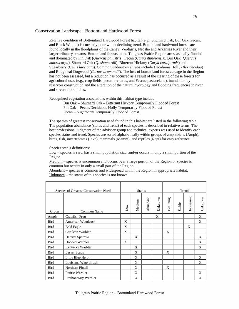
Conservation Landscape: Bottomland Hardwood Forest Relative condition of Bottomland Hardwood Forest habitat (e.g., Shumard Oak, Bur Oak, Pecan, and Black Walnut) is currently poor with a declining trend. Bottomland hardwood forests are found locally in the floodplains of the Caney, Verdigris, Neosho and Arkansas River and their larger tributary streams. Bottomland forests in the Tallgrass Prairie Region are seasonally flooded and dominated by Pin Oak (Quercus palustris), Pecan (Carya illinoiensis), Bur Oak (Quercus macrocarpa), Shumard Oak (Q. shumardii), Bitternut Hickory (Carya cordiformis) and Sugarberry (Celtis laevigata). Common understory shrubs include Deciduous Holly (Ilex decidua) and Roughleaf Dogwood (Cornus drumondii). The loss of bottomland forest acreage in the Region has not been assessed, but a reduction has occurred as a result of the clearing of these forests for agricultural uses (e.g., crop fields, pecan orchards, and Fescue pastureland), inundation by reservoir construction and the alteration of the natural hydrology and flooding frequencies in river and stream floodplains. Recognized vegetation associations within this habitat type include:
Bur Oak – Shumard Oak – Bitternut Hickory Temporarily Flooded Forest Pin Oak – Pecan/Deciduous Holly Temporarily Flooded Forest Pecan – Sugarberry Temporarily Flooded Forest
The species of greatest conservation need found in this habitat are listed in the following table. The population abundance (status and trend) of each species is described in relative terms. The best professional judgment of the advisory group and technical experts was used to identify each species status and trend. Species are sorted alphabetically within groups of amphibians (Amph), birds, fish, invertebrates (Inve), mammals (Mamm), and reptiles (Rept) for easy reference. Species status definitions: Low – species is rare, has a small population size, and/or occurs in only a small portion of the Region. Medium – species is uncommon and occurs over a large portion of the Region or species is common but occurs in only a small part of the Region. Abundant – species is common and widespread within the Region in appropriate habitat. Unknown – the status of this species is not known.
Species of Greatest Conservation Need Status Trend
Group Common Name Low
Med
ium
Abu
ndan
t
Unk
now
n
Dec
linin
g
Stab
le
Incr
easi
ng
Unk
now
n
Amph Crawfish Frog X X Bird American Woodcock X X Bird Bald Eagle X X Bird Cerulean Warbler X X Bird Harris's Sparrow X X Bird Hooded Warbler X X Bird Kentucky Warbler X X Bird Lesser Scaup X X Bird Little Blue Heron X X Bird Louisiana Waterthrush X X Bird Northern Pintail X X Bird Prairie Warbler X X Bird Prothonotary Warbler X X
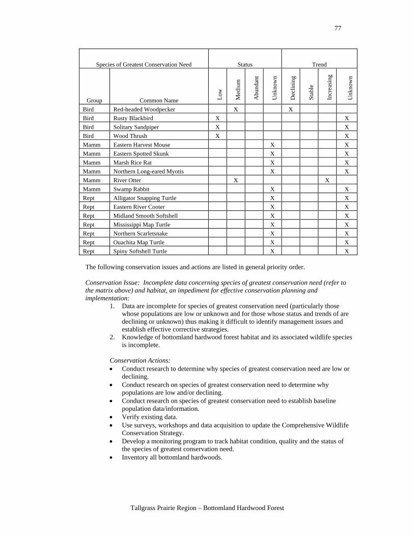
77
Tallgrass Prairie Region – Bottomland Hardwood Forest
Species of Greatest Conservation Need Status Trend
Group Common Name Low
Med
ium
Abu
ndan
t
Unk
now
n
Dec
linin
g
Stab
le
Incr
easi
ng
Unk
now
n
Bird Red-headed Woodpecker X X Bird Rusty Blackbird X X Bird Solitary Sandpiper X X Bird Wood Thrush X X Mamm Eastern Harvest Mouse X X Mamm Eastern Spotted Skunk X X Mamm Marsh Rice Rat X X Mamm Northern Long-eared Myotis X X Mamm River Otter X X Mamm Swamp Rabbit X X Rept Alligator Snapping Turtle X X Rept Eastern River Cooter X X Rept Midland Smooth Softshell X X Rept Mississippi Map Turtle X X Rept Northern Scarletsnake X X Rept Ouachita Map Turtle X X Rept Spiny Softshell Turtle X X
The following conservation issues and actions are listed in general priority order. Conservation Issue: Incomplete data concerning species of greatest conservation need (refer to the matrix above) and habitat, an impediment for effective conservation planning and implementation:
1. Data are incomplete for species of greatest conservation need (particularly those whose populations are low or unknown and for those whose status and trends of are declining or unknown) thus making it difficult to identify management issues and establish effective corrective strategies.
2. Knowledge of bottomland hardwood forest habitat and its associated wildlife species is incomplete.
Conservation Actions: • Conduct research to determine why species of greatest conservation need are low or
declining. • Conduct research on species of greatest conservation need to determine why
populations are low and/or declining. • Conduct research on species of greatest conservation need to establish baseline
population data/information. • Verify existing data. • Use surveys, workshops and data acquisition to update the Comprehensive Wildlife
Conservation Strategy. • Develop a monitoring program to track habitat condition, quality and the status of
the species of greatest conservation need. • Inventory all bottomland hardwoods.
78
Tallgrass Prairie Region – Bottomland Hardwood Forest
Conservation Issue: Habitat loss and fragmentation from land management practices: 3. Conversion of bottomland forest to pasture or cropland. 4. Chemical herbicides are used in some areas to eradicate bottomland hardwood
vegetation and convert the land to other uses (e.g., pastureland). 5. Inappropriate pesticide use. 6. Fragmentation of forest tracts caused by creation of roads, homes, utility line right of
ways, natural gas wells, and pipelines. 7. Unnatural stand ages/structure caused when many bottomland hardwood forest
stands were clear cut in the early 1990s. The regrowth forests that developed tend to be dense, even-aged stands with poor structural diversity, having dense mid stories and poorly developed understory vegetation.
8. Loss of temporary wetlands within this habitat that serve as breeding areas for amphibians and foraging areas for waterfowl, shorebirds and herons due to the draining of wetlands, reduction of flooding that maintains the hydrology for these wetlands, or the filling of wetland by direct human action or increased siltation of wetlands.
Conservation Actions: • Design landowner incentives to encourage the retention of riparian hardwood trees. • Educate landowners about watershed concepts, the importance of riparian habitat,
Best Management Practices, and existing Farm Bill type programs. • Enhance the Wildlife Habitat Improvement Program, providing an improved funding
mechanism for restoration. • Develop a Conservation Reserve type program for bottomland hardwoods. • Work to change the Wetland Reserve Program to include the preservation of
bottomland hardwoods. • Place existing bottomland hardwood forests into conservation ownership through
land acquisition or conservation easement by natural resource management agencies or private conservation organizations.
• Restore crop fields and pastures in floodplains back to bottomland hardwood forest habitat.
• Explore economic alternatives to clearing and grazing bottomland hardwoods (e.g., support the development of hunting leases as a revenue source for landowners).
• Acquire fee title ownership or conservation easements on existing bottomland hardwood forest habitat or crop fields and pastures that can be preserved or restored to bottomland hardwood forest habitat.
• Develop herbicide spraying education programs for landowners through Oklahoma State University extension.
• Reduce aerial spraying of bottomland hardwoods through regulations, conservation easements or landowner education of the ecological, habitat and species vulnerability, and water quality impacts.
• Enforce existing laws for application of pesticides in aquatic habitats. • Encourage and support hunting cooperatives in corridors and blocks. • Use the wide range of programs like Wetlands Reserve Program of the Natural
Resources Conservation Service to create habitat corridors for wildlife. • Use private landowner assistance programs such as U.S. Fish and Wildlife Service
Partners for Wildlife and the Landowner Incentive Program to provide cost-share funding to private landowners to restore hydrology through the construction of small dams and dikes to seasonally flood bottomlands.
• Develop Best Management Practices for logging bottomland hardwoods that encourage structural diversity and retain understory vegetation.
• Promulgate legislation that requires the use of Best Management Practices for logging.
• Encourage the protection of private forest land through conservation easement programs.
79
Tallgrass Prairie Region – Bottomland Hardwood Forest
• Thin and selectively remove trees to increase structural diversity within forest stands and increase understory vegetation.
• Enforce laws that prevent the filling of wetlands. • Encourage law makers to prevent any further draining of wetlands. • Create landowner incentives to maintain wetlands or restore the hydrology to
wetlands. • Construct vernal pools or similar small wetlands within bottomland forest sites. • Support the development of a state water plan and state wetlands plan.
Conservation Issue: Altered patterns of water flow that negatively affect both habitat and species:
9. The construction of reservoirs permanently inundates bottomland hardwood forests, resulting in a direct loss of acreage and alteration of the hydrology of the bottomland hardwood habitat downstream of the reservoir by reducing the amount of the natural flood frequency and pattern.
10. Altered flooding regimes occur as a result of the construction of impoundments and/ or the channelization of streams. In many watersheds there is a dramatic disconnection between the riparian forests/bottomland forests and their streams due to the channelization and incision of streams leading to a lowering of the shallow water table and a reduction in periodic flooding or soil saturation in the bottomland forest zone.
Conservation Actions: • Modify reservoir management to allow periodic flooding of bottomland hardwood
tracts below dams. • Remove structures that block the movement of fish or prevent natural flooding
regimes. • Remove cost-share programs that encourage the construction of ponds and lakes on
perennial streams. • Develop incentives for the restoration of stream channels and bottomland forest
habitat. • Develop forestry programs to protect and restore critical bottomland hardwoods. • Acquire land and/or conservation easements for existing habitats. • Use mitigation funds to acquire existing bottomland hardwood forests and to protect
these from future development (e.g., urban development, agricultural development, and future reservoir construction).
• Support the development of a state water plan and/or a state wetland plan. • Inventory all bottomland hardwoods remaining and their status and trend. • Support water conservation education to decrease the needs for reservoirs. • Encourage and support the U.S. Army Corps of Engineers, within their authority, to
restore bottom hardwood forest under their management. • Research the value of changing laws governing the regulation of groundwater as well
as surface water. • Provide ecological studies and their implications to land and water use planners and
encourage them to incorporate the information into management plans. • Restore stream channel structure to reconnect streams with their riparian zones. • Use private landowner assistance programs such as U.S. Fish and Wildlife Service
Partners for Wildlife and Landowner Incentive Program to provide cost-share funding to private landowners to restore hydrology.
• Remove flood control structures that are no longer needed, to allow seasonal floods to again occur.
• Research alternative flood control methods used in different places in the country (e.g., flood other areas, restore or plant new bottomlands inside existing levees, and create wetland mitigation sites/ banks) for applicability to Oklahoma needs.
• Improve drainage to remove standing water in bottomland hardwoods.
80
Tallgrass Prairie Region – Bottomland Hardwood Forest
• Conduct management pilot studies to determine successful management strategies. • Monitor response of wildlife populations to new water management practices. • Promote Wildlife Habitat Improvement Program funding mechanism for restoration. • Plug man-made drains to restore hydrology to bottomland hardwood habitat without
causing standing permanent water. • Reconnect bottomland hardwoods with the river/stream system along which they
developed to restore the natural meanders of streams and historic flooding patterns (e.g., manage for the natural hydro period - many streams have incised channels and do not overflow into bottomland hardwoods regularly).
Conservation Issue: Invasive and exotic plants and animals that are detrimental to species of greatest conservation need:
11. Several species of non-native plants and animals (e.g., Japanese honeysuckle, autumn olive, Chinese privet, and feral hogs) have become established within bottomland hardwood forest habitat and now compete with native species for food, water and/or space.
Conservation Actions: • Develop and implement control or management programs for invasive and exotic
species. • Provide cost-share programs to control exotic vegetation (e.g., privet and
honeysuckle). • Monitor invasive species in the bottomland hardwoods.
Potential indicators for monitoring the effectiveness of the conservation actions:
• Acres burned. • Acres of herbicide use. • Forest stand health, composition, and structure. • Natural stream discharge/flow regimes established. • Number of landowners/acres involved in conservation programs. • Number or percentage of acres acquired or placed into conservation programs (e.g.,
incentive programs). • Numbers of landowners educated about watershed concepts, riparian habitat, and
Best Management Practices. • Numbers of modified reservoir management plans to allow periodic flooding and
natural hydro periods. • Percent of available habitat in conservation programs, measuring net gain or loss of
habitat. • Stream flow and habitat quality, measuring return of stream flow with range of
natural variation. • Trends of nongame wildlife populations (e.g., amphibians, songbirds, and consider
use of indicator target species). • Value of incentives to property owners.
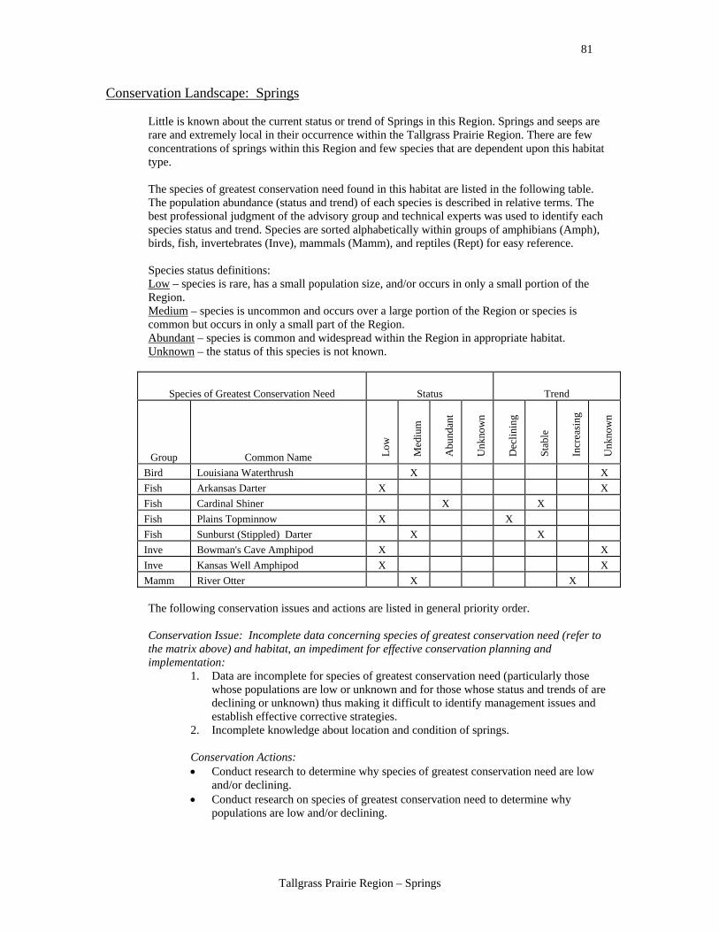
81
Tallgrass Prairie Region – Springs
Conservation Landscape: Springs
Little is known about the current status or trend of Springs in this Region. Springs and seeps are rare and extremely local in their occurrence within the Tallgrass Prairie Region. There are few concentrations of springs within this Region and few species that are dependent upon this habitat type.
The species of greatest conservation need found in this habitat are listed in the following table. The population abundance (status and trend) of each species is described in relative terms. The best professional judgment of the advisory group and technical experts was used to identify each species status and trend. Species are sorted alphabetically within groups of amphibians (Amph), birds, fish, invertebrates (Inve), mammals (Mamm), and reptiles (Rept) for easy reference. Species status definitions: Low – species is rare, has a small population size, and/or occurs in only a small portion of the Region. Medium – species is uncommon and occurs over a large portion of the Region or species is common but occurs in only a small part of the Region. Abundant – species is common and widespread within the Region in appropriate habitat. Unknown – the status of this species is not known.
Species of Greatest Conservation Need Status Trend
Group Common Name Low
Med
ium
Abu
ndan
t
Unk
now
n
Dec
linin
g
Stab
le
Incr
easi
ng
Unk
now
n
Bird Louisiana Waterthrush X X Fish Arkansas Darter X X Fish Cardinal Shiner X X Fish Plains Topminnow X X Fish Sunburst (Stippled) Darter X X Inve Bowman's Cave Amphipod X X Inve Kansas Well Amphipod X X Mamm River Otter X X The following conservation issues and actions are listed in general priority order. Conservation Issue: Incomplete data concerning species of greatest conservation need (refer to the matrix above) and habitat, an impediment for effective conservation planning and implementation:
1. Data are incomplete for species of greatest conservation need (particularly those whose populations are low or unknown and for those whose status and trends of are declining or unknown) thus making it difficult to identify management issues and establish effective corrective strategies.
2. Incomplete knowledge about location and condition of springs.
Conservation Actions: • Conduct research to determine why species of greatest conservation need are low
and/or declining. • Conduct research on species of greatest conservation need to determine why
populations are low and/or declining.
82
Tallgrass Prairie Region – Springs
• Conduct research on species of greatest conservation need to establish baseline population data/information.
• Verify existing data. • Use surveys, workshops and data acquisition to update the Comprehensive Wildlife
Conservation Strategy. • Create a springs and stream data base to track location, condition, land ownership,
and biological data. • Develop a monitoring program to track habitat condition/quality and status of species
of greatest conservation need.
Conservation Issue: Changing land use, modification of vegetation, community fragmentation, exotic species and conversion of habitat:
3. Lack of spring and stream headwaters protection. 4. Springs/seeps important to amphibians, crayfish are difficult to locate and protect. 5. Pipes, concrete collars, and hogs damage may damage springs. 6. Road crossings may create barriers that affect fish and mussel populations. 7. High nutrient levels caused by some inappropriate agricultural practices may affect
spring and cause detrimental algae increases, which in turn causes low oxygen in the water.
8. Springs are fragile habitat that is easily disturbed or modified. 9. Springs are mostly privately owned and protection and conservation is individually
determined. 10. Exotic plants and animals invade springs. 11. Clearing of riparian and forest vegetation and the subsequent loss of stream banks
and changes in width/depth ratios are detrimental to springs and headwater areas. 12. Lack of riparian vegetation and the loss of shading increases water temperatures and
may affect the aquatic community. 13. Groundwater contamination. 14. Groundwater withdrawal reducing spring and stream flow. 15. Lack of knowledge by the public that these habitat types are part of a larger system. 16. Endocrine disruptors related to agricultural runoff/discharge (e.g., poultry, cattle, and
use on plants). 17. Lack of biological resource monitoring. 18. Heavy metal contamination of some streams in the Miami area due to seepage from
abandoned lead and zinc mining.
Conservation Actions: • Create a springs and stream data base to track location, condition, land ownership,
and biological data. • Create stream teams and citizen groups to monitor streams (e.g., biota, habitat, and
water quality). • Demonstrate the importance of the habitat and what the landowner has – grass roots
level education about the connection of springs and streams as part of larger watersheds.
• Acquire land, conservation easements, lease, etc. to protect and restore habitat, water quality, and riparian habitat.
• Develop and market landowner incentive programs to protect and restore habitat, water quality, and riparian habitat.
• Support the proper design of bridges and stream crossings. • Delineate recharge areas of springs to protect water quality. • Assist public and private landowners to remove problem dams that warm water and
make springs unusable for species of greatest conservation need. • Control or stop introduction or spread of exotic species. • Support and encourage an increase in natural resources education in the public
schools and in the community.
83
Tallgrass Prairie Region – Springs
• Manage water withdrawals to have the least impact (i.e., in-stream flow of springs). • Reduce nutrient inputs (i.e., point and non-point sources) through better cost sharing,
providing more acceptable landowner incentives to reduce inputs, and encouraging Best Management Practices in the watershed.
• Provide results of ecological studies to water use planners and encourage the incorporation of the information into management plans for springs.
• Develop local watershed councils, citizen’s groups, or stream teams to address local concerns and to monitor wildlife populations.
• Restore riparian zones, including restoring channels. • Educate landowners about watershed concepts, riparian habitat, Best Management
Practices, existing Farm Bill type programs. • Provide alternative water sources for livestock to get them out of streams.
Potential indicators for monitoring the effectiveness of the conservation actions:
• Number of acres acquired or proportion of acres protected/acquired by watershed. • Number of acres under conservation practices. • Number of citizen groups formed around spring source protection and their
effectiveness. • Number of landowners participating in conservation practices. • Number of protected springs/streams. • Number of spring easements obtained. • Population trends of fish and wildlife species, with emphasis on species of greatest
conservation need. • Populations of spring/stream organisms. • Pubic opinion toward conservation actions. • Stream and spring flow GIS data base. • Stream flow and habitat quality - measure return of stream flow with range of natural
variation. • Water quality.
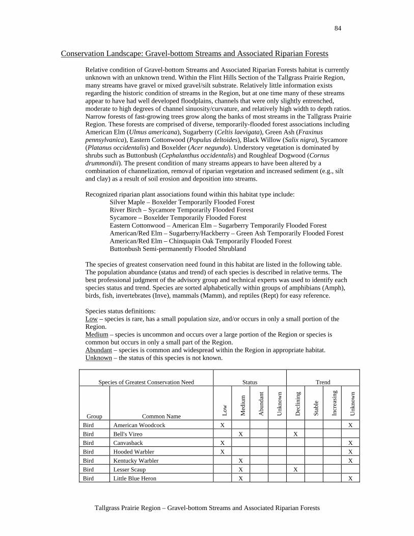
84
Tallgrass Prairie Region – Gravel-bottom Streams and Associated Riparian Forests
Conservation Landscape: Gravel-bottom Streams and Associated Riparian Forests
Relative condition of Gravel-bottom Streams and Associated Riparian Forests habitat is currently unknown with an unknown trend. Within the Flint Hills Section of the Tallgrass Prairie Region, many streams have gravel or mixed gravel/silt substrate. Relatively little information exists regarding the historic condition of streams in the Region, but at one time many of these streams appear to have had well developed floodplains, channels that were only slightly entrenched, moderate to high degrees of channel sinuosity/curvature, and relatively high width to depth ratios. Narrow forests of fast-growing trees grow along the banks of most streams in the Tallgrass Prairie Region. These forests are comprised of diverse, temporarily-flooded forest associations including American Elm (Ulmus americana), Sugarberry (Celtis laevigata), Green Ash (Fraxinus pennsylvanica), Eastern Cottonwood (Populus deltoides), Black Willow (Salix nigra), Sycamore (Platanus occidentalis) and Boxelder (Acer negundo). Understory vegetation is dominated by shrubs such as Buttonbush (Cephalanthus occidentalis) and Roughleaf Dogwood (Cornus drummondii). The present condition of many streams appears to have been altered by a combination of channelization, removal of riparian vegetation and increased sediment (e.g., silt and clay) as a result of soil erosion and deposition into streams. Recognized riparian plant associations found within this habitat type include:
Silver Maple – Boxelder Temporarily Flooded Forest River Birch – Sycamore Temporarily Flooded Forest Sycamore – Boxelder Temporarily Flooded Forest Eastern Cottonwood – American Elm – Sugarberry Temporarily Flooded Forest American/Red Elm – Sugarberry/Hackberry – Green Ash Temporarily Flooded Forest American/Red Elm – Chinquapin Oak Temporarily Flooded Forest Buttonbush Semi-permanently Flooded Shrubland
The species of greatest conservation need found in this habitat are listed in the following table. The population abundance (status and trend) of each species is described in relative terms. The best professional judgment of the advisory group and technical experts was used to identify each species status and trend. Species are sorted alphabetically within groups of amphibians (Amph), birds, fish, invertebrates (Inve), mammals (Mamm), and reptiles (Rept) for easy reference. Species status definitions: Low – species is rare, has a small population size, and/or occurs in only a small portion of the Region. Medium – species is uncommon and occurs over a large portion of the Region or species is common but occurs in only a small part of the Region. Abundant – species is common and widespread within the Region in appropriate habitat. Unknown – the status of this species is not known.
Species of Greatest Conservation Need Status Trend
Group Common Name Low
Med
ium
Abu
ndan
t
Unk
now
n
Dec
linin
g
Stab
le
Incr
easi
ng
Unk
now
n
Bird American Woodcock X X Bird Bell's Vireo X X Bird Canvasback X X Bird Hooded Warbler X X Bird Kentucky Warbler X X Bird Lesser Scaup X X Bird Little Blue Heron X X
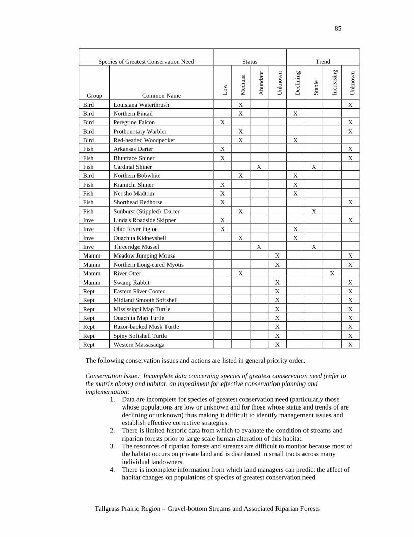
85
Tallgrass Prairie Region – Gravel-bottom Streams and Associated Riparian Forests
Species of Greatest Conservation Need Status Trend
Group Common Name Low
Med
ium
Abu
ndan
t
Unk
now
n
Dec
linin
g
Stab
le
Incr
easi
ng
Unk
now
n
Bird Louisiana Waterthrush X X Bird Northern Pintail X X Bird Peregrine Falcon X X Bird Prothonotary Warbler X X Bird Red-headed Woodpecker X X Fish Arkansas Darter X X Fish Bluntface Shiner X X Fish Cardinal Shiner X X Bird Northern Bobwhite X X Fish Kiamichi Shiner X X Fish Neosho Madtom X X Fish Shorthead Redhorse X X Fish Sunburst (Stippled) Darter X X Inve Linda's Roadside Skipper X X Inve Ohio River Pigtoe X X Inve Ouachita Kidneyshell X X Inve Threeridge Mussel X X Mamm Meadow Jumping Mouse X X Mamm Northern Long-eared Myotis X X Mamm River Otter X X Mamm Swamp Rabbit X X Rept Eastern River Cooter X X Rept Midland Smooth Softshell X X Rept Mississippi Map Turtle X X Rept Ouachita Map Turtle X X Rept Razor-backed Musk Turtle X X Rept Spiny Softshell Turtle X X Rept Western Massasauga X X
The following conservation issues and actions are listed in general priority order. Conservation Issue: Incomplete data concerning species of greatest conservation need (refer to the matrix above) and habitat, an impediment for effective conservation planning and implementation:
1. Data are incomplete for species of greatest conservation need (particularly those whose populations are low or unknown and for those whose status and trends of are declining or unknown) thus making it difficult to identify management issues and establish effective corrective strategies.
2. There is limited historic data from which to evaluate the condition of streams and riparian forests prior to large scale human alteration of this habitat.
3. The resources of riparian forests and streams are difficult to monitor because most of the habitat occurs on private land and is distributed in small tracts across many individual landowners.
4. There is incomplete information from which land managers can predict the affect of habitat changes on populations of species of greatest conservation need.
86
Tallgrass Prairie Region – Gravel-bottom Streams and Associated Riparian Forests
Conservation Actions: • Survey taxonomic experts to determine why species of greatest conservation need
have small and/or declining populations. • Conduct research on species of greatest conservation need to determine what factors
limit their population size and distribution. • Conduct research on species of greatest conservation need to establish baseline
population size, density, and distribution and habitat relationships. • Conduct biological inventories of amphibian, fish, crayfish and mussel populations
in streams to increase the knowledge of biological communities within specific watersheds.
• Summarize and verify existing species and habitat data. • Conduct literature reviews and focused studies to establish what stream and riparian
habitats looked like historically to establish a target condition for stream and riparian restoration efforts.
• Develop relational databases to monitor wildlife populations and the conditions of their habitats.
• Use surveys, workshops and data acquisition to update the Comprehensive Wildlife Conservation Strategy.
• Develop local watershed councils, stream teams and citizen’s groups to address local concerns through education and to monitor water quality and wildlife populations.
Conservation Issue: Water quality changes which negatively affect both habitat and species of greatest conservation need:
5. The presence of many confined animal feeding operations such as cattle feedlots, poultry houses, and hog farms, and waste application fields close to streams and drainages increase nutrient levels.
6. Additional nutrients enter streams as a result of cattle/livestock watering in streams and grazing in riparian areas.
7. Increased nutrient levels in streams increases the abundance of algae, which can result in other water quality impacts such as increased fluctuations in dissolved oxygen.
8. Endocrine disrupters and other pollutants from pesticides enter streams in storm water runoff from agricultural fields which alter the growth, reproduction and/or survival of fish, amphibians and invertebrates in the streams.
Conservation Actions: • Work collaboratively with landowners to reduce nutrient inputs (i.e., point and non-
point sources) through Best Management Practices, Farm Bill cost-share programs, and landowner incentives programs.
• Work collaboratively with landowners to provide alternative water sources for livestock to keep them out of streams.
• Increase landowner education efforts regarding watershed concepts, importance of riparian habitat, Best Management Practices for controlling nutrients, and existing Farm Bill conservation programs to control nutrients.
• Develop conservation easements or acquire land to maintain or restore natural riparian vegetation along streams and reduce or limit agricultural development in and adjacent to riparian areas.
• Establish set back distances between streams and confined animal feeding operations, waste lagoons and land application areas.
• Work collaboratively with landowners to provide cost-share funding to construct fencing along streams and riparian areas to control/limit their access by cattle.
• Work collaboratively with landowners to provide cost-share funding or increase promotion of existing programs to restore riparian vegetation along streams.
• Develop better cost sharing programs to increase the acceptability and use of Best Management Practices to control nutrients and pesticides by landowners.
87
Tallgrass Prairie Region – Gravel-bottom Streams and Associated Riparian Forests
• Reduce the use of herbicides and other pesticides in floodplains and riparian areas. • Develop local watershed councils, stream teams and citizen’s groups to address local
concerns through education and to monitor water quality and wildlife populations. • Improve the funding, knowledge of and access to Farm Bill incentives and cost-share
programs to improve water quality through the implementation of Best Management Practices and establishment of streamside buffer zones.
Conservation Issue: Altered patterns of water flow that negatively affect both habitat and species:
9. Some types of dams and culverts can become barriers to the movement of fish and mussels during low-flow conditions.
10. Bridges, dams and diversion structures alter the natural flow patterns and other processes of streams, especially the frequency and magnitude of natural flooding events.
11. Sedimentation, discharge, erosion, and channel straightening affect in-stream flow, community structure and the sustainability of species of greatest conservation need.
12. Water is being pumped from streams for irrigation. 13. Groundwater is being pumped from shallow aquifers for municipal and agricultural
purposes, lowering water tables and reducing the flow volume of springs and seeps that feed streams.
14. Increased pond construction may be decreasing the inflow and increasing temperatures having negative impacts on important aquatic communities and species of greatest conservation need.
15. Many streams in the Region have been channelized and straightened, resulting in their becoming incised and no longer connected with their riparian vegetation.
16. Streams with incised channels have cut banks that are prone to erosion which increases sediment loads in the streams.
17. Lack of connection between streams and riparian vegetation due to the channelization and incising of streams resulting in reduced riparian vegetation and a loss of wetlands within the stream floodplain.
18. In-stream gravel mining reduces bank stability upstream and downstream of the mining area, increasing bank erosion, and altering the width to depth ratio of the stream by making it wider and shallower.
19. In-stream gravel mining can remove or reduce riffles, gravel beds and other stream structures that are important habitat for aquatic wildlife.
Conservation Actions: • Work collaboratively with landowners to remove ponds and impoundments which
are obsolete but have been shown to block the movement of fish species of conservation need.
• Work collaboratively with landowners to remove or rehabilitate culverts and road crossing with new structures that do not create barriers to fish.
• Work collaboratively with landowners to replace ponds that have been constructed on streams with alternative water sources.
• Modify pond and reservoir management to ensure that minimum in-stream flows are maintained below these structures.
• Work collaboratively with public managers to establish minimum in-stream flow levels on all biologically important streams (e.g., those streams that support populations of species of greatest conservation need, or diverse aquatic communities).
• Work collaboratively with public managers to manage water withdrawals to have the least impact on aquatic biota.
• Work collaboratively with public managers to manage the proposals to sell water outside of the state, or the transfer of water between basins within Oklahoma.
88
Tallgrass Prairie Region – Gravel-bottom Streams and Associated Riparian Forests
• Provide results and implications of ecological studies to the water use planners and permit administrators so that they can do a better job protecting Oklahoma’s natural resources.
• Support the development of a state water management plan with sound biological data that demonstrates the ecological impact of water sales, water withdrawals and interbasin transfers of water.
• Provide cost-share funding or grants to restore the natural meander patterns and profile to stream channels and establish natural vegetation on stream banks for stability.
• Restore or construct seasonal wetlands/vernal pools within the riparian zones or floodplains of streams.
• Reconnect stream and riparian vegetation through the restoration of stream channels. • Work collaboratively with public managers to develop regulations to eliminate the
detrimental effects of gravel mining from within streams on species of greatest conservation need.
• Conduct management pilot studies to determine successful stream protection and management strategies.
• Work with local communities and counties to reduce stream channel impacts including in-stream gravel mining, placement of rip-rap on stream banks at bridge crossings, and recreational use of streams by off-road vehicles.
Conservation Issue: Habitat loss from land management practices:
20. The abundance and diversity of understory vegetation has declined in riparian areas as a result of livestock grazing, especially during the growing season.
21. Riparian forests have been cleared and converted to crop fields, or introduced pastures of exotic grasses such as Fescue and Bermuda.
22. Fragmentation of riparian forests is caused by roads, houses, pastures and utility right-of-ways.
23. Clearing of riparian vegetation reduces stream bank stability which subsequently increases erosion and alters the width/depth ratios of streams.
24. Streams and riparian habitats are fragile and easily disturbed or modified. 25. The loss of riparian vegetation increases erosion and sedimentation. 26. Lack of headwaters protection causes more sediment, nutrients, pesticides and other
pollutants to enter streams. 27. Livestock grazing along stream banks increases bank erosion and increases the
sediment load in the stream. 28. Livestock grazing causes a loss of stream shading as a result of reduced riparian
vegetation, increasing water temperatures and negatively affecting the aquatic community.
29. Increased sediment in the stream can fill or alter riffles and gravel beds which serve as spawning areas for fish and habitats for freshwater mussels.
Conservation Actions: • Work collaboratively with public managers to provide cost-share funding or grants to
fence riparian forests to control/limit access by cattle. • Purchase easements to protect or enhance existing riparian vegetation, and to restore
riparian forests. • Work collaboratively with landowners to encourage the planting/construction of
alternative shading for livestock to reduce their use of riparian areas. • Provide landowner incentives or cost-share programs to protect or restore riparian
forests, stream banks and in-stream habitat. • Acquire fee title purchase of stream and riparian habitat to place this into
conservation ownership to conserve or enhance existing habitat. • Acquire fee title headwaters to steams to control and limit the introduction of
sediment, nutrients and chemical pollutants.
89
Tallgrass Prairie Region – Gravel-bottom Streams and Associated Riparian Forests
• Develop new or promote existing Best Management Practices for the grazing of cattle in or adjacent to riparian zones.
• Increase the availability of aquatic resource educational information in the public schools.
Conservation Issue: Invasive and exotic plants and animals that are detrimental to species of greatest conservation need:
30. Exotic plant species such as Chinese Privet, Salt Cedar and Japanese Honeysuckle have become established and are becoming more abundant in riparian forests, competing with native plants and altering the structure of the habitat that can be used by animals.
31. Exotic predatory fish such as trout may compete with native predatory fish such as bass, and create increased predation pressure on stream fish or invertebrates.
32. Feral hogs that forage in streams and along stream banks damage riparian vegetation and reduce bank stability.
33. Some native plants and animals have become more abundant in riparian forests. o Eastern Redcedar has increased in abundance due to heavy grazing and
reduced fire frequency in riparian areas. o Brown-headed Cowbirds have become more abundant in riparian areas due to
cattle grazing. Brown-headed Cowbirds lay their eggs in the nests of other birds thus reducing the number of chicks from the host species.
Conservation Actions: • Develop management plans to control the abundance and distribution of exotic
species and invasive species. • Conduct management pilot studies to determine successful management strategies. • Conduct studies to quantify the impact of exotic species on riparian forest
communities (i.e., both plants and animals), or on aquatic animal communities. • Increase educational efforts and public awareness of the ecological and economic
impacts of exotic plant and animal populations.
Potential indicators for monitoring the effectiveness of the conservation actions: • Acres of land acquired. • Acres of riparian forest with diverse structure. • Amount of gravel mining. • GIS – change analysis. • Identify and monitor indicator species. • Measure the amount of quality habitat available annually. • National Wild Turkey Federation GIS data sets. • Number and linear miles and acres of easements obtained. • Number of community partners. • Number of enhanced or restored acres of quality habitat. • Number of local citizen groups, watershed councils, stream teams and citizen’s
groups organized. • Number of partnerships or easements. • Number of protected springs and streams. • Number of reservoir management plans that take into account hydro period of the
forest. • Number of stream miles degraded to measure change. • Number, periodicity, value and kinds of recreation users of streams. • Populations of indicator species or species of greatest conservation need. • Populations of spring/stream organisms. • Stream and spring flow relational data base. • Water quality.
90
Tallgrass Prairie Region – Sandy (soft)-bottom Streams and Associated Riparian Forests
Conservation Landscape: Sandy (soft)-bottom Streams and Associated Riparian Forests
Relative condition of Sandy (soft)-bottom Streams and Associated Riparian Forests habitat is currently unknown with an unknown trend. The majority of the streams in the Tallgrass Prairie Region have a predominantly sandy or silty substrate, especially those in the Osage Plains Section. Additional work is needed to determine the historic condition of streams in the Region, but at one time many of the streams appear to have had well developed floodplains, channels that were only slightly entrenched, moderate to high degrees of channel sinuosity (i.e., number of meanders, bends, or curves), and relatively high width to depth ratios. Narrow forests of fast-growing trees grow along the banks of most streams in the Tallgrass Prairie Region. These forests are comprised of diverse, temporarily flooded forest associations dominated by American Elm (Ulmus americana), Sugarberry (Celtis laevigata), Green Ash (Fraxinus pennsylvanica), Eastern Cottonwood (Populus deltoides), Black Willow (Salix nigra), Sycamore (Platanus occidentalis) and Boxelder (Acer negundo). Understory vegetation is dominated by shrubs including Buttonbush (Cephalanthus occidentalis) and Roughleaf Dogwood (Cornus drummondii), and perennial forbs. Currently, many streams in the Region have been altered by human activity such as the removal of riparian vegetation and the straightening of the channels to remove stream meanders. These efforts to reduce the amount of area occupied by the stream’s channel and floodplain have resulted in many streams cutting incised channels. Increasing degrees of channel incision separate the stream from its riparian vegetation. Riparian Plant Associations found within this habitat type include:
Silver Maple – Boxelder Temporarily Flooded Forest River Birch – Sycamore Temporarily Flooded Forest Sycamore – Boxelder Temporarily Flooded Forest Eastern Cottonwood - Black Willow Temporarily Flooded Forest Eastern Cottonwood – American Elm – Sugarberry Temporarily Flooded Forest American/Red Elm – Sugarberry/Hackberry – Green Ash Temporarily Flooded Forest American/Red Elm – Chinquapin Oak Temporarily Flooded Forest Green Hawthorn – Cockspur Hawthorn – Downy Hawthorn Temporarily Flooded Shrubland Buttonbush Semi-permanently Flooded Shrubland Swamp Privet - Buttonbush Semi-permanently Flooded Shrubland Giant Cane Temporarily Flooded Shrubland
The species of greatest conservation need found in this habitat are listed in the following table. The population abundance (status and trend) of each species is described in relative terms. The best professional judgment of the advisory group and technical experts was used to identify each species status and trend. Species are sorted alphabetically within groups of amphibians (Amph), birds, fish, invertebrates (Inve), mammals (Mamm), and reptiles (Rept) for easy reference. Species status definitions: Low – species is rare, has a small population size, and/or occurs in only a small portion of the Region. Medium – species is uncommon and occurs over a large portion of the Region or species is common but occurs in only a small part of the Region. Abundant – species is common and widespread within the Region in appropriate habitat. Unknown – the status of this species is not known.

91
Tallgrass Prairie Region – Sandy (soft)-bottom Streams and Associated Riparian Forests
Species of Greatest Conservation Need Status Trend
Group Common Name Low
Med
ium
Abu
ndan
t
Unk
now
n
Dec
linin
g
Stab
le
Incr
easi
ng
Unk
now
n
Bird American Woodcock X X Bird Bell's Vireo X X Bird Interior Least Tern X X Bird Kentucky Warbler X X Bird Lesser Scaup X X Bird Little Blue Heron X X Bird Louisiana Waterthrush X X Bird Northern Bobwhite X X Bird Northern Pintail X X Bird Painted Bunting X X Bird Prothonotary Warbler X X Bird Red-headed Woodpecker X X Bird Trumpeter Swan X X Fish Pallid Shiner (Chub) X X Fish Plains Minnow X X Inve Linda's Roadside Skipper X X Mamm Brazilian (Mexican) Free-tailed Bat X X Mamm Eastern Spotted Skunk X X Mamm Meadow Jumping Mouse X X Mamm River Otter X X Mamm Swamp Rabbit X X Rept Alligator Snapping Turtle X X Rept Eastern River Cooter X X Rept Midland Smooth Softshell X X Rept Mississippi Map Turtle X X Rept Ouachita Map Turtle X X Rept Spiny Softshell Turtle X X Rept Western Massasauga X X
The following conservation issues and actions are listed in general priority order. Conservation Issue: Incomplete data concerning species of greatest conservation need (refer to the matrix above) and habitat, an impediment for effective conservation planning and implementation:
1. Data are incomplete for species of greatest conservation need (particularly those whose populations are low or unknown and for those whose status and trends of are declining or unknown) thus making it difficult to identify management issues and establish effective corrective strategies.
2. There is limited historic data from which to evaluate the condition of streams and riparian forests prior to large scale human alteration of this habitat.
3. The resources of riparian forests and streams are difficult to monitor because most of the habitat occurs on private land and is distributed in small tracts across many individual landowners.
4. There is incomplete of information from which land managers can predict the affect of habitat changes on populations of species of greatest conservation need.
92
Tallgrass Prairie Region – Sandy (soft)-bottom Streams and Associated Riparian Forests
Conservation Actions: • Survey taxonomic experts to determine why species of greatest conservation need
have small and/or declining populations. • Conduct research on species of greatest conservation need to establish baseline
population size, density, and distribution and habitat relationships. • Conduct research on species of greatest conservation need to determine what factors
limit their population size and distribution. • Conduct biological inventories of amphibian, fish, crayfish and mussel populations
in streams to increase the knowledge of biological communities within specific watersheds.
• Summarize and verify existing species and habitat data. • Conduct literature reviews to establish what stream and riparian habitats looked like
historically to establish a target condition for stream and riparian restoration efforts. • Develop relational databases to monitor wildlife populations and the conditions of
their habitats. • Use surveys, workshops and data acquisition to update the Comprehensive Wildlife
Conservation Strategy. • Develop local watershed councils, stream teams and citizen’s groups to monitor
water quality and wildlife populations.
Conservation Issue: Water quality changes which negatively affect both habitat and species of greatest conservation need:
5. The presence of many confined animal feeding operations such as cattle feedlots, poultry houses, and hog farms apply waste to fields that run off into streams and drainages.
6. Additional nutrients enter streams as a result of cattle watering in streams and grazing in riparian areas.
7. Increased nutrient levels in streams increases the abundance of algae which can result in water quality impacts such as increased fluctuations in dissolved oxygen.
8. Endocrine disrupters and other pollutants from pesticides enter streams in storm water runoff from agricultural fields, altering the growth, reproduction and/or survival of fish, amphibians and invertebrates in the streams.
Conservation Actions: • Reduce nutrient inputs (i.e., point and non-point sources) through Best Management
Practices, Farm Bill cost-share programs, landowner incentives programs. • Work collaboratively with landowners to provide alternative water sources for
livestock to keep them out of streams. • Increase landowner education efforts regarding watershed concepts, importance of
riparian habitat, Best Management Practices for controlling nutrients, and existing Farm Bill conservation programs to control nutrients.
• Develop conservation easements or acquire land to maintain or restore natural riparian vegetation along streams to reduce or limit agricultural development in and adjacent to riparian areas.
• Work collaboratively with public managers to establish set back distances between streams and confined animal feeding operations, waste lagoons and land application areas.
• Provide cost-share funding to construct fencing along streams and riparian areas to control/limit their access by cattle.
• Provide cost-share funding or increase promotion of existing programs to restore riparian vegetation along streams.
• Develop better cost sharing programs to increase the acceptability and use of Best Management Practices to control nutrients and pesticides by landowners.
• Work collaboratively with public managers and landowners to reduce the use of herbicides and other pesticides in floodplains and riparian areas.
93
Tallgrass Prairie Region – Sandy (soft)-bottom Streams and Associated Riparian Forests
• Develop local watershed councils, stream teams and citizen’s groups to address local concerns through education and to monitor water quality and wildlife populations.
• Improve landowner knowledge of and access to Farm Bill incentives and cost-share programs to improve water quality through the implementation of Best Management Practices and establishment of streamside buffer zones.
Conservation Issue: Altered patterns of water flow that negatively affect both habitat and species:
9. Dams, bridges, stream crossings, some types of culverts and diversion structures alter the natural flow patterns, processes of streams, the frequency and magnitude of natural flooding events, and stream channels which have negative impacts on the movement of fish during low-flow conditions, and are barriers that affect the populations of fish and freshwater mussels.
10. Water is being pumped from streams for irrigation and may harm species of greatest conservation need.
11. Groundwater is being pumped from shallow aquifers for municipal and agricultural purposes and this is lowering water tables and reducing the flow volume of springs and seeps that feed streams.
12. Increased pond construction may be lowering the inflow that sustains streams. 13. Many streams in the Region have been channelized and straightened, causing them
to become incised and the streams are no longer connected with their riparian vegetation.
14. Streams with incised channels have cut banks that are prone to erosion that increases sediment loads.
15. Lack of connection between streams and riparian vegetation due to channelization and incising of streams, resulting in reduced riparian vegetation and a loss of wetlands within the stream floodplain.
Conservation Actions: • Work collaboratively with landowners to remove ponds and impoundments which
are obsolete but have been shown to block the movement of fish species of conservation need.
• Work collaboratively with public and private landowners to remove or rehabilitate culverts and road crossing with new structures that do not create barriers to fish.
• Work collaboratively with landowners to replace ponds that have been constructed on streams with alternative water sources (e.g., for livestock).
• Work collaboratively with public managers to modify pond and reservoir management to ensure that minimum in-stream flows are maintained below these structures.
• Establish minimum in-stream flow levels on all biologically important streams (e.g., those streams that support populations of species of greatest conservation need or diverse aquatic communities).
• Manage water withdrawals to have the least impact on aquatic biota. • Work collaboratively with public managers to address proposals to sell water outside
of the state, or the transfer of water between basins within Oklahoma. • Provide results of ecological studies to water use planners and permit administrators
so they can help sustain natural communities and habitat for species of greatest conservation need.
• Support the development of a state water management plan with sound biological data that demonstrates the ecological impact of water sales, water withdrawals and interbasin transfers of water.
• Work collaboratively with public managers to provide cost-share funding or grants to restore stream channels and establish natural vegetation on stream banks for stability.
• Work collaboratively with public and private landowners to restore or construct seasonal wetlands/vernal pools within the riparian zones or floodplains of streams.

94
Tallgrass Prairie Region – Sandy (soft)-bottom Streams and Associated Riparian Forests
• Work collaboratively with public managers to reconnect stream and riparian vegetation through the restoration of stream channels.
• Develop local watershed councils, stream teams and citizen’s groups to address local concerns through education and to monitor water quality and wildlife populations
Conservation Issue: Habitat loss and fragmentation from land management practices:
16. The abundance and diversity of understory vegetation has declined in riparian areas as a result of livestock grazing, especially during the growing season.
17. Riparian forests have been cleared and converted to crop fields or introduced pastures of exotic grasses such as Fescue and Bermuda.
18. Fragmentation of riparian forests by roads, houses, pastures and utility right-of-ways. 19. Clearing of riparian vegetation reduces stream bank stability which subsequently
increases erosion and alters the width/depth ratios of streams. 20. Streams and riparian habitats are fragile and easily disturbed or modified. 21. The loss of riparian vegetation increases erosion and sedimentation. 22. Lack of headwaters protection allows for more sediment, nutrients, pesticides and
other pollutants to enter streams. 23. Livestock grazing along stream banks increases bank erosion. 24. Loss of stream shading as a result of reduced riparian vegetation increasing water
temperatures and negatively affecting the aquatic animal community.
Conservation Actions: • Provide cost-share funding or grants to fence riparian forests to control/limit their
access by cattle. • Purchase easements to protect or enhance existing riparian vegetation, or to restore
riparian forests. • Work collaboratively with landowners to encourage the planting/construction of
alternative shading for livestock to reduce their use of riparian areas. • Provide landowner incentives or cost-share programs to protect or restore riparian
forests, stream banks and in-stream habitat. • Purchase fee title stream and riparian habitat to place this into conservation
ownership to conserve or enhance existing habitat. • Acquire fee title headwaters to steams to control and limit the introduction of
sediment, nutrients and chemical pollutants. • Develop new or promote existing Best Management Practices for the grazing of
cattle in or adjacent to riparian zones.
Conservation Issue: Invasive and exotic plants and animals that are detrimental to species of greatest conservation need:
25. Exotic plant species such as Chinese Privet, Salt Cedar and Japanese Honeysuckle have become established and are becoming more abundant in riparian forests, competing with native plants and altering the structure of the habitat that can be used by animals.
26. Exotic predatory fish such as trout may compete with native predatory fish such as bass, and create increased predation pressure on stream fish or invertebrates.
27. Feral hogs that forage in streams and along stream banks damage riparian vegetation and reduce bank stability.
28. Some native plants and animals have become more abundant in riparian forests. o Eastern Redcedar has increased in abundance due to heavy grazing and
reduced fire frequency in riparian areas. o Brown-headed Cowbirds have become more abundant in riparian areas due to
cattle grazing. Brown-headed Cowbirds lay their eggs in the nests of other birds thus reducing the number of chicks from the host species.
95
Tallgrass Prairie Region – Sandy (soft)-bottom Streams and Associated Riparian Forests
Conservation Actions: • Develop management plans to control the abundance and distribution of exotic
species and invasive species. • Conduct studies to quantify the impact of exotic species on riparian forest
communities (i.e., both plants and animals), or on aquatic animal communities. • Increase educational efforts and public awareness of the ecological and economic
impacts of exotic plant and animal populations.
Potential indicators for monitoring the effectiveness of the conservation actions: • Acres of riparian forest with diverse structure. • Degraded and restored stream miles of habitat. • Number of species of special conservation need provided with habitat quality
monitoring. • Miles of streams. • Number of acres acquired or proportion of acres protected/acquired within a given
watershed. • Number of acres under easements or conservation practices. • Number of enhanced or restored acres of quality habitat. • Number of landowners participating in conservation practices. • Number of new local conservation groups and their effectiveness. • Number of partnerships. • Population status of indicator species or species of greatest conservation need. • Population trends of fish and wildlife species, with emphasis on species of greatest
conservation need. • Pubic opinion toward conservation actions. • Quantity and quality habitat required for species of greatest conservation need. • Stream flow and habitat quality - measure return of stream flow with range of natural
variation. • U.S. Geological Survey monitoring stations data and U.S. Geological Survey
groundwater levels data. • GIS data to monitor change and management success. • Water quality parameters
96
Tallgrass Prairie Region – Potential Partnerships
Potential partnerships to deliver conservation within the Tallgrass Prairie Region:
State Government • Kansas -Arkansas-Oklahoma Arkansas River Compact Commission • Grand River Dam Authority • Kansas State University – Monarch Monitoring Program • Kansas Wildlife and Parks Department • Missouri Department of Conservation • Oklahoma Corporation Commission • Oklahoma Department of Agriculture, Food and Forestry • Oklahoma Department of Environmental Quality • Oklahoma Department of Wildlife Conservation • Oklahoma Legislature • Oklahoma Scenic Rivers Commission • Oklahoma State University – Cooperative Extension Service • Oklahoma State University – Department of Forestry • Oklahoma Tourism and Recreation Department • Oklahoma Water Resources Board • Other state universities and departments • Other state-funded museums • University of Oklahoma – Oklahoma Biological Station • University of Oklahoma – Oklahoma Biological Survey & Oklahoma Natural
Heritage Inventory • University of Oklahoma – Sam Noble Oklahoma Museum of Natural History
Federal Government
• U.S. Army Corps of Engineers • U.S. Bureau of Reclamation • U.S. Congress • U.S. Department of Agriculture – Animal and Plant Health Inspection Service • U.S. Department of Agriculture – Farm Service Agency • U.S. Department of Agriculture – Natural Resources Conservation Service • U.S. Department of Agriculture – Resource Conservation and Development Councils • U.S. Environmental Protection Agency • U.S. Fish and Wildlife Service • U.S. Geological Survey • U.S. National Park Service
Local Government
• Municipalities in Oklahoma, Arkansas, Missouri • Municipalities wanting to buy water • Tribal governments
Businesses, Citizens and Citizen Groups
• Chambers of Commerce • Ducks Unlimited and local Oklahoma chapters • Farm Bureau • Farmers Union • Individual farmers • Land Legacy • Local citizen’s groups • National Wild Turkey Federation and local Oklahoma chapters • Oklahoma Anglers United
97
Tallgrass Prairie Region – Potential Partnerships
• Oklahoma Cattlemen’s Association • Oklahoma Forestry Association • Oklahoma Native Plant Society • Oklahoma Ornithological Society • Oklahoma Section of the Society for Range Management • Other sportsmen’s groups • Private landowners • Producer Cooperatives • Quail Unlimited and local Oklahoma chapters • Small Woodland Owner’s Association • Sutton Avian Research Center • The Izaak Walton League of America • The National Audubon Society and local Oklahoma chapters • The Nature Conservancy • TNC Tallgrass Prairie Preserve • The Wildlife Society • Urban development groups • Vernal Pool Society