table of contents - united states environmental protection … · · 2016-03-31092883 coal ash...
TRANSCRIPT


GEI Consultants, Inc. i April 2011 092883 Coal Ash Impoundment SSA Report PacifiCorp Wyodak Power Station
Table of Contents
1.0 Introduction ................................................................................................... 1
1.1 Purpose ................................................................................................. 1 1.2 Scope of Work ....................................................................................... 1 1.3 Authorization .......................................................................................... 2 1.4 Project Personnel .................................................................................. 2 1.5 Limitation of Liability .............................................................................. 2 1.6 Project Datum ........................................................................................ 2 1.7 Prior Inspections .................................................................................... 2
2.0 Description of Project Facilities ................................................................... 3
2.1 General .................................................................................................. 3 2.2 Impoundment Dams and Reservoirs ..................................................... 3 2.3 Spillways ................................................................................................ 5 2.4 Intakes and Outlet Works....................................................................... 5 2.5 Vicinity Map ........................................................................................... 6 2.6 Plan and Sectional Drawings ................................................................. 6 2.7 Standard Operational Procedures ......................................................... 7
3.0 Summary of Construction History and Operation ...................................... 8
4.0 Hazard Potential Classification .................................................................... 9
4.1 Overview ................................................................................................ 9 4.2 North Pit Ash Pond Potential Release ................................................... 9 4.3 North Pit Ash Pond Hazard Classification ............................................ 10
5.0 Hydrology and Hydraulics .......................................................................... 11
5.1 Floods of Record ................................................................................. 11 5.2 Inflow Design Floods ........................................................................... 11
5.2.1 Determination of the Probable Maximum Flood (PMF) ............ 11 5.2.2 Freeboard Adequacy ............................................................... 11
5.2.3 Dam Break Analysis ................................................................ 11 5.3 Spillway Rating Curves ........................................................................ 11 5.4 Evaluation ............................................................................................ 12
6.0 Geologic and Seismic Considerations ...................................................... 13
7.0 Field Assessment ........................................................................................ 14
7.1 General ................................................................................................ 14 7.2 North Embankment Dam ..................................................................... 14
7.2.1 Dam Crest................................................................................ 14 7.2.2 Upstream Slope ....................................................................... 14
7.2.3 Downstream Slope .................................................................. 14

GEI Consultants, Inc. ii April 2011 092883 Coal Ash Impoundment SSA Report PacifiCorp Wyodak Power Station
7.3 Seepage Conditions ............................................................................ 15 7.4 Appurtenant Structures ........................................................................ 15
7.4.1 Outlet Structures ...................................................................... 15 7.4.2 Pump Structures ...................................................................... 15 7.4.3 Emergency Spillway ................................................................ 15 7.4.4 Water Surface Elevations and Reservoir Discharge ................ 15
8.0 Structural Stability ...................................................................................... 16
8.1 Visual Observations ............................................................................. 16 8.2 Field Investigations .............................................................................. 16 8.3 Structural Analyses .............................................................................. 16
9.0 Maintenance and Methods of Operation ................................................... 18
9.1 Procedures .......................................................................................... 18 9.2 Maintenance of Impoundments ............................................................ 18 9.3 Surveillance ......................................................................................... 18
10.0 Conclusions ................................................................................................. 19
10.1 Assessment of Dams ........................................................................... 19 10.1.1 Field Assessment .................................................................... 19 10.1.2 Adequacy of Structural Stability ............................................... 19 10.1.3 Adequacy of Hydrologic/Hydraulic Safety ................................ 19 10.1.4 Adequacy of Instrumentation and Monitoring of
Instrumentation ........................................................................ 19 10.1.5 Adequacy of Maintenance and Surveillance ............................ 19 10.1.6 Adequacy of Project Operations .............................................. 19
11.0 Recommendations ...................................................................................... 20
11.1 Corrective Measures and Analyses for the Structures ......................... 20 11.2 Corrective Measures Required for Instrumentation and Monitoring
Procedures .......................................................................................... 20 11.3 Corrective Measures Required for Maintenance and Surveillance
Procedures .......................................................................................... 20 11.4 Corrective Measures Required for the Methods of Operation of the
Project Works ...................................................................................... 20 11.5 Summary ............................................................................................. 20
11.6 Acknowledgement of Assessment ....................................................... 22
12.0 References ................................................................................................... 23

GEI Consultants, Inc. iii April 2011 092883 Coal Ash Impoundment SSA Report PacifiCorp Wyodak Power Station
List of Tables Table 2-1: Summary Information for Impoundment Dam Parameters
List of Figures Figure 1: Vicinity Map Figure 2: Site Map: Plan of Ash Impoundments List of Appendices Appendix A: Inspection Checklists – October 26, 2010 Appendix B: Inspection Photographs – October 26, 2010 Appendix C: Reply to Request for Information under Section 104(e) Acronym List
CCW coal combustion waste CMP corrugated metal pipe EPA U.S. Environmental Protection Agency FEMA Federal Emergency Management Agency GEI GEI Consultants, Inc. IDF inflow design flood HDPE high-density polyethylene MW megawatts NPDES National Pollutant Discharge Elimination System PMF probable maximum flood RCP reinforced concrete pipe USACE U.S. Army Corps of Engineers USBR U.S. Bureau of Reclamation USGS U.S. Geological Survey

GEI Consultants, Inc. 1 April 2011 092884 Coal Ash Impoundment SSA Report
PacifiCorp Wyodak Power Station
1.0 Introduction
1.1 Purpose
This report presents the results of a specific site assessment of the dam safety of a coal combustion waste (CCW) impoundment at the Wyodak Power Station (Wyodak Station) in Gillette, Wyoming. The Wyodak Station is operated and owned by PacifiCorp Energy. The impoundment is the North Pit Ash Pond. The specific site assessment was performed on October 26, 2010.
The specific site assessment was performed with reference to Federal Emergency Management Agency (FEMA) guidelines for dam safety, which includes other federal agency guidelines and regulations (such as U.S. Army Corps of Engineers [USACE] and U.S. Bureau of Reclamation [USBR]) for specific issues, and defaults to state requirements were not specifically addressed by federal guidance or if the state requirements were more stringent.
1.2 Scope of Work
The scope of work between GEI Consultants, Inc. (GEI) and the U.S. Environmental Protection Agency (EPA) for the specific site assessment is summarized in the following tasks:
1. Acquire and review existing reports and drawings relating to the safety of the project provided by the EPA and PacifiCorp Energy.
2. Conduct detailed physical inspections of the project facilities. Document observed conditions on Field Assessment Checklists provided by EPA for each management unit being assessed.
3. Review and evaluate stability analyses of the project’s coal combustion waste impoundment structures.
4. Review the appropriateness of the inflow design flood (IDF), and adequacy or ability to store or safely pass the IDF, provision for any spillways, including considering the hazard potential in light of conditions observed during the inspections or to the downstream channel.
5. Review existing dam safety performance monitoring programs and recommend additional monitoring, if required.
6. Review existing geologic assessments for the projects.
7. Submit draft and final reports.

GEI Consultants, Inc. 2 April 2011 092884 Coal Ash Impoundment SSA Report
PacifiCorp Wyodak Power Station
1.3 Authorization
GEI performed the coal combustion waste impoundment assessment as a contractor to the EPA. This work was authorized by EPA under Contract No. EP09W001698, Order No. EP-B10S-00018 between EPA and GEI, dated September 23, 2010.
1.4 Project Personnel
The scope of work for this task order was completed by the following personnel from GEI:
Stephen G. Brown, P.E. Project Manager Brian S. Johnson, P.E. Senior Project Engineer / Task Leader Thomas A. Daigle Project Geologist Steven R. Townsley, P.E. Senior Reviewer
The Program Manager for the EPA was Stephen Hoffman.
1.5 Limitation of Liability
This report summarizes the assessment of dam safety of coal a combustion waste impoundment Ash Pond at Wyodak Power Station, Gillette, Wyoming. The purpose of this assessment is to evaluate the structural integrity of the impoundments and provide summaries and recommendations based on the available information and on engineering judgment. GEI used a professional standard of practice to review, analyze, and apply pertinent data. No warrantees, express or implied, are provided by GEI. Reuse of this report for any other purpose, in part or in whole, is at the sole risk of the user.
1.6 Project Datum
No references to the project datum or a vertical datum were discovered during the document review process.
1.7 Prior Inspections
Semi-annual inspections of the CCW impoundment by a PacifiCorp engineer began in August 2009. The semi-annual inspections are intended to assess the environmental and dam safety conditions of the CCW impoundment. Cornforth Consultants, Inc. conducted a Phase I Geotechnical Assessment of the CCW impoundment in May 2009. Prior to 2009, no third-party inspections for the impoundment were performed. A visual inspection of the CCW impoundment is performed at least once per 12-hour shift by a PacifiCorp employee.

GEI Consultants, Inc. 3 April 2011 092884 Coal Ash Impoundment SSA Report
PacifiCorp Wyodak Power Station
2.0 Description of Project Facilities
2.1 General
The Wyodak Station is a coal-fired power plant consisting of one unit that has a nameplate capacity of 362 megawatts (MW). The power plant is located approximately 5 miles east of Gillette, Campbell County, Wyoming along Interstate 90; see Figure 1. The Wyodak Station is owned and operated by PacifiCorp Energy, which is a subsidiary of MidAmerican Energy Holdings Company which is owned by Berkshire Hathaway. The Power Station went online in 1978. The CCW impoundment is located west of the power plant at the bottom of an inactive coal mine. The CCW impoundment consists of two cells: a primary ash settling cell, and a clear water cell. There are no design records from the original construction of the impoundment, however a design report was provided for the pond expansion in 1989.
The North Pit Ash Pond (Ash Pond) was built in 1977 and was expanded in 1989. The primary uses of the Ash Pond are the holding and recovery of bottom ash received from the power station and storage of water for later re-use at the plant. Bottom ash and other wastewater is slurried to the Ash Pond from the power station through an underground pipeline. Primary settling of the ash occurs in the settling cell and the relatively clear decant water is transferred by gravity through a divider dike to the clear water cell. Water is pumped back to the plant from the clear water cell through a pump station located in the northeast corner of the cell.
Five additional coal-fired generating units are adjacent to the Wyodak plant that are owned and operated by the Black Hills Energy Holding Company. They are the: Neil Simpson 1 and 2, and WyGen1, 2, and 3 units. All five units utilize the Ash Pond for various wastewater discharge needs. Water from the clear water cell is pumped back to the Wyodak and Neil Simpson 1 units for re-use as service water.
2.2 Impoundment Dams and Reservoirs
The embankment dam of the CCW impoundment has not been previously assigned a hazard potential classification by a state or federal agency. Based on the geometry of the impoundment and the facilities downstream, a recommended hazard potential classification for the impoundment has been developed in Section 4.0 of this report. The basic dimensions and geometry of the CCW impoundment are summarized in Table 2-1.
The North Pit Ash Pond is roughly rectangular in shape and is constructed at the bottom of the inactive north coal mine pit at the Wyodak Mine. The Ash Pond is completely contained within the former coal mine pit; the rim of the mine pit is approximately 45 feet above the top of the Ash Pond Embankment dam. The Ash Pond is enclosed on the east, west, and

GEI Consultants, Inc. 4 April 2011 092884 Coal Ash Impoundment SSA Report
PacifiCorp Wyodak Power Station
south by excavated natural ground slopes (the original mine pit slopes) and on the north by a constructed embankment dam. The north embankment dam is approximately 900 feet long, and the natural ground perimeter length is approximately 2,600 feet for a total perimeter length of approximately 3,500 feet. The Ash Pond includes three cells. An approximately 650 foot long divider dike separates the southern clear water cell from the two primary ash settling cells that are located in the north part of the Ash Pond.
An embankment dam forms the northern margin of the Ash Pond and is approximately 30 feet high (maximum) with a crest width of approximately 100 feet. The downstream slope of the dam appears to be 2H:1V, or steeper, and is exposed earth with sparse vegetative cover. The upstream side of the dam appears to be 1H:1V and is exposed earth without an erosion protection layer. The original design called for a crest width of 23 feet and upstream and downstream slopes of 3H:1V. The crest width was subsequently expanded to accommodate a haul road. Design documents indicate that the embankment was to be constructed of compacted clay fill. There are no as-built documents, and no subsurface analyses have been performed to characterize the embankment construction materials. No signs of significant erosion were observed on the impoundment slopes.
The east, west, and south impoundment margins consist of natural cut slopes that range from approximately 10 to 50 feet high. The inactive mine pit extends west of the Ash Pond and is used for dry ash disposal.
The primary settling cell is partially separated by an earthen berm creating a “heavy ash” section and a “light ash” section. The clear water cell to the south is separated from the settling cell by a divider dike approximately 35 feet high. Water flows by gravity from the settling cell to the clear water cell through a drop-inlet pipe and high-density polyethylene (HDPE) culvert. Water is pumped from the clear water cell back to the power plants for re-use as service water.
Table 2-1: Summary Information for Impoundment Dam Parameters
Parameter Value Dam North Pit Ash Pond
Estimated Maximum Height (ft) 30
Estimated Length (ft) 900
Crest Width (ft) 100
Crest Elevation2 (ft) 4,350
Side Slopes Upstream/Downstream (H: V)3 1H:1V / 2H:1V
Estimated Freeboard (ft) at time of site visit 5
Storage Capacity1 (ac-ft) 320.2
Surface Area1 (acres) 15.5 1 Surface area and capacity based on CERCLA 104(e) Request for Information prepared by PacifiCorp at the request of the
EPA, dated March 30, 2009. 2 Based on design drawings for the North Pit Ash Pond Expansion created by Western Water Consultants and provided by
PacifiCorp. As-built drawings not provided and vertical datum not specified. 3 As estimated in the field. No survey or topographic maps were available.

GEI Consultants, Inc. 5 April 2011 092884 Coal Ash Impoundment SSA Report
PacifiCorp Wyodak Power Station
There are no records of the original geotechnical design or material properties for the embankment perimeter dikes. In 1989, a Design Report for the enlargement of the Ash Pond was compiled by Western Water Consultants, Inc. The geotechnical investigation included drilling 21 borings around the existing Ash Pond. The material descriptions indicate that the north embankment dam was originally constructed of a relatively homogenous mixture of silt, sand, and clay. The divider dike was originally constructed of a heterogeneous mix of sand, silt, clay, rock, and coal fragments. Both the north embankment dam and the divider dike were enlarged in 1989 using silt and clay compacted fill. The material underlying both embankments consists of medium to hard gray claystone of the Fort Union Formation and a thin layer of coal/clay mixed with coal fragments at the top of the bedrock contact.
2.3 Spillways
A single emergency spillway was included in the design of the north embankment dam for the 1989 Ash Pond enlargement. As described in the 1989 Design Report for the North Pit Ash Pond Enlargement, the spillway was 12 feet wide and 5 feet deep located at the northeast corner of the pond. The spillway has subsequently been filled in to accommodate the installation of a major haul road along the crest of the north embankment dam. A 30-inch diameter concrete-lined steel pipe was installed below the roadway to pass any potential flood flows that would have been conveyed by the original open spillway. The original spillway elevation was 4345 feet (5 feet below the north embankment dam crest).
According to the 1989 Design Report, the spillway was considered to be a conservative design element for the project. It was designed to pass the 100-year 6-hour flood with a minimum of 1.7 feet of freeboard remaining and provided an additional safety measure to prevent any failure of the north embankment dam. According to a Phase I Geotechnical Assessment conducted in 2009 by Cornforth Consultants, Inc., engineering evaluations were completed in 2001 when the haul road was constructed over the spillway. The conclusion was that a 30-inch diameter pipe would be sufficient to pass the original spillway design flood calculated in the 1989 design. Also, according to the Phase I Geotechnical Assessment, permit modifications for the spillway were approved by the Wyoming Department of Environmental Quality—Water Quality Division and the U.S. Mine Safety and Health Administration.
2.4 Intakes and Outlet Works
There are a total of seven inlet pipes discharging into the settling cell and one inlet pipe discharging into the clear water cell from the Wyodak and Black Hills Power Plants. Decant water from the settling cell is discharged by gravity to the clear water cell through a 48-inch diameter reinforced concrete pipe (RCP) drop-inlet pipe fitted with two 18-inch hand-operated canal gates spaced 5 feet apart (vertically) and joined to an 18-inch diameter HDPE conduit fitted with seepage cutoff collars passing through the southern divider dike. The clear water cell also receives surface water runoff and storm drain discharge from the

GEI Consultants, Inc. 6 April 2011 092884 Coal Ash Impoundment SSA Report
PacifiCorp Wyodak Power Station
Wyodak and Black Hills Neil Simpson 1 Plants. Water is pumped back to the Wyodak and Black Hills Plants through a pump station located at the northeast corner of the clear water cell.
The Ash Pond inlet pipes discharge:
Bottom ash slurry from the Wyodak Unit.
Bottom ash slurry and fly ash slurry from the Black Hills Neil Simpson 1 Unit.
Coal handling washdown from the Wyodak Unit.
Wastewater (not sewage) from the Wyodak Unit, the Black Hills Neil Simpson 1 and 2 Unit, and the Black Hills WyGen1, 2, and 3 Units, and the Black Hills Wyodak Resource Mine.
Scrubber waste from the Wyodak Unit (in emergencies only).
The wastewater inlet pipes are located at the northeast and southeast corners of the settling cell. Surface water runoff and storm drain water from the Wyodak and Black Hills Neil Simpson 1 Units are discharged directly into the clear cell near the pumphouse. The inlet pipes appear to discharge at or above the current water surface elevation and there are no known low-level outlets constructed through the north embankment dam or the divider dike.
Prior to 1989, the primary settling cells and the clear water cell were connected by seven 12-inch diameter corrugated metal pipe (CMP) culverts placed through the southern divider dike at staged elevations. As part of the 1989 Ash Pond enlargement, the seven CMP culverts were filled with grout to seal them in place. They were replaced with the existing 18-inch HDPE conduit fitted with two drop-inlet pipes with manually operated gates to control inflow from two different elevations. The drop-inlet pipes are connected to one 18-inch diameter HDPE pipe with seepage cutoff collars that passes through the divider dike.
2.5 Vicinity Map
The Wyodak Power Station is located approximately 5 miles east of Gillette, Wyoming, as shown on Figure 1. A single CCW impoundment is located approximately 1500 feet west of the Wyodak Station at the bottom of an inactive coal mine.
2.6 Plan and Sectional Drawings
Survey and design drawings were prepared as part of the 1989 North Pit Ash Pond Enlargement and were provided to GEI by PacifiCorp along with a copy of the design report. No earlier information regarding the original construction of the Ash Pond was located during a document search.

GEI Consultants, Inc. 7 April 2011 092884 Coal Ash Impoundment SSA Report
PacifiCorp Wyodak Power Station
2.7 Standard Operational Procedures
The Wyodak Station is a coal-fired power plant with a nameplate capacity of about 362 MW. Coal is delivered to the power plant by conveyor belt from the neighboring Black Hills Wyodak Mine, where it is then combusted to power the steam turbines. The burning of coal produces several gases and fly ash which are vented from the boiler. The bottom ash, which consists of coarse fragments, falls to the bottom of the boiler and is removed along with boiler slag. Coal combustion waste from the boiler is wet sluiced via subsurface piping into the Ash Pond.
The North Pit Ash Pond consists of a primary bottom ash settling cell and a clear water cell separated by a divider dike. The primary settling cell is divided into a “heavy ash” and “light ash” section separated by an earthen berm. Decant water from the “heavy ash” section flows around the berm and is discharged into the “light ash” section where secondary finer particles settle out. Decant water from the “light ash” section flows by gravity through a drop-inlet pipe installed through the divider dike and into the clear water cell. Water from the clear water cell is pumped back to the power plants for re-use as service water. The Ash Pond inflow is typically balanced with pumped outflow back to the power plants; however, discharge to surface water (Donkey Creek) is permitted under National Pollutant Discharge Elimination System (NPDES) permit number WY-0001384. Due to the Ash Pond location approximately 50 feet below the rim of the inactive mine, discharge to surface water cannot occur by gravity flow and must be pumped out.
According to PacifiCorp, an operation and maintenance manual currently does not exist for the CCW facilities. Plant operators perform routine inspections of the CCW facilities at least once per shift; however these inspections are not formally documented.

GEI Consultants, Inc. 8 April 2011 092884 Coal Ash Impoundment SSA Report
PacifiCorp Wyodak Power Station
3.0 Summary of Construction History and Operation
The North Pit Ash Pond was constructed at the bottom of an inactive coal mine adjacent to the Wyodak Power Station in the 1970s. The Ash Pond was enlarged in 1989 and has received CCW from several plants in the immediate vicinity since it went into service over 30 years ago. When the Ash Pond fills up, the CCW is excavated and transported offsite for disposal/recycling. The Ash Pond consists of two cells: one primary ash settling cell and a clear water cell separated by a divider dike. Water from the clear water cell is pumped back to the power plants for re-use as service water.
Documentation of the original design and construction of the CCW facility could not be located at the time of the inspection. A design report including survey drawings and boring logs was developed for the 1989 Ash Pond enlargement and was reviewed as part of this inspection. Twenty one borings were conducted as part of the enlargement design investigation and extended between 10 and 20 feet beneath the base of the dikes. The dikes consisted of silt, sand, and clay, and were underlain by bedrock consisting of medium to hard claystone.
The dam was not constructed on top of CCW—the original dam was constructed in 1977, prior to the plant going online, and the 1989 Ash Pond Enlargement drawings show construction of the embankment on a natural earth subgrade. The north embankment dam crest width is currently much wider than originally designed; there was no available information describing the fill material and construction methods. The 1989 Ash Pond Enlargement design report specified that the north embankment dam was to be constructed of compacted clay fill.

GEI Consultants, Inc. 9 April 2011 092884 Coal Ash Impoundment SSA Report
PacifiCorp Wyodak Power Station
4.0 Hazard Potential Classification
4.1 Overview
Consistent with the Federal Guidelines for Dam Safety, the hazard potential classification for the CCW impoundments is based on the possible adverse incremental consequences that would result from release of stored contents due to failure of the dam or misoperation of the dam or appurtenances. Impoundments are classified as Less Than Low, Low, Significant, or High hazard, depending on the potential for loss of human life and/or economic and environmental damages.
4.2 North Pit Ash Pond Potential Release
The North Pit Ash Pond is roughly rectangular in shape and is enclosed on the east, west, and south by natural cut slopes and on the north by a constructed embankment dam. The North Pit Ash Pond, with a storage volume of about 320 acre-feet and a maximum height of about 30 feet is considered a “Small” sized dam in accordance with the USACE Recommended Guidelines for Safety Inspection of Dams ER 1110-2-106 criteria.
Under normal operating circumstances, the inflow to the Ash Pond is balanced by the outflow being pumping back to the neighboring power plants. There are two plausible scenarios which could potentially result in a breach of the north embankment dam and an uncontrolled release of the contents of the pond. The first scenario would be during a significant rain event when stormwater inflow exceeds the pumped outflow. The second scenario would be if the outflow pumphouse failed and water continued to be discharged into the pond for an extended period of time. In the event of a breach of the north embankment dam through either scenario, CCW would enter the inactive mine pit sump (a low area to the north of the Ash Pond).
An uncontrolled release of CCW into the inactive mine pit sump area would pose no threat to human life in our opinion. In addition, there would be no threat to the environment or property. The rim of the former mine is approximately 50 feet above the elevation of the Ash Pond water level and the amount of water in the Ash Pond is small compared to the storage capacity of the entire mine pit. Therefore, we do not believe that an uncontrolled release would pose any threat to human life, property, or the environment. We also believe that an uncontrolled release from the Ash Pond would not overtop the mine pit rim approximately 50 feet above the current water level elevation. As a result, any breach in the Ash Pond north embankment dam would be contained within the inactive mine pit sump and would not be discharged outside the former mine.

GEI Consultants, Inc. 10 April 2011 092884 Coal Ash Impoundment SSA Report
PacifiCorp Wyodak Power Station
If the southern divider dike failed, water from the primary settling cell would flow into the clear water cell and equalize without overtopping the perimeter Ash Pond impoundments. The pumphouse may be damaged if this occurs.
4.3 North Pit Ash Pond Hazard Classification
Based on the absence of impacts described above and consistent with the Federal Guidelines for Dam Safety, we recommend classifying the north embankment dam of the North Pit Ash Pond as a “Less Than Low” hazard structure.
GEI Consultants, Inc. 11 April 2011 092884 Coal Ash Impoundment SSA Report
PacifiCorp Wyodak Power Station
5.0 Hydrology and Hydraulics
5.1 Floods of Record
Floods of record have not been evaluated and documented for the CCW impoundment at the Wyodak Station.
5.2 Inflow Design Floods
Currently there is no hazard classification for the North Pit Ash Pond at the Wyodak Station. Based on observations during the field inspection, we recommend classifying the North Pit Ash Pond as a “Less Than Low” hazard dam (see Section 4.0). The Wyoming State Engineer’s Office oversees the safety of dams in Wyoming and does not have a system of dam classification or associated guidelines for inflow design flood analyses. The North Pit Ash Pond is situated at the bottom of an inactive mine pit approximately 50 feet below the surrounding natural ground surface elevation such that any release will be contained within the inactive mine and the contents of the pond cannot flow by gravity into a receiving water body. GEI did not perform an inflow design flood analysis as part of this assessment.
An inflow design flood analysis was performed by Western Water Consultants, Inc. as part of the 1989 Ash Pond Enlargement design. They evaluated the 100-year 6-hour and 100-year 24-hour precipitation events and concluded that a 100-year 6-hour precipitation event would produce the maximum peak discharge. The spillway was designed to pass the design flood; however, they also concluded that due to the small contributing drainage area and the control of all other inflow to the Ash Pond, it is highly improbable that the emergency spillway would be used during the life of the enlarged pond.
5.2.1 Determination of the Probable Maximum Flood (PMF)
Not applicable.
5.2.2 Freeboard Adequacy
Not applicable.
5.2.3 Dam Break Analysis
Dam break analyses have not been performed for the North Pit Ash Pond.
5.3 Spillway Rating Curves
Not applicable.

GEI Consultants, Inc. 12 April 2011 092884 Coal Ash Impoundment SSA Report
PacifiCorp Wyodak Power Station
5.4 Evaluation
An inflow design flood analysis was not performed at the North Pit Ash Pond at the Wyodak Power Station.

GEI Consultants, Inc. 13 April 2011 092884 Coal Ash Impoundment SSA Report
PacifiCorp Wyodak Power Station
6.0 Geologic and Seismic Considerations
Boring logs taken by Western Water Consultants at the Wyodak Station in 1988 indicate that the predominant overburden soil consists of yellowish to dark brown sand, silt and clay with interbedded layers of fine coal fragments. The borings extend to a maximum depth between 10 and 20 feet below the dam foundation, and bedrock consists of medium to hard gray claystone of the Fort Union Formation. The Fort Union Formation is a thick deposit of interbedded sandstone, siltstone, and carbonaceous shale that is present across much of central and eastern Wyoming. The formation contains multiple coal beds up to100 feet thick and is actively mined for coal.
We are not aware of any seismic analyses that have been performed on the dams at the Wyodak Station. According to the 2008 U.S. Geological Survey (USGS) Seismic Hazard Map of the Western U.S., the site has a regional probabilistic peak ground acceleration of between 0.07 and 0.14 g with a 2 percent Probability of Exceedance within 50 years (recurrence interval of approximately 2,500 years).

GEI Consultants, Inc. 14 April 2011 092884 Coal Ash Impoundment SSA Report
PacifiCorp Wyodak Power Station
7.0 Field Assessment
7.1 General
A site visit to assess the condition of the CCW impoundments at the Wyodak Power Station was performed on October 26, 2010, by Brian Johnson, P.E., and Tom Daigle of GEI. Bernadette Hinshaw and Jeff Tucker of PacifiCorp assisted in the assessment.
The weather during the site visit (October 26, 2010) was cloudy and windy, with temperatures around 40 degrees Fahrenheit. The majority of the ground was dry at the time of the site visit.
At the time of inspection GEI completed an EPA inspection checklist, which is provided in Appendix A, and photographs, which are provided in Appendix B. Field assessment of the CCW impoundment included a site walk to observe the dam crest, upstream slope, downstream slope, and intake structures.
7.2 North Embankment Dam
7.2.1 Dam Crest
The crest of the north embankment dam appeared to be in good condition. No signs of cracking, settlement, movement, erosion or deterioration were observed during the assessment. The current minimum crest width is approximately 100 feet., and the surface is generally composed of road base material that traverses the length of the dam for vehicle access.
7.2.2 Upstream Slope
The upstream slope of the dam was generally exposed earth with sparse vegetation and a slope ranging from 2H:1V to 1H:1V. The 1H:1V upstream slope is significantly steeper than the 1989 Ash Pond enlargement design slope of 3H:1V. It is unknown if the embankment was intentionally constructed at this slope, or if the slope is a result of excavation operations to remove CCW from the pond. However, no scarps, sloughs, depressions or other indications of slope instability or signs of erosion were observed on the upper 5 feet of the upstream slope. The lower 25 feet of the upstream slope was submerged by the pond contents and could not be observed.
7.2.3 Downstream Slope
The downstream slope of the dam was covered with sparse grassy vegetation, but otherwise contained no erosion control measures. The downstream slope of the dam was estimated in

GEI Consultants, Inc. 15 April 2011 092884 Coal Ash Impoundment SSA Report
PacifiCorp Wyodak Power Station
the field as approximately 2H:1V and showed no signs of scarps, sloughs, depressions or other indications of slope instability or signs of erosion.
7.3 Seepage Conditions
No evidence of ongoing seepage or potential seepage was observed at either the north embankment dam or the southern divider dike.
7.4 Appurtenant Structures
7.4.1 Outlet Structures
The Ash Pond contains approximately seven inlet pipes (located in the northeast and southeast corners of the settling cell) and two outlet structures (one decant structure connecting the settling cell to the clear water cell through the divider dike, and one pumphouse located in the clear water cell). The inlet pipes discharge water at or above the current water surface elevation and do not penetrate the north embankment dam. All inlet and outlet structures appeared to be in good condition. The outlet pipe and decant structure from the settling cell to the clear water cell was observed to be working properly, decanting water into the clear water pond. There appeared to be adequate riprap protection around the decant overflow structure. There is no low level outlet conduit through the north embankment dam.
7.4.2 Pump Structures
The equipment in the pumphouse located in the northeast corner of the clear water cell was not inspected.
7.4.3 Emergency Spillway
An emergency spillway was constructed at the northeast corner of the Ash Pond as part of the 1989 enlargement. The spillway has been subsequently filled in to accommodate a haul road. A 30-inch diameter culvert was installed in the spillway under the road to convey overflow water from the Ash Pond to the reconstructed north mine sump.
7.4.4 Water Surface Elevations and Reservoir Discharge
Reservoir water surface elevations or discharge flow readings at the time of the inspection were not available. Based on visual observations, the reservoir freeboard during the site inspections was approximately 5 feet in the primary settling cells and greater than 15 feet in the clear water cell.

GEI Consultants, Inc. 16 April 2011 092884 Coal Ash Impoundment SSA Report
PacifiCorp Wyodak Power Station
8.0 Structural Stability
8.1 Visual Observations
The assessment team saw no visible signs of instability associated with the containment embankments of the Ash Pond during the October 26, 2010 site assessment. However, only the upper 5 feet of the upstream embankment slopes could be observed during the inspection; the lower 25 feet of the upstream slope was submerged by the pond contents.
8.2 Field Investigations
Subsurface investigations in the area of the north embankment dam were performed by Cornforth Consultants to support the 1989 Ash Pond enlargement design. It appears that no other field investigations have been performed at the Ash Pond.
8.3 Structural Analyses
No structural analyses have been performed for the north embankment dam.
The current embankment configuration has a 30-foot height, 1H:1V upstream slope, 100-foot crest width and 2H:1V downstream slope, providing a base width of about 190 feet. A theoretical embankment prism with 30-foot height, 3H:1V upstream slope, 20-foot crest width, 2.5H:1V downstream slope and 185-foot bottom width, constructed of low-plasticity clays and silts, would generally be expected to provide adequate stability under comparable hydraulic loading conditions. Since the theoretical embankment prism is contained within the existing embankment cross-section, the overall embankment is judged to be stable for expected hydraulic loading conditions.
At 1H:1V, the upstream slope is considered to be over-steep for clay/silt embankment materials. As a result, the slopes are expected to be at risk for localized, surficial slope failures, resulting in slumps, sloughing and other forms of slope instability. These localized slope failures will adversely impact the overall embankment stability if they extend into the theoretically stable prism described in the previous paragraph. Failures of steep slopes can be induced by excavation activities such as are conducted for removal of CCW wastes from the pond. These activities include, but are not limited to, direct excavation of materials at or near the slope and undercutting of the toe of the slope. Failure of the upstream slope could pose a safety risk to personnel performing excavation and hauling operations, and to vehicle operators traversing the embankment crest.
The downstream embankment slope is judged by inspection to be stable for expected loading conditions. This judgment is based on the observed condition of the slope and no reported history of slope instability.

GEI Consultants, Inc. 17 April 2011 092884 Coal Ash Impoundment SSA Report
PacifiCorp Wyodak Power Station
We understand that the embankment crest is used as a haul road for Plant operations, and have assumed that the crest is regularly traversed by large, off-road construction excavating and hauling vehicles. The structural stability assessment described in the preceding paragraphs does not consider the potentially significant surcharge loads imposed on the embankment by these vehicles. In addition, the materials and construction methods used to expand the crest width are unknown. Significant surcharge loads on the embankment will reduce the stability of the slopes, and could induce slope failures, with potential safety risks to vehicle operators. This Report does not address stability and safety of the embankment with respect to operational uses other than water retention.

GEI Consultants, Inc. 18 April 2011 092884 Coal Ash Impoundment SSA Report
PacifiCorp Wyodak Power Station
9.0 Maintenance and Methods of Operation
9.1 Procedures
Semi-annual inspections of the CCW impoundment began in August 2009 and are conducted and documented by PacifiCorp engineers. Prior to 2009, no formal visual inspections of the CCW impoundment were made; however, routine inspections were conducted by PacifiCorp staff on a daily basis. A third-party inspection of the CCW impoundment was conducted by Cornforth Consultants, Inc. on May 5-6, 2009.
9.2 Maintenance of Impoundments
Maintenance of the CCW impoundment is performed by PacifiCorp staff under the guidance of PacifiCorp managers and engineers.
9.3 Surveillance
The Ash Pond is patrolled once per shift by PacifiCorp operations personnel. A detailed visual inspection of the Ash Pond impoundments was performed by Cornforth Consultants, Inc. on May 5-6, 2009. Dam safety-related inspections have not been previously made by state or federal agencies.

GEI Consultants, Inc. 19 April 2011 092884 Coal Ash Impoundment SSA Report
PacifiCorp Wyodak Power Station
10.0 Conclusions
10.1 Assessment of Dams
10.1.1 Field Assessment
Issues of potential concern for the CCW impoundment were identified from our field assessment as follows:
North Pit Ash Pond north embankment dam downstream slope has no erosion protection.
North Pit Ash Pond north embankment dam upstream slope is oversteepened at about 1H:1V, with increased potential for local, surficial slope instability and sloughing.
10.1.2 Adequacy of Structural Stability
There are no records of a structural stability evaluation of the CCW impoundment.
10.1.3 Adequacy of Hydrologic/Hydraulic Safety
Not applicable.
10.1.4 Adequacy of Instrumentation and Monitoring of Instrumentation
There is currently no instrumentation installed at the CCW impoundment.
10.1.5 Adequacy of Maintenance and Surveillance
The CCW impoundment has fair maintenance and surveillance programs. The facilities appear to be adequately maintained and routine surveillance is performed by PacifiCorp staff.
10.1.6 Adequacy of Project Operations
Operating personnel are knowledgeable and are trained in the operation of the project. The current operations of the facilities appear to be satisfactory.

GEI Consultants, Inc. 20 April 2011 092884 Coal Ash Impoundment SSA Report
PacifiCorp Wyodak Power Station
11.0 Recommendations
11.1 Corrective Measures and Analyses for the Structures
Implement field procedures to prevent potential for encroachment of excavations into the theoretical embankment prism described in Section 8.3; procedures should include, but are not limited to, means to prevent undercutting the upstream slopes of embankment dikes when excavating bottom ash from the settling cell.
11.2 Corrective Measures Required for Instrumentation and Monitoring Procedures
None recommended.
11.3 Corrective Measures Required for Maintenance and Surveillance Procedures
Conduct regular visual observation of the upstream slope of the North Embankment Dam for sloughing, localized slope failures or other indications of slope instability. Repair upstream slope promptly upon discovery of any slope failure.
Conduct regular visual observation of downstream slope of the North Embankment Dam for signs of surficial erosion. Repair downstream slope promptly upon discovery of any erosion features.
11.4 Corrective Measures Required for the Methods of Operation of the Project Works
None recommended for operation of CCW ponds. Refer to Section 8.3 for related potential operational issues identified during the inspection.
11.5 Summary
The following factors were the main considerations in determining the final rating of the CCW impoundments at the Wyodak Power Station.
The north embankment dam is a Less Than Low Hazard structure based on federal classifications.
The CCW impoundment was observed to be in generally good condition at the time of the field assessment.

GEI Consultants, Inc. 21 April 2011 092884 Coal Ash Impoundment SSA Report
PacifiCorp Wyodak Power Station
The north embankment dam upstream slope exhibits localized areas of over steepened slopes that could lead to erosion and embankment instability over time.
The Ash Pond is located at the bottom of an inactive mine pit and as a result, any breach in the Ash Pond north embankment dam would be contained within the inactive mine pit sump and would not be discharged outside the former mine.


GEI Consultants, Inc. 23 April 2011 092884 Coal Ash Impoundment SSA Report
PacifiCorp Wyodak Power Station
12.0 References
PacifiCorp Energy (2009). “CERCLA 104(e) Request for Information Response,” prepared for U.S. Environmental Protection Agency, March 30, 2009.
Cornforth Consultants, Inc. (2009). “Phase I Geotechnical Assessments, Coal Combustion Waste Impoundments, Wyodak Power Plant, Gillette, Wyoming,” prepared for PacifiCorp Energy June 30, 2009.
Wyoming Safety of Dams Safety Law. (1992). W.S. 41-3-307 through 41-3-318. Enacted 1977, amended 1992.
Western Water Consultants, Inc. (1989). “Design Report for the North pit Ash pond Enlargement at the Wyodak Mine,” prepared for Pacific Power and Light Company AND Wyodak Resources Development Corporation, March 1989.

Figures

Gillette
Wyodak Power Station Site
North Pit Ash Pond
§̈¦I- 90
P:\092884 EPA Ash Ponds\Wyodak\Maps\WyodakLocationMap.mxd
Assessment of Dam Safety at Coal CombustionWaste ImpoundmentsWyodak Power Station
Environmental Protection AgencyWashington, D.C. Project 092884 April 2011 Figure 1
VICINITY MAP
0 2 41
Miles
^SITE
WYOMING

"Heavy Ash" Section
Clear Water Cell
"Light Ash" Section
Reclaimed Mine Sump
Dry Ash DisposalArea
Wyodak Plant
Neil Simpson 1 Plant
Neil Simpson 2 Plant
NorthEmbankment Dam
Southern DividerDike
Settling Cell
§̈¦I- 90
P:\092884 EPA Ash Ponds\Wyodak\Maps\WyodakAshPondMap.mxd
Assessment of Dam Safety at Coal CombustionWaste ImpoundmentsWyodak Power Station
Environmental Protection AgencyWashington D.C. Project 092884 April 2011 Figure 2
SITE MAP:PLAN OF ASH
IMPOUNDMENTS
0 1,000 2,000500
Feet
LEGEND:
NOTES:1. PLAN ESTIMATED FROM SITE VISIT OCTOBER 26, 2010.
North Pit Ash PondApproximate Extent of Mine Pit ¯

Appendix A
Inspection Checklists October 26, 2010

Coal Combustion Dam Inspection Checklist Form
1 EPA Form, Jan 09
US Environmental Protection Agency
Site Name: Wyodak
Date: October 26, 2010
Unit Name: Wyodak Power Plant
Operator’s Name: Pacificorp Energy
Unit ID: Wyodak Power Plant
Hazard Potential Classification: High Significant Low
Inspector’s Name: Brian Johnson/Thomas Daigle Check the appropriate box below, Provide comments when appropriate. If not applicable or not available, record "N/A", Any unusual conditions or construction practices that should be
noted in the comments section, For large diked embankments, separate checklists may be used for different embankment areas. If separate forms are used, identify approximate area that
the form applies to in comments.
Yes No Yes No
1. Frequency of Company’s Dam Inspections? Every 6 months 18. Sloughing or bulging on slopes? X
2. Pool elevation (operator records)? none 19. Major erosion or slope deterioration? X
3. Decant inlet elevation (operator records)? 4340 ft (max) 20. Decant Pipes (from cell to cell within pond)
4. Open channel spillway elevation (operator records)? NA Is water entering inlet, but not exiting outlet? X
5. Lowest dam crest elevation (operator records)? 4350 ft Is water exiting outlet, but not entering inlet? X
6. If instrumentation is present, are readings recorded (operator records)?
NA Is water exiting outlet flowing clear? X
7. Is the embankment currently under construction? X 21. Seepage (specify location, if seepage carries fines,
and approximate seepage rate below):
8. Foundation preparation (remove vegetation, stumps, topsoil in area where embankment fill will be placed)?
NA From underdrain? X
9. Trees growing on embankment? (If so, indicate largest diameter below.)
X At isolated points on embankment slopes? X
10. Cracks or scarps on crest? X At natural hillside in the embankment area? X
11. Is there significant settlement along the crest? X Over widespread areas? X
12. Are decant trashracks clear and in place? X From downstream foundation area? X
13. Depressions or sink holes in tailings surface or whirlpool in the pool area
X “Boils” beneath stream or ponded water? X
14. Clogged spillways, groin or diversion ditches? X Around the outside of the decant pipe? X
15. Are spillway or ditch linings deteriorated? X 22. Surface movements in valley bottom or on hillside? X
16. Are outlets of decant or underdrains blocked? X 23. Water against downstream toe? X
17. Cracks or scarps on slopes X 24. Were Photos taken during the dam inspection? X
Major adverse changes in these items could cause instability and should be reported for further evaluation. Adverse conditions noted in these items should normally be described (extent, location, volume, etc.) in the space below and on the back of this sheet.
Inspection Issue # Comments
14: Open channel spillway abandoned for construction of haul road. Replaced by a 30-inch diameter culvert to convey floodwaters beneath road.

U. S. Environmental Protection Agency
1 EPA Form, Jan 09
Coal Combustion Waste (CCW) Impoundment Inspection
Impoundment NPDES Permit # WY0001384 INSPECTOR Roland Peterson
Date Effective October 1, 2005, Renewal In Progress.
Impoundment Name North Pit Ash Pond
Impoundment Company PacifiCorp Energy
EPA Region 8
State Agency (Field Office) Address 1595 Wynkoop St
Denver, CO 80202
Name of Impoundment North Pit Ash Pond (Report each impoundment on a separate form under the same Impoundment NPDES Permit number)
New Update Yes No
Is impoundment currently under construction? X Is water or ccw currently being pumped into the impoundment? X IMPOUNDMENT FUNCTION: Bottom ash, scrubber waste, surface runoff and plant waste water. Nearest Downstream Town: Name Gillette, WY Distance from the impoundment 5 miles west Impoundment Location: Does a state agency regulate this impoundment? YES X NO If So Which Sate Agency? Wyoming DEQ, Wyoming State Engineer’s Office
Longitude -105 Degrees 23 Minutes 28 Seconds Latitude 44 Degrees 17 Minutes 20 Seconds State WY County Campbell

2 EPA Form, Jan 09
HAZARD POTENTIAL (In the event the impoundment should fail, the following would occur):
X LESS THAN LOW HAZARD POTENTIAL: Failure or misoperation of the dam results in no probable loss of human life or economic or environmental losses.
LOW HAZARD POTENTIAL: Dams assigned the low hazard potential classification are those where failure or misoperation results in no probable loss of human life and low economic and/or environmental losses. Losses are principally limited to the owner's property. SIGNIFICANT HAZARD POTENTIAL: Dams assigned the significant hazard potential classification are those dams where failure or misoperation results in no probable loss of human life but can cause economic loss, environmental damage, disruption of lifeline facilities, or can impact other concerns. Significant hazard potential classification dams are often located in predominantly rural or agricultural areas but could be located in areas with population and significant infrastructure.
HIGH HAZARD POTENTIAL: Dams assigned the high hazard potential classification are those where failure or misoperation will probably cause loss of human life. DESCRIBE REASONING FOR HAZARD RATING CHOSEN:
The Ash Pond is located at the bottom of an inactive mine pit and water cannot leave the ash disposal area by gravity. We do not expect loss of life or environmental or property damage to result from an uncontrolled release of CCW.
3 EPA Form, Jan 09
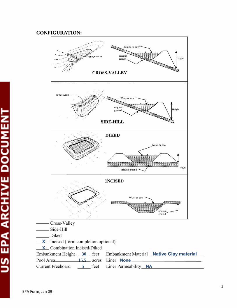
CONFIGURATION:
Cross-Valley Side-Hill Diked X Incised (form completion optional)
X Combination Incised/Diked Embankment Height 30 feet Embankment Material Native Clay material Pool Area 15.5 acres Liner None Current Freeboard 5 feet Liner Permeability NA

4 EPA Form, Jan 09
TYPE OF OUTLET (Mark all that apply)
NA Open Channel Spillway
Trapezoidal Triangular Triangular Depth Bottom (or average) width Top width
NA Outlet
inside diameter Material
corrugated metal welded steel concrete
plastic (hdpe, pvc, etc.) other (specify
Is water flowing through the outlet? YES NO NA
No Outlet
X Other Type of Outlet (Specify) Pumped from Clearwater pond
The Impoundment was Designed By Western Water Consultants, Sheridan, WY designed the Ash Pond Enlargement in 1989. No design documentation available for the original impoundments.

5 EPA Form, Jan 09
Has there ever been a failure at this site? YES NO X If So When?
If So Please Describe:

6 EPA Form, Jan 09
Has there ever been significant seepages at this site? YES X NO If So When?
If So Please Describe: Some noted on divider dike between settling ponds and Clearwater pond. Drains were installed and fly ash was placed on the opposite side of pond. No subsequent seepage has been observed.

7 EPA Form, Jan 09
Has there ever been any measures undertaken to monitor/lower Phreatic water table levels based on past seepages or breaches at this site? YES NO X If So which method (e.g., piezometers, gw pumping, …)?
If So Please Describe:

Appendix B
Inspection Photographs October 26, 2010

EPA Coal Ash Impoundment Assessment CLIN 003 – PacifiCorp Energy, Wyodak Power Station
October 2010
GEI Consultants, Inc. B 1 GEI Project 092884
Photo 1: Aerial image of Wyodak Power Plant and North Pit Ash Pond (in blue outline).
Aerial photo from www.bing.com maps accessed November 2, 2010.
Photo 2: North Pit Ash Pond and inactive Wyodak north mine pit from northeast rim
looking southwest.
Clear Cell and Southern Incised Perimeter Dike
Earthen Berm
Western Incised Perimeter Dike
Southern Divider Dike
“Light Ash” Section
Dry Ash Disposal Area
“Heavy Ash” Section
Clear Water Cell
“Light Ash” Section
Dry Ash Disposal Area
Wyodak Plant
Black Hills Neil Simpson Plant
Flow
Reconstructed mine sump
Settling Cell
North Embankment Dam
“Heavy Ash” Section
Eastern Incised Perimeter Dike

EPA Coal Ash Impoundment Assessment CLIN 003 – PacifiCorp Energy, Wyodak Power Station
October 2010
GEI Consultants, Inc. B 2 GEI Project 092884
Photo 3: North Pit Ash Pond and inactive mine pit from northeast rim looking southwest.
Photo 4: Elevated pipes sluicing ash and water from plant into settling cell southeast corner (“heavy ash” section).
North Pit Ash Pond
Dry Ash Disposal Area
Reconstructed Mine Pit Sump

EPA Coal Ash Impoundment Assessment CLIN 003 – PacifiCorp Energy, Wyodak Power Station
October 2010
GEI Consultants, Inc. B 3 GEI Project 092884
Photo 5: View across the settling cell from southern divider dike looking
northeast (“heavy ash” section).
Photo 6: Southern divider dike upstream slope looking east. Settling cell on left.

EPA Coal Ash Impoundment Assessment CLIN 003 – PacifiCorp Energy, Wyodak Power Station
October 2010
GEI Consultants, Inc. B 4 GEI Project 092884
Photo 7: Southern divider dike crest looking east. Settling cell on left.
Photo 8: Southern divider dike downstream slope looking east.

EPA Coal Ash Impoundment Assessment CLIN 003 – PacifiCorp Energy, Wyodak Power Station
October 2010
GEI Consultants, Inc. B 5 GEI Project 092884
Photo 9: Earthen berm in settling cell dividing “heavy ash” section (right) and
“light ash” section (left) looking north.
Photo 10: Earthen berm dividing “heavy ash” section (right) and “light ash”
section (left) looking north.

EPA Coal Ash Impoundment Assessment CLIN 003 – PacifiCorp Energy, Wyodak Power Station
October 2010
GEI Consultants, Inc. B 6 GEI Project 092884
Photo 11: Earthen berm dividing “heavy ash” section (right) and “light ash”
section (left) looking north.
Photo 12: Southern divider dike upstream slope looking west. Settling cell on
right (“light ash” section).

EPA Coal Ash Impoundment Assessment CLIN 003 – PacifiCorp Energy, Wyodak Power Station
October 2010
GEI Consultants, Inc. B 7 GEI Project 092884
Photo 13: Southern divider dike crest looking west. Settling cell on right
(“light ash” section).
Photo 14: Southern divider dike downstream slope looking west. Clear water
cell on left.

EPA Coal Ash Impoundment Assessment CLIN 003 – PacifiCorp Energy, Wyodak Power Station
October 2010
GEI Consultants, Inc. B 8 GEI Project 092884
Photo 15: Clear water cell and pumphouse looking southwest.
Photo 16: Clear water cell looking southwest.

EPA Coal Ash Impoundment Assessment CLIN 003 – PacifiCorp Energy, Wyodak Power Station
October 2010
GEI Consultants, Inc. B 9 GEI Project 092884
Photo 17: Southern divider dike downstream slope northeast corner near pumphouse.
Photo 18: Southern divider dike downstream slope northeast corner near pumphouse
showing man-made slump features from road grading.

EPA Coal Ash Impoundment Assessment CLIN 003 – PacifiCorp Energy, Wyodak Power Station
October 2010
GEI Consultants, Inc. B 10 GEI Project 092884
Photo 19: Southern divider dike upstream slope looking west. Settling cell on right.
Photo 20: Southern divider dike crest looking west. Settling cell on right.

EPA Coal Ash Impoundment Assessment CLIN 003 – PacifiCorp Energy, Wyodak Power Station
October 2010
GEI Consultants, Inc. B 11 GEI Project 092884
Photo 21: Eastern incised perimeter dike looking north. Settling cell “heavy ash”
section on left. Inlet pipes in foreground.
Photo 22: Eastern incised perimeter dike looking south. Settling cell “heavy ash” section on right.

EPA Coal Ash Impoundment Assessment CLIN 003 – PacifiCorp Energy, Wyodak Power Station
October 2010
GEI Consultants, Inc. B 12 GEI Project 092884
Photo 23: Eastern incised perimeter dike looking north. Settling cell on left.
Photo 24: Inlet pipes in northeast corner of settling cell “heavy ash” section.

EPA Coal Ash Impoundment Assessment CLIN 003 – PacifiCorp Energy, Wyodak Power Station
October 2010
GEI Consultants, Inc. B 13 GEI Project 092884
Photo 25: North embankment dam upstream slope looking west. Settling cell
on left. Inlet pipes in foreground.
Photo 26: Inlet pipe discharging onto ground at northeast corner of settling cell.

EPA Coal Ash Impoundment Assessment CLIN 003 – PacifiCorp Energy, Wyodak Power Station
October 2010
GEI Consultants, Inc. B 14 GEI Project 092884
Photo 27: Elevated pipes sluicing ash and water from plant into northeast corner
of settling cell.
Photo 28: North embankment dam crest looking west.

EPA Coal Ash Impoundment Assessment CLIN 003 – PacifiCorp Energy, Wyodak Power Station
October 2010
GEI Consultants, Inc. B 15 GEI Project 092884
Photo 29: North embankment dam upstream slope looking west. Settling cell
“heavy ash” section on left.
Photo 30: North embankment dam upstream slope looking west. Settling cell
“light ash” section on left.

EPA Coal Ash Impoundment Assessment CLIN 003 – PacifiCorp Energy, Wyodak Power Station
October 2010
GEI Consultants, Inc. B 16 GEI Project 092884
Photo 31: North embankment dam crest looking west.
Photo 32: Western incised dike upstream slope looking south. Settling cell
“light ash” section on left.

EPA Coal Ash Impoundment Assessment CLIN 003 – PacifiCorp Energy, Wyodak Power Station
October 2010
GEI Consultants, Inc. B 17 GEI Project 092884
Photo 33: Western incised dike crest looking south.
Photo 34: Northern perimeter embankment dam upstream slope looking east.
Settling cell “light ash” section on right.

EPA Coal Ash Impoundment Assessment CLIN 003 – PacifiCorp Energy, Wyodak Power Station
October 2010
GEI Consultants, Inc. B 18 GEI Project 092884
Photo 35: Settling cell “light ash” section looking southeast from northwest corner.
Photo 36: Western incised dike crest looking north. “Light ash” section on right.

EPA Coal Ash Impoundment Assessment CLIN 003 – PacifiCorp Energy, Wyodak Power Station
October 2010
GEI Consultants, Inc. B 19 GEI Project 092884
Photo 37: Western incised dike upstream slope. Settling cell “light ash” section on right.
Photo 38: Southern divider dike upstream slope looking east. Settling cell “light ash”
section and drop-inlet riser pipe on left.

EPA Coal Ash Impoundment Assessment CLIN 003 – PacifiCorp Energy, Wyodak Power Station
October 2010
GEI Consultants, Inc. B 20 GEI Project 092884
Photo 39: Drop-inlet riser pipe at southwestern corner of settling cell “light ash” section.
Photo 40: Southern divider dike crest looking east. Settling cell “light ash”
section on left.

EPA Coal Ash Impoundment Assessment CLIN 003 – PacifiCorp Energy, Wyodak Power Station
October 2010
GEI Consultants, Inc. B 21 GEI Project 092884
Photo 41: Southern divider dike downstream slope looking east. Clear water
cell on right.
Photo 42: Clear water cell inlet at downstream slope of southern divider dike.

EPA Coal Ash Impoundment Assessment CLIN 003 – PacifiCorp Energy, Wyodak Power Station
October 2010
GEI Consultants, Inc. B 22 GEI Project 092884
Photo 43: Western incised dike upstream slope looking south. Clear water cell on left.
Southern incised dike in background.
Photo 44: Southern divider dike downstream slope looking east. Clear water
cell and pumphouse on right.

Appendix C
Reply to Request for Information Under Section 104(e)

~ f.'.~~.!f~~9RPENERGYWyodak Plant48 Wyodak RoadGillette, WY 82718
March 30, 2009
Mr. Richard Kinch
US Environmental Protection AgencyTwo Potomac Yard
2733 S. Crystal Dr.51h Floor; N-5783
Arlington, VA 22202-2733
Via Overnight Delivery
Re: Wyodak Power Station: Request for Information Under Section 104(e) of the ComprehensiveEnvironmental Response, Compensation and Liability Act, 42 U.S.c. 9604(e) dated March 9,2009 and received on March 13,2009
Dear Mr. Kinch,
This letter and the enclosed materials constitute the response of the Wyodak Power Station to theabove Request for Information. Specifically, this letter and the enclosed materials provide the WyodakPower Station's response "to each request for information set forth in the Enclosure [A], including alIdocuments responsive to such request."
Although PacifiCorp, as operator of the Wyodak Power Station, intends to cooperate fully inresponding to the Request for Information, this response is made subject to the objections and otherexceptions as noted herein.
Moreover, PacifiCorp affirmatively asserts that the ten business day response deadline containedin the Request for Information is unrealistically short and does not reasonably reflect the type and volumeof responsive information which EPA has requested, particularly when considering that PacifiCorp isrequired to provide similar responses at three other facilities at the same time. Therefore, PacifiCorpobjects to this deadline and reserves the right to supplement this response after the 10 business day deadlinewith any materials that it was unable to gather and submit by the requested deadline.
PacifiCorp appreciates you agreeing by email dated March 17, 2009, that PacifiCorp can providethe Wyodak Power Station's response on March 30, 2009 at the same time PacifiCorp provides theresponses for its three other power stations in Wyoming which received similar requests.
I certify that the information contained in this response to EPA's request for information and theaccompanying documents is true, accurate and complete. As to the identified portions of this response forwhich I cannot personally verify their accuracy, I certify under penalty of law that this response and allattachments were prepared in accordance with a system designed to assure that qualified personnel properlygather and evaluate the information submitted. Based on my inquiry of the person or persons who managethe system, those persons directly responsible for gathering the information, the information submitted is,to the best of my knowledge. true, accurate and complete. I am aware that there are significant penalties forsubmitting false information, including the possibility of fines and imprisonment for knowing violations.

Mr. Richard Kinch
Wyodak Power Station Response to 104(e) LetterMarch 30, 2009Page 2
If you have any questions regarding this response, please direct them to Mr. Brett Shakespear at801-220-2575 or at brett.shakespearfal.pacificorp.com. Legal inquires should be made to Mr. MichaelJenkins at 801-220-2233 or at michael.ienkinstW.pacificorp.com.
:2IY'~~Ga~iSManaging DirectorWyodak Power Station
cc: Brett Shakespear,Michael JenkinsBernadette Hinshaw

Wyodak Power StationMarch 30, 2009Page 1
Response To Enclosure A
The term "Ash Pond" as used in this response means a two celled pond with abottom ash cell and a clear water cell. The two cells are separated by an earthenberm with the water from the bottom ash pond flowing into the clear cell. EPA'sEnclosure A requests are reproduced below in italics and separated within requestnumbers for ease of response. The responses below are offered without waiving anyof the objections noted herein and in the cover letter.
Wyodak Power Station Response to Request No.1
"Relative to the National Inventory of Dams criteriafor High, Significant, Low, or Lessthan-Low, please provide the potential hazard ratingfor each management unit"
NA
"Indicate who established the rating"
NA
"What the basis of the rating is"
NA
"What federal or state agency regulates the unit(s)"
No agency regulates the structural integrity of the Ash Pond.
"If the unit(s) does not have a rating, please note that fact"
The Ash Pond does not have a hazard rating.
Wyodak Power Station Response to Request No.2
"What year was each management unit commissioned and expanded? "
The initial construction permit for the Ash Pond was issued in 1976 andwork was completed on the Ash Pond by December 31, 1977.
Response to Enclosure A of Section 104(e) Letter dated March 9, 2009 and receivedon March 13,2009

Wyodak Power StationMarch 30, 2009
Page 2
The Ash Pond was expanded in 1989.
Wyodak Power Station Response to Request No.3
"What materials are temporarily or permanently contained in the unit? Use the followingcategories to respond to this question: (1) fly ash; (2) bottom ash: (3) boiler slag; (4) fluegas emission control residuals; (5) other. If the management unit contains more than onetype of material, please identify all that apply. Also, if you identify "other, "please specifythe other types of materials that are temporarily or permanently contained in theunit(s). "
The following categories of materials have been placed in the Ash Pond: flyash; bottom ash; boiler slag; flue gas emission control residuals; other.
The "other" category of materials consists of wastewater streams fromWyodak Power Station, and Black Hills Power, Inc. facilities including NeilSimpson I, Neil Simpson II, Wygen I, Wygen II, Combustion Turbine I,Combusting II, and the Wyodak Resource Mine. The materials placed in thepond are plant and yard stormwater runoff, plant drain effluent, fireprotection system overflow, boiler blow down water, cooling tower water,boiler chemical clean rinse, wastewater treatment plant effluent, wash downwater from ash silos, stormwater runoff from the reclaimed mine, andsurface water runoff from the Peerless and Clovis Pits.
Wyodak Power Station Response to Request No.4
"Was the management unit(s) designed by a Professional Engineer?"
Yes
"Is or was the construction of the waste management unit(s) under the supervision of aProfessional Engineer?"
The construction of a 1989 expansion in the size of the Ash Pond was underthe supervision of a Professional Engineer.
"Is inspection and monitoring of the safety of the waste management unit(s) under thesupervision of a Professional Engineer? "
Response to Enclosure A of Section 104(e) Letter dated March 9, 2009 and receivedon March 13,2009

Wyodak Power StationMarch 30, 2009
Page 3
No
Wyodak Power Station Response to Request No.5
"When did the company last assess or evaluate the safety (i.e., structural integrity) of themanagement unit(s)?"
The last dike stability inspection occurred at the Ash Pond on Aprill7, 2006.In addition, the Wyodak Power Station arranged for an investigation on July26, 2007 of the location and source of a leak in the divider dike within theAsh Pond that separates the ash disposal side of the pond from the clear wellside of the pond.
"Briefly describe the credentials of those conducting the structural integrityassessments/evaluations. "
CER Professional Consultants of Gillette, Wyoming conducted the 2006inspection. The inspector was a professional engineer. Water andEnvironmental Technologies of Butte, Montana conducted the 2007inspection. The inspector was a professional geologist.
"Identify actions taken or planned by facility personnel as a result of these assessmentsor evaluations. "
No actions were planned or taken as a result of the 2006 inspection. As to the2007 inspection, an existing drain tile present on the south side of the dividerdike was thought to be plugged. An alternate design was prepared by Waterand Environmental Technologies and installation of the new drainsupervised by Water and Environmental Technologies. The designincorporated a geotextile filter fabric wrap around the trench to preventplugging, a permeable layer that extends up the face of the dike to provide abigger capture area, and a sloped collection trench to insure adequatedrainage.
"If corrective actions were taken, briefly describe the credentials of those performing thecorrective actions, whether they were company employees or contractors. "
See responses above.
"If the company plans an assessment or evaluation in the future, when is it expected tooccur? "
Response to Enclosure A of Section l04(e) Letter dated March 9, 2009 and receivedon March 13,2009

Wyodak Power StationMarch 30, 2009
Page 4
An inspection ofthe Ash Pond is scheduled to occur in April 2009.
Wyodak Power Station Response to Request No.6
"When did a State or a Federal regulatory official last inspect or evaluate the safety(structural integrity) of the management unit(s)?"
In October 2006, the Ash Pond was inspected by the Mine Safety and HealthAdministration in connection with the nearby Wyodak ResourceDevelopment Company's coal mine. After that, the mine becameinactive MSHA determined that it no longer had a need to assert jurisdictionover the Ash Pond.
"If you are aware of a planned state or federal inspection or evaluation in the future,when is it expected to occur?"
PacifiCorp is not aware of any planned state or federal inspections of the AshPond.
"Please identify the Federal or State regulatory agency or department which conductedor is planning the inspection or evaluation. "
See response above.
"Please provide a copy of the most recent official inspection report or evaluation"
See attachment.
Wyodak Power Station Response to Request No.7
"Have assessments or evaluations, or inspections conducted by State or Federalregulatory officials conducted within the past year uncovered a safety issue(s) with themanagement unit(s)? "
No
"If so, describe the actions that have been or are being taken to deal with the issue orissues"
Response to Enclosure A of Section 104(e) Letter dated March 9, 2009 and receivedon March 13,2009

Wyodak Power StationMarch 30, 2009
Page 5
NA
"Please provide any documentation that you have for these actions. "
NA
Wyodak Power Station Response to Request No.8
"What is the surface area (acres) and total storage capacity of each of themanagement units? "
The Ash Pond surface area is 15.5 acres.
The Ash Pond storage capacity is 320.2 acre-feet.
"What is the volume of material currently stored in each of the management unit(s)?"
The volume of material in the Ash Pond is approximately 238.1 acre-feet.
"Please provide the date that the volume measurement(s) was taken. "
Exact measurements were not taken. An estimate was made on September 2,2008 and October 27, 2008.
"Please provide the maximum height of the management unit(s). The basis fordetermining maximum height is explained later in this Enclosure. "
The maximum height of the Ash Pond is thirty feet.
Wyodak Power Station Response to Request No.9
"Please provide a brief history of known spills or unpermitted releases from the unitwithin the last ten years, whether or not these were reported to State or federalregulatory agencies. For purposes of this question, please include only releases tosurface water or to the land (do not include releases to groundwater). "
No known spills or unpermitted releases have occurred in connection withthe Ash Pond within the last ten years.
Response to Enclosure A of Section 104(e) Letter dated March 9, 2009 and receivedon March 13, 2009

Wyodak Power StationMarch 30, 2009Page 6
Wyodak Power Station Response to Request No. 10
"Please identifY all current legal owner(s) and operator(s) at the facility. "
The current legal owner(s) ofthe Wyodak Power Station are PacifiCorp andBlack Hills Power, Inc. The current operator of the Wyodak Power Station isPacifiCorp.
Response to Enclosure A of Section 104(e) Letter dated March 9, 2009 and receivedon March 13,2009
Wyodak Power StationMarch 30, 2009
Page 7
Oblections To Enclosure A
Wyodak Power Station Objections to the Introductory Paragraph of Enclosure A:PacifiCorp objects to the general request for information contained in theintroductory paragraph of Enclosure A, including the information "requestedbelow," on the grounds that the request is outside the scope of EP A's authority ascontained in Section 104(e) ofthe Comprehensive Environmental Response,Compensation and Liability Act, 42 D.S.C. 9604(e). Moreover, PacifiCorp objects tothis general request because it contains undefined and ambiguous terms such as"surface impoundment" "similar diked or bermed management unit(s)," "landfills,""liquid-borne material," "storage or disposal," "no longer receive," "coal combustionresidues," "residuals or bypro ducts," "residues or by-products" and "free liquids"and because some of these terms seem to be used interchangeably within theintroductory paragraph and in other requests without an explanation of whetherthey are intended to have the same meaning.
Wyodak Power Station Objections to Request No.1: PacifiCorp objects to RequestNo.1 because it contains undefined and ambiguous terms such as "managementunit" and "unit(s)" and because some or all ofthese terms seem to be usedinterchangeably within this request and in other requests without an explanation ofwhether they are intended to have the same meaning.
Wyodak Power Station Objections to Request No.2: PacifiCorp objects to RequestNo.2 because it contains undefined and ambiguous terms such as "managementunit," "unit(s), "commissioned" and "expanded" and because some or all of theseterms seem to be used interchangeably within this request and in other requestswithout an explanation of whether they are intended to have the same meaning.
Wyodak Power Station Objections to Request No.3: PacifiCorp objects to RequestNo.3 because it contains undefined and ambiguous terms such as "temporarily,""permanently," "management unit" and "unit(s)" and because some or all of theseterms seem to be used interchangeably within this request and in other requestswithout an explanation of whether they are intended to have the same meaning.
Wyodak Power Station Objections to Request No.4: PacifiCorp objects to RequestNo.4 because it contains undefined and ambiguous terms such as "managementunit(s)", "designed," "construction," "waste management unit(s)", "inspection," and"monitoring" and because some or all of these terms seem to be used
Response to Enclosure A of Section 104(e) Letter dated March 9, 2009 and receivedon March 13,2009

Wyodak Power StationMarch 30, 2009Page 8
interchangeably within this request and in other requests without an explanation ofwhether they are intended to have the same meaning.
Wyodak Power Station Objections to Request No.5: PacifiCorp objects to RequestNo.5 because it contains undefined and ambiguous terms such as "safety,""structural integrity," "management unit(s)," "assessments," "evaluations,""actions," "corrective actions," and because some or all of these terms seem to beused interchangeably within this request and in other requests without anexplanation of whether they are intended to have the same meaning.
Wyodak Power Station Objections to Request No.6: PacifiCorp objects to RequestNo.6 because it contains undefined and ambiguous terms such as "official,""safety," "structural integrity," "management unit(s)," "inspection," "evaluation,""actions," "official inspection report," and because some or all of these terms seemto be used interchangeably within this request and in other requests without anexplanation of whether they are intended to have the same meaning.
Wyodak Power Station Objections to Request No.7: PacifiCorp objects to RequestNo.7 because it contains undefined and ambiguous terms such as "assessments,""evaluations," "inspections," "officials," "safety issue(s)," "management unit(s),""actions," and "deal with" and because some or all of these terms seem to be usedinterchangeably within this request and in other requests without an explanation ofwhether they are intended to have the same meaning.
Wyodak Power Station Objections to Request No.8: PacifiCorp objects to RequestNo.8 because it contains undefined and ambiguous terms such as "surface area(acres)," "total storage capacity," "management units," "volume," "material,""stored," "volume measurements," and "maximum height" and because some or allof these terms seem to be used interchangeably within this request and in otherrequests without an explanation of whether they are intended to have the samemeamng.
Wyodak Power Station Objections to Request No.9: PacifiCorp objects to RequestNo.9 because it contains undefined and ambiguous terms such as "known spills,""unpermitted releases," "unit," "surface water," "land," and "groundwater" andbecause some or all ofthese terms seem to be used interchangeably within thisrequest and in other requests without an explanation of whether they are intendedto have the same meaning.
Response to Enclosure A of Section 104(e) Letter dated March 9, 2009 and receivedon March 13,2009