table of contents - scholarspace at university of … the political edge: conservation in an era of...
TRANSCRIPT

ON THE POLITICAL EDGE: CONSERVATION IN AN ERA OF
DECENTRALIZATION AND DEMOCRATIZATION IN
CENTRAL SUMATRA, INDONESIA
A DISSERTATION SUBMITTED TO THE GRADUATE DIVISION OF THE UNIVERSITY OF HAWAIʻI AT MĀNOA IN PARTIAL FULFILLMENT
OF THE REQUIREMENTS FOR THE DEGREE OF
DOCTOR OF PHILOSOPHY
IN
GEOGRAPHY
MAY 2014
By
Keith Andrew Bettinger
Dissertation Committee:
Krisnawati Suryanata, Chairperson Ehito Kimura
Matthew McGranaghan Lyndon Wester
Kem Lowry
Keywords: Geography, Conservation, Indonesia, Decentralization, Kerinci Seblat

For my loving wife, Reem Miriam Bassous, without whom this would not have been possible.
ii

ACKNOWLEGEMENTS
This degree has taken me eight years to achieve, which in some ways seems like
an eternity, but in others it seems like I just arrived at UH yesterday. Over the years
I've been blessed to get to know and work with lots of wonderful people that have
helped to shape my development as a scholar, invariably for the best. At the same
time this dissertation and my doctoral degree would not have been possible without
the help of dozens of people with whom I have had the pleasure and privilege to
encounter. Although graduates think of their doctorates as a supreme, individual
achievement, they are in reality collaborative efforts. Thus there are a great number
of people to whom I am obliged to express my deep gratitude.
First, I want to express my thanks to Krisnawati Suryanata, my chair and advisor.
Krisna's support and commitment to me has been unwavering for years now. It has
been a privilege to work with Krisna on this project, and I have learned a great deal
from our talks and observing the way she goes about being a professor. I'm fortunate
to have had such a tremendous role model.
I am thankful as well to Matt McGranaghan for serving on my committee but also
for his mentoring and friendship over the years. Matt has been kind and generous in
the time that I have known him, and his dedication to our students and to scholarship
is beyond bounds. Matt's uniqueness, frankness, and humor have been a gift to his
many students over the years, and I'm proud to number myself among them. Lyndon
Wester also deserves heartfelt thanks for his service on my committee as well as for
his patience over the years. Lyndon is a gentleman and a scholar and I have benefited
greatly from his tutelage. His ongoing curiosity, even now as professor emeritus is
iii

something I strive for in my own academic career. Thanks also to Kem Lowry for
agreeing to serve as the outside member on my committee as well as for providing a
shining example of compassion and class. I have learned a great deal from how Kem
addresses problems, and also from the way he is able to use his academic training to
address real world problems. Lastly, but not least I thank Ehito Kimura for his
guidance over the years. Ehito has played the greatest role in my development as a
thinker.
Several other professors deserve mention as well. Ross Sutherland accepted me
into the graduate program at UH, provided funding, and has always been supportive
in terms of jobs and advice. I have learned a tremendous amount about how a
department does work, and how it should work from Ross, who has been one of the
greatest influence on me. Thomas Giambelluca has been a first rate role model and
has always been supportive. Reece Jones's encouragement has been a constant boon
to me. Reece encouraged me to get on the ball and write articles, and he showed me
how to do it. Ev Wingert has been an inspiration. I hope one day I can say that I
have made a similar contribution to the community and academy as he has. Qi Chen
taught me remote sensing and has always been patient and supportive. Allison Reiser,
Mary McDonald, Camilo Mora, Gary Fuller, Mark Merlin, Russ Yost, Uli Kozok,
and Hong Jiang all deserve thanks as well.
Richard Reeves deserves special thanks for helping me to understand the practice
of politics, and for teaching me how to ask practical questions. I am also indebted to
the counsel and advice of scholars that have come before me, including David Neidel
and Bambang Hariyadi. Thanks also to Debbie Martyr for all of her kindness and
iv

hospitality while I was in the field, as well as her unique perspective on Kerinci
Seblat National Park. I also would like to thank Emma at LTA, Barlian at
GenesisMukomuko, Yoan Dinata at FFI, Hendri and the gang at Winalsa, Eko Buce,
Daro Bujeng and everyone at LTB in Bangko, the members of the Kerinci
Birdwatching Club, Iswadi, Bang Wira, Doddy Saputra, and Salpa Yanri at ICS.
Thanks to Pak Agus Soehardjono for his friendship and advice, and also to Dewi
Anggoro, Dewi Maharani Purba, Yosef Key, Prisca Naris Rahimi, Anggita Paramita,
Mike Meriana, Itha Prabandhani, Dewi Astrilita, Danu Wibowo, Heri Rusdianto,
Anna Widiastuti, Rina Anisah, and everyone else at Wisma Bahasa for teaching me
Indonesian. At Kerinci my deepest thanks go to my good friend Agung Nugroho,
without whom I would not have been able to do the research for this dissertation.
Thanks also to Iding Achmad Haidir, Agusman Namsuga, David Ayah Rara, Rahmat
Arifin, Aryanto Jhoneisman, Ian Hadi, Andre Ginson, Dian Pratiwi, my good friend
Andhika Ariyanto, Syamsul Bahri, Donal Hutasoit, Yon Lukman Tanjung,
Najmuddin Naj, Nandang Gumilar, and Dian Risdianto, all at Kerinci Seblat National
Park
I also express my gratitude to the organizations that have funded my research and
development as a scholar. This includes the Department of Geography, the College
of Arts and Sciences, the Center for Southeast Asian Studies at UH, the Mellon
Foundation, and especially the USINDO Society. Thanks also to Dennis Nullet, Carl
Hefner, and Wes Teraoka for giving me jobs, and also to all of the hundreds of
students I've had the opportunity to teach over the years.
v

I have benefited from being around exceptional people in the Department of
Geography. I have made friends and colleagues that will stay with me throughout my
career and life. Ricardo Gonzalez, who I met during my first year, has always been
supportive and continues to be a dear friend. Thanks to Ryan Longman for patiently
sharing an office, and countless beers with me. Thanks also to Yoshitaka Miyake,
Bryan Bushley, Wendy Miles, Hatim Albasri, Migraliette Purbaranti, John Delay,
Abby Frazier, Lauren Kaiser, Cedar Louis, Nicole Milne, Mike Borger, Wen Liu,
Leandro Romero, Micah Fisher, Abby Frazier, Hillary Strasser, Susan Salosa, Mami
Takahashi, Rhonda Suka, Yuko Stender, Donovan Preza, Jordan Chetcuti, Sugato
Dutt, Urban El Fatih, Jack Kittinger, Anu Gupta, Aaron Kingsbury, Xiaofeng Kang,
Ryan Mudd, Maggie McCain, Kyle Kajihiro, Dylan Beatty, Chuck Devaney, Julius
Paolo, Brandon Barbour, Ben Schrager, and Mike Nullet. Other friends that I am
fortunate to have made and that have played a role (for better or worse!) include
Charley Sullivan, Alvin Lim, Keliʻi Collier, Matt Boswell, Paul Khoo, Nat Bletter,
John Taylor, Matt LaFevor, Christian Razukas, and Sebastian Dettman.
Special mention and thanks goes to my dearly departed appendix, for making the
ultimate sacrifice in my quest to advance the collective knowledge of humanity.
I also want to express special gratitude to my mother, Susan Hawkins Bettinger,
and my two sisters, Jill Canaday Bettinger and Sarah Stephens Bettinger as well as
Benjamin Gallagher.
Lastly I thank God for all good things and the opportunities I have been blessed
with, and life for making me the man that I am today.
vi

ABSTRACT
This dissertation examines the effects of Indonesia's decentralization and
democratization reforms on Kerinci Seblat National Park, a large protected area on the
Indonesian island of Sumatra. The reforms, which were implemented in the wake of the
resignation of President Suharto, whose highly centralized and authoritarian New Order
regime ruled Indonesia for more than three decades. The reforms have radically altered
the dynamics of formal and informal politics in Indonesia. This is significant in places
like rural Sumatra, where the economy is heavily reliant on primary sector activity. Thus
the reforms have led to an increase in direct and indirect pressures on the park. This
dissertation examines these changes from the perspective of political ecology, political
economy, providing a comprehensive analysis of the structure and form of
decentralization and democratization in Indonesia as well as the implications for national
park-based conservation in Indonesia.
vii

TABLE OF CONTENTS
Dedication..................................................................................................... ii Acknowledgements....................................................................................... iii Abstract......................................................................................................... vii List of Tables................................................................................................. xi List of Figures................................................................................................ xii List of Abbreviations..................................................................................... xiv Preface........................................................................................................... xvii 1. Introduction: Conservation Amidst Decentralization ................................1
1.1 The Lungs of the Earth ...............................................................1 1.2 Power to the People: An Overview of the Issues........................4 1.3 Research Overview .....................................................................17 1.3.1 Research Questions......................................................17 1.4 Methods.......................................................................................20 1.5 Contributions and Themes of the Dissertation............................23 1.6 Organization of the Dissertation .................................................29
2. Kerinci Seblat National Park and its Environs .........................................32
2.1 Introduction.................................................................................32 2.2 Indonesia's National Parks: A Brief History...............................35 2.3 The Park: Physical Characteristics..............................................44 2.4 History of Habitation ..................................................................47 2.5 Kerinci Seblat National Park ......................................................50 2.5.1 Establishment of the Park ............................................50 2.5.2 The Park's Functioning ................................................53 2.6 The Park's Neighbors ..................................................................60 2.7 Foreign Involvement...................................................................60 2.7.1 The ICDP Project.........................................................60 2.7.2 Tropical Rainforest Heritage of Sumatra WHS...........62 2.8 Conservation Issues Facing Kerinci Seblat National Park .........64 2.8.1 Deforestation................................................................64 2.8.2 People in and Around the Park ....................................66 2.8.3 Illegal Logging.............................................................68 2.8.4 Encroachment ..............................................................73 2.8.5 Poaching/Theft of NTFPs ............................................76 2.8.6 Human-Wildlife Conflict .............................................78 2.8.7 Mining..........................................................................78 2.8.8 Border Markers ............................................................79 2.8.9 Enforcement Difficulties..............................................80 2.9 Conclusion ..................................................................................82
viii

3. The Political Edge Effect: District Political Trends as Drivers of Direct and Indirect Pressures on Kerinci Seblat National Park.................................84
3.1 Introduction.................................................................................84 3.2 Decentralization and District Politics: Structures ......................87 3.2.1 Changes in How Regional Governments are Funded ..87 3.2.2 Changes to Resource Management Structure ..............100 3.3 Decentralization and District Politics: Processes........................102 3.3.1 Elite Capture ................................................................102 3.3.2 Money Politics and the Path to Power .........................105 3.3.3 A Hierarchy of Public Policy Formation? ...................115 3.3.4 Democracy and Aspirasi Masyarakat..........................124 3.3.5 Political Fragmentation................................................126 3.3.6 De Facto Versus De Jure Powers.................................129 3.4 Conclusions.................................................................................132
4. Indirect Pressures on KSNP: Administrative Proliferation ......................138
4.1 Introduction.................................................................................138 4.2 Administrative Proliferation in Indonesia...................................142 4.2.1 Defining Pemekaran.....................................................142 4.2.2 Lebong District: Pemekaran as a Pathway to Power ...145 4.2.3 The Case of Sungai Penuh/Kerinci ..............................149 4.3 Puncak Andalas and Elite Territorial Ambitions ........................155 4.3.1 Successful and Unsuccessful Provinces.......................162 4.3.2 The Formation of a Functional Region........................165 4.4.3 What's in a Name? .......................................................178 4.4 What are the Consequences? ......................................................180 4.5 Conclusions.................................................................................185
5. Death by 1000 Cuts: The Politics of Road Construction in and Around Kerinci
Seblat National Park ................................................................................188
5.1 Introduction.................................................................................188 5.2 Justifications for Roads...............................................................192 5.3 Impacts of Roads.........................................................................195 5.4 The Politics of Roads ..................................................................201 5.4.1 Case 1: The Kambura Road ........................................202 5.4.2 Case 2: Renah Pemetik ...............................................208 5.4.3 Case 3: The Serampas Road .......................................214 5.5 Conclusions.................................................................................220
6. Village Sites of Cooperation and Contestation.........................................225
6.1 Introduction.................................................................................225 6.2 General Characteristics of the Villages Around the Park ...........228
ix

6.2.1 Economic Aspects........................................................228 6.2.2 Educational Aspects.....................................................232 6.2.3 Patterns of Village Settlement and Distribution ..........234 6.3 Attitudes of the Park Towards People on the Periphery .............236 6.3.1 The Park's Early Years.................................................236 6.3.2 The ICDP and the "Local Turn" ..................................240 6.3.3 The Post-ICDP Return to Traditional Conservation....244 6.3.4 Encouraging "Participation" in Park Management ......246 6.3.5 The Rangers' Perspective .............................................250 6.3.6 Official Characterizations of Local People..................251 6.4 Attitudes of the People Towards the Park...................................253 6.4.1 An Expanded Role for Civil Society ...........................256 6.5 Towards an Understanding of Patterns of Encroachment...........258 6.5.1 The Erosion of Local Control ......................................258 6.5.2 From Controlled Access to Open Access ....................264 6.6 Conclusion ..................................................................................271
7. Examples of Village Responses to Decentralization ................................275
7.1 Introduction.................................................................................275 7.2 Gunung Tujuh: A History of Park-People Conflict ....................279 7.2.1 Background: Roots of Conflict ....................................279 7.2.2 Violent Expressions of Defiance .................................280 7.2.3 The Convergence of District-Village Interests ............286 7.3 Lembah Masurai: Conflict and a New Discourse ......................289 7.4 Serampas: Renewed Adat Claims...............................................294 7.5 Bangun Rejo Village: Park-Village Cooperation .......................300 7.6 Conclusions.................................................................................304
8. Conclusions: Conservation, Decentralization, and the Political Edge......307
8.1 Introduction.................................................................................307 8.2 The Unfolding of Dysfunctional Decentralization .....................312 8.2.1 Rescaling and New Nodes of Stateness .......................312 8.2.2 The Legacies of Dysfunctional Decentralization.........324 8.2.3 Positive Outcomes from Decentralization? ................329 8.2.4 Will Decentralization Benefit Villagers?.....................331 8.2.5 A Final Legacy: KSNP as an Impediment...................332 8.3 Decentralization, Reterritorialization and KSNP........................336 8.4 Rethinking Protected Areas ........................................................345 8.5 Conclusions.................................................................................349
Bibliography.................................................................................................. 354
x

LIST OF TABLES
Table Page Table 1.1: Major decentralization laws.........................................................13 Table 1.2: List of villages visited during fieldwork......................................21 Table 2.1: Reserves combined to become KSNP .........................................51 Table 2.2: Districts and provinces surrounding KSNP.................................60 Table 2.3: District level figures for deforestation at KSNP..........................65 Table 2.4: Village land in KSNP ..................................................................67 Table 2.5: Sawmills in districts surrounding KSNP .....................................71 Table 3.1: Distribution of natural resource revenues....................................91 Table 4.1: List of new/split districts surrounding KSNP..............................144 Table 4.2: Provinces created since 1998.......................................................163 Table 6.1: Number of villages around KSNP in districts .............................232 Table 8.1: The role of various scales through different historical eras.........315
xi

LIST OF FIGURES AND BOXES Figure Page Figure 1.1 Location of Kerinci Seblat National Park ...................................2 Figure 2.1 KSNP Zonation System...............................................................59 Figure 3.1 Factors Encouraging Natural Resource Extraction .....................134 Figure 4.1 Kerinci District with Subdistricts in 2011 ...................................151 Figure 4.2 West Central Sumatra Today.......................................................159 Figure 4.3 Proposed Puncak Andalas Province ............................................170 Figure 4.4 Connections in Puncak Andalas ..................................................176 Figure 5.1 Proposed Roads ...........................................................................190 Figure 5.2 Campaign Banner for Candidate for Headman ...........................194 Figure 5.3 Cultivation and Clearing on a Steep Slope..................................198 Figure 5.4 Road Cut on the Sungai Penuh-Bangko Road.............................200 Figure 5.5 Road Proposals Discussed...........................................................208 Figure 5.6 Landslide on Renah Pemetik Road..............................................213 Figure 6.1 KSNP Boundary Marker .............................................................260 Figure 7.1 Author at Destroyed Ranger Post ................................................282 Figure 7.2 Sign Warning Villagers at Pesisir Bukit......................................285 Figure 8.1 New Order Scalar Configuration.................................................317 Figure 8.2 Post-Authoritarian Scalar Configuration.....................................320 Box Page Box 2.1 Illegal Logging Case Study .............................................................71
xii

Box 3.1 The Rawa Bento Fiasco...................................................................119
xiii

ACRONYMS AND ABBREVIATIONS ABRI: Angkatan Bersenjata Republik Indonesia; armed forces of the Republic of
Indonesia AKAR Aliansi Konservasi Alam Raya Network of Conservation NGOs
including LTA, LTB, GenesisMukomuko, ICS AMAN: Aliansi Masyarakat Adat Nusantara. Indonesian Alliance of Customary
Law Communities. BAPPEDA: Badan Perencanaan dan Pembangunan Daerah. Regional Planning and
Development Agency. BBTNKS: Balai Besar Taman Nasional Kerinci Seblat BKSDA: Balai Konservasi Sumber Daya Alam (National Resources Conservation
Office) CI: Conservation International, an international conservation non-government
organization CPNS: Calon Pegawai Negeri Sipil. Candidate civil servant. DAK: Dana Alokasi Khusus. Special Allocation Funds. Post-Suharto era funds
from the central government to the regions intended for special projects. DAU: Dana Alokasi Umum. General Allocation Funds. Post-Suharto era funds
from central government to the regions intended for day-to-day operating expenses.
FAO: Food and Agriculture Organization, an arm of the United Nations. FFI: Flora and Fauna International, an international conservation non-
government organization GEF: Global Environment Facility GENESIS: Generasi Sungai Ipuh Sekitar di Mukomuko Local NGO based in Sungai
Ipuh, Mukomuko ICDP: Integrated Conservation and Development Project IDR: Indonesian Rupiah. Indonesia's currency. For this dissertation US$1 is
the equivalent of 9,500 rupiah.
xiv
KKN: "Korupsi, Kolusi, Nepotisme"; corruption, collusion, and nepotism. KPK: Komisi Pembarantasan Korupsi. Corruption Eradication Commission. A
national government agency with special legal powers established in 2003 to investigate and prosecute cases of political corruption at all levels of government.
KPU: Komisi Pemilihan Umum. Election commission. These official bodies
exist at the national, provincial, and district scales and are responsible for the organization and oversight of elections.
KSNP: Kerinci Seblat National Park LTA: Lembaga Tumbuh Alami Local NGO based in Sungai Penuh LTB: Lembaga Tiga Beradik Local NGO based in Bangko, Merangin NGO: Non-governmental organization NTFP: Non-timber forest product PAD: Pendapatan Asli Daerah Locally generated revenue. This refers to
government funds raised by districts and province that does not come from the central government.
POLHUT: Polisi Hutan. Forest Police. PRRI: Pemerintah Revolusioner Republik Indonesia. The Revolutionary
Government of the Republic of Indonesia. This was a revolt led by elements of the armed forces based primarily on Sumatra in 1957-1958.
RTRW: Rencana Tata Ruang Wilayah; regional spatial plan SBY: Susilo Bambang Yudhoyono. President of Indonesia from 2004-2014, the
Reformasi era's first directly elected president. SDO: Subsidi Daerah Otonom. Autonomous Region Subsidy. A New Order era
funding mechanism for districts and provinces granted by the central government.
SKAU Surat Keterangan Asal Usul. Official origin documents for logs. TRHS: Tropical Rainforest Heritage of Sumatra. The name of the World Heritage
Site including Kerinci Seblat, Gunung Leuser, and Bukit Barisan Selatan national parks.
xv

UNDP: United Nations Development Programme VOC: Vereenigde Oost-Indische Compagnie, Dutch East India Company WWF: World Wildlife Fund for Nature. An international conservation NGO.
xvi

PREFACE
"I don't care about trees..."
"I don't care about animals, lions, tigers, bears, or whether they live or die. I don't
care about trees, how many there are, or about 'the lungs of the Earth'. I care about
people," my informant told me. I'd heard sentiments like this from numerous people
living and trying to make a living around Sumatra's Kerinci Seblat National Park.
After all, the park is bordered by more than 400 villages where the primary
occupation is farming, and the primary means of getting ahead, be it to pay for school
fees, medical expenses, or a new cell phone, is through agricultural expansion:
opening up the forest to clear land for new fields. These farmers resent the park
because it is off limits to them; they live next door to it but it is illegal for them to
grow crops, gather non-timber forest products (NTFPs), or hunt, regardless of the
scale of the activity, within the park. Add to this the fact that many people around the
park claim that when its boundary markers were placed between 1992 and 1995 they
were cut off from their swiddens and rubber and cinnamon gardens as well as their
supply of manau1, rattan, and other forest products.
What made the statement remarkable is that it was uttered by the bupati (district
headman) of one of the fifteen districts2 and administrative municipalities
surrounding the park in his official capacity as the elected head of the district. This
open and almost rebellious defiance of the central government's policies would have
1 Manau is a type of vine used for a variety of purposes similar to rattan. 2 The districts are the middle level in Indonesia's five-tier administrative hierarchy (national-provincial-district-subdistrict-village). Administrative municipalities (kota) are horizontally equivalent to districts in this hierarchy.
xvii

been unheard of during the authoritarian reign of Suharto, when district headmen
were extensions of the central government's top-down pyramid structure of power.
After Suharto's fall in 1998, however, the Indonesian government swiftly passed
sweeping reforms that decentralized significant powers to the nation's 400-plus
districts (these laws and their enabling legislation along with the associated processes
are referred to collectively as desentralisasi) while simultaneously empowering the
districts to choose their own leaders (part of a related set of laws and processes
known as demokratisasi). These reforms taken together have dramatically altered the
political landscape as well as the language and strategies of political contestation in
Indonesia.
This self-described "number one person" continued to narrate the ways in which
the park burdens the people of the district: small farmers are prevented from
expanding their fields to increase produce and augment their incomes; the district is
forbidden from opening up roads through the park which would increase commerce
and improve access to markets; the rich mineral and geothermal resources within the
park can't be developed and taxed, and so the district is at a competitive disadvantage
compared to other districts that don't have part of their territory sequestered within a
national park. As our conversation continued, I asked the bupati for his take on the
thousands of encroaching farmers that had illegally moved into the park in his district.
While the forest of Sumatra have traditionally been ravaged by politically well-
connected illegal logging networks (McCarthy 2006), this phenomenon has declined
in recent years. The new face(s) of forest degradation and clearance belong to the
thousands, tens of thousands of small-scale farmers now farming in this and other
xviii

parks. "Do the people colonize the park, or does the park colonize the people," he
asked rhetorically in response.
The district headman's defiance and animosity towards the park is well known.
He campaigned on a platform promising villagers that if they elected him, he would
allow them to open up fields in the park, a promise he would have no legal authority
to fulfill. During his tenure the headman has also called for roads to be constructed
through the park, which stretches more than 350 kilometers from north to south along
the spine of the Bukit Barisan mountains. A glance at a regional map helps one to
understand his point of view: because there is only one route through the park it takes
twelve hours to reach the provincial capital, and seven hours under the best conditions
to reach the nearest port. For the farmers of the district time is money; longer trips
mean higher transport costs not only for outputs but also for inputs, as well as
increased spoilage on the way to market their produce. For everyone else this lack of
access inflates the price of everything ranging from gasoline to instant noodles to
electronic goods. Data from the district's statistical yearbook adds further support to
the headman's objection to the park's existence: last year the district was only able to
fund 4% of its own expenditures, with the balance coming from the central
government. Along with their new powers, the districts now also bear greater
responsibility for funding their own operations. That means that while the districts
are now free to chart their own course of development, they must raise the funds to
implement any policies or programs themselves. Central government transfers come
with significant restrictions, and so districts look to increase their locally-generated
revenue (pendapatan asli daerah, PAD) as a way of increasing discretionary
xix

spending targeted at district-specific programs. On Sumatra this is typically done by
attracting mining investors or agricultural conglomerates who develop expansive oil
palm plantations. But for this district this potential is limited by the existence of the
park.
As I leave the bupati's office I notice that my motorcycle is hovering on empty. I
swing by the Pertamina3 to fill up but notice that there is a line several dozen bikes
deep, waiting for the truck to come and refill the station's holding tanks. I decide to
head instead for one of the predatory gas profiteers across the street who charge
double for fuel. The time saved is definitely worth the extra US$1.50.
"What happened this time?" I asked the evil profiteer, an 11-year old girl.
"There was another landslide that washed out the road and so the trucks have to go
the long way," came the response. I was not surprised by her answer; landslides are
not uncommon in this wet, mountainous region, as the constant tectonic grinding that
has slowly built these mountains is counteracted by the nibbling eroding action of the
constant equatorial rainfall, but most people attribute the frequent washouts of the
small four-meter wide lifeline that serves to connect this town to the larger world to
uncontrolled and illegal logging of the steep slopes above the road. The logging most
likely is part of the problem, but the balance is the road itself; road construction in
central Sumatra involves bulldozing a path through the mountains, utilizing
3 Pertamina is the name of the state-owned petroleum company. Virtually all gas stations in Indonesia are Pertaminas.
xx

innumerable unreinforced switchbacks and leaving staggeringly steep, unbuttressed
roadcuts through the deeply-weathered regolith that comprises the mountains.
Later that night I found myself discussing the seemingly intractable dichotomy of
conservation verses economic development over a plate of sate Padang with a friend
that runs a local conservation non-government organization (NGO). Sitting on the
curbside, I told him about the events of the day.
"We like to think that our leaders are elected by us, by people now. But that is
not true. They are elected by money," he explained, launching into a now-familiar
explanation of the money politics that characterizes campaigns for district offices in
this new era of decentralization and democratization. This explanation goes that
while there have been some positive outcomes of decentralization, it mainly has led to
the decentralization and local proliferation of the old pattern of KKN, or korupsi,
kolusi, dan nepotisme ("corruption, collusion, and nepotism")4 that was so
characteristic of the despised Suharto regime. Now though it seems that the Suharto
regime is not so despised anymore.
"It's the same as it was before," says my friend. "We need a strong leader from
the military to enforce the rules5. The same with the park. The local leader doesn't
care about the park because he wants roads and development. But not for people, but
so he can give contracts to his friends, his cronies, the ones that gave the money so he
could be elected." He goes on to reiterate to me all the locally-essential ecological
services provided by the park. I recognize this as part of the new line adopted by
4 This slogan was popularized by Amien Rais, head of Muhamdiyah, one of two massive, national-scale organizations for Muslims. When Suharto fell Rais emerged as a reformist leader on the national stage. 5 I frequently heard this common sentiment described commonly as SARS, or "Sindrom Aku Rindu Suharto" ("I miss Suharto syndrome").
xxi

xxii
conservationists and park staff alike; this appeal to the local is an attempt to make the
park relevant locally in the context of the decentralized political regime.
This day was a nutshell of the problematique6 I'd been investigating for the past
few months. This dissertation, which is the result of my fieldwork and analysis,
focuses on the effects Indonesia's decentralization and democratization reforms have
had on Kerinci Seblat National Park. The story has familiar themes; people versus
parks, conservation versus development, the global versus the local. The difference,
though, is that Indonesia's decentralization regime has rebalanced each of these
dichotomous struggles. My dissertation is about understanding the changing
relationship between not only people and nature, but also between different levels of
government; I believe this topic is important not only for conservation and
democratization, but for the future of Indonesia. The conflicts we see at Kerinci
Seblat National Park are a microcosm of the challenges facing not only conservation
in Indonesia, but the nation itself as it forges a new identity amidst decentralization
reforms.
6 I have always found Fikret Berkes's term useful for describing complex geographical problems. Berkes (2006) defines a problematique as "a constellation of issues that need to be considered at higher as well as lower scales; have a large social content; interact and intersect with one another; tend to be inherently in conflict; and require long time horizons".

CHAPTER 1. INTRODUCTION: CONSERVATION AMIDST
DECENTRALIZATION
1.1 Introduction: The Lungs of the Earth
The Indonesian archipelago is a site of tremendous biodiversity stemming from its
tropical location. The country is expansive geographically; its more than 17,000
islands span a distance greater than that separating Los Angeles and New York City.
The islands also bracket the boundary between two biogeographical realms: the Indo-
Malayan region in the west, covering the islands of Sumatra, Kalimantan, Java, and
Bali, and the transition zone of Wallacea which covers Sulawesi and the smaller
islands of Nusa Tenggara Timor and bears distinct biogeographical characteristics
distinct from the Australasian region in the east (Haeruman 1988). The livelihood of
the people of most parts of the archipelago is and has always been predominantly
agricultural; the rich soils deriving from the volcanic origin of the islands contribute
to high agricultural yields. Agriculture continues to be a growth industry both at the
individual scale as farmers seek to improve their lots, and at the corporate scale, with
vast regions being converted to plantation agriculture.
Amidst this landscape of transformation and development are situated Indonesia’s
network of national parks. The national park system has its roots in the forest and
game reserves founded by the Dutch colonial authorities, but it was expanded
extensively by President Suharto during his 30-year reign. The development of the
park system was aided by the highly-centralized regimes, first the colonial system and
then the Orde Baru ("New Order") regime of Suharto (Jepson and Whittaker 2002).
1

The parks of Indonesia are invaluable assets in the global protected area network and
are viewed by many as part of a shared global nature heritage (Curran et al 2004,
Radford et al 1998).
Kerinci Seblat National Park covers an area of 1,368,000 hectares (approximately
5,000 square miles). For comparison purposes, this is slightly larger than the
Hawaiian islands of Hawai'i, Maui, and Oahu. It stretches approximately 350
kilometers north to south following the Bukit Barisan mountain range, and has a
maximum width of 70 kilometers. The park's border snakes for approximately 2800
kilometers, passing through fifteen districts and administrative municipalities,
covering parts of four provinces: Jambi, with 40% of the park’s total area, West
Sumatra (25%), Bengkulu (21%), and South Sumatra (14%). As might be expected,
the park's topography is rugged, and 86% of the land is classified by the government
as mountainous, whereas 14% is lowland hills or plains.
Figure 1.1: Location of Kerinci Seblat National Park
2

The park is a land of superlatives. It is the largest continuous area of undisturbed
primary forest in Sumatra (Werner, 2001). It is also the largest remaining habitat for
the critically-endangered Sumatran tiger (Panthera tigris sumatrae). KSNP has the
world's largest and tallest flowers (Rafflesia sp and Amorphophallus titanum,
respectively). It houses the highest lake in Southeast Asia (Danau Gunung Tujuh)
along with the highest active volcano in Indonesia (Gunung Kerinci). There are
approximately 4,000 plant species, 180 bird species, including 39 endemic species,
144 species of mammals, of which seven are found only in the park, ten reptiles, and
six primates. The park covers a variety of ecosystems ranging from lowland coastal
forest to high montane forest. It is recognized as an essential link in a global network
of protected areas, having been designated a World Heritage Site in 20047.
The park, though, is not an unpopulated wilderness. It is surrounded by hundreds
of villages with hundreds of thousands of residents, who, as a general rule, have a
lower than average standard of living and income (Moeliono 2008). Along with these
people come problems; the park has experienced the whole range of "classic" national
park difficulties, ranging from illegal logging and poaching to road construction and
agricultural encroachment. The park struggles to keep up with the threats, but it has
always been an uphill battle. Pressures on the park from district governments and
local people continue to increase, and the irreplaceable ecosystems that provide a
home for tigers and trees face increasing threats from a variety of sources. The
changing governance regime that has resulted from decentralization and
7 KSNP was designated along with Gunung Leuser National Park in northern Sumatra and Bukit Barisan Selatan National Park in southern Sumatra as the Tropical Rainforest Heritage of Sumatra World Heritage Site. Upon designation UNESCO's wanted to immediately place the site on the "List of World Heritage in Danger", but the government of Indonesia opposed this move (Hitchcock and Meyers 2006). In 2011 the parks were moved to the list.
3

democratization has greatly affected the threats facing the park. This dissertation
explores why this is the case. I seek to understand the effects of decentralization and
democratization reforms on Kerinci Seblat National Park, identifying the formal and
informal processes that have lead to these increased pressures.
1.2 Power to the People: An Overview of the Issues
The first thread of the story involves the process of statemaking, or how Indonesia
came to be as a centralized nation-state, since this establishes the foundation for
understanding political processes impinging upon KSNP8. For the purposes of this
analysis, it helps to conceptualize politics as a collection of processes happening at
different temporal and spatial scales, ranging from the grand narrative of states and
empires which forms the backbone of history as it is generally understood, to the
mundane and quotidian actions of individuals as they seek to make their way in the
world. With this in mind, "Indonesia" might be considered an idea or concept
emerging from historical processes. As a country it is relatively young, its existence
declared by Sukarno and Hatta9 in 1945 and acceded to by the Dutch colonial
authority and the broader global community of nation-states in 1949. Before this it
was for a time an idea, a dream shared by ambitious proto-statesmen spread
throughout the almost innumerable islands of the archipelago. To the Dutch the
"Indies" had been a marker of simplification denoting a territory understood as apart
from and subservient to the greater functioning of the metropole. Over the course of
8 There are many varied definitions of "politics." One of the most useful, which guides my analysis, is Kirkvliet's (2009:227): "Politics is about the control, allocation, production, and use of resources and the values and ideas underlying those activities". 9 Indonesia's first president and vice president, respectively. Both are now revered as national heroes.
4

more than three centuries they gradually expanded their control from Sabang to
Merauke. In the words of Anderson (1983: 479), "indeed, the Indonesia we know
today is the exact product of the extraordinary extension of Batavia's10 politico-
military power between 1850 and 1910." Before this though there was never any
coherent thing such as Indonesia; though on occasion major empires like Sri Vijaya,
Mataram, and Majapahit emerged, most of time and space was characterized by
relatively locally-rooted kingdoms, sultanates, and chiefdoms. This is particularly
true of Sumatra, where many riverine kingdoms rose and fell contingent partly on the
relationship between upstream and downstream (hulu-hilir) groups (Andaya 1993b,
Kathirithamby-Wells 1995, Reid 1993, Ricklefs 2008).
The Dutch era can be seen as the beginning of a long process of centralization.
The genesis of the modern state can also be seen here as the Dutch, through various
iterations of centralized policy (e.g. the Cultivation Policy, the Liberal Policy, the
Ethical policy) sought to institute a uniform system of control and administration
throughout the areas under their control, first with indirect and then direct rule
(Anderson 1983, Benda 1966). Standardization became more ambitious over time
and included the training of a specialized bureaucracy (Evers 1987, Furnivall 1956).
Kingsbury (2005) highlights two key contributions of the Dutch: 1) defining the
extent of the country and 2) cooperating with elites, forming a distinct administrative
elite class on Java and other places through direct and indirect rule. Though the era of
Dutch hegemony came to an end following the Second World War, these two aspects
would continue to influence politics in Indonesia into the 21st century.
10 Batavia was the Dutch colonial name for Jakarta.
5

Thus Indonesia came into being complete with some of the trappings of modern
nation states, including territory, a language, and a capital, but lacking others, such as
a unified, coherent vision and understanding of the identity of the new nation. In the
early days of the new Republic, there was such an economy of ideas as to the
appropriate path to take that the future of the fledgling state was at times in jeopardy
of collapse or splintering into several smaller countries (Reid 2004). What, then,
happened to transform this expansive archipelago from a collection of hundreds of
disparate peoples and cultures into today's Indonesia? The answer to this question is
central to the story of Kerinci Seblat National Park.
As previously mentioned, the first two decades of Indonesia's independent
existence were at times quite tenuous. This instability ultimately led to the demise of
Indonesia's visionary first president, Sukarno. Resistance to the Dutch during the
revolution had been decentralized, manifested in the way that regional military
commanders waged independent campaigns. There was no true centralized military
command, and so when the Dutch departed there were powerful regional interests
with their own military machines. Sukarno envisioned a unified Indonesian nation,
an example of what Anderson (2006) famously described as an "imagined
community," but most of his efforts were directed towards holding the country
together and creating a sound political and economic footing. Sukarno's Guided
Democracy (demokrasi terpimpin), in which freedoms were severely curtailed, did
however help set the stage for what was to follow.
Sukarno was succeeded by Suharto, who immediately took steps to open the
country to outsiders, making strong entreaties to the West for aid and investment
6

(Gellert 2010). Suharto benefited greatly from contemporary geopolitical and
ideological currents. This was the era of developmentalism, which entailed a
particular understanding of the problems of the third. Underdevelopment was seen as
a pathology to be treated by political, administrative, or economic adjustments
facilitated by foreign expertise (Escobar 1995, Mitchell 1995, Schuurman 2000).
What we understand now as complex, historically-contingent processes were
simplified in a process that Li (2007:126) refers to as "rendering technical," involving
"an arena of intervention [which] must be bounded, mapped, characterized, and
documented; the relevant forces and relations must be identified, and a narrative must
be devised connecting the proposed intervention to the problem it will solve". Scott
(1998) similarly describes this process as "bracketing", whereby all variables except
those bearing directly on a specific goal are ignored or treated as constant.
"Bracketing" and "rendering technical" make phenomena "legible" (ibid) to outside
authorities and amenable to top-down solutions. This approach would become a
hallmark of the Suharto regime (Dove and Kammen 2001, Haris 2004).
At the same time, Suharto took over at a time when proxy wars defined the
existential struggle between East and West, and heightened fears that the vast,
resource-rich archipelago would become yet another falling domino colored
perceptions of the emerging autocrat in the United States and Western Europe. Along
with development aid and investment came military hardware and a tacit decree of
noninterference with matters seen to be internal affairs, which more or less gave the
Suharto regime carte blanche to institute draconian policies aimed at cementing its
hold on power (Anderson 1983, Crouch 1979). These policies included the
7

elimination of opposition political parties (Antlov 1995, Samson 1973) and the
promulgation of the dual-function doctrine (dwifungsi) for the military, which
ensured that they would have a role in political process at all scales from the central
government on down to the village level, a role which not-so-subtly blended tasks of
guidance and pacification (Kimura 2012). The result of this was the establishment of
a vertically-articulated pyramid of power emanating from Jakarta and penetrating
down to the most far-flung village in the archipelago. Direction came in the form of
uniform directives from central government ministries enacted by a standardized,
professional bureaucracy through a political-administrative structure that facilitated
authoritarian control. The sophistication of this approach enabled the process of
centralization to reach its apex under Suharto.
An important factor that facilitated Suharto's centralization project (as well as the
subsequent decentralization era) was the structure of Indonesia's economy and the
presence of a vast wealth of natural resources throughout the archipelago. While
Suharto was both constrained and afforded opportunities by Indonesia's historical
economic trajectory, which positioned it definitively at the disadvantaged pole in the
global ordering of core and periphery (Wallerstein 1974), his actions and policies to a
significant degree have also impacted current conditions as well as future possibilities
in Indonesia. In other words, today there exists a strong economic path dependency
that is rooted not only in the actions of the Dutch, but also in the structure of the
Suharto regime and its management of natural resources. This path dependency
entails an ongoing economic reliance on primary sector activity and in many ways
8

directly and indirectly impacts KSNP. More generally, it strongly affects political
contestation throughout the archipelago.
The primary interest driving the Dutch colonial adventure was extractive
enterprises. Whereas in the pre-colonial era, particularly on Sumatra, upstream
peoples exercised significant control over whom they traded with, the Dutch
established the precedent of exploitative extraction, with the lion's share of profits
accruing to distant masters. In the latter part of their reign, the Dutch began
encouraging plantation agriculture and market-oriented production, thereby
establishing a trajectory of dependence on primary sector activities and vulnerability
to the shocks of global markets for commodities. Commodity dependence persisted
after the departure of the Dutch, and throughout the Sukarno and Suharto eras
industrialization as well as infrastructural investments were largely confined to Java
(Agustina et al 2012). This meant that, for most people on Sumatra and in particular
those in the areas around what would eventually become KSNP, the key to prosperity
lay in accessing the riches that could be extracted from the earth itself. The
reproduction of the social order as well as aspirations for wealth both were contingent
upon expanding the area under cultivation and tree crops, a pattern that is still
relevant today. But in addition to encouraging this economic trajectory, the Suharto
regime instituted formal policies and informal practices that would create a template
for the years to come, and would foreshadow eventual conflicts over access to land
and resources. These political-economic changes began in the 1970s and were driven
by two important and related processes.
9

The first of these was opening up the country for investment and trade. Suharto's
ambitious program of development-centralization depended on funds earned in
international markets. Early on in his rule Suharto nationalized virtually all forests in
the country with the passage of the Basic Forestry Law of 196711, placing them under
the control of the Ministry of Agriculture. This facilitated the large scale logging of
forests on Sumatra, Kalimantan, and other so-called "outer islands" (Barr 1998).
Revenues went straight to Jakarta, and few benefits accrued to rural residents of the
outer islands that had been displaced by logging concessions. Shortly after the
logging boom, "empty" lands began to be converted to plantation agriculture,
benefiting both the large corporations and in many cases the Javanese transmigrants
that moved en masse to Sumatra (and the other outer islands) to work in the
plantations (Ekadinata and Vincent 2011).
The second process concerned determining access to the new concessions. In
many cases it was the military officials that had been put in charge of the district and
provincial governments of the outer islands (Robison 1978). These officials were
given these positions to both reward those loyal to Suharto and to help control these
peripheral areas, which were perceived to harbor separatist elements (Antlov 1995,
Barr 1998, Dauvergne 1993). Inherent in these appointments was tacit permission to
use state resources as tools of patronage. Governors, mayors12, and district headmen
with military backgrounds could establish cooperative arrangements with regional
11 This landmark law gave the state control over 143 million hectares (approximately 74% of the country's total land area), allowing the Ministry of Agriculture to determine and allocate rights of access and exploitation (Arnold 2008, Barr 1998). 12 I use the English "mayor" as a translation for walikota to refer to the head of an administrative municipality, which in the administrative hierarchy is parallel to the district or kabupaten. Mayors then are of the same rank as district headmen or bupati.
10

military commanders to cut and sell timber and other commodities, a process that has
been referred to as the "franchising of corruption" (McLeod 2000:102).
In short, wealth on the outer islands was reserved for centrally connected elites,
rather than local communities. The marginalization of local resource users, which
began with the Dutch, was further advanced by Suharto's New Order and is
emblematic of a number of issues that arise from the political ecology literature, from
which my analytical framework draws heavily. First of all, local systems of
production have been absorbed into larger networks and incorporated into state
development plans, which is manifested in increased pressures of exploitation and
environmental degradation (Robbins 2004). Concomitant with this is increasing
poverty and social dislocation at the local level. Secondly, the enclosure and
appropriation of resources causes increasing scarcity, which can increase conflict
between groups (ibid).
In addition to the marginalization aspects, the historical reliance on primary
commodities has helped to determine the realistic options that are available to
policymakers and political leaders on the island of Sumatra (and elsewhere in
Indonesia). Gellert (2010:28) notes that many characteristics of the "extractive
regime" that financed the New Order have been carried over to the post-authoritarian
era. Gellert further notes two important aspects of the extractive regime that appear
to have persisted: 1) natural resources form a significant basis for production and
accumulation of value and 2) the extractive regime is resilient economically and
politically and can withstand crises and last for years if not decades.
11

The rigidly centralized New Order came to an end in 1998 with the toppling of
Suharto. After this, Indonesia's legislature underwent a transformation from being a
rubber-stamping body providing a facade of representativeness to the Suharto regime
to being a truly representative assembly directly elected in popular elections with
legitimate power. This new era quickly came to be known as Reformasi, and
parliament began passing a series of sweeping laws that would reconfigure the
relationship between the different levels of government. The most important of these
laws were Act 22 on Regional Governments, which transferred to the districts
decision making authority in a wide range of areas that had formally been the
jurisdiction of the central government, and Act 25 on Fiscal Balances, which
dramatically altered the fiscal relationship between the regions and the central
government. The earliest round of Reformasi laws also allowed for the direct election
of provincial and district representative assemblies.
In simple terms, the locus of power shifted from the executive to the legislative
branch and the sweeping reforms transferred unprecedented powers to the district
(kabupaten) governments. Authority over key public services as well as 2.5 million
staff were shifted to the hundreds of districts along with greater control over local
resources. Along with these new powers, though, came new responsibilities. For
example, the districts were tasked with raising a greater proportion of their operating
funds, which had previous come from several block grants administered by
bureaucrats in Jakarta. Decentralization reforms also made district headmen and
representative assemblies directly elected, whereas during the Suharto years they had
been appointed by the central government. Thus in one fell swoop the subnational
12

levels of government in Indonesia went from being upwardly accountable to the
Suharto regime to being downwardly accountable to their constituents. This is
significant because since colonial times these officials had essentially been the agents
of the central government (Malley 2003). Under Suharto in particular the district
headmen played a dual role as regional political leaders and representatives of the
central administrative regime in the districts, but in the decentralized era they would
theoretically be responsive to local concerns.
Table 1.1: Major decentralization laws discussed in this dissertation.
Year Law Function 1999 Act 22 on Regional
Government The foundation of administrative decentralization providing the legal basis for the transfer of power to districts over virtually all domestic government functions to the districts. Also makes regional (provincial and district) legislatures directly elected by constituents and headmen and governors chosen by legislatures.
1999 Act 25 on Fiscal Balances
Creates new formulae for center-region transfers of funds and rebalances government revenues from natural resources. Stipulates the types of revenue raising authority devolved to regions.
2000 Regulation 129 on the Formation of Regions
Lays out procedures and requirements for establishing new districts and provinces. Allows for administrative proliferation (chapter 4)
2004 Act 32 on Regional Governments
Revises and replaces Act 22/1999 in order to reassert central government authority in some aspects of government. Also makes governors and district heads directly elected by constituents and re-establishes the hierarchical relationship between districts and provinces.
2004 Act 33 on Fiscal Balances
Revises and replaces Act 25/1999 to clear up ambiguities concerning regional finances.
2007 Regulation 78 on the Formation of Regions
Revises and replaces Regulation 129/2000 in an attempt to slow down the creation of new regions by establishing more rigorous requirements.
13

These changes are part of a broader regime shift in which socioeconomic
coalitions, political institutions and public policy profiles have all changed (Pempel
1998). Reformasi has meant that political contestation has been reinvigorated at the
district level and the incentives for aspiring elites at the subnational level have
changed. Initially the reforms were positively received, as they ushered in an era of
hope for the country. Reformasi represented a roadmap away from the predations and
abuses of the Suharto years. However, as the implementation of desentralisasi
became more and more confused, optimism yielded to cynicism. Many observers (e.g.
Carnegie 2010, Hadiz, 2003, 2004) noted cases where the old Suharto-era elites were
able to creep back into power and that the reform movement had been compromised,
again marginalizing those that suffered the most under the New Order and who had
been the driving force behind the protests that led to Suharto's resignation. In other
locales observers have noted a true decentralization and reassertion of local control,
but with a lack of administrative and bureaucratic capacity.
During the New Order, in order to access the benefits of state resources, one
needed to be connected in some way to the centrally-dominated hierarchy. In the
Reformasi era, however, aspiring elites must cultivate locally-rooted coalitions which
are critical in organizing votes. Thus in order to be elected, one must be seen to
represent the aspirations of those below. The machine politics that has come to
dominate regional elections relies on a steady flow of money, and on Sumatra money
comes from natural resources and government funds (Aspinall 2005a). Thanks to
decentralization, once elected, district headmen have a tremendous amount of
influence over the distribution of lucrative government contracts as well as the
14

awarding of rights to exploit natural resources. These can then be used to enrich
oneself and reward loyal supporters. As a consequence, the post-Suharto era has
witnessed a flurry of primary sector activity as the newly-empowered district
governments rush to exploit natural resources.
These factors are important for understanding the establishment of KSNP and its
place in broader struggles over control of and access to resources. Since Reformasi
began Indonesia's parks have fallen prey to increased logging, encroachment, mining,
and poaching. The increase in forest crimes is rooted in the tension between local
development aspirations and the global/national imperative to safeguard nature. This
is the fundamental conundrum that stems from the awkward juxtaposition of
decentralization and conservation. On the one hand, advocates of decentralization
idealize and extol the democratizing effects of re-localization of governance and the
efficiency gains deriving from redistribution of authority. On the other hand,
however, environmentalists fret over the triumph of localized agendas of extraction
and consumption over global needs to protect biodiversity and ecosystem services
that benefit us all (Terborgh 1999). It is the “tragedy of the commons” (Hardin 1968)
and the dilemma of short-term gains versus long-term losses all rolled into one. It is
the problematic geography of conflicting values and valuations at differing scales, a
problem that has been hitherto under-theorized and oversimplified.
Though decentralization has increased the scope of local powers tremendously,
control of Indonesia's extensive network of national parks remains with the national
level Ministry of Forestry (MoF) and is still administered in the top-down pattern
characteristic of the New Order. In practical terms this means that the districts that
15

have portions of their territory encompassed by KSNP are forbidden from accessing
the natural riches within the park to raise government revenues or to fuel the
patronage networks as they might be in other districts. For most of the fifteen
districts surrounding the park, this is perceived by the local government and people
alike as an unfair burden, as some of the districts have as much as three-quarters of
their territory sequestered within the park. They argue that they are at an unfair
disadvantage compared to districts that are not burdened with the presence of a
protected area, and this keeps them from attracting investment and thus limits their
capacity for economic and social development. Moreover, many of these districts are
relatively isolated, with few roads connecting them to larger cities, ports, and markets.
The districts would like to build roads to open up their economies and establish new
routes of commerce and trade, but according to national law this is forbidden through
the park. Thus in many ways the presence of the park has served to inhibit effective
decentralization. In several of the districts the government is strongly defiant of the
park, challenging the central government's authority. At the local level, agricultural
encroachment has increased as thousands of farmers have moved into the park to
grow coffee and other cash crops.
The overall effect is that decentralization has led to an increase in both formal and
informal pressures on the park. In short, decentralization has meant that practices that
were during the New Order deemed illegal are becoming sanctioned at the district
level, which is a reversal of a century and a half long trend of criminalization of forest
utilization by local resource users (Peluso 1992). Since the relationship between the
various scales of government has been altered, actors at the province, district, and
16

village level all seek to redefine the status, purpose, and function of forests, minerals,
and other natural resources, which had previously been claimed by the central
government as conservation resources. Through the use of formal and informal
influence and powers, these actors seek to reterritorialize KSNP, which during the
New Order was declared as a conservation territory (Zimmerer 2000) for the
purposes of serving priorities established at the national and international scales. The
actions of district governments as well as those of encroaching farmers are challenges
to the central government's hegemony and control of resources. The difference is that
Reformasi has given these actions an aura of officialdom. In other words, we are
witnessing an undoing of the structures and patterns that evolved during the Suharto
years, as they are being replaced by emerging structures and patterns. Those actors
that had been marginalized during the colonial and post-colonial eras have taken on a
new political relevance. These processes fundamentally challenge the conventional
role of conservation on Sumatra and elsewhere.
1.3 Research Overview
1.3.1 Research Questions
This dissertation addresses the broad question of how decentralization reforms
and regional autonomy are affecting conservation at Kerinci Seblat National Park. I
draw on literatures of political ecology, state formation and identity, and political and
administrative decentralization to develop a framework of analysis to address this
question. In order to tackle the complexity and impact of changes taking place, I
17

divided my task into three interrelated levels of analysis, each of which I
operationalized with a set of sub-questions.
1. Defining the Park's Relations With Surrounding Districts. This first level of
analysis develops a "status report" of decentralization and conservation to serve as a
baseline for further inquiry. Questions guiding this level of analysis included:
a. What is the official status of relations between the park and surrounding
district and provincial governments, and how do local governments understand
their responsibilities vis-à-vis the park?
b. Are some areas of the park more vulnerable to logging/encroachment/poaching
than others, and is the rate of each of these activities increasing?
c. What are the development priorities of the district governments?
d. How has the Ministry of Forestry (MoF) in general and KSNP specifically
adapted to the changed political environment?
2. Understanding Kerinci Seblat National Park as an Object of Political Contestation.
This second level of analysis builds upon the first and analyzes district level political
processes as well as trends in administrative proliferation (pemekaran)13 in an effort
to map shifting formal and informal power relations as well as patterns of political
contestation. Guiding questions included:
a. Who are the power brokers in each district, and how do they perceive KSNP?
b. Are resources within the park becoming targets of political contestation?
13 Administrative proliferation (pemekaran) refers to a process enabled by reformasi laws whereby districts and provinces can be subdivided, creating new political entities at the equivalent level in Indonesia's administrative hierarchy. I will explain this process in detail in Chapter 4.
18

c. How can geographic variations in levels of encroachment be explained?
3. Mapping Local Sites of Contestation and Micropolitics of Access and Control.
This last level of analysis tests the understanding of patterns of political contestation
developed in the previous levels by examining current events related to the park at
both the village and district level in an effort to understand how the new patterns and
conditions actually structure the actions and decision-making processes of individual
actors. Subquestions included:
a. Do villagers feel that the existence of the park hinders the realization of their
social and economic aspirations? If so, what is their response?
b. What are the characteristics of officially illegal activities such as
encroachment? Who are the perpetrators, and how are they organized?
c. How are district level political and economic aspirations manifested in the
form of policies and projects that exert direct and indirect pressures upon KSNP?
Through this research framework I was able to identify a number of emerging
structures and trends that have direct and indirect impacts on the park. The chapters
of this dissertation step through each of these questions more or less in order; I start at
the broadest scale of analysis and work my way down to the local. This enables me
to describe how actors and processes operating at different scales have been affected
by Indonesia's decentralization reforms, and how their relationship with one another
has changed.
19
1.4 Methods
This dissertation is primarily a case study but there are elements within that case
study of comparative analysis as well. Kerinci Seblat National Park provides
opportunities for a wide range of research approaches utilizing many different
methods. My work is for the most part qualitative; I conducted semi-structured
interviews, focus groups, archival research and participant observation. Fieldwork for
this dissertation took place over the course of approximately twelve months between
August 2011 and August 2012. During this time I resided primarily in Sungai Penuh,
an administrative municipality in Jambi province, where the headquarters of KSNP is
located, though I made numerous visits to villages bordering the park as well as to
capitals of districts and provinces surrounding the park.
During my fieldwork I partnered with a local conservation NGO, Lembaga
Tumbuh Alami. Over the course of a year I conducted visits to 24 different villages
that share a border with or are located entirely within the national park. My stay in
each of these villages ranged from one to five days, and I visited several of these
villages more than once. The primary objective for each of these visits was to
interview the village head and village secretary. If the village had an adat chief I
would attempt to schedule an interview with this official as well. Each of these
interviews was semi-structured; I usually used a modified form of a standard 11-
question interview guide (see appendix) over which conversation would flow. These
interviews generally lasted between one and two hours and typically would take place
at the home of the official, but sometimes in the village office if there was one.
Village officials were typically very welcoming and interested in sharing their views
20

and information about the village. Other information about the various villages was
gathered from discussions at food stalls or warungs14. In all instances I informed
discussants the purpose of my project, describing the project in terms as an
investigation into the socio-economic and cultural patterns of villages on the edge of
the park.
In some cases I was able to make recordings of conversations with village
officials, but in general I did not attempt to make recordings of discussions with
village residents, although I did make notes. The reason for this is that I found
recordings tend to make people uneasy, and I found it very difficult to explain the
purpose of the recording in ways that interviewees could relate to. In cases where I
did make recordings I asked informants to sign a disclosure form, which I translated
into Indonesian. I always asked permission to make notes. All respondents were
welcoming and forthcoming. However in order to protect informants and ensure
anonymity information from village informants will be referred to with only the most
general terms in this dissertation. Quotations or direct references to specific villages
will be based on information obtained from village heads, village secretaries, or adat
heads from whom I obtained proper permission.
Table 1.2: List of villages visited during fieldwork.
Village District Province Bangun Rejo Solok Selatan West Sumatra Tandai Solok Selatan West Sumatra Village Solok West Sumatra Muara Sako Pesisir Selatan West Sumatra Kebun Baru Sungai Penuh Jambi Renah Kayu Sungai Penuh Jambi
14 A warung might be thought of as a "village convenience store".
21

Embun Muara Hemat Kerinci Jambi Sungai Jernih Kerinci Jambi Pesisir Bukit Kerinci Jambi Pasir Jaya Kerinci Jambi Lolo Kerinci Jambi Lempur Kerinci Jambi Sungai Kuning Kerinci Jambi Rantau Kermas Merangin Jambi Tanjung Kasri Merangin Jambi Renah Kemumu Merangin Jambi Nilo Dingin Merangin Jambi Serami Baru Mukomuko Bengkulu Sungai Ipuh Mukomuko Bengkulu Village Mukomuko Bengkulu Suka Merindu Bengkulu Utara Bengkulu Suka Baru Bengkulu Utara Bengkulu Suka Raya Bengkulu Utara Bengkulu Talang Donok Lebong Bengkulu
In addition to village visits, I also made trips to the capitals of three provinces
(Bengkulu, Jambi, West Sumatra) and nine districts. I was able to interview planning
bureaucrats (BAPPEDA) from all nine of these districts, and either the headman or
his deputy in four districts. I conducted visits to six park offices and resort posts and
followed forest police activities on three occasions. Throughout the course of my
year in the field I also attended as many park socialization and training activities as
possible. I even received certification as an auxiliary forest policeman.
I conducted archival research in the library of KSNP as well as the small libraries
maintained by district planning offices (BAPPEDA) when I was permitted. I
gathered and read through park documents on management, collaboration with local
governments, and enforcement operations. From the districts and provinces I
collected spatial planning documents, including long-term spatial plans (RTRW:
Rencana Tata Ruang Wilayah). I also collected statistical yearbooks, annual
22

accountability reports for district headmen, budgets, and other documents related to
the policy direction and politics of the districts. Due to the influence of "gatekeepers"
in various districts, I was able to gather more information in some districts and less in
others. Also, some districts seemed to be better at maintaining records than others.
A significant difficulty stemmed from the Indonesian government's system of
permissions for foreign researchers. The system is set up for researchers planning to
do projects in single locations. However my project covered the entire park and thus
crossed multiple district and provincial jurisdictions. Each time I entered a new
district I was required to register with the district police and the cultural affairs office.
In some cases I was asked for letters from various district and provincial offices
which I did not have, and so it was difficult to secure access to some libraries.
Generally I was able to work around obstacles, and visiting all the different offices
introduced me to a wide range of bureaucrats, most of whom were happy to talk to
me about their jobs, district politics, and their perceptions of the park. I have taken to
referring to this interviewing technique as the "bureaucratic snowball effect."
1.5 Contributions and Themes of the Dissertation
Though I focus on a specific area of Sumatra, the scope of this dissertation is
quite broad. As is the custom in political ecology analysis I have attempted to
incorporate a historical perspective in my analysis (Bryant and Bailey 1997, Kull
2004, Neumann 2005, Watts 1983). I will show how historical processes play an
important role in determining current trajectories and outcomes. My treatment of the
issues is also informed by an attention to actors and processes operating at different
23

spatial scales in order to gain a fuller understanding of the interaction between them
and their impacts on KSNP (Daniels and Basset 2002, Peterson 2000, Purcel and
Brown 2005). Throughout the dissertation I address not only the direct consequences
that decentralization and democratization have had for the park, but also indirect
effects as well. These indirect effects are often not obvious to the casual observer,
and so it is necessary in some cases to go into some detail and background to
adequately explain my points and conclusions.
With this in mind, this section describes several key themes which run through the
entire dissertation along with the contributions of the current work. Much of the
information provided might at first glance seem to be peripheral or tangential to the
real story, but one of the major points I am trying to make here is that to truly
understand the impacts of decentralization on the park (and vice versa), we have to
understand how the changing political-administrative environment relates not just to
direct pressures and processes, but indirect ones as well.
1. Statemaking and reverse statemaking. In this introductory chapter I have
described the long process of centralization and subsequent nation building. As
others have shown (Bryant 1997, Neumann 1998, Peluso 1992), a large element of
these processes is asserting control over natural resources. In the following chapters
it will be clear that KSNP is not just a protected area, but rather is a component of this
process of authoritarian centralization and control of natural resources. I examine
how the policies and practices of the park's managers (and their superiors in the
24

Ministry of Forestry) have been built upon a foundation of authoritarianism, and to a
large degree these practices continue to reflect these origins.
I will describe how Indonesia's decentralization and democratization reforms have
divided sovereignty between different scales of government (primarily between the
central government, districts and provinces) in effect creating new nodes of official
"stateness" that are often in opposition to one another in terms of goals and
aspirations. I argue that the MoF and KSNP have been weakened vis-à-vis other
scales of government by these changes, but they continue to operate as though the old
rules of the New Order were still in place. I show how Indonesia's national parks
have historically served the interests and priorities of actors at higher scales.
However, the establishment of districts and provinces as new, largely independent
nodes of stateness has served to undermine the effectiveness of the park.
2. Marginalization and Relegitimizing Local Claims to Natural Resources. Many
prior studies have shown how local resource users have been marginalized and
criminalized as distant governments coercively and sometimes forcefully appropriate
their natural resources (Ghimire and Pimbert 1997, Turnbull 1972, West and Brechin
1991, West et al 2006). This historical process of marginalization can be seen in and
around Indonesia's forests (McCarthy 2006, Peluso 1992). However, decentralization
and democratization have created new opportunities and channels for local resource
users to renew their claims on natural resources, and the aforementioned new nodes
of stateness provide some degree of official legitimacy for these local claims. This
dissertation describes how decentralization allows for the relegitimizing of these local
25

claims and how "everyday" or "hidden" resistance (Kerkvliet 2009, Scott 1985) has
become official challenge. Moreover, I will describe how the implementation of
decentralization has allowed district level elites to appropriate local struggles to gain
popular support at election time, and how after they are elected these elites, who are
neither upwardly nor downwardly accountable, are able to work through local
resource users to exploit forests and mineral resources for personal gain. The
outcome is likely to be the continued marginalization of some of the poorest and most
vulnerable sectors of the population along with continued environmental degradation
3. Contestation of the Concept of Conservation. A third theme that runs through the
dissertation is an attention to the language used by all the actors in the story, from
villagers and farmers to district level politicians and bureaucrats to park managers,
MoF officials, and representatives of international NGOs. Reformasi has allowed for
the park's conservation mission, which was officially unchallenged during the Suharto
years, to be questioned, scrutinized, and assailed. I will show how competing and
conflicting definitions of forests as a resource (e.g. as a conservation resource, as a
livelihood resource, as a resource for regional economic development) have made
KSNP a political object and how conservation and development issues are portrayed
by the various stakeholders.
4. Path Dependent Reliance on Primary Sector Activity and the Political Economy
of Extraction. Sumatra has historically been a region where agriculture and
extractive activities have dominated the economy. This dissertation demonstrates
26

how this history combined with the structure of the decentralization reforms limits the
future economic and policy options available to elected and appointed officials in the
areas around the park. Moreover, the constraints of this situation make conflict with
the park virtually unavoidable.
5. Protected Areas as an Obstacle to Effective Decentralization. Most if not all
prior analyses of the impacts of decentralization on natural resources, both in
Indonesia and further afield, have described the detrimental effects that the reforms
have had on natural resources and protected areas (Brown and Purcell 2005, Dressler
et al 2006, EPIQ 1999, Hollenbach 2005, Lutz and Caldecott 1996, Pradnja 2003).
Though this dissertation describes a variety of direct and indirect effects on KSNP
stemming from decentralization, a major contribution of the current work is that it
describes how KSNP has inhibited effective decentralization in its neighboring
districts. I draw on the decentralization literature to show a number of ways in which
the park as it currently functions and is administered has undermined decentralization.
6. Remapping and Reterritorialization. Two key interrelated issues of interest to
geographers are how political and administrative boundaries are created and how
spatial units are used to reinforce claims on natural resources. As alluded to above,
territorialiality as a strategy to control natural resources has been a key component of
the centralization process throughout the colonial and post-colonial eras (Peluso and
Vandergeest 2001, Sack 1986, Vandergeest and Peluso 1995). Analyzing the park as
a "conservation territory" (Zimmerer 2000) established by a particular regime helps
27

us to see the characteristics and priorities of the regime that created the park. By
creating new nodes of stateness, decentralization and democratization have
established a new regime and have unleashed processes of reterritorialization as
newly empowered village, district, and provincial governments seek to remap the
geography of Sumatra to advance their interests.
7. Rescaling. During the Suharto years governance in general and the management
of protected areas more specifically was in response to directives and priorities
originating at higher scales (national and international), and lower scale actors were
either incorporated into this top-down hierarchy or largely disregarded. However,
decentralization and democratization have led to the rescaling of many issues,
including political contestation and resource management. Rescaling has given new
political importance to some previously marginal geographic areas and groups of
people and changes many of the kinds of issues that are important in elections and
other forms of political contestation. Rescaling has also modified the relative powers
of actors at different scales ranging from global to village and alters the relationships
of authority, influence, and accountability between them. The rescaling that
accompanies decentralization is important in terms of environmental governance
because concepts of scale and space are generally assumed to be congruent with the
nested territorial containers for political life (Bulkeley 2005). For national parks this
assumption holds true if the national scale of government (the central government) is
dominant, but decentralization has altered the relative power of the various scales of
government and society, and this is having a significant impact on the park.
28

1.6 Organization of the Dissertation
This dissertation is made up of eight chapters. In the next chapter I describe
Kerinci Seblat National Park, the field site for this dissertation. This chapter briefly
discusses the history of protected area-based conservation in Indonesia along with an
overview of some controversies associated with national parks in general. I will
describe the history of the park and provide some details about how it operates.
Lastly this chapter will describe challenges currently facing the park's managers from
their perspectives.
Chapter 3 discusses Reformasi, focusing on district level political processes in the
districts surrounding KSNP and how these processes have changed since the fall of
Suharto. This chapter draws on other case studies and research from around the
archipelago to describe some broader patterns related to decentralization and political
contestation at the district level as well as observations made during my time in the
field. I apply these broader patterns to the districts around KSNP to identify
processes that lead to direct and indirect pressures on the park.
Chapter 4 describes in depth the process of administrative proliferation which has
increased the number of districts around the park from nine to fifteen. I argue that
administrative proliferation is a major driver of indirect pressures on KSNP, serving
to increase the nodes of stateness that operate largely independent of the central
government. Each of these new nodes creates an additional arena where the processes
described in Chapter 3 can flourish.
Chapter 5 applies the arguments developed in Chapter 3 to proposed road
construction projects around the park. Road construction projects are seen as a
29

manifestation of broader political trends; they are also sites of confrontation with
KSNP and by extension the central government. The chapter examines the economic
geography of central Sumatra as well as patterns of economic development in the
region to show that much of the pressure on the park is at least in part due to
historical patterns of resource extraction on Sumatra.
Chapter 6 develops a framework for analyzing relations between the park and
village residents. I show how villages are distinct politically from district
governments, but also how decentralization has altered the political balance so that
they have common objectives. I provide an overview of socioeconomic conditions in
the village, followed by an examination of the general characteristics of the
relationship between the park and its neighboring villages over time, with special
attention as to how Reformasi is changing various aspects of this relationship.
Chapter 6 relates how the New Order marginalized locally-rooted systems of social
organization and resource management (adat), and how this continues to impact the
rate of encroachment in villages around the park.
Chapter 7 examines several villages and their troubled relationship with the park.,
demonstrating how Reformasi has changed how tensions between the park and people
are manifested, and how aspiring district elites are able to use sites of conflict for
political gain. In this chapter I also describe the ways in which discourses of human
rights and customary claims to land are used to challenge the legitimacy of the MoF's
conservation mission, as well as how these claims relate to district level political
contestation.
30

Chapter 8 reflects upon the preceding chapters to construct a theoretical
understanding of the changes decentralization is fostering around Kerinci Seblat
National Park. These changes are understood from a geographic perspective; I
describe processes of rescaling and reterritorialization and how they relate to a new
geography of Sumatra. This chapter then concludes the dissertation with some
comments about the way forward for the park.
31

CHAPTER 2. KERINCI SEBLAT NATIONAL PARK AND ITS
ENVIRONS
2.1 Introduction
In this chapter I provide a brief history of national parks in Indonesia followed by
a description of the setting for my research, Kerinci Seblat National Park. This
chapter has two basic objectives. The first is to provide support for the assertion I
made in the introductory chapter, that national parks in Indonesia are a product of the
specific political configuration of Suharto's New Order. As such they are part of a
general process of centralization that began with the Dutch administration during the
colonial era but was greatly accelerated and eventually reached its apex during the
Suharto years. The general point then is that Indonesia's parks are an artifact of that
regime, and so much of the conflict and contestation that is described in later chapters
is rooted in the fundamental conundrum that Indonesia's national parks are a relic of
authoritarianism in a post-authoritarian era. I will provide support for my contention
that national park management for the most part still follows the patterns of
management established during the Suharto years, which contributes to conflicts with
the surrounding districts. From this discussion it should be clear that KSNP (and
national parks in general) are political objects.
The second, more mundane objective is to present an overview of the geography
and the functioning of the park, which provides a context for understanding the later
chapters. The general point here is that over the past fifteen years the management of
32

KSNP, as well as the Ministry of Forestry in general, has been slow to respond to the
new political realities of the post-authoritarian era. This lethargy has led to two
important outcomes. The first is that the MoF and KSNP are not able to play an
effective role in helping to guide the process of decentralization with respect to how
the process affects natural resources and ecological processes. Rather their
intractability has meant that they have remained on the sidelines while new formal
and informal political-administrative practices and traditions are established at the
village, district, and provincial level. This is significant because the MoF, as the
guardian of the country's forest estate, is largely responsible for ensuring the long-
term continuity of ecological services deriving from forested areas. However, in the
Reformasi era the MoF has assumed the role of adversary to the districts, which limits
the possibility of institutionalizing environmental concerns in regional governance.
This is one of the key legacies of "Big Bang" decentralization (Hofman and Kaiser
2002) in Indonesia: the separation of responsibility for adverse environmental
outcomes from the set of incentives that reward exploitation of natural resources.
This outcome has never been inevitable, though; rather it was brought about by the
specific provisions of Act 22/1999 and Act 25/1999 (see chapter 1).
The second key outcome is that the park has actually passively inhibited the
progress of decentralization in its neighboring districts. An additional point to be
taken from this chapter is that the establishment and management of protected areas
in Indonesia has always been in response to concerns and directives originating from
"higher" scales (e.g. national and international), and has for the most part ignored or
at most paid lip service to priorities originating from "lower" scales (e.g. village,
33

district, and provincial). The information for this chapter comes from a literature
review of previous research on KSNP and its surroundings, a review of official park
documents, interviews with park staff, and direct observation. The chapter aims to
address the following questions and issues:
1. How is Kerinci Seblat National Park part of the broader historical
processes of centralization and state formation? Does the fact that the park
was established during the authoritarian New Order era have any implication
for the way that it has been managed? These questions fit in with the overall
theme of statemaking and reverse statemaking.
2. How has the park historically reflected the priorities of actors at national
and international scales? What effect has this bias had on the people living
around the park, and can the problems facing the park be linked to this
orientation towards broader scale priorities? These questions are directly
related to the overall issues of marginalization and reterritorialization and
remapping because they provide critical background for understanding
processes currently affecting the park.
3. How have the MoF and KSNP been affected by and responded to
decentralization? As noted in chapter 1, decentralization and democratization
have been accompanied by reinvigorated calls on the part of regional scale
actors for greater control over natural resources. In what ways has this state
34

of affairs affected the park? This includes attention to the ways in which the
rescaling of administration and political processes is being experienced by
park managers as representatives of the central government.
2.2 Indonesia's National Parks: A Brief History
Indonesia's system of national parks traces its origins to foundational policies and
practices established during the colonial era. Jepson and Whittaker (2002) trace the
Dutch concern with nature in the archipelago back to the 1811-1814 administration of
Sir Stamford Raffles15, whose naturalist-oriented policies led the Dutch elite to take
an interest in the science of the colonies. The first Dutch governor general of Java
was accompanied by Carl Reinwardt, who lived on Java for seven years and
established the Botanic Garden at Buitenzorg (now Bogor) in 1818. Upon
Reinwardt's return to the Netherlands the Dutch king began authorizing missions to
the colony to conduct botanical and zoological surveys (ibid). Then around the
middle part of the century the Dutch began to be concerned about the detrimental
effects of logging on steep slopes on Java (Boomgaard 1999). This led to the
establishment of the colonial Forest Service, which is well documented in Peluso's
(1992) account of the history of teak forestry on Java. One of the major events of the
19th century was the Dutch domeinverklaring ("domain declaration") by which "the
Dutch had completed their shift in status from that of 'tenants,' with leased rights to
forest products and labor, to 'landlords' who controlled forest lands and forest access
thus reshaping the entire nature of forest access and control" (Peluso 1992:67). With
15 Raffles, a British official, was put in charge of Java when the British occupied it during the Napoleonic Wars.
35

this declaration the Dutch colonial government asserted control over all "unutilized"
forests, which not only curtailed local users' rights to forest products, but also
appropriated all lands in shifting cultivation systems that had been fallow for three
years or more. Efforts to catalogue the immense flora and fauna of the archipelago
continued through the 19th century despite ups and downs16 and culminated in the
establishment of the 280 hectare research reserve at Cibodas in 1889, which can be
considered the colony's first western-style protected area17. This was followed by the
establishment of a number of hydrological reserves (schermbossen) where all cutting
was prohibited (Boomgaard 1999).
By the late 1800s the Dutch had extended their control to most areas of the
archipelago, with only a few isolated pockets remaining beyond their reach (including
Aceh and Kerinci Valley). Meanwhile at home in Holland awareness of the natural
riches of the archipelago as well as commercial pressures encouraging
overexploitation was growing, at least among the upper classes. One of the major
impetuses for this was shock over the scale and impact of the feather trade. At that
time feathers from exotic birds including the various species of bird-of-paradise were
in high demand for hats (Westermann 1945). A contemporary observer noted that the
bird trade "rightly aroused indignation everywhere, and societies that had the
protection of nature in view, in the Netherlands Indies as well as in Holland and
abroad, more than once tried to exert pressure on the Netherlands-Indian or Dutch
government to put an end to this" (Dammerman 1929:11). In 1904 prominent
16 For example, extremely high mortality rates amongst the Dutch naturalists sent to do the inventories. 17 Boomgaard (1999) points out that the rulers of Mataram established game parks (krapyak) and regulations (larangan). He also describes indigenous angker (holy; sacred) areas as wooded places with restricted access. On Sumatra these areas were referred to as keramat.
36

citizens founded the Society for the Protection of Nature Monuments (Vereniging tot
Behoud van Natuurmonumenten) in Amsterdam (Jepson and Whittaker 2002). This
was followed by the Netherlands Indian Society for the Protection of Nature, founded
in 1912 and recognized by the government in 1913 (Dammerman 1929). Then in
1925 wealthy banker Pieter Gerbrand Van Tienhoven established the Dutch
Committee for International Nature Conservation (Nederlandsche Commissie voor
International Natuurbescherming) (Jepson and Whittaker 2002). Nature groups grew
both in the colony and the metropole and exerted pressure on the colonial government
to expand the network of reserves, suggesting 46 over the course of ten years. The
governor general, who was granted the power to designate nature reserves in 1916,
created 33 in 1919, and by 1949 there were approximately 120 nature and wildlife
reserves scattered across the archipelago (Boomgaard 1999). The origins of many of
Indonesia's national parks, including KSNP, Gunung Leuser National Park, and Bukit
Barisan Selatan National Park can be traced to these early efforts to create reserves as
these parks encompassed land originally set aside by the Dutch. It is clear from the
historical progression described here that the gradual increase in control over forest
resources on the part of the colonial government occurred in parallel with their
gradual assertion of control over more and more territory.
The contemporary outlook that supported the protection of nature in the Dutch
East Indies is consistent with the underlying logic that led other colonial powers to
establish protected areas in Africa (Adams and Hutton 2007, Gibson 1999, Neumann
1998, 2001). These assumptions included a conception that nature was in peril, the
37

notion that vast areas of pristine landscape were on the verge of being despoiled, and
am assumed a moral imperative to take action to forestall the destruction of nature:
Seeing the immense tropical virgin forests, one would suppose that here would be no urgency to create nature reserves, but if one notices how quickly in Java the primeval jungle has disappeared, so that now in the lowlands hardly any real jungle is to be found anymore, one will have to acknowledge that there is periculum in mora18. Sumatra is going the same way as Java; here too the primeval forest is disappearing at an alarmingly rapid rate, and where cultivation does not already exist, often the land has been granted years before, so that it is hardly possible to withdraw it from the violating hand of the cultivator (Dammerman 1929:21).
Here we see that the principle enemy is man (specifically local people), and the
modus operandi is agricultural extensification. This perception of dichotomy
between cultivation and conservation still exists in protected area management in
Indonesia today (and, as we will see in chapters to come, political discourse), though
the reality in the field is somewhat less black and white. Related to this point, the
quotation also is indicative of a particular epistemological position that sees forests
not as a source of livelihood or sustenance, but rather as a undespoiled nature
(Castree 2014, 2005, Coates 1998, Cronon 1996, Hinchliffe 2007). This definition of
forest resources is imposed from the top down and originates not among local
resource users but rather actors operating in this case at the international scale. Upon
this is built a particular way of defining resources such as trees; they exist as
conservation resources rather than extractive resources, and so local users come to be
seen as threats by outside managers. This way of defining the resource brings with it
a particular moral framework which determines the types of interactions humans will
18 Latin: "danger in delay"
38

have with the protected area, and anyone that doesn't conform to these strictures is
deemed "criminal."
In 1941 the Nature Protection Ordinance placed the newly-created Directorate
General of Forestry under the Ministry of Agriculture and gave it authority for
managing protected areas (Werner 2001). Upon achieving independence from the
Dutch in 1949 the new government of Indonesia inherited the protected area network,
but some of the reserves had "disappeared" in the period of war between 1942 and
1949 (Boomgaard 1999:272), and still others were neglected or abandoned during
Sukarno's rule, as the political regime was less interested in conservation and the
development of extractive activities and more interested in ensuring stability and the
territorial and ideological integrity of the state. But the structure established by the
Dutch would prove useful to Sukarno's successor, Suharto.
By the mid-1970s interest was growing within the Indonesian bureaucracy to
bring the system of protected areas up to date19. In partnership with the Food and
Agriculture Organization (FAO), researchers from the Ministry of Agriculture began
background research on several potential national park sites. The result of this
research was a series of recommendations based on several principles, including the
establishment of a large protected area in each of the major biogeographic regions of
the country in order to protect "continuous habitat types and if possible the richest
example of those habitats" (Jepson and Whittaker 2002b: 52). This shows that
elements within the Suharto regime were particularly enthusiastic about protected
areas and adopted a “science based protected areas policy and expanded the
19 Jepson argues in his unpublished dissertation (2001) that nature conservation and protected areas was one area which afforded developing countries the opportunity to be global leaders and pioneers.
39

designated area to nearly 10% of the terrestrial land area in the form of national parks,
wildlife sanctuaries, and nature reserves” (ibid: 130). By 1977 the Directorate of
Nature Protection and Conservation (PPA) had formulated criteria for national parks
based on the International Union for the Conservation of Nature (IUCN) definition of
parks (Wiratno et al 2004:102). The first national parks were gazetted in 1980, with a
group of five (Gunung Leuser, Komodo, Ujung Kulun, Baluran, and Gunung Gede-
Pangrango) being listed that year. A further eleven parks, including KSNP, were
declared at the Third World Congress on National Parks and Conservation Areas,
held in Bali in 1982. A major development occurred in 1985 with the removal of the
Forestry Department from the Ministry of Agriculture and its elevation to full
ministry status with complete responsibility for the management of the nation’s forest
estate.
While the establishment of parks in the archipelago was hailed as a major victory
by conservationists, it also served the general centralizing interests of the Suharto
regime. As noted in the introductory chapter, during the 1970s Indonesia greatly
expanded exports of timber from the outer islands after the passage of the Basic
Forestry Act of 1967 (Undang undang 5/1967 Tentang Ketentuan-ketentuan Pokok
Kehutanan), which had extended state sovereignty over virtually all forests in the
same manner as the aforementioned Domain Declaration served as the legal
instrument by which the Dutch usurped all forests on Java. This increase in logging
coincided with a growing global perception that the expansion of logging across the
tropical belt was a threat to biodiversity and would have other adverse ecological
impacts as well. Thus the parks were an important tool for the Suharto regime to
40

placate international fears over rapacious and unsustainable practices. It is also likely
that Suharto and other elites within the New Order felt that protected areas were a
feature of the modern nation state, and thus were a necessary part of the regime's
modernization project (Li 2007, Robison 1981).
With the establishment of these parks the first steps had been taken towards the
goal of creating a network of protected areas, but a formal legal framework for
management was still lacking. The major legislative tool concerning protected areas
was Act 5 from 1990 Concerning the Conservation of Living Resources and their
Ecosystems (Undang undang 5/1990 Tentang Konservasi Sumber Daya Alam Hayati
dan Ekosistemnya). This law described five different types of protected areas,
including Strict Nature Reserves (Cagar Alam), Wildlife Sanctuaries (Suaka
Margasatwa), Grand Forest Parks (Taman Hutan Raya), Nature Recreation Parks
(Taman Wisata Alam), and National Parks (Taman Nasional, TN). Neidel (2006)
points out that the key consideration of all of these protected areas was biodiversity
conservation, a concern that responded to international conservation norms and
discourse. This act required that national parks be managed with a system of zones,
including a core zone with the strictest restrictions, a utilization zone for ecotourism,
an education and research zone, traditional use zones for communities living in or
near parks, and other zones to be based on specific needs (Wirato et al 2004). Act 5
still forms the basis of national park management in Indonesia, and is the primary
legal instrument cited by park managers, rangers, and many conservation NGOs at all
scales when discussing their duties. For example, park officials refer to this law in
41

explaining why encroachment and deforestation are bad, rather than to more
ecologically-based rationalizations.
This overview shows that the national parks of Indonesia and the various
protected areas which came before them were, for the most part, rooted in
international discourses of conservation. Early reserves were established to protect
nature from abuses stemming from the caprices of the international market, whereas
the gazettement of official national parks was based on creating a network of parks to
protect representative samples as part of a global protected area network. These
international priorities coincided with the New Order's project of centralization and
provided legitimacy for the regime's efforts to extend central control over the
archipelago's forest estate. It also shows that from the beginning the government of
Indonesia seems to have had a commitment to the idea of national parks, but as I will
show in the following section, not to providing adequate resources to enable parks to
function properly. Over the ensuing decade and a half more parks were created but
by 1996 only 12 of 36 had an active presence. As Werner (2001:67) notes, "although
Indonesia's domestic legal framework for nature protection is well developed, it lacks
sufficient implementation regulations."
It is clear then that the establishment of the park's network was made possible by
the strength of the central government. In fact, among all government ministries
during the New Order, the Ministry of Forestry was one of the biggest beneficiaries
of centralized rule, as it was given control over nearly 75% of the country's land area.
It is therefore understandable that the Ministry of Forestry was very resistant to idea
of decentralization when it was being debated in 1998 and 1999. For the most part
42

the MoF has been brought kicking and screaming into the Reformasi era, and MoF
bureaucrats have resisted most efforts to redistribute their powers and responsibilities
from Jakarta to the regions (Moeliono et al. 2009). In fact, in the early years of
Reformasi the MoF took steps to recentralize powers and authorities that had been
delegated to the provincial and district branches of the ministry (Patlis 2004). The
reason for this illustrates a fundamental point about the nature of the decentralization
laws and their departure from the New Order's way of doing things. During the
1990s the MoF transferred authority over certain aspects of forest management to
lower level offices. However, since all of these offices were still part of the top-down
system, this transfer is an example of deconcentration rather than decentralization
(Agrawal and Ribot 1999, Furtado 2001). However, Act 22/1999 abolished the old
bureaucratic hierarchy along with the provincial branches of the Ministry of Forestry
(known as Regional Offices, Kantor Wilayah or "Kanwil" for short) while
simultaneously removing the district offices from ministerial control. Instead these
district offices (now known as Dinas) would henceforth fall under the authority of the
district governments. Despite this the MoF has continued to resist decentralization.
One of their major arguments has been that the districts don't have the necessary
technical capacity to appropriately manage the forests (Resosudarmo 2004). They
further assert a general lack of commitment on the part of the districts to sustainable
management, pointing to a huge increase in the issuance of small scale logging
permits by the districts in the years immediately following the fall of the Suharto
regime (Barr et al 2006, Djogo and Syaf 2004). In many areas these permits were
issued for areas falling within the borders of national parks and protected areas, which
43

is technically illegal. The practical upshot of this is that the MoF continues to operate
in a strictly hierarchical manner reminiscent of the Suharto era, which has led to
management challenges for the national parks, which are on the front lines of center-
regional struggles arising from decentralization and democratization.
2.3 The Park: Physical Characteristics
Kerinci Seblat National Park covers an area of 1,368,000 hectares. For
comparison purposes, this is slightly larger than the US state of Connecticut, or the
Hawaiian islands of Hawai'i, Maui, and Oahu. It is the largest national park on
Sumatra and the second largest terrestrial protected area in all of Indonesia, behind
only Papua's gigantic Lorenz National Park. KSNP's size, according to the park's
director, is related to the areal and physical characteristics required to protect top
predators and large herbivores (described below). It stretches approximately 350
kilometers north to south following the Bukit Barisan mountain range, and has a
maximum width of 70 kilometers. The park ranges in altitude from below 300 to
3,800 meters above sea level. These mountains are part of the Sunda Arc orogeny,
which stretches from Burma across the Indian Ocean and includes the Andaman
islands, one-third of Sumatra, most of Java, and the lesser Sunda islands. These
mountains are formed by the convergence of the Australian and Eurasian tectonic
plates; the Australian plate is slowly subducting beneath the Eurasian plate which
fuels the orogenesis process20. One of the most conspicuous features of the Bukit
Barisan system on Sumatra (other than the mountains themselves) is a series of high
20 This is a necessary simplification of a fascinatingly complex geology. For a more thorough discussion of the tectonic plates of Sumatra see Schluter, et al 2002.
44

valleys formed by the crustal folding, faulting, and breaking that accompanies
subduction. These valleys, technically known as the Semangka Graben, are marked
by a series of volcanoes, including Mount (Gunung) Kerinci, the highest active
volcano in Indonesia, which is located in the park. The valleys have also been
covered with alluvial and colluvial material, making them quite fertile. Because of
the mountainous topography, most of the land in the park is steeply sloped21.
The park is the largest continuous area of undisturbed primary forest on Sumatra
(Werner, 2001). There are approximately 4,000 plant species from 63 families, 306
bird species from 49 families, including 39 endemic species, 144 species of mammals,
of which seven are found only in the park, 10 reptiles, and 6 primates. The park is
among the last remaining refuges for several charismatic megafauna species including
the Sumatran tiger (Panthera tigris sumatrae)22 and Sumatran rhinoceros
(Dicerohinus sumatrensis)23. Other mammals of interest include the rarely-
photographed and until recently presumed extinct Sumatran hare (Nesolagus
netscheri), sun bear (Helarctos malayanus), Malayan Tapir (Tapiricus indicus),
clouded leopard (Neofelis nebulosa), and Sumatran elephant (Elephas maximus
sumatranus) (KS-ICDP 2002). The park covers a wide range of ecosystems,
including lowland dipterocarp forests, ranging from 200-1500 meters above sea level
and dominated by Dipterocarpaceae and Leguminosaeae families, hill and montane
forests ranging from 1500-2500 meters above sea level and dominated by
21 For example, approximately 92% of the park area in Bengkulu province is sloped at greater than 60 degrees. 22 Though the Sumatran tiger is found in several locations across the island this is thought to be the largest population. 23 Though officially these animals still exist within the park, none have been recorded for several years and it is widely suspected that they have gone extinct locally, though while I was doing my fieldwork a routine patrol encountered a trap intended for a rhinoceros, which suggest the animal is still thought by poachers to inhabit the park.
45

Dipterocarpaceae, Lauraceae, and Myrtaceae species, swamp forests, highland
wetlands, as well as montane and alpine ecosystems, which are found above 2500
meters and are dominated by Lauraceae, Fagaceae, and Ericaceae species. The park
contains more than 20 unique wetland areas including volcanic lakes and peat swamp
forests, including the highest peat swamp forest in Southeast Asia (Ladeh Panjang in
Kerinci district at 1600 meters).
KSNP also provides important ecosystems services. It protects catchment areas
for three major rivers, the Musi, which flows through South Sumatra province, the
Batang Hari, flowing through Riau and Jambi provinces, and the Ketahun in
Bengkulu province. There are 20 other important rivers with their headwaters in the
park as well, and these are fed by hundreds of tributaries. Werner (2001) points out
that three million people in the four provinces surrounding the park depend on
irrigation water from KSNP; boilerplate introductions to park documents state that the
park is the main source of water for several million hectares of wet rice cultivation in
the surrounding provinces and is also an important source for hydroelectric power for
people living around the park. Moreover, 86% of the land is classified as
mountainous, whereas 14% is lowland hills or plains, so much of the land in the park
is susceptible to erosion, which highlights the ecological importance of maintaining
permanent forest cover.
The park covers parts of four provinces: Jambi, with 40% of the park’s total area,
West Sumatra (25%), Bengkulu (21%), and South Sumatra (14%). Within the four
provinces the park covers parts of fifteen different districts and administrative
municipalities (see table below). One important feature about the physical
46

characteristics of the park is its shape; as mentioned in the preceding paragraph the
park has something of an elongated shape, which means that relative to its area its
boundary with its neighbors is long; approximately 2800 km. Moreover there is a
large enclave in the middle of the park. This is Kerinci valley, which is divided
administratively between Kerinci district and the administrative municipality of
Sungai Penuh. The population here is approximately 280,000 people. Despite the
aforementioned characterization of KSNP, more than 80% of the park borders
directly with settled and/or cultivated areas (KSNP 2006a). The next section details
the history of habitation in the area.
2.4 History of Habitation
The people of Kerinci...strategically played upon their geographic remoteness and the 'mysteries' that shrouded the region to maintain their autonomy from unwanted influence and interventions of outsiders-- Hartanto 2009:110.
In the introductory chapter I provided a general overview of the pre-colonial
political arrangements of central Sumatra in the context of centralization and the
statemaking project. Here I will expound upon this discussion in more detail to
illustrate the fact that before Kerinci Seblat National Park was gazetted in the late
twentieth century, parts of the area had been inhabited for hundreds of years.
Pollen evidence indicates that the area around Lake Kerinci in Kerinci district was
first occupied thousands of years ago. It is thought that prehistoric settlers would
have been attracted by the valley's rich volcanic soils and cool climate. These early
settlers developed systems of shifting cultivation because much of the complex
topography beyond the valley itself is not suited for wet rice (Aumeeruddy, 1994). In
47

terms of political administration, the area has traditionally been a sort of political
transition zone; around the 14th century it formed the fluid border zone between the
Pagar Ruyung kingdom to the west and the Kingdom of Jambi to the east (Schnitger
1989). This is characteristic of old kingdoms in Southeast Asia and in the Malay
Archipelago; spheres of influence were more important than political boundaries as
the “state” was traditionally an instrument of control over people and resources, with
geography being a secondary consideration (Kathirithamby-Wells, 1995, Winichakul,
1994). Further, according to local custom, Sitinjau Laut hill within the park area
(located in Kerinci district) has traditionally marked the boundary between the
Kerinci people to the south and the Minangkabau people24 to the north. Thus the area
might be thought of almost as a neutral zone; the people there have been self-
sufficient, living on the periphery, and as a result customary law (adat) and
customary resource management regimes have emerged25.
During this time the area drew interest from both of the aforementioned regions
due to its abundant gold. Minang people from the north slowly began moving into
the areas that are now Solok Selatan, Kerinci, Pesisir Selatan, and Mukomuko
districts (Kathirithamby-Wells 1986). These areas are now sometimes described as
Minang rantau areas26, an expression acknowledging that though the Minang have
long inhabited these areas, they are not considered part of the traditional
Minangkabau heartland. In the first half of the 16th century black pepper (Piper
24 The Minang are one of the largest ethnic groups on Sumatra. Their cultural hearth is centered on the towns of Agam, Bukit Tinggi, and Pariaman in what is now the province of West Sumatra. 25 Local legend also holds that the fascinating and mysterious carved megaliths that are scattered throughout the region are remnants of an ancient fight among gods (sometimes described as giants) who lobbed the big rocks at one another in a battle over territory. 26 Rantau means to roam or wander in search of a livelihood. Minang areas are typically divided into heartland or hearth areas, and rantau areas which exist primarily on the southern periphery of the heartland areas. These are areas to which Minang people have migrated over the past 200-300 years.
48

nigrum), which had been introduced into Aceh in the 13th century by Islamic traders
from India, likely expanded into the Kerinci area, which strengthened trading ties
with the Jambi Sultanate (Andaya 1993, Burgers 2004). Kathirithamby-Wells (1986)
notes that there was never a relationship of domination, however; even though the
Sultan of Jambi claimed de jure authority over the Kerinci area, the Sultanate was
often ignored by the people themselves, and until the late 19th century they fiercely
maintained their autonomy. Interestingly, in some areas around Kerinci Seblat
National Park local people still use documents from the Jambi Sultanate to support
their claims of ownership or control over land that is now within the borders of KSNP
(Neidel, 2006)27.
By the early 1800s Kerinci was known as "the Secret Valley" by the Dutch
(Watson 1984). The Dutch had long been interested in the area because of rumors
about gold in the valley, and the first treaty between the VOC and people of Kerinci
was in 1660 (ibid). The British, who had a colony centered on Bencoolin (Bengkulu)
on the southwest coast of Sumatra, were also interested in the island's interior28. By
the 18th century they were trading salt, textiles, ironware, and luxury goods for
cinnamon, gums and resins, and other forest products (ibid). However, most trading
activities with both the British and the Dutch took place on the coast, and so the
interior of the island remained a mystery. Indeed, Kerinci valley itself was among the
last areas in the entire archipelago to come under Dutch domination. In 1903, after a
long struggle the Dutch finally managed to assert control over the entire valley.
27 For example, the territorial claims of the Serampas people, who will be discussed in chapters 5 and 7, are based on a royal edict (piagam) from the Sultan of Jambi, which according to the Serampas provided pre-colonial recognition of village boundaries (Neidel 2006). 28 The British ceded control of Bencoolin to the Dutch through the Anglo-Dutch Treaty of 1824. This is the same treaty in which the Dutch ceded control of Malacca to the British.
49

In 1921 the Dutch opened up a road from Tapan on the western coastal plain of
the island to Sungai Penuh complete with telegraph lines, which for the first time
opened up the valley to easy access to and from the outside. From this point onward,
commodities, including the rice surpluses which made the valley largely self-
sufficient, could be marketed to the outside (Kathirithamby-Wells, 1986). This led to
a major increase in cash crop cultivation and significant deforestation of the hills
surrounding the valley, which led to an increase in erosion (Watson 1984). In 1926
the Dutch designated part of the Kerinci area for development of tea plantations. In
1935 coffee was introduced into the area, continuing a process of integration into the
commodity-production system that was already established in various stages in other
colonies throughout Southeast Asia. Cultivation of coffee increased through the
1970s spurred on by and spurring the construction of new roads into remote areas.
Through the 1930s, 1940s, and 1950s new areas were colonized for plantations and
coffee cultivation, attracting new settlers to the area, including people fleeing the
exploitative policies of the Dutch and later the Japanese. Increased coffee prices in
the 1950s and 1960s drove further cultivation (WWF & DGFPNC, 1994). Kerinci
today remains an area primarily reliant on agricultural activity, including extensive
wet-rice farming as well as large areas of agroforests.
2.5 Kerinci Seblat National Park
2.5.1 Establishment of the park
The Dutch colonial authorities began to declare protected status for several forests
in the area in 1921. In 1929 the forests of Mount Indrapura in the heart of what
50

would become the park were declared a nature reserve. It should be noted that this
action was enabled by the 1903 conquest of Kerinci and likely accelerated by
concerns over erosion stemming from expanded forest clearance, which was an
indirect byproduct of the conquest. Details of the various gazettements are provided
the table below.
Table 2.1 Reserves combined to become KSNP. Source: KSNP 2002.
Number Legal Basis
Date Name Location Area (ha) Original Status
1 GB No. 42
June 3 1921
2 SK Mentan 808
Nov 5 1980
Kelompok Hutan Indrapura dan Bayang
PESSEL, SOLSEL
205,550
3 GB No. 27
December 9 1929
4 SK Mentan 460/1978
July 24 1978
Kelompok Hutan Vick van Inderapura dan Bukit Tapan
Kerinci, Bungo
279,550
Nature reserve
5 SK Mentan 424/1979
July 5 1979 Kelompok Hutan Rawas Ulu Lakitan
Musi Rawas
281,120
6 SK Mentan 339/1980
June 7 1980
7 SK Mentan 443/1981
May 21 1981
Kelompok Hutan Bukit Kayu Embun dan Bukit Gedang
Bengkulu Utara, Rejang Lebong, Lebong, Muko-Muko
154,750
Wildlife refuge
8 GB No 36 1921
January 31 1921
Kelompok Hutan Batanghari I, Lubuk Nyuir dan Kambang
PESSEL 129,580
9 GB 37 1921
February 16 1921
10 SK Mentan 46 1987
February 12 1987
Kelompok Hutan Merangin Alai
Bungo, Merangin
24,287
11 SK Mentan 38 1985
December 27 1985
Kelompok Hutan Bukit Reges, Hulu Selup, Bukit
Lebong, Rejang Lebong, Muko-
139,420
Protection forest
51

Kelam, Bukit Pendinding, Air Selangan, Hulu Air Ipuh, Bukit Sekat, Air Seblat
Muko, Bengkulu Utara
12 GB 28 1921
April 26 1921
13 GB 42 1921
June 8 1921
14 GB 37 1932
February 16 1932
Kelompok Hutan Sangir, Huhuhan, Kambang
SOLSEL, Solok, Dharmas Raya, PESSEL
40,800
15 SK Menhut 46/1987
February 12 1987
Kelompok Hutan Merangin Alai, Ketelo Singkut
Bungo, Merangin
36,321
Production forest and limited production forest
TOTAL 1,291,378
The establishment of several protected areas in 1926 meant that local households
could no longer open new land in the designated forests, but they were still allowed to
extract forest products (Burgers, 2004). Thus Burgers (2004) writes that during these
early years of conservation efforts there were few conflicts between local people and
conservation managers, due in part to the low population density and existence of
adat forests, which helped to regulate outside access to forest land and resources.
Following studies by the Food and Agriculture Organization and Directorate of
Nature Conservation in the late 1970s and 1980s the idea of a large park emerged,
and in the early 1980s, amidst the explosive growth of protected areas in Indonesia,
KSNP was proposed as a consolidation of several separate blocks of reserves and
protection forests. At this time conservation was becoming an important issue for the
Indonesian government, which was influenced by the World Conservation Strategy,
drafted in 1981 by the IUCN, WWF, FAO, and UNEP (Moeliono 2008). In 1982 the
Minister of Agriculture announced a decree during the 1982 World Congress on
52

National Parks in Bali proposing the gazettement of Kerinci Seblat National Park
with an area of 1,484,650 hectares, bringing together 17 already gazetted and planned
wildlife and nature reserves (Werner 2001). The park was officially declared by the
Ministry of Agriculture in 1983, but by 1984 KSNP had already made the IUCN’s
commission on National Parks and Protected Areas list of the world’s most threatened
parks, even before the park had been officially gazetted. In 1992 a general consensus
over the boundary was agreed to by the Ministry of Forestry, the four provincial
governments, and holders of logging concessions in areas surrounding the park.
In 1990 the park was officially decreed; shortly thereafter the World Bank and the
WWF initiated plans for a massive integrated conservation and development project
(ICDP; see full description below) initially intended to be renewed in increments of
five years for at least 30 years.29 By 1999, after seven years, the entire 2800
kilometer boundary of the massive park was finally determined, delimited, and
marked (Neidel, 2006). In 2004 an additional area (known as Sipurak Hook) that
had been removed from the park in the early 1990s was restored, bring the park up to
its current dimensions.
2.5.2 The Park's Functioning
Though this dissertation is not the place for a comprehensive description of the
management structure of the park, a brief discussion of how the park is run is relevant
to the research. In 2010 the budget of the park was approximately US$2 million
29 The fact that the park was declared “threatened” before it was even gazetted, and the pace at which the international community involved itself in the park should indicate something about the international community’s priorities and conception of the park, and also might lead one to believe that there was negotiation between these entities and the GOI.
53

(IDR19,874,807,000), or approximately US$1.52 per hectare30. The park is currently
almost completely funded domestically, though some staff members individually
apply for small grants from international donors to fund pet projects such as camera
trapping or educational programs. Administratively the park is an "Echelon II"
bureau, which is significant in the confusing matrix of relations between various
bureaucratic entities in Indonesia. The echelon refers to the institution's rank within
the bureaucracy. This promotion to Echelon II occurred in 2007; prior to 2007 the
park was only an Echelon III office, and so in the words of park officials they were
not "brothers"31 with other offices within the districts, including the district police,
and so the park's administrators weren't afforded respect by administrators in other
government offices. The head office is at Echelon II, which makes the manager of
the park the rank equivalent of a district headman in the civil service hierarchy. Five
of the operating units within the park are at Echelon III, and six are at Echelon IV.
However, though KSNP, as with other parks in Indonesia, are responsible for day
to day operations and enforcement, they don't have much autonomy in terms of long-
term planning. This has the effect of making the park's management relatively
inflexible and not particularly responsive to the concerns of the communities situated
around the park. For example, in one village I visited the village head wanted to pipe
irrigation water from a stream located inside the park to provide water to the village,
which would have entailed running a four-inch diameter pvc pipe from several
hundred feet inside the park. He was told by park officials that he would need to send
30 The park's funding fortunes have had significant ups and downs through the years. During the ICDP years (see description below) millions of dollars flowed to the park. After the abrupt departure of the ICDP, funding declined significantly, to a minimum of approximately IDR3.5 billion in 2005 (approximately US$370,000). 31 "Saudara"
54

a written proposal to the subsection in charge of management of his area, which
would then be forwarded to the park's headquarters. After review the proposal would
then be forwarded to the Directorate General of Nature Protection and Conservation
in Bogor. If approved by the Director General, there would then be a memorandum
of understanding signed between the village and the park to conduct periodic checks
to the site. Stories such as this abound in the villages around the park, and district
bureaucrats relate similar frustrations: dealing with the park's administrators is seen as
an overly cumbersome process by villagers and village leaders as well as district and
provincial bureaucrats and elected officials (this topic will be more fully explored in
chapters 6 and 7). Moreover, from the perspective of the village, the MoU would
have the effect of increasing central government surveillance on the village, which
conjures up local remembrances of the sinister Suharto regime. Officials in a few of
the districts around the park use this bureaucratic inefficiency as a justification to
proceed with small projects in the park (such as upgrading tourism infrastructure)
without consulting with the park's management. This further strains relations
between the park and the districts, since any kind of project carried out in the park
without consent is technically illegal. However, in most cases park officials only
discover these circumventions of its authority after the fact since monitoring capacity
is stretched so thin (see below), and so in many cases they have no other options but
to accept the activity.
Park administrators openly describe the top-down organization of the Ministry of
Forestry and the park itself and the constraints this places upon them. Moreover, I
even found that some park documents, including the 2002 five year-year management
55

plan (page 4), lament the lack of autonomy ("this style of management is not
compatible with the situation in this autonomy era, when district government has
been given authority to manage natural resource"). As noted above, the park is very
large, and so it is divided into four regional management units (wilayah), which are in
turn each divided into two management sections (seksi). The sections are further
divided into a number of resorts, which are basically patrol jurisdictions under a
ranger post. Each of the regional units are managed by experienced, high-ranking
forestry officials, but they have very little autonomy from the park headquarters.
They are not authorized to meet with officials from the nearby districts without the
approval of the park's headquarters, even though the regional offices are located in
district capitals. In other words, they are not able to coordinate with the districts or
initiate any kinds of agreements or plans. Some park managers see this as a major
weakness, whereas others don't seem to mind. One regional manager explained to me
that he did not know about the political or administrative developments happening in
the districts bordering the park in his region because it was not his job to know about
these things32. In general, many members of the park's administrative staff (as
opposed to the rangers) are from Java and have been posted to KSNP and expect to be
rotated out at some point, generally to a posting that represents a higher pay-grade.
Thus many staffers I interviewed and interacted with viewed themselves as temporary
residents only; in some cases they complained about being posted "in the middle of
32 I specifically asked this park bureaucrat about the possible existence of feasibility projects for road proposals (see Chapter 6 for a fuller discussion of this topic). He told me that he wasn't interested in issues like roads, even if they threatened to cut through the park, until they were actually being built on park land.
56

nowhere"33. This aspect of park management seems to be an institutional legacy of
the New Order in which strong central control, hierarchical organization, and down-
the-line management was the norm.
Another important aspect of the park's functioning that deserves mention here is
its system of zones. In compliance with regulations from the Ministry of Forestry
(based on Act 5/1990), the park has established a system of zones which in theory are
meant to help with management tasks (see figure 2.1). The largest zone is the core
zone (zona inti), covering 53.6% of the park. The core zone is the highest level of
protection and all human activities are prohibited here. The next zone is the forest
zone (zona rimba), which is meant to serve as an undisturbed buffer for the core zone.
The rehabilitation zone (zona rehabilitasi) covers 9.8% of the park. These are areas
that were degraded at the time of the establishment of the system of zones in the
1990s and were targeted for afforestation projects. The recreation zone (zona
pemanfaatan) covers 1.2% of the park. These are areas that have been targeted for
ecotourism development or other non-extractive uses. Most of these are relatively
easy to access and cover areas including waterfalls and hot springs. The special use
zone (zona khusus) covers .9% of the park's territory and encompasses villages that
were established before the park but fall inside the park's boundaries; importantly the
special use zone does not encompass all of the adat territory of these villages. The
people living in the special use zone are permitted to cultivate land that has already
been cleared, but they are not allowed to expand their fields, including areas that were
under long fallow when the park was established. According to interviews with park
managers, when the park was initially established it was hoped that people living in
33 "Di tenggah tempat tidak bertuan", literally "in the middle of a place without God".
57

the special use zone would gradually move away from the park. The last zone, the
traditional use zone (zona tradisi) also covers .9% of the park. Gathering of non-
timber forest products is permitted in this area. However the zones haven't been
physically marked in the park, in most places villagers don't know about the
distinction in function much less the location of the various zones. Even rangers have
only the most general sense of the zones; they exist for the most part only in the
park's GIS.
58

Figure 2.1: KSNP zonation system. Red denote the core zone, yellow the forest zone, green the special use zone, light blue the rehabilitation zone, gray the special use zone, and brown the traditional use
zone. Map courtesy of Kerinci Seblat National Park.
59

2.6 The Park's Neighbors
As mentioned in the introduction to this chapter, the park covers parts of four
provinces. Among these provinces the park also covers parts of 15 districts and
administrative municipalities, as detailed in the table below34.
Table 2.2 Districts and Provinces (capital letters) surrounding KSNP
Size (ha) Area in park
(ha) % in park % of
park JAMBI 5,005,800 436,036 8.4 30.6 Bungo 716,000 86,364 19.2 6.3 Kerinci 391,500 231,776 59.2 16.9 Merangin 638,000 148,833 16 8.9 Sarolangun 782,000 1,000 .1 .07 Sungai Penuh 39,150 3,076 7.9 .2 BENGKULU 1,991,900 340,575 17.1 24.5 Bengkulu Utara 442,460 71,028 16.1 5.2 Lebong 151,576 111,035 73.3 8.1 Muko-Muko 403,670 144,355 35.8 10.6 Rejang Lebong 151,581 25,780 17 1.9 SOUTH SUMATRA 9,159,243 250,613 8.3 25.4 Lubuklinggau 40,150 6,616.0 2.6 .5 Musi Rawas 1,236,583 243,997 19.7 17.8 WEST SUMATRA 4,201,289 347,125 8.26 25.4 Dharmas Raya 296,113 5,993 1.72 .4 Pesisir Selatan 572,789 263,230 46 19 Solok 373,800 8901 2 .7 Solok Selatan 322,280 70,000 21.7 5.1
2.7 Foreign Involvement
2.7.1 The ICDP Project
As noted above, the establishment of the park was in response to a convergence of
environmental concerns originating at the international level and practical political-
34 An interesting point, but not surprising to researchers accustomed to working in Indonesia, is that different government entities have different figures for the amount of land in the park. This is an indication of a problem that will be described later: namely, it is often the case that different scales and in some cases different bureaus within the same scale of government use different spatial databases.
60
administrative exigencies at the national scale. Because of this KSNP's early history
featured a significant amount of involvement from international NGOs and
multilateral institutions. But these national and international priorities have always
encountered resistance from local scale actors. In 1996 the World Bank in
partnership with WWF and the Government of Indonesia initiated an integrated
conservation and development project (ICDP) at KSNP. ICDPs originated in the
1980s and represented a new strategy for conservation emphasizing linkages between
protected area management and local economic activities. The idea took off and by
the early 1990s international donors were funding numerous projects around the
world in conjunction with national governments and international and local NGOs
(Marcus, 2001). This project was also part of the Global Environmental Facility
(GEF) and in fact at the time, the project was the largest GEF project ever initiated.
Global Environmental Facility (GEF) projects, according to Ghimire and Pimbert
(1997) approach conservation from the standpoint that protected areas are isolated
areas, cut off from outside influences. They argue that a fundamental assumption is
that “decisions on which land or water areas of a country should be incorporated in
national parks are made by the state environmental agencies or/and expatriate
conservation professionals, who independently design and execute park management
plans” (1997:7).
The project had four components, including park management, village
development, integration of biodiversity in forest concession management, and
monitoring and evaluation. Anti-illegal logging activities focused on the district level
and looked to the district headmen to coordinate enforcement and monitoring. This
61

portion of the project was funded though block grants to the districts. This is an
important point, because according to ICDP documents, this engagement with district
governments was meant as an effort to incorporate local people and priorities into the
program. However, at the time of the ICDP's inception, district governments were
still part of the centralized hierarchy, and were thus agents of the central government.
By 2001 results were less than anticipated, and the project was terminated. The
World Bank’s 2003 completion report summarizes the projects achievements:
Outcome: Unsatisfactory….
Sustainability: Unlikely….
Institutional Development Impact: Modest….
Bank Performance: Unsatisfactory….
Borrower Performance: Unsatisfactory....
The Bank’s post-project analysis echoes problems that have traditionally plagued the
Indonesian bureaucracy, including a lack of coordination among the various agencies
at the national and local level. Without coordination the integrated nature of the
program suffered and each of the agencies developed their own sub-projects.
2.7.2 Tropical Rainforest Heritage of Sumatra World Heritage Site
In 2004 KSNP became part of the newly-created Tropical Rainforest Heritage of
Sumatra (TRHS) World Heritage Site along with Bukit Barisan Selatan and Gunung
Leuser national parks at the 28th session of the World Heritage committee in 2004.
62

At this time the Committee wanted to bring the TRHS site in as an endangered area,
but the Government of Indonesia protested (Hitchcock and Meyers 2006). A 2006
assessment of the site observed illegal logging, encroachment, and road building as
threats (ibid).
This large protected area also has been closely monitored by outsiders including
the WWF, Conservation International (CI), and Flora and Fauna International (FFI).
The organizations bring with them the assertion that KSNP is an important natural
resource for the planet as a whole, and the two-pronged assumption that 1) it is the
duty of the government of Indonesia to protect the park and 2) these organizations
have the expertise to guide the process. There are institutional expectations stemming
from various compacts, agreements, and multilateral organizations as well. For
example, the Rio declaration “stresses that authority should be vested at a level of
decision making suitable to the scale of the environmental issue” (UNDP 2002). The
Convention on International Trade in Endangered Species expects nations to take
action to prevent trade in endangered animals. For the most part, these actors and
processes operate through the central government, and the expectations that come
with them fall upon the central government. This is consistent with the terms of the
decentralization laws, as conservation remains the responsibility of the central
government. However, decentralization has also limited the power of the central
government, operating through the MoF and KSNP, to fulfill the obligations it has
taken on. Instead the central government is now being challenged by subnational
nodes of stateness, a product of the divided sovereignty that has been engendered by
those same decentralization reforms.
63

The common perception amongst the international actors as well as the MoF is
that local people constitute the greatest threat to the integrity and mission of the park,
and indeed as noted above the park has always encountered resistance on the part of
local people (to be discussed more fully in chapters 6 and 7). However, the
fundamental change that has come about as a result of the decentralization and
democratization reforms is that this local resistance has been fortified (and in many
cases appropriated) by district and in come cases provincial actors, who previously
had been extensions of the central government. This difference is manifested in the
pressures facing the park, which are discussed in the next section.
2.8 Conservation Issues Facing Kerinci Seblat National Park
2.8.1 Deforestation
I use the term "deforestation" here to broadly refer to any kind of degradation in
the park resulting in the clearance of a significant proportion of trees from a given
area. There are a number of different drivers of deforestation at KSNP, including
mining, logging, and encroachment. Over the course of my fieldwork it has been
very difficult to find consistent and reliable numbers for deforestation at the park
because the definition as well as the methods to determine rates of deforestation are
so variable. However, according to a World Bank report produced by the ICDP
(2001), forest cover declined from 1,268,328 hectares in 1995 to 1,249,129 hectares
in 2001 as determined by Landsat comparison. Thus the six-year loss was
approximately 19,000 hectares, or .28% per year, which was lower than deforestation
rates experienced at other Sumatran parks, including Gunung Leuser National Park
64
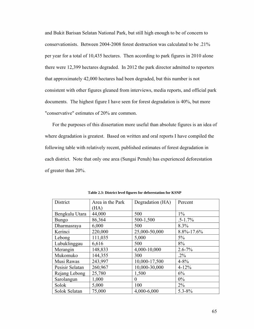
and Bukit Barisan Selatan National Park, but still high enough to be of concern to
conservationists. Between 2004-2008 forest destruction was calculated to be .21%
per year for a total of 10,435 hectares. Then according to park figures in 2010 alone
there were 12,399 hectares degraded. In 2012 the park director admitted to reporters
that approximately 42,000 hectares had been degraded, but this number is not
consistent with other figures gleaned from interviews, media reports, and official park
documents. The highest figure I have seen for forest degradation is 40%, but more
"conservative" estimates of 20% are common.
For the purposes of this dissertation more useful than absolute figures is an idea of
where degradation is greatest. Based on written and oral reports I have compiled the
following table with relatively recent, published estimates of forest degradation in
each district. Note that only one area (Sungai Penuh) has experienced deforestation
of greater than 20%.
Table 2.3: District level figures for deforestation for KSNP
District Area in the Park (HA)
Degradation (HA) Percent
Bengkulu Utara 44,000 500 1% Bungo 86,364 500-1,500 .5-1.7% Dharmasraya 6,000 500 8.3% Kerinci 220,000 25,000-50,000 8.8%-17.6% Lebong 111,035 5,000 5% Lubuklinggau 6,616 500 8% Merangin 148,833 4,000-10,000 2.6-7% Mukomuko 144,355 300 .2% Musi Rawas 243,997 10,000-17,500 4-8% Pesisir Selatan 260,967 10,000-30,000 4-12% Rejang Lebong 25,780 1,500 6% Sarolangun 1,000 0 0% Solok 5,000 100 2% Solok Selatan 75,000 4,000-6,000 5.3-8%
65

Sungai Penuh 6,000 2,000 33% TOTAL 1,444,947 62,900-125,400
According to the park the main reasons for deforestation include 1) limited
availability of land outside KSNP, 2) Low levels of economic development; 3) lack of
patrolling by district government, 4) low level of awareness as to the benefits of
KSNP. These drivers will be further examined in chapters 6 and 7, but it is important
to note here that park documents tend not to examine the forces behind these reasons.
2.8.2 People in and Around the Park
It is estimated that 1.7 million people live in and around the park, but the
population is unevenly distributed. Approximately 280,000 live in Kerinci Valley, a
densely populated enclave which is part of the central rift valley of the Bukit Barisan
range. There are approximately 460 villages in and around the park35, with
approximately 70% of the residents working as farmers. Close to 80% of the park's
border is adjacent to settlements and cultivation. Werner (2001:87) notes that 134 of
these had agriculture lands opened up in the park. She also observes that
encroachment takes on several forms: 1) local people living outside the park cultivate
cash and subsistence crops within the park; 2) local people living within agricultural
enclaves in the park, and 3) sharecroppers living outside the park. This informal
classification is consistent with what I found in the field. The table below, based on
information from the park headquarters, indicates the relative proportions of village
land inside the park.
35 14 villages are inside the park. The number of villages bordering on the park has increased due to administrative proliferation over the years.
66
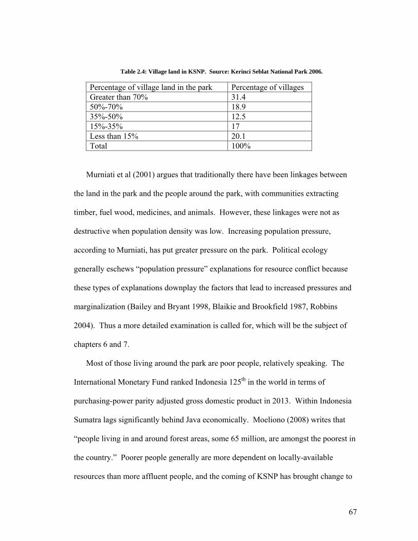
Table 2.4: Village land in KSNP. Source: Kerinci Seblat National Park 2006.
Percentage of village land in the park Percentage of villages Greater than 70% 31.4 50%-70% 18.9 35%-50% 12.5 15%-35% 17 Less than 15% 20.1 Total 100%
Murniati et al (2001) argues that traditionally there have been linkages between
the land in the park and the people around the park, with communities extracting
timber, fuel wood, medicines, and animals. However, these linkages were not as
destructive when population density was low. Increasing population pressure,
according to Murniati, has put greater pressure on the park. Political ecology
generally eschews “population pressure” explanations for resource conflict because
these types of explanations downplay the factors that lead to increased pressures and
marginalization (Bailey and Bryant 1998, Blaikie and Brookfield 1987, Robbins
2004). Thus a more detailed examination is called for, which will be the subject of
chapters 6 and 7.
Most of those living around the park are poor people, relatively speaking. The
International Monetary Fund ranked Indonesia 125th in the world in terms of
purchasing-power parity adjusted gross domestic product in 2013. Within Indonesia
Sumatra lags significantly behind Java economically. Moeliono (2008) writes that
“people living in and around forest areas, some 65 million, are amongst the poorest in
the country.” Poorer people generally are more dependent on locally-available
resources than more affluent people, and the coming of KSNP has brought change to
67

local resource use regimes (Werner 2001, Neidel 2006). Thus local people are
intuitively the most affected by the opportunity costs inherent in the establishment of
the park, while the benefits of the park (carbon sink, biodiversity, existence values,
etc) accrue globally. There is in other words a differential between who pays for and
who receives the benefits of conservation. However, as mentioned above,
decentralization and democratization have meant that the concerns of local people
have taken on a new significance.
2.8.3 Illegal Logging
Though this is not the greatest threat facing the park, it is perhaps the most widely
known issue to those outside of Sumatra. The causes for this are structural. In
general, Hitchcock and Meyers (2006) argue that too much unsustainable exploitation
of forests has made timber exploitation increasingly dependent on illegal exploitation
of protected areas. However, this should be understood in the context of the historical
and contemporary political-economic forces that have led to a dependence on primary
sector activity on Sumatra. Like other extractive activities described below, illegal
logging can be divided into two categories: subsistence and for profit. These two
categories have different characteristics. Normally local people take wood to build
houses or for firewood. Although they sometimes cut down trees for this purpose,
they often take logs and wood that have already fallen down. While this is
technically illegal, rangers and park officials have tolerance for this level of
harvesting in part because they sympathize with the villagers but also because it is
hard to stop. Moreover, they realize that if they were extremely strict regarding these
68

rules it would damage the relationship between the park and the villagers and would
make their jobs more difficult.
Larger scale logging is coordinated by financiers (cukong or tauke) who buy
chainsaws and market harvested lumber. The work is generally done by local labor,
though it is commonplace for villagers in areas that experience a high-level of illegal
logging to blame it on outsiders. The financiers, on the other hand, almost
universally come from elsewhere. Wages for laborers depend on the type of labor
and wood involved; on average chainsaw operators earn approximately IDR300,000
per day (US$33.33), whereas porters earn IDR100,000 per day (US$11.11), though
sometimes porters are paid by the trip or per cubic meter hauled36. Regardless of
how they are paid, these wages are significantly higher than virtually all o
opportunities available in most of the villages around the park, but this is an
opportunity available to only a few people with connections to the financiers, who
often work through village heads. Overall though local people generally function as
the "point of the spear" (ujung tombak); they get paid the least but do the most work.
Much of this type of logging is demand-driven; small to medium sized sawmills,
when operational, require significantly higher numbers of logs to meet their capacity
than are available via legal means. Thus illegal logging at the park is also tied to
overcapacity in terms of sawmills. For example Djogo and Syaf (2004) point out that
the proliferation of illegal sawmills in Jambi meant that demand for timber was three
times greater than legal supply. When sawmills close down, there is a corresponding
decrease in illegal logging. The problem for the park's managers is that legal
ther
36 According to my field research the average is about IDR200,000 per cubic meter, but this depends on distance.
69

sawmills exist outside the park and so they are beyond the park's enforcement
jurisdiction. Thus the park's managers must rely on help from the surrounding
districts to handle the sawmill problem. In most cases though there isn't much
incentive for the district governments to close sawmills; in several districts the
sawmills are owned by members of the regional assembly or others with close ties to
political elites. Another problem related to sawmills is that all harvested logs are
required to have documents proving their legal origin (surat keterangan asal usul,
SKAU). These documents are normally issued by the district forestry authority
(DINAS Kehutanan). A common problem is that corrupt officials within these
offices sell SKAU documents under the table, thus allowing harvesters of wood from
within the park to "launder" their logs. Thus district authorities are able to make the
case that logs processed by local sawmills are legally obtained.
Logging is not as rampant now as it was during the three to four years following
the fall of Suharto, when one NGO informant told me you could see piles of wood
along the main road in Solok Selatan waiting to be transported. This is representative
of a well-documented spike in illegal logging that occurred following the end of the
New Order; most observers attribute the increase to a breakdown in law and order
resulting from the fall of Suharto (Barr et al 2006, Gaveau et al 2009, Gellert 2010,
Obidzinski 2004). During this time illegal logging was for the most part a
coordinated activity usually facilitated by politically influential financiers and
sawmill owners. At KSNP the existence of sawmills outside the park drove demand
for wood, which was sourced from within the park. For example, park officials
indicated that Sarolangun district, which has almost none of its territory covered by
70

the park, was a major destination for illegally logged timber because there were so
many sawmills there. Solok Selatan, Pesisir Selatan, and Bengkulu Utara are all sites
where illegal logging was perceived to be a problem during this period. The
proliferation in both legal and illegal sawmills in the districts around the park is
shown in table 2.5 (below). The post-Suharto spike in illegal logging started to
decline after the election of Susilo Bambang Yudhoyono as President of Indonesia.
Yudhoyono took a harder line on illegal logging, issuing a directive to the national
police, attorney general, army, state intelligence agency, and other government
entities in 2005 to make combating illegal logging a priority37.
Table 2.5. Sawmills in districts surrounding Kerinci Seblat National Park. Source: Various park documents.
1996 1997 1998 1999 Legal 2000
Illegal 2000
Legal 2002
Illegal 2002
Sarko38 18 19 20 20 20 No data 16 20 Bungo Tebo 7 7 12 12 12 28 8 42 PESSEL 6 5 6 6 6 9 10 58 Solok/SOLSEL 2 2 3 4 4 15 13 35 SWL/SJJ 10 10 10 10 10 20 10 21 Rejang Lebong 4 4 5 5 5 0 5 0 BengUt - 5 11 13 13 19 19 17 Musi Rawas 3 4 12 12 12 20 16 36 TOTAL 50 56 79 82 82 111 131 219
BOX 2.1: Illegal Logging Case Study
The following account is translated from an interview with a local informant.
37 It should be noted here that most media accounts of SBY's 2005 directive paint it as a failure resulting in very few convictions; the information about KSNP is derived from interviews not only with park officials but also local conservation NGOs. 38 "Sarko" is short for "Sarolangun-Bangko", the name of one of the kapubatens neighboring the park before it was split into Merangin and Sarolangun kapubatens in 2003.
71

The people that do the cutting are from Sukaraja village. They take the wood
from inside Kerinci Seblat National Park around Bukit Tujuh all the way to Sungai
Manggus. It takes about 5 hours to walk there from Lubuk Kumbung village. The
wood is then floated down the Rupit river (Sungai Rupit) towards Sukaraja village
and then loaded onto a Colt Diesel and taken to the final destination very early in the
morning. The destination is a sawmill called Rimba Ria Persada, owned by someone
named Bambang or Joko who lives on Simpang Lake. Some of the wood is also
taken to Rejang Lebong. The people that transport the wood are able to get SKAUs
from the district government.
The whole process begins with a cukong (financier, mastermind, coordinator) that
gives money to a penampung ("floater") at the village level. This person channels the
money to the chainsaw operator and the person that makes the wood rafts to float
down the river. The village "floater" has 5-15 "orang anak kapak" ("ax children",
subordinates or "clients") and sometimes the floater operates the chainsaw himself.
The floater gives loans to the people below him for operational expenses and also for
shopping for their families. Then the wood is floated out of the area with the river
and is valued according to type and condition; later the anak kapak will receive their
portion of the money.
The amount required to make a truck load is about five cubic meters, and when
they get this much accumulated they contact the person in the town at the lumber
depot to come get the wood. Sometimes a truck is provided by the village floater, but
if he doesn't have a truck the town contact will haul the wood for a fee of IDR100,000
per cubic meter. The wood is transported with a SKAU.
72

It is known that this all involves people that are influential at the village level and
also people that have close relationships with business elites and the police.
2.8.4 Encroachment
By all accounts encroachment is currently the greatest problem facing the park.
However, for the same reasons alluded to above it is difficult to ascertain how much
of the park has been degraded. Hitchcock and Meyers (2006) point out that
encroachment is one of the most serious and sensitive problems facing the park when
they did the assessment for the World Heritage site. They argue that a lack of
coherent policy coupled with financial constraints have conspired to undermine
efforts to address encroachment. Encroachment is perpetrated by a broad spectrum of
actors ranging from isolated households to large scale commercial plantations
(Hitchcock and Meyers 2006:8). Werner (2001) identifies three sources of
encroachment: 1) local people living outside the park cultivating cash and subsistence
crops; 2) local people living within agricultural enclaves inside the park; and 3)
sharecroppers who live outside the park. The park acknowledges that encroachment
is the most difficult challenge and park documents indicate a number of reasons
contributing to encroachment, including the fact that the borders of the park are long
and that in many places they are unclear. Based on a review of official park
documents causes of encroachment include the following:
--Population pressure
--Lack of understanding on the part of local communities as to the
conservation importance of the park
73

--Unclear borders
--Overreliance of local people on natural resources within the park
--Limited availability of land outside the park
--Low economic development
--Lack of patrolling by district governments
--People prefer the land in the park because it is more fertile and the climate is
mild
Thus there are many perceived factors driving the problem of encroachment, but it is
clear that encroachment has increased tremendously in the Reformasi era. This is no
coincidence, and the issue of encroachment will be discussed in chapters 6 and 7.
Agroforests
In her dissertation Werner (2001) describe the cultivation of Cassiavera, which is
the local name for Cinnamomon burmannii, a species of cinnamon in and around
Kerinci. Kerinci Valley is a hotspot of Cassiavera cultivation, accounting for about
40% of national production. This crop represents a significant source of income and
attracts not only contract laborers but also those with money to invest, including
government officials, army officers, and the successful elite of Kerinci Valley.
Another agroforestry crop popular in the central Sumatra area is rubber. Villagers
cultivate Hevea brasiliensis as "jungle rubber" (hutan karet) in mixed-species
agroforestry systems (Penot 2004). Much of the land in the park but on its edges
consists of cinnamon and rubber agroforests that predate the park. Although
continued harvesting in most of these areas is technically illegal, most rangers
74

interviewed say that harvesting is allowed on a case-by-case basis with the
understanding that further expansion into the park is not allowed. The general pattern
in most places is what Suyanto and Otsuka (2001:4) refer to as "multi-strata
agroforestry" where paddy fields are located in the valleys and flat areas and
agroforestry fields with both mature trees and newly planted trees are intercropped
with annuals and bush-fallow fields under shifting cultivation are developed in the
surrounding fields and mountains. Werner (2001) also notes these patterns of
intercropping and rotation. During my fieldwork I also noted that many farmers tend
to live temporarily in shacks constructed in their upland fields.
More worrying for park managers are new stands of rubber, cinnamon, and now
oil palms that have been planted by smallholders in the park. Werner (2001) argues
that smallholders are forced into the park because of estate development for
plantation crops such as tea, rubber, and oil palm. According to this log commercial
plantation companies displace local communities which then move into the park39.
Although plantation companies need labor, and although part of the rationale for
districts to reach agreements with plantation companies rests on job creation, local
people are in many cases not willing to work for the low wages offered by the
plantation companies. Instead migrants enter the area from elsewhere to do the work.
This topic will be further discussed in chapters 6 and 7.
39 My own research confirms this dynamic, but it should be pointed out that in many cases local people sell their land to plantation operations.
75

2.8.5 Poaching/Theft of Non-Timber Forest Products
Poaching has always been a major concern at KSNP, with charismatic megafauna
such as the tiger and rhinoceros receiving the most attention from international
conservation organizations. Traditionally tigers have been poached for a number of
reasons. Their bones and vital organs are highly valued in some medical traditions.
Additionally, tiger skins have in the past been a preferred gift for clients aspiring to
climb the bureaucratic or military ladder.
In recent years the poaching of smaller mammals and birds have received more
attention. According to informants in and around the park, poaching of birds is
thought to be a significant problem, but there are no statistics or studies to support
this claim. The keeping of birds is a popular hobby throughout Indonesia. Birds are
highly sought for their songs, sometimes fetching thousands of dollars for a single
animal. Songbird competitions are a common occurrence and there is a significant
amount of social prestige attached to good songbirds. This hobby is thought to drive
poaching of birds in the park. Conservationists and park officials claim that many of
the birds sold in areas around the park are illegally taken from the park, but since
birds are small it is difficult to catch the poachers40. Hitchcock and Meyers (2006)
suggested that as many as 100,000 birds were poached annually from the park. Forest
rangers and residents of villages bordering on the park also say that birds are
noticeably rarer compared with five years ago. During my fieldwork some
informants that accompanied me on forest walks through the park were
simultaneously hunting birds. These casual hunters had the birds' songs recorded on
40 On almost every instance when I entered the forest with guards or NGO representatives, these people remarked on the conspicuous absence of birds at the periphery of the park.
76

their cell phones, which they would use in an effort to attract the birds. Other tactics
include the use of glue and lures.
Probably the most commonly poached mammals at KSNP are kijang (Muntiacus
sp.; muntjac) and rusa sambar (Cervus unicolor; deer) and forest pigs. The former
two species are hunted for their meat, whereas pigs are seen to be a crop pest41.
Other widely poached animals include landak (porcupine), trenggiling (pangolin
pemalu (slow loris). Porcupines are sought for their quills and the bezoar stones that
sometimes form in their stomachs. Pangolins are taken because their scales are
thought to have medicinal properties. Slow lorises are sought because they are
thought to be very good pets.
) and
Kerinci Seblat National Park also contains a wide variety of non-timber forest
products that are valuable. Normally forest rangers turn a blind eye to harvesting that
is truly done for the day-to-day consumption of local people, but there also exist
networks of harvesters that gather products like rattan and manau (Calamus manan)
on a for-profit basis. These coordinated networks involve financiers and complicit
officials, including forest rangers. According to several informants, theft of forest
products seems to increase during economic downturns; this was true even before the
existence of the park. Werner (2001) writes that this trend was particularly noticeable
during the Asia Economic Crisis which began in 1997. This would seem to suggest
that forests serve as a kind of emergency reserve for people for use during tough
times; thus the forested area probably adds to the resilience of the community because
it enables people to eke out a living in lean times.
41 The dominant religion around the park is Islam, so the pigs are generally not eaten.
77

2.8.6 Human-Wildlife Conflicts
Bearing in mind the fact that approximately 80% of the park's border abuts settled
areas (fields/villages), it should come as no surprise that there are frequent conflicts
between humans and wildlife. The most well-publicized are instances when a tiger
enters a village. Normally tigers prey on goats or cows, but from time to time a
person is mauled or killed by a tiger as well. Indeed during my fieldwork villagers
were often eager to show me gruesome pictures of victims caught on their cell phone
cameras. Conservationists argue that these conflicts occur because encroachment and
development are cutting into the tigers' habitat. Elephants are a more frequent cause
of conflict; the big pachyderms often raid crops. They appear to particularly enjoy
eating the fruit of oil palms, and so in places where land has been converted to oil
palm holdings elephant conflicts are a frequent occurrence.
2.8.7 Mining
Mining is also an issue within the park, both on the part of individuals and
corporations. Individuals carry out illegal mining using artisanal techniques (panning
for gold, using a pickaxe or similar implement to dislodge coal) in several districts
including Lebong, which is known for its gold deposits42. In several places mining
concessionaires have moved beyond their borders to encroach into the park.
According to park officials, when this happens the mining companies claim that they
have been granted permission to mine within the park, or that the coordinates
provided by rangers are incorrect. With the advent of handheld GPS units it is easier
42 The gold leaf that adorns the top of the National Monument (Monas) was mined in Lebong.
78

for rangers and conservation activists to document encroachment by corporations,
though.
2.8.8 Border Markers
As mentioned previously, the park has a border of more than 2800 kilometers.
There are supposed to be markers every 100 meters, meaning that theoretically there
are more than 28,000 markers delimiting the park's boundary. Some of these are
made from stone, others from concrete or even wood. But it is safe to assume that
most of the border markers don't actually exist; periodic surveys of the border
universally find that the vast majority of markers are missing43. Given the nature of
the tropics, the natural environment takes its toll on some of the markers. Others
might be lost in foliage. But there are many cases in which the markers have been
allegedly destroyed or moved by villagers. Many villagers claim that on the contrary
park officials have actually moved the markers to expand the area of the park; another
common charge is that when the markers were first being placed, those responsible
for the job didn't want to go through the trouble of hacking through the forest to
accurately place the markers, so instead they just placed them on the edge of the
forest, which according to local accounts also served to unofficially increase the area
of the park while cutting them off from their agroforests or long fallow swiddens.
Since the onset of decentralization these accusations have been voiced by elected
43 One survey of 75 kilometers of border in Bengkulu in 2008 found that 703 of 750 markers were missing; 40 were found in good condition and 7 were badly damaged. A more recent survey of border markers in Kerinci district found that on 13 of 100 markers along a 10-km stretch were in good condition, with 10 damaged and 77 lost. Interestingly the notes from this survey indicated that the locations for every single one of the 100 markers, whether found or not, was in cultivated fields (ladang masyarakat)
79

members of district assemblies in many cases, and so Reformasi has given an official
voice to these locally-originating challenges to the park's extent.
2.8.9 Enforcement Difficulties
Enforcement has always been a problem at the park due to chronic understaffing.
Currently there are approximately 106 forest rangers assigned to the park, which
averages out to one guard for approximately 130 square kilometers of area and 25
kilometers of borders44. Park guards are stretched thin, and large areas of the border,
especially in hard-to-access places are patrolled infrequently. Moreover, a common
complaint is that too many of the park's 183 total staff are based at the park's
headquarters in Sungai Penuh. Many park documents acknowledge the chronic
understaffing and underfunding the park has experienced since the end of the ICDP
project. For example, one document explicitly states that "limitations in funding,
human resources, and infrastructure at KSNP in protecting and preserving the
integrity of the area are very unsatisfactory in terms of creating ideal conditions"
(Nugraha 2006: 3). Another related problem is a lack of personnel with expertise in
areas such as conflict resolution, community relations, and public outreach. Park
staff also complain that the park manager is replaced every 2-3 years, which hinders
continuity in management and is detrimental to institutional memory.
44 KSNP has the lowest ranger density of any operational park in Indonesia with the exception of Betung Kerihun National Park in West Kalimantan, which has 24 rangers responsible for 800,000 hectares. Bruner et al (2001:126) show that density of park guards is strongly correlated with park effectiveness; according to their statistical analysis the median density of guards in the most effective parks was 3 per 100 square kilometers. Moreover, the number of forest guards officially assigned to KSNP is somewhat misleading, as approximately 30 of the most experienced and capable guards have been seconded to the Ministry of Forestry's Rapid Reaction Force (SPORC), which is based in Jambi City, hundreds of kilometers from the park. A common complaint at KSNP is that SPORC never patrols in the park.
80

Related to this is the fact that the park must often rely on outside help when
conducting enforcement operations. This means that the park's manager must
formally request assistance from other agencies (e.g. the district police or the district
army barracks) in writing. Bureaucratic rivalries as well as a general decline in intra-
government coordination that has resulted from decentralization mean that this
assistance doesn't come as readily as it did during the Suharto years. In addition, if
the other agencies do provide assistance, KSNP must pay them a per diem fee, which
comes out of the park's budget45.
These institutional weaknesses are compounded by outside forces as well. Park
managers complain that district and provincial prosecutors are reluctant to try cases,
and Indonesia's rules concerning evidence (two eyewitnesses are needed for
conviction) complicate the judicial process. Moreover, if and when cases finally do
make it to trial, district judges sentence offenders to what might be described as a slap
on the wrist. All of these factors taken together mean that the laws governing the
park are not effectively enforced, and so it is highly questionable whether there is any
deterrent effect whatsoever. For example the following arrest data comes from the
park's 2010 annual report. These figures represent arrests and confiscations for the
entire park for the period of one year: 3 chainsaws and 1 large saw
seized...mobilization against 794.5 hectares of illegal cultivation and settlement with
1 suspect prosecuted...five cases of illegal logging...one case of hunting and trading
endangered species...eight cases of encroachment...one case of transporting wood
45 For the first nine months I was in the field the park conducted very few coordinated patrols and in general there weren't many outreach activities. This was the result of an embezzlement case two years prior to my arrival in which the park's treasury officer, whose name was Erwin Rommel, had absconded with 60% of the park's budget. Though he was captured and put on trial, the money was not recovered, and so the park was forced to economize for two and a half years.
81

without proper documents, one case of theft of non-timber forest products. This is for
the entire year, for the entire park, and speaks to the difficulties the park faces in
enforcing the law.
Therefore it is very clear that management strategies that rely on strict
enforcement alone are doomed to failure. Officials at the park concede this point, but
they also complain that the personnel assigned to the park don't have the appropriate
skills needed at the park, noting a general lack of conservation professionals with
training in ecology, GIS, education and outreach, and conflict resolution.
2.9 Conclusion
This short history of conservation in Indonesia and the establishment of KSNP
illustrates how the park is rooted in international conservation priorities. During the
New Order, the top-down structure of the MoF and the park was consistent with other
aspects of the regime and thus fit in with the overall strategy of centralized control
and administration of natural resources. However, as noted in chapter 1,
decentralization reforms have completely altered the relationship between the various
scales of government and have liberated the villages, districts, and provinces from the
direct supervision of the national government, effectively establishing them as
independent nodes of stateness. Though the park's management structure may have
been somewhat effective during the authoritarian era, a wide variety of challenges
have emerged now that decentralization has taken hold of the country. Patlis's
observation (2004:1) is instructive here:
82

The key to increasing the benefits of decentralization and improving the legal framework is to enact laws that confront, rather than ignore, the practical realities of society. Specifically, past legislation ignored the realities of corruption and non-compliance and were written as if they would be fully implemented and enforced...New legislation must address such realities. For example, if in the past there has been widespread noncompliance with regulatory measures, it is unrealistic to expect that new regulations may enjoy better compliance.
In this new era the park's management strategies are mismatched with the political-
administrative realities; moreover the way the park is administered by the MoF serves
to obstruct decentralization. This is not due simply to poor planning and
implementation; I have argued that it is part of the MoF's efforts to "protect its turf."
However, this has and will continue to lead to conflicts with the provinces, districts,
and villages. This chapter has provided an overview of the current situation around
the park and has discussed the Ministry of Forestry's response to decentralization. In
the next chapter I will turn to regional politics in order to identify the factors driving
the pressures described in this chapter.
83

CHAPTER 3. THE POLITICAL EDGE EFFECT: DISTRICT POLITICAL
TRENDS AS DRIVERS OF DIRECT AND INDIRECT PRESSURES ON
KERINCI SEBLAT NATIONAL PARK
3.1 Introduction
Decentralization has to this point been a disastrous process leading to the destruction of large production forests, conservation forests, and nearly all of the national parks in Jambi (Djogo and Syaf 2004: 14).
Ecologists use the term "edge effect" to refer to the ways in which abrupt
transitions between habitats impact the biological and ecological processes occurring
within the habitats. These effects are often most pronounced on population or
community structures, since edge areas (for example, between a meadow and a forest)
provide advantages for some organisms and disadvantages for others (Lahti 2001).
Edges also provide invasive species a point of entry for colonizing new habitats, and
many species exhibit avoidance behaviors with respect to edges. The geometry of
agricultural encroachment, roads, fires, and other forms of modification and
conversion greatly increase edge effects, so these activities are of concern to
conservationists and protected area managers (Cochrane and Laurance 2002). A
major contention of this dissertation is that protected areas are not only susceptible to
physical changes on the periphery, but also to changes in governance as well. The
changes to the political landscape that have come about as a result of democratization
and decentralization are key factors in what I call "the political edge effect" at Kerinci
Seblat National Park and are the subject of this chapter.
84
As I pointed out in the introductory chapter, decentralization has introduced a new
configuration of government, with new rules and new stakeholders constituting new
nodes of stateness. This chapter turns the lens on the process of decentralization as it
has been implemented and contested in the four provinces and fifteen districts and
administrative municipalities that surround Kerinci Seblat National Park in an effort
to identify the general ways in which these new actors are operating. I will focus on
formal and informal aspects of this new political configuration with the ultimate goal
of identifying general patterns and how these patterns affect the park, both directly
and indirectly. In the following two chapters (4 and 5) I will further develop the
themes laid out in this chapter by examining specific projects and policies and how
they reflect the processes described here and in turn the impacts they have on KSNP.
Part and parcel of apprehending local politics in Indonesia is understanding
informal networks and relations between those actors that hold political power and
business elites (Hidayat 2007). The districts have become the arena for all sorts of
political contestation and much of this is tied to control over resources. Firman
(2009:143) notes that district governments have become "kingdom[s] of authority"
for local elites able to gain control of districts through the electoral process.
Reformasi has increased contestation and the unprecedented powers devolved by the
decentralization reforms means that the stakes are quite high in district elections. As
McCarthy (2007: 152) explains, "in addition to the district government agencies and
the police, business interests, preman46, indigenous entrepreneurs and remote
villagers vied with or accommodated each other in attempting to maximize their
46 "Preman" is derived from the Dutch word for "free man" and is generally used to refer to thugs and gangsters, who have been integral to strong arm tactics used by various powerful actors over the past half century.
85

benefits." This applies to the districts around KSNP, but the existence of the park
frustrates efforts to formally benefit from the control of natural resources that might
be successful elsewhere in Indonesia (through the awarding of exploitation permits,
for example) since the central government maintains administrative authority over
national parks. Despite this fact, in general, decentralization has opened up
tremendous opportunities for district elites around the park, but given the special
status of the protected area, informal networks and processes as well as indirect
strategies using formal powers to access and benefit from natural resources are often
more evident (though the latter are also used to indirectly affect the park as well; this
will be discussed in chapter 5). In an effort to sort through all of this complexity, this
chapter seeks to address the following issues and questions:
1. How are decentralization and democratization reforms taking shape in the
regions around the park? In this chapter I aim to present a clear and detailed
picture of Refomasi era politics in order to ascertain connections between the
structure and processes of decentralization and the increased challenges facing
the park. This addresses the overall theme of statemaking and reverse
statemaking by describing how new nodes of "stateness" are developing at the
district level.
2. In what ways have decentralization reforms increased district-level
pressures on natural resources? I will discuss how the structure of
decentralization laws place great weight on the role of natural resources in
86

terms of financing the increased responsibilities that have been decentralized
to the districts. I will also show how the form decentralization is taking in
central Sumatra is exacerbating these pressures to exploit the environment.
3. In what ways do the approaches of the Ministry of Forestry and KSNP to
managing natural resources conflict with the structure and form of
decentralization in the districts? I will show how the MoF and KSNP have
obstructed the implementation of decentralization in the districts and
provinces around the park. At the same time, decentralization has created no
incentives for village, district, or provincial governments to support the park.
4. Are these processes contributing to the institutionalization of a dichotomy
between development and conservation at the district level in Indonesia? I
will describe the tensions that have emerged between the park and its
neighboring regions. These tensions lead to greater informal and indirect
pressures on the park.
3.2 Decentralization and District Politics: Imperatives and Structures
3.2.1 Changes in How Regional Governments are Funded
One of the most important factors in political contestation at the district level has
been changes in the way district governments are funded. In addition to changing the
balance of powers between the central government and the districts, the
decentralization laws (most important in this respect was Act 25/1999) altered the
87
fiscal balance between the districts and provinces and the central government as well
as their respective responsibilities in terms of funding public service provision. It is
difficult to overstate the importance of these changes; Booth (2003:181) predicted
that "in the space of a few years, the Indonesian fiscal system will change from being
one of the most centralized to one of the most decentralized in the world, and there
can be little doubt that this is one of the most ambitious decentralization programs
undertaken by any country in recent times."
District Finances Before and After Decentralization
Prior to 2001, Jakarta exerted very strict control over essentially all official
financial aspects of government (Firman 2009). This dominance over fiscal affairs
was a product of the New Order's centralization project (Booth 2003). Most taxes
and other revenues from fees were funneled to the central government, which then
distributed these to the districts in the form of grants, establishing a system of
dependency whereby the district government, in exchange for implementing the
programs of the central government, would receive a steady and reliable source of
revenue47. The two most important sources of funding for districts were Inpres
(Instruksi President, Presidential Instruction) grants and SDO funds (Subsidi Daerah
Otonom, Autonomous Region Subsidies). Inpres funds were generally associated
with development projects originating from Jakarta and formulated according to the
central government's priorities (Booth 2011). For example, the Primary School
Inpres (Inpres Sekolah Dasar) program of the 1970s provided funds and directions to
47 It should also be remembered that district officials were appointed by the Ministry of Home Affairs in most cases as a reward for loyalty to the regime, and so the district government was oriented more towards Jakarta than its constituents.
88

build a three room primary school in every village unit in the country (Booth 2003).
Examination of the Inpres program reveals not only how projects were funded during
the New Order years, but also how they were standardized, conforming to cookie-
cutter blueprints formulated by the central ministries in Jakarta with little or no input
from lower levels of government, and little or no consideration for the variations
within the country. SDO funds, on the other hand, were used to pay civil servant
salaries and other day-to-day expenses associated with government (Seymour and
Turner 2002). Like Inpres funds, the districts had little official discretion over how
these funds would be spent (Barr et al 2006; Ryaas 2003).
Decentralization laws abolished both the Inpres grants and SDO funds and
replaced them with a different system of funding, which includes a mix of grants
from the central government and a new revenue sharing formula between the central
government and the regions (provinces and districts) for revenues derived from
natural resources (see table 3.1). The main stream of revenue from the central
government to the districts and provinces is the General Allocation Fund (DAU,
Dana Alokasi Umum), which is intended to fill the "fiscal gap," which is the
difference between the regions' expenditures and earning capacity in order to enable
local governments to finance their routine activities and public services (Firman
2003). DAU varies from district to district and is determined based on a formula used
by the Home Affairs Ministry. Though there are very few official stipulations on
how DAU funds are used and so theoretically the districts now have more discretion
over how funds are spent, the reality is that the vast majority of these disbursements
go to covering the salaries of civil servants and other day-to-day expenses (Firman
89

2003, Lewis 2005)48, and so in reality the districts don't have much leeway in terms
of how these funds are used. Although the decentralization laws stipulate that DA
funds must be at least equal to the former SDO funds, with decentralization more than
two million civil servants were transferred from the central government to the
districts and provinces, which greatly increased their payroll liabilities.
U
A second stream of revenue from the central government to the districts is the
Special Allocation Fund (DAK, Dana Alokasi Khusus), which in general is intended
to help meet special needs of economically disadvantaged districts and provinces;
these are generally targeted funds for specific projects. While districts don't have as
much formal discretion over these funds as they do the DAU, the ability to secure
DAK funds is something local politicians are proud of, and so they are somewhat
similar to Congressional earmarked funds in the United States. Because they are
dedicated to special projects, district and provincial officials have a great deal of
discretion over where the funds are spent (i.e. which contractor). Thus DAK funds
provide opportunities for graft as district and provincial leaders are able to skim a
certain percentage off the top in the form of bribes and kickbacks, or channel projects
to firms owned by cronies.
Besides these center-periphery funding mechanisms, decentralization laws
instituted a new revenue sharing mechanism that applies to natural resources,
including oil and gas, fisheries, and most germane to this discussion, mining and
forestry revenues. During the New Order all of these funds went directly to the
central government where they would be divided up between all the districts and
48 Hidayat and Firdausy (2003) conducted an extensive survey of district level officials in the wake of decentralization reforms. Their study indicated that less than 25% of DAU funds were typically left after paying salaries and overhead.
90

provinces. Now, however, 80% of taxes and other government revenues from mining
and forestry go to the districts (64%) and provinces (16%). As we shall see below,
since these reforms have been passed districts and provinces, especially on the outer
islands, have looked to natural resources as a way to increase their official revenues.
Table 3.1: Distribution of natural resource revenues after Seymour and Turner 2002.
Revenue from Central Government % Province/District % Land and Property tax 10 90 Acquisition of land and building rights
20 80
Forestry, mining, fisheries
20 80
Oil 85 15 Gas 70 30 Income tax 80 20
The PAD Imperative and the Importance of Locally Generated Revenues
Though there are a few exceptions, officials in most of the districts around the
park complain that they have been given new responsibilities without adequate
financial resources to fulfill those responsibilities, and that even though they have a
significant degree of autonomy, because the presence of the park limits their options,
they don't have the fiscal capability to initiate projects that meet the specific needs of
the districts. It has been shown that an important component of successful
decentralization regimes is an increase in the fiscal capacity of the administrative
units that are the target of the reforms (Guess 2005, Mawhood 1987). This improved
capacity comes from increasing local revenue generation and improved funding
stability. Theoretically decentralization allows for more efficient public sector
service provision as local governments have a greater knowledge of local needs than
91

the central government, but the funding must be there for this to work. One of the
lasting legacies of Indonesia's decentralization adventure has been the failure of the
central government to fulfill these requirements. Thus a major project for many
district governments is to increase locally generated revenue, or PAD (pendapatan
asli daerah). According to the structure of the decentralization laws, PAD comes
primarily from local taxes, regional contributions, profits from district-owned
enterprises, and legal revenues.
The facts of this new mechanism of distribution combined with the historical
trajectory of primary sector activity described in the introductory chapter means that
the natural avenue for increasing district revenues in many places, especially on the
outer islands like Sumatra, is by encouraging natural resource extraction. Because of
this, many district governments have begun to exploit their natural resources more
intensively than under the Suharto years (Duncan 2007; Firman 2009)49. For park
managers this is particularly problematic because, while the district and provincial
governments cannot legally award concessions or permissions to cut trees or mine
within the park, they are able to do so in certain areas of the park's buffer zone, which
consists of a variety of non-national park forests (production forests). The fact that
these forests are not designated as national parks or protection forests means that the
district and provincial governments have more policy options in managing them and
that there is a clearer path for gaining permission from the Ministry of Forestry to
grant concessions to these lands. Some park officials worry that this will have
49 Djogo and Syaf (2004) refer explicitly to the case of Kerinci district, where the head of the district forestry office was required by the district head to raise IDR 700 million (approximately US$86,000) from forest resources annually, despite the fact that most of the district, and virtually all of its forested area, lies within the park.
92

adverse affects on the park because it decreases effective habitat for certain species,
increases the ecological edge effect, and also increases incidents of human-animal
conflict. Dealing with these types of conflicts is a major weakness for the park for
the reasons explained in chapter 2. Moreover, park managers admit that it is very
difficult to keep concessionaires from encroaching into the park, both accidentally
and intentionally. In the past this encroachment has been a way for concessionaires
to pad their revenues. Park managers and local NGOs also point out the indirect
effects of this reliance on expanding primary sector activity as district governments
award concessions to land claimed by local people. These concessions go to
businesses with ties to the district politicians, and the local owners of the land are
forced to move elsewhere, in some cases pushing into the national park50. Around
the park this has reportedly taken place in Mukomuko, Bengkulu Utara, Bungo, a
Merangin districts, and local NGOs worry that instances will increase as district
governments endeavor to entice more investors to set up operations. This is an
example of a broader phenomenon occurring throughout the archipelago whereby
small scale communities that were marginalized by the natural resource politics of the
Suharto regime are continuing to lose out in the post-authoritarian era (Duncan 2007).
nd
Reinforcing New Order Networks of Extraction
In this way the "PAD imperative" reinforces informal structures that developed
during the Suharto years. During the New Order there was a significant amount of
illegal logging on Sumatra, but much of it was done by entrepreneurs with
50 It is important to note here the possibility that in some cases local people are more willing to sell their land to plantation companies due to a perception that the park's borders are poorly enforced and hence the local sellers will be able to clear new land in the park.
93

connections to the military, and in some cases by the military themselves (McCarthy
2002, Morishita 2008). This can be seen as part of the "franchising" of corruption
that helped Suharto maintain his grip on power (McLeod 2000). The general pattern
was that high-ranking military officials and others with ties to the regime were
appointed as governors or district heads, and along with their formal powers there
was a tacit understanding that they would exercise control over illegal resource
extraction in their regions. In many places these outside interests overwhelmed local
people and their customary law institutions (further discussed in Chapters 6 and 7) to
the point where many village elites saw no alternative other than to participate in the
system. These village level elites became part of a vertically-articulated system of
patronage based on extraction, in many cases buying chainsaws and setting up their
own localized logging and processing operations to take advantage of the informal
system. As McCarthy (2002: 45) points out: "the pattern of collusion that emerged
between oknum51 and logging operations constituted a set of accommodations that
operated according to a predictable logic."
Village leaders were also incorporated into patterns of legal extraction as well.
During the New Order, the central government controlled the awarding of forest
concessions, which for the most part were granted to corporations close to Suharto.
Most of these concessions were large-scale operations, but the Jakarta-based
corporations would often subcontract work out to district entrepreneurs, who would
then work with village leaders to recruit and supervise workers and manage
operations at the local level. Once permission to log was granted local entrepreneurs
51 An oknum is a delinquent or corrupt government official, including military and police officers. Oknum are actively (orchestrating) and passively (facilitating) illegal activities such as illegal logging and mining.
94

could exceed their quotas and log beyond the boundaries of their small concessions
by paying bribes to local officials to look the other way. Morishita (2008:99)
describes the system with respect to Kalimantan:
These local businessmen were tasked to....manage logging operations and the shipping of timber on site, to conciliate and/or intimidate locals who opposed logging and so forth. Some also engaged in illegal logging to meet the targets of a particular company's annual work plan, a cooperative effort that allowed them, at the same time, to accumulate their own capital. Their positions were also protected by personal connections with local bureaucrats, politicians, military personnel, and police, all of whom were important figures when it was necessary to obtain official protection for their operations.
The result of this is that a structure of extraction developed during the Suharto
years, and networks including village elites, local entrepreneurs, and district
bureaucrats (but excluding the vast majority of local people) emerged to facilitate
extractive activities. The structure of the decentralization reforms, instead of
dismantling these local networks of corruption and extraction, has created
opportunities for them to continue their activities and has even institutionalized
incentives via the redistribution of revenues from natural resources for district
governments to encourage these activities. The post-authoritarian manifestations of
this can be seen in several districts around the park, but one of the clearest examples
is in Solok Selatan district. When Suharto fell, these local entrepreneurs, who had
already established networks of chainsaw operators and timber porters and who
already had systems in place to transport and market illegally felled wood, were able
to take advantage of the confusion of decentralization and step up production. In
addition, at about the same time the military was pulling back from their involvement
95

in these activities, which opened up additional space and increased the take for the
local entrepreneurs. Local NGO informants recall a huge increase in timber leaving
the area between 1999 and 2003, and so these local entrepreneurs experienced
windfall profits, which some of them would later use to bankroll political campaigns.
Now it is widely known that several members of Solok Selatan's district assembly as
well as other high-ranking district officials made their fortunes from illegal logging52.
Since these elites have experience in the timber industry, it stands to reason that they
would likely benefit from expanded timber harvesting in the district. Thus according
to local informants they have used their formal powers and informal influence to
encourage more logging. Informally, district officials have deprioritized enforcement
of forest laws, giving loggers a freer hand to cut trees. Formally they have pushed for
infrastructural improvements that would make logging and other extractive activities
more profitable (see chapter 5).
Creating a Dichotomy Between Development and Conservation
Perhaps the most important aspect of the PAD imperative with respect to KSNP
and other national parks though is that it establishes a clear line of cleavage between
the district governments and the national park's managers and contributes to a
dichotomy that pits conservation against development in a zero sum game. The
upshot of this is that it institutionalizes disincentives for the districts to cooperate with
the park. As pointed out in Chapter 2, the park is very under-resourced, and the 70 or
so active rangers are stretched thin along the 2800 km border. Because of this, park
52 Several officials admitted directly to me that they had been involved in illegal logging in various capacities, but maintained they were no longer associated with illegal activities of any kind.
96

officials admit that in order to have effective policing and patrolling, the cooperation
of both the district police (which are technically under the administration of the
central government) and the district constables (Satpol PP) and other local
enforcement officials is necessary. For example, district forestry police (Dinas
POLHUT)53 ideally would police the buffer zone and alert KSNP authorities in the
case where encroachment or illegal logging was found. District police would also
respond to reports of poached animals or forest products being trafficked through the
districts. But park managers admit that there is now little communication with some
of the districts (though as pointed out in chapter 2, the level of communication and
cooperation varies from district to district). For example, endangered and protected
birds that are almost undoubtedly captured within KSNP are openly sold in the
market in Sungai Penuh, which is located in the middle of the Kerinci enclave. Park
managers are powerless to stop this trade, however, since their jurisdiction is limited
to the park itself. They must rely on district authorities for interdiction and
enforcement outside the park. And while the district police are under the command
and administration of the central government, their organization parallels the
province-district-subdistrict administrative structure of the country, and so in many
places the district headman is able to exercise a significant degree of influence over
the police. In fact, in many instances officials from each of these agencies are said to
be involved in the illegal activities (Djogo and Syaf 2004). During the Suharto years
there was at least tacit support for the park, since as it has been pointed out, district
53 POLHUT is an abbreviation for polisi hutan, or "forest police", a general term for any forestry law enforcement officials. District and provincial forestry officials and police during the New Order were part of the Ministry of Forestry's hierarchy. However the decentralization laws put them under the authority of the district headman and governor, respectively.
97
headman and representative assemblies took their official marching orders from
Jakarta. But now there are really no practical reasons for district governments to
support the park.
This is reflected in the attitudes of district headmen, bureaucrats, and assembly
members, but their way of expressing their opinions differs. Some are openly defiant,
often explicitly challenging the park and the authority of the Ministry of Forestry.
Others, while they lament the fact that the district receives no direct compensation for
the presence of the park and the foregone revenue earning opportunities, express a
kind of dutiful resignation that they must enforce the national law. A key difference
between these two positions is that those most opposed to the park are district elites
that have gained power and influence since the fall of Suharto, while those expressing
a legal obligation to support the park are more likely to be former Suharto-era
functionaries (police, military offices) that have entered electoral politics after the fall
of Suharto. Examples of the former trait would include the district headmen of
Kerinci and Lebong districts, both of whom were not closely connected to the New
Order apparatus. The headman of Kerinci was an adat leader, successful farmer, and
small scale businessman during the Suharto years, but his influence didn't extend
beyond his subdistrict (kecamatan) nor into the halls of government. However, he
was able to take advantage of favorable conditions after decentralization54 and
consolidate his position and eventually become headman. He has no strong ties to
preexisting networks of power at the provincial or national levels, and so he doesn't
have to risk alienating any patrons. He is known not only for his outspoken stance
54 These favorable conditions include the formation of Sungai Penuh as an independent administrative municipality and the arrest on corruption charges of the former district headman, who was closely connected to the Suharto regime. These factors are discussed elsewhere in the dissertation.
98

towards the park, but also for his less-than-friendly relationship with the provincial
governor. Likewise, the current district headman of Lebong during the Suharto years
was an important local preman in a neglected corner of Rejang-Lebong district who is
known to have made a significant amount of money illegally harvesting swiftlet
(walet) nests from caves located in the park. However, when Lebong district was
established in the early 2000s this created an opportunity for him to gain power which
he otherwise likely would not have had, since his power base was always
overshadowed by and subservient to more influential groups in the former district
capital of Curup. Like the headman of Kerinci, he is well known for his antagonistic
attitude towards the park. In contrast, the headman of Merangin district was a high
ranking police officer during the Suharto years, a position that is associated with the
patronage dynamics of the New Order regime. He and his subordinates are much
more accommodating to the park, at least in conversation and in terms of their public
statements.
Another aspect of this that can be traced back to the relationship between Java and
the outer islands during the Suharto years. After Suharto gained power, he appointed
loyal Javanese military allies to important posts in government throughout the
archipelago. At the same time, revenues from natural resource exploitation on the
outer islands flowed disproportionately to development projects (as well as the
pockets of corrupt cronies) located on Java. These aspects of the New Order, which
are collectively known as the "Java Bias", are described in detail elsewhere (Charras
2005, Dauvergne 1993, Duncan 2007, Kimura 2012, McCarthy 2002, 2006), but
around KSNP many districts, especially newer districts, point to the exploitative
99

policies of the Suharto years and are demanding a bigger slice of natural resource
revenues as compensation (Morishita 2008). Indeed, it has been noted that the
decentralization process in general has been driven in part by regional pressures
(district and provincial) calling for a greater share of these lucrative revenue streams
(Duncan 2007). In other words, a major consideration and driving factor behind
decentralization has been access to natural resources. In several cases provinces and
districts have experienced windfall profits due to the new revenue sharing
arrangements. This is most notable in areas that have large oil and natural gas
deposits. Many of the district officials I interviewed used these natural resource rich
areas as examples for comparison, complaining that the existence of the park is an
unfair constraint on their economic development. They argue that the Bukit Barisan
mountains are rich in minerals, particularly gold, which could be used to develop the
districts.
3.2.2. Changes to Resource Management Structure (KANWIL to Dinas)
One of the major decentralization changes that has been noted is the transfer of
approximately two million civil servants from the central government to the districts
and provinces. This was accompanied by a reordering of bureaucratic entities.
Previously during the new order, many bureaucratic offices operated under the
supervision of the Regional Offices (Kantor Wilayah; KANWIL) which were under
the control of the ministries in Jakarta. At the same time, there were parallel offices
nominally under the control of the districts and provinces (Dinas), but Dinas offices
coordinated with and were largely subservient to KANWIL offices. Theoretically the
100

KANWIL offices were responsible for policy formulation at the provincial level
whereas the Dinas offices were responsible for implementation, though in practice
there was some overlap.
Since the fall of Suharto the picture has changed. KANWIL bureaus at the
provincial level, including the KANWIL for forestry, have been abolished by
decentralization reforms55 and replaced by Dinas offices under the control of the
district government (Alm et al 2001). These are now only accountable to the district
level and they operate according to district level regulations (peraturan daerah;
PERDA). According to McCarthy (2007), with this move the national forestry
department lost its capacity to operate as a vertically-integrated agency with full
technical responsibility for forests. Djogo and Syaf (2004) indicated that after the
dissolution of the KANWIL forestry office in Jambi province, staff were relocated to
the provincial and district DINAS offices, which created competition for jobs and
resulted in conflicts between the newcomers and the preexisting staff. Other
problems associated with this aspect of decentralization include the fact that there was
no capacity building or training to help DINAS officials incorporate good governance
practices into their management of forest resources. This has created a situation in
which district elites pressure DINAS forestry officials to increase revenues to fund
rapid development (and corruption), but since the DINAS officials lack the expertise
to develop long-term sustainable management plans, deforestation and degradation
are the outcomes. However, while the MoF's authority over most forest resources has
been modified, national parks remain a bastion of MoF control, as the ministry is still
the absolute arbiter as to what happens within national parks.
55 The specific legal instrument was Act 22 of 1999.
101

3.3 Decentralization and District Politics: Processes
Anyone that has visited Indonesia in the year or so leading up to a district election
immediately understands that democracy is flourishing in Indonesia. Democracy by
any definition is thriving (Bunte and Ufen 2009); all elections, from those for district
headman all the way up to the presidential level are heavily contested. Regardless of
this, there has been criticism as to the "quality" of the democratic process (Mietzner
2009). Much of this revolves around the degree of elite capture that has taken place
since decentralization as well as the role of money and political parties in political
campaigns. Elite capture has a number of follow-on effects that serve to weaken the
overall responsiveness of district governments to citizen needs. In this section I will
describe the formal and informal political processes that have taken hold in districts
since the fall of Suharto. This discussion complements the preceding discussion of
structural changes. I will describe some general patterns based on academic and
professional literature and relate how these patterns are manifested in the districts
around Kerinci Seblat National Park. Then I will describe how these patterns and
processes shape elections there.
3.3.1 Elite Capture
"Elite capture" has been a major theme of research and analysis since
decentralization reforms were implemented (Aspinal 2005a, 2009, Hadiz 2003, 2004,
2010). Elite capture refers broadly to a phenomenon whereby entrenched figures
from the New Order are able to repackage themselves as reformers, distancing
themselves from the old regime, in order to hold onto power in the post-authoritarian
102

era. These entrenched figures have an advantage over new political aspirants because
they already have patronage networks they can draw on for support. These Suharto-
era elites include high-ranking military officers, police officers, bureaucrats,
businessmen, and even criminal figures (Aspinall 2005a, 2009; Hidayat 2007), all
who were spokes in the wheels on which the New Order machine ran. Moreover,
these elites exist at various scales, from the central government in Jakarta all the way
down to village heads. During the Suharto years they were all part of a loosely
connected network, but in the post-authoritarian era there is less upward
accountability so individual actors have more options available to enrich themselves
and their personal networks56. These predatory elites are seen as a lasting legacy of
the Suharto regime that has derailed decentralization and democratization. For
example, Aspinall (2009:2) notes that
...it has become all too obvious that patterns of corruption and predatory behavior that grew and consolidated under that regime have persisted into the new era of democratic and decentralized politics, and that New Order era neo-patrimonial networks linking the worlds of politics and business have been both resilient and adaptable, especially at the local level.
However, the fact that elite capture has occurred in most cases does not mean that
there is not active political contestation. In fact, the opposite is the case. Because
virtually all leaders are democratically elected (except for subdistrict heads), they are
downwardly accountable, at least at election time. This makes it much more difficult
to engineer victories and establish top-down machines because politicians no longer
56 Hidayat and Firdausy (2003:52) relate a popular play on words describing this phenomenon: "Autonomy is auto-money."
103

rely on patronage from above for their positions. Moreover, the New Order relied on
an intricate web of relationships to maintain control. This web included the army,
police, bureaucrats, political leaders, and others. When the regime fell apart the
authoritarian cement that held all of these various interests together disintegrated, and
so in the Reformasi era they have all sought independently to improve their positions
(Buehler 2007). Moreover, certain aspects of the decentralization reforms have
created opportunities for figures that had influence in certain sectors of society during
the New Order, but not within the regime itself. This group includes some adat
leaders and small to medium scale business people operating at the district level.
These figures are often able to take advantage of opportunities provided by the
establishment of new districts (described in detail below)57 or seemingly random
investigations for corruption, which strike like lightening in a forest, clearing away
the old growth and making room for new seedlings to sprout58. The struggles
between these elites are reflected in hotly contested elections for district head, which
as has been pointed out is one of the most powerful and desirable political positions
in Indonesia. Contesting these elections has become very expensive and has given
rise to a phenomenon referred to as money politics, which is an important indirect
driver of new pressures on KSNP.
57 The aforementioned example of the head of Lebong district would be an example of this. 58 An example of this second "opening" would be the current head of Kerinci district, who was elected after the protégé candidate of the former district head was implicated in a corruption scandal which resulted in prison sentences for the former district head and several of his associates as well as fines for his protégé.
104

3.3.2 Money Politics and The Path to Power
Since Act 32/2004 made district heads directly elected by their constituents the
rule in Indonesia, running for district head has become an expensive proposition.
There are two main expenses associated with political campaigns. The first expense
is for party sponsorship. The second expense arises from wooing of voters and
includes general campaign expenses but also informal direct and indirect payments to
voters. During my fieldwork I was able to directly track two campaigns for district
headman. The first of these was in Kerinci district, where the election was held in
201359. The second was in Merangin district, where the election was held in late
2012 (after my fieldwork was completed). My description of money politics is based
on these observations.
Finding a "Perahu"
An interesting development stemming from the flowering of democracy in
Indonesia is the role of political parties. During the Suharto years the two opposition
parties that were permitted to exist were essentially toothless and heavily
circumscribed in their activities and hence they did not constitute a threat to Golkar60
and the ruling regime. After Suharto resigned, new laws allowed for the formation of
new political parties. Shortly thereafter, 148 parties registered for the June 1999
parliamentary elections, 48 of which were eventually allowed to take part in the
election after meeting some minimum requirements (Ufen 2009, 2008). Over the
59 This election actually took place on September 8, 2013 as I was working on an earlier draft of this chapter. As I write this footnote, the election results are being bitterly contested. 60 Golkar, or Golongan Karya ("the Party of Functional Groups") was the political vehicle of the Suharto regime and is still a major force in Indonesia politics.
105

course of several elections, some of these parties went defunct and others merged. By
the 2009 presidential election, though, there were still 34 parties in the coalitions that
had candidates running, and by 2013 there were nine parties with representation in the
national parliament. However, it is easy to overstate the meaningfulness of this range
of choices to Indonesian voters. Although some parties maintain a relatively distinct
identity, there is a lot of blurring of lines between their platforms. Moreover, most of
the parties that currently exist in Indonesia share several characteristics that combine
to make them not only undemocratic, but also inefficient at meaningfully expressing
the will of the people. These characteristics are explained in detail in Ufen (2008),
but here some of the more striking characteristics deserve mention, including vague
platforms, internal conflicts, and "shady financing" (7).
Most if not all of the major national parties have representation in the districts and
municipalities around KSNP61, but one characteristic of parties in Indonesia is that
the vast majority of them have little or no grassroots organization. Nor do they
typically have well-developed platforms62. However, the endorsement of one of the
political parties is important for aspiring politicians because of the way the new
election laws are structured. Before 2007, all candidates were required to be
sponsored by a party. Modifications to decentralization laws in 2007 allowed for
candidates to run independently by collecting the signatures of 15% of the registered
voters in the electoral unit63. Still this is a very difficult benchmark to achieve since
61 One of the decentralization laws requires parties that contest national elections to have organizations in at least 50% of districts and provinces. 62 Mietzner 2009: 145 remarks on the "structural inability of political parties to serve as vehicles of political aggregation and popular representation, allowing independent but wealthy elite figures to dominate the political processes". 63 This is the result of a Constitutional Court decision in a case in which two candidates for governor of Jakarta failed to gain support from political parties, and so they challenged the provision in Act
106

the validity of the signatures is subject to the approval of the local election
commission (Komisi Pemilihan Umum; KPU), and so most candidates opt to
associate themselves with a party64. But as mentioned, parties don't have clear
platforms, and so politicians rarely have lasting, career-long relationships with one
party. Rather it might be thought of as a reverse free agency type of relationship in
which candidates form ad-hoc partnerships with a political party.
This makes party endorsement quite valuable and hence puts the local branches of
political parties in a good situation to make demands of potential candidates, and in
the period leading up to elections for district heads, there is much gesturing and
positioning as the potential candidates negotiate with the various parties for
sponsorship. During my fieldwork this process was openly and well-covered in the
local media, and candidates openly commented on their relationships with the various
parties. This indicates that the practice of auctioning off party endorsement has
become institutionalized in district level politics (Mietzner 2009)65. Reaching an
agreement with a political party is colloquially referred to as "riding a canoe" (naik
perahu) or "renting a canoe" (menyewa perahu). Though it is difficult to know how
much money is required to gain the endorsement of a party, to get an idea we can
look to bribery estimates for elections prior to 2004. As mentioned previously, before
2004 district heads were elected by district assemblies rather than through general
32/2004 which required candidates to be sponsored by political parties. The Court sided with the challengers. 64 The district KPUs are widely acknowledged to be subject to corruption, and so independent-minded candidates cannot be assured that, even fairly reaching the 15% threshold, they will be allowed to contend the election. One candidate confided to me that this was a major concern of his, and in fact the Kerinci district KPU disallowed one candidate on the basis that his 15% signatures were deemed fraudulent, a judgment that has caused a significant amount of controversy in Kerinci. 65 Rinakit (2005) studied 86 district/municipal campaigns and found that winning candidates for district head or mayor spent between 1.8 billion and 16 billion IDR (US$180,000-US$1.6 million) on their campaigns, with an average of 20% going to pay for political party endorsement.
107

elections. Djogo and Syaf (2004) for example estimate that for election held in Jambi
province between 1999 and 2000, members of local assemblies received IDR 100-120
million (US$12,000-$15,000) from candidates, which would require a total of more
than half a million dollars.
Wooing Voters
The dominance of "money politics" has a variety of impacts on voters and
elections, but one of the most important is that there really isn't that much distinction
between the various candidates other than their village or sub-district affiliation.
Moreover, party affiliation doesn't indicate very much about the candidates or what
they are likely to do if elected. The only guide most voters have then are the slogans
found on hundreds of oversized banners that dot the district up to two years before the
election. These banners normally feature the face of the candidate along with a
general slogan. Examples from Kerinci and Merangin include the following:
Only by relying on the help of God and the support of the people I endeavor to proceed....Young, Intelligent, Unpretentious. I ask for prayers of blessings and support to lead Kerinci with Heart... Three Demands: 1) Increase the people's economy and realize prosperity; 2) Successfully develop the capital of Kerinci at Bukit Tengah as a center for economic growth; 3) Form the [new] district of Lower Kerinci to increase and equalize development.
Most of the slogans are variations on a theme, and so politics has become more
personal and charismatic. This is a characteristic of district level elections throughout
Indonesia, and one of major results is that voters tend to be more swayed by the
108

personalities of candidates rather than actual platforms (Erb and Sulistiyanto 2009).
This then results in the second type of expense, which on the surface seems similar to
what might be observed in other democracies. Candidates have to get the message
out; they have to pay for billboards, newspaper advertisements, fliers, and other
promotional materials. They also have to travel around and meet voters, "pounding
the pavement" in order to garner support. In many cases candidates sponsor village
gatherings with meals and karaoke performers. However, there are also other
informal expenses that have to be paid, as the reality is that voters are more likely to
be persuaded by material bribes than personality66. This includes direct payments to
voters and vote-brokers to ensure they vote for the candidate. These incentives can
come in the form of direct cash payments to voters, but they also often take the shape
of gifts, such as free fertilizer or livestock67. Many village residents indicated that
they expected to receive gifts from candidates, and that they based their decision for
whom to vote on gifts and payments received. Around the park a common "gift" to
voters is to promise them that they will be allowed to farm in the park if elected. This
type of promise is an inexpensive, low-risk way of gaining support.
Another expense is the funding of temporary campaign newspapers and websites.
These media outlets tend to proliferate conspicuously in the one to two years leading
up to an election and appear irregularly, but their professional layout lends an air of
legitimacy to the articles within, which hagiographically portray a certain candidate
66 The results of a survey done by a now-defunct internet newspaper in Kerinci are particularly revealing. Their survey of approximately 600 respondents indicated that 76% of voters could be persuaded by money, 60% plan to take money from the candidate they will vote for, and 40% would take money but not vote for the candidate providing the money. 67 In the currently unfolding election drama in Kerinci, there are allegations that certain candidates distributed bribes in the form of basic household consumables ("Sembako"; Sembilan bahan pokok. This is an Indonesian term for the seven household necessities, including cooking oil and rice).
109

and his allies while subtly maligning opponents. Interestingly, the lifecycle of these
publications tends to mirror the fortunes of the candidates; in several instances I
observed certain publications disappear after a candidate linked to the publication
dropped out of the election or decided to become running mate to a stronger candidate.
Some candidates challenging incumbents go so far as to fund ad-hoc non-
governmental organizations which claim to function as corruption watchdogs. In one
of the districts around the park I was given several hundred pages of documents by
one of these NGOs that was hoping to bring a corruption case against the current
district head to the national Corruption Eradication Commission (KPK)68. It was
very clear to me that this NGO was directed and funded by another candidate for
office, and information from NGO and other informants in the district confirme
suspicion. Other unofficial expenses include bribes to journalists for favorable
coverage (or to ignore unfavorable news angles) and payments for endorsements.
d this
"The Success Team" ("Tim Sukses")
"District government officials in Jambi are less accountable to the public or the central government than they are to the private business interests that support their elections and contribute to their official district revenues as rent from extracted forest resources" (Djogo and Syaf 2004: 12).
All of this is obviously expensive, and beyond the reach of even the most wealthy
candidates, especially since the returns on investment are not guaranteed. For this
reason most potential candidates assemble a "success team" (tim sukses) consisting of
wealthy and/or influential backers. Members of the success team provide financial or
68 The "NGO representative" asked me to convey the documents to a friend that works for the national newspaper, Kompas.
110

other in-kind resources to the candidate. To cynical observers this might not seem
out of the ordinary, as in most democratic systems a quid-pro-quo is expected for
campaign support. The difference in Indonesian district elections is the openness in
which reciprocation is provided. Campaign debts are repaid in two major ways, both
of which can have an indirect bearing on the park. First, if his campaign is successful
and the candidate becomes district head, he gains the power to appoint the heads of
the district bureaus (Dinas). Second, the district head can use his position to ensure
that his supporters receive contracts for infrastructure and other development projects.
Both of these are desirable outcomes for supporters because they open up
opportunities for rent-seeking. As Aspinall (2005a: 125) explains, "once these
elections [are] completed, there [is] a reversion to more old fashioned markups,
channeling of contracts, and siphoning off of funds from regional budgets."
Appointment as head of a district office (kepala dinas) can be very lucrative. Not
only is the head of the bureau able to appropriate funds and assets from the district
office69, he also exercises influence over who is hired to work in the office. Civil
servant positions in the districts around the park are highly desirable, as evidenced by
the hundreds of people that sit for the civil service exam in each district each year.
When interviewing villagers and farmers I would usually ask them what sort of future
they wanted for their children, the answer was almost universally to work as a civil
servant. The benefits of one of these jobs are perceived to be job security along with
the pension and other formal benefits. Moreover, most people see working for the
government as easier than working as a farmer or in some other occupation, and there
69 Bureau chiefs at the district level are provided with a late model automobile with coveted government license plates ("plat merah"; literally "red plate" as government license plates are red) and driver, a significant perk in Indonesia.
111

is also a significant amount of prestige associated with civil service jobs70 71. Thus
there is value associated with these positions that extends above and beyond the
salary, which is not particularly high, so demand for the positions increases. District
officials therefore are able to solicit bribes from people wanting to become civil
servants. Normally those wanting to become a civil servant negotiate with a
middleman or broker, who later disperses payments to senior officials in the office the
candidate wants to join, as well as officials within the government office responsible
for administering the civil service as a whole. Elected officials, including the district
headman, receive a fixed percentage of all of the payments. In all of the districts
around the park this pattern can be observed, but the people of Kerinci district are
infamous in central Sumatra because they are willing to pay higher bribes72, as much
as IDR150,000,000 (approximately US$16,500)73. To put this in perspective, the
highest starting salary for civil servants in Indonesia is approximately IDR 1,500,000
monthly (approximately US$165), which means that it would take approximately 100
months, or eight years just to recoup the initial investment from salary alone. The
70 I also believe that the desirability of civil servant positions is at least in part related to the historical and ongoing dominance of primary sector activity on Sumatra. I will discuss this characteristic of the island's economy in Chapter 5, but here it suffices to say that because a disproportionate number of jobs on Sumatra are for mining and plantation firms which generally are perceived as low-paying and difficult, working for the government becomes a more attractive option. 71 This phenomenon has been noted by many other observers as well. Some attribute a prestige factor to civil service positions; Levang (1993:11) in commenting on Jambi province noted that "the prestige of old priyayi still surrounds modern aristocrats." 72 Kerinci district is said to be much wealthier relative to other districts in central Sumatra due to the fertility of the land, and also due to the number of Kerinci residents that have worked temporarily in Malaysia. 73 60 million rupiah (approximately $6,700) seems to be a common average for how much it costs to land a civil servant position nationwide. Speaking in November of 2011, Azwar Abubakar, then the Minister of Empowerment of Civil Servants and Bureaucratic Reform, indicated that 60 million was the going rate (SIKE 2011 Korupsi Birokrasi). The minister lamented the level of corruption and suggested that civil servant exams, instead of being administered by the district governments, be given by an independent organization. Only after the tests were scored would the results be released to district and provincial executives, while at the same time being made public.
112

price depends on the position as some bureaus are more desirable than others; for
example, it is more expensive to get a job for the public works bureau than the health
bureau74. Each year the districts accept candidate civil servants (CPNS, calon
pegawai negeri sipil) who must pass an exam and complete various other
requirements before becoming a full-fledged civil servant. Thus every year the
incoming crop of civil servants represents a significant income opportunity for higher
level bureaucrats that are able to influence the selection process75.
Tim sukses members can also benefit greatly from government contracts. Indeed,
political donations are a well-known way for district and provincial businessmen to
gain access to state funds and indirectly influence the budgeting, tendering, and
bidding processes. Contractors are often part of the success team (Aspinall 2009;
Hidayat 2007), and in return for their support they receive contracts from the district
or provincial government. Hidayat (2007: 203) for example describes a situation in
Banten in which private businessmen function as a "shadow state," operating behind
the scenes to control the tendering and bidding process. Government bureaucrats,
NGO officials, and several contractors I was able to interview in the districts around
the park confirm a similar pattern at KSNP.
74 This is because of the possibilities to enrich oneself vary. Indonesians call jobs with ample opportunities for corruption "wet places" (tempat basah) whereas positions that offer fewer opportunities for graft are called "dry places" (tempat kering). 75 The issue of civil servants in Kerinci district deserves a dissertation-length treatment of its own. While I was in the field the headman of Kerinci was reported to the national Corruption Eradication Commission (KPK, Komisi Pemberantasan Korupsi) because he allegedly exercised extreme favortism in his appointment of civil servants; several different informants estimated that as many as 80% of all new civil servants appointed during his tenure lived in his home village. At the same time, the district headman frequently publicly lamented the fact that virtually everyone in the district wants to become a civil servant, complaining that it stifles the creativity of the younger generation. Also, several times during my fieldwork the district headman, along with the mayor of Sungai Penuh, enlisted the help of the district police to arrest civil servants (civil servants wear conspicuous uniforms) found out of the office during work hours. These draconian steps were taken to combat truancy among civil servants, which was seen to be a big problem in the district.
113

Infrastructure is King
A major factor contributing to the use of contracts as tools of political patronage
is the fact that most regional governments (both districts and provinces) have a strong
preference for infrastructure development projects. Although this is partly an
inheritance from the Suharto years, district and provincial governments have
enthusiastically taken up the mantle of developing roads, irrigation projects, and other
concrete and steel upgrades. During the Suharto years infrastructure development
was a key part of the modernization project, and so there is a traditional association
for many Indonesians that government means infrastructure development. However,
at the same time, much infrastructure development was controlled and directed by the
aforementioned Inpres programs, and this resulted in gaps between Java and the outer
islands, and also between rural and urban areas (Firman 2009). So not only did the
Suharto era establish a pattern to be followed, but it also indirectly contributed to a
catch-up mentality on the outer islands. Many district administrators allude to the
standards of infrastructure on Java as a model or target for their own district
development plans.
This creates natural areas of partnership with contractors, and as a result the
construction industry is "one of the most politicized and corrupt sectors of the
Indonesian economy" (Aspinall 2009:2). This will be discussed more fully in
Chapter 5, but one of the many reasons that politicians push for infrastructure projects
like roads is that they can sell contracts for road construction or maintenance to the
highest bidder (Kuncoro et al 2013). Those aspiring to political office recruit
members to their "success teams" by promising future contracts for public works
114

projects in exchange for support from successful businesspeople. In this way then
infrastructure projects become an important means for paying political debts.
3.3.3 A Hierarchy of Public Policy Formation?
The role of the tim sukses in district elections shows that the politics of regional
autonomy, at least in central Sumatra, seems to have led to a decoupling of
qualification and skill from the heads of district offices, who are appointed by the
district headman. This decoupling of skill and qualification extends down through
the district bureaucracy, since a significant proportion of civil servants are hired not
on the basis of their qualifications for the job, but rather on the basis of their ability
and willingness to pay the bribes necessary to secure the position. In addition,
DINAS officials are often moved from office to office every couple of years, which
further limits the cultivation of skilled personnel. I interviewed numerous civil
servants that had worked in several seemingly unrelated departments; for example
one bureaucrat I interviewed had worked in the district's agriculture office, the small
business administration, and the financial office all in a span of five years.
Bureaucrats are moved from office to office as punishments and rewards by the
district head, but virtually all of the bureaucrats I interviewed that described this
phenomenon admitted that it has a negative influence on morale and performance,
and that it leads to a prioritization of political goals over public service provision.
Several bureaucrats expressed doubts over their ability to adequately fulfill the
requirements of the job they had been appointed to. Another widely acknowledged
weakness of decentralization with regards to the bureaucracy is the tendency to
115
prioritize local people in recruiting new civil servants. Several informants mentioned
that during the Suharto years the bureaucracy was more heterogeneous, with people
from all over the archipelago serving in the districts' administrations. This was seen
to be tied to improved performance. Since decentralization reforms were enacted,
however, less experienced and less competent local people have been appointed to
most of the vacancies.
Though these aspect of district politics do not directly impact Kerinci Seblat
National Park, they do have indirect impacts, mainly because the lack of skilled and
experienced personnel seems to contribute to a bias towards a particular type of
policy and project orientation. To explain this I suggest a hierarchy or continuum of
public policy initiatives where on the upper end we find interventions and programs
that require a high level of expertise, training and commitment. Agribusiness
development and land or tax reform would be found here. Then moving down this
continuum we find policies and interventions that require less expertise, commitment,
and training, including road building and issuing permits for extraction. Based on a
careful review of regional planning documents obtained from several of the districts
around the park, there is a clear need for the former type of policies and programs.
These professionally-prepared district spatial plans elucidate the needs of the districts.
For example, the long-range spatial plan for Bengkulu Utara district laments the
district's dependence on primary sector activity, which doesn't provide added value
for the district's residents. Moreover most of the spatial plans I reviewed described
the importance of the park from the perspective of local ecosystem services, including
watershed protection and erosion control. The spatial plans acknowledge that forest
116

protection limits agricultural expansion, but this is framed as a necessary tradeoff.
Thus it is important to encourage an economic transformation away from primary
sector activities. For example:
The location of the protection forest in the eastern part of Bengkulu Utara district and the special characteristics of the watershed means that that there are limitations to land that can be developed for agricultural activities. Therefore it is necessary to encourage changes in the economic structure from activities based on land to those that are not based on land, along with an increase in the productivity of the land (BAPPEDA Bengkulu Utara 2010: II-5).
Other strategic problems and priorities described in the various district medium term
(RPJMD: 5 years) and long term (RTRW: 20 years) plans include the following:
--Gender equality and involving women in governance
--Increasing competitive power of regional products
--Improving access to education and healthcare
--Sustainable development
--Intensification of agricultural activity and encouragement of locally-
based agribusiness
--Improved agricultural technology
--Addressing the lack of agricultural extension services
--Development of secondary and tertiary sectors based on district
competitive advantage
--Overreliance on commodity production leading to vulnerability to global
price fluctuations
117

--Lack of access to credit for smallholder farmers
--Inefficiency in tax collection
--Lack of alternative employment outside agriculture
--Lack of access to market information for farmers
--Improved nutrition for school children
--Improved educational services for disabled children
--Limited competence and capacity of government workers
These needs are confirmed by information obtained from interviews with villagers,
village heads, and district bureaucrats. For example, a commonly voiced complaint is
that the districts lack agricultural cooperatives and extension services. Farmers
complain that there are inadequate insurance programs, and that it is difficult to
obtain accurate market information, which puts them at a disadvantage when selling
their produce. At the same time, virtually all informants indicate that the district
governments are unwilling or lack the capacity to address these issues. Instead
district governments focus on agricultural extensification via opening up new lands
for cultivation. Another focus for district governments is an increase in extractive
activities, like mining and plantations. As has been explained, these activities are
lucrative both for the districts in the short run and for informal networks of corruption
and patronage. This focus on projects and policies at the lower end of the public
policy continuum exerts significant indirect pressures on the park. An example of
this is the stated policy of increasing the area under cultivation in Kerinci district.
118

This is clearly not in line with the problems identified in various planning documents,
nor is it consistent with the project recommendations found in those same documents.
Though this bias towards lower-order programs and projects indirectly affects the
park, the park also contributes to the problem. As noted previously, one of the key
determinants of success for decentralization reforms is adequate control over financial
resources to implement the reforms. I noted that the vast majority of General
Allocation Funds (DAU) from the central government go towards funding day-to-day
operations in the regions, and thus in order to fund their own projects many districts
have encouraged private-sector development of natural resources to take advantage of
the new formula for revenue sharing. The presence of the park limits this potential
for the surrounding districts, thereby cutting off an important source of revenue that
could be used to fund the kinds of higher-order activities mentioned above. Moreover,
scholars point to the importance of transferring discretionary powers over natural
resources to local authorities along with property rights that transform local users into
legal claimants in order to maximize the outcomes of decentralization (Barr et al 2006,
Ribot 2005). This has the dual effect of creating incentives for sustainable
management on the part of local people while increasing the downward
accountability of the district leadership.
Box 3.1: The Rawa Bento Fiasco
Rawa Bento76 is a forested wetland coving approximately 2,000 hectares in the
northern part of Kerinci District. The swamp's average altitude is 1,375 meters above
76 "Rawa" means "swamp" and "bento" is the local name for an endemic species of grass found in the area.
119

sea level, making it one of the highest wetlands in Indonesia. The swamp is
considered unique in Sumatra in terms of habitat and vegetation and it is an important
stopover point for several species of migratory birds. Park officials say that they are
working to have the site recognized as a wetland of international importance under
the Ramsar convention. Over the years part of the swamp has gradually been
converted to wet rice fields by the residents of Pelompek and other nearby villages,
but conversion slowed when approximately 1,100 hectares of the swamp were
included in the park in the 1990s.
In 2012 the swamp was the subject of an interesting dispute between KSNP and
the government of Kerinci district. The district government formulated a plan to
drain the swamp and convert it into wet rice fields operating under the assertion that
the swamp had been used by residents of the nearby villages, including Pelompek,
Pesisir Bukit, and Sungai Jernih77. This plan is understandable; to the district the
swamp is a wasteland, but it is also a large area of well-watered territory that could
easily be converted to wet rice. To this end the district received 35 billion rupiah
(US$3.88 million) from the central government in the form of special allocation funds
(DAK) to develop the area. However, when it was revealed that part of the proposed
project would be on park territory, the central government's funds were put on hold.
Several subsequent newspaper accounts described the incident, portraying it as an
example of the park inhibiting district development. One headline declared "35
billion rupiah cancelled by Kerinci Seblat National Park," clearly attributing the loss
of funds to the park. In these media accounts district officials attack the park,
77 Information from residents of these villages is contradictory; some claim that the swamp is adat land while others don't. The villagers do use the swamp as a sort of holding pen for water buffalos, though, and I witnessed villagers fishing and gathering non-timber forest products from the swamp.
120

suggesting that the borders are not clear or that the park staff had surreptitiously
moved the borders so that the park encompassed more territory78. The head of the
district public works department79, which was behind the proposed swamp
conversion, even challenged the park to re-measure the boundaries: "Don't just play
on paper....it's better to meet [us] directly in the field so that everything is clear."80
One might ask why the district government did not coordinate with the park
administration, which is located approximately half a kilometer from the Public
Works office. Indeed, informants in the district government indicated to me that the
park's boundaries are well-known to district officials, and that the whole conflict
could have been avoided with a simple GIS comparison of spatial information that the
district's planning office has on file. The message was heard loud and clear among
the district's population, though. After the incident many villagers pointed to the
cancelled project as evidence that the park is actively sabotaging the district's
s
t
that
economic development plans.
This particular misadventure underscores how the district government politicize
the park and the resources located therein. In this example the district government
attempted to use its formal powers to access resources, in this case land, located
within the park's boundaries. The park's official spokesperson indicated that this sor
of incident happens fairly frequently, though on a somewhat smaller scale, and
78 The accusation that park officials have moved the border markers over time to expand the park appears both in news stories and also interviews with district and village officials. 79 The head of Kerinci's public works department is the district headman's son. Heads of departments are appointed by district headmen. 80 "Jangan hanya main di atas kertas. Bagusnya bertemu langsung di lapangan biar semuanya jelas": "PU Tantang TNKS Ukur Tapal Batas", Tribun Jambi December 10, 2011.
121

park officials feel that the media coverage is always slanted against the park,
portraying the park as in the wrong.
This episode also shows how district officials often use or attempt to use forma
powers to undermine the park (discussed further in chapter 5). In this case the
district's plans were foiled, likely due to the scope of the proposed project and the
location of the swamp, which is just a couple of kilometers off of the main road
through the district and thus is easily monitored by the park's staff. And while the
cancellation of the project meant the loss of a significant amount of money for the
district, the district leadership was quick to frame the issue in their favor. Several
park officials told me in interviews that it is not the park's duty to assist or advis
district governments in any capacity related to development projects, and so in
instances the park rarely if ever makes an effort to counteract or respond to the
charges of local politicians. Thus even if the local politicians are consciously
distorting or misrepresenting the situation, there was virtually no risk because ther
no one to call them out. This is another small way in which the park (and by
extension the MoF) has failed to adjust to Reformasi. Although they have a staff
position that is responsible for communicating with the media, the person currently
occupying this position has no communications training, and the budget for getti
l
e the
these
e is
ng
s due to
a
the park's message out is minimal and often spent on misdirected efforts (see chapter
7). The park is clearly losing the battle for the hearts and minds of the public.
The nature of the project also supports the hypothesis that there is an overreliance
on policies and projects focusing on extensification of primary sector activitie
a lack of bureaucratic capacity stemming from political corruption as well. The Raw
122

Bento conversion project was a key element in the current district headman's
economic development program, which relies on expansion of wet rice agriculture
throughout the district, but tellingly most actively in areas near (and in) the park.
Privately, professional rank and file government officers lament this type of project,
because it does very little to address the real issues facing the district and distracts
attention from more intractable, but crucial, issues. It is also indicative of a g
trend in several districts around the park to initiate projects that directly or indire
affect the park without consulting the park's administration. These projects
frequently blur the lines between legality and illegality and il
eneral
ctly
lustrate one of the
sting problems of Indonesia's decentralization: the difficulty of policing district
s
rom
ts in
ints
men are even aware of these aspects of governance.
his contributes to the overall inability of district offices to formulate and implement
igher level policy initiatives.
la
governments and ensuring compliance with national laws.
Another major issue stemming from the hiring processes at the district level i
that decentralization transferred responsibility for many "back office" functions f
the central government to the regional governments (Alm et al 2001:90). These
functions include personnel and data management, contracting, and many other
specialized, professional responsibilities for which it is doubtful the capacity exis
many localities (Patlis 2004). In many districts around KSNP, there are compla
among rank-and-file bureaucrats that these aspects are not considered by district
heads when making appointments for Dinas offices; indeed many bureaucrats
privately doubt that district head
T
h
123

3.3.4 The (Re)Birth of Democracy and the Aspirasi Masyarakat
As noted above sloganeering is an important part of Reformasi era politicking
part due to the lack of clear and developed party platforms. "Aspirasi masyarakat"
one of the most commonly used slogans, means "the aspirations of the people."
Basically it refers to the will of the citizenry in general; it is a catchall, ambiguous
phrase that emphasizes the fact that the government should serve the people. It is no
something that can be measured or quantified, but is frequently used by candidates f
office during their campaigns. It also appears in formal legal documents includin
laws and regulations
, in
,
t
or
g
rom
,
he
o
81. While it can be argued that virtually all governments, f
the most vibrant democracies to the most authoritarian tyrannies use this sort of
language to rationalize their rule and claim that they have a mandate from the
citizenry, in Indonesia aspirasi masyarakat seems to be a justification for policy on
its own. In other words, rather than serving as a guiding principle for government
aspirasi masyarakat has become a primary criteria for policy formation. In this way
aspirasi masyarakat is reminiscent of the concept of the "floating mass" doctrine
espoused by one of Suharto's chief political advisors, Ali Murtopo, in the early years
of the New Order. The floating mass doctrine was used to justify the consolidation of
all opposition political parties into two ineffectual umbrella parties, asserting that t
population's low educational levels made them unprepared for full democracy, and s
81 For example see Government Regulation 129/2000 concerning the creation of new regions: "Regional autonomy is an authority of the autonomous region to regulate and maintain the priorities of local society according to their own initiative based on the aspirations of society consistent with laws and regulations."
124

the state would fulfill a sort of caretaker role, facilitating the social and economic
transformations needed for a true democracy in the spirit of Pancasila and the 1
Constitution to take shape (Crouch 1979, Samson 1973). Both concepts are used to
depoliticize certain issues, placing them beyond the reach of contestation and
establishing them within an unassailable realm of universal goals or aim
such as aspirasi masyarakat create an impression that "society" is a homogeno
block with easily identifiable goals, essentializing the population as an
undifferentiated mass. This can be tied to other phenomena described above,
including the lack of real differentiation between political parties and the superficial
nature of political campaigns. This represents a fundamental weakness of Indonesia's
emerging democracy because it is counter to the notion of pluralism, which is a key
component of democracy. Indeed, debate and the exchange of ideas is considered by
most to be one of the most positive aspects of democracy because it enables "socie
to grow through elective processes and public deliberation. Another issue associated
with the as
945
s. Concepts
us
ty"
pirasi masyarakat is that it raises questions as to what "society" being
y
referred to. In this way the aspirasi masyarakat discourse is used as tool in identity
politics.
More concretely this has ramifications for Kerinci Seblat National Park. In man
instances this discourse is used to justify policies for which there are few practical
reasons to implement. It is a discourse invoked by powerful interests that stand to
gain from the proposed policy or project, and thus it facilitates elite capture of state
resources. Two specific examples in which aspirasi masyarakat is used to justify
projects that indirectly and directly affect the park are new administrative units (see
125

chapter 4) and roads through the park (see chapter 5). When the aspirasi masyaraka
discourse is used to support these types of projects it represents a failing of publ
policy because it undermines the role of important tools of accountability and g
governance such as environmental impact assessments (for roads), cost benefit
analyses, and other types of studies that are used to support projects in mature
democracies. These tools are essential in order to ensure that the benefits of the
project outweigh the costs, both in terms of expenditure of public monies and damag
to the environment. In addition, these types of studies a
t
ic
ood
e
lso help to determine whether
e project is actually merited and is a legitimate use of public funds and are part of
of public resources.
to
tal
ts
th
the government's role as steward
3.3.5 Political Fragmentation
Another general pattern that has emerged since the implementation of
decentralization is political fragmentation (Buehler 2007). During the Suharto years
the districts and provinces were somewhat insulated from one another by design
minimize the potential that a powerful regional block might emerge to challenge the
central government (as happened during the Sukarno era). As noted, all of the
regions were part of the top down system and hence there was very little horizon
interaction between them. One of the major problems that has emerged from
decentralization is that it has granted significant powers to the districts, but has
provided few new mechanisms to improve coordination between the them. When
decentralization laws were being enacted, there were questions as to whether distric
should be responsible for "functions that are inherently regional in nature" (Alm et al
126

2001:09), such as hospitals and universities. Moreover, prior to the 2004
Act 22/1999 de-articulated the districts and the provinces, removing the hierarchical
relationship between them. Because of this, during the first few years of
decentralization, there were low levels of coordination between these two levels of
government, and in some cases the districts even refused to follow directives handed
down from the provinces. The 2004 revision addressed some of these issues, and
further regulations passed in 2009 aimed at improving coordination between distric
and provincial planning offices (BAPPEDA), but there is still a long way to go.
Inefficiencies have emerged as districts have embarked on redundant projects (for
example, airports in close proximity to one another) and in some cases have even
tried to undercut one another. Indonesia's decentralization has also led to political
fragmentation of a number of issues by superimposing new boundaries or altering
significance of preexisting ones. Since power has been decentralized to the district
revision,
t
the
cted
tion
level, districts are now responsible for addressing issues such as health care and
education, and they do so within the narrow frame of their own territory.
Just as actual physical fragmentation can undermine the effectiveness of prote
areas, this political fragmentation has a large influence on Kerinci Seblat National
Park. Political fragmentation serves to break the park into fifteen smaller "forest
blocks", and while there is no physical demarcation, the existence of the different
political entities around the park creates specific baskets of interests and stresses on
the park. The most obvious direct consequence of this is that it increases transac
costs for park managers, as they (theoretically) must coordinate and liaise with all of
the districts and administrative municipalities. This coordination would ideally
127
include linking the park's management plan with the various district and provincial
spatial plans, but this is not likely to happen anytime in the near future. For ex
Djogo and Syaf (2004), in examining the case of Jambi district, point out that there
has been conflict between the different levels of government in term
ample,
s of forest
classic
al
e
des (e.g.
management. Unintentional beggar-thy-neighbor policies are a major risk stemming
planning because they use different maps, and so as a result district governments in
Jambi have allocated national forest land for plantations.
Perhaps most damaging to the long term functioning of the park though is that
these fifteen different administrative entities create a situation similar to the
tragedy of the commons (Hardin 1968). By this I mean that none of the individu
district governments has sufficient power or even incentives to incorporate
environmental factors into their planning processes. This is exacerbated by the
structure of the decentralization laws, which leave conservation in the hands of th
central government, which as has been shown has been unable to implement an
effective conservation strategy at KSNP. The practical upshot is that nobody is
responsible for environmental governance or establishing policies that safeguard
ecosystem services that function at scales greater than the district. On the other hand,
all of the districts have both powers and incentives to manage resources unsustainably
such that the continuity of these ecosystem services are compromised. Moreover, this
aspect of political-administrative fragmentation means that downstream areas that do
not harbor part of the park but do benefit from the ecosystem services it provi
hydrological services) must suffer the consequences taken by the districts around the
park without recourse if they suffer adverse effects from poor environmental
128

from fragmentation, and park officials claimed that elected leaders in at least one
downstream district have started to complain about the rate of forest clearance in one
cts
es
n
on
t to
of the districts neighboring the park.
3.3.6 De Facto versus De Jure Powers
One of the big issues with the early stages of decentralization was that the initial
autonomy laws made little mention of how forests would be administered, so distri
took advantage of the confusion to assert administrative authority over forests. In
some districts the government issued a large number of small-scale timber extraction
and forest conversion permits and imposed new fees and royalties on the harvesting
of logs (Barr et al 2006). In many cases districts took control over natural resourc
including forests in their regions before the laws went into effect, a phenomeno
Rhee (2002) refers to as "de facto decentralization." Moreover, Moeliono and
Dermawan (2006) note that there was a tendency for district governments to apply
only the regulations most advantageous to them and Ribot et al (2006) describe how
the confusion surrounding decentralization laws and resource management allowed
different claimants to justify their actions by referring to different, and sometimes
contradictory laws. Most devastating to forests throughout the archipelago was a
decision by the Ministry of Forestry in the early stages of decentralization to allow
district governments to issue small scale logging permits of up to 100 hectares
state lands. Ribot et al (2006) argue that this was part of a strategy to bypass
provincial governments, which at the time were seen as posing a potential threa
the unity of the Republic. Many districts, including some around KSNP, took
advantage of this opportunity to issue permits, in many cases for areas that had
129

already been assigned to large corporations during the Suharto years. Though
theory these permits were supposed to go to local people and benefit village
stakeholders, in many instances district governments awarded numerous contracts to
associates (members of their "success team", for instance) under fraudulent names,
thereby making an end run around the 100 hectare limit (McCarthy 2000, Moeliono
al 2009). In some cases districts illegally issued permits to log national parks and
other protection forests, but this doesn't seem to have happened around KSNP. This
does not mean that the park was safe from the wave of logging that accompanie
fall of Suharto; like in other places around the country and in keeping with th
Suharto-era patterns, entrepreneurs that received permits for production and
conversion forests around the park frequently logg
in
et
d the
e
ed beyond the limits of their
to
ed to
r.
s
concessions, taking timber from inside the park.
The pillaging of forest resources during this period was remarkable. According
an article in Tempo (Adityo 2001), by 2001 107,000 hectares, or nearly 10% of the
park had been deforested due to uncontrolled clearance, and according to the Jakarta
Post (2002), provincial police in Jambi seized 4,000 cubic meters of logs believ
have been looted from the park over the course of one month. For the sake of
comparison, the park's 2010 annual report (cited in chapter 2) indicated that less than
10 cubic meters of illegally felled timber was seized over the course of the entire yea
Forest police and NGO activists recall the scale of illegal logging at the time, telling
stories of countless trucks leaving Kerinci, Mukomuko, and Pesisir Selatan district
heading for the port at Padang. In Solok Selatan illegal logging was so out in the
open that piles of illegally felled logs and timber planks waiting to be picked up were
130

a frequent sight on the side of the main highway that runs through the district. K
spokesman Rudijanta Tjahyo lamented that "illegal logging here is unbeatable,"
claiming that 30% of the total forest in the park had disappeared and that illegal
loggers weren't afraid to physically assault the park's forest policemen (Saraswati and
Siboro 2002). The increase in logging was accompanied by an increase in legal an
illegal sawmills operating around the park. According to park administrators, by
2002 there were at least 183 illegal sawmills in operation, sourcing an estimated
70% of their supply from the park. The problem got so bad that one assembly
member in Kerinci district recommended abolishing or priva
SNP
d
60-
tizing the park, because
ing in the park, but it
it was perceived as being ineffective in protecting forests.
By mid-2002 however the Ministry of Forestry began to take steps to reassert
control over forest resources. One major step was to rescind the power of the districts
to issue small scale permits. Slowly the rampant illegal logging slowed down, in part
due to coverage from the national and international media. The Reformasi era's first
directly elected president, Susilo Bambang Yudhoyono, also made strong statements
against illegal logging and directed all provincial and district authorities to take steps
to curtail the practice as well. Currently there is still illegal logg
is not nearly the same scale as it was between 1999 and 2002.
However, even though the districts have lost the authority to grant small scale
permits, in many instances district governments have used their legal authority to
push policies and programs that indirectly affect the park. One example of this is
road construction projects and will be described in Chapter 5. Related to this is the
effect of the anti-park discourse on the part of district leaders (as well as their direct
131

involvement in illegal activities). Park administrators and forest police express
frustration in dealing with local residents because the latter have been embol
decentralization reforms to the point where they no longer respect (or more
appropriately fear) forest police. In many instances encroaching farmers insist tha
their activities are not illegal because they have received verbal permission from
district authorities to expand into the park. In other cases
dened by
t
villagers have physically
ssaulted forest police (discussed in Chapters 6 and 7). a
3.4 Conclusions
This chapter has endeavored to describe how decentralization reforms have been
manifested in formal and informal political processes in the districts and provinc
around Kerinci Seblat National Park. I have made the case that the structure of
decentralization reforms has institutionalized a policy gulf in terms of responsibil
for conservation and therefore exacerbated antagonism between the park and its
neighboring districts and provinces. Districts have no responsibility for conservation
or environmental governance, but they do have both formal and informal incentives
to increase pressures on natural resources. Structural incentives stem from the need
to increase locally generated revenues coupled with the rebalancing of payouts from
natural resources, whereas the form decentralization has taken has led to a particular
type of elite politics in which natural resources are used as political resources. The
leadership of the districts for the most part resent the fact that they don't have any
input into the management of the park. They also in many cases seem to have a
different vision as to what the park ought to be used for and what its function is.
es
ity
132

Given the nature of the decentralization laws, there is no way currently for this
tension to be resolved. I have also shown how this tension comes to the fore in the
form of district elections, and how political aspirants politicize the park to curry fav
amongst the electorate. We have seen in this chapter that since the fall of Suharto,
district governments and people in general have demande
or
d greater access to forest
ways.
art
e
hts for
ent
of
resources for cultivation, exploitation, and conversion.
All of the processes described in this chapter contribute to an overall diminution
in the quality of governance that indirectly increases pressure on the park in two
The first is that leads to a tendency to implement projects and policies that have
negative impacts on the park. The proposed Rawa Bento rice project is a failed
example, but in chapter 5 I will describe an example of a successful effort on the p
of a district government that has had negative impacts. The second way in which
pressure is increased is that the people in the district continue to be dependent on th
exploitation of natural resources as political elites trade informal access rig
political support. Moreover, these processes serve to reify the dichotomy
conservation and development, treating it as an inevitable fact when in truth it is not.
There is certainly a tradeoff between conservation and a certain type of developm
in the environs of Kerinci Seblat National Park. The type of development I am
referring to is that which is based on infrastructure development and expansion
primary sector activities. This is the kind of development preferred by elected
officials. However, as I have shown in the preceding discussion, most government
professionals and virtually all planning documents point to the need to move away
133

from primary sector activities if the economy is to experience growth sufficient to
drive real improvements in the overall socio-economic picture.
Figure 3.1: Factors encouraging natural resource extraction.
n
c
is
y
en they blame the park with
e
ich the park actively and passively inhibits
However, this dichotomy is very useful to local elites seeking elected office. I
many cases, especially in the new districts, local elites have little experience in publi
administration. The lack of meaningful political party platforms compounds th
problem. In the absence of concrete platforms, aspirants for political office portra
the park as anti-development, and so the issue upon which they are running is
essentially their opposition to the park. Candidates frequently make promises (I
witnessed this in Kerinci, Merangin, and Lebong districts) about opening up the park
for roads and farming, which they legally can't keep. Th
the plan is rejected, this is reported in the local media, and it contributes to a negativ
perception on the part of the people towards the park.
But this is only part of the story of dysfunctional decentralization. This chapter
has also shown several ways in wh
134

decentralization. Because of the significance of this, I briefly summarize and reiterate
rom all levels of
ent (Rondinelli and Nellis 1986). However, the MoF and by
over the territory within the park has been transferred to the districts, and so
sources to raise locally
generated revenues, but for the districts around KSNP the presence of the park
f
these points in the bullets below.
--It has been shown that decentralization relies on support f
governm
extension the park have resisted decentralization reforms.
--Decentralization of discretionary powers over natural resources is a key
element of successful decentralization (Ribot 2005). However, no authority
they have no incentive to dedicate scarce resources to protecting the park.
--Successful decentralization entails that adequate financial resources are
transferred to the target of the decentralization measures (Guess 2005,
Mawhood 1987). The structure of Indonesia's decentralization reforms pushes
district governments to increase pressure on natural re
removes this policy option for increasing revenues.
--Effective decentralization is in part determined by the actors to whom
powers are decentralized (Agrawal and Ribot 1999). These actors must be
downwardly accountable. As noted, one of the effects of the way in which
decentralization has been implemented is that districts have taken control o
135

the process themselves without regard for the actual laws. They have been
successful in some instances due to a lack of enforcement capacity on the
central government (as is the case in national parks). Thus it can be stated th
power over certain aspects of government has been informally transferred (o
possibly usurped) by district level elites. However, since there has been no
formal transfer of ownership by or accountability to local people, predatory
local elites have a free hand to exploit and otherwise misuse the resource in
question (KSNP) in whatever way they can with no checks or balances on
their activities (Chavis 2010). There is no effective mechanism for
participation at the local level in the
at
r
popular
areas of environmental governance and
resource management, which is another prerequisite of successful
tly
e, in a
decentralization (Hutchcroft 2001).
Thus it can be convincingly argued that the presence of the park as it is curren
managed is contradictory to the currents of Reformasi, and so much of the tension
between the park and its neighboring districts stems from this incompatibility of
institutions. As noted, the MoF has done little to improve upon this situation, an
attitude which is counter to orthodox thinking on decentralization. For exampl
widely-cited World Bank guide, Litvack et al (1998) emphasize the importance of
providing incentives to local political-administrative units to ensure outcomes
important to the central government. In Reformasi Indonesia, conservation policy is
still by law the responsibility of the central government, but local governments, as
new nodes of stateness, have the ability to impede and even subvert this goal. In this
136

case it is incumbent on the central government to provide support services or create
incentives for local governments to act according to central government preference as
In the next chapter I will describe two in depth case studies from my fieldwork
that illustrate many of the general topics discussed in this chapter.
well as to hold local governments accountable for their compliance. With respect to
KSNP, neither of these has happened.
137

CHAPTER 4. INDIRECT PRESSURES ON KSNP: ADMINISTRATIVE
PROLIFERATION
4.1 Introduction
Pemekaran82, or administrative proliferation, refers to the increase in sub-national
political-administrative units that has taken place since the fall of Suharto.
Administrative proliferation has been an important part of the Reformasi political
landscape in central Sumatra, and it is a process particularly salient to this dissertation
as the number of administrative units around KSNP has increased from nine to fifteen
since the end of the New Order era. This chapter builds on the themes explored in the
last chapter and applies them to a detailed examination of administrative proliferation.
My examination of administrative proliferation illustrates three key themes of this
dissertation: remapping, rescaling, and the dynamics of marginalization in the post-
authoritarian era.
In the first two chapters of this dissertation I made the case that Indonesia's
national parks are an artifact of centralized government, as they came about first
through the conservation policies of the Dutch colonial authorities and later those of
the Suharto regime. I also described the sweeping decentralization reforms that have
been enacted since the end of Suharto's New Order. These reforms have divided
power and sovereignty between the central government and the regions, creating
hundreds of new nodes of stateness at the district level that have changed incentives
for established political elites while empowering newcomers. These regional actors
have a greater role now in determining policies and how state resources will be used
82 Pemekaran literally translates to "blossoming" or "flowering."
138

and divided, both through their formal activities as well as their informal
machinations. In the last chapter I described some ways in which this new
government configuration has been manifested in indirect pressures in the districts
around Kerinci Seblat National Park. The informal practices and corruption
discussed in Chapter 3 have become a fixture in political contestation as well as in
governance and policymaking more broadly. Two important points from this
discussion relating to KSNP inform this chapter. The first is that the position of the
park (as well as the Ministry of Forestry) vis-à-vis actors and institutions at other
scales of government (district and provincial) has been weakened, if not in law then
certainly in practice. The second point is that new patterns of political contestation,
which include a great deal of backroom dealing and other forms of corruption, are
key indirect drivers of the mounting pressures on the park.
I first discuss the process of administrative proliferation in general, and then I
describe how pemekaran has affected the districts around KSNP. In the first part of
the chapter I elaborate on two specific cases that demonstrate that administrative
proliferation might be perceived to have caused more problems than it has solved.
Key findings are that there has been an increase in rent-seeking while the capacity of
the district government to serve its citizens has actually decreased. Old ethnic
rivalries have resurfaced in some cases due to the fact that the political spoils of
pemekaran have been unevenly distributed, and the door has been opened for still
more administrative proliferation despite efforts on the part of the central government
to reign in new district formation. This process is a key indirect driver of pressures
on the park. In the second part of the chapter I will describe the campaign to create a
139

new province in central Sumatra. This case reveals that while the establishment of a
new province would greatly benefit regional and local elites, the steps that would be
required to make the new province a reality would greatly undermine conservation
efforts at KSNP. The issues and questions addressed in this chapter include the
following:
1. How have decentralization reforms governing administrative proliferation
allowed regional elites to remap the political-administrative geography of
central Sumatra? As noted in the preceding paragraph, the number of districts
and municipalities bordering KSNP has increased significantly over the past
fifteen years, and regional elites are pushing for the creation of even more
districts and possibly even a province. This chapter examines the motivations
behind these ambitions as well as the ramifications of previous district splits.
I will show that this process is driven not by national priorities or concerns,
but rather by elite coalitions at the district and provincial level. The creation
of new districts and provinces is a very effective way to reterritorialize the
political and administrative landscape to create formal pathways through
which corrupt networks can operate and improve their access to state
resources.
2. In what ways do the aspirations of regional elites and everyday local
people converge in the form of proposed districts and provinces, and in what
ways do these aspirations and expectations diverge once new regions are
140

created? In addition to illustrating how decentralization has created a set of
institutional incentives that ultimately lead to increased pressure on protected
areas, administrative proliferation provides a very clear example of how
decentralization potentially benefits regional elites while disadvantaging the
general citizenry. I will show in this chapter how district elites in the areas
around KSNP have used powers devolved through decentralization as a lever
to improve their access to state resources. These district elites are able to use
identity politics and populist tactics to portray their ambitions as congruent
with the aspirations of local people, thereby creating widespread support
within their districts. However, due to a general lack of oversight and
mechanisms that ensure that the official goals of decentralization are met,
administrative proliferation has led in many cases to negative outcomes for
everyday people while district elites are able to benefit at the state's expense.
3. How does KSNP fit in with this new geography of Sumatra? This chapter
will examine how administrative proliferation has impacted the park thus far,
and how it could potentially be impacted in the future if plans to form
additional new political-administrative units are successful. This chapter will
show how administrative proliferation opens the door for local elites to profit
from all of the activities described in chapter 3 while creating an additional
front whereby the indirect drivers of forest destruction in the park are
multiplied.
141

4.2 Administrative Proliferation in Indonesia
4.2.1 Defining Pemekaran
Administrative proliferation refers to the creation of new subnational political-
administrative units, including new provinces, districts, subdistricts, and villages.
The original national law facilitating pemekaran (Government Regulation129/2000)
was part of the decentralization reforms passed shortly after the end of Suharto's rule.
With the fall of Suharto came a movement to empower lower levels of government,
especially on the outer islands of Indonesia, where resentment towards the Java-
centric policies of the New Order regime spurred calls for greater independence and
autonomy. The new regulation led to a mushrooming of new polities in Indonesia;
pemekaran was so rampant that beginning in 2004 the central government took steps
to limit the expanding powers of the regions and to slow the establishment of new
regions (Bunte 2009), and by 2007 President Yudhoyono had declared a moratorium
on the establishment of new regions. However, in 2012 the central government's
moratorium on the creation of new regions had lapsed and by late 2013 there were 34
provinces, 402 districts and 98 administrative municipalities, an increase of eight
provinces, 168 districts, and 34 administrative municipalities since 1998. Moreover,
since the moratorium has lapsed, the door has been opened for the creation of still
more regions, and so pemekaran continues to be the subject of political struggles,
both between different scales of government and also between the executive and
legislative branches.
The original intent of the law allowing for the creation of new regions was to
identify areas that could eventually stand on their own in terms of government. The
142

goals of the law included improving provision of public services, promoting
democracy, accelerating regional economic development, and accelerating the
mobilization of regional economic potential. In addition to these official
justifications observers have pointed to several other reasons for the creation of new
resions, and it is these additional motivations that led to runaway administrative
proliferation. During the financial crisis many new districts were created in resource
rich parts of the country by coalitions seeking a larger share of revenues from the
exploitation of natural resources, especially in Sumatra and Kalimantan (Oosterman
2007). New regions also create additional revenue streams from the central
government, which is a major enticement for locally-rooted elites. These two factors
combine to create a situation in which identity politics are frequently used by local
elites to mobilize popular support for the formation of new regions. Still other
reasons for administrative proliferation include geographic isolation and ongoing
neglect of certain areas by existing regional governments (Fitrani et al 2005, Kimura
2007).
In the districts around KSNP the official reasons given for pemekaran are
consistent with those in the law. The most commonly cited goals are to increase the
quality of public services and to decrease the distance traveled to access government
services. However, elected officials and bureaucrats are surprisingly candid about the
real motivations, which include increasing the amount of general and special
allocation funds received from the central government as well as to increase the
number of civil servant positions in the district. One can also assume that a
significant motivation is the construction of a new administrative complex as well.
143

Numerous sources indicated that the family of the new district headman in at least
two cases are major landholders where the new administrative complex was to be
built. Thus most observers assert that political rent seeking is the primary driver of
administrative proliferation as the establishment of new districts increase by millions
of dollars the state resources available to those that are able to gain power.
Table 4.1: List of New/Split Districts Surrounding KSNP
Name Established Mother district Capital Sungai Penuh 2010 Kerinci Sungai Penuh Bungo83 1999 Bungo-Tebo Muara Bungo Sarolangun 1999 Sarolangun Bangko Sarolangun Merangin84 1999 Sarolangun Bangko Bangko Mukomuko 2003 Bengkulu Utara Mukomuko Solok Selatan 2003 Solok Padang Aro Lebong 2004 Rejang Lebong Muara Aman Dharmas Raya 2003 Sawahlunto-Sijunjung Pulau Punjung
Although one of the main officially stated reasons for new regions is to improve
the provision of government services, several studies have shown that this benefit has
not materialized in most cases. A 2006 government survey of service delivery in 134
districts and administrative municipalities shows that people in new regions are not as
satisfied, and that new regions were far less likely to have poverty reduction programs
in place or involve communities in planning. Moreover, a 2008 study by the national
planning agency (BAPPENAS) and the United Nations Development Programme
(UNDP) indicated that economic growth in new regions is unstable compared to the
parent regions, and that new regions have been unable to close the gap with parent
regions. Another study (Hidayat et al 2007) showed that among newly formed
83 Bungo is technically considered the mother district (kabupaten induk) with Tebo district considered to be the new district, but Tebo doesn't border the park. 84 As in the case of Bungo, Merangin is considered the mother district for Sarolangun. I have included Merangin in this chart because of the name change.
144

districts and administrative municipalities in North Sumatra province, locally-
generated revenue (pendapatan asli daerah, PAD) has increased in some, but there is
a general pattern whereby the increase in PAD does not keep pace with the increase
in overall spending. Thus in almost all cases throughout the country, administrative
proliferation has not lived up to expectations. This general finding holds true for the
districts around KSNP, and in many cases the creation of new districts has caused
new difficulties to emerge in governance and resource management.
4.2.2 Lebong District: Pemekaran as a Pathway to Power for Marginal Elites
One illustrative case is the new district of Lebong, in Bengkulu province, which
was split off from its "mother district," Rejang Lebong in 2003. Lebong is currently
the site of massive encroachment into KSNP on the part of local farmers, and
according to park staff the problem is getting worse85. Two of the main stated
reasons for the split were that the people of Lebong had different cultural traditions
than those in Rejang Lebong and that the government of Rejang Lebong was
neglecting the Lebong subregion, and so it was argued by proponents that the
establishment of a new district would remedy these problems. However, since 73%
of the new district's territory lay within KSNP it was questionable from the start
whether the new district would have the resources upon which to grow its economy.
Due to the fact that the Ministry of Forestry has isolated itself from the
implementation of decentralization, these concerns were never a part of formal
deliberations, which were driven primarily by aspiring elites, and so the Lebong
85 A 2011 article in Kompas (6800 Hektar Hutan di TNKS Dirambah) indicated that at least 5,000 hectares had been encroached upon in Lebong; park rangers say the real total is likely 3-4 times as high.
145

became one of more than 100 new districts that were created between 1998 and 2004.
Now ten years have passed and Lebong is still among the poorest districts in
Bengkulu86, and the hoped for economic improvements have failed to materialize.
Moreover, the district's new political leadership has taken to blaming the park for the
sputtering economy, citing the familiar complaints described in chapter 1. The
district is currently lobbying for two roads through the park, and the district headman
is widely said to be protecting encroaching farmers and miners in exchange for their
political support87. Thus in this case we see that the park has become a kind of
subsidy for the sputtering district since farmers, encouraged not only by lax
enforcement but also by the support of district leaders, are able to move into the park
and open up new cultivation. In this way the park absorbs excess labor and relieves
pressure on district officials to implement policies that would improve the economy
of the district. At the same time, district elites benefit from receiving unofficial
payments from those wishing to access land and other resources within the park in
addition to additional money from the central government in the form of General
Allocation Funds.
Meanwhile the mother district of Rejang Lebong continues to prosper. Relieved
of its poorest section, the district's planners are focused on diversifying the economy
and taking advantage of the district's proximity to the Trans-Sumatran Highway. The
majority of the most experienced civil servants remained in Rejang Lebong after the
split, and while the elites of Lebong profited greatly from the contracts to build the
new district seat at Muara Aman as well as under-the-table fees solicited from those
86 According to the provincial statistical yearbook (Bengkulu Dalam Tahun 2010). 87 Interestingly the district headman himself made his fortune illegally harvesting swiftlet nests (sarang walet) from caves with the park.
146

seeking employment in the new district's administration, the leadership now admits
that one of the biggest challenges facing Lebong is a lack of capacity in the
government. Thus the split has resulted in the separation of capacity from need and
the creation of a poor district whose future prosperity amounts to a zero-sum-game
with Kerinci Seblat National Park: the well-being of one depends on the immiseration
of the other.
In addition to illustrating the sad outcomes of administrative proliferation gone
awry, this case is an interesting example of another aspect of rescaling, a
phenomenon geographers refer to as the modifiable areal unit problem (MAUP).
Heywood (1998:54) describes the MAUP "a problem arising from the imposition of
artificial units of spatial reporting on continuous geographical phenomena resulting in
the generation of artificial spatial patterns." In other words, the way lines are drawn
affects the way that geographical phenomena are perceived. And as we know from
the proverbial Gerry-mander, the drawing of lines can affect political outcomes as
well (Griffith 1907). The creation of Lebong district can be seen as an example of the
scaling effect of the MAUP in that it has created a statistical anomaly in terms of the
proportion of the district population living below the poverty level as well as overall
income of the district. The creation of the district hasn't created more poor people,
but it has altered the relationship between the poor people and the government by
aggregating them into a discrete administrative unit.
This has very real implications for politics and policy for several reasons. Prior to
the establishment of Lebong district, the income inequality in the district would have
been a district issue, but now it has become a provincial and even national concern.
147

Moreover, when compared to Rejang Lebong, Lebong is lagging, but the difference is
not as stark as it is when Lebong is compared to all of the other districts of Bengkulu
province. Pemekaran has not only emphasized the area's poverty, but also its lack of
connectivity. Although Rejang Lebong is relatively well connected to other parts of
Sumatra, Lebong is not. The level of infrastructure has not decreased in any way, but
rather the creation of a new district has emphasized the lack of connectivity for the
area, an issue that takes on a much greater significance now that Lebong is its own
district. In addition, if Lebong had not been split off from Rejang Lebong, some of
the benefits of the prosperous economy in Rejang Lebong would certainly be felt in
Lebong, if not through diffusion then certainly through redistribution. Lastly, as
noted in chapter 2, one of the most cutting critiques of national parks and other
protected areas is that while the benefits of these territories accrue to consumers on
the global scale, the opportunity costs fall disproportionately on the shoulders of the
people that live near the protected area. The creation of Lebong district has actually
exacerbated this dynamic as well, since instead of having one district with
approximately 45% coverage by KSNP, now there are two districts, the poorer with
73% coverage and the richer with 16% coverage. Thus the district split has reordered
the share of the burden so that it disproportionately affects the poorest people.
This process threatens to repeat itself in other places currently angling for district
splits, as discussed below. As noted above, these splits pay great dividends for
regional elites even as they further marginalize already peripheral populations. But
local elites are able to use the promise of new sub-districts, districts, and even the
dream of a new province to mobilize support, since administrative proliferation brings
148

benefits in the short term and creates the illusion of economic progress. For example,
a new district seat must be created with the formation of each new district, which
means new buildings and access roads, which come with construction jobs. However,
once the initial building boom has passed in most cases the people are saddled with
an ineffectual government lacking the capacity and resources to foster economic
development. In cases like Lebong the result has been increased pressure on the park
as local people, who are not being served by their district government, take advantage
of the lack of enforcement to move across the borders and open up new fields. This
case illustrates an important legacy of uncompleted decentralization in Indonesia: the
failure to implement measures designed to control or prevent abuse by elites at the
district level. In this case there exists on the books laws and procedures intended to
prevent the profligate administrative proliferation that has been occurring in central
Sumatra and elsewhere, but they have not been enforced.
4.2.3 The Case of Sungai Penuh/Kerinci
The case of the administrative municipality of Sungai Penuh and Kerinci district
also illustrates many of the issues that have emerged from pemekaran in general as
well as how administrative proliferation exacerbates the problems described in
chapter 3 and hence contributes to indirect pressures on KSNP. Sungai Penuh was
formerly the district seat of Kerinci district, but was split off in 2009 and established
as an independent administrative municipality. In theory the administration of cities
and rural areas require different skill sets, and so governing them separately allows
for specialization and greater efficiency. The official reasons for pemekaran in this
149

case were to increase the level of public service provision by enabling the
government of the new administrative municipality (Sungai Penuh) to specialize in
urban services and promoting the tertiary sector while allowing the district
government (Kerinci) to focus more on rural services, including agricultural
infrastructure. Unofficially pemekaran also would increase the number of civil
service positions, thereby creating more jobs.
The establishment of the new municipality has created an additional arena for
money politics, which in turn has led to elite capture and corruption. Although the
former district headman's machine was defeated unexpectedly amidst widespread
corruption charges88, the new district head of Kerinci is widely perceived to be even
more corrupt than his predecessor. Numerous instances of misappropriation, misuse,
and complete disappearance of public funds have arisen. Local corruption monitoring
NGOs have formally reported the new district head and his family members to the
Corruption Eradication Commission (KPK) at least four times. The most egregious
of these cases involves 107 billion IDR (US$11.3 million) dispensed by the central
government to aid victims of a large earthquake in 2009. According to media and
NGO reports, this entire sum was rechanneled into road construction projects from
which the current district head received a 10% kickback for contracts89. In addition
the tendering process for road construction projects has come under scrutiny; in one
case a construction company owned by the current district headman's son was
88 Before the corruption scandal arose protégés of the former district head were said to be in position to take leadership of both Kerinci and Sungai Penuh. 89 See Jambi Independent 11/21/11 KPK Bidik Korupsi Dana Bencana di Jambi; Jambi Independent 11/23/11 BPK Audit Dana Bencana Kerinci
150

reported to the KPK for misappropriation of funds intended for the purchase of heavy
equipment (Radar Kerinci 2011a).
As mentioned in Chapter 3, one of the most lucrative privileges for district heads
is control over the appointment of civil servants. According to informants in the
public and NGO sectors the current headman of Kerinci has tightly controlled civil
service appointments, and it is estimated that approximately half of the appointments
over the past two years have been awarded to people from Siulak90 subdistrict alone.
In addition, the current headman has reportedly proven very adept at extracting
payments from the various government departments. According to numerous
informants in NGOs, the district bureaucracy, and the media, the current district head
has been open about these contributions, and frequently replaces heads of
departments that refuse or are otherwise unable to play ball. In one case the head of a
department was replaced three times in one year. This rapid turnover decreases
continuity in decision making and strains relations with other levels of government, a
dynamic consistent with the hypothesis of low quality service provision described in
Chapter 3.
In addition to these results, the administrative split has resulted in two building
booms; one for the creation of the new district offices in Siulak (see figure 4.2) and
another for the construction of new facilities for the city government of Sungai Penuh.
Many of the old district government facilities, located in the former capital of Sungai
Penuh, are in the process of being vacated. The new offices for the city government
are being constructed on a hill in a relatively sparsely-populated area west of town,
90 Siulak is the home and base of power for the current district headman. It is one of twelve subdistricts in Kerinci.
151

whereas the district offices will be moved to the village of Bukit Tenggah in Siulak
subdistict91. There is one road linking the new facilities in Sungai Penuh to the rest
of the town, and to get to the new facilities one must travel five kilometers on a
winding road in poor condition. The former facilities are located in the center of
town in an easy-to-reach location. When the respective governments complete the
moves, there will be numerous vacant buildings in the center of town. Moreover, in
the case of Bukit Tenggah, which is near the border of KSNP in a relatively s
populated corner of Kerinci district, NGO activists and park officials expect there to
be a significant influx of people, including encroachers moving into the park.
ir
parsely
91 Bukit Tenggah and Siulak is the seat of power of the district headman.
152

Figure 4.2: Kerinci district with subdistricts in 2011. Also shown is the old district seat at Sungai Penuh along with recommended sites for the new district seat with the Siulak site,
which was eventually chosen amid controversy.
There was also a heated dispute over the site for the new district seat, which will
eventually be located in Bukit Tengah in Siulak subdistrict. There is a lot at stake
here, as construction costs for the new buildings will reach into the millions of dollars.
Initially a research team from the Bandung Technology Institute (Institut Teknologi
Bandung, ITB) proposed four sites for the new capital92; two of these were in Air
Hangat subdistrict and one site each in Air Hangat Timur and Danau Kerinci
subdistricts. As can be seen from the map, each of these locations is relatively central
92 The regulations governing administrative proliferation mandate that convenience of location should be a determining factor in deciding where capitals should be cited, but few specifics are provided.
153

to the district. Each site had its own supporters and detractors, but late in the
selection process Bukit Tengah was put forth by the district headman as a potential
site. The major argument in favor of this site was that residents were willing to
donate the 300 hectares of land that would be required to construct the facilities. This
site was strongly supported by the current district headman and was finally chosen in
a process almost universally perceived to be corrupt. There have also emerged
questions as to how "voluntary" the donation of land in Siulak actually was, with
several landowners alleging they were coerced into selling land cheaply so that it
could be "donated".
In most of cases of the new district formation, the new capital is much closer to
most of the people than the old capital, with a few exceptions93. However in the case
of Sungai Penuh and Kerinci, the former was previously the capital of Kerinci District,
and is located almost dead center in the middle of the district. The two subdistricts
that were furthest away from the regional capital Sungai Penuh before pemekaran
(Gunung Raya and Batang Merangin) are now actually farther away from the new
regional capital at Bukit Tengah. Residents of these sub-districts complain that
previously they could make a trip to the district seat, handle their official business,
and return home in a day. The new location requires them to spend two days. The
increased geographic distance has been accompanied by an increased identity
distance as well. Residents of downstream Kerinci (Kerinci hulu, comprising
subdistricts south of Sungai Penuh including Batang Merangin, Gunung Raya,
Keliling Danau, and Danau Kerinci) complain that residents of Siulak are being
93 Every part of Mukomuko, Solok Selatan, Lebong, and Dharmas Raya districts are now closer to the new district capital than they were before they were split off as new districts.
154

favored for coveted civil-servant positions. They also complain about the distance to
the new district seat, as well as perceived neglect of infrastructure in their subdistricts.
People in the valley seem to be increasingly identifying themselves with their village
or subdistrict rather than as Kerinci people (Orang Kerinci).
Thus the results of pemekaran have not been as promised. In addition to the
resurgence of sub-regionalism, money politics, and corruption, the relationship
between the city and the kabupaten have been less than cooperative (Radar Kerinci
2011b, c, d, e). These factors contribute to the general decline in quality of
government at the district level, which as chapter 3 demonstrates, leads to greater
pressures on the park. Moreover, the district split means that there are two
administrative units clamoring for greater access to the resources where previously
there was only one.
4.3 Puncak Andalas and Elite Territorial Ambitions
The third case study covered in this chapter describes efforts on the part of a loose
coalition of local, regional, and national elites to form a new province, which would
be called Puncak Andalas94 and would be formed from all or part of several districts
in three provinces (Bengkulu, West Sumatra, and Jambi). The case of Puncak
Andalas reveals a great deal about the informal effects of the processes of
decentralization on KSNP as well as the way that decentralization is being
implemented and contested in general.
94 "Puncak" means peak or top, and Andalas is a name given to the island of Sumatra by Arab traders in the 13th century. The name is a reference to Mount Kerinci, which would be in the approximate center of the new province.
155

As mentioned above, in addition to the official justifications for creating new
regions, the process has also been driven by district and provincial elites seeking to
increase their rent-seeking opportunities. The possibilities for self-enrichment draw
together alliances of elite actors at various scales to form territorial coalitions, which
Kimura (2010) defines as ad-hoc alliances of influential actors at different scales that
find common cause in lobbying for the new regions. However, although there has
been an unprecedented degree of administrative proliferation in Indonesia, many
proposed regions have failed because they have been unsuccessful either in gaining
the approval of the Ministry of Home Affairs or the necessary support in the national
parliament. Thus in many cases the presence of a territorial coalition is not sufficient
to ensure the success of the proposed region. There are numerous reasons why these
proposals fail, but the geographic concept of spatial regions provides some insight
into the difference between success and failure. Geographers describe three basic
types of regions: formal, functional, and vernacular. All of the provinces that have
been created in post-authoritarian Indonesia seem to very clearly fit into either or both
of the functional/formal categories. In cases where there is not a clear functional
identity or agreed upon formal extent, the likelihood of a proposal succeeding seems
to be greatly diminished.
Regional elites vary in their capacity to overcome the obstacles to the formation
of new regions. In some instances districts and provinces have emerged fairly easily,
while in other cases local elites face much higher hurdles and a much longer road to
realize their aspirations of forming new administrative entities. Puncak Andalas is a
case in which, on the surface, the chances for success would seem quite remote.
156

There is no compelling regional identity that could form the basis of a formal or
functional region. There is no geographically discrete ethnic group that is
marginalized by the current administrative configuration. There is no historical
justification, such as the traditional boundaries of a pre-colonial sultanate.
Furthermore, the creation of this new province would require the establishment of at
least two new districts as well as new road connections through the park between the
principle towns. In other words, it would require a significant remapping of central
Sumatra, both in terms of the cartography of administrative boundaries as well as the
creation of new physical infrastructure. In order to overcome these formidable
hurdles, local elites have embraced an incremental strategy whereby smaller, more
attainable goals are targeted, including the development of transportation links and
the establishment of new subdistricts. This incremental strategy broadens the base of
support for each intervening goal while gradually establishing the basis of a
functional region, thereby increasing the possibilities of Puncak Andalas eventually
being approved as a new province. Moreover, this gradual, incremental strategy
enables peripheral regional elites to proceed without the active cooperation of
existing provincial elites; in this way it is a sort of "backdoor" strategy for pursuing a
new province.
The story of Puncak Andalas is a curious one for a number of reasons. First, it
demonstrates how relatively weak local elites are able to work through a system of
decentralization that creates significant legal barriers for the creation of new
provinces. They are able to exploit the new powers granted to districts in order to
initiate smaller, more mundane policies and projects which simultaneously improve
157

their rent-seeking potential while creating the foundation and momentum for more
ambitious move in the future. Moreover, this case shows how powers granted to
districts are not being used in to benefit the majority of residents of the districts, but
instead are being used to advantage a small group of district elites. Second, the fact
that Puncak Andalas would be carved from three existing provinces makes this case
so exceptional that it is important to understand just how local elites would pursue its
realization95. Moreover, the case of Puncak Andalas helps advance an understanding
of both the varied and contested notions of regions and the politics of decentralization
in contemporary Indonesia by illustrating struggles over territoriality. Lastly, this
case shows that while the local elites pushing for the formation of Puncak Andalas
province stand to benefit greatly, the residents of the largely peripheral areas that
would constitute the new province could very well experience further marginalization
and a deterioration of quality in terms of representation, government service provision,
and environmental degradation.
95 Of the eight new provinces that have been formed since the fall of Suharto, all of them have been split from a single mother province. Moreover, of the 11 potential provinces envisioned in the Ministry of Home Affairs' Grand Design for Regional Arrangement 2010-2025 (Desain Besar Penataan Daerah di Indonesia Tahun 2010-2025), all would be formed from a single contributing province. See also Ridwan Max Sijabat, "How Many Provinces Does Indonesia Need?" Jakarta Post, April 20, 2012, p. 10.
158

Figure 4.2: West Central Sumatra today.
Since Puncak Andalas province would be created from pieces of three existing
provinces, it would require a significant redrawing of the administrative map of
western and central Sumatra, including the establishment of several new districts.
From Bengkulu province the recently created (2003) district of Mukomuko would be
added. West Sumatra province would contribute the entire district of Solok Selatan,
and Jambi province would yield Kerinci district and Sungai Penuh, which would
become the new province's capital. Additional areas would be split from other
existing districts and grafted on to Puncak Andalas as new districts as well. Currently
the Ministry of Home Affairs is considering a proposal to split Pesisir Selatan district
159

in West Sumatra province, creating a new district called Ranah Indojati. Ranah
Indojati would then become a part of Puncak Andalas. Jambi would also contribute a
remote corner of Merangin district, which would be split off to form the new district
of Jangkat. In addition, Kerinci would be split into two smaller districts, Kerinci Hilir
and Kerinci Hulu. These district splits would not only enable the new province to
meet the legal minimum requirement of five districts to create a new province, but
they would also create "kingdoms of authority" (Firman 2009) for supporters.
However, this project of administrative remapping is a daunting task requiring the
cooperation of a range of actors in different provinces and at different scales of
government.
The presence of KSNP also helps to bring the territorial coalition together for two
reasons. The first is that they find in the park a common enemy, as all of the districts
have a significant portion of their territory covered by the park. All of those
supporting the creation of the province are relatively marginal elites, hailing from
somewhat neglected corners of their respective provinces. This marginality is what
brings them together, since for all of the elites in question the establishment of a new
province would have several noteworthy benefits, including greater access to state
resources. Thus the presence of the park helps to explain both why local elites might
want to break away from their current provinces, and why the current provinces might
let them go or even encourage them to bolt. In the latter case, the provincial
governments may perceive these remote areas as drains on provincial resources, or
areas that have to be subsidized. This dynamic is exacerbated by the fact that many
of the districts in question (especially those in Jambi and Bengkulu) have noticeably
160

lower levels of infrastructure development. Thus if these relatively lagging remote
areas were to become part of a new province, the contributing provinces would no
longer be responsible for funding projects there96. On the other hand, for the district
elites that complain about the presence of the park, elevation to provincial status
would give them a unified voice and more leverage against the Ministry of Forestry,
which administers the park. It would also allow them to send legislators to the
national parliament, who could exert pressure on the Ministry of Forestry to negotiate
certain access rights to parts of the park97. The Bukit Barisan mountains are widely
thought to be rich in coal, gold, natural gas, and other resources, and so if local elites
were successful in renegotiating access rights, they would experience a significant
windfall. Moreover, even if efforts to negotiate legal access were unsuccessful,
establishment of a new province would also enable them to control various forms of
informal and illegal access to the park98.
Lastly, regional elites might be drawn to supporting a new province because it
would offer the possibility of moving up in the provincial pecking order. This would
be true for leaders in both existing districts and those yet to be created. The
leadership of all of the existing districts would benefit from their geographic and
relational proximity to the new provincial capital, whereas for districts that have yet
to be created, becoming part of a new province would increase their influence in
96 A 2008 study conducted by the National Planning Agency (BAPPENAS) explicitly noted that parent regions often attempt to offload their poor to new autonomous regions; the study found that higher concentrations of poor people are found in new regions. 97 This would certainly not be unprecedented. Zaini Abdullah, elected governor of Aceh province in 2012, has formally proposed to the Ministry of Forestry that some protection forests in the province be rezoned as production forests, which would open the door for oil palm extensification, logging, and mining. See Indriyatno, Hayat, "Aceh Governor Wants to Allow More Logging in Protected Forests" Jakarta Globe 2/13/2013. 98 Several scholars, including Booth 2011 and Firman 2009, have asserted that potential access to natural resources has been a driver of province and district creation.
161

provincial affairs compared to the old province. For example, if and when Ranah
Indojati district is created, the district headman will be one of 20 district heads in
West Sumatra province, all presumably competing for influence with the governor,
all attempting to foster coalitions at the national level. The new headman of Ranah
Indojati in this case would likely be disadvantaged both by shear numbers and the fact
that he would be competing against existing networks of regional elites. However, if
Ranah Indojati became part of Puncak Andalas, the headman would be one of only
seven, and would in that case have much more influence in provincial affairs as well
as access to national parliamentarians, and might even have a greater opportunity to
one day become governor himself.
4.3.1 Successful and Unsuccessful Provinces: The Importance of Regional
Identity
Since 1998 numerous new provinces have been proposed, but only eight have
been established. What makes the difference between a successful and failed
campaign to form a new province? Geography offers a simple yet useful
conceptualization of regions that helps to understand the political aspects of
provincial formation in Indonesia and cast some light on the current potential for the
Puncak Andalas ambition to be realized. Most introductory human geography
textbooks discuss three types of regions: formal, functional, and perceptual. Formal
regions are those that are united by some common unifying characteristic, such as
nationality, climate, or vegetation. Indonesia is a formal region, as are its provinces
and districts. Functional regions (also known as nodal regions), in contrast, are
162

centered on some type of activity; common examples include delivery or media
regions. The broadcast radius of a local television station would be an example.
Lastly, perceptual regions refer to human attitudes towards places; perceptual regions
(also sometimes referred to as "vernacular regions") are somewhat subjective as their
limits might vary from person to person. "Dixie" is a commonly cited example of a
perceptual region in the United States.
Table 4.2: Provinces created since 1998
Province Year Established Mother Province Bangka-Belitung 2000 South Sumatra Banten 2000 West Java Gorontalo 2000 North Sulawesi North Maluku 1999 Maluku North Kalimantan 2012 East Kalimantan Riau Islands 2004 Riau West Papua 2003 Papua West Sulawesi 2004 South Sulawesi
Table 4.2 lists the provinces that have been formed since the fall of Suharto. All
of these can be classed as either formal or functional regions or a combination of the
two. Gorontalo province, for example, has a distinctive history and cultural tradition
(Kimura 2007). Gorontalo can clearly be defined as a formal region, and thus given
the laws on regional autonomy there was a strong case to be made for the formation
of this province. Booth (2011) describes the formation of Banten province on Java,
which was split off from West Java in 2000. At that time West Java was the most
populous province in Indonesia with a staggering 40 million people. Many in the
government felt that such a large population made it impossible for the provincial
government to fairly and efficiently provide public services. At the same time, the
163

people of Banten had a distinct history and culture and were also geographically
separate from the majority Sundanese, who are concentrated in the highlands around
Bandung. Thus in addition to arguments based on administrative efficiency, the
people of Banten were successfully able to argue that they deserved to have their own
province.
Other new provinces are more accurately described as functional regions. One
example would be the Riau Islands (Kepulauan Riau), centered on the island of
Batam. These islands have a long history of association with the Johor Sultanate, but
more recently have been associated with Singapore and Peninsular Malaysia via the
establishment of the SIJORI growth triangle (Kimura 2012). Thus these islands form
a functional region of export processing that takes advantage of their proximity to
Malaysia and Singapore. The history of the Riau Islands also suggests the area could
be treated as a formal region as well. North Maluku and the Bangka-Belitung Islands
both demonstrate characteristics of functional regions; these provinces were created
in part to cut down on administrative costs due to the distance to the capital of their
mother provinces. Thus virtually all of the new provinces created in Indonesia since
the fall of Suharto had clear identities or economic orientations (or both) prior to their
establishment as provinces.
Failed campaigns to create provinces also provide some lessons as to the
difficulty of province formation and some of the common problems that can derail a
campaign to form a new province. Roth (2007) explains the saga of the failed effort
to form the province of Luwu Raya on Sulawesi, a province that would have
164

combined Tana Toraja and Luwu districts99. These two areas have historical
connections, but the extent of the Greater Luwu region was opened up to
reinterpretation after the departure of the Dutch. Throughout the post-colonial era
various powerful interests have attempted, with varying degrees of success, to
redefine the region in accordance with their political agendas. The result is that there
is now no clear consensus among local and national elites on the extent and identity
of Greater Luwu; one might make the argument that the historical formal region has
gradually become a perceptual region, and thus the case for provincial formation is
much less compelling. Disputes among regional elites as to what areas would be
included in the new province ultimately led to the failure of Luwu Raya100.
4.3.2 The Formation of a Functional Region as the Basis of Province Formation
Puncak Andalas doesn't fit the bill as a functional, formal, or perceptual region. It
is ethnically heterogeneous without a marginalized cultural minority. Thus in this
case, a strategy relying on identity politics whereby religion or ethnicity are utilized
as fulcrums to achieve political ends, would most likely be a non-starter101.
Moreover, there are no real defined patterns of commerce centered on a node that
would define it as a functional region on the scale of a province; rather most of the
trade in the area ultimately passes though the port of Padang, but the distance to
Padang is widely held to be a burden on economic activity. In addition, it isn't a
99 Each of these districts has experienced at least one split since the reformasi movement began. 100 It should be noted here that Luwu Raya likely failed in part to divisions within its supporting territorial coalition. Indeed, territorial coalitions and coherent regional identity should be considered as mutually-constitutive. 101 See Vel (2007) for an examination of efforts to form new districts in the island of Sumba in Eastern Indonesia. Sumba, she argues, is relatively homogenous religiously and ethnically and thus has some parallels with the current situation.
165

particularly large area with a huge population as in the case of West Java (the current
population of the districts and subdistricts that would become Puncak Andalas is
approximately 850,000). The districts that would become Puncak Andalas would
drawn from three existing provinces (Bengkulu, West Sumatra, and Jambi) and
represent the most far-flung parts of those provinces. Thus unlike the instances
described above, there isn't a strong or particularly compelling preexisting case for
creating a new province on the basis of any of these commonly used logics. In the
present case, most arguments for the new province focus on the distance from the
districts involved to their respective provincial capitals as well as a general feeling of
neglect on the part of local residents and their leaders. For example, the head of the
Kerinci district legislative assembly was publicly quoted as saying "Jambi province
must be split into two, that is, Jambi province and Puncak Andalas. This should ha
been done long ago, because the distance from the capital of Jambi to the distric
municipalities, especially Merangin, Kerinci, and Sungai Penuh, is very far." Elected
officials and bureaucrats in these areas frequently cite disparities in provincial outlay
between their districts and areas closer to the provincial capital as evidence of neglect
They also argue that they are too far away from their provincial capitals to effect
lobby for their districts, and the leaderships of districts closer to Jambi City,
Bengkulu City, and Padang have an unfair advantage, both in terms of formal and
informal political processes. Unfortunately for the local elites, the distance argum
is likely not enough to compel national authorities to approve the formation of a new
be
ve
ts and
s
.
ively
ent
province102, but it seems to have the effect of encouraging far-flung district elites to
102 The distance argument is commonly used in advocating for new regions; while it doesn't seem to besufficient in and of itself to merit a new province, it has been an effective
argument for new districts.
166

cleave to one another, in effect creating what might be considered a new type of
region whereby similar circumstances are conducive to the emergence of personal t
and informal connection between political and business leaders of different districts
and provinces.
ies
For this reason local elites, in order to increase their prestige and financial
opportunities, have to create some sort of regional identity if they ever want to see
their dream of a new province realized (Radar Kerinci 2010). The most sensible way
to do this would be to foster an economic functional region centered on a node, which
would, according to the plan, be Sungai Penuh. However, so far there isn't much
active support among provincial or national elites for forming a new province as it is
still widely perceived to be an impossible vision. Thus for devoted supporters of the
new province, the best approach is an incremental one103. In other words, approach
the task as a series of smaller goals. This makes it easier to mobilize active support
for each incremental goal, and the administrative (and financial) barriers for these
goals are much easier to overcome. These intervening goals are described in the
following sections.
Step One: Establish Sub-districts. Sub-districts (kecamatan) are relatively small and
are fairly easy to create104. All of the requirements for new sub-districts except for
on threads that emerged from my discussions with these leaders is that
ent Regulation 19/2008 spells out the role of the subdistrict and its head within the context of Indonesia' istricts include the following:
This argument was used to justify the creation of Solok Selatan district in 2003 and is currently being used by advocates of splits in both Kerinci and Pesisir Selatan districts. 103 This statement is based on interviews with several of the prime movers behind the Puncak Andalas movement. One of the commthey see the process of creating a new province as a long-term project; one mentioned the timeframe of twenty to twenty-five years. 104 Governm
s administrative hierarchy. Requirements for forming new sub-d
167

one can be fulfilled within the district itself, and given the massive proliferation of
sub-districts, the last requirement (approval of the provincial governor) seems to be a
minor obstacle at most. A new sub-district is an easy objective to get widespread
support for because it increases the recognition for the people in the sub-district.
There are also a few new jobs created for administrative positions and more
government money flows to the sub-district105, so most people are in favor of their
formation. But new sub-districts have two other functions. First, the head of the sub-
district (camat) is the only official in the government hierarchy that is not elected106;
instead the camat is picked by the district head. Thus camat positions can be used to
reward loyal supporters and prepare them for positions as heads of district bureaus,
and they can also be used to create a powerful electoral machine at the subdistrict
level that generates votes. Second, according to regulation 19/2008, at least five sub-
districts are required to progress to step two (creating a new district; discussed below).
Sub-district proliferation can be seen in several of the districts involved in the
plan to create Puncak Andalas province. For example, Merangin district, which
according to the plan would be split to form a new district (called Jangkat), increased
from nine sub-districts in 2006 to twenty-four in 2012. Perhaps more importantly, the
part of the district that would be ceded to form a new district now has five sub-
1. Agreement from all village representative councils involved 2. Agreement from all village heads 3. At least 10 villages or wards (in urban areas the requirement is five) 4. Research on the part of the district or administrative municipality showing that the proposed subdistrict (and mother sub-district) meet a number of loosely-defined technical requirements 5. A recommendation from the governor.
105 The amount of money available to sub-districts varies from place to place depending on the programs that have been implemented by the provincial and central governments as well as any outside (multilateral, bilateral, or international NGO) involvement. In 2012 the governor of Jambi province announced grants of up to IDR1 billion (slightly more than US$100,000) per sub-district. 106 Heads of kelurahans, which are parallel with desas and are found in urban areas, are also appointed civil servants.
168

districts (formerly there were three), which fulfills the technical requirement.
Likewise Pesisir Selatan district, which also would be split into two districts (Pesisir
Selatan and Ranah Indojati) to facilitate the formation of Puncak Andalas province,
created three new sub-districts in 2012, increasing to six the number of sub-districts
in the southernmost portion of the district, which would be split off to form a new
district. Lastly Kerinci district, which lost five sub-districts when Sungai Penuh was
split off as an independent administrative municipality in 2008, created four new sub-
districts in 2012, for a total of twelve. District officials in Kerinci openly admit their
goal is to create a new district; the head of the district assembly was quoted in a local
newspaper as saying "if this subdistrict is made official then Kerinci district will have
four new districts, so that the road to dividing the district into two governments is
more open" (Sike 2011). This means that now Kerinci district has enough sub-
districts to be split into two districts. Conversely in the two districts that would join
Puncak Andalas province without district splits (Solok Selatan and Mukomuko) there
have been no new sub-districts created in the past five years, which suggests the
possibility that in this case sub-district creation is related to plans to split districts.
169

Figure 4.3: Proposed Puncak Andalas Province
Step Two: Establish New Districts. According to the aforementioned 2008 regulation,
at least five districts and municipalities are required to form a new province, and so
currently Puncak Andalas is one district short of the requisite number. Establishing
new districts is significantly more difficult than the creation of sub-districts though as
it requires a special law to be passed by the national legislature or approval from a
multi-ministerial committee headed by the Ministry of Home Affairs, but as noted
above, hundreds of new districts have been created in the reformasi era. A large
number of these new districts have been created on Sumatra, and in particular in the
area that would become Puncak Andalas province. Merangin (formerly part of
170

Sarolangun-Bangko district), Solok Selatan (split off from Solok district), Mukomuko
(split off from Bengkulu Utara in 2003) and Sungai Penuh (split off from Kerinci
district) are all relatively new administrative entities.
New sub-districts help make the case for new districts, but popular support and
elite coalitions are essential as well. In each of the cases described above coalitions
of district, provincial, and national level actors were instrumental in forming the new
districts. In the first few years after the passage of regulation 129/2000 most new
districts were approved, and so these coalitions were able to take advantage of a
particular historical juncture to elevate their position and status. Since the law was
revised in 2008 it has become more difficult to create new districts, but there are
currently campaigns in several stages of development afoot to orchestrate district
splits that would contribute to Puncak Andalas province. The most advanced of these
movements is the one to create a new district, Ranah Indojati, from the southernmost
portion of Pesisir Selatan district in West Sumatra province. The plan has already
been approved by the district leadership and the provincial government and has been
submitted to the Home Affairs Ministry along with supporting technical
documentation. The new district has widespread support, especially from residents of
the six sub-districts who claim that they have long been neglected by the district
government in Painan, the district seat of Pesisir Selatan. Moreover, they say that the
distance to Painan is a significant hardship for them and that it reduces the efficiency
of government. If the geographic characteristics of nearby districts are any guide,
Ranah Indojati stands a good chance of being approved; Pesisir Selatan is twice as
large as most of the other districts in the area and its population of approximately
171

450,000 is far higher than that of many other districts. In addition, local leaders feel
that Minister of Home Affairs Gamawan Fauzi, himself a Minang, strongly supports
the formation of the new district107. Time is of the essence, though, since national
elections will be held in 2014 and it is likely that Gamawan Fauzi's tenure as minister
will come to an end.
Efforts are also underway in Kerinci to split the district in two, but the earliest this
could occur would be in 2015 since the Sungai Penuh-Kerinci split happened in 2008
and there is a seven year waiting period for new splits. This split has widespread
support throughout the usually fractious district; the most powerful members of the
district assembly as well as the current and former headmen are very vocal in their
support of the split and have had meetings to endorse the plan and coordinate their
efforts. Members of the district assembly routinely make public statements in support
of the split, framing the issue as an inevitable outcome. Moreover there are powerful
supporters in the Jambi provincial assembly, including the wife of the former district
headman108.
Efforts to split Merangin into two districts (Merangin and Jangkat) are less
advanced than in the other districts but they are underway and it is reasonable to
107 Gamawan Fauzi was born in Solok, the mother district of Solok Selatan, one of the districts that would become part of Puncak Andalas. The fact that the proposal was channeled through the Ministry of Home affairs is notable itself, since most proposals for new provinces and districts are channeled through the national parliament. It makes sense then that the minister would be instrumental in this move, but this connection is only part of an elite coalition supporting the Pesisir Selatan split. Gamawan Fauzi previously served as governor of West Sumatra province. After he supported the reelection bid of Democrat party candidate SBY he was appointed minister. The new district is also supported by the chairman of the Democrat party for Pesisir Selatan, who currently serves in the West Sumatra provincial legislature. He is from Lunang Silaut, a town in the part of Pesisir Selatan that would become the new district, and hence would stand an excellent chance of being appointed and then elected district headman of the new district. Moreover, the current head of Pesisir Selatan district, through a member of the National Mandate Party (PAN), was elected in part due to support from the Democrat party. 108 This couple is also among the most outspoken supporters of Puncak Andalas province.
172

expect that they will gain momentum in the near future, especially if the Pesisir
Selatan and Kerinci splits are approved. While I was in the field the district
government of Merangin has not formally begun the research required to examine the
feasibility of the split and the district leaders, though supportive of the split, are less
vocal about it109. However, there is a base of support for the creation of the new
district, and the close ties between high level bureaucrats and elected officials in
Merangin and Kerinci districts suggest that there is most likely coordination between
them (Rakyat Merdeka 2007). As described above, the district government has
created the necessary sub-districts to realize the split, and so it is likely only a matter
of time before the movement gains momentum.
As mentioned above, new districts bring tremendous benefits for local elites. A
new district requires a new headman. It also entails an enormous increase in funds
from the central government in the form of general allocations, special allocations,
and balancing funds. And in addition to the contracts associated with the construction
of the new district seat, all of the new civil service positions provide ample
opportunities for rent-seeking. For all of these reasons new districts generally enjoy
widespread support among local residents and are seen as a realistic and worthy goal.
Forming a new district has even become a campaign promise for at least one
candidate for district headman110. Therefore in and of themselves district splits are a
lucrative goal, but in this case they are only a means to an end. These splits go hand-
109 However, at the time of writing this dissertation, a new district head had been elected in Merangin thanks in part to strong support from the Jangkat area. The new district headman's wife is from Muara Maderas, which would presumably become the district seat of the new district. 110 Like many campaign promises, especially those sanctioning illegal activities, this was an oral rather than unwritten promise. After I personally witnessed this bupati candidate tell villagers that he would ensure the formation of a new district if elected he told me that he had already made arrangements with the Director General of Regional Autonomy at the Ministry of Home Affairs to make the new district a reality.
173

in-hand with achieving step three (below), but they also help to make the case that
step three is necessary.
Step Three: Establish New Connections. Economic functional regions are
characterized by mutually interdependent ties between towns, which currently are
limited in the area that would become Puncak Andalas province. KSNP is a major
obstacle to commerce, as there is only one road from the west coast of Sumatra into
Kerinci District, which is essentially a large enclave within the park. Two additional
roads run north and east out of Kerinci Valley, but other than that there are no other
ways around the park and so it is in effect a massive barrier to regional integration,
dividing the Puncak Andalas area into four mutually hard to access mini-regions (see
figure 4.4). Currently the fifteen districts surrounding the park have proposed a total
of more than 30 road projects through the park (see chapter 5). Four of these roads
are essential for the future of Puncak Andalas province. Moreover, the creation of
new districts helps to make the case that these roads are necessary.
Much of the local rationale for supporting roads is that they will spur economic
growth. However most of the sub-districts around the park are relatively sparsely
populated and are hence not very powerful politically, and so they have up until now
not been able to muster much support for their road projects. Two small towns are of
particular interest in this regard: Lempur in Kerinci district and Muara Maderas in
Merangin. Historically both of these have been rich rice producing areas and because
of their relatively isolated locations they have developed a distinctive local identity.
Now this isolation is seen as a burden; both towns are hemmed in by KSNP, located
174

along roads that stop at the edge of the park, making each of the towns a sort of dead
end. Muara Maderas is approximately six hours from Bangko, the district seat of
Merangin, while Lempur is approximately two hours from Bukit Tenggah, the new
seat of Kerinci district. Decentralization and the rescaling of politics has given a new
significance to these areas, as both towns are also the homes of powerful and vocal
minorities in their respective districts, and so if these two districts succeed in pushing
through proposals for district splits, Muara Maderas and Lempur are the most likely
choices to become the seats of the two new districts111. This would not only increase
the status and prestige of these two towns, but it would also provide a direct line of
communication to the provincial governor as well as more influence in the national
parliament, along with greatly enhanced financial resources (in the form of
allocations from the central government) to "lobby" for improvements to the districts.
In this scenario it would be far easier to make a compelling case that new linkages are
necessary. In the case of Lempur these linkages would be two roads through the park.
The first of these would be directly to Muara Maderas and Jangkat district, a route
that has long been desired by some local residents and bitterly opposed by
environmental groups.
111 The new district headman of Merangin has moved aggressively over the past few months to make the road a reality.
175

Figure 4.4: Connections in Puncak Andalas
The second road would connect Lempur to the small town of Sungai Ipuh and the
sub-district seat of Penarik in Mukomuko, which would create an easy route from the
interior to the coast. Lempur residents have long desired this road as well, and it to
has been particularly contentious for environmental reasons as it would pass through
176

the core zone of KSNP. This road would also potentially spur the exploitation of coal
resources in the mountainous interior, as a large coal mining company is currently
constructing a modern port facility at the border of Mukomuko and Bengkulu Utara
districts. Residents of Lempur also argue that they have historical and cultural ties
with both of these areas, and this argument would likely carry more weight if Lempur
were a district seat. Muara Maderas would also argue for the road to Lempur and a
further connection through the park to Lebong district in Bengkulu province to the
south.
In addition to these roads, two other proposed routes figure prominently into the
blueprint for Puncak Andalas Province. Local leaders say the first, a road connecting
Kerinci district to Bungo district to the east, would allow for improved market access
to more heavily populated areas in Jambi and Riau provinces while providing a boost
to the tourism industry in Kerinci district. The second road, from Muara Labuh in
Solok Selatan district to the town of Kambang in Pesisir Selatan district, would
provide another vital link between the high mountain valleys of the Bukit Barisan
mountains and the west coast of Sumatra. Road proponents argue that this link would
spur inter-district commerce and would also help Solok Selatan district develop
natural resource-based industries because they would have access to port facilities on
the west coast of the island. All together these new roads would significantly
increase access to the region. If approved the roads together would provide two
north-south arteries connected by three east-west roads linking the interior to the
coast, providing a strong infrastructural foundation for the new province112.
112 Over the course of my fieldwork, I reviewed numerous spatial plans, and I made the observation that Christaller's Central Place Theory seems to be an important theoretical underpinning in many of
177
These four roads are crucial for the development of a coherent functional region.
The roads would most likely increase commerce within the larger area and Sungai
Penuh would serve as a natural hub of economic activity, helping to make the case
that the region should be elevated to provincial status. And much like steps one and
two, it is much easier to develop a base of popular support for roads (at least in the
case of this part of Indonesia) than it is for a province. Indeed in at least three of the
districts involved in Puncak Andalas province, some candidates for headman have
based their entire political campaigns on promises that they will build roads through
the park. New roads, like new districts, enjoy widespread support which enables
local elites to form issue-focused coalitions. At the same time, roads have significant
payoffs for local politicians, as they are able to either directly or indirectly influence
the outcome of the bidding and tendering process for construction contracts. Roads
and other infrastructure projects are favorites for district governments throughout
Indonesia in part because they offer such great potential for graft. However, the roads
at Kerinci Seblat National Park should be seen in the context of new province
formation; because these roads are integral to the formation of a functional region the
stakes are much higher.
4.3.3 What's in a Name?
This discussion describes distinct steps for creating a functional region. However,
another noteworthy aspect of this case is the name of the proposed province. All of
these documents. I asked several BAPPEDA professionals about this, and they confirmed that Christaller's ideas are very popular in government planning circles in Indonesia. This is relevant here because the roads and new districts mentioned in this chapter would create an almost textbook example of Christaller's model, with Sungai Penuh serving as the highest order center, and the prospective district capitals as lower order hubs.
178

the provinces established in the post-authoritarian era have names that refer to their
geographic extent or location (see table 4.2). For example, Bangka-Belitung province
refers clearly to the islands that constitute the new province. West Papua refers to a
specific geographic location. Puncak Andalas does not follow this pattern; rather it
refers to a specific topographical feature. Again this might be dismissed as a trivial
curiosity, but upon contemplation this curious choice lends support to the case made
here. As I argued above, there has never been any unifying political or cultural unit
that encompasses all of the constituent areas of Puncak Andalas; in other words, there
has never been any formal region here. In fact, the Kerinci area has been described
historically as relatively isolated or a transition area between the Minangkabau
dominated areas to the north and areas under the influence of the Jambi Sultanate to
the south (Bonatz et al 2009, Watson 1978). Moreover, the coastal areas that would
be included in the new province consist of a mixture of people as well; Pesisir Selatan
and Mukomuko are both Minang rantau areas, but the latter region has also been
historically tied to Bengkulu and the Rejang people that inhabit southwest Sumatra
(Andaya 1993b). Therefore since Puncak Andalas encompasses a variety of people,
choosing a geographic name (e.g. Kerinci Province) risks alienating one or more
groups, which given the importance of building popular support for the province
would be counterproductive. Due to the presence of the national park, the name
Kerinci is also associated with conservation. However, this connotation doesn't
support the idea that the area is worthy of having its own province. Puncak Andalas,
"the peak of Sumatra" does have the potential to serve as a marker of regional identity.
The name is historically rooted, suggesting a long-standing significance. It also has a
179

glorious ring to it, which intentionally or not conjures up comparisons to the concept
of the mandala whereby kingdoms in pre-colonial Indonesia were seen not as
bounded political units but rather as centers of power and influence, radiating from
the ruler and attenuating with geographic distance (Anderson, 1990, Kathiritahmby-
Wells 1995, Kingsbury 2005). In this conceptualization Puncak Andalas represents
Olympian heights, a symbol of identity visible to the people living on its slopes.
Thus we see that while Puncak Andalas is being pushed as a functional region via a
series of administrative and political steps, it also seems that the seed is being planted
that the area represents a sort of formal region as well.
4.4 What are the Consequences?
The stakes are indeed high for the regional elites who stand to gain a great deal
from the creation of the new province, but most if not all of the negative
consequences might be shouldered by local residents if the province does not come to
pass. Whether or not the new province is created there have and will be significant
changes for residents of these areas. As Kimura (2012:1) explains:
...people living in areas with newly-drawn local boundaries experience an immediate change in patterns of everyday life. Their leaders suddenly change because new districts or provinces come with new mayors, district chiefs, or governors. Rules change for a range of issues from tax codes and local budget allocations to public service provision. And the fragmentation affects the physical aspects of everyday life. Where you go to perform even the most mundane tasks such as registering your car or filing for a marriage license may suddenly change because of new boundaries.
180

This is indeed true, and in many cases the ease (or difficulty) of obtaining
government services depends on where you are. Residents of Kerinci district joke
about having to pay the highest bribes to obtain a driving license; the reasoning is that
since civil servants in Kerinci must pay the most to obtain a job, they must charge the
highest bribes in order to recoup their investments. As mentioned previously, new
districts tend not to fare as well as older, established districts in terms of service
delivery. This is in part due to a lack of skilled personnel in the district government;
district splits tend to dilute the talent pool (BAPPENAS 2008, USAID 2006). New
officials are also less likely to be familiar with standard operating procedures and the
regulations associated with their positions, leading to increased possibilities for elite
capture and a decline in public satisfaction with government performance (Firman
2013, Vel 2009).
Ironically, one of the main arguments for the creation of the new province is that
the local people are neglected by the provincial centers in terms of expenditures and
service provision; this is also a major justification for district splits as is witnessed in
Kerinci and Pesisir Selatan. The common term for this is to be treated like a step-
child (dianak-tirikan). From a geographic perspective this argument is
understandable; all of the districts and potential districts are among the farthest in
their respective provinces from their provincial capitals. However, along the way in
the course of making the case for new districts and provinces there seems to be a
process of almost intentional marginalization. Each step of the way a certain group or
geographic region is further marginalized because they are further removed from
established centers of power and policy. This may help to make the case that the next
181

round of administrative proliferation is needed, but it is not sufficient in terms of the
law, and certainly there is a limit to how much regions can be split. Thus if the
province does not materialize but the constituent districts do, the residents of the new
districts may find themselves even more marginalized and shut out by established
elites and informal networks of political patronage in the existing provincial capitals.
This neglect would likely fuel encroachment and other illegal activities in KSNP.
Consider the five sub-districts in Merangin that would be split off to form Jangkat
district. These sub-districts are already remote, far from not only the provincial
capital at Jambi City but also the district seat at Bangko. In addition to their isolation,
these sub-districts are among the poorest in Merangin in terms of standard of living
and among the least reached by government services113. Splitting these sub-districts
off from Merangin would administratively concentrate a group of people that are
relatively poorer and underserved by the government, separating them from an
established government that is likely far more equipped to address the
aforementioned problems than the district government would be (as in the
aforementioned case of Lebong). There is also the possibility that, once the mother
district is aware of a desire on the part of several sub-districts to break away, that
those sub-districts receive less attention from the district government. The same
could be said for districts attempting to break away from existing provinces to form
new provinces; knowledge of the plans could lead the provincial government to
113 This statement is based partially on observation and interviews, but also on an interpretation of district statistics. While most districts in Indonesia do not calculate per capita income for each sub-district, they do record annual numbers of Hajj pilgrims and percentages of residents with government registration cards (KTP). I used these numbers as proxies for household income and effectiveness of government service delivery; the Jangkat sub-districts were among the lowest in the district. The same holds true for Mukomuko district when compared to the rest of Bengkulu province and the three (now six) southernmost sub-districts of Pesisir Selatan.
182

deprioritize spending in the districts planning to bolt. Moreover, if the formation of
the new province fails, there may be lasting effects in terms of the influence of
assembly members from the breakaway districts, and the relations between the
province and the districts may suffer in other ways.
All of these processes have consequences for KSNP. Burgess et al. (2011)
recently used MODIS satellite imagery for the years spanning 2000-2008 to analyze
the effects of new district formation on deforestation rates in Indonesia. They
concluded that there is an increase in forest clearance where new districts are created.
Their findings apply to national parks, though the rate of forest clearance was slightly
lower. Kerinci Seblat National Park is currently experiencing significant problems
with deforestation stemming from agricultural encroachment within the park. These
problems are by all accounts worse in newly-created districts. Moreover, many of the
district governments around the park are antagonistic towards the park, and in some
cases district leaders take "behind the scenes" steps to undermine the park's borders
(see chapter 5). It stands to reason that the creation of new districts and a new
province will increase direct and indirect pressures on the park. As noted in the case
of Lebong, new district proponents typically ignore the limitations imposed on them
by the park. For example, the chairman of the committee to support Ranah Indojati
district recently remarked that new coal mining operations and oil palm plantations
would help the proposed district generate operating funds, but given that at least fifty
percent of the proposed district is covered by the park and the current land use within
the district, it is difficult to imagine where the mines and plantations will be located if
not in the park. This illustrates how, by resisting decentralization, the MoF and
183

KSNP have sidelined themselves from these unfolding processes, in the process
inadvertently marginalizing conservation and environmental priorities from district
and provincial planning processes. Moreover, the roads that have been shown to be
integral to the new province's fate have been bitterly opposed by local, national, and
international conservationists because of the impact they would have on animal
habitats and ecosystems (see chapter 5). These conservationists also argue that the
new roads would facilitate even more poaching, illegal logging, and encroachment,
which is consistent with experiences elsewhere on Sumatra. In addition to these
direct impacts, elevation to provincial status would likely give political elites in the
area and their clients more influence at the national level; this would likely be
manifested in calls to degazette parts of the park, as statements to this effect are
frequently heard from district leaders in the areas around the park. Indeed
degazettement of parts or all of KSNP might become the central preoccupation of
leaders of the new province.
Thus the negative consequences will almost certainly not be felt by those pushing
most adamantly for the new province, but rather by the residents of the districts as
well as the ecosystems that support the agricultural activities on this part of Sumatra.
Scarce government resources that might be better allocated towards improving
government service delivery in underserved areas have in many cases been diverted
to the several sub-goals related to the formation of the new province.
184

4.5 Conclusions
Since Indonesia gained independence from the Dutch in 1945 the country's
internal borders have been shifted and redrawn, and new provinces, districts, and
administrative municipalities have been created. During the Guided Democracy and
New Order periods, most instances of new region creation were initiated or at least
coordinated from Jakarta and have, directly or indirectly, figured into an overall
strategy of centralization and control. For example, the formation of Riau and Jambi
provinces from Central Sumatra in 1957 can be seen as part of the central
government's response to the emergence of the PRRI (Pemerintah Revolusioner
Republik Indonesia: Revolutionary Government of the Republic of Indonesia)
movement on Sumatra. Booth (2011: 36) refers to this split and others carried out in
the 1950s as part of a "divide and rule" tactic implemented by a central government
facing armed insurrections in several regions and the threat of more violent outbreaks
in others." Thus it can be argued that administrative proliferation prior to 1998 was a
centrally-directed and driven process. However, since the fall of Suharto, Indonesia
has experienced unprecedented administrative proliferation. Decentralization has
provided opportunities for locally and regionally anchored elites to pursue new
provinces, and so the process of administrative proliferation has become much more
decentralized and in many cases new provinces are the result of regional movements
and coalitions.
This chapter has described the effects administrative proliferation has already had
on the people of central Sumatra and KSNP. I have shown that elite coalitions are
pushing an agenda to create a new province. In order to increase the chances of the
185

new province being approved, these coalitions utilize a step-by-step strategy, focusing
first on a number of smaller intervening goals which are easier to achieve but which
also improve the overall probability for the province to be approved. This dynamic is
a result of elite capture stemming from decentralization and democratization and the
new opportunities provided by these movements. Lastly I have shown that efforts to
create new provinces, which are based in part on arguments that peripheral areas have
been neglected by power centers, could very possibly end up increasing the
marginalization of the poorest and least served by district and provincial governments.
If successful, though the establishment of Puncak Andalas could establish a new
precedent whereby isolated, neglected, and remote corners of existing provinces are
cobbled together to form new provinces, which could lead to further administrative
balkanization of the Indonesian archipelago.
The case of pemekaran in Kerinci suggests that local elites have a significant role
in steering new region formation and that increased opportunities for rent-seeking
through the appointment of civil servants and the awarding of government contracts
are among the principle drivers (and possibly the single most important motivation)
for pemekaran. The combination of increased local freedom is developing the
regional budget and increased funds from the central government provide an ideal
environment for corruption, rent-seeking, and political patronage. Pemekaran has
also provided an opportunity for the emergence of a new local political machine (the
"Siulak group"), which thus far has proven to be more corrupt than the previous
district regime. It is widely known that corruption was rampant during the tenure of
the former head, but many residents of Kerinci Valley recall that, regardless of the
186

graft, development projects were completed and district offices were led by
bureaucrats with experience and training consistent with their duties. The new
regime is characterized by political appointees being places in high positions for
which they have little or no qualifications.
One of the major problems with pemekaran in Indonesia is that there is little to no
oversight from the central government. The whole process is initiated at the district
level and the central government has thus far failed to design an adequate system for
measuring the feasibility of proposed administrative splits. The implementing
regulations allowing even below-average districts to apply and be approved for
administrative splits. The ambiguous requirement that pemekaran embody the
"aspirations of the people" (aspirasi masyarakat) creates a significant amount of
latitude for local elites and power-brokers to organize coalitions to support the
implementation of pemekaran. There is no metric for gauging "aspirasi masyarakat,"
and so the statistical studies that are commissioned to support the creation of new
districts in fact provide little clue as to how new districts will perform.
This chapter has focused mainly on indirect drivers of environmental change at
KSNP. In the next chapter I will examine another manifestation of Refomasi era
politics that has led to more direct pressures on the park.
187

CHAPTER 5: DEATH BY 1000 CUTS: THE POLITICS OF ROAD
CONSTRUCTION IN AND AROUND KERINCI SEBLAT NATIONAL PARK
5.1 Introduction
The execution of Wang Weiqin unfolded in the middle of a crowd of soldiers and onlookers who had gathered to watch the most severe legal penalty the Qing state could impose. Two soldiers brought forward the basket holding the knives that the procedure required. Others stripped the victim and bound him by his queue to a tripod in such a way that the front of his body was fully exposed to the state executioner and his assistant. The executioner began by slicing off pieces of flesh from the convict's breasts, his biceps, and his upper thighs.... (Brook et al 2008:1)
Death by 1000 cuts, or lingchi chusi, refers to a form of execution used in China
for approximately 1000 years until it was banned in 1905. Lingchi chusi was
reserved for the very worst crimes in Imperial China and conjures up images of a
slow, tortured, and inevitable doom. I use this gruesome form of execution as a
metaphor to describe a process currently underway at KSNP where conservationists
and park managers say that the specter of road construction poses an existential threat
to the massive protected area. In the previous chapters I discussed how
decentralization reforms have changed the balance of powers between the central
government and the districts. I also explained how, even though the districts benefit
from these new powers, the central government has thus far failed to delegate
adequate authority to the districts to raise revenues to fund development projects.
Instead decentralization reforms have created additional incentives for the districts to
increase primary sector activities, since this is one of the only ways they can increase
discretionary funds. Districts argue compellingly that outside investors are more
188

likely to locate their operations in places where they have relatively secure access to
natural resources, and so they are losing out not only on taxes and other direct
revenues, but also the jobs and downstream industries that would accompany outside
investment. According to the districts the park hampers their development in two
ways: 1) they are not able to develop the land in the park, and 2) they are not able to
build roads through the park so that the limited natural resources they do have access
to can be developed.
These contradictions are manifested in the more than 30 roads the various districts
have proposed to be built through the park. The problem for the districts is that each
of the roads would require special approval from the Minister of Forestry, since road
construction in national parks is forbidden by law. As of the writing of this
dissertation, several of the proposals were under deliberation, but none had been
approved. For the districts and their residents these struggles are significant. On
Sumatra and in Indonesia in general, roads are visible symbols of development. They
make it easier for farmers to get their produce to market and create new trading
opportunities. Roads are also important tools of patronage in local politics (see
Chapter 3), and they allow local elites greater access to state resources in the form of
lucrative contracts. These benefits come with costs, however; roads often lead to
adverse environmental outcomes and social tension. The positives and negatives of
roads are distributed unequally, with benefits generally accruing to political and
economic elites while those unconnected to networks of patronage, control, and
access suffer the environmental and social 'bads'.
189

Figure 5.3: Proposed roads. Map courtesy of GenesisMukoMuko
I made the case in Chapters 3 and 4 that decentralization reforms have put into
motion processes that directly and indirectly increase pressure on Kerinci Seblat
National Park. This chapter describes how road proposals are used by district elites
as they challenge the central government's definition and claim over forest resources.
The politics surrounding roads are a very visible manifestation of many of the
characteristics of post-authoritarian era politics described in Chapter 3. I describe
190

strategies, both legal and illegal, used by district elites to contest access to forest
resources. Indonesia's decentralization reforms are the proximate trigger for the new
developments currently unfolding in and around Kerinci Seblat National Park, but the
issues involved are not new. This story deals with classic conservation and
development issues: parks versus people, central versus decentralized authority,
conservation versus economic development, and market integration. Moreover, the
issues at KSNP are ultimately rooted in the economic and political history of Sumatra
and Indonesia in general; these longer term conditions create an essential inertia that
factors into the form contestation over resources takes as well as the results of these
struggles. The role of decentralization has been to modify the relative power of
actors at different scales ranging from global to village and to alter the relationships
of authority and accountability between these actors. Struggles over roads at Kerinci
Seblat are a manifestation of these new arrangements. Bearing this in mind, this
chapter seeks to address the following issues and questions:
1. How is the existence of Kerinci Seblat National Park impeding local economic
development in its surrounding districts while frustrating plans of local elites to
increase profits from extractive activities? This question addresses the overall
theme of the park as an obstacle to effective decentralization.
2. How are district elected officials able to use the formal powers granted by
decentralization to facilitate and encourage illegal activities that in turn lead to
increased pressures on the park? This chapter reveals how district elites are able
191

to work through the government to structure "rule breaking" (Robbins et al 2009)
activities at KSNP. This question relates to the overall theme of reverse
statemaking by examining how newly-empowered district elites are able to use
their aura of stateness to challenge the central government's claim on forest
resources. This question also relates to the broader theme of remapping and
reterritorialization by illustrating specific examples of these spatial practices.
3. How do roads proposals serve as rallying issues upon which priorities of actors
at different scales converge, and in what potential ways could the interests of
these actors diverge in road building ambitions bear fruit? This question relates
to the dissertation's overall theme of how decentralization and democratization
have in some cases led to outcomes that marginalize local people around KSNP.
5.2 Justifications for Roads
One of the most contentious debates stemming from the implementation of
decentralization reforms in the districts and provinces around KSNP centers on the
issue of roads. Road construction through national parks is forbidden by national law
without the consent of the Ministry of Forestry. The Ministry has not approved any
of the proposed roads ostensibly because of ecological impacts, but roads also pose a
threat to the Ministry's control over forest resources (Peluso 1992, 1995). The MoF,
like other bureaucratic entities responsible for land, forests, and other natural
resources, is both a regulator and rent seeker (Bryant 1997; Peluso and Lund 2011),
and so increased access for district elites potentially decreases the ability of the MoF
192

to reach lucrative conservation and/or exploitation agreements with multinational
corporations, international nongovernmental organizations (NGOs), and other non-
state actors. Roads are also opposed by local, national, and international conservation
organizations, but they have widespread support from most other sectors of society.
District governments, for example, argue that roads provide an economic advantage,
providing shorter routes to existing markets and additional routes to new ones. For
farmers in the mostly agricultural communities surrounding the park, new and better
roads decrease transportation costs. Other commonly used justifications for road
projects are that they will help to open up isolated and underdeveloped areas or that
they will reconnect villages and regions that have traditional or historical ties.
As mentioned in previous chapters, most of the districts around the park argue
that the park is an obstacle to development. Not only can they not benefit from the
timber, ore, and land sequestered within the park, but the lack of existing roads serves
as an enforced isolation that unfairly disadvantages them in relation to other districts.
In many instances they have a point. For example, Kerinci district in Jambi province,
which is a densely populated enclave completely surrounded by the park, is
accessible only via one of three roads, which adds to travel times and increases the
cost of consumer goods and very likely has adverse impacts on district economic
development. It takes twelve hours by road to reach the provincial capital (Jambi
City) and seven hours to reach the nearest port and major airport (Padang)114. The
third route out of the district leads over the Bukit Barisan mountains towards the
114 By road Padang is approximately 250 kilometers from Sungai Penuh, the former capital of Kerinci district. The fact that it takes seven hours to travel 250 kilometers provides some indication of the condition of the road. Likewise, the first 150 kilometers (from Sungai Penuh to Bangko) of the 10-12 hour, 400 kilometer trip to Jambi City takes approximately 5-6 hours.
193

coastal town of Tapan in Pesisir Selatan district. This 40 kilometer journey takes
approximately two hours on a motorcycle; longer (and occasionally impossible) in a
car, bus, or truck. A similar story can be told for scores of villages surrounding the
park. A significant portion of the 10,000 kilometers I motorcycled while doing my
fieldwork were across mud, gravel, and rock roads linking these villages with the
main district and provincial roads. Progress on these roads is slow and takes a toll not
only on the vehicle but also on one's body. In addition, these rough roads increase the
cost for everything that crosses them.
Figure 5.4: Campaign banner for candidate for headman of Kerinci district: "Make it a reality!
Opening of the evacuation routes between Kerinci and Dusun Tuo and Kerinci and Ipuh.
194

As noted in chapter 3, roads have become a key issue in district level politics.
The condition of roads is frequently in the news, and political challengers often point
to the condition roads as an indictment of the performance of the current district
leadership.
5.3 Impacts of Roads
There are two major local groups that are opposing the construction of roads
through the park. The first is composed primarily of a loose group of
conservationists, including NGOs and local nature lovers. They oppose the roads
primarily because of the follow-on effects of encroachment, logging, and hunting
(described below). The second group opposed to roads is the staff of the park itself,
from the park director on down to the forest rangers. This group differs from the first
primarily because their objections are legal in nature; they oppose the roads because
they are illegal, and thus they see it as part of their professional responsibilities to
oppose their construction. Many park staff that I talked to privately approved of at
least some of the road projects, and thus they don't have any ideological or moral
objection to some of the proposals.
One of the main pillars of the conservationists' arguments against roads through
the park is that they will adversely affect the natural environment and will threaten
biological diversity in the park. Over the past twenty years a whole mini-science has
sprung up to research the ecological impacts of roads with studies examining the
effects of transportation networks from the landscape scale on down to molecular-
level analysis (Forman and Alexander 1998; Coffin 2007; Balkenhol and Waits 2009,
195

Koelle 2012). Although a comprehensive review of the advances of road ecology are
beyond the scope of this dissertation, a brief overview of major impacts is germane to
this discussion. Perhaps the most visible impact of roads on wildlife are dead animals
along the shoulders and in the centers of roads. Forman and Alexander (1998)
estimate that up to one million vertebrates per day are killed on roads in the US. New
roads obviously increase roadkill totals and it stands to reason that roads through
protected areas would experience higher rates of roadkill. But roads also fragment
habitats for some animals leading to the splitting up of larger populations into smaller,
sometimes less viable groups, since the population of these smaller populations
fluctuates more widely over time. Road ecologists have documented a wide range of
avoidance behaviors triggered by noise, pollution, and an increase in stress hormones
(ibid 1998). Other species that feed on carrion may be attracted by roadkill (Coffin
2007). Roads also alter the type of plant communities found near them; the road
corridor tends to be dominated by herbaceous vegetation with fast-growing plants that
take advantage of the ample sunlight and moisture from drainage (Forman and
Alexander 1998). Roads can also act as avenues for invasive vegetation as vehicles
can carry and deposit seeds. The dispersal of these seeds is further aided by air
turbulence caused by traffic on heavily-used roads (ibid 1998). The dust from roads
covers surfaces and interferes with photosynthesis, respiration, and transpiration
(Coffin 2007). Lastly, roads impact ecosystems and hydrology. Roads facilitate
runoff and thereby increase the rate and extent of erosion; more sediments entering
streams can alter channel morphology and discharge rates (Coffin 2007). This can
lead to an interesting but ecologically devastating complex of effects: faster streams
196

often have less vegetated banks, which, when combined with siltation of streams
causes increased temperature of water which in turn stresses certain species of fish
that are temperature sensitive. At the same time, other species that are not as
temperature dependent experience more favorable conditions (Coffin 2007). As
impervious surfaces they reduce rates of infiltration, percolation, and thus aquifer
recharge.
A second pillar in the road opponents' critique of roads is the indirect or
secondary effects they have on forests. For those that employ them, these arguments
are generally based on observation and experience rather than scientific study, but
they are nonetheless valid concerns from the perspective of conservationists and are
supported by a wide range of case studies from elsewhere in the world (Chomitz and
Gray 1996; Laurance et al. 2001, Rudel and Horowitz 1993). In many instances
roads open up new areas to settlement and cultivation. This is consistent with the
follow-on dynamic described by Rudel and Horowitz (1993) whereby 'lead
institutions,' be they governments or private enterprises, establish roads through
forests to access resources or to connect up isolated regions (see chapter 6 for a full
analysis). Land along the left and right sides of the road is in many cases unclaimed
and unregulated, and so pioneering farmers move in and begin cultivation.
Additionally, conservationists argue that roads increase access for illegal loggers and
hunters. The former problem is particular acute at KSNP, as the number of forest
police is already insufficient to patrol existing roads and borders, and stories abound
of midnight trucks filled with timber exiting the park. Evidence of surreptitious and
small scale clearance can be seen in many places on the periphery of the park. The
197

latter problem is also quite severe at KSNP; tiger poaching is a serious and ongoing
challenge, and in recent years nature lovers and park staff have reported dramatic
declines in bird populations.
Figure 5.3: Cultivation and clearing on a steep slope along a newly-opened road on the periphery
of KSNP. Photo by Bettinger.
These impacts are compounded by the economic and physical contexts in which
roads are constructed on Sumatra. Road construction in Indonesia is rife with
corruption from the sub-district level all the way up to the national scale (Olken 2007).
Aspinall (2009) demonstrates how local elites collude to control the tendering and
bidding process while Kuncoro et al (2013) describe how elected officials solicit
bribes and kickbacks from businessmen in exchange for road construction and
198

maintenance contracts. As a result, to recoup costs contractors often use lesser-
quality materials and techniques when constructing roads, leading to an inferior
product. Interviews with district officials indicate this type of corruption is
characteristic of the districts around KSNP as well. These negative outcomes are
made more apparent by geographic factors. In the mountainous areas surrounding the
park, steep, unbuttressed road cuts through deeply weathered parent material
undermines slope stability, which when coupled by high rainfall leads to frequent
landslides which wash out the roads. In addition to temporarily cutting off
communities from the outside world, landslides alter stream hydrology and can affect
species composition (Coffin 2007). Any road passing through the mountains must
utilize numerous switchbacks to wind tortuously over the ridges with very steep cuts
into the surrounding hills. Virtually all of the roads around the park are two lane
roads, and so the steep gradients force the truck traffic to go very slowly, resulting in
significant backups115. In some cases an entire slope or even the top of a hill is
removed to make room for the road. However, all of central Sumatra lies within the
wet tropics, and so there is a significant amount of rainfall over the course of the year.
In tropical climates with heavy rainfall, the rate of chemical weathering is
exceptionally high (Ritter et al 2006), resulting in the rapid breakdown and decay of
rock which leads to mass wasting. Thus the major components of the Bukit Barisan
mountains is deeply weathered rock, regolith, and soil (see figure 5.6 below). This
means that the shear strength of slopes decreases dramatically as the slope gets
steeper, and so unlike the very steep road cuts characteristic of roads through the
115 This aspect of traffic on Sumatra also encourages drivers to take risks to pass slow moving traffic on curves and switchbacks. As a result there are frequent accidents and traffic fatalities are a common occurrence.
199

primarily granite Appalachian mountains, the slopes of the steep road cuts through
the Bukit Barisan are very unstable and extremely susceptible to slope failure. The
heavy rain that serves as the agent of rock weathering also serves double duty as the
agent of slope failure, since heavy rains trigger frequent landslides (longsor) which
block the roads and pose a danger to drivers.
Figure 5.4: Road cut on the Sungai Penuh-Bangko road in Central Sumatra, constructed in
2010; the photo was taken in early 2012. Photo by Bettinger.
200

5.4 The Politics of Roads
In the three case studies that follow, I demonstrate how aspiring district elites use
a particular discourse of the park to gain popular support in district elections. This
allows these elected officials to assert an electoral mandate for road construction; they
can claim they are representing the aspirations of their constituents (aspirasi
masyarakat) as they seek to maximize the flow of benefits from construction
contracts and natural resources to themselves and their supporters. The first case
describes a form of counter-mapping that is used to discursively construct a
geographic identity for a new district. A second case study demonstrates how district
elites make use of the formal powers to facilitate and encourage illegal activities,
which undermine the park, and from which they benefit through new informal
networks and arrangements. A third case study demonstrates how the interests of
district elites and long neglected villages converge in the form of a proposed road.
Decentralization reforms have created conditions where stakeholders at these two
scales find common cause, but the eventual development of the road would most
likely lead to a divergence of interests, with the costs and benefits being shared
unequally between the district and village level stakeholders.
Two important issues of concern to political ecologists stand out as relevant to
this discussion. The first of these is that an overreliance of technical solutions often
masks embedded sociopolitical issues and impacts (Hecht 1985; Bryant and Bailey
1997). Roads are the quintessential technical solution to development problems in
Central Sumatra; district leaders assert that roads will enhance development by
decreasing the distance to market for farmers and will open up new trading
201

opportunities for entrepreneurs. Roads enjoy widespread support as they are favored
by politicians, bureaucrats, and common people. But each of these groups favors the
opening up of new roads for different reasons. This leads to the second postulate:
costs and benefits associated with environmental change are for the most part
distributed among actors unequally. Because these different groups have varying
levels of power and influence, their capability to determine the ultimate outcomes of
development projects like roads is unequal. It follows then that more influential
actors will reap more of the rewards and shoulder less of the burdens, while weaker
actors tend to experience more of the environmental hardships while enjoying fewer
benefits. Using the tools of political ecology we can tease apart these various
interests to understand where they converge, and predict where they will likely
diverge in the future and what the consequences of this divergence will be. By
looking at the strategies that are used to mobilize support for a particular road project,
and by observing how support for road projects coalesce, we might be able to identify
potential sites of future environmental degradation and social dislocation.
5.4.1 Case 1: The Kambura Road and the Formation of a Geographic Identity
Official district-produced maps of Solok Selatan, a mountainous region on the
southern periphery of West Sumatra province, show a road linking Muara Labuh, the
largest town in the district, with Kambang, a village in Pesisir Selatan district located
on the western coast of Sumatra (see Figure 5.5). The road is also portrayed in the
district's spatial plan for the period 2011-2031 (rencana tata ruang wilayah, RTRW),
a document which illustrates and describes the long term development vision for the
202

district. However, if you travel to Solok Selatan you will find that the road does not
actually exist; rather these maps represent the district government's imagined
geography. As mentioned in Chapter 3, RTRW plans are developed by district
planning boards (BAPPEDA) and while they must comply with broad national
guidelines, they reflect the development aspirations of the districts themselves. The
road figures prominently in the strategic plan because it provides a direct route to the
coast for the district's expanding mining output. The 'Kambura' road is named for the
towns that bookend its path through the hills and down to the coast. Officials in
Solok Selatan say the road is still in the planning stages, but they see its eventual
construction as an inevitability. The reality is a bit more complicated; since the road
would pass through KSNP, it would require special approval from the Ministry of
Forestry. Though the MoF has already rejected the road, district officials have
resubmitted the proposal and have budgeted money for the road's construction.
The maps produced by the government of Solok Selatan are an interesting case
countermapping, which has, over the years, been used in Indonesia for the purposes
of 'appropriat[ing] the state's techniques and manner of representation to bolster the
legitimacy of "customary" claims to resources' (Peluso 1995:384). Typically those
that employ countermapping techniques are local communities, indigenous groups
supported by non-governmental organizations and international donors. This case
differs from most instances of countermapping in that it is an official political entity
that is using maps to challenge the central state's authority. The maps are part of a
broader narrative of the impact of Kerinci Seblat National Park on the district as well
as an important part of the district's emerging geographic identity. This identity
203

serves the interests of district elites empowered by processes set in motion by
decentralization who are seeking the road in order to enhance the benefits they
already realize from privileged access to natural resources.
Solok Selatan is a new district, formed in 2003 after being split off from Solok
district to the north. The rationale for the district split was that Solok district was too
large, which hindered administrative efficiency, and the resource endowment of what
would become Solok Selatan district was deemed sufficient to support a new
administrative entity. Some local informants, however, say the split was driven by
well-connected local elites seeking to take advantage of new laws to increase their
access to state resources, both in the form of grants to districts from the central
government and access to the new district's natural resources. Those pushing for the
creation of the new district were eventually elected to powerful positions in the new
government, giving them access to a wide array of patronage powers. The result has
been the establishment of a new center of political power and decision making that is
relatively remote from larger markets for its agricultural produce and ports from
which to ship raw materials.
For these elites the road is very important because it will decrease the distance to
port facilities in Pesisir Selatan. Conservation activists insist that this is part of a
larger plan which would enable district elites to more easily and profitably ship
timber, mined ore, and other commodities out of Solok Selatan. These elites would
benefit directly because they own land that would be mined and indirectly as they
would be able to issue licenses to mining companies in exchange for kickbacks.
According to local conservationists the park would suffer in two ways: first from the
204

construction of the road corridor through the park, which would fragment habitat and
provide a point of entry for loggers and poachers, and secondly because increased
mining and logging would lead to encroachment since the companies would, with the
sanction and protection of the district government, move beyond the official borders
of their concessions and mine and log within the park.
This obviously is not the sort of justification that is likely to gain the approval of
the Ministry of Forestry, and so the district's administration has been working to
construct a narrative of the new district's geographic identity, which includes
historical connections to Pesisir Selatan district. Officials in Solok Selatan say that
there was a well-travelled route between the two districts that for centuries was used
by locals to trade potatoes, sugar, and other inland products for fish and other coastal
specialties. As a result of this commerce, the two areas share kinship ties and cultural
affinities, but when the borders of the park were established in the mid-late 1990s, the
route was severed as access to the footpath was cut off. They argue that in addition to
general economic development, the road would foster a renewal of these historical
ties. Villagers on either end of the proposed road admit that there were direct trading
relations between the two areas, but that traffic on the road dried up in 1990 when
roads in both areas were upgraded, which improved access for vehicles on either end
of the road. Better roads encouraged local villagers to take longer, but easier to
traverse routes.
The local government also claims that the route is needed as an evacuation
route116. In interviews they point to the number of active faults in the district as well
as the district's proximity to Mount Kerinci, the highest active volcano in Indonesia.
116 Padang Ekspres (newpaper) 11/12/2911: "Kambura Jadi Jalur Evakuasi".
205

They say the new road is needed because in the case of a natural disaster, the existing
roads out of the district would quickly become clogged, which would hamper access
to emergency crews and relief supplies. This vulnerability also forms an important
part of the district's geographic identity, an identity that necessitates the construction
of the Kambura road. Local conservation NGOs dismiss this logic, though, since the
proposed road would take a steep and winding path through one of the most
seismically active parts of the district, thus greatly limiting its functionality as an
escape route. Moreover, according to interviews with high level bureaucrats in Solok
Selatan, there has been no feasibility study or environmental impact assessment to
support the assertion that the road is needed, or how it would be built if it were to be
approved.
Though these justifications for the road are rejected by local NGOs, they are
effective at mobilizing support amongst the voting public. The concern over
evacuation routes seems to be widespread in the district, and many people in other
parts of the district feel that renewing historical ties is a legitimate justification for the
road. Indeed, some people in the district already think the road exists. But the road is
not universally supported in the district government. High ranking bureaucrats
admitted to me that the road has drawn attention and resources away from more
pressing issues in the district, and while some informants personally are not in favor
of the road project, they are compelled to publicly support it because they were
appointed and can be dismissed by the district's headman. The road, according to
206

many informants, is the most important political issue in the district, and this is due to
the district headman's dogged insistence that it be built117.
The Kambura road case illustrates how district elites discursively create and
promote a particular vision of the district's geographic identity that places great
weight on the construction of the road. This stands in stark contrast to the Suharto
years, when differences between districts and provinces were minimized (see Chapter
7). The case also shows how decentralization has led to fragmentation in planning
processes and how planning is subject to the whims and priorities of local elites. In
Solok Selatan the road would greatly aid local elites as they seek to maximize their
benefits from natural resources. In Pesisir Selatan district, on the other hand, the road
is not as vehemently championed by the local elites. It appears neither on spatial
planning documents nor on maps for the district, which lends support to the
aforementioned hypotheses that the road discourse functions as an important political
symbol for aspiring elites.
117 It is also remarkable that the governor of West Sumatra province, of which Solok Selatan and Pesisir Selatan are parts of, has publicly stated that the road is not needed.
207

Figure 5.5: Road proposals discussed in this chapter
5.4.2 Case 2: Renah Pemetik: Encouraging Frontier Settlement
The second case centers on an isolated enclave of Kerinci district called Renah
Pemetik, a smaller, fertile valley that is connected to the main Kerinci Valley by a
narrow pass. According to local sources, due to its remoteness Renah Pemetik was
208

virtually unpopulated until the 1940s when, during the Second World War, farmers
moved into the area to grow rice, fleeing the Japanese occupation forces who were at
the time appropriating all rice surpluses produced in the main valley. When the
Japanese were defeated these farmers moved back to their homes, abandoning their
field in Renah Pemetik. In the 1950s a few farmers from the closest village outside
the valley (Pungut) began planting cinnamon in the area, but utilization of the areas
was still limited because of its isolation. In the 1970s a new wave of farmers entered
the valley to clear farmland, forming settlements that would eventually grow into the
five administrative villages that exist today.
Though a dirt road was constructed into Renah Pemetik in the 1980s, access was
still difficult by motor vehicle in the dry season and often impossible in the rainy
season. These factors have limited migration into the valley, and in 2010 there were
approximately 700 families there. When compared to the rest of Kerinci district,
Renah Pemetik is very sparsely populated. However, in 2010 the district government
began improving the road, widening, smoothing, and hardening it while altering the
route to shorten travel times. This endeavor is a pet project for the current district
head, who has kinship ties with the families of the initial settlers118. The new road is
six meters wide and has been hardened to a village in the center of the valley, with
work continuing to one of the more remote villages. The road has concrete-lined one
meter deep drainage ditches on either side, which are designed to channel water away
from the road during the rainy season and are not found on other roads in the district.
This road, which represents a significant investment for an area populated by 700
118 The original settlers came from the current district headman's village complex in Siulak, Kerinci, and until very recently Renah Pemetik valley, though separated by mountains, was in the same administrative subdistrict as Siulak.
209

families in a dead-end valley with no through traffic, has greatly improved access into
Renah Pemetik.
This may seem like a profligate use of scarce resources until one considers the
geographic context. Since construction began the district head has proclaimed his
intentions to convert the sparsely-populated area into a 'lumbung padi' ('rice barn'119).
The fundamental reasoning behind this is sound, since the valley is relatively flat and
covered with rich volcanic soils and has ample water resources. From an economic
perspective, though, the valley's isolation decreases the potential for commercial
agriculture there. To address this, the district head has announced plans to develop
irrigation infrastructure and two additional roads linking the region with the main
Kerinci Valley as well as an adjacent district to the east (Bungo), which would
presumably provide a ready market for Renah Pemetik's increased agricultural
produce. The district has also already built a new school and clinic in Renah Pemetik.
The problem with this plan is that the two additional roads would pass through the
park and would hence need to be approved by the MoF. Though there are no signs
that approval is forthcoming, the district leadership seems convinced that the roads
will become a reality. Interestingly, in none of the district head's public statements
about the road and the development of the Renah Pemetik area does he mention of the
park. According to local NGOs as well as field interviews and observation, the
population of Renah Pemetik is increasing rapidly. Farmers are highly confident that
the proposed roads will be completed, and this is fueling the influx of migrants.
However, along with the increase in population has come an increase in deforestation
in the national park surrounding the enclave. According to local informants, many of
119 This expression is similar to the English expression 'breadbasket'.
210

the newcomers are not spontaneous smallholder migrants but are rather sharecroppers
working on land 'owned' by district elites. There are even indications that certain
village heads in Renah Pemetik are selling park land with the informal sanction of the
district head. According to numerous residents, park land is currently being sold for
two million rupiah (about US$222) per hectare if the buyer clears the land himself, or
four million rupiah (about US$444) per hectare for cleared land120. This is
significantly cheaper than land in other parts of the district. Moreover, this
opportunity is not available to everyone; only those with connections to district elites
are permitted to buy in. Thus it can be said that much of the new clearance is based
on speculation that the roads will be built and is facilitated by district elites.
This information gathered from field informants is supported by an event that
occurred in October 2012 which was widely reported in local newspapers (Jambi
Ekspres 2012, Januar 2012a,b,c). A task force consisting of personnel from the park,
district police, and army conducted an operation and arrested five farmers that were
present on 100 hectares of illegally cleared land121. In the days that followed,
hundreds of district residents converged on the district legislature's office building to
demand the release of the five encroachers. As the story unfolded it was revealed in
the newspaper accounts that those arrested were merely working land controlled by
powerful district elected officials. Park officials publicly acknowledged these
connections and drew attention to the scale of the clearing, which they argued could
120 Since these transactions involve park land they are illegal and hence there is no title of ownership. This in part accounts for the discounted price, but those buying land in this system are demonstrating their faith that the district leadership will eventually prevail. 121 The amount of land here suggests external backing and involvement that extends beyond these five farmers. Most encroaching smallholders cultivate between one and two hectares, which on average is the maximum that can be worked by a family.
211
not have been done by smallholders and was instead evidence of stronger backing and
greater influence. Eventually the encroachers were released and their alleged backers
went uninvestigated and the issue was dropped.
The fact that the population is increasing in Renah Pemetik allows the district
government to make the case that this "isolated area" (daerah terpencil) should be
linked up with other regions. As noted above, any new road through the national park
would require approval from the Minister of Forestry; in other words, an exception to
national law. It might be difficult to justify this exemption for a mere 700 households,
but the more people that move into the area the greater demand there is for improved
infrastructure and the easier it is to make the case that there indeed should be a road.
Thus by widening the road and informally encouraging migration the district
government has created a positive feedback loop. Better roads lead to more
immigration into the valley, which in turn strengthen calls for additional
infrastructure.
The district headman has been able to leverage formal powers assigned to him by
decentralization reforms to encourage this migration. But the dismantling of the
Suharto system of upward accountability comes into play as well, as he has also used
his formal powers to directly undermine and weaken the park. On one of my field
visits to Renah Pemetik I discovered by using my handheld GPS unit that the road
connecting the two valleys passes illegally through the park. When I asked a park
staffer about this, the informant told me that I was mistaken, so I double-checked the
route on a subsequent visit. During our next conversation my informant told me that
the road was indeed built illegally through the park but that this fact is not common
212

knowledge. According to this source and others the district government instructed
the contractor to reroute the road during construction so that it diverged from the
originally planned route to take a slightly shorter course through the park. Park
officials admit a degree of embarrassment since they only learned about the
"intentional mistake" after the road was completed and nothing could be done. This
episode highlights the difficulties faced by the park's managers as they struggle to
control the park's long boundary with a skeleton crew of forest police. It also
illustrates the lack of accountability towards district governments which implement
programs and projects that directly undermine or damage the park, and the district
headman's understanding of this dynamic. The new road through the park has already
been flanked by extensive coffee cultivation on either side, and erosion of the slopes
where the cut was made is already clearly visible.
Figure 5.6: A landslide on the Renah Pemetik road has triggered the backup of a stream within
the park's boundaries. Photo by Bettinger
213

The benefits from increased access to Renah Pemetik are not shared evenly
among all district residents, though. This case study indicates that group membership,
in this case close ties to or membership in the current district headman's regional
group, plays a strong role in determining access to resources. Previous research
(Berry 1989) has shown that cultural ties including kinship or village membership are
in fact very important factors in resource control, but in most cases around KSNP
these ties have generally been utilized informally, beyond the bounds of formal
government. The case in Renah Pemetik shows that decentralization has created the
conditions whereby these group ties become institutionalized at the district level.
5.4.3 Case 3: The Serampas Road: Cross-Scale Convergence of Interests
The third case study shows how local aspirations in a formally peripheral area
have been appropriated by district elites to lobby for a road that would greatly benefit
these elite interests. Serampas is the name given to an area and its inhabitants in
Merangin district in Jambi province. While historically Serampas has been a difficult
to reach corner of Sumatra owing to its rough topography, it has been populated for
hundreds of years and has a strong adat tradition and oral history (Neidel 2006;
Hariyadi 2008). Indeed, in many areas around central Sumatra, including Kerinci
Valley and parts of Mukomuko in Bengkulu province, people claim that their
ancestors that founded their current villages originated from Serampas. The region
consists of five villages; two of these are located on a sealed road that connects to the
district capital, but the other three (Tanjung Kasri, Lubuk Mentalin, and Renah
Kemumu) are located within the national park along a poorly maintained spur road
214

that dead ends at the most remote village (Renah Kemumu). There is also a 20-
kilometer footpath through the park linking the latter village with the Lempur
complex of villages in Kerinci district. Traditionally there has been a significant
amount of traffic along this path and there are strong kinship ties between the Kerinci
villages and the Serampas. Over the years the traffic has decreased along this path,
but some people, including groups of school children, use the path to make the seven
hour trek to Kerinci from Renah Kemumu.
The road through the park which links up these three villages to the main district
road has long been the subject of a great deal of tension between conservationists and
the park on the one side and the residents of Serampas on the other. As mentioned
previously, access to these villages has historically been limited by geographic
conditions, but this situation is not unique to Serampas. Throughout central Sumatra
there are inland valleys that until recently could only be accessed on foot, and there
are a number of villages in upland areas around the park where access remains
difficult during the rainy season. However, while roads to other villages have been
improved over the past twenty years, the situation in Serampas is complicated
because Tanjung Kasri and Renah Kemumu are located completely within the borders
of the park, and so the types of road upgrades that have been completed elsewhere
have to be approved by the MoF. Serampas residents have long objected to this
enforced isolation, and many residents maintain that the lack of a good road is a
violation of their constitutional rights as Indonesians. Prior to decentralization though
local residents' complaints fell on deaf ears, both among district officials and park
managers. In fact, until very recently the road to Tanjung Kasri was passable only by
215

two-wheeled vehicles and only in the dry season. Renah Kemumu, which is
separated from its neighbor village by two rivers, was not accessible by motor vehicle
at all. However, when a large earthquake struck the region in 2009 the lack of access
hampered relief efforts, resulting in increased casualties. In the wake of this disaster
the national legislature allocated funds to improve the road and the MoF approved the
plans with a number of caveats regarding the dimensions of the road.
Though the road has been improved to Tanjung Kasri, the continuation to Renah
Kemumu has stalled because money has run out. Residents of the area attribute this
to corruption in the road construction process; they say that if the originally budgeted
funds would have been sufficient for the construction of the road, but because of the
off-the-top bribes paid by the contractors, the appropriated funds were not sufficient.
Clearing has been completed about half the distance between the two villages, with
steep gradients and cuts through hills to create a passable dirt path where previously
there was only a footpath. Though at the time of my fieldwork there was still some
heavy equipment parked along the route, the project seems to be abandoned, and so
the steep gradients and cuts into the hillsides have been left without any kind of
buttressing, reinforcing, or other improvements to reduce erosion, which is very
noticeable on the uncompleted road.
The residents of Renah Kemumu, and to a lesser extent Tanjung Kasri want the
road to be completed. The reasons for this are understandable; in Renah Kemumu the
price of gasoline in 2012 was 12,000 rupiah per liter (approximately US$1.33),
compared with the subsidized rate of 4,500 rupiah per liter (US$.50) at the pump. In
Tanjung Kasri the price is 10,000 rupiah per liter (US$1.11). Moreover, since most
216

people in Renah Kemumu don't have motorcycles they have to pay for transport to
the main district road; from Renah Kemumu and Tanjung Kasri the price is 2,000
rupiah US$.22) and 1,500 rupiah per kilogram (US$.16), respectively. These high
prices have the double effect of lowering the profitability of all agricultural produce
in the area while simultaneously inflating the cost of all goods brought into the
area122. It also limits the crop choices available to the farmers, and according to th
the encroachment that occurs in the area is driven by the fact that the only way f
farmers to make money is through expansion of tree crops like cinnamon. Thus the
residents argue that they are caught in a sort of "poverty trap" (Sachs 2006) which
prevents them from making the investments necessarily to improve their productivity
and hence their profitability and by extension their standard of living. Renah
Kemumu residents also want the 20 kilometer footpath from Renah Kemumu to
Kerinci district upgraded so that it is passable using a motorcycle (approximately 1.5
meters wide). This would allow them to transport their cinnamon to the large market
in Kerinci district, which geographically is much closer than the district capital and
market center of Merangin district.
em
or
Improvements to the existing road and permission to upgrade the forest path are
not forthcoming, however. A special independent fact finding team was dispatched to
the area by the Minister of Forestry in 2011, and although the proposed road from
Serampas to Kerinci is still being deliberated within the MoF, there are indications
that it will not be approved. This continued lack of action has increased tensions
between Serampas residents and the park. The resentment is so high that villagers
122 Interestingly this has forced the farmers to "go organic" (or "stay organic") as they can't afford fertilizer or pesticide.
217

speak of a detailed plan to sell dozens of hectares of land to a group of approximately
60 families from outside the region for 900 million rupiah (US$100,000), which
would be divided amongst the households of Renah Kemumu123. The plan is being
coordinated by two influential retired government officials in the district capital.
These officials are said to have reached an agreement in principle with a well-known
financier who has already organized the migrants. The people of Renah Kemumu
have not decided whether to approve the sale yet124. While some members of the
community are quite defiant towards the park, they realize that selling the land would
be an irreversible step and might invite strong intervention from the central
government. Moreover, they worry about land availability for their descendents and
recognize that they might begin to lose control if outsiders begin to outnumber
natives. Regardless of these considerations, residents of Renah Kemumu describe the
plan in terms of an ultimatum to the park to approve the road upgrades.
Meanwhile, the next election for head of Merangin district will be conducted in
2013, and several of the candidates have made repeated trips to the area, promising to
push for the road's approval. Visiting candidates have distributed livestock and seeds
and in some cases cash to voters. Since decentralization reforms made district
officials directly elected by their constituents, the road has become a political issue,
and aspirants for office have appropriated the plight of the Serampas to make
themselves more attractive as candidates. These politicians stand to gain more than
123 The land that would be sold is, like all land in the area, in the park, and so the villagers have no legal title to it. The people of Serampas claim adat rights to thousands of hectares, a claim that is not acknowledged by the MoF. 124 Land ownership in Renah Kemumu, like many places in Indonesia is largely governed by local adat conventions that allow both for private ownership and hereditary inheritance, as well as common property and usufruct rights which periodically revert back to the community.
218

votes from their support for the road project, though. If they are elected then they
will be able to appoint cronies and supporters to the district's bureau of public works,
which would be responsible for coordinating the tendering and bidding processes for
any construction project. The fact that the budgeted improvements following the
earthquake were never completed strongly suggests the presence of corruption.
In the case of the Serampas road, the interests of the district elites and the village
residents converge. Both want the road, but for different reasons. For example,
district officials would prefer a six meter road from Renah Kemumu to Kerinci,
whereas locals want a paved motorcycle path, which would limit access to the area to
certain types of vehicles. The difference would be in the amount of traffic passing
through the park. The goal of local residents is increased access to Kerinci for
themselves only, whereas district officials envision a new inter-district artery and
evacuation route (Bandot 2013). Therefore although interests at different scales
merge behind the idea of the road, if it were to be approved these interests would
likely diverge. District elites would control virtually all aspects of the road's
construction, and the improved access would most likely encourage in-migration,
since as mentioned above migration generally follows the opening of new roads. The
new road would also likely lead to increased penetration of the state, which could
have dire consequences for locals. Hall (2011:837) describes the ongoing "land grab"
as it relates to commodity booms in Indonesia and Southeast Asia. As access to the
Serampas area increases, it could potentially become a frontier for cash crops, with
state actors, private corporations, and migrants all competing against local residents
for access to land (Hall 2011). Since the residents of Renah Kemumu and Tanjung
219

Kasri live within KSNP, they have no formal title to their land, which makes them
vulnerable to various strategies employed by powerful actors attempting to usurp
control over land (Potter 2001; Hall 2011; Li 2011). Currently there is some in-
migration, but numbers are low and male migrants must marry into the community to
have access to land. Thus until now the Serampas have been able to control
movement into their territory which has enabled their traditional land management
institutions to persist. However, it has been shown convincingly that outside migrants
can disrupt and weaken traditional management systems in other parts of Indonesia
(Bebbington 2004, Bebbington et al 2006). This disruption takes at least two forms.
The first due to shear numbers; vast numbers of migrants overwhelm an area,
increasing stress on local institutions of government and resource management. The
second effect is by exposing and aggravating divisions within the local community
(Li 2002). Presumably, as in other cases, village elites might ally with outside
interests to sell access rights to village or park territory to outsiders, as has happened
in many places around KSNP, including the previously discussed case of Renah
Pemetik. These village elites and their district level partners could stand to benefit
greatly from this type of arrangement, but the rest of the villagers would likely be
worse off, especially if adat systems were weakened.
5.5 CONCLUSIONS
Political and economic processes play a large role in how natural resources are
managed (Daniels and Basset 2002). This chapter has demonstrated how Indonesia's
decentralization reforms have invigorated formal and informal struggles over access
220

to natural resources at Kerinci Seblat National Park. I have argued that Sumatra's
historical reliance on primary sector activity, at smaller scales such as the household
and village level as well as for larger political units, shapes development trajectories
into the future. The decentralization movement has made access to resources much
more valuable to local elites, and so the national park has become what Peluso and
Lund (2011:668) call a "new frontier of land control": "a [site] where authorities,
sovereignties, and hegemonies of the recent past have been or are currently being
challenged by new enclosures, territorializations, and property regimes". Road
proposals have become an important weapon in the arena of struggle between the
districts around KSNP and the central government. The case studies have
demonstrated the ways in which newly empowered local elites seek to build support
for road proposals.
This chapter has also shown how district governments facilitate challenges to
central authority by utilizing formal powers devolved to them by decentralization
reforms. Two examples are illustrated, the first demonstrating how district officials
conjure the Kambura road, allowing it to be treated as an inevitable part of the
district's development process. The second case shows how formal powers are used
to construct roads and other infrastructure, which facilitates migration into Renah
Pemetik.
Thirdly, Robbins et al. (2009:560) note that in conservation areas, "the reality of
resource use and access is often characterized by informal negotiation, illegal
extraction, and rule bending". These authors refer to the realities that structure these
dynamics as "hidden institutions"; although these activities are illegal there are
221

defined rules of access. One of the major contributions of the case studies is that they
illustrate the potential utility of roads in structuring the rules of rule-breaking in favor
of district level elites. These elites understand that the park's enforcement capacity is
limited, and so there is great potential for rule-breaking in the form of selling land as
well as access to trees and minerals in the park. Thus the case studies reveal the
evolution and emergence of hidden institutions of access at KSNP.
Fourth, although most clearly articulated in the final case study, from these
examples is clearly demonstrated how decentralized politics, which has empowered
districts while making them downwardly accountable, has led to a convergence of
interests between district elites and villagers. District elites benefit from roads in
several ways. The simplest and most universal is through corruption associated with
road building contracts. But we also see from these case studies that local elites can
benefit through improved access to natural resources. Villagers also benefit from
improved access because transport costs are lowered. To the list of beneficiaries we
must also add migrants, who benefit from increased access to land in the national
park. However, this chapter has demonstrated the temporary nature of these
conditions, since after roads are built the costs and benefits from road construction,
and particularly the substandard roads that are generally built on Sumatra, are
distributed unevenly, with villagers often shoulder a far greater share of the
detrimental environmental impacts.
These projects also support the assertion made in Chapter 3 about diminishing
public policy capacity in the post-authoritarian era. None of the road proposals
described in this chapter have feasibility studies or any other kind of research
222

associated with them. The districts merely want the central government's permission
to build the roads, which would serve as carte blanche to administer the project in
any way the districts choose. This lack of oversight, standardization, and supervision
is a key characteristic of decentralization and has thus far hindered the development
of good governance at the district level. In fact, I was only able to find feasibility
study documents for two of the road proposals. These roads would link Lebong
district in Bengkulu with Merangin district in Jambi and Musi Rawas district in South
Sumatra and are covered by the same document, which the Lebong district planning
office proudly provided me. This document, which is in excess of 100 pages, does
not include a field survey or proposed route; the only geographic information is of the
most general kind125. The "feasibility study" component of the report consists of the
results of a Strengths-Weaknesses-Opportunities-Threats (SWOT) analysis conducted
over the course of two days. During these two days members of the district planning
bureau (BAPPEDA) along with staff from the district public works department
brainstormed and recorded the various considerations and how they fit into the
SWOT framework. The team was able to come up with 13 strengths of the proposed
road, but only four weaknesses, and so the conclusion of the team was that both of the
roads are indeed feasible126, a finding which given the structure of the exercise was
all but inevitable.
125 Interestingly, the report points out that 57% of the land in the district has a slope of at least 40%, and 26% is between 15-40%, which underscores how little of the land in the district is useful for agriculture, not only because of the presence of the park, but because of the mountainous terrain. 126 "Kesimpulan kelayakan peningkatan jalan Lebong Meranging, berdasarkan penilaian dengan metologi SWOT, dengan parameter: ekonomi, sosial, fisik, kelembagaan dan lingkungan adalah: layak untuk dikembangkan" (Kabupaten Lebong 2011: V-11).
223

This chapter, along with chapter 4, has focused primarily on district level
processes that directly and indirectly affect the park. In the next chapter I take a
closer look at the villages around the park to understand how their relationship with
the park has changed over time, and what effect this changing relationship is having
on both the villagers and the park.
224

CHAPTER 6: VILLAGE SITES OF COOPERATION AND
CONTESTATION
6.1 Introduction
In the previous chapters I focused primarily on the interactions between the
district and provincial governments and the management of KSNP, as well as the
direct and indirect pressures on the park stemming from formal and informal political
activities in the districts. However, a major component of my dissertation research
involved visiting villages in and around the park to interview villagers and their
political and customary (adat) leaders. This is because Indonesia's decentralization
and democratization reforms have redefined the relationships between the various
levels of government and have created incentives for the emergence of new types of
coalitions between village and district elites, which are independent from, and in
many cases in opposition to, the priorities, policies, and programs of the central
government, and so an understanding of these relationships and priorities is key to
understanding the overall effects of decentralization and democratization on KSNP.
In this chapter I will relate and analyze information gleaned from these village visits
in order to provide insights into the relationship between the park and the people
living on its periphery in order to explain village-level resource conflicts as well as
village-scale drivers of environmental change. This chapter first describes the
physical aspects of the villages around the park. I then describe the attitudes and
practices of the park's managers, both in terms of official policies as well as the
personal attitudes of park staff, towards the people around the park and vice-versa.
225

Next I discuss villagers' perceptions of the park followed by a discussion of the
history of collaborative activities between the park and its neighbors over the years
and how these have changed. This includes a discussion of Ministry of Forestry
policies on local collaboration as well as a brief analysis of KSNP management
documents covering a time span of approximately fifteen years. In the last section of
the chapter I discuss how decentralization has affected processes of agricultural
encroachment into KSNP. I argue that decentralization has created political and
economic conditions that have enhanced the flow of local and non-local smallholders
into the park.
This chapter aims to address the following questions and issues:
1. How have the central government's centralization and territorialization
projects served to marginalize villagers and their customary systems of land
management and social organization (adat) from the control of forest
resources? The chapter also provides further elaboration on the issue of
marginalization, which is a unifying theme of the dissertation, by showing
how marginalization actually occurs, and the patterns of forest degradation
that result from this marginalization. I will show how the national park has
typically reflected national and international conservation priorities, which has
led to a minimal role for local people and their lifeways in management and
planning.
226

2. What has been the role of KSNP and more generally the Ministry of
Forestry on local peoples' patterns of use of natural resources? I will
demonstrate first how components of the statemaking and territorialization
efforts of the Suharto regime undermined local systems of governance and
resource management as well as the effects this has had on village economies.
I will also describe how villagers have historically contested the national
government's interrelated centralization and territorialization projects with
respect to the control of natural resources.
3. How have the new political realities of democratization and
decentralization been reflected in MoF policies, and how has this been
manifested in KSNP's formal and casual interactions with the villages around
the park? I will describe the waning influence of these national and
international priorities in the era of decentralization and democratization. I
will show that while the park's rhetoric towards local people has changed in
the reformasi era, in practical terms the park has been slow to adapt to the
political realities of the post-Suharto era. In other words, the park's approach
in dealing with its neighbor villages remains rooted in the practices of the
authoritarian New Order regime. This relates to the overall theme of
understanding the park as an obstacle to decentralization. I will also describe
how decentralization has empowered village elites to more boldly and openly
challenge the central government's claim on resources, which illustrates how
divided sovereignty has provided new legitimacy for local resource users that
227

have historically been sidelined by the park. Whereas challenges at the
district level are most obvious in the road proposals described in chapter 5, at
the village level they are most clearly seen in increased rates of deforestation
for agricultural encroachment in various areas around the park.
6.2 General Characteristics of the villages around the park
6.2.1 Economic Aspects
According to park officials and documents, there are more than 400
administrative villages directly adjacent to KSNP, with 134 having agricultural lands
or agroforests located within the park's boundaries127. An additional 14 villages are
located entirely within the park. These 14 villages as a general rule occupy special
use zones and are permitted to continue their agricultural activities but are not
permitted to clear any new fields. Between 80-90% of the people living in these
villages earn their incomes from agricultural activities. They farm different things in
different places depending in part on the characteristics of the local climate. The
most desirable crop is oil palm (Elaeis guineensis)128, and over the past two decades
there has been a tremendous increase of oil palm cultivation on Sumatra by both
plantation corporations and smallholders (Feintrenie et al 2010). This expansion has
drawn a large number of migrants from Java seeking employment in plantations and
127 This number has likely increased slightly since my fieldwork since villages are periodically divided into additional villages for the reasons described in chapter 4. Moreover, other sources, including dissertation and documents from non-government organizations, cite higher totals for villages bordering the park. 128 I use the term "oil palm" in reference to the actual tree; the term "palm oil" is generally used to refer to the industry.
228

the eventual opportunity of owning part of a plasma-nucleus estate129. Oil palm is
viewed by scholars, government officials, and farmers alike as having a great deal of
promise for improving economic and social conditions on Sumatra, so there is a great
deal of support for it. However for smallholders oil palm requires a fairly significant
investment as well as high opportunity costs, as the tree requires 3-4 years before it
begins to produce marketable fruit, so many migrants begin as laborers. For this
reason, villagers that are able to finance their own oil palm plots prefer to open up
new plots in the forest rather than to convert their existing food crop plots130. In
addition, oil palm trees are largely limited to lowland areas due to climate and soil
conditions (although I observed villagers attempting to grow oil palm at
approximately 1200 meters; see chapter 7 for details). Moreover, the more isolated
villages around the park tend not to have much oil palm, but this is likely due to lower
accessibility rather than a rejection on the part of the farmers (ibid). In other words,
virtually everyone from the provincial and district governments on down to the
villages wants oil palm. According to villagers, two hectares of the tree provides a
good income, and five hectares, which by most accounts seems to be the maximum
easily manageable by a smallholder and 2-3 hired hands, provides enough income to
send two children to university.
Another extremely desirable crop is robusta coffee (Coffea canephora), but this is
limited to highland areas as it will not grow productively in the lowlands. Cacao is
129 A "plasma-nucleus" estate is a plantation arrangement in which a private corporation is granted a land concession to grow a tree crop and processing factory (nucleus). Individual landholders are also granted land, but they must raise the tree crop in question and sell their produce to the processing plant. After a certain number of years, often seven, they are given title to the land. 130 Generally speaking if one encounters a villager cultivating young oil palms exclusively, it is usually an indication that the villager is working for someone else.
229

also grown in the uplands, but this crop is not as popular in central Sumatra as it is in
North Sumatra province or the northern areas of West Sumatra province. Potatoes
and chili peppers are also commonly grown. In some places local farmers say that
they are limited by their knowledge (e.g., "we only know how to farm potatoes")
which is likely true in some instances. This rudimentary knowledge leads to over-
liberal use of inputs such as fertilizer and pesticide as well as poor soil management
and tilling techniques. However, large areas given over to potato cultivation also
suggests that the farmers are directed and/or supplied by some outside investor that
dictates what they will grow, and most potato and chili farmers have ongoing
relationships with a village middleman that extends loans at the beginning of the
planting season and buys up the entire crop at harvest time. In these cases many
farmers said that they viewed the relationship with the middleman as more or less
fair131, while at the same time they admitted that they didn't know and had no easy
way of finding out the market price for these products in large cities. In other words,
a relationship of trust between themselves and the middleman is very important to the
farmers. They also expressed a preference for transporting their produce to the
market themselves, but cited distance and the poor condition of the roads as a limiting
factor. Moreover, transporting potatoes requires a truck.
Lastly, another important part of the village agricultural economy is agroforestry.
In the uplands around the park agroforests consist mainly of rubber (Hevea
brasiliensis), Sumatran cinnamon or cassiavera (Cinnamomum burmannii), durian
(Durio sp) and other trees producing resins such as dammar. In some places these
agroforests were planted more than 100 years ago, providing both food and cash
131 Though as noted in a previous chapter there are some that feel disadvantaged by this situation.
230

income to some of the older villages, but in the Kerinci villages cinnamon cultivation
really took off in the 1920s after the Dutch built the road connecting Sungai Penuh to
Padang (Werner 2001). According to Neidel (2006), cinnamon cultivation
experienced a further boom in the late 1960s when the US, who was at the time the
largest consumer, ended trade relations with Vietnam, which was the largest supplier.
Then in the 1980s cinnamon cultivation experienced a third boom when world prices
increased dramatically (Hartanto 2009). Each of these booms was accompanied by a
wave of forest clearance and the establishment of satellite villages (see below) which
would eventually become formal villages. Because of this history Kerinci is currently
the largest cinnamon producing region in Indonesia. The traditional planting cycle
averages approximately 15-20 years for cinnamon, 30 years for rubber, and 70-100
years for dammar and durian trees (Thiollay 1995). Traditionally agroforestry plots,
known locally as ladang, allow farmers to intercrop annual crops such as rice,
tobacco, or tomatoes at early stages of growth. Since these agroforestry plots contain
so many different species, they embody a significant amount of local site-specific
traditional ecological knowledge (Hariyadi 2009, Thiollay 1995). Thiollay (1995)
notes that these agroforestry systems are very effective when the population density is
relatively low, but when population increases, either naturally or due to migration,
they tend to come under pressures leading to overharvesting or clearance, which
applies to how cinnamon is currently grown in Kerinci and surrounding districts, as in
many places agroforestry plots are being cleared so land can be sold to incoming
migrants, who in turn grow coffee (see chapter 7 for a case study). Moreover,
cinnamon is seen as an investment (the bigger it grows the more it is worth), and so
231

successful merchants as well as government officials from Sungai Penuh and other
market centers buy land to be tended by contract workers (anak ladang, literally
"field child").
Table 6.1: Number of villages around KSNP in each neighboring district
District Villages adjacent to KSNP
Villages within KSNP
Bengkulu Utara 7 0 Dharmasraya 3 0 Lebong 21 2 Lubuklinggau 5 3 Merangin 23 3 Muara Bungo 26 0 Mukomuko 11 0 Musi Rawas 20 1 Pesisir Selatan 22 2 Rejang Lebong 25 0 Sarolangun 2 0 Solok 20 0 Solok Selatan 17 3 Sungai Penuh & Kerinci
159 0
6.2.2 Educational Aspects
All of the villages I visited have primary schools, and many even have lower
secondary schools. This is in part the result of a nationwide campaign during the
Suharto years to build a three room school in every administrative village in the
country (Booth 2003). Villagers say that overall the level of education has improved
remarkably over the past two generations, as has the use of Bahasa Indonesia, and so
this aspect of the nation-building project seems to have been effective. In some
places around the park older people are not able to read, and some have difficulty
communicating in the national language. But according to interviews and official
232

statistics, literacy rates among youths are quite high. However, in many places there
is a significant drop off in school attendance after lower secondary school (the
equivalent of middle school in the US; there is also a smaller drop off in attendance
after elementary school). According to informants, this drop off is greatest in places
that are farthest away from a high school. Farmers say that they want their children
to go to high school, but in remote villages this requires either the purchase of a
second motorcycle132 so the child can drive himself/herself to school, or for one of
the parents to take the child to school and pick him/her up in the afternoon. Due to
the distance and condition of the roads, in many places the commute to or from
school can take an hour or more. Thus schooling entails a significant burde
opportunity cost for parents in terms of the costs of transportation and the potential
labor given up by enrolling the child in school, and so for this reason many people
claim that they are not able to send their children to secondary school.
n and
Based on my observations and information from informants, this condition seems
to affect mainly the poorer people in the community, as wealthier parents often send
their children to the district capital or sub-district centers for schooling. There they
board with relatives or friends, and the parents generally pay a fee or work out some
form of compensation. Thus the isolation and poor infrastructure in many places
around the park serves to reinforce socioeconomic differences and limits the career
opportunities for many young people such that the most realistic path for them is to
be farmers like their parents. In this way a positive feedback loop is created whereby
a pattern of low socioeconomic conditions that can contribute to encroachment in the
132 In the poorest and most remote villages most of the villagers do not have ready access to even a first motorcycle.
233

park is reproduced. First the existence of the park creates enforced isolation in
certain villages by making it illegal for district governments (and even the villagers
themselves) to upgrade the road infrastructure. The lack of infrastructure lowers
profit margins on agricultural products while making it more expensive in terms of
both time and money to transport children to school. This makes it more difficult to
obtain an education, which in turn limits economic possibilities, which in turn leads
to further encroachment into the park. Because of poor road infrastructure, this
agricultural livelihood is marginal at best, which means that the new farmer will
likely rely on his children for labor.
6.2.3 Pattern of Village Settlement and Distribution
Some of the villages are several centuries old (most notably in Serampas, see
Chapters 5 and 7), but the vast majority of them have been developed over the past
100 years. Some of the most troublesome areas in terms of encroachment and
poaching are relatively newly settled areas that have been colonized by groups further
away from the park over the past 50 years, For example, Pauh Tinggi and Pesisir
Bukit, which will be discussed in the next chapter, were founded in the 1960s by
people from the Siulak area of Kerinci district, and as noted in chapter 5 the Renah
Pemetik area was settled primarily in the 1970s and 1980s, also by people from the
Siulak area. Other villages in Mukomuko and Bengkulu Utara were established in the
1990s. These settlement patterns will be further discussed in section 6.6 below.
Many of the villages are spread out and relatively remote, located along difficult
to access roads. These villages might be thought of as the furthest extent of pioneer
234

advancement before the establishment of the park halted expansion into the wild
uplands of central Sumatra. Prior to the establishment of the park, groups of settlers
would commonly split off from mother villages to establish satellite settlements
closer to newly-cleared lands in upland valleys (Feintrenie et al. 2010, Neidel 2006).
As time when on, these villages would develop their own leadership structure, but
they would still maintain kinship ties to their mother villages. The Lempur complex
of villages in Kerinci district (see chapters 4 and 5) is an example of this pattern of
settlement. In other places, villages were founded by Javanese migrants that were
brought or moved on their own to work on Dutch plantations in the 1920s. During
World War II, most of these plantations shut down, and only a few of them resumed
operations after the war, and so many of the workers founded villages in the uplands,
opening up new land in the forest for cultivation. Bangun Rejo (see chapter 7) is an
example of this pattern.
This remoteness has the effect of making it virtually impossible for rangers to
monitor all of the villages effectively. At best, the field staff can only visit them
infrequently, but the reality of the situation revealed in discussions with rangers is
that many areas go virtually unpatrolled, with several years elapsing between ranger
visits. Thus the effectiveness of KSNP and its territorial integrity depend in large part
on the acquiescence of local people and their willingness to respect the borders of the
park. Rangers indicate that there are some areas that they avoid patrolling on a
regular basis because their relationship with the villagers is poor and in some cases
has erupted into violent exchanges (see Chapter 7). By all accounts these types of
conflicts have increased in the post-New Order era. On the other hand, NGO
235

informants claim that rangers often avoid the most remote villages because of the
difficulty of access means that they are away from the comforts of their homes and
offices for extended periods, suggesting that the park lacks adequate institutional
mechanisms to ensure that all areas are patrolled. One informant told me that many
forest police "only patrol at their desk" (patroli atas meja saja), indicating that many
rangers are more interested in fulfilling the bureaucratic requirements for advancing
in rank than being in the field. Rangers and other staff are governed by the same
rules as other branches of the professional bureaucracy, earning merit points for
attending meetings, writing reports, and participating in trainings. They earn fewer
points for actively patrolling, and so this might be considered an institutional
disincentive working against effective patrolling. Based on my own observations it
appears that both inadequate motivation and resources contribute to policing gaps, but
the relative contribution of these factors varies depending on the ranger post.
Leadership seems to be a key variable here; in some places the rangers were
genuinely committed to their jobs, whereas in other places they seemed less than
eager to venture into the field.
6.3 Attitudes of the park towards people on the periphery
6.3.1 The park's early years and the conspicuous absence of a local perspective
As noted in chapter 2, during the 1970s and 1980s when the preliminary surveys
were being done in anticipation of the establishment of KSNP, much of the support
and direction for these efforts came from the FAO and international conservation
NGOs such as the WWF and Flora and Fauna International. The documents resulting
236

from these surveys as well as the preliminary management plan for the park reflects a
focus on traditional "fortress conservation" priorities, such as protecting endangered
species as well as the forest in general. There was very little consideration for the
people living around the park, likely in part due to the fact that many places currently
experiencing problems with encroachment were at that time still relatively sparsely
populated. Moreover, many of the people living in the area that would become the
park maintained agroforestry plots, which to the untrained eye can easily be confused
with secondary or even primary higher elevation forest, and so the consultants
charged with surveying the park very likely underestimated the level of human
modification and activity in the peripheral areas (Neidel 2006, Thiollay 1995). Thus
in the early years of the park the human element was not a part of the management
focus aside from enforcement. The unquestioned prioritizing of formulaic science-
based conservation strategies was certainly enabled by the authoritarian Suharto
regime; the park's planners didn't think about the local people because they didn't
have to.
However, from an official perspective, the attitude of the park and the Ministry of
Forestry in general towards the people around the park is slowly but surely changing.
To illustrate this I turn to some representative examples of official park documents to
show how the language describing the park's management goals and priorities has
changed over the years since one of the first annual reports was compiled in 1995
(KSNP 1995). At that time, the park had three principle goals:
237

1. Protect ecological processes due to their importance as life support
mechanisms, including the preservation of biodiversity and genetic
resources
2. Make the park a center of research and education
3. Increase protection efforts so the benefits of the park can be felt by
humanity at large, including through tourism activities.
These goals as well as the initial establishment of the park were very characteristic of
the Suharto regime's way of governing lower levels. Lindayati (2002:42) describes
this as the "pre-social forestry phase" of forest management, which entailed a
"complete rejection of local community forest access" to forest resources. There was
very little consultation with the villages and people living around what would become
the park as to the extent of their lands when the borders were demarcated. As a result,
there were and continue to be conflicting claims to the land as many agroforests and
cultivated plots were sequestered within the park. It is very clear from my village
visits that some of these durian, cinnamon, and rubber agroforestry plots pre-date the
park. In some instances entire villages were enclosed in the park. At this early stage
there is no mention of the people living around the park in the management plan, and
the only mention of them throughout the entire document (and others produced
around the same time) is in terms of the threat they pose to the park; it is clear that the
park managers at the time perceived local people to be the greatest threat to the
integrity of the park. In fact, in this initial year approximately 5% of the park's
budget (approximately US$25,000 according to historical exchange rates) was
238

targeted at programs to develop local economies133, whereas 16% of the budget
(approximately US$75,000) was set aside for relocating a total of 700 households
from inside the park. This was to be an ongoing project in subsequent years as well.
This is particularly interesting because it reflects a preference for removing people
rather than accommodating them into the management structure, a relic of the
"Yellowstone model" of park management (Ghimire and Pimbert 1997, Southgate
and Clark 1993). This portrayal of local people as the major threat also obscures the
fact that in the early stages of planning the park's boundaries were redrawn several
times, and in fact approximately 150,000 hectares was removed from the proposed
area so that it could be set aside as logging or production forest concessions. These
facts also reflect two converging goals of the Suharto regime during the authoritarian
era. The first goal was extending central control over virtually all natural resources of
the archipelago, including forests and minerals, and invalidating local claims to these
resources. The second goal, which dovetailed with the first, was to create institutions
seen as integral to the modern state (in this case the national park), thereby
strengthening the state's identity (i.e., "nation building") while in the process gaining
international recognition. In this way the establishment of the park and its early
management plans represent an example of what Anderson (1983:487) refers to as
"the resurrection of the state and its triumph vis-à-vis society and nation." It is
important to recognize that the park's management style reflects the authoritarian
nature of the New Order regime, and that strategies such as relocating people were
made possible by the strong central government.
133 These programs included orchid cultivation and planting fruit trees in the buffer zone.
239
Moreover these details are an indication that when the park was first being
established there was an awareness that some of the land that would eventually
become the park was indeed inhabited and used. The report goes on to indicate that
the relocation project could ultimately not be completed (though an unspecified
number of households were in fact relocated) because the Ministry of Forestry was
not able to secure land from the Ministry of Transmigration. Indeed according to
informants that were working at the park in these early years, there initially was a
plan to resettle all of the people from the Serampas area (see chapters 5 and 7) to
areas away from the park; according to these informants the residents of Serampas
were enthusiastic about these plans. However, the Serampas people tell a different
story in which they were bitterly opposed to any relocation, collecting signatures for
petitions and writing letters to officials at the park, the MoF, and in the district and
provincial governments in an effort to forestall the plan. Neidel's ethnography (2006)
claims that the Serampas people were on many occasions harassed by forest police
who led them to believe that they would be evicted at any time. As a result the
villagers delayed planting food crops and subsequently suffered from famine.
Curiously after 1995 there is no mention of relocation projects in any park documents.
6.3.2 The ICDP and the "local turn"
Whereas the first management plan reflects traditional international conservation
priorities as well as the concerns of the central government, the KSNP ICDP project,
which was implemented in 1996, reflected a new paradigm which attempted to link
the goals of conservation and development (World Bank 1996b). This new paradigm
240

was based on the assumption that by improving social and economic conditions in
areas around national parks and other important natural areas, the pressures on the
park would be eased (Blaikie and Jeanrenaud 1997, Rudel 2005). In the words of the
World Bank (1996b: 3), the ICDP would work to "reconcile the management of
protected areas with social and economic needs of local people." The project, which
included a Global Environment Facility (GEF) grant for US$15.5 million (at the time
the largest GEF program ever) and a World Bank loan of US$21.3 million, was the
largest ICDP project in the world and was intended to serve as a model for
approximately a dozen other ICDPs in Indonesia (McCarthy and Zen 2008, Wiratno
et al 2004). This new approach represented an explicit acceptance of the presence of
people on the conservation landscape and mirrored a broader global trend whereby
neoliberal norms and assumptions were injected into the management and design of
protected areas. The literature on neoliberal conservation is vast, but in general
neoliberalism involves an assumption that many problems facing national parks are
the result of market failures and inefficient government (Clapp and Dauvergne 2011).
Important prescriptions from the neoliberal perspective include deregulation and
greater reliance on market mechanisms. Igoe and Brockington (2007: 442) succinctly
summarize neoliberalism as it relates to conservation:
...local people are increasingly seen as having fundamentally flawed relationships to both nature and the market. As the most proximate and visible threat to protected areas, they are often treated as the primary threat. According to the dominant perception, their hope lies in being brought out of nature and into the market so that they can return to nature as competent conservationists.
241

Even though the ICDP included a greater role for local people, the strategy is still
fundamentally top-down, and it entails preconceived notions about the people living
around the protected area, including the assumption that local management systems
were inefficient and backwards (Lindayati 2002). Moreover, the ICDP project
furthers the aforementioned goals of the Suharto regime by providing a mechanism
whereby the state could continue to assert its claim to forest resources while at the
same time ensuring international legitimacy for these efforts under the banner of
conservation and development. For the Ministry of Forestry as an organ of the New
Order, the ICDP provided tremendous financial resources, and so it was easy for the
MoF and by extension the park to adopt language more accepting of local people. In
other words, the MoF adapted itself according to the demands of the World Bank and
other international funders134, but in terms of on the ground practices the MoF, acting
through national parks such as KSNP, stayed true to its roots as an integral
component of the New Order.
Although the ICDP had four components135, the one most germane to this
discussion is component B, the Village Development Component. This part of the
project involved programs in 134 (all of the villages with land within the park; later
scaled down to 74 due to implementation difficulties) of the villages adjoining the
park. The procedure involved negotiating Village Conservation Agreements (VCAs)
with the villages whereby the villagers agreed to halt all activities within the park. In
134 It is worth noting here that one of the larger components of the ICDP involved upgrading the capabilities of the park headquarters and staff. This included furnishing the park with a state-of-the-art GIS lab and up-to-date remotely sensed imagery, as well as funds to hire staff specially trained in the interpretation of imagery and creation of mapping products. Thus the ICDP project improved the park's capacity to monitor its borders, theoretically providing enhanced surveillance capabilities to the State. 135 The four components were a) park management; b) village development; c) improving forest concession management; d) monitoring and evaluation.
242

exchange they would receive Village Conservation Grants (VCGs) of approximately
US$50,000 which could be used for development projects chosen by the villages. As
time went on, though, reaching these agreements proved to be more difficult than had
been anticipated, and implementation difficulties in the villages led to suboptimal
results. In many places projects failed because of insufficient training and follow-up.
In other places there emerged accusations that village elites appropriated for
themselves or channeled to family members and associates the majority of benefits
from the program. In 2002 the World Bank decided to pull the plug on the ICDP
project, representing a significant turnaround since originally the project was intended
to run for 30 years in five year intervals. The Bank's post implementation assessment
of the project read like a dysfunctional child's elementary school report card:
"Outcome: Unsatisfactory; Sustainability: Unlikely; Institutional Development
Impact: Modest; Bank Performance: Unsatisfactory; Borrower Performance:
Unsatisfactory" (World Bank 2003). The Bank pinned much of the blame on the
corruption of the various levels of government, but also argued that lack of awareness
on the part of local people about the importance of the environment was another key
factor. Though this theme will be developed more fully below, this is consistent with
broader observations (Fortwangler 2007, West 2006) on failed ICDPs where
according to neoliberal advocates of ICDPs, failure is often blamed on the ignorance
of the local people. Although it was ultimately considered a failure by the Bank, the
ICDP marked a departure from the earlier approach and indicates greater appreciation
for the socioeconomic conditions in the villages around the park. However, the Bank
admitted that the changes brought about by decentralization were having a significant
243

impact on their ability to administer a centrally-directed intervention, and the
institution predicted that the ongoing reforms would continue to play a key role in
determining the success of conservation at the park in years to come.
6.3.3 The post-ICDP return to traditional conservation concerns
The 2002-2006 management framework reflects the influence of consultants
working with the ICDP but also indicates a sort of reaction against the perceived
failure of the massive project and a refocusing on environmental and ecological goals.
Local people are accounted for, but their involvement is deemphasized and they are
treated as passive consumers of non-timber forest products. The goals in this
management framework include the following:
1. Protecting watersheds
2. Preserving biodiversity
3. Protecting endangered and endemic species
4. Stabilizing regional climate
5. Providing nature recreation
6. Promoting research, education, and training
7. Provide non-timber forest products for people on a sustainable basis in
designated zones.
The goals clearly prioritize traditional conservation concerns and reflect a current of
resurgent protectionism and rejection of the ICDP concept that was gaining
244

momentum towards the end of the 1990s (Barrett and Arceses 1995, Brandon 1998,
Terborgh 1999, Wilshusen et al 2002). However, the park's apparent return to typical
conservation activities also indicates some recognition of the new political realities of
decentralization. More important than local people in these new priorities seems to
be attention to regionally-oriented ecosystem services. Former consultants that had
been involved in the ICDP project confirmed to me that this was part of a strategy to
emphasize the utility of the park to the district governments in the wake of
decentralization. Thus by this point the park's planners and their consultant associates
had evidently realized the imperative of making the park seem relevant to district and
provincial governments, and it was thought that by doing so the district governments
would be more willing to cooperate in protecting the park, and that district heads
would pressure village heads to more effectively monitor encroachment, poaching,
and illegal logging. However, this was a rhetorical shift only and there were no
substantive changes in the way the park was managed or the kinds of access and
decision making powers granted to district or village governments. Tellingly, this
new approach coincided with a huge increase in illegal logging throughout Indonesia
(see chapter 3), which affected KSNP as well. Most analyses of this rise in illegal
logging tie it to the chaotic transition from authoritarian to decentralized rule, which,
as noted in previous chapters, provided ample self-enrichment opportunities to those
who were able to gain control of district governments. Under different circumstances
the efforts to emphasize the regional ecosystem benefits might not have come to
naught, but in decentralizing Indonesia it has become abundantly clear that those that
profit most from environmentally damaging activities are generally insulated from the
245

adverse effects of those activities136. This is a legacy of the dysfunctional and
unfinished nature of the decentralization reforms.
6.3.4 Encouraging "participation" in park management
In 2004 the Minister of Forestry implemented a new regulation concerning
collaborative management in nature reserves (PERMENHUT 19 2004 Tentang
Kolaborasi Pengelolaan Kawasan Suaka Alam Dan Kawasan Pelestarian Alam),
which instructed national park managers to increase their efforts to incorporate local
people into certain management activities, including maintenance of border markers,
monitoring of flora and fauna, rehabilitation of ecosystems, developing interpretive
programs and media, preventing forest fires, and increasing participation in the
community through activities such as citizen forest patrols. Officials from both the
park and the Ministry of Forestry stated that the purpose of this new regulation was to
make the nation's national parks more compatible with the pace of decentralization as
well as keep up with global trends in conservation. The new mission priorities of the
park, promulgated in 2005, reflected this directive (KSNP 2006b):
1. Protect and preserve the forest
2. Conservation of the protected area
3. Conservation of biodiversity
4. Developing nature tourism
136 The Lapindo mud flow disaster in which negligent drilling triggered a huge (and ongoing) eruption of subterranean volcanic mud is an excellent example of this. Although geologists have stated definitely that the mudflow was the result of the company's activities, the company has escaped culpability. Moreover, the principle shareholder in the company, Aburizal Bakrie, is likely to run for president in 2014, backed by the Golkar party.
246

5. Control of forest fires
6. Establishing a support zone
7. Empowerment of the community economy (ekonomi masyarakat)
8. Developing local cooperation, partnerships, and networks
9. Increasing the professionalism of the staff.
The management plan goes on to explicitly state that:
For KSNP, the involvement of society in the management of the park is greatly anticipated, and society can play a role and actively participate along with the park office in management to achieve collaborative management with society. It is hoped that in this collaborative management framework, society will receive benefits from all of the management activities that are implemented (18).
These new goals came in the wake of the collapse of support from the World
Bank and WWF, and so the park's budget was dramatically cut. But although the
park was suffering from shortages in terms of personnel and financial resources, staff
initiated several new programs aimed at incorporating local people into certain
aspects of park management in the first decade of the twentieth century. The official
documentation of these projects suggests different ideological underpinnings than
those from the Suharto years or the ICDP project; in addition to references to
partnership (kemitraan) and sustainability (keberlanjutan), park documents begin to
mention independence (kemandirian), cooperation, and the local economy. The
philosophical basis behind these new programs seems to reflect a broader trend within
Indonesia of reviving the economic idealism of Mohamad Hatta, one of the
247

cofounders of the Republic of Indonesia in 1945. Hatta championed the idea of the
"people's economy" (ekonomi kerakyatan); according to his vision the overall goal of
economic activity should be to meet the needs of all of the people, in particular the
economically disadvantaged. Hatta saw village cooperatives rooted in equity and the
traditional notions of mutual aid (tolong-menolong) and community labor (gotong-
royong) as major pillars of the people's economy. Small-scale enterprises that relied
on community control of capital and the factors of production were an important part
of this ideal as well. Hatta's vision stands in stark contrast with the centrally-directed
modernization focus of the Suharto years, and an acceptance of this contrast appears
in numerous park documents pertaining to co-management activities137. For example,
the planning documents from the Model Village Community Empowerment program
(Desa Model Pemberdayaan Masyarakat Di Sekitar Kawasan Taman Nasional
Kerinci Seblat Master Plan) define the objective of the new approach:
An approach based on the participation, initiative, and strength of society is obviously in opposition to a centralistic approach to growth dominated by a version of the phases of development of the New Order, because this approach no longer fully relies on the mechanisms of the market to provide resources for development" (BTNKS 2006a: 6).
Despite the new rhetoric, though, the Ministry of Forestry's support for these
efforts was minimal. Though the management plans and annual reports through the
reformasi era reflect a grudging acceptance of the importance of local people and
137 The emergence of Hatta's language in park documents to me also reflects disenchantment with market mechanisms arising from the Asian financial crisis, which is widely considered to be one of the principle causes of the fall of the New Order. The massive economic difficulties that accompanied the fall of Suharto meant that a new legitimizing strategy was needed.
248

governments in determining the overall success or failure of conservation efforts at
the park, as noted in Chapter 2, the structure of the park didn't change much, nor did
the bureaucratic hierarchy or the types of professionals working at the park. This
lends greater support to the contention that the park has failed to respond
meaningfully to the new political realities of the reformasi era and remains mired in
the patterns of the New Order. Moreover, it is instructive to consider the types of
participatory activities authorized by the 2004 Ministry of Forestry regulation. None
of the aforementioned activities involves any real decision-making authority for local
people, which has been shown to be one of the major determinants of successful
decentralization (Ribot et al 2006). As I argued in chapter 3, this is another way in
which the national park has impeded decentralization. Instead, all of the activities
involve implementing projects the park management has already designed and
planned. In many cases the participation is limited to manual labor (as in the case of
afforestation projects and border marker maintenance). It has long been understood
by planning and community development experts that these types of "participation"
are often counter-productive. For example, Arnstein (1969:218) notes that
Citizen participation is a categorical term for citizen power. It is the redistribution of power that enables the have not citizens, presently excluded from the political and economic processes, to be deliberately included in the future....Participation without redistribution of power is an empty and frustrating process for the powerless. It allows the powerholders to claim that all sides were considered, but makes it possible for only some of those sides to benefit. It maintains the status quo.
249

Arnstein goes on to describe a "ladder" of citizen participation. All of the
participatory activities currently underway at KSNP would fall under the lower end of
this participatory continuum where "participation" refers to paying lip service to local
concerns and priorities, and serves as a sort of rationalization for the continuation of
centralized control and direction. This fact is not lost on the people around the park,
who often observe that the park treats them as a source of cheap labor.
6.3.5 The Rangers' Perspective
As for the personnel, for the most part park staffers are sympathetic with local
people, and among those that are most understanding of local peoples' plights is the
park rangers, as they often live in rural communities around the park. Most rangers I
interviewed offered up some compassionate rationale as to why people encroach,
poach, or log illegally, but they all maintained that it was their duty to enforce the law.
They say that in many cases people unknowingly violate the law, and thus the rangers
argue that better signage and public information campaigns would go a long way
towards solving many of the problems the park is facing138. Rangers that had worked
in the park during the Suharto era all said that there have been big changes since
regional autonomy laws were implemented, and most seemed to recall pleasantly the
Suharto days. Many explained that the forest police were respected during the
Suharto years because they were representatives of the state and had the backing of
the army, but some instead noted that they were feared rather than respected. The
difference now however is that people are more frequently non-cooperative or even
138 I met very few people during my village visits that claimed not to know where the park boundaries were; instead many villagers admitted to me that they pretend (pura-pura) not to know where the markers are if and when the rangers appear.
250

openly hostile towards the rangers. One ranger even said that during the Suharto
years he would always be served tea if he visited a farmer's residence, but now he
worried that he might be poisoned instead. The rangers universally attribute this new
dynamic to regional autonomy and the higher level of freedom on the part of the
district government, as well as the reduced role of the army in law enforcement and
government in general. They also noted that the decentralization of forest
administration in the districts has led to less cooperation between the district forestry
services (Dinas Kehutanan) and the park itself, and that district forest police are
generally poorly trained and equipped when compared to the national park rangers.
Many park rangers I interviewed proudly informed me that they had been trained at
the national police academy in Riau, and that they were highly proficient with
firearms, although since 2010 they were no longer allowed to carry firearms at the
direction of the former park manager. In contrast, they are generally looked down on
district forest police, who are now appointed by the districts rather than the Ministry
of Forestry.
6.3.6 Official characterizations of local people
The opinion of the rangers stands in stark contrast with the park's official
documents, including annual reports and management plans all the way down to
accounts of more mundane activities such as border marker maintenance and
community meetings. There is a very strong current in these documents suggesting
that the people around the park are ignorant of conservation and that they don't
understand how important conservation is. For example a park-sponsored research
251

project (Pattipawaej 2005) concluded that the encroachment problem is rooted not
only in the low socio-economic status of the villages but also in a very low level of
awareness towards conservation, which causes people to use resources without
thinking about the consequences. Park reports assert that people commit forest
crimes because of a breakdown in law enforcement stemming from reformasi, but
there is little if any attempt to analyze political-economic incentives that have resulted
from these same reforms. Local people are portrayed as ignorant of the ecological
functioning of the park, and thus there is a clear privileging of management based on
scientific principles of ecology and forestry. This attitude is a tactic of control and is
reminiscent of the Suharto regime's perception of the citizenry in general as a
"floating mass" (massa mengambang) that is "still ignorant" (masih bodoh) and in
need of modernization. This doctrine and policies based on these assumptions was
used to shut down virtually all political debate in the 1970s and remove formal
politics from the world of the everyday Indonesians (Antlov 1995, Samson 1973,
Crouch 1978). As will be shown in the next chapter, this attitude contributed to the
marginalization of local systems of resource management (adat) and thus reflects the
general bias towards scientific management, which can be considered a form of
rendering technical (Li 2007) as was a cornerstone of the Suharto regime's official
approach to the management of forests. The country's national parks were gazetted
during the Suharto years and fit the mold as an accoutrement of the modern state; it is
easy to see how these baseline assumptions have carried over to the post-authoritarian
era, especially since the structures of the Ministry of Forestry with respect to national
parks have not faced decentralization pressures. In other words, the MoF in general
252

could be considered a relic of the Suharto years, and its control over the country's
massive forest estate depends in part on the presumption that they are the most
capable in terms of managing the resource.
6.4 Attitudes of the people towards the park
For the most part, people resent the presence of the park because they are
excluded from it. Like many of the district officials, the majority of villagers I
interviewed expressed the opinion that the park was set aside by the Suharto regime
according to New Order priorities, and thus it represents to them the Java bias
described in chapter 3. Some suggested that the park had been created to protect the
trees so they could be part of future logging concessions for cronies of the regime.
Others suggested that Suharto personally received huge payments from European
countries to preserve the park. The overall perception though is that the park
represents an illegitimate land grab on the part of the central government. However,
in contrast to the park's view of villagers as ignorant of conservation and ecosystem
services, I found the opposite to be true in virtually every village I visited. Career
farmers as well as elected heads and especially adat leaders were aware of the
ecosystem services provided by the forest and were interested in maintaining and
preserving those services. My perception was that people at the village level were far
more cognizant of ecosystem services than elected officials and professional
bureaucrats at the district level. However, the importance of conservation and
ecosystem services to local people was mainly utilitarian in nature; they were
interested in ecosystem services that benefited them directly, such as the filtering of
253

water and regulation of the local climate. They were less sympathetic to the park's
goals of protecting biodiversity and to a lesser extent addressing global warming
(though several informants pointed out the importance of the park for the global
community). This is significant because attention to regional scale ecosystem
services does not demand the same level of protection as some other aspects of the
park's mission, such as the strict preservation of tigers, and so a management
approach more oriented towards safeguarding regional ecosystem services might
potentially allow for some forms of forest access that are currently prohibited. For
example, a management strategy based on the protection of a watershed, for example,
might allow for agroforestry activities and the collection of non-timber forest
products.
Acceptance of the park's role in combating global warming was tempered by a
widespread feeling that the park was an unfair burden and that it had been unfairly
expropriated by the national government. One common counter-slogan embodies
this: locals often reappropriate the Indonesian acronym for KSNP (Taman Nasional
Kerinci Seblat, TNKS) as Tanah Nenek-moyang Kita Semua ("the land of all our
ancestors") or Tolong Nenek Kami Sesat ("help our ancestors that have been defiled").
One local informant noted that "KSNP is famous as the 'lungs of the earth' (paru paru
dunia), but at the same time the lungs of the people (paru paru kita) around the park
feel constricted and suffocated. How does the park address this issue? What is the
contribution that the park gives to the people?" I heard variations on this refrain
throughout the course of my fieldwork in many different places. While these slogans
show how local people perceive the burdens placed upon them by international
254

conservation interests to be unfair, the reference to ancestors also indicate a deeper
reaction against the very idea of the park. To illustrate this point I turn again to
Neidel's (2006) detailed account of the effects of the establishment of the park on the
Serampas people. The creation of the park, Neidel argues, was made possible by "the
discursive erasure of local history and the remembrance of particular administrative
histories" (9). In the planning stages of the park, the MoF, FAO, and other groups
portrayed the area that would become the park as unpeopled wilderness, but Neidel
further argues that the park doesn't protect pristine ecosystems,
...but rather discursively constructs them out of landscapes shaped by the interactions of humans and biophysical forces. [The] legitimization of these protected areas if exercised through a metaphorical erasure of certain histories and remembrance of others...serves to strengthen state control while obfuscating local claims to resources and/or demands for compensation (36).
The aforementioned slogans then should be seen as a critique of the state's
centralization and territorialization projects and hence were used as a moral
justification for officially illegal activities ranging from gathering of non-timber
forest products to illegal logging. During the Suharto era then this fits the bill as
"everyday resistance" (Kirkvliet 2009, Scott 1985). Because of the power of the state
people had to be somewhat cautious in their expressions of defiance. Reformasi has
brought about huge changes in that acts considered illegal by the park and the
Ministry of Forestry are now deemed legitimate by the district government.
Therefore expressions of defiance are much more open and slogans such as "the land
of our ancestors" represents the reverse of the process Neidel described; instead of a
255

"discursive erasure" there is a discursive remembrance of local history as people
overwrite the history and claims of the park, and by extension the central government.
6.4.1 An Expanded Role for Civil Society
Another important aspect of the relationship between the park and its neighbors
has to do with the new space created for civil society organizations in the wake of the
collapse of the New Order, in particular non-state sponsored NGOs. During the
Suharto years the state was able to firmly control most non-governmental
organizations, and those that did exist independently from the state for the most part
occupied carefully circumscribed niches (Aspinall 2005a, Nyman 2006). However,
since the end of the New Order many new NGOs have been founded all over
Indonesia (Warren and McCarthy 2009). Since 2001 there has been a blossoming of
small, 2-5 person operations in some of the villages near the park. One reason for this,
according to my NGO sponsor, was that during the Suharto years dissent was
suppressed and people were silent because they were afraid, but now that the Suharto
era has come to an end there has been a tremendous outpouring of activism,
expression, and critique at the community level. During my fieldwork I had the
opportunity to observe and work with several of these conservation-oriented NGOs.
One interesting aspect of the NGOs is that they do not work in isolation; they have
come together under an umbrella organization that they founded which brings
together small groups from all four provinces around the park (AKAR: Aliansi
Konservasi Alam Raya). Thus decentralization has created incentives for and allowed
civil society organizations to accomplish a feat that has largely vexed district
256

governments: they have been able to organize, plan, and coordinate across district and
provincial borders.
Although these NGOs are concerned with conservation, as a general rule they also
feature social justice and community empowerment as part of their core missions, and
therefore they believe that the way forward for the park is working with communities
and by increasing village input and participation in management activities. They are
also very critical of corruption in the local government, and so these NGOs occupy a
sort of political neutral zone between the park and the district administrations. These
groups have pioneered village patrols and are pushing for more co-management types
of activities, including community forestry which would grant secure tenure to
longtime local farmers living around the park. They are not shy in critiquing the top-
down organization of the park, and they are very vocal about the lack of a true
management role for local people. In this way these NGOs are able to articulate the
concerns of many of the people living around the park. This has created a significant
degree of friction between the park and the NGOs, with the former blaming the latter
for unrealistic expectations, and the latter blaming the former for intractable policies.
On the park's end, some of the friction is rooted in the structure of the park, but some
of it is based on personalities of park staffers struggling to maintain their authority in
the wake of the fall of the New Order. This counter-productive relationship between
the park and the local NGOs suggests another area in which the park and the Ministry
of Forestry have not adjusted to or accepted the new realities of decentralization. The
result is that a potentially useful ally and resource for implementing conservation
activities has been marginalized. For example, one NGO leader explained in
257

exasperation that "the park is too mired in rules, and this is a very high wall that is
separating KSNP from society". The NGOs frequently complain that the central
office staff at the park only do conservation activities because it is in their job
description; they aren't really invested in the mission of conservation like the NGOs.
One very important upshot of all of this is that the NGOs have developed partnerships
with bilateral and international organizations, including USAID, the WWF, and FFI,
and so they provide a route through which donors can largely bypass the state and
work through local groups rather than the park's management. However, this requires
the international donors to modify their approaches somewhat, and the local NGOs
have to a certain extent been successful in pushing their priorities on the international
donors.
6.5 Towards an Understanding of Patterns of Encroachment
6.5.1 The Erosion of Local Control Over Land and Forest Resources
In chapter 5 I argued that the districts' road proposals through the park are the
most visible direct manifestation conflict between the park and the district
governments. Though villagers are often involved in the disputes over roads, it is
forest encroachment that most clearly depicts the dynamics of conflict between the
village scale (the villagers themselves) and the central government (in the form of the
park). In this section I will describe how decentralization and democratization have
affected the amount and nature of encroachment. There is some degree of
agricultural encroachment in virtually every village around the park, but some places
can be considered hotspots. These hotspots can be divided into two basic categories.
258

The first is areas where long-standing disputes over the border exist, and thus
encroachment has been a long-term problem. In these areas it is mainly local people
that are responsible for expansion into the forest. The second category is new areas
of encroachment perpetrated primarily by migrants from other districts and provinces.
These patterns of settlement both reflect different aspects of what I term here a
"frontier mentality" on the part of certain groups inhabiting central Sumatra. The
frontier mentality and the economic assumptions and patterns that underlie it are an
integral part of land management and use patterns that are on the one hand rooted in
centuries of practice on Sumatra but on the other encouraged by the political
economic conditions that have emerged as a result of democratization and
decentralization. Historically in central Sumatra young, unmarried males have
opened up new land in preparation for having a family, and heads of households try to
open up land as a reserve for their children. Traditionally this expansion was
governed by customary law, which purportedly ensured that land was managed
relatively sustainably. For example, von Benda Beckmann and von Benda Beckmann
(2009, 2007) provide rich accounts of the Minangkabau system of traditional tenure,
which is evident in many of the districts around the park, while Watson (1984, 1978)
documents the complex traditional tenure system of the peoples of the Kerinci Valley
and Galizia (1996) describes the tenure arrangements of the Rejang and Lebong
people that inhabit the southwestern periphery of the park. These authors show that
in virtually all places in and around what would become KSNP there existed an
indigenous system of tenure and land management. The point to be taken here is not
necessarily that these systems were inherently conservationist in nature, but rather
259

that they were successful in preventing large scale migrations (as noted in the case of
the Serampas in chapter 5). However these patterns have been altered and influenced
by the penetration of the cash economy, which was facilitated by the Dutch colonial
authorities, and the centralizing mission of Suharto's New Order.
Figure 6.1: KSNP Boundary marker amidst encroaching cultivation. Location not to be disclosed.
The first of these factors, the colonial experience, has already been discussed in
the introductory chapter, and while its importance cannot be overstated in influencing
the current situation around the park, it is a factor that is not unique to Indonesia and
is in fact central to world systems theories of history and international politics (Rudel
2005, Wallerstein, 1974). The second factor, the New Order's centralizing project, is
a manifestation of post-colonial statemaking more specific to Indonesia. As noted in
260

the introductory chapter, the centralization project involved a great deal of
standardization as the Suharto regime created a vertically-articulated top-down
hierarchical system radiating from Jakarta which established the dominance of the
central state's institutional arrangements (McCarthy 2006). One of the problems that
had to be overcome though was that throughout the archipelago there existed scores if
not hundreds of locally-rooted systems of land management and social organization,
collectively referred to as adat. One of the major centralizing triumphs of the New
Order was to replace these systems with a standardized model of administration based
on the Javanese village (desa) system. The legal instrument that facilitated this
massive and far-reaching transformation was the Village Act of 1979 (Undang
undang 5/1979 Tentang Pemerintahan Desa).
The village law, along with Act 5 of 1974 on the Principles of Local
Administration (Undang undang 5/1974 Tentang Pokok-pokok Pemerintahan
Daerah) created the legal foundation to standardize the functioning of local
government all over the country (Kato 1989, Charras 2005). The official goal of
these laws was to replace all of the old regulations, many of which were carryovers
from the Dutch colonial administration in order to create the legal tools to accelerate
rural development. As mentioned in the explanatory text of 5/1979, " those [old]
laws and regulations did not create uniformity in village government and did not
stimulate the community to develop. Therefore the present villages and village
governments have various forms and structures; each area has its own characteristics
which often hinder intensive upgrading and control to improve the community's
welfare" (quoted in Bebbington et al 2006:1960). The New Order's approach to local
261

government represented a real departure from the colonial era, since the Dutch had a
far greater tolerance for plurality due to the fact that in most places off Java they
utilized indirect rule until the end of the colonial period. Thus there was a certain
degree of diversity in terms of local governance arrangements which allowed some
space for adat systems to continue. Bebbington et al (2006) goes on to explain that
the new law made the village head (Kepala Desa) upwardly accountable to the
district head rather than downwardly accountable to the villagers. This was
significant for two reasons: 1) it removed incentives for the village head to work for
the true best interests of the village and 2) it made the village head part of the top-
down structure of power originating in Jakarta, since at that time district heads were
selected by the Home Affairs Ministry (McCarthy 2006)139. After the new system
was implemented, village heads became the point person for coordinating central
government directives and programs at the village level, and a host of new
organizations and community groups were created to implement these standardized
development programs: "these were supposed to be present in every village and
played a mix of community, development, and surveillance roles. Other
organizations, such as cooperatives, farmers' associations and especially groups
affiliated to political parties were replaced by government-sponsored ones all over the
country" (Bebbington et al 2006: 1961).
139 See Mietzner (2009: 126) for an excellent account of how local leaders, including district headman and village heads were selected. Local parliaments could draft a short list of candidates for executive positions which would then go to the central government. "Most importantly, the composition of parliaments was such that it was virtually impossible for a candidate not backed by the regime to get nominated, let alone elected to top the shortlist. The government's electoral machine, Golkar, controlled comfortable majorities in almost all local legislatures, and even the parliamentarians of the other two parties sanctioned by the regime, PPP and PDI, had to undergo intensive screening by the authorities before being allowed to take up their seats".
262

The Village Act represented the apex of state penetration into the day-to-
day lives of villagers and the ultimate expression of the modernization project.
McCarthy (2006:205) refers to this as the "negation of pluralism" that completed
the "reshaping of institutions down to the village level". Kato (1989:104)
describes the effects of the village law on communities in Riau: "the desa are now
nearly formalized in administrative terms. They are structured so as to be highly
responsive to directives from above. Unfortunately they are less responsive to
needs from below...." The village law enabled the remapping of local
geographies as administrative boundaries were redrawn and old systems of
political organization were erased and replaced140. The connection between
village administration and traditional law in many cases was severed, and new
policies implemented via the village head (kepala desa) even disrupted planting
cycles. Again Kato (1989:105) illustrates the effects in Riau; note the ecological
as well as the social effects of the abandonment of the traditional system in this
area:
Previously the rice planting season was communally regulated in Koto Dalam. Magicians (dukun) decided when to start preparing seed beds by consulting the movement of Orion's Belt (bintang tiga) and an age-old calendrical system. People gathered in a field on an appointed day, prayed together, had a cow or water buffalo slaughtered, and performed appropriate rituals on some riceland. A feast was held afterward in the field There the adat leaders announced the planting schedules and regulations to be observed during the period of rice cultivation. For example, cattle had to be tied or taken to the grazing ground and chickens were to be penned. There were penalties for violations. The coordination of rice planting no longer takes place. Since 1981 people have been induced to plant new varieties of rice which mature much more quickly than the local varieties. As a result, they plant rice whenever they like, in the expectation of harvesting rice
140 Two examples from the vicinity of KSNP include the Minangkabau nagari-jorong system in West Sumatra and the marga system common in parts of Bengkulu and South Sumatra provinces.
263

twice or three times a year. Unfortunately, there has also been a rampant increase in field rats and grasshoppers, which can now find food on riceland practically at any time of the year, so this expectation has not materialized. Some people in Koto Dalam have begun to wonder whether they should again coordinate their rice-planting calendar, but there is no way to build up anew an organized body which can coordinate inter-desa activities.
The Village Act represents the incorporation of local society into an organized,
controlled, surveyed and surveilled centralized hierarchy. This resulted in the
standardization of the local in Indonesia, the culmination of an ambitious effort to
render the local technical and legible after which technical solutions could be applied
to increasing productivity, improving health and education, and raising the standard
of living. However the reality of the village law was to marginalize and in some
cases erase a vast store of indigenous knowledge and practice, an experiential
database of metis141 that would tear down resilient communities and refashion them
as the lowest order units integrated into a national system of politics and economy. I
many cases this left communities vulnerable to outside perturbations, whether
ecological or economic. This upheaval would undermine traditional systems of land
management and lay the groundwork for decades of conflict between communities
and the Kerinci Seblat National Park.
n
6.5.2 From Controlled Access to Open Access
In many areas in and around the park the dismantling and delegitmizing of adat
systems means that forests to which previously access was controlled have now
become open access resources. For example, Suyanto and Otsuka (2001:2) note that:
141 Scott (1998) uses the Greek word metis to refer to specific experiential and practical knowledge.
264

...from our observation, primary forest areas are largely open access, at least for community members, even though the village chief is supposed to be a custodian of communally-held primary forest areas. As a result, forests have been cleared on a first come, first serve basis, which has led to the rapid exhaustion of forest land and its conversion to cropland in many areas.
Park staff as well as adat leaders from the villages around the park indicate that the
marginalization of adat during the New Order years created a vacuum of land
management. But it was not only the marginalization of traditional systems of land
and resource management that led to encroachment and other forms of deforestation.
Another contributing factor was the incorporation of village, subdistrict, and district
officials into the expansive network of patron-client corruption that sustained the
Suharto regime. McCarthy (2002) observes that village heads, for example, took part
in the corruption of local logging because they had no control over whether the
logging took place or not, so they were only left with the choice of benefiting by
taking part, or missing out on benefits by not taking part. In many cases village
officials and local people were overwhelmed by outside loggers, either the military
itself or those connected to the military, and so there was no way to control or
regulate access and extraction. In summary,
...logging networks operating at the district level had extended downwards to embrace adat leaders and village heads, and this was connected with a shift in local power relations. The rearrangement of the village government in accordance with the village government law, together with the injection of capital by outside entrepreneurs, weakened the ability of the adat community facing outside intervention. The principal adat head became an instrument of outside interests on whose patronage he depended. After the restructuring of village administration, village heads were no longer under the tutelage
265

of the adat elders; they were now directly responsible to a subdistrict head (camat), who (informally) benefited from logging. Adat sanctions could not be brought to bear on loggers violating adat principles or local leaders who used their office corruptly. To some degree the community had lost its ability to control logging that damaged forests and endangered surrounding farming lands (McCarthy 2002: 875-6).
As noted in chapter 3, when the New Order fell, in many places the corrupt
networks of bureaucrats and "elected" officials were able to remain in power.
Elsewhere, although new elites gained control of districts, the corrupt structures and
ways of administering access to and control of natural resources that had been
established during the Suharto years were still in place. The one major difference is
that the unifying central authority that in many ways had constrained the predations
of local elites was no longer as effective, and so these elites were no longer upwardly
accountable. It was at this important juncture that KSNP took on a new value, as
district officials have been able to broker access to the park. Because of this, inter-
district and province migration has increased significantly, as KSNP has become a
destination for those seeking land due to the enforcement difficulties mentioned in
chapter 2. In the next chapter I will describe a case study which illustrates how this
encroachment becomes a problem that is beyond the management capacity of the
park's administration.
Based on the historical background as well as the interview data I gathered in the
field, the encroachment pattern that has emerged as a result of decentralization
exhibits some characteristics of two classic models of encroachment. The first of
these, the "frontier model of development", is explained in van Schaik and Rao
(2002). They describe a frontier as "an area of unstable land use at the edge of
266
wilderness" (424) which gradually replaces the "remote pattern", which is
characterized by low population densities, extensive land use, and largely
subsistence-oriented production. While they describe encroachment as
environmentally destructive, their theory is somewhat teleological and
developmentalist, since the four stages of the model ultimately lead to the relaxation
of pressures on the forest:
1. Migrants are attracted by available convertible land or some other natural
resource (mining) from areas considered to be open access. As I argued in the
preceding paragraphs, a major impact of the New Order was that adat
institutions, which had previously controlled access to resources were
marginalized, thus turning controlled-access regimes into de facto open access
regimes in some places, while in others it transferred the control of access
from local communities to officials with connections to the Suharto regime.
2. As more and more migrants enter the frontier area, the resource in question
(land) becomes scarcer and more valuable, and so pressure on the resource
increases. This is consistent with information provided by local informants
who say that the influx of new migrants increases the pressure on local
residents to encroach further into the park as well for fears that they will be
left out or that all of the most accessible land will be taken by the migrants.
267

3. The frontier then closes when extractable resources become depleted and
free land becomes scarce enough to enforce a lifestyle that requires less land
per capita and extensive cultivation gives way to intensive cultivation Van
Schaik and Rao refer to this as the "crisis state".
4. The "stably settled phase" follows when stable intensive land-use patterns
are established and is characterized by horticulture and intensive cultivation.
In this stage degraded land is restored to productivity or allowed to
rehabilitate itself naturally. According to the authors, intensive cultivation
requires less land and allows society to conserve more land.
This land conversion progression is a hopeful scenario, but the realities of Reformasi
serve to undermine the transformation in Indonesia and so rather than witnessing a
gradual market-driven end to encroachment, KSNP and other protected areas are
experiencing a massive free-for-all. The first two stages of this cycle have taken
place at several locations around the park. However, the third stage is hindered by
the fact that the land in the park is considered to be open access due to the lack of
enforcement and local management systems. Further contributing to this is the fact
that in some places encroachers are able to clear land for free, and in other places they
"buy" the land at prices much lower than the market would bear if the park did not
exist and a true market for land was allowed to emerge. In this way the park is
providing a subsidy for the local economy. The further transformation to the "stably
settled phase" is frustrated in part by Sumatra's continuing reliance on primary sector
268

activities, including the expansion of agricultural lands. This suggests that the classic
economic transformation, whereby excess rural workers are absorbed into the urban
market, thereby providing a cheap source of labor for a rapidly expanding secondary
sector, is also hampered by the perceived availability of land in KSNP and other
protected areas on Sumatra (Harris and Todaro 1970).
Related to this is the issue of "sleeping land" (tanah tidur), which refers to
agricultural lands that are not currently in use for one reason or another. Sleeping
land is widely perceived to be a problem in most of the districts around the park, and
in fact one park manager claimed that there are currently approximately 30,000
hectares of unused farmland in Kerinci district alone, which, if true, would exceed the
amount of encroached land in the park in Kerinci. Village residents often express
indignation at the fact that there is so much uncultivated land, because to them it
represents misuse of a valuable and scarce resource. This problem is rooted in the
patronage dynamics of the New Order. As I noted previously the top-down structure
of Suharto's regime coupled with the marginalization of adat allowed for a great deal
of land concentration into the hands of those that were able to attach themselves to
the regime. By all accounts the "sleeping land" is owned by district (and in some
cases provincial) elites, who have no incentive to cultivate the land, and since those in
search of land can acquire it for free (or at well below market prices) in the park, an
effective market for land has not developed and so it is relatively inexpensive for the
local elites to hold onto land, since access to the park has distorted the value of land.
This dynamic would suggest that it would be in the best interest of the district elites to
stop encroachment so that the price of land would increase, but virtually all sources
269

confirmed that these same elites are major financiers of encroachment in several
locations.
The question that arises is why have these first two stages only recently (over the
past two decades) been manifested around KSNP. Rudel and Horowitz (1993)
describe two mechanisms whereby deforestation is encouraged in large, previously
untouched forest blocks. The first mechanism involves "lead institutions" (Rudel and
Horowitz 1993) which open up new regions for development, usually by building a
penetration road into the forest. Free-riding groups and individuals then take
advantage of the improved access. In the case of KSNP, one of the most important
drivers of encroachment is new roads. When new roads are opened, and as has been
shown in chapter 5 when district officials loudly trumpet plans to open new roads,
peasants quickly move in to colonize the areas that will be opened up by the road, as
land at this point is basically a free good. Support from the district elites diminishes
the risks of pioneering to the point where poor colonists will gladly move in. The
second mechanism involves a "growth coalition" consisting of government officials,
business interests, and smallholders: "large rain forests only undergo extensive
settlement and deforestation when large numbers of people tied together in some form
of complex organization work together to open up a forested region for development"
(Rudel and Horowitz 1993:24-5). In the case of the districts around the park, the
newly empowered district governments, their business associations, and migrating
farmers constitute a growth coalition that drives encroachment in the park.
Decentralization has played an important role in changing the incentives for lead
institutions as well as the emergence of growth coalitions involving smallholders.
270

Local people provide support for local leaders promising to build roads, and so a
symbiotic relationship develops between district elites and villagers that want to
expand their landholdings. During the Suharto years district elites gained access to
state resources through their upward-oriented connections to the regime, and so there
was no reason to involve villagers other than as labor. However access now depends
upon support from below. Previously local people could not find government
officials that were responsive to their desires to have new roads but the new political
configuration ensures that they do. Moreover, the creation of new districts and
concomitant rounds of village and subdistrict formation creates additional layers of
elected officials and professional bureaucrats that are increasingly close and
responsive to these local aspirations.
6.6 Conclusion
In this chapter I have described the historical relationship between KSNP and the
people living on its periphery. One of the key points that should come out of this
chapter is that the New Order, through the village law and other interventions in local
life, created a vacuum in terms of local land management. Adat systems of
controlling access to land and natural resources, which had by all accounts been
effective, were shunted aside by the New Order while at the same time a structure
was imposed in which village officials were not accountable to their communities, but
were rather the tips of the tentacles that comprised the New Order regime. In other
words, through the Basic Forestry Act and the Village Act the New Order
systematically dismantled institutions that had functioned to control access to forest
271

resources. As I have noted, these local institutions were not inherently
conservationist, but a key aspect that served to limit extractive pressures was the fact
that there was no spatial or scalar divide between those that benefited from the
exploitation of the natural environment and those that suffered the effects of
concomitant environmental bads. The diminished role of adat systems in resource
management had the general effect of converting controlled access regimes to
conditions of open access. The New Order also altered the dynamics of
accountability for leaders at the local level such that they were no longer accountable
to their communities, but rather local leaders became part of the New Order hierarchy.
As such they facilitated the plundering of natural resources, in the process enriching
themselves. Reformasi served to decapitate this vertically articulated system,
providing freedom for these village officials to utilize their networks to benefit from
further pillaging of forest resources. Moreover, the marginalization of adat has had
lasting effects, as local elites often encourage encroachment by outsiders in some
cases. This organized encroachment, backed by wealthy outsiders and investors, can
overwhelm and weaken local communities and the traditional systems of land and
resource management.
KSNP national park, as an instrument of the New Order, contributed to these
conditions. In the park's early years there was no consideration of local priorities or
livelihood patterns. This is very characteristic of the New Order's developmentalist
approach and the park served to "render technical" (Li 2007) issues of conservation,
bracketing (1998) them in such a way that local people were identified as the major
threat to the park. This bracketing allowed the broader political-economic forces that
272

were in fact leading to increased pressure on the park to pass unexamined and hence
continue unabated. In other words, the park served to displace attention away from
the unsustainable and predatory extractive practices of the Suharto regime, in the
process vilifying villagers and in fact exacerbating local pressures on the natural
environment by undermining traditional resource management institutions.
The park then has historically served interests and priorities emanating from the
national and international scales while ignoring or marginalizing those at the local
level. This continued into the reformasi era since the MoF and KSNP have not been
forced to decentralize authority over protected areas. Arthur Mitchell, a consultant
with the ICDP project, noted that the major goal of the program was "the systematic
devolution of management responsibility to the people living around the protected
area" (2001:2). However, one of the fundamental flaws is that there has never been
any rethinking of the role of local people and governments in terms of the park's
management. I have shown by comparing the park's official documents with its
practice in the field that even when the park and the MoF accepted the role of local
people it has always been on the park's terms and conditions, and local people have
only been afforded a very minimal role in park activities. The villages around the
park have always been viewed as something to be acted on, either they have
deficiencies that need to be remedied by things like the community empowerment
model village program or they are to be co-opted or used as a tool. All of the current
programs to remediate village communities seem to have goals like empowerment
and building institutional capacity. All of these things have been traditionally
components of adat society, which the New Order essentially destroyed. And now an
273

organ of the central government is trying half-heartedly to rebuild these things and it
is quite ironic.
We see again in this chapter how the park has been intransigent in terms of
working with local governments, and in many cases the local governments have
enacted policies that undermine the park. There is at the time no middle ground
between them. However, Reformasi has empowered civil society, and several local
NGOs have been founded over the past 10 years in the districts around the park.
These NGOs are in the pocket of neither the park nor the district governments, and so
potentially the NGOs could serve as a sort of mediator or middle ground between the
two sides, but unfortunately the park has not recognized the potential for these groups
and instead has relegating them to the same role it has for local people in its
programs: as implementers.
There has been a steady parade of ideas from the outside that has affected the
people around what is now Kerinci Seblat National Park. This includes external
notions about what adat is, nationalism and the birth of the Indonesian state, the
modernization project of the Suharto years, and then ideas about biodiversity
conservation, ecosystem services, and so forth. All of these have left a mark on the
people in the area, and the continuing exercise by higher authorities has altered the
space available as well as the role for local management institutions like adat, and so
the form of adat has changed over time; it is an evolving institutions. A major
weakness though is the park has failed to adequately address local livelihoods and the
practical realities of decentralization and democratization. However, the next chapter
will examine some specific cases studies to illustrate this weakness.
274

CHAPTER 7: EXAMPLES OF VILLAGE RESPONSES TO
DECENTRALIZATION
7.1 Introduction
On August 31, 2010, Nalim, the headman of Merangin district in Jambi province
published an edict ordering approximately 10,000 people to vacate land they had been
cultivating, in some cases for more than a decade, within two months or else face
forced eviction. The major problem was that the farmers, who mainly grow coffee,
had encroached on land within the borders of Kerinci Seblat National Park, and the
Forestry Ministry had been pressuring the district government here and elsewhere to
take action against illegal encroachment. On November 12 a multi-agency taskforce,
including rangers from the national park, members of the district's forest police,
Jambi provincial police, and local law enforcement officials attempted to enforce the
eviction order. They were unsuccessful, and the encroaching farmers remain on what
they claim is their land.
In neighboring Kerinci district similar events were unfolding in a different way.
Here the district government was also under mounting pressure from the MoF to deal
with the problem of encroachment. Gunung Tujuh ("Mountain Seven") lies within
the boundaries of KSNP and is of particular interest to tourists and conservationists
alike because of the presence of Lake Gunung Tujuh, the highest lake in all of
Southeast Asia. There are three villages near the park entrance here: Pauh Tinggi,
Harapan Jaya, and Pesisir Bukit, which actually straddles the national park's boundary.
In this area there are more than a thousand families illegally farming in the park.
275
Like the Merangin case, the headman of Kerinci issued an edict ordering the
encroachers to leave the park. However, when it came time to execute the order the
bupati, who is widely considered to be "anti-park," refused, arguing that the boundary
lines of the park are not clear, and so according to the headman there was some
question as to whether the encroachers were actually in the wrong. Interviews with
encroaching farmers as well as village administrators indicate that they do indeed
know where the borders are. According to one informant, "when [the park rangers]
come we act as though we don't know where the borders are." The headman's refusal
essentially to execute the order torpedoed the park's law enforcement efforts, since
the understaffed and under-resourced management relies on surrounding regions for
cooperation.
Meanwhile, at another site in Solok Selatan district, encroaching villagers have
actually received a national award from the Ministry of the Environment for their
efforts to safeguard the park. The village of Bangun Rejo has managed to become
something of a media darling, and even the management of KSNP trumpets the
village as a positive example of the potential of village-park cooperation and what
could be in other locations. These three scenarios illustrate the interesting outcomes
of decentralization and democratization reforms at the village level and are the
subject of this chapter, which uses several case studies to examine the local level
intersections between access to resources, politics, and conservation at KSNP. In
short, this chapter is about the micropolitics142 of resource access and Reformasi. I
have shown in previous chapters that one of the biggest changes that has come about
142 The term "micropolitics" refers to contestation and negotiation over resources taking place at the village level and is used to describe primarily informal processes.
276

since the fall of Suharto is that actions on the part of local scale actors that would
have been deemed illegal during the New Order now have an aura of legitimacy due
to the creation of new nodes of "stateness" at the district level. Along with this
change comes the fact that certain policy tools that would have been available to the
central government during the New Order are now off the table. One example of this
dynamic is that forced evictions have been deemed morally unjust by the media, the
some elements of the newly emergent NGO sector, and to a certain extent by district
and provincial governments. This chapter illustrates the practical consequences of
this moral shift for KSNP through the case studies described below. This chapter
seeks to address the following issues and questions:
1. What specific forms have conflicts between villagers and the national park
taken since the end of the Suharto era? I focused a significant amount of time
and effort gathering data in the Gunung Tujuh area of Kerinci district. This
area has long been a zone of conflict between villagers and the park, and now
in the Reformasi era the district government has gone from being a proxy of
the New Order to being an influential and independent player whose interests
currently align with the villagers at Gunung Tujuh. However, part of the
value of this case study is that it illustrates circumstances under which
political alliances may shift as the interests of district and village actors
diverge. This question directly addresses several themes of the dissertation,
including statemaking and reverse statemaking and rescaling of political
processes.
277

2. What sorts of strategies are villagers and their leaders employing in efforts
to gain access to state forest resources, and how effective have these strategies
been? Through the use of case studies this chapter focuses on the discursive
practices local people use to challenge the state's claim over resources and to
gain access to KSNP. I will describe three strategies specifically: 1) the use of
human rights discourse to resist the park's enforcement efforts; 2) the
reassertion of adat rights to support claims to lands that have been usurped by
the park, and 3) unofficial, tacit agreement with the park that reflect the on-
the-ground realities of the Reformasi era. This question addresses the
dissertation's broader themes of reterritorialization, marginalization, and
contestation of the concept of conservation.
3. How is the role of adat changing at the national, district, and village scales
in terms of political processes and the management of natural resources? As
noted in chapter 6 the role of adat was greatly reduced during the New Order,
but now decentralization and democratization have brought important changes
to how adat is conceived, represented, and used. However, defining adat in
the context of decentralizing Indonesia is easier said than done, and both the
structure and form of decentralization and democratization have led to adat
becoming highly politicized. Moreover, a recent successful legal challenge to
the central government's claim on all adat forests provides unprecedented
opportunities for local people to manage forest resources according to their
278

own priorities, but it also makes it easier for predatory elites to take control of
state resources, thereby denying local people access. This question also
addresses some of the more general themes of the dissertation, including
reterritorialization and remapping, contesting the concept of conservation, and
processes of marginalization.
7.2 Gunung Tujuh: A History of Park-People Confrontation
7.2.1 Background: Roots of Conflict
Gunung Tujuh refers to a part of Kerinci district that lies within the boundaries of
KSNP. Gunung Tujuh is of particular interest to tourists and conservationists alike
because of the presence of the Lake Gunung Tujuh (Danau Gunung Tujuh), which at
1,950 meters above sea level is the highest lake in all of Southeast Asia. The
spectacular lake is formed in a volcanic depression and is named for the seven peaks
ringing the area. However, like virtually all places around the park, the area is
inhabited as well, and the footpath that takes visitors to the lake first passes through
hundreds of hectares of technically illegal fields cultivated by the residents of three
villages: Pauh Tinggi, Harapan Jaya, and Pesisir Bukit. These three villages straddle
the park's boundary, and thus perhaps not surprisingly the Gunung Tujuh area has
been the site of significant conflict between the residents of these villages and the
park over the past fifteen years.
As noted in chapter 4143, settlement in this area began after the Second World
War as people moved from the Siulak area of Kerinci Valley to open up new
farmland. Traditionally the people utilized shifting cultivation with long fallow
143 These are the same people mentioned in my description of the Rawa Bento fiasco.
279

cycles, but in the 1970s and 1980s agricultural production shifted towards a focu
external markets, and so the system of shifting cultivation gave way to a pattern of
opening the forest, cultivating the land, and then selling the land. Currently most of
the people in villages farm paddy rice in the flat areas outside the park while
maintaining dry cultivation on the slopes of the mountains inside the park. T
fields are technically illegal, but the main problem from the park's point of view i
the existing fields but rather the expansion into the park, which has continued
unabated for sever
s on
hese
s not
al years.
7.2.2 Violent Expressions of Defiance
The people in the villages have always maintained that they have been victimized
by the park. Current village officials say that back in the 1990s when the borders of
the park were being negotiated, they were indeed visited by officials from the
Ministry of Forestry along with some foreign consultants, who seemed interested in
the village economy and carefully marked the extent of territory claimed by the
villages144, including their agroforests. The villagers claim that they were assured
that the park's boundaries would be placed beyond the limits of their land, and so they
were cooperative. However, when the border markers were eventually physically
placed, they crossed cultivated fields and thus hundreds of hectares were absorbed
into the park. The park never took action against those already cultivating fields in
these zone, but the villagers claim that the placement of the park's boundaries has
144 The official administrative history of these villages is somewhat convoluted and not important for this dissertation, but in the 1990s none of the current villages existed as administrative units; rather they were wards of the village of Pelompek, which is located several miles away on the main road through the district.
280

meant that they have been unable to secure formal titles of ownership to their land.
However, an uneasy truce existed between the two sides.
In the years immediately following the fall of Suharto relations between the park
and the villagers around Gunung Tujuh deteriorated, and in 2001 the long-simmering
tension erupted into violence. The people burned the ranger post along with
approximately a dozen cabins that had been constructed for visitors145. The violence
erupted in response to the arrest of four villagers who had allegedly been logging
illegally in the park. A mob of villagers set upon the three rangers stationed at the
post, who fled into the woods to escape. The villagers were reportedly egged on by a
village leader, who used the public address system of a nearby mosque to direct the
crowd to "Kill the Officers!" (Bunuh Petugas!). Eventually reinforcements from the
park and the district police arrived, but the three rangers had to be hospitalized with
serious injuries. According to the park's official inquiry, this incident occurred
because people felt freer to express their objections against perceived
authoritarianism, and the recommended solution was for the district government to
step up policing efforts and support for the park in the area. However, locals insist
that the incident derived from pent-up resentment on the part of the local farmers,
who claimed that they had been harassed and arrested by rangers for taking wood to
fulfill the needs of the village, while the rangers themselves had been colluding with
outsiders to extract timber and sell it illegally. The district assembly conducted their
own investigation of the issue and concluded that the park was at fault as well. The
farmers that had been arrested for cutting trees were eventually released, and there
145 These cabins, which represent the highest level of tourism development anywhere around the park, were operated by KSNP and were by all accounts quite nice. The site also had two trained elephants (owned by the Ministry of Forestry) and offered rides for visitors.
281

was no further action against the villagers. The cabins were never rebuilt, but the
park did build a new ranger post, however it is much closer to the main road and is
only sporadically manned. Many of the rangers I interview during my fieldwork said
they felt betrayed by the lack of follow up in this situation, and asserted that the
Gunung Tujuh incident emboldened villagers in several other sites in and around the
park where other violent incidents have taken place.
Figure 7.1: Author at the site of the destroyed ranger post in 2007. Cleared fields in the background.
After the incident the park greatly reduced its presence and patrols in the Gunung
Tujuh resort, while encroachment increased. In 2010 the park conducted a survey of
encroachment sites and found that several thousand heads of households had opened
282

up thousands of hectares of land there146. By all accounts encroachment increased
gradually after 2001 as villagers opened up new fields for their children, but in 2008
the rate increased significantly as people from other parts of Kerinci district began
paying villagers to clear new land. The reason for this spike, according to villagers,
NGOs, and park officials, is that one of the candidates for district headman told
people in other villages in the district (in particular, his own home village) that if he
was elected he would allow them to open up fields in the park. Many people took
him at his word, and he was eventually elected amidst an unprecedented new wave of
forest clearance.
However, after taking office the new headman came under pressure from the
Ministry of Forestry and the provincial governor to take action against the
encroachers because the rate of forest destruction was starting to draw national
attention. The district headman agreed to cooperate with a joint operation to be
carried out by KSNP, the district police, and the army to evict the encroaching
farmers. The eviction was scheduled for late 2010, and approximately three months
prior to the operation signs were posted around the park notifying villagers of the
headman's declaration and subsequent plans. The well-publicized impending eviction
triggered a significant amount of consternation among the encroaching farmers as
they were not sure what to expect. However, at the eleventh hour the district
headman, who from the beginning was reluctant to comply with the eviction request,
146 The encroachment inventory was for the entire district of Kerinci and covered three sites: Batang Merangin, Gunung Tujuh, and Kayu Aro. Total encroachment for the entire district was 25,619.6 hectares and 8568 heads of households, but the data is not broken down by location. The park officials that did the inventory however told me that Gunung Tujuh has by far the most encroachment. The 2010 annual report in fact indicates that the level of encroachment at Gunung Tujuh was the most pressing problem facing the park that year.
283

engineered a reprieve for the encroachers by issuing a legally questionable executive
decision decreeing that the park's borders should be resurveyed before any eviction
could take place. His reasoning was that many villagers claimed that the park's
borders were incorrectly marked in the field (either by design or in error), and so they
should be double checked to ensure that no one was unjustly evicted. The eviction
operation was postponed indefinitely, and as of the writing of this chapter no action
had been taken against the encroaching farmers. The district headman's actions
reveal a great deal about the form of decentralization, since by all accounts he did not
have the legal authority to issue the order requiring that the borders be resurveyed147.
Park officials still view the Gunung Tujuh situation as a crisis, but they complain that
they can't move against the encroachers without the support of the district
government.
The most recent case of anti-park direct action at Gunung Tujuh took place during
my fieldwork. In 2011 the park allocated funds for an afforestation project covering
three blocks of land at Gunung Tujuh where farmers had been persuaded (or
compelled) to quit the land. Each block was roughly 500 hectares and was to be
planted with surian, a fast growing tree species (Toona sp.). The work was facilitated
by the army and workers from outside the community were hired and brought in to
perform the labor. After several weeks of hard work all the seedlings were planted,
but when I returned to the area approximately two months later, nearly half of the
seedlings had been intentionally pulled up. Local informants claimed not to know
147 This order would entail action on the part of the national mapping agency, an arm of the central government.
284

who was responsible for the sabotage, but they explained the reasons for it: frustration
with the park's management policies.
.
Figure 7.2: Sign warning villagers at Pesisir Bukit not to encroach on park land.
285

7.2.3 The Tenuous Convergence of District-Village Interests
The case of Gunung Tujuh is interesting because it gives a face to the conflict
between the park and the district government and reveals how vulnerable the local
people are in reality. The headman of Kerinci district has been very vocal in his
opposition to the park and has turned the Gunung Tujuh case into a political issue.
Vilifying the park has garnered widespread support for his administration and has
helped to deflect attention away from charges of corruption. The villagers and
migrating encroachers have benefitted as well, as they continue to open and sell the
park's land. However, encroaching farmers do not have secure title to their land, and
hence express apprehensions about what the future holds. They have realistic fears
that they may at some point be evicted from their land.
These fears are justified given the nature of the convergence of interests between
the villagers and district elites (the district headman) that results in district officials
using their informal powers to tacitly endorse and even encourage encroachment in
the park. Decentralization has given the districts greater power to manage their
natural resources and so they can reach deals with businesses for projects outside the
park. One potentially lucrative resource is water; in mountainous Sumatra the many
streams have steep gradients which means there is a significant amount of untapped
potential for the generation of hydroelectric power. At the time of my fieldwork, a
major national conglomerate was actively planning to develop a hydroelectric station
on the Batang Merangin River. It which flows out of Lake Kerinci, which receives its
inflow from most of Kerinci district148. One of the major investors in the
148 The conglomerate subsequently signed a memorandum of understanding with the national power provider to sell energy generated at the 350 megawatt station.
286

conglomerate is Jusuf Kalla, who was vice president of Indonesia during
Yudhoyono's first term in office and is a potential presidential candidate for 2014.
The hydroelectric station, which would supposedly generate enough electricity for all
of Jambi province, would provide a great deal of revenue and relatively high paying
jobs for Kerinci district. Kalla has publicly proclaimed the importance of intact
watersheds for the project to help prevent siltation of the reservoir that would be
created by the dam but has avoided directly references the high rates of deforestation
and encroachment in Kerinci. In this way Kalla and the conglomerate he speaks for,
have avoided politicizing the issue, but the tacit warning contained in his statements
is clear.
The point to be made is that in the recent past the district headman has
encouraged encroachment because of political expediency, and so the interests of the
district elites and the villagers coincide temporarily. However, the villagers still do
not have title to the land that they are occupying, and if Kalla's statements are any
indication as to potential developments, the villagers and migrants responsible for
deforestation in Kerinci could quickly go from being a political asset to a liability if
their activities are perceived as jeopardizing this or any other project. Moreover, the
current district head, who was reelected in 2013 and cannot be reelected, could decide
to move against the encroaching farmers if by doing so he could improve his standing
in the eyes of the hydroelectric concern (or some other outside investor). Indeed
some of the local NGOs raised the possibility that district governments are allowing
and even encouraging encroachment with the idea that at some point in the future the
district or provincial government might be able to renegotiate the borders of the park
287

such that degraded areas are degazetted, including areas that have been encroached
upon. In this case the land would revert back to the districts, which would then
formally exercise control over the land. According to the NGO hypothesis, certain
district heads employ this strategy with the long term goal of gaining access to
mineral resources, as they would be in the position to evict encroachers, who would
have no title to the land149. This possibility is not lost on the villagers, who complain
that they cannot afford to make investments in sustainable land management practices
since they do not know if they will have access to the land in the future.
Hence like some of the other cases described in this dissertation, although
decentralization and democratization have benefitted villagers around KSNP to a
certain degree, this situation derives from the fact that village interests are aligned
with those of district elites, rather than the fact that villagers have truly been
empowered by the reforms, which is not the case. The intransigence of the park and
MoF on the issue of people living on the park's periphery contributes to the long term
uncertainty facing encroaching farmers and thus puts them in a vulnerable situation.
While the lack of enforcement creates a doorway for encroachers to access the park
and move in, the situation creates disincentives for sustainable management. One
wonders if rezoning areas of the park that were long ago converted to allow
cultivation or agroforestry would help to alleviate this situation by providing secure
tenure to farmers, which would encourage them to adopt more sustainable agricultural
practices (this would potentially provide an ideal site for agricultural extension
149 One NGO representative suggested obtaining geological maps of the park to determine if there is any correlation between the location of mineral deposits and the encroachment hotspots. I was intrigued by this idea but was unsuccessful in obtaining detailed GIS layers of the mineralogy of the park and surrounding districts. I know for certain, however, that this information exists, as most of the districts around the park have extensive inventories of mineral deposits.
288

services) and would protect them against the potential caprices of the district
government. In this way the park would actually improve the implementation of
decentralization by providing a kind of check and balance against the regional
government.
7.3 Lembah Masurai: A New Site of Conflict and a New Discourse
Lembah Masurai is a subdistrict in the Jangkat area of Merangin district. As
noted in chapter four, Jangkat is a hard to access area well off the beaten path.
Lembah Masurai is on the bumpy road to Muara Maderas, which due to the presence
of the park, represents the end of the line. Lembah Masurai is an interesting case
because, despite its isolation, it has been the destination for thousands of migrants150
from places as far away as Lampung in southern Sumatra. The farmers first started
arriving in the late 1990s, when, according to locals, a retired policeman from Pagar
Alam in South Sumatra province requested permission from a local village head to
farm coffee on abandoned forest concession land. Due to the excellent soil the new
farmer experienced windfall profits, and sent word back to friends and family in
South Sumatra that there was money to be made in Merangin. More farmers came,
each asking permission from the local authorities. At the time there was perceived to
be ample land available, since two logging firms had abandoned their concessions,
and so the migrants at first occupied these areas. Eventually, however, there were so
many outsiders that newcomers no longer felt the need to fulfill the customary
requirement of asking local authorities for permission. As the number of farmers
increased they started encroaching into the park. At the same time, tensions increased
150 The most recent estimate is that 15,000 households have moved into the area.
289

between the now outnumbered locals and the pioneers, and by the mid 2000s there
were increasing reports of robbery, assaults, banditry, and even murder. Like the
aforementioned Gunung Tujuh case, the situation in Lembah Masurai began to attract
national media attention, and so the MoF along with the provincial government began
to pressure the district headman to act. In this case the district headman more
willingly cooperated with the province and ministry, and a multi-agency field task
force was assembled to move on the encroachers to first warn them and then
physically evict them if necessary.
On the surface this case seems similar to the Gunung Tujuh situation described in
the preceding section, but there are some key differences. The overwhelming
majority of encroachers at Lembah Masurai were from outside the area, and there was
no question that the fields inside the park had been recently cleared, and so there was
no easy out strategy that would allow the district head to avoid confrontation with the
encroachers. In addition, in the weeks leading up to the scheduled eviction, the
encroaching farmers were able to gain the support of several well-resourced regional
and national NGOs, including CAPPA (the Community Alliance for Pulp and Paper
Advocacy) and the Union of Indonesian Farmers (Serekat Petani Indonesia, a
particularly influential organization). Representatives of these NGOs set up shop in
Lembah Masurai, working to organize the farmers. These NGOs were extremely
successful in framing the case as an issue of fundamental human rights, arguing that
the farmers would face hunger and their children would be put out of school if the
evictions were to take place. The NGOs claimed the evictions were part of a plan to
free up the land for oil palm plantations. This very powerful discourse portrays an
290

arbitrary and authoritarian government acting against small-scale farmers and was
even picked up by the World Rainforest Movement (WRM). WRM's website, which
has since removed its description of the incident, called for support for...
...family farmers who have settled in abandoned forest concessions of around 10,000 hectares [and] are facing the threat of being displaced to give the land for oil palm plantations. The farmers who settled in that land 12 years ago started growing coffee, which is now the main source of income of the families and also a very important product for the local economy. They have now been told to leave the land, or else they will be forcibly evicted.
The appeal went on to say that the farmers moved into the area because of a
"management vacuum" and provided information so that supporters could send an
advocacy message to Indonesian president Susilo Bambang Yudhoyono. However,
while it is true that there are some small-scale farmers, interviews with locals as well
as park and NGO officials indicates that most of the farmers are employed by large-
scale financiers (one of whom is reportedly a major financial supporter of Serekat
Petani Indonesia) and are mobilized by organized networks that recruit laborers from
other provinces to work on the expanding coffee farms.
Problems with the combined operation began the day before it was supposed to
begin, when the heads of five nearby villages refused to participate because they had
not been consulted or involved in the formation of the team. On the day of the
scheduled eviction operation, the integrated task force moved into the area and began
pulling up coffee plants and burning huts belonging to the encroachers. By the end of
the second day, however, they began encountering stiff resistance from the farmers,
who by that time had mobilized and formed a mob. The integrated task force began
291

to splinter, as the highest ranking army officer ordered his men to fall back rather than
risk a violent confrontation with the farmers. Soon the highest ranking police officer
did the same, and by the end of the third day the task force had disintegrated and
retreated from the area. The farmers and their supporting NGOs proclaimed victory,
and to this day the situation persists.
The result of the shift in demographics and the failure of the district government
to enforce its will have been the establishment of a relatively autonomous enclave.
The outsiders at Lembah Masurai have established schools, mosques, and other
community services on their own, and for the most part there is little presence on the
part of the district government in the disputed area. No one in the local government
knows how to handle the problem; the repressive measures that might have been
utilized during the Suharto years are no longer an option. The human rights framing
of the situation has been a particularly useful weapon for the farmers (and the
investors that are recruiting and capitalizing them), and since the Lembah Masurai
case unfolded this discourse has been adopted in other sites of conflict over control of
land.
There is also a very important political dimension to the attempted eviction as the
district headman of Merangin was up for reelection in 2012. The campaign became
particularly contentious over the course of 2012 and two major challengers emerged.
It was clear at the time that every vote was going to count in the election, and thus the
district headman's opponents recognized that the 12-18 thousand encroachers in
Lembah Masurai were also potential voters. One of the challengers worked
feverishly to register the migrants as voters in Merangin, which required an official
292

change of residence and an unofficial gratuity to the new voter. The incumbent
district headman ended up losing the election, where the winner was elected in part
thanks to strong support from Lembah Masurai and the Serampas area.
The Lembah Masurai and Gunung Tujuh cases illustrate a major weakness of
Indonesia's decentralization reforms: it is in many instances in the district headman's
best interest to disobey national law and directives from the central government. In
the case of Kerinci district, the district headman was able to undermine the planned
eviction, and he benefitted politically from this as he was reelected in 2013 in part
thanks to strong support from the Gunung Tujuh area. On the other hand, the Bupati
of Merangin was defeated in his bid to be reelected in 2012, and most observers
attribute his loss to a lack of support in Jangkat. It is clear then that, like the situation
at Gunung Tujuh, it was in the district headman's best interest not to cooperate with
the central government, but he chose to attempt to enforce the law and as a
consequence was defeated in the election. Had he decided differently and provided
he was able to woo the encroachers, the situation would be such that the more
encroachment there is, then the more secure his political future would be. Hence it is
very clear that access to the park is a very valuable political carrot. At the same time,
there is nothing compelling the district government to enforce the borders of the park;
the head of Kerinci district actually encouraged people to move into the park and then
refused to cooperate with the central government, and in both cases he was rewarded
by being elected.
293

7.4 Serampas: Renewed Adat Claims
The Serampas area was discussed in both chapters 4 and 5 because the dynamics
of decentralization have made this area very important for district elites; it might be
thought of as a keystone upon which plans for both roads and a new province rely.
However, the people of Serampas have not been mere pawns of higher powers in this
reformasi era; they have also reasserted their adat claims to KSNP land. These
efforts represent a second strategy used by local people to contest the central
government's claim on forest and land resources, a strategy which has yielded
significant results elsewhere in Indonesia and which has become much more
important given recent events in the country.
Adat is most commonly rendered in English as "customary law", but this
translation sufficiently conveys neither the complexity nor the context-dependency of
the term151. Though the meaning and scope of adat has been contested for more than
100 years, adat and its role in governing access to forest resources has always been
shaped by extralocal actors and agendas. The Basic Forestry Act of 1967 which was
the foundation of New Order forestry policy recognized adat forests, but made them
legally the property of the state, and although adat systems were in theory recognized,
the law explicitly stated that these systems could not be in conflict with national
priorities. In 1999 a new forestry law was passed which replaced the old one, but it
maintained the stipulation that adat forests were state forests. Hence these laws
served as legal mechanisms whereby the central government usurped control over
virtually all village forests in the Indonesian archipelago. Adat was problematic to
151 I define adat as a term referring to locally-rooted systems of social organization. I feel that this term succinctly corresponds to what the early Dutch and Indonesian legal scholars were endeavoring to describe in their work.
294

the New Order regime in both theory and practice; as noted in the introductory
chapter the notion of adat as a legitimate source of management expertise was in
conflict with Jakarta's modernization project, whereas the existence of heterogeneous,
locally-rooted systems of social organization were an obstacle to top-down
administration and control of natural resources, upon which the New Order largely
depended for reasons elaborated in earlier chapters. Hence, during the Suharto years
many adat communities were labeled as "isolated communities" (masyarakat
terasing) and therefore in need of remediation (Bakker and Moniago 2010, Duncan
2007) 152. The "remoteness" of adat communities also made them susceptible to
communism in the eyes of the central government (Davidson and Henley 2007).
Though adat forests continued to exist in the villages around KSNP, there is ample
evidence to support the existence of the general trend of erosion of adat authority, as
field researchers have shown that in the years following the implementation of the
Village Act of 1979 there were problems with uncontrolled extraction from adat
forests as well as forest clearance by both outsiders and members of the local villages
(Belsky and Siebert 1995, Hartanto et al 2008, Sutono 2011).
Reformasi however dismantled the system that had marginalized adat society as
an alternative mode of social organization, and almost immediately following the
resignation of Suharto, adat-based claims started to become very powerful tools in
contestation over control of land and natural resources (von Benda-Beckmann and
von Benda-Beckmann 2011, McCarthy 2005). In several districts and provinces
152 Duncan (2007) describes one such effort, the Program for the Development of Social Prosperity of Isolated Societies (Pembinaan Kesejahteraan Sosial Masyarakata Terasing) which sought to incorporate adat groups into the nation state through a five year period of social engineering that attempted to change various aspects of the group's culture, such as agricultural techniques and religious beliefs and often included forced resettlement.
295

across the country laws were passed to reinstate traditional systems of administration
and territorial organization. Perhaps the most notable example of this occurred in the
year 2000 when the entire province of West Sumatra abandoned the Javanese desa
system that was implemented after the passage of the Village Act and returned to the
unique Minangkabau nagari-jorong153 system of local administration. When this bi-
level system was replaced by the desa system in the 1980s it required a significant
redrawing of the administrative map of the province, as desas are much smaller units
than nagaris154. Thus the recognition of the traditional Minang system of
administrative divisions was not a return to the pre-New Order status as the nagari-
jorong system, and in fact the entire character of governance in a more general sense
had been irreversibly altered. However, this move would create expectations that
other reforms would be made to institutionalize specifically Minang customs of law
and resource management as well, including the ulayat system, which refers to the
administration of village territory. Recognition of ulayat rights would be particularly
contentious, since prior to the New Order when this system was still in place,
virtually all of the land in West Sumatra was claimed by one nagari or another, and
elaborate rules were in place to govern access to forests and the resources contained
within (von Benda-Beckmann and von Benda-Beckmann 2011). Any revival of the
ulayat system however would obviously create tremendous potential for conflict with
153 It is difficult to describe an appropriate analogue to this system. In the Javanese desa system the unit of local administration is universally translated as a village. However nagaris, which are divided into jorongs, are larger than desas and are more appropriately thought of as clan territories. 154 While most scholars assume that West Sumatra was forced to adopt the desa system, von Benda-Beckmann and von Benda-Beckmann, two leading scholars on Minang culture and history, argue that elite in West Sumatra made a calculated decision to embrace the desa system because it would increase the number of administrative units, thereby increasing the amount of money from the central government. This is analogous to the tendency to create new administrative units in the Reformasi era in order to increase DAU funds from the central government.
296

the central government over land and forests. Laws were also passed in Jambi and
Bengkulu to recognize traditional adat systems as well, including the suku and marga
systems of territorial administration.
Nationally groups from all over the archipelago rallied under the banner of
renewed adat rights, and the umbrella organization AMAN (Aliansi Masyarakat Adat
Nusantara, the Alliance of Adat Societies of the Archipelago) was formed in 2001.
AMAN rapidly became extremely influential as an advocate for adat recognition on
the national stage and has succeeded in pressuring various levels and agencies of
government to pass regulations recognizing adat systems. This has the potential to be
incredibly empowering for local people, since AMAN claims that there are between
50-70 million members of adat groups in Indonesia. Like the aforementioned human
rights discourse, adat has become a very powerful discursive tool in Reformasi
Indonesia, and many groups have been successful in harnessing an adat identity to
influence district and provincial political processes (Li 2001, 2007). However, there
are concerns that adat has been as subject to elite capture as many other aspects of
regional and local government. Davidson and Henley (2007:4-5) note that...
In the past, the social order in Indonesia was seldom egalitarian. Even among stateless peoples, individual interests were often subordinated to those of collectivities dominated by traditional elites. The informal, uncodified character of most 'adat law', moreover, makes it vulnerable to political manipulation, as does the idealization of order and stability with which adat is associated. Not surprisingly, then, adat-based movements often threaten to become bandwagons for the pursuit or defense of private wealth and power. The role of adat in political ideology at the national level can readily be interpreted in the same way.
297

But although these systems were recognized by district and provincial laws,
national law still governed state forests and protected areas, including Kerinci Seblat
National Park. In the Reformasi era it has become quite common for local actors to
articulate their claims with the use of adat discourse. The people of Serampas have
probably made the most sophisticated use of their adat identity, which they have used
to draw attention to their plight. The five villages of Serampas have reinvigorated
their intervillage adat council, and this unified voice has proven quite effective at
exerting influence in district politics. One of the most interesting things about the
adat claims though is that the people of the Serampas villages, all of which were
subjects of the ICDP project, have learned the language of conservation, and therefore
the intervillage council has liberally alluded to conservation principles as being linked
to the Serampas adat system. Other villages around the park have asserted adat
claims and in some cases have even begun mapping their adat territories with GPS
units. In Bengkulu these efforts have been added by a provincial NGO that seeks to
support adat rights.
Among the most noteworthy changes that have come about since the end of the
New Order occurred in 2013 after I had completed my fieldwork, but this
development is so important for the future of park-people relations at KSNP that is
deserves special mention here. In April of 2013 the Constitutional Court155 handed
down the landmark decision that Act 41/1999's assertion of state domain over adat
forests is unconstitutional, with the upshot being that adat forests were determined
not to be state forests, but rather the sole property of the adat groups in question to be
155 The Constitutional Court (Mahkamah Konstitusi) was established in 2003 and has several special powers, including reviewing the constitutionality of laws.
298

administered in whatever way deemed fit by the adat group. The decision was in
response to a challenge to the law brought by AMAN on behalf of two groups. It is a
big deal because there have been numerous disputes between adat groups and the
Ministry of Forestry but so far the Ministry of Forestry has had the law on its side
(Bakker and Moniaga 2010). But now recognized adat groups can file adat claims on
forested areas previously controlled by the Ministry of Forestry. The MoF has
publicly indicated that it will comply with the Court's decision. The decision does not
technically apply to national parks, because they are considered to be "strategic lands",
but nonetheless there is no doubt that the park has and will continue to hear louder
calls from the villages on its periphery for a greater role in management, and it is
likely that some villages will assert their rights to park lands claimed as adat territory
through direct action.
There is another important dimension to this unfolding drama that serves to
further politicize adat and adat forests. The authority to officially recognize adat
systems is vested in the district governments, and recognition of adat systems are
completely at the discretion of the district head and assembly. This gives the district
government a significant amount of power over the villages, as there are no
independent special rights of self-determination or self-government for the villages
(Bedner and van Huis 2008). Given the high level of corruption and backroom
dealing that characterizes district politics in Indonesia, this raises great potential for
abuse. The Constitutional Court decision creates an easy pathway for district elites to
manufacture adat systems and subsequently make claims on state resources.
Currently there is no mechanism above the district level for examining the veracity of
299

adat claims and thus there are major concerns that the decision will unleash a flood of
new, illegitimate adat systems. At the same time, as noted in previous chapters the
decentralization laws encourage district governments to generate revenue through
natural resource extraction. This can work against the best interests of adat people
because it could lead to a situation where their adat system is not recognized because
unscrupulous district elites do not want to lose control over potentially lucrative
natural resources. So as it stands, the Constitutional Court decision along with the
current laws governing adat claims further concentrates power in the district
governments without providing adequate checks to prevent abuses, which could
ultimately lead to the furthering weakening of genuine adat systems.
7.5 Bangun Rejo Village: A Posterchild for Park-Village Cooperation?
Both Gunung Tujuh and Lembah Masurai are situations in which the park's
management has been unable to take decisive action against encroachers due to a lack
of resources and support from outside agencies. These situations continue to fester
and are dramatic examples of the park's relationship with most of the people living on
its periphery. However, during my fieldwork I did encounter one most interesting
example of informal negotiation and compromise between the park's management
and a bordering village. The village is Bangun Rejo, which is located in Solok
Selatan district approximately seven kilometers from the sleepy district seat of
Padang Aro. There are approximately 700 households with a total population of
around 3000, and 70% of the population derives its livelihood from agriculture. At
approximately 1300 meters the village is at a fairly high altitude, and the main crops
300

are cacao, coffee, rubber, ground nuts and dry rice. The vast majority of the villagers
are Javanese, as Bangun Rejo was founded in the early twentieth century by Javanese
that had been brought to the area by the Dutch to work in a nearby tea plantation.
I first travelled to Bangun Rejo because the village has received a great deal of
attention from the media for its cooperative stance towards the park, and is heralded
as a success story in village conservation. The village has been featured in numerous
newspaper articles and even received national recognition in the form of a Kalpataru
award from the Environment Ministry for their greenness. One newspaper account
describes the village thusly: "dense forests blanket the village. One is immersed in
the songs of animals from the direction of the forest; visitors begin to feel a sense of
peace. The whine of the chainsaw is not to be heard as in other areas that border the
forest." The media depiction is of a people possessed of an indigenous conservation
ethic; they don't cut down trees, they don't poach, they don't encroach, and they even
patrol the park's borders voluntarily. The village head told me of a case in which the
citizens of Bangun Rejo evicted 16 families from Kerinci district that had moved into
the park to clear land for farming. The village was one of the participants in the
World Bank's ICDP program. One of the projects was a microloan program which
the villagers were able to maintain after the conclusion of the ICDP. The loan fund
provides start-up capital for small-scale businesses so people don't have to be as
reliant on agriculture. The village has even begun "constructing" a "green fence"
(pagar hijau), which consists of a border of fast growing surian trees (Toona sp)
which form the boundary between village and park territory. The park has embraced
301

and publicized the Bangun Rejo story, and managers frequently point to the village as
a case of what could be in other places.
However, the reality of the situation is a bit more complicated, as I learned over
the course of several visits to the area during my year of fieldwork. On one of my
visits I was accompanied by members of a pro-conservation NGO based in Padang
Aro. We visited a sawmill in the village characteristic of the types of small-scale
operations that exist in numerous locations around the park and that process illegally-
felled timber. Although the sawmill was not currently functioning, there were signs
that it has been in operation in the not too distant past, and the village head later
confirmed to me that the sawmill is used to process trees that have fallen naturally
within the park. We also visited the site of the "green fence," which is impressive but
is actually located well within the park's territory rather than at the border. In front of
the green fence there exists scores of hectares of coffee, which is geographically
located within the park. I also noted some oil palm saplings, which at the time
surprised me because of the altitude. Each sapling was fortified by a specially
constructed box which protected it from the wind. The village head told me that all
of the cultivation was indeed within the park, but he said that the village has a special
arrangement with the park's headquarters. He also said that the oil palms were an
experiment which if successful would be expanded to the nearby dry rice plots (also
located in the park).
On my way back to Sungai Penuh I stopped at the local ranger station, located
approximately 15 kilometers from Bangun Rejo to ask about the encroachment.
Though I had interviewed personnel at this ranger post previously, and despite the
302

fact that all of my papers and permits were in order, one ranger was visibly upset that
I had visited Bangun Rejo and threatened to arrest me if I went back to the village. I
learned later that he also threatened to arrest the members of the NGO that had
accompanied me to the village as well. After admonishing me he told me that the
park was aware of the encroachment and was currently formulating a plan to evict the
farmers that had cleared land in the park. Based on follow up inquiries I learned that
this was not the case, and to my knowledge the situation today in Bangun Rejo
remains as it was when I was in the field.
This case is extremely interesting because it illustrates a different dimension of
the informal politics of access to natural resources in the Reformasi era. The
residents of Bangun Rego have mastered the art of public relations when it comes to
the park. The "green fence" is an ingenious way to take control of the border; it is a
visible symbol of the villagers' commitment to conservation and protecting the park,
but the villagers have also used it as a tool of territoriality, since it actually lies
several hundreds meters within the park's boundaries. Thus the green fence has
allowed villagers to appropriate resources officially claimed by the state while
creating a way for the park's managers to overlook the encroachment, so there is a
balance between the official duties and mission of the park and the political and
material realities on the ground. This could be considered a win for the park, since it
has been shown that in most cases it doesn't have the material resources or support to
do anything about medium to large scale cases of encroachment. The eviction of the
16 interloping families indicates that the villagers have been able to exclude outsiders,
and their tacit understanding with the park probably helps facilitate this outcome. At
303

the same time, it is the villagers, rather than district elites, that benefit from this
gentleman's agreement.
7.6 Conclusions
This penultimate chapter has described several village level case studies that
illustrate a number of the key themes of my dissertation and shed light on the overall
effects of decentralization and democratization on the relationship between village
level actors and Kerinci Seblat National Park. The cases I have described make it
clear that conflict (and cooperation) between village people and the park is
emblematic of larger struggles between the center and periphery and thus is
illustrative of the broader theme of statemaking and reverse statemaking as well as
that of marginalization and relegitimizing local claims to natural resources. The New
Order's centralization project was characterized by the marginalization of locally
rooted adat systems, but now Reformasi has created space for the expression of
renewed adat claims. However, the structure and form of Reformasi has influenced
how these claims are formulated and articulated. District governments now play the
role of gatekeeper and arbiter since they have been given the authority to grant
official recognition to adat systems.
The reemergence of adat claims as a source of legitimacy is important for a
number of reasons. From the park's perspective it complicates management because
it creates hundreds of potential sites for negotiation of access rights, since each of the
more than 300 villages around the park could potentially raise adat claims to land
within the park. And while there is a narrow technical distinction between national
304

parks and other forms of state forest which for the time being exempts the park from
these claims, it is not unreasonable to expect that this exemption might in the future
be challenged as well. However, practically speaking, at the village scale the legal
provision that technically exempts national park land as a strategic resource makes no
difference to villagers voicing adat claims to those resources. In other words, to
villagers forests are forests, and so if a community in a neighboring district is able to
secure a claim to what was formerly state forest (production forest, industrial forest,
etc), then they should have the same right. Moreover, the emergence of hundreds of
adat groups would greatly exacerbate the problem of administrative fragmentation
discussed in chapter 2.
When seen from a different angle, though, recognition of adat rights could create
a useful ally for the park and the MoF. In the case of the Constitutional Court
decision, the MoF has been a passive observer. However, if the Ministry of Forestry
were to create its own procedure for recognizing adat claims to park land, then it
would be able to guide the unfolding of the process whereby local communities
access state resources. It could then negotiate with local communities, establishing
accepted rules of use and access that might be revoked if abused. In this way the
MoF would become an enabling institution rather than a limiting one. Villagers
would benefit from greater access to the park. They would also be somewhat
insulated from the caprices of the district government, which currently serves as the
arbiter of the legitimacy of adat claims. Moreover, it has been shown that making
tenure more secure reduces uncertainty and generates incentives to improve forest
resource management and is conducive to the alleviation of rural poverty (Contreras-
305

Hermosilla and Fay, 2005, Deinenger 2003, de Soto 2000). With some innovative
thinking the MoF could empower village level actors that have a greater interest in
sustainable management of forest resources. At the same time this would discourage
the kind of temporary village-district confluences of interests described in this chapter
(and chapter 5) that can ultimately lead to the further marginalization of villagers.
The Bangun Rejo case provides an example of this potential outcome, though
ironically since the people of this village are not indigenous to central Sumatra, they
have not utilized the adat discourse.
In addition, this chapter has illustrated how decentralization has led to remapping
and reterritorialization at the village level, reversing and nullifying corresponding
territorialization projects of the Suharto regime. A major element of these processes
is the discourse that is use in various circumstances. The emergence of these counter-
discourses (including adat claims to land as well as framing contestation in terms of
human rights issues) would have been far less feasible during the Suharto years and
thus represent a significant new development for the post-authoritarian era. The
human rights and adat discourse have become powerful tools to question the
legitimacy of state-led conservation efforts, as they have a powerful effect on the
public imagination. This process is still unfolding and would be an interesting topic
for future research efforts.
306

Chapter 8: Conclusion: Conservation, Decentralization, and the Political Edge
8.1 Introduction
A key question is "how is the relationship between society and nature defined and conceptualized, how is access to land and resources controlled, and how are environmental costs and benefits distributed". Neumann 2005:120.
This dissertation has demonstrated that Kerinci Seblat National Park is in trouble.
Over the past ten years tens of thousands of farmers have moved into the park to
cultivate coffee and other cash crops. In addition the districts around the park have
proposed more than 30 road development projects which would cut through the park,
increasing edge effects, habitat fragmentation, and providing new avenues of access
for illegal loggers, poachers, and squatters. But in addition to these challenges to its
spatial integrity, the park also faces a legitimacy crisis as local elected leaders
increasingly question the park's contributions to local livelihoods. Though critiques
of the park are not new, since the onset of decentralization and democratization
reforms in Indonesia these dissenting voices have gained an official platform as local
leaders are now directly elected and hence downwardly accountable, which contrasts
starkly with the top-down nature of the authoritarian Suharto regime.
The quotation that begins this section comes from an introductory textbook on
political ecology and summarizes many of the concerns of that discipline. With this
question in mind, Indonesia in general and KSNP specifically present a fascinating
case study because virtually all of the issues addressed are currently changing due to
Reformasi reforms. The park sits at the intersection of a number of processes,
including the ongoing political and administrative decentralization project. This
307

process has not only empowered village, district, and provincial elites, but it has
reawakened the popular political imagination at each of these levels and has led to a
flowering of civic activity in the form of non-governmental organizations. A second
process is regional economic development, as I have also shown that the island's
reliance on primary sector and extractive activities, which has been shaped by both
recent and more long term historical processes, has created a sort of path dependency
that limits the options of decision makers from the provincial and district government
all the way down to the household level. In the midst of these unfolding dynamics
the park is charged with safeguarding resources deemed valuable at the national and
global scales: biodiversity and global ecosystem services. However, I have shown
that this depends on defining forests as conservation resources, a definition that thus
far has been incompatible with the way that the processes of decentralization and
economic development have converged on Sumatra. Because of this the park has
become an arena for the renegotiation of the scope and limits of formal and informal
power between the central, district, and village governments.
I began this dissertation by describing seven key themes that run through the
entire dissertation. These themes include the following:
1. Statemaking and reverse statemaking. This dissertation has shown
how the Indonesian state came to be through a gradual (and at times
not so gradual) process of centralization. I have also shown how
decentralization and democratization have reversed this process and
initiated a new epoch in terms of the identity and form of the state.
308

2. Marginalization and relegitimizing local claims to natural resources.
I have described how, over time, villagers have been increasingly
marginalized from the management of local forest resources as well as
how local systems of resource management have been undermined.
The weakened role of local adat systems has reduced the power of
these systems to check externally-driven extractive pressures on
resources. I have also shown how decentralization and
democratization have created space for the reemergence of local
claims on natural resources and the forms these claims have taken.
3. Contestation of the concept of conservation. The structure of
decentralization has created a major dilemma for conservationists in
Indonesia. This is because the responsibility and authority for parks
(and other aspects of environmental governance) remains with the
central government, but in many cases the real power to implement
programs and policies is lacking because the priorities of sub-national
governments are at odds with the national government's goals.
Moreover, I have shown how local people and district governments
have challenged KSNP's mission of conservation, implicitly declaring
it invalid and illegitimate through their "rule breaking" activities
(Robbins et al 2009).
309

4. Path dependent reliance on primary sector activity. Sumatra's
historical reliance on commodity extraction along with the political-
economic factors that have contributed to this dependence are of
paramount importance in understanding how and why conservation
and development are at loggerheads on the island today, and why this
situation will likely persist into the future. I have shown how the
tensions between the park and its neighbors are a manifestation of the
incompatibility between natural-resource led growth and biodiversity
conservation.
5. Protected areas as an obstacle to effective decentralization. This
dissertation has addressed some of the problems associated with
decentralization and environmental degradation from an
unconventional angle: I have held the Ministry of Forestry partially
responsible for these difficulties and have shown how the MoF has
resisted decentralization to the point that now it is in a much weaker
position both in terms of power vis-à-vis other agencies and scales of
government as well in terms of being able to manage Indonesia's forest
resources.
6. Remapping and reterritorialization. This theme will be expounded
upon below, but this dissertation has illustrated several ways in which
decentralization and democratization have unleashed new processes
310
that are leading to the redrawing of the political-administrative map of
Sumatra (and Indonesia in general). This remapping is reflected in the
creation of new districts and provinces, the dozens of road proposals
that have been forwarded by the districts around the park, as well as by
the actions of the thousands of farmers that have moved into the park
since the fall of the New Order.
7. Rescaling. Lastly this dissertation has shown how power has been
redistributed in post-authoritarian Indonesia. I have discussed how the
relationships between the different scales of government have changed
since the fall of the New Order. I have also placed these changes in a
historical perspective in order to shed light on the problems currently
facing KSNP.
In this final chapter I will revisit these themes in the form of several concluding
observations concerning the status of decentralization and national park-based
conservation in Indonesia. These observations will elaborate on how my research and
analysis contributes to the general knowledge base on political ecology, state
formation, and decentralization. Throughout this dissertation I have paid attention to
the formal structure of decentralization and democratization, by which I mean the
actual laws and formal institutions, as well as the form of the reforms, by which I
mean the way Reformasi has been manifested in practice. These aspects of Reformasi
311

will be described in this chapter as well as I conclude my examination of the
geographical transformations taking place in and around Kerinci Seblat National Park.
8.2 The Unfolding Processes of Dysfunctional Decentralization
8.2.1 Rescaling and the creation of new nodes of stateness
Political ecologists over the past two decades have lamented and railed against an
unsophisticated understanding of scale as merely a nested set of politically and
geographically bounded units (Bryant and Bailey 1997; Daniels and Basset 2002;
Paulson and Gezon 2005, Neumann 2008). Rather than seeing scale as nested
political-economic Matryoshka dolls they argue that it is rather socially constructed
and is the product of political contestation (Brown and Purcell 2005) and hence the
study of how scales emerge and how actors and processes operating at different scales
bump up against one another is a central focus of political ecology (Tsing 2004). A
more sophisticated notion of scale focuses on control over natural resources in the
context of the shifting calculus of influence and power of actors and institutions
operating at different levels. Political ecologists are also interested in how scales
change over time in terms or relative power and influence, especially as these changes
relate to control over resources. As Gezon (2005:148) notes, "in a study of conflict,
the subject of analysis is not merely contestation among individuals but the situated
negotiation of connections, commitments, and subjectivities". Swyngedouw
(2004:33) advises thusly:
A process-based approach to scale focuses attention on the mechanisms of scale transformation through social conflict and
312

political-economic struggle. These socio-spatial processes change the importance and role of certain geographical scales, reassert the importance of others and on occasion create entirely new scales. These scale redefinitions in turn alter the geometry of social power by strengthening the power and the control of some while disempowering others.
Scale is a central concern of this dissertation, and I have explained the historical
roots of the various scales that are in play in and around KSNP as well as how these
scales have changed, waxing and waning in their relative power and influence. This
waxing and waning in turn affects how the various scales interact and influence one
another. Moreover, the norms, pressures, and influences to which actors and
institutions at a particular scale are susceptible is also extremely important. Forces
affected by and acting upon various scales change over time, and so by making
careful note of these additional relations and dynamics we can understand changes
through time. I have made the argument in this dissertation that the New Order era
scalar configuration allowed for the establishment of Kerinci Seblat National Park. I
have also shown that Reformasi has changed the scalar configuration and the
relationships of power between actors and institutions at different scales, an outcome
that is worthy of broader examination. The number of scales in Indonesia has
changed over time, as has the role and influence of actors and institutions within each
scale (see table 8.1). Describing these changes and how they relate to real pressures
on natural resources and contribute to environmental change is a major contribution
of this research.
313

The most geographically expansive scale is the global156. The global scale
includes institutions and actors that exist outside the borders of Indonesia. This
includes identifiable actors such as the World Bank and the World Wildlife Fund for
Nature (WWF) but also more ambiguous players such as "global markets" and
international norms and currents of thought such as "neoliberalism" and
"conservation." The global scale should not be thought of as homogenous, harboring
one agenda or guided by a singular philosophy. The relative power and leverage of
the various international actors has changed over time, as has the role they play in the
national political-economy. During the colonial era, international actors wielded
significant influence in the archipelago; for example, it was international norms and
concerns about declining wildlife populations that provided the initial impetus for the
Dutch colonial authorities to create several of the nature preserves and wildlife
sanctuaries that would eventually become part of KSNP (Jepson and Whittaker 2002).
During Sukarno's attempted forays into autarky during the Guided Democracy period,
the direct influence of international actors decreased significantly (Bunnell 1966).
Then during the Suharto years the international scale regained some influence and
served an advisory role through development grants and loans as well as a source of
incentives for certain economic policies (e.g. large scale logging and mining) through
market mechanisms (Barr 1998; Resosudarmo 2004). And it was international
concerns over tropical deforestation that provided part of the impetus for the
establishment of Indonesia's national parks.
156 Here I use terminology that conjures up images of a nested hierarchy. While writing this chapter I tried to come up with different terms but was unsuccessful. I hope the reader will distinguish between "nestedness" which is not the meaning I intend, and spatial remoteness.
314
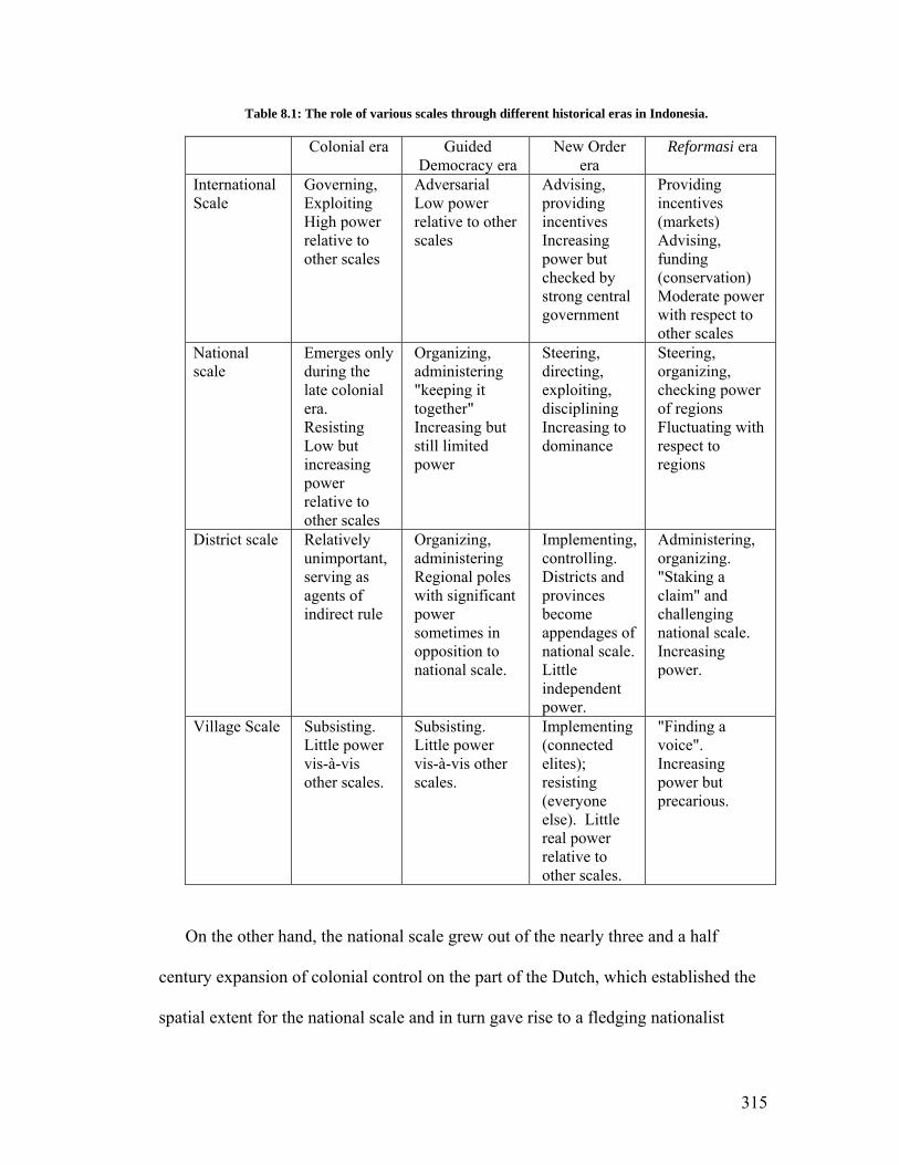
Table 8.1: The role of various scales through different historical eras in Indonesia.
Colonial era Guided Democracy era
New Order era
Reformasi era
International Scale
Governing, Exploiting High power relative to other scales
Adversarial Low power relative to other scales
Advising, providing incentives Increasing power but checked by strong central government
Providing incentives (markets) Advising, funding (conservation) Moderate power with respect to other scales
National scale
Emerges only during the late colonial era. Resisting Low but increasing power relative to other scales
Organizing, administering "keeping it together" Increasing but still limited power
Steering, directing, exploiting, disciplining Increasing to dominance
Steering, organizing, checking power of regions Fluctuating with respect to regions
District scale Relatively unimportant, serving as agents of indirect rule
Organizing, administering Regional poles with significant power sometimes in opposition to national scale.
Implementing, controlling. Districts and provinces become appendages of national scale. Little independent power.
Administering, organizing. "Staking a claim" and challenging national scale. Increasing power.
Village Scale Subsisting. Little power vis-à-vis other scales.
Subsisting. Little power vis-à-vis other scales.
Implementing (connected elites); resisting (everyone else). Little real power relative to other scales.
"Finding a voice". Increasing power but precarious.
On the other hand, the national scale grew out of the nearly three and a half
century expansion of colonial control on the part of the Dutch, which established the
spatial extent for the national scale and in turn gave rise to a fledging nationalist
315

movement in the early part of the twentieth century (Reid 2004), which would lead to
a direct divorce of national actors from global actors. The national scale only truly
emerged in the 20th century, and then only really gaining significant power after the
departure of the Japanese at the end of the Second World War. As I explained earlier
in the dissertation, the national scale became dominant during the Suharto period, and
all of the other subnational scales were basically appendages of a vertically-
articulated network of command and control. This hierarchy was a crucial part of the
regime's power as virtually all executive officials at all levels down to the heads of
villages owned their positions either directly or indirectly to the Ministry of Home
Affairs in Jakarta, and by extension the Suharto regime. The regional poles that had
existed during the Sukarno years were pacified and emasculated, replaced with
provinces and districts that were firmly embedded in Suharto's network. The powers
of this expanded national scale during the Suharto administration included
envisioning priorities and making and implementing policy as noted in table 8.1
("steering, directing, and implementing"). Thus during the Suharto years the national
scale was by far the most powerful, and there were no serious challenges to its
dominance from either the village or global scales. This configuration is illustrated in
figure 8.1.; note the conspicuous absence of the district scale but the presence of the
village scale. In this dissertation I have described the village scale as independent of
other scales. The village scale in Indonesia has emerged from the histories, cultures,
and actions of local groups in places like central Sumatra, where since time
immemorial the village has been the fundamental unit of production and social
organization. Prior to the Suharto period I have characterized the role of the villages
316

mainly as "subsisting". I do not mean here to trivialize the role of villages nor to treat
villages as homogenous entities, nor do I imply that all the thousands of villages
across the archipelago are or ever were the same. Rather my point is that during the
colonial and Sukarno periods, the ability of villagers to articulate their priorities and
influence over events transpiring at higher levels was limited. Historically villages
developed systems of adat to govern life within the village, and the details and
nuances of adat varied from village to village.
Figure 8.1: New Order scalar configuration
During the Suharto years however villages became sites of "everyday resistance"
(Scott 1985), especially in terms of the management of natural resources (Peluso
1992, McCarthy 2006). Part of the Suharto regime's standardization triumph was the
institution of the Javanese village system to every corner of the archipelago. This
317

enabled the regime to extend its control to the village level and village heads and
allied officials became the primary implementers of the central government's
developmentalism (Kato 1989, Charras 2005), which was a key element in the
establishment of the Indonesian state. Thus I characterize the roles of the village
scale during the Suharto years as implementation and resistance; though life at the
village level was subject to significant influences imposed from above, village-level
actors were able to exert some control over their day-to-day situation. I have shown
in this dissertation that the end of the Suharto regime brought an end to the New
Order scalar configuration, which has been replaced by new relationships and power
balances.
However, the reconfiguration of scale in Indonesia began prior to decentralization
with the onset of the Asian Financial Crisis, which had two very important impacts.
First, it helped hasten the fall of the teetering New Order, which ushered in the
Reformasi era. Secondly, because of the havoc wrought on the Indonesian economy,
the leverage of multi-lateral neoliberal institutions operating at the international scale,
such as the World Bank and International Monetary Fund, increased such that they
were able to wield more influence over the national government and hence the
process of decentralization. International norms of democratization working through
neoliberal understandings of the form and function of democracy helped to guide the
remaking of the Indonesian political system and the process of statemaking in reverse
(Hadiz 2003; Firman 2009).
After the fall of Suharto the establishment of the districts as a scale of great
influence and power (figure 8.2) was completed through several key pieces of
318

legislation. Act 22/1999 divided sovereignty by transferring responsibility to
subnational scales of government. This was the first step in creating new nodes of
stateness. Act 25/1999 created legitimate and official pathways of access to state
resources at the sub-national level. These two acts reconfigured the identity of the
state, but it was democratization, which was truly completed with the passage of Act
32/2004 that achieved the division of sovereignty by making sub-national executives
(governors and district heads) directly elected by their constituents, thus completely
severing the links of upward accountability that had made them beholden to national
officials during the New Order. These legislative instruments empowered new actors
and provided them with a halo of "stateness", a kind of aura of officialdom that gives
certain actors or interests special access to quite specific and exclusive tools and
means to accomplish their objectives. Thus sovereignty has been divided, the state
fragmented, and a whole new constellation of relations and interactions between the
various scales has emerged. New political space has been opened up at the district
level, and perhaps most importantly the type of politicking required of ambitious
elites desirous of access to "stateness" and all of the associated spoils of office has
changed dramatically; whereas during the New Order the path to power ran through
Jakarta, now it meanders down the windy and rocky roads connecting the villages and
subdistricts. In addition to these sweeping acts, Government Regulation 129/2000
created a procedural mechanism whereby additional subnational nodes of stateness
could be created through the establishment of new districts and provinces. This
process was described in chapter 4, along with the incentives that have lead to this
process spiraling out of control.
319

Figure 8.2: Post-authoritarian scalar configuration
This new scalar configuration is accompanied by new and altered linkages,
particularly between the international and national scales. Not only can actors at the
newly empowered district level confound arrangements made between national and
international actors (notably in the arena of conservation), but also because of the
devolution of control over non-protected natural resources, the districts have a more
direct connection with actors at the international level, most applicable here in the
area of extractive activities. Though this point will be more fully developed in a
following section, it is important to note here that this creates an area of difficulty for
the dominant approach to conservation activities in that international scale
conservation interests are typically accustomed to working through national scale
320

institutions, and they have thus far not adjusted to the new scalar configuration.
Many factors contribute to this bias towards working with the national scale, but
Bryant and Bailey (1997) suggest that it is rooted deep within western political
thought, beginning with Hobbes's Leviathan and the assertion that an authoritarian
state is required to regulate and mediate conflicts over scarce resources. This is
particularly interesting and relevant when juxtaposed against the reemergence of adat
systems of social organization and resource management. Another key point relates
to the scale at which incentives and markets operate. Because of the decentralization
laws districts have more say in how natural resources are managed, and so this also
creates incentives for outside investors to work through districts rather than the
national government. In many cases it is only outside investors that have access to
the types of startup capital and expertise needed to exploit natural resources on a
medium to large scale. Moreover, although Sumatra's economy is heavily reliant on
primary sector activity, there are few markets for these resources on the island, and so
products such as palm oil, coal, rubber, and cinnamon have to be exported, either to
Java or to an international destination. This new linkage is potentially problematic
because the districts don't have the same capacity in terms of planning and oversight
as the national government, and even though the districts stand to gain from these
new connections, in most cases they likely don't have the technical know-how or
institutional capacity to ensure the sustainable development of natural resources, nor
do they have the regulatory capacity to ensure that outside companies are adhering to
applicable regulations.
321
Also worth noting is the altered relationship between the national and village
scales. During the Suharto years the relationship between the villages and the
national government was one of coercion, resistance, and compromise, but now under
the Reformasi scalar configuration there are new coalitions forming between actors at
the district and village scale. As I have shown in several instances there is a
convergence of interests (chapters 5, 6, and 7) between district and village elites.
Though there are major limitations (see below), village scale actors at least have some
input in the formal political arena, whereas during the Suharto era they had virtually
none. A major change resulting from this lies in the official perception of forest
"crimes" on the part of village scale actors. Under the Suharto regime, many
livelihood activities that had been going on for decades and even centuries were made
illegal. Though in many cases these activities continued, they had to be executed on
the sly due to the New Order's enforcement mechanisms. However, in the post-
authoritarian era the big change that has come with the emergence of the district as a
node of stateness and sovereignty is that these rule breakers now have a degree of
official legitimacy and support from newly empowered district officials, who are in
many cases seeking to control the rule breaking themselves. Rule breaking in the
form of encroachment is now much more widespread and out in the open, and as we
have seen villagers in some instances have even physically challenged park rangers.
In this way there is a two-way flow of benefits and support between actors at the
village and district levels. First of all, candidates for district office visit villages to
curry favor and distribute gifts and bribes in exchange for support. Village heads
thought to have the power to mobilize blocks of voters in some instances may be
322

promised a position in the district government in exchange for helping a district
headman get elected. The district patronizes the villages and in exchange the village
supports the district elite. The district elites, due to the powers devolved through
decentralization, have a great deal of influence in channeling benefits to villagers,
which can be used as both a carrot and stick.
In several of the preceding chapters I have described the form this takes around
KSNP in terms of political processes. Longstanding complaints against the park
harbored by villages on its periphery have been taken up by district politicians,
especially when there is synergy between the aims of district elites and the aspirations
of the villagers. This is most conspicuous in the case of proposed roads where
relatively remote villages have long petitioned for infrastructural upgrades that would
allow them greater access to markets. Local elites appropriate these aspirations and
fold them into proposals for larger road projects that would bring greater benefits to
the district elites. Another form of scalar interaction between the districts and the
villages relates to access to resources: in exchange for support district politicians
tolerate, encourage, or promise to protect villagers who encroach into the national
park and convert forests. In some more egregious cases village heads that have close
ties to the district leadership are granted a sort of franchise to sell land within the park.
This is found in some areas where encroachment is most marked.
In summary then this rescaling is altering both formal and informal political
processes at the district level and below. Formal elements are those that are codified
in laws and include aspects such as choosing leaders and decision makers. District
and village heads are now directly elected by their constituents, making them at least
323

nominally downwardly accountable. Another formal process that has changed is
district level spatial planning. Now district planning offices (BAPPEDA) have been
largely decoupled from the national hierarchy and are responsible for formulating
medium and long range development and spatial plans the their districts. Though
these offices are generally staffed by trained professional bureaucrats, leadership
decisions are left up to the district head, and so the general direction of planning has
been politicized. Lastly, related to these two aspects, the formation of policy
priorities and district imperatives is controlled by district level actors, whereas
previously under the New Order there was a high degree of standardization in terms
of development planning. There are also changes to informal aspects of politicking,
including networks of collusion, cronyism, and nepotism. Informal decision making
power as to who has access to natural resources, including who benefits and how
those spoils are divided are made at the district level as well. These outcomes are the
subject of the next section.
8.2.2 The Legacies of Dysfunctional Decentralization
In the introductory chapter I described the general characteristics of the
decentralization laws, and in subsequent chapters I discussed the processes of
decentralization and democratization in Indonesia. These processes are still
unfolding, and there is no real indication that the numerous disputes between the
different levels of government in Indonesia regarding decentralization and how it will
be implemented. Therefore it is probably best at this point to think of
decentralization as a permanent fixture of Indonesian politics rather than as a phase or
324

transition through which the new democracy must pass on its way to stability. This is
because the reforms have divided sovereignty, creating sub-national nodes of
stateness. As an analogue, one might think of the distribution of power between the
states and the federal government in the United States. Over time the balance of
power has shifted back and forth. Moreover, this balance isn't uniform across all
sectors of government; on occasion the states are able to challenge the federal
government on certain issues (for example, the recent legalization of recreational
marijuana in Colorado), and sometimes the federal government asserts its will (as in
the case of the Civil Rights Act of 1964). However, whereas this divided sovereignty
is seen to be a strength of governance in the United States, there are some aspects of
decentralization in Indonesia that have so far constrained the anticipated salutary
effects of reforms there. I refer to these aspects as legacies of unfinished (or
dysfunctional) decentralization.
One of the main legacies is that it is often in the best interest of political leaders at
the district level to disobey the central government, or at least to advocate policies
that are opposed to or undermine the directives and policies of the central government.
Examples of this include proposed road projects (chapter 5) and the way district
headman have handled large scale agricultural encroachment (chapter 7). In these
cases district leaders don't suffer any consequences from the central government, and
they only stand to lose if they comply with the central government, in which case they
stand to lose money and political support. The unfinished legacy of dysfunctional
decentralization indicated here is the lack of an effective legal mechanism or
325

institutional checks and balances which would compel district governments to enforce
the national law. In short there is a general lack of upward accountability and review.
A second legacy is the uncoordinated nature of district policies resulting from
administrative fragmentation. Due to the structure and form of decentralization,
districts are for the most part on their own in terms of policy formation and setting an
agenda for economic development. In the lead up to decentralization there was
virtually no capacity building, and so the districts have been the recipients of new
responsibilities that in many cases they do not have the capacity to fulfill. Moreover,
due to the vertically articulated nature of the different scales of government in the
Suharto years, there is very little coordination between the districts, and so there are
cases of inefficiencies and redundancies in terms of infrastructure and other projects.
The lack of horizontal coordination also leads to intentional and inadvertent cases of
"beggar they neighbor" policies, as in the case of deforestation in upstream districts
leading to ecological and economic problems in downstream districts. Related to this
is the emerging reality that districts often compete with one another for investment
and in some cases have initiated infrastructural projects in order to poach commerce
from a neighboring district157. The result of this is that individual districts may
benefit, but in the aggregate the broader region, and the country in general, is worse
off.
A third legacy is evident from my examination of administrative proliferation
(chapter 4). Safeguards to prevent abuses of the decentralization laws have been
157 One example from my study area that has emerged in just the past few weeks is that the government of Kerinci district wants to build a new road to the coast so that traffic between the coast and the interior will bypass the administrative municipality of Sungai Penuh, which currently serves as a regional distribution hub.
326

written into regulations, and the central government has made an effort to reign in
excesses on the part of the district governments. But in many cases these safeguards
and rules have not been applied, or can easily be circumvented by elite coalitions.
Because of this administrative proliferation has spun out of control because all of the
in-practice incentives support the creation of more and more districts. The result is
that administrative proliferation has become a tool to advance elite interests, and the
original intent of the law, which was to improve the efficiency of government and
citizen access to government services, has been subverted. I have shown that
administrative proliferation in some cases has even lead to a decrease in efficiency
and service provision. There has been a general lack of oversight and enforcement.
Decentralization also needs to be considered in the context of the vacuum of local
accountability and resource management institutions that was created by the Suharto
regime. It is tempting to say that decentralization has been responsible for increased
pressure on natural resources, because in a sense it has, but it is crucial to understand
the importance of the historical drivers that set the stage for this dynamic as well.
There has been a major change in terms of the structure of resource management on
Sumatra over the past century. As noted in the introductory chapter, this began with
the Dutch as they improved transportation networks in the region of central Sumatra
and opened up places like Kerinci Valley, which brought along with it deeper
integration with the global economy. And although this began a general move away
from subsistence agricultural patterns to market-oriented production (Polanyi 1944),
it was not until the emergence of the New Order that local people really began to lose
control over their resources as the Suharto regime passed laws that not only usurped
327

claims over land and resources, but simultaneously dismantled and marginalized
indigenous systems for managing these resources. While it must be emphasized that
these adat systems were for the most part not strictly conservationist, they emerged
from a socio-economic context in which the benefits from extractive activities had to
be balanced against the environmental bads, which were internalized locally, and in
which access to local resources for outsiders was tightly controlled and regulated. In
other words, the positives and negatives of extractive activities were linked and
experienced at the same spatial and sociopolitical scale. The changes to the system,
which included the Basic Forestry Act of 1967 and the Village Act of 1979 meant
that local leadership, both in the villages and the districts, was rooted not in local
sociopolitical context but instead was imposed from above with local leaders being
agents of and subservient to priorities emanating from the national scale.
The aforementioned vacuum was created when the New Order ended, and it
became a space into which self-interested elites, who to a large degree had been
constrained by their positions as lower-order functionaries in the Suharto hierarchy,
could expand their access to state resources given the structure and form of the
decentralization laws without having to worry about local political structures such as
adat which might have limited their ability to pursue their own interests without
regards to other stakeholders in the community. Many of the excesses, especially
with respect to KSNP, should be considered inevitable effects of this historical
process, which systematically eliminated capacity and metis (Scott 1998) at the local
level. Now there are virtually no checks on those that are able to gain control of
district governments, as they are now free to reach agreements with investors to
328

exploit the natural resource riches of Sumatra. The results can be seen in the boom in
coal mining, exploration, and oil palm cultivation that has swept across central
Sumatra. The penetration of capital into the mountains and forests of Sumatra also
coincides with and is facilitated by rapid industrial development in China, which is a
ready market for coal and raw materials extracted from the Bukit Barisan mountains.
In short there now exists a wide range of incentives and drivers for increased natural
resource extraction, but for the most part there are no structures or incentives for
sustainable or responsible extractive activities that might serve to balance these
pressures.
8.2.3 Positive outcomes from Decentralization?
Most of my dissertation (and probably 95% of all of the literature on
decentralization in Indonesia) has focused on the negative aspects of decentralization
and democratization with respect to conservation, forest resources, and national parks.
It is the stock and trade of scholars to focus on problems, especially for dissertations
and research papers. However, I feel that I would be remiss if I did not point out
some positive aspects of decentralization. In the preceding chapters I put significant
effort into describing the contentious politics in the districts around KSNP.
Democracy has certainly flourished at the sub-national level in Indonesia as
evidenced by the number of candidates standing for election. This indicates that a
certain amount of downward accountability has indeed emerged since the fall of
Suharto, and so it can be discerned in the actions of district governments that they are
indeed responding, at least nominally, to the will of the people, which is a very
329
hopeful development for decentralization158. District governments are trying to
figure out ways to make people more prosperous, or to improve services (even if it i
just lower level services like transportation networks). When all is said and done, it
really is difficult to make the argument that roads, or more land for cultivation are not
in the best interests of the people of central Sumatra, at least in the short term, and s
the actions of district governments, regardless of how corrupt they are, are in
response to perceived needs, which is a major change from the Suharto years. And
keeping with the optimistic mood of this section, an argument can be made that the
issues with corruption will be sorted out over time, as the central government
increases its monitoring and enforcement capabilities, and perhaps more important
as voters become more sophisticated and begin to demand higher levels of
performance from their elected officials. Moreover, it has been noted (Ufen 2009)
that political parties have thus far failed to serve as aggregators of interests, but
emerging civil society is having an effect in many places and thus we might expect t
see the parties mature somewhat in the coming years. It must be remembered that the
centralization project in Indonesia took the better part of four centuries, thus we
should admonish ourselves to have patien
s
o
in
ly
o
ce with decentralization.
District governments have been responsive in providing roads, but unfortunately
for KSNP these are in conflict with the conservation mission of the park. Roads
encourage encroachment, and so in this way what is good for decentralization and
improved service delivery is bad for the park. One district headman that is routinely
vilified by park staff made the point clear to me during an interview. He told me that
158 I would add to this that a new breed of politician is emerging, one that seems to genuinely feel a commitment to public service. The mayors of Jakarta and Surabaya are the embodiment of this new type of political figure and they have been embraced enthusiastically by voters.
330

he started as a farmer, and so the most important priorities for him have been to make
things easier farmers and to build roads for them. He recalled that when he was
younger farmers had to carry their produce to market on their backs, but then came
smaller roads and so they could start using motorcycles. He said he looked forward
to the day when farmers were able to use their own trucks to haul their produce,
because this would be a symbol not only of infrastructural improvement and
modernization, but also of socioeconomic improvement because it would mean that
the farmers were producing more and making more money. This is the crux of the
fundamental incompatibility between development and conservation as it is
manifested in the Reformasi era at Kerinci Seblat National Park.
8.2.4 Will decentralization continue to benefit villagers in the long term?
These points have to be judged against actual outcomes though. As it currently
stands, one important result of decentralization is that it has provided to people that
previously had no access to power opportunities to form and join coalitions that
enable them to access and redefine state resources. The decentralization of power as
well as the associated laws that enabled administrative proliferation have created new,
more local bases of power and influence independent from the national government.
However, there are limits to this new power, especially for people living in villages
because decentralization has not empowered them directly, but has given them more
indirect influence in certain issues in which they can be used as levers by newly
empowered districts interests. I have shown several cases that support the point that
villagers benefit so long as their interests converge with those of district elites, but
331

there is great potential for these interests to diverge, in which case the district
interests will trump the village interests. In other words, I have shown how villagers
have become proxies in the ongoing power struggle between the central government
and the districts. As noted by Agrawal and Ribot (1999), as important to the success
of decentralization as adequate financing and the types of powers devolved is the
question of to whom powers are decentralized. Thus far from a practical perspective,
formal powers have been decentralized to district elites who have leveraged them to
increase their informal powers through networks of patronage and corruption. Thus
the goal of creating the conditions necessary for successful decentralization of
management authority to stakeholders that would in theory have incentives to
sustainably manage those resources has been thwarted, as it is still the case that the
costs and benefits of extractive activities are delinked. One could make the case that
it would be more promising to decentralize power to adat institutions, and the recent
Constitutional Court decision discussed in chapter 7 opens the door for this, but the
fact remains that the official fate of adat institutions remains in the hands of district
elites. From this perspective decentralization can't yet really be considered a success,
because instead of empowering local people, it has provided opportunities for local
elites.
8.2.5 A Final Legacy: KSNP as an Impediment to Decentralization
A major theme of this dissertation has been that the Ministry of Forestry and
Kerinci Seblat National Park have served as barriers to effective decentralization by
exacerbating the overall weakness of Indonesia's decentralization efforts. There are
332

many reasons for this, some intentional and some structural, but probably the most
important factor is that the Ministry of Forestry, which has long been resistant to
decentralization, is attempting to protect its turf. The 1967 Basic Forestry Act was in
effect the largest land grab in the history of the archipelago, and the establishment of
the MoF in the 1980s made it one of the most powerful organs of the New Order
apparatus. The control of trees and land was central to the Suharto regime, and so the
MoF occupied a privileged position. With the emergence of the carbon economy,
forests are taking on new value, and so control of this resource allows the MoF to
solicit funding from international donors for carbon sequestration activities, which
could potentially be extremely lucrative. Protected areas are one of the last bastions
of complete control for the MoF, and thus the ministry is reluctant to cede any power.
Because of this intransigence the park is at odds with the decentralization movement.
It prevents district governments from developing natural resources to increase their
locally generated revenue.
Along with the theme of the park serving to inhibit decentralization is the
corollary that the MoF and the park have not participated in guiding the process. This
is a key consideration that has been overlooked in most analyses of decentralization
and forest resources. These institutions for the past fifteen years have for the most
part been sitting on the sidelines while Reformasi unfolds, sporadically and often
unsuccessfully reacting to transgressions here and there. An example of this is the
way that the MoF handles the road proposals. It is not politically tenable for the
Ministry to completely reject the proposals out of hand because of the caveat in Act 5
of 1990 that governs protected areas that projects initiated in national parks need the
333

approval of the Minister. This creates the potential for exceptionality, and the
districts argue that their various circumstances constitute grounds for exception.
However, the MoF has no standardized procedure and no guidelines for scrutinizing
road proposals, so the districts argue that the process is unfair and capricious because
they don't know what they are supposed to do to secure approval for roads. The
process is less-than-transparent and potentially highly susceptible to corruption
because roads are treated on an ad-hoc, case-by-case basis. The Ministry could
rectify this problem by establishing a formal, codified mechanism to review road
proposals, including a list of studies and documents such as feasibility and
environmental impact studies that have to be done prior to application for a road
through the park. These guidelines would include descriptions of how these studies
should be conducted, along with a list of approved bureaus or institutions to conduct
the studies. This could reduce the possibilities of collusion between the local
government applying for the road exception and the instituted conducting the study
while at the same time serving to indirectly improve capacity at the district level.
However, at the time of writing this chapter the Ministry was lagging in
developing procedures and policies for dealing with district governments around
protected areas, instead falling back in most cases on Act 5 1990, an approach that
seems not to grasp the new realities of decentralization. As a result, most of the
interactions between the park and the districts are adversarial, at least in part due to
the fact that the MoF's intransigence in the face of the current of decentralization does
not allow for constructive interactions between the districts and the park. The
manifestation of this on the ground is that the districts are essentially testing the park
334

at every opportunity, informally looking for weaknesses and ways to undermine the
park, so the park's managers are constantly fighting a rearguard action against the
districts. An important overall point here is that conservationists and park managers
can passively choose to have the terms under which they work to conserve nature
dictated to them as the processes of decentralization and democratization unfold, or
they can take steps to anticipate changes and thus to make the park more relevant to
local and district powers. So far they have chosen the former course of action while
new political-administrative practices, norms, and traditions are established at the
district level. The longer the Ministry of Forestry waits to engage with the districts in
a more constructive manner, the more difficult it will be for it to counteract some of
the practices that directly and indirectly affect the park. In fact, the cases of Gunung
Tujuh and Lembah Masurai (chapter 7) indicate that in some cases it is already too
late. In practical terms this may have the longer term effect of limiting future options
for the park, especially in terms of community-based or co-management strategies.
The reason for this is simple to grasp; as noted in Chapter 6, the MoF and the park
have taken very small steps to increase the role of local people in certain aspects of
the park's management. As I pointed out, these efforts so far focus on
implementation types of activities, and so no substantive management responsibilities
have been devolved to local communities or the districts. But if in the future it
transpires that the MoF, working through the park, decides to involve local people
more substantially, this will likely involve some form of negotiation with local
communities (possibly resembling the village development component of the ICDP)
whereby greater access and control for local people is contingent upon following
335

certain rules of acceptable use. In the ideal situation this would be a give-and-take for
both sides, with both benefitting from the collaboration. However, if current village-
level trends around the park continue into the future, these types of negotiations
would involve local people giving up their unofficial but very real "rights" of access
and thus would in reality represent new restrictions rather than access privileges. If,
on the other hand, the park were actively engaged with local communities in
formulating co-management strategies that allowed for truly enhanced access for
villagers, the outcomes might be more acceptable. The case of Bangun Rejo is a
useful example; though through the informal "truce" between the park and the
villagers the park has lost some control over a swath of territory, the villagers have
created a "green fence" that seems to represent an acceptable outcome as well as a
limit to their expansion into the park.
8.3 Decentralization, Reterritorialization, and Kerinci Seblat National Park
As noted in the previous sections, the rescaling of politics and administration in
Indonesia is significant for conservation in general because international conservation
organizations often have a preference for operating through the national scale
administratively. The national scale is often taken for granted as the home of the state
and so it is distinguished from the other scales based on the presence of sovereignty,
which corresponds to an abstract but internationally recognized and respected basket
of rights and powers. This has all changed now, but there are some important
legacies. For example, developmentalism was an important characteristic of the
Suharto years, and modernization was an obsession of the regime. Modernization and
336
development took very specific forms during the Suharto years, and this has had
important implications for the trajectory of economic development on Sumatra. This
enamorment with developmentalism has carried over to the post-authoritarian era and
forms the foundation of the primary aspirations of the populace, at least as voiced
through the filter of political campaigns. I have shown that this can be seen in the
slogans of the candidates in political contests in the districts around the park.
However, planning processes are more driven by district level priorities now; in other
words the object of development is the district, rather than the national state.
During the Suharto years there was a general flow of benefits from natural
resources from the villagers to the central government (McCarthy 2006) in the service
of developmentalism. Although the New Order regime built schools and clinics in
most of the villages of the archipelago and so it could be argued that the villages
benefitted from Suharto's developmentalism, the negative net balance in favor of
Jakarta and Java is evidenced by the significant asymmetries in development between
Java and the outer islands. In the post-authoritarian era this transfer of wealth has
been challenged, and along with this comes a reordering of the landscape to be more
in line with district level preferences and aspirations. For KSNP this means that there
have been attempts on the part of district governments to redefine the resources
within the park, which have hitherto been officially designated as conservation
resources.
The on-ground-manifestation of rescaling then is reterriorialization. In other
words, villagers and districts have sought to overwrite the territoriality or spatial
ordering imposed by the Suharto regime. Sack (1986:19) defines territoriality as "the
337

attempt by an individual or group to affect, influence, or control people, phenomena,
and relationships by delimiting and asserting control over a geographic area."
Numerous scholars have in the past argued that national parks and other protected
areas are mechanisms of territorial control (Peluso 1992, Bryant 1997, Neumann
1998, Peluso and Vandergeest 2001), but Sack's conceptualization of the "tendencies"
of territoriality is useful for understanding the relationships between state power and
the particular form of conservation practiced in a national park because it provides a
very specific framework for conceptualizing the particular aspects of strong central
government that support the park as a tool of governance and coercion. By using this
framework we can understand how changing the regime of government will
necessarily bring about changes in the role of the park in the political-administrative
ordering. Very briefly, Sack describes ten different tendencies159 of territoriality and
14 combinations of these tendencies, which he used to describe different forms of
territoriality. Beginning with the assertion that national parks are indeed tools of
territoriality, there are at least seven of these tendencies that come together in the
unique and particular combination that is a national park. These are described below,
along with the role that strong centralized authority plays in the functioning of each.
a. Classification. This refers to the assigning of roles or functions
to spatially-delineated units. Parks classify territory with systems of
zonation (e.g. core zone, special use zone, forest zones). Moreover,
parks themselves are often classified as biodiversity hotspots or are
159 The three tendencies not discussed below are "Neutrality", "Emptiability", and "Engendering more territoriality".
338

given roles and meanings within larger global or national scale
frameworks. In the case of parks central authority is important for
coordinating the classification function because it provides the broader
framework in which to situate the park as well as the coercive power
and coordination required to do so.
b. Communication. Parks communicate their mission as well as
rules of use and access through the use of uniforms, signs, and border
markers. Since KSNP is so large and overlaps so many district and
provincial jurisdictions, central authority is essential in creating a
"super-jurisdiction" that transcends more local scale territorial units.
c. Enforcement. Enforcement of park rules relies on laws, codes
and on-the-ground actions of forest policemen. Throughout this
dissertation I have shown the importance of central authority for
enforcement at the park. Even the smallest villages have forms of
territorial enforcement, but in the case of KSNP central authority is
essential for carrying out the enforcement function and imposing the
central government's conservation agenda on more local patterns of
land use, both formally and informally.
d. Reifying. Parks are a symbol of state power and the state's
claim on resources, and in some cases they are a symbol of national
339

identity. The designation of a conservation area as a "national" park
explicitly signals that the territory is the property of the entire nation.
The role of central authority in this case is obvious: the park is a
national possession and thus part of the state's conservation identity.
As such the central government has the backing of actors and
institutions operating at the international scale in establishing the park.
e. Displacing. Displacement refers to the ability of a territory to
distract the attention of the subject of the exercise of authority away
from the agent that is exercising power. Thus in the case of national
parks and other protected areas, the displacement function means that
subjects' behavior within the territory is conditioned by the territory
itself rather than the authority behind the territory. This idea has been
popularized by Agrawal (2005) as environmentality. For example, if
the subject thinks the "we do not hunt in this area because it is a
national park" rather than "we do not hunt in this area because the
central government has forbidden hunting", then the displacement
function is effective and people become self-regulators. It should be
noted that this function is generally much more effective in first world
parks than in developing countries. But in Indonesia the case can be
made that another, slightly more convoluted (but equally valid) form
of displacement is as work. Here state forests have attempted to
"displace" by conditioning subjects that forests have ecological
340

benefits. This serves to distract attention away from the fact that forest
resources have in the past been territorialized to reserve the extractive
benefits for those with privileged ties to the ruling regime. In the case
of protected forests like parks there are benefits not from logging but
rather from conserving, but these accrue to the state as well. In other
words, the benefits of protection forests have been set aside for actors
and interests at the national or global scale, but the designation of the
forest as a conservation area is a subterfuge to distract locals from the
reality that they are being excluded from the benefits. The role of the
central government in displacing is also fairly obvious.
f. Impersonal. Parks exhibit the "impersonal" tendency because the
forest police and park administrators are tasked with controlling a
particular territory, rather than a group of people, but the ultimate
outcome is the same. Thus the relationship between the controller and
the controlled is impersonal and technical. Central control has been
quite important for this function in Indonesia since in most cases park
administrators have been assigned from Java, and they are periodically
transferred to other parks. It could be argued that impersonal
administration of a national park is essential because the park by
definition is removed from local patterns of land use and is
incorporated into national and global networks of conservation.
341

g. Container/Mold. Parks embody the container/mode tendency
because they are specific spatial units set aside for conservation.
Moreover, parks can become a target for international aid or
recognition. The park becomes the place where conservation is
"done"; it is an internationally recognized space for a certain set of
activities. Central authority is essential for facilitating and
coordinating this container/mold function as international donors and
aid agencies typically operate through the central government.
Sack (1986:28) goes on to argue that "certain historical contexts will draw upon
specific potential effects and in a very general sense match historical contexts with
territorial effects." A strong argument can be made that this is indeed the case with
the national parks of Indonesia. Each of the aforementioned tendencies is predicated
on a strong central authority to legitimize, or at least compel local people to obey, the
rules of use and the definition of forest as conservation resources. Thus when seen
from this perspective, it is clear that parks are a territorial product of a particular
historical epoch: the New Order, and the creation of the park in the 1980s and 1990s
can be seen as a form of reterritorialization itself whereby the central government
used its coercive power to set aside the park as a conservation resource, whereas
previously the area was classified by locals in different ways. As noted in chapter 6,
Neidel (2006) describes this as the "erasure of memory" in which the park, or more
accurately the power behind the park attempts to overwrite local conceptions of the
342

landscape. The central government's definition of the territory has national and
international legitimacy, whereas the local narrative has no voice and no legitimacy.
Now that the authoritarian foundations of national parks as a strategy of
territoriality have weakened, elite interests in the districts and provinces around the
park have been engaged in efforts to "reterritorialize" the park. This includes at least
two ongoing processes. The first of these is the redefinition of resources within the
park. This is a largely informal process that works through various forms of subtly
undermining the park, including direct action as well as through discourse. This can
be observed in the way that district officials talk about the park. There is a very clear
framing of the park as an obstacle and a burden that exists primarily for the benefit of
outsiders, a framing that is echoed by district headmen, assembly members, and
bureaucrats. Statements and sentiments trickle down from charismatic political
leaders through village heads and finally down to individual farmers themselves,
forming a current of resentment and resistance. On the other hand, the most obvious
visual manifestation is the increase in encroachment, which is fundamentally different
from illegal logging, which, prior to the fall of Suharto, was the primary problem
facing the park. Whereas illegal logging (which in the case of KSNP is and always
has been non-mechanized and involves the select cutting of trees) is a "cut and run"
enterprise that leaves the forest, for the most part, intact, encroachment is a claim on
the land that involves the clear-cutting and burning of forest over a certain parcel of
land, and subsequent maintenance of whatever is grown there. Encroachment
changes the function of the land as a resource. At first glance, encroachment seems
to be the work of thousands of independent farmers moving into the park, but upon
343

closer inspection, as I have noted in chapters 6 and 7, new waves of encroachment are
motivated by and are inseparable from forces and processes unleashed and
empowered by decentralization. The encroachment that is besieging the park can
only be properly understood in the context of these political processes.
The second process is to integrate the reterritorialized space and the resources
held within it into larger existing networks and the establishment of new
connectivities, which district governments are attempting to effect through formal and
informal channels. The creation of parks and subsequent laws and implementing
regulations also created no-go zones in terms of roads, and thus created what I here
will describe as "negative connectivity"; this refers to legally impassible areas which
in some cases overwrote traditional trading routes. Though at the time the
implications of this were not as severe as they are now since people were still getting
around by hiking, these no go areas would become spaces off- limits to development,
and so as the rest of the territory was "modernizing" these areas were not. The
villages of Renah Kemumu and Tanjung Kasri are examples of this process. In the
logic of centrally-guided development planning and implementation, these
inequalities can be understood as part of a larger plan. In other words, from the
bird's-eye view of the Jakarta-based elite, underdeveloped areas fulfill the expectation
that certain spaces will be set aside for conservation. However, in the context of
decentralization and democratized Indonesia they become fodder for populist politics,
as well as political spoils because the resources are still largely unexploited. New
roads promise to open up new trading opportunities and to link up communities that
had been separated by the park. As discussed in chapter 5, roads are visible symbols
344

of economic development and opportunity, but according to conservationists and the
Ministry of Forestry they are incompatible with the mission of the park. District
governments however remain undeterred and the roads remain central elements in
political contestation at the district level.
8.4 Rethinking protected areas
Daniels and Basset (2002:483) asserted that the standard design of "conservation
territories [e.g. national parks] needs to be rethought in light of the land and resource
use patterns of local people and the ecological and social dynamics influencing
resource management that commonly transcend these rigid boundaries." This
statement is part of a general current of political-ecology critique of protected areas,
part of which I alluded to in the preceding chapters. Much of this critique is rooted in
the perspective of social justice and advocacy; many political ecologists have
identified the myriad ways in which protected areas have disadvantaged and
marginalized local scale actors. In some instances protected areas have been used as
a tool of domination, in other cases this marginalization has resulted from the
structural characteristics of conservation that is driven primarily by priorities
originating at the national and international scales. My analysis has demonstrated
similar findings for the case of Kerinci Seblat National Park and the people living in
and around it. However the "rethinking" that political ecologists have called for is a
moral call, hence the appeal is to actors at national and international scales to adjust
their practices and approaches towards the helpless subaltern masses that are
figuratively swept under the carpet by conservation interests. In real terms this would
345

require powerful stakeholders to relinquish some of their power over natural
resources. One of the major conclusions of this dissertation, though, is that Reformasi
in Indonesia is forcing this rethinking from a practical perspective rather than a moral
one. In explaining this conclusion I will tie together a number of the themes from the
dissertation.
Protected areas are a particular and peculiar type of policy tool, one that has
generally relied on a high degree of central government control and coordination.
McCarthy and Zen (2008) point out that policy tools take their meaning from the
specific legal, social, and cultural context in which they operate. Authority tools
involve statements backed by the authority of governments that grant permission,
prohibit, or require action under designated circumstances. Thus a policy tool that
might be useful in certain political milieus might not be appropriate for others. I
have shown that Indonesia's national parks were established during the authoritarian
New Order regime, and their establishment and management bear the characteristics
of the authoritarian regime. Decentralization has altered the kinds of policy
instruments that can effectively be used by the various levels of government, and so if
an agency chooses the wrong type of policy tool, one that is inappropriate for the
specific social and cultural context in which it is applied, there is an increased risk of
failure and backlash.
If one considers KSNP from this perspective, several key observations can be
made. One of the most important is that the park, as it has been implemented, has
created a gulf between local people and the resources that sustain them. It has
contributed to the undermining of important social capital institutions such as adat,
346

which served the purpose of excluding outsiders and controlling extractive pressures
on forests and other natural resources, which has been widely recognized as a key
prerequisite for sustainable community natural resource management. The result is
that there are currently few incentives for local people to sustainably manage the
forest, as their informal access and tenure is, from their perspective, precarious since
it is subject to the caprices of the district government. And even in cases where there
have been efforts to encourage sustainable management (e.g. programs run by local
NGOs), these efforts have encountered resistance from the park and are contrary to
the political realities of decentralization. Consequently there is a high discount rate
for investment in sustainable use of land, making it impractical and really against the
best interests of local people.
The concept of the national park should also be considered in the context of the
general theme of rescaling. Scale is important because in many cases it encourages
decision makers to think about problems and their solutions as bounded by a
particular spatial resolution (Mitchell 1995). For example, the existence and
widespread use of national parks encourages us to think about the solution to issues
like environmental destruction, the loss of biological diversity, and the increase in
greenhouse gases as being contained within the protected area. As noted in my
introductory chapter, this is a form of bounding or bracketing (Scott 1998). This is
limiting because it prevents us from thinking about the broader socio-economic
context and backcloth from which the problem emerges and in which it is situated.
National parks tend to encourage a certain epistemological approach whereby
conservation has to transpire on a large scale in a demarcated territory and be
347

governed by the State; it has to be a big, centrally-directed endeavor rather than
something more local and decentralized. And even when conservation works through
local actors and decentralized networks, it is still driven and directed by priorities
originating from higher scales (see chapter 6). Along these lines the national park
creates an artificial scale such that any given environmental problem becomes
territorialized; in other words the problem is obscured and the solution becomes one
of protected the integrity of the national park rather than addressing the actual
environmental issue. The conservation territory becomes the site of the solution to a
global problem that has its roots in independent and uncoordinated actions of billions.
For states it is much easier to regulate a territory from this perspective rather than
attempt to alter patterns of consumption and livelihood that could have potentially
significant economic and political ramifications. In this way it is easy to get caught
up in encroachment and other border transgressions, but in this way we are thinking
of the integrity and form of a territory rather than the structural drivers of
deforestation, biodiversity loss, global warming, and so forth. Encroachment then
goes from being a local transgression to being a crime against global resources. In
other words, the magnitude of the transgression is magnified by the characteristics of
the territorial unit in which the transgression occurs. This compartmentalization
benefits entrenched interests and those that are in power because it distracts attention
away from the way that ecological problems are produced by the everyday structure
and function of society, which simultaneously produces the entrenched interests. And
it distracts us from other solutions which might be more compatible with
decentralization and might be more effective.
348

A more fundamental problem is that Kerinci Seblat National Park is currently at
odds with the development trajectory of rural Sumatra, both in terms of historical
development as well as the future strategic national plan for the economic
development of the country as a whole. Because of historical factors and the
structure of decentralization, the districts are always going to seek to exploit natural
resources because the structure of decentralization incentivizes extractive activities.
However, this requires investment from outside capital, which seeks a reliable return
on investment, which in turn is partially dependent upon considerations of economies
of scale and transportation costs. Therefore districts that are not burdened with a
national park, that have more formal control over their territory, will most likely be
more competitive in attracting capital. Mining operations, exploration, and many
other activities are likely going to prefer to locate themselves in places without strict
restrictions on land use. Not only is this bad for district development, but it also
means that less money is available to local elites for kickbacks and corruption. As
noted in chapter 6, a more optimistic future might emerge for the park if Sumatra
experienced a high level of economic development and underwent at least a partial
transformation from the primary sector to a stronger mix of secondary and tertiary
sector activities, but the institutional and structural characteristics of the political
economy of Sumatra are working against this brighter future.
8.5 Conclusion
This dissertation has described a number of issues from general questions
regarding decentralization to more specific ones focusing on the appropriateness of
349
current management practices at Kerinci Seblat National Park. I have provided an
overview of the status of decentralization fifteen years after the passage of the initial
acts which initiated the process, including an examination of some unfinished
legacies of decentralization as well as unintended outcomes stemming from the
reforms. As far as KSNP is concerned, decentralization has empowered predatory
elites who have two main goals vis-a-vis the park. The first of these stems from the
exercise of these elites' informal powers and influence: controlling the structure of
rule breaking in and around the park (Robbins et al 2009) in order to maximize
benefits to themselves and their political networks from access to natural resources.
The second goal is a more long term project and involves controlling the terms
whereby outside capital in the form of investment money penetrates the districts.
From the perspective of district elites as well as most everyday citizens, the park is an
impediment to regional development that has functioned to frustrate the progress of
decentralization.
The issues that have emerged in Indonesia are examples of a more general tension
between conservation and democratization that stems from an interesting double
movement. As conservation gets scales up via networks of protected areas and
hotspots, government and democracy is scaled down through a general trend of
decentralization. This downward movement associated with decentralization is in
direct contrast with the context in which national parks are conceived. In general
trends in conservation tend to scale up; that is, the priorities and benchmarks involved
in conservation seem to go from smaller to large scale. Authors such as Terborgh
(1999) make the argument that the conservation of nature is a global priority and
350
frame the issue in terms of global responsibilities. Other examples of this include the
notion that forests, oceans, national parks, etc represent a "global commons," as was
voiced at the Rio Summit in 1992. Neumann (2005) describes how the IUCN is a
manifestation of this discourse. Norman Myers's concept of the "hotspot" (1988,
1990) has entered the popular lexicon and has been taken up by international non-
governmental organizations: WWF's "Earth's Most Special Places," Birdlife
International's "endemic bird areas" and other similar classification schemes are all
representations of the hotspot concept, and they all operate on the assumption that
conservation is a global priority or responsibility. The contradictions inherent in this
double movement are manifested at KSNP and should serve as a cautionary tale for
governments contemplating massive decentralization projects, as no easy solutions
have yet to emerge. Encroachment and road projects continue to threaten the park.
These issues are challenging because of the rescaling of politics. The scope of
decentralization in Indonesia calls into question a monolithic understanding of the
state, and even what the term "state" refers to. Even an understanding of the state as a
collection of often competing and antagonistic interests with their own agendas
(Baker 2005, Bryant 2007, Kull 2004) is not sufficient in the context of post-
authoritarian Indonesia, because it doesn't explain some of the processes that are
currently taking place in and around Kerinci Seblat National Park. Instead we should
understand the "state" as a mantle of legitimacy, an attribute that is held in different
concentration by actors who operate at different scales, and therefore influence and in
turn are influenced by processes operating at different scales. This means then that
the mission and official legitimacy of conservation is opened up to be questioned; this
351

was certainly the case before the fall of Suharto and can be seen in numerous other
developing countries as well. The fundamental difference here is that these
challenges come from within the state from state actors and institutions that are able
to create alternative official narratives and development trajectories that are
contradictory to the mission of national park based conservation.
The overall utility of this analysis is that it provides a framework for
understanding conservation challenges for the future as well as the failings of past
management strategies. It shows that politics and configurations of power and scale
are key variables that must be taken into consideration when doing the work of
conservation. It also shows that political-economic factors must be taken into
consideration when designing conservation policies and strategies; merely relying on
national parks as a proxy through which international NGOs operate is most likely
not going to yield satisfactory results into the future in Indonesia. Moreover, this
dissertation indicates how the structure and form of decentralization have served to
isolate conservation and environmental concerns from other aspects of government by
leaving this responsibility with the national government. The result, at least around
KSNP, is that districts have largely ignored environmental impacts, or in more
extreme cases have actively endeavored to undermine the central government's agent
of environmental protection (KSNP), thereby exacerbating negative environmental
outcomes.
This is significant for a number of reasons. First of all, Indonesia is staring down
the barrel of abrupt and irreversible climate departure (Mora et al 2013). As one of
the largest emitters of carbon dioxide on the planet, Indonesia continues to make a
352

significant contribution to anthropogenic global warming. However, Indonesia, as a
tropical country, will feel the effects sooner and more severely than most developed
countries, and therefore must take steps to address both the causes and effects of
climate change. This involves incorporating environmental considerations into sub-
national development planning, especially now that so much power has been
decentralized. This is particularly true of islands like Sumatra, which are heavily
reliant on the primary sector, as it is likely that agriculture, agroforestry, and other
related sectors will disproportionately be affected by climate change. And as political
ecologists have shown in the past, the consequences of environmental degradation are
generally distributed unequally, with those least able to cope with climate change
being the most vulnerable. In many of the districts around the park people are
dependent on agriculture, and there are significant populations earning far below the
national average. These people are likely to experience hardships in the coming years.
Thus climate change will have far reaching economic and social impacts throughout
the archipelago, which could very possibly trigger a political crisis or outbreaks of
social unrest. Kerinci Seblat National Park has an important role in a larger strategy
to address these issues, as the park does indeed provide important ecosystem services
at the regional level that will be key in determining resilience to climate change. But
as it stands now dysfunctional decentralization, along with the intransigence of the
Ministry of Forestry have conspired to bring about what could be the worst of all
possible outcomes: continued degradation of the park's forests with no end in sight.
353

Literature Cited
__. 2012. Pejabat Ikut Rambah TNKS. Jamibi Ekspres. http://www.jambiekspres.co.id/berita-1550-pejabat-ikut-rambah-tnks.html. Last Accessed July 30, 2013. __. 2011. 6800 Hektar Hutan di TNKS Dirambah. Kompas 11/23/2011. http://regional.kompas.com/read/2011/11/23/03103798/6.800.Hektar.Hutan.di.TNKS.Dirambah. Last accessed 1/5/14. __. 2011. KPK Bidik Korupsi Dana Bencana di Jambi. Jambi Independent, Nov 11, 2011 p5. __. 2011. BPK Audit Dana Bencana Kerinci. Jambi Independent, Nov 13, 2011, p7. __. 2007. Muko-muko Ajak Kerinci Bergabung. Rakyat Merdeka, March 18, 2007 p2. __. 2005. Persiapan Pembentukan Kota Sungai Penuh Kerinci Menjadi 14 Kecamatan. Kerinci Membangun 35, p17. Adams, William M., and Hutton, Jon. (2007). People, parks and poverty: political ecology and biodiversity conservation. Conservation and Society, 5(2), 147. Adityo, Dimas. (2001, July 11 2001). Sedikitnya 107,000 HA Hutan di Kerinci Gundul. Tempo, 14-15. Agrawal, Arun. (2005). Environmentality: Techologies of Government and the Making of Subjects. Durham, NC: Duke University Press. Agrawal, Arun, and Jesse Ribot. (1999). Accountability in Decentralization: A Framework with South Asian and West African Cases. Journal of Developing Areas, 33(4), 473-502. Agustina, Cut Dian, Ahmad, Ehtisham, Nugroho, Dhanie, and Siagian, Herbert. (2012, March 2012). Political Economy of Natural Resource Revenue Sharing in Indonesia. Paper presented at the Alternative Directions for Decentralization in Indonesia, Jakarta, Indonesia. Alm, James, Aten, Robert H, and Bahl, Roy. (2001). Can Indonesia decentralise successfully? Plans, problems and prospects. Bulletin of Indonesian Economic Studies, 37(1), 83-102. Andaya, Barbara Watson. (1993a). Cash Cropping and Upstream-Downstream Tensions: The Case of Jambi in the Seventeenth and Eighteenth Centuries. In A. Reid
354
(Ed.), Southeast Asia in the Early Modern Era: Trade, Power, and Belief (pp. 91-122). Ithaca, NY: Cornell University Press. Andaya, Barbara Watson. (1993b). To Live as Brothers: Southeast Sumatra in the Seventeenth and Eighteenth Centuries. Honolulu: University of Hawaii Press. Anderson, Benedict. (1983). Old State, New Society: Indonesia's New Order in Comparative Historical Perspective. Journal of Asian Studies, 42(3), 477-496. Anderson, Benedict. (1990). Language and Power: Exploring Political Cultures in Indonesia. Ithaca, NY: Cornell University Press. Anderson, Benedict R. O'G. (2006). Imagined Communities: Reflections on the Origin and Spread of Nationalism (Second ed.). New York: Verso. Anderson, Benedict R. O'G. (Ed.). (2001). Violence and the State in Suharto's Indonesia. Ithaca, NY: Cornell Southeast Asia Program. Antlöv, H. (2003). Village government and rural development in Indonesia: The new democratic framework. Bulletin of Indonesian Economic Studies, 39(2), 193-214. Antlöv, Hans. (1995). Exemplary Centre, Administrative Periphery: Rural Leadership and the New Order in Java. Richmond, UK: Curzon. Antlöv, Hans, and Cederroth, Sven (Eds.). (2004). Elections in Indonesia: The New Order and Beyond. London: RoutledgeCurzon. Antlov, Hans, and Sutoro, Eko. (2012). Village and Sub-District Functions in Decentralized Indonesia. Paper presented at the DSF Closing Workshop, Jakarta. Arghiros, Daniel. (2001). Democracy, Development and Decentralization in Provincial Thailand. London: RoutledgeCurzon. Arnold, Luke Lazarus. (2008). Deforestation in Decentralized Indonesia: What's Law Got to Do With It? Law, Environment and Development Journal, 4(2), 77-101. Arnstein, Sherry R. (1969). A Ladder of Citizen Participation. JAIP, 35(4), 216-224. Aspinall, Edward. (2005a). Elections and the normalization of politics in Indonesia. South East Asia research, 13(2), 117-156. Aspinall, Edward. (2005b). Opposing Suharto: Compromise, Resistace, and Regime Change in Indonesia. Stanford, CA: Stanford University Press. Aspinall, Edward. (2009). Combatants to Contractors: The Political Economy of Peace in Aceh. Indonesia, 87, 1-34.
355

Aumeeruddy, Yildez. (1994). Local Representations and Management of Agroforests on the Periphery of Kerinci Seblat National Park, Sumatra, Indonesia (Vol. People and Plants Working Paper). Paris: UNESCO. Baker, J Mark. (2005). The Kuhls of Kangra: Community-Managed Irrigation in the Western Himalaya. Seattle: University of Washington Press. Bakker, Laurens, and Moniaga, Sandra. (2010). The Space Between: Land Claims and the Law in Indonesia. Asian Journal of Social Science, 38(2), 187-203. Balkenhol, Niko, and Lisette Waits. (2009). Molecular Road Ecology: Exploring the Potential of Genetics for Investigating Transportation Impacts on Wildlife. Molecular Ecology, 18(20), 4141-4164. BAPPEDA Bengkulu Utara. 2010. Rencana Tata Ruang Wilayah (RTRW) 2011-2031. Arga Makmur: BAPPEDA. 258pp. BAPPENAS. (2011). Sustaining Partnership: Media for Information on Public Private Partnership. In BAPPENAS (Ed.), (pp. 28). Jakarta: BAPPENAS. Barr, Christopher M. (1998). Bob Hasan, the Rise of Apkindo, and the Shifting Dynamics of Control in Indonesia's Timber Sector. Indonesia, 65, 1-36. BAPPENAS and UNDP. 2008. Evaluation of the Proliferation of Administrative Regions in Indonesia 2001-2007. Jakarta: BRIDGE. 90pp. Bandot. 2013. Jalur Evakuasi Membelah TNKS. Jambi Tribun. http://jambi.tribunnews.com/2013/11/24/jalur-evakuasi-membelah-tnks, last accessed 1/7/2014. Barr, Christopher, Resosudarmo, Ida Aju Pradnja, Dermawan, Ahmad, McCarthy, John F., Moeliono, Moira, and Setiono, Bambang (Eds.). (2006). Decentralization of Forest Administration in Indonesia: Implications for Forest Sustainability, Economic Development, and Community Livelihoods. Bogor, Indonesia: Center for International Forestry Research. Barrett, Christopher B, and Arcese, Peter. (1995). Are integrated conservation-development projects (ICDPs) sustainable? On the conservation of large mammals in sub-Saharan Africa. World development, 23(7), 1073-1084. Bebbington, Anthony. (2004). Village politics, culture and community-driven development: insights from Indonesia. Progress in development studies, 4(3), 187-205.
356

Bebbington, Anthony, Dharmawan, Leni, Fahmi, Erwin, and Guggenheim, Scott. (2006). Local capacity, village governance, and the political economy of rural development in Indonesia. World Development, 34(11), 1958-1976. von Benda-Beckmann, Franz, and Von Benda-Beckmann, Keebet. (2007). Ambivalent Identities: Decentralization and Minangkabau Political Communities. In H. Schulte-Norholt and G. v. Klinken (Eds.), Renegotiating Boundaries: Local Politics in Post-Suharto Indonesia (pp. 417-442). Leiden, Netherlands: KITLV Press. von Benda-Beckmann, Franz, and von Benda-Beckmann, Keebet. (2009). Recentralization and Decentralization in West Sumatra. In C. J. G. Holtzappel and M. Ramstedt (Eds.), Decentralization and Regional Autonomy in Indonesia: Implementation and Challenges (pp. 293-328). Singapore: Institute for Southeast Asian Studies. von Benda-Beckmann, Franz, and von Benda-Beckmann, Keebet. (2011). Myths and stereotypes about adat law: A reassessment of Van Vollenhoven in the light of current struggles over adat law in Indonesia. Bijdragen tot de Taal-, Land-en Volkenkunde, 167(2/3), 167-195. Bedner, Adriaan and Stijn van Huis. 2008. The return of the native in Indonesian Law: Indigenous Communities in Indonesian Legislation. Bijdragen tot de Taal-, Land- en Volkenkunde 164:2/3 pp165-193 Belsky, Jill M., and Siebert, Stephen F. (1995). Managing Rattan Harvesting for Local Livelihoods and Forest Conservation in Kerinci Seblat National Park, Sumatra. Selbyana, 16(2), 212-222. Benda, Harry J. (1966). The pattern of administrative reforms in the closing years of Dutch rule in Indonesia. The Journal of Asian Studies, 25(04), 589-605. Berkes, Fikret. (2006). The Problematique of Community-Based Conservation in a Multi-Level World. Paper presented at the Survival of the Commons: Mounting Challenges and New Realities, the Eleventh Conference of the International Association for the Study of Common Property, Bali, Indonesia. Berry, Sara. (1989). Social institutions and access to resources. Africa, 59(1), 41-55. Blaikie, Piers. (1985). The Political Economy of Soil Erosion in Developing Countries. London: Longman Scientific and Technical. Blaikie, Piers, and Brookfield, Harold. (1987). Land Degradation and Society. London: Methuen.
357

Blaikie, Piers, and Sally Jeanrenaud. (1997). Biodiversity and Human Welfare. ch2, pp46-70 in Social Change and Conservation, edited by Krishna B. Ghimire and Michel P. Pimbert. London: Earthscan. Bonatz, Dominik, Miksic, John, Neidel, John David, and Tjoa-Bonatz, Mai Lin (Eds.). (2009). From Distant Tales: Archaeology and Ethnohistory in the Highlands of Sumatra. Newcastle, UK: Cambridge Scholars. Bonner, Raymond. (1994). At the Hand of Man: Peril and Hope for Africa's Wildlife. New York: Vintage. Boomgaard, Peter. (1999). Oriental Nature, Its Friends and Its Enemies: Conservation of Nature in Late-Colonial Indonesia 1889-1949. Environment and History, 5(3), 257-292. Booth, Anne. (2003). Decentralisation and poverty alleviation in Indonesia. Environment and Planning C, 21(2), 181-202. Booth, Anne. (2011). Splitting, Splitting and Splitting Again: A Brief History of the Development of Regional Government in Indonesia Since Independence. Bijdragen to de Taal-, Land-, en Volkenkunde, 167(1), 31-59. Brandon, Katrina, Redford, Kent H., and Sanderson, Steven E. (Eds.). (1998). Parks in Peril: People, Politics, and Protected Areas. Washington, DC: Island Press. Brockington, Dan, Duffy, Rosaleen, and Igoe, Jim. (2008). Nature Unbound: Conservation, Capitalism and the Future of Protected AReas. London: Earthscan. Brook, T., J. Bourgon, and G Blue. (2008). Death by 1000 Cuts. Cambridge: MA: Harvard University Press. Brown, Christopher, and Purcell, Mark. (2005). There's Nothing Inherent About Scale: Political Ecology, the Local Trap, and the Politics of Development in the Brazilian Amazon. Geoforum, 36(5), 607-624. Bryant, Raymond. (1997). The Political Ecology of Forestry in Burma, 1824-1994. Honolulu: University of Hawaii Press. Bryant, Raymond, and Bailey, Sinead. (1997). Third World Political Ecology. Lodon: Routledge. Buehler, Michael. (2007). Local elite reconfiguration in post-New Order Indonesia: the 2005 election of district government heads in South Sulawesi. Review of Indonesian and Malaysian Affairs, 41(1), 119-147.
358

Bulkeley, Harriet. (2005). Reconfiguring environmental governance: towards a politics of scales and networks. Political geography, 24(8), 875-902. Bunnell, Frederick P. (1966). Guided Dmocracy Foreign Policy: 1960-1965 President Sukarno Moves From Non-Alignment to Confrontation. Indonesia, 2, 37-76. Bunte, Marco. (2009). Indonesia's Protracted Decentralization: Dontested Reforms and Their Unintended Consequences. In M. Bunte and A. Ufen (Eds.), Democratization in Post-Suharto Indonesia (pp. 102-123). Abingdon, UK: Routledge. Bunte, Marco, and Ufen, Andreas (Eds.). (2009). Democratization in Post-Suharto Indonesia. Abingdon, UK: Routledge. Burgers, Paulus Petrus Maria. (2004). Resource Management Under Stressed Livelihood Conditions: Changing Livelihoods and Management Practices in the Bufferzone of the Kerinci Seblat National Park, Kerinci District, Sumatra. (phd), Utrecht University, Utrecht, Netherlands. Burgess, Robin, Olken, Benjamin, Hansen, Matthew, Potapov, Peter, and Sieber, Stephanie. (2011). The Political Economy of Deforestation in the Tropics NBER Working Paper Series (Vol. 17417, pp. 49). Cambridge, MA: National Bureau of Economic Research. Carnegie, Paul J. (2010). The Road From Authoritarianism to Democratization in Indonesia. New York: Palgrave MacMillan. Castree, Noel. (2014). Making Sense of Nature. London: Routledge. Charras, Muriel. (2005). The Reshaping of the Indonesian Archipelago After 50 Years of Regional Imbalance. In M. Erb, P. Sulistiyanto and C. Faucher (Eds.), Regionalism in Post-Suharto Indonesia (pp. 91-104). London: RoutledgeCurzon. Chavis, Larry. (2010). Decentralizing development: Allocating public goods via competition. Journal of development economics, 93(2), 264-274. Chomitz, Kenneth M, and Gray, David A. (1996). Roads, land use, and deforestation: a spatial model applied to Belize. The World Bank Economic Review, 10(3), 487-512. Clapp, Jennifer and Peter Dauvergne. (2011). Paths to a Green World: The Political Economy of the Global Environment. 2nd edition. Cambridge, MA:MIT Press. Coates, Peter. (1998). Nature: Western Attitudes Since Ancient Times. Berkeley, CA: University of California Press. Cochrane, Mark A, and Laurance, William F. (2002). Fire as a large-scale edge effect in Amazonian Forests. Journal of Tropical Ecology, 18(2), 311-325.
359

Coffin, Alisa. (2007). From Roadkill to Road Ecology: A Review of the Ecological Effects of Roads. Journal of Transport Geography, 15(5), 396-406. Contreras-Hermosilla, Arnoldo and Chip Fay. (2005). Strengthening Forest Management in Indonesia Through Land Tenure Reform: Issues and Framework for Action. Forest Trends, Washington DC. Cronon, William (Ed.). (1996). Uncommon Ground: Rethinking the Human Place in Nature. New York: W.W. Norton and Company. Crouch, Harold. (1979). Patrimonialism and Military Rule in Indonesia. World Politics, 31(04), 571-587. Curran, L.M., S. N. Trigg, A. K. McDonald, D. Astiani, Y. M. Hariono, P. Siregar, I. Caniago, E. Kasischke. (2004). Lowland Forest Loss in Protected Areas of Indonesian Borneo. Science 303: 1000-1003. Dammerman, Karel Willem. (1929). Preservation of Wild Life and Nature Reseraves in the Netherlands Indies. Batavia: Weltevreden. Daniels, Robert, and Bassett, Thomas J. (2002). The Spaces of Conservation and Development around Lake Nakuru National Park, Kenya. The Professional Geographer, 54(4), 481-490. Dauvergne, Peter. (1993). The Politics of Deforestation in Indonesia. Pacific Affairs, 66(4), 497-518. Davidson, Jamie S, and Henley, David (Eds.). (2007). the Revival of Tradition in Indonesian Politics: the Deployment of Adat from Colonialism to Indigenism. London: Routledge. Development, United States Agency for International. (2006). Decentralization 2006: Stock Taking on Indonesia's Recent Decentralization Reforms Main Report (pp. 213). Washington, DC: USAID. Djogo, Tony, and Syaf, Rudi. (2004). Decentralization without Accountability: Power and Authority over Local Forest Governance in Indonesia. Dove, Michael R., and Kammen, Daniel. (2001). Vernacular Models of Development: An Analysis of Indonesia Under the "New Order". World Development, 29(4), 619-639. Dressler, Wolfram H., Kull, Christian A., and Meredith, Thomas C. (2006). The politics of decentralizing national parks management in the Philippines. Political Geography, 25(7), 789-816.
360

Duncan, Christopher R. (2007). Mixed outcomes: the impact of regional autonomy and decentralization on indigenous ethnic minorities in Indonesia. Development and Change, 38(4), 711-733. Ekadinata, Andree, and Vincent, Gregoire. (2011). Rubber agroforests in a changing landscape: analysis of land use/cover trajectories in Bungo district, Indonesia. Forests, Trees and Livelihoods, 20(1), 3-14. EPIQ Program. (1999). Decentralization of Protected Areas Management in Indonesia: Discussion Paper. Erb, Maribeth, and Sulistiyanto, Priyambudi (Eds.). (2009). Deepening Democracy in Indonesia: Direct Elections for Local Leaders. Singapore: Institute for Southeast Asian Studies. Escobar, Arturo. (1995). Encountering Development: The Making and Unmaking of the Third World. Princeton, NJ: Princeton University Press. Evers, Hans-Dieter. (1987). The Bureaucratization of Southeast Asia. Comparative Studies in Society and History, 29(4), 666-685. Feintrenie, Laurène, Chong, WanKian, and Levang, Patrice. (2010). Why do Farmers Prefer Oil Palm? Lessons Learnt from Bungo District, Indonesia. Small-scale Forestry, 9(3), 379-396. Firman, Tommy. (2003). Potential impacts of Indonesia's fiscal decentralisation reform on urban and regional development: Towards a new pattern of spatial disparity. Space and Polity, 7(3), 247-271. Firman, Tommy. (2009). Decentralization and Local-Government Proliferation in Indonesia: Towards a Fragmentation of Regional Development. Review of Urban and Regional Development Studies, 21(2/3), 143-157. Firman, Tommy. (2013). Territorial Splits (Pemekaran Daerah) in Decentralising Indonesia, 2000–2012: Local Development Drivers or Hindrance? Space and Polity, 17(2), 180-196. Fitrani, Fitria, Hofman, Bert, and Kaiser *, Kai. (2005). Unity in diversity? The creation of new local governments in a decentralising Indonesia. Bulletin of Indonesian Economic Studies, 41(1), 57-79. Forman, Richard and Lauren Alexander. (1998). Roads and Their Major Ecological Effects. Annual Review of Ecological Systems, 29, 207-231.
361

Fortwangler, Crystal. (2007). Producing and Preserving Park Island: Transforming St. Johns, U.S. Virgin Islands into a Leisure-Oriented Space. PhD dissertation, University of Michigan. Furnivall, J.S. (1956). Colonial Policy and Practice: A Comparative Study of Burma and Netherlands India. New York: New York University Press. Furtado, Xavier. (2001). Decentralization and Capacity Development: Understanding the Links and the Implications for Programming Capacity Development Occasional Papers Series (Vol. 4, pp. 11). Ottawa, Canada: Canadian Development Agency Policy Branch. Gale, Bruce. (2013). New Indonesian Province Means New Set of Problems. Jakarta Globe February 12, p 8. Galizia, Michele. (1996). Village institutions after the law n° 5/1979 on village administration. The case of Rejang-Lebong in South-Western Sumatra. Archipel, 51(1), 135-160. Gaveau, D. L. A., Wandano, Hagnyo, and Setiabudi, Firman. (2007). Three decades of deforestation in southwest Sumatra: Have protected areas halted forest loss and logging, and promoted re-growth? Biological conservation, 134(4), 495. Gellert, Paul K. (2010). Extractive regimes: toward a better understanding of Indonesian development. Rural Sociology, 75(1), 28-57. Gezon, Lisa L. (2005). Finding the Global in the Local: environmental Struggles in Northern Madagascar. In S. Paulson and L. L. Gezon (Eds.), Political Ecology Across Spaces, Scales, and Social Groups (pp. 135-153). New Brunswick, NJ: Rutgers University Press. Ghimire, Krishna B., and Pimbert, Michel J. (1997a). Social Change and Conservation: An Overview of Issues and Concepts. In K. B. Ghimire and M. J. Pimbert (Eds.), Social Change and Conservation (pp. 1-45). London: Earthscan. Ghimire, Krishna B., and Pimbert, Michel J. (Eds.). (1997b). Social Change ad Conservation. London: Earthscan. Gibson, Clark C. (1999). Politicians and Poachers: The Political Economy of Wildlife Policy in Africa. Cambridge: Cambridge University Press. Greiner, Alyson. (2011). Visualizing Human Geography. Hoboken, NJ: Wiley. Griffith, Elmer. (1907). The Rise and Development of the Gerrymander. PhD dissertation, University of Chicago.
362
Guess, George. (2005). Comparative Decentralization: Lessons from Pakistan, Indonesia, and the Philippines. Public Administration Review, 65(2), 217-230. Hadiz, Vedi R. (2004). Decentralization and Democracy in Indonesia: A Critique of Neo-Institutionalist Perspectives. Development and Change, 35(4), 697-718. Hadiz, Vedi. (2005). Reorganizing Political Power in Indonesia: A Reconsideration of so-called ‘democratic transitions’. in Regionalism in Post-Suharto Indonesia. Maribeth Erb, Priyambudi Sulistiyanto and Carole Faucher, editors. RoutledgeCurzon London. Hadiz, Vedi R. (2010). Localising Power in Post-Authoritarian Indonesia: A Southeast Asia Perspective. Stanford, CA: Stanford University Press. Haeruman, Herman. (1988). Conservation in Indonesia. Ambio, 17(3), 218-222. Hall, Derek. (2011). Land grabs, land control, and Southeast Asian crop booms. Journal of Peasant Studies, 38(4), 837-857. Hardin, Garrett. (1968). The Tragedy of the Commons, Science (162), pp1243-1248 Haris, Syamsuddin. (2004). General Elections Under the New Order. In H. Antlöv and S. Cederroth (Eds.), Elections in Indonesia: The New Order and Beyond (pp. 18-37). London: RoutledgeCurzon. Hariyadi, Bambang. (2008). The Entwined Tree: Traditional Resources Management of Serampas, Jambi, Indonesia. (PhD), University of Hawaii, Honolulu. Harris, John R. and Michael Todaro. (1970). Migration and Development: A Two-Sector Analysis. American Economic Review 60:1 pp126-142. Hartanto, Herlina. (2009). Adaptability of Customary Forest Insitutions in Kerinci, Central Sumatra, Indonesia. (PhD), Monash University. Hartanto, Herlina, Rangan, Haripriya, Thorburn, Craig, and Kull, Christian. (2008). Strategic Engagement and Dynamic Adaptation: Customary Forest Management in Kerinci, Central Sumatra, Indonesia. Hecht, Susanna B. (1985). Environment, Development and Politics: Capital Accumulation and the Livestock Sector in Eastern Amazonia. World Development, 13(6), 663-684. Heywood, Ian. (1998). An Introduction to Geographic Information Systems. New York: Addison Wesley Longman.
363

Hidayat, Syarif. (2007). "Shadow State"? Business and Politics in the Province of Banten. In H. Schulte-Norholt and G. v. Klinken (Eds.), Renegotiating Boundaries: Local Politics in Post-Suharto Indonesia (pp. 203-224). Leiden, Netherlands: KITLV Press. Hidayat, Syarif, and Firdausy, Carunia Mulya. (2003). Beyond Regional Autonomy: Local State-Elite's Perception on the Concept and Practice of Decentralisation in Contemporary Indonesia. Jakarta: JICA. Hinchliffe, Steve. (2007). Geographies of Nature: Societies, Envionments, Ecologies. Los Angeles: Sage. Hitchcock, Peter, and Meyers, Koen. (2006). Report on The IUCN-UNESCO World Heritage Monitoring Mission to the Tropical Rainforest Heritage of Sumatra, Indonesia (pp. 62). Jakarta: UNESCO. Hofman, Bert and Kai Kaiser. (2002). The Making of the Big Bang and Its Aftermath: A Political Economy Perspective. Conference paper presented at “Can Decentralization Help Rebuild Indonesia?”, Georgia State University. Hollenbach, Allen. (2005). Promise of Peril? The Fate of Indonesia's Protected Areas in an Era of Decentralization. Journal of Development and Social Transformation, 2(1), 79-87. Hutchcroft, Paul D. (2001). Centralization and Decentralization in Administration and Politics: Assessing Territorial Dimensions of Authority and Power. Governance, 14(1), 23-53. Igoe, Jim, and Brockington, Dan. (2007). Neoliberal conservation: A brief introduction. Conservation and Society, 5(4), 432-449. Indriyatno, Hayat. (2013). Aceh Governor Wants to Allow More Logging in Protected Forests. Jakarta Globe, Feb 13 2013. Jakarta Post. (2002). RI's Rain Forests May Vanish. September 21, 2002. http://www.thejakartapost.com/news/2002/09/21/ri039s-rain-forests-may-vanish.html. Last accessed 2/2/2014 Januar, Edi. (2012a). Lima Perambah TNKS Ditangkap. Jambi Tribun. http://jambi.tribunnews.com/2012/10/10/lima-perambah-tnks-ditangkap, Last accessed July 30, 2013. Januar, Edi. (2012b). Warga 16 Desa di Kerinci Tuntut Perambah Dilepas. Jambi Tribun http://jambi.tribunnews.com/2012/10/13/warga-16-desa-di-kerinci-tuntut-perambah-dilepas, Last accessed July 30, 2013.
364

Januar, Edi. (2012c). Perambah TNKS Akhirnya Dilepaskan. Jambi Tribun. http://jambi.tribunnews.com/2012/10/15/perambah-tnks-akhirnya-dilepaskan, Last accessed January 7, 2014. Jepson, Paul. (2001). Biodiversity and Protected Area Policy: Why is it Failing in Indonesia? (PhD), University of Oxford, Oxford. Retrieved from http://books.google.com/books?id=uzc3MgEACAAJ Jepson, Paul, and Whittaker, Robert J. (2002). Histories of Protected Areas: Internationalisation of Conservationist Values and their Adoptions in the Netherlands Indies (Indonesia). Environment and History, 8(2), 129-172. Kathirithamby-Wells, Jeya. (1995). Socio-Political Structures and the Southeast Asian Ecosystem: An Historical Perspective up to the Mid-Nineteenth Century. In O. Bruun and A. Kalland (Eds.), Asian Perceptions of Nature: A Critical Approach (pp. 25-47). London: Curzon. Kato, Tsuyoshi. (1989). Different Fields, Similar Locusts: Adat Communities and the Village Law of 1979 in Indonesia. Indonesia, 47, 89-114. Kelman, Candice Carr. (2013). Governance Lessons from Two Sumatran Integrated Conservation and Development Projects. Conservation and Society, 11(3), 247-263. Kerinci Seblat National Park. (2006a). Analisa Potensi Ekonomi Perberdayaan Masyarakat di Daerah Penyangga (An analysis of the potential for economic empowerment of communities in the buffer zone). Sungai Penuh: Kerinci Seblat National Park. Kerinci Seblat National Park. (2006b). Laporan Kelompok CPNS Magang Departemen Kehutanan Formasi Tahun 2005 Di Balai Taman Nasional Kerinci Seblat. Sungai Penuh: Kerinci Seblat National Park. Kerinci Seblat National Park. (2006c). Laporan Tahunan 2005. Sungai Penuh: Kerinci Seblat National Park. Kerinci Seblat Integrated Conservation and Development Project. (2002). Management Framework for Kerinci Seblat National Park 2002-2006. Sungai Penuh, Indonesia: Ministry of Forestry. Kerinci Seblat National Park. (2001). Kronologis, Analisis dan Refleksi Kasus Gunung Tujuh. Sungai Penuh: Kerinci Seblat National Park. Kerinci Seblat National Park. (1995). Laporan Tahunan Proyek Pengembangan Taman Nasional Kerinci Seblat Tahun 1994/1995. Sungai Penuh: Kerinci Seblat National Park.
365

Kerkvliet, Benedict. (2009). Everyday politics in peasant societies (and ours). Journal of Peasant Studies, 36(1), 227-243. Kimura, Ehito. (2007). Marginality and Opportunity in the Periphery: The Emergence of Gorontalo Province in North Sulawesi. Indonesia, 84, 71-95. Kimura, Ehito. (2010). Proliferating provinces: Territorial politics in post-Suharto Indonesia. South East Asia Research, 18(3), 415-449. Kimura, Ehito. (2012). Political Change and Territoriality in Indonesia: Provincial Proliferation. London: Routledge. Kingsbury, Damien. (2005). The Politics of Indonesia (3rd ed.). Oxford, UK: Oxford University Press. Koelle, Alexandra. (2012). Intimate Bureaucracies: Roadkill, Policy, and Fieldwork on the Shoulder. Hypatia, 27(3), 651-669. Kull, Christian. (2004). Isle of Fire: The Political Ecology of Landscape Burning in Madagascar. Chicago: University of Chicago Press. Kuncoro, Ari, Adrison, Vid, and Isfandiarni, Ifa. (2013). Varieties of Governance of Public Goods Delivery in Indonesia: The Case of Roads after Decentralization and Local Democratization Working Paper in Economics and Business (Vol. 1, pp. 39). Jakarta: Institutie of Economic and Social Research, Department of Economics, University of Indonesia. Lahti, D.C. (2001). The "edge effect on nest predation" hypothesis after twenty years. Biological Conservation, 99(3), 365-374. Laurance, William F, Cochrane, Mark A, Bergen, Scott, Fearnside, Philip M, Delamônica, Patricia, Barber, Christopher, . . . Fernandes, Tito. (2001). Environment: the future of the Brazilian Amazon. Science, 291(5503), 438-439. Levang, Patrice. (1993). From Rags to Riches: Or How Peasants shift from Food Self-Sufficiency to Market Oriented Tree Crops in Six Years. Paper presented at the International Conferencee on Cocoa Economy '93, Bali, Indonesia. Lewis, Blane D. (2005). Indonesian Local Government Spending, Taxing and Saving: An Explanation of Pre‐and Post‐decentralization Fiscal Outcomes*. Asian Economic Journal, 19(3), 291-317. Li, Tanya Murray. (2002). Local Histories, Global Markets: Cocoa and Class in Upland Sulawesi. Development and Change, 33(3), 415-437.
366

Li, Tanya Murray. (2007). The Will to Improve: Governmentality,Development, and the Practice of Politics. Durham, NC: Duke University Press Books. Li, Tanya Murray. (2011). Centering Labor in the Land Grab Debate. Journal of Peasant Studies, 38(2), 281-298. Lindayati, Rita. (2002). Ideas and Institutions in Social Forestry Policy. In C. J. P. Colfer and I. A. P. Resosudarmo (Eds.), Which Way Forward? People, Forests, and Policymaking in Indonesia (pp. 36-59). Washington, D.C.: Resources for the Future. Litvack, Jennie, Ahmad, Junaid, and Bird, Richard. (1998). Rethinking Decentralization in Developing Countries (pp. 40). Washington, DC: World Bank. Lutz, Ernst, and Caldecott, Julian Oliver (Eds.). (1996). Decentralization and Biodiversity Conservation. Washington DC: World Bank. MacAndrews, Colin. (1998). Improving The Management of Indonesia's National Parks: Lessons from two Case Studies. Bulletin of Indonesian economic studies, 34(1), 121. Marcus, Richard. (2001). Seeing the Forest for the Trees: Integrated Conservation and Development Projects and Local Perceptions of Conservation in Madagascar. Human Ecology, 29(4), 381-397. Malley, Michael. (2003). New Rules, Old Structures and the Limits of Democratic Decentralization. in Local Power and Politics in Indonesia: Decentralization and Democratization. Aspinall, Edward, and Greg Fealy, eds. Singapore: Insitute of Southeast Asian Studies. Mawhood, Philip. (1987). Decentralization and the Third World in the 1980s. Planning and Administration, 14(1), 10-23. McCarthy, John. (2000). The Changing Regime: Forest Property and Reformasi in Indonesia. in Forests: Nature, People, Power. Martin Doornbos, Ashwani Saith and Ben White, editors. Blackwell Publishers, Oxford UK. McCarthy, John F. (2002). Turning in Circles: District Governance, Illegal Logging, and Environmental Decline in Sumatra, Indonesia. Society and Natural Resources, 15(10), 867-886. McCarthy, John F. (2005). Between Adat and State: Institutional Arrangements on Sumatra’s Forest Frontier. Human Ecology, 33(1), 57-82. McCarthy, John F. (2006). The Fourth Circle: A Political Ecology of Sumatra's Rainforest Frontier. Stanford, CA: Stanford University Press.
367

McCarthy, John F. (2007). Sold Down the River: Renegotiating Public Power Over Nature in Central Kalimantan. In H. S. Nordholt and G. van Klinken (Eds.), Renegotiating Boundaries: Local Politics in Post-Suharto Indonesia (Vol. 238, pp. 151-176). Leiden: Netherlands: KITLV Press. McCarthy, John F., and Zen, Zahari. (2008). Learning from King Canute: Policy Approaches to Biodiversity Conservation, Lessons from the Leuser Ecosystem. In N. S. Sodhi, G. Acciaioli, M. Erb and A. K.-J. Tan (Eds.), Biodiversity and Human Livelihoods in Protected Areas: Case Studies from the Malay Archipelago (pp. 429-453). Cambridge, UK: Cambridge University Press. McLeod, Ross H. (2000). Soeharto's Indonesia: a better class of corruption. Agenda, 7(2), 99-112. Mietzner, Marcus. (2009). Indonesia and the Pitfalls of Low-Quality Democracy: A Case Study of the Gubernatorial Elections in North Sulawesi. In M. Bunte and A. Ufen (Eds.), Democratization in Post-Suharto Indonesia (pp. 124-149). Abingdon, UK: Routledge. Mitchell, Arthur. (2001). Strategy for Implementing Cooperative (Co-) Management in Kerinci Seblat National Park (C. B. A. V. Development, Trans.) (pp. 39). Sungai Penuh, Indonesia: World Bank. Mitchell, Timothy. (1995). The Object of Development: America's Egypt. In J. Crush (Ed.), Power of Development (pp. 129-157). London: Routledge. Moeliono, Moira. (2008). “Hands Off, Hands On: Communities and the Management of National Parks in Indonesia in Biodiversity and Human Livelihoods in Protected Areas: Case Studies from the Malay Archipelago. Navjot Sodhi, Greg Acciaioli, Maribeth Erb, and Alan Khee-Jin Tan, editors. University of Cambridge Press, Cambridge, 478pp. Moeliono, Moira, and Dermawan, Ahmad. (2006). The Impact of Decentralization on Tenure and Livelihoods. In C. Barr, I. A. P. Resosudarmo, A. dermawan and J. F. McCarthy (Eds.), Decentralization of Forest Administration in Indonesia: Implications for Forest Sustainability, Economic Development and Community Livelihoods (pp. 108-120). Bogor: CIFOR. Mora, Camilo, Abby G. Frazier, Ryan J. Longman, Rachel S. Dacks, Maya M. Walton, Eric J. Tong, Joseph J. Sanchez, Lauren R. Kaiser, Yuko O. Stender, James M. Anderson, Christine M. Amrosino, Iria Fenandez-Silva, Louise M. Giuseffi, and Thomas W. Giambelluca. (2013). The Projected Timing of Climate Departure from Recent Variability. Nature 502, pp183-187.
368

Moeliono, Moira, Wollenberg, Eva, and Limber, Godwin (Eds.). (2009). The Decentralization of Forest Governance: Politics, Economics and the Fight for Control of Forests in Indonesian Borneo. London: Earthscan. Morishita, Akiko. (2008). Contesting Power in Indonesia's Resource-Rich Regions in the Era of Decentralization: New Strategy for Central Control Over the Regions. Indonesia, 86, 81-107. Murniati, Garrity, D. P., and Gintings, A. (2001). The Contribution of agroforestry systems to reducing farmers' dependence on the resources of adjacenet national parks: a case study from Sumatra, Indonesia. Agroforestry Systems, 52(2), 171-184. Neidel, John David. (2006). The Garden of Forking Paths: History, Its Erasure and Remembrance in Sumatra's Kerinci Seblat National Park. (PhD), Yale University, New Haven, CT. Neumann, Roderick P. (1998). Imposing Wilderness: Struggles Over Livelihood and Nature Preservation in Africa. Berkeley, CA: University of California Press. Neumann, Roderick P. (2001). Africa's last wilderness': reordering space for political and economic control in colonial Tanzania. Africa, 71(4), 641-665. Neumann, Roderick P. (2005). Making Political Ecology. London: Hodder Arnold. Neumann, Roderick P. (2008). Political Ecology: Theorizing Scale. Progress in Human Geography, 33(3), 398-406. Nugraha, Mulat Setiya. (2006). Kajian Peranan Hutan Kemasyarakatan Terhadap Laju Perambahan Hutan dan Pencurian Kayu di Dalam Kawasan Taman Nasional. Sungai Penuh: Kerinci Seblat National Park. Nyman, Mikaela. (2006). Democratising Indonesia: The Challenges of Civil Society in the Era of Reformasi (1st ed.). Copenhagen, Denmark: NIAS Press. Obidzinski, Krystof. (2004). Illegal Logging and the Fate of Indonesia's Forests in Times of Regional Autonomy. Paper for Tenth Biennial Conference of the International Association for the Study of Common Property (IASCP) Oaxaca Mexico 9-13 O'Rourke, Kevin. (2002). Reformasi: The Struggle for Power in Post-Soeharto Indonesia. Crow's Nest, Australia: Allen and Unwin. Olken, Benjamin. (2007). Monitoring Corruption: Evidence From a Field Experiment in Indonesia. Journal of Political Economy, 115(2), 200-249.
369

Oosterman, Andre. (2007). Costs and Benefits of New Region Creation in Indonesia: Final Report (pp. 102). Jakarta: Decentralization Support Facility. Patlis, Jason M. (2004). A Rough Guide to Developing Laws for Regional Forest Management (pp. 31). Bogor: CIFOR. Patlis, Jason M. (2008). What Protects the Protected Areas? Decentralization in Indonesia and the Challenges Facing its Terrestrial and Marine National Parks and the Rise of Regional Protected Areas. In N. S. Sodhi, G. Acciaioli, M. Erb and A. K.-J. Tan (Eds.), Biodiversity and Human Livelihoods in Protected Areas: Case Studies from the Malay Archipelago (pp. 405-428). Cambridge, UK: Cambridge University Press. Pattipawaej, Meity. (2005). Kajian Perilaku Masyarakat Sekitar Kawasan Terhadap Upaya Konservasi Sumberdaya Alam Hutan TNKS. Sungai Penuh: KSNP Paulson, Susan, and Gezon, Lisa L. (Eds.). (2005). Political Ecology Across Spaces, Scales, and Social Groups. New Brunswick, NJ: Rutgers University Press. Peluso, Nancy Lee. (1992). Rich Forests, Poor People: Resource Control and Resistance in Java. Berkeley, CA: University of California Press. Peluso, Nancy Lee. (1995). Whose Woods Are These? Counter-Mapping Forest Territories in Kalimantan, Indonesia. Antipode, 27(4), 383-406. Peluso, Nancy Lee, and Lund, Christian. (2011). New Frontiers of Land Control: Introduction. Journal of Peasant Studies, 38(4), 667-681. Peluso, Nancy Lee, and Vandergeest, Peter. (2001). Genealogies of the Political Forest and Customary Rights in Indonesia, Malaysia, and Thailand. Journal of Asian Studies, 60(3), 761-812. Pempel, T.J. (1998). Regime Shift: Comparative Dynamics of the Japanese Political Economy. Ithaca, NY: Cornell University Press. Penot, E. (2000) From shifting agriculture to sustainable rubber agroforestry systems (jungle rubber) in Indonesia: a history of innovation processes. In D. Babin (Ed.), Beyond tropical deforestation (pp. 221-250). Paris: UNESCO. Peterson, Garry. (2000). Political ecology and ecological resilience:: An integration of human and ecological dynamics. Ecological Economics, 35(3), 323-336. Polanyi, Karl. (1944). The Great Transformation. New York: Norton. Potter, Lesley. (2001). Agricultural Intensification in Indonesia: Outside Pressures and Indigenous Strategies. Asia Pacific Viewpoint, 42(2/3), 305-324.
370

Pradna, Ida Aju. (2003). Shifting Power to the Periphery: The Impact of Decentralization on Forests and Forest People. In Local Power and Politics in Indonesia: Decentralization and Democratization. Edward Aspinall and Greg Fealy, eds. Institute of Southeast Asian Studies, Singapore, 303pp. Purcell, Mark and J. Christopher Brown. (2005). Against the Local Trap: Scale and the Study of Environment and Development. Progress in Development Studies, 5(4), 279-297. Quinn, George. (2003). Coming Apart and Staying Together at the Center: Debates Over Provincial Status in Java and Madura. In E. Aspinall and G. Fealy (Eds.), Local Power and Politics in Indonesia: Decentralisation and Democratisation (pp. 164-178). Singapore: Institute of Southeast Asian Studies. Radar Kerinci. (2010). Provinsi Puncak Andalas Diwacanakan Kerinci Siap Pisa Dari Jambi. Aug 5, 2010 p1. Radar Kerinci. (2011a). Pemkab, 2011 Pemekaran Kecamatan Rampung. Nov 11, 2011. Radar Kerinci. (2011b). Pemkab Ekesikusi Asset Di Kota. Oct 7, 2011. Radar Kerinci. (2011c). Pemkab Kembail Tarik Kennas di Kota. Nov 2, 2011. Radar Kerinci. (2011d). PNS, Perkerjaan Primadona Masyarakat Kerinci. Nov 15, 2011. Radar Kerinci. (2011e). Dewan Wacanakan Pemekaran Kerinci. Nov 7, 2011. Redford, Kent H., Brandon, Katrina, and Sanderson, Steven E. (1998). Holding Ground. In K. Brandon, K. H. Redford and S. E. Sanderson (Eds.), Parks in Peril: People, Politics, and Protected Areas. Washington, DC: Island Press. Reid, Anthony. (2004). A 'Cultural Turn' or the end of Indonesia's Nationalist Century. Ch 4 pp42-6 in Ethnicities, Diasporas and 'Grounded' Cosmopolitanisms in Asia. Asia Research Institutes: Monograph Series. April 29 2004 Reid, Anthony (Ed.). (1993). Southeast Asia in the Early Modern Era: Trade, Power, and Belief. Ithaca, NY: Cornell University Press. Resosudarmo, Ida Aju Pradnja. (2004). Closer to the People and Trees: Will Decentralisation Work for the People and Forests of Indonesia? . European Journal of Development Research, 16(1), 110-132.
371

Rhee, Steve. (2002). Community Management of Natural Resources in De Facto Decentralizing Indonesia: A Case Study from East Kalimantan. Tropical Resources: The Bulletin of the Yale Tropical Resources Institute, 21, 25-30. Ribot, Jesse C. (2005). Choosing Representation: Institutions and Powers for Decentralized Natural Resources Management. In The Politics of Decentraliztion: Forests, Power, and People. Carol J. Pierce Colfer and Doris Capistrano, eds. Earthscan London, 322pp Ribot, Jesse C, Agrawal, Arun, and Larson, Anne M. (2006). Recentralizing while decentralizing: how national governments reappropriate forest resources. World Development, 34(11), 1864-1886. Ricklefs, M.C. (2008). A History of Modern Indonesia Since c. 1200 (4th ed.). Stanford, CA: Stanford University Press. Ritter, Dale, R Kochel and Jerry Miller. (2006). Process Geomorphology (4th ed.). Long Grove, IL: Waveland. Robbins, Paul. (2004). Political Ecology: A Critical Introduction. Malden, MA: Blackwell. Robbins, Paul, McSweeney, Kendra, Chhangani, Anil K, and Rice, Jennifer L. (2009). Conservation as it is: illicit resource use in a wildlife reserve in India. Human Ecology, 37(5), 559-575. Robbins, Paul; Kendra McSweeney; Thomas Waite; Jennifer Rice. (2006). Even Conservation Rules Are Made to Be Broken: Implications for Biodiversity. Environmental Management, 37(2), 162-169. Robison, Richard. (1978). Toward a Class Analysis of the Indonesian Military Bureaucratic State. Indonesia, 25, 17-40. Robison, Richard. (1981). Culture, Politics, and Economy in the Political History of the New Order. Indonesia, 31(31), 1-29. Rondinelli, Dennis A., and Nellis, John R. (1986). Assessing Decentralization Policies in Developing Countries: The Case for Cautious Optimism1. Development Policy Review, 4(1), 3-23. Roth, Dik. (2007). Many Governors, No Province: The Struggle for a Province in the Luwu-Tana Toraja Area in South Sulawesi. In H. Schulte-Norholt and G. v. Klinken (Eds.), Renegotiating Boundaries: Local Politics in Post-Suharto Indonesia (pp. 121-150). Leiden, Netherlands: KITLV Press.
372

Rubenstein, James. 2010. Contemporary Human Geography. New York: Prentice Hall. Ruckmana, Nana. 2002. Calls Mount for Cirebon Province. Jakarta Post August 7 2002. http://www.thejakartapost.com/news/2002/08/07/calls-mount-cirebon-province.html, last accessed March 11, 2013 Ruckmana, Nana. 2001. Regency Legislatures to prepare formation of Cirebon Province. Jakarta Post November 8 2001. http://www.thejakartapost.com/news/2001/11/08/regency-legislatures-prepare-formation-cirebon-province.htm, last accessed March 11, 2013 Rudel, Thomas. (2005). Tropical Forests: Regional Paths of Destruction and Regeneration in the Late Twentieth Century. New York: Columbia University Press. Rudel, Thomas, and Horowitz, Bruce. (1993). Tropical Deforestation: Small Farmers and Land Clearing in the Ecuadorian Amazon. New York: Columbia University Press. Ryaas, Rasyid M. (2003). Regional Autonomy and Local Politics in Indonesia. In E. Aspinal and G. Fealy (Eds.), Local Power and Politics in Indonesia: Decentralization and Democratization (pp. 63-71). Sachs, Jeffrey. The End of Poverty: Economic Possibilities for Our Time. New York: Penguin. Sack, Robert. (1986). Human Territoriality: Its Theory and History. Cambridge: Cambridge University Press. Salim, Wilmar. (2009). Policy Making and Implementation in a Decentralizing Indonesia: Poverty Reduction Strategy from 'Above' and 'Below'. (PhD), University of Hawaii, Honolulu, HI. Samson, A. A. (1973). Indonesia 1972: The solidification of Military control. Asian Survey, 13(2), 127-139. Saraswati, Muninggar Dri, and Siboro, Tiarma. (2002, November 19 2002). No Laws, Cops Can Stop Illegal Loggers in Kerinci Seblat, Jakarta Post. Retrieved from http://www.thejakartapost.com/news/2002/11/19/no-laws-cops-can-stop-loggers-kerinci-seblat.html Schlager, Edella, and Ostrom, Elinor. (1992). Property-rights regimes and natural resources: A conceptual analysis. Land economics, 68(3), 249-262. Schnitger, F.M. (1989). Forgotten Kingdoms in Sumatra. Singapore: Oxford University Press.
373

Schuurman, Frans J. (2000). Paradigms lost, paradigms regained? Development studies in the twenty-first century. Third world quarterly, 21(1), 7-20. Scott, James C. (1987). Weapons of the Weak: Everyday Forms of Peasant Resistance. New Haven, Connecticut: Yale University Press. Scott, James C. (1999). Seeing Like A State: How Certain Schemes to Improve the Human Condition Have Failed. New Haven, CT: Yale University Press. Seymour, Richard, and Sarah Turner. (2002). Otonomi Daerah: Indonesia's Decentralization Experiment. New Zealand Journal of Asian Studies, 4(2), 33-51. Sike (Newpaper) 2011. Kerinci Bisa Dimekarkan Lagi. Dec 9, 2011. p3. Sijabat, Ridwan Max. (2012, April 20, 2012). How Many Provinces Does Indonesia Need?, Jakarta Post. Retrieved from http://www.thejakartapost.com/news/2012/04/20/how-many-provinces-does-indonesia-need.html. Last accessed 2/18/1014 Southgate, Douglas, and Clark, Howard L. (1993). Can conservation projects save biodiversity in South America? Ambio, 163-166. Sutono, Muhammad. (2011). Developing Commodity of Non Timber Forest Product of Dragon Bloods as the Conservation and Poverty Alleviation Effort for Local Community Around the Buffer Zone of Kerinci Seblat National Park (pp. 8): Ruffords Small Grants Foundation. Suyanto, S., and Otsuka, Keijiro. (2001). From deforestation to development of agroforests in customary land tenure areas of Sumatra. Asian economic journal, 15(1), 1. Swyngedouw, Erik. (2004). Globalisation or 'Glocalisation'? Networks, Territories and Rescaling. Cambridge Review of International Affairs, 17(1), 25-48. Terborgh, John. (1999). Requiem for Nature. Washington, D.C.: Island Press. Thiollay, Jean-Marc. (1995). The role of traditional agroforests in the conservation of rain forest bird diversity in Sumatra. Conservation biology, 9(2), 335-353. Thorburn, Craig. (2002). Regime Change--Prospects for Community-Based Resource Management in Post-New Order Indonesia. Society and Natural Resources, 15(7), 617-628. Tsing, Anna Lowenhaupt. (2004). Friction: An Ethnography of Global Connection. Princeton, NJ: Princeton University Press.
374

Turnbull, Colin. (1972). The Mountain People. New York: Touchstone. Ufen, Andreas. (2008). From aliran to dealignment: political parties in post-Suharto Indonesia. South East Asia Research, 16(1), 5-41. Ufen, Andreas. (2009). Political Parties and Democratization in Indonesia. In M. Bunte and A. Ufen (Eds.), Democratization in Post-Suharto Indonesia (pp. 153-175). London: Routledge. USAID. (2006). Stock Taking on Indonesia's Recent Decentralization Reforms (pp. 56). Jakarta: USAID. Van Schaik, Carel, and Rao, Madhu. (2002). The Frontier Model of Development and Its Relevance to Protected Area Management. In J. Terborgh, C. Van Schaik, L. davenport and M. Rao (Eds.), Making Parks Work: Strategies for Preserving Tropical Nature (pp. 424-440). Washington, DC: Island Press. Vandergeest, Peter, and Peluso, Nancy Lee. (1995). Territorialization and state power in Thailand. Theory and society, 24(3), 385-426. Vel, Jacqueline. (2007). Campaigning for a New District in West Sumba. In H. Schulte-Norholt and G. v. Klinken (Eds.), Renegotiating Boundaries: Local Politics in Post-Suharto Indonesia (pp. 91-120). Leiden, Netherlands: KIYLV Press. Vel, Jacqueline. (2009). Uma Politics: An Ethnography of Decentralization in West Sumba, Indonesia, 1986-2006. Leiden: KITLV Press. Wallerstein, Immanuel. (1974). The Modern World-System I: Capitalist Agriculture and the Origins of the European World-Economy in the Sixteenth Century. New York: Academic Press. Warren, Carol, and McCarthy, John F. (Eds.). (2009). Community, Environment, and Local Governance in Indonesia: Locating the Commonweal. London: Routledge. Watson, CW. (1984). Kerinci: Two Historical Studies (Vol. 3). Canterbury, UK: University of Kent. Watson, Cyril W. (1978). Depati Parbo: a case study in indigenous History. Archipel, 15(1), 123. Watts, Michael. (1983). Silent Violence: Food, Famine and Peasantry in Northern Nigeria. Berkeley: University of California Press. Werner, Sylvia. (2001). Environmental Knowledge and Resource Management: Sumatra's Kerinci-Seblat National Park. (PhD), University of Berlin, Berlin.
375

West, Paige. 2006. Conservation is Our Government Now: The Politics of Ecology in Papua New Guinea. Durham: Duke University Press. West, Paige, Igoe, Jim, and Brockington, Dan. (2006). Parks and peoples: the social impact of protected areas. Annual Review of Anthropology, 35(1), 251. West, Patrick C., and Brechin, Steven R. (Eds.). (1991). Resident Peoples and National Parks: Social Dilemmas and Strategies in International Conservation. Tucson: University of Arizona Press. Westermann, J.H. (1945). Wild Life Conservation in the Netherlands Empire, Its National and International Aspects. In P. Honig and F. Verdoorn (Eds.), Science and Scientists in the Netherlands Indies, Surinam, and Curacao (pp. 417-424). New York: Board for the Netherlands Indies, Surinam, and Curacao. Wibowo, Dradjad Hari. (2001). An Economic Analysis of Deforestation Mechanisms in Indonesia: Empirics and Theory based on Stochastic Differential and Fokker-Planck Equations. (PhD), University of Queensland, Queensland. Wilshusen, Peter R., Brechin, Steven R., Fortwangler, Crystal L., and West, Patrick C. (2002). Reinventing a Square Wheel: Critique of a Resurgent "Protection Paradigm" in International Biodiversity Conservation. Society and Natural Resources, 15(1), 17-40. Winichakul, Thongchai. (1997). Siam Mapped: A History of the Geo-Body of a Nation. Honolulu: University of Hawaii Press. Wiratno, Indriyo, Daru, Syarifudin, Ahmad, and Kartikasari, Ani. (2004). Looking Into A Cracked Mirror: Reflection of Conservation and Implication for National Park Management. Jakarta: Gibbon Foundation. World Bank. 2003. Implementation Completion Report for Kerinci Seblat Integrated Conservation and Development Project. Report Number 28753. Washington DC: World Bank. World Bank. 1996a. Decentralization and Biodiversity Conservation. Ernst Lutz and Julian Caldecott, eds. Washington, DC, 176pp World Bank. 1996b. Kerinci Seblat Integrated Conservation and Development Project. Washington, D.C.: World Bank. 128pp. World Wildlife Fund and Directorate General of Forest Protection and Nature Conservation (DGFPNC). 1994. Baseline Landscape-Socioeconomic Survey for Six Villages Adjacent to Kerinci Seblat National Park. Sungai Penuh: Kerinci Seblat National Park. 48pp.
376

377
Zimmerer, Karl S. (2000). The Reworking of Conservation Geographies: Nonequilibrium Landscapes and Nature-Society Hybrids. Annals of the Association of American Geographers, 90(2), 356-369. Zimmerer, Karl S., and Bassett, Thomas J. (Eds.). (2003). Political Ecology: An Integrative Approach to Geography and Environment-Development Studies. New York: Guilford.