table of contents - idaho of contents executive summary ... cswp: priest river basin 1995 - i. table...
TRANSCRIPT

TABLE OF CONTENTS EXECUTIVE SUMMARY...........................................................................................................................iii I. INTRODUCTION ......................................................................................................................................1
Planning Process ..................................................................................................................................1 Public Involvement ..............................................................................................................................2
II. BASIN DESCRIPTION Area Overview.....................................................................................................................................3
Geography and Climate.................................................................................................................3 Geology and Soils .........................................................................................................................3 Ownership and Land Use ..............................................................................................................7 Population and Economics............................................................................................................9 Energy Supply and Conservation..................................................................................................9
Water Resources Water Quantity and Stream Discharge Patterns..........................................................................10 Water Quality..............................................................................................................................12 Water Use and Allocations .........................................................................................................15 Hydropower Development ..........................................................................................................17
Other Resources Fish and Wildlife.........................................................................................................................17 Recreation ...................................................................................................................................21 Scenic Values..............................................................................................................................25 Cultural Features .........................................................................................................................25 Timber.........................................................................................................................................26 Mining.........................................................................................................................................26
III. ISSUES, CONSIDERATIONS, AND PLAN OBJECTIVES Local Issues........................................................................................................................................29
Character and Aesthetic Quality .................................................................................................29 Recreation ...................................................................................................................................29 Issues Update ..............................................................................................................................29
Flood Management ............................................................................................................................30 Navigation..........................................................................................................................................30 Goals and Objectives .........................................................................................................................31
IV. RESOURCE SUMMARY & EVALUATION ......................................................................................32 Stream Flow Protection...............................................................................................................33 Priest Lake Outlet Structure Management Study........................................................................33
V. ACTIONS AND RECOMMENDATIONS............................................................................................39 Existing Plan ......................................................................................................................................39
Protected River Designations......................................................................................................39 Minimum Stream Flows..............................................................................................................41 Recommendations .......................................................................................................................41
Plan Amendments Outlet Structure Operation ..........................................................................................................41 Protected River Designations......................................................................................................41 Recommendations .......................................................................................................................42
GLOSSARY ..............................................................................................................................................44 REFERENCES.............................................................................................................................................47 APPENDIX ..............................................................................................................................................49 LIST OF TABLES CSWP: Priest River Basin 1995 - i
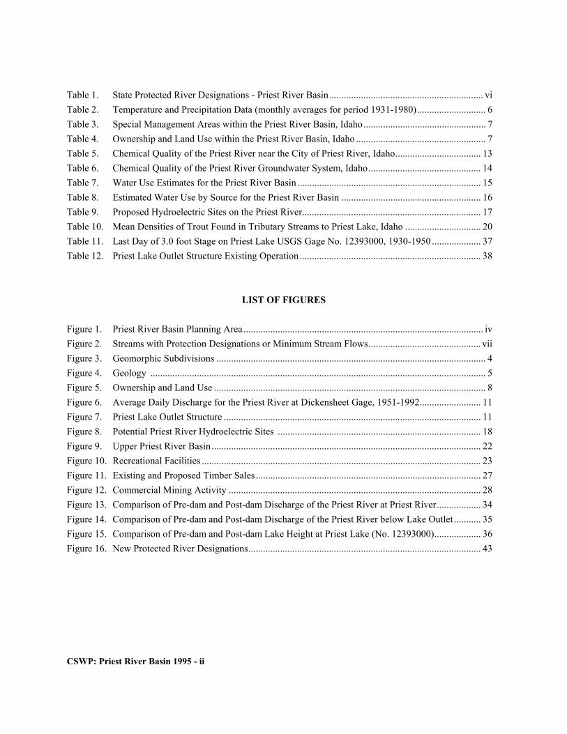
Table 1. State Protected River Designations - Priest River Basin............................................................... vi Table 2. Temperature and Precipitation Data (monthly averages for period 1931-1980)............................ 6 Table 3. Special Management Areas within the Priest River Basin, Idaho.................................................. 7 Table 4. Ownership and Land Use within the Priest River Basin, Idaho ..................................................... 7 Table 5. Chemical Quality of the Priest River near the City of Priest River, Idaho................................... 13 Table 6. Chemical Quality of the Priest River Groundwater System, Idaho.............................................. 14 Table 7. Water Use Estimates for the Priest River Basin ........................................................................... 15 Table 8. Estimated Water Use by Source for the Priest River Basin ......................................................... 16 Table 9. Proposed Hydroelectric Sites on the Priest River......................................................................... 17 Table 10. Mean Densities of Trout Found in Tributary Streams to Priest Lake, Idaho ............................... 20 Table 11. Last Day of 3.0 foot Stage on Priest Lake USGS Gage No. 12393000, 1930-1950 .................... 37 Table 12. Priest Lake Outlet Structure Existing Operation .......................................................................... 38 LIST OF FIGURES Figure 1. Priest River Basin Planning Area .................................................................................................. iv Figure 2. Streams with Protection Designations or Minimum Stream Flows.............................................. vii Figure 3. Geomorphic Subdivisions .............................................................................................................. 4 Figure 4. Geology ......................................................................................................................................... 5 Figure 5. Ownership and Land Use ............................................................................................................... 8 Figure 6. Average Daily Discharge for the Priest River at Dickensheet Gage, 1951-1992......................... 11 Figure 7. Priest Lake Outlet Structure ......................................................................................................... 11 Figure 8. Potential Priest River Hydroelectric Sites ................................................................................... 18 Figure 9. Upper Priest River Basin.............................................................................................................. 22 Figure 10. Recreational Facilities .................................................................................................................. 23 Figure 11. Existing and Proposed Timber Sales............................................................................................ 27 Figure 12. Commercial Mining Activity ....................................................................................................... 28 Figure 13. Comparison of Pre-dam and Post-dam Discharge of the Priest River at Priest River.................. 34 Figure 14. Comparison of Pre-dam and Post-dam Discharge of the Priest River below Lake Outlet ........... 35 Figure 15. Comparison of Pre-dam and Post-dam Lake Height at Priest Lake (No. 12393000)................... 36 Figure 16. New Protected River Designations............................................................................................... 43
CSWP: Priest River Basin 1995 - ii

PRIEST RIVER BASIN Component of the
COMPREHENSIVE STATE WATER PLAN ............... EXECUTIVE SUMMARY The Priest River Basin component of the Comprehensive State Water Plan was adopted by the Idaho Water Resource Board in 1990 and approved by the Idaho Legislature in 1991. Actions of the Board included designation of State protected river reaches, application for minimum stream flows, and a request for a management study of the Priest Lake outlet structure. In 1994-95 the Water Resource Board reviewed and reevaluated the Comprehensive State Water Plan for the Priest River Basin as required by law [Idaho Code 42-1734B(7)]. The Priest River Basin plan as amended, protects three additional streams with State designations and seeks a more gradual autumn draw-down of Priest Lake to protect Priest River fishery habitat and reduce erosion.
The Priest River Basin plan describes and evaluates water resources and related economic, cultural, and natural resources of the basin. Prepared at a reconnaissance level with public participation, the plan provides a general assessment of water management and current issues. Goals, objectives, actions, and recom- mendations of the Water Resource Board are designed to improve, develop, and conserve the water resources of the Priest River Basin in the public interest.
River segments with outstanding fish and wildlife, recreational, aesthetic or geologic value are identified and assessed for State protection in the plan. This involves an evaluation of the existing and potential water constraints and the issues for each stream reach, including: (1) water allocations and projected uses; (2) water quality; (3) power development; (4) flood control; and, (5) water and energy conservation. If the Board decides that the values of preserving the water-way in its existing state outweigh the values of
continued development, it can, subject to legislative approval, prohibit several activities from occurring within the stream channel to protect existing values and uses.
The Priest River Basin is 913 square miles in area; 761 square miles are in Idaho (Fig. 1). The northeast corner of Washington state contains 137 square miles along the west side of the basin, and the northernmost fifteen square miles of the drainage are within British Columbia, Canada. Approximately 90 percent of the basin is publicly owned land.
An estimated two million acre-feet of water falls on the basin each year as precipitation. The amount leaving the basin, as the annual flow volume of the Priest River, is 1.2 million acre-feet. The 800,000 acre-feet difference is lost primarily through evapotranspiration, although approximately 20,000 acre-feet are withdrawn annually for consumptive uses.
Water quality from both ground and surface sources within the Priest River Basin is generally good. The chemical quality of the Priest River meets the criteria for salmonid spawning and cold-water life forms, although the water temperature is high during summer months. Recent sampling and analysis show that both Priest and Upper Priest Lakes have excellent water quality. Ground-water quality is reported as suitable for domestic purposes. Some tributaries to Priest Lake and the lower Priest River, however, were evaluated as not fully supporting salmonid spawning or cold-water life forms.
CSWP: Priest River Basin 1995 - iii

CSWP: Priest River Basin 1995 - iv

The 1990 population of the Priest River Basin was just under 4,500. Nearly 40 percent of that population resided in the city of Priest River. The two major industries within the Priest River Basin are timber and tourism. Current estimates suggest basin forests can provide a sustained yield approaching 35 million board-feet. The tourism industry focuses on the scenic and recreational values of the basin. Tourists spend over two million visitor-days in the Priest River Basin annually, with about 75 percent of the activity centered on Priest Lake.
Water appropriations in the Priest River Basin equal the average annual runoff, but are markedly nonconsumptive. Water rights for recreation, aesthetics, fish, and wildlife, held by the State of Idaho, comprise the largest appropriations. Based on Department of Water Resources records, approximately 20,000 acre-feet of water are appropriated annually within the Priest River Basin for consumptive purposes. This is one percent of the annual volume of the Priest River. The major consumptive uses are irrigation and domestic water supplies. Surface water is the principal water source in the basin. Less than one percent of the basin's dedicated water is from ground water, but it is relied on heavily for domestic supplies.
Total water supplies are adequate to meet all current beneficial uses, and to support additional economic growth. However, diminished Priest River flows during the late summer and early fall, due to management practices and seasonal variability, jeopardize fishery habitat and recreation. Development options for water use in the basin were not suggested or discussed in the course of public review. Improvement opportunities focused on antidegradation options to protect stream and lake water quality and increase flows in the lower Priest River. Goals and objectives support continued use of the basin's natural resources for outdoor recreation and long-term sustainable timber harvest. The Board promotes critical fish and wildlife habitat protection, management and monitoring programs to maintain and enhance water quality in the basin, and encourages local land use planning to foster
orderly development and preserve the basin's outstanding natural resources.
Concern for maintaining the outstanding aesthetic quality of the basin, fish habitat, and maximizing recreational opportunities, led to protected river designations and application for minimum stream flow appropriations on basin rivers and streams. Waterways within the Priest River Basin designated as a State Natural or Recreational River are listed in Table 1 and shown in Figure 2. Actions and recommendations of the Idaho Water Resource Board are consistent with Idaho Code, private property rights, local and state management plans, and reflect public comment.
The Board will not pursue legislation authorizing an alternate summer operating scheme for the Priest Lake outlet structure. The Board will work with Washington Water Power to implement an autumn operating scheme to protect Priest River fishery habitat and reduce erosion. Releases should not exceed 1,000 cfs through the end of October; changes in discharge downstream of the outlet structure should be gradual but still meet the 0.0 foot level by December 31.
New State protected-river designations protect and preserve valuable fish and wildlife habitat in Lion, Two-Mouth, and Indian Creek (Fig. 2). The Recreational River designations allow streambed alteration for construction and maintenance of bridges and culverts, cleaning, maintenance, and replacement of water diversion works, and installation of fisheries enhancement structures. The plan further recommends modifications to the Northwest Power Planning Council's protected areas designations, and continued utilization of the basin's timber resources.
CSWP: Priest River Basin 1995 - v

Table 1. State Protected River Designations — Priest River Basin.
River Reach
Length
Values
Designation
Conditions Upper Priest River, Canadian border to Upper Priest Lake (1990)
19.6 miles
Species of Concern Spawning Recreation Use Scenic Area
Natural River
Prohibits — Construction or expansion of: dams or impoundments, hydropower projects, or water diversion works; new dredge or placer mining; new mineral or sand and gravel extraction within the stream bed; stream bed alteration.
Upper Priest Lake and The Thorofare (1990)
5.9 miles
Species of Concern Boating opportunity Scenic Area Geologic Features
Natural River
Same as above
Hughes Fork (1990)
14.1 miles
Species of Concern Spawning Recreation Use Scenic Area
Recreational River
Same as above except: allows for alteration of the stream bed for maintenance and construction of bridges and culverts, cleaning, maintenance, and replacement of water diversion works, and installation of fisheries enhancement structures.
Rock Creek (1990)
3.8 miles
Same as above
Recreational River
Same as above
Lime Creek (1990)
3.9 miles
Same as above
Recreational River
Same as above
Cedar Creek (1990)
4.2 miles
Same as above
Recreational River
Same as above
Trapper Creek (1990)
7.9 miles
Same as above
Recreational River
Same as above
Granite Creek (1990)
11.1 miles
Same as above
Recreational River
Same as above
Priest River, Priest Lake outlet structure to McAbee Falls (1990)
43.7 miles
Wildlife Boating opportunity
Recreational River
Same as above
Lion Creek (1995)
11.1 miles
Species of Concern Spawning Recreation Use Scenic Area
Recreational River
Same as above
Two-Mouth Creek (1995)
10.6 miles
Same as above
Recreational River
Same as above
Indian Creek (1995)
10.5 miles
Same as above
Recreational River
Same as above
CSWP: Priest River Basin 1995 - vi

CSWP: Priest River Basin 1995 - vii

I. INTRODUCTION The Idaho Water Resource Board is a constitutional agency responsible for developing a plan for the State’s water resources (Article XV, Section 7 of the Idaho Constitution). Legislation in 1988 provided for the development of a “comprehensive state water plan” based upon river basins or other geographic considerations. Each basin or waterway plan becomes a component of the State Water Plan. The Priest River Basin plan examines existing and planned resource use in the basin, and discusses the goals, objectives, and recommend-ations of the Board concerning improving, developing, and conserving water resources in the public interest.
The 1988 legislation authorized the Water Resource Board to preserve highly-valued waterways as state protected rivers. If the Board decides that the values of preserving a waterway in its existing condition outweigh the values of continued development, it can, subject to legislative approval, designate that waterway either a Natural or a Recreational River to protect existing values and resources.
The 1988 legislation specifically recognized the Upper Priest River, Upper Priest Lake, and The Thorofare for protection consideration. On July 1, 1988 these water bodies were given State interim protection. The Idaho Water Resource Board adopted a comprehensive plan for the Priest River Basin on May 25, 1990. Actions of the Board included designation of State protected river reaches, application for minimum stream flows, and a request for a management study of the Priest Lake outlet structure.
The Upper Priest River from the International Boundary to Upper Priest Lake, Upper Priest Lake and The Thorofare are designated as State Natural Rivers to preserve their scenic and recreational values, and to protect valuable fish and wildlife habitat. Hughes Fork, Rock Creek, Lime Creek,
Cedar Creek, Trapper Creek and Granite Creek are designated as State Recreational Rivers to preserve and protect valuable habitat for fish and wildlife. The Priest River from the Priest Lake outlet structure to McAbee Falls is designated as a State Recreational River to preserve and enhance recreational values, and to protect and improve fish and wildlife habitat. Recreational River designations allow streambed alteration for construction and maintenance of bridges and culverts, cleaning, maintenance, and replacement of water diversion works, and installation of fisheries enhancement structures.
Because public concerns, values, and demands change over time, the Comprehensive State Water Plan must be reevaluated and may be amended. The Board will review and reevaluate the Comprehensive State Water Plan at least every five years [Idaho Code 42-1734B(7)].
Private parties and public agencies may propose plan amendments. The Board will decide whether to amend the plan based on their evaluation of the impact of such change on the protection and preservation of the State's waterways, its economic impact on the state as a whole, whether it affects existing water rights, whether it is necessary to provide adequate and safe water for human consumption, and whether it is necessary to protect life. All amendments to the Comprehensive State Water Plan are submitted for review to the Idaho Legislature as required by law. Planning Process
CSWP: Priest River Basin 1995 - ii

The planning process encompasses roughly six steps: (1) developing an inventory of resource attributes, (2) assessing current and potential water uses and constraints, (3) assessing and identifying river segments with outstanding fish and wildlife, recreational, aesthetic or geologic value for State protection, (4) identifying local issues, concerns, and goals specific to water use in the Priest River Basin, (5) formulating policy alternatives, and (6) guided by public interest, setting forth actions and recommendations relative to improving, developing, and conserving the water resources of the Priest River Basin.
Information, figures, and statistics for this plan were obtained through literature review, field reconnaissance, contact with management agency personnel, and public meetings. Maps of resource data were prepared at a scale of 1:100,000 using a geographic information system (GIS). Resource data were reviewed for accuracy by the local Advisory Group, government agencies, and interested public. Public Involvement
Public involvement is an important part of the planning process, and is necessary in assessing viewpoints and conditions in the planning area. Information and review meetings, local advisory group meetings, and formal hearings provided opportunity for public criticism and suggestions on the Priest River Basin plan.
A Priest River Basin Advisory Group was formed in early 1989 to "inform the Board of local concerns" (Rule 30.01.b, Comprehensive State Water Plan Rules, Idaho Water Resource Board, 1992). The advisory group represented local government, water-user organizations, conservation groups, industry, and other interested parties. A list of the 1989 Advisory Group members is furnished in the Appendix.
A draft plan for the Priest River Basin was released to the public in 1990. A public infor- mation meeting and a formal public hearing were
held in the town of Priest River to discuss and receive comment on the draft plan. Following adoption by the Board, the plan was presented to the Idaho Legislature for its consideration as required by Idaho Code Section 42-1734B. The Idaho Legislature approved the Priest River Basin plan in 1991.
To prepare for the five-year review of the basin plan, a public meeting was held April 26, 1994, in Priest River. Participants were asked to comment on local issues and possible changes to the plan. The draft 5-year update for the Priest River Basin was released to the public August 2, 1995. A public information meeting was held in Coolin, Idaho, August 10, 1995 to present and discuss the draft plan. A formal public hearing was conducted at Grandview Lodge, Nordman, Idaho, on September 14, 1995. Sixty people attended the formal hearing and 18 people testified regarding the plan. A petition with 200 signatures and 25 letters with comments on the plan were received by the Board prior to close of the 61 day review period on October 2, 1995.
Comments on the plan overwhelmingly addressed lake level management and river flows below the outlet structure. Property owners and lease holders on Priest Lake are predominantly opposed to any change in lake level management, and people who reside in the lower basin, along the river and in the city of Priest River, unequivocally support increased flows in the river below the outlet structure.
CSWP: Priest River Basin 1995 - iii

II. BASIN DESCRIPTION Area Overview
The Priest River Basin shoulders the Idaho panhandle, in western Bonner and Boundary Counties (Fig. 1, pg. iv). Just over 83 percent of the basin's 913 square miles, is within Idaho. The northeast corner of Washington contains 137 square miles of the basin. This area includes the headwaters of most west-side tributaries to the Priest River system. The northern-most fifteen square miles of the Upper Priest River drainage are within British Columbia, Canada.
Upper Priest River originates within the Nelson Mountain Range of British Columbia, and crosses into Idaho approximately 6 miles from its origin. It flows for a distance of 18.5 miles from the international boundary to Upper Priest Lake. Upper Priest Lake is 3.3 miles in length, covers 1,352 acres, and has a mean depth of 48.6 feet (Milligan et al., 1983). It is connected to Priest Lake by The Thorofare, a 2.7 mile-long channel with little to no gradient. Priest Lake, the third largest natural lake entirely within Idaho, is 18 miles long, covers 23,680 acres and has a mean depth of 94.5 feet (Milligan, et. al, 1983). From the Priest Lake outlet, the Priest River flows for a distance of 45.5 miles to its confluence with the Pend Oreille River near the city of Priest River. The total distance of the Priest River system from the international boundary to the Pend Oreille River is 88 miles. GEOGRAPHY AND CLIMATE
The Priest River Basin is within the Northern Rocky Mountain physiographic province (Savage, 1967). Lowlands of the Priest River valley and the Priest Lake basin are flanked by the Priest Lake and Western Cuban uplands to the west, and the Selkirk Mountain range and Eastern Cuban uplands to the east (Fig. 3). Snow Valley separates
the Priest Lake and Western Cuban uplands. Elevation within the basin ranges from 2,960 feet at the confluence of the Priest and Pend Oreille Rivers to over 7,000 feet within the Selkirk Mountain Range.
Climate within the Priest River Basin is modified continental with well-defined seasons. A continental climate exhibits a large range in temperature. Summers and winters are relatively mild due to the pacific maritime influence. However, conditions can vary locally due to the wide range in elevations and terrain features. Priest Lake has a moderating effect on adjacent areas, but down-slope air drainage from the surrounding mountains can produce early and late frosts within the valley lowlands (Savage, 1967). Annual precipitation ranges from near 30 inches in the lower valley to over 60 inches along the higher ridges. July and August are the driest months, whereas the greatest amounts of precipitation occur between November and January (Table 2). Snowfall during the winter season can be heavy in the mountains. GEOLOGY AND SOILS
Geologic formations ranging in age from Precambrian to Quaternary occur within the Priest River Basin (Fig. 4). Metamorphosed sediments of Precambrian age form the basement complex, and where uplifted, constitute a major rock type in the surrounding uplands (Parliman et al., 1980). These metasediments are often intrud- ed by igneous dikes and sills of Precambrian age (Savage, 1967). Tertiary and Cretaceous age granitic rocks composed of granodiorites and quartz monzonites form the Selkirk Range (Ross and Savage, 1967). These rock types are mainly associated with the Idaho Batholith, and may also occur locally as plutonic intrusions within the Priest River Uplands (Parliman et al., 1980; Savage, 1967).
CSWP: Priest River Basin 1995 - iv

CSWP: Priest River Basin 1995 - v

Table 2. Temperature and Precipitation Data Priest River Experimental Forest Control Station monthly averages for period 1931-1980
Precipitation Avg. Max. Avg. Min. Water Equivalent Snowfall Temp. F° Temp. F° Inches Inches
January 30.1 17.5 4.28 21.1 February 37.1 20.2 3.10 15.8 March 45.0 24.1 2.75 6.9 April 56.9 30.1 2.01 0.6 May 67.1 37.6 2.28 0.1 June 73.4 43.9 2.31 0.0 July 82.8 46.5 .99 0.0 August 81.6 44.7 1.15 0.0 September 71.6 39.1 1.59 Trace October 56.6 32.9 2.82 0.8 November 39.1 26.7 4.03 10.2 December 32.5 22.6 4.86 24.9 Annual Average 56.2 32.2 32.17 88.4
Undifferentiated deposits of alluvium, primarily of glacial origin, fills lowlands of the valley and lake basins (Parliman et al., 1980). Remnants of identifiable glacial activity within the basin include (Savage, 1967): (1) A terminal moraine situated just north of the
City of Priest River. (2) Thinly laminated sediments likely
representing the existence of glacial meltwater ponds within the Priest River valley.
(3) Extensive deposits of outwash and morainal materials located just south of Priest Lake.
Soils within the basin are derived principally
from glacial drift with parent material consisting of granite and silica-rich, locally limey, meta-morphic rocks (Savage, 1967). Soils range from rock outcrops on mountains to level soils with varying permeability on glacial moraines and terraces (Weisel, 1982).
Mountain soils are generally found at elevations ranging from 4,800 ft. to 7,200 ft.
(Weisel, 1982). Other than rock outcrops composed of exposed granite, gneiss and schist, these soils are formed in glacial till (unsorted glacial material). Soil units consist of stony to gravelly loam and may have a thin mantle of volcanic ash or loess. Lower mountain slope and foothill soils are generally found on rolling and steep terrain, at elevations ranging from 2,100 ft. to 5,000 ft. (Weisel, 1982). These soils are well drained, and are also formed in glacial till. Soil units consist of sandy to gravelly loams, and have a thin mantle of loess and volcanic ash.
Valley lowland soils are found at elevations below 3,000 feet (Weisel, 1982). Soils on glacial outwash terraces are generally well drained, whereas soils on glacial lake terraces usually contain dense silt and silty clay loams, and are poorly drained.
CSWP: Priest River Basin 1995 - vi

OWNERSHIP AND LAND USE
Ownership and land use in the basin are shown in Figure 5. Over 90 percent of the basin is forested, administered by state, federal and Canadian provincial agencies. The Idaho Department of Lands (IDL) and the Panhandle National Forest (PNF) administer 319 and 314 square miles respectively. Thirty-two percent of the remaining 128 square miles consists of water surface, primarily on Priest and Upper Priest Lakes, the rest is in private ownership.
Special management areas are a significant property of the Priest River Basin and highlight unique resources (Table 3 and 4). They comprise over 60,000 acres, or 13 percent of publicly-owned lands within the planning area. These lands include exemplary white pine, cedar, and wetland communities managed as Research Natural Areas, the Priest River Experimental Forest where forest management practices may be tested, scenic and recreation areas around Upper Priest Lake and Priest Lake, and wilderness areas in the upper reaches of the basin. The Panhandle National Forest determined that the Upper Priest River is suitable for Wild River designation under the national Wild and Scenic Rivers Act. The river corridor is managed to protect this classifi-cation until Congress acts on the designation proposal (see also Fig. 5).
Table 3. Special Management Areas within the Priest
River Basin, Idaho. Priest River Experimental Forest Priest Lake Recreation Area Selkirk Crest Special Management Area Upper Priest Lake Scenic Area Potholes Research Natural Area Binarch Research Natural Area Bottle Lake and Tepee Creek Research Natural Area Kaniksu Marsh Research Natural Area Proposed Upper Priest River Wild and Scenic River Proposed Salmo-Priest Wilderness extension
Publicly-owned lands within the basin, excluding special management areas, are managed primarily for timber production (Table 4). Predominant tree associations are Western Red Cedar, Douglas Fir, Grand Fir, Western Hemlock, Subalpine Fir, Engelmann Spruce, and White Pine. Brush fields blanket old burn areas, and range lands comprise the remainder of the basin's vegetation cover.
Some livestock grazing occurs on public lands. Grazing is not a major activity within the basin, but is important to permit and lease holders. Just over 20,000 acres of public land are leased to provide 2,700 animal unit months of grazing activity.
Table 4. Ownership and Land Use within the Priest River Basin, Idaho. Special Agricultural Timber Management Areas or Range Land Residential Total (acres) (acres) (acres) (acres) (acres) Private 10,000 ------- 32,000 12,500 54,500 Panhandle National Forest Management 148,000 41,500 11,500 1,000 202,000 U.S. Bureau of Land Management 1,300 ------- ------- ------- 1,300 Idaho Department of Lands 198,000 20,700 10,000 1,500 230,200 Idaho Department of Parks & Recreation ------- 400 ------- ------- 400 TOTAL 357,300 62,600 53,500 15,000 488,400
CSWP: Priest River Basin 1995 - vii

CSWP: Priest River Basin 1995 - viii

CSWP: Priest River Basin 1995 - ix
POPULATION AND ECONOMICS
Estimated population of the Priest River Basin for 1994 is 4,400 people (U.S. Bureau of the Census and Idaho Department of Commerce, 1995). The Priest River census division, exclud- ing Oldtown, closely approximates the Priest River Basin. In 1994, the city of Priest River, the largest town in the basin, had a resident popula- tion of 1,679 (Idaho Department of Commerce, 1995). An additional 1,422 summer homes and eighty-three condominiums in the Priest Lake area add seasonally to the year-round population (Bonner County Assessor, 1994). In contrast to population growth in the region, the basin's year-round resident population has not grown significantly over the last fifteen years.
Throughout the early 1990s, the Idaho Panhandle region's population grew rapidly. Idaho's population grew at an average annual rate of 3 percent, and the Panhandle — a remarkable 4.5 percent. Bonner County with a 1994 estimated population of 31,890 people added 7,000 people to its population in the first four years of the 1990s, a 19.8 percent increase. This is comparable with Ada County's (Boise) 18.3 percent increase for the same period (Department of Employment, 1995).
Most experts expect fewer people to move into the region during the next few years. Other regions of the country are creating jobs at a faster rate than they were in the first few years of this decade, and the difference between the costs of housing in this region and the rest of the country has narrowed.
Total employment in Bonner County in 1994 was 14,387, a fifty percent increase over the 1980 figure of 9,537 and a 17 percent increase over the 1990 figure of 12,300 (Idaho Department of Employment, 1995). The annual unemployment rate was 8 percent in 1994, compared with 13.8% in 1980, 8.7% in 1990, and 9.4% in 1993. Based on employment, the major basin industries are:
(1) Manufacturing, primarily related to the timber industry
(2) Business, personal, health and legal services (3) Retail trade related to food, clothing,
hardware and automotive sales, and eating and drinking places
(4) State and local government services, including public education
(5) Farming and ranching
The population explosion in Bonner County and the growth of tourism are mutually rein- forcing. As more people move to the region, more people find out about the area, consequent- ly, more people visit as tourists, and then decide they want to move to the area. The region's tourist industry has been growing rapidly for the past five years. Bonner County hotel-motel receipts grew five percent between 1993 and 1994 and totaled over $9 million in 1994 (Idaho State Tax Commission). New permits for hous- ing and commercial services in the basin also attest to this growth. From 1990 to 1994 the Priest Lake area experienced a 10.7 percent average annual rate of growth in summer home construction and a 7 percent annual average growth rate in power demand. ENERGY SUPPLY AND CONSERVATION
Electrical power is supplied to the Priest River Basin by two utilities. Northern Lights, a rural electric cooperative, services over 2,000 primarily rural residential accounts (J. Shelby, Northern Lights, personal communication, 1995). Many residential accounts are for seasonal service to second homes in the vicinity of Priest Lake. Washington Water Power, an investor-owned utility, provides power to approximately 2,000 accounts in the city of Priest River and the lower east side of the basin along East River Road. Washington Water Power's service to the basin includes industrial accounts and all commercial accounts within the city of Priest River.
Demand for additional power within the basin was low through the 1980s due to slow economic growth and the implementation of energy conservation programs. However, the current trend toward greater year-round use of recreational
homes and considerable growth in summer home construction has increased electrical power use in the basin. Demand in the Northern Lights service area has grown about 7 percent per year since

1990 (J. Shelby, Northern Lights, personal communication, 1995).
Conservation programs have played a major role in meeting current and future electrical energy needs. The Northwest Energy Code and Super Good Cents programs support model conservation standards for new residential structures. Bonneville Power Administration funds both programs. Northern Lights promotes the Super Good Cents program for new electric- ally heated residential facilities.
Existing facilities are eligible for energy conservation upgrading through several programs sponsored by state and federal agencies, and the public utilities. These programs promote conser- vation upgrades by providing low-interest loans to fund the conservation measure installation costs. Approximately 50 percent of the existing residen- ces within the Priest River Basin have been up- graded under the residential weatherization programs.
Existing public nonprofit schools and hospitals are eligible for energy conservation grants under the Institutional Conservation Program, funded by the U.S. Department of Energy and administered by the IDWR Energy Division. Priest River Junior High and Priest Lake Elementary schools were both weatherized under this program.
Natural gas via pipeline is not provided to the basin (D. Hooper, Priest River City, personal communication, 1995). Other petroleum products, such as gasoline, heating oil and LP gas, are transported into the basin from terminal facilities in Spokane, and are currently available in adequate amounts to meet transportation, space heating and other energy needs. Water Resources
WATER QUANTITY AND STREAM DISCHARGE PATTERNS
Based on an average annual precipitation of 40.1 inches, the volume of water entering the basin yearly is 1,944,000 acre-feet (Warnick et al., 1981a). The reported volume of water leaving the basin is assumed to be the discharge of the Priest River at its mouth. Annual average discharge of the Priest River at the U.S. Geological Survey gage near the city of Priest River is 1,200,000 acre-feet.
The difference between the annual volume of precipitation and measured outflow is 744,000 acre-feet per year. This quantity is either lost through evapotranspiration or used consump- tively. Based on IDWR records, approximately 20,000 acre-feet are withdrawn annually from ground and surface water sources for consump- tive purposes, although not all is consumed. The balance, more than 700,000 acre-feet per year, is assumed to be lost through evapotranspiration.
Ground water in the basin is found within unconsolidated valley fill material comprised of stream sediments, lake sediments and glacial deposits (Graham and Campbell, 1981). Reported depths to water in wells range from 24 feet to 203 feet below land surface, and reported well yields vary from ten to 60 gallons per minute. Ground water leaving the basin as underflow has not been documented. Ground- water recharge is therefore assumed to equal pumped withdrawals plus natural discharges to the surface.
Figure 6 illustrates the seasonal discharge pattern for the Priest River below Priest Lake. Spring runoff normally starts in April, peaks in May or early June, then subsides rapidly. Lowest flows usually occur in August and September. Based on flow duration analysis, late summer discharge is reduced to less than 100 cfs during 15 percent of the low flow period.
CSWP: Priest River Basin 1995 - x
CFS

Maximum
Median
Minimum
Oct Nov Dec Jan Feb Mar Apr May June July Aug Sept
The river's natural hydrograph is altered by the outlet structure, a small dam, near the mouth of Priest Lake (Fig. 7). Lake level management at the outlet structure decreases river flows during the summer (July-September) and increases river flows substantially in October and November.
In 1951 the State of Idaho constructed the
outlet control structure at the mouth of Priest Lake. The state legislature authorized this facility to stabilize the summer lake levels of Priest and Upper Priest Lakes for recreation use [Idaho Code, Sec. 70-501 to 70-507]. The law requires that the lake level be maintained at 3.0 feet on the present U.S. Geological Survey (USGS) outlet gage until the end of the summer recreation season. Structure oversight was given to the Department of Water Resources. The
Department has authority to contract with other parties to operate and maintain the facility. Washington Water Power Company currently operates and maintains the outlet structure.
WATER QUALITY Upper Priest River
Upper Priest River is a spring-flow dominated system with cobble substrate and significant amounts of deposited sediment. The river is wider than hydraulic geometry calcu-
lations (width to depth ratio) suggest it should be, due to sediment loading. There is more sediment than the stream can transport. Banks are covered. Insects are diverse, but not abundant. A relatively nutrient poor river, algal growth on rocks is minimal. Upper reaches of the river lack large organic debris, but above the mouth, near Upper Priest Lake, the river is choked with large organic
CSWP: Priest River Basin 1995 - xi

debris making desirable fish habitat. Water quality has improved over four years of monitoring, but point sources of sediment still need to be controlled (Jill Cobb, USFS - Priest Lake, personal communication). Upper Priest and Priest Lakes
The overall quality of Upper Priest and Priest Lakes, based on the trophic status index calculations of Milligan et al. (1983) is good. This index is determined from the values of eleven physical and chemical parameters that relate to the general productivity of the lake system. Priest Lake was classified as oligo-trophic, meaning relatively deep and nutrient-poor. Upper Priest Lake was classified as oligo-mesotrophic, which is one step more advanced in the natural aging process of lakes, but still relatively young and nutrient-poor. The more advanced trophic classification of Upper Priest Lake is likely due to slightly higher nutrient loading and biologic productivity.
Analyses of recent water samples collected on Priest Lake indicate continued high water quality and classification as an oligotrophic system. Priest Lake is known for its excellent water clarity. Typical mid-summer clarity readings in Priest Lake range from 30 to 46 feet (DEQ, 1995). Chlorophyll a in Priest Lake is extremely low. This low algal biomass is largely the reason for high water clarity in the lake.
Low phytoplankton productivity in Priest Lake is attributable to little nutrient input from the watershed, and also a relatively large lake size and depth. Priest Lake appears to be somewhat different than most other high quality lakes in that its phytoplankton productivity is limited by low amounts of both phosphorus and nitrogen. However nitrogen to phosphorus ratios indicate that Priest Lake may be extremely sensitive to small increases in phosphorus loading (Bellatty, 1989). Possible contaminant sources are animal grazing, forest practices (timber harvest and road building), and sewage treatment and disposal systems. Bottom waters maintain good dissolved oxygen levels essential for maintenance of the lake trout fishery.
A common perception among long time Priest Lake users is that two or three decades ago nearshore rocks were clean and “sparkled,” but now they are covered with “slime.” This obser-vation may represent nearshore nutrient/sediment enrichment resulting from human activity, but there are no past scientific assessments of periphyton levels for comparison. In the summer of 1994, KCM Inc., a consulting firm from Seattle, Washington, assessed the current level of periphyton growth. If periphyton growth has increased over the last few decades, preliminary findings attribute the increase to the management practice of holding the lake level at a constant height through the summer months (Glenn Rothrock, DEQ - Coeur d’Alene, personal communication, 1995).
Legislation enacted by the state legislature in March 1991 requires development of a Priest Lake Management Plan (House Bill No. 319). The legislation says that the plan shall include comprehensive characterization of lake water quality through completion of a baseline monitoring program to be conducted by the Department of Health and Welfare. Objectives and goals of the plan include ascertaining baseline conditions using conventional limnological parameters in both open and shallow nearshore waters, development of a nutrient/sediment load budget for Priest Lake, and establishment of an annual total maximum nutrient load into Priest Lake that would maintain baseline water quality.
Lower Priest River and Tributaries
Based on water samples collected from the Priest River near the city of Priest River, the general quality of the river is good (Table 5). Concentrations of dissolved solids, indicated by specific conductance and concentrations of the major chemical constituents, are low. Cations, anions and nutrients are all within established criteria for domestic water supplies, aquatic life, and other defined uses. However, summertime water temperatures approach the maximum limit for cold-water biota. Cold-water biota includes the salmonid fishes, aquatic insects and other life forms that require cool (maximum temperature not to exceed 22°C), well-oxygenated water.
CSWP: Priest River Basin 1995 - xii

A comparison of values of specific conduct-ance between water samples collected from the Priest River at the Dickensheet gage, five miles below Priest Lake, and the Priest River City gage showed an increase in total dissolved solids as the river flowed through the lower part of the basin. This difference was largest during the low flow period of July through October, and was likely the result of more intensive land use within the lower valley. Seasonally, the lowest levels of dissolved solids were observed during spring runoff, and highest levels were noted during low flow periods.
A review of water quality data revealed some differences between tributaries originating from the east and west sides of the Priest River Basin. A comparison of total dissolved solids, as indicated by specific conductance, suggested that,
Table 5. Chemical Quality of the Priest River near the City of Priest River, Idaho Number of Samples Average Value Range of Values Water Temp (°C) 82 9.5 0.0 - 22 Turbidity (J.T.U.) 4 13.6 3.0 - 23 Specific conductance (µmhos/cm) 80 66.0 38 - 474 pH (range, std units) 15 6.2 - 8.4 Anions
HCO3 (bicarbonate, mg/l) 10 34.0 21 - 58 CO3 (carbonate, mg/l) 10 0.0 Cl (chloride, mg/l) 15 0.5 0.1 - 1.0 SO4 (sulfate, mg/l) 14 3.6 2.0 - 8.0 F (fluoride, mg/l) 14 0.1 0.1 - 0.2 Cations
Ca (calcium, mg/l) 15 7.7 4.3 - 13.0 Mg (magnesium, mg/l) 15 1.9 1.1 - 2.6 Na (sodium, mg/l) 15 1.9 1.2 - 3.0 K (potassium, mg/l) 14 0.7 0.3 - 1.6 Nutrients
Nitrogen, total (mg/l) 1 2.5 NO2 + NO3 as N (dissolved, mg/l) 14 0.05 0.01 - 0.30 Phosphorus, total (mg/l) 11 0.02 0.01 - 0.03 while all values were low, the west-side streams had slightly higher levels of dissolved solids than the east-side streams. The west-side streams flow through the Priest Lake uplands, consisting of metamorphosed sediments, while the east-side
streams flow through the granitic Selkirk Mountains. Beneficial Use Support
CSWP: Priest River Basin 1995 - xiii

The Idaho Department of Health and Welfare, Division of Environmental Quality (DEQ) conducted a water quality assessment of streams within the basin to determine beneficial use support (DEQ, 1989). A beneficial use is a reasonable and appropriate use of water for a purpose consistent with Idaho state laws and the best interest of the people. Beneficial uses include domestic water supplies, agricultural water supplies, cold water biota and recreation.
Six streams or stream reaches within the Priest River Basin were evaluated as not fully supporting designated beneficial uses: Lamb Creek, Reeder Creek, Tango Creek, the East River, Binarch Creek, and the Priest River from the Upper West Branch of the Priest River to the Pend Oreille River. The tributaries to Priest Lake
(Lamb, Reeder and Tango Creeks) are affected by forest practices and do not support or only partially support cold water biota and salmonid spawning. Stream reaches in the lower valley (the East River, Binarch Creek and the lower Priest River) are impacted by animal grazing and streambank modification, in addition to forest practices. These nonpoint sources threaten additional beneficial uses including domestic water supplies, primary contact recreation and secondary contact recreation. Primary contact recreation includes activities, such as swimming, where small amounts of water may be ingested. Secondary contact recreation includes activities, such as wading or fishing, where ingestion is not likely to occur. Ground-water Quality The chemical quality of samples from the Priest River ground-water system is summarized in Table 6. Concentrations of dissolved consti- tuents are higher than reported for surface sources, and reflect an increased exposure to soils and rock substrates. However, based on the limited number of samples, the quality of ground water is suitable for domestic use.
Table 6. Chemical Quality of the Priest River Ground Water System, Idaho Number of Samples Average Value Range of Values Dissolved solids (mg/l) 6 106.0 47 - 206 Specific conductance (µmhos/cm) 6 145.0 41 - 312 pH (range, std units) 6 6.2 - 7.4 HCO3 (bicarbonate, mg/l) 6 91.0 24 - 190 CO3 (carbonate, mg/l) 6 0.0 Cl (chloride, mg/l) 6 0.6 0.1 - 0.9 SO4 (sulfate, mg/l) 6 10.6 2.1 - 28 F (fluoride, mg/l) 6 0.13 0.0 - 0.3 Ca (calcium, mg/l) 6 18.3 4.4 - 41.0 Mg (magnesium, mg/l) 6 5.3 0.8 - 12.0 Na (sodium, mg/l) 6 4.6 1.5 - 12.0 K (potassium, mg/l) 6 1.5 0.8 - 2.8 NO2 + NO3 as N (dissolved, mg/l) 6 0.13 0.01 - 0.41 Source: Grahan and Campbell, 1981. WATER USE AND ALLOCATIONS
The constitution and statutes of the State of Idaho declare all the waters of the state, when
flowing in their natural channels, including ground waters, and the waters of all natural springs and lakes within the boundaries of the state, to be public waters. The constitution and statutes also
CSWP: Priest River Basin 1995 - xiv

guarantee the right to appropriate the public waters of the State of Idaho, and it is the state's duty to supervise that appropriation and allotment [Idaho Code 42-101].
Water appropriations in the Priest River Basin equal the average annual runoff, but are markedly nonconsumptive. Water right data by type of use for the Priest River Basin is summarized in Table 7. Water rights for recreation, aesthetics, fish, and wildlife, held by the State of Idaho, comprise the largest appropriations.
Most water use in the basin utilizes surface water. Less than one percent of the basin's appropriated water is from ground water, but it is relied on heavily for domestic supplies.
Developments and water right claims by source are shown in Table 8.
Within the upper Priest River Basin, (Priest Lake and all tributaries), total appropriations from surface water sources exceed 800,000 acre-feet. The State of Idaho has a water right for 800,000 acre-feet to maintain the level of Priest Lake in the public interest. The Idaho Water Resource Board has permits to maintain minimum stream flows for 26 cfs on Indian Creek and 22 cfs on Lion Creek.
The Idaho Department of Lands holds water rights on Indian Creek and its tributaries, formerly owned by Diamond Match Company, for 121 cfs to transport logs to Priest Lake via flume. Remnants of the log flume are on display at the Indian Creek unit of Priest Lake State Park. This is evidence that the water rights have, probably, not been used within the past ten years, and have technically been forfeited. Section 42-222, Idaho Code provides that all rights to the use of water may be lost and forfeited after a five-year period of nonuse.
T able 7. Water Use Estimates for the Priest River Basin Water Use Number of Appropriations Total CFS of Diversion Estimated Use or Stream Flow Acre-feet/annum CONSUMPTIVE USES Irrigation 121 56.00 12,000 Stockwater 58 2.50 1,500 Industrial 15 121.00 ---- Commercial 9 0.66 460 Domestic 259 13.35 6,000 NON-CONSUMPTIVE USES Fish Propagation 1 0.04 29 Power 1 0.03 22 Wildlife 3 0.05 8 Stream Flows 4 754.00 458,000 Recreation (Priest Lake) 8 0.70 800,000 Fire Protection 17 1.77 ---- Aesthetics 2 1.04 230 T able 8. Estimated Water Use by Source for the Priest River Basin Water Source Number of Appropriations Total CFS of Diversion Estimated Use or Stream Flow Acre-feet/annum Upper Priest Basin - Priest Lake and All Tributaries
Cougar Creek 3 0.35 159 CSWP: Priest River Basin 1995 - xv
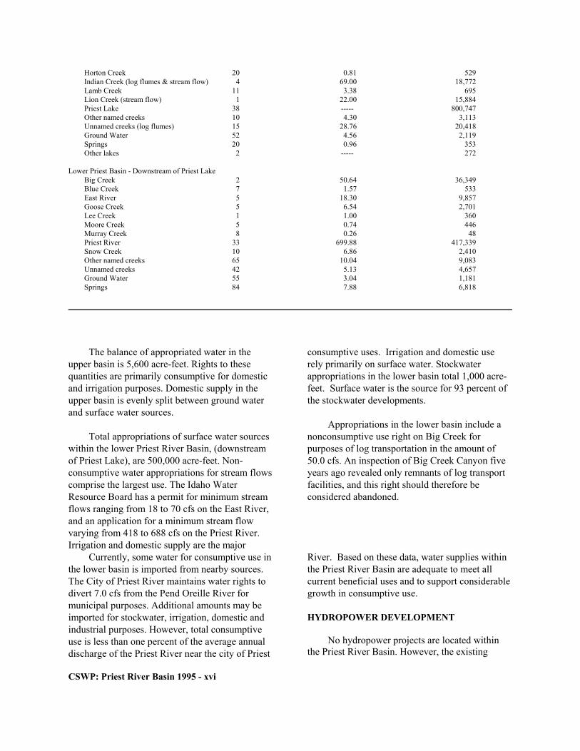
Horton Creek 20 0.81 529 Indian Creek (log flumes & stream flow) 4 69.00 18,772 Lamb Creek 11 3.38 695 Lion Creek (stream flow) 1 22.00 15,884 Priest Lake 38 ----- 800,747 Other named creeks 10 4.30 3,113 Unnamed creeks (log flumes) 15 28.76 20,418 Ground Water 52 4.56 2,119 Springs 20 0.96 353 Other lakes 2 ----- 272
Lower Priest Basin - Downstream of Priest Lake
Big Creek 2 50.64 36,349 Blue Creek 7 1.57 533 East River 5 18.30 9,857 Goose Creek 5 6.54 2,701 Lee Creek 1 1.00 360 Moore Creek 5 0.74 446 Murray Creek 8 0.26 48 Priest River 33 699.88 417,339 Snow Creek 10 6.86 2,410 Other named creeks 65 10.04 9,083 Unnamed creeks 42 5.13 4,657 Ground Water 55 3.04 1,181 Springs 84 7.88 6,818
The balance of appropriated water in the upper basin is 5,600 acre-feet. Rights to these quantities are primarily consumptive for domestic and irrigation purposes. Domestic supply in the upper basin is evenly split between ground water and surface water sources.
Total appropriations of surface water sources within the lower Priest River Basin, (downstream of Priest Lake), are 500,000 acre-feet. Non-consumptive water appropriations for stream flows comprise the largest use. The Idaho Water Resource Board has a permit for minimum stream flows ranging from 18 to 70 cfs on the East River, and an application for a minimum stream flow varying from 418 to 688 cfs on the Priest River. Irrigation and domestic supply are the major
consumptive uses. Irrigation and domestic use rely primarily on surface water. Stockwater appropriations in the lower basin total 1,000 acre-feet. Surface water is the source for 93 percent of the stockwater developments.
Appropriations in the lower basin include a nonconsumptive use right on Big Creek for purposes of log transportation in the amount of 50.0 cfs. An inspection of Big Creek Canyon five years ago revealed only remnants of log transport facilities, and this right should therefore be considered abandoned.
CSWP: Priest River Basin 1995 - xvi
Currently, some water for consumptive use in the lower basin is imported from nearby sources. The City of Priest River maintains water rights to divert 7.0 cfs from the Pend Oreille River for municipal purposes. Additional amounts may be imported for stockwater, irrigation, domestic and industrial purposes. However, total consumptive use is less than one percent of the average annual discharge of the Priest River near the city of Priest
River. Based on these data, water supplies within the Priest River Basin are adequate to meet all current beneficial uses and to support considerable growth in consumptive use. HYDROPOWER DEVELOPMENT
No hydropower projects are located within the Priest River Basin. However, the existing

outlet structure at Priest Lake provides storage for 72,000 acre-feet of water by controlling the lake level. The stored water is normally released in the fall to augment flows in the Pend Oreille and Columbia River systems for power generation. This structure reportedly has the potential to produce 800 kilowatts of electrical power with the addition of generating facilities (Warnick et al., 1981b).
Six sites on the Priest River below Priest Lake have attracted eight hydroelectric project proposals (Fig.8; U.S. Army Corps of Engineers, 1986). Proposed facilities range in height from 60 feet to 185 feet, in storage capacity from 26,000 to 908,000 acre-feet, and in power potential from 1.1 to 26 megawatts (Table 9). Although the higher structures have the greatest storage and power potentials, those located near Priest Lake would cause the lake level to exceed authorized elevation. All eight proposals are considered inactive [no licenses, permits, or applications are on file with the Federal Energy Regulatory Commission] and infeasible under current conditions.
Small hydroelectric facilities (facilities generating less than one megawatt of power) have been proposed on eight east-side tributaries to Upper Priest Lake, Priest Lake and the Priest River. Most of the suggested facilities were located on streams with Northwest Power Planning Council protected area designations. These filings expired, or were withdrawn, rejected, or canceled before adoption of the Priest River Basin plan in 1990. Table 9. Potential Hydroelectric Sites, Priest River Dam Max Power Map Project Height Storage Potential # Name (Feet) (Acre-feet) (MWs) 1 Priest 4.0 River 70.0 25,892 1
Priest Lake is the most popular fishery within the basin, and one of the most popular fisheries in the Idaho Panhandle. Total angler effort in 1994 was 62,602 hours (Horner et al., in progress). Most of the fishing effort is from boat anglers in search of lake trout. In 1994, only 49 percent of the anglers were residents of Idaho. Between January 1, 1994 and December 31, 1994 an estimated 13,987 lake trout were harvested from Priest Lake. The average length of lake trout in the catch was approximately 20 inches, weighing about 2.25 pounds (L. Nelson, IDFG - Coeur d’Alene, personal communication). This average size is down from the previous estimate, in 1984, of 24 inches and 5.3 pounds (Mauser et al., 1988).
2 Priest No. 6 185.0 592,000 26.2
3 Prie4 Prie5 Prie6 Prie
New Outlet Co. 60.07 Prie8 Prie Source: Warnick, 1981; U.S. Army Corps of Engineers, 1986. Other Resources FISH AND WILDLIFE
Fish and wildlife are extremely important resources within the Priest River Basin. The basin provides valuable habitat for several species of concern, and is a popular hunting and fishing area for residents of northern Idaho and eastern Washington. Fisheries and Fish Habitat
CSWP: Priest River Basin 1995 - xvii

The primary reason for the decline is the increased harvest of lake trout from Priest Lake. While the estimated fishing effort in 1986 was greater than in 1994 (71,516 hours in 1986 and 62,602 hours in 1994), the harvest of lake trout increased more than two fold in 1994 (13,987 fish) from that of 1986 (6,295 fish). While the fishery has experienced a decline in the mean size of lake trout caught, Priest Lake is still one of the nation's best lake trout fisheries.
Other game fish present in Priest Lake include westslope cutthroat trout, largemouth bass, yellow perch, mountain whitefish, and bull trout. The westslope cutthroat trout and bull trout are designated species of special concern in Idaho and no harvest of either fish is permitted in Priest or Upper Priest lakes. Populations of largemouth bass and yellow perch are scattered around the lake, mainly limited to the shallow littoral areas along the shoreline and in the bays of the lower lake. Kokanee salmon once supported a thriving fishery within the lake. For thirty years the kokanee population was the major fishery in the lower lake. Due to mysis shrimp introduction, an expanding lake trout population, and water level fluctuations during kokanee spawning, the kokanee population crashed in the late 1970s and is now functionally extinct in Priest Lake.
Upper Priest Lake contains a small, naturally-sustaining population of kokanee salmon, a remanent of the lower lake population. Westslope cutthroat trout, mountain whitefish, and bull trout exist in Upper Priest Lake in greater numbers than in the lower lake, but the populations are still limited and all fishing in Upper Priest Lake is restricted to Catch and Release. The cutthroat population residing within the lake is one of the few populations of adfluvial westslope cutthroat trout remaining in Idaho. Adfluvial fish reside in the lake environment after maturity, but migrate to the tributary streams to spawn. The young remain in the stream for two to five years, then migrate to the lakes.
The Upper Priest River, its tributaries, and tributaries to Priest and Upper Priest lakes provide valuable fish spawning and rearing habitat, and
most are closed to fishing. Many of these streams are also designated protected areas for resident fish by the Northwest Power Planning Council (Fig.2, pg. vii). Northwest Power Planning Council (NPPC) designations must be considered by the Federal Energy Regulatory Commission (FERC) in their hydropower project authorization processes and by the Bonneville Power Administration (BPA) when acquiring and transmitting power.
Snorkel surveys for selected tributaries to Priest and Upper Priest lakes suggest that the westslope cutthroat trout and brook trout populations in the surveyed tributary streams are generally stable. Granite Creek and South Fork Granite Creek are two tributaries where trout densities were down from previous estimates (Table 10). Bull trout redd surveys began in the Priest River drainage in 1992. In both 1993 and 1994 five bull trout redds were counted in the upper Priest River. In tributaries to the upper Priest River, eight redds were counted in 1993 and nineteen in 1994.
Within the lower basin (downstream of Priest Lake), only the Middle and North Forks of the East River, and Moores Creek are designated by the NPPC as protected areas for resident fisheries and wildlife. The Middle Fork of the East River is the only drainage in the lower part of the basin to support Bull Trout. The Priest River contains only limited populations of wild trout due to low stream discharges and elevated water temperatures during summer low-flows. Stream habitat in other tributaries to the Priest River is limited, often due to land use practices. Wildlife
Waterways and their associated riparian habitats are extremely valuable to wildlife by
CSWP: Priest River Basin 1995 - xviii

T able 10. Mean densities of Trout (fish/100m2) Found in Tributary Streams to Priest Lake
SPECIES
S tream /Year Cutthroat Book Trout Bull Trout All Fishes Lion Creek
1983 0.8 0.0 0.0 0.8 1987 6.4 0.0 0.1 6.5 1988 14.4 0.0 0.03 14.8 1994 12.6 0.0 0.03 13.0
Two Mouth Creek
1983 0.4 0.0 0.0 0.4 1987 16.9 0.02 0.0 17.0 1988 12.3 0.4 0.2 13.0 1989 14.0 0.0 0.0 15.0 1994 15.3 0.4 0.0 18.5
Indian Creek
1983 22.6 1.4 0.9 24.8 1987 11.4 4.7 4.9 21.0 1988 16.1 2.1 0.0 18.2 1989 10.0 0.0 0.3 10.2 1994 7.0 1.8 0.6 13.1
Granite Creek
1987 0.8 0.0 0.6 1.3 1988 1.1 0.7 0.2 2.0 1989 0.2 0.0 0.1 0.3 1994 0.0 0.0 0.0 0.1
S.F. Granite Creek
1983 1.4 6.9 0.1 8.4 1984 7.2 1.3 0.6 9.1 1985 4.0 0.0 0.0 4.0 1986 0.0 0.0 0.0 0.0 1987 0.6 1.7 2.7 0.5 1988 1.8 0.3 0.2 2.3 1994 0.0 0.4 0.0 0.4
Source: Lance Nelson, Idaho Department of Fish and Game providing food, water and cover. Most tributaries to Priest Lake and Upper Priest Lake, including the Thorofare, Upper Priest River and the Hughes Fork, are designated as protected areas for wildlife by the NPPC (Fig. 2, pg. vii), and are considered
highly valued areas by IDFG. Upper basin streams and associated riparian areas provide habitat for grizzly bear, mountain caribou, moose, whitetail deer, mule deer, black bear, mountain goat, and furbearers.
The upper Priest River Basin contains recovery areas for both the Selkirk grizzly bear and mountain caribou, and is one of three areas from which confirmed or probable reports of wolverine sightings were received (Groves, 1988). The grizzly bear is listed as a threatened species,
and the mountain caribou is classified as an endangered species by the U.S. Fish and Wildlife Service. The wolverine is a state species of special concern, a U.S. Forest Service (USFS) sensitive species, and is listed for consideration by the
CSWP: Priest River Basin 1995 - xix

CSWP: Priest River Basin 1995 - xx
USFWS as a threatened or endangered species (Groves, 1988).
A bald eagle nest was identified at the mouth of the Upper Priest River in 1992 and has successfully produced chicks in 1993 and 1994 (Dave Spicer, IDFG - Coeur d’Alene, personal communication). The bald eagle is currently listed as a threatened species by the U.S. Fish and Wildlife Service.
Harlequin ducks are known to use riparian areas along Priest Lake tributaries. Documented areas include Granite Creek, Hughes Fork, Gold Creek, the Upper Priest River, and Lion Creek (David Ortmann, IDFG - Coeur d’Alene, personal communication, 1995). This bird is listed as a state species of special concern, and a USFS sensitive species (Wallen and Groves, 1989). Priest River and its associated riparian area from Priest Lake outlet to its mouth provide valuable wildlife habitat for moose, black bear, whitetail deer, and river otter, and is a wintering area for the bald eagle. Bald eagles have been observed along the Lower Priest River during the breeding season and additional nests are suspect- ed but have not been documented (Dave Spicer, IDFG, personal communication). This waterway is designated as a protected area for wildlife by the NPPC (Fig.2, pg. vii), and is considered a highly valued wildlife area by the Idaho Depart- ment of Fish and Game. Other streams in the lower basin designated as protected areas for wildlife are the East River, Quartz Creek, Lower West Branch of the Priest River, and Moores Creek. RECREATION
Outdoor recreation within the Priest River Basin is important to both the local and regional economies. Tourism survey estimates for 1995 indicate that over two million visitor-days are spent in the Priest River Basin (Nick Sanyal, University of Idaho, personal communication, 1995). About 75 percent of the recreational
activity occurs around Priest Lake. Activities range from hiking and backpacking in remote and scenic settings to using the fully developed facilities at Priest Lake.
No developed recreational facilities occur within the Upper Priest River drainage. Most of this area is accessible by trail only. Use of motorized vehicles is prohibited within the proposed Wild and Scenic River corridor which parallels the upper river. Recreational activities within the upper drainage are limited to hiking, camping and hunting within a natural environment.
The Upper Priest River is not suitable for water-based activities, such as swimming, floating or kayaking, due to cold water temp- eratures, and channel morphology. The river channel is generally shallow and narrow, and is covered by many log jams. The Upper Priest River and its tributaries are also closed to fishing to protect spawning and rearing populations of adfluvial westslope cutthroat trout and bull trout. Special management areas, in addition to the corridor along the Upper Priest River, include the proposed extension to the Salmo-Priest Wilder- ness Area, and the Selkirk Crest management area (see Fig. 9).
The recreational hub of the basin is Priest Lake. This natural lake, the third largest entirely within north Idaho, is surrounded with camp- grounds, summer homes and resorts (Fig. 10). The popularity of Priest Lake is based on the scenic beauty of the lake and numerous water-based recreational opportunities. Boating, swimming, water skiing and fishing are popular. Three full-time outfitters operate on the lake. Use of the fishery resources was discussed in the Fish and Wildlife section. One popular pleasure boating experience involves traveling through the Thorofare into Upper Priest Lake. Upper Priest Lake and the Thorofare are currently being managed to preserve their natural character.

CSWP: Priest River Basin 1995 - xxi
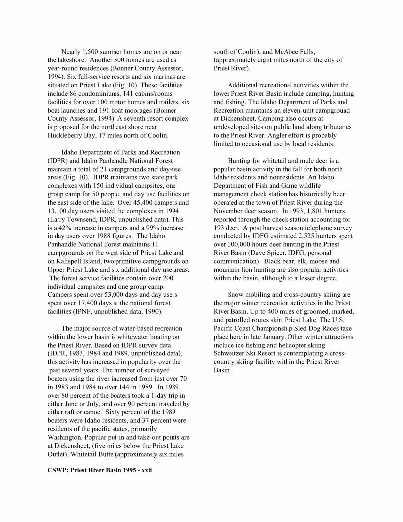
Nearly 1,500 summer homes are on or near the lakeshore. Another 300 homes are used as year-round residences (Bonner County Assessor, 1994). Six full-service resorts and six marinas are situated on Priest Lake (Fig. 10). These facilities include 86 condominiums, 141 cabins/rooms, facilities for over 100 motor homes and trailers, six boat launches and 191 boat moorages (Bonner County Assessor, 1994). A seventh resort complex is proposed for the northeast shore near Huckleberry Bay, 17 miles north of Coolin.
Idaho Department of Parks and Recreation (IDPR) and Idaho Panhandle National Forest maintain a total of 21 campgrounds and day-use areas (Fig. 10). IDPR maintains two state park complexes with 150 individual campsites, one group camp for 50 people, and day use facilities on the east side of the lake. Over 45,400 campers and 13,100 day users visited the complexes in 1994 (Larry Townsend, IDPR, unpublished data). This is a 42% increase in campers and a 99% increase in day users over 1988 figures. The Idaho Panhandle National Forest maintains 11 campgrounds on the west side of Priest Lake and on Kalispell Island, two primitive campgrounds on Upper Priest Lake and six additional day use areas. The forest service facilities contain over 200 individual campsites and one group camp. Campers spent over 53,000 days and day users spent over 17,400 days at the national forest facilities (IPNF, unpublished data, 1990).
The major source of water-based recreation within the lower basin is whitewater boating on the Priest River. Based on IDPR survey data (IDPR, 1983, 1984 and 1989, unpublished data), this activity has increased in popularity over the past several years. The number of surveyed boaters using the river increased from just over 70 in 1983 and 1984 to over 144 in 1989. In 1989, over 80 percent of the boaters took a 1-day trip in either June or July, and over 90 percent traveled by either raft or canoe. Sixty percent of the 1989 boaters were Idaho residents, and 37 percent were residents of the pacific states, primarily Washington. Popular put-in and take-out points are at Dickensheet, (five miles below the Priest Lake Outlet), Whitetail Butte (approximately six miles
south of Coolin), and McAbee Falls, (approximately eight miles north of the city of Priest River).
Additional recreational activities within the lower Priest River Basin include camping, hunting and fishing. The Idaho Department of Parks and Recreation maintains an eleven-unit campground at Dickensheet. Camping also occurs at undeveloped sites on public land along tributaries to the Priest River. Angler effort is probably limited to occasional use by local residents.
Hunting for whitetail and mule deer is a popular basin activity in the fall for both north Idaho residents and nonresidents. An Idaho Department of Fish and Game wildlife management check station has historically been operated at the town of Priest River during the November deer season. In 1993, 1,801 hunters reported through the check station accounting for 193 deer. A post harvest season telephone survey conducted by IDFG estimated 2,525 hunters spent over 300,000 hours deer hunting in the Priest River Basin (Dave Spicer, IDFG, personal communication). Black bear, elk, moose and mountain lion hunting are also popular activities within the basin, although to a lesser degree.
Snow mobiling and cross-country skiing are the major winter recreation activities in the Priest River Basin. Up to 400 miles of groomed, marked, and patrolled routes skirt Priest Lake. The U.S. Pacific Coast Championship Sled Dog Races take place here in late January. Other winter attractions include ice fishing and helicopter skiing. Schweitzer Ski Resort is contemplating a cross-country skiing facility within the Priest River Basin.
CSWP: Priest River Basin 1995 - xxii
SCENIC VALUES
The popularity of the Priest River Basin for recreational activities is primarily attributed to the scenic values of the area. Priest Lake and Upper Priest Lake are the main scenic attractions within the basin. The two lakes, connected by the 2.7 mile-long Thorofare, exhibit a high degree of clarity due to their low levels of biological productivity, and are surrounded by heavily wooded forests. A product of its glacial origin, Priest Lake has over 70 miles of irregular shoreline, and contains several wooded islands.
The glacially-carved Selkirk Mountains dominate the landscape along the east side of the basin. The rugged topography consists of numerous sharp peaks and pinnacles that are readily visible from Priest and Upper Priest Lakes. Some of the more spectacular landmarks are The Lions Head, The Wigwams and Chimney Rock. The Priest Lake Uplands, along the west side of the basin, consist of heavily forested, rolling hills.
From the Canadian border to Upper Priest Lake, the Upper Priest River flows through a narrow, relatively undisturbed valley containing numerous stands of mature timber. The only man-caused impacts within the drainage are associated with the Forest Service Road # 1013 (Fig. 9, pg. 23). This road crosses the Upper Priest River by bridge approximately 3.5 miles upstream from Upper Priest Lake, then goes north along the east side of the upper valley for approximately five miles. At this point, the road climbs out of the valley and traverses the western and northern sides of Continental Mountain to Malcom Creek, then leaves the basin near the International Boundary. The road is outside the visual corridor except a short distance approxi- mately 4.5 miles upstream from the bridge, and does not encroach upon the riparian zone except at the bridge crossing. Upper Priest Falls, a scenic feature, is located on the river approxi-mately one mile south of the international
boundary and can be reached by a 1.5-mile hike from the road.
Priest River, from the Priest Lake outlet structure to McAbee Falls, flows through predominantly undeveloped public land admin- istered on the west side by the Panhandle National Forest, and on the east side by the Idaho Department of Lands. The stream gradient is moderate from the outlet structure to the mouth of the Upper West Branch of the Priest River, and this reach contains Class II and one Class III rapid (Moore and McClaran, 1989). From the mouth of the Upper West Branch to McAbee Falls, the stream gradient is generally low, and the river exhibits considerable meandering. McAbee Falls and Chipmunk, located about 4 miles below Dickensheet, are Class II rapids. In some areas, the river is bordered by old oxbows and wetland areas.
Below McAbee Falls, the Priest River flows through predominantly private lands (see Fig. 5, pg. 8). Throughout this reach, roads, houses, agricultural fields, utilities and logging activities are visible from the river. Eight Mile Rapids, a Class III rapid, is located in this reach approx- imately 6 miles upstream of the river's mouth (Moore and McClaran, 1989). CULTURAL FEATURES
Efforts to survey cultural features within the Priest River Basin have been limited to federally managed lands and special study areas. A University of Idaho database contains 105 historical and architectural sites in the Priest River Basin. Thirteen additional sites were identified in a survey conducted by Marti (1976) as part of the Priest River Wild and Scenic River study. Many sites are indicative of past industrial activities within the basin — forest service facilities, remnants of old mining or logging operations. The U.S. Forest Service has converted the Luby Bay Ranger Station into a museum.
Most historical sites on or near Priest and Upper Priest Lakes are old cabins and summer homes. Of the 118 documented historic and architectural sites, two are on the National Register of Historic Places. Both sites are summer homes located on islands in Priest Lake (T. Green, Idaho
Historical Society, personal communication). Most of the remaining sites, including those evaluated by Marti, do not meet the criteria for National Register nomination. TIMBER
CSWP: Priest River Basin 1995 - xxiii
CSWP: Priest River Basin 1995 - xxiv
The timber industry is a major industry within
the Priest River Basin. Over eighty percent of the basin is publicly owned and managed primarily for timber production. A substantial amount of private land is also devoted to timber production. Based on current agency projections, a sustained annual yield for timber harvest in the basin approaches 35 million-board feet, enough to supply one medium-sized lumber mill.
Predominant tree species within the basin are western red cedar, hemlock, Douglas fir, grand fir, western larch, white pine, lodgepole pine and subalpine fir. Western red cedar, Douglas fir, grand fir and white pine are primarily used for lumber and lumber products. Hemlock, grand fir and subalpine fir, and to a lesser extent, lodgepole pine and ponderosa pine, are utilized for paper and paper products.
Current and proposed timber sales within the National Forest, and on state lands are shown in Figure 11. Timber sales on national forest land within the Priest Lake Ranger District in 1994 totaled 2.3 million board-feet with timber removal estimated at ten to twelve million board-feet. Sustained annual yield for the Priest Lake District is estimated at eight to twelve million board-feet (Dave Cobb, IPNF, personal communication). State forest lands are managed to produce a sustained yield of nearly 21 million board-feet annually (R. Greene and M. Reeb, IDL, personal communication).
Sawlogs harvested from the Priest River Basin supply mills as distant as 80 miles. Local mills using timber from the basin include Idaho Forest Industries and JD Lumber, Inc. near Priest River, Crown Pacific Inland near Oldtown, Riley Creek in Laclede and the Priest Lake Mill near Priest Lake. Pulpwood harvested from the basin, and wood chips from local lumber mills, are transported via highway and railroad to paper mills throughout the Pacific Northwest. MINING
Although interest in mineral extraction in the basin has surfaced from time to time since the turn of the century, no large scale mining operations
have ever been shown to be feasible. Mines and prospects for nonradioactive metals occurred primarily within veins and sills in metasedimentary rock (Savage, 1967). The primary metals of interest were lead, gold, silver, beryllium, tungsten, molybdenum, zinc and copper. Field examinations at selected mines and prospects by Savage (1967) revealed only traces of metals or ores; none were active then, nor are any believed to be active today. Mines and prospects for radioactive metals, primarily uranium, were associated with granites and related rocks (Savage, 1967). No important deposits were discovered in the basin.
Five mines and prospects for nonmetallic minerals were for quartz and mica (Idaho Department of Lands, 1980), and are currently inactive. A sixth site consists of a small quarry for granite building stone (M. Reeb, IDL, personal communication). The basin does not have or expect to have in the foreseeable future a substantial mineral leasing program (IDL, 1992).
The Priest River Basin contains adequate sources of sand, gravel and rock to support current and future construction activities within the basin and the surrounding area. Fifty-eight mined sand and gravel sites have been identified in the basin (Fig. 12). In 1991, the Department of Lands issued 13 permits to remove approximately 14,500 cubic yards of gravel (IDL, 1992).

CSWP: Priest River Basin 1995 - xxv

CSWP: Priest River Basin 1995 - xxvi

III. ISSUES, CONSIDERATIONS, AND PLAN OBJECTIVES Local Issues
Local issues center on maintaining the high aesthetic quality of the Priest River Basin, maximizing recreation opportunities, and supporting long-term sustainable timber harvest. AESTHETIC QUALITY
Small hydropower development, continued summer population growth, and proposed resort developments are specific concerns relative to preservation of the scenic character of the basin.
Sixteen small hydroelectric projects on seven east-side tributaries to Priest and Upper Priest Lakes, and the Middle Fork of the East River have been proposed in the past. Since filing for FERC authorizations, these applications either expired, or were withdrawn. Because these tributaries provide valuable spawning and rearing habitat for fish residing in Priest and Upper Priest lakes, the local public is concerned about future proposals for small hydroelectric project developments on these streams.
New resort developments have been pro-posed on Priest Lake. Local concern centers on potential detrimental impacts to scenic aspects of the basin and the water quality of Priest Lake. A fully developed, commercial resort could include marinas, golf courses, skiing facilities, lodging, and housing developments.
Increasing human activity in the Priest Lake watershed has led to public concern about maintaining the excellent water quality of Priest Lake. Priest Lake has very high water quality and attracts hundreds of thousands of recreationalists annually to shoreline residential homes, resorts, campgrounds, and day-use areas. While there are several sewer districts collecting and treating septic tank effluent, there are many individual
septic drainfields. Timber harvest, a major activity in the watershed, also impacts water quality. Road building and harvest may increase hillside erosion and sediment runoff into basin streams and lakes. RECREATION
Recreational issues focus on fisheries management in Priest Lake and regulation of flows within the Priest River below the Priest Lake outlet structure.
Management of the Priest Lake fishery is a concern because of recent declines and probable loss of the lake's kokanee population. Deterior-ation is attributed to a combination of factors, including the introduction of mysis shrimp and existing lake level management practices. Most likely, this loss is not reversible because of the high predation levels associated with the current lake trout population. Present management direction for Priest Lake is toward maintenance of the lake trout population as a yield fishery producing quality-sized fish at the current level of harvest. The lake is also managed to provide enhanced catch and release angling for wild bull and cutthroat trout.
Current operation of the Priest Lake outlet structure is an issue. Low summer flows and related increases in water temperature in the Priest River result in poor boating conditions and impaired fish habitat. ISSUES UPDATE
In reviewing the 1990 Priest River Basin Plan the public expressed these additional specific concerns: (a) Noise and wake from motorboats in
theThorofare and Upper Priest Lake is a problem.
CSWP: Priest River Basin 1995 - xxvii

CSWP: Priest River Basin 1995 - xxviii
(b) What are the economic consequences of implementing Board actions and recommendations?
(c) What is the effect of the existing Natural
River designation on channel maintenance of the Thorofare? The Thorofare may need to be dredged.
(d) What is the value of water stored in Priest
and Pend Oreille Lakes relative to regional hydropower generation?
(e) Two-Mouth Creek, tributary to Priest Lake,
may need a minimum streamflow. (f) Water rights for log transportation -should
they be abandoned? Flood Management
Major flood events have not been docu- mented within the Priest River Basin (Idaho Department of Water Resources, 1976). The low risk to property from flooding may be attributed to the ability of Priest Lake to dampen runoff peaks, and the lack of structural development within the flood plain.
The 100-year flood peak discharge for the Priest River at its mouth is 11,100 cfs (Federal Emergency Management Agency, 1987). This flow has not been met or exceeded at the USGS gage near Priest River City for the period of record, 1930 through 1988 (Harenberg et al., 1988). The highest recorded discharge was 10,500 cfs in 1948. The highest recorded discharge since construction of the Priest Lake outlet structure in 1951 was 10,200 cfs in 1974. Storage capacity is not specifically maintained at Priest Lake for flood control, although the annual fall drawdown for hydropower may provide some storage space for the following spring runoff.
Generally, flooding from the Priest River is confined to shore areas (Federal Emergency Management Agency, 1987). Backwater from the Pend Oreille River into the Priest River near its mouth may result in a larger area being flooded.
However, building within this area is restricted through city and county zoning regulations. Navigation
Currently, there is no commercial navigation within the Priest River Basin. Historically, mail was delivered to homes surrounding Priest Lake by boat, but this practice has not occurred in recent times. Log towing was a common practice on Priest Lake, and logs were also floated or flushed down tributary streams, The Thorofare and the Priest River (Ray Green, IDL, personal communication).
Concern about dredging the Thorofare was voiced at the 1994 public meeting. The mouth of the Thorofare was dredged in the past.
Under the Idaho Admissions Act and the Idaho Constitution, the State claims title to all bodies of water that are navigable (Idaho Depart-ment of Lands, 1986). Within the basin, this applies to Priest Lake, Upper Priest Lake, the Thorofare, and the entire Priest River.

Goals and Objectives
In adopting a comprehensive state water plan the Board is guided by these criteria from Idaho Code 42-1734A: 1. Existing rights, established duties, and the
relative priorities of water established in the Idaho Constitution shall be protected and preserved.
2. Optimum economic development in the
interest of and for the benefit of the state as a whole shall be achieved by the integration and coordination of the use of water, the augmentation of existing supplies, and the protection of designated waterways for all beneficial purposes.
3. Adequate and safe water supplies for human
consumption and maximum supplies for other beneficial uses shall be preserved and protected.
4. Minimum stream flow for aquatic life, recre-
ation and aesthetics, minimization of pollu-tion, and the protection and preservation of waterways shall be fostered and encouraged, and consideration shall be given to the development and protection of water recreation facilities.
5. Watershed conservation practices consistent
with sound engineering and economic princi-ples shall be encouraged.
Specific goals and objectives for the Priest
River Basin plan reflect local issues raised at public meetings and current and future uses of water and related natural resources of the basin. They are: 1. Encourage and promote continued use of
basin resources for outdoor recreation. Recreational opportunities should continue to focus on the Priest and Upper Priest Lakes and designated special management areas, such as the Upper Priest River proposed Wild and Scenic River corridor, and the Selkirk Crest.
2. Support continued timber harvest within the
basin at or near sustained yield rates that protect visual corridors around major recreational areas, critical fish and wildlife habitat and the quality of the basin's water resources.
3. Encourage and promote protection and
management of critical fish and wildlife habitat within the basin. Recreational use and timber harvesting must be closely regulated in or around designated big game recovery areas and the habitats of other species of concern.
4. Support development, implementation and
maintenance of monitoring and management programs to maintain and, where necessary, enhance the quality and quantity of the water resources within the basin. Special emphasis should be placed on maintaining the excellent water quality conditions in Priest and Upper Priest Lakes, and developing a streamflow management program for the lower Priest River.
5. Support and encourage local land use
planning to foster orderly development and to preserve and enhance the outstanding natural resources of the basin.
CSWP: Priest River Basin 1995 - xxix

IV. RESOURCE SUMMARY AND EVALUATION The Priest River Basin is remote and sparsely populated. Over 90 percent of the land area is under public jurisdiction. The basin contains a variety of habitats ranging from steep, rocky mountain slopes, to old-growth forests, meadows and wetlands. These factors contribute to the value of the area in providing habitat for many fish and wildlife species of concern — the mountain caribou, the Selkirk grizzly bear, the wolverine, the harlequin duck, the adfluvial westslope cutthroat trout, and the bull trout.
Timber harvest and tourism are the prominent industries in the basin. They are also important at the regional level. Sustained yield timber harvest estimates for the Priest River Basin are currently 35 million board-feet per year. Sawlogs harvested from the basin supply lumber mills both locally and within the region, and provide pulpwood to paper mills throughout the pacific northwest.
Basin tourism focuses on outdoor recreation. Annually, the basin receives over two million visitor-days. Recreation activity is centered on Priest Lake. Over 1,500 summer homes, six full-service resorts, six marinas, two state park complexes, 13 forest service campgrounds, and six day-use areas are located in the vicinity of Priest Lake. Significant growth in summer home construction, power service, and state park visitors over the last five years highlights the popularity of the basin.
Popularity of the basin for recreational activities is attributed to outstanding scenery and excellent water quality. The major scenic attractions are Priest and Upper Priest Lakes, and the Selkirk Mountains, which dominate the landscape along the east side of the basin.
Cultural features within the Priest River Basin consist of a limited number of prehistoric sites of primarily local significance, and a substantial number of historic and architectural sites. These are primarily of interest to local historians.
Considerable prospecting has occurred within the basin for a substantial list of both radioactive and nonradioactive minerals. However, no economically important mineral deposits have been discovered. The basin contains adequate sources of sand, gravel and rock to support local construction activities.
Currently, the quantities of water withdrawn for consumptive uses are approximately one percent of the annual volume of the Priest River. Total water supplies are adequate to meet all current beneficial uses, and to support additional economic growth. However, diminished Priest River flows during the late summer and early fall, due to management practices and seasonal variability, jeopardize fishery habitat and recreation.
The Priest River Basin does not currently contain hydroelectric facilities. However, water stored in the Priest Lake system is released in the fall to augment flows in the Pend Oreille and Columbia River systems for production of hydropower. Hydropower production is not considered an important direct use of the basin's water resources.
Electrical power is provided to the Priest River Basin by two public utilities. Both have
adequate resources to supply current customers and to respond to some growth. Energy conser-
CSWP: Priest River Basin 1995 - xxx

vation programs have been implemented by both utilities, and are playing a role in meeting current and future energy demands. An accelerated program in conservation and efficiency improvement can increase the State's power generation margin. This course buys time, limits new demands on our natural environment and is the most cost-effective choice. STREAM FLOW PROTECTION
Stream flows are essential to the maintenance of fish and wildlife habitat and the scenic values of the basin and provide recreational opportunities. The value of instream uses are considered on an equal level with consumptive uses.
The 1990 Comprehensive State Water Plan for the Priest River Basin called for minimum stream flow water rights for Zero and Packer Creeks, tributaries to Granite Creek, and for the North Fork of the East River. In November 1990, the Idaho Water Resource Board applied for a minimum stream flow for the North Fork of the East River for the purposes of fish spawning and rearing. That application is now a licensed water right. Natural barriers found on Zero and Packer Creeks precluded their suitability for spawning and rearing purposes. Consequently, applications for minimum stream flows on these two creeks were dropped.
The Board filed a water right application in 1992, for a Priest River minimum stream flow. The application asked for 688 cfs from October 1 to July 31 and 418 cfs from August 1 to Septem-ber 30, to protect fish and wildlife habitat and recreational values. However, current water management practices do not support water availability through substantial portions of the year. Due to lack of available flows and lack of public support at the Department of Water Resources hearing conducted October 5, 1995, the Director denied the application.
In September of 1992, the Idaho Department of Fish and Game completed the "Lower Priest River Instream Flow Study." The study deter-mined that the minimum recommended rearing
flow for adult and juvenile cutthroat trout and adult rainbow trout is 200 cfs during the period August 1 to October 31; the optimum rearing flow for adult cutthroat and rainbow trout, during the period, is 400 cfs. The 200 cfs (point where marginal increases in habitat are maximized) recommended rearing flow is based only on depth and velocity, and does not relate to water temp-eratures in the river. An alternate summer and early fall operating scheme for the Priest Lake outlet structure is one option for improving flows in the lower Priest River. PRIEST LAKE OUTLET STRUCTURE MANAGEMENT STUDY
In accordance with the adopted 1990 Comp-rehensive State Water Plan for the Priest River Basin, the Department of Water Resources re-quested that the Corps of Engineers conduct an evaluation of alternative summer and fall opera-ting schemes for the Priest Lake outlet structure. The objectives of the study were to define the optimum combination of benefits relative to power production, lake levels and river flows. The Corps’ optimization study suggests that river conditions could be improved without signifi-cantly affecting lake concerns and uses.
The outlet control structure, a small dam, was constructed at the mouth of Priest Lake in 1951 by the State of Idaho and rebuilt in 1978. The state legislature authorized this facility to stabilize the summer lake levels of Priest and Upper Priest Lakes and The Thorofare for recreational purposes [Idaho Code, Sec. 70-501 to 70-507]. Near the end of spring runoff the outlet structure gates are closed to maintain the summer lake level at 3.0 ft. on the outlet gage. At this level, approximately 70,000 acre-feet of water are stored. Sometime between October 1 and November 30, the stored water is released downstream to supplement Pend Oreille and Columbia River flows for fall hydropower production. Historically, storage releases have not started until mid to late October and continue until a lake elevation of 0.0 is reached. This is usually completed within a relatively short time frame of about eight to ten days.
CSWP: Priest River Basin 1995 - xxxi
This storage and release pattern has resulted in two concerns. First, flows in the lower Priest
River often drop to extremely low levels before the fall draw-down. At present, it is common for Priest
CSWP: Priest River Basin 1995 - xxxii
river flows at the Dickensheet gage to fall well below 200 cfs in late summer and early fall (August-October). Consequently, fish habitat and river recreation in the lower Priest River have been negatively affected. The second concern with the operating pattern is that the short period of lake draw-down produces a surge in river flows during October. Flows above 600 cfs during the fall negatively affect fish habitat and increase erosion.
Hydrologic Records
Priest Lake is the primary water source for Priest River. It provides ¾ (about 900,000 acre-feet) of the annual discharge volume of the river at the mouth (USGS gage No. 12395000). Tributaries below the lake provide approximately 300,000 acre-feet per year to the river.
River flows below the lake have been significantly altered by summer lake level maintenance. Prior to completion of the outlet structure, Priest River flows in July and August were approximately 200 cfs greater than they are today (Figs. 13 and 14).

CSWP: Priest River Basin 1995 - xxxiii
Based on the 1920-1950 period, there was a 50% probability river flows below the lake outlet would equal or exceed 2000 cfs in early July and 600 cfs at the end of July. During August, there was a 50% probability flows would equal or exceed 600 cfs early in the month and 350 cfs by the end of August. Base flows of 200 cfs were not realized until October (based on a 90% probability of equaling or exceeding this rate). This compares with a post dam 50% probability that flows will equal or exceed 1200 cfs at the beginning of July, 300 cfs at the end of July, and 200 cfs during the month of August.
The 90% probability flows compare pre-dam and post-dam river flows with more certainty. Again, through-out the summer, river flows were approximately 200 cfs greater prior to dam construction and operation, than they are today. Based on the 1920-1950 period, there was a 90% probability river flows below the lake outlet would equal or exceed flows of 800 cfs in early July and 400 cfs by the end of July. This compares with a post dam 90% probability that flows will equal or exceed 400 cfs at the beginning of July, 200 cfs at the end of July, and 100 cfs during the month of August.

Natural lake height on average dropped below 3.0 feet by July 1. Records from 1930 through 1950 show the lake height on the USGS gage (12393000) typically receded below 3.0 feet by the end of June (Table 11). Figure 15 illustrates maximum, minimum, and median lake stages pre- and post- dam. The outlet structure began operating in August 1950. Since the structure was built in 1951, the summer lake level has routinely varied between approximately 2.9 feet and 3.1 feet. In 1949, Diamond Match Company removed rock, driftwood, and boulders
from the lake outlet which had impeded the passage of logs (during the low-water stage) from the lake to their sawmill situated approximately ¼ mile down-stream. This operation was probably of some immediate benefit, but not wholly successful, according to a Department of Water Administration Field Engineer. An examination of lake height and lake inflow records does not indicate that dredging significantly altered either the surface height of the lake or river flows.
CSWP: Priest River Basin 1995 - xxxiv

Table 11. Last Day of 3.0 foot Stage on Priest Lake
USGS Gage No. 12393000, 1930-1950 Year Last Day at 3.0 Stage† Day of Year 1930 June 12 163 1931 June 7 158 1932 July 7 188 1933 July 14 195 1934 June 8 159 1935 July 1 182 1936 June 9 160 1937 June 30 181 1938 July 2 183 1939 June 6 157 1940 June 10 161 1941 June 11 162 1942 July 5 186 1943 July 11 192 1944 May 18 - 2.93 Max 138 1945 June 28 179 1946 July 8 189 1947 June 20 171 1948 July 1 182 1949 June 12 163 1950 July 10 191 Average=173 = June 22 Median=179 = June 28 †after this date lake height was below 3.0 feet for emainder of year r
Alternate Operation Schemes
An alternate operation scheme that procured an instream flow (not a water right) of 200 cfs from July to the end of October would improve Priest River flows in late summer and early fall. Lake level for this same period should not drop below 3.0 feet to accommodate infrastructure and current boat usage on the lake.
Computer models show that an alternate operation scheme to store an additional 5,000 acre-feet could procure a minimum river flow of 200 cfs from July to the end of October (measured at the Dickensheet USGS gage approximately 5.2 miles downstream of the outlet structure). The Corps’ modeling determined that an alternate
scheme to store an additional 5,000 acre-feet is operationally feasible in normal and dry water years.
Increasing flows during the late summer and early fall would have a positive affect on fish habitat (David Ortmann, IDFG - Coeur d’Alene, personal communication,1995). It is unlikely storage of additional water for release through the summer would result in significantly elevated water temperatures in the river downstream, because most of Priest Lake is steep sided. Changing the operation of the outlet structure alone, however, cannot be expected to optimize fish habitat due to the high water temperatures of outflow from the lake and lack of riparian habitat along the river.
Primary concerns with river recreation under current operations are unstable river flows during the summer recreation season, and lack of opportunity to increase river recreation-based tourism due to low summer flows. The entire river can be rafted at flows of 500 cfs or above, but maintaining 500 cfs flows would clearly not be feasible during the late summer. However, canoeing is possible at flows of 200 cfs. When the lake is controlled initially at a higher stage than the current 3.0 feet, river flow predictability is improved and river recreation opportunities are slightly improved when compared to current operation. More consistent river flows in the lower basin would also reduce the "drawdown" appearance along the river.
An alternate operating scheme that does not drop the lake level below 3.0 feet, would hold summer lake levels higher for a longer period during the early summer. Operation schemes to hold 5,000 acre-feet at a gage height of 3.5 feet or less and gradually release it, are unlikely to cause serious property damage as median lake elevations during spring runoff (May-June) reach 4.0 feet.
CSWP: Priest River Basin 1995 - xxxv

T
able 12. Existing Operation Observed Outflow Observed Lake Elevation Observed Lake Storage at Dickensheet Gage (above datum 2434' at end of month) (acre-feet at end of month) (mean monthly cfs) 1977 July 244 3.01 69,160 (dry) Aug 139 3.09 71,000 Sept 226 3.11 71,461 Oct 1,270 0.61 14,020 Nov 698 0.12 2,760 1987 July 434 3.01 69,160 (dry) Aug 233 2.99 68,700 Sept 90 2.94 67,550 Oct 1,045 0.78 17,900 Nov 617 0.07 1,610 1988 July 370 3.04 73,530 (dry) Aug 116 2.98 67,100 Sept 78 3.08 62,500 Oct 890 1.35 31,020 Nov 1,096 0.31 7,120 1989 July 502 3.00 68,930 (norm) Aug 384 3.07 70,540 Sept 194 3.01 69,160 Oct 919 1.27 29,180 Nov 1,210 0.53 12,180 1990 July 1,144 3.04 69,850 (norm) Aug 297 3.08 70,770 Sept 197 2.98 68,470 Oct 906 1.57 36,070 Nov 1,265 1.02 23,440
An alternate operation scheme that moderated the extreme fluctuations during fall releases in October and November would improve Priest River flows for fishery habitat. Moderating fall releases, at least until the end of October would provide more optimal conditions. During the fall draw-down period, releases should not exceed 1,000 cfs through the end of October and changes in discharge downstream of the outlet structure should be gradual.
An analysis of hydropower impacts shows that there would be an increase in energy generation of 435 mega-watt hours under an alternative operation scheme managing the lake between 3.2 and 2.8 feet. The increase can largely be attributed to more lake storage to draw from in the summer and early fall months. This water is
spilled during the spring run-off period under existing operation. The alternative operation scheme would, however, result in a slight net reduction in power revenues, based on Washington Water Power's existing seasonally varying charges (19.1 mils/kwh in November compared with 19.4 mils/kwh in October). At this point it cannot be determined whether the overall increase in hydropower generation offsets the slight decrease in price from October to November. Also, it is uncertain whether prices will remain at their current levels in the future. There is no impact to fish habitat in the lake under an alternate summer or autumn operating scheme.
CSWP: Priest River Basin 1995 - xxxvi
V. ACTIONS AND RECOMMENDATIONS
evelopment options for water use in the basin were not suggested or discussed in the course of public review. Improvement
oppor-tunities focused on antidegradation options to protect stream and lake water quality and increase flows on the lower Priest River. Concern for maintaining the character and aesthetic quality of the basin, fish habitat, maximizing recreational opportunities, and supporting long-term sustainable timber harvest led to protected river designations and application for minimum stream flows on basin rivers and streams.
D
In planning for the use of the water resources
of the state, the Idaho Water Resource Board is charged with weighing and balancing competing uses and needs. Multi-objective resource planning necessarily involves making trade-offs aimed at achieving the greatest number and best combination of objectives. In theory, resource planning from a societal perspective requires knowledge of the full costs and benefits of each option. In practice, the quantification of many environmental or societal assets in monetary terms is extremely difficult or impossible. As a result, judgment must be exercised regarding the external environmental and societal costs and benefits of any action.
Actions and recommendations of the Idaho Water Resource Board are consistent with the Idaho Code, private property rights, local and state management plans, and recognize public comment gathered at public meetings, through the local Advisory Group, and public hearings. Existing Plan PROTECTED RIVER DESIGNATIONS
The Idaho Water Resource Board considered the impacts of protected river designations on the social, economic, and environmental livelihood of the region and determined that the value of preserving outstanding streams and rivers of the Priest River Basin, with their current beneficial uses, outweighs the value of further development at this time. The Board believes State protected river designations are preferable to federal protection, and are in the best interest of the residents of the State of Idaho. Federal protection limits the flexibility of planning for the reach, and removes the option of amending the designation by action of the Water Resource Board and the Idaho Legislature.
To protect the public interest, current resource use, and the multiple-use character of the basin, and recognizing that no action by the Idaho Water Resource Board using their comprehensive water planning authorities can interfere with vested rights, or the repair, replacement, or continued operation of existing facilities or works, the Idaho Water Resource Board reaffirms the following designations: (1) Upper Priest River, Upper Priest Lake, The
Thorofare and Tributaries
The Upper Priest River, from the Interna- tional Boundary to the confluence with Upper Priest Lake, excluding a short reach containing the bridge crossing on USFS road #1013 in the SW¼ of Section 2, T63N, R5W, is designated as a state Natural River.
The reach of the Upper Priest River containing the bridge crossing on USFS road #1013 in the SW¼ of Section 2, T63N, R5W, and extending 100 feet both upstream and downstream of the bridge is designated as a state Recreational River, and is condi- tioned to allow alterations of the streambed for repair and/or replacement of the bridge.
CSWP: Priest River Basin 1995 - xxxvii

CSWP: Priest River Basin 1995 - xxxviii
Upper Priest Lake is designated as a state Natural River. In making this designation, the Water Resource Board recognizes the value, and formally supports protection of this waterway, and the associated riparian area, in its current natural state. The Board requests the support of other agencies with legal jurisdiction over the lake and its shores in protecting this valuable resource.
The Thorofare, from its origin at Upper Priest Lake to the beginning of private property along its south bank in Section 9, T62N, R4W, is designated as a state Natural River. To protect scenic values and vegetation communities in the Thorofare, the State's Natural River designation prohibits dredging above the mouth. Present maintenance structures appear adequate to keep the channel open and are compatible with current State designation. Existing protection does not interfere with dredging activities at the mouth.
Hughes Fork, from its headwaters to its confluence with the Upper Priest River, is protected as a state Recreational River, and is conditioned to allow alterations of the streambed for maintenance and construction of bridges and culverts, and installation of fisheries enhancement structures.
Rock Creek, from its headwaters to its confluence with the Upper Priest River is protected as a state Recreational River, and is conditioned to allow alterations of the streambed for maintenance and construction of bridges and culverts, and installation of fisheries enhancement structures.
Lime Creek, from its headwaters to its confluence with the Upper Priest River, is protected as a state Recreational River, and is conditioned to allow alterations of the streambed for maintenance and construction of bridges and culverts, and installation of fisheries enhancement structures.
Cedar Creek, from its headwaters to its confluence with the Upper Priest River, is protected as a state Recreational River, and is
conditioned to allow alterations of the streambed for maintenance and construction of bridges and culverts, and installation of fisheries enhancement structures.
Trapper Creek, from its headwaters to its confluence with the Upper Priest River, is protected as a state Recreational River, and is conditioned to allow alterations of the streambed for maintenance and construction of bridges and culverts, and installation of fisheries enhancement structures.
(2) Tributaries to Priest Lake
Granite Creek, from the confluence of its North and South Forks in Section 30, T62N, R5W, to its mouth, is protected as a state Recreational River, and is conditioned to allow alterations of the streambed for maintenance and construction of bridges and culverts, and installation of fisheries enhancement structures.
(3) The Priest River below Priest Lake and
Tributaries
The Priest River, from the Priest Lake outlet structure to and including McAbee Falls in the SW¼ of Section 17, T57N, R4W, is protected as a state Recreational River, and is conditioned to allow alterations of the streambed for maintenance and construction of bridges and culverts, and construction and maintenance of water diversion works.
Figure 2 (pg. vii) shows streams with State
protection designations. Activities listed in Idaho Code, Section 42-1734A(5) are prohibited in waterways designated as Recreational Rivers unless specifically authorized as part of the designation. Bridges and culverts over Recreational Rivers must be constructed and maintained to reduce sedimentation and toallow unrestricted fish passage. Alterations of the streambed must comply with the Idaho Stream Channel Alterations Rules and Regulations and Minimum Standards.

MINIMUM STREAM FLOWS
The 1990 Comprehensive State Water Plan for the Priest River Basin called for minimum instream flow water rights for Zero and Packer Creeks, tributaries to Granite Creek, and for the North Fork of the East River. Natural barriers found on Zero and Packer Creeks precluded their suitability for spawning and rearing purposes. Consequently, applications for minimum instream flows on these two creeks were dropped. In November 1990, the Idaho Water Resource Board applied for a minimum instream flow for the North Fork of the East River for the purposes of fish spawning and rearing. That application is now a licensed water right. RECOMMENDATIONS 1. The Water Resource Board supports the NPPC Protected Areas program for the Priest River Basin with two exceptions.
(1) Protected areas designations for the following streams should be withdrawn:
(a) Quartz Creek, from its headwaters to its confluence with the Priest River.
(b) The East River, from the confluence of the North and Middle Forks of the East River to its mouth.
(2) Streams and/or reaches designated for State protection should be included in the Protect-ed Areas program. 2. The Water Resource Board supports continued harvest of the basin's timber at sustained-yield rates that maximize long-term production, while protecting visual corridors around major recreational areas and critical fish and wildlife habitat. Use of forest practices that preserve and enhance the quality of the basin's water resources is strongly encouraged. 3. The Water Resource Board recommends implementation and maintenance of water quality
monitoring and management programs to maintain and, where necessary, enhance the quality of the water resources within the basin. Continued emphasis should be placed on maintaining the excellent water quality conditions in Priest and Upper Priest Lakes. Maintaining the high quality of Priest Lake requires the application of best management practices to prevent increased nutrient loading and sedimentation. 4. The Water Resource Board recommends implementation and maintenance of management programs to protect, preserve and enhance the fish and wildlife habitat. Habitat protection should focus on both game species and species of concern. 5. The Water Resource Board recommends local land use plans to foster orderly development of the Priest River Basin in the public interest, and to preserve the outstanding natural resources of the basin. Plan Amendments OUTLET STRUCTURE OPERATION
The Board will not pursue legislation authorizing an alternate summer operating scheme for the Priest Lake outlet structure. The Board will work with Washington Water Power to implement an autumn operating scheme to protect Priest River fishery habitat and reduce erosion. Releases should not exceed 1,000 cfs through the end of October; changes in discharge downstream of the outlet structure should be gradual but still meet the 0.0 foot level by December 31. PROTECTED RIVER DESIGNATIONS
The Idaho Water Resource Board considered the impacts of three additional protected river designations on the social, economic, and environmental livelihood of the region and determined that the value of preserving these
outstanding streams, with their current beneficial uses, outweighs the value of further development at this time. The Board believes State protected river designations are preferable to federal
CSWP: Priest River Basin 1995 - xxxix
protection, and are in the best interest of the residents of the State of Idaho.
To protect the public interest, current resource use, and the multiple-use character of the basin, and recognizing that no action by the Idaho Water Resource Board using their comprehensive water planning authorities can interfere with vested rights, or the repair, replacement, or continued operation of existing facilities or works, the Idaho Water Resource Board makes the following designations: (A) Tributaries to Priest Lake:
Lion Creek, from its headwaters to its mouth, is protected as a state Recreational River, and is conditioned to allow alterations of the stream bed for maintenance and construction of bridges and culverts, and installation of fisheries enhancement structures.
Two-mouth Creek, from its headwaters to its mouth, is protected as a state Recreational River, and is conditioned to allow alterations of the stream bed for maintenance and construction of bridges and culverts, and installation of fisheries enhancement structures.
Indian Creek, from its headwaters to its mouth, is protected as a state Recreational River, and is conditioned to allow alterations of the stream bed for maintenance and cons- truction of bridges and culverts, and install-ation of fisheries enhancement structures.
The three east side tributaries are boulder-
strewn, high gradient streams. Water quality in the three streams is good. Pools provide a relatively complex habitat. Spawning and rearing of Bull trout and westslope cutthroat trout, both Idaho Species of Special Concern, are important beneficial uses in the three creeks. All are vulnerable to sedimentation from mass move- ment, i.e., landslides and earthflow, which may be exacerbated by activities in the vicinity.
Figure 16 shows streams given State protection designations with this amendment. Activities listed in Idaho Code, Section 42-
1734A(5) are prohibited in waterways designated as Recreational Rivers unless specifically authorized as part of the designation. Bridges and culverts over Recreational Rivers must be constructed and maintained to reduce sedimen-tation and to allow unrestricted fish passage. Alterations of the streambed must comply with the Idaho Stream Channel Alterations Rules and Regulations and Minimum Standards. RECOMMENDATIONS 1. The Water Resource Board recommends that
the Idaho Department of Water Resources pursue a water right abandonment for log flumes on Indian Creek and Big Creek. The water rights have, probably, not been used within the past ten years, and have technically been forfeited. State law (Section 42-222, Idaho Code) provides that all rights to the use of water may be lost and forfeited after a five-year period of nonuse.
2. The Water Resource Board supports the
Northwest Power Planning Council Protected Areas program regarding the Priest River Basin and recommends designation modifications to reflect State protected river status for Lion, Two-mouth, and Indian Creek.
3. The Water Resource Board supports the local
Priest Lake Management Plan to protect the water quality of Priest Lake.
CSWP: Priest River Basin 1995 - xl

CSWP: Priest River Basin 1995 - xli

CSWP: Priest River Basin 1995 - xlii
Glossary acre-foot - the volume of water required to cover 1 acre of land (43,560 cubic feet) to a depth of one foot; this is equivalent to 325,851 gallons. alluvium - soil material, such as sand, silt and clay that has been deposited on land surface by water. alteration - any activity using mechanized equipment that moves or overturns gravel or earth. Animal unit month (AUM) - the amount of grazing required to sustain a 1,000-pound cow, a horse, or five sheep for one month. Annual sustained yield - a term typically used in forestry which means the yield harvested in a given year is equivalent to the replacement during that same time period. Beneficial use - a set of uses of water which are deemed by law to provide legitimate bases for a water right. Best management practices - the state-of-the-art practices to protect and enhance water quality that are efficient and effective, practical, economical, and environmentally sound. benthic invertebrates - organisms that typically live on the bottoms of streams and lakes. Board - Idaho Water Resources Board (IWRB). cfs - cubic feet per second, a unit of measure for the rate of discharge of water. One cubic foot per second is the rate of flow of a stream with a cross section of one square foot which is flowing at a mean velocity of one foot per second. It is equal to 448.8 gallons per minute, or 1.98 acre-foot per day. Comprehensive State Water Plan - the plan adopted by the Board pursuant to section 43-
1734A, Idaho Code, or a component of such plan developed for a particular water resource, waterway or waterways and approved by the legislature. confluence - the flowing together of two or more bodies of water. conservation - increasing the efficiency of energy and water use, production, or distribution. consumptive use - the amount of water that actually is consumed during its application to beneficial use and is removed from the stream system. electric power system - physically connected electric generating, transmission, and distribution facilities operated as a unit under one control. Endangered Species Act - Section 7 of this federal statute, (16 U.S.C. §1536), requires that the government take no action which may jeopardize the continued existence of any endangered or threatened species or adversely modify its critical habitat. Where the federal government is involved in a water project (either by building it or issuing a permit or license), the Endangered Species Act may prohibit the government from proceeding if the loss of water will be harmful to such species. endangered species - any species which, as determined by the U.S. Fish and Wildlife Service, is in danger of extinction throughout all or a significant portion of its range. evapotranspiration - the loss of moisture by evaporation from land and water surfaces and transpiration from plants.
Federal Energy Regulatory Commission (FERC) - established in 1977 (replacing the Federal Power Commission) with the primary responsibility of ensuring the Nation's consumers
adequate energy supplies at just and reasonable rates and providing regulatory incentives for increased productivity, efficiency, and competition. Its primary functions are to establish

and enforce rates and regulations regarding interstate aspects of the electric, natural gas, and oil industries. It also issues licenses for non-Federal hydroelectric plants and certifies small power production and cogeneration facilities. habitat - the place or type of natural site where a plant or animal normally lives and grows. headwaters - a natural water course in perceptible extent with definite beds and banks which confines and conducts continuously and intermittently flowing waters ( from Rules and Regulations Pertaining to the Idaho Forest Practices Act, IDL, 1988). highwater line (mark) - the line that separates the aquatic vegetation from the terrestrial vegetation. hydropower project - any development which uses a flow of water as a source of electrical or mechanical power, or which regulates the flow of water for the purpose of generating electrical or mechanical power. A hydropower project development includes all powerhouses, dams, water conduits, transmission lines, water impoundments, roads, and other appurtenant works and structures. Idaho batholith - the body of intrusive igneous (volcanic) rock in central Idaho about 250 miles long and a maximum of 100 miles wide. It is approximately 100 million years old. Idaho Code - Idaho State laws. Interim protected river - a waterway designated pursuant to section 42-1734D or 42-1734-H, Idaho Code, as protected for up to two (2) years while a component of the comprehensive state water plan is prepared for that waterway. irrigation - water used for irrigation of cropland. Residential lawn and garden uses are not included.
kilowatt (KW) - unit of electric power equal to 1,000 watts, or about 1.34 horsepower. megawatt (MW) - unit of electrical power equal to 1,000,000 watts, or about 1,340 horsepower. minimum stream flow - the water that is not diverted and used but rather remains for wildlife habitat, recreation, navigation, and aesthetic beauty. Natural River - a waterway which possesses outstanding fish and wildlife, recreation, geologic or scenic values, which is free of substantial existing man-made impoundments, dams or other structures, and of which the riparian areas are largely undeveloped, although accessible in places by trails and roads. placer or dredge mining - any dredge or other operation to recover minerals with the use of a dredge boat or sluice washing plant whether fed by bucket line or separate dragline or any other method. This could include, but is not limited to, suction dredges which are capable of moving more than 2 cubic yards per hour of surficial material. publicize - to notify the public through press releases to the media, published notice in local, regional or statewide publications, and other procedures, as may be appropriate to inform and notify the local and general public of an impending action or decision. public interest - something that impacts the majority of the people, usually beneficially. Recreational River - a waterway which possesses outstanding fish and wildlife, recreation, geologic or scenic values, and which might include some man-made development within the waterway or within the riparian area of the waterway. redd - spawning ground or nest of various fishes.
riparian - living on or adjacent to a water supply such as a riverbank, lake, or pond; that area within 100 feet of the mean highwater mark of a waterway.
riparian vegetation - vegetation that is associated with aquatic (streams, rivers, lakes) habitats, usually deciduous trees and shrubs, such as willows, cottonwood, red alder and numerous
CSWP: Priest River Basin 1995 - xliii

berry-producing bushes, that have adapted to moist streambank conditions. river basin - the total drainage or catchment area of a stream (i.e., the watershed). river corridor - the area along each side of the river that is being studied. river reach - a continuous section of a river from one point to another; i.e., a stretch of the river. Species of Special Concern - Native species which are either low in numbers, limited in distribution, or have suffered significant habitat losses. stream bed - a natural water course of perceptible extent with definite bed and banks, which confines and conducts the water of a waterway which lies below and between the ordinary highwater mark on either side of that waterway. Stream Segment of Concern - a specific stream segment or body of water that has been designated by the Water Quality Advisory Working Committee or the Governor. threatened species - a species, determined by the U.S. Fish and Wildlife Service, which are likely to become endangered within the foreseeable future throughout all or a significant portion of their range. turbidity - a measure of the extent to which light passing through water is reduced due to suspended materials. Excessive turbidity may interfere with light penetration and minimize photosynthesis, thereby causing a decrease in primary productivity. It may alter water temperature and interfere directly with essential physiological functions of fish and other aquatic organisms, making it difficult for fish to locate a food source. vested rights - those rights that are fixed and not contingent upon any future actions. For example, a protected river designation cannot interfere with vested property rights made prior to the designation.
water table - the highest part of the soil or underlying rock material that is wholly saturated with water. On some places an upper, or perched water table may be separated from a lower one by a dry zone. waterway - a river, stream, creek, lake or spring, or a portion thereof.
CSWP: Priest River Basin 1995 - xliv

REFERENCES Allen, S.T., D.J. Reece and T. Pansky. 1989. Idaho Rivers Information System. Idaho Department of Fish and Game and Bonneville Power Administration. Vers. 3.1, Release 7. Bellatty, J.M. 1989. Annual Summary, North Idaho, 1988, Citizen's Volunteer Monitoring Program. Idaho Department of Health and Welfare, Division of Environmental Quality Status Report No. 86. Bonner County Department of Planning. 1989. Priest Lake Comprehensive Plan Resource Element. Bonner Co. Dept. of Planning. Caicco, S.L., and M.J. Ciscell. 1989. Actual Vegetation of Idaho. Draft version. Idaho Department of Water Resources. Map. DEQ [Division of Environmental Quality, Idaho Department of Health and Welfare], 1989. Idaho Water Quality Status Report and Nonpoint Source Assessment. DEQ [Division of Environmental Quality, Idaho Department of Health and Welfare], 1994. Panhandle Basin Status Report. An Interagency Summary for the Basin Area Meetings to Implement the Antidegradation Agreement. North Idaho Regional Office, Division of Environmental Quality, Coeur d'Alene, Idaho. DEQ [Division of Environmental Quality, Idaho Department of Health and Welfare], 1995. Priest Lake Project Public Information Update No. 1, January 1995. Federal Emergency Management Agency. 1987. Flood Insurance Study, City of Priest River, Idaho, Bonner County. Fed. Emergency Mgt. Agency. Graham, W.G. and L.J. Campbell. 1981. Groundwater Resources of Idaho. Idaho Department of Water Resources.
Groves, C.R. 1988. Distribution of the Wolverine in Idaho as Determined by Mail Questionnaire. Northwest Science, Vol 62, No. 4. Harenburg, W.A., M.L. Jones, I. O'Dell and S.C. Cordes. 1988. Water Resources Data, Idaho, Water Year 1988. U.S. Geological Survey. Horner, N.J., J.A. Davis, and V.L. Nelson, in progress. Regional Fisheries Management Investigations, Idaho Department of Fish and Game. Federal Aid in Fish & Wildlife Restoration, F-71-R-19, Job A, Job Performance Report. Boise, Idaho. Idaho Department of Commerce. 1989. County Profiles of Idaho. ID Dept. of Commerce, Economic Development Division. Idaho Department of Lands. 1980. Mines and Prospects - Sandpoint Quadrangle. Id. Dept. of Lands, Bureau of Mines and Geology. Idaho Department of Lands. 1986. Navigable Waters in Idaho. ID Dept. of Lands Operations Memorandum No. 1700. Idaho Department of Lands. 1988. Rules and Regulations Pertaining to the Idaho Forest Practices Act, Title 38, Chapter 13, Idaho Code. ID Dept of Lands. Idaho Department of Lands. 1992. Priest Lake Supervisory Area Land Use Plan. Idaho Department of Water Resources. 1976. Technical and Support Information for the Panhandle River Basins, State Water Plan -Part 2. ID Dept. of Water Resources. Idaho Department of Water Resources. 1983. Stream Channel Alterations, Rules and Regulations, and Minimum Standards. ID Dept. of Water Resources.
Irving, David B. 1984. Trout Densities for Various Tributaries of Upper Priest and Priest Lakes in
Northern Idaho, Summary 1982-1983. ID Dept. of Fish and Game. Unpublished report.
CSWP: Priest River Basin 1995 - xlv

Marti, D. 1976. An Archaeological Reconnaissance of the Priest Wild and Scenic River Study Area, Panhandle National Forests. University of Idaho Anthropological Research Manuscript Series, No. 24. Mauser, G.R., R.W. Vogelsang and C.L. Smith. 1988. Enhancement of Trout in Large North Idaho Lakes. ID Dept. of Fish and Game Lake and Reservoir Investigations. McLaughlin, W.J. and M.D. Feldman. 1983. Idaho River Study 1983: Volume Nine: Priest River Results. Idaho Department of Parks and Recreation. McLaughlin, W.J. and M.D. Feldman. 1986. Idaho River Study 1984: Volume Eight: Priest River Results. Idaho Department of Parks and Recreation. Milligan, J.H., R.A. Lyman, C.M. Falter, E.E. Krumpe and J.E. Carlson. 1983. Classification of Idaho's Freshwater Lakes. ID Water and Energy Resources Research Institute. Univ. of Idaho. 67 pp plus appendices. Moore, G. and D. McClaran. 1989. Idaho Whitewater. Class VI Whitewater. McCall, ID. Parliman, D.J., H.R. Seitz and M.L. Jones. 1980. Ground-Water Quality in North Idaho. U.S. Geological Survey Open-File Report 80-596. Ross, S.H. and C.N. Savage. 1967. Idaho Earth Science. ID Bureau of Mines and Geology. Savage, C.N. 1967. Geology and Mineral Resources of Bonner County. ID Bureau of Mines and Geology. U.S. Army Corps of Engineers. 1986. Pacific Northwest Hydropower Database and Analysis System. U.S. Army Corps of Engineers. U.S. Department of Agriculture. 1978. Wild and Scenic Rivers Draft Environmental Statement and Study Report. USDA, Idaho Panhandle National Forests.
U.S. Department of Agriculture. 1987. Forest Plan, Idaho Panhandle National Forests. USDA Forest Service, Northern Region. U.S. Department of Commerce. 1981. 1980 Number of Inhabitants and Local Population Estimates. U.S. Dept. of Commerce, Bureau of the Census. U.S. Environmental Protection Agency. 1989. Storet Database Retrieval for Hydrologic Unit Codes 17010001 through 17010080. U.S. EPA. Wallen, R.L. and C.R. Groves. 1989. Distribution, Breeding Biology and Nesting Habitat of Harlequin Ducks (Histrionicus histrionicus) in Northern Idaho. ID Dept. of Fish and Game and ID Panhandle National Forest. Warnick, C.C., L.F. Heitz, L.A. Kirkland and G.G. Burke. 1981a. User Guide for Idaho Hydrologic Maps. Idaho Water and Energy Resources Research Institute. Warnick, C.C., J.R. Filler and P.J. Vance. 1981b. Potential Hydroelectric Energy Resources of Idaho. Idaho Water and Energy Resources Research Institute.. Weisel, C.J. 1982. Soil Survey of the Bonner County Area, Idaho. USDA Soil Conservation Service.
CSWP: Priest River Basin 1995 - xlvi

APPENDIX 1990 Local Advisory Group Norm Suenkel, Priest River DAW Forest Products H. Bruce Brockway, Priest River Selkirk-Priest Basin Association Lorin Morgan, Sandpoint Bonner County Planning and Development Doug Hooper, Priest River City of Priest River R.G. Wright, Coolin Priest Lake Chamber of Commerce Dean Stevens, Sandpoint Bonner County Commissioner Jules Gindraux, Coolin Priest Lake Coalition Gerry Jones, Priest River Priest River Chamber of Commerce 1994 Public Meeting Attendance Norm Suenkel, Priest River Crown Pacific Inland Bob Camp Panhandle Health District Randall Sondheim Panhandle Health District Rick Samples Priest Lake State Park Roger Jansson Idaho Department of Lands Jules Gindraux, Coolin Priest Lake Coalition Pam Duquette, Priest River Dave Cassel, Priest River Cassel Engineers Bob Davis, Priest Lake Elkins Resort
CSWP: Priest River Basin 1995 - xlvii