symposium on tagging and tracking marine fish with
TRANSCRIPT

i
Symposium on Tagging and TrackingMarine Fish with Electronic Devices
Abstracts
February 7-11, 2000University of Hawaii, East-West Center
Honolulu, Hawaii
Sponsored by:Pelagic Fisheries Research Program,
Joint Institute for Marine and Atmospheric Research,School of Ocean and Earth Science and Technology,
University of Hawaii at Manoa

ii
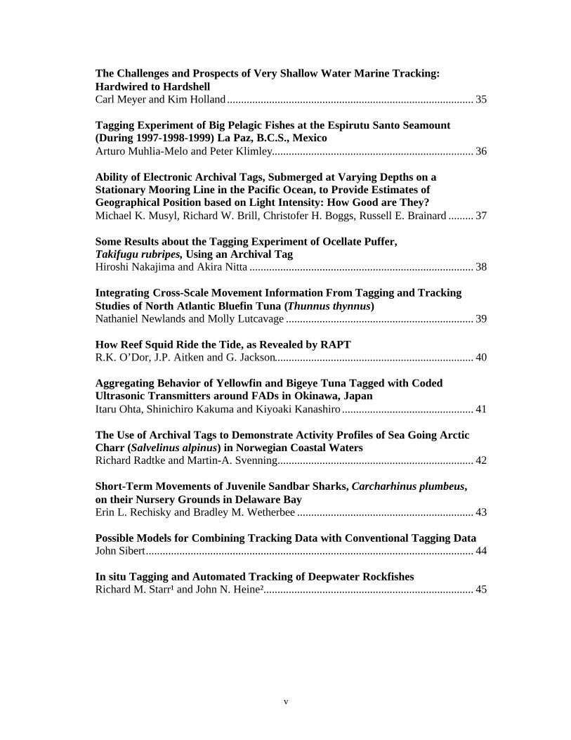
Table of Contents
PageLifestyles of the Giant Cuttlefish (Sepia apama)J.P. Aitken, R. K. O’Dor, and G. Jackson....................................................................... 1
Analysis of Swimming Behavior of a Free-Range Red Sea Bream using a MicroData-Logger Nobuaki Arai and Wataru Sakamoto .............................................................................. 2
Seasonal Residence, Movement, and Activity Patterns of Adult Tautog(Tautoga onitis) in Lower Chesapeake BayMichael Arendt and Jon A. Lucy.................................................................................... 3
Vertical Distribution of Tuna: Ultrasonic Tagging Versus InstrumentedLongline FishingPascal Bach, Laurent Dagorn, Arnaud Bertrand, Erwan Josse, Christophe Misselis ..... 4
Depth, Thermal Preferences and Body Temperature of Pacific Bluefin Tunafrom Acoustic and Pop-Up Satellite Archival TrackingSusanna B. Blackwell, David Marcinek, Heidi Dewar, Chuck Farwell,Andy Seitz, André Boustany and Barbara A. Block....................................................... 5
Archival and Pop-Up Satellite Archival Tags Reveal New Information AboutAtlantic Bluefin Tuna Migrations, Biology and Oceanographic PreferencesBarbara A. Block, Heidi Dewar, Susanna B. Blackwell, Tom Williams,André Boustany, Eric Prince,Chuck Farwell and Andy Seitz......................................... 6
Use of Acoustic Tracking to Determine Home Range of a Coral-Reef FishStephania K. Bolden........................................................................................................ 7
Behavior and Environmental Preference of Bluefin Tuna (Thunnus thynnus)off the Coast of North Carolina Inferred from Acoustic, Archival, andPop-Up Satellite TagsA. Boustany, D. Marcinek, H. Dewar, J. Keene, T. Kade, B. A. Block ......................... 8
New Muscle Biopsy for Sex Determination and Sexual Maturity in LargePelagic FishesC. R. Bridges, R. Janissen, P. Schröder, V. Susca, G. De Metrio................................... 9
Horizontal and Vertical Movements of Bigeye Tuna (Thunnus obesus)Carrying Archival TagsRichard Brill, Christofer Boggs, and Michael Musyl ................................................... 10

iii
Orientation and Swimming Speed of Migrating Plaice from Acoustic Trackingand ADCP MeasurementsAinsley Buckley and Geoff Arnold............................................................................... 11
Effects of Intraperitoneal Implantation of Acoustic Transmitters on theSwimming Performance and Growth Rates of Juvenile Atlantic Cod,Gadus morhuaD. Cote, D. A. Scruton, L. J. Cole, R. S. McKinley...................................................... 12
Pop-Up Archival Tags: Prospects for Assessment of Tuna Dynamics fromMicro- to Large-ScaleLaurent Dagorn, Francis Marsac, Olivier Maury, Erwan Josse, Arnaud Bertrand,Pascal Bach, Alain Fonteneau....................................................................................... 13
Tagging Mediterranean Bluefin Tuna with Pop-Up Satellite-Detected TagsG. De Metrio, G. P. Arnold, J. M. de la Serna, C. Yannopoulos, P. Megalofonou,A. A. Buckley, and G. Sylos Labini.............................................................................. 14
The First Deployment of Single-Point Pop-Off Satellite Tags on Bluefin Tunaand MarlinH. Dewar, C. Farwell, E. Prince and B.A. Block.......................................................... 15
A Pressure Induced Release Mechanism for Satellite Pop-Off TagsMichael L. Domeier, Daniel Preston, and Heidi Dewar ............................................... 16
Habitat Utilization and Seasonal Migrations of Adult and Juvenile Jewfish,Epinephelus itajara, using Acoustic TelemetryAnne-Marie Eklund, Christopher Koenig and Felicia Coleman................................... 17
Satellite Tracking of Whale SharksAndrew Gifford, Marie Levine, and Alex Antoniou Ph.D............................................ 18
An Evaluation of Pop-Up Satellite Tag Technology to Estimate Post-ReleaseSurvival of Blue Marlin (Makaira nigricans) John E. Graves, Brian E. Luckhurst, and Eric D. Prince .............................................. 19
Basin Scale Migrations and Fine-Scale Movements of Juvenile Southern BluefinTuna Determined through Data Collected by Archival TagsJohn Gunn and Jason Hartog......................................................................................... 20
How Much Does a Tuna Eat Each Day? Do Archival Tags Provide Us with aMeans for Determining Daily Ration?John Gunn, Jason Hartog, and Kirsten Rough.............................................................. 22

iv
Use of a Remote Acoustic Telemetry System to Monitor Shark Movements in aCoastal Nursery AreaMichelle R. Heupel and Robert E. Hueter .................................................................... 23
Geolocation by Light Level, The Next Step: LatitudeRoger Hill...................................................................................................................... 24
Five Tags Applied to a Single Species in a Single Location: The Tiger SharkExperience Kim Holland, Aaron Bush, Carl Meyer, Steven Kajiura, Brad Wetherbee,and Christopher Lowe ................................................................................................... 25
A Summary of Norwegian Experiments with Tracking the Early MarineMigration of Atlantic Salmon (Salmo salar) Post-Smolts with HydroacousticTransmittersMarianne Holm, Bjørn E. Axelsen, Ingvar Huse, Jan Aure, Arne Ervik, JohannesSturlaugsson, Nils A. Hvidsten, Bjørn O. Johnsen and Erkki Ikonen.......................... 26
Popup Satellite Tags: Their Evolution, So FarPaul W. Howey, Ted J. Rollins and Molly E. Lutcavage ............................................. 27
Changing Plaices: Where and When to Go with the FlowEwan Hunter Julian Metcalfe, Carl O’Brien, Bruce Holford, Geoff Arnoldand John Reynolds ........................................................................................................ 28
Modeling the Physiology, Behaviour and Spatial Dynamics of Tunas in Relationto Their Environment: A Mini-Review with Special Reference to the Role ofTagging in Model Derivation and EvaluationDavid Kirby................................................................................................................... 30
Finding the Smoking Gun: Where do Atlantic Salmon from the Inner Bay ofFundy go at Sea?Gilles L. Lacroix and Derek Knox................................................................................ 31
Quantifying the Energetic Demands and Behavior of Juvenile ScallopedHammerhead Sharks using Acoustic Telemetry TechniquesChristopher Lowe.......................................................................................................... 32
They do Get Around: An Update on North Atlantic Bluefin Tuna TaggingResults in the NW Atlantic, 1990-2000M. Lutcavage, R. Brill, J. Porter, P. Howey, G. Stomal, and B. Chase ........................ 33
Modeling Population Movements from Individual BehaviourJulian Metcalfe, Ewan Hunter and Geoff Arnold ......................................................... 34
v
The Challenges and Prospects of Very Shallow Water Marine Tracking:Hardwired to HardshellCarl Meyer and Kim Holland ........................................................................................ 35
Tagging Experiment of Big Pelagic Fishes at the Espirutu Santo Seamount(During 1997-1998-1999) La Paz, B.C.S., MexicoArturo Muhlia-Melo and Peter Klimley........................................................................ 36
Ability of Electronic Archival Tags, Submerged at Varying Depths on aStationary Mooring Line in the Pacific Ocean, to Provide Estimates ofGeographical Position based on Light Intensity: How Good are They?Michael K. Musyl, Richard W. Brill, Christofer H. Boggs, Russell E. Brainard ......... 37
Some Results about the Tagging Experiment of Ocellate Puffer,Takifugu rubripes, Using an Archival TagHiroshi Nakajima and Akira Nitta ................................................................................ 38
Integrating Cross-Scale Movement Information From Tagging and TrackingStudies of North Atlantic Bluefin Tuna (Thunnus thynnus)Nathaniel Newlands and Molly Lutcavage ................................................................... 39
How Reef Squid Ride the Tide, as Revealed by RAPT R.K. O’Dor, J.P. Aitken and G. Jackson....................................................................... 40
Aggregating Behavior of Yellowfin and Bigeye Tuna Tagged with CodedUltrasonic Transmitters around FADs in Okinawa, JapanItaru Ohta, Shinichiro Kakuma and Kiyoaki Kanashiro ............................................... 41
The Use of Archival Tags to Demonstrate Activity Profiles of Sea Going ArcticCharr (Salvelinus alpinus) in Norwegian Coastal WatersRichard Radtke and Martin-A. Svenning...................................................................... 42
Short-Term Movements of Juvenile Sandbar Sharks, Carcharhinus plumbeus,on their Nursery Grounds in Delaware BayErin L. Rechisky and Bradley M. Wetherbee ............................................................... 43
Possible Models for Combining Tracking Data with Conventional Tagging DataJohn Sibert..................................................................................................................... 44
In situ Tagging and Automated Tracking of Deepwater RockfishesRichard M. Starr¹ and John N. Heine²........................................................................... 45

vi
Tracking Distribution and Migration Routes of Sea Trout (Salmo trutta L.),Arctic Char (Salvelinus alpinus L.) and Homing Atlantic Salmon (Salmo salar L.),in Icelandic Waters Using Information on Temperature and Salinity from DataStorage Tags and Integrated Information From Tidal Stream Data,Hydrographical Data and from Sea Surface Satellite ImageryJohannes Sturlaugsson................................................................................................... 46
Vertical Movements of Homing Atlantic Salmon (Salmo salar L.) in Coastal andOceanic WatersJohannes Sturlaugsson................................................................................................... 48
Sex Determination and Maturation Stage Estimation in Large Pelagic FishesUsing Steroids and Vitellogenin Levels. - An Experimental Field ApproachV. Susca, C.R. Bridges, F. Acone, G. De Metrio.......................................................... 50
Choice of Coded Acoustic Transmitter Repeat Intervals Using a Simulator, withComparison to Actual Detections Recorded from Multiple Transmitters in theSame LocationFred Voegeli, Giles Lacroix and Andrew Barnes......................................................... 51
Calibrating Caudal Pressure to Swimming Speed in European Sea Bass,Dicentrarchus LabraxD. M. Webber, G. P. McKinnon, and G. Claireaux...................................................... 51
Effects of Depth on Estimating Geoposition from Archival TagsDavid W. Welch and J. Paige Eveson........................................................................... 51
Depth Behaviour and Position Estimates from Archival-Tagged School Sharks(Galeorhinus galeus) in AustraliaGrant J. West and John D. Stevens ............................................................................... 51
Estimating the Time of Dawn and Dusk from Archival Tag Light Data: MethodsUsed in the Archival Tagging of School Shark (Galeorhinus galeus) in AustraliaGrant J. West and John D. Stevens ............................................................................... 51
Are Tiger Sharks Pelagic or Coastal? Their Movement Patterns at TwoLocations in HawaiiBradley M. Wetherbee, Christopher G. Lowe, and Kim N. Holland............................ 51
Symposium Participants ............................................................................................. 51
1
Lifestyles of the Giant Cuttlefish (Sepia apama)
J.P. Aitken1, R. K. O’Dor1, and G. Jackson2
1Biology Dept., Dalhousie University, Halifax, N.S., Canada B3H 4J12Institute of Antarctic and Southern Ocean Studies, University of Tasmania,
GPO Box 252 – 77 Hobart, Tasmania 7001, Australia
The giant cuttlefish Sepia apama, lives in the shallow temperate waters of SouthAustralia. Few detailed studies have been undertaken into the biology, behaviour andreproduction of this cephalopod. With surgically attached acoustic transmitters cuttleswere physiologically monitored on their native reef in Boston Bay, South Australia usinga radio acoustic positioning telemetry system (RAPT). There were three applications:positioning, mantle jet pressure, and cuttlebone vacuum (buoyancy) which weremonitored for up to 19 days. Reef fidelity was observed as the cuttles remained on andaround their native reef during the monitoring period. Diurnal activity cycles wereobserved with emergence from their dens in morning and brief excursions during theevening. Cuttle behaviour was individualistic and resembles that of octopuses muchmore than squid. Emergence from dens appears to be just long enough for successfulforaging and to be influenced by environmental factors possibly including predation.Energy expenditures will be extrapolated from lab ground-truthing combined with thesedaily activity records.

2
Analysis of Swimming Behavior of a Free-Range Red Sea Breamusing a Micro Data-Logger
Nobuaki Arai1 and Wataru Sakamoto2
1 Graduate School of Informatics, Kyoto University2 Graduate School of Agriculture, Kyoto University
Swimming behavior of a free-range red sea bream was examined using micro data-loggers. The loggers were able to record activity parameters including surging andswaying acceleration, swimming speed, and depth. The adult red sea bream mountedwith the logger was released in a experimental fishpond. Five swimming patterns werefound for over two days. The types and their frequency were as follows; type1: dash andstop, 46.5%, type 2: dash, moderate swim, and stop, 23.3%, type 3: moderate swim, dash,and stop, 4.6%, type 4: moderate swim and stop, 2.3%, and others, 23.3%.

3
Seasonal Residence, Movement, and Activity Patterns of Adult Tautog(Tautoga onitis) in Lower Chesapeake Bay
Michael Arendt and Jon A. Lucy
Sea Grant Marine Advisory Program, Virginia Institute of Marine Science
Seasonal residence, movement, and activity patterns of fishes are influenced byphysiological (i.e., reproduction), biotic (i.e., food, habitat), and abiotic (i.e., temperature,photoperiod) factors. Physiological factors are assumed to affect a species similarlythroughout its geographic distribution; however, changes in biotic and abiotic conditionsmay not affect a species similarly throughout its geographic distribution. Differentresponses to changes in biotic and abiotic conditions may result in different seasonalresidence, movement, and activity patterns. Seasonal residence, movement, and activitypatterns are documented for northern tautog (Tautoga onitis) populations, but have neverbeen examined for southern tautog populations. Seasonal abundance and tag-recapturedata suggest regional differences in seasonal residence, movement, and activity patternsfor southern populations. This study used ultrasonic transmitters and automated acousticreceivers to document seasonal residence, movement, and activity patterns of adult tautog(n=33, 400-514 mm TL) in lower Chesapeake Bay. Tautog were caught using standardtwo-hook bottom rigs, tagged with ultrasonic transmitters (surgically implanted), andreleased at the same sites where captured less than two hours later. From 9 November1998 to 13 October, tautog were monitored at four sites (two natural sites, two manmadesites) near Cape Charles, VA. Seventy percent (n=23) of all tautog remained at releasesites and were never detected or recaptured away from release sites for the duration oftransmitter battery life (up to 6 months). Tautog remaining resident near Cape Charles,VA, tolerated a wide range (5-27°C) of water temperatures. Rather than move to areas ofwarmer water in the winter and cooler water in the summer, as documented for northernpopulations, tautog released at sites near Cape Charles, VA, remained resident anddecreased activity slightly in response to the thermal extremes. Tautog were diurnallyactive on 53-80% of days in this study. Nocturnal activity was greatest in winter andspring. Resident tautog were detected daily, except during the coldest water temperatures(5-7°C) in the winter and after abrupt (3°C) decreases in surface water temperature in thesummer. Eighteen percent of tautog (n=6) were recaptured or detected at sites located2.2-10.2 km away from where these fish were released. Tautog moved away frommanmade sites only. No evidence of inshore-offshore movement was documented.Three tautog moved away from a single site, but returned to this site on severaloccasions. These three tautog primarily moved between this release site and anunmonitored site 2.2 km to the south. When these tautog were not located at the releasesite, attempts to locate them at the unmonitored site were always successful, suggestinghigh site affinity for both sites. Twelve percent (n=4) of tautog released were detected24-106 days less (mean = 175 days) than resident tautog. These four tautog were neverrecaptured or detected elsewhere, thus, it could not be determined whether these fishmoved or if transmitters failed. When these fish were assumed to have moved, percentmovement of fish away from release sites was highly suggested (R2=0.97) to be related tosize (m2) of release sites.
4
Vertical Distribution of Tuna: Ultrasonic Tagging VersusInstrumented Longline Fishing
Pascal Bach1, Laurent Dagorn1, Arnaud Bertrand2, Erwan Josse2, Christophe Misselis3
1 IRD, BP 5045, 34032 Montpellier Cedex 1 – Francee-mail: {bach, dagorn}@mpl.ird.fr
2 IRD, BP 70, 29280 Plouzané Cedex – Francee-mail: {Arnaud.Bertrand, Erwan.Josse }@ird.fr
3 IRD, BP 529, Papeete - French Polynesiae-mail: [email protected]
Knowledge about vertical distribution of tuna is of great importance for analyzing pelagiclongline CPUE. Sonic tags allow to record continuous movements of individual fishduring a short period (one or a few days) and therefore represent an appropriate tool tostudy the vertical behavior of fish in their habitat. This technique, however, usuallyprovides a very small sample size, in terms of number of individuals and variety ofenvironmental conditions. Fishing experiments with longline equipped with time-depthrecorders and hook-timers only give discrete data on the vertical distribution of fish, butconcern a larger number of individuals, in different environmental conditions. Longlinecaptures, however, do not only depend on the behavior of fish (movements, feedingmotivation, attraction, etc.) but also on fishing effort, fishing technique, etc., andtherefore represent an indirect observation of the movements of fish. The objective ofthis work is to compare very informative data on a few fish (sonic tagging experiments)to discrete data on more individuals (fishing experiments), that only provideinstantaneous positions of fish in their habitat, in relation to fishing effort. We focus ourstudy on the diurnal vertical distribution of one species (bigeye tuna, Thunnus obesus) inone area (French Polynesia). We discuss the utilization of these techniques (separately orsimultaneously) and the most appropriate protocols for studying the vertical distributionof pelagic fish in their habitat.

5
Depth, Thermal Preferences and Body Temperature of Pacific Bluefin Tuna fromAcoustic and Pop-Up Satellite Archival Tracking
Susanna B. Blackwell1, David Marcinek1, Heidi Dewar2, Chuck Farwell3, Andy Seitz3, André Boustany1 and Barbara A. Block1
1 Tuna Research and Conservation Center, Stanford University, Hopkins Marine Station,Oceanview Blvd., Pacific Grove CA 93950
2 Pfleger Institute of Environmental Research, 1400 N. Pacific St., Oceanside CA 92054
3 Monterey Bay Aquarium, 886 Cannery Row, Monterey CA 93940
The Pacific bluefin tuna is a large, epipelagic, long-lived member of the tuna family.Compared to other bluefin species, comparatively little is known about this tuna’sbiology and seasonal migrations across the North Pacific. To augment our knowledge ofthe species and aid in our efforts to collect and maintain Pacific bluefin we tracked 8 fishin the Eastern Pacific with acoustic and pop-up satellite archival tags (PSATs). FivePacific bluefin (13-49 kg) were tracked acoustically for up to 4 days in offshore waters ofSouthern California and Mexico. The bluefin spent the majority of their time in the top20 meters of the water column in waters with sea surface temperatures of 16 to 22oC.The oscillatory diving behavior of the bluefin was characterized by extended periodsspent at the surface, as well as sunrise and sunset dives. An acoustic tag with an externalthermistor probe was placed in the slow oxidative muscle of 3 bluefin. Thermal excessranged from 6.2 to 8.6 oC. We were able to compare this acoustic data with PSAT datatransmitted from tags deployed on three fish (20-65 kg) for 4-52 days. Pressure,temperature and light were sampled at 1-2 minute intervals, summarized in 6-8 h bins andtransmitted via satellite or recovered in an archival fashion by retrieving the tag. Thebluefin spent most of their time in the mixed layer, but made occasional dives to over300m. The PSAT data was similar to data from acoustic tracking, confirming theusefulness of this technique for collecting fisheries-independent information.

6
Archival and Pop-Up Satellite Archival Tags Reveal New Information AboutAtlantic Bluefin Tuna Migrations, Biology and Oceanographic Preferences
Barbara A. Block1, Heidi Dewar2, Susanna B. Blackwell1, Tom Williams3,André Boustany1, Eric Prince4, Chuck Farwell3 and Andy Seitz3
1Tuna Research and Conservation Center, Stanford UniversityHopkins Marine Station, Oceanview Blvd. Pacific Grove, CA 93950
2Pfleger Institute of Environmental Research1400 N. Pacific St. Oceanside, CA 92054
3Monterey Bay Aquarium, 886 Cannery Row, Monterey CA, 93940
4National Marine Fisheries Service, Southeast Fisheries Science Center75 Virginia Beach Dr., Miami, FL 33149
The size, power and speed of Atlantic bluefin tuna (Thunnus thynnus) has made it achallenge to study their biology. Previous technology limitations have been overcomeusing archival and pop-off satellite archival tags, enabling studies of long-termmovements, oceanographic preferences and behaviors. Archival tags provide estimatesof geolocation, vertical movements, ambient and internal temperatures. The majoradvantage is the extensive detail of the archival record and the ability to extract dailygeolocation and oceanographic profiles in addition to biological data. We have deployed279 archival tags (during 1996, 1997 and 1999) in bluefin tuna in the western NorthAtlantic in fish up to 240 kg in size. To date, 21 archival-tagged fish have been reportedas recaptured from both the western Atlantic and the Mediterranean. Detailed records upto 3.5 years in length have been obtained and some patterns have emerged. Archival tagsindicate that bluefin tuna maintain a warm body temperature (23-30oC) whileexperiencing a wide range of ambient temperatures (4-30oC). Foraging events areevident in the record by reductions in peritoneal temperatures. Pressure records indicatebluefin prefer the surface 200m, dive at dusk and dawn, and make occasional dives toover 800m. Longitude estimates for bluefin tuna recovered in the western Atlanticindicate these fish remain in the west, both on and off the continental shelf. Although 3tags have been reported from the Mediterranean, no instruments have been returned.Information on feeding and migration, combined with oceanographic data from the tags,reveals when and where bluefin tuna forage and how these behaviors are influenced byenvironmental conditions. Pop-up archival satellite tags that record depth, externaltemperature and light and at two minute intervals have also been deployed on bluefintuna from the western North Atlantic. These tags bin the high resolution data into userset intervals which are then transmitted to the satellite. To date, 95% of the tags wedeployed have transmitted data and position information. Patterns of verticalmovements, ambient temperature and oceanographic profiles are comparable to dataobtained from archival tags deployed in the same region.

7
Use of Acoustic Tracking to Determine Home Range of a Coral-Reef Fish
Stephania K. Bolden
National Marine Fisheries Service75 Virginia Beach Drive, Miami, FL 33133
(305) 361-4293, fax (305) 361-4499, [email protected]
Home range has been investigated in few coral-reef species: lemon shark (Morrissey andGruber, 1993), and coral trout (Zeller, 1997). However, studies identifying the positionof a reef fish over time, and home range studies on fishes in lakes and rivers are muchmore prevalent in the literature. The tropical marine environment provides uniquechallenges for investigations of home range. Acoustic telemetry with radio linkedacoustic positioning buoys was utilized as a non-intrusive, remote monitoring techniqueto determine the home range size of Nassau grouper (Epinephelus striatus), a coral-reeffish. Transmitters with individual frequencies were surgically implanted into theabdomen of mature (>40cm) Nassau grouper. These cylindrical transmitters werepressure-sensitive, powered by a lithium battery, had a battery life of 60 days, andconstituted less than 1% of the total fish weight. The internal transmitters emit acontinuous signal of one acoustic pulse per second and provide opportunity forcontinuous surveillance. The study took place in The Exuma Cay Land and Sea Parklocated in the central Bahamas. This remote Park is comprised of islands oriented NW-SE along the edge of the Exuma Sound separated by inlets or tidal channels (which rangefrom 200 m to > 2 km wide) with tidal currents around 2 knots. The challenge ofworking in a remote tropical locale and the logistical constraints of the tracking systemwill also be discussed.

8
Behavior and Environmental Preference of Bluefin Tuna (Thunnus thynnus) off theCoast of North Carolina Inferred from Acoustic, Archival, and
Pop-Up Satellite Tags
A. Boustany1, D. Marcinek1, H. Dewar2, J. Keene1, T. Kade3, B. A. Block1
1 Tuna Research and Conservation Center, Stanford University, Hopkins Marine Station,Oceanview Blvd., Pacific Grove CA, 93950
2 Pfleger Institute of Environmental Research, 1400 N. Pacific St. Oceanside CA, 92054
3 Duke University Marine Laboratory, Beaufort NC 28516
Atlantic bluefin tuna (Thunnus thynnus) have been congregating off the coastal waters ofNorth Carolina for the past five years. Questions remain as to what attracts bluefin to thisarea in the winter months as well as whether the appearance of these fish is a recentphenomenon or one that was only recently noticed. The behavior of bluefin tuna hasbeen studied off the coast of North Carolina since 1996 using acoustic, archival and pop-up satellite tracking. Data from acoustic and archival tags revealed that bluefin tuna inthis area exhibit similar behavior patterns and environmental preferences. Bluefin remainover the mid to outer continental shelf, predominately in waters 30 - 80 meters deep.Temperature and oxygen concentrations varied little from surface to bottom. Bluefinshowed a strong preference for the frontal boundary region between the warmer waters ofthe Gulf Stream (> 25 oC SST) and the much colder near shore waters (<16 oC SST).This narrow distribution around frontal zones combined with the lack of verticalstratification means that bluefin in this area were exposed to a very narrow temperaturerange (18 - 24 oC). This area, time of year and temperature range coincide with a largespawning concentration of forage fish predominantly menhaden, croaker and spot.Histological sampling of the bluefin tuna gonads indicate that fish in this region are notspawning. It is proposed that the large numbers of bluefin that are residential along thecoast of North Carolina in the winter months are feeding aggregations that are exploitingthe abundant food resources that are present in this area during winter.

9
New Muscle Biopsy for Sex Determination and Sexual Maturityin Large Pelagic Fishes
C. R. Bridges¹, R. Janissen², P. Schröder³, V. Susca4, G. De Metrio5
1, 2, 3, 4 Institut fuer Zoophysiologie -Stoffwechselphysiologie-Heinrich-Heine –UniversityUniversitaetsstr. 1 D-40225 Duesseldorf Germany, 5 Department of Animal Production, via
Amendola 165\A, 70126 Bari, Italy
Presenter: Christopher R. Bridges; Institut fuer Zoophysiologie-Stoffwechselphysiologie-Heinrich-Heine-University Universitaetsstr. 1 D-40225Duesseldorf, Tel.: 0049/211/8114991 Fax.: 0049/211/8114991, e-mail: [email protected]
Through the use of new biotechnological techniques it is now possible to use molecularmarkers such as sex hormones and vitellogenin to determine sex and gonadal maturationin muscle samples from teleost fish. This type of data may play an important role inassessing migration patterns. The present study concerns the development of a musclebiopsy punch which can be used either in the field or at the market to obtain musclebiopsy samples from live or dead tuna or swordfish. These samples can then be assayedusing standard ELISA methods developed in our laboratory for sex hormones andvitellogenin. Experiments in the laboratory have to date shown that as little as 100 mg oftissue are required for these determinations and the self-activating punch system can beadapted to fit on harpoons or used as a "stand alone" hand-held device. Further fieldtrials are now planned to test this system in a full sampling programme. Financialsupport provided by EU grant CFP - BFTMED - 97/0029

10
Horizontal and Vertical Movements of Bigeye Tuna (Thunnus obesus)Carrying Archival Tags
Richard Brill1, Christofer Boggs1, and Michael Musyl2
1 Honolulu Laboratory, Southwest Fisheries Science Center,National Marine Fisheries Service, Honolulu, Hawaii
2 Pelagic Fisheries Research Program,Joint Institute for Marine and Atmospheric Research,
School of Earth and Ocean Science Technology,University of Hawaii at Manoa, Honolulu, Hawaii
To understand harvest impacts and interactions among fisheries for populations of tunaand billfish across the Pacific, information is needed on migration patterns and on howenvironmental factors influence distribution and catchability. Archival tags provide apowerful new tool for acquiring these data. The Honolulu Laboratory is, therefore,conducting an archival tagging project on bigeye tuna and swordfish in collaboration withthe Pelagic Fisheries Research Program (Joint Institute for Marine and AtmosphericResearch, University of Hawaii) and the Commonwealth Scientific & Industrial ResearchOrganization of Australia.
Since April 1998, archival tags have been deployed on 63 bigeye tuna (fork length 50-133 cm) during research cruises aboard the NOAA Ship Townsend Cromwell. Fish werecaught both near the leeward (Kona) coast of the Island of Hawaii, and over CrossSeamount (≈18° 42 N, ≈158° 17 W). Tags were implanted either into the dorsalmusculature or the peritoneal cavity.
As of December 1999, four tagged fish have been recaptured and three archival tags havebeen returned. The fish from which archival tags have been returned had been at libertyfor approximately three months, nine months, and nine days before recapture.Preliminary calculations of position showed the fish remained within a few hundred milesof the leeward coast of the Island of Hawaii, or almost immediately adjacent to CrossSeamount. As observed during studies of bigeye tuna carrying ultrasonic transmitters,the fish spent daylight hours at depth and returned to the surface at night. Bigeye tunaare, however, able to descend deeper (up to 735 m), into much colder water (down toapproximately 5°C), and to withstand much lower oxygen levels (≈ 1 ml l-1) thenyellowfin tuna in the same areas. During daylight, bigeye tuna make regular upwardexcursions into the warm surface layer in order to maintain body temperature, whichnever went below approximately 17°C.
The minimum depths reached during the night were also found to be strongly correlatedwith moon phase; fish would ascend to shallower depths during the new moon. Theseobservations confirmed and explained the correlation between catch rates of bigeye tunaon longline gear and moon phase previously observed.

11
Orientation and Swimming Speed of Migrating Plaice from Acoustic Trackingand ADCP Measurements
Ainsley Buckley and Geoff Arnold
The Centre for Environment, Fisheries and Aquaculture ScienceLowestoft Laboratory, Pakefield Road, Lowestoft, Suffolk, NR33 0HT, UK
Theoretical studies have shown that plaice can save a significant proportion of themetabolic cost of their annual spawning migrations through the use of selective tidalstream transport. Maximum gains (40% for adults, 90% for juveniles) are possible if thefish orientate precisely down-tide when in midwater, and also swim at their optimumspeed. For large adult fish tidal stream transport is only economical when they activelyswim down-tide relative to the current; juvenile plaice can, however, still gain a ten-foldincrease in migration range without orientating.
We have been tracking large female plaice in order to investigate swimming speed andorientation of adult plaice during pre- and post-spawning migrations between thesouthern North Sea and eastern English Channel. We used 300 kHz transpondingacoustic tags and sector scanning sonar to follow the fish and we determined the positionof the research vessel by GPS. At the same time we measured the speed and direction ofthe tidal stream using a vessel-mounted broad band Acoustic Doppler Current Profiler(ADCP) transmitting at a frequency of 150 kHz. We have estimated the swimming speedand direction of the fish by vector subtraction, using data from 52 midwater excursionstaken from the tracks of 10 fish that exhibited selective tidal stream transport.
Our results agree with theoretical predictions and show that adult fish generally headdown-tide when in midwater. Although the degree of orientation is not sufficient torealise the maximum possible reduction in metabolic costs, mean headings are mostlywithin ± 20º of the mean direction of the tidal stream. The average down-tide swimmingspeed is approximately 0.6 body lengths s-1. This value, which is close to theexperimentally determined optimum swimming speed, confirms an earlier estimate basedon whole-tide ground tracks and average tidal stream vectors derived from navigationcharts, rather than direct measurements. We discuss our results in relation to thereconstruction of the geographical tracks of fish from pressure records obtained from datastorage (archival) tags, and the sensory mechanisms involved in the migration ofdemersal fish in tidal seas.

12
Effects of Intraperitoneal Implantation of Acoustic Transmitters on the SwimmingPerformance and Growth Rates of Juvenile Atlantic Cod, Gadus morhua
D. Cote1, D. A. Scruton2, L. J. Cole2, R. S. McKinley1
1 Waterloo Biotelemetry Institute, Department of Biology,University of Waterloo, Waterloo, Ontario N2L 3G1, Canada
2 Department of Fisheries and Oceans, Science Branch,Post Office Box 5667, St. John’s, Newfoundland A1C 5X1, Canada
As part of a three year study on the inshore habitat preferences of wild juvenile Atlanticcod, Gadus morhua, the short-term and long-term effects of intraperitoneal implantationof dummy acoustic transmitters (1.9 - 4.6% of the fishes’ body weight) were investigated.Short term effects were examined by comparing critical swimming speeds 24 h post-surgery for implanted, sham-implanted and control treatments using a Blaska-style swimtube. Longer term effects were assessed through comparison of growth rates, mortality,and tag expulsion of cod, using the same three treatments, over a 220 d period.Differences in critical swimming speed between treatment groups was found to be non-significant between groups, suggesting that tagged juvenile cod are capable of similarphysical performance to that of untagged cod soon (24 h) after surgery. During the long-term study period, there was no significant difference in growth between treatments, noincrease in mortality associated with the tagging procedure, and no incidents oftransmitter expulsion. This study suggests that intraperitoneal implantation of acoustictransmitters can be a valid technique to examine the behaviour of juvenile Atlantic cod inboth short and long-term studies.

13
Pop-Up Archival Tags: Prospects for Assessment of Tuna Dynamicsfrom Micro- to Large-Scale
Laurent Dagorn1, Francis Marsac1, Olivier Maury1, Erwan Josse2, Arnaud Bertrand2,Pascal Bach1, Alain Fonteneau1
1 IRD, BP 5045, 34032 Montpellier Cedex 1 – Francee-mail: {bach, dagorn}@mpl.ird.fr
2 IRD, BP 70, 29280 Plouzané Cedex – Francee-mail: {Arnaud.Bertrand, Erwan.Josse}@ird.fr
This prospective paper examines the potential use of «ideal» pop-up archival tags, i.e.tags that give reliable and precise data on movements of tagged fish, independent of thefisheries, to study tuna dynamics from small- to large-scales. These «ideal» tags do notexist for the moment but it is necessary to explore some of the potential use of these tagsin order to promote their development. Whereas sonic tags and conventional tags provideinformation on small- and large scale movements of fish, respectively, pop-up archivaltags could represent the appropriate tool to fill the gap between those scales, i.e. betweenbehavioral studies and stock assessment.
One important tactical objective of behavioral studies in fisheries sciences is tounderstand the 3-D movements of fish, with the ambitious strategic objective of beingable to explain some meso- or large-scale movement and distribution from knowledge ofsmall-scale behavior. Sonic tags give detailed information on very fine-scale movementsof tagged fish that can be coupled with 3-D observations of the hydrological andbiological environment. The main shortcoming of this kind of experiment is their relativeshort duration (less than one week) making it difficult to infer behavior on larger scales.Pop-up archival tags allow longer observations, and experiments should be designed tosimultaneously observe the hydrological and biological environment. Specific protocols,employing multiple tagging techniques (sonic + pop-up) in conjunction with acousticsurveys are discussed.
Conventional tags are used to estimate population parameters (fishing mortality, naturalmortality, growth, movements) of primary importance for stock assessment. However,the lack of information between points of release and recapture is a major limiting factorfor an accurate assessment of transfer rates (diffusion and advection terms) at a mesoscale, since it depends on the routes taken by the fish. In this perspective, the pop-uparchival tags would provide highly valuable information. Their high cost requires anappropriate design of experiments, especially the number of tags to release according tospecific issues.
By filling the gap between sonic and conventional tags, pop-up archival tags couldgreatly contribute to consider behavior in stock assessment. Some aspects of thischallenge are discussed.

14
Tagging Mediterranean Bluefin Tuna with Pop-Up Satellite-Detected Tags
G. De Metrio1, G. P. Arnold2, J. M. de la Serna3, C. Yannopoulos4, P. Megalofonou4,A. A. Buckley2, and G. Sylos Labini5
1 Department of Animal Production, University of BariVia Amendola 165/A, 70125 Bari, Italy
2 CEFAS Lowestoft (UK)3 IEO Malaga (Spain)
4 Department of Zoology-Marine Biology, University of Athens (Greece)5 Planatek Italia, Bari (Italy)
Fifty bluefin tuna, several of them giants, were tagged in 1998 and 1999, as part of an EC-fundedproject (TUNASAT) set up to investigate movements of tuna in the Mediterranean and easternNorth Atlantic and evaluate the use of electronic pop-up tags. The fish were marked with tagsprogrammed to detach themselves from the fish and float to the surface after intervals of 5 to 300days. The 61 average hourly, or daily, sea temperatures recorded by each tag were recovered byradio telemetry using the Argos satellite system, which also determined the pop-up position. Thetags were attached by nylon monofilament line to medical grade nylon darts (Floy Inc.)embedded in the dorsal muscles, or (in the case of three fish tagged in the Aegean Sea) insertedthrough the base of the dorsal fin rays. In 1998 the fish were caught in traditional tuna traps andtagged by divers using an underwater sport-fishing gun. Three fish were tagged at Stintino(northern Sardinia) in June and nine at Barbate (southern Spain) in late July. A further 23 fishwere caught in the trap at Barbate in July 1999 and tagged by a diver using a hand-held harpoon.Fifteen line-caught fish were also tagged during 1999. Three fish, caught on hand lines, weretagged near Chalkidiki in the northern Aegean Sea in April; the fish were tagged in the water andthe tags attached by hand. A further 12 fish were tagged in the sports fishery off Bonifacio(Corsica) in September and November 1999. These fish, which were caught on rod-and-line,were also tagged alongside the boat using a T-shaped tagging stick generously loaned bycolleagues in the USA.
Six (50%) of the 1998 tags popped up successfully. Tags from Stintino popped up in theTyrrhenian Sea (1 tag) and off the coast of North Africa (2 tags) after periods of 5-15 days atliberty. Two tags from Barbate popped up in the Atlantic near Madeira and the Cape VerdeIslands after 60 and 177 days, respectively. Data from a third tag released at Barbate werereturned from the Greenland Sea in March 1999, after the fish had been at liberty for 240 days.So far only 3 tags (19%) have popped up from the 1999 releases, although 16 were expected.One, which was tagged off Chalkidiki, popped up in the southern Aegean Sea after 30 days. Ofthe other two, one popped up off the coast of Morocco after 60 days, the other between Gibraltarand Madeira after 88 days. The first tags from the Corsican releases are not expected to pop-upuntil the end of December 1999; the last tag from the 1999 releases is due up in July 2000. Ourpop-up rates are much lower than the rates of 85% and 95% recorded from two previous studiesin the western North Atlantic, which used the same type of tag. The reasons for this markeddiscrepancy are not yet clear but we discuss a number of technical and biological possibilities.

15
The First Deployment of Single-Point Pop-Off Satellite Tagson Bluefin Tuna and Marlin
H. Dewar1, C. Farwell2, E. Prince3 and B.A. Block4
1 Pfleger Institute of Environmental Research1400 N. Pacific St. Oceanside CA, 92054, USA
2 Tuna Research and Conservation Center, Monterey Bay Aquarium886 Cannery Row, Monterey CA, 93940, USA
3 Department of Commerce, National Oceanographic and Atmospheric Administration,Southeast Fisheries Science Center, 75 Virginia Beach Dr., Miami FL 33149
4 Stanford University, Hopkins Marine StationOceanview Blvd. Pacific Grove CA, 93950
A novel fisheries-independent tool, the pop-off satellite tag, was recently developed forstudying the biology of pelagic fish. We piloted the use of this technology in February1997, by tagging 37 Atlantic bluefin tuna (96-181 Kg) with short (3-14 day) and long-term (60-97 day) tags. Short-term tags archived ambient temperature hourly while long-term tags logged average daily values. Temperature both provided insight into thermalbiology and was an important indicator of survivorship and premature release. In theshort-term study, temperature records showed 100% survivorship. In the long-termstudy, 93% of the tags provided data. In a few cases, using temperature as a measure ofwhether the tag remained on the bluefin proved difficult. We also successfully deployedone 60-day tag on longline-caught, 40 kg, yellowfin tuna. We believe that tag placementis critical. Based on studies with captive tuna, we found the base of the second dorsal finto be the ideal anchoring site, here contact with the body is minimized. In 1997, we alsodeployed twenty pop-up tags on marlin (70-390 kg) in the Atlantic and Pacific. We had alower success rate (45%) with marlin but recorded some remarkable long-distancemovements. Tag interaction with the fish could lead to instrument damage and mortalitymay be a factor. Interpreting temperature data was more difficult with marlin because oftheir preference for warm surface waters. While temperature is an important tool forexamining whether tags remain on fish, caution must be exercised in data interpretation.

16
A Pressure Induced Release Mechanism for Satellite Pop-Off Tags
Michael L. Domeier, Daniel Preston, and Heidi Dewar
Pfleger Institute of Environmental Research1400 N. Pacific St. Oceanside CA, 92054
Pop-off satellite tags, although only a few years old, have already made significantcontributions to pelagic fish research. One frustrating problem, however, has been theinability to determine the significance of a tag that does not report via satellite. Plausibleexplanations for a tag not reporting include: tag failure; a tagged dead (or live) animalsinking below the crush depth of the tag; premature shedding and subsequent loss; or thefish being caught and the tag not returned. The inability to distinguish between these haslimited the ability to examine survivorship in existing studies or to design experiments totest mortality. We are developing a small, pressure induced release mechanism that willsever the connection between the tag and the anchor as the tag reaches its maximumdepth rating, helping to eliminate mortality as a source of data loss. Development of apressure based release mechanism used in conjunction with pop-off satellite tags willimprove data interpretation and increase the breadth of questions that can be addressedusing this technology.

17
Habitat Utilization and Seasonal Migrations of Adult and Juvenile Jewfish,Epinephelus itajara, using Acoustic Telemetry
Anne-Marie Eklund1, Christopher Koenig2 and Felicia Coleman2
1 NOAA-Fisheries, Southeast Fisheries Science Center75 Virginia Beach Drive, Miami, FL 33149
(305) 361-4271, FAX: 305-365-4102, [email protected]
2 NOAA/FSU Institute for Fishery Resource EcologyDepartment of Biological Science, Florida State University
Tallahassee, FL 32306-1100(850) 644-4509, FAX: 850-644-2019, [email protected]; [email protected]
Jewfish, Epinephelus itajara, the largest grouper in the western North Atlantic, has beenprotected from all harvest in U.S. waters since 1990, after years of overexploitation at itsspawning aggregations. We are currently assessing this species’ recovery by monitoringthe adult populations at offshore spawning aggregations and the juveniles at their nurseryareas along mangrove shorelines. We have used externally-placed acoustic tags, coupledwith large visual tags, on adults and have found much greater movement amongaggregation sites than originally suspected. Juvenile jewfish, on the other hand, havemore limited movement patterns. Some individuals have been recaptured up to seventimes from the exact location. By using acoustic telemetry throughout the year, we havebeen able to describe juvenile jewfish habitat utilization under mangrove overhangs andin depressions in tidal passes. Although we were unable to catch jewfish in the winterusing traditional trapping and angling methods, the internally-placed, acoustic tagsdemonstrated that the animals were present throughout the year and were quite sedentaryin the winter months when the temperature declined. We are mid-way through anexperiment using both visual tagging methods and acoustic telemetry to compare jewfishabundance and distribution in altered and unaltered habitats.

18
Satellite Tracking of Whale Sharks
Andrew Gifford, Marie Levine, and Alex Antoniou Ph.D.Shark Research Institute
Results are presented from a series of satellite tags deployed on whale shark in the IndianOcean and Caribbean Sea. Satellite tags were tethered to the sharks by darts of variousdesigns. This study confirms that satellite tagging can be an effective tool in monitoringlong and short term movements of whale sharks, but there exist significant problems withattachment of the tags to the host animals.

19
An Evaluation of Pop-Up Satellite Tag Technology to Estimate Post-ReleaseSurvival of Blue Marlin (Makaira nigricans)
John E. Graves1, Brian E. Luckhurst2, and Eric D. Prince3
1 Virginia Institute of Marine Science, College of William and MaryP.O. Box 1346, Gloucester Point, VA 23062 USA
2 Division of Fisheries, Department of Agriculture and FisheriesP.O. Box CR53, Crawl CRBX BERMUDA
3 National Marine Fisheries Service75 Virginia Beach Drive, Miami, FL 33146 USA
About 90% of blue marlin taken by U.S. recreational fishermen are released after capture.The conservation impact of catch-and-release fishing for this species is not wellunderstood as little is known about the survival of blue marlin following release. Resultsof acoustic tracking studies in which blue marlin were followed for up to several daysafter release suggest that mortality, when it occurs, usually happens within 48 hours ofrelease. Pop-up satellite tags, which have been used to study movements of bluefin tunaand blue marlin over time periods of one to several months, provide a potential tool tostudy post-release survival of billfish over shorter time periods. To evaluate thefeasibility of using pop-up satellite tag technology to estimate post-release survival wedeployed nine pop-up satellite tags on blue marlin caught on recreational gear near twobanks off the southwest coast of Bermuda. Tags were programmed to take and storedirect water temperature measurements every two hours and release after five days. Thefirst nine blue marlin made available to us were tagged. Estimated weights of the fishranged from 150 to 425 pounds. Blue marlin were captured on rod and reel with trolledlures or skirted dead baits. Fight times ranged from fifteen to thirty-five minutes, andsome individuals required resuscitation before release. Eight of nine tags reported afterfive days at liberty. Temperature records indicated that each fish was moving up anddown in the water column over the course of the five day period. The eight individualsdispersed in all directions from Bermuda, with a mean net movement of approximately90 nautical miles (range 40 to 134 nmi). These data demonstrate that at least eight of thenine tagged fish were alive for five days following capture and release, and clearlyindicate that pop-up satellite tag technology is appropriate for estimating post-releasesurvival of this highly migratory species.

20
Basin Scale Migrations and Fine-Scale Movements of Juvenile Southern BluefinTuna Determined through Data Collected by Archival Tags
John Gunn and Jason Hartog
CSIRO Marine ResearchHobart, Australia
The development of archival (data storage) tags in the early 1990’s allowed researchersstudying the patterns and process of migration in oceanic pelagic fishes to overcome thesignificant gaps in our knowledge between the fine-scale data we’d collected usingultrasonic telemetry and coarse-scale data derived from conventional tag-and-recaptureexperiments. The technology has now been used successfully throughout the world onthree species of bluefin tuna, and recently also on bigeye tuna. In all cases, the datacollected have provided a quantum leap forward in our understanding of the biology andecology of species.
Southern Bluefin Tuna (SBT) (Thunnus maccoyii) are distributed throughout the southernAtlantic, Indian and Southern Oceans and the Tasman Sea. Recent assessments estimatethat the parental biomass of SBT is at historically low levels. Over the last two decadesthere has been significant contraction in the areas in which SBT are caught by high seaslongline fleets. Depending on which assessment we adopt, the contraction in geographicdistribution of catches is thought to be due either to a “real” contraction in thedistribution of fish (resulting from drastic reduction in biomass), or to operationalchanges within the fishery. If the former is the case, then the chances of recovery of thestock are considered to be very low under current levels of exploitation, whereas if thelatter is the case, the inference is that there is a large, currently unexploited (cryptic),biomass in non-fished areas which could support a stock recovery.
Conventional tagging experiments are uninformative in examining hypotheses regardingdistribution and movement of fish outside fished areas. CSIRO has tagged over 100,000SBT with dart tags since the early 1960’s and from the many thousands of recaptures hasdeveloped a conceptual model of migration paths and distribution for the species. Since1994 we have also used archival tags to examine the movements of juvenile SBT. Theresults from our first 80 archival tag recoveries have challenged the conceptual modelsbased on conventional tag data. We have found that large-scale, cyclic migrations,associated with major changes in habitat and feeding behaviour, are common. The datafrom archival tags indicate that our previous understanding of migratory behaviour wassignificantly biased by the behaviour/co-operation of fishermen.
Archival tags have shown us the nature of variation in behaviour over daily, weekly,lunar and seasonal time periods. For example, diving patterns vary on lunar cycles whenfish are in oceanic waters, but not when they are in coastal waters. Fish sun-bake in theupper 2 metres of the water column during summer afternoons, but in the winter prefer tospend most of the day at depth sin excess of 200 metres. At some times of the year fish

21
are restricted to depths above the thermocline, while at others this provides no barrier tomovement. Although explanations for the variability are difficult to determine, webelieve the majority are related to shifts in feeding behaviour.
The internal thermistor of the archival tag has allowed us to examine variation in visceraltemperature. As Carey found for Atlantic bluefin in the 1970’s, visceral temperature inSBT increases as digestion begins and remains above basal core temperature throughoutthe digestion process. Using thermodynamics models, we have been able to examinewhen, how often and where fish are feeding. These data show that fish frequently go formany days to a week or so without feeding; the longest period of “starvation” is 42 days.We are currently examining the relationship between the amount of heat produced andration/calorific to determine whether we can also estimate the amount of food eaten overa given period.
The presentation will provide brief views through the various windows opened byarchival tags and conclude with a look towards future developments in archival tagtechnology and associated science.

22
How Much Does a Tuna Eat Each Day? Do Archival Tags Provide Us with a Meansfor Determining Daily Ration?
John Gunn1, Jason Hartog1, and Kirsten Rough2
1 CSIRO Marine ResearchHobart, Australia
2 Tuna Boat Owners Association of Australia
Tunas are unusual among teleosts in that they are capable of maintaining core temperaturessignificantly above ambient. Although it is primarily believed that these elevated coretemperatures promote an increased muscle efficiency, it has also been demonstrated that bluefintuna warm their visceral during digestion. In the 1970’s, Frank Carey and his associates foundthat visceral temperature in Atlantic Bluefin Tuna (Thunnus thynnus) increased as digestionbegan and remained above basal core temperature throughout the digestion process. Using theinternal thermistor of an archival tag we have found a similar relationship in Southern BluefinTuna (Thunnus maccoyii).
We developed a thermodynamics model that provides a means of distinguishing betweentemperature variation related to changes in environmental temperature and that related todigestion. From there we have been able to examine when, how often and where fish are feeding.These data show that fish frequently go for many days to a week or so without feeding; thelongest period of “starvation” is 42 days.
Having determined when a fish is feeding, we are now particularly interested in understanding therelationship between the amount of heat produced within the viscera and the ration or calorificvalue of the meal ingested. To estimate these relationships, we have begun a series ofexperiments on tuna being held in grow-out cages in South Australia. These fish are caught inpurse seines, transferred into cages and for periods of 2-8 months fed to satiation each day in anattempt to fatten them for the very lucrative sashimi market in Japan. The cages provide an idealsetting for a range of biological and physiological experiments.
Over the last two months we have conducted two experiments, in summer and in winter, in whichwe examined the relationship between the amount of food eaten and the extent and nature ofwarming of the viscera. We implanted Vemco minilog temperature loggers into the visceral massventral to the caecum and the stomach.
Preliminary analyses of the experimental data suggest a very close linear relationship betweenheat production and ration in both summer and winter. Although the duration of visceralwarming was similar in summer and winter for the same ration, we found very significantdifferences in the extent of warming, and the slope of the relationship between ration and totalheat production.
We discuss the findings of the experiment in relation to the physiology and ecology of juveniletuna.

23
Use of a Remote Acoustic Telemetry System to Monitor Shark Movementsin a Coastal Nursery Area
Michelle R. Heupel and Robert E. Hueter
Center for Shark Research, Mote Marine Laboratory1600 Ken Thompson Parkway, Sarasota, Florida 34236
A series of 14 VR1 remote acoustic hydrophones (Vemco Ltd, Nova Scotia) weredeployed within a coastal shark nursery area during the summer of 1999 to monitor thelong-term movements of neonate Carcharhinus limbatus. Terra Ceia Bay, Florida, is asmall bowl shaped bay with a muddy bottom and a mean depth of about 4 m.Hydrophones were deployed in Terra Ceia Bay in the middle of the water column with afloat and anchor system used to maintain height and position. Hydrophone stations weredeployed approximately 700 m apart and range tests confirmed an omnidirectionalacoustic range of at least 500 m. Vemco V16 RCODE transmitters were surgicallyimplanted into the abdomens of 18 C. limbatus. Sharks were tracked for periods of threeto 159 days as they moved within the study site. Three sharks were also actively trackedto confirm movement patterns recorded by the remote hydrophone stations. Since remoteacoustic technology provides data covering much greater time periods and lower spatialresolution than traditional acoustic tracking, novel approaches to data analysis needed tobe developed. Some of these analyses are described. Observations were also madeconcerning movements into areas not monitored by hydrophone stations.

24
Geolocation by Light Level, The Next Step: Latitude
Roger Hill
Wildlife ComputersSeattle, WA
Published methods of calculating location from light level involve selecting a thresholdlight level and determining the times at which recorded light levels cross this thresholdduring sunrise and sunset. This threshold level must be equated to an angle of the sunabove the horizon (elevation), and standard astronomical equations can then be used todetermine the location on the earth at which the recorded transitions could have occurred.A problem arises with this simple method in that there are a number of days near thespring and vernal equinoxes for which there is very little variation in day-length, and thisresults in a significant uncertainty in the latitude estimate. However, there is a significantvariation in the shape of the light-level curves at dawn and dusk regardless of the day ofthe year. A method is presented in which the relationship between the elevation of thesun and measured light level (corrected to the seawater surface) is determined. Thisrelationship is used to predict the light intensity through sunrise and sunset for anylocation on any day. The measured light level curve is then compared with predictedlight level curves for the day in question and the best correlated curves give the bestestimate of position. This process works well even through the equinoxes.

25
Five Tags Applied to a Single Species in a Single Location:The Tiger Shark Experience
Kim Holland1, Aaron Bush1, Carl Meyer1, Steven Kajiura1,Brad Wetherbee2, and Christopher Lowe3
1 Hawaii Institute of Marine Biology and Department of ZoologyUniversity of Hawaii
2 NEFSC-NMFS, Narragansett Laboratory
3 Dept. of Biological Sciences, California State University, Long Beach, CA
Between 1993 and 1999, five different types of tag have been used to study themovements and habitat usage patterns of tiger sharks. In all cases, the sharks werecaught, tagged and released in the same coastal area (approx. 1.5 miles offshore ofHonolulu Harbor in water 20 to 50 meters deep). Tags used were: 1) standardidentification dart tags, 2) pressure sensitive sonic transmitters used for active tracking,3) long-life acoustic pingers monitored by a data logger fixed on the ocean floor at therelease site, and 4) archiving "CHAT" tags which sonically download stored data to thesame fixed data logger site and 5. an archiving pop-up satellite tag.
The different tag types produced data which are congruent with each other and allowconstruction of a consistent hypothetical picture of the vertical and horizontal behaviorand habitat utilization patterns of tiger sharks in the Hawaiian Islands. The relative valueof the different tagging methods to the construction this overall picture will be discussed.

26
A Summary of Norwegian Experiments with Tracking the Early Marine Migrationof Atlantic Salmon (Salmo salar) Post-Smolts with Hydroacoustic Transmitters
Marianne Holm1, Bjørn E. Axelsen1, Ingvar Huse1, Jan Aure1, Arne Ervik, JohannesSturlaugsson2, Nils A. Hvidsten3, Bjørn O. Johnsen3 and Erkki Ikonen4
1 Institute of Marine ResearchP.O. Box 1870 Nordnes, N- 5817 Bergen, Norway
2 Institute of Fresh Water Fisheries and AquacultureVagnhöfda 7, 112 Reykjavik, Iceland
3 Norwegian Institute for Nature Research,Tungasletta 2, N-7005 Trondheim, Norway
4 Finnish Game and Fisheries Research InstitutePO Box 6, FIN- 00721 Helsinki, Finland
Results from tracking experiments in the early 80-ties in the Høgsfjord in SW Norwayand from 1996 - 98 in the Trondheim fjord (mid- Norway) have been joined together toanalyse details of the migratory behaviour during the first days of seaward migration ofthe Atlantic salmon post-smolts. In the first experiment we were able to monitor thevertical movements of some of the salmon post-smolts with miniature depth sensitivetransmitters (SINTEF, Norway) attached to the fish. Later it was not possible to obtaindepth sensitive tags small enough for post-smolts, and in these experiments we usedminiature pingers (Vemco, Canada) and were able to track horizontal positions only. Inthese experiments 60 fish have been tracked for time periods varying from 1 - 80 hours(0.5 - 100 km tracks). The migratory behaviour of the fish is seen in relation tohydrographical and meteorological conditions observed in the fjords. The influence onpost-smolt behaviour of different tag attachment methods used are discussed, and theimportance of hydrocaoustic tagging for advancing post-smolt research is brieflydiscussed.

27
Popup Satellite Tags: Their Evolution, So Far
Paul W. Howey1, Ted J. Rollins1 and Molly E. Lutcavage2
1 Microwave Telemetry Inc.Columbia, MD, US
2 New England AquariumBoston, MA, US
The technology of popup satellite tracked tags has advanced rapidly since our initial testsof the feasibility of such tags in the summer of 1996. The first free deployments of theoriginal design single point popup tags in early 1997 proved very successful, 35 of the 37tags deployed on Atlantic bluefin tuna reporting back after popping up successfully.Since then similar single point tags have been used around the world on marlin andsharks as well as tuna.
Since 1998 we have worked on the design of a true archival popup tag with light levelgeolocation. Several experimental tags were deployed in 1998 to gather fundamentallight level data and test sensors in the real environment. In 1999 the design of ourarchival tag was completed. Since then a series of these tags have been deployed onbluefin tuna in the NE Atlantic, the first of these have already reported back fascinatinginsights into movements and behavior of these fish.

28
Changing Plaices: Where and When to Go with the Flow
Ewan Hunter1,2, Julian Metcalfe2, Carl O’Brien2, Bruce Holford2,Geoff Arnold2 and John Reynolds1
1School of Biological Sciences, University of East AngliaNorwich NR4 7TJ, UK
2Centre for Environment, Fisheries and Aquaculture Science,Lowestoft Laboratory, Lowestoft, Suffolk, England UK.
Correspondence: Dr. Ewan Hunter, Centre for Environment, Fisheries andAquaculture Science, Lowestoft Laboratory, Lowestoft, Suffolk, England, UK.
Tel. +44 (0) 1502-524226, Fax +44 (0) 1502-513865e-mail [email protected]
Fish populations inhabiting the European continental shelf are exposed to a wide range oftidal current speeds. In the northern and central North Sea, mean spring current speedsare around 0.2 ms-1, but in the Southern Bight they can be greater than 0.5 ms-1, and mayexceed 1.2 ms-1 in the Dover Strait. Tracking studies and mid-water trawlingexperiments during the seventies and eighties revealed that plaice, Pleuronectes platessaL., use the fast currents in the southern North Sea to transport between centrally locatedsummer feeding grounds, and winter spawning areas in the Southern Bight and easternEnglish Channel. These results demonstrate that in areas of fast tidal currents plaice usethe tidal streams efficiently for selective tidal stream transport (STST) and, furthermore,that this behaviour can minimise the energetic costs of migration.
More recently, our understanding of the use of STST by plaice in the Southern Bight hasbeen extended using depth and temperature sensing electronic data storage tags (DST).Of 302 DST tagged plaice released between December 1993 and February 1997, 50 havebeen returned. Of the 50 returned DST, we were able to reconstruct ground-tracks for 33fish. These tracks were reconstructed using a simple 2-dimensional computer simulationmodel of tidal stream movement, which translated the vertical movements of fishrecorded by DST into horizontal movement by assuming a constant down-tide swimmingspeed of 0.6 BLs-1. By using temperature records and hydrographic data recorded by theDST, and by comparing track endpoints and capture positions, we were able to confirmthe geographical accuracy of 22 of these tracks. Of the remaining 11 tracks, 10 were tooshort or contained insufficient additional information, however only 1 fish suggestedbehaviour different to down-tide swimming.
More recently we have tested the hypothesis that STST is an energy saving strategy.Between October 1997 and September 1999 we released 453 plaice equipped with DSTsin areas of contrasting tidal current speeds. Calculations of energy expenditure suggestedthat fish of a given size should only use STST when the current exceeds a criticalminimum velocity. These experiments have already yielded in excess of 14 000 days of

29
behavioural data from 107 returned DST. We now have evidence that plaice in areas oflow tidal flow behave very differently from southern North Sea fish. The movements offish in areas of low tidal flow could not be accounted for by STST with down-tideswimming alone, suggesting instead that these fish were migrating by directed movementwhich is independent of the tidal currents. In these areas we have only been able toreconstruct ground-tracks using hydrostatic and temperature data. In this paper wecompare the activity patterns and behaviour rhythms of plaice from different areas of theNorth Sea, and discuss these in terms of their adaptive significance.

30
Modeling the Physiology, Behaviour and Spatial Dynamics of Tunas in Relationto Their Environment : A Mini-Review with Special Reference to the
Role of Tagging in Model Derivation and Evaluation
David KirbyNational Institute of Water and Atmospheric Research (NIWA)
Wellington, New Zealand
A true understanding of fish behaviour and spatial population dynamics requiresintegrated study incorporating various approaches across traditional scientific disciplines.Modelling provides a means by which such a synthesis may be realised. The modellingapproach adopted will depend on the purpose of the exercise. Statistical models describethe data and may have predictive power if relationships hold past measured values —theoretical models seek to represent the underlying processes of interaction between fishand environment and to then simulate behaviour in response to environmental variabilityand life history imperatives. Tagging and tracking of fish with electronic devices allowsobservations of free-living animals to be made. Such observations may be used to helpderive models and also to test their predictions. This will only be possible if the rightvariables are measured and through collaboration between scientists involved in field,laboratory and computational ecology. Methods must be developed to simultaneouslymeasure physiological variables such as heart rate and body temperature, andenvironmental variables such as water temperature, depth and ambient light, and toestimate local abundance of predators, prey and con-specifics. Modelling efforts maythen proceed to integrate observations, illustrating the interconnectedness of fish andenvironment and highlighting gaps in present understanding that can be dealt with byfurther research.

31
Finding the Smoking Gun: Where do Atlantic Salmon fromthe Inner Bay of Fundy go at Sea?
Gilles L. Lacroix1,2 and Derek Knox1
1 Department of Fisheries and Oceans, Oceans SectorBiological Station, 531 Brandy Cove Road, St. Andrews, NB E5B 2L9, Canada
2 Atlantic Salmon Federation, PO Box 5200, St. Andrews, NB E5B 3S8, Canadae-mail: [email protected]
Finding where post-smolt Atlantic salmon (Salmo salar) go at sea and when they can befound in those locations are crucial steps to ultimately identify the causes for theexceptionally high marine mortality of some salmon populations. Few salmon fromrivers of the inner Bay of Fundy survive at sea, and they are under consideration forlisting as “Endangered” in Canada. “Salar MAP”, the Atlantic salmon Marine Acoustic-tagging Program, determined the feasibility of mapping the marine migration anddistribution of Atlantic salmon from the inner Bay of Fundy, on the east coast of Canada,using strategically-deployed automated listening stations. Two groups of smolts (N=60)of similar genetic origin (Big Salmon River, New Brunswick) but with different juvenilehistory were tagged by surgically inserting coded sonic transmitters into their abdomen.The two groups of smolts were released near the mouth of the river at different times, 2weeks apart, based on their readiness to enter salt water. Their initial movements awayfrom the river were monitored using a network of submersible automated receiversdeployed within a 5-mile radius of the river mouth. Subsequently, the passage of post-smolts from the inner to outer sectors of the Bay of Fundy was monitored for nearly 3months using receivers deployed from shore to shore along a 25-mile line.
Automated monitors were effective in detecting the movements and depicting thebehavior of tagged salmon during the initial stages of seaward migration. Over 80% offish from the first group released and 100% of the second group were detected by at leastone monitor, and the majority were detected by several monitors as they moved awayfrom the coastal area and into the outer Bay of Fundy. Migratory behavior confirmed thesuccessful adaptation of smolts to salt water and the survival of the majority of post-smolts beyond the first few weeks. The monitors were also very successful at logging thepassage of post-smolts out of and, for some fish from the second group released (around40%), back into the inner Bay of Fundy up to 2.5 months later during the first summer atsea. This behavior indicates that some salmon may not migrate very far during their timeat sea. The technology developed for this study and the approach used should proveuseful to determine the distribution of salmon throughout the Bay of Fundy, to find theirwinter habitat and, hopefully, the “smoking gun” responsible for their demise.

32
Quantifying the Energetic Demands and Behavior of Juvenile ScallopedHammerhead Sharks using Acoustic Telemetry Techniques
Christopher Lowe
Dept. of Biological SciencesCalifornia State University Long Beach
1250 Bellflower Blvd., Long Beach, CA 90840562-985-4918, [email protected]
Metabolic and activity rates were determined from free-ranging juvenile scallopedhammerhead shark pups (Sphyrna lewini) in Kaneohe Bay, Oahu, Hawaii using aspecially designed acoustic tailbeat transmitter. Previous laboratory experimentsindicated that tailbeat frequency (TBF) and water temperature could be used as predictorsof instantaneous swimming speed (U) and oxygen consumption rates. Five sharkstracked in the bay had an overall average (± SD) TBF of 70 ± 10 beats min-1 and a U of0.81 ± 0.1 bodylengths sec-1, but swam significantly faster at night than during the day.These sharks also exhibited high average metabolic rates (MR) (23 ± 3.5 kcal kg-1 d-1)compared with other species of sharks previously studied. Sharks tracked during warmersummer months swam slightly faster and exhibited higher MR than one tracked inDecember. The high MR measured for sharks in the bay indicate that these sharksrequire a high daily ration. Low and/or negative growth rates of shark pups in the fieldand declining population size over the summer season suggests that a significantpercentage of pups in Kaneohe Bay may starve due to their high MR requirements. Thetailbeat transmitters offered an inexpensive effective tool for quantifying the behaviorand energetics of these sharks in the field.

33
They do Get Around: An Update on North Atlantic Bluefin Tuna Tagging Resultsin the NW Atlantic, 1990-2000
M. Lutcavage1, R. Brill2, J. Porter3, P. Howey4, G. Stomal5, and B. Chase6
1 Edgerton Research Lab, New England Aquarium, Boston, MA
2 Honolulu Laboratory, SWFSC, NMFS, Honolulu, HI
3 Dept. of Fisheries and Oceans, St. Andrews, NB, Canada
4 Telemetry 2000, Inc., Columbia, MD
5 Massachusetts Division of Marine Fisheries, Vineyard Haven, MA
6 Massachusetts Division of Marine Fisheries, Gloucester, MA
Intensive conventional tagging of giant North Atlantic bluefin tuna was conducted byCanadian scientists and fishermen in the Gulf of Maine from 1990 to 1992. With a 19%return rate overall, a broad picture of bluefin movements was observed, consistent withresults of historical tagging studies (including strong seasonal homing tendency and asmall amount of trans-Atlantic movement). In 1993, the New England Aquarium’s directassessment aerial survey program was undertaken to improve understanding of bluefinpopulation biology. The fishery-linked spotter pilot surveys in the Gulf of Mainegenerated questions on spatial and temporal scales of school movement, behavior, andenvironmental associations. In 1996-97, working with tuna fishermen, we completedeleven hydroacoustic tracks (7- 48 hr) of giant bluefin in schools. Three consistentpatterns of movement emerged from tracking: foraging with small daily displacements(e.g. < 20 km d-1) and repetitive travel through the thermocline, long range movement(e.g. 40 -78 km d-1) with travel primarily in the surface layer (<12 m), and daily, deepbounce dives at dusk and dawn. In 1997-98, in a collaborative study between the USAand Canada (scientists and fishermen), we deployed 51 single point pop-up satellite tagsin New England and Canada, scheduled to jettison from the fish during their presumedspawning period (April - July) after 5 - 9 months. All successful tag releases (30)reported positions from the mid-Atlantic, each year 30% of the tagged bluefin werelocated east of the 45 degree W stock division line, and none were in known spawningareas when the tags jettisoned. These results put into question some of the basicassumptions about bluefin migration theory, in particular, where and when spawningoccurs, and the range of NW Atlantic bluefin. In 1999, we successfully tested anddeployed 21 fully archival pop-up satellite tags on giant bluefin, with attachment terms ofup to 365 days, to identify full migration paths and possible spawning areas of the NWAtlantic fish.
34
Modeling Population Movements from Individual Behaviour
Julian Metcalfe, Ewan Hunter and Geoff Arnold
The Centre for Environment, Fisheries and Aquaculture Science,Lowestoft Laboratory, Pakefield Road, Lowestoft, Suffolk, NR33 0HT, UK
Fish, like many animals, move between different areas at different times in order to makeoptimal use of their environment. In most cases these movements are not random, but arestructured in space and time.
Almost all fish species show ontogenetic and/or seasonal changes in habitat use. Juvenilefish often use habitats that are spatially different from those used by adults of the samespecies, while stocks of adults, particularly those of large and commercially importantspecies, often undertake regular, seasonal migrations between spawning and feedingareas. These migrations often cover large distances and result in substantial seasonalchanges in the distribution of fish stocks. Consequently, understanding the spatial andtemporal scale of such population movements is critical to an effective fisheriesmanagement.
Our approach to the study of fish migration is to identify the basic biological (behaviourand physiology) and environmental (water currents, temperature etc.) processes whichaffect migrations, and to use this knowledge to develop predictive models of populationmovement. However, obtaining information about the behaviour of fish in the open seais a difficult task; once a fish is released it disappears from view and cannot easily befollowed.
Early studies involved ship-based sonar to track the movements and behaviour ofindividual fish over periods of a few days. More recently we have been using electronicdata storage (archival) tags to monitor the movements and behaviour of many fish overextended time scales. We now have sufficient data to allow us to build behaviour-basedmodels of population movement that will help to improve assessment methods and allowus to evaluate the management potential of special protected areas.

35
The Challenges and Prospects of Very Shallow Water Marine Tracking:Hardwired to Hardshell
Carl Meyer and Kim Holland
Hawaii Institute of Marine Biology and Department of ZoologyUniversity of Hawaii
Between 1993 and 1999, three acoustic tracking methods have been used to study themovements and habitat usage patterns of coral reef fish in two Hawaii 'no-fishing' marinereserves situated in different coastal habitats (sheltered patch reef and high energyfringing reef). Six species of food and game reef fish from three families have beentracked to date (Caranx melampygus, Caranx ignobilis, Caranx sexfasciatus, Mulloidesflavolineatus, Parupeneus porphyreus, Naso unicornis).
Reef fish equipped with small acoustic transmitters were actively tracked using a 5 mBoston Whaler and 4 m kayak equipped with acoustic receivers, directional hydrophones,and GPS units. The tracking kayak provided access to extensive shallow areas offringing reef habitat that were unnavigable by conventional boat but frequently visited byreef fish. The fidelity of transmitter-equipped fish to a daytime refuge habitat wasmonitored using an omnidirectional hydrophone hardwired to a datalogging system onland. All three systems provided unique data on reef fish behavior and the hardwiredmonitoring system demonstrated how array systems might in future be used to collectfish movement data at a fraction of the cost of current active tracking systems.
Reef fish tracked typically showed high site fidelity to well-defined home ranges andpredictable diel patterns of habitat use, including separate diurnal and nocturnal habitats.Behavior patterns, home range size and habitat preferences varied considerably betweenspecies but showed relatively little intraspecific variation. Home ranges of most fishtracked in the patch reef environment were encompassed by the boundaries of theCoconut Island reserve. Preliminary tracking data from Waikiki suggest that whilebehavior patterns are broadly similar in the two habitats, some species (Goatfish andjacks) may range more widely in fringing reef habitats. The relevance of these findingsto design and function of effective marine reserves is discussed.

36
Tagging Experiment of Big Pelagic Fishes at the Espirutu Santo Seamount(During 1997-1998-1999) La Paz, B.C.S., Mexico
Arturo Muhlia-Melo1 and Peter Klimley2
1 Biological Research Center of the Northwest of México
2 University of California-Davis
Tagging is one of the most effective methods to study movements of any materialobjects. It is widely applied in practice of scientific researches in most diverse processesin micro and macro world. We recorded the occurrence of pelagic fishes at EspirituSanto seamount during the 1997-1998 and 1999 El Niño by tagging individuals withcoded acoustic beacons and detecting their presence with electronic listening devices.These research activities were carried out at all times of the year from small boats, butmore intensively during four seasonal cruises research vessels. Two cruises were onboard the R/V BIP II of the Centro de Investigaciones Biologicas del Noroeste(CIBNOR, SC.), one on board of the R/V Francisco de Ulloa of Centro de InvestigacionCientifica y de Educacion Superior de Ensenada, B.C. (CICESE), and another on boardthe R/V Sproul of Scripps Institution of Oceanography. During these cruises, we placedtwo moorings on their ends of the 1,200-m long underwater ridge of Espiritu Santoseamount. Each mooring consisted of a concrete block with line leading upwater to arosette of subsurface buoys. Attached in the middle of each line was a fish-detectingmonitor and temperature recorder. The first mooring was deployed on February 22ndand the second on August 17th. 1998. Twenty-three yellowfin tunas (Thunnus albacares)were tagged from Apr 11th to Sept 12th 1998. During the last 15 months, local watertemperatures were above normal but less than earlier during of the Southern Oscillation.Results of this experiment show that some tagged tunas emigrated of the seamount fromSeptember 11th to October 13th, when the water temperature peaked at 30°C and beganto drop. A fewer number of yellowfin tunas still remained at the site on Novembrer 2th1999, when the temperature was 23° C and the monitors were last interrogated. Mostother pelagic species of fishes were absent from the seamount during the ENSO event.Although yellowfin tuna were very abundant at the seamount during the summers of1997-98, other species of pelagic fishes frequently observed in the past were lesscommon. During these periods, temperatures were unusual due to the El Niño event.

37
Ability of Electronic Archival Tags, Submerged at Varying Depths on a StationaryMooring Line in the Pacific Ocean, to Provide Estimates of Geographical
Position based on Light Intensity: How Good are They?
Michael K. Musyl1, Richard W. Brill2, Christofer H. Boggs2, and Russell E. Brainard2
1 Joint Institute of Marine and Atmospheric ResearchUniversity of Hawaii at Manoa
2570 Dole St., Honolulu, HI 96822
2 National Marine Fisheries Service, Honolulu Lab/SWF2570 Dole St., Honolulu, HI 96822
To test the ability of electronic archival storage tags to provide estimates of geographicalposition based on light intensity, six tags (three tags from two different vendors) wereattached at 10 m depth intervals to a subsurface oceanographic mooring deployed on a 70m bank in the central North Pacific Ocean (ca. 24.0oN, 160.42o W) for the period August29, 1998 until August 16, 1999. Upon retrieval, data from two of the tags (one from eachvendor) could only partially be downloaded in one case and was not recoverable in theother. Longitude was estimated from a proprietary algorithm for 353 days. Due to thevernal and autumnal equinoxes, latitude could only be estimated for 317 days with theexisting algorithms. The shallowest tag at a depth of 24 m recorded a noon light intensityabout 13% higher than the deepest tag at 58m. Consequently, although longitudeestimates for the tags were similar, the shallow tag at 24m had significantly smallerposition errors (mean longitude error = 0.35 , sd = 0.41), than the deepest tag at 58m(mean longitude error = 0.64 , sd = 0.81 ). The tag at 24m also had significantly smallerposition errors for latitude estimates (mean latitude error = 2.2 , sd=3.2 ) than the tag at58m ( mean latitude error = 9.8 , sd=8.5). Ambient weather conditions and water claritywill obviously introduce errors into any geoposition algorithm based on light. Our datashow position estimates were also greatly influenced by depth, and that appropriatecorrection factors must be developed to adjust for light attenuation. A logical extensionof our findings is that deep dwelling fishes (or other marine organisms) that do notexhibit regular crepuscular diving behavior are unlikely to be suitable candidates fortracking by the current generation of archival tags. Lastly, although archival tags aresuitable for studies to ascertain basin-scale movements, they do not appear well suited formesoscale movement studies due to the magnitude of the observed position estimateerrors. For studies of fine scale movements in relation to specific oceanographicconditions and forage densities, acoustic tagging remains the tool of choice.

38
Some Results about the Tagging Experiment of Ocellate Puffer, Takifugu rubripes,Using an Archival Tag
Hiroshi Nakajima1 and Akira Nitta2
1 Fisheries Research Institute of Mie, JAPAN2 Japan NUS CO.,LTD
To obtain new information about the behavior of ocellate puffer, archival taggingexperiments were conducted in 1997 in the coastal water off Mie Prefecture, Japan.Eight wild ocellate puffers, 39-53cm in total length, were released with the tags installedin the body cavity. Four individuals were recaptured after an average of 202 days at sea.Based on the analyses of retrieved 2 tag data, some interesting findings were noted asfollows:
1) In autumn, main swimming layers ranged from surface to 20m in depth, indicatingsome diving and rising. In winter, the fish stayed in the surface, shallower than 10m,with temporal diving. On the contrary, the maximum diving depth became deeper inwinter, 40-90m. During the spawning season from late March to early April in 1998,swimming layers drastically changed and the fish remained on the bottom of the seawith frequent rising to subsurface layer.
2) The puffer fish is well known to practice a specific behavior to hide itself underbottom substratum, a burrowing behavior. The retrieved tag data gave relevantinformation on its time and depth of the behavior by identifying such recorded dataas no change in depth and no reception of light during daytime. The duration of theburrowing is largely fluctuated from 2 minutes to 75 hours in autumn and 2 minutesto 41 hours in winter. Results also showed that ocellate puffer were under theburrowing behavior for 40-65% of the days analyzed. Diurnal regularity was notobserved. The data further indicated that there were no relations between burrowingbehaviors and the ambient temperature.

39
Integrating Cross-Scale Movement Information From Tagging and TrackingStudies of North Atlantic Bluefin Tuna (Thunnus thynnus)
Nathaniel Newlands1 and Molly Lutcavage2
1 Fisheries Science Centre, University of British Columbia2204 Main Mall, Vancouver, B.C. Canada V6T 1Z4
2 Edgerton Research Lab, New England AquariumCentral Wharf, Boston, MA, 02110 USA
North Atlantic bluefin tuna exhibit continual movement, high rates of spatialre-distribution, and complex aggregation behavior that may be linked with changes intheir three-dimensional environment. Our paper will analyze the spatial and temporalmovements of giant bluefin tuna in the Gulf of Maine and northwestern Atlantic byintegrating information derived from tagging and tracking studies. An improvedunderstanding of bluefin tuna movements is key to evaluating depth and surfacingbehavior, spatial mixing, residency, and the structure and size distribution of schools.Identification of patterns of bluefin aggregation and schooling dynamics is also crucialfor elucidating how school structure and distribution is linked with changes in the bluefintuna’s prey distribution and habitat. Failure to address these questions will limitdevelopment of direct, fishery-independent population assessments.

40
How Reef Squid Ride the Tide, as Revealed by RAPT
R.K. O’Dor1, J.P. Aitken1 and G. Jackson2
1 Biology Department, Dalhousie UniversityHalifax, N.S., Canada B3H 4J1
2 Antarctic, University of Tasmania, Hobart, Australia
Squid of the genus Sepioteuthis have full-length fins along their mantles, resemblecuttlefish (Sepia) and are called reef squid because schools are common, hanging overreef tops. Our earlier telemetry studies of jet pressures from the Azorean squid Loligoforbesi suggested that they used their ¾-length fins to reduce swimming costs by‘soaring’ in tidal flows near seamounts. We used a Radio Acoustic Position andTelemetry system (RAPT) to continuously monitor the movements and power output ofSepioteuthis australis through tidal cycles around a rock reef 300m across, near theLincoln Marine Science Centre in Port Lincoln, South Australia, to clarify and quantifythis behavior. After release, tagged squid moved randomly until they joined a school.Simultaneously tagged squid did not necessarily wind up in the same school, but mostshowed similar movement patterns for several days orienting to tidal flows around thereef. The largest squid, carrying a jet pressure transmitter, demonstrated a mixed strategyof moving with the tide and holding against the tide, apparently minimizing swimmingcosts while maximizing opportunities to observe prey in currents. Although there weresmall variation in jet pressure with tidal phase, powerful jets associated with predator orprey interactions were rare.
41
Aggregating Behavior of Yellowfin and Bigeye Tuna Tagged with Coded UltrasonicTransmitters around FADs in Okinawa, Japan
Itaru Ohta, Shinichiro Kakuma and Kiyoaki Kanashiro
Okinawa Prefectural Fisheries Experiment Station1-3-1 Nishizaki Itoman, Okinawa, Japan
Nine yellowfin tuna (Thunnus albacares, 48-99 cm FL) and three bigeye tuna (Thunnusobesus, 56-64 cm FL) were tagged with coded acoustic transmitters inserted into theabdominal cavity of the fish. We released the fish at two huge FADs (Nirai-1 and Nirai-8) off the south of Okinawa Island, Japan between 18 August and 15 October 1999.Automated acoustic receivers were attached to both Nirai FADs to detect pulses of eachcoded transmitter within a 500m range, and current meters and thermometers to monitorthe environment. Eleven tuna stayed at the same Nirai they were released or visitedanother Nirai. The stays or visits ranged from three hours to 24 days (median = 12 days).Two yellowfin traveled between Nirai-1 and Nirai-8, 10 nautical miles apart from eachother. One yellowfin released at Nirai-1 stayed there for about 12 hours before leavingthere, then after 17 days, this fish appeared at Nirai-8 and stayed there for four days.Another yellowfin released at Nirai-8 stayed there for 15 days; after an eight day absence,this fish appeared at Nirai-1 and stayed there for two days. In the last half of October, theaverage current speed at Nirai-8 was more than one knot; still, four tuna stayed thereduring that time. For five yellowfin and one bigeye that stayed at Nirai over 48 hours,the frequency of detected pulses per hour was significantly higher in the nighttime than inthe daytime. This may indicate that these tuna swam close to the FADs at night andextended their swimming range in the daytime. For two yellowfin, the frequency waslower in the nighttime than in the daytime.

42
The Use of Archival Tags to Demonstrate Activity Profiles of Sea Going ArcticCharr (Salvelinus alpinus) in Norwegian Coastal Waters
Richard Radtke1 and Martin-A. Svenning2
1 University of Hawaii at ManoaHawaii Institute of Geophysics and Planetology
School of Ocean and Earth Science and Technology2525 Correa Road Honolulu, Hawaii 96822 U.S.A.
2 Norwegian institute for nature research (NINA)Division for Arctic Ecology, Polar Environmental Center
N-9296 Tromsø, Norway
Arctic charr (Salvelinus alpinus L.) are a diadromous fish which is fairly common in riversystems in northern Norway. Migrating fish feed in seawater during the summer, and spend thewinter in freshwater. Sea residence only lasts for a few weeks each year and fish increase theirweight rapidly during this time. Life history investigations on the oceanic behavior wouldbenefit from tracing migratory patterns of individual fish.
In the present study, small (16 g in air) archival tags which can store over 500,000 data samplesto measure depth (0-100 m + 0.2 m), water temperature (—4 to 23°C + 0.03 °C) were used tomonitor detailed oceanic migration patterns of descending charr from the river Halselva,northern Norway. Out of five fish, three specimens were recaptured from two to four weeksafter tagging. The archival tags provided new information of oceanic migration in Arctic charr.These analyses, were related to environmental factors to demonstrate activity profiles associatedwith salinity migrations.

43
Short-Term Movements of Juvenile Sandbar Sharks, Carcharhinus plumbeus,on their Nursery Grounds in Delaware Bay
Erin L. Rechisky1 and Bradley M. Wetherbee2
1 University of Rhode Island, Fisheries, Animal and Veterinary ScienceEast Farm, Bldg. 50, Kingston, RI 02881(401) 874-2334, [email protected]
2 National Marine Fisheries Service28 Tarzwell Drive, Narragansett, RI 02882
(401) 782-3272, fax (401) 782-3201, [email protected]
Acoustic telemetry was used to investigate short-term movements of neonate and juvenilesandbar sharks, Carcharhinus plumbeus, on their nursery grounds in Delaware Bayduring the summers of 1998 and 1999. Twenty-five sharks were tracked continuously forbetween 2.5-75 hours. The majority of the sharks caught and tracked on the Delawareside of the bay remained in this area for the entire duration of the tracks. These sharkspredominantly limited their movements to within 3 km of shore and to water that was 2-5m deep. Sharks tracked on the New Jersey side of the bay appeared to roam farther afieldinto deeper water and farther from shore, and occupied a larger activity space. Severalsharks made longer offshore movements into the deepest section of the bay (37 m), andtwo sharks completely crossed the bay from Lewes, DE to Cape May, NJ and vice versa.In most cases tidal flow appeared to strongly influence the fine-scale movements of thesesharks, and no diel patterns were observed. Since young sandbar sharks concentrate theirmovements within a restricted portion of the bay on the Delaware side, and utilize alarger activity space on the New Jersey side, the behavioral patterns should be taken intoaccount by local agencies responsible for management of these populations.

44
Possible Models for Combining Tracking Data with Conventional Tagging Data
John Sibert
Pelagic Fisheries Research ProgramUniversity of Hawaii at Manoa
Advection diffusion models have been used successfully to describe the time and place ofrecapture of tuna tagged with conventional dart tags. Such models are the continuousanalogs a biased random walk. This paper demonstrates how biased random walks canbe used to simulate large scale movements of tunas as recorded by archival tags in a waythat captures all of the major characteristics of the tracks. The parameters of the biasedrandom walk model are identical to the parameters of the advection diffusion modelsuggesting that a joint parameter estimation procedure might be feasible. Finally thepotential application of the Kalman filter to the analysis of tracking data is discussed.This statistical model has the potential to increase the accuracy geo-position estimatesfrom tracking devices as well as to estimate biased random walk parameters fromtracking data.
45
In situ Tagging and Automated Tracking of Deepwater Rockfishes
Richard M. Starr¹ and John N. Heine²
¹ University of California Sea Grant Extension ProgramPO Box 440, Moss Landing, CA 95039
² Moss Landing Marine LaboratoriesPO Box 450, Moss Landing, CA 95039
We developed techniques to use SCUBA to surgically implant sonic tags in fishes atdepth to reduce barotrauma and temperature stress associated with bringing fish to thesurface. In August and September of 1997 and 1998, we tagged 16 bocaccio (Sebastespaucispinis) and 6 greenspotted rockfish (S. chlorostictus) with VEMCO V16 seriesacoustic transmitters in Monterey Bay, CA. Each year, rockfish were captured at a depthof about 100 m, then reeled up to a depth of approximately 20 m. SCUBA diversdescended to the depth of the captured fish, then anesthetized and surgically implantedacoustic transmitters in the rockfish. Tagged fish were released on the bottom at thelocation of catch. Several weeks after fish were tagged, we used the Delta submersible toplace an array of VEMCO VR-20 recording receivers on the seafloor. The array ofreceivers enabled the tracking of horizontal and vertical fish movements for a three tofour month period. In September 1998, we were able to re-locate three of the tagged fishby using a deepwater hydrophone on the submersible to navigate to the middle of schoolsthat contained tagged fish. Tagged fish were tracked for more than three months andresults indicate that the two species have different movement patterns. Greenspottedrockfish exhibited almost no vertical and only small horizontal movements whereasbocaccio demonstrated a wider variety of movements.

46
Tracking Distribution and Migration Routes of Sea Trout (Salmo trutta L.), ArcticChar (Salvelinus alpinus L.) and Homing Atlantic Salmon (Salmo salar L.), inIcelandic Waters Using Information on Temperature and Salinity from Data
Storage Tags and Integrated Information From Tidal Stream Data,Hydrographical Data and from Sea Surface Satellite Imagery
Johannes Sturlaugsson
Institute of Freshwater Fisheries, Vagnhofdi 7, 112, Reykjavík, IcelandTel: (354) 567 64 00, Fax: (354) 567 64 20
E-mail:[email protected]
A data storage tags (DSTs) has been used to observe salmonid migration in Icelandicwaters since May 1993. The tags recorded fish depth (pressure) and ambient temperatureand salinity. The studies included sea (feeding) migration of sea trout (Salmo trutta L.)SE-Iceland (1995-1999) and of anadromous arctic char (Salvelinus alpinus L.) NW-Iceland (1997-1999) and homing migration of Atlantic salmon (Salmo salar L.) during1993-1999. The observations were made onboard DSTs by mapping of behavioural andenvironmental information. Part of the data processing included delimiting howfish/species utilised different sea habitat, based on the salinity/temperature measurements(estuaries/shore migration and outer areas). In addition, the DSTs temperature data werein some studies on salmon and sea trout compared to corresponding sea surface data fromNOAA AVHRR images, in order to delimit more precisely their distribution. Alsovertical hydrographical information serves as comparative landmarks in relation to thevertical distribution of temperature and salinity.
The char (fork length = 36-55cm) started sea migration in manly in June and stayedduring all their migration in the estuary area during their 7-10 weeks of sea migration, asalso shown by the highly accurate experience of the tides. The char leaving the estuaryhabitat migrated along shores and then often stayed during some adaptation period in theestuaries before and after that off-estuary migration.
The sea trout (fork length = 32-72cm) observation showed that they migrated manly intosea in May and June, were they were in regular and often close contact with estuaries andnear shore areas during the 4-10 weeks of feeding. Their migration behaviour partiallyreflected changes in tidal streams (spring/neap tide and ebb/flood tide). This shorelineaxis in the sea migration of trout is still more obvious when taking also into considerationthe high temperature recordings experienced by trout, because according to satellitemeasurements that sea temperature could only be found in narrow zone of 1-fewkilometre’s out from shore. That was also consistent to satellite photographs (30 x 30 m)of the coast of S-Iceland showing high influence of glacier rivers waters (little absorptionof light) in this narrow zone along the SE shore. Comparison between DST data andsatellite data on temperature also indicated that sea trout migrate partly eastward alongthe coast manly early migrants. These fishes seemed partly be feeding in narrow shearzone where the warm Atlantic water from the Gulf Stream met cold sea from the north,

47
approximately where this front was closest to shore, in range within tens of kilometreseast of their home estuary. The salinity mapping verified this showing that majority ofthe sea trout visited very rapidly the less saline waters along shore. Comparison to windand wave measurements showed that the fish stayed closer to shore when wind andwaves were calm.
The homing salmon (fork length = 50-97 cm) observed were migrating quite close to thecoast according to comparison of temperature data from satellites and from DSTs. Thiswas confirmed by the DSTs salinity measurements reflecting experience of sea not fullysaline and even brief migration into estuaries and even into rivers on the salmon way totheir home. According to salinity recordings the salmon stayed more frequently nearshore/estuaries during day than during night. SST images are valuable to compare totemperature recordings from migrants in order to locate them approximately. But theirusefulness is manly dependent on the following: on the size of the area of interest (lengthof the migration); the cloud cover in the area of interest at a given time, and of course onthe available temperature gradients in a given area together with the migration speed ofthe fish.

48
Vertical Movements of Homing Atlantic Salmon (Salmo salar L.)in Coastal and Oceanic Waters
Johannes Sturlaugsson
Institute of Freshwater FisheriesVagnhofdi 7, 112, Reykjavík, Iceland
Tel: (354) 567 64 00, Fax: (354) 567 64 20E-mail: [email protected]
The long and precise migrations of homing of Atlantic salmon (Salmo salar L.) have longbeen of special interest with respect to fish orientation and navigation mechanism. Amigration studies on homing Atlantic salmon were carried out in Icelandic waters 1993 –1999 to get detailed information on their migration behaviour with references to theenvironment experienced. The studies were based on observations of 142 salmonequipped with electronic tags that were recaptured from the 245 salmon that were tagged.Here we look at the vertical movements of the salmon during this spawning migrationphase in sea, observing the response of the salmon to different environmental conditionand using the patterns involved to get insight in the underlying mechanism, especiallythose involving orientation and navigation. The observations were based on mappingsalmon behaviour during homing and the corresponding environmental conditions by useof data storage tags (DSTs). Additionally some information were received by means ofdouble electronic tagging, using DSTs and ultrasonic transmitting tags. The DSTs wereused during the migration to record pressure (fish depth), the corresponding ambienttemperature and conductivity (salinity) and tilt (fish vertical heading).
The depth records showed the same main pattern in vertical movements in the coastal andoceanic waters. The salmon migrated mostly in the uppermost few meters, but most ofthem did also for short periods migrate through deeper layers, down to 153 m in coastalwaters and down to 322 m in the ocean. During the preferred near-surface migration thesalmon held very constant depth course manly within the uppermost 3 meters forintervals ranging from hours to days. The near-surface migration was disrupted by divingactivity, which most frequently consisted of series of rapid excursions down from thesurface layers (vertical speed up to 0,70m/sec). The salmon moved to considerable depthin the ocean and outer coastal area but most of the diving in coastal waters seemed to betargeted to the steep conditions gradient of the thermo- and haloclines layers that wereapproximately at 20-40m depth in the study area. In some of the studies there weresignificant diurnal pattern in the overall vertical movements of the salmon, though thedifference were not large. The salmon preferred to stay in deeper layers during night andoften made even deeper dives during the dusk hours. Diving activity of salmon were alsotriggered when they rapidly experienced large temperature changes during near-surfacemigration, that in one known instance where shown to be parallel to crossing area ofcomplex currents. Also there were found examples where tides controlled verticalmovements of salmon in near shore area, indicating tidal transport.

49
The main characters of the diving pattern of homing salmon, a series of very rapid dives,often targeted on steep gradients, indicates that these movements are made to scan thedifferent layers involved, to receive (update) orientation information in order to navigateto the home estuary. In addition to these characteristics this assumption is made becauseavailable information from counterparts salmon in the area showed that non/low feedingof salmon could not stand for the overall diving activity. The diving at dusk hoursindicates that such scanning behaviour is triggered by light condition. The light referencecould also been needed directly along with the information received by moving troughdifferent depth layers, in order to co-ordinate the orientation clues/cues to be able tomigrate further and/or hold position. Such depth dependent orientation clues that canserve in conjunction with the navigation process of salmon can be of various sources, e.g.geomagnetic dip, odors and hydrographical gradients. The near-surface migration ispreferred most of the migration time and it is therefore reasonable to assume that thesalmon does receive important orientation clues from that part. The near-surfacemigration can for example reflect the use of sun compass for orientation. That suggestionis supported by the placement of homing salmon that are significantly closest to thesurface at/near noon, and as revealed the excursion from that layer at dusk and dawn mayalso be linked to oriental reference of the sun. It might also be speculated whether themagnetic field generated by earth movements might be of some oriental use during thesenear-surface migration, because these magnetic potentials have the highest values in thesurface layer whereof they are strongest at noon due to the position of the sun. Whenconsidering the role of near-surface migration it was shown to play important role inrelation to salinity detection near shore, but such freshwater detection would parallel beexpected to involve olfactory sensing of odors clues for orientation use.

50
Sex Determination and Maturation Stage Estimation in Large Pelagic Fishes UsingSteroids and Vitellogenin Levels. - An Experimental Field Approach
V. Susca1, C.R. Bridges2, F. Acone3, G. De Metrio4
1,2 Institut fuer Zoophysiologie -Stoffwechselphysiologie-Heinrich-Heine-University,Universitaetsstr. 1 D-40225 Duesseldorf Germany
3 Department of Animal Biologyvia Vienna2, 0 7100 Sassari, Italy
4 Department of Animal Productionvia Amendola 165\A, 70126 Bari, Italy
Measurements of the steroid hormones 17ß-Estradiol (E2), Testosterone (T) and 11-Ketotestosterone (11-KT) and Vitellogenin levels in the plasma of Bluefin tuna (Thunnusthynnus) and Swordfish (Xiphias gladius) have revealed characteristic patterns fordifferent sexes and reproductive maturity stages. These endocrinological characteristichave been confirmed by analysis of gonadal histology. High levels of E2 and T arepresent in maturing females. High 11-KT concentrations are typical for mature males. Inmature fish with increasing testosterone concentrations it is possible to determine sexfrom the ratio of [T] / [11-KT]. vitellogenin on the other hand is present only in femalefish. The experimental field approach used to determine these parameters will beillustrated by a step by step description of such studies in the Bluefin Tuna and theSwordfish. The future role of a simple muscle biopsy to determine sex and sexualmaturation for large pelagic fish tagging programmes will be emphasised. Financialsupport provided by EU grant CFP - BFTMED - 97/0029

51
Choice of Coded Acoustic Transmitter Repeat Intervals Using a Simulator, withComparison to Actual Detections Recorded from Multiple Transmitters
in the Same Location
Fred Voegeli1, Giles Lacroix2 and Andrew Barnes1
1 VEMCO Limited100 Osprey Drive, Shad Bay, Nova Scotia, Canada E5B 3S8
2 Dept. of Fisheries and OceansSt.Andrews, New Brunswick, Canada E5B 2L9
Simple acoustic pingers have advanced to more complex ID coded transmitters whichtransmit infrequent code bursts. This type of coding extends the battery life, provideslarge numbers of unique ID codes, and provides a greater immunity to noise. Theinfrequent transmissions allow multiple transmitters on the same frequency, when onetransmitter is silent there is room for another to transmit. The repeat interval for the codeis usually a pseudo-random time interval so that codes from two transmissions whichcollide or overlap in time, will be distinct on their next transmissions. The choice ofaverage code repeat interval is determined by the number of transmitters likely to be atthe same monitor station at the same time, and the expected time for the transmitter topass by the monitor. A simulator was written to predict the time required for detection ofa user selectable number of transmitters given a user selectable code repeat interval.Simulator results are presented for typical migration studies. Simulator results arecompared to actual recordings of multiple transmitters at fixed locations. Tables arepresented as a guide in selection of code repeat intervals for future studies.

52
Calibrating Caudal Pressure to Swimming Speed in European Sea Bass,Dicentrarchus Labrax
D. M. Webber1, G. P. McKinnon1, and G. Claireaux2
1 VEMCO Limited100 Osprey Drive, Shad Bay, N.S., Canada
2 CREMA-CNRSBP5, L’Houmeau, 17137 France
We report the results of an experiment designed to verify the use of caudal peduncledifferential pressure as a predictor of swimming speed in sea bass, both in the laboratoryand in the field.
Six sea bass (0.180 – 0.226 kg) were instrumented with a miniature differential pressuresensor mounted on one side of the caudal peduncle. Differential pressure, tail beatfrequency, tail beat amplitude and oxygen consumption (MO2) were highly correlated toswimming speed of sea bass swum at 9 and 14ΒC. Integrated pressure ranged from 0 to200 pascals for speeds up to 2.5 Ls-1 while ‘pressure difference’ (maximum – minimum)ranged from 0 to 800 pascals. Burst swimming in the respirometer resulted in hugepressure ‘bursts’ of up to 3000 pascals ‘pressure difference’.
We introduced sea bass (1.5 kg) with V-16 differential pressure transmitters, to a tidalmarsh pond (19 x 11 x 1m ) and monitored their position and tail beat pressure eachsecond for two weeks using a radio-acoustic buoy positioning system. Pressure washighly correlated to swimming speed calculated from positions, confirming that pressureas an indicator of caudal muscle power output can accurately predict activity patterns andswimming speeds of fish in nature. This technique uses a noninvasive sensor which canbe coupled to ‘ real time’ telemetry transmitters or data loggers for field measurements.

53
Effects of Depth on Estimating Geoposition from Archival Tags
David W. Welch and J. Paige Eveson
Department of Fisheries and Oceans, Pacific Biological StationNanaimo, BC V9R 5K6 CANADA
Light-recording data storage tags potentially allow us to estimate the daily position ofmarine animals that remain continuously submerged. We conducted several earlierstudies in which we deployed tags at fixed moorings in the North Pacific Ocean in orderto test their geolocating capability. Data retrieved from the tags allowed us to deriveestimation algorithms and to evaluate the accuracy of the position estimates obtained.The results were promising, suggesting an average positional error of ca. ±140 km (ca. 67km in longitude and ca. 114 km in latitude; Welch and Eveson, 1999).
In our previous study, the tags were deployed at a uniform depth, which is notrepresentative of a field study where tags would be attached to free-moving fish. In sucha study, the issue of how light is attenuated with changes in depth becomes criticalbecause it is necessary to correct the record of light variations for depth changes. Wereport here the results from a new experiment in which we again placed tags at threedistinct depths on a fixed subsurface mooring. From the resulting data, we were able toestimate a relationship between light and depth, which we could then use to “correct” thelight values to a constant depth.
Using data from the three depths, we generated a simulated variable-depth light recordand applied our estimation algorithm to the depth-corrected values. This yielded anaverage error in longitude of 45 km and an average error in latitude of 51 km, asignificantly better result than previously obtained. Reasons for the improvement couldinclude modifications we made to our algorithms, changes made to the tags by themanufacturer, different environmental and meteorological conditions betweenexperiments, and different mooring locations.
54
Depth Behaviour and Position Estimates from Archival-Tagged School Sharks(Galeorhinus galeus) in Australia
Grant J. West and John D. Stevens
CSIRO Marine ResearchGPO Box 1538 Hobart, Tasmania, Australia 7001
(email: [email protected])
Archival tags were used to study the movement and depth behaviour of school sharks(Galeorhinus galeus) in southern Australia. Thirty fish were released in October-November 1997 with externally attached tags, and another 16 in November 1998 withinternal tags. To date there have been nine recaptures (30% recapture rate) from the 1997releases, and four (25%) from the 1998 releases. Periods at liberty varied from 8 days to18 months. Data from returned tags showed a relatively regular diel pattern of verticalmovements with the sharks usually rising towards the surface at night and descendingclose to the bottom during the day. About 20 % of their time was spent in deep-water offthe continental shelf when the diel vertical movements were up to 550 m in extent. Lightdata from the tags was used to estimate position when the sharks were at 100-150 m orless. Latitude estimates were refined from bathymetry information in conjunction withthe maximum daily depth recorded by the tag, assuming the fish were on the bottom.None of the recaptured sharks showed extensive movements outside of the general areabounded by the release and recapture positions.

55
Estimating the Time of Dawn and Dusk from Archival Tag Light Data:Methods Used in the Archival Tagging of School Shark
(Galeorhinus galeus) in Australia
Grant J. West and John D. Stevens
CSIRO Marine ResearchGPO Box 1538 Hobart, Tasmania, Australia 7001
(email: [email protected])
Current geo-location estimation from archival tag light data is based on determining thetime of solar noon (for longitude) and the length of the day (for latitude). Solar noon canbe estimated from the mid-point of the daily light curve using light levels indicative ofdawn and dusk, but with no need to match the levels with a particular sun elevation.These indicative levels may simply be a light level (or a percentage of noon light, or apercentage of the difference between light at noon and at night) or alternatively be basedon the time at which light levels are observed to change most rapidly. The time at whichlight changes most rapidly at the earth's surface is around the start and end of civiltwilight (centre of sun 6º below the horizon), but under water it is delayed at dawn, andadvanced at dusk, depending upon the depth and the sensitivity of the tag. The sunelevation chosen as the basis for calculation of day length should ideally be the time atwhich light is changing most rapidly at the particular depth. This results in the bestestimates of sun elevation because large differences in light are associated with onlysmall differences in elevation. Although the depths occupied by school shark oftenchanged on a daily basis, for estimating positions for the entire deployment in a singlepass, we chose a standard depth (typically the most common depth) and adjusted lightlevels to this depth using either a linear or exponential light vs. depth relationship derivedfor the particular type of tag.

56
Are Tiger Sharks Pelagic or Coastal? Their Movement Patternsat Two Locations in Hawaii
Bradley M. Wetherbee1, Christopher G. Lowe2, and Kim N. Holland3
1 National Marine Fisheries Service, Northeast Fisheries Science Center28 Tarzwell Dr., Narragansett, RI 02882
(401) 782-3272, fax (401) 782-3201
2 Department of Biological SciencesCalifornia State University - Long Beach
1250 Bellflower Blvd. Long Beach, CA 90840
3 Hawaii Institute of Marine Biology, University of HawaiiPO Box 1346, Kaneohe, HI 96744
During the summer, fledging seabirds, nesting green sea turtles and Hawaiian monk sealsare abundant within the Northwestern Hawaiian Islands and represent potential prey forsharks. Tiger sharks are thought to move to these locations to take advantage of theseprey and have been observed feeding on birds, turtles, and seals. Concern about theimpact of shark predation on the population of endangered monk seals has promptedinterest on the behavior of tiger sharks near seal haulout and pupping areas such as thoseat French Frigate Shoals (FFS). In a preliminary study on the movement patterns of tigersharks at FFS, two sharks were fed transmitters and were tracked for multiple days near asmall island where seals, turtles, and fledging birds are common. Movements of thesesharks were often closely associated with shallow reefs and the sharks returned to thesmall island where tracking was initiated numerous times within a span of several days.The behaviors observed for sharks at FFS differed markedly from those of tiger sharkscaptured on longlines and tracked near Oahu in the main Hawaiian Islands. Nearly all ofthe sharks tracked near Oahu made directed offshore movements and traveledconsiderable distances after their release. These sharks remained far from shore andcrossed water as deep as 600 m. Several of these sharks were recaptured or detected offOahu near the original site of capture, but were reacquired after a period of weeks ormonths. Possible explanations for differences observed between the behavior of tigersharks at FFS and off Oahu include variations in habitat, prey availability, method oftransmitter attachment and human population.

57
Symposium Participants
* did not attend, paper presented by colleague** did not attend, poster presentation
Jill AitkenBiology DepartmentDalhousie University1545 Oxford Street, Apt. 42Halifax, NS B3H [email protected]
Franco AndaloroIstituto Centrale per la Ricera Applicata alMareICRAMVia E. Amari, 12490139 Palermo, SicilyITALYPh. 39-091-6114044Fax [email protected]
Alex AntoniouShark Research InstituteP.O. Box 40Princeton, NJ [email protected]
Nobuaki AraiGraduate School of InformaticsKyoto University606-8501Kyoto,[email protected]
Michael ArendtVirginia Institute of Marine ScienceCollege of William and MaryP.O. Box 334Gloucester Point, VA 23062USAPh. [email protected]
Geoff ArnoldThe Centre for Environment, Fisheries andAquaculture Science (CEFAS)Pakefield RoadLowestoft LaboratoryLowestoft, Suffolk NR33 0HTUNITED [email protected]
Pascal Bach *IRDCentre de MontpellierB.P. 504534032 Montpellier [email protected]
Sallie BeaversP.O. Box 4992Kailua-Kona, HI 96745USAPh. [email protected]
Susanna Blackwell *Hopkins Marine StationStanford University120 Ocean View Blvd.Pacific Grove, CA 93950USAPh. [email protected]
Barbara BlockHopkins Marine StationStanford University120 Ocean View Blvd.Pacific Grove, CA [email protected]

2
Scott BloomOceanic InstituteMakapuu Point41-202 Kalanianaole Hwy.Waimanalo, HI [email protected]
Christofer BoggsNational Marine Fisheries ServiceHonolulu Lab2570 Dole StreetHonolulu , HI 96822USAPh. 808-983-5370Fax [email protected]
Stephania BoldenNational Marine Fisheries ServiceSoutheast Fisheries Science Center75 Virginia Beach DriveMiami, FL 33133USAPh. 305-361-4293Fax [email protected]
Junio Fabrizio BorsaniIstituto Centrale per la Ricera Applicata alMareICRAMvia di Casalotti 30000166Rome,ITALYPh. 39-0661570407Fax [email protected]
Andre BoustanyHopkins Marine StationStanford University120 Ocean View Blvd.Pacific Grove, CA 93950USAPh. [email protected]
Russell BrainardNational Marine Fisheries ServiceHonolulu Lab2570 Dole StreetHonolulu , HI 96822USAPh. 808-983-5392Fax [email protected]
Christopher BridgesInstitute for ZoophysiologieHeinrich-Heine-UniversitatUniversitatsstraBe 1/26 12D-40225Dusseldorf,[email protected]
Richard BrillNational Marine Fisheries ServiceHonolulu Lab2570 Dole StreetHonolulu , HI 96822USAPh. 808-592-8304Fax [email protected]
Raffaele Brunettivia Ottaviano 900192Rome,ITALYPh. 39-06-39729989Fax [email protected]
Aaron BushUniversity of HawaiiHawaii Institute of Marine BiologyP.O. Box 1346Kaneohe, HI 96744USA
Sally Campen1800 Birch Rd.McClean, VA 22101USAPh. 703-847-3143

3
David CoteDepartment of BiologyUniversity of WaterlooWaterloo, Ontario N2L 3G1CANADA
Laurent DagornIRDCentre de MontpellierB.P. 504534032 Montpellier [email protected]
Gregorio De Metrio *Department of Animal ProductionUniversity of BARI - Italyvia Amendola, 165\A70125Bari,ITALYPh. 39-80-4670604Fax [email protected]
Heidi DewarPleger Institute of Environmental Research1400 N. Pacific St.Oceanside, CA 92054USAPh. 760-721-2531Fax [email protected]
Michael DomeierPleger Institute of Environmental Research1400 N. Pacific St.Oceanside, CA [email protected]
Kanesa DuncanUniversity of HawaiiHawaii Institute of Marine BiologyP.O. Box 1346Kaneohe, HI 96744USA
Anne-Marie EklundNational Marine Fisheries ServiceSoutheast Fisheries Science Center75 Virginia Beach DriveMiami, FL 33133USAPh. 305-361-4271Fax [email protected]
Tim FitzgeraldUniversity of HawaiiHawaii Institute of Marine BiologyP.O. Box 1346Kaneohe, HI 96744USA
Malcom FrancisNatl. Institute of Water & AtmosphericResearch (NIWA)P.O. Box 14901Wellington,NEW [email protected]
Alan FriedlanderOceanic InstituteMakapuu Point41-202 Kalanianaole Hwy.Waimanalo, HI [email protected]
Rachel GrahamEnvironment DepartmentUniversity of YorkYork, Y010 5DDUNITED KINGDOMPh. 44-1904-434-068Fax [email protected]
John Graves **Virginia Institute of Marine ScienceCollege of William and MaryP.O. Box 1346Gloucester Point, VA 23062 USAPh. 804-642-7352Fax [email protected]

4
John GunnCSIRODivision of Marine ResearchGPO 1538Hobart, TAS 7001AUSTRALIAPh. 61-3-6232-5222Fax [email protected]
Jason HartogCSIRODivision of Marine ResearchGPO 1538Hobart, TAS [email protected]
Michelle HeupelMote Marine Laboratory1600 Ken Thompson PkwySarasota, FL [email protected]
William HeymanThe Nature Conservancy62 Front StreetPunta Gorda,BELIZEPh. [email protected]
Roger HillWildlife Computers16150 NE 85th Street, #226Redmond, WA 98052USAPh. 425-881-3048Fax [email protected]
Kim HollandUniversity of HawaiiHawaii Institute of Marine BiologyP.O. Box 1346Kaneohe, HI [email protected]
John HoolihanEnvironmental Research & WildlifeDevelopment AgencyChamber of Commerce Tower, 10th floorP.O. Box 45553Abu Dhabi,UNITED ARAB EMIRATESPh. 011-9712-4414441Fax [email protected]
Marianne HolmInstitute of Marine ResearchP.O. Box 1870 NordnesN-5817Bergen,NORWAYPh. 47-55-23-85-00Fax [email protected]
Paul HoweyMicrowave Telemetry10280 Old Columbia Rd., Ste. 260Columbia , MD 21046USAPh. 410-290-8672Fax [email protected]
Robert HumphreysNational Marine Fisheries ServiceHonolulu Lab2570 Dole StreetHonolulu , HI [email protected]
Ewan HunterThe Centre for Environment, Fisheries andAquaculture Science (CEFAS)Pakefield RoadLowestoft LaboratoryLowestoft, Suffolk NR33 0HTUNITED KINGDOMPh. 44-1502-524226Fax [email protected]

5
Walter IkeharaHawaii Dept. Land & Natural ResourcesDivision of Aquatic Resources1151 Punchbowl St., Rm. 330Honolulu , HI [email protected]
David ItanoUniversity of HawaiiJIMAR, Pelagic Fisheries Research Program1000 Pope Road, MSB 312Honolulu , HI 96822USAPh. 808-956-4108Fax [email protected]
Adam JaffeUniversity of HawaiiHawaii Institute of Marine BiologyP.O. Box 1346Kaneohe, HI [email protected]
Erwan JosseIRDCentre de BretagneB.P. 7029280 Plouzane,FRANCEPh. 33-2-98-22-45-03Fax [email protected]
Stephen KajiuraUniversity of HawaiiHawaii Institute of Marine BiologyP.O. Box 1346Kaneohe, HI 96744 [email protected]
Shinichiro KakumaOkinawan Prefectural Fisheries ExperimentStation1 NishizakiItoman City, Okinawa [email protected]
David Kirby **National Institute of Water and AtmosphericResearch (NIWA)Remote Sensing for Fisheries ProjectP.O. Box 14-901Greta PointWellington,NEW ZEALANDPh. 64-4-386-0487Fax [email protected]
Pierre KleiberNational Marine Fisheries ServiceHonolulu Lab2570 Dole StreetHonolulu , HI 96822USAPh. 808-983-5399Fax [email protected]
Gilles LacroixDept. of Fisheries and Oceans, Ocean SectorGovernment of CanadaBiological Station531 Brandy Cove RoadSt. Andrews, NB E5B 2L9CANADAPh. 506-529-8854Fax [email protected]
Michael LaursNational Marine Fisheries ServiceHonolulu Lab2570 Dole StreetHonolulu , HI 96822USAPh. 808-983-5301Fax [email protected]
Bruno LeroySecretariat of the Pacific Community (SPC)B.P. D5Noumea Cedex,NEW [email protected]

6
James LotimerLotek Marine Technologies, Inc.115 Pony DriveNewmarket, Ontario L3Y 7B5CANADAPh. 905-836-6680Fax [email protected]
Christopher LoweDept. of Biological SciencesCalifornia State University, Long Beach1250 Bellflower Blvd.Long Beach, CA [email protected]
Jon LucyVirginia Institute of Marine ScienceCollege of William and MaryGloucester Point, VA 23062USAPh. 804-684-7161Fax [email protected]
Molly LutcavageEdgerton LaboratoryNew England AquariumCentral WharfBoston, MA [email protected]
Greg McKinnonVEMCO Limited100 Osprey DriveShad Bay, NS B3T 2C1CANADA
Julie MekaUSGS Biological Resources DivisionAlaska Biological Science Center1011 E. Tudor Rd.Anchorage, AK 99503USAPh. [email protected]
Carl MeyerUniversity of HawaiiHawaii Institute of Marine BiologyP.O. Box 1346Kaneohe, HI [email protected]
Julian MetcalfeThe Centre for Environment, Fisheries andAquaculture Science (CEFAS)Pakefield RoadLowestoft LaboratoryLowestoft, Suffolk NR33 0HTUNITED [email protected]
Hiroshi NakajimaFisheries Research Institute of Mie3564-3 HamajimaHamajimacho SimagunMie,[email protected]
Nathaniel NewlandsEdgerton LaboratoryNew England AquariumCentral WharfBoston, MA [email protected]
Jennifer NielsenU.S. Geological SocietyBiological Resources Division1011 E. Tudor Rd.Anchorage, AK [email protected]
Ron O'DorBiology DepartmentDalhousie UniversityHalifax, NS B3H [email protected]

7
Itaru OhtaOkinawan Prefectural Fisheries ExperimentStation1 NishizakiItoman City, Okinawa 901-03 [email protected]
Francois PoissonIFREMERDelegation de La ReunionB.P. 6097822 Le Port Cedex FRANCEPh. 0262-42-03-40Fax [email protected]
Julie PorterDept. of Fisheries and Oceans, Ocean SectorGovernment of CanadaBiological Station531 Brandy Cove RoadSt. Andrews, NB E0G 2X0 CANADAPh. 506-529-5902/8854Fax [email protected]
Richard RadtkeUniversity of HawaiiHawaii Institute of Geophysics andPlanetology2525 Correa RoadHonolulu , HI 96822 USAPh. 808-956-7498Fax [email protected]
Erin Rechisky1194 Boston Neck RoadNarragansett, RI 2992 [email protected]
Attilio RinaldiIstituto Centrale per la Ricera Applicata alMareICRAMvia di Casalotti 30000166Rome,ITALY
Wataru SakamotoGraduate School of AgricultureKyoto University606-8502 Kitashirakawa OiwakechoSakyo-kuKyoto,[email protected]
Kurt SchaeferInter-American Tropical Tuna Commission8604 La Jolla Shores DriveLa Jolla , CA [email protected]
David ScrutonDept. of Fisheries and OceansGovernment of CanadaP.O. Box 5667St. John's, NF A1C 5X1CANADAPh. 709-772-2007Fax [email protected]
Michael SekiNational Marine Fisheries ServiceHonolulu Lab2570 Dole StreetHonolulu , HI 96822USAPh. 808-983-5393Fax [email protected]
Chugey Sepulveda12582 Hill StreetOrange, CA [email protected]
Michael ShaneSan Diego State UniversityHubbs-Sea World Research Institute2595 Ingraham StreetSan Diego, CA 92109 USAPh. 619-226-3946Fax [email protected]

8
John SibertUniversity of HawaiiJIMAR, Pelagic Fisheries Research Program1000 Pope Road, MSB 312Honolulu , HI 96822 USAPh. 808-956-8083Fax [email protected]
Colin SimpfendorferMote Marine Laboratory1600 Ken Thompson PkwySarasota, FL 34236 [email protected]
Richard StarrUniversity of CaliforniaSea Grant Extension ProgramP.O. Box 440Moss Landing, CA [email protected]
John StevensCSIRODivision of Marine ResearchGPO 1538Hobart, TAS 7001AUSTRALIAPh. 61-3-6232-5222Fax [email protected]
Johannes SturlaugssonInstitute of Freshwater FisheriesVagnhofdi 7, 112Reykjavik ,ICELANDPh. 354-567-64-00Fax [email protected]
Greg Stutzer6551 Edmonton Ave.San Diego, CA [email protected]
Vito SuscaInstitute for ZoophysiologieHeinrich-Heine-UniversitatUniversitatsstraBe 1/26 12D-40225Dusseldorf,GERMANYPh. 0049-211-8114847Fax [email protected]
Marc TaquetIFREMER - Delegation AntillesLaboratoire Ressources HalieutiquesPointe Fort97231Le Robert, MARTINIQUEFRENCH W. INDIESPh. 596-65-79-09Fax [email protected]
Elizabeth TylerUniversity of London7 Westcombe Park RoadLondon, UNITED KINGDOM
Fred VoegeliVEMCO Limited100 Osprey DriveShad Bay, NS B3T 2C1 CANADAPh. 902-852-3047Fax [email protected]
Michael WalkerUniversity of AucklandSchool of Biological SciencesPrivate Bag 98019Auckland, NEW ZEALANDPh. 64-9-373-7599 ext. 7054Fax [email protected]
William WalshHawaii Dept. Land & Natural ResourcesDivision of Aquatic ResourcesP.O. Box 936Hilo, HI 96721-0936 [email protected]

9
David WelchOcean Sciences & Productivity DivisionPacific Biological StationNanaimo, B.C. V9R [email protected]
Kevin WengHopkins Marine Station120 Ocean View Blvd.Pacific Grove, CA 93950USAPh. [email protected]
Andrew West75-5863 Kuakini Hwy.Kailua-Kona, HI 96740 [email protected]
Grant WestCSIRODivision of Marine ResearchGPO 1538Hobart, TAS 7001AUSTRALIAPh. 61-3-6232-5222Fax [email protected]
Hakan WesterbergNational Board of FisheryNya Varvet 31SE-426 71 Va [email protected]
Brad WetherbeeNational Marine Fisheries ServiceNortheast Fisheries Science Center28 Tarzell DriveNarragansett, RI [email protected]
Bill WoodwardService ARGOS, Inc.1801 McCormick Drive, Ste. 10Largo, MD 20774USAPh. 301-925-4411Fax [email protected]

1
Vendor Participants
Alec Electronics Co., Ltd.7-2-3 Ibukidai-HigashiNishi-kuKobe,JAPANPh. 078-997-8686Fax [email protected]: Fabian Wolk
Lotek Marine Technologies, Inc.114 Cabot StreetSt. John's, NF A1C [email protected]: Keith Stoodley
VEMCO Limited100 Osprey DriveShad Bay, NS B3T 2C1CANADAPh. 902-852-3047Fax [email protected]: Fred Voegeli
Wildlife Computers16150 NE 85th Street, #226Redmond, WA 98052USAPh. 425-881-3048Fax [email protected]: Melinda Braun, Roger Hill