sydney private bus routessydneybusroutes.com/images/pdfs/rtehist 26-50.pdfjune 1983 bankstown –...
TRANSCRIPT

Page 1 of 71 19 July 2019 Private Route Histories 26 - 50
SYDNEY PRIVATE BUS ROUTES
Brief histories from 1925 to the present of private bus services in the metropolitan area of Sydney, New South Wales, Australia
Route Histories
Routes 26 – 50
in the 1925 number system
A work in progress. Corrections and comments welcome – [email protected]
All routes in this section have ceased.
Route 26
BANKSTOWN – MILPERRA via Milperra Rd & Ashford Av
Timeline As at date of Govt Gazette 13 November 1925: Being operated by Thomas Harland.
By date of Govt Gazette 27 May 1927: Ceased.
Streets 1925 (Source: Govt Gazette of 13 November 1925)
From Bankstown (South Tce at railway bridge) via South Tce, Chapel St [now Rd], Canterbury Rd, Milperra Rd,
Ashford Av, Bullecourt Av to Fleurbaix Av [now Henry Lawson Dr] (Milperra). Reverse on return.
Timetable Summary September 1925
Destinations Off-peak
trip time Day
First trip Last trip Av day
freq/No
of trips No
tes
From Time From Time
Bankstown-
Milperra
25 M-F Milperra 6.00am Bankstown 6.30pm 5 trips
Sat 6.00am 6.30pm 5 trips A
Sun Bankstown 10.05am Milperra 6.30pm 2 trips
A – Plus picture bus Saturday night.
Route 26
BANKSTOWN – PUNCHBOWL – LAKEMBA
Timeline November 1929: Commenced by RJ (Roy) Doughty.
13 February 1939: Rerouted (?) via Wiley Park station.
1 July 1950: Transferred to Red Top Transport Service (group of Campsie businessmen including Arthur Marrin;
Roy Gledhill manager). From about this time ran in conjunction with 176.
October 1965: Rerouted via Roselands shopping centre, following its opening.
12 September 1972: Transferred to Blue & White Bus Service (Neville J Muscat).
27 September 1976: Transferred to Bankstown – Lakemba Bus Lines (Bob Stephens).
By 1973:
Most inter-peak trips (also most peak hour trips by 9 December 1978) diverted via Moxon Rd to cover that
part of 176.
Most Saturday trips further diverted via Marshall St, also covering part of 176.
Circa 1980: Operator’s name altered to Bankstown Coaches.
Page 2 of 71 19 July 2019 Private Route Histories 26 - 50
4 July 1983:
Truncated to run Bankstown – Punchbowl.
All trips rerouted via Moxon Rd.
Shared part of route with 176.
Punchbowl – Roselands section replaced by extension of 92 and Roselands – Lakemba section replaced by
rerouting of 35 (35 and 92 operated by Cumberland Coaches) [1925 numbers].
June 1984: Bankstown Coaches transferred to Geoff Tegel.
16 December 1985:
Transferred to Canterbury Bus Lines (part of the Highway Tours group – JD (Jim) Hill).
Re-extended from Punchbowl to Roselands, replacing part of 92 which was amalgamated with 39 & 229 as
39, which did not serve Punchbowl.
February 1986: Transferred to Challenge Travel (Bob Stephens).
29 January 1990: Transferred to Revesby Bus & Coach Service (Colin Crossley).
10 January 1992: Ceased. Parts of route replaced by rerouting of Punchbowl Bus Co’s 36, 188 & 244 [1925
numbers].
Streets
Bankstown – Punchbowl – Lakemba Circa 1946 (Source: Gregory’s Street Directory)
From Bankstown via South Tce, Chapel Rd, Macauley Av, Stacey St, Aster Av, James St, Lancaster Av, Warwick
St, Punchbowl Rd (Punchbowl), Canterbury Rd, Rossmore Av, The Boulevarde, Dudley St, Hillcrest St, Renown Av,
The Boulevarde (Wiley Park), Wileys Av [now King Georges Rd], Canterbury Rd, Sproule St, The Boulevarde
(Lakemba).
Circa 1948 (Source: Gregory’s Street Directory)
From Bankstown via Restwell St, Macauley Av, Stacey St, Aster Av, James St, Lancaster Av, Warwick St,
Punchbowl Rd (Punchbowl), Canterbury Rd, Rossmore Av, The Boulevarde, Dudley St, Hillcrest St, Renown Av,
The Boulevarde (Wiley Park), Wileys Av [now King Georges Rd], Canterbury Rd, Sproule St, The Boulevarde
(Lakemba).
Bankstown – Punchbowl – Roselands – Lakemba 1969 (Source: RGH notes/Leon Batman)
From Bankstown (Restwell St at South Tce) via Restwell St, Macauley Av, Chapel Rd, Macauley Av, Stacey St,
Aster Av, James St, Lancaster Av, Warwick St, Punchbowl Rd, Canterbury Rd, Rossmore Av, The Boulevarde
(Punchbowl), Arthur St, Hillcrest St, Renown Av, The Boulevarde (Wiley Park), King Georges Rd, Roselands Dr
(Roselands shops), Roseland Av, King Georges Rd, Canarys Rd, Canterbury Rd, Sproule St, The Boulevarde,
Croydon St, Oneata St, Haldon St, The Boulevarde to Lakemba station.
From Lakemba (The Boulevarde at station) via The Boulevarde, Sproule St Canterbury Rd, Canarys Rd, King
Georges Rd, Roselands Dr (Roselands shops), Roseland Av, King Georges Rd, then reverse route to Restwell St, then
Raymond St, West Tce, South Tce to Bankstown station.
Alterations
Circa 1976 (Source: Leon Batman)
Ex Bankstown from Canterbury Rd via Moxon Rd, Joyce St, Kylie Pde, Cullens Rd, Canterbury Rd. Reverse
on return.
Ex Bankstown from Rossmore Av via The Boulevarde, The Broadway, Hillcrest St. Return from Hillcrest St
via Arthur St, The Boulevarde, Rossmore Av.
Trips terminating at Punchbowl: From Rossmore Av via Hillcrest St, Arthur St to The Boulevarde.
Returning via The Boulevarde, Rossmore Av.
Bankstown – Punchbowl 1983 (Source: timetable)
From Bankstown (bus terminal, South Tce) via West Tce, Raymond St, Cross St, Stacey St, Lancaster Av, Warwick
St, Punchbowl Rd, Canterbury Rd, Moxon Rd, Joyce St, Kylie Pde, Cullens Rd, Canterbury Rd, Rossmore Av,
Hillcrest St, Arthur St to The Boulevarde (Punchbowl).
From Punchbowl (Arthur St at The Boulevarde) via The Boulevarde, Rossmore Av, then reverse route to Raymond
St, then Restwell St to Bankstown station.

Page 3 of 71 19 July 2019 Private Route Histories 26 - 50
Bankstown – Punchbowl – Roselands From 16 December 1985 (Source: RGH notes/Leon Batman)
From Bankstown (bus terminal, South Tce) via West Tce, Raymond St, Cross St, Stacey St, Lancaster Av, Warwick
St, Punchbowl Rd, Canterbury Rd, Moxon Rd, Joyce St, Kylie Pde, Cullens Rd, Canterbury Rd, Rossmore Av, The
Boulevarde (Punchbowl), Dudley St (or The Broadway?), Hillcrest St, Ferguson Av (or Denman St?), Canterbury Rd,
King Georges Rd, Roselands Dr to Roselands shops
From Roselands (shops) via Roseland Av, King Georges Rd, Canterbury Rd, Ferguson Av (or Denman St?), Hillcrest
St, Arthur St, The Boulevarde (Punchbowl), Rossmore Av, then reverse route to Raymond St, then Restwell St to
Bankstown station.
Timetable Summary 1930s
Destinations Off-peak
trip time Day
First trip Last trip Av day
freq/No
of trips No
tes
From Time From Time
Bankstown-
Lakemba
29 M-F Lakemba 7.36am Bankstown 8.07pm 60 A
Sat 7.36am 7.07pm 30-60 B
Sun
A – Extra trips Friday night.
B – Plus picture bus Saturday night.
Circa 1965
Destinations Off-peak
trip time Day
First trip Last trip Av day
freq/No
of trips No
tes
From Time From Time
Bankstown-
Punchbowl-
Roselands-
Lakemba
Fr Banks
18P
35L
M-F Punchbowl 6.02amB Lakemba 5.06pmB A
Bankstown 8.50amL Bankstown 6.58pmP
Sat Bankstown 7.23amP
8.32amL
Lakemba 11.56pmB 40 C
Bankstown 11.10pmP
Sun Punchbowl 6.57amB Punchbowl 7.06amB 40 D
* More frequent in peak hours.
A – Peak hours, Bankstown-Punchbowl. Day, Bankstown-Lakemba 40*. Plus short-working/s before first trip
shown.
B – To Bankstown.
C – Morning, Bankstown-Lakemba 40. Afternoon 40, includes 176.
D – Includes 176. Plus short-working/s before first trip & after last trip shown.
L – To Lakemba.
P – To Punchbowl.

Page 4 of 71 19 July 2019 Private Route Histories 26 - 50
6 November 1976
Bankstown – Punhbowl (south side) routes 26, 176
Destinations Off-peak
trip time Day
First trip Last trip Av day
freq/No
of trips
No
tes
From Time From Time
26: Bankstown-
Punchbowl-
Roselands-Lakemba
via James St
Fr Banks
18P
35L
M-F Punchbowl 6.13amB Lakemba 5.07pmB A
Bankstown 8.05amL Bankstown 6.50pmP
Sat 8.10amR Roselands 12.05pmB C
Sun
176: Bankstown-
Punchbowl via
Marshall St
18 M-F Punchbowl 5.55am Punchbowl 7.11pm Ph D
Sat D
Sun
A – Peak hours, mainly Bankstown-Punchbowl (selected trips diverted via Marshall St & Moxon Rd parts of 176).
Day, Bankstown-Lakemba 40 (diverted via Moxon Rd part of 176). Plus short-working/s before first trip
shown.
B – To Bankstown.
C – Mostly Bankstown-Roselands 20-40 (most trips diverted via Marshall St & Moxon Rd parts of 176). Plus short-
working/s before first trip & after last trip shown.
D – Trips to parts of route at other times provided by diversions of 26 (see 26 above).
L – To Lakemba.
P – To Punchbowl.
Ph – Peak hours only.
R –To Roselands.
June 1983
Bankstown – Punhbowl (south side) routes 26, 176
Destinations Off-peak
trip time Day
First trip Last trip Av day
freq/No
of trips
No
tes
From Time From Time
26: Bankstown-
Punchbowl via
Lancaster Av
17 M-F Punchbowl 7.32am Bankstown 6.13pm 60* A
Sat 7.40am Punchbowl 12.28pm 60 B
Sun
176: Bankstown-
Punchbowl via
Marshall St
Fr Banks
5C
20P
M-F Punchbowl 5.49am Punchbowl 7.05pm D
Sat Bankstown 7.20am Bankstown 12.47pm E
Sun
* More frequent in peak hours.
A – Plus short-working/s before first trip shown.
B – Plus short-working/s after last trip shown.
C – To Clements Av.
D – Peak hours, Bankstown-Punchbowl. Day, Bankstown-Clements Av 60.
E – Selected trips, Bankstown-Punchbowl. Morning, Bankstown-Clements Av 60.
P – To Punchbowl.
Circa 1989
Destinations Off-peak
trip time Day
First trip Last trip Av day
freq/No
of trips
No
tes
From Time From Time
Bankstown-
Punchbowl-
Roselands
Fr Banks
18P
26R
M-F Punchbowl 7.05amB Bankstown 5.35pmP A
Sat Roselands 8.30amB Roselands 12.00nnB 60 C
Sun
* More frequent in peak hours.
A – Peak hours, Bankstown-Punchbowl. Day, Bankstown-Roselands 60*. Plus short-working/s before first trip &
after last trip shown.
B – To Bankstown.
C – Plus short-working/s before first trip & after last trip shown.
P – To Punchbowl.
R –To Roselands.

Page 5 of 71 19 July 2019 Private Route Histories 26 - 50
Route 27
BANKSTOWN – ENFIELD – BURWOOD STRATHFIELD – ENFIELD – BANKSTOWN via various routes
STRATHFIELD – ENFIELD – GREENACRE
Timeline As at date of Govt Gazette 13 November 1925: Bankstown – Enfield – Burwood being operated by A Widderson.
1930: Transferred to ARB (Archie senior) McVicar.
31 October 1931: Curtailed to run Bankstown – Enfield, as Enfield – Burwood was competitive with Government
railway or tram services under State Transport (Co-ordination) Act.
April 1932: Extended from Enfield to Strathfield to become Strathfield – Enfield – Bankstown via Liverpool Rd
[now Hume Hwy].
By 26 June 1950: At least half of trips rerouted via Rawson Rd & Noble Av, Greenacre.
By 21 July 1952: Almost all trips rerouted through parts of Greenacre and Chullora (now all Greenacre), mostly via
two separate routes, which varied between 1952 and 1979.
July 1959: Operator incorporated as McVicars Bus Services (AA (Archie junior) McVicar).
8 October 1962: Extra route, Strathfield – Greenacre, commenced.
February 1978: Transferred to Bankstown-Strathfield Bus Service (Treuer family).
18 September 1988: Renumbered into Sydney Region Route Number System (see Private Route Histories –
Contract Region 13):
484 Strathfield – Greenacre
485 Strathfield – Bankstown via Roberts Rd
486 Strathfield – Bankstown via Rawson Rd
Streets
Bankstown – Enfield – Burwood 1925 (Source: Govt Gazette of 13 November 1925)
From Bankstown (North Tce at station) via North Tce, Marion St, Meredith St, Liverpool Rd [now Hume Hwy]
(Enfield), Burwood Rd, Belmore Rd, Shaftesbury Rd, Railway Pde to Burwood station.
From Burwood (Railway Pde at station) via Railway Pde, Burwood Rd, then reverse route to Bankstown station.
Strathfield – Enfield – Bankstown direct via Liverpool Rd [now Hume Hwy] Circa 1946 (Source: Gregory’s Street Directory)
From Bankstown via North Tce, Chapel Rd, Liverpool Rd [now Hume Hwy] (Enfield), The Boulevarde, Strathfield
Sq (Strathfield).
Strathfield – Enfield – Bankstown 21 July 1952 (Source: timetable)
Via Highview Av From Strathfield (Strathfield Sq at station) via The Boulevarde (Enfield), Hume Hwy, Highview Av (Greenacre),
Banksia Rd, Stacey St, Hume Hwy, Chapel Rd, North Tce to Bankstown station. Reverse on return.
Via Noble Av & Rawson Rd From Strathfield (Strathfield Sq at station) via The Boulevarde (Enfield), Hume Hwy, Noble Av, Rawson Rd
(Greenacre), Hume Hwy, Chapel Rd, North Tce to Bankstown station. Reverse on return.
26 June 1965 (Source: timetable)
Via Lawford St & Highview Av From Strathfield (Strathfield Sq at station) via The Boulevarde (Enfield), Hume Hwy, Roberts Rd, Lawford St,
Hume Hwy, Highview Av (Greenacre), Banksia Rd, Stacey St, Hume Hwy, Chapel Rd, North Tce to Bankstown
station. Reverse on return. Jacobs St diversion: Ex Strathfield from Stacey St via Frederick St, Jacobs St, Rickard Rd, Chapel Rd. Reverse on
return.
Alteration
17 April 1967 (Source: timetable): Ex Strathfield from The Boulevarde via Hume Hwy, Margaret St, Jean St,
Roberts Rd, Lawford St, Hume Hwy, Hillcrest Av (Greenacre), Chiswick Rd, Highview Av; reverse on return.

Page 6 of 71 19 July 2019 Private Route Histories 26 - 50
26 June 1965 (Source: timetable)
Via Noble Av & Rawson Rd From Strathfield (Strathfield Sq at station) via The Boulevarde (Enfield), Hume Hwy, Waterloo Rd, Shellcote Rd,
Noble Av, Rawson Rd (Greenacre), Hume Hwy, Chapel Rd, North Tce to Bankstown station. Reverse on return.
7 November 1977 (Source: timetable)
Via Roberts Rd & Hillcrest Av From Strathfield (Strathfield Sq at station) via The Boulevarde (Enfield), Hume Hwy, Margaret St, Jean St, Roberts
Rd, Lawford St, Murray St, Hume Hwy, Waterloo Rd, Shellcote Rd, Noble Av (Greenacre), Cardigan Rd, Hillcrest
Av, Chiswick Rd, Highview Av, Boronia Rd, Hume Hwy, Chapel Rd, The Mall, Lady Cutler Av (Bankstown Sq
shops), North Tce to Bankstown station.
From Bankstown (North Tce at station) via Chapel Rd, then reverse route to Waterloo Rd, then Norfolk Rd, Roberts
Rd, Lawford St, Murray St, Jean St, Roberts Rd, Hume Hwy, The Boulevarde to Strathfield station.
Via Noble Av & Rawson Rd From Strathfield (Strathfield Sq at station) via The Boulevarde (Enfield), Hume Hwy, Margaret St, Jean St, Roberts
Rd, Lawford St, Murray St, Hume Hwy, Waterloo Rd, Shellcote Rd, Noble Av (Greenacre), Rawson Rd, Hillcrest
Av, Chiswick Rd, Highview Av, Boronia Rd, Hume Hwy, Chapel Rd, The Mall, Lady Cutler Av (Bankstown Square
shops), North Tce to Bankstown station.
From Bankstown (North Tce at station) via Chapel Rd, then reverse route to Waterloo Rd, then Hume Hwy, The
Boulevarde to Strathfield station.
1 January 1979 (Source: timetable)
Via Roberts Rd & Hillcrest Av From Strathfield (Albert Rd at station) via Churchill Av, Raw Sq, Redmyre Rd, The Boulevarde (Enfield), Hume
Hwy, Roberts Rd, Jean St, Murray St, Lawford St, Roberts Rd, Norfolk Rd, Waterloo Rd, Shellcote Rd, Noble Av
(Greenacre), Cardigan Rd, Hillcrest Av, Chiswick Rd, Highview Av, Boronia Rd, Hume Hwy, Chapel Rd, (?),
Bankstown Square shops, The Mall, The Appian Way, North Tce to Bankstown station.
From Bankstown (North Tce at station) via Fetherstone St, The Mall, (?), Chapel Rd, then reverse route to Raw Sq,
then Albert Rd to Strathfield station.
Via Noble Av & Rawson Rd From Strathfield (Albert Rd at station) via Churchill Av, Raw Sq, Redmyre Rd, The Boulevarde (Enfield), Hume
Hwy, Waterloo Rd, Shellcote Rd, Noble Av (Greenacre), Rawson Rd, Hillcrest Av, Chiswick Rd, Highview Av,
Boronia Rd, Hume Hwy, Chapel Rd, (?), Bankstown Square shops, The Mall, The Appian Way, North Tce to
Bankstown station.
From Bankstown (North Tce at station) via Fetherstone St, The Mall, (?), Chapel Rd, then reverse route to Raw Sq,
then Albert Rd to Strathfield station.
Strathfield – Enfield – Greenacre 1968 (Source: RGH Notes)
From Strathfield (Strathfield Sq at station) via The Boulevarde (Enfield), Hume Hwy, Margaret St, Jean St, Roberts
Rd, Juno Pde to Waterloo Rd (Greenacre Post Office). Reverse on return.
Alteration
7 November 1977 (Source: timetable): Ex Strathfield from Hume Hwy via Murray St, Lawford St, Roberts Rd. Ex
Greenacre from Juno Pde via Roberts Rd, Lawford St, Murray St, Jean St, Roberts Rd.
1 January 1979 (Source: timetable)
From Strathfield (Albert Rd at station) via Churchill Av, Raw Sq, Redmyre Rd, The Boulevarde (Enfield), Hume
Hwy, Roberts Rd, Jean St, Murray St, Lawford St, Roberts Rd, Juno Pde to Waterloo Rd (Greenacre Post Office).
From Greenacre (Juno Pde/Waterloo Rd at Post Office) via reverse route to Raw Sq, then Albert Rd to Strathfield
station.

Page 7 of 71 19 July 2019 Private Route Histories 26 - 50
Timetable Summary September 1925
Destinations Off-peak
trip time Day
First trip Last trip Av day
freq/No
of trips No
tes
From Time From Time
Bankstown-
Burwood
39 M-F Bankstown 7.05am Burwood 10.30pm 30-90 A
Sat 7.05am 10.30pm 30-90
Sun 10.15am 9.40pm 40-90
A – Extra trips Friday night.
21 July 1952
Destinations Off-peak
trip time Day
First trip Last trip Av day
freq/No
of trips No
tes
From Time From Time
Strathfield-
Bankstown via
various routes
28 M-F Bankstown 5.55am Strathfield 12.02am 15-30* A
Sat 6.35am 12.30am 15-30 A
Sun 6.52am 11.45pm 15-30 A
* More frequent in peak hours.
A – Plus short-working/s before first trip shown.
20 April 1968
Destinations Off-peak
trip time Day
First trip Last trip Av day
freq/No
of trips No
tes
From Time From Time
Strathfield-
Greenacre
21 M-F Greenacre 6.35am Strathfield 6.00pm 50*
Sat 6.39am 5.53pm 60
Sun 7.48am 5.58pm 60
* More frequent in peak hours.
1 January 1979
Destinations Off-peak
trip time Day
First trip Last trip Av day
freq/No
of trips No
tes
From Time From Time
Strathfield-
Bankstown via
various routes
34 M-F Bankstown 5.05am Strathfield 11.10pm 20*
Sat 5.45am 11.09pm 20
Sun 7.20am 10.15pm 30
Strathfield-
Greenacre
24 M-F Greenacre 5.02am Strathfield 6.05pm 60*
Sat 6.45am 2.00pm 60
Sun
* More frequent in peak hours.
Route 28
BAY VIEW PARK, CONCORD – CENTRAL RAILWAY
Timeline As at date of Govt Gazette 13 November 1925: Being operated by Mortlake Bus Co. Also operated for a period by
Metropolitan Omnibus & Transport Co (FH (later Sir Frederick) Stewart).
By date of Govt Gazette 22 February 1929: Ceased.
Streets 1925 (Source: Govt Gazette of 13 November 1925)
From Bay View Park (Burwood Rd at park entrance) via Burwood Rd (Concord), Parramatta Rd, George St West
[now Broadway], George St, Hay St, Pitt St to Eddy Av (Central Railway).
From Central Railway (Pitt St at Eddy Av) via Pitt St, George St, then reverse route to Bay View Park.

Page 8 of 71 19 July 2019 Private Route Histories 26 - 50
Timetable Summary September 1925
Destinations Off-peak
trip time Day
First trip Last trip Av day
freq/No
of trips No
tes
From Time From Time
Bay View Park-
Central Railway
46 M-F Bay View Pk 6.18am Central Rly 10.44pm 90-120
Sat 6.18am 10.44pm 90-120
Sun 10.26am 10.44pm 90-120
Route 28
HURSTVILLE – NARWEE – PUNCHBOWL
Timeline Unknown, prior to 1930s: Hurstville – Dumbleton [now Beverly Hills] – Punchbowl commenced by Arthur Marrin
(by 1940s trading as Red & White Bus Service).
1940: Suspended because of World War II.
2 January 1944: Recommenced, but with 83 (Narwee – Hurstville) absorbed into it. Part of route shared with 33
when it commenced.
November 1945: Transferred to CA (Cec) Leach & HC (Cliff) Mallam.
Circa 1946: Timetable suggests alternate trips on weekdays & Saturday mornings ran via Canarys [now King
Georges] Rd (as above) & Karne St (as below). Saturday afternoon trips all via Karne St.
May 1946: Transferred to De Luxe Bus Service (PM (Pat) Geoghegan).
December 1947: Operator incorporated as Punchbowl Bus Co.
30 June 1952: Transferred to Narwee Bus Co (WH Griffin, CV Griffin & FS Pobje).
October 1958: Narwee Bus Co became part of Punchbowl Bus Co when Punchbowl Bus Co was transferred to the
owners of Narwee Bus Co.
By 25 May1959: Service via King Georges Rd reduced to 2 trips per weekday. All other trips via Karne St.
October 1965: Rerouted through Roselands shopping centre, following its opening.
6 November 1967: 4 & 28 amalgamated as 244, Bankstown – Chullora – Punchbowl – Roselands – Narwee –
Hurstville [1925 numbers].
Streets
Hurstville – Punchbowl via Canarys [now King Georges] Rd or Karne St Circa 1946 (Source: timetable)
Timetable suggests alternate trips on weekdays & Saturday mornings ran via Canarys [now King Georges] Rd (see
below) & Karne St (see below). Saturday afternoon trips all via Karne St.
Hurstville – Punchbowl via Canarys [now King Georges] Rd Circa 1948 (Source: Gregory’s Street Directory)
From Hurstville via Tracey [now Treacy] St, Forest Rd, Penshurst St (Penshurst), Stoney Creek Rd, Mercury St,
Edgbaston Rd, Queensbury St [now Mountview Av], Broad Arrow Rd (Narwee), Penshurst St, Canary[s] Rd, Wileys
Av [last two now King Georges Rd], Canterbury Rd, Rossmore Av, Hillcrest St, Arthur St (Punchbowl).
Hurstville – Punchbowl via Karne St 1959 From Hurstville (Forest Rd at station) via Forest Rd, Penshurst St (Penshurst), Stoney Creek Rd, Mercury St,
Edgbaston Rd, Mountview Av, Broad Arrow Rd (Narwee), Hannans Rd, Penshurst Rd, Graham Rd, Karne St, Martin
St, Violet St, Payten Av, Draper Av, Canterbury Rd, Dudley St, The Boulevarde to Punchbowl station.
From Punchbowl (The Boulevarde at station) via Rossmore Av, Canterbury Rd, then reverse route to Hurstville.
Alteration
Circa 1965 (after opening of Roselands shops): From Martin St/Violet St via Martin St, Roselands Dr to Roselands
shops, then Roselands Dr, Martin St to Violet St.

Page 9 of 71 19 July 2019 Private Route Histories 26 - 50
Timetable Summary Probably 30 April 1946
Destinations Off-peak
trip time Day
First trip Last trip Av day
freq/No
of trips No
tes
From Time From Time
Hurstville-
Punchbowl
26 M-F Punchbowl 6.25am Hurstville 8.07pm 30 A
Sat 7.10am 8.07pm AM 30
PM 60
A
Sun
A – Timetable suggests alternate trips on weekdays & Saturday mornings ran via Canarys [now King Georges] Rd &
Karne St. Saturday afternoon trips all via Karne St. Plus short-working/s before first trip shown.
25 May 1959
Destinations Off-peak
trip time Day
First trip Last trip Av day
freq/No
of trips No
tes
From Time From Time
Hurstville-
Punchbowl
24 M-F Hurstville 6.42am Punchbowl 10.12pm 30 A
Sat 7.46am 8.06pm AM 30
PM 60
A
Sun 8.56am 9.45pm 60 A
A – Plus short-working/s before first trip shown.
Route 28
KILLARA – EAST KILLARA LINDFIELD – EAST KILLARA
Timeline 3 March 1969: Lindfield – East Killara (off-peak) and Killara – East Killara (peak hour) parts of 133 transferred to
Keith M Chalmers and given new number, as a result of East Killara Bus Service (Basil Lombe) being delicensed by
the Department of Motor Transport and 133 Lindfield – Killara – East Killara – Gordon – East Gordon being divided
between Keith Chalmers and St Ives Bus Services.
July 1969: Operator incorporated as Chalmers Coaches. From 1975, Chalmers Coaches also traded as East Killara
Lindfield Bus Services.
February/March 1985: Keith Chalmers sold interest in business, when Bayside/Sunliner group became involved
with operation.
Late 1988: Transferred to East Killara-Lindfield Bus Service (Stan Graham).
5 April 1990:
Operator’s name changed to East West Bus Lines.
28 & 183 reorganised and renumbered into the Sydney Region Route Number System (see Private Route
Histories – Contract Region 12):
556 Lindfield – Killara – East Killara
557 Roseville – East Lindfield – Lindfield
558 Chatswood – Roseville – East Lindfield – Lindfield – East Killara – Gordon (through journeys on
556 & 557).
Streets
Killara – East Killara 1969 (Source: RGH notes/timetable)
Morning From Killara (Locksley St at Werona Av) via Werona Av, Arnold St, Rosebery Rd, Koola Av, Saiala Rd (East
Killara), Redfield Rd, Barrie Rd, Cunliffe Rd, Koola Av, Churchill Rd, Yirgella Av, Springdale Rd, Karranga Av,
Locksley St to Killara station.
Afternoon From Killara (Locksley St at Werona Av) via Werona Av, Stanhope Rd, Springdale Rd, Yirgella Av, Churchill Rd,
Koola Av, Saiala Rd (East Killara), Redfield Rd, Barrie Rd, Cunliffe Rd, Koola Av, Rosebery Rd, Arnold St,
Locksley St to Killara station.
Page 10 of 71 19 July 2019 Private Route Histories 26 - 50
1981 (Source: timetable)
Morning From Killara (Werona Av at Locksley St) via Werona Av, Powell St, Wattle St, Koola Av, Churchill Rd, Wentworth
Av, Redfield Rd (East Killara), Koola Av, Churchill Rd, Yirgella Av, Springdale Rd, Stanhope Rd, Werona Av to
Killara station.
Afternoon From Killara (Werona Av at Locksley St) via Werona Av, Stanhope Rd, Springdale Rd, Yirgella Av, Churchill Rd,
Wentworth Av, Redfield Rd (East Killara), Koola Av, Wattle St, Powell St, Werona Av to Killara station.
Lindfield – East Killara 1969 (Source: RGH notes/timetable)
From Lindfield (Lindfield Av at station) via Lindfield Av, Woodside Av, Nelson Rd, Stanhope Rd, Rosebery Rd,
Koola Av, Saiala Rd (East Killara), Redfield Rd, Barrie Rd, Cunliffe Rd, Koola Av, Churchill Rd, Yirgella Av,
Springdale Rd, Rosebery Rd, Stanhope Rd, Nelson Rd, Woodside Av, Lindfield Av to Lindfield station.
1981 (Source: timetable)
From Lindfield (Lindfield Av at station) via Lindfield Av, Woodside Av, Nelson Rd, Stanhope Rd, Rosebery Rd,
Koola Av, Churchill Rd, Wentworth Av, Redfield Rd (East Killara), Koola Av, Churchill Rd, Yirgella Av,
Springdale Rd, Rosebery Rd, Nelson Rd, Woodside Av, Lindfield Av to Lindfield station.
Timetable Summary 3 March 1969
Destinations Off-peak
trip time Day
First trip Last trip Av day
freq/No
of trips No
tes
From Time From Time
Killara-East Killara 18
round
trip
M-F East Killara 7.06am Killara 6.25pm Ph
Sat
Sun
Lindfield- East
Killara
21
round
trip
M-F East Killara 9.30am Lindfield 2.00pm 3 trips
Sat
Sun
Ph – Peak hours only.
Route 29
BELLEVUE HILL – CENTRAL RAILWAY via Carlotta Rd
Post 31 October 1931 feeder: DOUBLE BAY – BELLEVUE HILL – BONDI
JUNCTION
Timeline As at date of Govt Gazette 13 November 1925: Being operated by RJ Norris.
31 October 1931: Ceased as competitive with Government railway or tram services under State Transport (Co-
ordination) Act.
1932: Relicensed as a feeder, Double Bay – Bellevue Hill – Bondi Junction, operated by Blue Transit Co (Bardsley &
Warburton families).
17 June 1933: Ceased due to competition from Department of Road Transport & Tramways 30 (Central Railway –
Bondi Junction via West Bellevue Hill), which commenced on 8 March 1933.
Streets 1925 (Source: Govt Gazette of 13 November 1925)
From Bellevue Hill (Bellevue Rd at Victoria Rd) via Bellevue Rd, Arthur St, Suttie St, Carlotta St, Kiora St (Double
Bay), New South Head Rd, Bayswater Rd (Kings Cross), Victoria St, Oxford St, Liverpool St, Elizabeth St, Eddy Av
(Central Railway).
From Central Railway (Eddy Av) via Eddy Av, Pitt St, Hay St, Elizabeth St, then reverse route to Bellevue Hill.
1926 (Source: Govt Gazette of 15 October 1926)
From Bellevue Hill (Bellevue Rd at Victoria Rd) via Bellevue Rd to Arthur St, then Bellevue Rd, Bulkara Rd,
Kulgoa Rd, Yamba Rd, Bellevue Rd, Arthur St, Suttie St, Carlotta St, Kiora St (Double Bay), New South Head Rd,
Page 11 of 71 19 July 2019 Private Route Histories 26 - 50
Bayswater Rd (Kings Cross), Darlinghurst Rd, Oxford St, Liverpool St, Elizabeth St, Eddy Av (Central Railway).
Reverse on return.
Alteration
1926 (Source: Govt Gazette of 17 December 1926): Ex Bellevue Hill from Bellevue Rd via Arthur St. Reverse on
return.
Timetable Summary September 1925
Destinations Off-peak
trip time Day
First trip Last trip Av day
freq/No
of trips No
tes
From Time From Time
Bellevue Hill-
Central Railway
M-F Bellevue Hill 6.55am Central Rly 11.26pm 30-60
Sat 6.55am 11.26pm 30-60
Sun 8.18am 10.03pm 90
1 August 1927
Destinations Off-peak
trip time Day
First trip Last trip Av day
freq/No
of trips No
tes
From Time From Time
Bellevue Hill-
Central Railway
37 M-F Central Rly 7.27am Central Rly 11.27pm 20
Sat 7.27am 11.27pm 20
Sun Bellevue Hill 8.52am 11.27pm AM 20-40
PM 20
Route 29
HURSTVILLE – HERNE BAY – PEAKHURST
Hurstville – Punchbowl (Russell St) (1953-57)
(Herne Bay was gazetted as Riverwood in 1958.)
(Russell St, Punchbowl terminus is in current Riverwood.)
Timeline 29 April 1946: Hurstville – Herne Bay commenced by De Luxe Bus Service (PM (Pat) Geoghegan).
November 1946: Extended in Herne Bay from station to Pan Rd [now Salt Pan Rd].
December 1947: Operator incorporated as Punchbowl Bus Co.
April 1953: Extra route, Hurstville – Punchbowl (Russell St) commenced.
1956: Miss P Fitzpatrick became governing director following Pat Geoghegan’s death.
1957: Hurstville – Punchbowl (Russell St) ceased.
October 1958: Punchbowl Bus Co transferred to the owners of Narwee Bus Co.
12 September 1964: Extended from Herne Bay (Pan Rd) to Peakhurst (Johnstone St/Evans St).
Between circa 1970 & 1986: Peakhurst terminus progressively curtailed (see Alterations to Streets below).
18 August 1997: Ceased as part of general reorganization of Punchbowl Bus Co’s routes. 940 covered most of route
between Hurstville & Riverwood, but 941 & 944 also replaced some other streets.
Streets
Hurstville – Herne Bay (Pan Rd) Circa 1948 (Source: Gregory’s Street Directory)
From Hurstville via Tracey [now Treacy] St, Forest Rd, Apsley St, Bridge St, Penshurst St (Penshurst), Austral St,
Ocean St, Forest Rd, Queensbury Rd, Argyle St, Stoney Creek Rd, Penshurst St, Edgbaston Rd, Mercury St, Broad
Arrow Rd (Narwee), Queensbury St, Gardinia St, Baumans Rd, Meadowland Rd, Romilly St, Thurlow St (Herne
Bay), Belmore Rd, Clarendon Rd [to Pan Rd?] (Herne Bay).
Hurstville – Riverwood – Peakhurst 1968 (Source: RGH notes/timetable)
From Hurstville (Treacy St) via Forest Rd, Connelly St, Bridge St, Penshurst St (Penshurst), Austral St, Ocean St,
Forest Rd, Queensbury Rd, Argyle St, Stoney Creek Rd, Penshurst St, Bryant St, Broad Arrow Rd (Narwee),
Mountview Av, Gardinia St, Baumans Rd, Meadowland Rd, Bonds Rd, Romilly St, Thurlow St (Riverwood),
Belmore Rd, Shenstone Rd, Salt Pan Rd, Clarendon Rd, Johnstone St to Evans St (Peakhurst).

Page 12 of 71 19 July 2019 Private Route Histories 26 - 50
From Peakhurst (Johnstone St/Evans St) via Evans St, Ogilvy St, Henry Lawson Dr, Johnstone St, then reverse route
to Connelly St, then Forest Rd, Alfred St, Treacy St (Hurstville).
Alterations
By circa 1970 (Source: timetable): Peakhurst terminus curtailed to Johnstone St/Clarendon St.
By circa 1970 (Source: timetable): Ex Hurstville from Argyle St via Nicholson St, Penshurst St. Reverse on
return.
By January 1983 (Source: timetable): Peakhurst terminus curtailed to Ogilvy St/Henry Lawson Dr, due to
changed traffic conditions in Henry Lawson Dr.
By February 1986 (Source: timetable): Peakhurst terminus further curtailed to Clarendon Rd/Johnstone St.
Timetable Summary 12 September 1964
Destinations Off-peak
trip time Day
First trip Last trip Av day
freq/No
of trips No
tes
From Time From Time
Hurstville-
Peakhurst
30 M-F Peakhurst 6.16am Hurstville 6.23pm 30
Sat 7.12am 4.45pm AM 30
PM 60
Sun
1983
Destinations Off-peak
trip time Day
First trip Last trip Av day
freq/No
of trips No
tes
From Time From Time
Hurstville-
Peakhurst
30 M-F Peakhurst 6.14am Hurstville 6.21pm 30
Sat 8.02am 12.06pm 70
Sun
Route 30
BEXLEY – KOGARAH – BRIGHTON-le-SANDS
Timeline As at date of Govt Gazette 13 November 1925: Being operated by Byrne & McGuire.
By date of Govt Gazette 15 October 1926: Renumbered 32.
Streets 1925 (Source: Govt Gazette of 13 November 1925)
From Bexley (Kingsland Rd at Forest Rd) via Kingsland Rd, Forest Rd, Queen Victoria St, Kitchener St, Paine St,
Station St, Railway Pde (Kogarah), Regent St, Gladstone St, President Av, Grand Pde to Bay St (Brighton-le-Sands).
Reverse on return.
Brighton-le-Sands extension (Sundays & Public Holidays): Extended from Grand Pde via Bay St, Trafalgar St,
Duke St, Grand Pde to Duke St. Return via Grand Pde, President Av.
Timetable Summary September 1925
Destinations Off-peak
trip time Day
First trip Last trip Av day
freq/No
of trips No
tes
From Time From Time
Bexley-
Brighton-le-
Sands
18 M-F Brighton 6.50am Bexley 8.55pm 60
Sat 6.50am 8.55pm 60
Sun 9.25am 9.55pm 60
Route 30
BRIGHTON-le-SANDS – NEWTOWN – CENTRAL RAILWAY
Timeline By date of Govt Gazette 15 October 1926: Commenced.
By date of Govt Gazette 22 June 1928: Ceased.
Page 13 of 71 19 July 2019 Private Route Histories 26 - 50
Streets 1926 (Source: Govt Gazette of 15 October 1926)
From Brighton-le-Sands (Grand Pde at Bay St) (Sundays & Public Holidays, Grand Pde at Princess St) via Grand
Pde, Princess St, The Avenue [now Moate Av], Bay St (Rockdale), Rocky Point Rd [now Princes Hwy], King St
(Newtown), City Rd, George St West [now Broadway], George St, Hay St, Pitt St to Eddy Av (Central Railway)
From Central Railway (Pitt St at Eddy Av) via Pitt St, George St, then reverse route to Bay St, then Grand Pde
(Brighton-le-Sands).
Route 30
BEROWRA – BEROWRA CREEK
(Berowra Creek terminus is now known as Berowra Waters.)
Timeline By date of Govt Gazette 22 June 1928: Being operated by WC (Charlie) Lailey.
1932: Ceased.
General note: Berowra – Berowra Creek later revived as 31.
Streets 1928 (Source: Govt Gazette of 22 June 1928)
From Berowra (railway station approach) via Peats Ferry Rd [now Pacific Hwy], Parks St, Crown St [both assumed
now part of Berowra Waters Rd], Berowra Creek Rd [now Berowra Waters Rd] to Refreshment Room (Berowra
Creek). Reverse on return.
Route 30
BROOKLYN (Hawkesbury River station) – MOONEY MOONEY
Extended from Mooney Mooney to Cheero Point (selected trips)
Mooney Mooney – Brooklyn – Hornsby (shoppers service)
Timeline 1944: Brooklyn (Hawkesbury River station) – Mooney Mooney, being operated by BA Callen, given a route number
after having been probably run as a “country” route since 1939.
Early 1950s: Transferred to WD Scott.
June 1955: Transferred to AJ Schubert.
December 1957: Transferred to JEL (Jim) Talbot, then or later trading as Talbot’s Transport Service.
25 September 1978: Talbot’s Transport Service transferred to Jim Knox (becoming part of the Hornsby Bus Group).
By 1 November 1989:
Selected trips extended from Mooney Mooney to Cheero Point
Friday shopper service, Mooney Mooney – Brooklyn – Hornsby, commenced (days of service extended to all
weekdays by 12 January 1992; later also Saturdays).
January 1990: Operator’s trading name changed to Shorelink.
1 October 1992: Shorelink transferred to John A Gilbert.
6 February 1995: Renumbered 592 in the Sydney Region Route Number System (see Private Route Histories –
Contract Region 12).
Streets
Brooklyn – Mooney Mooney 1973 (Source: RGH notes)
From Brooklyn (Dangar Rd at Hawkesbury River station) via Dangar Rd, Brooklyn Rd, Pacific Hwy, Point Rd to
Mara Cr (Mooney Mooney). Reverse on return.
Peat Island diversion: From Pacific Hwy/Peat Island access road via Peat Island access road to end. Reverse on
return.
Brooklyn – Mooney Mooney (selected trips extended to Cheero Point) Alteration
1990 (Source: RGH notes/timetable)
Cheero Point extension: Extended from Mooney Mooney (Pacific Hwy/Point Rd) via Pacific Hwy, Cheero Point Rd
to Milloo Pde. Reverse on return.

Page 14 of 71 19 July 2019 Private Route Histories 26 - 50
Timetable Summary 1940s/early 1950s
Destinations Off-peak
trip time Day
First trip Last trip Av day
freq/No
of trips No
tes
From Time From Time
Brooklyn-Mooney
Mooney
20 M-F M/Mooney 6.40am Brooklyn 7.15pm A
Sat 6.40am 8.10pm 9 trips B
Sun Brooklyn 7.00am 7.35pm C
A – Mondays-Thursdays, 6 trips. Fridays, 3 extra trips (last trip 8.10pm from Brooklyn (Hawkesbury River station)).
B – Plus picture bus.
C – 8 trips from Mooney Mooney, 10 trips from Brooklyn (Hawkesbury River station).
1960s
Destinations Off-peak
trip time Day
First trip Last trip Av day
freq/No
of trips No
tes
From Time From Time
Brooklyn-Mooney
Mooney
10 M-F M/Mooney 5.15am Brooklyn 6.15pm 8 trips
Sat 5.20am 6.15pm 7 trips
Sun 4.55am 6.20pm 5 trips
2 February 1984
Destinations Off-peak
trip time Day
First trip Last trip Av day
freq/No
of trips No
tes
From Time From Time
Brooklyn-Mooney
Mooney
10 M-F M/Mooney 5.15am Brooklyn 6.15pm 9 trips
Sat
Sun
12 January 1992
Destinations Off-peak
trip time Day
First trip Last trip Av day
freq/No
of trips No
tes
From Time From Time
Brooklyn-Mooney
Mooney†
10 M-F M/Mooney 5.50am Brooklyn 6.10pm 9 trips A
Sat
Sun
† Selected trips extended from Mooney Mooney to Cheero Point (weekdays) & from Brooklyn to Hornsby (shoppers
trip)
A – 2 trips extended to Cheero Point. Friday, shoppers trip extended to Hornsby.
Route 31
BONDI JUNCTION – CENTRAL RAILWAY via Oxford St
Timeline As at date of Govt Gazette 13 November 1925: Being operated by J McMahon.
By date of Govt Gazette 22 June 1928: Ceased.
Streets 1925 (Source: Govt Gazette of 13 November 1925)
From Bondi Junction (Spring St at Cowper St) via Spring St, Cowper St [now Bronte Rd], Oxford St, Liverpool St,
Elizabeth St, Eddy Av (Central Railway).
From Central Railway (Eddy Av) via Pitt St, Hay St, Elizabeth St, Liverpool St, Oxford St, Newland St, Spring St to
Bondi Junction.
Alteration
1926 (Source: Govt Gazette of 15 October 1926): Ex Central Railway from Eddy Av via Elizabeth St.

Page 15 of 71 19 July 2019 Private Route Histories 26 - 50
Timetable Summary September 1925
Destinations Off-peak
trip time Day
First trip Last trip Av day
freq/No
of trips No
tes
From Time From Time
Bondi Junction-
Central Railway
21 M-F Bondi Jun 5.44am Central Rly 12.05am 10-15
Sat 5.44am 12.05am 10-15
Sun 1.20pm 12.33am 10-20
Route 31
HORNSBY – BEROWRA – BEROWRA WATERS
(Berowra Creek terminus is now known as Berowra Waters)
Timeline
General note: Berowra – Berowra Creek previously operated as 30.
1 April 1935: Berowra – Berowra Creek commenced by Berowra Coach Services (RH (Roy) Corrigan). ER (Ted)
Jackson also provided a car service over the route, at least around 1935. Corrigan was sole proprietor by 1941.
By 1 August 1955:
Extended from Berowra to Hornsby.
Base service ran Berowra –Berowra Heights. Selected trips at school times, off-peak & weekends extended
from Berowra Heights to Berowra Waters. Selected trips on Mondays to Saturdays also extended from
Berowra to Hornsby.
By 1973: Curtailed from Berowra Waters to Berowra Heights. Routes then became:
Berowra – Berowra Heights
Hornsby – Berowra Heights
1 July 1974: Berowra Coach Services transferred to Jim Knox (becoming part of the Hornsby Bus Group).
28 September 1987: As part of general reorganization of Hornsby Bus Group’s routes, renumbered into the Sydney
Region Route Number System (see Private Route Histories – Contract Region 12):
594 Hornsby – Berowra Heights
597 Berowra – Berowra Heights.
Streets
Hornsby – Berowra – Berowra Waters Circa 1964 (Source: RGH notes)
From Hornsby (Station St at station) via Station St, Jersey St, Pacific Hwy to Berowra station, then Pacific Hwy,
Berowra Waters Rd (Berowra Heights) to Berowra Waters ferry.
Hornsby – Berowra Heights 1977 (Source: timetable)
From Hornsby (Station St at station) via Station St, Coronation St, Pacific Hwy, Yallambee Rd, Anembo Rd,
Waratah Rd, Crowley Rd, Berowra Waters Rd (Berowra Heights), Barnetts Rd, Easton Rd, Wyanna Rd, Barnetts Rd,
Turner Rd, Elizabeth St, Woodcourt Rd, Alan Rd, Berowra Waters Rd, Crowley Rd, then reverse route to Pacific
Hwy, then Station St to Hornsby station.
Gwandalan Cr & Kywong Rd diversion: From Yallambee Rd/Anembo Rd via Yallambee Rd, Gwandalan Cr,
Kywong Rd, Redwood Av (?), Yallambee Rd to Anembo Rd.
Berowra – Berowra Heights 1977 (Source: timetable)
Morning From Berowra (Pacific Hwy at station) via Pacific Hwy, Berowra Waters Rd (Berowra Heights), Barnetts Rd,
Easton Rd, Wyanna Rd, Barnetts Rd, Turner Rd, Elizabeth St, Woodcourt Rd, Alan Rd, Berowra Waters Rd, Warrina
St, Hillcrest Av, Berowra Waters Rd, Pacific Hwy to Berowra station.
Afternoon From Berowra (Pacific Hwy at station) via Pacific Hwy, Berowra Waters Rd, Hillcrest Av, Warrina St, Berowra
Waters Rd (Berowra Heights), Barnetts Rd, Easton Rd, Wyanna Rd, Barnetts Rd, Turner Rd, Elizabeth St,
Woodcourt Rd, Alan Rd, Berowra Waters Rd, Pacific Hwy to Berowra station.
Page 16 of 71 19 July 2019 Private Route Histories 26 - 50
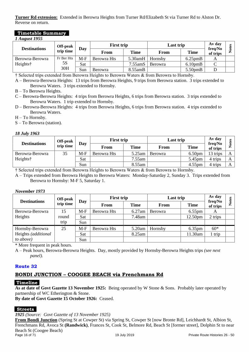
Turner Rd extension: Extended in Berowra Heights from Turner Rd/Elizabeth St via Turner Rd to Alston Dr.
Reverse on return.
Timetable Summary 1 August 1955
Destinations Off-peak
trip time Day
First trip Last trip Av day
freq/No
of trips No
tes
From Time From Time
Berowra-Berowra
Heights†
Fr Ber Hts
5S
30H
M-F Berowra Hts 5.30amH Hornsby 6.25pmB A
Sat 7.55amS Berowra 6.10pmB C
Sun Berowra 8.55amB 5.50pmB D
† Selected trips extended from Berowra Heights to Berowra Waters & from Berowra to Hornsby.
A – Berowra-Berowra Heights: 13 trips from Berowra Heights, 9 trips from Berowra station. 3 trips extended to
Berowra Waters. 3 trips extended to Hornsby.
B – To Berowra Heights.
C – Berowra-Berowra Heights: 4 trips from Berowra Heights, 6 trips from Berowra station. 3 trips extended to
Berowra Waters. 1 trip extended to Hornsby.
D – Berowra-Berowra Heights: 4 trips from Berowra Heights, 6 trips from Berowra station. 4 trips extended to
Berowra Waters.
H – To Hornsby.
S – To Berowra (station).
18 July 1963
Destinations Off-peak
trip time Day
First trip Last trip Av day
freq/No
of trips No
tes
From Time From Time
Berowra-Berowra
Heights†
35 M-F Berowra Hts 5.25am Berowra 6.50pm 13 trips A
Sat 7.55am 5.45pm 4 trips A
Sun 8.55am 4.55pm 4 trips A
† Selected trips extended from Berowra Heights to Berowra Waters & from Berowra to Hornsby.
A – Trips extended from Berowra Heights to Berowra Waters: Monday-Saturday 2, Sunday 3. Trips extended from
Berowra to Hornsby: M-F 5, Saturday 1.
November 1973
Destinations Off-peak
trip time Day
First trip Last trip Av day
freq/No
of trips No
tes
From Time From Time
Berowra-Berowra
Heights
15
round
trip
M-F Berowra Hts 6.27am Berowra 6.55pm A
Sat 7.48am 12.50pm 2 trips
Sun
Hornsby-Berowra
Heights (additional
to above)
25 M-F Berowra Hts 5.20am Hornsby 6.35pm 60*
Sat 8.25am 11.30am 1 trip
Sun
* More frequent in peak hours.
A – Peak hours, Berowra-Berowra Heights. Day, mostly provided by Hornsby-Berowra Heights trips (see next
panel).
Route 32
BONDI JUNCTION – COOGEE BEACH via Frenchmans Rd
Timeline As at date of Govt Gazette 13 November 1925: Being operated by W Stone & Sons. Probably later operated by
partnership of WC Etherington & Stone.
By date of Govt Gazette 15 October 1926: Ceased.
Streets 1925 (Source: Govt Gazette of 13 November 1925)
From Bondi Junction (Spring St at Cowper St) via Spring St, Cowper St [now Bronte Rd], Leichhardt St, Albion St,
Frenchmans Rd, Avoca St (Randwick), Frances St, Cook St, Belmore Rd, Beach St [former street], Dolphin St to near
Beach St (Coogee Beach)

Page 17 of 71 19 July 2019 Private Route Histories 26 - 50
From Coogee Beach (Dolphin St at Beach St) via reverse route to Cowper St, then Ebley St, Newland St, Spring St to
Bondi Junction.
Timetable Summary September 1925
Destinations Off-peak
trip time Day
First trip Last trip Av day
freq/No
of trips No
tes
From Time From Time
Bondi Junction-
Coogee Beach
22 M-F Bondi Jun 7.15am Coogee Bch 12.01am 20
Sat 7.15am 12.01am 20
Sun 9.00am 12.01am 20
Route 32
BEXLEY – KOGARAH – BRIGHTON-le-SANDS BEXLEY – KOGARAH – RAMSGATE – DOLLS POINT
Timeline By date of Govt Gazette 15 October 1926: Bexley – Kogarah – Brighton-le-Sands renumbered from 30, operated by
FH Uren, later trading as Ramsgate Bus Co.
By October 1931: Extra route, Bexley – Kogarah – Scarborough Park (somewhere along current Chuter Av?),
commenced.
By October 1935: Bexley – Kogarah – Scarborough Park extended from Scarborough Park to Ramsgate Baths.
About 1940: Ramsgate Bus Co transferred to Reo Motors (John A Gilbert).
March 1947: Transferred to Foleys Bus Service (John Foley & his sons Neville, Keith & Paul). (At about the same
time, Foley sold his Orange town services to Reo Motors.)
June 1947:
Bexley – Kogarah – Brighton-le-Sands section renumbered 193.
32 curtailed to run Kogarah – Ramsgate.
Early 1948: Kogarah – Ramsgate extended from Ramsgate to Dolls Point.
1951: John Foley died & the service passed to his sons.
Late December 1994: Transferred to Peakhurst Bus Co (Saint family).
By April 1995: Amalgamated with 113 as 32/113 Peakhurst – Hurstville – Ramsgate – Kogarah (see following
entry).
Streets
Bexley – Kogarah – Brighton-le-Sands 1926 (Source: Govt Gazette of 15 October 1926)
From Bexley (Kingsland Rd at Forest Rd) via Kingsland Rd, Forest Rd, Queen Victoria St, Paine St, Station St,
Railway Pde (Kogarah), Regent St, Rocky Point Rd [now Princes Hwy], President Av, Grand Pde to Bay St
(Brighton-le-Sands). (On Sundays & Public Holidays, continued via Bay St, Trafalgar St, Duke St, Grand Pde to
Duke St.) Reverse on return.
Alteration
1928 (Source: Govt Gazette of 22 June 1928): Weekday trips followed Sunday route at Brighton-le-Sands.
Circa 1946 (Source: Gregory’s Street Directory)
From Bexley via Bexley Rd, Kingsland Rd, Forest Rd, Queen Victoria St, Paine St, Station St, Railway Pde
(Kogarah), Montgomery St, Hogben St, Princes Hwy, President Av, The Grand Pde (Brighton-le-Sands).
Bexley – Kogarah – Ramsgate Baths Circa 1946 (Source: Gregory’s Street Directory)
From Bexley via Oriental St, Kingsland Rd, Forest Rd, Queen Victoria St, Paine St, Station St, Railway Pde
(Kogarah), Montgomery St, Hogben St, Princes Hwy, President Av, O’Connell St, Robinson St, Cassilis St,
Burlington St, Garden St [now part of Chuter Av], Chuter Av, Ramsgate Rd (Ramsgate Baths).

Page 18 of 71 19 July 2019 Private Route Histories 26 - 50
Kogarah – Dolls Point 1968 (Source: RGH notes)
Morning From Kogarah (Montgomery St at Regent St) via Regent St, Gladstone St, Princes Hwy, President Av, O’Connell St,
Chuter Av, Ramsgate Rd (Ramsgate), The Grand Pde, Malua St (Dolls Point), Gannon Av, Norman Av,
Sandringham St, Chuter Av, O’Connell St, President Av, Princes Hwy, Montgomery St to Regent St (Kogarah).
Afternoon From Kogarah (Montgomery St at Regent St) via Regent St, Gladstone St, Princes Hwy, President Av, O’Connell St,
Chuter Av, Sandringham St, Norman Av, Gannon Av, Malua St (Dolls Point), The Grand Pde, Ramsgate Rd
(Ramsgate), Chuter Av, O’Connell St, President Av, Princes Hwy, Montgomery St to Regent St (Kogarah).
1979 (Source: timetable)
All trips followed the afternoon route.
Timetable Summary July 1966
Destinations Off-peak
trip time Day
First trip Last trip Av day
freq/No
of trips No
tes
From Time From Time
Kogarah-Dolls
Point
24
round
trip
M-F Dolls Pt 5.25am Kogarah 9.40pm 30*
Sat 5.58am 11.35pm 30
Sun 7.04am 9.27pm 30
* More frequent in peak hours.
15 February 1986
Destinations Off-peak
trip time Day
First trip Last trip Av day
freq/No
of trips No
tes
From Time From Time
Kogarah-Dolls
Point
28
round
trip
M-F Dolls Pt 5.50am Kogarah 7.00pm 30*
Sat 7.45am 1.30pm 30
Sun
* More frequent in peak hours.
Combined Routes 32/113
PEAKHURST – HURSTVILLE – RAMSGATE – KOGARAH
Timeline By April 1995: 32 & 113 amalgamated as 32/113 Peakhurst – Hurstville – Ramsgate – Kogarah, operated by
Peakhurst Bus Co (Saint family).
29 April 1997: Renumbered 947 in the Sydney Region Route Number System (see Private Route Histories –
Contract Region 10/11).
Streets 1997 (Source: timetable)
From Kogarah (Railway Pde at station) via Railway Pde, Gladstone St, Regent St, Princes Hwy, President Av,
O’Connell St, Chuter Av, Sandringham St, Norman Av, Gannon Av, Malua St (Dolls Point), The Grand Pde,
Ramsgate Rd, Park Rd, Tanner Av, Andover St, Railway Pde, Lily St, Durham St, Forest Rd, Treacy St, Park Rd,
Cross St (Hurstville), Crofts Av, Barratt St, Queens Rd, Forest Rd, Gloucester Rd, Stoney Creek Rd, Central Rd,
Junction Rd, Baumans Rd to Stoney Creek Rd (Peakhurst).
From Peakhurst (Baumans Rd at Stoney Creek Rd) via Stoney Creek Rd, Gloucester Rd, Forest Rd (Hurstville),
Lily St, Railway Pde, Andover St, Tanner Av, Park Rd, Ramsgate Rd, Chuter Av, Sandringham St, Norman Av,
Gannon Av, Malua St (Dolls Point), The Grand Pde, Ramsgate Rd, Chuter Av, O’Connell St, President Av, Princes
Hwy, Kensington St, Montgomery St, Railway Pde to Kogarah station.
Page 19 of 71 19 July 2019 Private Route Histories 26 - 50
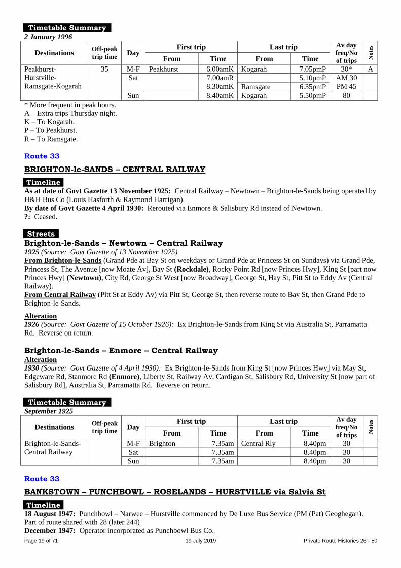
Timetable Summary 2 January 1996
Destinations Off-peak
trip time Day
First trip Last trip Av day
freq/No
of trips No
tes
From Time From Time
Peakhurst-
Hurstville-
Ramsgate-Kogarah
35 M-F Peakhurst 6.00amK Kogarah 7.05pmP 30* A
Sat 7.00amR
8.30amK
5.10pmP AM 30
PM 45
Ramsgate 6.35pmP
Sun 8.40amK Kogarah 5.50pmP 80
* More frequent in peak hours.
A – Extra trips Thursday night.
K – To Kogarah.
P – To Peakhurst.
R – To Ramsgate.
Route 33
BRIGHTON-le-SANDS – CENTRAL RAILWAY
Timeline As at date of Govt Gazette 13 November 1925: Central Railway – Newtown – Brighton-le-Sands being operated by
H&H Bus Co (Louis Hasforth & Raymond Harrigan).
By date of Govt Gazette 4 April 1930: Rerouted via Enmore & Salisbury Rd instead of Newtown.
?: Ceased.
Streets
Brighton-le-Sands – Newtown – Central Railway 1925 (Source: Govt Gazette of 13 November 1925)
From Brighton-le-Sands (Grand Pde at Bay St on weekdays or Grand Pde at Princess St on Sundays) via Grand Pde,
Princess St, The Avenue [now Moate Av], Bay St (Rockdale), Rocky Point Rd [now Princes Hwy], King St [part now
Princes Hwy] (Newtown), City Rd, George St West [now Broadway], George St, Hay St, Pitt St to Eddy Av (Central
Railway).
From Central Railway (Pitt St at Eddy Av) via Pitt St, George St, then reverse route to Bay St, then Grand Pde to
Brighton-le-Sands.
Alteration
1926 (Source: Govt Gazette of 15 October 1926): Ex Brighton-le-Sands from King St via Australia St, Parramatta
Rd. Reverse on return.
Brighton-le-Sands – Enmore – Central Railway Alteration
1930 (Source: Govt Gazette of 4 April 1930): Ex Brighton-le-Sands from King St [now Princes Hwy] via May St,
Edgeware Rd, Stanmore Rd (Enmore), Liberty St, Railway Av, Cardigan St, Salisbury Rd, University St [now part of
Salisbury Rd], Australia St, Parramatta Rd. Reverse on return.
Timetable Summary September 1925
Destinations Off-peak
trip time Day
First trip Last trip Av day
freq/No
of trips No
tes
From Time From Time
Brighton-le-Sands-
Central Railway
M-F Brighton 7.35am Central Rly 8.40pm 30
Sat 7.35am 8.40pm 30
Sun 7.35am 8.40pm 30
Route 33
BANKSTOWN – PUNCHBOWL – ROSELANDS – HURSTVILLE via Salvia St
Timeline 18 August 1947: Punchbowl – Narwee – Hurstville commenced by De Luxe Bus Service (PM (Pat) Geoghegan).
Part of route shared with 28 (later 244)
December 1947: Operator incorporated as Punchbowl Bus Co.
Page 20 of 71 19 July 2019 Private Route Histories 26 - 50
30 June 1952: Transferred to Narwee Bus Co (WH Griffin, CV Griffin & FS Pobje).
October 1958: Narwee Bus Co became part of Punchbowl Bus Co when Punchbowl Bus Co was transferred to the
owners of Narwee Bus Co.
October 1965: Rerouted through Roselands shopping centre, following its opening.
January 1968: Transferred to GP Bus Co (also trading at one time as GP Transport Service) (GP being the initials of
proprietors, Griffin & Pobje) (another company associated with Punchbowl Bus Co).
16 December 1968: Amalgamated with 37 (Punchbowl – Bankstown via Salvia St) to become 33 Bankstown –
Punchbowl – Narwee – Hurstville.
By 1992: Routes run by GP Bus Co & Narwee Bus Co regarded as being run by Punchbowl Bus Co (Griffin
family/Steve Scott).
18 August 1997: Renumbered 940 in the Sydney Region Route Number System & rerouted to include part of 29 as
part of general reorganization of Punchbowl Bus Co’s routes (see Private Route Histories – Contract Region 5).
Streets
Punchbowl – Narwee – Hurstville Circa 1948 (Source: Gregory’s Street Directory)
From Punchbowl via Arthur St, The Boulevarde, Rossmore Av, Canterbury Rd, Mount Av, Payten Av, Bonds Rd,
Broad Arrow Rd (Narwee), Mercury St, Stoney Creek Rd, Penshurst St, Forest Rd, Alfred St, Tracey [now Treacy] St
(Hurstville).
May 1959 (Source: timetable)
From Punchbowl (The Boulevarde at station) via Rossmore Av, Canterbury Rd, Draper Av, Payten Av, Bonds Rd,
Broad Arrow Rd (Narwee), Mercury St, Stoney Creek Rd, Penshurst St, Forest Rd, Alfred St, Tracey [now Treacy] St
(Hurstville).
From Hurstville (Tracey [now Treacy] St) via Forest Rd, then reverse route to Canterbury Rd, then Dudley St, The
Boulevarde to Punchbowl station.
Punchbowl – Roselands – Hurstville
1968 (Source: RGH notes)
From Punchbowl (The Boulevarde at station) via Rossmore Av, Canterbury Rd, Pentland Av, Payten Av, Violet St,
Martin St, Roselands Rd (Roselands shops), Roselands Dr, Martin St, Violet St, Payten Av, Bonds Rd, Broad Arrow
Rd (Narwee), Mercury St, Stoney Creek Rd, Penshurst St, Bridge St, Connelly St, Forest Rd, Alfred St, Treacy St
(Hurstville).
From Hurstville (Treacey St) via Forest Rd, then reverse route to Canterbury Rd, then Dudley St, The Boulevarde to
Punchbowl station.
Bankstown – Punchbowl – Roselands – Hurstville December 1968 (Source: RGH notes/timetable)
From Bankstown (South Tce at station) via South Tce, Stacey St, Salvia Av, Columbine Av, Scott St, Gowrie Av,
Warwick St, Punchbowl Rd, The Boulevarde (Punchbowl), Arthur St, Hillcrest St, Canterbury Rd, Pentland Av,
Payten Av, Violet St, Martin St, Roselands Rd (Roselands shops), Roselands Dr, Martin St, Violet St, Payten Av,
Bonds Rd, Broad Arrow Rd (Narwee), Mercury St, Stoney Creek Rd, Penshurst St, Forest Rd, Alfred St, Treacy St
(Hurstville).
From Hurstville (Treacey St) via Forest Rd, then reverse route to Canterbury Rd, then Dudley St, The Boulevarde
(Punchbowl), Punchbowl Rd, then reverse route to South Tce, then Restwell St, Greenfield St, Chapel Rd, South Tce
to Bankstown station.
Alterations
1975 (Source: timetable): To approach Bankstown from Columbine Av via Gardenia Av, Stacey St, Rickard
St, Lady Cutler Av, Bankstown Square shops, North Tce to Bankstown station. Ex Bankstown (North Tce)
via [railway bridge], South Tce, West Tce, [Raymond St], Cross St, Stanley St, Stacey St, Salvia St,
Columbine Av.
1983 (Source: timetable): From Bankstown (North Tce) via Fetherstone St, The Mall [which then extended
eastwards to Lady Cutler Av], Lady Cutler Av, North Tce, Stacey St, Salvia St.
1995 (Source: timetable): From Hurstville from Forest Rd via Park Rd, Queens Rd, Forest Rd. Unaltered on
return.
1995 (Source: timetable): To approach Bankstown from Rickard Rd via Jacobs St, Bankstown Square shops
[then The Mall, The Appian Way, North Tce].

Page 21 of 71 19 July 2019 Private Route Histories 26 - 50
Timetable Summary 25 May 1959
Destinations Off-peak
trip time Day
First trip Last trip Av day
freq/No
of trips No
tes
From Time From Time
Punchbowl-
Hurstville
27 M-F Punchbowl 6.00am Hurstville 10.30pm 30* A
Sat 6.30am 11.45pm 30 A
Sun 7.06am 9.46pm 60 A
* More frequent in peak hours.
A – Plus short-working/s before first trip shown. Plus picture bus Monday-Saturday nights.
16 December 1968
Destinations Off-peak
trip time Day
First trip Last trip Av day
freq/No
of trips No
tes
From Time From Time
Bankstown-
Hurstville
41 M-F Bankstown 6.20am Hurstville 10.48pm 30 A
Sat 7.15am 7.00pm 30 A
Sun 9.00am 6.45pm 60 A
A – Plus short-working/s before first trip shown.
Route 34
BURWOOD – LAKEMBA – BANKSTOWN
BURWOOD – LAKEMBA – HURSTVILLE STRATHFIELD – LAKEMBA – HURSTVILLE
Post 31 October 1931 feeder: ENFIELD – LAKEMBA – HURSTVILLE
Timeline As at date of Govt Gazette 13 November 1925: Burwood – Lakemba – Punchbowl – Bankstown being operated by
Arthur Marrin (in the 1920s, trading as All-Gold Bus Service, but by late 1940s trading as Red & White Bus Service).
By date of Govt Gazette 15 October 1926: Rerouted as Burwood – Lakemba – Hurstville.
31 October 1931: Ceased as competitive with Government railway or tram services under State Transport (Co-
ordination) Act.
31 December 1931: Relicensed as a feeder, Enfield – Lakemba – Hurstville, as only the Burwood – Enfield section
was competitive under the State Transport (Co-ordination) Act. (A list dated October 1935 lists the route as Hurstville
– Punchbowl.)
September 1946: Extended from Enfield to Strathfield.
December 1948: Transferred to Red Top Transport Service (group of Campsie businessmen including Arthur Marrin;
Roy Gledhill manager).
October 1965: Rerouted through Roselands shopping centre, following its opening. Roselands – Hurstville shared
with 39 until 18 December 1985.
1 July 1977: Transferred to Cumberland Coaches (Todd family).
31 August 1983: Transferred to Canterbury Bus Lines (part of the Highway Tours group – JD (Jim) Hill).
16 July 1986: Through-routed with 68.
September 1987: Through-routing with 68 ceased, so that 68 could be transferred separately.
1 September 1987: Canterbury Bus Lines transferred to partnership of Eddie Hayman & Colin Crossley.
12 October 1995: Renumbered 450 in the Sydney Region Route Number System (see Private Route Histories –
Contract Region 5).
Streets
Burwood – Lakemba – Bankstown 1925 (Source: Govt Gazette of 13 November 1925)
From Burwood (Railway Pde at station) via Railway Pde, Burwood Rd, Liverpool Rd, Jersey St [now Homebush
Rd], Water St, [Punchbowl Rd], Linda St, [Lola St, now Burwood Rd], Yangoora Rd, Wangee Rd, Lakemba St,
Haldon St (Lakemba), Railway Pde, Croydon St, Lakemba St, Wiley’s Av [now King Georges Rd], Hillcrest St,
Dudley St, The Boulevarde (Punchbowl), Punchbowl Rd, Griffiths Av, Scott St, Columbine Av, Salvia Av, Stanley
St, Restwell St, South Tce to Bankstown station.
From Bankstown (South Tce to station) via reverse route to Burwood Rd, then Belmore St, Shaftesbury Rd, Railway
Pde to Burwood station.
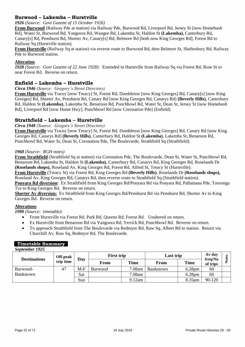
Page 22 of 71 19 July 2019 Private Route Histories 26 - 50
Burwood – Lakemba – Hurstville 1926 (Source: Govt Gazette of 15 October 1926)
From Burwood (Railway Pde at station) via Railway Pde, Burwood Rd, Liverpool Rd, Jersey St [now Homebush
Rd], Water St, Burwood Rd, Yangoora Rd, Wangee Rd, Lakemba St, Haldon St (Lakemba), Canterbury Rd,
Canary[s] Rd, Penshurst Rd, Shorter Av, Canary[s] Rd, Belmore Rd [both now King Georges Rd], Forest Rd to
Railway Sq (Hurstville station).
From Hurstville (Railway Sq at station) via reverse route to Burwood Rd, then Belmore St, Shaftesbury Rd, Railway
Pde to Burwood station.
Alteration
1928 (Source: Govt Gazette of 22 June 1928): Extended in Hurstville from Railway Sq via Forest Rd, Rose St to
near Forest Rd. Reverse on return.
Enfield – Lakemba – Hurstville Circa 1946 (Source: Gregory’s Street Directory)
From Hurstville via Tracey [now Treacy] St, Forest Rd, Dumbleton [now King Georges] Rd, Canary[s] [now King
Georges] Rd, Shorter Av, Penshurst Rd, Canary Rd [now King Georges Rd, Canarys Rd] (Beverly Hills), Canterbury
Rd, Haldon St (Lakemba), Lakemba St, Benaroon Rd, Punchbowl Rd, Water St, Dean St, Jersey St [now Homebush
Rd], Liverpool Rd [now Hume Hwy], Punchbowl Rd [now Coronation Pde] (Enfield).
Strathfield – Lakemba – Hurstville Circa 1948 (Source: Gregory’s Street Directory)
From Hurstville via Tracey [now Treacy] St, Forest Rd, Dumbleton [now King Georges] Rd, Canary Rd [now King
Georges Rd, Canarys Rd] (Beverly Hills), Canterbury Rd, Haldon St (Lakemba), Lakemba St, Benaroon Rd,
Punchbowl Rd, Water St, Dean St, Coronation Pde, The Boulevarde, Strathfield Sq (Strathfield).
1968 (Source: RGH notes)
From Strathfield (Strathfield Sq at station) via Coronation Pde, The Boulevarde, Dean St, Water St, Punchbowl Rd,
Benaroon Rd, Lakemba St, Haldon St (Lakemba), Canterbury Rd, Canarys Rd, King Georges Rd, Roselands Dr
(Roselands shops), Roseland Av, King Georges Rd, Forest Rd, Alfred St, Treacy St (Hurstville).
From Hurstville (Treacy St) via Forest Rd, King Georges Rd (Beverly Hills), Roselands Dr (Roselands shops),
Roseland Av, King Georges Rd, Canarys Rd, then reverse route to Strathfield Sq (Strathfield station).
Ponyara Rd diversion: Ex Strathfield from King Georges Rd/Ponyara Rd via Ponyara Rd, Pallamana Pde, Tooronga
Tce to King Georges Rd. Reverse on return.
Shorter Av diversion: Ex Strathfield from King Georges Rd/Penshurst Rd via Penshurst Rd, Shorter Av to King
Georges Rd. Reverse on return.
Alterations
1990 (Source: timetable):
From Hurstville via Forest Rd, Park Rd, Queens Rd, Forest Rd. Unaltered on return.
Ex Hurstville from Benaroon Rd via Yangoora Rd, Yerrick Rd, Punchbowl Rd. Reverse on return.
To approach Strathfield from The Boulevarde via Redmyre Rd, Raw Sq, Albert Rd to station. Return via
Churchill Av, Raw Sq, Redmyre Rd, The Boulevarde.
Timetable Summary September 1925
Destinations Off-peak
trip time Day
First trip Last trip Av day
freq/No
of trips No
tes
From Time From Time
Burwood-
Bankstown
47 M-F Burwood 7.08am Bankstown 6.28pm 60
Sat 7.08am 6.28pm 60
Sun 9.12am 8.35pm 90-120

Page 23 of 71 19 July 2019 Private Route Histories 26 - 50
8 September 1927
Destinations Off-peak
trip time Day
First trip Last trip Av day
freq/No
of trips No
tes
From Time From Time
Burwood-Hurstville 55 M-F Burwood 6.55am Hurstville 6.20pm 60 A
Sat 8.45am 8.15pm 60 B
Sun Hurstville 8.30am Burwood 9.20pm 60**
** Less frequent in morning
A – Extra trips Friday night. Plus short-working/s before first trip & after last trip shown.
B – Plus picture bus Saturday night.
15 March 1943
Destinations Off-peak
trip time Day
First trip Last trip Av day
freq/No
of trips No
tes
From Time From Time
Enfield-Hurstville 37 M-F Enfield 7.00am Hurstville 10.00pm 45*
Sat 7.00am 10.00pm 30-45 A
Sun 8.28am 10.30pm 45
Plus short-working/s Enfield-Lakemba before first trip & after last trip shown each day.
* More frequent in peak hours.
A – Plus picture bus Saturday night.
1 July 1962
Destinations Off-peak
trip time Day
First trip Last trip Av day
freq/No
of trips No
tes
From Time From Time
Strathfield-
Hurstville
43 M-F Hurstville 6.00am Strathfield 10.55pm 30*
Sat 7.00am 10.55pm 30
Sun 7.10am 10.25pm 30
Plus short-working/s Strathfield-Lakemba & Hurstville-Lakemba before first trip & after last trip shown each day.
* More frequent in peak hours.
21 September 1977
Destinations Off-peak
trip time Day
First trip Last trip Av day
freq/No
of trips No
tes
From Time From Time
Strathfield-
Hurstville
40 M-F Hurstville 6.00am Strathfield 7.15pm 30* A
Sat 7.00am 7.00pm AM 30
PM 45
Sun 8.30am 7.15pm AM 45
PM 90
Plus short-working/s Strathfield-Lakemba & Hurstville-Lakemba before first trip & after last trip shown each day.
* More frequent in peak hours.
A – Extra trips Thursday night.
Route 35
BURWOOD – CENTRAL RAILWAY via Queen St & Parramatta Rd
Timeline As at date of Govt Gazette 13 November 1925: Being operated by Metropolitan Omnibus & Transport Co (FH
(later Sir Frederick) Stewart) & Burwood Bus Co.
31 October 1931: Ceased as competitive with Government railway or tram services under State Transport (Co-
ordination) Act.
Streets 1925 (Source: Govt Gazette of 13 November 1925)
From Burwood (station, Deane St at Burwood Rd) via Deane St, Burwood Rd, Victoria St, Queen St, Lang St,
Church St, Frederick St, Parramatta Rd, George St West [now Broadway], George St, Hay St, Pitt St to Eddy Av
(Central Railway).

Page 24 of 71 19 July 2019 Private Route Histories 26 - 50
From Central Railway (Pitt St at Eddy Av) via Pitt St, George St, then reverse route to Burwood Rd, then George St
Mary St, Deane St to Burwood Rd (Burwood station).
Timetable Summary September 1925
Destinations Off-peak
trip time Day
First trip Last trip Av day
freq/No
of trips No
tes
From Time From Time
Burwood-Central
Railway
M-F Burwood 6.48am Central Rly 11.33pm 10
Sat 6.48am 11.33pm 10
Sun 6.48am 11.33pm 10
Route 35
PUNCHBOWL – CAMPSIE PUNCHBOWL – ENFIELD
Timeline November 1931: Punchbowl – Enfield (The Broadway) via Punchbowl Rd commenced by Arthur Marrin.
16 December 1933: Altered/extended to run Punchbowl (– Enfield?) – Campsie.
19 March 1934: Campsie – Enfield absorbed into 39. Enfield – Punchbowl section discontinued.
Route 35
BELMORE – LAKEMBA
Timeline 19 August 1935: Commenced by Arthur Marrin (by 1940s trading as Red & White Bus Service).
December 1948: Transferred to Red Top Transport Service (group of Campsie businessmen including Arthur Marrin;
Roy Gledhill manager).
April 1951: Transferred back to Red & White Bus Service (Arthur Marrin).
February 1963: Transferred to EM (Eddie) Hayman.
April 1963: Transferred to Redline Bus Service (WE (Bill) Hayward).
February 1964: Transferred to Belmore–Lakemba Bus Service (LG (Les) & CC Roberts).
12 October 1965: Rerouted via Roselands shopping centre, upon its opening.
March 1978: Transferred to Cumberland Coaches (Todd family).
4 July 1983: Route altered between Roselands & Lakemba to partly replace truncation of 26 from Lakemba to
Punchbowl.
31 August 1983: Transferred to Canterbury Bus Lines (part of the Highway Tours group – JD (Jim) Hill).
September 1986: Transferred to Pleasure Tours of Australia (Ernie Stafford).
12 October 1992: As part of general reorganization of Pleasure Tours’ routes, renumbered into the Sydney Region
Route Number System (see Private Route Histories – Contract Region 5) as:
445 Roselands – Belmore
446 Roselands – Kogarah
447 Roselands – Greenacre
Streets Circa 1946 (Source: Gregory’s Street Directory)
From Belmore via Bridge Rd, Peel St, Leylands Pde, Moreton St, Chalmers St, Chapel St, Moorefields Rd,
McCallum St, Rogers St, Dreadnought St, Canterbury Rd, Haldon St, The Boulevarde (Lakemba).
Circa 1961 (Source: timetable)
From Lakemba via Haldon St, Canterbury Rd, Dreadnought St, Albion St, Ludgate St, Stoddart St, Moorefields Rd,
Rogers St, McCallum St, Moorefields Rd, Ada St, Forsythe St, Chapel St, Moreton St, Leyland Pde, Burwood Rd
(Belmore).
Alteration
Circa 1962 (Source: Collins Street Directory): Ex Lakemba from Dreadnought St via Bennett Av, Ludgate St,
Stoddart St, Moorefields Rd, Rogers St.

Page 25 of 71 19 July 2019 Private Route Histories 26 - 50
1968 (Source: RGH notes)
From Belmore (station, Bridge Rd at Burwood Rd) via Bridge Rd, Peel St, Leylands Pde, Moreton St, Chalmers St,
Chapel St, Forsyth St, Kingsgrove Rd, Moorefields Rd, McCallum St, Rogers St, Moorefields Rd, Stoddart St, Berring
Av, King Georges Rd, Roselands Dr (Roselands shops), Roseland Av, King Georges Rd, Berring Av, Stoddart St,
Ludgate St, Albion St, Dreadnought St, Canterbury Rd, Haldon St, The Boulevarde to Haldon St (Lakemba).
From Lakemba (station,The Boulevarde at Haldon St) via The Boulevarde, Croydon St, Oneata St, Haldon St, then
reverse route to Ludgate St, Stoddart St, Berring Av, King Georges Rd, Roselands Dr (Roselands shops), Roseland
Av, King Georges Rd, Berring Av, Stoddart St, Moorefields Rd, Rogers St, then reverse route to Leylands Pde, then
Burwood Rd, Bridge Rd to near Burwood Rd (Belmore station).
Alterations
1983 (Source: timetable):
To approach Lakemba station from Canterbury Rd via Sproule St, The Boulevarde, Croydon St, Oneata St,
Haldon St. Returning via The Boulevarde, Sproule St.
Via Robert St instead of Kingsgrove Rd.
Timetable Summary 10 June 1961
Destinations Off-peak
trip time Day
First trip Last trip Av day
freq/No
of trips No
tes
From Time From Time
Belmore-Lakemba 24 M-F Lakemba 6.14am Belmore 9.18pm 30
Sat 8.22am 6.50pm AM 30
PM 60
A
Sun 8.23am 5.57pm 60 A
A – Gap in service.
May 1983
Destinations Off-peak
trip time Day
First trip Last trip Av day
freq/No
of trips No
tes
From Time From Time
Belmore-Lakemba 24 M-F Lakemba 6.11am Belmore 6.32pm 60 A
Sat 7.08am 12.37pm 60
Sun
A – Extra trips Thursday night.
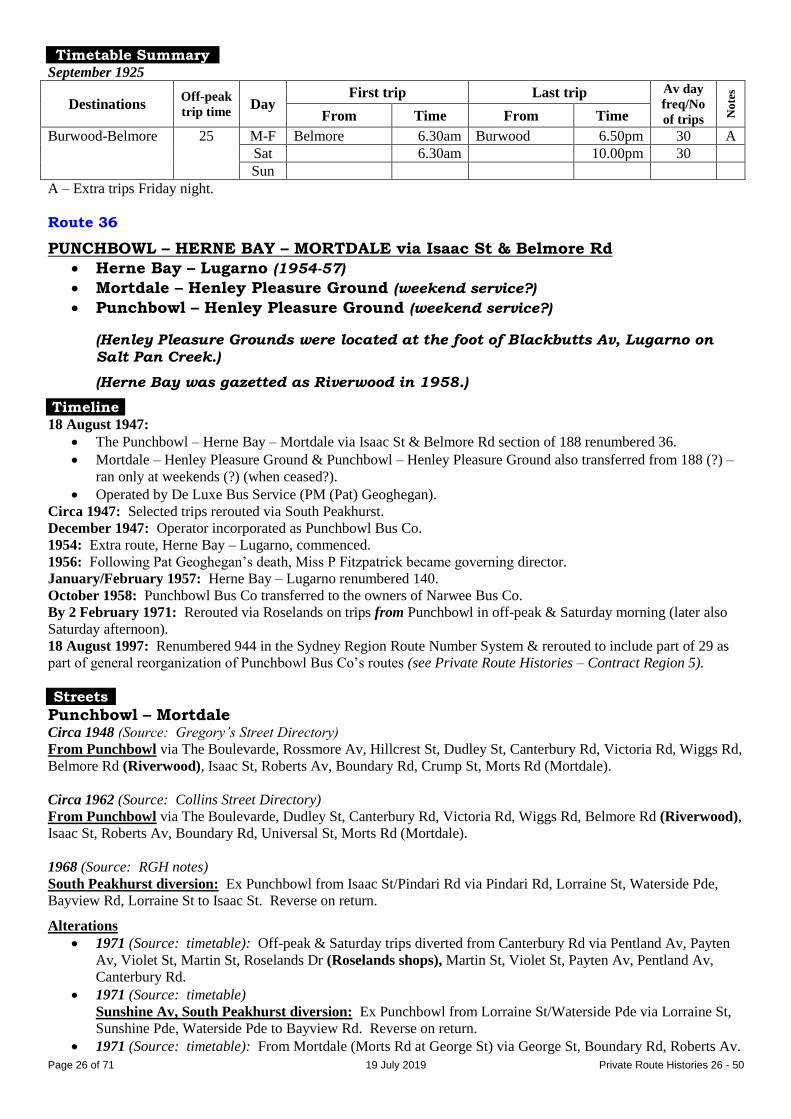
Route 36
BURWOOD – ENFIELD – BELMORE via Water St
Post 31 October 1931 feeder: ENFIELD – BELMORE
Timeline As at date of Govt Gazette 13 November 1925: Being operated by Mrs AE Rose.
31 October 1931: Burwood – Enfield ceased as competitive with Government railway or tram services under State
Transport (Co-ordination) Act, leaving the route as a feeder, Enfield – Belmore.
By 1934: Transferred to JC Moreton.
2 January 1934: Absorbed into 216, which became Strathfield – Belmore.
Streets 1925 (Source: Govt Gazette of 13 November 1925)
From Burwood (Railway Pde at station) via Railway Pde, Conder St, Nicholson St, Wentworth St, Liverpool Rd
(Enfield), Jersey St [now Homebush Rd], Water St, Burwood Rd to Railway Pde (Belmore station).
From Belmore (Burwood Rd at Railway Pde) via reverse route to Burwood Rd, then Belmore St, Shaftesbury Rd,
Railway Pde to Burwood station.
Page 26 of 71 19 July 2019 Private Route Histories 26 - 50
Timetable Summary September 1925
Destinations Off-peak
trip time Day
First trip Last trip Av day
freq/No
of trips No
tes
From Time From Time
Burwood-Belmore 25 M-F Belmore 6.30am Burwood 6.50pm 30 A
Sat 6.30am 10.00pm 30
Sun
A – Extra trips Friday night.
Route 36
PUNCHBOWL – HERNE BAY – MORTDALE via Isaac St & Belmore Rd
Herne Bay – Lugarno (1954-57)
Mortdale – Henley Pleasure Ground (weekend service?)
Punchbowl – Henley Pleasure Ground (weekend service?)
(Henley Pleasure Grounds were located at the foot of Blackbutts Av, Lugarno on
Salt Pan Creek.)
(Herne Bay was gazetted as Riverwood in 1958.)
Timeline 18 August 1947:
The Punchbowl – Herne Bay – Mortdale via Isaac St & Belmore Rd section of 188 renumbered 36.
Mortdale – Henley Pleasure Ground & Punchbowl – Henley Pleasure Ground also transferred from 188 (?) –
ran only at weekends (?) (when ceased?).
Operated by De Luxe Bus Service (PM (Pat) Geoghegan).
Circa 1947: Selected trips rerouted via South Peakhurst.
December 1947: Operator incorporated as Punchbowl Bus Co.
1954: Extra route, Herne Bay – Lugarno, commenced.
1956: Following Pat Geoghegan’s death, Miss P Fitzpatrick became governing director.
January/February 1957: Herne Bay – Lugarno renumbered 140.
October 1958: Punchbowl Bus Co transferred to the owners of Narwee Bus Co.
By 2 February 1971: Rerouted via Roselands on trips from Punchbowl in off-peak & Saturday morning (later also
Saturday afternoon).
18 August 1997: Renumbered 944 in the Sydney Region Route Number System & rerouted to include part of 29 as
part of general reorganization of Punchbowl Bus Co’s routes (see Private Route Histories – Contract Region 5).
Streets
Punchbowl – Mortdale Circa 1948 (Source: Gregory’s Street Directory)
From Punchbowl via The Boulevarde, Rossmore Av, Hillcrest St, Dudley St, Canterbury Rd, Victoria Rd, Wiggs Rd,
Belmore Rd (Riverwood), Isaac St, Roberts Av, Boundary Rd, Crump St, Morts Rd (Mortdale).
Circa 1962 (Source: Collins Street Directory)
From Punchbowl via The Boulevarde, Dudley St, Canterbury Rd, Victoria Rd, Wiggs Rd, Belmore Rd (Riverwood),
Isaac St, Roberts Av, Boundary Rd, Universal St, Morts Rd (Mortdale).
1968 (Source: RGH notes)
South Peakhurst diversion: Ex Punchbowl from Isaac St/Pindari Rd via Pindari Rd, Lorraine St, Waterside Pde,
Bayview Rd, Lorraine St to Isaac St. Reverse on return.
Alterations
1971 (Source: timetable): Off-peak & Saturday trips diverted from Canterbury Rd via Pentland Av, Payten
Av, Violet St, Martin St, Roselands Dr (Roselands shops), Martin St, Violet St, Payten Av, Pentland Av,
Canterbury Rd.
1971 (Source: timetable)
Sunshine Av, South Peakhurst diversion: Ex Punchbowl from Lorraine St/Waterside Pde via Lorraine St,
Sunshine Pde, Waterside Pde to Bayview Rd. Reverse on return.
1971 (Source: timetable): From Mortdale (Morts Rd at George St) via George St, Boundary Rd, Roberts Av.

Page 27 of 71 19 July 2019 Private Route Histories 26 - 50
1995: (Source: timetable): From Mortdale via Pitt St instead of George St. Ex Punchbowl from Victoria Rd
via Mitcham St, Cullens Rd, Wiggs Rd. Reverse on return.
Timetable Summary 28 January 1963
Destinations Off-peak
trip time Day
First trip Last trip Av day
freq/No
of trips No
tes
From Time From Time
Punchbowl-
Mortdale
25 M-F Punchbowl 5.59am Mortdale 11.25pm 30*
Sat 7.02am 11.23pm 30
Sun 9.15am 8.12pm 60 A
* More frequent in peak hours.
A – Plus short-working/s before first trip shown.
1983
Destinations Off-peak
trip time Day
First trip Last trip Av day
freq/No
of trips No
tes
From Time From Time
Punchbowl-
Mortdale
23MP
33PRM
†
M-F Punchbowl 5.54am Mortdale 6.53pm 30* A
Sat 7.23am 5.49pm AM 30
PM 60
Sun 9.40am 5.02pm 60 B
* More frequent in peak hours.
† Extra 3-4 via South Peakhurst diversion.
A – Extra trips Thursday night.
B – Gap in service.
MP – From Mortdale to Punchbowl.
PRM – From Punchbowl to Mortdale via Roselands.
Route 37
BURWOOD – CAMPSIE via Brighton Av
Timeline As at date of Govt Gazette 13 November 1925: In operation.
By date of Govt Gazette 15 October 1926: Ceased, but 38 already running Burwood – Campsie – Earlwood over
same route between Burwood & Campsie.
Streets 1925 (Source: Govt Gazette of 13 November 1925)
From Burwood (Railway Pde at station) via Railway Pde, Burwood Rd, Liverpool Rd, Brighton St, Georges River
Rd (Croydon Park), Brighton Av, Beamish St, South Pde to near Beamish St (Campsie).
From Campsie (South Pde at Beamish St) via reverse route to Burwood Rd, then Belmore St, Shaftesbury Rd,
Railway Pde to Burwood station.
Timetable Summary September 1925
Destinations Off-peak
trip time Day
First trip Last trip Av day
freq/No
of trips No
tes
From Time From Time
Burwood-Campsie 19 M-F Campsie 7.00am Burwood 10.20pm 60
Sat 7.00am 10.20pm 60
Sun
Route 37
PUNCHBOWL – BANKSTOWN via Salvia Av
Timeline June 1947: Commenced by Green Line (GH (Harold) Gail). Also traded as Star Omnibus Service.
1968: Transferred to GP Bus Co (GP being the initials of proprietors, Griffin & Pobje) (associated with Punchbowl
Bus Co), following death of Mr Gail.

Page 28 of 71 19 July 2019 Private Route Histories 26 - 50
16 December 1968: Amalgamated with 33 (Punchbowl – Hurstville) as 33 Bankstown – Punchbowl – Narwee –
Hurstville.
Streets Circa 1948 (Source: Gregory’s Street Directory)
From Bankstown via South Tce, Stacey St, Salvia Av, Columbine Av, Scott St, Gowrie Av, Warwick St, Punchbowl
Rd, The Boulevarde to Punchbowl station.
Timetable Summary 1950
Destinations Off-peak
trip time Day
First trip Last trip Av day
freq/No
of trips No
tes
From Time From Time
Punchbowl-
Bankstown
17 M-F Bankstown 5.55am Punchbowl 8.00pm 30 A
Sat 5.55am 8.00pm 30 A
Sun
A – Plus picture bus Wednesday, Friday & Saturday nights.
Route 38
BURWOOD – CAMPSIE – EARLWOOD (Marana Rd)
Timeline As at date of Govt Gazette 13 November 1925: Being operated by Edwyn L Balfour &/or (?) United Motors
(McNicol Bros).
23 June 1934: Burwood – Campsie section taken over by Department of Road Transport & Tramways (&
amalgamated with 93 as DRTT 92), leaving 38 as Campsie – Earlwood.
By October 1935: Operated by United Motors (McNicol Bros).
1 March 1937:
Campsie – Earlwood taken over by Department of Road Transport & Tramways.
Amalgamated with 87, 213 & DRTT 90, as 90 Drummoyne – Campsie – Earlwood.
Streets 1925 (Source: Govt Gazette of 13 November 1925)
From Burwood (Railway Pde at station) via Railway Pde, Burwood Rd, Liverpool Rd, Brighton St, Georges River
Rd (Croydon Park), Brighton Av, Beamish St, South Pde to near Beamish St (Campsie), then Beamish St,
Canterbury Rd, Northcote St, Marana Rd to William St (Earlwood).
From Earlwood (Marana Rd at William St) via reverse route to Beamish St, then Brighton Av, then reverse route to
Burwood Rd, then Belmore St, Shaftesbury Rd, Railway Pde to Burwood station.
Alteration
1927 (Source: Govt Gazette of 27 May 1927): Via Croydon Av instead of Brighton Av.
Timetable Summary September 1925
Destinations Off-peak
trip time Day
First trip Last trip Av day
freq/No
of trips No
tes
From Time From Time
Burwood-Campsie-
Earlwood
28 M-F Campsie 6.45am Burwood 9.50pm 60 A
Sat 6.45am 9.50pm 60 B
Sun 9.00am 10.35pm 30 C
A – Selected trips (mainly off-peak) extended from Campsie to Earlwood. Extra trips Friday night.
B – Selected trips extended from Campsie to Earlwood.
C – Alternate trips extended from Campsie to Earlwood during afternoon.

Page 29 of 71 19 July 2019 Private Route Histories 26 - 50
Route 38
BANKSTOWN – PADSTOW – REVESBY HEIGHTS – REVESBY (bidirectional loop south of Revesby)
Timeline October 1947: Bankstown – Revesby – Padstow commenced by ARB (Archie) McVicar.
September 1957: Selected trips diverted via Bankstown Hospital. (By 1964, all trips rerouted via Hospital.)
February 1958: Diverted via South Revesby War Service Estate [now Revesby Heights].
July 1959: Operator incorporated as McVicars Bus Services (AA (Archie junior) McVicar).
By at least 1960s: Loop section of route became bidirectional.
By 30 August 1965: Sunday service (later also Saturday afternoons) along Northam Av (Bankstown Hospital) & via
Revesby Heights provided by diversions of selected 23 trips.
5 March 1978: Transferred to Bankstown Bus Lines (Max Holman).
October 1979: Operator’s name altered to South Western Coach Lines.
27 February 1984: Renumbered 926 in the Sydney Region Route Number System as part of general reorganization
of South Western Coach Lines’ South Bankstown routes (see Private Route Histories – Contract Region 13).
Streets
Bankstown – Padstow – Revesby Heights – Revesby Circa 1962 (Source: Collins Street Directory)
Similar to that shown for 1968 below, but loop in Revesby Heights area from Vega St/Mars St via Vega St,
Edinburgh Dr, Centaur St, Morotai Rd, Rowell St, Sandakan Rd, Morotai Rd, Centaur St, Edinburgh Dr, Vega St.
Bankstown – Padstow – Revesby Heights – Revesby – Bankstown 1968 (Source: RGH notes)
Clockwise loop From Bankstown (Restwell St at South Tce) via Restwell St, Macauley Av, Chapel Rd, Chertsey Av, Northam Av,
Eldridge Rd, Artegall St (Bankstown Hospital), Claribel St, Canterbury Rd, The River Rd, Sphinx Av, Doyle Rd,
Howard Rd (Padstow), Ryan Rd, Davies Rd, Windsor Rd, Uranus Rd, Hydrae St, Mars St, The River Rd, Sandakan
Rd, Morotai Rd (Revesby Heights), Centaur St, Edinburgh Dr, The River Rd, Mars St, Vega St, Uranus Rd, The
River Rd, Macarthur Av, Revesby Pl, Blamey St (Revesby), The River Rd, Canterbury Rd, Claribel St, Artegall St
(Bankstown Hospital), Eldridge Rd, Northam Av, Chertsey Av, Chapel Rd, South Tce to Bankstown station.
Anti-clockwise loop From Bankstown (Restwell St at South Tce) via Restwell St, Macauley Av, Chapel Rd, Chertsey Av, Northam Av,
Eldridge Rd, Artegall St (Bankstown Hospital), Claribel St, Canterbury Rd, The River Rd, Blamey St (Revesby),
Brett St, Macarthur Av, The River Rd, Uranus Rd, Vega St, Mars St, The River Rd, Sandakan Rd, Morotai Rd
(Revesby Heights), Centaur St, Edinburgh Dr, The River Rd, Mars St, Hydrae St, Uranus Rd, Windsor Rd, Davies
Rd, Ryan Rd, Faraday Rd, Padstow Pde (Padstow), Howard Rd, Doyle Rd, Sphinx Av, The River Rd, Canterbury Rd,
Claribel St, Artegall St (Bankstown Hospital), Eldridge Rd, Northam Av, Chertsey Av, Chapel Rd, South Tce to
Bankstown station.
Timetable Summary 27 July 1964
Destinations Off-peak
trip time Day
First trip Last trip Av day
freq/No
of trips No
tes
From Time From Time
Bankstown-
Padstow-Revesby
Heights-Revesby
56
round
trip
M-F Bankstown 5.18am Padstow 8.43pm 30 A
Sat 5.55am 8.03pm 30 B
Sun
A – Generally alternately in each direction.
B – Generally alternately in each direction. Plus picture bus Saturday night.

Page 30 of 71 19 July 2019 Private Route Histories 26 - 50
22 May 1978
Destinations Off-peak
trip time Day
First trip Last trip Av day
freq/No
of trips No
tes
From Time From Time
Bankstown-
Padstow-Revesby
Heights-Revesby
56
round
trip
M-F Padstow 5.50am Bankstown 6.53pm 60* A
Sat 8.30am 7.15pm 60** B
Sun 8.35am 6.15pm 120 C
* More frequent in peak hours.
** Less frequent in afternoon.
A – Generally alternately in each direction.
B – Morning, generally alternately in each direction. Afternoon, service provided by diversions of 23.
C – Service provided by diversions of 23.
Route 39
BURRANEER POINT – CRONULLA
(Burraneer Point is in the suburb of Burraneer.)
Timeline As at date of Govt Gazette 13 November 1925: Being operated by AJ Edwards.
By date of Govt Gazette 15 October 1926: Ceased.
General note: Later part of 66.
Streets 1925 (Source: Govt Gazette of 13 November 1925)
From Cronulla (Gerrale St at Surf Rd) via Gerrale St, Surf Rd, Curranulla St [now Cronulla St & Bicentennial
Plaza], Kingsway, Burraneer [Bay] Rd [part now St Andrews Pl], Woolooware Rd to Burraneer Point. Reverse on
return.
Trips from Burraneer Point terminating at Woolooware Rd/Kingsway (likely route in order to connect with
Sutherland-Cronulla steam tram at the latter point): Ex Burraneer Point via Woolooware Rd to Kingsway [in current
suburb of Woolooware]. Reverse on return.
Timetable Summary September 1925
Destinations Off-peak
trip time Day
First trip Last trip Av day
freq/No
of trips No
tes
From Time From Time
Burraneer Point-
Woolooware
Rd/Kingsway†
Fr Burr Pt
9K
18C
M-F Burraneer Pt 7.03am Woolooware
Rd/Kingsway
6.44pm 7 trips A
Sat 7.03am 4.16pm 10 trips A
Sun 8.55am 7.38pm 10 trips A
† Selected trips extended to Cronulla.
A – Selected trips extended to Cronulla, including picture bus Monday-Saturday nights.
C – To Cronulla.
K – To Woolooware Rd/Kingsway.
Route 39
CAMPSIE – BELFIELD – ROSELANDS – HURSTVILLE CAMPSIE – BELFIELD – ROSELANDS – KOGARAH HOSPITAL CAMPSIE – NORTH BELMORE – ROSELANDS
Campsie – Belfield – Roselands – Bardwell Park (selected trips, 1985-86)
Timeline 1920s: Campsie – Portland St, Enfield commenced.
By 1932: Operated by Arthur Marrin (by 1940s trading as Red & White Bus Service).
16 December 1933: Extended from Portland St to The Broadway, Enfield via Enfield Baths.
19 March 1934: Amalgamated with Campsie – Enfield part of 35 to become 39, Campsie – Water St/Punchbowl Rd,
Belfield.
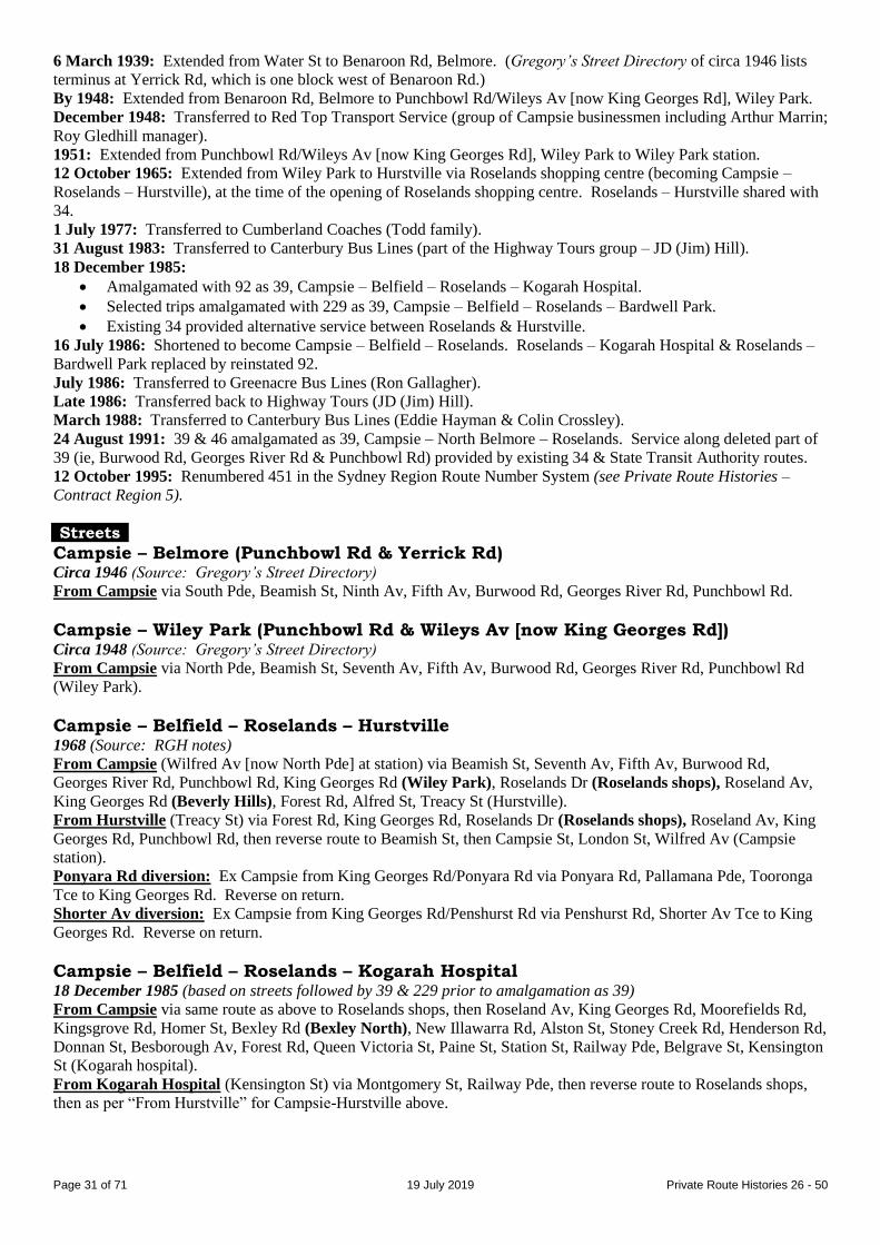
Page 31 of 71 19 July 2019 Private Route Histories 26 - 50
6 March 1939: Extended from Water St to Benaroon Rd, Belmore. (Gregory’s Street Directory of circa 1946 lists
terminus at Yerrick Rd, which is one block west of Benaroon Rd.)
By 1948: Extended from Benaroon Rd, Belmore to Punchbowl Rd/Wileys Av [now King Georges Rd], Wiley Park.
December 1948: Transferred to Red Top Transport Service (group of Campsie businessmen including Arthur Marrin;
Roy Gledhill manager).
1951: Extended from Punchbowl Rd/Wileys Av [now King Georges Rd], Wiley Park to Wiley Park station.
12 October 1965: Extended from Wiley Park to Hurstville via Roselands shopping centre (becoming Campsie –
Roselands – Hurstville), at the time of the opening of Roselands shopping centre. Roselands – Hurstville shared with
34.
1 July 1977: Transferred to Cumberland Coaches (Todd family).
31 August 1983: Transferred to Canterbury Bus Lines (part of the Highway Tours group – JD (Jim) Hill).
18 December 1985:
Amalgamated with 92 as 39, Campsie – Belfield – Roselands – Kogarah Hospital.
Selected trips amalgamated with 229 as 39, Campsie – Belfield – Roselands – Bardwell Park.
Existing 34 provided alternative service between Roselands & Hurstville.
16 July 1986: Shortened to become Campsie – Belfield – Roselands. Roselands – Kogarah Hospital & Roselands –
Bardwell Park replaced by reinstated 92.
July 1986: Transferred to Greenacre Bus Lines (Ron Gallagher).
Late 1986: Transferred back to Highway Tours (JD (Jim) Hill).
March 1988: Transferred to Canterbury Bus Lines (Eddie Hayman & Colin Crossley).
24 August 1991: 39 & 46 amalgamated as 39, Campsie – North Belmore – Roselands. Service along deleted part of
39 (ie, Burwood Rd, Georges River Rd & Punchbowl Rd) provided by existing 34 & State Transit Authority routes.
12 October 1995: Renumbered 451 in the Sydney Region Route Number System (see Private Route Histories –
Contract Region 5).
Streets
Campsie – Belmore (Punchbowl Rd & Yerrick Rd) Circa 1946 (Source: Gregory’s Street Directory)
From Campsie via South Pde, Beamish St, Ninth Av, Fifth Av, Burwood Rd, Georges River Rd, Punchbowl Rd.
Campsie – Wiley Park (Punchbowl Rd & Wileys Av [now King Georges Rd]) Circa 1948 (Source: Gregory’s Street Directory)
From Campsie via North Pde, Beamish St, Seventh Av, Fifth Av, Burwood Rd, Georges River Rd, Punchbowl Rd
(Wiley Park).
Campsie – Belfield – Roselands – Hurstville 1968 (Source: RGH notes)
From Campsie (Wilfred Av [now North Pde] at station) via Beamish St, Seventh Av, Fifth Av, Burwood Rd,
Georges River Rd, Punchbowl Rd, King Georges Rd (Wiley Park), Roselands Dr (Roselands shops), Roseland Av,
King Georges Rd (Beverly Hills), Forest Rd, Alfred St, Treacy St (Hurstville).
From Hurstville (Treacy St) via Forest Rd, King Georges Rd, Roselands Dr (Roselands shops), Roseland Av, King
Georges Rd, Punchbowl Rd, then reverse route to Beamish St, then Campsie St, London St, Wilfred Av (Campsie
station).
Ponyara Rd diversion: Ex Campsie from King Georges Rd/Ponyara Rd via Ponyara Rd, Pallamana Pde, Tooronga
Tce to King Georges Rd. Reverse on return.
Shorter Av diversion: Ex Campsie from King Georges Rd/Penshurst Rd via Penshurst Rd, Shorter Av Tce to King
Georges Rd. Reverse on return.
Campsie – Belfield – Roselands – Kogarah Hospital 18 December 1985 (based on streets followed by 39 & 229 prior to amalgamation as 39)
From Campsie via same route as above to Roselands shops, then Roseland Av, King Georges Rd, Moorefields Rd,
Kingsgrove Rd, Homer St, Bexley Rd (Bexley North), New Illawarra Rd, Alston St, Stoney Creek Rd, Henderson Rd,
Donnan St, Besborough Av, Forest Rd, Queen Victoria St, Paine St, Station St, Railway Pde, Belgrave St, Kensington
St (Kogarah hospital).
From Kogarah Hospital (Kensington St) via Montgomery St, Railway Pde, then reverse route to Roselands shops,
then as per “From Hurstville” for Campsie-Hurstville above.
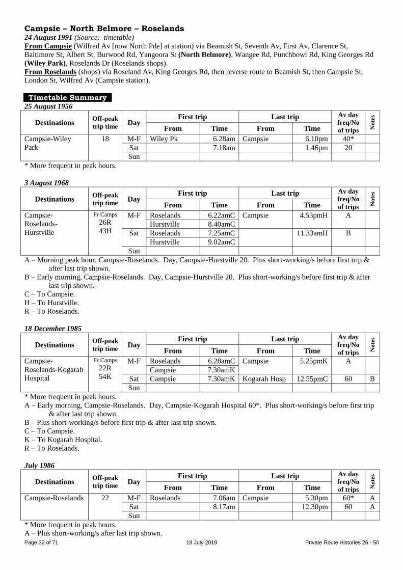
Page 32 of 71 19 July 2019 Private Route Histories 26 - 50
Campsie – North Belmore – Roselands 24 August 1991 (Source: timetable)
From Campsie (Wilfred Av [now North Pde] at station) via Beamish St, Seventh Av, First Av, Clarence St,
Baltimore St, Albert St, Burwood Rd, Yangoora St (North Belmore), Wangee Rd, Punchbowl Rd, King Georges Rd
(Wiley Park), Roselands Dr (Roselands shops).
From Roselands (shops) via Roseland Av, King Georges Rd, then reverse route to Beamish St, then Campsie St,
London St, Wilfred Av (Campsie station).
Timetable Summary 25 August 1956
Destinations Off-peak
trip time Day
First trip Last trip Av day
freq/No
of trips No
tes
From Time From Time
Campsie-Wiley
Park
18 M-F Wiley Pk 6.28am Campsie 6.10pm 40*
Sat 7.18am 1.46pm 20
Sun
* More frequent in peak hours.
3 August 1968
Destinations Off-peak
trip time Day
First trip Last trip Av day
freq/No
of trips No
tes
From Time From Time
Campsie-
Roselands-
Hurstville
Fr Camps
26R
43H
M-F Roselands 6.22amC Campsie 4.53pmH A
Hurstville 8.40amC
Sat Roselands 7.25amC 11.33amH B
Hurstville 9.02amC
Sun
A – Morning peak hour, Campsie-Roselands. Day, Campsie-Hurstville 20. Plus short-working/s before first trip &
after last trip shown.
B – Early morning, Campsie-Roselands. Day, Campsie-Hurstville 20. Plus short-working/s before first trip & after
last trip shown.
C – To Campsie.
H – To Hurstville.
R – To Roselands.
18 December 1985
Destinations Off-peak
trip time Day
First trip Last trip Av day
freq/No
of trips No
tes
From Time From Time
Campsie-
Roselands-Kogarah
Hospital
Fr Camps
22R
54K
M-F Roselands 6.28amC Campsie 5.25pmK
A
Campsie 7.30amK
Sat Campsie 7.30amK Kogarah Hosp 12.55pmC 60 B
Sun
* More frequent in peak hours.
A – Early morning, Campsie-Roselands. Day, Campsie-Kogarah Hospital 60*. Plus short-working/s before first trip
& after last trip shown.
B – Plus short-working/s before first trip & after last trip shown.
C – To Campsie.
K – To Kogarah Hospital.
R – To Roselands.
July 1986
Destinations Off-peak
trip time Day
First trip Last trip Av day
freq/No
of trips No
tes
From Time From Time
Campsie-Roselands 22 M-F Roselands 7.06am Campsie 5.30pm 60* A
Sat 8.17am 12.30pm 60 A
Sun
* More frequent in peak hours.
A – Plus short-working/s after last trip shown.

Page 33 of 71 19 July 2019 Private Route Histories 26 - 50
24 August 1991
Destinations Off-peak
trip time Day
First trip Last trip Av day
freq/No
of trips No
tes
From Time From Time
Campsie-North
Belmore-Roselands
25 M-F Roselands 7.24am Roselands 5.38pm 60* A
Sat 8.15am Campsie 4.35pm 60
Sun
* More frequent in peak hours.
A – Plus short-working/s before first trip & after last trip shown.
Route 40
CAMMERAY (Cammaray Rd) – MILSONS POINT
Timeline As at date of Govt Gazette 13 November 1925: Being operated by White Transit Co (Charles H Hicks).
By date of Govt Gazette 15 October 1926: Ceased.
Streets 1925 (Source: Govt Gazette of 13 November 1925)
From Cammeray (Cammeray Rd at Alan St) via Cammeray Rd, Carter St, Palmer St, Miller St, Berry St, Walker St,
Mount St, Alfred St, Dind St, Glen St (Milsons Point tram terminus). Reverse on return.
Timetable Summary September 1925
Destinations Off-peak
trip time Day
First trip Last trip Av day
freq/No
of trips No
tes
From Time From Time
Cammeray-Milsons
Point
20 M-F Cammeray 6.38am Milsons Pt 11.18pm 20-30
Sat 6.38am 11.18pm 20-30
Sun 8.56am 11.42pm 20-30
Route 40
CABRAMATTA – BONNYRIGG – MT PRITCHARD (Dayments Corner or Reservoir) via
Cabramatta Rd CABRAMATTA – MT PRITCHARD (Townview Rd) CABRAMATTA – SOUTH BONNYRIGG via Cabramatta Rd
CABRAMATTA – ST JOHNS PARK via John St CABRAMATTA – ST JOHNS PARK via St Johns Rd
LIVERPOOL – BONNYRIGG
Extended from Bonnyrigg to Badgerys Creek (infrequent service)
Cabramatta – Sussex St, Cabramatta (limited service)
(Dayments [Corner], Mt Pritchard was at Park Rd/Mulgoa Rd [now Meadows
Rd/Elizabeth Dr, Mt Pritchard]. It was apparently named after the family of John Dayment, who is said to have lived there in the late 1800s/early 1900s.)
(South Bonnyrigg is now known as Bonnyrigg Heights.)
Timeline By date of Govt Gazette 22 June 1928: Cabramatta – Bonnyrigg via Cabramatta Rd commenced.
By October 1935: Operated by Mrs EL Roberts
August 1948: Transferred to Cabramatta-Bonnyrigg Bus Service (GW Stanton).
By 1950:
Outer termini for most trips:
Bonnyrigg (probably Cabramatta Rd/Mulgoa Rd [now Elizabeth Dr]) or
Dayments Corner (see above) or
Reservoir (Mulgoa Rd/Green Valley Rd [now North Liverpool Rd/Elizabeth Dr, Mt Pritchard]).
Page 34 of 71 19 July 2019 Private Route Histories 26 - 50
New route, Liverpool – Bonnyrigg – Green Valley commenced. Selected trips extended from Bonnyrigg to
Cowpasture Rd or Badgerys Creek.
August 1951: Transferred to Calabro Bros (A, B, G & F Calabro).
December 1956: Selected trips rerouted via Hemphill Av & Mulgoa Rd.
June 1957: New route(s), Cabramatta – Humphreys Rd (either via John St and/or St Johns Rd?), commenced. St
Johns Rd route ran in competition with Bosnjaks’ 45 along the same road until 24 October 1982, when Bosnjaks’ 45
ceased to run there.
December 1959: New route, Cabramatta – Mt Pritchard (Townview Rd) (destination “Townview Rd via Cooks
Hill”), commenced.
By 25 January 1960: Trips to Reservoir (Mulgoa Rd/Green Valley Rd [now North Liverpool Rd/Elizabeth Dr, Mt
Pritchard]) curtailed to Dayments Corner (Park Rd/Mulgoa Rd [now Meadows Rd/Elizabeth Dr, Mt Pritchard]).
By 1960s: Routes were:
Cabramatta – Bonnyrigg via Cabramatta Rd (infrequent service extended to Badgerys Creek)
Cabramatta – Mt Pritchard (Townview Rd)
Cabramatta – St Johns Park (Humphries Rd) via John St
Cabramatta – St Johns Park (Humphries Rd) via St Johns Rd
By 2 February 1982: New route, Liverpool – Bonnyrigg via Cabramatta Rd. Infrequent extension from Bonnyrigg
to Badgerys Creek transferred from Cabramatta – Bonnyrigg via Cabramatta Rd to this new route.
By 1984: Routes were:
Cabramatta – Bonnyrigg (Tarlington Pde) via John St
Cabramatta – Mt Pritchard (Townview Rd)
Cabramatta – South Bonnyrigg
Cabramatta – St Johns Park (Edensor Rd) via St Johns Rd
Liverpool – Bonnyrigg (Cowpasture Rd) via Cabramatta Rd (selected trips extended to Badgerys Creek)
By February 1988: New route (limited service), Cabramatta – Sussex St, Cabramatta commenced.
By 12 September 1988: Infrequent extension Bonnyrigg – Badgerys Creek transferred from Liverpool – Cowpasture
Rd via Cabramatta Rd service to new Liverpool – Cowpasture Rd via John St service.
8 June 1989: Transferred to Westbus (Bosnjak family, proprietors; Roger L Graham, general manager till 1990).
4 February 1991: As part of general reorganization of Westbus’s Bonnyrigg area routes, renumbered into the Sydney
Region Route Number System (see Private Route Histories – Contract Region 3) as: 826 Cabramatta – Fairfield via Canley Vale Rd & Polding St
827 Cabramatta – Fairfield via St Johns Rd & Brenan St
831 Cabramatta – Bonnyrigg
832 Cabramatta – South Bonnyrigg
833 Cabramatta – Mt Pritchard – South Bonnyrigg
834 Cabramatta – Mt Pritchard (Townview Rd)
835 Liverpool – South Bonnyrigg – Penrith
836 Liverpool – South Bonnyrigg – Badgerys Creek
837 Liverpool – South Bonnyrigg – Bonnyrigg
Cabramatta – Sussex St, Cabramatta (limited service) continued as an unnumbered route.
Streets
Cambramatta – Bonnyrigg via Cabramatta Rd 1928 (Source: Govt Gazette of 22 June 1928)
From Cabramatta (Railway Pde at station) via Railway Pde, Cabramatta Rd, Mulgoa Rd [now Elizabeth Dr] to Park
[now Meadows] Rd [Dayments Corner] (in current Mt Pritchard).
Circa 1946 (Source: Gregory’s Street Directory)
From Cabramatta via Railway Pde, Cabramatta Rd, Mulgoa Rd [now Elizabeth Dr] (Bonnyrigg).
By 1960
Trips to Dayments (Corner): Ex Cabramatta from Cabramatta Rd in a loop via Mulgoa Rd [now Elizabeth Dr] to
Park [now Meadows] Rd (Dayments), then Park [now Meadows] Rd, Cabramatta Rd; or reverse order of streets.
1984 (Source: timetable)
From Cabramatta (Railway Pde at station) via Railway Pde, Boundary Lane, Church St, Cabramatta Rd, Meadows
Rd, Anderson Av, Hemphill Av, Elizabeth Dr (Bonnyrigg), Cabramatta Rd, Hill St, Hughes St, Railway Pde to
Cabramatta station.

Page 35 of 71 19 July 2019 Private Route Histories 26 - 50
Cowpasture Rd extension: Extended from Bonnyrigg (Elizabeth Dr/Cabramatta Rd) via Elizabeth Dr, Kalang Rd,
Cowpasture Rd, Elizabeth Dr. Reverse on return.
Lewis St, South Bonnyrigg extension: Extended from Bonnyrigg (Elizabeth Dr) via Brown Rd, Aplin Rd, Simpson
Rd, Wilson Rd, Lewis St. Reverse on return.
Tarlington Pde extension: Extended from Bonnyrigg (Elizabeth Dr) via Bonnyrigg Av, Tarlington Pde to
Cabramatta Rd.
Cabramatta – St Johns Park (Humphries Rd) via John St 1969 (Source: RGH notes)
From Cabramatta (Railway Pde at station) via John St, Harrington St, St Johns Rd, Humphries Rd (St Johns Park),
Edensor Rd, Harrington St, John St, Park Rd, Arthur St, Railway Pde to Cabramatta station.
Cabramatta – Bonnyrigg (Tarlington Pde) via John St 1984 (Source: timetable)
From Cabramatta (Railway Pde at station) via John St, Harrington St, Edensor Rd, Bonnyrigg Av, Tarlington Pde
(Bonnyrigg), Cabramatta Rd, Humphries Rd, Edensor Rd, Harrington St, John St, Hill St, Hughes Av, Railway Pde to
Cabramatta station.
Cabramatta – St Johns Park (Humphries Rd) via St Johns Rd 1969 (Source: RGH notes)
From Cabramatta (Railway Pde at station) via John St, Gladstone St, St Johns Rd, Harrington St, Edensor Rd,
Humphries Rd (St Johns Park), St Johns Rd, Gladstone St, Hughes St, Railway Pde to Cabramatta station.
Cabramatta – Bonnyrigg (Bunker Pde) via St Johns Rd 1984 (Source: timetable)
From Cabramatta (Railway Pde at station) via John St, Park Rd, McBurney Rd, Gladstone St, St Johns Rd,
Humphries Rd, Edensor Rd, Bunker Pde (Bonnyrigg), Humphries Rd, St Johns Rd, Gladstone St, McBurney Rd,
Railway Pde to Cabramatta station Pde.
Cabramatta – Mt Pritchard (Townview Rd) 1984 (Source: timetable)
From Cabramatta (Railway Pde at station) via Railway Pde, Boundary Lane, Church St, Cabramatta Rd, Townview
Rd, Oliphant St (clockwise loop) (Mt Pritchard), Townview Rd, Cabramatta Rd, Hill St, Hughes St, Railway Pde to
Cabramatta station.
Alteration
1988 (Source: timetable): From Cabramatta Rd via Anderson Av, David St, Oliphant St, Townview Rd, Oliphant St
(clockwise loop), Townview Rd to Cabramatta Rd.
Liverpool – Bonnyrigg – Badgerys Creek via Cabramatta Rd 1984 (Source: timetable)
From Liverpool (station forecourt) via Bigge St, Moore St, Macquarie St, Elizabeth St, Elizabeth Dr, Copeland St,
Orange Grove Rd, Cabramatta Rd, Elizabeth Dr (Bonnyrigg), Badgerys Creek Rd to Longleys Rd (Badgerys Creek).
From Badgerys Creek (Badgerys Creek Rd at Longleys Rd) via reverse route to Copeland St, then Elizabeth Dr,
Elizabeth St, George St, Moore St, Bigge St to Liverpool station.
Liverpool – South Bonnyrigg via Brown Rd 12 September 1988 (Source: timetable)
From Liverpool (station forecourt) via Bigge St, Moore St, Northumberland St, Elizabeth Dr, Copeland St, Orange
Grove Rd, Cabramatta Rd, Elizabeth Dr (Bonnyrigg), Brown Rd, Aplin Rd, Simpson Rd, Wilson Rd, Mount St,
Cowpasture Rd (South Bonnyrigg), Lewis St, Wilson Rd, then reverse route to Copeland St, then Elizabeth Dr,
Elizabeth St, George St, Moore St, Bigge St to Liverpool station.
Liverpool – South Bonnyrigg via John St (selected trips extended to Badgerys Creek) 12 September 1988 (Source: timetable)
From Liverpool (station forecourt) via Bigge St, Moore St, Northumberland St, Elizabeth Dr, Copeland St, Orange
Grove Rd, Cabramatta Rd, Gladstone St, John St, Harrington St, Edensor Rd, Humphries Rd, Cabramatta Rd,
Elizabeth Dr (Bonnyrigg), Kalang Rd [Kalang Rd then met Elizabeth Dr at Smithfield Rd & met Cowpasture Rd] to
Cowpasture Rd (Edensor Park).

Page 36 of 71 19 July 2019 Private Route Histories 26 - 50
From Cowpasture Rd (at Kalang Rd) via Cowpasture Rd, Elizabeth Dr, Humphries Rd, then reverse route to
Copeland St, then Elizabeth Dr, Elizabeth St, George St, Moore St, Bigge St to Liverpool station.
Badgerys Creek extension: Extended from Bonnyrigg (Cowpasture Rd/Elizabeth Dr) via Elizabeth Dr, Martin Rd,
Cuthel St, Lawson Rd, Pitt St, Badgerys Creek Rd to Longleys Rd (Badgerys Creek), returning via Badgerys Creek
Rd, Elizabeth Dr to Cabramatta Rd.
Cabramatta – Sussex St 1988 (Source: timetable)
From Cabramatta (Railway Pde at station) via Railway Pde, Boundary Lane, Church St, Bolivia St, Huon St, Sussex
St, Carrabeen St, Bolivia St, Kurrajong St, Cabramatta Rd, Hill St, Hughes St, Railway Pde to Cabramatta station.
Timetable Summary 14 August 1950
Destinations Off-peak
trip time Day
First trip Last trip Av day
freq/No
of trips No
tes
From Time From Time
Cabramatta-various
termini in
Bonnyrigg area
M-F Reservoir 5.58amC Cabramatta 9.50pmD 40-60* A
Sat Dayments 5.45amC 12.37amD AM 30
PM 60
A
Sun Bonnyrigg 7.35amC 9.50pmD 60 A
Liverpool-various
termini in
Bonnyrigg area
M-F Bonnyrigg 8.10amL Liverpool 4.00pmP B
Sat 8.15amL 11.45pmG E
Sun
* More frequent in peak hours.
A – Cabramatta-various termini (Bonnyrigg, Reservoir, Cowpasture Rd or Dayments). Extra trips Wednesday night.
B – Liverpool-various termini (Bonnyrigg, Green Valley or Cowpasture Rd). 6 trips to Liverpool, 4 trips from
Liverpool.
C – To Cabramatta.
D – To Mt Pritchard (Dayments).
E – Liverpool-various termini (Bonnyrigg or Green Valley). 5 trips to Liverpool, 3 trips from Liverpool.
G – To Green Valley.
L – To Liverpool.
P – To Cowpasture Rd.
25 January 1960
Destinations Off-peak
trip time Day
First trip Last trip Av day
freq/No
of trips No
tes
From Time From Time
Cabramatta-
Bonnyrigg or Mt
Pritchard via
Cabramatta Rd
12 M-F Bonnyrigg or
Mt Pritchard
4.58am Cabramatta 11.18pm 30*
Sat 5.32am 11.20pm 30
Sun 7.22am 9.18pm 30-60
Cabramatta-
Edensor Rd/
Meadows Rd via
John St
8 M-F Edensor Rd/
Meadows Rd
5.09am Cabramatta 9.16pm 20* A
Sat 5.32am 9.46pm AM 15
PM 30
A
Sun 8.33am 9.18pm 30 B
Cab’matta-St Johns
Pk (Humphries Rd)
via St Johns Rd
10 M-F Humphries Rd 5.10am Cabramatta 11.16pm 30* A
Sat 6.22am 11.16pm 30 A
Sun 7.58am 5.48pm 4 trips B
* More frequent in peak hours.
A – Selected trips ran from Cabramatta via St Johns Rd & returned via John St.
B – Selected trips ran from Cabramatta via John St & returned via St Johns Rd.

Page 37 of 71 19 July 2019 Private Route Histories 26 - 50
12 September 1988
Destinations Off-peak
trip time Day
First trip Last trip Av day
freq/No
of trips No
tes
From Time From Time
Cabramatta-South
Bonnyrigg via
Cabramatta Rd
35 M-F Sth Bonnyrigg 4.40am Cabramatta 10.20pm 30*
Sat 5.45am 5.30pm 40-55
Sun 7.20am 6.30pm 55
Cabramatta-
Bonnyrigg
(Tarlington Pde)
via John St
15 M-F Tarlington Pde 4.55am Cabramatta 7.08pm 35*
Sat 6.25am 6.05pm AM 35
PM 30
A
Sun 7.50am 6.05pm 30 A
Cabramatta-St
Johns Park (Bunker
Pde) via St Johns
Rd
15 M-F Bunker Pde 4.55am Cabramatta 7.08pm 35*
Sat 6.25am 6.05pm AM 35
PM 30
A
Sun 7.50am 6.05pm 30 A
Cabramatta-Mt
Pritchard
(Townview Rd)
20
round
trip
M-F Townview Rd 4.53am Cabramatta 10.30pm 30
Sat 6.08am 5.30pm AM 30
PM 50
B
Sun 7.38am 6.30pm 50 B
Liverpool-South
Bonnyrigg via
Cabramatta Rd
23 M-F Sth Bonnyrigg 5.32am Liverpool 6.43pm 50
Sat 7.12am 1.16pm 50
Sun
Liverpool-South
Bonnyrigg via John
St
27 M-F Sth Bonnyrigg 5.35am Liverpool 6.07pm 60 C
Sat 8.20am 12.30pm 60 C
Sun
* More frequent in peak hours.
A – Saturday afternoon & Sunday trips ran from Cabramatta via St Johns Rd & returned via John St.
B – Weekday nights, Saturday afternoons & Sundays, service provided by diversion of Cabramatta-Bonnyrigg via
Cabramatta Rd route.
C – Selected trips extended to Badgerys Creek.
Route 41
CAMPSIE – PETERSHAM – CENTRAL RAILWAY
Timeline As at date of Govt Gazette 13 November 1925: Being operated by (1) J Northey & (2) Mick Fitzgibbons (also
trading as White Deluxe Bus Service)
31 October 1931: Ceased as competitive with Government railway or tram services under State Transport (Co-
ordination) Act.
Streets 1925 (Source: Govt Gazette of 13 November 1925)
From Campsie (station, North Pde at Beamish St) via North Pde, Beamish St, Canterbury Rd, New Canterbury Rd
(Dulwich Hill), Palace [now Audley] St (Petersham), Trafalgar St, Crystal St, Parramatta Rd, George St West [now
Broadway], George St, Hay St, Pitt St to Eddy Av (Central Railway).
From Central Railway (Pitt St at Eddy Av) via Pitt St, George St, George St West [now Broadway], Parramatta Rd,
Railway St, Croydon St, Crystal St, then reverse route to Campsie station.
Alteration
1929 (Source: Govt Gazette of 22 February 1929): Ex Campsie from Crystal St via Fort St, Railway St, Parramatta
Rd. Unaltered ex Central Railway.

Page 38 of 71 19 July 2019 Private Route Histories 26 - 50
Timetable Summary September 1925
Destinations Off-peak
trip time Day
First trip Last trip Av day
freq/No
of trips No
tes
From Time From Time
Campsie-Central
Railway
M-F Campsie 6.50am Central Rly 11.21pm 30
Sat 6.50am 11.21pm 30
Sun 7.50am 12.03am 30
March 1930
Destinations Off-peak
trip time Day
First trip Last trip Av day
freq/No
of trips No
tes
From Time From Time
Campsie-Central
Railway
M-F Campsie 6.49am Central Rly 11.38pm 20
Sat 6.49am 12.38am 20
Sun 8.09am 11.38pm 20
Route 41
LIVERPOOL – ASHCROFT – HINCHINBROOK via South Liverpool Rd LIVERPOOL – BONNYRIGG – GREEN VALLEY
LIVERPOOL – MILLER via Maxwells Av (selected trips extended to Busby Rd) LIVERPOOL – MT PRITCHARD (Townview Rd) LIVERPOOL – ORANGE GROVE ESTATE
Liverpool – Heckenberg – Busby – Miller (shopping service, from 1980)
Miller – Busby – Heckenberg – Miller (shopping service, approx. 1968-80)
(Orange Grove estate is in the vicinity of O’Brien Pde & Marsden Rd)
(Dayments [Corner], Mt Pritchard was at Park Rd/Mulgoa Rd [now Meadows Rd/Elizabeth Dr, Mt Pritchard]. It was apparently named after the family of John
Dayment, who is said to have lived there in the late 1800s/early 1900s.)
Timeline 31 July 1933: Liverpool – Bonnyrigg commenced by Mrs EL Roberts.
By 1948: Route was Liverpool – Bonnyrigg – Green Valley (terminus at Green Valley Rd/Wilson Rd).
August 1948: Transferred to Cabramatta – Bonnyrigg Bus Service (GW Stanton).
August 1951: Transferred to Calabro Bros.
December 1954: Transferred to Oliveri Bros.
October 1956: Rerouted via Meadows Rd & Mulgoa Rd [now Elizabeth Dr].
December 1956: Route extended via Cowpasture Rd & Heckenberg Rd [now North Liverpool Rd].
December 1959: New route, Liverpool – Mt Pritchard (Townview Rd) commenced (in off peak & at weekends,
service provided by diverting selected Green Valley trips via Townview Rd/Oliphant St).
By 8 August 1960:
New routes to Orange Grove estate commenced:
Liverpool – Woodlands Rd (in off peak & at weekends, service provided by diverting selected Green
Valley trips via Woodlands Rd)
Liverpool – Orange Grove Rd
Green Valley trips extended in a loop via North Liverpool Rd, Cowpasture Rd & Green Valley Rd.
Late 1962: New route, Liverpool – Green Valley housing estate, commenced (possibly to South Liverpool Rd via
Ashcroft and/or to Sadleir Av/Insignia St, Sadleir, the latter being the beginnings of the Liverpool – Miller route).
December 1962: Operator’s name changed to Oliveri Transport Services.
June 1963: Liverpool – Sadleir Av/Insignia St extended to Bobin Rd, Sadleir.
By April 1965:
[Probably] Liverpool – Bobin Rd, Sadleir extended from Bobin Rd to “Green Valley” [probably now Miller]
shopping centre.
Green Valley trips ran clockwise round North Liverpool Rd-Cowpasture Rd-Green Valley Rd loop on
weekday afternoons & nights, but anti-clockwise at other times.

Page 39 of 71 19 July 2019 Private Route Histories 26 - 50
By 1966: Routes were:
Liverpool – Cowpasture Rd, Green Valley*
Liverpool – Miller
Liverpool – Mt Pritchard (Townview Rd)
Liverpool – Orange Grove Estate (Liverpool – Woodlands Rd & Liverpool – Orange Grove Rd routes
combined)
Liverpool – South Liverpool Rd via Ashcroft*
*On weeknights, Saturday afternoons & Sundays, these routes were combined in a loop from Liverpool via Dayments,
Green Valley Rd, Rundle Rd, South Liverpool Rd & Dayments (not via Ashcroft) & return to Liverpool.
By 1968: New route, Miller – Busby – Heckenberg – Miller shopping service, commenced.
By July 1980:
Miller – Busby – Heckenberg – Miller shopping service altered to run Liverpool – Heckenberg – Busby –
Miller.
Selected Liverpool – Miller trips extended to Busby Rd.
By 1981: New Bonnyrigg Estate (Montgomery Rd, Brown Rd & Wearne Rd) served by:
Rerouting of selected Liverpool – Green Valley trips
Extension of selected Liverpool – Ashcroft – South Liverpool Rd trips.
September 1988: Liverpool – Ashcroft – South Liverpool Rd extended to Hinchinbrook (new suburb).
1 July 1989: Oliveri Transport Services & Ingleburn Bus Services (different branches of the Oliveri family) jointly
traded as Oliveri’s Metro-link.
10 December 1989: As part of general reorganization of Oliveris’ Liverpool routes, renumbered into the Sydney
Region Route Number System (see Private Route Histories – Contract Region 3) as: 841 Liverpool – Heckenberg – Bonnyrigg – Green Valley
842 Liverpool – Miller – Hinchinbrook
843 Liverpool – Mt Pritchard (Townview Rd) – Orange Grove Estate
844 Liverpool – Ashcroft – Green Valley (South Liverpool Rd)
845 Liverpool – Green Valley via Bonnyrigg
846 Liverpool – Bonnyrigg – Green Valley (South Liverpool Rd) (loop)
Streets
Liverpool – Bonnyrigg – Green Valley Circa 1946 (Source: Gregory’s Street Directory)
From Liverpool via Railway Pde [possibly station forecourt], Scott St, Macquarie St, Elizabeth St, Kemps Creek Rd
[now Elizabeth Dr] (Bonnyrigg), Green Valley Rd [includes current Matthew Av] to Wilson Rd (Green Valley), then
Green Valley Rd to Park Rd [now Meadows Rd] & Mulgoa Rd [now Elizabeth Dr].
Circa 1948 (Source: Gregory’s Street Directory)
From Liverpool via Bigge St, Railway St, George St, Scott St, Macquarie St, Elizabeth St, Kemps Creek Rd [now
Elizabeth Dr], Green Valley Rd [includes current Matthew Av] to Wilson Rd (Green Valley), then Green Valley Rd
to Park Rd [now Meadows Rd] & Mulgoa Rd [now Elizabeth Dr].
1969 (Source: RGH notes)
From Liverpool (station forecourt) via Scott St, Macquarie St, Elizabeth St, Elizabeth Dr, Reservoir Rd, Elizabeth
Dr, Meadows Rd, Matthew Av, St Johns Rd, North Liverpool Rd, Cowpasture Rd (Green Valley), Green Valley Rd,
St Johns Rd, then reverse route to Elizabeth St, then George St, Railway St to Liverpool station.
Trips via Green Valley loop in opposite direction: From St Johns Rd via Green Valley Rd, Cowpasture Rd, North
Liverpool Rd to St Johns Rd.
Alterations
Circa 1980 (Source: timetable): To approach Liverpool station from George St via Moore St. Return via
Moore St, Macquarie St.
1981 (Source: timetable): Ex Liverpool from Matthew Av via St Johns Rd, Green Valley Rd, Oliveri Cr,
Rundle Rd, North Liverpool Rd, Cowpasture Rd. Selected trips via reverse route.
1984 (Source: timetable)
Trips via Elizabeth Dr direct: Ex Liverpool from Elizabeth Dr/Reservoir Rd (eastern intersection) via Elizabeth Dr
(not Reservoir Rd) to Elizabeth Dr/Reservoir Rd (western intersection). Reverse on return.

Page 40 of 71 19 July 2019 Private Route Histories 26 - 50
Liverpool – Miller 1969 (Source: RGH notes)
From Liverpool (station forecourt) via Scott St, Macquarie St, Elizabeth St, Elizabeth Dr, Maxwells Rd, Sadleir Av
(Sadleir), Insignia St, Bobin Rd, Heckenberg Av, Cartwright Av, Woodward Av (anti-clockwise loop) to Miller
shops.
From Miller (Woodward Cr at shops) via Cartwright Av, Heckenberg Av, then reverse route to Elizabeth St, then
George St, Railway St to Liverpool station.
Alteration
Circa 1980 (Source: timetable): To approach Liverpool station from George St via Moore St. Return via Moore St,
Macquarie St.
Liverpool – Miller (selected trips extended to Busby Rd) 1981 (Source: timetable)
Busby Rd extension: Extended from Miller shops via Cartwright Av, Busby Rd to South Liverpool Rd (?).
Liverpool – Ashcroft – Green Valley (South Liverpool Rd) 1969 (Source: RGH notes)
From Liverpool (station forecourt) via Scott St, Macquarie St, Elizabeth St, Elizabeth Dr, Maxwells Rd, Sinclair Rd,
Sutton Rd (Ashcroft), Sadleir Av, South Liverpool Rd to Rundle Rd (Busby).
From South Liverpool Rd (at Rundle Rd) via reverse route to Elizabeth St, then George St, Railway St to Liverpool
station.
Alteration
Circa 1980 (Source: timetable): To approach Liverpool station from George St via Moore St. Return via Moore St,
Macquarie St.
Liverpool – Mt Pritchard (Townview Rd) 1969 (Source: RGH notes)
From Liverpool (station forecourt) via Scott St, Macquarie St, Elizabeth St, Elizabeth Dr, Reservoir Rd, Townview
Rd, Oliphant St (clockwise loop) (Mt Pritchard), Townview Rd, then reverse route to Elizabeth St, then George St,
Railway St to Liverpool station.
Alterations
Circa 1980 (Source: timetable): To approach Liverpool station from George St via Moore St. Return via
Moore St, Macquarie St.
1984 (Source: timetable): Ex Liverpool from Reservoir Rd via Phyllis St, Townview Rd, Oliphant St
(clockwise loop), Townview Rd to Reservoir Rd.
Liverpool – Orange Grove Estate 1969 (Source: RGH notes)
From Liverpool (station forecourt) via Scott St, Macquarie St, Elizabeth St, Elizabeth Dr, Secant St, Campbell St,
Copeland St, Orange Grove Rd, O’Brien Pde, Marsden Rd (Orange Grove Estate), Woodlands Rd, Lewis St,
Marsden Rd, Elizabeth Dr, Elizabeth St, George St, Railway St to Liverpool station.
Alteration
Circa 1980 (Source: timetable): To approach Liverpool station from George St via Moore St. Return via Moore St,
Macquarie St.
Miller – Busby – Heckenberg – Miller shopping service 1968 (Source: timetable)
From Miller (Woodward Cr at shops) via Cartwright Av, Busby Rd (Busby), South Liverpool Rd, Rundle Rd, Green
Valley Rd, St Johns Rd, Matthew Av (Heckenberg), South Liverpool Rd, Heckenberg Av, Cartwright Av, Woodward
Cr to Miller shops.
Liverpool – Heckenberg – Busby – Miller shopping service 1981 (Source: timetable)
From Liverpool (station forecourt) via Moore St, Macquarie St, Elizabeth St, Elizabeth Dr, Reservoir Rd, Elizabeth
Dr, Meadows Rd, Matthew Av (Heckenberg), St Johns Rd, Green Valley Rd, Rundle Rd, South Liverpool Rd, Busby
Rd (Busby), Cartwright Av, Woodward Cr to Miller shops.
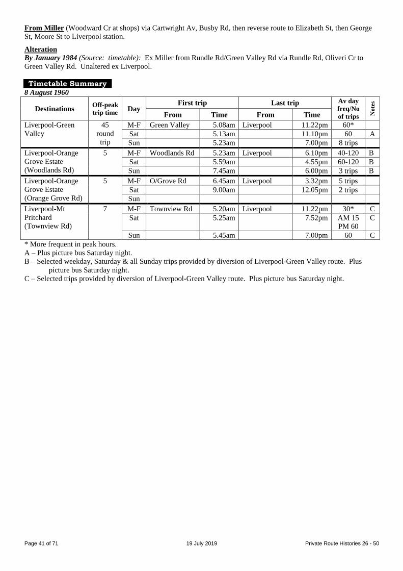
Page 41 of 71 19 July 2019 Private Route Histories 26 - 50
From Miller (Woodward Cr at shops) via Cartwright Av, Busby Rd, then reverse route to Elizabeth St, then George
St, Moore St to Liverpool station.
Alteration
By January 1984 (Source: timetable): Ex Miller from Rundle Rd/Green Valley Rd via Rundle Rd, Oliveri Cr to
Green Valley Rd. Unaltered ex Liverpool.
Timetable Summary 8 August 1960
Destinations Off-peak
trip time Day
First trip Last trip Av day
freq/No
of trips No
tes
From Time From Time
Liverpool-Green
Valley
45
round
trip
M-F Green Valley 5.08am Liverpool 11.22pm 60*
Sat 5.13am 11.10pm 60 A
Sun 5.23am 7.00pm 8 trips
Liverpool-Orange
Grove Estate
(Woodlands Rd)
5 M-F Woodlands Rd 5.23am Liverpool 6.10pm 40-120 B
Sat 5.59am 4.55pm 60-120 B
Sun 7.45am 6.00pm 3 trips B
Liverpool-Orange
Grove Estate
(Orange Grove Rd)
5 M-F O/Grove Rd 6.45am Liverpool 3.32pm 5 trips
Sat 9.00am 12.05pm 2 trips
Sun
Liverpool-Mt
Pritchard
(Townview Rd)
7 M-F Townview Rd 5.20am Liverpool 11.22pm 30* C
Sat 5.25am 7.52pm AM 15
PM 60
C
Sun 5.45am 7.00pm 60 C
* More frequent in peak hours.
A – Plus picture bus Saturday night.
B – Selected weekday, Saturday & all Sunday trips provided by diversion of Liverpool-Green Valley route. Plus
picture bus Saturday night.
C – Selected trips provided by diversion of Liverpool-Green Valley route. Plus picture bus Saturday night.

Page 42 of 71 19 July 2019 Private Route Histories 26 - 50
23 February 1975
Destinations Off-peak
trip time Day
First trip Last trip Av day
freq/No
of trips No
tes
From Time From Time
Liverpool-Green
Valley
42
round
trip
M-F Green Valley 5.52am Liverpool 11.30pm 60* A
Sat 5.08am 10.27pm AM 50** A
Sun 5.15am 7.27pm 60
Liverpool-Orange
Grove estate
5 M-F O/Grove est 5.27am Liverpool 7.30pm 30*
Sat 5.47am 6.05pm AM 60 PM 1 trip
Sun 5.48am 5.10pm 2 trips
Liverpool-Mt
Pritchard
(Townview Rd)
8 M-F Townview Rd 5.07am Liverpool 7.30pm 30
Sat 5.23am 9.08pm AM 20 PM 3 trips
Sun 7.28am 6.05pm 2 trips
Liverpool-Miller 27 M-F Miller 4.30am Liverpool 12.00mn 30*
Sat 4.48am 11.00pm AM 15
PM 60
Sun 6.30am 7.00pm 60
Liverpool-
Ashcroft-South
Liverpool Rd
28 M-F Sth Liv Rd 4.52am Liverpool 11.30pm 30
Sat 5.36am 10.27pm AM 15
PM 60
Sun 8.10am 5.25pm 4 trips
Miller-Busby-
Heckenberg-Miller
19
round
trip
M-F Miller 10.00am Miller 2.30pm 60
Sat Busby 9.06am 12.30pm 60
Sun
* More frequent in peak hours.
** Less frequent in afternoon.
A – Extra trips Liverpool-Rundle Rd weekday & Saturday mornings.
Route 42
CAMPSIE – HURLSTONE PARK – MARRICKVILLE – CENTRAL RAILWAY
Timeline As at date of Govt Gazette 13 November 1925: Being operated by Mick Fitzgibbons (also trading as White Deluxe
Bus Service)
By date of Govt Gazette 4 April 1930: Rerouted via Enmore & Salisbury Rd (instead of Newtown).
31 October 1931: Ceased as competitive with Government railway or tram services under State Transport (Co-
ordination) Act.
Streets 1925 (Source: Govt Gazette of 13 November 1925)
From Campsie (station, North Pde at Beamish St) via North Pde, Beamish St, South Pde, Duke St, Canterbury Rd
(Canterbury), Floss St (Hurlstone Park), Garnet St, Ewart St, Beauchamp St, Warren Rd, Illawarra Rd
(Marrickville), Agar St, Newington Rd, Wemyss St, Stanmore Rd (Enmore), Enmore Rd, King St (Newtown), City
Rd, George St West [now Broadway], George St, Hay St, Pitt St to Eddy Av (Central Railway).
From Central Railway (Pitt St at Eddy Av) via Pitt St, George St, George St West [now Broadway], then reverse
route to Campsie station.
Alteration
1930 (Source: Govt Gazette of 4 April 1930): Ex Campsie from Stanmore Rd via Liberty St, Railway Av, Cardigan
St, Salisbury Rd, University St [now Salisbury Rd], Missenden Rd, Parramatta Rd, George St West [now Broadway].
Reverse on return.
Page 43 of 71 19 July 2019 Private Route Histories 26 - 50
Timetable Summary September 1925
Destinations Off-peak
trip time Day
First trip Last trip Av day
freq/No
of trips No
tes
From Time From Time
Campsie-Central
Railway
48 M-F Campsie 6.50am Central Rly 11.35pm 60
Sat 6.50am 11.35pm 60
Sun 8.58am 12.03am 60
March 1930
Destinations Off-peak
trip time Day
First trip Last trip Av day
freq/No
of trips No
tes
From Time From Time
Campsie-Central
Railway
48 M-F Central Rly 7.12am Central Rly 11.52pm 20
Sat 7.12am 12.32am 20
Sun Campsie 8.17am 11.52pm 20
Route 42
LIVERPOOL – HAMMONDVILLE – HOLSWORTHY
Extended from Hammondville to Williams Creek [later known as East Hills
Migrant Hostel, now Voyager Point] (selected trips)
Further extended from East Hills Hostel to Sandy Point (selected trips)
LIVERPOOL – HILLVIEW [now Lurnea] LIVERPOOL – MILPERRA BRIDGE
LIVERPOOL – MOOREBANK CAMP
Timeline 11 July 1933: Routes commenced by JC Bridges:
Liverpool – Milperra Bridge
Liverpool – Hillview
Liverpool – Hammondville
19 September 1933: Liverpool – Hillview service ceased.
20 August 1934: Liverpool – Milperra Bridge service curtailed to run Liverpool – Newbridge Rd/Gordon Rd [now
Governor Macquarie Dr]. (List dated October 1935 shows route as Liverpool – Chipping Norton – Milperra Bridge.)
Circa 1943: Liverpool – Newbridge Rd/Gordon Rd & Liverpool – Hammondville transferred to GV Scott.
Later: Liverpool – Newbridge Rd/Gordon Rd re-extended to Milperra Bridge.
August 1948:
Liverpool – Milperra Bridge transferred to R Shepherd & renumbered 69.
Liverpool – Hammondville transferred to Jeffrey H Moore.
By 24 July 1954:
Operator’s name changed to Liverpool Bus Service.
Selected trips diverted via Moorebank Av.
Extended from Hammondville to Holsworthy Camp.
Selected trips extended to Williams Creek, which was the site of East Hills Migrant Hostel.
August 1959: Transferred to Hammondville Bus Service (Alan Redman). The 1 March 1961 timetable shows
proprietors as Hammondville Bus Service and Moorebank Bus Service.
By 11 March 1968: Trips diverting via Moorebank Av altered to separate route, Liverpool – Moorebank Camp.
1973: Transferred to Mrs Redman on Mr Redman’s death.
December 1974: Transferred to Holsworthy Bus Service (Frank & Maurice Grubisic).
1977: Operator’s name changed to Westway Bus & Coach Service.
August 1982: Westway Bus & Coach Service transferred to Threlkeld family.
By December 1982: Selected East Hills Migrant Hostel trips extended to Sandy Point.
21 December 1987: Extended from Holsworthy Camp to Holsworthy railway station, upon opening of East Hills –
Glenfield railway. Both train & extended bus route initially ran in weekday peak hours only, but both became full
time from 12 September 1988, when a full service was provided on the railway.

Page 44 of 71 19 July 2019 Private Route Histories 26 - 50
16 March 1992:
Renumbered into the Sydney Region Route Number System (see Private Route Histories – Contract Region
13):
857 Liverpool – Moorebank Camp
862 Liverpool – Holsworthy, with selected trips extended to East Hills Hostel & Sandy Point
New 858, Holsworthy – Moorebank – Chipping Norton – Warwick Farm, commenced.
Streets
Liverpool – Milperra Bridge Circa 1946 (Source: Gregory’s Street Directory)
From Liverpool via Railway Pde [possibly station forecourt], Illawarra [now Heathcote] Rd, Epsom Rd [part now
Newbridge Rd, then current Epsom Rd, then approx current Abingdon St & Ascot Dr], Charlton Av [approx current
Homestead Av], Ernest Av, Gordon Rd [now Governor Macquarie Dr], Newbridge Rd, Rickard Rd (Milperra Bridge).
Liverpool – Hammondville Circa 1946 (Source: Gregory’s Street Directory)
From Liverpool via Railway Pde [possibly station forecourt], Illawarra [now Heathcote] Rd, Moorebank Av, Anzac
Rd, Illawarra [now Heathcote] Rd, Walder Rd, Stewart Av (Hammondville).
Liverpool – Hammondville – Holsworthy (selected trips extended to East Hills Hostel
[now Voyager Point] & Sandy Point) 1970 (Source: RGH notes)
From Liverpool (station forecourt) via Scott St, Newbridge Rd, Heathcote Rd, Walder St, Judd Av, Stewart Av
(Hammondville), Walder St, Heathcote Rd, Bardia Pde, Huon Pde (Holsworthy), Light Horse Pde [now Artillery
Cr], Wagon St [now part of Sabre Cr], Artillery Cr [subsumed by Harris Creek reserve], Gunners Row [now Mews],
Light Horse Pde, Bardia Pde, Wewak Rd, Derna Rd, Anzac Rd [which then extended to meet Heathcote Rd],
Heathcote Rd, Scott St, George St, Railway St to Liverpool station.
East Hills Hostel extension: Extended from Holsworthy (Heathcote Rd/Bardia Rd) via Heathcote Rd, Sirius Rd
[now The Avenue] to Migrant Centre [approx site of current western end of Sirius Rd]. Reverse on return.
Junction Rd & Nuwarra Rd diversion: Ex Liverpool from Heathcote Rd/Junction Rd via Junction Rd, Nuwarra Rd
to Heathcote Rd. Reverse on return.
Alterations
1983 (Source: timetable)
Junction Rd &Nuwarra Rd diversion: Ex Liverpool from Heathcote Rd/Junction Rd via Junction Rd,
Stockton Av, Maddecks Av (Moorebank shops), Nuwarra Rd to Heathcote Rd. Reverse on return.
Sandy Point extension: (After running via East Hills Hostel) extended from Holwsorthy (Heathcote
Rd/Sirius Rd) via Heathcote Rd, St George Cr to Bingara Dr. Reverse on return.
Holsworthy Camp diversion (likely route): From Holsworthy (Heathcote Rd/Illawarra Rd) via Illawarra Rd
[extension of existing Illawarra Rd to Heathcote Rd] to camp (in Holsworthy Military Reserve).
1987 (Source: timetable): All trips ex Liverpool from Heathcote Rd via Junction Rd, Nuwarra Rd to
Heathcote Rd. Reverse on return.
1988 (Source: timetable)
From Liverpool (station forecourt) via Moore St, George St, Scott St, Heathcote Rd, Junction Rd, Stockton Av,
Maddecks Av, Nuwarra Rd, Heathcote Rd, Walder Rd, Judd Rd (Hammondville), Stewart Av, Keato Av, Heathcote
Rd, Infantry Pde (Holsworthy), Bardia Pde, Heathcote Rd, Nuwarra Rd, Maddecks Av, Stockton Av, Junction Rd,
Heathcote Rd, Scott St, Bigge St to Liverpool station.
Holsworthy station extension: Extended in Holsworthy from Heathcote Rd/Infantry Pde via Heathcote Rd,
Macarthur Dr, station car park [now The Boulevarde] to station. Reverse on return.
Alterations
September 1988 (Source: timetable):
Route through Hammondville became a one-way loop from Heathcote Rd via Walder Rd, Judd Rd, Stewart
Av, Keato Av to Heathcote Rd.
From Heathcote Rd/Bardia Pde via Bardia Pde, Infantry Pde, Heathcote Rd, Macarthur Dr, station car park
[now The Boulevarde] to Holsworthy station. Return via reverse route.

Page 45 of 71 19 July 2019 Private Route Histories 26 - 50
Liverpool – Moorebank Camp 1970 (Source: RGH notes)
From Liverpool (station forecourt) via Scott St, Heathcote Rd, Moorebank Av to Chatham Village [approx site of
current Chatham Av] (Moorebank). Return via reverse route to Scott St, then George St, Railway St to Liverpool
station.
Alteration
1988 (Source: timetable): To approach Liverpool station from Heathcote Rd via Scott St, Bigge St. Return via
Moore St, George St, Scott St, Heathcote Rd.
Timetable Summary 24 July 1954
Destinations Off-peak
trip time Day
First trip Last trip Av day
freq/No
of trips No
tes
From Time From Time
Liverpool-
Hammondville-
Holsworthy†
34
round
trip
M-F Hammondville 5.40am Liverpool 7.20pm 30* A
Sat 6.30am 6.55pm 30 A
Sun Liverpool 8.50am Holsworthy 9.07pm 9 trips
* More frequent in peak hours.
† Selected trips extended to Holsworthy or Williams Creek.
A – Trips extended to Holsworthy: M-F 11, Saturday 13. Trips extended to Williams Creek: M-F 4, Saturday 2. Plus
picture bus Monday-Saturday nights.
10 December 1982
Destinations Off-peak
trip time Day
First trip Last trip Av day
freq/No
of trips No
tes
From Time From Time
Liverpool-
Holsworthy†
40
round
trip
M-F Holsworthy 5.15am Liverpool 7.40pm 30* A
Sat 6.40am 7.00pm 30-45 A
Sun
Liverpool-
Moorebank Camp
12 M-F Liverpool 6.45am M’bank Camp 4.30pm 9 trips
Sat
Sun
* More frequent in peak hours.
† Selected trips extended to East Hills Hostel.
A – Trips extended to East Hills Hostel: M-F 12, Saturday 8. Extra trips Thursday night.
Route 43
CAMPSIE – HURLSTONE PARK – CENTRAL RAILWAY via various routes
Timeline As at date of Govt Gazette 13 November 1925: Being operated by (1) J Northey & (2) Mick Fitzgibbons (also
trading as White Deluxe Bus Service), running via Hurlstone Park, Wardell Rd, Lewisham & Parramatta Rd.
By date of Govt Gazette 17 December 1926: Rerouted via North Campsie
By date of Govt Gazette 27 May 1927: Rerouted via Petersham instead of Lewisham.
By date of Govt Gazette 22 February 1929: Rerouted via Enmore & Newtown instead of Petersham.
By date of Govt Gazette 4 April 1930: Rerouted via Salisbury Rd instead of Newtown.
31 October 1931: Ceased as competitive with Government railway or tram services under State Transport (Co-
ordination) Act.
Streets
Campsie – Hurlstone Park – Lewisham – Central Railway 1925 (Source: Govt Gazette of 13 November 1925)
From Campsie (station, North Pde at Beamish St) via North Pde, Beamish St, South Pde, Duke St, Canterbury Rd
(Canterbury), Floss St (Hurlstone Park), Garnet St, Ewart St, Wardell Rd (Dulwich Hill), New Canterbury Rd,
Fraser Rd [now Hunter St], Railway Tce (Lewisham), Victoria St, Henry St, Old Canterbury Rd, Parramatta Rd,
George St West [now Broadway], George St, Hay St, Pitt St to Eddy Av (Central Railway).
From Central Railway (Pitt St at Eddy Av) via Pitt St, George St, George St West [now Broadway], then reverse
route to Campsie station.
Page 46 of 71 19 July 2019 Private Route Histories 26 - 50
Alteration
1926 (Source: Govt Gazette of 17 December 1926): Ex Campsie from Beamish St via Moore St, Belombi St, Nowra
St, Wairoa St, Wonga St, Canterbury Rd. Reverse on return.
Campsie – Hurlstone Park – Petersham – Central Railway Alteration
1927 (Source: Govt Gazette of 27 May 1927): Ex Campsie from New Canterbury Rd via Palace [now Audley] St,
Trafalgar St (Petersham), Crystal St, Parramatta Rd. Reverse on return.
Campsie – Hurlstone Park – Newtown – Central Railway Alteration
1929 (Source: Govt Gazette of 22 February 1929): Ex Campsie from Canterbury Rd via New Canterbury Rd,
Stanmore Rd (Enmore), Enmore R, King St (Newtown), Australia St, Parramatta Rd. Reverse on return.
Campsie – Hurlstone Park – Enmore – Central Railway Alteration
1930 (Source: Govt Gazette of 4 April 1930): Ex Campsie from Stanmore Rd via Liberty St, Railway Av, Cardigan
St, Salisbury Rd, University St [now Salisbury Rd], Australia St. Reverse on return.
Timetable Summary September 1925
Destinations Off-peak
trip time Day
First trip Last trip Av day
freq/No
of trips No
tes
From Time From Time
Campsie-Central
Railway
48 M-F Campsie 6.37am Central Rly 11.16pm 60
Sat 6.37am 11.16pm 60
Sun 8.24am 11.58pm 60
March 1930
Destinations Off-peak
trip time Day
First trip Last trip Av day
freq/No
of trips No
tes
From Time From Time
Campsie-Central
Railway
M-F Campsie 6.55am Central Rly 10.49pm 60
Sat 6.55am 11.49pm 60
Sun 12.55pm 11.49pm 60
Route 43
CANTERBURY – CAMPSIE – BELMORE
Timeline 1932(?): Canterbury – Campsie (Beamish St/Canterbury Rd) commenced by United Motors (McNicol brothers).
11 September 1933: Extended from Beamish St/Canterbury Rd to Campsie station & Belmore (Sharp St).
1 March 1937: Taken over by Department of Road Transport & Tramways & combined with its70 as 70, Summer
Hill – Belmore (Sharp St).
Route 43
CARINGBAH – MIRANDA via Matson Cr
Timeline July 1950: Caringbah – Miranda via Matson Cr section separated from 50 & renumbered 43, operated by Mrs M
Batty.
November 1952: Renumbered back to part of 50.
Streets See 50, circa 1946.

Page 47 of 71 19 July 2019 Private Route Histories 26 - 50
Route 43
LAKEMBA – GREENACRE – CHULLORA
Timeline 1954: Lakemba – Greenacre (Valencia St) section separated from 47 & renumbered 43, operated by XL Transport
(Alfred, Henry & Eric O’Hara, brothers).
December 1955: Transferred to West Bankstown Bus Service (Treuer family).
July 1959: Extended from Valencia St to Chullora (Norfolk Rd).
September 1963: Renumbered back to part of 47.
Streets Circa 1962 (Source: Collins Street Directory)
From Lakemba via Railway Pde, Haldon St, Lakemba St, Benaroon Rd, Punchbowl Rd, Juno Pde (Greenacre),
Roberts Rd, Karuah St, Maiden St to Norfolk Rd (Chullora [now Greenacre]).
Timetable Summary 5 February 1962
Destinations Off-peak
trip time Day
First trip Last trip Av day
freq/No
of trips No
tes
From Time From Time
Lakemba-Chullora 14 M-F Chullora 5.35am Lakemba 11.07pm 30*
Sat 6.15am 11.00pm AM 30
PM 60
Sun 7.05am 10.06pm 60
* More frequent in peak hours.
Route 43
CHATSWOOD – RYDE – WEST RYDE via various routes
Chatswood – Artarmon – Willoughby (limited service)
Chatswood – Lane Cove West (Mars Rd) (peak hours)
Chatswood – Macquarie University via Epping Rd (limited service, 1967-86)
Chatswood – Macquarie University via Mowbray Rd West (1981-82)
Timeline 16 January 1967:
New routes commenced by Hunters Hill Bus Co (John A Gilbert family, majority shareholder; KA (Ken)
Butt, manager):
Chatswood – Ryde via Lane Cove Rd
Chatswood – Ryde via Wicks Rd
Chatswood – Macquarie University via Epping Rd (limited service)
These routes partly replaced 53 (which was was rerouted via Pacific Hwy) & 205 (which was reduced to run
during weekday peak hours & Saturday mornings only).
The commencement of 43 compensated Hunters Hill Bus Co for the extension of Government bus routes
(particularly 516, Circular Quay-Hunters Hill-Ryde Depot) through Hunters Hill Bus Co territory.
6 July 1970:
Chatswood – Ryde (via both routes) extended from Ryde to West Ryde, apparently as further recompense for
the extension of Government bus 518 through Hunters Hill Bus Co territory to East Ryde (affecting Hunters
Hill Bus Co’s 75).
Chatswood – Lane Cove West (Mars Rd) peak hour industrial route renumbered from part of 53.
16 August 1974: Selected trips rerouted via full length of Mowbray Rd West on Thursday nights, Saturday
afternoons & Sundays, when 128 did not operate, following transfer of 128 to Hunters Hill Bus Co. By 25 December
1974, additional trips on 43 on weekdays, all Saturday afternoon & all Sunday trips ran via Mowbray Rd West.
26 September 1977:
Chatswood – West Ryde (via both routes) & Chatswood – Macquarie University via Epping Rd rerouted via
Mowbray Rd West as the standard route, replacing 128.
Selected trips ran Chatswood – Lane Cove West (Epping Rd/Moore St) along previous route, but by 1980 had
been reduced to school trips, which remained until sometime after 1984.

Page 48 of 71 19 July 2019 Private Route Histories 26 - 50
Chatswood – Artarmon – Willoughby section of 128 renumbered part of 43, with limited weekday service
only. After a short time, this service also reduced to school trips only, which remained until 23 July 1990
(when transferred to the State Transit Authority).
28 April 1978: Transferred to North & Western Bus Lines (KA (Ken) Butt, proprietor).
16 November 1981: Full time Monday-Saturday service, Chatswood – Macquarie Centre (selected trips extended to
Macquarie University) via Mowbray Rd West, commenced at the time of opening of Macquarie Centre shopping
centre. These trips were similar to existing Chatswood – Macquarie University trips (but ran via Fontenoy Rd instead
of Talavera Rd, North Ryde).
Mid/late 1982: Chatswood – Macquarie Centre/University via Mowbray Rd West & Fontenoy Rd (introduced on 16
November 1981) ceased.
4 July 1986: Remaining Chatswood – Macquarie University (via Mowbray Rd West & Talavera Rd) trips ceased, as
a quicker & more frequent service was already being provided by 54, then recently transferred to North & Western
Bus Lines.
23 July 1990: As part of general reorganisation of North & Western’s routes, renumbered into Sydney Region Route
Number System (see Private Route Histories – Routes transferred to State Transit Authority).
534 Chatswood – West Ryde via Wicks Rd
534 Chatswood – Lane Cove West (Mars Rd)
535 Chatswood – West Ryde via Lane Cove Rd
Streets
Chatswood – Ryde via Wicks Rd From 16 January 1967 (Source: timetable/RGH notes)
From Chatswood (Railway St at station) via Victoria Av, Pacific Hwy, Mowbray Rd, Centennial Av, Epping Rd,
Pittwater Rd, Blenheim Rd, Edmondson St (North Ryde), Ryrie St, Morshead St, Wicks Rd, Twin Rd, Goulding Rd,
Lane Cove Rd, Devlin St to Ryde shops.
From Ryde (Devlin St at shops) via Blaxland Rd, Lane Cove Rd, then reverse route to Pacific Hwy, then Brown St,
Railway St to Chatswood station.
Chatswood – Ryde via Lane Cove Rd From 16 January 1967 (Source: timetable/RGH notes)
From Chatswood (Railway St at station) via Victoria Av, Pacific Hwy, Mowbray Rd, Centennial Av, Epping Rd
(North Ryde), Lane Cove Rd, Devlin St to Ryde shops.
From Ryde (Devlin St at shops) via Blaxland Rd, Lane Cove Rd, then reverse route to Pacific Hwy, then Brown St,
Railway St to Chatswood station.
Alteration
21 July 1969 (Source: timetable/RGH notes) (“via Lane Cove Rd” trips): Ex Chatswood from Epping Rd via
Pittwater Rd, Blenheim Rd, Edmondson St, Ryrie St, Morshead St, Wicks Rd, Epping Rd, Lane Cove Rd, Coxs Rd,
Wicks Rd, Twin Rd, Goulding Rd, Lane Cove Rd. Reverse on return.
Chatswood – Ryde – West Ryde via Wicks Rd Chatswood – Ryde – West Ryde via Lane Cove Rd Alterations
From 6 July 1970 (Source: timetable/RGH notes): Extended from Ryde (Devlin St) via Victoria Rd,
Hermitage St, Herbert St, Ryedale Rd to West Ryde station. From West Ryde via Ryedale Rd, Victoria Rd,
Church St, Blaxland Rd.
From 16 August 1974 (Source: timetable) (selected trips Thursday night, Saturday afternoon & Sunday): Ex
Chatswood from Mowbray Rd via Epping Rd (not via Centennial Av). Reverse on return.
From 26 September 1977 (Source: timetable): All trips ran via Mowbray Rd West.
From 26 September 1977 (Source: timetable): To approach Chatswood from Mowbray Rd via Orchard Rd,
Help St, Railway St. Return unaltered.
From 19 May 1979 (Source: N&W notice): Extended to approach West Ryde from Herbert St via Ryedale
Rd, Marlow Av bridge, West Pde to West Ryde interchange. Return via West Pde, Marlow Av bridge,
Ryedale Rd, Victoria Rd.
Chatswood – Lane Cove West (Mars Rd) From 6 July 1970 (Source: timetable/RGH notes)
From Chatswood (Railway St at station) via Victoria Av, Pacific Hwy, Mowbray Rd, Centennial Av, Burns Bay Rd,
Cullen St, Mars Rd, Sirius St to Orion Rd (Lane Cove West).

Page 49 of 71 19 July 2019 Private Route Histories 26 - 50
From Lane Cove West (Sirius Rd at Orion Rd) via reverse route to Pacific Hwy, then Brown St, Railway St to
Chatswood station.
Chatswood – Artarmon – Willoughby From 26 September 1977 (Source: timetable)
From Chatswood (Railway St at station) via Orchard Rd, Help St, Anderson St, Albert Av, Archer St, Johnson St,
Orchard Rd, Tindale Rd (Artarmon), Elizabeth St, Artarmon Rd, Edward St, Borlaise St, Willoughby Rd to Frenchs
Rd (Willoughby).
From Willoughby (Willoughby Rd at Frenchs Rd) via Willoughby Rd, Mowbray Rd, Penshurst St, Edward St, then
reverse route to Anderson St, then Victoria Av, Orchard Rd to Chatswood station.
Chatswood – Lane Cove (Moore St/Epping Rd) From 26 September 1977 (Source: timetable)
From Chatswood (Railway St at station) via Victoria Av, Pacific Hwy, Mowbray Rd, Centennial Av, Epping Rd to
Moore St (Lane Cove).
From Lane Cove (Moore St/Epping Rd) via reverse route to Pacific Hwy, then Brown St, Railway St to Chatswood
station.
Chatswood – Macquarie University via Epping Rd (via Waterloo Rd in North Ryde) From 16 January 1967 (Source: timetable)
From Chatswood (Railway St at station) via Victoria Av, Pacific Hwy, Mowbray Rd, Centennial Av, Epping Rd,
Lane Cove Rd (North Ryde), Waterloo Rd to Macquarie University bus terminal.
From Macquarie University (bus terminal) via reverse route to Pacific Hwy, then Brown St, Railway St to
Chatswood station.
Chatswood – Macquarie University via Epping Rd (via Talavera Rd in North Ryde) Alteration
1970 (Source: timetable/RGH notes): Ex Chatswood from Lane Cove Rd via Talavera Rd, Khartoum Rd, Waterloo
Rd to Macquarie University. Reverse on return.
Chatswood – Macquarie University via Mowbray Rd West Rd (via Talavera Rd in North
Ryde) Alteration
From 26 September 1977 (Source: timetable): Ex Chatswood from Mowbray Rd via Epping Rd (not via Centennial
Av). Reverse on return.
Chatswood – Macquarie Centre via Mowbray Rd West (via Fontenoy Rd in North Ryde) (selected trips extended to Macquarie University)
From 16 November 1981 (Source: timetable)
From Chatswood (Railway St at station) via Victoria Av, Pacific Hwy, Mowbray Rd, Epping Rd, Lane Cove Rd,
Fontenoy Rd (North Ryde), Khartoum Rd, Waterloo Rd, Herring Rd to Macquarie Centre bus terminal.
From Macquarie Centre (bus terminal) via reverse route to Pacific Hwy, then Brown St, Railway St to Chatswood
station.
Trips via Talavera Rd: Ex Chatswood from Khartoum Rd via Talavera Rd, Lane Cove Rd.
Macquarie University extension: Extended from Macquarie Centre bus terminal via Waterloo Rd, University Av,
Macquarie Dr to Macquarie University. Return via Macquarie Dr, Waterloo Rd, Herring Rd to Macquarie Centre
shops.
Page 50 of 71 19 July 2019 Private Route Histories 26 - 50
Timetable Summary 16 January 1967
Destinations Off-peak
trip time Day
First trip Last trip Av day
freq/No
of trips# No
tes
From Time From Time
Chatswood-Ryde
via Wicks Rd
24 M-F Ryde 6.09am Chatswood 9.40pm 60* A
Sat 7.10am 8.42pm AM 30-60
PM 60 B
Sun 8.18am 8.12pm 60
Chatswood-Ryde
via Lane Cove Rd
24 M-F Ryde 9.08am Chatswood 1.40pm 60
Sat 9.10am 11.42am 2 trips
Sun
Chatswood-
Macquarie Uni via
Epping Rd
20 M-F Chatswood 7.55am Macquarie Uni 9.05pm C
Sat
Sun
# Average day frequency along common route
M-F Chatswood-Ryde 30.
Sat AM: Chatswood-Ryde 30.
PM: Chatswood-Ryde `30.
Sun Chatswood-Ryde 60.
* More frequent in peak hours.
A – Plus peak hour trips Chatswood-North Ryde (AWA factory). Plus short-working/s before first trip shown.
B – Plus short-working/s before first trip shown.
C – 6 trips from Chatswood, 8 trips from Macquarie University.
16 November 1981
Destinations Off-peak
trip time Day
First trip Last trip Av day
freq/No
of trips No
tes
From Time From Time
Chatswood-
Macquarie Uni via
Mowbray Rd West
28 M-F Macquarie Ctr 6.56am Macquarie Ctr 6.18pm 30 A
Sat Chatswood 7.22am 5.55pm AM 30
PM 60
Sun
A – Selected trips extended to Macquarie University. Extra trips Thursday night.

Page 51 of 71 19 July 2019 Private Route Histories 26 - 50
19 November 1984
Destinations Off-peak
trip time Day
First trip Last trip Av day
freq/No
of trips# No
tes
From Time From Time
Chatswood-West
Ryde via Wicks Rd
33 M-F West Ryde 5.42am Chatswood 9.05pm 60* A
Sat 6.58am 7.57pm 60 B
Sun 8.32am 5.57pm 60 B
Chatswood-West
Ryde via Lane
Cove Rd
37 M-F West Ryde 7.11am Chatswood 6.20pm 60
Sat 6.58am 1.42pm 60
Sun
Chatswood-Lane
Cove West (Mars
Rd)
14 M-F Chatswood 7.05am Mars Rd 5.05pm Ph1
Sat
Sun
Chatswood-
Macquarie Uni via
Mowbray Rd West
32 M-F Chatswood 7.51am Chatswood 8.22am Ph2
Sat
Sun
# Average day frequency along common route
M-F Chatswood-West Ryde30.
Sat AM: Chatswood-West Ryde 30.
PM: Chatswood-West Ryde 60.
Sun Chatswood-West Ryde 60.
* More frequent in peak hours.
A – Plus short-working/s before first trip & after last trip shown.
B – Plus short-working/s before first trip shown.
Ph1 – Peak hours only (morning from Chatswood, afternoon from Lane Cove West (Mars Rd)).
Ph2 – Morning peak hour only (from Chatswood).
Route 44
CAMPSIE – KINGSGROVE – BEXLEY – ROCKDALE
Extended from Rockdale to Brighton-le-Sands (until 1931)
It is not clear whether the Rockdale – Brighton-le-Sands extension operated on a daily basis (as per the route
listing in Government Gazettes between 1925 & 1930) or on Sundays & Public Holidays only (as per the
“Complete” timetable of September 1925).
Timeline As at date of Govt Gazette 13 November 1925: Being operated by Jack Iffland.
1930: Transferred to United Motors (McNicol Bros).
1931: Extension from Rockdale to Brighton-le-Sands ceased, as competitive with Government railway or tram
services under State Transport (Co-ordination) Act.
1 March 1937: Taken over by Department of Road Transport & Tramways, becoming part of 92.
Streets 1925 (Source: Govt Gazette of 13 November 1925)
From Campsie (station, North Pde at Beamish St) via North Pde, Beamish St, Canterbury Rd, Sharp St, Croydon Rd,
Stoney Creek Rd (Bexley), Forest Rd, Frederick St, Railway St to Rockdale station.
From Rockdale (Railway St at station) via Frederick St, then reverse route to Campsie station.
Brighton-le-Sands extension: Extended from Rockdale station via Frederick St, Bay St, Grand Pde either to Bay St
(Mondays to Saturdays) or to Princess St (Sundays & Public Holidays) (Brighton-le-Sands). Return via Princess St,
The Avenue [now Moate Av], Bay St, Frederick St, Railway St to Rockdale station.
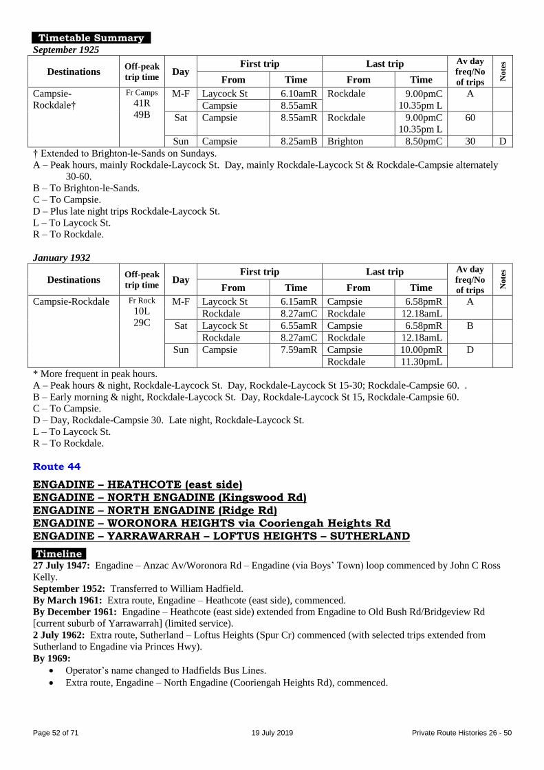
Page 52 of 71 19 July 2019 Private Route Histories 26 - 50
Timetable Summary September 1925
Destinations Off-peak
trip time Day
First trip Last trip Av day
freq/No
of trips No
tes
From Time From Time
Campsie-
Rockdale†
Fr Camps
41R
49B
M-F Laycock St 6.10amR Rockdale 9.00pmC
10.35pm L
A
Campsie 8.55amR
Sat Campsie 8.55amR Rockdale 9.00pmC
10.35pm L
60
Sun Campsie 8.25amB Brighton 8.50pmC 30 D
† Extended to Brighton-le-Sands on Sundays.
A – Peak hours, mainly Rockdale-Laycock St. Day, mainly Rockdale-Laycock St & Rockdale-Campsie alternately
30-60.
B – To Brighton-le-Sands.
C – To Campsie.
D – Plus late night trips Rockdale-Laycock St.
L – To Laycock St.
R – To Rockdale.
January 1932
Destinations Off-peak
trip time Day
First trip Last trip Av day
freq/No
of trips No
tes
From Time From Time
Campsie-Rockdale Fr Rock
10L
29C
M-F Laycock St 6.15amR Campsie 6.58pmR A
Rockdale 8.27amC Rockdale 12.18amL
Sat Laycock St 6.55amR Campsie 6.58pmR B
Rockdale 8.27amC Rockdale 12.18amL
Sun Campsie 7.59amR Campsie 10.00pmR D
Rockdale 11.30pmL
* More frequent in peak hours.
A – Peak hours & night, Rockdale-Laycock St. Day, Rockdale-Laycock St 15-30; Rockdale-Campsie 60. .
B – Early morning & night, Rockdale-Laycock St. Day, Rockdale-Laycock St 15, Rockdale-Campsie 60.
C – To Campsie.
D – Day, Rockdale-Campsie 30. Late night, Rockdale-Laycock St.
L – To Laycock St.
R – To Rockdale.
Route 44
ENGADINE – HEATHCOTE (east side) ENGADINE – NORTH ENGADINE (Kingswood Rd)
ENGADINE – NORTH ENGADINE (Ridge Rd) ENGADINE – WORONORA HEIGHTS via Cooriengah Heights Rd ENGADINE – YARRAWARRAH – LOFTUS HEIGHTS – SUTHERLAND
Timeline 27 July 1947: Engadine – Anzac Av/Woronora Rd – Engadine (via Boys’ Town) loop commenced by John C Ross
Kelly.
September 1952: Transferred to William Hadfield.
By March 1961: Extra route, Engadine – Heathcote (east side), commenced.
By December 1961: Engadine – Heathcote (east side) extended from Engadine to Old Bush Rd/Bridgeview Rd
[current suburb of Yarrawarrah] (limited service).
2 July 1962: Extra route, Sutherland – Loftus Heights (Spur Cr) commenced (with selected trips extended from
Sutherland to Engadine via Princes Hwy).
By 1969:
Operator’s name changed to Hadfields Bus Lines.
Extra route, Engadine – North Engadine (Cooriengah Heights Rd), commenced.
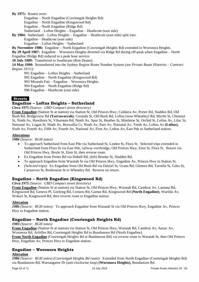
Page 53 of 71 19 July 2019 Private Route Histories 26 - 50
By 1975: Routes were:
Engadine – North Engadine (Cooriengah Heights Rd)
Engadine – North Engadine (Kingswood Rd)
Engadine – North Engadine (Ridge Rd)
Sutherland – Loftus Heights – Engadine – Heathcote (east side)
By 1984: Sutherland – Loftus Heights – Engadine – Heathcote (east side) split into:
Engadine – Heathcote (east side)
Engadine – Loftus Heights – Sutherland
By November 1986: Engadine – North Engadine (Cooriengah Heights Rd) extended to Woronora Heights.
By 29 April 1987: Engadine – Woronora Heights diverted via Ridge Rd during off-peak when Engadine – North
Engadine (Ridge Rd) reduced to a peak hour service.
10 July 1989: Transferred to Southtrans (Ron Deane).
14 May 1990: Renumbered into the Sydney Region Route Number System (see Private Route Histories – Contract
Region 10/11):
991 Engadine – Loftus Heights – Sutherland
992 Engadine – North Engadine (Kingswood Rd)
993 Miranda Fair – Engadine – Woronora Heights
994 Engadine – North Engadine (Ridge Rd)
996 Engadine – Heathcote (east side)
Streets
Engadine – Loftus Heights – Sutherland Circa 1975 (Source: UBD Compact street directory)
From Engadine (Station St at station) via Station St, Old Princes Hwy, Caldarra Av, Porter Rd, Sladden Rd, Old
Bush Rd, Bridgeview Rd (Yarrawarrah), Cooinda St, Old Bush Rd, Loftus [now Wheatley] Rd, Myrtle St, Chestnut
St, Ninth Av, Hawthorn St, Viburnum Rd, Ninth Av, Spur St, Heather St, Mistletoe St, Orchid St, Loftus Av, Lilac St,
National Av, Logan St, Ninth Av, Browallia Cr, Ninth Av, Pare Av, National Av, Tenth Av, Loftus Av (Loftus),
Sixth Av, Fourth Av, Fifth Av, Fourth Av, National Av, First Av, Loftus Av, East Pde to Sutherland station.
Alterations
1986 (Source: RGH notes):
To approach Sutherland from East Pde via Sutherland St, Linden St, Flora St. Selected trips extended in
Sutherland from Flora St via East Pde, railway overbridge, Old Princes Hwy, Eton St, Flora St. Return via
Old Princes Hwy, Boyle St, Eton St, then reverse route.
Ex Engadine from Porter Rd via Dobell Rd, (left) Brooke St, Sladden Rd.
To approach Engadine from Waratah St via Old Princes Hwy, Engadine Av, Princes Hwy to Station St.
(Selected trips): Ex Engadine from Old Bush Rd via Dalziel St, Urana Rd, Glenora Rd, Turrella St, Giles St,
Carnarvon St, Roebourne St to Wheatley Rd. Reverse on return.
Engadine – North Engadine (Kingswood Rd) Circa 1975 (Source: UBD Compact street directory)
From Engadine (Station St at station) via Station St, Old Princes Hwy, Waratah Rd, Cambrai Av, Lantana Rd,
Kingswood Rd, Geneva Pl, Geelong Rd, Croston Rd, Gamut Rd, Kingswood Rd (North Engadine), Warilda Av,
Wokari St, Kingswood Rd, then reverse route to Engadine station.
Alteration
1986 (Source: RGH notes): To approach Engadine from Waratah St via Old Princes Hwy, Engadine Av, Princes
Hwy to Engadine station.
Engadine – North Engadine (Cooriengah Heights Rd) 1983 (Source: RGH notes)
From Engadine (Station St at station) via Station St, Old Princes Hwy, Waratah Rd, Cambrai Av, Anzac Av,
Woronora Rd, Achilles Rd, Cooriengah Heights Rd to Bundanoon Rd (North Engadine).
From North Engadine (Cooriengah Heights Rd at Bundanoon Rd) via reverse route to Waratah St, then Old Princes
Hwy, Engadine Av, Princes Hwy to Engadine station.
Engadine – Woronora Heights Alteration
1986 (Source: RGH notes) (Cooriengah Heights Rd route): Extended from North Engadine (Cooriengah Heights Rd)
via Bundanoon Rd, Warrangaree Dr (anti-clockwise loop) (Woronora Heights), Bundanoon Rd.

Page 54 of 71 19 July 2019 Private Route Histories 26 - 50
Engadine – North Engadine (Ridge Rd) Circa 1975 (Source: UBD Compact street directory)
From Engadine (Station St at station) via Station St, Old Princes Hwy, Waratah Rd, Woronora Rd, Ferntree Rd,
Ridge Rd [further detail not shown on maps].
1986 (Source: RGH notes)
From Engadine (Station St at station) via Station St, Old Princes Hwy, Woronora Rd, Thurlgoona Rd, Woronora Rd,
Sabugal Rd, Ridge Rd (North Engadine), Andromeda Cr, Sierra Rd, Kanadah Rd, Ridge Rd, Ferntree Rd, Woronora
Rd, Old Princes Hwy, Engadine Av, Princes Hwy to Engadine station.
Engadine – Heathcote (east side) Circa 1975 (Source: UBD Compact street directory)
From Engadine (Station St at station) via Station St, Old Princes Hwy, Princes Hwy, Wilson Pde, The Avenue,
Forest Rd (Heathcote), Bottle Forest Rd, Tecoma St, Dillwynnia Gve, Wilson Pde, Princes Hwy to Engadine station.
1986 (Source: RGH notes)
From Engadine (Station St at station) via Station St, Old Princes Hwy, Engadine Av, Fairview Av, Higgerson Av,
Stephen Rd, Auckland St, Numantia Rd, Princes Hwy, then same route through Heathcote East, returning to Engadine
Av, Princes Hwy to Engadine station.
Timetable Summary 23 January 1956
Destinations Off-peak
trip time Day
First trip Last trip Av day
freq/No
of trips No
tes
From Time From Time
Engadine-Anzac
Av/Woronora Rd
14
round
trip
M-F Anzac Av 5.32am Engadine 6.53pm 60* A
Sat 5.59am 1.44pm 30-60 B
Sun
* More frequent in peak hours.
A – Gap in service. Plus picture bus Wednesday night.
B – Plus picture bus Saturday night.
29 April 1987
Destinations Off-peak
trip time Day
First trip Last trip Av day
freq/No
of trips No
tes
From Time From Time
Engadine-
Woronora Heights
20 M-F Woronora Hts 5.55am Engadine 6.35pm 60*
Sat Coor Hts Rd 7.40am 12.43pm 6 trips
Sun
Engadine-North
Engadine
(Kingswood Rd)
10 M-F Kingswood Rd 6.05am Engadine 6.35pm 60*
Sat 8.00am 12.23pm 4 trips
Sun
Engadine-North
Engadine (Ridge
Rd)
7 M-F Ridge Rd 6.25am Engadine 6.35pm 10 trips
Sat
Sun
Engadine-
Yarrawarrah
5 M-F Yarrawarrah 6.45am Engadine 6.35pm 10 trips A
Sat Engadine 8.30am Sutherland 11.34am 2 trips B
Sun
Engadine-
Heathcote (east
side)
10 M-F Heathcote 8.32am Engadine 2.25pm 6 trips
Sat
Sun
Sutherland-Loftus
Heights
18 M-F Loftus Hts 7.02am Sutherland 4.24pm 9 trips A
Sat Engadine 8.30am 11.34am 2 trips B
Sun
* More frequent in peak hours.
A – Includes 3 off-peak trips, Engadine-Yarrawarrah-Loftus Heights-Sutherland.
B – Saturday service, Engadine-Yarrawarrah-Loftus Heights-Sutherland.

Page 55 of 71 19 July 2019 Private Route Histories 26 - 50
Route 45
CAMPSIE – PUNCHBOWL – PADSTOW PARK
Extended from Punchbowl to Picnic Point (limited service on Saturdays)
(Padstow Park Estate was the original name for Padstow, which became the suburb
name when the East Hills railway was opened in 1931.)
Timeline As at date of Govt Gazette 13 November 1925: Being operated by Henry (Harry) Dale.
By date of Govt Gazette 27 May 1927: Ceased.
Streets 1925 (Source: Govt Gazette of 13 November 1925)
From Campsie (South Pde at Beamish St) via South Pde, Beamish St, Ninth Av, Albert St, Lakemba St, Haldon St,
Railway Pde (Lakemba), Croydon St, Lakemba St, Wileys Av [now King Georges Rd], Punchbowl Rd, Wattle St,
Highclere Av, Punchowl Rd (Punchbowl), Canterbury Rd, Fairford Rd, Watson Rd to Gibson Av (Padstow Park
[now Padstow]). Reverse on return.
Picnic Point extension: Extended from Punchbowl via Punchbowl Rd, Canterbury Rd, [The] River Rd, Tower St,
Picnic Point Rd to Georges River (Picnic Point). Reverse on return.
Timetable Summary September 1925
Destinations Off-peak
trip time Day
First trip Last trip Av day
freq/No
of trips No
tes
From Time From Time
Campsie-
Punchbowl-
Padstow Park†
40 M-F Padstow Pk 6.05amB
6.45amC
Campsie 4.50pmB 60 A
Punchbowl 6.40pmP
Sat 6.05amB
6.45amC
Campsie 11.50amB 60 D
Punchbowl 2.25pmP
Sun
† Limited service extended to Picnic Point.
A – Peak hours, Padstow Park-Punchbowl. Most day trips, Punchbowl-Campsie 60.
B – To Punchbowl.
C – To Campsie.
D – Early morning & afternoon, Padstow Park-Punchbowl. Most day trips, Punchbowl-Campsie 60. 1 trip extended
from Padstow Park to Picnic Point.
P – To Padstow Park.
Route 45
CABRAMATTA – CANLEY VALE – EDENSOR PARK via Canley Vale Rd
CABRAMATTA – ST JOHNS PARK – EDENSOR PARK via St Johns Rd Cabramatta – Canley Vale – St Johns Park via Canley Vale Rd (1981-82)
Cabramatta – Canley Vale – Wakeley (Richards Rd) via Parklea Pde (1981-82)
Timeline By date of Govt Gazette 22 June 1928: Canley Vale – Edensor Park via Canley Vale Rd commenced by Cecil C
Prowse (a list dated October 1935 shows operator as WJ Prowse). Also traded as Prowse’s Red Motor Service.
July 1955: Transferred to Simun Bosnjak, soon after trading as Bosnjaks Bus Service.
June 1957: Extra route, Cabramatta – Humphries Rd/Canley Vale Rd via St Johns Rd (selected trips extended to
Edensor Park), commenced. Shared route along St Johns Rd with Calabros’ 40.
By 19 November 1962: Cabramatta – Humphries Rd/Canley Vale Rd via St Johns Rd rerouted/extended to Edensor
Park.
By 1967: Canley Vale – Edensor Park via Canley Vale Rd extended from Canley Vale to Cabramatta.
By February 1978: Cabramatta – Canley Vale – Edensor Park via Canley Vale Rd curtailed & split into:
Cabramatta – Canley Vale – St Johns Park (Canley Vale Rd/Bibbys Rd) via Canley Vale Rd
Cabramatta – Canley Vale – Wakeley (Avoca Rd/Humphries Rd) via Parklea Pde

Page 56 of 71 19 July 2019 Private Route Histories 26 - 50
2 November 1981:
Cabramatta – Edensor Park via St Johns Rd amalgamated with 167 (Parramatta – Smithfield) & renumbered
800 (first private route renumbered into the Sydney Region Route Number System).
Remaining part of 45 (via Canley Vale Rd) rearranged as:
Cabramatta – Canley Vale – St Johns Park (loop via Bibbys Rd & Melbourne Rd) via Canley Vale Rd
Cabramatta – Canley Vale – Wakeley (Richards Rd) via Parklea Pde.
24 October 1982: Replaced by 800 when it was rerouted from St Johns Rd to Canley Vale Rd, as a result of
agreement between Bosnjaks Bus Service & Calabro Bros for a single route along St Johns Rd (being Calabros’ 40).
Streets
Canley Vale – Edensor Park via Canley Vale Rd 1928 (Source: Govt Gazette of 22 June 1928)
From Canley Vale (Railway Pde at station) via Railway Pde, Canley Vale Rd to Bibbys Rd [now Brisbane Rd], then
Canley Vale Rd, Bulls Rd [alignment of current Runcorn St, part of Corinda St, Knapton St], Parkes [now part of
Edensor] Rd, Edensor Rd to Park [now Meadows] Rd (Edensor Park). Reverse on return.
Circa 1946 (Source: Gregory’s Street Directory)
From Canley Vale (station) via Brighton [now Railway] Pde, Canley Vale Rd, Bulls Rd [alignment of current
Runcorn St, part of Corinda St, Knapton St], Parkes [now part of Edensor] Rd, Edensor Rd (Edensor Park).
Cabramatta – Canley Vale – Edensor Park via Canley Vale Rd 1969 (Source: RGH notes)
From Cabramatta (Railway Pde at station) via Railway Pde (Canley Vale), Canley Vale Rd, Avoca St, Humphries
Rd, Canley Vale Rd, Bulls Rd [alignment of current Runcorn St, part of Corinda St, Knapton St] (St Johns Park),
Edensor Rd to Swan St (Edensor Park).
From Edensor Park (Edensor Rd at Swan St) via reverse route to Railway Pde, then Arthur St, Park Rd, John St,
Railway Pde to Cabramatta station.
Trips via Canley Vale Rd direct: Ex Cabramatta from Canley Vale Rd/Avoca Rd via Canley Vale Rd to Canley
Vale Rd/Humphries Rd. Reverse on return.
Cabramatta – Edensor Park via St Johns Rd 1969 (Source: RGH notes)
From Cabramatta (Railway Pde at station) via Railway Pde, Arthur St, Park Rd, McBurney St, Gladstone St, St
Johns Rd, Humphries Rd (St Johns Park), Edensor Rd to Cowpasture Rd (Edensor Park).
From Edensor Park (Edensor Rd at Cowpasture Rd) via reverse route to Park Rd, then John St, Railway Pde to
Cabramatta station.
Cabramatta – Canley Vale – St Johns Park via Canley Vale Rd 1978 (Source: timetable)
From Cabramatta (Railway Pde at station) via John St, Park Rd, Bartley St, Phelps St, Canley Vale Rd, Railway Pde
(Canley Vale), Pevensey St, Phelps St, Canley Vale Rd to Bibbys Rd [now Brisbane Rd] (St Johns Park).
From St Johns Park (Canley Vale Rd/Bibbys Rd [now Brisbane Rd]) via Canley Vale Rd, Railway Pde to
Cabramatta station.
Trips via Avoca Rd & Humphries Rd (generally from St Johns Park in morning & from Cabramatta in afternoon):
Ex Cabramatta from Canley Vale Rd via Avoca Rd, Humphries Rd, Canley Vale Rd. Reverse on return.
Cabramatta – Canley Vale – Wakeley (Humphries Rd) via Parklea Pde 1978 (Source: timetable)
From Cabramatta (Railway Pde at station) via John St, Park Rd, Bartley St, Phelps St, Canley Vale Rd, Railway Pde
(Canley Vale), Pevensey St, Phelps St, Canley Vale Rd, Cambridge St, Parklea Pde, Chelsea Dr, Foxlow St, Avoca
Rd, Canley Vale Rd, Humphries Rd (Wakeley), Avoca Rd, Foxlow St, Chelsea Dr, Parklea Pde, Cambridge St,
Canley Vale Rd, Railway Pde to Cabramatta station.
Cabramatta – Canley Vale – St Johns Park via Canley Vale Rd 2 November 1981 (Source: timetable)
From Cabramatta (Railway Pde at station) via John St, Park Rd, Bartley St, Phelps St, Canley Vale Rd, Railway Pde
(Canley Vale), Pevensey St, Phelps St, Canley Vale Rd, Avoca St, Humphries Rd, Canley Vale Rd, Bulls Rd
[alignment of current Runcorn St, part of Corinda St, Knapton St] (St Johns Park), Hargreaves St [now Box Rd],
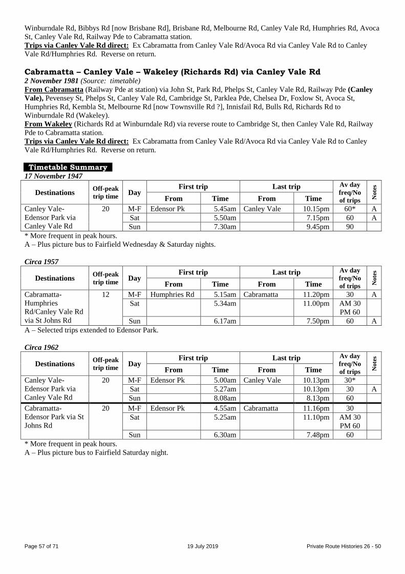
Page 57 of 71 19 July 2019 Private Route Histories 26 - 50
Winburndale Rd, Bibbys Rd [now Brisbane Rd], Brisbane Rd, Melbourne Rd, Canley Vale Rd, Humphries Rd, Avoca
St, Canley Vale Rd, Railway Pde to Cabramatta station.
Trips via Canley Vale Rd direct: Ex Cabramatta from Canley Vale Rd/Avoca Rd via Canley Vale Rd to Canley
Vale Rd/Humphries Rd. Reverse on return.
Cabramatta – Canley Vale – Wakeley (Richards Rd) via Canley Vale Rd 2 November 1981 (Source: timetable)
From Cabramatta (Railway Pde at station) via John St, Park Rd, Phelps St, Canley Vale Rd, Railway Pde (Canley
Vale), Pevensey St, Phelps St, Canley Vale Rd, Cambridge St, Parklea Pde, Chelsea Dr, Foxlow St, Avoca St,
Humphries Rd, Kembla St, Melbourne Rd [now Townsville Rd ?], Innisfail Rd, Bulls Rd, Richards Rd to
Winburndale Rd (Wakeley).
From Wakeley (Richards Rd at Winburndale Rd) via reverse route to Cambridge St, then Canley Vale Rd, Railway
Pde to Cabramatta station.
Trips via Canley Vale Rd direct: Ex Cabramatta from Canley Vale Rd/Avoca Rd via Canley Vale Rd to Canley
Vale Rd/Humphries Rd. Reverse on return.
Timetable Summary 17 November 1947
Destinations Off-peak
trip time Day
First trip Last trip Av day
freq/No
of trips No
tes
From Time From Time
Canley Vale-
Edensor Park via
Canley Vale Rd
20 M-F Edensor Pk 5.45am Canley Vale 10.15pm 60* A
Sat 5.50am 7.15pm 60 A
Sun 7.30am 9.45pm 90
* More frequent in peak hours.
A – Plus picture bus to Fairfield Wednesday & Saturday nights.
Circa 1957
Destinations Off-peak
trip time Day
First trip Last trip Av day
freq/No
of trips No
tes
From Time From Time
Cabramatta-
Humphries
Rd/Canley Vale Rd
via St Johns Rd
12 M-F Humphries Rd 5.15am Cabramatta 11.20pm 30 A
Sat 5.34am 11.00pm AM 30
PM 60
Sun 6.17am 7.50pm 60 A
A – Selected trips extended to Edensor Park.
Circa 1962
Destinations Off-peak
trip time Day
First trip Last trip Av day
freq/No
of trips No
tes
From Time From Time
Canley Vale-
Edensor Park via
Canley Vale Rd
20 M-F Edensor Pk 5.00am Canley Vale 10.13pm 30*
Sat 5.27am 10.13pm 30 A
Sun 8.08am 8.13pm 60
Cabramatta-
Edensor Park via St
Johns Rd
20 M-F Edensor Pk 4.55am Cabramatta 11.16pm 30
Sat 5.25am 11.10pm AM 30
PM 60
Sun 6.30am 7.48pm 60
* More frequent in peak hours.
A – Plus picture bus to Fairfield Saturday night.

Page 58 of 71 19 July 2019 Private Route Histories 26 - 50
Circa 1978
Destinations Off-peak
trip time Day
First trip Last trip Av day
freq/No
of trips No
tes
From Time From Time
Cabramatta-St
Johns Park via
Canley Vale Rd
30
M-F St Johns Pk 5.00am Cabramatta 7.30pm A
Canley Vale 9.15pm
Sat 5.24am Cabramatta 2.02pm B
Canley Vale 5.12pm
Sun Wakeley 8.15am 12.15pm 3 trips C
Cabramatta-
Wakeley
(Humphries Rd) via
Parklea Pde
18 M-F Humphries Rd 6.36am Cabramatta 4.13pm 30 D
Canley Vale 5.58pm
Sat
Sun
Cabramatta-
Edensor Park via St
Johns Rd
19 M-F Edensor Pk 4.53am Cabramatta 9.00pm 30*
Sat 5.43am 7.00pm AM 30
PM 60
Sun 7.30am 11.15am 3 trips
* More frequent in peak hours.
A – Day, either Cabramatta-St Johns Park or Canley Vale-St Johns Park 30*. Night, Canley Vale-St Johns Park.
B – Morning, Cabramatta-St Johns Park 30. Afternoon, Canley Vale-St Johns Park 30.
C – 1 trip extended to Cabramatta.
D – Either Cabramatta-Wakeley or Canley Vale-Wakeley.
2 November 1981
Destinations Off-peak
trip time Day
First trip Last trip Av day
freq/No
of trips No
tes
From Time From Time
Cabramatta-St
Johns Park via
Canley Vale Rd
20 M-F St Johns Pk 5.02am Cabramatta 9.04pm 30* A
Sat 5.16am 5.00pm AM 30
PM 60
B
Sun Cabramatta 7.48am St Johns Pk 3.51pm 4 trips
Cabramatta-
Wakeley (Richards
Rd) via C/Vale Rd
18 M-F Richards Rd 6.43am Richards Rd 6.05pm 60* C
Sat
Sun
* More frequent in peak hours.
A – Extra trip Thursday night.
B – Some aftenoon trips ran Canley Vale-St Johns Park only (not Cabramatta).
C – Some afternoon peak hour trips ran Canley Vale-Wakeley (Richards Rd) only (not Cabramatta).
Route 46
CAMPSIE – NORTH BELMORE via various routes
Extended from North Belmore to Punchbowl (1920s & 1930s)
Extended from Punchbowl to Picnic Point (Sundays, 1920s)
(Harcourt – once called “Harcourt model suburb” – is an estate formed by the
“numbered” streets north of Campsie.)
Timeline As at date of Govt Gazette 13 November 1925: Campsie – North Belmore – Punchbowl via Baltimore St (extended
to Picnic Point on Sundays) being operated by Arthur F O'Hara.
By date of Govt Gazette 22 June 1928: Curtailed to run Campsie – North Belmore – Punchbowl Rd/Wattle St,
Punchbowl.
26 August 1935: Extended/new route from Campsie to Harcourt (terminus at First Av/Clarence St).
30 March 1939: Split into two routes:
46 Campsie – North Belmore either via Harcourt or via Baltimore St.
47 Lakemba – Punchbowl (transferred to XL Transport)
1951: Campsie – North Belmore transferred to Red Top Transport Service (group of Campsie businessmen including
Arthur Marrin; Roy Gledhill manager).

Page 59 of 71 19 July 2019 Private Route Histories 26 - 50
By 16 August 1969: Weekday early morning & night, Saturday afternoon & selected Sunday trips ran Campsie –
Harcourt – Campsie loop.
1 September 1971: Transferred to Greenacre Bus Service (EM (Eddie) Hayman).
1 July 1984: Transferred to Highway Tours (JD (Jim) Hill).
1985/6: Transferred to Greenacre Bus Service (Ron Gallagher, former manager of Highway Tours).
Late 1986: Transferred back to Highway Tours (JD (Jim) Hill). Mr Gallagher remained as manager.
1 July 1988: Transferred to Commodore Coaches (Michael Bedford).
August 1989: Transferred to Newhams Bus Service (Jeff Newham).
12 August 1991: Transferred to Canterbury Bus Lines (EM (Eddie) Hayman).
24 August 1991: 39 & 46 amalgamated as 39, Campsie – North Belmore – Roselands.
Streets
Campsie – North Belmore – Punchbowl (extended to Picnic Point on Sundays) 1925 (Source: Govt Gazette of 13 November 1925)
From Campsie (South Pde at Beamish St) via South Pde, Beamish St, Ninth Av, Albert St, Baltimore St, Omaha St,
Burwood Rd, Yangoora Rd (North Belmore), Wangee Rd, Lakemba St, Haldon St, Railway Pde (Lakemba),
Croydon St, Lakemba St, Wileys Av [now King Georges Rd], Punchbowl Rd, Wattle St, Highclere Av, Punchbowl
Rd to near Highclere Av (Punchbowl). Reverse on return.
Picnic Point extension: Extended from Punchbowl (Punchbowl Rd/Highclere Av) via Punchbowl Rd, Canterbury
Rd, [The] River Rd, Tower St, Picnic Point Rd to Georges River (Picnic Point). Reverse on return.
Campsie – North Belmore – Punchbowl 1928 (Source: Govt Gazette of 22 June 1928)
From Campsie (South Pde at Beamish St) via South Pde, Beamish St, Ninth Av, Albert St, Baltimore St, Omaha St,
Burwood Rd, Yangoora Rd (North Belmore), Wangee Rd, Lakemba St, Haldon St, Railway Pde (Lakemba),
Croydon St, Lakemba St, Wileys Av [now King Georges Rd], Punchbowl Rd (Punchbowl). Reverse on return.
Alteration
From 23 February 1934 (Source: Annual report of DRTT): Ex Campsie from Lakemba St via Colin St, Punchbowl
Rd.
Campsie – North Belmore Circa 1946 (Source: Gregory’s Street Directory)
From Campsie via Beamish St, Ninth Av, Albert St, Baltimore St, Clarence St, Burwood Rd, Lola St [now part of
Burwood Rd], Yangoora Rd (North Belmore).
Circa 1948 (Source: Gregory’s Street Directory)
From Campsie via North Pde, Beamish St, Ninth Av, Albert St, Baltimore St, Clarence St, Burwood Rd, Yangoora
Rd (North Belmore).
Campsie – Harcourt – North Belmore 1969 (Source: RGH notes)
From Campsie (Wilfred St [now North Pde] at station) via Beamish St, Ninth Av, Second Av, Seventh Av, First Av,
Clarence St (Harcourt), Baltimore St, Omaha St, Burwood Rd, Knox St, Lucerne St (North Belmore), Neale St,
Yangoora Rd, Burwood Rd, then reverse route to Beamish St, then Campsie St, London St, Wilfred St [now North
Pde] to Campsie station.
Alterations
1986 (Source: RGH notes): From Yangoora Rd via Benaroon Rd, Allan Av, Burwood Rd.
Campsie – North Belmore via Baltimore St 1969 (Source: RGH notes)
From Campsie (Wilfred St [now North Pde] at station) via Beamish St, Ninth Av, Albert St, Baltimore St, Omaha St,
Burwood Rd, Knox St, Lucerne St (North Belmore), Neale St, Yangoora Rd, Burwood Rd, then reverse route to
Beamish St, then Campsie St, London St, Wilfred St [now North Pde] to Campsie station.
Alteration
1986 (Source: RGH notes): From Yangoora Rd via Benaroon Rd, Allan Av, Burwood Rd.
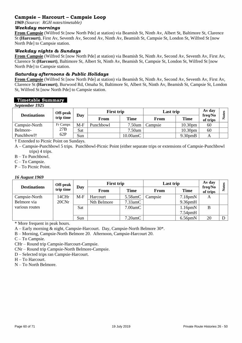
Page 60 of 71 19 July 2019 Private Route Histories 26 - 50
Campsie – Harcourt – Campsie Loop 1969 (Source: RGH notes/timetable)
Weekday mornings From Campsie (Wilfred St [now North Pde] at station) via Beamish St, Ninth Av, Albert St, Baltimore St, Clarence
St (Harcourt), First Av, Seventh Av, Second Av, Ninth Av, Beamish St, Campsie St, London St, Wilfred St [now
North Pde] to Campsie station.
Weekday nights & Sundays From Campsie (Wilfred St [now North Pde] at station) via Beamish St, Ninth Av, Second Av, Seventh Av, First Av,
Clarence St (Harcourt), Baltimore St, Albert St, Ninth Av, Beamish St, Campsie St, London St, Wilfred St [now
North Pde] to Campsie station.
Saturday afternoons & Public Holidays From Campsie (Wilfred St [now North Pde] at station) via Beamish St, Ninth Av, Second Av, Seventh Av, First Av,
Clarence St (Harcourt), Burwood Rd, Omaha St, Baltimore St, Albert St, Ninth Av, Beamish St, Campsie St, London
St, Wilfred St [now North Pde] to Campsie station.
Timetable Summary
September 1925
Destinations Off-peak
trip time Day
First trip Last trip Av day
freq/No
of trips No
tes
From Time From Time
Campsie-North
Belmore-
Punchbowl†
Fr Camps
27B
62P
M-F Punchbowl 7.50am Campsie 10.30pm 60
Sat 7.50am 10.30pm 60
Sun 10.00amC 9.30pmB A
† Extended to Picnic Point on Sundays.
A – Campsie-Punchbowl 5 trips. Punchbowl-Picnic Point (either separate trips or extensions of Campsie-Punchbowl
trips) 4 trips.
B – To Punchbowl.
C – To Campsie.
P – To Picnic Point.
16 August 1969
Destinations Off-peak
trip time Day
First trip Last trip Av day
freq/No
of trips No
tes
From Time From Time
Campsie-North
Belmore via
various routes
14CHr
20CNr
M-F Harcourt 5.58amC Campsie 7.18pmN
9.36pmH
A
Nth Belmore 7.33amC
Sat 7.00amC 1.16pmN
7.54pmH
B
Sun 7.20amC 6.56pmN 20 D
* More frequent in peak hours.
A – Early morning & night, Campsie-Harcourt. Day, Campsie-North Belmore 30*.
B – Morning, Campsie-North Belmore 20. Afternoon, Campsie-Harcourt 20.
C – To Campsie.
CHr – Round trip Campsie-Harcourt-Campsie.
CNr – Round trip Campsie-North Belmore-Campsie.
D – Selected trips ran Campsie-Harcourt.
H – To Harcourt.
N – To North Belmore.

Page 61 of 71 19 July 2019 Private Route Histories 26 - 50
January 1979
Destinations Off-peak
trip time Day
First trip Last trip Av day
freq/No
of trips No
tes
From Time From Time
Campsie-North
Belmore via
various routes
14CHr
21CNr
M-F Harcourt 5.53amC Campsie 7.16pmN
A
Nth Belmore 7.33amC
Sat 7.58amC 1.16pmN
3.56pmH
B
Sun
* More frequent in peak hours.
A – Early morning, Campsie-Harcourt. Day, Campsie-North Belmore 30*.
B – Morning, Campsie-North Belmore 20-25. Afternoon, Campsie-Harcourt 60.
C – To Campsie.
CHr – Round trip Campsie-Harcourt-Campsie.
CNr – Round trip Campsie-North Belmore-Campsie.
H – To Harcourt.
N – To North Belmore.
Route 47
CABARITA PARK – CENTRAL RAILWAY
Timeline As at date of Govt Gazette 13 November 1925: In operation.
By date of Govt Gazette 22 February 1929: Ceased.
Streets 1925 (Source: Govt Gazette of 13 November 1925)
From Cabarita Park (at wharf) via park roadway, Cabarita Rd, Frederick St, Brewer St, Majors Bay Rd (Concord),
Crane St, Burwood Rd, Parramatta Rd, George St West [now Broadway], George St, Hay St, Pitt St to Eddy Av
(Central Railway).
From Central Railway (Pitt St at Eddy Av) via Pitt St, George St, George St West [now Broadway], then reverse
route to Cabarita Park wharf.
Timetable Summary September 1925
Destinations Off-peak
trip time Day
First trip Last trip Av day
freq/No
of trips No
tes
From Time From Time
Cabarita Park-
Central Railway
53 M-F Cabarita Pk 7.38am Central Rly 10.17pm 120
Sat 7.38am 10.17pm 120
Sun 9.29am 12.07am 120
Route 47
CHATSWOOD – WILLOUGHBY PARK – WILLOUGHBY (Frenchs Rd) – NORTHBRIDGE (The Knoll)
Lane Cove – Willoughby (1920s & early 1930s)
Timeline Unknown: Lane Cove – Willoughby (location?) commenced by EW Garner.
By 1933: Altered to Chatswood – Willoughby Park – Willoughby (Frenchs Rd).
22 May 1933: Extended to become Chatswood – Willoughby Park –Willoughby – Northbridge (The Knoll). The
extended route was deemed competitive with trams under the State Transport (Co-ordination) Act & paid tax.
1934/5: Transferred to Fred Rohrs.
1 March 1937: Taken over by Department of Road Transport & Tramways (see Government Route Histories – Inner
Northern Suburbs).

Page 62 of 71 19 July 2019 Private Route Histories 26 - 50
Streets
Chatswood – Willoughby Park – Northbridge (The Knoll) Probably same as or similar to route after it was taken over on 1 March 1937 by Department of Road Transport &
Tramways (see Government Route Histories – Inner Northern Suburbs).
Route 47
PUNCHBOWL – LAKEMBA – GREENACRE via various routes
Timeline 30 March 1939: Punchbowl – Lakemba section of Arthur F O’Hara’s 46 renumbered 47, operated by XL Transport
(brothers Alfred, Henry & Eric O’Hara). Extended towards Greenacre.
By 1948: Ran Punchbowl – Lakemba – Greenacre (Wilbur St/Roberts Rd).
1950s: Extra route, Lakemba – Greenacre (Valencia St) commenced.
1954: Lakemba – Greenacre (Valencia St) renumbered 43.
December 1955: Transferred to West Bankstown Bus Service (Treuer family).
October 1956: Route rearranged (?).
1961/2 (on or by 5 February 1962): Ceased running between Punchbowl & Greenacre.
September 1963: 43, now Lakemba – Greenacre (Norfolk Rd), renumbered back to 47.
By 4 July 1966: Routes were:
Lakemba – Greenacre Post Office via Punchbowl Rd& Roberts Rd
Lakemba – Greenacre Post Office via Yerrick Rd & Macquarie St
Lakemba – Greenacre (Norfolk Rd) via Yerrick Rd
27 November 1967: Transferred to Greenacre Bus Co (Eddie Hayman).
1 July 1984: Transferred to Highway Tours (JD (Jim) Hill).
1985/6: Transferred to Greenacre Bus Co (Ron Gallagher, former manager of Highway Tours).
Late 1986: Transferred back to Highway Tours (JD (Jim) Hill). Mr Gallagher remained as manager.
1 July 1988: Transferred to Commodore Coaches (Michael Bedford).
By 27 February 1989:
Curtailed from Norfolk Rd to Greenacre Post Office. Routes were:
Lakemba – Greenacre Post Office via Punchbowl Rd & Roberts Rd
Lakemba – Greenacre Post Office via Yerrick Rd
Area between Greenacre Post Office & Greenacre (Norfolk Rd) already served by 485 & 486 (Bankstown-
Strathfield Bus Service) (see Private Route Histories – Contract Region 13), 189 & 244 (Punchbowl Bus Co).
August 1989: Transferred to Newhams Bus Service (Jeff Newham).
12 August 1991: Transferred to Pleasure Tours of Australia (Ernie Stafford).
12 October 1992: As part of general reorganization of Pleasure Tours’ routes, renumbered into the Sydney Region
Route Number System (see Private Route Histories – Contract Region 5) as:
445 Roselands – Belmore
446 Roselands – Kogarah
447 Roselands – Greenacre
Streets
Punchbowl – Lakemba – Greenacre (Roberts Rd & Wilbur St) Circa 1946 (Source: Gregory’s Street Directory)
From Punchbowl via Punchbowl Rd, Wattle St [now Park Av], Roberts Rd to Plasto St, then Roberts Rd, Wattle St
[now Park Av], Punchbowl Rd, Colin St, Lakemba St, Croydon St (North), Railway Pde, Haldon St (North)
(Lakemba), Lakemba St, Wangee Rd, Yangoora Rd, Yerrick Rd, Punchbowl Rd, Wangee Rd, Skyline St, Wilbur St
(Greenacre).
Punchbowl – Greenacre – Lakemba Circa 1962 (Source: Collins Street Directory, as interpreted by RGH)
From Punchbowl via Highclere Av or Acacia Av (?), then Wattle St, Roberts Rd, Napoleon Rd, Lascelles Av,
Chaseling St, Roberts Rd, Juno Pde, Waterloo Rd (Greenacre), Wangee Rd, Roberts Rd, Macquarie St, Skyline St,
Wangee Rd, Lakemba St, Haldon St to Lakemba station.
Page 63 of 71 19 July 2019 Private Route Histories 26 - 50
Lakemba – Greenacre Post Office 1968 (Source: RGH notes)
“Via Plasto Av [St]”
(Route did not actually run along Plasto St, but past its intersection with Roberts Rd. The term possibly harked back
to the time when the route reversed at that intersection - see route circa 1946 above.)
From Lakemba (Railway Pde at station) via Haldon St, Lakemba St, Colin St, Punchbowl Rd, Park Av, Wattle St,
Roberts Rd, Juno Pde to Waterloo Rd (Greenacre Post Office).
From Greenacre (Juno Pde at Waterloo Rd) via Waterloo Rd, Wangee Rd, Roberts Rd, Wattle St, Park Av,
Punchbowl Rd, Colin St, Lakemba St, Croydon St, Railway Pde to Lakemba station.
Alteration
1986 (Source: RGH notes): Ex Campsie from Punchbowl Rd via Wiley Av, Roberts Rd. Reverse on return.
Via Yerrick Rd From Lakemba (Railway Pde at station) via Haldon St, Lakemba St, Wangee Rd, Yangoora Rd, Yerrick Rd, Skyline
St, Macquarie St, Roberts Rd, Juno Pde.
From Greenacre (Juno Pde at Waterloo Rd) via Waterloo Rd, Wangee Rd, Roberts Rd, then reverse route to
Lakemba St, then Croydon St, Railway Pde to Lakemba station.
Lakemba – Geenacre (Norfolk Rd) 1968 (Source: RGH notes)
From Lakemba (Railway Pde at station): Same as either “via Plasto Av” route to Juno Pde/Roberts Rd or “via
Yerrick Rd” route to Juno Pde/Skyline St, then via Juno Pde, Roberts Rd, Valencia St, Maiden St to Norfolk Rd
(Greenacre). Reverse on return.
Timetable Summary 5 February 1962
Destinations Off-peak
trip time Day
First trip Last trip Av day
freq/No
of trips No
tes
From Time From Time
Lakemba-
Greenacre Post
Office via various
routes
14 M-F Greenacre 5.35am Lakemba 11.39pm 15
Sat 6.00am 11.40pm AM 15
PM 60
Sun 6.23am 9.36pm 60
Lakemba-
Greenacre (Norfolk
Rd)
14 M-F Norfolk Rd 5.35am Lakemba 11.07pm 30*
Sat 6.15am 11.00pm AM 30
PM 60
Sun 7.05am 10.06pm 60
* More frequent in peak hours.
February 1975
Destinations Off-peak
trip time Day
First trip Last trip Av day
freq/No
of trips No
tes
From Time From Time
Lakemba-
Greenacre via
various routes
15 M-F Greenacre 5.48am Lakemba 7.27pm 15* A
Sat 7.45am 4.20pm AM 30
PM 60
B
Sun
* More frequent in peak hours.
A – Selected peak hour trips extended to Greenacre (Norfolk Rd).
B – 2 trips extended to Norfolk Rd.
Page 64 of 71 19 July 2019 Private Route Histories 26 - 50
27 February 1989
Destinations Off-peak
trip time Day
First trip Last trip Av day
freq/No
of trips No
tes
From Time From Time
Lakemba-
Greenacre via
various routes
15 M-F Greenacre 6.16am Lakemba 7.00pm 30
Sat 8.16am 2.45pm 30 A
Sun
A – Gap in service.
Route 48
CANTERBURY – ASHBURY – CENTRAL RAILWAY
Timeline As at date of Govt Gazette 13 November 1925: Being operated by SH Miller.
1926: Transferred to Metropolitan Omnibus & Transport Service Co (FH (later Sir Frederick) Stewart)
31 October 1931: Ceased as competitive with Government railway or tram services under State Transport (Co-
ordination) Act.
Streets 1925 (Source: Govt Gazette of 13 November 1925)
From Canterbury (station, Broughton St at Canterbury Rd) via Broughton St, Canterbury Rd, Jeffrey St, King St,
Second St (Ashbury), Holden St, Hanks St, Old Canterbury Rd, Nowranie St (Summer Hill), Smith St, Longport St,
Old Canterbury Rd, Parramatta Rd, George St West [now Broadway], George St, Hay St, Pitt St to Eddy Av (Central
Railway).
From Central Railway (Pitt St at Eddy Av) via Pitt St, George St, George St West [now Broadway], then reverse
route to Canterbury station.
Timetable Summary September 1925
Destinations Off-peak
trip time Day
First trip Last trip Av day
freq/No
of trips No
tes
From Time From Time
Canterbury-
Central Railway
M-F Canterbury 6.45am Central Rly 11.23pm 30
Sat 6.45am 11.18pm 30
Sun 8.35am 11.23pm 30
Route 48
ENGADINE – WATERFALL – GARIE BEACH ENGADINE – WATERFALL – SANITORIUM
Waterfall – Woronora Dam (1930s)
(The Sanitorium was renamed Garrawarra Hospital in 1958.)
Timeline 12 July 1932:
Classified as omnibus services in accordance with the Transport Act, 1930 (even though they had operated for
many years as “country” routes):
Waterfall – Sanitorium
Waterfall – Woronora Dam
The service to Woronora Dam ran during the dam’s construction.
Operated by Stork’s Bus Service (Mrs Sally (or Sarah) Stork, later Mrs Sarah Mason).
By 1941: Transferred to DG (Doug) McCubben (Mrs Mason’s son-in-law), but trading as Sally Stork.
Probably in 1941 (when construction of Woronora Dam was completed): Waterfall – Woronora Dam ceased.
By 1953: Extra weekend route, Waterfall – Garie Beach, commenced.
January 1968: Transferred to William Hadfield.
By February 1969:
Extended from Waterfall to Engadine, making routes:
Engadine – Waterfall – Garrawarra Hospital
Engadine – Waterfall – Garie Beach.
Operator incorporated as Hadfields Bus Lines.

Page 65 of 71 19 July 2019 Private Route Histories 26 - 50
Mid 1970s(?): Engadine – Waterfall – Garie Beach ceased.
10 July 1989: Transferred to Southtrans (Ron Deane).
14 May 1990: Engadine – Waterfall – Garrawarra Hospital renumbered 997 in the Sydney Region Route Number
System (see Private Route Histories – Contract Region 10/11).
Streets
Engadine – Waterfall – Garrawarra Hospital Circa 1975 (Source: UBD Compact street directory)
From Engadine (Station St at station) via Station St, Old Princes Hwy, Waratah Rd, Woronora Rd, Old Princes Hwy,
Princes Hwy, Dalley Rd, Willandra Pde, Rosebery St, Oliver St, Dorset Rd, Abbott Rd, Boundary Rd, Oliver St,
Rosebery St, Veno St (Heathcote), Princes Hwy to Waterfall [further detail not shown on maps, but probably similar
to route in 1986 below].
Alterations
1986 (Source: RGH notes)
Route beyond Heathcote via Princes Hwy, Waterfall station access ramps, Princes Hwy, Garrawarra Hospital
entrance road. Return via Garrawarra Hospital entrance road, Princes Hwy, Bundarra St, Warrabin St,
Yanagang St, Princes Hwy.
Ex Engadine from Boundary St via Oliver St, Princes Hwy. Reverse on return.
Timetable Summary 1960s
Destinations Off-peak
trip time Day
First trip Last trip Av day
freq/No
of trips No
tes
From Time From Time
Waterfall-
Garrawarra
Hospital
Approx
10
M-F Waterfall 7.00am G’warra Hosp 7.15pm 9 trips
Sat 7.00am 7.15pm 8 trips
Sun 9.35am 7.10pm 9 trips
24 February 1969
Destinations Off-peak
trip time Day
First trip Last trip Av day
freq/No
of trips No
tes
From Time From Time
Engadine-
Garrawarra
Hospital
Fr G Hosp
6W
30E
M-F Engadine 6.50am G’warra Hosp 7.20pm 9 trips
Sat 6.51am 5.20pm 5 trips A
Sun 6.57am 3.08pm 4 trips B
Engadine-
Waterfall-Garie
Beach
Fr Garie
25W
38E
M-F
Sat
Sun Engadine 9.04am Garie Bch 4.40pm 2 trips C
A – Selected trips ran Waterfall-Garrawarra Hospital only. Extra trip on request after last trip shown.
B – Extra trip on request after last trip shown.
C – Plus selected trips, Waterfall-Garie Beach only. Additional afternoon trip during summer months.
E – To Engadine.
W – To Waterfall.
29 April 1987
Destinations Off-peak
trip time Day
First trip Last trip Av day
freq/No
of trips No
tes
From Time From Time
Engadine-
Garrawarra
Hospital
28 M-F Engadine 7.40am G’warra Hosp 4.08pm 7 trips
Sat 9.55am 1.23pm 2 trips
Sun

Page 66 of 71 19 July 2019 Private Route Histories 26 - 50
Route 49
CARLTON – ROCKDALE
Extended from Rockdale to Brighton-le-Sands (Saturday afternoons, Sundays &
Public Holidays, until 1931)
Timeline As at date of Govt Gazette 13 November 1925: Carlton – Rockdale (extended from Rockdale to Brighton-le-Sands
on Saturday afternoons, Sundays & Public Holidays) being operated by Thos D Hyland.
October 1931: Extension from Rockdale to Brighton-le-Sands ceased, as it was competitive with Government
railway or tram services under State Transport (Co-ordination) Act.
April 1933: Transferred to Pioneer Coaches (Neville Iffland).
1937/8: Transferred to RO (Ray) Harrigan.
By October 1940: Operated by Mrs AE Harrigan.
February 1956: Transferred to ES Coutman.
August 1963: Extended to South Side shopping centre on three months' trial. Believed not made permanent.
February 1969: Transferred to Rockdale-Carlton Bus Service (TR Jamieson & CA Tunks).
31 May 1976: Transferred to Carlton Bus Service (Warren King & R Hall)
23 December 1977: Transferred to Caledonian Bus Lines (John Brown).
3 February 1978: Transferred to W (Bill) & CK Sharpe & T Burton.
May 1979: Licence transferred to R Murray, Murray's Charter Coaches, but route continued to be operated by
Sharpes.
About September 1981: WC Sharpe relinquished interest in business & Murray took over full operation.
November 1982: Transferred to Brighton Bus Lines (AH & J Jones).
2 December 1983: Transferred to Jenteeno Nominees, trading as Toughs Bus Service (Bob Stephens & John Brown).
27 March 1985: Transferred to Sydney Coach Lines (TR (Dick) Crowe).
14 October 1996: Transferred to State Transit Authority (because of previous common ownership with 6 & 68), but
immediately retransferred to Pioneer Coaches (Harbridge family).
1 April 1997: Renumbered 453 in the Sydney Region Route Number System (see Private Route Histories – Contract
Region 10/11).
Streets
Carlton – Rockdale – Brighton-le-Sands 1925 (Source: Govt Gazette of 13 November 1925)
From Carlton (Railway Pde* [probably means Carlton Pde] at station) via Railway Pde*, Short St, Willison Rd,
Wallace St (Bexley), Verdun St, Caledonia St, Park Av, Watkin St, Frederick St, Railway St (Rockdale), Frederick
St, Bay St, Grand Pde either to Bay St (Mondays to Saturdays) or to Princess St (Sundays & Public Holidays)
(Brighton-le-Sands).
From Brighton-le-Sands (Grand Pde) via Princess St, The Avenue [now Moate Av], Bay St, Frederick St, Railway
St, then reverse route to Carlton station.
(* The Govt Gazette of 22 June 1928 shows Carlton Pde instead of Railway Pde in these two positions - perhaps
correction of an error.)
Carlton – Rockdale Circa 1949 (Source: Gregory’s Street Directory)
From Carlton via Carlton Pde, High St, Durham St, Willison Rd, Wallace St, Verdun St, Caledonia St, Park Av,
Watkins St, Walz St, Railway St (Rockdale).
1968 (Source: RGH notes)
From Rockdale (Railway St at station) via Walz St, Watkin St, Park Av, Caledonian St, Verdun St, Wallace St,
Willison Rd, Carlton Pde to Carlton station.
From Carlton (Carlton Pde at station) via Carlton Pde, Grey St, Durham St, Willison Rd, then reverse route to
Watkin St, then Frederick St, Railway St to Rockdale station.
Alteration
1986 (Source: RGH notes): Ex Rockdale from Watkin St via Harrow Rd, Caledonian St. Reverse on return.

Page 67 of 71 19 July 2019 Private Route Histories 26 - 50
Timetable Summary September 1925
Destinations Off-peak
trip time Day
First trip Last trip Av day
freq/No
of trips No
tes
From Time From Time
Carlton-Rockdale†
8RW
Fr Carl
15R
20B
M-F Wallace St 6.15amR Rockdale 10.35pmC A
Carlton 8.55amR
Sat Wallace St 6.15amR 11.35pmC D
Carlton 8.55amR
Sun 8.55amB Brighton 6.25pmC 60
* More frequent in peak hours.
† Extended to Brighton-le-Sands on Saturday afternoons & Sundays.
A – Morning peak hour, Rockdale-Wallace St. Day & afternoon peak hour, Rockdale-Carlton 60*. Night, Rockdale-
Carlton.
B – To Brighton-le-Sands.
C – To Carlton.
D – Early morning, Rockdale-Wallace St. Morning, Rockdale-Carlton 60. Afternoon, Carlton-Brighton-le-Sands 60.
Night, Rockdale-Carlton.
R – To Rockdale.
RW – From Rockdale to Wallace St.
Circa 1973
Destinations Off-peak
trip time Day
First trip Last trip Av day
freq/No
of trips No
tes
From Time From Time
Carlton-Rockdale Fr Rock
7W
11C
M-F Willison Rd 5.45amR Carlton 5.45pmR A
Rockdale 8.37amC Rockdale 9.10pmW
Sat Willison Rd 7.43amR 7.40pmC B
Rockdale 8.37amC
Sun
* More frequent in peak hours.
A – Morning peak hour & night, Rockdale-Willison Rd. Day & afternoon peak, Rockdale-Carlton 30*. Extra trip
Thursday night.
A – Early morning, Rockdale-Willison Rd. Day, Rockdale-Carlton 30.
C – To Carlton.
R – To Rockdale.
W – To Willison Rd.
Circa 1984
Destinations Off-peak
trip time Day
First trip Last trip Av day
freq/No
of trips No
tes
From Time From Time
Carlton-Rockdale Fr Rock
5W
10C
M-F Wallace St 6.20amR Carlton 4.35pmR A
Rockdale 8.18amC Rockdale 6.20pmW
Sat Carlton 8.30amR 12.20pmC 60
Sun
A – Peak hours, Rockdale-Wallace St. Day, Rockdale-Carlton 60.
C – To Carlton.
R – To Rockdale.
W – To Wallace St.

Page 68 of 71 19 July 2019 Private Route Histories 26 - 50
14 October 1996
Destinations Off-peak
trip time Day
First trip Last trip Av day
freq/No
of trips No
tes
From Time From Time
Carlton-Rockdale Fr Rock
5W
10C
M-F Willison Rd 6.16amR Carlton 4.50 pmR A
Rockdale 7.46amC Rockdale 6.25pmW
Sat 8.25amC 1.00pmC 25
Sun
* More frequent in peak hours.
A – Peak hours, Rockdale-Willison Rd. Day, Rockdale-Carlton 25.
C – To Carlton.
R – To Rockdale.
W – To Willison Rd.
Route 50
CARINGBAH – GANNONS POINT – DOLANS BAY – PORT HACKING – LILLI PILLI – CRESCENT RD (in various combinations)
CARINGBAH – TAREN POINT
Caringbah – Miranda via Matson Cr (late 1940s)
Extended from Caringbah to Miranda (1992-3)
(Crescent Rd area was also known locally as Beauty Point.)
Timeline As at date of Govt Gazette 13 November 1925: Caringbah – Lilli Pilli being operated by Joseph E James & AE
(Archie) Tickner, also trading as Port Hacking Motor Service Garage.
By 1930: Tickner became sole proprietor.
1 August 1931: Extended from Caringbah to Taren Point.
About 1935 (after October 1935): Transferred to JN Hume.
1942: Transferred to Keith Wood.
Later: On death of Keith Wood, transferred to Mrs M Wood, who later remarried, becoming Mrs M Batty.
Later: Transferred to Fred Batty.
By 1948: New route, Caringbah – Miranda via Matson Cr, commenced.
July 1950: Caringbah – Miranda via Matson Cr renumbered 43.
November 1952: Caringbah – Miranda via Matson Cr renumbered back to part of 50.
Early 1950s: Caringbah – Miranda via Matson Cr ceased.
May 1955: Caringbah – Taren Point section transferred to Sutherland Bus Service (Moore family) & added to 130.
1955: Operator incorporated as Caringbah Bus Service (Wood/Batty families).
July 1961: Extended from Caringbah to Taren Point on Sundays & public holidays (at other times, part of 130) on
permit (when ceased?).
By 1964: Routes were:
Caringbah – Crescent Rd
Caringbah – Gannons Point
Caringbah – Port Hacking – Lilli Pilli
By 1986: Routes altered to:
Caringbah – Crescent Rd
Caringbah – Gannons Point – Port Hacking
Caringbah – Lilli Pilli
28 January 1992: Following discussions between Department of Transport & affected operators in the area, Miranda
– Caringbah section of 114 transferred from Southtrans (under contract to the Department of Transport) to Caringbah
Bus Service & added to 50. Routes rearranged as:
Miranda – Caringbah – Lilli Pilli – Crescent Rd (peak hour trips ran separately Caringbah – Lilli Pilli &
Caringbah – Crescent Rd)
Miranda – Caringbah – Gannons Point – Port Hacking
1992 (possibly 2 November): Combined route, Miranda – Caringbah – Port Hacking – Lilli Pilli – Crescent Rd,
commenced on Sundays in conjunction with introduction of Sunday service on 985 & 987.
2 September 1993: Renumbered into the Sydney Region Route Number System (see Private Route Histories –
Contract Region 10/11):
977 Miranda – Caringbah – Lilli Pilli
978 Miranda – Caringbah – Port Hacking.

Page 69 of 71 19 July 2019 Private Route Histories 26 - 50
Streets
Caringbah – Port Hacking – Lilli Pilli 1925 (Source: Govt Gazette of 13 November 1925)
From Caringbah (tram line, Port Hacking Rd at Kingsway) via Port Hacking Rd to Port Hacking (at boatshed),
[then return via Port Hacking Rd(?)], Lilli Pilli [Point] Rd to Mansfield’s store (Lilli Pilli).
From Lilli Pilli (Mansfield’s store) via Lilli Pilli [Point] Rd, Port Hacking Rd to Caringbah.
Taren Point – Caringbah – Lilli Pilli – Port Hacking Circa 1946 (Source: Gregory’s Street Directory)
From Taren Point via Taren Point Rd, Kingsway (Caringbah), Port Hacking Rd (Port Hacking), Lilli Pilli Point Rd
(Lilli Pilli).
Caringbah – Miranda via Matson Cr Circa 1946 (Source: Gregory’s Street Directory)
From Caringbah via Kingsway, President Av, Kareena Rd, Matson Cr, then return via Matson Cr, Kareena Rd,
Kingsway, Kiora Rd (Miranda).
Caringbah – Port Hacking – Lilli Pilli 1968 (Source: RGH notes)
From Caringbah (Hay Av at station) via Kingsway, Port Hacking Rd, Wentworth St, Parthenia St (Dolans Bay),
Wistaria St, Langer Av, Port Hacking Rd (Port Hacking), Turriell Point Rd, Lilli Pilli Point Rd to Swan St (Lilli
Pilli), then Lilli Pilli Point Rd, Port Hacking Rd, Cawarra Rd South [now Mackay St], Hay Av to Caringbah station.
Caringbah – Lilli Pilli 1986 (Source: RGH notes)
From Caringbah (Hay Av at station) via Kingsway, Port Hacking Rd, Lilli Pilli Point Rd to Swan St (Lilli Pilli).
From Lilli Pilli (Lilli Pilli Point Rd at Swan St) via Lilli Pilli Point Rd, Port Hacking Rd, Mackay St, Hay Av to
Caringbah station.
Caringbah – Gannons Point 1968 (Source: RGH notes)
From Caringbah (Hay Av at station) via Kingsway, Jackaranda Rd, Burraneer Bay Rd, Saunders Bay Rd, Gannons
Rd to Homer Pl.
From Gannons Point (Gannons Rd at Homer Pl) via reverse route to Kingsway, then Cawarra Rd South [now
Mackay St], Hay Av to Caringbah station.
Caringbah – Gannons Point – Port Hacking 1986 (Source: RGH notes)
Morning From Caringbah (Hay Av at station) via Kingsway, Jackaranda Rd, Burraneer Bay Rd, Saunders Bay Rd, Parthenia
St, Wistaria St, Langer Av, Port Hacking Rd, Lilli Pilli Point Rd, Turriell Point Rd (Port Hacking), Port Hacking Rd,
Parthenia St [? loop direction], Saunders Bay Rd, Gannons Rd, Fernleigh Rd (clockwise loop) (Gannons Point),
Gannons Rd, Saunders Bay Rd, Burraneer Bay Rd, Jackaranda Rd, Mansfield Av, Port Hacking Rd, Mackay St, Hay
Av to Caringbah station.
Afternoon Via Gannons Point first, then Port Hacking.
Caringbah – Crescent Rd 1968 (Source: RGH notes)
Morning From Caringbah (Hay Av at station) via Kingsway, President Av, Willarong Rd, Telopea Av, Gillham Rd, Crescent
Rd (Caringbah South), Willarong Rd, President Av, Cawarra Rd South [now Mackay St], Hay Av to Caringbah
station.
Afternoon From Caringbah (Hay Av at station) via Kingsway, President Av, Willarong Rd, rescent Rd (Caringbah South),
Gillham Rd, Telopea Av, Willarong Rd, President Av, Cawarra Rd South [now Mackay St], Hay Av to Caringbah
station.
Page 70 of 71 19 July 2019 Private Route Histories 26 - 50
Miranda – Caringbah – Gannons Point – Port Hacking 28 January 1992 (Source: timetable)
From Miranda (Gibbs St at station) via Kiora Rd, Karimbla Rd, Kareena Rd, President Av, Mackay St, Hay Av
(Caringbah), Kingsway, Jackaranda Rd, Burraneer Bay Rd, Saunders Bay Rd, Gannons Rd, Fernleigh Rd (clockwise
loop) (Gannons Point), Gannons Rd, Saunders Bay Rd, Parthenia St (Dolans Bay), Port Hacking Rd (Port
Hacking), Turriell Point Rd, Lilli Pilli Point Rd, Port Hacking Rd, Mackay St, Hay Av (Caringbah), President Av,
Kareena Rd, Karimbla Rd, Jackson St, Gibbs St to Miranda station.
Miranda – Caringbah – Lilli Pilli – Crescent Rd 28 January 1992 (Source: timetable)
Other than in peak hours From Miranda (Gibbs St at station) via Kiora Rd, Karimbla Rd, Kareena Rd, President Av, Mackay St, Hay Av
(Caringbah), Kingsway, Port Hacking Rd, Lilli Pilli Point Rd to Swan St (Lilli Pilli), then Lilli Pilli Point Rd, Mirral
Rd, Crescent Rd (Caringbah South), Willarong Rd, President Av, Mackay St, Hay Av (Caringbah), President Av,
Kareena Rd, Karimbla Rd, Jackson St, Gibbs St to Miranda station.
Taren Rd diversion: From Willarong Rd/Burraneer Bay Rd via Burraneer Bay Rd, Taren Rd, Caringbah Rd to
Willarong Rd.
Caringbah – Lilli Pilli (peak hours) From Caringbah (Hay Av at station) via Kingsway, Port Hacking Rd, Lilli Pilli Point Rd to Swan St (Lilli Pilli),
then Lilli Pilli Point Rd, Port Hacking Rd, Mackay St, Hay Av to Caringbah station.
Caringbah – Crescent Rd (peak hours) From Caringbah (Hay Av at station) via Kingsway, President Av, Willarong Rd, Telopea Av, Gillham Av, Crescent
Rd (Caringbah South), Willarong Rd, President Av, Kingsway, Mackay St, Hay Av to Caringbah station.
Miranda – Caringbah – Port Hacking – Lilli Pilli – Crescent Rd (combined route
Sundays) 1992 (possibly 2 November, when Sunday service on 985 & 987 commenced) (Source: timetable)
From Miranda (Gibbs St at station) via Kiora Rd, Karimbla Rd, Kareena Rd, President Av, Mackay St, Hay Av
(Caringbah), Kingsway, Port Hacking Rd, Telopea Av, Saunders Bay Rd, Parthenia St (Dolans Bay), Port Hacking
Rd (Port Hacking), Turriell Point Rd, Lilli Pilli Point Rd (Lilli Pilli), Mirral Rd, Crescent Rd (Caringbah South),
Willarong Rd, Caringbah Rd, Port Hacking Rd, Mackay St, Hay Av (Caringbah), President Av, Kareena Rd,
Karimbla Rd, Jackson St, Gibbs St to Miranda station. Timetable Summary
September 1925
Destinations Off-peak
trip time Day
First trip Last trip Av day
freq/No
of trips No
tes
From Time From Time
Caringbah-Lilli
Pilli
25
round
trip
M-F Caringbah 6.40am Lilli Pilli 6.55pm 3 trips A
Sat 6.40am 5.15pm 7 trips B
Sun 7.50am 6.55pm 7 trips
A – Extra trip, Monday, Thursday & Friday nights.
B – Plus picture bus Saturday night.
Page 71 of 71 19 July 2019 Private Route Histories 26 - 50
Circa 1973
Destinations Off-peak
trip time Day
First trip Last trip Av day
freq/No
of trips No
tes
From Time From Time
Caringbah-Port
Hacking-Lilli Pilli
27
round
trip
M-F Pt Hacking 5.03am Caringbah 10.16pm 30*
Sat 6.03am 7.40pm AM 15
PM 30
Sun 7.12am 7.12pm 30
Caringbah-Crescent
Rd
20
round
trip
M-F Crescent Rd 5.40am Caringbah 7.12pm 60*
Sat 7.32am 6.16pm AM 30
PM 60
A
Sun 8.39am 6.45pm 5 trips
Caringbah-Gannons
Point
19
round
trip
M-F Gannons Pt 5.40am Caringbah 6.48pm 60*
Sat 7.57am 11.15am 30-60
Sun
* More frequent in peak hours.
A – Gap in service.
25 February 1992
Destinations Off-peak
trip time Day
First trip Last trip Av day
freq/No
of trips No
tes
From Time From Time
Miranda-
Caringbah-Lilli
Pilli-Crescent Rd
20CLr
35MLr
M-F Lilli Pilli 5.50amC
8.50amM
Miranda 3.48pmL A
Caringbah 8.16pmL
Sat 7.26amC
9.07amM
Miranda 4.45pmL B
Caringbah 6.21pmL
Sun
Miranda-
Caringbah-Gannons
Point-Dolans Bay-
Port Hacking
21CDr
37MDr
M-F Dolans Bay 5.44amC
9.03amM
Miranda 4.16pmD E
Caringbah 8.16pmD
Sat 7.40amC
9.45amM
Miranda 4.14pmD F
Caringbah 5.21pmD
Sun
* More frequent in peak hours.
A – Peak hours & night, Caringbah-Lilli Pilli. Day, Miranda-Lilli Pilli 60*. Extra trips Thursday night.
B – Early morning & late afternoon, Caringbah-Lilli Pilli. Day, Miranda-Lilli Pilli 60.
C – To Caringbah.
CDr – Round trip Caringbah-Dolans Bay-Caringbah.
CLr – Round trip Caringbah-Lilli Pilli-Caringbah.
D – To Dolans Bay & Port Hacking.
E – Peak hours & night, Caringbah-Dolans Bay. Day, Miranda-Dolans Bay 60*. Extra trips Thursday night.
F – Early morning & late afternoon, Caringbah- Dolans Bay. Day, Miranda- Dolans Bay 60.
L – To Lilli Pilli.
M – To Miranda.
MDr – Round trip Miranda-Dolans Bay-Miranda.
MLr – Round trip Miranda-Lilli Pilli-Miranda.