swan lake geotechnical investigations ea · ii environmental assessment for 2015 geotechnical...
TRANSCRIPT

The world’s leading sustainability consultancy
Prepared for: EDF-Renewable Energy and US Department of the Interior Bureau of Land Management
Environmental Assessment for 2015 Geotechnical Investigations on BLM Land: Swan Lake North Pumped Storage Project EA No. DOI-BLM-OR-LO40-2015-019EA
August 2015
www.erm.com

ii
Environmental Assessment for 2015 Geotechnical Investigations on BLM Land: Swan Lake North Pumped Storage Project; EA No. DOI-BLM-OR-LO40-2015-019EA
August 2015
John Gangemi Partner
Erik Steimle Project Manager
Environmental Resources Management 1001 SW 5th Avenue, Suite 1010 Portland, Oregon 97204 T: 503-488-5282 F: 503-488-5142
iii
TABLE OF CONTENTS
1 INTRODUCTION 1
1.1 PURPOSE AND NEED FOR ACTION 3
1.2 CONFORMANCE WITH LAND USE PLANS 3
1.3 PUBLIC INVOLVEMENT 4
2 PROJECT DESCRIPTION 5
2.1 PROPOSED ACTION 5 2.1.1 Survey 5 2.1.2 Drilling 6 2.1.3 Access 7
2.2 NO ACTION ALTERNATIVE 8
3 AFFECTED ENVIRONMENT 9
3.1 CULTURAL RESOURCES 10 3.1.1 Affected Environment 10 3.1.2 Environmental Consequences (Indirect and Direct Effects) 11
3.2 NATIVE AMERICAN RELIGIOUS CONCERNS 11 3.2.1 Affected Environment 11 3.2.2 Environmental Consequences 12
3.3 SOILS 12 3.3.1 Affected Environment 12 3.3.2 Environmental Consequences 12
3.4 WATER RESOURCES 13 3.4.1 Affected Environment 13 3.4.2 Environmental Consequences 13 3.4.3 No Action 13
3.5 VEGETATION 14 3.5.1 Affected Environment 14 3.5.2 Environmental Consequences 17

iv
3.6 WILDLIFE 17 3.6.1 Affected Environment 17 3.6.2 Environmental Consequences 23
3.7 THREATENED, ENDANGERED, OR CANDIDATE SPECIES 23 3.7.1 Affected Environment 23 3.7.2 Environmental Consequences 26
3.8 3.7 LIVESTOCK GRAZING 26 3.8.1 Affected Environment 26 3.8.2 Environmental Consequences 26
3.9 CUMULATIVE EFFECTS 26 3.9.1 Cultural Resources 27 3.9.2 Native American Religious Concerns 28 3.9.3 Soils 28 3.9.4 Water Resources 29 3.9.5 Vegetation 29 3.9.6 Wildlife 30 3.9.7 Threatened, Endangered, or Candidate Species 31 3.9.8 Livestock Grazing 31
4 PROJECT DESIGN FEATURES 32
4.1 ACCESS 32
4.2 SAFETY 32
4.3 FIRE PROTECTION 33
4.4 NOISE AND LIGHTING 33
4.5 AIR QUALITY 33
4.6 SOILS 33
4.7 VEGETATION 34
4.8 NOXIOUS WEEDS 34
4.9 CULTURAL RESOURCES 34
4.10 WILDLIFE 35

v
4.11 HAZARDOUS MATERIALS, HAZARDOUS WASTE, AND EXPLOSIVES 35
5 SOURCES CITED 36
APPENDIX A — BLM REVEGETATION SEED MIX
LIST OF FIGURES
Figure 1-1. Proposed Projects on BLM Lands 2
Figure 3-1. Project Area Vegetation 16
Figure 3-2. Project Area Eagle Nests and Exclusion Areas 19
LIST OF TABLES
Table 2-1 Length and Area of Testing Sites 5
Table 3-1 Critical Resource Elements Eliminated From Further Analysis in EA 9
Table 3-1 Project Area Vegetation and Potential Impact 14
ERM 1 SWAN LAKE PUMPED STORAGE PROJECT/0250204 - JULY 2015
1 INTRODUCTION
Swan Lake North Hydro, LLC and EDF-Renewable Energy (referred to as the applicant) have requested a short term right-of-way (SF-299 case number OROR 68446) to conduct geophysical and geotechnical investigations on federal lands managed by the Bureau of Land Management (BLM) in Oregon. These investigations are in association with the proposed Swan Lake North Pumped Storage Project in order to collect geotechnical soil property information for the further design of the project facilities.
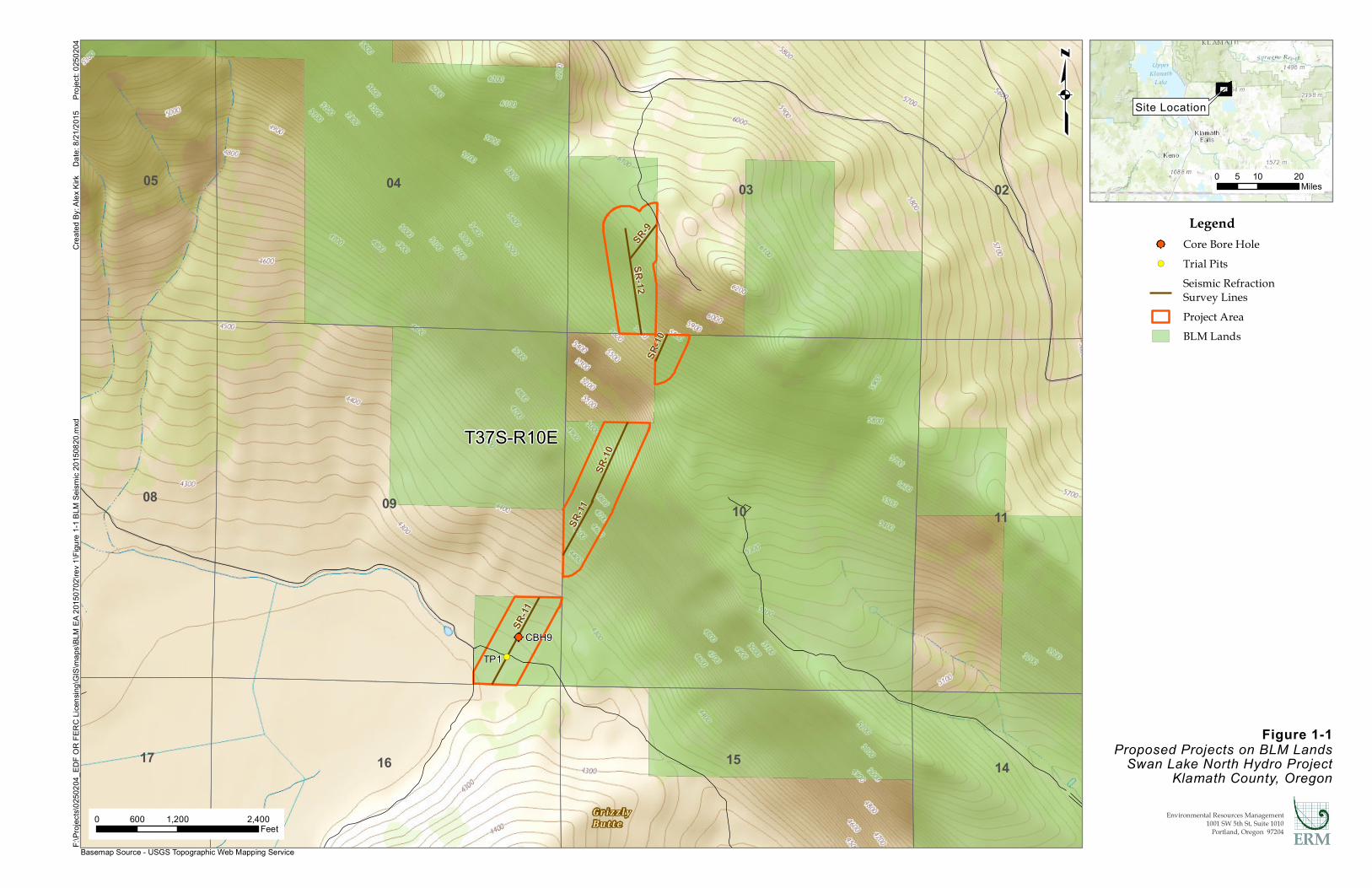
The geotechnical information is important in design of foundations and support structures for the project penstock, reservoirs, transmission line structures, and other associated building foundations. On land administered by BLM, the investigations would include the drilling of one borehole approximately 6 to 18 inches in diameter and one trial pit. Seismic studies on BLM land would include the collection of seismic reflection and refraction data with seismographs and geophones (Figure 1-1). All work areas would be accessed via existing roads. The studies are anticipated to begin in the fall of 2015, and are expected to take approximately 30 days to complete.
The Swan Lake North Geotechnical Investigations EA number is DOI- BLM-OR-L040-2015-019-EA. This Environmental Assessment (EA) has been prepared to evaluate the proposed project as required by the National Environmental Policy Act (NEPA) and other relevant federal and state laws and regulations. Prior to authorizing the proposed geotechnical investigations on BLM lands, the environmental and social effects of those actions must be evaluated. The EA is tiered to the BLM Resource Management Plan for the Klamath Falls Resource Area (KFRA). This EA discloses the direct, indirect, and cumulative effects of the alternatives for geological surveying. The decision maker, KFRA Field Manager, will make decisions based on consideration of the purpose and need for the project, the significance of the effects of alternatives, and public concerns. If impacts are not significant as defined in 40 Code of Federal Regulations (CFR) 1508.27, then a Decision Record and FONSI may be prepared.
@
!(
10
17
05 04
11
02
14
03
16
08 09
15
T37S-R10E
SR-10
SR-9
SR-11
SR-10
SR-11
SR-12
CBH9TP1
Figure 1-1Proposed Projects on BLM Lands
Swan Lake North Hydro ProjectKlamath County, Oregon
Crea
ted By
: Alex
Kirk
Da
te: 8/
21/20
15
Proj
ect: 0
2502
04F:\
Proje
cts\02
5020
4_ED
F OR
FERC
Lice
nsing
\GIS
\map
s\BLM
EA 20
1507
02\re
v 1\Fi
gure
1-1 B
LM S
eismi
c 201
5082
0.mxd
0 1,200 2,400600Feet
qLegend
@ Core Bore Hole!( Trial Pits
Seismic RefractionSurvey LinesProject AreaBLM Lands
0 10 205Miles
Site Location
Environmental Resources Management1001 SW 5th St, Suite 1010
Portland, Oregon 97204
G r iz z l yBu t t e
Basemap Source - USGS Topographic Web Mapping Service
ERM 3 SWAN LAKE PUMPED STORAGE PROJECT/0250204 - JULY 2015
1.1 PURPOSE AND NEED FOR ACTION
The applicant’s purpose for the proposed action is to conduct geophysical and geotechnical investigations on federal lands managed by the BLM in Oregon (Figure 1). The short term right-of-way application for this work was submitted in June 2015, (SF-299 case number OROR 68446) . These investigations are in association with the proposed Swan Lake North Pumped Storage Project, and are needed to collect geotechnical soil property information for the further design of the project facilities. Geophysical and geotechnical investigations must be completed to ascertain structural properties of the subsurface soils in order to advance the design of the proposed project.
BLM’s purpose and need stems from the policy and direction in the Federal Land Policy and Management Act of 1976, as amended (FLPMA) and its mission, multiple use management of the National System of Public Lands. BLM’s purpose and need is further guided by the National
Energy Policy Act of 2005, which recognizes the need to improve domestic energy production, develop renewable energy resources, improve system reliability, and to enhance the infrastructure for collection and distribution of energy resources across this nation. The National Energy Policy Act promotes projects including the proposed Swan Lake North Pumped Storage Project.
BLM’s action in this regard is to analyze the application, define the proposed action and a reasonable range of alternatives, consider the environmental consequences of the proposed action and alternatives, and render a decision on the application. The decision to be made by BLM is to allow the proposed action as proposed, allow the proposed action with modification, or to deny the application.
1.2 CONFORMANCE WITH LAND USE PLANS
The proposed action would be in conformance with the 1995 Klamath Falls Resource Area Resource Management Plan and conditions as required by 43 CFR 1610.5.
ERM 4 SWAN LAKE PUMPED STORAGE PROJECT/0250204 - JULY 2015
1.3 PUBLIC INVOLVEMENT
The project was internally scoped by BLM’s ID team of resource specialists, and a public scoping letter was sent to 139 adjacent landowners, permittees, agencies, and other interested individuals for a 30-day public scoping period in July 2015. As a result, the BLM received one letter and one comment in person. No issues were evident in the initial project scoping beyond the need for vegetation restoration and documentation that any seismic line blasting activities would not impact cultural resources. Therefore, no additional alternatives were developed for analysis. Since scoping, the number of bore holes proposed for drilling was reduced from three to one (based on operational efficiencies).

ERM 5 SWAN LAKE PUMPED STORAGE PROJECT/0250204 - JULY 2015
2 PROJECT DESCRIPTION
2.1 PROPOSED ACTION
The proposed action is for the BLM to issue a short-term right-of-way grant for geotechnical investigations on BLM lands, to collect information needed for the design of the proposed Swan Lake Pumped Storage Project. This EA discloses the environmental impacts of geotechnical activities on BLM lands.
2.1.1 Survey
Geotechnical surveys include seismic reflection, refraction, or similar investigation methods with adjustment in method at the time of investigation to account for site‐specific geology and data quality. A series of seismic refraction surveys would be completed on BLM lands in the vicinity of the areas where data gathering is needed for the proposed upper reservoir and penstock alignment of the Swan Lake North Pumped Storage Project (Figure 1-1). The length and area of testing sites proposed on BLM lands is shown in Table 2-1 below.
Table 2-1 Length and Area of Testing Sites
Testing Site Name Length (feet) Area (square feet) SR-9 640 3,818 SR-10 1,746 10,337 SR-11 2,404 14,432 SR-12 1,595 9,581 Total 5,810 43,088
The data would be collected using a 48‐channel engineering seismograph coupled to vertically‐oriented geophones, or similar. Each of the seismic lines would be comprised of several overlapping spreads of geophones. The energy source to be used for the geophysical survey would consist of an accelerated weight drop, a large sledgehammer and steel plate, or safe use of explosives, including the sourcing of appropriate explosives and mobilization of an approved magazine for storage of those materials. The required energy source would depend upon the survey method and energy transfer capabilities of the soil and rock experienced at the time of the survey. Explosives may be detonated above (air) or below ground (pit) depending on site requirements and surficial materials (rock versus soil). The Poulter Seismic Method would be implemented where blasting is necessary. The exception to this is areas within 660 feet of the active bald eagle nest. No blasting activity would occur within 660 feet of the eagle

ERM 6 SWAN LAKE PUMPED STORAGE PROJECT/0250204 - JULY 2015
nest between January 15 and August 15 or until a KFRA biologist has confirmed that the young have fledged, are mobile, and are out of the immediate area. For areas beyond 660 feet of the nest, there would be no restrictions for wildlife (see Section 3.6.2). All explosives would be properly stored off-site and not on federal lands.
The Poulter Seismic Method has been approved by U.S. Forest Service and the BLM as a best practices method (USDA 2004). The standard practice is to place the shot 1.5 feet above the ground attached to a lath, and detonate it with a seismic cap. This method virtually eliminates the potential for flyrock. In some instances vegetation may be temporarily pressed down but not destroyed during the effort. The geotechnical contractor, Barr, has routinely used this method on public lands without incident. The handling and firing of explosives would be under the supervision of experienced Barr personal. Audible disturbance at distances of 0.5 miles are similar to those associated with a shotgun blast. The no‐flash explosive minimizes fire risk as does the distance of the explosive from ground materials. In addition, a fire check with a shovel in hand is completed after each shot.
In addition to impacts caused by the energy sources described above such as small depressions due to weight drop or sledge hammer sources, tracks/ruts, and shallow explosive holes (which may be filled with adjacent soils following detonation), the bulk of the impact to the terrain would be as required to facilitate access. In general, the geophysics team would work around the limited scrub and sage present on site. Access should be suitable for pulling of a 300‐foot steel tape in a straight line through the vegetation. Typical access paths for this type of work are 4 to 6 feet wide, though they need not be completely clear of brush.
Geophysical survey equipment would be transported to the site using 4WD trucks (large pickup or small panel truck) on existing access roads. Where not readily accessible to trucks due to lack of existing roads, etc., the geophysical survey equipment would be transported by ATV and/or foot.
2.1.2 Drilling
The proposed drilling work would include one borehole, approximately 6 to 18 inches in diameter, and one trial pit. The borehole would be filled and capped upon completion of the study. Borehole 9 (CBH9) would be located on BLM land and be drilled to a depth of 80 feet. A single trial pit (TP1) would be dug on BLM land to a depth of 15 feet, 16 inches wide,

ERM 7 SWAN LAKE PUMPED STORAGE PROJECT/0250204 - JULY 2015
and 8 feet long (120 square feet). The trial pit investigation should take less than 1 hour to complete and the pit would be backfilled immediately.
The proposed drilling work would include advancement of drill string through the surficial soils using standard auger, air rotary, or mud‐rotary methods as required of the material being drilled and the site constraints. Upon reaching the top of the bedrock, the borehole would be advanced to the target depths using standard diamond bit rock coring methods. Hammer drilling or ODEX methods may be used as required to advance the drill string through cobbles, boulders, or highly fractured rock, or to accelerate borehole advancement through non‐critical zones with respect to data collection. Impact to the terrain caused by the proposed drilling operations may include typical rutting resulting from truck and tracked equipment accessing the boring locations as well as the impact of the borehole themselves. The borehole would be on the order of 6 to 18 inches in diameter, likely on the smaller side pending soil and rock materials encountered at the time of drilling. Drilling water or mud consisting of bentonite, water, and drilling additives as allowed would be used to remove cuttings from the hole and cool the drill rods during advancement. The drilling water/mud would be recirculated if possible to minimize water use and would not be allowed to run out on the ground surface. It would be containerized. Any spoils present at the ground surface following completion of drilling would be containerized. All containerized mud and spoils would be properly disposed of off-site and off federal lands. The borehole drilling would be performed within an approximately 40 by 60 foot work area containing the drill rig and support equipment (2,400 square feet). The work area would be accessed as described in the following sections and the access paths may be utilized for temporary staging of materials and equipment if the work area is not deemed large enough at the time of investigation.
2.1.3 Access
Existing private roads (improved dirt roads) would be used to access the boring, test pit, and seismic refraction line locations on BLM land. EDF-Renewable Energy has secured access to these private lands and roads for the purposes of the geotechnical investigations. Existing road access, boring, and test pit locations would be flagged ahead of the investigations. Some minor overland vehicle travel would be necessary in the immediate vicinity of CBH 9. No improvements are necessary to existing roads and new roads are needed. Any vehicular tracks resulting from the overland travel would be used for ingress and retraced for egress.

ERM 8 SWAN LAKE PUMPED STORAGE PROJECT/0250204 - JULY 2015
2.2 NO ACTION ALTERNATIVE
Under the no action alternative, the BLM would deny the right-of-way application. No near term geophysical or geotechnical investigations would occur on BLM lands related to the proposed Swan Lake Project North Pumped Storage Project. Without completing these near term investigations, the applicant would not be able to advance portions of the project design prior to filing of a Federal Energy Regulatory Commission (FERC) Final License Application. The no action alternative would result in reduced ability of the design team to effectively engineer project features on BLM-managed lands and could cause unnecessary surface disturbance related to over-engineered project features.
ERM 9 SWAN LAKE PUMPED STORAGE PROJECT/0250204 - JULY 2015
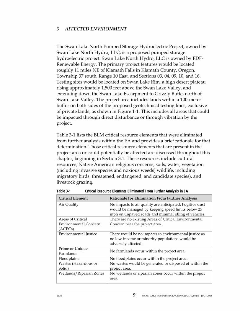
3 AFFECTED ENVIRONMENT
The Swan Lake North Pumped Storage Hydroelectric Project, owned by Swan Lake North Hydro, LLC, is a proposed pumped storage hydroelectric project. Swan Lake North Hydro, LLC is owned by EDF-Renewable Energy. The primary project features would be located roughly 11 miles NE of Klamath Falls in Klamath County, Oregon, Township 37 south, Range 10 East, and Sections 03, 04, 09, 10, and 16. Testing sites would be located on Swan Lake Rim, a high desert plateau rising approximately 1,500 feet above the Swan Lake Valley, and extending down the Swan Lake Escarpment to Grizzly Butte, north of Swan Lake Valley. The project area includes lands within a 100-meter buffer on both sides of the proposed geotechnical testing lines, exclusive of private lands, as shown in Figure 1-1. This includes all areas that could be impacted through direct disturbance or through vibration by the project.
Table 3-1 lists the BLM critical resource elements that were eliminated from further analysis within the EA and provides a brief rationale for that determination. Those critical resource elements that are present in the project area or could potentially be affected are discussed throughout this chapter, beginning in Section 3.1. These resources include cultural resources, Native American religious concerns, soils, water, vegetation (including invasive species and noxious weeds) wildlife, including migratory birds, threatened, endangered, and candidate species), and livestock grazing.
Table 3-1 Critical Resource Elements Eliminated From Further Analysis in EA Critical Element Rationale for Elimination From Further Analysis Air Quality No impacts to air quality are anticipated. Fugitive dust
would be managed by keeping speed limits below 25 mph on unpaved roads and minimal idling of vehicles.
Areas of Critical Environmental Concern (ACECs)
There are no existing Areas of Critical Environmental Concern near the project area.
Environmental Justice There would be no impacts to environmental justice as no low-income or minority populations would be adversely affected.
Prime or Unique Farmlands No farmlands occur within the project area.
Floodplains No floodplains occur within the project area. Wastes (Hazardous or Solid)
No wastes would be generated or disposed of within the project area.
Wetlands/Riparian Zones No wetlands or riparian zones occur within the project area.

ERM 10 SWAN LAKE PUMPED STORAGE PROJECT/0250204 - JULY 2015
Critical Element Rationale for Elimination From Further Analysis Wild and Scenic Rivers There are no designated or proposed wild and scenic
rivers within or near the project area. Wilderness or Wilderness Study Areas
The project would not be in wilderness or within a wilderness study area.
Rangeland Resources The proposed action would not affect any of the four fundamentals of rangeland health (i.e., watershed function, ecological processes, water quality, and special status species’ habitats).
Recreation There are no existing recreation sites in or near the project area.
Visual The proposed action is within a VRM Class IV area. The project meets the objectives of VRM Class IV.
Geology/Mineral Resources
No mining claims or mineral leases occur within the project area.
Lands/Access There would be no changes to land status or changes in access as a result of the project.
Socioeconomics The project would require less than a dozen workers for 30 days. There would be minor positive socioeconomic impacts as a result of the project.
Wild Horses and Burros There are no wild horse/burro ranges in the project area.
3.1 CULTURAL RESOURCES
3.1.1 Affected Environment
The National Historic Preservation Act (NHPA) of 1969, as amended, and its implementing regulations (36 CFR 60 and 800) require that federal agencies take into account the effects of their undertakings on cultural resources that are listed or eligible for listing to the National Register of Historic Places (NRHP); eligible or listed resources are labeled “historic properties.”
Section 106 of the NHPA requires consultations among federal agencies, like BLM, the state historic preservation office (SHPO), culturally affiliated American Indian Tribes, and other affected parties, including private land owners, to develop and evaluate alternatives or modifications to proposed undertakings, in order to avoid, minimize, or mitigate adverse effects on historic properties. Federal regulations at 36 CFR 800.5 and 800.6 detail the process by which the consulting parties determine whether undertakings would adversely affect historic properties and how the agencies consult to avoid, minimize, or mitigate the adverse effects in order to meet Section 106 requirements.
Historic Research Associates (HRA) conducted cultural resource surveys in the greater Swan Lake Valley area in 2011 and 2012 and recorded sites
ERM 11 SWAN LAKE PUMPED STORAGE PROJECT/0250204 - JULY 2015
as old as 9,000 years old; stacked rock features illustrating the spiritual significance of the Swan Lake Escarpment and an associated viewshed for the Klamath Tribe and their ancestors. In addition, there are numerous Euroamerican artifacts and sites in the Swan Lake Valley, evidence of historic settlement, and agricultural development by non-native people.
Historical Research Associates (HRA) conducted a cultural resource survey on BLM lands in May and June 2015 under Cultural Resource Permit OR-50842 and the project-specific Fieldwork Authorization issued 12 May 2015. The Area of Potential Effect (APE) for the proposed project was defined as the geotechnical project centerline, buffered by 100 meters on all sides, exclusive of private lands (see project area, Figure 1-1). No cultural sites were found to occur within this APE during the 2015 field work, as reported to BLM under separate cover from HRA.
3.1.2 Environmental Consequences (Indirect and Direct Effects)
3.1.2.1 Proposed Action
No cultural resources were identified in or within 100 meters any of the locations where geotechnical investigations would occur. Right-of-way application OROR 68446 includes detailed information on the sites closest to the proposed geotechnical activities. Therefore, there would be no effects to cultural resources from the proposed action.
3.1.2.2 No Action
No project-related impacts to cultural resources would occur under the no action alternative.
3.2 NATIVE AMERICAN RELIGIOUS CONCERNS
3.2.1 Affected Environment
There has been a long history of human activity in the Swan Lake Valley. HRA conducted cultural resource surveys in the greater Swan Lake Valley area in 2011 and 2012 as mentioned above in 3.1.1.

ERM 12 SWAN LAKE PUMPED STORAGE PROJECT/0250204 - JULY 2015
3.2.2 Environmental Consequences
3.2.2.1 Proposed Action
No known place of geographic interest or significance to the tribes would be impacted by the geotechnical investigations.
3.2.2.2 No Action
No known place of geographic interest or significance to the tribes would be impacted by the no action alternative.
3.3 SOILS
3.3.1 Affected Environment
Soils in the Swan Lake Valley near Grizzly Butte and the lower portion of the project area (SR-10 and SR-11) consist mostly of clay-loam to loamy soils. This soil is derived from tuff, basalt, and diatomite. Lorella-Calimus loam is well-drained, found mainly on terraces, and steep north slopes. Soils found on the escarpment (SR-9 and SR-12) are characterized as very stony loams and rock outcrops. The escarpment slope ranges in steepness from 5 to 65 percent. Parent material is colluvium derived from basalt and andesite. Soils near SR-9 are a Woodcock- Rock outcrop complex. Soils are residuum weathered from flow breccia, tuff, and basalt.
3.3.2 Environmental Consequences
3.3.2.1 Proposed Action
Implementation of the proposed action would temporarily disturb approximately 1 acre of soil, including work for the seismic lines, bore holes, and test pit. This temporary disturbance within the project area would be negligible to minor and include compaction of the soil, soil boring, and the possibility of erosion as a result of soil boring activities. Further, the project design features (PDFs) described in Section 4.0 would be implemented during construction activities to minimize temporary disturbance to soils.
3.3.2.2 No Action
All previously undisturbed soils would remain unaltered under the no action alternative.

ERM 13 SWAN LAKE PUMPED STORAGE PROJECT/0250204 - JULY 2015
3.4 WATER RESOURCES
3.4.1 Affected Environment
The proposed project would be located in the northern portion of the Lost River Basin. Swan Lake is the nearest surface major water feature to the project area. It is located approximately 1.4 miles southeast of the project’s lower reservoir. A remnant of ancient Lake Modoc, Swan Lake is relatively shallow, with dramatic seasonal fluctuations in size and depth. Swan Lake often dries completely in late summer during low rainfall years. Swan Lake is fed by Anderson Creek; however this perennial stream has been modified and flows only when water is released from the Whiteline Reservoir for irrigation purposes, although some seepage through the dam does occur. When water is released for irrigation, it is largely rerouted through irrigation systems used for agricultural irrigation or lost to seepage. As a result, very little discharge reaches Swan Lake. Even historically, water from Anderson Creek reached Swan Lake only in periods of its greatest flow. Additional surface water inputs to Swan Lake are from overland flow and many small, intermittent springs on the ridges surrounding the valley, including Stiles Spring south of the project area on the escarpment. All water emanating from Stiles Spring infiltrates the soil in the immediate vicinity of the spring.
3.4.2 Environmental Consequences
3.4.2.1 Proposed Action
There would be no impacts to water resources under the proposed action. Implementation of the proposed action would disturb approximately 1 acre of soil and none of the activities are in proximity to existing water resources. The PDFs described in Section 4.0 would be implemented during construction activities to further minimize the potential for erosion-related impacts to water resources.
3.4.3 No Action
There would be no impacts to water resources under the no action alternative.

ERM 14 SWAN LAKE PUMPED STORAGE PROJECT/0250204 - JULY 2015
3.5 VEGETATION
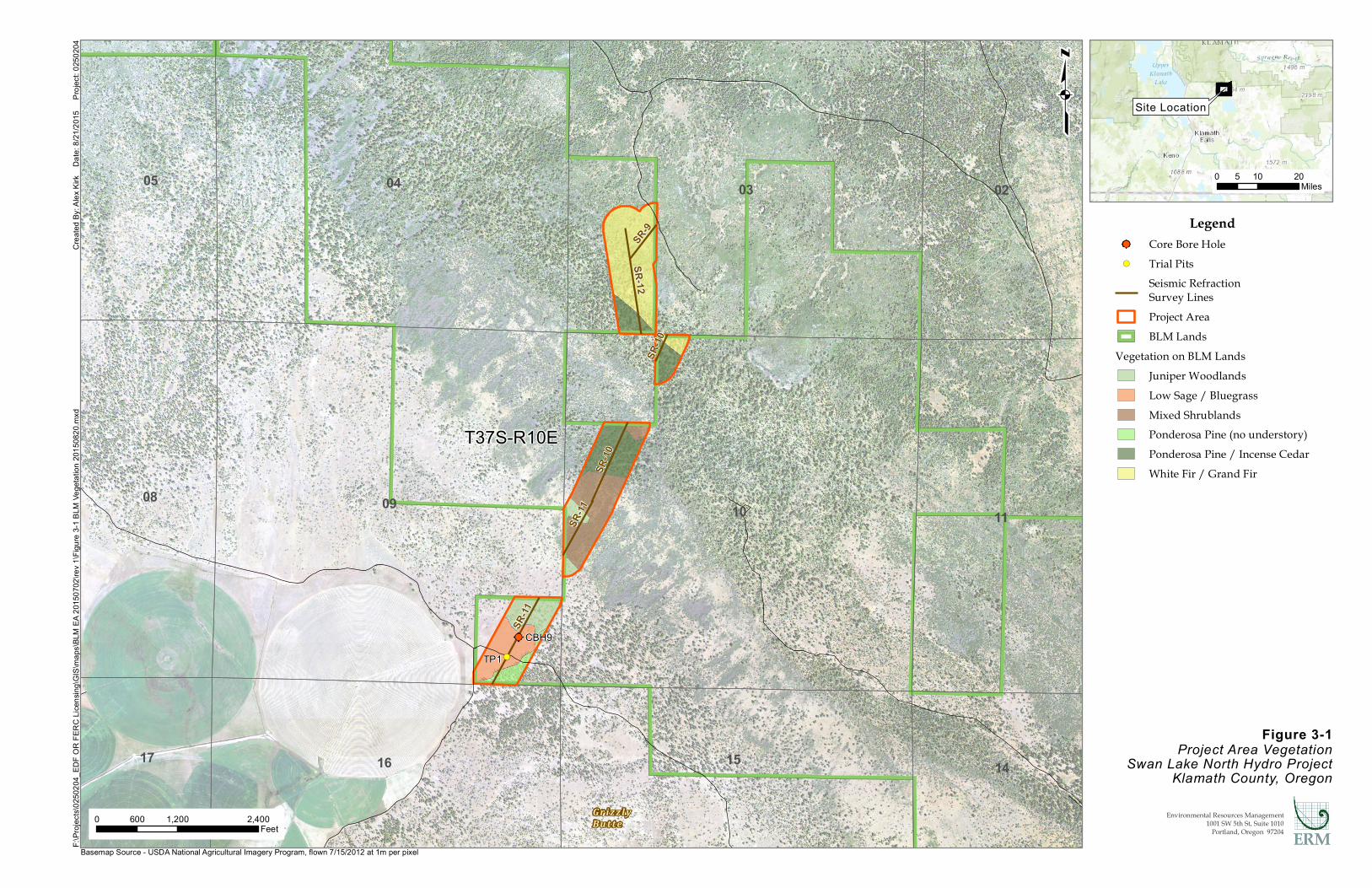
3.5.1 Affected Environment
The proposed project is located in the East Cascades Slopes and Foothills Level III Ecoregion (Thorson et. al. 2003), in the rain shadow of the Cascade Mountains. This ecoregion is characterized by open forests of ponderosa pine (Pinus ponderosa) and some lodgepole pine (Pinus contorta), and is drier than the forested ecoregions to the west of the Cascades and wetter than shrub-steppe and grassland ecoregions to the east. The dry climate in this ecoregion is highly susceptible to wildfire.
Vegetation found within the project area is shown in table 3-1, below. The project area consists primarily of white fir/grand fir forest, with lesser amounts of ponderosa pine, and a generally dense understory of Arctostaphylos patula and Ceanothus velutinus -- these are the same dominant shrub species in the disturbed area Figure 3-1. Continuing southwest along the escarpment, the project area changes from forest to ponderosa pine/incense cedar and continues into a large area of mixed shrublands that make up the majority of the area along the escarpment (Figure 3.-1). Continuing southwest down the steep slope along the proposed seismic refraction line, the area surrounding CBH9 and TPI is a mix of low sage/bluegrass ponderosa pine with no understory and some juniper woodlands. No special status plants or their habitats were found within the area of potential disturbance.
Table 3-1 Project Area Vegetation and Potential Impact
Vegetation Type Project Area (acres)
Temporary Impact (acres)
Permanent Impact (acres)
Juniper Woodlands 10.40 0.08 0 Low Sage/Bluegrass 10.71 0.16 0 Mixed Shrublands 17.93 0.18 0 Ponderosa Pine, no understory 4.00 0.03 0 Ponderosa Pine/Incense Cedar 19.32 0.19 0 White Fir/Grand Fir 27.34 0.28 0
Klamath County lists all species identified by the County Board of Commissioners, ODA, and the BLM as noxious weeds of concern. A total of 16 introduced species were recorded south of the proposed project area in 2011 and could occur in the area slated for geotechnical investigations; of which only eight are listed by the county as noxious weeds (Symbiotics 2011). They include bull thistle, Canada thistle (Cirsium arvense), dalmation toadflax (Linaria dalmatica), mayweed chamomile (Anthemis cotula), musk thistle (Carduus nutans), scotch thistle (Onopordum

ERM 15 SWAN LAKE PUMPED STORAGE PROJECT/0250204 - JULY 2015
acanthium), medusahead (Taeniatherum caput-medusae), and common mullein. The other eight species are weedy invasives, and include pineapple weed (Matricaria discoidea), prickly lettuce (Lactuca serriola), tumble mustard (Sisymbrium altissimum), yellow salsify (Tragopogon dubius), yellow sweet clover (Melilotus officinalis), bulbous bluegrass, cereal rye, and cheatgrass.
Botanists from Pacific Crest Consulting completed plant surveys in the project area in May and June of 2015 and determined that there are no threatened, endangered, or special status plant species in the project area.
@
!(
10
17
05 04
11
02
14
03
16
08 09
15
T37S-R10E
SR-10
SR-9
SR-11
SR-10
SR-11
SR-12
CBH9TP1
Figure 3-1Project Area Vegetation
Swan Lake North Hydro ProjectKlamath County, Oregon
Crea
ted By
: Alex
Kirk
Da
te: 8/
21/20
15
Proj
ect: 0
2502
04F:\
Proje
cts\02
5020
4_ED
F OR
FERC
Lice
nsing
\GIS
\map
s\BLM
EA 20
1507
02\re
v 1\Fi
gure
3-1 B
LM Ve
getat
ion 20
1508
20.m
xd
0 1,200 2,400600Feet
qLegend
@ Core Bore Hole!( Trial Pits
Seismic RefractionSurvey LinesProject AreaBLM Lands
Vegetation on BLM LandsJuniper WoodlandsLow Sage / BluegrassMixed ShrublandsPonderosa Pine (no understory)Ponderosa Pine / Incense CedarWhite Fir / Grand Fir
0 10 205Miles
Site Location
Environmental Resources Management1001 SW 5th St, Suite 1010
Portland, Oregon 97204
G r iz z l yBu t t e
Basemap Source - USDA National Agricultural Imagery Program, flown 7/15/2012 at 1m per pixel
ERM 17 SWAN LAKE PUMPED STORAGE PROJECT/0250204 - JULY 2015
3.5.2 Environmental Consequences
3.5.2.1 Proposed Action
The proposed action has the potential to temporarily disturb less than 1 acre of vegetation; there would be no permanent disturbance (Table 3-1). Any impacts to surface areas would be reclaimed and reseeded; therefore, impacts to vegetation resources would be minor, temporary, and short term. The environmental protection and mitigation measures described in Section 4.0 would be implemented during and after construction activities to minimize temporary disturbance to vegetation, avoid the spread of noxious weeds, and avoid impacting any special status plant species. Further, impacts to special status plant species are not anticipated as proposed locations of temporary disturbance would be situated out of preferred habitat types.
3.5.2.2 No Action
There would be no vegetation disturbed by project-related activities under the no action alternative.
3.6 WILDLIFE
3.6.1 Affected Environment
A species list for the Klamath National Wildlife Refuge system included 267 bird species, 75 mammals, 14 reptiles, and eight amphibians (USFWS 1995). Many of these species have the potential to occur in the Swan Lake Basin or on Swan Lake Rim. Swan Lake and surrounding forests, shrublands, and grasslands also support numerous raptor species in both summer and winter. Commonly sighted wintering raptors include the bald eagle (Haliaeetus leucocephalus), golden eagle (Aquila chrysaetos), ferruginous hawk (Buteo regalis), rough-legged hawk (Buteo lagopus), northern harrier (Circus cyaneus), and American kestrel (Falco sparverius). There are active bald eagle nests adjacent to the proposed project area (Figure 3-2).
In general, the patchy nature of habitats in the Klamath region provides for relatively high avian diversity. Klamath County is a popular destination for hunters, not just for waterfowl, but also upland game birds and big game. Commonly hunted upland game birds include ring-necked pheasant (Phasianus colchicus), mountain quail (Oreortyx pictus), and blue grouse (Dendragapus obscurus). Big game mammals include mule deer
ERM 18 SWAN LAKE PUMPED STORAGE PROJECT/0250204 - JULY 2015
(Odocoileus hemionus), elk (Cervus canadensis), pronghorn (Antilocapra americana), cougar (Puma concolor), and black bear (Ursus americanus). Swan Lake Rim is an important wintering area for ungulates. The Swan Lake Basin hosts a youth hunt for pronghorn each year, though less than 10 tags are drawn. However, most of the basin is private land, thus access is limited for hunters. There is BLM land on the rim, including the area of the proposed upper reservoir. Access by road is somewhat limited, but the area is open to hunters.
Numerous small mammals likely occur in habitats in the project vicinity. Bats may use large ponderosa pines and outcrops on the escarpment for roosting. Chipmunks, woodrats, ground squirrels, mice, voles, and shrews undoubtedly occur in the juniper woodlands and shrub-steppe communities. Other species may be found in wet meadow and grassland habitats. Reptiles may occur in either xeric or mesic habitats within the project area. Western rattlesnakes (Crotalus viridis helleri), for example, are common on the escarpment and rim, while Pacific pond turtles (Actinemys marmorata marmorata) are restricted to riparian and freshwater habitats (e.g., the Lost River). Amphibians are also largely restricted to aquatic and wetland habitats, though the western toad (Bufo boreas) may be seen far from water in upland habitats outside the breeding season, and storage ponds can provide adequate breeding habitat for some species.

@
!(
[b
[b
10
17
05 04
11
02
14
03
16
08 09
15
T37S-R10E
SR-10
SR-9
SR-11
SR-10
SR-11
SR-12
CBH9TP1
Figure 3-2Project Area Eagle Nests
and Exclusion AreasSwan Lake North Hydro Project
Klamath County, Oregon
Crea
ted By
: Alex
Kirk
Da
te: 8/
20/20
15
Proj
ect: 0
2502
04F:\
Proje
cts\02
5020
4_ED
F OR
FERC
Lice
nsing
\GIS
\map
s\BLM
EA 20
1507
02\re
v 1\Fi
gure
3-2 B
LM E
agles
2015
0820
.mxd
0 1,200 2,400600Feet
qLegend
[b Eagle NestEagle Nest 660ftExclusion Area
@ Core Bore Hole!( Trial Pits
Seismic RefractionSurvey LinesProject AreaBLM Lands
0 10 205Miles
Site Location
Environmental Resources Management1001 SW 5th St, Suite 1010
Portland, Oregon 97204
G r iz z l yBu t t e
Basemap Source - USGS Topographic Web Mapping Service

ERM 20 SWAN LAKE PUMPED STORAGE PROJECT/0250204 - JULY 2015
3.6.1.1 Ponderosa Pine, White/Grand Fir, Incense Cedar Forests
Ponderosa pine forests occur on Grizzly Butte, Swan Lake Rim, and along the fringes of Swan Lake Valley. Ponderosa pine forest with minor areas of incense cedar occurs in smaller areas along the edge of the Swan Lake Rim. Large ponderosa pine trees provide nesting, roosting, and denning habitat for raptors, owls, bats, and numerous other bird and mammals species. The seeds of the tree are important food items for some birds, many small mammals, and invertebrates. White-headed woodpeckers (Picoides albolarvatus) are associated almost exclusively with large ponderosa pine trees due to their preference for pine seeds as forage. Bald eagles and many other raptor species in the region also rely heavily on large ponderosa pine trees for nesting, especially where other conifers are absent. Previous surveys conducted for the project found some raptors, such as northern goshawks (Accipiter gentilis), to not occur in or near the project area. Open, old- growth stands of ponderosa pine are increasingly rare due to the long- term effects of timber harvest and fire suppression. They are also considered a strategy habitat in the state (ODFW 2006).
White fir forests within the project vicinity include those areas where white fir cover is greater than 10 percent of canopy cover. Many stands that are dominated by ponderosa pine can be seral within white fir forest types. White fir forests within the project boundary are limited to those on Swan Lake Rim. Mammalian species that utilize ponderosa pine and white fir forests in the area include bats, woodrats, chipmunks, ground squirrels, tree squirrels, mice, voles, shrews, coyotes, weasels, badger, cougars, and bobcats. Deer, elk, and pronghorn use low elevation forests year round and are found in and near higher elevation forests during migration and the summer fawning period. Resident and migratory songbirds, including many not found in other nearby habitats, utilize forests in the project vicinity for breeding and during migration. Many species of conservation concern to state and federal agencies are found in these forested habitats, including local bats species, northern goshawks, flammulated owls (Otus flammeolus), white-headed woodpeckers, and Lewis’ woodpecker (Melanerpes lewis).
Most of the forested areas within the project vicinity on Grizzly Butte and Swan Lake Rim are grazed seasonally, and have recently experienced logging activity. Large, decadent conifer trees with high wildlife value are present but generally uncommon. Many other mammals are known to occur on Swan Lake Rim, including cougar and bobcat. Woodrat nests are common in forested areas. During Symbiotics’ field surveys in 2011, a number of bird species were detected in forest stands that were not seen elsewhere in the proposed project area, including hermit warblers
ERM 21 SWAN LAKE PUMPED STORAGE PROJECT/0250204 - JULY 2015
(Setophaga occidentalis), mountain chickadees (Poecile gambeli), red-breasted nuthatches (Sitta canadensis), Clark’s nutcrackers (Nucifraga columbiana), western tanagers (Piranga ludoviciana), Cassin’s vireos (Vireo cassinii), house wrens (Troglodytes aedon), black-headed grosbeaks (Pheucticus melanocephalus), red-breasted sapsuckers (Sphyrapicus ruber), purple finches (Carpodacus purpureus), Hammond’s flycatchers (Empidonax hammondii), and warbling vireos (Vireo gilvus). White-headed woodpeckers were observed in the southeastern edge of Grizzly Butte on multiple occasions. Two separate gopher snakes (Pituophis catenifer) were also observed in cavities in dead trees in the immediate vicinity. At least one pair of red-tailed hawks was regularly observed near the northwest side of Grizzly Butte, but no nest was located in the project vicinity.
3.6.1.2 Juniper Woodlands
Juniper woodlands occur in various places throughout the project boundary and intermingle with most other vegetation types. For over 100 years, western juniper has been expanding across eastern Oregon into sites previously dominated by shrubs and grasses (Miller et al. 2005). Many areas have experienced an estimated 10-fold increase in juniper from pre-settlement levels. Altered fire and hydrologic regimes and livestock grazing are primary contributors to post-settlement expansion of western juniper into other valuable habitats.
Many species in the region utilize juniper woodlands at various times of the year. At least 97 wildlife species have been observed in juniper woodlands in Oregon, including two amphibians, 13 reptiles, 53 birds, and 29 mammals (Puchy and Marshall 1993). Ungulates often rely on these woodlands, including those in the proposed project boundary, for thermal cover during the winter. At least eight bat species in Oregon are associated with juniper woodlands. Rabbits, chipmunks, ground squirrels, and their predators all rely on juniper woodlands for various aspects of their life histories. Many bird species, including woodpeckers and raptors of conservation concern, nest in juniper trees, which are often the only suitable substrates in a given area. Various birds also consume juniper berries. Many small birds of conservation concern are also associated with juniper woodlands and associated shrublands including loggerhead shrikes (Lanius ludovicianus) and green-tailed towhees (Pipilo chlorurus). Late-successional juniper woodlands are considered a “specialized and local” habitat by the ODFW and are targeted for conservation (ODFW 2006). Woodrats are present in juniper woodlands throughout the project area (Symbiotics 2011).
ERM 22 SWAN LAKE PUMPED STORAGE PROJECT/0250204 - JULY 2015
3.6.1.3 Mixed Shrublands
Mixed shrublands in the project vicinity are those habitats that contain less than 10 percent tree cover and are dominated by a diverse shrub layer, with or without well-developed grass and forb layers. The escarpment and plateau of Swan Lake Rim contain large areas that are dominated by mixed shrublands. Shrub species commonly found in such habitats in the region include big sagebrush, bitterbrush, curl-leaf mountain mahogany, serviceberry, bitter cherry, currant species, rabbitbrush species, goldenweed, greenleaf manzanita, snowbrush, western juniper, and several species that are uncommon elsewhere, such as Klamath plum and birch-leaf mountain mahogany. Mixed shrublands provide important year-round habitat for big game, and become especially important during winter when grasses and forbs are scarce or under snow. Many raptor and songbird species utilize mixed shrublands, including some species that are less common in other habitats, such as olive-sided flycatchers (Contopus cooperi), and fox and Lincoln’s sparrows (Passerella iliaca and Melospiza lincolnii, respectively).
3.6.1.4 Low Sagebrush / Bluegrass
Low sagebrush-steppe communities occur on Grizzly Butte, and in shallow rocky soils on many of the hills, ridges, and benches in the vicinity of the proposed project. Although the ranges of many sagebrush-obligate wildlife species, including greater sage-grouse (Centrocercus urophasianus), pygmy rabbits (Brachylagus idahoensis), sage sparrows (Amphispiza belli), Brewer’s sparrows (Spizella breweri), and sage thrashers (Oreoscoptes montanus), do not extend to habitats in the vicinity of the proposed project, numerous other species associated with low sagebrush habitats (but not obligates) occur in the project vicinity.
These include some of conservation concern to state and federal managers-- many raptor species, small mammals, common nighthawks, fence and northern sagebrush lizards (Sceloporus occidentalis and S. graciosus graciosus, respectively), and numerous songbird species. Forb and grass cover in low sagebrush habitats provide important browse for ungulates during migration periods and late summer. Sagebrush-steppe is an ODFW Strategy Habitat that is considered at-risk and targeted for conservation (ODFW 2006).
ERM 23 SWAN LAKE PUMPED STORAGE PROJECT/0250204 - JULY 2015
3.6.2 Environmental Consequences
3.6.2.1 Proposed Action
Some wildlife in the project area would be impacted by the geotechnical investigations. Individual small reptiles and small mammals in the existing roadways could be run over by vehicles while accessing the boring locations. While these impacts are unfortunate, they are not expected to affect populations at even at the local scale. Mobile and larger animals could be temporarily displaced into similar and adjacent habitats. Impacts on the wildlife communities in the project area would be minor, temporary, and short-term. A portion of the project area is within the 660 foot buffer of an active bald eagle nest. No blasting activity would occur within 660 feet of the eagle nest between January 15th and August 15th \ or until a KFRA biologist has confirmed that the young have fledged, are mobile, and are out of the immediate area. For areas beyond 660 feet of the nest, there would be no restrictions for wildlife.
The PDFs described in Section 4.0 would be implemented during the geotechnical investigations to minimize temporary disturbance to wildlife. With these protection measures, impacts to wildlife would be low, with avoided impacts to eagles due to these measures.
3.6.2.2 No Action
There would be no impacts to wildlife species under the no action alternative.
3.7 THREATENED, ENDANGERED, OR CANDIDATE SPECIES
3.7.1 Affected Environment
U.S. Fish and Wildlife Service (USFWS) maintains a list of species known to occur in Klamath County that are protected under the ESA. This list includes one federally endangered wildlife species, gray wolf (Canis lupus), and three federally threatened wildlife species, northern spotted owl (Strix occidentalis caurina), yellow-billed cuckoo (Coccyzus americanus occidentalis), Canada lynx (Lynx canadensis). The fisher (Martes pennanti), which is proposed for listing, is also known to occur in the county.
ERM 24 SWAN LAKE PUMPED STORAGE PROJECT/0250204 - JULY 2015
3.7.1.1 Gray Wolf
The gray wolf, which is federally listed as endangered in the project area, was historically found throughout the state, including Klamath County, but was extirpated from the early 1940s until 1999. Wolves are currently reestablishing in the northeastern part of the state from the Idaho experimental population, and sightings are becoming more common in many other parts of Oregon (ODFW 2005).
Gray wolves have been documented to use two areas of Klamath County west of Klamath Falls. The Rogue pack now consists of five wolves and occurs northwest of Klamath Falls on the Klamath-Jackson county line. The Rogue pack was started by a lone wolf who dispersed from the Imnaha pack in northeastern Oregon in September 2011. He was recorded to have mated and produced offspring in 2014 and 2015. The Keno Pair (two wolves) were first recorded in 2014 southwest of Klamath Falls, also on the Jackson/Klamath county line many miles from the project area. Gray wolves are currently not known to utilize habitat in the project area (ODFW 2015).
3.7.1.2 Northern Spotted Owl
The northern spotted owl was listed as federally threatened in 1990. The historical range includes southwestern British Columbia, western Washington and Oregon, and northwestern California. The project area is many miles outside the well documented range of occurrence of this species. There is no suitable habitat for spotted owls in the project area, no known breeding pairs or individuals nearby, and the species is not expected to occur in the project area.
3.7.1.3 Yellow-Billed Cuckoo
The yellow-billed cuckoo is federally threatened (USFWS 2014) with critical habitat designated in August 2014. The species breeds in streamside habitats and river floodplains across much of North America, but the western subpopulation (a USFWS distinct population segment) has been in decline for over 50 years. Loss of riparian habitat is the greatest threat to the species (USFWS 2008b). In the west, agricultural conversion, grazing, and water flow management all contribute to the loss and degradation of riparian habitats.
The species was probably never common in Oregon (ODFW 2009). Most historic records are from the Willamette and Columbia floodplains and there are few records of sightings in eastern Oregon. The last confirmed

ERM 25 SWAN LAKE PUMPED STORAGE PROJECT/0250204 - JULY 2015
breeding records were in the 1940s, but sightings of adults still occur in the Malheur National Wildlife Refuge, and Malheur and Deschutes counties. No suitable habitat exists within the proposed project area or vicinity and the species is not expected to occur.
3.7.1.4 Canada Lynx
The Canada lynx was federally listed as threatened (USFWS 2000) and critical habitat is designated (USFWS 2014). The Canada lynx was once widespread in the United States, inhabiting boreal forest across the northern United States into Canada. Fur trapping, habitat loss, and reduction of their primary prey, the snowshoe hare, led to the decline of the species. Lynx were historically found in the southern Oregon Cascade Mountains, but are now only rarely sighted in the Blue Mountains of northeastern Oregon and in adjacent Washington and Idaho (USFWS 2005). The project area is outside their known range and it has not been documented in the area, thus they are not anticipated to occur in the project area or vicinity.
3.7.1.5 Fisher
The fisher, a member of the weasel (Mustelidae) family, is proposed for listing under the ESA (USFWS 2015) and is classified as sensitive-critical by the ODFW (ODFW 2006). The historical distribution of the fisher includes forested regions in the northern half of the United States and much of Canada. Fishers prefer large tracts of closed-canopy forest with large-diameter trees (conifers and hardwoods), snags with cavities and other deformities, large-diameter down wood, and multiple canopy layers. They require large trees for denning, and thus tend to be associated with mature and old-growth forests in Oregon. Heavy trapping in the early 1900s and fragmentation and loss of old-growth forests have led to steep declines and isolation of populations across much of its range.
A distinct subspecies, referred to as the West Coast Distinct Population Segment, is recognized in the Sierra Nevada and Klamath-Siskiyou Mountains (USFWS 2008c). A disjunct and genetically isolated population also exists in the southern Cascades. As they require mature old growth forest habitats, no suitable habitat for the fisher exists within the proposed project vicinity and the species is not expected to occur there.
ERM 26 SWAN LAKE PUMPED STORAGE PROJECT/0250204 - JULY 2015
3.7.2 Environmental Consequences
3.7.2.1 Proposed Action
As no known occurrences or suitable habitat for gray wolf, northern spotted owl, yellow-billed cuckoo, Canada lynx, or fisher occurs in the project area or vicinity, the proposed action would not have any impacts on threatened endangered, or candidate species.
3.7.2.2 No Action
There would be no impacts to threatened, endangered, or candidate species under the no action alternative.
3.8 LIVESTOCK GRAZING
3.8.1 Affected Environment
The proposed geotechnical investigations would occur within a single BLM grazing allotment (Schedule No. 00832-Jespersen). The 00832-Jespersen allotment supports 161 cattle animal unit months (AUMs) and its season of allowable use is from May 1st through July 1st.
3.8.2 Environmental Consequences
3.8.2.1 Proposed Action
Under the proposed action, the geotechnical investigations would be scheduled to occur outside of the grazing allotment season. There would be no project-related impacts to livestock or grazing.
3.8.2.2 No Action
There would be no project-related impacts to livestock grazing under the no action alternative.
3.9 CUMULATIVE EFFECTS
Cumulative effects are those impacts to the environment that result from the incremental impact of an action when added to other past, present, and reasonably foreseeable future actions (40 CFR 1508.7). Past, present, and reasonably foreseeable future actions considered in this EA are
ERM 27 SWAN LAKE PUMPED STORAGE PROJECT/0250204 - JULY 2015
generally related to surrounding land uses and the Swan Lake North Pumped Storage Project (including its associated field work and data gathering). Under the Proposed Action, once the geotechnical investigation activities are completed, the Applicant would utilize this information to aide in the siting and conceptual design of the Swan Lake North Pumped Storage Project. The FERC licensing process has been initiated for that project, which will include an analysis under the National Environmental Policy Act to assess its potential impacts. Because the geotechnical investigations are short-term and temporary, and are confined to a small area, the Proposed Action would have overall low cumulative impacts on Swan Lake Rim, Grizzly Butte, and the surrounding area.
Because there would be no direct or indirect environmental impacts from the proposed or no action alternative on the resources listed in Table 3-1, there would be no cumulative effects on these resources from the proposed action or no action alternative.
3.9.1 Cultural Resources
3.9.1.1 Proposed Action
As potential impacts to cultural resources across a geographic landscape are not additive, the analysis area for cumulative impacts to cultural resources is the project area. Past and present actions in the area include grazing and rangeland management as well as dispersed recreation such as hunting. Reasonably foreseeable future actions include ongoing land uses, as well as the proposed Swan Lake North Pumped Storage Project. The surface disturbance, if any, associated with grazing, rangeland management, and recreation activities is impossible to quantify due to their dispersed nature. Cultural resources surveys are conducted in areas with high potential for producing cultural resources prior to approval of surface disturbing activities, and identified resources are avoided or collected. However, cultural resources that are not visible on the surface could be unknowingly damaged or destroyed by construction activities where surveys have not been conducted. The proposed geotechnical investigations would have no impacts to cultural resources; therefore the Proposed Action would not contribute cumulative effects to cultural resources in the area.
3.9.1.2 No Action
Because the No Action Alternative would not result in any direct or indirect impacts, it would not result in an accumulation of impacts.

ERM 28 SWAN LAKE PUMPED STORAGE PROJECT/0250204 - JULY 2015
However, the no action alternative could result in over-engineering of the Swan Lake North Pumped Storage Project, potentially increasing its surface disturbance and therefore indirectly increasing the potential for cumulative disturbance of cultural resources.
3.9.2 Native American Religious Concerns
3.9.2.1 Proposed Action
The cumulative effects analysis area for Native American religious concerns is the Swan Lake Valley and Swan Lake Rim. Past and present actions in the area include agriculture, grazing, and rangeland management as well as dispersed recreation such as hunting. Reasonably foreseeable future actions include ongoing land uses, as well as the proposed Swan Lake North Pumped Storage Project. The proposed geotechnical investigations may have impacts to Native American religious concerns; therefore the Proposed Action may contribute to cumulative effects to Native American religious concerns in the area. Consultation between the BLM and the Klamath Tribes revealed a strong concern regarding possible impacts of the final pump storage project on spiritual and religious use of the Swan Lake Rim.
3.9.2.2 No Action
Because the No Action Alternative would not result in any direct or indirect impacts to Native American religious concerns, it would not result in an accumulation of impacts to this resource.
3.9.3 Soils
3.9.3.1 Proposed Action
The analysis area for cumulative impacts to soils is the project area. Past and present actions in the area include grazing and rangeland management as well as dispersed recreation such as hunting. Reasonably foreseeable future actions include ongoing land uses, as well as the proposed Swan Lake North Pumped Storage Project. The surface disturbance, if any, associated with grazing, rangeland management, and recreation activities is impossible to quantify due to their dispersed nature. The amount of soil that would be affected by the Proposed Action is temporary, and is also small compared to the area affected by other past, present and reasonably foreseeable future actions in the area. Additionally, implementation of the environmental protection and mitigation measures described in Section 4.0 would further reduce the

ERM 29 SWAN LAKE PUMPED STORAGE PROJECT/0250204 - JULY 2015
potential for impacts. Therefore, the Proposed Action would have a low cumulative impact on geology and soils.
3.9.3.2 No Action
As all previously undisturbed soils would remain so under the no action alternative, it would not result in direct effects to cumulative resources; however the no action alternative could result in over-engineering of the Swan Lake North Pumped Storage Project, potentially increasing its surface disturbance and therefore indirectly increasing the potential for cumulative disturbance of soils.
3.9.4 Water Resources
3.9.4.1 Proposed Action
The analysis area for cumulative effects to water resources is the Swan Lake Watershed. Past and present actions in the area include agriculture, grazing, and rangeland management as well as dispersed recreation such as hunting. Reasonably foreseeable future actions include ongoing land uses, as well as the proposed Swan Lake North Pumped Storage Project. These actions have the potential to impact water resources through water use for irrigation and pumped storage hydroelectric power generation. As the Proposed Action would not utilize water resources, there would be no impacts to cumulative effects from water use for geotechnical investigations. Past, present, and future actions in the area, along with the Proposed Action, have the potential to indirectly impact water resources through erosion and surface-disturbance related impacts; however these impacts from the Proposed Action would be temporary and minimized with implementation of PDFs, resulting in negligible cumulative impacts to water resources.
3.9.4.2 No Action
As there would be no water use or surface disturbance under the No Action Alternative, it would not contribute to cumulative effects.
3.9.5 Vegetation
3.9.5.1 Proposed Action
The analysis area for cumulative impacts to vegetation is the project area. Past and present actions in the area include grazing and rangeland management as well as dispersed recreation such as hunting. Reasonably
ERM 30 SWAN LAKE PUMPED STORAGE PROJECT/0250204 - JULY 2015
foreseeable future actions include ongoing land uses, as well as the proposed Swan Lake North Pumped Storage Project. The vegetation disturbance associated with grazing, rangeland management, and recreation activities is impossible to quantify due to their dispersed nature. The amount of vegetation that would be affected by the Proposed Action is temporary, and is also small compared to the area affected by other past, present and reasonably foreseeable future actions in the area. Additionally, implementation of the PDFs described in Section 4.0 would further reduce the potential for impacts. Therefore, the Proposed Action would have a low cumulative impact on vegetation.
3.9.5.2 No Action
As all previously undisturbed vegetation would remain so under the no action alternative, it would not result in direct effects to cumulative resources; however the no action alternative could result in over-engineering of the Swan Lake North Pumped Storage Project, potentially increasing its surface disturbance and therefore indirectly increasing the potential for cumulative disturbance of vegetation.
3.9.6 Wildlife
3.9.6.1 Proposed Action
The analysis area for cumulative impacts to wildlife is the Swan Lake Rim and Grizzly Butte. Silviculture, grazing, and rangeland management as well as dispersed recreation such as hunting are responsible for most of the past and present impacts to wildlife and wildlife habitat in this area. Reasonably foreseeable future actions include ongoing land uses, as well as the proposed Swan Lake North Pumped Storage Project. Wildlife disturbance associated with grazing, rangeland management, and recreation activities is impossible to quantify due to their dispersed nature. Impacts to wildlife due to the Proposed Action would primarily be related to temporary disturbances to common, less mobile species, with limited impact to mobile species. These ongoing activities, including the Proposed Action, would have a low cumulative effect on wildlife and wildlife habitat. Additionally, implementation of the PDFs described in Section 4.0 would further reduce the potential for impacts contributed by the Proposed Action.
ERM 31 SWAN LAKE PUMPED STORAGE PROJECT/0250204 - JULY 2015
3.9.6.2 No Action
As all previously undisturbed wildlife and wildlife habitat would remain so under the no action alternative, it would not result in cumulative effects to wildlife resources.
3.9.7 Threatened, Endangered, or Candidate Species
3.9.7.1 Proposed Action
The analysis area for cumulative effects to threatened, endangered, or candidate species is the project vicinity, including Swan Lake Rim and Grizzly Butte. As no known occurrences or suitable habitat for gray wolf, northern spotted owl, yellow-billed cuckoo, Canada lynx, or fisher occurs in the project area or vicinity, the Proposed Action would not have any impacts on threatened endangered, or candidate species, and no cumulative effects to this resource.
3.9.7.2 No Action
Likewise, the no action alternative would not result in cumulative effects to threatened, endangered, or candidate species..
3.9.8 Livestock Grazing
3.9.8.1 Proposed Action
Under the proposed action, the geotechnical investigations would be scheduled to occur outside of the grazing allotment season. There would be no project-related impacts to livestock or grazing, and no cumulative impacts to this resource.
3.9.8.2 No Action
Likewise, the no action alternative would not result in cumulative effects to livestock grazing.
ERM 32 SWAN LAKE PUMPED STORAGE PROJECT/0250204 - JULY 2015
4 PROJECT DESIGN FEATURES
The BLM would inspect the project before, during, and after the geotechnical investigations, to ensure compliance with project design features (PDFs), best management practices (BMPs), and other requirements.
EDF-Renewable Energy and its contractors would implement the following procedures.
4.1 ACCESS
Utility clearances would be conducted on the borehole before entry to the site. Clearances would be conducted by a certified utility locator. It would be up to the discretion of the utility locators as to whether a site visit is necessary for the borehole. Road access, trial pits, core bore holes, and seismic refraction lines would be flagged for BLM investigation. Any fences that need to be cut for access would be repaired to their original conditions before the drilling crew leaves the area, or immediately if livestock are present.
4.2 SAFETY
Contractors would develop a Health and Safety Plan which includes the following information (at a minimum):
• Identification of responsible parties;
• Identification of potential physical, chemical, or environmental hazards and relevant health and safety precautions;
• Required personal protective equipment;
• Emergency evacuation procedures;
• Location and content of warning signs to be posted;
• Local emergency telephone numbers would be posted at drilling locations.

ERM 33 SWAN LAKE PUMPED STORAGE PROJECT/0250204 - JULY 2015
4.3 FIRE PROTECTION
All vehicles would be equipped with a working fire extinguisher and a shovel. Drill rigs would be equipped with a filled water tank during periods of high, very high, or extreme fire danger. Uncontained fires of any kind would be prohibited. The crew contingency plan would include a fire communications protocol for contacting fire-fighting personnel. Contractors would need a permit to operate machinery during fire season from ODF. All operations would abide by current fire restrictions and must do everything reasonable to prevent and suppress wildfires in the immediate vicinity of the right-of-way area. Vegetation immediately adjacent to structures and improvements for a distance of at least 30 feet, or to the property line, whichever is the shortest distance must be cleared. BLM and ODF would be notified of all blasting operations and appropriate permits would be obtained.
4.4 NOISE AND LIGHTING
All vehicles and construction equipment would use working mufflers to minimize equipment-related noise. Any outdoor lighting used would be shielded and directed downward to the extent possible.
4.5 AIR QUALITY
A 25 mph speed limit would be enforced on dirt/gravel roads during fieldwork, as would minimization of idling work vehicles. All project activities would comply with the Clean Air Act, National Ambient Air Quality Standards.
4.6 SOILS
No soil boring activities would take place during or immediately following rain events when the soil is too wet to adequately support equipment. If equipment creates surface ruts in excess of 6 inches deep, activities in the area would be delayed until the soils dried out adequately enough to prevent deep rutting. Limit equipment operations to periods when the soil moisture is below 20 percent at a six inch depth. Although not anticipated, if necessary, disturbed sites would be re-graded to restore the site to approximately the original contour following work. Silt fences and/or straw bales would be used to minimize erosion if needed. No erosion hazards are anticipated.
ERM 34 SWAN LAKE PUMPED STORAGE PROJECT/0250204 - JULY 2015
Retain minimum effective ground cover amounts to prevent erosion from ground-disturbing activities. Vegetative retention and establishment is 45-60% in the first year and 60-75% in the second year on disturbed sites of high erosion hazard (KFRA ROD/RMP, page D-11).
4.7 VEGETATION
Upon completion of the geotechnical investigations, any disturbed areas would be revegetated. Steps would be taken to regrade, minimize erosion, minimize compaction, restore natural ground cover, reestablish plant growth, and allow natural surface drainage. Rehabilitation measures planned for the disturbed areas include raking of soil and revegetation via broadcast seeding. A site-specific seed mixture was provided by BLM and is included in Appendix A.
4.8 NOXIOUS WEEDS
Vehicles and equipment that will travel off system roads will be pressure washed prior to entry onto BLM-managed lands. This would remove loose seeds, grease, plant parts, and dirt that may contain viable noxious weed seeds, thereby reducing potential introduction of new noxious weeds into the project area and into newly disturbed sites. If the job site includes a noxious weed infestation, require cleaning of all equipment and vehicles prior to leaving the job site.
Monitor the project area 1-3 years after project is completed and treat noxious weeds as detected in areas that were disturbed by project implementation.
Equipment used for road construction or maintenance would grade towards any known noxious weed infestations. If no good turn around area exists within one half mile that would allow the operator to grade towards the noxious weed infestation, then the operator would leave the material that is being moved within the boundaries of the noxious weed infestation..
4.9 CULTURAL RESOURCES
All construction and subsequent maintenance activities would be restricted to the cleared areas. Although not anticipated, if during the geotechnical investigations, cultural resources were uncovered, the BLM
ERM 35 SWAN LAKE PUMPED STORAGE PROJECT/0250204 - JULY 2015
would be notified and work in the area would halt until documentation and evaluation by a BLM-approved archaeologist was conducted. Adverse effects to eligible properties would be avoided or mitigation measures implemented prior to resuming construction within the area of the discovery.
4.10 WILDLIFE
Any blasting activities associated with the seismic line work would be restricted within 660 feet of the eagle nest. No blasting activity would occur within 660 feet of the eagle nest until August 15 or until a KFRA biologist has confirmed that the young have fledged, are mobile, and are out of the immediate area. For areas beyond 660 feet of the nest, there would be no restrictions for wildlife.
4.11 HAZARDOUS MATERIALS, HAZARDOUS WASTE, AND EXPLOSIVES
Diesel fuel, hydraulic fluids, and engine oil products would be the only hazardous material liquids used on site. The only significant source of potential petroleum spills would be from mobile equipment. Any spills from mobile equipment would be promptly cleaned up and disposed of appropriately according to applicable Oregon Department of Environmental Quality. Any material storage, including the temporary storage of explosives, would not occur on public lands.

ERM 36 SWAN LAKE PUMPED STORAGE PROJECT/0250204 - JULY 2015
5 SOURCES CITED
Miller, R.F., J. D. Bates, T. J. Svejcar, F. B. Pierson,L. B. Eddleman . 2005. Biology, Ecology, and Management of Western Juniper (Juniperus occidentalis). Oregon State University, Agricultural Experiment Station, Technical Bulletin, 152.
ODFW (Oregon Department of Fish and Wildlife). 2005. Oregon Wolf Conservation Management Plan. 116pp.
----. 2006. Oregon Conservation Strategy. Oregon Department of Fish and Wildlife, Salem, Oregon . 55 pages
--. 2009. Species Fact Sheet – Yellow Billed Cuckoo. <http://www.fws/gov/oregon/fwo/Species/Data/YellowBilledCuckoo/default.asp>
----. 2015. Wolves in Oregon. Online posting. Oregon Department of Fish and Wildlife. <http://www.dfw.state.or.us/wolves/>
Puchy C, Marshall D. 1993 Oregon wildlife diversity plan. Oregon Dept. of Fish and Wildlife, Portland, Oregon.
Symbiotics. 2011. Swan Lake North Pumped Storage Project Draft License Application FERC No. 13318.
Thorson T, S. Bryce, D. Lamers, A. Woods, J. Omernik, D. Pater, J. Comstock. 2003. Ecoregions of Oregon: Reston, Virginia, US Geological Survey.
United States Department of Agriculture (USDA). 2004. Geophysical Operations; Providing Needed Information on the Geology of the National Forest System. USDA, Forest Service and International Association of Geophysical Contractors, FS-589.
USFWS (US Fish and Wildlife Service). 1995. Wildlife of the Klamath Basin National Wildlife Refuges. Tulelake, California 10p.
----. 2005. Canada Lynx Recovery Outline. Helena, Montana 21pp.
----. 2008a. Recovery Plan for the Northern Spotted Owl. Portland, Oregon 158pp.

ERM 37 SWAN LAKE PUMPED STORAGE PROJECT/0250204 - JULY 2015
----. 2008b. Species Assessment and Listing Priority Assignment Form –Yellow-billed Cuckoo. 45pp.
----. 2008c. Species Assessment and Listing Priority Assessment Form-Mardon Skipper. 29pp
----. 2014. Determination of Threatened Status for the Western Distinct Population Segment of the Yellow-billed Cuckoo (Coccyzus americanus). http://www.gpo.gov/fdsys/pkg/FR-2014-10-03/pdf/2014-23640.pdf

Appendix A BLM Revegetation Seed Mix
