sustainable landscape approach
TRANSCRIPT
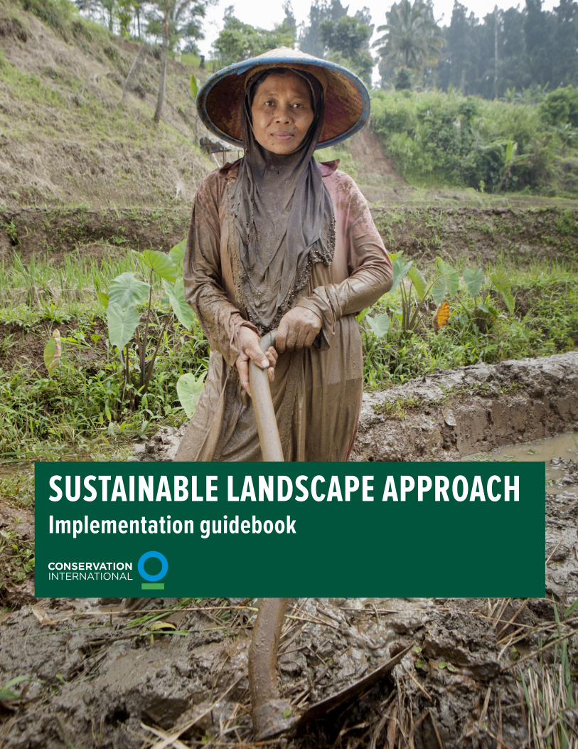
SUSTAINABLE LANDSCAPE APPROACHImplementation guidebook

© November 2018
These guidelines for the design, implementation and monitoring of sustainable landscapes were developed in consultation with Conservation International’s field offices and departments in U.S. offices.
LEAD WRITER Danielle King | Sustainable Landscapes Fellow, Conservation Finance Division | [email protected]
CONTRIBUTORS Simon Badcock, Patti Dunne, Joanna Durbin, Janet Edmond, Fabiano Godoy, Daniel Juhn, Anurag Ramachandra and Janice-Renee Yoshioka
ACKNOWLEDGEMENTSMahbub Alam, Ginny Farmer, Ana Gloria Guzman, Trond Larsen, Monica Morales, Allison Myers, Rosimeiry Portela, Claudio Schneider, Percy Summers, Karyn Tabor, Derek Vollmer and Max Wright, as well as all participants in the May 2018 Sustainable Landscape Approach training workshop and the April 2015 REDD+ and Sustainable Landscapes workshop.
MORE INFORMATIONFabiano Godoy | Technical Director, Conservation Finance Division | [email protected]
Front cover: © Jessica Scranton; Page 22: © Flavio Forner

TABLE OF CONTENTS
SUSTAINABLE LANDSCAPE APPROACH
Glossary
Acronyms
0. Introduction: The Sustainable Landscape Approach0.1 Overview of the SLA
0.2 A tiered approach
0.3 The SLA and the Open Standards
0.4 The SLA and the Rights-based Approach
1. Landscape Characterization1.1 Landscape goals and boundary
1.2 Stakeholder mapping
1.3 Contextual and spatial assessment
1.4 Multi-stakeholder engagement
2. Landscape Action Plan2.1 Decision support: Scenarios, tradeoff analysis and prioritization
2.2 Integration of priorities and strategies
2.3 Results chains
3. Landscape Finance Plan3.1 Identify potential financial mechanisms and funders for strategies
3.2 Compile finance plan: Match strategies, mechanisms and funding sources
3.3 Develop business plans
4. Implementation and monitoring4.1 CI workplan and budget
4.2 Integrated monitoring
5. Learning and adaptive management5.1 Review and adapt Landscape Action and Finance Plans and integrated monitoring
5.2 Share learning
6. Appendices
4
5
6
6
7
8
8
9
910
1112
14
1415
16
16
17
18
18
19
19
20
21
21
22
23
Implementation guidebook

4
GLOSSARY
Due to CI’s Sustainable Landscape Approach (SLA) being built upon different experience on the ground with existing initiatives and frameworks, some terms are defined differently in various contexts.1 The following key terms are defined for the purpose of this document to facilitate comprehension and alignment.
1 For example, where the SEEA Experimental Ecosystem Accounting uses “values,” the Open Standards for the Practice of Conservation (OS) refers to “conservation targets.”
GOAL
HUMAN WELL-BEING
LANDSCAPE
LANDSCAPE MANAGER
NATURAL CAPITAL
OBJECTIVE
STAKEHOLDER
SUSTAINABLE LANDSCAPE
VALUE
A statement of the desired status of the landscape’s values and ultimate impact you hope to achieve.
The provision of and access to health, good social relations, security, agency and the material necessary for a good life.
A geographical space that results from the interaction between social, ecological, economic and governability processes.
The catalyzing actor in the sustainable landscape initiative. For the purposes of this document, this generally implies the CI field team responsible for designing and implementing the initiative. Sometimes referred to as a “project team” or “landscape team” in the conservation community.
The stock of resources that provide the wide range of ecosystem services upon which life depends.
A statement of the desired changes, outcomes or intermediate results required to achieve your goals. This should be specific, measurable, achievable, relevant and time-bound (or, “SMART”).
Any individual, group or institution who has a vested interest in the ecological, economic and socio-cultural values of land and natural resources of the landscape area and/or who will be affected by landscape management.
A place where people steward natural capital alongside sustainable production systems at a scale that encompasses multiple levels of governance, a wide range of uses, and essential natural capital, to enhance long-term human well-being in a changing world.
The measure of ecosystem attributes and their material and immaterial benefits, which can be broadly distinguished into three distinct categories: ecological, economic and social-cultural. Essentially, values are components of natural capital that are used in the landscape. Related to “conservation targets” in Open Standards terminology.

5
ACRONYMS
CI Conservation International
CSO Civil society organization
GIS Geographic information system
KPI Key performance indicator
LAP Landscape Action Plan
LFP Landscape Finance Plan
M&E Monitoring and Evaluation
NGO Non-governmental organization
SLA Sustainable Landscape Approach
SLS Sustainable landscape(s) and seascape(s)
MSP Multi-stakeholder platform
OS Open Standards for the Practice of Conservation
RBA Rights-based Approach
REDD+ Reducing Emissions from Deforestation & Forest Degradation, plus conservation, sustainable management of forests and enhancement of forest carbon stocks

6
0. INTRODUCTION TO THE SUSTAINABLE LANDSCAPE APPROACHCI’s “Southern Cross” is a framework of four current institutional priorities that will guide our work: Sustainable Landscapes and Seascapes (SLS), Nature for Climate, Ocean Conservation at Scale, and Innovation in Science and Finance.
Due to this institutional focus, the Sustainable Landscape Approach (SLA) has been developed to guide and promote the application of a consistent approach by practitioners across CI’s sustainable landscape initiatives to meet our overarching mission of securing nature for people. This approach reflects an important shift in the traditional conservation movement of the last few decades: from one focused solely on biodiversity, to one that recognizes that conserving nature can lead to improvements in human well-being.
This approach has been developed based on years of learning from divisions and field programs across CI and will continue to be refined based on our experiences moving forward. Additional resources—including training materials tailored for specific phases of the SLA—can be found on the SLS SharePoint site.2 Further contextual information on the SLS initiative can be found in the forthcoming Practitioner’s Guide.3
These guidelines are written for the “landscape manager” as the catalyzing actor; more specifically, this refers to the team actively involved in and responsible for the sustainable landscape initiative.
0.1 Overview of the SLAAs defined in CI’s SLS Practitioner’s Guide, a sustainable landscape or seascape is a place where people steward natural capital alongside sustainable production systems at a scale that encompasses multiple levels of governance, a wide range of uses and essential natural capital, to enhance long-term human well-being in a changing world. These large-scale initiatives comprise many stakeholders implementing interventions in coordination across a variety of land uses that collectively meet multiple goals in pursuit of overall landscape sustainability.
The SLA is an integrated approach implemented through partnerships to address the multiple—and, at times, competing—goals of conservation and economic development to benefit human well-being. The approach provides a structured process for systematically coordinating the complex design,
2 SLS COP SharePoint3 CI. (Forthcoming.) Sustainable Landscapes & Seascapes: A Practitioner’s Guide.
implementation and monitoring of integrated sustainable landscape initiatives by a set of partners.
The SLA involves five phases (see Figure 1), each of which has sub-steps (see Figure 2):
1. Landscape Characterization: To assess the status of landscape sustainability in terms of natural capital, production, human well-being and governance, and develop a shared understanding of the goals and priorities for the landscape2. Landscape Action Plan (LAP): To plan interventions with partners in pursuit of multiple goals by maximizing synergies, making well-informed decisions and identifying the best set of interventions for investment3. Landscape Finance Plan (LFP): To build a diverse portfolio of financial resources that can support implementation, with a range of mechanisms, timelines, risk tolerances and levels of investment4. Implementation and Monitoring: To implement the management interventions and investment opportunities employed through partnerships as outlined in the LAP and LFP and monitor the impact of these interventions as well as the overall achievement of landscape goals. 5. Learning and Adaptive Management: To exchange ideas and experience across CI to improve our interventions and effectiveness through adaptive management
The SLA can be applied in many situations, and is particularly well-fitted in situations where: (1) intervention areas include multiple land uses and/or functions (e.g., watersheds, national parks, forestry concessions, agricultural zones); (2) interventions require addressing
Figure 1: SLA phases

7
multi-level governance issues and engaging across jurisdictions with government authorities and agencies with varying roles and responsibilities (e.g., improved management of a watershed that falls into two jurisdictions); or (3) implementation will require coordination of diverse, large-scale financial resources across multiple commodities (e.g., addressing the collective impacts of pulp, paper, palm oil, coffee and cocoa in Indonesia).
Several factors are key to keep in mind when applying the SLA:
• The phases as further outlined in sections 1-5 are designed to provide guidance without being too prescriptive, considering each landscape is very different and must be managed accounting for unique characteristics, challenges and opportunities.
• While there is order to the phases, some of the steps4 in each phase will be implemented concurrently, while others are more sequential. Moreover, there are many relationships and interactions between the phases, and the steps embedded within each of the phases involve an iterative and adaptive approach, responsive to contextual changes and other relevant factors (e.g., new data or policies), so some will be implemented and revisited throughout the entire initiative (e.g., multi-stakeholder engagement).
• There are many different entry points and catalyzing factors for sustainable landscape initiatives, as landscapes are complex entities that are sometimes shaped by opportunistic decision-making rather than an informed set of interrelated activities. For example, some initiatives begin with one large grant which provides an influx of cash for holistic, large-scale management, through which we can apply the SLA, while other initiatives are created by aggregating many smaller projects into a larger initiative with holistic management under the SLA. Others are established in response to local government leadership in the fields of environment and development.
• The strength of the SLA comes from maintaining a focus on the integrated approach, as opposed to implementing a set of small project interventions that do not aggregate toward the same landscape goals.
• The SLA is designed to succeed where others have failed: namely, by being built upon strong project management, thematically cross-cutting strategies, implementation through partnership, and long-term resource commitments. The historic focus of
4 We use the term “step” to describe the sub-components of each phase; however, this term does not necessarily indicate the sub-components are sequential.
integrated conservation and development projects being confined to protected areas and those communities living in close geographic proximity has led to the real threats and opportunities—that exist beyond the immediate geography—being ignored or considered outside of the project scope, allowing the true drivers to continue unabated.
Tools and resources are available to support application of each Phase. Please see Appendix 1 for more information.
0.2 A tiered approachOne factor to consider is the level of robustness and depth the landscape manager can practically achieve in terms of the assessments involved in characterization and planning for the initiative. Landscape managers should not become stuck or delayed in pursuit of information and analyses that are beyond budget, time and/or data constraints.
As such, landscape managers might consider a tiered approach:
• Tier 1 approaches are rapid efforts that collect adequate information to catalyze implementation, but are less intensive in terms of the funding, time, technology and/or other resources.
• Tier 2 approaches provide more robust and precise information to make decisions and design interventions, but require more funding, time, technology and/or other resources.
As an example, a Tier 1 approach to identify the location of essential freshwater resources within the landscape may involve a participatory mapping exercise with some stakeholders, while a Tier 2 approach to the same exercise may involve using geographic information system (GIS) layers and hydrological modeling to more precisely identify and delineate these areas.
Projects can begin with Tier 1 information and refine this with Tier 2 information as time and budget allow.This guide is currently geared toward a Tier 1 approach, but some of the tools and resources referenced will enable Tier 2 analysis. Please see Appendix 1 for more information on tools and resources.

8
0.3 The SLA and the Open StandardsThe Open Standards for the Practice of Conservation5 (OS) framework was developed collaboratively by a group of conservation organizations to enable more systematic planning, implementation and monitoring of conservation initiatives with the ultimate aim of adapting and improving conservation efforts.
The SLA is built upon this framework, considering the growing interest by CI, donors and partners. While the OS served as a foundation, there are components of the SLA that go beyond this framework, which is why these SLA-specific guidelines have been developed.
By ensuring close alignment between the SLA and the OS adaptive management cycle, CI’s initiatives can demonstrate good practices in project planning, implementation and monitoring; reduce the burden of applying two separate frameworks; and develop funding proposals that meet updated donor requirements (e.g., the US Agency for International Development now requires proposals to follow the OS cycle).
The OS most directly supports portions of Phases 1, 2, 4 and 5 (see Figure 2).
5 Conservation Measures Partnership. (April). Open Standards for the Practice of Conservation, Version 3.0. Bethesda, MD. Foundations of Success. http://cmp-openstandards.org/
0.4 The SLA and the Rights-based ApproachCI applies a Rights-based Approach (RBA) to conservation to ensure that our interventions respect indigenous peoples and local community rights and voices, and human rights more broadly. A primary tenet underpinning the RBA is the protection of vulnerable people most subject to infringements of their rights and the ecosystems that sustain them.
The RBA is fundamental to ensure sustainable and responsible interventions. It involves long-term support for marginalized and vulnerable people to claim and secure their rights to access and control over natural resources and decision-making in harmony with the environment. This respect for human rights and commitment to promote human well-being, good governance and sustainable livelihoods within our work is at the core of CI’s sustainable landscape initiatives.
While the RBA underpins all of CI’s activities, it is particularly relevant for characterizing and understanding the landscape and its stakeholders in Phase 1 and for designing and implementing activities that are respectful of all stakeholder groups in Phases 2 and 4.
Figure 2: Phases and steps of the SLA, with notation regarding the Open Standards
9
The first phase of the SLA is to develop our understanding of the landscape and establish the multi-stakeholder body comprised of CI—as the landscape manager—and partners that will manage the initiative. This includes assessing the landscape’s sustainability as well as identifying the varying interests of stakeholders within the landscape and developing a common understanding of the landscape among key actors.
While described here sequentially for practicality’s sake, the steps within this phase occur simultaneously, as they are iterative and the exercises within each step inform the others—in particular, steps 1.1: Landscape goals and boundary and 1.2: Stakeholder mapping.
Theoretically, CI is pursuing application of the SLA in geographies where we already have a decent understanding of the people and place. As such, in practice, many of the steps in this phase may be completed preliminarily by the landscape manager—as the catalyzing agent—and refined by input from other stakeholders complemented by spatial analysis.
This iterative process is needed to maximize compatibility and minimize conflicts among the many goals and commitments of the stakeholders involved in designing and implementing the initiative. For example, a CI field team may have multiple funders contributing to an initiative—each with specific goals—in addition to the goals of other stakeholders in the initiative.
Throughout this process, it is best to frame the conversation in terms of interests or what we are hoping to achieve as opposed to how we will achieve it. In this way, it is easier to determine where stakeholders are aligned and where discrepancies exist. Ultimately, these varying goals should be as compatible and synergistic as possible, with appropriate means of reconciliation for topics that are in conflict.
Please see Appendix 1 for more information on tools and resources to support implementation of this phase.
1.1 Landscape goals and boundary6
Planning and reconciling multiple demands on limited land and natural resources relies on solutions that optimize sustainable production and ecosystem services along with their benefits across the landscape. This process begins with understanding the suite of
6 For more guidance and ideas on how to complete this step, please refer to the OS resources as mentioned above.
unique goals in each landscape—both complementary and competitive—and recognizing a common boundary.
GOALSAt this point, goals7 are considered preliminary, as they are being developed by the initiating stakeholder or landscape manager but will ultimately require bringing together landscape actors within a multi-stakeholder structure for refining and reaching consensus on goals and priorities.
Relatedly, in this early phase, it is important to consider the national and local political context (which is further explored in step 1.2: Stakeholder mapping). Many factors relating to the political context can serve as enabling conditions for or barriers to implementation of sustainable landscape initiatives. As such, it is helpful to consider these factors in terms of whether they could bolster or hinder feasibility of the initiative.
Understanding the political context also entails ensuring the landscape manager has a strong understanding of development plans in and around the landscape. This includes reviewing multi-sectoral spatial plans (e.g., where the sugar industry has plans to expand cultivation), national and local development plans (e.g., national commitments to produce more import substitutions) and also projected unplanned development (e.g., forest clearance by squatters).
BOUNDARYA “landscape” can be interpreted as a geographical space that results from the interaction between social, ecological, economic and governability processes.8 As delineated, the landscape should be large enough to capture both production and conservation goals, yet still small enough to make implementation feasible.
The delineation of a landscape can be complex given the potential range of ecological, social, economic and governability variables and the interdependencies between these factors. The process is generally iterative, and may start with an area around farms, indigenous lands, a watershed, community boundaries, an existing conservation intervention area or other features (either tangible or in-tangible) and be
7 “Goals” are statements of the desired status of the landscape’s values and the ultimate impact you hope to achieve. 8 Minang, P.A., van Noordwijk, M., Freeman, O.E., Duguma, L.A., Mbow, C., de Leeuw, J., and Catacutan, D.E. (2015). Introduction & Basic Propositions. in P.A. Minang, et al. (Eds.), Climate-Smart Landscapes: Multifunctionality in Practice (p. 3-17). Nairobi, Kenya: World Agroforestry Centre.
1. LANDSCAPE CHARACTERIZATION

10
expanded or reduced based on the surrounding population and geography.9
While certainly not mandatory, it can be rather pragmatic in practice to define landscapes in relation to administrative or jurisdictional boundaries to best integrate government actors, optimize investments and enable use of existing datasets (e.g., most censuses are conducted along administrative boundaries). Jurisdictional boundaries also help to recognize and engage governments as key actors in establishing policy and governance enabling conditions.
Ultimately, all stakeholders affected by or with influence on the way the landscape is managed should inform the delineation of the boundary. However, it is helpful to define a preliminary boundary to provide some guidance for our initial contextual and spatial assessment. Then once some preliminary assessment has been completed and discussed with stakeholders, the final delineation can be defined.
Once delineated and agreed-upon by stakeholders, boundaries should be fixed so that we are best able to manage and monitor the interventions in the landscape.
1.2 Stakeholder mappingThe landscape manager should systematically map actors involved in a sustainable landscape initiative during the contextualization phase given the diversity of stakeholders10 active in a landscape and the various financial resources involved in implementing these initiatives.
Stakeholder engagement is a key component of any conservation activity, which is especially true for sustainable landscape initiatives. Any individual, group or institution who has a vested interest in the ecological, economic and socio-cultural values of land and natural resources of the landscape area and/or who will be affected by landscape management should be considered and consulted as a stakeholder.11
Stakeholder mapping helps the landscape manager identify all the relevant actors—including potential partners—in a systematic way and understand how they
9 If aggregating smaller-scale or single-sector projects up to a sustainable landscape initiative, the landscape manager must consider how the scope of current projects relates/aggregates to the focus of the entire, more holistic landscape initiative.10 “Stakeholders” are organizations or social groups of any size that act at various levels (domestic, local, regional, national, international, private and public), have a significant and specific stake in a given set of resources, and can affect or be affected by resource management. [Chevalier, J. (2001). Stakeholder Analysis and Natural Resource Management. Ottawa: Carleton University.]11 These include relevant government bodies or officials, local communities, indigenous peoples, farmer cooperatives, private companies, non-governmental organizations (NGOs), civil society organizations (CSOs), research institutions and others.
influence or are affected by landscape management, as well as the interactions between them. This also includes stakeholder analysis to assess the actors in terms of both level of interest or potential and level of influence or power.
The mapping of stakeholders enables landscape managers to identify who might be able to play what role(s) in support of the sustainable landscape initiative. It can also help identify government actors to join your coalition, in addition to those who may require attention to bring them on board.
While considering the actors in the landscape, the landscape manager should collect information regarding the existing major financial flows in the landscape which may enhance or undermine the sustainable landscape initiative. This provides an opportunity to access existing finance and to potentially adjust existing revenue streams toward supporting landscape sustainability.
While mapping stakeholders and financial flows are two distinct exercises, together they provide a good understanding of power and finance in the landscape under business-as-usual. During this step, it is important to consider not only the major financial actors in the landscape, but also how other stakeholders are allocating funds for their activities and whether those are complimentary or competing with the vision of the sustainable landscape initiative.
For each of these, information should be collected on financial sources, uses, delivery mechanisms (e.g., payment for ecosystem services schemes, conservation agreements, public budget allocations), funding levels, timeframes, applicable conditions or requirements (e.g., requires co-financing, requires land tenure, requires collateral) and the extent to which these financial resources may support or undermine the impact and aim of the sustainable landscape initiative.
While this information will be built upon in Phase 3: Landscape Finance Plan, it can also be helpful during this preliminary step to begin identifying the barriers to sustainable or “green” finance12 in the landscape and whether the enabling conditions are in place for green enterprise development.
12 Green finance is that which provides environmental benefits in the broader context of environmentally sustainable development. [EIB & GFC. (2017). The need for a common language in Green Finance. Kirchberg, Luxembourg: European Investment Bank & Green Finance Committee of China Society for Finance and Banking.]

11
1.3 Contextual and spatial assessment13
Sustainable landscapes are best viewed as a “mosaic” of different land uses, levels of degradation, stakeholders and other characteristics, so a robust understanding of the landscape is critical—including its context-specific components, values, and stakeholders, and the interaction and dependencies among them.
In this exercise, the aim is to understand the values14 related to natural capital in the landscape and build a situation analysis or conceptual model.15 This contextual and spatial overview underpins the LAP as developed in Phase 2, so adequate time, attention and thought should be given to this step. By understanding different ecosystem values, potential impacts and risks—and proactively determining management opportunities—decision-makers can more coherently plan to improve the health of ecosystems and the livelihoods of people who rely on them while maximizing production opportunities.
It can be helpful to complete most of the exercises in this step in a group with open sharing and dialogue (#1-3, below), and then further refine it with geospatial analysis (#4, below).
1. The natural capital16 that provides value to people—in terms of both human well-being and production—must be identified.
2. The ecological, economic and social-cultural value of the benefits and services17 provided by natural capital must be measured through qualitative, quantitative and monetary valuation techniques. These techniques consider the stock (i.e., quantity) and flows (i.e., use of or additions to said stock) of natural capital in the landscape. Landscape values and notions about sustainability vary from place to place, so landscape managers must understand and measure the different values different people derive from natural capital in the landscape.
13 For more guidance and ideas on how to complete this step, please refer to the OS resources as mentioned above.14 “Values” refer to the measure of ecosystem attributes and their material and immaterial benefits, which can be broadly distinguished into three distinct categories: ecological, economic and social-cultural. The measurement of these different values to different beneficiaries—through qualitative, quantitative and monetary valuation techniques—has been increasingly used to inform the significance of nature’s benefits to livelihoods and economies, as well as opportunity costs and tradeoffs associated with the loss of nature. [CI. (2017, August). South-South Exchange Workshop Report: Values & Decision-Making. Arlington, VA: CI.] These are described as “targets” in OS terminology. 15 A conceptual model is the visual portrayal of the relationships among the various factors—values, impacts, threats, opportunities, drivers, etc.—in the landscape.16 Natural capital is the stock of resources (e.g., soil, air, water, species, ecosystems) that provide the wide range of ecosystem services upon which life depends.17 These generally include provisioning, regulating, supporting and cultural benefits or services.
3. The relevant details of each of the four dimensions of sustainability must be identified by brainstorming and prioritizing the potential impacts (both threats and opportunities) and dependencies of these components, in addition to the drivers or direct causes of these impacts, the underlying or indirect causes of these drivers and the primary agents or stakeholders associated with these causes, where possible. These connections are not a simple linear relation (as visualized in Figure 3), but rather a complex network of connections that together makes up the conceptual model of the landscape.
4. Finally, the information on values and impact should be spatialized to the extent possible. In some cases, this is done in a participatory manner based on local knowledge and experts; however, a more robust analysis could include analyzing specific GIS data layers.
There are four dimensions of sustainability to analyze and understand through this process: natural capital, production, human well-being and governance.
•Natural capital refers to the stock of resources (e.g., soil, air, water, species, ecosystems) that provide the wide range of ecosystem services upon which life depends. Areas of natural capital are not defined solely as geographies inclusive of biodiversity, natural resources and ecological processes, but must also consider the human beneficiaries within the landscape and how they benefit. An understanding of the spatial links between ecosystem and/or land cover change and the related impact on ecosystem service flows and associated values supports this type of assessment.
Example components of natural capital to consider: biodiversity, ecosystems and the flow of services that ecosystems provide to beneficiaries
Example impacts to natural capital to consider: deforestation, pollution, hunting
Example causes of impacts to natural capital to consider: agricultural expansion, rural development, mining, logging
Example dependencies on natural capital to consider: impacts to forests might adversely affect both clean fresh water for drinking and/or water availability for hydropower through sedimentation due to deforestation

12
•Production refers to harvested raw materials or goods manufactured from inputs for consumption. It is important to consider the productive activities that are the primary components in terms of both providing livelihoods and contributing to environmental degradation, which may or may not be the same components. More developed landscapes may need to consider activities beyond production (e.g., services, energy production, extractives) to adequately characterize the landscape’s economy. Sustainable production systems enable economic development and food security while minimizing the impact of production activities on natural capital.
Example components of production to consider: timber, precious minerals, agricultural commodities (both subsistence and cash crops), non-timber forest products
Example impacts to production to consider: climate change, market volatility, limited arable land, water scarcity
•Human well-being refers to health, good social relations, security, agency and the material necessary for a good life.18 Incorporating strategies for the improvement of human well-being is necessary for developing sustainable livelihoods and broader human welfare systems.
Example components of human well-being to consider: demographics of the landscape (in some cases, this may include multiple demographic/cultural groups), food security
Example impacts to human well-being to consider: lack of employment, migration, lack of access to basic needs, lack of physical security, illiteracy
•Governance refers to the norms, practices and rules by which a group of people direct and organize their activities and interests. Good governance ensures that social and environmental safeguards of all groups19 are respected, and it is characterized by: accountability, effectiveness, efficiency, fairness/equity, participation and transparency.20
18 Millennium Ecosystem Assessment. (2005). Ecosystems & Human Wellbeing: Synthesis. Washington, DC: Island Press.19 Good governance applies to government agencies, communities, CSO/NGOs, academics/researchers and private sector companies operating and influencing outcomes in a given landscape.20 Program on Forests (PROFOR) and the Food & Agriculture Organization of the UN (FAO). (2011). Framework for Assessing & Monitoring Forest Governance. Rome: FAO.
Example components of governance to consider: policies, laws and regulations, land use planning/zoning, institutional arrangements, labor rights, international treaties, conventions and agreements, multi-stakeholder platforms/structures, government fiscal measures
Example impacts to governance to consider: child/forced labor, gender issues, insecure land and resource tenure21, overlapping land and resource rights, lack of policy coherence and coordination across sectors and levels of government, corruption, lack of capacity and resources
Considering the interactions and impacts along these four dimensions helps promote a holistic contextualization, and any gaps will become apparent and can be filled when these connections are visualized in the conceptual model, as referenced above. At the end of this exercise, the landscape manager should have a good understanding of how the different activities and actors in the landscape are currently functioning, so that interventions may be planned in the LAP in Phase 2.
1.4 Multi-stakeholder engagementThe effectiveness of SLS planning relies on its relevance within local development priorities and processes as a means of facilitating policy and land allocation decisions and resolving conflicting demands on limited land and ecosystem resources. While described here for practicality’s sake, this is a step that cuts across all phases (as demonstrated in Figure 2), so the aim is to both plan and implement the multi-stakeholder process and structure that will manage the initiative.
The design of a planning effort goes beyond the technical analyses toward creating avenues for local capacity-building and facilitation of local participation in, and ownership of, the land use decision process. The ultimate success and longevity of a sustainable landscape initiative depends upon the relationships that are built among the stakeholders involved in its planning and implementation, such that the landscape initiative is transferred to local governance structures for long-term management.
Framing engagement with stakeholders over time to support landscape initiatives is important not only to ensure that the activities are relevant and appropriate to local communities but that they are
21 The context of land tenure and rights varies greatly between landscapes, thus characterizing the tenure arrangements should be prioritized. In some cases, this fundamental enabling condition must be clarified before any strategies may be designed or implemented.

13
integrated into or are at least aligned with government policies and plans which in turn can translate into opportunities for broader amplification and replication. To this end, plans should be developed for stakeholder participation throughout the design, implementation and assessment of a landscape initiative, including processes and structures for engagement such as targeted consultations for specific inputs and a multi-stakeholder platform (MSP) for ongoing strategic engagement.
THE MULTI-STAKEHOLDER PLATFORMThe MSP is the forum for dialogue and participation where all relevant stakeholders both provide input and receive information from the actors involved in management of the landscape. As a platform for all landscape stakeholders, the MSP can be instrumental in reviewing and refining the sustainable landscape contextual assessment (including preliminary goals, boundary delineation and priorities), and also in planning the consultation and communications strategy on what information is disseminated to whom and how.
This forum can provide a platform for capacity building, learning and exchange between stakeholders, developing strategies and policy reform, advocacy and decision-making. The composition, functions and internal processes and regulations of the MSP—including how members are identified, how they liaise with their constituents, how meetings are organized and how information is shared—should be agreed upon by the members.
The stakeholder mapping will have identified the key actors who should participate in the MSP and the extent to which they are organized to ensure effective representation. In some cases, it may be most effective to establish a new structure for the MSP. In other cases, the MSP can be a pre-existing platform, either one that is already situated for the task or one that may need strengthening (e.g., inclusion of relevant stakeholders or a change in mandate to cover the relevant issues).
Beyond the MSP, other potential mechanisms to support the initiative’s stakeholder engagement strategy include, but are not limited to: SLS Advisory
Figure 3: Simplified example situation analysis for potential impacts to the sustainability of forests in the landscape, as a primary component of natural capital. In practice, these connections are not as clean, straightforward and linear, but rather form more of an interconnected web.

14
Councils, which are more specific to high-level champions that are committed to the vision and can include academics/researchers; government working committees or mandated processes that enable long-term engagement of government personnel from multiple agencies (e.g., Strategic Environmental
Assessments to support spatial planning in Indonesia); private sector associations committed to sustainable production; or local non-governmental organization (NGOs), civil society organizations (CSOs) or farmer associations that can help scale efforts.
2. LANDSCAPE ACTION PLANWith any stakeholder engagement mechanism, it is important to keep in mind the ultimate aspiration of engendering support and participation of stakeholders to drive innovative science and investment for implementation, impact monitoring and an exit strategy.
The development of the LAP focuses on planning interventions that maximize synergies and also represent the best set of management opportunities for investment. The LAP is based on the boundary, goals and stakeholder analysis as completed in Phase 1 and vetted collectively by the MSP.
From a planning perspective, in any given landscape initiative—where multiple goals (e.g., enhancing carbon stocks, developing large-scale hydroelectric, clearing forest for oil palm, reducing pollution from agricultural runoff) are involved—a logical, well-structured decision-making process is necessary to assess competing and complementary land uses.
Three phases support the LAP: decision support, to prioritize values in the landscape; integration of strategies, to develop and rate strategies and interventions; and results chains, to link strategies to goals and enable the definition of objectives and some indicators as the basis of a monitoring plan.
This phase also includes the identification of priority activities and interventions. Some consideration of and planning for the monitoring plan should occur in parallel with this phase; however, the monitoring itself is further discussed in Phase 4.
Please see Appendix 1 for more information on tools and resources to support implementation of this phase.
2.1 Decision support: Scenarios, trade-off analysis and prioritizationAfter developing a robust, holistic understanding of the landscape—including core landscape goals, values, threats, opportunities and risks—tools should be applied to support decision-making for landscape planning. Ultimately, the landscape manager needs to
maximize the impact of interventions while minimizing the cost of implementation.
1. Develop and model scenarios to assess the impacts of scenarios on goals. This may include scenarios relating to possible future states (e.g., projecting future scenarios of climate change that might affect planned production boundaries or projecting the impact of various potential infrastructure development plans) and/or scenarios relating to potential policies (e.g., modeling the impact to payment for ecosystem services schemes if mining concessions are granted close to rivers or modeling the impact on water availability if policies are passed halting deforestation in upstream forests), among other scenarios.
2. Building on the characterization work in the previous phase—in particular, the stakeholder analysis and contextualization—the landscape manager must then assess trade-offs between the various scenarios22, which effectively means ranking and then mapping the greatest opportunities for and barriers to achieving sustainability at a landscape level. Consider how and where different sectors using the same area or natural resource (e.g., water for hydropower versus irrigation versus freshwater) compete and reconcile via various context-dependent methods (e.g., stakeholder engagement, negotiation, suitability analyses, conflict resolution).
In order to complete this exercise, the landscape manager and other partners in the MSP must have a basic understanding and appreciation of how trade-offs between natural capital, sustainable production, human well-being and governance will
22 Application of the mitigation hierarchy may be helpful in identifying activities for this component. Following this guidance, ideally, natural capital is sustained, and environmental degradation is avoided. When adequate avoidance is not possible, impacts should be minimized. When adequate minimization is not possible, measures should be taken to restore natural capital. When adequate restoration is not possible, measures should be taken to utilize offsets to compensate for any residual impacts.
15
be exhibited at the landscape level23 (in particular, concerning land allocation decisions).
3. After analyzing the trade-offs between various scenarios, priorities should be identified (based on impact and geography). This is not a prioritization of interventions (as discussed below in 2.2), but rather of which areas of natural capital need to be conserved, what productive sectors need to implement improved practices and any human well-being or governance issues that must be addressed.
This will then allow for strategy development and more detailed consideration of staffing, logistics, implementing partners and other factors to support next steps.
After completing these steps, the landscape manager should have a good idea of the priorities for achieving sustainability in the landscape in terms of the natural capital to better manage, conserve and/or restore to continue benefitting human well-being and sustainable production.
2.2 Integration of priorities and strategies24 Once the implications of various scenarios have been considered, integrated strategies25—or sets of activities—must then be developed to achieve sustainability in the landscape.
This exercise is generally best completed by researching existing strategies (including those implemented in other landscapes), generating new strategies and selecting the most optimal strategies. In reality, capacity and resources will not be available to implement every strategy, so the strategies should be assessed based on: how well the strategy is linked to the priorities and goals identified in earlier steps; the level of potential impact the strategy would have on these priorities and values; and, finally, the feasibility—technical, financial, political—of implementation.
For example, if one of the primary goals of the initiative is to implement sustainable management practices in a mangrove area that supports food security for local communities, in addition to the provision of clean drinking water for a nearby city, the main threats may be infrastructure development and pollution. In this case, there may be a suite of potential strategies—including establishing a mangrove protected area, lobbying the government on development policies, reforesting the
23 A detailed understanding of and ability to explain the assessment and ranking process as related to the recommended priorities is necessary.24 For more guidance and ideas on how to complete this step, please refer to the OS resources as mentioned above.25 A strategy is a set of activities or interventions with a common focus that work together to achieve specific goals and objectives.
degraded mangrove areas or implementing improved land-use planning—but these strategies have varying levels of potential impact and feasibility.
Strategies should also be evaluated for potential alignment and integration with government plans26 and corporate commitments27 to maximize impact, where possible. Additionally, all strategies should follow CI’s RBA to ensure that the rights of all stakeholders in the landscape are respected.
It is important to remember that the activities and interventions will be implemented in partnership by a variety of actors, so these strategies should not solely consider conservation interventions, but rather the entire suite of interventions needed to improve the sustainability of the landscape. As such, it is ultimately best practice to consider this integration of interventions by different stakeholders in conjunction with the MSP.
While each strategy is evaluated, the most appropriate partner to lead implementation should also be identified. It may be helpful to collect this information in a table to promote a shared understanding of roles and responsibilities (see Table 1). Also, there is always room to add additional strategies and activities through the adaptive management process as teams have more funding, staff or other resources for scaling implementation.
Once the strategies have been identified, the next step is to determine which of these strategies CI will lead and/or coordinate, and which should be led and/or coordinated by a partner.28 For example, continuing the mangrove example above, if education and outreach regarding health and hygiene are a necessary strategy to fight pollution which is degrading the mangroves, it may make more sense for a partner CSO to lead on those activities, while CI works to restore mangrove habitat.
Unfortunately, a common reality is that the strategies receiving the most interest from the donor(s) may not be closely aligned with the primary goals of the sustainable landscape initiative. The landscape manager and members of the MSP may need to discuss their priorities, recognizing that not all activities will directly translate into outcomes for donors.
26 For example, this may include regional infrastructure development plans or Nationally Determined Commitments to the UNFCCC.27 For example, large global food chain companies (e.g., Nestle, Unilever, Mars) committed to achieving net zero deforestation by 2020, so global commodity chains (e.g., palm oil, soy, livestock, cocoa, coffee) are working to reduce negative environmental impacts (specifically, no deforestation associated with their supply chain).28 It can be useful here to conduct a complementary analysis of CI’s (the field office plus relevant expertise from across CI) strengths, weaknesses, opportunities and threats (SWOT) to inform which activities CI should lead and which should be led by a partner.

16
2.3 Results chains29
Building results chains30 allows the landscape manager to analyze and demonstrate that interventions will lead to expected impacts and how the strategies CI will lead/coordinate contribute to overall sustainable landscape goals. Moreover, results chains also serve as the basis of impact monitoring (as further discussed in Phase 4).31
To do this, you may start from the strategy and work toward the threat and goal it will impact or go the other way and start from the threat and goal and work toward the strategy. Regardless, the results chain should clearly link the strategy to the goal through a series of intermediate results. For example, starting from the strategy to “improve land-use planning,” the first intermediate result may be “conservation-friendly
3. LANDSCAPE FINANCE PLANFinancial sustainability enables the implementation of a successful sustainable landscape initiative. As such, Phase 3 is to develop an LFP32 to pursue and coordinate a diverse funding portfolio with a range of mechanisms, timelines, risk tolerances and levels of investment (see Figure 4). Without developing a sound financial strategy, there remains a risk that efforts toward sustainability will not be continued after the catalyzing investment.
29 For more guidance and ideas on how to complete this step, please refer to the OS resources as mentioned above.30 “Results chains” depict the explicit assumptions that show how strategies will contribute to achieving sustainable landscape goals in a causal progression of “if…then” statements of intermediate results.31 This exercise should only be completed for strategies that CI will lead, as this is the basis of planning activities and monitoring, and CI does not have control over the implementation, monitoring or resourcing of strategies by partners.32 Adapted from Shames, S., and Scherr, S. (2017). Landscape Investment & Finance Tool (LIFT). Washington, DC: EcoAgriculture Partners & IUCN.
zoning regulations developed,” from which the chain continues: if conservation-friendly zoning regulations are developed, then zoning regulations are enforced; if zoning regulations are enforced, then there will be less urban development into mangroves; if there is less urban development into mangroves… and so on.
From here, objectives33 and indicators34 can be identified along the results chains to inform monitoring plans as further discussed in Phase 4.
The development of an LFP involves considering thefull range of financial resources that can support the implementation of the priority strategies that were identified in 2.2. A strong LAP must be established prior to developing an LFP, given financial resources are based on the specific activities in the LAP. This should involve all key actors through the MSP, including and going beyond the finance needed for the priority activities that CI will focus on.
Please see Appendix 1—in particular, the LIFT—and Appendix 2 for more information on tools and resources to support implementation of this phase.
33 An “objective” is a statement of the desired changes, outcomes or intermediate results required to achieve your goals.34 An indicator is a measurable, precise, consistent and sensitive entity related to a specific information need (status, change or progress).
Strategy Activities or Interventions
Partner Responsible Objective Threat Goal
1. Improve land-use planning
Lobby government for improved regulations
CSO Partner A
By 2020, the regional govern-ment approves new zoning regulations.
Urban expansion into mangroves
By 2022, 50% of the mangrove area within the boundary of the initiative is protected and/or under im-proved management practices.
Survey current land use methods
Academic Partner B
By 2018, an analysis of the spatial distribution of different land uses is complete.
2. […]
Table 1: Example of priority strategy (including roles and responsibilities)

17
3.1 Identify potential financial mechanisms and funders for strategiesHere, landscape managers should brainstorm all potential mechanisms and funders for the strategies identified in Phase 2. By conducting a broad brainstorm, all potential options can be assessed, and the best blended financial plan can be developed.
A review should be conducted of all potential financial mechanisms that may be relevant for the identified strategies. There are two general categories of financial mechanisms: (1) for-profit (e.g., loans, equity) and (2) not-for-profit (e.g., philanthropic grants, public finance instruments, public program budgets). For each potential financial mechanism, information should be collected on the type of finance, conditions or pre-requisites, funding level, process, barriers to access, and potential time frame, among other considerations. Examples of potential financial mechanisms that CI has used in sustainable landscape initiatives can be found in Appendix 2.
There are two types of investments: (1) asset investments, which directly improve production,
ecosystems, income generation, or other components of the landscape and (2) enabling investments, which establish the institutional and policy foundation by generating incentives and supporting coordination.
There are two general categories of investors: (1) public or civic sources (e.g., government agencies, tax revenues, public bonds, non-governmental organizations, philanthropic foundations, conservation trusts, development finance institutions) and (2) private sources (e.g., microfinance institutions, agribusiness, extractive companies, tourism operators, energy utilities, commercial banks, impact investment funds).
This exercise should be completed keeping in mind at least a time frame of five to 10 years, aligned with the duration of commitment required for sustainable landscape initiatives. It can be helpful to map investors and financial mechanisms in relation to their risk tolerance, time horizon, and funding levels (or amount) to begin understanding the funding configuration that could provide finance for the landscape initiative (see LIFT worksheets in Appendix 1).
Figure 4: Changing investment needs and financing sources as landscape interventions move from concept to scale. Adapted from Shames, S., Hill Clarvis, M., and Kissinger, G. (2014). Financing Strategies for Integrated Landscape Investment. Washington, DC: EcoAgriculture Partners
18
3.2 Compile finance plan: Match strategies, mechanisms and funding sourcesOnce the LAP—including strategies and activities—and potential mechanisms and sources of finance have been identified, the next step is to match these spatially and temporally across the landscape. For example, while the development of the MSP may be appropriate to pursue an enabling investment from a philanthropic family foundation due to the level of funding they can provide at a low expected level of return, the implementation of improved agricultural practices may be more appropriate to pursue an asset investment from a private company due to their interest in engagement later in the timeframe with a relatively higher expected rate of return.
It is important to consider issues of aggregation and interdependencies to identify potential and conditions for leverage as well as gaps. It may be helpful to identify discrete activities and/or bundles of activities that may be of greatest relevance for particular funding mechanisms and sources of finance. There may be opportunities to facilitate or scale up finance by blending public and private finance, for example through domestic public fiscal mechanisms, such as providing tax incentives. Through this process, the MSP can also help to facilitate or leverage more finance in order to achieve sustainable landscape goals, with attention on CI’s role and the roles of partners.
Based on the matching of strategies and actions with potential financial mechanisms and funding sources, further analysis should be conducted to identify the most promising sources and the preparations and process needed to secure funding. This will involve identifying who will be responsible for further work securing finance and the proposed time frame and will include outreach to potential sources of finance to help narrow down the most promising opportunities and plan next steps. It may be helpful to create a finance sub-group within the MSP and a facilitator to lead the work.
Ultimately, the finance plan should map out the blending of the multiple mechanisms, types of finance, and investors necessary to finance the sustainable landscape initiative.
3.3 Develop business plansWithin the overall LFP, CI teams should identify the specific opportunities they will lead on to secure finance for priority activities identified in 2.2 and 2.3. More specifically, the landscape manager should develop business plans for several specific CI activities35, thinking creatively to identify target investors, make pitches, close deals, and coordinate funding from multiple sources. This would entail writing relatively succinct investment profiles that outline the problem and solution, along with other information, including but not limited to:
• Value proposition—the value delivered (or needs met) for beneficiaries/customers by the interventions
• Key activities—interventions required by the value proposition
• Key partners—allies for implementing the interventions, including what resources they have and what activities they can perform (related to step 1.4)
• Channels—current and future methods of communicating with beneficiaries/customers
• Customer/beneficiary segments—those groups of customers/beneficiaries for whom the interventions generate value
• Complementary landscape activities and investments—other existing or potential investments which may help the interventions succeed (related to step 1.4)
• Risks—potentials for the investment not achieving
its desired outcome
• Social, economic and environmental benefits in the landscape—expected benefits of the interventions, including to whom they will accrue and how they will be distributed
• Social, economic and environmental costs—potential costs of the interventions, and who will bear them
This exercise is based on a modified Business Model Canvas (see LIFT worksheets in Appendix 1).
35 Shames & Scherr (2017) suggest the development of three to eight business plans per sustainable landscape initiative.

19
4. IMPLEMENTATION AND MONITORINGDuring this phase, partners begin project implementation.36 A shared understanding of roles and responsibilities—as outlined in the LAP and LFP—ensures coordinated implementation and monitoring by the many partners involved in sustainable landscape initiatives.
CI’s field teams in general have high capacity for designing and implementing conservation activities; however, two new challenges—unique to application of the SLA—may emerge:
1. While it is expected that CI field teams will have good competency with respect to conservation projects, there may be less capacity and experience in terms of developing and implementing interventions linked with sustainable production (e.g., commodities and supply chains). Moreover, a landscape will not necessarily have a single commodity that is clearly linked to threats to natural capital. For example, in North Sumatra, there is pressure on forests from palm oil, coffee, rubber, and pulp and paper.
Necessary new technical capacity may include analysis and management relating to: value/supply chains, food and water security issues, watershed management, spatial planning, climate change modeling and associated climate mitigation and adaptation strategies.
2. Beyond the potentially new thematic project elements that the team will need to understand and then consider solutions/strategies too is the fact that new donors might be required to fund these larger projects. e.g., GCF, GEF and USAID, among others.37 In this respect, considerable support might also be required to help transition the CI team and implementing partners from customary donor reporting and implementation practices to a setting where compliance, procurement, safeguards and financial management are considerably more
36 For more guidance and ideas on how to complete this phase, please refer to the OS resources as mentioned above.37 To complement this guidebook, another body of work that has been developed as a parallel initiative has been to document and collate key documents core to project implementation specific to three key donors: the Green Climate Fund (GCF), the Global Environment Facility (GEF) and the United States Agency for International Development (USAID). These three donors are all potential key donors for CI’s SLS portfolio into the future (or have already committed funding to SLS) and have been reviewed extensively to better understand the respective project implementation requirements that each has. An overarching project implementation document has been produced which can provide a more general overview of project management, and in-depth and detailed Annexes (those linked in this section) have been produced for each of these donors that are also then supported by a series of thematic folders and multiple links.
structured and rigid—along with the potential added responsibility of CI serving as the primary recipient of donor funds but legally responsible to distribute and manage them among partners.
Likewise, where in the past CI field teams might have had considerable flexibility with respect to budget pipeline management, these larger- scale donors want to see implementation—and spending—begin upon execution of the contract.
Taking into account the two points above, the most important internal enabling condition for successful implementation is to identify and build a high-performing team to serve as the “landscape manager.” Not only does this team require deep knowledge of the objectives of the landscape and methodology of the SLA, but they must also have (1) an understanding of the need to work across thematic silos and (2) an appreciation for implementation through partnerships, recognizing the complementary efforts by other team members, partners and stakeholders. By valuing and including members of the MSP and other stakeholders, all actors can feel a sense of ownership and serve as advocates for the initiative, and ultimately assume management of the initiative.
The steps in this phase are not sequential, but rather occur in parallel. Please see Appendix 1 for more information on tools and resources to support implementation of this phase.
4.1 CI workplan and budgetThe workplan, budget and timeline will guide implementation and are based on the subset of activities in the overall LAP and LFP that CI will lead. Clearly defining these components enables meeting donor commitments and adhering to safeguards and other regulations.
The workplan should align with any pre-existing commitments and include the following information38:
•What specific activities and interventions are required where to complete each planned strategy, including monitoring activities (as outlined in the next step) and operational tasks
•Who will be responsible and accountable for each activity and task
38 More specific guidance and assistance should be available from the operations and finance staff in support of the landscape manager.

20
•When each activity and task will occur and the sequence of linked activities and tasks
•How much—in terms of financial resources—is required to complete each activity and task
Routine capacity-building must also be incorporated into the workplan given new tools, methods and data are increasingly available. Workplans and budgets can be built in tables and charts in a program like Excel or using OS in Miradi.
4.2 Integrated monitoringRoutine capacity-building must also be incorporated into the workplan given new tools, methods and data. Sufficient monitoring is required to enable adaptive management of not only the sustainable landscape initiative, but for learning across all of CI’s SLS interventions more broadly. The monitoring plan should be fully incorporated into the project workplan to ensure adequate, effective data collection and analysis.
Several levels of monitoring might be required for a sustainable landscape initiative (see Figure 5). These levels are not sequential, but rather occur in parallel and might iteratively inform other levels. The landscape manager should aim to collect the minimum amount of information possible to adequately clarify assumptions and demonstrate progress. Moreover, there is ideally a fair amount of overlap among the sets of indicators involved in each level of monitoring to streamline the process and most efficiently allocate resources for monitoring (e.g., rate of deforestation as a percent of total area may be one of the indicators included in the LAF and the CI institutional indicators).
A number of monitoring tools can be used to inform the suite of indicators as identified for the sustainable landscape initiative (see Appendix 1). New tools, technologies and datasets should be used whenever possible to minimize effort and cost.
As referenced in the description of Phase 1, the level of data collected to develop the characterization and baseline determines the robustness of monitoring and evaluation (M&E) efforts moving forward. A greater level of analysis on the effectiveness of our interventions can be conducted built upon Tier 2 assessment methods.
Landscape Assessment Framework—sustainable landscape goal level
The LAF is a method for holistically measuring, monitoring and communicating a landscape’s progress toward sustainable goals.39 The LAF uses unique,
39 For more information, please visit: www.conservation.org/LAF
landscape-specific indicators across all four dimensions of sustainability (i.e., natural capital, production, human well-being and governance40), so it is highly adaptable for various features and contexts.
It is not a system for attribution of landscape trends to specific interventions or M&E of project outcomes, but rather of unique indicators that collectively characterize the sustainability of the landscape based on the initiative’s specific goals. As such, it is not applicable for comparing progress in different landscapes.
Periodic updates of the LAF enable tracking of trends across time. The production of user-friendly outputs maximizes accessibility and communicability across audiences: a summary card to capture overlying trends at the landscape level, including the Sustainable Landscape Index which displays progress of indicators against targets as an axis of a radar graph; an interactive online dashboard for monitoring and communicating; and web maps to perform simple analysis and interpret the spatial dynamic of the landscape
Additionally, there is a set of standard CI institutional SLS indicators which should already be included as a subset of indicators in the LAF to minimize reporting burden. These institutional indicators are to measure the aggregate impact of CI’s sustainable landscape initiatives and to contribute to other CI institutional metrics.
40 Governance is assessed using the Climate, Community and Biodiversity Alliance’s Sustainable Landscape Rating Tool.
Figure 5: Visualization of the multiple levels of monitoring needed in sustainable landscape initiatives

21
An example LAF and CI Institutional SLS indicator may be: the increase in coffee productivity in the landscape.
CI impact and results chain impact indicators—outcome-level
Here the goals and some of the intermediate factors along the results chains as built in Step 2.3 are translated into quantitative objectives.41 For example, instead of a goal to “increase production of palm oil,” the objective may be “by 2030, to increase palm oil production by 25% above 2017 levels while using best practices as defined by RSPO and without further degrading any forest or freshwater ecosystems.”
It is good practice to identify three indicators per results chain: one that is process-oriented, one based on an intermediate result and one relating to an outcome.
Related to the example above, an example results chain indicator may be: the hectares under improved coffee production techniques.
In order to improve our interventions and approach, we must capture learning to enable adaptive management of the sustainable landscape initiative itself and for dissemination of results in the COP.42
The mapping of roles and responsibilities should also ultimately plan for the gradual transition of management and governance of the initiative from CI as the manager to local partners for long-term stewardship.The steps in this phase are not sequential, but rather occur in parallel. Please see Appendix 1 for more information on tools and resources to support implementation of this phase.
5.1 Review and adapt Landscape Action and Finance Plans and integrated monitoringAnalyzing the effectiveness of the interventions and indicators in the LAP workplan allows the landscape manager to adjust interventions and monitoring as needed to optimize effectiveness and efficiency.
• Are the assumptions correct as conceptualized in steps 1.3: Contextual and spatial assessment and
41 An “objective” is a specific, measurable, achievable, relevant and time-bound (“SMART”) statement of the desired changes or intermediate results required to achieve your goals.42 For more guidance and ideas on how to complete this step, please refer to the OS resources as mentioned above.
Donor requirements & key performance indicators–output-level
With every sustainable landscape initiative, there will likely be multiple major funding sources with reporting requirements and key performance indicators (KPIs). The landscape manager must strive to have the minimum yet sufficient number of indicators as mandated by these donor requirements.
Ideally, the LAP and LFP are used in developing proposals and pursuing funds, so that the donor requirements are aligned with the results chains objectives and indicators, monitoring remains streamlined, and the effort required is minimized.
Related to the example above, an example donor-required indicator may be: the number of people trained in improved coffee production techniques.
2.3 Results chains? Do links need to be adjusted? Factors removed or added?
• Are the goals and objectives achievable as proposed in the original timeline?
• Are the indicators appropriate and useful? Do they adequately yet efficiently measure the right things?
• Is there new data or science available that should be considered? New technology that should be considered for monitoring efforts?
• Are resources properly allocated among the project’s activities? Does staff have adequate capacity for implementation and monitoring?
• Are efforts to leverage and secure additional forms of sustainable finance successful?43
Based on this analysis, the landscape manager should adapt the LAP—including the integrated monitoring system, workplan, and budget—and LFP. Related to Phases 1 & 4, a more robust characterization and M&E plan enables more specific adjustments to be made to our interventions in terms of adaptive management. Ideally, some level of impact evaluation is possible in this phase.
43 This is particularly relevant considering the types of blended finance are somewhat different at various stages of the initiative (e.g., some of the sources of funding for enabling investments may not be as relevant once the project matures and requires more asset investments).
5. LEARNING AND ADAPTIVE MANAGEMENT

22
All of these adjustments should be noted, and lessons learned should be documented to facilitate learning, as further described in the next step.
5.2 Share learningAt the core, our sustainable landscapes are not expressions of fact or the application of a panacea in pursuit of sustainability; rather, they test a collective context-based hypothesis of sustainability put forward by actors in that landscape that expect a return on investment. Learning must be shared to refine, improve and scale our approach.
For CI, there are several layers of and purposes for sharing to promote collective learning by the organization. These include:
• To promote internal adaptive management and improved project interventions within the project team referred to as the “landscape manager” and the broader MSP. While this may seem intuitive, it is important to document successes and challenges to both ensure alignment among actors but also to
support smooth transitions in staff and partners that may arise throughout the course of implementation.
• To share collective learning and exchange experience factors among the different project teams or “landscape managers” relating to specific ecosystems, commodities, policies, operations, and other. Within CI, this will be facilitated through the COP and associated SharePoint site.
• To communicate our experiences to a broader CI audience and beyond in an attempt to secure additional funding and new partnerships to scale our approach. This can include everything from media pieces geared toward storytelling for general public to academic journal articles describing the effectiveness of our interventions.
Being mindful of the multiple channels for exchange and learning will enable project teams serving as “landscape managers” to best inform the design, implementation and monitoring of their sustainable landscape initiatives built upon the experience of other colleagues.

23
6. APPENDICESAppendix 1: Annotated List of Select Resources
This list of tools and resources serves as an example of the resources available for the design, implementation and monitoring of sustainable landscape initiatives; however, it is not exhaustive. More details for these resources will be made available on the SLS COP SharePoint site.23
44 The SLS COP SharePoint site is accessible (for CI staff only) at: https://conservation.sharepoint.com/sites/SustainableLandscapesandSeascapes
TOOL CORRESPONDING PHASE/STEP DESCRIPTION
Rights-based Approach policies
1 – Landscape characterization2 – Landscape Action Plan4 – Implementation & monitoring
Guidance on the development and application of CI activities to ensure that human rights are respected and ingrained into all of our work.
Open Standards for the Practice of Conservation & Miradi [CMP/FOS]
1.1 – Landscape goals & boundary1.3 – Contextual/spatial assessment2.2 – Integration of strategies2.3 – Results chains4 – Implementation & monitoring5– Learning & adaptive mgmt
An adaptive management framework to help teams be systematic about planning, im-plementing, and monitoring their conservation initiatives so they can learn what works, what does not work, and why — and ultimately adapt and improve their efforts.Miradi is a computer program that allows practitioners to design, manage, moni-
tor, and learn from their projects following a process laid out in OS
Landscape Assessment Framework
1.1 – Landscape goals & boundary1.3 – Contextual/spatial assessment4.2 – Integrated monitoring
A structure for measuring, monitoring and communicating the sustainability of a land-scape.
The Economics of Eco-systems & Biodiversity (TEEB) framework [TEEB Initiative]
1.3 – Contextual/spatial assessment A comprehensive, universal, value-chain based framework for evaluating food and agricultural systems in a holistic manner that reflects systems thinking. The framework is in the TEEB for Agriculture & Food: Scientific & Economic Foundations Report, and there is also a CI Amazon TEEB case study.
Experimental Ecosystem Accounting [UN-SEEA]
1.3 – Contextual/spatial assessment An integrated statistical framework for organizing biophysical data, measuring eco-system services, tracking changes in ecosystem assets and linking this information to economic and other human activity.
Firecast 1.3 – Contextual/spatial assessment4.2 – Integrated monitoring
A system that generates near real-time fire alerts and fire forecasting by packaging and delivering satellite information critical for land managers responding to ecosystem treats.

24
Freshwater Health Index 1.3 – Contextual/spatial assessment A web-based tool that applies indicators of freshwater system health in specific basin-scan decision contexts. [Currently being piloted in the Lower Mekong Basin in Cambodia/Laos/Vietnam and the Dongjiang River in China.]
Integrated Valuation of Ecosystem Services & Tradeoffs (InVEST) [NCP]
1.3 – Contextual/spatial assessment A suite of free, open-source software models used to map and value the goods and services provided by landscapes and seascapes that sustain and fulfill human life. [Running InVEST does not require knowledge of Python programming, but it does require basic-to-intermediate skills in GIS software.]
Natural Capital Account-ing Protocol [NCC/UN-SEEA]
1.3 – Contextual/spatial assessment2.1 – Decision support
A framework to help understand the dependencies of and impacts on natural capital by businesses.
Rapid Assessment Pro-gram
1.3 – Contextual/spatial assessment The RAP sends teams of experts into critically important field sites around the world to evaluate the state of a region’s biodiversity, the health of its ecosystems and the multi-ple benefits that nature provides to people by combining field surveys (usually lasting 2-4 weeks) that utilize cost-effective, standardized methods, innovative technologies and state-of-the-art analysis and planning.
The Resilience Atlas 1.3 – Contextual/spatial assessment An interactive analytical tool for building (1) understanding of the extent/severity of some of the key stressors and shocks affecting rural livelihoods, production systems, and ecosystems, and (2) insights into the ways different types of wealth/assets—and combinations among these—impact resilience in particular contexts
Sustainable Landscapes Rating Tool [CCBA]
1.3 – Contextual/spatial assessment4.2 – Integrated monitoring
A tool to enable the rapid assessment of the key conditions for jurisdictional policies and governance that enable sustainable landscapes.
TerrSet [Clark Labs] 1.3 – Contextual/spatial assessment An integrated geospatial software system for monitoring and modeling the earth sys-tem for sustainable development. [Software purchase required.]
TRENDS.Earth 1.3 – Contextual/spatial assessment4.2 – Integrated monitoring
A platform for monitoring land change using an innovative desktop and cloud-based system.
Vital Signs 1.3 – Contextual/spatial assessment4.2 – Integrated monitoring
A platform that collects and integrates data on agriculture, ecosystems and human well-being. [For African countries only.]
PDP Environmental Peacebuilding Training Manual
1.2 – Stakeholder mapping1.4 – Multi-stakeholder engagement
Guidelines to build the capacity of CI staff and partners to better respond to conflict and capitalize on opportunities to support peacebuilding in the communities with whom we work. Chapter 2 describes the basic principles for undertaking broad-based, participatory and transparent processes that encourage meaningful participa-tion and consent across environmental peacebuilding activities. Chapter 5 teaches a process for building consensus among conflict parties, emphasizing the use of advanced communication skills and collaborative consensus building techniques.
Participatory social net-work analysis [general]
1.2 – Stakeholder mapping1.4 – Multi-stakeholder engagement
A process of visualizing social relationships through mapping and systematic analysis, allowing members of the network to be involved in and apply their knowledge to the mapping and/or analysis process. Please visit the DGM Global site for an example of its application in Asia as facilitated by CI.
SPP Stakeholder Map-ping Guide
1.2 – Stakeholder mapping A guide for the systematic mapping and analysis of stakeholders.
CI-GEF Environment & Social Management Framework
2 – Landscape Action Plan4 – Implementation & Monitoring
The most complete procedural statement of safeguard and RBA requirements for GEF & GCF projects at CI.
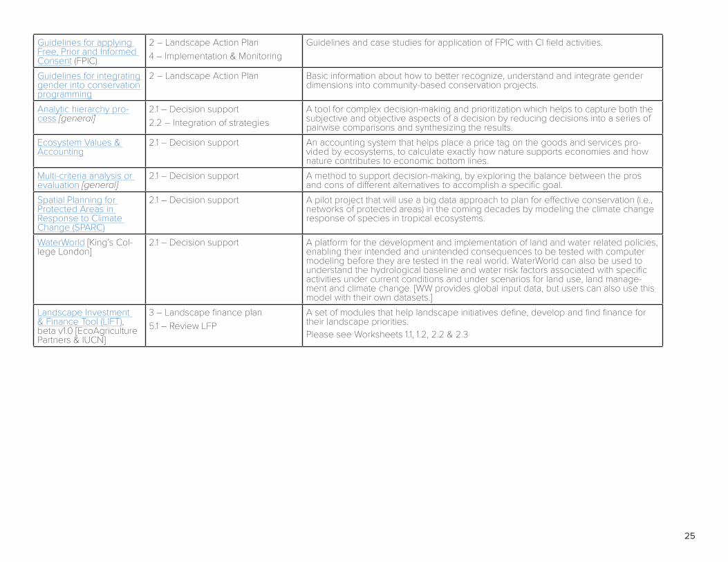
25
Guidelines for applying Free, Prior and Informed Consent (FPIC)
2 – Landscape Action Plan4 – Implementation & Monitoring
Guidelines and case studies for application of FPIC with CI field activities.
Guidelines for integrating gender into conservation programming
2 – Landscape Action Plan Basic information about how to better recognize, understand and integrate gender dimensions into community-based conservation projects.
Analytic hierarchy pro-cess [general]
2.1 – Decision support2.2 – Integration of strategies
A tool for complex decision-making and prioritization which helps to capture both the subjective and objective aspects of a decision by reducing decisions into a series of pairwise comparisons and synthesizing the results.
Ecosystem Values & Accounting
2.1 – Decision support An accounting system that helps place a price tag on the goods and services pro-vided by ecosystems, to calculate exactly how nature supports economies and how nature contributes to economic bottom lines.
Multi-criteria analysis or evaluation [general]
2.1 – Decision support A method to support decision-making, by exploring the balance between the pros and cons of different alternatives to accomplish a specific goal.
Spatial Planning for Protected Areas in Response to Climate Change (SPARC)
2.1 – Decision support A pilot project that will use a big data approach to plan for effective conservation (i.e., networks of protected areas) in the coming decades by modeling the climate change response of species in tropical ecosystems.
WaterWorld [King’s Col-lege London]
2.1 – Decision support A platform for the development and implementation of land and water related policies, enabling their intended and unintended consequences to be tested with computer modeling before they are tested in the real world. WaterWorld can also be used to understand the hydrological baseline and water risk factors associated with specific activities under current conditions and under scenarios for land use, land manage-ment and climate change. [WW provides global input data, but users can also use this model with their own datasets.]
Landscape Investment & Finance Tool (LIFT), beta v1.0 [EcoAgriculture Partners & IUCN]
3 – Landscape finance plan5.1 – Review LFP
A set of modules that help landscape initiatives define, develop and find finance for their landscape priorities.Please see Worksheets 1.1, 1.2, 2.2 & 2.3

26
Appendix 2: Examples of financial mechanisms to support sustainable landscapes This list serves as an example of the mechanisms available for financing sustainable landscape initiatives; however, it is not exhaustive.
MECHANISM (CI PROGRAM) CHARACTERISTICS TIME
FRAME CONDITIONS: WHEN & WHERE SUITABLE
REDD+ (Carbon Fund)
Support to access results-based payments for reduced deforestation & forest degradation & for enhancement of carbon stocks
10+ years
- Significant deforestation/degradation is occurring, or reforestation/restoration is planned, that can be addressed through intervention & will generate emissions reductions & removals (ERRs)
- National & sub-national governments are creating a pathway for nesting - Only applicable to ecosystems meeting national definitions of forests (can include mangroves) - In the past, CI supported projects to use VCS & CCB Standards to generate verified ERRs but moving forward projects will need to be nested within national & jurisdictional programs. Nesting pathways are unclear & are only in early development in some countries. Nesting will involve integration of project reference levels, MRV & safeguards information into government systems, possibly not using VCS & CCB Standards.
Trust funds (Global Conservation Fund)
Support for establishment of a legally independent fund to provide long-term grant finance for managing natural capital
10+ years
- Areas of significant biodiversity & ecosystem service value where long-term finance is required for recurrent management costs to maintain values e.g., for protected areas
- Long-term conservation tenure has been secured. - Particularly relevant where there is a gap in public or other finance - Government & other key stakeholders such as indigenous & local communities are committed to conservation & are seeking support to build management capacity & secure long-term finance.
- Donor(s) identified interested in contributing significant endowment funds Accelerator fund (Conservation Ventures)
Loans to sustainable production/SLS enterprises to enhance investment readiness, to scale up & to test innovations
1-3 years
- Enterprises must generate positive, measurable environmental & social impacts alongside financial returns
- Seed funding (early stage) for novel market-based approaches that disrupt or replace existing production model & have potential for large scale impact
- Scaling funding (mid-stage) for enterprises with viable, proven business models needing capital to grow
- Catalyzing (bridging) targeted investment to mobilize larger additional investment for opportunities where follow-on investment/offtake is identified
- Priority sectors include agriculture, forestry, livestock, seafood, eco-tourism & natural products - Initially focusing in 2018 in Kenya, S. Africa, Colombia & Peru. Seascape/oceans-related investments may have broader geographic focus but within CI marine programmatic priority areas (ETPS, Pacific Oceanscape, Bird’s Head Seascape, Sulu Sulawesi Seascape, Abrolhlos Seascape, etc.)
Conservation agreements (Conservation Stewards Program)
Support to establish agreements with communities providing direct incentives for conservation through a negotiated benefit package in return for conservation actions
3-10 years
- Site offers valuable & measurable conservation outcomes (e.g., species protected, hectares protected)
- There is a funder with a strong interest in supporting conservation at the site - There is a capable implementer ready to manage engagement, agreement design & implementation
- There are local resource owners/managers/users who can serve as the agreement counterparts, who can perform identified activities to deliver conservation outcomes
- The scale of the funding & the agreements is likely to provide sufficient incentives to cover opportunity & implementation costs to achieve conservation outcomes
- Can be used to structure relationship with local resource owners/managers/users, directing finance from other mechanisms (REDD+ payments, trust fund disbursements, PES programs, etc.)

27
Supply chain partnerships (CELB Sustainable Food & Ag Program)
Support with engaging international commodity production & sourcing companies in transformations to sustainable practices
3-10 years
- Commodity production for international markets is linked to SLS goals e.g. driver of deforestation with potential for adoption of sustainable practices
- International production/sourcing companies can be identified with specific interest in SLS commodities
- Company has made sustainable supply chain commitments - Investment or partnership such as sourcing agreement, extension services can help company meet their commitments & support SLS goals
Commercial Investment in Green Infrastructure (e.g., Blue Energy, Water & Cities)
Support to establish sustainable mechanisms for investments in green infrastructure
5-20 years
- Green infrastructure generates ecosystem services with significant & measurable commercial value to users (e.g., forest cover to reduce siltation)
- Land owners/managers can implement or refrain from activities at sufficient scale to maintain or build green infrastructure which in turn maintains or increases the value of ecosystem services
- Ecosystem service users are willing to pay for ecosystem services – could be via a public fund or an aggregation mechanism
- Potential example is water utility/hydro dam which values maintenance of forest cover to maintain water flow regularity, reduce siltation etc.
Grants (potentially CF, CSP, GCF as part of funding package)
Short term targeted financial support to develop enabling conditions & leverage additional longer-term finance
1-5 years
- Can be used for feasibility studies, capacity building, institutional development, etc. depending on needs & conditions of granting agency.
- Recipient needs proven capacity to manage funds & deliver agreed outcomes. - No repayment required but need to report on achievement of agreed objectives - Depends on availability of funds within Global Conservation Fund, Carbon Fund, Conservation Stewards Program, etc.
Grants (Global Environment Facility Agency)
Large scale grant finance to empower national governments & partners to generate global environmental benefits in support of human well-being, through stewardship of natural capital
3-5 years?
- Proposals aligning with national priorities approved by the national focal point for the Convention on Biological Diversity
- Within priorities of CI GEF Agency – i) improving Natural Capital Conservation & Governance; ii) Improving Sustainability of Production in Terrestrial & Marine Ecosystems; iii) Preventing Loss & Degradation in Ridge to Reef Ecosystems; iv) Ensuring a Sustainable Flow of Ecosystem Services
- Dependent on GEF allocation available to the country in current funding cycle
Grants (Green Climate Fund Agency)
Large scale grant finance for transformational shift in countries’ climate resilience & green economies, through both adaptation & mitigation
3-5 years?
- Proposals aligning with national priorities approved by the nationally designated authority for the UN Framework Convention on Climate Change