sustainable futures for europe’s - hercules … · 1 december 2013 – 30 november 2016 ... first...
TRANSCRIPT

1
SUSTAINABLE FUTURES FOR EUROPE’S
HERITAGE IN CULTURAL LANDSCAPES: Tools for understanding, managing, and protecting
landscape functions and values
MID-TERM ASSESSMENT REPORT
This project has received funding from the European Union’s Seventh
Framework Programme for research, technological development and
demonstration under grant agreement no 603447.
FP7, Collaborative Project
1 December 2013 – 30 November 2016

2
Berlin / Copenhagen, July 2015
COMPILED BY
Kathrin Trommler & Tobias Plieninger
CONTRIBUTORS
HERCULES team
COVER PICTURES
Thanasis Kizos, Maurice de Kleijn, Berta Martín López (f.l.t.r.)
CONTACT INFORMATION

3
Contents
Abbreviations ......................................................................................................................................... 5
List of partners ....................................................................................................................................... 6
1 Objectives ....................................................................................................................................... 7
1.1 General objectives ................................................................................................................... 7
1.2 Objectives for the reporting period.......................................................................................... 7
2 Work progress and achievements during the reporting period ...................................................... 8
Goal 1: To organise and develop a preliminary synthesis of existing knowledge on patterns,
drivers and outcomes of persistence and change in Europe’s cultural landscapes ........................ 8
Assessment criterion 1: Interdisciplinary cultural landscapes framework developed ................... 8
Assessment criterion 2: Protocols for all reviews available........................................................... 9
Assessment criterion 3: First draft reviews on drivers, outcomes and actors of landscape
dynamics finished......................................................................................................................... 12
Goal 2: To initiate targeted case studies to develop in-depth insights on dynamics and values of
cultural landscapes ........................................................................................................................... 16
Assessment criterion 4: Five case study landscapes selected and documented ........................... 16
Assessment criterion 5: Interdisciplinary protocol for case study work set-up ........................... 18
Assessment criterion 6: Compiled timelines of cultural landscape change for study areas......... 21
Assessment criterion 7: Spatial Data Infrastructure (SDI) for linking geographical,
archaeological, historical and ecological data and information set-up ........................................ 24
Goal 3: To contribute to the development of a typology of cultural landscapes and an up-
scaling of case study insights using observations and landscape modelling ................................... 26
Assessment criterion 8: Heritage-sensitive typology of cultural landscapes available................ 26
Assessment criterion 9: Indicator geodatabase and description of input data, methodology
and data quality available ............................................................................................................. 29
Assessment criterion 10: Multi-scale scenario framework documented...................................... 31
Assessment criterion 11: First results of model-based analysis of threats and opportunities
for cultural landscape development under alternative scenario conditions available .................. 33
Goal 4: To develop visions for re-coupling social and ecological components in cultural
landscapes and translate them into policy and management options ............................................... 35
Assessment criterion 12: European-scale survey on landscape practices performed and
analysed ........................................................................................................................................ 35
Assessment criterion 13: Outline of roadbook on best landscape practices available ................. 37
Assessment criterion 14: Stakeholder engagement and communication strategy established
and implemented .......................................................................................................................... 39
Assessment criterion 15: First stakeholder workshops at EU level performed ........................... 42
Goal 5: To design a community-based Knowledge Hub for Good Landscape Practice and
demonstrate good landscape practices with land-users, agencies, SMEs and citizen associations . 45

4
Assessment criterion 16: Prototype of web-based GIS application for crowdsourcing
powered data collection available ................................................................................................ 45
Assessment criterion 17: Prototype of smartphone based application for crowdsourcing
powered data collection developed .............................................................................................. 47
Assessment criterion 18: First stakeholder workshops in study landscapes performed .............. 49
Assessment criterion 19: First cultural landscape days performed .............................................. 53
3 Further project highlights ............................................................................................................. 56
3.1 Expanding the European reviews on landscape change, values, and practices ..................... 56
3.2 Conceptualising landscape stewardship ................................................................................ 56
3.3 Advancing methods for analysing landscape change and values .......................................... 57
3.4 Developing landscape as a core theme of sustainability science .......................................... 58
3.5 Inviting the community of science and practice .................................................................... 59
3.6 Development of the HERCULES Knowledge Hub .............................................................. 59
4 Project management ..................................................................................................................... 61
4.1 Tasks and achievements ........................................................................................................ 61
4.2 Project planning and status .................................................................................................... 62
5 Overview of core dissemination components achieved .................................................................... 63
6 Overview of work planned for the second half of the project...................................................... 66
7 List of publications ....................................................................................................................... 67
8 List of presentations ..................................................................................................................... 69
9 List of other dissemination activities ........................................................................................... 71

5
Abbreviations
CAP: Common Agricultural Policy
CLD: Cultural Landscapes Day
DoW: Description of Work
ILIs: Integrated Landscape Initiatives
EHD: European Heritage Days
ELC: European Landscape Convention
ELO: European Landowners’ Organization
FP7: EU’s Seventh Framework Programme for Research
GIS: Geographic information system
GPMJ Grand Parc Miribel Jonage
HERCULES: Sustainable Futures for Europe’s Heritage in Cultural Landscapes
LULC: Land-use / land cover
NGO: Non-governmental organisation
PSC: Project Steering Committee
REFIT: European Commission’s Regulatory Fitness and Performance Programme
SDI: Spatial Data Infrastructure
SME: Small and medium-sized enterprises
WP: Work package

6
List of partners
Table 1.1. List of HERCULES partners, their short names, countries of origin and form of
organisation.
Name Short name Country Form of
organisation
Humboldt-Universität zu Berlin UBER Germany University
University of Copenhagen UCPH Denmark University
Perez Girod Geneviève / Conseil
Innovation Management et
Environment
CIME France SME
European Landowners’ Organization ELO Belgium NGO
Forest Communications Network Ltd. FOC United
Kingdom
SME
Landscape Research Group LRG United
Kingdom
NGO
Sinergise Laboratorij za geografiske
informacijske sisteme
SIN Slovakia SME
Stichting VU-VUmc / VU University
Amsterdam
VU/VUmc Netherlands University
Eidgenössische Forschungsanstalt WSL
/ Swiss Federal Institute WSL
WSL Switzerland Research Institute
Tallinn University TU Estonia University
Albert-Ludwigs-Universität Freiburg ALU-FR Germany University
University of the Aegean UAEGEAN Greece University
Uppsala Universitet UU Sweden University

7
1 Objectives
European cultural landscapes are valued as everyday living environment, countryside, heritage,
scenery with aesthetic and recreational qualities and unique biodiversity and as a source of
ecosystem services that they provide to society. Cultural landscapes, however, are undergoing
rapid and fundamental transformations across Europe, mainly as a result of an on-going
polarisation of land-use, with abandonment and rural exodus on the one hand, and intensification
and urbanisation or peri-urbanisation on the other. Although the specific drivers and outcomes of
these processes vary across Europe, a central tendency is the fundamental decoupling of the
social and ecological sub-systems in cultural landscapes: linkages between people and nature, in
many parts of Europe often tightly linked historically, disperse increasingly. This leads to the
degradation of biodiversity and cultural heritage values, and renders the future of many of these
landscapes highly uncertain.
1.1 General objectives
The HERCULES project strives for the empowerment of public and private actors to protect,
manage and plan for sustainable cultural landscapes at local, national and pan-European scales.
HERCULES has the goal to increase understanding of drivers, patterns and social-ecological
values of European cultural landscapes and to use this knowledge to develop, test and
demonstrate strategies for their protection, management and planning.
Key research aims are to:
Synthesize existing knowledge on the drivers, patterns and outcomes of persistence and
change in European cultural landscapes;
Close knowledge gaps regarding the dynamics and social-ecological values of cultural
landscapes;
Generate tools for landscape observation and modelling in order to understand values of and
threats to cultural landscapes in Europe;
Develop a strong vision of pathways towards protecting landscape services;
Provide policy makers and practitioners with a cutting-edge Knowledge Hub to guide
decision-making for the benefit of cultural landscapes (http://kh.hercules-landscapes.eu).
1.2 Objectives for the reporting period
In order to achieve the general objectives, the HERCULES consortium defined concrete goals to
be reached during the first reporting period:
1) To organise and develop a preliminary synthesis of existing knowledge on patterns, drivers
and outcomes of persistence and change in Europe’s cultural landscapes;
2) To initiate targeted case studies to develop in-depth insights on dynamics and values of
cultural landscapes;
3) To contribute to the development of a typology of cultural landscapes and an up-scaling of
case study insights using observations and landscape modelling;
4) To develop visions for re-coupling social and ecological components in cultural landscapes
and translate them into policy and management options;
5) To design a community-based Knowledge Hub for Good Landscape Practice and
demonstrate good landscape practices with land-users, agencies, SMEs and citizen
associations.

8
2 Work progress and achievements during the reporting period
This chapter is intended to be a critical assessment of progress with respect to the goals set out in
the project’s Description of Work (DoW). For each goal below, assessment criteria have been
specified which are clearly linked to Work Packages (WPs) and deliverables.
Goal 1: To organise and develop a preliminary synthesis of existing knowledge on
patterns, drivers and outcomes of persistence and change in Europe’s cultural
landscapes
Assessment criterion 1: Interdisciplinary cultural landscapes framework developed
In Europe, landscape research has received broad attention since the adoption of the European
Landscape Convention (ELC). More recently, landscape approaches have found substantial
resonance also outside Europe. Landscape studies are diverted into a wide array of disciplines.
This illustrates that landscapes are meeting points for different disciplines, theories, concepts,
analytical tools and scales. Therefore, a landscape approach can be deemed particularly useful for
the highly complex research field on society-ecosystem interactions in the context of
sustainability. HERCULES has a particular focus on dynamics, actors and cultural values around
landscapes.
WP1 (Pan-European systematic review and meta-analysis) strives for a common understanding of
core concepts in HERCULES. Therefore, it developed a cultural landscape framework – mapping
problems, analysing cultural landscapes and finding a way forward. The framework is part of the
Report describing the cultural landscapes framework developed, including a dictionary of terms
(deliverable 1.1). The report was co-authored by all WP leaders. An elaborated version was later
published as an article in “Ecology and Society”, titled “Exploring ecosystem-change and society
through a landscape lens: recent progress in European landscape research” (Plieninger et al.
2015).
In order to develop the cultural landscapes framework, the authors reviewed and synthesized
findings from six important areas of landscape research in Europe and discussed how these
findings may advance the study of ecosystem change and society and its thematic key priorities.
The report is centred on the following key characteristics of cultural landscapes:
1) Landscapes are shaped by the connections and disconnections between people and their
environment.
2) Landscapes exhibit important biophysical structures and land-use intensities.
3) Landscapes have experienced long-term histories, which have left land-use legacies that
critically determine the functions and values of many contemporary landscapes.
4) Landscapes are undergoing change at different rates, with a multiplicity of driving forces,
processes, actors and outcomes.
5) Landscapes entail broad and diverse sets of values and meanings for people.
6) Landscape governance can follow a preservation or a stewardship approach, with the latter
becoming increasingly influential.
Six research areas form the basis of the cultural landscape framework (Fig. 1):
1) Linkages between people and the environment in landscapes;
2) Landscape structure and land-use intensity;
3) Long-term landscape history;
4) Driving forces, processes and actors of landscape change;
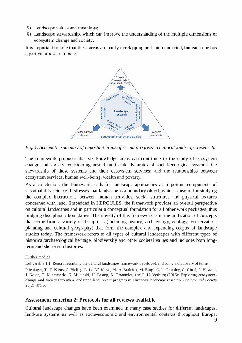
9
5) Landscape values and meanings;
6) Landscape stewardship, which can improve the understanding of the multiple dimensions of
ecosystem change and society.
It is important to note that these areas are partly overlapping and interconnected, but each one has
a particular research focus.
Fig. 1. Schematic summary of important areas of recent progress in cultural landscape research.
The framework proposes that six knowledge areas can contribute to the study of ecosystem
change and society, considering nested multiscale dynamics of social-ecological systems; the
stewardship of these systems and their ecosystem services; and the relationships between
ecosystem services, human well-being, wealth and poverty.
As a conclusion, the framework calls for landscape approaches as important components of
sustainability science. It stresses that landscape is a boundary object, which is useful for studying
the complex interactions between human activities, social structures and physical features
concerned with land. Embedded in HERCULES, the framework provides an overall perspective
on cultural landscapes and in particular a conceptual foundation for all other work packages, thus
bridging disciplinary boundaries. The novelty of this framework is in the unification of concepts
that come from a variety of disciplines (including history, archaeology, ecology, conservation,
planning and cultural geography) that form the complex and expanding corpus of landscape
studies today. The framework refers to all types of cultural landscapes with different types of
historical/archaeological heritage, biodiversity and other societal values and includes both long-
term and short-term histories.
Further reading
Deliverable 1.1. Report describing the cultural landscapes framework developed, including a dictionary of terms.
Plieninger, T., T. Kizos, C. Bieling, L. Le Dû-Blayo, M.-A. Budniok, M. Bürgi, C. L. Crumley, G. Girod, P. Howard,
J. Kolen, T. Kuemmerle, G. Milcinski, H. Palang, K. Trommler, and P. H. Verburg (2015): Exploring ecosystem-
change and society through a landscape lens: recent progress in European landscape research. Ecology and Society
20(2): art. 5.
Assessment criterion 2: Protocols for all reviews available
Cultural landscape changes have been examined in many case studies for different landscapes,
land-use systems as well as socio-economic and environmental contexts throughout Europe.

10
Despite profound conceptual and case study-level knowledge, however, a systematic synthesis of
existing case studies is lacking that goes beyond exemplary descriptions and abstract typologies.
To overcome this limitation, WP1 performs systematic reviews of main fields of research in order
to synthesize and build on existing knowledge. The main fields under investigation are:
1) The driving forces of landscape change in Europe;
2) The rates and patterns of landscape change;
3) The actors in the field of cultural landscape change, including their perceptions.
The reviews use both qualitative and quantitative techniques to identify commonalities across the
large number of existing European case studies and scrutinise which factors cause different cases
to behave differently. The reviews are based on searching scientific databases as well as the
internet for empirical studies on change of cultural landscapes in Europe. Study selection follows
a multi-level process and includes study quality assessment. As a first step, WP1 defined the
procedures for the three systematic reviews in three protocols.
1) The driving forces of landscape change in Europe
Background: The number of studies on the driving forces of landscape change in Europe has
grown considerably. However, the understanding of the drivers of landscape change remains
challenged because of the strong variation of existing case studies over disparate spatial and
temporal scales and the current fragmentation and dispersal of landscape research across many
domains and disciplines. Integration of this knowledge is needed as landscape is the most
relevant scale to address real-world sustainability problems. The aim of this study is to provide a
first systematic synthesis of the underlying drivers and proximate causes of landscape change
across Europe. A systematic review of the literature on landscape change identifies and
catalogues all available knowledge from a wide variety of sources. In particular, the review has
the following objectives: 1) to characterize how underlying drivers and proximate causes of
landscape change have been addressed in empirical case studies; 2) to identify and classify the
most important drivers and causes of change in European landscapes; 3) to evaluate which types
of actors are considered in landscape change studies and how their role is assessed; and 4) to
examine existing biases in the scientific literature related to particular environmental, land-use
and socio-economic attributes.
Methods: This systematic review is based on searching scientific databases as well as the internet
for empirical studies on the drivers and causes of landscape change in Europe. Study selection
follows a three-stage process. Stage 1: Synthesis of how different studies have addressed the
drivers, causes and actors of landscape change will be derived from the extracted information in a
narrative form. The relationship between different methods, scales and landscape contexts used in
the studies is explored through univariate statistics. Stage 2: Both single-factor and multi-factor
causations of underlying drivers and proximate causes of landscape change are identified. A
cluster analysis of cases is made to identify groups of studies that address typical combinations of
drivers, causes, and contexts of landscape change. Stage 3: To identify knowledge gaps, the
observed number of studies performed in a particular environmental, land-use and socio-
economic context is compared to the expected number, given that studies would be distributed
randomly.
2) Rates and patterns of landscape change
Background: Land-use change has contributed to reshaping European landscapes. Recent
research addresses the challenges that landscape change poses on environmental and social

11
aspects. The objective of this study is the implementation of a Pan-European systematic review of
the literature and meta-analysis on the quantification of landscape changes and rates and the
analysis of patterns they present at multiple scales. The literature review considers available
sources to enumerate all relevant studies and aims to: 1) provide estimations and measurements
when possible of land-cover and land-use change in landscapes across Europe; 2) provide
measurements of rates of persistence and change in multiple spatial scales, revealing acceleration
and deceleration of rates; 3) link landscape changes to the driving forces concept; and 4) to
examine existing biases in the scientific literature related to particular scales, rates, drivers,
processes and landscape attributes. The outcome of the study is expected to fill the gaps in
landscape change literature, reveal current trends in landscape change in Europe and provide
evidence to improve policy-making at a landscape level.
Methods: Characterization of the rates of landscape change and persistence is synthesized in a
narrative form. The relationship between different methods, scales and landscape contexts used in
the studies is explored through univariate statistics, e.g. through Chi-square tests. The
identification of the rates of change is carried out through frequency analysis across all study
cases. Both single-factor and multi-factor causations are identified. Further contextual
information (e.g., on population density, gross domestic product, drivers of change) is included.
3) Actors: Integrated Landscape Initiatives in Europe
Background: We further specified the complex and diverse field of landscape actors and put an
emphasis on collaborative approaches that work towards intersectorial acknowledgement and
fostering of services that landscapes provide to human well-being. The number of such integrated
landscape initiatives (ILIs) has increased strongly over the last decades. The characteristics of
these initiatives vary in terms of location, scale, organisation, funding, size, professionalism,
stakeholders, etc. Notwithstanding the importance of the ILIs for European cultural landscapes,
very little is known about their spectrum in the continent. Their spatial distribution and the range
of landscape values addressed by the ILIs remain uncertain. Having an overview of these
initiatives in Europe contributes to making them more effective, to enabling a better management
of their resources, to taking advantage of their potentials and to mitigating their constraints.
Moreover, the exchange of experiences and ideas could be triggered. Bearing this in mind, the
aim of this review is to provide a systematic analysis of the spectrum of the initiatives that
contribute to the safeguard of landscape services in Europe. Therefore, the review has the
following objectives: to find varied, well distributed and relevant examples of ILIs, to create a
typology of ILIs and to recognise the gaps, potentials and constrains of the ILIs existing in
Europe.
Methods: The methodology proposed is based on systematic internet searches, on the canvassing
of HERCULES experts, umbrella organisations and representatives of the ILIs and on an online
survey with selected ILIs. The collection of information is based on a two-stage procedure: 1)
Gathering of basic information on potential ILIs in order to further contact their representatives
and to delete the ones that do not qualify as ILIs, and 2) collection of detailed information on
each ILI by inviting all of the representatives to participate in an online survey.
Further reading:
Deliverable 1.2. Systematic review protocol.

12
Assessment criterion 3: First draft reviews on drivers, outcomes and actors of
landscape dynamics finished
The driving forces of landscape change in Europe
The review of the proximate causes and underlying drivers of landscape change selected 144 case
studies in 23 European countries (Fig. 2) out of an initial set of 2,190 published papers.
Fig. 2. Map of case study sites and number of case studies per country in the review of proximate
causes and underlying drivers of landscape change.
First, the results show that research on landscape drivers is diverse, covering multiple disciplines,
methods as well as spatial and temporal scales. We find a significantly positive correlation
between the number of landscape change studies in a country and its GDP, and studies are
significantly more frequent in EU/EFTA member countries, compared to non-member states.
Also, we reveal gaps regarding long-term longitudinal studies, multi-scale analyses, cross-site
comparisons and quantitative methods for analysing underlying drivers.
Second, the analysis of proximate causes (Fig. 3) of landscape change reveals that land
abandonment is a dominant process. Urban and industrial development, agricultural
intensification and expansion and expansion and intensification of forestry are wide-spread as
well. The analysis shows some typical geographical patterns, with land abandonment being most
frequent in the Mediterranean and Eastern European countries. Opposing causes of landscape
changes frequently act in close spatial proximity (e.g. land abandonment and agricultural
intensification). Novel processes of landscape change (e.g. spread of wind turbines or expansion
of biomass production) have been rarely covered. Third, political and institutional factors, in
particular agricultural and forestry policies, are the most frequently identified underlying drivers.
Most typically, however, combinations of underlying drivers are controlling landscape change,
rather than single key variables. The most frequent combination to be found is the interplay of
political / institutional, economic, cultural, technological and natural / spatial driving forces.

13
Fig. 3. Causal patterns of landscape change in Europe, as revealed in the review of proximate causes and underlying drivers (n=144).

14
Rates and patterns of landscape change
The review of the rates and patterns of landscape change was based on a selection of 45 case
studies including 65 different types of landscape change rates in 16 European countries out of an
initial set of 2,346 published papers. The relatively limited number of papers is a result of the
need to calculate annual rates of change and is a small subset of the total numbers of the
preselected papers (742 papers). The conceptual approach distinguished between the rate for
individual changes within a landscape (e.g. a rate for urbanization and a different rate for
abandonment in the same landscape) and the magnitude of changes in the landscape, calculated
by the percent of area that the particular change affected. The combination of the rate and the
magnitude results in the overall change rate for the landscape as a whole from very slow to fast
changes (Fig. 4). The rates were related with 11 different processes of land change (adapted from
van Vliet et al., 20151): Four reflecting intensification processes (increase in agricultural land
area, decrease in landscape elements, increase in management intensity, change in agricultural
land-use activities and specialization/monoculture), five reflecting disintensification processes
(land abandonment, increase in landscape elements, decrease in management activities, change in
agricultural land-use, on farm diversification) and one reflecting urbanization.
Fig. 4. Annual rates, magnitude and type of change for the case study landscapes analysed in the
review.
The results show that research on landscape change rates is quite diverse, covering multiple
disciplines, methods as well as spatial scales, with 38% being areas smaller than 100 km² and
13% larger than 10000 km², and sources that include satellite images (35% of the total case
studies), aerial images (47%), historical maps (13%) and CORINE data (17%). Spatially, half of
1 van Vliet, J., H.L.F. de Groot, P. Rietveld, and P.H. Verburg (2015) Manifestations and underlying drivers of
agricultural land use change in Europe, Landscape and Urban Planning 133:24–36.
Very slow
(N=16)
Slow
(N=17)
Fast
(N=15)
Rapid
(N=15)
Annual rate of
change
Small
(N=33)
Large
(N=30)
Type of change
Magnitude of
change
Increase in agricultural land
area (N=5)
Category of
change
Very Slow
(N=18)
Slow
(N=28)
Fast
(N=16)
Rapid
(N=1)
Decrease in landscape
elements (N=6)
Land abandonment
(N=17)
Increase in landscape elements (N=22)
Urbanization (Ν=13)
5
11 5 6
17
1
14 2 1
14
14
6 10 9 11
3 2 1 4 1
8 3 5 5 5 3 14 5 1 3

15
the case studies are in the Mediterranean, and land abandonment processes are dominant in these.
The analysis of rates reveals important differences (Fig. 5), with a statistically significant and
positive correlation between the magnitude of change and the rate of change.
Integrated Landscape Initiatives (ILIs) in Europe
In this review, 71 initiatives from 23 European countries have been analysed (out of an initial set
of 338 ILIs identified and invited to the survey).
First results show that most of the ILIs have been created due to the initiative of local people and
roughly a quarter due to an external incentive. Independently of their origin, the most common
aims of the ILIs are the conservation of nature, the promotion and protection of the cultural
heritage and local memory and the enhancement of the beauty of landscape. Nevertheless, these
aims never go alone but in combination with other aims, highlighting the holistic character of the
initiatives. Linked to this integrated character, the analysis has proved that ILIs also foster inter-
sectorial coordination and multi-stakeholder process.
In line with the aims, the most common activities developed by the ILIs are: efforts to preserve
and promote cultural heritage, awareness raising activities towards landscape and efforts to
strengthen the sense of community. The activities and outcomes have been synthesised in
domains in Fig. 6. The chart reveals that the domains where a higher proportion of activities and
outcomes have been developed and achieved are: heritage, culture and traditions and multi-
sectorial coordination and planning in issues affecting the landscape. A more detailed analysis on
typical patterns of successful and less successful ILIs shows that within these two domains, the
activities that have yielded a relatively high proportion of outcomes are those working towards: a)
the support of integrated landscape management among the public, b) the improvement of the
cooperation in issues related to landscape among different stakeholders and sectors, and c) the
support for traditional knowledge, local culture and historical physical heritage protection among
the public. To conclude, it is noteworthy that after the problem of lack of funding, the most
frequent problems are related with political and institutional issues, such as: political shifts that
threaten the permanency of the initiative’s achievement, narrow-minded and tight policies that
block the development of the initiative, lack of broader institutional support and low level of
public support.
Fig. 6. Activities developed and outcomes obtained by the Integrated Landscape Initiatives.
0%
10%
20%
30%
40%
50%
60%
70%
Heritage, culture and
traditions
Multi-sectorial
coordination and planning
Conservation and natural
resource management
Livelihoods and human
well-being
Farming and agriculture
Activities Outcomes

16
For all three reviews first drafts have been written, and the full version of the reviews will be
submitted as Deliverable 1.3 by November 2015.
Goal 2: To initiate targeted case studies to develop in-depth insights on
dynamics and values of cultural landscapes
Assessment criterion 4: Five case study landscapes selected and documented
HERCULES develops insights, tools, technologies and strategies and applies and tests these at
regional case studies that span major environmental and land-use history gradients throughout
Europe. As a project that specifically refers to landscapes, the case studies form a cornerstone for
HERCULES.
The case study selection was a joint enterprise, led by WP3 (Landscape-scale case studies, short-
term history) to which all HERCULES partners contributed. This process resulted in the
identification of study landscapes which span a variety of different characteristics (e.g. the major
biogeographical zones of Europe), include both outstanding heritage features and everyday
landscapes with more hidden historical layers, cover rural and urban areas and are all firmly
embedded in the project via a local contact person who is member of the HERCULES consortium
(Fig. 7). As it turned out that some WPs have specific requirements in regard to access to
stakeholders, availability of historical maps etc., the consortium decided to select a total of nine
case study landscapes (rather than the originally planned five to six landscapes). Usually, WPs
will perform fieldwork in around five areas out of this pool of case study landscapes.
For this, the homogenisation of material from different languages and administrative systems had
to be achieved; moreover, all project partners needed to develop a common understanding of the
potential of different proposed sites, from an integrative point of view beyond specific
disciplinary or geographic interests. Therefore, the successful selection of the study landscapes
can be regarded as an exercise for and demonstration of the consortium’s capacity to work as
joint and target-oriented team.

17
Fig. 7. Overview map of HERCULES study landscapes.
In a second step, a detailed profile for each area was created. All study landscapes are described
regarding their exact location, basic environmental characteristics, history, current
sociodemographic and economic as well as landscape characteristics. The descriptions are based
on information provided by those HERCULES consortium members that serve as contact persons
for the respective study landscapes. This text is complemented by an orthophotograph, a
topographic map and a land cover map (based on CORINE data) for each study landscape, and if
applicable, additionally for the focus area/study municipality for in-depth and stakeholder
interaction-related investigations (Fig. 8).

18
Fig. 8. Left: Orthophoto of the study landscape Vooremaa and Kodavere (Estonia). Centre:
Topographic map of the study landscape Lesvos (Greece). Right: Land cover map of the study
landscape Sierra de Guadarrama foothills (Spain).
More information on the study landscape has been collected (e.g. indicating references and
available historical maps and providing practical information on contact details for local actors).
They are made available to all project members via the HERCULES Knowledge Hub.
The study landscape descriptions serve not only as a reference for all specific tasks connected to
the case studies, but as a starting point and common basis for developing a comparative view on
European landscapes, e.g. by developing and testing hypotheses on specific drivers of landscape
change.
Further reading
Deliverable 3.1. List and documentation of case study landscapes selected for HERCULES.
Assessment criterion 5: Interdisciplinary protocol for case study work set-up
A case study approach is at the core of HERCULES research on long-term history of landscape
change, carried out by WP2 (Studying long-term landscape change). The principal aim is to
enhance methodologies to collect data and to create knowledge about the long-term dimension of
cultural landscape change. One of its objectives is to define an innovative methodological
procedure for understanding the long-term development and transformation of cultural
landscapes, drawing on recent insights from geography, landscape archaeology, (historical)
ecology, anthropology and information science. The concrete possibilities of these innovative
methodologies are explored by adopting a case study approach. This is done for three different
areas, each being representative for more widespread environmental and climatic conditions
within Europe: Atlantic (the Dutch river delta Rhine-Meuse), Boreal (the Uppland area, Sweden)
and Continental (Vooremaa and Kodavere, Estonia) (Fig. 9).

19
Fig. 9. Study landscapes Dutch river delta Rhine-Meuse (Netherlands), Uppland area (Sweden),
Vooremaa and Kodavere (Estonia) (from left to right).
In order to assess the long-term interactions between social and natural drivers more accurately
and systematically, three different concepts were integrated: 1) Landscape biographies, 2)
Historical ecology, and 3) Complex systems approach. While the frameworks largely overlap,
landscape biographic approaches focus on the regional scale of analysis and are more explicitly
phenomenological and aimed at heritage studies, while historical ecological approaches are multi-
scalar and are more comprehensive and explicitly empirical. Both frameworks embrace the
stakeholders, planners and managers of landscapes.
Based on these concepts, the protocol describes innovative methodological procedures for
integrating long-term landscape history with
Geodesign: In order to create a suitable work flow for planning and designing sensitive to the
long-term character of processes and the historical foundations of societal values.
Spatial Data Infrastructure: In order to develop an infrastructural facility for retrieving and
linking archaeological, historical and ecological data and geo-information by academia as
well landscape management practitioners (for more detail see assessment criterion 7).
Dynamic geospatial modelling: In order to adopt and further enhance models that are able to
close the gap between static mapping aimed at heritage professionals and dynamical
modelling designed for academic research.
As part of the protocol, we specify a set of premises for understanding long-term changes in
cultural landscapes as well as a number of operational principles for translating these premises to
concrete starting points, procedures, methods and techniques in individual or comparative
landscape projects. Taking the set of premises as its methodological starting point, the protocol
does not produce a single paradigm but rather offers a toolbox of concepts and competencies. At
the same time, the premises can be chosen as explicit theoretical guidelines for research projects
that tackle long-term changes in cultural landscapes.
Set of premises for understanding long-term changes in cultural landscapes:
Coupled human-natural systems are the most complex systems we know.
A complex systems approach offers a useful focus for the study of coupled human-natural
systems.
Much of what we know about such systems cannot be based on extrapolation from present
conditions.
Diversity plays a critical role in ensuring resilience to systemic shocks.
A region’s linked human and environmental history contains information about how it
responds to extremes.

20
Knowledge of past management strategies can help to avoid earlier mistakes or, in the case
of good results to a particular strategy, offer viable alternatives to a similar contemporary
challenge.
Knowing a system’s history can be seen as using completed experiments undertaken in the
laboratory of the past.
Landscape change is affected by forces at all spatial scales, from local to global.
Landscapes have their own temporalities and rhythms.
The holistic form of historical ecology that we employ is theoretically and methodically
strong.
An explicit research question of landscape biography is to investigate the power of existing
landscapes on people and their spatial practices, as well as the dynamic way in which people
have dealt with their environment through time.
Landscape biography highlights the importance of social memory and the means to construct
“a chronicle of life and dwelling”.
Historical ecology and landscape biography both study long-term transformations in
landscapes.
Together, historical ecology and landscape biography can link social memories to the long
term, connecting the micro-histories of places to broad-scale developments, and integrating
experience and process.
Thus landscape biography and historical ecology view landscapes as palimpsests that are
transformed continuously, both through conscious interaction by people with the material
past in the environment and through less conscious forms of agency.
Set of operational principles for understanding long-term changes in cultural landscapes:
Commitment to begin with a research design constructed by all collaborating scholars and
evaluated/supported by relevant stakeholders who jointly decide central questions, elucidate
desired outcomes, and plan the data gathering, data merging, and interpretive phases of the
project.
Commitment to work with both quantitative and qualitative empirical data.
Commitment to integrate both academic and non-academic knowledge in a fashion, which
privileges neither and attempts to translate each to the other.
Commitment to employ data collected using “best practice” protocols for each relevant
discipline when available.
Willingness to keep independent from one another these various lines of evidence until such
time as discipline-based data gathering is considered sufficient, but also to keep researchers
themselves in constant dialogue.
Willingness to see conclusions about the history of a region constantly modified or reversed
by new, evidence-based interpretation.
Recognition that changes in knowledge about a region tend to have material (and thus
historical) effects in the region.
Recognition that evidential gaps (both spatial and temporal) raise questions about the
appropriate extent of extrapolation, leading to questions of scale and reliability.

21
Recognition that designers’ decisions about temporal and spatial parameters must be tied
both to desired outcomes and to available information about historical and on-going
processes of change.
Recognition that while “baselines” are very important, they have the potential to introduce
errors into later interpretations.
This approach aims to contribute to overall approaches for HERCULES by including future
management aspects and by enhancing the role of long-term thinking and analysis in geodesign,
urban planning, landscape design and stakeholder involvement. The technical aspects of the
testing, which involve the dynamic models and Spatial Data Infrastructure (SDI), are done in
close cooperation with the development of the HERCULES Knowledge Hub.
Further reading
Deliverable 2.1. Innovative interdisciplinary protocol for under-standing long-term landscape dynamics, based on the
perspectives of historical ecology, landscape biography, and complex systems theory.
de Kleijn, M., N. van Manen, J. Kolen, H. Scholten (2014): Towards a User-centric SDI Framework for Historical
and Heritage European Landscape Research . International Journal of Spatial Data Infrastructures Research 9, 1-35.
Kolen, J., H. Renes, and R. Hermans (eds.) (2015): Landscape Biographies. Geographical, Historical and
Archaeological Perspectives on the Production and Transmission of Landscapes. Amsterdam University Press,
Amsterdam.
Assessment criterion 6: Compiled timelines of cultural landscape change for study
areas
To reconstruct and assess the short-term past changes and dynamics of cultural landscapes, using
a case study approach, is the aim of WP3. Within the chosen HERCULES study landscapes
smaller scale study municipalities were distinguished in order to carry out a more detailed
analysis. For each study municipality WP3 prepared “Compiled timelines of cultural landscape
change” based on land-use / land cover (LULC) change analysis of maps and aerial images since
mid-19th
century from scales 1:10,000 – 1:50,000 digitised and generalised to 1:50,000 level.
Being wary of the perils in cartographic endeavours, the process of receiving Compiled Timelines
based on LULC change analysis was carried out by following previously defined steps:
1) Selecting study municipality (see assessment criterion 4);
2) Creation of a spatial data availability questionnaire that was sent out to study landscape
coordinators to select the best maps for our purpose;
3) Gathering of maps with the help of study landscape coordinators;
4) When needed, georeferencing maps or using the right projections for Web Map Service
providers;
5) Determining a suitable legend for each study municipality;
6) On-screen digitising;
7) Topology checking;
8) Eliminating mistakes:
9) Compiling of brief statistics.
The variety of available maps, scales and level of detail for each study municipality in different
natural, physical, political, social and cultural environment is enormous and does not justify
cross-study municipality comparisons on LULC level but provides basis for grasping change,

22
especially for a researcher whose study municipality is not his/her home landscape. Some
individual conclusions for compiled timelimes for specific study municipalities can be drawn:
Study municipality Alatskivi and Peipsiääre (Vooremaa and Kodavere, Estonia): Constant
struggle with amelioration has reduced the area of wetlands remarkably promoting forest in a
marginalised area where otherwise the landscape has been quite stable: massive forest with
mosaic village landscapes.
Study municipality Gera (Lesvos, Greece): The most remarkable change from 1960 to 2012
has been the decline of agriculture whereas the grassland and shrubs, especially wooded
grasslands and shrubs taking over based on mapping categories. Also the forest and built-up
areas are increasing as is the road network. Probably the processes of modernisation and
tourist influx have had impact on abandoning agriculture, which in turn may negatively
affect tourism industry that is in search for traditional olive landscapes.
Study municipality Lenk (Obersimmental, Switzerland): With the glaciers melting away bare
natural rock area grows slowly. No agriculture. Built-up area grows slowly. Grassland and
shrubs are decreasing and forest increasing, both fragmented. Linear infrastructures have
been modernised from main roads, railways to cable cars. It seems to be a rather natural
landscape with forest overgrowth.
Study municipality Colmenar Viejo (Sierra de Guadarrama foothills, Spain): 1946 seems to
be the crucial year, agriculture was in large amounts substituted with grasslands and shrubs;
forest area is minimal. Built-up area and quarries spread as it is situated NW from Madrid.
The landscape is criss-crossed with infrastructures: highways, railways and channels. A peri-
urban landscape that is in constant change (Fig. 10).
Study municipality Börje (Uppland, Sweden): Changes in the vicinity of Uppsala city do not
seem radical at all. Scattered mosaic land-use seems to have found its peri-urban equilibrium.
Typical mature polarisation is slowly under way: more monolithic fields appear and
grasslands and shrubs are taking over – perhaps as the urban way of life creeps into the
countryside leaving fields aside, or more eco-aware attitudes have emerged.
The compiled timelines of cultural landscape change will serve as a basis for “objective”
background against which comparison of other methods (e.g. oral history interviews, major
events and driving forces analysis, public participatory GIS, terrestrial photos etc.) can be done
forming landscape change trajectories as a case study approach. The mapping exercise results
will be uploaded to the HERCULES Knowledge Hub. The overall outcome should enhance the
understanding of perceived landscape change and improving comparative methods for achieving
that.

23
Figure 10. Colmenar Viejo (Sierra de Guadarrama foothills) land-use / land cover change
between 1875 und 2012. After agriculture had almost vanished by 1946, mostly formerly not used
areas have been used for agricultural production. The area of forest was half lost to agriculture.
Built-up area spreads. Urban area with grasslands and shrubs dominate today.
Further reading
Deliverable 3.2: Compiled timelines of cultural landscape change for the study landscapes.

24
Assessment criterion 7: Spatial Data Infrastructure (SDI) for linking geographical,
archaeological, historical and ecological data and information set-up
The availability of digital tools and data to study long term changes in the landscape has, over the
last decade, grown tremendously. Landscape scholars and landscape practitioners are more and
more digitally skilled and the use of geospatial technologies has grown significantly. Landscape
research is nowadays unthinkable without the use of Geographic Information Systems software as
a tool to analyse and visualise spatial phenomena.
To follow up on this trend, there are several aspects to take into account: First, the availability of
data; second, the variety of visualisation and analysis tools; third, the different levels of
Geospatial Information Literacy; and, fourth, the methods to share relevant information. WP2
focuses on these issues by discussing the implementation of a Spatial Data Infrastructure (SDI) to
facilitate the case study work.
The core function of an SDI is to enable users, beyond the level of a single institute or
organisation, to share geospatial information. The study of long-term landscape change would
benefit considerably from improved availability of data about the history and heritage of the
landscape and functionalities with which the data can be processed and shared through an SDI
(Fig. 11). Relating the SDI to the activities in WP2, three scenarios of usage can be distinguished.
1) SDI will be used by the spatial modellers to integrate and share their spatial information.
These users will work with the SDI to systematically store their information and share their
modelling outcomes within the partners of the WP. For these users, the SDI mainly functions
as a repository to integrate different data sources and process these as viewing, upload and
download services.
2) SDI will be used when interacting with local professionals. The SDI can be used as a
communication tool by providing viewing services to facilitate exchange of insights from
these models with local professionals. By not only offering static model outcomes but also
allowing the local professionals to go through the model input and bandwidths of outcomes,
the professionals can provide feedback based on their own knowledge and at the same time
increase their knowledge on past diachronic spatial dynamics.
3) SDI will be used for knowledge dissemination of the modelling activities. These activities will
take place in close collaboration with the Knowledge Hub developed in WP7. The modelling
results will be presented and sustainably preserved by WP7.

25
Fig. 11. Schematic overview over the Spatial Data Infrastructure set-up in WP2.
The SDI plays a primary role in WP2 attempts to incorporate socio-economic, political and
religious and ideological parameters. Data is collected (about natural characteristics and physical
properties; social-economic land-use and land-use systems; political and religious aspects of past
landscapes; and past experiences and meanings of landscapes) from a variety of data sources as
input for modelling long term landscape change. This has to date been done for two study
landscapes: the Dutch river delta Rhine-Meuse and the Swedish Uppland; the third study
landscape, Vooremaa and Kodavere in eastern Estonia, will be served during the next stage of the
project. Although the SDI has been developed and is fully operational offering the necessary
functionalities to support the data management for the long term landscape change modelling, it
must be noted that at the time of writing the modelling activities are still ongoing. Hence, the
modelling results have not yet been fully included into the SDI. Furthermore, the SDI offers the
required functionalities to share knowledge with local professionals, but these will only be put to
use once the modelling has been completed
The SDI developed is closely related to the WP7 Knowledge Hub. The final output and the
creation of a showcase interface will be done making use of the Knowledge Hub. Since WP2 has
applied standardized protocols for the mapping services published, the services will be
interoperable with the mapping interfaces developed for the Knowledge Hub. Ideally all the data
will be integrated in the WP7 repository. To this end, the WP2 SDI has adopted standardized data
and metadata standards to facilitate such transfer to the Knowledge Hub servers.
The purpose of this tool is to advance the interactions with local stakeholders. The WP2 case
studies Voorema and Kodavere and Dutch river delta Rhine-Meuse are subject to local
workshops organised in collaboration with WP8. The data management and modelling
26
visualisation conducted with the help of the WP2 SDI provides important input for the
workshops. In these workshops, the WP2 researchers not only seek to validate the data and
models used, but also explore with local heritage professionals the added value of the
visualisation tools. Such tools will include a biographical-historical ecology presentation of
landscape change through a cartographic reconstruction.
Further reading
Deliverable 2.2. Spatial Data Infrastructure (SDI) for linking geographical, archaeological, historical, and ecological
data and information for the case studies.
Goal 3: To contribute to the development of a typology of cultural landscapes
and an up-scaling of case study insights using observations and landscape
modelling
Assessment criterion 8: Heritage-sensitive typology of cultural landscapes available
A central task in assessing and synthesizing the existing knowledge dynamics, drivers, patterns
and outcomes of cultural landscape transformations is the development of a cultural landscape
typology, focusing explicitly on cultural heritage. The development of this typology takes place
in WP4 (Cultural landscape typology and recent dynamics). In a first step, we describe which
datasets are needed and will be used for this purpose, and to what type of landscape categories
this will lead for the final typology.
To date there is – to our knowledge – no European landscape typology with a specific focus on
cultural heritage. To fulfil this need, we propose a new typology of cultural landscapes focusing
specifically on the identification of cultural heritage within the landscapes of Europe. In this way
we provide an idea of the “allocation” of cultural heritage across Europe. To create this new
cultural landscape typology, we first identify how cultural heritage is incorporated in existing
typologies and landscape classifications. Although a European typology with the explicit focus
on cultural heritage is not available, many existing landscape typologies (on both a national and
continental scale) used indicators that can be useful. Using the cultural landscape framework (see
assessment criterion 1) as a starting point, we subdivided the review of these typologies in three
dimensions of the cultural landscape: 1) landscape structure and land-use intensity, 2) landscape
history, and 3) landscape value and meaning. Per dimension, we reviewed both national and
European typologies with the aim of drawing inspiration for the proposed typology. Subsequently
we propose a method for developing a new typology, based on three separate geospatial layers
(one for each dimension).
Landscape structure and land-use intensity
To capture the most important cultural aspect of the landscape, the first division of landscapes
will be made according to the land-use intensity and the landscape structure. The two concepts
combined tell us what the current use is of the landscape and are therefore indispensable to a
categorisation of any type of cultural landscape. A good starting point for the categorisation in
this layer is to look at differences in land cover. We will make a distinction between urban,
forest, grass, arable, mosaic, permanent crops and other land cover. The data for this distinction
will be drawn from the CORINE land cover maps. With data on field size, we can categorise
landscapes into small- or large-scale farming landscapes. The processed data on linear elements
(tree lines, stone walls, etc.) will be used to differentiate between open and enclosed landscapes.
Land-use intensity is more complex since it often cannot be derived directly from visual

27
observations. We will use nitrogen input classes as a proxy for land-use intensity. The mentioned
data sources and indicators give a good overview of the characteristics of croplands and
grasslands. To include forest in this typology, we will classify forest structure based on the
degree of fragmentation. This classification will lead to a set of classes differentiating landscapes
according to landscape structure and land-use intensity.
History
Most historical analyses of landscapes has been carried out locally on historical features on and
below the ground, typically based on intensive fieldwork. This is not feasible at the European
scale. Despite the current efforts of, for instance, the ARIADNE project to create a European
archaeological database, we have not found any suitable, consistent and European-wide data on
these types of indicators. During the actual mapping of the typology we will keep track and
possibly take stock of the progress of the ARIADNE project, especially with respect to advances
on spatial databases on archaeological heritage. The studies by Fuchs et al. (2013; 2014)2, give
good insight into the persistence of landscapes on a European scale and enable us to identify this
historical aspect of the landscape (Fig. 12). It should be noted that these data represent the
persistence of land cover and not necessarily the persistence of the landscape structure as the data
do not include a representation of landscape elements. Due to the data limitations described
above, the historical layer of our typology will be proxied by this persistence map. This layer is
therefore not to be considered as a map revealing historic landscapes. A landscape which is
situated in a pixel labelled non-persistent might still hold historical value. The persistence
indicator however does reveal those landscapes that were not disrupted by other land-use and
remained stable throughout the twentieth century. Combined with the first layer of this typology
this can give insights into the (recent) history of the landscape.
Value and meaning
From all three layers, value and meaning is the most difficult layer to operationalise due to both
its often intangible nature and its multi-faced interpretability. Measuring this dimension often
relies on the availability of proxies, especially for classifications on a continental scale. Since we
2 Fuchs, R., M. Herold, P.H. Verburg, and J.G.P.W. Clevers (2013): A high-resolution and harmonized model
approach for reconstructing and analysing historic land changes in Europe. Biogeosciences 10:1543-1559.
Fuchs, R., M. Herold, P.H. Verburg, J.G.P.W. Clevers, and J. Eberle (2014): Gross changes in reconstructions of
historic land cover/use for Europe between 1900 and 2010. Global Change Biology 21:299-313.

28
Fig. 12. Preliminary map of landscape persistence between 1900 and 2010.
are working at a European scale, many local indicators are not useful for our purposes. The most
obvious indicators of value and meaning on a European scale are the highly correlating aspects of
recreation and aesthetics. People tend to recreate in aesthetically pleasing landscapes and these
landscapes thus have a value and/or meaning and should therefore be identified in this typology.
Some landscapes can possess all characteristics of highly visually appreciated landscapes but are
less frequently visited by actual people due to their remoteness. We chose to incorporate this by
taking accessibility of the landscapes into account. Inaccessible landscapes will therefore score
“lower” on the visual preference map. Other indicators that we will use to approximate the
aesthetic and recreational value are camping locations and Panoramio photo locations. A different
indicator is based on Protective Designation of Origin of local food. This indicator will show
which regions produce geographically bounded local products. These type of values are
especially important since they consider the values of those who “belong” to the landscape.
By revealing the location of cultural heritage across Europe, our typology can help identifying
which landscapes deserve more attention in order to protect cultural heritage. The typology can
generate awareness of unique landscapes in Europe among policymakers, scientists and the
people. Moreover, the typology can unite those landscapes showing strong resemblance and cater
for better conservation of cultural heritage on those landscapes. The cartographic layers that will
be created for this typology will be made publically available via the HERCULES Knowledge
Hub. Through open access to the cartographic layers, the typology can be used for many purposes
by many different people. As such, the typology might become a useful tool for landscape
practitioners aiming at planning and conserving cultural heritage on landscapes.
Further reading:
Deliverable 4.1. Typology of cultural landscapes.

29
Assessment criterion 9: Indicator geodatabase and description of input data,
methodology and data quality available
Once a cultural landscapes map of cultural landscape distribution has been developed, it will
form the basis to assess how cultural landscapes have been transformed during the recent decades
in terms of land-use change. Thus, in D4.2, we give an overview of the indicators needed for an
assessment of the impacts of land-use change, pertaining to land conversions (e.g., farmland
abandonment or urban expansion) and changes in management intensity (e.g., changes in
fertilizer application or livestock stocking densities) (see Fig. 13).
We thus document the indicators that were gathered to map the dimensions of the proposed
typology – “Landscape structure and intensity” and “Landscape history” – as well as the
indicators that will be used to map land-use changes within cultural landscape in Europe,
pertaining to changes in the area-extent of broad land-use classes and the management intensity
within these classes. Table 1 provides a summary of the indicators gathered and documented. The
indicators used to describe the third dimension of our typology, “Landscape value”’, will be
documented further in Deliverable 4.4.
Table 1. Overview of indicators gathered.
Indicator Name of
Dataset
Short description Time period
covered
Used in
typology
generation?
Used for
assessing
land-use
change?
La
nd
co
ver
an
d
use
ex
ten
ts
Land Cover
2006
CORINE
Land-Cover
(categorical)
The CORINE land cover/use
map at a resolution of 100m,
generated from Landsat
TM/ETM+ satellite imagery
from the European
Environment Agency
2006 YES NO
Fig. 13. Overview of characterizing and mapping cultural landscapes, as applied in WP4. So far,
indicators are gathered to document map Dimensions I: Landscape structure and intensity and
Dimension II: Landscape history of our typology.

30
Land
conversions NO YES
Farmland
abandon-
ment
Abandonment
map (binary)
Farmland abandonment
mapped from MODIS satellite
image time series
2000-2012 NO YES
Protected
areas
CDDA
(binary)
Nationally designated areas
(CDDA) from the European
Environmental Agency
1990-2012 NO NO
La
nd
sca
pe
stru
ctu
re
Field size
pattern Field Size (ha)
Field size map generated from
the LUCAS ground survey
data
2012 YES NO
Green
elements
Landscape
elements (#)
Landscape elements (e.g.,
ditches, tree rows, etc.) map
generated from the LUCAS
ground survey data
2012 YES NO
La
nd
ma
na
gem
ent
Fertilizer
application
Agricultural
Intensity
(categorical)
Fertilizer application based on
downscaled NUTS-2 fertilizer
use statistics
1990, 2000,
2006 YES YES
Farm size
Economic
Farm size
(ESU)
Economic farm size from the
FADN database at NUTS-3
level measured in European
Size Units (1 ESU = 1,2000€)
2007-2009
(average) YES NO
Crop yields Yields (kg/ha)
Yields for major crops based
on NUTS-2/3 yields from the
CAPRI database
1990, 2000,
2006 YES YES
Grazing
intensity
Livestock
heads
(LSU/km²)
Livestock heads (cattle,
horses, sheep and goats) based
on downscaled NUTS-2
livestock statistics
1990, 2000,
2006 YES YES
Wood
extraction
Volume
(1000m3/km
2)
Wood production in terms of
timber harvested based on
downscaled statistics from the
NUTS0-3 level stats
1990, 2000,
2006, 2010 YES YES
La
nd
-
sca
pe
his
tory
Land-use
History
Land-use age
(# years)
Persistent land-use age
derived from a historical
landscape reconstruction
1900 - 2010 YES NO
La
nd
sca
pe
va
lue Traditional
foodstuffs
DOOR
database (#)
Number of protected
designation of origin food
products per region
2014 YES NO
Panoramio Panoramio (#)
Number of unique user
uploaded geotagged photo in
Google service Panoramio.
2014 YES NO
The maps of the input indicators for creating our cultural landscape typology, and the resulting
cultural landscapes map itself, will be made publically available via the HERCULES Knowledge

31
Hub. Through open access to the cartographic layers, our typology can be explored by landscape
practitioners, researchers and the interested public. The Knowledge Hub will also allow to alter
the typology, if necessary, to adapt it to a wide range of uses. As such, the typology might
become a useful tool for landscape practitioners aiming at planning and conserving cultural
heritage on landscapes.
Further reading
Deliverable 4.2. Indicator database and report describing the input data, methodology, and data quality for each
indicator.
Assessment criterion 10: Multi-scale scenario framework documented
WP5 studies future changes in cultural landscapes, both at the EU scale and in a few case studies.
In order to assess the future of cultural landscapes, the use of scenarios of possible changes is
necessary, because scenarios allow plausible futures of complex systems with uncertain outcomes
to be addressed. Scenarios can help to work with stakeholders and managers to better understand
the driving forces in landscape change and can help to improve the adaptive capacity in
anticipating and responding to landscape changes.
In a first step, WP5 describes the approach for scenario development to be used in HERCULES.
For the European-scale context, we build on previous scenario studies. Many studies on the future
of rural Europe have been performed that assessed the range of future changes of drivers for
landscape change. Based on an inventory of these driver changes and scenarios, we identify the
most important and most divergent drivers of change and identify knowledge gaps specific to
cultural landscapes. Second, in the first EU-scale HERCULES workshop, future threats and the
actors for cultural landscapes were discussed. Based on these inventories we specify a set of EU-
scale scenarios that explicitly address issues important for (features of) cultural landscapes.
EU scale scenarios
Scenario development for the EU scale will focus on:
• Evaluating the potential impacts of additional policies on both land demand in the EU and on
landscape structure, and, if relevant, including them in the scenarios. This applies most
importantly for policies on landscapes (European Landscape Convention) and ecosystem
services (most importantly, biodiversity policy). An inventory will be performed of relevant
policies, their potential impact on cultural landscapes, and their level of implementation.
Based on this review, policy options can be designed and parameterised that capture the
additional effect of such policies.
• Specifically, policy options that account for protecting natural areas for biodiversity
conservation will be explored. Such measures impose a demand for nature areas and with
that change the land area available for agriculture, thus influencing the level of
intensification required.
• Evaluate better differentiation of population dynamics between rural and urban population
dynamics. Country or region specific population projections will be reviewed and, if
necessary, population dynamics will be disaggregated for rural and urban areas.
• Including differentiation between different farming systems: A land-use system or
specifically a farming system represents both land cover and land-use in mosaic landscapes
with different land-use intensities, livestock densities or population. We explore the
possibilities for simulating changes in cultural landscapes based on farming systems instead
of based on land cover.

32
• Climate change: The average climate change levels over the past few decades are expected to
have a limited impact on agricultural land-use compared to other drivers, such as
globalisation or demography. However, increasing probabilities of extreme events (droughts,
floods) are already observed over the past years and new climate change scenarios better
include this. These changes in extreme values do influence the suitability of the land to
support agricultural land-use but are, however, difficult to capture. We will evaluate if
available spatially explicit climate change scenarios provide sufficient basis to include these
effects in the EU scale scenario assessment.
Case study scale scenarios
Within the case studies, opportunities and threats specific to the case study will be elaborated,
however focusing on issues that are widespread in cultural landscapes in Europe. Examples are
the impacts of tourism, of ageing farmer populations, or of within- or between-country migration.
As such, the scenario studies in the study landscape provide a more detailed elaboration of a
selection of drivers of landscape change important at EU scale and with that fitting in the EU
scale context. The EU scale scenarios will be used to set the boundaries for the developments in
the study landscape. From the case studies identified in WP3, two study landscapes will be
selected where some of these issues play a role. Scenarios for the study landscapes will be
primarily developed to cover the relevant issues in the best possible way:
• Exploratory scenarios will be developed with the participation of the stakeholders. In
interviews with them, challenges for different regional developments given the emergent
trends will be discussed. Based on these, a few diverging trends for socio-economic and / or
policy trends are selected and used to simulate possible futures for the case studies.
Alternatively, these can be derived from the EU-scale scenarios. Next, the impact on the
cultural landscape and the landscape services is analysed using simulation models.
• In parallel, stakeholders are asked to participate in developing visions for the future of their
cultural landscape. These visions provide a set of normative scenarios. Using mind maps,
stakeholders can formulate actions necessary to achieve the goals specified in these visions
within the framework of the model outcomes.
• In a workshop, the results of the simulations of the exploratory scenarios are evaluated with
the stakeholders and compared with the normative stakeholder visions. The stakeholder
visions are then used to further inform the scenarios. With a participatory backcasting an
evaluation is made of measures that potentially bring the extrapolatory scenarios closer to
the desired visions. These measures are again evaluated in a simulation model and
evaluated with the stakeholders.
WP5 will use EU-scale scenarios to map potential future threats to cultural landscapes. Also, case
study scale scenarios will be used to explore landscape dynamics at local scale. Alternative
landscape management visions will be tested under different scenario conditions. For the EU
scale as well as for the case studies, scenarios will cover a timeframe of a few decades. The
scenarios will build on the driver inventory conducted in WP1. The analysis of scenarios in the
study landscape can inform the visions for re-coupling social and ecological components in
cultural landscapes, and vice versa. Finally, good practice options developed in WP8 can either
use insights from the WP5 study landscape results or can help informing the management
scenarios.
Further reading
Deliverable 5.1. Documentation of the multi-scale scenario framework.

33
Assessment criterion 11: First results of model-based analysis of threats and
opportunities for cultural landscape development under alternative scenario
conditions available
WP5 performs a model-based assessment of processes of change in cultural landscapes. For this
purpose, we evaluate potential future threats to cultural landscapes at a European scale. It is
assumed that processes like globalization, demography and changes in affluence result in a
polarization of land-use, with urbanization and intensification as well as abandonment threatening
the character and functioning of European cultural landscapes. We analyse how cultural
landscapes are expected to change by 2040 under four scenarios (Fig. 14).
The scenarios are structured along two axes, one ranging from local development to global
development, while the second axis indicates the level of government intervention. Land-use and
land cover changes under the scenarios were simulated with a coupled set of macro- economic
and land-use allocation models. Next, these changes were summarized into fourteen trajectories
that represent well-known and significant land change trends in Europe, like (peri)urbanization,
intensification and extensification of agriculture and forestry and land abandonment with
subsequent rewilding. Cultural landscapes were mapped based on a “Landscape Character Index”
(LCI), which is derived from landscape patterns, landscape structure and intensity of land-use,
and cultural significance (Fig. 15). These three variables are commonly considered important
features of cultural landscapes. An overlay of the LCI map and the cultural landscape map was
made to assess which trajectories were most important for the future of European cultural
landscapes.
Our large-scale overview of threats to cultural landscapes in Europe results in important insights.
While it is often assumed that cultural landscapes are threatened by urban sprawl and polarization
of land-use, this analysis showed that mainly land abandonment and subsequent rewilding is
expected to affect cultural landscapes. Urbanization does affect cultural landscapes along the
Mediterranean coasts while there is some intensification on cultural landscapes. Nevertheless,
these land-use trajectories are underrepresented on cultural landscapes compared to other
landscapes.
Abandonment and rewilding of cultural landscapes can result in loss of landscape quality,
provision of ecosystem services including support for recreation and changes in biodiversity.
While there are trade-offs with ecosystem services being enhanced upon abandonment of cultural
landscapes, loss of landscape quality and loss of the other, intangible, values of cultural
landscapes cannot be easily compensated and are likely to be irreversible.
These expected changes are for a large part scenario dependent. While few cultural landscapes
face the threat of abandonment in all scenarios, the analysis showed that scenarios with Common
Agricultural Policy (CAP) support and protection from global markets can limit loss of cultural
landscapes.

34
Fig. 14: Hotspots of land change in four selected scenarios.
The scenarios used in our analysis do include some of the major policies affecting land-use
change in the European Union, like the Habitats and Birds Directives (Natura 2000 areas) and the
Common Agricultural Policy. Several other policies that could influence land-use decisions are
not included. The Water Framework Directive for example might place additional restrictions on
land take or specific land-use conversions at specific locations while the Biodiversity Strategy
can reduce land take and gross land-use change, especially in protected areas. Additionally,
several recent changes in EU policy context demonstrate an increasing attention for land-use and
land functions, particularly in the agriculture and energy sectors. These policies are not targeted
at cultural landscapes, but could result in either additional pressures or in protection of these
landscapes.

35
Fig. 15: Landscape Character Index (LCI) of European landscapes. Countries in grey are not
considered. Areas in white have “no-data” value due to missing input data.
By now, we have provided a large-scale overview of threats to cultural landscapes. However, the
scale of the analysis poses several limitations. The trajectories of change do indicate if and where
a certain change is occurring, while the strength or the type of change is not further specified.
Especially for intensification and extensification the exact way the management changes will
have a strong impact on the landscape. For example, small increases in fertilizer or pesticide
inputs to agricultural land have completely different impacts on the landscape character than
scale enlargement. These processes are driven by the large- scale drivers analysed here, but also
by farm and farmer characteristics such as age, motivation for farming, presence of a successor,
or general attitude, and local demographic variation. The latter are not captured at this stage of
the project. We will elaborate the impact of these drivers on a selection of cultural landscape case
studies and elaborate on European scale impacts as a next step in the second half of the project.
Further reading
Deliverable 5.2. Model-based analysis of threats and opportunities for cultural landscape development under
alternative scenario conditions.
Goal 4: To develop visions for re-coupling social and ecological components in
cultural landscapes and translate them into policy and management options
Assessment criterion 12: European-scale survey on landscape practices performed
and analysed
One of the objectives of HERCULES is to develop visions for re-coupling social and ecological
components in cultural landscapes and to translate them into policy and management options. For
this, WP6 acquires stakeholder-based, explicit and context-sensitive knowledge on ways to foster
possibilities for a broad and increasingly differentiated public to experience material and
immaterial heritage features and to receive memories, meaning, values and knowledge by cultural

36
landscapes. We carried out a review on landscape practices as related to natural and cultural
heritage in Europe, in order to provide a first European-wide compendium on the spectrum of
heritage management practices. This is accompanied by the exploration and piloting of
possibilities for a broad public to report on perceived landscape values and related good
management strategies.
For the first step, the review included different review approaches (web based keyword search,
canvassing of academic sources like journal and conference abstracts as well as resources of
major organisations in the field of heritage and landscape, using personal contacts etc.) and
yielded 97 examples from 21 European countries (Table 2).
Table 2: Number of heritage practices per country identified within review.
Country Number of
practices identified
Country Number of practices
identified
UK 36 Slovenia 2
Ireland 8 Switzerland 2
Netherlands 8 Austria 1
Sweden 6 Cyprus 1
France 5 Czech Republic 1
Germany 4 Finland 1
Greece 4 Latvia 1
Spain 4 Norway 1
Transnational /
European
4 Serbia 1
Italy 3 Slovakia 1
Hungary 2 Ukraine 1
Due to the language bias inherent in most of the available review approaches, Anglophone
countries are dominating. Four types of approaches related to heritage values can be
distinguished. Conservation and development practices focus on conserving, protecting or re-
vitalising heritage features and account for the greatest part of the examples found, but also the
other three approaches are very common: activities striving for knowledge enhancement, artistic
and creative approaches and approaches in the field of enhancing experiences (Fig. 16). The set
of examples identified with the review will be fully integrated in the HERCULES Knowledge
Hub. They are not finalised results, but serve as a starting point for an ongoing and interactive
process where people add other examples they know. By this, the information gathered so far has
primarily the role of attracting attention and triggering involvement. Therefore, perceived gaps in
the review results may not be problematic, but rather an impulse for people to engage and
increase the information available within the Knowledge Hub.

37
Fig. 16: Main approach chosen by identified heritage practices (N=97).
As a second step for acquiring stakeholder-based, explicit and context-sensitive knowledge, the
possibilities of using crowdsourcing approaches have been explored via a literature and project
review and by piloting a smartphone application. The review showed that motivating people to
spend some of their free time collaborating in projects they do not see direct benefit in is a
challenge. However, experiences within other projects deliver several ideas for overcoming this
challenge, most notably by including game-like elements. The smartphone application “My
landscape ratings” was developed to provide the opportunity to upload pictures on valued places
and includes questions on how the user is linked to that landscape. With this, the application
serves as a first test for engaging people via such technique. In a subsequent step, it is planned to
use the experiences made for further specifying and implementing crowdsourcing-activities
within HERCULES. If proven possible to involve people by such smartphone application, this
could result in extending it to other issues, e.g. asking for feedback on proposed practices.
Both approaches will allow for specifying the further use of crowdsourcing and citizen science
activities within HERCULES.
Further reading
Deliverable 6.1. Report on survey including geolocated datasets.
Draux, Hélène (2014): Citizen science to engage participation in landscape research. Annex II of Deliverable 6.1.
Assessment criterion 13: Outline of roadbook on best landscape practices available
The insights on the potentials of various landscape practices in specific contexts, stakeholder
groups and fields of application will be compiled in a roadbook. This roadbook delivers detailed
and applicable information on the range of different approaches available to foster re-coupling of
social and ecological realms for the protection and development of heritage values in cultural
landscapes. Within the activities of WP6, the outline for the roadbook has been prepared and has
been accepted for publication by Cambridge University Press as an edited volume entitled “The
Science and Practice of Landscape Stewardship”.
The book responds to the call from prominent voices in landscape ecology and related landscape
studies to move toward a science of landscape sustainability, i.e. toward a place-based, use-
inspired science in changing landscapes. We propose landscape stewardship as an inclusive
notion for all individual and collaborative efforts toward landscape sustainability. At the heart of
19%
38%
20%
23% Artistic and CreativeApproaches
Conservation andDevelopment
Enhancement ofExperience
KnowledgeEnhancement
38
landscape stewardship are the actions of people, their appreciation for, and awareness of, the
multiple landscape values that they perceive as crucial for their own well-being. In general terms,
stewardship strategies assess and reduce vulnerability to known stresses, develop proactive
strategies to shape uncertain change and advance transformational changes to potentially more
favourable trajectories. More specifically, landscape stewardship:
1. seeks to simultaneously improve heritage, food production, biodiversity or ecosystem
conservation and rural livelihoods, and particularly acknowledges the interconnections
between social justice and environmental health;
2. works at a landscape scale and includes deliberate planning, policy, management or support
activities at this scale (while at the same time considering the complex and often non-linear
interactions with processes and practices at other scales);
3. involves inter-sectoral coordination or alignment of activities, policies or investments at the
level of ministries, local government entities, farmer and community organizations, NGOs,
donors and/or the private sector;
4. is self-organized and highly participatory (including people not only as variables affecting
landscapes but also as participants in those landscapes), supporting adaptive, collaborative
management within a social learning framework; and
5. values a diversity of perspectives and “ways of knowing”, including local and indigenous
knowledge, of landscapes and natural resources.
Landscape stewardship finds ground wherever people are attached to nature, in the countryside
and also in urban areas. Stewardship of landscapes, ecosystems and the planet requires a new
agenda for both the science and the practice of natural resources management; it relies strongly
on real-world case studies and experimentation.
Taking up this notion of transformative societal learning at the science-practice interface, the
roadbook seeks to align analytical and applied perspectives to the understanding of landscape
stewardship, with the interconnected aims of enhancing its understanding and fostering its
implementation. Going beyond an ecosystem approach, the contributions to the roadbook will
explicitly acknowledge the normative (and sometimes contested) content of landscape
stewardship, with the assessment of desirable stewardship practices being strongly dependent on
a given context, shaped for instance by diverging landscape preferences of different stakeholders.
While landscape stewardship is by definition place-based, its spheres of influence are not
necessarily limited to the scale of a local landscape, but can be internationally relevant; likewise,
overarching principles of effective stewardship can be identified. Therefore, both landscape-scale
practices of landscape stewardship and a general perspective on its foundations, functioning and
prospects are addressed within the roadbook.
The roadbook consists of 18 individual chapters, contributed by leading authors in the field of
landscape science and practice. The first chapter sets the stage by introducing the concept of
landscape stewardship as an emerging paradigm in landscape practice, policy, and research. Part I
is dedicated to the foundations of landscapes stewardship and provides four different
perspectives, starting with two conceptual contributions that explore the ecological foundations as
well as the human and social dimensions of landscape stewardship. Acknowledging the crucial
role of collaborative approaches, the next chapter provides an overview on partnerships for
landscape stewardship. At the end of this section is a contribution on citizen science tools that, by
bridging different strands of knowledge, form a basic component of landscape stewardship
approaches.

39
In Part II, we move to the practical application of landscape stewardship in several different
fields. With a geographic focus on Europe, these nine chapters consider the principles and
functioning of landscape stewardship as related to major land-use practices and landscape values.
Long-standing issues like agricultural and forestry practices are addressed, alongside more
recently emerging topics like urban farming and renewable energy supply. Drawing on the five
basic characteristic of landscape stewardship outlined above, each of the chapters in Part II
provides an overview on the current stage of implementation and role of such approaches,
highlights instructive examples and discusses gaps, challenges, potentials and ways forward.
Part III takes a future-oriented perspective, exploring and substantiating visions of landscape
stewardship in three chapters. It starts with a global view on prospects for integrating practices,
knowledge, and experiences of landscape stewardship. Connecting this to concrete action, the
subsequent chapter discusses incorporating landscape stewardship concepts in landscape planning
and land-use policy. This is followed by a chapter that highlights and concretizes the role of art
and creative practices for fostering landscape stewardship.
The volume is completed by a synthesis of the analytical and applied perspectives of landscape
stewardship and its contributions to the sustainability agenda.
To make the roadbook appealing to – and relevant for – landscape practitioners and policy
makers alike, the scholarly book chapters will be complemented by a collection of 15 to 20
concise (one-page) cases of good practices that exemplify the principles of landscape stewardship
and can serve as a model to inspire implementation in other areas. Innovative landscape
stewardship in the understanding of this roadbook will particularly foster re-coupling of social
and ecological realms for the protection and development of multiple landscape values. These
illustrative cases will be identified on the basis of a Pan-European survey of good landscape
practices and be based on site-visits in various European landscapes. Cases will be selected to
span the spectrum of environmental and land-use characteristics, thus representing the diversity
of European landscapes, ranging from outstanding flagship landscapes to more ordinary
landscapes. The practices portrayed will cover individual action for landscapes, collaborative
engagement at community level, and innovative landscape policies at regional scales. Possible
examples include a heritage community that integrates features of the local long-term history into
modern settlement development, a farmers’ network dedicated to sustaining soil fertility by
exchanging experiential knowledge via movies, and an artist’s initiative advocating sustainable
human-nature relationships by offering sensory experiences with the local landscape. Case
narratives will show context, aims, and functioning of the approaches, and will end with concrete
“lessons learnt” that are instructive for application elsewhere. Each case will be accompanied by
a compelling photograph illustrating its particular example of landscape stewardship in practice.
Assessment criterion 14: Stakeholder engagement and communication strategy
established and implemented
As its title suggests, the HERCULES (Sustainable Futures for Europe’s Heritage in Cultural
Landscapes) project is geared toward assessing what drives cultural landscape change across
Europe with respect to the many economic, social and ecological services they provide. This
requires taking stock of existing knowledge on the drivers of landscape change and assessing the
ways in which this knowledge has changed throughout the past. Unsurprisingly, stakeholders are
central to the entire endeavour. Stakeholders provide insight into what precisely they value in
their surrounding landscapes and do so from very different perspectives depending on their

40
professions and relationships to their surroundings. This has been critical at the early stage of the
HERCULES project as it allows the identification of cultural landscape values, as well as
landscape aspects that individuals feel are being threatened by transformations. The involvement
of stakeholders throughout the project as it progresses is be of equal importance as they ensure
that the project remains true to its intended objectives. These objectives range from academic
excellence through policy relevance to on the ground change. Thus, involving diverse and
representative pan-European stakeholders allows HERCULES to provide holistic safeguards and
management tools that shape the future of cultural landscape heritage.
As an instructional plan toward activities related to raising awareness, engaging stakeholders and
disseminating results WP9 together with WP8 developed a Communication and Stakeholder
Engagement Strategy (D9.1). It defines the key group of stakeholders, the communication and
dissemination materials (logo, website, powerpoint template, poster, leaflet, banner, videos,
articles and press releases) and the activities (EU-level stakeholder workshops, local workshops
and final conference).
By mid-term, WP9 monitored whether the various dissemination components introduced by the
communication and stakeholder engagement strategy are realized and/or effective enough to
ensure that the project affects real change on a local, regional, national and pan-European level.
In order to be able to assess the achievements, their report on this (D9.3) outlines an inventory of
all communication and dissemination tools and activities carried out since the projects kick-off.
The HERCULES website, available since February 2014, serves as the most versatile public
dissemination tool for the project (www.hercules-landscapes.eu). It is quite successful with
an average of 241 visits per week (202 unique users) with an average 2:30 minutes session
duration. The most visited pages are: the “Homepage”, the “Cultural Landscapes Blog”,
“Consortium” and the part on “Stakeholder Workshops”.
The HERCULES Knowledge Hub is available under http://www.hercules-
landscapes.eu/knowledge_hub.php. It further communicates and disseminates the results of
research carried out in the context of HERCULES. This platform is very helpful to raise the
awareness of the public about cultural landscapes since it provides concrete examples.
“Cultural Landscapes Blog”: Launched in April 2014. The idea of the blog is to establish a
forum that promotes the cultural landscapes theme and HERCULES throughout the
communities of landscape science, practice, and policy on a regular base. Since its launch, 36
articles were featured on the blog. Contributions are mainly made by HERCULES partners
and Advisory Board members, but the blog is also open for contributions from outside.
Scientific publications: 21 journal articles were published by project partners since the
beginning of HERCULES in relation with the research that has been carried out in the
context of the project. These publications are collected and shared on the project’s website.
HERCULES in other media outlets: A number of articles are issued in the Countryside
Magazine (ELO’s bi-monthly magazine) to keep key stakeholders abreast of project
developments. Past issues are available on the HERCULES website. During the stakeholder
engagement activities several other information and factual outreach products were produced
and published by external media entities about the project. These media coverages are mainly
linked to the local stakeholder workshops carried out in five locations (Colmenar Viejo,
Spain; Modbury, UK; Grand Parc Miribel Jonage, France; Rupsi village, Estonia; Lesvos,
Greece) and the Cultural Landscapes Days.

41
Social media: The project was made available through Twitter
(https://twitter.com/HerculesFP7, 138 Followers), Facebook
(https://www.facebook.com/HerculesLandscapes, 600 likes) and YouTube (teaser video,
https://youtu.be/I5Q33HN5OeY).
HERCULES leaflets: Two instructional leaflets were produced in English and widely
disseminated by the project partners.
Public Relations: Communication about HERCULES through public relations is an
important pillar of the communication strategy. In each WP, the members of the consortium
involved organized or participated to platforms where they promoted the project. The
platforms where HERCULES was promoted took different forms such as conferences,
workshops, presentations, seminars, stands at fairs and events related to environmental
protection such as the Green Week (Brussels).
In addition, WP9 highlights areas for improvement, where the project’s communication activities
should focus in the upcoming period in order to improve the project outreach to different
stakeholders:
Social media: Although social media have already been used to promote HERCULES and
the different events related to it, it is felt that a stronger reliance on these communication
tools will help to enhance the reach of the project.
Internal communication: Better coordination among the members of the consortium is
necessary to guarantee the coherence of the project and the different deliverables. An intranet
has already been created and will be launched among the participants as soon as possible.
This platform will enable the members of the consortium to better coordinate and cooperate
on project related issues.
Involvement of young generation: To ensure the longevity of HERCULES, the involvement
of the young generation is necessary. They strengthen the protection of cultural landscape
heritage in the future. There are different events taking place within HERCULES where
young people can be further involved. Mainly the Cultural Landscape Days (CLD, see
below) constitute a good platform where to raise awareness of the youth about cultural
landscapes.
Language: The official language of HERCULES is English. Nevertheless, to increase the
quantity of stakeholders engaged in the project, translation of documents such as leaflets and
publications will be introduced and welcomed. Interpretation in the languages of the
participants could also be organized for the European level workshops in order to render the
workshops accessible to a broader public.
Finally, the report sets the further steps for the stakeholder engagement and communication that
need to be realized during upcoming project period:
Social media plan: It is envisaged that social media activities will be more frequent a month
before important stakeholder engagement activities such as local or European level
workshops, to widely communicate the foreseen topics with the stakeholders and to generate
interest in the project’s activities.
Summary publications: To ensure the legacy of HERCULES, the consortium is planning to
realize a formal and non-technical summary publication (web-based and/or paper). The idea

42
is to render scientific results of the project accessible to the public through a user-friendly
presentation. Final decision regarding the summary booklet, its content and format will be
made at the end of 2015.
Scientific publications: On-going scientific research on landscapes and cultural heritage will
be pursued, at least to the level it has currently reached. This is also the case for scientific
publications. New publications are already foreseen. Additionally, members of the
HERCULES consortium will contribute to a special issue in the “Landscape Research”
journal.
Demo videos: A teaser video including interviews with various project partners was realized
in February 2015. As part of the upcoming communication activities the project shall
develop at least two further videos related to the projects’ various activities: 1) a 3-4 minutes
compilation showing insights of work carried out within the selected study landscapes; 2) a
3-4 minutes compilation showcasing how everyday people perceive the landscape they
currently live or work in.
Further reading
Deliverable 8.1. Stakeholder engagement strategy.
Deliverable 9.1. Stakeholder engagement and communication strategy.
Deliverable 9.3. Report on implementation of communication strategy.
Assessment criterion 15: First stakeholder workshops at EU level performed
To ensure the effective involvement of stakeholders at a European level throughout the project‘s
lifetime, three European level workshops are to be organized. The workshops contribute to the
flow of information top-down and bottom-up toward the target groups of the project and gather
participants from the European institutions, government agencies, NGOs, businesses,
practitioners and academia and aim to create a platform where to exchange ideas, research and
recommendations on cultural landscapes. So far, two workshops have been organized by WP9
and reported on in Deliverable 9.2. The first European level workshop took place on the 23rd of
May 2014 in Brussels and was titled “European Landscapes at a Crossroads”. The second
workshop was organized in Brussels on the 3rd of June 2015 and gathered stakeholders under the
following theme: “Landscape Stewardship: Integrating a broad suite of landscape values into
rural development policies”.
Aims of the workshops
The goals of the first workshop were first to present HERCULES to the key stakeholders and to
collect their inputs on the issues to be addressed throughout the project. In this way, orientations
that integrate the concerns of different types of actors could be given to HERCULES. The
workshop focused on changes in cultural landscapes and aimed at offering various perspectives
on their current conditions in order to establish an updated state of the art and target better future
research and activities within HERCULES.
The second workshop started a debate on the results of the research already done on cultural
landscape initiatives and the landscapes values embedded within landscape stewardship. More
precisely, the workshop intended to explore the characteristics of landscape stewardship
initiatives in Europe and their contributions to sustainable land management, to discuss the role

43
Practitioners
Academia
European policy
makersNational government
representativesLocal government
associationSMEs
NGO
Media
of landscape stewardship in EU rural development policies and to examine how Europe could
contribute towards making innovative models of landscape stewardship more effective.
Participants of the workshop
Attendees to the workshop were selected in a form of a targeted invitation list that consisted of a
variety of EU policy makers, Brussels based organizations that deal with agriculture, rural
development, planning and landscape issues as well as land practitioners. The first EU level
workshop gathered 38 participants. As planned the actors were mainly involved in European level
NGO and national government bodies. The European policy makers present to the workshop
came from the Commission – DG Environment and DG Research & Innovation – and the
European Economic and Social Committee. The second EU level workshop counted 54
participants. The main actors present were researchers and practitioners. The European policy
makers came from several European institutions: the Commission – DG Agriculture, DG
Environment, DG Research & Innovation, the European Network for Rural Development – as
well as the European Parliament and the European Economic and Social Committee. The
diversity of stakeholders present on the workshops illustrate that many actors have an interest in
or are concerned by the preservation of cultural landscape (Fig. 17). Their presence ensured the
richness of the debate and led to constructive discussions on the issues raised.
Fig. 17. Sectorial proportions of participants to the first (left) and second (right) EU level
workshop.
Issues and challenges raised
Different debates took place during the workshops organized at the European level. Taking into
account the broad diversity of participants, the point of views exchanged led to fruitful
discussions on the different issues raised (Table 3).
Practitioners
Academia
European policy
makers
National government
representatives
SMEs
NGO
Media

44
Table 3. Main issues raised during the HERCULES EU level workshops.
Main issues Relevance to specific WPs
First
EU level
workshop
1. Flexible policies to adapt to the
genius loci of each landscape.
The issue will be addressed as part of Task 9.4. To
design recommendations for landscape policy and
practice.
2. Landscape policies are based
on a bottom-up approach.
The issue will be addressed as part of T.9.4. To
design recommendations for landscape policy and
practice.
3. Knowledge and values about
landscape shall be shared.
HERCULES Knowledge Hub will serve as a tool
share and widely disseminate knowledge and values
to stakeholders (linked to WP7, WP8 and WP9).
4. Transdisciplinary research and
cooperation to ensure the
relevance of HERCULES and
to take into account the
different factors leading to the
preservation of cultural
landscapes.
The project as a whole.
5. Local engagement of actors
having an impact on cultural
landscapes.
WP8 is the main responsible for the engagement of
local actors in the form of a series of stakeholder
engagement activities which will then facilitate the
project to identify good landscape practices.
6. Integration of landscape
considerations in the economy.
The issue will be addressed as part of T.9.4. To
design recommendations for landscape policy and
practice.
Second
EU level
workshop
7. Absence of mainstream policy
field focusing on landscapes.
The issue will be addressed as part of T.9.4. To
design recommendations for landscape policy and
practice.
8. Multiplicity of significations
given to the concept of
landscape stewardship in
function of the stakeholder.
The issue will be addressed as part of WP6 activities.
9. Diversity of framing, values
and management actions
among landscape stewards.
The issue will be addressed as part of WP6 activities.
10. Need to foster innovative
models of landscape
stewardship.
The matter will be discussed as part of the roadbook
on “The Science and Practice of Landscape
Stewardship”, particularly in the section “Collection
of innovative landscape stewardship in practice” as
part of D6.2 as well as part of T6.4.
Implementation of lessons learnt
Other HERCULES WPs are invited to make use of the knowledge of EU level stakeholders and
test, discuss and further refine their work.
The issues raised during the workshops will feed policy briefs and a set of recommendations for
landscape policy and practice. In addition, the purpose of the recommendations paper will be to
propose solutions and answers regarding the challenges faced to preserve cultural landscapes that

45
were raised in the course of the project. It is foreseen that the final policy recommendations will
contain suggestions on innovative models that foster landscape stewardship.
An important question that has not clearly been taken up in the list of Table 3 relates to
knowledge transfer. In addition to the already exiting Knowledge Hub, it was decided that, in the
context of WP9, Landscape Research Group will propose and organize specific contributions
around this issue, notably on methods of knowledge transfer from one discipline to another
(interdisciplinary), knowledge/practice transfer from scientists to stakeholders and vice-versa
(transdisciplinary) and knowledge/uses transfer from population/groups of actors (participation).
Other windows of opportunity to implement the lessons learnt from HERCULES and to promote
sustainable management of cultural landscape in Europe among policy makers are the ongoing
European Commission’s Regulatory Fitness and Performance Programme (REFIT) on Nature
Directives (Birds and Habitat Directives) as well as the mid-term review of the EU Biodiversity
Strategy due in September 2015. For the latter, as an additional concrete outcome of these
meetings, a first set of policy recommendations was sent by the project coordinator.
Recommendations were made on Target 2 Maintain and restore ecosystems and their services and
Target 3 Increase the contribution of agriculture and forestry to biodiversity.
Further reading
Deliverable 9.2. Report on first two stakeholder workshops at EU level.
Goal 5: To design a community-based Knowledge Hub for Good Landscape
Practice and demonstrate good landscape practices with land-users, agencies,
SMEs and citizen associations
Assessment criterion 16: Prototype of web-based GIS application for crowdsourcing
powered data collection available
Across Europe, a multitude of approaches have been developed to protect and develop heritage
values in cultural landscapes. Current approaches, however, mostly deal with specific features of
cultural heritage and/or apply a local or regional spatial focus. It therefore still results difficult to
overview existing experiences with heritage-related landscape practices and draw conclusions
which are much needed to inform decision-making on landscape management and policy.
The HERCULES Knowledge Hub for Good Landscape Practices, developed and implemented
mainly by WP7, is meant to overcome this problem, allowing for learning and exchange on
landscape practices on pan-European scale and not limited to a particular feature type. The
Knowledge Hub is a joint platform for interaction with the wider landscape community. It acts as
a toolkit for communication of project insights while it provides at the same time the means for
collecting feedback and input from professionals (landscape practitioners, managers and
policymakers) and the general public (Fig. 18).

46
Figure 18. Illustration of what the Knowledge Hub is and how it can connect various target
audiences.
The overall idea of the Knowledge Hub is to act as a general repository of data in all forms.
Technically, this approach involves large amounts of data. A web geographic information system
(GIS) platform was built within WP7, allowing processing and storing this data. These datasets
can be used by different stakeholders to present their stories in a quick and efficient way (Fig.
19). Although being a European project, data from anywhere in the world can be added and
viewed. The user interface of the web GIS application is based on the needs of the HERCULES
WPs and on an analysis of user requirements and the current state-of-the-art in GIS and cloud
computing.
Figure 19: Illustration of the Knowledge Hub as data repository and web GIS portal providing a
platform for the HERCULES project.
The Knowledge Hub is configured in a way that makes it easy for laypersons to 1) create a new
dataset (layer) and its data model, 2) add data through the web application, 3) edit it, and 4) share
it with others and give permission to the general public to input data. To walk the user through
this process, in addition to a few video tutorials, a written tutorial on data creation and
management was added to the Help site of the application.
The entire content window of the web browser is taken up by the application; the left side of the
screen is taken by the application control panel, and the right side is reserved for the map view
(Fig. 20). The control panel usually contains various components supporting configuration of the
map window and the use of various tools. These components are organized in tabs (e.g. Info,

47
Content, Layer, Results). The map view can, in addition to the spatial data, contain various
floating components, such as navigation buttons, zoom slider, buttons for managing the display of
selected layers or layer groups, scale bar, coordinate display bar, status line, etc. The width and
height of various panels in the use interface can be adjusted by the user; collapsible panels enable
components to be shown and hidden as needed for efficient completion of various tasks. All
layers can be switched on or off, allowing users to build comprehensive maps from the available
data.
Figure 20: Grand Parc Miribel Jonage case study theme with orthophoto imagery.
Further reading
Deliverable 7.1. Repository of spatial and alphanumerical datasets.
Deliverable 7.3. Web-based GIS application for crowdsourcing powered data collection.
Assessment criterion 17: Prototype of smartphone based application for
crowdsourcing powered data collection developed
For the Knowledge Hub to become (successfully) operational, it is essential to become filled with
data and stories. In addition to the web GIS application, we additionally provide a smartphone
based tool for an easy-to-use crowdsourcing GIS data collection. It is inter-connected with the
web-based Knowledge Hub and supports many different instances of specific applications, each
focused to crowd-sourced data-collection. The implementation of the smartphone application
allows easy reconfiguration, providing HERCULES with an extensible tool for asking public for
specific things (for instance collect feedback on proposed good landscape practices).
The first application instance, called “My landscape ratings” (Android-based) is the first instance
which was implemented for specific use-cases and stories. This survey-like mobile prototype
application is available on Google Play. It has been configured in collaboration with WP6,
allowing users to take a photo, choose predefined answers to a few questions and add comments
(Fig. 21). The application was part of “European-scale survey on landscape practices” (see
above) and collects geolocated data (geotagged photos) and gathers additional information on
how users perceive their landscapes.

48
Fig. 21: Data model on Knowledge Hub: main data fields (left), question “Do you know about
the history of this place?” in detail (top right) and predefined answers to the question (bottom
right).
The main window shows a map. Existing records are shown, and the user can create new records,
following the model given by the survey specifications (Fig. 22).
Fig 22: Filling the survey for a view from the Sinergise office.

49
The prototype heavily relies on the Knowledge Hub data repository which acts as a storage
system, since data upload of the user’s “records” is transferred directly to the repository. Upon
successful synchronisation, the record can be viewed both from mobile devices (of all users) and
via the Knowledge Hub web GIS application. This process can be easily configured and
customized for other specific use-cases (validation of landscape typology, land cover, etc.) based
on the actual needs from HERCULES partners. Actual requirements, ideas and wishes can be
integrated constantly. Being the basis of the dissemination and modelling platform, the
Knowledge Hub and its applications develop further throughout the project, based on specific
requirements of the project partners and especially project use-cases.
The two viewports presented here, the web GIS application and the smartphone application, build
the technology to collect and share use-cases on good landscape practices. They invite everybody
to participate. The challenge for the second half of the project is to make the tools be used and
filled with data and “stories”. The start is promising. To date, within the Knowledge Hub, there
are “themes” such as different European awards, projects and examples of good landscape
practices. Much effort will be made bring the crowdsourcing tools to life and into a real useful
platform for sharing knowledge of good landscape practices. The life-time of the Knowledge Hub
goes beyond the duration of the project such that it ensures the results of HERCULES are
available in the future and can still be communicated.
Further reading
Deliverable 7.2. Smartphone based application for crowdsourcing powered data collection.
Assessment criterion 18: First stakeholder workshops in study landscapes performed
To ensure the involvement of stakeholders at local level throughout the project‘s lifetime, WP8
organises workshops in the study landscapes with support of local partners. Three different series
of workshops have been planned in five study landscapes. Two of these three series have already
been performed. The first series of workshops took place between September 2014 and January
2015, while the second series of workshops was organized between March and May 2015. The
schedule of the workshops was adapted to the seasonal patterns of activities of the local
stakeholders, mainly farmers, foresters and other land managers. The planning was also tailored
to the project’s development in order to provide the possibility for other WPs to discuss, refine
and/or provide insights about their results.
Participants of the workshop
The chosen study landscapes for already performed local stakeholder workshops are: 1) Sierra de
Guadarrama foothills, Colmenar Viejo, Spain; 2) Grand Parc Miribel Jonage, Rhône-Alpes area,
France; 3) South-West Devon, United Kingdom; 4) Petrified forests and agroforestry landscape
of Lesvos, Greece; and 5) Vooremaa with adjacent Kodavere parish, Estonia (Table 4). In the
Dutch river delta Rhine-Meuse, the local workshops series will start in 2015-2016. The two study
landscapes South-West Devon (UK) and Rhône-Alpes (France) were involved earlier as fast-
track study landscapes through internet survey and one-to-one interviews with local stakeholders,
which served as a testing ground for some of the methods, protocols and questionnaires
developed for stakeholder interaction.
Potential stakeholders were identified by the local organizers of the workshops and invited to the
workshops, but there were also open invitations to reach additional stakeholders. As a result, the
workshops were attended by a well-diversified group of people. Many actors expressed an

50
interest in or are concerned by the preservation of cultural landscape. Their presence ensured the
richness of the debate and led to constructive discussions on the issues raised.
Aims of the workshops
The first series of workshops were conducted with the objective to discuss the landscape issues
that were identified by local experts and the research team with local stakeholders and to revise if
necessary the original “diagnosis” of the issues. Specific issues in each case study landscape were
discussed, including preserving the traditional management practices of olives in Lesvos, the dry
stones walls in Sierra de Guadarrama, the linguistic heritage in Vooreemaa and Kodavere and
developing access to local food and other products in Grand Parc Miribel Jonage. The whole
approach seeks to identify different sets of values of the landscape and to discuss ideas and
practices to manage these values.
The second series of workshops revisited the ideas and approaches from the first round and was
particularly framed on debating landscape management practices. These workshops also
introduced the HERCULES Knowledge Hub to the local participants.

51
Table 4. Overview of local workshops performed in five study landscapes and the types of stakeholders.
Study landscape Municipality /
Location
Series Date of
workshop
Title of workshop Number of
participants
Types of stakeholders
South-West
Devon
Modbury fast-
track
January –
May 2014
One-to-one interviews 21 Land practitioners
South-West
Devon
Modbury 1 16.01.2014 Landscape stewardship 8 Academics, local associations, experts,
landowners
Rhône-Alpes French network fast-
track
February –
June 2014
Internet survey 9 Academics, local associations, experts,
landowners, local community
representatives
Rhône-Alpes Grand Parc
Miribel Jonage
1 16.12.2014 Geopedia or ‘Knowledge Hub’ on Grand Parc
Miribel Jonage : Which content for what use ?
16 Local community representatives, experts,
landowners
Rhône-Alpes Grand Parc
Miribel Jonage
2 22.01.2015 Extended functions of Geopedia or 'Knowledge
Hub' on Grand Parc Miribel Jonage: potential and
limits
9 Local community representatives, experts,
landowners
Sierra de
Guadarrama
Colmenar Viejo 1 06.10.2014 A Dialogue for Landscape Action: Linkages
between landscapes and human well-being
27 Local officials, experts, academics, farmers
Sierra de
Guadarrama
Colmenar Viejo 2 10.04.2015 Good landscape practices: How to preserve our
landscapes?
24 Local officials, experts, academics, farmers
Lesvos Mytilini 1 06.10.2014 Present and future of olive cultivation and its
landscape: Landscape protection and integrated
management of olive plantations on Lesvos
35 Local officials as well as academics,
representatives from sector of olives
production, local association defending
olives producers, farmer consultants
Lesvos Ksenonas /
Skopelos village
2 08.03.2015 Integrated management of olives and their
landscape on Lesvos
35 Local officials as well as academics,
representatives from sector of olives
production, local association defending
olives producers, farmer consultants
Vooreemaa and
Kodavere
Rupsi village /
Liiv museum
1 21.10.2014 A Dialogue for Landscape Action: Linkages
between landscape and cultural heritage
preservation in Kodavere
19 Members of the municipality, universities,
local associations, experts in heritage
conservation, landowners, farmers, local
residents
Vooreemaa and
Kodavere
Rupsi village /
Liiv museum
2 02.04.2015 Heritage-related activities in Kodavere parish:
how to most effectively protect cultural heritage?
16 Members of municipality, universities, local
associations, experts in heritage conser-
vation, landowners, farmers, local residents

52
Issues and challenges raised
The five different study landscapes reveal major differences of the issues at stake concerning
landscape change, heritage and its management as well as engagement of local stakeholders.
Some of the key findings are:
Governance of cultural landscapes: Local stakeholders wish for more participative policies and
stronger support on local initiatives. Participation is expected to be more permanent and not
limited to single landscape projects.
Cultural landscapes versus (new) infrastructure: Infrastructure is seen as a major component to
cultural landscapes. Linear transport such as railways and highways can fundamentally shape a
landscape. Energy infrastructures such as windfarms are particularly controversial.
Improvement of knowledge transfer: The European Landscape Convention is perceived as not
being sufficiently weighted in environmental assessments, mainly due to a lack of awareness for
cultural landscape issues among assessors and authorities. Better information on the European
Landscape Convention could be made through guidelines.
Integration of sustainable intensive agriculture into cultural landscapes: Farming is a key factor
in shaping the visual features of rural areas and creating valuable habitats for wildlife. In order to
continue to agricultural production that meets the food security targets dictated by a growing
world population, continued development of sustainable intensive agriculture, while maintaining
cultural landscapes, is essential. Topics related to agro-ecology and sustainable intensive
agriculture were integrated into the agenda of the workshops, including trade-offs and reports on
how they can be addressed.
Multi-functional land-use: Heterogeneity is a basic characteristic of cultural landscapes. The
workshops discussed whether multi-functionality is a qualitative characteristic that combines
economic and ecological principles in production and improves the end economic results in the
area. They concluded that a balance must be found between the use of the land and the
preservation of landscapes and their values. Thus governance practices should allow discussing
the diversity of stakeholder expectations. Green corridors policies in progress are in some places
(e.g. in France) seen as an opportunity to consider landscape as a whole and integrate heritage
and biodiversity issues.
Findings indicate that despite the expected differences of national and regional institutional
contexts and of the issues involved, some similarities emerged concerning the interplay between
“expert” and “local” knowledge and between “insideness” and “outsideness”, especially in cases
where post-productive landscape functions have become dominant. These findings are important
to develop in-depth insights on dynamics and values of cultural landscapes and visions for re-
coupling social and ecological components in cultural landscapes and translate them into policy
and management options.
Implementation of lessons learnt
Consultations with local landowners, farmers and practitioners are essential to reach relevant
outcomes. The lessons learnt will be integrated wherever possible in the activities of HERCULES
WPs. Some of the issues will be addressed in WP1, WP6 and WP7 by identifying local initiatives
in the field of landscape management and relay and elaborate on them via the HERCULES
Knowledge Hub.
The third workshops series is scheduled to take place in autumn 2015 and will present the
findings of the regional case studies. Participants will be asked to provide feedback on the results
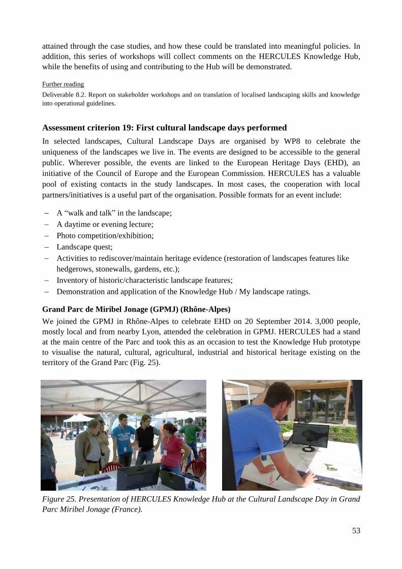
53
attained through the case studies, and how these could be translated into meaningful policies. In
addition, this series of workshops will collect comments on the HERCULES Knowledge Hub,
while the benefits of using and contributing to the Hub will be demonstrated.
Further reading
Deliverable 8.2. Report on stakeholder workshops and on translation of localised landscaping skills and knowledge
into operational guidelines.
Assessment criterion 19: First cultural landscape days performed
In selected landscapes, Cultural Landscape Days are organised by WP8 to celebrate the
uniqueness of the landscapes we live in. The events are designed to be accessible to the general
public. Wherever possible, the events are linked to the European Heritage Days (EHD), an
initiative of the Council of Europe and the European Commission. HERCULES has a valuable
pool of existing contacts in the study landscapes. In most cases, the cooperation with local
partners/initiatives is a useful part of the organisation. Possible formats for an event include:
A “walk and talk” in the landscape;
A daytime or evening lecture;
Photo competition/exhibition;
Landscape quest;
Activities to rediscover/maintain heritage evidence (restoration of landscapes features like
hedgerows, stonewalls, gardens, etc.);
Inventory of historic/characteristic landscape features;
Demonstration and application of the Knowledge Hub / My landscape ratings.
Grand Parc de Miribel Jonage (GPMJ) (Rhône-Alpes)
We joined the GPMJ in Rhône-Alpes to celebrate EHD on 20 September 2014. 3,000 people,
mostly local and from nearby Lyon, attended the celebration in GPMJ. HERCULES had a stand
at the main centre of the Parc and took this as an occasion to test the Knowledge Hub prototype
to visualise the natural, cultural, agricultural, industrial and historical heritage existing on the
territory of the Grand Parc (Fig. 25).
Figure 25. Presentation of HERCULES Knowledge Hub at the Cultural Landscape Day in Grand
Parc Miribel Jonage (France).

54
The event successfully highlighted the opportunities the HERCULES Knowledge Hub offers for
local actors and the general public. The Hub created a portal for the GPMJ, presenting among
others natural areas (Natura 2000) with the association of representative species and habitat,
artworks presented on the Park and historic heritage (also in an industrial and agricultural sense).
This has led to further use and elaboration of the Knowledge Hub, e.g. in the meantime GPMJ
has developed ecological trails for cultural and natural enhancement and intends to use the Hub
for promotion of local food producers.
Modbury (South West Devon)
The Devon event on 20 September 2014, in parallel to EHD in UK, focussed on “Cultural Trees
in Your Landscape” and attracted about 30 local participants. In the afternoon, an open circular
walk stopped by many trees of significant cultural importance. Rob McBride (“The Treehunter”,
BBC), and the renowned British arboriculturalist Antony Croft were on hand to answer questions
relating to these trees and their management and more (Fig. 26). In the evening, people were
invited to a lecture on “The Heritage of Trees” given by one of the UK’s leading tree luminaries,
Jeremy Barrell (Fig. 27).
Fig. 26. Open walk as first part of the Cultural Landscape Day in Modbury (South West Devon)
focussed on cultural importance of trees in landscapes.
Figure 27. Evening lecture as second part of the Cultural Landscape Day in Modbury (South
West Devon).
The CLD draw local people’s attention to the specific role of trees in their landscape, far and
away one of the greatest natural features in our landscapes. The importance of trees in an arboreal
landscape (“living library”) is intrinsically linked to the history of the people in that landscape.

55
When work is done on trees or they are threatened with removal, people often react strongly. In
Britain they remain a point of conflict between those who live in a landscape and those who work
in it. The event answered questions on how to read these trees towards a better understanding of
their value and how to define their purpose and manage these trees in the future for the benefit of
the tree and ourselves.
Upcoming Cultural Landscape Days in 2015
The planning of the events in 2015 is well on its way. WP8 follows its successful model of
cooperating with local partners to make use of their widespread network between local residents
and experts on “their” landscapes. Due to the seasonal agenda of the municipality and local
farmers, the CLD events in 2015 cannot be linked to EHD in September. The first CLD in 2015
will be on 03 August 2015 in the Estonian study landscape Kodavere/Vooremaa, in close
cooperation with the Juhan Liiv Museum. It will focus on celebrating the cultural and heritage-
related diversity of the landscape, closely linked to landscape pictures in poetry and music. The
second CLD takes place in Colmenar Viejo (Spanish study landscape Sierra de Guadarrama) on
03 October 2015, in close cooperation with the municipality. The CLD is the last day in a row of
landscape activities in Colmenar Viejo (local HERCULES workshop on 01 October and a photo
competition celebration of the municipality on 02 October) and will take on the form of a hike
through the landscape with stops at industrial heritage sites in this area of a rich mining and
quarrying past.
These activities help us fulfil the HERCULES vision of learning about the dynamics and values
of cultural landscapes. The CLD constitutes a forum for stakeholders and HERCULES members
to meet and learn from one another. They help us celebrate and explore both the rich tradition and
the uncharted future of European cultural landscapes. Because we are interested in learning how
to care for a landscape in and from a long-term perspective, we strive to know these places and
people having a stake in them more deeply.

56
3 Further project highlights
HERCULES has high ambitions to achieve impact on the science, policy, and practice around
cultural landscapes. In this section, we specify a set of successful activities that the project
consortium has performed in the first 18 months and that will be continued in the second half of
the project.
3.1 Expanding the European reviews on landscape change, values, and
practices
HERCULES has complemented the three core review on drivers, outcomes, and actors of
landscape dynamics (see assessment criterion 3) by four additional reviews of important
dimensions of landscape change, values, and practices in Europe:
Agricultural land-use change (van Vliet et al., 2015);
Traditional ecological knowledge (Hernández-Morcillo et al., 2014);
Landscape preferences (van Zanten et al., 2014);
Cultural ecosystem services and landscape management / planning (Plieninger et al., 2015).
Once all are published, HERCULES will put the seven multi-disciplinary review studies together
in a format that makes them widely available among scientists, policy-makers, and practitioners.
With this set of multi-disciplinary reviews and meta-analyses, we fulfil our aim (as stated in the
Description of Work) “to perform the largest effort to date to synthesise knowledge on cultural
landscape dynamics” and provide ample evidence on understanding and managing landscape
change, values, and practices in Europe.
Further reading
Plieninger, T., C. Bieling, N. Fagerholm, A. Byg, T. Hartel, P. Hurley, CA. López-Santiago, N. Nagabhatla, E.
Oteros-Rozas, C.M. Raymond, D. van der Horst, and L. Huntsinger (2015): The role of cultural ecosystem services
in landscape management and planning. Current Opinion in Environmental Sustainability 14, 28-33.
van Vliet, J., H.L.F. de Groot, P. Rietveld, and P.H. Verburg (2015): Manifestations and underlying drivers of
agricultural land use change in Europe. Landscape and Urban Planning 133, 24-36.
Hernández-Morcillo, M., J. Hoberg, E. Oteros-Rozas, T. Plieninger, E. Gómez-Baggethun, and V. Reyes-García
(2014): Traditional ecological knowledge in Europe: Status quo and insights for the environmental policy agenda.
Environment: Science and Policy for Sustainable Development 56, 3-17.
van Zanten, B.T., Verburg, P.H., Koetse, M.J., van Beukering, P.J.H. (2014): Preferences for European agrarian
landscapes: A meta-analysis of case studies. Landscape and Urban Planning 132, 89-101.
3.2 Conceptualising landscape stewardship
Stewardship is currently emerging in science and policy arenas (e.g., the Global Future Earth
research initiative and the Charter of Rome on Natural and Cultural Capital) as an approach to
secure a stable basis for human civilization in future. HERCULES has taken up this notion and
worked on introducing stewardship thinking into cultural landscape research through four
activities:
Provision of an analytical and comparative perspective on the scientific underpinning and
practical implementation of landscape stewardship (Bieling and Plieninger, accepted,
Cambridge University Press, see assessment criterion 13);
57
Development of a landscape stewardship classification which distinguishes between farmers'
understanding of landscape stewardship, their landscape values and land management actions
(Raymond et al., accepted, AMBIO);
Elaboration of a framework for supporting landscape stewardship in agri-environmental
schemes (Raymond et al., under review, Land Use Policy);
Performance of an EU level stakeholder workshop on “Landscape Stewardship: Integrating a
broad suite of landscape values into rural development policies”, 03.06.2015, Brussels (see
assessment criterion15).
The activities on conceptualising landscape stewardship will serve the purpose of generating an
overall framework that unifies the science- and action-agenda of HERCULES. It will also allow
HERCULES to feed insight into science-policy processes, for example around the
Intergovernmental Platform on Biodiversity and Ecosystem Services (IPBES) and the European
Landscape Convention.
Further reading
Bieling, C., and T. Plieninger, T. (eds.): The Science and Practice of Landscape Stewardship. Cambridge University
Press, accepted.
Raymond, C.M., C. Bieling, N. Fagerholm, B. Martín-López, and T. Plieninger (2015): The farmer as a landscape
steward: Comparing local understandings of landscape stewardship, landscape values and land management actions.
AMBIO, accepted.
Raymond, C.M., C. Bieling, M.S. Reed, G.M. Robinson, and T. Plieninger: A framework for supporting a broader
set of landscape values in agri-environmental schemes – Challenges, opportunities and future policy directions. Land
Use Policy, under review.
3.3 Advancing methods for analysing landscape change and values
HERCULES intends to advance methods of cultural landscape research. So far, five activities
have been performed that put particular focus on method development:
Development of a method to use historic statistics and old topographic maps for model-based
reconstructions of historic land cover for Central Europe back to 1900, considering diverse
types of historic land data (Fuchs et al., 2015);
Remote-sensing based assessment to assess abandonment trends in landscapes at high
temporal and spatial resolution (Estel et al., 2015, Baumann et al., ongoing work);
Creation of a web-based Public Participation GIS (PPGIS) tool to study the perception of
landscape services and changes and their relation to landscape behaviours (García et al.,
ongoing work);
Exploration of the use of shared images on social media (Panoramio, Flickr) for the elicitation
of cultural landscape values (Oteros-Rozas et al., ongoing work);
Biographical approaches of landscape (Kolen et al., 2015).
The first four methods will be particularly useful for cross-site analyses in different European
countries, as they provide standardised protocols that can handle a diversity of data types and
overcome language barriers. The insight on the potential of historical maps has been taken up in
the empirical work of WP3. The work on spatially explicit elicitation of cultural landscape values
has proven as a valuable addition to the study of landscape changes, drivers, and actors in WP3. It
is complementary, as landscape changes have impacts on cultural landscape values and as in turn
values are important determinants of landscape dynamics. In the second half of the project, the
relation between landscape changes and landscape values will be analysed empirically, based on

58
the data from the HERCULES study landscapes. The last method is an approach to integrate
geographical, historical and archaeological perspectives on the production and transmission of
landscapes. In the HERCULES context, it aims at a better integration of historical landscape
research with urban planning, landscape design and public participation.
Further reading
Estel, S., T. Kuemmerle, C. Alcantara, C. Levers, A.V. Prishchepov, and P. Hostert (2015): Mapping farmland
abandonment and recultivation across Europe using MODIS NDVI time series. Remote Sensing of Environment 163,
312–325.
Fuchs, R., P.H. Verburg, J.G.P.W. Clevers, and M. Herold (2015): The potential of old maps and encyclopaedias for
reconstructing historic European land cover/use change. Applied Geography 59, 43-55.
Kolen, J, H. Renes, and R. Hermans (eds.) (2015): Landscape Biographies. Geographical, Historical and
Archaelogical Perspectives on the Production and Transmission of Landscapes. Amsterdam University Press.
3.4 Developing landscape as a core theme of sustainability science
HERCULES has the ambition to make cultural landscape research a core topic of sustainability
science. Therefore, the project has established linkages to the FUTURE EARTH research
platform for global sustainability, sponsored by the Science and Technology Alliance for Global
Sustainability. HERCULES has been endorsed by three FUTURE EARTH research projects:
Program on Ecosystem Change and Society (PECS): HERCULES partners have attended
two PECS workshops in Montpellier/France (02.-03.05.2015) and Stockholm/Sweden (28.-
30.01.2015) and have contributed a landscape perspective to a special journal issue on PECS
(Plieninger et al., 2015). HERCULES partners are currently engaged in PECS synthesis
activities on “Ecosystem service trade-offs and synergies: synthesizing and learning across
case-studies”. HERCULES has been frequently featured on the PECS website. Also,
HERCULES will arrange a workshop on “The value of ecosystem stewardship for managing
social-ecological systems: insights from place-based research in different regions” at the
PECS 2015 Conference in Stellenbosch/South Africa (03.-05.11.2015).
Global Land Project (GLP): HERCULES partners have presented at the GLP Open Science
Meeting in Berlin/Germany (19.-21.05.2014). Linkages are close, with the GLP chair being a
HERCULES partner.
Integrated History and Future of People on Earth (IHOPE): Linkages to IHOPE are also
close, with the Director of the International Project Office of IHOPE being HERCULES
partner.
On the one hand, endorsement by FUTURE EARTH research projects helps to make
HERCULES more widely known and to reach out to other communities of sustainability
research. On the other hand, HERCULES and the broader landscape community use this linkage
to feed important insights into sustainability science.
Further reading
Plieninger, T., T. Kizos, C. Bieling, L. Le Dû-Blayo, M.-A. Budniok, M. Bürgi, C.L. Crumley, G. Girod, P. Howard,
J. Kolen, T. Kuemmerle, G. Milcinski, H. Palang, K. Trommler, and P.H. Verburg (2015): Exploring ecosystem-
change and society through a landscape lens: recent progress in European landscape research. Ecology and Society
20(2): art. 5.

59
3.5 Inviting the community of science and practice
HERCULES fosters intensive collaboration among project partners, but at the same time also
invites the broader community of science and practice around cultural landscapes. Such opening
of HERCULES has occurred through different activities:
Organization of expert workshops on landscape issues, e.g. “Landscape Stewardship in the
Anthropocene: A discussion on moving the agenda forward”, Berlin/Germany, 17.04.2015,
and “Enhancing cultural ecosystem services and nature-based experiences through novel
green infrastructure strategies”, Kristianstad/Sweden, 20.-21.10.2015.
Participation of invited guests to project meetings that provide an external perspective to the
project, e.g. Karl Zimmerer (Pennsylvania State University), David Harvey (University of
Exeter), Dirk Gotzmann (Civilscape), Michael Dower (University of Gloucestershire), Simon
Bell (University of Edinburgh and Estonian University of Life Sciences).
Arrangement of conference sessions on HERCULES topics: “The value of place-based
research in an era of big data”, Resilience 2014 Conference, Montpellier/France, 04.-
08.05.2014; “Visioning for re-coupling social and ecological landscape components”,
PECSRL 2014 Conference, Gothenburg/Sweden, 08.-12.09.2014; “Bridging cultural
landscapes and landscape ecology”, IALE World Congress, Portland/USA, 09.-12.07.2015
Invitation to 23 non-project members to contribute chapters to the HERCULES book project
on “The Science and Practice of Landscape Stewardship”.
Regular contributions by non-project authors to the HERCULES blog.
Including the larger community of science and practice in HERCULES activities helps
integrating disciplines, skills, and perspectives that the consortium partners do not have. It is also
important for making HERCULES a central project of the European landscape community.
Through this, we hope that the HERCULES-Knowledge Hub on Good Landscape Practices will
be embraced by the community.
3.6 Development of the HERCULES Knowledge Hub
The Knowledge Hub is an online platform with which the HERCULES partners can collect,
archive, distribute and share data across the project as well as with stakeholders and the general
public. It is a spatial and alphanumerical data repository that can be accessed via dedicated web
GIS application and extendable mobile applications. A comprehensive review of citizen science
and participation in landscape research was conducted, from which valuable insights assisted the
development of the platform as a tool for communication within the broader landscape
community, with a broad range of thematic applications from HERCULES partners, stakeholders,
and the general public already active, including:
Good Heritage Practices: a dataset containing examples of a broad range of heritage practices
and landscape initiatives derived from two European reviews. These examples are now open
to the public, and they can share their examples of good practices to the community.
Local Good Practices: containing examples of good landscape practice derived from
stakeholder interviews onsite in the Rhône-Alpes area of France, and in South West Devon
Good Landscape Practices: showing exemplars of award-winning landscape practices
submitted by a range of HERCULES stakeholders.
Grand Parc Miribel Jonage: a 2,200 ha park near Lyon, France, which uses the full range of
Knowledge Hub mapping of the cultural and natural heritage of the park.

60
At a series of co-design workshops with stakeholders, a range of needs for and a differentiation
between different Knowledge Hub users were identified, resulting in the creation of a (front-end)
complimentary portal called HERCULES Labs, designed as an intuitive platform where users can
explore and interact with different (predefined) datasets, derived from the existing (back-end)
Knowledge Hub. Data and spatial information created and processed on the Knowledge Hub can
now be presented in a simplified way with HERCULES Labs, which is a vital addition to the
communication and outreach capacity of the HERCULES project. Demonstration activities have
been carried out to introduce the Knowledge Hub and Hercules Labs to additional stakeholders in
the wider research and practitioner communities at the Forum for Agriculture 2015 and Green
Week 2015.
Further reading
http://kh.hercules-landscapes.eu/
http://labs.kh.hercules-landscapes.eu/

61
4 Project management
4.1 Tasks and achievements
The tasks and achievements of the project management have been:
1) Implementation of the management structure: The Consortium Agreement has been signed
by each beneficiary of the HERCULES project. A Project Handbook was compiled that
specifies all mutually agreed timelines, regular communications, and formal procedures. A
Project Steering Committee (PSC) was established and meets in bi-monthly intervals. Marie-
Alice Budniok (ELO) has been elected as Gender Representative during the Kick-off
Meeting.
2) Quality assurance: A work plan, the HERCULES Research Implementation Plan, was set up
and agreed upon by all partners. It specifies individually the members responsible for work
packages and deliverables. The HERCULES Project Handbook is the basis for the quality
assurance. It defines procedures of both deliverable review and regular reporting. Moreover,
internal activity reports and workforce statistics are conducted to monitor the work progress
and use of resources.
3) Internal exchange of information: An intranet site (hosted by University of Freiburg) has
been set up to store and share key documents. The mail list [email protected] is the
main project-wide forum for sharing information. It is managed by Humboldt-Universität zu
Berlin.
4) Communication and cooperation with the Commission, the Advisory Board, and other
external partners: A regular communication with the project officer at the European
Commission has been established. Regular consultation with advisory board members and all
beneficiaries takes place. External partners are involved in several discussions.
Table 5 gives an overview of the consortium and PSC meetings held during the reporting period.
Additionally, several workshop-internal meetings were arranged. Advisory Board members were
actively involved in the second Consortium Assembly and will be so in future meetings. The PSC
has held seven teleconferences during the reporting period and one personal meeting of the
Extended PSC (representatives of all beneficiaries involved). When appropriate, external project
members were invited to the teleconferences.
Table 5. Consortium Assemblies and WP meetings held during the reporting period.
Meetings Location and dates Description
Consortium Assembly
Kick-off meeting Brussels, 02-03.12.2013 Hosted by ELO. 27 participants.
2nd
Project meeting Amsterdam, 24.-26.09. 2014 Hosted by VU/VUmc. 35
participants. Included a visit to the
Rhine-Meuse study landscape.
Project Steering Committee
PSC meeting Teleconference, 30.01. 2014 8 participants.
PSC meeting Teleconference, 08.04. 2014 8 participants.
PSC meeting Teleconference, 06.06.2014 7 participants.
PSC meeting Teleconference, 05.09.2014 6 participants.

62
PSC meeting Teleconference, 13.11.2014 8 participants.
Extended PSC
meeting
Berlin, 26.-27.01.2015 Hosted by UBER. 18 participants.
PSC meeting Teleconference, 11.03.2015 7 participants.
PSC meeting Teleconference, 26.05.2015 4 participants.
Project activities have been followed up by bi-annual Internal Activity Reports, prepared by all
beneficiaries and WP leaders.
4.2 Project planning and status
Almost all project activities have been conducted according to the Description of Work (DoW).
All WPs had deliverables due within the reporting period. The HERCULES consortium has
established a procedure for reviewing draft deliverables before submission. This system functions
very well and ensures that the deliverables reach the qualitative requirements set out in the DoW.
During the reporting period, the following minor delays in the submission of the deliverables of
occurred:
WP8: After having received agreement from the project officer, Deliverable 8.2 was postponed
by two months due to difficulties of the lead beneficiary to perform a revision.
WP9: After having received agreement from the project officer, Deliverable 9.2 was postponed
by one months. Reason for this was the we wished to arrange the second stakeholder workshop in
Brussels as a side-event of the Green Week on the 03.06.2015.
These changes did not affect (and the latter in fact improved) the overall outcomes of the project.

63
5 Overview of core dissemination components achieved
Assessment criterion 14 describes the assessment of the dissemination achievements in detail. In
addition, this chapter gives a brief overview of HERCULES dissemination achievements in
comparison with the core dissemination components as specified in the DoW.
A community-based Knowledge Hub that provides easy access to a rich action-oriented
toolkit for good landscape practices
The HERCULES Knowledge Hub comprises detailed outlines of best practices and practical
guidelines for implementation in their own context, including links to helpful programmes and
incentives. A broad range of thematic applications from HERCULES partners, stakeholders, and
the general public is already active, including Good Heritage Practices, Local Good Practices,
Good Landscape Practices, showing exemplars of award-winning landscape practices. Interfaces
allow the use of existing crowdsourced information on cultural landscapes, such as photos and
site descriptions in GoogleEarth or Panoramio. Additionally, an app was developed to allow
people to easily gather information about cultural landscapes (My landscape ratings,) and feed
them into an online database. This app disseminates place-specific information on cultural
landscapes to endusers and allows users to engage in collecting data on the state and change in
cultural landscapes by contributing observations and photos.
http://kh.hercules-landscapes.eu
https://play.google.com/store/apps/details?id=com.sinergise.android.scaperatings
Stakeholder workshops to be organised at EU level and study landscape level
Two series of EU as well as local stakeholder workshops took place in the first project period.
During the first workshop participants were asked for input into the research plan to refine tasks
and questions and to make sure that the research plan is as practice-and policy-relevant as
possible. The workshops revealed stakeholder needs and were a platform for the exchange of
ideas for landscape management and discussion of best practice-models. The mid-term
workshops provided a reality check for the preparation of policy options.
EU level: Assessment criterion 15
Local level: Assessment criterion 18
A roadbook for the management of heritage values in cultural landscapes
The insights on the potentials of various landscape practices in specific contexts, stakeholder
groups and fields of application will be compiled in a roadbook. This roadbook delivers detailed
and applicable information on the range of different approaches available to foster re-coupling of
social and ecological realms for the protection and development of heritage values in cultural
landscapes. Within the activities of WP6, the outline for the roadbook has been prepared and has
been accepted for publication by Cambridge University Press as an edited volume entitled “The
Science and Practice of Landscape Stewardship”.
Assessment criterion 13
On-the-ground demonstration activities focusing on stakeholder-to-stakeholder
communication organised with landscape users (Cultural Landscape Days)
Cultural Landscape days performed in 2014:

64
Rhône-Alpes area (France) / 20.09.2014 / In close cooperation with Grand Parc Miribel
Jonage / Focus on testing the Knowledge Hub prototype to visualise the natural, cultural,
agricultural, industrial and historical heritage existing on the territory of the Grand Parc.
Modbury, South-West Devon (UK) / 20.09.2014 / Focus on “Cultural Trees in Your
Landscape”
Upcoming Cultural Landscape Days in 2015:
Kodavere/Vooremaa (Estonia) / 03.08.2015 / In close cooperation with the Juhan Liiv
Museum (Rupsi Village) / Focus on celebrating the cultural and heritage-related diversity of
the landscape, closely linked to landscape pictures in poetry and music.
Sierra de Gudarrama foothills (Spain) / 03.10.2015 / In close cooperation with the
municipality of Colmenar Viejo / Focus on industrial heritage sites, e.g. mining and
quarrying sites.
Assessment criterion 19
Other dissemination materials operational
HERCULES website
www.hercules-landscapes.eu
Cultural Landscapes Blog
http://www.hercules-landscapes.eu/blog.php
Presence in social media
https://www.facebook.com/HerculesLandscapes
https://twitter.com/HerculesFP7
Informational factsheets
http://www.hercules-landscapes.eu/tartalom/publications/permanent_european_conference_3.pdf
http://www.hercules-landscapes.eu/tartalom/publications/permanent_european_conference_4.pdf
Magazine articles
Ten press and media articles have been published (Annex 9)
Press releases (at least 5 during the project lifetime)
Focus on final results, policy recommendations and final conference in the second project
period
A set of re-usable illustrations
150 pictures are available on the HERCULES intranet.
A project presentation
http://www.hercules-landscapes.eu/tartalom/publications/articles_2.pdf
Demo video
https://youtu.be/I5Q33HN5OeY

65
A special section for SMEs available on the Knowledge Hub
This has been mainly done in the study landscape Rhone-Alpes, in close cooperation with the
Grand Parc Miribel Jonage. HERCULES members explored together with the stakeholders the
opportunities of and needs for the use of the Knowledge Hub. The set-up is not finished yet. It
aims at providing a tool to play an active role as knowledge brokers between scientific insights
and on the ground implementation of landscape actions.
At least 15 scholarly publications 20 presentations
21 journal articles have been published and 25 presentations at major landscape-related
conferences and smaller workshops have been held already.
List of publication (Annex 7)
List of presentations (Annex 8)
Policy briefs
Policy briefs will be prepared in the second project period. A preparation workshop is planned for
the next Consortium Assembly in Tallinn, on the 09.09.2015.

66
6 Overview of work planned for the second half of the project
The first half of HERCULES was dedicated to the successful work on innovative concepts and
approaches to tackle the cultural landscape issues. Different methods have been assessed and
evaluated to build a proper cultural landscape framework. After agreeing on common study
landscapes – exhibiting localised landscape values and at the same time representing the diversity
of European cultural landscapes – data was collected and is in an ongoing process of being
analysed. Major effort was put into building a trustful dialogue with stakeholders.
The second project period will be used to finalise the data analysis and translate the results in
policy recommendations. WP1 will finalise the findings of the individual systematic reviews soon
and start to categorise the drivers, outcomes and actors of landscape dynamics. This will provide
insights for the practical guidelines to develop. WP2 will finalise the modelling for long-term
landscape change and land-use. Very soon, the fieldwork on short-term historical dynamics in all
study landscapes will be completed in WP3. It is planned to transfer the results to the Knowledge
Hub and relate them to the landscape typology (WP 4), landscape modelling (WP 5), the
visioning process (WP6) and the implementation of good landscape practices (WP 8). The current
distribution and very recent dynamics in cultural landscape on a pan-European scale will be
mapped by WP4 while WP5 will assess the robustness and applicability of landscape
management and policy options under scenario conditions, in order to build a basis for the policy
recommendations and guidelines to be developed by HERCULES. The insights on the potentials
of various landscape practices will be compiled in the roadbook and innovative strategies and
policy measures will be prioritised in the work of WP6. The Knowledge Hub is well on its way.
Together with WP8, WP7 will work on further use of resulting data and dissemination. In
addition, the third series of local stakeholder workshops and additional Cultural Landscape Days
will be performed by WP8, while WP9 takes on the lead to translate the HERCULES findings
into policy briefs and a set of recommendations for landscape policy and practice.
Regarding the achievements and the progress made in the first project period, HERCULES does
not expect any major delays in the upcoming tasks, but expects to have achieved all its goals at
the end of the project.

67
7 List of publications
Journal articles
Bieling, C., T. Plieninger, H. Pirker, H., and C.R. Vogl (2014): Linkages between landscapes and
human well-being: An empirical exploration with short interviews. Ecological Economics 105:
19-30.
Bürgi, M., L. Li, and T. Kizos (2015): Exploring links between culture and biodiversity: studying
land use intensity from the plot to the landscape level. Biodiversity and Conservation, in press.
Estel, S., T. Kuemmerle, C. Alcantara, C. Levers, A.V. Prishchepov, and P. Hostert (2015):
Mapping farmland abandonment and recultivation across Europe using MODIS NDVI time
series. Remote Sensing of Environment 163: 312-325.
Fuchs, R.,Verburg, P.H., J.G.P.W. Clevers, and M. Herold (2015): The potential of old maps and
encyclopaedias for reconstructing historic European land cover/use change. Applied Geography
59: 43-55.
Hernández-Morcillo, J. Hoberg, E. Oteros-Rozas, T. Plieninger, E. Gómez-Baggethun, and V.
Reyes-García (2014): Traditional ecological knowledge in Europe: Status quo and insights for the
environmental policy agenda. Environment: Science and Policy for Sustainable Development 56:
3-17.
Karro, K. (2015): Continuing Landscape, Continuing Life: Burial Site of Lahepera in Eastern
Estonia. Papers from the Institute of Archaeology 25: 1-11.
Kolen, J., C. Crumley, G.J. Burgers, K. von Hackwitz, P. Howard, K. Karro, M. de Kleijn, D.
Löwenborg, N. van Manen, H. Palang, A. Printsmann, H. Renes, H. Scholten, P. Sinclair, P., M.
Veldi, and P. Verhagen (2015): HERCULES: Studying long-term changes in Europe’s
landscapes. Analecta Praehistorica Leidensia 45: 209-219.
Munteanu, C., T. Kuemmerle, M. Boltiziar, V. Butsic, U. Gimmi, L. Halada, D. Kaim, G. Király,
E. Konkoly-Gyuró, J. Kozak, J. Lieskovský, M. Mojses, D. Müller, K. Ostafin, K. Ostapowicz,
O. Shandra, P. Štych, S. Walker, and V.C. Radeloff (2014): Forest and agricultural land change
in the Carpathian region—A meta-analysis of long-term patterns and drivers of change. Land Use
Policy 38: 685–697.
Ohnesorge, B., T. Plieninger, and P. Hostert (2013): Management effectiveness and land cover
change in dynamic cultural landscapes - assessing a Central European biosphere reserve. Ecology
and Society 18 (4): art. 23.
Plieninger, T. and C. Bieling (2013): Resilience-based perspectives to guiding high-nature-value
farmland through socioeconomic change. Ecology and Society 18 (4): art. 20.
Plieninger, T., C. Bieling, N. Fagerholm, A. Byg, T. Hartel, P. Hurley, C.A. López-Santiago, N.
Nagabhatla, E. Oteros-Rozas, C.M. Raymond, D. van der Horst, and L. Huntsinger (2015): The
role of cultural ecosystem services in landscape management and planning. Current Opinion in
Environmental Sustainability 14: 28-33.
Plieninger, T., C. Bieling, B. Ohnesorge, H. Schaich, C. Schleyer, and F. Wolff (2013): Exploring
futures of ecosystem services in cultural landscapes through participatory scenario development
in the Swabian Alb, Germany. Ecology and Society 18 (3): art. 39.

68
Plieninger, T., C. Hui, M. Gaertner, and L. Huntsinger (2014): The impact of land abandonment
on species richness and abundance in the Mediterranean basin: A meta-analysis. PloS ONE 9(5):
e98355.
Plieninger, T., T. Kizos, C. Bieling, L. Le Dû-Blayo, M.-A. Budniok, M. Bürgi, C. L. Crumley,
G. Girod, P. Howard, J. Kolen, T. Kuemmerle, G. Milcinski, H. Palang, K. Trommler, and P.H.
Verburg (2015): Exploring ecosystem-change and society through a landscape lens: recent
progress in European landscape research. Ecology and Society 20(2): art. 5.
Plieninger, T., C. Levers, M. Mantel, A. Costa, H. Schaich, and T. Kuemmerle (2015): Patterns
and drivers of scattered tree loss in agricultural landscapes: Orchard meadows in Germany (1968-
2009). PLoS ONE 10(5): e0126178.
Plieninger, T., D. van der Horst, C. Schleyer, and C. Bieling (2014): Sustaining ecosystem
services in cultural landscapes. Guest editorial. Ecology and Society 19(2): art. 59.
Raymond, C.M., C. Bieling, N. Fagerholm, B. Martín-López, and T. Plieninger (2015): The
farmer as a landscape steward: Comparing local understandings of landscape stewardship,
landscape values and land management actions. Ambio – A Journal of the Human Environment,
accepted.
Raymond, C.M., J.O. Kenter, T. Plieninger, N.J. Turner, and K.A. Alexander (2014): Comparing
instrumental and deliberative paradigms underpinning the assessment of social values for cultural
ecosystem services. Ecological Economics 107: 145-156.
Schaich, H., T. Kizos, S. Schneider, and T. Plieninger (2015): Land change in Eastern
Mediterranean wood-pasture landscapes: the case of deciduous oak woodlands in Lesvos
(Greece). Environmental Management 56: 110-126.
Van Vliet, J., H.L.F. de Groot, P. Rietveld, and P.H. Verburg (2015): Manifestations and
underlying drivers of agricultural land use change in Europe. Landscape and Urban Planning
133: 24–36.
Van Zanten, B.T., P.H. Verburg, M.J. Koetse, and P.J.H. van Beukering (2014): Preferences for
European agrarian landscapes: A meta-analysis of case studies. Landscape and Urban Planning
132: 89–101.
Edited Books
Kolen, J., H. Renes, and R. Hermans (eds.) (2015): Landscape Biographies. Geographical,
Historical and Archaeological Perspectives on the Production and Transmission of Landscapes.
Amsterdam University Press, Amsterdam.

69
8 List of presentations
Special sessions
T. Plieninger. Resilience 2014 conference. Special session: The value of place-based research in
an era of big data. Montpellier (France), 07.05.2014.
C. Bieling, T. Plieninger, and T. Kizos. Permanent European Conference for the Study of the
Rural Landscape (PECSRL). Special session: Visioning for re-coupling social and ecological
landscape components. Gotenburg (Sweden), 09.09.2014.
Invited presentations
2015
P.H. Verburg. Reconstructing landscape change. Landcover6000 meeting of PAGES. Paris
(France), 16.-17.02.2015.
B. Shaw. Eliciting valued forms, practices and relationships: Informing policy and management
by combining the Cultural Values Model with empirical Cultural Domain Analysis. Conference
on Cultures(s) in sustainable futures: theories, practices and policies. Helsinki (Finland), 06.-
08.05.2015.
T. Plieninger. Exploring ecosystem-change and society through a landscape lens, Stockholm
Resilience Centre, Stockholm (Sweden), 11.05.2015.
C. Bieling. Landscape as perceived, valued and constructed by people. CHeriScape
conference.Oslo (Norway), 19./20.05.2015.
H. Palang. Landscape conversations. Getting involved with local people and their landscapes.
Nitra (Slovakia) 27.-29.05.2015.
2014
T. Plieninger. Ökosystemleistungen, Landnutzungswandel und Lebensqualität in land- und
forstwirtschaftlich geprägten Kulturlandschaften. University of Hohenheim, 28.01.2014.
M. Bürgi, A. Humbel, L. Li, T. Kizos. Land use intensity is the missing link between actors and
biodiversity – conceptual considerations and empirical examples. Florence (Italy), 10.04.2014.
G. Girod. HERCULES project. Program on Ecosystem Change and Society PECS. Workshop
“Building a strong sense of PECS community”. Montpellier (France), 02.-03.05.2014.
M. Bürgi. Some thoughts on how to link place-based research and large-scale approaches.
Resilience 2014 conference. Montpellier (France), 06.05.2014.
P.H. Verburg. The value of place-based research for large scale landscape change modelling.
Resilience 2014 conference. Special session: The value of place-based research in an era of big
data. Montpellier (France), 07.05.2014.
T. Plieninger. Sustainable futures for Europe’s heritage in cultural landscapes. University of
Copenhagen (Denmark), 20.05.2014.

70
C. Bieling. Sustainable Futures for Europe's Heritage in Cultural Landscapes: Towards a Pan-
European synthesis on landscape practices related to heritage values. Poster presentation.
CHeriScapes Conference I – Landscape as Heritage in Policy. Gent (Belgium), 1.-2.07.2014.
K. von Hackwitz. HERCULES – Methodologies to study long-term landscape change. Poster
presentation. Cheriscapes Conference I – Landscape as Heritage in Policy. Gent (Belgium), 01.-
02.07.2014.
T. Plieninger. A social-ecological perspective on ecosystem services in cultural landscapes.
University of Edinburgh (UK), 03.07.2014.
J. Kolen. Humanizing Biotopes. Permanent European Conference for the Study of the Rural
Landscape (PECSRL). Gotenburg (Sweden), 09.09.2014.
J. Kolen. Terrorscapes as Heterotopias Permanent European. Conference for the Study of the
Rural Landscape (PECSRL). Gotenburg (Sweden), 10.09.2014.
M. de Kleijn. Landscapes of the Long Now. European Geodesign Summit 2014. Delft
(Netherlands), 12.09.2014.
J. Kolen. Rediscovering the Archaeological Terrain. International Landscape Archaeology
Conference 2014. Keynote presentation. Rome (Italy), 19.09.2014.
K. von Hackwitz. Boundaries of mind & nature. International Landscape Archaeology
Conference 2014. Rome (Italy), 17.-20.09.2014.
C. Bieling. Social-ecological resilience: How about the social in it? Sustainability Summit 2014.
Freiburg (Germany), 13.10.2014.
K. von Hackwitz. Boundaries of Mind & Nature. GIS and Landscape conference. Uppsala
University (Sweden), 14.10.2014.
T. Kizos, G. Tsilimigkas, and T. Balatsos. Land use intensity and rural landscape management
and planning: Evidence from Lesvos. 10th International Congress of the Hellenic Geographical
Society. Thessaloniki, 24.10.2014.
T. Kizos. Αγροτική Γεωγραφία και Αγροπεριβαλλοντική Πολιτική στην Ελλάδα (Agricultiural
geography and agroenvironmental policy in Greece). The Hellenic Association of Agricultural
Economists (ETAGRO) conference. Athens, 22.11.2014.
T. Kizos. Αναπαράγοντας παλαιότερες αδικίες ή προς μεγαλύτερη δικαιοσύνη; Η χωρική
διάσταση της Πολιτικής Ενιαίας Ενίσχυσης στην Ελλάδα (Reproducing older injustices or
towards more justice? The spatial patterns of the Single Farm Payment Policy in Greece). The
Hellenic Association of Agricultural Economists (ETAGRO) conference. Athens, 22.11.2014.
Plieninger, T. Cultural heritage research and innovation – Some observations. Workshop
“Towards a new EU agenda for cultural heritage research and innovation“. Brussels (Belgium),
27.11.2014.

71
9 List of other dissemination activities
Exhibition stands
HERCULES. Forum for the Future of Agriculture 2014. Brussels (Belgium), 01.04.2014.
HERCULES. Green Week 2014. Brussels (Belgium), 03.-05.06.2014.
HERCULES. Demo application of the Knowledge Hub. Forum for the Future of Agriculture
2015. Brussels (Belgium), 31.03.2015.
HERCULES. Demo application of the Knowledge Hub. Green Week 2015. Brussels (Belgium),
03.-05.06.2015.
Press and media article
Batič, M. (2014): Project HERCULES’ First Milestone: The Knowledge Hub is Operational.
Countryside Magazine (EN) 153: 12.
Hesp, M. 82014): Beauty of South devon in pilot project to map countryside. Western Morning
News. 04.07.2014.
Howard, P. (2015): Who fills in the gaps? Landscape Research Extra 73: 4-5.
Nagy, J. (2014): HERCULES Kick Off Event. Countryside Magazine (EN) 149: 11.
Nagy, J. (2014): Le lancement du projet HERCULES. Countryside Magazine (FR) 149: 10.
Nagy, J. (2014): HERCULES puts cultural landscapes back on the agenda. Countryside
Magazine (EN) 151: 11.
Nagy, J. (2014): HERCULES remet les paysages culturels à l’agenda. Countryside Magazine
(FR) 151: 11.
Nagy, J. (2014): HERCULES bringt die Kulturlandschaft wieder auf die Tagesordnung.
Countryside Magazine (D) 151: 3.
Nagy, J. (2014): HERCULES coloca a los paisajes culturales en la agenda oficial. Countryside
Magazine (SP) 151: 4.
Nagy, J. (2014): HERCULES: a bridge between research and practice. Stakeholder engagement
is one of the project’s cornerstones. Countryside Magazine (EN) 154: 12-13.
Plieninger, T. (2015): Landscape Stewardship: Integrating landscape values into rural
development policies. Countryside Magazine (EN) 157: 6.
Plieninger, T. (2015): La gérance des paysages via l’intégration des valeurs paysagères dans les
politiques de développement rural. Countryside Magazine (FR) 157: 6.
Shuttleworth, S. and L. le Dû-Blayo (2014): EU. Research project HERCULES. Landscape
Research Extra 68: 3-4.
Shuttleworth, S. (2015): Project HERCULES – Fifteen month in. Landscape Research Extra 73:
2-4.
Uken, M. (2014): Die Ökonomie der Jäger und Sammler. Zeit Online Blog „Grüne Geschäfte“,
16.09.2014.

72
Blog entries of HERCULES members
Plieninger, T.: A blog on cultural landscapes. Cultural Landscapes Blog. 07.04.2014.
http://www.hercules-landscapes.eu/blog.php?a_blog_on_cultural_landscapes&id=5
Howard, P.: Landscape and Heritage – Two Opposing Systems. Cultural Landscapes Blog.
7.05.2014.
http://www.hercules-
landscapes.eu/blog.php?landscape_and_heritage__two_opposing_systems&id=4
Bieling, C.: Linkages between landscapes and human well-being. Cultural Landscapes Blog.
20.06.2014.
http://www.hercules-
landscapes.eu/blog.php?linkages_between_landscapes_and_human_wellbeing&id=8
Plieninger, T.: Sustaining cultural landscape values. The need for a mature ecosystem services
approach. Cultural Landscapes Blog. 07.07.2014.
http://www.hercules-
landscapes.eu/blog.php?sustaining_cultural_landscape_values_the_need_for_a_mature_ecosyste
m_services_approach&id=9
Crumley, C.: What is historical ecology? Cultural Landscapes Blog. 24.07.2014.
http://www.hercules-landscapes.eu/blog.php?what_is_historical_ecology&id=10
Schulp, C.J.E.: New maps reveal large variation in the use of “wild food” across Europe. Cultural
Landscapes Blog. 29.08.2014
http://www.hercules-
landscapes.eu/blog.php?new_maps_reveal_large_variation_in_the_use_of_wild_food_across_eur
ope&id=12
Plieninger, T.: European wood-pastures as cultural landscapes. Cultural Landscapes Blog.
11.09.2014.
http://www.hercules-
landscapes.eu/blog.php?european_woodpastures_as_cultural_landscapes&id=13
Kizos, T.: Visioning for recoupling social and ecological landscape components: a report of the
PECSRL workshop. Cultural Landscapes Blog. 29.09.2014.
http://www.hercules-
landscapes.eu/blog.php?visioning_for_recoupling_social_and_ecological_landscape_components
_a_report_of_the_pecsrl_workshop&id=14
Zimmerer, K.: Foodscapes: the land use ecology and culinary practices of food in cultural
landscapes. Cultural Landscapes Blog. 02.10.2014.
http://www.hercules-
landscapes.eu/blog.php?foodscapes_the_land_use_ecology_and_culinary_practices_of_food_in_
cultural_landscapes&id=15
Plieninger, T.: About forestry and landscape thinking. Cultural Landscapes Blog. 23.10.2014.
http://www.hercules-landscapes.eu/blog.php?about_forestry_and_landscape_thinking&id=16
Harvey. D.: Gardening the Cultural Landscapes of European Heritage. Cultural Landscapes Blog.
07.11.2014.
http://www.hercules-
landscapes.eu/blog.php?gardening_the_cultural_landscapes_of_european_heritage&id=17
Garcia Martin, M.: Help us to develop a European review on Landscape Initiatives! Cultural
Landscapes Blog. 27.12.2014.

73
http://www.hercules-
landscapes.eu/blog.php?help_us_to_develop_a_european_review_on_landscape_initiatives&id=1
9
David Harvey. How to build an “Ancient Monument” in a “Natural Landscape”. 12.01.2015.
http://www.hercules-
landscapes.eu/blog.php?how_to_build_an_ancient_monument_in_a_national_landscape&id=21
Howard, P.: What can the Knowledge Hub do for you? Cultural Landscapes Blog. 21.01.2015.
http://www.hercules-landscapes.eu/blog.php?what_can_the_knowledge_hub_do_for_you&id=22
Kizos. T.: Dear Oliver… some thoughts on the loss of Oliver Rackham. Cultural Landscapes
Blog. 16.02.2015.
http://www.hercules-
landscapes.eu/blog.php?dear_oliver_some_thoughts_on_the_loss_of_oliver_rackham&id=24
Howard, P.: Making a community plan. Cultural Landscapes Blog. 05.03.2015.
http://www.hercules-landscapes.eu/blog.php?making_a_community_plan&id=26
Plieninger, T.: The role of cultural ecosystem services in landscape management and planning.
Cultural Landscapes Blog. 11.03.2015.
http://www.hercules-
landscapes.eu/blog.php?the_role_of_cultural_ecosystem_services_in_landscape_management_an
d_planning&id=27
Plieninger, T.: Introducing landscape stewardship. Cultural Landscapes Blog. 13.03.2015.
http://www.hercules-landscapes.eu/blog.php?introducing_landscape_stewardship&id=28
Plieninger, T.: Exploring ecosystem-change and society through a cultural landscape lens.
Cultural Landscapes Blog. 15.04.2015.
http://www.hercules-
landscapes.eu/blog.php?exploring_ecosystemchange_and_society_through_a_cultural_landscape
_lens&id=30
Karro, K.: New archaelogical site was discovered in Kodavere parish, Estonia. Cultural
Landscapes Blog. 29.04.2015.
http://www.hercules-
landscapes.eu/blog.php?new_archaeological_site_was_discovered_in_kodavere_parish_estonia&
id=32
Video
HERCULES teaser video. 2015. http://www.hercules-landscapes.eu/resources.php?videos
Promotional material
HERCULES flyer. 2014. Sustainable futures for Europe’s Heritage in Cultural landscapes: Tools
for understanding, managing, and protecting landscape functions and values.
http://www.hercules-landscapes.eu/tartalom/publications/permanent_european_conference_3.pdf
HERCULES flyer. 2015. Sustainable futures for Europe’s Heritage in Cultural landscapes: Tools
for understanding, managing, and protecting landscape functions and values. (English)
http://www.hercules-landscapes.eu/tartalom/publications/permanent_european_conference_4.pdf

74
HERCULES flyer. 2015. Pour un future durable des paysages culturels constitutifs du patrimoine
européen: Outils pour la comprehension, la gestion et la protection des fonctions et valeurs
paysagères. (French)
http://www.hercules-landscapes.eu/tartalom/publications/articles_1.pdf
HERCULES poster. 2014. Sustainable futures for Europe’s Heritage in Cultural landscapes:
Tools for understanding, managing, and protecting landscape functions and values
http://hercules-landscapes.eu/tartalom/hercules_poster_a2.pdf
HERCULES project presentation. 2014.
http://www.hercules-landscapes.eu/tartalom/publications/articles_2.pdf