sustainable development in tribal areas of gujarat … your company logo here on master slide add...
TRANSCRIPT

Add your company logo here on master slide
Add your company logo and other footers here on master slide
Sustainable Development in Tribal areas
of Gujarat through Par-Tapi-Narmada link
project- Application of Geoinformatics
MK Srinivas
Chief Engineer
National Water Development Agency

Add your company logo here on master slide
Par-Tapi-Narmada Link
• Par-Tapi-Narmada (PTN) link is one of the 30 links envisaged in the Interlinking of rivers programme
• Objective is to transfer surplus water available in west flowing rivers between Par and Tapi in Gujarat and Maharashtra for utilisation in tribal areas in Gujarat and drought prone Saurashtra and Kutch region

Add your company logo here on master slide
Important Features
• Six dams (5 in Gujarat and 1 in Maharashtra) – Jheri (Maharashtra), Paikhed, Chasmandava, Chikkar, Dabdar,
Kelwan (in Gujarat)
• Two diversion weirs – d/s of Paikhed and Chasmandava Dams
• Six power houses – 4 dam toe (Paikhed, Chasmandava Dabdar & Kelwan)
– One in feeder canal from Chikkar to Dabdar
– One at canal fall from Kelwan dam
• 400 km long canal
• One tunnel about 9.5km long

Add your company logo here on master slide
FLOW DIRECTION
TUNNEL
FEEDER CANAL
UKAI
SARDAR SAROVAR

Add your company logo here on master slide
Submergence
Ratio of Submerged area to Culturable Command Area (CCA) works out to 0.031
Type of Land Gujarat Maharashtra Total
Forest land 2421 408 2829
Cultivable land 2021 343 2364
River portion 656 216 872
Total 5097 968 6065
Add your company logo here on master slide
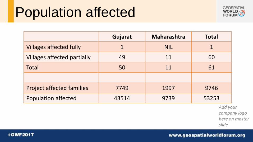
Population affected
Gujarat Maharashtra Total
Villages affected fully 1 NIL 1
Villages affected partially 49 11 60
Total 50 11 61
Project affected families 7749 1997 9746
Population affected 43514 9739 53253

Add your company logo here on master slide
Suggestions of Gujarat
• Inclusion of command area of five projects viz., Ugta, Sidhumber, Khata Amba, Zankhari and Kuntali in PTN link
• Providing Irrigation to tribal areas lying on right side of the PTN canal by lift.
• Providing Irrigation to tribal areas in Chhota Udepur and Panchmahal districts
• Providing Irrigation in Tribal areas of Dangs and Valsad districts

Add your company logo here on master slide

Add your company logo here on master slide

Add your company logo here on master slide

Add your company logo here on master slide
Additional Tribal areas identified
Name Annual Irrigation in ha Taluka / District
Area 1 900 Vyra / Tapi
Area 2 13100 Songadh / Tapi
Area 3 6500 Mandvi, Mangrol / Surat
Area 4 15700 Valia / Bharuch
Total Area 36200

Add your company logo here on master slide
Additional Tribal areas identified Name Annual Irrigation in ha
Tribal Non Tribal District
North of Narmada 1
14940 8810 Chhota Udepur
North of Narmada 2
1833 8759 Panchmahal
16773 17569
Total 34342

Add your company logo here on master slide
CCA (ha)
Annual Irrigation (ha)
Water use (MCM)
Enroute command 61190 76488 475
Projects proposed by Govt. of Gujarat on the left side of the Canal in south Gujarat
45561 57489 360
Tribal areas in enroute right side by lift 36200 36200 140
Tribal areas in vicinity of reservoirs in Valsad and Dang districts( by lift)
12154 12154 48
Tribal areas right side of Narmada Main Canal by lift
a) Chhota Udepur 23750 19000 72
b) Panchmhal District 10592 8470 32
Total irrigation in tribal areas 83056 76184 292
Target Command in Saurashtra 18000 18000 83
Total (C) 207361 228161 1210

Add your company logo here on master slide
Cadastral overlaid on proposed canal

Add your company logo here on master slide

Add your company logo here on master slide