sustainable development and environmental justice t · sustainable development and environmental...
TRANSCRIPT

20 General Plan Guidelines
CHAPTER 2
Sustainable Development andEnvironmental Justice
All statutory references are to the California Government Code unless otherwise noted.
This chapter addresses the incorporation of en-vironmental justice into the general plan.While environmental justice is not a manda-
tory topic in the general plan, there is a strong case forits inclusion. Federal and state anti-discrimination stat-utes, which have a long history, apply to planning asthey do to other policy areas. As discussed below, envi-ronmental justice issues are often related to failures inland use planning. Planning policies that promote liv-able communities and smart growth can be tools forachieving environmental justice. In keeping with thatidea, this chapter begins with a discussion of sustain-able development. Sustainable development provides acontext for understanding how environmental justicefits into land use planning. This chapter concludes witha discussion of transit-oriented development, which hasimportant implications for environmental justice andsustainable development.
SUSTSUSTSUSTSUSTSUSTAINABLE DEVELOPMENTAINABLE DEVELOPMENTAINABLE DEVELOPMENTAINABLE DEVELOPMENTAINABLE DEVELOPMENTSustainable development encompasses established
principles of good planning and advocates a proactiveapproach to future development. The basic concept ofsustainability is meeting the needs of current genera-tions without compromising the ability of future gen-erations to meet their own needs. Sustainabledevelopment can be further defined as promoting the“three E’s:” environment, economy, and equity. Forexample, a decision or action aimed at promoting eco-nomic development should not result in decreased en-vironmental quality or social inequity. Ensuring that agiven decision or action promotes all three E’s is oftenreferred to as the triple bottom line.
What does sustainable development look like on theground? In a community that is developing sustainably,the neighborhood is the basic building block of urbandesign and is characterized by walkability, mixed-usedevelopment, and mixed-income housing. Walkabilityis a function of compactness and density. Attention tostreetscape and public spaces is a key design elementin creating desirable places to live. Such neighborhoods,
also known as neo-traditional or new urbanist develop-ment, are more likely to support efficient transit systems.The character and function of each neighborhood is thenplaced properly within its regional setting. This approachto planning, from the neighborhood to the regional level,is often referred to as smart growth.
Sustainable development goals and policies includethe following:♦ Decrease urban sprawl.
� Promote compact, walkable, mixed-use de-velopment.
� Promote infill development.� Restore urban and town centers.� Limit non-contiguous (leafrog) development.� Promote transit-oriented development.
♦ Protect open space and working landscapes.� Conserve prime agricultural lands.� Conserve lands of scenic and recreational
value.� Use open space to define urban communi-
ties.♦ Protect environmentally sensitive lands.
� Conserve natural habitat lands.� Preserve habitat connectivity.� Minimize impact to watershed functions, in-
cluding water quality and natural floodways.� Avoid natural hazards.
♦ Create strong local and regional economies.� Encourage jobs/housing balance.� Provide adequate housing for all income
levels.� Encourage the expansion of telecommuni-
cations infrastructure.� Provide a fair and predictable land use plan-
ning process.♦ Promote energy and resource efficiency.
� Support energy- and resource-efficient in-dustries.
� Promote waste reduction programs, such asrecycling.
Topic: Environmental Justice and Disadvantaged Communites (DAC) Sustainable Development and Environmental Justice
CA Water Plan Update 2013 Vol. 4 Reference Guide Page 1
21General Plan Guidelines
� Promote alternative forms of transportation.� Promote energy- and resource-efficient build-
ings.♦ Promote equitable development.
� Require fair treatment in the development,adoption, implementation, and enforcement ofenvironmental laws, regulations, and policies.
� Promote mixed-income housing development.� Promote alternative transportation options to
increase access.� Promote economic opportunity for all seg-
ments of the community.� Protect culturally significant sites.
The comprehensive, integrated, and long-term na-ture of the general plan makes it an ideal vehicle forimplementing local sustainable development goals.When preparing or amending a general plan, sustain-able development policies or programs may be ad-dressed within the various elements of the plan. Forexample, policies on minimizing urban sprawl may beaddressed in the land use element; policies for primeagricultural land preservation may be introduced in theopen-space element; and the transportation element maybe used to address public transportation concerns.
The principles of sustainable development may alsoguide the overall goals of the general plan. For example,Santa Clara County’s general plan addresses four themesof sustainable development in its general plan vision:social and economic well-being, managed and balancedgrowth, livable communities, and responsible resourceconservation. The general plan’s goals for social andeconomic well-being include achieving “a healthy, di-verse economy and adequate employment opportuni-ties” by reaching “sustainable levels of growth and jobformation consistent with planned improvements inhousing, transportation, urban services, and maintenanceof environmental quality.” Goals for the other themesalso reflect the necessary balance of social, environ-mental, and economic objectives that characterizes sus-tainable development.
General plans can work in concert with other plansand policy documents to promote sustainability. Forinstance, the City of Pasadena uses a quality-of-life in-dex to identify, measure, and set quality-of-life indica-tors for a healthier, more sustainable city. “The Qualityof Life in Pasadena” index combines information fromthe city’s general plan and other documents and ad-dresses such topics as the environment, health, educa-tion, transportation, the economy, and employment. TheCity of Oakland includes in each staff report to the CityCouncil a discussion of how the proposed action would
promote the three E’s of sustainability. The concept andapplication of sustainable development is evolvingthrough creative interpretation and use.
Jobs/Housing BalanceOne issue that cuts across several elements of the
general plan is jobs/housing balance. Jobs/housing bal-ance compares the available housing and availalbe jobswithin a community, a city or other geographically de-fined subregion. Relying on the automobile as our pri-mary means of transportation has encouraged patternsof development and employment that are often ineffi-cient. Suburbanites routinely commute 25 miles or morefrom their homes to their places of employment. Publictransit is impractical for most people because jobs aredispersed throughout employment regions and housingdensity is too low. With residential and commercial landuses often separated by long distances, people mustmake multiple car trips to perform routine errands, suchas grocery shopping, going to the bank, eating out, go-ing to the dentist, etc.
Jobs/housing balance is based on the premise thatcommuting, the overall number of vehicle trips, and theresultant vehicle miles traveled can be reduced whensufficient jobs are available locally to balance the em-ployment demands of the community and when com-mercial services are convenient to residential areas.Planning for a jobs/housing balance requires in-depthanalyses of employment potential (existing and pro-jected), housing demand (by income level and housingtype), new housing production, and the relationshipbetween employment opportunities and housing avail-ability. Other factors, such as housing costs and trans-portation systems, must also be evaluated.
Improving the jobs/housing balance requires carefullyplanning for the location, intensity, and nature of jobs andhousing in order to encourage a reduction in vehicle tripsand miles traveled and a corresponding increase in theuse of mass transit and alternative transportation meth-ods, such as bicycles, carpools, and walking. Strategiesinclude locating higher-density housing near employmentcenters, promoting infill development, promoting transit-oriented development, actively recruiting businesses thatwill utilize the local workforce, developing a robust tele-communications infrastructure, developing workforceskills consistent with evolving local economies, and pro-viding affordable housing opportunities within the com-munity. Jobs-housing provisions most directly affect theland use, circulation, and housing elements.
The question of a jobs/housing balance on the scaleof a community should not be confused with the designof mixed-use, walkable neighborhoods. Planning for a
Chapter 2: Sustainable Development and Environmental Justice
Topic: Environmental Justice and Disadvantaged Communites (DAC) Sustainable Development and Environmental Justice
CA Water Plan Update 2013 Vol. 4 Reference Guide Page 2
22 General Plan Guidelines
jobs/housing balance alone could easily result in a citycomposed of single-use residential subdivisions on oneside of town and single-use business parks and shop-ping centers on the other side of town. At the scale ofthe region, this might be preferable to a jobs/housingimbalance, but at the scale of the community and of theneighborhood it does not improve livability or reducedependence on the automobile. While it is not likelythat most employees of a local business will also live inthe neighborhood, it is important that the planning ofthe neighborhood not preclude that possibility for thosewho would chose it.
ENVIRENVIRENVIRENVIRENVIRONMENTONMENTONMENTONMENTONMENTAL JUSTICEAL JUSTICEAL JUSTICEAL JUSTICEAL JUSTICE
Environmental justice is defined in state planninglaw as the fair treatment of people of all races, cultures,and incomes with respect to the development, adoption,implementation, and enforcement of environmental laws,regulations, and policies (§65040.12(e)). The Governor’sOffice of Planning and Research (OPR) is required to pro-vide guidance to cities and counties for integrating envi-ronmental justice into their general plans (§65040.12(c)).This section discusses the framework for environmentaljustice and the relationship of environmental justice to thegeneral plan. The recommendations in this chapter arealso reflected in the chapters on the required general planelements (Chapter 4), optional elements (Chapter 6), andpublic participation (Chapter 8).
Federal FrameworkThe basis for environmental justice lies in the Equal
Protection Clause of the U.S. Constitution. The Four-teenth Amendment expressly provides that the statesmay not “deny to any person within [their] jurisdic-tion the equal protection of the laws” (U.S. Constitu-tion, amend. XIV, §1).
On February 11, 1994, President Clinton signed Ex-ecutive Order (E.O.) 12898, titled “Federal Actions toAddress Environmental Justice in Minority Populationsand Low-Income Populations.” The executive order fol-lowed a 1992 report by the U.S. Environmental Protec-tion Agency (U.S. EPA) indicating that “[r]acial minorityand low-income populations experience higher than av-erage exposures to selected air pollutants, hazardouswaste facilities, and other forms of environmental pol-lution.” Among other things, E.O. 12898 directed fed-eral agencies to incorporate environmental justice intotheir missions.
In a memorandum accompanying E.O. 12898, Presi-dent Clinton underscored existing federal laws that canbe used to further environment justice. These laws in-
clude Title VI of the Civil Rights Act of 1964 and theNational Environmental Policy Act (NEPA), amongothers. Title VI prohibits any recipient (state or localentity or public or private agency) of federal financialassistance from discriminating on the basis of race,color, or national origin in its programs or activities(42 USC §2000d-§2000d-7). State and local agenciesthat receive federal funding must comply with Title VI.Pursuant to the Civil Rights Restoration Act of 1987,this requirement applies to all agency programs andactivities, not just those that receive direct federal fund-ing. In response, many state and local agencies that re-ceive federal funding have initiated environmentaljustice programs of their own.
NEPA applies to projects carried out or funded by afederal agency (including the issuance of federal per-mits). NEPA is useful relative to environmental justicebecause it requires public participation and discussionof alternatives and mitigation measures that could re-duce disproportionate effects on low-income and mi-nority populations. On December 10, 1997, the Councilon Environmental Quality (CEQ) released NEPA Guid-ance for Federal Agencies on Key Terms in E.O. 12898.This document is a useful reference for planners, al-though it is focused on environmental review of indi-vidual projects rather than long-term comprehensiveland use planning.
State FrameworkAnti-discrimination laws existed in California prior
to the passage of the first state environmental justicelegislation in 1999. The California Constitution prohibitsdiscrimination in the operation of public employment,public education, or public contracting (Article I, §31).State law further prohibits discrimination under anyprogram or activity that is funded or administered bythe state (§11135). The Planning and Zoning Law pro-hibits any local entity from denying any individual orgroup of the enjoyment of residence, land ownership,tenancy, or any other land use in California due to therace, sex, color, religion, ethnicity, national origin, an-cestry, lawful occupation, or age of the individual orgroup of individuals (§65008). The Fair Employmentand Housing Act (FEHA) specifically prohibits hous-ing discrimination on the basis of race, color, religion,sex, sexual orientation, marital status, national origin,ancestry, familial status, disability, or source of income(§12900, et seq.)
In 1999, Governor Davis signed SB 115 (Solis,Chapter 690, Statutes of 1999) into law, defining envi-ronmental justice in statute and establishing OPR as
Chapter 2: Sustainable Development and Environmental Justice
Topic: Environmental Justice and Disadvantaged Communites (DAC) Sustainable Development and Environmental Justice
CA Water Plan Update 2013 Vol. 4 Reference Guide Page 3
23General Plan Guidelines
the coordinating agency for state environmental jus-tice programs (§65040.12). SB 115 further required theCalifornia Environmental Protection Agency (Cal/EPA)to develop a model environmental justice mission state-ment for boards, departments, and offices within theagency by January 1, 2001 (Public Resources Code§72000-72001).
In 2000, Governor Davis signed SB 89 (Escutia,Chapter 728, Statutes of 2000), which complementedSB 115 by requiring the creation of an environmentaljustice working group and an advisory group to assistCal/EPA in developing an intra-agency environmentaljustice strategy (Public Resources Code §72002-72003). SB 828 (Alarcón, Chapter 765, Statutes of2001) added and modified due dates for the develop-ment of Cal/EPA’s intra-agency environmental justicestrategy and required each board, department, and of-fice within Cal/EPA to identify and address any gapsin its existing programs, policies, and activities that mayimpede environmental justice no later than January 1,2004 (Public Resources Code §71114-71115).
AB 1553 (Keeley, Chapter 762, Statutes of 2001)required OPR to incorporate environmental justice con-siderations in the General Plan Guidelines. AB 1553specified that the guidelines should propose methodsfor local governments to address the following:♦ Planning for the equitable distribution of new pub-
lic facilities and services that increase and enhancecommunity quality of life.
♦ Providing for the location of industrial facilities anduses that pose a significant hazard to human healthand safety in a manner that seeks to avoidoverconcentrating these uses in proximity to schoolsor residential dwellings.
♦ Providing for the location of new schools and resi-dential dwellings in a manner that avoids proxim-ity to industrial facilities and uses that pose asignificant hazard to human health and safety.
♦ Promoting more livable communities by expand-ing opportunities for transit-oriented development.
Forms of InequityProblems of environmental justice can be broken
down into two categories: procedural inequity andgeographic inequity. In other words, unfair treatmentcan manifest itself in terms of process or in terms ofresults.
Procedural inequity occurs when the planning pro-cess is not applied uniformly. Examples of proceduralinequity include:
♦ “Stacking” commissions or committees with cer-tain interests while ignoring the interests of othersegments of the community, such as minority andlow-income residents.
♦ Holding meetings at times or in locations that mini-mize the ability of certain groups or individuals toparticipate.
♦ Using English-only written or verbal communica-tion when a non-English speaking population willbe affected by a planning decision.
♦ Requiring lower levels of mitigation for projectsaffecting low-income or minority populations.
♦ Unevenly enforcing environmental rules.
Geographic inequity describes a situation in whichthe burdens of undesirable land uses are concentratedin certain neighborhoods while the benefits are re-ceived elsewhere. It also describes a situation inwhich public amenities are concentrated only in cer-tain areas. Examples of geographic inequity includesituations in which:♦ Certain neighborhoods have a disproportionate
share of industrial facilities that handle or producehazardous waste, while the economic benefits aredistributed to other neighborhoods (in the form ofjobs and tax revenue).
♦ Certain neighborhoods have a disproportionateshare of waste disposal facilities, while the ben-efits of such facilities are received by the commu-nity or region as a whole.
♦ Certain neighborhoods have ample community cen-ters, parks, and open space and thus experiencemore of the environmental benefits associated withthese amenities, while other neighborhoods havefewer such amenities.
Public ParticipationCommunity involvement in the planning process is
an important part of environmental justice. Cities andcounties should develop public participation strategiesthat allow for early and meaningful community involve-ment in the general plan process by all affected popu-lation groups. Participation plans should incorporatestrategies to overcome linguistic, institutional, cultural,economic, and historic barriers to effective participa-tion. Chapter 8 is dedicated to the issue of public par-ticipation and suggests methods to improve outreachto and communication with all population groups, in-cluding low-income and minority populations.
Chapter 2: Sustainable Development and Environmental Justice
Topic: Environmental Justice and Disadvantaged Communites (DAC) Sustainable Development and Environmental Justice
CA Water Plan Update 2013 Vol. 4 Reference Guide Page 4

24 General Plan Guidelines
CompatibilityAt the general plan level, discussions about envi-
ronmental justice involve a central land use concept:compatibility. The primary purpose of planning, andthe source of government authority to engage in plan-ning, is to protect the public health, safety, and wel-fare. Incompatible land uses may create health, safety,and welfare issues for the community. Geographic in-equity occurs when incompatible land uses dispropor-tionately affect a particular socioeconomic segment ofthe community. In this sense, environmental justiceproblems indicate a failure of land use planning to de-liver on its original promise—reducing the harmful ef-fects of incompatible land uses.
Traditionally, zoning has attempted to minimizehealth and safety risks by segregating land uses. How-ever, taking this approach too far has negative conse-quences that run counter to the goals of sustainabledevelopment. Rigid separation of land uses has resultedin disconnected islands of activity and contributed tosprawl. As discussed above, development patterns char-acterized by single-use zoning result in the automobilebeing the only viable transportation option, which hashigh environmental, economic, and social costs.
The traditional pyramidal zoning model placessingle-family homes at the pinnacle, followed by densermulti-family housing, followed by office and commer-cial uses, and, finally, followed by industrial uses atthe base. In this model, land uses at a lower level onthe pyramid are not allowed within the higher designa-tions (e.g., commercial uses are not allowed in multi-family zones, and apartments are not allowed insingle-family zones). This is giving way to a much moresustainable model, where the middle of the pyramidconsists of mixed-use development that integrates hous-ing, commercial, and recreational/cultural activities.Despite the desirability of mixed-use zoning, it is im-portant to recognize that there are certain industrial usesthat will always be incompatible with residential andschool uses.
Residential and school uses are harmed by incom-patible land uses that have environmental effects, suchas noise, air emissions (including dust), and exposureto hazardous materials. The compatibility problem alsooperates in reverse. Incompatible uses adjacent to resi-dential units, schools, or environmentally sensitive ar-eas may also suffer negative consequences in the formof higher mitigation costs or the curtailment of eco-nomic activities. Specific examples of land use incom-patibility include:♦ Residential and school uses in proximity to indus-
trial facilities and other uses that, even with the best
available technology, will contain or produce ma-terials that, because of their quantity, concentration,or physical or chemical characteristics, pose a sig-nificant hazard to human health and safety.
♦ Residential and school uses adjacent to intensiveagricultural uses.
♦ Residential and school uses adjacent to major thor-oughfares, such as highways.
♦ Residential or commercial uses in proximity to re-source utilization activities, such as mining or oiland gas wells.
Issues related to industrial overconcentration and thelocation of residential dwellings and schools are dis-cussed below.
Information and AnalysisGood information is critical to making informed
decisions about environmental justice issues. The analy-sis of environmental justice problems has benefitedfrom the advancement of geographic information sys-tems (GIS), as has the entire planning field. The role ofdata in the general plan process is discussed more fullyin Chapter 3. The data suggestions for the mandatorygeneral plan elements (Chapter 4) include much of theinformation necessary for developing environmentaljustice policies.
Relevant information for addressing environmentaljustice issues includes, but is not limited to:♦ Base map of the city or county planning area.♦ General plan designations of land use (existing and
proposed).♦ Current demographic data.
� Population location and density.� Distribution of population by income.� Distribution of population by ethnicity.� Distribution of population by age.
♦ Location of public facilities that enhance commu-nity quality of life, including open space.
♦ Location of industrial facilities and other uses thatcontain or produce materials that, because of theirquantity, concentration, or physical or chemicalcharacteristics, pose a significant hazard to humanhealth and safety.
♦ Location of existing and proposed schools.♦ Location of major thoroughfares, ports and airports.♦ Location and density of existing and proposed resi-
dential development.
Chapter 2: Sustainable Development and Environmental Justice
Topic: Environmental Justice and Disadvantaged Communites (DAC) Sustainable Development and Environmental Justice
CA Water Plan Update 2013 Vol. 4 Reference Guide Page 5
25General Plan Guidelines
Although the use of population data is a normal partof the planning process, cities and counties do not al-ways gather socioeconomic data when preparing orsubstantially revising their general plans. Jurisdictionsdo have to collect some socioeconomic data during thepreparation of the housing element, such as incomelevel and persons with special housing needs (elderly,farmworkers, single head of household, etc.), but thisrequired information is not enough to paint a completesocioeconomic picture of the community. From an en-vironmental justice perspective, socioeconomic data isuseful for a number of things, including:♦ Improving the public participation process.♦ Identifying low-income and minority neighbor-
hoods that are underserved by public facilities andservices that enhance quality of life and planningfor the equitable distribution of such facilities andservices.
♦ Planning for infrastructure and housing needs.♦ Identifying low-income and minority neighbor-
hoods in which industrial facilities and uses thatpose a significant hazard to human health and safetymay be overconcentrated.
As discussed below, the definitions of both equi-table distribution and overconcentration do not dependon socioeconomic factors. However, reversing historicalproblems of procedural and geographic inequity requiresaccurate socioeconomic information in order to developpolicies and prioritize implementation measures.
Relationship to the General PlanCities and counties may incorporate environmental
justice into their general plans in several ways. A cityor county may choose to adopt an optional environ-mental justice element. However, OPR recommendsincorporating policies supportive of environmental jus-tice in all of the mandatory elements of the general plan.These policies should also be reflected in any optionalelements. In keeping with the internal consistency re-quirement, environmental justice policies in one elementcannot conflict with the policies of another element. Forexample, if the land use element contains a policy pro-hibiting residential uses adjacent to certain industrialuses, properties affected by that policy could not beused as part of the housing element site inventory.
Public Facilities and ServicesCities and counties should plan for the equitable
distribution throughout the community of new publicfacilities and services that increase and enhance com-
munity quality of life, given the fiscal and legal con-straints that restrict the siting of such facilities.
Public facilities and services that enhance qualityof life include, but are not limited to, parks, open space,trails, greenbelts, recreational facilities (including se-nior and youth centers), community centers, child carecenters, libraries, museums, cultural centers, sciencecenters, and zoos. The equitable distribution of facili-ties and services has two components. The first com-ponent is the number and size of facilities. Simply put,a community should have adequate facilities and ser-vices to serve all residents equally. The second compo-nent is access, which can be measured as the distanceor travel time from each residential area to the facilityor service. Access may also be measured by the abilityto use a variety of transportation modes, including pub-lic transit, walking, and bicycling, to travel betweeneach residential area and the facility or service. A geo-graphic analysis of residential areas and the location ofpublic amenities may reveal underserved neighbor-hoods. Policies addressing the distribution of benefi-cial public facilities and services should address existingdisparities as well as the needs of future residents.
Public facilities and services that enhance commu-nity quality of life can be divided into three basic typesfor purposes of distribution. The first type is neighbor-hood facilities, such as parks, that serve a specific neigh-borhood or subdivision. The second type is districtfacilities, such as branch libraries or recreational cen-ters, that serve more than one neighborhood. The thirdtype is unique facilities, where one facility serves theentire community—“community” being an incorpo-rated city or, for counties, an unincorporated area.
Neighborhood facilities should be geographicallydispersed throughout the community. Examples includeparks, tot lots, and neighborhood activity centers. Thesefacilities should be located within the neighborhoodthey serve. Public amenities can serve to anchor a neigh-borhood and should be centrally located. Furthermore,locating neighborhood-serving public facilities withinwalking distance of most residents will encourage useand provide a sense of place. A distance of a quarter toa half mile is generally considered a walkable distance.
Planning for the location of district facilities shouldfollow the same principles as above. Since these facilitiesserve several neighborhoods, they should be centrally lo-cated relative to the neighborhoods they serve. Locatingsuch facilities along transit corridors or in transit-orienteddevelopments will increase their accessibility (see Tran-sit-Oriented Development later in this chapter).
Examples of unique public facilities include the cen-tral library or city museum. Where a community has
Chapter 2: Sustainable Development and Environmental Justice
Topic: Environmental Justice and Disadvantaged Communites (DAC) Sustainable Development and Environmental Justice
CA Water Plan Update 2013 Vol. 4 Reference Guide Page 6

26 General Plan Guidelines
only one recreational or cultural center, that would beconsidered a unique facility or service. These facilitiesshould be located in the civic center or urban core ratherthan isolated in remote single-use complexes. Theyshould be close to transit to allow maximum access forthe entire community.
Consideration should also be given to regional fa-cilities, which may exhibit the characteristics of all threebasic types described above. Re-gional facilities include trails,networks of open space such asgreenbelts, regional parks andrecreation areas, etc. Linear facili-ties (such as trails and greenbelts)may serve several neighborhoodsbut are also a unique amenity forthe entire area. The same is trueof large regional recreational ar-eas. Individual cities and countiesmay have less control over the lo-cation of regional facilities, whichmay be operated by special dis-tricts or joint powers authorities.Cities and counties have even lesscontrol over state and federal parks, recreational areas,and forests, although cities and counties should accountfor such facilities in the planning process. New regionalfacilities are rare, and when the opportunity to acquireor develop such facilities arises, the location may bepredetermined by such factors as natural features, aban-doned rail lines (for trail use), or the availability of largeundeveloped properties. Nevertheless, planners shouldconsider existing and proposed regional facilities whenanalyzing community access to public facilities thatcontribute to quality of life and when planning for fu-ture such facilities.
Locating public facilities and uses according to theseplanning principles may be limited by fiscal and legalconstraints. Fiscal constraints include the relative costof land and the ability of public agencies to obtain fi-nancing for acquisition and construction. Legal con-straints include, but are not limited to, local, state, andfederal regulations for the protection of the environ-ment, public health and safety, and the preservation ofnatural and cultural resources, including historical andarcheological resources.
Industrial FacilitiesCities and counties should develop policies that pro-
vide for the location of industrial facilities and otheruses that, even with the best available technology, willcontain or produce materials that, because of their quan-
tity, concentration, or physical or chemical character-istics, pose a significant hazard to human health and safetyin a manner that seeks to avoid overconcentrating theseuses in proximity to schools or residential dwellings.
Overconcentration occurs when two or more indus-trial facilities or uses, which do not individually ex-ceed acceptable regulatory standards for public healthand safety, pose a significant hazard to adjacent resi-
dential and school uses due totheir cumulative effects.
Facilities that emit, handle,store, or dispose of hazardousmaterials are regulated by a vari-ety of agencies. These agenciesinclude local Certified UnifiedProgram Agencies (such as en-vironmental health departmentsor fire departments), air dis-tricts, regional water qualitycontrol boards, the CaliforniaDepartment of Health Services,the California Integrated WasteManagement Board, and theCalifornia Department of Toxic
Substance Control (DTSC). However, cities andcounties, as the local land use authority, are prima-rily responsible for the location and distribution ofpotentially hazardous industrial facilities throughtheir general plans and zoning ordinances.
Cities and counties may pursue several strategieswithin their general plans to address overconcentration.Strategies may include:♦ Buffer zones between industrial and residential
land uses.♦ Policies addressing individual project siting decisions.♦ Capping the number of certain facilities and uses.♦ Changing land use designations in
overconcentrated areas.
Buffer zones are a broad approach to land usecompatibility. Buffer zone policies may be ap-proached in one of two ways. First, the general planland use diagram may designate transitional land usesbetween industrial and residential areas. Transitionaluses may include open space, light industry, officeuses, business parks, or heavy commercial uses. Theland use policies for these buffer areas should pro-hibit school uses (see discussion below on schoolsiting). Appropriate distances for buffer areas willvary depending on local circumstances. Factors suchas the intensity of nearby residential uses, prevailing
A University of Southern Californiastudy, Parks and Park Funding in LosAngeles: An Equity Mapping Analysis,is an example of how equitabledistribution of public amenities (inthis case, parks and open space)can be analyzed using a geographicinformation system (GIS). Thereport is available at www.usc.edu/dept/geography/espe.
Analyzing Equitable Distribution
Chapter 2: Sustainable Development and Environmental Justice
Topic: Environmental Justice and Disadvantaged Communites (DAC) Sustainable Development and Environmental Justice
CA Water Plan Update 2013 Vol. 4 Reference Guide Page 7

27General Plan Guidelines
winds, geographic features, and the types of facili-ties and uses allowed in industrial areas should beconsidered.
Second, buffer zones may be implemented at theproject level. One weakness of general buffer zone poli-cies is the difficulty of making a priori decisions abouthow much distance is needed to minimize potentialhealth and safety hazards to residential and school uses.A stronger approach may be buffer policies aimed atindividual siting decisions.
Approval of certain industrial facilities or uses canbe made conditional if they are within a certain dis-tance of residential or school uses and/or contain orproduce hazardous materials. This allows the city orcounty to consider the potential hazards associated withindividual facilities or uses on a case-by-case basis.General plan policies can outline consistent standardsto be used in approving, conditionally approving, ordenying proposed locations for industrial facilities andother uses that may pose a significant hazard to humanhealth and safety. Such standards should be reflected inthe zoning ordinance that implements the general plan(see Chapter 10 for a discussion of zoning consistency).
Approval of a conditional use is discretionary andthus would be subject to the California EnvironmentalQuality Act (CEQA). CEQA requires decision makersto consider the environmental consequences of theiractions. CEQA also serves as an important consulta-tion tool. A lead agency must consult with an affectedschool district if any facility that would create hazard-ous air emissions or handle acutely hazardous materialis proposed within a quarter mile of a school (PublicResources Code §21151.4).
Another policy response to overconcentration is tocap the number of potentially hazardous facilities withina certain distance of each other. For example, the Stateof Georgia does not allow siting of a new solid wastefacility if two such facilities already exist within a twomile radius of the proposed facility. While capping poli-cies are easy to implement and understandable to the pub-lic, they have serious drawbacks. Numerical caps are morelikely to be based on perception and political compromisethan scientific merit. Without analyzing the type, quan-tity, and concentration of materials to be contained or pro-duced at a proposed facility, it is difficult to determine thenumber of facilities that would create a situation ofoverconcentration.
The general plan strategies above can assist a cityor county in addressing future problems ofoverconcentration. General plans, which are by theirnature concerned with future development, are not aseffective at correcting past problems. One way to ad-
dress existing or potential future problems ofoverconcentration is to change the land use designa-tion for existing industrial areas. This approach differsfrom buffer zones in that buffer zones affect the landuse designation of areas adjacent to existing or pro-posed industrial areas. Changing the allowable landuses in existing industrial areas prevents new indus-trial land uses from being established and may affectthe expansion of existing facilities and uses (depend-ing on how local policies treat pre-existing or “legalnon-conforming,” land uses).
An important caveat is to consider what new useswill be allowed in the previously industrial areas. Anew environmental justice problem could be createdif residences and schools are allowed without consid-ering any lingering effects of industrialoverconcentration. At the same time, whereoverconcentration is no longer an issue and effectiveremediation or clean-up is possible, so-called“brownfield” development is an important tool for acommunity’s continued sustainable development.
Finally, planners should remember to differentiatebetween overconcentration and the mere presence ofmaterials that may be classified as hazardous. Many neigh-borhood businesses, such as gas stations, photographystudios, retail paint stores, dry cleaners, etc., may havehazardous materials present. While these activities mustbe conducted in a responsible manner in accordancewith all environmental regulations, they should not beconfused with those truly industrial activities that are in-appropriate for residential or mixed-use areas.
New Residential Uses and SchoolsCities and counties should provide for the location
of new schools and residential dwellings in a mannerthat seeks to avoid locating these uses in proximity toindustrial facilities and uses that will contain or pro-duce materials that, because of their quantity, concen-tration, or physical or chemical characteristics, pose asignificant hazard to human health and safety.
The location of new residential and school develop-ment is the flip side of the problem discussed in thesection above. Given the need for new housing andschools and given the need to make efficient use of land,how do cities and counties deal with existingoverconcentration of industrial uses? When designat-ing areas for residential development, the city or countyshould identify any areas of overconcentration. Appro-priate buffers should be placed betweenoverconcentrated industrial areas and new residentialareas. Using their authority over the approval and de-sign of subdivisions, cities and counties may develop
Chapter 2: Sustainable Development and Environmental Justice
Topic: Environmental Justice and Disadvantaged Communites (DAC) Sustainable Development and Environmental Justice
CA Water Plan Update 2013 Vol. 4 Reference Guide Page 8
28 General Plan Guidelines
policies and standards related to industrialoverconcentration and new residential subdivision ap-provals. These policies could include buffer zones, as wellas the criteria to be used for rejecting new residential de-velopment (such as standards for risk to human healthand safety from nearby industrial facilities and uses).
The location of new schools is of particular concernto both local governments and school districts. The gen-eral plan should identify possible locations for newschools. Such locations may be approximate and neednot indicate specific parcels. Identifying appropriateschool locations as part of the general plan process mayavoid project-level problems of proximity to certain in-dustrial facilities and uses. Due to the fragmentation ofauthority in the areas of land use planning and schoolsiting and construction, it is recommended that the plan-ning agency work closely with the school district to iden-tify suitable school locations. Prior to adopting oramending a general plan, the planning agency must re-fer the proposed action to any school district within thearea covered by the proposed action (§65352). The cityor county should use this opportunity to engage schooldistricts on issues of school siting.
For their part, school districts are required to notifythe planning commission of the city or county prior toacquiring property for new schools or expansion of anexisting school. School districts are not bound by localzoning ordinances unless the ordinance provides for thelocation of schools and the city or county has adopted ageneral plan (§53091). School districts can override thegeneral plan and zoning ordinances with regard to theuse of property for classroom facilities by a two-thirdsvote of the school board (§53094). The school boardcannot exercise this power for non-classroom facilities,such as administrative buildings, bus storage and main-tenance yards, and warehouses. If the school board ex-ercises their override power, they must notify the cityor county within 10 days (§53904).
CEQA requires that the environmental documentprepared for a new school identify whether the proposedsite is any of the following: a current or former hazard-ous waste or solid waste disposal facility, a hazardoussubstances release site identified by DTSC, the site ofone or more pipelines that carry hazardous substances,or located within a quarter mile of a facility that emitshazardous air emissions or handles acutely hazardousmaterial (Public Resources Code §21151.8). If suchfacilities exist, the school board must make findings thatthe facilities would not endanger the health of thoseattending or employed by the proposed school or thatexisting corrective measures would result in the miti-gation of any health endangerment.
TRANSITTRANSITTRANSITTRANSITTRANSIT-ORIENTED DEVELOPMENT-ORIENTED DEVELOPMENT-ORIENTED DEVELOPMENT-ORIENTED DEVELOPMENT-ORIENTED DEVELOPMENTCities and counties should promote more livable
communities by expanding opportunities for transit-ori-ented development (TOD) so that residents minimizetraffic and pollution impacts from traveling for purposesof work, shopping, school, and recreation.
TOD is defined as moderate- to high-density devel-opment located within an easy walk of a major transitstop, generally with a mix of residential, employment,and shopping opportunities. TOD encourages walkingand transit use without excluding the automobile. TODcan be new construction or redevelopment of one ormore buildings whose design and orientation facilitatetransit use (Statewide Transit-Oriented DevelopmentStudy: Factors for Success in California, CaliforniaDepartment of Transportation, 2002).
A well-designed, vibrant TOD community can pro-vide many benefits for local residents and businesses,as well as for the surrounding region. Compact devel-opment near transit stops can increase transit ridershipand decrease rates of vehicle miles traveled (VMT),thereby yielding a good return on transit system invest-ments. TOD can also provide mobility choices, increasepublic safety, increase disposable household income byreducing transportation costs, reduce air pollution andenergy consumption rates, help conserve resources andopen space, assist in economic development, and con-tribute to the housing supply.
TOD is a strategy that may help a community achieveits general plan goals related to circulation, housing,environmental quality, and economic development.Additionally, by improving access to jobs and housingand revitalizing existing neighborhoods, TOD can be atool for promoting environmental justice.
A variety of factors need to be considered during thedevelopment and implementation of TOD. These fac-tors include transit system design; community partner-ships; understanding of local real estate markets;coordination among local, regional, and state organiza-tions; and providing the right mix of planning and fi-nancial incentives and resources. A successful TOD willreinforce the community and the transit system. Transitoperators, property owners, and residents should be in-volved in the development of TOD proposals.
Data to identify and assess potential locations forTOD should be collected during preparation of the landuse, circulation, and housing elements of the generalplan. An inventory of potential development (and rede-velopment) sites within a quarter to a half mile of exist-ing and proposed transit stops may reveal potentiallocations for TOD. Additional data may be used to verifythe optimum location and mix of uses to further refine
Chapter 2: Sustainable Development and Environmental Justice
Topic: Environmental Justice and Disadvantaged Communites (DAC) Sustainable Development and Environmental Justice
CA Water Plan Update 2013 Vol. 4 Reference Guide Page 9
29General Plan Guidelines
the viability of TOD at specific transit hubs. This datamay include origin and destination studies, transit rid-ership projections, and data to determine the appropri-ate jobs-to-housing ratio and level of retail services. Theappropriate density and intensity will support a highlevel of transit service. An optimal mix of uses will pro-vide opportunities to shop, work, live, and recreate with-out the need for an automobile.
Local governments can promote TOD through gen-eral plan policies that encourage supportive densitiesand designs and a mix of land uses. TOD-supportivepolicies may provide for higher land use densities, re-duced parking requirements, decreased automobile traf-fic levels of service, and increased transit levels ofservice. TOD policies should facilitate a pedestrian-ori-ented environment with features such as traffic calm-ing strategies, traditional grid street patterns with smallerblocks, and architecture that orients buildings to side-walks, plazas, and parks rather than to parking.
TOD Standards and PoliciesTOD design will vary with local needs and context,
but there are several generally accepted characteristics.These characteristics should be addressed broadly ingeneral plan policies and standards. Policies for spe-cific neighborhood districts or development sites canbe implemented through the planning tools discussedat the end of this section.
DensityDensity is a key concern in designing TOD policies.
A higher residential density relative to the communityas a whole is necessary to achieve a high level of transitservice and maximize the use of land suitable for suchdevelopments. Density levels vary significantly basedon local circumstances, but a minimum of 15 to 25 unitsper acre may be required to sustain an appropriate levelof transit use and commercial activity. The location ofthe TOD (regional urban core, town center, suburbandevelopment, etc.) and the mix of uses envisioned for aparticular TOD will affect the optimal level of densityand intensity.
Mixed UseA mix of uses is also a key element in TOD. Mixed-
use development facilitates a pedestrian-oriented envi-ronment, encouraging walking and transit overautomobile trips. A mix of uses also creates an environ-ment that encourages both day and night activity. Forexample, residential development supports restaurantsand entertainment uses after regular work hours haveended.. This can increase safety by avoiding the “deadzone” atmosphere that many residential areas have by
day and that many downtowns and commercial districtshave in the evening. Public uses also can contribute tothe success of TOD. Some TODs are anchored by apublic facility, such as a police station, child care cen-ter, recreation center, or government office. Not onlydoes a TOD benefit from the presence of public ameni-ties, but the public also benefits by having these ameni-ties convenient to transit.
A mix of uses may be within the same building (suchas first-floor commercial with residential units above)or in separate buildings within a quarter to a half mileof the transit stop. Particularly with the latter case, re-ferred to as “horizontal mixed-use,” it is important toprovide safe and direct pedestrian linkages betweendifferent uses.
It is recommended that general plan standards anddefinitions of mixed-use development exclude indus-trial facilities and uses that, even with the best avail-able technology, will contain or produce materials that,because of their quantity, concentration, or physical orchemical characteristics, pose a significant hazard tohuman health and safety.
Pedestrian ScaleWith higher-density mixed-use development, scale
is important. Pedestrian scale should be maintainedthrough appropriate street and sidewalk widths, blocklengths, the relationship of the buildings to the street,and the use of public spaces.
SafetyIn addition to the round-the-clock activity mentioned
above, it is important to maintain “eyes on the street”in urban development through the appropriate place-ment of windows and entrances. Appropriate lightingalso contributes to safety and the attractiveness of thedevelopment.
LandscapingA TOD, particularly when it is infill development,
may not have large areas available for landscaping.Nevertheless, high quality landscaping should be usedto enhance public spaces. The generous use of trees cre-ates a more livable environment and reduces energycosts for cooling. Street trees can make developmentmore pedestrian friendly by providing a barrier betweenthe sidewalk and street.
CirculationCirculation within a TOD should, in addition to sup-
porting transit, maximize walking and bicycling with-out eliminating the automobile. Cities and counties maydesignate certain qualifying areas served by transit as
Chapter 2: Sustainable Development and Environmental Justice
Topic: Environmental Justice and Disadvantaged Communites (DAC) Sustainable Development and Environmental Justice
CA Water Plan Update 2013 Vol. 4 Reference Guide Page 10

30 General Plan Guidelines
“infill opportunity zones.” (§65088.1) These zones,which must be identified by December 31, 2009, areexempt from county Congestion Management Planlevel of service requirements (§65088.4).
ParkingParking requirements for TOD are typically lower
than for conventional development and often specify amaximum rather than a minimum number of spaces. Inorder to maximize the use of land, parking structuresare favored over surface parking, particularly at infillTOD sites. The placement of parking structures shouldnot physically separate the TOD from the surroundingcommunity.
Implementation ToolsSuccessful TOD implementation is dependent upon
TOD-supportive general plan policies enabled by spe-cific zoning codes, development regulations, and de-sign guidelines. To create an effective regulatory andreview environment, local jurisdictions can modifyexisting zoning codes to encourage TOD; tailor de-velopment regulations to individual TOD sites whereappropriate; develop TOD-friendly design standards;and simplify and streamline the permit and reviewprocess.
The following planning tools are typical ways acommunity can implement TOD-supportive generalplan policies.
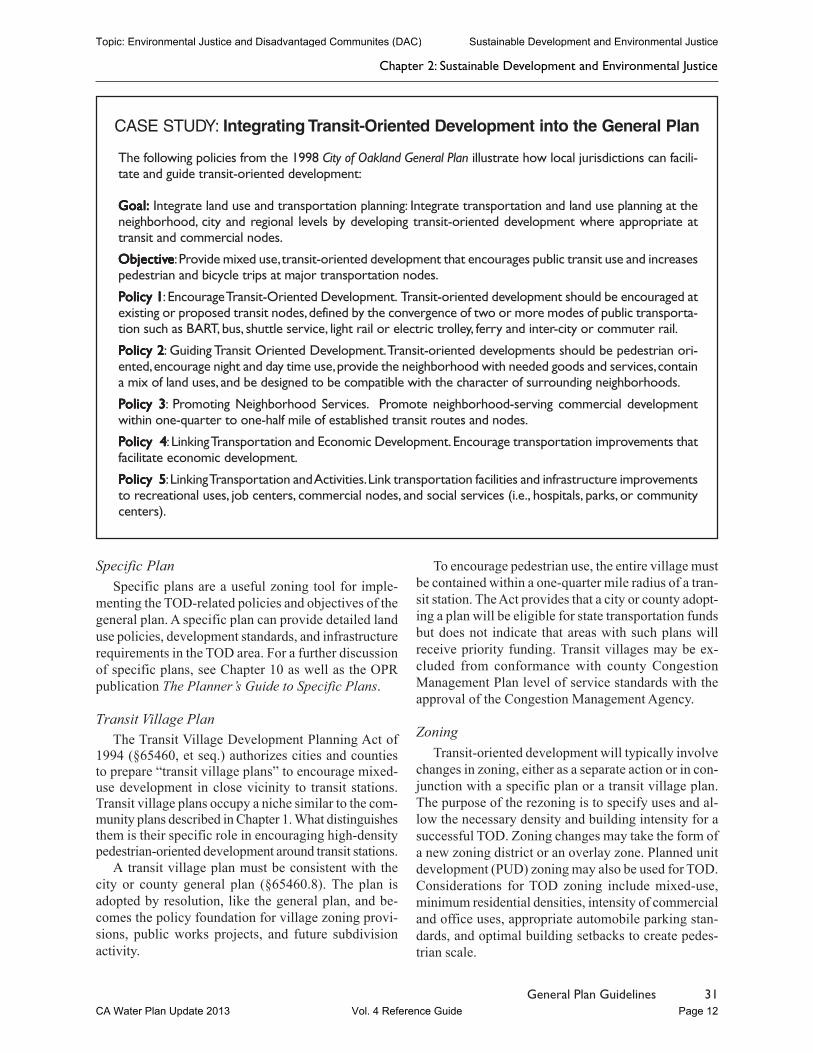
CASE STUDY: Integrating Transit-Oriented Development into the General Plan
The following policies from the agriculture and land use element of the Fresno County General Plan illustratehow local jurisdictions can facilitate and guide transit-oriented development:
PPPPPolicy LU-Folicy LU-Folicy LU-Folicy LU-Folicy LU-F.1.1.1.1.1 The County shall encourage mixed-use development that locates residences near compatiblejobs and services.
PPPPPolicy LU-Folicy LU-Folicy LU-Folicy LU-Folicy LU-F.2.2.2.2.2 The County shall encourage the combination of residential, commercial, and office uses inmixed use configurations on the same site.
PPPPPolicy LU-Folicy LU-Folicy LU-Folicy LU-Folicy LU-F.3.3.3.3.3 The County shall promote development of higher-density housing in areas located along majortransportation corridors and transit routes and served by the full range of urban services, including neighbor-hood commercial uses, community centers, and public services.
PPPPPolicy LU-Folicy LU-Folicy LU-Folicy LU-Folicy LU-F.4 .4 .4 .4 .4 The County shall selectively redesignate vacant land for higher density uses or mixed uses tofacilitate infill development.
PPPPPolicy LU-Folicy LU-Folicy LU-Folicy LU-Folicy LU-F.5.5.5.5.5 The County shall encourage subdivision designs that site neighborhood parks near activitycenters such as schools, libraries, and community centers.
PPPPPolicy LU-Folicy LU-Folicy LU-Folicy LU-Folicy LU-F.6.6.6.6.6 The County shall encourage the creation of activity centers including schools, libraries, andcommunity centers in existing neighborhoods.
PPPPPolicy LU-Folicy LU-Folicy LU-Folicy LU-Folicy LU-F.7.7.7.7.7 The County shall seek to reduce the amount of land devoted to parking in new urban non-residential development and encourage the use of shared parking facilities.
PPPPPolicy LU-Folicy LU-Folicy LU-Folicy LU-Folicy LU-F.8.8.8.8.8 The County shall adopt transit- and pedestrian-oriented design guidelines and incorporatethem into community plans and specific plans. The County shall review development proposals for compli-ance with its adopted transit-and pedestrian-oriented design guidelines to identify design changes that canimprove transit, bicycle, and pedestrian access.
PPPPPolicy LU-Folicy LU-Folicy LU-Folicy LU-Folicy LU-F.9.9.9.9.9 The County shall plan adequate pedestrian-oriented neighborhood commercial shoppingareas to serve residential development.
PPPPPolicy LU-Folicy LU-Folicy LU-Folicy LU-Folicy LU-F.10.10.10.10.10 The County shall encourage school districts to site new schools in locations that allowstudents to safely walk or bicycle from their homes, and to incorporate school sites into larger neighborhoodactivity centers that serve multiple purposes.
Chapter 2: Sustainable Development and Environmental Justice
Topic: Environmental Justice and Disadvantaged Communites (DAC) Sustainable Development and Environmental Justice
CA Water Plan Update 2013 Vol. 4 Reference Guide Page 11
31General Plan Guidelines
Specific PlanSpecific plans are a useful zoning tool for imple-
menting the TOD-related policies and objectives of thegeneral plan. A specific plan can provide detailed landuse policies, development standards, and infrastructurerequirements in the TOD area. For a further discussionof specific plans, see Chapter 10 as well as the OPRpublication The Planner’s Guide to Specific Plans.
Transit Village PlanThe Transit Village Development Planning Act of
1994 (§65460, et seq.) authorizes cities and countiesto prepare “transit village plans” to encourage mixed-use development in close vicinity to transit stations.Transit village plans occupy a niche similar to the com-munity plans described in Chapter 1. What distinguishesthem is their specific role in encouraging high-densitypedestrian-oriented development around transit stations.
A transit village plan must be consistent with thecity or county general plan (§65460.8). The plan isadopted by resolution, like the general plan, and be-comes the policy foundation for village zoning provi-sions, public works projects, and future subdivisionactivity.
To encourage pedestrian use, the entire village mustbe contained within a one-quarter mile radius of a tran-sit station. The Act provides that a city or county adopt-ing a plan will be eligible for state transportation fundsbut does not indicate that areas with such plans willreceive priority funding. Transit villages may be ex-cluded from conformance with county CongestionManagement Plan level of service standards with theapproval of the Congestion Management Agency.
ZoningTransit-oriented development will typically involve
changes in zoning, either as a separate action or in con-junction with a specific plan or a transit village plan.The purpose of the rezoning is to specify uses and al-low the necessary density and building intensity for asuccessful TOD. Zoning changes may take the form ofa new zoning district or an overlay zone. Planned unitdevelopment (PUD) zoning may also be used for TOD.Considerations for TOD zoning include mixed-use,minimum residential densities, intensity of commercialand office uses, appropriate automobile parking stan-dards, and optimal building setbacks to create pedes-trian scale.
The following policies from the 1998 City of Oakland General Plan illustrate how local jurisdictions can facili-tate and guide transit-oriented development:
Goal:Goal:Goal:Goal:Goal: Integrate land use and transportation planning: Integrate transportation and land use planning at theneighborhood, city and regional levels by developing transit-oriented development where appropriate attransit and commercial nodes.
ObjectivObjectivObjectivObjectivObjectiveeeee: Provide mixed use, transit-oriented development that encourages public transit use and increasespedestrian and bicycle trips at major transportation nodes.
PPPPPolicy 1olicy 1olicy 1olicy 1olicy 1: Encourage Transit-Oriented Development. Transit-oriented development should be encouraged atexisting or proposed transit nodes, defined by the convergence of two or more modes of public transporta-tion such as BART, bus, shuttle service, light rail or electric trolley, ferry and inter-city or commuter rail.
PPPPPolicy 2olicy 2olicy 2olicy 2olicy 2: Guiding Transit Oriented Development. Transit-oriented developments should be pedestrian ori-ented, encourage night and day time use, provide the neighborhood with needed goods and services, containa mix of land uses, and be designed to be compatible with the character of surrounding neighborhoods.
PPPPPolicy 3olicy 3olicy 3olicy 3olicy 3: Promoting Neighborhood Services. Promote neighborhood-serving commercial developmentwithin one-quarter to one-half mile of established transit routes and nodes.
PPPPPolicy 4olicy 4olicy 4olicy 4olicy 4: Linking Transportation and Economic Development. Encourage transportation improvements thatfacilitate economic development.
PPPPPolicy 5olicy 5olicy 5olicy 5olicy 5: Linking Transportation and Activities. Link transportation facilities and infrastructure improvementsto recreational uses, job centers, commercial nodes, and social services (i.e., hospitals, parks, or communitycenters).
CASE STUDY: Integrating Transit-Oriented Development into the General Plan
Chapter 2: Sustainable Development and Environmental Justice
Topic: Environmental Justice and Disadvantaged Communites (DAC) Sustainable Development and Environmental Justice
CA Water Plan Update 2013 Vol. 4 Reference Guide Page 12