sustainable cities - världsnaturfonden wwf sverige · sustainable cities ... the teaching material...
TRANSCRIPT

SUSTAINABLE CITIES Working with Sustainable Community Planning in Secondary Schools
HANDBOOK

2 WWF – Sustainable Cities
Cover and layout: Sven Ängermark
Translation: Richard Vincent
ThanksWe would like to thank the Pupils at the Global college in Stockholm, who participated in the Monster Cities or Flower Cities and My Future City projects, they have, with support from among others the KIT architects inspired us to continue to develop this work. We are especially grateful to the Urban Atlas group: Isak Roth, Birgitta Sjödell, Maria Gustafsson, Sophie Löfström, Maria Klawitter, Evangelina Lindberger och Linda Brelin. Without your incredible dedication and ideas this teaching material would never have seen the light of day.
We would also like to thank Thomas Elmqvist and Jeff Ranara at the Stockholm Resilience Centre for helping us get the project off the ground and for all the time you have spent on our students and us. Your contribution has been invaluable!
Thanks also to the staff and students at Porthälla gymnasium, Ullrika Forsgren and others at Borgarskolan in Gävle, Claes Malmberg with students at Miljöverkstaden in Helsing-borg and Anna Lodén with students from the Dragon School in Umeå for evaluating the material in this guide and for your clear-sighted comments.
Last but not least we want to thank Gitte Jutvik Guterstam and her colleagues from WWF for giving us the fantastic opportunity to spread this material further afield.
If teachers/students who read this guide are interested in further training in this area, please do not hesitate to contact us (at the addresses below) for inspiring lectures, work-shops, planning meetings, and more. We will tailor an approach that fits your wants and needs and the requirements of your school.
Lotta Jankell [email protected]
Karolina Sandahl [email protected]
Jonna Wiblom [email protected]

3WWF – Sustainable Cities
Welcome to the city as classroom!Over a period of three years ten schools took part in the WWF Project Schools on the Path to Sustainability. This project examined ways and models for integrating sustainable develop-ment in teaching, school management and developmental activities. Educators and students agree that when teaching involves real issues and students are engaged in problem solving in the community everybody wins – students become highly motivated and engaged in social questions and key players are given valuable support when those being taught themselves contribute creative solutions and viewpoints.
This guide is based on experiences from a variety of projects and has been developed by teachers at the Global College, a Secondary School in Stockholm. The teaching material mainly targets secondary school teachers, but can also be used in other contexts where inter-disciplinarity and education for sustainable development is the prime focus.
An informed pedagogical methodology has been implemented throughout. The goals estab-lished by school curriculum are the foundation for innovative and interdisciplinary activities carried out on a project basis. The guide contains numerous exercises and advice on how best to structure your work.
Please send us lesson plans, contributions from students and press clippings so that we can make these available to others.
Good luck in your vital work!
WWF Sustainable Cities [email protected]
Schools on the Path to Sustainability What do you need if the whole school is to be infused with education for sustainable development?
During three years WWF followed, supervised and documented developmental work in five primary
schools and four secondary schools. Six areas were found to of particular importance for schools
to grasp the principles of sustainable development. One of these is the educational benefits when
teaching involves students in real-world problems and gives them an opportunity to become in-
volved in community development.

4 WWF – Sustainable Cities
WORKING WITH SUSTAINABLE URBAN DEVELOPMENTPlease read this section before you start working with the project and before you start doing the exercises! Think about what it will entail for your teaching. Discuss with other teachers who intend to work in the project how you can integrate the various subjects involved.
The whole purpose of the project-oriented approach set forth in this guide is to help students acquire a deeper understanding of the opportunities and challenges that mate-rialise in sustainable community building – to give them the opportunity to consider how our future cities will emerge, and last but not least to provide them with the tools they will need to influence development in a democratic society. The idea is that student work will be based in the local environment (near the school or close to where they live), because this will awaken their interest, curiosity and commitment. There are also many benefits to be gained by adopting a global approach and comparing local conditions with situations in other cities and communities around the world.
Evaluations made by students who have worked in urban projects in the Schools on the Path to Sustainability project show that one of the things students thought most impor-tant and fun was the realisation they can become agents of influence and change. The city is not a fixed structure determined by others but under continual development and they discovered that they have role to play in this process.
Here are some quotes from students at the Global College in Stockholm who worked with sustainable urban development issues based on this guide:
The following questions will be repeatedly posed in in both outreach activities and in dis-cussions and presentations:
• What part of the city is to be studied (park, playground, district)?
• What is the situation in the selected city/ district, seen from different perspectives?
• How has the city/district changed?
• What challenges does the city/district face?
• What preconditions are in place to meet these challenges?
• What is an ecologically and socially sustainable society, and how can you achieve it?
• What is a socio-ecological perspective and how can it be linked to sustainable deve-lopment?
• What does the economic perspective involved in student questions and comments dictate? How does it impact your proposals for change?
• What is a vision and how the vision can take into account ecological and social sustainability?
• What is an ecosystem service, and how is the concept linked to sustainable deve-lopment in the city?
• What is an ecological footprint, what impacts do cities make and why are they so huge?
• What social and ecological values exist and which ones are important in a city/district?
• How can you utilise maps to spot relationships between human beings and the environment?
“Lots of responsibility and freedom.”
“It was fun to be out there learning things in real life.”
“Interesting to see you can influence things.”
“Nice to know how my immediate environment af-
fects society and myself.”
”To think that I could be part of actually changing
something in the city.”
“Amazing that real politici-ans listened to my proposal
and took it seriously.”
”Our group changed the way be people thought
about a square. Cool!

5WWF – Sustainable Cities
• What measures are needed to uphold ecological and socially sustainable development and ultimately achieve your vision?
• How can you help reduce the city’s ecological footprint and increase and maintain ecosystem services?
• How can you contribute to change and influence social development in your city?
The way this guide is structured and how to plan the project The teaching material is made up of five parts which together form a whole:
1. Preparation
2. Mapping
3. Analysis
4. Reports and evaluation
5. Consolidation and in-depth studies
Each part builds on the one that proceeds it, but each part can be used separately. By chang-ing the subjects covered and by selecting a particular part, you/your team can choose to work with the material during a few lessons to sketch an outline of the content, or embark upon a larger in-depth project that can span several weeks.
Each of the above components includes both basic and more advanced in-depth exercises. The exercises are based on groups of three to six students. It’s fine just to pick out one or two exercises from each part and if you are pressed for time this may be preferable, as you will often need more time for reflection and discussion than you might at first think.
PlanningIf multiple subject teachers are involved in the project it is important in the initial phase to set aside shared planning time. To find common entry points it is often useful to look at the syllabus together. Think about the way different subjects can “ride on each other’s backs” and how they can deepen an understanding of, for example, the concept of sustainable develop-ment (which recurs in several syllabuses). It is important that the project is not just some-thing grafted on top of the regular curriculum, but becomes a creative and challenging way of carrying out the curriculum in an integrated form.
Suggested points to discuss:
• Subjects in the project
• Core content, skills and abilities
• Student examinations and evaluation
• Joint assessment
• Running Time
• Possible field trips or guest speakers
• Purchase of materials for model making, etc.
• Evaluation
At a later stage it may also be thought-provoking to allow students to get involved in plan-ning the project. Be sure to have regular meetings during the project to coordinate how things are going and to make any planning changes.
The subjects, core content, skills and abilities that are to be covered by the project and subse-quently judged, depend of course on a variety of factors: the depth and scope of student and teacher knowledge and interest, how much time is at your disposal, the particular subjects students are studying at the moment and so on. The first steps in the project can be adapted to harmonise with subjects that that have been allotted most time in the syllabus and for this reason the project may take quite different forms, but the central theme should always the future of city and the challenges and opportunities it provides.
6 WWF – Sustainable Cities
Links with national curriculum, Gy11Below are suggestions for subjects that can be included in a project whose focus is urban sustainability. Examples of knowledge and skills that the Swedish National Agency for Ed-ucation requires in its syllabuses are also listed here. These are all embracing and can also be used as guidelines in most other countries. Since the guide emphasises socio-ecological aspects, detailed examples based on biology, natural history, geography and civics are provided. It should be pointed out however, that it is a good idea to link language studies and aesthetic and practical subjects to the project. Programmes in these subjects promote aptitudes and skills that instil collaborative behaviour in those who study them.
Suggestions for subjects to include:
• Geography
• Biology
• Science
• Civics
• Sustainable society
• History
• Language studies
• English
• Aesthetic courses
Examples of relevant abilities, skills and knowledge from some selected secondary school subjects (summary). The codes refer to course plans in Swedish national curricula Gy11. The salient parts of the curricula are available in English http://www.skolverket.se/polo-poly_fs/1.191466!/Menu/article/attachment/Curriculum.pdf. Below you can find links between this Sustainable City guide and different course plans. Unfortunately these plans are not available in English:
Biology (BIOBIO01) 1. Familiarity with concepts, models, theories and methods used in biology and an
understanding of how these develop.
2. Ability to analyse and seek answers to subject-related questions and to identify, formulate and solve problems.
3. Ability to reflect on and evaluate selected approaches, methods and results.
4. Ability to plan, execute, interpret and report on field studies, experiments and observations, as well as the ability to handle materials and equipment.
5. Awareness of biology’s impact on individuals and society.
6. Ability to use knowledge of biology to communicate and to evaluate and use infor-mation.
Science (NAKNAK01b)1. Ability to use knowledge of science to discuss, make choices and formulate policy
options.
2. Knowledge of the role of science in current affairs and in relation to sustainable development.

7WWF – Sustainable Cities
Geography (GEOGEO01)1. Familiarity with concepts, theories and models used in geography.
2. Knowledge about development and change over time, and the relationship between man, society and the environment.
3. Knowledge of phenomena in the local environment and how these can be related to other locations and regions on earth.
4. Ability to use a variety of geographic sources, methods and techniques to work with geographical analysis and to collect, process, evaluate, and present geographical data.
5. Skills in using digital geographic tools to analyse and visualize spatial relationships
Civics (SAMSAM1a1, SAMSAM01b)1. Knowledge about democracy and human rights, both individual and collective, social
issues, social conditions, and the organisation of various societies and their function at local and global levels in different interpretations and perspectives.
2. Awareness of the importance of historical background and how various ideological, political, economic, social and environmental conditions influence and are influenced by individuals, groups and social structures.
3. Ability to analyse social issues and identify causes and consequences using the con-cepts, theories, models and methods of social science.
4. Ability to seek, critically evaluate and interpret data from various sources and eva-luate the relevance and credibility of these sources.
5. Ability to express knowledge acquired in social studies in different presentation forms.
Sustainable Society (HÅLHÅBO)1. Ability to apply sustainable development.
2. Awareness of different prerequisites and opportunities for achieving sustainable development.
3. Ability to identify, analyse and define problems and propose and compare diverse options.
4. Ability to plan, implement and interpret own surveys and suggestions.
5. Ability to present ideas and results in sustainable development.
6. Ability to analyse the consequences of different courses of action based on scientific principles, sustainability, ethics and gender.
Examples of key content based on some selected secondary school subjects:
Biology (BIOBIO01)1. Ecosystem structure and dynamics. Energy flows and cycles of matter and ecosystem
services.
2. Natural and manmade disturbances in ecosystems linked to sustainability and biodi-versity issues.
3. Population size, communities, species richness and species composition and factors that affect these.
4. Ecologically sustainable development locally and globally, as well as ways to contri-bute to this.
5. Position on social issues in biological explanations, such as sustainable development issues.
6. Boundaries and study of problems and issues using biological analysis tools.
7. Planning and execution of field studies, experiments and observations, and formula-tion and testing of hypotheses related to these.
8. Evaluation of results and conclusions by analyzing the methodology, work process and sources of error.

8 WWF – Sustainable Cities
Science (NAKNAK01b)1. Issues of sustainable development: energy, climate and ecosystem impacts.
Ecosystem services, resources and ecosystems.
2. Scientific approaches, how to ask questions that can be verified scientifically and how to go about questioning phenomena in the world around you.
Geography (GEOGEO01)1. Population growth, population distribution and spatial change.
2. Urbanisation and urban emergence, function, structure, and environmental im-pact.
3. The importance of migration, education, environmental change, livelihood strate-gies, reproductive health and family planning from various perspectives, such as gender, sexuality, ethnicity, and socioeconomic background.
4. Alternative energy sources, renewable energy resources and technologies as well as local, regional and global social development.
5. Correlation between population growth, resource availability, resource use and conflicts of interest.
6. Geographic sources and spatial information. How data is collected, for example, from maps, satellite and aerial imagery, field studies and laboratory experiments. How geographical data is assessed, processed and presented. How to create maps.The fundamentals of cartography and the map as a model of reality. Scale and ge-neralisation. Map-making. Fundamentals of geographic information systems (GIS) and visualisation of geographic information in maps.
Civics (SAMSAM01b)1. Democracy and political systems at local and national level. International coopera-
tion.
2. Opportunities for citizens to influence political decisions at various levels.
3. Sharing power and influence in different systems and at different levels based onfundamental democratic models and digital technologies.
4. Political ideologies and their connections to community building and welfare theo-ries.

9WWF – Sustainable Cities
1. PREPARATIONThe purpose of the first part of the project is to create an understanding of the importance of ecological sustainability and social sustainability, and how these fit together. Students must also be given tools to detect and visualise key concepts and formulate a vision. (In this guide, we attempt to link ecological sustainability and social sustainability by highlighting on two interdisciplinary concepts, ecosystem services and ecological footprints.
What are ecological sustainability and social sustainability?The purpose of the two following exercises is to familiarise students with concepts and fac-tors that govern ecological and social sustainability, and to provide them with examples from their immediate surroundings.
Exercise 1 (duration 10 minutes)
The exercise can be carried out by the whole group together or individually and then dis-cussed in the group.
Do you agree or not?
• You trust the people who live in your neighbourhood.
• In your opinion do people usually try to be helpful (or do they mostly think only of themselves?)
• You have great confidence in: the health service, the police, parliament, government funded health schemes, central government, local politicians
• Green field areas in your vicinity give you a feeling of wellbeing
• You feel safe in nearby parks and green areas
• There are lots of trees and other greenery and ponds or water features in your neigh-bourhood
Let the group summarise their responses. Do the students agree with one another? How do their opinions differ? Keep the results to use in future exercises in social and ecological sustainability!
EXERCISE 2(duration 20 to 30 minutes)
Ask students the following questions: What helps you relax, gives you a feeling of wellbeing, inspires you, makes you joyful and happy? Which of these feelings have their roots in your natural surroundings and which are connected with the people around you?
Students first consider these questions on their own and then write down their thoughts. Divide them into small groups and let them compile their answers on colour-coded pieces of papers (for example, green for ecological values, yellow for social values and pink for the hard-to-place). The group agrees on five values for each colour – values they think are par-ticularly important for wellbeing – and then reads them aloud to the class. The small paper pieces with key values are arranged on a large sheet of paper under two headings – “Ecologi-cally Sustainable” and ”Socially Sustainable”. Keep the results for use in future exercises!
Students gather in groups and discuss the way in which the pieces of paper have been grouped under the two different headings. Were there any values that could not be assigned to either area? Which values are important now and will still be important in the future? Document the results for use in future exercises!
EXERCISE
EXERCISE

10 WWF – Sustainable Cities
Ecologically Sustainable DevelopmentEcological sustainability is about the importance of preserving the natural cycle and a rich biodiversity in order to maintain long-term sustainability. When natural processes and ecosystem functions are intact nature can provide all living creatures, including humans, with air to breathe, clean water and food to eat. The natural processes cleanse, restore and manufacture. The ecological perspective on sustainable development is therefore largely about how people utilise the earth’s resources and this exploitation can be made visible using the concepts “ecological footprint” and “ecosystem services”. These concepts allow students to understand that an ecologically sustainable society has a small footprint, and leaves room for viable ecosystems that provide invaluable services to humans.
The purpose of the exercises is to give clear and concrete examples of ecosystem services in the city and show how these can increase or decrease as a result on social planning, technology choice and lifestyle. The exercises will allow the students to develop an un-derstanding of the factors involved and to make a difference by coming up with their own ideas about how to enrich ecosystem services thereby cut back the ecological footprint. When the ecological footprint is reduced and ecosystem services increase the city comes closer to the objective, a sustainable society. The exercises are based on local conditions but elevated, reflected and challenged in a global context.
Ecosystem ServicesThe purpose of the following exercises is to help students understand the concept of eco-system services, and to highlight the value of nature’s work as it benefits human beings.
Can we put a price on a tree? What is a lake worth? What is the hourly rate for biological decomposition agents in the seas off our coasts?
Working with the ecosystem services concept generates an insight into how ecosystem functions contribute to our survival and prosperity. The workings of processes such as photosynthesis and soil formation, how nutrient cycles work and how water is filtered as it passes through soil on its way to the aquifer, the role of waste decomposition agents, how plants are pollinated and the air is purified. How ecosystems provide us with a wide range of products such as food, medicine, timber, fibre and biofuels and about the emotional val-ues of recreation, beauty and spiritual experience. The concept also embraces social and economic perspectives on sustainability. If the ecosystem is not working it cannot deliver important services to humans, and this will be very costly in the future, both in humani-tarian and economic terms. Ecological sustainability is not only valuable in its own right, but also because we humans are totally dependent on functioning ecosystems and intact cycles for our survival and development.
Putting a price tag in dollars and cents on ecosystem services is not easy, however this is one way of generating interest and discussion among social actors about the functions, services and values nature provides, to highlight environmental issues based on the eco-nomic and social consequences of collapsing ecosystems. Similarly, students can discuss how ecosystems benefit people, and they may be able to act to preserve these systems. However, it is important to understand that nature is complex and the value of its services is dependent on many different factors!
Ecosystem ServicesThe diversity of nature
allows mankind to thrive
and flourish. Biodiversity
and natural processes per-
form a multitude of tasks
we humans depend on for
our survival and prosperi-
ty. Ecosystem services are
a collective term for all
the products, services and
benefits that nature gives
us. The air we breathe, the
food we eat, medicines,
fuels, pollination, as well
as the intellectual and
emotional values of our
environment.

11WWF – Sustainable Cities
The poor are not able to pay as much as the rich for cultural or aesthetic values in nature – that’s partly because richer countries can afford greater environmental protection, while in poorer countries nature takes a back seat. People appreciate nature in different ways. For example although I’m not fond of bees I may be willing to contribute to their wellbeing financially because I know the importance of the role they play in pollination. Someone who doesn’t know how important pollination is for our food supply may be less willing to pay. For this reason it is important that the exercises include critical reflections on the pros and cons of methods such as willingness to pay, i.e., how much you are willing to pay to conserve na-ture. The method of asking local residents how they value different ecosystems (a tree, a wet-land, etc.) is used primarily as a pedagogical/consensus-building exercise to better serve the interests and planning needs of the local population. Of course, in this context, you should point out that what people spontaneously “think” should be compared with what scientists estimate it would cost to replace the various ecosystem services.
The bottom line is that willingness to pay should never be taken to mean that money can re-place a degraded environment. The willingness to pay method should not be used arbitrarily, but as an eye-opener to illustrate how science works to calculate the different values and functions that exist in nature and what it will cost to replace them if they are destroyed. This is about both the costs of replacing various processes such as the pollination of plants, and if we will feel worse and become sicker if the air is not purified or if there is lesser possibility for recreation or rest in our daily lives.
Thus the exercises are designed to allow students to both understand ecosystem functions, services and values and how these can be linked to social and economic factors that can increase or decrease the sustainability of society.
Exercise 1 (duration 20 minutes)
Students work in groups. Use web sites or books to get information for an overview of the services that ecosystems contribute. There are quite a few as you can see! The list includes everything from good climate, arable land and medicines to beautiful surroundings and rec-reation opportunities. The more you look and read, the more you realize how much we really need them and that there are ecosystem services both outside the classroom window and on the other side of the earth.
Group 1: Write down some ecosystem services that put food on the table.
Group 2: What is a prerequisite in nature if we are to get clean water?
Group 3: What organisms help us to have clean air?
Group 4: Imagine that you have cut down all the trees. Which ecosystem services will have disappeared?
Group 5: How can nature protect us from natural disasters?
Group 6: Have you ever experienced a feeling of wellbeing in the woods, at sea or among fields and meadows? Recount a particular occasion. In what way did nature provide an ecosystem service for you at that moment?
Step 1:
• Read through the question/task you have been given and if you like, a fact sheet about ecosystem services
• Each student in the group should do this on his/her own
• Ask each member of the group if they have any ideas or proposals
• Discuss the various proposals in the group. Write down the group’s responses
Step 2:
• Different ecosystem services have different functions (regulating, provisioning, cultur-al, supporting). What type of ecosystem services have you talked about?
EXERCISE

12 WWF – Sustainable Cities
Exercise 2(duration about 30 minutes)
Examples should be taken from the school’s local environment (see the previous exercise) and assigned to the appropriate ecosystem services type (regulating, provisioning, cultur-al). Keep in mind that some may fit into more than one category. You can get the students started by discussing, for example, how the value of a tree is to be categorized. Each group is provided with sheets of paper and coloured pencils and draws its own “fact sheet” based the ecosystem services existing in the area. Older students can also work more in depth and detail and create a record of ecosystem services for upcoming fieldwork.
Exercise 3 (duration about 15 minutes)
The teacher acts as an auctioneer and asks students to bid for a tree. How much is it worth? What are they willing to pay? Students should motivate their bids.
For example, you can mention that a tree in London was estimated to have a value of € 943 500 (London Tree Officers, 2008). The teacher then introduces the concept of willing-ness to pay and the importance of trying to put a price on nature and thereby including an economic perspective. Discuss whether ecosystem services really are “free”?
Extended exerciseThis exercise is suitable as advanced training for secondary school students. Its purpose is to exemplify the way in which economic, ecological and social values are linked.
Students are divided into seven groups. Each group reads on a case study from “Eco8” (Sorry, not available in English). After reading the text ask the students to discuss the points below and write down and keep their responses for future use.
• Summarise the key messages in the article!
• How can the text be understood in an ecosystem service perspective?
• What problems and opportunities are linked to the content of the article and the concept of ecosystem services?
Read more: For example, the Bee Ur-
ban website http://www.
beeurban.se/?lang=en
read more about how
much it would cost society
if we lacked pollinators.
EXERCISE
EXERCISE

13WWF – Sustainable Cities
Ecological footprintThe purpose of introducing the concept of ecological footprint is to create an understand-ing of how human wellbeing and urban prosperity depend on the ecosystem both in nearby areas and in far-flung places on the other side of the world. When ecosystems are affected vital ecosystem services are threatened. The ecological footprint and ecosystem services are connected we can utilise these concepts to visualise and communicate the extent to which we rely on nature. Using ecological footprints we can compare the extent to which different countries – and their cities – exploit productive land area through consumption. This gives us a global perspective. We can also compare the ecological footprint of individuals, schools, meals or clothes. The exercises below are based on WWF material and tailored to suit an urban perspective.
Exercise 1 (duration 1 lesson)
Is the breakfast you ate this morning suffering from travel sickness? The purpose of this exercise is to highlight the dependence of cities on local and global ecosystem services, and to create an understanding of how we can influence development in a sustainable direction through conscious consumption.
• Ask students to write down exactly what they ate for breakfast.
• How far has the breakfast you ate this morning travelled? Read the information on the labels packages and ask the farmer or the shopkeeper where they come from.
• Which ecosystem services were needed to produce and transport your breakfast?
• Make maps, measure and calculate!
You can present the results in tabular form. Vary the exercise targeting school meals, the clothes in your wardrobe or something similar.
Product Origin Transport Distance (km)
Ecosystem Services
Ecological footprint
Teabag India Boat till England, from there boat to Sweden, truck to retail outlet.
16020 Pollination, erosion control, water cycle, photosynthe-sis...
Arable land, climate foot-print (agricul-tural machines, transport), water footprint.
Egg Grandma’s summer cottage.
Private car from the chicken hoop.
4 Chicken dung gives better micro fauna and bigger tomatoes.
Arable land for fodder, climate footprint for car journey.
• How far have the products been transported? Whereabouts in the world have ecosys-tems worked for you? Where can your ecological footprint be seen?
• Which breakfast product do you think contributed most to emissions? Keep in mind that different modes of transport (ship, truck, train and car utilise different amounts of fuel), and that the products weigh different amounts.
• Are the ecosystem services used to produce your breakfast threatened/vulnerable?
• Can you think of a more sustainable breakfast?
What connection exists between the ecological footprint and ecosystem services? Explain!
Ecological FootprintThe ecological footprint is
the biologically productive
area required to produce
what we consume and
to absorb the concomi-
tant waste. Humanity’s
total ecological footprint
includes all the surfaces of
the earth needed to meet
our needs for food, build-
ing materials and energy,
as well as space for build-
ings and infrastructure.
Much of the ecological
footprint, including
the carbon footprint, is
caused by urban activi-
ties. Mankind is becoming
increasingly urban and
herein lies many of the
major sustainability chal-
lenges.
EXERCISE

14 WWF – Sustainable Cities
If students find it difficult to understand the difference between sustainable and unsus-tainable consumption you can provide examples. Here it might be a good idea to use the material students created in the tables they constructed.
There are many examples of unsustainable consumption patterns. Here is one: Milk from Denmark is transported by truck to Italy where a dairy turns it into yogurt and adds fruit before shipping it back to Denmark for consumption. Ask students to think about what aspects of this production chain are unsustainable and why. Can they think of other ex-amples of unsustainable consumption?
You can also discuss examples where it can actually be better to produce goods in far away sun or water-rich countries and them transport them long distance (preferably not by air), instead of producing them locally (e.g., in greenhouses heated with fossil fuels or as in Saudi Arabia using desalinated water or water from wells drilled to a great depth). Transport is not always the most significant part of a product’s ecological footprint – local production can sometimes be excessively energy and resource intensive.
Extended exerciseIf you want to expose the social aspects of the ecological footprint concept, you can ask students to construct a simplified life-cycle analysis that targets a single product, where working conditions in the product’s country of origin are taken into account. It may also be relevant to examine eco labels and certificates attached to the product.
Find out more about urban agriculture:
• What is urban agriculture? Can you give some examples?
• Are there any opportunities for urban farming in the city where you live?
• How could urban farming reduce the city’s ecological footprint?
• How might urban farming impact the countries we import from?
• What might be the consequences of urban farming in your city?
There’s a lot of literature about urban farming online. Here are some tips:
www.ruaf.org/node/101
www.sustainweb.org/cityharvest/
Exercise 2 (duration between 15 minutes and 1 lesson, depending on whether you go outside the classroom)
How large are urban footprints? How large an area is a global hectare? The purpose of this exercise is to gain an understanding of how large a footprint different cities make and how they make them. Students see the impact on ecosystems at different scales and think about how to interpret and compare statistics.
Cities have a big impact on the planet, according to several prominent researchers, includ-ing Will Steffen, who has worked for many years to show the connections between human impact and the climate change that now challenge humanity, especially in the cities. Steffen believes that urbanisation is this century’s most dramatic trend in terms of human impact on the planet, both locally and globally. The city affects areas thousands of times its own size. For example, London requires 40 per cent of all England’s productive land for its food production and also impacts large areas in Kansas, France, Spain, Kenya and other places for its daily intake of wheat, tea and soy. The inhabitants of the Baltic region are dependent for their wellbeing on viable ecosystems equivalent to 250 to 300 tennis courts, distributed both locally and globally.
Life Cycle AssessmentA life cycle assessment is an analysis of how a product or service impacts the environ-ment and climate, from cradle to grave throughout their life-times. Food commodi-ties are followed from cultivation via process-ing and marketing to the table and finally to the waste bin.
EXERCISE

15WWF – Sustainable Cities
These footprints will increase in size, as more and more people are moving into cities. Ac-cording to the Living Planet Report 2012, in 2010 3.5 billion people lived in cities, and in 2050 an estimated 6.3 billion people will live in metropolitan areas. About thirty years hence 1.7 billion more people will live in cities in Africa and Asia. Urban impacts on ecosystems are increasing rather than decreasing. What will be the extent of urban footprints then?
Ecological footprints are calculated in global hectares. A global hectare is the biologically productive land available per person on the planet. It is possible to calculate this by taking the biologically productive area of the whole earth and dividing it by the number of people that live there. Each person will thus have at their disposal approximately 1.8 hectares to meet all their needs for food, energy, materials, and so on.
Measure 1.8 hectares outdoors (round up to 2 hectares) – an acre is about 40% of a hectare (1 ha = 100 x 100 meters, one football field = 1/2 ha). This is the of biologically productive soil area available for each person if we divide the earth’s resources equitably among the popula-tion of the planet. The average ecological footprint of a person living in Sweden is 5.7 global hectares (Living Planet Report 2012).
Exercise 3 (Duration 30 minutes to 1 lesson, alternatively as preparation for the lesson)
A good way of gauging the extent different countries impact ecosystems is to compare their ecological footprints. You can do this using the Living Planet Report. Energy consump-tion from housing, transport and food that is that which principally determines the size of ecological footprints. Most people live in cities, and thus most energy is consumed there, at the same time there is not sufficient space around cities in which to produce the energy, food and materials these cities need. People in the richer parts of the world use more land area for energy consumption than their equitable share.
Below are some questions you can work on:
• What creates the largest footprint according to the diagrams in the Living Planet Report 2012?
• Compare the footprint of high-income countries with that of low-income countries. Can you see any differences? What explanations can you find for these differences?
• How is biodiversity loss in low-countries income linked to the increased footprint of high-income countries?
• What is meant by the concept of “business as usual” and why is it impossible to conti-nue on this path, according to the Living Planet Report 2012?
• Despite the fact that cities have large footprints, in one way it is better to live in a city than in the countryside. Explain in what way cities have a smaller impact than rural areas and why this is particularly relevant in a future climate perspective.
• Which countries have the largest footprint according to the report?
Examine the graphs that show the various countries’ footprints. Which countries have the smallest footprint? Which countries exceed the biological capacity allotted to each person? Note that the available biological capacity/person has fallen during the time Living Planet Report has followed developments, partly because the world population has increased. Try to explain why this is so, for example by studying the graphs and ascertaining what causes the impact in these countries. How do you think this has changed and how it may change in the future? What is needed if the biological capacity per person is to increase?
Read more: www.panda.org
The Living Planet Report
2012 is available at:
http://wwf.panda.org/
about_our_earth/all_pub-
lications/living_planet_
report/
(http://awsassets.
panda.org/downloads/1_
lpr_2012_online_full_
size_single_pages_fi-
nal_120516.pdf ).
EXERCISE

16 WWF – Sustainable Cities
Socially Sustainable DevelopmentSocial sustainability is all about building a long-term stable and dynamic society that sat-isfies all basic human needs – an attractive living environment that promotes health and wellbeing. This means providing adequate and decent employment opportunities, but is also about creating a society where everybody participates. Equitable welfare is critical to people’s sense of security and justice, which in turn is necessary for a functioning democ-racy.
The purpose of this exercise is to encourage discussion about the forces that drive society forward and the structures that will characterise society in the future.
Exercise (duration 1 to 2 lessons)
Let the students (preferably in small groups) visit different parts of the city. Their task is to make careful observations, to discover traces left by the industrial, service and informa-tion societies and to try and imagine what the society of the future will look like. Let the students use matrix below as a starting off point.
After completing their observations the pupils should reflect on the following:
• What challenges and opportunities were there in past societies, what can be found in the society of today and what might there be future societies?
• What drives society and what will characterise the society of the future?
• What should the society of the future to be like?
• What would you like to ask people who have lived in the area for many years to increase your understanding of what drives society forward?
Technological Development
Economic Development
Social Development
Environmental Development
Industrial Society
Service Society
Information Society
Future Society
Socio-ecological matrixThe socio-ecological matrix is used to visualise the interaction of environmental and social sustainability in a field area. The matrix functions as a tool to analyse and discuss social and ecological issues related to this area. The matrix can also serve as underpinning for visions of the future and as an aid when planning measures for improving social and envi-ronmental sustainability.
We believe that the matrix is a suitable tool because it:
• Serves as introduction to the socio-ecological perspective
• Enables people to concretise their ideas on social and ecological perspectives in sustainable development and highlight what they themselves value in a particular area
• Can be used as a tool to identify socially and ecologically sustainable development in different areas and thus visualise opportunities and challenges
• Make it possible to compare conditions in different areas or cities worldwide
• Can inspire people to take a stand and influence their own surroundings
EXERCISE

17WWF – Sustainable Cities
Exercise (duration 15 to 20 minutes)
The purpose of the exercise is to give students a hands-on opportunity to practice using the socio-ecological matrix.
The teacher displays the socio-ecological matrix and explains how it has been designed. The teacher gives each student group a selection of images from different environments/areas together with the matrix printed on a large sheet of paper. It is important that all student groups be given identical images. E.g., industrial areas, urban parks, wetlands, forests, golf courses, playgrounds, parking lots, courtyards, green walls and ceilings, allotments and other public spaces in the city.
The group is asked to:
• Discuss the values that indicate social and ecological sustainability, as seen in the images.
• Discuss how the status of the area with regards to socially and ecologically sustainable development.
• Place each image in one of the matrix cells and to motivate the choice.
• Discuss what is necessary if an image is to be moved to a cell that represents a higher ecological and social value.
Round off with a discussion in which the whole class takes part and highlight any similari-ties, differences and proposals for improvement.
Material: A socio-ecological matrix that can be drawn by hand, printed from the Appendix, or displayed digitally. Images can be printed out, or displayed digitally.
0
0
2
2
4
4
6
6
8
8
10
10
12
12
Low-High High-High
Low-Low
Ranara et al ms
High-Low
Ecological sustainability
Soc
ial s
usta
inab
ility
Socio-ekologisk matris
EXERCISE

18 WWF – Sustainable Cities
WORKING WITH VISIONSThe two following exercises are intended to give the students an understanding of the vision and hence tools that will enable them to develop their own vision together in the group.
Exercise(duration 30 minutes to 1 lesson)
What is a vision? “A vision expresses a desirable future state, which can be realised in whole or in part, and which gives strength and energy”. A vision can be defined as some-thing you want to achieve in the future, and which need not be subject to realistic de-mands, time constraints or measurability. A vision is something you strive for and that can shed light on the goals of a community, project, organization, company or individual.
Based on previous exercises that dealt with ecological and social values pupils working to-gether in a group develop a vision for a sustainable future city/sustainable future district. Questions to consider are:
• How can you promote wellbeing? Initially you can wish for anything you like!
• Which ecological and social values are most important to you?
• How can these be realised in the future?
• What is the current state of affairs in those areas of socially and ecologically sustai-nable development that the group feels are most important?
Without limiting it in any way make a rough outline of the vision the group has arrived at and illustrate it with a few simple keywords, it is important to discover how the group envisions a future utopian society and that they are able to communicate their ideas. The students can also continue to work on a more realistic and substantiated vision of the fu-ture taking local conditions into account. How realistic is this vision in the particular area where the students live? What is necessary for their wishes to come true in this particular area? Let the students scrutinise the visions created by local and city authorities. How do these differ from the ones they have produced and in what way are they similar?
Students can work to develop their own visions or to grasp existing visions for the local community. Visions that have been worked out for certain aspects of the local community can also be applied in other areas. What are challenges must be overcome before the vi-sion can be realised?
EXERCISE

19WWF – Sustainable Cities
2. SURVEYThe purpose of this part of the project is to create a foundation for working with analytical questions such as:
• How has the city/district changed?
• What are the socio-ecological challenges?
• Do any conditions pre-exist that make it possible to meet these?
• How can the city/district be made more sustainable (more resilient), socially and ecologically?
Divide the class into smaller groups that will be responsible for identifying and analysing a part the city from a socio-ecological perspective.
This can be done in two steps. The first step can be implemented in the school with the help of statistics, maps or visiting experts and is designed to furnish a comprehensive understand-ing of the district from different perspectives. The second step is carried out in the district under investigation. The group may use a variety of methods, such as empirical observation, quantitative analysis, questionnaires and interviews, to get a deeper understanding of one or more perspective.
Step 1: Investigate using statistics and mapsThe objective of this step is to gain a overarching understanding of the district from different perspectives. Students are asked to describe the part of the city they are investigating (dis-trict, neighbourhood, residential area) from a social, economic, geographical and ecological perspective. For example the students can study population, urban type, housing, employ-ment, income, education, crime statistics, culture, services, health, social care, trade and communications, political affiliation, sociotopical values and land use.
Step 2: Mapping in the districtHere the objective is to identify important social and environmental components of sus-tainable development in the district and to ascertain their qualitative level. This part of the survey is carried out in the district assigned to the group. It is important to ensure that the group has a contiguous period in the schedule so that multiple visits in the district can be made.
The time required for the mapping part is entirely dependent on way the project has been structured, the choice of materials, strategies and perspectives.
Different perspectives to work with when surveying the town/district:
Historical Perspective• When and why was the district built?
• How has the character and function of the district changed over time?
• For example, what changes have taken place with regards to transport facilities, hou-sing, places of employment, retail venues, the district centre and recreational activi-ties?
An interesting way to carry out this part of the survey is to interview people of all ages and to inspect city archives to see how the city has grown to be what it is today. What was the city like before and what have people thought about society and the affairs of their community throughout the years?
Ecological Perspective• What is the extent of green structures in the district (both green and blue areas)?
• What ecosystem services are in play?
• What is the resource usage in the district?
• What is the ecological footprint of people living and working in the area?
• Is the footprint small or large?
EXERCISE
EXERCISE
20 WWF – Sustainable Cities
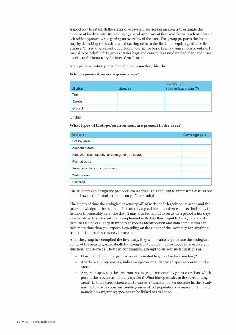
A good way to establish the status of ecosystem services in an area is to estimate the amount of biodiversity. By making a general inventory of flora and fauna, students learn a scientific approach while getting an overview of the area. The group prepares the inven-tory by delimiting the study area, allocating tasks in the field and acquiring suitable lit-erature. This is an excellent opportunity to practice basic keying using a flora or online. It may also be helpful if the group carries bags and cans to take unidentified plant and insect species to the laboratory for later identification.
A simple observation protocol might look something like this:
Which species dominate green areas?
Stratum SpeciesNumber of species/coverage (%)
Trees
Shrubs
Ground
Or this:
What types of biotope/environment are present in the area?
Biotope Coverage (%)
Grassy area
Asphalted area
Park with trees (specify percentage of tree cover)
Planted beds
Forest (coniferous or deciduous)
Water areas
Buildings
The students can design the protocols themselves. This can lead to interesting discussions about how methods and estimates may affect results!
The length of time the ecological inventory will take depends largely on its scope and the prior knowledge of the students. It is usually a good idea to dedicate at least half a day to fieldwork, preferably an entire day. It may also be helpful to set aside a period a few days afterwards so that students can complement with data they forgot to bring in or clarify data that is unclear. Keep in mind that species identification and data compilation can take more time than you expect. Depending on the extent of the inventory can anything from one to three lessons may be needed.
After the group has compiled the inventory, they will be able to penetrate the ecological status of the area at greater depth by attempting to find out more about local ecosystem functions and services. They can, for example, attempt to answer such questions as:
• How many functional groups are represented (e.g., pollinators, seeders)?
• Are there any key species, indicator species or endangered species present in the area?
• Are green spaces in the area contiguous (e.g., connected by green corridors, which permit the movement of many species)? What biotopes exist in the surrounding area? (In this respect Google Earth can be a valuable tool) A possible further study may be to discuss how surrounding areas affect population dynamics in the region, namely how migrating species can be linked to resilience.

21WWF – Sustainable Cities
• Is there any natural protection against flooding (wetlands or large areas that are not paved, i.e., green areas)?
• Is there any natural protection against erosion (e.g., trees with long roots along the shore)?
• Are there any easily accessible recycling centres, energy efficient buildings, opportuni-ties to use and develop renewable energy sources?
• How easy is it for people living in the area to access green spaces? Find out if it is pos-sible to access the green areas by public transport or on foot, and if the green spaces are suitable for children, the elderly and disabled? Are the green areas for viewing only or they available for play, exercise and other activities?
Key concepts: sustainable development, ecosystem services, inventory, flora, fauna, keying, functional groups, key species, signal species, red list, tree, shrub and ground strata, habitat, green corridors, biodiversity, renewable energy, resilience, population dynamics.
Geographical PerspectiveThe geographical perspective lets you utilise a spatial perspective. Using the map as a starting point gives you an overview, enabling you to visualise geographical features in the area and to see how they are located relative to each other. Geographical models furnish an insight into how a city has been planned and the different ways in which it can expand as population increases. The relationships between nature, man and society are laid bare.
The group can study:
A bird’s-eye view of the city/area. When you look at a city from above and see how different areas relate to one another you get an entirely new perspective.
• How many buildings are there in relation to green spaces?
• Is there water nearby?
• What sorts of buildings are there? Who lives there?
• Is there any infrastructure visible? Are there trains, roads, bike paths, trams?
• Are there barriers separating people from each other and fences that separate the city from the countryside?
Estimating the relative distribution of built-up areas, blue (water) and green spaces is a good way to start assessing ecological values (see the ecological perspective above). It’s a good idea for students to get an impression of the area before carrying out surveys and interviews in the field. Viewing the study area from above often enables them to discover things that may merit further investigation.
• Use Google Earth to get a helicopter view. This will give you an understanding of how the area you intend to study relates to other areas, and reveal conditions that exist at the site. A comparison with other cities can also easily be made. Take a virtual flight to Mumbai, New York or Amsterdam to get a better grasp of different types of cities and city models!
• Find out how the city was planned and how urban planners work. Use different city models or urban design strategies as starting points. What do cities planned using densification, green density, urban sprawl and sector models look like? It’s a good idea show both past and present pictures of the city and let the students become ac-customed to different spatial perspectives and geographical concepts.
• Secondary School courses in geography attach great importance to the student being able to collect, process, and present spatial information, preferably via maps and using the Graphical Information System (GIS.) In addition, students should be given a basic knowledge of cartography. For this reason you should make a map of the area that the group is studying during the project – either using simple digital mapping software or analogue drawings. These maps are also valuable to include in reports proposing corrective measures!
ResilienceResilience is the capac-
ity of a system to cope
with change and continue
developing. A resilient
community or ecosystem
is robust and not easily
upset by external events. It
is renewed and contin-
ues to develop despite
turbulences such as fire,
eutrophication or political
or economic collapse. A
community or ecosystem
that has lost its resilience,
however, is vulnerable.
Changes resulting from
these disturbances are
often less desirable from
an ecological, social and
economic point of view.
Sociotope Maps and Sociotope ValuesA sociotope map shows
how people use and
perceive public spaces
and green areas in the
city. Sociotope maps are
based on user surveys, i.e.,
systematic site observa-
tions, surveys, meetings
and interviews, where
people can say what
locations they use and
what they see as valuable.
The result is shown in
sociotope values visualised
on a map. Sociotope maps
are an important part of
city planning for a better
urban environment.

22 WWF – Sustainable Cities
• There are many opportunities in the project to use maps and to compare different types of maps. What do different types of maps tell us about the area? In larger cities you can often find many different types of maps, including perhaps sociotope maps with indexes showing how different areas are evaluated in a social perspec-tive. A sociotope map reveals social and cultural values in the city’s open spaces (common areas). If this type of map is not readily available students can make simpler sociotope maps of smaller, targeted areas. Similarly, students can work on a map showing biotope distribution in the urban environment.
• Conflicts of interest can provide a basis for the discussion of geographic resources. What resources does a city need? Here, the concept of ecological footprint is used. The more people who move to the city, the more people who will have to share the same area. Resources in the form of surface area are not enough. Should we build homes, offices or malls? Is it a good idea to cultivate the land, or should we con-struct parks or sports fields?
Key concepts: land use, place utility, sense of place, push-and-pull factors, gentrification, urban planning models/strategies (urban sprawl, densification, green density), city types (residential area, garden), agglomerations, urban models (concentric model, multi-core model, sector model), degree of urbanisation (if you are making global comparisons), demographics.
Social Perspective• What opportunities do people have to meet each other?
• What opportunities are there for recreation, exercise and play?
• What opportunities are there for cultural experiences?
• How safe and secure is it?
• Do people trust each other?
• Is it possible to participate in things and influence them?
• How accessible are various social institutions such as: the police, schools, medi-cal services, employment services etc.? How much confidence do people have in these?
The group can study:• Public transport (unlike travelling by car this enables meetings between people)
• Small-scaleness (small local shops, cafés, gyms, etc.)
• Public spaces (parks, libraries, cultural centres and squares)
• The behaviour of people in public places
• Whether people share a “we-feeling” and a “common pride
• The mix of buildings (workplaces, shops, housing and recreational areas)
• Local media (for example, a newspaper that covers local issues)
• Associations (music, culture, sports, politics, educational activities)
• The borough council (or equivalent institution) function and availability
• Social institutions (employment offices, schools, police stations, medical centres)
• The incidence of crime and common types of crime
• Road safety
• Lighting
• Noise
Students can use statistics, fieldwork and interviews with different categories of residents as the basis of their analysis.
Key concepts: Security, participation, trust, public spaces, meeting places, social institu-tions.
Habitat MapBiotopes, the building
blocks of ecosystems, can
be defined and delimited
spatially and visualised as
maps and used in plan-
ning. A habitat map is a
tool for assessing ecosys-
tem service viability.

23WWF – Sustainable Cities
3. ANALYSISHere the objective is for students to compile and analyse material collected during the survey exercise and determine how the city/urban district can boost social and ecological values. The analysis is carried out in three stages.
Step 1: Social and ecological values in the district.
Step 2: Measures to increase sustainability.
Step 3: Comparisons between districts.
Step 1 Social and ecological sustainable development (duration 30 minutes to 1 lesson)
• Provide examples of social and ecological sustainability in the district.
• Is social and ecological development becoming more sustainable?
• Is resilience high or low?
• What are the socio-ecological challenges?
• What pre-conditions exist to meet these challenges?
Compile by inserting the examples in the socio-ecological matrix, estimating how high the social and ecological values are. Did the district get a high or low score?
Materials: A socio-ecological matrix printed in large format (alternatively a digital solution).
Step 2 Measures (duration 1 lesson)
How can the area be made more socially and economically sustainable (more resilient) ? Here the socio-ecological matrix functions as a starting-point for a discussion of how social or economical values in the area can be enhanced and any compromises that might need to be made. The discussion should lead to proposals for actions for change. These actions for change can take concrete form, e.g., model building, campaigns, films, etc. The students explain the reasons behind their analysis to the teacher and motivate their proposals. The teacher then responds and evaluates their suggestions!
Step 3 Comparisons (duration 1 lesson)Here the objective is to give students a greater understanding of their districts and the city as a whole by comparing and discussing with the other groups. The class is divided into special “cross-groups” made up of students representing the different districts. The students are given the task of documenting the deliberations and conclusions of the cross-groups. A tip here is to start with a discussion on the meaning of sustainable development and resilience. Each student reports on the proposals for actions for change in their district and motivates how these can boost the social and ecological values there.
Suggestions for issues that can be taken up in the cross-groups:
• Are there examples of social and ecological sustainability in the district?
• Groups present reports from their districts in the form of social-ecological matrices
• Which areas show the highest respectively lowest values Rank the districts/areas and motivate
• What socio-ecological challenges are there in the district/area?
• The groups enumerate the socio-ecological challenges and the pre-conditions that exist to address these. Can you see any similarities/differences between districts /areas?
• How can the district/area and the city become more socially and economically sustai-nable (resilient)?
EXERCISE
EXERCISE
EXERCISE

24 WWF – Sustainable Cities
4. REPORTS AND EXAMINATION The purpose is to give students the capacity to influence the way things are done in their own city by visualising and spreading proposals for actions for change worked out by the group. It is an advantage if reports and evaluations of student achievements cross over subject boundaries, but they can also be restricted to a particular subject. This will depend on the skills and abilities being tested. When presentations and evaluations are interwo-ven with actions for change, students are motivated not only to achieve higher results, but also to act in the real world ¬– discovering how knowledge and knowhow they have mastered can be put to effect. They can influence society and other people by their ideas and in this respect inviting local actors and parents to exhibitions on the future of the city has turned out a great success!
Below are a few suggestions for implementing reports and evaluations. Some of the sug-gestions can also be used as exercises.
VisualisationThe students should be able to visualise their proposals for actions for change so that they can communicate with and influence target audiences using, for example:
• Models
• Films
• Flyers
• Social Media
Ask students to spread information about their proposed actions to encourage one or more selected target groups to take action for increased sustainability. Students can, for example, engage in different types of advocacy campaigns in the field area, petition decision makers and write opinion articles, letters to the editor and columns to various newspapers.
Other means of evaluating student achievement and presentations:
• Life stories
• Newspaper
• Exhibition
• Reports/public lectures


WWF.SE SUSTAINABLE CITIES - WORKING WITH SUSTAINABLE SOCIAL PLANNING IN SECONDARY SCHOOLS
This document has been financed with the support of Sida, the Swedish Agency for International Development Cooperation. Sida does not neces-sarily agree with the opinions expressed. The author alone is responsible for the content.
ENREPRENEURSA holistic approach, creativity and problem solving are entrepreneur-ial skills that shape a sustainable future
ONE PLANET
THE CITY
In the first world, we live as if we have THREE planets at our disposal
A good life for all as part of a ONE planet future
Learning and involvement go hand in hand when students reach out and impact society
PARTICIPATION
•
WWF.SE HÅLLBARA STÄDER- ETT UNDERVISNINGSMATERIAL FRÅN VÄRLDSNATURFONDEN
If there is no URL
With URL - Regular
OR
Därför är vi härFör att hejda förstörelsen av jordens naturliga livsmiljöer och bygga en framtid där människor lever i harmoni med naturen.
Därför finns vi
www.wwf.se
Vi arbetar för att hejda förstörelsen av jordens naturliga livsmiljöeroch bygga en framtid där människor lever i harmoni med naturen.
Världsnaturfonden WWF, Ulriksdals Slott, 170 81 Solna. Telefon 08-624 74 00. [email protected], plusgiro 90 1974-6, bankgiro 901-9746
HANDLEDNING
ENREPRENÖRERHelhetssyn, kreativitet och problemlösning är kompetenser för entreprenörer som formar en hållbar framtid.
EN PLANET
STADEN
I västvärlden lever vi som om vi har TRE planeter.
Ett gott liv för alla inom ramen för EN planet
Lärande och delaktighet går hand i hand när elever arbetar utåtriktat och påverkar sam-hällets utveckling
DELAKTIGHET
•
Hållbara-städer-16.indd 28 2013-02-26 12:12
HANDBOOK
SE
Världsnaturfonden WWF, Ulriksdals Slott, 170 81 Solna Sweden.
Phone +46 8-624 74 00, [email protected]
If there is no URL
With URL - Regular
OR
Why we are hereTo stop the degradation of the planet’s natural environment andto build a future in which humans live in harmony and nature.
Why we are here
www.panda.org/earpo
To stop the degradation of the planet’s natural environment andto build a future in which humans live in harmony with nature.