sustainability appraisal scoping report final · 2019-11-11 · sustainability appraisal scoping...
TRANSCRIPT
Sustainability Appraisal Scoping Report Final
Version - v1.0
1
Sustainability Appraisal Scoping Report Final
November 2017

Sustainability Appraisal Scoping Report Final
Version - v1.0
2
Prepared on behalf of Holt Town Council by
If you would like this document in large print or in any another format
please contact
Town Clerk, Holt Town Council.
or telephone 01263 712149

Sustainability Appraisal Scoping Report Final
Version - v1.0
3
Contents 1.0 Executive Summary ...………………………………………………………………... 6
2.0 Introduction ...………………………………………………………………………….. 7
3.0 Sustainability Appraisal Process ...………………………………………………….. 11
4.0 Task A1: Review of Relevant Policies, Plans & Programmes ……………..…..... 18
5.0 Task A2: Review of Baseline Information …………………………………..……… 20
6.0 Task A3: Identifying Sustainability Issues for Holt …….…….…………..……….. 58
7.0 Task A4: Developing the Sustainability Assessment Framework ……..……..….. 71
8.0 Task A5: Consulting, Review & Next Steps ……………………………..…………. 74
9.0 Document Control …………………………………………………………………….. 74
Appendix 1: Strategic Environmental Assessment Screening Determination Approach ……….. 75
Appendix 2: Compliance with Strategic Environmental Assessment Directive ………………...... 79
Appendix 3: Document Reviewed by the North Norfolk Local Plan Sustainability Appraisal …... 83
Appendix 4: Document Review ………………..……………………………………………………….. 89
Appendix 5: Baseline Information for Holt ……....………..……………..…………………………… 108
Appendix 6: Compatibility Between the Holt Sustainability Appraisal Objectives ……..…….….... 119
Appendix 7: Sustainability Appraisal Framework for Holt ….…......……………..…..…………..… 120
Appendix 8: Feedback & Actions ……..……………………………………………………………….. 126
List of Tables
Table 1 - SEA Sustainability Topics …………………………………………………………………… 12
Table 2 - Five Stages of Sustainability Appraisal …………………………………………………….. 12
Table 3 - Tasks required within Stage A (Scoping) of Sustainability Appraisal ............................ 15
Table 4 – Policies, Plans & Programmes Subject to Review ……………………………………….. 19
Table 5 – Income Deprivation Sub Indicators .…………………………..………............................ 30
Table 6 – Listed Buildings in Holt …………………………………………………............................ 35
Table 7 – Benefit Levels ……………………………………………………………............................ 52
Table 8 – Key Sustainability Issues For North Norfolk & Holt ….....………………….………..…… 59
Table 9 – Sustainability Issues Identified For Holt from Baseline & Consultation ………...……… 66
Table 10 – How Issues Across North Norfolk Relate To Those Identified For Holt …………..….. 67
Table 11 - Proposed Sustainability Appraisal Objectives for Holt ……………...…….…………… 71

Sustainability Appraisal Scoping Report Final
Version - v1.0
4
Contents Table 12 – Assessment of Significance of Effects ……………...…….…………………..………… 76
Table 13 – Quality Assurance Check List ……………………………….………...…….…………… 79
List of Figures
Figure 1: Overview of Sustainability Appraisal & Plan Making Process ……….……………….…. 13
Figure 2: Holt Population ……….………………………………………………………………………. 21
Figure 3: Population - By Age ……….…………..………………………………............................... 21
Figure 4: Population Age Comparison ……...………...…………………….………..……………….. 22
Figure 5: Male Life Expectancy ………………………………………………………………...……... 22
Figure 6: Female Life Expectancy .……..………………………….…………………………………. 23
Figure 7: Population By Ethnic Group ………..…….…………………………………………………. 23
Figure 8: General Health ..…………………...………...………………………………………………. 24
Figure 9: Long-Term Health ……………………………………………………………………………. 24
Figure 10: Cancer Rates (SIR) ……………………………..…………………………………………. 25
Figure 11: People Who Have a Fall Aged 65 and Over ….…………………………………………. 26
Figure 12: Hospital Admissions (SAR’s) ……………….………………….…………………………. 26
Figure 13: Deprivation By Domain ……….……………………………………………………………. 29
Figure 14: Deprivation Dimension for Households ………..…………………………………………. 30
Figure 15: Crime Comparison ………..…………………………….………………………………….. 31
Figure 16: Breakdown of Crime By Type in North Norfolk ……..………………………………….. 31
Figure 17: North Norfolk Monthly Crime Levels …………...……..………………………………….. 32
Figure 18: Housing Size …...…………….…………………………………………………………….. 41
Figure 19: Housing Type …..…………….…………………………………………………………….. 42
Figure 20: Holt Housing Tenure …...……...……..…………………….………………………………. 42
Figure 21: Holt Average House Prices ……….………………….……...…………………………….. 43
Figure 22: Holt Average House Prices by Type ……….…………….………..……………………... 43
Figure 23: Holt Affordable Housing by Type ……...……..…….…………………….……………….. 44
Figure 24: Employment Type: Holt …………..……………………………………............................ 51
Figure 25: Vehicles per Household …………………………..…..……………………………………. 54
Figure 26: Method of Travel to Work ……...…….…..……….……………………........................... 55
Figure 27: Skills Levels – Highest Qualification ……..……………………………………………….. 57

Sustainability Appraisal Scoping Report Final
Version - v1.0
5
Contents
List of Maps
Map 1 – Holt Parish in Relationship with North Norfolk District ………….….….………………….. 9
Map 2 – Holt Parish ………….…...……………………………………………...……………………… 10
Map 3 – North Norfolk 006C Index of Multiple Deprivation (IMD) ….………….…...…………..…. 27
Map 4 – North Holt 004B Index of Multiple Deprivation (IMD) ….……………...…...…………..…. 28
Map 5 – South Holt 004C Index of Multiple Deprivation (IMD) ….……………..…...…………..…. 28
Map 6 – North Norfolk Agricultural Land Classifications …..………………………………….…… 33
Map 7 – Holt Lowes SSSI Natural England Designation …..……………………………...….…… 34
Map 8 – Listed Buildings & Buildings of Local Interest in Holt Conservation Area …..…….…… 38
Map 9 – Environment Agency Flood Zones in North Norfolk ………….……………………….…… 40
Map 10 – Site Allocations DPD Map 6.1 Allocations for Holt ……………………….....………...… 47
Map 11 – Site Allocations DPD Map 6.2 Land West of Woodfield Road (HO1) …………….…… 48
Map 12 – Site Allocations DPD Picture 6.1 Land at Heath Farm / Hempstead Road (HO9) ….. 49
Map 13 – Site Allocations DPD Map 6.3 Land at Thornage Road (CP10) ……….………….…… 50

Sustainability Appraisal Scoping Report Final
Version - v1.0
6
Sustainability Appraisal Scoping Report
1. 1 Executive Summary
1.1 This document has been produced to support the neighbourhood planning process.
It explains how the Holt Neighbourhood Plan (HNP) will be assessed. It recognises the effect on people’s quality of life and the environment, both now and in the future, need to be considered when drawing up planning documents.
1.2 Whilst preparing the HNP a Sustainability Appraisal will also be undertaken to ensure that economic, environmental and social sustainability objectives are complied with and to avoid or minimise any adverse impacts. It is intended that the Sustainability Appraisal will incorporate the Strategic Environmental Assessment (SEA) in accordance with the regulations.
1.3 This document follows the Government guidance on undertaking a Sustainability
Appraisal of development plans and uses the five-stage process. 1.4 The first stage of a Sustainability Appraisal requires the production of this Scoping
Report; it comprises five specific steps, each with defined tasks, and explains how these will be applied to the production of the HNP and its assessment. Through the review of relevant policies, plans, programmes and the identification of issues, opportunities and implications will be better understood for the HNP and the Sustainability Appraisal process.
1.5 A framework of objectives, key questions for decision-making criteria, and
indicators have been developed to cover the broad range of economic, environmental and social factors arising from the characterisation and issues assessment. These form the basis that will be used to assess the emerging options and policies as they are developed.
1.6 This Scoping Report will enable the Sustainability Appraisal Report to document
how the Sustainability Appraisal process has been followed throughout the development of the different policy options.
1.7 This initial Sustainability Appraisal Scoping Report (September 2017) will be
subject to consultation. Any amendments and clarification, based on comments received from the national environmental bodies, Environment Agency, Historic England and Natural England, will be made and included in the final Scoping Report.
Sustainability Appraisal Scoping Report Final
Version - v1.0
7
2 Introduction
2.1 Introduction to the Scoping Report
2.1.1 This is the Scoping Report for the Sustainability Appraisal of the Holt Neighbourhood Plan (HNP). It brings together the results on the initial stages of the sustainability appraisal process; setting out baseline information on a wide range of topics, highlighting key trends, issues and objectives for Holt.
2.1.2 A key output of this Scoping Report is the sustainability framework. This will be used to appraise the sustainability of the HNP.
2.2 Background
2.2.1 The purpose of the sustainability appraisal process is to appraise the social, environmental and economic effects of a plan from the outset. In doing so it will help to ensure decisions are made that contribute to achieving sustainable development.
2.2.2 The Sustainability Appraisal is integral to the plan-making process. It should perform a key role in providing a sound evidence base for the plan and form an integrated part of the plan preparation process. It should be transparent and open to public participation. The sustainability appraisal should inform the decision-making process to facilitate the evaluation of alternatives. It should also help demonstrate that the plan is the most appropriate given the reasonable alternatives.
Source: www.pas.gov.uk
2.3 The Holt Neighbourhood Plan (HNP)
2.3.1 The right for communities to shape their local areas was formulated within the Localism Act 2011. Neighbourhood planning was introduced into the hierarchy of spatial plan-making in England.
2.3.2 The HNP is being produced by a Neighbourhood Planning Steering Group, which includes Town Council members, residents, and representatives from the local community with support provided by Abzag Ltd and North Norfolk District Council.
2.3.3 Once in place the HNP will set out how future development should take place in
Holt, including the type and quality of that development to ensure it meets local objectives and needs.
2.3.4 The Mission Statement and Objectives have emerged through the Holt Town
Council, the Neighbourhood Plan Steering Group, from local residents attending the public consultation events and survey responses, where the local community and businesses were asked to share ideas on the future of Holt.

Sustainability Appraisal Scoping Report Final
Version - v1.0
8
2.4 Mission Statement for Holt
As the gateway to the North Norfolk coast Holt will be
recognised as an historic market town, based in a
rural setting, with a vibrant town centre.
Harnessing its growth potential, whilst retaining
a strong local identity and distinctiveness.
2.5 Objectives
1. To preserve the character of Holt, including the spatial balance between the rural and built environment, historical assets, character and ethos whilst improving design based on styles in keeping with the locality.
2. To promote the integration of new housing development into the social and physical fabric of the Town. Ensuring infrastructure improvements are made to healthcare, education, roads, sewage, broadband and mobile communications.
3. To support housing tailored to the needs and context of Holt which is affordable and made available to ‘local people’ first, where development is sensitive; in keeping whilst protecting and enriching the landscape and built setting.
4. To protect, enhance, strengthen and support economic and tourist activities. Seeking the development, growth and regeneration of employment sites for an appropriate mix of employment uses.
5. To develop and improve local community facilities, open green space, parking and services (such as recreation, education and medical) for all age groups.
6. To reduce the negative impact (speed, safety and volume) of traffic on all our roads. Support enhanced public transport infrastructure and sustainable transport options.
7. To involve local people on an ongoing basis in the process of plan-making,
monitoring and delivery of development.

Sustainability Appraisal Scoping Report Final
Version - v1.0
9
2.6 Holt in Context
2.6.1 Holt is a market town located in north Norfolk. The town is 22.8 miles (36.7 km) north of the city of Norwich, 9.5 miles (15.3 km) west of Cromer and 35 miles (56 km) east of King’s Lynn. The town is on the route of the A148 King's Lynn to Cromer road. The nearest railway station Sheringham where access to the national rail network can be made via the Bittern Line to Norwich. The nearest airport is Norwich.
2.6.2 Holt is positioned in the centre of the Norfolk Norfolk District and its relationship with he surrounding towns and villages is illustrated in Map.
Map 1: Holt in Relationship with North Norfolk District
2.6.3 The name Holt is thought to derive from the Anglo-Saxon word for woodland and Holt is located on wooded high ground of the Cromer-Holt ridge at the crossing point of two ancient by-ways, as such was a natural point for a settlement to grow. Holt has a mention in the Domesday Book and is described as a market town and port (with the nearby port of Cley-next-the-Sea being described as Holt's port). Over the years Holt has grown as a local place of trade and commerce, although the weekly market, which has taken place since before the 1080’s, was stopped in 1960’s.
2.6.4 On 1st May 1708 the town of Holt was devastated by a fire which destroyed most of the medieval town, the fire started at Shirehall Plain and quickly spread through the timber houses of the town. With most of the medieval buildings destroyed in the fire the townsfolk set about rebuilding the town. The rebuilding made Holt notable for its abundance of Georgian buildings, that being the style of the day at the time when the town centre was rebuilt. However, the town’s people repaired and retains its Norman parish church, which is dedicated to St Andrew.
2.6.5 The Parish Church of Saint Andrew the Apostle was established in Holt before 1086, the year of the Domesday Book. The church is situated in the heart of the
5.0.4 With regard to health, deprivation and inequality, life expectancies within the District arehigher than both the Norfolk and England averages (ONS, 2014b). The proportion of peoplein the District living in the very highest levels of deprivation is lower than the England average,although the District is ranked high for some deprivation indicators, including the physicaland financial accessibility of housing and local services (DCLG, 2015a).
5.0.5 North Norfolk has a high proportion of detached dwellings (44%, (ONS, 2014c)) and a highproportion of second and holiday homes (13.5% recorded as being either second homes,holiday lets or vacant (ONS, 2012f).
5.0.6 Tourism makes a vital contribution to the economy of the District, with both the natural andthe historic environment representing a strong draw for tourists. Much of North Norfolk’snatural environment is protected by internationally, nationally or locally recogniseddesignations for its features, flora, fauna or geodiversity, including the nationally recognisedareas of the Norfolk Coast Area of Outstanding Natural Beauty and The Broads. Whilst aglobal phenomenon, it is recognised that the low-lying District is particularly susceptible tothe challenge of climate change, coastal erosion and flood risk. North Norfolk is also aDistrict immensely rich in architectural heritage with 81 conservation areas, over 2,200 listedbuildings, 100 scheduled ancient monuments and a rich array of other designated andnon-designated assets.
5.0.7 North Norfolk’s economy is dominated by its rural nature. The District has a lowereconomically active employment rate of the working population and higher proportion ofself-employment than the than regional and national averages and a higher proportion ofpart-time employee jobs than both the East of England and Great Britain. In 2014, theemployment sectors of public admin, education and health and wholesale and retail, includingmotor trades accounted for 45.1% of jobs in the District (ONS, 201?b).
Based upon the Ordnance Survey Map with permission of the Controller of H.M Stationery Office. © Crown Copyright.Unauthorised reproduction infringes Crown Copyright and may lead to prosecution or civil proceedings. O.S. Licence 100018623 (2009)
Map 2 North Norfolk District (2009)
5.0.8 Themain local important transport routes are the A148 and A149 east-west and to the southfrom Cromer, and the A140, A1065 and A1067 to the south. The major rail links areNorwich/Cambridge and Norwich/Ipswich, with Norwich/Sheringham also locally important(ORS, 2016a, p.19).
Draft Sustainability Appraisal Scoping Report: Consultation Version18
5Overview: Portrait of North Norfolk
HOLT

Sustainability Appraisal Scoping Report Final
Version - v1.0
10
town at the end of Church Street, which is found behind the War Memorial, at the east end of what was the original market place.
2.6.6 Holt retains a 'small market town' character with development contained within a limited area, which has so far avoided urban sprawl into the wider countryside. The population of Holt is 3,808 with 1,807 households [Source: 2011 Census].
Map 2: Holt Parish
Parish of Holt
Sustainability Appraisal Scoping Report Final
Version - v1.0
11
3 Sustainability Appraisal Process
3.1 Introduction
3.1.1 The concept of sustainable development is about balancing economic, social and environmental needs. The UK Government has set out that this means stimulating economic growth and tackling the UK's financial deficit, maximising wellbeing and protecting the environment, without negatively impacting on the ability of future generations to do the same.
3.1.2 The HNP must be centred on the concept of sustainable development. This is achieved through the use of a Sustainability Appraisal (SA).
3.1.3 SA is a process that identifies and reports on the likely effects of a plan and the extent to which the plan’s implementation will impact upon the environmental, social and economic objectives for an area. SAs must meet the requirements of two principal pieces of legislation:
• The Planning and Compulsory Purchase Act 2004; and
• The Environmental Assessment of Plans and Programmes Regulation 2004, which seeks to implement the EU Strategic Environmental Assessment (SEA) Directive.
3.1.4 The overall aims of the Holt Neighbourhood Plan SA are to:-
• ensure that all aspects of sustainable development are fully integrated into the Neighbourhood Plan throughout its preparation;
• adopt a long-term view of development within the area covered by the plan, with a specific assessment of the potential environmental, economic and social effects of the plan;
• identify the sustainability issues for Holt and consult on the sustainability appraisal procedure, allowing the public and stakeholders to have an input into the process;
• provide an audit trail of how the HNP has been revised to take into accountthe findings of the SA;
• develop an effective system for ensuring that sustainability objectives are transformed into sustainable planning policies;
• meet the requirements of the SEA Directive; and
• produce and consult on a Scoping Report early in the process for the plan making process.

Sustainability Appraisal Scoping Report Final
Version - v1.0
12
3.2 Strategic Environmental Assessment (SEA)
3.2.1 The SA process incorporates the requirements of the EU Strategic Environmental Assessment (SEA) Directive. It is intended that this SA will incorporate the SEA in accordance with the regulations and to give due consideration as to whether or not the HNP is likely to have a significant effect on the environment. Table 1 details the SEA topics relating to the sustainability themes.
Table 1: SEA Sustainability Topics
3.3 Sustainability Appraisal (SA) Methodology
3.3.1 The following sections contain a brief summary of the key SA stages that will be completed during the preparation of the HNP. The methodology used follows national guidance.
3.3.2 Government guidance on undertaking SA of Local Development Documents (of which the HNP will be comparable) presents a five-stage process, see Table 2, each of which contains criteria to fulfil that requirement.
Table 2: Five Stages of Sustainability Appraisal
Stage
Definition
A
Pre-production, setting the context and objectives, evidence gathering to establish a baseline and deciding on the scope, culminating in production of scoping report.
B
Developing and refining options and assessing effects and mitigation by
Overarching Sustainability
Theme
Topic
Issues required to be addressed by SEA
Regulations
Environmental
Land, Water and Soil Resources
Soil Water
Climate Change, Energy, Air Quality and Pollution
Air Water Climatic factors
Biodiversity, Fauna, Flora and Geodiversity
Biodiversity Fauna Flora
Landscape, Townscape and the Historic Environment
Historic environment, including architectural and archaeological heritage Landscape
Social Healthy and Inclusive Communities
Population Human Health
Housing
Population Material Assets
Economic
Economic Activity and Education
Infrastructure and Accessibility
Human Health

Sustainability Appraisal Scoping Report Final
Version - v1.0
13
testing plan objectives against the SA Framework.
C
Documenting and appraising the effects of the plan and preparing the SA Report.
D
Consulting on the HNP and the SA Report.
E
Monitoring the significant effects of implementing the plan.
Source: Sustainability Appraisal of Regional Spatial Strategies and Local Development Documents
3.3.3 SA will continue to be an iterative process after the production of this Scoping Report (Stage A). The appraisal framework will be used to consider the effects of the different options proposed by the HNP, and considering the key issues where they arise.
3.3.4 The overview of the SA process is shown in Figure 1, this illustrates how the SA stages correspond to the Neighbourhood Plan preparation process.
Figure 1: Overview of Sustainability Appraisal & Plan Making Process
SAStage SAProcess PlanMaking
A
ScopeSAprocess&developSA
FrameworktoappraisetheNeighbourhoodPlan
ProduceaSAScopingReport
Prepareaprofileoftheareatoinformlocalconsulta@onissues
Undertakeaneighbourhoodappraisal
Produce&consultonVision
PreparedraCNeighbourhoodPlan
ConsultondraCNeighbourhoodPlan
SubmitdraCNeighbourhoodPlanforExamina@on
PublishfinalNeighbourhoodPlan&proceedtoReferendum
B
AppraisethedraC
NeighbourhoodPlanop@ons&prepare
SAReport
C
ConsultStakeholdersonSAReport
Appraiseanysignificantchangesrequired
followingconsulta@onD
PublishfinalSAReportE
NeighbourhoodPlanMaking&SustainabilityAppraisal(SA)Overview

Sustainability Appraisal Scoping Report Final
Version - v1.0
14
3.3.5 The SA process will run concurrently with the HNP process, after the initial scoping for the SA has been carried out the next stage will be the developing and refining options and assessing their effects.
3.3.6 The process of refinement and assessment will be carried out concurrently with the production of the HNP. Drafts of the SA Report and the HNP will be made available for consultation prior to their publication for submission to North Norfolk District Council. Final versions of the SA Report and the HNP will be submitted to North Norfolk District Council who will arrange for them to be examined and reviewed by an independent person, prior to a referendum being held.
3.4 Habitats Directive
3.4.1 Plans and programmes must now ensure that they comply with the requirements of The Directive on Conservation of Natural Habitats and of Wild Fauna and Flora 92/32/EEC (Habitats Directive).
3.4.2 This involves undertaking an appropriate assessment into any potential effects on ‘European sites’ or ‘Natura 2000 Sites’ of nature and habitat value, namely Special Areas of Conservation, Special Protection Areas, and Ramsar sites of international wetland importance. Even a plan that is not directly concerned with these sites can still indirectly affect them; so appropriate assessment must determine the likelihood of their significance and suggest alternatives where possible.
3.4.3 The significance of effect is determined through appropriate assessment, a process that will feature as a specific stage of the options appraisals. A plan should seek to avoid adverse affects on the integrity of designated sites, mitigate those impacts that remain and, if necessary, put in place compensatory measures.
3.4.4 Assessment considers the reasons for designation as a protected site, such as habitat and species present, and the conservation objectives of management plans in place to preserve these. If these are compromised directly by site allocations or through ‘in combination’ effects with other plans or developments, the plan must explain how it intends to avoid or mitigate the impacts.
3.5 Scoping
3.5.1 The first stage of SA (Stage A) requires the production of a Scoping Report. This compromises five specific steps. The steps are part of a circular process of continuous improvement and refinement. The Scoping Report structure is detailed in Table 3.

Sustainability Appraisal Scoping Report Final
Version - v1.0
15
Table 3: Tasks required within Stage A (Scoping) of Sustainability Appraisal
Task Definition A1 Identifying other relevant policies, plans, programmes and sustainability
objectives.
A2 Collecting baseline information.
A3 Identifying sustainability issues.
A4 Developing the SA Framework.
A5 Consulting on the scope of the SA.
Source: SA of Regional Spatial Strategies and LDDs (ODPM 2005)
3.5.2 Each task in Stage A is dealt with in turn in the following sections of this report.
3.5.3 This Scoping Report will conform to the North Norfolk Local Development Framework; it is the first section of the SA that will be developed alongside the production of the HNP and has regard to, and builds upon, the Core Strategy Sustainability Appraisal and emerging North Norfolk Local Plan Sustainability Appraisal Scoping reports.
3.5.4 These reports contain a broad range of information across North Norfolk relevant to the production of the HNP and a SA Assessment Framework with a set of indicators for the appraisal of emerging polices. Subsequently this had regard to, and built upon, the SA Scoping Report for the Core Strategy and emerging Local Plan.
3.5.5 As the proposed HNP will be subsidiary to the overarching Core Strategy and emerging North Norfolk Local Plan, the HNP must be in general conformity with the Core Strategy and emerging North Norfolk Local Plan. Therefore, the sustainability principles applied to the Core Strategy and North Norfolk Development Plan Documents are equally applicable to the proposed HNP.
3.5.6 Government sustainability appraisal guidance suggests that one scoping report can be produced for several Local Development Documents provided that it details sufficient information for each document concerned.
3.5.7 To be concise and where appropriate, this Scoping Report refers to sections of the Core Strategy, emerging North Norfolk Local Plan and other North Norfolk Development Plan Documents Sustainability Appraisals, rather than reproducing these and so should be read alongside them. However, the main SA Frameworks are either reiterated or altered where relevant to the HNP. In addition to the generic information contained within the Core Strategy and emerging North Norfolk Local Plan there is the opportunity to add more specific information relevant to the more focused area of the HNP.
3.5.8 The Scoping Report will establish the framework for the remainder of the sustainability appraisal process as an ongoing, iterative procedure that will evolve as new evidence becomes apparent. This framework will involve setting sustainability objectives, which the HNP will work towards, and background indicators to gauge the possible effects, that will guide the appraisal.

Sustainability Appraisal Scoping Report Final
Version - v1.0
16
3.6 North Norfolk Authority Local Development Documents
3.7 Core Strategy Incorporating Development Control Policies 2008
3.7.1 The Core Strategy, including Development Control Policies, provides a clear vision for how new development can address the challenges faced in North Norfolk and identifies where, when, how much and how new development will take place in North Norfolk up to 2021.
3.7.2 The vision guides other documents in the North Norfolk Local Development Framework such as the Site Specific Proposals document which will outline the detailed allocations for land for different uses.
3.8 Site Allocations 2011
3.8.1 The Site Allocations document identifies and allocates specific areas of land for different types of new development, such as housing, employment, retail, open space and other uses. For Holt there are three allocations.
3.9 Emerging Local Plan
3.9.1 The emerging new North Norfolk Local Plan will provide the planning policy context for development across the whole of North Norfolk for the period 2016 - 2036. The main elements which will form the single Plan document are:
• Strategic Policies - These provide the overarching approach to development in North Norfolk, such as where and how much development should take place, and also set the long-term spatial vision, objectives and key policies.
• Development Management Policies - These cover specific topic areas such as affordable housing, tourism, coastal erosion, and protecting the natural and built environment, and are used in the determination of individual planning applications.
• Site Allocations - Sets out detailed policies for the development of individual sites to help meet the aims of strategic policies.
• Policies Map - Shows geographically where policies apply. 3.9.2 North Norfolk District Council have made good progress to produce the new Local
Plan. The first draft is expected later this year.
3.10 Holt Neighbourhood Plan (HNP)
3.10.1 The ability to produce neighbourhood plans is a function of the Localism Act 2011. The aim is for local communities to have greater control over what happens in their area. Holt Town Council is leading the plan process. The HNP must ‘broadly’ conform to higher-level policy at a national and district level including the Core Strategy.

Sustainability Appraisal Scoping Report Final
Version - v1.0
17
3.10.2 Holt and the surrounding areas are directly affected by significant development proposals for housing, employment and related services in Core Strategy. Holt Town Council is keen to work with the developers in order to provide local knowledge to their development proposals. The Town Council is also keen to see a holistic plan, both within Holt and the wider area, addressing the aspirations and needs of all sections of the community.
3.10.3 The HNP will be a Neighbourhood Development Plan for the whole of Holt and, through community engagement, the views of the local community will be represented through the plan-making process.
3.10.4 The aim of the HNP is to embrace the change, inform and shape development proposals to enhance and improve design elements whilst providing guidance to protect the existing community, its facilities and character.
3.10.5 Drafting of the HNP is ongoing; therefore, this document draws and builds upon the Mission Statement for Holt and Objectives identified so far. As the HNP evolves these may be refined.

Sustainability Appraisal Scoping Report Final
Version - v1.0
18
4 Task A1 – Review of Relevant Policies, Plans & Programmes
SEA Directive Requirements - The ‘Environmental Report’ should include: - “an outline of the contents, main objectives of the plan or programme and relationship with other relevant plans and programmes”
(Annex 1(a)) and
“the environmental protection objectives, established at international, Community or Member State level, which are relevant to the plan or programme and the way those objectives and any environmental considerations have been taken into account during its preparation”
(Annex 1(e))
4.1 Introduction
4.1.1 Task A1 of the SA Scoping Report reviews and assesses the national, regional and local plans and programmes that should be taken into account through the preparation of the HNP.
4.1.2 This will help to drawn out important aims, targets, indicators and sustainability objectives from the context review to identify key issues, opportunities and implications for the HNP and the Sustainability Assessment Framework.
4.2 Approach
4.2.1 North Norfolk District Council is completing a new North Norfolk Local Plan 2016 - 2036 to supersede the Core Strategy and other Development Plan documents. The emerging North Norfolk Local Plan Sustainability Appraisal documents include a wide-ranging review of the plans, policies and programmes that are likely to impact on the plans within North Norfolk, of which the HNP designated Neighbourhood Area is within.
4.2.2 This work is set out in the emerging North Norfolk Local Plan Sustainability Appraisal documents and is, therefore, not repeated in this document. There is a significant degree of overlap between the documents within the hierarchy, often with “lower” level documents rightly reflecting and applying the objectives and policies of “higher” level ones.
4.2.3 The list of documents within the emerging North Norfolk Local Plan Sustainability Appraisal documents, see Appendix 3 for the full list, has been examined to establish whether any of the documents have since been superseded, or whether any additional “lower” level documents should be included which are specifically relevant to the production of the HNP.

Sustainability Appraisal Scoping Report Final
Version - v1.0
19
4.2.4 In addition to those documents reviewed in the emerging North Norfolk Local Plan Sustainability Appraisal, Table 4 is a summary of the newly reviewed documents.
Table 4: Policies, Plans & Programmes Subject to Review
National Planning Policy Statements 1 National Planning Policy Framework (2012), updates & PPG (Planning Policy
Guidance)
National Level 2 Air Quality Strategy for England, Scotland, Wales & Northern Ireland (2007)
3 Building for Life 12 (2015)
4 The National Adaption Programme – Making the country resilient to a changing climate (2013)
Regional Level 5 Central Norfolk Strategic Housing Market Assessment 2015 (Report Findings
January 2016)
6 NewAnglia Local Enterprise Partnership for Norfolk & Suffolk – Strategic Economic Plan (2014)
Local Level 7 Core Strategy Incorporating Development Control Policies September 2008
8 Design Guide December 2008
9 Landscape Character Assessment SPD June 2009
10 North Norfolk Local Plan Draft Sustainability Appraisal Scoping Report: Consultation Version (September 2016)
11 Norfolk Ambition Sustainable Community Strategy 2003 – 2023
12 Partnership of Norfolk District Councils - Strategic Flood Risk Assessment (2008)
13 Site Allocations February 2011
Neighbourhood Level 14 Holt Conservation Area Character Appraisal and Management February 2010 15 North Norfolk Local Plan Regulation 18 Consultation: Holt Local Plan Workshop
Feedback Summary June 2016
16 The Holt Vision February 2012
4.2.1 A detailed review of each document, their key objectives, targets and indicators, possible implications for the preparation of the HNP and any emerging issues for the Sustainability Appraisal can be seen in Appendix 4.
4.2.2 This document should be read in conjunction with the review of Policies, Plans and Programmes already carried out for the emerging North Norfolk Local Plan Sustainability Appraisal. Listed in Appendix 3, these documents are available at:-
https://www.north-norfolk.gov.uk

Sustainability Appraisal Scoping Report Final
Version - v1.0
20
5 Task A2 – Review of Baseline Information
SEA Directive Requirements - The ‘Environmental Report’ should include: - “the relevant aspects of the current state of the environment and the likely evolution thereof without implementation of the plan or programme”
(Annex 1(b)) and
“the environmental characteristics of areas likely to be significantly affected” (Annex 1(c))
5.1 Introduction
5.1.1 Task A2 of the Sustainability Appraisal Scoping Report provides outline summary of
the environmental, social and economic baseline for Holt. By outlining the current situation and identifying, where possible, trends and targets for the area, this information provides a useful starting point for predicting and monitoring the effects of the Neighbourhood Plan and identifying sustainability issues.
5.2 Approach
5.2.1 The comprehensive review undertaken for the Core Strategy and emerging North Norfolk Local Plan Sustainability Appraisal Scoping reports set out ‘baseline’ information for North Norfolk and provides evidence for Holt. Given the wider coverage of these documents, much of the information is given generically for their corresponding areas.
5.2.2 As the HNP, which will contribute towards the North Norfolk Local Development Framework, is at the parish level focus will be given to gathering baseline information specific to the Holt Neighbourhood Area and seek to identify local priorities.
5.2.3 The process of assembling baseline information has been guided by the objectives
and content of the emerging HNP and the requirements of the SEA Directive. It has focused on developing an understanding of the current social, economic and environmental profile of Holt to highlight potential issues for the HNP and the Sustainability Appraisal. The effects of the emerging plan policies will be assessed in relation to the baseline for the Sustainability Appraisal.
5.2.4 The collecting of baseline information can be difficult for areas such as parishes
and/or neighbourhoods, therefore, the statistics used have been collected from a number of sources. These sources have been identified and recorded accordingly.
5.2.5 The sustainability issues identified from the baseline analysis have then been
incorporated into the Sustainability Appraisal Framework for the HNP. The key messages for the HNP and Sustainability Appraisal are discussed within each topic.

Sustainability Appraisal Scoping Report Final
Version - v1.0
21
5.3 Population
5.3.1 The 2011 Census records a population for Holt of 3,808 an increase of 7.3% on the 2001 Census numbers and a significant increase of over 50% in the last thirty years.
5.3.2 The age structure of the population of Holt is significantly older than Norfolk as a
whole, with 38% of the population aged 65 and over compared with 24% in Norfolk and only 19% for England.
0
500
1000
1500
2000
2500
3000
3500
4000
Pop
ulation
Figure 2: Holt Population [Source: Census]
0 10 20 30 40
0 to 15
16 to 29
30 to 44
45 to 64
65 and over
Percentage of Holt Population
Age Figure 3: Population - By Age
[Source: Norfolk Insight)]
England Norfolk Holt
Demographics

Sustainability Appraisal Scoping Report Final
Version - v1.0
22
5.3.3 With 3% and 5% less of the population aged 15 years or less when compared to Norfolk and England. This gap widens further with 4% less of the population aged less than 10 years old compared to Norfolk.
5.3.4 The gender split of the population is approximately 44% male and 56% female as recorded in the 2011 Census.
0 1 2 3 4 5 6 7 8 9 10
0 to 4 5 to 9
10 to 14 15 to 19 20 to 24 25 to 29 30 to 34 35 to 39 40 to 44 45 to 49 50 to 54 55 to 59 60 to 64 65 to 69 70 to 74 75 to 79 80 to 84 85 to 89
90 +
Percentage
Age Figure 4: Population Age Comparison [Source: Health & Wellbeing Profile 2017]
Holt
Norfolk
78
79
80
81
2010 2011 2012 2013 2014
Age
Figure 5: Male Life Expendancy [Source: Norfolk Insight]
North Norfolk Norfolk England

Sustainability Appraisal Scoping Report Final
Version - v1.0
23
5.3.5 There is significance difference in life expectancy between the genders, with female
life expectancy 4.3 years greater than male. The North Norfolk life expectancy exceeds that of Norfolk and is almost 1 year above the national average for males and 1.5 years above the national average for females.
5.4 Ethnicity
5.4.1 The resident population of Holt, as recorded in the 2011 Census, is predominately white British 96.3% with a further 2.4% classed as other white. The remaining groups mixed at 0.6%, Asian ay 0.6% and black at 0.1%. There are no other ethnic grouped recorded in the 2011 Census.
82
83
84
85
86
2010 2011 2012 2013 2014
Age
Figure 6: Female Life Expendancy [Source: Norfolk Insight]
North Norfolk Norfolk England
96.3%
2.4%
0.6%0.6%
0.1%3.7%
Figure 7: Population by Ethnic Group [Source: 2011 Census]
WhiteBritish
OtherWhite
Mixed
Asian
Black
Other

Sustainability Appraisal Scoping Report Final
Version - v1.0
24
5.5 Health and Wellbeing
5.5.1 General Health
5.5.2 General health is a self-assessment of a person’s general state of health. This assessment is not based on a person's health over any specified period of time. The Heath and Wellbeing Profile 2017 indicates that people’s general health in Holt is worse than the Norfolk average. 75.8% of people described their health as good or very good, compared with 79.3% in Norfolk, and 6.1% as bad or very bad, as against 5.6% in Norfolk.
Figure 8: General Health
5.5.3 Long-Term Heath
5.5.4 A long-term health problem or disability that limits a person's day-to-day activities, and has lasted, or is expected to last, at least twelve months. 10.2% of people in Holt said that their day-to-day activities were limited a lot by a long-term illness or disability, compared with 9.1% in Norfolk and 8.3% in England.
Figure 9: Long-Term Health Problem or Disability
5.5.5 Cancers
5.5.6 Standardised incidence ratios (SIR1) for all cancers, breast cancer, colorectal cancer, lung cancer and prostate cancer enable a comparison of incidents across areas of England with a number of 100 used as the standard unit.
1 Standardised incidence ratios (SIR) for all cancers, breast cancer, colorectal cancer, lung cancer and prostate cancer. Indirectly age-sex standardised ratios (number of new cases as a percentage of expected new cases), calculated relative to England. Ratios calculated by dividing the observed total number of new
Page 2 of 4
Age Structure The estimates for mid-2015 show that the population of Holt is older than Norfolk as a whole, with 38% of the population aged 65 and over compared with 24% in Norfolk. - See more at: http://www.norfolkinsight.org.uk/jsna/population
General Health General health is a self-assessment of a person’s general state of health. This assessment is not based on a person's health over any specified period of time. General health in Holt is worse than the Norfolk average. 75.8% of people described their health as good or very good, compared with 79.3% in Norfolk, and 6.1% as bad or very bad, as against 5.6% in Norfolk.
Long-term health problem or disability A long-term health problem or disability that limits a person's day-to-day activities, and has lasted, or is expected to last, at least twelve months. 10.2% of people in Holt said that their day-to-day activities were limited a lot by a long term illness or disability, compared with 9.1% in Norfolk and 8.3% in England.
6% 4% 2% 0% 2% 4% 6%
0-45-9
10-1415-1920-2425-2930-3435-3940-4445-4950-5455-5960-6465-6970-7475-7980-8485-89
90+
Male Female Male Norfolk Female Norfolk
2.4
0.60.6 0.1 0.0
WhiteBritish
OtherWhite
Mixed Asian Black Other0
80%5%
90%
85%
95%
96.0
England, 47.2%
Norfolk, 42.7%
Holt, 38.1%
34.2%
36.6%
37.6%
13.1%
15.1%
18.1%
4.2%
4.4%
4.7%
Very good Good Fair Bad Very bad
England, 82.4%
Norfolk, 79.9%
Holt, 75.3%
9.3%
11.0%
14.5%
8.3%
9.1%
10.2%
Activities not limited Activities limited a little Activities limited a lot
Population – 2015
Health
Source: 2015 mid-year estimates, Office for National Statistics
Percentage of resident population by five year age groups 2015 compared with Norfolk
Ag
e
Source: 2011 Census, Office for National Statistics
Source: 2011 Census, Office for National Statistics
Source: 2011 Census, Office for National Statistics
Percentage of resident population by ethnic group

Sustainability Appraisal Scoping Report Final
Version - v1.0
25
5.5.7 The population of Norfolk has lower risks of incidents of cancer compared to England. With incident levels for the population of Holt at lower risk levels in all categories compared to Norfolk, especially in breast, lung and prostate cancers.
5.5.8 Estimated Dementia Prevalence
5.5.9 In Norfolk in 2015 there were estimated to be 14,592 older people (aged 65 and over) with dementia but by 2030 the number is predicted to increase to around 26,937 people diagnosed with dementia.
5.5.10 In Holt there were estimated to be 130 older people (aged 65 and over) with dementia. This is marginally higher as a percentage, 8.3%, than Norfolk, 7.0% of this age group. [Source: NCC Health and Wellbeing Profile July 2012 and Norfolk Insight]
5.5.11 Falls in the Elderly
5.5.12 In Holt 28.1% of people aged 65 and over have a fall, which is a higher percentage when compared to 26.5% for both Norfolk and England.
cases (numerator) in the area by the expected number (denominator) and multiplying by 100. A SIR number greater than 100 implies a higher risk and a number lower than 100 implies a lower risk.
0 20 40 60 80 100 120
Breast
Colorectal
Lung
Prostate
All Cancers
Standardised Incidence Ratio (SIR)
Figure 10: Cancer Rates (SIR) [Source: Norfolk Insight 2010-14]
Norfolk
Holt

Sustainability Appraisal Scoping Report Final
Version - v1.0
26
5.5.13 Hospital Admissions 5.5.14 Standardised admission ratios (SAR’s2) for emergency hospital admissions for all
causes, coronary heart disease, chronic obstructive pulmonary disease, stroke, myocardial infarction (heart attack) and hip fractures are based on an expected level of 100.
5.5.15 Based on these SAR’s the population of Holt has higher than expected levels of emergency hospital admissions relating to heart attacks and stokes, whilst below expected levels of admissions in all other categories, especially pulmonary (lung) disease. All admissions levels are significantly below expected levels both for Holt and Norfolk. As illustrated in Figure 12.
2 SAR’s are expected admissions calculated by applying age-specific admission rates for England to each area's population. Ratios calculated by dividing the observed admissions (numerator) in the area by the expected admissions (denominator) and multiplying by 100. If a SAR is less than 100 that means the number of admissions for the area was less than would have been expected. If a SAR is greater than 100 the number of admissions was greater than expected.
24
25
26
27
28
29
England Norfolk Holt
Percentage Figure 11: People who have a fall aged 65 and over
[Source: Norfolf Insight 2015]
20
30
40
50
60
70
80
90
100
110
120
Hip Fracture Heart Attack Stroke Pulmonary Disease
Heart Disease All Admissions
SAR Figure 12: Hospital Admissions (SAR's) [Norfolk Insight 2010-14]
Holt Norfolk
Sustainability Appraisal Scoping Report Final
Version - v1.0
27
5.5.16 Diabetes
5.5.17 In Holt 3.4% of the population aged between 16 and 64 years have diabetes (either Type 1 or Type 2), which is marginally higher when compared to Norfolk at 3.3% and England at 3.1%.
5.5.18 Whilst in the older population of Holt, 65 years and over, the trend is the complete opposite with 12.2% of this group have diabetes compared to Norfolk at 12.5% and 12.4% for England.
5.6 Deprivation
5.6.1 The Index of Multiple Deprivation (IMD) is an overall relative measure of deprivation constructed by combining seven categories of deprivation according to their respective weights.
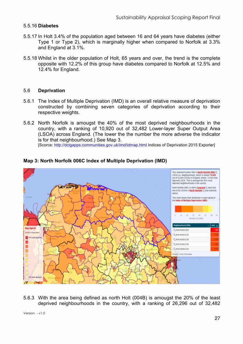
5.6.2 North Norfolk is amougst the 40% of the most deprived neighbourhoods in the country, with a ranking of 10,920 out of 32,482 Lower-layer Super Output Area (LSOA) across England. (The lower the the number the more adverse the indicator is for that neighbourhood.) See Map 3. [Scorce: http://dclgapps.communities.gov.uk/imd/idmap.html Indices of Deprivation 2015 Exporler]
Map 3: North Norfolk 006C Index of Multiple Deprivation (IMD)
5.6.3 With the area being defined as north Holt (004B) is amougst the 20% of the least deprived neighbourhoods in the country, with a ranking of 26,296 out of 32,482

Sustainability Appraisal Scoping Report Final
Version - v1.0
28
Lower-layer Super Output Area (LSOA) across England and performing significantly better than North Norfolk. See Map 4.
Map 4: North Holt 004B Index of Multiple Deprivation (IMD)
5.6.4 With the area being defined as south Holt (004C) is amougst the 40% of the most deprived neighbourhoods in the country, with a ranking of 9,972 out of 32,482 Lower-layer Super Output Area (LSOA) across England and performing marginally worse than North Norfolk, although still in the same grouping of 40% most deprived neighbourhoods in the country. See Map 5.
Map 5: South Holt 004C Index of Multiple Deprivation (IMD)

Sustainability Appraisal Scoping Report Final
Version - v1.0
29
5.6.5 The breakdown by Deprivation Domain category 3 enables a more detailed analysis of the indicators. For the two Holt LSOAs (004B and 004C) and using North Norfolk as the comparison (all 62 LSOAs) the differences between north and south Holt is startling apparent, see Figure 13.
5.6.6 The area being defined as north Holt generally performs much better in all categories when compared to North Norfolk and better in all excpet one – Housing & Services – when compared to the area being defined as south Holt. The south Holt area performs better in only two categories and adversely in five categories when compared to North Norfolk.
3 In each Deprivation Domain category the higher the percentage the more favourable the situation is whilst the lower the percentage the more adverse the situation is.
0%
10%
20%
30%
40%
50%
60%
70%
80%
90%
100% Income
Employment
Education Skills & Training
Health & Disability Crime
Housing & Services
Living Environment
Figure 13:Deprivation by Domain [Source: DCLG:Indices of Deprivation Exporler 2015]
Holt North Holt South North Norfolk

Sustainability Appraisal Scoping Report Final
Version - v1.0
30
Table 5: Income Deprivation Sub Indicators
Income Deprivation (Ranking out of 32,844)
North Holt South Holt North Norfolk
Affecting Children (IDACI)
24,628 30% least deprived
7,024 30% most deprived
15,294 30% most deprived
Affecting Older People (IDAOPI)
30,865 10% least deprived
13,692 50% most deprived
21,170 40% least deprived
5.7 Household Deprivation
5.7.1 Deprivation is measured through selected household characteristics. These deprivation measures (including income, employment and education) illustrate how Holt is ranked overall against other areas. See Figures 13 and 14.
5.7.2 The household deprivation measures for Holt are adverse when compared to Norfolk and nationally, see Figure 14. Households in Holt without any deprivation indicator are significantly lower at 35% compared to Norfolk at 41% and England at 43%.
5.7.3 Holt households with one indicator are higher, at 39%, than Norfolk and England, at
34% and 33% respectively. This trend continues with Holt households with two indicators at 22% and higher than Norfolk and England, at 20% and 19% respectively. Although Holt households with three indicators is lower at 3.7% when compared to Norfolk and England, at 4.3% and 5.1% respectively.
0%
10%
20%
30%
40%
50%
None One Two Three Deprivation Indicators per Household
Figure 14: Deprivation Dimension for Households [Source:2011Census]
Holt Norfolk England

Sustainability Appraisal Scoping Report Final
Version - v1.0
31
5.8 Crime
5.8.1 North Norfolk has the second lowest crime rate, at 33.6, in Norfolk with only the district of Broadland lower at 31.9. See Figure 15. Crime figures relate to the number of crimes per 1000 population.
0
20
40
60
80
100
120
Force
average
Broadland North
Norfolk
South
Norfolk
Breckland King'sLynn
&West
Norfolk
Great
Yarmouth
Norwich
Figure 15: Crime Comparisons Source: UK CrimeStats
0 200 400 600 800 1000 1200 1400 1600 1800
Anit-Social Behaviour
Burglary
Robbery & Theft
Vehicle
Violent
Criminal Damage & Arson
Drugs
Weapons
Public Order
Other
Number of Crimes Recorded Between July 2016 and June 2017
Figure 16: Breakdown of Crime By Type in North Norfolk Source: UK CrimeStats

Sustainability Appraisal Scoping Report Final
Version - v1.0
32
5.8.2 The large influx of tourists through the summer months is attributed to significant increases in the level of crimes associated with anti-social behavior, criminal damage, public order and violence. See Figures 16 and 17.
Landscape & Environment
5.9 Landscape
5.9.1 North Norfolk contains many important and protected sites with priority habitats and species. Designated sites are those areas that are particularly notable for their features, biodiversity, flora, fauna or geodiversity and may be designated under international agreements (such as the Ramsar Convention and the EC Habitats Directive), national law (such as Sites of Special Scientific Interest (SSSI)) or through non-statutory designations (such as County Wildlife Sites). Such sites are managed to protect and preserve those features for which they are particularly valued.
5.9.2 Holt sited three miles (five kilometres) from the North Norfolk coast. It is at the western end of the Cromer Ridge, a glacial moraine of sandy soil running parallel to the sea, a region that is recognised today as an Area of Outstanding Natural Beauty.
5.9.3 Holt enjoys a particularly attractive rural setting. To the north, the Ridge slopes down towards the coastal villages at the edge of the saltmarsh; Cley next the Sea, Kelling and Salthouse. On the west side is the picturesque Glaven Valley.
5.9.4 There is a good deal of woodland around Holt, particularly on the south side, This includes areas of older woodland and more recent plantations of pine trees, which make use of areas of poor acidic soil.
5.9.5 The plantations on the east side are broken up by Gresham's School and Kelling Hospital; both have large grounds.
200
250
300
350
400
450
500
550
Num
ber o
f Crim
es
Figure17: Norfolk Norfolk Monthly Crime Levels Source: UK CrimeStats

Sustainability Appraisal Scoping Report Final
Version - v1.0
33
5.9.6 The south side of Holt is separated from the town centre by the A148 road, which separates Holt from the woods to the south and an important local amenity, Holt Country Park.
Map 6: North Norfolk Agricultural Land Classifications
5.10 Holt Country Park
5.10.1 Holt Country Park is a short walk from the town. It has had a chequered history, including a horseracing course, heath, farmland, forestry and woodland garden. It has now been developed into a tranquil woodland dominated with Scots pine and native broadleaves. Its rich ground flora supports an abundant display of wildlife including deer.
5.10.2 The park has achieved a Green Flag Award every year since 2005. The park is very popular with school and families where they join in environmental and arts events throughout the year, with way-marked routes suitable for walkers and wheelchairs and pushchair users. There is also orienteering posts in the park for groups to use. The park is free to the public with a small charge for parking.
5.11 Holt Lowes
5.11.1 The Lowes is an area of heathland of around 120 acres (0.49 km2) to the south of Holt, see Map 7, set aside by the Inclosure Act of 1807. The poor of Holt had grazing rights for an animal and to take wood and gorse from the land for their own use.
5.11.2 The Lowes is open to the public and has long been recognised as an important area for wildlife. It was designated a Sites of Special Scientific Interest (SSSI) in 1954 and for a while managed as a nature reserve by Norfolk Wildlife Trust, which continues to act as managing agents for the trustees. The Lowes are also designated as a Special Area of Conservation (SAC)
Fakenham
Holt
Cromer
North Walsham
Wells-next-the-Sea
Stalham
Hoveton
Walsingham
Little Snoring
BlakeneyWeybourne
Briston / Melton Constable
Corpusty / Saxthorpe
Aldborough
RoughtonSouthrepps
Overstrand
Mundesley
Bacton
Happisburgh
Catfield
LudhamHorning
GRADE 5NON AGRICULTURALURBAN
GRADE 1GRADE 2GRADE 3GRADE 4
Principle Settlements
Secondary Settlements
Service Village
Coastal Service Village
Agricultural Land Classifications
Sheringham
North Norfolk istrict Council Reproduced by permission of Ordnance Survey Cro n copyright and database right 2016 All rights reserved Ordnance Survey Licence number 100018623
ata Source Natural England 1995
Map 3 Agricultural Land Classifications
Minerals and Waste
6.1.2.4 Household waste actually comprises only a small proportion (approximately 9%) of wasteproduced, with much larger amounts generated by businesses, through construction anddemolition and inert waste generated by mineral extraction and associated development(Norfolk County Council, 2011a).
6.1.2.5 The Norfolk Minerals and Waste Development Framework (Norfolk County Council, 2011a)sets out broad areas where mineral extraction and associated development and wastemanagement facilities will be preferred. For North Norfolk, the Framework identifies Cromer,Fakenham, North Walsham and Sheringham as locational preferences. It is recognised,however, that minerals can only be extracted where they occur and consequently in NorthNorfolk, there is likely to be some loss of land and environmental impact as a result.
6.1.2.6 A number of important minerals are found in North Norfolk, including sand and gravel.Aggregate minerals (such as sand and gravel) are the main raw materials used by theconstruction industry.
Water
6.1.2.7 With the exception of a small area to the District’s south-east which is served by the Broadswater resources, North Norfolk’s water resources are entirely dependent on the North NorfolkCoast Cromer Ridge chalk aquifer.
21Draft Sustainability Appraisal Scoping Report: Consultation Version
Scoping Report Tasks A1-A36

Sustainability Appraisal Scoping Report Final
Version - v1.0
34
Map 7: Holt Lowes SSSI Natural England Designation
5.12 Spout Hills
5.12.1 Spout Hills consist of 14 acres (57,000 m2) of green space, which historically provided the town of Holt with all of its water needs, enabling it to grow and flourish. An old reservoir still exists but the pumping station was dismantled in the 1950’s. Much work has been undertaken in more recent years to restore and conserve the hills for future generations by removing scrub, keeping the pastures clear and maintaining the woodlands which have grown up over the last 50 years.
5.13 Historic Environment and Conservation Area
5.13.1 The centre of Holt was designated a Conservation Area in December 1974. It covers the historic centre of Holt, and includes primarily early-mid Victorian housing to the north and green spaces bordering the town on the east and west sides.
5.13.2 Most of the buildings within the Conservation Area date from the Georgian, being rebuilt after the fire of 1708 when much the historic centre of Holt was destroyed, and early Victorian periods, they have a similar character and scale, and use a common range of building materials.

Sustainability Appraisal Scoping Report Final
Version - v1.0
35
5.13.3 The historic core of the town is rectangular in plan, bordered by Market Place, Bull Street, White Lion Street and Shirehall Plain. The High Street extends away to the west from this, encouraging more linear development. The Conservation Area is enclosed on the northern, southern and western sides by 20th century development.
5.13.4 One of the most significant changes to the centre has been the construction of a large Budgens supermarket store and car park on the south side of High Steet and Market Place. This is a visual intrusion into what is otherwise a small-scale and relatively homogeneous town centre. There has also been some new smaller-scale retail development, where courtyards have been created or re-used, lined with small shops. While this sort of development is preferable to the 20th century shopping arcades which blight many towns, they do lack the picturesque element which makes Holt’s older streetscapes so appealing.
5.13.5 There are 118 listed buildings in the parish of Holt. Table 6 lists each of these buildings and Map 8 identifies those that are located within the Holt Conservation Area.
Table 6: Listed Buildings in Holt
List Number Grade Name 1 1049316 II * The Old Rectory, Letheringsett Hill, Holt
2 1306557 II * Parish Church of St. Andrew, Church Street, Holt
3 1169415 II Holt Hall, Cley Road, Holt
4 1407823 II Holt War Memorial, Market Place, Holt
5 1049287 II Milestone, Obelisk Plain, Holt
6 1049311 II 50, High Street, Holt
7 1049330 II 12, Albert Street, Holt 8 1049336 II Oddfellows’ Hall, 35, Albert Street, Holt 9 1049347 II Premises occupied by Spar Foodmarket,4,Fish Hill, Holt
10 1169461 II 52, High Street, Holt 11 1169605 II Signpost, Obelisk Plan, Holt 12 1373737 II 34 & 36, High Street, Holt 13 1049315 II Hill House, Letheringsett Hill, Holt 14 1049329 II Osokozi, 6, Albert Street, Holt 15 1049331 II 16, Albert Street, Holt 16 1049342 II Praze Cottage, 24, Bull Street, Holt 17 1049346 II 1, Fish Hill, Holt 18 1169572 II 27, Market Place, Holt 19 1373736 II 24, High Street, Holt 20 1373741 II 31 & 33, Market Place, Holt 21 1373746 II 8, Albert Street, Holt 22 1373748 II The Nook, 24, Albert Street, Holt 23 1373750 II 23, Albert Street, Holt 24 1049285 II 37 & 39 Norwich Road, Holt 25 1049305 II Barn 40 Yards North-East of Heath Farm House,
Hempstead Road, Holt

Sustainability Appraisal Scoping Report Final
Version - v1.0
36
List Number Grade Name 26 1049306 II 2 & 4, High Street, Holt 27 1049308 II 20 & 22 High Street, Holt 28 1049309 II 26 & 28 High Street, Holt 29 1049310 II 46, High Street, Holt 30 1049312 II 7, 9 & 11, High Street, Holt 31 1049319 II 12, Market Place, Holt 32 1049320 II 1, Market Place, Holt 33 1049325 II 28, New Street, Holt 34 1049328 II 4, Albert Street, Holt 35 1049333 II 26, Albert Street, Holt 36 1049335 II 29, Albert Street, Holt 37 1049338 II 27, Bull Street, Holt 38 1049344 II 29, Cromer Road, Holt 39 1168890 II 3, Bull Street, Holt 40 1168892 II 37, Bull Street, Holt 41 1168908 II 3, 4, 5 & 6, Chapel Yard, Holt 42 1169430 II 1 & 3, Cross Street, Holt 43 1169433 II 3 & 5, Fish Hill, Holt 44 1169460 II 48, High Street, Holt 45 1169556 II 5, Market Place, Holt 46 1169565 II 17, 19 & 21, Market Place, Holt 47 1169578 II 35, Market Place, Holt 48 1169593 II Pear Tree Cottage, 24, New Street, Holt 49 1169644 II 8, Station Road, Holt 50 1169660 II Wansbeck House, 6, White Lion Street, Holt 51 1306496 II Tithe Barn, Letheringsett Hill, Holt 52 1306528 II School Chapel, Cromer Road, Holt 53 1306545 II 38, 40 & 42, High Street, Holt 54 1306786 II 33, Albert Street, Holt 55 1373713 II 4, Cross Street, Holt 56 1373714 II 13, Fish Hill, Holt 57 1373738 II Lloyds Bank, 1, 3 & 5, High Street, Holt 58 1373743 II 17-27, New Street, Holt 59 1373747 II 14, Albert Street, Holt 60 1373749 II 28 & 30, Albert Street, Holt 61 1373751 II 3, Church Street, Holt 62 1373763 II 3, Norwich Road, Holt 63 1373765 II Garden Wall Fronting No.41, Norwich Road, Holt 64 1373766 II Methodist Church, Obelisk Plain, Holt 65 1373767 II 4 & 6, Station Road, Holt 66 1049282 II 33, New Street, Holt 67 1049304 II 8, Fish Hill, Holt 68 1049317 II 2, Market Place, Holt 69 1049324 II Cranmer House, 20 & 22, New Street, Holt 70 1049341 II 8, Bull Street, Holt

Sustainability Appraisal Scoping Report Final
Version - v1.0
37
List Number Grade Name 71 1168881 II 5-19, Albert Street, Holt 72 1168885 II 25 & 27, Albert Street, Holt 73 1306563 II 13, Cromer Road, Holt 74 1373762 II 35, New Street, Holt 75 1049283 II Barn Cottage, 1, Norwich Road, Holt 76 1049284 II 5, Norwich Road, Holt 77 1049286 II Bacon’s House, 41, Norwich Road, Holt 78 1049288 II 3-21, Pearsons Lane, Holt 79 1049289 II 1, 3 & 5, Shirehall Plain, Holt 80 1049290 II 12-18, Station Road, Holt 81 1049291 II Nelson House, 2, White Lion Street, Holt 82 1049292 II White Lion Public House, White Lion Street, Holt 83 1049307 II 6 & 8, High Street, Holt 84 1049313 II 27 & 29, High Street, Holt 85 1049314 II High Silver, 35 & 37, High Street, Holt 86 1049321 II 11 & 13, Market Place, Holt 87 1049322 II 23, Market Place, Holt 88 1049332 II 18 & 20, Albert Street, Holt 89 1049334 II 1 & 3, Albert Street, Holt 90 1049337 II Greenways, 1, Bull Street, Holt 91 1049340 II 45 & 47, Bull Street, Holt 92 1168906 II 49 & 49A, Bull Street, Holt 93 1169511 II 39, High Street, Holt 94 1169534 II Feathers Hotel, 4 & 6, Market Place, Holt 95 1169585 II 16, New Street, Holt 96 1169595 II 11, New Street, Holt 97 1169633 II Fighting Henry Public House, 2, Station Road, Holt 98 1169650 II Janaway House, White Lion Street, Holt 99 1306472 II 14, Market Place, Holt
100 1373733 II Heath Farm House, Hempstead Road, Holt 101 1373735 II 18, High Street, Holt 102 1049339 II 39, Bull Street, Holt 103 1168900 II Hanworth House, 43, Bull Street, Holt 104 1169480 II 13 & 15, High Street, Holt 105 1169491 II 21 & 23, High Steet, Holt 106 1169500 II 33, High Street, Holt 107 1306469 II 10, Market Place, Holt 108 1049345 II Woodlands, Cromer Road, Holt 109 1373712 II The Grove, Cromer Road, Holt 110 1373734 II Water Mill & Mill House, Hempstead Road, Holt 111 1373739 II King’s Head Public House, High Street, Holt 112 1373742 II St. John Hill, 18, New Street, Holt 113 1373764 II 27 & 29, Norwich Road, Holt 114 1373768 II Shrublands, 28, Station Road, Holt 115 1169620 II The Shirehall, Shirehall Plain, Holt

Sustainability Appraisal Scoping Report Final
Version - v1.0
38
List Number Grade Name 116 1049318 II 8, Market Place, Holt 117 1049323 II School House, Market Place, Holt 118 1373740 II 3 & 3A, Market Place Holt
Map 8: Listed Buildings & Buildings of Local Interest in Holt Conservation Area
Water Resources 5.14 Water
5.14.1 With the exception of a small area to the District’s southeast which is served by the Broads water resources, North Norfolk’s water resources are entirely dependent on the North Norfolk Coast Cromer Ridge chalk aquifer.
5.14.2 With average annual rainfall of approximately 71% of the long-term average for England, the Anglian region is the driest in the UK. The region also contains a significant number of internationally important wetland sites and other water

Sustainability Appraisal Scoping Report Final
Version - v1.0
39
dependent habitats. In recognition of the large number of customers and the vulnerability of the natural resources, the Anglian region is designated as an area of serious water stress (Anglian Water, 2015, p.26).
5.14.3 Over the 25-year period between 2015 and 2040, Anglian Water predict that their supply-demand balance will be adversely affected by a combination of growth, climate change and the reductions in deployable output and that abstraction levels will need to restore abstraction to sustainable levels (Anglian Water, 2015, p.2).
5.14.4 In 2012/13, the vast majority of available water supplies came from groundwater (53%) and reservoirs (40%) (Anglian Water, 2015, p.35). Approximately 30% of delivered supplies were to non-household customers ((Anglian Water, 2015, p.41). Non-household demands in the Norfolk Rural, North Norfolk Coast and Hunstanton resource zones are dominated by wholesale, retail trade, food, accommodation and other services (Anglian Water, 2015, p.42).
5.14.5 An important consideration for the Neighbourhood Plan will be to ensure that there is sufficient capacity to not only provide water, but also to look at sewage networks, waste water treatment works and receiving watercourses. North Norfolk District Council is currently working, through the Duty to Co-operate process and Norfolk Strategic Framework, to map known constraints; this ongoing work and the potential for further work thorough a Water Cycle Study will be used to inform the Neighbourhood Plan.
5.14.6 In respect of local sources of flooding, such as surface water runoff, ground water and ordinary watercourses, no nationally significant indicative flood risk areas have been identified (Environment Agency, 2010 cited in Norfolk County Council, 2011b p.6-7). Within the District, however, it should be noted that there is a high risk of flooding from local sources across the county, particularly from surface water and in combination with other sources of flooding such as main rivers and the sea. See Map 9 for the Environment Agency Flood Zones in North Norfolk.
5.14.7 Based on the work undertaken by the lead Floor Agency, Norfolk County Council, in identifying those settlements and infrastructure as being most at risk from surface water flooding Holt is not recognised in the top four priority groups, although another North Norfolk settlements are. (Priority 3: Cromer, North Walsham and Sheringham and priority 4: West Runton, Fakenham, Stalham, Wells, Mundesley and Ludham).
5.14.8 Following on from the preliminary report, a draft Norfolk Local Flood Risk Management Strategy (Post Consultation Final Draft v.13.1 (2015)) has been produced and identifies tidal flooding as the most significant hazard in North Norfolk, identifying that in the south and east of the District flooding could extend over a significant area (Norfolk County Council, 2015, p.75). Further detailed studies are being produced, including a North Norfolk Surface Water Management Plan (SWMP) to gain a greater understanding of the potential risks and consequences of flooding from sources of local flood risk, (i.e. flooding from surface water, groundwater and ordinary watercourses). As more information becomes available it will be used to inform the Neighbourhood Plan and help inform local flood risk management strategies.

Sustainability Appraisal Scoping Report Final
Version - v1.0
40
Map 9: Environment Agency Flood Zones in North Norfolk
Air 5.15 Air Quality
5.15.1 Due to the location and rural nature, industry in North Norfolk is generally small scale. The main population within North Norfolk is located around the market towns of Wells-Next-The-Sea, Fakenham, Holt, Sheringham, Cromer, North Walsham, and Stalham. The population varies significantly between the summer and winter due to varying levels of tourism; a sector which makes a vital contribution to the economy of the District.
5.15.2 There are no Air Quality Management Areas (AQMAs) in North Norfolk, although a nitrogen dioxide hotspot has been identified in Hoveton, southeast of Holt, due to the high levels of traffic and congestion in the town centre. Air quality levels are kept under review. There is the potential for nitrogen dioxide levels to increase with an increase in population, vehicles and traffic.
climate change, flood risk in the District is likely to becomemore of an issue, with an increasein the frequency and scale expected. In addition, more extreme weather conditions couldlead to an increase in surface water flooding and increased flooding risk. This has thepotential to impact on development potential.
Map 4 Environment Agency Flood Zones
27Draft Sustainability Appraisal Scoping Report: Consultation Version
Scoping Report Tasks A1-A36

Sustainability Appraisal Scoping Report Final
Version - v1.0
41
Housing 5.16 Housing Supply
5.16.1 The 2011 Census records 1,807 dwellings across the parish. The household size, as illustrated by Figure 18, differs considerably from that of Norfolk and England. Whilst it is recognised national that household size is reducing, Holt already has significantly more one and two person households when compared to both Norfolk and England.
5.17 Housing Type
5.17.1 The 2011 Census shows that the housing mix in Holt is dominated by detached dwellings, 49%, see Figure 19, is significantly high when compared to 39% for Norfolk. Whilst Holt, with 26% semi-detached, has 3% less than Norfolk with 29%. Holt also has fewer terraced, 14%, and flats, maisonettes or apartments dwellings, 10% than across Norfolk that has 19% and 12% respectively.
38.5
43.1
9.2
6.5
2.7
29.3
39.4
14.5
11.6
5.2
30.2
34.2
15.6
13
7
0
5
10
15
20
25
30
35
40
45
One Two Three Four Five or More
%
People per Household
Figure 18: Household Size [Source: Census 2011]
Holt Norfolk England

Sustainability Appraisal Scoping Report Final
Version - v1.0
42
5.18 Tenure
5.18.1 In Holt just under 67.5% of housing is owner occupied, as illustrated in Figure 20, with 53.5% being owned out right and 14% with mortgages. There is a very small percentage, only 0.3%, of shared ownership housing. Of the local housing market 29.8% is rented accommodation, with 18.4% affordable and 11.4% private rented. The tenure split is broadly inline with that seen across Norfolk.
0%
10%
20%
30%
40%
50%
Detached Semi-Detached Terraced Flat,Maisonette or Apartment
Figure 19: Housing Type [Source: 2011 Census]
Holt Norfolk
67.5%
0.3%
18.4%
11.4% 2.4%
Figure 20: Holt Housing Tenue [Source: 2011 Census]
Owned Shared Ownership Affordable Rent Private Rented Living Rent Free

Sustainability Appraisal Scoping Report Final
Version - v1.0
43
5.19 House Prices and Affordability
5.19.1 In Holt average house price over the last twenty years has risen by 69%, this is higher than Norfolk at 66% but lower than England at 72%.
5.19.2 Affordability of local houses is a significant issue. With the median salary for North
Norfolk, £18,008 and the average house price in Holt £401,137. see Figure 21 and Figure 22, results in an average house price to income ratio of 1:22. This is significantly higher than the ration for Norfolk North and England at 1:9 and 1:7 respectfully. [Source: Annual Survey of Hours and Earnings Office for National Statistics].
£150,000
£200,000
£250,000
£300,000
£350,000
£400,000
1997 2007 2012 2013 2014 2015 2016 2017
Figure 21: Holt Average House Prices [Source: Zoopla July 2017]
Holt Norfolk England
£100,000
£150,000
£200,000
£250,000
£300,000
£350,000
£400,000
£450,000
£500,000
1997 2007 2012 2013 2014 2015 2016 2017
Figure 22: Holt Average House Prices by Type [Source: Zoopla July 2017]
Detached Semi-Detached Terrace Flats

Sustainability Appraisal Scoping Report Final
Version - v1.0
44
5.20 Affordable Homes
5.20.1 In Holt there are currently a total of 363 affordable homes, of these 47 are sheltered housing, 8 are shared ownership and a total of 308 are rented. See Figure 23 for a breakdown of size and type.
5.20.2 Within these numbers are 27 homes are rented and 6 homes are shared ownership properties on the Holt Exception Housing Scheme (solely available to meeting the local housing need of Holt and the adjoining parishes).
5.21 Housing Needs
5.21.1 The Central Norfolk Strategic Housing Market Assessment Report identifies the Objectively Assessed Need (OAN) for Norfolk and the individual Districts.
5.21.2 For North Norfolk a total of 10,067 dwellings have been identified as the OAN for the period 2011 to 2036.
5.21.3 As at August 2017 there are 817 applicants on the housing list requiring housing in Holt of which 76 are on the Housing Register (high level of need and meet the
104
62
1
108
27
43
18
0 10 20 30 40 50 60 70 80 90 100 110
3-Bed House
2-Bed House
3-Bed Bungalow
2-Bed Bungalow
1-Bed Bungalow
2-Bed Flat
1-Bed Flat
Figure 23: Holt Affordable Housing by Type [Source: North Norfolk District Council August 2017]

Sustainability Appraisal Scoping Report Final
Version - v1.0
45
reasonable preference criteria), 76 are on the Transfer Register (specifically wish to transfer to the Holt area) and 649 on the Housing Options Register (lower levels of need and may not meet one or more of the reasonable preference criteria).
5.22 Housing Land Availability
5.22.1 Holt Form and Character
5.22.2 Holt is identified as one of a cluster of three towns, together with Cromer and Sheringham, which are identified as performing complementary roles. Whilst identified as a Principal Settlement, Holt has a small market town character, which is derived not only from the historic town centre and many period buildings, but also from the attractive countryside which surrounds the town. In particular, to the north or west is the Glaven Valley Conservation Area and the A.O.N.B.
5.22.3 There are a small number of sites within the established built up area of Holt which may become available for development in future years, but none of sufficient size to accommodate the number of dwellings required. To meet the Core Strategy requirement for new housing it was therefore necessary to identify new 'greenfield' sites for development.
5.22.4 Within the central cluster of towns, Holt has been identified as the most suitable location for new employment development, as Holt already performs a strong employment role.
5.22.5 The pressure on car parking space in Holt is severe and it is increasingly the case that inadequate spaces are available to accommodate both employees and visitors to the town. This manifests itself in excessive on-street car parking and traffic congestion as drivers circulate the town in search of car parking. North Norfolk District Council does not consider that this issue can be addressed through the management of existing spaces alone, and to protect the long-term viability and vitality of the town centre, an additional car park is required.
5.22.6 Anglian Water has indicated that there is limited capacity in the sewage treatment works and foul sewerage network and therefore the timing of development will be dependent on available capacity.
5.23 Core Strategy Settlement Hierarchy
5.23.1 The Core Strategy identifies Holt as a Principal Settlement with a Small Town Centre, as an employment area attracting people from the surrounding area to work in Holt. The Core Strategy seeks to development of the towns industrial estate at Hempstead Road and providing a choice of possible development sites that may be beneficial to the local economy particularly for business-park style developments which would enhance employment opportunities for the cluster of towns and villages in the central part of the district.

Sustainability Appraisal Scoping Report Final
Version - v1.0
46
5.23.2 The Core Strategy recognises, as with the rest of North Norfolk, there is significant demand and need for new housing in Holt. As there are few, if any, significant opportunities for brownfield redevelopment it would be necessary to identify new greenfield development sites if substantial house building were proposed but that this must respect the scale and character of Holt and protect the surrounding Area of Outstanding Natural Beauty (A.O.N.B.) and Glaven Valley Conservation Areas.
5.23.3 Policy SS9 of the Core Strategy specifically relates to Holt and states that: -
• Between 2001-2021 a total of between 650 and 700 dwellings will be built in Holt. This will include 250-300 dwellings on newly identified greenfield development sites which are well integrated with the established built up area of the town and minimise the impact on the countryside, particular the A.O.N.B and the Glaven Valley Conservation Area.
• Approximately 15 hectares of land will be identified for employment
generating development comprising 10 hectares already in use or designated for this purpose and a further 5 hectares with suitable vehicular access onto the A148, focusing on business park style uses.
• Opportunities to improve the pedestrian environment of the town centre will
be identified in the Site Specific Proposals document and the provision of additional car parking, with high quality pedestrian links to the town centre will be sought.
• A Public Realm designation is defined to co-ordinate the use of areas where
pedestrian access, informal recreation and appearance are crucial to the town’s attractiveness to residents and visitors.
• All major new development must demonstrate no adverse impact on the
hydrology of Norfolk Valley Fens Special Area of Conservation (Holt Lowes), and developments within the groundwater catchment of this site must fully mitigate the impact of all-hard surfacing to minimise storm run-off.
5.24 Site Allocations
5.24.1 Holt, through Policy SS9 of the Core Strategy has its housing allocation and the Site Allocation Development Plan Document identifies the growth policies and sites (HO1 and HO9).
Local Development FrameworkCore Strategyincorporating development control policiessustainability appraisal
September 2008
N O R T H N O R F O L K
NORTH NORFOLKLocal Development Framework
SiteAllocations
February 2011
DevelopmentPlanDocument

Sustainability Appraisal Scoping Report Final
Version - v1.0
47
Map 10: Site Allocations DPD Map 6.1 Allocations for Holt
[Source: Site Allocations Document: Section 6 Major Growth Locations]
5.25 Policy H01: Land West of Woodfield Road
5.25.1 The site is within the Norfolk Coast A.O.N.B. and Glaven Valley Conservation Area but due to the topography of the site and the surrounding development and landscaping it is not prominent in the wider landscape. The landscape boundary to the north of the site should be supplemented and improved to ensure the impact of development is minimised. The site is well integrated within the town, with convenient access to the town centre and other key facilities.
Allocations for Holt
Pond
1596Lodge Farm
Lodge
Cottage
Westholm
Jenis Barn
Poplars Pig Farm
Holt Lodge
Track
Track
64.0m
GP
BM 62.37m
60.8m
Tra
ck
B 11
10
THORNAGE ROAD
B 1149
B 1
149
NORWICH
ROAD
2964
8771
0775
0686
930080006100
Holt Lodge
62.9m
Lowes Plantation
Path
(um
)
Path
(um
)
Four Acre Plantation
Pit(disused)
Track
B 1149
Dra
in
Riv
er G
lave
n
2374
5170
0005 5200 77004700
Def
ED
& W
ard
Bdy
Pit
(disused)
Pit (disused)
Holt Country Park
Track
Moo
rclo
se P
lant
atio
n
Tra
ck
57.7m
Mackey's Hill
21
28
18
20
30
42
10
24
CASTON CLOSE
19
27
Court
Regal
8 t
o 1
4
1 to
7
1a
King George's Field
PE
AC
OC
K L
AN
E
HALES COURT
The
WhiteLion
13
8
7
13 9
82
17
17
Sub Sta
ElCROMER ROAD
Norman
Cockaday
43
11
Court
5
141
49
PO
4
1
5
1
28
10
14
15
22
23
18
Car Park
39d
39a
39c
39b
7
15
2
3
5
39
BU
LL C
L
19
17
11
2
Sub S
ta
El
13
PC
1
4
Pos
ts YA
RD
LE
ES
6
Old School
House
2
10
26a
26
8a
1
1
2
18
5
48
Hall
62.6m
BM 63.35m
GP
GP
STREET
WH
ITE
LIO
N S
TR
EE
T
STATION ROAD
CHURCH
24
8
37
Shelter
2420
16
14
2325
1
2733 35
2216
10 to 14
2220
22
31Bk
13
Hote
l
11
War Meml
HIL
L
FISH
MARKET PLACE35 11
9
13
17 to 21
2
Bk15
2729
1
121084
TCB
63.6m
SHIREHALL PLAIN
BULL STREET
7
12
4
4
6
2
1 to 5
6
8
Place
Bank
Bank
10
7
Hotel
12
14
17
15
13 9
11
12
4
6a
6b
A
8
E
The
Market
B to
D
Sub Sta
Posts
El
24
23
17
6
Hotel
The Beeches
Sub Sta
El
14 to
36
11
28
to17
9
El S
ub Sta
8556
Appleyard
Car Park
Community
1 to 19
15
21
Centre
El S
ub S
ta
The Old Stables
16
5
7
13
9
12 SH
RU
BLA
ND
S C
OU
RT
2
1
12
Manor W
alk
A 148
20
Kerridge Ct
Kimberley
13
1
Shaldon
13
19
7
Caro
la S
utto
n C
t
KE
RR
IDG
E W
AY
39
27
11
2
4
18
22
1
14
24
3
AVENUE
2
4
6
5
5
19
17
NEIL
30
20
56
18
28
60
41
22
66
16
WOODROW AVENUE1
3
House
2
3
6
2
1
Prospect
1
Sta
Playing Field
Ppg
NIXON COURT
The
3
White
House
20
Subway
63.5
m
B 1110
B 1
149
6
42
28
30
8
1
3234
40
54
3
RE
GE
NT
S C
LO
SE
EDINBURGH ROAD
0006
31
1
25
20
7
12
El Sub Sta
CLOSE
LODG
E
The White
Police
Bungalow Lodge
Station
2
Road SchEdinburgh
Cottage
Fire Station
Farm
Hig
hgate
TCB
LB
Pond
7700
38
28
NO
RW
ICH
RO
AD
B 1
149
26
1
12a
9b
14a
12
14c
3
14
16
22
Tra
ck
19
5
3
9
14
24
2
Chapel Y
ard
10 to
12
14
9c
ALBERT STREET
4
1 23
26
19
24
CO
UR
T
MILL
28
32
3839
MILL STREET
29
23
30b
Garage
21
35
30a
3028
31
33
2624
Hall
12
8
1
3
1
3
13
GroundBurial
CROSS STREET
13
4
10
5
2
Post
WE
ST
ON
SQ
Bank
1
18
4
53
16
HIGH STREET
16
Bay
15
2
4
18
13
Studio
House
17
11
20
64.5m
NE
W S
TRE
ET
33a
27
3
1
33
44
Surgery
31
Queen
Adelaide
Court
Birchwood
31a
House
44
8
6
2a
5
39
7
6
43
10
8a
57
45
2
4
41
2B
M 63.33m
31
55
16
5
11
3
8P
ath (um)
LB
62.6m
El Sub Sta
RO
AD
CLE
Y
5380
1
12
6
57
Cottage
St Johns
12
13
15
8
Horn Pits
48.60m
BM
53.3m
Car Park
Path (um
)
Path (u
m)
TOWN CLOSE
THE FAIRSTEAD
Pond
3473
3085
3471
4183
1183
3600
Old Rectory
The
Westhill
Tra
ck
Pereer's Wood
(disused)
Path
(um
)
Pit
LETHERINGSETT HILL
PH
39
8
41
7
9
2123
2927
11
13
5
33
31
3735
391
5
3634
32
40
30
374a
66a
CARPENTERS COTTAGES
1
38
LB
Obelisk
5561
Sta
46
Holt
Meth Ch
18
12
Tree
Hall
1
2
2a
4
El
3
42
52
Sub
2
11
House
Car Park
BM 63.06m
GP
62.1m
PLAIN
OBELISK
The Ba
rn
2
8
1
8
12
4
63.8m
NO
RW
ICH
RO
AD
VALL
EY L
ANE
7032
7634
7521
7608
White House
Holt Primary School
Farm
Well
0006
6148
0006
5351
20
Thornwood
Valley Farm
18
16
16a
El Sub Sta
BM 60.41m
Pat
h (u
m)
Spring
Spring
Springs
Dra
in
IssuesPond
Spring
Spring
1661
2968
0006
4256
0743
2047
0006
00064870
ED
& W
ard
Bdy
1.2
2m
RH
Def
Bungalow
The Tithe Barn
Spout Hills
Common Hill
Path (um)
Path (u
m) Tank
Spout Hills
Path (um)
4408
5218
0924
4422
1.2
2m
RH
1.2
2m
RH
RH
The Bungalow
The Cottage
Hawthorn Farm
62.3m
Track
Common Hills
Plantation
Path
(um
)
THO
RN
AGE
RO
AD
B 11
10
Hunters Lodge
24b
24a
2
17
Stone Lodge
GR
OV
E
A 148
CLO
SE
36
1
28
The Oaks
30
13
38a38
7
9469
7
25
24
25b
24c
14
2112
41
12
31
ME
AD
OW
CLOSE
6
6
37
33a
24
33
20
22
18
11
23
12
12a
14a
15
13
15a
16
CLOSE
GROVE LANE
6
3
The Brindles
1b
11
1d
2
15
28
13
29
GR
AV
EL P
IT L
AN
E
PEARSONS
GLAVEN HALE CLOSE
Pond
930080006100
64
56a
8
14
H
A
2
72
42
40
13
50
60
43
10
2
41
24
20
5761
67
11
1
3
2
66
59
51
4
31
14
12
10
5
1
49
9
7
1
8
15
1
65
7
12
Warehouse
The Firs
56
El Sub Sta
5b
5a
4c
4a
Depot
D
33
58
62.8m
BM
Track
Lowes Plantation
El Sub Sta
66.6m
Holt Country Park
ElSub Sta
Mackey's Hill
Path
67.03m
El
Sub Sta
Car Park
HEMPSTEAD ROAD
HEA
TH D
RIV
E
ELS
DE
N C
LO
SE
ARNOTT
ROAD
AV
EN
UE
LOW
ES
PA
RK
CLO
SE
GLAVEN ROAD
27b
10
27a
27
17
5
25
7
20
27e
11
15
4
1
5
5a
3
321
23
8
3a
18
23
17
15
11
26
20
21
Gresham's
Preparatory
School
14
19
12
1
66.14m
BM
El S
ub S
ta
3860
11
20
20
61218
30
1016
814
Track
Scrap Yard
GR
OV
E
PEARSON'S ROAD
29
30
33
17
23
2
El Sub Sta
34
1
35
46
Depot
35a
66.4m
THE
DR
IFTWA
Y
SWAN
N
26
1
5
4b
18
6
4
40
4
4a
3
2
12
Adult Training Centre
21
1
19
2
CHARLES ROAD
BERESFORD ROAD
1
9
11
3100
26
12
17
22
14
9
TH
OM
PS
ON
AVENUE
53
2
12 14
5
7
9
Games Court
Path
ST ANDREW'S CLOSE
8
43
3
Pandor
Pavilion
1
Playing Field
EC
CLE
S R
OA
D
CROMER ROAD
4
6a
6
3
2
35
37Garage
23
27
41
63.1m
Path
Library PC
St Andrew's Church
Lion House
Old School House
Rectory
11
9a
9
Sub StaEl
63.0m
BM 63.60m
HOLT
CHURCH ST
1
13
8
15
1
21
2
1
23
7
TCB
QUEEN'S RO
AD
Ppg Sta
5
9
26
23
14
Works
Subway
LB
OLD STATION W
AY
Beeches
The
5
Amberley
32
6
Depot
5
1 t
o 4
Tel Ex3
24
32a
1
SHR
UBLAN
DS C
T
WAY
KE
RR
IDG
E
STATION ROAD
7
Oakland House
11
Car Park
A 148
39
29
6
47
5
60
1
2
25
36
KING
'S RO
AD
CO
RO
NAT
ION
ROAD
9
39
1
12
THE CLOSE
16
8
1
76
5
2
8
4
2
15
3
14
El Sub Sta
WIL
LIA
MS
WA
Y
53
48
69
46
21
52
38
16
26
14
1913
3385
81
77
71
59
57
92
12 17
87
91
97
90
9843
37
68
7880
El S
ub
Sta
64
49
WOODROW AVENUE
1
26
60
2
LB
1
22
23
4
ELIZ
AB
ET
H C
RE
SC
EN
T
16
5
10
Allotment
Gardens
6
2
15
8
1
PRINCESS
CO
UR
T
9
1
24
10
7
EDINBURGH ROAD
0001
17
34
24
21
9
Playing Field
LODGE CLOSE
Pond
Dra
in
Drain
6364
Trac
k
Lodge Bottom
Heath Plantation
Dra
in
Drain
Pond
1700
2372
1994
2169
3200
4
3
Heath Farm Bungalow
Heath Farm
Heath Farm Cottage
Tra
ck
The Belt
Track
HOLLY CL
A 148
A 148
Drain
Drain
Drain
Drain
River G
laven
Mill Pond
Dra
in
6000 7700
8640
6423
6622
5617
ED &
Ward Bd
y
CR
Def
Hawksmere
Plantation
(disused)
Horsepit Brake
Scotch Hill
Track
Pit
Gravelpit Hill
Moorclose
Pond
River G
laven
4210
0005
4100
4700
5105
4033
1542
Hempstead
Mill
Mill House
Trac
k
Sandy Hill
63.7m
45.1m
BM 45.55m
(disused)
(disused)
Pit
Pit
Sandy Hill Plantation
Track
Mackey's Hill
HEMPSTEAD ROAD
0056
21
23
Ppg Sta
Path
(um
)
6559
Pereers Lodge
Reepers
Cottage
BM 57.85m
50.9m
CLE
Y R
OA
D
7632
31
1
26
11
19
9
7
Stud Farm
RO
WA
N W
AY
Dra
in
9322
8620
53
50
5
El Sub Sta
49
46
WOODFIELD ROAD
BRYONY COURT
50
44
Lane End
7
Greenbanks
6
Three Gables
4
10
3
Tra
ck
THE PEACOCKS
PE
AC
OC
K L
AN
E
HE
AT
HE
RD
RIV
E
JUBILEE ROAD
7111
House
Garden
King George's Field
Track
Tra
ck
Tra
ck
Allotment Gardens
6824
Poultry
Farm
32 1
6
1
3
15
36
42
BM 61.29m
58.1m
WITHERS CLOSE
CHERRY TREE CLOSE
Hall
4
17
26
16
6
11
11
a
11
b
1
13
5
11
24
9
16
28
1325
3600
Pereer's Farm
11
9
5
4
15
11
12
8
17
Cemetery
Tra
ck
Pereer's Wood
Tra
ck
PEREERS CLOSE
WINN'S CLOSE
Pond
FB
Open Air
Rifle Range
Playing Fields
Playing Fields
Path (um)Path
(um)
Butts
Theatre
Games Courts
Miniature
Grove Cottage
The Grove
(private)
Chapel
Theatre
62.4m
61.6m
A 148
Gresham's School
LB
63.3m
FB
Pavilion
8
Tennis Court
Path
Tennis Court
Woodlands
Howsons
8985c
CROMER ROAD
0056
1156
1863
12
29
30
7a
1
4
11
33
2
20
24
3
Pavilion
1
20
41
35
20
35 34
23
18
a
27
18b
59.3m
Playing Field
Bowling Green
Tennis Court
Playing Field
Path
Games Court
BLA
CK
TH
OR
N A
VE
NU
E
ROWAN WAY
KE
LLIN
G R
OA
D
3
7b
14
7
7c
GREENWAYS
3a
10
8
18
1
21
12
2
BM 63.86m
3
11
19
25
2
5
1
8
23a
El Sub Sta
KELLING CLOSE
LARCH
CR
ES
CE
NT
8
36
18
14
22
16
11
21
KE
NW
YN
CLO
SE
WOODFIELD ROAD
31
24
26
612
27
2
37
5
8
1
3
33
30
1
1
HAWTHORN WK
38
2
1
2
7
45
39
9
COURT
HEAT
HER
DRIVE
WA
Y
RO
WA
N
BRYONY
Gresham
Cottage
Oakeley
39a
47
49
48
2
10
50
62
Lodge
Stone
20
7
1
39
Tallis
The Wilderness
64.9m
Playing Field
GROVE LANE
BARRETT
ROAD
HO
LLY
CLO
SE
1
32
4
87
353
House
31a
1
4
40
5
Milestone
2
33a
El Sub Sta
37
2
65.9m
FountainMS
BM 65.57m
LAUREL D
RIVE
WO
OD
LA
ND
S C
LO
SE
83a
83
77b
85
71
1
30
22a
6
2
66.1m
BU
RR
ELL C
LO
SE
77a
16
22
61
6
4
LB
65.4m
A 148
11
1
2
15
5
17
3
1
59
3
1
4
7
15a
WRIGHT'S C
LOSE
KENWYN CLOSE
11
20
11
12
15
21
8
22
9
4
11
29
7
2
5
24
ECCLES ROAD
15
7
12
31
11
Path (um)
HENDRIE ROAD
23
11
6
7
12
3
1
JUBILEE ROAD
5900
5254
Und
Und
CF
Pine
ViewChimneys
The
Bungalow
6
1
PO
1
TCB
67.2m
LB
Track
Track
Plantation
Heath
OLD CROMER ROAD
Pond
2556
0154
Ward
Bdy
CR
CF
Und
Britten House
Lockhart House
House
Ashburn
The Belt
Track
Pit
Tra
ck
Trac
k
(disused)
Path
(um
)
Pla
tfo
rm
2424
2436
80
2
1
78
Waterloo
82
Farm
Depot
63.6m
Tra
ck
Path
(um
)
BM 63.25m
The Belt
GR
OV
E L
AN
E
A 148
CROMER ROAD
0520
72
4
64a
Woodside
66a
Gresham's
66b
1
Edinburgh House
School
68
2
64
3
68a
66
76
GP
CL
HO
LLY
OR
CH
AR
D C
LO
SE
A148
H09
CP10
H01
NOT TO SCALEBased upon the Ordnance Survey Mapwith permission of the Controller ofH.M. Stationery Office.© Crown Copyright.Unauthorised reproduction infringesCrown Copyright and may lead toprosecution or civil proceedings.
O.S. LICENCE No. 100018623 (2011)Woodfield Road
Cley Road
Thornage Road
Town Centre
Primary School
Hempstead Road
KEY
Car Park Allocation
Residential/Mixed Use Allocation
Map 6.1 Allocations for Holt
51
North
Norfo
lkSite
Allo
catio
ns
Allo
catio
nsforHolt6

Sustainability Appraisal Scoping Report Final
Version - v1.0
48
Map 11: Site Allocations DPD Map 6.2 Land West of Woodfield Road (H01)
[Source: Site Allocations Document: Section 6 Major Growth Locations]
5.25.2 The site is land amounting to 3.25 hectares, allocated for residential development of approximately 100 dwellings. Development will be subject to compliance with adopted Core Strategy policies including on-site provision of the required proportion of affordable housing (currently 45%) and contributions towards infrastructure, services and other community needs as required.
5.26 Policy H09: Land at Heath Farm / Hempstead Road
5.26.1 The site is a large area of land which is capable of accommodating housing, employment, recreational, commercial and community uses. It is allocated for a mixed use development including approximately 200 dwellings, not less than 5 hectares of land in employment generating uses of which not less that 3.5 hectares shall comprise serviced industrial land, public open space, and a mix of commercial and community uses, possibly including a petrol filling station. Uses such as a nursing/care home and a hotel would also be acceptable. No retail development will be permitted other than small local convenience shopping which is designed to serve the needs of new residents but not compete with the town centre. The main vehicular access to the site would be from the A148 which would serve both the new development and the existing Hempstead Road Industrial Estate.
a. Layout, design and landscaping that has regard to the setting of the town and the siteslocation within the Norfolk Coast AONB;
b. no vehicular access to Peacock Lane;c. provision of suitable pedestrian / cycle links to the town centre and surrounding area;d. provision of suitable landscaping along site boundaries with particular attention to the
northern boundary;e. retention of hedgerows along site boundaries;f. prior approval of a scheme of mitigation to minimise potential impacts on the North Norfolk
Coast SPA/SAC arising as a result of increased visitor pressure, and on-going monitoringof such measures; and,
g. demonstration that there is adequate capacity in sewage treatment works and the foulsewerage network and that proposals have regard toWater Framework Directive objectives.
This site is within the Norfolk Coast AONB and development proposals should be informed by,and be sympathetic to, the special landscape character of this protected site. Proposals shouldalso be informed by Core Strategy Policies EN1 and EN2.
Site Map
The following map shows the area of land that is allocated for development.
27
26 23
12
20
7
11
9
8
1
30
51
7
2
1
46
El Sub Sta
4953
38
2
39
9
7
45
106
1
7
4
1
3
5
50
44
3
7
Track
50
Lane End
Drain
Three Gables
Greenbanks
HouseTrack
16
TrackHall
3
Allotment Gardens
Track
Garden
12
11
23
Path (um)
15
42
King George's Field
King George's Field
6
17
19
58.1m
Stud Farm
36
42
6
Poultry
Farm
8
11
6
412
16
1
26
4
1
32
2824
5
1311
b
1111
a9
15
1
H01
Cley Road
NOT TO SCALE
This map is based upon Ordnance Survey material with the permission of OrdnanceSurvey on behalf of the Controller of HerMajesty's Stationery Office © Crown Copyright.Unauthorised reproduction infringes Crown Copyright and may lead to prosecution or civil proceedings. (100018623) (2011)
Map 6.2 Land West of Woodfield Road (H01)
53North Norfolk Site Allocations
Allocations for Holt 6

Sustainability Appraisal Scoping Report Final
Version - v1.0
49
Map 12: Site Allocations DPD Picture 6.1 Land at Heath Farm / Hempstead Road (H09) [Source: Site Allocations Document: Section 6 Major Growth Locations]
5.26.2 The site is land amounting to approximately 15 hectares, allocated for a mixed use development including approximately 200 dwellings, not less than 5 hectares of land in employment generating uses of which not less that 3.5 hectares shall comprise serviced industrial land, public open space, and community facilities.
5.27 Policy CP10: Car Park: Land at Thornage Road
5.27.1 The allocation comprises undeveloped grazing land on the northern side of Thornage Road. The site is low lying at the eastern end but rises to the west. Roadside hedging partly screens the site but it is nevertheless prominent in the local landscape and is highly visible from the Thornage Road. The site is part of the Glaven Valley Conservation Area and is adjacent to Spout Hills which are an important wildlife habitat. A large area has been identified to ensure that sufficient space is available to provide for a comprehensive landscaping scheme which will be necessary to mitigate the visual impact of a car park within the Conservation Area.
g. prior approval of a scheme of mitigation to minimise potential impacts on the North NorfolkCoast SPA / SAC and Ramsar site arising as a result of increased visitor pressure, andon-going monitoring of such measures; and,
h. demonstration that there is adequate capacity in sewage treatment works and the foulsewerage network and that proposals have regard toWater Framework Directive objectives.
Retail development, other than that serving the needs of the proposed development, will not bepermitted.
Site Map
The following map shows the area of land that is allocated for development.
A148NOT TO SCALE
This map is based upon Ordnance Survey material with the permission of OrdnanceSurvey on behalf of the Controller of HerMajesty's Stationery Office © Crown Copyright.Unauthorised reproduction infringes Crown Copyright and may lead to prosecution or civil proceedings. (100018623) (2010)
H09
Picture 6.1 Land at Heath Farm / Hempstead Road (H09)
North Norfolk Site Allocations56
6Allocations for Holt

Sustainability Appraisal Scoping Report Final
Version - v1.0
50
Map 13: Site Allocations DPD Map 6.3 Land at Thornage Road (CP10) [Source: Site Allocations Document: Section 6 Major Growth Locations]
5.27.2 The site is land amounting to approximately 2 hectares is allocated for a public car park. Development of the site will be subject to compliance with adopted Core Strategy policies and car parking standards.
b. improvements to the pedestrian environment in Valley Lane;c. comprehensive landscaping within the site and to the Thornage Road frontage;d. provision of bicycle parking; and,e. prior completion of a Traffic Impact Assessment (TIA) and completion of any highway
improvements identified by the Assessment.
Site Map
The following map shows the area of land that is allocated for car park use.
Holt Community
El Sub Sta
Farm
White House
16
Primary School20Pa
th (u
m)
16a
Thornwood
Well
NOT TO SCALE
CP10
This map is based upon Ordnance Survey material with the permission of OrdnanceSurvey on behalf of the Controller of HerMajesty's Stationery Office © Crown Copyright.Unauthorised reproduction infringes Crown Copyright and may lead to prosecution or civil proceedings. (100018623) (2010)
Thornage Road
Map 6.3 Land at Thornage Road (CP10)
North Norfolk Site Allocations58
6Allocations for Holt

Sustainability Appraisal Scoping Report Final
Version - v1.0
51
5.28 Employment Demographics
5.28.1 In the 2011 Census 1,219 people were identified of working age (aged between 16 and 74 years old) in Holt and predominately, 61%, employed in the higher classifications of employment, with the majority in professional, technical, administrative, skilled or managerial roles (as illustrated in Figure 24.
5.28.2 The working population of Holt is spread across the classifications. When comparing across Norfolk there are 2.6% higher in roles as managers and senior officials, whilst professional and technical are just about the same percentage although administrative and secretarial are 3.4% lower. Skilled trades are 2.1% higher.
5.29 Employment
5.29.1 Within the Core Strategy Holt is recognised as having established a reputation as a niche market shopping centre and jobs in retailing constitute a significant proportion of total employment.
13.0%
24.5%
7.1%16.2%
10.8%
9.0%
5.4%
13.9%
Figure 24: Employment Type: Holt [Source: 2011 Census]
Managers & Senior Officials Professional & Technical Administrative & Secretarial
Skilled Trades Caring, Leisure & Services Sales & Customer Service
Plant & Machine Operatives Elementary Occupations
Economic Development

Sustainability Appraisal Scoping Report Final
Version - v1.0
52
5.29.2 Holt has the fourth largest retail provision in terms of sales floorspace in the District. The centre has a very low shop vacancy rate and appears to be trading healthily. The centre has a relatively high number of comparison goods shops. Most of shops are small independent outlets, but there is a selection of high end multiples. The centre has a lower proportion of non-retail services but the overall choice is satisfactory. Holt has established niche-shopping role with a range of shops and other services, which acts as both a local service centre and a tourist visitor destination. A key issue with Holt is the pressure on car parking to meet these customer’s needs.
5.29.3 Holt does provide a comparatively wide choice of employment opportunities in retail, light industrial, education and service sectors.
5.29.4 Employment levels in Holt are high and above Norfolk. Data from Department for Work & Pensions has 2.3% of the working age population of Holt claiming Job Seekers Allowance (JSA). This compares favourably to 3% for Norfolk and 3.3% for England. See Table 7.
5.30 Benefits
5.30.1 The level of benefits being claimed in North Norfolk is lower across all three key measures, when compared to Norfolk and England, see Table 7.
Table 7: Benefit Levels
Benefit Norfolk Norfolk Norfolk England Jobseekers Allowance 2.3% 3% 3.3%
Incapacity Benefits 2.2% 2.4% 2.4% Any Benefits (including in work benefits) 12.4% 13.2% 13.5%
Source: www.ilivehere.co.uk (accessed July 2017) & Department for Work and Pensions
5.31 Employment Areas
5.31.1 The main employment areas for the residents of the area are: -
• Gresham’s School and Holt Community Primary School for educational based vocations.
• Town Centre for small retail, financial, legal and hospitality sectors.
• Hempstead Road Industrial Estate for light industry, manufacturing, retail and office based vocations.

Sustainability Appraisal Scoping Report Final
Version - v1.0
53
Transport & Access 5.32 Transport Routes
5.32.1 Holt is well served by roads linking it to surrounding villages and to the larger settlements of Fakenham, Cromer and Norwich. The main thoroughfare through Holt is Market Place and High Street, which comprise the main commercial centre.
5.32.2 The A148 by-pass curves round to the south, following the line of a former railway, while the original main road continues on into the town. This allows traffic to bypass the centre of the town.
5.32.3 Holt is 25 miles (37.5 kilometres) north of the centre of Norwich. With the costal towns of Cromer (10 miles or 15 kilometres) and Sheringham (6.5 miles or 10 kilometres) to the east. To the west is the market town of Fakenham (13 miles or 19.5 kilometres) and King’s Lynn (34 milles or 51 kilometres) away.
5.33 Public Transport
5.33.1 There are two providers, North Norfolk Community Transport and Sanders Coaches, operating bus services to and from Holt. These bus services run to the following main locations with stops in smaller villages in between:-
• Aldborough • Cawston • Cromer • Drayton • East and West Runton • Edgefield • Fakerham • Felthorpe • Hellesdon • Hillington • Horsford • King’s Lynn • Lenwade • Melton Constable • Mundesley • North Walsham • Norwich • Overstrand • Reepham • Sheringham • Taverham

Sustainability Appraisal Scoping Report Final
Version - v1.0
54
5.33.2 Holt no longer has an operational railway station, closing to passengers in April 1964 and to freight in December 1964. It was part of the Midland and Great Northern Joint Railway network, which spread over much of East Anglia, providing connections to Cromer, Norwich and Yarmouth.
5.33.3 The nearest national railway station is 6.5 miles (10 kilometres) away by road at Sheringham on the Bittern Line, which is 29 miles (43.5 kilometres) by train away from the City of Norwich. Norwich Airport is 21 miles (31.5 kilometres) away by road.
5.34 Car & Van Ownership
5.34.1 Household ownership of cars and vans in Holt is considerably lower than across Norfolk and East of England. With 23% of households not owning a vehicle this is only just short of the 26% for England. Holt households with one vehicle, at 53%, are much higher when compared to Norfolk at 45% although all other categories are significantly lower than Norfolk, East of England and England. See Figure 25 for more details and information.
23%
53%
20%
3% 1%
19%
45%
27%
6%
3%
19%
43%
29%
7%
3%
26%
42%
25%
5%
2%
0%
10%
20%
30%
40%
50%
60%
None 1 Vehicle 2 Vehicles 3 Vehicles 4 or more
Figure 25: Vehicles per Household [Source: 2011 Census]
Holt
Norfolk
East of England
England

Sustainability Appraisal Scoping Report Final
Version - v1.0
55
5.35 Travel to Work
5.35.1 The 2011 Census shows that 29% of residents aged 16 to 74 drive or are driven to work compared to 45% for Norfolk which with the lower level of households with multiple vehicle ownership, see Figure 25, illustrates that residents are less dependent on the car than other parts of Norfolk.
5.35.2 It has been identified within the Core Strategy that Holt is a significant net importer of employees from the surrounding area including Sheringham and Cromer and 55% of the town's working population work in Holt, therefore, walking to work, as a method of travel, is significantly higher in Holt, 12%, compared to Norfolk and England at 8% and 7% respectfully. More residents work from home, 5%, compared to 4% for Norfolk and England. See Figure 26 for details.
5.35.3 The success of Holt’s town centre and attracting visitors results in acute parking problems with both the lack of sufficient spaces and the location of existing car parks creating congestion and conflict with pedestrians. This issue should be addressed in advance of any significant increase in retail development.
49%
26%
3% 5%
2% 0%
2%
12%
0%
10%
20%
30%
40%
50%
Not in Work
Driving Car or Van
Passenger Car or Van
Work from Home
Public Transport
Motorcycle Bicycle On Foot
Figure 26: Method of Travel to Work (Source: 2011 Census)
Holt
Norfolk
East of England
England

Sustainability Appraisal Scoping Report Final
Version - v1.0
56
Education 5.36 Educational Facilities
• Primary education is provided at Holt Community Primary School for children aged
between 4 and 11.
• Secondary and Sixth Form education is provided by Sheringham High School for children aged between 11 and 18.
• Gresham’s School, a long-established public school, provides a high quality, fully rounded education to boys and girls from the age of three in Pre-Prep and Nursery to Sixth Form students.
• Further and higher education at University of East Anglia (UEA) and Norwich City College (NCC)
5.37 Gresham's School
5.37.1 Holt has long associations with Gresham’s School, a long-established public school founded in 1555 by Sir John Gresham, originally for boys only but co-educational since 1971.
5.38 Holt Community Primary School
5.38.1 Holt Community Primary School is a state primary school for children aged 4–11. The Infant School was built in 1910 with the Junior School being built by 1928. The Infant School and Junior School was amalgamated in 1965 to form Holt County Primary School. The school has been extended and developed over the years with an activities hall, offices, staff room and library built in the mid-1990s. The most recent addition to the school has been in the form of a new school kitchen. The old kitchen and canteen was demolished. The school changed its name in 1999 to Holt Community Primary School.
5.38.2 There is no state high school in Holt, therefore, children are educated at Sheringham High School from the ages of 11–18.
5.39 Highest Qualification
5.39.1 The percentage of residents with no qualifications in Holt is 3% higher when compared to Norfolk and 7% higher when compared nationally. See Figure 27 for the full breakdown.
5.39.2 Qualifications at levels 1 and 3 are lower Holt when compared to Norfolk and England, although levels 2 and 4 are both higher than Norfolk. Indicating that a

Sustainability Appraisal Scoping Report Final
Version - v1.0
57
more residents leaving school achieved 5 or more GCSE passes (grades A to C) or equivalent whilst those remaining in higher education a greater number achieve a degree or equivalent.
5.39.3 Qualification Level Key
Level 1: 1 to 4 O levels/CSE/GCSEs (any grades), Foundation Diploma, NVQ level 1, Foundation GNVQ, Basic/Essential Skills.
Level 2: 5 or more O level (Passes) / CSEs (Grade 1) / GCSEs (Grades A* to C), School Certificate, 1 A Level / 2 to 3 AS Levels / VCEs, Intermediate / Higher Diploma, NVQ level 2, Intermediate GNVQ, City and Guilds Craft, BTEC First/General Diploma, RSA Diploma.
Level 3: 2 or more A Levels /VCEs, 4 or more AS Levels, Higher School Diploma, Progression/Advanced Diploma, NVQ level 3, Advanced GNVQ, City and Guilds Advanced Craft, ONC, OND, BTEC National, RSA Advanced Diploma.
Level 4: Degree (BA, BSc), Higher Degree (MA, PhD, PGCE), NVQ level 4 or 5, RSA Higher Diploma, BTEC Higher level, Professional Qualifications.
Other Qualifications: Vocation and work-related, apprenticeship, foreign qualification (level unknown).
0
5
10
15
20
25
30
35
None Level 1 Level 2 Level 3 Level 4 Other
% Figure 27: Skills Levels - Highest Qualification [Source Census 2011]
Holt Norfolk England

Sustainability Appraisal Scoping Report Final
Version - v1.0
58
6 Task A3 - Identifying Sustainability Issues for Holt
SEA Directive Requirements - The ‘Environmental Report’ should include:-
“any existing environmental problems which are relevant to the plan or
programme including, in particular, those relating to any areas of a particular
environmental importance, such as areas designated pursuant to Directives
79/409/EEC (the ‘Birds Directive’) and 92/43/EEC (‘Habitats Directive’)
6.1 Introduction
6.1.1 Task A3 of the SA Scoping process requires the identification of sustainability issues for Holt that the Neighbourhood Plan should then seek to address.
6.1.2 Building on Task A1 (reviewing the relevant policies, plans and programmes) and Task A2 (considering the baseline character of the area) a number of sustainability issues for Holt have been identified. As these are relevant to the production of documents that will form part of the North Norfolk Local Development Framework they must be considered when undertaking the Sustainability Appraisal for the HNP.
6.2 Approach
6.2.1 In reviewing the issues it was found that those identified for the Holt Neighbourhood Plan Area (Task A3) are the similar to those identified for the North Norfolk District.
6.2.2 As produced from the emerging North Norfolk Local Plan Sustainability Appraisal Scoping Report (September 2016) which the issues for North Norfolk are summarised in Table 8, and all apply, characterised under the following categories:-
• environmental;
• social; and
• economic.
6.2.3 The Sustainability Appraisal Objectives have been identified as a result of the issues emerging and form the basis of the appraisal framework in Task A4. These will help to assess how sustainable options for growth within the HNP are explored and developed. The links between the issues and the objectives are shown to highlight how the framework will ensure the issues are considered throughout the appraisal process.
6.2.4 Where appropriate, SEA topics are provided in brackets to identify which parts of the table correspond to specific SEA requirements.

Sustainability Appraisal Scoping Report Final
Version - v1.0
59
Table 8: Key Sustainability Issues for North Norfolk & Holt
ENVIRONMENTAL ISSUES SEA topics: Land, soil water, bio-diversity, fauna, flora, air, climatic factors, cultural heritage,
architectural and archaeological heritage, landscape
HOLT PARISH SPECIFIC RESEARCH (2017) Land, Soil and Water Resources
• Holt has a very limited amount of ‘brownfield’ sites for redevelopment. (ENV1, ENV2 and ENV6)
• The surrounding area of Holt is open countryside, farmland, heathland and parkland. (ENV6) Biodiversity, Fauna, Flora and Geodiversity
• The area is particularly noted for its wildlife; bats, deer, dragonflies and barn owls. (ENV5)
• Parts of Holt and the surrounding area is situation in the Glaven Valley conservation area. (ENV5 and ENV6)
Landscape, Townscape and the Historic Environment
• Parts of the Parish benefit from views across open countryside, which are highly valued by local residents. (ENV5, ENV6 and SOC1)
• Easy access to Holt County Park and The Lowes (SSSI). (ENV3, ENV5, ENV6 and SOC1)
• 118 Listed buildings with zero identified as being ‘at risk’. (ENV6)
• Holt is a market town settlement build up along old historic trade routes and roads with a degree of ‘infill’. The town centre reflects predominately retail activities with more substantial commercial or community activity on the outskirts of the built environment. (ENV1, ENV5 and ENV6).
• Any new development needs to be integrated into the existing character, form and density. (ENV1, ENV5 and ENV6)

Sustainability Appraisal Scoping Report Final
Version - v1.0
60
NORTH NORFOLK EMERGING LOCAL PLAN SUSTAINABILITY APPRAISAL SCOPING REPORT (September 2016) Land, Soil and Water Resources
• The District has a limited amount of suitable and available previously developed land and significant areas of high quality agricultural land. The need to identify and maintain a supply of developable land to meet the District’s needs means that there is increasing pressure on greenfield land.
• How to protect the best and most versatile agricultural land whilst meeting District’s development needs.
• The impact of new development on water supply capacity, sewage networks, waste water treatment works and receiving water courses should be considered as should the incorporation of water conservation measures to protect water resources.
Climate Change, Air Quality, Pollution and Energy
• Climate change is expected to have significant and wide-reaching impacts. There is a need to consider addressing climate change mitigation and adaption as a cross-cutting issue.
• How to ensure that the risk of and impacts of flooding (fluvial, tidal, surface and sewer) is managed.
• How to ensure that the risk of and impacts of coastal erosion is managed.
• Per capita CO2 emissions are higher than the national average. There is a need to promote the use of renewable energy and reduce climate change emissions.
• Conflicting priorities between the need to develop renewable energy sources and the desire to protect the unique environment of North Norfolk.
• How to ensure that new development does not impact negatively on local air quality levels.
• The need to ensure that the impacts of pollution (including water, noise, light and odour) are suitably considered and addressed, with consideration
given to pollution being a cross-cutting issue (for example there are potential impacts on the natural environment and health).
• The need to ensure that there is no risk to public health or the environment from contaminated land. Biodiversity, Fauna, Flora and Geodiversity
• How to protect and enhance habitats, including designated sites and protected species, including taking into account the effects of climate change.

Sustainability Appraisal Scoping Report Final
Version - v1.0
61
• How to conserve and protect geodiversity.
• How to protect and enhance green infrastructure networks and ensure that habitats do not become further fragmented.
Landscape, Townscape and the Historic Environment
• How policies and development proposals can protect and enhance the District’s landscape / seascape / townscape character.
• How policies and development proposals can protect and enhance the District’s historic environment, and their settings (designated and non-designated assets).
• How policies and development proposals can address ‘heritage at risk’.
• The Government attaches great importance to the design of the built environment. Good design is a key aspect of sustainable development, is
indivisible from good planning, and should contribute positively to making places better for people. North Norfolk settlements have distinct characters, reflecting the local environment and their historic development.
• How to achieve sustainable, high quality design that reflects local character and creates places, spaces and buildings that work well, wear well and
look good.
• How to balance development with protecting and enhancing enhance the District’s landscape / seascape / townscape character.
SOCIAL ISSUES (SEA topic: Population and human heath)
HOLT SPECIFIC RESEARCH (2017) Population Healthy and Inclusive Communities
• In the 10 year period between the Census of 2001 and 2011 the population of Holt has increased by 7.3%. The population of Holt is significantly older when compared to the comparison groups with 38% of the population aged 65 or over. Having an aging population has implications for the level,

Sustainability Appraisal Scoping Report Final
Version - v1.0
62
nature and distribution of community services and amenities that are required. (SOC1)
• Facilities for local play and interaction are needed to help build and maintain a strong community. (SOC1)
• Access to key medical services (Holt Medical Practice and its doctors) are located just outside parish at the Hospital site in High Kelling and have a lack of a safe pedestrian and/or cycleway to enable residents access without the use of a car. (ENV4 and SOC1)
Human Health
• Access to housing that is affordable is a significant problem for the residents of Holt, especially the young and first-time buyers. The affordability of new housing stock needs to be at a level that will ensure that local community and key workers can access their local housing markets. (SOC2)
• Housing types that are suitable for and meet the requirements of an older person. (SOC2)
• Household sizes are becoming smaller as more people remain single for longer or become single, and as a result require more homes to cater for this trend. (SOC2)
• The Index of Multiple Deprivation (IMD) illustrates a clear divide between the north and south of Holt. There is a need to create a balanced, inclusive
and integrated community. (SOC1 and SOC2) .
The reduction of deprivation involves: • Improving education and attainment. (EC1) • Reducing income deprivation. (EC1) • Improving health and environmental quality. (ENV5 and SOC1) • Reducing crime. (SOC1) • Reducing social exclusion. (SOC1, SOC2 and EC1)
• The issue of ‘second homes’ and its impact on communities and the availability of the housing stock are of great concern. Holt currently has cc10%
‘second homes’ although this percentage is anticipated to rise as in other North Norfolk towns and villages. (SOC1 and SOC2)
NORTH NORFOLK EMERGING LOCAL PLAN SUSTAINABILITY APPRAISAL SCOPING REPORT (September 2016) Healthy and Inclusive Communities
• The limited number of young people living in the district creates a less socially balanced community.
• The needs of the ageing population, including an increased demand for health and care services, will need to be considered.

Sustainability Appraisal Scoping Report Final
Version - v1.0
63
• There is a lack of young and working-age people in the district to support the economy and sustain workforce levels.
• There is a need to improve the health of the population and promote healthy lifestyles.
• Relatively, the District measures poorly on a number of measures of deprivation including access to housing and local services, quality of living and
education, skills and training.
• There is a need to plan for growth where it can provide the growth benefits and sustainable access to services.
• Crime rates within the District’s largest towns are generally higher than within the rest of the District.
• There is a need to improve the opportunities to walk and cycle and use open space provisions as a means of recreation and for leading a more sustainable lifestyle. (ENV4, ENV5, SOC1 and EC2)
• There are varying levels of attainment across the area; generally lower levels are experienced amongst older people. (SOC1 and EC1)
Housing
• The housing market does not meet the needs of all parts of the community. In particular, there is a significant lack of affordable housing for local people that the Local Plan will need to address.
• A significant proportion of the existing housing stock is made-up of second homes and holiday homes and will need to be taken into account when planning for future housing needs.
• The housing needs of the ageing population need to be addressed.
• There is a need to plan for housing and economic growth where it can provide the growth benefits and sustainable access to services and jobs.
• How to balance housing needs with protecting and enhancing enhance the District’s landscape / seascape / townscape character.

Sustainability Appraisal Scoping Report Final
Version - v1.0
64
ECONOMIC ISSUES (SEA topic: Human heath)
HOLT SPECIFIC RESEARCH (2017) Economic Activity and Education
• The reliance on traditional industries and sectors for local jobs; the need to embrace and create the environment suitable to attract modern technologies and new employment. (EC1 and EC2)
• Impact of high business rates and the growth in Charity Shops (who an exempt from business rates) on the trades in the town centre. (EC1 and EC2)
• Growth in tourism and accommodating the subsequent growth in traffic entering Holt and town centre parking spaces. (EC1 and EC2) Transport and Accessibility
• Growth in tourism and accommodating the subsequent growth in traffic entering Holt and town centre parking spaces. (EC1 and EC2)
• Availability and access (using more sustainable transport modes) of services and facilities for all age groups. (ENV4, SOC1 and EC2)
• Improving access to jobs, services and facilities by public transport and reducing the need to travel by private car. (ENV4, SOC1 and EC2)
• Providing appropriate transport infrastructure. (ENV1, SOC1 and EC2)
• Improving the accessibility to services and facilities for those who wish to walk and cycle. (ENV4, SOC1 and EC2)
NORTH NORFOLK EMERGING LOCAL PLAN SUSTAINABILITY APPRAISAL SCOPING REPORT (September 2016) Economic Activity and Education
• The District is reliant on a narrow economic base and low wage economy.
• There is a low employment rate in the District.
• The need to support the retention of existing employment and traditional rural industries.

Sustainability Appraisal Scoping Report Final
Version - v1.0
65
• There is a need to encourage new employment.
• There has been a significant loss of jobs in some industries, including manufacturing. This trend is expected to continue.
• The need to consider the impact of older people on employment.
• The need to ensure that tourism continues to play an important part in terms of employment, although it is generally seasonal and low paid.
• The need to retain retail spend in Market Towns.
• The need to retain retail services in towns and villages.
• The need to plan for housing and economic growth where it can provide the growth benefits and sustainable access to services and jobs.
• The need to ensure that employment land is appropriately located and balanced across the District.
• Educational and job opportunities for young people within the District are limited.
Transport and Accessibility
• Given the rural nature of the District, there is a high dependency on travel by car to access employment, services and facilities.
• Given the rural nature of the District, there is pressure on public transport.
• The District is car centric and there may be scope for more sustainable modes of transport.
• There may be scope to reduce the need for travel.
• Given the rural nature of the District, commuting distances tend to be significant.
• Access to services and facilities in North Norfolk is limited by its rural nature.

Sustainability Appraisal Scoping Report Final
Version - v1.0
66
6.2.5 Within Table 10 are the topics identified by the Strategic Environmental Assessment Directive that arise from the sustainability issues for North Norfolk (and, therefore, Holt) that need to be covered within development strategies.
6.2.6 The issues identified in Task A3 are those faced across Holt, which need to be tackled within the HNP. A brief overview of the main issues identified from the data baseline and consultation events is outlined in Table 9.
Table 9: Sustainability Issues Identified For Holt From Baseline & Consultation
Holt Sustainability Issues
1
Holt allows access to the North Norfolk coast, faces major challenges with tourism, increasing traffic and congestion whilst balancing the need to preserve the town character and protect the environment.
2
Employment businesses need support to diversify. This will be particularly important to strengthening the tourism industry, although promoting the tourism product of the area will need to be done in a sustainable way.
3
As the population grows and ages, the need to supply facilities and services and, in particular access to them, will become increasingly pressing.
4
The attraction and retention of young people through availability of jobs and access to the housing market will be a key priority.
5
An ageing population, Holt is over represented by people of or above retirement age.
6
Increasing demand and pressure to supply suitable housing, facilities and services.
7
Creating balanced and integrated communities will be an essential aspect of providing new development. Housing of all types and tenures is essential for mixed communities.
8
Difficulties in accessing the housing market must be minimised. Availability of affordable housing, especially for the first time buyer, makes it difficult for young people to access the housing market.
9
Increasing percentage of ‘second homes’ and the problems it will bring for Holt.
10
Reliance on the car should be reduced through improved access to public transport and improved cycling and walking links to local facilities and services.
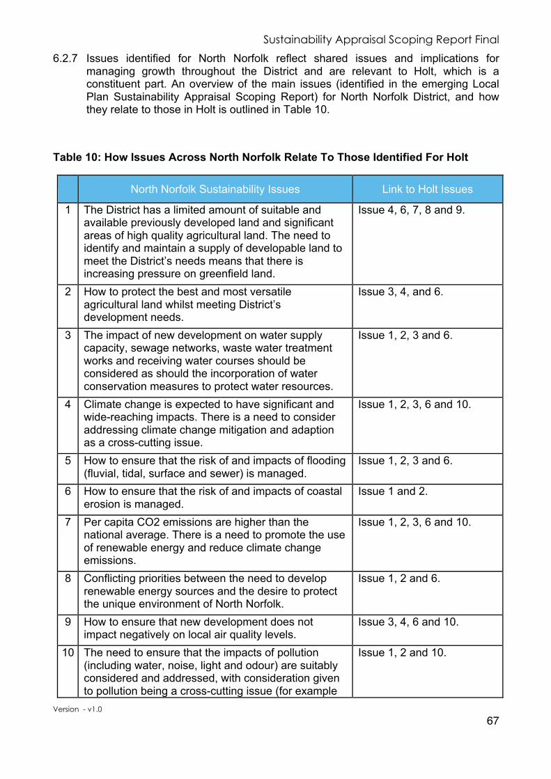
Sustainability Appraisal Scoping Report Final
Version - v1.0
67
6.2.7 Issues identified for North Norfolk reflect shared issues and implications for managing growth throughout the District and are relevant to Holt, which is a constituent part. An overview of the main issues (identified in the emerging Local Plan Sustainability Appraisal Scoping Report) for North Norfolk District, and how they relate to those in Holt is outlined in Table 10.
Table 10: How Issues Across North Norfolk Relate To Those Identified For Holt
North Norfolk Sustainability Issues Link to Holt Issues
1 The District has a limited amount of suitable and available previously developed land and significant areas of high quality agricultural land. The need to identify and maintain a supply of developable land to meet the District’s needs means that there is increasing pressure on greenfield land.
Issue 4, 6, 7, 8 and 9.
2 How to protect the best and most versatile agricultural land whilst meeting District’s development needs.
Issue 3, 4, and 6.
3 The impact of new development on water supply capacity, sewage networks, waste water treatment works and receiving water courses should be considered as should the incorporation of water conservation measures to protect water resources.
Issue 1, 2, 3 and 6.
4 Climate change is expected to have significant and wide-reaching impacts. There is a need to consider addressing climate change mitigation and adaption as a cross-cutting issue.
Issue 1, 2, 3, 6 and 10.
5 How to ensure that the risk of and impacts of flooding (fluvial, tidal, surface and sewer) is managed.
Issue 1, 2, 3 and 6.
6 How to ensure that the risk of and impacts of coastal erosion is managed.
Issue 1 and 2.
7 Per capita CO2 emissions are higher than the national average. There is a need to promote the use of renewable energy and reduce climate change emissions.
Issue 1, 2, 3, 6 and 10.
8 Conflicting priorities between the need to develop renewable energy sources and the desire to protect the unique environment of North Norfolk.
Issue 1, 2 and 6.
9 How to ensure that new development does not impact negatively on local air quality levels.
Issue 3, 4, 6 and 10.
10 The need to ensure that the impacts of pollution (including water, noise, light and odour) are suitably considered and addressed, with consideration given to pollution being a cross-cutting issue (for example
Issue 1, 2 and 10.

Sustainability Appraisal Scoping Report Final
Version - v1.0
68
North Norfolk Sustainability Issues Link to Holt Issues
there are potential impacts on the natural environment and health).
11 The need to ensure that there is no risk to public health or the environment from contaminated land.
Issue 3, 6 and 7.
12 How to protect and enhance habitats, including designated sites and protected species, including taking into account the effects of climate change.
Issue 1, 2, 3, 6 and 10.
13 How to conserve and protect geodiversity.
Issue 1 and 2. 14 How to protect and enhance green infrastructure
networks and ensure that habitats do not become further fragmented.
Issue 1, 2 and 10.
15 How policies and development proposals can protect and enhance the District’s landscape / seascape / townscape character.
Issue 1, 2, 3 and 6.
16 How policies and development proposals can protect and enhance the District’s historic environment, and their settings (designated and non-designated assets).
Issue 1.
17 How policies and development proposals can address ‘heritage at risk’.
Issue 1.
18 The Government attaches great importance to the design of the built environment. Good design is a key aspect of sustainable development, is indivisible from good planning, and should contribute positively to making places better for people. North Norfolk settlements have distinct characters, reflecting the local environment and their historic development.
Issue 1, 2, 3, 6, 7, 8 and 9.
19 How to achieve sustainable, high quality design that reflects local character and creates places, spaces and buildings that work well, wear well and look good.
Issue 1, 3, 4, and 7.
20 How to balance development with protecting and enhancing enhance the District’s landscape / seascape / townscape character.
Issue 1, 2, 3 and 6.
21 The limited number of young people living in the district creates a less socially balanced community.
Issue 3, 4 and 5.
22 The needs of the ageing population, including an increased demand for health and care services, will need to be considered.
Issue 3, 5, and 6.
23 There is a lack of young and working-age people in the district to support the economy and sustain workforce levels.
Issue 2, 4, 7 and 8.
24 There is a need to improve the health of the Issue 6 and 10.

Sustainability Appraisal Scoping Report Final
Version - v1.0
69
North Norfolk Sustainability Issues Link to Holt Issues
population and promote healthy lifestyles.
25 Relatively, the District measures poorly on a number of measures of deprivation including access to housing and local services, quality of living and education, skills and training.
Issue 3, 4, 6, 7 and 8.
26 There is a need to plan for growth where it can provide the growth benefits and sustainable access to services.
Issue 3, 6, 7 and 8.
27 Crime rates within the District’s largest towns are generally higher than within the rest of the District.
Issue 1, 2, and 9.
28 The housing market does not meet the needs of all parts of the community. In particular, there is a significant lack of affordable housing for local people that the Local Plan will need to address.
Issue 4, 7, 8 and 9.
29 A significant proportion of the existing housing stock is made-up of second homes and holiday homes and will need to be taken into account when planning for future housing needs.
Issue 9.
30 The housing needs of the ageing population need to be addressed.
Issue 5 and 6.
31 There is a need to plan for housing and economic growth where it can provide the growth benefits and sustainable access to services and jobs.
Issue 1, 2, 3, 6, 7 and 8.
32 How to balance housing needs with protecting and enhancing enhance the District’s landscape / seascape / townscape character.
Issue 1, 2, 3, 4, 6, 7 and 8.
33 The District is reliant on a narrow economic base and low wage economy.
Issue 2 and 4.
34 There is a low employment rate in the District.
Issue 2 and 4. 35 The need to support the retention of existing
employment and traditional rural industries.
Issue 1, 2 and 4.
36 There is a need to encourage new employment.
Issue 2 and 4. 37 There has been a significant loss of jobs in some
industries, including manufacturing. This trend is expected to continue.
Issue 2 and 4.
38 The need to consider the impact of older people on employment.
Issue 2, 3, 4 and 5.
39 The need to ensure that tourism continues to play an important part in terms of employment, although it is generally seasonal and low paid.
Issue 1 and 2.
40 The need to retain retail spend in Market Towns.
Issue 1.

Sustainability Appraisal Scoping Report Final
Version - v1.0
70
North Norfolk Sustainability Issues Link to Holt Issues
41 The need to retain retail services in towns and villages.
Issue 1.
42 The need to plan for housing and economic growth where it can provide the growth benefits and sustainable access to services and jobs.
Issue 2, 3, 4, 6, 7 and 8.
43 The need to ensure that employment land is appropriately located and balanced across the District.
Issue 2.
44 Educational and job opportunities for young people within the District are limited.
Issue 2, 3 and 4.
45 Given the rural nature of the District, there is a high dependency on travel by car to access employment, services and facilities.
Issue 1, 2, 3, 4 and 10.
46 Given the rural nature of the District, there is pressure on public transport.
Issue 1, 2, 3, 4 and 10.
47 The District is car centric and there may be scope for more sustainable modes of transport.
Issue 10.
48 There may be scope to reduce the need for travel.
Issue 2, 3, 6 and 9. 49 Given the rural nature of the District, commuting
distances tend to be significant.
Issue 2, 3, 6 and 10.
50 Access to services and facilities in North Norfolk is limited by its rural nature.
Issue 1, 2, 3, 6 and 10.

Sustainability Appraisal Scoping Report Final
Version - v1.0
71
7 Task A4 - Developing the Sustainability Appraisal Framework
7.1 Introduction
7.1.1 The previous chapters of this report have highlighted sustainability issues relevant to the Holt area and the development of the Neighbourhood Plan. Using this information, this chapter of the Scoping Report sets out the SA Framework that will be used to assess the economic, social and environmental effects of the Neighbourhood Plan.
7.2 Approach
7.2.1 The starting point of preparing the Holt SA Framework has been the Norfolk Norfolk Core Strategy and emerging Norfolk Norfolk Local Plan Sustainability Appraisals and Scoping Reports. These identified a large number of key sustainability issues and objectives that are relevant to the HNP.
7.2.2 The SA Objectives largely reflect those suggested in the Government guidance, and are grouped under the broad headings of “environmental, social, economic” in the list below. These have been used to form the basis of this SA Framework.
7.2.3 A framework of objectives, key questions for decision-making criteria, and indicators have been developed to cover the broad range of environmental, social and economic factors arising from the characterisation and issues assessment. Together, these form the basis of the SA Framework, set out in Table 11, and are the same objectives identified for the emerging North Norfolk Local Plan. These will be used to assess the emerging options and policies as they are developed.
7.2.4 The appraisal process examines the effects and implications of policy over short, medium, and long-term timescales, and considers the cumulative impacts that might arise as one or more policies are put together. The appraisal will be able to offer a summary of the possible environmental, social and economic effects.
Table 11: Proposed Sustainability Appraisal Objectives for Holt
Environmental Objectives SEA Theme
ENV1
Promote the efficient use of land, minimise the loss of undeveloped land and protect the most valuable agricultural land.
• Soil • Water
ENV2
Minimise waste generation, avoid the sterilisation of mineral resources and remediate contaminated land.
• Soil • Water
ENV3
To enhance water quality and ensure the most sustainable use of water.
• Soil • Water

Sustainability Appraisal Scoping Report Final
Version - v1.0
72
ENV4
Continue to reduce contributions to climate change and mitigate and adapt against it and its effects and minimise pollution.
• Air • Water • Climatic factors
ENV5
Protect and enhance the areas’ biodiversity and geodiversity assets and increase the provision of green infrastructure.
• Biodiversity • Fauna • Flora
ENV6
Respect the variety of landscape types in the area and protect, and where appropriate, enhance the historic environment.
• Cultural heritage including architectural and archaeological heritage
• Landscape
Social Objectives SEA Theme
SOC1
To maintain and improve the quality of life of the population by promoting healthy lifestyles and access to services, reducing deprivation and reducing crime and the fear of crime.
• Population • Human health
SOC2
To ensure that everyone has the opportunity of a good quality and affordable home to meet their needs.
• Population • Material assets
Economic Objectives SEA Theme
EC1
Encourage sustainable economic development and education/skills training covering a range of sectors and skill levels to improve employment opportunities for residents, to encourage investment and maintain and enhance town centres.
• Human health
EC2
Reduce the need to travel and promote the use of sustainable transport.
• Human health
7.3 Monitoring
7.3.1 The SA is an iterative process, so its success and effectiveness must be monitored. A monitoring scheme with appropriate indicators will be developed based on the baseline information and sustainability objectives presented in this report. This will be reported in the Sustainability Appraisal Report for the HNP.

Sustainability Appraisal Scoping Report Final
Version - v1.0
73
7.4 Compatibility of Sustainability Appraisal Objectives
7.4.1 The compatibility of the SA Objectives can be considered to identify possible tensions in the assessment, such as those seeking to preserve land and those advocating growth. The matrix set out in Appendix 6 details where any conflicts may occur following a precautionary principle.
7.4.2 In Appendix 7 each of the objectives is listed alongside the decision-making criteria and indicators. As an assessment is made, the likely effects will be considered and noted in the Framework. As well as providing a summary of the effects, the Framework also provides recommendations for how each policy option can be improved or their negative effects lessened.
7.4.3 The testing of potential conflicts displayed in the matrix shows that the majority of the Sustainability Appraisal Objectives are either compatible or there is no link between them. For a number of objectives however there is uncertainty over whether conflicts or further positive compatibility will arise, with these only likely to occur during the implementation of policies.
7.4.4 There is uncertainty in particular over the implications for further housing, employment and regeneration and how these could impact on achieving the prudent use of natural resources, flooding and protecting the town’s landscape. Depending on their implementation such schemes could have either a positive or negative impact towards meeting these objectives. Adequately developed policies should however control or reduce these impacts.

Sustainability Appraisal Scoping Report Final
Version - v1.0
74
8 Task A5 – Consulting, Review & Next Steps
8.1 Next Steps
8.1.1 Stakeholders with an interest in the effects of the HNP will be able to comment on the SA Scoping Report. See Appendix 8 for the Consultation Form.
8.1.2 In accordance with the Strategic Environmental Assessment Directive, the Scoping Report will be available for consultation for a minimum of five weeks; will be specifically open to consultation by three statutory bodies, and others as deemed appropriate.
8.1.3 The three statutory to be bodies consulted on the Scope of the Sustainability Appraisal will be:-
• Environment Agency;
• Historic England; and
• Natural England In addition, the Scoping Report will be sent to:-
• Norfolk County Council;
• Norfolk Wildlife Trust; and
• North Norfolk District Council.
8.1.4 The Scoping Report will then be finalised in line with any comments received during this process. It is important to ensure that key organisations are able to play a part in the ongoing sustainability appraisal process and help the emerging HNP take into account the wide variety of factors identified through the scoping process.
8.1.5 The Framework devised through the Scoping Report will play a significant role in developing policies within the emerging HNP. Its application will be documented in a SA Report; that will document how the sustainability appraisal process has been applied through the development of the different policy options considered during the production of the HNP.
8.1.6 The SA Framework will then be used to appraise the first draft of the complete HNP. An interim SA Report will be prepared to assess the social, economic and environmental effects of the emerging proposals for the parish and will be subject to consultation alongside the pre-submission version of the HNP.
8.1.7 A final SA Report will be published alongside the examination version of the HNP for consultation.
9 Document Control Document History
Version Date Reason for Change V1.0 08/09/2017 Issued to Statutory Bodies for consultation.
Sustainability Appraisal Scoping Report Final
Version - v1.0
75
Appendix 1: Strategic Environmental Assessment Screening Determination Approach
THE ENVIRONMENTAL ASSESSMENT OF PLANS AND PROGRAMMES REGULATIONS 2004
SCREENING DETERMINATION APPROACH
HOLT NEIGHBOURHOOD PLAN (HNP)
In accordance with the Environmental Assessment of Plans and Programmes Regulations 2004 (The 2004 Regulations) and European Directive 2001/42/EC, this document gives the approach to the Screening Determination and the current position of the need for a Strategic Environmental Assessment (SEA) for the HNP Development Plan Document (DPD). Under the Environmental Assessment of Plans and Programmes Regulations 2004 (the Regulations), a Strategic Environmental Assessment (SEA) must be undertaken for land-use and spatial plans. It is likely that Development Plan Documents, such the HNP DPD will require a SEA as they will contain planning policies that influence land uses which will be used to determine planning applications. The first stage in the SEA process is to determine whether or not a plan is likely to have a significant effect on the environment. The regulations advise that this is determined by a screening process, which should use a specified set of criteria (set out in Schedule 1 of the Regulations). The results of this process must be summarised in a SEA screening statement, which must be publicly available.
It is considered that the HNP falls within the scope of the 2004 Regulations on the basis that:
• The Neighbourhood Plan is a plan and programme as defined in Regulation 2;
• The Neighbourhood Plan is prepared for town and country planning or land use as defined in Regulation 5;
• The Neighbourhood Plan will determine the use of a small area at a local level but is likely to have significant environmental effects.
The screening process set out in Regulation 9 and Schedule 1 of the 2004 Regulations includes two sets of characteristics for determining the likely significance of effects on the environment. These relate firstly to the characteristics of the Neighbourhood Plan and secondly to the characteristics of the effects and of the area likely to be affected. There

Sustainability Appraisal Scoping Report Final
Version - v1.0
76
are a number of criteria relating to each of these characteristics, the answers to which are set in Table 12.
Table 12: Assessment of Significance of Effects
Criteria (Schedule 1)
Significant Environmental Effect Likely (Yes / No)?
Assessment &
Justification
1. The characteristics of the plans & programmes, having regard in particular to:
(a) The degree to which the plan or programme sets a framework for projects and other activities, either with regard to the location, nature, size and operating conditions or by allocating resources.
No
The HNP will provide a local policy framework for the Holt Neighbourhood Area. It could allocate housing, employment land and set policies for the nature and size of development. At this stage it is unlikely to make any such allocation. Should this change in the development of the HNP the assessment will be update to reflect the likelihood of these having any significant negative environmental impact.
(b) The degree to which the plan or programme influences other plans and programmes including those in a hierarchy.
No
The HNP will inform the Development Framework and any supplementary planning documents, development briefs or site-specific guidance notes in the Holt Neighbourhood Area. With the local community’s support it is felt that the HNP will have a positive environmental impact.
(c) The relevance of the plan or programme for the integration of environmental considerations, in particular with a view to promoting sustainable development.
No
The HNP will have regard to the objective of achieving sustainable development in the local area. It will be in conformity with strategic policies in the Development Framework and have a positive effect on environmental considerations.
(d) Environmental problems relevant to the plan or programme.
No
The HNP will seek to address and improve environmental, economic and social issues in the Holt Neighbourhood Area.
(e) The relevance of the plan or programme for the implementation of community legislation on the environment (for example, plans and programmes linked to waste management or water protection).
No
The HNP is relevant to the implementation of the land use elements and will seek to protect natural resources and reduce waste.

Sustainability Appraisal Scoping Report Final
Version - v1.0
77
Criteria (Schedule 1)
Significant Environmental Effect Likely (Yes / No)?
Assessment &
Justification
2. Characteristics of the effects and of the area likely to be affected, having regard, in particular to:
(a) The probability, duration, frequency and reversibility of effects. Yes
The HNP will set the local Vision, Objectives and policies to guide new development in the Holt Neighbourhood Area. It could lead to effects associated with changes to land use and development.
(b) The cumulative nature of the effects.
Yes
There may be local cumulative effects arising, from and between, the different policies in the HNP.
(c) The transboundary nature of the effects. No
There are no trans-boundary effects arising from the HNP.
(d) The risks to human health or the environment (for example, due to accidents). No
There will be no risks to human health or the environment arising from the HNP.
(e) The magnitude and spatial extent of the effects (geographical area and size of the population likely to be affected).
Yes
The HNP will apply to new developments in the Holt Neighbourhood Area. The population is approximately 3,800 that may be affected at the local level.
(f) The value and vulnerability
of the area likely to be affected due to;
a. special natural
characteristics or cultural heritage;
b. exceeded environmental quality standards or limit values; and/or
c. intensive land use.
No
HNP will cover the buildings in and around the Holt Neighbourhood Area of cultural and historical interest. Whilst there is a risk, it is unlikely that the HNP will affect these adversely.

Sustainability Appraisal Scoping Report Final
Version - v1.0
78
Criteria (Schedule 1)
Significant Environmental Effect Likely (Yes / No)?
Assessment &
Justification
(g) The effects on areas or landscapes which have a recognised national, community or international protection status.
No
The HNP will seek to protect and enhance areas of international or national landscape designations. Specifically, the Holt Lowes a designated Site of Special Scientific Interest (SSSI) and the Glaven Valley.
Consultation To expedite the SA process the approach to the HNP SEA Screening Determination and SA Scoping Report are being published and consulted upon in tandem. The SA process is being undertaken based on a judgment that the HNP may have a significant effect on the environment when judged against the characteristics set out in Regulation 9 and Schedule 1 of the 2004 Regulations. The consultation bodies specified in the Environmental Assessment of Plans and Programmes Regulations 2004 that will be consulted on the Screening Determination for the Neighbourhood Plan are as follows;
• Environment Agency;
• Historic England; and
• Natural England. The comments received will be incorporated into the final screening determination for the Holt Neighbourhood Plan.
Conclusion Following the analysis of the above information, the requirements of the Strategic Environmental Assessment (SEA) will be met by the decision to undertake a Sustainability Assessment of the HNP.
The consultation responses received from the Statutory Bodies will be used to inform and update the SEA. Copies of the final determination, together with the reasons for the determination, will be circulated to the Statutory Bodies in line with the Regulations.
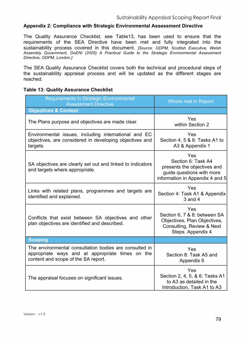
Sustainability Appraisal Scoping Report Final
Version - v1.0
79
Appendix 2: Compliance with Strategic Environmental Assessment Directive
The Quality Assurance Checklist, see Table13, has been used to ensure that the requirements of the SEA Directive have been met and fully integrated into the sustainability process covered in this document. [Source: ODPM, Scottish Executive, Welsh Assembly Government, DoENI (2005) A Practical Guide to the Strategic Environmental Assessment Directive, ODPM, London.]
The SEA Quality Assurance Checklist covers both the technical and procedural steps of the sustainability appraisal process and will be updated as the different stages are reached.
Table 13: Quality Assurance Checklist
Requirements in Strategic Environmental Assessment Directive Where met in Report
Objectives & Context
The Plans purpose and objectives are made clear.
Yes within Section 2
Environmental issues, including international and EC objectives, are considered in developing objectives and targets.
Yes Section 4, 5 & 6: Tasks A1 to
A3 & Appendix 1
SA objectives are clearly set out and linked to indicators and targets where appropriate.
Yes Section 6: Task A4
presents the objectives and guide questions with more
information in Appendix 4 and 5
Links with related plans, programmes and targets are identified and explained.
Yes Section 4: Task A1 & Appendix
3 and 4
Conflicts that exist between SA objectives and other plan objectives are identified and described.
Yes Section 6, 7 & 8: between SA Objectives, Plan Objectives, Consulting, Review & Next
Steps. Appendix 4
Scoping The environmental consultation bodies are consulted in appropriate ways and at appropriate times on the content and scope of the SA report.
Yes Section 8: Task A5 and
Appendix 6
The appraisal focuses on significant issues.
Yes Section 2, 4, 5, & 6: Tasks A1
to A3 as detailed in the Introduction, Task A1 to A3

Sustainability Appraisal Scoping Report Final
Version - v1.0
80
Requirements in Strategic Environmental Assessment Directive Where met in Report
Technical, procedural and other difficulties encountered are discussed: assumptions and uncertainties are made explicit.
This will form part of the SA Report
Reasons are given for eliminating issues from further consideration.
This will form part of the SA Report
Options / Alternatives
Realistic alternatives are considered for key issues and the reasons for choosing them are documented.
This will form part of the SA Report
Alternatives include ‘do nothing’ and/or ‘business as usual’ scenarios wherever relevant.
This will form part of the SA Report
The sustainability effects (both adverse and beneficial) of each alternative are identified and compared.
This will form part of the SA Report
Inconsistencies between the alternatives and other relevant plans, programmes or policies are identified and explained.
This will form part of the SA Report
Reasons are given for the selection or elimination of alternatives.
This will form part of the SA Report
Baseline Information Relevant aspects of the current state of the environment and their evolution without the plan are described.
Yes Section 5: Task A2 and
Appendix 5
Characteristics of the area likely to be significantly affected are described, including areas wider than the physical boundary of the plan area where it is likely to be affected by the plan where practicable.
Yes
Section 5: Task A2 and Appendix 5
Difficulties such as deficiencies in information or methods are explained.
Yes - These are stated
throughout the report where appropriate. Especially Section
5: Task A2 and Appendix 5

Sustainability Appraisal Scoping Report Final
Version - v1.0
81
Requirements in Strategic Environmental Assessment Directive Where met in Report
Prediction & Evaluation of Likely Significant Effects
Likely significant social, environmental and economic effects are identified including those listed in the SEA Directive (biodiversity, population, human health, flora, fauna, soil, water, air, climate, material assets, cultural heritage and landscape) as relevant; other likely environmental effects are also covered as appropriate.
Yes Section 6: Task A3 This will form part of the SA Report
Both positive and negative effects are considered and where practicable the duration of effects (short, medium or long term) is addressed.
This will form part of the SA Report
Likely secondary, cumulative and synergistic effects are identified where practicable.
This will form part of the SA
Report
Inter-relationships between effects are considered where practicable.
This will form part of the SA Report
The prediction and evaluation of effects makes use of relevant accepted standards, regulations and thresholds.
This will form part of the SA Report
Methods used to evaluate the effects are described.
Yes Section 3, 6 & 7: Tasks A3
and A4.
Mitigation Measures
Measures envisaged to prevent, reduce and offset any significant adverse effects of implementing the plan or programme are indicated.
This will form part of the SA Report
Issues to be taken into account in development consents are identified.
This will form part of the SA Report
The Sustainability Appraisal Report Is clear and concise in layout and presentation.
This will form part of the SA Report
Uses simple, clear language and avoids or explains technical terms.
This will form part of the SA Report
Uses maps and other illustrations where appropriate. This will form part of the SA Report
Explains the methodology used. This will form part of the SA Report
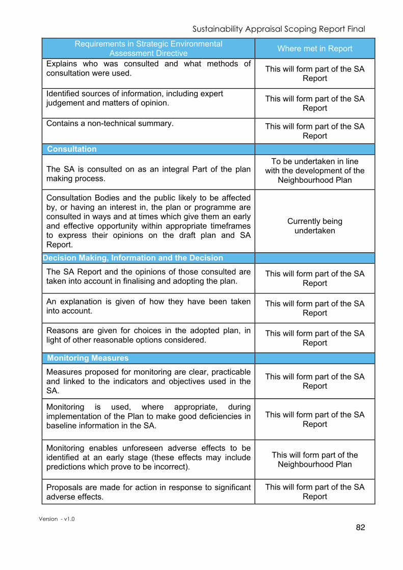
Sustainability Appraisal Scoping Report Final
Version - v1.0
82
Requirements in Strategic Environmental Assessment Directive Where met in Report
Explains who was consulted and what methods of consultation were used. This will form part of the SA
Report
Identified sources of information, including expert judgement and matters of opinion. This will form part of the SA
Report
Contains a non-technical summary.
This will form part of the SA Report
Consultation The SA is consulted on as an integral Part of the plan making process.
To be undertaken in line with the development of the
Neighbourhood Plan
Consultation Bodies and the public likely to be affected by, or having an interest in, the plan or programme are consulted in ways and at times which give them an early and effective opportunity within appropriate timeframes to express their opinions on the draft plan and SA Report.
Currently being
undertaken
Decision Making, Information and the Decision
The SA Report and the opinions of those consulted are taken into account in finalising and adopting the plan.
This will form part of the SA Report
An explanation is given of how they have been taken into account.
This will form part of the SA Report
Reasons are given for choices in the adopted plan, in light of other reasonable options considered.
This will form part of the SA Report
Monitoring Measures
Measures proposed for monitoring are clear, practicable and linked to the indicators and objectives used in the SA.
This will form part of the SA Report
Monitoring is used, where appropriate, during implementation of the Plan to make good deficiencies in baseline information in the SA.
This will form part of the SA Report
Monitoring enables unforeseen adverse effects to be identified at an early stage (these effects may include predictions which prove to be incorrect).
This will form part of the Neighbourhood Plan
Proposals are made for action in response to significant adverse effects.
This will form part of the SA Report

Sustainability Appraisal Scoping Report Final
Version - v1.0
83
Appendix 3: Document Reviewed by the North Norfolk Local Plan Sustainability Appraisal
International Level 1 Convention on the Conservation of European Wildlife and Natural Habitats
(Bern Convention) Council of Europe 1979
2 Convention for the Protection of the Architectural Heritage of Europe Council of Europe 1987
3 Convention on Wetlands of International Importance especially as Waterfowl Habitat (The Ramsar Convention) UNESCO 1971
4 Directive 2001/42/EC Strategic Environmental Assessment (SEA) European Commission 2001
5 Directive 2009/147/EC on the conservation of wild birds European Commission 2009
6 Directive on the Promotion of Biofuels and other Renewable Fuels for Transport 2003/30/EC European Parliament and the Council 2003
7 EC Council Directive 2008/50/EC on ambient air quality and cleaner air for Europe European Union 2008
8 European Convention on the Protection of the Archaeological Heritage (The Valletta Convention) Council of Europe 2011
9 European Landscape Convention European Union 2000
10 European Spatial Development Perspective European Commission 1999
11 Flood Directive 2007/60/EC European Union 2007 12 Kyoto Protocol to the UN Convention on Climate Change United Nations
Adopted 1992, amendment 1997, entered into force 2005
13 Renewable Directive EU Directive 2009/28/EC European Parliament 2009
14 The Convention on Biological Diversity Rio Earth Summit 1992
15 The Convention on the Conservation of Migratory Species of Wild Animals (Bonn Convention) 1979 UN
16 ‘The Habitats Directive’ EC Council Directive 92/43/EEC, on the Conservation of Natural Habitats and of Wild Fauna and Flora European Commission 1992
17 The United Nations Conference on Environment and Development (UNCED) (Rio Earth Summit) United Nations 1992
18 Water Framework Directive 2000/60/EC European Union 2002
19 World Heritage Convention UNESCO 1972
National Level 20 50 Year Vision for Wetlands English Heritage (now Historic England),
Environment Agency, Natural England RSPB and The Wildlife Trusts. 2008

Sustainability Appraisal Scoping Report Final
Version - v1.0
84
21 2008/98/EC EU Framework Directive on Waste European Union 2008
22 Air Quality Strategy for England, Wales, Scotland and Northern Ireland Defra, Scottish Executive, Welsh Assembly Government and Department of the Environment Northern Ireland 2011
23 Ancient Monuments and Archaeological Areas Act 1979 UK Government 1979
24 A Strategy for Sustainable Growth (Department for Business Innovation & Skills) 2010
25 Biodiversity 2020: A strategy for England’s wildlife and ecosystem services Department for Environment, Food & Rural Affairs 2011
26 Broadband Delivery UK Department for Culture, Media & Sport 2013, latest update 2015
27 Climate Change Act UK Government 2008
28 Conserving Biodiversity- A UK Approach Department for Environment, Food & Rural Affairs 2011
29 Creating growth, cutting carbon: making sustainable local transport happen Department for Transport 2011
30 Creating the Conditions for Integration DCLG 2012
31 Delivering a Sustainable Railway Department for Transport 2007
32 Delivering Sustainable Low Carbon travel: An Essential Guide for Local Authorities Department of Health 2009
33 Energy Act 2011 UK Government 2011
34 Environment Act 1995 UK Government 1995
35 Environmental Protection Act 1990 UK Government 1990
36 Fixing the Foundations: Creating a more Prosperous Nation HM Treasury, Department for Business, Innovation and Skills, The Rt Hon George Osborne MP and The Rt Hon Sajid Javid MP 2015
37 Flood and Water Management Act 2010 UK Government 2010
38 Future water: The Government’s Water Strategy for England Department for Environment, Food & Rural Affairs 2011
39 Government Forestry Policy Statement Department for Environment, Food & Rural Affairs 2013
40 Government Tourism Policy DCMS 2011
41 Healthy Lives, Healthy People: Our Strategy for Public Health in England Department of Health 2010
42 Housing and Planning Bill DCLG 2015-16
43 Laying the Foundations: A Housing Strategy for England DCLG 2011
44 Lifetime Neighbourhoods DCLG 2011
45 Local Growth: Realising Every Place’s Potential Department for Business, Innovation and Skills 2010

Sustainability Appraisal Scoping Report Final
Version - v1.0
85
46 Localism Act DCLG 2011
47 Making the Connection: the Plug-in Vehicle Infrastructure Strategy Office for Low Emission Vehicles 2011
48 Manual for Streets Department for Transport and Department for Communities and Local Government 2007
49 Manual for Streets 2. Wider Application of the Principles. The Chartered Institutes of Highways and Transportation 2010
50 Marine and Coastal Access Act 2009 UK Government 2009
51 Marmot Review ‘Fair Society, Healthy Lives’ Department of Health 2010
52 Meeting the energy challenge: a White Paper on energy Department of Trade and Industry 2007
53 National Planning Policy for Waste Department for Communities and Local Government 2014
54 National Planning Policy Framework (NPPF) DCLG 2012 Guidance to support the NPPF is contained within the Planning Practice Guidance DCLG 2014 (and updated as needed)
55 National Pollinator Strategy: for Bees and other Pollinators in England DEFRA 2014
56 Natural Environment and Rural Communities Act UK Government 2006
57 Plan for Growth HM Treasury 2011
58 Planning (Listed Buildings and Conservation Areas) Act 1990 UK Government 1990
59 Planning Policy for Traveller Sites DCLG 2015
60 Policy Statement: Planning for Schools DCLG 2011
61 Public Health Guidance 8 Promoting and creating built or natural environments that encourage and support physical activity The National Institute for Health and Care Excellence (NICE) 2008
62 Safeguarding our Soils - A Strategy for England Department for Environment, Food & Rural Affairs 2011
63 Securing the Future Delivering UK Sustainable Development Strategy HM Government 2005
64 Sporting Future: A New Strategy for an Active Nation HM Government 2015
65 The Air Quality Standards Regulations 2010 UK Government 2010
66 The Conservation of Habitats and Species Regulations (As amended) UK Government 2010
67 The Countryside and Rights of Way Act 2000 UK Government 2000
68 The Environmental Assessment of Plans and Programmes Regulations 2004 HM Government 2004
69 The Flood Risk Regulations 2009 UK Government 2009
Sustainability Appraisal Scoping Report Final
Version - v1.0
86
70 The Future of Transport: A Network for 2030 Department for Transport 2004
71 The Mental Health Strategy for England Department of Health 2011 & Healthy Lives, Healthy People: A call to action on obesity in England Department of Health 2011
72 The Natural Choice: Securing the Value of Nature Department for Environment, Food & Rural Affairs 2011
73 The 'UK Post-2010 Biodiversity Framework' Joint Nature Conservation Committee (JNCC) and Defra 2012
74 Towards an Active Nation Strategy 2016 - 2021 Sport England
75 Towards a Sustainable Transport System Department for Transport 2007 & Delivering a Sustainable Transport System Department for Transport 2008
76 UKGAP Action Plan Natural England
77 UK Renewable Energy Roadmap: 2011 Department of Energy & Climate Change 2011
78 Waste Management Plan for England Department for Environment, Food & Rural Affairs 2013
79 Wildlife and Countryside Act (As Amended) UK Government 1981
80 Working with the Grain of Nature - A Biodiversity Strategy for England Department for Environment, Food & Rural Affairs 2011
Regional Level 81 AONB Management Plan Strategy 2014-19 Action Plan 2014-19 Norfolk Coast
Partnership 201?
82 Biodiversity Supplementary Planning Guidance for Norfolk
83 Connecting Norfolk Implementation Plan for 2015-2021 Norfolk County Council 2015 & Connecting Norfolk Norfolk’s Transport Plan for 2026 Norfolk County Council 2011
84 DEFRA & EA 2015
85 East of England Marine Plans Marine Management Organisation 2014
86 Habitat and Species Action Plans Norfolk Biodiversity Partnership
87 Health and Wellbeing Strategy 2014-2017 Norfolk’s Health and Wellbeing Board May 2014 / March 2015
88 Making Space for Wildlife and People. Creating an Ecological Network for Norfolk. Norfolk Biodiversity Partnership & Norfolk Wildlife Trust 2005
89 New Anglia Strategic Economic Plan New Anglia Local Enterprise Partnership (LEP) for Norfolk and Suffolk 201?
Sustainability Appraisal Scoping Report Final
Version - v1.0
87
90 Norfolk Infrastructure Plan 2015 Norfolk County Council
91 Norfolk Local Flood Risk Management Strategy- Post Consultation Final Draft v.13.1 Norfolk County Council
92 Norfolk Rural Development Strategy 2013-2020 Norfolk Rural Development Strategy Steering Group 2013
93 Norfolk’s Earth Heritage & Norfolk Geodiversity Action Plan (GAP) Norfolk Geodiversity Partnership
94 North Norfolk Abstraction Licensing Strategy & Broadland Abstraction Licensing Strategy EA, 2013
95 North Norfolk: Catchment flood Management Plan & Broadland Rivers Catchment flood Management Plan EA 2009
96 Police and Crime Plan for Norfolk 2014-2016 Office of the Police and Crime Commissioner for Norfolk 2015 (refresh)
97 Realising the Benefits of Trees, Woods and Forests in the East of England Woodland for life Publication 2011
98 SMP 5 Hunstanton to Kelling Hard Shoreline Management Plan EA 2010
99 SMP 6 Kelling Hard to Lowestoft Shoreline Management Plan EA 2012
100 Tomorrow’s Norfolk, Today’s Challenge - Climate Change Strategy for Norfolk (2008)
101 Water Resources Management Plan Anglian Water 2015
102 Wild Anglia Manifesto New Anglia Local Enterprise Partnership for Norfolk and Suffolk 201?
Local Level 103 Affordable Housing NNDC
104 Business Growth and Investment Opportunities Study, DRAFT Report V4 BE Group 2015
105 Economic Growth Plan NNDC 2015
106 Homelessness Strategy NNDC 2015
107 Housing Allocation Scheme (Your Choice Your Home) NNDC
108 Housing Strategy 2012-2015 2012
109 Norfolk Minerals and Waste Development Framework: Core Strategy and Minerals & Waste Development Management Policies Development Plan Document 2010-2026 Norfolk County Council 2011 & Minerals Site Specific Allocations Development Plan Document (DPD) Norfolk County Council 2013 & Waste Site Specific Allocations Development Plan Document (DPD) Norfolk County Council 2013

Sustainability Appraisal Scoping Report Final
Version - v1.0
88
110 North Norfolk Conservation Area Appraisals Various
111 North Norfolk District Council Annual Action Plan 2016/17
112 North Norfolk District Council Contaminated Land Strategy NNDC 2015
113 North Norfolk District Council Corporate Plan 2015 - 2019 NNDC 2015
114 North Norfolk District Indoor Leisure Facilities Strategy Neil Allen Associates 2015
115 North Norfolk Empty Homes Policy NNDC 2014

Sustainability Appraisal Scoping Report Final
Version - v1.0
89
Appendix 4: Document Review
Document Title
Key Relevant Objectives
Key Relevant Targets & Indicators
Implications for Holt
Neighbourhood Plan
Issues for Sustainability Appraisal
National .
1
National Planning Policy Framework (NPPF)
Sets out the Government’s planning policies for England and how these are expected to be applied.
The NPPF is fundamental to the process of preparing Local Development Documents.
Implications across SA.
2
Air Quality Strategy for England, Scotland, Wales and Northern Ireland (2007)
Further improve air quality in the UK into the long term. As well as direct benefits to public health, the options are intended to provide important benefits to quality of life and help to protect the environment.
The current policy framework and the legislative requirement to meet EU air quality limit values everywhere in the UK tend to direct attention to localised hotspot areas of pollution (where the objectives are not met).
Encourage a reduction in air pollutants.
§ Contribution to reducing air pollution and improving air quality.
3
Building for Life 12 (2015)
Building for Life 12 is the government-endorsed industry standard for well-designed homes and neighbourhoods. It seeks to encourage and guide discussions about creating good places to live.
There are 12 questions for new development:-
• Connections
• Facilities and services
• Public transport
• Meeting local housing requirements
Use Building for Life standards to enable discussion at workshops and to determine policies in the Design and Character theme.
§ Contribution to sustainable development.

Sustainability Appraisal Scoping Report Final
Version - v1.0
90
Document Title
Key Relevant Objectives
Key Relevant Targets & Indicators
Implications for Holt
Neighbourhood Plan
Issues for Sustainability Appraisal
Using three key themes • Integrating into the
neighbourhood; • Creating a place; and • Street & home.
§
• Character
• Working with the site and its context
• Creating well defined streets and spaces
• East to find your way around
• Streets for all
• Car parking
• Public and private spaces
• External storage and amenity space.
4
The National Adaption Programme – Making the country resilient to a changing climate (2013)
Provides a guide to a Vision of a “society which makes timely, far-sighted and well-informed decisions to address the risks and opportunities posed by a changing climate” to address the requirements and actions of The Climate Change Risk Assessment 2012 (CCRA).
Setting out 31 objectives to meet the challenges.
These objectives have been developed to address the greatest risks and opportunities. These objectives cover 4 main areas across the programme:
1. Increasing awareness 2. Increasing resilience to
current extremes 3. Taking timely action for
long-lead time measures 4. Addressing major
evidence gaps.
To develop policies which recognise the need where:-
§ built environment delivers sustainable growth and making homes more resilient;
§ infrastructure is planned, delivered and maintained to be resilient, whilst identifying mitigation and risk management for vulnerabilities in local infrastructure;
§ natural environment is placed in the strongest
§ Contribution to mitigate against the anticipated impacts of future climate change.

Sustainability Appraisal Scoping Report Final
Version - v1.0
91
Document Title
Key Relevant Objectives
Key Relevant Targets & Indicators
Implications for Holt
Neighbourhood Plan
Issues for Sustainability Appraisal
possible position to meet the challenges and changes ahead.
Regional .
5
Central Norfolk Strategic Housing Market Assessment 2015 (Report Findings January 2016)
A Strategic Housing Market Assessment (SHMA) was undertaken to establish the Objectively Assessed Need (OAN) for housing for Norfolk including the local authorities of Norwich City, Broadland, Breckland, North Norfolk and South Norfolk, plus the Broads Authority. The primary objective of this study is to establish the Objectively Assessed Need (OAN) for housing. The OAN identifies the future quantity of housing that is likely to be needed (both market and affordable) in the Housing Market Area over future plan periods.
Estimates for OAN are the latest household projections published by the Department for Communities and Local Government (CLG) for the period 2012-37. These projections suggest that household numbers across Central Norfolk will increase by 2,509 households each year (2,655 dwellings) and provides the most appropriate demographic projection on which to base the Objectively Assessed Need for housing.
The SHMA identifies an OAN for 70,483 dwellings over the 24-year period 2012-36, an annual average of 2,937. This represents a 20% increase above the demographic trends for the area.
The additional dwellings will also provide more affordable housing. If the full OAN for affordable housing is to be met then 26% of all housing must be affordable across Central Norfolk.
Develop policies that address the identified OAN for housing.
§ Increase in the identified OAN for housing across area.
§ The need for more affordable housing.
§ Pressure for growth and more development sites.
§ Impact on environment and heritage.
§ Improve accessibility to essential services, facilities and jobs.
§ Improving infrastructure to enable development.

Sustainability Appraisal Scoping Report Final
Version - v1.0
92
Document Title
Key Relevant Objectives
Key Relevant Targets & Indicators
Implications for Holt
Neighbourhood Plan
Issues for Sustainability Appraisal
For North Norfolk the target annual average is the delivery of 419 new homes across the period to 2036.
6
NewAnglia Local Enterprise Partnership for Norfolk & Suffolk – Strategic Economic Plan (2014)
The vision for New Anglia in 2026 is: more jobs, more businesses and more prosperity.
§ To achieve this we want to harness the strength of our world class sectors, our natural assets, and the competitive advantage our location gives us.
Targeting by 2026 across the NewAnglia area to:-
§ 95,000 more jobs;
§ 10,000 new businesses;
§ 117,000 new homes; and
§ Increased productivity (added value per job) to equal the national average - increasing Gross Value Added (GVA) from £36,000 a job to £40,000 on present numbers.
§ Drive for job creation.
§ Requirement for additional housing.
NewAnglia LEP impact on local policies and priorities.
Local .
7
Core Strategy Incorporating Development Control Policies September 2008
Sets out long term the development strategy and policies for North Norfolk area up to 2021. Forms part of the North Norfolk Development Plan. Sets out generic policies that are to be applied throughout the North Norfolk planning authority area.
The Core Strategy provides for nearly 7,000 new dwellings from commitments and allocations. It is anticipated that at least 1,000 dwellings will come forward as windfall, in the form of small in-fill plots in the selected settlements, as affordable housing exception schemes and as barn conversions in locations
As part of the Development Plan the policies set out key planning requirements for the area.
Policies impact on SA objectives.

Sustainability Appraisal Scoping Report Final
Version - v1.0
93
Document Title
Key Relevant Objectives
Key Relevant Targets & Indicators
Implications for Holt
Neighbourhood Plan
Issues for Sustainability Appraisal
adjacent to the selected settlements. The Development Control Policies identify and define detailed local policies for the management of development. Aims to guide decision-takers and applicants in order to achieve high standards of development that will complement the valued attributes of the District.
8
Design Guide December 2008
This latest version is no exception in that it responds to the most recent Government guidance, and to the ever increasing pressures associated with 21st century development such as reducing carbon emissions and designing out crime. The Guide covers a wide range of subject areas, from new housing estates to hanging signs, and from barn conversions to large retail supermarkets. It also recognises the huge contribution heritage makes in defining our District and the need to conserve the best of this past.
Supplementary Planning Document has two main purposes:-
§ To provide further guidance and background information on North Norfolk Core Strategy policies, in particular EN4 Design (including crime prevention) and EN6 Sustainable Construction and Energy Efficiency.
§ To offer advice and support to everyone involved or interested in the design or alteration of the built environment in North Norfolk with the objective of raising the quality of design
The Design Guide Supplementary Planning Document (SPD) forms part of the North Norfolk LDF and is a material consideration for the Local Planning Authority (LPA) when determining planning applications. A starting point for improving design in and around Holt.
§ Promote sustainable development.
§ Identification of key and
desirable character and design features.
§ Protect and enhance the
natural and built environment.
§

Sustainability Appraisal Scoping Report Final
Version - v1.0
94
Document Title
Key Relevant Objectives
Key Relevant Targets & Indicators
Implications for Holt
Neighbourhood Plan
Issues for Sustainability Appraisal
At the same time, and in accordance with what Government now expects from good planning, the Guide promotes sustainable construction as a means of tackling climate change. Hence, minimising energy and resource consumption, maximising energy efficiency and reducing carbon emissions are all central themes of the Guide. It also seeks to ensure that new development incorporates renewable energy technologies where appropriate and that it is able to respond to the longer-term impacts of climate change.
9
Landscape Character Assessment SPD June 2009
North Norfolk District Council Core Strategy Policy EN2 requires that proposals for development should be informed by, and be sympathetic to, the distinctive character of an area. The Landscape Character Assessment SPD provides the tools and guidance to help implement this policy.
Landscape as an entity is not static but is constantly changing and developing. Decisions relating to development often impinge considerably upon landscape, changing and altering it. It is therefore important that proposals are informed by an understanding of the landscape and what factors may be more, or less, appropriate.
Landscape Character Assessment is underpinned by a set of key principles, however there is a degree of flexibility and evolution in this process that allows response to local circumstances. The HNP may develop policies that give more guidance in the implementation specific to Holt.
§ Protection of and contribution to green infrastructure.
§ Impact on environmental assets, both natural and built.
§ Impact on / enhancement of countryside and the environment.
§ Mitigate potential adverse affects on climate change.

Sustainability Appraisal Scoping Report Final
Version - v1.0
95
Document Title
Key Relevant Objectives
Key Relevant Targets & Indicators
Implications for Holt
Neighbourhood Plan
Issues for Sustainability Appraisal
10 North Norfolk Local Plan Draft Sustainability Appraisal Scoping Report: Consultation Version (September 2016)
This document seeks to assess the extent to which the emerging plan, when judged against reasonable alternatives, will help to achieve relevant economic, social and environmental objectives, as well as a means of identifying and mitigating any potential adverse effects that the plan might otherwise have.
There are eight Objectives linked to the SEA Themes. These are :- 1. Land, Water and Soil
Resources: • Promote the efficient
use of land, minimise the loss of undeveloped land and protect the most valuable agricultural land.
• Minimise waste generation, avoid the sterilisation of mineral resources and remediate contaminated land.
• To enhance water
quality and ensure the most sustainable use of water.
2. Climate Change, Energy,
Air Quality and Pollution: Continue to reduce contributions to climate change and mitigate and adapt against it and its effects and minimise pollution.
3. Biodiversity, Fauna, Flora
The HNP policies will be judged and assessed against the same Sustainability Objectives to being consistency in approach.
Implications across SA. Used as the basis of the Sa Objectives for the HNP SA.
Sustainability Appraisal Scoping Report Final
Version - v1.0
96
Document Title
Key Relevant Objectives
Key Relevant Targets & Indicators
Implications for Holt
Neighbourhood Plan
Issues for Sustainability Appraisal
and Geodiversity: Protect and enhance the areas’ biodiversity and geodiversity assets and increase the provision of green infrastructure.
4. Landscape, Townscape and
Historic Environment: Respect the variety of landscape types in the area and protect, and where appropriate, enhance the historic environment.
5. Healthy and Inclusive
Communities: To maintain and improve the quality of life of the population by promoting healthy lifestyles and access to services, reducing deprivation and reducing crime and the fear of crime.
6. Housing: To ensure that
everyone has the opportunity of a good quality and affordable home to meet their needs.
7. Economic Activity and
Education: Encourage sustainable economic development and

Sustainability Appraisal Scoping Report Final
Version - v1.0
97
Document Title
Key Relevant Objectives
Key Relevant Targets & Indicators
Implications for Holt
Neighbourhood Plan
Issues for Sustainability Appraisal
education/skills training covering a range of sectors and skill levels to improve employment opportunities for residents, to encourage investment and maintain and enhance town centres.
8. Infrastructure and
Accessibility: Reduce the need to travel and promote the use of sustainable transport.
11
Norfolk Ambition Sustainable Community Strategy 2003 – 2023
This Local Area Agreement takes the Sustainable Community Strategy of Norfolk County Strategic Partnership (Norfolk Ambition) and looks to deliver its long-term vision.
Using national and local indicators as monitoring tools.
Maintain and enhance the elements that contribute to the quality of life of residents.
§ Improve the quality of where people live.
§ Improvement of the health of the population.
§ Improve accessibility to essential services and facilities.
§ Encourage local community identity, good behaviour and co-operative attitudes.
§ Maximise the use of renewable energy solutions and reduce contributions to climate change.
§ Reduce vulnerability to climate change.
§ Improve education and skills of population.

Sustainability Appraisal Scoping Report Final
Version - v1.0
98
Document Title
Key Relevant Objectives
Key Relevant Targets & Indicators
Implications for Holt
Neighbourhood Plan
Issues for Sustainability Appraisal
12
Partnership of Norfolk District Councils - Strategic Flood Risk Assessment (2008)
Ensure that flood risk is taken into account at all stages in planning process to avoid :-
§ inappropriate development in areas at risk of flooding; and
§ to direct development away from areas at highest risk.
Where new development is, exceptionally, necessary in such areas policy aims to make it safe without increasing flood risk elsewhere and where possible, reducing flood risk overall.
Reduction in flooding.
Consider the implications of flood risk for development, avoiding risks where possible and enabling improvements.
§ Avoid, reduce and manage flood risk
13
Site Allocations February 2011
Defines allocated sites in Holt setting out constraints and requirements for each. Identifies policies to support the delivery of the allocated sites.
Supports the scale of development and reflects the requirements set out in the Core Strategy. There are three policies relating to allocation in Holt which clearly defined as:- HO1: Land West of Woodfield Road
Land amounting to 3.25 hectares is allocated for residential development of approximately 100 dwellings. The development of the site will
Defines current development allocations for Holt Allocates areas for growth and development.
Consideration of potential sites having already been appraised to arrive at any site allocations.

Sustainability Appraisal Scoping Report Final
Version - v1.0
99
Document Title
Key Relevant Objectives
Key Relevant Targets & Indicators
Implications for Holt
Neighbourhood Plan
Issues for Sustainability Appraisal
be required to ensure the following:
a. Layout, design and landscaping that has regard to the setting of the town and the sites location within the Norfolk Coast AONB;
b. no vehicular access to Peacock Lane;
c. provision of suitable pedestrian / cycle links to the town centre and surrounding area;
d. provision of suitable landscaping along site boundaries with particular attention to the northern boundary;
e. retention of hedgerows along site boundaries;
f. prior approval of a scheme of mitigation to minimise potential impacts on the North Norfolk Coast SPA/SAC arising as a result of increased visitor pressure, and on-going monitoring of such measures; and,
g. demonstration that there is adequate capacity in sewage treatment works and the foul sewerage

Sustainability Appraisal Scoping Report Final
Version - v1.0
100
Document Title
Key Relevant Objectives
Key Relevant Targets & Indicators
Implications for Holt
Neighbourhood Plan
Issues for Sustainability Appraisal
network and that proposals have regard to Water Framework Directive objectives.
This site is within the Norfolk Coast AONB and development proposals should be informed by, and be sympathetic to, the special landscape character of this protected site. Proposals should also be informed by Core Strategy Policies EN1 and EN2. HO9: Land at Heath Farm / Hempstead Road
Land amounting to approximately 15 hectares is allocated for a mixed use development including approximately 200 dwellings, not less than 5 hectares of land in employment generating uses of which not less that 3.5 hectares shall comprise serviced industrial land, public open space, and community facilities. The development of the site will be required to ensure the following:
a. The prior approval of a Development Brief to address access (to be

Sustainability Appraisal Scoping Report Final
Version - v1.0
101
Document Title
Key Relevant Objectives
Key Relevant Targets & Indicators
Implications for Holt
Neighbourhood Plan
Issues for Sustainability Appraisal
from the A148) and sustainable transport, layout, phasing, including the phased provision of serviced employment land, and conceptual appearance;
b. retention and enhancement of perimeter hedgerows and trees;
c. provision of significant internal open spaces, hedgerow and tree planting within the site and a landscape buffer to the A148 and the adjacent County Wildlife Site;
d. prior approval of an agreement to secure contributions towards management of the adjacent County Wildlife Site;
e. investigation and remediation of any land contamination;
f. provision of a direct pedestrian / cycleway connection to Hempstead Road underpass;
g. prior approval of a scheme of mitigation to

Sustainability Appraisal Scoping Report Final
Version - v1.0
102
Document Title
Key Relevant Objectives
Key Relevant Targets & Indicators
Implications for Holt
Neighbourhood Plan
Issues for Sustainability Appraisal
minimise potential impacts on the North Norfolk Coast SPA / SAC and Ramsar site arising as a result of increased visitor pressure, and on-going monitoring of such measures; and,
h. demonstration that there is adequate capacity in sewage treatment works and the foul sewerage network and that proposals have regard to Water Framework Directive objectives.
Retail development, other than that serving the needs of the proposed development, will not be permitted.
CP10: Land at Thornage Road
Land amounting to approximately 2 hectares is allocated for a public car park. The development of the site will be required to ensure the following:
a. Safe vehicular access being provided solely from Thornage Road
Sustainability Appraisal Scoping Report Final
Version - v1.0
103
Document Title
Key Relevant Objectives
Key Relevant Targets & Indicators
Implications for Holt
Neighbourhood Plan
Issues for Sustainability Appraisal
incorporating a right-turn lane facility;
b. improvements to the pedestrian environment in Valley Lane;
c. comprehensive landscaping within the site and to the Thornage Road frontage;
d. provision of bicycle parking; and, prior completion of a Traffic Impact Assessment (TIA) and completion of any highway improvements identified by the Assessment.
Neighbourhood .
14
Holt Conservation Area Character Appraisal and Management February 2010
Identification and protection of key characteristics and details of design value.
Management Proposals identifies future actions and enhancements in the Holt Conservation Area.
Consider areas identified as enhancing and detracting from the character of the area.
Key characteristics of the Holt Conservation Area:
§ For much of the town’s history, agricultural markets were the main source of income. Their importance is reflected by the rebuilding of the town around the market place after the fire of 1708.
§ Most of the buildings
Suitability and application of design principles and use of traditional materials across a wider area. Identification of aspects that detract from the character of the area. A number of issues have been identified, these are:-
§ Review of the Conservation Area boundary.
§ Some poor modern shop fronts and signage lowering

Sustainability Appraisal Scoping Report Final
Version - v1.0
104
Document Title
Key Relevant Objectives
Key Relevant Targets & Indicators
Implications for Holt
Neighbourhood Plan
Issues for Sustainability Appraisal
within the Conservation Area date from the Georgian and early Victorian periods, they have a similar character and scale, and use a common range of building materials.
§ The historic core of the town is rectangular in plan, bordered by Market Place, Bull Street, White Lion Street and Shirehall Plain. The High Street extends away to the west from this, encouraging more linear development.
§ The main thoroughfare through Holt is Market Place and High Street, which comprise the main commercial centre.
§ The Conservation Area is enclosed on the northern, southern and western sides by 20th century development.
§ Range of small independent shops.
§ A medium sized supermarket and car park situated on the south side
the quality of the streetscape.
§ Widespread on-street parking Indifferent quality and myriad of street surfaces and street furniture.
§ Neglected alleyways and uncoordinated street lighting.
§ Permitted development resulting in the loss of architectural detail.
§ Permitted but detrimental alterations and extensions
§ Need to improve the quality of design for new developments.
§ Need to adopt a list of Buildings of Local Interest.
§ Need to ensure quality of 'visitor' experience.

Sustainability Appraisal Scoping Report Final
Version - v1.0
105
Document Title
Key Relevant Objectives
Key Relevant Targets & Indicators
Implications for Holt
Neighbourhood Plan
Issues for Sustainability Appraisal
of the town centre.
§ There is a sharp division between the streets and open fields on the east and west sides.
15
North Norfolk Local Plan Regulation 18 Consultation: Holt Local Plan Workshop Feedback Summary June 2016
North Norfolk District Council facilitated a serious of local workshops to feedback to outcomes of the Regulation 18 consultation, conducted in August 2015, on the topic areas that the new emerging single Local Plan will consider. These topics included a review of the housing target for the District and how this housing growth will be spatially distributed. The Local Plan will, amongst other topics, set the strategic approach to development in relation to the level and distribution of employment, retail, the protection and management of the natural and historic environment, and how to approach development in the countryside. On 23 May 2016 the Holt Workshop was held with local stakeholders.
By the end of each session the aim was that groups would: • Have clarity on the
process for preparing a Local Plan, the work undertaken so far, and what will happen next.
• Have an understanding of the scale of growth which might be required in the town and have the opportunity to identify suitable locations.
• Have listed the planning issues that they feel are important to address, and, understood if and how the Local Plan can address those issues.
• Have described the places that give rise to issues, present opportunities, or that should change.
• Have described the positives and negatives about the town and
Holt has a number of existing allocations and permissions which combined have consented permission to deliver approximately 450 dwellings. In terms of future growth levels and allocations for the town in the emerging new single Local Plan no decision has yet been made on the overall numbers and distribution. It is likely that decisions around the level of growth in Holt will be dependent on the overall distribution in other towns and villages and in particular the amount of development at North Walsham and Fakenham. The approach taken to the former air bases also has the potential to influence the final figure and options for Holt.
§ Car parking provision, number of spaces in logical / connected places;
§ Additional school provision;
§ Changes in national planning policy, in particular the potential impacts / concerns around a brownfield register and permission in principle;
§ Approach to growth in surrounding villages and the opportunity to review the current flexible approach through the Local Plan process.
§ Viability issues and policy flexibility around affordable housing requirements and provision including the practice of cross subsidy.

Sustainability Appraisal Scoping Report Final
Version - v1.0
106
Document Title
Key Relevant Objectives
Key Relevant Targets & Indicators
Implications for Holt
Neighbourhood Plan
Issues for Sustainability Appraisal
identified the key opportunities for growth in a collaborative manner.
• Have heard other’s points of view about matters that affect the area.
Issues identified:-
§ Delivery of appropriate affordable housing including the opportunities/size requirements around downsizing for the elderly.
§ Employment land facilitation particularly what further support could be given to ensure the release/delivery of existing employment land and address delivery issues associated with land ownership.
16
The Holt Vision February 2012
The Vision document had the key purpose of producing a visioning study for the development of key community, economic and environmental improvements for Holt and its hinterland for the next 5 years. Ultimately the improvements will be aimed to have long-term sustainable benefits achieving positive impacts for the next 25 years.
Indicators and areas of improvement identified were:-
§ Improve pedestrian and shopper access around key central areas.
§ Ease traffic flows.
§ Enable people to engage more easily with training and skills development opportunities.
§ To bring job opportunities.
Identifies a number of issues and actions linked to land usage.
Local community aspirations and priorities may align to sustainability issues identified.

Sustainability Appraisal Scoping Report Final
Version - v1.0
107
Document Title
Key Relevant Objectives
Key Relevant Targets & Indicators
Implications for Holt
Neighbourhood Plan
Issues for Sustainability Appraisal
§ Strengthen social cohesion.
§ Enhance the built environment and the public realm.

Sustainability Appraisal Scoping Report Final
Version - v1.0
108
Appendix 5: Baseline Information for Holt Based on the North Norfolk District level information. Where data, values, trends or targets are not available at Holt parish level the North Norfolk District level data has been used. This is in addition to the base line date in Section 5 of this report.
Sustainability Appraisal
Objective Indicator
North Norfolk Value
Comparison Value
Trends
Target
Comments
Environmental Baseline
ENV1: Promote the efficient use of land, minimise the loss of undeveloped land and protect the most valuable agricultural land. Number of new dwellings are built on previously developed land.
Source: Local Authority AMR.
2015/16: N/A
N/A
2014 /15: 50% 2013 /14: 71% 2012 /13: 78% 2011 /12: 84% 2010 /11: 78%
The amount of available previously developed land is very limited.
ENV2: Minimise waste generation, avoid the sterilisation of mineral resources and remediate contaminated land. Recycling levels: -
a) percentage b) national ranking
North Norfolk: 2016 /17:
a) n/a b) n/a
Breckland DC: 2015 /16 :
a) 39.9% b) 220
2014 /15 a) 37.3% b) 256
Broadland DC: 2015 /16:
North Norfolk: 2015 /16:
a) 41.8% b) 192
2014 /15
a) 41.4% b) 203
Increase in percentage of household waste recycled and composted.
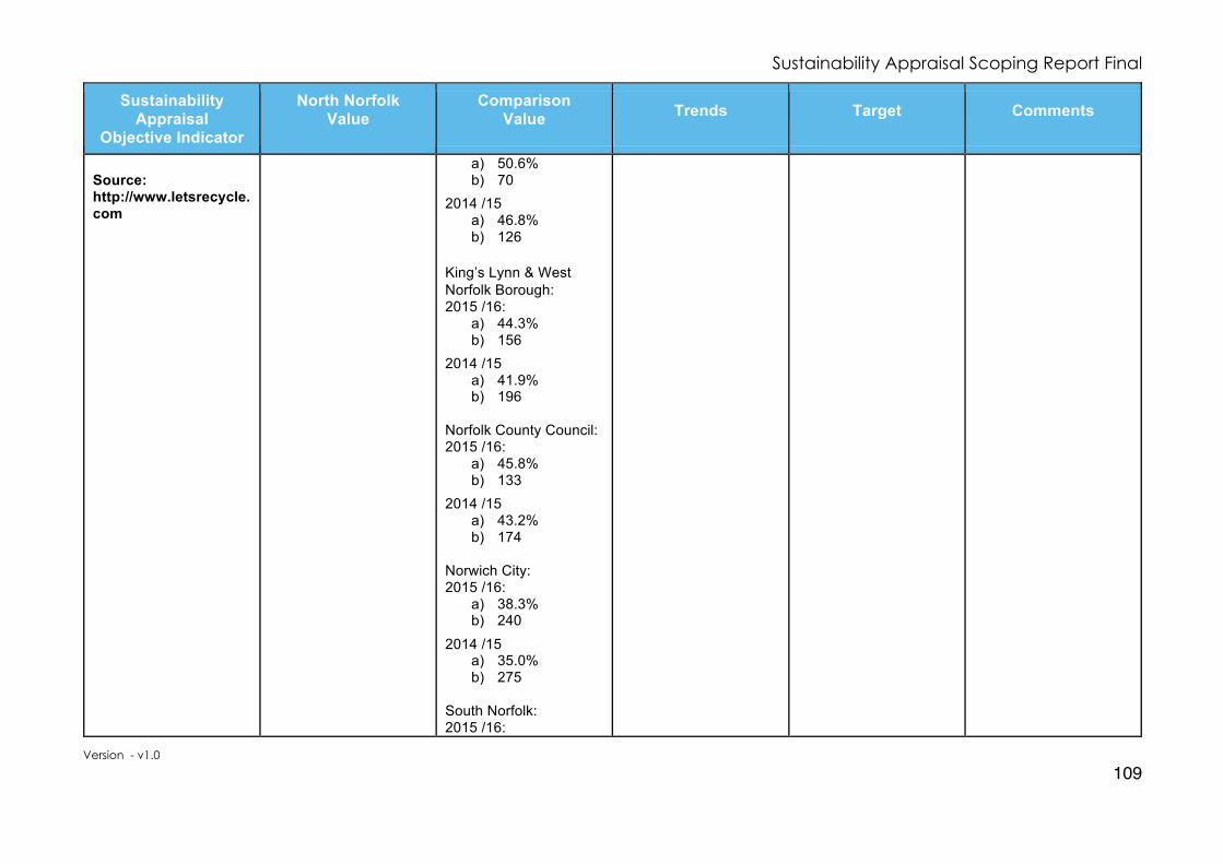
Sustainability Appraisal Scoping Report Final
Version - v1.0
109
Sustainability Appraisal
Objective Indicator
North Norfolk Value
Comparison Value
Trends
Target
Comments
Source: http://www.letsrecycle.com
a) 50.6% b) 70
2014 /15 a) 46.8% b) 126
King’s Lynn & West Norfolk Borough: 2015 /16:
a) 44.3% b) 156
2014 /15 a) 41.9% b) 196
Norfolk County Council: 2015 /16:
a) 45.8% b) 133
2014 /15 a) 43.2% b) 174
Norwich City: 2015 /16:
a) 38.3% b) 240
2014 /15 a) 35.0% b) 275
South Norfolk: 2015 /16:

Sustainability Appraisal Scoping Report Final
Version - v1.0
110
Sustainability Appraisal
Objective Indicator
North Norfolk Value
Comparison Value
Trends
Target
Comments
a) 43.6% b) 167 2014 /15 a) 40.4% b) 220
ENV3: To enhance water quality and ensure the most sustainable use of water.
Daily domestic water use: consumption litres per person per day.
a) measured b) unmeasured c) weighted
average Source: Anglian Water.
North Norfolk Coast RZ 2015 /16: N/A
National average:- 2015 : 150 litres/ day
2014 /15: N/A 2013 /14: N/A 2012 /13:
a) 115 b) 148 c) 125
Overall decrease in patterns of daily domestic water use (per capita consumption). 2020
a) 106 b) 139 c) 110
2030 a) 107 b) 122 c) 107
2040
a) 106 b) 108 c) 106
Data not available at the district level.
ENV4: Continue to reduce contributions to climate change and mitigate and adapt against it and its effects and minimise pollution.
Holt 2011:
a) 29% b) 2% c) 14% d) 5% e) 1% f) 49%
Norfolk 2011:
a) 45% b) 4% c) 11% d) 4% e) 1% f) 36%
N/A
To increase the use of sustainable transport method and the percentage of people travelling to work by more environmentally friendly means..

Sustainability Appraisal Scoping Report Final
Version - v1.0
111
Sustainability Appraisal
Objective Indicator
North Norfolk Value
Comparison Value
Trends
Target
Comments
Percentage of residents who travel to work:-
a) by private motor vehicle
b) by public transport
c) by foot or cycle d) work at or
mainly from home
e) other f) Not in work
Source: 2011 Census.
England 2011:
a) 41% b) 11% c) 9% d) 4% e) 0% f) 35%
a) Decrease b) Increase c) Increase d) Increase e) n/a f) n/a
ENV5: Protect and enhance the areas’ biodiversity and geodiversity assets and increase the provision of green infrastructure. Change in condition of SSSIs – percentage of SSSIs in ‘favourable’ or ‘unfavourable recovering’ condition.
a) favourable b) unfavourable:
recovering c) unfavourable:
no change d) unfavourable:
declining
Holt Lowes 2017: a) 30.07% (15.01 ha)
b) 69.93% (34.91 ha)
c) 0% (0 ha)
d) 0% (0 ha)
e) 0% (0 ha)
f) 0% (0 ha)
Norfolk County 2017: a) 54.74% (29,770 ha)
b) 41.18% (22,394 ha)
c) 2.93% (1,591 ha)
d) 1.16% ( 630 ha)
e) 0% ( 0 ha)
f) 0% ( 0 ha) East of England 2017: a) 49.66% (60,844 ha)
b) 44.63% (54,679 ha)
Improvement of SSSIs in ‘favourable’ or ‘unfavourable recovering’ condition.

Sustainability Appraisal Scoping Report Final
Version - v1.0
112
Sustainability Appraisal
Objective Indicator
North Norfolk Value
Comparison Value
Trends
Target
Comments
e) Partially destroyed
f) destroyed Source: Natural England www.naturalengland.org.uk
c) 3.80% (4,651 ha)
d) 1.86% (2,277 ha)
e) 0.02% ( 25 ha)
f) 0.03% ( 34 ha)
England 2017: a) 38.52% (421,074ha)
b) 55.79% (609,850ha)
c) 3.38% (36,999 ha)
d) 2.08% (22,786 ha)
e) 0.03% ( 333 ha)
f) 0.02% ( 202 ha)
ENV6: Respect the variety of landscape types in the area and protect, and where appropriate, enhance the historic environment. Heritage at risk – number of buildings and monuments recorded on
Norfolk Norfolk: 29
Holt: zero
Norfolk: 68 England: 604
To reduce the number of heritage assets at risk.

Sustainability Appraisal Scoping Report Final
Version - v1.0
113
Sustainability Appraisal
Objective Indicator
North Norfolk Value
Comparison Value
Trends
Target
Comments
the register at risk.
Source: Historic England (Buildings at Risk Register 2017).
Social Baseline
SOC1: To maintain and improve the quality of life of the population by promoting healthy lifestyles and access to services, reducing deprivation and reducing crime and the fear of crime.
Life expectancy of residents at birth (years):
a) Male b) Female
Source: Norfolk Insight.
2015 and 2016 data not available yet.
Norfolk 2014:
a) 80.2 b) 83.8
2013: a) 80.2 b) 83.8
2012: a) 80.2 b) 83.8
2011: a) 79.7 b) 83.6
2010: a) 79.3 b) 83.3
England 2014:
a) 79.6 b) 83.2
2013: a) 79.4 b) 83.1
2012: a) 79.2 b) 83.0
2011:
North Norfolk 2014:
a) 80.3 b) 84.6
2013: a) 80.2 b) 84.7
2012: a) 80.5 b) 85.0
2011: a) 80.4 b) 85.1
2010: a) 79.6 b) 84.6
Increase life expectancy of residents.
Life expectancy ages are seen as being very good, especially considering the higher proportion of elderly residing in the area.

Sustainability Appraisal Scoping Report Final
Version - v1.0
114
Sustainability Appraisal
Objective Indicator
North Norfolk Value
Comparison Value
Trends
Target
Comments
a) 78.9 b) 82.9
2010: a) 78.5 b) 82.5
Level of benefits claimed
a) Any benefits b) Incapacity c) Jobseekers
Source: Department for Work and Pensions.
2017 (July):
a) 12.4% b) 2.2% c) 2.3%
2017 (July): Norfolk
a) 13.2% b) 2.4% c) 3.0%
England
a) 13.5% b) 2.4% c) 3.3%
To reduce the level of benefits claims.
Reduce crime and anti-social activity. Crime stuff Incidences of crime committed;
a) Anit-social behavior
b) Burglary c) Violent offences d) Criminal
damage and arson
e) Drugs f) Public order g) Total number
recorded.
Source: UKCrimeStats and Police Constabulary.
2016 /17: a) 1,653
b) 228
c) 2,075
d) 539
e) 91
f) 288
g) 5,154
To reduce the level of crime and anti-social behavior.
A very low area for crime. The incidents do increase through the summer months when more tourists and holiday markers visit the area.

Sustainability Appraisal Scoping Report Final
Version - v1.0
115
Sustainability Appraisal
Objective Indicator
North Norfolk Value
Comparison Value
Trends
Target
Comments
SOC2: To ensure that everyone has the opportunity of a good quality and affordable home to meet their needs. H 007 - Number of affordable homes built (Quarterly Cumulative)
a) number
b) percentage of new homes built
Source: Local Authority AMR: H002 & 001.
2015 /16:
a) 66
b) 13.8%
N/A
2014 /15: a) 74
b) 14.7%
2013 /14
a) 152
b) 39.7%
To increase the affordability of homes.
More needs to be done to enable people with local connection to access affordable homes.
Number of long term empty homes (6 months or more) (monthly)
Source: Local Authority AMR: H002.
2015 /16: 637
N/A
2014 /15: 579
To reduce the number of empty homes.
Economic Baseline
EC1: Encourage sustainable economic development and education/skills training covering a range of sectors and skill levels to improve employment
2015 /16: 78
N/A
2014 /15: 55
Target: 36 To retain local jobs.
Whilst the assistance target successfully achieved the outcomes and impacts are not tracked.

Sustainability Appraisal Scoping Report Final
Version - v1.0
116
Sustainability Appraisal
Objective Indicator
North Norfolk Value
Comparison Value
Trends
Target
Comments
opportunities for residents, to encourage investment and maintain and enhance town centres. Number of businesses assisted to retain jobs and/or increase employment each year (monthly cumulative).
Source: Local Authority AMR: J004.
School leaver qualifications - Percentage of school leavers with 5 or more GCSEs at A*to C grades.
Source: 2011 Census.
Holt 2011: 49%
Norfolk 2011: 50% England 2011: 55%
To increase percentage of school leavers with 5 or more GCSEs at A* to C grades.
Number of new business start-ups supported by Enterprise North Norfolk (quarterly cumulative)
Source: Local Authority AMR: ED 023.
2015 /16: 59
N/A
2014 /15: 71
Target: 50 To increase the number of new business start-ups.
The contract for the Enterprise North Norfolk programme finished in December 2015, it is anticipated that a new business start-up programme will be established as part of a European funded initiative set up by New Anglian Local Enterprise Partnership. This is

Sustainability Appraisal Scoping Report Final
Version - v1.0
117
Sustainability Appraisal
Objective Indicator
North Norfolk Value
Comparison Value
Trends
Target
Comments
pending final approval from the Department for Communities and Local Government (DCLG).
Number of people supported with Information, Advice and Guidance (IAG) (quarterly cumulative)
Source: Local Authority AMR: ED 025.
2015 /16: 592
N/A
2014 /15: 686
Target: 450 To increase the number of new business start-ups.
This represents the number of contacts made in provision of information, advice and guidance. The impacts of this activity has not been tracked. The Economic Growth team will work with external organisations (e.g. DWP and its partners) to enable more focused and cost effective outcomes to be achieved, rather than to deliver contracts directly.
EC2: Reduce the need to travel and promote the use of sustainable transport.
Percentage of residents who travel to work:-
a) by private motor vehicle
b) by public transport
c) by foot or cycle d) work at or
Holt 2011:
a) 29% b) 2% c) 14% d) 5% e) 1% f) 49%
Norfolk 2011:
a) 45% b) 4% c) 11% d) 4% e) 1% f) 36%
England 2011:
a) 41% b) 11%
N/A
To increase the use of sustainable transport method and the percentage of people travelling to work by more environmentally friendly means..
a) Decrease b) Increase c) Increase d) Increase

Sustainability Appraisal Scoping Report Final
Version - v1.0
118
Sustainability Appraisal
Objective Indicator
North Norfolk Value
Comparison Value
Trends
Target
Comments
mainly from home
e) other f) Not in work
Source: 2011 Census.
c) 9% d) 4% e) 0% f) 35%
e) n/a f) n/a
Road casualties - number of people killed or seriously injured per 100,000 of the population.
Source: Norfolk County Council.
Norfolk: 2014: Data not available
East of England 2013: 40 2012: 42 2011: 41 2010: 44 2009: 47 England 2013: 38 2012: 40 2011: 41 2010: 41 2009: 45
Norfolk: 2013: 45 2012: 41 2011: 41 2010: 41 2009: 46
To improve road safety.
Motorcycles incidents resulting in death or serious injury account for 26.5% of the total, with pedestrians 14% and cyclists 9.4%.

Sustainability Appraisal Scoping Report Final
Version - v1.0
119
Appendix 6: Compatibility between the Holt Sustainability Appraisal Objectives
ENV1 ENV2 ENV3 ENV4 ENV5 ENV6 SOC1 SOC2 EC1 EC2
Environmental
ENV1 ü ? ü ü ü ü X X ~
ENV2 ü ü ~ ~ ~ ~ ~ ~
ENV3 ü ü ü ~ X X ü
ENV4 ü ü ü X X ü
ENV5 ü ü ü ? ü
ENV6 ü X X ü
Social
SOC1 ü ü ü
SOC2 ü ü
Economic
EC1 ü
EC2
Key:
ü Compatible ? Uncertain ~ No link X Conflicting

Sustainability Appraisal Scoping Report Final
Version - v1.0
120
Appendix 7: Sustainability Appraisal Framework for Holt The Holt Framework is based on the Sustainability Appraisal Framework prepared for the emerging North Norfolk Local Plan and uses the same Environmental, Social and Economic Objectives.
SA Objective
Decision making criteria with points to consider
Indicators and targets
Short, Medium and Long Term Effects
Environmental
ENV1: Promote the
efficient use of land,
minimise the loss of
undeveloped land and
protect the most
valuable agricultural
land.
v Will it reduce the need for development on greenfield land ?
v Will it make efficient use of land ? v Will it minimise the loss of the
best and most versatile agricultural land (grades 1-3a) ?
Ø Increase in the number of new developments and dwellings on previously developed land.
ENV2: Minimise waste
generation, avoid the
sterilisation of mineral
resources and
remediate contaminated
land.
v Will it contribute to the minimisation of waste production and to recycling ?
v Will it lead to the sterilisation of safeguarded mineral (sand and gravel) resources?
Ø Kilograms of waste produced per head of population; and percentage change on previous year.
Ø Increase in percentage of household waste recycled and composted.

Sustainability Appraisal Scoping Report Final
Version - v1.0
121
SA Objective
Decision making criteria with points to consider
Indicators and targets
Short, Medium and Long Term Effects
ENV3: To enhance
water quality and
ensure the most
sustainable use of
water.
v Will it minimise impact on water quality (including impact on surface and ground water) ?
v Will it maximise water efficiency ?
v Will it help to support wetland
habitats and species ?
Ø Increase in biological and chemical quality of water environment.
Ø Development permissions granted contrary to Environment Agency advice on flood risk.
Ø Number of dwellings permitted within the high flood-risk areas (Environment Agency Flood Zones 2 and 3).
Ø Patterns of daily domestic water use
(per capita consumption).
ENV4: Continue to
reduce contributions to
climate change and
mitigate and adapt
against it and its effects
and minimise pollution.
v Will it help adapt to or mitigate against climate change ?
v Will it reduce energy consumption or improve energy efficiency ?
v Will it minimise the risk of
flooding ? v Will it minimise coastal erosion
and its impacts ? v Will it support renewable energy
generation ? v Will it minimise impact on air
quality ?
Ø Look to decrease the number of designated Air Quality Management Areas and the concentration of air pollutants.
Ø Decrease in Total CO2 emissions per capita (million tonnes carbon equivalent) and reduction of Carbon Footprint of area.
Ø Increase in renewable energy generation capacity.

Sustainability Appraisal Scoping Report Final
Version - v1.0
122
SA Objective
Decision making criteria with points to consider
Indicators and targets
Short, Medium and Long Term Effects
v Will it minimise the impact of
noise, light and odour pollution ? v Will it minimise, and where
possible address, land contamination ?
ENV5: Protect and
enhance the areas’
biodiversity and
geodiversity assets and
increase the provision
of green infrastructure.
v Will it protect, maintain and enhance sites designated for their nature conservation interest?
v Will it conserve and enhance species diversity and avoid harm to protected species?
v Could it provide opportunities for
geodiversity enhancement ? v Could it contribute towards
enhancing or increasing green infrastructure networks?
Ø Increase in areas placed into Environmentally Sensitive Area schemes.
ENV6: Respect the
variety of landscape
types in the area and
protect, and where
appropriate, enhance
the historic
environment.
v Will it minimise or maintain, and where possible enhance, impact on the landscape character of the area ?
v Will it maintain or enhance the character and appearance of the townscape character of the area?
v Will it enable the protection and
Ø Changes in the conditions of SSSIs, CWS and natural / semi – natural habitats.
Ø Heritage at risk – Number and percentage of:-
a. Listed Buildings; and
b. Scheduled Ancient Monuments on the Buildings at Risk register.

Sustainability Appraisal Scoping Report Final
Version - v1.0
123
SA Objective
Decision making criteria with points to consider
Indicators and targets
Short, Medium and Long Term Effects
enhancement of the historic environment (including designated and non-designated assets and their settings) ?
v Could it benefit heritage assets
currently ‘at risk’?
Social
SOC1: To maintain and
improve the quality of
life of the population by
promoting healthy
lifestyles and access to
services, reducing
deprivation and
reducing crime and the
fear of crime.
v Will it help improve the health or life expectancy of residents ?
v Will it promote healthy lifestyles ? v Will it promote integration with
existing communities ? v Will it maximise access to
services, taking into account the needs of an ageing population ?
v Will it encourage access to
accessible open space ?
v Will it help reduce deprivation ? v Will it help design out crime and
the fear of crime from new development?
Ø Reduce percentage of children living in low-income households.
Ø Key benefit claimants - percentage of working age population claiming benefits.
Ø Life expectancy of residents.
Ø Incidences of crime committed per
1,000 households.
SOC2: To ensure that
everyone has the
v Will it deliver housing to meet needs in appropriate locations? Will it deliver affordable housing and other tenures to meet
Ø Decrease percentage of overall housing stock not meeting the ‘Decent Homes Standard’.
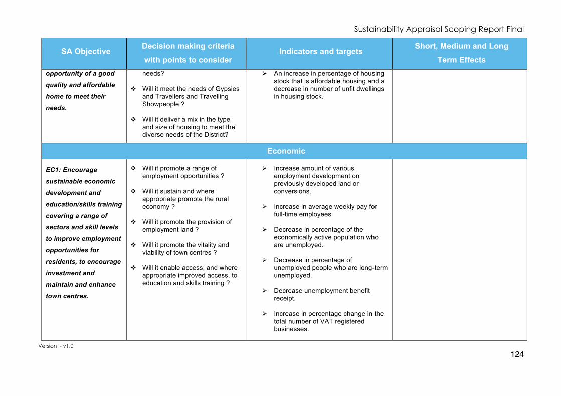
Sustainability Appraisal Scoping Report Final
Version - v1.0
124
SA Objective
Decision making criteria with points to consider
Indicators and targets
Short, Medium and Long Term Effects
opportunity of a good
quality and affordable
home to meet their
needs.
needs?
v Will it meet the needs of Gypsies and Travellers and Travelling Showpeople ?
v Will it deliver a mix in the type and size of housing to meet the diverse needs of the District?
Ø An increase in percentage of housing stock that is affordable housing and a decrease in number of unfit dwellings in housing stock.
Economic
EC1: Encourage
sustainable economic
development and
education/skills training
covering a range of
sectors and skill levels
to improve employment
opportunities for
residents, to encourage
investment and
maintain and enhance
town centres.
v Will it promote a range of employment opportunities ?
v Will it sustain and where appropriate promote the rural economy ?
v Will it promote the provision of
employment land ? v Will it promote the vitality and
viability of town centres ? v Will it enable access, and where
appropriate improved access, to education and skills training ?
Ø Increase amount of various employment development on previously developed land or conversions.
Ø Increase in average weekly pay for full-time employees
Ø Decrease in percentage of the
economically active population who are unemployed.
Ø Decrease in percentage of unemployed people who are long-term unemployed.
Ø Decrease unemployment benefit receipt.
Ø Increase in percentage change in the
total number of VAT registered businesses.

Sustainability Appraisal Scoping Report Final
Version - v1.0
125
SA Objective
Decision making criteria with points to consider
Indicators and targets
Short, Medium and Long Term Effects
Ø Workforce qualifications - percentage of working age population with qualifications at NVQ Level or above.
Ø School leaver qualifications - percentage of school leavers with 5 or more GCSEs at A* to C grades.
EC2: Reduce the need
to travel and promote
the use of sustainable
transport.
v Does it reduce the need to travel?
v Does it promote sustainable
transport use? v Does it promote access to local
services and facilities?
Ø Increase in the percentage of people travelling to work by more environmentally friendly means.
Ø Increase percentage of residents who travel to work by public transport; foot or cycle; and reduce private car journeys.
Ø Reduce average distance travelled to the workplace by residents.
Overall Conclusions

Sustainability Appraisal Scoping Report Final
Version - v1.0
126
Appendix 8: Feedback & Actions
The specific feedback and any actions arising from the Sustainability Appraisal Scoping Report consultation with the Statutory Bodies has been completed below and any updates or changes made in the final version of this document.
1: General Comments
Consultation General Comments: Environment Agency: Thank you for your email inviting our comments on the Holt Neighbourhood Plan Sustainability Appraisal Scoping Report. We are satisfied with the Scoping Report and have no further comments to make. Historic England: Thank you for your email requesting a scoping/screening opinion for the Holt Neighbourhood Plan Sustainability Appraisal. We would refer you to the guidance in Historic England Advice Note 8: Sustainability Appraisal and Strategic Environmental Assessment, which can be found here: <https://historicengland.org.uk/images-books/publications/sustainability-appraisal-and-strategic-environmental-assessment-advice-note-8/> This advice sets out the historic environment factors which need to be considered during the Strategic Environmental Assessment or Sustainability Appraisal process, and our recommendations for information you will need to include. In addition to the above, we would suggest that the wording of Objective 1 is altered slightly to read “To preserve the unique character of Holt and the balance between its rural surroundings and important townscape; to conserve and enhance its natural, built and historic environment and landscape setting, and maintain its rich sense of place while encouraging innovative design rooted in the forms, materials and styles of its local area”. Natural England: Thank you for your consultation on the above dated 8 September 2017. Natural England is a non-departmental public body. Our statutory purpose is to ensure that the natural environment is conserved, enhanced, and managed for the benefit of present and future generations, thereby contributing to sustainable development. Natural England is a statutory consultee in neighbourhood planning and must be consulted on draft neighbourhood development plans by the Parish/Town Councils or Neighbourhood Forums where they consider our interests would be affected by the proposals made. Natural England does not have any specific comments on this draft neighbourhood plan. However, we refer you to the attached annex which covers the issues and opportunities that should be considered when preparing a Neighbourhood Plan. Norfolk County Council: 1. Preface 1.1. The officer-level comments below are made on a without prejudice basis and the County
Council reserves the right to make further comments on the emerging Neighbourhood Plan. 1.2. The County Council welcomes the opportunity to comment on the emerging
Neighbourhood Plan and recognises the considerable amount of work and effort which has

Sustainability Appraisal Scoping Report Final
Version - v1.0
127
been put into developing the Plan to date. 2. Infrastructure Delivery 2.1 The neighbourhood plan will need to consider the following;
• Housing and other development will be expected to contribute towards improving local services and infrastructure (such as transport, education; library provision, fire hydrant provision, open space etc.) through either the payment of a Community Infrastructure Levy (CIL); planning obligations (via an s106 agreement / s278 agreement); or use of a planning condition/s.
• Norfolk Fire and Rescue Service advocates the installation of sprinklers in all new developments. Sprinklers have a proven track record to protect property and lives. It would therefore be helpful if the emerging Neighbourhood Plan could refer to the installation of Sprinklers in new development. The neighbourhood plan should therefore contain policies referencing the delivery of the above infrastructure and services.
6. Historic Environment 6.1. The historic environment team offers the following advice. Historic England’s published
guidance on the preparation of Neighbourhood Plans should be consulted (https://historicengland.org.uk/advice/planning/plan-making/improve- your-neighbourhood/) It encourages the full consideration of heritage assets and suggests ways with which this can be achieved. Based on this guidance, we would like to suggest the authors of the plan follow a number of steps:
1. Study Historic England’s published guidance and consider how the plan can take its advice on board.
2. Contact the Norfolk Historic Environment Record (NHER) and request information on designated and undesignated heritage assets within the plan area. The NHER can be contacted at [email protected].
3. Consider the full range of heritage assets within the plan area and identify those they feel are most significant. They may wish to prepare a local list of heritage assets they believe should be protected and enhanced and put this to the community for consideration.
4. Directly consult the Historic Environment Service’s planning advice team ([email protected]), who can provide advice on which heritage assets are most significant and ways in which they can be protected and enhanced. They can also offer advice on the wording of historic environment policies.
Norfolk Wildlife Trust: NWT are interested in commenting on the Neighbourhood Plans but are happy not to comment at the Sustainably Appraisal Scoping Report stage. Once it gets to the stage of defining policies and identifying areas of ecological interest and areas of potential green infrastructure we will be happy to make detailed comments. We are also able to advise if the NP team wish to carry out any habitat surveys as part of the background evidence for the plan. North Norfolk District Council: I refer to your email on behalf of Holt Town Council concerning a formal consultation on the emerging Sustainability Appraisal (SA), Scoping Report relating to the Holt Neighbourhood Plan dated 08.09.2017. The Council as the Local Planning Authority has the responsibility for the neighbourhood planning process in the District. It is the role of the Council to provide advice and assistance and to take decisions at key stages in the neighbourhood planning process. In doing so it is important to note that the Council must satisfy itself that any future submitted neighbourhood plan complies with

Sustainability Appraisal Scoping Report Final
Version - v1.0
128
the relevant statutory requirements and it is incumbent that the neighbourhood plan group (the qualifying body) liaise with officers to establish and where necessary agree the process and required documentation to ensure that the authority has all the information it needs. The comments contained in this letter although lengthy, are intended to be informative and constructive to aid the formation of a sound document and the effective formation of and use of policies that complement the wider existing and emerging Development Plan. There are a number of misleading statements and inaccurate interpretations in the consultation document around the legislative process and the requirements of neighbourhood planning. If these are left unchecked there is the potential to carry forward serious issues into those later stages of the neighbourhood plan making process and examination. It is strongly recommended before the next stages are embarked upon that the neighbourhood plan group engage with officers of the Council, not only to establish the required process but also in compilation of the emerging plan’s content and structure. This letter highlights some of the areas of concern however I would strongly advise the Holt neighbourhood plan group make an appointment to see me where I will explain these fully and seek agreement on how to take the emerging neighbourhood plan forward. In the meantime your attention is drawn to a series of guidance notes which have been issued to assist local communities in the production of neighbourhood plans which can be found on the council’s web site: https://www.north‐norfolk.gov.uk/tasks/planning‐policy/neighbourhood‐planning/ Detailed in the guidance are links to independent guidance that detail how neighbourhood plan groups should engage with their local authority as well as guidance around when it is appropriate to undertake a Sustainability Appraisal and, Strategic Environmental Assessment, who should undertake these and how. Contrary to the assertions in the consultation document there is no requirement to undertake a Sustainability Appraisal SA in the Neighbourhood Planning Regulations, nor is there a requirement to produce a Sustainability Appraisal Scoping Report. It is recognised that in some cases, depending on the content of the emerging neighbourhood plan, undertaking an SA may offer the precautionary route of demonstrating how the neighbourhood plan meets one of the “basic conditions” tests; however there is no requirement to undertake such a scoping report. In such cases the national Planning Practice Guidance is clear that where a Sustainability Appraisal is carried out material produced for the Local Plan would be relevant. If the group is intent on undertaking an SA then the interim SA Framework, already developed for the Local Plan and freely available, should be used. This will also help the neighbourhood plan group demonstrate conformity with the Local Plan. However it is considered that such an approach has the potential to add a significant and potentially unnecessary amount of complexity to the process as well as adding to the financial burdens and costs of producing a neighbourhood plan by incurring additional consultant’s costs. At this stage it is thought that undertaking an SA may not be necessary. It is not yet clear what areas of land use planning the neighbourhood plan is seeking to address and until this has been established it is hard to advise on the most appropriate approach. Sustainability Scoping Report It is noted that the SA Scoping Report contains a series of Objectives for the Holt neighbourhood plan. This is the first time officers have seen these Objectives and it is considered that the SA Scoping Report is not the correct place to seek consultation feedback on the aspirations that the neighbourhood plan group are suggesting the plan seek to address. It is recommended that the Vision and Objectives are grounded by evidence, consulted on through community consultation and that they are sense checked with the local authority to make sure they are deliverable and offer a suitable foundation from which to build a Land Use

Sustainability Appraisal Scoping Report Final
Version - v1.0
129
Plan which will be used in the determination of planning applications. For example objective three is seeking to make affordable housing in “sensitive areas” occupied by “local people”. Putting aside the ambiguity around what is meant by “sensitive areas” any policy approach which seeks to add further local connection criteria outside of the Council’s Choice Based Lettings Scheme would not only be contrary to the Councils allocation policy but also contrary to the legislation to which Local Authorities must conform to. Any such policy has the strong potential to be in direct conflict with the statutory requirements of the Council and the policies of the Local Plan to which neighbourhood plans are required to be in general conformity with. Other neighbourhood plans which tried to go down this route have all been revised. Our advice is that these Objectives should be refined to ensure they create an appropriate basis from which land use polices can be derived. There is concern that the Scoping Report as presented is misleading in places, while in others it is incorrect in its interpretation of the legislation and due process. Going forward it is recommended that officer’s opinions are sought so that there is a mutual understanding between officers and the neighbourhood plan steering group around the neighbourhood plan process and the documentation required. Although there is an acknowledgment that the Council’s SA Scoping Report has informed the development of this report, it would appear that the content has in places been largely reproduced from the Council’s own document. Text, Maps and diagrams should as a minimum be acknowledged and identified by source. Permission should be sought before reproducing images and maps, and it is also worth noting that more updated mapping around flooding and in particular surface water flooding could have been provided. The Document Review contained in appendix 3 is a reproduction for the Local Plan SA Scoping Report 2016; it is unlikely to have been used to inform the development of the SA Framework contained in this document. It is not known if the Holt Town Council has obtained a public sector mapping licence for the reproduction of OS mapping. If they have then the appropriate license number should be displayed on each map otherwise the group should contact the Council for advice. Habitats Directive Schedule 2 of the Neighbourhood Planning (General) Regulations 2012 refers to the Habitats Directive. The Regulations require Habitats Regulations Assessment (HRA) screening to be undertaken (by the qualifying body) to identify if a neighbourhood plan would have a significant impact on nature conservation sites that are of European importance, also referred to as Natura 2000 sites. Article 6 (3) of the EU Habitats Directive and Regulation 61 of the Habitats and Species Regulations 2010 (as amended) requires that an Appropriate Assessment is carried out on any plan or project likely to have a significant effect on a European Site. To fulfil the legal requirements to identify if likely significant effects will occur on European Sites through the implementation of the neighbourhood plan, the neighbourhood plan group should undertake an HRA Screening Assessment and submit to the competent authority (LPA), for the purpose of determining if further assessment of the implications for European Sites is required. Details of the internationally designated sites need to be assessed to see if there is the potential for the implementation of the Neighbourhood Plan to have an impact on the sites. The Regulations state (Regulation 102A (3) Schedule 2 of the Neighbourhood Planning (General) Regulations 2012) that any assessment should be in view of the sites conservation. Any such affect needs to be ascertained and this can be done at the time the screening opinion is being sought. Way Forward As a way forward once more details of the plan’s contents and policy approaches are known and documented a Screening Report should be submitted to the Council along with a formal request for a SEA Screening Opinion. In the production of a neighbourhood plan close working relationship should be sought with the

Sustainability Appraisal Scoping Report Final
Version - v1.0
130
Council and it is recommend that the neighbourhood plan group contact me to set up an appointment at the earliest opportunity.
Response: Environment Agency: Thank you for confirming the Environment Agency are satisfied with the Scoping Report. Historic England: Comments noted and thank you for pointing out the availability of guidance on your website. The Objective has remained unchanged as the suggested changes are already included in the sentiment of the Objective. Natural England: Thank you for your response and confirming that Natural England does not have any specific comments. Thank you for enclosing details of possible issues and opportunities that should be considered when preparing a Neighbourhood Plan. Norfolk County Council: Thank you for your comments noted on infrastructure delivery, although it is felt the appropriate place for infrastructure delivery is to be incorporated within the Holt Neighbourhood Plan. Your comments from Norfolk Fire and Rescue Service advocating the installation of sprinklers will be noted in the within the Holt Neighbourhood Plan. Comments regarding heritage have been noted and consultation response has also been received from Historic England. Norfolk Wildlife Trust: We note your response at choosing not to comment at the Sustainably Appraisal Scoping Report stage. North Norfolk District Council: We note your response and thank you for your comments. It is fully understood what NNDC role is and the HNP Steering Group and Town Council hope that NNDC undertake their requirement of duty to co-operate. There are a number of statements that have proven less than help full – such as “There are a number of misleading statements and inaccurate interpretations in the consultation document around the legislative process” – it would be helpful if NNDC rather than making grand statements actually specify the “misleading statements and inaccurate interpretations” they are referring to, as none have been identified. It is felt by the Neighbourhood Plan Steering Group (NPSG) and Town Council that the NNDC response is very negative, not supportive and full of bluster with little substance. There is no “assertion” that there is a requirement to complete a Sustainability Appraisal for the HNP. The NPSG made the choice to do so on the basis in so doing could only help in the development of the HNP, provide considerable information, evidence and data to inform the HNP as well as ensuring the HNP contributes to achieving ‘sustainable development’ – one of the basic condition tests. Thank you for your comments on the Objectives, although they feel misplaced. It is not NNDC place to decide if the Objectives are “achievable” - these are the Objectives that have been developed by the NPSG following consultations with residents and stakeholders. The NPSG are unsure why there is a need for NNDC to misquote “objective three is seeking to make affordable housing in “sensitive areas” occupied by “local people. The Objective actually reads…….. Objective 3

Sustainability Appraisal Scoping Report Final
Version - v1.0
131
To support housing tailored to the needs and context of Holt which is affordable and made available to ‘local people’ first, where development is sensitive, in keeping whilst protecting and enriching the landscape and built setting.
The Objective has two key elements. Firstly, to enable local people to access affordable housing and, secondly, to endeavor to see where development does happen it is sensitive and in keeping. Many neighbourhood plans tackle the difficult subject of affordable homes and their allocation. NNDC is incorrect to say in so doing so the HNP is “contrary to the legislation”. Within the NNDC Housing Allocation Policy there is inbuilt flexibility to enable a local letting policy to be applied – as NNDC already does on exception sites. Again in the response NNDC say the Scoping Report is “misleading” and “incorrect” but fails to be specific about where or how. This is not helpful and does not enable changes or corrections, if necessary, to be made. Holt Town Council has obtained permission from NNDC to use maps produced by NNDC. HRA: Due to the lack of confidence in the ability of NNDC Officers the Town Council (as the Qualified Body) will undertake the HRA Screening and consult directly with Natural England to seek their agreement on the opinion reached on the likely impact of the HNP and its policies. The suggested way forward is welcomed and meeting will be sought with the relevant planning officers.
Action: Environment Agency: No changes to the Holt Neighbourhood Plan Sustainability Appraisal Scoping Report. Historic England: Review the guidance and include any changes relating from that guidance. Natural England: Consider issues and opportunities raise and make any updates to include. Norfolk County Council: Add text on Infrastructure delivery and sprinklers to the Holt Neighbourhood Plan. Norfolk Wildlife Trust: No changes to the Holt Neighbourhood Plan Sustainability Appraisal Scoping Report. North Norfolk District Council: To seek clarity from NNDC Head of Planning the specific details of comments made in relation to the Scoping Report. Set up meeting with relevant officers to assist the NPSG in undertaking the HNP.
2. Policies, Plans & Programmes
Consultation comments on Policies, Plans & Programmes: Environment Agency: No specific comments received. Historic England: No specific comments received. Natural England: No specific comments received.

Sustainability Appraisal Scoping Report Final
Version - v1.0
132
Norfolk County Council: No specific comments received. Norfolk Wildlife Trust: No specific comments received. North Norfolk District Council: No specific comments received.
Response: Environment Agency: None necessary as no specific comments received. Historic England: None necessary as no specific comments received. Natural England: None necessary as no specific comments received. Norfolk County Council: None necessary as no specific comments received. Norfolk Wildlife Trust: None necessary as no specific comments received. North Norfolk District Council: None necessary as no specific comments received.
Action:
Environment Agency: No changes to the Holt Neighbourhood Plan Sustainability Appraisal Scoping Report. Historic England: No changes to the Holt Neighbourhood Plan Sustainability Appraisal Scoping Report. Natural England: No changes to the Holt Neighbourhood Plan Sustainability Appraisal Scoping Report. Norfolk County Council: No changes to the Holt Neighbourhood Plan Sustainability Appraisal Scoping Report. Norfolk Wildlife Trust: No changes to the Holt Neighbourhood Plan Sustainability Appraisal Scoping Report. North Norfolk District Council: No changes to the Holt Neighbourhood Plan Sustainability Appraisal Scoping Report.
3. Baseline Information
Consultation comments on Baseline Information: Environment Agency: No specific comments received. Historic England: In particular, we would highlight that the historic environment includes both above and below ground heritage assets, as well as historic landscapes. Presently, the review of baseline information includes a useful and concise discussion of Holt’s historic character, as well as mention of the Holt Town Centre Conservation Area, and provides a table of listed buildings. However, the scoping report does not consider either below ground archaeology, or the Glaven Valley Conservation Area, which is also partially within the neighbourhood area, and which is in
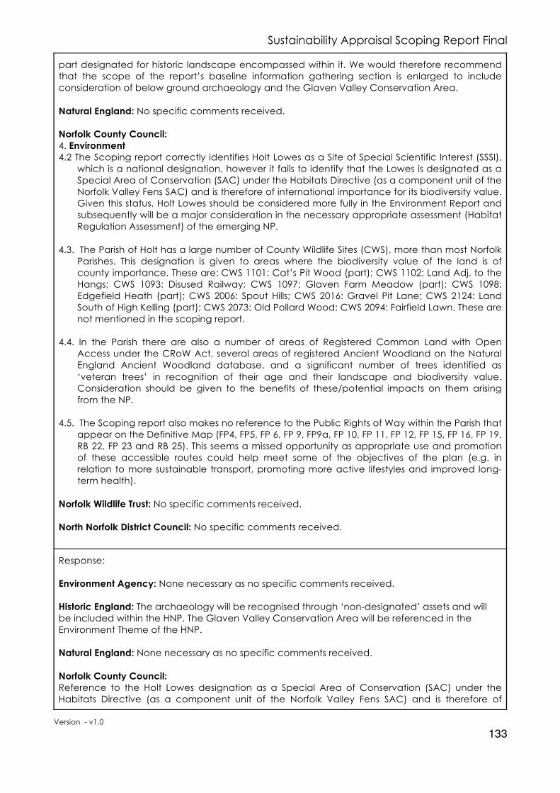
Sustainability Appraisal Scoping Report Final
Version - v1.0
133
part designated for historic landscape encompassed within it. We would therefore recommend that the scope of the report’s baseline information gathering section is enlarged to include consideration of below ground archaeology and the Glaven Valley Conservation Area. Natural England: No specific comments received. Norfolk County Council: 4. Environment 4.2 The Scoping report correctly identifies Holt Lowes as a Site of Special Scientific Interest (SSSI),
which is a national designation, however it fails to identify that the Lowes is designated as a Special Area of Conservation (SAC) under the Habitats Directive (as a component unit of the Norfolk Valley Fens SAC) and is therefore of international importance for its biodiversity value. Given this status, Holt Lowes should be considered more fully in the Environment Report and subsequently will be a major consideration in the necessary appropriate assessment (Habitat Regulation Assessment) of the emerging NP.
4.3. The Parish of Holt has a large number of County Wildlife Sites (CWS), more than most Norfolk
Parishes. This designation is given to areas where the biodiversity value of the land is of county importance. These are: CWS 1101: Cat’s Pit Wood (part); CWS 1102: Land Adj. to the Hangs; CWS 1093: Disused Railway; CWS 1097: Glaven Farm Meadow (part); CWS 1098: Edgefield Heath (part); CWS 2006: Spout Hills; CWS 2016: Gravel Pit Lane; CWS 2124: Land South of High Kelling (part); CWS 2073: Old Pollard Wood; CWS 2094: Fairfield Lawn. These are not mentioned in the scoping report.
4.4. In the Parish there are also a number of areas of Registered Common Land with Open
Access under the CRoW Act, several areas of registered Ancient Woodland on the Natural England Ancient Woodland database, and a significant number of trees identified as ‘veteran trees’ in recognition of their age and their landscape and biodiversity value. Consideration should be given to the benefits of these/potential impacts on them arising from the NP.
4.5. The Scoping report also makes no reference to the Public Rights of Way within the Parish that
appear on the Definitive Map (FP4, FP5, FP 6, FP 9, FP9a, FP 10, FP 11, FP 12, FP 15, FP 16, FP 19, RB 22, FP 23 and RB 25). This seems a missed opportunity as appropriate use and promotion of these accessible routes could help meet some of the objectives of the plan (e.g. in relation to more sustainable transport, promoting more active lifestyles and improved long- term health).
Norfolk Wildlife Trust: No specific comments received. North Norfolk District Council: No specific comments received.
Response: Environment Agency: None necessary as no specific comments received. Historic England: The archaeology will be recognised through ‘non-designated’ assets and will be included within the HNP. The Glaven Valley Conservation Area will be referenced in the Environment Theme of the HNP. Natural England: None necessary as no specific comments received. Norfolk County Council: Reference to the Holt Lowes designation as a Special Area of Conservation (SAC) under the Habitats Directive (as a component unit of the Norfolk Valley Fens SAC) and is therefore of

Sustainability Appraisal Scoping Report Final
Version - v1.0
134
international importance for its biodiversity value will be added to the text of the HNP and covered in depth in the HRA Screening Report. Details of Country Wildlife Sites (CWS) and Public Rights of Way (PWoW), including the NCC Interactive map will be included in the HNP. Norfolk Wildlife Trust: None necessary as no specific comments received. North Norfolk District Council: None necessary as no specific comments received.
Action: Environment Agency: No changes to the Holt Neighbourhood Plan Sustainability Appraisal Scoping Report. Historic England: Include ‘non-designated’ assets in the policies of the HNP and reference in the Environment Theme of the Glaven Valley Conservation Area. Natural England: No changes to the Holt Neighbourhood Plan Sustainability Appraisal Scoping Report. Norfolk County Council: Add text to HNP and ensure covered in the HRA Screening Report. Norfolk Wildlife Trust: No changes to the Holt Neighbourhood Plan Sustainability Appraisal Scoping Report. North Norfolk District Council: No changes to the Holt Neighbourhood Plan Sustainability Appraisal Scoping Report.
4. Sustainability Issues
Consultation comments on Sustainability Issues: Environment Agency: No specific comments received. Historic England: No specific comments received. Natural England: No specific comments received. Norfolk County Council: No specific comments received. Norfolk Wildlife Trust: No specific comments received. North Norfolk District Council: No specific comments received.
Response: Environment Agency: None necessary as no specific comments received. Historic England: None necessary as no specific comments received. Natural England: None necessary as no specific comments received. Norfolk County Council: None necessary as no specific comments received.

Sustainability Appraisal Scoping Report Final
Version - v1.0
135
Norfolk Wildlife Trust: None necessary as no specific comments received. North Norfolk District Council: None necessary as no specific comments received.
Action: Environment Agency: No changes to the Holt Neighbourhood Plan Sustainability Appraisal Scoping Report. Historic England: No changes to the Holt Neighbourhood Plan Sustainability Appraisal Scoping Report. Natural England: No changes to the Holt Neighbourhood Plan Sustainability Appraisal Scoping Report. Norfolk County Council: No changes to the Holt Neighbourhood Plan Sustainability Appraisal Scoping Report. Norfolk Wildlife Trust: No changes to the Holt Neighbourhood Plan Sustainability Appraisal Scoping Report. North Norfolk District Council: No changes to the Holt Neighbourhood Plan Sustainability Appraisal Scoping Report.
5. Sustainability Appraisal Framework
Consultation comments on the Sustainability Appraisal Framework: Environment Agency: No specific comments received. Historic England: We would also expect that the final SA (incorporating the requirements of the Strategic Environmental Assessment) includes consideration of these factors (as mentioned in the Baseline comments) where appropriate. Natural England: No specific comments received. Norfolk County Council: 5. Minerals and Waste 5.1. The County Council is pleased to note Sustainability Appraisal Objective Indicator ENV2. 5.2. Appendix 3: ‘documents received by the North Norfolk Local Plan Sustainability Appraisal’
does list the Norfolk Minerals and Waste Core Strategy and Development Management Policies DPD, the Minerals Site Specific Allocations DPD and the Waste Site specific Allocations DPD on page 87. These documents form part of the Development Plan for the area and are particularly relevant to the Holt Neighbourhood Plan because there is a Mineral Safeguarding Area for sand and gravel located in the Holt Neighbourhood Plan area. This Mineral Safeguarding Area is shown in the adopted Revised Policies Map (Oct 2013). Norfolk County Council’s minerals and waste planning policy documents are available on our website at: www.norfolk.gov.uk/nmwdf and then select the ‘Adopted Policy Documents’ page.
5.3 Appendix 7: ‘Sustainability Appraisal Framework for Holt’ does not include any decision
making criteria about avoiding the sterilisation of minerals. A decision making criteria point to consider would be “Will it lead to the sterilisation of safeguarded mineral (sand and gravel) resources?”

Sustainability Appraisal Scoping Report Final
Version - v1.0
136
Norfolk Wildlife Trust: No specific comments received. North Norfolk District Council: SA Framework A Sustainability Appraisal is a systematic process. Its role is to promote sustainable development by identifying indicators and assessing the extent to which emerging plans, when judged against reasonable alternatives, will help achieve relevant environmental, economic and social objectives. The SA Framework contained in the Holt neighbourhood plan SA Scoping Report is largely a reproduction of that contained in the Local Plan Draft Sustainability Appraisal Scoping Report consultation version September 2016. It is not the case of picking and choosing which Objectives to use as all the Objectives are relevant for all communities across the District. As such these should all be used in any Sustainability Appraisal of the Holt neighbourhood plan. You should also be aware that since the publication and consultation of the Local Plan Draft SA Framework it has been updated. These updates have not been reflected in the Holt SA Scoping Report. It is recommended that going forward the Holt neighbourhood plan adopt the use of this readily available and updated SA Framework.
Response: Environment Agency: None necessary as no specific comments received. Historic England: The SA Objectives ENV6 will consider the historic environment and specifically identifies ‘Cultural heritage including architectural and archaeological heritage’ as part of the theme. The SA Objective ENV5 and 6 will ensure consideration of the protection of the Glaven Valley Conservation Area, as with other assets. Natural England: None necessary as no specific comments received. Norfolk County Council: The Norfolk Minerals and Waste Core Strategy and Development Management Policies DPD, the Minerals Site Specific Allocations DPD and the Waste Site specific Allocations DPD are all included in the Development Framework through their inclusion in the North Norfolk Local Plan, which covers Holt. Add decision-making criteria about avoiding the sterilisation of minerals. Norfolk Wildlife Trust: None necessary as no specific comments received. North Norfolk District Council: Emailed response 18th October 2017 direct to Mark Ashwell, NNDC Planning Policy Manager: It was good to catch up with you last week (12th October 2017) at the D2C meeting at County Hall. Thank you for confirming that the Local Plan SA Scoping Report issued in September 2016 contains the latest version of the SA Framework, the 10 objectives in that HNP SA Framework are current and the correct ones to use and, to date, there is no updated SA Framework for the Local Plan.
Action: Environment Agency: No changes to the Holt Neighbourhood Plan Sustainability Appraisal Scoping Report. Historic England: No changes to the Holt Neighbourhood Plan Sustainability Appraisal Scoping Report.

Sustainability Appraisal Scoping Report Final
Version - v1.0
137
Natural England: No changes to the Holt Neighbourhood Plan Sustainability Appraisal Scoping Report. Norfolk County Council: Add the criteria to ENV2 “Will it lead to the sterilisation of safeguarded mineral (sand and gravel) resources?” Norfolk Wildlife Trust: No changes to the Holt Neighbourhood Plan Sustainability Appraisal Scoping Report. North Norfolk District Council: Confirmation received from NNDC that the correct SA Objectives are being used in the SA Framework to test the HNP.
6. Strategic Environmental Assessment Screening Approach
Consultation comments on the Strategic Environmental Assessment Screening Approach: Environment Agency: No specific comments received. Historic England: No specific comments received. Natural England: No specific comments received. Norfolk County Council: 4. Environment 4.1. The Holt NP Scoping report does not adequately describe the situation relating to the natural environment. As the Scoping report states on p18 the SEA Directive requires that the Environmental Report should include “environmental protection objectives” including those established at international level, and demonstrate how “environmental considerations have been taken into account”. Similarly (again stated in the Scoping report states on p58) the SEA Directive should include consideration of issues relating to “any area of particular environmental importance, such as areas pursuant to the Birds and Habitat Directives”. Norfolk Wildlife Trust: No specific comments received. North Norfolk District Council: Strategic Environmental Assessment In some limited circumstances, where a neighbourhood plan is likely to have a significant environmental effect, it may require a strategic environmental assessment. The guidance is clear that draft neighbourhood plan proposals should be assessed to determine whether the plan is likely to have significant environmental effects. This process is commonly referred to as a screening assessment and the requirements are set out in regulation 9 of the Environmental Assessment of Plans and Programmes Regulations 2004. To avoid any ambiguity the Council as the Local Planning Authority and the responsible body has, as part of its duty to assist, in place processes to determine whether proposed neighbourhood plans will require a Strategic Environmental Assessment. Guidance is clear that the qualifying body should work with the Local Planning Authority to be sure that the authority has the information it needs for such a determination. The SA Scoping Report contains a section in the appendix detailed Screening Determination.
A) ABZAG are not the “responsible” determining body to whom the regulations apply and the determination of whether SEA is required lies with the Council. Rather than a screening determination, what should be provided is a screening report detailing the

Sustainability Appraisal Scoping Report Final
Version - v1.0
138
plan characteristics and the environmental characteristics that the plan may impact on. Further guidance on this is available in the national Planning Practice Guidance and in a specific Locality guide accessed through the NNDC planning guidance fact sheet;
B) It is premature to undertake such an exercise and too early to make a “judgment” around the potential effects the Holt neighbourhood plan may or may not have on the environment especially as the content of the plan is not known;
C) There is concern that the other Statutory bodies will not consider the screening section contained in this report, it is tucked away in an appendix and they may not realise that the consultation on the sustainability appraisal scope includes elements of SEA screening, it is best practice to separate these out;
D) The determination concludes that the neighbourhood plan “may” have a significant effect. The test however is around whether the neighbourhood plan is likely to have significant effect.
Whether a neighbourhood plan proposal requires a strategic environmental assessment, and (if so) the level of detail needed, will depend on what is proposed. A Strategic Environmental Assessment may be required, for example, where:
. A neighbourhood plan allocates sites for development – (it is our understanding that the neighbourhood plan is not intending to allocate growth, though this is not clear);
. The neighbourhood area contains sensitive natural or heritage assets that may be affected by the proposals in the plan;
. The neighbourhood plan is likely to have significant environmental effects that have not already been considered and dealt with through a sustainability appraisal of the Local Plan. Put simply there are three steps to checking whether an SEA is required for neighbourhood plans:
The neighbourhood plan group should prepare a Screening Report; Request a Screening Opinion from the “responsible body” who will in turn consult with the statutory bodies; In light of their response the responsible body will determine whether the emerging neighbourhood plan is likely to have significant effects on the environment and therefore be a requirement for the neighbourhood plan group to undertake an SEA.
Response: Environment Agency: None necessary as no specific comments received. Historic England: None necessary as no specific comments received. Natural England: None necessary as no specific comments received. Norfolk County Council: The key Sustainability Issues both for North Norfolk and especially Holt are cover in considerable depth within this SA Scoping Report. The approach to the SEA is outlined within this Scoping Report and has been consulted on and agreed with the Statutory Bodies. The SEA determination will be published in the SA Report that will accompany the HNP. Norfolk Wildlife Trust: None necessary as no specific comments received. North Norfolk District Council: The statutory bodies made no specific comment on the approach and it is intended for the SEA requirement to be satisfied through the SA process and report. The Qualified Body – Holt Town Council – will issue to the statutory bodies.

Sustainability Appraisal Scoping Report Final
Version - v1.0
139
Action: Environment Agency: No changes to the Holt Neighbourhood Plan Screening approach. Historic England: No changes to the Holt Neighbourhood Plan Screening approach. Natural England: No changes to the Holt Neighbourhood Plan Screening approach. Norfolk County Council: No changes to the Holt Neighbourhood Plan Screening approach. Norfolk Wildlife Trust: No changes to the Holt Neighbourhood Plan Screening approach. North Norfolk District Council: No changes to the Holt Neighbourhood Plan Screening approach.

Sustainability Appraisal Scoping Report Final
Version - v1.0
140
Holt Neighbourhood Plan
Town Clerk Holt Town Council
Nelson House 2 White Lion Street
Holt. NR25 6BA
Telephone: 01263 712149
Email: [email protected]
© Copyright 2019 – Holt Town Council