sustainability appraisal report – sa of the draft kent
TRANSCRIPT

Sustainability Appraisal Report – SA of the draft Kent Minerals Sites Plan Regulation 19 Consultation
CO04300613
November 2018
Project Name: Regulation 19 Consultation Document Title: Sustainability Appraisal Report – SA of the draft Kent Minerals Sites Plan
1
Document Control Sheet
Project Name: Regulation 19 Consultation
Project Number: CO04300613
Report Title: Sustainability Appraisal Report – SA of the draft Kent Minerals Sites Plan
Report Number: SR2
Issue
Status/Amendment
Prepared Reviewed Approved
Rev 0 Name:
Hilary Livesey
Signature:
Date: 1/11/18
Name:
Jenefer Taylor
Signature:
Date: 15/11/18
Name:
Mike Comerford
Signature:
Date: 16/11/18
Name:
Signature:
Date:
Name:
Signature:
Date:
Name:
Signature:
Date:
Name:
Signature:
Date:
Name:
Signature:
Date:
Name:
Signature:
Date:
Project Name: Regulation 19 Consultation Document Title: Sustainability Appraisal Report – SA of the draft Kent Minerals Sites Plan
1
Executive Summary Amey is commissioned to undertake Sustainability Appraisal (SA) in support of the Kent Minerals and Waste
Local Plan (KMWLP) Minerals Sites Plan (MSP) preparation process. This report presents the interim
outcomes of this process up to Regulation 19 stage (Pre-submission consultation).
The Kent Minerals and Waste Local Plan (KMWLP) was adopted in July 2016 and sets out the vision and
objectives for Kent’s minerals supply and waste management capacity from 2013 to 2030. It identified that
the specific sites for minerals developments would be set out in the separate MSP which is the subject of this
SA Report. The MSP is a land use plan produced by Kent County Council which identifies and allocates
mineral sites within the county for the working and winning of minerals. The main objective of the MSP is to
ensure that Kent has enough permitted mineral reserves over the plan period (until 2030) and 7 years
beyond to meet plan making requirements. The following sites are proposed for allocation in the MSP:
§ M3 Chapel Farm (western part only)
§ M10 Moat Farm
§ M13 Stonecastle Farm Quarry Extension
Various environmental, social and economic issues have been identified through reviewing a wide variety of
plans and strategies, collecting baseline information and identifying sustainability issues and problems.
These issues have informed the development of the sustainability appraisal framework, which consists of a
set of sustainable development policy objectives as set out in Table 1 of the report. The Pre-submission
MSP has been appraised against this set of sustainability objectives.
Each of the sites contain or are adjacent to some form of biodiversity asset or biodiversity value and impacts
are possible in each case. It will be important for planning applications to fully assess the impacts on
biodiversity, to provide mitigation where possible and where this is not possible to provide replacement
habitat of equal value. Restoration proposals at two of the sites aim to restore the site to biodiversity
habitat which will help to mitigate any potential loss.
Some negative impacts are possible on community wellbeing, mainly due to the potential for negative
impacts on residential amenity from operations and transport, and also on the diversion or removal of
footpaths. It should be possible for mitigation to adequately minimise impacts from dust, noise, vibration,
light and visual impacts, although cumulative impacts are not likely to be significant.
Minerals sites generate vehicle movements accessing and leaving the sites. The scale of the cumulative
impact of the MSP overall is not expected to be great given the predicted number of movements and the
context of all traffic movements in the county.
Each of the minerals sites have the potential for significant impacts on hydrology/hydrogeology and water
quality. However, the cumulative impacts from all sites in the Minerals Sites Plan is not expected to be
Project Name: Regulation 19 Consultation Document Title: Sustainability Appraisal Report – SA of the draft Kent Minerals Sites Plan
2
significant for the county as a whole.
Two of the minerals sites lie within Flood Zone 3. In these cases, it must be demonstrated that
development can take place without adversely affecting flood risk and where possible contributing to a
reduction in overall flood risk.
Two of the sites lie within the Metropolitan Green Belt, in which case it must be demonstrated that
operations will not constitute inappropriate development or constitute very special circumstances. Given
that sites will be restored to wetland habitat, lasting cumulative impacts on the Green Belt are not
envisaged.
There is the potential for the sites to have limited impacts on landscape and on the historic environment.
However, it will be possible to provide mitigation such that the significance of impacts is minimised. Adverse
impacts on the AONBs are not likely to be significant.
The Minerals Sites Plan will help to contribute to economic growth by providing a supply of minerals to
support construction and potentially other economic sectors that depend on aggregates. By facilitating the
extraction of primary aggregates, the Minerals Sites Plan is exploiting a non-renewable resource, which
cannot be considered sustainable.
The Minerals Sites Plan is likely to increase emissions of greenhouse gases overall by generating additional
HGV movements and increasing the energy requirements for mineral processing on site. However, these are
not significant when considered in the context of emissions from the county as a whole.
Recommendations are made in the report for measures to prevent, reduce and offset the likely significant
adverse effects of the sites proposed for allocation in the MSP. These recommendations are for measures
that must be addressed in detailed proposals submitted at planning application stage.
In November 2017, Kent County Council identified a longer list of 9 site allocation options following a
consultation and gathering of more detailed information on the potential sites. These site options have been
appraised as ‘reasonable alternatives’ for the MSP.
In addition to site alternatives, it was considered that there was potential to consider an alternative to
allocating some sites for land-won aggregates in Kent. This alternative is to increase the supply of
secondary and recycled aggregates, marine dredged aggregates and land-won aggregates from outside of
Kent. This alternative has also been appraised and the results of this are set out in this report.
Project Name: Regulation 19 Consultation Document Title: Sustainability Appraisal Report – SA of the draft Kent Minerals Sites Plan
3
Contents
Executive Summary ................................................................................................................................ 1
Non-Technical Summary ..................................................................................................................... 5
1.1. Background ................................................................................................................................. 5
1.2. What is the plan seeking to achieve? ............................................................................................. 5
1.3. What’s the situation now and how would it change without the plan (sustainability ‘baseline’)? ......... 6
1.4. Characteristics of areas likely to be significantly affected ................................................................. 8
1.5. Areas of Particular Environmental Importance ................................................................................ 8
1.6. SA Framework and Sustainability Objectives .................................................................................. 8
1.7. Likely Significant Effects of the Pre-submission MSP ..................................................................... 10
1.8. Recommendations for Mitigating Adverse Effects .......................................................................... 12
1.9. Reasons for Selecting Alternatives Dealt With .............................................................................. 13
1.10. Methodology ............................................................................................................................ 15
1.11. Monitoring Recommendations ................................................................................................... 16
Introduction ..................................................................................................................................... 17
2.1. Background ............................................................................................................................... 17
2.2. The SA Process .......................................................................................................................... 17
2.3. Compliance with the SEA Directive and Regulations ...................................................................... 18
The Scope of the Sustainability Appraisal ........................................................................................... 21
3.1. What is the plan seeking to achieve? ........................................................................................... 21
3.2. What’s the sustainability context? ................................................................................................ 22
3.3. What’s the situation now and how would it change without the plan (sustainability ‘baseline’)? ....... 24
3.4. What are the key sustainability issues? ........................................................................................ 26
3.5. Characteristics of areas likely to be significantly affected ............................................................... 28
3.6. Areas of Particular Environmental Importance .............................................................................. 28
How has the plan developed up to this point? ..................................................................................... 32
4.1. Background to the Development of the SA ................................................................................... 32
4.2. The Development of the MSP ...................................................................................................... 33
4.3. Difficulties Encountered .............................................................................................................. 39
How has the appraisal at this current stage been undertaken? [Sustainability Appraisal Methodology] .... 41
5.1. SA Framework and Sustainability Objectives ................................................................................ 41
5.2. Applying the Framework ............................................................................................................. 43
Sustainability Appraisal Findings and Recommendations ...................................................................... 48
6.1. SA of the Site Selection Methodology ........................................................................................... 48
6.2. SA of the Sites ........................................................................................................................... 49
6.3. SA of the Alternatives to Land-Won Sand and Gravel .................................................................... 53
Project Name: Regulation 19 Consultation Document Title: Sustainability Appraisal Report – SA of the draft Kent Minerals Sites Plan
4
6.4. Cumulative Effects and Inter-Relationship Between Effects ........................................................... 54
How might we monitor the plan’s impacts? ........................................................................................ 59
References ....................................................................................................................................... 61
Appendix A: Summary of Relevant Policy Objectives from National Planning Policy Framework July 2018 ... 63
Appendix B: Assumptions Underpinning Appraisal of Sites (2012 vs 2016) ................................................ 68
Appendix C: SA of Site Selection Methodology – Assessment Matrix (Information Sought from Applicants & Method of RAG Assessment) ................................................................................................................. 75
Appendix D: Detailed Findings and Recommendations of SA of Sites ........................................................ 78
Appendix E: Detailed Findings and Recommendations of SA of Alternatives to Land-Won Aggregates ....... 111
Appendix F: Contribution of Other Plans and Strategies to Cumulative Effects ......................................... 116
Tables Table 1Questions that must be answered (sequentially) within the SA Report ........................................... 18Table 2 Requirements of SEA Directive and Compliance of SA Report ....................................................... 20Table 3 Additional Aspects of Sustainability Context since 2013 ............................................................... 23Table 4 Sustainability Objectives established during SA Scoping (Scott Wilson, 2010) ................................ 32Table 5 Sustainability Assessment Framework used in SA Report (Consultation Draft) (URS, 2013) ............ 32Table 6 SA Framework .......................................................................................................................... 43Table 7: Summary of Findings of SA of KCC Site Selection Methodology ................................................... 49Table 8: Summary of Findings of SA of Sites .......................................................................................... 50Table 9: Monitoring Recommendations .................................................................................................. 60
Figures
Figure 1 Summary of the parallel planning and SA processes ................................................................... 39Figure 2 Effects categories (URS, 2012) ................................................................................................. 43
Project Name: Regulation 19 Consultation Document Title: Sustainability Appraisal Report – SA of the draft Kent Minerals Sites Plan
5
Non-Technical Summary
1.1. Background
Amey is commissioned to undertake Sustainability Appraisal (SA) in support of the Kent Minerals and Waste
Local Plan (KMWLP) Minerals Sites Plan (MSP) preparation process. This report presents the interim
outcomes of this process up to Regulation 19 stage (Pre-submission consultation). SA is a mechanism for
considering and communicating the likely effects of a draft plan, and alternatives, with a view to avoiding
and mitigating adverse effects and maximising positives.
1.2. What is the plan seeking to achieve?
The MSP is a land use plan produced by Kent County Council which identifies and allocates mineral sites
within the county for the working and winning of minerals. From 11 ‘Reasonable Alternatives’, the following
sites are proposed for allocation:
§ M3 Chapel Farm
§ M10 Moat Farm
§ M13 Stonecastle Farm Quarry Extension
The main objective of the MSP is to ensure that Kent has enough permitted mineral reserves over the plan
period (until 2030) and 7 years beyond to meet plan making requirements. Site M3 is a soft sand site and
M10 and M13 are sharp sand and gravel sites.
The Kent Minerals and Waste Local Plan (KMWLP) was adopted in July 2016 and sets out the vision and
objectives for Kent’s minerals supply and waste management capacity from 2013 to 2030. The KMWLP did
not allocate specific sites suitable for minerals and waste development except for two strategic sites - one
for cement production (and related mineral reserves) at Holborough in the Medway Valley and one for
hazardous waste disposal at Norwood Quarry on the Isle of Sheppey). The KMWLP identified that the
specific sites for minerals developments would be set out in the separate MSP which is the subject of this SA
Report. The selection of sites will be based on the policies of the KMWLP and sites proposed for
development will be required to comply with the policies of the KMWLP.
In parallel with the development of the MSP, Kent County Council is also undertaking a Partial Review of
the KMWLP. Policies CSW7, CSW8, CSW 12 and CSW 14 of the KMWLP state that a Waste Sites Plan will
be prepared that will identify sites suitable for accommodating facilities needed to address the identified
capacity shortfalls. A review of the future needs for waste management facilities in Kent has recently
been undertaken and this has concluded that there is now no need for the development of this additional
capacity. The policies will be amended by the Partial Review to reflect this updated understanding.
Policies DM7 and DM8 set out criteria to allow development that may affect safeguarded sites to proceed
Project Name: Regulation 19 Consultation Document Title: Sustainability Appraisal Report – SA of the draft Kent Minerals Sites Plan
6
in certain prescribed circumstances. Policies DM 7 and DM 8 will be amended by the Partial Review to
ensure that the safeguarding is not unduly rigid in its application. The Partial Review has been subject to
SA and the results of this are set out in a separate SA Report.
1.3. What’s the situation now and how would it change without the plan (sustainability ‘baseline’)?
The following is a summary of the sustainability baseline characteristics in Kent.
Environmental baseline
§ Kent is considered to be one the UK’s most wildlife-rich counties. This is a result of its varied geology, long coastline, landscape history and southerly location / proximity to mainland Europe.
§ Natura 2000 habitat is concentrated around the coast, particularly around the Thames Gateway (much within Medway UA), the Isle of Thanet, the Stour Estuary and Dungeness. Sites of Special Scientific Interest (SSSI) cover 8.5% of the county. The county contains c.10% of England’s ancient woodland.
§ The Thames Gateway is also acknowledged for its national importance due to ‘brownfield’ biodiversity.
§ The last century has seen major losses and declines of species within Kent. Amongst the most important drivers of biodiversity loss in Kent are: the direct loss of land of value to wildlife to built-development or intensive farming, which has reduced and fragmented populations; and the effects of climate change.
§ Analysis at the County level has informed the location of 16 Biodiversity Opportunity Areas (BOAs) across Kent covering 40% of the land area (BOAs cover 35% of the South East).
§ Since 2008 there has been a reduction in carbon dioxide emissions of 0.8 tonnes per capita. Nonetheless, this figure remains higher than regional and national emission levels.
§ In 2010 it is estimated that 1050 early deaths occurred as a result of just PM2.5 air pollution across Kent & Medway [KMAQM, 2015]
§ Kent is considered to be the most at risk lead local flood authority in England. Flooding has a significant impact on residents and the economy, with such effects predicted to worsen due to climate change.
§ In Kent there are many catchments where there is little or no water available for abstraction during dry periods. Pressures are particularly notable in Kent as it is one of the driest parts of England and Wales, coupled with high population density and household water use. Over the next few decades, there will be increasing pressures from the rising population and associated development. Looking further ahead, climate change could have a major impact on the water that will be available for consumption. [EA, 2012]
Social baseline
§ Kent had an estimated population of 1,466,500 in mid-2011. By 2021 the population of Kent is projected to increase by 9.4% from 2012. The age group with the greatest projected percentage change in population is 65+ (21.2%).
§ In mid-2011, Kent had the largest rural population of any county in the South East (29%) and identified problems of ‘rural deprivation’, e.g. associated with access to services, facilities and housing affordability.
§ In terms of the ‘Index of Multiple Deprivation’, Kent ranks within England’s least deprived third of authorities. However, significant areas within Kent are amongst England’s most deprived 20%. Life expectancy is 8.2 years lower for men and 4.5 years lower for women in the most deprived areas of Kent than in the least deprived areas.
Project Name: Regulation 19 Consultation Document Title: Sustainability Appraisal Report – SA of the draft Kent Minerals Sites Plan
7
§ Early death rates from cancer, heart disease and stroke have fallen and are better than the England average. About 18.4% of Year 6 children are classified as being obese, lower than the average for England. However, estimated levels of adult obesity are worse than the England average.
§ Climate change projections highlight an increase in risk to people from flooding; and hotter and sunnier summers leading to public health risks.
Economic baseline
§ In 2011, the Gross Domestic Household Income (GDHI) in Kent was £16,855, 5.1% above the UK average, while the South East region was 12.8% above the UK average.
§ 2011 was the first year since 2008 that the ‘birth’ of enterprises in the Kent exceeded the number of ‘deaths’.
§ During the period October 2011 to September 2012, the employment rate for residents of Kent was 71.1%, a lower figure than that for the South East (74.6%) and close to that for England (70.7%).
§ In Kent, the unemployment rate for October 2011 to September 2012 was 7.4% of the population aged 16 years and over; greater than the rate for the South East (5.8%) and close to the rate for England (7.9%).
§ The ‘public administration, education and health’ sector employs the highest proportion of persons aged 16 to 64 (30.7%). Agriculture and fishing employs the lowest proportion of the population aged 16 to 64 (1.6%). These are also the lowest / highest employers at regional and national levels.
How would the baseline would change without the Minerals Sites Plan?
There is a degree of uncertainty about how the baseline might change without the adoption of the MSP.
Mineral sites will still come forward for development and these will be required to comply with the
development management policies of the KMWLP. This includes policies on the protection and enhancement
of: biodiversity value, landscape, Green Belt, heritage assets, the water environment, health and amenity
(including air quality) and transportation. Long term trends in environmental quality are likely to continue.
However, without the MSP there will be less certainty that Kent would be able to provide enough minerals to
support the expected future demand for minerals from construction and industry. In such an event, there
would be a need to source minerals from elsewhere. This may mean importing minerals from other parts of
the country, which will have adverse effects on transport networks and air quality. Alternatively, increased
quantities may need to be secured from secondary and recycled aggregates and/or marine dredged
aggregates. If sufficient minerals of the right type cannot be found, construction and industrial growth may
be checked. This could lead to insufficient homes being provided with adverse effects on people and
communities. Minerals in Kent would not provide sufficient material to support economic growth, in which
case employment levels could reduce and GDP and household incomes may fall.
Emissions of carbon dioxide may be unchanged without the MSP. Mineral sites will still be developed and
emissions of carbon dioxide from mineral operations will continue largely the same as at current levels.
However, if imports from other parts of the country are required, this will lead to increased carbon dioxide
emissions associated with mineral transport and associated risks to people and communities.
Project Name: Regulation 19 Consultation Document Title: Sustainability Appraisal Report – SA of the draft Kent Minerals Sites Plan
8
The social baseline is unlikely to be affected without the adoption of the MSP. Population, levels of
deprivation and health are unlikely to be significantly different with or without the MSP. Mineral sites will
still come forward for development and these must comply with the policies of the KMWLP, including on
health and amenity.
1.4. Characteristics of areas likely to be significantly affected
The SEA Directive requires that the appraisal describes the characteristics of areas likely to be significantly
affected by the MSP. In deciding which areas are likely to be significantly affected by the MSP, the SA has
made reference to the spatial distribution of the proposed minerals sites to determine whether there are any
areas of Kent which contain a particular concentration of minerals sites that could give rise to significant
effects. This was not found to be the case.
1.5. Areas of Particular Environmental Importance
There are five European sites designated under European Directives 79/409/EEC and 92/43/EEC and which
are located within a 20km radius of the 8 sites which have been considered as ‘reasonable alternatives’ for
the MSP. These are:
§ Dungeness SAC;
§ Dungeness, Romney Marsh & Rye Bay SPA & Ramsar site;
§ Ashdown Forest SAC and SPA;
§ North Downs Woodlands SAC and
§ Peter’s Pit SAC.
The characteristics of these designated sites are described in detail in Section 3.6 of the main report.
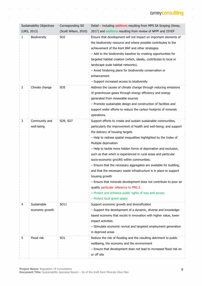
1.6. SA Framework and Sustainability Objectives
Various environmental, social and economic issues have been identified through reviewing a wide variety of
plans and strategies, collecting baseline information and identifying sustainability issues and problems.
These issues have informed the development of the sustainability appraisal framework, which consists of a
set of sustainable development policy objectives (sustainability objectives) as set out in Table 1. Following
due diligence in terms of the context and baseline conditions, the Framework and Sustainability Objectives
for the SA of the MSP has been developed using that produced by URS (2013). The relationship between the
2010 Scoping and 2013 SA Report objectives is presented in Table 1 below, which also expands on the detail
of the objectives and the additions made following the 2017 Scoping exercise and review of the NPPF 2018
and the 25 Year Environment Plan.
Project Name: Regulation 19 Consultation Document Title: Sustainability Appraisal Report – SA of the draft Kent Minerals Sites Plan
9
Sustainability Objectives
(URS, 2013)
Corresponding SO
(Scott Wilson, 2010)
Detail – including additions resulting from MPS SA Scoping (Amey,
2017) and additions resulting from review of NPPF and 25YEP
1 Biodiversity SO2 Ensure that development will not impact on important elements of
the biodiversity resource and where possible contributes to the
achievement of the Kent BAP and other strategies
– Add to the biodiversity baseline by creating opportunities for
targeted habitat creation (which, ideally, contributes to local or
landscape scale habitat networks).
– Avoid hindering plans for biodiversity conservation or
enhancement
– Support increased access to biodiversity
2 Climate change SO5 Address the causes of climate change through reducing emissions
of greenhouse gases through energy efficiency and energy generated from renewable sources
– Promote sustainable design and construction of facilities and
support wider efforts to reduce the carbon footprint of minerals
operations.
3 Community and
well-being
SO9, SO7 Support efforts to create and sustain sustainable communities,
particularly the improvement of health and well-being; and support
the delivery of housing targets
– Help to redress spatial inequalities highlighted by the Index of
Multiple deprivation.
– Help to tackle more hidden forms of deprivation and exclusion,
such as that which is experienced in rural areas and particular socio-economic groURS within communities.
– Ensure that the necessary aggregates are available for building,
and that the necessary waste infrastructure is in place to support
housing growth
– Ensure that minerals development does not contribute to poor air
quality particular reference to PM2.5.
– Protect and enhance public rights of way and access
– Protect local green space
4 Sustainable
economic growth
SO11 Support economic growth and diversification
– Support the development of a dynamic, diverse and knowledge-
based economy that excels in innovation with higher value, lower
impact activities – Stimulate economic revival and targeted employment generation
in deprived areas
5 Flood risk SO1 Reduce the risk of flooding and the resulting detriment to public
wellbeing, the economy and the environment
– Ensure that development does not lead to increased flood risk on
or off site
Project Name: Regulation 19 Consultation Document Title: Sustainability Appraisal Report – SA of the draft Kent Minerals Sites Plan
10
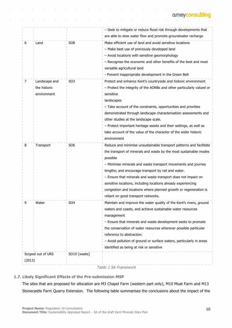
– Seek to mitigate or reduce flood risk through developments that are able to slow water flow and promote groundwater recharge
6 Land SO8 Make efficient use of land and avoid sensitive locations – Make best use of previously developed land
– Avoid locations with sensitive geomorphology
– Recognise the economic and other benefits of the best and most
versatile agricultural land
- Prevent inappropriate development in the Green Belt
7 Landscape and
the historic
environment
SO3 Protect and enhance Kent’s countryside and historic environment
– Protect the integrity of the AONBs and other particularly valued or
sensitive
landscapes
– Take account of the constraints, opportunities and priorities
demonstrated through landscape characterisation assessments and other studies at the landscape scale.
– Protect important heritage assets and their settings, as well as
take account of the value of the character of the wider historic
environment
8 Transport SO6 Reduce and minimise unsustainable transport patterns and facilitate
the transport of minerals and waste by the most sustainable modes
possible
– Minimise minerals and waste transport movements and journey
lengths; and encourage transport by rail and water.
– Ensure that minerals and waste transport does not impact on
sensitive locations, including locations already experiencing congestion and locations where planned growth or regeneration is
reliant on good transport networks.
9 Water SO4 Maintain and improve the water quality of the Kent’s rivers, ground
waters and coasts, and achieve sustainable water resources
management
– Ensure that minerals and waste development seeks to promote
the conservation of water resources wherever possible particular
reference to abstraction.
– Avoid pollution of ground or surface waters, particularly in areas
identified as being at risk or sensitive
Scoped out of URS
(2013)
SO10 [waste]
Table 1 SA Framework
1.7. Likely Significant Effects of the Pre-submission MSP
The sites that are proposed for allocation are M3 Chapel Farm (western part only), M10 Moat Farm and M13
Stonecastle Farm Quarry Extension. The following table summarises the conclusions about the impact of the

Project Name: Regulation 19 Consultation Document Title: Sustainability Appraisal Report – SA of the draft Kent Minerals Sites Plan
11
MSP overall with these three sites proposed for allocation.
Sustainability Objective
Site
1 Bi
odiv
ersit
y
2 Cl
imat
e ch
ange
3 Co
mm
unity
and
wel
lbei
ng
4 Su
stai
nabl
e ec
onom
ic
grow
th
5 Fl
ood
risk
6 La
nd
7 La
ndsc
ape
and
the
hist
oric
envi
ronm
ent
8 Tr
ansp
ort
9 W
ater
M3 Chapel Farm - - - ++/- 0 - -/? ? -
M10 Moat Farm ?/- 0 - ++/- ? ? -/? 0 -
M13 Stonecastle Farm Quarry -/+ 0 0 ++/- ? 0/? ? 0 -/?
Overall impacts - - - ++/- ? ? -/? ? -/?
Table 2: Summary of Findings of SA of MSP Overall
Each of the sites contain or are adjacent to some form of biodiversity asset or biodiversity value and impacts
are possible in each case. It will be important for planning applications to fully assess the impacts on
biodiversity, to provide mitigation where possible and where this is not possible to provide replacement
habitat of equal value. Restoration proposals at two of the sites aim to restore the site to biodiversity
habitat which will help to mitigate any potential loss.
The Minerals Sites Plan is likely to increase emissions of greenhouse gases overall by generating additional
HGV movements and increasing the energy requirements for mineral processing on site. However, these are
insignificant when considered in the context of emissions from the county as a whole.
Some negative impacts are possible on community wellbeing, mainly due to the potential for negative
impacts on residential amenity from operations and transport, and also on the diversion or removal of
footpaths. It should be possible for mitigation to adequately minimise impacts from dust, noise, vibration,
light and visual impacts, although cumulative impacts are not likely to be significant.
The Minerals Sites Plan will help to contribute to economic growth by providing a supply of minerals to
support construction and potentially other economic sectors that depend on aggregates. By facilitating the
extraction of primary aggregates, the Minerals Sites Plan is exploiting a non-renewable resource, which
cannot be considered sustainable.
Two of the minerals sites lie within Flood Zone 3. In these cases, it must be demonstrated that
development can take place without adversely affecting flood risk and where possible contributing to a
reduction in overall flood risk.
One of the minerals sites contains soil which is classed as the best and most versatile agricultural land,
Project Name: Regulation 19 Consultation Document Title: Sustainability Appraisal Report – SA of the draft Kent Minerals Sites Plan
12
although restoration to agricultural land is proposed and therefore the impact of the MSP on soil quality is
not likely to be significant. Two of the sites lie within the Metropolitan Green Belt, in which case it must be
demonstrated that operations will not constitute inappropriate development or constitute very special
circumstances. Given that sites will be restored to wetland habitat, lasting cumulative impacts on the Green
Belt are not envisaged.
There is the potential for the sites to have limited impacts on landscape and on the historic environment.
However, it will be possible to provide mitigation such that the significance of impacts is minimised. Adverse
impacts on the AONBs are not likely to be significant.
Minerals sites generate vehicle movements accessing and leaving the sites. The majority of these are HGV
movements and it is estimated that these will range between 4 movements per hour to 8 movements per
hour depending on the site. In addition, staff vehicles will access the sites, around an estimated 10
movements per day. For sites M10 and M13, operations are planned to run sequentially with existing
extraction in the locality so that the impacts from vehicles are likely to be no greater than existing impacts.
The scale of the cumulative impact of the MSP overall is not expected to be great given the predicted
number of movements and the context of all traffic movements in the county. It is unlikely that the Minerals
Sites Plan will support the use of sustainable modes of transport for minerals, although the KMWLP
safeguards railheads and wharves to support rail and water transport of minerals.
Each of the minerals sites have the potential for significant impacts on hydrology/hydrogeology and water
quality. Restoration to wetland could affect local hydrology. However, the cumulative impacts from all sites
in the Minerals Sites Plan is not expected to be significant for the county as a whole.
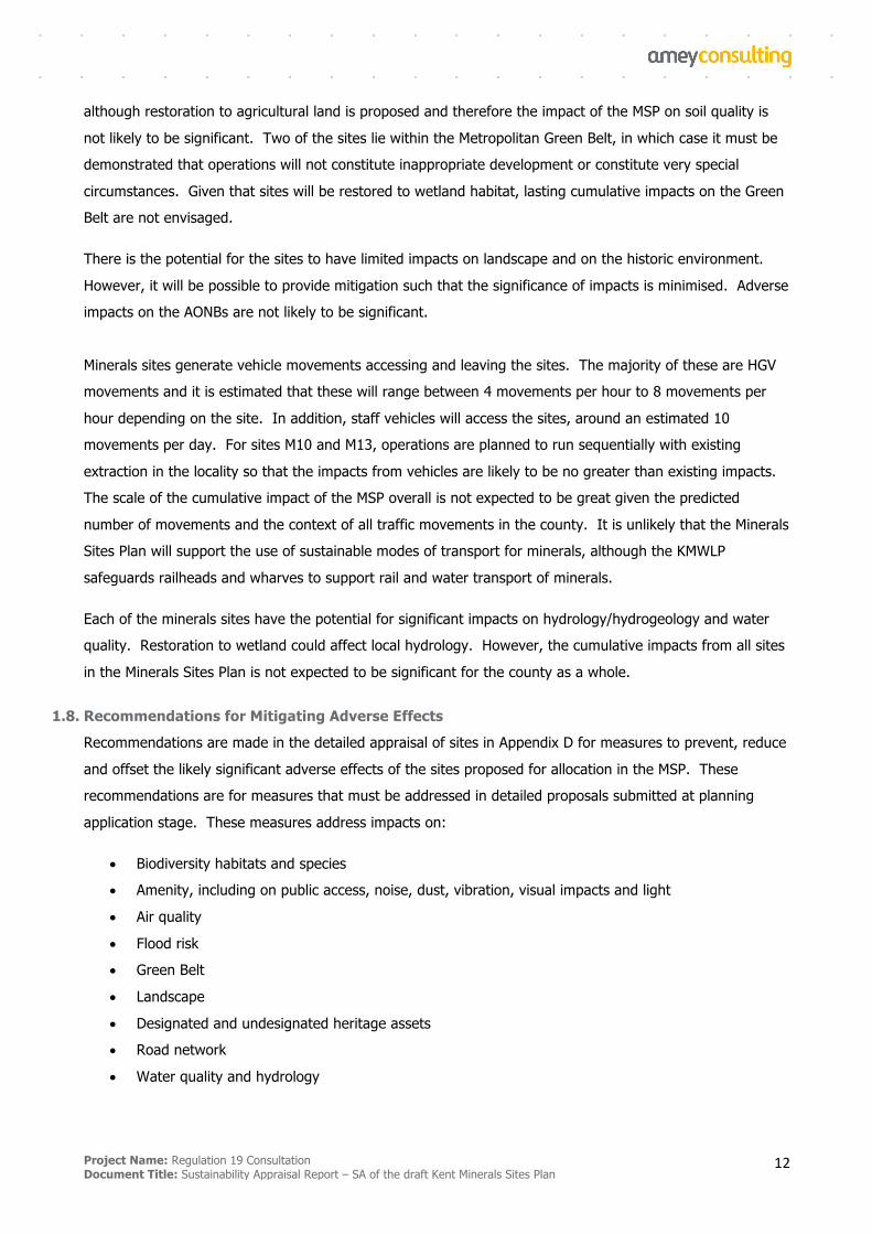
1.8. Recommendations for Mitigating Adverse Effects
Recommendations are made in the detailed appraisal of sites in Appendix D for measures to prevent, reduce
and offset the likely significant adverse effects of the sites proposed for allocation in the MSP. These
recommendations are for measures that must be addressed in detailed proposals submitted at planning
application stage. These measures address impacts on:
• Biodiversity habitats and species
• Amenity, including on public access, noise, dust, vibration, visual impacts and light
• Air quality
• Flood risk
• Green Belt
• Landscape
• Designated and undesignated heritage assets
• Road network
• Water quality and hydrology
Project Name: Regulation 19 Consultation Document Title: Sustainability Appraisal Report – SA of the draft Kent Minerals Sites Plan
13
1.9. Reasons for Selecting Alternatives Dealt With
A Refresh Call for Sites took place from December 2016 to March 2017, resulting in 38 sites being submitted
to KCC for selection assessment, accompanied by a wide range of detailed technical and operational impact
data from applicants. For a site to be considered to be a Mineral Site Option it had to:
§ Align with the objectives of the adopted KMWLP and scope of the Sites Plan: The KWMLP sets out the
minerals supply needs and waste management capacity provision over the period 2013-2030 and the
Sites Plan needs to identify sufficient sites to contribute to this requirement.
§ Be justified: The site should represent an appropriate option based on a desktop assessment of the
opportunities and constraints associated with its location.
§ Be deliverable: Development of the site should not result in severe adverse effects that would affect
its deliverability, and its development should also be supported by the landowner
A number of sites were ruled out of consideration as reasonable alternatives and therefore were not subject to KCC’s Regulation 18 ‘Minerals Sites Plan Options Consultation’.
Kent County Council published a short list of options1 for minerals sites being considered as allocations in the
MSP. These sites were subject to an initial screening as stage 2 of the KCC Site Selection Methodology,
known as the ‘RAG’ assessment. The following sites were published as options for consultation with a
summary of the results of the Stage 2 RAG assessment:
§ site M2 Lydd Quarry Extensions
§ site M3 Chapel Farm
§ site M7 Central Road
§ site M8 West Malling Sandpit
§ site M9 The Postern
§ site M10 Moat Farm
§ site M11 Joyce Green Quarry
§ site M12 Postern Meadows
§ site M13 Stonecastle Farm Quarry Extension
In November 2017, Kent County Council identified site allocation options following a review of the
information obtained through the above consultation on options and gathering of more detailed information
1MineralSitesPlanOptionsConsultation,KentCountyCouncil,September2017
Project Name: Regulation 19 Consultation Document Title: Sustainability Appraisal Report – SA of the draft Kent Minerals Sites Plan
14
on the sites. M9 was no longer being progressed because it was withdrawn by the promoter. Therefore the
following options remained as ‘reasonable alternatives’ to be considered for site allocations:
§ site M2 Lydd Quarry Extensions
§ site M3 Chapel Farm
§ site M7 Central Road
§ site M8 West Malling Sandpit
§ site M10 Moat Farm
§ site M11 Joyce Green Quarry
§ site M12 Postern Meadows
§ site M13 Stonecastle Farm Quarry Extension
These reasonable alternatives have been subject to SA in this report.
Following detailed technical assessment, review of further submissions to Kent County Council in relation to
the sites and the findings of this SA, several of the sites listed as reasonable alternatives have been ruled
out as proposed allocations in the Pre-submission MSP. Three sites are proposed for allocation in the Pre-
submission MSP. These sites are judged to have acceptable or mitigable impacts following detailed technical
assessment, consultation and review of the findings of the SA:
• M3 Chapel Farm
The western part of the site is suitable for allocation in Pre-Submission Draft MSP, subject to meeting
development management criteria at planning application stage. The eastern part of the site has been
withdrawn by the promoter due to likely unacceptable impact on heritage asset.
• M10 Moat Farm
Suitable for allocation in Pre-Submission Draft MSP, subject to meeting development management
criteria at planning application stage.
• M13 Stonecastle Farm Quarry Extension
Suitable for allocation in Pre-Submission Draft MSP, subject to meeting development management
criteria at planning application stage.
In addition to site alternatives, it was considered that there was potential to consider an alternative to
allocating some or any sites for land-won aggregates in Kent.
Project Name: Regulation 19 Consultation Document Title: Sustainability Appraisal Report – SA of the draft Kent Minerals Sites Plan
15
With its coastal location, Kent fulfils an important role in the importation of minerals including a range of
construction aggregates from mainland Europe, as well as marine dredged aggregates (MDA) and imported
recycled and secondary materials. Kent benefits from a number of aggregate wharves, into which significant
quantities of MDA and crushed rock are landed. Land-won sharp sand and gravel is also imported by rail
and road from areas beyond Kent. Assurances regarding the security of these minerals imports during the
Plan period were obtained in developing the KMWLP.
In addition to the land-won maintenance of landbanks to support a steady future supply of aggregate in
Kent, the KMWLP contains strategic objectives and policies to
§ Promote and encourage the use of recycled and secondary aggregates in place of land-won minerals.
§ Safeguard existing, planned and potential sites for mineral infrastructure including wharves and rail
depots across Kent to enable the on-going transportation of marine dredged aggregates, crushed rock
and other minerals as well as other production facilities.
It is therefore reasonable to assume that an increased supply of secondary and recycled aggregates and
MDA is an alternative to the mining of some land-won sharp sand and gravels. It is also reasonable to
assume that some land-won aggregates could be imported into Kent from sites outside of Kent. This has
therefore been appraised as an alternative to the allocation of sites for sharp sand and gravel. The results
of this appraisal are set out in detail in Appendix E and summarised in Section 6.3.
1.10. Methodology
The SA has appraised each of the sites considered as reasonable alternatives, as well as the alternative to
allocating some or any land-won aggregate sites in Kent against the appraisal framework set out in Table 1.
The SA has also appraised the Kent site selection methodology against this framework. The appraisal was
done by assessing each site, other alternative and element of methodology against the appraisal objectives
in turn and making a largely qualitative assessment, with reference also to the baseline data from the
Scoping Report.
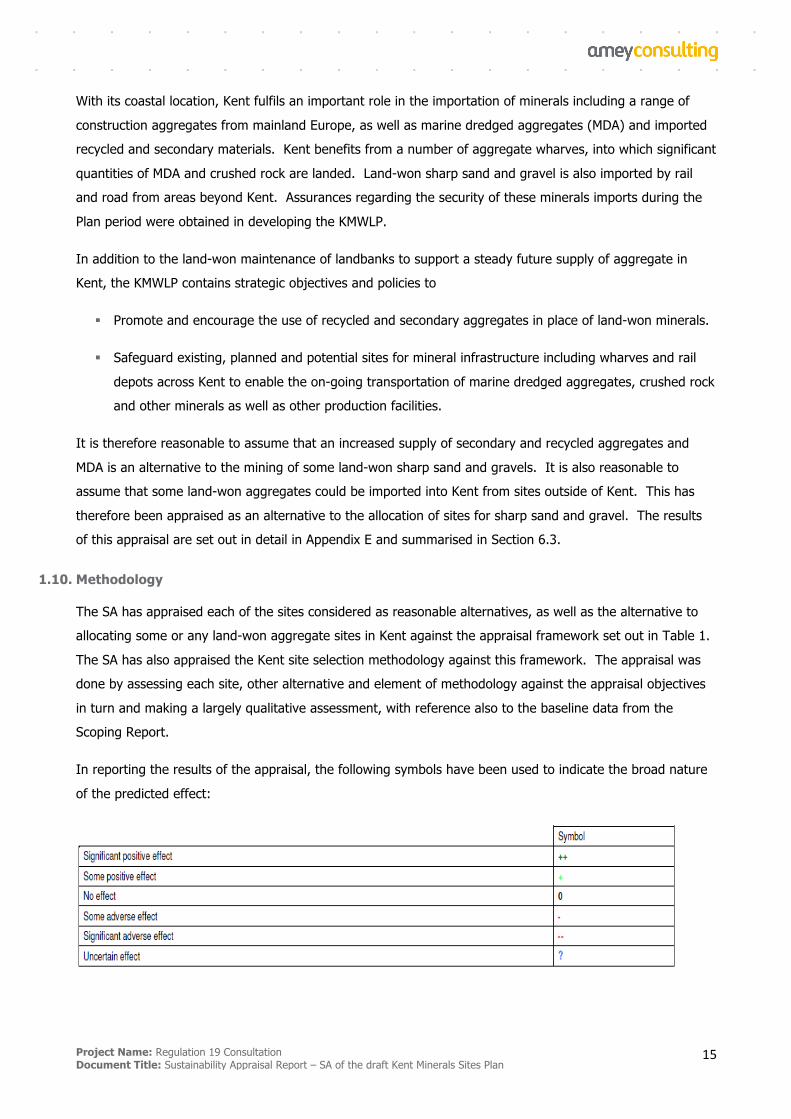
In reporting the results of the appraisal, the following symbols have been used to indicate the broad nature
of the predicted effect:
Project Name: Regulation 19 Consultation Document Title: Sustainability Appraisal Report – SA of the draft Kent Minerals Sites Plan
16
Further details on the methodology, including assumptions made, are given in Section 6 of the main report.
Information on the difficulties encountered is provided in Section 4 of the main report. These relate to the
lack of available data in some instances, and uncertainties about detailed matters of implementation.
1.11. Monitoring Recommendations
The sustainability appraisal has developed a set of recommendations for monitoring the predicted and
unforeseen impacts of implementation of the Pre-submission MSP as proposed. These are set out as a
series of indicators related to the sustainability appraisal framework based on the likely and possible impacts
of the Pre-submission MSP. The recommended indicators should be incorporated into the Annual Monitoring
Report for the Local Plan and are set out in Section 7.
Project Name: Regulation 19 Consultation Document Title: Sustainability Appraisal Report – SA of the draft Kent Minerals Sites Plan
17
Introduction
2.1. Background
Amey is commissioned to undertake Sustainability Appraisal (SA) in support of the Kent Minerals and Waste
Local Plan (KMWLP) Minerals Sites Plan (MSP) preparation process. This report presents the interim
outcomes of this process up to Regulation 19 stage (Pre-submission consultation). SA is a mechanism for
considering and communicating the likely effects of a draft plan, and alternatives, with a view to avoiding
and mitigating adverse effects and maximising positives.
2.2. The SA Process
It is a legal requirement that SA is undertaken in-line with the procedures prescribed by the Environmental
Assessment of Plans and Programmes Regulations 2004, which were prepared in order to transpose into
national law the EU Strategic Environmental Assessment (SEA) Directive.
The Regulations require that a report - which for the purposes of SA is known as the ‘SA Report’ – is
published for consultation alongside the Preferred Options Consultation document of the Kent Minerals Sites
Plan and then taken into account, alongside consultation responses, when finalising the plan. Essentially, the
SA Report must ‘identify, describe and evaluate’ the likely significant effects of implementing ‘the plan, and
reasonable alternatives’.
In-line with regulatory requirements, Sustainability Appraisal has already been undertaken throughout the
drafting and adoption of Kent’s MWLP (most recently: URS, 2013 and Addenda). Kent are currently
developing their Minerals Sites Plan: The MSP must be in conformity with the overarching MWLP policies,
and will identify sites which meet with the MWLP’s requirements and aspirations. The selection of minerals
sites has been made from those sites promoted in the call for sites, KCC having employed their own Site
Selection Methodology (KCC, 2016) based on best practice, in order to determine which of those submitted
for consideration are ‘Reasonable Alternatives’. This SA Report has informed the selection of the ‘Preferred
Options’ sites to go forward to the Pre-Submission Draft of the Kent Mineral Sites Plan and the Regulation 19
consultation.
SA has been undertaken of the Site Selection Methodology and Reasonable Alternatives to inform Regulation
19 Pre-submission consultation. The SA of the Kent Minerals Sites Plan will assess both the KCC (2016)
methodology, and the sites deemed to be ‘Reasonable Alternatives’. A scoping exercise has been
undertaken, leading to the production in September 2017 of a Scoping Report which explains the rationale
behind the SA Framework selected for this Site Selection Methodology and Reasonable Alternatives SA. This
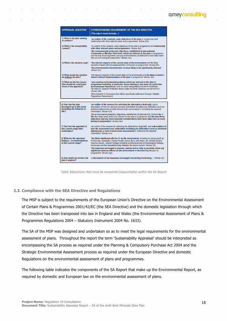
SA Report has been produced in order to address the statutory appraisal questions as detailed in Table 3, to
ensure that the sites proposed as ‘Preferred Options’ have been assessed, any matters of significance noted
and mitigation proposed if appropriate.
Project Name: Regulation 19 Consultation Document Title: Sustainability Appraisal Report – SA of the draft Kent Minerals Sites Plan
18
Table3Questionsthatmustbeanswered(sequentially)withintheSAReport
2.3. Compliance with the SEA Directive and Regulations
The MSP is subject to the requirements of the European Union’s Directive on the Environmental Assessment
of Certain Plans & Programmes 2001/42/EC (the SEA Directive) and the domestic legislation through which
the Directive has been transposed into law in England and Wales (the Environmental Assessment of Plans &
Programmes Regulations 2004 – Statutory Instrument 2004 No. 1633).
The SA of the MSP was designed and undertaken so as to meet the legal requirements for the environmental
assessment of plans. Throughout the report the term ‘Sustainability Appraisal’ should be interpreted as
encompassing the SA process as required under the Planning & Compulsory Purchase Act 2004 and the
Strategic Environmental Assessment process as required under the European Directive and domestic
Regulations on the environmental assessment of plans and programmes.
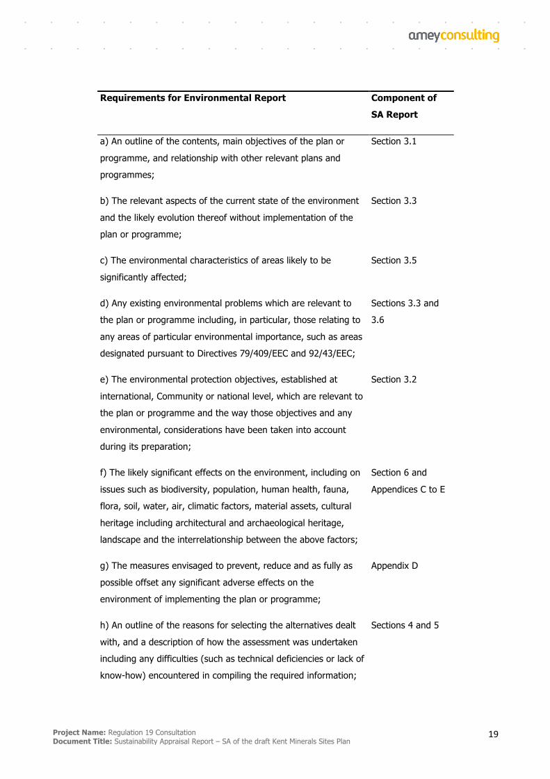
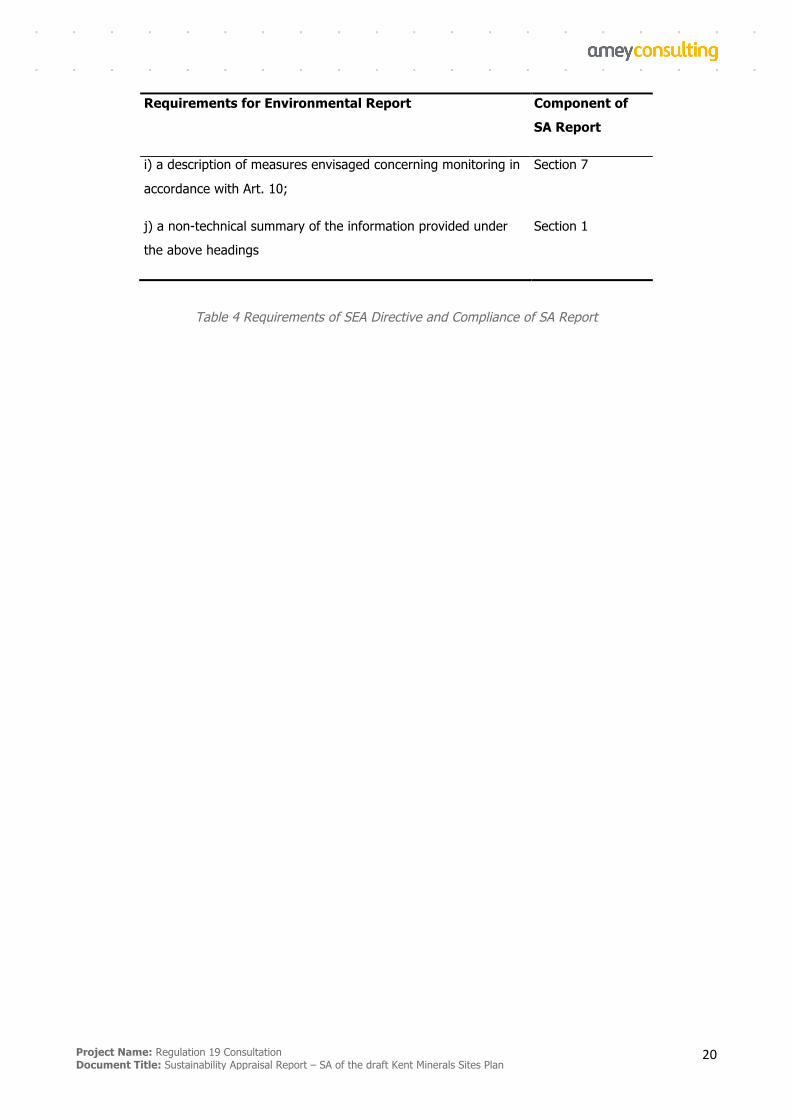
The following table indicates the components of the SA Report that make up the Environmental Report, as
required by domestic and European law on the environmental assessment of plans.
Project Name: Regulation 19 Consultation Document Title: Sustainability Appraisal Report – SA of the draft Kent Minerals Sites Plan
19
Requirements for Environmental Report Component of
SA Report
a) An outline of the contents, main objectives of the plan or
programme, and relationship with other relevant plans and
programmes;
Section 3.1
b) The relevant aspects of the current state of the environment
and the likely evolution thereof without implementation of the
plan or programme;
Section 3.3
c) The environmental characteristics of areas likely to be
significantly affected;
Section 3.5
d) Any existing environmental problems which are relevant to
the plan or programme including, in particular, those relating to
any areas of particular environmental importance, such as areas
designated pursuant to Directives 79/409/EEC and 92/43/EEC;
Sections 3.3 and
3.6
e) The environmental protection objectives, established at
international, Community or national level, which are relevant to
the plan or programme and the way those objectives and any
environmental, considerations have been taken into account
during its preparation;
Section 3.2
f) The likely significant effects on the environment, including on
issues such as biodiversity, population, human health, fauna,
flora, soil, water, air, climatic factors, material assets, cultural
heritage including architectural and archaeological heritage,
landscape and the interrelationship between the above factors;
Section 6 and
Appendices C to E
g) The measures envisaged to prevent, reduce and as fully as
possible offset any significant adverse effects on the
environment of implementing the plan or programme;
Appendix D
h) An outline of the reasons for selecting the alternatives dealt
with, and a description of how the assessment was undertaken
including any difficulties (such as technical deficiencies or lack of
know-how) encountered in compiling the required information;
Sections 4 and 5
Project Name: Regulation 19 Consultation Document Title: Sustainability Appraisal Report – SA of the draft Kent Minerals Sites Plan
20
Requirements for Environmental Report Component of
SA Report
i) a description of measures envisaged concerning monitoring in
accordance with Art. 10;
Section 7
j) a non-technical summary of the information provided under
the above headings
Section 1
Table 4 Requirements of SEA Directive and Compliance of SA Report

Project Name: Regulation 19 Consultation Document Title: Sustainability Appraisal Report – SA of the draft Kent Minerals Sites Plan
21
The Scope of the Sustainability Appraisal
3.1. What is the plan seeking to achieve?
The MSP is a land use plan produced by Kent County Council which identifies and allocates mineral sites
within the county for the working and winning of minerals. The following sites are proposed for allocation:
§ M3 Chapel Farm
§ M10 Moat Farm
§ M13 Stonecastle Farm Quarry Extension
The main objective of the MSP is to ensure that Kent has enough permitted mineral reserves over the plan
period (until 2030) and 7 years beyond to meet plan making requirements. Sites M3 is a soft sand site and
M10 and M13 are sharp sand and gravel sites.
The Kent Minerals and Waste Local Plan (KMWLP) was adopted in July 2016 and sets out the vision and
objectives for Kent’s minerals supply and waste management capacity from 2013 to 2030. The KMWLP did
not allocate specific sites suitable for minerals and waste development except for two strategic sites - one
for cement production (and related mineral reserves) at Holborough in the Medway Valley and one for
hazardous waste disposal at Norwood Quarry on the Isle of Sheppey). The KMWLP identified that the
specific sites for minerals developments would be set out in the separate MSP which is the subject of this SA
Report. The selection of sites will be based on the policies of the KMWLP and sites proposed for
development will be required to comply with the policies of the KMWLP.
The KMWLP is a high level document planning to 2030 which:
§ sets out the vision and strategy for mineral provision and waste management in Kent;
§ contains a number of development management policies for evaluating minerals and waste planning
applications;
§ considers strategic site provision for all minerals and waste management facilities; and identifies two
areas where key (strategic) mineral and waste development should take place. These have been fully
assessed previously and therefore are not subject to this SA.
In parallel with the development of the MSP, Kent County Council is also undertaking a Partial Review of
the KMWLP. Policies CSW7, CSW8, CSW 12 and CSW 14 of the KMWLP state that a Waste Sites Plan will
be prepared that will identify sites suitable for accommodating facilities needed to address the identified
capacity shortfalls. A review of the future needs for waste management facilities in Kent has recently
been undertaken and this has concluded that there is now no need for the development of this additional
capacity. The policies will be amended by the Partial Review to reflect this updated understanding.
Policies DM7 and DM8 set out criteria to allow development that may affect safeguarded sites to proceed
Project Name: Regulation 19 Consultation Document Title: Sustainability Appraisal Report – SA of the draft Kent Minerals Sites Plan
22
in certain prescribed circumstances. Policies DM 7 and DM 8 will be amended by the Partial Review to
ensure that the safeguarding is not unduly rigid in its application. The Partial Review has been subject to
SA and the results of this are set out in a separate SA Report.
The government has published the National Planning Policy Framework (July 2018), which sets out planning
policies for achieving sustainable development. Emphasis has been placed on the importance of ensuring
that Local Plan policies contribute to achieving sustainable development. The MSP has been prepared in
compliance with the National Planning Policy Framework (NPPF).
The current piece of work is to undertake SA of the draft MSP to inform Regulation 19 consultation on the
Pre-submission draft of the MSP, which must be in conformity with the overarching KMWLP. Rather than
being a strategy document, the MSP identifies sites which meet with the MWLP’s aspirations, and which can
be demonstrated to meet social, economic and environmental criteria. The MSP and associated SA do not
replace the statutory need for Environmental Impact Assessment, nor does it remove the need for applicants
to apply for detailed planning permission.
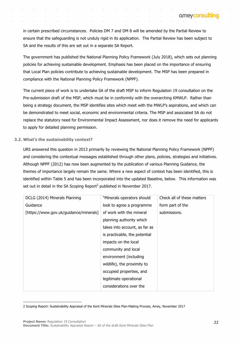
3.2. What’s the sustainability context?
URS answered this question in 2013 primarily by reviewing the National Planning Policy Framework (NPPF)
and considering the contextual messages established through other plans, policies, strategies and initiatives.
Although NPPF (2012) has now been augmented by the publication of various Planning Guidance, the
themes of importance largely remain the same. Where a new aspect of context has been identified, this is
identified within Table 5 and has been incorporated into the updated Baseline, below. This information was
set out in detail in the SA Scoping Report2 published in November 2017.
DCLG (2014) Minerals Planning
Guidance
[https://www.gov.uk/guidance/minerals]
“Minerals operators should
look to agree a programme
of work with the mineral
planning authority which
takes into account, as far as
is practicable, the potential
impacts on the local
community and local
environment (including
wildlife), the proximity to
occupied properties, and
legitimate operational
considerations over the
Check all of these matters
form part of the
submissions.
2 Scoping Report: Sustainability Appraisal of the Kent Minerals Sites Plan-Making Process, Amey, November 2017
Project Name: Regulation 19 Consultation Document Title: Sustainability Appraisal Report – SA of the draft Kent Minerals Sites Plan
23
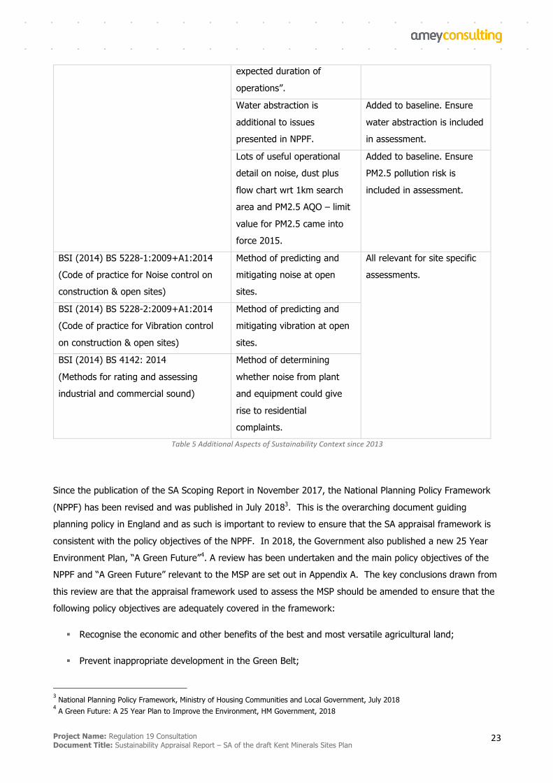
expected duration of
operations”.
Water abstraction is
additional to issues
presented in NPPF.
Added to baseline. Ensure
water abstraction is included
in assessment.
Lots of useful operational
detail on noise, dust plus
flow chart wrt 1km search
area and PM2.5 AQO – limit
value for PM2.5 came into
force 2015.
Added to baseline. Ensure
PM2.5 pollution risk is
included in assessment.
BSI (2014) BS 5228-1:2009+A1:2014
(Code of practice for Noise control on
construction & open sites)
Method of predicting and
mitigating noise at open
sites.
All relevant for site specific
assessments.
BSI (2014) BS 5228-2:2009+A1:2014
(Code of practice for Vibration control
on construction & open sites)
Method of predicting and
mitigating vibration at open
sites.
BSI (2014) BS 4142: 2014
(Methods for rating and assessing
industrial and commercial sound)
Method of determining
whether noise from plant
and equipment could give
rise to residential
complaints. Table5AdditionalAspectsofSustainabilityContextsince2013
Since the publication of the SA Scoping Report in November 2017, the National Planning Policy Framework
(NPPF) has been revised and was published in July 20183. This is the overarching document guiding
planning policy in England and as such is important to review to ensure that the SA appraisal framework is
consistent with the policy objectives of the NPPF. In 2018, the Government also published a new 25 Year
Environment Plan, “A Green Future”4. A review has been undertaken and the main policy objectives of the
NPPF and “A Green Future” relevant to the MSP are set out in Appendix A. The key conclusions drawn from
this review are that the appraisal framework used to assess the MSP should be amended to ensure that the
following policy objectives are adequately covered in the framework:
§ Recognise the economic and other benefits of the best and most versatile agricultural land;
§ Prevent inappropriate development in the Green Belt;
3National Planning Policy Framework, Ministry of Housing Communities and Local Government, July 2018
4A Green Future: A 25 Year Plan to Improve the Environment, HM Government, 2018
Project Name: Regulation 19 Consultation Document Title: Sustainability Appraisal Report – SA of the draft Kent Minerals Sites Plan
24
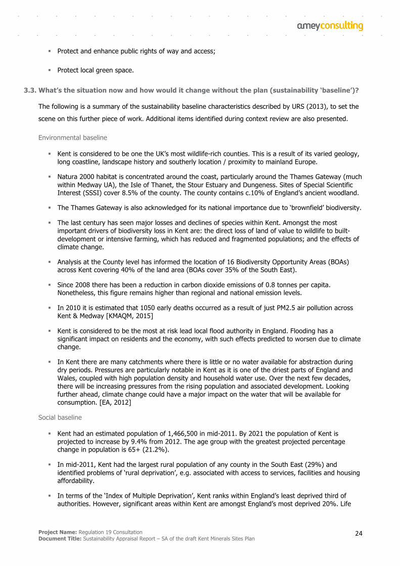
§ Protect and enhance public rights of way and access;
§ Protect local green space.
3.3. What’s the situation now and how would it change without the plan (sustainability ‘baseline’)?
The following is a summary of the sustainability baseline characteristics described by URS (2013), to set the
scene on this further piece of work. Additional items identified during context review are also presented.
Environmental baseline
§ Kent is considered to be one the UK’s most wildlife-rich counties. This is a result of its varied geology, long coastline, landscape history and southerly location / proximity to mainland Europe.
§ Natura 2000 habitat is concentrated around the coast, particularly around the Thames Gateway (much within Medway UA), the Isle of Thanet, the Stour Estuary and Dungeness. Sites of Special Scientific Interest (SSSI) cover 8.5% of the county. The county contains c.10% of England’s ancient woodland.
§ The Thames Gateway is also acknowledged for its national importance due to ‘brownfield’ biodiversity.
§ The last century has seen major losses and declines of species within Kent. Amongst the most important drivers of biodiversity loss in Kent are: the direct loss of land of value to wildlife to built-development or intensive farming, which has reduced and fragmented populations; and the effects of climate change.
§ Analysis at the County level has informed the location of 16 Biodiversity Opportunity Areas (BOAs) across Kent covering 40% of the land area (BOAs cover 35% of the South East).
§ Since 2008 there has been a reduction in carbon dioxide emissions of 0.8 tonnes per capita. Nonetheless, this figure remains higher than regional and national emission levels.
§ In 2010 it is estimated that 1050 early deaths occurred as a result of just PM2.5 air pollution across Kent & Medway [KMAQM, 2015]
§ Kent is considered to be the most at risk lead local flood authority in England. Flooding has a significant impact on residents and the economy, with such effects predicted to worsen due to climate change.
§ In Kent there are many catchments where there is little or no water available for abstraction during dry periods. Pressures are particularly notable in Kent as it is one of the driest parts of England and Wales, coupled with high population density and household water use. Over the next few decades, there will be increasing pressures from the rising population and associated development. Looking further ahead, climate change could have a major impact on the water that will be available for consumption. [EA, 2012]
Social baseline
§ Kent had an estimated population of 1,466,500 in mid-2011. By 2021 the population of Kent is projected to increase by 9.4% from 2012. The age group with the greatest projected percentage change in population is 65+ (21.2%).
§ In mid-2011, Kent had the largest rural population of any county in the South East (29%) and identified problems of ‘rural deprivation’, e.g. associated with access to services, facilities and housing affordability.
§ In terms of the ‘Index of Multiple Deprivation’, Kent ranks within England’s least deprived third of authorities. However, significant areas within Kent are amongst England’s most deprived 20%. Life
Project Name: Regulation 19 Consultation Document Title: Sustainability Appraisal Report – SA of the draft Kent Minerals Sites Plan
25
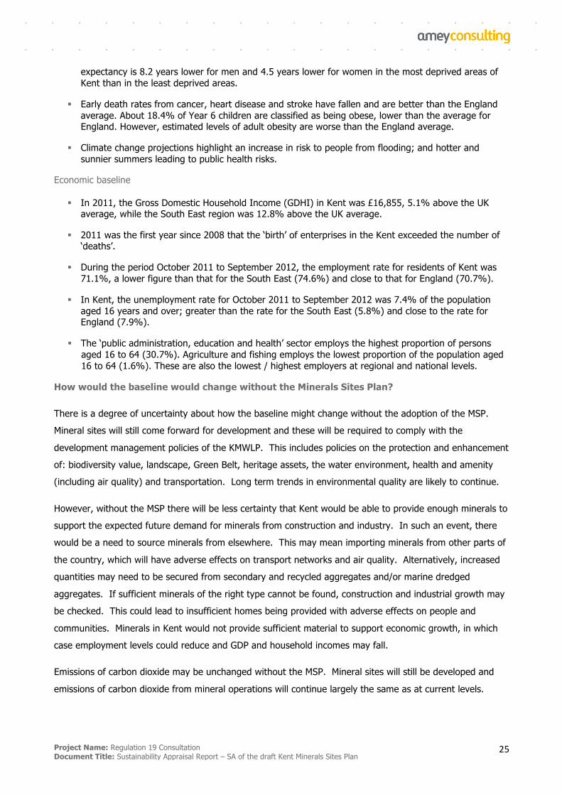
expectancy is 8.2 years lower for men and 4.5 years lower for women in the most deprived areas of Kent than in the least deprived areas.
§ Early death rates from cancer, heart disease and stroke have fallen and are better than the England average. About 18.4% of Year 6 children are classified as being obese, lower than the average for England. However, estimated levels of adult obesity are worse than the England average.
§ Climate change projections highlight an increase in risk to people from flooding; and hotter and sunnier summers leading to public health risks.
Economic baseline
§ In 2011, the Gross Domestic Household Income (GDHI) in Kent was £16,855, 5.1% above the UK average, while the South East region was 12.8% above the UK average.
§ 2011 was the first year since 2008 that the ‘birth’ of enterprises in the Kent exceeded the number of ‘deaths’.
§ During the period October 2011 to September 2012, the employment rate for residents of Kent was 71.1%, a lower figure than that for the South East (74.6%) and close to that for England (70.7%).
§ In Kent, the unemployment rate for October 2011 to September 2012 was 7.4% of the population aged 16 years and over; greater than the rate for the South East (5.8%) and close to the rate for England (7.9%).
§ The ‘public administration, education and health’ sector employs the highest proportion of persons aged 16 to 64 (30.7%). Agriculture and fishing employs the lowest proportion of the population aged 16 to 64 (1.6%). These are also the lowest / highest employers at regional and national levels.
How would the baseline would change without the Minerals Sites Plan?
There is a degree of uncertainty about how the baseline might change without the adoption of the MSP.
Mineral sites will still come forward for development and these will be required to comply with the
development management policies of the KMWLP. This includes policies on the protection and enhancement
of: biodiversity value, landscape, Green Belt, heritage assets, the water environment, health and amenity
(including air quality) and transportation. Long term trends in environmental quality are likely to continue.
However, without the MSP there will be less certainty that Kent would be able to provide enough minerals to
support the expected future demand for minerals from construction and industry. In such an event, there
would be a need to source minerals from elsewhere. This may mean importing minerals from other parts of
the country, which will have adverse effects on transport networks and air quality. Alternatively, increased
quantities may need to be secured from secondary and recycled aggregates and/or marine dredged
aggregates. If sufficient minerals of the right type cannot be found, construction and industrial growth may
be checked. This could lead to insufficient homes being provided with adverse effects on people and
communities. Minerals in Kent would not provide sufficient material to support economic growth, in which
case employment levels could reduce and GDP and household incomes may fall.
Emissions of carbon dioxide may be unchanged without the MSP. Mineral sites will still be developed and
emissions of carbon dioxide from mineral operations will continue largely the same as at current levels.
Project Name: Regulation 19 Consultation Document Title: Sustainability Appraisal Report – SA of the draft Kent Minerals Sites Plan
26
However, if imports from other parts of the country are required, this will lead to increased carbon dioxide
emissions associated with mineral transport and associated risks to people and communities.
The social baseline is unlikely to be affected without the adoption of the MSP. Population, levels of
deprivation and health are unlikely to be significantly different with or without the MSP. Mineral sites will
still come forward for development and these must comply with the policies of the KMWLP, including on
health and amenity.
3.4. What are the key sustainability issues?
Following review of both context and baseline, the SA Scoping Report set out the key sustainability issues in
Kent as follows. Findings of significance from the SA of Kent’s MWLP are also presented (see boxes) (both
URS, 2013):
Biodiversity
§ Ambitious BAP targets have been set, including for habitat creation and for reducing fragmentation and improving connectivity. Landscape scale projects are underway with biodiversity conservation and access to biodiversity as central components.
§ It is possible to increase the connectivity between important habitat patches by incorporating habitat creation as part of new development. There is a particular need to maximise the biodiversity benefits associated with restoration of minerals sites.
§ Biodiversity benefits relate to the minerals development management strategy, which is set to ensure that negative effects associated with minerals extraction are avoided or mitigated, and the potential for minerals development to contribute to biodiversity objectives is realised.
Climate change
§ There is the potential to promote energy from waste as well as other technologies that increase the carbon efficiency of minerals and waste operations.
§ Transport is a significant contributor to greenhouse gas emissions that should be addressed through the plan.
Community and well-being
§ Clear spatial variation across Kent exists in terms of income, employment and health deprivation.
§ Rural deprivation is also a recognised problem, for example for the Isle of Sheppey and the Romney Marsh area.
§ Deprivation is focused amongst particular socio-economic groups, for example Gypsies and travellers.
§ Community impacts associated with the proximity of quarries and also lorry movements is an issue of strategic importance.
§ Traffic on the motorway and A-road network is the cause of the majority of designated Air Quality Management Areas (AQMAs)
§ Future development at existing population centres is likely to put further pressure on the road network, and lead to new and worsened occurrences of poor air quality.
§ There remain instances where point source air pollution is a strategic issue.
Project Name: Regulation 19 Consultation Document Title: Sustainability Appraisal Report – SA of the draft Kent Minerals Sites Plan
27
Sustainable economic growth
§ There are ambitious plans for economic growth and regeneration, for example in East Kent and the Kent Thames Gateway.
§ There are local disparities in economic activity (including problems of ‘rurality’)
§ Economic benefits relate to the targeted measures that are proposed as part of the minerals strategy; in particular, around ensuring supply of materials for strategically important industries / economic activities.
Flood risk
§ There is extensive flood risk in Kent, and this situation is set to become worse with climate change.
Land
§ There is a need to make best use of previously developed land and avoid the loss of the County’s best and most versatile agricultural land. There is also a need to avoid conflict with coastal geomorphology
§ 'Land' and 'landscape' benefits relate to the support that is provided for Construction and Demolition (CD) recycling (i.e. aggregate recycling), which reduces the need to extract primary aggregates. There is also a focus on ensuring that the non-recyclable fraction of this inert waste is targeted at quarry restoration projects as a priority. In addition, the MWLP is supportive of efforts to increase the movement of minerals via wharves which should have the effect of encouraging supply of marine dredged aggregates and hence reducing the need for land won aggregates.
Landscape and the historic environment
§ There is a need to protect the integrity of the most valued and sensitive landscapes as well as to avoid damage to the landscape character more widely (signs of change inconsistent with countryside character have been identified in several areas).
§ Along with a loss of the distinctiveness of the landscape character there has been a noticeable decrease in the tranquillity of landscapes and landscapes that are genuinely ‘wild and remote’.
§ Specific landscape impacts can be associated with minerals and waste development. Appropriate restoration should be sought to mitigate effects.
§ There is a need to take account of designated heritage assets and their settings as well as undesignated assets and wider historic character
§ Heritage / historic environment benefits (which are relatively small magnitude and hence of unclear significance) relate to the support that is provided to extraction of minerals for heritage building products with a view to maintaining a diverse supply.
§ There remains ongoing debate about the potential for impacts to the AONB, e.g. from silica sand extraction, but the stringency of policy has been strengthened and so effects are now unlikely. There is also some uncertainty around the landscape / biodiversity implications of making provision for both soft sand and sharp sand / gravel landbanks.
Transport
§ Much of the primary road network operates at, or above, capacity and there is a shortage of freight paths on the rail network.
§ There is a need to adhere to the proximity principle wherever possible.
§ There is a need to increase the amount of waste and, in particular, minerals transported by rail or inland waterway.
Project Name: Regulation 19 Consultation Document Title: Sustainability Appraisal Report – SA of the draft Kent Minerals Sites Plan
28
§ Plans are in place to improve the transport infrastructure within and to the Thames Gateway, East Kent and Ashford. The Kent MWDF should recognise and support the aims of regional hubs.
§ 'Transport' (and hence also climate change mitigation) benefits relate to the fact that the waste strategy is geared towards ensuring strict adherence to the 'proximity principle', i.e. a situation whereby waste is managed close to the source of production. It is also the case that the minerals strategy includes a focus on the safeguarding of wharves and railheads across the County to enable the on-going importation of marine dredged aggregates, crushed rock and other minerals by sea and rail, rather than by road. No significant negative effects / trade-offs are identified and no recommendations remain outstanding at this current stage.
Water
§ Water scarcity is set to become a greater problem in coming as a result of population growth, climate change and the need to comply with the requirements of the Water Framework Directive.
§ Groundwater pollution from a range of sources is evident across much of Kent.
3.5. Characteristics of areas likely to be significantly affected
The SEA Directive requires that the appraisal describes the characteristics of areas likely to be significantly
affected by the MSP. In deciding which areas are likely to be significantly affected by the MSP, the SA has
made reference to the spatial distribution of the proposed minerals sites to determine whether there are any
areas of Kent which contain a particular concentration of minerals sites that could give rise to significant
effects.
There are two proposed mineral sites in one locality to the east of Tonbridge, on the border of Tonbridge
and Malling Borough and Tunbridge Wells Borough. These are sites M10 and M13. There is also an existing
site with permission in the same area (Stonecastle Farm Quarry). It could be considered that the locality
might be significantly affected by two allocated sites in that area in addition to the already permitted site.
However, it is proposed that sites M10 and M13 are worked sequentially with the permitted site so that the
extraction rate and HGV movements are no greater than with the existing permission.
More detailed assessment of the impacts arising from each of the sites and cumulatively are provided in
Section 6.2 and Appendix D.
3.6. Areas of Particular Environmental Importance
There are five European sites designated under European Directives 79/409/EEC and 92/43/EEC and which
are located within a 20km radius of the 8 sites which have been considered as ‘reasonable alternatives’ for
the MSP. These are:
§ Dungeness SAC;
§ Dungeness, Romney Marsh & Rye Bay SPA & Ramsar site;
§ Ashdown Forest SAC and SPA;
§ North Downs Woodlands SAC and
Project Name: Regulation 19 Consultation Document Title: Sustainability Appraisal Report – SA of the draft Kent Minerals Sites Plan
29
§ Peter’s Pit SAC.
Dungeness SAC
Dungeness is the UK’s largest shingle structure and represents the habitat type on the south-east coast of
England. The total area of exposed shingle covers some 1,600ha, though the extent of the buried shingle
ridges is much greater. Despite considerable disturbance and destruction of the surface shingle, the site
retains very large areas of intact parallel ridges with characteristic zonation of vegetation. It still has the
most diverse and most extensive examples of stable vegetated shingle in Europe, including the best
representation of scrub on shingle. A feature of the site, thought to be unique in the UK, is the small
depressions formed within the shingle structure, which support fen and open-water communities. It contains
a large number of waterbodies within its 2,000ha. This extensive site hosts a large and viable great crested
newt population in a range of natural and anthropogenic habitats. These include natural pools and those
resulting from gravel extraction and other activities. Terrestrial habitat of importance for feeding and shelter
is provided by a range of open shingle vegetation with scrub in the vicinity of some of the waterbodies.
Dungeness, Romney Marsh and Rye Bay SPA and Ramsar.
The SPA and Ramsar site is located on the south coast of England between Hythe in Kent crossing the
county border of East Sussex to Norman’s Bay. This is a large area with a diverse coastal and marine
landscape comprising a number of habitats, which appear to be unrelated to each other. However, all of
them persist because coastal processes have formed and continue to shape a barrier of extensive coastal
shingle beaches and sand dunes across an area of intertidal mud and sand flats. The site includes the
largest and most diverse area of shingle beach in Britain, with low-lying hollows in the shingle providing
nationally important saline lagoons, natural freshwater pits and basin fens. Rivers draining the Weald to the
north were diverted by the barrier beaches, creating a sheltered saltmarsh and mudflat environment, which
was gradually infilled by sedimentation, and then reclaimed on a piecemeal basis by man. This area is
fringed by important intertidal habitats, and contains relict areas of saltmarsh, extensive grazing marshes
and reedbeds.
The site also includes a diverse range of broadscale habitats within the marine environment which support a
variety of prey species for the foraging seabirds.
Ashdown Forest SAC and SPA
Ashdown Forest is located in the High Weald of East Sussex in south-east England, where valley mires,
heath and damp woodland have developed on soils derived from Hastings Sands (Lower Cretaceous). Once
a royal hunting forest, reduced grazing has resulted in the accelerated development of woodland and
encroachment of bracken over former heath. Nevertheless, some fine examples of heathland habitats
remain, with humid or wet heath predominating. Where drier heaths occur they are dominated by heather in
association with Gorse and Dwarf Gorse. Streamsides and mires add further variety, with characteristic
Project Name: Regulation 19 Consultation Document Title: Sustainability Appraisal Report – SA of the draft Kent Minerals Sites Plan
30
plants. The woodlands are also varied, with Birch typically establishing first over heath, followed by Oak,
Willow and Pine in places, eventually forming dense and shaded areas with sparse ground flora. Breeding
birds of heath, scrub and woodland are associated with the varied mosaic of their respective habitats,
distributed over the higher slopes and valleys of the High Weald.
Together with the nearby Wealden Heaths SPA and Thames Basin Heath SPA, Ashdown Forest forms part of
a complex of heathlands in southern England that support breeding bird populations of European
importance.
North Downs Woodland SAC
This site consists of mature beech forests and yew woods on steep slopes. The stands lie within a mosaic of
scrub, other woodland types and areas of unimproved grassland on thin chalk soils. The beech and yew
woodland is on thin chalk soils and where the ground flora is not shaded dog’s mercury predominates.
Associated with it is stinking iris and several very scarce species such as lady orchid and stinking hellebore.
The chalk grassland, on warm south-facing slopes, is dominated by upright brome and sheep’s-fescue but
supports many other plants which are characteristic of unimproved downland, including the nationally rare
ground pine.
Peters Pit SAC
Peter’s Pit is an old chalk quarry with adjoining soil-stripped fields on the North Downs, with scattered ponds
situated amongst grassland, scrub and woodland. The ponds have widely fluctuating water levels and
support large breeding populations of great crested newt. The site has an undulating terrain in which many
rain fed ponds, of various sizes, have developed. Those which dry up early in the season are of less interest,
but five ponds are sufficiently large to support very substantial populations of amphibians, particularly the
great crested newt. The value of the site for newts is enhanced by the presence, around the edges and
between the ponds, of areas of scrub with loose rock which serve as day and winter refuges. Aquatic
vegetation provides shelter in the pond environment.
Habitats Regulations Assessment
Kent County Council have commissioned Amey to undertake a Habitats Regulations Assessment (HRA) of the
MSP. The HRA investigates the potential impact of the reasonable alternatives strategic site allocations
proposed by the MSP on Natura 2000 sites in the context of the Conservation of Habitats and Species
Regulations 2010 (as amended) (‘the Habitats Regulations’), which transpose the European Habitats
Directive 1992 and Wild Birds Directive 2009 (‘the Directives’) into English law and hereafter referred to as
the ‘Habitats Regulations’.
As part of the HRA, a screening exercise has been undertaken to determine which if any of the proposed
sites is likely to have a significant effect on any Natura 2000 site. Where a site is deemed not likely to have
a significant effect, that site can be screened out from further assessment. Where a site is likely to have a
Project Name: Regulation 19 Consultation Document Title: Sustainability Appraisal Report – SA of the draft Kent Minerals Sites Plan
31
significant effect, that site must be subject to a further detailed assessment known as Appropriate
Assessment.
The HRA screening exercise has determined that site M2 Lydd Quarry Extensions is required to be subject to
an Appropriate Assessment. Potential effects could include the disturbance of birds within the SPA/Ramsar
and direct loss of habitat if the open fields are used by significant numbers of birds within the SPA/Ramsar.
Other potential impacts may include water quality and flow impacts and air quality issues from the workings.
However, site M2 Lydd Quarry Extensions is not proposed for allocation in the MSP therefore these potential
effects will be avoided.
All other proposed minerals sites have been screened out and do not require Appropriate Assessment.
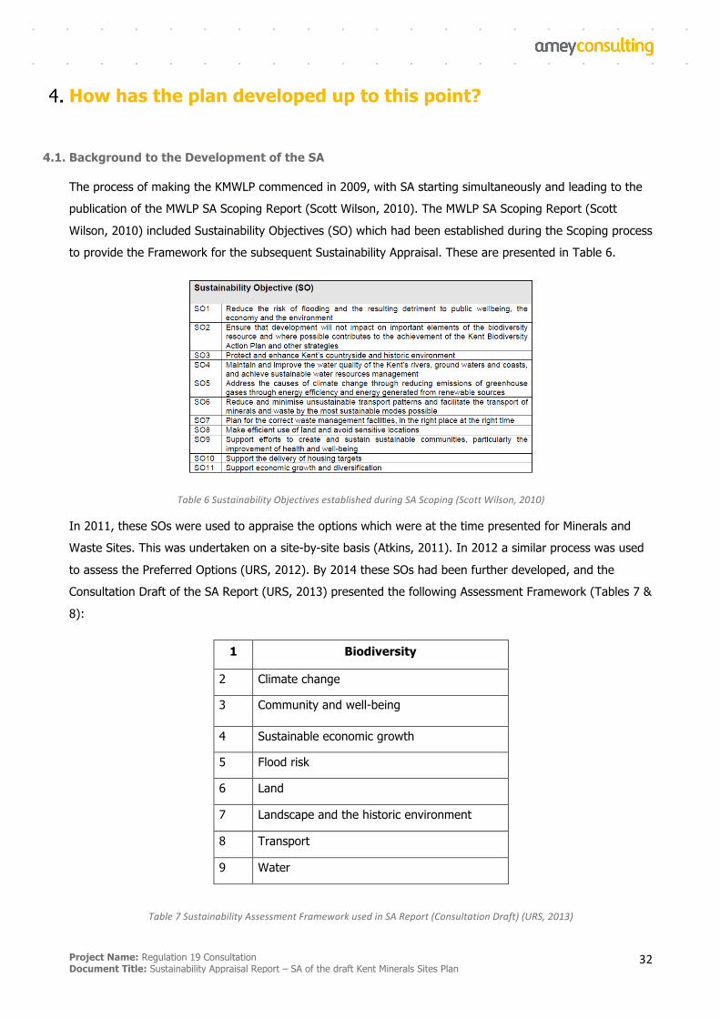
Project Name: Regulation 19 Consultation Document Title: Sustainability Appraisal Report – SA of the draft Kent Minerals Sites Plan
32
How has the plan developed up to this point?
4.1. Background to the Development of the SA
The process of making the KMWLP commenced in 2009, with SA starting simultaneously and leading to the
publication of the MWLP SA Scoping Report (Scott Wilson, 2010). The MWLP SA Scoping Report (Scott
Wilson, 2010) included Sustainability Objectives (SO) which had been established during the Scoping process
to provide the Framework for the subsequent Sustainability Appraisal. These are presented in Table 6.
Table6SustainabilityObjectivesestablishedduringSAScoping(ScottWilson,2010)
In 2011, these SOs were used to appraise the options which were at the time presented for Minerals and
Waste Sites. This was undertaken on a site-by-site basis (Atkins, 2011). In 2012 a similar process was used
to assess the Preferred Options (URS, 2012). By 2014 these SOs had been further developed, and the
Consultation Draft of the SA Report (URS, 2013) presented the following Assessment Framework (Tables 7 &
8):
1 Biodiversity
2 Climate change
3 Community and well-being
4 Sustainable economic growth
5 Flood risk
6 Land
7 Landscape and the historic environment
8 Transport
9 Water
Table7SustainabilityAssessmentFrameworkusedinSAReport(ConsultationDraft)(URS,2013)

Project Name: Regulation 19 Consultation Document Title: Sustainability Appraisal Report – SA of the draft Kent Minerals Sites Plan
33
The KMWLP was adopted in 2016 having been through full Sustainability Appraisal culminating in the SA
Report and Addenda (URS, 2013; URS, 2015; AECOM, 2015a and 2015b) and the SA Adoption Statement
(AECOM, 2016). Kent County Council (KCC) are now proceeding with their Minerals Sites Plan preparation
process. Kent’s Site Selection Methodology was published in June 2016.
4.2. The Development of the MSP
A Refresh Call for Sites took place from December 2016 to March 2017, resulting in 38 sites being submitted
to KCC for selection assessment, accompanied by a wide range of detailed technical and operational impact
data from applicants. For a site to be considered to be a Mineral Site Option it had to:
§ Align with the objectives of the adopted KMWLP and scope of the Sites Plan: The KWMLP sets out the
minerals supply needs and waste management capacity provision over the period 2013-2030 and the
Sites Plan needs to identify sufficient sites to contribute to this requirement.
§ Be justified: The site should represent an appropriate option based on a desktop assessment of the
opportunities and constraints associated with its location.
§ Be deliverable: Development of the site should not result in severe adverse effects that would affect
its deliverability, and its development should also be supported by the landowner
A number of sites were ruled out of consideration as reasonable alternatives and therefore were not subject
to KCC’s Regulation 18 ‘Minerals Sites Plan Options Consultation’. These are listed below with the reasons
why they are not being considered as reasonable alternatives.
• Paradise Farm
Majority of nominated site has recently been granted planning permission for brickearth extraction and
the remaining areas would not be viable.
The promoted site has and was the subject of a planning application in 2016 (ref. SW/0277/2016 for
0.885mt of Brickearth to be extracted over 19 years). This was permitted (January 2017) with
deletion of two working phases that were adjacent to Newington (phases 16 and 17) and a minor
area to the westerly quadrant of the site. This reduced the permitted reserve to 0.75mt to be
extracted over 18 years. The un-permitted areas are nominated for allocation in the Minerals Sites
Plan. The total reserve in Kent of Brickearth are 0.75mt at Paradise Farm, 0.15 mt at Orchard Farm,
an estimated 0.08mt at Hempstead House and Jeffries, Claxfield Road that has an estimated reserve
of 0.095mt. Overall the Kent Brickearth reserve is some 1.075mt. Those reserves under the control of
the promoter amount to 0.995mt of this and would provide for approximately 23-24 years, almost for
the required period of 25 years. The adopted Plan requires sites to be identified for the supply of
Brickearth to have reserves of at least 25 years to support the level of actual and proposed
Project Name: Regulation 19 Consultation Document Title: Sustainability Appraisal Report – SA of the draft Kent Minerals Sites Plan
34
investment of existing plant and equipment. Furthermore, the Brickearth resources that are still being
promoted represent areas that are considered too small to be sites in their own right and may be
unacceptable for material planning considerations.
• Norwood Quarry (Engineering Clay)
This site is identified in the Minerals Sites Plan though this site is an allocation in the adopted KMWLP.
Further supply of clay for engineering purposes has been promoted through the Call for Sites exercise,
as an extension to this site. The site promoter wishes to extract 1 million cubic metres of London Clay
(at a rate of 50,000 cubic metres per annum) in three phases (1-3). Phase 3 and part of Phase 2 is
currently the identified in the KMWLP as the strategic allocation for engineering clay extraction to meet
needs for the clay and to create void space for the disposal of residues from EfW processes in Kent.
Thus this strategic allocation currently adopted underpins the waste strategy needs of the KMWLP. The
promoted site extension has a Phase 1 and the majority of a Phase 2. These areas, together with the
adopted strategic allocation, would release significantly more engineering clay material than current
need suggests is required. The strategic allocation site is identified as an adequate clay reserve up to
2030 in the adopted KMWLP. The NPPF does not require specific landbanks to be maintained and no
justification is forthcoming by the site promoter as to why a significant quantity of further London Clay
reserves (in the region of some 1 million cubic metres or 1.826 million tonnes) is justified at this time.
• Richborough Road
A site providing this type of mineral is not required for allocation.
• Wrotham Quarry Extension (Silica Sand)
A site providing this type of mineral is not required for allocation.
Silica sand is a mineral that has national importance due to its limited distribution and its specialist
application in industrial processes such as glass manufacture and as a foundry sand amongst others. In
Kent the deposit is found in the Folkestone Formation as parts of the geological unit with particular
purity. The NPPF states: Minerals planning authorities should plan for a steady and adequate supply of industrial minerals by:
providing a stock of permitted reserves to support the level of actual and proposed investment required for new or existing plant and the maintenance and improvement of existing plant and equipment, as follows:
- at least 10 years for individual silica sand sites;
- at least 15 years for cement primary (chalk and limestone) and secondary (clay and shale) materials to maintain an existing plant, and for silica sand sites where significant new capital is required.
Project Name: Regulation 19 Consultation Document Title: Sustainability Appraisal Report – SA of the draft Kent Minerals Sites Plan
35
The adopted KMWLP states that the MPA will seek to permit sites to meet the above requirements and
that proposals will be considered on their merits having regard to the policies of the Development Plan
as a whole, with consideration of the technical matters and the husbanding of the material of high-grade
(pure) deposits for industrial end uses. The Plan does not require silica sand sites to be allocated in the
Mineral Sites plan and none have been promoted.
• Collarmakers Quarry
Geology includes part the complex Lambeth Group of sands, clays and gravels. The formation has been
quarried in the past (Upnor Quarry in Medway where the outcropped is a fine to medium grained clean
sand to sandy clay that can be well graded, rounded flint gravel is also present). The promoted site
reserve is only estimated (no bore hole data has been supplied) nor is there any supporting technical
evidence to demonstrate that the resource in this location is capable of yielding a building sand
aggregate.
• Wey Street Quarry
Geology includes part of the complex Lambeth Group of sands, clays and gravels. The formation has
been quarried in the past (Upnor Quarry in Medway where the outcropped is a fine to medium
grained clean sand to sandy clay that can be well graded, rounded flint gravel is also present). The
promoted site reserve is only estimated (no bore hole data has been supplied) nor is there any
supporting technical evidence to demonstrate that the resource in this location is capable of yielding
a sand and gravel aggregate.
• Hegdale Quarry
The nominated site is an extension to an existing quarry of the same name in the Kent Downs Area of
Outstanding Natural Beauty (AONB), a planning application would only be successful if it could be
demonstrated that there were exceptional circumstances justifying the extraction of chalk in this sensitive
landscape and it was in the public interest. Assessment of the site suggests that exceptional
circumstances would not exist and none have been advanced by the site promoter. Moreover the site has
an estimated 1.5 cubic million metres of chalk that would yield some 3.75mt of chalk and this reserve
alone would last for 58 years at the recorded 2011-14 average sales rate of extraction. The indicated
current chalk reserve position in Kent, that is sufficient for the anticipated Plan period, also suggests that
there is no need to identify the promoted site in the Minerals Sites Plan at this time. The recorded
average per annum sales for the period 2011-14 is 69,955 tonnes. Assuming the same sales per annum
for the period 2015-16 (0.14mt in total) the 2014 reserves of 1.50 mt would now be reduced to 1.37mt.
Assuming that extraction has remained at a level equivalent to the average of the 2011-14 period
(0.07mtpa) the current permitted reserves will be sufficient for 22 years, if sales have been lower, closer
to that recorded in 2014 (38,810 tonnes) then the permitted landbank could be sufficient for some 39
years. The Minerals Sites Plan is anticipated to be for the period 2019 to 20-30 a time of 11years.
Project Name: Regulation 19 Consultation Document Title: Sustainability Appraisal Report – SA of the draft Kent Minerals Sites Plan
36
Therefore there are sufficient permitted reserves of engineering and agricultural chalk in the county at
this time for the anticipated plan period.
• Richborough Hall
Sites already have benefit of full planning permission for waste treatment activities that give rise to
recycled aggregates from the Construction, Demolition and Excavation Waste stream. In this regard
the sites are fully operational and contributing to the current supply of recycled aggregates (844,946
tonnes in 2015 or 16.59% of overall supply of aggregates). The sites were promoted as sites that
could expand their waste role as waste facilities beyond current activities.
• Richborough Park
Sites already have benefit of full planning permission for waste treatment activities that give rise to
recycled aggregates from the Construction, Demolition and Excavation Waste stream. In this regard
the sites are fully operational and contributing to the current supply of recycled aggregates (844,946
tonnes in 2015 or 16.59% of overall supply of aggregates). The sites were promoted as sites that
could expand their waste role as waste facilities beyond current activities.
In Summer 2017 a Scoping exercise was undertaken by Amey, leading to the publication in November 2017
of a Scoping Report5 which developed the context and baseline for this MSP SA, and developed the SA
Framework and Objectives to be used in the appraisal (presented in Section 4.1).
Alongside publication of the SA Scoping Report, Kent County Council published a short list of options6 for
minerals sites being considered as allocations in the MSP. These sites were subject to an initial screening as
stage 2 of the KCC Site Selection Methodology, known as the ‘RAG’ assessment. The following sites were
published as options for consultation with a summary of the results of the Stage 2 RAG assessment:
§ site M2 Lydd Quarry Extensions
§ site M3 Chapel Farm
§ site M7 Central Road
§ site M8 West Malling Sandpit
§ site M9 The Postern
§ site M10 Moat Farm
5ScopingReport:SustainabilityAppraisaloftheKentMineralsSitesPlan-MakingProcess,Amey,November
2017
6MineralSitesPlanOptionsConsultation,KentCountyCouncil,September2017
Project Name: Regulation 19 Consultation Document Title: Sustainability Appraisal Report – SA of the draft Kent Minerals Sites Plan
37
§ site M11 Joyce Green Quarry
§ site M12 Postern Meadows
§ site M13 Stonecastle Farm Quarry Extension
Kent County Council identified the preferred site allocation options following a review of the information
obtained through the above consultation on options and gathering of more detailed information on the sites.
M9 was no longer being progressed because insufficient information has been obtained from the operator to
enable a detailed assessment of the site’s suitability to be made. Therefore the following options remained
as ‘reasonable alternatives’ to be considered for site allocations:
§ site M2 Lydd Quarry Extensions
§ site M3 Chapel Farm
§ site M7 Central Road
§ site M8 West Malling Sandpit
§ site M10 Moat Farm
§ site M11 Joyce Green Quarry
§ site M12 Postern Meadows
§ site M13 Stonecastle Farm Quarry Extension
These reasonable alternatives have been subject to SA in this report.
Following detailed technical assessment, review of further submissions to Kent County Council in relation to
the sites and the findings of this SA, several of the sites listed as reasonable alternatives have been ruled
out as proposed allocations in the Pre-submission MSP. These sites and the reason for rejection are as
follows:
• M2 Lydd Quarry Extensions
Likely unacceptable impacts upon the Dungeness, Romney Marsh and Rye Bay Special Protection Area
(SPA), the Special Area of Conservation (SAC) and the Ramsar Site; Likely unacceptable impact upon the
Dungeness, Romney Marsh and Rye Bay Site of Special Scientific Interest (SSSI). In respect of parcel 23
(Allen’s Bank), the likely unacceptable impact upon archaeological interests. It is noted that the impact
upon the setting and character of the historic town of Lydd is uncertain.
Project Name: Regulation 19 Consultation Document Title: Sustainability Appraisal Report – SA of the draft Kent Minerals Sites Plan
38
• M7 Central Road
Likely unacceptable highway impacts on Bob Dunn Way (A206) and on M25 Junction 1a (Dartford
Crossing), likely unacceptable loss of biodiversity habitat, impact upon Local Wildlife Sites (LWS) and UK
Biodiversity Action Plan (BAP) interests, likely unacceptable impacts on residential amenity, likely
unacceptable air quality impact on AQMA and conflict with Local Plan open space objectives.
• M8 West Malling Sandpit
Inconsistent with green belt policy with regard to inappropriate development. An alternative promoted
soft sand site at Chapel Farm, Lenham lies outside the Green Belt and is considered acceptable in
principle to meet the soft sand mineral requirements in Kent. It is not therefore reasonable to conclude
that the necessary ‘very special circumstances’ exist to override the presumption against inappropriate
development within the Green Belt. It is noted that the site is within the setting of the Kent Downs Area
of Outstanding Natural Beauty (AONB) and the impacts upon the AONB are uncertain.
• M11 Joyce Green Quarry
Likely unacceptable highway impacts on Bob Dunn Way (A206) and on M25 Junction 1a (Dartford
Crossing), likely unacceptable air quality impact on AQMA, likely unacceptable loss of biodiversity habitat,
impact upon LWS and UK Biodiversity Action Plan (BAP) interests and uncertainty that restoration
proposals would meet ecological objectives to replace habitat. The mineral proposal is considered to be
inappropriate development within the Green Belt through restoration proposals and harm arising from
highway impacts, air quality and biodiversity impacts.
• M12 Postern Meadows
Insufficient evidence to conclude with any certainty that the development is acceptable in principle for
mineral development.
Three sites are proposed for allocation in the Pre-submission MSP. These sites are judged to have
acceptable or mitigable impacts following detailed technical assessment, consultation and review of the
findings of the SA:
• M3 Chapel Farm
The western part of the site is suitable for allocation in Pre-Submission Draft MSP, subject to meeting
development management criteria at planning application stage. The eastern part of the site has been
withdrawn by the promoter due to likely unacceptable impact on heritage asset.
• M10 Moat Farm
Suitable for allocation in Pre-Submission Draft MSP, subject to meeting development management
criteria at planning application stage.
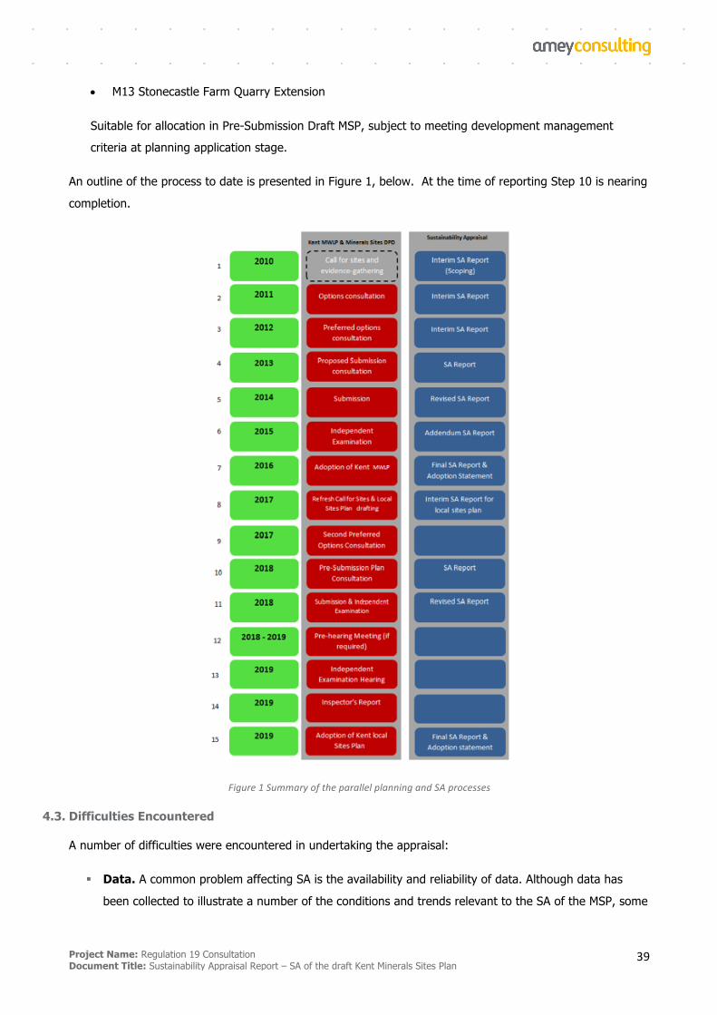
Project Name: Regulation 19 Consultation Document Title: Sustainability Appraisal Report – SA of the draft Kent Minerals Sites Plan
39
• M13 Stonecastle Farm Quarry Extension
Suitable for allocation in Pre-Submission Draft MSP, subject to meeting development management
criteria at planning application stage.
An outline of the process to date is presented in Figure 1, below. At the time of reporting Step 10 is nearing
completion.
Figure1SummaryoftheparallelplanningandSAprocesses
4.3. Difficulties Encountered
A number of difficulties were encountered in undertaking the appraisal:
§ Data. A common problem affecting SA is the availability and reliability of data. Although data has
been collected to illustrate a number of the conditions and trends relevant to the SA of the MSP, some
Project Name: Regulation 19 Consultation Document Title: Sustainability Appraisal Report – SA of the draft Kent Minerals Sites Plan
40
data sets are more useful than others, and some data sets are known to be old, incomplete or
unreliable. In some cases, no data is available. It is therefore almost impossible to quantify effects
with total certainty. The SA has relied on technical assessments produced by other organisations,
either by the promoter of a site or their agents/consultants or on information provided by consultees
including statutory consultees. The sites typically had varying amounts of information available in
technical assessments.
§ Uncertainty. Some of the sites proposed for mineral development are accompanied by proposals for
mitigation of some impacts. Until planning applications are submitted and full operational details and
an Environmental Statement are provided, it is not possible to be certain how significant the impacts
will be and whether impacts can be successfully mitigated. All of the sites that are allocated in the
MSP will be required to be compliant with the policies in the KMWLP but it has not been assumed that
this will be sufficient to guarantee no adverse impacts. The SA makes recommendations for
mitigation of effects, including where this should be addressed within planning applications when
sufficient technical detail is available.
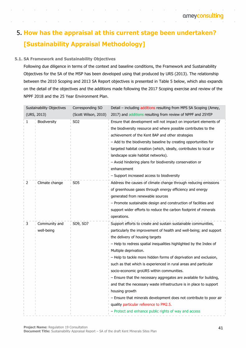
Project Name: Regulation 19 Consultation Document Title: Sustainability Appraisal Report – SA of the draft Kent Minerals Sites Plan
41
How has the appraisal at this current stage been undertaken?
[Sustainability Appraisal Methodology]
5.1. SA Framework and Sustainability Objectives
Following due diligence in terms of the context and baseline conditions, the Framework and Sustainability
Objectives for the SA of the MSP has been developed using that produced by URS (2013). The relationship
between the 2010 Scoping and 2013 SA Report objectives is presented in Table 5 below, which also expands
on the detail of the objectives and the additions made following the 2017 Scoping exercise and review of the
NPPF 2018 and the 25 Year Environment Plan.
Sustainability Objectives
(URS, 2013)
Corresponding SO
(Scott Wilson, 2010)
Detail – including additions resulting from MPS SA Scoping (Amey,
2017) and additions resulting from review of NPPF and 25YEP
1 Biodiversity SO2 Ensure that development will not impact on important elements of
the biodiversity resource and where possible contributes to the
achievement of the Kent BAP and other strategies
– Add to the biodiversity baseline by creating opportunities for
targeted habitat creation (which, ideally, contributes to local or landscape scale habitat networks).
– Avoid hindering plans for biodiversity conservation or
enhancement
– Support increased access to biodiversity
2 Climate change SO5 Address the causes of climate change through reducing emissions
of greenhouse gases through energy efficiency and energy
generated from renewable sources
– Promote sustainable design and construction of facilities and
support wider efforts to reduce the carbon footprint of minerals
operations.
3 Community and
well-being
SO9, SO7 Support efforts to create and sustain sustainable communities,
particularly the improvement of health and well-being; and support the delivery of housing targets
– Help to redress spatial inequalities highlighted by the Index of
Multiple deprivation.
– Help to tackle more hidden forms of deprivation and exclusion,
such as that which is experienced in rural areas and particular
socio-economic groURS within communities.
– Ensure that the necessary aggregates are available for building,
and that the necessary waste infrastructure is in place to support
housing growth
– Ensure that minerals development does not contribute to poor air quality particular reference to PM2.5.
– Protect and enhance public rights of way and access
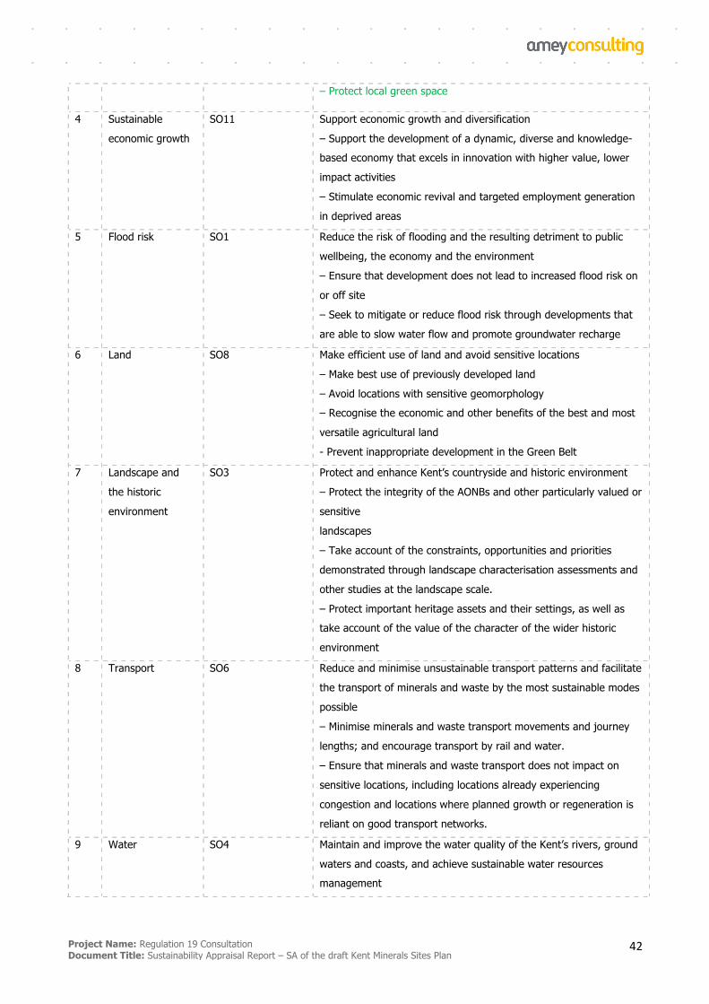
Project Name: Regulation 19 Consultation Document Title: Sustainability Appraisal Report – SA of the draft Kent Minerals Sites Plan
42
– Protect local green space
4 Sustainable
economic growth
SO11 Support economic growth and diversification
– Support the development of a dynamic, diverse and knowledge-based economy that excels in innovation with higher value, lower
impact activities
– Stimulate economic revival and targeted employment generation
in deprived areas
5 Flood risk SO1 Reduce the risk of flooding and the resulting detriment to public
wellbeing, the economy and the environment
– Ensure that development does not lead to increased flood risk on
or off site
– Seek to mitigate or reduce flood risk through developments that
are able to slow water flow and promote groundwater recharge
6 Land SO8 Make efficient use of land and avoid sensitive locations
– Make best use of previously developed land
– Avoid locations with sensitive geomorphology – Recognise the economic and other benefits of the best and most
versatile agricultural land
- Prevent inappropriate development in the Green Belt
7 Landscape and
the historic
environment
SO3 Protect and enhance Kent’s countryside and historic environment
– Protect the integrity of the AONBs and other particularly valued or
sensitive
landscapes
– Take account of the constraints, opportunities and priorities
demonstrated through landscape characterisation assessments and
other studies at the landscape scale.
– Protect important heritage assets and their settings, as well as take account of the value of the character of the wider historic
environment
8 Transport SO6 Reduce and minimise unsustainable transport patterns and facilitate
the transport of minerals and waste by the most sustainable modes
possible
– Minimise minerals and waste transport movements and journey
lengths; and encourage transport by rail and water.
– Ensure that minerals and waste transport does not impact on
sensitive locations, including locations already experiencing
congestion and locations where planned growth or regeneration is
reliant on good transport networks.
9 Water SO4 Maintain and improve the water quality of the Kent’s rivers, ground
waters and coasts, and achieve sustainable water resources management
Project Name: Regulation 19 Consultation Document Title: Sustainability Appraisal Report – SA of the draft Kent Minerals Sites Plan
43
– Ensure that minerals and waste development seeks to promote the conservation of water resources wherever possible particular
reference to abstraction.
– Avoid pollution of ground or surface waters, particularly in areas
identified as being at risk or sensitive
Scoped out of URS
(2013)
SO10 [waste]
Table8SAFramework
5.2. Applying the Framework
5.2.1 Effects Categories and Assumptions
The SA of sites was undertaken by URS in 2012 for the sites that at the time were deemed to be Preferred
Options. Although the outcome of this exercise is no longer relevant due to subsequent changes to the
MWLP and different sites being put forward at the refresh call for sites, the Effects Categories (Figure 2) and
underpinning assumptions (as amended) (Appendix B) have been used in the current exercise.
Figure2Effectscategories(URS,2012)
5.2.2 SA of the Site Selection Methodology
Kent’s Site Selection Methodology was published in June 2016 and is comprehensively detailed in the MSP
Scoping Report (Amey, 2017). In brief, it has four stages as follows – of which Stages 1 and 2 have been
undertaken to date [and of which SA forms part of Stage 3]:
§ Stage 1 - Alignment with Scope of Sites Plan
§ Stage 2 - Initial Screening – RAG rating to define the ‘Reasonable Alternatives' (Appendix B).
§ Stage 3 - Detailed Technical Assessment to demonstrate sites’ potential as possible ‘Preferred Options’
for allocation in the Minerals Sites Plan. For the Preferred Options Consultation stage of the Kent
Minerals Sites Plan technical assessment is more limited to an understanding of the main constraints
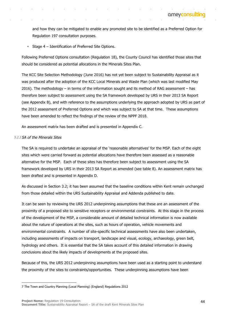
Project Name: Regulation 19 Consultation Document Title: Sustainability Appraisal Report – SA of the draft Kent Minerals Sites Plan
44
and how they can be mitigated to enable any promoted site to be identified as a Preferred Option for
Regulation 197 consultation purposes.
§ Stage 4 – Identification of Preferred Site Options.
Following Preferred Options consultation (Regulation 18), the County Council has identified those sites that
should be considered as potential allocations in the Minerals Sites Plan.
The KCC Site Selection Methodology (June 2016) has not yet been subject to Sustainability Appraisal as it
was produced after the adoption of the KCC Local Minerals and Waste Plan (which was last modified May
2016). The methodology – in terms of the information sought and its method of RAG assessment – has
therefore been subject to assessment using the SA framework developed by URS in their 2013 SA Report
(see Appendix B), and with reference to the assumptions underlying the approach adopted by URS as part of
the 2012 assessment of Preferred Options and which was subject to SA at that time. These assumptions
have been amended to reflect the findings of the review of the NPPF 2018.
An assessment matrix has been drafted and is presented in Appendix C.
5.2.3 SA of the Minerals Sites
The SA is required to undertake an appraisal of the ‘reasonable alternatives’ for the MSP. Each of the eight
sites which were carried forward as potential allocations have therefore been assessed as a reasonable
alternative for the MSP. Each of these sites has therefore been subject to assessment using the SA
framework developed by URS in their 2013 SA Report as amended (see table 8). An assessment matrix has
been drafted and is presented in Appendix D.
As discussed in Section 3.2; it has been assumed that the baseline conditions within Kent remain unchanged
from those detailed within the URS Sustainability Appraisal and Addenda published to date.
It can be seen by reviewing the URS 2012 underpinning assumptions that these are an assessment of the
proximity of a proposed site to sensitive receptors or environmental constraints. At this stage in the process
of the development of the MSP, a considerable amount of detailed technical information is now available
about the nature of operations at the sites, such as hours of operation, vehicle movements and
environmental constraints. A number of site-specific technical assessments have also been undertaken,
including assessments of impacts on transport, landscape and visual, ecology, archaeology, green belt,
hydrology and others. It is essential that the SA takes account of this detailed information in drawing
conclusions about the likely impacts of developments at the proposed sites.
Because of this, the URS 2012 underpinning assumptions have been used as a starting point to understand
the proximity of the sites to constraints/opportunities. These underpinning assumptions have been
7 The Town and Country Planning (Local Planning) (England) Regulations 2012
Project Name: Regulation 19 Consultation Document Title: Sustainability Appraisal Report – SA of the draft Kent Minerals Sites Plan
45
supplemented by the available technical information to make a more accurate assessment of the likelihood
and significance of any impacts rather than simply the proximity of a site to constraints/opportunities.
The appraisal of sites has considered a range of different types of effects as required by Annex I of the SEA
Directive, namely: secondary effects; effects in the short, medium and long term; whether effects are
permanent or temporary; and positive and negative effects. The type of effects identified are indicated in
the tables in Appendix D.
Effects are identified in the short, medium and long term. To make this assessment, the short term has
been chosen as being within the first 5 years of adoption of the MSP, the medium term is considered to be
the operational life of the site and the long term is after the site has been restored.
An assessment has also been made of the probability of the identified effect occurring (low, medium or
high), whether the effect is direct or indirect, and whether the effect is temporary or permanent indicated by
whether or not the effect could be reversed.
Cumulative and synergistic effects are discussed in Section 6.4.
In order to determine the significance of effects, the appraisal has followed the criteria for determining
significance as set out in Annex II of the SEA Directive.
Sites which come forward for development under the MSP will be required to comply with policies in the
KMWLP. These include development management policies in the KMWLP to manage and mitigate the
impacts of development. For several of the sites, but not all sites, the promoters have proposed mitigation
measures to address likely impacts that have already been identified. In undertaking the appraisal, it has
been assumed that any mitigation that has already been proposed will be implemented to address the
potential impacts of development. It is also assumed that if no mitigation has been proposed then the
potential effects are unmitigated at this stage. In order to comply with development management policies in
the KMWLP, it is expected that sites will be required to provide mitigation where necessary or desirable, but
no assumptions have been made as to what that mitigation would be and whether it would be sufficient to
address impacts.
The appraisal has assessed the likely effects arising from development at each of the sites. Where
appropriate, the appraisal has made recommendations for mitigation which is necessary or desirable to
address the predicted effects of development. These recommendations are set out in the tables in Appendix
D.
5.2.4 SA of Alternatives to Land-Won Aggregates
With its coastal location, Kent fulfils an important role in the importation of minerals including a range of
construction aggregates from mainland Europe, as well as marine dredged aggregates (MDA) and imported
recycled and secondary materials. Kent benefits from a number of aggregate wharves, into which significant
quantities of MDA and crushed rock are landed, 1.7 million tonnes (mt) being imported into its wharves in
Project Name: Regulation 19 Consultation Document Title: Sustainability Appraisal Report – SA of the draft Kent Minerals Sites Plan
46
2013 and of the total of 3.13mt of MDA landed in Kent and Medway in 2009 (1.41mt into Kent), 2.5mt was
consumed within Kent and Medway. Land-won sharp sand and gravel is also imported by rail and road from
areas beyond Kent. Assurances regarding the security of these minerals imports during the Plan period were
obtained in developing the KMWLP.
In addition to the land-won maintenance of landbanks to support a steady future supply of aggregate in
Kent, policy CSM 8 of the adopted Kent Minerals and Waste Local Plan 2013-30 states that sites will be
identified in a Minerals Sites Plan to produce recycled and secondary aggregates to ensure a processing
capacity of at least 2.7 million tonnes to maximise the availability of alternatives to marine-won and local
land-won sand and gravel extraction. Current capacity of production in this sector is some 3.45 million
tonnes per annum. Additional sites were therefore not needed at the time of development of the KMWLP to
meet the Plan’s requirements.
The KMWLP contains strategic objectives to
§ Promote and encourage the use of recycled and secondary aggregates in place of land-won minerals.
§ Safeguard existing, planned and potential sites for mineral infrastructure including wharves and rail
depots across Kent to enable the on-going transportation of marine dredged aggregates, crushed rock
and other minerals as well as other production facilities.
The KMWLP also contains policy to support the increased use of secondary and recycled aggregates and
wharves and rail depots:
§ Policy CSM seeks to maintain and increase production capacity of secondary and recycled aggregates;
§ Policy CSM 6 seeks to prevent non-minerals development that may unacceptably adversely affect the
operation of existing, planned or potential safeguarded wharves and rail depots, such that their
capacity or viability for minerals transportation purposes may be compromised.
The most recent Local Aggregates Assessment8 reports that with regard to recycled and secondary
aggregates and wharves there is significant available headroom. In 2016 it is shown that there was a spare
capacity of 73% for managing recycled and secondary aggregate and 75% spare capacity for managing
mineral at wharves. There is potential to provide almost an additional 2.8 million tonnes of secondary and
recycled aggregates over the current demand of 1.03 million tonnes if more CD&E waste becomes available
to contribute to aggregate supply needs. The rail depots would appear to have less capacity headroom,
though sufficient capacity to cope with an increase to ensure an adequate and steady supply of aggregate.
Importation of aggregates in the form of largely marine dredged sands and gravels and crushed rock
continue to be very significant in overall supply terms, accounting for 3.55 million tonnes of the total 6.14
8 Local Aggregates Assessment 2017, Kent County Council, May 2018
Project Name: Regulation 19 Consultation Document Title: Sustainability Appraisal Report – SA of the draft Kent Minerals Sites Plan
47
million tonnes produced overall in Kent in 2016. This accounts for almost 58% of total supply. In both
cases the last three year sales averages are greater than the last 10 year sales average for imported crushed
rock and marine dredged aggregates which clearly indicates that importation is becoming more important
than the land-won alternatives in overall supply terms. Soft sand is not generally supplied from marine won
sources and so remains essentially a Kent land-won resource that is not being supplanted in the supply chain
by imports to any great extent. The wharves in Kent are operating at 25% of their available capacity and,
while this appears low, the Local Aggregates Assessment reports that as the land-won reserves of sharp
sands and gravels are depleted the need for marine dredged sands and gravels to meet identifiable and
objectively assessed needs will increase.
The 2017 LAA reports the Crown Estate as stating in 2012 that “The marine aggregate resource available in
the East Coast, Thames Estuary and East English Channel areas and which are used to supply Kent wharves
is 994 million tonnes of which 31.25 million tonnes is permitted for extraction per annum. Kent wharves
only received some 1.3 million tonnes (4.2% of total permitted per annum) in 2010, but increased in 2011
with 1.55 million tonnes (5%). There is therefore a long term viable and sustainable supply of marine
dredged aggregate both for construction uses and for direct beach nourishment by vessel delivery.”
It is therefore reasonable to assume that an increased supply of secondary and recycled aggregates and
MDA is an alternative to the mining of some land-won sharp sand and gravels. It is also reasonable to
assume that some land-won aggregates could be imported into Kent from sites outside of Kent. This has
therefore been appraised as an alternative to the allocation of sites for sharp sand and gravel. The results
of this appraisal are set out in detail in Appendix E and summarised in Section 6.3.
The same is not true for soft sands. Artificial ‘soft sands’ have not been developed (if technically possible)
and soft sands as imports are relatively marginal in the overall supply chain. It is clear that an alternative to
the land-won soft sands, that will provide a steady and adequate supply as required by the National Planning
Policy Framework, is unavailable at this time. Neighbouring authorities support the allocation of sites
suitable for the development of soft sand on the basis that this would help address a wider issue that the
vast majority of soft sand in the unconstrained south east is being progressively exhausted, and much of
what remains is constrained by designations such as AONBs or National Parks (such as the South Downs).
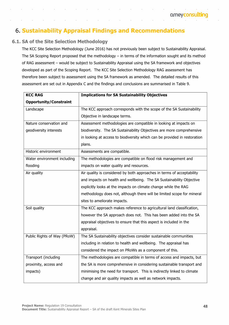
Project Name: Regulation 19 Consultation Document Title: Sustainability Appraisal Report – SA of the draft Kent Minerals Sites Plan
48
Sustainability Appraisal Findings and Recommendations
6.1. SA of the Site Selection Methodology The KCC Site Selection Methodology (June 2016) has not previously been subject to Sustainability Appraisal.
The SA Scoping Report proposed that the methodology – in terms of the information sought and its method
of RAG assessment – would be subject to Sustainability Appraisal using the SA framework and objectives
developed as part of the Scoping Report. The KCC Site Selection Methodology RAG assessment has
therefore been subject to assessment using the SA framework as amended. The detailed results of this
assessment are set out in Appendix C and the findings and conclusions are summarised in Table 9.
KCC RAG
Opportunity/Constraint
Implications for SA Sustainability Objectives
Landscape The KCC approach corresponds with the scope of the SA Sustainability
Objective in landscape terms.
Nature conservation and
geodiversity interests
Assessment methodologies are compatible in looking at impacts on
biodiversity. The SA Sustainability Objectives are more comprehensive
in looking at access to biodiversity which can be provided in restoration
plans.
Historic environment Assessments are compatible.
Water environment including
flooding
The methodologies are compatible on flood risk management and
impacts on water quality and resources.
Air quality Air quality is considered by both approaches in terms of acceptability
and impacts on health and wellbeing. The SA Sustainability Objective
explicitly looks at the impacts on climate change while the RAG
methodology does not, although there will be limited scope for mineral
sites to ameliorate impacts.
Soil quality The KCC approach makes reference to agricultural land classification,
however the SA approach does not. This has been added into the SA
appraisal objectives to ensure that this aspect is included in the
appraisal.
Public Rights of Way (PRoW) The SA Sustainability objectives consider sustainable communities
including in relation to health and wellbeing. The appraisal has
considered the impact on PRoWs as a component of this.
Transport (including
proximity, access and
impacts)
The methodologies are compatible in terms of access and impacts, but
the SA is more comprehensive in considering sustainable transport and
minimising the need for transport. This is indirectly linked to climate
change and air quality impacts as well as network impacts.
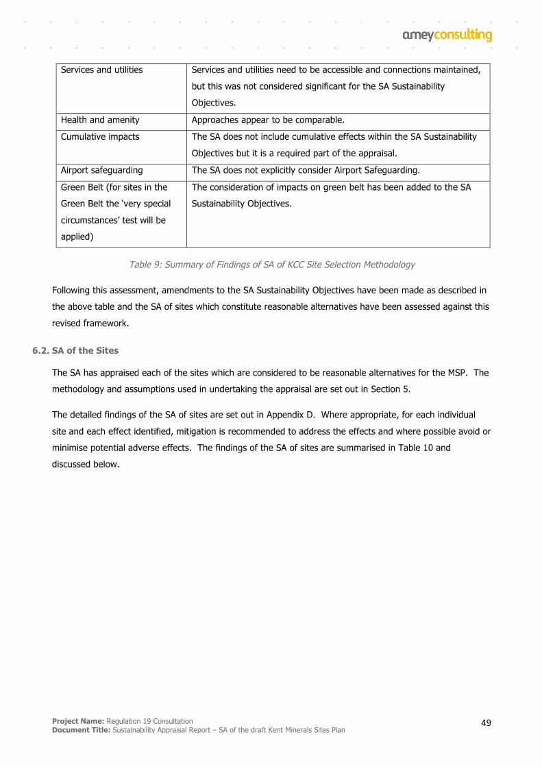
Project Name: Regulation 19 Consultation Document Title: Sustainability Appraisal Report – SA of the draft Kent Minerals Sites Plan
49
Services and utilities Services and utilities need to be accessible and connections maintained,
but this was not considered significant for the SA Sustainability
Objectives.
Health and amenity Approaches appear to be comparable.
Cumulative impacts The SA does not include cumulative effects within the SA Sustainability
Objectives but it is a required part of the appraisal.
Airport safeguarding The SA does not explicitly consider Airport Safeguarding.
Green Belt (for sites in the
Green Belt the ‘very special
circumstances’ test will be
applied)
The consideration of impacts on green belt has been added to the SA
Sustainability Objectives.
Table 9: Summary of Findings of SA of KCC Site Selection Methodology
Following this assessment, amendments to the SA Sustainability Objectives have been made as described in
the above table and the SA of sites which constitute reasonable alternatives have been assessed against this
revised framework.
6.2. SA of the Sites
The SA has appraised each of the sites which are considered to be reasonable alternatives for the MSP. The
methodology and assumptions used in undertaking the appraisal are set out in Section 5.
The detailed findings of the SA of sites are set out in Appendix D. Where appropriate, for each individual
site and each effect identified, mitigation is recommended to address the effects and where possible avoid or
minimise potential adverse effects. The findings of the SA of sites are summarised in Table 10 and
discussed below.
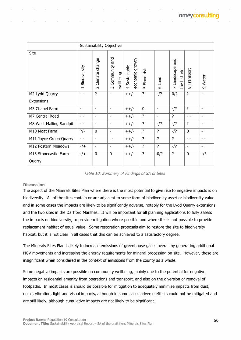
Project Name: Regulation 19 Consultation Document Title: Sustainability Appraisal Report – SA of the draft Kent Minerals Sites Plan
50
Sustainability Objective
Site
1 Bi
odiv
ersit
y
2 Cl
imat
e ch
ange
3 Co
mm
unity
and
wel
lbei
ng
4 Su
stai
nabl
e
econ
omic
grow
th
5 Fl
ood
risk
6 La
nd
7 La
ndsc
ape
and
the
hist
oric
envi
ronm
ent
8 Tr
ansp
ort
9 W
ater
M2 Lydd Quarry
Extensions
- - ? - ++/- ? -/? 0/? ? -
M3 Chapel Farm - - - ++/- 0 - -/? ? -
M7 Central Road - - - - ++/- ? - ? - - -
M8 West Malling Sandpit - - - - ++/- ? -/? -/? ? -
M10 Moat Farm ?/- 0 - ++/- ? ? -/? 0 -
M11 Joyce Green Quarry - - - - ++/- ? ? ? - - - -
M12 Postern Meadows -/+ - - ++/- ? ? -/? - -
M13 Stonecastle Farm
Quarry
-/+ 0 0 ++/- ? 0/? ? 0 -/?
Table 10: Summary of Findings of SA of Sites
Discussion The aspect of the Minerals Sites Plan where there is the most potential to give rise to negative impacts is on
biodiversity. All of the sites contain or are adjacent to some form of biodiversity asset or biodiversity value
and in some cases the impacts are likely to be significantly adverse, notably for the Lydd Quarry extensions
and the two sites in the Dartford Marshes. It will be important for all planning applications to fully assess
the impacts on biodiversity, to provide mitigation where possible and where this is not possible to provide
replacement habitat of equal value. Some restoration proposals aim to restore the site to biodiversity
habitat, but it is not clear in all cases that this can be achieved to a satisfactory degree.
The Minerals Sites Plan is likely to increase emissions of greenhouse gases overall by generating additional
HGV movements and increasing the energy requirements for mineral processing on site. However, these are
insignificant when considered in the context of emissions from the county as a whole.
Some negative impacts are possible on community wellbeing, mainly due to the potential for negative
impacts on residential amenity from operations and transport, and also on the diversion or removal of
footpaths. In most cases is should be possible for mitigation to adequately minimise impacts from dust,
noise, vibration, light and visual impacts, although in some cases adverse effects could not be mitigated and
are still likely, although cumulative impacts are not likely to be significant.
Project Name: Regulation 19 Consultation Document Title: Sustainability Appraisal Report – SA of the draft Kent Minerals Sites Plan
51
The Minerals Sites Plan will help to contribute to economic growth by providing a supply of minerals to
support construction and potentially other economic sectors that depend on aggregates. By facilitating the
extraction of primary aggregates, the Minerals Sites Plan is exploiting a non-renewable resource, which
cannot be considered sustainable.
Some of the minerals sites lie within Flood Zone 3. In these cases, it must be demonstrated that
development can take place without adversely affecting flood risk and where possible contributing to a
reduction in overall flood risk.
Some of the minerals sites contain soils which are classed as the best and most versatile agricultural land.
In some cases this soil will be lost as restoration is to wetland/open water. If the restoration is to
agricultural land, this should be to at least the grade of soil removed, and where possible the same soil
should be retained for reuse. In one case, development of the site will result in the removal of a
geomorphological SSSI. Some of the sites lie within the Metropolitan Green Belt, in which case it must be
demonstrated that operations will not constitute inappropriate development or constitute very special
circumstances. Given that sites will be restored to agricultural or wetland habitat, lasting cumulative impacts
on the Green Belt are not envisaged.
There is the potential for several of the sites to have impacts on landscape and on the historic environment.
However, it will be possible to provide mitigation such that the significance of impacts is minimised. Adverse
impacts on the AONBs are not likely to be significant.
Minerals sites generate vehicle movements accessing and leaving the sites. The majority of these are HGV
movements and it is estimated that these will range between 3 movements per hour to 9 movements per
hour depending on the site. In addition, staff vehicles will access the sites, ranging from an estimated 6 to
12 movements per day. For sites M10 and M13, operations are planned to run sequentially with existing
extraction in the locality so that the impacts from vehicles are likely to be no greater than existing impacts.
It is possible for cumulative impacts from transport to occur from more than one minerals site, in the case of
M7 which would act cumulatively with site M11, and in the case of M12 which would act cumulatively with
sites M10 and M13. However, the scale of the cumulative impact of the MSP overall is not expected to be
great given the predicted number of movements and the context of all traffic movements in the county. The
area with potentially the most significant constraint is for sites M7 and M11 in the context of congestion on
the M25 and local roads. These sites must be able to demonstrate the road network is able to
accommodate site traffic without adverse impacts on congestion and air quality. It is unlikely that the
Minerals Sites Plan will support the use of sustainable modes of transport for minerals.
Some of the minerals sites have the potential for significant impacts on hydrology/hydrogeology and water
quality. In some cases operation and/or restoration to wetland could affect local hydrology. However, the
cumulative impacts from all sites in the Minerals Sites Plan is not expected to be significant for the county as
a whole.
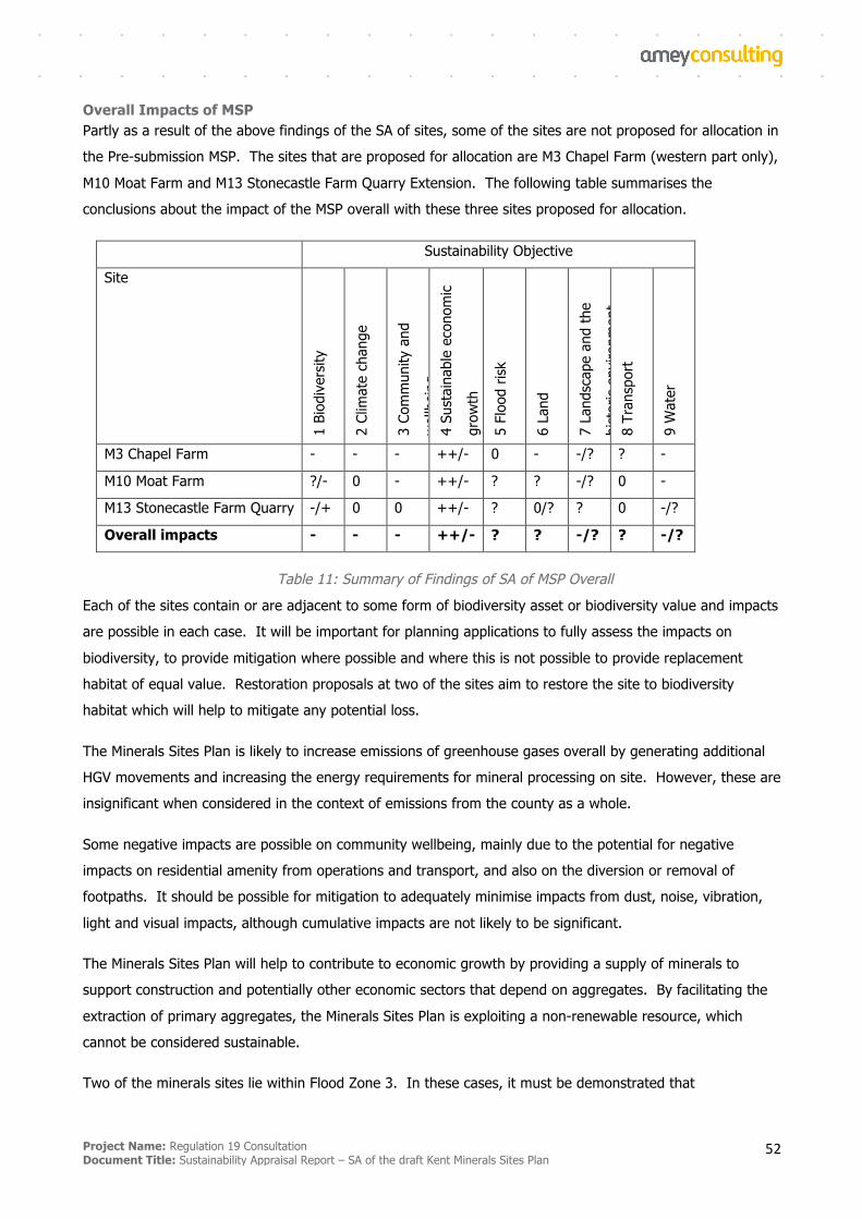
Project Name: Regulation 19 Consultation Document Title: Sustainability Appraisal Report – SA of the draft Kent Minerals Sites Plan
52
Overall Impacts of MSP Partly as a result of the above findings of the SA of sites, some of the sites are not proposed for allocation in
the Pre-submission MSP. The sites that are proposed for allocation are M3 Chapel Farm (western part only),
M10 Moat Farm and M13 Stonecastle Farm Quarry Extension. The following table summarises the
conclusions about the impact of the MSP overall with these three sites proposed for allocation.
Sustainability Objective
Site
1 Bi
odiv
ersit
y
2 Cl
imat
e ch
ange
3 Co
mm
unity
and
wel
lbei
ng
4 Su
stai
nabl
e ec
onom
ic
grow
th
5 Fl
ood
risk
6 La
nd
7 La
ndsc
ape
and
the
hist
oric
envi
ronm
ent
8 Tr
ansp
ort
9 W
ater
M3 Chapel Farm - - - ++/- 0 - -/? ? -
M10 Moat Farm ?/- 0 - ++/- ? ? -/? 0 -
M13 Stonecastle Farm Quarry -/+ 0 0 ++/- ? 0/? ? 0 -/?
Overall impacts - - - ++/- ? ? -/? ? -/?
Table 11: Summary of Findings of SA of MSP Overall Each of the sites contain or are adjacent to some form of biodiversity asset or biodiversity value and impacts
are possible in each case. It will be important for planning applications to fully assess the impacts on
biodiversity, to provide mitigation where possible and where this is not possible to provide replacement
habitat of equal value. Restoration proposals at two of the sites aim to restore the site to biodiversity
habitat which will help to mitigate any potential loss.
The Minerals Sites Plan is likely to increase emissions of greenhouse gases overall by generating additional
HGV movements and increasing the energy requirements for mineral processing on site. However, these are
insignificant when considered in the context of emissions from the county as a whole.
Some negative impacts are possible on community wellbeing, mainly due to the potential for negative
impacts on residential amenity from operations and transport, and also on the diversion or removal of
footpaths. It should be possible for mitigation to adequately minimise impacts from dust, noise, vibration,
light and visual impacts, although cumulative impacts are not likely to be significant.
The Minerals Sites Plan will help to contribute to economic growth by providing a supply of minerals to
support construction and potentially other economic sectors that depend on aggregates. By facilitating the
extraction of primary aggregates, the Minerals Sites Plan is exploiting a non-renewable resource, which
cannot be considered sustainable.
Two of the minerals sites lie within Flood Zone 3. In these cases, it must be demonstrated that
Project Name: Regulation 19 Consultation Document Title: Sustainability Appraisal Report – SA of the draft Kent Minerals Sites Plan
53
development can take place without adversely affecting flood risk and where possible contributing to a
reduction in overall flood risk.
One of the minerals sites contains soil which is classed as the best and most versatile agricultural land,
although restoration to agricultural land is proposed and therefore the impact of the MSP on soil quality is
not likely to be significant. Two of the sites lie within the Metropolitan Green Belt, in which case it must be
demonstrated that operations will not constitute inappropriate development or constitute very special
circumstances. Given that sites will be restored to wetland habitat, lasting cumulative impacts on the Green
Belt are not envisaged.
There is the potential for the sites to have limited impacts on landscape and on the historic environment.
However, it will be possible to provide mitigation such that the significance of impacts is minimised. Adverse
impacts on the AONBs are not likely to be significant.
Minerals sites generate vehicle movements accessing and leaving the sites. The majority of these are HGV
movements and it is estimated that these will range between 4 movements per hour to 8 movements per
hour depending on the site. In addition, staff vehicles will access the sites, around an estimated 10
movements per day. For sites M10 and M13, operations are planned to run sequentially with existing
extraction in the locality so that the impacts from vehicles are likely to be no greater than existing impacts.
The scale of the cumulative impact of the MSP overall is not expected to be great given the predicted
number of movements and the context of all traffic movements in the county. It is unlikely that the Minerals
Sites Plan will support the use of sustainable modes of transport for minerals, although the KMWLP
safeguards railheads and wharves to support rail and water transport of minerals.
Each of the minerals sites have the potential for significant impacts on hydrology/hydrogeology and water
quality. Restoration to wetland could affect local hydrology. However, the cumulative impacts from all sites
in the Minerals Sites Plan is not expected to be significant for the county as a whole.
6.3. SA of the Alternatives to Land-Won Sand and Gravel
In addition to the site options of the MSP, the SA has identified that there is an alternative to the allocation
of sites for extraction of land-won aggregates and that is the increased supply of secondary and recycled
aggregates, marine-dredged aggregates and import of land-won aggregates from outside of Kent. The
detailed findings of the SA of this alternative are presented in Appendix E and summarised below.
The increased supply of marine-dredged aggregates (MDA), secondary and recycled aggregates and land-
won aggregates from outside Kent will help to reduce the potential negative impacts associated with
proposed site allocations. These include negative impacts on biodiversity, water quantity and quality,
landscape, the historic environment, agricultural land, Green Belt and flood risk which are associated with
some of the sites. Some of these negative impacts from some land-won aggregate sites are still likely as
sites are still likely to be needed to meet requirements. The scale of the benefits will depend on which sites
are replaced by the supply of alternatives which is unknown.
Project Name: Regulation 19 Consultation Document Title: Sustainability Appraisal Report – SA of the draft Kent Minerals Sites Plan
54
Opportunities for habitat improvement and improved access through restoration will be lost, although the
loss of this benefit is unlikely to be significant. There may be biodiversity impacts associated with transport
of alternative aggregates through noise, disturbance and effects on air quality, but this is unlikely to be
significantly different from that associated with land-won aggregates. MDA may have adverse effects on
marine biodiversity, but the likelihood and significance of any effects is unknown.
The increased supply of secondary and recycled aggregates and MDA will contribute to ensuring the supply
of aggregates to support construction to the benefit of current and future communities and to support
economic growth. The use of secondary and recycled aggregates avoids the use of non-renewable
resources and therefore constitutes a more sustainable route to growth. The use of MDA is a non-renewable
resource and is not a sustainable route to growth.
There may be some scope to transport aggregates from safeguarded wharves by rail and recycled
aggregates from safeguarded rail depots. This will help to promote the transport of materials by more
sustainable modes than road transport. It will also help to reduce the potential for adverse impacts on air
quality from road transport, although the scale and significance of this will depend on which land-won sites
would be replaced by alternative aggregate supply and whether this will avoid areas of poor air quality. This
is unknown at this stage. The likely proportion of either MDA or recycled aggregates transported by rail is
unknown and therefore the significance of any benefits is also unknown. Any imports of land-won
aggregates from outside of Kent are likely to be by bulk transfer to be economic, and therefore most likely
to be transported by rail or through wharves, enabling a more sustainable mode of transport to be used
than road. The climate change effects of this bulk transport are uncertain as this will depend on the
distance the material has travelled which is not known. Railheads and wharves are safeguarded in the
KMWLP to support bulk transfer of minerals.
There will be climate change impacts associated with the energy requirements for processing and transport
of secondary and recycled aggregates and MDA and land-won aggregates from outside of Kent after these
are deposited at railheads or wharves, although these impacts are not likely to be significantly different from
the processing and transport of land-won aggregates from Kent.
6.4. Cumulative Effects and Inter-Relationship Between Effects
Cumulative Effects
The SEA Directive requires assessment of an additional level of impacts in addition to straightforward direct
impacts. These are specified as “secondary, cumulative, synergistic, short, medium and long-term
permanent and temporary, positive and negative”. The following approach has been taken to identifying
such impacts.
A number of different types of impact are set out in European Commission guidance:
§ separate developments causing the same impact – cumulative;
Project Name: Regulation 19 Consultation Document Title: Sustainability Appraisal Report – SA of the draft Kent Minerals Sites Plan
55
§ different impacts acting together on a receptor e.g. air pollution and land take – cumulative;
§ plan impacts which give rise to other indirect impacts – secondary; and
§ different impacts which together give rise to yet another impact – cumulative and secondary.
There is therefore a need to consider both secondary and cumulative impacts in the appraisal. Secondary
impacts were considered as an integral part of the main appraisal work, and this is indicated in the appraisal
matrices in Annexes D and E where impacts are either direct or indirect i.e. secondary. Certain other
attributes are common to all types of impact: these are timescales (i.e. short, medium and long-term
impacts), reversibility (i.e. permanent or temporary impacts) and whether the impacts are positive or
negative. These attributes were also all considered as integral aspects of impact assessment, and this is
similarly indicated in the appraisal matrices in Annexes D and E. Cumulative impacts are discussed in this
section of the SA Report.
There are two types of situation that could give rise to cumulative impacts:
§ the same effect arising from two or more different sources; and
§ different effects where there is a relationship between the effects and potentially an interaction.
Synergistic effects are a type of cumulative impact. These are effects where the cumulative impact may be
greater or smaller than the sum of the separate effects. Cumulative impacts were considered in the appraisal
in two ways:
§ the potential for different developments to give rise to the same type of effect; and
§ the potential for interaction between different types of effect.
In order to assess the cumulative impacts arising from all potential developments under the Minerals Sites
Plan, the appraisal considered the overall effect of the Plan as a whole on each of the SA objectives. The
results of this are summarised in tables 10 and 11 and discussed in section 6.2.
Cumulative Impacts in Combination with Other Plans and Strategies
The appraisal has considered the potential for effects arising from other plans and strategies which, in
combination with effects arising from the Minerals Sites Plan, may give rise to significant impacts. The
results of the review of other plans and strategies and their potential to give rise to cumulative effects is set
out below.
The following key plans/programmes have been identified that could give rise to significant cumulative
impacts together with the Minerals Sites Plan:
§ Shepway Core Strategy Local Plan, Shepway District Council, September 2013;

Project Name: Regulation 19 Consultation Document Title: Sustainability Appraisal Report – SA of the draft Kent Minerals Sites Plan
56
§ Council Core Strategy Review, Consultation Draft Plan, Shepway District Council, March 2018;
§ Maidstone Borough Local Plan, Maidstone Borough Council, October 2017;
§ Submission Local Plan 2030, Ashford Borough Council, December 2017;
§ Local Plan Regulation 19 Pre-submission Publication, Tonbridge and Malling Borough Council,
September 2018;
§ Site Allocations Local Plan, Tunbridge Wells Borough Council, July 2016;
§ Core Strategy DPD, Tunbridge Wells Borough Council, June 2010;
§ Dartford Core Strategy, Dartford Borough Council, September 2011;
§ Bexley Core Strategy, London Borough of Bexley, February 2012;
§ Bexley Growth Strategy, December 2017;
§ Core Strategy and Policies for Management of Development (as amended), Thurrock Council, January
2015;
§ Local Transport Plan 4: Delivering Growth Without Gridlock 2016-2031, Kent County Council;
§ Waste and Minerals Plan for East Sussex, South Downs and Brighton & Hove, February 2013;
§ Waste and Minerals Sites Plan, East Sussex County Council, February 2017;
§ Core Strategy, Rother District Council, September 2014;
§ Local Transport Plan 3 2011-2026, East Sussex County Council, June 2011;
§ New London Plan – Consultation Draft, London Assembly, December 2017;
§ Minerals and Waste Local Plan 2013-30, Kent County Council, July 2016;
§ Regulation 19 Consultation: Partial Review of the Kent Minerals and Waste Local Plan 2013-30, Kent
County Council, December 2017.
The relevant sections of each of these with the potential to give rise to cumulative effects is summarised in
Appendix F, noting the relevant minerals sites affected. An assessment has been made of the potential
contribution to significant cumulative effects in combination with the Minerals Sites Plan and this is discussed
below.
The main area where there is the potential for cumulative effects to arise in combination with the Minerals
Sites Plan is in relation to impacts on the road network and in some cases also on air quality. All minerals
sites are near to areas proposed for housing and economic growth, in some cases significant levels of
Project Name: Regulation 19 Consultation Document Title: Sustainability Appraisal Report – SA of the draft Kent Minerals Sites Plan
57
growth. The growth provided for in plans and strategies will give rise to additional demands for access to
road space. In most cases, plans are also in place for measures to manage this demand, including through
infrastructure improvements and promotion of more sustainable modes of transport, although the degree to
which such measures will offset the increased demand is uncertain. In all cases, it is likely that the demand
for access to the road network from planned housing and economic growth will be significantly greater than
the demand from minerals developments.
There is synergy between the MSP and local plans and strategies, in that all local plans provide for
significant amounts of housing and employment growth and this will be assisted by the MSP ensuring that
there are sufficient available reserves of the minerals required by the construction sector and for other
economic uses.
There are likely to be cumulative pressures on biodiversity due to the development of some greenfield sites
for housing and economic uses and the loss of sites of biodiversity value to minerals developments, but it is
uncertain what the scale of these cumulative impacts will be and what their significance is.
Interrelationship Between Effects
The SEA Directive requires the appraisal to consider the interrelationship between the significant effects of
the Minerals Sites Plan. This has been done as an integral part of the appraisal of the sites and options, and
examples of this can be found throughout Section 6 and Annexes C to E of this report. The main
interrelationships found through the appraisal are highlighted below.
Impacts on biodiversity can arise through habitat loss, disturbance from noise and human activity, changes
to the water environment, reductions in air quality and deposition of dust and other pollutants. These
impacts have the potential to act in synergy with each other such that multiple pressures have a greater
total impact than the sum of individual impacts. These impacts also have the potential to negatively affect
human amenity, along with visual impacts.
Preservation, replacement and enhancement of green spaces and connectivity will be of benefit to
biodiversity by ensuring connectivity and protection and enhancement of green and blue infrastructure. It
will also benefit human health and quality of life, encouraging active lifestyles and helping to promote
sustainable travel by encouraging people to walk or cycle rather than using the car. It can also help to
support biodiversity protection and improvement. This will also help to protect landscape quality and help to
promote the wellbeing of communities.
Protection of historic features and assets will contribute to maintaining landscape quality in Kent,
contributing to preserving its distinctive quality and supporting tourism and the visitor economy.
Changes in air quality can have significant consequences for human health and biodiversity, while
improvements in air quality arising from more sustainable transport patterns will benefit human health and
vulnerable species and ecosystems. Changes in water quality also have the potential to significantly affect
Project Name: Regulation 19 Consultation Document Title: Sustainability Appraisal Report – SA of the draft Kent Minerals Sites Plan
58
species and ecosystems, as well as having economic impacts resulting from changes to the availability or
quality of water supply.
Flood risk reduction will help to protect and enhance water quality. It will also have economic benefits by
protecting homes and businesses from having to deal with the financial consequences of flooding.
Project Name: Regulation 19 Consultation Document Title: Sustainability Appraisal Report – SA of the draft Kent Minerals Sites Plan
59
How might we monitor the plan’s impacts?
As required by the SEA Directive, a number of recommendations are made for indicators to monitor the
likely significant impacts of the Local Plan. These are set out in Table 12 corresponding to the relevant
impacts identified and summarised in the preceding chapters of this report.
One of the aims of monitoring as specified by the SEA Directive is to identify unforeseen adverse effects in
order to be able to take appropriate remedial action. To enable this to be done, recommendations are also
made in Table 12 for monitoring potential sustainability impacts that are not expected to occur as foreseen
by the appraisal.
An Annual Monitoring Report will be produced to monitor the implementation of the Local Plan, and the
recommendations given below for monitoring should be incorporated within this.
Sustainability Objectives Recommended Indicators
1 Biodiversity
Area of land of biodiversity value lost to minerals development, by
significance (international, national, local)
Area of land proposed for habitat creation through mineral site
restoration
Area of accessible land of biodiversity value created through restoration.
2 Climate change No practical indicators identified.
3 Community and
well-being
Sales (tonnage) of aggregates by type and end use
Metres/number of public rights of way lost to minerals development
Metres/number of public rights of way proposed through restoration of
minerals sites.
Hectares of designated open space lost to minerals development.
Hectares of accessible open space proposed for creation in mineral site
restoration.
4
Sustainable
economic
growth
Sales (tonnage) of aggregates by type and end use
5 Flood risk
Number of flood events near to mineral sites
Number of restoration plans proposing restoration to wetland/open
water
6 Land
Hectares of good quality agricultural land lost to minerals development
Hectares of good quality agricultural land proposed in restoration plans.
Area of land of geodiversity value lost to minerals development, by
significance
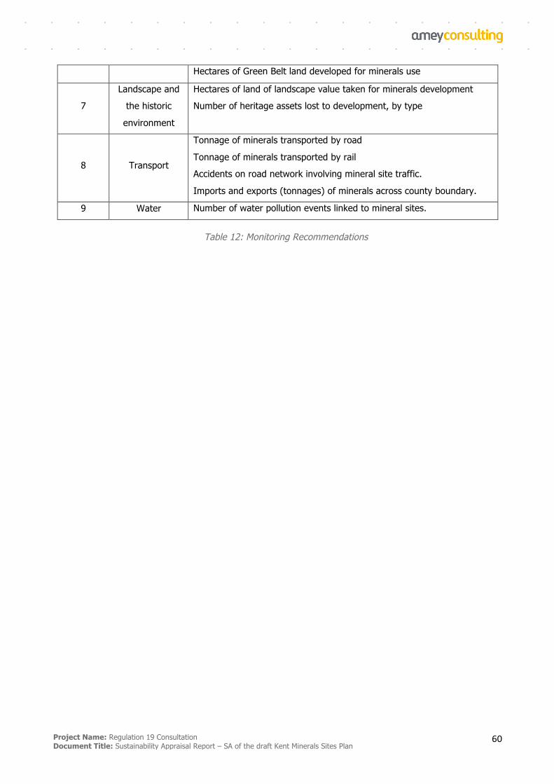
Project Name: Regulation 19 Consultation Document Title: Sustainability Appraisal Report – SA of the draft Kent Minerals Sites Plan
60
Hectares of Green Belt land developed for minerals use
7
Landscape and
the historic
environment
Hectares of land of landscape value taken for minerals development
Number of heritage assets lost to development, by type
8 Transport
Tonnage of minerals transported by road
Tonnage of minerals transported by rail
Accidents on road network involving mineral site traffic.
Imports and exports (tonnages) of minerals across county boundary.
9 Water Number of water pollution events linked to mineral sites.
Table 12: Monitoring Recommendations
Project Name: Regulation 19 Consultation Document Title: Sustainability Appraisal Report – SA of the draft Kent Minerals Sites Plan
61
References
§ Site Selection Methodology (KCC, 2017)
Related to SA of Kent MWLP (adopted 2016):
§ AECOM, July 2016 – Sustainability Appraisal (SA) of the Kent MWDF – SA Adoption Statement
§ Scott Wilson, March 2010 – SA Scoping Report – Introductory Paper URS, 2011 – Interim SA Report (Assessment of Preferred Options)
§ URS, November 2013 – Sustainability Appraisal (SA) of the Kent Minerals and Waste Local Plan - SA Report (Consultation Draft)
§ URS, July 2014 – Kent County Council: Draft Minerals and Waste Local Plan 2013-30 - Habitats Regulations Assessment
§ URS, July 2014 – Sustainability Appraisal (SA) of the Kent Minerals and Waste Local Plan – SA Report Non-Technical Summary
Other references:
§ UK Government (2004) Environmental Assessment of Plans and Programmes Regulations 2004
§ UK Government (2012) The Town and Country Planning (Local Planning) (England) Regulations 2012
§ UK Government (2018) The National Planning Policy Framework
§ Shepway District Council (2013) Shepway Core Strategy Local Plan
§ Shepway District Council (2018) Council Core Strategy Review, Consultation Draft Plan
§ Maidstone Borough Council (2017) Maidstone Borough Local Plan
§ Ashford Borough Council (2017) Submission Local Plan 2030
§ Tonbridge and Malling Borough Council (2018) Local Plan Regulation 19 Pre-submission Publication
§ Tunbridge Wells Borough Council (2016) Site Allocations Local Plan
§ Tunbridge Wells Borough Council (2010) Core Strategy DPD
§ Dartford Borough Council (2011) Dartford Core Strategy
§ London Borough of Bexley (2012) Bexley Core Strategy
§ London Borough of Bexley (2017) Bexley Growth Strategy
§ Thurrock Council (2015) Core Strategy and Policies for Management of Development (as amended)
§ Kent County Council (2016) Local Transport Plan 4: Delivering Growth Without Gridlock 2016-2031
Project Name: Regulation 19 Consultation Document Title: Sustainability Appraisal Report – SA of the draft Kent Minerals Sites Plan
62
§ East Sussex, South Downs and Brighton & Hove Councils (2013) Waste and Minerals Plan
§ East Sussex County Council (2017) Waste and Minerals Sites Plan
§ Rother District Council (2014) Core Strategy
§ East Sussex County Council (2011) Local Transport Plan 3 2011-2026
§ London Assembly (2017) New London Plan – Consultation Draft
§ Kent County Council (2016) Minerals and Waste Local Plan 2013-30
§ Kent County Council (2018) Regulation 19 Consultation: Partial Review of the Kent Minerals and
Waste Local Plan 2013-30
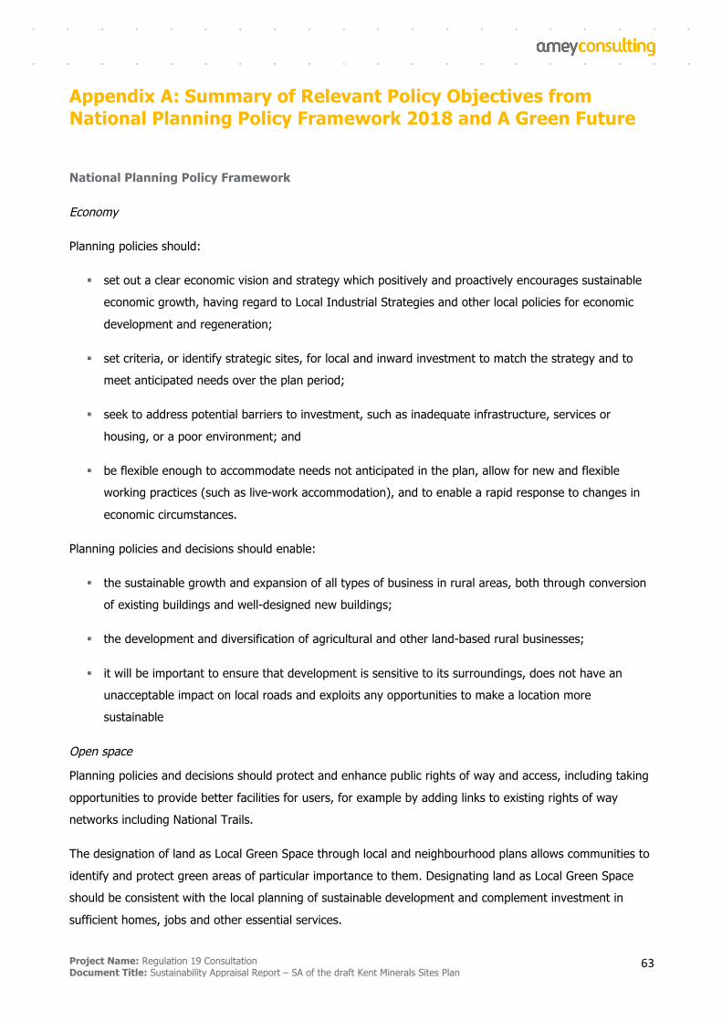
Project Name: Regulation 19 Consultation Document Title: Sustainability Appraisal Report – SA of the draft Kent Minerals Sites Plan
63
Appendix A: Summary of Relevant Policy Objectives from National Planning Policy Framework 2018 and A Green Future
National Planning Policy Framework
Economy
Planning policies should:
§ set out a clear economic vision and strategy which positively and proactively encourages sustainable
economic growth, having regard to Local Industrial Strategies and other local policies for economic
development and regeneration;
§ set criteria, or identify strategic sites, for local and inward investment to match the strategy and to
meet anticipated needs over the plan period;
§ seek to address potential barriers to investment, such as inadequate infrastructure, services or
housing, or a poor environment; and
§ be flexible enough to accommodate needs not anticipated in the plan, allow for new and flexible
working practices (such as live-work accommodation), and to enable a rapid response to changes in
economic circumstances.
Planning policies and decisions should enable:
§ the sustainable growth and expansion of all types of business in rural areas, both through conversion
of existing buildings and well-designed new buildings;
§ the development and diversification of agricultural and other land-based rural businesses;
§ it will be important to ensure that development is sensitive to its surroundings, does not have an
unacceptable impact on local roads and exploits any opportunities to make a location more
sustainable
Open space
Planning policies and decisions should protect and enhance public rights of way and access, including taking
opportunities to provide better facilities for users, for example by adding links to existing rights of way
networks including National Trails.
The designation of land as Local Green Space through local and neighbourhood plans allows communities to
identify and protect green areas of particular importance to them. Designating land as Local Green Space
should be consistent with the local planning of sustainable development and complement investment in
sufficient homes, jobs and other essential services.
Project Name: Regulation 19 Consultation Document Title: Sustainability Appraisal Report – SA of the draft Kent Minerals Sites Plan
64
Transport
Transport issues should be considered from the earliest stages of plan-making and development proposals,
so that:
§ the potential impacts of development on transport networks can be addressed;
§ opportunities to promote walking, cycling and public transport use are identified and pursued;
§ the environmental impacts of traffic and transport infrastructure can be identified, assessed and taken
into account – including appropriate opportunities for avoiding and mitigating any adverse effects, and
for net environmental gains
Planning policies should be prepared with the active involvement of local highways authorities, other
transport infrastructure providers and operators and neighbouring councils, so that strategies and
investments for supporting sustainable transport and development patterns are aligned.
In assessing sites that may be allocated for development in plans, or specific applications for development, it
should be ensured that:
§ appropriate opportunities to promote sustainable transport modes can be – or have been – taken up,
given the type of development and its location;
§ safe and suitable access to the site can be achieved for all users; and
§ any significant impacts from the development on the transport network (in terms of capacity and
congestion), or on highway safety, can be cost effectively mitigated to an acceptable degree.
Green Belt
Certain forms of development are not inappropriate in the Green Belt provided they preserve its openness
and do not conflict with the purposes of including land within it, including mineral extraction. Planning
policies and decisions should recognise that some undeveloped land can perform many functions, such as
for wildlife, recreation, flood risk mitigation, cooling/shading, carbon storage or food production.
Flood risk
Inappropriate development in areas at risk of flooding should be avoided by directing development away
from areas at highest risk (whether existing or future). Where development is necessary in such areas, the
development should be made safe for its lifetime without increasing flood risk elsewhere.
Development should only be allowed in areas at risk of flooding where it can be demonstrated that:
§ within the site, the most vulnerable development is located in areas of lowest flood risk, unless there
are overriding reasons to prefer a different location;
§ the development is appropriately flood resistant and resilient;
Project Name: Regulation 19 Consultation Document Title: Sustainability Appraisal Report – SA of the draft Kent Minerals Sites Plan
65
§ it incorporates sustainable drainage systems, unless there is clear evidence that this would be
inappropriate;
§ any residual risk can be safely managed; and
§ safe access and escape routes are included where appropriate, as part of an agreed emergency plan.
Natural environment
Planning policies and decisions should contribute to and enhance the natural and local environment by:
§ protecting and enhancing valued landscapes, sites of biodiversity or geological value and soils (in a
manner commensurate with their statutory status or identified quality in the development plan);
§ recognising the intrinsic character and beauty of the countryside, and the wider benefits from natural
capital and ecosystem services – including the economic and other benefits of the best and most
versatile agricultural land, and of trees and woodland;
§ maintaining the character of the undeveloped coast, while improving public access to it where
appropriate;
§ minimising impacts on and providing net gains for biodiversity, including by establishing coherent
ecological networks that are more resilient to current and future pressures;
§ preventing new and existing development from contributing to, being put at unacceptable risk from,
or being adversely affected by, unacceptable levels of soil, air, water or noise pollution or land
instability. Development should, wherever possible, help to improve local environmental conditions
such as air and water quality, taking into account relevant information such as river basin
management plans; and
§ remediating and mitigating despoiled, degraded, derelict, contaminated and unstable land, where
appropriate.
Heritage assets
When considering the impact of a proposed development on the significance of a designated heritage asset,
great weight should be given to the asset’s conservation. Any harm to, or loss of, the significance of a
designated heritage asset (from its alteration or destruction, or from development within its setting), should
require clear and convincing justification.
Minerals
Planning policies should:
§ provide for the extraction of mineral resources of local and national importance, but not identify new
sites or extensions to existing sites for peat extraction;
Project Name: Regulation 19 Consultation Document Title: Sustainability Appraisal Report – SA of the draft Kent Minerals Sites Plan
66
§ so far as practicable, take account of the contribution that substitute or secondary and recycled
materials and minerals waste would make to the supply of materials, before considering extraction of
primary materials, whilst aiming to source minerals supplies indigenously;
§ safeguard mineral resources by defining Mineral Safeguarding Areas; and adopt appropriate policies
so that known locations of specific minerals resources of local and national importance are not
sterilised by non-mineral development where this should be avoided (whilst not creating a
presumption that the resources defined will be worked);
§ set out policies to encourage the prior extraction of minerals, where practical and environmentally
feasible, if it is necessary for non-mineral development to take place;
§ safeguard existing, planned and potential sites for: the bulk transport, handling and processing of
minerals; the manufacture of concrete and concrete products; and the handling, processing and
distribution of substitute, recycled and secondary aggregate material;
§ set out criteria or requirements to ensure that permitted and proposed operations do not have
unacceptable adverse impacts on the natural and historic environment or human health, taking into
account the cumulative effects of multiple impacts from individual sites and/or a number of sites in a
locality;
§ when developing noise limits, recognise that some noisy short-term activities, which may otherwise be
regarded as unacceptable, are unavoidable to facilitate minerals extraction; and
§ ensure that worked land is reclaimed at the earliest opportunity, taking account of aviation safety, and
that high quality restoration and aftercare of mineral sites takes place.
A Green Future: Our 25 Year Plan to Improve the Environment
Using and managing land sustainably
• Embedding an ‘environmental net gain’ principle for development, including housing and
infrastructure
• Improving how we manage and incentivise land management, including designing and delivering a
new environmental land management system
• Improving soil health and restoring and protecting our peatlands, including developing better
information on soil health
• Focusing on woodland to maximise its many benefits
• Reducing risks from flooding and coastal erosion, including expanding the use of natural flood
management solutions and putting in place more sustainable drainage systems
Project Name: Regulation 19 Consultation Document Title: Sustainability Appraisal Report – SA of the draft Kent Minerals Sites Plan
67
Recovering nature and enhancing the beauty of landscapes
• Protecting and recovering nature, including developing a Nature Recovery Network and providing
opportunities for the reintroduction of native species
• Conserving and enhancing natural beauty, including reviewing National Parks and Areas of
Outstanding Natural Beauty
• Respecting nature in how we use water and reforming our approach to water abstraction
Connecting people with the environment to improve health and wellbeing
• Helping people improve their health and wellbeing by using green spaces
• Creating more green infrastructure
Increasing resource efficiency and reducing pollution and waste
• Maximising resource efficiency and minimising environmental impacts at end of life.
o Improving management of residual waste
o Reducing the impact of wastewater
• Reducing pollution
o Publishing a Clean Air Strategy
o Curbing emissions from combustion plants and generators
o Minimising the risk of chemical contamination in our water
o Ensuring we continue to maintain clean recreational waters and warning about temporary
pollution
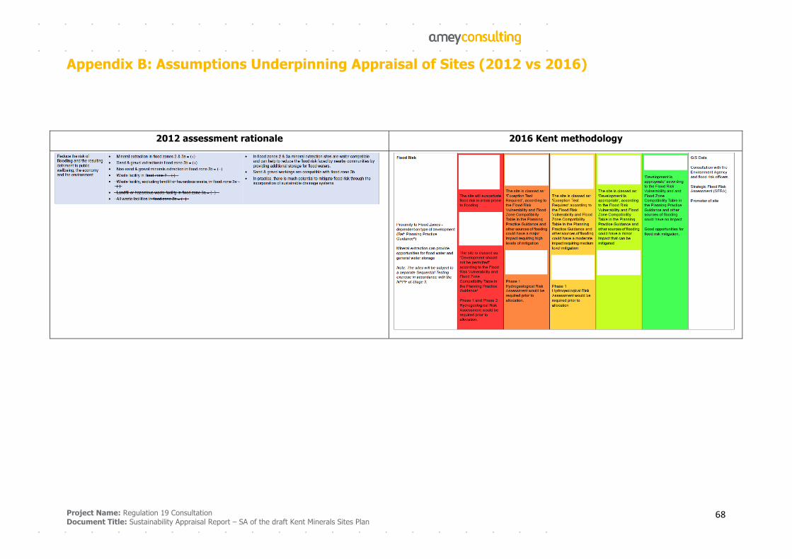
Project Name: Regulation 19 Consultation
Document Title: Sustainability Appraisal Report – SA of the draft Kent Minerals Sites Plan 68
Appendix B: Assumptions Underpinning Appraisal of Sites (2012 vs 2016)
2012 assessment rationale 2016 Kent methodology
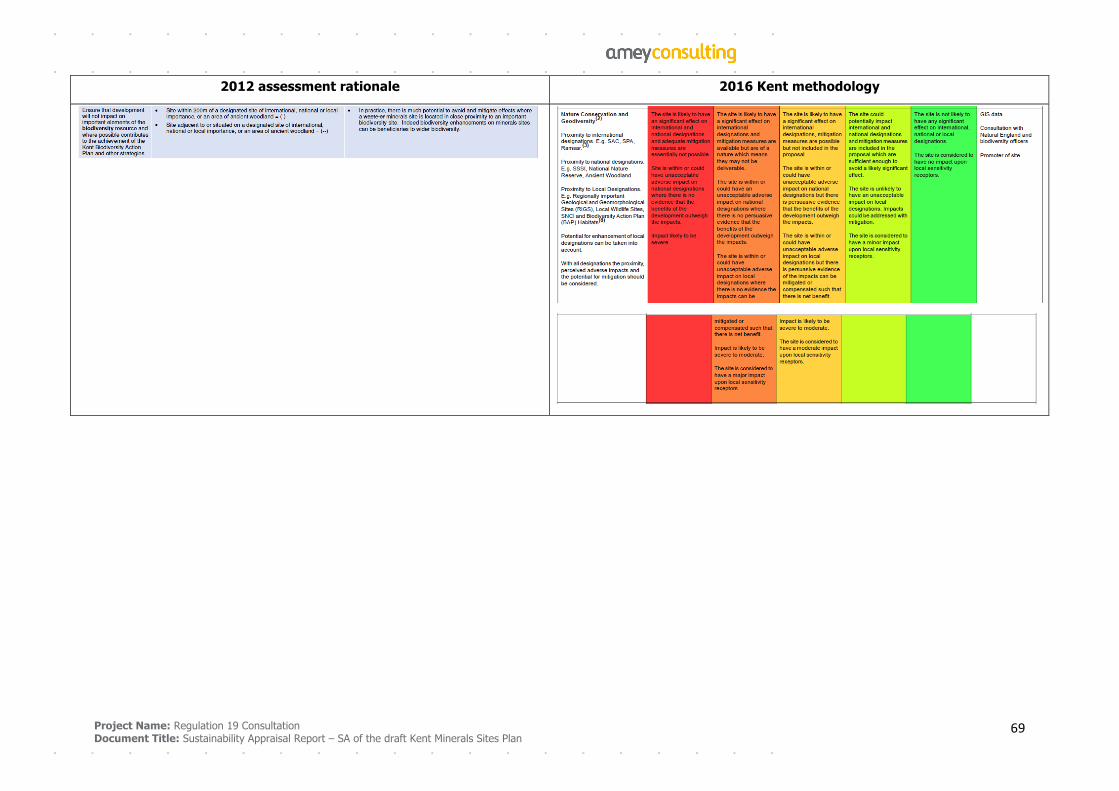
Project Name: Regulation 19 Consultation
Document Title: Sustainability Appraisal Report – SA of the draft Kent Minerals Sites Plan 69
2012 assessment rationale 2016 Kent methodology
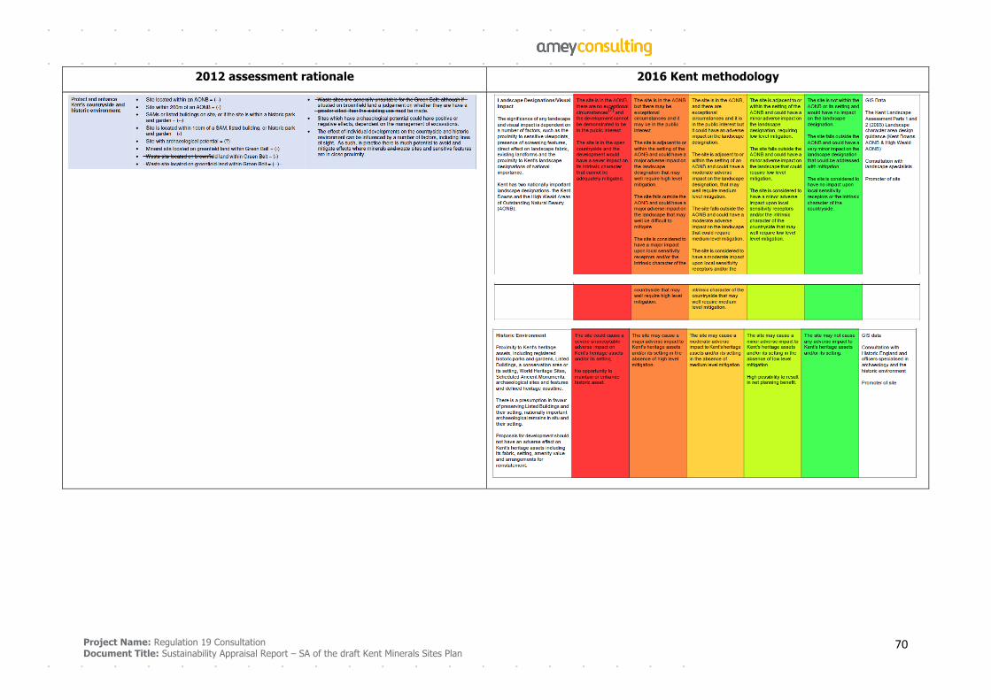
Project Name: Regulation 19 Consultation
Document Title: Sustainability Appraisal Report – SA of the draft Kent Minerals Sites Plan 70
2012 assessment rationale 2016 Kent methodology
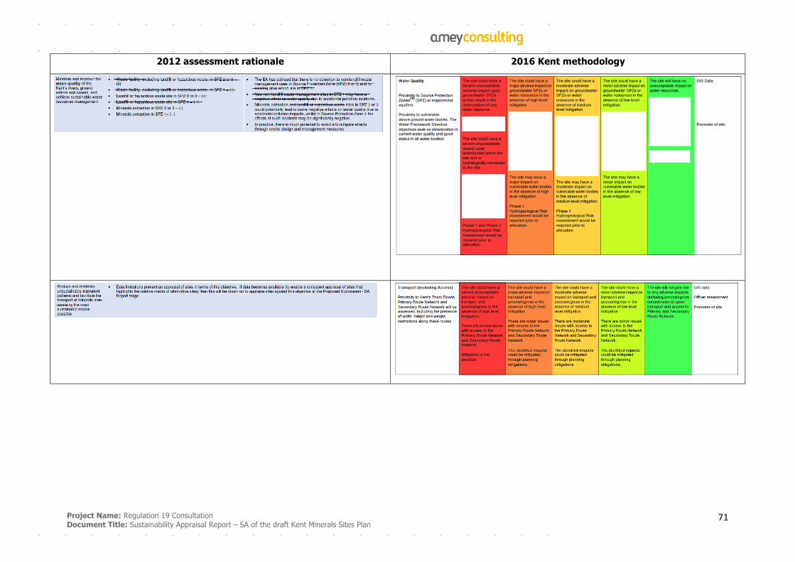
Project Name: Regulation 19 Consultation
Document Title: Sustainability Appraisal Report – SA of the draft Kent Minerals Sites Plan 71
2012 assessment rationale 2016 Kent methodology
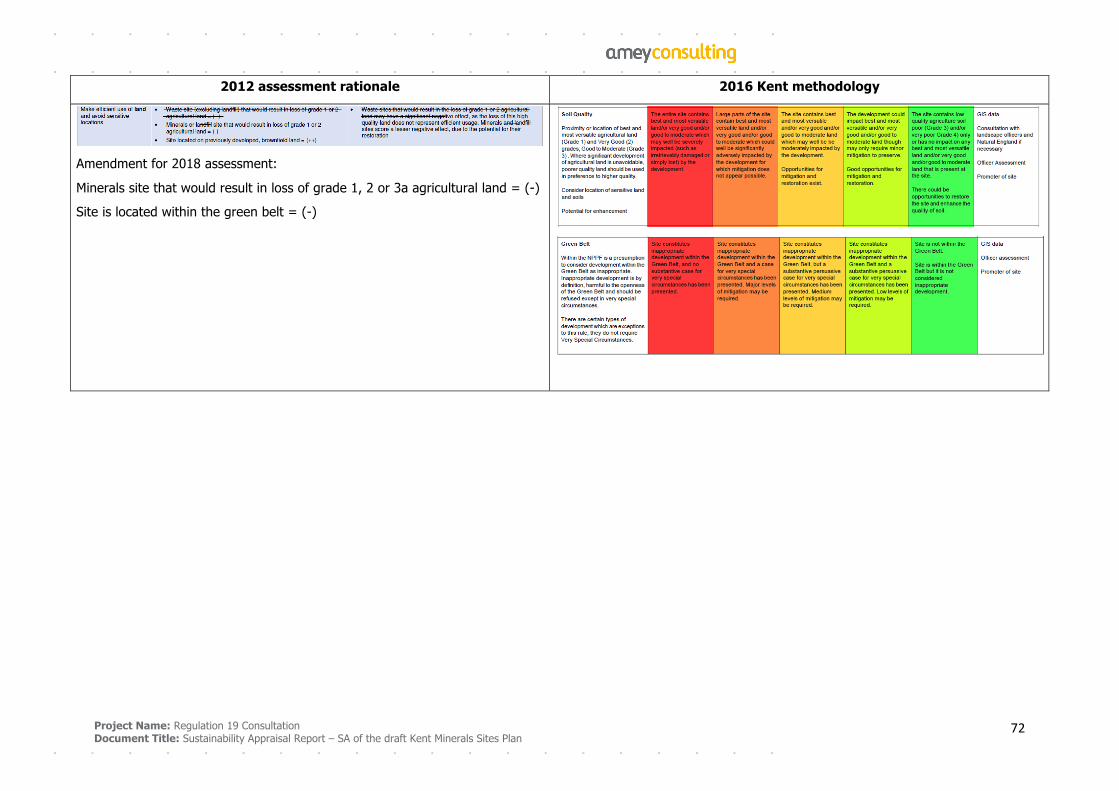
Project Name: Regulation 19 Consultation
Document Title: Sustainability Appraisal Report – SA of the draft Kent Minerals Sites Plan 72
2012 assessment rationale 2016 Kent methodology
Amendment for 2018 assessment:
Minerals site that would result in loss of grade 1, 2 or 3a agricultural land = (-)
Site is located within the green belt = (-)
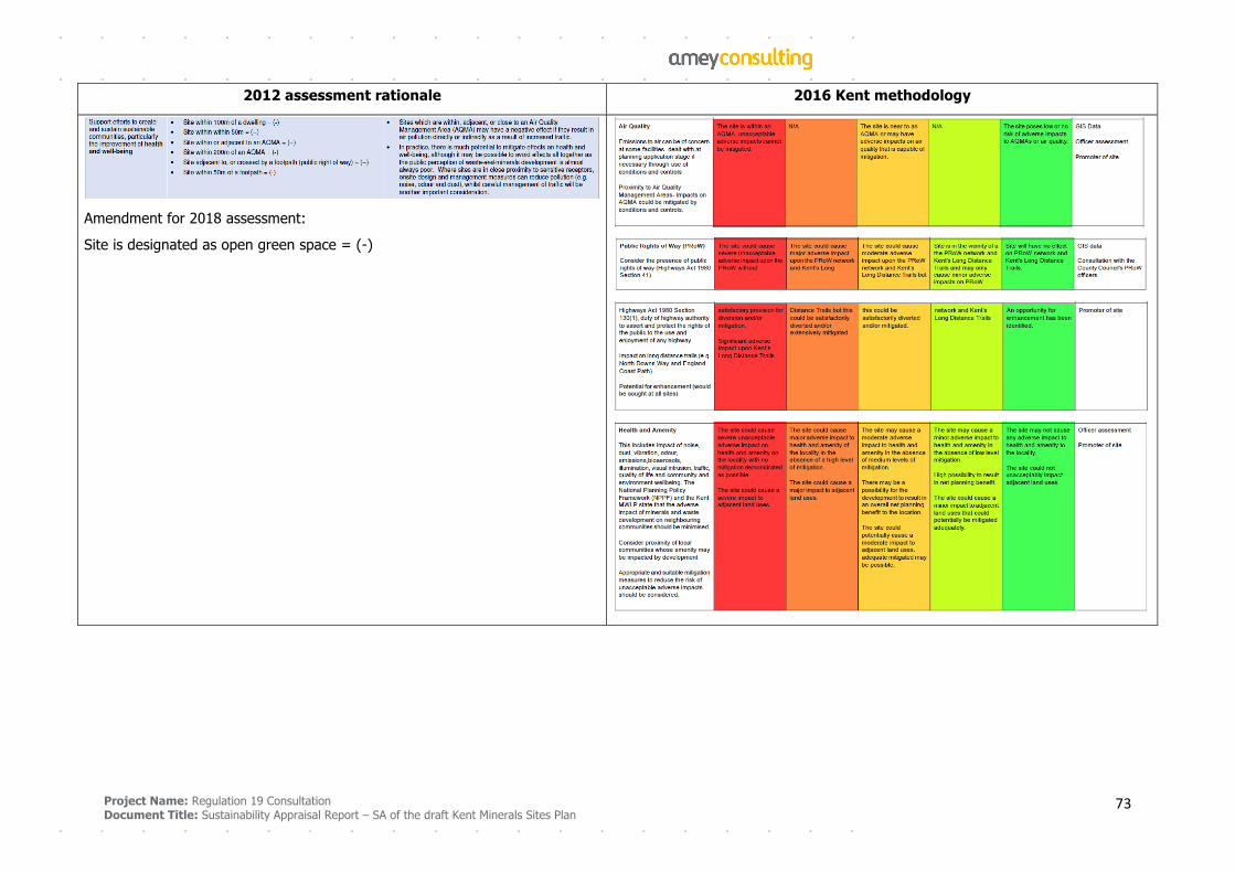
Project Name: Regulation 19 Consultation
Document Title: Sustainability Appraisal Report – SA of the draft Kent Minerals Sites Plan 73
2012 assessment rationale 2016 Kent methodology
Amendment for 2018 assessment:
Site is designated as open green space = (-)
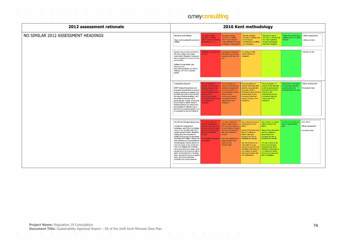
Project Name: Regulation 19 Consultation
Document Title: Sustainability Appraisal Report – SA of the draft Kent Minerals Sites Plan 74
2012 assessment rationale 2016 Kent methodology
NO SIMILAR 2012 ASSESSMENT HEADINGS
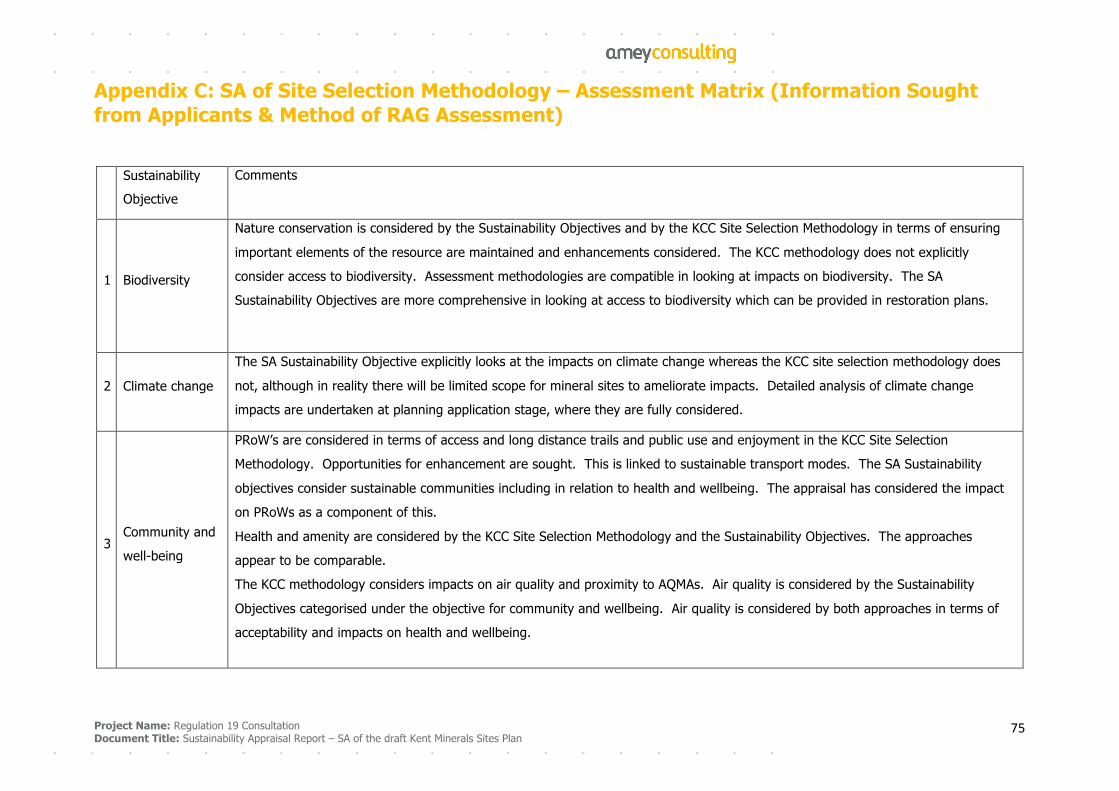
Project Name: Regulation 19 Consultation
Document Title: Sustainability Appraisal Report – SA of the draft Kent Minerals Sites Plan 75
Appendix C: SA of Site Selection Methodology – Assessment Matrix (Information Sought from Applicants & Method of RAG Assessment)
Sustainability
Objective
Comments
1 Biodiversity
Nature conservation is considered by the Sustainability Objectives and by the KCC Site Selection Methodology in terms of ensuring
important elements of the resource are maintained and enhancements considered. The KCC methodology does not explicitly
consider access to biodiversity. Assessment methodologies are compatible in looking at impacts on biodiversity. The SA
Sustainability Objectives are more comprehensive in looking at access to biodiversity which can be provided in restoration plans.
2 Climate change
The SA Sustainability Objective explicitly looks at the impacts on climate change whereas the KCC site selection methodology does
not, although in reality there will be limited scope for mineral sites to ameliorate impacts. Detailed analysis of climate change
impacts are undertaken at planning application stage, where they are fully considered.
3 Community and
well-being
PRoW’s are considered in terms of access and long distance trails and public use and enjoyment in the KCC Site Selection
Methodology. Opportunities for enhancement are sought. This is linked to sustainable transport modes. The SA Sustainability
objectives consider sustainable communities including in relation to health and wellbeing. The appraisal has considered the impact
on PRoWs as a component of this.
Health and amenity are considered by the KCC Site Selection Methodology and the Sustainability Objectives. The approaches
appear to be comparable.
The KCC methodology considers impacts on air quality and proximity to AQMAs. Air quality is considered by the Sustainability
Objectives categorised under the objective for community and wellbeing. Air quality is considered by both approaches in terms of
acceptability and impacts on health and wellbeing.
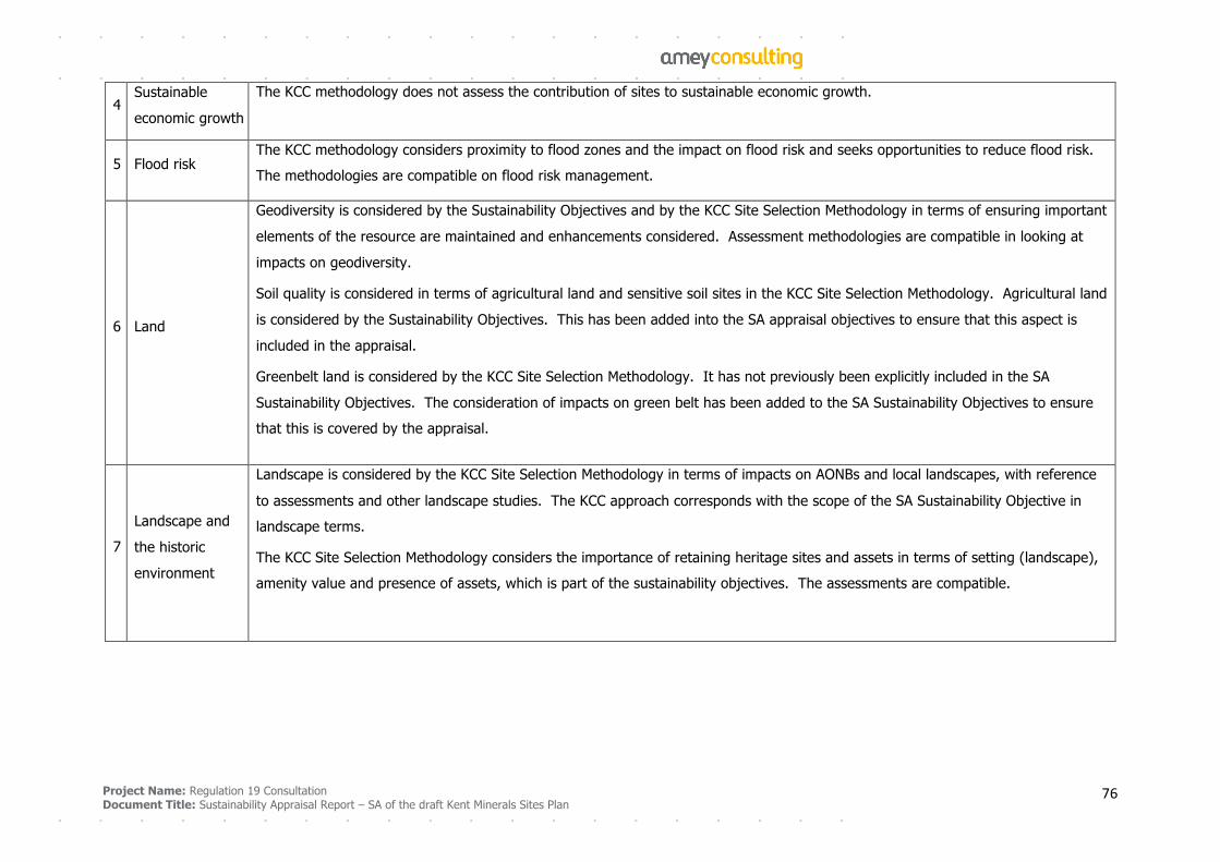
Project Name: Regulation 19 Consultation
Document Title: Sustainability Appraisal Report – SA of the draft Kent Minerals Sites Plan 76
4 Sustainable
economic growth
The KCC methodology does not assess the contribution of sites to sustainable economic growth.
5 Flood risk The KCC methodology considers proximity to flood zones and the impact on flood risk and seeks opportunities to reduce flood risk.
The methodologies are compatible on flood risk management.
6 Land
Geodiversity is considered by the Sustainability Objectives and by the KCC Site Selection Methodology in terms of ensuring important
elements of the resource are maintained and enhancements considered. Assessment methodologies are compatible in looking at
impacts on geodiversity.
Soil quality is considered in terms of agricultural land and sensitive soil sites in the KCC Site Selection Methodology. Agricultural land
is considered by the Sustainability Objectives. This has been added into the SA appraisal objectives to ensure that this aspect is
included in the appraisal.
Greenbelt land is considered by the KCC Site Selection Methodology. It has not previously been explicitly included in the SA
Sustainability Objectives. The consideration of impacts on green belt has been added to the SA Sustainability Objectives to ensure
that this is covered by the appraisal.
7
Landscape and
the historic
environment
Landscape is considered by the KCC Site Selection Methodology in terms of impacts on AONBs and local landscapes, with reference
to assessments and other landscape studies. The KCC approach corresponds with the scope of the SA Sustainability Objective in
landscape terms.
The KCC Site Selection Methodology considers the importance of retaining heritage sites and assets in terms of setting (landscape),
amenity value and presence of assets, which is part of the sustainability objectives. The assessments are compatible.
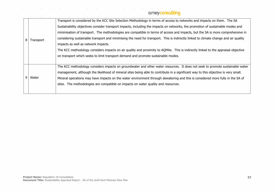
Project Name: Regulation 19 Consultation
Document Title: Sustainability Appraisal Report – SA of the draft Kent Minerals Sites Plan 77
8 Transport
Transport is considered by the KCC Site Selection Methodology in terms of access to networks and impacts on them. The SA
Sustainability objectives consider transport impacts, including the impacts on networks, the promotion of sustainable modes and
minimisation of transport. The methodologies are compatible in terms of access and impacts, but the SA is more comprehensive in
considering sustainable transport and minimising the need for transport. This is indirectly linked to climate change and air quality
impacts as well as network impacts.
The KCC methodology considers impacts on air quality and proximity to AQMAs. This is indirectly linked to the appraisal objective
on transport which seeks to limit transport demand and promote sustainable modes.
9 Water
The KCC methodology considers impacts on groundwater and other water resources. It does not seek to promote sustainable water
management, although the likelihood of mineral sites being able to contribute in a significant way to this objective is very small.
Mineral operations may have impacts on the water environment through dewatering and this is considered more fully in the SA of
sites. The methodologies are compatible on impacts on water quality and resources.

Project Name: Regulation 19 Consultation
Document Title: Sustainability Appraisal Report – SA of the draft Kent Minerals Sites Plan 78
Appendix D: Detailed Findings and Recommendations of SA of Sites Key:
Impacts Probability of effects Direct or indirect effects Reversibility
++ significant positive effect
+ some positive effect
0 no effect
- some adverse effect
- - significant adverse effect
? uncertain effect
L low probability
M medium probability
H high probability
D direct effect
I indirect effect
Y reversible effect
N not reversible i.e. permanent effect
Site M2: Lydd Quarry Extensions
Sustainability
Objective
Comments
1 Biodiversity
Short Med Long Prob Dir/Ind Rev?
- - - - - - H D/I N
Parcel 19 of the proposed allocation is within the Dungeness, Romney Marsh and Rye Bay Ramsar site and SPA/Ramsar
designated site. The site will have a direct impact upon the SPA (the one parcel) and likely indirect impacts on the wider SPA
and the Dungeness SAC and Dungeness, Romney Marsh and Rye Bay Ramsar Site. The whole site lies within the Dungeness,
Romney Marsh and Rye Bay SSSI and supports a range of nationally important plant and animal species. The biodiversity value
of the SSSI will be lost from the site.
Lydd Common and Pastures Local Wildlife Site (LWS) abuts part of the proposed allocation (to the south of parcel 23 Allens
Bank) and there is the potential for adverse impacts on the site from mineral working. Ecological surveys should be undertaken
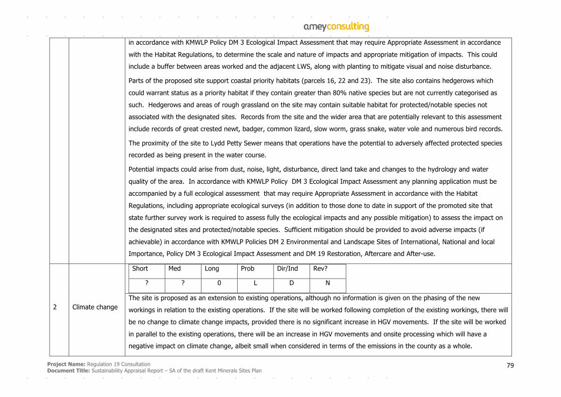
Project Name: Regulation 19 Consultation
Document Title: Sustainability Appraisal Report – SA of the draft Kent Minerals Sites Plan 79
in accordance with KMWLP Policy DM 3 Ecological Impact Assessment that may require Appropriate Assessment in accordance
with the Habitat Regulations, to determine the scale and nature of impacts and appropriate mitigation of impacts. This could
include a buffer between areas worked and the adjacent LWS, along with planting to mitigate visual and noise disturbance.
Parts of the proposed site support coastal priority habitats (parcels 16, 22 and 23). The site also contains hedgerows which
could warrant status as a priority habitat if they contain greater than 80% native species but are not currently categorised as
such. Hedgerows and areas of rough grassland on the site may contain suitable habitat for protected/notable species not
associated with the designated sites. Records from the site and the wider area that are potentially relevant to this assessment
include records of great crested newt, badger, common lizard, slow worm, grass snake, water vole and numerous bird records.
The proximity of the site to Lydd Petty Sewer means that operations have the potential to adversely affected protected species
recorded as being present in the water course.
Potential impacts could arise from dust, noise, light, disturbance, direct land take and changes to the hydrology and water
quality of the area. In accordance with KMWLP Policy DM 3 Ecological Impact Assessment any planning application must be
accompanied by a full ecological assessment that may require Appropriate Assessment in accordance with the Habitat
Regulations, including appropriate ecological surveys (in addition to those done to date in support of the promoted site that
state further survey work is required to assess fully the ecological impacts and any possible mitigation) to assess the impact on
the designated sites and protected/notable species. Sufficient mitigation should be provided to avoid adverse impacts (if
achievable) in accordance with KMWLP Policies DM 2 Environmental and Landscape Sites of International, National and local
Importance, Policy DM 3 Ecological Impact Assessment and DM 19 Restoration, Aftercare and After-use.
2 Climate change
Short Med Long Prob Dir/Ind Rev?
? ? 0 L D N
The site is proposed as an extension to existing operations, although no information is given on the phasing of the new
workings in relation to the existing operations. If the site will be worked following completion of the existing workings, there will
be no change to climate change impacts, provided there is no significant increase in HGV movements. If the site will be worked
in parallel to the existing operations, there will be an increase in HGV movements and onsite processing which will have a
negative impact on climate change, albeit small when considered in terms of the emissions in the county as a whole.
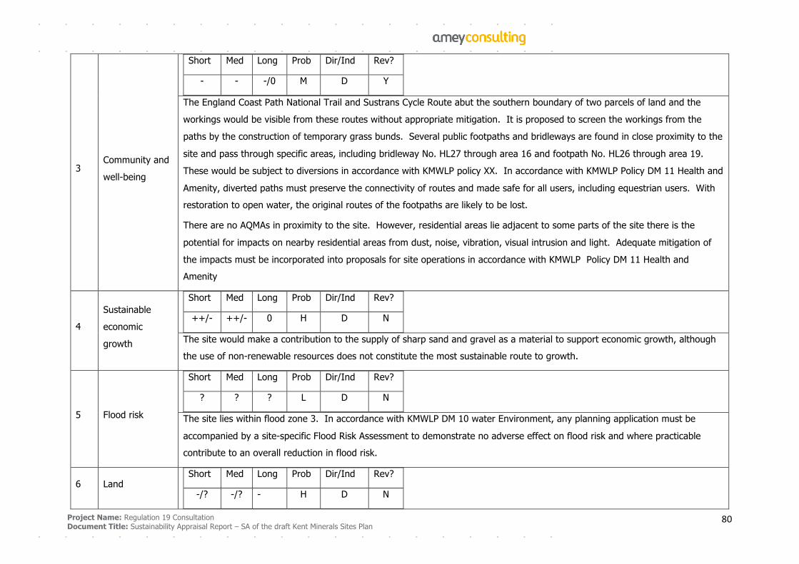
Project Name: Regulation 19 Consultation
Document Title: Sustainability Appraisal Report – SA of the draft Kent Minerals Sites Plan 80
3 Community and
well-being
Short Med Long Prob Dir/Ind Rev?
- - -/0 M D Y
The England Coast Path National Trail and Sustrans Cycle Route abut the southern boundary of two parcels of land and the
workings would be visible from these routes without appropriate mitigation. It is proposed to screen the workings from the
paths by the construction of temporary grass bunds. Several public footpaths and bridleways are found in close proximity to the
site and pass through specific areas, including bridleway No. HL27 through area 16 and footpath No. HL26 through area 19.
These would be subject to diversions in accordance with KMWLP policy XX. In accordance with KMWLP Policy DM 11 Health and
Amenity, diverted paths must preserve the connectivity of routes and made safe for all users, including equestrian users. With
restoration to open water, the original routes of the footpaths are likely to be lost.
There are no AQMAs in proximity to the site. However, residential areas lie adjacent to some parts of the site there is the
potential for impacts on nearby residential areas from dust, noise, vibration, visual intrusion and light. Adequate mitigation of
the impacts must be incorporated into proposals for site operations in accordance with KMWLP Policy DM 11 Health and
Amenity
4
Sustainable
economic
growth
Short Med Long Prob Dir/Ind Rev?
++/- ++/- 0 H D N
The site would make a contribution to the supply of sharp sand and gravel as a material to support economic growth, although
the use of non-renewable resources does not constitute the most sustainable route to growth.
5 Flood risk
Short Med Long Prob Dir/Ind Rev?
? ? ? L D N
The site lies within flood zone 3. In accordance with KMWLP DM 10 water Environment, any planning application must be
accompanied by a site-specific Flood Risk Assessment to demonstrate no adverse effect on flood risk and where practicable
contribute to an overall reduction in flood risk.
6 Land
Short Med Long Prob Dir/Ind Rev?
-/? -/? - H D N
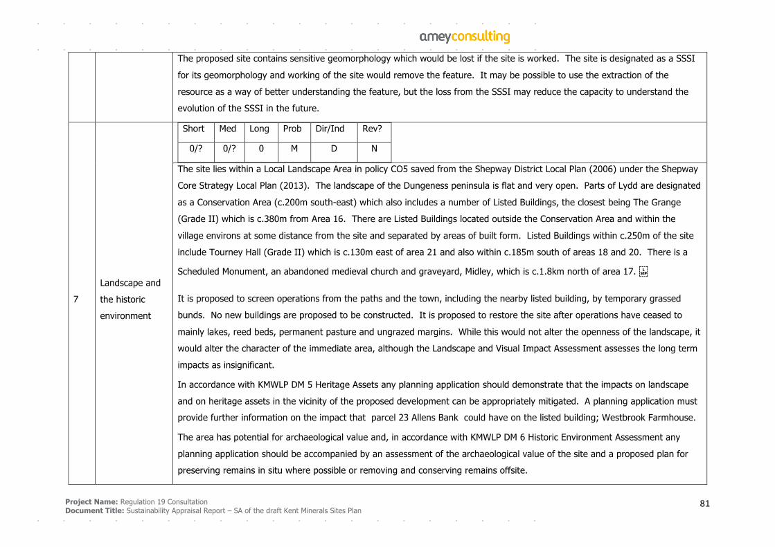
Project Name: Regulation 19 Consultation
Document Title: Sustainability Appraisal Report – SA of the draft Kent Minerals Sites Plan 81
The proposed site contains sensitive geomorphology which would be lost if the site is worked. The site is designated as a SSSI
for its geomorphology and working of the site would remove the feature. It may be possible to use the extraction of the
resource as a way of better understanding the feature, but the loss from the SSSI may reduce the capacity to understand the
evolution of the SSSI in the future.
7
Landscape and
the historic
environment
Short Med Long Prob Dir/Ind Rev?
0/? 0/? 0 M D N
The site lies within a Local Landscape Area in policy CO5 saved from the Shepway District Local Plan (2006) under the Shepway
Core Strategy Local Plan (2013). The landscape of the Dungeness peninsula is flat and very open. Parts of Lydd are designated
as a Conservation Area (c.200m south-east) which also includes a number of Listed Buildings, the closest being The Grange
(Grade II) which is c.380m from Area 16. There are Listed Buildings located outside the Conservation Area and within the
village environs at some distance from the site and separated by areas of built form. Listed Buildings within c.250m of the site
include Tourney Hall (Grade II) which is c.130m east of area 21 and also within c.185m south of areas 18 and 20. There is a
Scheduled Monument, an abandoned medieval church and graveyard, Midley, which is c.1.8km north of area 17. �
It is proposed to screen operations from the paths and the town, including the nearby listed building, by temporary grassed
bunds. No new buildings are proposed to be constructed. It is proposed to restore the site after operations have ceased to
mainly lakes, reed beds, permanent pasture and ungrazed margins. While this would not alter the openness of the landscape, it
would alter the character of the immediate area, although the Landscape and Visual Impact Assessment assesses the long term
impacts as insignificant.
In accordance with KMWLP DM 5 Heritage Assets any planning application should demonstrate that the impacts on landscape
and on heritage assets in the vicinity of the proposed development can be appropriately mitigated. A planning application must
provide further information on the impact that parcel 23 Allens Bank could have on the listed building; Westbrook Farmhouse.
The area has potential for archaeological value and, in accordance with KMWLP DM 6 Historic Environment Assessment any
planning application should be accompanied by an assessment of the archaeological value of the site and a proposed plan for
preserving remains in situ where possible or removing and conserving remains offsite.
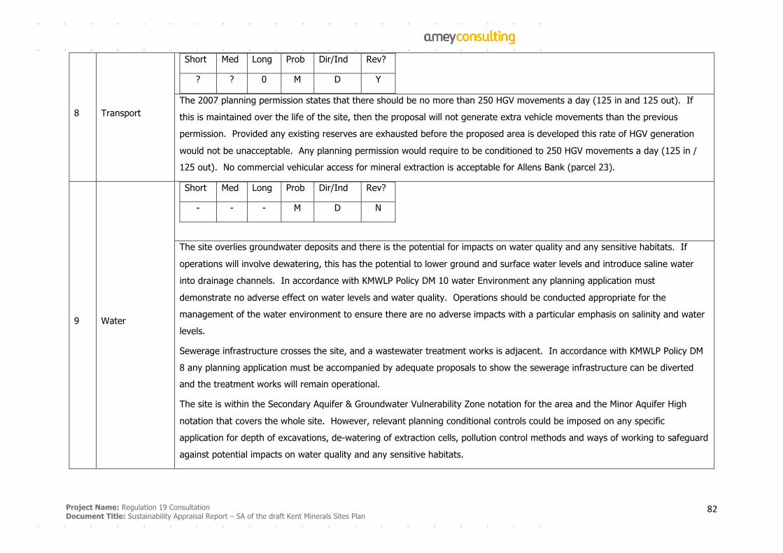
Project Name: Regulation 19 Consultation
Document Title: Sustainability Appraisal Report – SA of the draft Kent Minerals Sites Plan 82
8 Transport
Short Med Long Prob Dir/Ind Rev?
? ? 0 M D Y
The 2007 planning permission states that there should be no more than 250 HGV movements a day (125 in and 125 out). If
this is maintained over the life of the site, then the proposal will not generate extra vehicle movements than the previous
permission. Provided any existing reserves are exhausted before the proposed area is developed this rate of HGV generation
would not be unacceptable. Any planning permission would require to be conditioned to 250 HGV movements a day (125 in /
125 out). No commercial vehicular access for mineral extraction is acceptable for Allens Bank (parcel 23).
9 Water
Short Med Long Prob Dir/Ind Rev?
- - - M D N
The site overlies groundwater deposits and there is the potential for impacts on water quality and any sensitive habitats. If
operations will involve dewatering, this has the potential to lower ground and surface water levels and introduce saline water
into drainage channels. In accordance with KMWLP Policy DM 10 water Environment any planning application must
demonstrate no adverse effect on water levels and water quality. Operations should be conducted appropriate for the
management of the water environment to ensure there are no adverse impacts with a particular emphasis on salinity and water
levels.
Sewerage infrastructure crosses the site, and a wastewater treatment works is adjacent. In accordance with KMWLP Policy DM
8 any planning application must be accompanied by adequate proposals to show the sewerage infrastructure can be diverted
and the treatment works will remain operational.
The site is within the Secondary Aquifer & Groundwater Vulnerability Zone notation for the area and the Minor Aquifer High
notation that covers the whole site. However, relevant planning conditional controls could be imposed on any specific
application for depth of excavations, de-watering of extraction cells, pollution control methods and ways of working to safeguard
against potential impacts on water quality and any sensitive habitats.
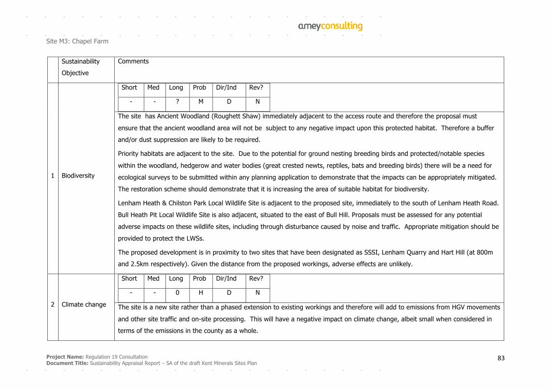
Project Name: Regulation 19 Consultation
Document Title: Sustainability Appraisal Report – SA of the draft Kent Minerals Sites Plan 83
Site M3: Chapel Farm
Sustainability
Objective
Comments
1 Biodiversity
Short Med Long Prob Dir/Ind Rev?
- - ? M D N
The site has Ancient Woodland (Roughett Shaw) immediately adjacent to the access route and therefore the proposal must
ensure that the ancient woodland area will not be subject to any negative impact upon this protected habitat. Therefore a buffer
and/or dust suppression are likely to be required.
Priority habitats are adjacent to the site. Due to the potential for ground nesting breeding birds and protected/notable species
within the woodland, hedgerow and water bodies (great crested newts, reptiles, bats and breeding birds) there will be a need for
ecological surveys to be submitted within any planning application to demonstrate that the impacts can be appropriately mitigated.
The restoration scheme should demonstrate that it is increasing the area of suitable habitat for biodiversity.
Lenham Heath & Chilston Park Local Wildlife Site is adjacent to the proposed site, immediately to the south of Lenham Heath Road.
Bull Heath Pit Local Wildlife Site is also adjacent, situated to the east of Bull Hill. Proposals must be assessed for any potential
adverse impacts on these wildlife sites, including through disturbance caused by noise and traffic. Appropriate mitigation should be
provided to protect the LWSs.
The proposed development is in proximity to two sites that have been designated as SSSI, Lenham Quarry and Hart Hill (at 800m
and 2.5km respectively). Given the distance from the proposed workings, adverse effects are unlikely.
2 Climate change
Short Med Long Prob Dir/Ind Rev?
- - 0 H D N
The site is a new site rather than a phased extension to existing workings and therefore will add to emissions from HGV movements
and other site traffic and on-site processing. This will have a negative impact on climate change, albeit small when considered in
terms of the emissions in the county as a whole.
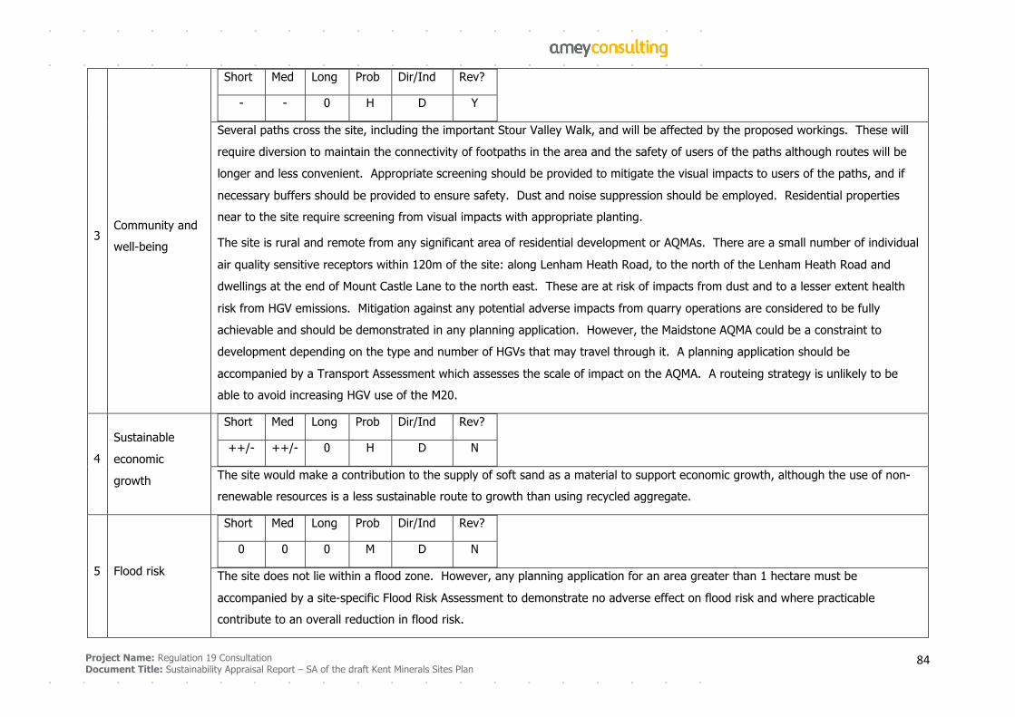
Project Name: Regulation 19 Consultation
Document Title: Sustainability Appraisal Report – SA of the draft Kent Minerals Sites Plan 84
3 Community and
well-being
Short Med Long Prob Dir/Ind Rev?
- - 0 H D Y
Several paths cross the site, including the important Stour Valley Walk, and will be affected by the proposed workings. These will
require diversion to maintain the connectivity of footpaths in the area and the safety of users of the paths although routes will be
longer and less convenient. Appropriate screening should be provided to mitigate the visual impacts to users of the paths, and if
necessary buffers should be provided to ensure safety. Dust and noise suppression should be employed. Residential properties
near to the site require screening from visual impacts with appropriate planting.
The site is rural and remote from any significant area of residential development or AQMAs. There are a small number of individual
air quality sensitive receptors within 120m of the site: along Lenham Heath Road, to the north of the Lenham Heath Road and
dwellings at the end of Mount Castle Lane to the north east. These are at risk of impacts from dust and to a lesser extent health
risk from HGV emissions. Mitigation against any potential adverse impacts from quarry operations are considered to be fully
achievable and should be demonstrated in any planning application. However, the Maidstone AQMA could be a constraint to
development depending on the type and number of HGVs that may travel through it. A planning application should be
accompanied by a Transport Assessment which assesses the scale of impact on the AQMA. A routeing strategy is unlikely to be
able to avoid increasing HGV use of the M20.
4
Sustainable
economic
growth
Short Med Long Prob Dir/Ind Rev?
++/- ++/- 0 H D N
The site would make a contribution to the supply of soft sand as a material to support economic growth, although the use of non-
renewable resources is a less sustainable route to growth than using recycled aggregate.
5 Flood risk
Short Med Long Prob Dir/Ind Rev?
0 0 0 M D N
The site does not lie within a flood zone. However, any planning application for an area greater than 1 hectare must be
accompanied by a site-specific Flood Risk Assessment to demonstrate no adverse effect on flood risk and where practicable
contribute to an overall reduction in flood risk.
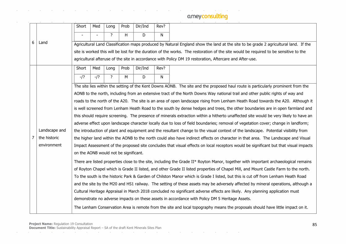
Project Name: Regulation 19 Consultation
Document Title: Sustainability Appraisal Report – SA of the draft Kent Minerals Sites Plan 85
6 Land
Short Med Long Prob Dir/Ind Rev?
- - ? H D N
Agricultural Land Classification maps produced by Natural England show the land at the site to be grade 2 agricultural land. If the
site is worked this will be lost for the duration of the works. The restoration of the site would be required to be sensitive to the
agricultural afteruse of the site in accordance with Policy DM 19 restoration, Aftercare and After-use.
7
Landscape and
the historic
environment
Short Med Long Prob Dir/Ind Rev?
-/? -/? ? M D N
The site lies within the setting of the Kent Downs AONB. The site and the proposed haul route is particularly prominent from the
AONB to the north, including from an extensive tract of the North Downs Way national trail and other public rights of way and
roads to the north of the A20. The site is an area of open landscape rising from Lenham Heath Road towards the A20. Although it
is well screened from Lenham Heath Road to the south by dense hedges and trees, the other boundaries are in open farmland and
this should require screening. The presence of minerals extraction within a hitherto unaffected site would be very likely to have an
adverse effect upon landscape character locally due to loss of field boundaries; removal of vegetation cover; change in landform;
the introduction of plant and equipment and the resultant change to the visual context of the landscape. Potential visibility from
the higher land within the AONB to the north could also have indirect effects on character in that area. The Landscape and Visual
Impact Assessment of the proposed site concludes that visual effects on local receptors would be significant but that visual impacts
on the AONB would not be significant.
There are listed properties close to the site, including the Grade II* Royton Manor, together with important archaeological remains
of Royton Chapel which is Grade II listed, and other Grade II listed properties of Chapel Mill, and Mount Castle Farm to the north.
To the south is the historic Park & Garden of Chilston Manor which is Grade I listed, but this is cut off from Lenham Heath Road
and the site by the M20 and HS1 railway. The setting of these assets may be adversely affected by mineral operations, although a
Cultural Heritage Appraisal in March 2018 concluded no significant adverse effects are likely. Any planning application must
demonstrate no adverse impacts on these assets in accordance with Policy DM 5 Heritage Assets.
The Lenham Conservation Area is remote from the site and local topography means the proposals should have little impact on it.
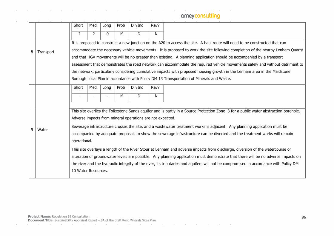
Project Name: Regulation 19 Consultation
Document Title: Sustainability Appraisal Report – SA of the draft Kent Minerals Sites Plan 86
8 Transport
Short Med Long Prob Dir/Ind Rev?
? ? 0 M D N
It is proposed to construct a new junction on the A20 to access the site. A haul route will need to be constructed that can
accommodate the necessary vehicle movements. It is proposed to work the site following completion of the nearby Lenham Quarry
and that HGV movements will be no greater than existing. A planning application should be accompanied by a transport
assessment that demonstrates the road network can accommodate the required vehicle movements safely and without detriment to
the network, particularly considering cumulative impacts with proposed housing growth in the Lenham area in the Maidstone
Borough Local Plan in accordance with Policy DM 13 Transportation of Minerals and Waste.
9 Water
Short Med Long Prob Dir/Ind Rev?
- - - M D N
This site overlies the Folkestone Sands aquifer and is partly in a Source Protection Zone 3 for a public water abstraction borehole.
Adverse impacts from mineral operations are not expected.
Sewerage infrastructure crosses the site, and a wastewater treatment works is adjacent. Any planning application must be
accompanied by adequate proposals to show the sewerage infrastructure can be diverted and the treatment works will remain
operational.
This site overlays a length of the River Stour at Lenham and adverse impacts from discharge, diversion of the watercourse or
alteration of groundwater levels are possible. Any planning application must demonstrate that there will be no adverse impacts on
the river and the hydraulic integrity of the river, its tributaries and aquifers will not be compromised in accordance with Policy DM
10 Water Resources.

Project Name: Regulation 19 Consultation
Document Title: Sustainability Appraisal Report – SA of the draft Kent Minerals Sites Plan 87
Site M7: Central Road
Sustainability Objective Comments
1 Biodiversity
Short Med Long Prob Dir/Ind Rev?
- - - - - - M D N
The site is a grazing marsh, a priority habitat and a habitat of principal importance under the Natural Environment
and Rural Communities Act. It currently supports a wide range of flora and fauna, including a number of rare plant
species, important wintering and breeding bird populations and the most important water vole populations in the
north-west of the county. It is of national importance for its aquatic macroinvertebrate assemblages and water vole
populations. The development will result in the loss of this priority habitat and it is unlikely to be possible to recreate
it, either elsewhere or on restoration. Development is also likely to have indirect impacts on the adjacent coastal
saltmarsh and deciduous woodland priority habitats.
The site overlaps Dartford Marshes Local Wildlife Site. Extraction should avoid this part of the site and any planning
application should be accompanied by an assessment of the likely impacts on the LWS and appropriate mitigation to
ensure no significant adverse effects on the site.
2 Climate change
Short Med Long Prob Dir/Ind Rev?
- - 0 H D N
The site is a new site rather than a phased extension to existing workings and therefore will add to emissions from
HGV movements and other site traffic and on-site processing. This will have a negative impact on climate change,
albeit small when considered in terms of the emissions in the county as a whole.
3 Community and well-
being
Short Med Long Prob Dir/Ind Rev?
- - 0 H D Y
A large number of residential properties are located in close proximity to the site, including three and four-storey
apartment blocks. Clear views of operations are likely to be available from these properties, and from the public

Project Name: Regulation 19 Consultation
Document Title: Sustainability Appraisal Report – SA of the draft Kent Minerals Sites Plan 88
rights of way that run around the eastern and western boundaries of the site. It is unlikely that the adverse effects
from such change in view could be adequately mitigated against, due to the height of property windows and the
lower level of the site than the surrounding land.
Extraction activity could be constrained by existing residential receptors on Wellcome Avenue (east) and Riverside
Walk (west) which are sensitive to deposited dust and potentially noise, vibration, light and visual impacts. Mitigation
should be employed in the form of dust suppression and appropriate bunds or planting in accordance with Policy DM
11 Health and Amenity.
The bridleway to the east of the site and public footpath DB1 to the west should be retained for use with appropriate
safety measures and screening. It is unlikely that views into the site from the paths and nearby residential properties
can be mitigated.
The promoted site area is part of the Dartford Borough Open Space (Policy CS14 and DP24) and is part of the
strategic development site local plan designation. The intention is to retain the site as an area of undeveloped land
within the overall strategic development designation. There will be a loss of this open space in the short and
medium term, to be restored in the long term.
There are three AQMAs in the vicinity of the site and air quality could be further reduced in these areas, either from
site traffic or from other traffic trying to avoid congestion. An access and routeing plan should be developed to allow
site traffic to avoid the AQMAs to reduce the risk of adverse health impacts, and a planning application should be
accompanied by a detailed air quality assessment to demonstrate that the development can be accommodated on
the road network without significant adverse effects on air quality to satisfy policy DM Health and Amenity.
4 Sustainable economic
growth
Short Med Long Prob Dir/Ind Rev?
++/- ++/- 0 H D N
The site would make a contribution to the supply of sharp sand and gravel as a material to support economic growth,
although the use of non-renewable resources is a less sustainable route to growth than using recycled aggregate.
The site is identified in the Dartford Local Plan as part the Northern Gateway Strategic Site (Policy CS3). The
promoted site area is also part of the Borough Open Space (Policy CS14 and DP24) that is part of the strategic
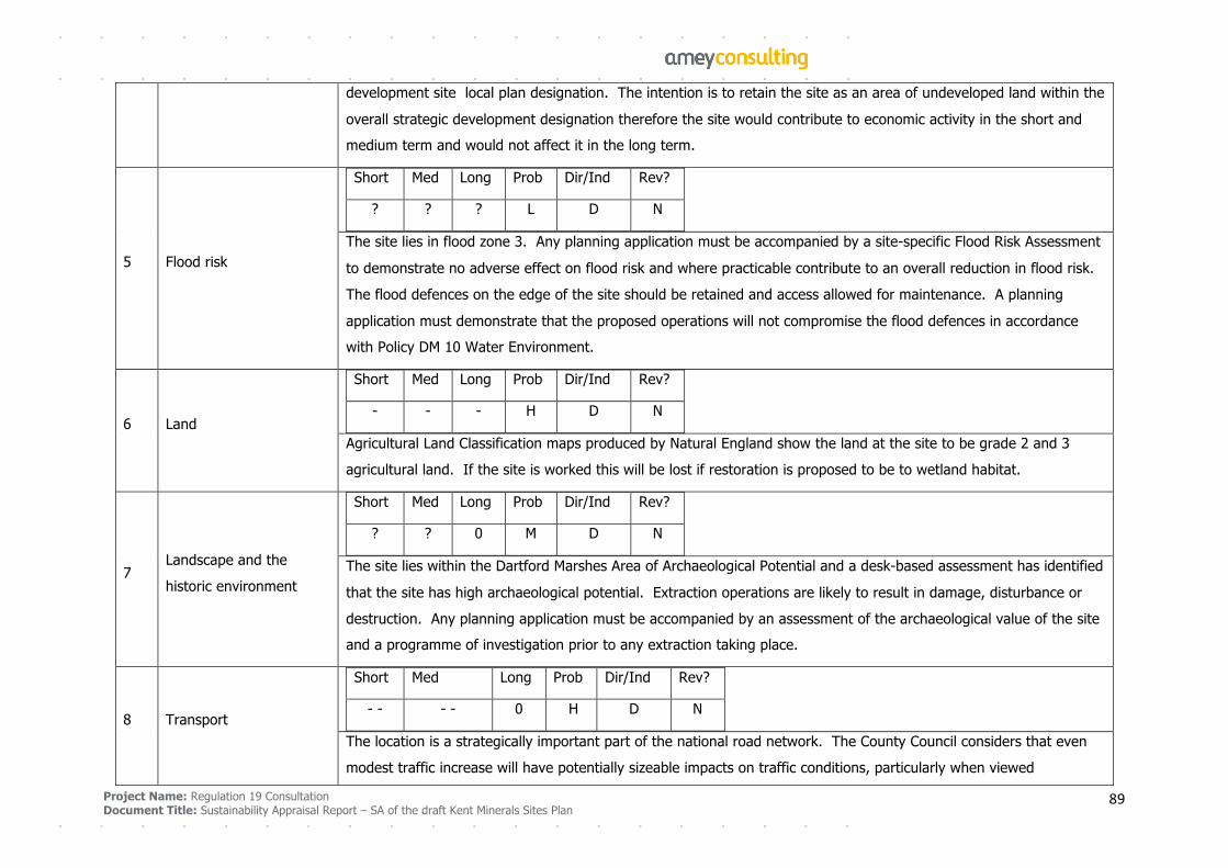
Project Name: Regulation 19 Consultation
Document Title: Sustainability Appraisal Report – SA of the draft Kent Minerals Sites Plan 89
development site local plan designation. The intention is to retain the site as an area of undeveloped land within the
overall strategic development designation therefore the site would contribute to economic activity in the short and
medium term and would not affect it in the long term.
5 Flood risk
Short Med Long Prob Dir/Ind Rev?
? ? ? L D N
The site lies in flood zone 3. Any planning application must be accompanied by a site-specific Flood Risk Assessment
to demonstrate no adverse effect on flood risk and where practicable contribute to an overall reduction in flood risk.
The flood defences on the edge of the site should be retained and access allowed for maintenance. A planning
application must demonstrate that the proposed operations will not compromise the flood defences in accordance
with Policy DM 10 Water Environment.
6 Land
Short Med Long Prob Dir/Ind Rev?
- - - H D N
Agricultural Land Classification maps produced by Natural England show the land at the site to be grade 2 and 3
agricultural land. If the site is worked this will be lost if restoration is proposed to be to wetland habitat.
7 Landscape and the
historic environment
Short Med Long Prob Dir/Ind Rev?
? ? 0 M D N
The site lies within the Dartford Marshes Area of Archaeological Potential and a desk-based assessment has identified
that the site has high archaeological potential. Extraction operations are likely to result in damage, disturbance or
destruction. Any planning application must be accompanied by an assessment of the archaeological value of the site
and a programme of investigation prior to any extraction taking place.
8 Transport
Short Med Long Prob Dir/Ind Rev?
- - - - 0 H D N
The location is a strategically important part of the national road network. The County Council considers that even
modest traffic increase will have potentially sizeable impacts on traffic conditions, particularly when viewed
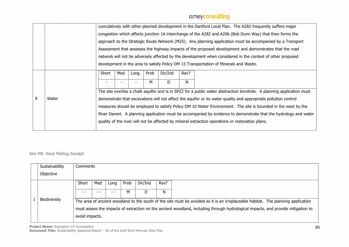
Project Name: Regulation 19 Consultation
Document Title: Sustainability Appraisal Report – SA of the draft Kent Minerals Sites Plan 90
cumulatively with other planned development in the Dartford Local Plan. The A282 frequently suffers major
congestion which affects junction 1A interchange of the A282 and A206 (Bob Dunn Way) that then forms the
approach to the Strategic Route Network (M25). Any planning application must be accompanied by a Transport
Assessment that assesses the highway impacts of the proposed development and demonstrates that the road
network will not be adversely affected by the development when considered in the context of other proposed
development in the area to satisfy Policy DM 13 Transportation of Minerals and Waste.
9 Water
Short Med Long Prob Dir/Ind Rev?
- - - M D N
The site overlies a chalk aquifer and is in SPZ2 for a public water abstraction borehole. A planning application must
demonstrate that excavations will not affect the aquifer or its water quality and appropriate pollution control
measures should be employed to satisfy Policy DM 10 Water Environment. The site is bounded in the west by the
River Darent. A planning application must be accompanied by evidence to demonstrate that the hydrology and water
quality of the river will not be affected by mineral extraction operations or restoration plans.
Site M8: West Malling Sandpit
Sustainability
Objective
Comments
1 Biodiversity
Short Med Long Prob Dir/Ind Rev?
- - - - - - M D N
The area of ancient woodland to the south of the site must be avoided as it is an irreplaceable habitat. The planning application
must assess the impacts of extraction on the ancient woodland, including through hydrological impacts, and provide mitigation to
avoid impacts.
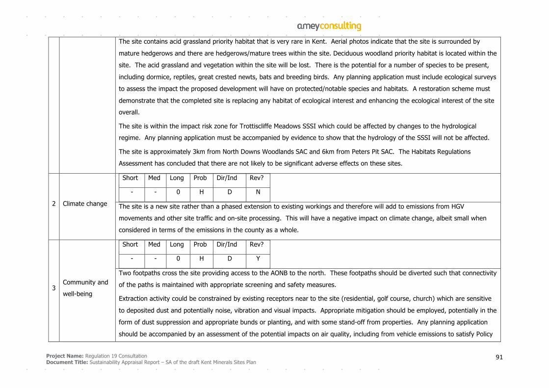
Project Name: Regulation 19 Consultation
Document Title: Sustainability Appraisal Report – SA of the draft Kent Minerals Sites Plan 91
The site contains acid grassland priority habitat that is very rare in Kent. Aerial photos indicate that the site is surrounded by
mature hedgerows and there are hedgerows/mature trees within the site. Deciduous woodland priority habitat is located within the
site. The acid grassland and vegetation within the site will be lost. There is the potential for a number of species to be present,
including dormice, reptiles, great crested newts, bats and breeding birds. Any planning application must include ecological surveys
to assess the impact the proposed development will have on protected/notable species and habitats. A restoration scheme must
demonstrate that the completed site is replacing any habitat of ecological interest and enhancing the ecological interest of the site
overall.
The site is within the impact risk zone for Trottiscliffe Meadows SSSI which could be affected by changes to the hydrological
regime. Any planning application must be accompanied by evidence to show that the hydrology of the SSSI will not be affected.
The site is approximately 3km from North Downs Woodlands SAC and 6km from Peters Pit SAC. The Habitats Regulations
Assessment has concluded that there are not likely to be significant adverse effects on these sites.
2 Climate change
Short Med Long Prob Dir/Ind Rev?
- - 0 H D N
The site is a new site rather than a phased extension to existing workings and therefore will add to emissions from HGV
movements and other site traffic and on-site processing. This will have a negative impact on climate change, albeit small when
considered in terms of the emissions in the county as a whole.
3 Community and
well-being
Short Med Long Prob Dir/Ind Rev?
- - 0 H D Y
Two footpaths cross the site providing access to the AONB to the north. These footpaths should be diverted such that connectivity
of the paths is maintained with appropriate screening and safety measures.
Extraction activity could be constrained by existing receptors near to the site (residential, golf course, church) which are sensitive
to deposited dust and potentially noise, vibration and visual impacts. Appropriate mitigation should be employed, potentially in the
form of dust suppression and appropriate bunds or planting, and with some stand-off from properties. Any planning application
should be accompanied by an assessment of the potential impacts on air quality, including from vehicle emissions to satisfy Policy
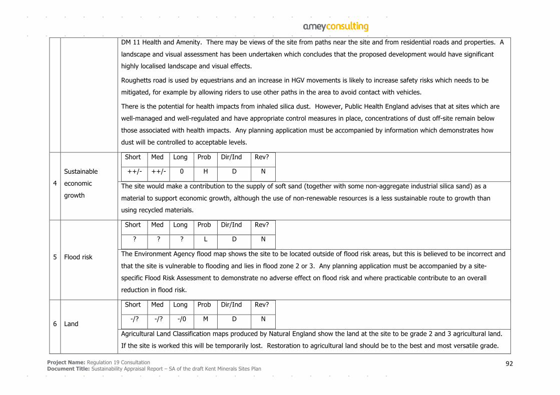
Project Name: Regulation 19 Consultation
Document Title: Sustainability Appraisal Report – SA of the draft Kent Minerals Sites Plan 92
DM 11 Health and Amenity. There may be views of the site from paths near the site and from residential roads and properties. A
landscape and visual assessment has been undertaken which concludes that the proposed development would have significant
highly localised landscape and visual effects.
Roughetts road is used by equestrians and an increase in HGV movements is likely to increase safety risks which needs to be
mitigated, for example by allowing riders to use other paths in the area to avoid contact with vehicles.
There is the potential for health impacts from inhaled silica dust. However, Public Health England advises that at sites which are
well-managed and well-regulated and have appropriate control measures in place, concentrations of dust off-site remain below
those associated with health impacts. Any planning application must be accompanied by information which demonstrates how
dust will be controlled to acceptable levels.
4
Sustainable
economic
growth
Short Med Long Prob Dir/Ind Rev?
++/- ++/- 0 H D N
The site would make a contribution to the supply of soft sand (together with some non-aggregate industrial silica sand) as a
material to support economic growth, although the use of non-renewable resources is a less sustainable route to growth than
using recycled materials.
5 Flood risk
Short Med Long Prob Dir/Ind Rev?
? ? ? L D N
The Environment Agency flood map shows the site to be located outside of flood risk areas, but this is believed to be incorrect and
that the site is vulnerable to flooding and lies in flood zone 2 or 3. Any planning application must be accompanied by a site-
specific Flood Risk Assessment to demonstrate no adverse effect on flood risk and where practicable contribute to an overall
reduction in flood risk.
6 Land
Short Med Long Prob Dir/Ind Rev?
-/? -/? -/0 M D N
Agricultural Land Classification maps produced by Natural England show the land at the site to be grade 2 and 3 agricultural land.
If the site is worked this will be temporarily lost. Restoration to agricultural land should be to the best and most versatile grade.
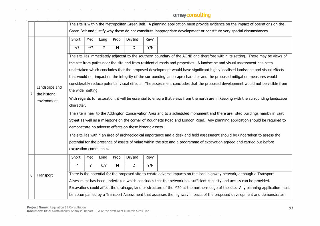
Project Name: Regulation 19 Consultation
Document Title: Sustainability Appraisal Report – SA of the draft Kent Minerals Sites Plan 93
The site is within the Metropolitan Green Belt. A planning application must provide evidence on the impact of operations on the
Green Belt and justify why these do not constitute inappropriate development or constitute very special circumstances.
7
Landscape and
the historic
environment
Short Med Long Prob Dir/Ind Rev?
-/? -/? ? M D Y/N
The site lies immediately adjacent to the southern boundary of the AONB and therefore within its setting. There may be views of
the site from paths near the site and from residential roads and properties. A landscape and visual assessment has been
undertaken which concludes that the proposed development would have significant highly localised landscape and visual effects
that would not impact on the integrity of the surrounding landscape character and the proposed mitigation measures would
considerably reduce potential visual effects. The assessment concludes that the proposed development would not be visible from
the wider setting.
With regards to restoration, it will be essential to ensure that views from the north are in keeping with the surrounding landscape
character.
The site is near to the Addington Conservation Area and to a scheduled monument and there are listed buildings nearby in East
Street as well as a milestone on the corner of Roughetts Road and London Road. Any planning application should be required to
demonstrate no adverse effects on these historic assets.
The site lies within an area of archaeological importance and a desk and field assessment should be undertaken to assess the
potential for the presence of assets of value within the site and a programme of excavation agreed and carried out before
excavation commences.
8 Transport
Short Med Long Prob Dir/Ind Rev?
? ? 0/? M D Y/N
There is the potential for the proposed site to create adverse impacts on the local highway network, although a Transport
Assessment has been undertaken which concludes that the network has sufficient capacity and access can be provided.
Excavations could affect the drainage, land or structure of the M20 at the northern edge of the site. Any planning application must
be accompanied by a Transport Assessment that assesses the highway impacts of the proposed development and demonstrates
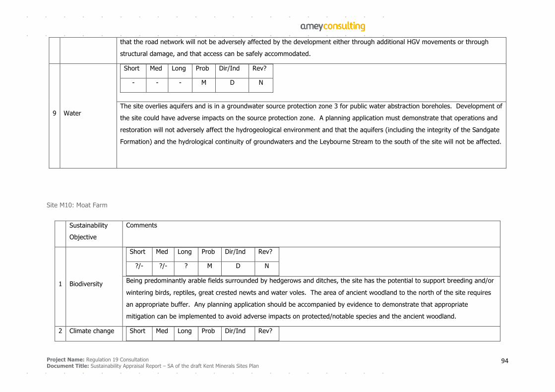
Project Name: Regulation 19 Consultation
Document Title: Sustainability Appraisal Report – SA of the draft Kent Minerals Sites Plan 94
that the road network will not be adversely affected by the development either through additional HGV movements or through
structural damage, and that access can be safely accommodated.
9 Water
Short Med Long Prob Dir/Ind Rev?
- - - M D N
The site overlies aquifers and is in a groundwater source protection zone 3 for public water abstraction boreholes. Development of
the site could have adverse impacts on the source protection zone. A planning application must demonstrate that operations and
restoration will not adversely affect the hydrogeological environment and that the aquifers (including the integrity of the Sandgate
Formation) and the hydrological continuity of groundwaters and the Leybourne Stream to the south of the site will not be affected.
Site M10: Moat Farm
Sustainability
Objective
Comments
1 Biodiversity
Short Med Long Prob Dir/Ind Rev?
?/- ?/- ? M D N
Being predominantly arable fields surrounded by hedgerows and ditches, the site has the potential to support breeding and/or
wintering birds, reptiles, great crested newts and water voles. The area of ancient woodland to the north of the site requires
an appropriate buffer. Any planning application should be accompanied by evidence to demonstrate that appropriate
mitigation can be implemented to avoid adverse impacts on protected/notable species and the ancient woodland.
2 Climate change Short Med Long Prob Dir/Ind Rev?

Project Name: Regulation 19 Consultation
Document Title: Sustainability Appraisal Report – SA of the draft Kent Minerals Sites Plan 95
0 0 0 H D N
The site is proposed as an extension to existing operations, with phasing to work this and the proposed Stonecastle Farm site
(M13) sequential, such that they are not developed concurrently and with an extraction rate of 120,000 tonnes per annum as
that which exists at the existing Stonecastle Farm Quarry site. The climate change impacts from HGVs and other vehicles
accessing the site and on-site processing are likely to be unchanged from current emission levels.
3 Community and
well-being
Short Med Long Prob Dir/Ind Rev?
- - ?/0 H D Y
Footpaths cross the site which will be diverted during operations and possibly permanently. These footpaths should be
diverted such that connectivity of the paths and safety is maintained.
The nearest residential building is at Moat Farm and is approximately 170m from the site and which may be sensitive to
deposited dust and potentially noise, vibration and visual impacts. Any planning application should assess the potential
impacts on residential buildings and appropriate mitigation should be employed.
A Landscape Assessment undertaken in 2001 concluded that the visual impact of operations will be limited to adjacent
footpaths. These impacts must be mitigated by planting and use of bunds around the perimeter of the working. A second
assessment of landscape and visual impact was undertaken in 2018 which concluded that effects on landscape character are
unlikely to be significant other than on paths in the immediate vicinity and within the site itself. Views of the site are likely to
be seen from residential properties although screening is possible and should avoid significant impacts.
4
Sustainable
economic
growth
Short Med Long Prob Dir/Ind Rev?
++/- ++/- 0 H D N
The site would make a contribution to the supply of sharp sand and gravel as a material to support economic growth, although
the use of non-renewable resources is a less sustainable route to growth than using recycled aggregate.
5 Flood risk
Short Med Long Prob Dir/Ind Rev?
? ? ? L D N
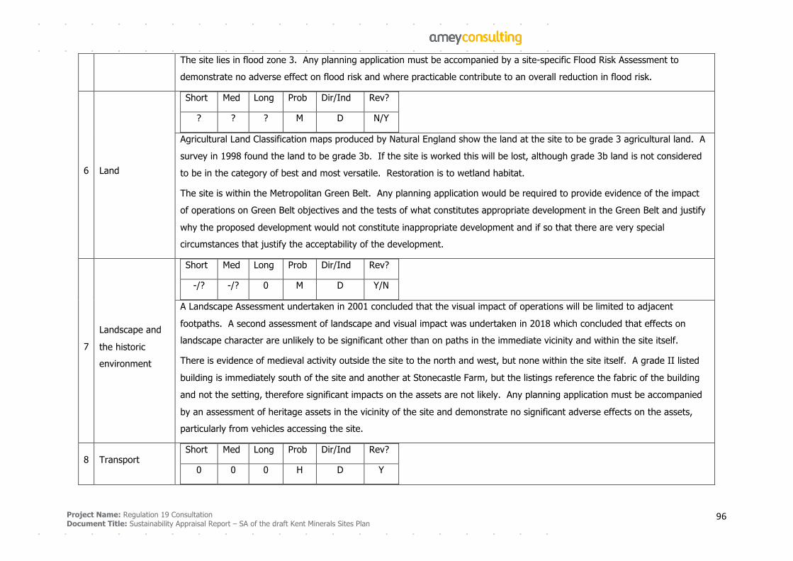
Project Name: Regulation 19 Consultation
Document Title: Sustainability Appraisal Report – SA of the draft Kent Minerals Sites Plan 96
The site lies in flood zone 3. Any planning application must be accompanied by a site-specific Flood Risk Assessment to
demonstrate no adverse effect on flood risk and where practicable contribute to an overall reduction in flood risk.
6 Land
Short Med Long Prob Dir/Ind Rev?
? ? ? M D N/Y
Agricultural Land Classification maps produced by Natural England show the land at the site to be grade 3 agricultural land. A
survey in 1998 found the land to be grade 3b. If the site is worked this will be lost, although grade 3b land is not considered
to be in the category of best and most versatile. Restoration is to wetland habitat.
The site is within the Metropolitan Green Belt. Any planning application would be required to provide evidence of the impact
of operations on Green Belt objectives and the tests of what constitutes appropriate development in the Green Belt and justify
why the proposed development would not constitute inappropriate development and if so that there are very special
circumstances that justify the acceptability of the development.
7
Landscape and
the historic
environment
Short Med Long Prob Dir/Ind Rev?
-/? -/? 0 M D Y/N
A Landscape Assessment undertaken in 2001 concluded that the visual impact of operations will be limited to adjacent
footpaths. A second assessment of landscape and visual impact was undertaken in 2018 which concluded that effects on
landscape character are unlikely to be significant other than on paths in the immediate vicinity and within the site itself.
There is evidence of medieval activity outside the site to the north and west, but none within the site itself. A grade II listed
building is immediately south of the site and another at Stonecastle Farm, but the listings reference the fabric of the building
and not the setting, therefore significant impacts on the assets are not likely. Any planning application must be accompanied
by an assessment of heritage assets in the vicinity of the site and demonstrate no significant adverse effects on the assets,
particularly from vehicles accessing the site.
8 Transport
Short Med Long Prob Dir/Ind Rev?
0 0 0 H D Y
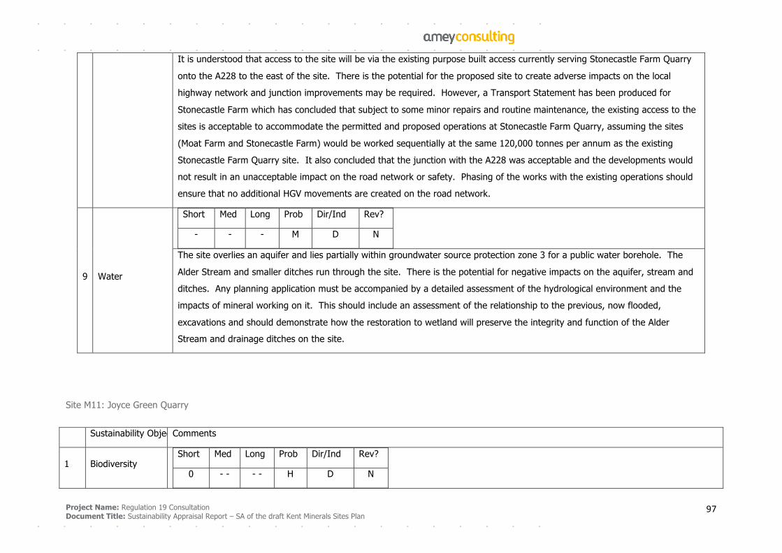
Project Name: Regulation 19 Consultation
Document Title: Sustainability Appraisal Report – SA of the draft Kent Minerals Sites Plan 97
It is understood that access to the site will be via the existing purpose built access currently serving Stonecastle Farm Quarry
onto the A228 to the east of the site. There is the potential for the proposed site to create adverse impacts on the local
highway network and junction improvements may be required. However, a Transport Statement has been produced for
Stonecastle Farm which has concluded that subject to some minor repairs and routine maintenance, the existing access to the
sites is acceptable to accommodate the permitted and proposed operations at Stonecastle Farm Quarry, assuming the sites
(Moat Farm and Stonecastle Farm) would be worked sequentially at the same 120,000 tonnes per annum as the existing
Stonecastle Farm Quarry site. �It also concluded that the junction with the A228 was acceptable and the developments would
not result in an unacceptable impact on the road network or safety. Phasing of the works with the existing operations should
ensure that no additional HGV movements are created on the road network.
9 Water
Short Med Long Prob Dir/Ind Rev?
- - - M D N
The site overlies an aquifer and lies partially within groundwater source protection zone 3 for a public water borehole. The
Alder Stream and smaller ditches run through the site. There is the potential for negative impacts on the aquifer, stream and
ditches. Any planning application must be accompanied by a detailed assessment of the hydrological environment and the
impacts of mineral working on it. This should include an assessment of the relationship to the previous, now flooded,
excavations and should demonstrate how the restoration to wetland will preserve the integrity and function of the Alder
Stream and drainage ditches on the site.
Site M11: Joyce Green Quarry
Sustainability Objective Comments
1 Biodiversity
Short Med Long Prob Dir/Ind Rev?
0 - - - - H D N
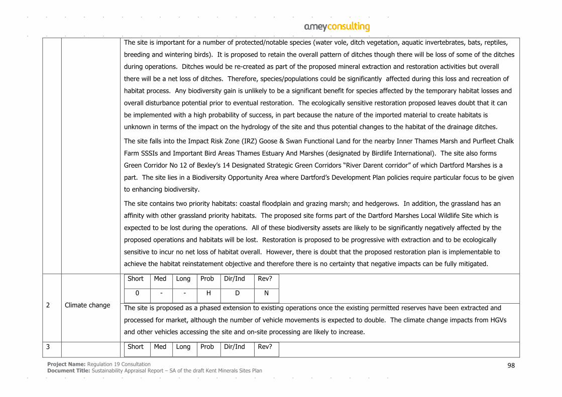
Project Name: Regulation 19 Consultation
Document Title: Sustainability Appraisal Report – SA of the draft Kent Minerals Sites Plan 98
The site is important for a number of protected/notable species (water vole, ditch vegetation, aquatic invertebrates, bats, reptiles,
breeding and wintering birds). It is proposed to retain the overall pattern of ditches though there will be loss of some of the ditches
during operations. Ditches would be re-created as part of the proposed mineral extraction and restoration activities but overall
there will be a net loss of ditches. Therefore, species/populations could be significantly affected during this loss and recreation of
habitat process. Any biodiversity gain is unlikely to be a significant benefit for species affected by the temporary habitat losses and
overall disturbance potential prior to eventual restoration. The ecologically sensitive restoration proposed leaves doubt that it can
be implemented with a high probability of success, in part because the nature of the imported material to create habitats is
unknown in terms of the impact on the hydrology of the site and thus potential changes to the habitat of the drainage ditches.
The site falls into the Impact Risk Zone (IRZ) Goose & Swan Functional Land for the nearby Inner Thames Marsh and Purfleet Chalk
Farm SSSIs and Important Bird Areas Thames Estuary And Marshes (designated by Birdlife International). The site also forms
Green Corridor No 12 of Bexley’s 14 Designated Strategic Green Corridors “River Darent corridor” of which Dartford Marshes is a
part. The site lies in a Biodiversity Opportunity Area where Dartford’s Development Plan policies require particular focus to be given
to enhancing biodiversity.
The site contains two priority habitats: coastal floodplain and grazing marsh; and hedgerows. In addition, the grassland has an
affinity with other grassland priority habitats. The proposed site forms part of the Dartford Marshes Local Wildlife Site which is
expected to be lost during the operations. All of these biodiversity assets are likely to be significantly negatively affected by the
proposed operations and habitats will be lost. Restoration is proposed to be progressive with extraction and to be ecologically
sensitive to incur no net loss of habitat overall. However, there is doubt that the proposed restoration plan is implementable to
achieve the habitat reinstatement objective and therefore there is no certainty that negative impacts can be fully mitigated.
2 Climate change
Short Med Long Prob Dir/Ind Rev?
0 - - H D N
The site is proposed as a phased extension to existing operations once the existing permitted reserves have been extracted and
processed for market, although the number of vehicle movements is expected to double. The climate change impacts from HGVs
and other vehicles accessing the site and on-site processing are likely to increase.
3 Short Med Long Prob Dir/Ind Rev?
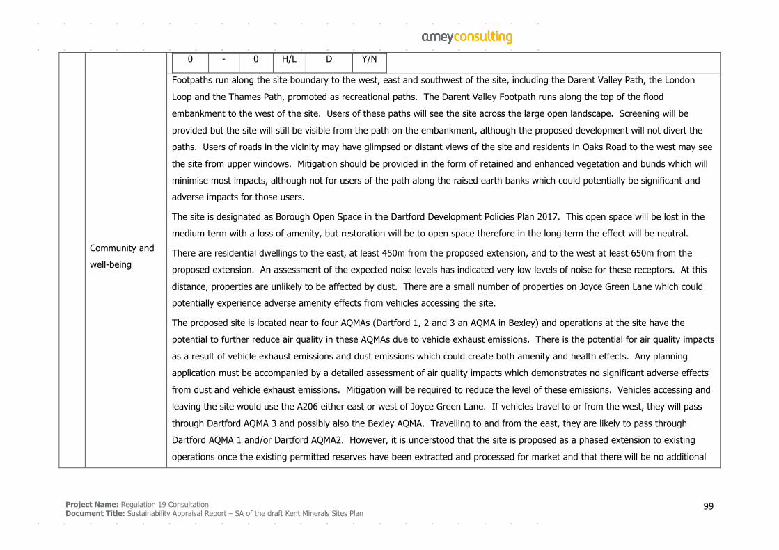
Project Name: Regulation 19 Consultation
Document Title: Sustainability Appraisal Report – SA of the draft Kent Minerals Sites Plan 99
Community and
well-being
0 - 0 H/L D Y/N
Footpaths run along the site boundary to the west, east and southwest of the site, including the Darent Valley Path, the London
Loop and the Thames Path, promoted as recreational paths. The Darent Valley Footpath runs along the top of the flood
embankment to the west of the site. Users of these paths will see the site across the large open landscape. Screening will be
provided but the site will still be visible from the path on the embankment, although the proposed development will not divert the
paths. Users of roads in the vicinity may have glimpsed or distant views of the site and residents in Oaks Road to the west may see
the site from upper windows. Mitigation should be provided in the form of retained and enhanced vegetation and bunds which will
minimise most impacts, although not for users of the path along the raised earth banks which could potentially be significant and
adverse impacts for those users.
The site is designated as Borough Open Space in the Dartford Development Policies Plan 2017. This open space will be lost in the
medium term with a loss of amenity, but restoration will be to open space therefore in the long term the effect will be neutral.
There are residential dwellings to the east, at least 450m from the proposed extension, and to the west at least 650m from the
proposed extension. An assessment of the expected noise levels has indicated very low levels of noise for these receptors. At this
distance, properties are unlikely to be affected by dust. There are a small number of properties on Joyce Green Lane which could
potentially experience adverse amenity effects from vehicles accessing the site.
The proposed site is located near to four AQMAs (Dartford 1, 2 and 3 an AQMA in Bexley) and operations at the site have the
potential to further reduce air quality in these AQMAs due to vehicle exhaust emissions. There is the potential for air quality impacts
as a result of vehicle exhaust emissions and dust emissions which could create both amenity and health effects. Any planning
application must be accompanied by a detailed assessment of air quality impacts which demonstrates no significant adverse effects
from dust and vehicle exhaust emissions. Mitigation will be required to reduce the level of these emissions. Vehicles accessing and
leaving the site would use the A206 either east or west of Joyce Green Lane. If vehicles travel to or from the west, they will pass
through Dartford AQMA 3 and possibly also the Bexley AQMA. Travelling to and from the east, they are likely to pass through
Dartford AQMA 1 and/or Dartford AQMA2. However, it is understood that the site is proposed as a phased extension to existing
operations once the existing permitted reserves have been extracted and processed for market and that there will be no additional
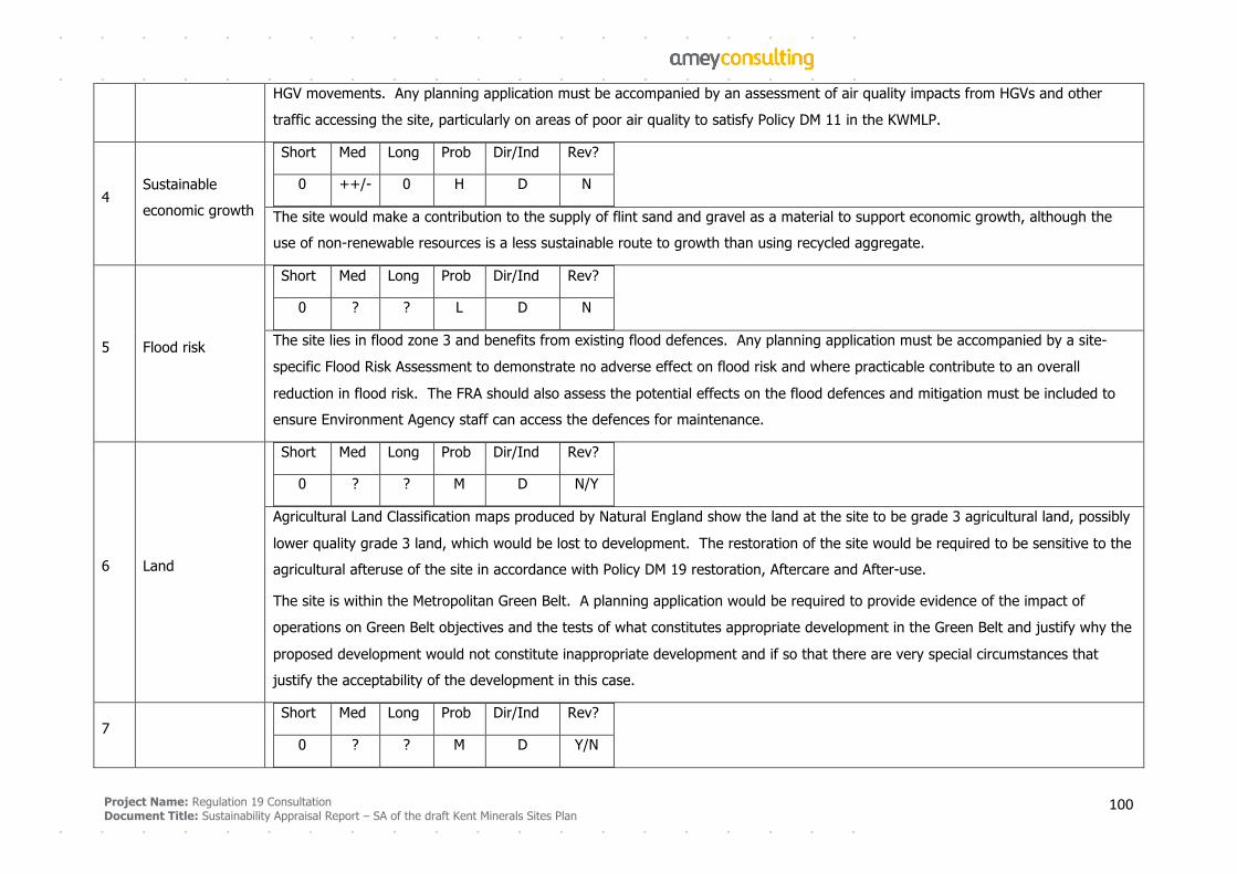
Project Name: Regulation 19 Consultation
Document Title: Sustainability Appraisal Report – SA of the draft Kent Minerals Sites Plan 100
HGV movements. Any planning application must be accompanied by an assessment of air quality impacts from HGVs and other
traffic accessing the site, particularly on areas of poor air quality to satisfy Policy DM 11 in the KWMLP.
4 Sustainable
economic growth
Short Med Long Prob Dir/Ind Rev?
0 ++/- 0 H D N
The site would make a contribution to the supply of flint sand and gravel as a material to support economic growth, although the
use of non-renewable resources is a less sustainable route to growth than using recycled aggregate.
5 Flood risk
Short Med Long Prob Dir/Ind Rev?
0 ? ? L D N
The site lies in flood zone 3 and benefits from existing flood defences. Any planning application must be accompanied by a site-
specific Flood Risk Assessment to demonstrate no adverse effect on flood risk and where practicable contribute to an overall
reduction in flood risk. The FRA should also assess the potential effects on the flood defences and mitigation must be included to
ensure Environment Agency staff can access the defences for maintenance.
6 Land
Short Med Long Prob Dir/Ind Rev?
0 ? ? M D N/Y
Agricultural Land Classification maps produced by Natural England show the land at the site to be grade 3 agricultural land, possibly
lower quality grade 3 land, which would be lost to development. The restoration of the site would be required to be sensitive to the
agricultural afteruse of the site in accordance with Policy DM 19 restoration, Aftercare and After-use.
The site is within the Metropolitan Green Belt. A planning application would be required to provide evidence of the impact of
operations on Green Belt objectives and the tests of what constitutes appropriate development in the Green Belt and justify why the
proposed development would not constitute inappropriate development and if so that there are very special circumstances that
justify the acceptability of the development in this case.
7
Short Med Long Prob Dir/Ind Rev?
0 ? ? M D Y/N
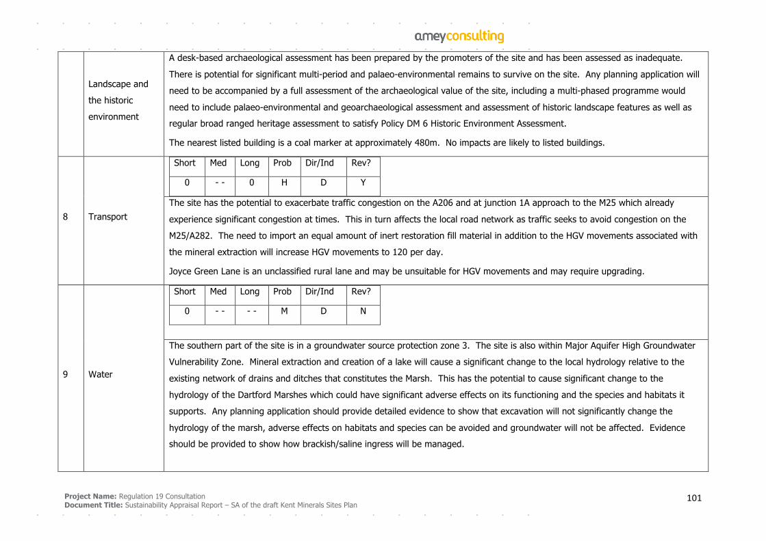
Project Name: Regulation 19 Consultation
Document Title: Sustainability Appraisal Report – SA of the draft Kent Minerals Sites Plan 101
Landscape and
the historic
environment
A desk-based archaeological assessment has been prepared by the promoters of the site and has been assessed as inadequate.
There is potential for significant multi-period and palaeo-environmental remains to survive on the site. Any planning application will
need to be accompanied by a full assessment of the archaeological value of the site, including a multi-phased programme would
need to include palaeo-environmental and geoarchaeological assessment and assessment of historic landscape features as well as
regular broad ranged heritage assessment to satisfy Policy DM 6 Historic Environment Assessment.
The nearest listed building is a coal marker at approximately 480m. No impacts are likely to listed buildings.
8 Transport
Short Med Long Prob Dir/Ind Rev?
0 - - 0 H D Y
The site has the potential to exacerbate traffic congestion on the A206 and at junction 1A approach to the M25 which already
experience significant congestion at times. This in turn affects the local road network as traffic seeks to avoid congestion on the
M25/A282. The need to import an equal amount of inert restoration fill material in addition to the HGV movements associated with
the mineral extraction will increase HGV movements to 120 per day.
Joyce Green Lane is an unclassified rural lane and may be unsuitable for HGV movements and may require upgrading.
9 Water
Short Med Long Prob Dir/Ind Rev?
0 - - - - M D N
The southern part of the site is in a groundwater source protection zone 3. The site is also within Major Aquifer High Groundwater
Vulnerability Zone. Mineral extraction and creation of a lake will cause a significant change to the local hydrology relative to the
existing network of drains and ditches that constitutes the Marsh. This has the potential to cause significant change to the
hydrology of the Dartford Marshes which could have significant adverse effects on its functioning and the species and habitats it
supports. Any planning application should provide detailed evidence to show that excavation will not significantly change the
hydrology of the marsh, adverse effects on habitats and species can be avoided and groundwater will not be affected. Evidence
should be provided to show how brackish/saline ingress will be managed.
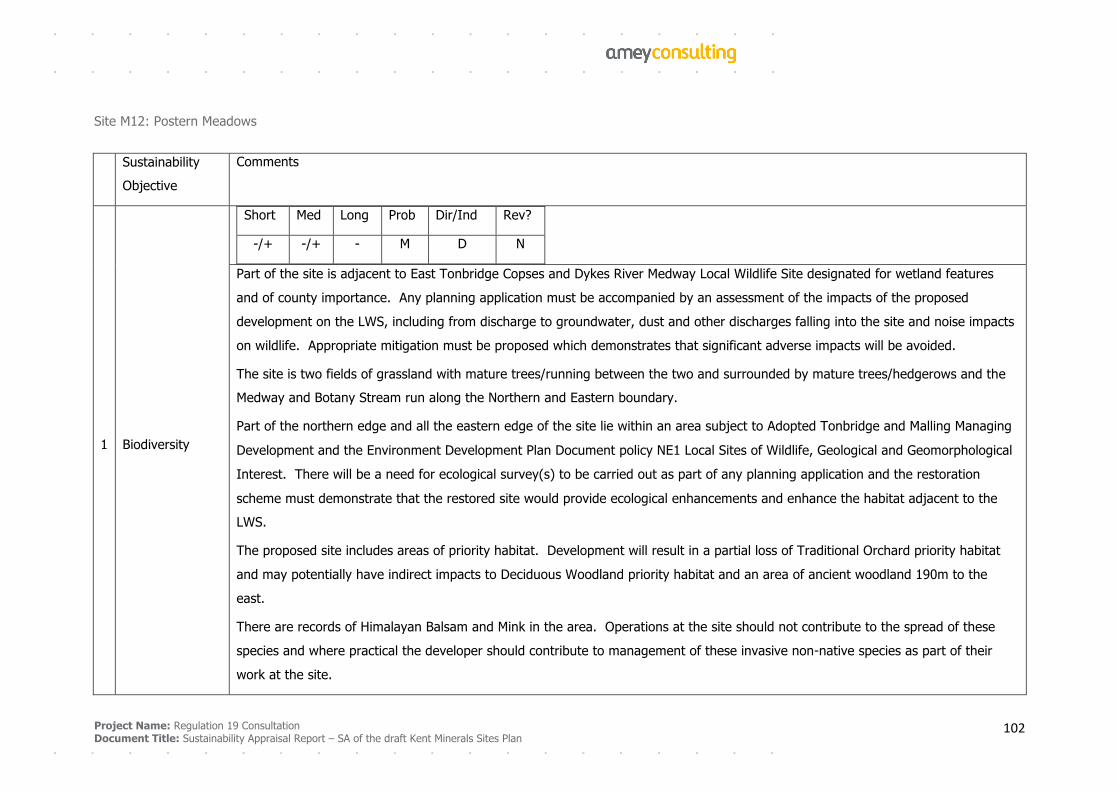
Project Name: Regulation 19 Consultation
Document Title: Sustainability Appraisal Report – SA of the draft Kent Minerals Sites Plan 102
Site M12: Postern Meadows
Sustainability
Objective
Comments
1 Biodiversity
Short Med Long Prob Dir/Ind Rev?
-/+ -/+ - M D N
Part of the site is adjacent to East Tonbridge Copses and Dykes River Medway Local Wildlife Site designated for wetland features
and of county importance. Any planning application must be accompanied by an assessment of the impacts of the proposed
development on the LWS, including from discharge to groundwater, dust and other discharges falling into the site and noise impacts
on wildlife. Appropriate mitigation must be proposed which demonstrates that significant adverse impacts will be avoided.
The site is two fields of grassland with mature trees/running between the two and surrounded by mature trees/hedgerows and the
Medway and Botany Stream run along the Northern and Eastern boundary.
Part of the northern edge and all the eastern edge of the site lie within an area subject to Adopted Tonbridge and Malling Managing
Development and the Environment Development Plan Document policy NE1 Local Sites of Wildlife, Geological and Geomorphological
Interest. There will be a need for ecological survey(s) to be carried out as part of any planning application and the restoration
scheme must demonstrate that the restored site would provide ecological enhancements and enhance the habitat adjacent to the
LWS.
The proposed site includes areas of priority habitat. Development will result in a partial loss of Traditional Orchard priority habitat
and may potentially have indirect impacts to Deciduous Woodland priority habitat and an area of ancient woodland 190m to the
east.
There are records of Himalayan Balsam and Mink in the area. Operations at the site should not contribute to the spread of these
species and where practical the developer should contribute to management of these invasive non-native species as part of their
work at the site.
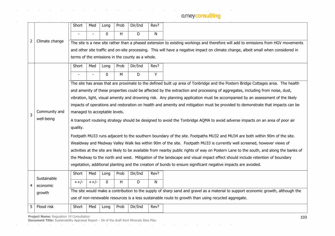
Project Name: Regulation 19 Consultation
Document Title: Sustainability Appraisal Report – SA of the draft Kent Minerals Sites Plan 103
2 Climate change
Short Med Long Prob Dir/Ind Rev?
- - 0 H D N
The site is a new site rather than a phased extension to existing workings and therefore will add to emissions from HGV movements
and other site traffic and on-site processing. This will have a negative impact on climate change, albeit small when considered in
terms of the emissions in the county as a whole.
3 Community and
well-being
Short Med Long Prob Dir/Ind Rev?
- - 0 M D Y
The site has areas that are proximate to the defined built up area of Tonbridge and the Postern Bridge Cottages area. The health
and amenity of these properties could be affected by the extraction and processing of aggregates, including from noise, dust,
vibration, light, visual amenity and drowning risk. Any planning application must be accompanied by an assessment of the likely
impacts of operations and restoration on health and amenity and mitigation must be provided to demonstrate that impacts can be
managed to acceptable levels.
A transport routeing strategy should be designed to avoid the Tonbridge AQMA to avoid adverse impacts on an area of poor air
quality.
Footpath MU33 runs adjacent to the southern boundary of the site. Footpaths MU32 and MU34 are both within 90m of the site.
Wealdway and Medway Valley Walk lies within 90m of the site. Footpath MU33 is currently well screened, however views of
activities at the site are likely to be available from nearby public rights of way on Postern Lane to the south, and along the banks of
the Medway to the north and west. Mitigation of the landscape and visual impact effect should include retention of boundary
vegetation, additional planting and the creation of bunds to ensure significant negative impacts are avoided.
4
Sustainable
economic
growth
Short Med Long Prob Dir/Ind Rev?
++/- ++/- 0 H D N
The site would make a contribution to the supply of sharp sand and gravel as a material to support economic growth, although the
use of non-renewable resources is a less sustainable route to growth than using recycled aggregate.
5 Flood risk Short Med Long Prob Dir/Ind Rev?
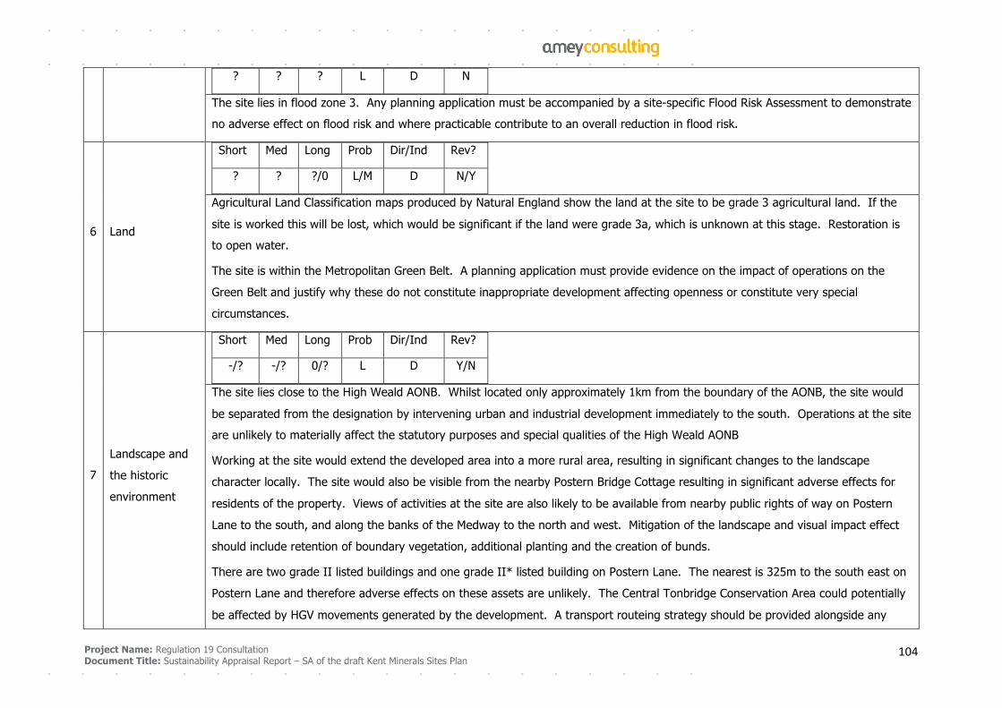
Project Name: Regulation 19 Consultation
Document Title: Sustainability Appraisal Report – SA of the draft Kent Minerals Sites Plan 104
? ? ? L D N
The site lies in flood zone 3. Any planning application must be accompanied by a site-specific Flood Risk Assessment to demonstrate
no adverse effect on flood risk and where practicable contribute to an overall reduction in flood risk.
6 Land
Short Med Long Prob Dir/Ind Rev?
? ? ?/0 L/M D N/Y
Agricultural Land Classification maps produced by Natural England show the land at the site to be grade 3 agricultural land. If the
site is worked this will be lost, which would be significant if the land were grade 3a, which is unknown at this stage. Restoration is
to open water.
The site is within the Metropolitan Green Belt. A planning application must provide evidence on the impact of operations on the
Green Belt and justify why these do not constitute inappropriate development affecting openness or constitute very special
circumstances.
7
Landscape and
the historic
environment
Short Med Long Prob Dir/Ind Rev?
-/? -/? 0/? L D Y/N
The site lies close to the High Weald AONB. Whilst located only approximately 1km from the boundary of the AONB, the site would
be separated from the designation by intervening urban and industrial development immediately to the south. Operations at the site
are unlikely to materially affect the statutory purposes and special qualities of the High Weald AONB
Working at the site would extend the developed area into a more rural area, resulting in significant changes to the landscape
character locally. The site would also be visible from the nearby Postern Bridge Cottage resulting in significant adverse effects for
residents of the property. Views of activities at the site are also likely to be available from nearby public rights of way on Postern
Lane to the south, and along the banks of the Medway to the north and west. Mitigation of the landscape and visual impact effect
should include retention of boundary vegetation, additional planting and the creation of bunds.
There are two grade II listed buildings and one grade II* listed building on Postern Lane. The nearest is 325m to the south east on
Postern Lane and therefore adverse effects on these assets are unlikely. The Central Tonbridge Conservation Area could potentially
be affected by HGV movements generated by the development. A transport routeing strategy should be provided alongside any
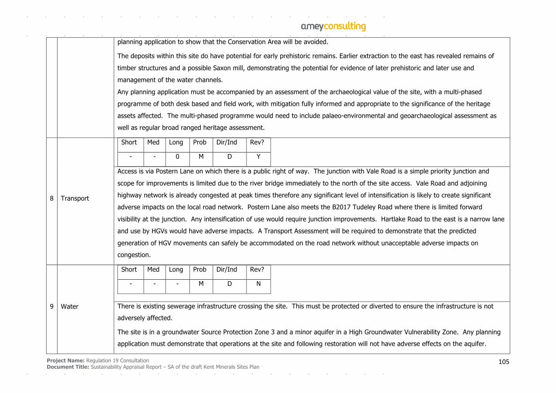
Project Name: Regulation 19 Consultation
Document Title: Sustainability Appraisal Report – SA of the draft Kent Minerals Sites Plan 105
planning application to show that the Conservation Area will be avoided.
The deposits within this site do have potential for early prehistoric remains. Earlier extraction to the east has revealed remains of
timber structures and a possible Saxon mill, demonstrating the potential for evidence of later prehistoric and later use and
management of the water channels.
Any planning application must be accompanied by an assessment of the archaeological value of the site, with a multi-phased
programme of both desk based and field work, with mitigation fully informed and appropriate to the significance of the heritage
assets affected. The multi-phased programme would need to include palaeo-environmental and geoarchaeological assessment as
well as regular broad ranged heritage assessment.
8 Transport
Short Med Long Prob Dir/Ind Rev?
- - 0 M D Y
Access is via Postern Lane on which there is a public right of way. The junction with Vale Road is a simple priority junction and
scope for improvements is limited due to the river bridge immediately to the north of the site access. Vale Road and adjoining
highway network is already congested at peak times therefore any significant level of intensification is likely to create significant
adverse impacts on the local road network. Postern Lane also meets the B2017 Tudeley Road where there is limited forward
visibility at the junction. Any intensification of use would require junction improvements. Hartlake Road to the east is a narrow lane
and use by HGVs would have adverse impacts. A Transport Assessment will be required to demonstrate that the predicted
generation of HGV movements can safely be accommodated on the road network without unacceptable adverse impacts on
congestion.
9 Water
Short Med Long Prob Dir/Ind Rev?
- - - M D N
There is existing sewerage infrastructure crossing the site. This must be protected or diverted to ensure the infrastructure is not
adversely affected.
The site is in a groundwater Source Protection Zone 3 and a minor aquifer in a High Groundwater Vulnerability Zone. Any planning
application must demonstrate that operations at the site and following restoration will not have adverse effects on the aquifer.
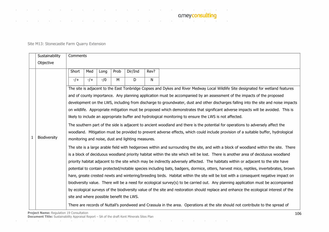
Project Name: Regulation 19 Consultation
Document Title: Sustainability Appraisal Report – SA of the draft Kent Minerals Sites Plan 106
Site M13: Stonecastle Farm Quarry Extension
Sustainability
Objective
Comments
1 Biodiversity
Short Med Long Prob Dir/Ind Rev?
-/+ -/+ -/0 M D N
The site is adjacent to the East Tonbridge Copses and Dykes and River Medway Local Wildlife Site designated for wetland features
and of county importance. Any planning application must be accompanied by an assessment of the impacts of the proposed
development on the LWS, including from discharge to groundwater, dust and other discharges falling into the site and noise impacts
on wildlife. Appropriate mitigation must be proposed which demonstrates that significant adverse impacts will be avoided. This is
likely to include an appropriate buffer and hydrological monitoring to ensure the LWS is not affected.
The southern part of the side is adjacent to ancient woodland and there is the potential for operations to adversely affect the
woodland. Mitigation must be provided to prevent adverse effects, which could include provision of a suitable buffer, hydrological
monitoring and noise, dust and lighting measures.
The site is a large arable field with hedgerows within and surrounding the site, and with a block of woodland within the site. There
is a block of deciduous woodland priority habitat within the site which will be lost. There is another area of deciduous woodland
priority habitat adjacent to the site which may be indirectly adversely affected. The habitats within or adjacent to the site have
potential to contain protected/notable species including bats, badgers, dormice, otters, harvest mice, reptiles, invertebrates, brown
hare, greate crested newts and wintering/breeding birds. Habitat within the site will be lost with a consequent negative impact on
biodiversity value. There will be a need for ecological survey(s) to be carried out. Any planning application must be accompanied
by ecological surveys of the biodiversity value of the site and restoration should replace and enhance the ecological interest of the
site and where possible benefit the LWS.
There are records of Nuttall’s pondweed and Crassula in the area. Operations at the site should not contribute to the spread of
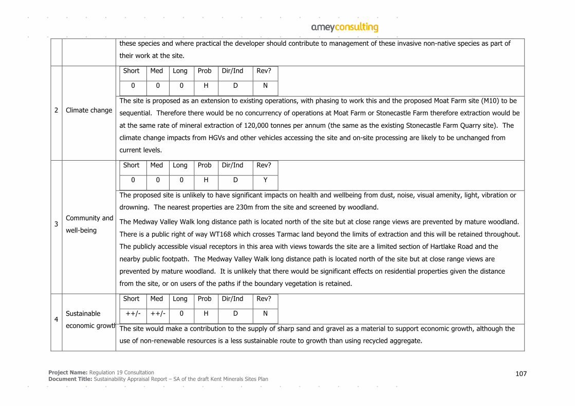
Project Name: Regulation 19 Consultation
Document Title: Sustainability Appraisal Report – SA of the draft Kent Minerals Sites Plan 107
these species and where practical the developer should contribute to management of these invasive non-native species as part of
their work at the site.
2 Climate change
Short Med Long Prob Dir/Ind Rev?
0 0 0 H D N
The site is proposed as an extension to existing operations, with phasing to work this and the proposed Moat Farm site (M10) to be
sequential. Therefore there would be no concurrency of operations at Moat Farm or Stonecastle Farm therefore extraction would be
at the same rate of mineral extraction of 120,000 tonnes per annum (the same as the existing Stonecastle Farm Quarry site). The
climate change impacts from HGVs and other vehicles accessing the site and on-site processing are likely to be unchanged from
current levels.
3 Community and
well-being
Short Med Long Prob Dir/Ind Rev?
0 0 0 H D Y
The proposed site is unlikely to have significant impacts on health and wellbeing from dust, noise, visual amenity, light, vibration or
drowning. The nearest properties are 230m from the site and screened by woodland.
The Medway Valley Walk long distance path is located north of the site but at close range views are prevented by mature woodland.
There is a public right of way WT168 which crosses Tarmac land beyond the limits of extraction and this will be retained throughout.
The publicly accessible visual receptors in this area with views towards the site are a limited section of Hartlake Road and the
nearby public footpath. The Medway Valley Walk long distance path is located north of the site but at close range views are
prevented by mature woodland. It is unlikely that there would be significant effects on residential properties given the distance
from the site, or on users of the paths if the boundary vegetation is retained.
4 Sustainable
economic growth
Short Med Long Prob Dir/Ind Rev?
++/- ++/- 0 H D N
The site would make a contribution to the supply of sharp sand and gravel as a material to support economic growth, although the
use of non-renewable resources is a less sustainable route to growth than using recycled aggregate.
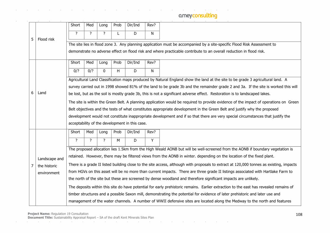
Project Name: Regulation 19 Consultation
Document Title: Sustainability Appraisal Report – SA of the draft Kent Minerals Sites Plan 108
5 Flood risk
Short Med Long Prob Dir/Ind Rev?
? ? ? L D N
The site lies in flood zone 3. Any planning application must be accompanied by a site-specific Flood Risk Assessment to
demonstrate no adverse effect on flood risk and where practicable contribute to an overall reduction in flood risk.
6 Land
Short Med Long Prob Dir/Ind Rev?
0/? 0/? 0 H D N
Agricultural Land Classification maps produced by Natural England show the land at the site to be grade 3 agricultural land. A
survey carried out in 1998 showed 81% of the land to be grade 3b and the remainder grade 2 and 3a. If the site is worked this will
be lost, but as the soil is mostly grade 3b, this is not a significant adverse effect. Restoration is to landscaped lakes.
The site is within the Green Belt. A planning application would be required to provide evidence of the impact of operations on Green
Belt objectives and the tests of what constitutes appropriate development in the Green Belt and justify why the proposed
development would not constitute inappropriate development and if so that there are very special circumstances that justify the
acceptability of the development in this case.
7
Landscape and
the historic
environment
Short Med Long Prob Dir/Ind Rev?
? ? ? M D Y
The proposed allocation lies 1.5km from the High Weald AONB but will be well-screened from the AONB if boundary vegetation is
retained. However, there may be filtered views from the AONB in winter. depending on the location of the fixed plant.
There is a grade II listed building close to the site access, although with proposals to extract at 120,000 tonnes as existing, impacts
from HGVs on this asset will be no more than current impacts. There are three grade II listings associated with Hartlake Farm to
the north of the site but these are screened by dense woodland and therefore significant impacts are unlikely.
The deposits within this site do have potential for early prehistoric remains. Earlier extraction to the east has revealed remains of
timber structures and a possible Saxon mill, demonstrating the potential for evidence of later prehistoric and later use and
management of the water channels. A number of WWII defensive sites are located along the Medway to the north and features
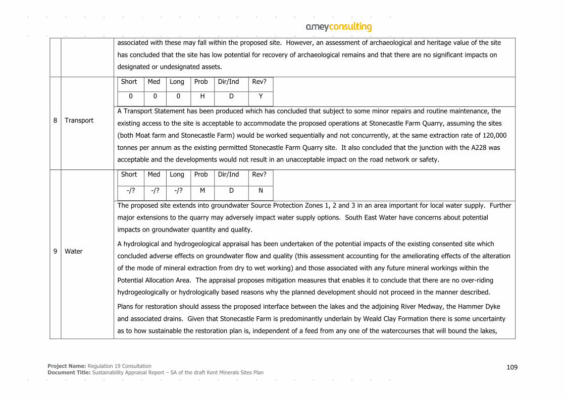
Project Name: Regulation 19 Consultation
Document Title: Sustainability Appraisal Report – SA of the draft Kent Minerals Sites Plan 109
associated with these may fall within the proposed site. However, an assessment of archaeological and heritage value of the site
has concluded that the site has low potential for recovery of archaeological remains and that there are no significant impacts on
designated or undesignated assets.
8 Transport
Short Med Long Prob Dir/Ind Rev?
0 0 0 H D Y
A Transport Statement has been produced which has concluded that subject to some minor repairs and routine maintenance, the
existing access to the site is acceptable to accommodate the proposed operations at Stonecastle Farm Quarry, assuming the sites
(both Moat farm and Stonecastle Farm) would be worked sequentially and not concurrently, at the same extraction rate of 120,000
tonnes per annum as the existing permitted Stonecastle Farm Quarry site. It also concluded that the junction with the A228 was
acceptable and the developments would not result in an unacceptable impact on the road network or safety.
9 Water
Short Med Long Prob Dir/Ind Rev?
-/? -/? -/? M D N
The proposed site extends into groundwater Source Protection Zones 1, 2 and 3 in an area important for local water supply. Further
major extensions to the quarry may adversely impact water supply options. South East Water have concerns about potential
impacts on groundwater quantity and quality.
A hydrological and hydrogeological appraisal has been undertaken of the potential impacts of the existing consented site which
concluded adverse effects on groundwater flow and quality (this assessment accounting for the ameliorating effects of the alteration
of the mode of mineral extraction from dry to wet working) and those associated with any future mineral workings within the
Potential Allocation Area. The appraisal proposes mitigation measures that enables it to conclude that there are no over-riding
hydrogeologically or hydrologically based reasons why the planned development should not proceed in the manner described.
Plans for restoration should assess the proposed interface between the lakes and the adjoining River Medway, the Hammer Dyke
and associated drains. Given that Stonecastle Farm is predominantly underlain by Weald Clay Formation there is some uncertainty
as to how sustainable the restoration plan is, independent of a feed from any one of the watercourses that will bound the lakes,
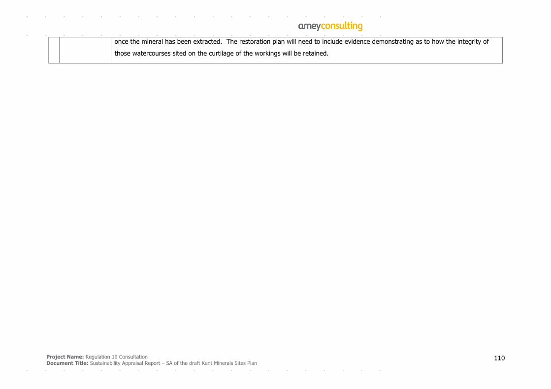
Project Name: Regulation 19 Consultation
Document Title: Sustainability Appraisal Report – SA of the draft Kent Minerals Sites Plan 110
once the mineral has been extracted. The restoration plan will need to include evidence demonstrating as to how the integrity of
those watercourses sited on the curtilage of the workings will be retained.
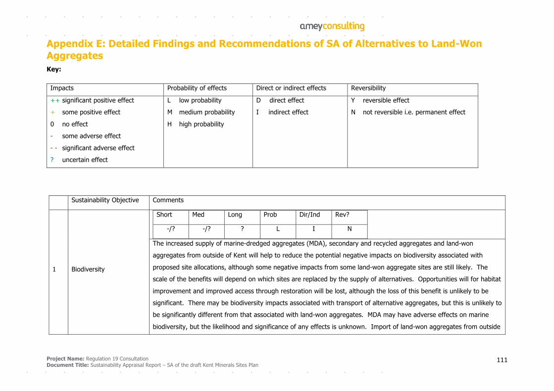
Project Name: Regulation 19 Consultation
Document Title: Sustainability Appraisal Report – SA of the draft Kent Minerals Sites Plan 111
Appendix E: Detailed Findings and Recommendations of SA of Alternatives to Land-Won Aggregates Key:
Impacts Probability of effects Direct or indirect effects Reversibility
++ significant positive effect
+ some positive effect
0 no effect
- some adverse effect
- - significant adverse effect
? uncertain effect
L low probability
M medium probability
H high probability
D direct effect
I indirect effect
Y reversible effect
N not reversible i.e. permanent effect
Sustainability Objective Comments
1 Biodiversity
Short Med Long Prob Dir/Ind Rev?
-/? -/? ? L I N
The increased supply of marine-dredged aggregates (MDA), secondary and recycled aggregates and land-won
aggregates from outside of Kent will help to reduce the potential negative impacts on biodiversity associated with
proposed site allocations, although some negative impacts from some land-won aggregate sites are still likely. The
scale of the benefits will depend on which sites are replaced by the supply of alternatives. Opportunities will for habitat
improvement and improved access through restoration will be lost, although the loss of this benefit is unlikely to be
significant. There may be biodiversity impacts associated with transport of alternative aggregates, but this is unlikely to
be significantly different from that associated with land-won aggregates. MDA may have adverse effects on marine
biodiversity, but the likelihood and significance of any effects is unknown. Import of land-won aggregates from outside
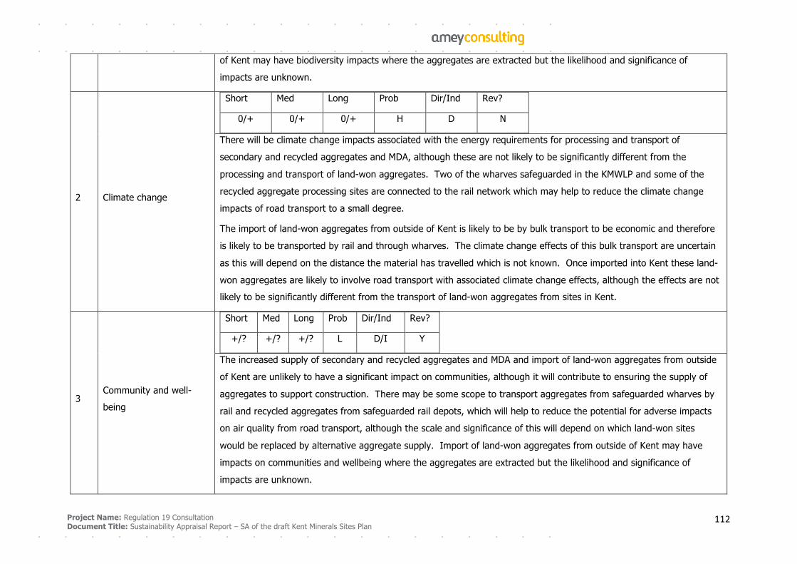
Project Name: Regulation 19 Consultation
Document Title: Sustainability Appraisal Report – SA of the draft Kent Minerals Sites Plan 112
of Kent may have biodiversity impacts where the aggregates are extracted but the likelihood and significance of
impacts are unknown.
2 Climate change
Short Med Long Prob Dir/Ind Rev?
0/+ 0/+ 0/+ H D N
There will be climate change impacts associated with the energy requirements for processing and transport of
secondary and recycled aggregates and MDA, although these are not likely to be significantly different from the
processing and transport of land-won aggregates. Two of the wharves safeguarded in the KMWLP and some of the
recycled aggregate processing sites are connected to the rail network which may help to reduce the climate change
impacts of road transport to a small degree.
The import of land-won aggregates from outside of Kent is likely to be by bulk transport to be economic and therefore
is likely to be transported by rail and through wharves. The climate change effects of this bulk transport are uncertain
as this will depend on the distance the material has travelled which is not known. Once imported into Kent these land-
won aggregates are likely to involve road transport with associated climate change effects, although the effects are not
likely to be significantly different from the transport of land-won aggregates from sites in Kent.
3 Community and well-
being
Short Med Long Prob Dir/Ind Rev?
+/? +/? +/? L D/I Y
The increased supply of secondary and recycled aggregates and MDA and import of land-won aggregates from outside
of Kent are unlikely to have a significant impact on communities, although it will contribute to ensuring the supply of
aggregates to support construction. There may be some scope to transport aggregates from safeguarded wharves by
rail and recycled aggregates from safeguarded rail depots, which will help to reduce the potential for adverse impacts
on air quality from road transport, although the scale and significance of this will depend on which land-won sites
would be replaced by alternative aggregate supply. Import of land-won aggregates from outside of Kent may have
impacts on communities and wellbeing where the aggregates are extracted but the likelihood and significance of
impacts are unknown.
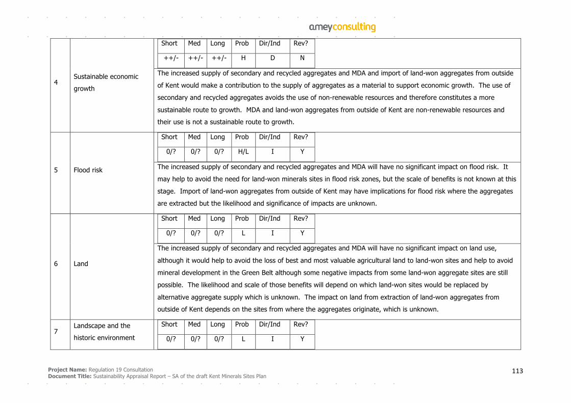
Project Name: Regulation 19 Consultation
Document Title: Sustainability Appraisal Report – SA of the draft Kent Minerals Sites Plan 113
4 Sustainable economic
growth
Short Med Long Prob Dir/Ind Rev?
++/- ++/- ++/- H D N
The increased supply of secondary and recycled aggregates and MDA and import of land-won aggregates from outside
of Kent would make a contribution to the supply of aggregates as a material to support economic growth. The use of
secondary and recycled aggregates avoids the use of non-renewable resources and therefore constitutes a more
sustainable route to growth. MDA and land-won aggregates from outside of Kent are non-renewable resources and
their use is not a sustainable route to growth.
5 Flood risk
Short Med Long Prob Dir/Ind Rev?
0/? 0/? 0/? H/L I Y
The increased supply of secondary and recycled aggregates and MDA will have no significant impact on flood risk. It
may help to avoid the need for land-won minerals sites in flood risk zones, but the scale of benefits is not known at this
stage. Import of land-won aggregates from outside of Kent may have implications for flood risk where the aggregates
are extracted but the likelihood and significance of impacts are unknown.
6 Land
Short Med Long Prob Dir/Ind Rev?
0/? 0/? 0/? L I Y
The increased supply of secondary and recycled aggregates and MDA will have no significant impact on land use,
although it would help to avoid the loss of best and most valuable agricultural land to land-won sites and help to avoid
mineral development in the Green Belt although some negative impacts from some land-won aggregate sites are still
possible. The likelihood and scale of those benefits will depend on which land-won sites would be replaced by
alternative aggregate supply which is unknown. The impact on land from extraction of land-won aggregates from
outside of Kent depends on the sites from where the aggregates originate, which is unknown.
7 Landscape and the
historic environment
Short Med Long Prob Dir/Ind Rev?
0/? 0/? 0/? L I Y
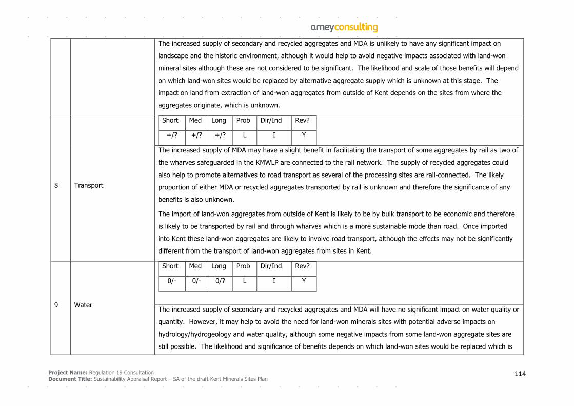
Project Name: Regulation 19 Consultation
Document Title: Sustainability Appraisal Report – SA of the draft Kent Minerals Sites Plan 114
The increased supply of secondary and recycled aggregates and MDA is unlikely to have any significant impact on
landscape and the historic environment, although it would help to avoid negative impacts associated with land-won
mineral sites although these are not considered to be significant. The likelihood and scale of those benefits will depend
on which land-won sites would be replaced by alternative aggregate supply which is unknown at this stage. The
impact on land from extraction of land-won aggregates from outside of Kent depends on the sites from where the
aggregates originate, which is unknown.
8 Transport
Short Med Long Prob Dir/Ind Rev?
+/? +/? +/? L I Y
The increased supply of MDA may have a slight benefit in facilitating the transport of some aggregates by rail as two of
the wharves safeguarded in the KMWLP are connected to the rail network. The supply of recycled aggregates could
also help to promote alternatives to road transport as several of the processing sites are rail-connected. The likely
proportion of either MDA or recycled aggregates transported by rail is unknown and therefore the significance of any
benefits is also unknown.
The import of land-won aggregates from outside of Kent is likely to be by bulk transport to be economic and therefore
is likely to be transported by rail and through wharves which is a more sustainable mode than road. Once imported
into Kent these land-won aggregates are likely to involve road transport, although the effects may not be significantly
different from the transport of land-won aggregates from sites in Kent.
9 Water
Short Med Long Prob Dir/Ind Rev?
0/- 0/- 0/? L I Y
The increased supply of secondary and recycled aggregates and MDA will have no significant impact on water quality or
quantity. However, it may help to avoid the need for land-won minerals sites with potential adverse impacts on
hydrology/hydrogeology and water quality, although some negative impacts from some land-won aggregate sites are
still possible. The likelihood and significance of benefits depends on which land-won sites would be replaced which is
Project Name: Regulation 19 Consultation
Document Title: Sustainability Appraisal Report – SA of the draft Kent Minerals Sites Plan 115
not known at this stage. Import of land-won aggregates from outside of Kent may have effects on water quality and
quantity where the aggregates are extracted but the likelihood and significance of impacts are unknown.
Project Name: Regulation 19 Consultation Document Title: Sustainability Appraisal Report – SA of the draft Kent Minerals Sites Plan
116
Appendix F: Contribution of Other Plans and Strategies to Cumulative Effects
Shepway Core Strategy Local Plan, Shepway District Council, September 2013
There is a target for construction of 400 dwellings per year to 2026 and to deliver an average of
approximately 1 hectare per year (to 2026) of office/industrial premises.
Business activity and the provision of jobs will be facilitated through supporting town centres, the protection
of sufficient employment land across the district, allocations and concerted efforts to deliver rural
regeneration (especially in south and west Shepway).
The Plan seeks to accommodate new retail, leisure and an improved public environment at Folkestone,
Hythe and New Romney town centres. The majority of Shepway's commercial floorspace and the majority
of the urban area's housing development will take place in Folkestone, to enhance its role as a sub-regional
centre.
The Plan seeks to regenerate Romney Marsh through a positive approach to sustainable economic
development and infrastructure opportunities, and through increasing the strategic role of New Romney
town in serving the area. The future spatial priority for new development in the Romney Marsh area is on
accommodating development at the towns of New Romney and Lydd and at sustainable villages, improving
communication, and on protecting and enhancing the coast and the many special habitats and landscapes,
especially at Dungeness.
The strategic growth of New Romney is supported to allow the market town to fulfill its potential to
sustainably provide for the bulk of the housing, community infrastructure and commercial needs of the
Romney Marsh Area. Development will also be planned at other identified settlements in line with the
Settlement Hierarchy sufficient to ensure the achievement of growth requirements. In particular,
development which helps to maintain and support the local role of the market town of Lydd, and rural
centres including Sellindge, can meet priority needs.
New Romney is defined as a Strategic Town, to accommodate significant development – in so far as
consistent with maintaining historic character – appropriate to the needs of its wider hinterland in Shepway,
and maintaining the viability of its local transport hub, town centre and higher-order tourism, employment
and public services. It is expected to be suitable for expansion from its current built limit. The town centre
will accommodate the majority of the identified needs for retail, office and leisure uses through new
development to improve its vitality, public realm, mix of uses, and daytime and evening economy.
Project Name: Regulation 19 Consultation Document Title: Sustainability Appraisal Report – SA of the draft Kent Minerals Sites Plan
117
New Romney should develop as the residential, business, service, retail and tourist centre for the Romney
Marsh. The future development of the town should seek to support the retention of existing businesses and
the attraction of new employment opportunities through the provision of an adequate supply of employment
land to meet future need and through the provision of a sufficient level of new residential development to
maintain an adequate labour supply.
There is a broad location for residential development to the north of the town centre, to provide around 300
dwellings (Class C3). Appropriate off-site mitigation measures must be identified, including to ameliorate
highway impacts and manage drainage demands.
A site at New Romney is identified as appropriate as a Major Employment Site, to protect existing and
provide further industrial premises suitable to the needs of Shepway's businesses and inward investors.
The junction of A259/B2071/ Church Road junction is identified as strategically critical infrastructure for
improvement by 2026. Hammonds Corner west of New Romney A259/ B2075 junction improvement is
identified as important, potentially necessary infrastructure to help deliver the Core Strategy.
Lydd is identified as a Service Centre, to accommodate development appropriate to Shepway and its own
needs, in order to grow and consolidate its position as a District Centre serving the local hinterland with
shops, employment and public services. Lydd has played a significant role in the district's development and
includes some significant opportunities, but they should be delivered without a substantial expansion of the
outer extent of its built environment. It will accommodate appropriate development to maintain its mix of
uses and improve its vitality, viability and public realm.
There are sites in Lydd appropriate as Major Employment Sites, to protect existing and provide further
industrial (B-class and similar sui generis uses) premises suitable to the needs of Shepway's businesses and
inward investors.
Dymchurch is identified as a Rural Centre, to develop – consistent with enhancing the natural and historic
environment – in a manner that supports its role as an integrated tourist and local centre providing shops
and services for a significant number of residents, visitors, and also for other villages in Romney Marsh. The
aim is to protect crucial services and accommodate development that maintains its viability for residents and
visitors.
St Mary's Bay, Greatstone-on-Sea, Brookland and Brenzett are identified as Primary Villages, to contribute to
strategic aims and local needs; and as settlements with the potential to grow and serve residents, visitors
and neighbourhoods in the locality with rural business and community facilities.
Project Name: Regulation 19 Consultation Document Title: Sustainability Appraisal Report – SA of the draft Kent Minerals Sites Plan
118
Connections to existing ports and airports within and outside the district will be promoted, such as by new
rail and coach services, and to support improved access to London Ashford (Lydd) Airport subject to no
adverse environmental consequences.
Lydd is identified as a Green Infrastructure (GI) Fringe Zone. Green infrastructure will be protected and
enhanced and the loss of GI uses will not be allowed, other than where demonstrated to be in full
accordance with national policy, or a significant quantitative or qualitative net GI benefit is realised or it is
clearly demonstrated that the aims of this strategy are furthered and outweigh its impact on GI. Shepway's
GI network and other strategic open space will be managed with a focus on:
§ Adapting to and managing climate change effects;
§ Protecting and enhancing biodiversity and access to nature, and avoiding development which results
in significant fragmentation or isolation of natural habitats;
§ Identifying opportunities to expand the GI functions of greenspaces and their contribution to a
positive sense of place;
§ Tackling network and qualitative deficiencies.
Contribution to Cumulative Effects
The development of new housing and employment sites and enhancing the vitality of New Romney, Lydd
and smaller settlements in the Romney Marsh area will provide housing, employment and services for the
needs of local communities. They will also contribute to increased demand for use of the road network and
contribute to increased greenhouse gas emissions. Improving access to Lydd Airport for road vehicles will
also increase demand for road space, although improving rail connections may help to bring about a modal
shift and reduce demand for road space. Improvements to the junction of the A259 and B2075 should assist
the function of the junction, potentially assisting mineral site traffic.
Minerals development may potentially be in conflict with green infrastructure policy for Lydd.
Relevant minerals site: M2
Project Name: Regulation 19 Consultation Document Title: Sustainability Appraisal Report – SA of the draft Kent Minerals Sites Plan
119
Council Core Strategy Review, Consultation Draft Plan, Shepway District Council, March 2018
The future spatial priority for new development in the Romney Marsh Area is on accommodating
development at the towns of New Romney and Lydd, and at sustainable villages; improving
communications; protecting and enhancing the coast and the many special habitats and landscapes,
especially at Dungeness; and avoiding further co-joining of settlements and localities at the most acute risk
to life and property from tidal flooding.
In all other substantive aspects, the policies for Lydd and New Romney are unchanged.
Contribution to Cumulative Effects
As for the Core Strategy Local Plan September 2013
Maidstone Borough Local Plan, Maidstone Borough Council, October 2017
An expanded Maidstone urban area will be the principal focus for development in the borough.
Approximately 1,846 new dwellings will be delivered on 23 sites, with approximately 11,400m2 of retail
floorspace, approximately 6,000m2 of employment floorspace and a medical campus of up to 100,000m2
floorspace. Key infrastructure requirements include improvements to highway and transport infrastructure,
including junction improvements, capacity improvements and improved pedestrian/cycle access and bus
prioritisation measures
Rural service centres including Harrietsham and Lenham will be a secondary focus for housing development
with the emphasis on maintaining and enhancing their role and the provision of services to meet the needs
of the local community. Suitably scaled employment opportunities will also be permitted, building on and
expanding existing provision in these locations.
In Harrietsham, key services will be retained and supported. In addition to minor development and
redevelopment of appropriate sites, approximately 242 new dwellings will be delivered on three allocated
sites. Two existing sites are designated as Economic Development Areas in order to maintain employment
opportunities in the locality. Key infrastructure requirements for Harrietsham include improvements to
highway and transport infrastructure including improvements to the A20 Ashford Road, improvements to
Church Road and the provision of additional pedestrian crossing points
At the rural service centre of Lenham, key services will be retained and supported. In addition to minor
development and redevelopment of appropriate sites, approximately 155 new dwellings will be delivered on
Project Name: Regulation 19 Consultation Document Title: Sustainability Appraisal Report – SA of the draft Kent Minerals Sites Plan
120
two allocated sites, Tanyard Farm and Glebe Gardens, both to the east of Lenham on the Old Ashford Road.
Three existing sites are designated as Economic Development Areas in order to maintain employment
opportunities in the locality. Key infrastructure requirements for Lenham include improvements to highway
and transport infrastructure including junction improvements, a variety of measures to improve sustainable
transport infrastructure, and improvements to pedestrian access. The council will seek to maintain and
enhance the existing retail function and supporting community uses in The Square.
Lenham is also identified as a broad location for growth for the delivery of approximately 1,000 dwellings
post April 2021. Master planning of the area will be essential to achieve a high quality design and layout,
landscape and ecological mitigation, and appropriate provision of supporting physical, social and green
infrastructure. Housing site allocations and associated infrastructure requirements will be made through the
Lenham Neighbourhood Plan or through the local plan review to be adopted by April 2021. The broad
location for growth is on the east side of Lenham, between the current built up area and the Northdown
Business park on the Ashford Road to the west of mineral site M3.
The council and its partners will:
§ Ensure the transport system supports the growth projected by Maidstone’s local plan and facilitates
economic prosperity;
§ Deliver modal shift through managing demand on the transport network through enhanced public
transport and the continued Park and Ride services and walking and cycling improvements;
§ Improve highway network capacity and function at key locations and junctions across the borough;
§ Improve transport choice across the borough and seek to influence travel behaviour;
§ Address the air quality impact of transport.
A prestigious business park at Junction 8 of the M20 that is well connected to the motorway network will
provide for a range of job needs up to 2031. The site will make a substantial contribution to the need for
new office space in the borough as well as meeting the 'qualitative' need for a new, well serviced and well
connected mixed use employment site suitable for offices, industry and warehousing.
Contribution to Cumulative Effects
Proposed housing and economic development at Lenham and Harrietsham will provide housing, employment
and services to meet the needs of communities, contributing to their wellbeing. It will increase traffic on the
A20 and through junction 8 of the M20, potentially in competition with the traffic accessing the minerals site.
Project Name: Regulation 19 Consultation Document Title: Sustainability Appraisal Report – SA of the draft Kent Minerals Sites Plan
121
Policy on managing the transport impacts of development may help to avoid or reduce increased demand for
road space. The development of new sites for housing and employment is likely to increase pressures on
biodiversity. Greenhouse gas emissions will be increased.
Relevant mineral site: M3
Submission Local Plan 2030, Ashford Borough Council, December 2017
A total housing target of 12,950 net additional dwellings applies for the Borough between 2017 and 2030.
The majority of new housing development will be at Ashford and its periphery, as the most sustainable
location within the Borough based on its range of services and facilities, access to places of employment,
access to public transport hubs and the variety of social and community infrastructure available. In addition
to existing commitments, new land allocations to deliver 5,159 dwellings are proposed.
Job growth and economic prosperity will be supported in order to enable the achievement of a sustainable
economy with the intention to deliver 66 hectares of new employment land and a total of 11,100 jobs in the
Borough between 2014-30.
A regenerated Ashford Town Centre will expand significantly its leisure, cultural, educational and residential
offer. A new Commercial Office Quarter next to the railway station will be a major economic impetus for the
area, helping to substantially increase employment, trigger more spending in the town centre economy, and
improve wage rates and skills levels.
The other rural service centres, including Charing, will remain important providers of local shops and
services, whilst delivering new development of a scale appropriate to the individual characteristics of the
settlement. Smaller rural settlements will also provide smaller scale new development, to help sustain local
communities.
Land at Northdown Service Station in Charing is proposed for residential development for up to 20 dwellings.
Development proposals for this site shall provide vehicle access onto the A20 Maidstone Road.
The land south of the Arthur Baker playing fields in Charing is proposed for residential development, up to
35 units. Development proposals for this site shall provide a vehicular, pedestrian and cycle link from the
A20 through the site to the adjoining Arthur Baker playing fields and be designed to include a built-up
frontage to the A20.
Project Name: Regulation 19 Consultation Document Title: Sustainability Appraisal Report – SA of the draft Kent Minerals Sites Plan
122
The site to the rear of the Holiday Inn at Hothfield is proposed for residential development with an indicative
capacity of 150 dwellings. Development proposals for the site shall be designed and laid out to take account
of the surrounding uses in particular the existing hotel and the M20 motorway and provide a primary
vehicular access directly from the A20 Ashford Road.
The site to the rear of Westwell Lane at Tutt Hill is proposed for residential development with an indicative
capacity of 75 dwellings. Development proposals for this site shall provide primary vehicular access from the
A20 Ashford Road.
Provision of new employment premises, and the redevelopment, enhancement and reconfiguration of
existing employment premises will be permitted within or adjoining the built-up confines of Ashford,
Tenterden and the rural settlements, provided that: any impact upon the local road network can be
mitigated. In the rural settlements, it must be demonstrated that the development will not generate a type
or amount of traffic that would be inappropriate to the rural road network that serves it.
Contribution to Cumulative Effects
The provision of housing and employment sites in the Borough will help to meet the needs of communities
leading to increased wellbeing. Development of greenfield sites is likely to lead to increased pressure on
biodiversity. Proposed housing developments at Charing and to a lesser extent at Hothfield and Tutt Hill are
likely to increase demand for road space on the A20, potentially in competition with mineral site traffic. The
Plan requires mitigation of impacts on the road network, so effects should be minimised although this is
uncertain.
Housing and economic growth in Ashford is likely to increase traffic on the M20. The scale of this
will be significantly greater than the impacts from minerals site traffic, which will arise from site M3
and also M2 as Ashford is likely to be an important market for minerals from site M2.
Relevant minerals site: M3, M2
Local Plan Regulation 19 Pre-submission Publication, Tonbridge and Malling Borough Council, September 2018
The Local Plan provides for at least 6,834 dwellings to address in full the Objectively Assessed Need for
housing during the plan period up to 2031. Provision is made for at least 38 ha of additional employment
land to address the needs of the borough during the plan period up to 2031. Development will be
concentrated within the confines of urban areas, which include Tonbridge, the Medway Gap (including
Project Name: Regulation 19 Consultation Document Title: Sustainability Appraisal Report – SA of the draft Kent Minerals Sites Plan
123
Aylesford, Ditton, Larkfield, Leybourne areas) and Snodland. Major new housing development will be
delivered at the following strategic sites during the plan period up to 2031:
§ Bushey Wood, Eccles – 900 dwellings;
§ Broadwater Farm, north of Kings Hill – 900 dwellings;
§ South-west Tonbridge – 480 dwellings.
Outside of the urban areas, the focus of development will be within the confines of the Rural Service
Centres, including West Malling. Within the confines of other rural settlements, development will be
restricted to development that is proportionate to the scale and appropriate to the character of the
settlement. These include Ryarsh, Addington, Addington Clearway, Birling Trottiscliffe, Wrotham and
Wrotham Heath.
The Council will work in partnership with Kent County Council, Highways England, transport providers and
other key stakeholders to ensure that developments:
§ are designed so that opportunities for sustainable transport modes are maximised; and
§ make the necessary contributions to the improvement of existing, and provision of new, transport
schemes that lead to improvements in accessibility and give priority to the needs of pedestrians,
cyclists, users of public transport, car sharers and users of low and ultra-low emission vehicles;
The following areas are identified as areas of opportunity to help address the future longer-term
development needs of the borough beyond 2031:
§ Bushey Wood, Eccles
§ East Malling Research Station, south Aylesford & Ditton
Land at East Malling Research Station can only be released for development in the post plan period once
significant improvements to the A20/Mills Road/Hall Road junction have been implemented to the
satisfaction of Kent County Council and the link between Hermitage Lane and the A20 at the 20/20
roundabout is complete and open and improvements to Junction 5 of the M20 motorway have been
implemented.
Project Name: Regulation 19 Consultation Document Title: Sustainability Appraisal Report – SA of the draft Kent Minerals Sites Plan
124
The following sites, as defined on the proposals map, are allocated for employment development:
§ North of RBLI Warehouse, Aylesford (1.5 ha) (B1 and B8 uses)
§ East Malling Research Station (East) (5.5ha) (B1uses)
§ East Malling Research Station (West) (2.3 ha) (B1 uses)
§ Little Postern, Postern Lane, Tonbridge (10.8ha) (B2 and B8 uses)
§ Munday Works, Tonbridge (1.7 ha) (B1 and B2 uses)
Development of the sites for employment uses will only be permitted where it is of an acceptable design to
the locality and does not result in unacceptable impacts on the highway network, air quality and the amenity
of the area
Contribution to Cumulative Effects
The proposed housing and employment growth will enable the needs of communities for jobs and homes to
be met. However, the growth will result in increased greenhouse gas emissions. Development of new sites
is likely to lead to increased pressure on biodiversity from habitat loss and disturbance. Proposed
developments in the Medway Gap and at Snodland and Eccles are likely to increase demand for road space,
including on the A20. This could potentially be in competition for road space with minerals site traffic,
although as the proposed developments are at some distance from the minerals site cumulative effects on
the road network may not be significant.
The employment site at Postern Lane Tonbridge is likely to contribute to cumulative impacts on the local
road network which is constrained in that area. Housing development south west of Tonbridge is likely to
increase traffic on the A21.
Impacts of development on the transport network may be offset to some degree by the requirement for
measures to mitigate effects, although the overall balance of effects is not certain.
Relevant minerals sites: M8, M10, M12, M13
Project Name: Regulation 19 Consultation Document Title: Sustainability Appraisal Report – SA of the draft Kent Minerals Sites Plan
125
Site Allocations Local Plan, Tunbridge Wells Borough Council, July 2016
Land at Brook Farm, Capel (adjacent to this borough's boundary with Tonbridge & Malling Borough), as
shown on the Villages & Rural Areas (Capel) Proposals Map, is designated as a Key Employment Area.
Contribution to Cumulative Effects
The designated Key Employment Area is likely to increase traffic on the A228, although the site is relatively
small and the impacts are likely to be minor.
Relevant minerals site: M10, M13
Core Strategy DPD, Tunbridge Wells Borough Council, June 2010
Policy for development in Royal Tunbridge Wells provides for approximately 4,200 net additional dwellings
over the period 2006 to 2026. It encourages a greater proportion of office space (B1) within the town
centre, with approximately 23,500sqm (net) additional comparison retail floorspace to be provided by 2017
in the town centre. The Core Strategy emphasises the role of the town centre as a focal point for a mix of
employment, retail and complementary uses.
Approximately 300 net additional dwellings will be delivered in Southborough. In the order of 500sqm (net)
additional comparison floorspace will be delivered by 2017. Infrastructure improvements to encourage the
uptake of sustainable transport modes, such as walking, cycling and use of public transport, will be pursued
in order to reduce congestion and improve transport links to Royal Tunbridge Well. Measures to improve air
quality within the Air Quality Management Area will be investigated and pursued.
Contribution to Cumulative Effects
Proposed developments in Royal Tunbridge Wells and Southborough are likely to contribute to increased
wellbeing by meeting the needs of communities for homes and jobs. However, they will contribute to
increased greenhouse gas emissions and increased demand for space on the road network, potentially
including the A21, although this may be offset to some degree by measures to encourage sustainable
transport use and air quality improvements.
Relevant minerals sites: M10, M12, M13
Project Name: Regulation 19 Consultation Document Title: Sustainability Appraisal Report – SA of the draft Kent Minerals Sites Plan
126
Dartford Core Strategy, Dartford Borough Council, September 2011
Dartford Town Centre and Northern Gateway are to provide up to 3070 homes and 1500 jobs and up to
24,000m2 net shopping floorspace. Of this, Northern Gateway will provide up to 2,040 homes, 1200 jobs in
B1, B2 and B8 uses and provision of a mix of uses and the creation of a new area of public realm around the
Mill Pond. Uses may include local shops and leisure uses, a hotel, community facilities and cafes, pubs and
restaurants fronting onto the waterside.
The Core Strategy will create multifunctional greenspace alongside the River Darent and within and across
the Northern Gateway site, providing at least 30% open space across the site, with provision for biodiversity
and landscape improvements as well as recreational, sporting and amenity areas. Land at Dartford Fresh
Marsh, the Mill Pond and the provision of a park on the eastern side will form part of the provision.
The Core Strategy seeks to minimise the amount of traffic generated by the Northern Gateway site, with an
emphasis on sustainable forms of travel, with Fastrack provision through the site, direct access to Dartford
station and foot and cycle connectivity. Planning applications must be supported by a transport assessment
which takes into account all planned development in the town centre as well as the Northern Gateway. In
advance of a Community Infrastructure Levy (CIL), a proportionate contribution will be required towards
short-term mitigation measures to address any impact of the proposal on Junction 1a of the M25 (A282). A
Travel Plan will be required for each application.
New residential communities will be focused on Ebbsfleet Valley and Stone, providing up to 7,850 homes
within the Plan period, with further development beyond 2026. The Plan will also provide 9,700 jobs in
offices and other B1 uses within the Plan period, with a concentration of these in the Ebbsfleet Valley. A
centre of excellence for sport and recreation will be provided at Stone Lodge, expanding on the existing
Olympic-level provision on the site. Options for the evolution of Bluewater which provide for a wider range
of uses will be explored. At Ebbsfleet Valley, a community of up to 10,000 homes, (up to 5,250 assumed to
be provided in the Plan period) with a business district providing approx 16,900 jobs, (up to 9,500 assumed
to be provided in the Plan period) and leisure and retail uses to support local residents, workers and visitor.
The Kent Thameside Strategy for the waterfront
seeks to open up access to the river for existing and future
communities and to produce a high quality riverscape. Recent piecemeal development of the Thames
Waterfront has not achieved the full potential that co-ordinated development of the riverside could bring. A
number of potential sites on the Thames Waterfront present a unique opportunity to create mixed use
development, bringing life and activity back to the river. The Council will promote the creation of a vibrant
mixed-use riverfront, incorporating sustainable communities, new employment opportunities, leisure use of
Project Name: Regulation 19 Consultation Document Title: Sustainability Appraisal Report – SA of the draft Kent Minerals Sites Plan
127
the river /riverside and use of the river for sustainable transport, by supporting residential development of
up to 3,750 homes and provision of up to 456,000 sq m of employment floorspace.
The Core Strategy seeks to protect and enhance Black Duck Marsh and Dartford Marshes as areas of
biodiversity value and public recreational areas for quiet enjoyment, to the extent that the ecological
protection of the area permits. New development will be expected to include connecting corridors of natural
habitat along the river to enhance biodiversity linkages and to protect s41 species and other species of local
ecological value.
In order to reduce the need to travel, minimise car use and make the most effective use of the transport
network, the Council will:
§ Encourage mixed use development and close interrelationship between complementary land uses:
homes, jobs, shops and leisure, recreational and community facilities;
§ Require major development sites to make provision for Fastrack as part of planning proposals.
In order to enable the transport network to respond to the pressures of new development, the Council will
work with its partners to deliver a Strategic Transport Infrastructure Programme to ensure that the transport
network operates at acceptable levels and that the transport infrastructure is in place to support new
development.
The following infrastructure improvements are identified:
§ Provision of Fastrack route through the Northern Gateway site by 2021
§ A206/Marsh Street - replacement of roundabout with signal controlled junction by 2021
§ Junction 1A improvements by 2021
Contribution to Cumulative Effects
Planned housing and employment developments in Dartford will contribute to the wellbeing of communities
by providing homes and jobs to meet identified needs. It will also contribute to increased greenhouse gas
emissions. Growth in the town centre and Northern Gateway strategic site will create increased demands for
space on the road network, very likely including the M25 and potentially also Bob Dunn Way although this is
less likely. Growth in Stone and Ebbsfleet is also likely to increase demand for road space on the M25. This
could potentially lead to cumulative impacts with minerals site traffic, although the scale of minerals traffic
Project Name: Regulation 19 Consultation Document Title: Sustainability Appraisal Report – SA of the draft Kent Minerals Sites Plan
128
impacts will be much smaller in comparison. Transport infrastructure improvements may help to reduce the
level of additional demand. The Core Strategy is likely to contribute to biodiversity enhancement and public
wellbeing by providing multifunctional greenspace and improved habitat connectivity.
Minerals development may potentially be in conflict with biodiversity and recreational policy in the Dartford
Marshes.
Relevant minerals sites: M7, M11
Bexley Core Strategy, London Borough of Bexley, February 2012
The Core Strategy provides for 5468 new dwellings and employment growth of 12500 jobs 2011-2026.
Crayford and Erith are identified growth areas with 1412 new dwellings and 2250 new jobs for the Erith and
Slade Green area, and 717new dwellings and 1750 jobs for Crayford and Old Bexley area.
The vision for the Erith geographic region will be achieved by:
§ making contributions to future housing and employment growth across the area but particularly
through development opportunities in and around Erith town centre, Slade Green, and designated
employment sites in the region;
§ supporting higher levels and more diverse employment, improved environmental quality of industrial
estates, enhanced public transport links and access to skills and training for new jobs by supporting
businesses in the region’s town centres and employment areas;
§ encouraging further retail development, leisure developments and an enhanced variety of uses.
The vision for the Crayford and Old Bexley geographic region will be achieved by:
§ contributing to housing and employment growth by focusing growth in and around Crayford town
centre and the nearby employment locations, and to a lesser extent, Old Bexley
§ supporting Crayford’s business function, as well as the managed consolidation of employment uses,
within the region;
§ progressing proposals that address local traffic issues, such as congestion in and around the town
centres (including the Bexley by-pass scheme, and London Road, Crayford) and low public transport
Project Name: Regulation 19 Consultation Document Title: Sustainability Appraisal Report – SA of the draft Kent Minerals Sites Plan
129
accessibility levels, and schemes that would reduce reliance on car use (including walking and
cycling);
The Council will assist in developing a strong and sustainable local economy, so as to contribute to London
and Thames Gateway regeneration.
The Council will work to achieve a comprehensive, high quality, safe, integrated and sustainable transport
system which makes the most of existing and proposed transport infrastructure within the borough and
seeks to ensure a much improved and expanded role for public transport through effectively maintaining and
managing the existing highway network to ensure the free flow of traffic, improve the environment, in
particular air quality, and promote safety, health and wellbeing.
Contribution to Cumulative Effects
Planned housing, employment, retail and leisure development in Bexley will contribute to community
wellbeing by providing jobs and homes to meet the needs of local communities. Growth will also contribute
to increased greenhouse gas emissions. Growth planned for Erith, Crayford and Old Bexley will add to
demand for space on the road transport network both locally and also the M25, which may have attendant
impacts on the Bexley and Dartford AQMAs. Measures to promote sustainable transport choices and address
traffic issues will help to offset the potential adverse impacts on the road network and air quality.
Relevant minerals sites: M7, M11
Bexley Growth Strategy, December 2017
Good growth will be secured by focusing new residential development on a series of well-connected public
transport nodes, making the most of Bexley’s riverside location and industrial heritage. Core industrial areas
retained for employment uses will be improved and intensified.
Erith will provide the opportunity to deliver an exciting and well-connected urban riverfront destination of up
to 6,000 new homes, with the area supporting up to 2,000 new jobs through a shift to new engineering and
manufacturing activities.
Crayford will provide the opportunity to consolidate and redefine the town centre, opening up the north of
the area to up to 1,000 new high quality homes with increased access to a more naturalised River Cray.
Employment will remain important to Crayford, with uses consolidated to the east, delivering 1,000
Project Name: Regulation 19 Consultation Document Title: Sustainability Appraisal Report – SA of the draft Kent Minerals Sites Plan
130
additional jobs. Targeting key junctions for improvement will allow for the enhancement of movement in
and around the town centre and will increase local connectivity.
Situated next to one of London’s remaining marshlands along the River Thames, Slade Green will be
transformed into a high quality neighbourhood with a new local town centre set around a potential new
Crossrail station and access to outstanding recreational spaces, delivering up to 8,000 new homes and 1,000
new jobs.
In line with principles of sustainable development, the strategy seeks to provide transport-orientated
development where higher density mixed-use development is concentrated around public transport nodes,
thereby making the most ef cient use of the best-connected land. The proposed growth figures for housing
and jobs are based on significant increases in connectivity through improvements to the existing transport
infrastructure in Bexley,
The main elements of strategic transport infrastructure that will trigger growth in the borough are:
§ a new transit system that introduces high quality local services, which link the main areas of activity
and major transport nodes, the expectation being that there will ultimately be an uninterrupted
segregated public transport corridor from Slade Green through to Abbey Wood and South
Thamesmead, forming the basis of a future bus rapid transit corridor and/or tram operation;
§ a DLR extension from the Becton line under the River Thames to Thamesmead, which could be
extended on to Belvedere;
§ an extension of Crossrail from Abbey Wood to Ebbsfleet, introducing high frequency and faster
journey times to key employment and leisure destinations – an extension on dedicated infrastructure
that would require approximately 20km of new lines, signalling and electrification to avoid
‘performance pollution’ resulting from mixing with existing North Kent Line services; and,
§ new river crossings to address severance across the River Thames and provide much improved access
between different market areas.
The strategy also envisages investment in necessary highway capacity at locally strategic road bottlenecks.
Contribution to Cumulative Effects
Growth planned for Erith, Crayford and Slade Green will add to demand for space on the road transport
network both locally and also the M25, which may have attendant impacts on the Bexley and Dartford
AQMAs. It will also contribute to increased greenhouse gas emissions. Measures to promote sustainable
Project Name: Regulation 19 Consultation Document Title: Sustainability Appraisal Report – SA of the draft Kent Minerals Sites Plan
131
transport choices and address traffic issues will help to offset the potential adverse impacts on the road
network and air quality.
Relevant minerals sites: M7, M11
Core Strategy and Policies for Management of Development (as amended), Thurrock Council, January 2015
The Core Strategy makes provision through allocations at broad locations for approximately 13,550 dwellings
for the period 1 April 2009 to 31 March 2021. Within the overall total allocation, the Council has also made
an Indicative provision for 4750 dwellings for the 5-year period 1 April 2021 to 31 March 2026. The great
majority of new housing and associated development for the period 2009-2021 will be located in and around
the Thurrock Urban Area Key Centre for Development and Change including:
§ Purfleet: 3180 dwellings;
§ West Thurrock/Lakeside Basin: 3365 dwellings;
§ Grays: 2605 dwellings;
§ Tilbury: 470 dwellings;
§ Chadwell St Mary: 390 dwellings.
For the Period 2021-2026, indicative locations and capacity are as follows:
§ Lakeside Basin: 2600 dwellings (approx.);
§ Tilbury Town Centre: 546 dwellings (approx);
§ Grays: 1935 dwellings (approx);
§ West Thurrock: 279 dwellings (approx);
§ Stanford–le-hope and Corringham: 250 dwellings (approx).
The great majority of new housing, employment and associated development in the Borough will be located
in the Lakeside/West Thurrock Regeneration Area. A mix of 3,300 new dwellings will be located to the south
Project Name: Regulation 19 Consultation Document Title: Sustainability Appraisal Report – SA of the draft Kent Minerals Sites Plan
132
and east of Lakeside; new Neighbourhood Areas will be developed at West Thurrock and South Stifford
including community and health facilities, primary schools and shopping facilities.
The Lakeside Basin will be transformed into a Regional Centre (town centre), and, together with the wider
area, will provide between 7,000 and 9,000 jobs. Development will include a substantial expansion of retail
floorspace (50,000 m2 net of comparison floorspace) to serve sub-regional needs and additional convenience
and service retail, office and leisure floorspace to broaden the mix of uses.
The transport network will be redesigned with improved accessibility east and west to Lakeside Shopping
Centre from the A13, a relocated bus station and environmental improvements surrounding the Shopping
Centre, including road and parking alterations.
The Plan proposes the provision of a new railway station at West Thurrock, introduces the South Essex
Rapid Transit and will ensure pedestrian access will be improved, including north-south access from the river
through Lakeside and West Thurrock to the Green Belt and beyond to South Ockendon.
Grays will be modernised and regenerated as the key Civic, Cultural and Education centre in the Borough.
There will be provision of approximately 2,600 additional dwellings of different types and 1600 jobs including
commercial offices in and around Grays. A new commercial and residential quarter will be developed to the
south of the railway.
The Council has identified the Key Strategic Infrastructure Projects set out below as essential to the delivery
of the Core Strategy, including.
§ M25 widening to Dual four lanes north of Junction 30.
§ M25 Junction 30/31 Improvements.
North of the Dartford crossing is identified as a key strategic employment hub and regeneration area.
The Council will work with partners to deliver at least a 10% reduction in car traffic from forecast 2026
levels. Measures include the following:
§ Improve public transport infrastructure in the Thurrock Urban Area through the phased delivery of the
South Essex Rapid Transit (SERT) and other inter-urban public transport and bus priority, allowing fast
and reliable services to the new Community Hospital and Learning Campus at Grays, Lakeside
Regional Shopping Centre, and employment opportunities.
Project Name: Regulation 19 Consultation Document Title: Sustainability Appraisal Report – SA of the draft Kent Minerals Sites Plan
133
§ Ensure new development promotes high levels of accessibility by sustainable transport modes and
local services are conveniently located to reduce the need to travel by car.
§ Employ Smarter Choices measures to change travel behaviour to achieve a reduction in forecast traffic
and help to deliver better air quality and a better environment for job creation. Priority areas for
Smarter Choices programmes include Grays and Lakeside.
§ Identify priority areas such as Grays town centre and Lakeside Basin, for network efficiency
improvement measures to address congestion and air quality issues. Other Air Quality Management
Areas as well as growth/regeneration areas will undergo transport network improvements, including
where improved access is required.
Regeneration and remodelling of the wider Lakeside Basin and West Thurrock areas will be taken forward
with the following guiding principles:
§ Securing more sustainable movement patterns, reduced private motor vehicle dependence and
complementary travel demand management measures including an area-wide travel plan.
§ Improving local accessibility and connectivity by public transport and pedestrian and cyclist
permeability throughout the area including consideration of ways to reconnect the north and the
south of the area, a high frequency service rail station in the south, and a personal rapid transit
system.
§ Providing the necessary improvements to the local and strategic road network.
§ Introduction of a car parking charging and management regime.
§ The Council will work with partners to deliver improvements to national and regional transport
networks to ensure growth does not result in routes being above capacity. Public transport
improvements will be prioritised in order to achieve a modal shift. To achieve this the Council and
partners will:
Contribution to Cumulative Effects
Planned housing, employment, retail and leisure development in Thurrock will contribute to community
wellbeing by providing jobs and homes to meet the needs of local communities. Proposed development in
Thurrock will add to pressure on the M25 which could affect congestion and air quality south of the Dartford
Crossing. Infrastructure improvements and measures to promote more sustainable transport modes may go
Project Name: Regulation 19 Consultation Document Title: Sustainability Appraisal Report – SA of the draft Kent Minerals Sites Plan
134
some way to offsetting the potential adverse impacts on the road network and on air quality along the M25.
Greenhouse gas emissions will increase with the planned housing and employment growth.
Relevant minerals sites: M7, M11
Local Transport Plan 4: Delivering Growth Without Gridlock 2016-2031, Kent County Council
The Counci’s strategic transport priorities include the following:
§ Enabling Growth in the Thames Estuary with a range of measures including Crossrail extension to
Dartford and Ebbsfleet and an expanded Fastrack bus network.
§ Bifurcation of Port Traffic: traffic for the Eastern Docks would be encouraged to use the M2/A2.
Bifurcation will also facilitate growth of Whitfield, Folkestone, Ashford and Maidstone by releasing
capacity on the M20.
§ Port Expansion: The Western Docks will provide a cargo terminal with a port-centric distribution
centre, allowing the existing cargo operations to move out of the Eastern Docks so a dedicated ferry
terminal and an increase in freight vehicle space can be delivered. The Port of London has set its goal
to become the busiest it has ever been by 2035, including greater use of the Thames wharves for
river transport of freight that will take up to 400,000 lorries of the region’s roads. The Port of
Sheerness largely handles bulk goods and also has signi cant expansion plans. The Port of Ramsgate
has potential for growth and could also contribute to the strategic priority of bifurcation.
§ A Solution to Operation Stack: delivery of a Lorry Area that will reduce the need to use the M20 to
queue freight vehicles during times of disruption to cross-Channel services
Transport schemes that have a countywide impact (particularly in terms of supporting sustainable travel)
are:
§ Kent Thameside Local Sustainable Transport Fund (£4.5m LGF funding), a capital programme of
works for Dartford and Gravesham delivering schemes to promote the use of alternative modes of
transport to the private car, e.g. cycle parking, cycle and walking routes and bus infrastructure.
§ West Kent Local Sustainable Transport Fund (£4.9m LGF funding), a capital programme of works
delivering schemes to promote the use of alternative modes of transport to the private car, including
Snodland Station forecourt, Tonbridge Station access improvements, Maidstone East Station
improvements and Swanley Station improvements.
Project Name: Regulation 19 Consultation Document Title: Sustainability Appraisal Report – SA of the draft Kent Minerals Sites Plan
135
§ ‘Smart’ (managed) motorway to increase capacity on the M20 and M26.
Transport priorities for Dartford include:
§ Improvements or new bridge at A282 Junction 1a
§ Pedestrian/cycle bridge over River Darent at Northern Gateway strategic site
§ Meausres to address the impacts of Dartford Crossing traffic on the local road network
§ Dartford town centre improvements
Priorities for Maidstone include M20 junctions 3 to 5 ‘smart’ (managed) motorway system.
Transport priorities for Shepway include:
§ Highway improvements and sustainable access to support Lydd Airport
§ New Romney South Spine Road, A259 west of New Romney to Mountfield Road
Contribution to Cumulative Effects
Proposed measures are likely to relieve pressure on the road network in Dartford, increase capacity on the
M20 and M26, improve traffic flow in the Romney Marsh area and promote greater use of the rail network.
Impacts on greenhouse gas emissions are uncertain.
Relevant minerals sites: M2, M3, M7, M8, M11
Waste and Minerals Plan for East Sussex, South Downs and Brighton & Hove, February 2013
The Authorities will maintain provision for the production of land won aggregates at a rate of 0.10mtpa
throughout the Plan period. The Mineral Planning Authorities will maintain a landbank of at least 7 years of
planning permission for the extraction of sand and gravel.
Project Name: Regulation 19 Consultation Document Title: Sustainability Appraisal Report – SA of the draft Kent Minerals Sites Plan
136
Contribution to Cumulative Impacts
The Plan will support continued extraction of sand and gravel at sites in East Sussex.
Relevant minerals site: M2
Waste and Minerals Sites Plan, East Sussex County Council, February 2017
The following land-won minerals resources are identified as Mineral Safeguarding Areas:
§ Scotney Court Farm, Jury's Gap Road, Camber, near Lydd
§ Scotney Court Extension and Wall Farm, Jury's Gap Road, Camber, near Lydd
§ Broomhill, near Lydd
Contribution to Cumulative Effects
The Plan will support continued extraction of sand and gravel at sites on the Dungeness peninsula.
Relevant minerals site: M2
Core Strategy, Rother District Council, September 2014
The Strategy for the Overall Spatial Development is to:
§ plan for at least 5,700 dwellings (net) in the district over the period 2011-2028;
§ plan for at least 100,000 square metres of gross additional business floorspace.
New development will be focused at Bexhill, giving particular attention to promoting economic regeneration
and growth of the Hastings and Bexhill area. Some development will be provided for in Battle and Rye that
helps maintain their small market town roles and is consistent with their respective environmental
constraints and settings.
Project Name: Regulation 19 Consultation Document Title: Sustainability Appraisal Report – SA of the draft Kent Minerals Sites Plan
137
Proposals for development and change in Rye and Rye Harbour Village will:
§ Promote efficiencies and improvements to the strategic transport network to improve connectivity
between Rye and other major urban centres;
§ Support traffic management on the local road network, promote sustainable alternatives to the car
and implement the objectives stated in Local Transport Plan 3 and the Rye Local Area Transport
Strategy;
§ Provide between 355-400 dwellings net additional dwellings between 2011 and 2028. Opportunities
for growth will primarily be sought within the built up area of Rye;
§ Seek to secure and maintain effective flood defences for Rye and Rye Harbour, whilst also minimising
and managing flood risk, including in relation to the location of new development in accordance with
other criteria;
§ Promote at least 10,000 sq m of employment floorspace at Rye Harbour Road industrial estate to
promote economic regeneration and job creation.
Contribution to Cumulative Effects
Planned housing and employment development in Rother will contribute to community wellbeing by
providing jobs and homes to meet the needs of local communities. It will also contribute to increased
greenhouse gas emissions. Planned housing and economic growth at Rye and Rye Harbour will add to
demand for space on the local road network. This will be offset to some degree by planned improvements
to the transport network and promotion of more sustainable modes of transport.
Relevant minerals site: M2
Local Transport Plan 3 2011-2026, East Sussex County Council, June 2011
The key priorities in Rye are to:
§ work with Rother District Council to identify improvements to transport infrastructure to support sustainable development in Rye which emerges through the LDF,
§ focus on improvements on safe, coherent walking and cycling routes on key routes/corridors in Rye,
§ focus on improvements to public transport on key routes and corridors in Rye.
Project Name: Regulation 19 Consultation Document Title: Sustainability Appraisal Report – SA of the draft Kent Minerals Sites Plan
138
Contribution to Cumulative Effects
The Plan will help to mitigate the demand for road space associated with the planned housing and economic
growth in Rye, easing pressure on the network. In Rye, measures will help to reduce greenhouse gas
emissions.
Relevant minerals site: M2
New London Plan – Consultation Draft, London Assembly, December 2017
The draft Plan identifies the following Opportunity Areas:
§ Thamesmead and Abbey Wood: 8000 new homes and 4000 new jobs. Alongside the opening of the
Elizabeth Line in December 2018, major investments in transport infrastructure such as the proposed
DLR extension from Gallions Reach are also needed to support high density development and provide
access to areas of significant employment growth.
§ Bexley Riverside: 6000 new homes and 19,000 new jobs. The Bexley Riverside Opportunity Area
stretches along the south side of the Thames and includes the areas of Belvedere, Erith, Slade Green
and Crayford. Future improvements to accessibility through better services on the existing transport
network, and the extension of the Elizabeth Line to Slade Green and beyond, offer the opportunity for
significant redevelopment around the stations. The Mayor will support the borough and the adjoining
Kent authorities in seeking a Government-led extension of the Elizabeth Line. In the interim, within
London, the Planning Framework should explore the level of growth that could be supported through
significantly enhanced bus services and priority measures.
The Mayor will work with WSE partners to find solutions to shared strategic concerns such as: barriers to
housing and infrastructure delivery; factors that influence economic prosperity; the need to tackle climate
change (including water management and flood risk); improvements to the environment (including air
quality) and waste management (including the promotion of Circular Economies); wider needs for freight,
logistics and port facilities; and scope for the substitution of business and industrial capacity where mutual
benefits can be achieved.
Project Name: Regulation 19 Consultation Document Title: Sustainability Appraisal Report – SA of the draft Kent Minerals Sites Plan
139
Contribution to Cumulative Effects
Planned housing and employment growth will contribute to community wellbeing by providing jobs and
homes to meet the needs of local communities. It will also contribute to increased greenhouse gas
emissions. Planned housing and economic growth at Bexley Riverside, and to a lesser extent, at
Thamesmead and Abbey Wood, may create additional pressures on the road network in Dartford, although
measures are planned to make improvements to infrastructure and promote more sustainable modes of
traffic which will help to reduce the additional pressure that planned levels of development will bring on the
road network.
Relevant minerals sites: M7, M11
Minerals and Waste Local Plan 2013-30, Kent County Council, July 2016
The proposed extension areas for Norwood Quarry and Landfill Site, Isle of Sheppey are together identified
as the Strategic Site for Waste in Kent. The site of the proposed Medway Cement Works, Holborough and
its permitted mineral reserves are together identified as the Strategic Site for Minerals in Kent.
Sites that have permanent planning permission for waste management, or are allocated in the Waste Sites
Plan are safeguarded from being developed for non waste management uses. A non-hazardous treatment
site is located in Dartford, as well as at other locations around the county.
Facilities for the storage and/or management of radioactive waste will be acceptable within the Nuclear
Licensed area at Dungeness where this is consistent with the national strategy for managing radioactive
waste and discharges and the outcome of environmental assessments justify it being managed on site.
The Plan lists a large number of existing operational and inactive waste and minerals sites. Some of these
could contribute to cumulative effects in combination with sites in the MSP.
Contribution to Cumulative Effects
The following sites have the potential to contribute to cumulative effects in combination with mineral sites
in the MSP. In most cases the impacts are most likely to be on the road network, with the potential for
adverse effects on air quality, congestion and amenity for communities in the vicinity of the roads.
However, it is also possible that where existing sites are very close to sites in the MSP, the cumulative
effects could arise from the combined impacts from operations on the site. This could affect the amenity of
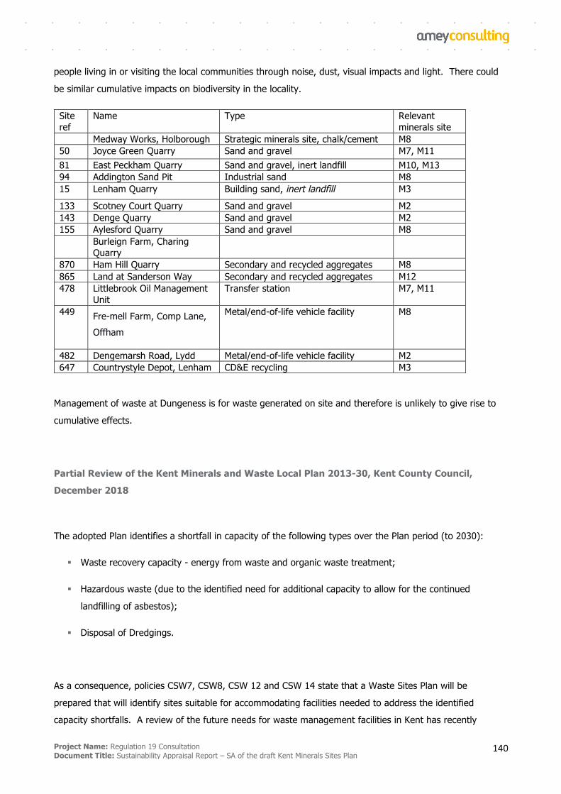
Project Name: Regulation 19 Consultation Document Title: Sustainability Appraisal Report – SA of the draft Kent Minerals Sites Plan
140
people living in or visiting the local communities through noise, dust, visual impacts and light. There could
be similar cumulative impacts on biodiversity in the locality.
Site ref
Name Type Relevant minerals site
Medway Works, Holborough Strategic minerals site, chalk/cement M8 50 Joyce Green Quarry Sand and gravel M7, M11 81 East Peckham Quarry Sand and gravel, inert landfill M10, M13 94 Addington Sand Pit Industrial sand M8 15 Lenham Quarry Building sand, inert landfill M3
133 Scotney Court Quarry Sand and gravel M2 143 Denge Quarry Sand and gravel M2 155 Aylesford Quarry Sand and gravel M8 Burleign Farm, Charing
Quarry
870 Ham Hill Quarry Secondary and recycled aggregates M8 865 Land at Sanderson Way Secondary and recycled aggregates M12 478 Littlebrook Oil Management
Unit Transfer station M7, M11
449 Fre-mell Farm, Comp Lane, Offham
Metal/end-of-life vehicle facility M8
482 Dengemarsh Road, Lydd Metal/end-of-life vehicle facility M2 647 Countrystyle Depot, Lenham CD&E recycling M3
Management of waste at Dungeness is for waste generated on site and therefore is unlikely to give rise to
cumulative effects.
Partial Review of the Kent Minerals and Waste Local Plan 2013-30, Kent County Council, December 2018
The adopted Plan identifies a shortfall in capacity of the following types over the Plan period (to 2030):
§ Waste recovery capacity - energy from waste and organic waste treatment;
§ Hazardous waste (due to the identified need for additional capacity to allow for the continued
landfilling of asbestos);
§ Disposal of Dredgings.
As a consequence, policies CSW7, CSW8, CSW 12 and CSW 14 state that a Waste Sites Plan will be
prepared that will identify sites suitable for accommodating facilities needed to address the identified
capacity shortfalls. A review of the future needs for waste management facilities in Kent has recently
Project Name: Regulation 19 Consultation Document Title: Sustainability Appraisal Report – SA of the draft Kent Minerals Sites Plan
141
been undertaken and this has concluded that there is now no need for the development of this additional
capacity.
Encouraging more waste to be managed via re-use or recycling will be achieved by enabling policies for the
development of waste management facilities for recycling and processing including a policy to grant planning
permission for redevelopment or extensions to existing waste management facilities to enable more waste to
be recycled or processed for re-use providing the facility's overall throughput is not increased.
Sections 5.5, 5.6, and 5.7 of the adopted Kent Minerals and Waste Local Plan (KMWLP) set out policies
(CSM5, CSM6 and CSM7), with reasoned justification, for the safeguarding of:
§ Land-won minerals (as defined in the Minerals Safeguarding Areas (MSAs)) from needless sterilisation
from other development; and,
§ Minerals supply and waste management and transport infrastructure from direct, and potential, loss
due to incompatible development being sited nearby such that it has the potential to prejudice their
future lawful operation.
Further policies, DM 7 and DM 8, are included to ensure that the safeguarding is not unduly rigid in its
application. Policies DM7 and DM8 set out criteria to allow development that may affect safeguarded sites to
proceed in certain prescribed circumstances.
Contribution to Cumulative Effects
None.