susitna-watana hydroelectric project · project susitna-watana hydroelectric project prm project...
TRANSCRIPT
Susitna-Watana Hydroelectric Project
(FERC No. 14241)
Initial Geomorphic Reach Delineation and
Characterization, Middle and
Lower Susitna River Segments
2012 Study Technical Memorandum
Prepared for
Alaska Energy Authority
Prepared by
Tetra Tech
February 2013
TECHNICAL MEMORANDUM GEOMORPHIC REACH DELINEATION & CHARACTERIZATION
Susitna-Watana Hydroelectric Project Alaska Energy Authority FERC Project No. 14241 Page i February 2013
TABLE OF CONTENTS
1. Introduction ........................................................................................................................1
2. Study Objectives.................................................................................................................1
3. Study Area ..........................................................................................................................2
3.1. General .....................................................................................................................2
3.2. Susitna River Segments ...........................................................................................2
4. Methods ...............................................................................................................................3
4.1. Deviations from Study Plan .....................................................................................3
4.2. Geomorphic Reach Classification System ...............................................................3
4.3. Geomorphic Parameters ...........................................................................................4
5. Results .................................................................................................................................6
5.1. Geomorphic Reach Delineation ...............................................................................6
5.2. Geomorphic Parameters ...........................................................................................6
5.3. Geomorphic Reach Descriptions for the Middle River (MR) Segment ..................7
5.3.1. Geomorphic Reach MR-1: PRM 187.1 to PRM 184.6; SC2 ...................... 7
5.3.2. Geomorphic Reach MR-2: PRM 184.6 to PRM 169.6; SC2 ...................... 7
5.3.3. Geomorphic Reach MR-3: PRM 169.6 to PRM 166.1; SC2 ...................... 7
5.3.4. Geomorphic Reach MR-4: PRM 166.1 to PRM 153.9; SC1 ...................... 8
5.3.5. Geomorphic Reach MR-5: PRM 153.9 to PRM 148.4; SC2 ...................... 8
5.3.6. Geomorphic Reach MR-6: PRM 148.4 to PRM 122.7; SC3 ...................... 8
5.3.7. Geomorphic Reach MR-7: PRM 122.7 to PRM 107.8; SC2 ...................... 8
5.3.8. Geomorphic Reach MR-8: PRM 107.8 to PRM 102.4; SC3/MC1 ............ 9
5.4. Geomorphic Reach Descriptions for the Lower River (LR) Segment .....................9
5.4.1. Geomorphic Reach LR-1: PRM 102.4 to PRM 87.9; MC1 ........................ 9
5.4.2. Geomorphic Reach LR-2: PRM 87.9 to PRM 65.6; MC2/MC3 .............. 10
5.4.3. Geomorphic Reach LR-3: PRM 65.6 to PRM 44.6; MC3 ........................ 10
5.4.4. Geomorphic Reach LR-4: PRM 44.6 to PRM 32.3; MC2 ........................ 10
5.4.5. Geomorphic Reach LR-5: PRM 32.3 to PRM 23.5; SC2 ......................... 11
5.4.6. Geomorphic Reach LR-6: PRM 23.5 to PRM 3.3; MC4 .......................... 11
6. Summary and Conclusions .............................................................................................11
7. References .........................................................................................................................12
8. Tables ................................................................................................................................15
TECHNICAL MEMORANDUM GEOMORPHIC REACH DELINEATION & CHARACTERIZATION
Susitna-Watana Hydroelectric Project Alaska Energy Authority FERC Project No. 14241 Page ii February 2013
9. Figures ...............................................................................................................................18
LIST OF TABLES
Table 5.1-1. Geomorphic Reach Boundaries in the Upper, Middle, and Lower Susitna River
Segments ............................................................................................................................... 16
Table 5.2-1. Summary of geomorphic parameters by reach for the Middle and Lower Susitna
River Segments ..................................................................................................................... 17
LIST OF FIGURES
Figure 3.2-1. Susitna River Geomorphology Study Area and Large-scale River Segments .......19
Figure 5.1-1. Longitudinal profile of Susitna River from Cook Inlet to the Headwaters.
Sources of data are shown on the figure. Reach boundaries are also included. ...20
Figure 5.3-1. Map of Middle Susitna River showing the Geomorphic Reaches. .......................21
Figure 5.3-2. Longitudinal profile of Susitna River in Middle River segment. Data
sources are shown on the figure. Reach boundaries are also included. ................22
Figure 5.4-1. Map of Lower Susitna River Segment showing the Geomorphic Reaches. .........23
Figure 5.4-2. Longitudinal profile of Susitna River in Lower River Segment. Sources of
data are shown on the figure. Reach boundaries are also included. .....................24
TECHNICAL MEMORANDUM GEOMORPHIC REACH DELINEATION & CHARACTERIZATION
Susitna-Watana Hydroelectric Project Alaska Energy Authority FERC Project No. 14241 Page iii February 2013
LIST OF ACRONYMS AND SCIENTIFIC LABELS
Abbreviation Definition
AEA Alaska Energy Authority
ER entrenchment ratio
FERC Federal Energy Regulatory Commission
ft/mile feet per mile
ILP Integrated Licensing Process
LiDAR Light Detection and Ranging-based Topography
LR Lower Susitna River Segment
MC Multiple Channel Reach Classification
mi mile(s)
mm millimeter(s)
MR Middle Susitna River Segment
NEPA National Environmental Policy Act
Project Susitna-Watana Hydroelectric Project
PRM Project River Mile (the current, Susitna-Watana Project river-mile system)
RM River Mile (the 1980s Project river-mile system)
SC Single Channel Reach Classification
UR Upper Susitna River Segment
USGS United States Geological Survey
TECHNICAL MEMORANDUM GEOMORPHIC REACH DELINEATION & CHARACTERIZATION
Susitna-Watana Hydroelectric Project Alaska Energy Authority FERC Project No. 14241 Page 1 February 2013
1. INTRODUCTION
This report provides the results of the Delineate Geomorphically Similar (Homogeneous) River
Reaches tasks in the 2012 Aquatic Habitat and Geomorphic Mapping of the Middle River using
Aerial Photography Study (G-S2) and the 2012 Reconnaissance-Level Geomorphic and Aquatic
Habitat Assessment of Project Effects on Lower River Channel (G-S4), based on work outlined
in the Revised Study Plan (AEA 2012).
The Alaska Energy Authority (AEA) is preparing a License Application that will be submitted to
the Federal Energy Regulatory Commission (FERC) for the Susitna-Watana Hydroelectric
Project (Project) using the Integrated Licensing Process (ILP). The Project is located on the
Susitna River, an approximately 300-mile-long river in Southcentral Alaska. The Project’s dam
site would be located at Project River Mile (PRM) 187.1.
This study provided data to inform the 2013–2014 licensing study program, Exhibit E of the
License Application, and FERC’s National Environmental Policy Act (NEPA) analysis for the
Project license.
This effort involved development of a geomorphic classification system for the Susitna River,
determination of geomorphic parameters and delineation of geomorphic reaches within the
Middle and Lower Susitna River segments.
The effort was based primarily on readily available data including information contained in the
1980s reports for the Project, aerial photographs, geologic maps, topographic maps, and 2011
Mat – Su Borough Light Detection and Ranging (LiDAR) data. Information specifically
collected for the current Project included aerial photographs flown in 2012 and a profile of the
Middle River and upper portion of the Lower River developed from cross-sections surveyed in
2012.
The information presented in this technical memorandum will be updated and expanded as
additional information is developed, including results of hydraulic modeling, additional cross-
section surveys, bed material sampling, mapping of relic geomorphic features, and field
observations made in executing the 2013 and 2014 Geomorphology Study and Fluvial
Geomorphology Modeling Study. As part of the efforts in the 2013 Geomorphology Study, the
geomorphic parameters will be determined for the reaches in the Upper Susitna River Segment.
2. STUDY OBJECTIVES
The objective of the effort presented in this technical memorandum is to delineate large-scale
geomorphic river reaches with relatively homogeneous characteristics (e.g., channel width,
lateral confinement by terraces, entrenchment ratio, sinuosity, slope, bed material,
single/multiple channel, hydrology) for the purposes of stratifying the river into study segments.
This objective was stated for both the 2012 Aquatic Habitat and Geomorphic Mapping of the
Middle River using Aerial Photography Study (G-S2) and the 2012 Reconnaissance-Level
Geomorphic and Aquatic Habitat Assessment of Project Effects on Lower River Channel Study
TECHNICAL MEMORANDUM GEOMORPHIC REACH DELINEATION & CHARACTERIZATION
Susitna-Watana Hydroelectric Project Alaska Energy Authority FERC Project No. 14241 Page 2 February 2013
(G-S4). This technical memorandum presents the geomorphic reach delineation effort performed
for both the Middle and Lower Susitna River segments.
More specific objectives of the geomorphic reach delineation tasks are as follows:
Develop a geomorphic classification system for the Susitna River that considers both form
and process;
Apply the classification system to delineation of geomorphic reaches in both the Middle and
Lower Susitna River segments;
Determine geomorphic parameters for each of the identified geomorphic reaches.
3. STUDY AREA
3.1. General
The Susitna River, located in Southcentral Alaska, drains an area of approximately 20,010 square
miles and flows about 320 miles from its headwaters at the Susitna, West Fork Susitna, and East
Fork Susitna glaciers to the Cook Inlet (USGS 2012). The Susitna River basin is bounded on the
west and north by the Alaska Range, on the east by the Talkeetna Mountains and Copper River
Lowlands and on the south by Cook Inlet. The highest elevations in the basin are at Mt.
McKinley at 20,320 feet while its lowest elevations are at sea level where the river discharges
into Cook Inlet. Major tributaries to the Susitna River between the headwaters and Cook Inlet
include the Chulitna, Talkeetna and Yentna Rivers that are also glacially fed in their respective
headwaters. The basin receives, on average, 35 inches of precipitation annually with average
annual air temperatures of approximately 29oF.
3.2. Susitna River Segments
Within the study area that extends from Cook Inlet to the Maclaren River confluence at Project
River Mile (PRM) 261.3, the river can be subdivided into three segments whose general
characteristics are governed by the basin geology as described by Wilson et al. (2009). The
segments are referred to as the Upper, Middle and Lower Susitna River segments and are
identified on Figure 3.2-1 with the associated extents:
Upper Susitna River Segment: Maclaren River confluence (PRM 261.3) downstream to the
proposed Watana Dam site (PRM 187.1).
Middle Susitna River Segment: Proposed Watana Dam site (PRM 187.1) downstream to the
Three Rivers Confluence (PRM 102.4).
Lower Susitna River Segment: Three Rivers Confluence (PRM 102.4) downstream to Cook
Inlet (PRM 3.3).
The upstream-most segment, referred to as the Upper River (UR), extends from PRM 261.3 to
PRM 187.1 at the Watana Dam site. The morphologic characteristics of this segment of the river
are dominated by the products of Quaternary-age glaciation. The Middle River (MR) segment
extends from the Watana Dam site to the Three Rivers Confluence at about PRM 102.4. The
general characteristics of the river in this segment are heavily influenced by bedrock outcrop as
TECHNICAL MEMORANDUM GEOMORPHIC REACH DELINEATION & CHARACTERIZATION
Susitna-Watana Hydroelectric Project Alaska Energy Authority FERC Project No. 14241 Page 3 February 2013
well as Quaternary-age glaciations. The Lower River (LR) segment extends from the Three
Rivers Confluence (PRM 102.4) to the tidal flats at Cook Inlet (PRM 3.3). The morphologic
characteristics of the river in this segment are dominated by the sediment loading from the major
tributaries and variable resistance to erosion of the Pleistocene-age, glacially-derived materials
including tills (moraines), glacio-fluvial sediments in various elevation outwash-surfaces and
glacio-lacustrine sediments that control the width of the valley.
4. METHODS
4.1. Deviations from Study Plan
There were no deviations from the tasks in the 2012 study plans involving the delineation of the
Middle and Lower Susitna River segments into geomorphic reaches.
4.2. Geomorphic Reach Classification System
The first step in the geomorphic reach delineation effort for the Susitna River was the selection
of the system to be used to classify and delineate the individual reaches within the three
identified segments. Classification of the river segments is required to provide a basis for
communication among the various disciplines and to identify relatively homogeneous river
reaches that can then be used as a basis for extrapolation of results and findings from more
spatially-limited studies. Numerous river classifications exist (Leopold and Wolman 1957;
Schumm 1963; Schumm 1968; Kellerhals et al. 1976; Brice 1981; Mosley 1987; Rosgen 1994;
Rosgen 1996; Thorne 1997; Montgomery and Buffington 1997; Vandenberghe 2001), but no
single classification has been developed that meets the needs of all investigators. Several factors
have prevented the achievement of an ideal geomorphic stream classification, and foremost
among these has been the variability and complexity of rivers and streams (Mosley 1987;
Juracek and Fitzpatrick 2003). Problems associated with the use of existing morphology as a
basis for extrapolation (Schumm 1991) further complicates the ability to develop a robust
classification (Juracek and Fitzpatrick 2003).
However, from a practical viewpoint, Schumm (2005) has suggested that rivers and streams can
be divided into two principal types: regime and non-regime. Regime channels, which are
defined as those that flow on and in sediments transported by the river during the present
hydrologic regime, and whose morphology is controlled primarily by the interactions of the flow
regime and the sediment supply (Leopold et al. 1964; Schumm 1977), can be further subdivided
on the basis of patterns (straight, meandering, wandering, braided, anastomosing). Non-regime
channels are defined as those whose channel morphology is not controlled by a balance between
the sediment supplied and the ability of the flow-regime to transport it. Non-regime channels can
be further subdivided into constrained, where the form of the channel is forced by non-alluvial
factors such as bedrock, colluvium, glacial deposits or extreme flood deposits (Montgomery and
Buffington 1997; Tinker and Wohl 1998; O’Connor and Grant 2003), or unstable, which can
include degrading (Schumm et al. 1984; Darby and Simon 1999), aggrading (Schumm 1977) or
avulsing (Schumm et al. 2000) channels.
Based on Schumm’s (2005) classification scheme, the factors used in the initial geomorphic
classification of the individual reaches of the Susitna River include the following:
TECHNICAL MEMORANDUM GEOMORPHIC REACH DELINEATION & CHARACTERIZATION
Susitna-Watana Hydroelectric Project Alaska Energy Authority FERC Project No. 14241 Page 4 February 2013
Channel planform (single channel: straight, meandering; multiple channels: braided,
anastomosing) – identified from topographic mapping, aerial photography
Constraints (bedrock, colluvium, moraines, alluvial fans, glacio-lacustrine and glacio-fluvial
sediments) – identified from geologic mapping
Confinement (width of the floodplain and modern alluvium in relation to the width of the
active channel[s]) – identified from geologic mapping, Light Detection and Ranging
(LiDAR)-based topography, hydraulic modeling
Gradient and bed materials – derived from various sources of survey data and 1980s era data.
Based on currently available information, the individual reaches within the three river segments
were classified as one of the following categories:
Single Channel (SC):
SC1– Laterally confined with no sediment storage in bars, islands, or floodplain
SC2 – Laterally confined with limited sediment storage in mid-channel bars and non-
continuous bank-attached floodplain segments
SC3 – Laterally confined with sediment storage in mid-channel bars, vegetated islands,
and continuous floodplain segments
Multiple Channels (MC):
MC1 –Wide floodplain with significant sediment storage in unvegetated braid bars
MC2 – Wide floodplain with significant sediment storage in vegetated islands and bars
MC3 – Wide floodplain with vegetated floodplain segments separated by anastomosed
channels with downstream base level controls
MC4 – Delta distributary channels
4.3. Geomorphic Parameters
The geomorphic parameters developed in this document include the following:
Gradient
Sinuosity
Active channel width
Valley bottom width
Entrenchment ratio
Median bed material size
Channel branching index
The procedures used to develop each of these parameters are described below.
Gradient (feet/mile): The gradient is defined as the change in elevation between the upstream to
downstream limits of a reach divided by the reach length. The gradient is expressed in feet per
mile (ft/mile). The reach lengths were developed from the stationing of the PRM line which was
developed to follow the channel thalwegs. The elevations at the reach boundaries were taken
from the best available information. For the Middle River and the Portion of the Lower River
above PRM 80, the elevations were taken from the 2012 cross section surveys. For the
remainder of the Lower River, the elevations were taken from the 2011 Mat-Su Borough LiDAR.
TECHNICAL MEMORANDUM GEOMORPHIC REACH DELINEATION & CHARACTERIZATION
Susitna-Watana Hydroelectric Project Alaska Energy Authority FERC Project No. 14241 Page 5 February 2013
Sinuosity (dimensionless): Sinuosity is the ratio of the channel length to the valley length. It
was determined using the reach length developed from the PRM line and a valley length
developed by tracing a line up the general alignment of the valley as interpreted using the 2012
aerial photography.
Active Channel Width (feet): The active channel width was defined as the width of the various
channel features comprising the Susitna River as defined by their top of banks. The channel
features were delineated in GIS as part of the 2012 G-S2 and G-S4 study efforts (Tetra Tech
2013a). Channel features that were considered part of the active channel included the main
channel, side channels and side sloughs. Upland sloughs were not included as part of the active
channel since they do not typically convey flows from the mainstem until channel banks have
been overtopped. The average active channel width within a reach was determined by dividing
the area of the channel features by the reach length previously developed for the sinuosity from
the PRM line. The active channel width will be replaced with bankfull channel width when
results of 2013 field studies and hydraulic modeling are available to define the bankfull width.
Valley Bottom Width (feet): The valley bottom width was used as an approximation of the area
that is still subject to occasional flooding and potentially subject to lateral migration of the
channel. It was defined using the 2011 Mat – Su Borough LiDAR as the area within 20 feet
vertically of the water surface elevation present at the time of the LiDAR survey (Matanuska-
Susitna Borough 2011). This typically meant the line defining the valley bottom intersected the
slope of a terrace or the valley or canyon wall. At locations where a tributary crossed into the
valley bottom, the valley bottom line was drawn across the tributary rather than following the
contours up the tributary. In some locations, a second valley bottom line was defined based on
manmade features, such as the railroad, that potentially constrain flooding and lateral migration
of the river. The average valley bottom width for a reach was determined by dividing the area
within the boundary of the valley bottom by the reach length previously developed from the
RPM line for the determination of sinuosity. Similar to the active channel width, the valley
bottom width will be refined after results of 2013 field studies and hydraulic modeling are
available.
Entrenchment Ratio (dimensionless): For the initial geomorphic reach delineation effort, the
entrenchment ratio (ER) was defined as the average valley bottom width of a reach divided by
the average active channel width of a reach. The entrenchment ratio is a measure of the vertical
confinement of the stream. The higher the ratio, the wider the frequently flooded area adjacent to
the river. Rivers with high entrenchment ratios generally dissipate proportionately more energy
on the floodplain during large flood events and hydraulic forces, sediment transport and flow
depth tend to increase less rapidly once bankfull flows are reached than rivers with similar active
channel characteristics with low entrenchment ratios.
Median Bed Material Size (mm): The median bed material size is the diameter of the bed
material for which half is coarser than and half is finer. Since this parameter falls at the 50
percent point on the grain size distribution, it is also referred to as the D50. The median bed
material size was derived from several sources including Harza-Ebasco (1984), R&M
Consultants (1982 and 1985) and USGS (2013).
Channel Branching Index (dimensionless): The channel branching index is defined as the
average number of channel features present across the active channel within a reach. This was
determined by counting the number of channels separated by relatively stable, vegetated islands
TECHNICAL MEMORANDUM GEOMORPHIC REACH DELINEATION & CHARACTERIZATION
Susitna-Watana Hydroelectric Project Alaska Energy Authority FERC Project No. 14241 Page 6 February 2013
at a series of approximately evenly spaced cross sections within each reach. Similar to the active
channel width, the channel features included in the channel branching index included the main
channel, side channels and side sloughs, but excluded upland sloughs. The branching index was
determined in GIS for each reach by first drawing lines across the active channels at intervals
equal to approximately one channel width and counting the number of channel features
intersected by the line. The number of channel features intersected was totaled for the reach then
divided by the number of lines sampled to determine the channel branching index.
5. RESULTS
5.1. Geomorphic Reach Delineation
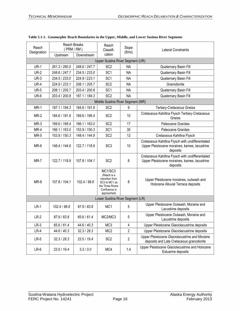
Table 5.1-1 identifies the reach boundaries (PRM) and their individual geomorphic designations
for each of the three Susitna River segments and also includes a brief description of the
individual reach geology (Wilson et al. 2009). Figure 5.1-1 shows the longitudinal profile of the
Susitna River from Cook Inlet to the headwaters. The profile tends to reflect the bounding
geology along the river (Wilson et al. 2009). Upstream of the Maclaren River confluence the
river is bounded by Quaternary-age sediments and the slope is relatively mild (about 6 ft/mile).
In the Upper River, between the Maclaren River (PRM 261.3) and the Watana Dam site (PRM
187.1) the slope significantly increases (11-20 ft/mile) and the channel boundary is composed of
both Quaternary-age sediments and bedrock (meta-sediments and gneiss). From the Watana
Dam site to the head of Devils Canyon (PRM 166.1), the slope is about 11 ft/mile and the
channel is bounded by meta-sedimentary and gneissic rocks. The channel slope in Devils
Canyon (PRM 166.1 to PRM 153.9) is about 31 ft/mile and the channel is bounded by granitic
rocks. Between Devils Canyon and the Three Rivers Confluence (PRM 102.4) the channel slope
decreases progressively from about 12 ft /mile to about 7 ft/mile and the reduction in slope is
correlated with a reduction in the erosion-resistance of the bounding materials and the transition
to an alluvial channel. The upper part of the reach is bounded by primarily meta-sedimentary
rocks, the middle by Pleistocene-age glacial deposits and the lower by Pleistocene- and
Holocene-age alluvial terraces. Downstream of the Three Rivers Confluence, the bed slope
progressively decreases from 6 ft/mile to about 1.5 ft/mile in the lowest reach. The channel is
bounded primarily by Pleistocene-age glacial, fluvio-glacial and glacio-lacustrine deposits.
5.2. Geomorphic Parameters
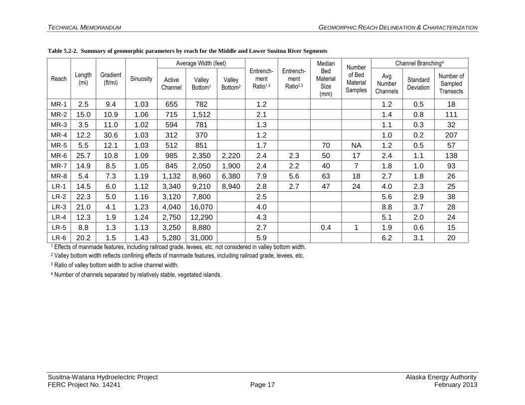
Table 5.2-1 summarizes the geomorphic parameters for each of the reaches that were derived
from a number of different sources. The geomorphic parameters include (1) gradient (2)
sinuosity, (3) average active channel width, (4) valley bottom width for both natural and man-
modified conditions, (5) entrenchment ratio (ER), (6) average median bed material size where
data were available, and (7) channel branching index.
For the purposes of this document, geomorphic reach descriptions are only provided for the
Middle and Lower River segments. Detailed determination of geomorphic characteristics for the
Upper River Segment will be developed in 2013 and included in an updated version of this
report.
TECHNICAL MEMORANDUM GEOMORPHIC REACH DELINEATION & CHARACTERIZATION
Susitna-Watana Hydroelectric Project Alaska Energy Authority FERC Project No. 14241 Page 7 February 2013
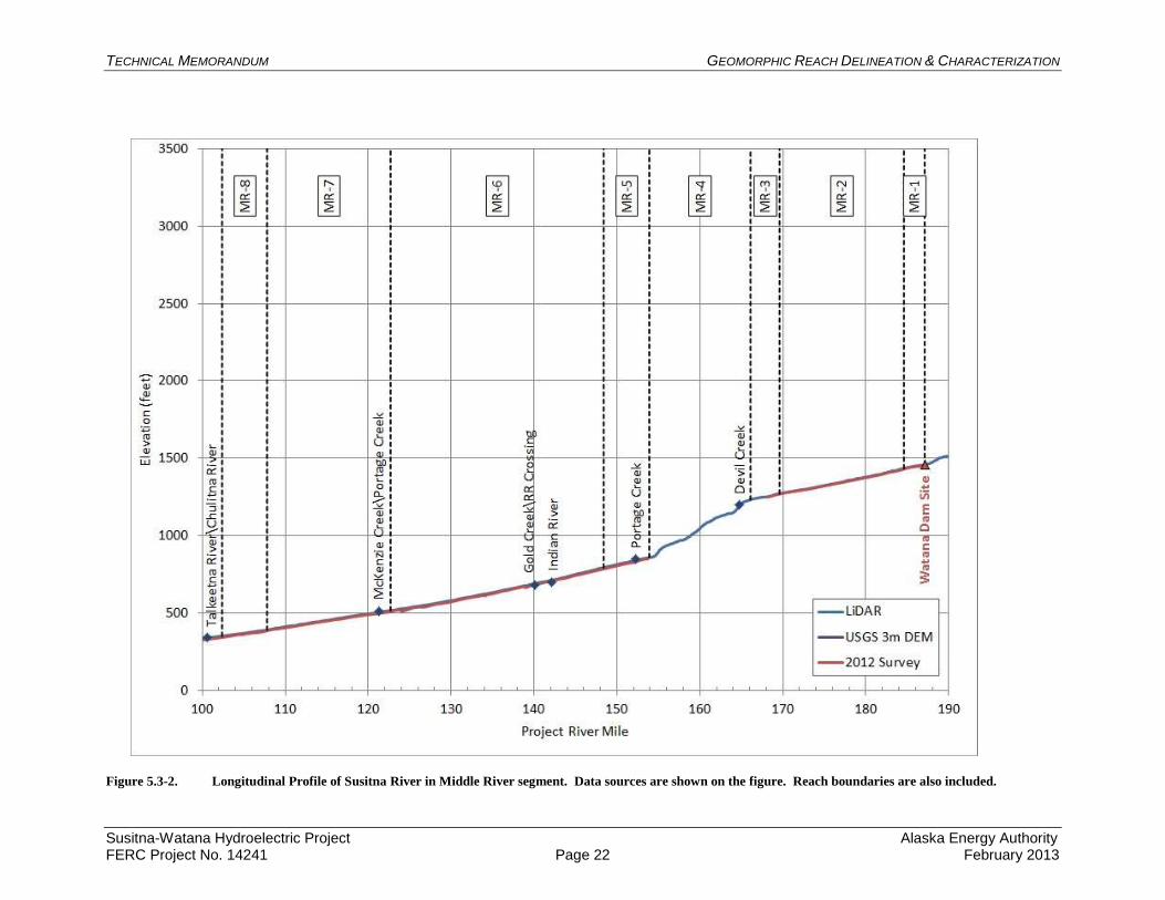
5.3. Geomorphic Reach Descriptions for the Middle River (MR) Segment
Between Watana Dam at PRM 187.1 and the Three Rivers Confluence at PRM 102.4, eight
reaches were identified and classified based on their geomorphic characteristics (Figure 5.3-1).
A somewhat enlarged scale longitudinal profile of the Middle River Segment showing the reach
boundaries is provided in Figure 5.3-2.
5.3.1. Geomorphic Reach MR-1: PRM 187.1 to PRM 184.6; SC2
The Susitna River (655 feet active width) flows in a narrow, approximately 780 feet wide,
bedrock-bounded canyon downstream of the Watana Dam site. The canyon is formed in Tertiary
to Cretaceous-age gneiss. There is limited sediment storage potential in the reach because of the
narrow valley bottom (ER=1.2) and relatively steep slope (9.4 ft/mile). Alluvial sediments are
stored within vegetated and non-vegetated mid-channel bars that tend to be located in local
hydraulic expansion zones. The sinuosity of the reach is 1.03, and the average number of
channels in the reach is 1.2+/-0.5.
5.3.2. Geomorphic Reach MR-2: PRM 184.6 to PRM 169.6; SC2
The Susitna River (715 feet active width) flows in a wider, approximately 1,500 feet wide,
bedrock-bounded canyon between the Tsusena Creek confluence and about PRM 173, where the
canyon narrows to about 1,000 feet. The wider, upper part of the reach is formed in more
erodible Cretaceous-age Kahiltna Flysch meta-sedimentary rocks and the narrower, lower part
between PRM 173 and PRM 169.6 is formed in less-erodible Tertiary to Cretaceous-age gneiss.
The average slope of the reach is 10.9 ft/mile. There are considerably more alluvial sediments
stored in vegetated islands, mid-channel bars and in vegetated discontinuous floodplain segments
in this reach with an entrenchment ratio of 2.1. This is particularly true of the wider, upper
portion of this reach. It is likely that Fog Creek, a south bank tributary, is a local source of
sediment in the upper reach. In the lower, narrower part of the reach, alluvial sediments are
stored within discontinuous vegetated floodplain segments and in unvegetated mid-channel bars.
The sinuosity of the reach is 1.06 and the average number of channels in the reach is 1.4+/-0.8.
5.3.3. Geomorphic Reach MR-3: PRM 169.6 to PRM 166.1; SC2
The Susitna River (594 feet active width) flows in a narrow (about 780 feet wide), bedrock-
bounded canyon from PRM 169.6 to PRM 166.1. The canyon is formed in Paleocene-age
granitic rocks. Based on the abrupt change in the direction of the canyon at the head of the
reach, which is part of an extensive NW-SE trending lineament, the reach is most likely fault-
controlled. Because of the relatively narrow canyon (ER=1.3) and steep slope (11 ft/mile), the
alluvial sediment storage potential in the reach is low. Alluvial sediments are stored within a
few vegetated mid-channel bars in the reach, and there is little evidence of even discontinuous
floodplain segments within the reach. The sinuosity of the reach is 1.02 and the average number
of channels in the reach is 1.1+/-0.3.
TECHNICAL MEMORANDUM GEOMORPHIC REACH DELINEATION & CHARACTERIZATION
Susitna-Watana Hydroelectric Project Alaska Energy Authority FERC Project No. 14241 Page 8 February 2013
5.3.4. Geomorphic Reach MR-4: PRM 166.1 to PRM 153.9; SC1
The Susitna River (312 feet active width) flows in a very narrow (370 feet wide), very steep
(30.6-ft/mile), bedrock-bounded canyon, referred to as Devils Canyon. The narrow canyon has
formed in Paleocene-age granitic rocks that are probably not faulted given the very narrow width
of the canyon. Because of the narrow canyon (ER=1.2) and steep slope, there is very little, if
any, alluvial sediment stored within the reach. The sinuosity of the reach is 1.03 and the average
number of channels in the reach is 1.0+/-0.2.
5.3.5. Geomorphic Reach MR-5: PRM 153.9 to PRM 148.4; SC2
The Susitna River (512 feet active width) flows through a slightly wider (about 850 feet),
bedrock-bounded canyon from PRM 153.9 to PRM 148.4. The relatively narrow canyon has
formed in Cretaceous-age Kahiltna Flysch meta-sedimentary rocks. The somewhat wider
canyon and lower slope (12.1 ft/mile) compared to MR-4 (Devils Canyon) allow some alluvial
sediment storage within the reach, primarily in a few vegetated mid-channel islands and
discontinuous floodplain segments in the slightly wider parts of the reach (ER=1.7). The
sinuosity of the reach is 1.03 and the average number of channels in the reach is 1.2+/-0.5.
Based on a single sample collected in the 1980s, the median size of the bed material in the reach
is about 70 mm.
5.3.6. Geomorphic Reach MR-6: PRM 148.4 to PRM 122.7; SC3
The Susitna River (985 feet active width) flows through a wider (2,350 feet wide without
consideration of manmade features and 2,220 feet wide with consideration of manmade
features), bedrock-bounded canyon from PRM 148.4 to PRM 122.7. The south side of the
canyon is formed in Paleocene-age granitic rocks and the north side is formed in Cretaceous-age
Kahiltna Flysch meta-sedimentary rocks that are overlain in many parts of the reach by
undifferentiated Upper Pleistocene-age moraines, kames and lacustrine deposits. The wider
valley may be due to the weakening effects of contact metamorphism between the older
sedimentary rocks and the younger granites. In the wider parts of the reach, alluvial sediments
are stored in continuous, vegetated floodplain segments and within numerous vegetated islands
and bars, as well as in unvegetated mid-channel bars (ER=2.4 without manmade features,
ER=2.3 with manmade features). Where the valley bottom is wider within the reach, the alluvial
deposits tend to be more vegetated, and where the valley bottom is narrower, the alluvial
deposits tend to be less vegetated. Channel slope is 10.8 ft/mile, sinuosity of the reach is 1.09
and the average number of channels is 2.4+/-1.1. The average median size of the bed material in
the reach is 50 mm based on 17 samples that were collected in the 1980s.
5.3.7. Geomorphic Reach MR-7: PRM 122.7 to PRM 107.8; SC2
The Susitna River (845 feet active width) flows through a bedrock-bounded canyon from PRM
122.7 to PRM 107.8 (2,050 feet wide without manmade features, 1,900 feet w/ manmade
features). The canyon is formed in Cretaceous-age Kahiltna Flysch meta-sedimentary rocks that
are overlain in many parts of the reach by undifferentiated Upper Pleistocene-age moraines,
kames and lacustrine deposits. Because of the wider valley and lower slope (8.5 ft/mile), there is
a reasonably high sediment storage potential within the reach (ER=2.4 without manmade
features, ER=2.2 with manmade features). Alluvial sediments are stored primarily within

TECHNICAL MEMORANDUM GEOMORPHIC REACH DELINEATION & CHARACTERIZATION
Susitna-Watana Hydroelectric Project Alaska Energy Authority FERC Project No. 14241 Page 9 February 2013
continuous, vegetated floodplain segments and in vegetated islands and mid-channel bars. The
sinuosity of the reach is 1.05 and the average number of channels in the reach is 1.8+/-1.0.
Based on 7 samples collected in the 1980s, the average median size of the bed material in the
reach is 40 mm.
5.3.8. Geomorphic Reach MR-8: PRM 107.8 to PRM 102.4; SC3/MC1
This reach of the Susitna River (1,130 feet active width) extends from PRM 107.8 to above the
Three Rivers Confluence at PRM 102.4. The valley floor (8,960 feet wide without manmade
features and 6,380 feet with manmade features) above the confluence is confined by Upper
Pleistocene–age moraines and glacial outwash surfaces as well as Holocene-age alluvial terraces.
The average gradient of the river decreases slightly to 7.3 ft/mile. In the upper part of the reach,
alluvial sediments are stored within continuous floodplain segments, vegetated islands and mid-
channel bars (SC3). Just upstream of the confluence, the bulk of the alluvial sediments are stored
in active, un-vegetated braid bars (MC1). The large entrenchment ratio (ER=7.9 without
manmade features and ER=5.6 with manmade features) is largely the result of the wide
floodplain created by the confluence of the Susitna, Chulitna and Talkeetna Rivers. The sinuosity
of the reach is 1.19 and the average number of channels is 2.7+/-1.8. Based on 18 samples
collected in the 1980s, the average median size of the bed material in the reach is 63 mm.
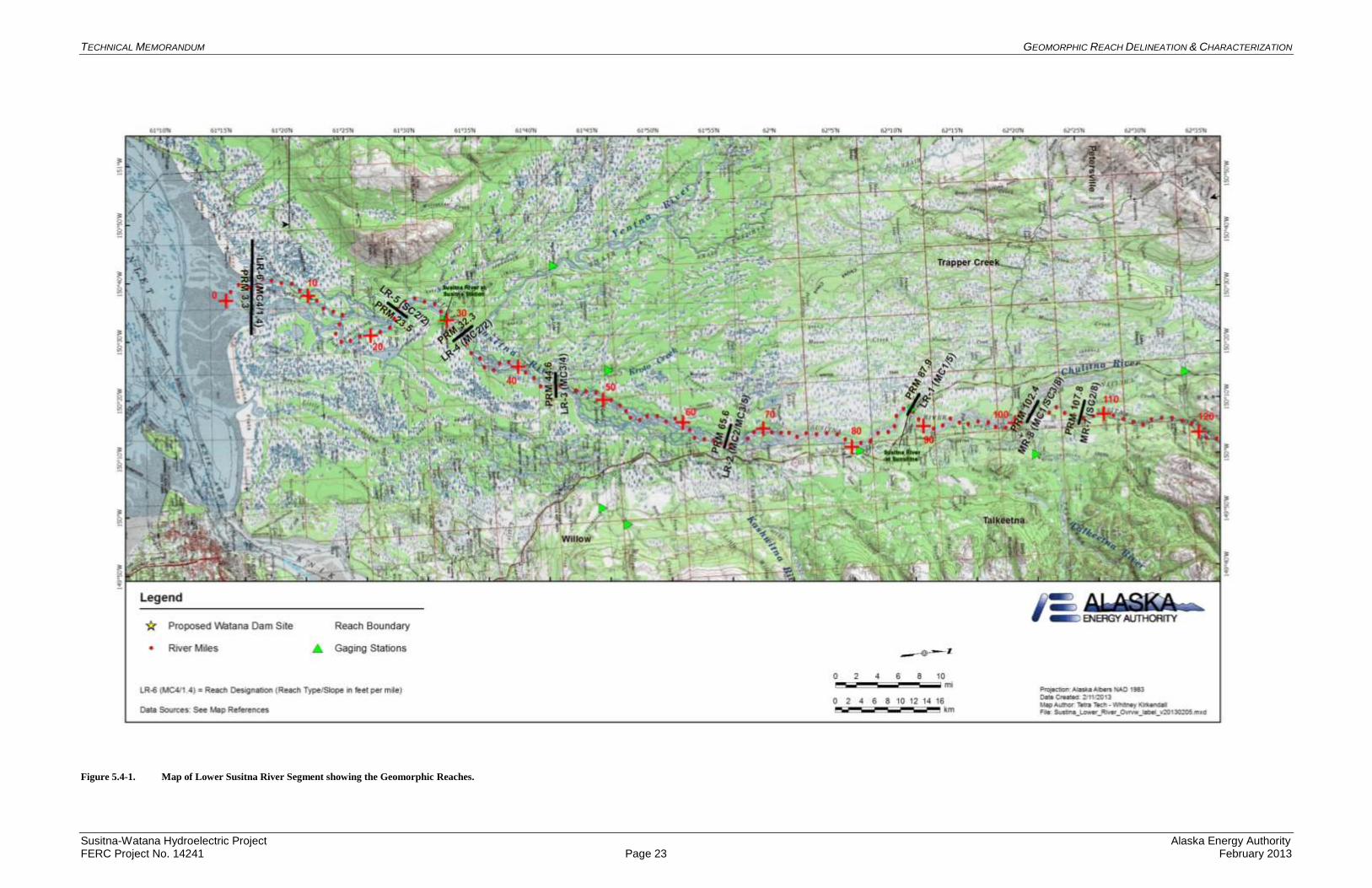
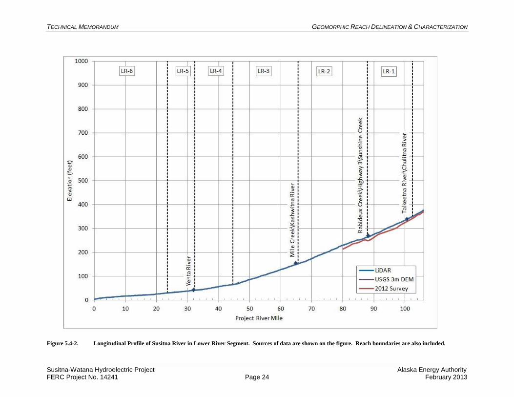
5.4. Geomorphic Reach Descriptions for the Lower River (LR) Segment
Between the Three Rivers Confluence at PRM 102.4.1 and Cook Inlet at PRM 3.3, six reaches
were identified and classified based on their geomorphic characteristics (Figure 5.4-1). A
somewhat enlarged-scale longitudinal profile of the Lower River segment showing the reach
boundaries is provided in Figure 5.4-2. Throughout the Lower River Segment, the gradient of the
Susitna River steadily decreases from 6 ft/mile below the Three Rivers Confluence to 1.5 ft/ per
mile as it flows into the Cook Inlet. The character of the river changes dramatically below the
Three Rivers Confluence as the width of the river more than triples from the widest portions in
the Middle River Segment, and it adopts a braided channel form.
5.4.1. Geomorphic Reach LR-1: PRM 102.4 to PRM 87.9; MC1
This reach of the Susitna River (3,340 feet active width) includes the Three Rivers Confluence
downstream of PRM 102.4 and extends downstream to a valley bottom constriction at PRM
87.9. The Susitna River triples its width in LR-1 compared with MR-8. This is the result of the
added flow and sediment loads from the Chulitna and Talkeetna rivers. However, the width of
the valley floor at approximately 9,200 feet wide without manmade features; with consideration
of manmade features, the width is 8,940 feet) is nearly identical to MR-1 immediately upstream.
LR-1 is confined on the south side primarily by Upper Pleistocene-age moraines and glacial
outwash surfaces and on the north side by Upper Pleistocene-age lacustrine deposits intercalated
with glacial outwash surfaces. The average channel gradient for the reach is 6 ft/mile. In
general, because of the combined sediment delivery from the Three Rivers Confluence, the
reach is net aggradational and the bulk of the alluvial sediment is stored in active, unvegetated
braid bars upstream of the valley floor constriction at PRM 87.9 (ER=2.8 without manmade
features, ER=2.7 with manmade features). Within the reach, there are also locations where
TECHNICAL MEMORANDUM GEOMORPHIC REACH DELINEATION & CHARACTERIZATION
Susitna-Watana Hydroelectric Project Alaska Energy Authority FERC Project No. 14241 Page 10 February 2013
alluvial sediments are stored within vegetated islands and mid-channel bars, and the reach is
bounded on each side by a vegetated floodplain of varying width. The sinuosity of the reach is
1.12 and the average number of channels is 4.0+/-2.3. Based on 24 samples collected in the
1980s, the average median size of the bed material in the reach is about 47 mm.
5.4.2. Geomorphic Reach LR-2: PRM 87.9 to PRM 65.6; MC2/MC3
This reach of the Susitna River (3,120 feet active width) can be further subdivided into upper and
lower subreaches. The upper reach extends from the valley floor constriction formed by Upper
Pleistocene-age glacial outwash on the south bank and Upper Pleistocene-age moraines on the
north bank at PRM 87.9, down to about PRM 74.4. Within this subreach, the valley floor is
confined on the south by Upper Pleistocene-age glacial outwash and on the north side by similar
aged moraines. The valley floor width varies from about 4,000 to 5,200 feet and the alluvial
sediments are primarily stored in vegetated islands, bars and continuous floodplain segments
(MC2). Between PRM 74.4 and PRM 65.6, where there is a valley floor constriction most
probably created by the Kashwitna River fan on the south bank and Upper Pleistocene-age
moraines on the north bank, the planform of the river changes to anastomosed as a result of the
imposed baselevel control (Smith and Smith 1980; Knighton and Nanson 1993; Makaske 2001).
The bulk of the alluvial sediments within the lower subreach are stored in longitudinally
extensive, relatively stable, vegetated floodplain segments (MC3). The valley floor width is on
the order of 8,000 feet upstream of the constriction. The south side of the valley is composed of
Upper Pleistocene-age glacio-lacustrine deposits and the north side by similar-aged moraines.
The greater width of the valley in the lower subreach suggests that the Upper Pleistocene-age
glacial outwash that forms the south bank in the upper subreach is more erosion-resistant than
the glacio-lacustrine deposits. The average slope of the channel is 5 ft/mile, the sinuosity is 1.16,
the ER is 2.5, and on average there are 5.6+/-2.9 channels in the reach.
5.4.3. Geomorphic Reach LR-3: PRM 65.6 to PRM 44.6; MC3
The Susitna River (4,040 feet active width) within this reach is bounded by Upper Pleistocene-
age lacustrine deposits on both the south and north sides of the valley, the apparent reason for a
wider valley floor (16,000 feet). A valley floor constriction at PRM 44.6 forms a downstream
baselevel control for the river in this reach (Smith and Smith 1980; Knighton and Nanson 1993;
Makaske 2001), and consequently, the river planform is anastomosed for most of the reach
(MC3). The bulk of the alluvial sediments within reach are stored in longitudinally extensive,
relatively stable, vegetated floodplain segments that are referred to as the Delta Islands (ER=4.0).
The average slope of the channel in the reach is 4.1 ft/mile, the sinuosity is 1.23, and on average,
there are 8.8+/-3.7 channels in the reach.
5.4.4. Geomorphic Reach LR-4: PRM 44.6 to PRM 32.3; MC2
The Susitna River (2,750 feet active width) in this reach flows between Upper Pleistocene-age
lacustrine deposits on both the south and north sides of the valley. Valley floor width is about
12,300 feet and a valley floor constriction is created by the Yentna River alluvial fan and the
Upper Pleistocene-age moraine on the south side of the river and the moraine-draped, Late
Cretaceous-age, granodiorite outcrop on the north side of the river at PRM 30.1 (Susitna Station
downstream of the reach boundary). The bulk of the alluvial sediments in the reach are stored in
vegetated islands and mid-channel bars and in continuous, vegetated floodplains on both sides of
TECHNICAL MEMORANDUM GEOMORPHIC REACH DELINEATION & CHARACTERIZATION
Susitna-Watana Hydroelectric Project Alaska Energy Authority FERC Project No. 14241 Page 11 February 2013
the river (ER=4.3). The average slope of the channel in the reach is 1.9 ft/mile, the sinuosity is
1.24, and on average there are 5.1+/-2.0 channels in the reach.
5.4.5. Geomorphic Reach LR-5: PRM 32.3 to PRM 23.5; SC2
Between the Yentna River confluence at PRM 32.3 and PRM 23.5, the Susitna River (3,248 feet
active width) is confined by Upper Pleistocene-age glacio-lacustrine deposits on the south bank
as well as the Late Cretaceous-age granodiorite outcrop on the north side of the river at Susitna
Station (PRM 30.1). The valley floor width is about 8,880 feet and the river slope is very low
(1.3ft/mile). The relatively constricted valley limits the sediment storage potential within the
reach and the bulk of the sediment is stored in mid-channel bars, vegetated islands and
discontinuous floodplain segments (ER=2.7). The sinuosity is 1.13 and on average there are
1.9+/-0.6 channels in the reach.
5.4.6. Geomorphic Reach LR-6: PRM 23.5 to PRM 3.3; MC4
From PRM 23.5 to the Cook Inlet at PRM 3.3, the Susitna River (5,280 feet active width) forms
a delta-distributary system with longitudinally continuous, vegetated and relatively stable inter-
distributary channel delta plain segments (ER=5.9). The delta is bounded to the south by Upper
Pleistocene-age, glacio-lacustrine deposits and to the north by Holocene-age estuarine deposits.
The active Castle Mountain Fault, with evidence of Holocene-age displacement (Labay and
Haeussler 2001), crosses the river at the head of the reach. The width of the delta plain is about
31,000 feet and the river slope in the reach is extremely flat (1.5 ft/mile). The sinuosity is 1.43,
and on average, there are 6.2+/-3.1 channels in the reach.
6. DISCUSSION
The geomorphic characteristics of the study area of the Susitna River between the Maclaren
River confluence (PRM 261.1) and Cook Inlet (PRM 3.3) are predominantly the result of two
factors. The first factor is the geologic setting and the relative erodibility of the channel
bounding materials (Montgomery and Buffington 1997, Tinker and Wohl 1998, O’Connor and
Grant 2003). In general, the Upper River segment reflects the effects of Pleistocene- and
ongoing, Holocene-age glaciation. The Middle River Segment is dominated by the presence of
relatively erosion-resistant meta-sedimentary, gneissic and granitic rocks and the distribution of
Pleistocene age glacially-derived materials. The Lower River Segment is primarily an alluvial
system with a wide valley that is laterally constrained by Pleistocene-age, glacially-derived,
materials that have variable resistance to erosion.
The second factor is the balance between the sediment supply and the potential for sediment
storage within a reach. Extensive braidplains downstream of the active glaciers at the
headwaters of the Susitna River buffer sediment supply to the project reach. Based on the
available sediment record at the Gold Creek gage, the annual bed load and suspended sediment
load in the Middle River are relatively low, and this is reflected in the somewhat limited
sediment storage potential within the Middle River reaches where the entrenchment ratios, with
the exception of geomorphic reach MR-8, are low (<2.5). In contrast, the combined bed-load
and suspended sediment loads delivered to the Lower River segment from the Chulitna,
Talkeetna and Yentna Rivers are relatively high, and this is reflected in the extensive sediment
storage potential in the Lower River Segment where the entrenchment ratios, with the exception
TECHNICAL MEMORANDUM GEOMORPHIC REACH DELINEATION & CHARACTERIZATION
Susitna-Watana Hydroelectric Project Alaska Energy Authority FERC Project No. 14241 Page 12 February 2013
of geomorphic reach LR-5, are high (>4). The sediment transport rates, and hence the potential
for sediment storage and remobilization within the Lower River geomorphic reaches, is reflected
in the form of the channel. Where the coarse sediment supply is likely higher than the transport
capacity, the channel form is primarily braided (e.g. LR-1), and where the coarse sediment
transport capacity and supply are likely more balanced, the channel form is dominantly
anastomosed (e.g., LR-3).
The sediment balance is an important factor in determining the morphology and behavior of the
Lower River. Sediment transport and the sediment balance in the Lower Susitna River are further
investigated in the 2012 Study Technical Memorandum Development of Sediment Transport
Relationships and an Initial Sediment Balance for the Middle and Lower Susitna River Segments
(Tetra Tech 2013b). An initial assessment of potential Project effects on the morphology of the
Lower River is presented in the 2012 Study Technical Memorandum Reconnaissance Level
Assessment of Potential Channel Change in the Lower Susitna River Segment (Tetra Tech
2013c).
7. REFERENCES
AEA (Alaska Energy Authority). 2012. Study Component: Delineate Geomorphically Similar
(Homogeneous) Reaches and Characterize the Geomorphology of the Susitna River.
Revised Study Plan: Susitna-Watana Hydroelectric Project FERC Project No. 14241,
Section 6.5.4.1. December 2012. Prepared for the Federal Energy Regulatory Commission
by the Alaska Energy Authority, Anchorage, Alaska. http://www.susitna-
watanahydro.org/wp-content/uploads/2012/12/02-RSP-Dec2012_2of8-Sec-6-
Geomorphology-v2.pdf.
Brice, J.C. 1981. Stability of relocated stream channels. Federal Highway Commission Report
FHWA/RD-80/158.177 p.
Darby, S.E. ,and A. Simon (eds). 1999. Incised River Channels. Wiley. Chichester. 442 p.
Harza-Ebasco. 1984. Reservoir and River Sedimentation. Prepared for Alaska Power Authority.
98p.
Juracek, K.E., and F.A. Fitzpatrick. 2003. Limitation and implications of stream classification.
Jour. of American Water Res. Assn. v. 83. no. 3. June: 659-670.
Kellerhals, R., M. Church, and D.I. Bray. 1976. Classification and analysis of river processes.
Jour. of Hydraulic Div. Proc. 102: 813-829.
Knighton, A.D., and G.C. Nanson. 1993. Anastomosis and the continuum of channel pattern.
Earth Surface Processes and Landforms, v.18: 613-625.
Labay, K., and P.J. Haeussler. 2001. GIS Coverages of the Castle Mountain Fault, South Central
Alaska. US Geological Survey Open-File Report 01-504.
Labelle, J.C., M. Arend, L. Leslie, and W. Wilson. 1985. Geomorphic Change in the Middle
Susitna River since 1949. Report by Arctic Environmental Information and Data Center.
Prepared for the Alaska Power Authority.
TECHNICAL MEMORANDUM GEOMORPHIC REACH DELINEATION & CHARACTERIZATION
Susitna-Watana Hydroelectric Project Alaska Energy Authority FERC Project No. 14241 Page 13 February 2013
Leopold, L.B., and M.G. Wolman. 1957. River channel patterns: Braided meandering and
straight. U.S. Geological Survey Professional Paper 282-B. 47 p.
Leopold, L.B., M.G. Wolman, and J.P. 1964. Fluvial Processes in Geomorphology. Freeman
Co., San Francisco, California, and London. 522 p.
Makaske, B. 2001. Anastomosing rivers: review of their classification, origin and sedimentary
products. Earth-Science Reviews, v.53: 149-196.
Matanuska-Susitna Borough. 2011. Matanuska Susitna Borough LiDAR/Imagery Project.
http://matsu.gina.alaska.edu.
Montgomery, D.R., and J.M. Buffington. 1997. Channel-reach morphology in mountain
drainage basins. Geological Survey America Bulletin. v. 109: 596-611.
Mosley, M.P. 1987. The classification and characterization of rivers. In Richards, K. (ed), River
Channels, Oxford, Blackwell, pp 295-320.
O’Connor, J.E., and G.E. Grant (eds). 2003. A Peculiar River: Geology, Geomorphology, and
Hydrology of the Deschutes River, Oregon. Amer. Geophysical Union, Water Science.
R&M Consultants, Inc. 1982. Susitna Hydroelectric Project: River Morphology. Prepared for
Alaska Power Authority. 232p.
R&M Consultants, Inc. 1985. Lower Susitna River Aggradation Study: Field Data. Prepared for
Alaska Power Authority. 231p.
Rosgen, D.L. 1994. A classification of natural rivers. Catena. 22:. 169-199.
Rosgen, D.L. 1996. Applied river morphology. Wildland Hydrology books. Pagosa Springs, CO.
Schumm, S.A. 1963. A tentative classification of alluvial river channels. U.S. Geological
Survey Circular 477. 10 p.
Schumm, S.A. 1968. River adjustment to altered hydrologic regimen, Murrumbidgee River and
paleochannels, Australia: U.S. Geol. Survey Prof. Paper 598, 65 p.
Schumm, S.A. 1977. The Fluvial System. John Wiley & Sons. New York. 338 p.
Schumm, S.A. 1991. To Interpret the Earth. Cambridge Univ. Press. Cambridge. U.K. 133 p.
Schumm, S.A. 2005. River Variability and Complexity. Cambridge Univ. Press. Cambridge.
U.K. 220 p.
Schumm, S.A., M.D. Harvey, and C.C. Watson. 1984. Incised Channels. Initiation, Evolution,
Dynamics and Control. Water Res. Publ. Littleton, Colorado. 200 p.
Schumm, S.A., J.F. Dumont, and J.M. Holbrook. 2000. Active Tectonics and Alluvial Rivers.
Cambridge University Press, 276 p.
Smith, D.G., and N.D. Smith. 1980. Sedimentation in anastomosed river system: Examples from
alluvial valleys near Banff, Alberta. J. Sedimentary Petrology. v. 50 (1): 0157-0164.
Tetra Tech, Inc. 2013a. Mapping of Geomorphic Features and Assessment of Channel Change in
the Middle and Lower Susitna River Segments from 1980s and 2012 Aerials. Susitna-
Watana Hydroelectric Project. 2012 Study Technical Memorandum. Prepared for the
Alaska Energy Authority. Anchorage, Alaska.
TECHNICAL MEMORANDUM GEOMORPHIC REACH DELINEATION & CHARACTERIZATION
Susitna-Watana Hydroelectric Project Alaska Energy Authority FERC Project No. 14241 Page 14 February 2013
Tetra Tech, Inc. 2013b. Development of Sediment Transport Relationships and an Initial
Sediment Balance for the Middle and Lower Susitna River Segments. Susitna-Watana
Hydroelectric Project. 2012 Study Technical Memorandum. Prepared for the Alaska
Energy Authority. Anchorage, Alaska.
Tetra Tech, Inc., 2013c. Reconnaissance Level Assessment of Potential Channel Change in the
Lower Susitna River Segment. Susitna-Watana Hydroelectric Project. 2012 Study
Technical Memorandum. Prepared for the Alaska Energy Authority. Anchorage, Alaska.
Thorne, C.R. 1997. Channel types and morphological classification. In Thorne, C.R., R.D. Hey,
and M.D. Newson (eds). Applied Fluvial Geomorphology for River Engineering and
Management. Chichester, Wiley. pp 175-222.
Tinker, K.J., and E.E. Wohl (eds). 1998. Rivers Over Rock: Fluvial Processes in Bedrock
Channels. Amer. Geophysical Union. Geophysical Monograph 17. Washington, D.C.,
U.S. Geological Survey (USGS). 2012. Streamflow Record Extension for Selected Streams in
the Susitna River Basin, Alaska, Scientific Investigations Report 2012–5210. 46 p.
U.S. Geological Survey. 2013 website. Accessed January 23. http://www.waterdata.usgs.gov.
Vandenberghe, J. 2001. A typology of Pleistocene cold-based rivers. Quatern. Internl. 79. pp
111-121.
Wilson, F.H., C.P. Hults, H.R. Schmoll, P.J. Haeussler, J M. Schmidt, L.A. Yehle, and K.A.
Labay. 2009. Preliminary Mapping of the Cook Inlet Region Alaska Including Parts of
the Talkeetna, Talkeetna Mountains, Tyonek, Anchorage, Lake Clark, Seward, Iliamna,
Seldovia, Mount Katmai, and Afognak 1:250,000 Scale Quadrangles. USGS Open-File
Report 2009-1108. 54p plus maps.
TECHNICAL MEMORANDUM GEOMORPHIC REACH DELINEATION & CHARACTERIZATION
Susitna-Watana Hydroelectric Project Alaska Energy Authority FERC Project No. 14241 Page 15 February 2013
8. TABLES
TECHNICAL MEMORANDUM GEOMORPHIC REACH DELINEATION & CHARACTERIZATION
Susitna-Watana Hydroelectric Project Alaska Energy Authority FERC Project No. 14241 Page 16 February 2013
Table 5.1-1. Geomorphic Reach Boundaries in the Upper, Middle, and Lower Susitna River Segments
Reach Designation
Reach Breaks ( PRM / RM )
Reach Classifi- cation
Slope (ft/mi)
Lateral Constraints
Upstream Downstream
Upper Susitna River Segment (UR)
UR-1 261.3 / 260.0 248.6 / 247.7 SC2 NA Quaternary Basin Fill
UR-2 248.6 / 247.7 234.5 / 233.0 SC1 NA Quaternary Basin Fill
UR-3 234.5 / 233.0 224.9 / 223.1 SC1 NA Quaternary Basin Fill
UR-4 224.9 / 223.1 208.1 / 205.7 SC2 NA Granodiorite
UR-5 208.1 / 205.7 203.4 / 200.8 SC1 NA Quaternary Basin Fill
UR-6 203.4 / 200.8 187.1 / 184.3 SC2 NA Quaternary Basin Fill
Middle Susitna River Segment (MR)
MR-1 187.1 / 184.3 184.6 / 181.9 SC2 9 Tertiary-Cretaceous Gneiss
MR-2 184.6 / 181.9 169.6 / 166.4 SC2 10 Cretaceous Kahiltna Flysch Tertiary-Cretaceous
Gneiss
MR-3 169.6 / 166.4 166.1 / 163.0 SC2 17 Paleocene Granites
MR-4 166.1 / 163.0 153.9 / 150.3 SC1 30 Paleocene Granites
MR-5 153.9 / 150.3 148.4 / 144.9 SC2 12 Cretaceous Kahiltna Flysch
MR-6 148.4 / 144.9 122.7 / 118.9 SC3 10 Cretaceous Kahiltna Flysch with undifferentiated Upper Pleistocene moraines, kames, lacustrine
deposits
MR-7 122.7 / 118.9 107.8 / 104.1 SC2 8 Cretaceous Kahiltna Flysch with undifferentiated Upper Pleistocene moraines, kames, lacustrine
deposits
MR-8 107.8 / 104.1 102.4 / 98.6
MC1/SC3 (Reach is a
transition from SC3 to MC1 as
the Three Rivers Confluence is approached)
8 Upper Pleistocene moraines, outwash and
Holocene Alluvial Terrace deposits
Lower Susitna River Segment (LR)
LR-1 102.4 / 98.6 87.9 / 83.8 MC1 5 Upper Pleistocene Outwash, Moraine and
Lacustrine deposits
LR-2 87.9 / 83.8 65.6 / 61.4 MC2/MC3 5 Upper Pleistocene Outwash, Moraine and
Lacustrine deposits
LR-3 65.6 / 61.4 44.6 / 40.3 MC3 4 Upper Pleistocene Glaciolacustrine deposits
LR-4 44.6 / 40.3 32.3 / 28.3 MC2 2 Upper Pleistocene Glaciolacustrine deposits
LR-5 32.3 / 28.3 23.5 / 19.4 SC2 2 Upper Pleistocene Glaciolacustrine and Moraine
deposits and Late Cretaceous granodiorite
LR-6 23.5 / 19.4 3.3 / 0.0 MC4 1.4 Upper Pleistocene Glaciolacustrine and Holocene
Estuarine deposits
TECHNICAL MEMORANDUM GEOMORPHIC REACH DELINEATION & CHARACTERIZATION
Susitna-Watana Hydroelectric Project Alaska Energy Authority FERC Project No. 14241 Page 17 February 2013
Table 5.2-2. Summary of geomorphic parameters by reach for the Middle and Lower Susitna River Segments
Reach Length
(mi) Gradient
(ft/mi) Sinuosity
Average Width (feet)
Entrench-ment
Ratio1,3
Entrench-ment
Ratio2,3
Median Bed
Material Size (mm)
Number of Bed
Material Samples
Channel Branching4
Active Channel
Valley Bottom1
Valley Bottom2
Avg Number
Channels
Standard Deviation
Number of Sampled Transects
MR-1 2.5 9.4 1.03 655 782 1.2
1.2 0.5 18
MR-2 15.0 10.9 1.06 715 1,512 2.1
1.4 0.8 111
MR-3 3.5 11.0 1.02 594 781 1.3
1.1 0.3 32
MR-4 12.2 30.6 1.03 312 370 1.2
1.0 0.2 207
MR-5 5.5 12.1 1.03 512 851
1.7
70 NA 1.2 0.5 57
MR-6 25.7 10.8 1.09 985 2,350 2,220 2.4 2.3 50 17 2.4 1.1 138
MR-7 14.9 8.5 1.05 845 2,050 1,900 2.4 2.2 40 7 1.8 1.0 93
MR-8 5.4 7.3 1.19 1,132 8,960 6,380 7.9 5.6 63 18 2.7 1.8 26
LR-1 14.5 6.0 1.12 3,340 9,210 8,940 2.8 2.7 47 24 4.0 2.3 25
LR-2 22.3 5.0 1.16 3,120 7,800
2.5
5.6 2.9 38
LR-3 21.0 4.1 1.23 4,040 16,070
4.0
8.8 3.7 28
LR-4 12.3 1.9 1.24 2,750 12,290
4.3
5.1 2.0 24
LR-5 8.8 1.3 1.13 3,250 8,880
2.7
0.4 1 1.9 0.6 15
LR-6 20.2 1.5 1.43 5,280 31,000
5.9
6.2 3.1 20 1 Effects of manmade features, including railroad grade, levees, etc. not considered in valley bottom width. 2 Valley bottom width reflects confining effects of manmade features, including railroad grade, levees, etc. 3 Ratio of valley bottom width to active channel width. 4 Number of channels separated by relatively stable, vegetated islands.
TECHNICAL MEMORANDUM GEOMORPHIC REACH DELINEATION & CHARACTERIZATION
Susitna-Watana Hydroelectric Project Alaska Energy Authority FERC Project No. 14241 Page 18 February 2013
9. FIGURES
TECHNICAL MEMORANDUM GEOMORPHIC REACH DELINEATION & CHARACTERIZATION
Susitna-Watana Hydroelectric Project Alaska Energy Authority FERC Project No. 14241 Page 19 February 2013
Figure 3.2-1. Susitna River Geomorphology Study Area and Large-scale River Segments.
TECHNICAL MEMORANDUM GEOMORPHIC REACH DELINEATION & CHARACTERIZATION
Susitna-Watana Hydroelectric Project Alaska Energy Authority FERC Project No. 14241 Page 20 February 2013
Figure 5.1-1. Longitudinal Profile of Susitna River from Cook Inlet to the Headwaters. Sources of data are shown on the figure. Reach boundaries are also
included.
TECHNICAL MEMORANDUM GEOMORPHIC REACH DELINEATION & CHARACTERIZATION
Susitna-Watana Hydroelectric Project Alaska Energy Authority FERC Project No. 14241 Page 21 February 2013
Figure 5.3-1. Map of Middle Susitna River Segment showing the Geomorphic Reaches.
TECHNICAL MEMORANDUM GEOMORPHIC REACH DELINEATION & CHARACTERIZATION
Susitna-Watana Hydroelectric Project Alaska Energy Authority FERC Project No. 14241 Page 22 February 2013
Figure 5.3-2. Longitudinal Profile of Susitna River in Middle River segment. Data sources are shown on the figure. Reach boundaries are also included.
TECHNICAL MEMORANDUM GEOMORPHIC REACH DELINEATION & CHARACTERIZATION
Susitna-Watana Hydroelectric Project Alaska Energy Authority FERC Project No. 14241 Page 23 February 2013
Figure 5.4-1. Map of Lower Susitna River Segment showing the Geomorphic Reaches.
TECHNICAL MEMORANDUM GEOMORPHIC REACH DELINEATION & CHARACTERIZATION
Susitna-Watana Hydroelectric Project Alaska Energy Authority FERC Project No. 14241 Page 24 February 2013
Figure 5.4-2. Longitudinal Profile of Susitna River in Lower River Segment. Sources of data are shown on the figure. Reach boundaries are also included.