survival of atlantic salmon salmo salar smolts through a ... · smolt survival through a hydropower...
TRANSCRIPT
Journal of Fish Biology (2014) 85, 1074–1096
doi:10.1111/jfb.12483, available online at wileyonlinelibrary.com
Survival of Atlantic salmon Salmo salar smolts througha hydropower complex
D. S. Stich*†, M. M. Bailey‡ and J. D. Zydlewski*§
*Department of Wildlife Ecology, 5755 Nutting Hall, University of Maine, Orono, ME 04469,U.S.A., ‡U.S. Fish and Wildlife Service, Central New England Fishery Resource Office,Nashua, NH 03063, U.S.A. and §U.S. Geological Survey, Maine Cooperative Fish and
Wildlife Research Unit, 5755 Nutting Hall, University of Maine, Orono, ME 04469, U.S.A.
This study evaluated Atlantic salmon Salmo salar smolt survival through the lower Penobscot River,Maine, U.S.A., and characterized relative differences in proportional use and survival through themain-stem of the river and an alternative migration route, the Stillwater Branch. The work was con-ducted prior to removal of two main-stem dams and operational changes in hydropower facilities inthe Stillwater Branch. Survival and proportional use of migration routes in the lower Penobscot wereestimated from multistate (MS) models based on 6 years of acoustic telemetry data from 1669 smoltsand 2 years of radio-telemetry data from 190 fish. A small proportion (0⋅12, 95% c.i.= 0⋅06–0⋅25)of smolts used the Stillwater Branch, and mean survival through the two operational dams in this partof the river was relatively high (1⋅00 and 0⋅97). Survival at Milford Dam, the dam that will remain inthe main-stem of the Penobscot River, was relatively low (0⋅91), whereas survival through two damsthat were removed was relatively high (0⋅99 and 0⋅98). Smolt survival could decrease in the StillwaterBranch with the addition of two new powerhouses while continuing to meet fish passage standards.The effects of removing two dams in the main-stem are expected to be negligible for smolt survivalbased on high survival observed from 2005 to 2012 at those locations. Survival through Milford Damwas been well below current regulatory standards, and thus improvement of passage at this locationoffers the best opportunity for improving overall smolt survival in the lower river.
© 2014 The Fisheries Society of the British Isles
Key words: dams; discharge; downstream passage; migration; Penobscot River; restoration.
INTRODUCTION
Despite extensive efforts to restore Atlantic salmon Salmo salar L. 1758, in the U.S.A.,total adult returns remain low (NRC, 2004; Saunders et al., 2006). Historically lownumbers of S. salar led to the federal listing of the species in Downeast Maine, U.S.A.,waters in 2000 (USFWS & NOAA, 2000), and the Penobscot and Merrymeeting Baycatchments in 2009 (USFWS & NOAA, 2009). The total number of S. salar thatreturned to U.S.A. waters in 2011 was 4167 fish (USASAC, 2012). The majority ofthese fish (75%) returned to the Penobscot River in Maine. As the largest returningrun of S. salar in the U.S.A., the Penobscot River population has been one focus ofa major restoration effort in recent years. The Penobscot River Restoration Project(PRRP) was initiated in 1999 by hydropower companies, conservation groups, state
†Author to whom correspondence should be addressed: Tel.: +1 207 581 2821, email: [email protected]
1074
© 2014 The Fisheries Society of the British Isles
S M O LT S U RV I VA L T H RO U G H A H Y D RO P OW E R C O M P L E X 1075
and federal agencies, the Penobscot Indian Nation and the Penobscot River Restora-tion Trust (PRRT; Day, 2006). One goal of the PRRP is to balance the restoration ofsea-run fisheries (11 species) with hydropower production in the river. Pursuant to thisgoal, the PRRT purchased the two most seaward dams in the Penobscot for removal(Great Works Dam and Veazie Dam) and a third dam (Howland) for decommissioningand construction of a fish bypass (Day, 2006; Federal Energy Regulatory Commission,2009).
Dams were cited as the primary cause for the decline of S. salar in the PenobscotRiver (NRC, 2004) and they impede both the upstream migration of adult fish andthe downstream migration of smolts (Holbrook et al., 2009; Holbrook et al., 2011).Although all dams alter the physical environment of riverine ecosystems, some havemore pronounced effects on fish migration than others (Hall et al., 2010). In gen-eral, the most seaward dams in heavily impounded systems present comparativelygreater disturbances than do upstream dams in terms of system connectivity, total areaaffected, species richness or relative abundance of individual species (Vannote et al.,1980; Schlosser, 1982; Herbert & Gelwick, 2003; Hall et al., 2010). Furthermore, damsare known to cause mortality to downstream-migrating salmonids through migratorydelay and entrapment (Keefer et al., 2012), increased predation (Poe et al., 1991) andphysical injury (Mathur et al., 2000).
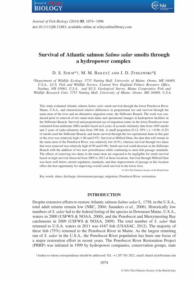
With the removal of Great Works Dam (2012) and Veazie Dam (2013; see Fig. 1),Milford Dam is now the lowermost barrier to anadromous fish passage in the PenobscotRiver (Opperman et al., 2011), and is known to be a site of high S. salar smolt mortality(Holbrook et al., 2011). It is thought that the majority of downstream-migrating smoltsuse the main-stem of the Penobscot as opposed to an alternate migration route aroundMarsh Island, the Stillwater Branch (Shepard, 1991; Holbrook et al., 2011). Therefore,most of these fish must pass Milford Dam before seawater entry, although precise esti-mates only exist for 2 years of passage data (Holbrook et al., 2011). These attributeshave made Milford Dam a focus for research and assessment regarding anadromous fishpassage and survival, as well as for future improvements to upstream and downstreamfish passage (Opperman et al., 2011). In addition, two operational dams (Stillwater andOrono Dams) in the Stillwater Branch (Fig. 1) are currently undergoing constructionof new facilities that will increase power generation and head-pond height through thatroute (Day, 2006; Opperman et al., 2011). The requirement for downstream passage ofS. salar smolts is a survival of 96% at each of these dams (National Marine FisheriesService, 2012). A baseline of knowledge about fish passage through this complex ofdams (the Marsh Island hydropower complex) prior to the implementation of restora-tion efforts will be necessary for assessment of future improvements of fish passage inthe lower river, and for determining the combined effects of dam removal and opera-tional changes on the survival of federally endangered S. salar smolts during seawardmigration in the lower river.
The goals of this study were (1) to estimate proportional use of migratory routes andthe apparent survival rates for S. salar smolts through the Marsh Island hydropowercomplex using a combination of acoustic- and radio-telemetry data and (2) to determinethe effects of in-river discharge and fish characteristics [fork length (LF), mass (M) andrearing origin] on path choice and survival through this section of the river. In orderto achieve these goals, the first objective of this study was to estimate proportional useof two migratory routes (Penobscot and Stillwater) by S. salar smolts and to estimatepath-specific survival using 6 years of acoustic telemetry data. The second objective of
© 2014 The Fisheries Society of the British Isles, Journal of Fish Biology 2014, 85, 1074–1096
1076 D . S . S T I C H E T A L.
0
F
2 km
0
C
B E
D
A98
76
2
3
4
5
1
Piscataquis River
Penobscot River
20 km
0 500 km
p5
p4
p3
p2
p1
Fig. 1. Map of the Penobscot River catchment showing location in North America in the small inset, coverage ofthe acoustic telemetry network and release sites for tagged Salmo salar smolts (acoustic and radio) in thelarge inset (1, Abbot; 2, Milo; 3, Weldon head pond; 4, Weldon tailrace; 5, Mattawamkeag; 6, Howland; 7,Passadumkeag; 8, Costigan; 9, Old Town), and locations of dams and coverage of radio receiver network inthe large map (A, Gilman Falls; B, Stillwater Dam; C, Orono Dam; D, Milford Dam; E, Great Works Dam;F, Veazie Dam). Release sites for acoustic- and radio-telemetry studies are numbered, and the dams in thelower Penobscot River are represented by solid lines and are lettered. Circles represent locations of acousticreceivers. Dashed lines represent locations of one or more radio receivers used in the radio-telemetry studyof passage at Milford Dam, each with multiple antennas. The detection occasions used in radio-telemetrymodels are indicated by the letter p with subscripts corresponding to detection occasions shown in the radioschematic in Fig. 2.
© 2014 The Fisheries Society of the British Isles, Journal of Fish Biology 2014, 85, 1074–1096

S M O LT S U RV I VA L T H RO U G H A H Y D RO P OW E R C O M P L E X 1077
the study was to estimate path-specific survival through the powerhouse and spillwayof Milford Dam using radio-telemetry data from 2010 and 2012. Finally, data fromboth acoustic- and radio-telemetry are used to characterize variability in selection ofmigratory route and survival in relation to river discharge. The results of this study willbe useful for making decisions about management of downstream fish passage throughthe complex of dams in the lower Penobscot River and assessing the overall effect ofthe PRRP on downstream passage of S. salar smolts.
MATERIALS AND METHODS
M A I N- S T E M DA M S
Milford Dam is located between the City of Old Town and the Town of Milford at river km(rkm) 61 on the main-stem of the Penobscot River in Maine, U.S.A. (Fig. 1). The current siteof the hydropower project is also the natural fall line in the Penobscot River (Opperman et al.,2011). Milford Dam is c. 6⋅1 m high, and spans 353 m across the river. The powerhouse at theproject, located on the eastern shore of the river, contains six generating turbines, with a maxi-mum authorized generation of c. 9 MW. Current fish passage facilities at the site include an eelladder and a Denil fish way for upstream fish passage, as well as a log sluice between the power-house and the spillway for downstream fish passage (Federal Energy Regulatory Commission,2009). Construction of a new fish elevator for upstream passage is ongoing and is anticipatedto be completed in spring 2014. Discharge into the Stillwater Branch is controlled primarilythrough increases and decreases in head pond level at Milford Dam up to c. 430 m3 s−1, atwhich point the facility can no longer control spill to the main-stem (Federal Energy RegulatoryCommission, 2004). Currently, the dam redirects c. 30% of total discharge in the lower Penob-scot into the Stillwater Branch and under legal agreements involved with the PRRP this can beincreased to 40% of total river discharge once new powerhouses in the Stillwater Branch areon-line (Federal Energy Regulatory Commission, 2004).
Great Works Dam (Fig. 1) was removed from the main-stem of the Penobscot River during thesummer 2012; just after the final year of this study. The former Great Works project was locatedat rkm 59, was 6⋅1 m high and 331 m across (Federal Energy Regulatory Commission, 2009).The powerhouse had 11 horizontal turbines and generating capacity of 7⋅9 MW. Fish passagefacilities at the former Great Works Dam included two Denil fish ways for upstream passage.
Veazie Dam (Fig. 1) was formerly located at rkm 45 in the main-stem of the Penobscot River,and was removed in summer 2013; a year after this study. The project consisted of two pow-erhouses, one with 15 turbines and another with three turbines, with a maximum generatingcapacity of 8⋅4 MW (Federal Energy Regulatory Commission, 2009). The dam was 10 m highand 257 m across, with a slot fish way for upstream passage. Operations at both Great Works andVeazie Dams were subject to periodic shutdowns for regulatory purposes, which had the poten-tial to affect smolt survival during the final 2 years of the study. Although records for turbine shutdowns were not publically available to correlate with survival estimates for any of the dams, thePRRT was required to shut down turbines during the smolt migration period 2011–2012 underthe conditions of the re-licencing agreement for Great Works and Veazie dams (Federal EnergyRegulatory Commission, 2009).
S T I L LWAT E R B R A N C H DA M S
Two operational hydropower dams will remain in the 16⋅9 km Stillwater Branch after thePRRP. Stillwater Dam (Fig. 1) is located at rkm 60 on the Stillwater Branch, is 6⋅7 m high and524 m across (National Marine Fisheries Service, 2012). The original powerhouse contains fourhorizontal turbines and has a generating capacity of c. 2⋅0 MW. The additional powerhousebeing constructed at the Stillwater project will have three vertical turbines and will add 2⋅2 MWto the total generating capacity of the Stillwater facility, more than doubling the capacity forpower generation. Current fish passage facilities at Stillwater Dam include a downstream bypass
© 2014 The Fisheries Society of the British Isles, Journal of Fish Biology 2014, 85, 1074–1096

1078 D . S . S T I C H E T A L.
discharging into the tail race and two eel passage facilities. No further upstream passage will beconstructed at Stillwater under the licence amendment for this facility, although a new down-stream bypass facility will replace the existing structure (National Marine Fisheries Service,2012).
Orono Dam is located in the Town of Orono at rkm 55 on the Stillwater Branch, at the con-fluence of the Stillwater with the main-stem of the Penobscot River (Fig. 1). The dam is 7⋅6 mhigh, and is 358 m across, with a powerhouse containing four turbines that have a total generat-ing capacity of 2⋅3 MW (National Marine Fisheries Service, 2012). The new powerhouse beingconstructed at Orono Dam will add three vertical turbines that have total generating capacity of3⋅7 MW, more than doubling total capacity of the Orono project. Current fish passage facilitiesat the Orono project include a downstream fish way and an upstream eel-passage facility. Theupgrades to the project will include construction of an additional downstream bypass, as wellas a fish trap used to catch upstream-migrating fishes for transport to the main-stem Penobscot(National Marine Fisheries Service, 2012).
AC O U S T I C R E C E I V E R A R R AY
Prior to the start of the S. salar smolt run during each year of this study, stationary acousticreceivers (VR2 and VR2-W; Amirix Vemco Ltd; http://vemco.com/) were deployed in thePenobscot River by the University of Maine, in cooperation with U.S. Geological Survey(USGS) Maine Cooperative Fish and Wildlife Research Unit, and the National Oceanic andAtmospheric Administration (NOAA). All receivers contained omnidirectional hydrophonesthat scanned continuously at 69 kHz. The number and type of receivers deployed in thePenobscot River catchment varied slightly between years. The number of receivers deployedin the catchment increased through time as new units were purchased and as new releasesites were added. The acoustic receiver array used in 2005 and 2006 was described in thestudy of Holbrook et al. (2011). Up to 198 acoustic receivers were deployed in a givenyear, providing detection coverage from the headwaters of the East Branch Penobscot andPiscataquis Rivers through outer Penobscot Bay for years 2009–2012 (Fig. 1). Despite dif-ferences in arrays between years, the configuration and proximity of acoustic receivers in andaround the Marsh Island hydropower complex were virtually identical through all years ofthe acoustic telemetry study. Acoustic receivers deployed in the Penobscot River and in theestuary were moored to cement blocks on the river bottom. Acoustic receivers deployed in thePenobscot Bay were moored c. 10 m below the surface of the water. Multiple receivers weredeployed where the width of the river exceeded the detection range of acoustic receivers orwhere obstructions (e.g. islands) prevented complete coverage with a single deployment, anddetections for all receivers at such locations were pooled as single encounter events for survivalanalyses.
AC O U S T I C TAG G I N G A N D R E L E A S E S
From 2005 to 2012, 1669 S. salar smolts, either wild-reared or from the U.S. Fish and WildlifeService (USFWS) Green Lake National Fish Hatchery, were acoustically tagged and releasedby the University of Maine and USGS for studies of in-river movements and survival duringdownstream smolt migration through the Penobscot River (Table I). Acoustic tagging meth-ods were described in detail by Holbrook et al. (2011) and identical procedures were usedin all years from 2005 to 2012. Smolts were anaesthetized using a 100 mg l−1 solution ofMS-222, LF (mm) and M (g) were measured and fish were placed ventral-side up in a v-shapedsaddle. A small (1 cm) incision was made offset from the ventral line and c. 1 cm poste-rior to the pelvic-fin girdle. An acoustic tag was inserted intraperitoneally and the incisionwas closed with two simple, interrupted knots using 4-0 absorbable vicryl sutures (Ethicon;www.ethicon.com). Model V7-2L (Amirix Vemco Ltd) tags were used in 2005, as well asfor wild-origin fish tagged in 2011. Expected battery life of V7-2L tags was 80 days for tagsused during 2005, and 69 days for tags used during 2011. In all other years, acoustic trans-mitters used were model V9-6L (Amirix Vemco Ltd) with expected battery life of 82 days(except during 2006 when battery life of V9-6L transmitters was 80 days). Total time for eachsurgery was <2 min. Salmo salar smolts of wild and hatchery origin were released at up to four
© 2014 The Fisheries Society of the British Isles, Journal of Fish Biology 2014, 85, 1074–1096

S M O LT S U RV I VA L T H RO U G H A H Y D RO P OW E R C O M P L E X 1079
Table I. Number, origin, tag type, mean± s.d. fork length (LF) and release site of Salmo salartagged and released within the Penobscot River drainage each year of study from 2005 to 2012
Year Release site Tag type Origin Number released LF (mm)
2005 Howland Acoustic Hatchery 150 189± 11Mattawamkeag Acoustic Hatchery 40 185± 12Milo Acoustic Hatchery 85 191± 11Weldon tailrace Acoustic Wild 60 178± 18
2006 Milo Acoustic Hatchery 72 196± 11Weldon tailrace Acoustic Hatchery 146 198± 15Weldon tailrace Acoustic Wild 73 190± 11
2009 Milo Acoustic Hatchery 100 180± 8Passadumkeag Acoustic Hatchery 100 180± 9
2010 Abbot Acoustic Wild 75 169± 8Milo Acoustic Hatchery 100 189± 11Passadumkeag Acoustic Hatchery 100 186± 11Weldon head pond Acoustic Wild 74 180± 13Old Town Radio Hatchery 58 198± 12
2011 Abbot Acoustic Wild 75 146± 8Milo Acoustic Hatchery 100 191± 13Passadumkeag Acoustic Hatchery 100 197± 32Weldon head pond Acoustic Wild 60 162± 19
2012 Abbot Acoustic Hatchery 74 199± 11Weldon head pond Acoustic Hatchery 85 199± 11Costigan Radio Hatchery 130 201± 15
Grand total All All 1857 –
different sites in a single year, although the numbers of fish and release sites varied between years(Table I).
R A D I O R E C E I V E R A R R AY
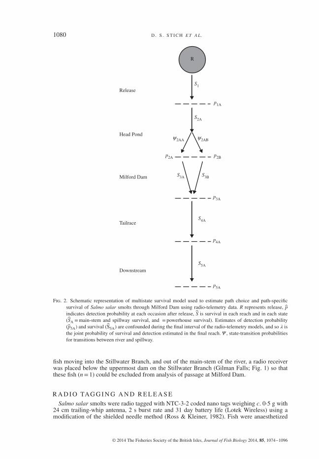
A total of 13 data-logging radio receivers (models SRX400 and SRXDL; Lotek Wireless;www.lotek.com) were used to detect radio-tagged S. salar smolts during migration throughMilford Dam in 2010 and 2012 (Fig. 1). Individually coded radio transmitters spanning threefrequencies were used in order to minimize tag collisions while allowing for an acceptablecycling time on radio receivers. At least two frequencies were used in each release group. Radioreceivers were set to scan each of the three frequencies for 3 s on each antenna. This resultedin total cycling times that ranged from 9 s in receivers with one antenna to 36 s in receiverswith four antennas. The radio receiver array differed slightly between 2010 and 2012 based onsmolt release locations. In 2012, smolts were released further upstream than in 2010; therefore,an extra pair of radio receivers was deployed between the release location and Milford Dam in2012. The location at which the additional pair of receivers was deployed in 2012 correspondedwith the release locations that were used in 2010 (Old Town and p1; Fig. 1). Multiple receivers,each with multiple antennas, were deployed at each detection site immediately above and belowMilford dam [a total of five receivers above the dam (p2 in Figs 1 and 2) and two below (p3 inFigs 1 and 3)] to ensure that path choice could be determined. Two receivers were deployed justdownstream of the Milford tailrace, each with one antenna (p4 in Figs 1 and 2). Finally, tworeceivers were deployed at a private residence downstream in the estuary (p5 in Fig. 1) to allowfor estimation of survival in the tailrace of Milford Dam. Receivers were pooled as a singleencounter location where multiple receivers or antennas were used to obtain adequate coverageacross the width of the river. Because the release site used in 2012 resulted in the possibility of
© 2014 The Fisheries Society of the British Isles, Journal of Fish Biology 2014, 85, 1074–1096
1080 D . S . S T I C H E T A L.
Release
Head Pond
R
Milford Dam
Tailrace
DownstreamS5A
p4A
p5A
S4A
S3B
S2A
2AA 2AB
S1
S3A
p3A
p2B
p1A
p2A
Fig. 2. Schematic representation of multistate survival model used to estimate path choice and path-specificsurvival of Salmo salar smolts through Milford Dam using radio-telemetry data. R represents release, pindicates detection probability at each occasion after release, S is survival in each reach and in each state(SA =main-stem and spillway survival, and = powerhouse survival). Estimates of detection probability(p5A) and survival (S5A) are confounded during the final interval of the radio-telemetry models, and so 𝜆 isthe joint probability of survival and detection estimated in the final reach. 𝛹 , state-transition probabilitiesfor transitions between river and spillway.
fish moving into the Stillwater Branch, and out of the main-stem of the river, a radio receiverwas placed below the uppermost dam on the Stillwater Branch (Gilman Falls; Fig. 1) so thatthese fish (n= 1) could be excluded from analysis of passage at Milford Dam.
R A D I O TAG G I N G A N D R E L E A S E
Salmo salar smolts were radio tagged with NTC-3-2 coded nano tags weighing c. 0⋅5 g with24 cm trailing-whip antenna, 2 s burst rate and 31 day battery life (Lotek Wireless) using amodification of the shielded needle method (Ross & Kleiner, 1982). Fish were anaesthetized
© 2014 The Fisheries Society of the British Isles, Journal of Fish Biology 2014, 85, 1074–1096
S M O LT S U RV I VA L T H RO U G H A H Y D RO P OW E R C O M P L E X 1081
SA1
‚ pA1...‚ SAn–1
‚
SB1
‚
‚
pB1...‚ pBj
‚SBj
‚
pAn–1‚
�n
SCk+1
‚ pCk+1...‚ SCm
‚ pCm‚
Piscataquis River (B)
ACk
Stillwater Branch (C)
Peno
bsco
t Riv
er (
A)
Variable occasions
Year
(b)(a)
Origin
2005 All
2006 All
2009 Hatchery
2010 Hatchery
2010 Wild
2011 Hatchery
2011 Wild
2012
3
3
4
5
9
4
10
10
7
7
8
6
11
8
13
13
10
10
10
7
14
10
17
15
16
16
32
25
31
30
19
16Hatchery
j k m n
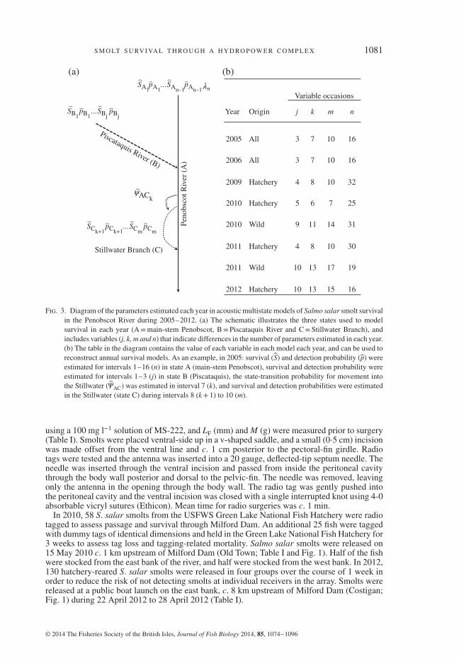
Fig. 3. Diagram of the parameters estimated each year in acoustic multistate models of Salmo salar smolt survivalin the Penobscot River during 2005–2012. (a) The schematic illustrates the three states used to modelsurvival in each year (A=main-stem Penobscot, B= Piscataquis River and C=Stillwater Branch), andincludes variables (j, k, m and n) that indicate differences in the number of parameters estimated in each year.(b) The table in the diagram contains the value of each variable in each model each year, and can be used toreconstruct annual survival models. As an example, in 2005: survival (S) and detection probability (p) wereestimated for intervals 1–16 (n) in state A (main-stem Penobscot), survival and detection probability wereestimated for intervals 1–3 (j) in state B (Piscataquis), the state-transition probability for movement intothe Stillwater (��AC) was estimated in interval 7 (k), and survival and detection probabilities were estimatedin the Stillwater (state C) during intervals 8 (k+ 1) to 10 (m).
using a 100 mg l−1 solution of MS-222, and LF (mm) and M (g) were measured prior to surgery(Table I). Smolts were placed ventral-side up in a v-shaped saddle, and a small (0⋅5 cm) incisionwas made offset from the ventral line and c. 1 cm posterior to the pectoral-fin girdle. Radiotags were tested and the antenna was inserted into a 20 gauge, deflected-tip septum needle. Theneedle was inserted through the ventral incision and passed from inside the peritoneal cavitythrough the body wall posterior and dorsal to the pelvic-fin. The needle was removed, leavingonly the antenna in the opening through the body wall. The radio tag was gently pushed intothe peritoneal cavity and the ventral incision was closed with a single interrupted knot using 4-0absorbable vicryl sutures (Ethicon). Mean time for radio surgeries was c. 1 min.
In 2010, 58 S. salar smolts from the USFWS Green Lake National Fish Hatchery were radiotagged to assess passage and survival through Milford Dam. An additional 25 fish were taggedwith dummy tags of identical dimensions and held in the Green Lake National Fish Hatchery for3 weeks to assess tag loss and tagging-related mortality. Salmo salar smolts were released on15 May 2010 c. 1 km upstream of Milford Dam (Old Town; Table I and Fig. 1). Half of the fishwere stocked from the east bank of the river, and half were stocked from the west bank. In 2012,130 hatchery-reared S. salar smolts were released in four groups over the course of 1 week inorder to reduce the risk of not detecting smolts at individual receivers in the array. Smolts werereleased at a public boat launch on the east bank, c. 8 km upstream of Milford Dam (Costigan;Fig. 1) during 22 April 2012 to 28 April 2012 (Table I).
© 2014 The Fisheries Society of the British Isles, Journal of Fish Biology 2014, 85, 1074–1096

1082 D . S . S T I C H E T A L.
M OV E M E N T A N D S U RV I VA L T H RO U G H M A R S H I S L A N DH Y D RO P OW E R C O M P L E X
MS Cormack–Jolly–Seber mark–recapture survival models were developed and analysed inprogramme MARK (White & Burnham, 1999) to estimate the proportional use of the StillwaterBranch and main-stem Penobscot River, as well as path-specific survival rates through eachroute using acoustic telemetry data. The logit-link function was used to model all parameters inacoustic MS models. While the term survival is used throughout this study for simplicity, theseestimates reflect only apparent survival and not true survival of S. salar smolts as the only dataused in these models were recaptures of fish at each receiver location, and information aboutwhether fish were alive or dead was not included. Although only those estimates of survivalrelevant to the Marsh Island hydropower complex are reported in this study, these estimatesare based on MS models that incorporated detections at acoustic receivers through the entireacoustic array. These whole-system survival models were constructed separately for each yeardue to differences in the acoustic receiver array between years at locations outside of the MarshIsland hydropower complex. Due to differences in migratory histories of hatchery and wild fishresultant from release locations in the Penobscot and Piscataquis Rivers, migratory route andsurvival were also modelled separately for hatchery and wild fish within years.
Three states were used in the development of acoustic MS survival models in each year:state 1, the main-stem of the Penobscot River (A) from the uppermost interval to Penobscot Bay;state 2, the Piscataquis River (B); state 3, the Stillwater Branch (C) as an alternative migratoryroute through the Marsh Island hydropower complex (Fig. 3).
The parameters estimated in the acoustic MS survival models varied each year (Fig. 3).Survival (S) and detection probability (p) were estimated in the main-stem of the Penobscotfrom release (SA1
pA1) through to interval n − 1 (SAn−1
pAn−1) each year, and the joint probability
of detection and survival (𝜆) was estimated during interval n each year. Survival and detectionprobability were estimated in the Piscataquis River each year from release (SB1
pB1) to interval
j (SBjpBj
). The probability of moving into the main-stem of the Penobscot River from the
Piscataquis River (��BAj) given survival in state B during interval j was fixed to 1⋅00 during
interval j each year. The proportion of fish that migrated through the Stillwater Branch eachyear was estimated as the state-transition probability for movement from the Penobscot Riverinto the Stillwater Branch (��ACk
) during interval k and the probability of remaining in the
main-stem (��AAk) was 1 − ��ACk
. Survival and detection probabilities in the Stillwater Branch
were estimated each year from interval k + 1 (SCk+1pCk+1
) through to interval m (SCmpCm
), andthe state-transition probability for movement from the Stillwater Branch into the main-stem(��CAm
) given survival during interval m was fixed to 1⋅00. All parameters not shown (Fig. 3) ordescribed above were fixed to zero during model estimation.
PAT H- S P E C I F I C S U RV I VA L T H RO U G H M I L F O R D DA M U S I N GR A D I O T E L E M E T RY
MS survival models were developed and analysed in programme MARK (White & Burn-ham, 1999) to estimate survival and determine proportional passage through two potential pathsthrough Milford Dam by radio-tagged S. salar smolts (the spillway or powerhouse). Due to lackof sample sizes required for estimation of a third transition probability, fish passage through alog sluice on the face of the dam was included in the estimation of passage via the spillway. Theradio MS models used for assessment of smolt passage through Milford Dam consisted of sixdetection events (Fig. 2). The logit-link function was used to model all parameters in all models.In both years of the radio-telemetry study, a downstream radio receiver station was establishedsuch that S. salar smolt survival could be estimated through all intervals of interest (Fig. 2).Detections at each receiver location were used to construct individual encounter histories fromrelease to the Penobscot Estuary for all radio-tagged fish. Passage path through Milford Dam(spillway or powerhouse) was discriminated by fine-tuning radio receivers at various locationsat the dam and the probability of using the spillway (��
2AA) or powerhouse (��
2AB) for passage
through the dam was estimated (Fig. 2). Each of the two potential passage paths was used as a
© 2014 The Fisheries Society of the British Isles, Journal of Fish Biology 2014, 85, 1074–1096
S M O LT S U RV I VA L T H RO U G H A H Y D RO P OW E R C O M P L E X 1083
state in the individual encounter histories, and state-specific survival (S) and detection probabil-ity (p) were estimated for passage through the spillway (S3A, p2A) (Fig. 2) and the powerhouse(S3B, p2B) (Fig. 2).
In 2010, the release of radio-tagged smolts coincided with draw-down of the Milford headpond for installation of flashboards downstream (this was serendipitous, not a study designdetail). Given the timing and degree of the drawdown, in combination with the narrow timeframeof passage by S. salar smolts, all of the radio-tagged fish that successfully passed Milford Damin 2010 did so by way of the powerhouse; therefore, all state-transition probabilities were fixed tozero and are not included in the parameters reported in model results for 2010. Salmo salar smoltreleases in 2012 occurred during variable discharge conditions; however, water was being spilledover the top of the dam during the majority of the 2012 smolt season. Because discharge condi-tions and intervals (i.e. distance between receivers) used in survival estimation varied between2010 and 2012, survival was modelled separately for each year of the radio-telemetry study.
M O D E L F I T A N D S E L E C T I O N
To assess fit of acoustic and radio-MS survival models, an overdispersion parameter, c, wasestimated for the saturated models each year using programme U-CARE (Choquet et al., 2009).In all cases, models were structured such that c was<2 and adequate model fit was achieved priorto analysis of competing hypotheses. After assessing the fit of each of the full models, candidatemodels of S. salar smolt survival were chosen, a priori, to determine the (hypothesized) relativeimportance of variability in survival (S) and detection probabilities (p) among river reachesin models for each year. Probability of using each passage path (spillway or powerhouse) inradio-telemetry models and each migratory route (Stillwater or Penobscot) in acoustic modelswas estimated as an interval-specific state-transition probability (�� ) in each model.
An information-theoretic approach to model selection, based on corrected Akaike informationcriterion (AICc; Burnham & Anderson, 2002), was used to determine whether survival variedbetween reaches of the river by comparing models with constant survival between reaches tomodels with reach-specific survival rates. The relative support for candidate models was evalu-ated as the difference in AICc between the best model and each ith model (𝛥i), and the relativeprobability of each model being the best was represented using AICc weights (wi; Burnham &Anderson, 2002). Models for which 𝛥i ≤ 2⋅0 were considered to have similar support to the bestmodel in each candidate model set (Burnham & Anderson, 2002).
E F F E C T O F D I S C H A R G E O N M OV E M E N T A N D S U RV I VA LA RO U N D M A R S H I S L A N D
Simple linear regression was used to obtain a characterization of the relationship betweendischarge and mean survival through the reach of the main-stem Penobscot River containingMilford Dam across all years using survival estimates from both radio and acoustic-telemetrystudies. Due to constraints on the possible values of survival (0, 1⋅0), survival estimates werelogit-transformed prior to analysis. It was determined that the variances of individual survivalestimates did not influence the results of the regression when the results were compared to aweighted least squares regression. Therefore, for the sake of simplicity, the results of ordinaryleast squares regression are presented graphically on the real scale of the response variable.Mean daily discharge values (m3 s−1) from the USGS gauge upstream of Milford at West EnfieldDam were used to characterize mean discharge during the window of time when smolts passedthrough Milford Dam each year.
Generalized linear mixed models (GLMMs; Zuur et al., 2007) were used to assess the rela-tionship between discharge and individual migration route (Stillwater Branch or main-stemPenobscot River), with year as a random effect on the intercept in all models using the lme4package (Bates et al., 2013) in R 3.0.1. (R Development Core Team; www.r-project.org). Onlythose fish (n= 759) for which passage path was known were used for the analysis, and the resultsof the GLMM were compared to predictions from MS models to assure that predictions were notbiased due to the exclusion of detection probability for fish that were omitted due to unknownpassage path. The model used a logit-link function and the response was binary (1= Stillwater,
© 2014 The Fisheries Society of the British Isles, Journal of Fish Biology 2014, 85, 1074–1096

1084 D . S . S T I C H E T A L.
0=main-stem Penobscot). Discharge experienced by individual fish prior to choosing a migra-tory route was characterized using mean of daily discharges at West Enfield Dam from the timea fish was first located 0⋅5 km upstream of West Enfield Dam until the time that it was firstdetected at Milford Dam or in the Stillwater Branch (mean travel time= 4 days for smolts).West Enfield Dam is located c. 40 km upstream of the Marsh Island hydropower complex,on the main-stem of the Penobscot, immediately upstream from the mouth of the PiscataquisRiver (Fig. 1). Although it is recognized that proportional distribution of discharge betweenthe Stillwater Branch and main-stem Penobscot around Marsh Island would have provided anideal measurement of discharge for this analysis, these data were not available and discharge atWest Enfield Dam offered the best available information about discharge in the Marsh Islandhydropower complex. The ability of the hydropower company to control the distribution of flowsat Milford Dam is lost (due to maximum pond height) at discharges of c. 430 m3 s−1. At dis-charges <430 m3 s−1, operations at Milford Dam maintain proportional flow of c. 30% of totalriver discharge to the Stillwater Branch (Federal Energy Regulatory Commission, 2004). It was,therefore, hypothesized that total discharge through the lower river, as measured at West EnfieldDam, would provide a biologically meaningful predictor of the probability that smolts used theStillwater Branch that could be indirectly related to hydropower operations in the Marsh Islandcomplex and would also provide comparisons in the future following operational changes. Totest the null hypothesis that choice of migratory route was not related to discharge, models ofmigratory route that did or did not include discharge were compared using AICc (Burnham &Anderson, 2002). Fish characteristics (rearing history and LF) that had the potential to influencechoice of migratory route were also investigated using model selection. Approximation of theoverdispersion parameter c for the most parameterized model in the candidate set indicated thatthe models were not overdispersed
(c ≤ 1
); therefore, model selection was not adjusted.
RESULTS
PAT H C H O I C E A RO U N D M A R S H I S L A N D
In all years and for all release groups, the fully reach-dependent parameterizationsfor survival and detection probability in MS models based on acoustic telemetry datawere the most parsimonious, and therefore model selection for these models are notshown. The mean (95% c.i.) annual probabilities of using the Stillwater Branch (��ACj
from acoustic MS survival models) ranged from 0⋅04 (0⋅01–0⋅11) to 0⋅25 (0⋅13–0⋅45),with an overall mean of c. 0⋅12 across years (Fig. 4). Individual-based GLMMs ofpath choice indicated that of the factors hypothesized to affect proportional use of theStillwater Branch, discharge at West Enfield Dam was most strongly related to useof the Stillwater Branch by individual smolts; it was the only covariate included inall models that had a meaningful amount of support in the candidate model set, andit was the only covariate included in the best model (Table II). Use of the Stillwa-ter Branch increased with discharge within the observed range of discharges duringthe smolt window during 2005–2012 (Fig. 5 and Table III). Based on observed flowsover the 6 years of this study, the overall mean (95% c.i.) probability of using theStillwater Branch in any given year, according to the GLMM used to model indi-vidual migration route, was 0⋅12 (0⋅06–0⋅25) conditional on flow. This conditionalmean is identical to the mean probability of using the Stillwater estimated in MSmodels.
S U RV I VA L A RO U N D M A R S H I S L A N D
Estimated survival of S. salar smolts (from acoustic MS models) varied betweenreaches and between states during passage through the Marsh Island hydropower
© 2014 The Fisheries Society of the British Isles, Journal of Fish Biology 2014, 85, 1074–1096

S M O LT S U RV I VA L T H RO U G H A H Y D RO P OW E R C O M P L E X 1085
20050·00
0·05
0·10
0·15
Prob
abili
ty o
f us
ing
still
wat
er b
ranc
h
0·20
0·25
0·30
0·35
2006 2009 2010Year
2011 2012
Fig. 4. Annual estimates of the mean± s.e. probability of Salmo salar smolt migration through the StillwaterBranch estimated using acoustic multistate models of smolt movement and survival in the Penobscot Riverduring 6 years from 2005 to 2012 for wild ( ) and hatchery ( ) smolts.
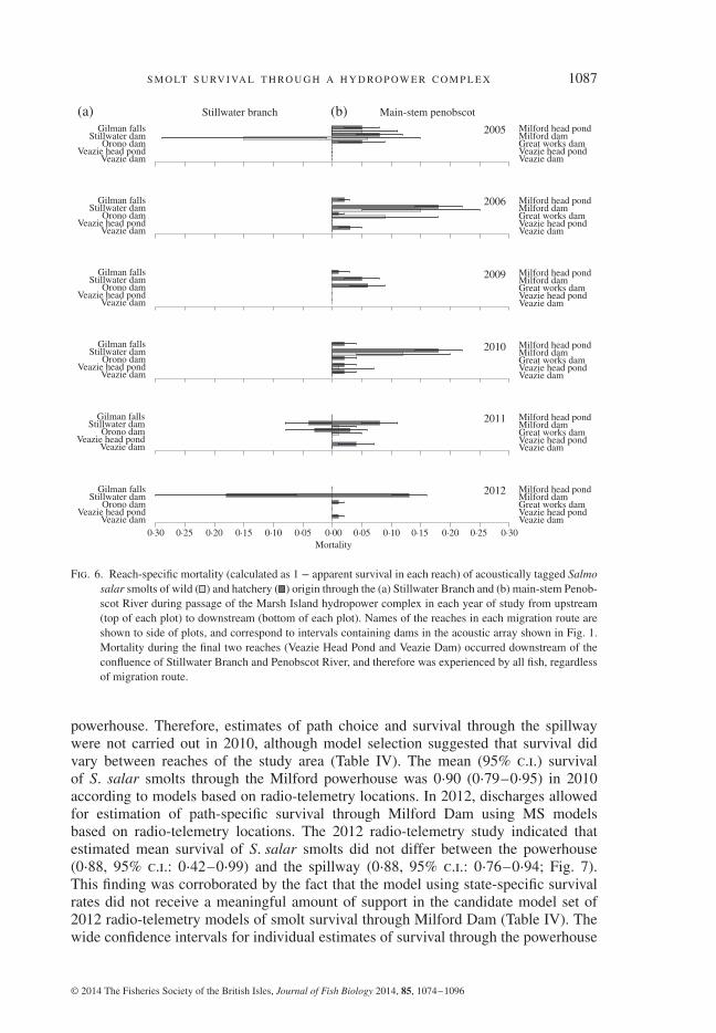
complex (Fig. 6). Survival through the project generally was higher for smolts thatmigrated through the Stillwater Branch than for smolts that migrated through themain-stem of the Penobscot River. Acoustic telemetry estimates of mean (95% c.i.) S.salar smolt survival through the 1 km reach of the main-stem Penobscot containingMilford Dam ranged from 0⋅75 (0⋅51–0⋅89) to 1⋅00 (1⋅00–1⋅00) during 2005–2012.In contrast, survival km−1 through any of the free-flowing (undammed) reachesin the Penobscot River was ≥99% in all years. Survival at the main-stem dams,Veazie (0⋅99± 0⋅00) and Great Works Dams (0⋅98± 0⋅02) that were removed washigher than at Milford Dam (0⋅91± 0⋅02) in all 6 years of this study. Similarly, mean
Table II. Model selection statistics for generalized linear mixed models (GLMMs) used tocharacterize relationships between the probability of Salmo salar smolts using the StillwaterBranch for migration and several factors of interest, including rearing history (Origin: hatcheryor wild), fork length (LF) and discharge measured at West Enfield Dam (Discharge). All mod-els included a random effect of year on the intercept, which accounts for one of the estimatedparameters in each model. Symbols in table are defined as number of parameters (k), correctedAkaike information criterion (AICc), the difference in AICc between the best model and theith model (𝛥i), and the relative probability that the ith model is the best model in the candidate
set (wi)
Model k AICc 𝛥i wi
Discharge 3 567⋅442 0⋅000 0⋅287Discharge+ LF 4 567⋅454 0⋅012 0⋅286Discharge+ origin 4 567⋅507 0⋅065 0⋅278Discharge+ LF + origin 5 568⋅972 1⋅530 0⋅134Origin 3 574⋅948 7⋅506 0⋅007LF 3 575⋅585 8⋅143 0⋅005LF + origin 4 576⋅309 8⋅867 0⋅003
© 2014 The Fisheries Society of the British Isles, Journal of Fish Biology 2014, 85, 1074–1096

1086 D . S . S T I C H E T A L.
00
500·20
0·40
P (S
tillw
ater
| flow
)
Freq
uenc
y of
flow 0·60
0·80
1·00
100
150
200
500 1000 20001500Discharge at West Enfield Dam (m3s–1)
Fig. 5. Frequency of observed mean daily discharge values ( ) from 2005 to 2012 Salmo salar smolt runs com-pared to predicted proportional use of the Stillwater Branch ( ) and asymmetric 95% prediction intervals( ). The horizontal box plot at the top of the plot indicates median value of observed discharge, the boxends represent the inner quartile for values of observed discharge and the whiskers represent the 95% c.l.of observed discharge values during smolt runs 2005–2012.
survival across years at the two dams in the Stillwater Branch was high at Stillwater(0⋅97± 0⋅02) and Orono Dams (1⋅00± 0⋅00).
M OV E M E N T A N D S U RV I VA L T H RO U G H M I L F O R D DA M
The most parsimonious models for the 2010 and 2012 radio-telemetry models dif-fered between years and model selection for MS radio-telemetry models are presentedwith the results (Table IV). No loss of tags or tagging-related mortality was observedin fish that were dummy tagged as part of the 2010 radio-telemetry study.
In 2010, a drawdown of the Milford head pond coincided with the radio-telemetrystudy such that any smolt passing through Milford Dam must have done so via the
Table III. Parameter estimates for the model of p(Stillwater Branch) that includedall covariates [p(Stillwater Branch), Discharge], showing direction of relations betweenp(Stillwater Branch) and discharge. Symbols are defined as the logit-scale parameter estimates
(𝛽 j), s.e., critical value of the test statistic (z) and the P-value for the test
Parameter 𝛽 j s.e. z P
Intercept −3⋅0131295 0⋅3656585 −8⋅240 <0⋅001Discharge 0⋅0013813 0⋅0003941 3⋅505 <0⋅001
© 2014 The Fisheries Society of the British Isles, Journal of Fish Biology 2014, 85, 1074–1096
S M O LT S U RV I VA L T H RO U G H A H Y D RO P OW E R C O M P L E X 1087
Stillwater branch(a) (b)Gilman falls
Stillwater damOrono dam
Veazie head pondVeazie dam
Gilman fallsStillwater dam
Orono damVeazie head pond
Veazie dam
Gilman fallsStillwater dam
Orono damVeazie head pond
Veazie dam
Gilman fallsStillwater dam
Orono damVeazie head pond
Veazie dam
Gilman fallsStillwater dam
Orono damVeazie head pond
Veazie dam
Gilman fallsStillwater dam
Orono damVeazie head pond
Veazie dam
Milford head pondMilford damGreat works damVeazie head pondVeazie dam
Milford head pondMilford damGreat works damVeazie head pondVeazie dam
Milford head pondMilford damGreat works damVeazie head pondVeazie dam
Milford head pondMilford damGreat works damVeazie head pondVeazie dam
Milford head pondMilford damGreat works damVeazie head pondVeazie dam
Milford head pondMilford damGreat works damVeazie head pondVeazie dam
Main-stem penobscot
2005
2006
2009
2010
2011
2012
0·300·30 0·00Mortality
0·050·05 0·100·10 0·150·15 0·200·20 0·250·25
Fig. 6. Reach-specific mortality (calculated as 1 − apparent survival in each reach) of acoustically tagged Salmosalar smolts of wild ( ) and hatchery ( ) origin through the (a) Stillwater Branch and (b) main-stem Penob-scot River during passage of the Marsh Island hydropower complex in each year of study from upstream(top of each plot) to downstream (bottom of each plot). Names of the reaches in each migration route areshown to side of plots, and correspond to intervals containing dams in the acoustic array shown in Fig. 1.Mortality during the final two reaches (Veazie Head Pond and Veazie Dam) occurred downstream of theconfluence of Stillwater Branch and Penobscot River, and therefore was experienced by all fish, regardlessof migration route.
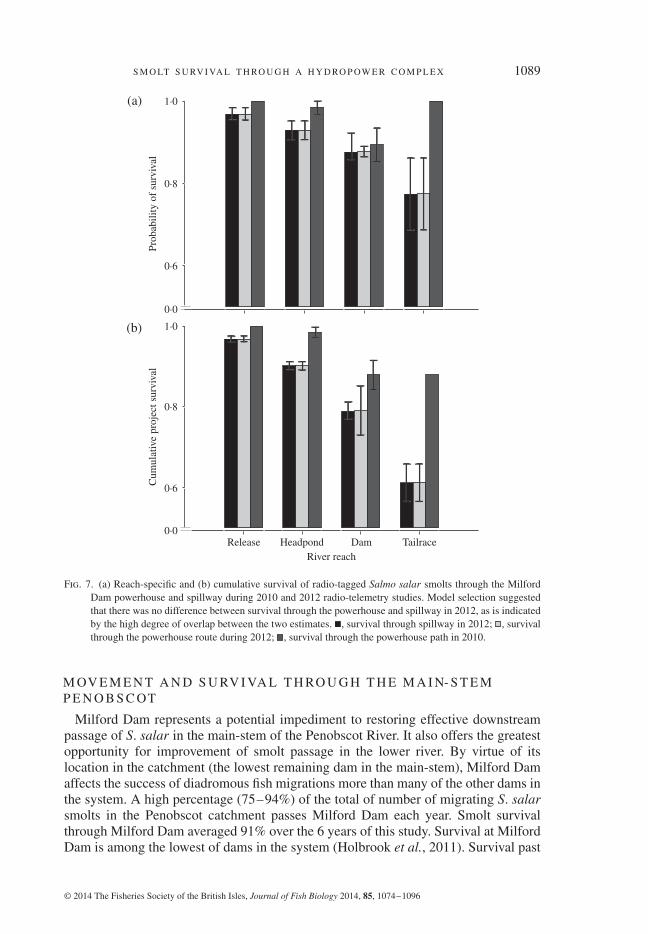
powerhouse. Therefore, estimates of path choice and survival through the spillwaywere not carried out in 2010, although model selection suggested that survival didvary between reaches of the study area (Table IV). The mean (95% c.i.) survivalof S. salar smolts through the Milford powerhouse was 0⋅90 (0⋅79–0⋅95) in 2010according to models based on radio-telemetry locations. In 2012, discharges allowedfor estimation of path-specific survival through Milford Dam using MS modelsbased on radio-telemetry locations. The 2012 radio-telemetry study indicated thatestimated mean survival of S. salar smolts did not differ between the powerhouse(0⋅88, 95% c.i.: 0⋅42–0⋅99) and the spillway (0⋅88, 95% c.i.: 0⋅76–0⋅94; Fig. 7).This finding was corroborated by the fact that the model using state-specific survivalrates did not receive a meaningful amount of support in the candidate model set of2012 radio-telemetry models of smolt survival through Milford Dam (Table IV). Thewide confidence intervals for individual estimates of survival through the powerhouse
© 2014 The Fisheries Society of the British Isles, Journal of Fish Biology 2014, 85, 1074–1096

1088 D . S . S T I C H E T A L.
Table IV. Model selection statistics for the 2010 and 2012 radio-telemetry models of Salmosalar smolt survival through Milford Dam. Parameters estimated in the multistate (MS)mark–recapture survival models were survival (S), detection probability
(p)
and state-transition
probabilities (�� ) for transitions between river and spillway (state A) and the powerhouse(state B) at Milford Dam. Symbols in the table heading are defined as in Table II. Reportednumber of parameters does not include parameters fixed for maximum likelihood estimation(e.g. 𝛹 3BA = 0⋅00 for MS models used in 2012). The (.) next to survival or detection parameters
indicates that survival or detection was held constant in the corresponding model
Year Model k AICc 𝛥i wi
2010 S(reach)p(.) 6 152⋅187 0⋅000 0⋅854S(reach)p(reach) 10 155⋅913 3⋅725 0⋅133S(.)p(reach) 6 160⋅574 8⋅386 0⋅013S(.)p(.) 2 267⋅000 114⋅813 0⋅000
2012 S(reach)p(state× reach)𝛹AB(reach)𝛹BA(reach) 11 615⋅538 0⋅000 0⋅935S(.)p(state× reach)𝛹AB(reach)𝛹BA(reach) 10 621⋅094 5⋅557 0⋅058S(reach)p(reach)𝛹AB(reach)𝛹BA(reach) 9 626⋅331 10⋅793 0⋅004S(state× reach)p(state× reach)𝛹AB(reach)𝛹BA(reach) 10 628⋅413 12⋅876 0⋅002S(state× reach)p(reach)𝛹AB(reach)𝛹BA(reach) 11 630⋅504 14⋅967 0⋅001S(.)p(reach)𝛹AB(reach)𝛹BA(reach) 7 630⋅887 15⋅350 0⋅000S(reach)p(.)𝛹AB(reach)𝛹BA(reach) 7 682⋅472 66⋅934 0⋅000S(state× reach)p(.)𝛹AB(reach)𝛹BA(reach) 10 688⋅694 73⋅156 0⋅000S(.)p(.)𝛹AB(reach)𝛹BA(reach) 3 737⋅870 122⋅332 0⋅000
suggest that precisions of the powerhouse survival estimate may have been low owingto the small probability of smolts using that movement path (0⋅09, 95% c.i.: 0⋅05–0⋅16)in 2012.
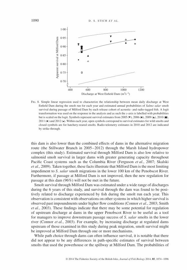
Discharge experienced by smolts in each year was found to explain a relatively largeamount of variation in estimated smolt survival through Milford Dam (r2 = 0⋅44),and discharge had a significant, positive influence on smolt survival (simple linearregression, d.f.= 15, F1,15 = 11⋅89, P< 0⋅01; Fig. 8).
DISCUSSION
Passage through the Marsh Island hydropower complex represents a critical tran-sition during downstream migration of the federally endangered S. salar populationin the Penobscot River. This hydropower complex represents the final set of physicalbarriers to downstream migration in the Penobscot River. To reach the free-flowingportion of the river (and eventually the estuary), all of the out-migrating smoltsin this system must pass either through Milford Dam on the east side of MarshIsland by using the main-stem Penobscot River or through the west side usingthe Stillwater Branch and passing through two other operational dams (StillwaterDam and Orono Dam). This study provides a baseline of information about fishpassage through the Marsh Island hydropower project before anticipated changesto discharge around the island, installation of new powerhouses at Stillwater andOrono Dams and installation of new downstream passage facilities at each of thosefacilities.
© 2014 The Fisheries Society of the British Isles, Journal of Fish Biology 2014, 85, 1074–1096
S M O LT S U RV I VA L T H RO U G H A H Y D RO P OW E R C O M P L E X 1089
Release0·0
0·6
0·8
1·0
0·0
0·6
Prob
abili
ty o
f su
rviv
alC
umul
ativ
e pr
ojec
t sur
viva
l
0·8
1·0(a)
(b)
Headpond DamRiver reach
Tailrace
Fig. 7. (a) Reach-specific and (b) cumulative survival of radio-tagged Salmo salar smolts through the MilfordDam powerhouse and spillway during 2010 and 2012 radio-telemetry studies. Model selection suggestedthat there was no difference between survival through the powerhouse and spillway in 2012, as is indicatedby the high degree of overlap between the two estimates. , survival through spillway in 2012; , survivalthrough the powerhouse route during 2012; , survival through the powerhouse path in 2010.
M OV E M E N T A N D S U RV I VA L T H RO U G H T H E M A I N- S T E MP E N O B S C OT
Milford Dam represents a potential impediment to restoring effective downstreampassage of S. salar in the main-stem of the Penobscot River. It also offers the greatestopportunity for improvement of smolt passage in the lower river. By virtue of itslocation in the catchment (the lowest remaining dam in the main-stem), Milford Damaffects the success of diadromous fish migrations more than many of the other dams inthe system. A high percentage (75–94%) of the total of number of migrating S. salarsmolts in the Penobscot catchment passes Milford Dam each year. Smolt survivalthrough Milford Dam averaged 91% over the 6 years of this study. Survival at MilfordDam is among the lowest of dams in the system (Holbrook et al., 2011). Survival past
© 2014 The Fisheries Society of the British Isles, Journal of Fish Biology 2014, 85, 1074–1096
1090 D . S . S T I C H E T A L.
400
0·70
0·75
0·80
0·85A
ppar
ent s
urvi
val a
t Milf
ord
Dam
0·90
0·95
1·00
600 800Discharge at West Enfield Dam (m3s–1)
1000 1200
Fig. 8. Simple linear regression used to characterize the relationship between mean daily discharge at WestEnfield Dam during the smolt run for each year and estimated annual probabilities of Salmo salar smoltsurvival during passage of Milford Dam by each release cohort of acoustic- and radio-tagged fish. A logittransformation was used on the response in the analysis and as such the y-axis is labelled with probabilitiesbut is scaled on the logit. Symbols represent survival estimates from 2005 ( ), 2006 ( ), 2009 ( ), 2010 ( ),2011 ( ) and 2012 ( ). Within each year, open symbols correspond to survival estimates for wild smolts andclosed symbols are for hatchery-reared smolts. Radio-telemetry estimates in 2010 and 2012 are indicatedby strike-through.
this dam is also lower than the combined effects of dams in the alternative migrationroute (the Stillwater Branch in 2005–2012) through the Marsh Island hydropowercomplex (this study). Estimated survival through Milford Dam is also low relative tosalmonid smolt survival in larger dams with greater generating capacity throughoutPacific Coast systems such as the Columbia River (Ferguson et al., 2007; Skalskiet al., 2009). Taken together, these facts illustrate that Milford Dam is the most limitingimpediment to S. salar smolt migrations in the lower 100 km of the Penobscot River.Furthermore, if passage at Milford Dam is not improved, then the new regulation forpassage at this dam (96%) will not be met in the future.
Smolt survival through Milford Dam was estimated under a wide range of dischargesduring the 6 years of this study, and survival through the dam was found to be posi-tively related to discharge experienced by fish during the smolt run each year. Thisobservation is consistent with observations on other systems in which higher survival isobserved past impoundments under higher flow conditions (Connor et al., 2003; Smithet al., 2003). These findings indicate that there may be some potential for regulationof upstream discharge at dams in the upper Penobscot River to be useful as a toolfor managers to improve downstream passage success of S. salar smolts in the lowerriver (Connor et al., 2003). For example, by increasing discharge at regulated damsupstream of those examined in this study during peak migration, smolt survival mightbe improved at Milford Dam through one or more mechanisms.
While path choice through dams can often influence survival, it is notable that theredid not appear to be any differences in path-specific estimates of survival betweensmolts that used the powerhouse or the spillway at Milford Dam. The probabilities of
© 2014 The Fisheries Society of the British Isles, Journal of Fish Biology 2014, 85, 1074–1096

S M O LT S U RV I VA L T H RO U G H A H Y D RO P OW E R C O M P L E X 1091
survival through the powerhouse (88%) and the spillway (88%) were strikingly similar,and they agreed well with the annual survival estimated for acoustically tagged smoltsthrough Milford Dam (91%). This suggests that the mechanism resulting in increasedsurvival during high discharge is not likely to be related to passage path (powerhouseor spillway) through Milford Dam, and could potentially be a result of decreased pas-sage time (Smith et al., 2003) and thus reduced exposure to physical injury at damstructures and predators above and below the dam (Venditti et al., 2000; Antalos et al.,2005) during high-discharge events (Raymond, 1979). Similarly, mortality experiencedby smolts at Great Works and Veazie Dams did not appear to be directly related to tur-bine passage because mortality during 2005–2010 at these facilities was similar tomortality during years in which turbines were shut down during the smolt run (2011and 2012).
In future assessments of the results of the PRRP, it is important to understand anddifferentiate between the acute effects of management actions on individual speciesand the integrated effects of the project as a whole. The benefits of conservation effortsin the Penobscot River are likely to be species-specific and responses to restorationefforts will also be specific to life-history stages for any species. The removal of GreatWorks and Veazie Dams is expected to improve upstream passage of adult S. salar(Holbrook et al., 2009; National Marine Fisheries Service, 2012) and will increaseaccess to nearly 100% of historical habitat for other species such as Atlantic stur-geon Acipenser oxyrinchus Mitchill 1815, shortnose sturgeon Acipenser brevirostrumleSueur1818, Atlantic tomcod Microgadus tomcod (Walbaum 1792) and striped bassMorone saxatilis (Walbaum 1792) (Trinko Lake et al., 2012). Thus, restoration effortsin the Penobscot River are expected to provide benefits to adult S. salar in addition tovarious life-history stages of several other species. The results of this study, however,suggest that the benefits afforded to S. salar smolts through the PRRP will be minimalin the lower main-stem Penobscot because estimated smolt survival at the two damsthat were removed in the main-stem, Great Works Dam (99%) and Veazie Dam (98%)was already high prior to the removal of those dams during the period studied. Ratherfor smolts using the main-stem of the river, improved passage will depend largely uponanticipated improvements to downstream passage at Milford Dam.
M OV E M E N T A N D S U RV I VA L I N T H E S T I L LWAT E R B R A N C H
Although only 6–25% of fish uses the Stillwater Branch, survival through this migra-tory route historically has been high relative to survival through the main-stem Penob-scot River around Marsh Island. In most years, survival was near 100% at Orono andStillwater Dams prior to PRRP actions. The estimated survival of 1⋅00 at the Oronofacility in all years indicates that there may have been some difficulty in estimating sur-vival at this dam due to the small number of fish using the Stillwater Branch; however;inspection of empirical relocation data at sites above and below the dam also suggestthat survival was near 1⋅00 at this facility in all years. Even estimates of minimumsurvival based on empirical data (0⋅97) that ignore detection probability suggest that therate of survival km−1 (0⋅99 km−1) was indistinguishable from survival in free-flowingreaches of the river (0⋅99 km−1; Holbrook et al., 2011). In all years of this study butone, mean passage success at each dam in the Stillwater Branch was higher than theminimum standards for passage (96%) that will be required under the species protec-tion plans for the two dams (National Marine Fisheries Service, 2012). If downstream
© 2014 The Fisheries Society of the British Isles, Journal of Fish Biology 2014, 85, 1074–1096

1092 D . S . S T I C H E T A L.
passage success through the Stillwater Branch is reduced below historically high sur-vival rates by the addition of generating capacity, the net result of the restoration projectfor S. salar smolts will be an overall reduction in survival through the Stillwater Branch,even if performance standards for downstream passage are met. This is because the cri-teria of 96% survival could result in a cumulative survival of 92% through the StillwaterBranch. Based on historically high (and therefore difficult to estimate) survival in theStillwater, combined with the small numbers of fish that use the migratory route eachyear, studies that stock tagged fish directly in the Stillwater may provide the most usefulmethod for assessing changes in passage success at these dams.
Proportional use of the Stillwater Branch by out-migrating smolts was variable duringthe 6 years of this study, and as many as 25% of migrating smolts used this route eachyear. Operational and structural changes at Stillwater and Orono Dams in the StillwaterBranch increase total energy production from 4⋅3 to 10⋅2 MW, more than doubling thecapacity of these dams over the pre-restoration configuration. Legal provisions existthat will allow for modest increases to discharge in the Stillwater Branch from thecurrent level of 30% of upstream (main-stem) discharge to 40% of upstream discharge(Federal Energy Regulatory Commission, 2004). While the proportional use of theStillwater Branch by smolts is clearly related to bulk flow in the lower river (Fig. 5),the importance of the proportional distribution of flows between the main-stem and theStillwater Branch in this relationship remains unclear. In the future, data about relativedistributions of flow through each branch of the lower river could provide invaluableinformation about effects of management on smolt passage.
The effects of operational and structural changes in the Stillwater Branch Damshave the potential to affect smolt survival in the lower river in two ways. First, ifdischarge through the Stillwater Branch is increased, it is hypothesized that a greaterproportion of migrating smolts will use this migration route. Second, with increasedgeneration and number of turbines, it is hypothesized that Stillwater Branch smolt sur-vival could decrease below historic rates, especially at Orono Dam where mean annualsurvival was near 100% during all 6 years of this study. Thus, as in the main-stem ofthe Penobscot River, it seems likely that there will be no net gain in smolt survivalthrough the Stillwater Branch through the actions of the PRRP. In the future, moni-toring changes in discharge in the Stillwater Branch, concurrent with smolt survival,will be imperative for evaluating the success of the restoration project with respect toS. salar smolts.
U N C E RTA I N T Y I N R E S T O R AT I O N
Predicting the influence of large-scale conservation efforts for any given speciesinvolves some understanding of the uncertainty surrounding expected results (Simen-stad et al., 2006; Millar et al., 2007). Despite the utility of basin-scale restoration as aconservation tool (Opperman et al., 2011), the results of this study indicate that the indi-vidual effects of specific dams have important, site-specific and species-specific con-sequences for restoration of downstream fish passage (improvements in fish survival,in this case) within large-scale conservation projects. This demonstrates the impor-tance of monitoring individual sites for adaptive management and governance withinbasin-wide restoration projects (Gunderson & Light, 2006; Opperman et al., 2011;Trinko Lake et al., 2012). In the Penobscot River, management agencies will have agood, working knowledge of the baseline conditions for survival of smolts by which
© 2014 The Fisheries Society of the British Isles, Journal of Fish Biology 2014, 85, 1074–1096

S M O LT S U RV I VA L T H RO U G H A H Y D RO P OW E R C O M P L E X 1093
progress can be measured. Few systems have such an unambiguous quantification ofboth the sites and magnitudes of loss during downstream migration.
Continued monitoring of passage through the hydropower complex in the lower riverwill provide the ability to assess management strategies and hydropower operationsthrough the complex. Importantly, uncertainty in the effectiveness of downstreampassage facilities and proportional discharge through the Marsh Island hydropowercomplex strongly suggests that monitoring will be fundamental for understandingbiological changes in the river in response to ongoing changes in dam operation, andultimately for determining the effects of the PRRP on the success of S. salar smoltpassage in the lower Penobscot River.
Even in natural systems, the transition into the lower river and estuary of coastalsystems is known to be a period of high mortality for S. salar smolts, owing to high ratesof predation (Blackwell et al., 1997; Kocik et al., 2009) and increased susceptibilityto both physical and physiological stressors (McCormick et al., 1998). The mortalityexperienced during this transition can be exacerbated owing to the direct and indirecteffects of dams such as disorientation, migratory delays (Mathur et al., 2000; Keeferet al., 2012), increased exposure to predators (Poe et al., 1991; Blackwell & Juanes,1998) and physical injury (Stier & Kynard, 1986; Zydlewski et al., 2010) caused duringdam passage.
This study only examined acute mortality at dams in the lower Penobscot. It is pos-sible that smolts experiencing different conditions through the two migration routesin the lower river also express different responses to the stressors encountered duringestuary migration and seawater entry. Fish passing dams that have increased rates ofmortality may also experience elevated rates of delayed mortality downstream (Schrecket al., 2006). In the future, these considerations may become increasingly important indetermining the overall effects of changes in the main-stem of the Penobscot River andthe Stillwater Branch, and may hold previously unrecognized benefits for improvementof downstream migration of S. salar smolts.
The quality of this manuscript was greatly improved by reviews from J. Kocik, J. Murphy,R. Saunders and T. Sheehan (NOAA Fisheries), D. McCaw (Penobscot Indian Nation Depart-ment of Natural Resources), and two anonymous reviewers, and through helpful conversationswith L. Rose-Day and G. Aponte Clarke (Penobscot River Restoration Trust) and J. Royte (TheNature Conservancy). The authors acknowledge substantial contributions to this work by C. Hol-brook, A. O’Malley and M. Kinnison (University of Maine). Financial support was provided bythe American Recovery and Reinvestment Act (ARRA) and the NOAA Open Rivers Initiativethrough the Penobscot River Restoration Trust and NOAA Fisheries. Additional funding wasprovided from National Fish and Wildlife Foundation, Brookfield Power, University of Maine,U.S. Geological Survey, Maine Cooperative Fish and Wildlife Research Unit and the MaineDepartment of Marine Resources (MDMR). The U.S. Fish and Wildlife Service, Green LakeNational Fish Hatchery provided juvenile Atlantic salmon and facilitated marking and stock-ing. This was done in co-ordination and cooperation with NOAA Fisheries Northeast FisheriesScience Center and Maine Department of Marine Resources. Mention of trade names or com-mercial products does not imply endorsement by the U.S. Government. This work was doneunder the auspices of The University of Maine IACUC protocol #A2011-06-06.
References
Antalos, M., Roby, D. D., Lyons, D. E., Collis, K., Evans, A. F., Hawbecker, M. & Ryan, B.A. (2005). Caspian tern predation on juvenile salmonids in the Mid-Columbia River.Transactions of the American Fisheries Society 134, 466–480.
© 2014 The Fisheries Society of the British Isles, Journal of Fish Biology 2014, 85, 1074–1096

1094 D . S . S T I C H E T A L.
Blackwell, B. F. & Juanes, F. (1998). Predation on Atlantic salmon smolts by striped bass afterdam passage. North American Journal of Fisheries Management 18, 936–939.
Blackwell, B. F., Krohn, W. B., Dube, N. R. & Godin, A. J. (1997). Spring prey use bydouble-crested cormorants on the Penobscot River, Maine, USA. Colonial Waterbirds20, 77–86.
Burnham, K. P. & Anderson, D. R. (2002). Model Selection and Multimodel Inference: A Prac-tical Information-Theoretic Approach, 2nd edn. New York, NY: Springer.
Choquet, R., Lebreton, J., Gimenez, O., Reboulet, A. & Pradel, R. (2009). U-CARE: utilitiesfor performing goodness of fit tests and manipulating Capture-Recapture data. Ecography32, 1071–1074.
Connor, W. P., Burge, H. L. & Yearsley, J. R. (2003). Influence of flow and temperature onsurvival of wild subyearling fall Chinook salmon in the Snake River. North AmericanJournal of Fisheries Management 23, 362–375.
Day, L. R. (2006). Restoring native fisheries to Maine’s largest watershed: the Penobscot RiverRestoration Project. Journal of Contemporary Water Research and Education 134,29–33.
Ferguson, J. W., Sanford, B. P., Reagan, R. E., Gilbreath, L. G., Meye, E. B., Ledgerwood, R. D.& Adams, N. S. (2007). Bypass system modification at Bonneville Dam on the ColumbiaRiver improved the survival of juvenile salmon. Transactions of the American FisheriesSociety 136, 1487–1510.
Gunderson, L. & Light, S. L. (2006). Adaptive management and adaptive governance in theeverglades ecosystem. Policy Sciences 39, 323–334.
Hall, C. J., Jordan, A. & Frisk, M. G. (2010). The historic influence of dams on diadromous fishhabitat with a focus on river herring and hydrologic longitudinal connectivity. LandscapeEcology 26, 95–107.
Herbert, M. E. & Gelwick, F. P. (2003). Spatial variation of headwater fish assemblagesexplained by hydrologic variability and upstream effects of impoundment. Copeia 2003,273–284.
Holbrook, C. M., Zydlewski, J., Gorsky, D., Shepard, S. L. & Kinnison, M. T. (2009). Move-ments of prespawn adult Atlantic salmon near hydroelectric dams in the lower PenobscotRiver, Maine. North American Journal of Fisheries Management 29, 495–505.
Holbrook, C. M., Kinnison, M. T. & Zydlewski, J. (2011). Survival of migrating Atlantic salmonsmolts through the Penobscot River, Maine: a prerestoration assessment. Transactions ofthe American Fisheries Society 140, 1255–1268.
Keefer, M. L., Taylor, G. A., Garletts, D. F., Helms, C. K., Gauthier, G. A., Pierce, T. M.& Caudill, C. C. (2012). Reservoir entrapment and dam passage mortality of juvenileChinook salmon in the Middle Fork Willamette River. Ecology of Freshwater Fish 21,222–234.
Kocik, J., Hawkes, J., Sheehan, T., Music, P. & Beland, K. (2009). Assessing estuarine andcoastal migration and survival of wild Atlantic salmon smolts from the NarraguagusRiver, Maine using ultrasonic telemetry. In Challenges for Diadromous Fishes in aDynamic Global Environment, American Fisheries Society Symposium 69 (Haro, A. J.,Smith, K. L., Rulifson, R. A., Moffitt, C. M., Klauda, R. J., Dadswell, M. J., Cunjak,R. A., Cooper, J. E., Beal, K. L. & Avery, T. S., eds), pp. 293–310. Bethesda, MD:American Fisheries Society.
Mathur, D., Heisey, P. G., Skalski, J. R. & Kenney, D. R. (2000). Salmonid smolt survival relativeto turbine efficiency and entrainment depth in hydroelectric power generation. Journalof the American Water Resources Association 36, 737–747.
McCormick, S. D., Hansen, L. P., Quinn, T. P. & Saunders, R. L. (1998). Movement, migra-tion, and smolting of Atlantic salmon (Salmo salar). Canadian Journal of Fisheries andAquatic Sciences 55, 77–92.
Millar, C. I., Stephenson, N. L. & Stephens, S. L. (2007). Climate change and forests of thefuture: managing in the face of uncertainty. Ecological Applications 17, 2145–2151.
NRC (National Research Council) (2004). Atlantic Salmon in Maine. Washington, DC: NationalAcademy Press.
Opperman, J. J., Royte, J., Banks, J., Rose Day, L. & Apse, C. (2011). The Penobscot River,Maine, USA: a basin-scale approach to balancing power generation and ecosystemrestoration. Ecology and Society 16, 7–25.
© 2014 The Fisheries Society of the British Isles, Journal of Fish Biology 2014, 85, 1074–1096
S M O LT S U RV I VA L T H RO U G H A H Y D RO P OW E R C O M P L E X 1095
Poe, T. P., Hansel, H. C., Vigg, S., Palmer, D. E. & Prendergast, L. A. (1991). Feeding of preda-ceous fishes on out-migrating juvenile salmonids in John Day reservoir, Columbia River.Transactions of the American Fisheries Society 120, 405–420.
Raymond, H. L. (1979). Effects of dams and impoundments on migrations of juvenile Chinooksalmon and steelhead from the Snake River, 1966 to 1975. Transactions of the AmericanFisheries Society 108, 505–529.
Ross, M. J. & Kleiner, C. F. (1982). Shielded-needle technique for surgically implantingradio-frequency transmitters in fish. Progressive Fish Culturist 44, 41–49.
Saunders, R., Hacheyk, M. A. & Fay, C. W. (2006). Maine’s diadromous fish community. Fish-eries 31, 537–547.
Schlosser, I. J. (1982). Fish community structure and Function along two habitat gradients in aheadwater stream. Ecological Monographs 52, 395–414.
Schreck, C. B., Stahl, T. P., Davis, L. E., Roby, D. D. & Clemens, B. J. (2006). Mortality esti-mates of juvenile spring-summer Chinook salmon in the Lower Columbia River andEstuary, 1992-1998: evidence for delayed mortality? Transactions of the American Fish-eries Society 133, 457–475.
Shepard, S. L. (1991). Report on Radio Telemetry Investigations of Atlantic Salmon SmoltMigration in the Penobscot River. Bangor, ME: Bangor Hydro-Electric Company.
Simenstad, C., Reed, D. & Ford, M. (2006). When is restoration not? Incorporatinglandscape-scale processes to restore self-sustaining ecosystems in coastal wetlandrestoration. Ecological Engineering 26, 27–39.
Skalski, J. R., Buchanan, R. A., Townsend, R. L., Steig, T. W. & Hemstrom, S. (2009).A multiple-release model to estimate route-specific and dam passage survivalat a hydroelectric project. North American Journal of Fisheries Management 29,670–679.
Smith, S. G., Muir, W. M., Hockersmith, E. E., Zabel, R. W., Graves, R. J., Ross, C. V., Connor,W. P. & Arnsberg, B. D. (2003). Influence of river conditions on survival and travel timeof Snake River subyearling fall Chinook salmon. North American Journal of FisheriesManagement 23, 939–961.
Stier, D. J. & Kynard, B. (1986). Use of radio telemetry to determine the mortality of Atlanticsalmon smolts passed through a 17-MW Kaplan turbine at a low-head hydroelectric dam.Transactions of the American Fisheries Society 115, 771–775.
Trinko Lake, T. R., Ravana, K. R. & Saunders, R. (2012). Evaluating changes in diadromousspecies distributions and habitat accessibility following the Penobscot River RestorationProject. Marine and Coastal Fisheries: Dynamics, Management, and Ecosystem Science4, 284–293.
USFWS & NOAA (2000). Endangered and threatened species; final endangered status for adistinct population segment of anadromous Atlantic salmon (Salmo salar) in the Gulf ofMaine. Federal Register 65, 69459–69483.
USFWS & NOAA (2009). Endangered and threatened species; determination of endangeredstatus for the Gulf of Maine distinct population segment of Atlantic salmon. FederalRegister 74, 29344–29387.
Vannote, R. L., Minshall, G. W., Cummins, K. W., Sedell, J. R. & Cushing, C. E. (1980).The river continuum concept. Canadian Journal of Fisheries and Aquatic Sciences 37,130–137.
Venditti, D. A., Rondorf, D. W. & Krauft, J. M. (2000). Migratory behavior and forebay delay ofradio-tagged juvenile fall Chinook salmon in a Lower Snake River impoundment. NorthAmerican Journal of Fisheries Management 20, 41–52.
White, G. C. & Burnham, K. P. (1999). Program MARK: survival estimation from populationsof marked animals. Bird Study 46, 120–139.
Zuur, A. F., Elena, E. N. & Smith, G. M. (2007). Analysing Ecological Data. New York, NY:Springer Science and Business Media.
Zydlewski, J., Zydlewski, G. & Danner, G. R. (2010). Descaling injury impairs the osmoregu-latory ability of Atlantic salmon smolts entering seawater. Transactions of the AmericanFisheries Society 138, 129–136.
© 2014 The Fisheries Society of the British Isles, Journal of Fish Biology 2014, 85, 1074–1096
1096 D . S . S T I C H E T A L.
Electronic References
Bates, D., Maechler, M. & Bolker, B. (2013). lme4 Vignette – Linear Mixed-Effects ModelsUsing S4 Classes. Available at http://cran.r-project.org/web/packages/lme4/lme4.pdf/(last accessed 9 September 2013).
Federal Energy Regulatory Commission (2004). Submittal of the Lower Penobscot River BasinComprehensive Settlement Accord with Explanatory Statement for FERC Project Num-bers 2403, 2534, 2666, 2710, 2712, 2721, and 10981. Washington, DC: United StatesDepartment of Energy. Available at http://elibrary.ferc.gov/idmws/common/OpenNat.asp?fileID=10188480/ (last accessed 3 February 2014).
Federal Energy Regulatory Commission (2009). Draft Environmental Assessment, Appli-cation for Surrender of License for FERC Project Numbers 2403-056, 2312-019and 2721-20. Washington, DC: United States Department of Energy. Available athttp://www.penobscotriver.org/assets/FERC_Environmental_Assessment_-_Draft_8-4-09.pdf/ (last accessed 14 July 2013).
National Marine Fisheries Service (2012). Endangered Species Act Biological Opinion forFERC projects 2710, 2712, 2354, 2600, and 2666. Washington, DC: United StatesDepartment of Commerce. Available at http://www.nero.noaa.gov/prot_res/section7/FERC-signedBOs/Black-BearHydroBO.pdf/ (last accessed 18 September 2013).
USASAC (2012). Annual Report of the U.S. Atlantic Salmon Assessment Committee Report No.24. Portland, ME: USASAC. Available at http://www.nefsc.noaa.gov/USASAC/Reports/USASAC2012-Report%2324-2011-Activities.pdf/ (last accessed 22 July 2013).
© 2014 The Fisheries Society of the British Isles, Journal of Fish Biology 2014, 85, 1074–1096