survey of vegetation and changes - publications · survey of vegetation and changes (2008 -2013) of...
TRANSCRIPT
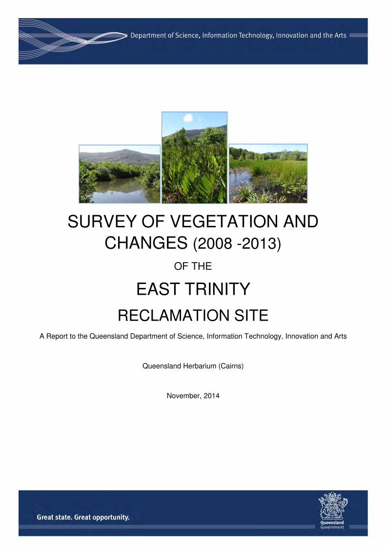
SURVEY OF VEGETATION AND
CHANGES (2008 -2013)
OF THE
EAST TRINITY
RECLAMATION SITE A Report to the Queensland Department of Science, Information Technology, Innovation and Arts
Queensland Herbarium (Cairns)
November, 2014

Department of Science, Information Technology, Innovation and the Arts
Prepared by
Mark Newton, Eda Addicott and Peter Bannink
Queensland Herbarium
Science Delivery Division
Department of Science, Information Technology, Innovation and the Arts
PO Box 5078
Brisbane QLD 4001
© The State of Queensland (Department of Science, Information Technology, Innovation and the Arts) 2014
The Queensland Government supports and encourages the dissemination and exchange of its information. The
copyright in this publication is licensed under a Creative Commons Attribution 3.0 Australia (CC BY) licence
Under this licence you are free, without having to seek permission from DSITIA, to use this publication in accordance with the licence terms.
You must keep intact the copyright notice and attribute the State of Queensland, Department of Science, Information Technology, Innovation and the Arts as the source of the publication.
For more information on this licence visit http://creativecommons.org/licenses/by/3.0/au/deed.en
Disclaimer
This document has been prepared with all due diligence and care, based on the best available information at the time of
publication. The department holds no responsibility for any errors or omissions within this document. Any decisions made
by other parties based on this document are solely the responsibility of those parties. Information contained in this
document is from a number of sources and, as such, does not necessarily represent government or departmental policy.
If you need to access this document in a language other than English, please call the Translating and Interpreting
Service (TIS National) on 131 450 and ask them to telephone Library Services on +61 7 3170 5725
Citation
Newton, M.R, Addicott, E.P. and Bannink P. J. (2014) Vegetation Survey of the East Trinity Reclamation Site :
November 2014. Queensland Herbarium, Queensland Department of Science, Information Technology,
Innovation and the Arts, Brisbane.
Acknowledgements
This report has been prepared by the Department of Science, Information Technology, Innovation and the Arts.
Acknowledgement is made of Ashley Field (DSITIA), Doug Smith (DSITIA and Steve Wilbraham (DSITIA).
10/11/2014

Vegetation Survey of the East Trinity Reclamation site
i
Executive Summary on the Vegetation of the East
Trinity Reclamation site
November 2014
East Trinity is located approximately two kilometres east of Cairns CBD across Trinity Inlet. The
area was cleared in the 1970s which subsequently resulted in the development of acid sulfate
soils (ASS). The site was purchased by the Queensland Government in 2000 who initiated a
project to neutralise the acidic soils. This involved, among other things, installing several gates in
the bund wall around the site to allow seawater to tidally enter, and the addition of hydrated lime to
the incoming tide to help neutralise the acidic soil.
This vegetation survey is the fourth to be carried out since the remediation work commenced. An
interim report was produced in June 2014. This is the fourth assessment to be carried out since
2002.
Ortho-rectified aerial photography acquired in September and October 2013 by the Queensland
Government provided the base imagery. In contrast to previous surveys, the aerial photography
was interpreted by desktop spatial analysis, with the line-work from the 2009 vegetation report as a
base, rather than as stereo pairs. Field visits were over five days during 2014 to confirm vegetation
communities and re-visit previous measurement sites. The same classification of communities was
retained to allow direct comparison with previous work.
This 2014 survey confirms that many of the changes in vegetation noted in earlier reports continue
to occur. Communities associated with the incursion of seawater and expansion of the tidal zones
within the site continues to increase. Most notable is the growth in area of Acrostichum aureum
(mangrove fern) fernlands (from 58 ha to 76 ha) and mangrove communities (from 38 ha to 85 ha).
This is particularly into former halophytic forblands, mixed forbland-grassland-fernland
communities and areas of former and recent Melaleuca leucadendra (weeping paperbark) dieback.
Despite much of the previously mapped extent of the A. aureum fernlands turning into either
mangroves or low M. leucadendra woodlands it has had a net overall increase in area.
Although there has been an increase in M. leucadendra shrublands, particularly into former
grasslands (12 ha), there are now larger areas of more mature M. leucadendra low woodland and
open woodlands. Intuitively, they are maturing from shrublands of the same species mapped in
2008 (4 ha), but they have also appeared in areas previously mapped as grassland (17 ha) and A.
aureum (12 ha).
The most notable reduction in vegetation has been in the grasslands, particularly those dominated
by exotic species (down by 54 ha) or Imperata cylindrica (down by 31 ha). These have been
largely invaded by M. leucadendra, turning into shrublands and low woodlands and by the native
grass Phragmites karka. Grasslands of the latter have increased in area, sometimes in association
with A. aureum (17 ha).
The dieback of open forests of M. leucadendra impacted by the tidal areas continues, with some
stands that were healthy in 2008 now in decline (27 ha loss). A. aureum fernlands now occupy

Department of Science, Information Technology, Innovation and the Arts
ii
much of the earlier mapped dieback of M. leucadendra (15 ha change). The decline of low
Clerodendrum inerme closed vinelands also continues in proximity to the tidal zone, though in
other areas it appears to be recovering.
The mosaic of forest types mapped in the north-east of the site remains apparently unaffected by
the reclamation. This area contains of concern regional ecosystems 7.2.8* and 7.3.25* and a small
area of Endangered regional ecosystem 7.3.6*. Small patches of regional ecosystem 7.2.8* are
found in four other small areas. The Endangered regional ecosystem 7.3.12* occurs along Hills
Creek.
As mentioned in previous reports the vegetation communities at East Trinity are, with the
exceptions of the above mentioned remnant regional ecosystems, secondary communities with
little resemblance to original vegetation composition and structure. The communities are still very
dynamic and complex. Changes in management regime are undoubtedly influencing the direction
and speed of the changes, but quantifying these is beyond the scope of this assessment.
Mark Newton, Eda Addicott and Peter Bannink
Queensland Herbarium (Department of Science, Information Technology, Innovation and the Arts)
Australian Tropical Herbarium, James Cook University, Cairns Campus
Smithfield, Queensland 4874
*Regional Ecosystem labelsQueensland Herbarium (2014) Regional Ecosystem Description Database (REDD). Version 8.1 (April 2014)
(Queensland Department of Science, Information Technology, Innovation and the Arts: Brisbane)
7.2.8: Melaleuca leucadendra open forest to woodland on sands of beach origin
7.3.6: Melaleuca dealbata +/- Melaleuca leucadendra open forest, on poorly drained alluvial plains
7.3.12: Mixed eucalypt open forest to woodland, dominated by Eucalyptus tereticornis and
Corymbia tessellaris +/- Melaleuca dealbata, (or vine forest with these species as emergents).
Lowland alluvial plains
7.3.25: Melaleuca leucadendra +/- vine forest species open forest to closed forest on alluvium
fringing streams
Vegetation Survey of the East Trinity Reclamation site
iii
CONTENTS
Executive Summary...........................................................................................i
1 Introduction...................................................................1
1.1 History of the East Trinity Property
1.2 Vegetation mapping of the East Trinity Property
2 Methods.........................................................................3
3 Results...........................................................................3
3.1 Melaleuca dieback
3.2 Low Melaleuca shrublands and woodlands
3.3 Mangrove communities
3.4 Acrostichum aureum fernlands
3.5 Phragmites karka dominated grasslands
3.6 Clerodendrum inerme vinelands
3.7 Grasslands
3.8 Exotic woodlands
3.9 Remnant native woodlands
3.10 Freshwater wetlands
4 Discussion.....................................................................7
5 References....................................................................7
Department of Science, Information Technology, Innovation and the Arts
iv
LIST OF TABLES
Table 1 Legend of vegetation communities.
Table 2 Changes in area in vegetation communities from 2008 to 2013.
Table 3 List of sites visited in 2014 Vegetation Survey of East Trinity.
LIST OF MAPS
Map 1 Study sites and localities.
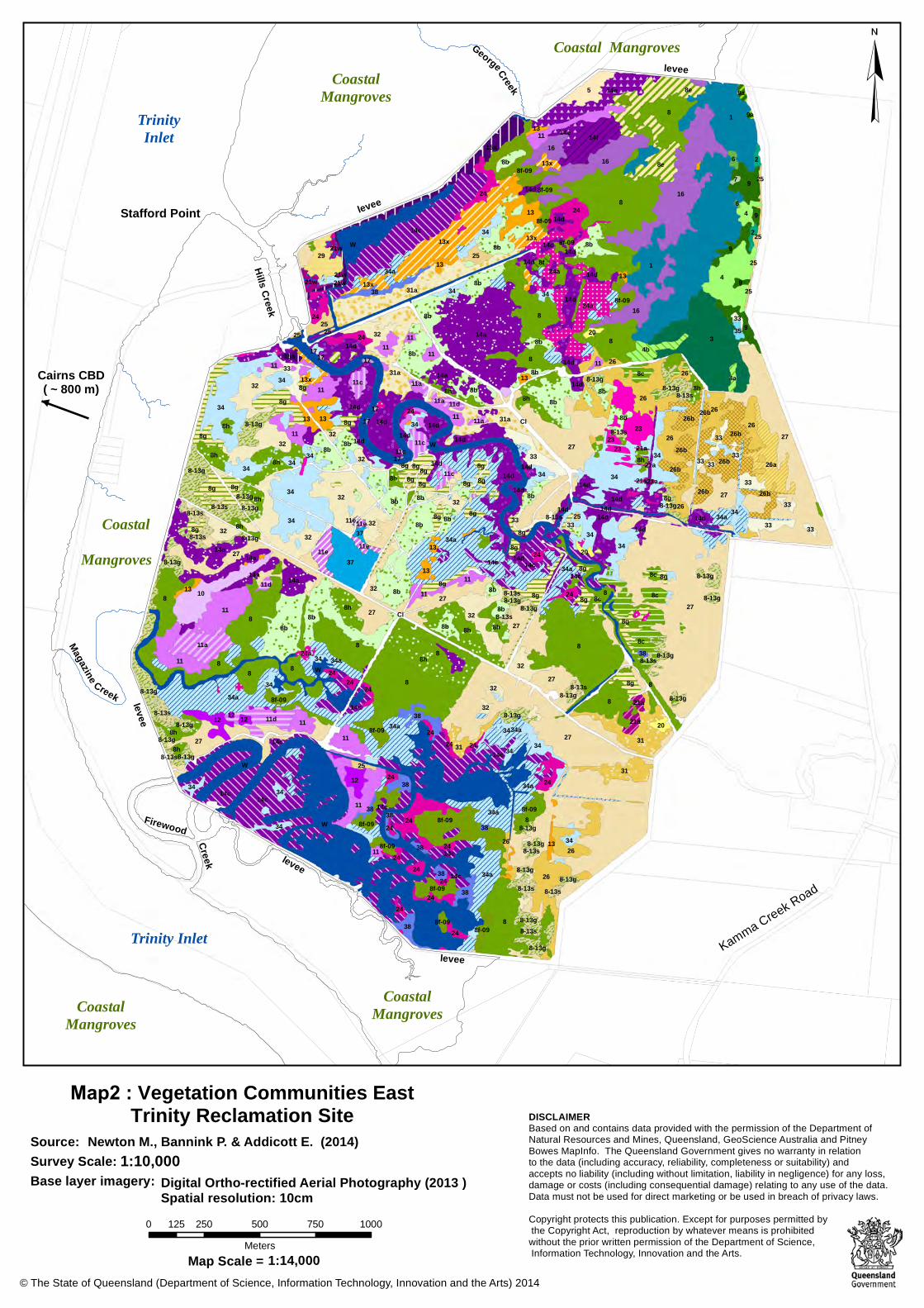
Map 2 Vegetation Communities (2013).
Map 3 (a-f) Vegetation communities with major changes in extent.
LIST OF PHOTOS
Cover (left) Aegiceras corniculatum mangrove forest
Cover (center) Acrostichum aureum fernland
Cover (right) Eleocharis dulcis sedgeland
Photo 1a Aerial view of Firewood Creek area from the 1980’s showing
extensive grasslands and Melaleuca leucadendra
woodlands to the left of the bund wall roadway.
Photo 1b Aerial view of Firewood Creek area in 2013 with extensive
flooded areas, Melaleuca woodland die-back and mangrove
development.
APPENDICES
APPENDIX A East Trinity site photographs from 2008 and 2014.

Vegetation Survey of the East Trinity Reclamation site
1
1. Introduction
1.1 History of the East Trinity property.
The East Trinity property is located approximately 2km east of the Cairns CBD across Trinity Inlet
and occupies an area of just over 750 ha. In its natural state up until the early 1970s the area was
a functioning tidal wetland containing seven distinct mangrove communities as well as samphire
flats , chenier sand ridges and some coastal lowland rainforest. In an ultimately failed attempt to
grow sugar cane, the area was mostly cleared and drained in the 1970s and surrounded by a
bund wall to exclude tidal inflow. This resulted in the severe acidification of underlying iron sulfide-
rich marine deposits and the development of actual acid sulfate soils (AASS). Over the course of
the ensuing two and a half decades the build-up of acid severely degraded the property and 3,000
tonnes of acid drained into the surrounding estuary per year.
This exclusion of tidal water, drainage and acidification also produced major changes in the
vegetation. The samphire communities were heavily degraded and all but one of the mangrove
communities (Lumnitzera racemosa and Avicennia marina) died. Many areas that were previously
mangrove were colonised by Melaleuca leucadendra even where the soil pH was reduced to 3.0.
The lowland forest in the elevated north-eastern section of the property remained largely
unaffected.
In the year 2000 the Queensland Government purchased the property and initiated an acidity
remediation program. This principally involved strategically installing several gates in the bund wall
and commencing controlled tidal flushing into the property augmented with the addition of hydrated
lime (active remediation). This treatment has successfully reduced the acidity in both soils and
drainage waters to the extent that in the north of the property in the Hill and Georges Creek
catchments the lime addition has recently ceased and tidal exchange alone is sustaining lower
acidity (passive remediation). In the south, in the Firewood and Magazine Creek catchments,
active remediation is still being employed, although only on the incoming tide.
Prior to the installation of the bund wall the natural level of tidal inundation was approximately 1.5m
above Australian Height Datum (AHD). Following the bunding AASS occurred up to approximately
1m AHD. The active remediation involved incremental inundation up to 0.5m, which is where the
most concentrated AASS occurs. Acid originating from above the 0.5 AHD level is now being
neutralised by natural tidal flow as the overall acidity within the system is reduced.
1.2 Vegetation mapping at the East Trinity property
As part of the terrestrial management of the East Trinity property QPWS contracted consultants to
document the changes in vegetation since the property’s purchase. This has been done by
mapping the changes in extent of the vegetation communities. The initial mapping was carried out
in 2002, then subsequently in 2006 and 2008. This report documents the vegetation on the
property at the time of survey and summarises the changes in vegetation between 2008 (as
outlined in the 2009 report) and 2013.
Department of Science, Information Technology, Innovation and the Arts
2
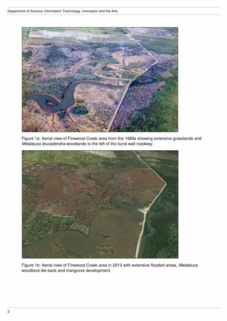
Figure 1a: Aerial view of Firewood Creek area from the 1980s showing extensive grasslands and
Melaleuca leucadendra woodlands to the left of the bund wall roadway.
Figure 1b: Aerial view of Firewood Creek area in 2013 with extensive flooded areas, Melaleuca
woodland die-back and mangrove development.
Vegetation Survey of the East Trinity Reclamation site
3
2. Methodology
Ortho-rectified aerial photography acquired in September and October 2013 by the Queensland
Government provided the base imagery for interpretation of vegetation patterns. Interpretation was
done manually rather than through digital interpretation methods. In contrast to previous surveys
the aerial photography was interpreted by desktop spatial analysis rather than as stereo pairs, and
used the 2008 line-work, as shown in the 2009 published report, as a base.
Over four days in late April 2014 and one follow-up day in August 2014, the property was visited to
ground-truth the new mapping. This included re-visiting sites established in previous mapping and
collecting information at new sites. The data from the sites was used to describe vegetation
communities occurring in the vegetation patterns delineated on the imagery. Due to the short time
elapsed between the date of the imagery used (late 2013) and the on ground site assessments
(mid 2014) it is assumed that the ground data reflects the mapping.
Data collected at each site included the date, GPS location, the structure and height of the
community, the dominant species in each discernible layer and a photograph of the community.
The 2008 mapped classification of communities was retained to allow direct comparison with
previous mapping, although there are several new communities that could not be assigned to
vegetation communities (VCs) described in 2008 as well as some 2008 vegetation communities
that were not observed in 2013.
Changes in the areas of vegetation communities between 2008 and 2013 were calculated by
intersecting the two mapping coverages. The mapping application used to do this as well as
create the vegetation map was ARCMAP 10.2.
3. Results
The new mapping for the East Trinity property is attached, and includes both a spatial
representation (Map 2) and the accompanying legend (Table 1). Table 2 summarises the change
in area for each major vegetation group and each vegetation community within those groups.
There are several distinct broad vegetation groups represented on the property. Fringing the tidal
and estuarine channels there are areas of mangroves and farmlands. In the supra-tidal zones
fernlands of Acrostichum aureum often occur. In more elevated areas shrublands and woodlands
(most often with Melaleuca leucadendra) or grassland communities become more evident. In the
north-east corner the remnant native forest communities persist as in all previous mapping.
This survey confirms that the changes in vegetation groups noted in earlier reports continue to
occur. Colonising mangrove communities have increased to 62 ha (or 300% of their 2008 extent),
and native grasslands have also increased to 43ha (or 114%). While there has been little change
in the Melaleuca dominated communities as a whole (by 17 ha or 12% of the 2008 extent) there
have been significant increases and decreases in area of specific communities within this group.
These are outlined below along with the largest changes in vegetation communities within other
groups. This survey found that the total area of communities dominated by native species since
2008 has increased by nearly 50 ha (or 7% of the total area in 2008).

Department of Science, Information Technology, Innovation and the Arts
4
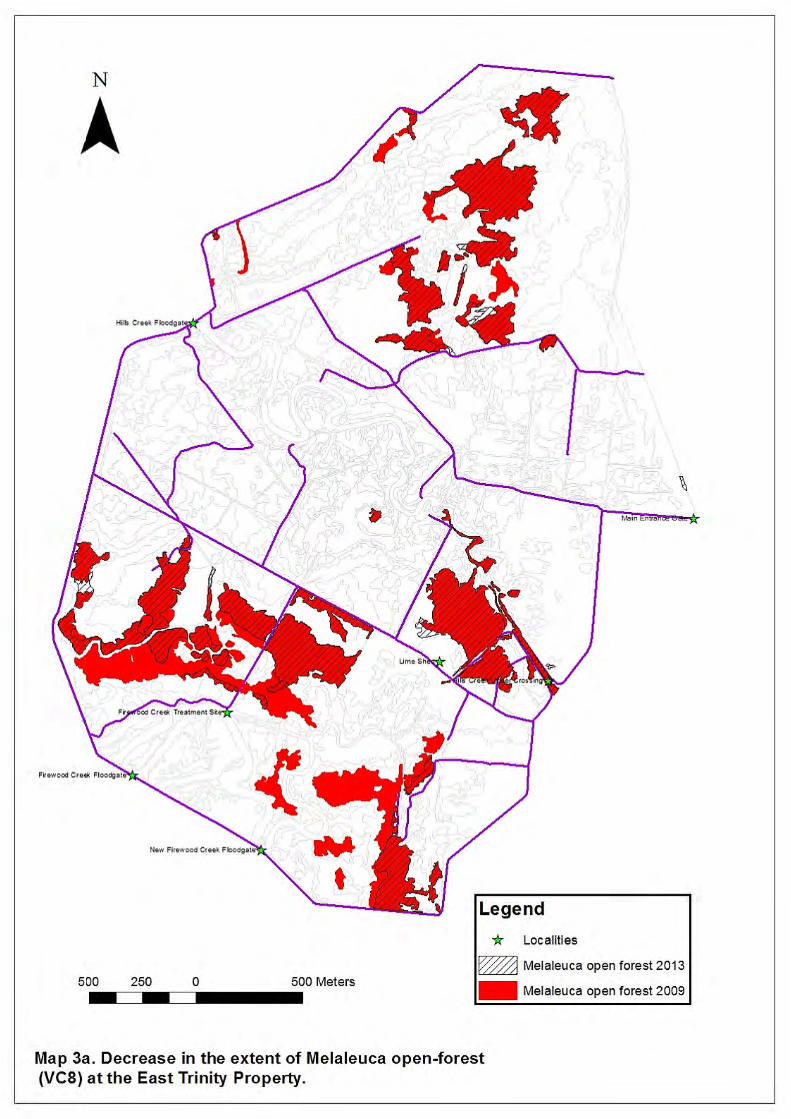
3.1 Melaleuca dieback
The large stands of Melaleuca leucadendra open forest (VC8) that proliferated in areas of highly
acidic soils have died back even further (see previous reports) as the influx of tidal water takes
effect (Map 3a). Some areas that were healthy in 2008 have died (27ha or 27% of their 2008
extent). Areas mapped in 2008 as die-back (13ha) have now changed to other communities, in
particular Acrostichum aureum fernlands or mangrove communities. Other areas of M.
leucadendra forest have remained healthy and intact, as they are elevated enough to be free of
current tidal influences. The zone between the healthy Melaleuca leucadendra and the mangroves
contains dead M. leucadendra stems and bare saline mud with Sesuvium portulacastrum (VC24).
Given the patterns observed in the survey these are likely to be colonised by mangrove or
Acrostichum communities.
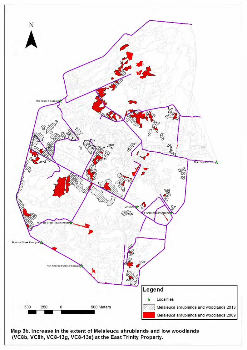
3.2 Low Melaleuca shrublands and woodlands
Despite the continued reduction of the Melaleuca leucadendra forests, this species is still
commonly found as shrublands (VC8h) that have expanded in area, particularly into former
grassland (12ha or 183% of 2008 extent). Additionally, more mature M. leucadendra low
woodland that was not recorded in 2008 is recognised and two new vegetation communities have
been created to describe where this occurs in former grasslands (VC8-13g) and former
M.leucadendra low shrublands (VC8-13s). These changes are represented in Map 3b.
Where M. leucadendra has colonised Acrostichum aureum fernlands, it has been assigned to the
2008 vegetation unit VC8g. This vegetation generally occupies areas that appear to be out of the
reach of current tidal effects and it is possible they will mature into communities similar to the
Melaleuca dominant communities (VC8) that declined due to the tidal inundation. The accelerated
increase in the extent of these woodlands since the last mapping is possibly explained by the
cessation of extensive burning on the property after 2009.
There has also been extensive thickening of woody vegetation, mainly in the central area of the
property in areas which were previously grasslands. Vegetation community 8b, which includes M.
leucadendra along with other non-sclerophyll species such as Timonius timon, Cordia dichotoma
and Terminalia sericocarpa has increased by 56 percent of its 2008 extent (35Ha).
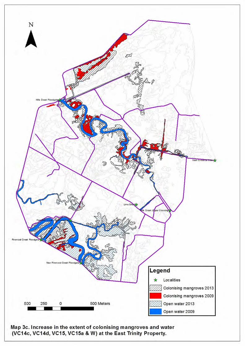
3.3 Mangrove communities There has been a significant increase in the area of mangrove communities across the property. Communities 14c (Avicennia marina) and 14d (Aegiceras corniculatum, Avicennia marina and
Excoecaria agallocha) have shown the largest increase and are in areas close to the tidal
channels subject to increased inundation (Map 3c). These areas of increased inundation include
some of the adjoining grasslands, Sesuvium portulacastrum forblands, Acrostichum fernlands
and areas of Melaleuca leucadendra dieback.
Mangrove communities continue to be a dominant vegetation community along the margins of the
various tidal channels on the property. In the vicinity of Firewood and Magazine Creek the
vegetation community 14c has increased by 32ha (or 999%) over its 2008 extent. This mangrove
community is now often fringed by Rhizophora stylosa in areas of deeper water, particularly along
Vegetation Survey of the East Trinity Reclamation site
5
the main channel. In the upper reaches of current regular tidal incursion, the presence of
numerous juvenile Avicennia marina suggests that this mangrove community (14c) will continue to
expand.
In the north of the property along the perimeter of Hills and George Creeks the mangrove
community 14d has expanded by 26 ha (or 235% over its 2008 extent). This is particularly
noticeable on the former samphire flats near the middle and upper reaches of George Creek,
where much of this community is now populated by mangroves, a process that is also likely to
continue if this tidal regime persists. It is likely that future increases in area and density of
mangroves will be assisted by the regular influx of propagules on incoming tides and the sexual
maturation of the existing community. The mangrove community 14a (Lumnitzera racemosa and
Avicennia marina), much of which survived the original disturbance, has also expanded slightly.
The Holly Mangrove Acanthus ilicifolius is often prominent in the early development of both
communities 14c and 14d.
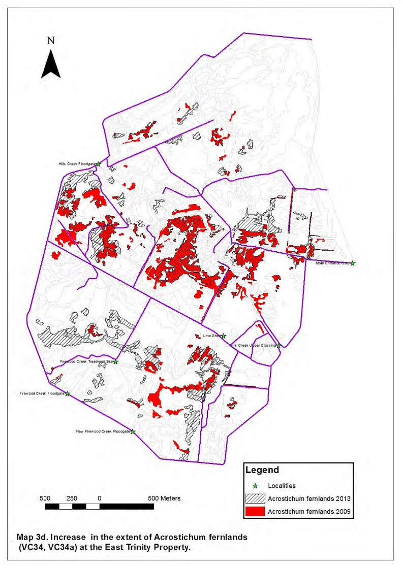
3.4 Acrostichum aureum fernlands
Extensive areas of Acrostichum aureum, (VC34 and VC34a), were mapped in 2008 where they
had colonised areas of Melaleuca leucadendra dieback (VC34a) or encroached into grasslands
that have become more saline (VC34). These fernland communities have also expanded
considerably since then as the supra-tidal zone has extended into grasslands bordering its
previously mapped extent along all the channels in the property (Map 3d). Some sections of
grasslands are now completely displaced by A. aureum (11 ha). Additionally A. aureum can persist
in areas of fresh water such as in the new vegetation community 26b. Here A. aureum has
pervaded areas of the existing Phragmites karka grassland and co-exists with this species.
A.aureum’s tolerance for fresh or brackish water is also indicated by its presence in the mid-layer
of several communities in the area which are above the reach of tidal influences. Despite areas of
vegetation community VC34 previously mapped in 2008 now being colonised by low Melaleuca
leucadendra woodlands (VC8g) or, in the more tidal zones by mangrove communities, there has
been a net increase in A. aureum dominated fernlands.
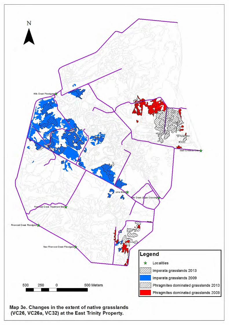
3.5 Phragmites karka dominated grasslands.
The native reed P. karka has expanded by 72% of its 2008 extent (7.5 ha). This has been in the
grassy areas along the eastern boundary of the property to both the north and south (Map 3e). It
has displaced extensive areas of other (often exotic) grassland communities. It occurs as a co-
dominant with Acrostichum aureum in some areas, prompting the formation of a new vegetation
community (VC 26b) mentioned above. P. karka appears to proliferate in areas that have some
level of fresh water inundation possibly explaining its predominant occurrence in the east of the
property which is a drainage zone for the hills to the northeast.
3.6 Clerodendrum inerme
Vinelands of C. inerme (VC13) have mixed levels of survival on the property, probably due to their
exposure to the influence of tidal salinity. As in 2008, the area of C. inerme has declined where it
Department of Science, Information Technology, Innovation and the Arts
6
has become exposed to the expanding tidal zone (4ha or 40% of 2008 extent), particularly in the
vicinity of George Creek and the large tidal flat to the west. Areas noted as in decline in 2008 have
changed to vegetation communities associated with the expanding tidal zones, particularly
mangrove communities and Acrostichum aureum fernlands. However, just to the west of the upper
reaches of the tidal zone of Hills Creek there have been some C. inerme vinelands recorded in
2008 as dead or in decline that appear to have recovered, though it is not clear why.
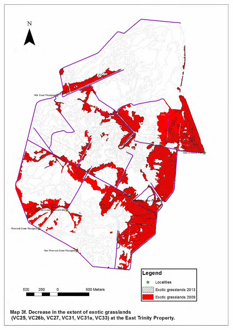
3.7 Grasslands
Grasslands, both exotic and native, are still a prominent vegetation group on East Trinity (170ha or
23% of the property), and are a common feature along the slightly more elevated eastern edge,
however they have reduced from their 2008 extent. This is particularly the case for those
dominated by exotic species, vegetation communities 25 (Megathyrsus maximus) and 27
(Brachiaria spp.), which have had a combined reduction of 54ha (or 36% of 2008 extent). In many
instances they have been replaced by native communities, including Acrostichum aureum
fernlands, Melaleuca woodlands and Phragmites karka grasslands (Map 3f). Native grasslands
dominated by Imperata cylindrica (VC32) have also reduced by 31ha (or 57% of 2008 extent). This
has occurred on plains in the central west of the property, and, like the exotic grasslands, they
have been displaced predominantly by A.aureum fernlands or Melaleuca shrublands and
woodlands (Map 3e).
3.8 Exotic woodlands
As a result of active removal activities, and noted in the 2009 survey, there was a reduction of
several woodland and shrubland communities dominated by exotic species. This trend has
continued through to 2013, with many of these areas now being dominated by native woody
species. It is understood that active removal of exotic woody species, except for some Anonna
glabra (Pond Apple) removal, has all but ceased in recent years and it is unclear what effect this
may have. Some grassland areas in the centre of the property have had an increase in Psidium
guajava (guava) in the form of scattered low shrubs, though, as noted in 2009, the native species
Timonius timon is colonising areas adjacent to and formerly populated by P. guajava.
3.9 Native communities
The mosaic of remnant native forest communities in the north-east of the property remain relatively
undisturbed as described in the 2009 survey. Some of these are also mapped as remnant regional
ecosystems (REs) by the Queensland Herbarium and contain two Of-concern regional
ecosystems, 7.2.8 (Melaleuca leucadendra open forest to woodland on sands of beach origin) and
7.3.25 (Melaleuca leucadendra +/- vine forest species open forest to closed forest on alluvium
fringing streams), and a small area of the endangered regional ecosystem 7.3.6 (Melaleuca
dealbata +/- M. leucadendra open forest, on poorly drained alluvial plains). Regional ecosystem
7.2.8 is equivalent to VC1 and includes VC4b. RE 7.3.6 is equivalent to VC2. RE 7.3.25 is
equivalent to VC4.
There are other patches of remnant vegetation mapped elsewhere across the property. Regional
ecosystem 7.2.8 is also mapped on a chenier ridge in the west of the property and the Endangered
regional ecosystem 7.3.12 (Mixed eucalypt open forest to woodland, dominated by Eucalyptus

Vegetation Survey of the East Trinity Reclamation site
7
tereticornis and Corymbia tessellaris +/- Melaleuca dealbata, (or vine forest with these species as
emergents) is mapped along the freshwater section of Hills Creek.
3.10 Freshwater wetlands
A small area just north-east of the flood-gate on Hills Creek appears to be a freshwater zone
protected by an internal bund wall. Anecdotal evidence indicates this is an artefact from an early
attempt to deposit spoil in the 1980s. At the time of the field visit in April 2014, the Schoenoplectus
littoralis freshwater sedgeland (VC29) had expanded to almost completely cover the area in
question. The subsequent field work in August 2014 revealed a significant influx of saline water
and the dieback of the S. littoralis. This suggests there is a seasonal fluctuation from a freshwater
to a saltwater environment and the vegetation changes reflect this.
4. Discussion
There are a number of general trends apparent. Some communities associated with the tidal zone
are expanding and woodland communities are effectively migrating to more elevated areas whilst
older woodlands within the new tidal regime are declining. There has been an increase in the
number of communities dominated by native species, particularly with respect to the grasslands,
where exotic grassland communities have considerably reduced in area.
As discussed in previous reports, whilst many of the vegetation communities are dominated by
native species, they are secondary in nature and have little resemblance to the pre-clearing
communities, the exception being the remnant communities in the north-east of the property.
However, as shown by the maps over the last 12 years, the vegetation is dynamic and the current
AASS management regime continues to effect the changes in vegetation structure and composition.
The continuing management of the level of the tidal zone to 0.5 m AHD (in consideration of the
land-use for sugar-cane in adjacent properties) suggests that even over time it is unlikely that the
property will be covered in halophytic and mangrove communities to the extent it once was. The
last 12 years of mapping also shows that under the current management the remnant regional
ecosystems will be maintained, some secondary communities may eventually resemble those that
existed before clearing and in more elevated areas grassland and non-estuarine woodland
communities may persist. Continued monitoring and mapping of the East Trinity property will
document the nature of these future changes.
The report includes a map and legend of the vegetation mapping, a general map of the property, a
table documenting the changes in area of the vegetation, a series of current and historical images
of field assessment sites and a table with detailed information about each site.
5. References
3D Environmental (2009) : Vegetation Survey of the East Trinity Reclamation Site. Unpublished report to the Department of Primary Industries.
Bostock, P.D. and Holland. A.E. (Eds.) (2013) : Census of the Queensland Flora. Queensland
Herbarium, Environment Protection Agency, Brisbane.

Department of Science, Information Technology, Innovation and the Arts
8
ESRI 2011. ArcGIS Desktop: Release 10.2. Redlands, CA, USA: Environmental Systems
Research Institute.
Stanton J. P. and Stanton D, J. (2002) : Vegetation of the East Trinity Reclamation Site. Unpublished report to the Department of Primary Industries.
Stanton D, J. (2006) : Vegetation of the East Trinity Reclamation Site. Unpublished report to the Department of Primary Industries.
Queensland Herbarium (2014) : Regional Ecosystem Description Database (REDD). Version 8.1 (April 2014), (Queensland Department of Science, Information Technology, Innovation and the Arts: Brisbane).
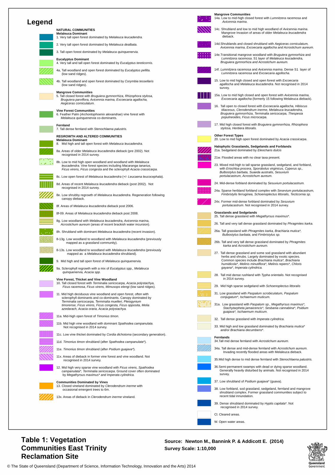
NATURAL COMMUNITIESMelaleuca Dominant1. Very tall open forest dominated by Melaleuca leucadendra.2. Very tall open forest dominated by Melaleuca dealbata.3. Tall open forest dominated by Melaleuca quinquenervia.Eucalyptus Dominant4. Very tall and tall open forest dominated by Eucalyptus tereticornis.4a, Tall woodland and open forest dominated by Eucalyptus pellita.
(low sand ridges).4b. Tall woodland and open forest dominated by Corymbia tessellaris
(low sand ridges).Mangrove Communities5. Tall closed forest with Bruguiera gymnorrhiza, Rhizophora stylosa,
Bruguiera parviflora, Avicennia marina, Excoecaria agallocha, Aegiceras corniculatum.
Vine Forest Communities6. Feather Palm (Archontophoenix alexandrae) vine forest with
Melaleuca quinquenervia co-dominants.Fernland7. Tall dense fernland with Stenochlaena palustris.REGROWTH AND ALTERED COMMUNITIESMelaleuca Dominant8. Mid high and tall open forest with Melaleuca leucadendra.8a. Areas of older Melaleuca leucadendra dieback (pre 2002). Not
recognised in 2014 survey.8b. Low to mid high open woodland and woodland with Melaleuca
leucadendra. Vine forest species including Macaranga tanarius, Ficus virens, Ficus congesta and the sclerophyll Acacia crassicarpa.
8c. Low open forest of Melaleuca leucadendra (+/- Leucaena leucocephala).8d. Areas of recent Melaleuca leucadendra dieback (post 2002). Not
recognised in 2014 survey.8e. Low shrubby regrowth of Melaleuca leucadendra. Regeneration following
canopy dieback.8f. Areas of Melaleuca leucadendra dieback post 2006.8f-09. Areas of Melaleuca leucadendra dieback post 2008.8g. Low woodland with Melaleuca leucadendra, Avicennia marina, Acrostichum aureum (areas of recent brackish water incursion).8h. Shrubland with dominant Melaleuca leucadendra (recent invasion).8-13g. Low woodland to woodland with Melaleuca leucadendra (previously
mapped as a grassland community).8-13s. Low woodland to woodland with Melaleuca leucadendra (previously
mapped as a Melaleuca leucadendra shrubland).9. Mid high and tall open forest of Melaleuca quinquenervia.9a. Sclerophyll regrowth with a mix of Eucalyptus spp., Melaleuca quinquenervia, Acacia spp.Vine Forest, Thicket and Vine Woodland10. Tall closed forest with Terminalia sericocarpa, Acacia polystachya,
Ficus racemosa, Ficus virens, Mimusops elengi (low sand ridges).11. Mid high deciduous vine woodland and open forest, often with
sclerophyll dominants and co-dominants. Canopy dominated byTerminalia sericocarpa, Terminalia muelleri, Pleiogyniumtimorense, Ficus virens, Ficus congesta, Ficus opposita, Meliaazedarach, Acacia oraria, Acacia polystachya.
11a. Mid-high open forest of Timonius timon.11b. Mid high vine woodland with dominant Spathodea campanulata.
Not recognised in 2014 survey.11c. Low vine thicket dominated by Cordia dichotoma (secondary generation).11d. Timonius timon shrubland (after Spathodea campanulata*).11e. Timonius timon shrubland (after Psidium guajava*).11x. Areas of dieback in former vine forest and vine woodland. Not
recognised in 2014 survey.12. Mid high very sparse vine woodland with Ficus virens, Spathodea
campanulata*, Terminalia sericocarpa. Ground cover often dominatedby Megathyrsus maximus* and Imperata cylindrica.
Communities Dominated by Vines13. Closed vineland dominated by Clerodendrum inerme with occasional emergent trees to 6m.13x. Areas of dieback in Clerodendrum inerme vineland.
© The State of Queensland (Department of Science, Information Technology, Innovation and the Arts) 2014
Table 1: Vegetation Communities East Trinity Reclamation Site
Source: Newton M., Bannink P. & Addicott E. (2014) Survey Scale: 1:10,000
Mangrove Communities14a. Low to mid-high closed forest with Lumnitzera racemosa and
Avicennia marina.14c. Shrubland and low to mid high woodland of Avicennia marina.
Mangrove Invasion of areas of older Melaleuca leucadendra dieback.
14d.Shrublands and closed shrubland with Aegiceras corniculatum, Avicennia marina, Excoecaria agallocha and Acrostichum aureum.
14e.Transitional mangrove woodland with Bruguiera gymnorhiza and Lumnitzera racemosa. S1 layer of Melaleuca leucadendra, Bruguiera gymnorhiza and Acrostichum aureum.
14f. Lumnitzera racemosa and Avicennia marina. Dense S1 layer of Lumnitzera racemosa and Excoecaria agollocha.
15. Low to mid high closed and open forest with Excoecariaagallocha and Melaleuca leucadendra. Not recognised in 2014survey.
15a. Low to mid high closed and open forest with Avicennia marina, Excoecaria agallocha (formerly 15 following Melaleuca dieback).
16. Tall open to closed forest with Excoecaria agallocha, Hibiscustiliaceous, Clerodendrum inerme, Melaleuca leucadendra,Bruguiera gymnorrhiza, Terminalia sericocarpa, Thespesiapopulneoides, Ficus microcarpa.
17. Mid high closed forest with Bruguiera gymnorrhiza, Rhizophorastylosa, Heritiera littoralis.
Other Forest Types20. Low to mid high open forest dominated by Acacia crassicarpa.Halophytic Grasslands, Sedgelands and Forblands21a. Sedgeland dominated by Eleocharis dulcis21w. Flooded areas with no clear taxa present.23. Mixed mid-high to tall sparse grassland, sedgeland, and forbland,
with Eriochloa procera, Sporobolus virginicus, Cyperus sp.,Bulbostylus barbata, Suaeda australis, Sesuviumportulacastrum, Acrostichum aureum.
24. Mid-dense forbland dominated by Sesuvium portulacastrum.24a. Sparse herbland forbland complex with Sesevium portulacastrum,
Fimbristylis ferruginea, Schoenoplectus littoralis, Tecticornia sp.24x. Former mid-dense forbland dominated by Sesuvium
portulacastrum. Not recognised in 2014 survey.Grasslands and Sedgelands25. Tall dense grassland with Megathyrsus maximus*.26. Tall and very tall dense grassland dominated by Phragmites karka.26a. Tall grassland with Phragmites karka, Brachiaria mutica*,
Bulbostylus barbata, and Fimbristylus sp.26b. Tall and very tall dense grassland dominated by Phragmites
karka and Acrostichum aureum.27. Tall dense grassland and some sod grassland with abundant
herbs and shrubs. Largely dominated by exotic species.Common species include Brachiaria mutica*, Brachiariahumidicola*, Melinis minutiflora*, Melinis repens*, Chlorisgayana*, Imperata cylindrica.
28. Tall mid dense rushland with Typha orientalis. Not recognised in 2014 survey.
29. Mid high sparse sedgeland with Schoenoplectus littoralis31. Low grassland with Paspalum scrobiculatum, Paspalum
conjugatum*, Ischaemum muticum.31a. Low grassland with Paspalum sp., Megathyrsus maximus*,
Stachytarpheta jamaicencis*, Sesbania cannabina*, Psidium guajava*, Ischaemum muticum.
32. Tall dense grassland with Imperata cylindrica.33. Mid high and low grassland dominated by Brachiaria mutica*
and/or Brachiaria decumbens*.Fernlands34.Tall mid dense fernland with Acrostichum aureum.34a. Tall dense and mid-dense fernland with Acrostichum aureum.
Invading recently flooded areas with Melaleuca dieback.35.Mid high dense to mid dense fernland with Stenochlaena palustris.36.Semi-permanent swamps with dead or dying sparse woodland.
Generally heavily disturbed by animals. Not recognised in 2014 survey.
37. Low shrubland of Psidium guajava* (guava).38. Low forbland, sod grassland, sedgeland, fernland and mangrove
shrubland complex. Former grassland communities subject torecent tidal innundation.
39. Dense shrubland dominated by Hyptis capitata*. Notrecognised in 2014 survey.
Cl. Cleared areas.W. Open water areas.
!!
!
!
!
!
!
!!
!
!
!
!
!!
!
!
EEE E E E E E E E E E E E E E E E EE E E E E E E E E E E E E E E E E E EE E E E E E E E E E E E E E E E E E EE E E E E E E E E E E E E E E E E E EE E E E E E E E E E E E E E E E E E EE E E E E E E E E E E E E E E E E E EE E E E E E E E E E E E E E E E E E EE E E E E E E E E E E E E E E E E E EE E E E E E E E E E E E E E E E E E E
!
!! !
! !!
!
!!
!
!
!
!
!
!
!
!
!
!
!!
!
!!
!!
!
!
!!!
!
!
F
FF
F
F FF
F
F FF
F
F
F
F
F
F
# # # # # # #
# # # # # # #
# # # # # # #
# # # # # # #
!
!!
!
!
!!!
!!
!!
!!
!
!
! !!
!!
! ! !!
!
!!
!
!
!
!!!
!
!
!!!
!
!
!
!!
!!
!
!
!
!!
!
!
!!
!
!!
!
!
!
!
!!
!
!
! ! ! ! ! ! ! ! !
! ! ! ! ! ! ! ! !
! ! ! ! ! ! ! ! !
! ! ! ! ! ! ! ! !
! ! ! ! ! ! ! ! !
"
"
"
"
""
"
"
"
""
"
"
"
" "
"
"
""
" "
"
"
""
"""
""
"""
"
"
""
"
""
"
"
Legend
Vegetation Survey of the East Trinity Reclamation site
1
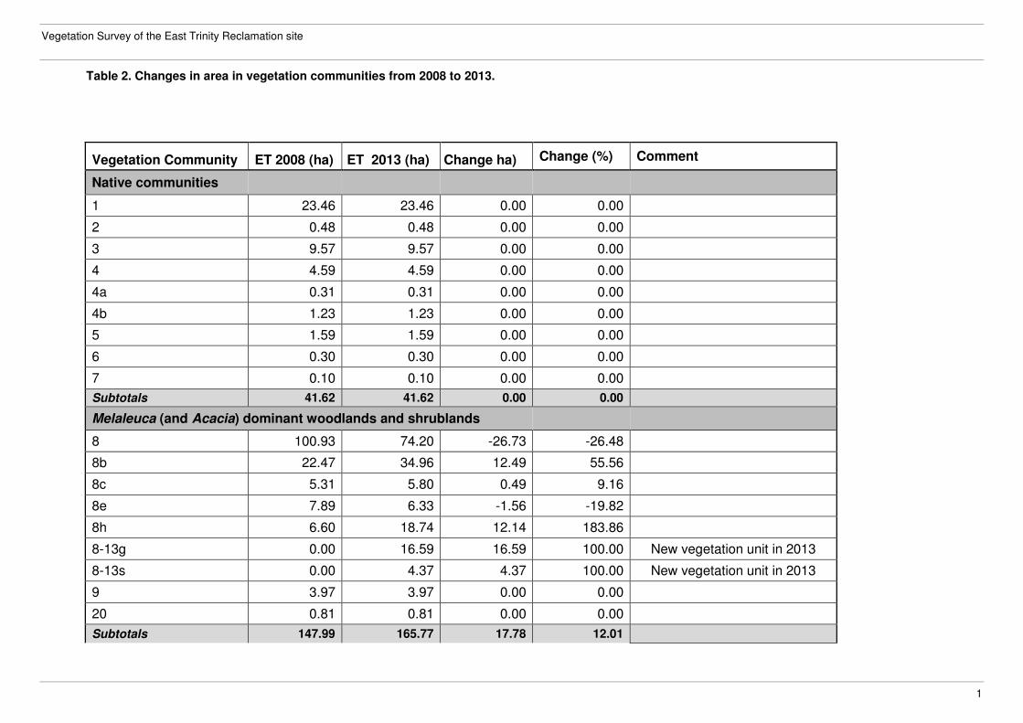
Table 2. Changes in area in vegetation communities from 2008 to 2013.
Vegetation Community ET 2008 (ha) ET 2013 (ha) Change ha) Change (%) Comment
Native communities
1 23.46 23.46 0.00 0.00
2 0.48 0.48 0.00 0.00
3 9.57 9.57 0.00 0.00
4 4.59 4.59 0.00 0.00
4a 0.31 0.31 0.00 0.00
4b 1.23 1.23 0.00 0.00
5 1.59 1.59 0.00 0.00
6 0.30 0.30 0.00 0.00
7 0.10 0.10 0.00 0.00
Subtotals 41.62 41.62 0.00 0.00
Melaleuca (and Acacia) dominant woodlands and shrublands
8 100.93 74.20 -26.73 -26.48
8b 22.47 34.96 12.49 55.56
8c 5.31 5.80 0.49 9.16
8e 7.89 6.33 -1.56 -19.82
8h 6.60 18.74 12.14 183.86
8-13g 0.00 16.59 16.59 100.00 New vegetation unit in 2013
8-13s 0.00 4.37 4.37 100.00 New vegetation unit in 2013
9 3.97 3.97 0.00 0.00
20 0.81 0.81 0.00 0.00
Subtotals 147.99 165.77 17.78 12.01

Department of Science, Information Technology, Innovation and the Arts
2
Vegetation Community ET 2008 ha) ET 2013 ha) Change ha) Change (%) Comment
Melaleuca dieback areas -old and recent
8a 22.42 0.00 -22.42 -100.00 Not mapped in 2013
8d 6.26 0.00 -6.26 -100.00 Not mapped in 2013
8f 13.21 0.33 -12.88 -97.50
8f-09 0.00 15.56 15.56 100.00 New vegetation unit in 2013
Subtotals 41.89 15.89 -26.01 -62.08
Regrowth and altered native vine forest communities
10 3.41 3.45 0.04 1.28
11 10.11 18.37 8.26 81.78
Subtotals 13.52 21.82 8.31 61.47
Native invasive (colonising) vine forest/shrubland communities
11a 3.59 3.43 -0.17 -4.61
11c 2.08 2.06 -0.02 -0.86
11d 0.86 2.62 1.76 205.99
11e 3.08 1.81 -1.27 -41.31
Subtotals 9.60 9.91 0.31 3.19
Shrublands and low vine woodlands dominated (or co-dominated) by exotic species
11b 0.56 0.00 -0.56 -100.00 Not mapped in 2013
37 0.90 3.75 2.85 315.92
12 1.89 2.45 0.56 29.85
39 0.54 0.00 -0.54 -100.00 Not mapped in 2013
Subtotals 3.90 6.20 2.30 59.05
Native vinelands
13 10.08 6.00 -4.07 -40.42
Subtotals 10.05 6.00 -4.05 -40.30
Vegetation Survey of the East Trinity Reclamation site
3
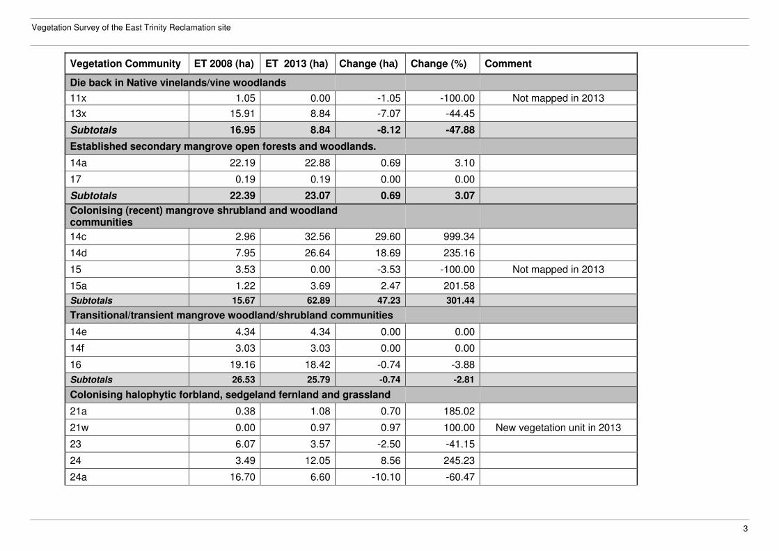
Vegetation Community ET 2008 (ha) ET 2013 (ha) Change (ha) Change (%) Comment
Die back in Native vinelands/vine woodlands
11x 1.05 0.00 -1.05 -100.00 Not mapped in 2013
13x 15.91 8.84 -7.07 -44.45
Subtotals 16.95 8.84 -8.12 -47.88
Established secondary mangrove open forests and woodlands.
14a 22.19 22.88 0.69 3.10
17 0.19 0.19 0.00 0.00
Subtotals 22.39 23.07 0.69 3.07
Colonising (recent) mangrove shrubland and woodland communities
14c 2.96 32.56 29.60 999.34
14d 7.95 26.64 18.69 235.16
15 3.53 0.00 -3.53 -100.00 Not mapped in 2013
15a 1.22 3.69 2.47 201.58
Subtotals 15.67 62.89 47.23 301.44
Transitional/transient mangrove woodland/shrubland communities
14e 4.34 4.34 0.00 0.00
14f 3.03 3.03 0.00 0.00
16 19.16 18.42 -0.74 -3.88
Subtotals 26.53 25.79 -0.74 -2.81
Colonising halophytic forbland, sedgeland fernland and grassland
21a 0.38 1.08 0.70 185.02
21w 0.00 0.97 0.97 100.00 New vegetation unit in 2013
23 6.07 3.57 -2.50 -41.15
24 3.49 12.05 8.56 245.23
24a 16.70 6.60 -10.10 -60.47
Department of Science, Information Technology, Innovation and the Arts
4
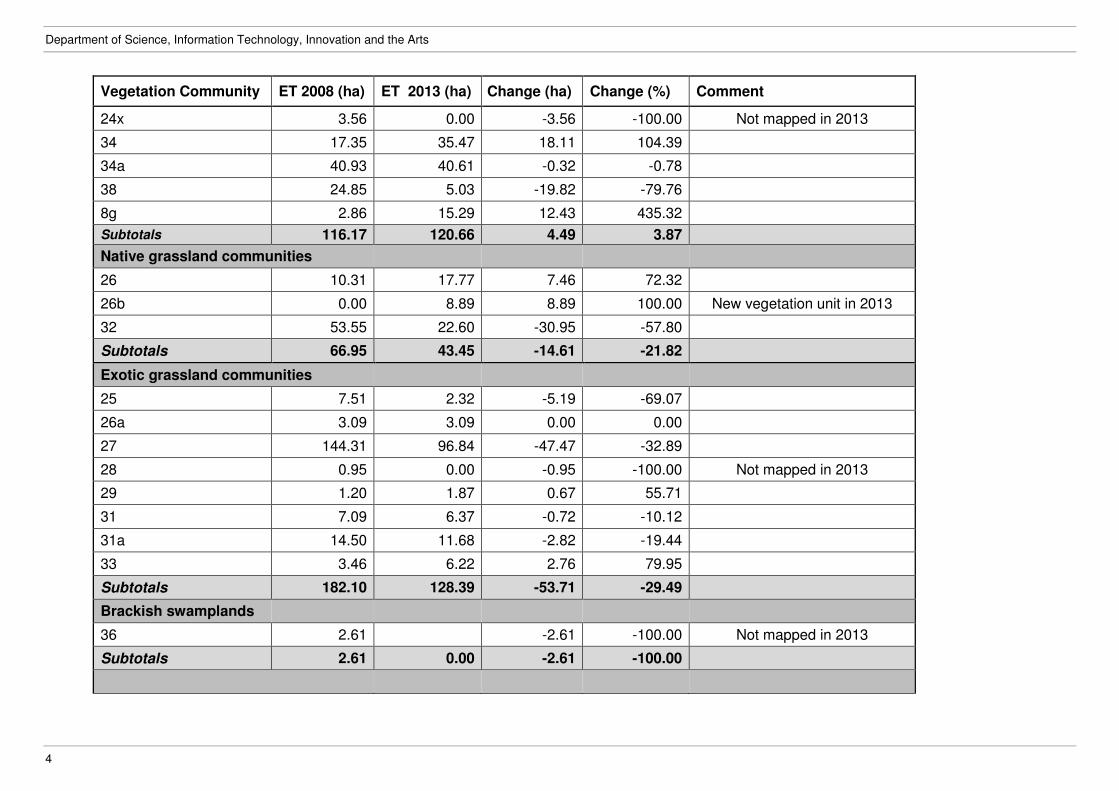
Vegetation Community ET 2008 (ha) ET 2013 (ha) Change (ha) Change (%) Comment
24x 3.56 0.00 -3.56 -100.00 Not mapped in 2013
34 17.35 35.47 18.11 104.39
34a 40.93 40.61 -0.32 -0.78
38 24.85 5.03 -19.82 -79.76
8g 2.86 15.29 12.43 435.32
Subtotals 116.17 120.66 4.49 3.87
Native grassland communities
26 10.31 17.77 7.46 72.32
26b 0.00 8.89 8.89 100.00 New vegetation unit in 2013
32 53.55 22.60 -30.95 -57.80
Subtotals 66.95 43.45 -14.61 -21.82
Exotic grassland communities
25 7.51 2.32 -5.19 -69.07
26a 3.09 3.09 0.00 0.00
27 144.31 96.84 -47.47 -32.89
28 0.95 0.00 -0.95 -100.00 Not mapped in 2013
29 1.20 1.87 0.67 55.71
31 7.09 6.37 -0.72 -10.12
31a 14.50 11.68 -2.82 -19.44
33 3.46 6.22 2.76 79.95
Subtotals 182.10 128.39 -53.71 -29.49
Brackish swamplands
36 2.61 -2.61 -100.00 Not mapped in 2013
Subtotals 2.61 0.00 -2.61 -100.00
Vegetation Survey of the East Trinity Reclamation site
5
Vegetation Community ET 2008 (ha) ET 2013 (ha) Change ha) Change (%) Comment
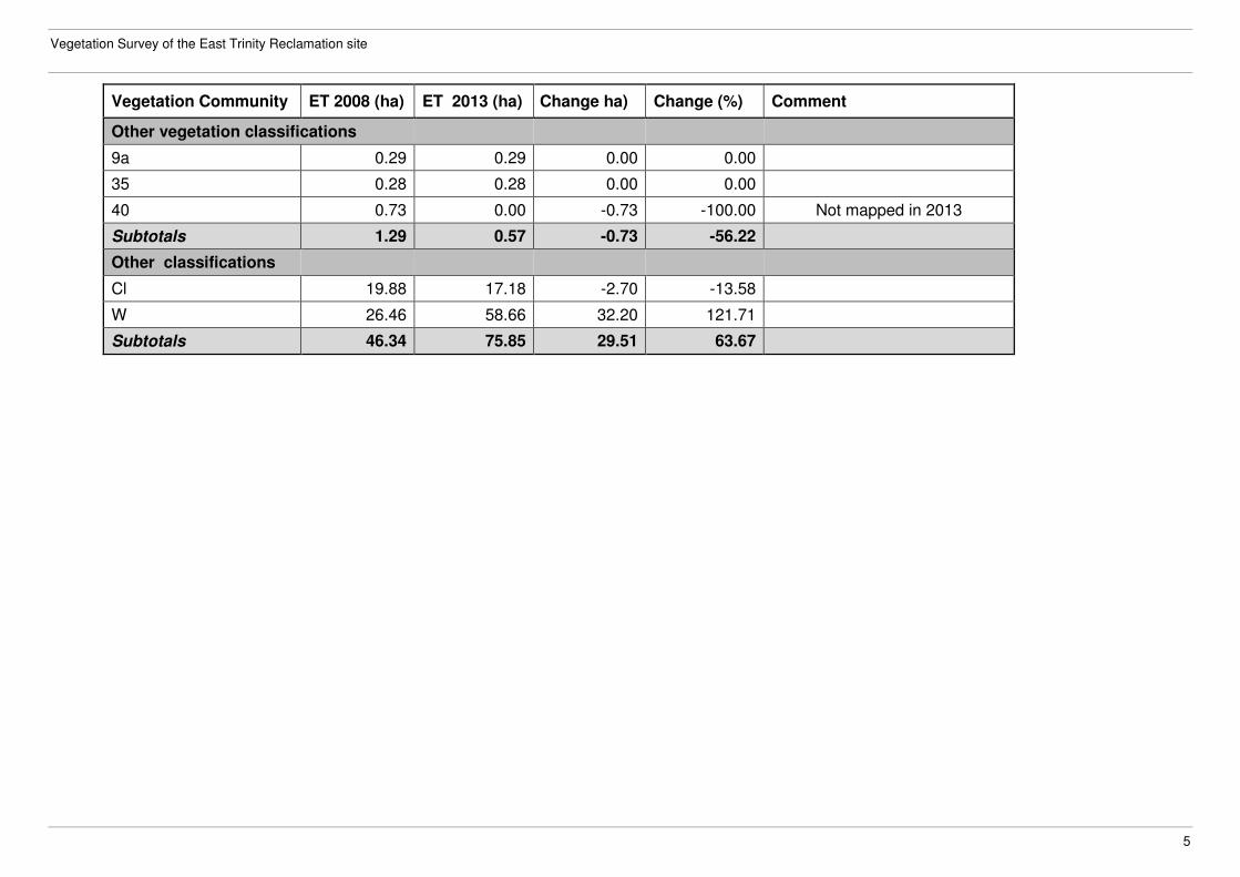
Other vegetation classifications
9a 0.29 0.29 0.00 0.00
35 0.28 0.28 0.00 0.00
40 0.73 0.00 -0.73 -100.00 Not mapped in 2013
Subtotals 1.29 0.57 -0.73 -56.22
Other classifications
Cl 19.88 17.18 -2.70 -13.58
W 26.46 58.66 32.20 121.71
Subtotals 46.34 75.85 29.51 63.67
Vegetation Survey of the East Trinity Reclamation site
1
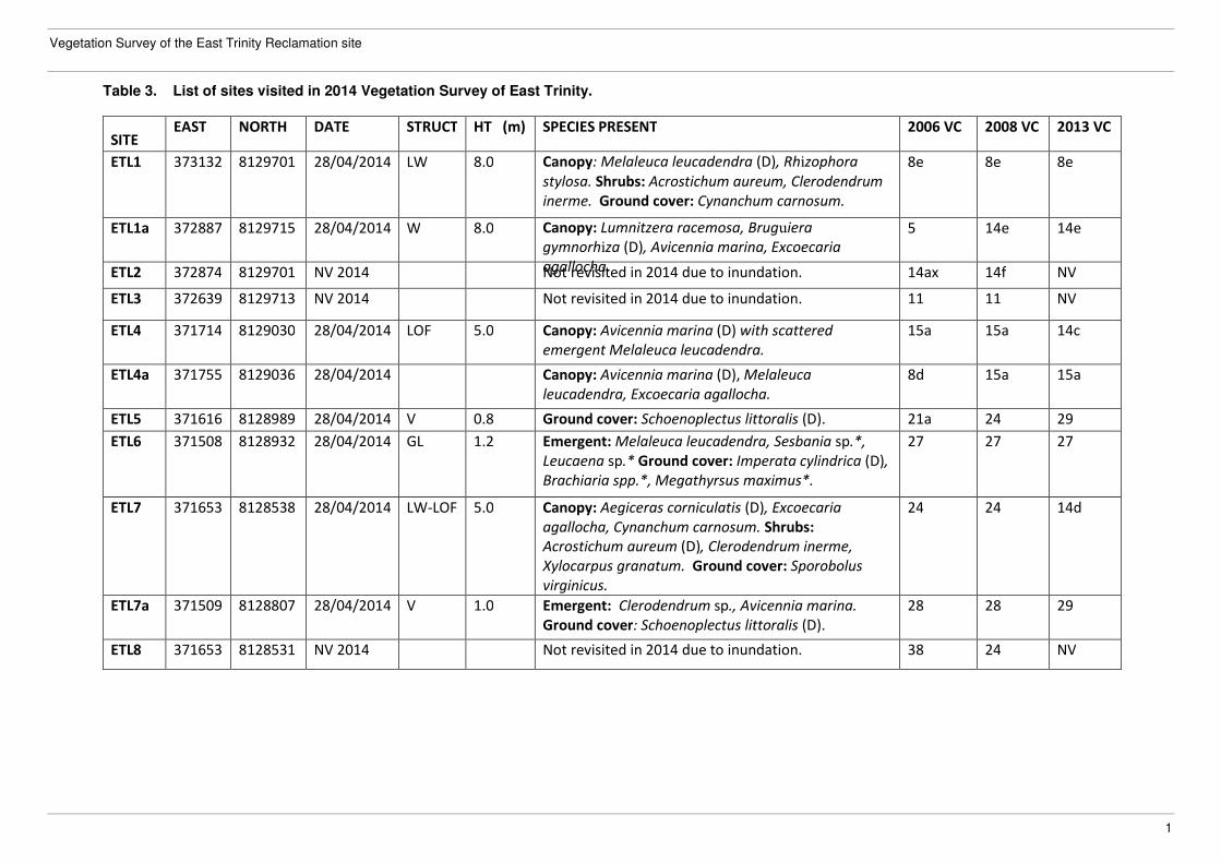
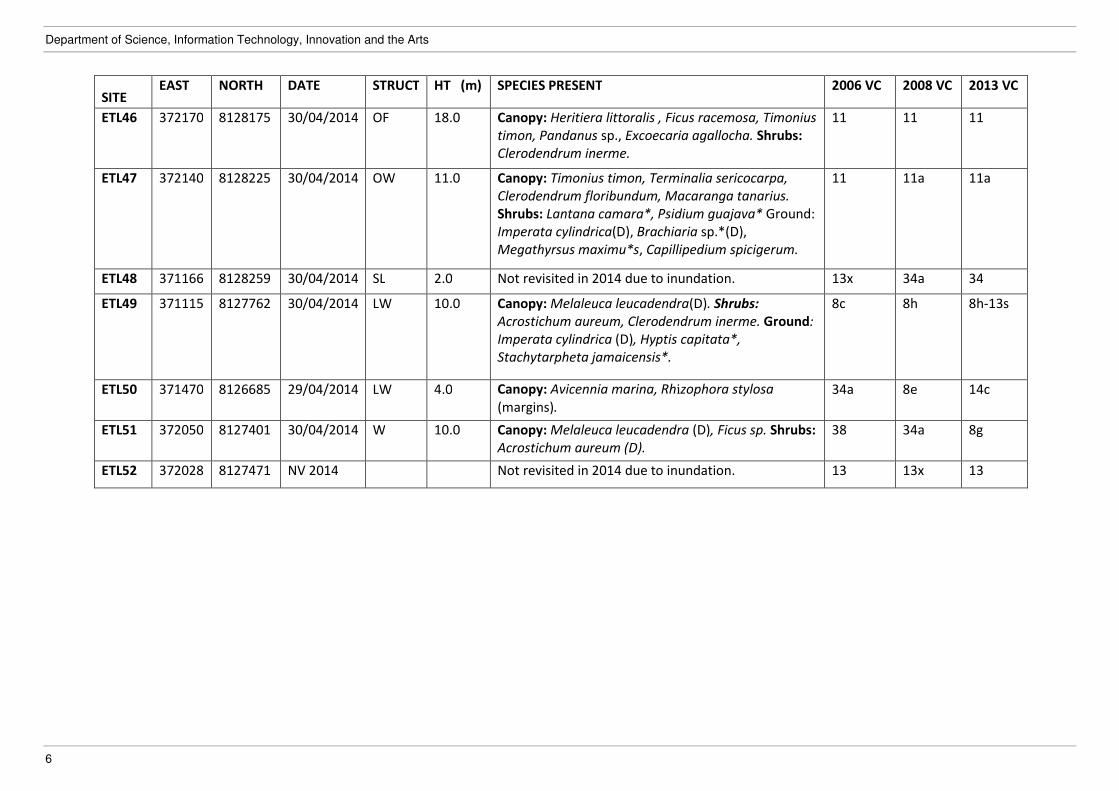
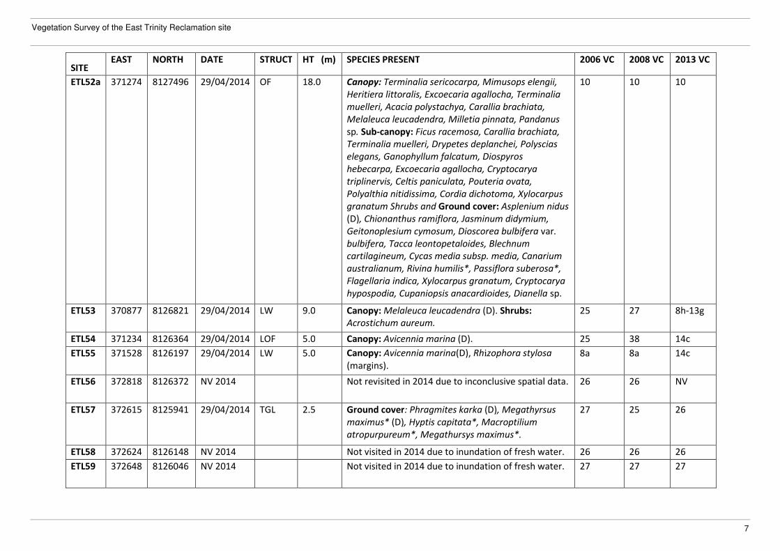
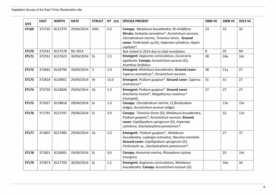
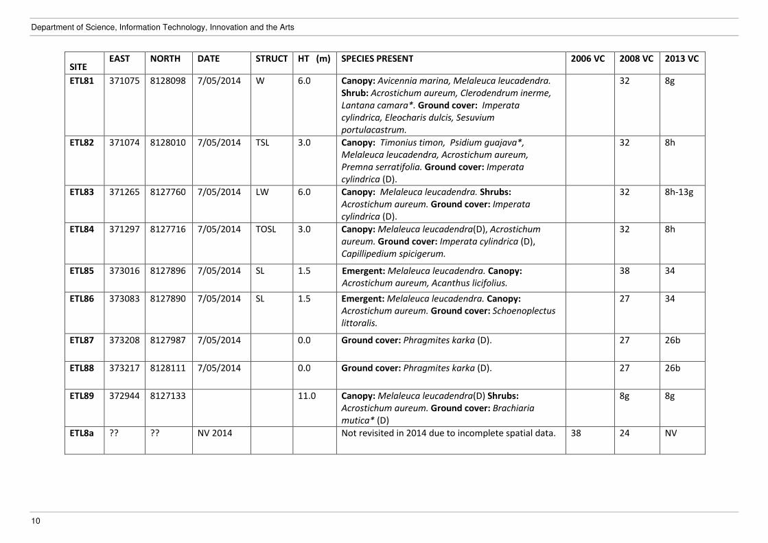
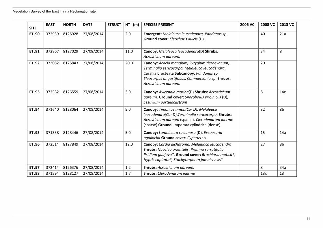
Table 3. List of sites visited in 2014 Vegetation Survey of East Trinity.
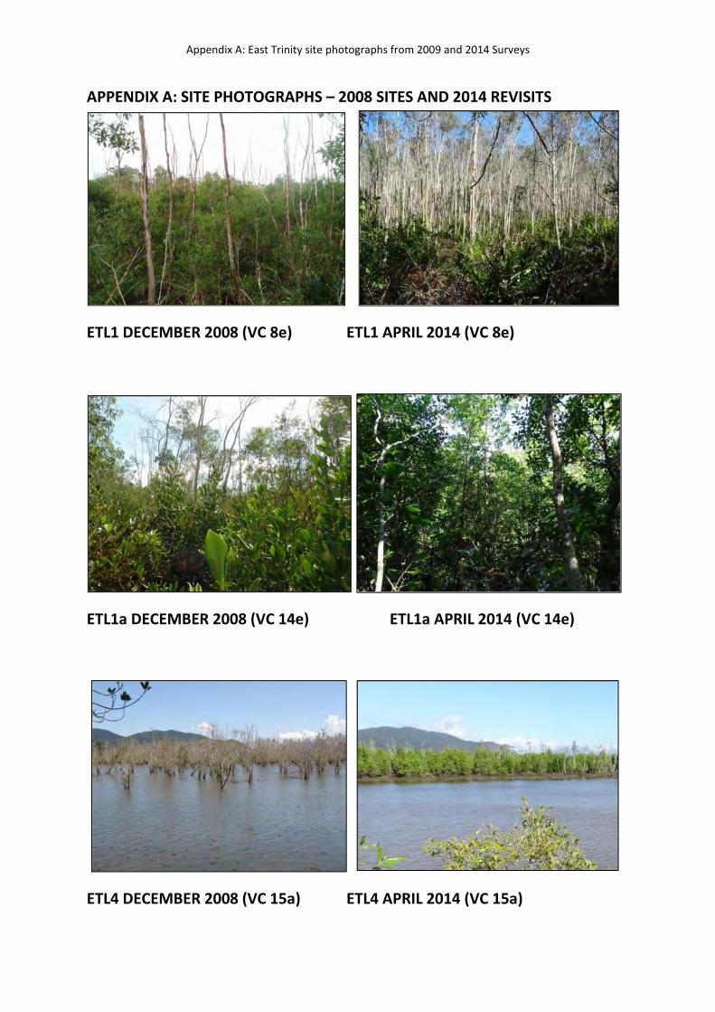
SITE EAST NORTH DATE STRUCT HT (m) SPECIES PRESENT 2006 VC 2008 VC 2013 VC
ETL1 373132 8129701 28/04/2014 LW 8.0 Canopy: Melaleuca leucadendra (D), Rhizophora
stylosa. Shrubs: Acrostichum aureum, Clerodendrum
inerme. Ground cover: Cynanchum carnosum.
8e 8e 8e
ETL1a 372887 8129715 28/04/2014 W 8.0 Canopy: Lumnitzera racemosa, Bruguiera
gymnorhiza (D), Avicennia marina, Excoecaria
agallocha.
5 14e 14e
ETL2 372874 8129701 NV 2014 Not revisited in 2014 due to inundation. 14ax 14f NV
ETL3 372639 8129713 NV 2014 Not revisited in 2014 due to inundation. 11 11 NV
ETL4 371714 8129030 28/04/2014 LOF 5.0 Canopy: Avicennia marina (D) with scattered
emergent Melaleuca leucadendra.
15a 15a 14c
ETL4a 371755 8129036 28/04/2014 Canopy: Avicennia marina (D), Melaleuca
leucadendra, Excoecaria agallocha.
8d 15a 15a
ETL5 371616 8128989 28/04/2014 V 0.8 Ground cover: Schoenoplectus littoralis (D). 21a 24 29
ETL6 371508 8128932 28/04/2014 GL 1.2 Emergent: Melaleuca leucadendra, Sesbania sp.*,
Leucaena sp.* Ground cover: Imperata cylindrica (D),
Brachiaria spp.*, Megathyrsus maximus*.
27 27 27
ETL7 371653 8128538 28/04/2014 LW-LOF 5.0 Canopy: Aegiceras corniculatis (D), Excoecaria
agallocha, Cynanchum carnosum. Shrubs:
Acrostichum aureum (D), Clerodendrum inerme,
Xylocarpus granatum. Ground cover: Sporobolus
virginicus.
24 24 14d
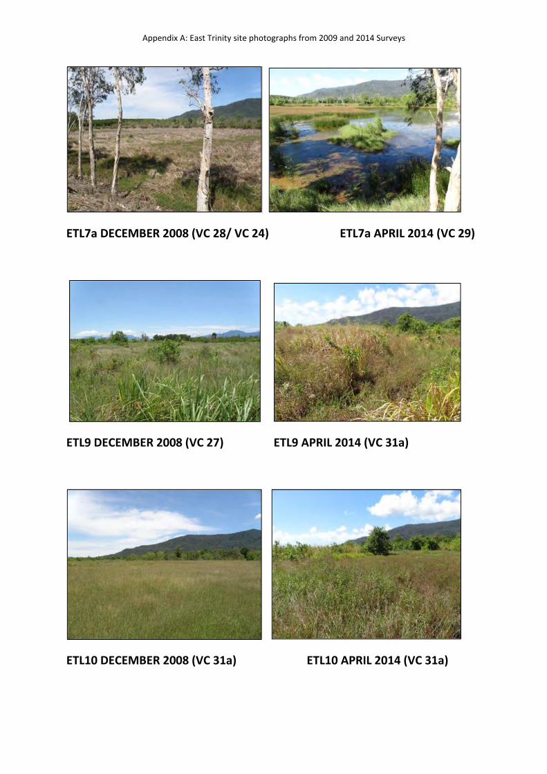
ETL7a 371509 8128807 28/04/2014 V 1.0 Emergent: Clerodendrum sp., Avicennia marina.
Ground cover: Schoenoplectus littoralis (D).
28 28 29
ETL8 371653 8128531 NV 2014 Not revisited in 2014 due to inundation. 38 24 NV
Department of Science, Information Technology, Innovation and the Arts
2
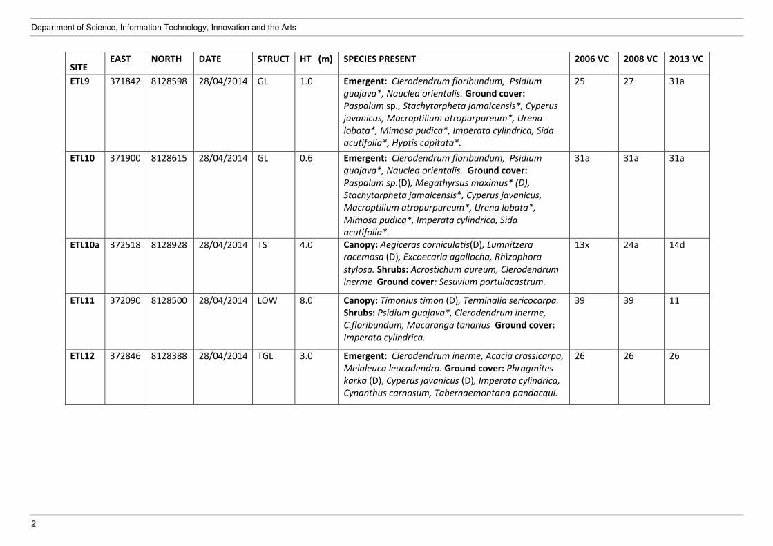
SITE EAST NORTH DATE STRUCT HT (m) SPECIES PRESENT 2006 VC 2008 VC 2013 VC
ETL9 371842 8128598 28/04/2014 GL 1.0 Emergent: Clerodendrum floribundum, Psidium
guajava*, Nauclea orientalis. Ground cover:
Paspalum sp., Stachytarpheta jamaicensis*, Cyperus
javanicus, Macroptilium atropurpureum*, Urena
lobata*, Mimosa pudica*, Imperata cylindrica, Sida
acutifolia*, Hyptis capitata*.
25 27 31a
ETL10 371900 8128615 28/04/2014 GL 0.6 31a 31a 31a
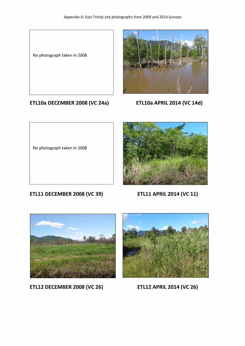
ETL10a 372518 8128928 28/04/2014 TS 4.0
Emergent: Clerodendrum floribundum, Psidium
guajava*, Nauclea orientalis. Ground cover:
Paspalum sp.(D), Megathyrsus maximus* (D),
Stachytarpheta jamaicensis*, Cyperus javanicus,
Macroptilium atropurpureum*, Urena lobata*,
Mimosa pudica*, Imperata cylindrica, Sida
acutifolia*.
Canopy: Aegiceras corniculatis(D), Lumnitzera
racemosa (D), Excoecaria agallocha, Rhizophora
stylosa. Shrubs: Acrostichum aureum, Clerodendrum
inerme Ground cover: Sesuvium portulacastrum.
13x 24a 14d
ETL11 372090 8128500 28/04/2014 LOW 8.0 Canopy: Timonius timon (D), Terminalia sericocarpa.
Shrubs: Psidium guajava*, Clerodendrum inerme,
C.floribundum, Macaranga tanarius Ground cover:
Imperata cylindrica.
39 39 11
ETL12 372846 8128388 28/04/2014 TGL 3.0 Emergent: Clerodendrum inerme, Acacia crassicarpa,
Melaleuca leucadendra. Ground cover: Phragmites
karka (D), Cyperus javanicus (D), Imperata cylindrica,
Cynanthus carnosum, Tabernaemontana pandacqui.
26 26 26

Vegetation Survey of the East Trinity Reclamation site
3
SITE EAST NORTH DATE STRUCT HT (m) SPECIES PRESENT 2006 VC 2008 VC 2013 VC
ETL13 372979 8128454 28/04/2014 OF 16.0 Canopy: Corymbia tessellaris (D), C.intermedia,
Acacia flavescens. Sub-canopy: Canarium
australianum, Pandanus sp., Polyscias elegans,
Terminalia sericocarpa, Brucea javanica. Shrubs:
Mallotus sp., Sterculia quadrifida, Alyxia spicata,
Tabernaemontana pandacaqui, Timonius timon,
Flagellaria indica Ground cover: Dianella sp.
4b 4b 4b
ETL14 373408 8128269 28/04/2014 TGL 1.7 Emergent: Nauclea orientalis, Terminalia sericocarpa,
Psidium guajava*. Ground cover: Phragmites karka
(D), Cyperus polycarpa, Brachiaria mutica*, Mimosa
pudica*, Senna obtusifolia*, Stachytarpheta
jamaicensis*, Urena lobata*, Macroptilium
atropurpureum*.
27 27 26
ETL14a 372699 8128377 28/04/2014 LW 5.0 Canopy: Avicennia marina, Excoecaria agallocha
Shrubs: Lumnitzera racemosa, Acanthus ilicifolius.
8d 24a 14d
ETL16 373280 8127668 30/04/2014 SL 4.0 Canopy: Aegiceras corniculatum (D), Lumnitzera
racemosa. Shrubs: Acanthus ilicifolius, Acrostichum
aureum.
38 14d 14d
ETL17 372602 8128042 30/04/2014 GL 0.7 Emergent: Melaleuca leucadendra, Psidium
guajava*, Acrosticum aureum, Acanthus ilicifolius.
Ground cover: Sporobulus jacquemontii* (D),
Capillipedium spicigerum, Brachiaria sp.*.
23 27 27
ETL18 371424 8128436 30/04/2014 GL 1.0 Emergent: Melaleuca leucadendra, Psidium
guajava.* Ground cover: Brachiaria mutica* (D),
Megathyrsus maximus*, Ipmerata cylindrica,
Fimbristylis ferruginea, Acrostichum aureum.
33 33 33
ETL18a ?? ?? NV 2014 Not revisited in 2014 due to incomplete spatial data. 13x 24a NV
ETL19 371055 8128127 28/04/2014 LW 6.0 Canopy: Melaleuca leucadendra (D), Clerodendrum
floribundum. Shrubs: Acrostichum aureum.
8b 8g 8g
Department of Science, Information Technology, Innovation and the Arts
4
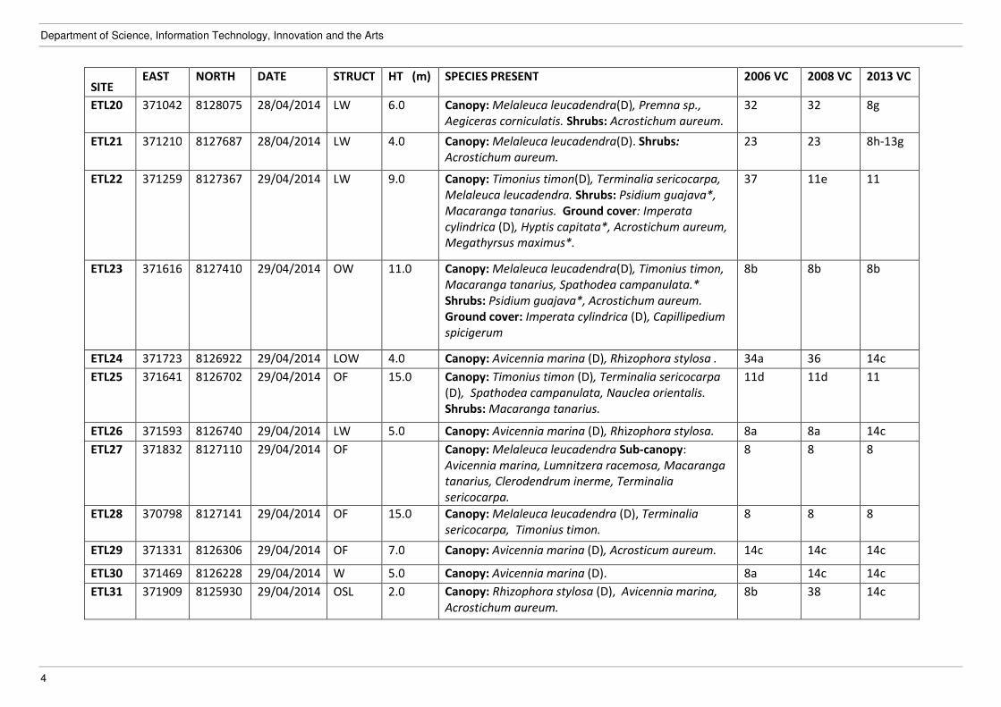
SITE EAST NORTH DATE STRUCT HT (m) SPECIES PRESENT 2006 VC 2008 VC 2013 VC
ETL20 371042 8128075 28/04/2014 LW 6.0 Canopy: Melaleuca leucadendra(D), Premna sp.,
Aegiceras corniculatis. Shrubs: Acrostichum aureum.
32 32 8g
ETL21 371210 8127687 28/04/2014 LW 4.0 Canopy: Melaleuca leucadendra(D). Shrubs:
Acrostichum aureum.
23 23 8h-13g
ETL22 371259 8127367 29/04/2014 LW 9.0 Canopy: Timonius timon(D), Terminalia sericocarpa,
Melaleuca leucadendra. Shrubs: Psidium guajava*,
Macaranga tanarius. Ground cover: Imperata
cylindrica (D), Hyptis capitata*, Acrostichum aureum,
Megathyrsus maximus*.
37 11e 11
ETL23 371616 8127410 29/04/2014 OW 11.0 Canopy: Melaleuca leucadendra(D), Timonius timon,
Macaranga tanarius, Spathodea campanulata.*
Shrubs: Psidium guajava*, Acrostichum aureum.
Ground cover: Imperata cylindrica (D), Capillipedium
spicigerum
8b 8b 8b
ETL24 371723 8126922 29/04/2014 LOW 4.0 Canopy: Avicennia marina (D), Rhizophora stylosa . 34a 36 14c
ETL25 371641 8126702 29/04/2014 OF 15.0 Canopy: Timonius timon (D), Terminalia sericocarpa
(D), Spathodea campanulata, Nauclea orientalis.
Shrubs: Macaranga tanarius.
11d 11d 11
ETL26 371593 8126740 29/04/2014 LW 5.0 Canopy: Avicennia marina (D), Rhizophora stylosa. 8a 8a 14c
ETL27 371832 8127110 29/04/2014 OF Canopy: Melaleuca leucadendra Sub-canopy:
Avicennia marina, Lumnitzera racemosa, Macaranga
tanarius, Clerodendrum inerme, Terminalia
sericocarpa.
8 8 8
ETL28 370798 8127141 29/04/2014 OF 15.0 Canopy: Melaleuca leucadendra (D), Terminalia
sericocarpa, Timonius timon.
8 8 8
ETL29 371331 8126306 29/04/2014 OF 7.0 Canopy: Avicennia marina (D), Acrosticum aureum. 14c 14c 14c
ETL30 371469 8126228 29/04/2014 W 5.0 Canopy: Avicennia marina (D). 8a 14c 14c
ETL31 371909 8125930 29/04/2014 OSL 2.0 Canopy: Rhizophora stylosa (D), Avicennia marina,
Acrostichum aureum.
8b 38 14c
Vegetation Survey of the East Trinity Reclamation site
5
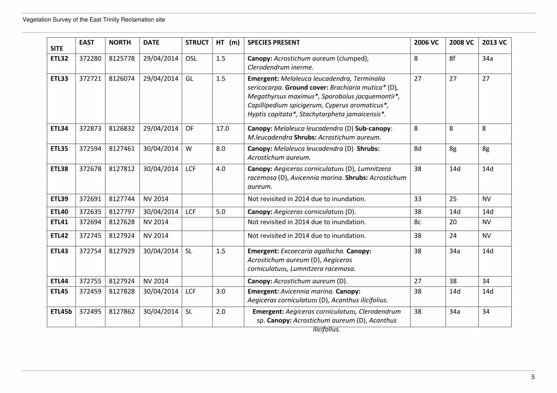
SITE EAST NORTH DATE STRUCT HT (m) SPECIES PRESENT 2006 VC 2008 VC 2013 VC
ETL32 372280 8125778 29/04/2014 OSL 1.5 Canopy: Acrostichum aureum (clumped),
Clerodendrum inerme.
8 8f 34a
ETL33 372721 8126074 29/04/2014 GL 1.5 Emergent: Melaleuca leucadendra, Terminalia
sericocarpa. Ground cover: Brachiaria mutica* (D),
Megathyrsus maximus*, Sporobolus jacquemontii*,
Capillipedium spicigerum, Cyperus aromaticus*,
Hyptis capitata*, Stachytarpheta jamaicensis*.
27 27 27
ETL34 372873 8126832 29/04/2014 OF 17.0 Canopy: Melaleuca leucadendra (D) Sub-canopy:
M.leucadendra Shrubs: Acrostichum aureum.
8 8 8
ETL35 372594 8127461 30/04/2014 W 8.0 Canopy: Melaleuca leucadendra (D) Shrubs:
Acrostichum aureum.
8d 8g 8g
ETL38 372678 8127812 30/04/2014 LCF 4.0 Canopy: Aegiceras corniculatum (D), Lumnitzera
racemosa (D), Avicennia marina. Shrubs: Acrostichum
aureum.
38 14d 14d
ETL39 372691 8127744 NV 2014 Not revisited in 2014 due to inundation. 33 25 NV
ETL40 372635 8127797 30/04/2014 LCF 5.0 Canopy: Aegiceras corniculatum (D). 38 14d 14d
ETL41 372694 8127628 NV 2014 Not revisited in 2014 due to inundation. 8c 20 NV
ETL42 372745 8127924 NV 2014 Not revisited in 2014 due to inundation. 38 24 NV
ETL43 372754 8127929 30/04/2014 SL 1.5 Emergent: Excoecaria agallocha. Canopy:
Acrostichum aureum (D), Aegiceras
corniculatum, Lumnitzera racemosa.
38 34a 14d
ETL44 372755 8127924 NV 2014 Canopy: Acrostichum aureum (D). 27 38 34
ETL45 372459 8127828 30/04/2014 LCF 3.0 Emergent: Avicennia marina. Canopy:
Aegiceras corniculatum (D), Acanthus ilicifolius.
38 14d 14d
ETL45b 372495 8127862 30/04/2014 SL 2.0 Emergent: Aegiceras corniculatum, Clerodendrum
sp. Canopy: Acrostichum aureum (D), Acanthus
ilicifolius.
38 34a 34
Department of Science, Information Technology, Innovation and the Arts
6
SITE EAST NORTH DATE STRUCT HT (m) SPECIES PRESENT 2006 VC 2008 VC 2013 VC
ETL46 372170 8128175 30/04/2014 OF 18.0 Canopy: Heritiera littoralis , Ficus racemosa, Timonius
timon, Pandanus sp., Excoecaria agallocha. Shrubs:
Clerodendrum inerme.
11 11 11
ETL47 372140 8128225 30/04/2014 OW 11.0 Canopy: Timonius timon, Terminalia sericocarpa,
Clerodendrum floribundum, Macaranga tanarius.
Shrubs: Lantana camara*, Psidium guajava* Ground:
Imperata cylindrica(D), Brachiaria sp.*(D),
Megathyrsus maximu*s, Capillipedium spicigerum.
11 11a 11a
ETL48 371166 8128259 30/04/2014 SL 2.0 Not revisited in 2014 due to inundation. 13x 34a 34
ETL49 371115 8127762 30/04/2014 LW 10.0 Canopy: Melaleuca leucadendra(D). Shrubs:
Acrostichum aureum, Clerodendrum inerme. Ground:
Imperata cylindrica (D), Hyptis capitata*,
Stachytarpheta jamaicensis*.
8c 8h 8h-13s
ETL50 371470 8126685 29/04/2014 LW 4.0 Canopy: Avicennia marina, Rhizophora stylosa
(margins).
34a 8e 14c
ETL51 372050 8127401 30/04/2014 W 10.0 Canopy: Melaleuca leucadendra (D), Ficus sp. Shrubs:
Acrostichum aureum (D).
38 34a 8g
ETL52 372028 8127471 NV 2014 Not revisited in 2014 due to inundation. 13 13x 13
Vegetation Survey of the East Trinity Reclamation site
7
SITE EAST NORTH DATE STRUCT HT (m) SPECIES PRESENT 2006 VC 2008 VC 2013 VC
ETL52a 371274 8127496 29/04/2014 OF 18.0 Canopy: Terminalia sericocarpa, Mimusops elengii,
Heritiera littoralis, Excoecaria agallocha, Terminalia
muelleri, Acacia polystachya, Carallia brachiata,
Melaleuca leucadendra, Milletia pinnata, Pandanus
sp. Sub-canopy: Ficus racemosa, Carallia brachiata,
Terminalia muelleri, Drypetes deplanchei, Polyscias
elegans, Ganophyllum falcatum, Diospyros
hebecarpa, Excoecaria agallocha, Cryptocarya
triplinervis, Celtis paniculata, Pouteria ovata,
Polyalthia nitidissima, Cordia dichotoma, Xylocarpus
granatum Shrubs and Ground cover: Asplenium nidus
(D), Chionanthus ramiflora, Jasminum didymium,
Geitonoplesium cymosum, Dioscorea bulbifera var.
bulbifera, Tacca leontopetaloides, Blechnum
cartilagineum, Cycas media subsp. media, Canarium
australianum, Rivina humilis*, Passiflora suberosa*,
Flagellaria indica, Xylocarpus granatum, Cryptocarya
hypospodia, Cupaniopsis anacardioides, Dianella sp.
10 10 10
ETL53 370877 8126821 29/04/2014 LW 9.0 Canopy: Melaleuca leucadendra (D). Shrubs:
Acrostichum aureum.
25 27 8h-13g
ETL54 371234 8126364 29/04/2014 LOF 5.0 Canopy: Avicennia marina (D). 25 38 14c
ETL55 371528 8126197 29/04/2014 LW 5.0 Canopy: Avicennia marina(D), Rhizophora stylosa
(margins).
8a 8a 14c
ETL56 372818 8126372 NV 2014 Not revisited in 2014 due to inconclusive spatial data. 26 26 NV
ETL57 372615 8125941 29/04/2014 TGL 2.5 Ground cover: Phragmites karka (D), Megathyrsus
maximus* (D), Hyptis capitata*, Macroptilium
atropurpureum*, Megathursys maximus*.
27 25 26
ETL58 372624 8126148 NV 2014 Not visited in 2014 due to inundation of fresh water. 26 26 26
ETL59 372648 8126046 NV 2014 Not visited in 2014 due to inundation of fresh water. 27 27 27

Department of Science, Information Technology, Innovation and the Arts
8
SITE EAST NORTH DATE STRUCT HT (m) SPECIES PRESENT 2006 VC 2008 VC 2013 VC
ETL60 373469 8127655 29/04/2014 GL 1.0 Ground cover: Brachiaria mutica*, Glycine sp.*,
Sesbania cannabina*, Psidium guajava*,
Macroptilium atropurpureum*, Megathyrsus
maximus* (clumped).
33 33 33
ETL61 373413 8127661 29/04/2014 TGL 1.5 Ground cover: Phragmites karka (D), Acrostichum
aureum, Sphagneticola trilobata*.
26 26 26
ETL62 373281 8127675 29/04/2014 SL 2.0 Emergent: Brugiera sp., Lumnitzera racemosa
Canopy: Acrostichum aureum (D), Acanthus
ilicifolius, Aegiceras corniculatum.
38 29 14d
ETL63 372931 8127724 30/04/2014 GL 0.6 Emergent: Melelauca leucadendra, Terminalia
sericocarpa, Psidium guajava*, Sesbania cannabina*.
Ground cover: Capillipedium spicigerum (D), Hyptis
capitata*, Mimosa pudica*, Stachytarpheta
jamaicensis*, Ageratum houstonianum*.
27 27 27
ETL64 371631 8128323 NV 2014 Not visited in 2014 due to tidal inundation. 11x 11c NV
ETL65 371717 8128395 NV 2014 Not visited in 2014 due to tidal inundation. 38 14d NV
ETL66 371663 8128254 NV 2014 Not visited in 2014 due to tidal inundation. 13x 13x NV
ETL67 371589 8127653 NV 2014 Not visited in 2014 due to tidal inundation. 38 34a NV
ETL68 371177 8127655 30/04/2014 GL 1.0 Emergent: Melelauca leucadendra, Acrostichum
aureum, Timonius timon, Psidium guajava*, Sesbania
cannabina*. Ground cover: Imperata cylindrica (D),
Capillipedium spicigerum, Sporobolus jacquemontii*,
Stachytarpheta jamaicensis*, Ageratum
houstonianum*.
32 32 32
Vegetation Survey of the East Trinity Reclamation site
9
SITE EAST NORTH DATE STRUCT HT (m) SPECIES PRESENT 2006 VC 2008 VC 2013 VC
ETL69 371735 8127375 29/04/2014 OWL 5.0 23 32 32
ETL70 372541 8127578 NV 2014 8 20 NV
ETL71 372552 8127623 30/04/2014 SL 1.5 38 24a 14c
ETL72 372842 8126794 29/04/2014 V 1.0
Canopy: Melaleuca leucadendra, M.viridiflora.
Shrubs: Sesbania cannabina*, Acrostichum aureum,
Clerodendrum inerme, Timonius timon. Ground
cover: Fimbristylis sp.(D), Imperata cylindrica, Hyptis
capitata*.
Not visited in 2014 due to tidal inundation.
Emergent: Aegiceras corniculatum, Excoecaria
agallocha. Canopy: Acrostichum aureum (D),
Acanthus ilicifolius.
Emergent: Melelauca leucadendra. Ground cover:
Cyperus aromaticus*, Acrostichum aureum.
38 21a 27
ETL73 372819 8126851 29/04/2014 W 15.0 Emergent: Psidium guajava*. Ground cover: Cyperus
aromaticus*.
31 31 27
ETL74 372720 8126826 29/04/2014 GL 1.3 Emergent: Psidium guajava*. Ground cover:
Brachiaria mutica*, Megathyrsus maximus*
(clumped).
27 27 27
ETL75 372027 8128818 28/04/2014 SL 1.0 Canopy: Clerodendrum inerme, Cl.floridundum
(edge), Acrostichum aureum (edge).
13x 13x
ETL76 371791 8127597 29/04/2014 SL 3.0 Canopy: Timonius timon (D), Melaleuca leucadendra,
Psidium guajava*, Acrostichum aureum. Ground
cover: Capillipedium spicigerum (D), Imperata
cylindrica, Stachytarpheta jamaicensis*.
32 11e
ETL77 371807 8127485 29/04/2014 GL 1.0 Emergent: Psidium guajava*, Melaleuca
leucadendra, Ludwigia octovalvis, Nauclea orientalis.
Ground cover: Capillipedium spicigerum (D),
Fimbristylis sp., Stachytarpheta jamaicensis*.
27 37
ETL78 371821 8126001 29/04/2014 SL 3.0 Canopy: Avicennia marina, Rhizophora stylosa
(margins).
25 14c
ETL79 372873 8127703 30/04/2014 SL 1.5 Emergent: Aegiceras corniculatum, Melaleuca
leucadendra. Canopy: Acrostichum aureum (D).
34a 34
Department of Science, Information Technology, Innovation and the Arts
10
SITE EAST NORTH DATE STRUCT HT (m) SPECIES PRESENT 2006 VC 2008 VC 2013 VC
ETL81 371075 8128098 7/05/2014 W 6.0 Canopy: Avicennia marina, Melaleuca leucadendra.
Shrub: Acrostichum aureum, Clerodendrum inerme,
Lantana camara*. Ground cover: Imperata
cylindrica, Eleocharis dulcis, Sesuvium
portulacastrum.
32 8g
ETL82 371074 8128010 7/05/2014 TSL 3.0 Canopy: Timonius timon, Psidium guajava*,
Melaleuca leucadendra, Acrostichum aureum,
Premna serratifolia. Ground cover: Imperata
cylindrica (D).
32 8h
ETL83 371265 8127760 7/05/2014 LW 6.0 Canopy: Melaleuca leucadendra. Shrubs:
Acrostichum aureum. Ground cover: Imperata
cylindrica (D).
32 8h-13g
ETL84 371297 8127716 7/05/2014 TOSL 3.0 Canopy: Melaleuca leucadendra(D), Acrostichum
aureum. Ground cover: Imperata cylindrica (D),
Capillipedium spicigerum.
32 8h
ETL85 373016 8127896 7/05/2014 SL 1.5 Emergent: Melaleuca leucadendra. Canopy:
Acrostichum aureum, Acanthus licifolius.
38 34
ETL86 373083 8127890 7/05/2014 SL 1.5 Emergent: Melaleuca leucadendra. Canopy:
Acrostichum aureum. Ground cover: Schoenoplectus
littoralis.
27 34
ETL87 373208 8127987 7/05/2014 0.0 Ground cover: Phragmites karka (D). 27 26b
ETL88 373217 8128111 7/05/2014 0.0 Ground cover: Phragmites karka (D). 27 26b
ETL89 372944 8127133 11.0 Canopy: Melaleuca leucadendra(D) Shrubs:
Acrostichum aureum. Ground cover: Brachiaria
mutica* (D)
8g 8g
ETL8a ?? ?? NV 2014 Not revisited in 2014 due to incomplete spatial data. 38 24 NV
Vegetation Survey of the East Trinity Reclamation site
11
SITE EAST NORTH DATE STRUCT HT (m) SPECIES PRESENT 2006 VC 2008 VC 2013 VC
ETL90 372939 8126928 27/08/2014 2.0 Emergent: Melaleuca leucadendra, Pandanus sp.
Ground cover: Eleocharis dulcis (D).
40 21a
ETL91 372867 8127029 27/08/2014 11.0 Canopy: Melaleuca leucadendra(D) Shrubs:
Acrostichum aureum.
34 8
ETL92 373082 8126843 27/08/2014 20.0 Canopy: Acacia mangium, Syzygium tierneyanum,
Terminalia sericocarpa, Melaleuca leucadendra,
Carallia bracteata Subcanopy: Pandanus sp.,
Eleocarpus angustifolius, Commersonia sp. Shrubs:
Acrostichum aureum.
20
ETL93 372582 8126559 27/08/2014 3.0 Canopy: Avicennia marina(D) Shrubs: Acrostichum
aureum. Ground cover: Sporobolus virginicus (D),
Sesuvium portulacastrum
8 14c
ETL94 371640 8128064 27/08/2014 9.0 Canopy: Timonius timon(Co- D), Melaleuca
leucadendra(Co- D),Terminalia sericocarpa. Shrubs:
Acrostichum aureum (sparse), Clerodendrum inerme
(sparse) Ground: Imperata cylindrica (dense).
32 8b
ETL95 371338 8128446 27/08/2014 5.0 Canopy: Lumnitzera racemosa (D), Excoecaria
agollocha Ground cover: Cyperus sp.
15 14a
ETL96 372514 8127849 27/08/2014 12.0 Canopy: Cordia dichotoma, Melaluaca leucadendra
Shrubs: Nauclea orientalis, Premna serratifolia,
Psidium guajava*. Ground cover: Brachiaria mutica*,
Hyptis capitata*, Stachytarpheta jamaicensis*
27 8b
ETL97 372414 8126376 27/08/2014 1.2 Shrubs: Acrostichum aureum. 8 34a
ETL98 371594 8128127 27/08/2014 1.7 Shrubs: Clerodendrum inerme 13x 13
!(!(!(!(
!( !(
!(
!(
!(
!(
!(
!(!(
!(
!(
!(
!(
!(
!(
!(
!(
!(
!(
!(
!(
!(
!(
!(
!(!(
!(!(
!(
!(
!(
!(
!(
!(
!(
!(
!(
!(
!(
!(!(!(
!(!(
!(
!(!(
!(
!(
!(
!(!(
!(
!(
!(
!(
!(
!(
!(
!(!(!(
!(
!(
!(
!(
!(!(
!(
!(
!(
!(
!(!(
!(
!(
!(
!(
!(
!(
!(
!(
!(
!( !(
!(
!(
!(
!(
!(
!(
!(
!(
!(
!(
!(
!(
!(
!(
!(
!(
!(
!(
!(
ETL9ETL8ETL7
ETL6ETL5
ETL4
ETL3 ETL2 ETL1
ETL98
ETL97
ETL96
ETL95
ETL94
ETL93
ETL92
ETL91
ETL90
ETL89
ETL88
ETL87
ETL86ETL85
ETL84ETL83
ETL82ETL81
ETL79
ETL78
ETL77
ETL76
ETL75
ETL74ETL73
ETL72
ETL71ETL70
ETL69
ETL68 ETL67
ETL66
ETL65ETL64
ETL63 ETL62 ETL61ETL60
ETL59
ETL58
ETL57
ETL56
ETL55
ETL54
ETL53
ETL52ETL51
ETL50
ETL49
ETL48ETL47
ETL46
ETL45
ETL44ETL43ETL42
ETL41
ETL40ETL39ETL38
ETL35
ETL34
ETL33
ETL32
ETL31
ETL30ETL29
ETL28ETL27
ETL26ETL25
ETL24
ETL23ETL22
ETL20ETL19
ETL18
ETL17
ETL16
ETL14
ETL13ETL12
ETL11ETL10
ETL7a
ETL4a
ETL1a
ETL52a
ETL14a
ETL10a
Lime Shed
Main Entrance Gate
Hills Creek Floodgate
Firewood Creek Floodgate
Hills Creek Upper Crossing
New Firewood Creek Floodgate
Firewood Creek Treatment Site
DISCLAIMERBased on and contains data provided with the permission of the Department of Natural Resources and Mines, Queensland, GeoScience Australia and PitneyBowes MapInfo. The Queensland Government gives no warranty in relationto the data (including accuracy, reliability, completeness or suitability) and accepts no liability (including without limitation, liability in negligence) for any loss, damage or costs (including consequential damage) relating to any use of the data. Data must not be used for direct marketing or be used in breach of privacy laws.Copyright protects this publication. Except for purposes permitted by the Copyright Act, reproduction by whatever means is prohibited without the prior written permission of the Department of Science, Information Technology, Innovation and the Arts.
0 250 500 750 1000125Meters
¥
© The State of Queensland (Department of Science, Information Technology, Innovation and the Arts) 2014
Base layer imagery: Digital Ortho-rectified Aerial Photography (2013 )Spatial resolution: 10cm
Map 1 : Study Sites and Localities of the East Trinity Reclamation Site
Source: Newton M., Bannink P. & Addicott E. (2014) Survey Scale: 1:10,000
Trinity Inlet Kamma Creek Road
levee
MagazineFirewood
Stafford Point
levee
TrinityInlet
Hills Creek
GeorgeCoastal
Mangroves
Coastal
Mangroves
CoastalMangrovesCoastal
Mangroves
levee
levee
leveeCreek
Creek
Creek
Cairns CBD( ~ 800 m)
W
1
27
27
8
8
3
8
1
W27
8
16
8
8
14a
4
34a
8
W
8
8
27
8
34
14c
34
8
8
26
34a
W
32
14c
13x
8
W
16
8h
8e
31a
8b
34
37
8c
8b
8
31
8h
32
10
11
5
16
9
8
26
11
27
8e
8b
34a
23
14e
32
8b
24a
27
14f
31a
13
15a
11
26
34
24
9
8f-09
27
32
26a
8b
32
8b
34
14d
14c
14d
8b
14c
14a
8
31a
24
8h
26
27
29
31
11a
14d
27
34a
9
8b
33 34
11
27
8g
27
8f-09
8b
11
8g
34
8
26b
8h
14d
8h
34a
26
11d
4
8g
8g
8
16
26b
32
8b
8b
14d
8b
11
8-13g
4b
26
26
14d
12
32
14d
32
3431
34
24
38
13
14a
24
33
11
14a
34a
8h
32
11
33
12
14d
8h
8h
8g
14a
34a
26b
11e
8b
8b
24
8g
34
8b
8c
38
38
8h
25
8c
34
32
11
11
3433
11
38
25
8b
8-13g
8b
8b
11c
11c
26b8g
14d
6
8g
9
8g
26b
2
8f
34a14d
11
8h
8b
8g
20
24
8c
34
32
21w
8b
38
23
8g
24
11
12
Cl
Cl
8
24a
14c
8-13g
38
8g
34a
24
8g
26
34
8f-09
8b
8b
26b
14a
8h
8f-09
34a
8g
13x 2
34a
13x
8h
14e
14d
33
14c
34
24
11
14c
8-13g
34
34
14d
33
26b
13
8b
8f-09
9
34
8h
13
8g
8-13g
34
8f-09
32
32
21a
14c
8g
34
8f-09
14c
8-13g
11c
24 8c
26
14d
14d
34
4a
24
8-13g8-13s
8f-09
34
14d
14c
8f-09
14c
8-13g
13x
8-13g
24
34
1326
11e
13x
8f-09
35
34
14c
23
24
34
8h
8h
14d 24
13
25
34
8-13g
24
8-13s
13
8g
8g
25
3838
32
8h8g
8-13s14d
33
24
32
14d
14d
11
9a
8f-09
20
20
14d
8b
8-13s
14d
8g
37
21a
8b
11d
24
7
33
8-13g
33
14d
14d
21w
24
14d
11
13
15a
11a
14d
24a
11
24
13
14d
24
8f-09
11d
11a
11a
8-13g
24
33
8-13g
24
38
14d
33
8g
26b
8f-09
8g
25
8-13g
8g
13
8-13g
8-13s
8-13g
8f-09
8-13g
8g
24
8-13g
1325
24
11e14d
8-13g
8-13g
38
6
8-13s
8-13s
8-13g
8g
33
33
38
8-13g
8-13g
8g
8-13g
8g
8-13s
25
25
8-13s
8-13s
17
8-13s
25
8-13g
8-13s
12
8-13g
8-13g
9a
8-13s
11e
2521w
21a
17
8-13s
8-13s
8-13s
21a
11c 21a
17
17
21a
17
21w
17
DISCLAIMERBased on and contains data provided with the permission of the Department of Natural Resources and Mines, Queensland, GeoScience Australia and PitneyBowes MapInfo. The Queensland Government gives no warranty in relationto the data (including accuracy, reliability, completeness or suitability) and accepts no liability (including without limitation, liability in negligence) for any loss, damage or costs (including consequential damage) relating to any use of the data. Data must not be used for direct marketing or be used in breach of privacy laws.Copyright protects this publication. Except for purposes permitted by the Copyright Act, reproduction by whatever means is prohibited without the prior written permission of the Department of Science, Information Technology, Innovation and the Arts.
0 250 500 750 1000125Meters
Map Scale =
¥
1:14,000© The State of Queensland (Department of Science, Information Technology, Innovation and the Arts) 2014
Base layer imagery: Digital Ortho-rectified Aerial Photography (2013 )Spatial resolution: 10cm
Map2 : Vegetation Communities East Trinity Reclamation Site
Source: Newton M., Bannink P. & Addicott E. (2014) Survey Scale: 1:10,000
Trinity Inlet Kamma Creek Road
levee
MagazineFirewood
Stafford Point
levee
TrinityInlet
Hills Creek
GeorgeCoastal
Mangroves
Coastal
Mangroves
CoastalMangrovesCoastal
Mangroves
levee
levee
leveeCoastal Mangroves
Creek
Creek
Creek
Cairns CBD( ~ 800 m)
Appendix A: East Trinity site photographs from 2009 and 2014 Surveys
APPENDIX A: SITE PHOTOGRAPHS – 2008 SITES AND 2014 REVISITS
ETL1 DECEMBER 2008 (VC 8e) ETL1 APRIL 2014 (VC 8e)
ETL1a DECEMBER 2008 (VC 14e) ETL1a APRIL 2014 (VC 14e)
ETL4 DECEMBER 2008 (VC 15a) ETL4 APRIL 2014 (VC 15a)

Appendix A: East Trinity site photographs from 2009 and 2014 Surveys
ETL5 DECEMBER 2008 (VC 24) ETL5 APRIL 2014 (VC 29)
ETL6 DECEMBER 2008 (VC 27) ETL6 APRIL 2014 (VC 27)
ETL7 DECEMBER 2008 (VC 24) ETL7 APRIL 2014 (VC 14d)
Appendix A: East Trinity site photographs from 2009 and 2014 Surveys
ETL7a DECEMBER 2008 (VC 28/ VC 24) ETL7a APRIL 2014 (VC 29)
ETL9 DECEMBER 2008 (VC 27) ETL9 APRIL 2014 (VC 31a)
ETL10 DECEMBER 2008 (VC 31a) ETL10 APRIL 2014 (VC 31a)
Appendix A: East Trinity site photographs from 2009 and 2014 Surveys
ETL10a DECEMBER 2008 (VC 24a) ETL10a APRIL 2014 (VC 14d)
ETL11 DECEMBER 2008 (VC 39) ETL11 APRIL 2014 (VC 11)
ETL12 DECEMBER 2008 (VC 26) ETL12 APRIL 2014 (VC 26)
No photograph taken in 2008
No photograph taken in 2008

Appendix A: East Trinity site photographs from 2009 and 2014 Surveys
ETL13 DECEMBER 2008 (VC 4b) ETL13 APRIL 2014 (VC 4b)
ETL14 DECEMBER 2008 (VC 27) ETL14 APRIL 2014 (VC 26)
ETL14a DECEMBER 2008 (VC 24a) ETL14 APRIL 2014 (VC 14d)
No photograph taken in 2008
Appendix A: East Trinity site photographs from 2009 and 2014 Surveys
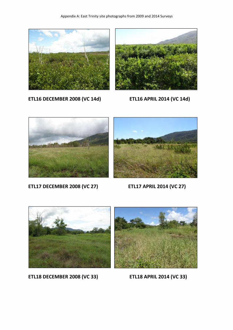
ETL16 DECEMBER 2008 (VC 14d) ETL16 APRIL 2014 (VC 14d)
ETL17 DECEMBER 2008 (VC 27) ETL17 APRIL 2014 (VC 27)
ETL18 DECEMBER 2008 (VC 33) ETL18 APRIL 2014 (VC 33)
Appendix A: East Trinity site photographs from 2009 and 2014 Surveys
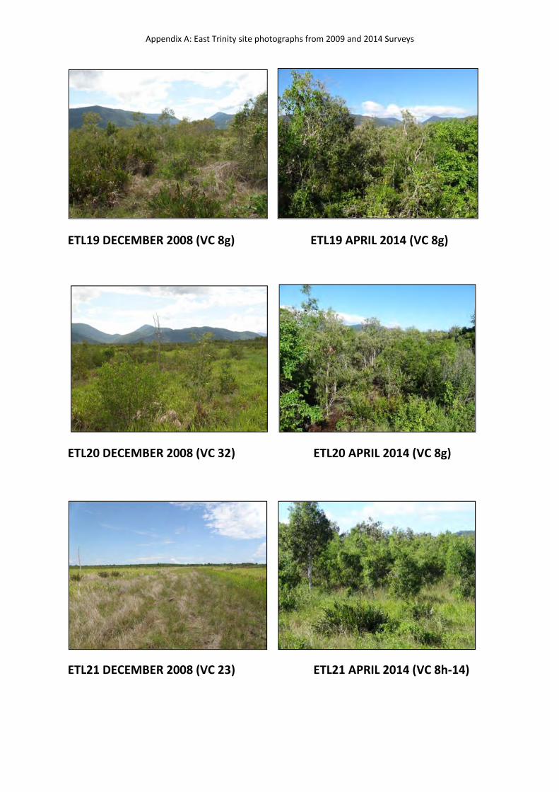
ETL19 DECEMBER 2008 (VC 8g) ETL19 APRIL 2014 (VC 8g)
ETL20 DECEMBER 2008 (VC 32) ETL20 APRIL 2014 (VC 8g)
ETL21 DECEMBER 2008 (VC 23) ETL21 APRIL 2014 (VC 8h-14)
Appendix A: East Trinity site photographs from 2009 and 2014 Surveys
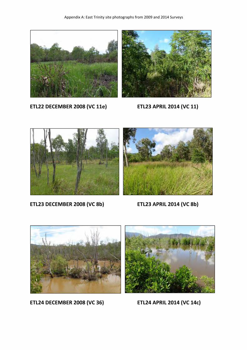
ETL22 DECEMBER 2008 (VC 11e) ETL23 APRIL 2014 (VC 11)
ETL23 DECEMBER 2008 (VC 8b) ETL23 APRIL 2014 (VC 8b)
ETL24 DECEMBER 2008 (VC 36) ETL24 APRIL 2014 (VC 14c)
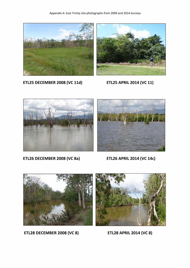
Appendix A: East Trinity site photographs from 2009 and 2014 Surveys
ETL25 DECEMBER 2008 (VC 11d) ETL25 APRIL 2014 (VC 11)
ETL26 DECEMBER 2008 (VC 8a) ETL26 APRIL 2014 (VC 14c)
ETL28 DECEMBER 2008 (VC 8) ETL28 APRIL 2014 (VC 8)
Appendix A: East Trinity site photographs from 2009 and 2014 Surveys
ETL29 DECEMBER 2008 (VC 14c) ETL29 APRIL 2014 (VC 14c)
ETL30 DECEMBER 2008 (VC 14c) ETL30 APRIL 2014 (VC 14c)
ETL31 DECEMBER 2008 (VC 38) ETL31 APRIL 2014 (VC 14c)
No photograph taken in 2008
Appendix A: East Trinity site photographs from 2009 and 2014 Surveys
ETL32 DECEMBER 2008 (VC 8f) ETL32 APRIL 2014 (VC 34)
ETL33 DECEMBER 2008 (VC 27) ETL33 APRIL 2014 (VC 27)
ETL34 DECEMBER 2008 (VC 8) ETL34 APRIL 2014 (VC 8)
Appendix A: East Trinity site photographs from 2009 and 2014 Surveys
ETL35 DECEMBER 2008 (VC 8g) ETL35 APRIL 2014 (VC 8g)
ETL38 DECEMBER 2008 (VC 14d) ETL38 APRIL 2014 (VC 14d)
ETL40 DECEMBER 2008 (VC 14d) ETL40 APRIL 2014 (VC 14d)
No photograph taken in 2008
Appendix A: East Trinity site photographs from 2009 and 2014 Surveys
ETL43 DECEMBER 2008 (VC 34a) ETL43 APRIL 2014 (VC 14d)
ETL45 DECEMBER 2008 (VC 14d) ETL45 APRIL 2014 (VC 14d)
ETL45b DECEMBER 2008 (VC 34a) ETL45b APRIL 2014 (VC 34)
No photograph taken in 2008
No photograph taken in 2008
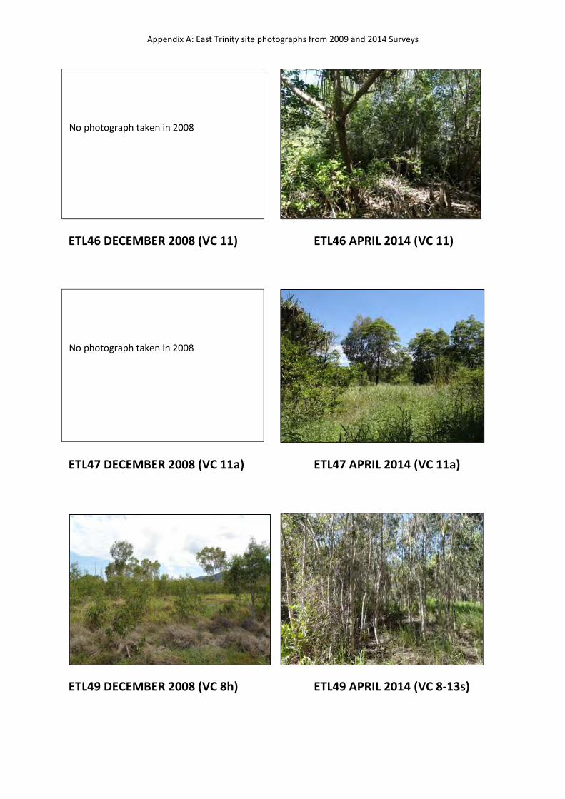
Appendix A: East Trinity site photographs from 2009 and 2014 Surveys
ETL46 DECEMBER 2008 (VC 11) ETL46 APRIL 2014 (VC 11)
ETL47 DECEMBER 2008 (VC 11a) ETL47 APRIL 2014 (VC 11a)
ETL49 DECEMBER 2008 (VC 8h) ETL49 APRIL 2014 (VC 8-13s)
No photograph taken in 2008
No photograph taken in 2008
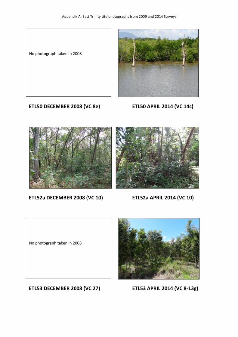
Appendix A: East Trinity site photographs from 2009 and 2014 Surveys
ETL50 DECEMBER 2008 (VC 8e) ETL50 APRIL 2014 (VC 14c)
ETL52a DECEMBER 2008 (VC 10) ETL52a APRIL 2014 (VC 10)
ETL53 DECEMBER 2008 (VC 27) ETL53 APRIL 2014 (VC 8-13g)
No photograph taken in 2008
No photograph taken in 2008
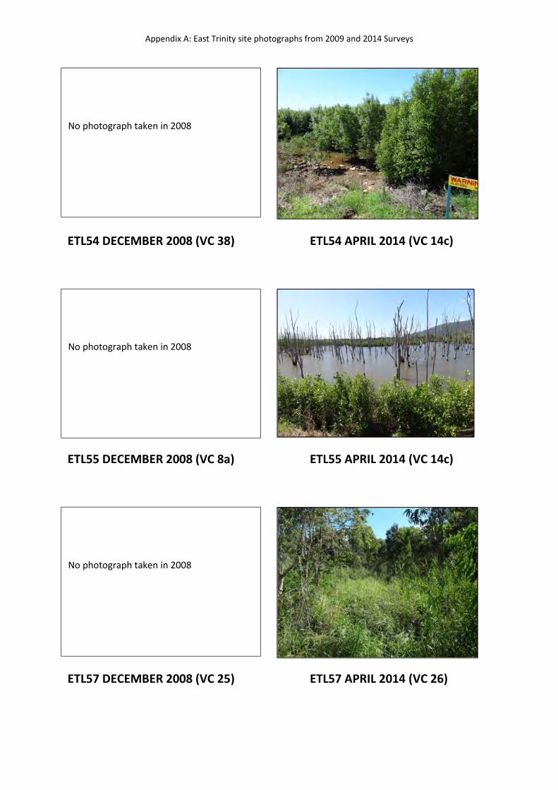
Appendix A: East Trinity site photographs from 2009 and 2014 Surveys
ETL54 DECEMBER 2008 (VC 38) ETL54 APRIL 2014 (VC 14c)
ETL55 DECEMBER 2008 (VC 8a) ETL55 APRIL 2014 (VC 14c)
ETL57 DECEMBER 2008 (VC 25) ETL57 APRIL 2014 (VC 26)
No photograph taken in 2008
No photograph taken in 2008
No photograph taken in 2008
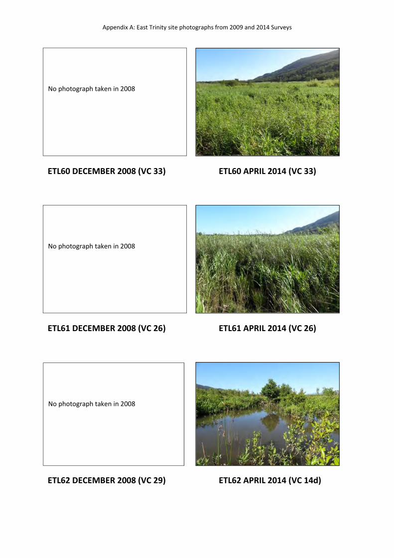
Appendix A: East Trinity site photographs from 2009 and 2014 Surveys
ETL60 DECEMBER 2008 (VC 33) ETL60 APRIL 2014 (VC 33)
ETL61 DECEMBER 2008 (VC 26) ETL61 APRIL 2014 (VC 26)
ETL62 DECEMBER 2008 (VC 29) ETL62 APRIL 2014 (VC 14d)
No photograph taken in 2008
No photograph taken in 2008
No photograph taken in 2008
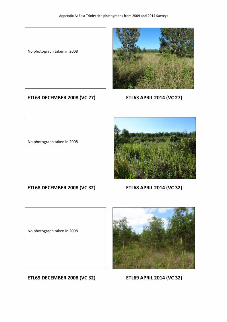
Appendix A: East Trinity site photographs from 2009 and 2014 Surveys
ETL63 DECEMBER 2008 (VC 27) ETL63 APRIL 2014 (VC 27)
ETL68 DECEMBER 2008 (VC 32) ETL68 APRIL 2014 (VC 32)
ETL69 DECEMBER 2008 (VC 32) ETL69 APRIL 2014 (VC 32)
No photograph taken in 2008
No photograph taken in 2008
No photograph taken in 2008
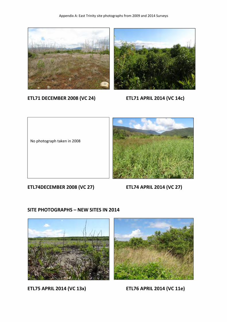
Appendix A: East Trinity site photographs from 2009 and 2014 Surveys
ETL71 DECEMBER 2008 (VC 24) ETL71 APRIL 2014 (VC 14c)
ETL74DECEMBER 2008 (VC 27) ETL74 APRIL 2014 (VC 27)
SITE PHOTOGRAPHS – NEW SITES IN 2014
ETL75 APRIL 2014 (VC 13x) ETL76 APRIL 2014 (VC 11e)
No photograph taken in 2008
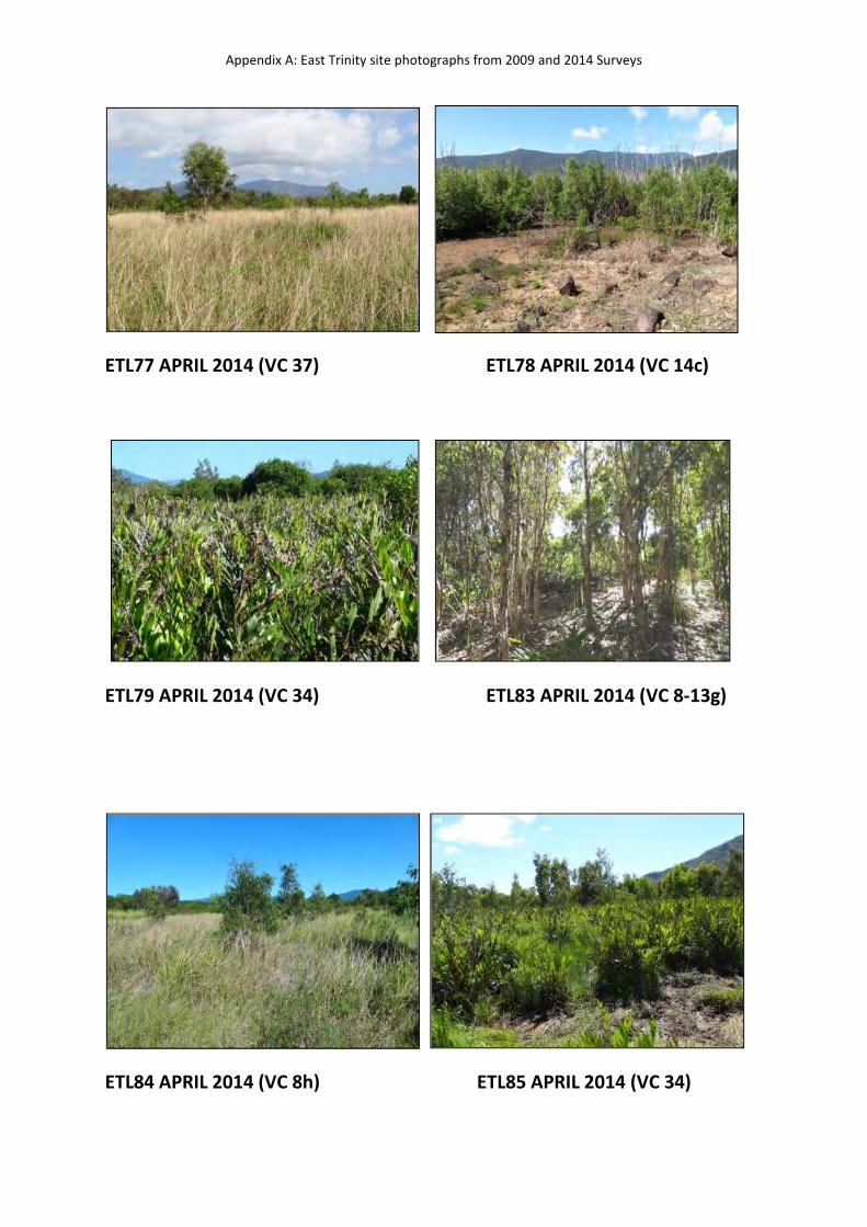
Appendix A: East Trinity site photographs from 2009 and 2014 Surveys
ETL77 APRIL 2014 (VC 37) ETL78 APRIL 2014 (VC 14c)
ETL79 APRIL 2014 (VC 34) ETL83 APRIL 2014 (VC 8-13g)
ETL84 APRIL 2014 (VC 8h) ETL85 APRIL 2014 (VC 34)
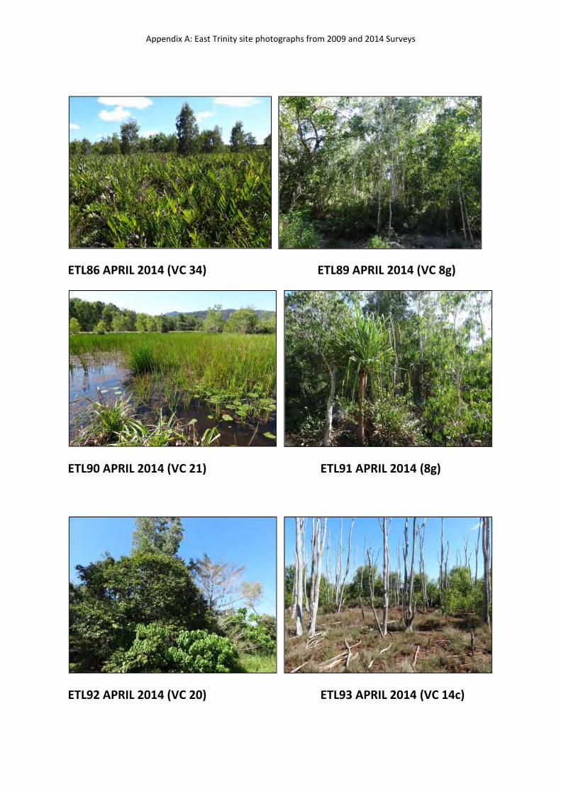
Appendix A: East Trinity site photographs from 2009 and 2014 Surveys
ETL86 APRIL 2014 (VC 34) ETL89 APRIL 2014 (VC 8g)
ETL90 APRIL 2014 (VC 21) ETL91 APRIL 2014 (8g)
ETL92 APRIL 2014 (VC 20) ETL93 APRIL 2014 (VC 14c)
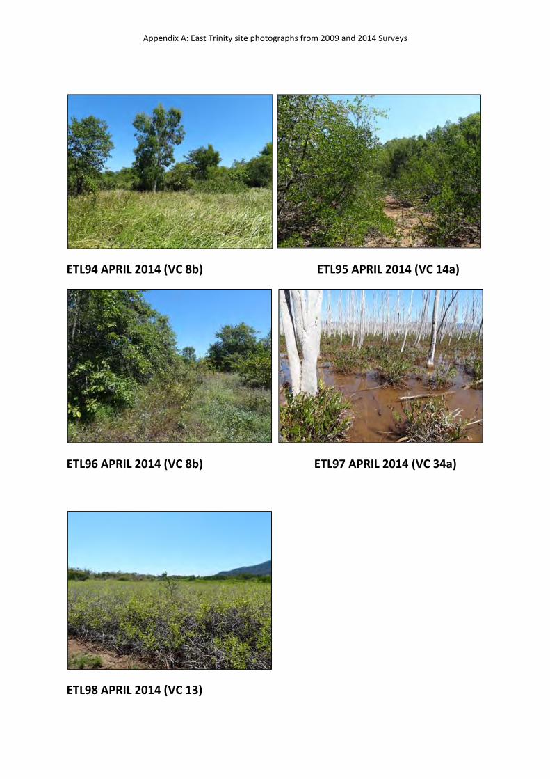
Appendix A: East Trinity site photographs from 2009 and 2014 Surveys
ETL94 APRIL 2014 (VC 8b) ETL95 APRIL 2014 (VC 14a)
ETL96 APRIL 2014 (VC 8b) ETL97 APRIL 2014 (VC 34a)
ETL98 APRIL 2014 (VC 13)