survey for the texas kangaroo rat (dipodomys elator) - texas parks
TRANSCRIPT

Section 6 (Texas Traditional) Report Review Form emailed to FWS S6 coordinator (mm/dd/yyyy): 3/26/2013 TPWD signature date on report: 3/25/2013 Project Title: Survey for the Texas kangaroo rat (Dipodomys elator) Final or Interim Report? Final Grant #: TX-E-131-R Reviewer Station: Arlington ESFO Lead station concurs with the following comments: NA (reviewer from lead station) Interim Report (check one):
Acceptable (no comments)
Needs revision prior to final report (see comments below)
Incomplete (see comments below)
Final Report (check one):
Acceptable (no comments)
Needs revision (see comments below)
Incomplete (see comments below)
Comments:

FINAL PERFORMANCE REPORT
As Required by
THE ENDANGERED SPECIES PROGRAM
TEXAS
Grant No. TX E-131-R
Endangered and Threatened Species Conservation
Survey for the Texas Kangaroo rat (Dipodomys elator)
Prepared by:
Allen Nelson
Carter Smith Executive Director
Clayton Wolf Director, Wildlife
25 March 2013
2
FINAL PERFORMANCE REPORT
STATE: ____Texas_______________ GRANT NUMBER: ___ TX E-131-R___
GRANT TITLE: Survey for the Texas Kangaroo rat (Dipodomys elator)
REPORTING PERIOD: ____1 Oct 10 to 28 Feb 13_
OBJECTIVE(S):
To assess demographic data from known populations of the Texas kangaroo rat (Dipodomys elator) to
determine their conservation status and burrow ecology over two years.
Segment Objectives:
Task 1. Travel to Wichita and Hardeman counties to establish base camps for trapping throughout the
range of the Texas kangaroo rat. At a minimum, trap two weeks in December, one week in March, and
three weeks in May.
Task 2. Analyze inventory data and ecological data gathered in May from active populations
Task 3. Repeat task one and two for a second year.
Task 4. Prepare reports and publications and presentations at professional meetings.
Significant Deviations:
None.
Summary Of Progress:
Please see Attachment A; GIS data files for burrow localities also attached (Excel).
Location: Hardeman, Montague, Wilbarger, and Wichita Counties, Texas.
Cost: ___Costs were not available at time of this report, they will be available upon completion of
the Final Report and conclusion of the project.__
Prepared by: _Craig Farquhar_____________ Date: 25 March 2013
Approved by: ______________________________ Date: 25 March 2013 C. Craig Farquhar

3
ATTACHMENT A
Status Survey for the Texas Kangaroo Rat (Dipodomys elator)
Prepared for
Texas Parks and Wildlife Department
4200 Smith School Road
Austin, Texas 78744-3291
Prepared by:
Allan D. Nelson Ph. D., Jim R. Goetze Ph. D.,
Steven Henderson M.S., & Brian Scoggins M.S.
Department of Biological Sciences
Tarleton State University
Stephenville, Texas 76401
TPWD Contract No. 403892
1 October 2011-30 February 2013
Final Report

4
Introduction.
The Texas Kangaroo Rat, Dipodomys elator, was first described as a separate species of kangaroo
rat over 100 years ago (Merriam 1894). Dipodomys elator is unusual in that the habitat in which it is found
is not typical among kangaroo rats. Dipodomys elator seems to prefer soils with high clay content which
support overgrazed or short grasses (Dalquest & Collier 1964; Roberts & Packard 1973; Dalquest & Horner
1984; Stangl et al. 1992; Schmidly 2004; Goetze et al. 2007; Nelson et al. 2009; Stasey et al. 2010) and has
rarely been recorded in locations with dense vegetation. In addition, D. elator has a distinctive dental
morphology that has led previous researchers to suggest that D. elator may represent a separate lineage
deserving recognition at the genus level (Dalquest et al. 1992). Alternatively, based on molecular data, it
and D. philipsii are putative sister species that comprise a unique lineage within the genus (Johnson &
Selander 1971; Mantooth et al. 2000).
Historically D. elator was known sporadically from an approximate area of 2.7 million ha
within Comanche and Cotton counties, Oklahoma and Cottle, Clay, Childress, Hardeman,
Wilbarger, Archer, Baylor, Foard, Montague, Motley, Wichita, and Coryell counties, Texas.
However, the single specimen collected in 1953 from Coryell County, Texas was likely
misidentified (Carter et al. 1985; Jones et al. 1988; Martin 2002). The historic range of D. elator
spanned across the convergence of two physiographic regions, the Rolling Plains to the west, and
the West Cross Timbers to the east. As a result of overgrazing and control of wildfires, mesquite
(Prosopis glandulosa), and other disturbance-related shrubs, grasses and forbs have increased in
abundance across the Rolling Plains and habitat modification such as conversion of pastureland to
monoculture has resulted in extensive fragmentation of Texas kangaroo rat habitat (Diamond &
Shaw 1990). From 1996-2000, Martin (2002) surveyed the historic range of D. elator and found
this species in only five counties in Texas: Archer, Childress, Hardeman, Motley, and Wichita, a
combined area of 1,025,868 ha. He did not find D. elator in Oklahoma (Martin 2002). This
concurs with other researchers who have been unable to locate any populations of D. elator in
Oklahoma (Jones et al. 1988; Moss & Mehlhop-Cifelli 1990).
The apparent decline in D. elator has led to the International Union for Conservation of
Nature (IUCN) listing D. elator as vulnerable on their Red List of Threatened Species in 1996.
The IUCN cited habitat degradation and loss resulting from expanding agricultural and
infrastructural development as the major threats to the continued existence of this species (Hafner
1996). Federally, D. elator was listed as a Category 2 candidate species under the Endangered
Species Act of 1973 (Martin 2002). Category 2 candidates were formerly considered species of
concern for the United States Fish and Wildlife Service (USFWS), and endangered or threatened
status was possibly warranted. However, insufficient data existed to justify an elevated listing
(USFWS 1996). In Texas, D. elator is listed as a threatened species by the Texas Parks and
Wildlife Department (TPWD) (Martin 2002; Schmidly 2004). Reasons for D. elator being listed
as a threatened species by the TPWD are based on scarcity of this species and the small geographic
range from which it is known (Stangl & Schafer 1990). Most recently, WildEarth Guardians
petitioned USFWS to federally list the Texas kangaroo rat (WildEarth Guardians 2010) and the
USFWS responded with a 90-day finding that concluded the petition presents substantial scientific
information indicating that listing the Texas kangaroo rat throughout its entire range may be
warranted (USFWS 2011). This finding was based on the present or threatened destruction,

5
modification, or curtailment of the Texas kangaroo rat’s habitat or range, and the inadequacy of
existing regulatory mechanisms (USFWS 2011). Specifically, they found that the loss of
burrowing habitat and genetic isolation of populations due to the conversion of native rangeland to
agricultural cropland, and the inadequacy of existing regulatory mechanisms to protect against
such land conversion, may pose a threat to the Texas kangaroo rat throughout all or a significant
portion of its range (USFWS 2011). Now USFWS is required to gather data for one year and then
make a determination regarding the status of the Texas kangaroo rat.
Whereas a relatively large number of studies have examined aspects of ecology (Dalquest
& Collier 1964; Roberts & Packard 1973; Stangl & Schafer 1990; Jones et al. 1988; Diamond &
Shaw 1990; Moss & Mehlhop-Cifelli 1990; Stangl et al. 1992; Martin 2002; Stasey 2005; Goetze
et al. 2007; Goetze et al. 2008; Nelson et al. 2009; Stasey et al. 2010) and systematics (Merriam
1894; Johnson & Selander 1971; Hamilton et al. 1987; Dalquest et al. 1992; Mantooth et al. 2000),
there have been no published investigations that examined historical populations using a
combination of trapping and current ecological knowledge of burrows (Goetze et al. 2007; Nelson
et al 2009; Stasey et al. 2010) to determine population numbers and size so that conservation status
can be assessed. In an unpublished report, Martin (2002) provides evidence from driving surveys
but, based on our work in Wichita County using burrow trapping methods, these estimates are
inaccurate (Goetze et al. 2007; Nelson et al. 2009). However, Martin (2002) did create a database
of historical localities for Texas kangaroo rats that needs to be examined to assess how many
populations persist. Therefore, we used Martin’s (2002) database of coordinates for historical
populations as a guide to assess sites and inventory active Texas kangaroo rat populations. Using
burrow trapping techniques over a two year period, we estimated numbers from as many of these
populations as possible. In addition to conducting a status survey at localit ies from throughout
much of the range of the Texas kangaroo rat, we collected vegetation data from all burrow sites
from which Texas kangaroo rats were captured.
Methods.
In general, the following methods were used. In the burrow ecology of Wichita County
and the Copper Breaks State Park sections of the report, more specific details are included. At
sites reported by Martin (2002), that are accessible (roadsides, private land where we could secure
permission, or state parks, for example), we surveyed the study site for burrows of the Texas
kangaroo rat by walking over the area where historical sightings occurred. Burrows possibly
belonging to D. elator were identified based on diameter and orientation of entrance/exit hole (see
Fig. 3 in Stangl et al. 1992). Distinct trails and dust-bathing areas often lead away from these
burrows and these runways sometimes connect to other distant burrows (Goetze et al. 2007, 2008).
The specific location of each burrow was recorded in decimal degrees using a Garmin GPS-12
unit. A geo-referenced base map was produced with a Manifold 5.0 (Manifold System Ltd, 2003)
GIS system using a digital orthophoto quadrangle obtained from IntraSearch, Denver, Colorado
(Figures 1 and 2).
Trapping to test for burrow residence were conducted by placing three Sherman Live Traps
within 0.10 to 0.50 m of each burrow entrance, with the open end of each trap facing the entrance
(Cross & Waser 2000). If no burrows were present, traps were placed at coordinates from Martin
(2002). Traps were baited with dry oatmeal each evening and checked each morning. Some
animals were marked with hair dye (Maher 2004) so that recapture rates could be determined.

6
When possible, animals were marked and sexed. We lost two animals while handling them during
trapping periods that coincided with extreme temperatures and decided to simply catch and release
during excessively hot sampling periods.
Once active burrows were located, vegetation was sampled during May to allow direct
comparisons of this investigation to previous ecological studies (Goetze et al. 2007; Nelson et al.
2009; Stasey et al. 2010). A 1-m2 quadrat was placed directly over burrows where D. elator was
captured. Within each quadrat, vegetative richness was recorded as total number of species
present. Percentage coverage of grass, forbs, bare ground, woody vegetation, and rocks or stumps
within each quadrat was recorded, as was average herbaceous vegetation height (obtained by
averaging the height of the herbaceous vegetation 15 cm interior to each corner of the quadrat). If
woody vegetation was present, the height of its lowest branch was also recorded. Specimens of the
dominant herbaceous and woody plants were collected and placed in a plant press. These
vegetation vouchers were deposited in the herbarium of Tarleton State University (TAC).
Burrows were also classified according to their association in the landscape. Categories
included: brush piles, fence row, honey mesquite, lotebush, mowed roadside, oil field pipe, oil
storage tank berm, old oil field pump-jack pad, pond dam, prairie mound, and rail crosstie.
Averages, ranges, and standard deviations for burrow data as well as comparisons between
years were calculated in Microsoft Excel. Comparisons between years were made using
SigmaPlot 12 to calculate a Mann-Whitney Rank Sum Test.
Mark-Recapture data was used to estimate population sizes of the Texas kangaroo rat. We
used the Lincoln-Peterson method and the following formula: N = M (n + 1)/ R + 1. In the
formula, N is the estimated population number, M the number of individuals marked, n the sample
of individuals taken after marking, and R the recaptured individuals (Brower et al. 1998).
Results & Discussion.
Survey of sites
We trapped a total of 15,530 trapnights for the sites surveyed (Appendix 1). There were
3901 trapnights for surveys in areas not reported by Martin (2002) and 11,629 in those surveyed by
Martin (2002). No Texas kangaroo rats were caught at the sites reported by Martin (2002). Of the
48 sites surveyed by Martin (2002), 33 were trapped for a minimum of 10 trapnights (Appendix 1).
Fifteen sites were not trapped because they occurred on private property or were poor habitat. At
all the sites not trapped, there was no burrow activity and if there was bare ground available it was
often due to plowing or road work. Over one-half (eight) of the sites that were not trapped were
cultivated fields. These were often plowed to the roadside and had little to no vegetation. Three of
the sites were on private property where we could not get within 0.3 mile of the Martin (2002)
trapping locality. Two were behind locked gates and one was in the middle of an irrigated wheat
field. Two sites were homesites and two were in areas where roadsides had high berms and had
poor quality habitat with dense introduced grasses like Johnsongrass and Japanese brome.
Of the 33 sites that were trapped, no Texas kangaroo rats were caught. Six of these sites
were located within the boundaries of Copper Breaks State Park in Hardeman County. Because
this property is managed by Texas Parks and Wildlife Department (TPWD), we allotted a large
proportion of trapnights to the park. In general, park vegetation was too dense and tall to support
Texas kangaroo rats. Poor habitat in the park has been noted by others (Martin 2002; Best & Wahl
1985). The park habitat has declined due to lack of grazing and fire as well as mesquite and

7
juniper invasion. In the last several years, part of the Texas state longhorn herd has been pastured
in the front part (near the entrance) of the park. Grazing and other disturbance by the longhorns
has created habitat similar to that from sites where we have gathered ecological data on 54 active
Texas kangaroo rat burrows in Wichita and Hardeman counties. Martin (2002) recommended the
grassland at the entrance to the park for active management to reduce cover and create areas for
Texas kangaroo rats to re-establish burrows within the park. We trapped in the area where
longhorns grazed and did not catch any Texas kangaroo rats. However, the habitat was similar to
that where we have caught them in Wichita County.
Of the 27 sites not in Copper Breaks State Park, 15 had 20% or less bare ground at the trap
sites. This is a low amount of bare ground when compared to that found at burrows of 54 Texas
kangaroo rats that we have captured and likely was a factor in our not catching Texas kangaroo
rats at these sites. Two sites were at areas with active road grading and root plowing of adjacent
mesquite pasture. These two sites had 90-100% bare ground and were likely disturbed too much
for Texas kangaroo rats. The other 10 sites had similar amounts of bare ground and had habitats
similar to those where we have caught Texas kangaroo rats. These included six sites in Hardeman
County with two along Hamby Road near Quanah, Texas and four along Copper Breaks Road on
the north side of Copper Breaks State Park. Three sites were in Childress County along County
Road 24 and one was in Wichita County at North Fork Buffalo Creek Reservoir (NFBCR). These
10 sites as well as the seven new sites that we report (Appendix 1.) were the focus of the second
year of trapping effort. Because six localities from Martin (2002) were near NFBCR and the
property is owned by the City of Iowa Park, which could have potential as a management site for
Texas kangaroo rats, we trapped around the reservoir for 6135 trapnights (Appendix 1, site 11).
We caught no Texas kangaroo rats at NFBCR, however site “C” (Figure 1), which has a
population of Texas kangaroo rats is near the reservoir property.
Based on the data gathered during this part of the investigation, Martin (2002) sites have
likely changed over time and today may no longer provide suitable habitat for the Texas kangaroo
rat. However, additional studies on private property near these areas should be conducted.
NFBCR could serve as a possible site for reintroduction if the habitat were managed properly
perhaps through a partnership formed with the City of Iowa Park.
Burrow Ecology for 54 Texas kangaroo rat burrows
Since 2005, we have caught 113 Dipodomys elator (71 individuals) from five locations and
characterized the vegetative ecology of 54 burrows regarding vegetative ecology. Most of the
burrows occurred near shrubs (37.3%) including honey mesquite (32.6%) and lotebush (4.7%;
Table 1). Honey mesquite has been widely reported at burrow sites of Texas kangaroo rats
whereas lotebush is rarer due to its more limited presence in the community. The shrubs
accumulate soils at their base and the soil is used for burrow construction. As mesquite becomes
larger and mature, its shade may change the vegetation composition sometimes favoring
introduced grasses like Japanese brome, which grows densely and changes the habitat so that it is
more suitable for other types of small mammals (Nelson et al. 2009). Prairie mounds were
associated with burrows 14.0% of the time. Prairie mounds are slightly raised areas in grasslands
(Diggs et al. 1999; Goetze et al. 2007) that are likely caused by swelling and shrinkage of clay
soils or differential erosion. These raised areas are used by Texas kangaroo rats for burrow
construction. Shrubs and prairie mounds comprise over one-half of the burrow characterizations

8
and may be natural components of the grassland ecosystem if one allows for cattle grazing to
replace bison and for increases in shrub density due to lack of fire and overgrazing. The other
burrow categorizations comprise slightly less than one-half of the burrow associations and include
environments modified by man mainly due to fencing, clearing of brush, and oil field activities.
To a lesser degree, road and reservoir construction have provided opportunistic habitats for Texas
kangaroo rats.
Brush piles and fence rows comprise 20.9% of Texas kangaroo rat burrow characterizations
(Table 1). Brush piles (11.6%) where Texas kangaroo rats have been found are about 30 years old
and have never been burned. The wood has rotted and captured loose soil that forms a dome about
0.25 m in height. This provides raised, loose soil for burrow construction. Fence rows (9.3%) that
are relatively old often collect a berm of soil around posts that is used for burrow construction.
Abandoned cross ties, used for fencing or oil pad construction in grasslands, have been associated
with burrows 7.0% of the time. Oil field pipe (2.3%), old pump-jack pads (9.3%), and oil storage
tank berm (2.3%) associations indicate that oil field activity can provide opportunistic habitat for
Texas kangaroo rats. Pond dams (2.3%) and mowed roadsides (4.7%) also have been used
opportunistically by Texas kangaroo rats. Mowed roadsides can provide berms for burrow
construction and mowing helps prevent tall, dense vegetation from becoming established. The
single pond dam that contained a Texas kangaroo rat burrow was at a small man-made reservoir
built to provide water for livestock. The dam had been breached by water from a heavy rainfall
event and provided high, relatively loose soil for burrow construction.
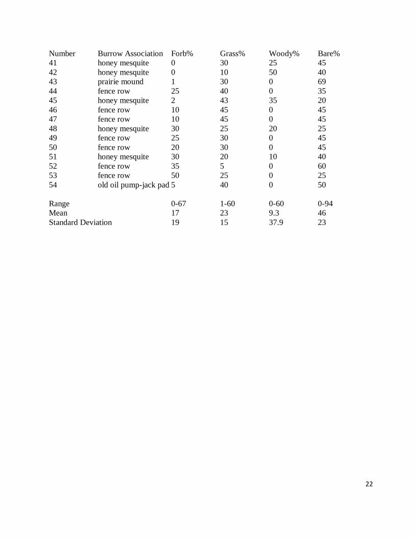
The percentage of forbs for the burrows ranged from 0-67 with a mean of 17, percentage
grass ranged from 1-60 with a mean of 23, and the percentage of woody vegetation ranged from 0-
60 with a mean of 9.3 (Table 1). Bare ground ranged from 0-94% with a mean value of 46%
(Table 1) and other materials found at burrows (for example rocks, stumps, oil field metal such as
pipes and pump-jack counterweights as well as dead, woody vegetation) ranged from 0-38% with a
mean of 5.1% (Table 2). Herbaceous vegetation height ranged from 0-53 cm. with a mean of 14
cm. and the lowest branch of woody vegetation present ranged from 0-121 cm. above the ground
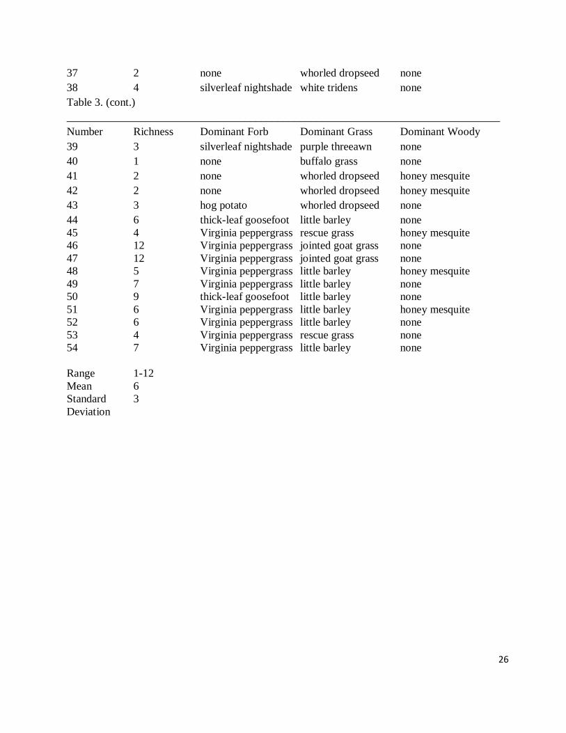
with a mean of 15 cm. (Table 2). Plant richness ranged from 1-12 with a mean of six (Table 3).
Little barley was the most common dominant grass, Virginia peppergrass the most common
dominant forb, and honey mesquite the most common dominant shrub (Table 3). Whorled
dropseed, common broomweed, and lotebush were the second most dominant vegetation types
(Table 3).
In conclusion, Texas kangaroo rats seem to prefer shrubs, prairie mounds, or anthropogenic
disturbances that create loose mounds of soil for burrow construction. Burrow vegetation has
about equal proportions of forbs and grasses with the most common being Virginia peppergrass
and little barley. Honey mesquite is the most dominant shrub associated with the burrows, but is
also extremely common due to its invasion of the ecosystem. It also appears that bare ground is
important to D. elator to facilitate dust bathing and burrow construction.
Population Estimates in Wichita County
We have population estimates from four locations in Wichita County, Texas (Figure 1;
Table 4). All populations were estimated at one or two in 2011. In two previous estimates (2005
and 2008) from two localities we no longer have the landowner’s permission to continue trapping,
population estimates were about the same (two), slightly higher (three to four) or higher (eight).
9
There had been a prolonged drought and higher than normal temperatures at all four locations in
2011, when our estimated population sizes were one or two animals. In 2012, we only had
landowner permission to trap in two of the localities that were surveyed in 2011. Both these sites
had higher numbers of Texas kangaroo rats in 2012 (three and 18). Future investigations are
needed to examine burrow dynamics and obtain population estimates over longer periods of time.
If one combines the data from 54 burrows obtained in 2005, 2007, and 2008 and compares
it to 2011 (Table 5), there are significant differences in percentage of forbs and bare ground with
fewer forbs and more bare ground in 2011. Richness and herbaceous plant height were also
significantly less in 2011. These changes in vegetation are likely related to hotter temperatures
and less rain in 2011 when compared to previous years. In 2011, Wichita Falls had the most 100
degree temperatures in a calendar year (100 compared to 79 in 1980) and the second driest Spring
and Summer as well as the fourth driest Winter on record (4.04 inches for that nine month period).
Fewer forbs resulting in less richness as well as shorter height and more bare ground during 2011
may have resulted in lower populations of the Texas kangaroo rat. Prior to 2011, Texas kangaroo
rats were hypothesized to prefer shorter vegetation with bare ground for burrow construction and
dust-bathing (Goetze et al. 2007; Nelson et al 2009; Stasey et al. 2010). However the drought
conditions in 2011, may have caused lower richness, fewer forbs, shorter vegetation, and more
bare ground than is preferred by Texas kangaroo rats, which resulted in a population decline.
Alternatively, excessive heat and dryness might have caused the animals to estivate. To date,
vegetation data is limited and long term population dynamics are virtually unknown for this rare
species.
In addition, although we did not catch any Texas kangaroo rats at the Martin (2002) sites,
we want to emphasize that there are large amounts of potential habitat on private land that likely
contain Texas kangaroo rats. We know of three instances in Wichita County where we have caught
Texas kangaroo rats on private lands but the landowners would not give us permission to report the
data. Similarly, we attempted to obtain permission from landowners that had allowed Martin
(2002) to trap on their property, but ownership had changed and the new landowners declined
permission.
Also, all the Martin (2002) sites, with the exception of those located in Copper Breaks State
Park, are along roadsides. Trapping along roadsides may be problematic because Texas kangaroo
rats may rarely move out of pasturelands onto roadsides. In 2011, to examine how trapping along
a roadside near a known population within a pastureland affects capture rates, we trapped 250 trap
nights along a roadside that is within 400 meters of a site where we caught Texas kangaroo rats
(population estimate of two and three, respectively, in 2011 and 2012) and another 150 trap nights
at a roadside where a Texas kangaroo rat was salvaged in 2011. In 2012, we were unable to trap
on two private properties because of a change in ownership, so we trapped on their northern
boundaries along the county road for 250 trap nights at each site. We caught one Peromyscus
leucopus along the roadside and no Dipodomys elator. The most recent population estimates
within these properties for Texas kangaroo rats was two at each site. These estimates were from
2011 when it was extremely dry and hot. In 2005, one of these localities had an estimate of four
Texas kangaroo rats and in 2008 the other property had an estimate of 14. We obtained landowner
permission to walk over the sites in 2012 and it appeared that the higher estimates (four and 14;
Table 4) would be more accurate due to the number of burrows and dust bathing sites observed.
At another site, we trapped 375 trapnights along a highway on the west side of the property and
375 trapnights within the property. We caught one Texas kangaroo rat along the highway,
10
adjacent to the property. Population estimates within the property were two in 2011, which was
extremely dry and hot, but 18 in 2012, which was wetter and had more typical temperatures.
These experiments were done to investigate whether the rats would leave the pastures and be
caught along roadsides and are important because most of the Martin sites (2002) are localities
along roadsides. For the combined 1650 trapnights that we conducted the experiments, only one
Texas kangaroo rat was captured along roadsides. It appears that even if Texas kangaroo rats are
near roads, they often stay within the interiors of the pasturelands where their burrows occur.
Therefore it may be critical to have access to interiors of pasturelands and not depend on roadside
sightings or trapping to accurately survey the animals. For instance, Martin (2002) reported only
two Texas kangaroo rats from Wichita County after extensive night driving surveys. The four
populations of 71 individuals that we report likely existed at the time of his night driving surveys
as well as additional populations on other private land.
Burrow ecology of Texas kangaroo rats in Wichita County
The goals of this part of our investigation are to quantify vegetative characteristics of
burrows in Wichita County and compare this data to that reported for D. elator burrows from
Motley County (Martin & Matocha 1989) as well as those from line transects (Martin 2002) and
two quadrats in Hardeman County.
Forty-six burrows were identified from Wichita County from four different localities
(Figure 1). Trapping to test for burrow occupancy was conducted by placing three 7.5 x 8.8 x 30
cm Sherman Live Traps within 0.10 to 0.50 m of each burrow entrance, with the open end of each
trap facing the entrance (Cross & Waser 2000).
Burrows were also classified according to their association in the landscape. Categories
included: brush piles, fence row, honey mesquite, lotebush, mowed roadside, oil field pipe, oil
storage tank berm, old oil field pump-jack pad, pond dam, prairie mound, and railroad crosstie
(used for fencing material by the landowners).
Beginning in 2005 and continuing to 2012, we characterized the vegetation associated with
46 Texas kangaroo rat burrows from four locations in Wichita County and two burrows from a
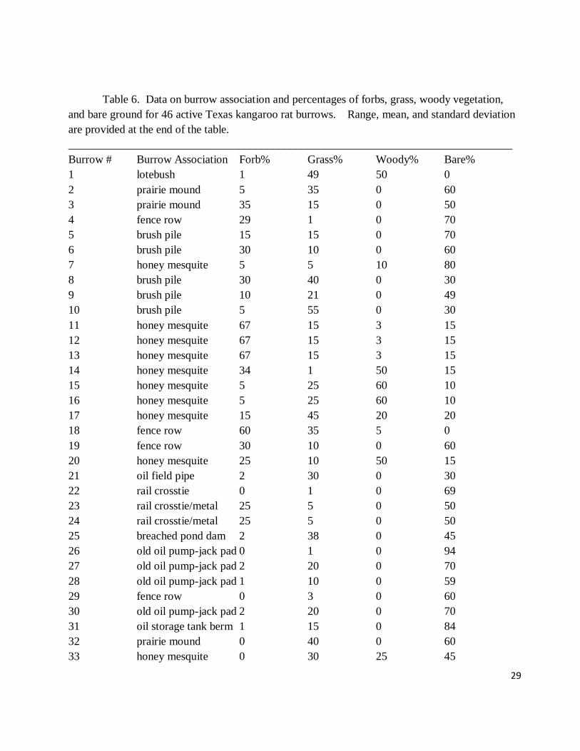
single location in Hardeman County. The two most common burrow associations were honey
mesquite (30%) and fence rows (24%; Table 6). Most of the burrows occurred near shrubs (32%)
including honey mesquite (32%) and lotebush (2.0%; Table 6). Prairie mounds were associated
with burrows 9.0% of the time. Brush piles comprise 11% of Texas kangaroo rat burrow
associations (Table 6). Abandoned crossties in grassland used for fencing or oil pad construction
have been associated with burrows 7.0% of the time along with oil field pipe (2.0%), old pump-
jack pads (11%), and oil storage tank berms (2.0%). Pond dams (2.0%) also have been used
opportunistically by Texas kangaroo rats.
The percentage of forbs for the burrows ranged from 0-67 with a mean of 18, percentage
grass ranged from 1.0-55 with a mean of 22.8, and the percentage of woody vegetation ranged
from 0-60 with a mean of 18.6 (Table 6). Bare ground ranged from 0-94% with a mean value of
44% (Table 1) and other materials found at burrows (for example rocks, stumps, oil field metal
such as pipes and pump-jack counterweights as well as dead woody vegetation) ranged from 0-
30% with a mean of 5.5% (Table 7). Herbaceous vegetation height ranged from 0-59 cm. with a
mean of 14 cm. and the lowest branch of woody vegetation present ranged from 0-121 cm. above
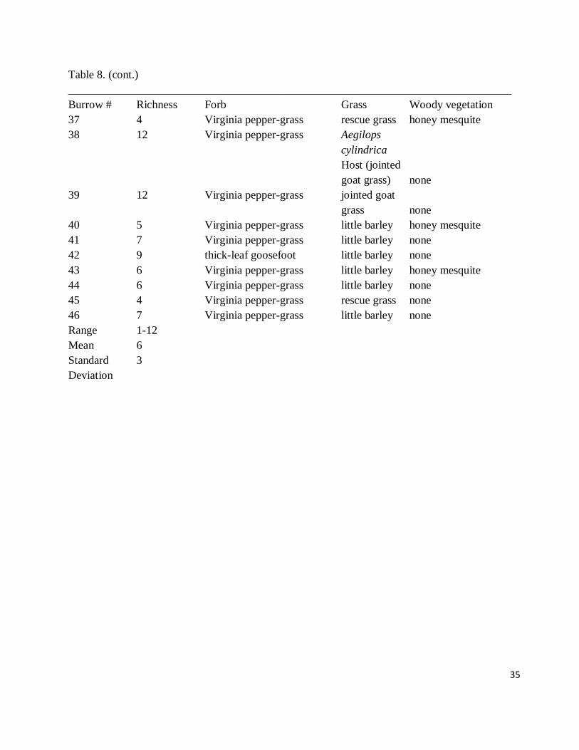
the ground with a mean of 16 cm. (Table 7). Plant richness ranged from 1-12 with a mean of six

11
(Table 8). The most common dominants were little barley, Virginia pepper-grass, and honey
mesquite (Table 8). Next in vegetation dominance were whorled dropseed, common broomweed,
and lotebush (Table 8). Herbaceous heights at burrows ranged from 0-59 cm with a mean of 14
cm. Woody vegetation heights at burrows ranged from 0-121 cm with a mean of 16 cm.
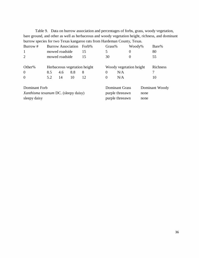
The two active Hardeman County burrows were both associated with mowed roadside
(Table 9). They both had 15% forbs, from 5-30% grass, no woody vegetation, and 55-80% bare
ground. There were no other materials associated with the burrows. Richness was 7-10 with
sleepy daisy as dominant forb and purple threeawn the dominant grass. Herbaceous vegetation
height ranged from 4.6 -14 cm with a mean of 9.1 cm.
Burrow Associations and Dominant Vegetation
Honey mesquite has been widely reported at burrow sites of Texas kangaroo rats whereas
lotebush is rarer due to its more limited presence in the community (Goetze et al. 2007). The
shrubs, which account for 32% of burrow associations, accumulate soils at their base that are used
for burrow construction. As mesquite becomes larger and mature, its shade may change the
vegetation composition sometimes favoring introduced grasses like Japanese brome, which grows
densely and changes the habitat to favor other types of small mammals (Nelson et al. 2009). In
Wichita County, prairie mounds were associated with burrows 9.0% of the time. Prairie mounds
are slightly raised areas in grasslands (Diggs et al. 1999; Goetze et al. 2007) that are likely caused
by swelling and shrinkage of clay soils or differential erosion. These raised areas are used by
Texas kangaroo rats for burrow construction. Shrubs and prairie mounds comprise slightly over
40% of the burrow characterizations and may be natural components of the grassland ecosystem if
one allows for cattle grazing to replace bison and for increases in shrub density due to lack of fire
and overgrazing.
The other burrow associations in Wichita County comprise almost 60% of the burrows and
include environments modified by man mainly due to fencing, clearing of brush, and oil field
activities. To a lesser degree, road, and reservoir construction have provided opportunistic habitats
for Texas kangaroo rats.
Fence rows (24% of burrow associations in Wichita County) that are relatively old often
collect a berm of soil around posts that are used for burrow construction. Brush piles (11% of
burrow associations) where Texas kangaroo rats have been found are about 30 years old and have
never been burned. The wood has rotted and captured loose soil that forms a dome about 0.25 m
in height. This provides raised, loose soil for burrow construction. Abandoned crossties in
pasturelands used for fencing or oil pump-jack pad construction have been associated with burrows
7.0% of the time along with oil field pipe (2.0%), old pump-jack pads (11%), and oil storage tank
berms (2.0%). This indicates that oil field activity can provide opportunistic habitat for Texas
kangaroo rats. Mowed roadsides can provide berms for burrow construction and mowing helps
prevent tall dense vegetation from becoming established. The single pond dam in Wichita County
that contained a Texas kangaroo rat burrow was at a small man-made reservoir built to provide
water for livestock. The dam had been breached by water from a heavy rainfall event and
provided high, relatively loose soil for burrow construction.
Dominant vegetation found at burrows in Wichita County was mostly native. All forbs and
shrubs and most grasses were native. Little barley was the most dominant native grass with
whorled dropseed being the second most common native grass. Introduced grasses dominated at
15.9 % of burrows and included Japanese brome, rescue grass, and jointed goat grass. As we
surveyed historical sites for trapping locations, we often encountered dense concentrations of

12
introduced grasses such as Japanese brome. Increases of these introduced grasses likely will
negatively affect the Texas kangaroo rat and is probably why many historical sites, especially
along roadsides, no longer have Texas kangaroo rats. Dense vegetation likely impedes burrow
construction, ease of movement, and prevents Texas kangaroo rats from locating potential
predators. In addition, dense vegetation reduces bare patches needed for dust bathing (Goetze et
al. 2008). Also, changes in land use that decrease grazing, such as conservation programs like the
Conservation Reserve and Grassland Reserve programs, probably negatively affect Texas
kangaroo rat populations.
Comparisons to Motley County
Ecological characteristics of burrows in Wichita County were different than those reported
from Motley County (Martin and Matocha 1991). In the classification system used for burrows in
Wichita County, the burrow in Motley County described by Martin & Matocha (1991) would have
been classified as a fence line association. At the Motley County site, values reported for bare
ground percentage (30.2%) is slightly lower than the mean (44.0%) from Wichita County but forb
percentage (4.8% compared to 18.0% in Wichita County) were low and grass percentage was high
(65% compared to 22.8% in Wichita County). These differences might be attributed to moderate to
heavy grazing that occurred at the sites in Wichita County. The location of the Motley County
burrow in a fence row berm may have provided the friable soil preferred for burrow construction.
In addition, its location at the edge of a Sudan grass field adjacent to a gravel road may have
provided enough disturbances to maintain bare patches for the dust bathing activities of D. elator.
Comparisons to Hardeman County
Martin (2002) reported that burrows in Hardeman County were typically associated with
several species of shrub including honey mesquite, lotebush, and Ephedra antisyphilitica Berland.
ex C. A. Mey (clapweed). Similarly 32% of the burrows in Wichita County were associated with
shrubs with greatest number associated with honey mesquite. Only 2.0% were found with
lotebush and none were found with clapweed. On average, the Hardeman County burrows had
18.9% bare ground, 75.5% grasses, and 15.8% forbs (Martin 2002). In Wichita County, bare
ground is on average over twice as high (44.0%), grasses are only about one-fourth as much
(22.2%), and forbs are slightly higher (18.0%). This could have been due to the moderate to heavy
grazing associated with the Wichita County sites and the values reported from Motley County are
similar to those reported from an ungrazed site in Wichita County (Stasey et al. 2010). However,
the two burrows where we captured Texas kangaroo rats in Hardeman County had mean values
more similar to those found in Wichita County with 67.5% bare ground, 17.5% grasses, and 15%
forbs. These two burrows were associated with a mowed roadside, which might simulate grazing
conditions associated with the Wichita County burrows. The Hardeman County burrows also had
different dominant vegetation with purple threeawn and sleepy daisy dominating instead of little
barley and Virginia pepper-grass that most commonly occured in Wichita County. Herbaceous
height means in Hardeman County (9.1 cm verses 14.0 cm in Wichita County) were lower likely
due to roadside mowing.
Copper Breaks State Park in Hardeman County
At the present time, there are only three tracts of public lands administered by the state of
Texas within the range of D. elator. One tract is Lake Arrowhead State Park in Clay County,
Texas in the eastern portion of D. elator's range. A second tract of public land, located to the west

13
in Cottle County, Texas, is the Matodor Wildlife Management Area. The third tract of public land
is Copper Breaks SP in Hardeman County, Texas (Fig. 2). The total area of Lake Arrowhead State
Park is 212.05 ha. Copper Breaks SP encompasses 768.40 ha, and Matador Wildlife Management
Area contains 11,405.66 ha. Therefore, a total of 12,386.11 ha within the range of D. elator is
administered by the state of Texas. Of the three state properties, the Texas kangaroo rat has been
reported only from Copper Breaks SP as a roadside sighting (Martin & Matocha 1998; Martin
2002).
The remainder of the land within the species' range is privately owned or, as in the case of
some impounded water reservoirs, controlled by local, municipal authorities. Survey of the public
lands within the range of D. elator and identification of suitable habitats within these tracts of land
is vital to the survival and conservation of the Texas kangaroo rat. Past capture sites of D. elator
and private lands within its range should also be studied. Regular surveys for this state threatened
species will provide information to park managers, wildlife biologists, and privately sponsored
organizations (such as the Nature Conservancy) and enable these personnel and entities to
implement appropriate conservation and management strategies.
The goals of this portion of the study were to survey for D. elator in Copper Breaks SP and
to note the vegetational structure at the park and compare it to a capture site of D. elator near the
park.
Field surveys for D. elator were conducted in Copper Breaks SP (Fig. 2) from 2006 to
2012. Martin (2002) reported six localities for D. elator in Copper Breaks SP. Trapping transects
were established at these six sites, within the state park’s longhorn enclosure, and in a centralized
trapping grid. Decimal degree coordinates for trapping localities were obtained utilizing a
Magellan GPS unit (Table 10). Sherman live traps were placed and baited with bird seed and
rolled oats. Traps were set in late afternoon hours and were checked shortly after sunrise.
Captured mammals were identified to species and released. The traps were closed during daylight
hours to avoid inadvertent captures and trap mortalities.
Trap transects were established in the six sites reported by Martin (2002) with traps
approximately 5 m apart on 15 March 2008; 19-20 May 2008; 13-18 March 2011; 16-17 April
2011; and 25-27 May 2011. Similar transects were established in the longhorn enclosure within
the park from 19-20 May 2007; 13-18 March 2011; 16-17 April 2011; 28 May 2011; and 15-23
May 2012.
The 100 station, 10 m by 10 m trapping grid was established adjacent to three of the sites
reported by Martin (2002) and sampled in 2006 on 30 June, 1-5 July, and 1, 6-8, 14-15 October. A
final sample was conducted on 9 May 2007. Two Sherman live traps were placed at each station
for a total of 200 trapnights per night. During our study, a total of 2,600 trapnights was conducted
on the trapping grid and, when including the other seven sites a grand total of 5127 trapnights
occurred during the study (Table 10).
Vegetation within the trapping grid at Copper Breaks SP was sampled during May 2008
within a 0.5 ha area. A 50 m by 50 m area within the grid was measured and woody vegetation
quantified and identified (Nelson et al. 2009). Herbaceous vegetation was also sampled using a 1-
m2 quadrat made from PVC pipe placed and centered over a random number along a 100 m tape
measure. Three random samples were chosen for the westernmost 100 m of the trapping grid, four
along a tape measure centered in the grid, and three along the easternmost 100 m of the grid.
Vegetative richness was recorded as total number of species present within each quadrat.
Percentage coverage of grass, forbs, bare ground, woody vegetation, and rocks or stumps within

14
each quadrat were recorded, as was average herbaceous vegetation height (obtained by averaging
the height of the herbaceous vegetation 15 cm interior to each corner of the quadrat). If woody
vegetation was present, its height also was recorded. Specimens of the dominant herbaceous and
woody plants were collected and placed in a plant press. Dominant vegetation at the site was
identified using floral references for the state and for North Central Texas (Correll & Johnson
1970; Diggs et al. 1999). Voucher specimens were deposited in the Tarleton State University
Herbarium (TAC). In the site outside the park (Table 10) where two D. elator were captured, the
1-m2 quadrat was centered over the opening of the burrow and vegetation was sampled in the same
manner as quadrats within the trapping grid.
Six genera and 10 species of mammals were collected during our study (Table 11). The
most commonly collected mammals were the northern pygmy mouse (Baiomys taylori), Texas
mouse (P. attwateri), and hispid cotton rat (Sigmodon hispidus).
The Texas kangaroo rat was only obtained outside of Copper Breaks SP at a nearby
roadside that had been mowed. Two D. elator (one male, one female) and a white-footed mouse
(Peromyscus leucopus) were trapped from separate burrow systems at this locality.
The dominant grass in the trapping grid at Copper Breaks SP was Japanese brome (Bromus
japonicus), whereas purple threeawn (Aristida purpurea) was dominant at the site outside the park
where Texas kangaroo rats were caught (Table 12). The dominant forb at Copper Breaks SP was
western ragweed (Ambrosia psilostachya) while Texas sleepy daisy (Xanthisma texanum) was
dominant outside the park (Table 12). Three of the ten quadrats at Copper Breaks SP had woody
vegetation dominated by Texas prickly-pear (Opuntia engelmannii) (Table 12).
At the site where kangaroo rats were captured, richness was higher, herbaceous vegetation
was shorter, there was more bare ground, more forbs, less grass, and no woody vegetation (Table
12). Within the trapping grid at Copper Breaks SP, 139 mesquites per ha were recorded.
The northern pygmy mouse, hispid cotton rat, fulvous harvest mouse (Reithrodontomys
fulvescens), and plains harvest mouse (R. montanus) prefer grassy or riparian areas of moderate to
heavy vegetation cover (Schmidly 2004). The northern pygmy mouse and hispid cotton rat were
the most common mammals within Copper Breaks SP, and the two species of Reithrodontomys
were also abundant. The presence of these rodents on the trapping grid and transects within
Copper Breaks SP indicates that these locations would not be favorable for D. elator. The Texas
kangaroo rats caught outside the park occurred in habitat with light vegetation. In studies of D.
elator in Wichita County (Goetze et al. 2007; Nelson et al. 2009; Stasey et al. 2010) light
vegetation and associated bare ground, likely caused by cattle grazing or other disturbances,
always occurred at burrow sites.
Also, the presence of S. hispidus likely is indicative of a significant change in the original
vegetation within the park. Hispid cotton rats often prefer areas of dense vegetation whenever
available (Schmidly 2004). Dense vegetation is usually avoided by D. elator (Stangl et al. 1992;
Goetze et al. 2007; Nelson et al. 2009; Stasey et al. 2010), thus the Texas kangaroo rat may now be
excluded from these sites.
The site where D. elator was obtained had an herbaceous vegetation cover that was lower
than coverage values sampled along grid transects within Copper Breaks SP (Table 12). The
percent bare ground at the capture sites was higher than within Copper Breaks SP (Table 12) as-
well-as that reported by Martin and Matocha (1989) for a more westward capture site in Motley
County, Texas. The percent bare ground reported from sites in Wichita County, Texas by Goetze
et al. (2007) was somewhat lower than at the Hardeman County sites. The two Texas kangaroo rat

15
burrows did not occur near mesquite; instead occurring in open, slightly raised areas between a
road and pasture fence. Opportunistic use of human-mediated disturbances such as fences and
roadsides as well as burrow utilization in areas without mesquite have been well documented in
Wichita County (Stangl et al. 1992; Goetze et al. 2007; Nelson et al. 2009).
In conclusion, absence of grazing from most of Copper Breaks SP and limited habitat
disturbances within the park likely have allowed vegetative cover to increase. Texas kangaroo rats
favor areas of reduced vegetation cover and utilize disturbed areas within their range (Stangl et al.
1992; Schmidly 2004; Goetze et al. 2007; Nelson et al. 2009; Stasey et al. 2010). The presence of
nonnative Japanese brome as a dominant at the Copper Breaks SP grid site may also contribute to
poor habitat, and dense Japanese brome coverage has been implicated in limiting Texas kangaroo
rat population size in Wichita County (Nelson et al. 2009). Considering these factors, much of the
current habitat within Copper Breaks SP may be unsuitable for D. elator because of dense
coverage by native grasses as well as encroachment of some introduced grasses like Japanese
brome.
Grazing effects may play an important role in the current ecology and distribution of D.
elator (Stangl et al. 1992; Goetze et al. 2007; Nelson et al. 2009; Stasey et al. 2010). Based upon
our survey results outside of Copper Breaks SP (Nelson & Goetze 2011), livestock grazing, on at
least some properties within Hardeman County, has also been reduced. Absence or reduction of
this ecological factor may have caused a decline in D. elator populations in these areas.
If no populations of D. elator are found within Copper Breaks SP in future surveys,
perhaps management strategies to reduce vegetative cover and create disturbed habitats within the
park might be implemented to increase favorable habitats for this threatened species. The Texas
kangaroo rat might then be reintroduced to Copper Breaks SP from Hardeman County populations
outside the state park.
Literature Cited
Best, T. L. & C. R. Wahl. 1985. Field survey of the Texas kangaroo rat (Dipodomys elator). Unpublished report to Texas Natural heritage Program, Austin, Texas.
Brower, J. E., J. H. Zar, & C. N. von Ende. 1998. Field and laboratory methods for general ecology, fourth
edition. William C. Brown and McGraw-Hill, Boston. Carter, D. C., W. D. Webster, J. K. Jones JR., C. Jones, & R. D. Suttkus. 1985. Dipodomys elator.
American Society of Mammalogists, Mammalian Species 232:1-3.
Correll, D.S. & M.C. Johnston. 1970. Manual of the vascular plants of Texas. Texas Research Foundation. Renner, Texas.
Cross, C. L. & P. M. Waser. 2000. Estimating population size in the banner-tailed kangaroo rat.
Southwestern Naturalist 45:176-183.
Dalquest, W. W. & G. Collier. 1964. Notes on Dipodomys elator, a rare kangaroo rat. Southwestern Naturalist 9:146-150.
Dalquest, W. W. & N. V. Horner. 1984. Mammals of north-central Texas. Midwestern State
University Press, Wichita Falls, Texas. Dalquest, W. W., J. V. Grimes & F. B. Stangl, Jr. 1992. Characters of the upper premolar of five
species of Dipodomys and evidence for diphyly in the genus. Southwestern Naturalist 37:231-246.
Diamond, D. D. & D. M. Shaw. 1990. GIS and remote sensing for Texas kangaroo rat habitat
characterization. Project E-1-2. Unpublished report prepared for the Texas Parks and Wildlife, Austin, Texas.
Diggs, G. M., B. L. Lipscomb & R.J. O’Kennon. 1999. Shinners & Mahler’s Illustrated Flora of

16
North Central Texas. Fort Worth, TX: Botanical Research Institute of Texas.
Goetze, J. R., W. C. Stasey, A. D. Nelson & P. D. Sudman. 2007. Mapping burrows of Texas kangaroo rats to examine soil types, vegetation, and estimate population size on an intensely grazed
pasture in Wichita County, Texas. Texas Journal of Science 59:11-22.
Goetze, J. R., A. D. Nelson & C. Stasey. 2008. Notes on behavior of the Texas kangaroo rat (Dipodomys
elator). Texas Journal of Science 60:309-316. Hafner, D. J. 1996. Dipodomys elator. In: IUCN 2004. 2004 IUCN Red List of Threatened
Species. www.redlist.org (Accessed 19 March 2012).
Hamilton, M. J., R. K. Chesser & T. L. Best. 1987. Genetic variation in the Texas kangaroo rat,
Dipodomys elator Merriam. Journal of Mammalogy 68:775-781.
Johnson, W. E. & R. K. Selander. 1971. Protein variation and systematics in kangaroo rats (genus
Dipodomys). Systematic Zoology 20:377-405. Jones, C., M. A. Bogan & L. M. Mount. 1988. Status of the Texas kangaroo rat (Dipodomys elator). Texas
Journal of Science 40:249-258.
Maher, C. R. 2004. Intrasexual territoriality in woodchucks (Marmota monax) Journal of Mammalogy 85:1087-1094.
Manifold Net Ltd. 2003. Manifold System 5.50 SP2. CDA International Ltd.. Carson City, Nevada.
Mantooth, S. J., C. Jones & R. D. Bradley. 2000. Molecular systematics of Dipodomys elator (Rodentia: Heteromyidae) and its phylogeographic implications. Journal of Mammalogy 81:885-894.
Martin, R. E. 2002. Status and long term survival of the Texas kangaroo rat, Dipodomys elator, Sect. 6,
Project 70. Unpublished report prepared for Texas Parks and Wildlife Department, Austin, Texas.
Martin, R. E. & K. G. Matocha. 1991. The Texas kangaroo rat, Dipodomys elator, from Motley Co., Texas, with notes on habitat attributes. The Southwestern Naturalist 56:354-356.
Martin, R. E. & K. G. Matocha. 1998. Dipodomys elator Merriami 1894: Texas kangaroo rat. pp. 69-70 in
North American rodents: Status survey and conservation action plan. (D. J. Hafner, Yensen, and G. L. Kirkland, Jr. eds.) IUNC.
Merriam, C. H. 1894. Preliminary descriptions of eleven new kangaroo rats of the genera
Dipodomys and Perodipus. Proceedings of the Biological Society of Washington 9:109-116. Moss, S. P. & P. Mehlhop-Cifelli. 1990. Status of the Texas kangaroo rat, Dipodomys elator
(Heteromyidae), in Oklahoma. Southwestern Naturalist 35:356-358.
Nelson, A. D., J. R. Goetze, E. Watson & M. Nelson. 2009. Changes in vegetation patterns and its effect
on Texas Kangaroo Rats (Dipodomys elator). Texas Journal of Science 61:119-130. Roberts, J. D. & R. L. Packard. 1973. Comments on movements, home range and ecology of the Texas
kangaroo rat, Dipodomys elator Merriam. Journal of Mammalogy 54:957-962.
Schmidly, D. J. 2004. The mammals of Texas. Texas Parks and Wildlife Press, Austin, Texas, USA. Stangl Jr., F. B. & T. S. Schafer. 1990. Report on the current status of the Texas kangaroo rat,
Dipodomys elator, in north-central Texas. Unpublished report prepared for Texas Parks and Wildlife
Department, Austin, Texas.
Stangl Jr., F. B., T. S. Schafer, J. R. Goetze & W. Pinchak. 1992. Opportunistic use of modified and disturbed habitat by the Texas kangaroo rat (Dipodomys elator). Texas Journal of Science 44:25-35.
Stasey, W. C. 2005. An evaluation of Texas kangaroo rat (Dipodomys elator): Biological habits and
population estimation. Unpublished Masters Thesis. Tarleton State University. Stasey, W. C., J. R. Goetze, P. D. Sudman & A. D. Nelson. 2010. Differential use of grazed and ungrazed
plots by Dipodomys elator (Mammalia: Heteromyidae) in North Central Texas. Texas Journal of
Science 62:3-14. U.S. Fish and Wildlife Service. 1996. Candidate notice of review, endangered species.
http://endangered.fws.gov/96cnorwt.html. (Accessed 19 March 2012).

17
U.S. Fish and Wildlife Service. 2011. Endangered and threatened wildlife and plants; 90-day finding on a
petition to list the Texas kangaroo rat as endangered and threatened. Federal Register 76(45):12683-12690.
WildEarth Guardians. 2010. Petition to list the Texas kangaroo rat (Dipodomys elator) under the U.S.
Endangered Species Act. WildEarth Guardians. Denver Colorado.

18
Figure 1. Map showing four locations in Wichita County where burrow data was obtained.

19
Fig. 2. Trapping locations within Copper Breaks State Park and Hardeman County, Texas.
Inset shows the location of Hardeman County within Texas.

20
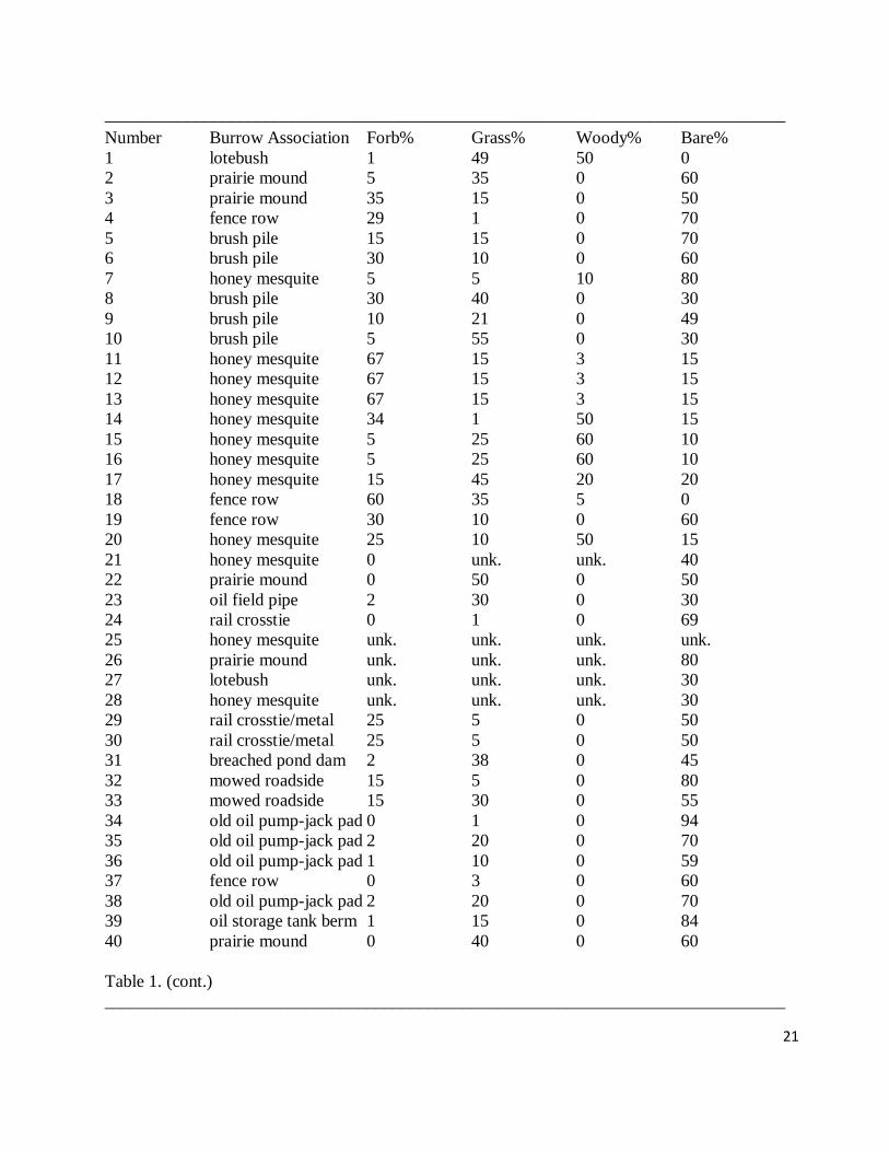
Table 1. Data on burrow association and percentages of forbs, grass, woody vegetation,
and bare ground for 54 active Texas kangaroo rat burrows. If percentages were not measured,
unknown (unk.) is used. Range, mean, and standard deviation are provided at the end of the table.
21
______________________________________________________________________________
Number Burrow Association Forb% Grass% Woody% Bare%
1 lotebush 1 49 50 0
2 prairie mound 5 35 0 60
3 prairie mound 35 15 0 50
4 fence row 29 1 0 70
5 brush pile 15 15 0 70
6 brush pile 30 10 0 60
7 honey mesquite 5 5 10 80
8 brush pile 30 40 0 30
9 brush pile 10 21 0 49
10 brush pile 5 55 0 30
11 honey mesquite 67 15 3 15
12 honey mesquite 67 15 3 15
13 honey mesquite 67 15 3 15
14 honey mesquite 34 1 50 15
15 honey mesquite 5 25 60 10
16 honey mesquite 5 25 60 10
17 honey mesquite 15 45 20 20
18 fence row 60 35 5 0
19 fence row 30 10 0 60
20 honey mesquite 25 10 50 15
21 honey mesquite 0 unk. unk. 40
22 prairie mound 0 50 0 50
23 oil field pipe 2 30 0 30
24 rail crosstie 0 1 0 69
25 honey mesquite unk. unk. unk. unk.
26 prairie mound unk. unk. unk. 80
27 lotebush unk. unk. unk. 30
28 honey mesquite unk. unk. unk. 30
29 rail crosstie/metal 25 5 0 50
30 rail crosstie/metal 25 5 0 50
31 breached pond dam 2 38 0 45
32 mowed roadside 15 5 0 80
33 mowed roadside 15 30 0 55
34 old oil pump-jack pad 0 1 0 94
35 old oil pump-jack pad 2 20 0 70
36 old oil pump-jack pad 1 10 0 59
37 fence row 0 3 0 60
38 old oil pump-jack pad 2 20 0 70
39 oil storage tank berm 1 15 0 84
40 prairie mound 0 40 0 60
Table 1. (cont.)
______________________________________________________________________________
22
Number Burrow Association Forb% Grass% Woody% Bare%
41 honey mesquite 0 30 25 45
42 honey mesquite 0 10 50 40
43 prairie mound 1 30 0 69
44 fence row 25 40 0 35
45 honey mesquite 2 43 35 20
46 fence row 10 45 0 45
47 fence row 10 45 0 45
48 honey mesquite 30 25 20 25
49 fence row 25 30 0 45
50 fence row 20 30 0 45
51 honey mesquite 30 20 10 40
52 fence row 35 5 0 60
53 fence row 50 25 0 25
54 old oil pump-jack pad 5 40 0 50
Range 0-67 1-60 0-60 0-94
Mean 17 23 9.3 46
Standard Deviation 19 15 37.9 23

23
Table 2. Data on percentage of other materials found at burrows (rocks, stumps, oil field
metal such as pipes and pump-jack counterweights as well as dead vegetation and holes other than
the burrow), herbaceous (four measurements), and woody vegetation height (as many as two
measurements if more than one shrub present in quadrat, if not than non-applicable (N/A)) in
centimeters for 54 active Texas kangaroo rat burrows. If not measured, then unknown (unk.) is
used. Range, mean, and standard deviation are provided at the end of the table.
______________________________________________________________________________
Number Other% Herbaceous vegetation height Woody vegetation height
#1 #2 #3 #4 #1 #2
1 0 31 15 17 40 121 N/A
2 0 3 3 2 4.5 0 N/A
3 0 0 2.5 10.5 7 0 N/A
4 0 4.9 3 4.5 5.4 0 N/A
5 0 5.5 4 7.5 3 0 N/A
6 0 0 4 13 3 0 N/A
7 0 0 5 7 3 57 19
8 0 13 2 14 9 0 N/A
9 20 11 6 4 2 37 N/A
10 10 7 2 4 2 20 N/A
11 0 32 27 17.8 41 112 N/A
12 0 32 27 17.8 41 112 N/A
13 0 32 27 17.8 41 112 N/A
14 0 13 18 32.5 53 36 N/A
15 0 29 29 25 24 14 N/A
16 0 29 29 25 24 14 N/A
17 0 19 17 45.5 30 54 N/A
18 0 33 32 18 34 0 N/A
19 0 17 15 2.3 1.6 0 N/A
20 0 9 4.5 22 36 21 N/A
21 unk. unk. unk. unk. unk. unk. unk.
22 0 unk. unk. unk. unk. 0 N/A
23 38 0 0 9.2 30 0 N/A
24 30 0 0 0 0 0 N/A
25 unk. unk. unk. unk. unk. unk. unk.
26 unk. unk. unk. unk. unk. unk. unk.
27 unk. unk. unk. unk. unk. unk. unk.
28 unk. unk. unk. unk. unk unk. unk.
29 20 10 9.8 0 0 0 N/A
30 20 10 9.8 0 0 0 N/A
31 15 0 0 0 15 0 N/A
32 0 8.5 4.6 8.8 8 0 N/A
33 0 5.2 14 10 12 0 N/A

24
34 5 0 0 0 0 0 N/A
35 8 0 0 0 24 0 N/A
36 30 0 0 6 3 0 N/A
Table 2. (cont.)
______________________________________________________________________________
Number Other% Herbaceous vegetation height Woody vegetation height
#1 #2 #3 #4 #1 #2
37 37 0 0 0 35 0 N/A
38 8 0 0 0 24 0 N/A
39 0 0 0 1 1.6 0 N/A
40 0 0 0 2.2 8.7 0 N/A
41 0 0 0 0 28 8 N/A
42 0 0 10 7 19 12 N/A
43 0 0 0 31 30 0 N/A
44 0 40 7.5 42 0 0 N/A
45 0 41 47 22 0 10 N/A
46 0 12 17 33 29 0 N/A
47 0 12 17 33 29 0 N/A
48 0 0 0 32 40 9 N/A
49 0 32 17 0 0 0 N/A
50 5 47 0 0 15 0 N/A
51 0 21 17 32 0 1 13
52 0 0 0 32 0 0 N/A
53 0 24 59 27 33 0 N/A
54 5 12 0 0 32 0 N/A
Range 0-38 0-53 0-121
Mean 5.1 14 15
Standard 10.3 14 32
Deviation

25
Table 3. Data on plant richness and dominant forb, grass, and woody vegetation found at 54
active Texas kangaroo rat burrows. Range, mean, and standard deviation for richness is provided
at the end of the table.
______________________________________________________________________________
Number Richness Dominant Forb Dominant Grass Dominant Woody
1 5 Virginia peppergrass little barley lotebush
2 5 Virginia peppergrass little barley none
3 4 Virginia peppergrass little barley none
4 3 unknown little barley none
5 5 Virginia peppergrass little barley none
6 8 common broomweed little barley none
7 10 hog potato little barley honey mesquite
8 7 Virginia peppergrass little barley none
9 10 western ragweed little barley none
10 5 Virginia peppergrass little barley none
11 6 common broomweed little barley honey mesquite
12 6 common broomweed little barley honey mesquite
13 6 common broomweed little barley honey mesquite
14 8 common broomweed little barley honey mesquite
15 6 Virginia peppergrass little barley honey mesquite
16 6 Virginia peppergrass little barley honey mesquite
17 10 common broomweed buffalo grass honey mesquite
18 10 common broomweed little barley none
19 7 common broomweed rescue grass none
20 6 common broomweed little barley honey mesquite
21 2 none little barley honey mesquite
22 2 none buffalo grass none
23 4 western ragweed little barley none
24 1 none whorled dropseed none
25 unk. western ragweed little barley honey mesquite
26 unk. silverleaf nightshade buffalo grass none
27 unk. hog potato little barley lotebush
28 unk. mock cypress little barley honey mesquite
29 12 sagebrush rescue grass none
30 12 sagebrush rescue grass none
31 3 Virginia peppergrass little barley none
32 7 sleepy daisy purple threeawn none
33 11 sleepy daisy purple threeawn none
34 1 none whorled dropseed none
35 4 silverleaf nightshate white tridens none
36 4 silverleaf nightshade whorled dropseed none
26
37 2 none whorled dropseed none
38 4 silverleaf nightshade white tridens none
Table 3. (cont.)
______________________________________________________________________________
Number Richness Dominant Forb Dominant Grass Dominant Woody
39 3 silverleaf nightshade purple threeawn none
40 1 none buffalo grass none
41 2 none whorled dropseed honey mesquite
42 2 none whorled dropseed honey mesquite
43 3 hog potato whorled dropseed none
44 6 thick-leaf goosefoot little barley none
45 4 Virginia peppergrass rescue grass honey mesquite
46 12 Virginia peppergrass jointed goat grass none
47 12 Virginia peppergrass jointed goat grass none
48 5 Virginia peppergrass little barley honey mesquite
49 7 Virginia peppergrass little barley none
50 9 thick-leaf goosefoot little barley none
51 6 Virginia peppergrass little barley honey mesquite
52 6 Virginia peppergrass little barley none
53 4 Virginia peppergrass rescue grass none
54 7 Virginia peppergrass little barley none
Range 1-12
Mean 6
Standard 3
Deviation

27
Table 4. Population estimates for Texas kangaroo rats at four sites in Wichita County
Texas (Figure 1).
______________________________________________________________________________
Dates Site Name/Coordinates Population Estimate
May 17-19, 2005 Site C/34.06497N, 98.70709W 2
June 20-22, 2005 3
July 5-7, 2005 4
May 17-19, 2011 2
May 16-18, 2008 Site B/34.05446N, 98.78699W 8
May 16-18, 2011 2
May 16-18, 2011 Site A/34.05423N, 98.781721W 1
March 12-14, 2012 18
May 15-17, 2011 Site D/34.05756N, 98.69716W 2
March 12-14, 2012 3

28
Table 5. Burrow data from samples taken in 2005, 2007, and 2008 compared to 2011 for
average percentages of forbs, grass, woody vegetation, and bare ground as well as average richness
and herbaceous height in Wichita County Texas. Standard deviations are provided in parentheses.
P-values are from a Mann-Whitney Rank Sum Test.
______________________________________________________________________________
2005, 2007, and 2008 2011 P-value
Forb% 22 (21.9) 0.7 (0.8) <0.001
Grass% 22 (16.7) 17.9 (12.6) 0.619
Woody% 12.1 (21.4) 7.5 (16.9) 0.285
Bare ground% 37.8 (23.5) 65.1 (16.3) 0.002
Richness 6.3 (3.0) 4.6 (1.2) <0.001
Herbaceous height 14.2 (13.5) 5.8 (10.5) <0.001
29
Table 6. Data on burrow association and percentages of forbs, grass, woody vegetation,
and bare ground for 46 active Texas kangaroo rat burrows. Range, mean, and standard deviation
are provided at the end of the table.
______________________________________________________________________________
Burrow # Burrow Association Forb% Grass% Woody% Bare%
1 lotebush 1 49 50 0
2 prairie mound 5 35 0 60
3 prairie mound 35 15 0 50
4 fence row 29 1 0 70
5 brush pile 15 15 0 70
6 brush pile 30 10 0 60
7 honey mesquite 5 5 10 80
8 brush pile 30 40 0 30
9 brush pile 10 21 0 49
10 brush pile 5 55 0 30
11 honey mesquite 67 15 3 15
12 honey mesquite 67 15 3 15
13 honey mesquite 67 15 3 15
14 honey mesquite 34 1 50 15
15 honey mesquite 5 25 60 10
16 honey mesquite 5 25 60 10
17 honey mesquite 15 45 20 20
18 fence row 60 35 5 0
19 fence row 30 10 0 60
20 honey mesquite 25 10 50 15
21 oil field pipe 2 30 0 30
22 rail crosstie 0 1 0 69
23 rail crosstie/metal 25 5 0 50
24 rail crosstie/metal 25 5 0 50
25 breached pond dam 2 38 0 45
26 old oil pump-jack pad 0 1 0 94
27 old oil pump-jack pad 2 20 0 70
28 old oil pump-jack pad 1 10 0 59
29 fence row 0 3 0 60
30 old oil pump-jack pad 2 20 0 70
31 oil storage tank berm 1 15 0 84
32 prairie mound 0 40 0 60
33 honey mesquite 0 30 25 45

30
34 honey mesquite 0 10 50 40
35 prairie mound 1 30 0 69
Table 6. (cont.)
______________________________________________________________________________
Burrow # Burrow Association Forb% Grass% Woody% Bare%
36 fence row 25 40 0 35
37 honey mesquite 2 43 35 20
38 fence row 10 45 0 45
39 fence row 10 45 0 45
40 honey mesquite 30 25 20 25
41 fence row 25 30 0 45
42 fence row 20 30 0 45
43 honey mesquite 30 20 10 60
44 fence row 35 5 0 60
45 fence row 50 25 0 25
46 old oil pump-jack pad 5 40 0 50
Range 0-67 1-55 0-60 0-94
Mean 18.0 22.8 9.9 44.0
Standard Deviation 20.0 15.2 18.6 23.0

31
Table 7. Data on percentage of other materials found at burrows (rocks, stumps, oil field
metal such as pipes and pump-jack counterweights as well as dead vegetation and holes other than
the burrow), herbaceous (four measurements), and woody vegetation height (as many as two
measurements if more than one shrub present in quadrat, if not than non-applicable (N/A)) in
centimeters for 46 Texas kangaroo rats. If not measured, then unknown (unk.) is used. Range,
mean, and standard deviation are provided at the end of the table.
______________________________________________________________________________
Burrow # Other% Herbaceous vegetation height Woody vegetation height
#1 #2 #3 #4 #1 #2
1 0 31 15 17 40 121 N/A
2 0 3 3 2 4.5 0 N/A
3 0 0 2.5 10.5 7 0 N/A
4 0 4.9 3 4.5 5.4 0 N/A
5 0 5.5 4 7.5 3 0 N/A
6 0 0 4 13 3 0 N/A
7 0 0 5 7 3 57 19
8 0 13 2 14 9 0 N/A
9 20 11 6 4 2 37 N/A
10 10 7 2 4 2 20 N/A
11 0 32 27 17.8 41 112 N/A
12 0 32 27 17.8 41 112 N/A
13 0 32 27 17.8 41 112 N/A
14 0 13 18 32.5 53 36 N/A
15 0 29 29 25 24 14 N/A
16 0 29 29 25 24 14 N/A
17 0 19 17 45.5 30 54 N/A
18 0 33 32 18 34 0 N/A
19 0 17 15 2.3 1.6 0 N/A
20 0 9 4.5 22 36 21 N/A
21 38 0 0 9.2 30 0 N/A
22 30 0 0 0 0 0 N/A
23 20 10 9.8 0 0 0 N/A
24 20 10 9.8 0 0 0 N/A
25 15 0 0 0 15 0 N/A
26 5 0 0 0 0 0 N/A
27 8 0 0 0 24 0 N/A
28 30 0 0 6 3 0 N/A
29 37 0 0 0 35 0 N/A
30 8 0 0 0 24 0 N/A

32
31 0 0 0 1 1.6 0 N/A
Table 7. (cont.)
______________________________________________________________________________
Burrow # Other% Herbaceous vegetation height Woody vegetation height
#1 #2 #3 #4 #1 #2
32 0 0 0 2.2 8.7 0 N/A
33 0 0 0 0 28 8 N/A
34 0 0 10 7 19 12 N/A
35 0 0 0 31 30 0 N/A
36 0 40 7.5 42 0 0 N/A
37 0 41 47 22 0 10 N/A
38 0 12 17 33 29 0 N/A
39 0 12 17 33 29 0 N/A
40 0 0 0 32 40 9 N/A
41 0 32 17 0 0 0 N/A
42 5 47 0 0 15 0 N/A
43 0 21 17 32 0 1 13
44 0 0 0 32 0 0 N/A
45 0 24 59 27 33 0 N/A
46 5 12 0 0 32 0 N/A
Range 0-30 0-59 0-121
Mean 5.5 14.0 16.0
Standard 10.5 14.0 33
Deviation

33
Table 8. Data on plant richness and dominant forb, grass, and woody vegetation found at
46 active Texas kangaroo rat burrows. Range, mean, and standard deviation for richness is
provided at the end of the table.
______________________________________________________________________________
Burrow # Richness Forb Grass Woody vegetation
1 5 Lepidium virginicum L. Hordeum Ziziphus obtusifolia
(Virginia pepper-grass) pusillum Nutt. (Hook.) Torr. & A.
(little barley) Gray) A. Gray
(lotebush)
2 5 Virginia pepper-grass little barley none
3 4 Virginia pepper-grass little barley none
4 3 unknown forb little barley none
5 5 Virginia pepper-grass little barley none
6 8 Gutierrezia dracunculoides
(DC) S. F. Blake (common
broomweed) little barley none
7 10 Hoffmannseggia glauca
(Ortega) Eifert (hog potato) little barley Prosopis glandulosa
Torr. (honey mesquite)
8 7 Virginia pepper-grass little barley none
9 10 Ambrosia psilostachya DC.
(western ragweed) little barley none
10 5 Virginia pepper-grass little barley none
11 6 common broomweed little barley honey mesquite
12 6 common broomweed little barley honey mesquite
13 6 common broomweed little barley honey mesquite
14 8 common broomweed little barley honey mesquite
15 6 Virginia pepper-grass little barley honey mesquite
16 6 Virginia pepper-grass little barley honey mesquite
17 10 common broomweed Buchloe
dactyloides
(Nutt.) Engelm.
(buffalo grass) honey mesquite
18 10 common broomweed little barley none
19 7 common broomweed Bromus
catharticus
Vahl
(rescue grass) none
20 6 common broomweed little barley honey mesquite

34
Table 8. (cont.)
______________________________________________________________________________
Burrow # Richness Forb Grass Woody vegetation
21 4 western ragweed little barley none
22 1 none Sporobolus
pyramidatus
(Lam.) Hitchc.
(whorled
dropseed) none
23 12 Artemesia ludoviciana Nutt.
(sagebrush) rescue grass none
24 12 sagebrush rescue grass none
25 3 Virginia pepper-grass little barley none
26 1 none whorled
dropseed none
27 4 Solanum elaeagnifolium
Cav. (silverleaf nightshade) Tridens
albescens
(Vasey)
Wooton &
Standl. (white
tridens) none
28 4 silverleaf nightshade whorled
dropseed none
29 2 none whorled
dropseed none
30 4 silverleaf nightshade white tridens none
31 3 silverleaf nightshade Aristida
purpurea Nutt.
(purple
threeawn) none
32 1 none buffalo grass none
33 2 none whorled
dropseed honey mesquite
34 2 none whorled
dropseed honey mesquite
35 3 hog potato whorled
dropseed none
36 6 Chenopodium pratericola
Rybd. (thick-leaf goosefoot) little barley none
35
Table 8. (cont.)
______________________________________________________________________________
Burrow # Richness Forb Grass Woody vegetation
37 4 Virginia pepper-grass rescue grass honey mesquite
38 12 Virginia pepper-grass Aegilops
cylindrica
Host (jointed
goat grass) none
39 12 Virginia pepper-grass jointed goat
grass none
40 5 Virginia pepper-grass little barley honey mesquite
41 7 Virginia pepper-grass little barley none
42 9 thick-leaf goosefoot little barley none
43 6 Virginia pepper-grass little barley honey mesquite
44 6 Virginia pepper-grass little barley none
45 4 Virginia pepper-grass rescue grass none
46 7 Virginia pepper-grass little barley none
Range 1-12
Mean 6
Standard 3
Deviation
36
Table 9. Data on burrow association and percentages of forbs, grass, woody vegetation,
bare ground, and other as well as herbaceous and woody vegetation height, richness, and dominant
burrow species for two Texas kangaroo rats from Hardeman County, Texas.
Burrow # Burrow Association Forb% Grass% Woody% Bare%
1 mowed roadside 15 5 0 80
2 mowed roadside 15 30 0 55
Other% Herbaceous vegetation height Woody vegetation height Richness
0 8.5 4.6 8.8 8 0 N/A 7
0 5.2 14 10 12 0 N/A 10
Dominant Forb Dominant Grass Dominant Woody
Xanthisma texanum DC. (sleepy daisy) purple threeawn none
sleepy daisy purple threeawn none

37
Table 10. Trapping localities at Copper Breaks State Park (CBSP) and one site outside the
park where the Texas kangaroo rat was captured. Numbered site localities are taken from Martin
(2002). Geographic coordinates are in decimal degrees (DDC).
Trap site DDC Trapnights
CBSP
8607061 34.11845N, 99.75390W 270
861201 34.11868N, 99.75730W 300
861203 34.11817N, 99.75943W 250
8710241 34.11015N, 99.75630W 250
9311121 34.10624N, 99.75653W 444
861202 34.11770N, 99.75468W 25
Longhorn enclosure 34.11216N, 99.74036W 988
Trapping Grid 34.10857N, 99.75618W 2600
Texas kangaroo rat site 34.15218N, 99.62694W 285

38
Table 11. Mammalian species arranged alphabetically by family and numbers of captures
in Copper Breaks SP (CBSP) and a site outside the park where the Texas kangaroo rat was
captured.
________________________________________________________________________
Species Number of captures
CBSP
Heteromyidae
Chaetodipus hispidus 11
Muridae
Baiomys taylori 114
Neotoma leucodon 2
Neotoma micropus 2
Peromyscus attwateri 89
Peromyscus leucopus 11
Peromyscus maniculatus 7
Reithrodontomys fulvescens 33
Reithrodontomys montanus 10
Sigmodon hispidus 97
Texas kangaroo rat site
Heteromyidae
Dipodomys elator 3
Muridae
Peromyscus leucopus 1
________________________________________________________________________

39
Table 12. Dominant vegetation and average herbaceous height, percent coverage of bare
ground, forbs, grasses, woody, and richness at in the Copper Breaks State Park (CBSP) trapping
grid and outside the park where two Texas kangaroo rats were caught. Ranges are enclosed in
parentheses. Dominant forbs are western ragweed (Ambrosia psilostachya) and Texas sleepy
daisy (Xanthisma texanum). Dominant grasses are Japanese brome (Bromus japonicus) and purple
threeawn (Aristida purpurea). Woody vegetation includes sugarberry (Celtis laevigata) and Texas
prickly-pear (Opuntia engelmanii).
_____________________________________________________________________
CBSP Quadrats Outside Park Quadrats
(n=10) (n=2)
Dominant Forb western ragweed Texas sleepy daisy
Dominant Grass Japanese brome Purple threeawn
Dominant Woody Veg. Texas prickly-pear None
Avg. Herb. Height (cm) 19.5 (0-37.5) 8.7 (4.6-13.5)
Avg. % Bare Ground 5.3 (0-30) 67.5 (55-80)
Avg % Forbs 2.7 (0-4) 15 (15-15)
Avg % Grasses 90.3 (70-98) 17.5 (5-30)
Avg.% Woody veg. 2.1 (0-10) 0 (0-0)
Avg. Richness 4.2 (3-5) 9 (7-11)

40
Appendix 1. Sites surveyed for presence of Dipodomys elator (Texas kangaroo rat),
abbreviated field notes, number of trapnights, and animals captured during status survey.
Martin (2002) sites (9029 trapnights)
1. Martin’s (2002) Record # 8607061. March 15, 2008. TX, Hardeman Co. Copper Breaks
State Park. Near Big Pond Lake at Group Camp Site # 46 (34.118450N, 99.753900W).
Sandstone outcrops with thin soil. Bare areas surrounded by dense vegetation. Dominant
shrub is juniper and dominant herb is little bluestem. No active burrows, runs (trails
between burrows), or dust bathing sites. 100 trapnights. Catch: Two Peromyscus
leucopus, six P. maniculatus, 10 Sigmodon hispidus, and six Baiomys taylori. March 13,
2011. 40 trapnights. Catch: Five P. attwateri in areas of little bluestem and juniper with
20-60% bare ground. April 16, 2011. 130 trap nights. Within 200 meters of Martin site.
Catch 19 P. attwateri, one P. maniculatus, five Reithrodontomys fulvescens, two S.
hispidus, one B. taylori, and one Neotoma leucodon. Total Trapnights: 270
2. Martin’s (2002) Record # 861201. March 13-18, 2011. TX, Hardeman Co. Copper Breaks
State Park. About 100 meters north of parking area for equestrian area near old windmill
(34.118687N, 99.757301W). Rocky, thin soil. Not as rocky as Group Camp Site # 46 but
with large amounts of small rock mixed with soil. Dominant shrubs are juniper and some
mesquite, and dominant herb is sideoats grama. No active runs, burrows, or dust bathing
sites. 250 trapnights. Catch: 28 Peromyscus attwateri mostly near junipers with 30-80%
bare ground; three Sigmodon hispidus in 100% covered areas near mesquite, prickly pear,
or no shrubs; one Baiomys taylori in 100% cover near juniper; and three Reithrodontomys
fulvescens in 70-90 % cover near juniper or prickly pear. May 25-27, 2011. 50 trapnights.
Catch: Two P. attwateri, one R. fulvescens, one R. montanus and two Chaetodipus
hispidus. Total Trapnights: 300
3. Martin’s (2002) Record # 861203. March 13-18, 2011. TX, Hardeman Co. Copper Breaks
State Park. About 0.3 miles northwest of intersection of Park Road 62 at Comanche
Camping Area entrance sign. South side of road just east of green electrical box
(34.11817N, 99.759433W). Loamy, relatively thick soil. Mesquite grassland with many
grass species but possibly vine mesquite as dominant grass. Dominant shrub is mesquite
with a few scattered junipers. No active runs, burrows, or dust bathing sites. 250
trapnights. Catch: Two Peromyscus attwateri mostly near junipers with 30% bare ground;
three P. leucopus in 0-10% bare ground near mesquite, juniper, and allthorn, respectively;
20 Sigmodon hispidus in 0-20% bare areas; six Baiomys taylori with 0 % bare ground; and
one Reithrodontomys montanus, as well as four R. fulvescens with 0-30% bare ground near
mesquite or less often juniper. Total Trapnights: 250
4. Martin’s (2002) Record # 8710241. March 13-18, 2011. TX, Hardeman Co. Copper
Breaks State Park. About 0.09 miles northwest of intersection of Park Road 62 at
Comanche Camping Area entrance sign, South side of road on curve (34.110150N,
99.756300W). Loamy, relatively thick soil. Mesquite grassland with many grass species
41
but possibly vine mesquite as dominant grass. Dominant shrub is mesquite with no
junipers. No active runs, burrows, or dust bathing sites. 250 trapnights. Catch: 16
Sigmodon hispidus with 0% bare areas near mesquite, prickly pear, or no shrubs; 20
Baiomys taylori in 0 % bare ground near mesquite, prickly pear, or rarely no shrubs; and
six Reithrodontomys fulvescens in 0-30% cover near mesquite or less often prickly pear.
Total Trapnights: 250
5. Martin’s (2002) Record # 9311121. June 30, 2006-May 9, 2007 (not continuous).
Trapping grid. See Table 12 for vegetative characteristics. No active runs, burrows, or
dust bathing sites. 2600 trapnights. Catch: Eight Chaetodipus hispidus, 75 Baiomys
taylori, one Reithrodontomys fulvescens, and eight R. montanus. May 19-20, 2008. TX,
Hardeman Co. Copper Breaks State Park. About 30 meters north of Bull Canyon Hiking
Trail sign on north side of road (34.106246N, 99.756539W). Clay-loam, relatively thick
soil. Mesquite and juniper grassland with little bluestem as dominant grass. About equal
numbers of mesquite and juniper. 24 trapnights. Catch: 14 Sigmodon hispidus, one
Peromyscus leucopus, and two Neotoma micropus. March 13-18, 2011. 250 trapnights.
Catch: 23 S. hispidus in with 0% bare areas mostly near mesquite and juniper but a few
near allthorn, prickly pear, and ephedra; two B. taylori with 0 % bare ground mostly near
mesquite; and two R. fulvescens in areas with 0% bare ground. April 17, 2011. 120 trap
nights. Within 200 meters of Martin site. Catch 12 P. attwateri, four P. leucopus, three R.
fulvescens, four S. hispidus, and one N. leucodon. May 25-27, 2011. 50 trapnights. Catch:
Two S. hispidus and one C. hispidus. Total Trapnights: 3044
6. Martin’s (2002) Record # 861202. March 15-18, 2011. TX, Hardeman Co. Copper Breaks
State Park. Area just behind Camp Site # 40 in Equestrian Camping Area (34.1177080N,
99.754684W). Sandstone outcrops with thin soil. Bare areas surrounded by dense
vegetation. Dominant shrub is juniper and dominant herb is little bluestem. No active
runs, burrows, or dust bathing sites. 25 trapnights. Catch: 12 Peromyscus attwateri in 10-
60% bare areas near junipers and/or rock outcrops. Total Trapnights: 25
7. Martin’s (2002) Record # 9608181. May 18, 2011. TX, Archer Co. Intersection of
Cemetery Road and North Parkey Ranch Road (33.72695N, 98.895367W). Clay soil.
Road side adjacent to mesquite pasture with fire break. Bare areas in fire break surrounded
by fairly dense vegetation with about 10% bare ground. Dominant shrub in adjacent
pasture is mesquite and dominant herb is broomweed. No indication of burrows, runs, or
dust bathing near fence. 15 trapnights. Catch: One Reithrodontomys fulvescens.
Total Trapnights: 15
8. Martin’s (2002) Record # 0008241. May 18, 2011. TX, Archer Co. About 200 yards from
southeast corner of Dundee Cemetery along North Parkey Ranch Road adjacent to
pastureland across from wheat field beside cemetery (33.72682N, 98.88364W). Clay soil.
Roadside adjacent to mesquite pasture with fairly dense vegetation with about 10% bare
ground. Dominant shrub in adjacent pasture is mesquite and dominant herb is broomweed.
No indication of burrows, runs, or dust bathing near fence. 15 trapnights. Catch: One
Chaetodipus hispidus. Total Trapnights: 15

42
9. Martin’s (2002) Record # 9908131. March 18, 2011. TX, Wilbarger Co. On Harrold Lane,
about 2.4 miles intersection of Highway 287 and Harrold Lane (34.04217N, 99.015951W).
Clay soil. Road side adjacent to mesquite pasture currently being root-plowed. Dominant
shrub in adjacent pasture is mesquite. Because of root-plowing and road grading there was
little herbaceous vegetation with 90-100% bare ground. Saw some holes in old fence line
but no indication of burrows, runs, or dust bathing near fence. Observed wild hogs along
road. 10 trapnights. Catch: No animals captured.
Total Trapnights: 10
10. Martin’s (2002) Record # 9908134. March 18, 2011. TX, Wilbarger Co. On Harrold Lane,
about 2.4 miles intersection of Highway 287 and Harrold Lane (34.04217N, 99.015951W).
Clay soil. Road side adjacent to mesquite pasture currently being root-plowed. Dominant
shrub in adjacent pasture is mesquite. Because of root-plowing and road grading there was
little herbaceous vegetation with about 90% bare ground. Saw some holes in old fence line
but no indication of burrows, runs, or dust bathing near fence. Observed wild hogs along
road. 10 trapnights. Catch: No animals captured.
Total Trapnights: 10
11. Site reported by Martin (2002) as an unplottable locality for Buffalo Creek Reservoir.
Mesquite grassland. May 23-24, 2011. TX, Wichita County. Buffalo Creek Reservoir.
Northwest corner of reservoir land boundary at entrance gate and along west boundary
fence. Coordinates at entrance gate: 34.00937N, 98.76695W). Clay soil with sandstone
bedrock. Bare areas surrounded by short vegetation. Dominant shrub is mesquite.
Dominant herb is silverleaf nightshade and grass is little barley. 35 trapnights. Catch: One
Peromyscus maniculatus. Surveyed for burrows on south and north entrance areas. North
entrance area was good habitat with grazing and bare ground and it was surveyed for
burrows from entrance gate to near back side of reservoir property. Bare ground was often
40-60%. No burrows were found but because the habitat was good and Martin had
reported six unplottable localities as Buffalo Creek Reservoir or Buffalo Lake, trapping
was done though no active burrows, runs, or dust bathing sites were located. June 30-July
3, 2011. Locality at northwest boundary of reservoir as well as southwest, northeast and
southeast localities. 300 trapnights. Catch: Four P. maniculatus, one Reithrodontomys
montanus, and one Neotoma leucodon. July 14-July 17, 2011. 300 trapnights. Catch:
Two P. maniculatus, one P. leucopus, and one Sigmodon hispidus. August 4-August 7,
2011. 300 trapnights. Catch: One R. montanus. August 18-August 21, 2011. 300
trapnights. Catch: Two P. maniculatus and one P. leucopus. September 1-4. 300
trapnights. Catch: Three P. maniculatus. September 22-25, 2011. 300 trapnights. Catch:
Nine P. maniculatus. September 29-October 2, 2011. 300 trapnights. Catch: One P.
maniculatus. October 13-October 16, 2011. 300 trapnights. Catch: Three P. maniculatus.
November 3-November 6, 2011. 300 trapnights. Catch: Four P. maniculatus. November
10-November 13, 2011. 300 trapnights. Catch: One S. hispidus. December 1-December
4, 2011. 300 trapnights. Catch: One P. maniculatus. December 15-December 18, 2011.
300 trapnights. Catch: One P. maniculatus. January 10-January 13, 2012. 300 trapnights.
Catch: No animals captured. January 27-January 30, 2012. 300 trapnights. Catch: 13 P.

43
maniculatus. February 3-February 6, 2012. 300 trapnights. Catch: Two P. maniculatus.
February 17-February 20, 2012. 300 trapnights. Catch: Three P. maniculatus. March 2-
March 5, 2012. 300 trapnights. Catch: Four P. maniculatus. March 16-March 19, 2012.
300 trapnights. Catch: Three P. maniculatus. April 13-April 16, 2012. 300 trapnights.
Catch: Five P. maniculatus. April 27-April 30. 300 trapnights. Catch: Two P.
maniculatus. May 3-4, 2012. 100 trapnights. Catch: One Chaetodipus hispidis. Total
Trapnights: 6135
12. Martin’s (2002) Record # 9708053. May 25-27, 2011. TX, Hardeman Co. Near entrance
to Copper Breaks State Park about six steps north of the Quanah/Altus road sign on east
side of Highway 6 (34.114072N, 99.731298W). Road side adjacent to cultivated field.
Dominant vegetation was Johnsongrass with no shrubs or herbaceous vegetation. Field
was surrounded by fire break. No active burrows, runs, or dust bathing sites observed and
there was little bare ground likely less than 5%. 10 trapnights. Catch: No animals
captured. Total Trapnights: 10
13. Martin’s (2002) Record # 87072523. May 25-27, 2011. TX, Hardeman Co. Near
intersection of Star Valley Road and Highway 6, about 25 yards east of stop sign on north
side of Star Valley Road (34.128517N, 99.73250W). Road side adjacent to ungrazed field
with roadside having similar vegetation to field. Dominant vegetation was mesquite and a
few small junipers with little bluestem and ragweed. No active burrows, runs, or dust
bathing sites observed and there was up to 60% bare ground. 10 trapnights. Catch: Two
Peromyscus maniculatus and one Chaetodipus hispidis. Total Trapnights: 10
14. Martin’s (2002) Record # 983101. May 25-27, 2011. TX, Hardeman Co. 0.2 miles west of
intersection of Highway 6 and Copper Breaks Road. At double gates of ranch on north side
of Copper Breaks Road. Martin site is actually about 10 steps into private land on north
side of road (34.128914N, 99.73657W). Trapped on each side of gate on county road
right-of-way. Road side adjacent to pastureland with roadside having similar vegetation.
Dominant vegetation was mesquite and junipers with some lotebush with dropseed and
broomweed. No active burrows, runs, or dust bathing sites observed and there was up to
60% bare ground. 10 trapnights. Catch: One Baiomys taylori. May 14-23, 2012. 80
trapnights. Catch: One Neotoma micropus, two Perognathus merriami, and one
Peromyscus maniculatus. Total Trapnights: 90
15. Martin’s (2002) Record # 982102. May 25-27, 2011. TX, Hardeman Co. 0.2 miles west of
intersection of Highway 6 and Copper Breaks Road. Across from double gates of ranch on
south side of Copper Breaks Road. Martin site is actually about 80 steps into private land
on south side of road (34.128015N, 99.73612W). Trapped on county road right-of-way.
Road side adjacent to pastureland with roadside having similar vegetation. Dominant
vegetation was mesquite, prickly pear, and junipers with some ephedra and lotebush with
sideoats grama and broomweed. No active burrows, runs, or dust bathing sites observed
and there was up to 50% bare ground. There were some mammal runways extending under
juniper and around prickly pear. 10 trapnights. Catch: One Peromyscus attwateri and one

44
Neotoma micropus near prickly pear and juniper. May 14-23, 2012. 80 trapnights. Catch:
One N. micropus. Total Trapnights: 90
16. Martin’s (2002) Record # 932101. May 25-27, 2011. TX, Hardeman Co. 0.2 miles west of
intersection of Highway 6 and Copper Breaks Road. Across from double gates of ranch on
south side of Copper Breaks Road. Martin site is actually about 80 steps into private land
on south side of road (34.128015N, 99.73612W). Trapped on county road right-of-way.
Road side adjacent to pastureland with roadside having similar vegetation. Dominant
vegetation was mesquite, prickly pear, and junipers with some ephedra and lotebush with
sideoats grama and broomweed. No active burrows, runs, or dust bathing sites observed
and there was up to 50% bare ground. There were some mammal runways extending under
juniper and around prickly pear. 10 trapnights. Catch: One Peromyscus attwateri and two
Neotoma micropus near prickly pear and juniper. May 14-23, 2012. 80 trapnights. Catch:
One N. micropus. Total Trapnights: 90
17. Martin’s (2002) Record # 932102. May 19-21, 2008. TX, Hardeman Co. 0.2 miles west of
intersection of Highway 6 and Copper Breaks Road. Across from double gates of ranch on
south side of Copper Breaks Road. Martin site is actually about 80 steps into private land
on south side of road (34.128028N, 99.73672W). Trapped on county road right-of-way.
Road side adjacent to pastureland with roadside having similar vegetation. Dominant
vegetation was mesquite, prickly pear, and junipers with some ephedra and lotebush with
sideoats grama and broomweed. No active burrows, runs, or dust bathing sites observed
and there was up to 50% bare ground. Traps placed around mesquite and prickly pear. 65
trapnights. Catch: 10 Peromyscus leucopus, one P. maniculatus, one Chaetodipus
hispidus, and 13 Neotoma micropa. May 25-27, 2011. 10 trapnights. Catch: Two P.
attwateri and one Baiomys taylori. May 14-23, 2012. 80 trapnights. Catch: Three N.
micropus. Total Trapnights: 155
18. Martin’s (2002) Record # 87072522. May 25-27, 2011. TX, Hardeman Co. Near
intersection of Wolf Hunt Road and Highway 6 near stop sign on north side of Wolf Hunt
Road (34.21190N, 99.74021W). Road side adjacent to pastureland with little grazing.
Dominant vegetation at roadside was hackberry with dropseed and thistles. No active
burrows, runs, or dust bathing sites observed and there was little bare ground, probably less
than 20% over most of trap site. 10 trapnights. Catch: Two Peromyscus leucopus and one
P. attwateri. Total Trapnights: 10
19. Martin’s (2002) Record # 87072521. May 25-27, 2011. TX, Hardeman Co. About 0.1
miles north of the intersection of Wolf Hunt Road and Highway 6 on east side of Highway
6 (34.212850N, 99.740217W). Road side adjacent to pastureland with little grazing.
Dominant vegetation at roadside was lotebush and mesquite with dropseed and sensitive-
briar. No active burrows, runs, or dust bathing sites observed and there was less than 20%
bare ground. 10 trapnights. Catch: Five Peromyscus attwateri. Total Trapnights: 10
20. Martin’s (2002) Record # 87072524. May 25-27, 2011. TX, Hardeman Co. 0.2 miles
north of the intersection of Stepp Road and Highway 6 on east side of Highway 6

45
(34.229200N, 99.739650W). Road side adjacent to pastureland with little grazing.
Dominant vegetation at roadside was juniper with dropseed and few forbs. No active
burrows, runs, or dust bathing sites observed and there was less than 5% bare ground. 10
trapnights. Catch: One Peromyscus leucopus. Total Trapnights: 10
21. Martin’s (2002) Record # 87072525. May 25-27, 2011. TX, Hardeman Co. 0.4 miles
north of the intersection of Stepp Road and Highway 6 on east side of Highway 6
(34.231950N, 99.739650W). Road side adjacent to pastureland with little grazing.
Dominant vegetation at roadside was mesquite with Johnsongrass and few forbs. No active
burrows, runs, or dust bathing sites observed and there was less than 5% bare ground. 10
trapnights. Catch: Three Peromyscus leucopus, one Baiomys taylori, and one Sigmodon
hispidus. Total Trapnights: 10
22. Martin’s (2002) Record # 913101. May 25, 2011. TX, Hardeman Co. 0.16 miles north of
the intersection of Bynum Road and Highway 6 in irrigated cropland (34.257467N,
99.736417W). Did not trap at site as it was in field on private property and the habitat was
poor. Current crop was wheat and there was irrigation at the site. Possible that this was
once pasture land that was converted to cropland in recent history. Total Trapnights: 0
23. Martin’s (2002) Record # 86072526. May 25, 2011. TX, Hardeman Co. 0.12 miles south
of the First United Methodist Church in Quanah on the east side of Highway 6
(34.283967N, 99.742800W). Area near two houses (one relatively new) and modified into
a horse pen. Horses had removed most vegetation. Did not trap due to poor habitat and
proximity of houses. Possible this was once pastureland that was converted to houses and
horse pens in recent history. Total Trapnights: 0
24. Martin’s (2002) Record # 87072525. May 25, 2011. TX, Hardeman Co. Intersection of
Highway 133 (Hamby Road) and FM 2560 (34.231950N, 99.739650W). Area at fence
corner with tall Johnsongrass adjacent to recently plowed cropland. Did not trap due to
poor habitat. Possible this was once pastureland that was converted to cropland in recent
history. Total Trapnights: 0
25. Martin’s (2002) Record # 8607292. May 25, 2011. TX, Hardeman Co. Intersection of
Highway 133 (Hamby Road) and FM 2560 (34.299533N, 99.719733W). Area at fence
corner with tall Johnsongrass adjacent to recently established yard with mobile home.
Mesquite pastureland north of mobile home but had not been grazed and there was no
evidence of burrows, runs, or dust bathing sites. Did not trap due to poor habitat. Possible
this was once pastureland that was converted to a homesite in recent history. Total
Trapnights: 0
26. Martin’s (2002) Record # 8607281. May 25, 2011. TX, Hardeman Co. 0.36 miles from
intersection of Highway 133 (Hamby Road) and FM 2560 on north side of Hamby Road
(34.299533N, 99.714017W). Area at narrow roadside with steep berm. Adjacent to
ungrazed tall dropseed and mesquite pastureland. No burrow activity, runs, or dust bathing

46
sites and little bare ground. Because of steepness of road berm and poor habitat the area
was not trapped.
Total Trapnights: 0
27. Martin’s (2002) Record # 86071215. May 25-27, 2011. TX, Hardeman Co. South of
intersection of Highway 133 (Hamby Road) and FM 2560 at railroad right-of-way where it
crosses FM 2560 (34.29666N, 99.719950W). Area at fence corner with tall little barley
and dense growth of tumbleweed adjacent to cropland. No active burrows, runs, or dust
bathing sites observed and there was less than 5% bare ground. 10 trapnights. Catch: One
Peromyscus maniculatus and four Sigmodon hispidus. Total Trapnights: 10
28. Martin’s (2002) Record # 0008281. June 13, 2011. TX, Motley Co. 0.7 miles east
intersection of County Road 423 and 404 on County Road 404 (33.980129N,
100.763644W). Cultivated fields on both sides of road with roadside dominated by
Japanese brome with few forbs. No burrow activity, runs, or dust bathing sites with only
10-20% bare ground. Did not trap due to poor habitat. Possible this was once pastureland
that was converted to a cultivated field in recent history. Total Trapnights: 0
29. Martin’s (2002) Record # 9908141. June 13, 2011. TX, Motley Co. 0.06 mile east
intersection of County Road 423 and 404 on County Road 404 (33.980357N,
100.773983W). Cultivated cotton fields on both sides of road with field plowed to
roadside with little vegetation. No burrow activity, runs, or dust bathing sites with 90-
100% bare ground due to plowing. Did not trap due to poor habitat. Possible this was once
pastureland that was converted to a cultivated field in recent history. Total Trapnights: 0
30. Martin’s (2002) Record # 9908142. June 13, 2011. TX, Motley Co. 0.06 mile east
intersection of County Road 423 and 404 on County Road 404 (33.980357N,
100.773983W). Cultivated cotton fields on both sides of road with field plowed to
roadside with little vegetation. No burrow activity, runs, or dust bathing sites with 90-
100% bare ground due to plowing. Did not trap due to poor habitat. Possible this was once
pastureland that was converted to a cultivated field in recent history. Total Trapnights: 0
31. Martin’s (2002) Record # 0008282. June 13, 2011. TX, Motley Co. 0.06 mile east
intersection of County Road 423 and 404 on County Road 404 (33.980160N,
100.774035W). Cultivated cotton fields on both sides of road with field plowed to
roadside with little vegetation. No burrow activity, runs, or dust bathing sites with 90-
100% bare ground due to plowing. Did not trap due to poor habitat. Possible this was once
pastureland that was converted to a cultivated field in recent history. Total Trapnights: 0
32. Martin’s (2002) Record # 0008283. June 13, 2011. TX, Motley Co. North of (0.06 mile)
the east intersection of County Road 423 and 404 on County Road 404 on private land in
cultivated field (33.983044N, 100.774095W). Cultivated cotton fields on both sides of
road with field plowed to roadside with little vegetation. No burrow activity, runs, or dust
bathing sites at road and unlikely in field on private land with 90-100% bare ground due to

47
plowing. Did not trap due to poor habitat. Possible this was once pastureland that was
converted to a cultivated field in recent history. Total Trapnights: 0
33. Martin’s (2002) Record # 0008284. June 13-14, 2011. TX, Motley Co. 0.3 miles west
intersection of County Road 433 and 422 on County Road 422 (33.995135N,
100.744901W). Cultivated fields on both sides of road with roadside dominated by
Japanese brome and bermuda with few forbs and no woody vegetation. No burrow
activity, runs, or dust bathing sites with only 10-20% bare ground. 10 trapnights. Catch:
No animals captured.
Total Trapnights: 10
34. Martin’s (2002) Record # 9608142. June 13, 2011. TX, Motley Co. 5.3 miles northeast
intersection of County Road 247 and Highway 62/70 on County Road 247 (34.051728N,
100.633105W). Matador Ranch gate blocked road at about 5.0 miles and employees said
that the road past the gate was ranch road and no longer county road. Did not trap as was
on private property. Total Trapnights: 0
35. Martin’s (2002) Record # 9608142. June 13, 2011. TX, Motley Co. at about 5.5 miles
northeast intersection of County Road 247 and Highway 62/70 on County Road 247
(34.054369N, 100.632919W). Matador Ranch gate blocked road at about 5.0 miles and
employees said that the road past the gate was ranch road and no longer county road. Did
not trap as was on private property. Total Trapnights: 0
36. Martin’s (2002) Record # 19960814. June 13-14, 2011. TX, Motley Co. 2.2 miles north
intersection of County Road 247 and Highway 62/70 on County Road 247 (34.039259N,
100.650482W). Mesquite pasture with little to no grazing and new fence. Cultivated fields
on opposite side of road with roadside dominated by Japanese brome with few forbs and no
woody vegetation. No burrow activity, runs, or dust bathing sites with only 5% bare
ground. 10 trapnights. Catch: No animals captured. Total Trapnights: 10
37. Martin’s (2002) Record # 0008285. June 13-14, 2011. TX, Motley Co. Intersection of
County Road 433 and Highway 62 on south side Highway 62 (34.009701N,
100.738702W). Cultivated fields surrounded by new fence on both sides road with
roadside dominated by oats and dropseed with few forbs and no woody vegetation. No
burrow activity, runs, or dust bathing sites with only 5% bare ground. 10 trapnights.
Catch: No animals captured.
Total Trapnights: 10
38. Martin’s (2002) Record # 9908152. June 13, 2011. TX, Childress Co. 1.6 miles north
intersection of County Road 24 and County Road Z on County Road 24 (34.414375N,
100.020134W). Cultivated fields on both sides of road with field plowed to roadside ditch
with little vegetation. Deep roadside ditch filled with sunflowers. No burrow activity,
runs, or dust bathing sites with 0% bare ground. Did not trap due to poor habitat. Possible
this was once pastureland that was converted to a cultivated field in recent history. Total
Trapnights: 0

48
39. Martin’s (2002) Record # 9708051. June 13, 2011. TX, Childress Co. Intersection of
County Road 21 and County Road EE (34.319379N, 100.075531W). Cultivated fields on
all sides of roads with field plowed to roadsides with little vegetation. Roadside ditch with
scattered Bermuda grass and sunflowers. No burrow activity, runs, or dust bathing sites
with 90-100% bare ground due to plowing to road edge. Did not trap due to poor habitat.
Possible this was once pastureland that was converted to a cultivated field in recent history.
Total Trapnights: 0
40. Martin’s (2002) Record # 970852. June 13-14, 2011. TX, Childress Co. 0.7 miles west
intersection of Ranch Road 2638 and County Road AA on County Road AA (34.378751N,
100.103523W). Cultivated wheat fields surrounded on both sides road with roadside
dominated by Japanese brome, some ragweed, with a few prickly pears in the fence. Old
fence with a berm. No burrow activity, runs, or dust bathing sites with only 10-20% bare
ground. 10 trapnights. Catch: No animals captured. Total Trapnights: 10
41. Martin’s (2002) Record # 9806211. June 13-14, 2011. TX, Childress Co. 0.17 miles north
intersection of County Road 24 and County Road Z on County Road 24 (34.393736N,
100.020419W). Mesquite pasture surrounded by old fence with pasture grazed. No active
burrows, runs, or dust bathing sites. 10 trapnights. Catch: No animals captured. May 15-
23, 2012. 122 trapnights. Catch: One Peromyscus maniculatus and one P. leucopus.
Total Trapnights: 132
42. Martin’s (2002) Record # 0007271. June 13-14, 2011. TX, Childress Co. 0.17 miles north
intersection of County Road 24 and County Road Z on County Road 24 (34.393736N,
100.020419W). Mesquite pasture surrounded by old fence with a good berm. Dropseed
and threeawn with few forbs and 40-60% bare areas. Adjacent pasture grazed. No active
burrows, runs, or dust bathing sites. 10 trapnights. Catch: No animals captured. May
15-23, 2012. 123 trapnights. Catch: One Peromyscus maniculatus. Total Trapnights:
133
43. Martin’s (2002) Record # 9908151. June 13-14, 2011. TX, Childress Co. 0.52 miles north
intersection of County Road 24 and County Road Z on County Road 24 (34.398857N,
100.020611W). Mesquite pasture surrounded by old fence with a good berm. Fence with
some yucca and large rocks. Dropseed and buffalograss with few forbs and 30-40% bare
areas. No active burrows, runs, or dust bathing sites. Adjacent pasture grazed. 10
trapnights. Catch: No animals captured. May 15-23, 2012. 175 trapnights. Catch: Four
Peromyscus maniculatus. Total Trapnights: 185
44. Martin’s (2002) Record # 9607091. June 13-14, 2011. TX, Childress Co. 0.6 miles
intersection of Highway 287 and Farm to Market Highway 2875, south on 2875
(34.362050N, 100.021833W). Cultivated fields surrounded by older fence on both sides
road with roadside dominated by Johnsongrass with few forbs and no woody vegetation.
Road paved and roadside mowed. No burrow activity, runs, or dust bathing sites. with 0-
10% bare ground. 10 trapnights. Catch: No animals captured. Total Trapnights: 10

49
45. Martin’s (2002) Record # 9607091. June 14, 2011. TX, Hardeman Co. 3.36 miles
intersection of Highway 287 and Farm to Market Highway 268, north on 268 (34.405533N,
99.967017W). Ungrazed mesquite pasture on east side of road and cultivated field on west
side road. East roadside dominated by Johnsongrass with few forbs and no woody
vegetation. Road paved and roadside mowed. No burrow activity, runs, or dust bathing
sites with 0% bare ground. 10 trapnights. Catch: One Sigmodon hispidus. Total
Trapnights: 10
46. Martin’s (2002) Record # 8607291. June 18, 2011. TX, Hardeman Co. 1.39 miles east
intersection of Hamby Road (133) and Farm to Market Highway 2568, east on Hamby
Road (34.299533N, 99.69593W). Ungrazed mesquite pasture. Roadside dominated by
dropseed and buffalograss with a few ragweeds and mesquite in older fence. No burrow
activity, runs, or dust bathing sites with 70-80% bare ground. 10 trapnights. Catch: No
animals captured. May 15-23, 2012. 140 trapnights. Catch: One Neotoma micropus.
Total Trapnights: 150
47. Martin’s (2002) Record # 8607301. June 18, 2011. TX, Hardeman Co. 1.8 miles east
intersection of Hamby Road (133) and Farm to Market Highway 2568, east on Hamby
Road (34.299533N, 99.688833W). Ungrazed mesquite pasture. Roadside dominated by
dropseed and ragweed with no mesquite in older fence. No burrow activity, runs, or dust
bathing sites with 0% bare ground. 10 trapnights. Catch: No animals captured. May 15-
23, 2012. 140 trapnights. Catch: Two Peromyscus leucopus and four P. maniculatus.
Total Trapnights: 150
48. Martin’s (2002) Record # 8707252. June 18, 2011. TX, Hardeman Co. 0.02 mile
northeast intersection of Bursey Road and Farm to Market Highway 2568, in abandoned
field (34.278417N, 99.720433W). Ungrazed abandoned field south of relatively new home
and adjacent to older home. Roadside dominated by Johnsongrass with a few ragweed.
Older fence paralleling paved highway that was mowed. No burrow activity, runs, or dust
bathing sites with 5% bare ground. Did not trap because of proximity to homes and poor
habitat. Total Trapnights: 0
Non-Martin (2002) Sites (3901 trapnights)
1. Goetze and Nelson (2011). Burrows along oil field road and salt scald (bare area caused by
salt water spillage during oil extraction) in mesquite grassland. May 15-19, 2011. TX,
Wichita County. Goetze Farm. Snow Place. 0.5 miles intersection Highway 2345 and
Hall Road (coordinates at entrance gate: 34.05756N, 98.69716W). Clay soil with
sandstone bedrock. Bare areas surrounded by short vegetation. Dominant shrub is
mesquite and herbs are silverleaf nightshade, white tridens, and whorled dropseed.
Burrows, runs, and dust bathing sites visible. 132 trapnights. Catch: 12 (five individuals
and seven recaptures; four females and one male) Dipodomys elator in 78-97% bare ground
near oil field pipe, road berms, and in fence lines. Also caught two Chaetodipus hispidus,
three Neotoma leucodon, four Peromyscus leucopus, seven P. maniculatus, and two
Sigmodon hispidus. June 30-July 6, 2011. Roadside ditch dominated by Johnsongrass and

50
bermudagrass and no forbs, One hackberry in fence with 0% bare ground except for those
traps along gravel road edge, which is completely bare on one side of about five of the
traps. No active burrows, runs, or dust bathing sites. 150 trapnights at gate entrance
around gate and fence at intersection of oil field and Hall Road. Catch: Nine P. leucopus.
August 3-August 7, 2011. Roadside ditch dominated by Johnsongrass and bermudagrass
and no forbs. One hackberry in fence with 0% bare ground except for those traps along
gravel road edge, which is completely bare on one side for five of the traps. No active
burrows, runs, or dust bathing sites. 100 trapnights at gate entrance around gate and fence
at intersection of oil field and Hall Road. Catch: 13 P. leucopus and one S. hispidus.
March 13-15, 2012. Clay soil with sandstone bedrock. Bare areas surrounded by short
vegetation. Dominant shrub is mesquite and herbs are silverleaf nightshade, white tridens,
and whorled dropseed. Active burrows, runs, and dust bathing sites observed. 48
trapnights. Catch: Six (three individuals and three recaptures; two females and one male)
D. elator in 25%-60% bare ground near oil field pipe, road berms, and in fence lines. Also
caught five P. leucopus and two P. maniculatus. May 4, 2012. 24 trapnights. Catch: Two
P. maniculatus. Total Trapnights: 454 (204 inside pasture and 250 outside at fence
and gate adjacent to Hall Road)
2. Nelson, Nelson, and Goetze site (2007). May 17-19, 2007. TX, Hardeman County. 5.1
miles east of Intersection of Highway 6 and Hurst Williams Road on Hurst Williams Road
until it becomes Highway 3295. Then 1.4 miles on Highway 3295 on north side of road
(34.15163N, 99.64107W). Roadside adjacent to ungrazed little bluestem pastureland.
Area along fence with little bluestem, side oats grama, purple threeawn, and Texas sleepy
daisy, and 55-80% bare ground. Two active burrows observed. 50 trapnights. Catch: One
Peromyscus leucopus and three (two individuals and one recapture; one female and one
male) Dipodomys elator. March 25-27, 2011. Area along fence with little bluestem, side
oats grama, few herbs, and 20-60% bare ground. No active burrows observed. 20
trapnights. Catch: No animals captured. June 18, 2011. No active burrows, runs, or dust
bathing sites observed. 40 trapnights. Catch: No animals captured. May 15-23, 2012. No
active burrows, runs, or dust bathing sites observed. 175 trapnights. Catch: No animals
captured. Total Trapnights: 285
3. Nelson, Nelson, and Goetze 2007. Longhorn enclosure fenceline. May 19-20, 2007. TX,
Hardeman Co. Copper Breaks State Park. West end of fence-line around longhorn
enclosure, 0.2 miles from park entrance (34.11216N, 99.74036W). Loamy soil. Dominant
shrubs are juniper and some mesquite, and dominant herb is sideoats grama on grazed side
of fence and little bluestem on ungrazed side. Grazed side as more bare areas and is more
like catch-sites for Texas kangaroo rat than other areas of the park. No active burrows,
runs, or dust bathing sites. 105 trapnights. Catch: No animals caught. March 13-18, 2011.
100 trapnights. Catch: Nine Peromyscus attwateri mostly near junipers with 5-30% bare
areas; one P. leucopus in 20% bare areas near juniper; and five Reithrodontomys
fulvescens with 0-10 % bare ground mostly near mesquite. April 16-17, 2011. Longhorn
Pasture at second gate after passing through park maintenance area. Traps set parallel to
cross fence beginning at gate (34.11068N, 99.73571W). Area grazed by longhorns with
30-50% bare ground. Dominant shrub was mesquite and dominant grass was sideoats

51
grama that had been grazed mostly to less than 12 cm in height. No active burrows, runs,
or dust bathing sites. 460 trap nights. Catch: three R. fulvescens, three Sigmodon hispidus,
and three Baiomys taylori. May 28, 2011. 50 trapnights. At site mentioned above for
April 16-17, 2011 and on east boundary fence on both sides of entrance gate into longhorn
enclosure (34.11029N, 99.73326W). Catch: No animals captured. May 15-23, 2012. 273
trapnights. Catch: None. Total Trapnights: 988
4. Goetze 2008. Burrows in pastureland with one near oil storage battery. Mesquite and
lotebush grassland. May 15-17, 2008. TX, Wichita County. Goetze Farm. Eades Place.
0.4 miles east of intersection of Highway 1739 and Highway 2345. (coordinates at
entrance gate: 34.05446N, 98.78699 W). Clay soil with sandstone bedrock. Bare areas
surrounded by short vegetation. Dominant shrubs are mesquite and lotebush. Herbs are
silverleaf nightshade, purple threeawn, and buffalo grass. Active runs, burrows, and dust
bathing sites observed. 160 trapnights. Catch: nine Peromyscus leucopus, nine Neotoma
micropus, and twelve (11 individuals and one recapture; five females and six males)
Dipodomys elator. May 17-19, 2011. 72 trapnights. Catch: Three (two individuals and
one recapture; one female and one male) D. elator in 60-74% bare areas near oil storage
tank and prairie mound. Active runs, burrows, and dust bathing sites observed. July 13-
July 22, 2012. North side of place on either side of entrance gate adjacent to Highway
2345. Roadside and fenceline dominated by Japanese brome. No active burrows, runs, or
dust bathing sites observed. 250 trapnights. Catch: No animals caught. Also walked over
area inside property and observed active burrows, runs, and dust bathing sites but was
unable to trap as new owner did not give permission after property changed ownership in
2012. Total Trapnights: 482 (232 inside pasture and 250 outside at fence and gate
adjacent to Hall Road)
5. Goetze 2007. Burrows in pasture land. Mesquite and lotebush grassland. March 11, 2007.
TX, Wichita County. Goetze Farm. Overall Place. Intersection of Highway 1739 and
Highway 2345. (coordinates at entrance gate: 34.05423N, 98.781721W). Clay soil with
sandstone bedrock. Bare areas surrounded by short vegetation. Dominant shrubs are
mesquite and lotebush. Herbs are silverleaf nightshade, whorled dropseed, and buffalo
grass. Active burrows, runs, and dust bathing sites observed. 30 trapnights. Catch: 10 (10
individuals; six females and four males) Dipodomys elator. May 17-19, 2011. Active
burrows, runs, and dust bathing sites observed. 108 trapnights. Catch: Two (one
individual and one recapture; one female) D. elator in 40-45% bare areas near low
growing, small mesquites. Also caught one Chaetodipus hispidus and four Peromyscus
leucopus. March 12-14, 2012. Active burrows, runs, and dust bathing sites observed. 144
trapnights. Catch: Eleven (10 individuals and one recapture; six females and four males)
D. elator in 20%-45% bare areas near low growing, small mesquites. Also caught three P.
leucopus and 11 P. maniculatus. May 3-4, 2012. Active burrows, runs, and dust bathing
sites observed. 72 trapnights. Catch: One D. elator (female). July 13-July 22, 2012.
Inside pasture at about same localities as above with dominant vegetation little barley and
buffalograss. Active burrows, runs, and dust bathing sites observed. 375 trapnights.
Catch: Eight (six individuals and zero recaptures; sex not determined) D. elator in fence
row and near low growing, small mesquites. Also caught two C. hispidus. July 13-July 22,

52
2012. On either side of entrance gate adjacent to Highway 1739. Roadside and fenceline
dominated by dense Japanese brome. No active burrows, runs, and dust bathing sites
observed. 375 trapnights. Catch: One D. elator (sex not determined) in fence row
adjacent to salt scald near low growing, small mesquites. Also caught two C. hispidus, one
Sigmodon hispidus, and three P. leucopus.
Total Trapnights: 1004 (629 inside pasture and 375 outside at fence and gate adjacent
to Hall Road)
6. Goetze 2005. Burrows in pasture land. Mesquite and lotebush grassland. May 21-July 22,
2005 (not continuous). TX, Wichita County. Goetze Farm. Home Place. On Goetze Road
about 3.5 miles east of intersection of Goetze Road and Highway 2345 (coordinates at
entrance gate: 34.06497N, 98.70709W). Clay soil with sandstone bedrock. Bare areas
surrounded by short vegetation. Dominant shrubs are mesquite and lotebush. Herbs are
silverleaf nightshade, hog potato, whorled dropseed, and buffalo grass. Active burrows,
runs, and dust bathing sites observed. 996 trap nights. Catch: 45 Dipodomys elator (18
individuals and 37 recaptures; nine females and nine males), 10 Chaetodipus hispidus, four
Neotoma micropus, and two Peromyscus leucopus. May 17-20, 2011. Active burrows,
runs, and dust bathing sites observed. 72 trapnights. Catch: One (male) D. elator in 69%
bare area at prairie mound. Also caught one C. hispidus and one Baiomys taylori. May 3-
4, 2012. Goetze Road that intersects site on north end (34.03843N, 98.76068W). Roadside
and fenceline dominated by dense Japanese brome. No active burrows, runs, and dust
bathing sites observed. 10 trapnights. Catch: No animals caught. July 13-July 22, 2012.
Same as May 3-4, 2012 site. 250 trapnights. Catch: One P. leucopus. Also walked over
area inside property and observed active burrows, runs, and dust bathing sites but was
unable to trap as new owner did not give permission after property changed ownership in
2012. Total Trapnights: 1328 (1078 inside pasture and 260 outside at fence and gate
adjacent to Hall Road)
7. Goetze 2011. Salvaged dead Dipodomys elator on Hall Road. June 25, 2011. TX, Wichita
County. About 150 yards intersection Highway 2345 and Hall Road (coordinates at
34.06412N, 98.69678W). June 30-July 6, 2011. Trapped on east side of road in ditch at
these coordinates. Adjacent area is mesquite pasture. Roadside ditch and fence with two
mesquites in fence and dominated by silver bluestem and Johnsongrass. Few to no forbs
and 10% bare ground. No active burrows, runs, and dust bathing sites observed. 150
trapnights. Catch: Four Peromyscus leucopus. Total Trapnights: 150