surrounded by volcanoes - usgs publications warehouse · pdf filesurrounded by volcanoes. ......
TRANSCRIPT

Overview This multi-faceted activity leads students from a broad discussion about plate tectonics to specific information about volcanic peaks of the Cascade Range. “Introducing Cascade Volcanoes as Links on the Ring of Fire” explores the location of Cascade volcanoes on the “Ring of Fire.” “Exploring Earthquakes and Volcanoes at Plate Boundaries” addresses associations of plate boundaries, earthquakes and the location of Cascade volcanoes. In “Discovering Volcanoes of the Cascade Range using Satellite Imagery” students investigate the location of Cascade volcanoes on a satellite photo using computer technology, or identify volcanoes on a conventional map.
Learner Objectives:Students will: ● Recognize individual Cascade volcanoes as part of an extensive volcanic mountain range, and as part of the circum-Pacific “Ring of Fire” ● Draw conclusions on relationships between tectonic plate movement and the occurrence of volcanic activity
Setting: Classroom, computer lab
Timeframe: Two 50-minute sessions
Session I: Introducing Cascade Volcanoes as Links on the Ring of Fire
Exploring Earthquakes and Volcanoes at Plate Boundaries
Session II:
Discovering Volcanoes of the Cascade Range using Satellite Imagery
Grade Level: 5+
Surrounded by Volcanoes
1
Materials:Introducing Cascade Volcanoes as Linkson the Ring of Fire ● Copies of “Introducing Cascade Volcanoes as Links on the Ring of Fire” student page ● Graphic “Cascade Volcanoes Links on the Ring of Fire” (optional) ● Dynamic Planet map (optional)
Exploring Earthquakes and Volcanoes atPlate Boundaries ● Copies of “Plate Tectonics-Cascade Range” student page ● Copies of “Using Earthquakes to Find the Subduction Zone”
● Graphic “Plate Tectonics Processes”
● Graphic “Types of Tectonic Plate Boundaries” ● Graphic “Plate Tectonics—Cascade Range”
Activity last modified: July 22, 2015
U.S. Department of the InteriorU.S. Geological Survey
General Information Product 19
Living with a Volcano in Your Backyard-An Educator's Guide with Emphasis onMount Rainier
Prepared in collaboration with the National Park Service
NATIONALPARK
SERVICE

Surrounded by Volcanoes-continued . . .
2
● Graphic “Using Earthquakes to Find the Subduction Zone” (student page) ● Graphic “Using Earthquakes to Find the Subduction Zone” (teacher page)
Discovering Volcanoes of the Cascade Range using Satellite Imagery
● Student-use computers ● Graphics or word processing program and the provided satellite image file installed on student computers ● “Surrounded by Volcanoes—Satellite Image” student page (digital file of same name) or “Map of Cascade Volcanoes” as low-tech adaptation ● Graphic “Map of Cascade Volcanoes”
Vocabulary: Asthenosphere, Cascadia Subduction Zone, convergent plate boundary, divergent plate boundary, hot spots, lithosphere, mafic, magma, magma chamber, mantle, Ring of Fire, spreading ridge, subduction, tectonic plates, transform plate boundary
Skills: interpreting, mapping, observing, relating spatially, synthesizing
Benchmarks:
See benchmarks in Introduction.
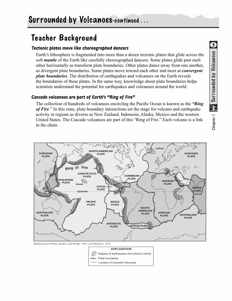
Teacher BackgroundTectonic plates move like choreographed dancers
Earth’s lithosphere is fragmented into more than a dozen tectonic plates that glide across the soft mantle of the Earth like carefully choreographed dancers. Some plates glide past each other horizontally as transform plate boundaries. Other plates dance away from one another, as divergent plate boundaries. Some plates move toward each other and meet at convergent plate boundaries. The distribution of earthquakes and volcanoes on the Earth reveals the boundaries of these plates. In the same way, knowledge about plate boundaries helps scientists understand the potential for earthquakes and volcanoes around the world.
Cascade volcanoes are part of Earth’s “Ring of Fire” The collection of hundreds of volcanoes encircling the Pacific Ocean is known as the “Ring of Fire.” In this zone, plate boundary interactions set the stage for volcano and earthquake activity in regions as diverse as New Zealand, Indonesia, Alaska, Mexico and the western United States. The Cascade volcanoes are part of this “Ring of Fire.” Each volcano is a link in the chain.
Surrounded by Volcanoes-continued . . .
3
Modified from Tilling, Heliker, and Wright, 1987, and Hamilton, 1976
AUSTRALIANPLATE
PACIFICPLATE
ANTARCTICPLATE
SOUTH AMERICAN
PLATE
NORTH AMERICANPLATE
JUAN DE FUCAPLATE
AUSTRALIANPLATE
INDIANPLATE
CARIBBEANPLATE
EURASIANPLATE
EURASIANPLATE
SCOTIA PLATE
COCOSPLATE
NAZCAPLATE
AFRICANPLATE
ARABIANPLATE
EQUATOR
Hawaii
Iceland
PHILIPPINEPLATE
Ring of Fire
Regions of earthquakes and volcanic activity
Plate boundaries
EXPLANATION
Location of Cascade Volcanoes
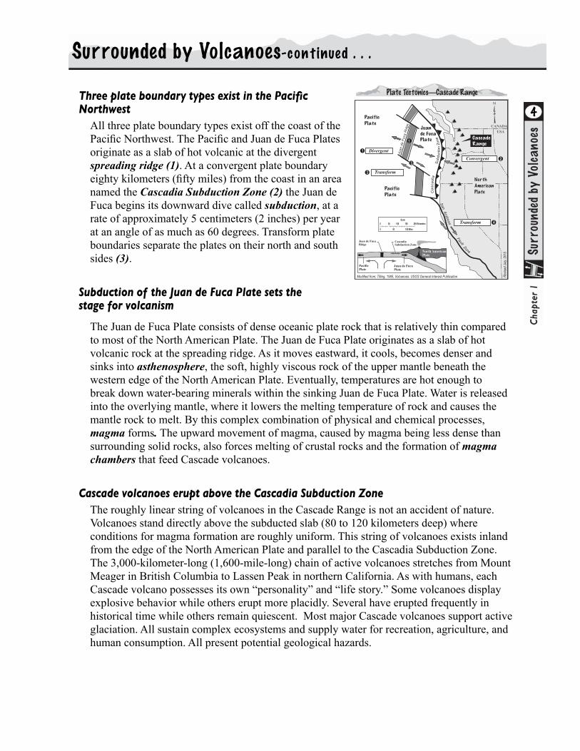
Three plate boundary types exist in the Pacific Northwest
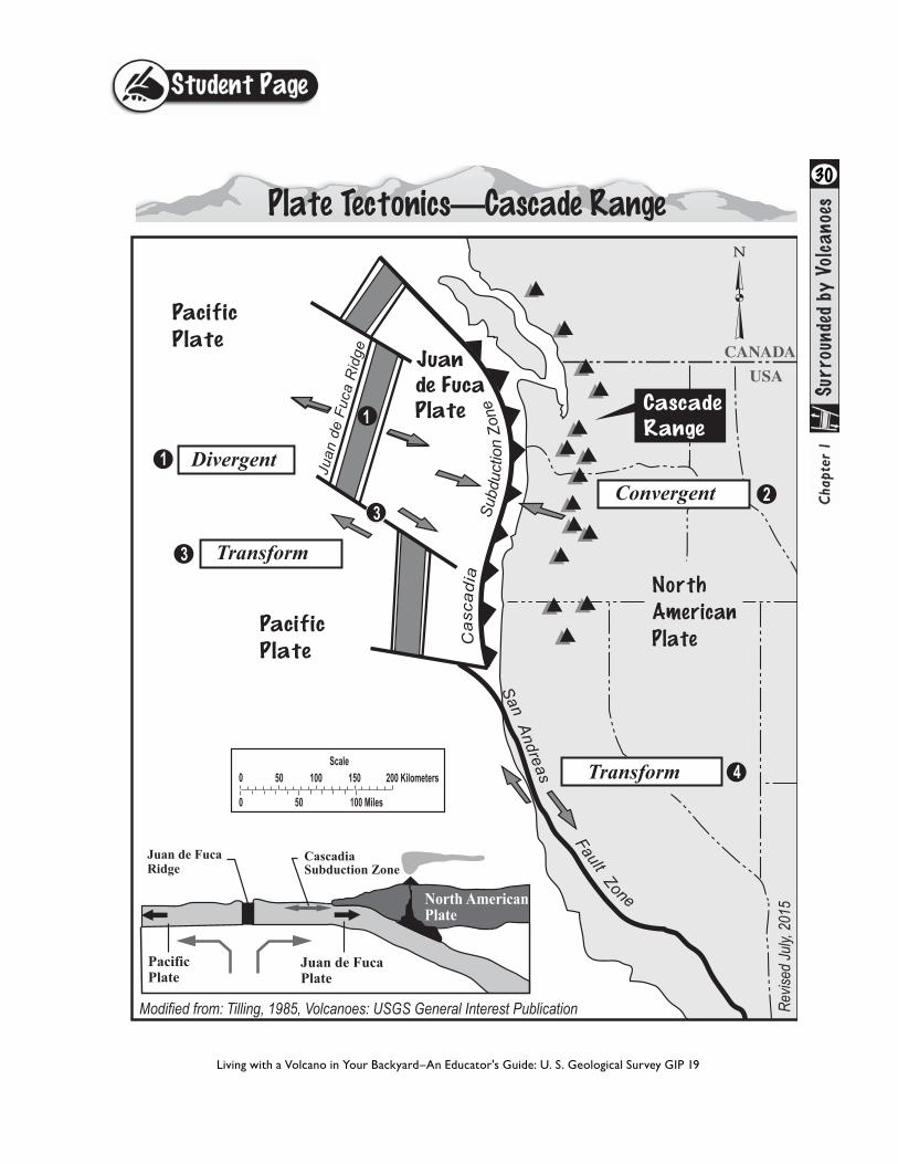
All three plate boundary types exist off the coast of the Pacific Northwest. The Pacific and Juan de Fuca Plates originate as a slab of hot volcanic at the divergent spreading ridge (1). At a convergent plate boundary eighty kilometers (fifty miles) from the coast in an area named the Cascadia Subduction Zone (2) the Juan de Fuca begins its downward dive called subduction, at a rate of approximately 5 centimeters (2 inches) per year at an angle of as much as 60 degrees. Transform plate boundaries separate the plates on their north and south sides (3).
Subduction of the Juan de Fuca Plate sets the stage for volcanism
The Juan de Fuca Plate consists of dense oceanic plate rock that is relatively thin compared to most of the North American Plate. The Juan de Fuca Plate originates as a slab of hot volcanic rock at the spreading ridge. As it moves eastward, it cools, becomes denser and sinks into asthenosphere, the soft, highly viscous rock of the upper mantle beneath the western edge of the North American Plate. Eventually, temperatures are hot enough to break down water-bearing minerals within the sinking Juan de Fuca Plate. Water is released into the overlying mantle, where it lowers the melting temperature of rock and causes the mantle rock to melt. By this complex combination of physical and chemical processes, magma forms. The upward movement of magma, caused by magma being less dense than surrounding solid rocks, also forces melting of crustal rocks and the formation of magma chambers that feed Cascade volcanoes.
Cascade volcanoes erupt above the Cascadia Subduction ZoneThe roughly linear string of volcanoes in the Cascade Range is not an accident of nature. Volcanoes stand directly above the subducted slab (80 to 120 kilometers deep) where conditions for magma formation are roughly uniform. This string of volcanoes exists inland from the edge of the North American Plate and parallel to the Cascadia Subduction Zone. The 3,000-kilometer-long (1,600-mile-long) chain of active volcanoes stretches from Mount Meager in British Columbia to Lassen Peak in northern California. As with humans, each Cascade volcano possesses its own “personality” and “life story.” Some volcanoes display explosive behavior while others erupt more placidly. Several have erupted frequently in historical time while others remain quiescent. Most major Cascade volcanoes support active glaciation. All sustain complex ecosystems and supply water for recreation, agriculture, and human consumption. All present potential geological hazards.
Surrounded by Volcanoes-continued . . .
4Pacific
Plate
Pacific
Plate
Juande FucaPlate
North
American
Plate
Modified from: Tilling, 1985, Volcanoes: USGS General Interest Publication Revis
ed Ju
ly, 2
015
San Andreas
Fault Zone
Juan
de
Fuca
Rid
ge CANADA
USA
Scale
0 50 100 Miles
0 50 100 150 200 Kilometers
PacificPlate
Juan de FucaPlate
North AmericanPlate
Juan de Fuca Ridge
CascadiaSubduction Zone
1
3
Plate Tectonics—Cascade Range
Cas
cadi
a
Cascade Range
1
3
2
4

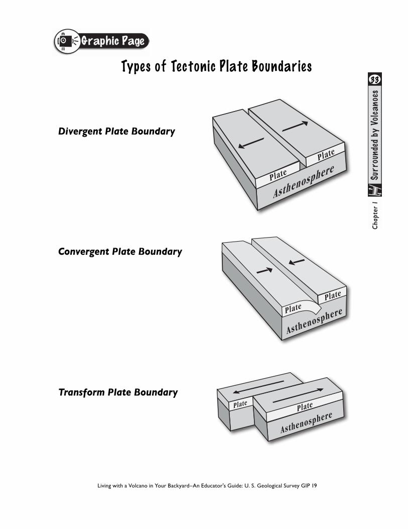
DIVERGENT PLATE BOUNDARIES
About seventy-five percent of Earth’s volcanism occurs sight unseen at the ocean bottom, where plates pull apart along divergent plate boundaries. Magma rises in the gap between the separating plates and erupts—building volcanoes as a spreading ridge on the sea floor. The recently (1998) erupting Axial Seamount located on the west edge of the Juan de Fuca Plate, 480 kilometers (300 miles) west of Cannon Beach, Oregon, is one of the best documented examples. Another well-known illustration is the spreading ridge of volcanoes along the Mid-Atlantic Ridge, which pulls apart at a rate of about 2.5 centimeters per year (1 inch per year) and which rises above sea level as Iceland.
CONVERGENT PLATE BOUNDARIES
Converging tectonic plates are frequently of different densities. While both plates are in motion, commonly the denser plate moves beneath the other in a process known as subduction. The grinding together of these plates generates a tremendous stress that causes the subducting plate to crack, fracture and shake. Thus, the pattern of earthquakes delineates the position of the subducting slab. Approximately 400 kilometers (250 miles) in depth, temperature and pressure are so high that the subducting plate ultimately loses physical identity and continuing movement fails to produce earthquakes.
TRANSFORM PLATE BOUNDARIES
At transform faults, plates slide past one another horizontally and produce earthquakes, though rarely cause volcanoes. The San Andreas Fault Zone in California, where the Pacific Plate slides past the North American Plate at a rate of 5 centimeters (2 inches) per year, is one of the best known examples of a transform plate boundary. In the Pacific Northwest, a transform plate boundary separates the Juan de Fuca Plate on the north side from the Pacific Plate on the south side.
INTRA-PLATE VOLCANISMThe Hawaiian volcanoes and the Yellowstone volcanic area are two
Tectonic Plates set the Stage for Earthquakes and Volcanoes
Surrounded by Volcanoes-continued . . .
51
examples of regions where magma rises beneath a tectonic plate rather than at plate margins. Continuing plate movement carries the land surface across a persistent source of rising magma called a hot spot. Through time, plate motion across the hot spot allows formation of a line of volcanoes. Not all intra-plate volcanoes are caused by hot spots. Researchers note that the gradual east-west spreading of western North America to form the Basin and Range province is responsible for volcanoes in eastern California, Nevada, Arizona and New Mexico, Utah and southern Idaho, too.

6
CLASSIFICATION BY ROCK TYPE
l Crustal rocks are distinguishable by their silica-rich composition
Underlying mantle rocks contain dark and dense minerals that are abundant in magnesium and iron (mafic rocks).
CLASSIFICATION BY ROCK FLOW PROPERTIES
l Lithosphere includes crustal rocks and the comparatively rigid rocks of the upper mantle. Together, they form a rigid shell, which breaks into pieces (tectonic plates), and moves around like floating puzzle pieces on more mobile mantle rock below.
l Asthenosphere describes the soft, highly viscous rock of the upper mantle, which supports tectonic plates of the lithosphere.
Both systems recognize the existence of a liquid outer and rigid inner core within the earth.
Researchers use two classification systems for categorizing Earth’s internal structure
Actual plate tectonics are more complex than generally portrayed, with many plates being a combination of continental and oceanic rock. In this activity we portray plates solely as oceanic or continental for the sake of simplicity.
The Difference Between Crustand Lithosphere2
Surrounded by Volcanoes-continued . . .
ProcedureWhat to do before class begins:
Introducing Cascade Volcanoes as Links on the Ring of Fire
1. Make copies of student page “Introducing Cascade Volcanoes as Links on the Ring of Fire.”
2. Prepare to show graphic “Cascade Volcanoes—Links on the Ring” teacher page (optional).
Exploring Earthquakes and Volcanoes at Plate Boundaries
1. Make copies of “Plate Tectonics—Cascade Range” and “Using Earthquakes to Find the Subduction Zone.”
2. Prepare to show graphics “Plate Tectonic Processes,” “Types of Tectonic Plate Boundaries,” and “Plate Tectonics—Teacher Page.”
Discovering Volcanoes of the Cascade Range using Satellite Imagery
1. Review capability of your students' computers and determine which graphics or word processing programs are suitable for students’ electronic labeling of features on the digital map provided. The satellite image is in .jpeg format and can be downloaded in almost any graphics program.
2. Download the “Surrounded by Volcanoes—Satellite Image” student page file. Import the image to a blank text document, or use a graphics program if available. Place file in a directory that is accessible to students.
3. If you are using the adaptation option, make copies of “Map of Cascade Volcanoes.”
4. Prepare to show graphics “Discovering Cascade Volcanoes with Satellite Imagery” teacher and student pages.
Surrounded by Volcanoes-continued . . .
7

Introducing Cascade Volcanoes as Links on the Ring of Fire
Students view map of Earth’s tectonic plates, such as the “Cascade Volcanoes—Links on the Ring of Fire,” or the optional “Dynamic Earth” map (see References) or other map. They note the region’s tectonic plate boundaries relative to the zones of earthquakes and volcanoes, and then answer questions.
1. Provide each student with the student page “Cascade Volcanoes—Links on the Ring of Fire,” You can display the color graphic version overhead.
2. Instruct students to answer questions.
3. Discuss answers with the class, focusing attention on the relationship of tectonic plate boundaries to the patterns of distribution of volcanoes and earthquakes.
8
Modified from Tilling, Heliker, and Wright, 1987, and Hamilton, 1976
AUSTRALIANPLATE
PACIFICPLATE
ANTARCTICPLATE
SOUTH AMERICAN
PLATE
NORTH AMERICANPLATE
JUAN DE FUCAPLATE
AUSTRALIANPLATE
INDIANPLATE
CARIBBEANPLATE
EURASIANPLATE
EURASIANPLATE
SCOTIA PLATE
COCOSPLATE
NAZCAPLATE
AFRICANPLATE
ARABIANPLATE
EQUATOR
Hawaii
Iceland
PHILIPPINEPLATE
Ring of Fire
Regions of earthquakes and volcanic activity
Plate boundaries
EXPLANATION
Location of Cascade Volcanoes
Surrounded by Volcanoes-continued . . .

Exploring Earthquakes and Volcanoes at Plate Boundaries
Perform a quick demonstration of plate boundaries, and then make information relevant to the Pacific Northwest with two student pages.
1. Read background to review your knowledge of plate tectonics and positions of Cascade volcanoes.
2. Review the basic concepts of plate tectonics with your students.
3. Demonstrate the three types of plate boundaries by first asking for six student volunteers (smaller numbers of students work as well).
◆ For a Convergent Plate Boundary: Instruct volunteers to form two lines of three—about 3 feet apart and facing each other. The three volunteers on the right represent an oceanic plate, which is dense and thin; and the other three volunteers on the left signify the less dense but thicker continental plate. Volunteers hold their arms out toward the person directly across from them. Students move towards each other and their hands collide. Then the oceanic plate volunteers “dive” their arms beneath the continental plate to illustrate subduction. ◆ For a Divergent Plate Boundary: Instruct volunteers to form two lines of three and to stand toe to toe. Instruct volunteers to grasp the hands of the person across from them. Tell students to move away from each other, slowly releasing their grasp as they inch farther and farther apart. ◆ For a Transform Plate Boundary: Instruct volunteers to form two parallel lines of three students. Ask the groups to face each other and to take three sideways steps to their respective lefts such that they glide past one another. Optional: Line up students who participated in the demonstration and some additional students. Call each forward and introduce them individually, from north to south, as representative of a Cascade volcano.
4. In further discussion use the graphic “Plate Tectonics Processes” and “Types of Tectonic Plate Boundaries” to illustrate plate boundaries.
9
Surrounded by Volcanoes-continued . . .

5. Provide each student with a copy of “Plate Tectonics—Cascade Range” student pages. Students label the three tectonic plate boundary types—convergent, divergent and transform.
6. Distribute “Using Earthquakes to find the Subduction Zone.” Students use depth and longitude data to plot locations of earthquakes. The resulting pattern indicates the location of the Cascadia Subduction Zone. Students answer questions on each student page. Teachers should note the extension activity about earthquakes associated with the Cascadia subduction zone.
7. As a class, review answers and summarize concepts learned.
10
Pacific
Plate
Pacific
Plate
Juande FucaPlate
North
American
Plate
Modified from: Tilling, 1985, Volcanoes: USGS General Interest Publication Revis
ed Ju
ly, 2
015
San Andreas
Fault Zone
Juan
de
Fuca
Rid
ge CANADA
USA
Scale
0 50 100 Miles
0 50 100 150 200 Kilometers
PacificPlate
Juan de FucaPlate
North AmericanPlate
Juan de Fuca Ridge
CascadiaSubduction Zone
1
3
Plate Tectonics—Cascade Range
Cas
cadi
a
Cascade Range
1
3
2
4
North AmericanPlate
Dep
th (k
m)
Longitude (degrees west)135 130 125 120 115
PacificPlate
JuandeFucaPlate
Cascade Range
100
102030405060708090
0
Surrounded by Volcanoes-continued . . .

Discovering Volcanoes of the Cascade Range Using Satellite Imagery
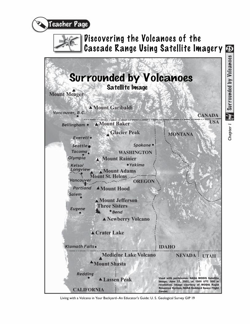
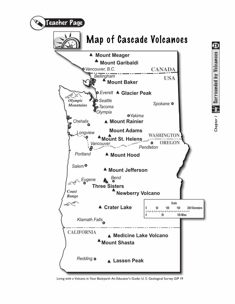
Students use library and Internet resources to find the location of volcanoes and nearby features on the satellite image. This activity can be accomplished using a variety of graphics or word processing computer programs depending on the computer literacy of your students, or in a low-tech manner by copying the graphic and having the students label each volcano by hand. Use student page “Map of Cascade Volcanoes” as a low-tech alternative (See Adaptations).
1. Explain to students that they will be importing a satellite image of volcanoes in the Cascade Range onto their computer and labeling it. The image was taken by either the Aqua or Terra satellites on June 13, 2002, using an instrument called MODIS (MODerate- resolution Imaging Spectroradiometer). This instrument is able to measure different wavelengths of light so that scientists can study oceans and land features. This image was originally used to spot forest fires, but it also provides a great view of volcanoes in the Cascades.
2. Divide students into small groups or instruct them to work individually.
3. Provide each student or group of students with a student page “Discovering Volcanoes of the Cascade Range
11
Vancouver
Kelso/Longview
Olympia
Portland
Salem
Eugene
TacomaSeattle
Vancouver, B.C.
Bellingham
Spokane
Yakima
Everett
Redding
Bend
Klamath Falls
Mount Baker
Mount Garibaldi
Glacier Peak
Mount Rainier
Mount St. HelensMount Adams
Mount Hood
Mount JeffersonThree Sisters
Newberry Volcano
Crater Lake
Medicine Lake VolcanoMount Shasta
Lassen Peak
Mount Meager
Used with permission. NASA MODIS SatelliteImage. June 13, 2002, at 1900 UTC 500 m resolution. Image courtesy of MODIS RapidResponse System, NASA Goddard Space FlightCenter.CALIFORNIA
OREGON
UTAH
IDAHO
MONTANA
NEVADA
CANADAUSA
WASHINGTON
CANADA
USA
CALIFORNIA
WASHINGTONOREGON
▲
▲▲
▲
▲▲▲
▲
▲
▲
▲
▲
▲
▲
▲ ▲
▲
▲
▲▲
▲
▲▲▲
▲
▲
▲
▲
▲
▲
▲
▲ ▲
▲
Mount Baker
Mount Garibaldi
Mount Meager
Glacier Peak
Mount Rainier
Mount St. Helens
Mount Adams
Mount Hood
Mount Jefferson
Three SistersNewberry Volcano
Crater Lake
Medicine Lake VolcanoMount Shasta
Lassen Peak
▲
OlympicMountains
CoastRange
Klamath Falls
Eugene
Salem
Portland
Bellingham
Vancouver, B.C.
Spokane
Longview
Vancouver
Redding
Scale
0 50 100 Miles
0 50 100 150 200 Kilometers
Yakima
Pendleton
Bend
Chehalis
OlympiaTacoma
Everett
Seattle
Using Satellite Imagery.”
4. Open the satellite image in an appropriate program. Review computer tools available for drawing and labeling features on the digital satellite image. In word processing programs, use drawing bar and text boxes.
5. Instruct students to identify and label state and national borders and the location of population centers. Using the Internet and (or) an atlas, students should identify the location of the volcanoes listed on the student activity sheet and circled on the satellite image. Students should label volcanoes on the satellite image.
6. Invite them to explore other land features—snow covered mountains, lakes, rivers, distinct vegetative zones, clouds, and the ocean. They will also note many smaller, less prominent volcanoes.
Surrounded by Volcanoes-continued . . .
12
Adaptations
◆ Introducing Cascade Volcanoes as Links on the Ring of Fire. Use the “This Dynamic Planet” map (see References and Internet Resources) as a more detailed visual to answer questions on the student pages. Explore other volcano issues: the pairing of earthquake zones to regions of volcanism. Ask students to investigate why not all volcanoes exist at plate boundaries. Use “This Dynamic Earth” booklet as resource for this guided exploration (see References and Internet Resources).
◆ Alternative to Exploring the Volcanoes of the Cascade Range using Satellite Imagery. Use a non-technical approach. Students use library and or Internet resources to research location of Cascade volcanoes, then identify and label each on the Map of Cascade Volcanoes.
Extensions
You may want to expand the Internet research goals for this activity.
◆ Use sandwich creme cookies to illustrate convergent, divergent and transform plate boundaries. Distribute one cookie to each student. Explain how the bottom cookie piece represents Earth’s core, the creme in the center illustrates plastic mantle rock, and the top cookie piece represents Earth’s crust and part of the upper mantle. Instruct students to twist off the cookie top and break it in half, then place the two halves back on top of the creme. Coach students through the following steps: use thumbs to move the two top halves towards each other to model convergent plates, away from each other for divergent plates, and back and forth, parallel to each other for a transform plate boundary. Used Courtesy of Dr. Robert Lillie, Oregon State University.
◆ Instruct students to find several facts about each volcano and add them to the information on the satellite image.
◆ Divide students into groups and tell them to become experts about one volcano. Students can later present the information to the class.
◆ Tell students to find information about the Cascade Range and to put it on the satellite image to make a poster.
◆ Instruct students to research the three types of earthquakes associated with the Cascadia subduction zone. They should explain the hazards of each type of earthquake.
◆ Volcano Hall of Fame activity. Students explore the individual personalities of volcanoes in the Cascade Range by reading facts and matching them to the appropriate volcano.
◆ String of Volcanoes activity. This activity is meant for younger grades (3 to 6). Students construct a mobile that represents volcanoes of the Cascade Range. Students use “Fun Facts” to identify and label the volcanoes.
Surrounded by Volcanoes-continued . . .

13AssessmentCascade Volcano Timeline addresses the temporal aspect of eruptions in the Cascades, while Surrounded by Volcanoes addresses the spatial aspect. Assess students’ ability to think of volcanic events in the Cascades on a global scale. For example, at the beginning of the activity, students may have recognized the presence of Cascade volcanoes as isolated topographic features. As the activity progresses, they may have added to their knowledge about how the movement of tectonic plates leads to the development of earthquakes and volcanoes in the Pacific Northwest. They might recognize the names of volcanoes closest to their community, but now they comprehend that the volcanoes are part of a larger pattern. Plate tectonics built the landscape of the Pacific Northwest.
ReferencesDzurisin, D., Stauffer, P., and Hendley, J.W., II, 2003, Living with volcanic risk in the Cascades (revised March, 2008): U.S. Geological Survey Fact Sheet 165–97, 2 p.
Harris, S., 2004, Fire mountains of the West: the Cascade and Mono Lake volcanoes: Missoula, Mont., Mountain Press Publishing Company, 3rd ed, 454 p.
Kious, J.W., and Tilling, R.I., 1996, This dynamic earth: the story of plate tectonics: U.S. Geological Survey General Interest Publication, 77 p.
Lillie, R.J., 2005, Parks and Plates: The geology of our national parks, monuments and seashores: New York, N.Y., W.W. Norton and Company, 298 p.
Simkin, T., Tilling, R., Vogt, P., Kirby, S., Kimberly, P., and Stewart, D., 2006, This dynamic planet: world map of volcanoes, earthquakes, impact craters, and plate tectonics: published by The Smithsonian, U.S. Naval Research Station and the U.S. Geological Survey as Geological Investigations Map I-2800, 1 plate, front and back.
Surrounded by Volcanoes-continued . . .
Refer to Internet Resources Page for a list of resources available as a supplement to this activity.

14
The Ring of Fire describes a zone of frequent earthquakes and volcanic eruptions that encircle the Pacific Ocean. The Ring of Fire exists along the edges of tectonic plates, often at the edges of continents. It stretches from the southern tip of South America to Alaska, then across the Pacific Ocean to Japan, Indonesia and New Zealand. Volcanoes of the Cascade Range are part of the Ring of Fire. Each Cascade volcano represents one link of this long chain of volcanoes.
1. Examine the map of Earth’s tectonic plates. Name some of the larger plates that touch the Pacific Plate.
2. Look for patterns in the distribution of volcanoes and earthquakes on the map. Describe them.
3. Name the plate that is surrounded on three sides by a ring of earthquakes and volcanoes.
4. Label the “Ring of Fire” on your map.
5. Place a circle around the general location of the Cascade Volcanoes.
Living with a Volcano in Your Backyard–An Educator's Guide: U. S. Geological Survey GIP 19
Introduc ing Cascade Volcanoes as L inks on the Ring of Fire
Modified from Tilling, Heliker, and Wright, 1987, and Hamilton, 1976
AUSTRALIANPLATE
PACIFICPLATE
ANTARCTICPLATE
SOUTH AMERICAN
PLATE
NORTH AMERICANPLATE
JUAN DE FUCAPLATE
AUSTRALIANPLATE
INDIANPLATE
CARIBBEANPLATE
EURASIANPLATE
EURASIANPLATE
SCOTIA PLATE
COCOSPLATE
NAZCAPLATE
AFRICANPLATE
ARABIANPLATE
EQUATOR
Hawaii
Iceland
PHILIPPINEPLATE
Regions of earthquakes and volcanic activity
Plate boundaries
EXPLANATION

15
The Ring of Fire describes a zone of frequent earthquakes and volcanic eruptions that encircle the Pacific Ocean. The Ring of Fire exists along the edges of tectonic plates, often at the edges of continents. It stretches from the southern tip of South America to Alaska, then across the Pacific Ocean to Japan, Indonesia and New Zealand. Volcanoes of the Cascade Range are part of the Ring of Fire. Each Cascade volcano represents one link of this long chain of volcanoes.
1. Examine the map of Earth’s tectonic plates. Name some of the larger plates that touch the Pacific Plate. Antarctic, Australian, Philippine, North American, Juan de Fuca, Cocos, Nazca
2. Look for patterns in the distribution of volcanoes and earthquakes on the map. Describe them. Earthquakes and volcanoes occur along or near the boundaries of tectonic plates.
3. Name the plate that is surrounded on three sides by a ring of earthquakes and volcanoes. The Pacific Plate.
4. Label the “Ring of Fire” on your map.
5. Place a circle around the general location of the Cascade Volcanoes.
Modified from Tilling, Heliker, and Wright, 1987, and Hamilton, 1976
AUSTRALIANPLATE
PACIFICPLATE
ANTARCTICPLATE
SOUTH AMERICAN
PLATE
NORTH AMERICANPLATE
JUAN DE FUCAPLATE
AUSTRALIANPLATE
INDIANPLATE
CARIBBEANPLATE
EURASIANPLATE
EURASIANPLATE
SCOTIA PLATE
COCOSPLATE
NAZCAPLATE
AFRICANPLATE
ARABIANPLATE
EQUATOR
Hawaii
Iceland
PHILIPPINEPLATE
Ring of Fire
Regions of earthquakes and volcanic activity
Plate boundaries
EXPLANATION
Location of Cascade Volcanoes
Introduc ing Cascade Volcanoes as L inks on the Ring of Fire—Answers
Living with a Volcano in Your Backyard–An Educator's Guide: U. S. Geological Survey GIP 19

The Pacific Ocean may look calm on its surface, but the floor beneath it moves eastward continuously off the coast of the Pacific Northwest at a rate of approximately 5 centimeters (2 inches) each year. In the Pacific Northwest, the Pacific and North American Plates are separated by a small tectonic plate called the Juan de Fuca Plate. As the Juan de Fuca Plate inches eastward it pulls away from the Pacific Plate, opening a gap that enables magma to rise and construct submarine volcanoes on the Juan de Fuca Ridge. Scientists refer to this pulling apart as a divergent plate boundary or spreading ridge. Further east, the Juan de Fuca and North American Plates move toward each other at a convergent plate boundary. Dense rock of the Juan de Fuca Plate sinks beneath the North American Plate in a process called subduction. We call this region the Cascadia Subduction Zone. The north and south edges of the Juan de Fuca Plate slide past neighboring plates at transform plate boundaries.
On the Plate Tectonics—Cascade Range map, the shaded triangles indicate the location of Cascade Volcanoes. Triangles on the line show the location of the Cascadia Subduction Zone.
Instructions:Label the diagram as instructed and answer the questions below.
1. On the Plate Tectonics—Cascade Range map, label the divergent, convergent and transform plate boundaries on the map above. Notice that one boundary type appears twice.
2. Does the eastern boundary of the Juan de Fuca Plate lie parallel to the Cascade Range?
3. Does the line of volcanoes extend north and south of the converging plates? Make a hypothesis that explains your answer.
16Plate Tectonics—Cascade Range
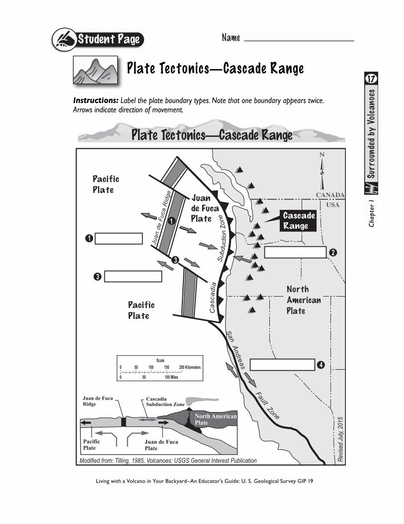
Instructions: Label the plate boundary types. Note that one boundary appears twice. Arrows indicate direction of movement.
17
Living with a Volcano in Your Backyard–An Educator's Guide: U. S. Geological Survey GIP 19
Plate Tectonics—Cascade Range
Pacific
Plate
Pacific
Plate
Juande FucaPlate
North
American
Plate
Modified from: Tilling, 1985, Volcanoes: USGS General Interest Publication Revis
ed Ju
ly, 2
015
San Andreas
Fault Zone
Juan
de
Fuca
Rid
ge CANADA
USA
Scale
0 50 100 Miles
0 50 100 150 200 Kilometers
PacificPlate
Juan de FucaPlate
North AmericanPlate
Juan de Fuca Ridge
CascadiaSubduction Zone
1
3
Plate Tectonics—Cascade Range
Cas
cadi
a
Cascade Range
1
3
2
4

18
1. On the Plate Tectonics—Cascade Range map, label the divergent, convergent and transform plate boundaries on the map above. Notice that one boundary type appears twice.
2. Does the eastern boundary of the Juan de Fuca Plate lie parallel to the Cascade Range? Yes.
3. Does the line of volcanoes extend north and south of the converging plates? Make a hypothesis that explains your answer. No, the volcanoes do not extend beyond the converging plates. The converging plates are responsible for formation of the Cascade Volcanoes.
Pacific
Plate
Pacific
Plate
Juande FucaPlate
North
American
Plate
Modified from: Tilling, 1985, Volcanoes: USGS General Interest Publication Revis
ed Ju
ly, 2
015
San Andreas
Fault Zone
Juan
de
Fuca
Rid
ge CANADA
USA
Scale
0 50 100 Miles
0 50 100 150 200 Kilometers
PacificPlate
Juan de FucaPlate
North AmericanPlate
Juan de Fuca Ridge
CascadiaSubduction Zone
1
3
Plate Tectonics—Cascade Range
Cas
cadi
a
Cascade Range
1
3
2
4
Plate Tectonics—Cascade Range—Answers
Living with a Volcano in Your Backyard–An Educator's Guide: U. S. Geological Survey GIP 19
Using Earthquakes to Find the Subduction Zone
North AmericanPlate
Dep
th (k
m)
Longitude (degrees west)135 130 125 120 115
PacificPlate
JuandeFucaPlate
Cascade Range
100
10
20
30
40
50
60
70
8090
0
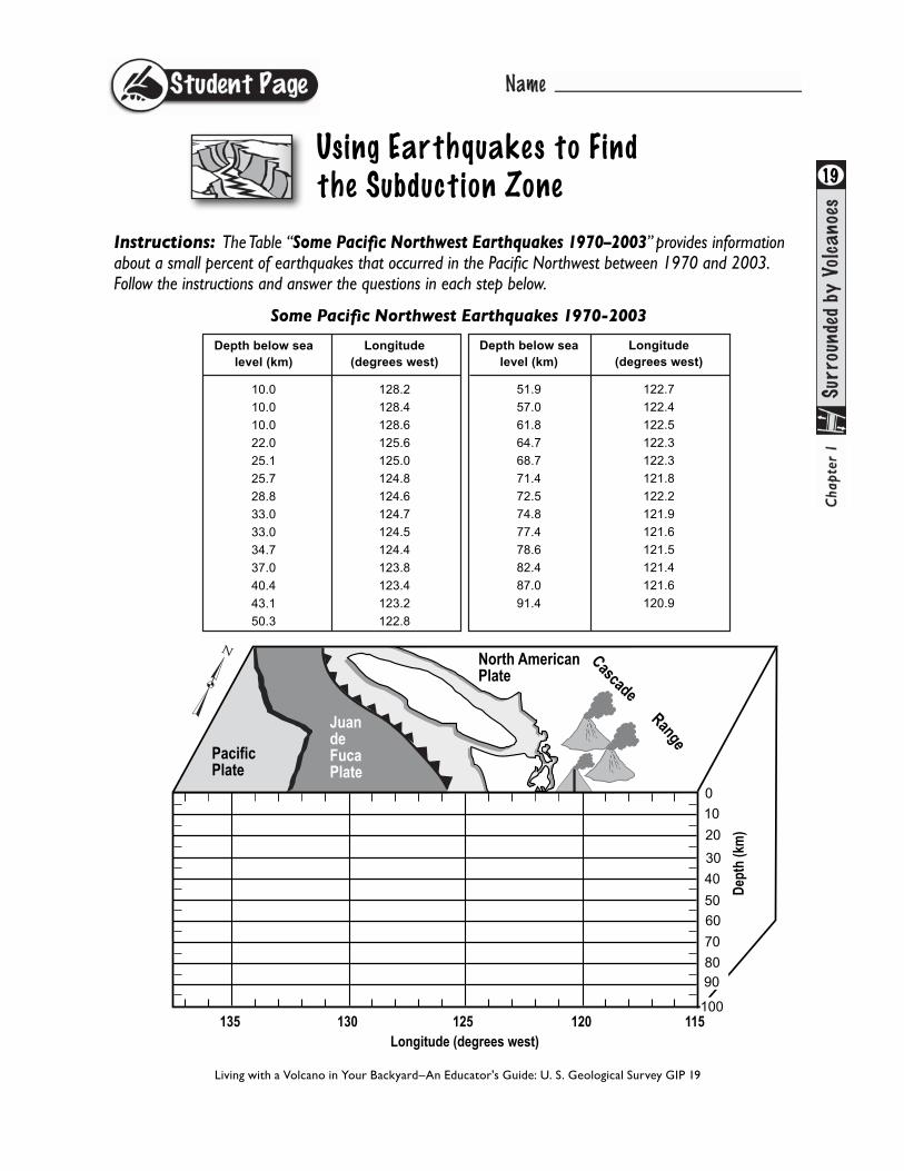
Instructions: The Table “Some Pacific Northwest Earthquakes 1970–2003” provides information about a small percent of earthquakes that occurred in the Pacific Northwest between 1970 and 2003. Follow the instructions and answer the questions in each step below.
Some Pacific Northwest Earthquakes 1970-2003
Living with a Volcano in Your Backyard–An Educator's Guide: U. S. Geological Survey GIP 19
19
Depth below sealevel (km)
10.0
10.0
10.0
22.0
25.1
25.7
28.8
33.0
33.0
34.7
37.0
40.4
43.1
50.3
Longitude(degrees west)
128.2
128.4
128.6
125.6
125.0
124.8
124.6
124.7
124.5
124.4
123.8
123.4
123.2
122.8
Depth below sealevel (km)
51.9
57.0
61.8
64.7
68.7
71.4
72.5
74.8
77.4
78.6
82.4
87.0
91.4
Longitude(degrees west)
122.7
122.4
122.5
122.3
122.3
121.8
122.2
121.9
121.6
121.5
121.4
121.6
120.9
20
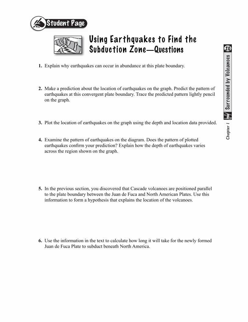
Us ing Earthquakes to Find the Subduct ion Zone—Questions
1. Explain why earthquakes can occur in abundance at this plate boundary.
2. Make a prediction about the location of earthquakes on the graph. Predict the pattern of earthquakes at this convergent plate boundary. Trace the predicted pattern lightly pencil on the graph.
3. Plot the location of earthquakes on the graph using the depth and location data provided.
4. Examine the pattern of earthquakes on the diagram. Does the pattern of plotted earthquakes confirm your prediction? Explain how the depth of earthquakes varies across the region shown on the graph.
5. In the previous section, you discovered that Cascade volcanoes are positioned parallel to the plate boundary between the Juan de Fuca and North American Plates. Use this information to form a hypothesis that explains the location of the volcanoes.
6. Use the information in the text to calculate how long it will take for the newly formed Juan de Fuca Plate to subduct beneath North America.

21Table of some Pacific Northwest Earthquakes
1970–2003 Subduction Zone Earthquakes
The Subduction Zone
North AmericanPlate
Dep
th (k
m)
Longitude (degrees west)135 130 125 120 115
PacificPlate
JuandeFucaPlate
Cascade Range
100
10
20
30
40
50
60
70
8090
0
Living with a Volcano in Your Backyard–An Educator's Guide: U. S. Geological Survey GIP 19
Depth below sealevel (km)
10.0
10.0
10.0
22.0
25.1
25.7
28.8
33.0
33.0
34.7
37.0
40.4
43.1
50.3
Longitude(degrees west)
128.2
128.4
128.6
125.6
125.0
124.8
124.6
124.7
124.5
124.4
123.8
123.4
123.2
122.8
Depth below sealevel (km)
51.9
57.0
61.8
64.7
68.7
71.4
72.5
74.8
77.4
78.6
82.4
87.0
91.4
Longitude(degrees west)
122.7
122.4
122.5
122.3
122.3
121.8
122.2
121.9
121.6
121.5
121.4
121.6
120.9

22Us ing Earthquakes to Find the Subduct ion Zone—Answers
1. Explain why earthquakes can occur in abundance at this plate boundary. The Juan de Fuca plate pushes under the North American Plate causing rocks in the brittle crust and mantle to crack and break.
2. Make a prediction about the location of earthquakes on the graph. Predict the pattern of earthquakes at this convergent plate boundary. Trace the predicted pattern lightly pencil on the graph. Students might predict that volcanoes occur in a pattern that descends from left to right, and this would be correct.
3. Plot the location of earthquakes on the graph using the depth and location data provided. (see completed table).
4. Examine the pattern of earthquakes on the diagram. Does the pattern of plotted earthquakes confirm your prediction? Explain how the depth of earthquakes varies across the region shown on the graph. Students will notice that earthquakes descend from left to right. Earthquakes occur within and above the subducting slab of oceanic lithosphere.
5. In the previous section, you discovered that Cascade volcanoes are positioned parallel to the plate boundary between the Juan de Fuca and North American Plates. Use this information to form a hypothesis that explains the location of the volcanoes. The interaction of the two plates creates conditions conducive to magma formation. 6. Use the information in the text to calculate how long it will take for the newly formed Juan de Fuca Plate, at the spreading center, to subduct beneath North America. Approximately 10 million years.
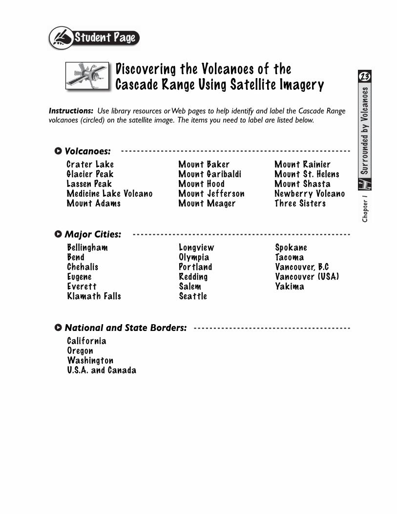
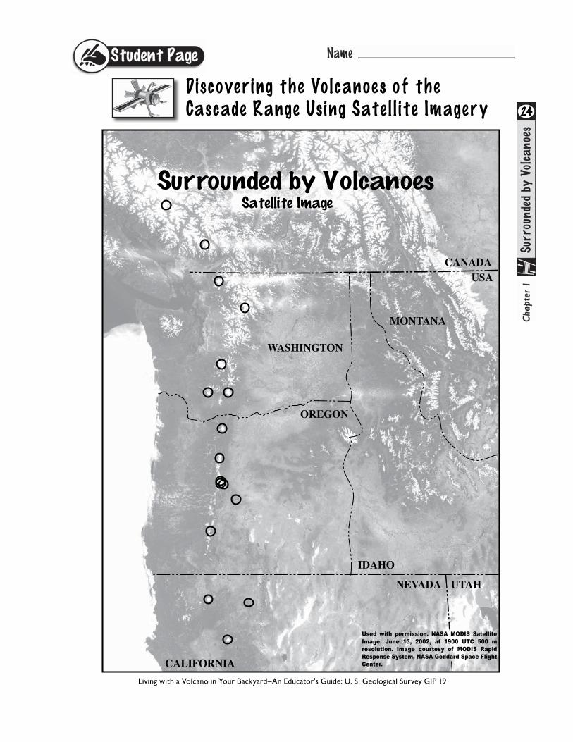
Instructions: Use library resources or Web pages to help identify and label the Cascade Range volcanoes (circled) on the satellite image. The items you need to label are listed below.
23
Crater Lake Glacier PeakLassen PeakMedicine Lake VolcanoMount Adams
Mount BakerMount GaribaldiMount HoodMount JeffersonMount Meager
Mount Rainier Mount St. HelensMount ShastaNewb erry VolcanoThre e Sisters
Volcanoes:
Bell ingham BendChehalisEugeneEverettKlamath Falls
LongviewOlympiaPortlandReddingSalemSeattle
SpokaneTacomaVancouver, B.CVancouver (USA)Yakima
Major Cities:
California OregonWashingtonU.S.A. and Canada
National and State Borders:
Discovering the Volcanoes of the Cascade Range Using Satell ite Imagery
Discovering the Volcanoes of the Cascade Range Us ing Sate l l ite Imagery 24
Living with a Volcano in Your Backyard–An Educator's Guide: U. S. Geological Survey GIP 19
Discovering the Volcanoes of the Cascade Range Us ing Sate l l ite Imagery 25
Living with a Volcano in Your Backyard–An Educator's Guide: U. S. Geological Survey GIP 19
Vancouver
Kelso/Longview
Olympia
Portland
Salem
Eugene
TacomaSeattle
Vancouver, B.C.
Bellingham
Spokane
Yakima
Everett
Redding
Bend
Klamath Falls
Mount Baker
Mount Garibaldi
Glacier Peak
Mount Rainier
Mount St. HelensMount Adams
Mount Hood
Mount JeffersonThree Sisters
Newberry Volcano
Crater Lake
Medicine Lake VolcanoMount Shasta
Lassen Peak
Mount Meager
Used with permission. NASA MODIS SatelliteImage. June 13, 2002, at 1900 UTC 500 m resolution. Image courtesy of MODIS RapidResponse System, NASA Goddard Space FlightCenter.CALIFORNIA
OREGON
UTAH
IDAHO
MONTANA
NEVADA
CANADAUSA
WASHINGTON
26
Plat
e Te
cton
ic P
roce
sses
Living with a Volcano in Your Backyard–An Educator's Guide: U. S. Geological Survey GIP 19
Modif
ied f
rom
Su
bdu
ctio
n i
n t
he
Paci
fic
Nort
hw
est
by
Rober
t J. L
illi
e.

27
Living with a Volcano in Your Backyard–An Educator's Guide: U. S. Geological Survey GIP 19
Casc
ade
Vol
cano
es—
Link
s on
the
Rin
g of
Fir
e

28
Living with a Volcano in Your Backyard–An Educator's Guide: U. S. Geological Survey GIP 19
CANADA
CALIFORNIA
WASHINGTONOREGON
▲
▲▲
▲
▲▲▲
▲
▲
▲
▲
▲
▲
▲
▲ ▲
▲
▲
▲▲
▲
▲▲▲
▲
▲
▲
▲
▲
▲
▲
▲ ▲
▲
▲
OlympicMountains
CoastRange
Klamath Falls
Eugene
Salem
Portland
Olympia
Bellingham
Vancouver, B.C.
Spokane
Yakima
Pendleton
Bend
Everett
Longview
Chehalis
Vancouver
Redding
Scale
0 50 100 Miles
0 50 100 150 200 Kilometers
TacomaSeattle
Map of Cascade Volcanoes
CANADA
USA
CALIFORNIA
WASHINGTONOREGON
▲
▲▲
▲
▲▲▲
▲
▲
▲
▲
▲
▲
▲
▲ ▲
▲
▲
▲▲
▲
▲▲▲
▲
▲
▲
▲
▲
▲
▲
▲ ▲
▲
Mount Baker
Mount Garibaldi
Mount Meager
Glacier Peak
Mount Rainier
Mount St. Helens
Mount Adams
Mount Hood
Mount Jefferson
Three SistersNewberry Volcano
Crater Lake
Medicine Lake VolcanoMount Shasta
Lassen Peak
▲
OlympicMountains
CoastRange
Klamath Falls
Eugene
Salem
Portland
Bellingham
Vancouver, B.C.
Spokane
Longview
Vancouver
Redding
Scale
0 50 100 Miles
0 50 100 150 200 Kilometers
Yakima
Pendleton
Bend
Chehalis
OlympiaTacoma
Everett
Seattle
29
Living with a Volcano in Your Backyard–An Educator's Guide: U. S. Geological Survey GIP 19
Map of Cascade Volcanoes
30
Living with a Volcano in Your Backyard–An Educator's Guide: U. S. Geological Survey GIP 19
Pacific
Plate
Pacific
Plate
Juande FucaPlate
North
American
Plate
Modified from: Tilling, 1985, Volcanoes: USGS General Interest Publication Revis
ed Ju
ly, 2
015
San Andreas
Fault Zone
Juan
de
Fuca
Rid
ge CANADA
USA
Scale
0 50 100 Miles
0 50 100 150 200 Kilometers
PacificPlate
Juan de FucaPlate
North AmericanPlate
Juan de Fuca Ridge
CascadiaSubduction Zone
1
3
Plate Tectonics—Cascade Range
Cas
cadi
a
Cascade Range
1
3
2
4

31
Living with a Volcano in Your Backyard–An Educator's Guide: U. S. Geological Survey GIP 19
Pacific
Plate
Pacific
Plate
Juande FucaPlate
North
American
Plate
Modified from: Tilling, 1985, Volcanoes: USGS General Interest Publication Revis
ed Ju
ly, 2
015
San Andreas
Fault Zone
Juan
de
Fuca
Rid
ge CANADA
USA
Scale
0 50 100 Miles
0 50 100 150 200 Kilometers
PacificPlate
Juan de FucaPlate
North AmericanPlate
Juan de Fuca Ridge
CascadiaSubduction Zone
1
3
Plate Tectonics—Cascade Range
Cas
cadi
a
Cascade Range
1
3
2
4
32
Using Earthquakes to find the Subduction Zone
Living with a Volcano in Your Backyard–An Educator's Guide: U. S. Geological Survey GIP 19
Nor
th A
mer
ican
Plat
e
Depth (km)
Long
itude
(deg
rees
wes
t)13
513
012
512
011
5
Paci
ficPl
ate
Juan
de Fuca
Plat
e
Casca
de
R
ange
100
10 20 30 40 50 60 70 80 900
33
Types of Tectonic Plate Boundaries
Living with a Volcano in Your Backyard–An Educator's Guide: U. S. Geological Survey GIP 19
Divergent Plate Boundary
Convergent Plate Boundary
Transform Plate Boundary