surficial geology of the fort calhoun and kennard 7.5...
TRANSCRIPT
Surficial Geologyof the
Fort Calhoun and Kennard7.5-Minute Quadrangles,
Nebraska-Iowa
Joseph A. Mason
Open-File Report 56
Conservation and Survey Division, IANR, University ofNebraska-Lincoln
in cooperation with U. S. Geological Survey
2
INTRODUCTION.
The Fort Calhoun and Kennard 7.5-minute quadrangles are located at the northern edge of theOmaha metropolitan area. Unconconsolidated sediment up to 360 feet (110 m) thick rests onbedrock of Cretaceous and Pennsylvanian ages. The unconsolidated sediments arepredominantly deposits of large ice sheets, wind-blown dust (loess), and stream deposits(alluvium). There are also extensive deposits at the foot of slopes resulting from water erosion,soil creep, and landslides.
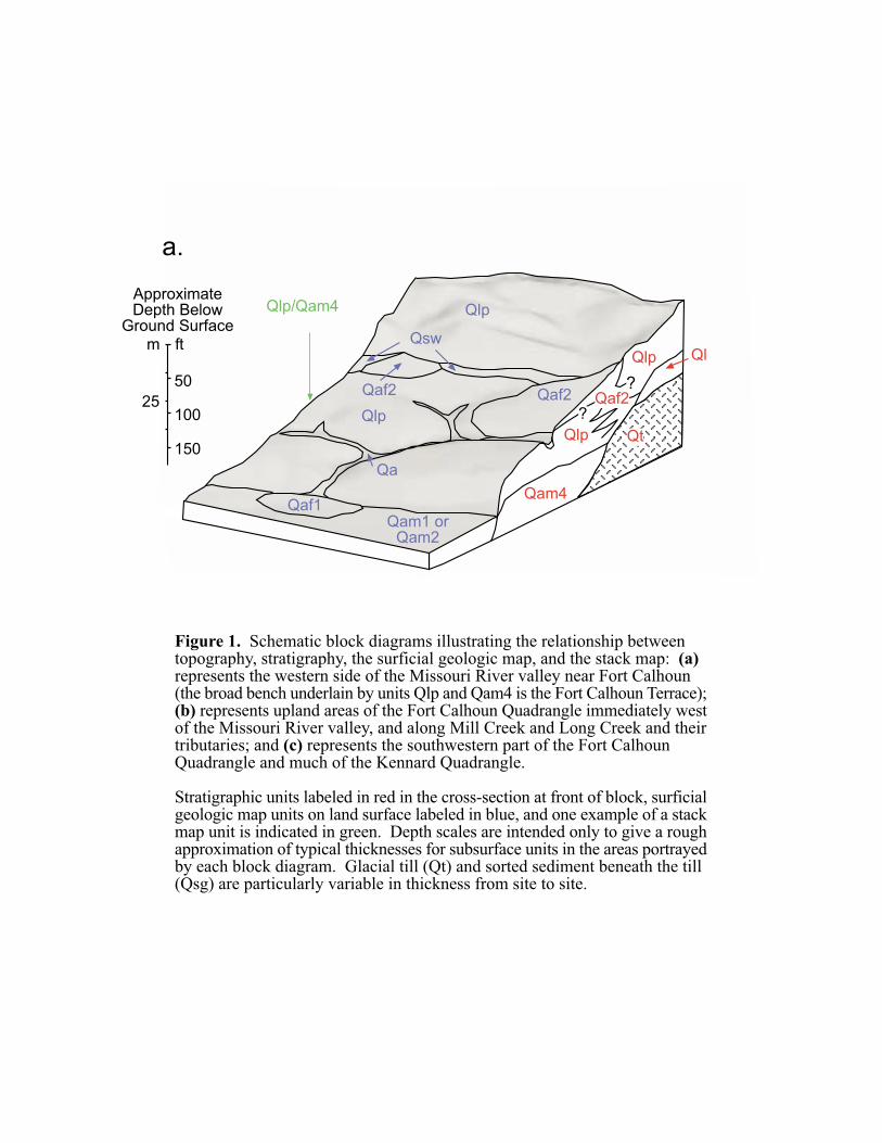
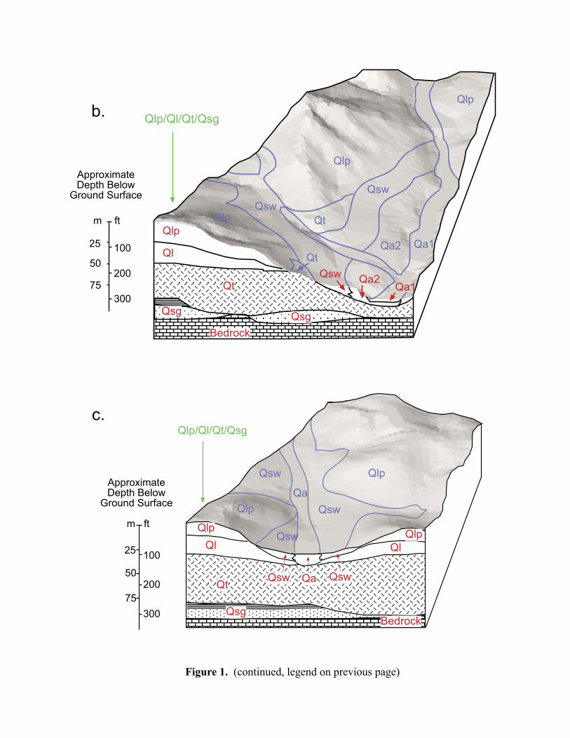
Maps representing the unconsolidated sediments of the Fort Calhoun and Kennard quadrangleshave been prepared by the Conservation and Survey Division (Institute of Agriculture andNatural Resources, University of the Nebraska-Lincoln), in cooperation with the U. S.Geological Survey. One is a map of surficial (near surface) geology, showing only theuppermost sediments. Units on this map portray deposits that are generally thicker than about 5feet (1.5 m), although some of these deposits are thinner than 5 feet immediately adjacent to theirboundary with other map units. The other map is called a stack map, and represents the entirestack of sediments down to bedrock. Units on this map represent various combinations ofgeologic materials with different properties, as well as the vertical sequence in which they occur.The relationship between subsurface stratigraphy, surficial geologic map units, and stack mapunits is illustrated in Figure 1. These maps are mostly based on direct observation of stratigraphyin exposures such as road cuts, on examination of logs and samples from test-hole drilling, andon interpretation of the drillers’ logs from registered wells. Because most surficial deposits inthis area are covered by vegetation, roads, or buildings, often the surficial and subsurfacegeology was reconstructed between widely scattered outcrops or test holes. This was done usingindirect evidence such as soil surveys and topographic features associated with particular typesof deposits, as well as by analyzing how different geologic materials were deposited. Forexample, the Peoria Loess was deposited as wind-blown dust and therefore forms a fairlyuniform mantle over ridge tops and gentle slopes, but it was eroded from steeper slopes afterdeposition. The boundaries of areas covered by Peoria Loess on hill slopes can often beidentified by a distinct break in slope gradient. Other map unit boundaries are more difficult toplace without good exposures or subsurface data. Both maps will be updated as more subsurfaceinformation, such as new registered well logs, becomes available.
These maps are intended for general planning and educational purposes and can also be used forinitial planning prior to more detailed site-specific geologic investigations. They will not beadequate, in most cases, for detailed planning of construction, waste disposal or remediation ofenvironmental contamination at specific sites. These maps should allow planners to identifyareas that generally have surficial deposits more suitable for domestic or high-capacity waterwells. Within these areas, however, local variations in subsurface geology may result ininadequate groundwater quantity or quality at specific sites.
Radiocarbon ages of geologic deposits are reported in uncalibrated radiocarbon years in thisreport. These are ages that are not corrected for variation in the 14C content of the atmosphereover time. Uncalibrated ages differ from the true age of the sample by a few hundred to as muchas several thousand years, but are used here to allow comparison with most published ages,which are also uncalibrated.
���
���� ����
���
���
��
������� ���
���
��� ��
����
�
��
����
���������������������� ������������������������������������������������������������������������������������������������������� �������������������������������������������������������������������������������������������������������������� ������� ��!��������������������"������#$ ���������������������������������������������� ��������������������������������������������������������������������� �����%�������� �����������������$������������������������������������������������������������ ��������������������������&������� ���������'
�����������������������������������������(���������������������� �����������������������������������������������������������������)��������������� �������������������������'��*������������������������������������������������)������������������� ��������������������������������������������������������� �������'��+����������� �#����������������������������������� ��#����������������������������� ��������������������'
��
��� �����������������
� ������� �����������
��
!�
!!
!
������������ ����
������ ������
������������ ����
������ ������
���
���
���
�����
��
�
���������
���
���
�����
����� ���
���
��
�
���
���������
������
���
������
�
��� ����
���
���
���
������������
������������
��
�� �
� �
!�
"
��
�� � �
� !�
"
��������������������� ��������������� �
�#
$#
��
����
���
����
�
��
���
��
���
���
��
��
��
���
���
��
���
���
��
�
��
����
����
�
���
�
��
��
���
����
����
���
���
����
����
���
���
���
��
���
�� �
��
�����
���
��
���
�����
����
���
��
���
��
���
���
��
���
��
�� ���
��
��
��
�
���
���
��
����
��
��� ���
���
�
���� �
���
��� �
�
6
DESCRIPTION OF STRATIGRAPHIC UNITS.
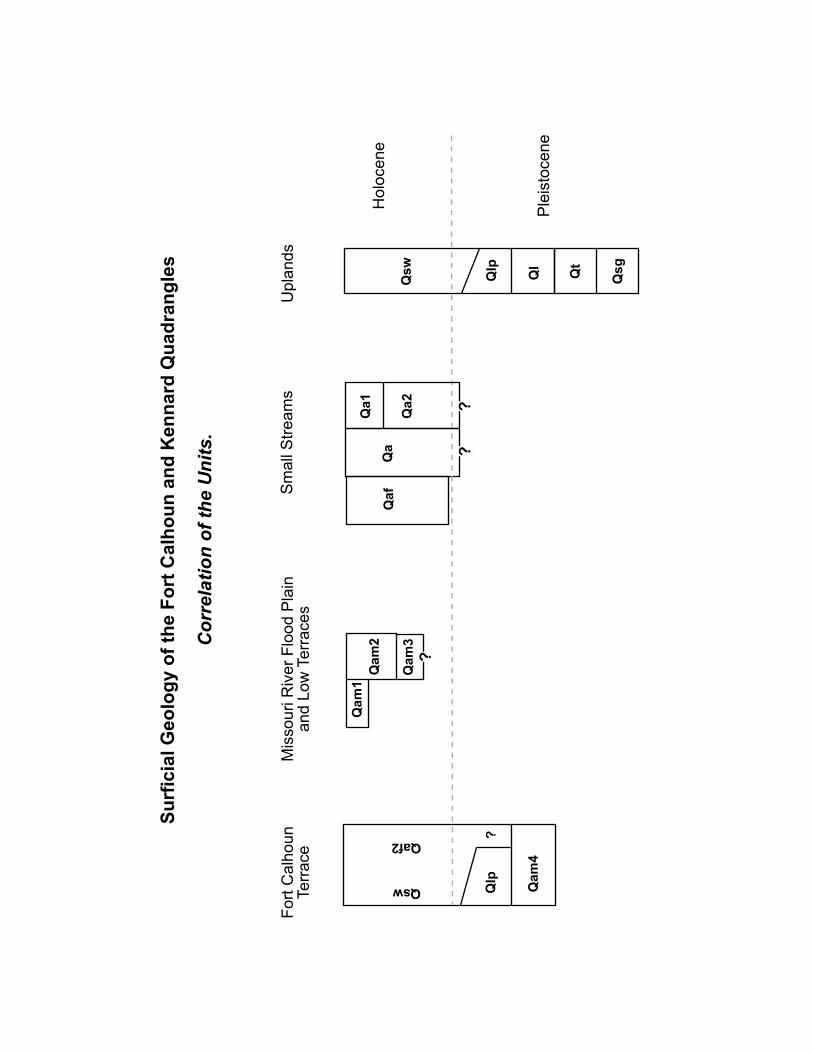
The units described below are those shown on the surficial geologic map, as well as a few thatoccur only in the subsurface. Figure 2 (Correlation of the Units) portrays the relative agerelations between the units described below. These individual stratigraphic units are combinedto form stack map units, described in a separate section following the stratigraphic unitdescriptions.
Qa1 Alluvium of the DeForest Formation, low terraces and modern channel andfloodplain (Holocene)
Slightly to very clayey silt, with occasional interbedded sand and gravel
Alluvium along small streams, beneath the modern channel, the modern flood plain (ifpresent), and low terraces (fig. 1b): on the basis of lithology and geomorphic position,this alluvium is mostly correlative with the Roberts Creek and Camp Creek members ofthe DeForest Formation, as defined by Bettis (1990) in Iowa. The stratigraphy andgeomorphology of areas mapped as Qa1 are complex, and the two members cannot bemapped separately; however, most alluvium in this map unit can be placed in one or theother of these lithostratigraphic units in adequately exposed sections. The Roberts CreekMember is dark brown or black, moderately to very clayey silt (occasionally sandy silt orsandy clay). The dark color reflects high organic matter content. It is often massive butdisplays weak stratification in some places. The Camp Creek Member overlies theRoberts Creek Member or is inset below it and is distinctly stratified, slightly tomoderately clayey silt (occasionally sandy silt). Many of the strata are light-colored, andoverall, the Camp Creek Member is lighter-colored and less organic-rich than the RobertsCreek Member. Lenses or thin beds of sand and gravel are present in the Camp CreekMember in some localities where these grain sizes are available, for example, where thereare till outcrops upstream. Some gravel lenses consist of calcium carbonate nodulesreworked from the Peoria Loess. There is little significant soil formation at the top of theCamp Creek Member.
The total thickness of alluvium in the Qa1 unit is at least 10 feet (3.1 m) thick in mostareas and exceeds 20 feet (6.2 m) in some places. The Roberts Creek Member in thenortheast part of the Fort Calhoun quadrangle is at least 10 feet thick at one localitywhere the base is not well exposed. Thinner increments of this unit are common.Sediment along small streams just south of Fort Calhoun, tentatively correlated with theCamp Creek Member, is 15-20 feet (4.6-6.2 m) thick. The Camp Creek Member is morecommonly 1-5 feet (0.3 to 1.5 m) thick where it overlies the Roberts Creek Member onlow terrace surfaces. The Roberts Creek Member in southwestern Iowa and nearLincoln, Nebraska, is of late Holocene age, based on radiocarbon dating (Bettis, 1990;Mandel and Bettis, 1995), but no dates are available from the Fort Calhoun or Kennardquadrangles. The Camp Creek Member was deposited in the last 500 years, particularlyafter European settlement in the 1850s and 1860s (Bettis, 1990; Mandel and Bettis,1995).
7
The physical properties of the Roberts Creek and Camp Creek members are highlyvariable, depending on texture and organic matter content. Few structures are built in theQa1 unit because of flood and erosion hazards. The relatively high organic mattercontent of the Roberts Creek Member may affect the subsurface transport ofcontaminants that are readily adsorbed (or retained) by natural organic matter. Artifactsand archaelogical sites may be present throughout both the Roberts Creek and CampCreek members. Where the Camp Creek Member is thick, artifacts on the surface or atshallow depth are likely to be historic; older material will be found at or below the lowerboundary of this member.
Qa2 Alluvium of the DeForest Formation, high terrace (Holocene)
Slightly to moderately clayey silt, overlying stratified sand and gravel in some areas
Alluvium beneath the highest terrace along small, high-gradient streams that draindirectly into the Missouri River, rather than to the Big or Little Papillion creeks (fig. 1b):it is largely correlative with the Gunder Member of the DeForest Formation (Bettis,1990), but may occasionally include a thin upper increment of the Roberts Creek andCamp Creek members. Small incised channel fills of Roberts Creek and Camp Creekmembers also occur within this unit. The upper part of the Gunder Member (typicallyseen in outcrops) is light yellowish brown or gray, slightly to moderately clayey silt withoccasional lenses or thin strata of sand or gravel. In the upper part of many outcrops, thismember is massive and closely resembles Peoria Loess. Faint to prominent stratificationis common in the lower part of many outcrops, although it is not always present. Nearthe surface of the Gunder Member, it typically is darkened and clay-enriched by soildevelopment, and the resulting moderately well-developed soil has distinct A and Bhorizons. Faint, slightly darker bands deeper within the Gunder Member probablyrepresent brief periods of soil development during deposition of this unit. These darkbands, faint stratification, and occasional lenses of sand or charcoal are useful indistinguishing the Gunder Member from the Peoria Loess in outcrop. The lower part ofthe Gunder Member may contain thick beds of sand, occasionally with some gravel. Thispart of the Gunder Member is less commonly exposed in the Fort Calhoun area, but isprobably extensive in the subsurface. Total thickness of the Gunder Member ranges froma few feet to more than 20 feet (6.2 m). The Gunder Member in southwestern Iowa andsoutheastern Nebraska is early to middle Holocene in age (Bettis, 1990). Charcoal fromthe Gunder Member along Mill Creek, in the Fort Calhoun area, at a depth of 15 feet (4.6m) below the surface, has a radiocarbon age of 6950 ± 50 yr B. P. (years before present,laboratory number Beta-119109).
The Gunder Member has properties similar to the Peoria Loess, but in many casesappears to have greater density (site-specific investigations are necessary to confirm this).Regarding subsurface movement of contaminants, the Gunder Member should bedistinguished from Peoria Loess. The stratification, buried soils and sand or gravel lensesthat occasionally occur in the Gunder Member, but not in the Peoria Loess, are featuresthat can impede downward flow of water and nonaqueous fluids (such as petroleumproducts). In some cases, these features also facilitate lateral flow of liquids.
8
Archeological sites and artifacts could potentially be present throughout the thickness ofthe Gunder Member, although Bettis (1990) reports that they are rare in the GunderMember of southwestern Iowa.
Qa Alluvium, undifferentiated (Holocene and late Pleistocene?)
Slightly to very clayey silt, overlying stratified sand and gravel in some areas
Alluvium beneath wide valley floors without distinct terraces, in the Big and LittlePapillion Creek drainage basins (fig. 1c): in these areas the alluvium is black, grayishbrown or gray, moderately to very clayey silt and silty clay, with some beds of sandy siltor clay. Sand and gravel is often, but not always, present near the base of the alluvium.The alluvium in this unit reaches thicknesses of at least 60 feet (18.5 m) in the valley ofBig Papillion Creek and other large streams, but thins to only a few feet near valleymargins and along the smallest stream valleys. This unit also includes areas alongsmaller streams where the high terrace and lower surfaces are both present but cannot bedistinguished at the scale of mapping. The alluvium in these areas is highly variable incolor and grain size and includes some light yellowish-brown silts similar to those in unitQa2, as well as darker-colored deposits that contain more organic matter.
The alluvium in this unit has not been dated in this investigation. Most sediments at thesurface are likely to be Holocene deposits of the DeForest Formation. Late Pleistocenefluvial deposits have not been identified but could be present, particularly in thesubsurface.
The physical properties of the alluvium in this unit are variable, depending on clay andorganic matter content. The relatively high organic matter content of some sediment inthe Qa unit may affect the subsurface transport of some contaminants. Sand and gravelpresent in this unit is not extracted because it is thin and patchy and deeply buriedbeneath fine-grained deposits. Artifacts and archaelogical sites may be presentthroughout the thickness of alluvium in the Qa unit.
Qam1 Alluvium of the Missouri River flood plain, late 19th to early 20th century semi-braided channel belt (Holocene)
Stratifed silt, clay, and sand
Alluvium underlying areas occupied by the Missouri River in the late 19th and early 20thcentury, when the river had a relatively wide, straight, semi-braided channel (Hallbergand others, 1979)(fig. 1a): this channel form is reflected by the topography of former barsand swales at the surface of unit Qam1, which is therefore distinct on aerial photographsfrom areas occupied by older meandering channels (units Qam2 and Qam3). Thesediment at the surface of Qam1 is sand in some areas but more commonly is 3 feet (1 m)or more of silt and clay. Information on subsurface stratigraphy is limited to a few wellsin adjacent quadrangles, but sand is increasingly abundant and probably coarser withdepth. Lignite pebbles and wood fragments are common in the subsurface. The upper
9
part of the alluvium in this unit was deposited in the last 100 years, but older depositsmay be present in the subsurface, as they are in Qam2. The total thickness of alluviumdown to bedrock in unit Qam1 is difficult to estimate from the limited subsurface data,but probably ranges between 30 and 100 feet (9 to 31 m).
The sand in this unit is not commercially extracted at present. It is not well-suited forsuch extraction because of its high lignite content and the overlying or interbedded fines.Artifacts of recent historical age can be buried deeply within the Qam1 unit. A notableexample is the Bertrand, a mid-19th century river boat buried in unit Qam1, that waslater excavated and is now displayed at De Soto National Wildlife Refuge.
Qam2 Alluvium of the Missouri River flood plain, meandering channel belts, includingearly 19th century channels (Holocene)
Stratified sand, silt, and clay
Alluvium underlying parts of the Missouri River flood plain with prominent meanderingformer channels and scroll bars: this includes highly sinuous channels occupied by theMissouri River at the time of the Lewis and Clark expedition in 1804-1806 (Moulton,1983), as well as older late Holocene channels (fig. 1a). This alluvium was extensivelyexposed in 1997-1999 in the East Quarry of the Fort Calhoun Stone Company.
One or more beds of dark gray clay, up to 5 feet (1.5 m) thick, are present near theground surface in places. In other locations the upper few feet of alluvium is slightlyorganic-rich, very fine or fine sand. The surficial clay or fine sand is generally underlainby multiple fining-upward depositional units about 1 to 5 feet (0.3 to 1.5 m) thick, withfine sand at the base, grading upward into very fine sand and silt or occasional clay.Mottles and root traces are common in the silty upper part of each fining-upward unit.Some of the fining-upward units form lenses that are not laterally continuous, but in othercases they can be traced laterally for 100 feet (31 m) or more. At least some of thefining-upward units may represent rapid deposition near the active river channel duringindividual floods. Other types of sediment occasionally occur, interbedded with orreplacing the fining-upward units. For example, at one location within the Fort CalhounStone Company East Quarry, a small channel filled with cross-stratified sand, woodfragments, and lignite pebbles occurs below a thick, lens-shaped fining-upward unit and asurficial mantle of fine and very fine sand. Wood from this channel, at a depth of 21.5feet (6.6 m) below the surface yielded a modern (~1950 A.D.) radiocarbon age (100.5% ±0.8 % of modern 14C activity, Beta-119108), consistent with deposition in the last 50-100years. Similar local channel fills are likely to be present elsewhere in unit Qam2,contributing to its heterogeneity. The lowest 10 to 16 feet (3-5 m) of the alluvium in unitQam2 are predominantly fine-medium sand with planar or very low angle stratification orrarely cross-stratification. This sand contains abundant wood and lignite fragments.Some coarse gravel is present at the base of this sand, above bedrock. Wood from planarbedded sand, 33.2 feet (10.2 m) below the modern ground surface and 5-10 feet (1.5 to3.1 m) above the bedrock surface in the Fort Calhoun Stone Company East Quarry,yielded a radiocarbon age of 890 ± 60 yr B.P. The two ages from unit Qam2 suggest that
10
it contains alluvium deposited from the late Holocene to very recent times. Even whenthe main channel of the Missouri was not located within areas mapped as Qam2, as in thelate 19th and early 20th century, these areas were frequently inundated during floods andcould have been the location of very active deposition or erosion.
The sand in this unit is used for fill material as a byproduct of stone quarry operation. Itis probably not suitable for large-scale commercial extraction because of its high lignitecontent and because of the overlying or interbedded fines. Where clay is at the surface inunit Qam2, structures may incur damage because of high shrink-swell potential.Irrigation wells and a few domestic wells are screened in the basal sand and gravel of unitQam2. Artifacts of historical or late Holocene age could be present throughout unitQam2.
Qaf1 Alluvial fan deposits on the Missouri River floodplain (Holocene)
Slightly to very clayey silt
Alluvium deposited in low-gradient alluvial fans that formed where small streams enterthe Missouri River valley (fig. 1a): exposures are limited, but the sediment beneath thesefans is predominantly silt reworked from Peoria Loess and older Holocene alluvium. Thelarge fan west of De Soto is capped by up to 5 feet (1.5 m) of light-colored, distinctlystratified alluvium over dark grayish-brown sediment that is less distinctly stratified.This sequence is similar to that commonly observed in unit Qa1, where the Camp CreekMember of the DeForest Formation overlies the Roberts Creek Member. Soil surveyssuggest that the stratigraphy is similar beneath other fans. The fan sediment overlies siltsand sands deposited by the Missouri River. The total thickness of fan sediment rangesfrom as much as 20 feet (6 m) at the head of larger fans to only a few feet near the fanmargins.
The youngest sediment on these fans has been deposited since 1800. For example, a fansoutheast of the historic site of Fort Atkinson has extended out over the channel occupiedby the Missouri River in 1838. Much of the rest of the fan sediment is probably lateHolocene. Active channel migration of the Missouri River is likely to have removedolder fan deposits. The alluvial fan deposits in unit Qaf1 are likely to be particularly richin historic and prehistoric sites and artifacts, because these fans provided shelteredsettlement or camp sites adjacent to the Missouri flood plain but slightly elevated aboveit.
Qam3 Alluvium of the Missouri River, beneath low terraces (Holocene)
Alluvium beneath one or more low terraces that are about 5-10 feet (1.5 to 3.1 m) abovethe Qam2 surface (fig. 1a): the surficial material in this unit is gray silt or dark gray clayup to 5 feet (1.5 m) thick. Exposures of deeper sediment are extensive only in the FortCalhoun Stone Company West Quarry (NW1/4 Section 12 T17N R12E), and in a largegully that formed adjacent to the quarry in 1999. In these exposures, dark gray clay 2.5to 5 feet (0.5 to 1.5 m) thick overlies fine-medium cross- or planar-stratified sand 20-40
11
feet (6 to 12 m) thick, which in turn overlies the bedrock surface. The upper surface ofthe sand is undulating, probably representing bars and swales of a former channel belt.The clay was deposited after the channel shifted away across the floodplain, anddeposition of the clay smoothed the formerly irregular surface. No radiocarbon agesfrom this unit are available, but it is assumed to be Holocene because it underlies asurface without Pleistocene loess cover and with relatively weakly developed surface soilprofiles.
The sand in Qam3 appears to contain less lignite and a smaller proportion of overlyingand interbedded fines than the sand in the lower part of Qam2. It is still likely to havelow potential for commercial extraction, except as a byproduct of stone quarrying. Theclays at the surface in parts of Qam3 can cause structural damage because of high shrink-swell potential.
Qaf2 Alluvial fan deposits and underlying or intermixed Peoria Loess on the FortCalhoun terrace (Holocene and/or late Pleistocene)
Slightly to moderately clayey silt.
Alluvial fan deposits and loess beneath low-gradient fans on the surface of the FortCalhoun Terrace (Lueninghoener, 1947), which is a broad, high bench above theMissouri River floodplain and below adjacent uplands, near the town of Fort Calhoun(fig. 1a): in exposures in and near Fort Calhoun, the sediment beneath these fans is lightyellowish brown, slightly clayey silt that closely resembles Peoria Loess on uplands.Exposures examined did not show stratification. The upper few feet of this sediment arebrown or dark grayish brown because of soil development, and the surface soil profile inmany places has distinct A and B horizons and resembles surface soils formed in PeoriaLoess. In other areas, the surface soil profile is less well developed and resembles soilsformed in slopewash or younger Holocene alluvium (Qa1).
The silts in Qaf2 probably include Peoria Loess directly deposited by the wind, as well asalluvium deposited on the fans by streams flowing out of the uplands, or by slope washfrom adjacent hillsides. These different types of sediment could not be distinguished inany exposures, but Qaf2 is separated from adjacent areas of Peoria Loess (Qlp) becausesediment in areas mapped as Qaf2 may have properties related to mixing of alluvium andloess (higher or more variable sand content or density as compared to the loess onuplands). Alluvium could have accumulated on these fans before, during, and afterPeoria Loess deposition and thus could be late Pleistocene or Holocene in age. Wherethe surface soil is moderately well-developed, there has probably been limited depositionin the late Holocene.
Most properties of the silt in alluvial fans of the Qaf2 unit are similar to the properties ofthe Peoria Loess. There may be some potential for archaeological sites or artifacts in thisunit if a significant amount of the silt accumulated as alluvium during the Holocene.
12
Qsw Slopewash sediment, with underlying or intermixed Peoria Loess (Holocene and latePleistocene?).
Slightly to moderately clayey silt.
Silt on concave lower slopes, in drainageways, and in small alluvial fans (fig. 1b, 1c): thelower part of this unit is light yellowish brown or gray and commonly contains brown,yellow, and gray mottles. The upper part is brown or dark brown because of soilformation. The dark brown surface layer (the soil A horizon) thickens downslope andinto the center of drainageways, where it is several feet (about 1 m) thick. Most areas ofthis unit probably include some Peoria Loess directly deposited by the wind, but thisprimary loess is overlain and/or mixed with sediment moved downslope by otherprocesses. These processes include rainsplash, sheet wash, flow in small rills and gullies,and possibly soil creep or other types of mass movement. The thickness of the darkbrown surface horizon indicates that this downslope sediment movement was generallyslow and soil development kept pace with it. It is difficult to clearly distinguish deeper,lighter-colored layers of slopewash sediment from primary loess (deposited directly bythe wind), because the slopewash deposits are largely made up of reworked Peoria Loess.The total thickness of this unit varies from less than 1 foot to more than 15 feet andincreases downslope and into drainageways. In many places this unit grades laterally intothe alluvium of unit Qa2, suggesting contemporaneous deposition during the Holocene.Slope erosion undoubtedly also occurred as the Peoria Loess was being deposited, sosome of the slopewash sediment is probably late Pleistocene.
Qam4 Alluvium of the Missouri River (late Pleistocene), [stack map only]
Stratified silt and sand.
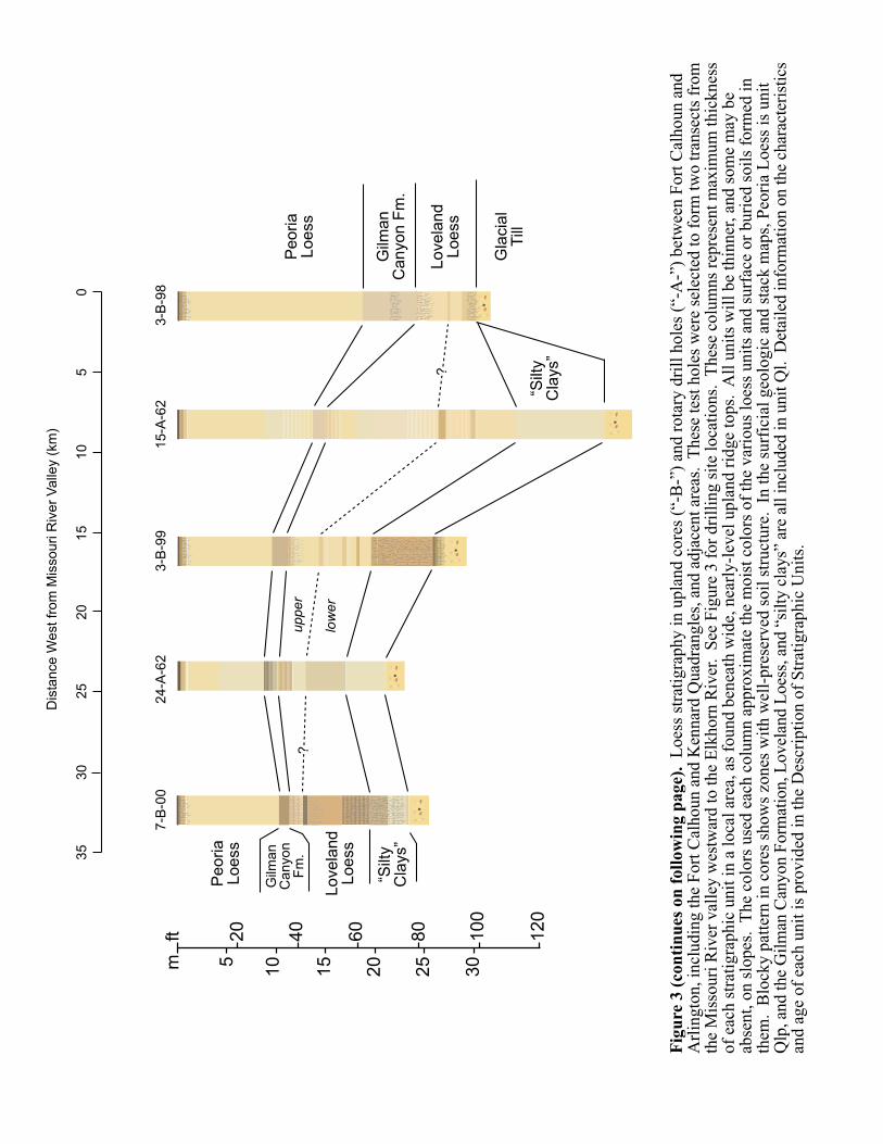
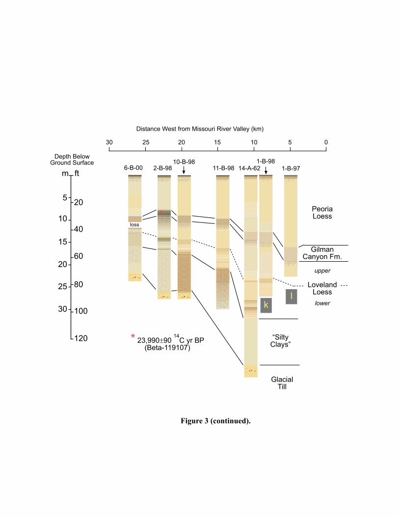
Alluvium underlying Peoria Loess, beneath the Fort Calhoun Terrace (fig. 1a): Miller(1964, p. 41) described a section formerly exposed at the north end of the terrace nearFort Calhoun in which stratified alluvium apparently extends to the modern groundsurface. In contrast, other sections beneath the terrace, including a large excavationopened in 1999 in the town of Fort Calhoun, indicate that the terrace surface is underlainby a significant thickness of massive, homogeneous silt that is probably primary PeoriaLoess. This loess was probably deposited after this area was no longer part of the activeMissouri River floodplain. Stratifed sand and silt, likely Missouri River alluvium, isalways present at depth beneath this massive silt and rests directly on bedrock. Woodand other organic debris are commonly present in this alluvium. In Conservation andSurvey Division core 1-B-99 (fig. 3), the stratigraphy beneath the terrace consists ofgrayish brown massive silt interpreted as Peoria Loess, 0-39 feet (0-12 m), brown togreenish gray alluvial (?) silt, 39 to 74 feet (12 to 22.8 m), and stratified silt and sand, 74to more than 79 feet (22.8 to more than 24.3 m). A radiocarbon age of 20,200 ± 200years B.P. (Beta-129697) was obtained from wood in the silt interpreted as alluvium at adepth of 52.9 feet (16.3 m). Miller (1964, p. 41) reported a radicarbon age of 22,200 ±1000 yr B.P. (W-618) for wood from stratified alluvium 40 feet (12.3 m) below the FortCalhoun terrace surface in a quarry section near the north end of the terrace. Miller’s
13
description of this section suggests that the stratigraphy is similar to core 1-B-99, exceptthat the upper grayish brown silt is about 10 feet (3.1 m) thinner in Miller’s section, andhe described it as stratified rather than massive. Correcting for this difference inthickness of the upper silt unit, Miller’s sample is from approximately the samestratigraphic level as the radiocarbon sample from core 1-B-99.
A few domestic wells are screened in sand within the alluvium of unit Qam4. Despite thelimited thickness of this aquifer, it is the only source of shallow groundwater on the FortCalhoun Terrace.
Qlp Peoria Loess (late Pleistocene)
Slightly to moderately clayey silt
Massive or occasionally faintly laminated silt mantling uplands throughout the FortCalhoun and Kennard quadrangles (fig. 1b, 1c): Peoria Loess is light yellowish-brown orgray, except in the upper few feet, which are very dark brown to brown because of soildevelopment. Brown, orange, and gray mottles are common below the surface soilprofile. Hard concretions of calcium carbonate are present in some localities, butotherwise, Peoria Loess contains little material coarser than 0.1 mm in diameter. PeoriaLoess is generally calcareous below the surface soil profile because of calcite anddolomite grains in the original loess deposit. Shells of land snails are also common inthis unit where it is calcareous.
Within a local area, the thickest Peoria Loess is on wide, gently sloping ridgetops. Thethinnest Peoria Loess in a local area is at the downhill edge of areas included in Qlp,bordering Qsw, Ql, or Qt. Figure 1b and 1c illustrate the typical local variation inthickness of Peoria Loess on hill slopes in different parts of the Fort Calhoun andKennard quadrangles. There is systematic regional variation in the thickness of PeoriaLoess on stable upland summits that have experienced little erosion since the loess wasdeposited (fig. 3, 4). The greatest thickness, 60-70 feet (18-21 m) occurs on gentlysloping ridge tops near the Missouri River valley. Peoria Loess thickness on gentlysloping ridge tops decreases westward to about 30 feet (9.1 m) just east of Big PapillionCreek, in the Kennard quadrangle. West of Big Papillion Creek, Peoria Loess thicknessis 25-30 feet thick, with some evidence of slightly greater thickness close to the ElkhornRiver valley (fig. 3, 4). Areas mapped as Qlp probably include many small outcrops ofolder loess deposits (Ql) or glacial till (Qt) that were not detected because of vegetationcover. Most of these outcrops occur near the downhill edge of areas mapped as Qlp.
Peoria Loess was deposited primarily as wind-blown dust, although this unit may includesome sediment that has been reworked downslope by water or gravity. Peoria Loess is theuppermost of a sequence of loess deposits consistently observed in the Omaha area (fig.3). It is also a widespread stratigraphic unit throughout the central United States and isnow referred to as the Peoria Silt in some states (Leigh and Knox, 1994; Hansel andJohnson, 1996). The basal part of the Peoria Loess dates to between 25,000 and 20,000yr B. P. (years before present) at Loveland, Iowa, just east of the Fort Calhoun
14
quadrangle (Forman and others, 1992). The end of Peoria Loess deposition is not datedin the Omaha area, but deposition had ended by about 10,500 yr B. P. in central Nebraska(Maat and Johnson, 1996) and ended as early as 14,000 yr B. P. in central Iowa (Ruhe,1969). Miller (1964) suggested that a younger loess deposit (Bignell Loess) is alsopresent in and around Omaha, but the present investigation produced no evidence of asignificant thickness of Bignell Loess in this area. Some dust was undoubtedly blownfrom the Missouri and Platte River floodplains to the surrounding uplands after the end ofPeoria Loess deposition but not enough to produce a distinct loess deposit.
Most previous workers have assumed that the primary source of Peoria Loess nearOmaha was the Missouri River floodplain, with a secondary contribution from the Platteor Elkhorn River floodplains to the west (Miller, 1964). The regional decrease in PeoriaLoess thickness with distance from the Missouri River indicates that the floodplain ofthat river was a major source. There is some evidence from this study that thePlatte/Elkhorn valley was a secondary source.
Peoria Loess has distinctive properties that can affect most types of construction (Benak,1967; Handy, 1973; Lutenegger and Hallberg, 1988). These properties of Peoria Loessare variable from place to place, and a site-specific geotechnical investigation isnecessary to determine whether any of the following generalizations apply at a particularlocation. Dry Peoria Loess will often stand in a very steep (70°-80°) face for many years(Lohnes and Handy, 1968), but wet loess has much lower strength. Peoria Loess in theOmaha area is often considered to have inadequate bearing capacity for large structures atits natural density, based on geotechnical tests and past experience. Because of thislimitation, special construction techniques are often required when large structures arebuilt in areas of thick Peoria Loess. Some dry, low-density Peoria Loess in the Omahaarea will collapse, or consolidate rapidly, when wetted (Handy, 1973). Low density istypically found in thick, well-drained deposits of Peoria Loess near the Missouri Rivervalley. Collapsible zones occur within thinner Peoria Loess as well (Lutenegger andHallberg, 1988). Handy (1973) describes a simple criterion for collapsibility: incollapsible loess the saturation moisture content typically exceeds the liquid limit. PeoriaLoess is highly erodible where it is not protected by vegetation, and erosion of exposedloess will cause rapid siltation in downstream reservoirs or floodplains. Deep gullies candevelop rapidly at construction sites or in agricultural fields if adequate erosion control isnot practiced. Slumps and other types of slope failure occur within Peoria Loess in somelocalities, particularly where steep slopes are undercut by streams, although many steepslopes underlain by Peoria Loess are stable and do not experience any significant massmovement. Undisputed human artifacts have not been found deeply buried within PeoriaLoess in Nebraska, although they could be present given increasing documentation ofhuman presence in North America during Peoria Loess deposition.
Ql Gilman Canyon Formation, Loveland Loess, and older unnamed loess deposits(middle to late Pleistocene)
Moderately to very clayey silt and silty clay
����
����
����
��
����� �� ������������������� ����� ������
�
�
�� �!"
���#�$�
����
�
�����
�� �
��
��%�
��
$���
"���
���
��
���
�� �!!
�%�#�$�
&� ���
'����
(�����)�*
+ ���
,� ��
,�� ��-
,� ��
./���
(���0
'����
1���
./���
(���0
,�� ��-
,� ��
'����
(����
)�*
+ ���
,� ��
���
����
��
�� �
����
����
�����
���
����
��������������������� ��������������������������������� ��������������������������������������������
��������������������������������������������� �����������������!�����������"��#���������������������������������$��%���������������$��%
����&������'(���(���� �����������������)�*�����'(��"��+��������,�$���������������������"��#���������%�������������%�-%�%����*����
�$����������������������������������������$����������������������� ���(������������������"��������������������������������%��%� ���
�����������������"��#������������������������%�������-%��������%������������$�����(������������������������$������������������$��%����
���%"������* �����������������������.��������������������(����������������"��/���������$������������������*�%�����0����������������
������������1�%������ ������%��������(��������������������� ���� ������������������������� �"��2��������$��%�������������������������
��������$���������������(����������2����������$�+����������3���"
�� �� �� �� �� � �
����� �� ������������������� ����� ������
� ��� ��!"����#�$����
�%&'&(��& &)*
�& &)+
����
�����
�������
,���-))��)���%.���� /� &��)��+�
,
��
� ��
��%�
��
(���
*���
�����
���
/ ���0� ��
0�� ��#0� ��
1$���.���2
"����3���
�& &)*��& &)*
��& &)*
"����.�����4�5
(& &��
����������� �������
��
����
�
���
����
����
�����������
��� �������������
�������������� �����������
������ �
�� �������������
������������
� ��������
�� ��� ��
������
������� �
�� �!
�"����
������� �
�� ��� ������#��������
���� � ��� �������$�# �� ��#� �� $
�������� ��#� �������������������� �!��� ������
����������%� ���
������$
&���� �$������ ��� ����'!()�*
��� �� ��!��
���� ��������
�������������
�����������&���� ��������������� ���� �+������ ���������
��������
����,
!
���������
����
�������� ���������������������������� ����%� � ��-!���
��
������.�/
��% ��
����0
���1
2133$333�*��� �� ��!
��
�
��
��
��
��
��
��
� �
�
� �
�� �
�
� �
�
� �
�
��
��
��
��
� �
� ��
��
��
��
� �
�
� �
�
� �
�
� �
�
��
��
��
�
��
�
��
�
19
Interpreted as wind-blown dust deposits, but including some material reworked by slopewash or mass movement, and often highly altered by soil formation and weathering afterdeposition (fig. 1b, 1c): this unit includes all loess deposits older than Peoria Loess,including, from youngest to oldest, the Gilman Canyon Formation, Loveland Loess, andone or more unnamed units. In many areas where this unit is mapped, there is a thinsurficial layer of Peoria Loess or local slopewash, up to 5 feet thick. Many outcrops ofGilman Canyon Formation or older loess are too small to show on the map, but theiroccurrence can be predicted from slope position (fig 1b, 1c).
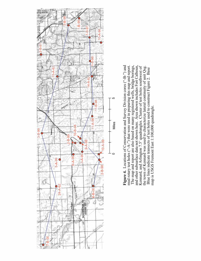
The Gilman Canyon Formation is moderately clayey silt and is grayish brown with aredder hue than overlying Peoria Loess (hue of 10YR rather than 2.5Y in the Munsellcolor system). This unit displays weak granular or blocky soil structure in manylocalities. Sediment interpreted as the Gilman Canyon Formation is 18 feet (5.5 m) thickat one site near the Missouri River at Fort Calhoun, but in most of the Fort Calhoun andKennard quadrangles this unit is 2-5 feet (0.6-1.5 m) thick. The contact between theGilman Canyon Formation and underlying Loveland Loess is gradational because soildevelopment continued as the initial increment of Gilman Canyon Formation loess wasdeposited. In many older descriptions of stratigraphy in the Omaha area, the GilmanCanyon Formation was considered to be part of the soil formed in the upper part of theLoveland Loess and was not recognized as a separate loess deposit. The Gilman CanyonFormation is stratigraphically equivalent to the Pisgah Formation in Iowa (Forman andothers, 1992) and the Roxana Silt in Illinois, Wisconsin, and Minnesota (Hansel andJohnson, 1996; Leigh and Knox, 1994; Mason and others, 1994). Deposition of theGilman Canyon Formation in the Omaha area began before 35,000 years B. P. andcontinued until some time between 25,000 and 20,000 years B. P., based on the availableradiocarbon ages. Mandel and Bettis (1995) reported a radiocarbon age of 25,340 ± 260years B. P. (CAMS-10190) from the just below the top of the Gilman Canyon Formationin Bellevue, Nebraska, 19 miles (31 km) south of the Fort Calhoun quadrangle. TheGilman Canyon Formation has also been radiocarbon dated near Winslow, Nebraska,26 miles (41 km) northwest of the Fort Calhoun quadrangle: Organic matter in the upperpart of this formation has an age of 23,000 ± 600 years B. P., and organic matter in thelower part yielded an age of 31,400 +1800, -1500 years B. P. (Souders and others, 1971).In this investigation, an age of 24,010 ± 90 years B. P. (Beta-119107) was obtained fromwood at a depth of 2 feet (0.6 m) below the top of the Gilman Canyon Formation insouthwestern Washington County, Nebraska (Conservation and Survey Division test hole2-B-98, fig. 3, 4). Thermoluminescence and radiocarbon ages reported by Forman andothers (1992) indicate that the Pisgah Formation was deposited between about 35,000 and23,000 yr BP at Loveland, Iowa; this is probably a good estimate for the age of thestratigraphically equivalent Gilman Canyon Formation near Fort Calhoun.
Loveland Loess is moderately to very clayey silt. In intact cores collected on wide,nearly level ridgetops in the Fort Calhoun and Kennard quadrangles, Loveland Loess is20 to 40 feet (6.1 to 12.2 m) thick. In two mud-rotary test holes in the Fort Calhounquadrangle (14-A-62 and 15-A-62, fig. 3 and 4), Loveland Loess may be up to 60 feet(18.3 m) thick. This unit is much thinner in outcrops on slopes. Where Loveland Loessis thick, it contains three distinct zones. The three zones vary widely in thickness. The
20
upper zone was highly altered by soil formation and weathering during both the lastinterglacial period and a significant part of the last glacial period, before it was deeplyburied by deposition of the Gilman Canyon formation and Peoria Loess. Effects of thisprolonged period of soil formation include the accumulation of clay, development of aredder color, and development of blocky structure. The soil formed in the upperLoveland Loess is considered correlative with the Sangamon Geosol (or Sangamon Soil)of the midwestern United States (Follmer, 1983). The middle zone of the LovelandLoess contains less clay, has a yellower color, and in some cases closely resembles PeoriaLoess. The lowest zone of the Loveland Loess is often slightly darker and firmer and hasa slightly redder hue than the middle zone. These differences between middle and lowerLoveland Loess could reflect different sediment sources. In many cases, one to threedistinct darker bands occur within the lowest zone, possibly representing brief periods ofsoil development because of slower loess deposition. In one core collected near thecenter of a wide ridgetop (CSD core 2-B-98, fig. 3 and fig. 4), all three zones of theLoveland Loess had gray, rather than brown or yellow, color, probably because of long-term saturation. This condition may be common in similar topographic settings. Nocalcareous Loveland Loess was identified in this study, although a few large carbonatenodules are occasionally present. Thermoluminescence dating at the paratype section ofthe Loveland Loess in Iowa indicates that it was deposited 135,000 ± 20,000 yr B. P.during the Illinoian glacial period (Forman and others, 1992). The main source ofLoveland Loess may have been the Missouri River valley, but this cannot be confirmedwithout more study of grain size and thickness trends.
Clayey silts and silty clays from 20 to 30 feet (6-9 m) thick occur beneath LovelandLoess on ridgetops and gentle slopes (fig. 3, 4), although they are rarely observed inoutcrop on steeper slopes. These deposits are either reddish brown or gray and typicallyhave blocky soil structure throughout. In some cases, two or more distinct soil profilescan be identified within these clayey silts and silty clays. They appear to drape thetopography of the underlying glacial till surface, and they are interpreted aspredominantly loess that has been altered by weathering and soil development. Theycould also include sediment deposited by slopewash in closed depressions on the glacialtill surface. These clayey silts and silty clays probably represent multiple thin incrementsof sediment deposited periodically over a long period of time. Extensive soildevelopment occurred after each episode of sedimentation, but the resulting soil profilesoverlap each other too closely to be distinguished. The clayey silts and silty clays arepre-Illinoian, based on their position beneath Loveland Loess.
The mechanical properties of older loess deposits are highly variable and depend ontexture, degree of compaction, and clay content, among other factors. Most loessdeposits older than Peoria Loess have higher density than that unit. Where LovelandLoess is thick, the less weathered, yellower part of it below the Sangamon Geosol andabove the basal dark zone, may have low density and bearing capacity, similar to thePeoria Loess. This is suggested by blow counts in Nebraska Department of Roadsborings, in which counts from the lower part of thick Loveland Loess are similar to thosefrom Peoria Loess. The Gilman Canyon Formation also is only a little denser than PeoriaLoess in some areas. The silty clays and clayey silts beneath Loveland Loess are quite
21
dense and may have high bearing capacity, similar to glacial till. It is commonly believedthat a perched saturated zone forms in lower Peoria Loess, because of the lowpermeability of the upper Loveland Loess. This may be true in some cases, but saturatedconditions in the pre-Loveland silts and clays below Peoria Loess may not be easilyrecognized because the hydraulic conductivity of these units is low and seepage into testholes or excavations is very slow. None of the loess deposits below Peoria Loess wouldbe expected to contain human artifacts because they predate any widely recognizedhuman inhabitation of North America.
Qt Glacial till and associated inclusions of sorted sediment (Pleistocene or latePliocene?)
Silty to sandy clay with rock fragments ranging from granule to boulder size, with lensesand beds of sorted sand (or occasionally silt or clay)
Predominantly dense, massive diamicton (a poorly sorted sediment containing materialfrom clay to boulder size), interpreted to be the deposits left by past advances of acontinental ice sheet into what is now the midwestern U. S (fig. 1b, 1c): includes rockfragments that must have been transported from the Canadian Shield and surroundingareas to the north and northeast of Nebraska. This diamicton has generally beendescribed as glacial till by previous researchers in Nebraska (Reed and Dreeszen, 1965),and that term is used in a similarly broad sense on these maps. Some glacial geologistsprefer to use the word till only for material deposited directly from the base of a glacier(Benn and Evans, 1998, p. 379-380), which may not be true of all till included in the Qtunit.
The total thickness of glacial till ranges from a few feet to at least 200 feet (1 to at least62 m). The greatest thicknesses are beneath wide upland ridge tops in the southwesternFort Calhoun quadrangle and the southeastern Kennard quadrangle. Thinner till occursbeneath ridge tops in other parts of these quadrangles, particularly where thick deposits ofsand and gravel and other sorted sediment (Qsg) are present beneath the till. Bothoxidized and unoxidized glacial till occur in the subsurface and in outcrops. Theoxidized till is light yellowish brown to light grayish brown, and often contains largefractures commonly filled with calcium carbonate. The unoxidized till is dark gray.Associated sorted sediments are predominantly sand that occurs as thin beds orirregularly shaped masses within the till. Similar masses of silt and clay have also beenobserved. These inclusions are common at some localities and rare or absent at others.The glacial till is homogeneous (except for the sand or silt inclusions) and unstratified inoutcrops.
The high density and homogeneity of much of the glacial till in eastern Nebraskasuggests deposition directly from the base of an ice sheet. Some of the glacial diamictonin this area that has lower density and is less homogeneous may have initiallyaccumulated as superglacial debris on the surface of the ice sheet and then may have beenreworked by gravity or water. Typical superglacial sediment as described by researchersin other areas (Johnson and Menzies, 1996) is rare in eastern Nebraska, however. The

22
difference in color between oxidized and unoxidized tills is the result of weathering afterdeposition. Oxygen-rich water passing through the till over time results in formation ofiron hydroxides that give the oxidized till its brown or yellow color. The inclusions ofsorted sediment could have originated in several ways. The ice sheet could have erodedintact masses of sorted sand or silt and then redeposited them along with surrounding till.Some sorted sediment could also have been deposited by flowing water in tunnels withinor at the base of the ice sheet.
The glacial till in the Omaha area is the result of several glaciations in the early andmiddle Pleistocene and possibly the late Pliocene (Boellstorff, 1978a, 1978b). At anyparticular site in the Omaha area, there is rarely evidence for more than one glaciation,for example, two tills separated by a well-developed interglacial soil. This is presumablybecause deposits of older glaciations were eroded, both by flowing water duringinterglacials and by the ice sheet itself during the most recent glaciations. Much glacialtill shown on the surficial geology map and occurring in the subsurface in the FortCalhoun quadrangle would probably have been included in the Cedar Bluffs or Nickersontills of Reed and Dreeszen (1965), both considered to be of Kansan age. Shimek (1909)originally described “Nebraskan” till near Florence, just outside the Fort Calhounquadrangle, but the section he described is not clearly identifiable at present. Boellstorff(1978a) recommended that the terms “Kansan” and “Nebraskan” be dropped, as they hadbeen applied inconsistently to tills of widely varying age. That recommendation isfollowed here. Boellstorff (1978b) identified several different informal till lithologicunits; these can be distinguished using a combination of pebble lithology, positionrelative to dated volcanic ash deposits, and remanent magnetism. No attempt has beenmade to distinguish between these units in this study due to insufficient data. Sandy tillwas consistently found overlying till with low sand content at widely scattered locationsin southern Washington County, but the regional significance of this observation isuncertain.
Because of its high density, the glacial till in the Omaha area provides better structuralsupport than overlying loess deposits, particularly Peoria Loess. The high clay content ofthe till makes it prone to shrinkage and swelling where it is near the surface, unconfinedand exposed to wetting and drying cycles. Because the till has low hydraulicconductivity, it can impede drainage where it is near the surface, potentially causingproblems such as wet basements or malfunctioning septic system drain fields. In somedeep excavations, it has been observed that water flows from sand lenses or beds withinthe till, sometimes at sufficient rates to cause drainage problems in the excavation.Archaeological sites should not be present in undisturbed till or associated sortedsediment because of its early to middle Pleistocene age.
Qsg Fluvial and lacustrine (?) sediment in the subsurface beneath uplands (Pleistocene orPliocene?) [stack map only]
Sand, gravel, and silt
23
Includes thick, extensive deposits of sorted sediment in the subsurface beneath uplands,usually occurring between glacial till and bedrock (fig. 1b, 1c): older till or silts underliethese deposits in a few places. Registered well logs and several Conservation and SurveyDivision test holes penetrate these deposits and the consistent stratigraphy andsedimentology suggest that they are laterally continuous over areas of several squaremiles. In the stack map, Qsg has been mapped only in areas near registered wells or testholes in which it is clearly present. As a result, this unit may be more extensive thanshown on the stack map. Medium and coarse sand beds are present in the upper part ofQsg in a few places, but the upper 30 to115 feet (9 to 35 m) of this unit is typicallyinterbedded fine sand, silt, and clay. The silt and clay beds have distinct lamination insamples from several CSD test holes. The lower 30 to 80 feet (9 to 25 m) of Qsgconsists of medium sand grading downward into coarse sand or gravel. The coarse sandor gravel often contains one or two thin beds of silt or clay. The coarse sand or gravelhas a distinctive yellowish-green color in fresh drill cuttings and contains abundant well-rounded quartz sand grains and pebbles.
The sediments included in Qsg are of middle Pleistocene age or older, based on theirstratigraphic position underlying pre-Illinoian glacial till. The gravel in Qsg includespebbles probably transported from the Canadian Shield by glacial ice, therefore post-dating the earliest continental glaciation, in the late Pliocene (Boellstorff, 1978b). Thecoarse sand and gravel in the lower part of this unit could have been deposited by non-glacial streams reworking older glacial deposits, but is more likely a once-extensiveaccumulation of outwash at the margin of an ice sheet. The finer-grained upper part ofthis unit may also be stream deposits but could alternatively have been deposited in lakesformed when the ice sheet dammed existing stream valleys. If so, the finer-grained siltsand clays were probably deposited in deeper water and the sands either accumulatednearer the shore or were carried into deeper water by occasional sediment flows down thebed of the lake. Similar sediment in the area around Lincoln, Nebraska, clearly formed inice-marginal lakes, but the sediments of Qsg in the Fort Calhoun and Kennard quadrangleare not adequately exposed to allow any definite conclusions on their origin. In somecases Qsg appears to be located in lows in the bedrock surface, but this cannot always bedetermined, and there are bedrock lows that do not contain these sorted sediments.Where the sorted sediment of Qsg is absent, it may originally have been present but waslater eroded by streams or by an ice sheet advancing over it.
The coarse sand or gravel in the lower part of unit Qsg forms an aquifer that is animportant source of water in southern Washington County. It is currently used fordomestic wells, a few irrigation wells, and a few high-capacity wells serving housingdevelopments. This aquifer is at least partially confined beneath fine-grained till, loess,and alluvium. The fine-grained deposits overlying unit Qsg will not always limit the rateof contaminant movement to this aquifer, however. Potentially rapid contaminantpathways to the aquifer include fractures in the till where it is thin, or the space aroundthe casing of poorly constructed wells. South of Kennard, along Big Papillion Creek,water from this aquifer emerges upward through alluvium, thin till, and loess orslopewash deposits to form numerous springs on the valley floor and adjacent lowerslopes. This groundwater discharge from the aquifer in Qsg is probably a major
24
contributor to base flow in Big Papillion Creek and may influence water quality in thatstream.
F Artificial fill.
Includes all types of artificial fill: examples include natural earth materials (silt, sand,gravel, and crushed rock) that have been moved and often compacted during constructionprojects, as well as construction debris and trash. Small areas of artificial fill occurthroughout the Fort Calhoun and Kennard quadrangles, for example, in roadbeds andaround buildings. Only the larger and more easily delineated areas of fill are shown onthis map. These areas mainly include earth-fill dams, quarry spoil piles, and a few largeroad fills.
W Water bodies.
Only larger water bodies are shown; these are mainly reservoirs and the Missouri Riverchannel. Many small farm ponds are not shown on the map.
P Pits.
Large, long-term excavations: used only for two large limestone quarries in the FortCalhoun quadrangle.
STACK MAP EXPLANATION
Units shown on the stack map are mostly combinations of different Quaternary and Pliocenestratigraphic units, listed in order from uppermost to deepest (example in fig. 1b). The intentionis to include all major, extensive stratigraphic units above Cretaceous or Pennsylvanian bedrock,although there are a variety of less extensive deposits that are locally present in the subsurfacebut not shown on this map. In parts of the Missouri River floodplain, only one stratigraphic unitoccurs over bedrock. Stack map units with artificial fill or water at the surface have not beendefined, for simplicity’s sake. The underlying stratigraphy in areas covered by fill or water canbe inferred from adjacent map units. Stack map units are described here in groups,corresponding to the parts of the landscape in which they occur. For detailed descriptions of theindividual components of stack map units, see the section on “Description of the StratigraphicUnits.” Where thickness ranges are given as “X feet to more than X feet,” the upper limitapproximates the maximum thickness observed or inferred from outcrops or subsurface data, butthe available information on thickness is limited, and greater thicknesses are possible.
Loess-mantled uplands
Qlp (> 50 ft)/Ql/QtSequence of materials (from surface downward):1) Peoria Loess (more than 50 feet thick on wide, gently sloping ridge tops, thinner on
steeper slopes and narrower ridge tops, less than 10 feet thick on the lower part of many
25
steep slopes, and less than 5 feet thick on lower slopes along Mill Creek, Long Creek,and their larger tributaries);
2) Gilman Canyon Formation, Loveland Loess, and older loess deposits (40 to more than100 feet thick on wide ridge tops; thinner (30-40 feet) on some ridge tops immediatelyadjacent to the Missouri River valley, much thinner on slopes and less than 5 feet thickon the lower part of many steep slopes);
3) glacial till (20 to more than 100 feet thick), interbedded with or overlying discontinuousbeds of sand and occasionally gravel (0 to 60 feet total thickness), as well as occasionalsilts and clays. The sorted sediments included with or underlying the till cannot becorrelated between drill holes, and their occurrence and thickness is unpredictable.
Same stratigraphy as above, but sand interbedded with glacial till has total thickness lessthan 10 feet (quantity of water available from surficial deposits often inadequate even fordomestic use).
Qlp (40-50 ft)/Ql/QtSequence of materials (from surface downward):1) Peoria Loess (40-50 feet thick on wide, gently sloping ridge tops, thinner on steeper
slopes and narrower ridge tops, less than 10 feet thick on the lower part of many steepslopes, and less than 5 feet thick on lower slopes along Mill Creek, Long Creek, and theirlarger tributaries);
2) Gilman Canyon Formation, Loveland Loess, and older loess deposits (40 to more than100 feet thick on wide ridge tops, much thinner on slopes and less than 5 feet thick on thelower part of many steep slopes);
3) glacial till (20 to more than 100 feet thick), interbedded with or overlying discontinuousbeds of sand and occasional gravel (0 to 60 feet total thickness), occasional silts andclays. The sorted sediments included with or underlying the till cannot be correlatedbetween drill holes, and their occurrence and thickness is unpredictable.
Qlp (40-50 ft)/Ql/Qt/QsgSequence of materials (from surface downward):1) Peoria Loess (40-50 feet thick on wide, gently sloping ridge tops, thinner on steeper
slopes and narrower ridge tops, less than 10 feet thick on the lower part of many steepslopes);
2) Gilman Canyon Formation, Loveland Loess, and older loess deposits (40 to more than100 feet thick on wide ridge tops, much thinner on slopes and less than 5 feet thick on thelower part of many steep slopes);
3) glacial till (20 to more than 100 feet thick), interbedded with discontinuous beds of sandand occasionally gravel (0 to 60 feet total thickness), and occasional silts and clays.
4) thick, laterally extensive sorted sediments, typically consisting of interbedded silt, sand,and clay (45 to 115 feet thick), overlying medium to coarse sand and gravel (30 to 80 feetthick).
Qlp (30-40 ft)/Ql/QtSequence of materials (from surface downward):
26
1) Peoria Loess (30-40 feet thick on wide, gently sloping ridge tops, thinner on steeperslopes and narrower ridge tops, and less than 10 feet thick on the lower part of most steepslopes);
2) Gilman Canyon Formation, Loveland Loess, and older loess deposits (30 to 40 feet thickon wide ridge tops, much thinner on steeper slopes and less than 5 feet thick on the lowerpart of many steep slopes);
3) glacial till (20 to more than 100 feet thick), interbedded with or overlying discontinousbeds of sand and occasionally gravel (0 to 60 feet total thickness), and occasional siltsand clays. The sorted sediments included with or underlying the till cannot be correlatedbetween drill holes, and their occurrence and thickness is unpredictable.
Qlp (30-40 ft)/Ql/Qt/QsgSequence of materials (from surface downward):1) Peoria Loess (30-40 feet thick on wide, gently sloping ridge tops, thinner on steeper
slopes and narrower ridge tops, less than 10 feet thick on the lower part of most steepslopes);
2) Gilman Canyon Formation, Loveland Loess, and older loess deposits (30 to 40 feet thickon wide ridge tops, much thinner on steeper slopes and less than 5 feet thick on the lowerpart of many steep slopes);
3) glacial till (20 to more than 200 feet thick), interbedded with discontinuous beds of sandand occasionally gravel (0 to 60 feet total thickness) and occasional silts and clays.
4) thick, laterally extensive sorted sediments, typically consisting of interbedded silt, sand,and clay (45 to 115 feet thick), overlying medium to coarse sand and gravel (30 to 80 feetthick).
Qlp (25-30 ft)/Ql/QtSequence of materials (from surface downward):1) Peoria Loess (25-30 feet thick on wide, gently sloping ridge tops, thinner on steeper
slopes and narrower ridge tops, and less than 10 feet thick on the lower part of most steepslopes);
2) Gilman Canyon Formation, Loveland Loess, and older loess deposits (20 to 30 feet thickon wide ridge tops, much thinner on steeper slopes and less than 5 feet thick on the lowerpart of many steep slopes);
3) glacial till (20 to more than 100 feet thick), interbedded with or overlying discontinuousbeds of sand and occasionally gravel (0 to 60 feet total thickness), as well as occasionalsilts and clays. The sorted sediments included with or underlying the till cannot becorrelated between drill holes, and their occurrence and thickness is unpredictable.
Qlp (25-30 ft)/Ql/Qt/QsgSequence of materials (from surface downward):1) Peoria Loess (25-30 feet thick on wide, gently sloping ridge tops, thinner on steeper
slopes and narrower ridge tops, less than 10 feet thick on the lower part of most steepslopes);
2) Gilman Canyon Formation, Loveland Loess, and older loess deposits (20 to 30 feet thickon wide ridge tops, much thinner on steeper slopes and less than 5 feet thick on the lowerpart of many steep slopes);
27
3) glacial till (20 to more than 100 feet thick), interbedded with discontinuous beds of sandand occasional gravel (0 to 60 feet total thickness), silts and clays.
4) thick, laterally extensive sorted sediments, typically consisting of interbedded silt, sand,and clay (45 to 115 feet thick), overlying medium to coarse sand and gravel (30 to 80 feetthick).
Lower slopes and valley floors of small streams
Ql/QtSequence of materials (from surface downward):1) Gilman Canyon Formation, Loveland Loess, and older loess deposits (5 to 25 feet thick);2) glacial till (10 to more than 50 feet thick), interbedded with or overlying discontinuous
beds of sand and occasional gravel (0 to 60 feet total thickness), as well as occasionalsilts and clays. The sorted sediments included with or underlying the till cannot becorrelated between drill holes, and their occurrence and thickness is unpredictable.
Ql/Qt/QsgSequence of materials (from surface downward):1) Gilman Canyon Formation, Loveland Loess, and older loess deposits (5 to 25 feet thick);2) glacial till (10 to more than 50 feet thick), interbedded with thin discontinuous beds of
sand and occasional gravel (0 to 60 feet total thickness), and occasional silts and clays.3) thick, laterally extensive sorted sediments, typically consisting of interbedded silt, sand,
and clay (45 to 115 feet thick), overlying medium to coarse sand and gravel (30 to 80 feetthick).
QtSequence of materials (from surface downward):1) glacial till (5 to more than 100 feet thick), interbedded with or overlying discontinuous
beds of sand and occasionally gravel (0 to 60 feet total thickness), as well as occasionalsilts and clays. The sorted sediments included with or underlying the till cannot becorrelated between drill holes, and their occurrence and thickness is unpredictable. Samestratigraphy as above, but sand interbedded with glacial till has total thickness less than10 feet (quantity of water available from surficial deposits often inadequate even fordomestic use).
Qt/QsgSequence of materials (from surface downward):1) glacial till (5 to more than 100 feet thick), interbedded with or overlying thin
discontinous beds of sand and occasionally gravel (0 to 50 feet total thickness).2) thick, laterally extensive sorted sediments, typically consisting of interbedded silt, sand,
and clay (45 to 115 feet thick), overlying medium to coarse sand and gravel (30 to 80 feetthick).
Qsw/[Qlp]/[Ql]/QtSequence of materials (from surface downward):
28
1) slopewash sediment (1 to more than 15 feet thick), possibly including some primaryPeoria Loess;
2) [may not be present] Peoria Loess, 0-20 feet thick3) [may not be present] Gilman Canyon Formation, Loveland Loess, and older loess
deposits (0 to 25 feet thick);4) glacial till (5 to more than 100 feet thick), interbedded with or overlying discontinuous
beds of sand and occasional gravel (0 to 60 feet total thickness), as well as occasionalsilts and clays. The sorted sediments included with or underlying the till cannot becorrelated between drill holes, and their occurrence and thickness is unpredictable.
Same stratigraphy as above, but sand interbedded with glacial till has total thickness lessthan 10 feet (quantity of water available from surficial deposits often inadequate even fordomestic use).
Qsw/[Qlp]/[Ql]/Qt/QsgSequence of materials (from surface downward):1) slopewash sediment (1 to more than 15 feet thick), possibly including some primary
Peoria Loess;2) [may not be present] Peoria Loess, 0-20 feet thick3) [may not be present] Gilman Canyon Formation, Loveland Loess, and older loess
deposits (0 to 25 feet thick);4) glacial till (5 to more than 100 feet thick), interbedded with discontinuous beds of sand
and occasional gravel (0 to 60 feet total thickness), silts, and clays.4) thick, laterally extensive sorted sediments, typically consisting of interbedded silt, sand,
and clay (45 to 115 feet thick), overlying medium to coarse sand and gravel (30 to 80 feetthick).
Qa/[Ql]/QtSequence of materials (from surface downward):1) alluvium, undifferentiated, (5 to more than 60 feet thick);2) [may not be present] Gilman Canyon Formation, Loveland Loess, and older loess
deposits (0 to 25 feet thick);3) glacial till (5 to more than 100 feet thick), interbedded with or overlying discontinous
beds of sand and occasional gravel (0 to 60 feet total thickness), as well as occasionalsilts and clays. The sorted sediments included with or underlying the till cannot becorrelated between drill holes, and their occurrence and thickness is unpredictable.
Same stratigraphy as above, but sand interbedded with glacial till has total thickness lessthan 10 feet (quantity of water available from surficial deposits often inadequate even fordomestic use).
Qa/[Ql]/Qt/QsgSequence of materials (from surface downward):1) alluvium, undifferentiated, (5 to more than 60 feet thick);2) [may not be present] Gilman Canyon Formation, Loveland Loess, and older loess
deposits (0 to 25 feet thick);
29
3) glacial till (5 to more than 50 feet thick), interbedded with discontinuous beds of sandand occasionally gravel (0 to 60 feet total thickness), and occasional silts and clays.
4) thick, laterally extensive sorted sediments, typically consisting of interbedded silt, sand,and clay (45 to 115 feet thick), overlying medium to coarse sand and gravel (30 to 80 feetthick).
Qa/Qsg (coarse lower part)Sequence of materials (from surface downward):1) alluvium, undifferentiated, (5 to more than 60 feet thick);2) thick, laterally extensive, medium to coarse sand and gravel (30 to 80 feet thick).
Qa1/[Qa2] /QtSequence of materials (from surface downward):1) alluvium, silt or clay, predominantly light gray and distinctly stratified or dark and
organic-matter-rich, (5 to more than 20 feet thick);2) [may not be present] alluvium, predominantly light yellowish brown or gray silt, with
sand and gravel in lenses or in thicker beds at the base (0 to more than 20 feet thick);3) glacial till (5 to more than 50 feet thick), interbedded with or overlying discontinuous
beds of sand and occasional gravel (0 to 60 feet total thickness), as well as occasionalsilts and clays. The sorted sediments included with or underlying the till cannot becorrelated between drill holes, and their occurrence and thickness is unpredictable.
Same stratigraphy as above, but sand interbedded with glacial till has total thickness lessthan 10 feet (quantity of water available from surficial deposits often inadequate even fordomestic use).
Qa1/[Qa2] /Qt/QsgSequence of materials (from surface downward):1) alluvium, silt or clay, predominantly light gray and distinctly stratified or dark and
organic-matter-rich, (5 to more than 20 feet thick);2) [may not be present] alluvium, predominantly light yellowish brown or gray silt, with
sand and gravel in lenses or in thicker beds at the base (0 to more than 20 feet thick);3) glacial till (5 to more than 100 feet thick), interbedded with discontinuous beds of sand
and occasional gravel (0 to 50 feet total thickness), silts, and clays;4) thick, laterally extensive sorted sediments, typically consisting of interbedded silt, sand,
and clay (45 to 115 feet thick), overlying medium to coarse sand and gravel (30 to 80 feetthick).
Qa2/QtSequence of materials (from surface downward):1) alluvium, predominantly light yellowish-brown or gray silt, with sand and gravel in
lenses or in thicker beds at the base (5 to more than 20 feet thick);2) glacial till (5 to more than 50 feet thick), interbedded with or overlying discontinuous
beds of sand and occasional gravel (0 to 60 feet total thickness), as well as occasional
30
silts and clays. The sorted sediments included with or underlying the till cannot becorrelated between drill holes, and their occurrence and thickness is unpredictable.
[cross-hatched pattern] Same stratigraphy as above, but sand interbedded with glacial tillhas total thickness less than 10 feet (quantity of water available from surficial depositsoften inadequate even for domestic use).
Qa2/Qt/QsgSequence of materials (from surface downward):1) Alluvium, predominantly light yellowish-brown or gray silt, with sand and gravel in
lenses or in thicker beds at the base (5 to more than 20 feet thick);2) glacial till (5 to more than 100 feet thick), interbedded with discontinuous beds of sand
and occasional gravel (0 to 50 feet total thickness), silts, and clays;3) thick, laterally extensive sorted sediments, typically consisting of interbedded silt, sand,
and clay (45 to 115 feet thick), overlying medium to coarse sand and gravel (30 to 80 feetthick).
Fort Calhoun Terrace (high bench on which the town of Fort Calhoun is located)
Qlp/Qam4Sequence of materials (from surface downward):1) Massive grayish-brown silt interpreted as Peoria Loess (30-40 feet thick), possibly
replaced by stratified silt (slopewash or alluvial fan deposits?) on parts of the terracesurface;
2) brown to greenish-gray silt, overlying stratified sand and silt, interpreted as MissouriRiver alluvium (more than 40 feet thick)
Qsw/[Qlp]/Qam4Sequence of materials (from surface downward):1) slopewash sediment (1 to more than 15 feet thick);2) [may not be present] massive grayish-brown silt interpreted as Peoria Loess (30-40 feet
thick), possibly replaced by stratified silt (slopewash or alluvial fan deposits?) on parts ofthe terrace surface;
3) brown to greenish-gray silt, overlying stratified sand and silt, interpreted as MissouriRiver alluvium (more than 40 feet thick).
Qa/[Qlp]/Qam4Sequence of materials (from surface downward):1) alluvium, undifferentiated, (5 to more than 20 feet thick);2) [may not be present] massive grayish-brown silt interpreted as Peoria Loess (30-40 feet
thick), possibly replaced by stratified silt (slopewash or alluvial fan deposits?) on parts ofthe terrace surface;
3) brown to greenish-gray silt, overlying stratified sand and silt, interpreted as MissouriRiver alluvium (more than 40 feet thick).
Qa1/[Qa2]/[Qlp]/Qam4
31
Sequence of materials (from surface downward):1) alluvium, silt or clay, predominantly light gray and distinctly stratified or dark and
organic-matter-rich, (5 to more than 20 feet thick);2) [may not be present] alluvium, predominantly light yellowish-brown or gray silt, with
sand and gravel in lenses or in thicker beds at the base (0 to more than 20 feet thick);3) [may not be present] massive grayish-brown silt interpreted as Peoria Loess (30-40 feet
thick), possibly replaced by stratified silt (slopewash or alluvial fan deposits?) on parts ofthe terrace surface;
4) brown to greenish gray silt, overlying stratified sand and silt, interpreted as MissouriRiver alluvium (more than 40 feet thick).
Qa2/[Qlp]/Qam4Sequence of materials (from surface downward):1) alluvium, predominantly light yellowish-brown or gray silt, with sand and gravel in
lenses or in thicker beds at the base (5 to more than 20 feet thick);2) [may not be present] Massive grayish-brown silt interpreted as Peoria Loess (30-40 feet
thick), possibly replaced by stratified silt (slopewash or alluvial fan deposits?) on parts ofthe terrace surface;
3) brown to greenish-gray silt, overlying stratified sand and silt, interpreted as MissouriRiver alluvium (more than 40 feet thick).
Qaf2/[Qlp]/Qam4Sequence of materials (from surface downward):1) alluvial fan sediment, possibly interfingering or mixed with Peoria Loess deposited
directly by the wind (thickness uncertain, see “Description of the Stratigraphic Units”);2) [may not be present] massive grayish-brown silt interpreted as Peoria Loess (30-40 feet
thick), possibly replaced by stratified silt (slopewash or alluvial fan deposits?) on parts ofthe terrace surface;
3) brown to greenish-gray silt, overlying stratified sand and silt, interpreted as MissouriRiver alluvium (more than 40 feet thick).
Qaf2/[Qlp]/[Ql]/QtSequence of materials (from surface downward):1) alluvial fan sediment, possibly interfingering or mixed with Peoria Loess deposited
directly by the wind (thickness uncertain, see Description of the Stratigraphic Units);2) [may not be present] Massive grayish brown silt interpreted as Peoria Loess (30-40 feet
thick), possibly replaced by stratified silt (slopewash or alluvial fan deposits?) on parts ofthe terrace surface;
3) [may not be present] Gilman Canyon Formation, Loveland Loess, and older loessdeposits (0 to 25 feet thick);
4) glacial till (20 to more than 100 feet thick), interbedded with or overlying thindiscontinous beds of sand and occasionally gravel (0 to 50 feet total thickness).
Missouri River floodplain
Qam1 Missouri River alluvium, see “Description of the Stratigraphic Units.”
32
Qam2 Missouri River alluvium, see “Description of the Stratigraphic Units.”
Qam3 Missouri River alluvium, see “Description of the Stratigraphic Units.”
Qaf1/Qam2Sequence of materials (from surface downward):1) Alluvial fan deposits, 5 to 20 feet thick;2) Missouri River alluvium of unit Qam2, see “Description of the Stratigraphic Units.”
Qaf1/Qam3 Sequence of materials (from surface downward):1) alluvial fan deposits, 5 to 20 feet thick;2) Missouri River alluvium of unit Qam3, see “Description of the Stratigraphic Units.”
Throughout Map Area
F Artifical fillW Water bodiesP Quarry Pits
ACKNOWLEDGEMENTS
The production of these maps was supported by the U. S. Geological Survey, through theSTATEMAP program, and the Conservation and Survey Division, Institute of Agriculture andNatural Resources, University of Nebraska-Lincoln. E. A. Bettis III, V. H. Dreeszen, and ScottSummerside provided helpful discussion and advice. Summerside and R. F. Diffendal, Jr.,reviewed the maps and text. Conservation and Survey Division drillers Jim Roberts and GregGrosch skillfully carried out the extensive drilling required for this project, with assistance fromBryan Penas, Michael Ponte, Michael Beshore, Cynda Timperley, Matt Joeckel, Joni Koskovic,Jim Swinehart, and Jim Durbin. Charles Flowerday edited the copy.
REFERENCES
Benak, J. V., 1967, Engineering properties of the late Pleistocene loess in the Omaha-CouncilBluffs area: Urbana, University of Illinois, Ph. D. dissertation, 321 p.
Benn, D. I., and Evans, D. J. A., 1998, Glaciers and glaciation: New York, Arnold, 734 p.Bettis, E. A., III. 1990. Holocene alluvial stratigraphy of western Iowa in Bettis, E. A., III, ed.,
Holocene alluvial stratigraphy and selected aspects of the Quaternary history of westernIowa: Midwest Friends of the Pleistocene 37th Field Conference Guidebook: Iowa City,Iowa Department of Natural Resources, Geological Survey Bureau, p. 1-16.
Boellstorff, J., 1978a, North American Pleistocene stages reconsidered in light of probablePliocene-Pleistocene continental glaciation: Science, v. 202, p. 305-307.
Boellstorff, J., 1978b, Chronology of some late Cenozoic deposits from the central United Statesand the Ice Ages: Transactions of the Nebraska Academy of Sciences, v. 6, p. 35-49.
33
Forman, S. L., Bettis, E. A., III, Kemmis, T., and Miller, B. B., 1992, Chronological evidence formultiple periods of loess deposition during the late Pleistocene in the Missouri andMississippi River Valleys, U. S.: Implications for the activity of the Laurentide Ice Sheet:Palaeogeography, Palaeoclimatology, Palaeoecology, v. 93, p. 71-83.
Hallberg, G. R., Harbaugh, J. M., and Witinok, P. M., 1979, Changes in the channel area of theMissouri River in Iowa, 1879-1976: Iowa Geological Survey Special Report Series 1, 32p.
Handy, R. L., 1973, Collapsible loess in Iowa: Soil Science Society of America Proceedings, v.37, p. 281-284.
Hansel, A. K., and Johnson, W. H.,1996, Wedron and Mason Groups: Lithostratigraphicreclassification of deposits of the Wisconsin Episode, Lake Michigan Lobe area: IllinoisState Geological Survey Bulletin 104, 116 p.
Johnson, W. H., and Menzies, J., 1996, Pleistocene supraglacial and ice-marginal deposits andlandforms in Menzies, J., ed., Past glacial environments: sediments, forms, andtechniques: Oxford, Butterworth-Heinemann, p. 137-160.
Leigh, D. S., and Knox, J. C., 1994, Loess of the Upper Mississippi Valley Driftless Area:Quaternary Research, v. 42, p. 30-40
Lohnes, R. A. and Handy, R. L., 1968, Slope angles in friable loess: Journal of Geology, v. 76, p.247-258.
Lueninghoener, G. C., 1947, The post-Kansan geologic history of the lower Platte valley area:Lincoln, University of Nebraska Studies, New Series 1, 82 p.
Lutenegger, A. J. and Hallberg, G. R., 1988, Stability of loess: Engineering Geology, v. 25, p.247-261.
Maat, P. B., and Johnson, W. C., 1996, Thermoluminescence and new 14C age estimates for lateQuaternary loesses in southwestern Nebraska: Geomorphology, v. 17, p. 115-128.
Mandel, R., and Bettis, E. A., III, 1995, Late Quaternary landscape evolution and stratigraphy ineastern Nebraska in Diffendal, R. F., Jr., chair, and Flowerday, C. A., ed., Geologic fieldtrips in Nebraska and adjacent parts of Kansas and South Dakota: Guidebook 10,Conservation and Survey Division, University of Nebraska-Lincoln, p. 77-90.
Mason, J. A., Nater, E. A., and Hobbs, H. C., 1994, Transport direction of Wisconsinan loess insoutheastern Minnesota: Quaternary Research v. 41, p. 44-51.
Miller, R. D., 1964, Geology of the Omaha-Council Bluffs area, Nebraska-Iowa: U. S.Geological Survey Professional Paper 472, 70 p.
Moulton, G. E, 1983, Journals of the Lewis and Clark expedition, Volume 1: Atlas of the Lewisand Clark expedition: Lincoln, University of Nebraska Press.
Reed, E. C., and Dreeszen, V. H., 1965, Revision of the classification of the Pleistocene depositsof Nebraska: Nebraska Geological Survey Bulletin 23, 65 p.
Ruhe, R. V., 1969, Quaternary landscapes in Iowa: Ames, Iowa, Iowa State University Press,255 p.
Shimek, B., 1909, Aftonian sands and gravels in western Iowa: Geological Society of AmericaBulletin v. 20, p. 399-408.
Souders, V. L., Elder, J. A., and Dreeszen, V. H., 1971, Guidebook to selected Pleistocenepaleosols in eastern Nebraska in Rocks, real estate, and resources, a field trip guidebookprepared for the Fifth Annual Meeting of the North-Central Section of the GeologicalSociety of America: Lincoln, Conservation and Survey Division, University of Nebraska-Lincoln, 18 p.