supplementary report on - amazon s3 · the city, old river channels, high groundwater levels,...
TRANSCRIPT

160
2040
60
80
40
60
204060
80
100
20
2040
60
80
4040
20
2040
6080
4060
80
From Sleeman and Pracht (1995)
LATE PLEISTOCENE-HOLOCENE BURIED VALLEYS IN THE CORK SYNCLINE, IRELAND
0 1 2 3 4
Kilometres
Grid North
MagneticNorth
Approx.
D
D1C1
C
B
B1
A
A1
KM
KM1
KM
KM2
KM
KM3
KM
KM4
KM
KM5
KM
KM6
DH
DH1
DH
DH2
DH3
DH
DH
DHDH5
DH
DH6
DH
DH7
DH-DH1to
DH-DH7
DH4
Map area
IRELAND
155 160 165 170 180175 190
70
75
155 160 165 170 175 180 190
70
75
185
185
154000076000
154000068000
194000076000
194000068000
E1
E
F1
F
X1
STRATIGRAPHICAL UNITSIN BURIED VALLEY MAP
BEDROCK
LEGEND TOBURIED VALLEY ISOPACHS(Thickness of sediment in buried valleys)
Carboniferous LimestonesMostly karstified micritesStrongly jointed and fractured
Devonian/Carboniferous ClasticsPurple, green, grey sandstones and mudstonesStrongly cleaved, jointed and fractured
Mayfield
?
?
?
??
?
?
?
?
?
??
X
Z
GEOLOGICAL SETTING OF THE BURIED VALLEY MAP AREA(after Sleeman & Pracht, 1995)
W
W1
Y
Y1 Z1
CORK CITY
Lough Mahon
?
?
MIDLETON
River Lee
Douglas Estuary
GREAT ISLAND
LITTLE ISLAND
Inniscarra
Templehill
Clogheen
Knocknaheehy
BallyvolaneGlanmire
Glounthane
Water-Rock
Rathcoursey
Passage WestRochestown
DouglasTramore River
Glasheen
Glasheen River
Doughcloyne
Curraheen River
BishopstownClasses
Ovens
River Bride
Ballincollig
DiamondQuarry
Gouldings Glen
ClassesGorge
InniscarraBar
Curraghbeg
Cloghroe
Blarney LakeKilleens
Sallybrook
Riverstown
BLARNEY
FOTA ISLAND
Owenna Gearagh River
Blarney River
River BrideGlashaboy River
Glenmore River
Dungourney River
?
Lake
Lake
NORTHERN BURIED VALLEY
SOUTHERN BURIED VALLEY
NORTHERNBURIED VALLEY
SOUTHERN BURIED VALLEY
V
V1
? ??
?
?
?
?
?Carrigrennan
Point
MahonPoint
Dunkettle
Belvelly
Killacloyne
? ?
HopIsland
MarinoPoint
100
120
140
80604020
40
120100806040
20
140 120
100806040
20 40
60 80
100120
2040
60
80
100
8060
4020
20
40
60
80
60
10020
40
60
80 100
20
40
6080
100120
120
100
80
60
40
20
20
20
20
20
20
20
120
Blackrock
??
?
? ?
?
GarryhestaQuarry
ClassesQuarry
Blackpool
Late Pleistocene-HoloceneBuried Valleys
in theCork Syncline,
Irelandby
T. Davis, I.A.J. MacCarthy, A.R. Allen and B. Higgs
Department of GeologyUniversity College Cork,
Cork,Ireland.
Symbols represent borehole locations. The colour ofthe symbols represents either the depth to bedrock, ifbedrock was encountered, or the depth of the borehole.The depth is measured in metres below ground level.
LEGEND TO BOREHOLE SYMBOLSIN BURIED VALLEY MAP
TOPOGRAPHICAL AND GEOLOGICAL FEATURESIN BURIED VALLEY MAP
Main Roads
Contours
Geophysical LinesKostic & Milosevic (2004)
Rivers/Streams/Coast
Buried Valley Isopachs, Plotting of Borehole Data: T. Davis, I.A.J. MacCarthyBorehole Data Collection: A.R. Allen, T. Davis, I.A.J. MacCarthy
Bedrock and Quaternary Geology: I.A.J. MacCarthyGeophysics: A.R. Allen, T. Davis, B. Higgs
Map Design and Cartography: I.A.J. MacCarthyFunding Coordination: A.R. Allen
2006 ACKNOWLEDGEMENTSThis project was funded by a grant from the Higher Education Authorityunder PRTLI 2 Strategic Research Area: Sustainable Energy.
The compilers are grateful to R.Unitt who provided assistance with thegeophysical work.
Topographical data are based on Ordnance Survey Ireland.Licence No. NE 0000706 ©Ordnance Survey Ireland and Government of Ireland.
MAP LOCATION
MAP SCALE1:25,000
A-A1to
F-F1
LithostratigraphicalCross-Sections betweenLogged Sections*(See Fig. 4)
<20m
20 - 40m
40 - 60m
60 - 80m
80 - 100m
Upper DevonianOld Red Sandstone
Lower Carboniferous Limestone
Upper Devonian-Lower Carboniferousmarine clastics
AREA OF BURIED VALLEY MAP
The grid shown is the Irish National Grid.Magnetic North is approximately 6 degreeswest of Grid North at the centre of the map
in 2004.
True North is approximately 31’ east of GridNorth in the western margin of this map and
approximately 5’ east of Grid North in theeastern margin of the map.
The representation of a road on this map is not evidence of the existence of a right of way.
The map is designed to represent certain aspects of the geological characteristicsof the area based on the available information at the t ime of i ts compilation.
The representation is interpretational between control points.
Determination of the actual geological characteristics at any particular point will normallyrequire a further detailed localised site investigation.
No part of this publication may be reproduced, stored in a retrieval system or transmitted in anyform or by any means without the permission in writing of the copyright holders and the publisher.
OV1
OV3
BE
OVENS FORMATION Member 3Fluvial gravels derived from the margins of theCork Valley as alluvial fans.
OVENS FORMATION Member 2Crudely bedded fluvial outwash gravelscontaining minor thin cross-stratifiedsand lenses increasing in frequency eastwards.
NOTE: This member is essentially confined to the buried valleys .These are depicted on the map by the use of colours whichrepresent isopachs for the valley fills. Consequently, Member 2 of the OvensFormation is not specifically depicted on the map by a single colour.
OVENS FORMATION Member 1Fluvial outwash gravels enclosed in karstifiedlimestone caverns
BALLYVOLANE FORMATIONGravels, sands and mudsProglacial lacustrine
NOTE: Recent Alluvium has been omitted from the map.
PLEISTOCENE-HOLOCENE
OV2V-V1
toZ-Z1
The margins of the buried valleys are speculative between control points.The confidence level in relation to the northern margin of the northernvalley and the southern margin of the southern valley is very highbecause of good topographical and rock outrcrop control. Other valley marginsare much more speculative between control points. These areindicated with a dashed line.
MARGIN OF BURIED VALLEYS
Stratigraphical Boundaries
Topographical/GeologicalCross-Sectionsacross Buried Valleys*(See Fig. 5)
Bedrock (Rock Outcrops) Additional Boreholes notincluded in database
KM-KM1to
KM-KM6
Geophysical LinesDavis & Higgs (2004)
100 - ?140m
*NOTE: There is a partial overlap between Sections A-A1 to F-F1 and Sections V-V1 to Z-Z1
OV1
OV2
OV2
OV2
OV2
OV2
OV1
BE
OV3
OV3
OV3
OV3
OV3OV3
0 - 4.9m5 - 9.9m
10 - 14.9m15 - 19.9m20 - 24.9m25 - 29.9m30 - 34.9m35 - 39.9m40 - 44.9m45 - 49.9m
Bedrock encountered(Depth to Bedrock)
Bedrock not encountered(Depth of Borehole)
230436-00December 2017
Lower Lee (Cork City) Flood Relief Scheme(Drainage Scheme)
Supplementary Report onGroundwater

Office of Public Works Lower Lee (Cork City) Flood Relief Scheme Supplementary Report – Groundwater/Hydrogeology
230436-00
Issue to website | 5 December 2017
This report takes into account the particular instructions and requirements of our client.
It is not intended for and should not be relied upon by any third party and no responsibility is undertaken to any third party. Job number 230436-00
Ove Arup & Partners Ireland Ltd
Arup 50 Ringsend Road Dublin 4 D04 T6X0 www.arup.com

Office of Public Works Lower Lee (Cork City) Flood Relief Scheme
Supplementary Report – Groundwater/Hydrogeology
230436-00 | Issue to website | 5 December 2017 \\GLOBAL\EUROPE\CORK\JOBS\230000\230436-00\4. INTERNAL PROJECT DATA\4-04 REPORTS\4-04-03 INFRASTRUCTURE\09_HYDROGEOLOGY\LOWER LEE HYDRO SUBMISSION RESPONSES_ISSUE 1.DOCX
Contents Page
Executive Summary 1
1 Introduction 3
1.1 Submissions 4
2 Proposed Scheme Description 5
3 Key Concerns 7
3.1 Uncertainty in the Ground Conditions and Groundwater Monitoring 7
3.2 The Potential for River Water to Move Beneath the Walls 8 3.3 The Possibility for the Wall to act as a Barrier on the ‘Dry
Side’ 9 3.4 The Potential for Changing the Groundwater Level and the
Influence it May Have 10
4 Responses to Submissions 12
5 Summary 16
Appendices
Appendix A
Hydrogeological Assessment Summary
Appendix B
Data & Interpretation of Hydrogeological Regime
Appendix C
Numerical Modelling
Appendix D
Publicly Available Papers

Office of Public Works Lower Lee (Cork City) Flood Relief Scheme
Supplementary Report – Groundwater/Hydrogeology
230436-00 | Issue to website | 5 December 2017 \\GLOBAL\EUROPE\CORK\JOBS\230000\230436-00\4. INTERNAL PROJECT DATA\4-04 REPORTS\4-04-03 INFRASTRUCTURE\09_HYDROGEOLOGY\LOWER LEE HYDRO SUBMISSION RESPONSES_ISSUE 1.DOCX
Page 1
Executive Summary The Lower Lee Flood Relief Scheme (LLFRS) was commissioned by the Office of Public Works (OPW) with the objective of delivering a flood relief scheme for Cork City and environs to provide protection against the 1-in-100 year fluvial/1-in-200year tidal flood events.
The proposed Scheme was subsequently brought to Statutory Exhibition stage through the Arterial Drainage Act (as amended) in late 2016/early 2017.
Details of the scheme were available for inspection to members of the public between the 12 December 2016 and the 20 January 2017 at four locations around Cork City. The Scheme has also been available to view online on the project website www.lowerleefrs.ie. Submissions were invited up to 7 April 2017.
During the exhibition stage, members of the public were invited and encouraged to submit their views in relation to the preferred Scheme. As part of the process, a significant number of submissions were received, some of which related to hydrogeology and the potential for groundwater flooding.
A key issue of concern raised, is the risk of water rising from the ground in the defended areas as a result of high water levels in the river. This is a process commonly considered and addressed in flood relief schemes. The primary action considered from the groundwater perspective is the seepage of water underneath the flood defence during flood conditions (high river/tide levels), leading to an increase in groundwater levels in the area.
A significant body of research and design work has been undertaken on this subject over the course of the project to date, and further work will continue during the detailed design stages.
It should be noted that the submissions received on the Statutory Exhibition Documents dealt predominantly with the hydrogeological conditions and the potential impacts to the City Island and for this reason, this report deals extensively with that specific part of the scheme. However, the assessments completed have been undertaken for the entire scheme.
Key concerns raised in the submissions included whether a raised river level around the City Island would cause groundwater beneath the island to rise, or whether the quay walls themselves would cause groundwater (from rainfall or leaking drains) to back up behind the wall. Concerns were raised about the potential impacts such as groundwater flooding, geotechnical instability beneath buildings and, conversely, the drying out of archaeological remains.
In answer to these concerns, this report outlines the key hydrogeological features that are considered as part of the assessment and development of the proposed flood defence design.

Office of Public Works Lower Lee (Cork City) Flood Relief Scheme
Supplementary Report – Groundwater/Hydrogeology
230436-00 | Issue to website | 5 December 2017 \\GLOBAL\EUROPE\CORK\JOBS\230000\230436-00\4. INTERNAL PROJECT DATA\4-04 REPORTS\4-04-03 INFRASTRUCTURE\09_HYDROGEOLOGY\LOWER LEE HYDRO SUBMISSION RESPONSES_ISSUE 1.DOCX
Page 2
Features, such as the presence of deep, high permeability gravels, which underlie the city, old river channels, high groundwater levels, additional recharge from leaking pipes, are some key elements considered. In contrast, the presence of lower permeability alluvium, variability of the permeability of the gravels and the delay in the groundwater response to river water levels (tidal lag), although identified as features that reduce the risk, are not assumed to prevent groundwater seepage.
The proposed design solutions to address the above issues have been developed specific to the Cork context, using an integrated multidisciplinary approach, which assessed all of the hydrogeology, drainage and geotechnical engineering requirements.
Based on the work carried out to date, it is considered that the current flood design and flood mitigation measures proposed (such as the flow control structure and back of wall drainage etc.) will prevent the flooding of properties from groundwater seepage during future fluvial or tidal flood conditions. In addition, the hydrogeological assessment and numerical modelling of the study areas indicates that that during flood conditions, only the top 1 - 2 meters of the groundwater table are affected for a limited time period, and the deep water bearing gravel deposits will remain saturated as they are normally. During the non-flood scenario, the hydrogeological regime will remain unchanged.
This hydrogeological assessment will be kept under review as further information is gathered, as the detailed design of the scheme progresses, and as further site investigation information is collected.
Office of Public Works Lower Lee (Cork City) Flood Relief Scheme
Supplementary Report – Groundwater/Hydrogeology
230436-00 | Issue to website | 5 December 2017 \\GLOBAL\EUROPE\CORK\JOBS\230000\230436-00\4. INTERNAL PROJECT DATA\4-04 REPORTS\4-04-03 INFRASTRUCTURE\09_HYDROGEOLOGY\LOWER LEE HYDRO SUBMISSION RESPONSES_ISSUE 1.DOCX
Page 3
1 Introduction The Lower Lee Flood Relief Scheme (LLFRS) was commissioned by the Office of Public Works (OPW) with the objective of delivering a flood relief scheme for Cork City and environs to provide protection against the 1-in-100 year fluvial/1-in-200 year tidal flood events.
The proposed scheme was subsequently brought to Statutory Exhibition stage through the Arterial Drainage Act (as amended) in late 2016/early 2017.
Details of the scheme were available for inspection to members of the public between 12 December 2016 and 20 January 2017 at four locations around Cork City. The Scheme has also been available to view online on the project website www.lowerleefrs.ie. Submissions were invited up to 7 April 2017.
During the exhibition stage, members of the public were invited and encouraged to submit their views in relation to the preferred Scheme. As part of the process, a significant number of submissions were received, some of which related to hydrogeology and the potential for groundwater flooding.
It was noted that a key issue of concern raised, is the risk of water rising from the ground in the defended areas as a result of high water levels in the river. This is a process commonly considered and addressed in flood relief schemes. The primary action considered is, from the groundwater perspective, during flood conditions (high river/tide levels), the seepage of water underneath the flood defence, leading to an increase in groundwater levels in the area.
A significant body of research and design work has been undertaken on this subject over the course of the project to date, and further work will continue during the detailed design stages. The purpose of this report is to summarise the approach to the work that has been completed to date, the relevant ongoing detailed design and to respond to submissions received.
In order to provide the context for the assessments completed, and the responses to the submissions, Section 2 of the report provides a summary of the design elements that are relevant to hydrogeology.
Section 3 provides an overview of the key concerns raised across the submissions and summarises the relevant hydrogeological regime that applies to that scenario during both non-flood and flood conditions. Section 4 provides responses to specific submissions.
Appendix A presents a summary of the hydrogeological assessments completed to date and the significant volume of information available, it outlines the approach taken to the hydrogeological assessments, and summarises the work completed to date. Additional details on the assessments, including examples of the 2D numerical analysis completed, are presented in Appendix B and C.

Office of Public Works Lower Lee (Cork City) Flood Relief Scheme
Supplementary Report – Groundwater/Hydrogeology
230436-00 | Issue to website | 5 December 2017 \\GLOBAL\EUROPE\CORK\JOBS\230000\230436-00\4. INTERNAL PROJECT DATA\4-04 REPORTS\4-04-03 INFRASTRUCTURE\09_HYDROGEOLOGY\LOWER LEE HYDRO SUBMISSION RESPONSES_ISSUE 1.DOCX
Page 4
1.1 Submissions As noted in Section 1, during the Statutory Exhibition process, a number of submissions were received on hydrogeology and the potential for groundwater flooding. These queries can generally be summarised as below:
1. What is the impact on the groundwater table: (a) Due to changes in the river wall structure e.g. grouting and/or
deepening, which may prevent groundwater from flowing into the River Lee?
(b) Due to greater recharge as a result of climate change/and or storm event?
(c) Due to increase in water level in the channel? (d) Due to rising sea levels?
2. What is the impact on buildings or archaeological features due to change in groundwater regime (including a change in groundwater levels/pore water pressures etc.)?
3. Is there a potential for karst cavity collapse? 4. Have buildings limit values been assessed in the city? i.e. is design in
accordance with Eurocode 7 – has failure by uplift, failure by heave, failure by internal erosion, failure by piping etc. been considered?
5. What is the potential for flooding on the dry side of the river wall due to an increase in groundwater table?
6. Are there any vulnerabilities in the upper aquitard layer (of made ground and silt/alluvium) and how will that be addressed? For example, has variability in ground conditions due to manmade ground works and natural variation been considered?
7. Where has groundwater monitoring been undertaken and was it limited to the vicinity of the two river channels? Does it capture tidal information, what is tidal max and min, where does it occur and why?
8. What is the influence of tidal lag? 9. How and where will water be diverted?
A number of the questions above relate to hydrogeological processes considered as part of the flood defence design, others relate to the proposed flood defence design. Section 3 of this report summarises the key concerns raised, the hydrogeological context and the relevant design. Section 4 of the report outlines specific responses to the queries above. Both sections address how risks have been assessed and any information that is being gathered to inform the detailed design stage. Appendix A, B and C provide a technical overview on the approach to the hydrogeological assessments and an example detailed study and 2D numerical model output from City Island.

Office of Public Works Lower Lee (Cork City) Flood Relief Scheme
Supplementary Report – Groundwater/Hydrogeology
230436-00 | Issue to website | 5 December 2017 \\GLOBAL\EUROPE\CORK\JOBS\230000\230436-00\4. INTERNAL PROJECT DATA\4-04 REPORTS\4-04-03 INFRASTRUCTURE\09_HYDROGEOLOGY\LOWER LEE HYDRO SUBMISSION RESPONSES_ISSUE 1.DOCX
Page 5
2 Proposed Scheme Description In order to provide the context for the later sections of the report, this Chapter provides an overview of the design principles that are relevant to hydrogeology and the potential for groundwater flooding. It summarises the broad principles and components of the exhibited Scheme.
The Scheme is a combined fluvial and tidal flood relief scheme, which means that it defends against high river flows originating from rainfall in the catchment to the west of Cork as well as defending against extreme tides, and a combination of both. After an extensive assessment of the hydrological and hydraulic regime, a number of possible options were developed and assessed, and a preferred option was established following a robust option selection process.
The preferred option as exhibited consists of the following primary elements:
Detailed flood forecasting system for the entire catchment, based on both predicted and real time data on rainfall, river flow, astronomical tide, atmospheric pressure and wind direction. This forecasting system will provide an early warning (4 to 5 days in advance) of an event that could otherwise cause flooding in Cork, and will allow the reservoirs to be safely drawn down in advance of a flood so that the storage is preserved until it is needed at the peak of the event to avoid flooding of Cork.
Revised dam operating procedures to be implemented during a flood event to reduce peak flows into Cork to a level, which in combination with the tide will not cause flooding in Cork.
Creation of designated areas known as ‘Washlands’ upstream of Cork. These are predominantly agricultural lands, which will be allowed to flood in advance of the flood to facilitate the operation of the revised regime.
Direct defences (walls and embankments) along discrete lengths of the channel, from downstream of Inniscarra dam through the city. Defence heights along the existing city quays are maintained at or below guarding height to maintain safe views of the river and ensure it remains at the heart of the city. The parapet walls to the east of the city where flood levels are driven largely only by the tide will be typically 600mm high or less. To the west of the city, many of these flood walls will include underground cut-off measures to effectively eliminate or significantly reduce the rate of flow underneath the defences and thus minimise the requirement for pumping of groundwater.
The strengthening and repair of the quay walls to ensure their stability and to support the new flood defence walls. An additional benefit to the strengthening of the quay walls is that this will aid the tidal lag effect which currently occurs.
A flow control structure at the head of the South Channel to reduce Lee flows into this channel during a fluvially-dominated flood event so that it is reserved for the much smaller R. Curaheen and R. Glasheen flows.

Office of Public Works Lower Lee (Cork City) Flood Relief Scheme
Supplementary Report – Groundwater/Hydrogeology
230436-00 | Issue to website | 5 December 2017 \\GLOBAL\EUROPE\CORK\JOBS\230000\230436-00\4. INTERNAL PROJECT DATA\4-04 REPORTS\4-04-03 INFRASTRUCTURE\09_HYDROGEOLOGY\LOWER LEE HYDRO SUBMISSION RESPONSES_ISSUE 1.DOCX
Page 6
This reduces the required lengths of defences on the western reach of the South Channel (west of Lancaster Quay) and ensures that only low-level tidal defences are needed at the eastern end of the South Channel. The flow control structure also serves an important function in the Scheme’s approach to managing groundwater flood risk in the western half of the city. During a fluvial flood event, river water levels in the South Channel will be significantly less than in the North Channel. This will allow the South Channel to effectively act as a drain – lowering groundwater levels in the western half of the city.
Back of wall drainage and pumping stations to safely manage both surface water (from rainfall falling directly on the central island) and groundwater on the ‘dry side’ of the defences, when river levels are elevated.
All the above measures will form an integrated system to defend Cork City from tidal and fluvial (river) flooding to the design standard as well as ensuring that the risk of groundwater and/or surface water flooding is not increased.

Office of Public Works Lower Lee (Cork City) Flood Relief Scheme
Supplementary Report – Groundwater/Hydrogeology
230436-00 | Issue to website | 5 December 2017 | Arup \\GLOBAL\EUROPE\CORK\JOBS\230000\230436-00\4. INTERNAL PROJECT DATA\4-04 REPORTS\4-04-03 INFRASTRUCTURE\09_HYDROGEOLOGY\LOWER LEE HYDRO SUBMISSION RESPONSES_ISSUE 1.DOCX
Page 7
3 Key Concerns The submissions received raised a number of recurring queries. While specific responses have been included in Section 4, this section of the report groups common queries together. This provides an overview of the assessment results to date and the detailed design work that is ongoing to address any outstanding queries.
3.1 Uncertainty in the Ground Conditions and Groundwater Monitoring
A number of submissions queried how uncertainty beneath the ground is being addressed in the assessments, specifically for parameters such as groundwater levels. Similarly, queries were raised whether groundwater levels were being monitored adjacent to the river banks only, or whether data is available in the wider City Island area.
As outlined in Appendix A, an extensive volume of information is available for the City Island from publicly available sources, academic research, previous projects and site-specific investigations. These investigations are also ongoing through the detailed design phases to ensure any data gaps arising out of changes in the design are addressed for the final design.
Figure 1 illustrates the significant volume of information available across the City Island. Figure 2 presents the number of groundwater and river water monitoring wells currently located across this area (shown in red), and additional wells that will be installed (shown in orange and yellow).
As part of the ground investigations, groundwater monitoring wells were initially installed adjacent to the river due to ease of access at these locations. In the subsequent phases of investigations, which are currently on site or scheduled for completion, additional wells are being installed across the City Island to allow the groundwater levels across the island to be confirmed.
The site investigation borehole design ensures the response zone, the open section of the borehole which allows water to enter it, is limited to a single geological unit in each borehole e.g. gravel only, alluvium only or made ground only. This ensures that the groundwater levels recorded can be distinguished between each unit to highlight how the groundwater in different stratigraphy across City Island interact with each other and the river.
Groundwater levels are being recorded at these locations both manually and using automatic data loggers, which capture the readings at 15-minute intervals to allow the full tidal cycle, where relevant, to be observed, see Appendix B.
This extensive dataset has provided a good understanding of the groundwater levels on City Island. This information will be supplemented by the additional ongoing investigations, the results of which will feed into the final design.

Office of Public Works Lower Lee (Cork City) Flood Relief Scheme
Supplementary Report – Groundwater/Hydrogeology
230436-00 | Issue to website | 5 December 2017 | Arup \\GLOBAL\EUROPE\CORK\JOBS\230000\230436-00\4. INTERNAL PROJECT DATA\4-04 REPORTS\4-04-03 INFRASTRUCTURE\09_HYDROGEOLOGY\LOWER LEE HYDRO SUBMISSION RESPONSES_ISSUE 1.DOCX
Page 8
Additional detail on data collection and hydrogeological interpretation is provided in Appendix B however in summary; the general observed groundwater regime is that deep water bearing gravel deposits underlie the City Island. These gravel deposits are saturated (deep groundwater flows continuously) but, depending on the gradient between water bodies i.e. river levels higher than groundwater levels or vice versa, the elevation of top of the groundwater table fluctuates over time.
3.2 The Potential for River Water to Move Beneath the Walls
During flood conditions, the potential for river water to move beneath the flood defence walls, causing groundwater levels on City Island to rise and result in flooding, has been raised in a number of submissions.
This is a complex issue and there are a number of factors, both natural and design driven, that influence whether this potential scenario is likely to occur. These factors include:
Peak flood water levels in the North and South Channels.
Duration of the flood event.
The permeability of the ground.
The depth of the walls (quay or flood defence) below the ground.
The drainage design to be incorporated on the dry-side.
The presence and influence of the shallow made ground.
Each of these elements are critical to assessing whether groundwater flooding is likely to occur, and for this project, are being considered in the specific context of each unique location in Cork city. Furthermore, they are interlinked and are considered as such and not in isolation e.g. the rate that seepage occurs and potential for groundwater flooding will be influenced by the permeability of the gravel, the presence of alluvium, also the depth of the wall and the ground elevation on the dry side of the flood defence.
There are some areas of City Island where the groundwater assessment highlights the potential for groundwater flooding. In these areas, detailed modelling using conservative parameters to consider the worst-case scenarios have been completed to inform the drainage design (these models are revised as new information becomes available, see Appendix C). Whilst the natural protection provided by the presence of silt over the gravel is understood, the conservative assessment has adopted high permeability gravels under the flood wall to maximise the potential groundwater flooding and ensure a robust design solution is developed.
In these areas, the dry-side drainage network will be used to capture groundwater and discharge this back over the flood walls into the river.

Office of Public Works Lower Lee (Cork City) Flood Relief Scheme
Supplementary Report – Groundwater/Hydrogeology
230436-00 | Issue to website | 5 December 2017 | Arup \\GLOBAL\EUROPE\CORK\JOBS\230000\230436-00\4. INTERNAL PROJECT DATA\4-04 REPORTS\4-04-03 INFRASTRUCTURE\09_HYDROGEOLOGY\LOWER LEE HYDRO SUBMISSION RESPONSES_ISSUE 1.DOCX
Page 9
3.3 The Possibility for the Wall to act as a Barrier on the ‘Dry Side’
A number of submissions contend that improving the integrity of the walls on the City Island, by re-grouting or deepening them, could potentially cause groundwater to build up behind them and cause flooding at the surface.
The source of this water could potentially be rainfall or leakage from the existing drainage system across the island (considered predominantly unlined), allowing it to discharge into groundwater.
This query concerns two elements of the scheme design, which will be dealt with individually.
Firstly, the sizing of the back of wall drainage:
The pipe network will be sized appropriately to accommodate not only surface water run-off from rainfall but also groundwater discharges, which in the urban area will be predominantly from leaking pipes.
Secondly, the re-grouting and/or deepening of the quay walls around the City Island:
A detailed study of the geology is provided in Appendix B, this outlines that much of the City Island is underlain by deep sand and gravel deposits (50 m plus). The current flood mitigation measure design includes the repair and grouting of the base of the existing quay walls on the City Island. Given the depth of the gravels in this area extending the walls to rockhead to provide a complete cut off is unfeasible.
During flood-conditions, repair of the wall will provide a more homogenous and consistent structure beneath the surface (currently the quay walls and the material behind the quay walls varies widely), which in turn results in more predictable seepage rate around this structure. This repair of the quay walls, is the key benefit to groundwater flooding risk assessment, not because it prevents groundwater flow, but allows a reasonable and consistent estimate of permeability and depth of the quay walls. These parameter details can be included in the numerical model and the expected groundwater flow regime more accurately assessed.
A secondary effect of this repair and deepening the base of the wall (in some areas) will be the slowing of flow from the river to groundwater and vice versa, due to a longer flow path around the wall. During non-flood conditions, this may result in a greater lag effect (i.e. delay in groundwater response to river water level change), but as there is not a total cut off, groundwater will not be prevented from flowing back to the River Lee. In contrast, during flood conditions, this additional delay in water seeping from the river to groundwater beneath the City Island will be advantageous.
Note, in some locations there may be no change in flows at all, as the quay wall may already be reasonably competent or due variability in the ground conditions in that area i.e. silt or clays, naturally slowing the rate of flow.
Office of Public Works Lower Lee (Cork City) Flood Relief Scheme
Supplementary Report – Groundwater/Hydrogeology
230436-00 | Issue to website | 5 December 2017 | Arup \\GLOBAL\EUROPE\CORK\JOBS\230000\230436-00\4. INTERNAL PROJECT DATA\4-04 REPORTS\4-04-03 INFRASTRUCTURE\09_HYDROGEOLOGY\LOWER LEE HYDRO SUBMISSION RESPONSES_ISSUE 1.DOCX
Page 10
3.4 The Potential for Changing the Groundwater Level and the Influence it May Have
A number of submissions queried whether widespread changes in groundwater levels would occur across the City Island and the influence that these would have on groundwater flooding in areas with shallow gravel, on basement stability (through settlement or hydraulic uplift) and on archaeological remains.
There are a number of key factors that influence whether this will occur. These include:
The influence of the drainage behind the flood defence walls.
The thickness of silt (alluvium)/made ground across City Island.
The influence of the flow control structure on the southern channel.
As outlined in Section 2, a flow control structure will be installed to the west of the South Channel and this will have the effect of controlling the river levels along the western part of City Island. As this design measure will be implemented during periods of flood, it will not affect the non-flood hydrogeological regime. By maintaining the current regime, the risk of settlement or hydraulic uplift beneath buildings remains unchanged.
During flood conditions, the interactions between the key factors (as listed above – ground conditions, flow control & drainage and pumping), across the entire City Island area, will determine whether the groundwater levels will change, and if it will, what influence that will have on flooding, buildings or buried archaeological remains. The influence of each of these features is outlined below:
The presence of the flow control structure and the lower levels maintained in the South Channel will cause groundwater to naturally flow from the North Channel to the South Channel, in the flood scenarios. Essentially the western section of the South Channel will act as a groundwater drain in a flood scenario. This will have a positive effect in terms of managing the potential for rising groundwater in the west of City Island.
To the east of City Island where the flow control structure has less impact, groundwater will be managed with the inclusion of drainage and pumping during a flood event. This will be aided by the repairing and re-grouting of existing quay walls to reduce the connectivity between tidal water and groundwater.
In order to consider impact of variability in the ground conditions to groundwater level change during flood conditions, ground models are created assuming no alluvium (estimating the fastest movement of water from the river to the dry side) and, with alluvium presence, to assess the groundwater level change throughout the study area (see Appendix C).
In summary, based on work completed do date it is considered that these features will only affect the top 1 to 2 meters of the groundwater table for the duration of the flood (which regularly fluctuates during non-flood conditions) and below this, the ground will remain saturated as it is currently.

Office of Public Works Lower Lee (Cork City) Flood Relief Scheme
Supplementary Report – Groundwater/Hydrogeology
230436-00 | Issue to website | 5 December 2017 | Arup \\GLOBAL\EUROPE\CORK\JOBS\230000\230436-00\4. INTERNAL PROJECT DATA\4-04 REPORTS\4-04-03 INFRASTRUCTURE\09_HYDROGEOLOGY\LOWER LEE HYDRO SUBMISSION RESPONSES_ISSUE 1.DOCX
Page 11
It should be noted that the archaeological assessment prepared by Ryan Hanley [1] notes that the vulnerable archaeological remains are all beneath the water table and are relatively deep. These will not be affected by any changes that controlling the upper water levels will have as they will remain saturated.

Office of Public Works Lower Lee (Cork City) Flood Relief Scheme
Supplementary Report – Groundwater/Hydrogeology
230436-00 | Issue to website | 5 December 2017 | Arup \\GLOBAL\EUROPE\CORK\JOBS\230000\230436-00\4. INTERNAL PROJECT DATA\4-04 REPORTS\4-04-03 INFRASTRUCTURE\09_HYDROGEOLOGY\LOWER LEE HYDRO SUBMISSION RESPONSES_ISSUE 1.DOCX
Page 12
4 Responses to Submissions Responses to specific submissions are provided below. If a query has been dealt with in Section 3, a cross-reference is made.
Submission Response
1(a) What is the impact on the groundwater table due to changes in the river wall structure e.g. grouting and/or deepening, which may prevent groundwater from flowing into the River Lee;
The potential implications of the changes in groundwater level are dealt with in detail in Section 3 and are summarised below.
The mitigation measures outline in Section 3, including the proposed drainage and pumping system, will be used to manage groundwater levels and prevent the flooding of ground floor properties from groundwater seepage.
In addition, the depth of the sand and gravel is considerable (50m +) therefore a complete cut off is not feasible for most locations on City Island and water will not be prevented from flowing back to the River Lee.
Repair of the quay walls will provide a more homogenous and consistent structure beneath the surface which is advantageous in the assessment of potential groundwater seepage. In addition, although this will not prevent seepage occurring a secondary benefit maybe slowing the rate of flow from the river to groundwater.
1(b) What is the impact on groundwater table due to greater recharge as a result of climate change/and or storm event;
High groundwater recharge as a result of a high rainfall event indicative of an extreme season (with a 100 yr return period) was considered. In the main urban area (City Island) the recharge contributed from leaking pipes was also considered. Increased recharge could potentially lead to increased groundwater level. However, natural recharge from rainfall is low in the urban area due to the impermeable nature of the ground over much of the city (i.e. concrete and road surfaces) therefore; much of this rainfall is taken away by the surface water drainage system in the city.
In addition, the influence of the engineering elements of the scheme, e.g. the flow control structure and the groundwater drainage design will ensure that the existing hydrogeological regime can be maintained largely as is as outlined in Section 3.

Office of Public Works Lower Lee (Cork City) Flood Relief Scheme
Supplementary Report – Groundwater/Hydrogeology
230436-00 | Issue to website | 5 December 2017 | Arup \\GLOBAL\EUROPE\CORK\JOBS\230000\230436-00\4. INTERNAL PROJECT DATA\4-04 REPORTS\4-04-03 INFRASTRUCTURE\09_HYDROGEOLOGY\LOWER LEE HYDRO SUBMISSION RESPONSES_ISSUE 1.DOCX
Page 13
Submission Response
1(c) What is the impact on groundwater table due to increase in water level in channel (or increased tidal levels in the downstream parts of the city);
The potential implications of the changes in river level are dealt with in detail in Section 3. In summary, during a fluvial event in the north channel the water level will increase and flow in the south channel will decrease to allow the south channel to act as a drain (this management of the channels will therefore reduce the water level increase that currently happens without the flood defence scheme in place).
For increased tidal levels - the transient nature of the tidal peaks, coupled with the time lag in groundwater response minimises the risk of groundwater seepage. This lag effect will be further aided by the repair and re-grouting of the existing quay walls (see Section 3.3).
In addition, flow beneath the wall in either a fluvial or tidal event will be managed by groundwater drainage and the pumping systems.
1(d) What is the impact on groundwater table due to rising sea levels?
As part of the design, we have assessed the groundwater response to the current 1 in 200year tidal level, but have also checked the potential impact of the MRFS and will ensure that the drainage system is designed to be adaptable for increased sea level rise, in so far as is feasible. Sea level rise is incremental and measureable. To the extent that sea level rises occur, future monitoring of changes in the groundwater regime will allow and necessary adaptation of the drainage system.
2 What is the impact on buildings or archaeological features due to changes in the groundwater regime (including a change in hydraulic head/groundwater elevation)?
As outlined in Section 3, the design of the scheme has considered the existing groundwater regime and sought to ensure that the regime in the non-flood case is unchanged.
During a flood event, the flow control structure on the South Channel will be closed to lower river levels on the south channel, allowing it to act as a drain and thus minimise groundwater levels across the western part of City Island during fluvial events. The drainage at the back of the flood defence walls will be designed to intercept water seeping underneath the flood defence and the pipes will be sized and detailed to allow groundwater flow to enter it. Only the top 1-2m of the groundwater levels will be altered and only for short periods. Below this, the groundwater regime will remain the same.

Office of Public Works Lower Lee (Cork City) Flood Relief Scheme
Supplementary Report – Groundwater/Hydrogeology
230436-00 | Issue to website | 5 December 2017 | Arup \\GLOBAL\EUROPE\CORK\JOBS\230000\230436-00\4. INTERNAL PROJECT DATA\4-04 REPORTS\4-04-03 INFRASTRUCTURE\09_HYDROGEOLOGY\LOWER LEE HYDRO SUBMISSION RESPONSES_ISSUE 1.DOCX
Page 14
Submission Response
The potential implications on building settlement and buried archaeological features have been dealt with in Section 3 which outlines how the non-flood groundwater regime will be maintained and any changes behind the wall will only occur in the top 1-2 m. Below this depth the ground will remain saturated as is. The archaeological remains are located below this depth and therefore the situation will be unchanged.
3 Is there a potential for karst cavity collapse?
The potential for karst is present on the southern part of City Island only (the north is underlain by sandstone). The potential for karst collapse occurs when groundwater regimes are significantly altered e.g. water flowing where it didn’t previously. The karst deposits are fully saturated and will remain so when the scheme is operational meaning that they will not be liable to collapse.
4 Have buildings limit values been assessed in city? i.e. is design in accordance with Eurocode 7 – has failure by uplift, failure by heave, failure by internal erosion, failure by piping etc. been considered?
Assessing the design tolerances of buildings within the city is outside the scope of this project. However, as outlined in Section 3 and the response to question 2, the Scheme will be designed to maintain the existing hydrogeological regime, and therefore risks to the structural integrity of existing structures and infrastructure will remain unchanged. All flood defence elements will be designed in accordance with the relevant Eurocodes.
5 What is the potential for flooding on the dry side of the river wall due to an increase in groundwater table?
This has been dealt with in Section 3. In summary, the potential for flooding on the dry side is being assessed and will be mitigated by the design of an appropriate back of wall drainage system and a series of pumps.

Office of Public Works Lower Lee (Cork City) Flood Relief Scheme
Supplementary Report – Groundwater/Hydrogeology
230436-00 | Issue to website | 5 December 2017 | Arup \\GLOBAL\EUROPE\CORK\JOBS\230000\230436-00\4. INTERNAL PROJECT DATA\4-04 REPORTS\4-04-03 INFRASTRUCTURE\09_HYDROGEOLOGY\LOWER LEE HYDRO SUBMISSION RESPONSES_ISSUE 1.DOCX
Page 15
Submission Response
6 Are there any vulnerabilities in the upper aquitard layer (of made ground and silt/alluvium) and how will that be addressed? E.g. has heterogeneity in ground conditions – natural/manmade been considered?
As outlined in Sections 3 and 4, the upper aquitard layer is not consistently present across City Island. This has been considered in the modelling, as outlined in Appendix C, by running scenarios where the silt (alluvium) is present and not. The influence of this on groundwater levels has been addressed in Section 4.
The ground models used to build the numerical models include the site-specific heterogeneity based on ground investigation information at each location. A conservative approach has been taken where no site-specific data is available, or the investigations are ongoing.
7 Where has groundwater monitoring been undertaken & was it limited to the vicinity of the two river channels? Does it capture tidal information, what is tidal max/min - where and why.
The groundwater monitoring network is identified in Section 3. Due to access restrictions for the first phases of ground investigation, these focused on the river channels. However, additional groundwater monitoring wells are in the process of being installed across the wider City Island.
The extent of the tidal influence on the river channel and groundwater is presented in Figure 2.
8 What is the influence of tidal lag? The tidal lag is the time between changes in the river level and corresponding changes being observed in the groundwater level. Groundwater levels fluctuate by smaller amounts than river water/tidal water.
The influence of this is discussed in Appendix A.
9 How and where will water be diverted?
Water diverted into the drainage system will be discharged into the River Lee via pumping.
Office of Public Works Lower Lee (Cork City) Flood Relief Scheme
Supplementary Report – Groundwater/Hydrogeology
230436-00 | Issue to website | 5 December 2017 | Arup \\GLOBAL\EUROPE\CORK\JOBS\230000\230436-00\4. INTERNAL PROJECT DATA\4-04 REPORTS\4-04-03 INFRASTRUCTURE\09_HYDROGEOLOGY\LOWER LEE HYDRO SUBMISSION RESPONSES_ISSUE 1.DOCX
Page 16
5 Summary The Lower Lee Flood Relief Scheme (LLFRS) was commissioned by the Office of Public Works (OPW) with the objective of delivering a flood relief scheme for Cork City and environs to provide protection against the 1-in-100 year fluvial/1-in-200 year tidal flood events.
During the exhibition stage, members of the public were invited and encouraged to submit their views in relation to the preferred Scheme. As part of the process, a significant number of submissions were received, some of which related to hydrogeology and the potential for groundwater flooding.
This report highlighted how those submissions have been addressed in the design to date and any work that is ongoing to further refine the design.
Key concerns raised included whether a raised river level around City Island would cause groundwater beneath the island to rise, or whether the quay walls themselves would cause groundwater (from rainfall or leaking drains) to back up behind the wall. The impacts of either of these were highlighted as being groundwater flooding, geotechnical instability beneath buildings and the drying out of archaeological remains.
In answer to these concerns, this report outlines the key hydrogeological features that are considered as part of the assessment and development of the proposed flood defence design. Features, such as the presence of deep, high permeability gravels which underlie the city, old river channels, high groundwater levels, additional recharge from leaking pipes are some key elements considered. In contrast, the presence of lower permeability alluvium layer, variability of the permeability of the gravels and the delay in the groundwater response to river water levels (tidal lag) although identified as features that reduce the risk, are not assumed to prevent groundwater seepage.
The design solutions identified were developed specific to each unique location, using an integrated multidisciplinary approach, which assessed the hydrogeology, drainage and geotechnical engineering requirements.
It is considered that design elements such as the construction of a flow control structure to maintain low water levels in the South Channel and the design of the back of wall drainage system to intercept water seepage are crucial to successfully managing groundwater in the flood scenario.
Based on the work carried out to date, it is considered that during flood conditions, only the top 1-2 meters of the groundwater table are affected for a limited time period, and the deep water bearing gravel deposits will remain saturated as they are normally. During the non-flood scenario, the hydrogeological regime will remain unchanged.

Appendix A
Hydrogeological Assessment Summary

Office of Public Works Lower Lee (Cork City) Flood Relief Scheme
Supplementary Report – Groundwater/Hydrogeology
230436-00 | Issue to website | 5 December 2017 | Arup \\GLOBAL\EUROPE\CORK\JOBS\230000\230436-00\4. INTERNAL PROJECT DATA\4-04 REPORTS\4-04-03 INFRASTRUCTURE\09_HYDROGEOLOGY\LOWER LEE HYDRO SUBMISSION RESPONSES_ISSUE 1.DOCX
Page A1
A1 Hydrogeological Assessment Summary This appendix provides a summary of the hydrogeological assessment completed as part of the flood defence design, due to the submissions received; the City Island area is the example study area. It should be noted, although the example provided is specific to the City Island, the principles apply to all areas.
The high permeability the gravel deposits along the River Lee and their potential influence on the Scheme were recognised at an early stage of the Scheme design. Section A1.1 summarises the extensive data available at the outset of this assessment, while Section A1.1.1 outlines the additional project-specific investigation work that was undertaken and is ongoing to supplement the existing data.
Section A1.2 outlines the methodology by which the hydrogeology of the region has been assessed and considered as part of the Scheme design. Section A1.3 provides a short summary of the Conceptual Site Model. Additional detail on the data available and its interpretation is provided in Appendix B and detail on the 2D numerical modelling is included in Appendix C.
A1.1 Data Available An extensive amount of publicly available site-specific data is available for the Lower Lee valley. This section of the report outlines the data that was available during the initial stages of the assessment.
The sources of information utilised in this study includes:
Geological Survey of Ireland (GSI) Groundwater Data Viewer.
GSI Geotechnical Data Viewer.
GSI website.
Met Eireann data.
Aerial Photography from Bing Map Service.
Tyndall National Institute river water monitoring data.
ADCO Underwater Archaeological Impact Assessment [1].
Halcrow Catchment Flood Risk Assessment and Management (CFRAMS), [2].
Medieval Reclamation of Estuarine Cork (historic maps and borehole database) [3], [4].
Arup historic site investigation database (including details of previous aquifer tests/pumping tests completed in the greater Cork city area).
Cork County Council Flooding Review [5]. A number of publicly available documents, including academic research papers are also available and these have been summarised in Appendix D.

Office of Public Works Lower Lee (Cork City) Flood Relief Scheme
Supplementary Report – Groundwater/Hydrogeology
230436-00 | Issue to website | 5 December 2017 | Arup \\GLOBAL\EUROPE\CORK\JOBS\230000\230436-00\4. INTERNAL PROJECT DATA\4-04 REPORTS\4-04-03 INFRASTRUCTURE\09_HYDROGEOLOGY\LOWER LEE HYDRO SUBMISSION RESPONSES_ISSUE 1.DOCX
Page A2
A1.1.1 Additional Data Collection The ground investigations and monitoring for the Scheme are ongoing, in order to maximise the volume of site-specific information included in the detailed design stage. The data currently available for City Island is shown in Table 1 and Figure 1, below. Site-specific data is currently available from the first 3 phases of ground investigations and monitoring of the river and groundwater levels at locations (the locations of current monitoring locations and proposed monitoring locations shown in Figure 2). Note: the first three phases are Phase 0, Phase 1 and Phase 2.
Phase 3 extends from June 2016 to the current factual report currently being finalised and Phase 4 began in 2017 and is currently ongoing. Phase 3 and 4 will provide the following additional data:
Groundwater level monitoring throughout the City Island. This will include both manual groundwater depth measurements and longer term high frequency automatic measurements with the use of in-situ pressure transducers and data loggers.
Two groundwater pumping tests to define regional hydrogeological parameters of the sand and gravels deposits undying the city. One pumping test on City Island and one in the Carrigrohane area to the west of the city.
Falling head tests in piezometer to determination of the local permeability of alluvium and sand and gravels.
River water monitoring at the Tyndall Institute on the north channel and Sullivan’s Quay on the south channel.
Soil and rock logging and geotechnical testing.
As this data becomes available, it informs the refinement of the conceptual models and any subsequent numerical modelling and, as a result, the detailed design.
Undertaking the investigations in this phased manner has ensured that any queries or uncertainties highlighted during design phases can be addressed through subsequent investigations to ensure that the most relevant information is incorporated into the design.
As outlined in Section 1, the majority of the submissions related the risk of groundwater flooding on the City Island; as such, this detail study is based on the City Island area.
Figure 1 (and Table 1) presents a location map of investigative locations on the City Island. This demonstrates the extensive dataset that has been developed and is being used in the detailed design process.
Figure 2, below, presents the following information:
The tidal reaches in the north and couth channels with the river channel sections affected by the tide during non-flood conditions, highlighted in green.
The locations of the weirs, which influence the extent of tidal reach.
The City Island subdivided into generalised tidal lag zones, 1 to 3 [2] as described in Appendix B1.2.3.

Office of Public Works Lower Lee (Cork City) Flood Relief Scheme
Supplementary Report – Groundwater/Hydrogeology
230436-00 | Issue to website | 5 December 2017 | Arup \\GLOBAL\EUROPE\CORK\JOBS\230000\230436-00\4. INTERNAL PROJECT DATA\4-04 REPORTS\4-04-03 INFRASTRUCTURE\09_HYDROGEOLOGY\LOWER LEE HYDRO SUBMISSION RESPONSES_ISSUE 1.DOCX
Page A3
The existing groundwater monitoring wells shown as red points.
The groundwater and river water monitoring locations and permeability testing locations currently being completed through ground investigations and monitoring programmes shown as yellow and orange points.

Office of Public Works Lower Lee (Cork City) Flood Relief Scheme
Supplementary Report – Groundwater/Hydrogeology
230436-00 | Issue to website | 5 December 2017 \\GLOBAL\EUROPE\CORK\JOBS\230000\230436-00\4. INTERNAL PROJECT DATA\4-04 REPORTS\4-04-03 INFRASTRUCTURE\09_HYDROGEOLOGY\LOWER LEE HYDRO SUBMISSION RESPONSES_ISSUE 1.DOCX
Page A4
Figure 1: Investigative locations on City Island

Office of Public Works Lower Lee (Cork City) Flood Relief Scheme
Supplementary Report – Groundwater/Hydrogeology
230436-00 | Issue to website | 5 December 2017 \\GLOBAL\EUROPE\CORK\JOBS\230000\230436-00\4. INTERNAL PROJECT DATA\4-04 REPORTS\4-04-03 INFRASTRUCTURE\09_HYDROGEOLOGY\LOWER LEE HYDRO SUBMISSION RESPONSES_ISSUE 1.DOCX
Page A5
Figure 2: Map showing weirs, tidal extent along river channels, groundwater response zones and groundwater monitoring locations

Office of Public Works Lower Lee (Cork City) Flood Relief Scheme
Supplementary Report – Groundwater/Hydrogeology
230436-00 | Issue to website | 5 December 2017 \\GLOBAL\EUROPE\CORK\JOBS\230000\230436-00\4. INTERNAL PROJECT DATA\4-04 REPORTS\4-04-03 INFRASTRUCTURE\09_HYDROGEOLOGY\LOWER LEE HYDRO SUBMISSION RESPONSES_ISSUE 1.DOCX
Page A6
Table 1: Summary of site investigation data available
Data Source Number of site investigation data point locations (i.e. boreholes, trial pits, trenches etc.)
Arup Phase 1 Site Investigation 92
Arup Phase 2 Site Investigation 194
Arup Phase 3 Site Investigation 57
Arup Phase 4 Site Investigation (on going) 138
Arup Historical Site Investigation – Cork City area
93
Other Consultant’s Historic Site Investigation database acquired
104
Geological Survey of Ireland (GSI) borehole database
675
Total 1353

Office of Public Works Lower Lee (Cork City) Flood Relief Scheme
Supplementary Report – Groundwater/Hydrogeology
230436-00 | Issue to website | 5 December 2017 \\GLOBAL\EUROPE\CORK\JOBS\230000\230436-00\4. INTERNAL PROJECT DATA\4-04 REPORTS\4-04-03 INFRASTRUCTURE\09_HYDROGEOLOGY\LOWER LEE HYDRO SUBMISSION RESPONSES_ISSUE 1.DOCX
Page A7
A1.2 Methodology for Design Assessments A standard tiered approach to assessing the regional and local influence of hydrogeology and the potential for groundwater flooding was implemented. This ensures that the assessment can be updated and the results fed into the Scheme design as any additional information becomes available.
The methodology for assessing the influence of groundwater on the Scheme consisted of the following steps:
1. Regional desk study: This phase of work gathered all relevant geological and hydrogeological information from the wider Lower Lee valley. This allowed a regional conceptual model to be developed. The conceptual model is a summary of how the geology and hydrogeology interact with the river. During this phase of work, an assessment of whether a regional 3-dimensional numerical groundwater model would be of aid to the Scheme design was undertaken. This assessment concluded that a thorough understanding of the geology and hydrogeology of the Scheme, in addition to local 2-dimensional numerical modelling, would be more appropriate.
2. Ground investigation and monitoring programmes: Three phases of ground investigations (Phases 0, 1 and 2), which gathered information on the geology, permeability of the ground, groundwater levels and river levels have been completed to date. Further phases of ground investigation are on-going or scheduled as outlined in Section A1.1.1.
3. Refined conceptual models: During this phase, the conceptual model was updated to focus on the areas of interest, e.g. discrete areas west of the city and the tidal reach of city island. Within these general areas, a number of specific locations were identified that would benefit from further analysis and conceptual models were developed for each of these to allow numerical modelling to be undertaken.
4. Numerical modelling: Numerical modelling using SEEP-W, a 2D finite-element modelling software package, was undertaken for each of the locations where detailed conceptual site models were developed. This assessment incorporated the maximum flood conditions and worst case potential ground conditions for that location, i.e. gravels continue to below made ground, and assessed whether groundwater flooding, due to river water passing beneath the flood defence wall and breaching the surface, was likely. The results of this analysis fed into the drainage and retaining wall design for those locations.
5. Dry side analysis: The additional discharge to groundwater via recharge from rainfall (in the catchment) or leaking pipes (in urban areas), have been considered and the back of wall pipe network will be sized appropriately to accommodate surface water run-off and groundwater discharge to prevent groundwater rise behind the wall.

Office of Public Works Lower Lee (Cork City) Flood Relief Scheme
Supplementary Report – Groundwater/Hydrogeology
230436-00 | Issue to website | 5 December 2017 \\GLOBAL\EUROPE\CORK\JOBS\230000\230436-00\4. INTERNAL PROJECT DATA\4-04 REPORTS\4-04-03 INFRASTRUCTURE\09_HYDROGEOLOGY\LOWER LEE HYDRO SUBMISSION RESPONSES_ISSUE 1.DOCX
Page A8
A1.3 Conceptual Site Model A Conceptual Site Model (CSM) is a summary the current understanding of the site hydrogeology and how, in this instance the groundwater and river levels interact. A CSM for one location across the City Island is presented below to illustrate the existing regime. The location of this section is shown in Figure 3 and a graphical representation of the non-flood scenario is presented in Figure 4. Figure 4 is vertically exaggerated to help illustrate the processes.
The general CSM for the Study Area can be summarised as follows:
The Cork Harbour area is characterised by folded bedrock. These folds are referred to as syncline and anticline structures, which are the trough and apex of the fold respectively and control the topography of the area. The Carboniferous reef limestones are present in the troughs of the folds (the valleys) and Devonian sandstones and shales are present at the apex (the upland areas). Faults are generally orientated west to east and north to south.
During the Pleistocene glaciation, the Lee valley syncline was infilled with glaciofluvial sands and gravels forming the “Lee Buried Valley”.
Sandstone and limestone bedrock outcrop on the north and south bank of the Lee floodplain, respectively.
The depth of the glaciofluvial deposits is unknown but along the centre of the syncline, considered to be roughly in line with the City Island, it is estimated to be at least 50 to 60m [6] and up to 100m or 140m [7] to bedrock.
The GSI Quaternary mapping shows that the Cork City area is underlain by made ground. The central city area historically consisted of about 12 marshy islands during medieval times and the ground level across much of City Island was raised. Made ground often consists of estuarine deposits, silts, clays and silty sand and for this reason, it is often difficult to distinguish from natural shallow ground, which is alluvium. These deposits are underlain by glaciofluvial sand and gravel deposits.
The river valley to the west of the city is predominantly mapped as fine grained alluvium, comprising clays and silts, which overlies the sand and gravel deposits.
Due to periods of deposition and erosion, the alluvium layer is not always present. Because of this, there can be both variability in the thickness of the alluvium layer, and in some locations, the sand and gravel layer continues to ground surface.
At the location where the CSM is presented, bedrock is intercepted in boreholes at both the northern and southern edges of the City Island. Consistent with the GIS bedrock map of the areas, sandstone bedrock is encountered in the north bank of the island and limestone bedrock to the south of the island and on the southern bank. Bedrock has not been met in site investigations undertaken in the centre of the island, nor are any records available in the literature, and it has been assumed that very deep gravel deposits underlie the city in this area.

Office of Public Works Lower Lee (Cork City) Flood Relief Scheme
Supplementary Report – Groundwater/Hydrogeology
230436-00 | Issue to website | 5 December 2017 \\GLOBAL\EUROPE\CORK\JOBS\230000\230436-00\4. INTERNAL PROJECT DATA\4-04 REPORTS\4-04-03 INFRASTRUCTURE\09_HYDROGEOLOGY\LOWER LEE HYDRO SUBMISSION RESPONSES_ISSUE 1.DOCX
Page A9
Groundwater roughly follows ground level topography flowing from the higher valley edges to discharge in the valley floor in the gravels. In the City Island area groundwater flow direction mirrors the river water and tidal water flow direction, which is towards the sea during low tide and landward during high tide. Literature [11][12] and groundwater monitoring wells have been used to establish the groundwater flow direction.
Groundwater is semi-confined by the alluvium and made ground but overall is considered to be in hydraulic connectivity with the river and tidal water. Groundwater is recharged by the river and tidal water during high tide and discharges to the river and sea during low tide.
The rate and degree to which groundwater responds to river/tidal water, defined as the tidal lag, varies across City Island. The tidal lag has been generalised into three zones shown in Figure 2, ranging from areas of greater groundwater response in Zone 1 to areas of lower groundwater response in Zone 3. Note, even in areas of greater groundwater response, groundwater level change is delayed and less than that observed in the river/tide. The cause of this varying groundwater response to tidal and river water levels can be affected by:
Natural variability in the ground conditions e.g. areas with more silt and clay, will slow water flow from the river to groundwater.
Anthropogenic effects e.g. the presence of quay walls will also slow the movement of water.
Proximity to the surface water bodies i.e. areas further from the river/sea will have lower response to these water bodies.
Figure 3: Location of the conceptual cross section B-B’ and summary of data available for Cork City Island used in the development of the conceptual model

Office of Public Works Lower Lee (Cork City) Flood Relief Scheme
Supplementary Report – Groundwater/Hydrogeology
230436-00 | Issue to website | 5 December 2017 \\GLOBAL\EUROPE\CORK\JOBS\230000\230436-00\4. INTERNAL PROJECT DATA\4-04 REPORTS\4-04-03 INFRASTRUCTURE\09_HYDROGEOLOGY\LOWER LEE HYDRO SUBMISSION RESPONSES_ISSUE 1.DOCX
Page A10
Figure 4: Conceptual cross section B-B’ through Cork City Island (groundwater level is marked with two blue dashed lines, representing the groundwater at high tide -HT and low tide –LT, below the dashed lines the ground is considered saturated)

Appendix B
Data & Interpretation of Hydrogeological Regime

Office of Public Works Lower Lee (Cork City) Flood Relief Scheme
Supplementary Report – Groundwater/Hydrogeology
230436-00 | Issue to website | 5 December 2017 | Arup \\GLOBAL\EUROPE\CORK\JOBS\230000\230436-00\4. INTERNAL PROJECT DATA\4-04 REPORTS\4-04-03 INFRASTRUCTURE\09_HYDROGEOLOGY\LOWER LEE HYDRO SUBMISSION RESPONSES_ISSUE 1.DOCX
Page B1
B1 Data and Hydrogeological Interpretation This appendix summarises the work that has been undertaken to understand the hydrogeological regime of City Island.
B1.1 Desk Study Summary & Interpretation of Hydrogeology
A regional desk study was undertaken to compile all publicly available information and to review existing SI information, literature and online resources within the River Lee Valley. The purpose of this was to establish the geological and hydrogeological setting of the study area at an early stage of the project.
This section of the report presents the data sources utilised and summarises the geology and hydrogeology as a regional Conceptual Site Model (CSM) area.
B1.1.1 Geology and Superficial Deposits The Cork Harbour area is characterised by folded bedrock (these folds are referred to as syncline and anticline structures, which are the trough and apex of the fold respectively) which also control the topography of the area. The Carboniferous reef limestones are present in the troughs of the folds (the valleys) and Devonian sandstones and shales are present at the apex (the upland areas). Faults are generally orientated west to east and north to south.
During the Pleistocene glaciation the Lee valley syncline was infilled with glaciofluvial sands and gravels forming the “Lee Buried Valley”.
Sandstone and limestone bedrock outcrop on the north and to a lesser degree on the south bank (respectively) of the Lee floodplain (see Figure B1 & B4) below.
The depth of the glaciofluvial deposits is unknown but along the centre of the syncline (the valley) - considered to be roughly in line with the City Island, it is estimated to be at least 50 - 60m [6] and up to 100m or 140m ([7] – see Figure B2 below) to bedrock.
The GSI Quaternary mapping shows that Cork City area is underlain by made ground (see Figure B3). The central city area historically consisted of about 12 marshy islands (during medieval times) and the ground level across much of City Island was artificially raised. Made ground often consists of estuarine deposits, silts, clays and silty sand and for this reason, it is often difficult to distinguish from natural ground. These deposits are underlain by glaciofluvial deposits.
The river valley to the west of the city is predominantly mapped as alluvium (consisting of clays and silts) which overlies the sand and gravel deposits.
Due to periods of deposition and erosion, the alluvium layer is not always present. Because of this, there can be both variability in the thickness of the alluvium layer, and in some locations the sand and gravel layer continues to ground surface.

Office of Public Works Lower Lee (Cork City) Flood Relief Scheme
Supplementary Report – Groundwater/Hydrogeology
230436-00 | Issue to website | 5 December 2017 | Arup \\GLOBAL\EUROPE\CORK\JOBS\230000\230436-00\4. INTERNAL PROJECT DATA\4-04 REPORTS\4-04-03 INFRASTRUCTURE\09_HYDROGEOLOGY\LOWER LEE HYDRO SUBMISSION RESPONSES_ISSUE 1.DOCX
Page B2
Figure B1: Solid geology across the Lower Lee Flood Defence Scheme. Dinantian Pure Unbedded Limestones are in blue, Dinantian Pure Bedded Limestones in green and Devonian Old Red Sandstone in red.

Office of Public Works Lower Lee (Cork City) Flood Relief Scheme
Supplementary Report – Groundwater/Hydrogeology
230436-00 | Issue to website | 5 December 2017 | Arup \\GLOBAL\EUROPE\CORK\JOBS\230000\230436-00\4. INTERNAL PROJECT DATA\4-04 REPORTS\4-04-03 INFRASTRUCTURE\09_HYDROGEOLOGY\LOWER LEE HYDRO SUBMISSION RESPONSES_ISSUE 1.DOCX
Page B3
Figure B2: Buried gravel channels in Cork City. (Davies et al., 2006)

Office of Public Works Lower Lee (Cork City) Flood Relief Scheme
Supplementary Report – Groundwater/Hydrogeology
230436-00 | Issue to website | 5 December 2017 | Arup \\GLOBAL\EUROPE\CORK\JOBS\230000\230436-00\4. INTERNAL PROJECT DATA\4-04 REPORTS\4-04-03 INFRASTRUCTURE\09_HYDROGEOLOGY\LOWER LEE HYDRO SUBMISSION RESPONSES_ISSUE 1.DOCX
Page B4
Figure B3: Superficial deposits (GSI map) across the Lower Lee Flood Defence Scheme. Blue = Made Ground (Cork City). Orange = Alluvium. Green = Glaciofluvial Sands and Gravels

Office of Public Works Lower Lee (Cork City) Flood Relief Scheme
Supplementary Report – Groundwater/Hydrogeology
230436-00 | Issue to website | 5 December 2017 | Arup \\GLOBAL\EUROPE\CORK\JOBS\230000\230436-00\4. INTERNAL PROJECT DATA\4-04 REPORTS\4-04-03 INFRASTRUCTURE\09_HYDROGEOLOGY\LOWER LEE HYDRO SUBMISSION RESPONSES_ISSUE 1.DOCX
Page B5
Figure B4: Groundwater vulnerability (GSI map) provides an indication of depth to bedrock with red areas – rock out crop, pink – extreme/rock within 3m of surface. Yellow (moderate) and green areas (low) indicate deeper overburden deposits i.e. greater than 5m.
B1.1.2 Hydrogeology The Geological Survey of Ireland (GSI) has identified 3 aquifer types in the region (see Figure B5). These are based on the hydrogeological characteristics of the material.
A sand and gravel aquifer, characterised as a ‘Regionally Important’ sand and gravel aquifer, underlies the River Lee valley and City Island. This is the primary focus of assessment as it generally underlies the proposed flood defence structures.
The sandstone and mudstone aquifer, on the north bank of the River Lee Valley, has been classified as a ‘Locally Important’ aquifer which is moderately productive in local zones. Groundwater is likely to occur in limited quantities in fissures, joints and bedding planes.
The limestone aquifer, on the south bank of the River Lee Valley, is highly karstified and has been classified as a ‘Regionally Important’ aquifer (karstic with conduit flow). Groundwater flow occurs through fissures and conduits.

Office of Public Works Lower Lee (Cork City) Flood Relief Scheme
Supplementary Report – Groundwater/Hydrogeology
230436-00 | Issue to website | 5 December 2017 | Arup \\GLOBAL\EUROPE\CORK\JOBS\230000\230436-00\4. INTERNAL PROJECT DATA\4-04 REPORTS\4-04-03 INFRASTRUCTURE\09_HYDROGEOLOGY\LOWER LEE HYDRO SUBMISSION RESPONSES_ISSUE 1.DOCX
Page B6
The groundwater in the sandstone and limestone aquifers are generally unconfined, with groundwater flowing from upland areas towards the base of the valley (following the ground contours) where it will emerge into the gravels in the base of the valley.
Groundwater in the gravels follows the ground contours and along the flat valley floor generally flows in the same direction as the River Lee, towards the sea (from east to the west). An exception to this occurs in tidally affected areas in Cork City where the groundwater flow direction will fluctuate with the tide (tidal fluctuation is described in more detail in Section B1.2.3 below)
Water levels in the gravels are generally close to the surface (between 1 and 5mBGL). The groundwater is considered to be confined or semi-confined by overlying alluvium and or made ground.
Figure B5: GSI aquifer classification mapping. Brown = locally important aquifer, Green = regionally important bedrock aquifer, Red = regionally important gravel aquifer
B1.1.3 Recharge Recharge is the amount of rainfall which seeps into the ground and enters the aquifer. Some of this can be lost through evaporation, overland flow, urban drainage system or through the capacity of the aquifer to accept recharge. The recharge coefficient is dependent upon the permeability of the soil and underlying bedrock. Information for site recharge was gathered from the GSI (2016) mapping tool and Met Eireann data (rainfall and evapotranspiration data) for historic extreme rain fall events.

Office of Public Works Lower Lee (Cork City) Flood Relief Scheme
Supplementary Report – Groundwater/Hydrogeology
230436-00 | Issue to website | 5 December 2017 | Arup \\GLOBAL\EUROPE\CORK\JOBS\230000\230436-00\4. INTERNAL PROJECT DATA\4-04 REPORTS\4-04-03 INFRASTRUCTURE\09_HYDROGEOLOGY\LOWER LEE HYDRO SUBMISSION RESPONSES_ISSUE 1.DOCX
Page B7
Recharge of gravel aquifer beneath the city is via:
Limestone bedrock (south bank of river).
Sandstone/mudstone bedrock to a lesser extent as this is a less productive aquifer (north bank of river).
Direct recharge from rainwater percolating through soil into aquifer (rural areas, parks, gardens etc.).
Recharge from river when river water level is higher than groundwater elevation.
Recharge from tidal water – high tide.
Anthropogenic sources – surface drainage and leaking pipes in urban areas.
Two potential recharge values were calculated for each groundwater catchment area along the flood defence for use in the detailed assessment. The first used the data from the GSI recharge mapping tool to represent a normal rainfall event. The second used high groundwater recharge as a result of a high rainfall event indicative of an extreme season with a 100 year return period.
In Cork City, artificial recharge contributing to the sand and gravel aquifer has also been considered from anthropogenic sources such as leaking sewers and pipe networks throughout the city area [8]. Natural recharge from rainfall is low in this area due to the impermeable nature of the ground over much of the city (i.e. concrete and road surfaces).
B1.2 Detailed Study: City Island As the submissions raised dealt predominantly with the hydrogeological conditions and the potential impacts on the City Island. This section provides some additional information on the river water, groundwater and tidal influence in for this area.
As outlined in Appendix A the desk study and site investigation information available has been used to develop a general CSM (see Section A1.3) for the greater City Island area. In line with the tiered approach to the assessments, multiple models which transect an individual flood defence section have been, or are in the process of being, developed. Once created, these models will be kept under review as further information is gathered and as the detailed design of the scheme progresses.
To illustrate the design process followed, one example section has been presented both in the CSM (see Figure 4) and numerical analysis (see Appendix C) in this report.
B1.2.1 River Water Regime The River Lee consists of two distributaries enclosing City Island, which is about 3km long and 0.5km in width at its maximum. This part of the city is located within the tidal range of the River Lee.

Office of Public Works Lower Lee (Cork City) Flood Relief Scheme
Supplementary Report – Groundwater/Hydrogeology
230436-00 | Issue to website | 5 December 2017 | Arup \\GLOBAL\EUROPE\CORK\JOBS\230000\230436-00\4. INTERNAL PROJECT DATA\4-04 REPORTS\4-04-03 INFRASTRUCTURE\09_HYDROGEOLOGY\LOWER LEE HYDRO SUBMISSION RESPONSES_ISSUE 1.DOCX
Page B8
During normal tides, river water levels on the North Channel are tidally influenced along almost the full length of City Island up as far as Salmon weir (as shown in Figure 2).
There are 5 No. weirs located along the South Channel which reduces the tidal influence to approximately half the length of City Island up as far as the Gill Abbey weir (Figure 2). During extreme flood events, the tidal influence extends over the full length of both channels downstream of Waterworks weir.
River water monitoring (in North Channel of the River Lee) from Tyndall National Institute located on Cork City Island (Figure 2) provides ongoing river gauge data which is recorded every 5 minutes. The gauge water levels recorded between 31 May and 10 July indicate a minimum depth of 0.5m, maximum of 4.5m, and average 2.2m. The average fluctuation of river water levels recorded was 3m. A maximum range in river water level of 4m correlated with the normal spring tide range.
The river levels in the South Channel are managed by five weirs, therefore the South Channel has reduced tidal fluctuation compared to that of the North Channel. As outlined in Appendix A, as part of the Phase 4 site investigation, a river water monitoring point will be installed along Sullivan’s Quay on the south River Lee channel and data will continue to be obtained from the Tyndall Institute on the northern channel.
B1.2.2 Groundwater Levels Ground investigations completed to date on the City Island included 14 No. groundwater monitoring installations (see red dots in Figure 2). These wells focused on gathering data close to the river channels. The wells currently being installed as part of Phase 4 are more widely distributed over the City Island area. An updated monitoring network is presented in Figure 2.
Monitoring of these installations indicate that the groundwater level in the gravels range from 0.85m to 5.7m below ground level and between 0.6mOD and 1.06mOD. Groundwater levels may be shallower in places in Cork city centre and levels as high as 300mm from street level have been reported [9].
B1.2.3 Tidal Influence (Tidal lag) The groundwater level data indicates that the groundwater level fluctuates and is in hydraulic connectivity with the river tidal fluctuations. However, the groundwater response to tidal fluctuation is not identical to the surface water variation whereby;
There is lag in the time it takes for the groundwater body to respond to the tidal change; and
There is a reduction in the amplitude of the fluctuation in groundwater levels.
The (2007) CFRAMS desk study [2] provides an estimate of the varying response of groundwater levels in the gravels to tidal level change.

Office of Public Works Lower Lee (Cork City) Flood Relief Scheme
Supplementary Report – Groundwater/Hydrogeology
230436-00 | Issue to website | 5 December 2017 | Arup \\GLOBAL\EUROPE\CORK\JOBS\230000\230436-00\4. INTERNAL PROJECT DATA\4-04 REPORTS\4-04-03 INFRASTRUCTURE\09_HYDROGEOLOGY\LOWER LEE HYDRO SUBMISSION RESPONSES_ISSUE 1.DOCX
Page B9
The generalised response zones shown in Figure 2 are based on “longer term groundwater level monitoring” carried out as part of site investigations completed in this area.
In Zone 1 the response is greatest (with a groundwater response of 80 - 90% of the tidal response and a lag time of 1 to 1.5hr), Zone 2 the groundwater response reduces to 70% and Zone 3, groundwater levels change the least or approximately 50% of the tidal change respectively.
Data available from the Phase 2 and 3 ground investigation (data loggers installed in groundwater monitoring wells and river water levels recorded at the Tyndall Institute) also correlate with these findings.
As part of the ongoing investigation further long term groundwater monitoring points are being installed across City Island and a second river water monitoring point at Sullivan’s Quay (as outlined in Appendix A) to provide a more extensive record of the lag effect.

Appendix C
Numerical Modelling

Office of Public Works Lower Lee (Cork City) Flood Relief Scheme
Supplementary Report – Groundwater/Hydrogeology
230436-00 | Issue to website | 5 December 2017 | Arup \\GLOBAL\EUROPE\CORK\JOBS\230000\230436-00\4. INTERNAL PROJECT DATA\4-04 REPORTS\4-04-03 INFRASTRUCTURE\09_HYDROGEOLOGY\LOWER LEE HYDRO SUBMISSION RESPONSES_ISSUE 1.DOCX
Page C1
C1 Numerical 2D Modelling Numerical modelling using SEEP-W, a 2D finite-element modelling software package, is being undertaken for each of the locations where detailed conceptual site models have been developed. This assessment incorporates the maximum flood conditions and worst ground conditions (i.e. gravels continue to surface) for that location and assesses the likelihood of groundwater flooding due to river water passing beneath the flood defence wall and breaching the surface. The results of this analysis feeds into the drainage and retaining wall design for those locations.
To illustrate the process, the results from a single location are presented here under. For ease of reference, the example 2D model location is the same as the CSM (Figure 4) described in Appendix A.
C1.1.1 Parameter Values Used in Model Model scenarios: fluvially dominated flood water levels & tidally dominated flood water levels.
River water level: Two hydrographs (for each location) have been created, providing a simulation of the flood river water level over time. The first hydrograph represents the current worst-case scenario flood levels, the second includes an additional factor for climate change. Both models are tested with regard to the potential groundwater seepage effect.
Ground level: A Lidar survey of the study area provides detailed ground levels across the City Island, which have been incorporated into the model.
Ground conditions: In order to consider heterogeneity in the ground conditions, two ground models are created for each study area, the first assuming no alluvium or low permeability material, with the sand and gravel aquifer continuing to the ground surface (this estimating the fastest movement of water from the river to the “dry side”.) The second model includes a zone of lower permeability alluvium/made ground, which is present in a non-continuous layer above the gravel aquifer across the study area, which allows us to investigate the impact of these zones of lower permeability.
Groundwater flow rate/permeability of the gravel aquifer: Currently the highest recorded literature value of 5x10⁻³ meters per second (m/s) has been used in the model. This is based on multiple excavations, SI data and pumping tests completed in Cork City for the sand & gravel aquifer. This is the upper limit for the potential permeability of this material. Due to documented heterogeneity in the particle size of the sand & gravel both with depth and horizontally, this value is considered very conservative.
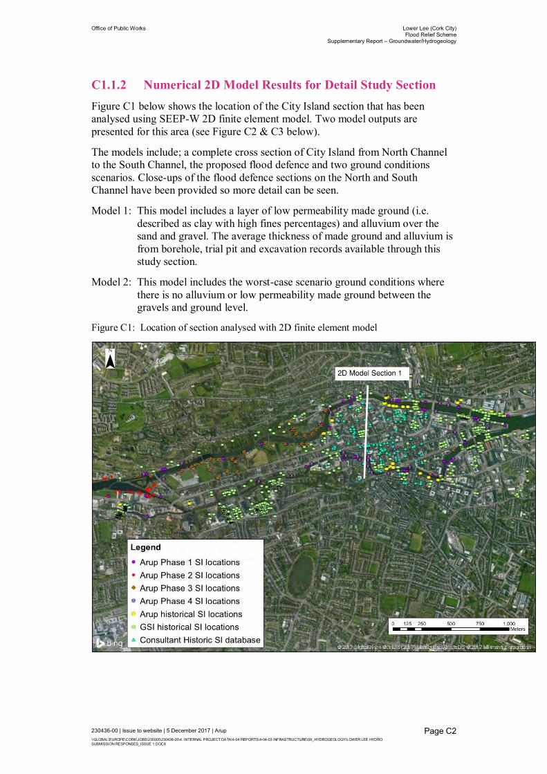
Office of Public Works Lower Lee (Cork City) Flood Relief Scheme
Supplementary Report – Groundwater/Hydrogeology
230436-00 | Issue to website | 5 December 2017 | Arup \\GLOBAL\EUROPE\CORK\JOBS\230000\230436-00\4. INTERNAL PROJECT DATA\4-04 REPORTS\4-04-03 INFRASTRUCTURE\09_HYDROGEOLOGY\LOWER LEE HYDRO SUBMISSION RESPONSES_ISSUE 1.DOCX
Page C2
C1.1.2 Numerical 2D Model Results for Detail Study Section Figure C1 below shows the location of the City Island section that has been analysed using SEEP-W 2D finite element model. Two model outputs are presented for this area (see Figure C2 & C3 below).
The models include; a complete cross section of City Island from North Channel to the South Channel, the proposed flood defence and two ground conditions scenarios. Close-ups of the flood defence sections on the North and South Channel have been provided so more detail can be seen.
Model 1: This model includes a layer of low permeability made ground (i.e. described as clay with high fines percentages) and alluvium over the sand and gravel. The average thickness of made ground and alluvium is from borehole, trial pit and excavation records available through this study section.
Model 2: This model includes the worst-case scenario ground conditions where there is no alluvium or low permeability made ground between the gravels and ground level.
Figure C1: Location of section analysed with 2D finite element model

Gravel Sandstone Limestone
Close up of River
Lee South Channel
Close up of River Lee
North ChannelDuring tidally dominated flood peak groundwater
level 0.6 mbgl.
Or during fluvially dominated flood event peak
groundwater level during flood 0.5 mbgl
Hydrograph provide simulated
river water levels in the north &
south river channels over flood
period
City Island Cross Section – with 2:1 vertical exaggeration (no flooding occurs during peak flood)
In central Island area bedrock not met
gravels continue to depth
Re-grouting of existing quay
wall (stonework repaired)
Grouting of foundation zone
off quay wall (depth -5mOD or
~8.3mbgl)
Railing
Groundwater table
below ground shown
with dashed line
WATER FLOW
(Low flow through sandstone as it is
lower permeability)
(flow through fissures in limestone)
Preferential flow through gravels
GRAVEL
SANDSTONE LIMESTONE
ALLUVIUM & MADE GROUND
Alluvium & made ground Alluvium & made ground
Figure C2: Model (with alluvium & made ground) output of tidally dominated flood event when peak groundwater levels
occur
Ground level on city island
WATER FLOW

Figure C3: Model out put of tidally dominated flood event when peak groundwater levels occur (conservative model excludes
made ground or alluvium below ground surface)
Gravel
(conservative model with no
alluvium or made ground below
surface)
Sandstone Limestone
Close up of River
Lee South Channel
Close up of River Lee
North Channel
OR during tidally dominated flood peak
groundwater level 0.2mbgl.
During fluvially dominated flood event peak
groundwater level during flood 0.5m bglHydrograph provide simulated
river water levels in the north &
south river channels over flood
period
City Island Cross Section – with 2:1 vertical exaggeration (no flooding occurs during peak flood)
In central Island area bedrock not met
gravels continue to depth
Re-grouting of existing quay
wall (stonework repaired)
Grouting of foundation zone
off quay wall (depth -5mOD or
~8.3mbgl)
Railing
Groundwater table
below ground shown
with dashed line
WATER FLOW
WATER FLOW
(Low flow through sandstone as it is
lower permeability)
(flow through fissures in limestone)
Preferential flow through gravels
GRAVEL
SANDSTONE LIMESTONE
Ground level on city island

Appendix D
Publicly Available Papers

Office of Public Works Lower Lee (Cork City) Flood Relief Scheme
Supplementary Report – Groundwater/Hydrogeology
230436-00 | Issue to website | 5 December 2017 | Arup \\GLOBAL\EUROPE\CORK\JOBS\230000\230436-00\4. INTERNAL PROJECT DATA\4-04 REPORTS\4-04-03 INFRASTRUCTURE\09_HYDROGEOLOGY\LOWER LEE HYDRO SUBMISSION RESPONSES_ISSUE 1.DOCX
Page D1
D1 Paper List [1] Ryan Hanley, 2016. Lower Lee (Cork City) Drainage Scheme
Environmental Impact Assessment, Chapter 10: Cultural Heritage.
[2] Barker, M., 2007. Halcrow Technical Note: Groundwater Desk Study Findings. Lee CFRAMS
[3] Beese, A., 2014. The Medieval Reclamation of Estuarine Cork. Phase Two – The Evidence of Historical Maps. Heritage Council Reference No. R00252.
[4] Beese, A., 2012. The Medieval Reclamation of Estuarine Cork. Phase Three. Heritage Council Reference No. R02426.
[5] Cork City Council, 2012. Review of Flooding Events on 28th June 2012
[6] Long, M., Robberts, T., Creed, M. Soil characterisation and construction of deep excavations in high permeability gravels in Cork, Ireland.
[7] Davis, T., MacCarthy, I.A.J., Allen, A.R., Higgs, B., 2006. Late Pleistocene-Holocene Buried Valleys in the Cork Syncline Ireland. UCC, Cork, Ireland.
[8] Allen, A., Milenic, D., 2003. Drainage problems during construction operations within a buried valley gravel aquifer. RMZ – Materials and Geoenvironment, Vol. 50, No. 1, pp. 1-4, 2003.
[9] Allen, A., Urban Groundwater Problems in Cork City, SW Ireland. UCC, Cork, Ireland.
[10] Comte, J.C., Cassidy, R., Nitsche, J., Ofterdinger, U., Pilatova, K., Flynn, R., 2012. The typology of Irish hard-rock aquifers based on an intergrated hydrogeological and geophysical approach
[11] Milenic, D., Allen, A.R., 2005. Buried Valley Ribbon Aquifers: A Significant Groundwater Resource of SW Ireland
[12] Allen, A.R., Milenic, D., 2003. Low enthalpy geothermal heat resources from groundwater in glaciofluvial gravels of buried valleys. Applied Energy, 74, 9-19.
[13] Allen, A.R., McGovern, C., O’Brien, M., Leahy, L., Connor, B. P., 1999. Low Enthalpy Geothermal Energy for Space Heating/Cooling From Shallow Groundwater in Glaciofluvial Gravels, Cork, Ireland. IAH, Bratislava, pp 655-664.
[14] Long, M., Murphy, M., Roberts, T., O’Brien, J., Clancy, N., 2015. Deep excavations in water-bearing gravels in Cork. QJEGH, Vol. 48, pp. 79-93
[15] Long, M., Roberts, T., 2008. Engineering Characterisation of the Glaciofluvial Gravels of Cork City. EI – Joint meeting of GSI and IAH 8th of January 2008.