sun prairie high school traffic impact analysis
TRANSCRIPT

PO Box 128Cedarburg, WI 53012
800.605.3091www.tadi-us.com
Sun Prairie High School
Traffic Impact Analysis
City of Sun PrairieDane County, Wisconsin
April 5, 2021

TRAFFIC IMPACT STUDY FOR:
SUN PRAIRIE HIGH SCHOOL
CITY OF SUN PRAIRIE, DANE COUNTY, WISCONSIN
DATE SUBMITTED: April 5, 2021
PREPARED FOR: Sun Prairie Area School District 501 S. Bird Street Sun Prairie, WI 53590 Phone: (608) 834-6683 Contact Persons: Janet Rosseter, Assistant Superintendent of Operations PREPARED BY: Traffic Analysis & Design, Inc. N36 W7505 Buchanan Street Cedarburg, WI 53012 Phone: (800) 605-3091 Contact Persons: Don Lee, P.E. (WisDOT TIA Certification # SE05-804-046) John Bieberitz, P.E., PTOE (WisDOT TIA Certification # SE05-804-044) “I certify that this Traffic Impact Analysis has been prepared by me or under my immediate supervision and that I have experience and training in the field of traffic and transportation engineering.” ______________________ Donald J. Lee, P.E. Wisconsin Registration #35214-006 Traffic Analysis & Design, Inc.

Sun Prairie High School Traffic Impact Analysis
Table of Contents
LIST OF EXHIBITS ....................................................................................................................... ii
LIST OF APPENDICES ................................................................................................................ iv
CHAPTER I – INTRODUCTION & EXECUTIVE SUMMARY..................................................1
Part A – Purpose of Report and Study Objectives .......................................................................1
Part B – Executive Summary .......................................................................................................1
CHAPTER II – PROPOSED DEVELOPMENT .............................................................................9
Part A – On-Site High school ......................................................................................................9
Part B – Study Area ...................................................................................................................10
Part C – Off-Site Land Use ........................................................................................................10
Part D – Site Accessibility .........................................................................................................10
CHAPTER III – ANALYSIS OF EXISTING CONDITIONS ......................................................13
Part A – Physical Characteristics ...............................................................................................13
Part B – Traffic Volumes ...........................................................................................................13
Part C – Capacity Level of Service ............................................................................................13
Part D – Sources of Data ............................................................................................................15
CHAPTER IV – FORECASTED TRAFFIC .................................................................................16
Part A – Background Traffic Forecasting ..................................................................................16
Part B – Site Traffic Forecasting ...............................................................................................16
Part C – Build Traffic ................................................................................................................18
CHAPTER V – TRAFFIC AND IMPROVEMENT ANALYSIS ................................................19
Part A – Site Access ...................................................................................................................19
Part B – Capacity Level of Service Analysis .............................................................................19
Part C – Queueing Analysis .......................................................................................................21
Part D – Pedestrian, Bicycle, Bus Service and Multi-Use Trail Considerations .......................22
Part E – Warrant Analysis ..........................................................................................................22
CHAPTER VI – RECOMMENDATIONS AND CONCLUSION ...............................................27
Part A – Recommendations .......................................................................................................27
Part B – Conclusion ...................................................................................................................31

Sun Prairie High School – City of Sun Prairie, Wisconsin April 5, 2021
Traffic Analysis & Design, Inc.
ii
LIST OF EXHIBITS
Exhibit 1-1 ........Project Overview Map
Exhibit 1-2 ........Conceptual Site Plan
Exhibit 1-3 ........Existing Traffic Recommended Modifications
Exhibit 1-4 ........Year 2022 Background Traffic Recommended Modifications
Exhibit 1-5 ........Year 2032 Background Traffic Recommended Modifications
Exhibit 1-6 ........Year 2022 Initial Build Traffic Recommended Modifications
Exhibit 1-7 ........Year 2032 Full Build Traffic Recommended Modifications
Exhibit 2-1 ........Project Overview Map
Exhibit 2-2 ........Conceptual Site Plan
Exhibit 3-1 ........Existing Transportation Detail
Exhibit 3-2A ......Existing Traffic Volumes
Exhibit 3-2B ......Year 2022 Background Traffic Volumes
Exhibit 3-3A ......Existing Traffic Operations – Without Modifications
Exhibit 3-3B ......Year 2022 Background Traffic Operations – Without Modifications
Exhibit 4-2 ........Year 2032 Background Traffic Volumes
Exhibit 4-3A ......Approved School Loading - Initial Build (with Target Student Population) On-Site Trip Generation & Distribution Tables
Exhibit 4-3B ......Approved School Loading - Full Build (with Maximum Capacity Student Population) On-Site Trip Generation & Distribution Tables
Exhibit 4-4 ........Trip Distribution - Approved School Loading
Exhibit 4-5 ........Initial Build New Trips - Approved School Loading
Exhibit 4-7 ........Full Build New Trips - Approved School Loading
Exhibit 4-8 ........Legacy Way Residential New Trips
Exhibit 4-11 ......Year 2022 Initial Build Traffic - Approved School Loading
Exhibit 4-13 ......Year 2032 Full Build Traffic - Approved School Loading
Exhibit 5-2 ........Year 2032 Background Traffic Operations – Without Modifications
Exhibit 5-3 ........Year 2022 Initial Build (Approved School Loading) Traffic Operations – Without Modifications
Exhibit 5-5 ........Year 2032 Full Build (Approved School Loading) Traffic Operations – Without Modifications
Exhibit 5-9 ........Existing Traffic Operations – With Modifications
Exhibit 5-10 ......Year 2022 Background Traffic Operations – With Modifications

Sun Prairie High School – City of Sun Prairie, Wisconsin April 5, 2021
Traffic Analysis & Design, Inc.
iii
Exhibit 5-11 ......Year 2032 Background Traffic Operations – With Modifications
Exhibit 5-12A ....Year 2022 Initial Build (Approved School Loading) Traffic Operations – With Modifications
Exhibit 5-12B ....Year 2022 Initial Build (Approved School Loading) Traffic Operations – Traffic Signal/Roundabout Comparison
Exhibit 5-14A ....Year 2032 Full Build (Approved School Loading) Traffic Operations – With Modifications
Exhibit 5-14B ....Year 2032 Initial Build (Approved School Loading) Traffic Operations – Traffic Signal/Roundabout Comparison

Sun Prairie High School – City of Sun Prairie, Wisconsin April 5, 2021
Traffic Analysis & Design, Inc.
iv
LIST OF APPENDICES
Appendix A ......Traffic
Existing Traffic Counts WisDOT Traffic Forecasts Existing Traffic Signal Timings Expected Trip Generation for Ongoing Residential Development at Legacy Way Approved New High School Boundary
Appendix B ......Existing/Background Traffic – Peak Hour Analysis Outputs
Existing Traffic Year 2022 Background Traffic Year 2032 Background Traffic
Appendix C ......Build Traffic – Peak Hour Analysis Outputs
Year 2022 Initial Build Traffic - Approved School Loading Year 2032 Full Build Traffic - Approved School Loading
Appendix D ......Peak Hour Improvement Analysis Outputs
Existing Traffic - With Modifications Year 2022 Background Traffic - With Modifications Year 2032 Background Traffic - With Modifications Year 2022 Initial Build Traffic - Approved School Loading - With Modifications Year 2032 Full Build Traffic - Approved School Loading - With Modifications
Appendix E ......Roundabout Analysis Outputs
Grand Avenue at Main Street Grand Avenue at STH 19
Grand Avenue at Blue Heron Boulevard
Appendix F.......Warrant Analysis
Traffic Signal Warrant Analysis Main Street at Legacy Way Grand Avenue at Blue Heron Boulevard
PHB & RRFB Warrant Analysis STH 19 at Charlotte’s Way
Appendix G ...Conceptual Designs and Cost Estimates

Sun Prairie High School – City of Sun Prairie, Wisconsin April 5, 2021
CHAPTER I – INTRODUCTION & EXECUTIVE SUMMARY
PART A – PURPOSE OF REPORT AND STUDY OBJECTIVES
The Sun Prairie Area School District is expecting significant growth within the district into the foreseeable future. To plan for this growth; the construction of an additional new high school, to supplement the existing high school, is being planned. The proposed high school is planned to be located on a vacant parcel of land west of North Grand Avenue, between State Trunk Highway (STH) 19 and Main Street on the west side of the City of Sun Prairie and within the Town of Burke, Dane County, Wisconsin. The existing Sun Prairie High School is located on the west side of Grove Street/CTH N, approximately ½ -mile south of STH 19 and approximately three miles southeast of the proposed high school. As part of the proposed high school plans, the City of Sun Prairie and the Wisconsin Department of Transportation (WisDOT) have requested a traffic impact analysis be conducted to determine the additional traffic expected to be generated by the proposed high school and to identify roadway modifications, if any, attributed to the new high school for the opening year (2022) and horizon year (2032) traffic scenarios. This study builds off the previously submitted and conditionally approved TIA dated September 16, 2020. At the time of the previous study the new high school boundary study was not finalized. The Sun Prairie Area School District recently approved the school boundary limits for their two middle schools and two high schools in a report titled “Sun Prairie Area School District Community Growth and Projections Report”, dated September 28, 2020. This report updates the assumptions and analysis based on that approved study.
This report documents the procedures, findings and conclusions of the traffic impact analysis. The analysis identifies recommended modifications based on existing intersection geometrics, background traffic volumes and additional traffic expected to be generated by the anticipated high school within the limits of the study area.
PART B – EXECUTIVE SUMMARY
The executive summary includes a description of the study area, description of the proposed high school and conclusions based on the findings of the TIA.
B1. Location of Study Site with Respect to Area Roadway Network
The proposed high school is planned to be constructed on a vacant parcel of land located west of North Grand Avenue, between STH 19 and Main Street on the west side of the city in the City of Sun Prairie and within the Town of Burke, as shown in Exhibit 1-1. Per discussions with the WisDOT and the City of Sun Prairie, the study area for the high school includes the following intersections:
STH 19 with Charlottes Way/Proposed School Access Roadway (existing one-way stop control from the north)
STH 19 with Oxford Place (existing right-in/right-out access one-way stop control from the south)
STH 19 with Grand Avenue (existing traffic signal control)
Grand Avenue with Ironwood Drive (existing traffic signal control)
Grand Avenue with Blue Heron Boulevard (existing two-way stop control)
Grand Avenue with Main Street (existing dual lane roundabout control)
Main Street with Legacy Way/Proposed School Access Roadway (existing two-way stop control)

Sun Prairie High School – City of Sun Prairie, Wisconsin April 5, 2021
Traffic Analysis & Design, Inc.
2
Under the original study, two access options were evaluated with the first option including a new full access roadway connection onto STH 19 across from Charlotte’s Way and the second option looking at the transportation network without this additional STH 19 access. Based on the analysis from the previous study, the access onto STH 19 was dropped from further consideration since operational issues were expected and traffic signal control was not expected to be warranted.
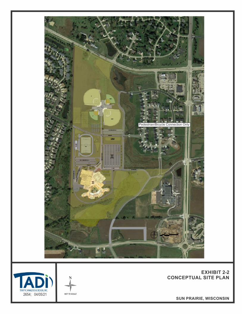
B2. On-Site Description
A copy of the conceptual site plans for the high school is illustrated in Exhibits 1-2. Parking at the school is proposed on the north and west sides of the building. In addition to the new high school building which is proposed to be located on the southwest corner of the site, several sports fields are proposed within the site. Specifically, two baseball fields, two softball fields, eight tennis courts and two soccer/football practice fields are planned on the northern portion of the site and a multi-use stadium with track and bleachers is planned near the middle of the site, immediately northwest of the high school building. Smaller practice fields are also proposed on the very south end of the site, near the existing elementary school. The proposed new high school is expected to include the following:
Student population target capacity – 1,658 students (with a 2,073-maximum capacity)
Based on the Sun Prairie Area School District planning projections, student populations are expected to increase over the next 5 to 10 years with the anticipated growth expected to occur throughout the district as lower grade class populations have grown. The anticipated growth is expected to occur via a combination of new neighborhoods throughout the district and within the existing neighborhoods themselves as more families with younger children age into the high school. A map showing the approved boundary limits for the proposed high school is included in the appendix of this report.
The target student population was included in the year 2022 initial build traffic volume conditions and the maximum capacity student population was included in the year 2032 full build traffic volume conditions.
B3. Off-Site Description
No specific off-site development was identified for this study; however, background traffic growth was included in the traffic projections provided by WisDOT to account for off-site development growth. In addition, residential uses along the north side of Main Street, immediately east of the proposed access drive were also included in the background traffic volumes as shown in the appendix of this report.
B4. Site Generated Traffic
The traffic volumes expected to be generated by the proposed school for the weekday morning arrival and weekday afternoon school discharge peak hours were calculated based on trip rates provided from a previous study for the existing Sun Prairie high school located on the east side of Sun Prairie. The previous study existing high school rates, which were calculated based on actual counts taken at the existing high school in 2008, were compared to the rates as published in the Institute of Transportation Engineer’s (ITE) Trip Generation Manual, 10th Edition, 2017. The previous study rates were significantly higher than the published ITE rates. It is noted that the counts taken at the existing high school included a student population made up of grades 10 thru 12; whereas the proposed school is planned to accommodate grades 9 thru 12. Regardless, since the previous study rates were based on actual count data for the local school district and they represent higher worst-case trip rates when compared to the published ITE rates, they were utilized for this study.

Sun Prairie High School – City of Sun Prairie, Wisconsin April 5, 2021
Traffic Analysis & Design, Inc.
3
The expected traffic volumes generated by the proposed school for the typical weekday evening commuter peak hour were calculated based on trip rates from the ITE manual. The expected traffic volumes generated by the proposed school for the typical weekday were calculated by factoring (1.68 factor) the trip rates from the ITE manual to reflect the same increase as the peak hour existing high school volumes compared to the ITE rates for peak hour.
Under initial build (with target student population), the proposed high school is expected to generate 1,345 new trips (915 entering/430 exiting) during a typical weekday morning peak hour. During a typical weekday afternoon school discharge peak hour, the proposed high school is expected to generate 945 new trips (300 entering/645 exiting). During a typical weekday evening commuter peak hour, the proposed high school is expected to generate 230 new trips (110 entering/120 exiting). On a typical weekday, the proposed high school is expected to generate approximately 5,650 new trips (2,825 entering/2,825 exiting) under initial build (with target student population) conditions.
Under full build (with maximum capacity student population), the proposed high school is expected to generate 1,680 new trips (1,140 entering/540 exiting) during a typical weekday morning peak hour. During a typical weekday afternoon school discharge peak hour, the proposed high school is expected to generate 1,180 new trips (380 entering/800 exiting). During a typical weekday evening commuter peak hour, the proposed high school is expected to generate 290 new trips (140 entering/150 exiting). On a typical weekday, the proposed high school is expected to generate approximately 7,070 new trips (3,535 entering/3,535 exiting) under full build (with maximum capacity student population) conditions.
B5. Proposed Access
Access connections to the new high school are proposed along Main Street at Legacy Way to the south, along Blue Heron Boulevard and Ironwood Drive to the east and at Rebel Drive to the west. An additional access onto STH 19, at Oxford Place is also proposed via the existing internal connection at Ironwood Drive. With the exception of the STH 19 intersection with Oxford Place which is a right-in/right-out access, all access points are proposed as full access intersections. As stated above, the STH 19 full access at Charlotte’s Way was removed from consideration.
B6. Existing Traffic – Recommended Modifications
The existing traffic volumes do not include the proposed high school and are based on the turning movement counts taken as part of this study. The analysis was conducted using existing intersection geometrics, traffic control and traffic signal timings. The following modifications, shown in Exhibit 1-3, are recommended to accommodate the existing traffic volumes. Modifications are for jurisdictional consideration and are not legally binding. The City of Sun Prairie and the WisDOT reserve the right to determine alternative solutions.
STH 19 & Grand Avenue Adjust the existing traffic signal timings.
Provide protected/permitted left turn phasing for the northbound movements and permitted (flashing yellow) phasing for the southbound movements.
Provide a dedicated left-turn lane, two through lanes and a dedicated right-turn lane on the north approach. [Addition of one through lane]
Extend the left-turn lane on the south and west approaches as shown on Exhibit 1-3.

Sun Prairie High School – City of Sun Prairie, Wisconsin April 5, 2021
Traffic Analysis & Design, Inc.
4
The southbound movements at the STH 19 intersection with Charlotte’s Way are expected to continue to operate unacceptably during the weekday afternoon school discharge and weekday evening peak hours. It is expected that if delays become excessive for these movements, frequent drivers will utilize the eastern neighborhood access connection to Grand Avenue at Whytecliff Way. Consideration could be given to providing a dedicated right-turn lane to allow right-turn vehicles to exit the residential neighborhood with less delay as they would not be required to wait behind a left-turning vehicle to make their intended movement. However, it is expected that gaps created by the existing traffic signal located immediately to the east along STH 19 at Grand Avenue are allowing this intersection to operate better than reflected in the modeling software; therefore, this intersection should be monitored and modifications should be considered as delays increase.
Adding a southbound through lane, adjusting the traffic signal timings and phasing, and extending turn bay lengths at the STH 19 intersection with Grand Avenue is expected to improve operations at this intersection. It is noted that the extension of the northbound left-turn lane is needed to allow all left-turning vehicles to exit the through lane; thereby allowing northbound through vehicles to continue unhindered. Currently backups in the northbound left-turn lane are being experienced during the typical weekday evening commuter peak period and these backups are expected to worsen over time. Extensions of the eastbound left-turn is recommended based on the expected queue lengths for the eastbound through movement. Extending the left-turn lane as recommended is expected to allow left-turning vehicles to enter the left-turn lane based on a 50th percentile queue length for the through movements.
The eastbound and westbound left-turn and through movements at the Grand Avenue intersection with Blue Heron Boulevard are expected to continue to operate unacceptably during the weekday afternoon school discharge and weekday evening peak hours. With the western approach of this intersection operating as one of two main driveways to the existing elementary school, it is expected that these delays are due to the typical school “surge” during the afternoon school traffic. Regardless, with dedicated left- and right-turn lanes currently existing on the west approach at this stop-controlled intersection, without restricting eastbound and westbound left-turn movements; no additional geometric modifications are expected to be available since a traffic signal warrant analysis was completed based on projected future traffic volumes and traffic signal warrants are not expected to be met under background traffic conditions, even in the design year. This intersection should be monitored and a higher level of traffic control such as traffic signal control should be considered once traffic volumes reach a level where traffic signals are warranted.
Except as noted, all intersections are expected to operate acceptably under the existing traffic volumes with these recommended modifications.
B7. Year 2022 Background Traffic – Recommended Modifications
Year 2022 background traffic volumes do not include the proposed high school; however, they do include background growth based on the WisDOT provided traffic projections. The analysis was conducted using existing intersection geometrics, traffic control and traffic signal timings. No additional modifications, shown in Exhibit 1-4, above and beyond the existing traffic recommended modifications, are recommended to accommodate the Year 2022 background traffic volumes. Modifications are for jurisdictional consideration and are not legally binding. The City of Sun Prairie and the WisDOT reserve the right to determine alternative solutions.
Except as noted, all intersections are expected to operate acceptably under the year 2022 background traffic volumes with these recommended modifications.

Sun Prairie High School – City of Sun Prairie, Wisconsin April 5, 2021
Traffic Analysis & Design, Inc.
5
B8. Year 2032 Background Traffic – Recommended Modifications
Year 2032 background traffic volumes do not include the proposed high school; however, they do include background growth based on the WisDOT provided traffic projections. The analysis was conducted using existing intersection geometrics, traffic control and traffic signal timings. No additional modifications, shown in Exhibit 1-5, above and beyond the existing traffic or year 2022 background traffic recommended modifications, are recommended to accommodate the Year 2032 background traffic volumes. Modifications are for jurisdictional consideration and are not legally binding. The City of Sun Prairie and the WisDOT reserve the right to determine alternative solutions.
Except as noted, all intersections are expected to operate acceptably under the Year 2032 background traffic volumes with these recommended modifications.
B9. Year 2022 Initial Build Traffic – Recommended Modifications
Year 2022 initial build traffic volumes include the initial build out of the proposed high school site which includes the target student population at the school. The following additional modifications, shown in Exhibit 1-6, above and beyond the existing traffic or Year 2022 background traffic recommended modifications, are recommended to accommodate the Year 2022 initial build traffic volumes. Modifications are for jurisdictional consideration and are not legally binding. The City of Sun Prairie and the WisDOT reserve the right to determine alternative solutions.
STH 19 & Grand Avenue Adjust the existing traffic signal timings.
Coordinate traffic signal timings with adjacent intersections to the south along Grand Avenue.
Provide protected left-turn phasing for the westbound left-turn movements.
Extend the dedicated right-turn lane on the west approach back to Oxford Place.
Provide dual left-turn lanes, a dedicated through lane and a dedicated right-turn lane on the east approach. [Addition of one left-turn lane]
ALTERNATE MODIFICATION: Provide dual lane roundabout control with dual lane entry for all approaches.
Grand Avenue & Blue Heron Boulevard Provide fully actuated traffic signal control with protected/permitted left turn
phasing for the northbound movements.
Provide a dedicated left-turn lane and a shared through/right-turn lane on the east and west approaches. [Switch lane configurations from current shared through/left-turn lane and dedicated right-turn lane utilizing pavement marking]
Provide a dedicated left-turn lane, two through lanes and a dedicated right-turn lane on the north approach. [Addition of one right-turn lane]
ALTERNATE MODIFICATION: Provide multi-lane roundabout control with dual lane entry for the northbound/southbound approaches and single lane entry for the eastbound/westbound approaches.
The southbound movements at the STH 19 intersection with Charlotte’s Way are expected to continue to operate unacceptably during the weekday morning and weekday afternoon school

Sun Prairie High School – City of Sun Prairie, Wisconsin April 5, 2021
Traffic Analysis & Design, Inc.
6
discharge peak hours with delays expected to be approximately 7 seconds higher than the acceptable delay for the southbound movements under background traffic conditions. It is expected that if delays become excessive for these movements, frequent drivers will utilize the eastern neighborhood access connection to Grand Avenue at Whytecliff Way. Consideration could be given to providing a dedicated right-turn lane to allow right-turn vehicles to exit the residential neighborhood with less delay as they would not be required to wait behind a left-turning vehicle to make their intended movement. However, it is expected that gaps created by the existing traffic signal located immediately to the east along STH 19 at Grand Avenue are allowing this intersection to operate better than reflected in the modeling software; therefore, this intersection should be monitored and modifications should be considered as delays increase.
The use of some form of pedestrian control treatment was evaluated for the STH 19 intersection at Charlotte’s Way to determine the potential for a pedestrian crossing treatment to improve the safety for both the pedestrian and motoring public at this location. Since the speed limit on STH 19 is greater than 35-mph, a Rapid Rectangular Flashing Beacon (RRFB) is not recommended by FHWA as this application is only recommended for lower speed corridors. In addition, a warrant analysis was completed to see if a Pedestrian Hybrid Beacon would be warranted at this location; however, pedestrian volume thresholds are not expected to be met for this application either. The school district is currently working on an unusually hazardous transportation plan (UHT) for the entire district and should consider this location and this northern neighborhood in that plan to provide for safe pedestrian accommodations or busing of students, if applicable.
In addition, the recommended modifications at the STH 19 intersection with Grand Avenue as stated under the existing traffic and Year 2022 background traffic recommended modifications section, the construction of dual left-turn lanes on the east approach of the intersection is required to improve operations at this intersection to acceptable levels under the initial build scenario. Although not recommended, a roundabout option was also evaluated at this intersection and a dual lane roundabout would be required to allow the intersection to operate acceptably under roundabout control.
Traffic signal control is recommended at the Grand Avenue intersection with Blue Heron Boulevard based on a traffic signal warrant analysis completed as part of this study. Traffic volume thresholds were easily met for both the weekday morning school arrival and afternoon school discharge peak hours under the peak hour warrant and were also met for the 4-hour warrant under rural warrant assumptions. Therefore, traffic signals should be installed at this intersection prior to opening of the new high school. In addition, due to the changed traffic patterns at this intersection, the lane designations on the east and west approach should be modified to provide a dedicated left-turn lane to allow for the higher volume of eastbound left-turn movements expected to exit the west approach during the peak periods. Without these lane designation modifications, the intersection is not expected to operate acceptably, even with traffic signal control.
Except as noted, all intersections are expected to operate acceptably under the year 2022 initial build traffic volumes with these recommended modifications.
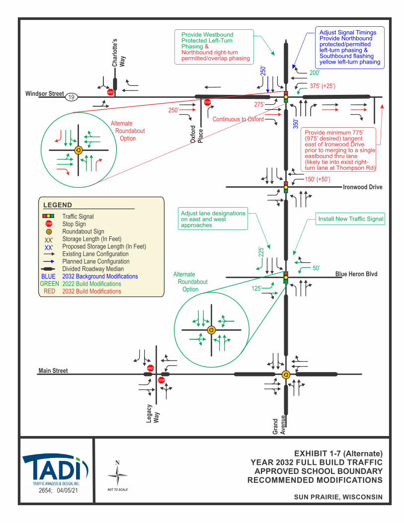
B10. Year 2032 Full Build Traffic – Recommended Modifications
Year 2032 full build traffic volumes include the full build out of the proposed high school site which includes the maximum capacity student population at the school. The following additional modifications, above and beyond the Year 2022 initial build traffic volume recommended modifications, shown in Exhibit 1-7, are recommended to accommodate the Year 2032 full build traffic volumes. Modifications are for jurisdictional consideration and are not

Sun Prairie High School – City of Sun Prairie, Wisconsin April 5, 2021
Traffic Analysis & Design, Inc.
7
legally binding. The City of Sun Prairie and the WisDOT reserve the right to determine alternative solutions.
STH 19 & Grand Avenue Adjust the existing traffic signal timings.
Provide permitted/overlap right-turn phasing for the northbound right-turn movements.
Provide a dedicated left-turn lane, two through lanes and a dedicated right-turn lane on the west approach. [Addition of one through lane]
Provide an additional receiving lane for eastbound traffic on the east side of the intersection. This lane should continue and tie into the existing dedicated right-turn lane at Ironwood Drive. “Right-Lane Must Turn Right” signage should be provided immediately east of Grand Avenue to designate this additional lane as a drop lane for eastbound through traffic.
Extend the dual left-turn lanes on the east approach as shown on Exhibit 1-7.
ALTERNATE MODIFICATION: Provide dual lane roundabout control with right-turn by-pass lanes on the north, south and west approaches. [Addition of by-pass lanes]
Grand Avenue & Ironwood Drive Extend the left-turn lane on the east approach as shown on Exhibit 1-7.
An additional through lane is recommended for eastbound traffic on the west approach of the STH 19 intersection with Grand Avenue. With the outside eastbound lane on the east approach of the intersection operating as a dedicated right-turn lane at the downstream intersection at Ironwood Drive, this outside lane should be signed to inform eastbound drivers using this lane as an eastbound through lane through the intersection that the lane ends as a dedicated right-turn lane downstream. It is noted that the minimum tangent distance recommended in the FDM to drop a downstream through lane is 775-feet with a desired downstream distance of 975-feet. With the Ironwood Drive intersection approximately 1,100-feet downstream, the tangent section fits within both of these requirements. However, in addition to the aforementioned signage to alert for the right lane ends recommendation shown in Exhibit 1-7, an alternate design has also been included and shown in Exhibit 1-7 (alternate), showing the tangent section further to the east of Ironwood Drive for comparison purposes.
The southbound movements at the STH 19 intersection with Charlotte’s Way are expected to continue to operate unacceptably during the weekday morning and weekday afternoon school discharge peak hours with delays expected to be up to approximately 11 seconds higher than the acceptable delay for the southbound movements under background traffic conditions for the weekday morning school discharge. It is expected that if delays become excessive for these movements, frequent drivers will utilize the eastern neighborhood access connection to Grand Avenue at Whytecliff Way. Consideration could be given to providing a dedicated right-turn lane to allow right-turn vehicles to exit the residential neighborhood with less delay as they would not be required to wait behind a left-turning vehicle to make their intended movement. However, it is expected that gaps created by the existing traffic signal located immediately to the east along STH 19 at Grand Avenue are allowing this intersection to operate better than reflected in the modeling software; therefore, this intersection should be monitored and modifications should be considered as delays increase.
Sun Prairie High School – City of Sun Prairie, Wisconsin April 5, 2021
Traffic Analysis & Design, Inc.
8
Conceptual designs and cost estimates are included in the appendix of this report.
Except as noted, all intersections are expected to operate acceptably under the Year 2032 full build traffic volumes with these recommended modifications.
B11. Conclusion
To accommodate the full build out of the proposed high school site which includes the potential maximum capacity student population at the school, recommended modifications are expected to be necessary at the study area intersections. Except as noted, all movements at the study area intersections are expected to operate safely and efficiently with the modifications identified in this TIA through the Year 2032.

N
NOT TO SCALE2654; 04/05/21
EXHIBIT 1-1PROJECT OVERVIEW MAP
SUN PRAIRIE, WISCONSIN
Copyright © and (P) 1988–2012 Microsoft Corporation and/or its suppliers. All rights reserved. http://www.microsoft.com/streets /Certain mapping and direction data © 2012 NAVTEQ. All rights reserved. The Data for areas of Canada includes information taken with permission from Canadian authorities, including: ©Her Majesty the Queen in Right of Canada, © Queen's Printer for Ontario. NAVTEQ and NAVTEQ ON BOARD are trademarks of NAVTEQ. © 2012 Tele Atlas North America, Inc. All rights reserved. Tele Atlas and Tele Atlas North America are trademarks of Tele Atlas, Inc. © 2012 by Applied Geographic Solutions. Al l rights reserved. Portions © Copyright 2012 by Woodall Publications Corp. All ri ghts reserved.
Sun Prairie, Wisconsin
0 mi 0.2 0.4 0.6
Study Area IntersectionProposed School CampusProposed Site Roadways/Connections
LEGEND

N
NOT TO SCALE2654; 04/05/21
EXHIBIT 1-2CONCEPTUAL SITE PLAN
SUN PRAIRIE, WISCONSIN
Pedestrian/Bicycle Connection Only

N
NOT TO SCALE2654; 04/05/21
EXHIBIT 1-3EXISTING TRAFFIC
RECOMMENDED MODIFICATIONS
SUN PRAIRIE, WISCONSIN
Windsor Street
Oxf
ord
Pla
ce
Ironwood Drive
Blue Heron BlvdG
ran
d
Ave
nu
e
Main Street
Ch
arlo
tte’
sW
ay
19
Leg
acy
Way
350’
(+1
75’)
250’
* Based on 50th percentile queue length of adjacent eastbound thru lane.
LEGEND
Traffic SignalStop SignRoundabout SignStorage Length (In Feet)2032 Proposed Storage Length (In Feet)Existing Lane ConfigurationPlanned Lane ConfigurationDivided Roadway MedianExisting/Background Traffic Modifications
XX’XX’
Adjust Signal TimingsProvide Northboundprotected/permitted left-turn phasing &Southbound flashingyellow left-turn phasing
BLUE
* 450’(+285’)

N
NOT TO SCALE2654; 04/05/21
EXHIBIT 1-4YEAR 2022 BACKGROUND TRAFFIC
RECOMMENDED MODIFICATIONS
SUN PRAIRIE, WISCONSIN
Windsor Street
Oxf
ord
Pla
ce
Ironwood Drive
Blue Heron BlvdG
ran
d
Ave
nu
e
Main Street
Ch
arlo
tte’
sW
ay
19
Leg
acy
Way
LEGEND
Traffic SignalStop SignRoundabout SignStorage Length (In Feet)2032 Proposed Storage Length (In Feet)Existing Lane ConfigurationPlanned Lane ConfigurationDivided Roadway MedianExisting/Background Traffic Modifications
XX’XX’
BLUE
* Based on 50th percentile queue length of adjacent eastbound thru lane.
350’
250’
* 450’
Adjust Signal TimingsProvide Northboundprotected/permitted left-turn phasing &Southbound flashingyellow left-turn phasing

N
NOT TO SCALE2654; 04/05/21
EXHIBIT 1-5YEAR 2032 BACKGROUND TRAFFIC
RECOMMENDED MODIFICATIONS
SUN PRAIRIE, WISCONSIN
Windsor Street
Oxf
ord
Pla
ce
Ironwood Drive
Blue Heron BlvdG
ran
d
Ave
nu
e
Main Street
Ch
arlo
tte’
sW
ay
19
Leg
acy
Way
LEGEND
Traffic SignalStop SignRoundabout SignStorage Length (In Feet)2032 Proposed Storage Length (In Feet)Existing Lane ConfigurationPlanned Lane ConfigurationDivided Roadway MedianExisting/Background Traffic Modifications
XX’XX’
BLUE
* Based on 50th percentile queue length of adjacent eastbound thru lane.
250’
350’
* 450’
Adjust Signal TimingsProvide Northboundprotected/permitted left-turn phasing &Southbound flashingyellow left-turn phasing

N
NOT TO SCALE2654; 04/05/21
EXHIBIT 1-6YEAR 2022 INITIAL BUILD TRAFFIC
APPROVED SCHOOL BOUNDARYRECOMMENDED MODIFICATIONS
SUN PRAIRIE, WISCONSIN
Windsor Street
Oxf
ord
Pla
ce
Ironwood Drive
Blue Heron BlvdG
ran
d
Ave
nu
e
Main Street
Ch
arlo
tte’
sW
ay
19
Leg
acy
Way
LEGEND
Traffic SignalStop SignRoundabout SignStorage Length (In Feet)Proposed Storage Length (In Feet)Existing Lane ConfigurationPlanned Lane ConfigurationDivided Roadway Median2032 Background Modifications2022 Build Modifications
XX’XX’
Install New Traffic Signal
GREEN
200’
BLUE
125’
Continuous to Oxford
Adjust lane designationson east and west approaches
Alternate Roundabout Option
Alternate Roundabout Option
* Based on 50th percentile queue length of adjacent eastbound thru lane.
350’
350’
* 450’
225’
50’
Adjust Signal TimingsProvide Northboundprotected/permitted left-turn phasing &Southbound flashingyellow left-turn phasing
Provide Westbound Protected Left-Turn Phasing
250’

N
NOT TO SCALE2654; 04/05/21
EXHIBIT 1-7YEAR 2032 FULL BUILD TRAFFICAPPROVED SCHOOL BOUNDARY
RECOMMENDED MODIFICATIONS
SUN PRAIRIE, WISCONSIN
Windsor Street
Oxf
ord
Pla
ce
Ironwood Drive
Blue Heron BlvdG
ran
d
Ave
nu
e
Main Street
Ch
arlo
tte’
sW
ay
19
Leg
acy
Way
150’ (+50’)
LEGEND
Traffic SignalStop SignRoundabout SignStorage Length (In Feet)Proposed Storage Length (In Feet)Existing Lane ConfigurationPlanned Lane ConfigurationDivided Roadway Median2032 Background Modifications2022 Build Modifications2032 Build Modifications
XX’XX’
Install New Traffic Signal
GREENRED
BLUE
225’
50’
375’ (+25’)
Alternate Roundabout Option
275’
Adjust lane designationson east and west approaches
Alternate Roundabout Option
200’
Continuous to Oxford
350’
Provide Westbound Protected Left-Turn Phasing &Northbound right-turnpermitted/overlap phasing
Adjust Signal TimingsProvide Northboundprotected/permitted left-turn phasing &Southbound flashingyellow left-turn phasing
Provide signage for“Right-Lane Must TurnRight”
250’
250’
125’
N
NOT TO SCALE2654; 04/05/21
EXHIBIT 1-7 (Alternate)YEAR 2032 FULL BUILD TRAFFICAPPROVED SCHOOL BOUNDARY
RECOMMENDED MODIFICATIONS
SUN PRAIRIE, WISCONSIN
Windsor Street
Oxf
ord
Pla
ce
Ironwood Drive
Blue Heron BlvdG
ran
d
Ave
nu
e
Main Street
Ch
arlo
tte’
sW
ay
19
Leg
acy
Way
150’ (+50’)
LEGEND
Traffic SignalStop SignRoundabout SignStorage Length (In Feet)Proposed Storage Length (In Feet)Existing Lane ConfigurationPlanned Lane ConfigurationDivided Roadway Median2032 Background Modifications2022 Build Modifications2032 Build Modifications
XX’XX’
Install New Traffic Signal
GREENRED
BLUE
225’
50’
Alternate Roundabout Option
275’
Adjust lane designationson east and west approaches
Alternate Roundabout Option
200’
Continuous to Oxford
350’
Provide Westbound Protected Left-Turn Phasing &Northbound right-turnpermitted/overlap phasing
Adjust Signal TimingsProvide Northboundprotected/permitted left-turn phasing &Southbound flashingyellow left-turn phasing
Provide minimum 775’(975’ desired) tangenteast of Ironwood Driveprior to merging to a single eastbound thru lane (likely tie into exist right-turn lane at Thompson Rd)
250’
250’
375’ (+25’)
125’

Sun Prairie High School – City of Sun Prairie, Wisconsin April 5, 2021
Traffic Analysis & Design, Inc.
9
CHAPTER II – PROPOSED DEVELOPMENT
PART A – ON-SITE HIGH SCHOOL
A1. Description and Site Location
The proposed west high school, expected to supplement the existing eastern high school, has been proposed on a vacant parcel of land west of North Grand Avenue, between STH 19 and Main Street on the west side of the City of Sun Prairie and within the Town of Burke, Dane County, Wisconsin. A project overview map illustrating the location of the proposed high school is shown in Exhibit 2-1.
A2. Land Use and Intensity
The proposed site is a vacant parcel of land bordered by residential neighborhoods to the east, west and north of the site. To the south, a parcel designated for residential use exists along the north side of Main Street. On the south side of Main Street, an additional residential neighborhood exists. In addition, commercial uses are currently present along Grand Avenue near STH 19 to the northeast of the site and near Main Street to the southeast of the site. An existing elementary school also exists to the east along Blue Heron Boulevard, adjacent to the site.
A3. Site Plan
Parking at the school is proposed on the north and west sides of the building. In addition to the new high school building which is proposed to be located on the southwest corner of the site, several sports fields are proposed within the site. Specifically, two baseball fields, two softball fields, eight tennis courts and two soccer/football practice fields are planned on the northern portion of the site and a multi-use stadium with track and bleachers is planned near the middle of the site, immediately northwest of the high school building. Smaller practice fields are also proposed on the very south end of the site, near the existing elementary school. The proposed new high school is expected to include the following:
Student population target capacity – 1,658 students (with a 2,073-maximum capacity)
A copy of the conceptual site plans for the high school is illustrated in Exhibits 2-2. Access connections to the new high school are proposed along Main Street at Legacy Way to the south, along Blue Heron Boulevard and Ironwood Drive to the east and at Rebel Drive to the west. An additional access onto STH 19, at Oxford Place is also proposed via the existing internal connection at Ironwood Drive. With the exception of the STH 19 intersection with Oxford Place which is a right-in/right-out access, all access points are proposed as full access intersections.
A4. Proposed Phasing
Based on the Sun Prairie Area School District planning projections, student populations are expected to increase over the next 5 to 10 years with the anticipated growth expected to occur throughout the district as lower grade class populations have grown. The anticipated growth is expected to occur via a combination of new neighborhoods throughout the district and within the existing neighborhoods themselves as more families with younger children age into the high school. A map showing the approved boundary limits for the proposed high school is included in the appendix of this report.
The target student population was included in the year 2022 initial build traffic volume conditions and the maximum capacity student population was included in the year 2032 full build traffic volume conditions.

Sun Prairie High School – City of Sun Prairie, Wisconsin April 5, 2021
Traffic Analysis & Design, Inc.
10
PART B – STUDY AREA
B1. Influence Area
The Sun Prairie Area School District recently approved the school boundary limits for their two middle schools and two high schools in a report titled “Sun Prairie Area School District Community Growth and Projections Report”, dated September 28, 2020. A map showing the approved school boundary limits is included in the appendix of this report. As shown, the proposed west high school is expected to draw from within the central and western limits of the overall Sun Prairie Area School District.
B2. Area of Significant Traffic Impact
Per discussions with the WisDOT and the City of Sun Prairie, the study area for the high school includes the following intersections:
STH 19 with Charlottes Way/Proposed School Access Roadway (existing one-way stop control from the north)
STH 19 with Oxford Place (existing right-in/right-out access one-way stop control from the south)
STH 19 with Grand Avenue (existing traffic signal control)
Grand Avenue with Ironwood Drive (existing traffic signal control)
Grand Avenue with Blue Heron Boulevard (existing two-way stop control)
Grand Avenue with Main Street (existing dual lane roundabout control)
Main Street with Legacy Way/Proposed School Access Roadway (existing one-way stop control from the south)
Under the original study, two access options were evaluated with the first option including a new full access roadway connection onto STH 19 across from Charlotte’s Way and the second option looking at the transportation network without this additional STH 19 access. Based on the analysis from the previous study, the access onto STH 19 was dropped from further consideration since operational issues were expected and traffic signal control was not expected to be warranted.
PART C – OFF-SITE LAND USE
No specific off-site development was identified for this study; however, background traffic growth was included in the traffic projections provided by WisDOT to account for off-site development growth. In addition, residential uses along the north side of Main Street, immediately east of the proposed access drive were also included in the background traffic volumes as shown in the appendix of this report.
PART D – SITE ACCESSIBILITY
D1. Study Area Roadways
The study area roadways are discussed below:
Windsor Street (STH 19) is a two-lane undivided east/west arterial highway that transitions to a median divided highway with turn lanes at the signalized intersection with Grand Avenue. The posted speed limit on STH 19 is 45 miles per hour (mph) within the limits of the study area. According to WisDOT, the Year 2018 annual average daily traffic (AADT) volumes on STH 19 were approximately 13,600 vehicles per day (vpd) west of Charlotte’s Way and approximately 12,700-vpd to the east of Grand Avenue. Multi-use trails currently exist along the south side of

Sun Prairie High School – City of Sun Prairie, Wisconsin April 5, 2021
Traffic Analysis & Design, Inc.
11
STH 19 throughout the project limits and along the north side of STH 19 from Grand Avenue to the east within the limits of the study area.
Grand Avenue is a four-lane median divided north/south arterial highway with a 40-mph posted speed limit within the limits of the study area. The Year 2018 AADT volumes along Grand Avenue were 5,000-vpd north of STH 19; 12,400-vpd (2015 count) south of STH 19 and 13,700-vpd south of Main Street. Multi-use trails (or sidewalks near Main Street) currently exist along both sides of Grand Avenue within the limits of the study area except north of STH 19, where the trail only exist along the east side of the roadway.
Main Street is a two-lane undivided east/west arterial roadway that transitions to a median divided street at the roundabout controlled intersection with Grand Avenue. The posted speed limit on Main Street is 30-mph to the west of Grand Avenue and 35-mph to the east. The Year 2009 AADT volumes along Main Street were 3,700-vpd east of Grand Avenue. There is currently no AADT data available along Main Street to the west of Grand Avenue; however, based on the peak period counts taken as part of this study, the ADT was extrapolated to be approximately 3,600-vpd within this stretch of roadway. A multi-use trail currently exists along the north side of Main Street and sidewalks exist along the south side of the street within the limits of the study area.
Charlotte’s Way is a two-lane median divided local roadway with an assumed 25-mph speed limit that exists as the north leg of a conventional full access “T” intersection with STH 19. Charlotte’s Way provides access to a residential neighborhood to the north. There is currently no AADT data available along Charlotte’s Way; however, based on the peak period counts taken as part of this study, the ADT was extrapolated to be approximately 500-vpd north of STH 19. Sidewalks do not currently exist along Charlotte’s Way within the limits of the study area.
Oxford Place is a two-lane undivided local roadway with an assumed 25-mph speed limit that exists as the south leg of a conventional right-in/right-out “T” intersection with STH 19. Oxford Place provides access to a commercial area and residential neighborhood to the south. There is currently no AADT data available along Oxford Place; however, based on the peak period counts taken as part of this study, the ADT was extrapolated to be approximately 550-vpd south of STH 19. Sidewalks currently exist along both sides of Oxford Place within the limits of the study area.
Ironwood Drive is a two-lane undivided east/west roadway with a 25-mph posted speed limit within the limits of the study area. Ironwood Drive provides the main access to commercial and residential areas located adjacent to Grand Avenue. There is currently no AADT data available along Ironwood Drive; however, based on the peak period counts taken as part of this study, the ADT was extrapolated to be approximately 6,600-vpd east of Grand Avenue and 2,300-vpd to the west. Sidewalks currently exist along both sides of Ironwood Drive within the limits of the study area.
Blue Heron Boulevard is a two-lane undivided east/west roadway with a 25-mph posted speed limit within the limits of the study area. Blue Heron Boulevard provides access to a residential neighborhood to the east of Grand Avenue and to an existing elementary school and additional residential uses to the west. There is currently no AADT data available along Blue Heron Boulevard; however, based on the peak period counts taken as part of this study, the ADT was extrapolated to be approximately 400-vpd east of Grand Avenue and 650-vpd to the west. Sidewalks currently exist along the north side and a multi-use path exists along the south side of Blue Heron Boulevard within the limits of the study area.
Sun Prairie High School – City of Sun Prairie, Wisconsin April 5, 2021
Traffic Analysis & Design, Inc.
12
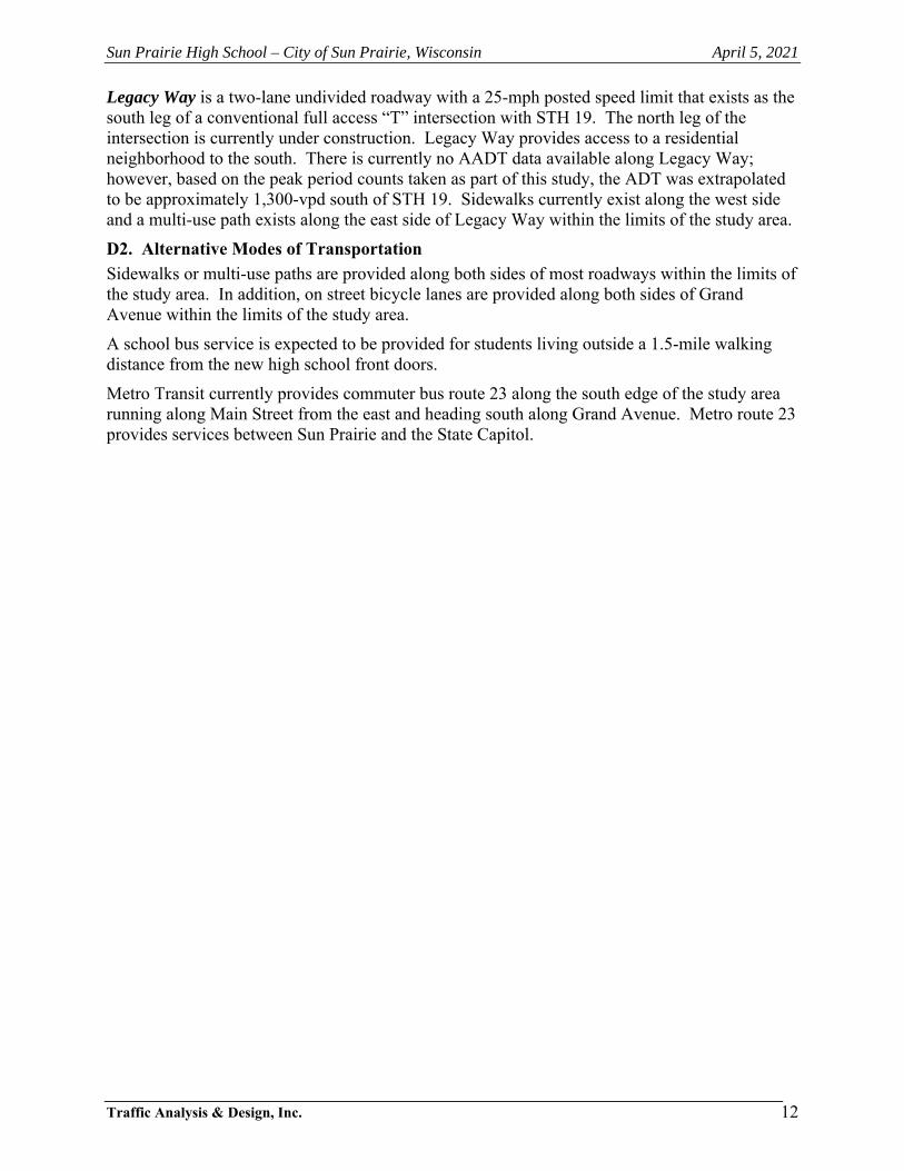
Legacy Way is a two-lane undivided roadway with a 25-mph posted speed limit that exists as the south leg of a conventional full access “T” intersection with STH 19. The north leg of the intersection is currently under construction. Legacy Way provides access to a residential neighborhood to the south. There is currently no AADT data available along Legacy Way; however, based on the peak period counts taken as part of this study, the ADT was extrapolated to be approximately 1,300-vpd south of STH 19. Sidewalks currently exist along the west side and a multi-use path exists along the east side of Legacy Way within the limits of the study area.
D2. Alternative Modes of Transportation
Sidewalks or multi-use paths are provided along both sides of most roadways within the limits of the study area. In addition, on street bicycle lanes are provided along both sides of Grand Avenue within the limits of the study area.
A school bus service is expected to be provided for students living outside a 1.5-mile walking distance from the new high school front doors.
Metro Transit currently provides commuter bus route 23 along the south edge of the study area running along Main Street from the east and heading south along Grand Avenue. Metro route 23 provides services between Sun Prairie and the State Capitol.

N
NOT TO SCALE2654; 04/05/21
Copyright © and (P) 1988–2012 Microsoft Corporation and/or its suppliers. All rights reserved. http://www.microsoft.com/streets /Certain mapping and direction data © 2012 NAVTEQ. All rights reserved. The Data for areas of Canada includes information taken with permission from Canadian authorities, including: ©Her Majesty the Queen in Right of Canada, © Queen's Printer for Ontario. NAVTEQ and NAVTEQ ON BOARD are trademarks of NAVTEQ. © 2012 Tele Atlas North America, Inc. All rights reserved. Tele Atlas and Tele Atlas North America are trademarks of Tele Atlas, Inc. © 2012 by Applied Geographic Solutions. Al l rights reserved. Portions © Copyright 2012 by Woodall Publications Corp. All ri ghts reserved.
Sun Prairie, Wisconsin
0 mi 0.2 0.4 0.6
EXHIBIT 2-1PROJECT OVERVIEW MAP
SUN PRAIRIE, WISCONSIN
Study Area IntersectionProposed School CampusProposed Site Roadways/Connections
LEGEND
N
NOT TO SCALE2654; 04/05/21
EXHIBIT 2-2CONCEPTUAL SITE PLAN
SUN PRAIRIE, WISCONSIN
Pedestrian/Bicycle Connection Only
Sun Prairie High School – City of Sun Prairie, Wisconsin April 5, 2021
Traffic Analysis & Design, Inc.
13
CHAPTER III – ANALYSIS OF EXISTING CONDITIONS
PART A – PHYSICAL CHARACTERISTICS
Exhibit 3-1 shows the existing transportation detail for the study area intersections. More specifically, the exhibit illustrates intersection lane configurations, intersection traffic controls, posted speed limits and approximate intersection spacing.
PART B – TRAFFIC VOLUMES
The weekday morning school arrival, weekday afternoon school discharge and typical weekday commuter evening peak hours are expected to drive the modifications needed to adequately accommodate the high school, as they represent the highest trip generation for the site and the highest volumes along the adjacent roadways. Therefore, in early-May of 2019, Traffic Analysis & Design, Inc. conducted weekday morning (6:00 to 9:00 am) and weekday afternoon (2:00 to 6:00 pm) turning movement traffic counts at the previously listed study area intersections. The high school bell schedule is expected to match the current high school bell schedule with morning bell at 8:00 am and afternoon dismissal bell at 3:14 pm.
A separate weekday afternoon school discharge peak hour turning movement count was also conducted at the Grand Avenue intersection with Blue Heron Boulevard in June of 2019 and again in September of 2019 to check and recheck the volumes at this intersection. The June 2019 counts were utilized in the study; however, the intersection was also reevaluated using the September 2019 counts as a sensitivity check to ensure that the recommended modifications were valid.
Based on the turning movement counts and the anticipated bell schedule, the weekday morning school arrival, weekday afternoon school discharge and typical weekday commuter evening peak hours were identified as being 7:30 to 8:30 am, 3:15 to 4:15 pm, and 4:00 to 5:00 pm, respectively. It is noted that even though the weekday morning peak hour is listed as the school arrival peak hour throughout this study, the school arrival peak hour coincides with the weekday commuter peak hour. The existing traffic volumes, balanced within the study area, are shown in Exhibit 3-2A. The traffic counts used to determine peak hour factors and truck percentages have been included in the appendix of this study.
The turning movement counts were submitted to WisDOT for its use in developing forecasts for the year 2020 and year 2030. The growth rates provided in these forecasts were then used to calculate the year 2022 and year 2032 background traffic volumes used in the study. The WisDOT forecasts are included in the appendix. The year 2022 background traffic volumes, balanced within the study area, are shown in Exhibit 3-2B. Since residential development and the roadway infrastructure is currently ongoing on the north side of Main Street at Legacy Way, the new trips expected from these residential uses (as shown on Exhibit 4-8) was also included in the year 2022 background traffic volumes.
PART C – CAPACITY LEVEL OF SERVICE
C1. Level of Service Definitions
The study area intersections were analyzed based on the procedures set forth in the 2010 Highway Capacity Manual (HCM), 6th Edition. Intersection operation is defined by “level of service”. Level of service (LOS) is a quantitative measure that refers to the overall quality of flow at an intersection ranging from very good, represented by LOS ‘A’, to very poor, represented by LOS ‘F’. For the purpose of this study, LOS D was used to define acceptable peak hour operating conditions. Descriptions of the various levels of service are as follows:

Sun Prairie High School – City of Sun Prairie, Wisconsin April 5, 2021
Traffic Analysis & Design, Inc.
14
LOS A is the highest level of service that can be achieved. Under this condition, intersection approaches appear quite open, turning movements are easily made, and nearly all drivers find freedom of operation. At signalized and unsignalized intersections, average delays are less than 10 seconds. LOS B represents stable operation. At signalized intersections, average vehicle delays are 10 to 20 seconds. At unsignalized intersections, average delays are 10 to 15 seconds. LOS C still represents stable operation, but periodic backups of a few vehicles may develop behind turning vehicles. Most drivers begin to feel restricted, but not objectionably so. At signalized intersections, average vehicle delays are 20 to 35 seconds. At unsignalized intersections, average delays are 15 to 25 seconds. LOS D represents increasing traffic restrictions as the intersection approaches instability. Delays to approaching vehicles may be substantial during short peaks within the peak period, but periodic clearance of long lines occurs, thus preventing excessive backups. At signalized intersections, average vehicle delays are 35 to 55 seconds. At unsignalized intersections, average delays are 25 to 35 seconds. LOS E represents the capacity of the intersection. At signalized intersections, average vehicle delays are 55 to 80 seconds. At unsignalized intersections, average delays are 35 to 50 seconds. LOS F represents jammed conditions where the intersection is over capacity and acceptable gaps for unsignalized intersections in the mainline traffic flow are minimal. At signalized intersections, average vehicle delays exceed 80 seconds. At unsignalized intersections, average delays exceed 50 seconds.
C2. Existing Traffic Operations – No Modifications
Exhibit 3-3A shows the existing traffic (no high school) peak hour operating conditions at the study area intersections. The existing traffic analysis was conducted using the existing lane configurations shown in Exhibit 3-1, the existing traffic volumes shown in Exhibit 3-2A, and the existing traffic signal timings included in the appendix of this study.
As shown in Exhibit 3-3A, all movements are expected to operate acceptably at LOS D or better at the study area intersections under the existing traffic volumes conditions during the weekday morning school arrival, weekday afternoon school discharge and typical weekday commuter evening peak periods except:
the southbound movements at the STH 19 intersection with Charlotte’s Way during the weekday afternoon school discharge peak hour;
the northbound left-turn movements and the southbound left-turn and through movements at the STH 19 intersection with Grand Avenue during the weekday afternoon school discharge and weekday evening peak hours; and
the eastbound and westbound left-turn and through movements at the Grand Avenue intersection with Blue Heron Boulevard during the weekday afternoon school discharge and weekday evening peak hours.
C3. Year 2022 Background Traffic Operations – No Modifications
Exhibit 3-3B shows the year 2022 background traffic peak hour operating conditions at the study area intersections. The year 2022 background traffic analysis was conducted using the existing lane configurations shown in Exhibit 3-1, the year 2022 background traffic volumes shown in Exhibit 3-2B, and the existing traffic signal timings included in the appendix of this study.

Sun Prairie High School – City of Sun Prairie, Wisconsin April 5, 2021
Traffic Analysis & Design, Inc.
15
As shown in Exhibit 3-3B, all movements are expected to continue to operate acceptably at LOS D or better at the study area intersections under the year 2022 background traffic volumes conditions during the weekday morning school arrival, weekday afternoon school discharge and typical weekday commuter evening peak except:
the southbound movements at the STH 19 intersection with Charlotte’s Way during the weekday afternoon school discharge peak hour;
the northbound left-turn movements and the southbound left-turn and through movements at the STH 19 intersection with Grand Avenue during the weekday afternoon school discharge and weekday evening peak hours; and
the eastbound and westbound left-turn and through movements at the Grand Avenue intersection with Blue Heron Boulevard during the weekday afternoon school discharge and weekday evening peak hours.
PART D – SOURCES OF DATA
The following sources of data were obtained for use in conducting this traffic study:
Turning movement traffic counts – TADI
Forecasted traffic counts – WisDOT forecasting unit
Existing transportation details – TADI along with Google Earth
Existing traffic signal timings – WisDOT and City of Sun Prairie
Existing eastern high school trip generation information - City of Sun Prairie
Approved SPASD School boundary – SPASD and MDRoffers Consulting
On-site high school information – Bray Architects and Sun Prairie Area School District

N
NOT TO SCALE2654; 04/05/21
EXHIBIT 3-1EXISTING TRANSPORTATION DETAIL
SUN PRAIRIE, WISCONSIN
Ironwood
Drive
Traffic SignalStop SignRoundaboutExisting Lane ConfigurationExisting Turn Bay Length (In Feet)Distance Between Intersections (in Feet)
LEGEND
1,675’
19
Windsor Street
Blue Heron Blvd
Main Street
Leg
acy
Way
85’
75’
175’
100’
140’
165’
SPEEDLIMIT
25
150’
190’
350’
250’
165’
185’
Cha
rlotte
’sW
ay
Oxf
ord
Pla
ce
XX’XX’
1,000’
750’
775’
1,30
0’1,
875’
100’
250’225’
125’
135’
115’
100’
Gra
nd
Ave
nu
e
SPEEDLIMIT
25
SPEEDLIMIT
30
SPEEDLIMIT
35
SPEEDLIMIT
45
SPEEDLIMIT
45
SPEEDLIMIT
40
C

N
NOT TO SCALE2654; 04/05/21
EXHIBIT 3-2A EXISTING TRAFFIC VOLUMES
SUN PRAIRIE, WISCONSIN
XX(XX)[XX]
-
LEGEND
Weekday Morning Arrival Peak Hour (7:30-8:30AM) Weekday Afternoon Discharge Peak Hour (3:15-4:15PM) Weekday PM Adjacent Peak Hour (4:00-5:00PM) Fewer than 3 vehicles per hour 2018 Annual Average Daily Traffic (AADT) 2015 Annual Average Daily Traffic (AADT) 2009 Annual Average Daily Traffic (AADT)
[1
5] (
10)
5
715 (635) [770]
[845] (805) 605
[35] (40) 25
Windsor Street
Oxf
ord
Pla
ce
[60]
(45
) 35
[555
] (42
5) 2
85 [2
00] (
195)
115
30 (
30)
[35]
440
(470
) [5
15]
105
(100
) [9
5]
120 (145) [200] 10 (15) [10]150 (115) [135]
[45] (40) 25[15] (20) 15 [60] (50) 20
Ironwood Drive
5,000
[305
] (23
5) 1
90[3
80] (
280)
205
[115
] (95
) 35
10 (
5) [5
] 1
5 (1
0) [5
]
45 (45) [55] 425 (340) [365]95 (95) [100]
[95] (65) 80[525] (475) 345 [240] (275) 185
[10]
(20
) 40
[800
] (64
5) 4
20 [1
0] (
10)
5
10 (
5) [5
]59
0 (6
25)
[695
] 10
(5)
[10]
5 (10) [10]- (5) [5]15 (10) [5]
[5] (10) 10[ - ] (10) -
[10] (35) 50
Blue Heron BlvdG
ran
d
Ave
nu
e
10 (15) [5] 705 (620) [765]
[5] (10) 10
[875] (835) 615
Main Street
Ch
arlo
tte’
sW
ay
[30]
(35
) 15
[645
] (50
0) 3
35[1
50] (
115)
25
40 (
65)
[60]
540
(565
) [6
05]
65 (
35)
[45]
80 (115) [135] 70 (125) [110]85 (165) [180]
[30] (30) 20[105] (85) 115
[20] (35) 45
19
[40]
(30
) 25
[15]
(20
) 55
110 (145) [155] 30 (40) [20]
[120] (80) 150
[35] (35) 20
Leg
acy
Way
100
(60)
[100
] 29
5 (2
30)
[305
]65
(40
) [5
0]
X,XXXX,XXX
3,700
13,60012,700
13,700
X,XXX
Pro
po
sed
Acc
ess

N
NOT TO SCALE2654; 04/05/21
EXHIBIT 3-2BYEAR 2022 BACKGROUND TRAFFIC VOLUMES
SUN PRAIRIE, WISCONSIN
[1
5] (
10)
5
735 (650) [785]
[865] (825) 625
[35] (40) 25
Windsor Street
Oxf
ord
Pla
ce
[65]
(50
) 35
[580
] (44
5) 3
00 [2
10] (
210)
125
30 (
30)
[35]
450
(460
) [5
10]
105
(100
) [9
5]
120 (155) [205] 10 (15) [10]160 (120) [140]
[45] (40) 25[15] (20) 15 [60] (50) 20
Ironwood Drive
[305
] (23
5) 1
95[4
05] (
305)
210
[120
] (10
0) 4
0
10 (
5) [5
]15
(10
) [5
]
45 (45) [55] 435 (350) [370]100 (100) [105]
[100] (70) 85[540] (490) 355 [240] (275) 190
[10]
(20
) 40
[840
] (68
5) 4
45 [1
0] (
10)
5
10 (
5) [5
]61
0 (6
20)
[695
] 10
(5)
[10]
5 (10) [10]- (5) [5]15 (10) [5]
[5] (10) 10[5] (10) -
[10] (35) 50
Blue Heron BlvdG
ran
d
Ave
nu
e
10 (15) [5] 725 (635) [780]
[5] (10) 10
[895] (855) 635
Main Street
Ch
arlo
tte’
sW
ay
[40]
(45
) 20
[660
] (51
5) 3
40[1
65] (
125)
35
- (
- )
[ - ]
- (
- )
[ - ]
5 (5
) [5
]
80 (115) [135] 75 (130) [120]100 (185) [200]
[35] (35) 25[105] (90) 120
[25] (40) 55
19
Pro
po
sed
Acc
ess
[45]
(30
) 25
[ - ]
( -
) -
[15]
(20
) 55
- (5) [5] 115 (155) [160] 30 (40) [20]
[ - ] ( - ) - [130] (85) 155
[35] (35) 20
Leg
acy
Way
105
(65)
[110
] 29
5 (2
15)
[295
]70
(40
) [5
0]
XX(XX)[XX]
-
LEGEND
Weekday Morning Arrival Peak Hour (7:30-8:30AM) Weekday Afternoon Discharge Peak Hour (3:15-4:15PM) Weekday PM Adjacent Peak Hour (4:00-5:00PM) Fewer than 3 vehicles per hour
45 (
70)
[65]
555
(580
) [6
20]
65 (
35)
[45]

N
NOT TO SCALE2654; 04/05/21
EXHIBIT 3-3AEXISTING TRAFFIC OPERATIONS
WITHOUT MODIFICATIONS
SUN PRAIRIE, WISCONSIN
Intersection
Level of
LT TH RT LT TH RT LT TH RT LT TH RT Service
LOS - - * *
Delay - - * *
Queue - - * *
LOS - - * *
Delay - - * *
Queue - - * *
LOS - - * *
Delay - - * *
Queue - - * *
LOS - * * - * - B
Delay - * * - * - 13
Queue - * * - * - 0
LOS - * * - * - C
Delay - * * - * - 17
Queue - * * - * - 25
LOS - * * - * - C
Delay - * * - * - 16
Queue - * * - * - 25
LOS C D C C C C D C C D D C
Delay 21 37 28 20 33 21 47 28 27 54 44 35
Queue 80 410 140 90 520 45 330 130 45 125 460 105
LOS C D C C D C F D D F F D
Delay 26 53 33 32 36 26 196 40 37 80 88 51
Queue 90 690 175 95 440 50 670 255 115 110 540 110
LOS C D C C C C F D C E E D
Delay 23 46 31 27 32 25 95 35 33 73 71 48
Queue 85 620 160 90 395 45 600 230 105 105 470 150
LOS B B B A
Delay 16 16 12 10
Queue 25 100 35 45
LOS C C B B
Delay 25 22 13 12
Queue 45 110 50 45
LOS C B B B
Delay 22 20 12 10
Queue 45 105 50 45
LOS B A A A
Delay 11 10 9 8
Queue 25 0 25 0
LOS B B A A
Delay 11 12 9 10
Queue 25 25 0 0
LOS B B A A
Delay 11 12 9 10
Queue 25 25 0 0
LOS A A A A
Delay 7 6 6 7
Queue 25 25 25 45
LOS A A A A
Delay 8 9 7 9
Queue 25 35 45 60
LOS A A A A
Delay 7 9 8 8
Queue 25 35 50 50
LOS A A A
Delay 8 8 9
Queue 0 25 0
LOS A A A
Delay 8 8 9
Queue 0 25 0
LOS A A A
Delay 8 8 9
Queue 0 25 0
Delay recorded in seconds, Queue length recorded in feet (min 25'), rounded to nearest 5'
Roundabout results shown are two lanes on each approach, shared left-turn/thru and shared thru/right-turn
35
A A
40
7 8
35 50
A A
7 8
25 30
A
A
5
25
45
6
25
A A
25 30
8
(-) movement that isn't available or allowed * free flow movement ** Extreme Delays and queues
AM
SouthboundEastbound Westbound
PM
PM
PM
AM
25
PM
-
-
-
Level of Service per Movement by Approach
Northbound
AM
School
PM
-
A
-
-
A
A
B
A
*
A
7
Exhibit 3-3A
Exiting Traffic Peak Hour Operating Conditions
Existing Geometrics and Traffic Control
Intersection
Peak
Hour
AM B
A11
25
A
B
PM
AAM
PM
AM
B
B
PM
B
A12
25
*
*
*
*
*
*
*
*
*
*
*
*
* 12
* 25
*
*
25
*
*
-
*
*
*
7 7
*
*
*
*
14
110
25
B
46
80
A
7
110
C A
16
220
*
#500 - Grand Avenue
& Blue Heron Boulevard
Two-Way Stop Control
#600 - Grand Avenue
& Main Street
Roundabout Control
School
PM
B
18
65
E
7
A
A
E
38
School
PM
School
PM
B
18
235
C
E
24
AM
C
22
160
25
F
51
25
2017
#700 - Main Street
& Legacy Way
One-Way Stop Control
School
PM
D
26
#100 - Windsor Street (STH 19)
& Charlotte's Way
One-Way Stop Control
#200 - Windsor Street (STH 19)
& Oxford Place
One-Way Stop Control
#300 - Windsor Street (STH 19)
& Grand Avenue
Traffic Signal Control
#400 - Grand Avenue
& Ironwood Drive
Traffic Signal Control
13
B
School
PM
160
*
*
*
30
B
15
85
School
PM
B
43
25
60
25
*
A
6
105
*
*
*
*
*
A
7
B
D
A
A
A
A
A
A
B
A
A
D
33
25
-
6
-
-
-
250
-
-
-
-
-
-
-
-
9
0
-
-
-
A
10
0
A
10
-
D
30
25
E
40
-
-
-
-
E
D
12
0
12
0
B
12
0
B

N
NOT TO SCALE2654; 04/05/21
EXHIBIT 3-3BYEAR 2022 BACKGROUND TRAFFIC OPERATIONS
WITHOUT MODIFICATIONS
SUN PRAIRIE, WISCONSIN
Intersection
Level of
LT TH RT LT TH RT LT TH RT LT TH RT Service
LOS - - * *
Delay - - * *
Queue - - * *
LOS - - * *
Delay - - * *
Queue - - * *
LOS - - * *
Delay - - * *
Queue - - * *
LOS - * * - * - B
Delay - * * - * - 13
Queue - * * - * - 0
LOS - * * - * - C
Delay - * * - * - 17
Queue - * * - * - 25
LOS - * * - * - C
Delay - * * - * - 16
Queue - * * - * - 25
LOS C D C C C C D C C D D D
Delay 21 38 28 21 34 21 50 29 28 54 46 36
Queue 80 425 140 95 535 45 345 135 50 135 470 110
LOS C D C C D C F D D F F D
Delay 25 54 32 32 36 26 197 41 38 80 87 52
Queue 95 720 175 100 450 50 670 270 120 110 510 120
LOS C D C C C C F D C E E D
Delay 23 46 31 27 32 24 96 36 34 74 70 49
Queue 90 645 160 95 405 45 600 245 110 105 435 115
LOS B B B A
Delay 16 16 12 10
Queue 25 110 35 45
LOS C C B B
Delay 27 23 13 12
Queue 45 115 55 45
LOS C C B B
Delay 23 20 12 10
Queue 45 110 50 45
LOS B A A A
Delay 11 10 9 9
Queue 25 0 25 0
LOS B B A B
Delay 11 12 9 10
Queue 25 25 0 0
LOS B B A B
Delay 11 12 9 10
Queue 25 25 0 0
LOS A A A A
Delay 8 6 6 8
Queue 25 25 25 45
LOS A A A A
Delay 8 9 7 10
Queue 25 40 50 65
LOS A A A A
Delay 7 9 8 9
Queue 25 40 55 55
LOS A A A
Delay 8 8 9
Queue 0 25 0
LOS A A A
Delay 8 8 9
Queue 0 25 0
LOS A A A
Delay 8 8 9
Queue 0 25 0
Delay recorded in seconds, Queue length recorded in feet (min 25'), rounded to nearest 5'
Roundabout results shown are two lanes on each approach, shared left-turn/thru and shared thru/right-turn
25 35 45 45
A A
7 9 7 8
8 9 7 9
25 35 40 50
A
25 25 25 40
A A A A
A A
7 6 6 7
A
Exhibit 3-3B
Year 2022 Background Traffic Peak Hour Operating Conditions
Existing Geometrics and Traffic Control
Intersection
Peak
Hour
Level of Service per Movement by Approach
Eastbound Westbound Northbound Southbound
#100 - Windsor Street (STH 19)
& Charlotte's Way
One-Way Stop Control
AM A
School
PMA
0 - 25
-
PM A
A - D
-
A-
-
-
#200 - Windsor Street (STH 19)
& Oxford Place
One-Way Stop Control
AM
-
A-
-
-
School
PM
-
-
ESchool
PM
#300 - Windsor Street (STH 19)
& Grand Avenue
Traffic Signal Control
AM D
PM
-
A-
-
B
B
#400 - Grand Avenue
& Ironwood Drive
Traffic Signal Control
AM
School
PM
PM D
B
B
PM
105
B
A*
*
B C A
7
C
#500 - Grand Avenue
& Blue Heron Boulevard
Two-Way Stop Control
AM
*
School
PM
A*
*
A*
*
A
#600 - Grand Avenue
& Main Street
Roundabout Control
AM
PM
School
PM
*
PM
*
45
A
A
A
A* 12
* 25
* 25
A*
*
*
*
12
0
B
12
12
School
PM
B
*
A* 12PM
* B
(-) movement that isn't available or allowed * free flow movement ** Extreme Delays and queues
AM *
*
*
* 25
11
#700 - Main Street
& Legacy Way
Two-Way Stop Control
*
25
A - E
10 - 42
34
B
65 165 240
10 -
0 -
19 23
-
-
-
-
-
B B
16
60
27
25
18
B
17
A
*
*
160 235
6
25
100
*
21
25 25 *
25
56
F F *
A
*
*
*
B
E E *
50
B
A - D
10
0 - 25
32
A
13 15 15
0
B
6
*
25 25
0
30 85 120 85
D D
*
53 *

Sun Prairie High School – City of Sun Prairie, Wisconsin April 5, 2021
Traffic Analysis & Design, Inc.
16
CHAPTER IV – FORECASTED TRAFFIC
PART A – BACKGROUND TRAFFIC FORECASTING
The turning movement counts were submitted to WisDOT for its use in developing forecasts for the year 2020 and year 2030. The growth rates provided in these forecasts were then used to calculate the year 2022 and year 2032 background traffic volumes used in the study. The WisDOT forecasts are included in the appendix. The year 2022 background traffic volumes, balanced within the study area, are shown in Exhibit 3-2B. The year 2032 background traffic volumes, balanced within the study area, are shown in Exhibit 4-2. Since residential development and the roadway infrastructure is currently ongoing on the north side of Main Street at Legacy Way, the new trips expected from these residential uses (as shown on Exhibit 4-8) was also included in the year 2022 and year 2032 background traffic volumes.
PART B – SITE TRAFFIC FORECASTING
The traffic volumes expected to be generated by the proposed school for the weekday morning arrival and weekday afternoon school discharge peak hours were calculated based on trip rates provided from a previous study for the existing Sun Prairie high school located on the east side of Sun Prairie. The previous study existing high school rates, which were calculated based on actual counts taken at the existing high school in 2008, were compared to the rates as published in the Institute of Transportation Engineer’s (ITE) Trip Generation Manual, 10th Edition, 2017. The previous study rates were significantly higher than the published ITE rates. It is noted that the counts taken at the existing high school included a student population made up of grades 10 thru 12; whereas the proposed school is planned to accommodate grades 9 thru 12. Regardless, since the previous study rates were based on actual count data for the local school district and they represent higher worst-case trip rates when compared to the published ITE rates, they were utilized for this study. The expected traffic volumes generated by the proposed school for the typical weekday evening commuter peak hour were calculated based on trip rates from the ITE manual. The expected traffic volumes generated by the proposed school for the typical weekday were calculated by factoring (1.68 factor) the trip rates from the ITE manual to reflect the same increase as the peak hour existing high school volumes compared to the ITE rates for peak hour.
B1. Trip Generation
The trip generation table for the initial build (with target student population) is shown in Exhibit 4-3A. As shown, under initial build (with target student population), the proposed high school is expected to generate 1,345 new trips (915 entering/430 exiting) during a typical weekday morning peak hour. During a typical weekday afternoon school discharge peak hour, the proposed high school is expected to generate 945 new trips (300 entering/645 exiting). During a typical weekday evening commuter peak hour, the proposed high school is expected to generate 230 new trips (110 entering/120 exiting). On a typical weekday, the proposed high school is expected to generate approximately 5,650 new trips (2,825 entering/2,825 exiting) under initial build (with target student population) conditions.
The trip generation table for the initial build (with maximum capacity student population) is shown in Exhibit 4-3B. As shown, under full build (with maximum capacity student population), the proposed high school is expected to generate 1,680 new trips (1,140 entering/540 exiting) during a typical weekday morning peak hour. During a typical weekday afternoon school discharge peak hour, the proposed high school is expected to generate 1,180 new trips (380 entering/800 exiting). During a typical weekday evening commuter peak hour, the proposed high school is expected to generate 290 new trips (140 entering/150 exiting). On a typical weekday, the proposed high school is expected to generate approximately 7,070 new trips

Sun Prairie High School – City of Sun Prairie, Wisconsin April 5, 2021
Traffic Analysis & Design, Inc.
17
(3,535 entering/3,535 exiting) under full build (with maximum capacity student population) conditions.
B2. Mode Split
Pedestrians, bicyclists and bus users are expected to use their respective modes to access the high school; however, the percentages of users for each of these alternate modes are expected to be consistent with the users at the existing eastern high school. Therefore, for the purpose of this TIA, all trips to/from the proposed high school were assumed to be accounted for in the trip generation rates utilized for this study which were calculated based on actual counts taken at the existing eastern high school.
B3. Trip Distribution
The Sun Prairie Area School District recently approved the school boundary limits for their two middle schools and two high schools in a report titled “Sun Prairie Area School District Community Growth and Projections Report”, dated September 28, 2020. A map showing the approved school boundary limits is included in the appendix of this report. As shown, the proposed west high school is expected to draw from within the central and western limits of the overall Sun Prairie Area School District. The trip distribution for the proposed high school was determined based on the projected future year student populations from each of the individual neighborhoods located within this approved west high school boundary limits. Calculations are included in the appendix of this report.
Based on the location of the individual neighborhoods in relation to the proposed high school and the transportation network around the high school, the following distribution is expected. The trip distribution is also shown in table format on Exhibits 4-3A&B, graphically on Exhibit 4-4 and as listed below:
31-percent to/from the east on STH 19
1-percent to/from the west on STH 19
18-percent to/from the north on Grand Avenue
2-percent to/from the south on Grand Avenue
16-percent to/from the east on Main Street
13-percent to/from the west on Main Street
1-percent to/from the north on Charlotte’s Way
4-percent to/from the south on Legacy Way
6-percent to/from the west on Rebel Drive
2-percent to/from the east on Ironwood Drive
6-percent to/from the east on Blue Heron Boulevard
B4. Trip Assignment
Initial Build (with target student population) The proposed high school initial build (with target student population) new trips traffic pattern under the approved school boundary were assigned to the study area and are shown in Exhibit 4-5.

Sun Prairie High School – City of Sun Prairie, Wisconsin April 5, 2021
Traffic Analysis & Design, Inc.
18
Full build (with maximum capacity student population) The proposed high school full build (with maximum capacity student population) new trips traffic pattern under the approved school boundary were assigned to the study area and are shown in Exhibit 4-7.
PART C – BUILD TRAFFIC
C1. Year 2022 Initial Build Traffic – Approved School Loading
The Year 2022 background traffic volumes, Exhibit 3-2B, were added to the high school initial build new trips (Approved School Loading), illustrated in Exhibit 4-5, to determine the Year 2022 initial build (Approved School Loading) traffic volumes (Exhibit 4-11).
C2. Year 2032 Full Build Traffic – Approved School Loading
The Year 2032 background traffic volumes, Exhibit 4-2, were added to the high school full build new trips (Approved School Loading), illustrated in Exhibit 4-7, to determine the Year 2032 full build (Approved School Loading) traffic volumes (Exhibit 4-13).

N
NOT TO SCALE2654; 04/05/21
EXHIBIT 4-2YEAR 2032 BACKGROUND TRAFFIC VOLUMES
SUN PRAIRIE, WISCONSIN
[1
5] (
10)
5
785 (700) [845]
[950] (900) 680
[40] (45) 25
Windsor Street
Oxf
ord
Pla
ce
[80]
(60
) 45
[645
] (50
0) 3
35 [2
55] (
255)
155
35 (
30)
[35]
465
(490
) [5
30]
105
(100
) [1
00]
130 (170) [230] 10 (15) [15]200 (135) [160]
[50] (45) 30[20] (20) 20 [65] (60) 35
Ironwood Drive
[305
] (24
0) 1
95[5
00] (
375)
260
[120
] (10
0) 4
0
15 (
5) [5
]15
(10
) [5
]
50 (50) [65] 455 (370) [385]100 (100) [105]
[145] (100) 115[575] (525) 380 [245] (285) 190
[15]
(25
) 50
[955
] (79
5) 5
15 [1
0] (
10)
5
10 (
5) [5
]67
5 (6
75)
[740
] 15
(5)
[10]
5 (10) [10]- (5) [5]15 (10) [5]
[5] (10) 15[5] (10) -
[10] (40) 60
Blue Heron BlvdG
ran
d
Ave
nu
e
10 (15) [5] 775 (685) [840]
[5] (10) 10
[985] (935) 690
Main Street
Ch
arlo
tte’
sW
ay
[80]
(80
) 40
[695
] (54
0) 3
55[2
30] (
170)
85
45 (
70)
[65]
605
(625
) [6
75]
65 (
35)
[45]
80 (115) [135] 75 (130) [120]160 (285) [305]
[35] (35) 25[105] (90) 120
[60] (75) 95
19
Leg
acy
Way
135
(90)
[155
] 31
5 (2
35)
[315
]80
(45
) [6
0]
XX(XX)[XX]
-
LEGEND
Weekday Morning Arrival Peak Hour (7:30-8:30AM) Weekday Afternoon Discharge Peak Hour (3:15-4:15PM) Weekday PM Adjacent Peak Hour (4:00-5:00PM) Fewer than 3 vehicles per hour
- (
- )
[ - ]
- (
- )
[ - ]
5 (5
) [5
]
[50]
(35
) 30
[ - ]
( -
) -
[20]
(20
) 65
- (5) [5] 135 (175) [185] 35 (45) [20]
[ - ] ( - ) - [145] (95) 175
[45] (40) 20
Pro
po
sed
Acc
ess
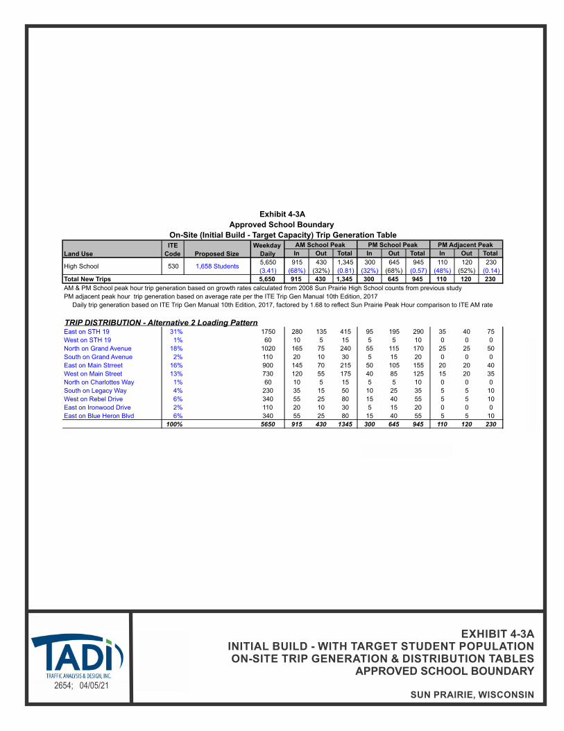
N
NOT TO SCALE2654; 04/05/21
EXHIBIT 4-3AINITIAL BUILD - WITH TARGET STUDENT POPULATIONON-SITE TRIP GENERATION & DISTRIBUTION TABLES
APPROVED SCHOOL BOUNDARY
SUN PRAIRIE, WISCONSIN
In Out Total In Out Total In Out Total
5,650 915 430 1,345 300 645 945 110 120 230
(3.41) (68%) (32%) (0.81) (32%) (68%) (0.57) (48%) (52%) (0.14)
5,650 915 430 1,345 300 645 945 110 120 230
TRIP DISTRIBUTION - Alternative 2 Loading PatternEast on STH 19 31% 1750 280 135 415 95 195 290 35 40 75
West on STH 19 1% 60 10 5 15 5 5 10 0 0 0
North on Grand Avenue 18% 1020 165 75 240 55 115 170 25 25 50
South on Grand Avenue 2% 110 20 10 30 5 15 20 0 0 0
East on Main Strreet 16% 900 145 70 215 50 105 155 20 20 40
West on Main Street 13% 730 120 55 175 40 85 125 15 20 35
North on Charlottes Way 1% 60 10 5 15 5 5 10 0 0 0
South on Legacy Way 4% 230 35 15 50 10 25 35 5 5 10
West on Rebel Drive 6% 340 55 25 80 15 40 55 5 5 10
East on Ironwood Drive 2% 110 20 10 30 5 15 20 0 0 0
East on Blue Heron Blvd 6% 340 55 25 80 15 40 55 5 5 10
100% 5650 915 430 1345 300 645 945 110 120 230
Total New Trips
PM adjacent peak hour trip generation based on average rate per the ITE Trip Gen Manual 10th Edition, 2017
AM & PM School peak hour trip generation based on growth rates calculated from 2008 Sun Prairie High School counts from previous study
Daily trip generation based on ITE Trip Gen Manual 10th Edition, 2017, factored by 1.68 to reflect Sun Prairie Peak Hour comparison to ITE AM rate
High School 530 1,658 Students
Exhibit 4-3A
On-Site (Initial Build - Target Capacity) Trip Generation Table
Land Use
ITE
Code Proposed Size
Weekday
Daily
AM School Peak PM School Peak PM Adjacent Peak
Approved School Boundary

N
NOT TO SCALE2654; 04/05/21
EXHIBIT 4-3BFULL BUILD - WITH MAXIMUM CAPACITY STUDENT POPULATION
ON-SITE TRIP GENERATION & DISTRIBUTION TABLESAPPROVED SCHOOL BOUNDARY
SUN PRAIRIE, WISCONSIN
In Out Total In Out Total In Out Total
7,070 1,140 540 1,680 380 800 1,180 140 150 290
(3.41) (68%) (32%) (0.81) (32%) (68%) (0.57) (48%) (52%) (0.14)
7,070 1,140 540 1,680 380 800 1,180 140 150 290
TRIP DISTRIBUTION - Alternative 2 Loading PatternEast on STH 19 31% 2200 350 170 520 115 245 360 40 45 85
West on STH 19 1% 70 10 5 15 5 10 15 0 0 0
North on Grand Avenue 18% 1270 205 100 305 65 140 205 25 25 50
South on Grand Avenue 2% 140 25 10 35 10 15 25 5 5 10
East on Main Strreet 16% 1140 180 90 270 55 130 185 20 25 45
West on Main Street 13% 920 150 70 220 50 105 155 20 20 40
North on Charlottes Way 1% 70 10 5 15 5 10 15 0 0 0
South on Legacy Way 4% 280 45 20 65 15 30 45 5 5 10
West on Rebel Drive 6% 420 70 30 100 25 50 75 10 10 20
East on Ironwood Drive 2% 140 25 10 35 10 15 25 5 5 10
East on Blue Heron Blvd 6% 420 70 30 100 25 50 75 10 10 20
100% 7070 1140 540 1680 380 800 1180 140 150 290
Total New Trips
PM adjacent peak hour trip generation based on average rate per the ITE Trip Gen Manual 10th Edition, 2017
AM & PM School peak hour trip generation based on growth rates calculated from 2008 Sun Prairie High School counts from previous study
Daily trip generation based on ITE Trip Gen Manual 10th Edition, 2017, factored by 1.68 to reflect Sun Prairie Peak Hour comparison to ITE AM rate
High School 530 2,073 Students
Exhibit 4-3B
On-Site (Full Build - Full Capacity) Trip Generation Table
Land Use
ITE
Code Proposed Size
Weekday
Daily
AM School Peak PM School Peak PM Adjacent Peak
Approved School Boundary
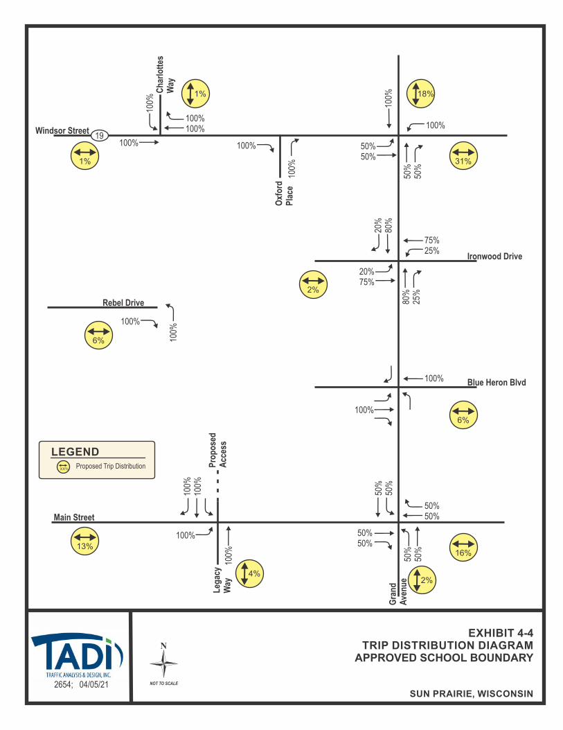
N
NOT TO SCALE2654; 04/05/21
EXHIBIT 4-4TRIP DISTRIBUTION DIAGRAM
APPROVED SCHOOL BOUNDARY
SUN PRAIRIE, WISCONSIN
Windsor Street
Oxf
ord
Pla
ce
Rebel Drive
Blue Heron BlvdG
ran
d
Ave
nu
e
Main Street
Ch
arlo
ttes
Way
19
Leg
acy
Way
Proposed Trip Distribution
LEGEND
XX%
13%
4%
1%
31%
6%
16%
6%
1%
18%
2%
Ironwood Drive
2%
50% 50%
1
00%
100%
10
0%
5
0% 50%
100%
100%
100%
1
00%
100%
100% 100%
100%
100%
5
0% 50%
50%50%
100%
100%
Pro
po
sed
Acc
ess
100%
100%
50% 50%
5
0% 50%
20%75%
75% 25%
8
0% 25%
20%
80
%

N
NOT TO SCALE2654; 04/05/21
EXHIBIT 4-5 INITIAL BUILD NEW TRIPS
APPROVED SCHOOL BOUNDARY
SUN PRAIRIE, WISCONSIN
10 (10) [ - ]
Windsor Street
Oxf
ord
Pla
ce
[1
5] (
100)
70
[ - ]
(5)
-
90 (
30)
[10]
355
(120
) [5
0]
15 (5) [ - ] 5 ( - ) [ - ]
[15] (60) 40[ - ] (10) 10
Ironwood Drive
10 (
5) [
- ]
280 (95) [35]
[10]
(30
) 80
360
(120
) [5
0]
55 (15) [5]
[15] (105) 70[5] (40) 25
[10] (60) 40
Blue Heron Blvd
Main Street
Ch
arlo
tte’
sW
ay
[ -
] ( -
) 1
0[ -
] (5
) 10
55 (
85)
[20]
15
(25
) [5
]40
(60
) [1
0]
70 (25) [10] 75 (25) [10]
[10] (55) 35
[ - ] (5) 5
19
[5] (
10)
35
85 (25) [10]
[15] (40) 120
Leg
acy
Way
165
(55)
[25]
[35]
(16
0) 1
10
5 (1
0) [
- ]
35 (
50)
[10]
Rebel Drive
25 (40) [5]
[5] (15) 55
XX(XX)[XX]
-
LEGEND
Weekday Morning Arrival Peak Hour (7:30-8:30AM) Weekday Afternoon Discharge Peak Hour (3:15-4:15PM) Weekday PM Adjacent Peak Hour (4:00-5:00PM) Fewer than 3 vehicles per hour
Gra
nd
A
ven
ue
[15] (60) 40[20] (100) 70
[ - ] ( - ) -
[ - ]
(10)
10
[10]
(55
) 35
[20]
(95
) 65
5 (5) [ - ]5 (5) [ - ]
[ - ] (5) 10
[ - ] (10) 20
Pro
po
sed
Acc
ess
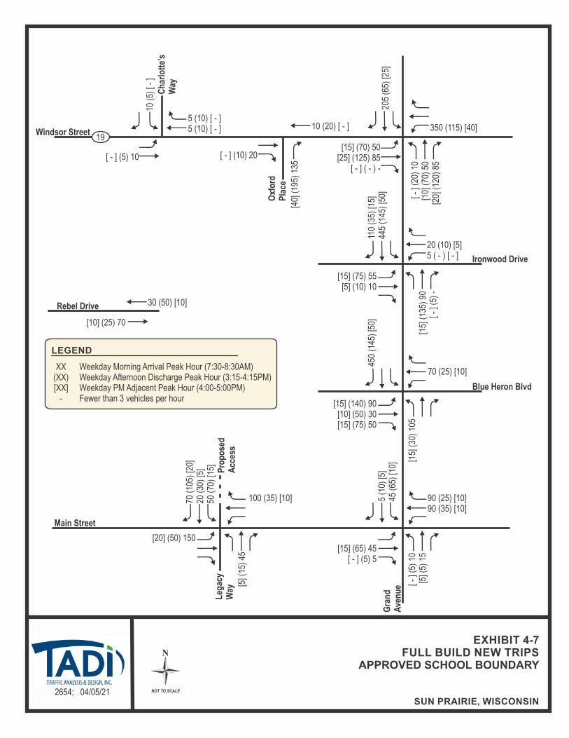
N
NOT TO SCALE2654; 04/05/21
EXHIBIT 4-7 FULL BUILD NEW TRIPS
APPROVED SCHOOL BOUNDARY
SUN PRAIRIE, WISCONSIN
10 (20) [ - ]
Windsor Street
Oxf
ord
Pla
ce
[1
5] (
135)
90
[ - ]
(5)
-
110
(35)
[15]
445
(145
) [5
0]
20 (10) [5] 5 ( - ) [ - ]
[15] (75) 55[5] (10) 10
Ironwood Drive
10 (
5) [
- ]
350 (115) [40]
[15]
(30
) 10
5
450
(145
) [5
0]
70 (25) [10]
[15] (140) 90[10] (50) 30 [15] (75) 50
Blue Heron Blvd
Main Street
Ch
arlo
tte’
sW
ay
[ -
] (5)
10
[5] (
5) 1
5
70 (
105)
[20]
20
(30
) [5
]50
(70
) [1
5]
90 (25) [10] 90 (35) [10]
[15] (65) 45
[ - ] (5) 5
19
[5] (
15)
45
100 (35) [10]
[20] (50) 150
Leg
acy
Way
205
(65)
[25]
[40]
(19
5) 1
35
5 (1
0) [5
] 45
(65
) [1
0]
Rebel Drive
30 (50) [10]
[10] (25) 70
XX(XX)[XX]
-
LEGEND
Weekday Morning Arrival Peak Hour (7:30-8:30AM) Weekday Afternoon Discharge Peak Hour (3:15-4:15PM) Weekday PM Adjacent Peak Hour (4:00-5:00PM) Fewer than 3 vehicles per hour
Gra
nd
A
ven
ue
[15] (70) 50[25] (125) 85
[ - ] ( - ) -
[ - ]
(20)
10
[10]
(70
) 50
[20]
(12
0) 8
5
5 (10) [ - ]5 (10) [ - ]
[ - ] (5) 10
[ - ] (10) 20
Pro
po
sed
Acc
ess

N
NOT TO SCALE2654; 04/05/21
EXHIBIT 4-8 LEGACY WAY RESIDENTIAL BACKGROUND TRAFFIC
SUN PRAIRIE, WISCONSIN
Windsor Street
Oxf
ord
Pla
ce
[5
] (5)
5
5 (5
) [5
]
Ironwood Drive
5 (5) [5]
[5] (
5) 5
5 (5
) [5
] Blue Heron Blvd
Main Street
Ch
arlo
tte’
sW
ay
[5] (
5) -
5 (
- )
[ - ]
- (5) [5]
[5] (5) 5
19
5 (10) [10]- (5) [5]
Leg
acy
Way
5 (5
) [5
]
Rebel Drive
XX(XX)[XX]
-
LEGEND
Weekday Morning Arrival Peak Hour (7:30-8:30AM) Weekday Afternoon Discharge Peak Hour (3:15-4:15PM) Weekday PM Adjacent Peak Hour (4:00-5:00PM) Fewer than 3 vehicles per hour
Gra
nd
A
ven
ue
[5] (
5) 5
Dri
vew
ay
5 (5
) [5
]
- (5) [5]
Pro
po
sed
Acc
ess
[5] (5) 5
[ - ] ( - ) 5

N
NOT TO SCALE2654; 04/05/21
EXHIBIT 4-11YEAR 2022 INITIAL BUILD TRAFFIC VOLUMES
APPROVED SCHOOL BOUNDARY
SUN PRAIRIE, WISCONSIN
[5
0] (
170)
115
745 (660) [785]
Windsor Street
Oxf
ord
Pla
ce
[65]
(50
) 35
[595
] (54
5) 3
70[2
10] (
215)
125
120
(60)
[45]
805
(580
) [5
60]
105
(100
) [9
5]
120 (155) [205] 20 (20) [10] 165 (120) [140]
[60] (100) 65[15] (30) 25[60] (50) 20
Ironwood Drive
10 (
5) [5
]25
(15
) [5
] 45 (45) [55]
435 (350) [370] 380 (195) [140]
[115] (130) 125[560] (590) 425[240] (275) 190
[20]
(50
) 12
0[8
40] (
685)
445
[10]
(10
) 5
370
(125
) [5
5]61
0 (6
20)
[695
]10
(5)
[10]
5 (10) [10] 55 (20) [10] 15 (10) [5]
[20] (115) 80[10] (50) 25 [20] (95) 90
Blue Heron BlvdG
ran
d
Ave
nu
e
15 (20) [5] 730 (640) [780]
[5] (10) 10[895] (860) 645
Main Street
Ch
arlo
tte’
sW
ay
[40]
(45
) 30
[660
] (52
0) 3
50[1
65] (
125)
35
55 (
85)
[20]
15
(25
) [5
]45
(65
) [1
5]
150 (140) [145] 150 (155) [130] 100 (185) [200]
[35] (35) 25 [115] (145) 155
[25] (45) 60
19
[45]
(30
) 25
[5] (
10)
35[1
5] (
20)
55
85 (30) [15]115 (155) [160]30 (40) [20]
[15] (40) 120[130] (85) 155
[35] (35) 20
Leg
acy
Way
105
(65)
[110
]46
0 (2
70)
[320
]70
(40
) [5
0]
[3
05] (
245)
205
[415
] (36
0) 2
45 [1
40] (
195)
105
45 (
70)
[65]
560
(590
) [6
20]
100
(85)
[55]
XX(XX)[XX]
-
LEGEND
Weekday Morning Arrival Peak Hour (7:30-8:30AM) Weekday Afternoon Discharge Peak Hour (3:15-4:15PM) Weekday PM Adjacent Peak Hour (4:00-5:00PM) Fewer than 3 vehicles per hour
[865] (825) 625
[35] (50) 45
Pro
po
sed
Acc
ess

N
NOT TO SCALE2654; 04/05/21
EXHIBIT 4-13YEAR 2032 FULL BUILD TRAFFIC VOLUMES
APPROVED SCHOOL BOUNDARY
SUN PRAIRIE, WISCONSIN
[5
5] (
205)
140
795 (720) [845]
Windsor Street
Oxf
ord
Pla
ce
[80]
(60
) 45
[660
] (63
5) 4
25[2
55] (
260)
155
145
(65)
[50]
910
(635
) [5
80]
105
(100
) [1
00]
130 (170) [230] 30 (25) [20] 205 (135) [160]
[65] (120) 85[25] (30) 30[65] (60) 35
Ironwood Drive
15 (
5) [5
]25
(15
) [5
] 50 (50) [65]
455 (370) [385] 450 (215) [145]
[160] (170) 165[600] (650) 465[245] (285) 190
[30]
(55
) 15
5[9
55] (
795)
515
[10]
(10
) 5
460
(150
) [5
5]67
5 (6
75)
[740
]15
(5)
[10]
5 (10) [10] 70 (30) [15] 15 (10) [5]
[20] (150) 105[15] (60) 30
[25] (115) 110
Blue Heron BlvdG
ran
d
Ave
nu
e
15 (25) [5] 780 (695) [840]
[5] (10) 10[985] (940) 700
Main Street
Ch
arlo
tte’
sW
ay
[80]
(85
) 50
[700
] (54
5) 3
70[2
30] (
170)
85
70 (
105)
[20]
20
(30
) [5
]55
(75
) [2
0]
170 (140) [145] 165 (160) [130] 160 (285) [305]
[35] (35) 25 [120] (155) 165
[60] (80) 100
19
[50]
(35
) 30
[5] (
15)
45[2
0] (
20)
65
100 (40) [15]135 (175) [185]35 (45) [20]
[20] (50) 150[145] (95) 175
[45] (40) 20
Leg
acy
Way
135
(90)
[155
]52
0 (3
00)
[340
]80
(45
) [6
0]
[3
05] (
260)
205
[510
] (44
5) 3
10 [1
40] (
220)
125
45 (
70)
[65]
610
(635
) [6
80]
110
(100
) [5
5]
XX(XX)[XX]
-
LEGEND
Weekday Morning Arrival Peak Hour (7:30-8:30AM) Weekday Afternoon Discharge Peak Hour (3:15-4:15PM) Weekday PM Adjacent Peak Hour (4:00-5:00PM) Fewer than 3 vehicles per hour
[950] (900) 680
[40] (55) 45
Pro
po
sed
Acc
ess

Sun Prairie High School – City of Sun Prairie, Wisconsin April 5, 2021
Traffic Analysis & Design, Inc.
19
CHAPTER V – TRAFFIC AND IMPROVEMENT ANALYSIS
PART A – SITE ACCESS
Access connections to the new high school are proposed along Main Street at Legacy Way to the south, along Blue Heron Boulevard and Ironwood Drive to the east and at Rebel Drive to the west. An additional access onto STH 19, at Oxford Place is also proposed via the existing internal connection at Ironwood Drive. With the exception of the STH 19 intersection with Oxford Place which is a right-in/right-out access, all access points are proposed as full access intersections. As stated above, the STH 19 full access at Charlotte’s Way was removed from consideration.
PART B – CAPACITY LEVEL OF SERVICE ANALYSIS
B1. Year 2032 Background Traffic Operating Conditions – No Modifications
Exhibit 5-2 shows the Year 2032 background traffic (no high school) peak hour operating conditions at the study area intersections. The Year 2032 background traffic analysis was conducted using existing intersection configurations and traffic signal timings.
As shown, all movements are expected to operate at LOS D or better conditions during the typical weekday morning school arrival, weekday afternoon school discharge and typical weekday commuter evening peak hours except:
the southbound movements at the STH 19 intersection with Charlotte’s Way during the weekday afternoon school discharge and weekday evening peak hours;
the eastbound through movements at the STH 19 intersection with Grand Avenue during the weekday afternoon school discharge peak hour;
the northbound left-turn movements and the southbound left-turn and through movements at the STH 19 intersection with Grand Avenue during the weekday morning school arrival, weekday afternoon school discharge and weekday evening peak hours; and
the eastbound and westbound left-turn and through movements at the Grand Avenue intersection with Blue Heron Boulevard during the weekday afternoon school discharge and weekday evening peak hours.
B2. Year 2022 Initial Build (Approved School Loading) Traffic Operating Conditions – No Modifications
Exhibit 5-3 shows the Year 2022 initial build traffic (Approved School Loading) peak hour operating conditions at the study area intersections. The Year 2022 initial build traffic (Approved School Loading) analysis was conducted using existing intersection configurations except with new access drives and existing traffic signal timings.
As shown in Exhibit 5-3, all movements are expected to operate at LOS D or better conditions during the typical weekday morning school arrival, weekday afternoon school discharge and typical weekday commuter evening peak hours except:
the northbound and southbound movements at the STH 19 intersection with Charlotte’s Way during the weekday morning school arrival, weekday afternoon school discharge and weekday evening peak hours;
the northbound left-turn movements and the southbound left-turn and through movements at the STH 19 intersection with Grand Avenue during the weekday morning school arrival, weekday afternoon school discharge and weekday evening peak hours;

Sun Prairie High School – City of Sun Prairie, Wisconsin April 5, 2021
Traffic Analysis & Design, Inc.
20
the eastbound and westbound left-turn and through movements at the Grand Avenue intersection with Blue Heron Boulevard during the weekday morning school arrival, weekday afternoon school discharge and weekday evening peak hours; and
the southbound movements at the Main Street intersection with Legacy Way during the weekday morning school arrival and weekday afternoon school discharge peak hours.
B3. Year 2032 Full Build (Approved School Loading) Traffic Operating Conditions – No Modifications
Exhibit 5-5 shows the Year 2032 full build traffic (Approved School Loading) peak hour operating conditions at the study area intersections. The Year 2032 full build traffic (Approved School Loading) analysis was conducted using existing intersection configurations and traffic signal timings.
As shown in Exhibit 5-5, all movements are expected to operate at LOS D or better conditions during the typical weekday morning school arrival, weekday afternoon school discharge and typical weekday commuter evening peak hours except:
the southbound movements at the STH 19 intersection with Charlotte’s Way during the weekday morning school arrival, weekday afternoon school discharge and weekday evening peak hours;
the eastbound through movement at the STH 19 intersection with Grand Avenue during the weekday afternoon school discharge peak hour;
the northbound left-turn movements and the southbound left-turn and through movements at the STH 19 intersection with Grand Avenue during the weekday morning school arrival, weekday afternoon school discharge and weekday evening peak hours;
the eastbound and westbound left-turn and through movements at the Grand Avenue intersection with Blue Heron Boulevard during the weekday morning school arrival, weekday afternoon school discharge and weekday evening peak hours; and
the northbound and southbound movements at the Main Street intersection with Legacy Way during the weekday morning school arrival and the southbound movements during the weekday afternoon school discharge peak hours.
B4. Year 2032 Background Traffic Operating Conditions – With Modifications
Modifications to accommodate the Year 2032 background traffic (no high school) volumes are summarized in Chapter VI – Recommendations and Conclusion.
As shown in Exhibit 5-11, all movements are expected to improve to operate at LOS D or better conditions with the modifications recommended to accommodate Year 2032 background traffic (no high school) volumes except:
the southbound movements at the STH 19 intersection with Charlotte’s Way during the weekday afternoon school discharge and weekday evening peak hours;
the eastbound and westbound left-turn and through movements at the Grand Avenue intersection with Blue Heron Boulevard during the weekday afternoon school discharge and weekday evening peak hours.
B5. Year 2022 Initial Build (Approved School Loading) Traffic Operating Conditions – With Modifications
Modifications to accommodate the Year 2022 initial build traffic (Approved School Loading) volumes are summarized in Chapter VI – Recommendations and Conclusion.

Sun Prairie High School – City of Sun Prairie, Wisconsin April 5, 2021
Traffic Analysis & Design, Inc.
21
As shown in Exhibit 5-12A, all movements are expected to improve to operate at LOS D or better conditions with the modifications recommended to accommodate Year 2022 initial build traffic (Approved School Loading) volumes except:
the southbound movements at the STH 19 intersection with Charlotte’s Way during the weekday morning school arrival and weekday afternoon school discharge peak hours;
the eastbound and westbound left-turn and through movements at the Grand Avenue intersection with Blue Heron Boulevard during the weekday morning school arrival and weekday afternoon school discharge peak hours; and
the southbound movements at the Main Street intersection with Legacy Way during the weekday morning school arrival peak hour.
These deficiencies are discussed further in Chapter VI – Recommendations and Conclusion.
Since Roundabout control was considered as a modification at the Grand Avenue intersection with STH 19 and the Grand Avenue intersection with Blue Heron Boulevard under the Year 2022 initial build traffic (Approved School Loading), a comparison of the intersection operations under traffic signal and roundabout control was also included and is shown in Exhibit 5-12B.
B6. Year 2032 Full Build (Approved School Loading) Traffic Operating Conditions – With Modifications
Modifications to accommodate the Year 2032 full build traffic (Approved School Loading) volumes are summarized in Chapter VI – Recommendations and Conclusion.
As shown in Exhibit 5-14A, all movements are expected to improve to operate at LOS D or better conditions with the modifications recommended to accommodate Year 2032 full build traffic (Approved School Loading) volumes except:
the southbound movements at the STH 19 intersection with Charlotte’s Way during the weekday morning school arrival, weekday afternoon school discharge and weekday evening peak hours;
the eastbound and westbound left-turn and through movements at the Grand Avenue intersection with Blue Heron Boulevard during the weekday morning school arrival and weekday afternoon school discharge peak hours; and
the northbound and southbound movements at the Main Street intersection with Legacy Way during the weekday morning school arrival and the southbound movements during the weekday afternoon school discharge peak hours.
These deficiencies are discussed further in Chapter VI – Recommendations and Conclusion.
Since Roundabout control was considered as a modification at the Grand Avenue intersection with STH 19 and the Grand Avenue intersection with Blue Heron Boulevard under the Year 2032 initial build traffic (Approved School Loading), a comparison of the intersection operations under traffic signal and roundabout control was also included and is shown in Exhibit 5-14B.
PART C – QUEUEING ANALYSIS
To estimate storage length requirements for turn bays at the study area intersections with modifications, a queuing analysis has been conducted. Note that the 95th percentile probable queue lengths were used for the design of turn bay storage at traffic signal and stop sign controlled intersections. The following is a list of where the results of the queuing analysis can be found. Only the scenarios with identified modifications are shown.
Year 2022 Background Traffic Expected Maximum Queues – Exhibit 3-3B

Sun Prairie High School – City of Sun Prairie, Wisconsin April 5, 2021
Traffic Analysis & Design, Inc.
22
Year 2032 Background Traffic Expected Maximum Queues – Exhibit 5-11 Year 2022 Initial Build (Approved School Loading) Traffic Expected Maximum Queues
– Exhibit 5-12A Year 2022 Initial Build (Approved School Loading) Traffic Signal/Roundabout
Comparison – Exhibit 5-12B Year 2032 Full Build (Approved School Loading) Traffic Expected Maximum Queues –
Exhibit 5-14A Year 2032 Full Build (Approved School Loading) Traffic Signal/Roundabout
Comparison – Exhibit 5-14B
PART D – PEDESTRIAN, BICYCLE, BUS SERVICE AND MULTI-USE TRAIL CONSIDERATIONS
Sidewalks or multi-use paths are provided along both sides of most roadways within the limits of the study area. In addition, on street bicycle lanes are provided along both sides of Grand Avenue within the limits of the study area.
A school bus service is expected to be provided for students living outside a 1.5-mile walking distance from the new high school front doors.
Metro Transit currently provides commuter bus route 23 along the south edge of the study area running along Main Street from the east and heading south along Grand Avenue. Metro route 23 provides services between Sun Prairie and the State Capitol.
PART E – WARRANT ANALYSIS
E1. Traffic Signal Warrant Analysis General
To provide safe and efficient traffic operations along the adjacent study area corridors, traffic signal control was considered at the following intersections:
Grand Avenue at Blue Heron Boulevard Main Street at Legacy Way
The need for traffic signals at these intersections was investigated by Traffic Analysis & Design, Inc. under the year 2032 background, year 2022 initial build, the year 2032 full build traffic volume conditions. For the study, the warrant analysis assumes Main Street as a roadway with one approach lane and the minor street movements (Legacy Way) as a one-lane minor street approach. In addition, the warrant analysis assumes Grand Avenue as a roadway with two or more approach lanes and the minor street movements (Blue Heron Boulevard) as a one-lane minor street approach. For the Blue Heron Boulevard intersection, based on the WisDOT Traffic Signal Design Manual (TSDM), even though the minor street is proposed to include a dedicated left-turn lane and a shared through/right-turn lane; under stop control, the lane configuration would be a shared through/let-turn lane and a dedicated right-turn lane; therefore, the minor street right-turn volume should not be included in the warrant analysis. At the Main Street intersection, the minor street movements (Legacy Way) are proposed with a shared through/left-turn lane and a dedicated right-turn lane; therefore, the right turn volume at these intersections was not included in the analysis.
Chapter 4C of the 2009 Manual on Uniform Traffic Control Devices (MUTCD) outlines the standards for determining the need for traffic signals at a particular location. For a traffic signal to be considered for installation, at least one of the following warrants must be satisfied. However, as stated in the Wisconsin MUTCD, the satisfaction of a traffic signal warrant or warrants shall not in itself require the installation of a traffic signal. The nine signal warrants are listed below:
Sun Prairie High School – City of Sun Prairie, Wisconsin April 5, 2021
Traffic Analysis & Design, Inc.
23
Warrant 1, Eight-Hour Vehicular Volume Warrant 2, Four-Hour Vehicular Volume Warrant 3, Peak Hour Warrant 4, Pedestrian Hour Warrant 5, School Crossing Warrant 6, Coordinated Signal Systems Warrant 7, Crash Experience Warrant 8, Roadway Network Warrant 9, Intersection Near a Grade Crossing
The posted speed limit along Grand Avenue is 40-mph and along Main Street is 30-mph within the limits of the study area. The MUTCD has different criteria based on urban speeds (less than or equal to 40-mph) and rural speeds (greater than 40-mph). In addition, the MUTCD has different criteria for communities with populations less than 10,000. Per the MUTCD and based on the existing posted speed limits, the urban traffic signal warrant analysis volume thresholds (100%) were used in this analysis at the Grand Avenue intersection with Blue Heron Boulevard and the Main Street intersection with Legacy Way. However, with a posted speed limit of 40-mph on Grand Avenue, it is likely that vehicles are traveling at speeds greater than 40-mph and the rural warrant could be used. Therefore, both the urban and rural warrants were completed for this intersection. Warrants 1, 2 and 3 were evaluated as a part of this study as described below; however, since only 7 hours of turning movement data was available, Warrant 1 was only used to see if a significant number of hours were met and therefore, the warrant would likely be met.
Urban (100%) Warrant Analysis
Warrant 1, Eight Hour Vehicular Volume states that a traffic signal may be considered if one of the following conditions exists for at least eight hours of an average day:
A. The vehicles per hour given on the major street (Grand Avenue/Main Street) meet or exceed 600 and the vehicles per hour on the higher volume minor street approach (Blue Heron Boulevard/Legacy Way) meet or exceed 150 at Legacy Way and 200 at Blue Heron; or
B. The vehicles per hour given on the major street (Grand Avenue/Main Street) meet or exceed 900 and the vehicles per hour on the higher volume minor street (Blue Heron Boulevard/Legacy Way) approach exceed 75 at Legacy Way and 100 at Blue Heron. Table 4C-1, MUTCD p. 4C-3.
Or if the following two conditions exist for eight hours of an average day after adequate trial of other alternatives that could cause less day and inconvenience has failed to solve traffic problems:
A. The vehicles per hour on the major street (Grand Avenue/Main Street) and the higher volume minor street approach (Blue Heron Boulevard/Legacy Way) meet or exceed 80% of the values stated in A (480 major, 120 minor at Legacy Way and 480 major, 160 minor at Blue Heron); and
B. The vehicles per hour on the major street (Grand Avenue/Main Street) and the higher volume minor street approach (Blue Heron Boulevard/Legacy Way) meet or exceed 80% of the values stated in B (720 major, 60 minor at Legacy Way and 720 major, 80 minor at Blue Heron).
Warrant 2, Four Hour Volume is satisfied if during any four hours of an average day the major street (Grand Avenue/Main Street) and higher volume minor street approach
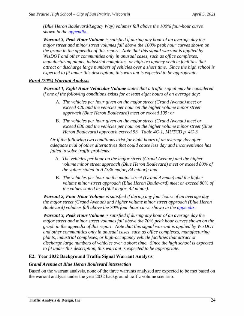
Sun Prairie High School – City of Sun Prairie, Wisconsin April 5, 2021
Traffic Analysis & Design, Inc.
24
(Blue Heron Boulevard/Legacy Way) volumes fall above the 100% four-hour curve shown in the appendix.
Warrant 3, Peak Hour Volume is satisfied if during any hour of an average day the major street and minor street volumes fall above the 100% peak hour curves shown on the graph in the appendix of this report. Note that this signal warrant is applied by WisDOT and other communities only in unusual cases, such as office complexes, manufacturing plants, industrial complexes, or high-occupancy vehicle facilities that attract or discharge large numbers of vehicles over a short time. Since the high school is expected to fit under this description, this warrant is expected to be appropriate.
Rural (70%) Warrant Analysis
Warrant 1, Eight Hour Vehicular Volume states that a traffic signal may be considered if one of the following conditions exists for at least eight hours of an average day:
A. The vehicles per hour given on the major street (Grand Avenue) meet or exceed 420 and the vehicles per hour on the higher volume minor street approach (Blue Heron Boulevard) meet or exceed 105; or
B. The vehicles per hour given on the major street (Grand Avenue) meet or exceed 630 and the vehicles per hour on the higher volume minor street (Blue Heron Boulevard) approach exceed 53. Table 4C-1, MUTCD p. 4C-3.
Or if the following two conditions exist for eight hours of an average day after adequate trial of other alternatives that could cause less day and inconvenience has failed to solve traffic problems:
A. The vehicles per hour on the major street (Grand Avenue) and the higher volume minor street approach (Blue Heron Boulevard) meet or exceed 80% of the values stated in A (336 major, 84 minor); and
B. The vehicles per hour on the major street (Grand Avenue) and the higher volume minor street approach (Blue Heron Boulevard) meet or exceed 80% of the values stated in B (504 major, 42 minor).
Warrant 2, Four Hour Volume is satisfied if during any four hours of an average day the major street (Grand Avenue) and higher volume minor street approach (Blue Heron Boulevard) volumes fall above the 70% four-hour curve shown in the appendix.
Warrant 3, Peak Hour Volume is satisfied if during any hour of an average day the major street and minor street volumes fall above the 70% peak hour curves shown on the graph in the appendix of this report. Note that this signal warrant is applied by WisDOT and other communities only in unusual cases, such as office complexes, manufacturing plants, industrial complexes, or high-occupancy vehicle facilities that attract or discharge large numbers of vehicles over a short time. Since the high school is expected to fit under this description, this warrant is expected to be appropriate.
E2. Year 2032 Background Traffic Signal Warrant Analysis
Grand Avenue at Blue Heron Boulevard intersection
Based on the warrant analysis, none of the three warrants analyzed are expected to be met based on the warrant analysis under the year 2032 background traffic volume scenario.

Sun Prairie High School – City of Sun Prairie, Wisconsin April 5, 2021
Traffic Analysis & Design, Inc.
25
Main Street at Legacy Way intersection
Based on the warrant analysis, none of the three warrants analyzed are expected to be met based on the warrant analysis under the year 2032 background traffic volume scenario.
All data pertaining to this signal warrant analysis are included in the appendix of this report.
E3. Year 2022 Initial Build (Approved School Loading) Traffic Signal Warrant Analysis
Grand Avenue at Blue Heron Boulevard intersection
Based on the warrant analysis, the peak hour warrant is expected to be met based on the warrant analysis under the year 2022 initial build traffic (Approved School Loading) volume scenario under both the urban and rural warrant assumptions. The four-hour warrant is also met under the initial build traffic scenario under the rural warrant assumptions, but this warrant is not met under the urban warrant assumption (only 2 of the required 4 hours met).
Based on the results with the peak hour warrant being easily met for both the weekday morning school arrival and afternoon school discharge peak hours and the four-hour warrant being met under the rural warrant assumptions; traffic signals are recommended at this intersection under the year 2022 initial build traffic (Approved School Loading) volume scenario.
Main Street at Legacy Way intersection
Based on the warrant analysis, none of the three warrants analyzed are expected to be met based on the warrant analysis under the year 2022 initial build traffic (Approved School Loading) volume scenario.
All data pertaining to this signal warrant analysis are included in the appendix of this report.
E4. Year 2032 Full Build (Approved School Loading) Traffic Signal Warrant Analysis
Grand Avenue at Blue Heron Boulevard intersection
Based on the warrant analysis, the peak hour warrant is expected to be met based on the warrant analysis under the year 2032 full build traffic (Approved School Loading) volume scenario under both the urban and rural warrant assumptions. The four-hour warrant is also met under the full build traffic scenario under the rural warrant assumptions, but this warrant is not met under the urban warrant assumption (only 2 of the required 4 hours met).
Based on the results with the peak hour warrant being easily met for both the weekday morning school arrival and afternoon school discharge peak hours and the four-hour warrant being met under the rural warrant assumptions; traffic signals are recommended at this intersection under the year 2032 full build traffic (without access onto STH 19) volume scenario.
Main Street at Legacy Way intersection
Based on the warrant analysis, none of the three warrants analyzed are expected to be met based on the warrant analysis under the year 2032 full build traffic (Approved School Loading) volume scenario.
All data pertaining to this signal warrant analysis are included in the appendix of this report.
E5. Rapid Rectangular Flashing Beacon (RRFB)
The use of some form of pedestrian control treatment was evaluated for the STH 19 intersection at Charlotte’s Way to determine the potential for a pedestrian crossing treatment to improve the safety for both the pedestrian and motoring public at this location. The MUTCD does not include a warrant for the installation of a RRFB. However, WisDOT and many communities allow the installation of a RRFB at pedestrian locations where a marked crossing exists, and

Sun Prairie High School – City of Sun Prairie, Wisconsin April 5, 2021
Traffic Analysis & Design, Inc.
26
higher volumes of pedestrians are present along roadways with speed limits less than 40-mph. For higher speed facilities, a Pedestrian Hybrid Beacon (PHB) can be considered. With a posted speed limit of 45-mph on STH 19 at the potential crossing location, the installation of an RRFB is not recommended by FHWA. Therefore, a RRFB would not be considered a good application for this location.
E6. Pedestrian Hybrid Beacon (PHB) Warrant Analysis
As stated in the previous section due to the higher speed limits on STH 19 at the potential crossing location, a PHB was considered for this location. The MUTCD includes an additional warrant analysis for a pedestrian crossing beacon as described below.
Pedestrian Hybrid Beacon Warrant is satisfied if during any hour of an average day the pedestrian volume crossing the major street and the vehicular volume on the major street fall above the peak hour curve (for 35 mph speed or greater) shown in the Appendix of this report.
As shown in the graphs located in the Appendix of this report, because of the higher peak hour volumes along STH 19, regardless of the roadway width, a minimum of 20 pedestrians in the peak hour would be required for a PHB to be considered. The volume (two-way) of traffic along STH 19 at the crossing location during the weekday morning school arrival and weekday afternoon school discharge peak hours are approximately 1,390 and 1,520 vehicles, respectively. Therefore, based on the MUTCD graph, there would need to be over 20 pedestrians crossing STH 19 during any peak hour of a typical weekday. Since the pedestrian volumes expected are considerably less than this for a typical weekday, the PHB warrant is not expected to be met for this location.
Based on the approved “Sun Prairie Area School District Community Growth and Projections Report”, dated September 28, 2020; the neighborhood located directly north of STH 19 at Charlotte’s Way is expected to have 57 high school students in the opening year and 35 high school students by the future year 2035. Assuming that somewhere between 10-percent and 25-percent of the freshman and sophomore students will walk to school (junior and senior students are likely expected to drive), if all students in this neighborhood crossed at the Charlotte’s Way crossing location, the expected volume of pedestrians crossing STH 19 is expected to range between 6 and 14 in the opening year and drop down to between 4 and 10 pedestrians in the future year. It is noted that the 25-percent threshold is likely a high estimate and used as a worst-case condition. However, it is expected that students on the east side of this neighborhood would likely cross STH 19 at the signalized intersection along Grand Avenue and students on the west side of this neighborhood would likely cross STH 19 near Westmount Drive to the west. Therefore, the calculated pedestrian volumes crossing STH 19 at this location would likely be even less than listed above; specifically, the pedestrian volumes will more likely range between 2 and 7 pedestrians at this location during the typical weekday morning school arrival and afternoon school discharge peak hours. Regardless, the pedestrians expected to cross at this location are expected to be well below the 20-person threshold required for consideration of a PHB.

N
NOT TO SCALE2654; 04/05/21
EXHIBIT 5-2YEAR 2032 BACKGROUND TRAFFIC OPERATIONS
WITHOUT MODIFICATIONS
SUN PRAIRIE, WISCONSIN
Intersection
Level of
LT TH RT LT TH RT LT TH RT LT TH RT Service
LOS - - * *
Delay - - * *
Queue - - * *
LOS - - * *
Delay - - * *
Queue - - * *
LOS - - * *
Delay - - * *
Queue - - * *
LOS - * * - * - B
Delay - * * - * - 14
Queue - * * - * - 0
LOS - * * - * - C
Delay - * * - * - 19
Queue - * * - * - 25
LOS - * * - * - C
Delay - * * - * - 18
Queue - * * - * - 25
LOS C D C C D C E C C E D D
Delay 24 40 29 22 38 23 56 31 29 57 53 38
Queue 105 455 140 95 580 50 370 175 50 155 555 145
LOS C E C D D C F D D F F D
Delay 28 59 33 37 40 29 223 46 40 82 95 55
Queue 135 790 180 110 480 60 670 340 120 125 565 165
LOS C D C C C C F D D E E D
Delay 25 49 31 29 35 26 115 40 36 76 77 52
Queue 125 700 165 95 440 55 600 310 110 120 490 150
LOS B B B B
Delay 16 17 14 11
Queue 25 135 40 50
LOS C C B B
Delay 31 26 15 14
Queue 50 135 65 45
LOS C C B B
Delay 26 23 13 12
Queue 50 125 65 45
LOS B B A A
Delay 12 10 10 9
Queue 25 0 25 25
LOS B B A B
Delay 12 13 10 11
Queue 25 25 25 25
LOS B B A B
Delay 11 13 10 11
Queue 25 25 25 25
LOS A A A A
Delay 9 6 6 9
Queue 25 25 30 60
LOS B B A B
Delay 10 11 8 13
Queue 25 50 60 90
LOS A B A B
Delay 9 11 9 11
Queue 25 45 75 75
LOS A A A
Delay 8 8 9
Queue 0 25 0
LOS A A A
Delay 8 8 9
Queue 0 25 0
LOS A A A
Delay 8 8 9
Queue 0 25 0
Delay recorded in seconds, Queue length recorded in feet (min 25'), rounded to nearest 5'
Roundabout results shown are two lanes on each approach, shared left-turn/thru and shared thru/right-turn
25 65 50 70
25 65 60 60
A B A A
9 12
A B A B
8
10 12 8 11
A
9 7 6 8
25 25 25 50
(-) movement that isn't available or allowed * free flow movement ** Extreme Delays and queues
A* * 13
10
* *
#700 - Main Street
& Legacy Way
Two-Way Stop Control
25
* * 25
PM
* * B
School
PM
* * B
B
A* * 13
A* * 11AM
* * B
* * 25
PM B
B
A
A
#600 - Grand Avenue
& Main Street
Roundabout Control
AM
School
PM
A A
A58 67 * *
25 25 * *
PM
F F * *
School
PM
F F * *
A70 75 * *
25 25 * *
A35 33 * *
25 25 * *
70 180 275 110
#500 - Grand Avenue
& Blue Heron Boulevard
Two-Way Stop Control
AM
E D * *
PM
B C B A
B18 23 18 7
A
B20 27 23 8
70 195 280 105
B13 14 17 7
40 90 150 105
#400 - Grand Avenue
& Ironwood Drive
Traffic Signal Control
AM
B B B A
School
PM
C C C
#300 - Windsor Street (STH 19)
& Grand Avenue
Traffic Signal Control
AM D
School
PME
PM D
PM
- -
A- -
- -
School
PM
- -
A- -
- -
25
#200 - Windsor Street (STH 19)
& Oxford Place
One-Way Stop Control
AM
- -
A- -
- -
PM
A - E
A10 - 41
0 -
A10 - 54
0 - 25
A10 - 35
0 - 25
Southbound
#100 - Windsor Street (STH 19)
& Charlotte's Way
One-Way Stop Control
AM
B - D
School
PM
B - F
Exhibit 5-2
Year 2032 Background Traffic Peak Hour Operating Conditions
Existing Geometrics and Traffic Control
Intersection
Peak
Hour
Level of Service per Movement by Approach
Eastbound Westbound Northbound
13
0
13
0
B
13
0
B

N
NOT TO SCALE2654; 04/05/21
EXHIBIT 5-3YEAR 2022 INITIAL BUILD TRAFFIC OPERATIONS
APPROVED SCHOOL BOUNDARYWITHOUT MODIFICATIONS
SUN PRAIRIE, WISCONSIN
Intersection
Level of
LT TH RT LT TH RT LT TH RT LT TH RT Service
LOS - - * *
Delay - - * *
Queue - - * *
LOS - - * *
Delay - - * *
Queue - - * *
LOS - - * *
Delay - - * *
Queue - - * *
LOS - * * - * - C
Delay - * * - * - 17
Queue - * * - * - 35
LOS - * * - * - C
Delay - * * - * - 19
Queue - * * - * - 25
LOS - * * - * - C
Delay - * * - * - 18
Queue - * * - * - 25
LOS C D C F D C F C C E F D
Delay 30 50 34 258 45 29 81 33 32 70 117 41
Queue 115 525 140 ** 550 45 390 165 105 140 ** 115
LOS C E C D D C F D D F F D
Delay 27 58 33 45 38 28 220 42 39 83 95 53
Queue 110 760 175 190 455 50 670 275 135 110 580 120
LOS C D C C C C F D C E E D
Delay 24 48 31 30 34 26 112 37 35 76 77 50
Queue 100 675 160 120 410 50 600 255 125 105 510 115
LOS B B B B
Delay 17 17 13 10
Queue 50 110 35 45
LOS C C B B
Delay 27 23 14 13
Queue 55 115 50 45
LOS C C B B
Delay 24 21 13 11
Queue 55 115 50 40
LOS B A B A
Delay 14 10 12 9
Queue 25 0 25 0
LOS B B A A
Delay 13 11 10 9
Queue 25 25 25 0
LOS B B A B
Delay 11 12 10 10
Queue 25 25 25 0
LOS A A A A
Delay 9 7 6 9
Queue 25 30 25 55
LOS A B A B
Delay 10 10 9 11
Queue 25 50 55 75
LOS A A A A
Delay 8 9 7 9
Queue 25 40 50 55
LOS A A A
Delay 8 8 10
Queue 25 25 25
LOS A A B
Delay 8 8 10
Queue 25 25 25
LOS A A A
Delay 8 8 9
Queue 0 25 25
Delay recorded in seconds, Queue length recorded in feet (min 25'), rounded to nearest 5'
Roundabout results shown are two lanes on each approach, shared left-turn/thru and shared thru/right-turn
40 45
A A A A
7 8 7 8
9 9 8 10
25 40 45 60
25 25 25 45
A A A A
A A A
8 7 6 8
Exhibit 5-3
Year 2022 Initial (Approved School Boundary) Build Traffic Peak Hour Operating Conditions
Existing Geometrics and Traffic Control
Intersection
Peak
Hour
Level of Service per Movement by Approach
Eastbound Westbound Northbound Southbound
#100 - Windsor Street (STH 19)
& Charlotte's Way
One-Way Stop Control
AM
A - E
School
PM
A - E
A10 - 40
0 - 30
A10 - 42
0 - 25
PM
A - D
A10 - 34
0 - 25
#200 - Windsor Street (STH 19)
& Oxford Place
One-Way Stop Control
AM
- -
A- -
- -
School
PM
- -
A- -
- -
PM
- -
A- -
- -
#300 - Windsor Street (STH 19)
& Grand Avenue
Traffic Signal Control
AM F
School
PME
PM D
#400 - Grand Avenue
& Ironwood Drive
Traffic Signal Control
AM
B B B A
School
PM
B C B
B14 15 16 8
35 95 135 185
A
B19 23 19 8
65 165 240 120
PM
B C B A
B17 21 17 7
#500 - Grand Avenue
& Blue Heron Boulevard
Two-Way Stop Control
AM
F F * *
150 * *
School
PM
65 165 235 110
410 55 * *
F F
F** 270 * *
385
* *
E640 116 * *
*
PM
F F * *
25 35
A64 64 * *
35 25 *
* 35
#600 - Grand Avenue
& Main Street
Roundabout Control
AM
School
PM
A
A
A
PM A
A* * 18
#700 - Main Street
& Legacy Way
Two-Way Stop Control
AM
* * C
*
A* * 15
* * 25
25
PM
* * B
School
PM
* * B
(-) movement that isn't available or allowed * free flow movement ** Extreme Delays and queues
A* * 13
* *
B
13
25
C
25
30
C
17
25

N
NOT TO SCALE2654; 04/05/21
EXHIBIT 5-5YEAR 2032 FULL BUILD TRAFFIC OPERATIONS
APPROVED SCHOOL BOUNDARYWITHOUT MODIFICATIONS
SUN PRAIRIE, WISCONSIN
Intersection
Level of
LT TH RT LT TH RT LT TH RT LT TH RT Service
LOS - - * *
Delay - - * *
Queue - - * *
LOS - - * *
Delay - - * *
Queue - - * *
LOS - - * *
Delay - - * *
Queue - - * *
LOS - * * - * - C
Delay - * * - * - 20
Queue - * * - * - 50
LOS - * * - * - C
Delay - * * - * - 21
Queue - * * - * - 25
LOS - * * - * - C
Delay - * * - * - 20
Queue - * * - * - 25
LOS C D C F D C F D C E F D
Delay 32 51 33 408 48 30 86 36 35 72 193 44
Queue 150 585 140 ** 585 50 405 210 125 160 ** 145
LOS C E C E D C F D D F F E
Delay 29 64 33 60 41 30 233 47 41 84 115 55
Queue 145 ** 180 250 480 60 670 350 135 125 630 165
LOS C D C C D C F D D E F D
Delay 26 52 32 34 35 28 132 41 3 79 84 52
Queue 135 745 165 130 440 55 600 315 125 120 555 150
LOS B B B B
Delay 19 19 15 11
Queue 65 150 45 55
LOS C C B B
Delay 30 25 15 15
Queue 105 110 50 45
LOS C C B B
Delay 27 23 14 12
Queue 60 125 65 45
LOS C B B A
Delay 17 10 15 9
Queue 30 0 40 25
LOS B B B A
Delay 14 12 10 10
Queue 25 25 25 0
LOS B B A B
Delay 12 13 10 11
Queue 25 25 25 25
LOS B A A B
Delay 11 9 7 11
Queue 35 40 35 75
LOS B B B C
Delay 13 13 10 15
Queue 40 75 75 115
LOS A B A B
Delay 9 11 9 11
Queue 25 55 75 75
LOS A A A
Delay 8 8 10
Queue 25 25 25
LOS A A B
Delay 8 8 10
Queue 25 25 25
LOS A A A
Delay 8 8 10
Queue 25 25 25
Delay recorded in seconds, Queue length recorded in feet (min 25'), rounded to nearest 5'
Roundabout results shown are two lanes on each approach, shared left-turn/thru and shared thru/right-turn
(-) movement that isn't available or allowed * free flow movement ** Extreme Delays and queues
35 60 60 90
60 60
A B
*
13
A B
9 12 8 10
10
30 35 30 60
B B A B
Exhibit 5-5
Year 2032 Full (Approved School Boundary) Build Traffic Peak Hour Operating Conditions
Existing Geometrics and Traffic Control
Intersection
Peak
Hour
Level of Service per Movement by Approach
Eastbound Westbound Northbound Southbound
#100 - Windsor Street (STH 19)
& Charlotte's Way
One-Way Stop Control
AM
B - E
School
PM
B - F
A10 - 46
0 - 35
A10 - 54
0 - 25
PM
A - E
A10 - 41
0 - 25
#200 - Windsor Street (STH 19)
& Oxford Place
One-Way Stop Control
AM
- -
A- -
- -
School
PM
- -
A- -
- -
PM
- -
A- -
- -
#300 - Windsor Street (STH 19)
& Grand Avenue
Traffic Signal Control
AM F
School
PME
PM E
#400 - Grand Avenue
& Ironwood Drive
Traffic Signal Control
AM
B B B B
School
PM
B C C
B14 16 17 10
50 110 175 265
A
B20 22 25 10
75 150 275 140
PM
B C B A
B18 22 19 8
70 185 275 125
#500 - Grand Avenue
& Blue Heron Boulevard
Two-Way Stop Control
AM
F F * *
E** ** * *
** 265 * *
F** ** * *
** ** * *
PM
F F * *
School
PM
F F * *
A122 110 * *
65 40 * *
A
A
B
PM B
25 65
A A A
65
#600 - Grand Avenue
& Main Street
Roundabout Control
AM
School
PM
10 8 7
12 12 9
B* * 27
#700 - Main Street
& Legacy Way
Two-Way Stop Control
AM
* * D
*
A* * 18
* * 25
PM
* * B
School
PM
* * C
A* * 14
* * 25
B
14
25
E
41
55
C
21
40

N
NOT TO SCALE2654; 04/05/21
Intersection
Level of
LT TH RT LT TH RT LT TH RT LT TH RT Service
LOS - - * *
Delay - - * *
Queue - - * *
LOS - - * *
Delay - - * *
Queue - - * *
LOS - - * *
Delay - - * *
Queue - - * *
LOS - * * - * - B
Delay - * * - * - 13
Queue - * * - * - 0
LOS - * * - * - C
Delay - * * - * - 17
Queue - * * - * - 25
LOS - * * - * - C
Delay - * * - * - 16
Queue - * * - * - 25
LOS B C C B C B C C C D D C
Delay 15 29 22 15 25 16 29 21 20 36 37 35
Queue 60 340 115 70 410 35 185 95 30 105 180 95
LOS B D C C C B D C C D D D
Delay 19 48 27 24 28 20 49 28 26 49 54 48
Queue 75 645 155 80 350 40 315 170 75 85 190 95
LOS B C C B C B D C C D D D
Delay 16 34 24 19 23 18 38 29 27 48 51 48
Queue 85 610 160 85 365 45 350 100 90 100 230 115
LOS B B B A
Delay 16 16 12 10
Queue 25 100 35 45
LOS C C B B
Delay 25 22 13 12
Queue 45 110 50 45
LOS C B B B
Delay 22 20 12 10
Queue 45 105 50 45
LOS B A A A
Delay 11 10 9 8
Queue 25 0 25 0
LOS B B A A
Delay 11 12 9 10
Queue 25 25 0 0
LOS B B A A
Delay 11 12 9 10
Queue 25 25 0 0
LOS A A A A
Delay 7 6 6 7
Queue 25 25 25 45
LOS A A A A
Delay 8 9 7 9
Queue 25 35 45 60
LOS A A A A
Delay 7 9 8 8
Queue 25 35 50 50
LOS A A A
Delay 8 8 9
Queue 0 25 0
LOS A A A
Delay 8 8 9
Queue 0 25 0
LOS A A A
Delay 8 8 9
Queue 0 25 0
Roundabout results shown are two lanes on each approach, shared left-turn/thru and shared thru/right-turn
12
0
12
0
B
12
0
B
(-) movement that isn't available or allowed * free flow movement ** Extreme Delays and queues
Delay recorded in seconds, Queue length recorded in feet (min 25'), rounded to nearest 5'
A* * 12
* * 25
#700 - Main Street
& Legacy Way
One-Way Stop Control * 25
PM
* * B
School
PM
* *
A* * 12
A* * 11
*
*
B
25 30 45 40
B
AM
* * B
PM
A A A
* 25
A
A7 8 7 7
A
A7 8 7 8
25 30 35 50
A7 6 5 7
25 25 25 35
#600 - Grand Avenue
& Main Street
Roundabout Control
AM
A A A A
School
PM
A A A
A38 46 * *
25 25 * *
*
PM
E E * *
School
PM
E F * *
A43 51 * *
25 25 *
A26 24 * *
25 25 * *
60 160 220 105
#500 - Grand Avenue
& Blue Heron Boulevard
Two-Way Stop Control
AM
D C * *
PM
B C B A
B17 20 16 6
A
B18 22 18 7
65 160 235 110
B13 15 14 6
30 85 110 80
#400 - Grand Avenue
& Ironwood Drive
Traffic Signal Control
AM
B B B A
School
PM
B C B
#300 - Windsor Street (STH 19)
& Grand Avenue
Traffic Signal Control
AM C
School
PMD
PM C
PM
- -
A- -
- -
School
PM
- -
A- -
- -
25
#200 - Windsor Street (STH 19)
& Oxford Place
One-Way Stop Control
AM
- -
A- -
- -
PM
A - D
A9 - 33
0 -
A10 - 40
0 - 25
A10 - 30
0 - 25
Southbound
#100 - Windsor Street (STH 19)
& Charlotte's Way
One-Way Stop Control
AM
A - D
School
PM
A - E
Exhibit 5-9
Existing Traffic Peak Hour Operating Conditions
Modified Geometrics and Traffic Control
Intersection
Peak
Hour
Level of Service per Movement by Approach
Eastbound Westbound Northbound
EXHIBIT 5-9EXISTING TRAFFIC OPERATIONS
WITH MODIFICATIONS
SUN PRAIRIE, WISCONSIN

N
NOT TO SCALE2654; 04/05/21
EXHIBIT 5-10YEAR 2022 BACKGROUND TRAFFIC OPERATIONS
WITH MODIFICATIONS
SUN PRAIRIE, WISCONSIN
Intersection
Level of
LT TH RT LT TH RT LT TH RT LT TH RT Service
LOS - - * *
Delay - - * *
Queue - - * *
LOS - - * *
Delay - - * *
Queue - - * *
LOS - - * *
Delay - - * *
Queue - - * *
LOS - * * - * - B
Delay - * * - * - 13
Queue - * * - * - 0
LOS - * * - * - C
Delay - * * - * - 17
Queue - * * - * - 25
LOS - * * - * - C
Delay - * * - * - 16
Queue - * * - * - 25
LOS B C C B C B C C C D D D
Delay 16 30 22 15 25 16 29 22 21 37 38 36
Queue 65 355 120 75 425 35 195 100 35 110 185 100
LOS B D C C C B D C C D D D
Delay 19 49 27 25 28 20 50 28 26 50 54 49
Queue 80 670 155 80 355 40 310 180 80 85 185 105
LOS B C C B C B D C C D D D
Delay 16 34 23 19 23 17 39 30 28 50 52 50
Queue 85 620 155 90 360 45 355 215 95 105 225 130
LOS B B B A
Delay 16 16 12 10
Queue 25 110 35 45
LOS C C B B
Delay 27 23 13 12
Queue 45 115 55 45
LOS C C B B
Delay 23 20 12 10
Queue 45 110 50 45
LOS B A A A
Delay 11 10 9 9
Queue 25 0 25 0
LOS B B A B
Delay 11 12 9 10
Queue 25 25 0 0
LOS B B A B
Delay 11 12 9 10
Queue 25 25 0 0
LOS A A A A
Delay 8 6 6 8
Queue 25 25 25 45
LOS A A A A
Delay 8 9 7 10
Queue 25 40 50 65
LOS A A A A
Delay 7 9 8 9
Queue 25 40 55 55
LOS A A A
Delay 8 8 9
Queue 0 25 0
LOS A A A
Delay 8 8 9
Queue 0 25 0
LOS A A A
Delay 8 8 9
Queue 0 25 0
Delay recorded in seconds, Queue length recorded in feet (min 25'), rounded to nearest 5'
Roundabout results shown are two lanes on each approach, shared left-turn/thru and shared thru/right-turn
0
12
0
B
12
0
B
(-) movement that isn't available or allowed * free flow movement ** Extreme Delays and queues
A* * 12
* * 25
#700 - Main Street
& Legacy Way
Two-Way Stop Control
12
* 25
PM
* * B
School
PM
* *
A* * 12
A* * 11
*
*
B
25 35 45 45
B
AM
* * B
PM
A A A
* 25
A
A7 9 7 8
A
A8 9 7 9
25 35 40 50
A7 6 6 7
25 25 25 40
#600 - Grand Avenue
& Main Street
Roundabout Control
AM
A A A A
School
PM
A A A
A45 50 * *
25 25 * *
*
PM
E E * *
School
PM
F F * *
A53 56 * *
25 25 *
A27 25 * *
25 25 * *
60 160 235 100
#500 - Grand Avenue
& Blue Heron Boulevard
Two-Way Stop Control
AM
D D * *
PM
B C B A
B17 21 16 6
A
B19 23 18 7
65 165 240 105
B13 15 15 6
30 85 120 85
#400 - Grand Avenue
& Ironwood Drive
Traffic Signal Control
AM
B B B A
School
PM
B C B
#300 - Windsor Street (STH 19)
& Grand Avenue
Traffic Signal Control
AM D
School
PMD
PM C
PM
- -
A- -
- -
School
PM
- -
A- -
- -
25
#200 - Windsor Street (STH 19)
& Oxford Place
One-Way Stop Control
AM
- -
A- -
- -
PM
A - D
A10 - 34
0 -
A10 - 42
0 - 25
A10 - 32
0 - 25
Southbound
#100 - Windsor Street (STH 19)
& Charlotte's Way
One-Way Stop Control
AM
A - D
School
PM
A - E
Exhibit 5-10
Year 2022 Background Traffic Peak Hour Operating Conditions
Modified Geometrics and Traffic Control
Intersection
Peak
Hour
Level of Service per Movement by Approach
Eastbound Westbound Northbound
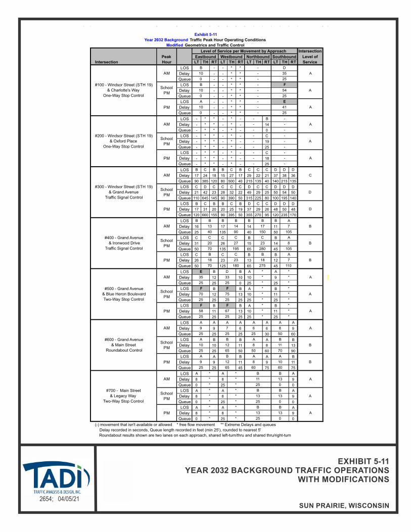
N
NOT TO SCALE2654; 04/05/21
EXHIBIT 5-11YEAR 2032 BACKGROUND TRAFFIC OPERATIONS
WITH MODIFICATIONS
SUN PRAIRIE, WISCONSIN
Intersection
Level of
LT TH RT LT TH RT LT TH RT LT TH RT Service
LOS - - * *
Delay - - * *
Queue - - * *
LOS - - * *
Delay - - * *
Queue - - * *
LOS - - * *
Delay - - * *
Queue - - * *
LOS - * * - * - B
Delay - * * - * - 14
Queue - * * - * - 0
LOS - * * - * - C
Delay - * * - * - 19
Queue - * * - * - 25
LOS - * * - * - C
Delay - * * - * - 18
Queue - * * - * - 25
LOS B C B B C B C C C D D D
Delay 17 24 18 15 27 17 29 22 21 37 38 36
Queue 90 385 120 80 500 40 215 135 40 140 215 135
LOS C D C C C C D C C D D D
Delay 21 42 23 28 32 22 49 29 25 50 54 50
Queue 110 645 145 90 390 50 315 225 80 100 195 140
LOS B C B B C B D C C D D D
Delay 17 31 20 20 25 19 37 29 26 48 50 48
Queue 120 660 155 90 395 50 355 270 95 120 235 170
LOS B B B B
Delay 16 17 14 11
Queue 25 135 40 50
LOS C C B B
Delay 31 26 15 14
Queue 50 135 65 45
LOS C C B B
Delay 26 23 13 12
Queue 50 125 65 45
LOS B B A A
Delay 12 10 10 9
Queue 25 0 25 25
LOS B B A B
Delay 12 13 10 11
Queue 25 25 25 25
LOS B B A B
Delay 11 13 10 11
Queue 25 25 25 25
LOS A A A A
Delay 9 6 6 9
Queue 25 25 30 60
LOS B B A B
Delay 10 11 8 13
Queue 25 50 60 90
LOS A B A B
Delay 9 11 9 11
Queue 25 45 75 75
LOS A A A
Delay 8 8 9
Queue 0 25 0
LOS A A A
Delay 8 8 9
Queue 0 25 0
LOS A A A
Delay 8 8 9
Queue 0 25 0
Delay recorded in seconds, Queue length recorded in feet (min 25'), rounded to nearest 5'
Roundabout results shown are two lanes on each approach, shared left-turn/thru and shared thru/right-turn
* 25
PM
* * B
(-) movement that isn't available or allowed * free flow movement ** Extreme Delays and queues
A* * 13
*
* * B
A* * 13
* * 25
A* * 11
* * 25
B
25 65 60 60
#700 - Main Street
& Legacy Way
Two-Way Stop Control
AM
* * B
School
PM
PM
A B A A
B9 12 8 10
B
B10 12 8 11
25 65 50 70
A9 7 6 8
25 25 25 50
#600 - Grand Avenue
& Main Street
Roundabout Control
AM
A A A A
School
PM
A B A
A58 67 * *
25 25 * *
PM
F F * *
School
PM
F F * *
A70 75 * *
25 25 * *
A35 33 * *
25 25 * *
70 180 275 110
#500 - Grand Avenue
& Blue Heron Boulevard
Two-Way Stop Control
AM
E D * *
PM
B C B A
B18 23 18 7
A
B20 27 23 8
70 195 280 105
B13 14 17 7
40 90 150 105
#400 - Grand Avenue
& Ironwood Drive
Traffic Signal Control
AM
B B B A
School
PM
C C C
#300 - Windsor Street (STH 19)
& Grand Avenue
Traffic Signal Control
AM C
School
PMD
PM D
PM
- -
A- -
- -
School
PM
- -
A- -
- -
25
#200 - Windsor Street (STH 19)
& Oxford Place
One-Way Stop Control
AM
- -
A- -
- -
PM
A - E
A10 - 41
0 -
A10 - 54
0 - 25
A10 - 35
0 - 25
Southbound
#100 - Windsor Street (STH 19)
& Charlotte's Way
One-Way Stop Control
AM
B - D
School
PM
B - F
Exhibit 5-11
Year 2032 Background Traffic Peak Hour Operating Conditions
Modified Geometrics and Traffic Control
Intersection
Peak
Hour
Level of Service per Movement by Approach
Eastbound Westbound Northbound
13
0
13
0
B
13
0
B
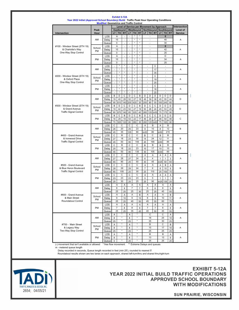
N
NOT TO SCALE2654; 04/05/21
EXHIBIT 5-12AYEAR 2022 INITIAL BUILD TRAFFIC OPERATIONS
APPROVED SCHOOL BOUNDARYWITH MODIFICATIONS
SUN PRAIRIE, WISCONSIN
Intersection
Level of
LT TH RT LT TH RT LT TH RT LT TH RT Service
LOS - - * *
Delay - - * *
Queue - - * *
LOS - - * *
Delay - - * *
Queue - - * *
LOS - - * *
Delay - - * *
Queue - - * *
LOS - * * - * - C
Delay - * * - * - 17
Queue - * * - * - 35
LOS - * * - * - C
Delay - * * - * - 19
Queue - * * - * - 25
LOS - * * - * - C
Delay - * * - * - 18
Queue - * * - * - 25
LOS B D C D C B D D D D D D
Delay 19 40 28 52 27 18 49 39 38 45 55 44
Queue 95 610 140 205 420 35 205 80 55 100 245 85
LOS B D C D C B D C C D D D
Delay 19 42 23 52 27 19 50 26 24 45 53 45
Queue 80 670 140 85 325 40 285 120 m55 75 175 90
LOS B C B D C B D C C D D D
Delay 16 29 19 53 22 17 49 29 27 46 54 46
Queue 70 505 120 80 280 35 260 120 m60 75 165 90
LOS C C A A
Delay 26 25 9 8
Queue 45 105 m20 m50
LOS C C B B
Delay 27 23 14 12
Queue 45 95 45 m50
LOS C C B B
Delay 25 22 10 10
Queue 45 90 30 m30
LOS C C A A A A
Delay 27 27 6 1 1 3
Queue 65 25 30 m25 50 65
LOS C C A A B A
Delay 28 29 7 8 10 9
Queue 85 25 25 25 150 70
LOS C C A A A A
Delay 23 23 5 1 1 1
Queue 25 25 25 m25 135 25
LOS A A A A
Delay 9 7 6 9
Queue 25 30 25 55
LOS A B A B
Delay 10 10 9 11
Queue 25 50 55 75
LOS A A A A
Delay 8 9 7 9
Queue 25 40 50 55
LOS A A A
Delay 8 8 10
Queue 25 25 25
LOS A A B
Delay 8 8 10
Queue 25 25 25
LOS A A A
Delay 8 8 9
Queue 0 25 25
m - metered queue length
Roundabout results shown are two lanes on each approach, shared left-turn/thru and shared thru/right-turn
Delay recorded in seconds, Queue length recorded in feet (min 25'), rounded to nearest 5'
30 25
C
29 24
105 30
C C
(-) movement that isn't available or allowed * free flow movement ** Extreme Delays and queues
C C
28 24
90 50
C
* *
A* * 13
* * 25
13
25
BB
School
PM
* * B
A* * 15
* * 25
C
17
25
A
C
25
30
* * 18
* * 35
35 40 45
#700 - Main Street
& Legacy Way
Two-Way Stop Control
AM
* * C
PM
PM
A A A A
A7 8 7 8
25
A
A9 9 8 10
25 40 45 60
A8 7 6 8
25 25 25 45
#600 - Grand Avenue
& Main Street
Roundabout Control
AM
A A A A
School
PM
A A A
A5
90
23
110
PM
A
23
School
PM
A
B6
A4
45
50 135 105 60
#500 - Grand Avenue
& Blue Heron Boulevard
Traffic Signal Control
AM
A
PM
B C B
#400 - Grand Avenue
& Ironwood Drive
Traffic Signal Control
AM
C
B
B18 23 17 10
B18 30 24 11
50 155 190 85
B20 23 10 12
35 90 80 215
C B B
School
PM
B C C B
#300 - Windsor Street (STH 19)
& Grand Avenue
Traffic Signal Control
AM D
School
PMD
PM C
PM
- -
A- -
- -
School
PM
- -
A- -
- -
25
#200 - Windsor Street (STH 19)
& Oxford Place
One-Way Stop Control
AM
- -
A- -
- -
PM
A - D
A10 - 34
0 -
A10 - 42
0 - 25
A10 - 40
0 - 30
Southbound
#100 - Windsor Street (STH 19)
& Charlotte's Way
One-Way Stop Control
AM
A - E
School
PM
A - E
Exhibit 5-12A
Year 2022 Initial (Approved School Boundary) Build Traffic Peak Hour Operating Conditions
Modified Geometrics and Traffic Control
Intersection
Peak
Hour
Level of Service per Movement by Approach
Eastbound Westbound Northbound
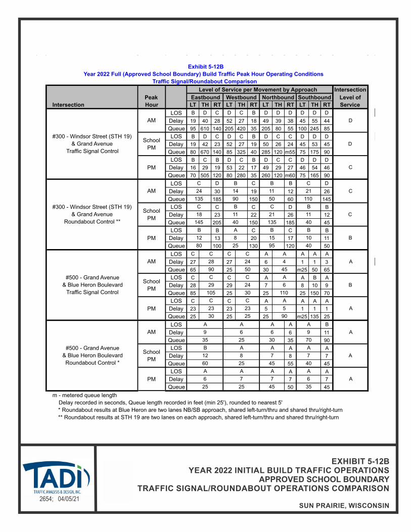
N
NOT TO SCALE2654; 04/05/21
EXHIBIT 5-12BYEAR 2022 INITIAL BUILD TRAFFIC OPERATIONS
APPROVED SCHOOL BOUNDARYTRAFFIC SIGNAL/ROUNDABOUT OPERATIONS COMPARISON
SUN PRAIRIE, WISCONSIN
Intersection
Level of
LT TH RT LT TH RT LT TH RT LT TH RT Service
LOS B D C D C B D D D D D D
Delay 19 40 28 52 27 18 49 39 38 45 55 44
Queue 95 610 140 205 420 35 205 80 55 100 245 85
LOS B D C D C B D C C D D D
Delay 19 42 23 52 27 19 50 26 24 45 53 45
Queue 80 670 140 85 325 40 285 120 m55 75 175 90
LOS B C B D C B D C C D D D
Delay 16 29 19 53 22 17 49 29 27 46 54 46
Queue 70 505 120 80 280 35 260 120 m60 75 165 90
LOS D C B D
Delay 30 19 12 26
Queue 185 150 60 145
LOS C C D B
Delay 23 22 26 12
Queue 205 150 185 45
LOS B C C B
Delay 13 20 17 11
Queue 100 130 120 50
LOS C C A A A A
Delay 27 27 6 1 1 3
Queue 65 25 30 m25 50 65
LOS C C A A B A
Delay 28 29 7 8 10 9
Queue 85 25 25 25 150 70
LOS C C A A A A
Delay 23 23 5 1 1 1
Queue 25 25 25 m25 135 25
LOS A B
Delay 6 11
Queue 35 90
LOS A A
Delay 8 7
Queue 55 45
LOS A A
Delay 7 7
Queue 50 45
m - metered queue length
* Roundabout results at Blue Heron are two lanes NB/SB approach, shared left-turn/thru and shared thru/right-turn
** Roundabout results at STH 19 are two lanes on each approach, shared left-turn/thru and shared thru/right-turn
25 25 45 35
Delay recorded in seconds, Queue length recorded in feet (min 25'), rounded to nearest 5'
PM
A A A A
A6 7 7 6
A
A12 8 7 7
60 25 45 40
A
A9 6 6 9
35 25 30 70
90
#500 - Grand Avenue
& Blue Heron Boulevard
Roundabout Control *
AM
A A A
School
PM
B A A
PM
C C A
A23 23 5
30 25
C C A
B29 24 6
105 30 110
A28 24 4
90 50 45
80 25 95 40
#500 - Grand Avenue
& Blue Heron Boulevard
Traffic Signal Control
AM
C C A
School
PM
PM
B A B B
B12 8 15 10
B
C18 11 21 11
145 40 135 40
C24 14 11 21
135 90 50 110
#300 - Windsor Street (STH 19)
& Grand Avenue
Roundabout Control **
AM
C B B C
School
PM
C B C
Southbound
#300 - Windsor Street (STH 19)
& Grand Avenue
Traffic Signal Control
AM D
School
PMD
PM C
Exhibit 5-12B
Year 2022 Full (Approved School Boundary) Build Traffic Peak Hour Operating Conditions
Traffic Signal/Roundabout Comparison
Intersection
Peak
Hour
Level of Service per Movement by Approach
Eastbound Westbound Northbound

N
NOT TO SCALE2654; 04/05/21
EXHIBIT 5-14AYEAR 2032 FULL BUILD TRAFFIC OPERATIONS
APPROVED SCHOOL BOUNDARYWITH MODIFICATIONS
SUN PRAIRIE, WISCONSIN
Intersection
Level of
LT TH RT LT TH RT LT TH RT LT TH RT Service
LOS - - * *
Delay - - * *
Queue - - * *
LOS - - * *
Delay - - * *
Queue - - * *
LOS - - * *
Delay - - * *
Queue - - * *
LOS - * * - * - C
Delay - * * - * - 20
Queue - * * - * - 50
LOS - * * - * - C
Delay - * * - * - 21
Queue - * * - * - 25
LOS - * * - * - C
Delay - * * - * - 20
Queue - * * - * - 25
LOS C C C D C C D D C D D D
Delay 22 34 31 55 33 21 46 29 20 44 55 43
Queue 130 260 150 235 490 40 175 100 25 110 275 105
LOS C C C D C C C A A D D D
Delay 23 28 25 54 32 22 33 9 7 46 54 45
Queue 115 260 145 90 360 45 m270 155 m50 95 185 125
LOS B C B D C B C B A D D D
Delay 17 31 11 41 25 19 32 14 8 47 52 46
Queue 105 235 135 85 340 45 m160 135 m40 85 170 115
LOS C C B B
Delay 24 24 19 11
Queue 60 130 m25 m60
LOS D C B B
Delay 54 27 15 11
Queue 110 115 m30 m45
LOS C C B B
Delay 27 23 11 11
Queue 50 120 30 35
LOS C C A A A A
Delay 27 27 7 2 3 7
Queue 100 25 40 m25 80 110
LOS C C A A A A
Delay 23 24 8 3 4 4
Queue 105 25 25 m25 150 m80
LOS C C A A A A
Delay 23 23 6 1 1 1
Queue 25 25 25 m25 125 m25
LOS B A A B
Delay 11 9 7 11
Queue 35 40 35 75
LOS B B B C
Delay 13 13 10 15
Queue 40 75 75 115
LOS A B A B
Delay 9 11 9 11
Queue 25 55 75 75
LOS A A A
Delay 8 8 10
Queue 25 25 25
LOS A A B
Delay 8 8 10
Queue 25 25 25
LOS A A A
Delay 8 8 10
Queue 25 25 25
m - metered queue length
Roundabout results shown are two lanes on each approach, shared left-turn/thru and shared thru/right-turn
Delay recorded in seconds, Queue length recorded in feet (min 25'), rounded to nearest 5'
55
C
21
40
B
(-) movement that isn't available or allowed * free flow movement ** Extreme Delays and queues
#700 - Main Street
& Legacy Way
Two-Way Stop Control
AM
*
19
110 30
C C
23 22
30 23
125 60
C B
Exhibit 5-14A
Year 2032 Full (Approved School Boundary) Build Traffic Peak Hour Operating Conditions
Modified Geometrics and Traffic Control
Intersection
Peak
Hour
Level of Service per Movement by Approach
Eastbound Westbound Northbound Southbound
#100 - Windsor Street (STH 19)
& Charlotte's Way
One-Way Stop Control
AM
B - E
School
PM
B - F
A10 - 46
0 - 35
A10 - 54
0 - 25
PM
A - E
A10 - 41
0 - 25
#200 - Windsor Street (STH 19)
& Oxford Place
One-Way Stop Control
AM
- -
A- -
- -
School
PM
- -
A- -
- -
PM
- -
A- -
- -
#300 - Windsor Street (STH 19)
& Grand Avenue
Traffic Signal Control
AM D
School
PMC
PM C
#400 - Grand Avenue
& Ironwood Drive
Traffic Signal Control
AM
B C B B
School
PM
C D C
B19 21 17 19
45 95 100 260
A
C20 38 26 7
65 155 160 65
PM
B C B A
B18 30 20 7
60 185 120 55
#500 - Grand Avenue
& Blue Heron Boulevard
Traffic Signal Control
AM
A
PM
A
School
PM
A5
55
C
A
A724
120
C
#600 - Grand Avenue
& Main Street
Roundabout Control
AM
A A A
25
35 30
10 8
A5
105
A
35 60 60 90
A
35
B
7 10
30
School
PM
B B A B
60
14
B12 12 9 13
25 65 60 60
* * C
65
E
41
PM
A B A
*
B
D
9 12 8 10
*
PM
*
25
School
PM
*
* 25
A
*
B* * 27
*
14*
*
A* * 18
* *
25
B

N
NOT TO SCALE2654; 04/05/21
EXHIBIT 5-14BYEAR 2032 FULL BUILD TRAFFIC OPERATIONS
APPROVED SCHOOL BOUNDARYTRAFFIC SIGNAL/ROUNDABOUT OPERATIONS COMPARISON
SUN PRAIRIE, WISCONSIN
Intersection
Level of
LT TH RT LT TH RT LT TH RT LT TH RT Service
LOS C C C D C C D D C D D D
Delay 22 34 31 55 33 21 46 29 20 44 55 43
Queue 130 260 150 235 490 40 175 100 25 110 275 105
LOS C C C D C C C A A D D D
Delay 23 28 25 54 32 22 33 9 7 46 54 45
Queue 115 260 145 90 360 45 m270 155 m50 95 185 125
LOS B C B D C B C B A D D D
Delay 17 31 11 41 25 19 32 14 8 47 52 46
Queue 105 235 135 85 340 45 m160 135 m40 85 170 115
LOS C D B D B B A C D A
Delay 24 30 13 29 11 13 7 23 29 8
Queue 120 160 45 220 50 60 25 115 150 25
LOS B C B C C D B B B A
Delay 15 18 10 23 21 26 10 11 12 7
Queue 105 140 55 135 125 165 45 35 45 25
LOS B B A C C C A A A A
Delay 10 11 7 17 16 19 7 9 10 7
Queue 60 75 30 85 95 125 25 30 40 25
LOS C C A A A A
Delay 27 27 7 2 3 7
Queue 100 25 40 m25 80 110
LOS C C A A A A
Delay 23 24 8 3 4 4
Queue 105 25 25 m25 150 m80
LOS C C A A A A
Delay 23 23 6 1 1 1
Queue 25 25 25 m25 125 m25
LOS A B
Delay 7 14
Queue 45 135
LOS A A
Delay 10 8
Queue 75 55
LOS A A
Delay 8 7
Queue 65 50
m - metered queue length
* Roundabout results at Blue Heron are two lanes NB/SB approach, shared left-turn/thru and shared thru/right-turn
** Roundabout results at STH 19 are two lanes with by-pass lane on NB/SB/EB approaches
8
25
A
8
25
A
9
25
25
B
12
55
C
17
95
Delay recorded in seconds, Queue length recorded in feet (min 25'), rounded to nearest 5'
#500 - Grand Avenue
& Blue Heron Boulevard
Roundabout Control *
AM
A B
A
7
55
A
7PM
A
School
PM
A
A79
60
A
A
A
A
A6
40
45
B12
100
7
105
35
A24 19 7
110 30 120
C B A
A30 23 5
125 60 55
A
School
PM
23 22 5
35 25
PM
C C
#300 - Windsor Street (STH 19)
& Grand Avenue
Traffic Signal Control
AM
#500 - Grand Avenue
& Blue Heron Boulevard
Traffic Signal Control
AM
C C
PM B
C
C
#300 - Windsor Street (STH 19)
& Grand Avenue
Roundabout Control **
AM
School
PM
D
School
PMC
PM C
Exhibit 5-14B
Year 2032 Full (Approved School Boundary) Build Traffic Peak Hour Operating Conditions
Traffic Signal/Roundabout Comparison
Intersection
Peak
Hour
Level of Service per Movement by Approach
Eastbound Westbound Northbound
C
Southbound
15
70
22
160
C
19
105
B

Sun Prairie High School – City of Sun Prairie, Wisconsin April 5, 2021
Traffic Analysis & Design, Inc.
27
CHAPTER VI – RECOMMENDATIONS AND CONCLUSION
PART A – RECOMMENDATIONS
The study area intersections were analyzed based on the procedures set forth in the 2010 Highway Capacity Manual (HCM). Intersection operation is defined by “level of service”. Level of Service (LOS) is a quantitative measure that refers to the overall quality of flow at an intersection ranging from very good, represented by LOS ‘A’, to very poor, represented by LOS ‘F’. For the purpose of this study, LOS D or better was used to define acceptable peak hour operating conditions.
A1. Existing Traffic – Recommended Modifications
The existing traffic volumes do not include the proposed high school and are based on the turning movement counts taken as part of this study. The analysis was conducted using existing intersection geometrics, traffic control and traffic signal timings. The following modifications, shown in Exhibit 1-3, are recommended to accommodate the existing traffic volumes. Modifications are for jurisdictional consideration and are not legally binding. The City of Sun Prairie and the WisDOT reserve the right to determine alternative solutions.
STH 19 & Grand Avenue Adjust the existing traffic signal timings.
Provide protected/permitted left turn phasing for the northbound movements and permitted (flashing yellow) phasing for the southbound movements.
Provide a dedicated left-turn lane, two through lanes and a dedicated right-turn lane on the north approach. [Addition of one through lane]
Extend the left-turn lane on the south and west approaches as shown on Exhibit 1-3.
The southbound movements at the STH 19 intersection with Charlotte’s Way are expected to continue to operate unacceptably during the weekday afternoon school discharge and weekday evening peak hours. It is expected that if delays become excessive for these movements, frequent drivers will utilize the eastern neighborhood access connection to Grand Avenue at Whytecliff Way. Consideration could be given to providing a dedicated right-turn lane to allow right-turn vehicles to exit the residential neighborhood with less delay as they would not be required to wait behind a left-turning vehicle to make their intended movement. However, it is expected that gaps created by the existing traffic signal located immediately to the east along STH 19 at Grand Avenue are allowing this intersection to operate better than reflected in the modeling software; therefore, this intersection should be monitored and modifications should be considered as delays increase.
Adding a southbound through lane, adjusting the traffic signal timings and phasing, and extending turn bay lengths at the STH 19 intersection with Grand Avenue is expected to improve operations at this intersection. It is noted that the extension of the northbound left-turn lane is needed to allow all left-turning vehicles to exit the through lane; thereby allowing northbound through vehicles to continue unhindered. Currently backups in the northbound left-turn lane are being experienced during the typical weekday evening commuter peak period and these backups are expected to worsen over time. Extensions of the eastbound left-turn is recommended based on the expected queue lengths for the eastbound through movement. Extending the left-turn lane as recommended is expected to allow left-turning vehicles to enter the left-turn lane based on a 50th percentile queue length for the through movements.
Sun Prairie High School – City of Sun Prairie, Wisconsin April 5, 2021
Traffic Analysis & Design, Inc.
28
The eastbound and westbound left-turn and through movements at the Grand Avenue intersection with Blue Heron Boulevard are expected to continue to operate unacceptably during the weekday afternoon school discharge and weekday evening peak hours. With the western approach of this intersection operating as one of two main driveways to the existing elementary school, it is expected that these delays are due to the typical school “surge” during the afternoon school traffic. Regardless, with dedicated left- and right-turn lanes currently existing on the west approach at this stop-controlled intersection, without restricting eastbound and westbound left-turn movements; no additional geometric modifications are expected to be available since a traffic signal warrant analysis was completed based on projected future traffic volumes and traffic signal warrants are not expected to be met under background traffic conditions, even in the design year. This intersection should be monitored and a higher level of traffic control such as traffic signal control should be considered once traffic volumes reach a level where traffic signals are warranted.
Except as noted, all intersections are expected to operate acceptably under the existing traffic volumes with these recommended modifications.
A2. Year 2022 Background Traffic – Recommended Modifications
Year 2022 background traffic volumes do not include the proposed high school; however, they do include background growth based on the WisDOT provided traffic projections. The analysis was conducted using existing intersection geometrics, traffic control and traffic signal timings. No additional modifications, shown in Exhibit 1-4, above and beyond the existing traffic recommended modifications, are recommended to accommodate the Year 2022 background traffic volumes. Modifications are for jurisdictional consideration and are not legally binding. The City of Sun Prairie and the WisDOT reserve the right to determine alternative solutions.
Except as noted, all intersections are expected to operate acceptably under the year 2022 background traffic volumes with these recommended modifications.
A3. Year 2032 Background Traffic – Recommended Modifications
Year 2032 background traffic volumes do not include the proposed high school; however, they do include background growth based on the WisDOT provided traffic projections. The analysis was conducted using existing intersection geometrics, traffic control and traffic signal timings. No additional modifications, shown in Exhibit 1-5, above and beyond the existing traffic or year 2022 background traffic recommended modifications, are recommended to accommodate the Year 2032 background traffic volumes. Modifications are for jurisdictional consideration and are not legally binding. The City of Sun Prairie and the WisDOT reserve the right to determine alternative solutions.
Except as noted, all intersections are expected to operate acceptably under the Year 2032 background traffic volumes with these recommended modifications.
A4. Year 2022 Initial Build Traffic – Recommended Modifications
Year 2022 initial build traffic volumes include the initial build out of the proposed high school site which includes the target student population at the school. The following additional modifications, shown in Exhibit 1-6, above and beyond the existing traffic or Year 2022 background traffic recommended modifications, are recommended to accommodate the Year 2022 initial build traffic volumes. Modifications are for jurisdictional consideration and are not legally binding. The City of Sun Prairie and the WisDOT reserve the right to determine alternative solutions.

Sun Prairie High School – City of Sun Prairie, Wisconsin April 5, 2021
Traffic Analysis & Design, Inc.
29
STH 19 & Grand Avenue Adjust the existing traffic signal timings.
Coordinate traffic signal timings with adjacent intersections to the south along Grand Avenue.
Provide protected left-turn phasing for the westbound left-turn movements.
Extend the dedicated right-turn lane on the west approach back to Oxford Place.
Provide dual left-turn lanes, a dedicated through lane and a dedicated right-turn lane on the east approach. [Addition of one left-turn lane]
ALTERNATE MODIFICATION: Provide dual lane roundabout control with dual lane entry for all approaches.
Grand Avenue & Blue Heron Boulevard Provide fully actuated traffic signal control with protected/permitted left turn
phasing for the northbound movements.
Provide a dedicated left-turn lane and a shared through/right-turn lane on the east and west approaches. [Switch lane configurations from current shared through/left-turn lane and dedicated right-turn lane utilizing pavement marking]
Provide a dedicated left-turn lane, two through lanes and a dedicated right-turn lane on the north approach. [Addition of one right-turn lane]
ALTERNATE MODIFICATION: Provide multi-lane roundabout control with dual lane entry for the northbound/southbound approaches and single lane entry for the eastbound/westbound approaches.
The southbound movements at the STH 19 intersection with Charlotte’s Way are expected to continue to operate unacceptably during the weekday morning and weekday afternoon school discharge peak hours with delays expected to be approximately 7 seconds higher than the acceptable delay for the southbound movements under background traffic conditions. It is expected that if delays become excessive for these movements, frequent drivers will utilize the eastern neighborhood access connection to Grand Avenue at Whytecliff Way. Consideration could be given to providing a dedicated right-turn lane to allow right-turn vehicles to exit the residential neighborhood with less delay as they would not be required to wait behind a left-turning vehicle to make their intended movement. However, it is expected that gaps created by the existing traffic signal located immediately to the east along STH 19 at Grand Avenue are allowing this intersection to operate better than reflected in the modeling software; therefore, this intersection should be monitored and modifications should be considered as delays increase.
The use of some form of pedestrian control treatment was evaluated for the STH 19 intersection at Charlotte’s Way to determine the potential for a pedestrian crossing treatment to improve the safety for both the pedestrian and motoring public at this location. Since the speed limit on STH 19 is greater than 35-mph, a Rapid Rectangular Flashing Beacon (RRFB) is not recommended by FHWA as this application is only recommended for lower speed corridors. In addition, a warrant analysis was completed to see if a Pedestrian Hybrid Beacon would be warranted at this location; however, pedestrian volume thresholds are not expected to be met for this application either. The school district is currently working on an unusually hazardous transportation plan (UHT) for the entire district and should consider this location and this northern neighborhood in that plan to provide for safe pedestrian accommodations or busing of students, if applicable.

Sun Prairie High School – City of Sun Prairie, Wisconsin April 5, 2021
Traffic Analysis & Design, Inc.
30
In addition, the recommended modifications at the STH 19 intersection with Grand Avenue as stated under the existing traffic and Year 2022 background traffic recommended modifications section, the construction of dual left-turn lanes on the east approach of the intersection is required to improve operations at this intersection to acceptable levels under the initial build scenario. Although not recommended, a roundabout option was also evaluated at this intersection and a dual lane roundabout would be required to allow the intersection to operate acceptably under roundabout control.
Traffic signal control is recommended at the Grand Avenue intersection with Blue Heron Boulevard based on a traffic signal warrant analysis completed as part of this study. Traffic volume thresholds were easily met for both the weekday morning school arrival and afternoon school discharge peak hours under the peak hour warrant and were also met for the 4-hour warrant under rural warrant assumptions. Therefore, traffic signals should be installed at this intersection prior to opening of the new high school. In addition, due to the changed traffic patterns at this intersection, the lane designations on the east and west approach should be modified to provide a dedicated left-turn lane to allow for the higher volume of eastbound left-turn movements expected to exit the west approach during the peak periods. Without these lane designation modifications, the intersection is not expected to operate acceptably, even with traffic signal control.
Except as noted, all intersections are expected to operate acceptably under the year 2022 initial build traffic volumes with these recommended modifications.
A5. Year 2032 Full Build Traffic – Recommended Modifications
Year 2032 full build traffic volumes include the full build out of the proposed high school site which includes the maximum capacity student population at the school. The following additional modifications, above and beyond the Year 2022 initial build traffic volume recommended modifications, shown in Exhibit 1-7, are recommended to accommodate the Year 2032 full build traffic volumes. Modifications are for jurisdictional consideration and are not legally binding. The City of Sun Prairie and the WisDOT reserve the right to determine alternative solutions.
STH 19 & Grand Avenue Adjust the existing traffic signal timings.
Provide permitted/overlap right-turn phasing for the northbound right-turn movements.
Provide a dedicated left-turn lane, two through lanes and a dedicated right-turn lane on the west approach. [Addition of one through lane]
Provide an additional receiving lane for eastbound traffic on the east side of the intersection. This lane should continue and tie into the existing dedicated right-turn lane at Ironwood Drive. “Right-Lane Must Turn Right” signage should be provided immediately east of Grand Avenue to designate this additional lane as a drop lane for eastbound through traffic.
Extend the dual left-turn lanes on the east approach as shown on Exhibit 1-7.
ALTERNATE MODIFICATION: Provide dual lane roundabout control with right-turn by-pass lanes on the north, south and west approaches. [Addition of by-pass lanes]

Sun Prairie High School – City of Sun Prairie, Wisconsin April 5, 2021
Traffic Analysis & Design, Inc.
31
Grand Avenue & Ironwood Drive Extend the left-turn lane on the east approach as shown on Exhibit 1-7.
An additional through lane is recommended for eastbound traffic on the west approach of the STH 19 intersection with Grand Avenue. With the outside eastbound lane on the east approach of the intersection operating as a dedicated right-turn lane at the downstream intersection at Ironwood Drive, this outside lane should be signed to inform eastbound drivers using this lane as an eastbound through lane through the intersection that the lane ends as a dedicated right-turn lane downstream. It is noted that the minimum tangent distance recommended in the FDM to drop a downstream through lane is 775-feet with a desired downstream distance of 975-feet. With the Ironwood Drive intersection approximately 1,100-feet downstream, the tangent section fits within both of these requirements. However, in addition to the aforementioned signage to alert for the right lane ends recommendation shown in Exhibit 1-7, an alternate design has also been included and shown in Exhibit 1-7 (alternate), showing the tangent section further to the east of Ironwood Drive for comparison purposes.
The southbound movements at the STH 19 intersection with Charlotte’s Way are expected to continue to operate unacceptably during the weekday morning and weekday afternoon school discharge peak hours with delays expected to be up to approximately 11 seconds higher than the acceptable delay for the southbound movements under background traffic conditions for the weekday morning school discharge. It is expected that if delays become excessive for these movements, frequent drivers will utilize the eastern neighborhood access connection to Grand Avenue at Whytecliff Way. Consideration could be given to providing a dedicated right-turn lane to allow right-turn vehicles to exit the residential neighborhood with less delay as they would not be required to wait behind a left-turning vehicle to make their intended movement. However, it is expected that gaps created by the existing traffic signal located immediately to the east along STH 19 at Grand Avenue are allowing this intersection to operate better than reflected in the modeling software; therefore, this intersection should be monitored and modifications should be considered as delays increase.
Conceptual designs and cost estimates are included in the appendix of this report.
Except as noted, all intersections are expected to operate acceptably under the Year 2032 full build traffic volumes with these recommended modifications.
PART B – CONCLUSION
To accommodate the full build out of the proposed high school site which includes the potential maximum capacity student population at the school, recommended modifications are expected to be necessary at the study area intersections. Except as noted, all movements at the study area intersections are expected to operate safely and efficiently with the modifications identified in this TIA through the Year 2032.