submit form division of water rights / … · o cfs 0gpm gpd 0 gallons m acre-feet h. quantity of...
TRANSCRIPT

State Water Resources Contro l Board Submit Form DIVISION OF WATER RIGHTS / fL 1
STATE WATE~l~~lATEMENT OF W~TER DIVERS~ON AND USE /tbfl!f:::/ · fX'C rnWTQnl Rn ~ P.n NOTE: A Statement IS not a Water Rtght u-1~ 'Re'AO 1'11~ ..tn' ACHr;D INFORMATION AND INSTRUCTION SHEET BEFORE COMPLETING THIS f ORM 7 . (; U
A. Claim a nt '1D.l ~P-'lll.. uiAIIh JU: 4 b !I
c laimant Nameg~V of1'b\I~PJaljWJ,S ff <?Tt.sf~ J L c_ I MailinQ Address SA,RAMtN ;_{t ( I
7 0 '7 LA ~~ V I L K /-ltv~ Citv~ "flat J'Z A u W\. v:l 04 . Zip q (_j q £' <-j
Phone Number
7 ol-:A i l - ~S'~ f \ I Email Address (if available) / €) C @
A r0C!>R~t..U(. oc..c.~ \ rV\ , Ao o o 11/\ Aqent Name (if applicable)
Mailino Address Citv State Zip
Phone Number I Email Address (if available) I
Land Owner Name (if different from claimant)
MailinQ Address Citv State Zip
B. T ype of Claim I Check the box(es) which describe the type of claim(s) under which you are diverting water
~ending Appropriabve Application 0 Riparian r ,..... ~ - 0 Court Decree .-7
If vou cheoked ves for Court Decree or PendinQ Appropriative Application. list the decree number or application ID:
I C. Water Course Description (required) ·r
s~~N;:~t6 ; int ~f~s~~tv\ Tributart L ?J A U YV\ ,q R t li ~ R
D. Legal Land Description (required)
Provide the location of the Point of Diversion using one of the following methods (check one box and enter c9,ordinates, 1f aw ble):
0 Latitude/Longitude Measurements: /22P )?'5? /D5"UJ 3go/O )2. b} ) 11
0 California Coordinate System (NAD 1983):
I ~ USGS Topographic Map with point of diversion labeled on map (if checked yes, please attach map)
Countv (reQuired)
?o1v o JNL ~ I Assessor's Parcel Number(s). if assiqned I
Provide Public Land Description to nearest 40 acres (if assigned) I Y. of the Y. of Section , Township , Range ~ , B&M I
E. Place of Use Description (required) I Prova e :(iQener~~escriptiG of the are~n w~h the water w.f used.
)~ D ~fl. _o (.< il 0 !ZoD u <'- ·I D)\.) Provide an outline of the Plaoe of Use using one or both of the following methods (check box indicating each map attached}
0 USGS Topographic map 0 County Assessor's paroel map ~1-\ o--\o F. Purpose of Use Description (required) I
Provide a listinQ of use types (s~nstructions for a listinQ of water uses)
::f ll 4? I Or #Q I fDIV ~ D n 2 G IJ c R f{ I
v uv~ YAf2 D Number of Acres (if applicable) I Persons Served (if applicable)
, Stock Watered (if applicable)
::;_C., CONTINUE TO PAGE 2
~0 1-0~ ~(b 13 5 022317 v::J ''broiL~
Additional copies of this form, instructions on how to complete this form and water right information can be obtained at http://www,waterboards.ca.gov/waterrightslwater issues/programs/diversiOn use/. This form version will expire on 12/31/2011 .

PAGE 2 of 2: INITIAL STATEMENT OF WATER DIVERSION AND USE CLAIMANT NAME I SOURCE/TRIBUTARY DIVERSION WORKS NAME I
I G. Diversion Works Description (required)
Name of Diversion Works, if named. I Year in which diversion commenced (or specify nearest known vear}
List anv related existinQ water riQhts. if applicable (for example. an appropriative ris:~ht usinQ the same diversion works}. I Type of Diversion Facility (select one) i ~Gravity O creek Pump D well Pump D Other (please specify):
I
Method of Measurement: O weir 0 Flume 0 In line Flow Meter I (check one box) 0 Electric Meter 0 Estimate D Other (please specify):
Capacity of Diversion Works (specify unit of measure) I Capacity of Storage Tank or Reservoir (if applicable)
m Acre-feet O cfs 0 gpm 0 gpd 0 Gallons
H. Quantity of Water Diverted (Required - if amounts are available, list below- otherwise check months in which d iversion occurred)
Provide the Quantity of water diverted each month in the table below as measured in (check one box) 0 Gallons ~Acre-feet
Year I Ja~ I F)( lx I Apr I Mav I Jun I Jul I AuQ 'Sep ' Oct I NK l oex ~~~ I. Recent Water Use
Provide the annual water use in recent years: Maximum ::;....o 0 Gallons ~Acre-feet
Minimum y 0 Gallons J0 Acre-feet
J . Maximum Rate of Diversion (if available)
If available, provide the maximum rate of diversion achieved in each month as measured in (check one box) Ocfs O gpm D aPd
Year I Jan I Feb I Mar I Apr I Mav Jun I Jul I AUQ I Sept I Oct ' Nov ' Dec
K . Miscellaneous Water Use (answer only sections applicable to your diversion) .,
Water Conservation: Are you curren0 employing any methods of water conservation? []YES NO I
If ves. describe anv water conservation efforts in current use. I Water Quality and Wastewater Reclamation: Are you now or have you been using recla1med water from a wastewater treatment facility, desalination facility or water polluted by waste to a degree that unreasonably affects such water for other beneficial uses?
D YES Rl.NO
Conjunctive use of surface water and groundwater: Are you using groundwater in lieu of surface water?
~YES 0 No I L. Certification of Statement (required) "' I declare under ~alty of pe~ury that the information in this statement of water diversion and use is true to the best of my knowledge and belief.
*DATE: L q/; ( at 2'<2/l...- 0 /Y1 A , Cahforma
~ (county)
I *SIGNATURE: ct /)_ 1- _ *PRINTED NAME: A ru o rc. ~ LA.J J, JZLoc~ H uv 1 I
(first name) (middle inijial) (last name)
I COMPANY NAME: ¥\ 0cc..l-\ 1rv \' 2 ~-/-d1t L L <:__ I
UPON COMPLETION OF THIS STATEMENT, ATTACH ALL SUPPORTING DOCUMENTATION AND MAPS AND MAIL TO:
State Water Resources Control Board Division of Water Rights PO Box 2000 5022317 Sacramento, CA 95812-2000
Additional copies of this form, instructions on how to complete this form and water right information can he obtained at http://www.waterboards.ca.gov/waterrights/water issues/programs/diversion use/. This form version will expire on 12/31/2011 .

l ~ ·?'
Marin
~ • «"'CC
WNER: ANDREW FLOCCHINI
SOURCE:
UNNAMED STREAM, SAN PABLO WATERSHED
LOCATION OF RESERVOIR:
WITHIN NW1/4 NE1/4 OF PROJECTED SECTION 27, T4N, R6W, MDB&M
COUNTY OF:
SONOMA
5022317
-( l ·'
u lA CALJF()AMA ENVIRONMENTAL PROTECTION .IIGENCY
STATE WATER RESOURCES CONTROL BOARD DIVISION OF WATER RIGHTS
RESERVOIR INVESTIGATION
RESERVOIR 10 NO. 543 ENFORCEMENT

Division of Water Rights Inspection (Fiocchini) 02/07/2011 Page 5 of5
Photograph No. 10 Weir structure on ..spillway.

. . Division of Water Rights Inspection (Fiocchini) 02/07/2011 Page 4 of5
Photograph No. 5 Groundwater well next to reservoir. Per the owners' statements, groundwater from this well is not ever put into the reservoir.
Photograph No. 8 Irrigation pumps that withdraws water from the reservoir to irrigate the vineyards. The owners said the irrigation pumps have 15 horsepower. Vineyard place of use in the background.
Pl~ c~ o ~ vS 6.
5022317
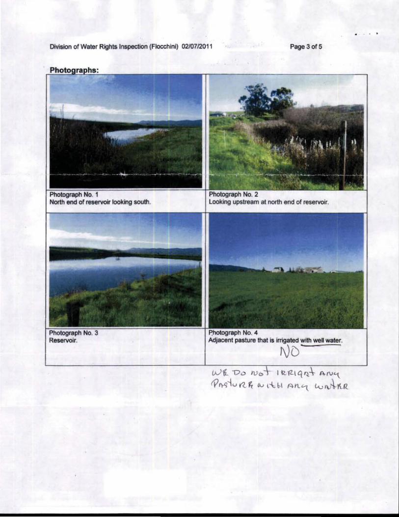
Division of Water Rights Inspection (Fiocchini) 02/07/2011 Page 3 of 5
Photograph No. 3 Reservoir.
Photograph No. 4 Adjacent pastl.Jre that is irrigated with well water.
ND (A)'(, Vi> IVo I R. fZ-l q ~.\- A N'\
tYI)-q'tu ((. ~ Ov l~b-1 Al'l'\. Lvi\J~ItR
. .