sublimity interchange area management plan final...
TRANSCRIPT


PDX/052070004_USR.DOC
F i n a l R e p o r t
Sublimity Interchange Area Management Plan
Prepared for
Oregon Department of Transportation
November 2006
Prepared by

PDX/052070004_USR.DOC

Acknowledgments
PDX/052070004_USR.DOC
~ Project Staff ~
Oregon Department of Transportation Dan Fricke, Project Manager
CH2M HILL Donna Kilber-Kennedy
Michael Hoffmann
Diane Kestner
Tung Le
Cheryl Yoshida
Terry Yuen
Dave Simmons
Christopher Wright
Jeanne Lawson Associates, Inc. Jamie Damon
Kristen Kibler
~ Project Steering Team ~
City of Stayton Gerry Aboud, Mayor
Mike Faught, Public Works Director
Steve Goeckritz, Community Development Director
City of Sublimity Gene Ditter, City Councilman
Alan Frost, Public Works Director
Mid-Willamette Valley Council of Governments Judith Ingram Moore
~ Project Steering Team, cont. ~
Marion County Mike McCarthy, Transportation Planner
Les Sasaki, Principal Planner
Bill Worcester, County Engineer
Oregon Department of Transportation Lisa Ansell, Project Leader
Kent Belleque, Senior Interchange Engineer (Roadway Engineering)
Carol Cartwright, Region 2 Roadway Manager
Steve Cooley, Region 2 Tech Center Manager
Bruce Erickson, Region 2 Traffic Manager
Erik Havig, Region 2 Planning and Development Manager
Don Jordan, District 3 Manager
Gerry Juster, Region 2 Access/Development Review Coordinator
Angela Kargel, Region 2 Traffic Engineer
Dan Knoll, Region 2 Public Information Representative
Jack Lee, Region 2 Planning/Development Review Manager
Jane Lee, Area 3 Manager
Jerry Rosenblad, Roadway Designer
Bill Swanson, Preliminary Designer
Robert Trevis, Region 2 Access/Development Review Coordinator
Dorothy Upton, Transportation Analyst (Transportation Planning Analysis Unit)
Federal Highway Administration Anthony Boesen, Region 2 Liaison Engineer


Contents
PDX/052070004_USR.DOC III
Section Page
Abbreviations and Acronyms ....................................................................................................... vii
Executive Summary......................................................................................................................ES-1
1 Background ............................................................................................................................1-1 Purpose and Intent.................................................................................................................1-1 Problem Context.....................................................................................................................1-1 Project History and Phasing .................................................................................................1-2 Interchange Function.............................................................................................................1-3 Goals and Objectives .............................................................................................................1-4 IAMP Study Area...................................................................................................................1-5 Related Work Products .........................................................................................................1-5 Public Involvement................................................................................................................1-6
2 Existing Conditions Inventory and Data Analysis .........................................................2-1 Regulatory Framework .........................................................................................................2-1 Existing Land Use ..................................................................................................................2-1
Comprehensive Plan Designations ...........................................................................2-1 Zoning Designations ...................................................................................................2-1
Transportation Facilities and Traffic Operations...............................................................2-3 Existing Transportation Facilities..............................................................................2-3 Existing Facilities Deficiencies ...................................................................................2-6 Existing Traffic Conditions.........................................................................................2-6 Existing Safety Conditions .......................................................................................2-10
Natural and Cultural Resources ........................................................................................2-17 Topography ................................................................................................................2-17 Hydrology...................................................................................................................2-18 Riparian Corridors.....................................................................................................2-18 Floodplains .................................................................................................................2-19 Floodway ....................................................................................................................2-20 Wetlands .....................................................................................................................2-20 Wildlife Habitat .........................................................................................................2-20 Federal Wild and Scenic Rivers ...............................................................................2-20 Oregon Scenic Waterways........................................................................................2-21 Groundwater Resources ...........................................................................................2-21 Approved Oregon Recreation Trails.......................................................................2-21 Natural Areas .............................................................................................................2-21 Wilderness Areas .......................................................................................................2-21 Mineral and Aggregate Resources ..........................................................................2-21 Energy Sources...........................................................................................................2-21 Open Space .................................................................................................................2-21 Scenic Views and Sites ..............................................................................................2-21
CONTENTS, CONTINUED
Section Page
IV PDX/052070004_USR.DOC
Threatened or Endangered Species ........................................................................ 2-22 Natural Hazards........................................................................................................ 2-22 Hazardous Substances.............................................................................................. 2-22 Air Quality ................................................................................................................. 2-22 Historic and Cultural Resources ............................................................................. 2-22
3 Future Conditions Analysis................................................................................................ 3-1 Land Use Analysis................................................................................................................. 3-1
Planned Land Development...................................................................................... 3-1 Land Development Forecast...................................................................................... 3-1
Forecasted Traffic Operations.............................................................................................. 3-2 Traffic Forecasting Methodology.............................................................................. 3-2 Future No Build (2025) Operations .......................................................................... 3-3 Year 2025 No Build Deficiencies ............................................................................... 3-5 Future Build (2025) Operations................................................................................. 3-5 Year 2025 Build Deficiencies...................................................................................... 3-6 Conclusions.................................................................................................................. 3-7
4 Alternatives Development and Analysis ......................................................................... 4-1 Sublimity Interchange Improvements................................................................................ 4-1 Access Management Requirements .................................................................................... 4-1 Alternatives ............................................................................................................................ 4-3
Along Oregon 22 ......................................................................................................... 4-5 Cascade Highway—Stayton (South of Interchange).............................................. 4-6 Cascade Highway—Sublimity (North of Interchange) ......................................... 4-9 Summary .................................................................................................................... 4-15
5 Interchange Area Management Plan................................................................................. 5-1 Selected Alternative and Findings ...................................................................................... 5-1
Access Management Plan........................................................................................... 5-1 Physical Improvements Plan ..................................................................................... 5-5 Traffic Management Plan........................................................................................... 5-6
Adoption and Implementation Plan ................................................................................... 5-6 Implementation Authority......................................................................................... 5-6 Implementation Steps and Responsibilities ............................................................ 5-7
6 References .............................................................................................................................. 6-1
Tables
1-1 Roadway Functional Classifications ................................................................................ 1-3 2-1 Maximum Volume to Capacity Ratios for Peak Hour Operating Conditions
Outside of the Portland Metropolitan Area .................................................................... 2-7 2-2 Existing Intersection Analysis Summary......................................................................... 2-9 2-3 Oregon 22 Mainline Crash Rates and Severity of Crashes.......................................... 2-11

CONTENTS, CONTINUED
PDX/052070004_USR.DOC V
2-4 Oregon 22 Crash Conditions............................................................................................2-12 2-5 Oregon 22 Crash Descriptions.........................................................................................2-13 2-6 Cascade Highway Mainline Crash Rates and Severity of Crashes ............................2-14 2-7 Cascade Highway Crash Conditions..............................................................................2-15 2-8 Cascade Highway Crash Descriptions ...........................................................................2-16 3-1 Population and Household Forecast ................................................................................3-3 3-2 Employment Forecast .........................................................................................................3-3 3-3 No Build Intersection Analysis Summary .......................................................................3-4 3-4 Build Intersection Analysis Summary..............................................................................3-5 4-1 Minimum Spacing Standards Applicable to Freeway Interchanges............................4-2 4-2 Existing Approaches along Cascade Highway ...............................................................4-3 4-3 Access Management Alternatives Summary...................................................................4-4 4-4 Oregon 22 Traffic Operations Analysis Summary..........................................................4-6 4-5 Stayton Traffic Operations Analysis Summary—Four–Lane Cascade Highway ......4-8 4-6 Stayton Traffic Operations Analysis Summary—Two–Lane Cascade Highway.......4-9 4-7 Sublimity Traffic Operations Analysis Summary—Alternative 1..............................4-11 4-8 Sublimity Traffic Operations Analysis Summary—Alternative 2..............................4-12 4-9 Sublimity Traffic Operations Analysis Summary—Alternative 3..............................4-13 4-10 Sublimity Traffic Operations Analysis Summary—Preferred Alternative ...............4-15 5-1 IAMP Access Deviations ....................................................................................................5-3
Appendixes
A Public Involvement B Compliance with State and Local Plans, Policies, and Regulations C Existing 2005 Turning Movement Counts D Existing 2005 Traffic Operations Worksheets E FEMA Flood Insurance Rate Map F No Build 2025 Traffic Operations Worksheets G Build 2025 Traffic Operations Worksheets H Access Road Intersection Sight Distance Memo I City of Sublimity Code Section 2.106 Amendment Ordinance J City of Sublimity Development Code Language Changes K MOU: City of Stayton and Marion County (Regarding Golf Lane Realignment) L City of Sublimity IAMP Adoption Ordinance M Sublimity Interchange Management Area Overlay Zoning District Boundary N City of Stayton IAMP Adoption Ordinance O Marion County IAMP Adoption Ordinance
Figures (located at the end of each section)
1-1 Interchange Area Improvements (Stage 1) 1-2 Interchange Area Improvements (Stage 2)

CONTENTS, CONTINUED
Section Page
VI PDX/052070004_USR.DOC
1-3 Study Area 2-1 Zoning 2-2 Existing Conditions (2005): Study Intersection Lane Configuration and Signal Control 2-3 Existing Conditions (2005): 30th Highest Hour Turning Movement Volumes 2-4 Potential Environmental Constraints 3-1 No Build Conditions (2025): Study Intersection Lane Configuration and Signal Control 3-2 No Build Conditions (2025): 30th Highest Hour Turning Movement Volumes 3-3 Build Conditions (2025): Study Intersection Lane Configuration and Signal Control 3-4 Build Conditions (2025): 30th Highest Hour Turning Movement Volumes 4-1 Interchange Area Improvements (Stage 1) 4-2 IAMP Access Inventory: Approaches along Cascade Highway 4-3 Proposed Access Treatments (Stayton) 4-4 Stayton Queues 4-5 Stayton Queues (Constrained Cascade Highway) 4-6 Access Treatments (Sublimity): Alternative #1 4-7 Access Treatments (Sublimity): Alternative #2 4-8 Access Treatments (Sublimity): Alternative #3 4-9 Access Treatments (Sublimity): Stakeholder Preferred Alternative 5-1 Sublimity Interchange IAMP Access Inventory/Action List 5-2 IAMP Access Inventory: Approaches and Properties

PDX/052070004_USR.DOC VII
Abbreviations and Acronyms
AADT average annual daily traffic AASHTO American Association of State Highway and Transportations Officials ATR automatic traffic recorder BLM U.S. Bureau of Land Management CARTS Chemeketa Area Regional Transit Service CLOMR Certified Letter of Map Revision DEQ Oregon Department of Environmental Quality DLCD Oregon Department of Land Conservation and Development DOGAMI Oregon Department of Geology and Mineral Industries EA Environmental Assessment ECSI Environmental Cleanup Site Information (DEQ database) EFU Exclusive Farm Use EPA U.S. Environmental Protection Agency FEMA Federal Emergency Management Agency FHWA Federal Highway Administration FIA Federal Insurance Administration FIRM Flood Insurance Rate Map FONSI Finding of No Significant Impact IAMP Interchange Area Management Plan LOS level of service LWI Local Wetlands Inventory MCBFHA Mill Creek Basin Flood Hazard Area MOU memorandum of understanding mph miles per hour MPO Metropolitan Planning Organization NEPA National Environmental Policy of 1969 NHS National Highway System NPDES National Pollutant Discharge Elimination System NRHP National Register of Historic Places NWI National Wetlands Inventory OAR Oregon Administrative Rule ODFW Oregon Department of Fish and Wildlife

SUBLIMITY INTERCHANGE AREA MANAGEMENT PLAN
VIII PDX/052070004_USR.DOC
ODOT Oregon Department of Transportation ODSL Oregon Department of State Lands OHP Oregon Highway Plan ONHP Oregon Natural Heritage Program OSHPO Oregon State Historic Preservation Office OTC Oregon Transportation Commission OWRD Oregon Water Resources Department PMT Project Management Team REA Revised Environmental Assessment SFHA Special Flood Hazard Area STIP State Transportation Improvement Program TSP Transportation System Plan UBA Urban Business Area UGB urban growth boundary UTF Urban Transitional Farm v/c volume to capacity

PDX/052070004_USR.DOC ES-1
Executive Summary
The Sublimity Interchange, located at the junction of Oregon 22 and Cascade Highway in Marion County, Oregon, will be undergoing modifications and improvements. In light of these planned improvements, this Interchange Area Management Plan (IAMP) documents the land use and transportation strategies developed to protect the function of the Sublimity Interchange over the long-term (20-plus years) , as directed by Oregon Administrative Rule (OAR) 734-051-0155(6).
Evaluation of interchange ramp and bridge alternatives occurred as a result of earlier planning and design efforts; the interchange ramp and bridge design was approved through an Environmental Assessment (EA) by the Federal Highway Administration (FHWA) in 1995.
Analysis performed for this IAMP indicated that the eastbound interchange ramp terminal will require signalization by the year 2025. A signal was assumed at Whitney Street in 2006, and the realignment of Golf Lane with Whitney Street is assumed to take place within the 20-year timeframe of this project. Analysis indicates that some adjustments to the signalization at Cascade Highway and Shaff Road–Fern Ridge Road would be required in the future to synchronize signal operations along Cascade Highway.
Land use analysis conducted as part of the IAMP indicates the proposed facility would be adequate to handle proposed land uses, as well as potential land uses that could arise from the conversion of land zoned for farm use and subject to Measure 37. Future development of industrial and commercial properties likely would lead to the signalization of the new access for the backage road during the 20-year timeframe.
Alternatives analyzed for this IAMP were access related in nature, and the preferred alternative package contains access management recommendations for Cascade Highway both north and south of the interchange, within the 1,320-foot Interchange Management Area limits.
An effective access management plan will help ensure compatibility between future transportation and land use needs (both local and regional) while optimizing mobility and safety conditions at the interchange and on Cascade Highway. This IAMP presents the following access management recommendations:
• A backage access road will be built behind the properties located northwest of the interchange, extending from Cascade Highway (at a point approximately 1,580 feet north of the interchange ramp terminus) to Sublimity Boulevard (at a point approximately 470 feet west of the Sublimity Boulevard and Cascade Highway intersection). Upon redevelopment, the properties located in this section would need to access the backage road instead of Cascade Highway. All private approaches to Cascade Highway in the Interchange Access Management Area Limit would be closed and access relocated to the backage road. These access recommendations are illustrated on Figure 4-9.

SUBLIMITY INTERCHANGE AREA MANAGEMENT PLAN
ES-2 PDX/052070004_USR.DOC
• The City of Sublimity will amend its Development Code to create an Interchange Overlay Zone that will prohibit future development on properties along Cascade Highway (northeast of the interchange) without the presence of an alternate access road.
• Access control will be purchased along the roadway property frontage of Tax Lot 091W03A00100.The existing access serving this lot and Tax Lot 091W03A0200 will be allowed to retain access to Cascade Highway.
• The existing approach serving Tax Lot 091W03A00300 will be consolidated with the approach serving Tax Lots 091W03A00200 and 091W03A00100.
• A frontage access road will be built from a point on Cascade Highway directly across from the proposed backage road (approximately 1,580 feet north of the interchange ramp terminus) to tie in with the existing driveway serving Tax Lots 091W03A00300, 091W03A00200, and 091W03A00100. The existing access currently serving Tax Lots 091W03A0200 and 091W03A00100 will be closed and access relocated to the frontage road.
• The Oregon Department of Transportation (ODOT) will grant deviations for several accesses south of the interchange, including Whitney Street, Golf Lane (with proviso that it be realigned, as agreed, with Whitney Street as warranted in the future), and access to the ODOT park-and-ride lot.
• ODOT will grant deviations for Sublimity Boulevard and several private driveway accesses north of the interchange, based on the City of Sublimity Development Code changes noted earlier.
• ODOT will grant a deviation for the intersection of Sublimity Boulevard and the westbound interchange ramp terminals, as the future project is designed.
• The Fern Ridge Road intersection along Oregon 22 will be modified or eliminated to improve access management and safety conditions.
In addition to access management recommendations, this IAMP also includes the following physical improvement and traffic management recommendations (agencies responsible are noted in brackets):
• Reconstruct the Oregon 22 entrance ramps to provide standard merge operations onto Oregon 22 [ODOT]
• Widen Cascade Highway from and including Sublimity Boulevard through the Shaff Road–Fern Ridge Road intersection [ODOT, Marion County, and City of Stayton]
• Signalize the Oregon 22 ramp termini and Sublimity Boulevard and Cascade Highway intersection (north of interchange) when signal warrants are met and signal approved by the State Traffic Engineer [ODOT]
• Signalize the Oregon 22 ramp termini and Cascade Highway intersection (south of intersection) when signal warrants are met and signal approved by the State Traffic Engineer [ODOT]
• Realign Golf Lane across from Whitney Street [Marion County and City of Stayton]

SUBLIMITY INTERCHANGE AREA MANAGEMENT PLAN
PDX/052070004_USR.DOC ES-3
• Signalize the Whitney Street–Golf Lane and Cascade Highway intersection [City of Stayton]
• Coordinate traffic signal operations along Cascade Highway due to the close spacing of signalized intersections [ODOT, Marion County, and City of Stayton]
• When traffic demand requires, install a right-turn pocket on the eastbound Oregon 22 exit ramp approach to Cascade Highway [ODOT and City of Stayton]
• When traffic demand requires, install right-turn pockets on the Shaff Road–Fern Ridge Road approaches to Cascade Highway [City of Stayton]
This document includes a complete description of the IAMP development process, land use assumptions, existing conditions analysis, access-related alternative evaluation, and traffic operations analysis. Short-term, medium-term, and long-term transportation strategies for the Sublimity Interchange Area are provided.
This IAMP was prepared in collaboration with ODOT, Marion County, the City of Stayton, and the City of Sublimity.


PDX/052070004_USR.DOC 1-1
SECTION 1
Background
This section provides a brief overview of the issues surrounding the Sublimity Interchange, previous and current projects at or near the site, and the purpose and goals of this Interchange Area Management Plan (IAMP).
Purpose and Intent Oregon Administrative Rule (OAR) 734-051-0155(6) states: “Interchange Area Management Plans are required for new interchanges and should be developed for significant modifications to existing interchanges….” This is a “project-based” IAMP and is being prepared in accordance with the recommendation in the above OAR because of planned modifications and reconstruction of the Sublimity Interchange, located at the junction of Oregon 22 (North Santiam Highway) and Cascade Highway in Marion County, Oregon. The intent of the IAMP is to provide a consensus framework plan among all affected public jurisdictions and agencies to protect the state’s investment in the Sublimity Interchange facility. Preparation of this document was conducted in accordance with state IAMP guidelines.1
This IAMP evaluates the transportation effects of the proposed interchange improvements and land use plans within the study area. Future commercial, industrial, and residential developments are expected to occur within the influence area of the interchange. The IAMP will recommend operational and physical improvements and access management techniques to maximize the operation of the interchange to accommodate future growth.
The purpose of this IAMP is to develop a course of action for the Sublimity Interchange that will protect the function of the interchange for at least 20 years. The Sublimity Interchange was proposed for modification and reconfiguration in the Joseph Street Environmental Assessment.2 The original design was subsequently revised and an interchange design that includes improvements to the entrance ramps, but not the exit ramps, is currently scheduled for construction in 2008–2009.
Problem Context The current Sublimity Interchange poses safety and operational issues in that both the east- and westbound entrance ramps to Oregon 22 terminate in stop signs. As a result, motorists are forced to quickly accelerate to highway speed from a complete stop. Westbound travelers must enter Oregon 22 traffic from a stop and accelerate uphill, as the interchange is located at the top of a knoll. Traffic on Oregon 22 is traveling at 55 miles per hour (mph) or
1 David Evans and Associates, Inc., with Angelo Eaton & Associates, 2005. Interchange Area Management Plan Guidelines (Final Draft). 2 ODOT and FHWA, 1995a. Joseph Street—Stayton North City Limits Environmental Assessment. ODOT and FHWA, 1995b. Joseph Street—Stayton North City Limits Revised Environmental Assessment.

SUBLIMITY INTERCHANGE AREA MANAGEMENT PLAN
1-2 PDX/052070004_USR.DOC
more, and during peak periods offers few breaks. Eastbound traffic enters on the top of a knoll, but with limited sight distance. Significant numbers of Stayton and Sublimity area residents traveling to jobs in the Salem area use the Sublimity Interchange.
The primary traffic issue within the interchange influence area is the location and function of access points to Cascade Highway. The Golf Lane access is very near the south side interchange ramp terminus. Currently, Golf Lane serves only a few houses. However, existing zoning would allow for more residential development, creating a potential operational conflict. Sublimity Boulevard, which provides access to the business cluster in the northwest quadrant of the interchange, is slightly offset from the existing interchange ramp terminals on the north side of the interchange. In the southeast quadrant, recent efforts have been made to improve traffic operations and to control the access to Cascade Highway by prohibiting left turns to Martin Drive. There is a traffic signal at the intersection of Shaff Road–Fern Ridge Road and Cascade Highway. On the north side of the interchange, the roadway is a two lane road, with a paved shoulder on the west side. Bicycle lanes are provided from Division Street through Sublimity.
Project History and Phasing The planned modification and reconstruction of the Sublimity Interchange is part of a much larger Oregon Department of Transportation (ODOT) undertaking, the Joseph Street—North Stayton City Limits project (“Joseph Street project”). The Joseph Street project was conceived in the late 1980s and the Environmental Assessment (EA) for the project was approved by the Federal Highway Administration (FHWA) in 1995.
The selected alternative of the Joseph Street project entailed the following transportation improvements:
• Conversion of approximately 8.5 miles of two-lane Oregon 22 to a four-lane divided highway. Includes a 100-foot separation between the centerline of the westbound and the centerline of the eastbound travel lanes (to permit future expansion to a six-lane roadway within the right-of-way required for this project)
• Construction of new interchanges at Aumsville-Shaw Highway and Golf Club Road
• Reconstruction and modification of existing interchanges at Silver Creek Falls and Cascade Highways (Sublimity Interchange)
• Implementation of full access control
• Construction of new frontage roads
Joseph Street project improvements were designed to be constructed in two major phases.
• Phase 1, which has already been completed, included the widening of Oregon 22 to four lanes between Joseph Street to mile point (MP) 12, the construction of new interchanges at Aumsville-Shaw Highway and Golf Club Road, and the construction of Golf Lane (to provide access for properties whose approaches to Oregon 22 were removed).

SUBLIMITY INTERCHANGE AREA MANAGEMENT PLAN
PDX/052070004_USR.DOC 1-3
• Phase 2, yet to be completed, will occur in two stages: Stage 1 entails the reconstruction and modification of the Sublimity Interchange; Stage 2 entails the widening of Oregon 22 from two to four lanes from MP 12 to MP 14.1.
− Stage 1 is currently underway, with physical improvements to the Sublimity Interchange scheduled to begin in 2008. The proposed improvements will provide for standard merge entrance ramp operations. This IAMP is being prepared as part of Stage 1. Stage 1 improvements are shown on Figure 1-1.
− Stage 2 will be completed when necessary funding is available. Stage 2 improvements are shown on Figure 1-2.
The project area was identified as Oregon 22 between MP 5.16 and MP 14.1. The Joseph Street project includes the following proposed improvements: widening Oregon 22 to four lanes in the project area; installing complete access control; and implementing Phase 1 to improve the segment of Oregon 22 from Joseph Street (MP 5.44) eastward to the MP 12 (already completed).
Interchange Function Oregon 22 is an Oregon Transportation Commission (OTC) designated expressway, and is classified by the Oregon Highway Plan (OHP) as a highway of statewide significance and a Statewide Freight Route. Oregon 22 is also part of the National Highway System (NHS). Oregon 22 serves as a major connector between the Mid-Willamette Valley and Central Oregon.
Functional classifications of roadways in the vicinity of the Sublimity Interchange are listed in Table 1-1.
TABLE 1-1 Roadway Functional Classifications
Roadway Functional Classification Jurisdiction
Oregon 22 (North Santiam Highway) Rural Principal Arterial—Othera ODOT Cascade Highway (outside city limits) Arterialb Marion County 1st Street (Cascade Highway south of Oregon 22) Principal Arterialc Marion County Center Street (Cascade Highway north of Oregon 22) Arteriald Marion County Fern Ridge Road Major Collectorc City of Stayton Shaff Road Minor Arterialc City of Stayton Martin Drive Localc City of Stayton Whitney Street Localc City of Stayton Golf Lane Localc City of Stayton Sublimity Boulevard Locald City of Sublimity 9th Street Locald City of Sublimity Sources: a Oregon Highway Design Manual (ODOT, 2003) b Marion County Rural Transportation System Plan (2005) c City of Stayton Transportation System Plan (2004) d City of Sublimity Transportation System Plan (1998)
SUBLIMITY INTERCHANGE AREA MANAGEMENT PLAN
1-4 PDX/052070004_USR.DOC
The Sublimity Interchange is an important facility for the communities of Stayton and Sublimity, and serves the following functions:
• Commercial/Industrial: The interchange directly serves the downtowns of each community and the businesses therein. As the commercial- and industrial-zoned areas of these communities continue to develop, the Sublimity Interchange will increasingly function as an integral economic development asset.
• Residential Commuting: A significant number of Stayton and Sublimity residents utilize the interchange to access Oregon 22 for their daily commutes into the Salem–Keizer area.
• Agricultural: The interchange serves a farm-to-market function for the numerous agricultural operations in the area.
Sublimity Interchange modifications and associated local improvements should be planned and implemented to accommodate the multi-functional nature of the interchange.
Goals and Objectives It is the goal of this IAMP to propose access management, construction, and land use measures to interactively augment the effectiveness of the interchange modification design. This report documents the results of the project planning process used to achieve this stated goal for the Sublimity Interchange.
As stated in Policy 3C of the 1999 OHP, “it is the policy of the State of Oregon to plan for and manage grade-separated interchange areas to ensure safe and efficient operation between connecting roadways.”3 Based on this definition and consideration of project-specific local transportation issues, the objectives of the Sublimity IAMP are to:
• Prolong the useful life of the state’s investment in the Sublimity Interchange
• Control or decrease, through access management measures, the number of conflict points on Cascade Highway in the vicinity of the Sublimity Interchange
• Provide feasible and equitable driveway relocation alternatives for property owners with current direct access to Cascade Highway
• Balance the need for the interchange to support community development interests with the need for safe and efficient operation within the interchange area
• Establish agreements with local governments on how to effectively manage the long-term function of the interchange
• Monitor how the interchange capacity is managed through cooperation with local governments
• Provide certainty for property and business owners and local governments
3 ODOT, 1999.

SUBLIMITY INTERCHANGE AREA MANAGEMENT PLAN
PDX/052070004_USR.DOC 1-5
IAMP Study Area The Sublimity IAMP project study area covers Oregon 22 between the Golf Club Road Interchange and the Mill Creek Bridge on Oregon 22, and Cascade Highway between SW 9th Street in Sublimity and Shaff Road–Fern Ridge Road in Stayton. The study area is shown on Figure 1-3.
Cascade Highway is alternatively called Center Street inside Sublimity city limits and North 1st Avenue inside Stayton city limits. The study area encompasses the southern portion of the City of Sublimity, the northeastern portion of the City of Stayton, and portions of unincorporated Marion County.
The boundaries of the IAMP study area were developed based on a review of the surrounding roadway network and land use patterns as well as existing and future travel patterns. The parameters of the study area take into account:
• State IAMP regulations
• State access management regulations: the IAMP study area includes all land uses and roadways located within 1,320 feet of the existing Sublimity Interchange. This distance corresponds to the spacing standard outlined in the OAR 734-051 Division 51 rules for interchange ramps.
• Transportation facilities and traffic operations
• The mutual impact of existing natural and cultural resources
• The mutual impact of existing and planned land uses
Related Work Products • The Oregon 22 Sublimity Interchange modernization project is an approved project in
the 2006-2009 State Transportation Improvement Program (STIP). The project is described in the STIP as a “Partial Interchange Reconstruction.” This IAMP is part of the final planning for this project.
• Integral to the preparation of this IAMP is the Joseph Street—North Stayton City Limits Environmental Assessment.4 This EA and subsequent Revised EA (REA), which were approved by FHWA, provide the rationale for Sublimity Interchange area improvements and serve to document the determination that project actions will not have a significant impact on the human environment.
• The City of Stayton Transportation System Plan (TSP) lists two Capital Improvement Projects (aside from the Sublimity Interchange project) that are located in the Sublimity Interchange influence area. These are excerpted below:
− Cascade Highway–1st Avenue widening from Highway 22 to Regis Street—widen to 5 lanes with sidewalks.
4 Both the Joseph Street —Stayton North City Limits Environmental Assessment and Revised Assessment were consulted in this IAMP planning process (ODOT and FHWA, 1995a and 1995b).

SUBLIMITY INTERCHANGE AREA MANAGEMENT PLAN
1-6 PDX/052070004_USR.DOC
− Cascade Highway and Whitney Street signalization with eastbound and westbound left turn lanes and Golf Lane realignment.5
Both of the above projects were factored into the operational analysis and alternatives decision-making process for this IAMP.
• The City of Sublimity Transportation System Plan lists the City’s objectives for street network circulation and access management in the immediate vicinity north of the Sublimity Interchange.
Public Involvement The purpose of the Sublimity IAMP public involvement program is to conduct a planning process that both:
• balances the needs and issues of residences and businesses in the Sublimity Interchange area, including those who depend on the highway
• has the informed support and acceptance of these communities and interests
One key goal of the program is to elicit public discussion of the issues affecting the selection of access relocation alternatives to ensure future safe and efficient conditions in the vicinity of the Sublimity Interchange along Cascade Highway.
Detailed discussion and results of the public involvement process for the Sublimity IAMP project are presented in Appendix A of this document.
5 Source: City of Stayton Transportation System Plan, 2004. Table 8-1 Capital Improvement Cost—Street Improvements, p. 8-1.

SU
BL
I MI T
YB V
Reconstruction / Improvements toCascade Highway
Reconstruction of existingbridge structure overCascade Highway
Reconstruction / Improvements toSublimity Boulevard
Reconstruction / Improvements toCascade Highway
Phase 1 WB exit ramp improvementsto this point
Reconstruction of existing bridge structureover Mill Creek to accommodatenew Eastbound Entrance RampMill Creek
SANTIAMHY
GOLF LN
CAS
CA
DE
HY
HOBSONSTO
AKMO
NTLN
CEN
TER
ST
WELDON ST
3RD
AV
Sublimity InterchangeArea Management Plan
0 200 400 600 Feet
Area Enlarged
'4
Figure 1-1Interchange Area
Improvements (Stage 1)
Oregon 22 & Cascade HighwaySublimity / Stayton, Oregon
LegendEastbound Entrance Ramp
Westbound Entrance Ramp
Westbound Exit Ramp
Sublimity Blvd. Reconstruction
Cascade Highway Reconstruction
Bridges to be Constructed
Existing Bridge Reconstruction
Water
Tax Lots
N

SU
BL
IM
I TY
BV
New bridge to be constructedover Mill Creek
Mill Creek
SANTIAMHY
GOLF LN
CAS
CA
DE
HY
WHITNEY ST
HOBSON ST
SUBLIMITY BV
GR
IER
DR
0 200 400 600 Feet
File Path: \\Rosa\Proj\ODOT\323129\GIS\planners\mxds\later_phase_constr.mxd, Date: June 22, 2005 10:24:36 AM
**Highway to be widened to 4 lanes(from existing 2 lanes)
Legend
Tax lots
Water
Eastbound Exit Ramp
Eastbound Lanes**
Westbound Lanes**
Westbound Exit Ramp
Phase 1 Infrastructure
Bridges to be Constructed
Sublimity InterchangeArea Management Plan
Oregon 22 & Cascade HighwaySublimity / Stayton, Oregon
Figure 1-2Interchange Area
Improvements (Stage 2)
Area Enlarged
N

SUBLIMITY
NW Quadrant
SW Quadrant
STAYTON
SE Quadrant
NE Quadrant
Mill Creek
GOLF LN
SHAFF RD
CAS
CA
DE
HY
9TH ST
FERN RIDGE RD
3RD
AV
REGIS ST
KIN
DLE
WY
OA
KMO
NT
LN
WHITNEY ST
KATHY ST
HOBSON STC
ENTE
RS
T
1ST
AV
WILDFLOWER DR
WYATT AV
SUBLIMITY BV
KEN
TAV
FER
NST
WELDON ST
KENT CT
DO
UG
LAS
AV
MEADOWBROOK LN
MA RTI
ND
R
EVE
RG
REE
NST
DAL
MAT
IAN
AV
SUMMERVIEW DR
FOXH
ILL
AV
WIL
DIN
GP
L
CED
AR TERRACE CTKATHY S T
KATHY ST
£¤22
Sublimity InterchangeArea Management Plan
300 0 300 600 Feet
Sublimity / Stayton, Oregon
Figure 1-3Study Area
Area Enlarged
File Path: P:\ODOT\323129\GIS\mxds\Fig.1_study_area.mxd, Date: 03 08, 05 12:55:37 PM
Legend
Streets and Roads
City Boundary
Tax Lots
Study Area
Water
N

PDX/052070004_USR.DOC 2-1
SECTION 2
Existing Conditions Inventory and Data Analysis
Regulatory Framework The Sublimity IAMP study area contains land from three jurisdictions: Marion County, the City of Sublimity, and the City of Stayton. IAMP improvements are therefore subject to applicable land use regulations for each jurisdiction, as well as state and federal regulations.
State, county, and local regulations pertaining to IAMP actions are addressed in the Plan and Policy Review, located in Appendix B.
Existing Land Use The Sublimity IAMP study area contains a mixture of urban and agricultural land uses. The Sublimity Interchange lies between the communities of Stayton (population 7,360) and Sublimity (population 2,160).6 Land in the immediate vicinity is used primarily for agricultural purposes. A general description of land uses in the study area is as follows:
• Northwest quadrant: commercial and light industrial uses along Sublimity Boulevard; low-density single-family residences along Cascade Highway
• Northeast quadrant: farm use
• Southwest quadrant: farm use; a few single-family residences
• Southeast quadrant: state-owned park-and-ride lot; medium-density single and multi-family residences; commercial establishments; elder-care residential facility
Comprehensive Plan Designations Comprehensive Plan land-use designations in Marion County, the City of Stayton, and the City of Sublimity coincide with the zoning designations for these respective public agencies. Relevant zoning district designations are addressed below.
Zoning Designations Planned interchange improvements will take place solely within unincorporated Marion County, and will therefore only be subject to applicable Marion County zoning code regulations. However, longer-term IAMP recommendations will involve utilizing land inside Sublimity or within Stayton jurisdictional limits. Additionally, the potential for increased traffic in the interchange is tied to the type and intensity of development allowed in each of the zoning districts in the IAMP study area. For this reason, IAMP study area 6 Qian Cai, 2005. 2004 Oregon Population Report. Population numbers given are year 2004 estimates.

SUBLIMITY INTERCHANGE AREA MANAGEMENT PLAN
2-2 PDX/052070004_USR.DOC
zoning regulations for Sublimity and Stayton are addressed here in addition to Marion County.
Zoning designations in the Sublimity IAMP study area are shown in Figure 2-1.
Marion County Zoning
Existing Marion County zoning districts in the study area are as follows:
• Exclusive Farm Use (EFU) • Urban Transitional Farm (UTF)
Project Relevant Issues • Public road improvements are permitted outright in all Marion County zones providing
that such improvements are in conformance with the “applicable comprehensive plan and the standards of the Department of Public Works” (per Marion County Zoning Ordinance 25.10(b)). The Marion County Comprehensive Plan does not contain any language constraining transportation improvements in an EFU zone. Therefore, Marion County zoning regulations do not constrain planned Sublimity Interchange improvements.
City of Stayton Zoning
Existing City of Stayton zoning districts in the Sublimity IAMP study area are as follows:
• Commercial-Retail (CR) • Interchange Development (ID) • High-Density Residential (HD) • Multiple-Family Residential (MD) • Single-Family Residential (LD)
Project Relevant Issues • Public road improvements are permitted outright in the CR and ID zones (per Stayton
Development Codes 17.16.690.2(j) and 17.16.710.2(i), respectively).
• Public road improvements are conditionally permitted in the HD, MD, and LD zones (per Stayton Development Codes 17.16.680.3(f), 17.16.670.3(b), and 17.16.660.3(b), respectively). Although no IAMP improvements are planned to occur in any of these three zones, any change which results in transportation-related public improvements in these zones would be subject to site review by the City of Stayton.

SUBLIMITY INTERCHANGE AREA MANAGEMENT PLAN
PDX/052070004_USR.DOC 2-3
City of Sublimity Zoning
Existing City of Sublimity zoning districts in the Sublimity IAMP study area are as follows:
• Commercial (COM) • Industrial (IND) • Future Industrial • Low-Density Residential (R-1) • Medium-Density Residential (R-2)
Project Relevant Issues • Public road improvements are permitted outright in all City of Sublimity zones (per
Sublimity Development Code 2.403.01.D) provided that “the right of way is not expanded to more width than prescribed for the street in the Public Facilities segment of the Comprehensive Plan.”
Transportation Facilities and Traffic Operations This section summarizes the existing transportation conditions within the study area, provides assumptions and methodologies to be used in the traffic operational analyses, and catalogues existing transportation system facilities and services. To the extent possible, physical as well as operational characteristics of the roadways, intersections, and transportation services are described.
Existing Transportation Facilities The following sections describe the existing physical characteristics of the study area roadways and intersections, truck routes, bicycle and pedestrian facilities, public transportation, and other services.
Vehicular Facilities
Figure 2-2 shows traffic control and channelization in the study intersection.
• Oregon 22 is the major east-west highway in Marion County. It is located between the cities of Stayton and Sublimity, and is connected to both cities via an interchange at Cascade Highway. In addition to the Cascade Highway interchange, one other interchange, Golf Club Road, provides access to and from Stayton and Sublimity. Fern Ridge Road and Santiam Street provide an additional connection between Oregon 22 and the City of Stayton. Golf Club Road and Cascade Highway are full interchanges, and Fern Ridge Road is a stop-controlled at-grade intersection located east of the study interchange.
Both the east- and westbound Oregon 22 entrance ramps terminate in stop signs. Drivers enter Oregon 22 traffic from a full stop (right-turn only), and are required to accelerate uphill from the westbound ramp due to the topography of the highway. In the vicinity of the Sublimity Interchange, Oregon 22 is a two-lane, undivided, access-controlled highway. The posted speed limit is 55 miles per hour (mph).

SUBLIMITY INTERCHANGE AREA MANAGEMENT PLAN
2-4 PDX/052070004_USR.DOC
The Oregon 22 eastbound exit ramp terminates in a shared left- and right-turn lane that is stop controlled at Cascade Highway. At this intersection, Cascade Highway has one through travel lane in each direction, with a shared through and right-turn lane for southbound travel and a shared through and left-turn lane for northbound travel.
The Oregon 22 westbound exit ramp splits into two legs approaching Cascade Highway. The northern leg carries traffic to and from Sublimity; the southern leg carries traffic to and from Stayton. Both legs consist of a stop-controlled single lane with shared left-turn, through, and right-turn movements. The two legs intersect partway up the ramp. At this intersection, Cascade Highway has one travel lane in each direction, with a shared through and left-lane for northbound travel and a shared left-turn, through, and right–turn lane for southbound travel.
• Cascade Highway is a major north-south arterial that provides the primary access to the cities of Sublimity and Stayton from Oregon 22.
North of Oregon 22, Cascade Highway is a two-lane roadway with paved asphalt shoulders on its west side. The posted speed limit on the minor arterial is 45 mph.
South of Oregon 22, Cascade Highway is generally a two-lane roadway with paved asphalt shoulders. Left-turn pockets are provided at the Whitney Street and Shaff Road–Fern Ridge Road intersections. As described in the Pedestrian Facilities section below, a portion of Cascade Highway, from Whitney Street to the south, is served by a sidewalk. The posted speed limit on Cascade Highway is 45 mph.
Between the Oregon 22 eastbound ramps and Whitney Street, the width of Cascade Highway is less than the City of Stayton’s standard street width of 40 feet for principal arterials. Two bridges are located on Cascade Highway within the City of Stayton project limits. Mill Creek Crossing occurs south of Golf Lane, and Lucas Ditch Crossing occurs south of Martin Drive.
• 9th Street forms a T-intersection with Cascade Highway in the southern portion of Sublimity and provides access to a residential area. All approaches to the intersection are single lanes, with no dedicated turn pockets. The west approach to the intersection is stop controlled.
• Sublimity Boulevard is located just north of Oregon 22, and aligns with one leg of the interchange’s westbound ramps. All approaches to the intersection are single lanes, with no dedicated turn pockets. The east leg is comprised of the Oregon 22 westbound ramps. The west leg is a two-lane roadway providing access to the business cluster in the northwest quadrant of the interchange, including an insurance agency, motorcycle and car dealerships, a tire shop, and a hotel. The east and west approaches to the intersection are stop controlled.
• Golf Lane, located just south of Oregon 22, is a two-lane local roadway. At Cascade Highway, a shared right- and left-turn lane is stop controlled. Cascade Highway has a shared through and right-turn lane for southbound travel and a shared through and left-turn lane for northbound travel. Currently this road serves a small number of residences; however, the adjacent undeveloped parcels are zoned for additional housing

SUBLIMITY INTERCHANGE AREA MANAGEMENT PLAN
PDX/052070004_USR.DOC 2-5
development. Across Cascade Highway from this intersection is the access to an ODOT park-and-ride lot.
• Whitney Street consists of one travel lane in each direction. At Cascade Highway, a shared right- and left-turn lane is stop controlled. Cascade Highway has a shared through and right-turn lane for northbound travel and a through lane with a left-turn pocket for southbound travel. Further to the east of Martin Drive, Whitney Street connects to a single-family residential area. Adjacent to Cascade Highway, Whitney Street services commercial and retail properties. The Whitney Street intersection with Cascade Highway is scheduled to be signalized in 2006.
• Martin Drive is a right-turn-in, right-turn-out only connection to Cascade Highway with access to Whitney Street. The area served by Martin Drive and Whitney Street is primarily a small commercial and retail base area that includes a fast-food restaurant, liquor store, pharmacy, and a gas station with a mini-mart.
• Shaff Road–Fern Ridge Road provides a key east-west route in northern Stayton and helps relieve traffic congestion through the City. It is a two-lane roadway with left-turn pockets at the signalized intersection with Cascade Highway.
Truck Routes
Through the project area, Oregon 22 and Cascade Highway are designated as truck routes. Oregon 22 is also designated as a Freight Route in the 1999 OHP.7 Truck routes designated by the City of Stayton serve the following areas: the industrial area on the west side of the city, NORPAC in central Stayton, and Morse Brothers south of Stayton. Shaff Road–Fern Ridge Road is a designated City of Stayton truck route.
Bicycle Facilities Dedicated bicycle lanes are provided on Cascade Highway from the northern portion of the study area (vicinity of Division Street) through the City of Sublimity. Through the remainder of the IAMP study area, bicyclists must utilize the available roadway shoulders or share the vehicle travel lanes.
Bicycle lanes are also provided on a segment of Fern Ridge Road, east of Cascade Highway to Wildflower Drive.
Pedestrian Facilities
A sidewalk is provided on the east side of Cascade Highway from just north of Whitney Street continuing south through the City of Stayton. Throughout the remainder of the study area, pedestrians on Cascade Highway must utilize the available roadway shoulders.
Shaff Road–Fern Ridge Road and Whitney Street also have a sidewalk on the south side of the roadway, while Martin Drive has a sidewalk on the north side.
7 ODOT, 1999.

SUBLIMITY INTERCHANGE AREA MANAGEMENT PLAN
2-6 PDX/052070004_USR.DOC
Public Transportation and Other Alternative Modes
Transit service in the Stayton and Sublimity area is provided by the Chemeketa Area Regional Transit Service (CARTS) and the Wheels of Joy dial-a-ride system for disabled persons. Based on current and future ridership projections, neither would have a significant effect on area traffic patterns.
Laidlaw Transit provides bus service for the North Santiam School District. Within the study area, Cascade Highway and Shaff Road–Fern Ridge Road are designated as school bus routes.
A park-and-ride facility with 94 stalls and semi-covered bicycle racks is located in the southeast quadrant of the Oregon 22 and Cascade Highway interchange.
Rail, Pipelines, and Others Willamette Valley Railroad services the City of Stayton on a spur line originating in Woodburn. Two to three trips per week currently service the area. Two at-grade crossings, Washington Street at NORPAC and Locust Street–Wilco Road, are located south and west of the IAMP study area, respectively.
The City of Sublimity has no railroad service.
There are no airports in the direct vicinity of the study area. A full service commercial airport is located in Salem, approximately 15 miles to the east. Several small private airstrips and a heliport at the Santiam Hospital are within a 20 mile radius.
Existing Facilities Deficiencies Deficiencies in the existing transportation network are outlined in the Marion County and City of Stayton TSPs. These deficiencies are noted below.
Missing sidewalk links within the study area include:
• Shaff Road—north side from Stayton Middle School to Cascade Highway • Fern Ridge Road—north side Cascade Highway to west of Summerview Way • Cascade Highway—west side from Oregon 22 to Shaff Road • Cascade Highway—east side from north of Whitney to Oregon 22
Arterials and Collectors with deficient pavement widths include:
• Shaff Road from western urban growth boundary (UGB) to west of Cascade Highway • Cascade Highway south of Oregon 22 Eastbound Ramps to Whitney Street
Existing Traffic Conditions The following sections describe existing traffic volumes and intersection operations within the study area, as compared to the performance standards of the three jurisdictions present.
Traffic Operations Performance Measures
Operational performance measures are outlined below for the three jurisdictions within the study area: ODOT, City of Stayton and City of Sublimity.

SUBLIMITY INTERCHANGE AREA MANAGEMENT PLAN
PDX/052070004_USR.DOC 2-7
ODOT. The intersections and approaches adjacent to the Oregon 22 interchange are under ODOT jurisdiction.
The OHP outlines specific performance standards to be maintained along ODOT facilities as part of their Mobility Policy. These standards are intended to maintain mobility along important roadway sections and vary according to functional classification, location, and role within the NHS. Table 2-1 summarizes the mobility standards set by the OHP.
TABLE 2-1 Maximum Volume to Capacity Ratios for Peak Hour Operating Conditions Outside of the Portland Metropolitan Area
Highway Category Inside Urban Growth Boundary Outside Urban Growth
Boundary
STAs MPO Non-MPO Outside of
STAs where non-
freeway speed limit ≤ 35 mph,
or a Designated
UBA
Non-MPO outside of
STAs where non-freeway speed limit >
35 mph
Non-MPO where non-
freeway speed limit ≥ 45 mph
Unincorporated Communities
RuralLands
Interstate Highways N/A 0.80 N/A 0.70 0.70 0.70 0.70
Statewide Expressways
N/A 0.80 0.70 0.70 0.70 0.70 0.70
Freight Route on a Statewide Highway
0.85 0.80 0.80 0.75 0.70 0.70 0.70
Statewide (not a freight route)
0.90 0.85 0.85 0.80 0.75 0.75 0.70
Freight Route on a Regional or District Highway
0.90 0.85 0.85 0.80 0.75 0.75 0.70
Expressway on a Regional or District Highway
N/A 0.85 N/A 0.80 0.75 0.75 0.70
Regional Highways 0.95 0.85 0.85 0.80 0.75 0.75 0.70
District or Local Interest Roads
0.95 0.90 0.90 0.85 0.80 0.80 0.75
Source: 1999 Oregon Highway Plan (OHP) (ODOT, 1999)—Updated per OHP Amendment 05-16. MPO = Metropolitan Planning Organization UBA = Urban Business Area Interstates and Expressways shall not be identified as Special Transportation Areas (STAs). For the purpose of this mobility policy of v/c ratio standards, the peak hour shall be the 30th highest annual hour. This approximates weekday peak hour traffic in larger urban areas.
• Oregon 22, North Santiam Highway is a Statewide Expressway and NHS Freight route, non-MPO within the UGB with a speed greater than 45 mph. The maximum acceptable volume-to-capacity (v/c) ratio for this facility is 0.70.
SUBLIMITY INTERCHANGE AREA MANAGEMENT PLAN
2-8 PDX/052070004_USR.DOC
• The interchange ramps with Oregon 22 at Cascade Highway have a maximum v/c ratio of 0.85 given their categorization as District or Local Interest Roads, Inside UGB, and non-MPO where non-freeway speed limit is less than 45 mph.
• Cascade Highway at the interchange ramps with Oregon 22 have a maximum v/c ratio of 0.85 given its categorization as a County roadway.
City of Stayton. The intersections south of the Oregon 22 interchange are within City of Stayton jurisdiction.
The City of Stayton TSP, Section 3 (Transportation Goals and Policies) establishes level of service (LOS) standards for the City of Stayton as follows:
• Signalized Intersections—LOS D • Unsignalized Intersections—LOS E
City of Sublimity. The intersections north of the Sublimity Interchange are within the City of Sublimity jurisdiction. Marion County mobility standards were applied to these intersections.
• Signalized Intersections—LOS D • Four-way Stop Controlled Intersections—LOS D • Two-way Stop Controlled Intersections—LOS E
Existing Traffic Volumes Manual turning movement counts were collected at eight intersections along Cascade Highway on February 3, 2005. The duration of each intersection count is shown below:
• Cascade Highway and 9th Street: 4 hours from 6 a.m. to 10 a.m. • Cascade Highway and Sublimity Boulevard: 16 hours from 6 a.m. to 10 p.m. • Cascade Highway and Oregon 22 eastbound ramps: 16 hours from 6 a.m. to 10 p.m. • Cascade Highway and Oregon 22 westbound ramps: 16 hours from 6 a.m. to 10 p.m. • Cascade Highway and Golf Lane: 4 hours from 6 a.m. to 10 a.m. • Cascade Highway and Whitney Street: 16 hours from 6 a.m. to 10 p.m. • Cascade Highway and Martin Drive: 4 hours from 6 a.m. to 10 a.m. • Cascade Highway and Shaff Road–Fern Ridge Road: 16 hours from 6 a.m. to 10 p.m.
These intersections were included in the IAMP scope of work to represent the influence area of the Sublimity Interchange. In addition to these intersections, the Oregon 22 operations at the interchange entrance ramps were analyzed utilizing the ODOT highway traffic data. The vehicle turning movement data is compiled in Appendix C.
Peak hour turning movement counts were seasonally adjusted to represent the 30th Highest Hour design volumes based on ODOT’s permanent automatic traffic recorder (ATR) at station 22-010, which is located on a segment of highway that closely resembles the traffic operations and geometric characteristics of Oregon 22.
The seasonal factor for volumes on Oregon 22 and Cascade Highway was interpolated from values between February 1 and February 15, 2003. The average seasonal factor was calculated to be 1.19.

SUBLIMITY INTERCHANGE AREA MANAGEMENT PLAN
PDX/052070004_USR.DOC 2-9
The derived 30th Highest Hour design volumes were then balanced along Cascade Highway between adjacent study intersections. The directional traffic volumes were adjusted until the difference between them was less than 10 percent. The derived traffic volumes at the study intersections are shown in Figure 2-3.
Existing Intersection Operations Existing (that is, 2005) v/c ratios, LOS, and vehicle queues were computed for the eight study intersections and Oregon 22 entrance ramps based on the 30th Highest Hour design volumes. Table 2-2 shows the results of the existing operations analyses. All locations that do not meet the applicable jurisdiction’s standards are highlighted in the table. Appendix D includes the traffic operations worksheets for the existing 30th Highest Hour conditions.
A Synchro model was constructed for the study area based on the collected traffic turning movement counts balanced to the 30th Highest Hour design volumes, peak hour factors, truck percentages, and field observations.
The Synchro model uses the methodology in the 2000 Highway Capacity Manual to analyze both signalized and stop-controlled intersections. The model also computes the LOS and v/c ratio necessary to determine whether the intersection meets the applicable mobility standards from the local municipalities and the OHP. Queue lengths are based on SimTraffic outputs and are reported to the nearest full vehicle length (assuming 25 feet per vehicle).
TABLE 2-2 Existing Intersection Analysis Summary 2005 30th Highest Hour Design Volumes
Intersection Mobility
Standarda V/c
Ratiob LOSb Queue (ft)b,c,d
Mobility Standarda
V/c Ratiob LOSb
Queue (ft)b,c,d
Oregon 22 Approaches Ramp Approaches
Oregon 22 eastbound entrance ramp [unsignalized]
0.70 0.30 - 0 0.85 0.40 - 100
Oregon 22 westbound entrance ramp [unsignalized]
0.70 0.41 - 0 0.85 0.74 - 200
Cascade Highway Approaches Cross Street Approaches
Cascade Highway at 9th Street [unsignalized]
E - A 50 E - B 75
Cascade Highway at Sublimity Boulevard–Oregon 22 westbound ramps [unsignalized]
0.85 0.04 - 75 0.85 0.57 - 75
Cascade Highway at Oregon 22 westbound entrance ramp [unsignalized]
0.75 0.46 - 0 - - - 0

SUBLIMITY INTERCHANGE AREA MANAGEMENT PLAN
2-10 PDX/052070004_USR.DOC
TABLE 2-2 Existing Intersection Analysis Summary 2005 30th Highest Hour Design Volumes
Intersection Mobility
Standarda V/c
Ratiob LOSb Queue (ft)b,c,d
Mobility Standarda
V/c Ratiob LOSb
Queue (ft)b,c,d
Cascade Highway at Oregon 22 eastbound ramps [unsignalized]
0.85 0.30 - 125 0.85 >1.0 - 500
Cascade Highway at Golf Lane [unsignalized]
E - A 75 E - D 50
Cascade Highway at Whitney Street [unsignalized]
E - B 75 E - F 325
Cascade Highway at Martin Drive [unsignalized]
- - - 0 E - B 50
Cascade Highway at Shaff Road–Fern Ridge Road [unsignalized]
D - E 650 D - D 400
a ODOT mobility standards are based on v/c ratios. Stayton and Sublimity standards are based on LOS. b Results are reported for approach with worst operational characteristics. c ODOT intersections are calculated with the 2-minute rule. Stayton and Sublimity intersection queues are
reported from SimTraffic outputs. d Assumes 25 feet per vehicle.
Existing Operational Deficiencies
The results of the existing operational analyses show that two stop-controlled intersection approaches to Cascade Highway, the Oregon 22 eastbound exit ramp and Whitney Street, operate below the required mobility standards. Both approaches are characterized by extensive vehicle queuing during the design hour. Additionally, although the overall intersection LOS of Cascade Highway at Shaff Road–Fern Ridge Road is at an acceptable LOS D, the Cascade Highway approaches operate at LOS E, with significant vehicle queuing.
Existing Safety Conditions A summary of the crashes within the study area was prepared for the period between January 1, 1999, and December 31, 2003.
Table 2-3 summarizes the crashes along Oregon 22 between MP 12.00 and 14.50. For reference, the approximate locations of the existing Oregon 22 entrance and exit ramps are as follows:
• Eastbound exit ramp—MP 13.0 • Eastbound entrance ramp—MP 13.2 • Westbound exit ramp—MP 13.4 • Westbound entrance ramp—MP 13.5 • Fern Ridge Road intersection—MP 14.3
SUBLIMITY INTERCHANGE AREA MANAGEMENT PLAN
PDX/052070004_USR.DOC 2-11
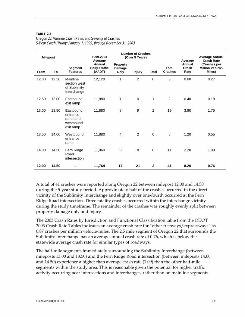
TABLE 2-3 Oregon 22 Mainline Crash Rates and Severity of Crashes 5-Year Crash History: January 1, 1999, through December 31, 2003
Milepost Number of Crashes
(Over 5 Years)
From To Segment Features
1999-2003 Average Annual
Daily Traffic (AADT)
Property Damage
Only Injury Fatal Total
Crashes
Average Annual Crash Rate
Average Annual Crash Rate
(Crashes per Million Vehicle-
Miles)
12.00 12.50 Mainline section west of Sublimity Interchange
12,120 1 2 0 3 0.60 0.27
12.50 13.00 Eastbound exit ramp
11,880 1 0 1 2 0.40 0.18
13.00 13.50 Eastbound entrance ramp and westbound exit ramp
11,880 8 9 2 19 3.80 1.75
13.50 14.00 Westbound entrance ramp
11,880 4 2 0 6 1.20 0.55
14.00 14.50 Fern Ridge Road intersection
11,060 3 8 0 11 2.20 1.09
12.00 14.50 — 11,764 17 21 3 41 8.20 0.76
A total of 41 crashes were reported along Oregon 22 between milepost 12.00 and 14.50 during the 5-year study period. Approximately half of the crashes occurred in the direct vicinity of the Sublimity Interchange and slightly over one-fourth occurred at the Fern Ridge Road intersection. Three fatality crashes occurred within the interchange vicinity during the study timeframe. The remainder of the crashes was roughly evenly split between property damage only and injury.
The 2003 Crash Rates by Jurisdiction and Functional Classification table from the ODOT 2003 Crash Rate Tables indicates an average crash rate for “other freeways/expressways” as 0.87 crashes per million vehicle-miles. The 2.5 mile segment of Oregon 22 that surrounds the Sublimity Interchange has an average annual crash rate of 0.76, which is below the statewide average crash rate for similar types of roadways.
The half-mile segments immediately surrounding the Sublimity Interchange (between mileposts 13.00 and 13.50) and the Fern Ridge Road intersection (between mileposts 14.00 and 14.50) experience a higher than average crash rate (1.09) than the other half-mile segments within the study area. This is reasonable given the potential for higher traffic activity occurring near intersections and interchanges, rather than on mainline segments.

SUBLIMITY INTERCHANGE AREA MANAGEMENT PLAN
2-12 PDX/052070004_USR.DOC
Tables 2-4 and 2-5 provide details of the conditions during the crashes as well as the type and severity.
TABLE 2-4 Oregon 22 Crash Conditions 5-Year Crash History: January 1, 1999, through December 31, 2003
Oregon 22 Mainline
Condition Number of Crashes Percentage of Total
Weather
Clear 28 68.3
Cloudy 7 17.1
Rain 4 9.8
Snow 0 0.0
Unknown 2 4.9
Roadway Surface
Dry 34 82.9
Wet 5 12.2
Ice 0 0.0
Snow 0 0.0
Unknown 2 4.9
Light
Day 28 68.3
Dimly lit 3 7.3
Dark 6 14.6
Dusk 3 7.3
Dawn 1 2.4

SUBLIMITY INTERCHANGE AREA MANAGEMENT PLAN
PDX/052070004_USR.DOC 2-13
TABLE 2-5 Oregon 22 Crash Descriptions 5-Year Crash History: January 1, 1999, through December 31, 2003
Oregon 22 Mainline
Condition Number of Crashes Percentage of Total
Collision Type
Rear-end 12 29.3
Turning 6 14.6
Fixed object 8 19.5
Sideswipe 3 7.3
Struck at angle 3 7.3
Pedestrian 1 2.4
Head On 3 7.3
Other 5 12.2
Severity
Property damage only 17 41.5
Injury 21 51.2
Fatality 3 7.3
Crash Cause
Failed to yield right-of-way 8 19.5
Other—improper driving 1 2.4
Speed too fast for conditions 18 43.9
Followed too closely 5 12.2
Made improper turn 2 4.9
Alcohol or drugs involved 2 4.9
Mechanical defect 1 2.4
Drove on wrong side of two-way road 1 2.4
No code 3 7.3
The majority of the crashes on Oregon 22 occurred during clear, dry, daylight conditions. A factor in many of the crashes involved speeding and failure to appropriately yield. The stop-controlled entrance ramp configuration is likely a large contributing factor to these crashes, as vehicles enter the highway from a complete stop.
One pedestrian fatality crash occurred in 2001. This incident involved a vehicle traveling eastbound on Oregon 22 and a pedestrian who was struck as he crossed Oregon 22 near the

SUBLIMITY INTERCHANGE AREA MANAGEMENT PLAN
2-14 PDX/052070004_USR.DOC
eastbound off-ramp (MP 13.01) to the Sublimity Interchange. There are no crosswalks or pedestrian signals along Oregon 22 at this location.
Two additional fatality crashes occurred in the vicinity of the Sublimity Interchange. In 2000, a head-on collision occurred in the morning when an eastbound vehicle crossed the centerline and struck a westbound passenger vehicle at MP 12.53. In 2003, a similar crash occurred in the late evening when an eastbound vehicle failed to maintain its lane, crossed over the centerline, and struck a westbound vehicle at MP 13.00.
Table 2-6 summarizes the crashes along Cascade Highway between mile points 0.61 and 1.59. Marion County utilizes mile points to represent distances on county roads; therefore, each 0.01 mile point is approximately 50 feet. For reference, the approximate mile point locations of intersections along Cascade Highway are listed below:
• Shaff Road–Fern Ridge Road—Mile point 0.61 • Eastbound Entrance–Exit ramp—Mile point 1.09 • Sublimity Blvd—Mile point 1.20 • 9th Street—Mile point 1.59
TABLE 2-6 Cascade Highway Mainline Crash Rates and Severity of Crashes 5-Year Crash History: January 1, 1999, through December 31, 2003
Mile point Number of Crashes
(Over 5 Years)
From To Segment Features
1999-2003 Average Annual
Daily Traffic (AADT)
Property Damage
Only Injury Fatal Total
Crashes Average Annual
Average Annual Crash Rate
(Crashes per Million Vehicle-
Miles)
0.60 0.85 Shaff Road–Fern Ridge Road
12,020 7 3 0 10 2.00 1.82
0.85 1.10 Eastbound entrance–exit ramp
11,780 2 1 0 3 0.60 0.56
1.10 1.35
Sublimity Blvd–westbound ramps
9,310 10 6 0 16 3.20 3.77
1.35 1.60 9th Street 7,920 2 2 0 4 0.80 1.11
0.60 1.60 — 10,260 21 12 0 33 6.60 1.76
A total of 33 crashes was reported along Cascade Highway between Shaff Road–Fern Ridge Road and 9th Street during the 5-year study period. Half of the crashes occurred near the intersection of Cascade Highway and the Sublimity Boulevard–Oregon 22 westbound exit ramp, and just under one-third of the total crashes occurred in the vicinity of the Shaff Road–Fern Ridge Road intersection. No fatality crashes occurred along the 1-mile study corridor within the study timeframe. Of the 33 crashes, approximately two-thirds resulted in property damage only while the remaining one-third resulted in injuries.

SUBLIMITY INTERCHANGE AREA MANAGEMENT PLAN
PDX/052070004_USR.DOC 2-15
Cascade Highway north of Oregon 22 is categorized as an arterial. The average crash rate for Suburban Non-Freeway Arterials is 0.60 crashes per million vehicle-miles. Both quarter-mile segments north of the interchange experience crashes at a rate higher than average 2003 Oregon crash rates. The segment immediately north of the interchange (including the intersection with Sublimity Boulevard–Oregon 22 westbound exit ramp) is over five times as great as this average. Cascade Highway south of Oregon 22 is categorized as a principal arterial. The average crash rate for this type of segment is 1.34 crashes per million vehicle-miles. The quarter-mile segment that includes the intersection of Shaff Road–Fern Ridge Road experiences a higher than average crash rate, but overall, the southern portion of Cascade Highway remains below the average rate.
Tables 2-7 and 2-8 provide details of the conditions during the crashes as well as the type and severity of crashes along Cascade Highway.
TABLE 2-7 Cascade Highway Crash Conditions 5-Year Crash History: January 1, 1999, through December 31, 2003
Cascade Highway Mainline
Condition Number of Crashes Percentage of Total
Weather
Clear 22 66.7
Cloudy 6 18.2
Rain 3 9.1
Snow 0 0.0
Unknown 2 6.1
Roadway Surface
Dry 27 81.8
Wet 6 18.2
Ice 0 0.0
Snow 0 0.0
Unknown 0 0.0
Light
Day 31 93.9
Dimly lit 1 3.0
Dark 1 3.0
Dusk 0 0.0
Dawn 0 0.0

SUBLIMITY INTERCHANGE AREA MANAGEMENT PLAN
2-16 PDX/052070004_USR.DOC
TABLE 2-8 Cascade Highway Crash Descriptions 5-Year Crash History: January 1, 1999, through December 31, 2003
Cascade Highway Mainline
Condition Number of Crashes Number of Crashes
Collision Type
Rear-end 17 51.5
Turning 8 24.2
Fixed object 0 0.0
Sideswipe 1 3.0
Struck at angle 6 18.2
Pedestrian 0 0.0
Head-on 1 3.0
Other 0 0.0
Severity
Property damage only 21 63.6
Injury 12 36.4
Fatality 0 0.0
Crash Cause
Failed to yield right-of-way 13 39.4
Other—improper driving 0 0.0
Speed too fast for conditions 15 45.5
Followed too closely 4 12.1
Made improper turn 0 0.0
Alcohol or drugs involved 0 0.0
Mechanical defect 1 3.0
Drove on wrong side of two-way road 0 0.0
No code 0 0.0

SUBLIMITY INTERCHANGE AREA MANAGEMENT PLAN
PDX/052070004_USR.DOC 2-17
Similar to those on Oregon 22, the majority of the crashes on Cascade Highway occurred during clear, dry, daylight conditions. Over half of the crashes on Cascade Highway involved rear-end collisions. Speed and failure to yield the right-of-way were factors in almost 85 percent of the crashes.
Access management requirements and deficiencies for the Sublimity Interchange are described in Section 4 of this report.
Natural and Cultural Resources The Sublimity IAMP study area contains land from three local jurisdictions: Marion County, the City of Sublimity, and the City of Stayton. Project improvements could, therefore, potentially trigger environmental protection regulations of any or all of these jurisdictions, as well as state and federal regulations. This section examines the existence of natural and cultural resources in the study area and related potential project constraints presented.
The existences of any Goal 5 resources are addressed in this section. Goal 5 is a broad, Oregon statewide planning goal that covers a variety of environmental and other resources. Goal 5 and related OARs (chapter 660, divisions 16 and 23) describe how cities and counties are to plan and zone land to conserve resources listed in the goal.
Topography The topography of the study area contains both flat and low rolling terrain. The main feature of the landscape is Mill Creek, which runs primarily east-west through the study area. Low ridges step up from the flatlands adjacent to the creek. Topography in the immediate vicinity of the Sublimity Interchange is described by quadrant below.
Northeast Quadrant of Interchange
From the point where it passes under Oregon 22 northward, Cascade Highway SE ascends approximately 50 feet in less than a quarter-mile, dips slightly, then rises again as it intersects with 9th Street in Sublimity.
Southeast Quadrant of Interchange
The southeast quadrant of the interchange contains the flat floodplain and wetland area adjacent to Mill Creek. A subdivision with new homes on fill materials is located in the floodplain depression. Moving southward toward the center of Stayton, a low ridge exists with an elevation gain of approximately 50 feet.
Southwest Quadrant of Interchange
The ridge in the northeast quadrant described above is present to the southwest of the interchange and presents a relatively steep grade. The existing two-way highway interchange ramp in this quadrant cuts through this ridge, with a resulting slight hill to the north of the ramp and a steeper hill to the south of the ramp.

SUBLIMITY INTERCHANGE AREA MANAGEMENT PLAN
2-18 PDX/052070004_USR.DOC
Northwest Quadrant Interchange
The terrain to the northwest of the intersection of Oregon 22 and Cascade Highway SE rises approximately 30-40 feet. Sublimity Boulevard SE drops from this ridge to its intersection with Cascade Highway SE.
Project Relevant Issues • The northbound grade on Cascade Highway SE and adjacent ridges present sight-
distance issues for motorists at the two-way highway ramp intersections as well as the intersections of Sublimity Boulevard and Golf Lane. Closely-spaced slope changes have an adverse effect on safety in the interchange area. Interchange rehabilitation efforts will require more earthwork during construction and may require additional stabilization, which will have budget and schedule implications.
Hydrology The project study area lies within the Willamette River Subbasin, in the Middle Willamette Subbasin, in the Mill Creek Watershed. Mill Creek, after passing through the study area, flows northwestward to its convergence with the Willamette River in the City of Salem. Within the study area for this IAMP, Mill Creek runs south of Oregon 22 from the west end of the study area. The creek passes through a culvert under Cascade Highway SE just south of Golf Lane and then traverses under Oregon 22 approximately a quarter-mile east of Cascade Highway.
Project Relevant Issues • There are hydrologic features contained in the study area that are classified as Goal 5
Resources (as defined in OAR Division 23). Sublimity IAMP actions may be subject to state or local regulations that are in place to protect Goal 5 resources, as will be discussed in greater detail in the next section.
Riparian Corridors The Mill Creek riparian corridor located inside the study area includes the perennially flowing Mill Creek, several intermittent streams, and a wetland area measuring just over 1 acre.
The section of Mill Creek running through the study area is included on the Oregon Department of Environmental Quality’s (DEQ’s) 303(d) list of water quality-limited streams. The DEQ 2003 303(d) list identifies the section of Mill Creek in the study area as water quality limited for fecal coliform.
According to the Oregon Department of Fish and Wildlife (ODFW), the study area section of Mill Creek is spawning and rearing habitat for winter steelhead and fall Chinook, and is rearing and migration habitat for spring Chinook.
Project Relevant Issues • Sublimity IAMP actions are subject to Oregon Department of Land Conservation and
Development (DLCD) Goal 5 ordinance regulations concerning land use actions inside the Mill Creek riparian corridor. Proposed Sublimity IAMP use actions are allowed in riparian corridors (per OAR 660-023-0090(8)(a)), provided that these actions “are designed and constructed to minimize intrusion into the riparian area.”

SUBLIMITY INTERCHANGE AREA MANAGEMENT PLAN
PDX/052070004_USR.DOC 2-19
• Highway runoff can be a source of fecal coliform. Improvements related to the Sublimity IAMP project would need to avoid or mitigate stormwater impacts to Mill Creek to meet the requirements of DEQ National Pollutant Discharge Elimination System (NPDES) 1200-CA.
Floodplains Portions of a river or stream channel and adjacent lands that are subject to floods with a 1 percent chance of being exceeded in any given year are identified as 100-year floodplains or Special Flood Hazard Areas (SFHAs). These floodplains are indicated on Flood Insurance Rate Maps (FIRMs), which are prepared by the Federal Emergency Management Agency (FEMA).
A large portion of the study area is located within the 100-year floodplain of Mill Creek. Only the northwest quadrant of the interchange is outside the FEMA floodplain boundaries. FEMA 100-year floodplain boundaries in the Sublimity IAMP study area are shown on Figure 2-4.
The portion of the floodplain area within the jurisdiction of Marion County is covered by Marion County’s Floodplain Overlay Zone, with associated development restrictions.
The portion of the floodplain area within the jurisdiction of the City of Stayton is covered by Stayton’s Floodplain Overlay Zone, with associated development restrictions.
Project Relevant Issues • If the Sublimity IAMP project improvements enter the footprint of the 100-Year
Floodplain, and if a National Environmental Policy Act of 1969 (NEPA) process is followed, environmental documentation would be required to explain specific impacts of the project and the resources within the floodplain.
• In the event that Sublimity IAMP project improvements result in any increase in the 100-year flood water level, FEMA must review and comment on the project. This involves applying for a Certified Letter of Map Revision (CLOMR) from FEMA. All requests for CLOMRs must be supported by detailed flood hazard analyses prepared by a qualified professional engineer.
• Any project-related improvement development (that is, placement of fill) in the Marion County Floodplain Overlay Zone is subject to conditional use review by the county via the submission of a Floodplain Development Permit.
• Per Marion County Rural Zoning Ordinance 178.050(E), any project related filling, grading, paving, or excavation within the 500-year floodplain of the Mill Creek Basin Flood Hazard Area (MCBFHA) is subject to conditional use review by the county via the submission of a Floodplain Development Permit.
• Any project-related improvement development (that is, placement of fill) in the City of Sublimity Floodplain Overlay Zone is subject to conditional use review by the county via the submission of a Floodplain Development Permit per Sublimity Code 17.16.190.

SUBLIMITY INTERCHANGE AREA MANAGEMENT PLAN
2-20 PDX/052070004_USR.DOC
Floodway The area of the 100-year floodplain is divided into floodway and floodway fringe. The floodway is the channel of a stream, plus any adjacent floodplain areas, that must be kept free of encroachment in order that the 100-year flood is carried without substantial increase in flood heights. As a minimum standard, the Federal Insurance Administration (FIA) limits increases in flood heights to 1.0 foot, provided that hazardous velocities are not produced.8
A FEMA-designated floodway exists along Mill Creek in the Sublimity IAMP study area. This floodway lies within the jurisdictions of Marion County and the City of Stayton. The location of this floodway can be seen on the FEMA FIRM, included in this report as Appendix E.
Project Relevant Issues • Any project-related development improvements (including fill, new construction, and
substantial improvements) in the floodway are prohibited unless a certified technical evaluation is submitted to FEMA demonstrating that such improvements will not result in an increase in flood levels during the occurrence of the base flood discharge. Upon FEMA approval, such improvements are then subject to applicable flood hazard reduction provisions of Marion County Rural Zoning Ordinance 178.060 and City of Stayton Code 17.16.190.
Wetlands A number of National Wetlands Inventory (NWI) wetland areas are present in the study area. A Local Wetland Inventory (LWI) commissioned by the City of Stayton delineated additional wetland areas in the study area. Figure 2-4 shows the boundaries of the delineated wetland area. A portion of land delineated as wetlands in the LWI, located in Stayton east of Cascade Highway, has since been filled to allow for the construction of a residential development (the aerial photo in Figure 2-4 predates the construction of this development).
Project Relevant Issues • The Sublimity IAMP will attempt to avoid actions that would affect identified wetlands.
If impacts are unavoidable, ODOT will need to identify mitigation opportunities. Mitigation will need to be performed per the land development application requirements of the jurisdiction within which the wetland alteration is occurring. A wetland delineation and functional assessment need to be performed to determine the type and full extent of the potential wetland impacts.
Wildlife Habitat The Sublimity IAMP does not affect a documented wildlife habitat area, as defined by OAR 660-023-0110.
Federal Wild and Scenic Rivers Mill Creek, the only river flowing through the study area, is not a designated Federal Wild and Scenic river.
8 City of Stayton Comprehensive Plan, 1995, p.15.

SUBLIMITY INTERCHANGE AREA MANAGEMENT PLAN
PDX/052070004_USR.DOC 2-21
Oregon Scenic Waterways Mill Creek, the only waterway flowing through the project study area, is not listed on the Oregon Department of State Lands (ODSL) list of designated scenic waterways.
Groundwater Resources The entire study area lies within an area designated as a “groundwater restricted” zone by the Oregon Water Resources Department (OWRD). The entire study area also lies within Marion County’s Sensitive Groundwater Overlay Zone. OAR 660-023-0030(5) states that local governments with jurisdiction in OWRD groundwater restricted areas must declare those areas Significant Natural Resource Areas. Per OAR requirements, these local governments must subsequently develop programs to protect the designated significant groundwater resources.
Project Relevant Issues • Sublimity IAMP project actions must comply with existing Marion County, City of
Sublimity, or City of Stayton local ordinances regulating development in a groundwater restricted area.
Approved Oregon Recreation Trails The Sublimity IAMP does not impact an Oregon Parks and Recreation Department (OPRD) designated recreational trail.
Natural Areas The Sublimity IAMP does not affect an area listed on the U.S. Bureau of Land Management’s (BLM’s) Established Natural Areas of Oregon.
Wilderness Areas The Sublimity IAMP does not take place in a designated federal or local wilderness area.
Mineral and Aggregate Resources There are no existing quarries or gravel sites located in the study area.
Energy Sources There are no existing energy sources, as defined by OAR 660-023-0190(1)(a), in the study area.
Open Space There are no existing open spaces, as defined by OAR 660-023-0220(1), in the study area.
Scenic Views and Sites There are no publicly designated scenic views or sites in the study area.

SUBLIMITY INTERCHANGE AREA MANAGEMENT PLAN
2-22 PDX/052070004_USR.DOC
Threatened or Endangered Species According to the Joseph Street—Stayton North City Limits EA, a query of the Oregon Natural Heritage Program (ONHP) database returned no specific listings for rare, threatened, or endangered plants and animals in the Joseph Street EA project area (which encompasses the Sublimity IAMP study area).9 The following Willamette Valley native grassland plant species were reported as possible in the general area of the project: Aster curtisii, Erigeron decumbens, Sidalcea nelsoniana, Sidalcea campestris, Lomatium bradshawii, and Lathyrus holochlorus.
Natural Hazards According to the Oregon Department of Geology and Mineral Industries (DOGAMI) Relative Earthquake Hazard Map, much of the study area is classified as a “Zone C” (low/intermediate earthquake hazard risk) with pockets of “Zone D” (low earthquake hazard risk) and “Zone B” (intermediate/high earthquake hazard risk). The immediate Oregon 22 and Cascade Highway SE interchange is classified as a “Zone C” low risk. The ridge which curves through the memo study area is where “Zone B” earthquake hazard conditions exist. The location of “Zone B” areas can be seen in Figure 2-4.
According to Marion County’s Slide Hazards map, there are no Landslide Hazard Areas within the study area. However, there are existing areas with slopes greater than 20 percent. These “excessive slope areas” are shown in Figure 2-4.
Project Relevant Issues • Project improvements will include earthwork. Cuts and fills located in areas of landslide
or earthquake hazards can be unstable. Further analysis of natural hazards would need to be conducted during project design, as would the development of applicable avoidance and mitigation techniques.
Hazardous Substances According to DEQ’s Environmental Cleanup Site Information (ECSI) database, there are no sites within the study area with known contamination from hazardous substances.
Air Quality The study area is located in an area that is consistently in attainment with clean air levels set by the U.S. Environmental Protection Agency (EPA) in the National Ambient Air Quality Standards.
Historic and Cultural Resources • Within the study area there are no properties listed on the National Register of Historic
Places (NRHP).
• The study area is not part of a National Historic District.
9 ODOT and FHWA, 1995a.

SUBLIMITY INTERCHANGE AREA MANAGEMENT PLAN
PDX/052070004_USR.DOC 2-23
• Within the study area there are no properties listed on the NRHP, nor are there properties listed on the Oregon State Historic Preservation Office (OSHPO) Historic Inventory list.
• There is a Century Farm located in the northeast quadrant of the study area, but the farm was found to be ineligible for Historic Registry listing, per the Joseph Street—Stayton North City Limits REA.10
10 ODOT and FHWA, 1995, p. 14.


STAYTON
SUBLIMITY
SANTIAMHY
GOLF LN
FERN RIDGE RD
SHAFF RD
3RD
AV
CAS
CA
DE
HY
9TH ST
REGIS ST
KIN
DLE
WY
1ST
AV
CEN
TER
ST
10TH
AV
OA
KMO
NT
LN
DAWN DR
KATHY ST
GA
RD
NER
AV
WYATT AV
CEDAR ST
WILDFLOWER DR
7TH ST
WESTERN AV
FER
NST
8TH ST
DAL
MAT
IAN
AV CO
NIF
ER
CT
KENT CT
MEADOWBROOK LN
SPENNER RD
KIWI LP
SUMMERVIEW DR
EME
RAL
DP
L
MARIAN ST
GR
IER
DR
MIS
TMA
IDEN
CT
RO
CK
YTO
PC
T
CEDAR ST
REGIS ST
KATHY ST
Mill Creek
Sublimity InterchangeArea Management Plan
400 0 400 800 Feet
Sublimity / Stayton, Oregon
Figure 2-1Zoning
Area Enlarged
File Path: \\rosa\proj\ODOT\323129\GIS\mxds\zoning_study-area.mxd, Date: April 19, 2005 9:26:41 AM
Urban Transition Farm (UTF)
Stayton Zoning
No Zone Code
Commercial General (CG)
Commercial Retail (CR)
Industrial Agriculture (IA)
Industrial Commercial (IC)
Interchange Development (ID)
Light Industrial (IL)
Low-Density Residential (LD)
High-Density Residential (HD)
Single-Family Residential (LD)
Public / Semi-Public (P)
Sublimity Zoning
Multiple-Family Residential (MD)
Marion County Zoning
Exclusive Farm Use (EFU)
Zoning
Single-Family Residential
Multiple-Family Residential
Commercial
Public
Industrial
Future Industrial
Legend
Streets and Roads
Water
Urban Growth Boundary
City Boundary
N

Traffic Signal
Cascade Hwy &Martin Dr
Cascade Hwy &Golf Lane
Cascade Hwy &Eastbound Oregon 22
Ramp
Cascade Hwy &Sublimity Blvd
Eastbound Oregon 22& Cascade Hwy On-Ramp
Cascade Hwy &Fern Ridge Rd
Cascade Hwy &Whitney St
Cascade Hwy &Westbound Oregon
22 Ramp
Cascade Hwy &9th Street
free NB rightmovement
Figure 2-2Existing Conditions (2005)
Sublimity InterchangeArea Management Plan
Sublimity / Stayton, Oregon
Study Intersection Lane Configuration and Signal Control
Streets and Roads
Urban Growth Boundary
City Boundary
Legend
Area Enlarged
Study Intersection
Turning Movement Direction
Stop Sign
1 inch equals 800 feet
400 0 400 800 Feet
N
Westbound Oregon 22 & Cascade
Hwy On-Ramp

Cascade Hwy &Martin Dr
Cascade Hwy &Golf Lane
Cascade Hwy &Sublimity Blvd
Cascade Hwy &Fern Ridge Rd
Cascade Hwy &Whitney St
Cascade Hwy &9th Street
595 20
695
15
130 425 85
120175160
7016085
110 505 80
555 55
620 17510075
45 615
60 400
45390
5 650
10 780
1015
20 475
15 375
1550
470 190
460
35 435
152555
455
10
15 395 15
465
105
875
230
645
570
Eastbound Oregon 22& Cascade Hwy On-Ramp
Cascade Hwy &Eastbound Oregon 22
Ramp
Cascade Hwy &Westbound Oregon
22 Ramp
Westbound Oregon 22 & Cascade
Hwy On-Ramp
Figure 2-3Existing Conditions (2005)
Sublimity InterchangeArea Management Plan
Sublimity / Stayton, Oregon
30th Highest HourTurning Movement Volumes
Streets and Roads
Urban Growth Boundary
City Boundary
Legend
Area Enlarged
Study Intersection
Turning Movement Direction and Volume
1 inch equals 800 feet
400 0 400 800 Feet
N
645

STAYTON
SUBLIMITY
NE Quadrant
SW Quadrant
SE Quadrant
NW Quadrant
GOLF LN
SHAFF RD
CAS
CA
DE
HY
9TH ST
FERN RIDGE RD
3RD
AV
REGIS ST
KIN
DLE
WY
OA
KMO
NT
LN
WHITNEY ST
KATHY ST
HOBSON STC
ENTE
RS
T
1ST
AV
WILDFLOWER DR
WYATT AV
SUBLIMITY BV
KEN
TAV
FER
NST
WELDON ST
KENT CT
DO
UG
LAS
AV
MEADOWBROOK LN
MA RTI
ND
R
EVE
RG
REE
NST
DAL
MAT
IAN
AV
SUMMERVIEW DR
FOXH
ILL
AV
WIL
DIN
GP
L
CED
AR TERRACE CT
KATHY STKATHY S T
£¤22
Mill Creek
Sublimity InterchangeArea Management Plan
0 300 600 900 Feet
Figure 2-4Potential
Environmental Constraints
File Path: \\rosa\proj\ODOT\323129\GIS\mxds\Fig.3_Environmental Constraints.mxd, Date: July 20, 2005 3:44:03 PM
Sublimity / Stayton, Oregon
Area Enlarged
* Includes National Wetland Inventoryand Local Wetland Inventory (conductedby City of Stayton)
Legend
Wetlands*
Study Area
City Boundary
FEMA 100-YearFloodplain
Intermediate/High EarthquakeHazard Area
Excessive Slopes
Streets and Roads
Water
N

PDX/052070004_USR.DOC 3-1
SECTION 3
Future Conditions Analysis
This section describes possible future development of the land in the Sublimity IAMP study area and presents potential future traffic operations under Build and No Build conditions.
Land Use Analysis No significant future land development constraints exist in portions of the IAMP study area; those portions, however, that are classified as floodplain or wetlands are subject to federal regulation. Other development may be subject to state land use constraints.
Planned Land Development According to City of Sublimity and City of Stayton staff, there are currently no known large-scale planned land developments in the Sublimity IAMP study area. The Santiam Station development in the southeast quadrant of the interchange has a few developable lots remaining, which are expected to be developed within the project timeframe.
Land Development Forecast The potential for future land development varies among the four quadrants of the Sublimity Interchange study area. Although it is difficult to predict when and how intensively land will be developed in the vicinity of the interchange, a general picture of development constraints and development potential in the immediate area surrounding the interchange is as follows.
Northwest Quadrant The northwest quadrant has no significant development constraints. Full build-out development scenarios under current zoning were integrated into traffic operations forecasts in the Forecasted Traffic Operations section.
Northeast Quadrant
Land use development potential is severely constrained by the following factors:
• The entire quadrant is outside the Sublimity UGB and is zoned EFU. Oregon law does not allow new development in this zoning district, apart from a single-dwelling unit and farm facility structures. However, the Century Farm property in this quadrant may be eligible to make a claim for development under Measure 37. The intensity of development that would be allowed to occur on this property under a successful Measure 37 claim is uncertain at this time.
• A portion of this quadrant is within the boundaries of the 100-year floodplain and subject to applicable governmental regulations.
SUBLIMITY INTERCHANGE AREA MANAGEMENT PLAN
3-2 PDX/052070004_USR.DOC
• A portion of this quadrant is within the boundaries of a delineated wetland and subject to applicable governmental regulations.
• Policies contained in the 2005 Marion County Rural Transportation System Plan (see Appendix B) will assure that any future development of this property will not adversely impact area transportation facilities.
Southeast Quadrant
Land use development potential is constrained by the following factors:
• A substantial portion of this quadrant is within the boundaries of the 100-year floodplain, and therefore subject to applicable governmental regulations (this is discussed in detail in Section 2).
• A significant portion of this quadrant is within the boundaries of a delineated wetland, and therefore subject to applicable governmental regulations (this is discussed in detail in Section 2).
• A portion of this quadrant is zoned EFU. This land is not believed to be eligible for a development claim under Measure 37.
• Most of the quadrant is owned by ODOT (park-and-ride lot, future interchange ramp, wetland mitigation site).
Southwest Quadrant
• A large portion of this quadrant is within the boundaries of both a 100-year floodplain and a delineated wetland. However, there is also a large piece of land, located between Golf Lane and the Mill Creek floodplain, which could be fully developed under City of Stayton zoning regulations. Full build-out development scenarios under current zoning were integrated into traffic operations forecasts in the Forecast Traffic Operations section.
Forecasted Traffic Operations This section provides forecasts of year 2025 traffic conditions assuming No Build and Build scenarios and describes possible deficiencies of both.
Traffic Forecasting Methodology Land use and associated traffic generation for the forecast year 2025 were estimated based on the City of Stayton’s Transportation Demand Model prepared for the City’s TSP.11
The household and employment data projections used in the model are shown in Tables 3-1 and 3-2. Overall population and employment are projected to increase by approximately 1.8 percent per year between 2000 and 2025.
11 2004.

SUBLIMITY INTERCHANGE AREA MANAGEMENT PLAN
PDX/052070004_USR.DOC 3-3
TABLE 3-1 Population and Household Forecast
Area 2000
Population 2025
Population 2000
Households 2025
Households
Stayton UGB 6,816 10,213 2,654 3,977
Sublimity 2,148 4,082 711 1,351
Other Surrounding Area 836 1,080 269 348
Total 9,800 15,375 3,634 5,676
Source: City of Stayton Transportation System Plan (2004).
TABLE 3-2 Employment Forecast
Area 2000
Employment 2025
Employment
Agriculture 33 33
Industrial 873 1,370
Retail 516 810
Service 769 1,206
Education 358 562
Government 47 74
Other 820 1,286
Total 3,416 5,341
Source: City of Stayton Transportation System Plan (2004).
The resultant traffic volume growth rate between the existing and Year 2025 No Build peak hour traffic volumes was calculated along the study corridor. An average growth rate for the entire area of 1.5 percent was calculated based on the 2003 and 2025 turning movement volumes presented in the City of Stayton TSP.12
This growth rate was applied to the 2005 turning movement counts and compounded annually to derive the Year 2025 traffic volumes for the 30th Highest Hour. Figure 3-2 depicts the design hour traffic volumes for Year 2025.
Future No Build (2025) Operations The No Build operations scenario assumes that the existing roadway lane configurations and traffic control are maintained, with one exception. Golf Lane would be realigned so that it forms a four-leg intersection with Whitney Street and Cascade Highway. The new intersection would be signalized and have left-turn pockets on all legs. Figure 3-1 depicts both existing and Year 2025 No Build lane geometry and traffic control.
12 2004.

SUBLIMITY INTERCHANGE AREA MANAGEMENT PLAN
3-4 PDX/052070004_USR.DOC
The forecast Year 2025 v/c ratios, LOS, and vehicle queues were computed for the eight study intersections and Oregon 22 entrance ramps based on the 30th Highest Hour design volumes. Table 3-3 shows the results of the operations analyses. Locations that do not meet the applicable mobility standards are highlighted. Figure 3-2 depicts the Year 2025 turning movement volumes at the study intersections.
Appendix F includes the traffic operations worksheets for the Year 2025 No Build 30th Highest Hour conditions.
TABLE 3-3 No Build Intersection Analysis Summary 2025 30th Highest Hour Design Volumes
Intersection Mobility
Standarda V/c
Ratiob LOSb Queue (ft)b,c,d
Mobility Standarda
V/c Ratiob LOSb
Queue (ft)b,c,d
Oregon 22 Approaches Ramp Approaches
Oregon 22 eastbound entrance ramp [unsignalized]
0.70 0.40 - 0 0.85 0.75 - 125
Oregon 22 westbound entrance ramp [unsignalized]
0.70 0.55 - 0 0.85 >1.0 - 275
Cascade Highway Approaches Cross Street Approaches
Cascade Highway at 9th Street [unsignalized]
E - A 75 E - C 75
Cascade Highway at Sublimity Boulevard– Oregon 22 westbound ramps [unsignalized]
0.75 0.06 - 150 0.85 >1.0 - 150
Cascade Highway at Oregon 22 westbound entrance ramp [unsignalized]
0.75 0.62 - 0 - - - 0
Cascade Highway at Oregon 22 eastbound ramps [unsignalized]
0.75 0.41 - 375 0.85 >1.0 - 475
Cascade Highway at Golf Lane–Whitney Street [signalized]
D - C 725 D - E 250
Cascade Highway at Martin Drive [unsignalized]
- - - - E - C 50
Cascade Highway at Shaff Road–Fern Ridge Road [signalized]
D - F 975 D - F 1000
a ODOT mobility standards are based on v/c ratios. Stayton and Sublimity standards are based on LOS. b Results are reported for approach with worst operational characteristics. c ODOT intersections are calculated with the 2-minute rule. Stayton and Sublimity intersection queues are
reported from SimTraffic outputs. d Assumes 25 feet per vehicle.

SUBLIMITY INTERCHANGE AREA MANAGEMENT PLAN
PDX/052070004_USR.DOC 3-5
Year 2025 No Build Deficiencies The results of the No Build operational analysis show that all of the cross streets south of and including the interchange will not meet the required mobility standards. The only intersection approach that will operate at an adequate LOS is the right-in/right-out movement of Martin Drive. Additionally, the westbound entrance ramp to Oregon 22 will decline below the applicable mobility standards by the forecast year 2025.
An area with growth potential within the study area is located in the northeast quadrant of the interchange. The area is designated as EFU. There are no known plans for development on the EFU properties, and they were not included in the land use forecasts. If, however, these lands are developed under a Measure 37-type claim, the study area intersection operations will be further deteriorated. The extent of impacts resulting from the properties would depend on the type and level of use. Development of the EFU lands would likely result in an increase of heavy vehicles at the interchange. Thus, accident rates could also increase due to heavy vehicles utilizing the stop-controlled access to Oregon 22.
Future Build (2025) Operations The Build scenario assumes that the ODOT Phase 1 improvements for the Sublimity Interchange are constructed. Phase 1 includes construction of a new loop ramp in the northeast quadrant of the interchange for the westbound entrance ramp. It also includes a new ramp in the southeast quadrant for the eastbound entrance ramp. Both of the reconstructed entrance ramps would have acceleration lanes to allow a merge movement for entering the Oregon 22 traffic stream. In addition, Cascade Highway will be widened to five lanes from the Sublimity Boulevard intersection to the south. As with the No Build scenario, Golf Lane will also be realigned to create a four-leg intersection with Whitney Street and Cascade Highway. The new Golf Lane–Whitney Street intersection will be signalized. The revised roadway configuration, traffic control and channelization are shown in Figure 3-3.
The ultimate configuration for Oregon 22 is a four-lane divided highway. Completion of the ultimate configuration has been assumed in the 2025 Build scenario.
Table 3-4 summarizes the Build intersection analysis. Figure 3-4 depicts the turning movement volumes for the Year 2025 Build scenario. It is identical to the No Build conditions, except at the new eastbound entrance ramp movement. Appendix G includes the traffic operations worksheets for the 30th Highest Hour conditions.
TABLE 3-4 Build Intersection Analysis Summary 2025 30th Highest Hour Design Volumes
Intersection Mobility
Standarda V/c
Ratiob LOSb Queue (ft)b,c,d
Mobility Standarda
V/c Ratiob LOSb
Queue (ft)b,c,d
Oregon 22 Approaches Ramp Approaches
Oregon 22 eastbound entrance ramp [unsignalized]
0.70 0.40 - 0 0.85 0.19 - 0

SUBLIMITY INTERCHANGE AREA MANAGEMENT PLAN
3-6 PDX/052070004_USR.DOC
TABLE 3-4 Build Intersection Analysis Summary 2025 30th Highest Hour Design Volumes
Intersection Mobility
Standarda V/c
Ratiob LOSb Queue (ft)b,c,d
Mobility Standarda
V/c Ratiob LOSb
Queue (ft)b,c,d
Oregon 22 westbound entrance ramp [unsignalized]
0.70 0.55 - 0 0.85 0.28 - 0
Cascade Highway Approaches Cross Street Approaches
Cascade Highway at 9th Street [unsignalized]
E - A 75 E - C 75
Cascade Highway at Sublimity Boulevard–Oregon 22 westbound ramps. [unsignalized]
0.75 0.22 - 50 0.85 0.44 - 100
Cascade Highway at Oregon 22 westbound ramps [unsignalized]
0.75 0.33 - 0 - - - 0
Cascade Highway at Oregon 22 eastbound ramps [unsignalized]
0.75 0.39 - 75 0.85 0.88 - 250
Cascade Highway at Whitney Street–Golf Lane [signalized]
D - B 325 D - D 175
Cascade Highway at Martin Drive [unsignalized]
- - - 0 E - A 50
Cascade Highway 30 at Shaff Road–Fern Ridge Road [signalized]
D - D 350 D - E 625
a ODOT mobility standards are based on v/c ratios. Stayton and Sublimity standards are based on LOS. b Results are reported for approach with worst operational characteristics. c ODOT intersections are calculated with the 2-minute rule. Stayton and Sublimity intersection queries are
reported from SimTraffic outputs. d Assumes 25 feet per vehicle
Year 2025 Build Deficiencies The results of the Build operational analysis show improved operations for the Oregon 22 entrance ramps with the construction of acceleration lanes to access the highway’s stream of traffic. Both ramps will operate well within the mobility standard thresholds.
Operations along Cascade Highway will remain within all jurisdictional mobility standards. The queue analyses depict that vehicle queuing from adjacent intersections will not interfere with the operations of the interchange.

SUBLIMITY INTERCHANGE AREA MANAGEMENT PLAN
PDX/052070004_USR.DOC 3-7
Intersection approaches to Cascade Highway also operate better under the Build conditions. However, two of the cross streets (the eastbound exit ramp and Shaff Road–Fern Ridge Road) would not meet the required mobility standards.
The interchange area traffic operations would likely remain similar to the Build scenario even if the EFU properties were developed. However, as discussed previously, the type and level of development would need to be considered. At the time of development, trip generation, operation, and traffic mitigation, should be analyzed. The revised entrance ramp configuration would allow for safer access onto the freeway, especially for any heavy vehicles generated by the EFU properties in the future.
Conclusions Current operating conditions along Oregon 22 meet ODOT’s applicable mobility standards. However, crashes along the highway exceed the state’s average rate in the vicinity of the interchange. The geometry of the roadway and the stop sign-controlled access likely contributed to the crashes, as the majority of incidents occurred during clear, dry, daylight conditions.
Along Cascade Highway, the stop sign-controlled Oregon 22 eastbound exit ramp and Whitney Street fall below the recommended operating standards. Additionally, the Cascade Highway and Shaff Road–Fern Ridge Road intersection operates poorly with extensive vehicle queuing. Crashes along the highway generally occur at a higher rate than the statewide average for similar facilities. Similar to the Oregon 22 crashes, most incidents on Cascade Highway occurred during clear, dry, daylight conditions.
By the year 2025, the Sublimity Interchange area would largely be operating beyond the required mobility standards set for the study intersections under current geometric and traffic control measures. With higher levels of congestion, accident rates are also likely to increase.
Various projects are planned to address the geometric and operational deficiencies. ODOT’s plans for the Sublimity Interchange include revision of the Oregon 22 entrance ramps to a standard merge configuration. In conjunction with the ODOT improvements, the preferred transportation system improvements for Cascade Highway, outlined in the Stayton TSP, assume the widening of Cascade Highway from Sublimity Boulevard to Regis Street (five-lane section).
Implementation of these improvements results in improved operations during the 2025 forecast year. Both Oregon 22 entrance ramps would operate within ODOT’s requirements. Crashes along Oregon 22 will likely decrease in the vicinity of the interchange as a result of installing the standard merge configuration.
Operations along Cascade Highway will also meet all mobility standards and will not result in interchange impacts due to queuing on the highway.
The Oregon 22 eastbound exit ramp operates slightly over the v/c standard of 0.85. It can likely be accommodated by the installation of a traffic signal if and when one becomes warranted. If full build-out volumes are achieved, an additional eastbound right-turn lane would accommodate the traffic demand at the intersection.

SUBLIMITY INTERCHANGE AREA MANAGEMENT PLAN
3-8 PDX/052070004_USR.DOC
Overall the Cascade Highway and Shaff Road–Fern Ridge Road intersection operates at LOS D, meeting the mobility requirements of the City of Stayton. However, the Shaff Road approach to Cascade Highway operates at LOS E during the design year. Construction of right-turn pockets on Shaff Road and Fern Ridge Road would allow all of the approaches to the intersection to operate at the required mobility standard.

Cascade Hwy &Martin Dr
Cascade Hwy &Sublimity Blvd
Cascade Hwy &Fern Ridge Rd
Cascade Hwy &Whitney St
Cascade Hwy &9th Street
Intersection is signalizedin No Build 2025
free NBright
movement
N/A
N/A - Turning Movement Direction is not applicable to design
Cascade Hwy &Eastbound Oregon 22
Ramp
Eastbound Oregon 22& Cascade Hwy On-Ramp
Cascade Hwy &Westbound Oregon
22 Ramp
Westbound Oregon 22 & Cascade
Hwy On-Ramp
Traffic Signal
Figure 3-1No Build Conditions (2025)
Sublimity InterchangeArea Management Plan
Sublimity / Stayton, Oregon
Study Intersection Lane Configuration and Signal Control
Streets and Roads
Urban Growth Boundary
City Boundary
Legend
Area Enlarged
Study Intersection
Turning Movement Direction(Existing 2005)
Stop Sign
1 inch equals 800 feet
400 0 400 800 Feet
N
Turning Movement Direction(No Build 2025)
New Construction (not to scale)

Cascade Hwy &Martin Dr
Cascade Hwy &Sublimity Blvd
Cascade Hwy &Fern Ridge Rd
Cascade Hwy &Whitney St
Cascade Hwy &9th Street
130 425 85
120175160
7016085
110 505 80150 680 110
175 575 115
95215115
165240215
230
645
570
315
770
860
470 190
460625
635 260
20 475
15 375
1550
20 505
30 640
2070
35 435
152555
455
10
15 395 1520 535 20
50 585
651015
203575
465
105
875
150
620
1175
45 615
60 400
45390
85 540
65 830
65530
595 20
695
15
940
20
805 30
N/A 555 55
N/AN/AN/A
100N/A75
N/A 620 175 15 815 240
10 740 75
1400
105
150
20
N/A - Turning Movement Direction is not applicable to design
Cascade Hwy &Eastbound Oregon 22
Ramp
Eastbound Oregon 22& Cascade Hwy On-Ramp
Cascade Hwy &Westbound Oregon
22 Ramp
Westbound Oregon 22 & Cascade
Hwy On-Ramp
Figure 3-2No Build Conditions (2025)
Sublimity InterchangeArea Management Plan
Sublimity / Stayton, Oregon
30th Highest HourTurning Movement Volumes
Streets and Roads
Urban Growth Boundary
City Boundary
Legend
Area Enlarged
Study Intersection
Turning Movement Direction
1 inch equals 800 feet
400 0 400 800 Feet
N
645 Turning Movement Volume(EX 2005)
Turning Movement Volume(NB 2025)
750
New Construction (not to scale)
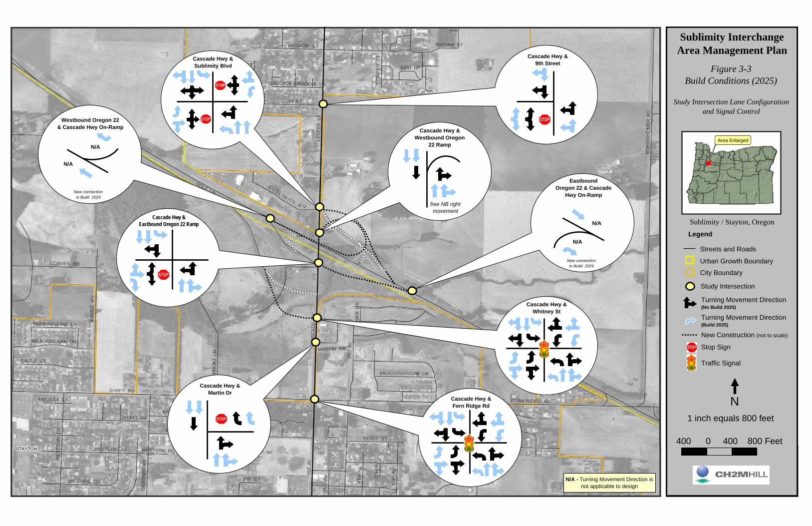
Cascade Hwy &Martin Dr
Cascade Hwy &Fern Ridge Rd
Cascade Hwy &Whitney St
Cascade Hwy &9th Street
free NB rightmovement
Cascade Hwy &Sublimity Blvd
N/A
N/A
New connection in Build 2025
New connection in Build 2025
N/A
N/A
N/A - Turning Movement Direction is not applicable to design
Cascade Hwy &Eastbound Oregon 22 Ramp
Westbound Oregon 22& Cascade Hwy On-Ramp Cascade Hwy &
Westbound Oregon22 Ramp
Eastbound Oregon 22 & Cascade
Hwy On-Ramp
Figure 3-3Build Conditions (2025)
Sublimity InterchangeArea Management Plan
Sublimity / Stayton, Oregon
Study Intersection Lane Configuration and Signal Control
Streets and Roads
Urban Growth Boundary
City Boundary
Legend
Area Enlarged
Study Intersection
1 inch equals 800 feet
400 0 400 800 Feet
N
Turning Movement Direction(No Build 2025)
Traffic Signal
Stop Sign
Turning Movement Direction(Build 2025)
New Construction (not to scale)

Cascade Hwy &Martin Dr
Cascade Hwy &Sublimity Blvd
Cascade Hwy &Fern Ridge Rd
Cascade Hwy &Whitney St
Cascade Hwy &9th Street
175 575 115
165240215
95215115
150 680 110150 680 110
175 575 115
95215115
165240215
635 260
625625
635 260
30 640
20 505
2070
20 505
30 640
2070
50 585
203575
651015
20 535 2020 535 20
50 585
651015
203575
805 30
940
20
940
20
805 30
65 830 N/A
85 540 N/A
65530
N/A 540 85
N/A 830 65
65530
10 740 75
150
20
1400
105
15 815 240 15 815 240
10 740 75
1400
105
150
20
* See No Build 2025 for volume location and lane channelization
New connection in Build 2025
860
315 *315
860 *
New connection in Build 2025
150
620
150 *
620 *
N/A - Turning Movement Direction is not applicable to design
Cascade Hwy &Eastbound Oregon 22 Ramp
Eastbound Oregon 22& Cascade Hwy On-Ramp
Cascade Hwy &Westbound Oregon
22 Ramp
Westbound Oregon 22 & Cascade
Hwy On-Ramp
Figure 3-4Build Conditions (2025)
Sublimity InterchangeArea Management Plan
Sublimity / Stayton, Oregon
30th Highest HourTurning Movement Volumes
Streets and Roads
Urban Growth Boundary
City Boundary
Legend
Area Enlarged
Study Intersection
Turning Movement Direction
1 inch equals 800 feet
400 0 400 800 Feet
N
645 Turning Movement Volume(No Build 2025)
Turning Movement Volume(Build 2025)
750
New Construction (not to scale)

PDX/052070004_USR.DOC 4-1
SECTION 4
Alternatives Development and Analysis
This section presents possible and preferred alternatives for Sublimity Interchange improvements of Cascade Highway along Oregon 22, in the City of Stayton, and in the City of Sublimity.
Sublimity Interchange Improvements The Sublimity Interchange is programmed for improvements in the 2006–2009 STIP. As proposed, this STIP project will involve partially reconstructing the interchange.
The entrance ramps in both directions will be rebuilt to a standard merge configuration, replacing the existing stop sign-controlled ramps. The ramp termini intersections with Cascade Highway will be aligned with their current locations. Both ramp terminals at Cascade Highway are proposed to be signalized in the future when warranted. Figure 4-1 depicts the Sublimity Interchange Phase 1 improvements.
In preparation for this project, a frontage road (Golf Lane) has already been constructed that eliminated all access to the Oregon 22 between Golf Club Road and Cascade Highway.
The ultimate configuration of the highway and interchange will include two lanes in each direction of travel on Oregon 22. This improvement is expected to occur by 2025, although the exact year is not currently known.
Access Management Requirements The purpose of the ODOT access management and spacing standards is to provide a safe and efficient transportation system by protecting highway traffic from the hazards of unrestricted and unregulated entry from adjacent properties. ODOT standards are outlined in OAR 734-051. The applicable standards are summarized in Table 4-1.

SUBLIMITY INTERCHANGE AREA MANAGEMENT PLAN
4-2 PDX/052070004_USR.DOC
TABLE 4-1 Minimum Spacing Standards Applicable to Freeway Interchanges
Spacing Dimension
Cascade Highway Configuration A X Y Z
Two-lane 1 mile 1,320 feet 1,320 feet 990 feet
Multi-lane 1 mile 1,320 feet 1,320 feet 1,320 feet
Source: Tables 5 and 6 in OAR 734-051-0125.
A = The distance between the start and end of tapers of adjacent interchanges along Oregon 22. X = The distance to the first approach on the right; right-in/right-out only. Y = The distance to the first intersections where left-turns are allowed. Z = The distance between the last right-in/right-out approach road and the start of the taper for the entrance
ramp.
In terms of access management, the goal of any interchange modernization project is to improve spacing and safety either by meeting or moving in the direction of applicable standards. The existing ramp configurations on Oregon 22 meet the ODOT access management spacing standards shown in Table 4-1. This is because the Golf Club Road Interchange to the west and the Fern Ridge Road intersection to the east are more than 1 mile apart.
Currently there are both public and private approaches onto Cascade Highway that do not meet ODOT’s minimum access spacing requirements of the Oregon 22 ramp terminals. Cascade Highway is currently a two-lane facility. The City of Stayton TSP, however, recommends widening the highway to five lanes from Sublimity Boulevard to Regis Street (south of Shaff Road–Fern Ridge Road) in its Year 2025 Preferred Alternative. Therefore, a 1320-foot spacing (multi-lane) requirement between the ramp termini and adjacent access points was assumed for Cascade Highway.
Table 4-2 lists existing approaches along Cascade Highway within the IAMP study area. Figure 4-2 depicts the corresponding locations of these approaches.
The following sections discuss access management alternatives for the IAMP area including spacing deficiencies, queuing, and traffic operations.

SUBLIMITY INTERCHANGE AREA MANAGEMENT PLAN
PDX/052070004_USR.DOC 4-3
TABLE 4-2 Existing Approaches along Cascade Highway
Figure 4-2 Approach Mile Point* Tax Lot(s) Served Approach Type
West Side of Cascade Highway (North of Oregon 22)
1 1.32 091W03BA03300 Single-Family Residence or Commercial Use
2 1.30 091W03BA03400 Single-Family Residence or Commercial Use
3 1.26 091W03BA03700 Single-Family Residence or Commercial Use
4 1.21 091W03B00500 Single-Family Residence or Commercial Use
5 1.20 091W03B00700 Single-Family Residence or Commercial Use
6 1.10 Sublimity Blvd. Public road
West Side of Cascade Highway (South of Oregon 22)
7 0.89 Oregon 22 Ramp Terminal Public road
8 0.83 Golf Lane Public road
East Side of Cascade Highway (South of Oregon 22)
9 0.74 Whitney Street Public road
10 0.83 091W03DB00300; 091W03DB00200 Park-and-ride lot; Wetland site
East Side of Cascade Highway (North of Oregon 22)
11 1.03 Oregon 22 Ramp Terminal Public road
12 1.09 Oregon 22 Ramp Terminal Public road
13 1.23 091W03A00300 Single-Family Residence or Commercial Farm
14 1.30 091W03A00200; 091W03A00100
Single-Family Residence or Commercial Farm
*Mile point given represents approximate midpoint of approach.
Alternatives This section describes how alternative solutions were developed and analyzed to remedy IAMP-identified deficiencies, which were predominantly access related in nature. Sublimity

SUBLIMITY INTERCHANGE AREA MANAGEMENT PLAN
4-4 PDX/052070004_USR.DOC
Interchange modernization plans and ODOT access management standards for freeway interchanges are outlined here as part of this description.
Alternatives for the IAMP study area were considered in three parts:
• Along Oregon 22 • Cascade Highway—Stayton (south of the interchange) • Cascade Highway—Sublimity (north of the interchange)
Table 4-3 summarizes all of the alternatives in tabular form. See Figure 4-2 for corresponding access locations.
TABLE 4-3 Access Management Alternatives Summary
Alternative Description
Access Standard
(feet) Deficient Access Distance
(feet) IAMP
Figure
Along Oregon 22
Existing Sublimity Interchange Configuration
Stop-controlled Oregon 22 entrance ramps
5,280 Fern Ridge Road. - 2-2
Proposed Sublimity Interchange Configuration
Entrance ramps with merge configuration
5,280 Fern Ridge Road 3,300 4-1
South of Interchange—Stayton (South of Interchange)
Existing Stayton Unsignalized, full movement intersections at Golf Lane, park-and-ride driveway, and Whitney Street
1,320
1,320
1,320
Golf Lane
Park-and-ride lot
Whitney Street
600
600
1,100
2-2
Preferred Stayton Alternative
Realignment of Golf Lane, across from Whitney Street
1,320
1,320
Park-and-ride lot
Golf Lane– Whitney Street
600
1,100
4-3
North of Interchange—Sublimity (North of Interchange)
Existing Sublimity
Sublimity Boulevard across from westbound ramp intersection and numerous private driveway access on Cascade Highway
1,320
1,320
1,320
1,320
1,320
1,320
1,320
Approach 5 (private)
Approach 4 (private)
Approach 3 (private)
Approach 2 (private)
Approach 1 (private)
Approach 13 (private)
Approach 14 (private)
500
600
900
1,100
1,250
700
1,100
2-2

SUBLIMITY INTERCHANGE AREA MANAGEMENT PLAN
PDX/052070004_USR.DOC 4-5
TABLE 4-3 Access Management Alternatives Summary
Alternative Description
Access Standard
(feet) Deficient Access Distance
(feet) IAMP
Figure
Sublimity Alternative 1
Sublimity Boulevard across from westbound ramp intersection and new intersection 1,320 feet from interchange servicing all property access
1,320 Sublimity Boulevard 0 4-6
Sublimity Alternative 2
Sublimity Boulevard across from westbound ramp intersection and private driveway access consolidated onto an internal road for driveways within 1,000 feet of the interchange
1,320
1,320
1,320
1,320
1,320
1,320
Sublimity Boulevard
New right-in/right-out approach
Approach 13 (private)
New consolidated approach
Approach 14 (private)
Approach 1 (private)
0
550
700
1,000
1,100
1,250
4-7
Sublimity Alternative 3
Sublimity Boulevard across from westbound ramp intersection, east parcels combined access, west parcels split into two combined accesses (one on Cascade, one on Sublimity)
1,320
1,320
Sublimity Boulevard
New consolidated approach
0
1,100
4-8
Preferred Sublimity Alternative
Sublimity Boulevard across from westbound ramp intersection, new intersection ~1,620 feet north of interchange servicing all properties. Internal roadway connection to the existing Sublimity Boulevard termini
1,320 Sublimity Boulevard 0 4-9
Along Oregon 22 The ODOT Sublimity Interchange Phase 1 design is the preferred alternative for the Oregon 22 mainline.
Oregon 22 Preferred Alternative
The recommendation for mainline Oregon 22 in the IAMP study area is for ODOT to consider closing the Fern Ridge Road at-grade intersection access to Oregon 22.13 Further analysis should be conducted to evaluate the demand or need for the Fern Ridge Road access, due to the applicable spacing requirements of the Sublimity Interchange and because
13 Closure of the intersection of OR-22 and Fern Ridge Road would be consistent with an agreement between the State and Marion County dated December 26, 1955, which states in Recital No. 5: “In the judgment of the State and county the interest of the public will best be served by eliminating the intersection of the throughway and Fern Ridge Road (Market Rd. #82) when a greater volume of traffic uses the said Fern Ridge Road. At such a future time the State will build and maintain a separation structure carrying Fern Ridge Road over the throughway and eliminate the intersection and connections provided for herein.”

SUBLIMITY INTERCHANGE AREA MANAGEMENT PLAN
4-6 PDX/052070004_USR.DOC
at-grade intersections are not typically utilized along freeway segments. The Fern Ridge Road at-grade intersection with Oregon 22 is located at approximately MP 14.30. The revised eastbound entrance ramp merge places this intersection within the minimum (1 mile) spacing requirement of the Sublimity Interchange improvements. The distance measured from the acceleration lane to the intersection is approximately 2,550 feet.
Otherwise, proposed Sublimity Interchange improvements achieve the operational mobility standards for both the Oregon 22 mainline and the new entrance ramps. 14 Table 4-4 summarizes the forecast year 2025 operations on Oregon 22.
TABLE 4-4 Oregon 22 Traffic Operations Analysis Summary 2025 30th Highest Hour Design Volumes
Intersection Mobility
Standarda V/c Ratio Mobility
Standarda V/c Ratio
Oregon 22 Approaches Entrance ramp Merge
Oregon 22 eastbound entrance ramp 0.70 0.40 0.85 0.19
Oregon 22 westbound entrance ramp 0.70 0.55 0.85 0.28 a ODOT mobility standards are based on v/c ratios.
Cascade Highway—Stayton (South of Interchange) The ODOT Sublimity Interchange Phase 1 design is the preferred alternative for the Oregon 22 mainline.
The City of Stayton’s preferred alternative roadway network concept (City of Stayton Transportation System Plan15) was analyzed for Cascade Highway south of Oregon 22.
Stayton Preferred Alternative The Year 2025 preferred alternative in the Stayton TSP incorporates ODOT’s plans for improving the Oregon 22 Sublimity Interchange. The supporting local street network improvements for the preferred alternative include the following:
• Widen Cascade Highway to five lanes (two lanes in each direction with left-turn pockets) between and including the Sublimity Boulevard and Regis Street intersections
• Realign Golf Lane to form a four-legged intersection with Whitney Street (for this improvement, the City of Stayton has entered into a memorandum of understanding [MOU] with Marion County)
• Install traffic signal and eastbound/westbound left-turn lanes at the Golf Lane–Whitney Street intersection.
14 Interchange physical improvements were proposed in the Joseph Street—Stayton North City Limits Environmental Assessment (ODOT and FHWA, 1995). 15 2004.

SUBLIMITY INTERCHANGE AREA MANAGEMENT PLAN
PDX/052070004_USR.DOC 4-7
Figure 4-3 shows proposed access management south of Oregon 22, representing the preferred alternative from the Stayton TSP.
The City of Stayton has provided a $50,000 match in conjunction with work recently completed for the interchange modernization project, further emphasizing their commitment to the project.
The City of Stayton’s TSP supports improvements to the Golf Club Road corridor (west of the study area) by widening Golf Club Road to five lanes from Oregon 22 to Shaff Road, and signalizing the major intersections along the roadway. These improvements have the potential to relieve a portion of the travel demand on the Cascade Highway corridor. However, as a conservative analysis approach, such vehicle diversions were not assumed in the analysis.
The three existing access deficiencies listed in Table 4-2 (Golf Lane, park-and-ride lot, and Whitney Street) would all remain deficient with the proposed configuration.
The realignment of Golf Lane, across from Whitney Street, would increase the spacing of the roadway from the Oregon 22 eastbound ramps by approximately 500 feet, but still would not meet the access management spacing standards of 1,320 feet. The new, signalized, four-legged intersection is expected to operate at an overall v/c ratio of 0.66. The critical movement in regards to the Sublimity Interchange operations is the southbound direction of travel. It is projected to produce queues of up to 315 feet. Queues of this magnitude would not interfere with the interchange’s eastbound ramp operations. Potential queue conflicts with the eastbound ramps can be further minimized by incorporating timing and phasing coordination between the new traffic signals along the Cascade Highway corridor. Figure 4-4 shows the anticipated vehicle queuing along Cascade Highway, south of the interchange, during the Year 2025 design hour. All traffic signals are assumed to be coordinated and optimized.
Neither the horizontal nor vertical alignment of Cascade Highway south of the interchange result in sight distance restrictions. The reconfigured intersection will have adequate stopping and decision time for drivers.
The park-and-ride lot access would remain at its current location, approximately 600 feet south of the eastbound ramp terminal. Relocation of this driveway would impact adjacent wetlands and Mill Creek, which would be both undesirable and costly. The usage of the park-n-ride was observed to be between 10 and 20 parked vehicles; the current low usage is because of limited transit opportunities in the Stayton and Sublimity area. Trip generation rates for park-and-rides with bus service were researched to estimate the potential trips emanating from this access if transit service were made available. Slightly more than 50 trips would be generated at the access during the peak traffic hour.
A potential area for relocation of the park-and-ride lot is adjacent to the realigned Golf Lane. If substantial improvements to transit and park-and-ride services are envisioned, relocation of the lot may be an alternative. Alteration of the access to a right-in/right-out only driveway may also lessen access impacts within the interchange access management area but could limit the transit service into and out of the lot.
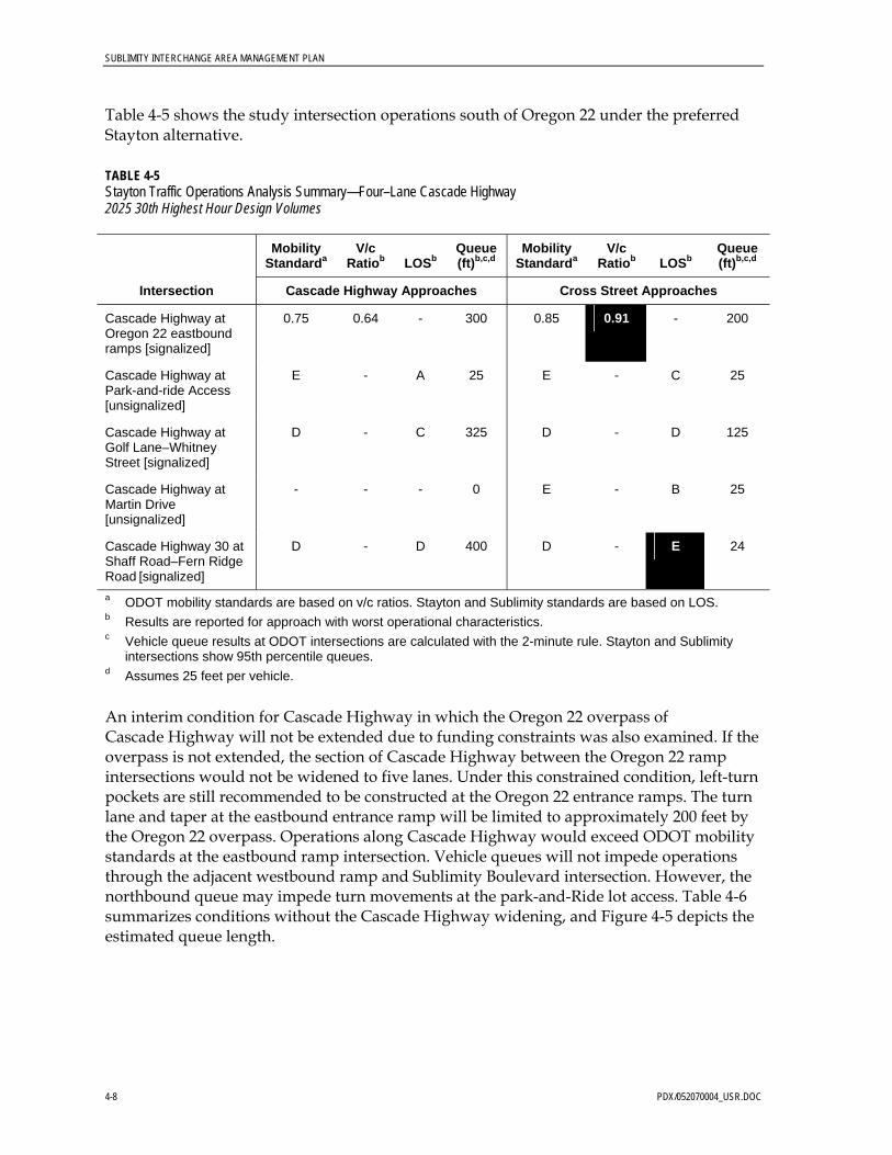
SUBLIMITY INTERCHANGE AREA MANAGEMENT PLAN
4-8 PDX/052070004_USR.DOC
Table 4-5 shows the study intersection operations south of Oregon 22 under the preferred Stayton alternative.
TABLE 4-5 Stayton Traffic Operations Analysis Summary—Four–Lane Cascade Highway 2025 30th Highest Hour Design Volumes
Mobility Standarda
V/c Ratiob LOSb
Queue (ft)b,c,d
Mobility Standarda
V/c Ratiob LOSb
Queue (ft)b,c,d
Intersection Cascade Highway Approaches Cross Street Approaches
Cascade Highway at Oregon 22 eastbound ramps [signalized]
0.75 0.64 - 300 0.85 0.91 - 200
Cascade Highway at Park-and-ride Access [unsignalized]
E - A 25 E - C 25
Cascade Highway at Golf Lane–Whitney Street [signalized]
D - C 325 D - D 125
Cascade Highway at Martin Drive [unsignalized]
- - - 0 E - B 25
Cascade Highway 30 at Shaff Road–Fern Ridge Road [signalized]
D - D 400 D - E 24
a ODOT mobility standards are based on v/c ratios. Stayton and Sublimity standards are based on LOS. b Results are reported for approach with worst operational characteristics. c Vehicle queue results at ODOT intersections are calculated with the 2-minute rule. Stayton and Sublimity
intersections show 95th percentile queues. d Assumes 25 feet per vehicle.
An interim condition for Cascade Highway in which the Oregon 22 overpass of Cascade Highway will not be extended due to funding constraints was also examined. If the overpass is not extended, the section of Cascade Highway between the Oregon 22 ramp intersections would not be widened to five lanes. Under this constrained condition, left-turn pockets are still recommended to be constructed at the Oregon 22 entrance ramps. The turn lane and taper at the eastbound entrance ramp will be limited to approximately 200 feet by the Oregon 22 overpass. Operations along Cascade Highway would exceed ODOT mobility standards at the eastbound ramp intersection. Vehicle queues will not impede operations through the adjacent westbound ramp and Sublimity Boulevard intersection. However, the northbound queue may impede turn movements at the park-and-Ride lot access. Table 4-6 summarizes conditions without the Cascade Highway widening, and Figure 4-5 depicts the estimated queue length.

SUBLIMITY INTERCHANGE AREA MANAGEMENT PLAN
PDX/052070004_USR.DOC 4-9
TABLE 4-6 Stayton Traffic Operations Analysis Summary—Two–Lane Cascade Highway 2025 30th Highest Hour Design Volumes
Mobility
Standarda V/c
Ratiob LOSb Queue (ft)b,c,d
Mobility Standarda
V/c Ratiob LOSb
Queue (ft)b,c,d
Intersection Cascade Highway Approaches Cross Street Approaches
Cascade Highway at Oregon 22–Sublimity Boulevard westbound ramps [signalized]
0.75 0.65 - 450 0.85 0.62 - 75
Cascade Highway at Oregon 22 eastbound ramps [signalized]
0.75 0.92 - 600 0.85 0.96 - 350
a ODOT mobility standards are based on v/c ratios. Stayton and Sublimity standards are based on LOS. b Results are reported for approach with worst operational characteristics. c Vehicle queue results at ODOT intersections are calculated with the 2-minute rule. Stayton and Sublimity
intersections show 95th percentile queues. d Assumes 25 feet per vehicle.
Cascade Highway—Sublimity (North of Interchange) The project management team (PMT) developed a preferred alternative for Cascade Highway north of Oregon 22 based on preliminary access management layouts.
Access management alternatives for the north side of the interchange were compiled based on input from the affected residents, the project management team, and the consultant team, as well as local government officials. All proposed alternatives were evaluated by the consultant team. A previous plan to realign Sublimity Boulevard was rejected by the City of Sublimity; thus, none of the alternatives considered that plan as an option. An access deviation will be needed for the Sublimity Boulevard approach, as all of the interchange designs maintain the connection to this approach (opposite from the westbound interchange ramps).
The widening of Cascade Highway to a five-lane section through the Sublimity Boulevard–Oregon 22 ramp intersection is assumed in all alternatives. The intersection is also assumed to be signalized in all alternatives.
Sublimity Alternative 1
The elements of Sublimity Alternative 1 are shown in Figure 4-6. The long-term plan removes all private approach access points along Cascade Highway within the management area. It creates a new intersection 1,320 feet north of the Oregon 22 westbound ramps. The existing properties in the northwest quadrant of the interchange will be served from an internal roadway connecting to the new intersection and to Sublimity Boulevard (300 feet west of Cascade Highway). The new roadway will be located near the western property line of the affected parcels. To further enhance circulation alternatives, an additional connection could also be constructed to the west when Sublimity Boulevard is extended.
SUBLIMITY INTERCHANGE AREA MANAGEMENT PLAN
4-10 PDX/052070004_USR.DOC
The two properties in the northeast quadrant of the interchange will also access Cascade Highway at the new intersection. The existing access points for these properties will be closed. A frontage road, to be built adjacent to Cascade Highway, will connect the existing driveways to the new intersection.
The new intersection on Cascade Highway is located along a crest vertical curve, with sight distance half the required 610 feet. In order to provide adequate sight distance at this location, it would be necessary to modify the vertical profile of Cascade Highway. This modification would be at substantial cost and would adversely impact the access to the properties fronting on Cascade Highway.
The new access along Sublimity Boulevard may be affected by queuing from the Cascade Highway signalized intersection. However, this would occur infrequently. The vehicle queue estimates for the Year 2025 design year are approximately 60 feet for the westbound Sublimity Boulevard traffic.
Currently, all properties within the access management area are residential (one residence contains a home occupation and parking lot) or farm use. Trip generation is and will remain low with these land uses. The parcels, however, are zoned for commercial use on the west side of the highway. Table 4-7 summarizes operations north of Oregon 22 assuming build-out of the properties as commercial businesses; further analyses should be performed upon redevelopment of properties, when detailed information is available. The new access along Cascade Highway is projected to operate poorly at LOS F. The stop-controlled approaches could be improved to meet the mobility standards by providing left-turn pockets for both the north- and eastbound vehicles.
The new roadway would provide safer access to and from Cascade Highway, good circulation, and access options. The roadway will be more suitable to serve the commercial land use upon redevelopment of the properties.

SUBLIMITY INTERCHANGE AREA MANAGEMENT PLAN
PDX/052070004_USR.DOC 4-11
TABLE 4-7 Sublimity Traffic Operations Analysis Summary—Alternative 1 2025 30th Highest Hour Design Volumes
Mobility
Standarda V/c
Ratiob LOSb Queue (ft)b,c,d
Mobility Standarda
V/c Ratiob LOSb
Queue (ft)b,c,d
Intersection Cascade Highway Approaches Cross Street Approaches
Cascade Highway at 9th Street [unsignalized]
E - A 25 E - C 50
Cascade Highway at new intersection 1,320 feet north of westbound ramps [unsignalized]
E - A 25 E - F 75
Cascade Highway at Sublimity Boulevard–Oregon 22 westbound ramps [unsignalized]
0.75 0.40 - 175 0.85 0.35 - 75
a ODOT mobility standards are based on v/c ratios. Stayton and Sublimity standards are based on LOS. b Results are reported for approach with worst operational characteristics. c Vehicle queue results at ODOT intersections are calculated with the 2-minute rule. Stayton and Sublimity
intersections show 95th percentile queues. d Assumes 25 feet per vehicle.
Sublimity Alternative 2
This alternative includes an internal connection between the properties fronting Cascade Highway in the northwest quadrant of the interchange. This alternative would connect the properties served by Approaches 5 to 2 listed in Table 4-2 and shown in Figure 4-2. Figure 4-7 depicts the proposed alignment of this alternative. Full access is proposed to occur at two locations: on Cascade Highway at the north end of Tax Lot 091W03BA03400 (1,100 feet north of the interchange), and on Sublimity Boulevard through the south side of Tax Lot 091W03BA03400 (300 feet west of the interchange). An additional right-in/right-out only access on Cascade Highway is proposed between Tax Lots 091W03B00500 and 091W03B00900 (550 feet north of the interchange). The consolidated access points remain within the access management area of the interchange. The internal roadway severely impacts the property served by Approach 5. However, this roadway would provide an alternative route for drivers when the Sublimity Boulevard and Cascade Highway intersection is operating at congested levels.
The new intersection on Cascade Highway is located along a crest vertical curve, with sight distance of slightly less than the required 610 feet.
The new access along Sublimity Boulevard may be affected by queuing from the Cascade Highway signalized intersection. However, this would not occur frequently. Queue estimates for the Year 2025 design year are approximately 60 feet for the westbound Sublimity Boulevard traffic.

SUBLIMITY INTERCHANGE AREA MANAGEMENT PLAN
4-12 PDX/052070004_USR.DOC
The two private driveways in the northeast quadrant of the interchange are proposed to remain in their current locations, within the 1,320 feet access management area. The residential and farm trip generation is expected to remain low, thus should not create operational problems. Mitigation for the accesses on the east side of Cascade Highway could include construction of a large radius driveway approach or widened shoulder to allow vehicles to slow down out of the travel lane.
Table 4-8 summarizes operations north of Oregon 22 assuming build-out of the commercial properties; further analyses should be performed upon redevelopment of properties, when detailed information is available. All of the access points along Cascade Highway are projected to operate within the required mobility standards and are characterized by minimal queuing.
TABLE 4-8 Sublimity Traffic Operations Analysis Summary—Alternative 2 2025 30th Highest Hour Design Volumes
Mobility
Standarda V/c
Ratiob LOSb Queue (ft)b,c,d
Mobility Standarda
V/c Ratiob LOSb
Queue (ft)b,c,d
Intersection Cascade Highway Approaches Cross Street Approaches
Cascade Highway at 9th Street [unsignalized]
E - A 25 E - C 50
Cascade Highway at Private Driveway 5 [unsignalized]
E - A 0 E - D 25
Cascade Highway at Private Driveway 7 [unsignalized]
E - A 0 E - D 25
Cascade Highway at Consolidated Driveways 1 through 4 [unsignalized]
E - A 0 E - B 25
Cascade Highway at Private Driveway 6 [unsignalized]
E - A 0 E - B 25
Cascade Highway at Sublimity Boulevard–Oregon 22 westbound ramps [signalized]
0.75 0.40 - 175 0.85 0.35 - 75
a ODOT mobility standards are based on v/c ratios. Stayton and Sublimity standards are based on LOS. b Results are reported for approach with worst operational characteristics. c Vehicle queue results at ODOT intersections are calculated with the 2-minute rule. Stayton and Sublimity
intersections show 95th percentile queues. d Assumes 25 feet per vehicle.

SUBLIMITY INTERCHANGE AREA MANAGEMENT PLAN
PDX/052070004_USR.DOC 4-13
Sublimity Alternative 3
This alternative combines aspects of the previous alternatives. Driveway consolidation is incorporated into the scenario, while minimizing impacts to the affected properties. The elements of Sublimity Alternative 3 are shown in Figure 4-8.
In the northeast quadrant of the interchange, Approaches 13 and 14 are proposed to be consolidated, with access at the existing 14 location (1,100 feet north of the interchange). Although within the access management area, travel demand for these two properties is expected to remain low. Sight distance at this location meets the 610 foot requirement. Mitigation could include construction of a large radius driveway approach or widened shoulder to allow vehicles to slow down out of the travel lane.
In the northwest quadrant, the southern properties would be served by a common access easement connecting to Sublimity Boulevard, approximately 300 feet west of Cascade Highway. The new access on Sublimity should not be affected by vehicle queues at the Cascade Highway traffic signal. Ninety-fifth percentile queues are estimated to be 60 feet. The northern properties are served by an access road connecting to a new intersection 1,320 feet north of the interchange. This configuration will decrease the amount of right-of-way acquisition and roadway construction needed to service the properties. This alternative will also maintain lower traffic volumes behind the residential properties, and reduce safety conflicts.
Table 4-9 summarizes operations north of Oregon 22 assuming build-out of the commercial properties; further analyses should be performed upon redevelopment of properties, when detailed information is available. Although characterized by short vehicle queues, the consolidated driveway access points would operate poorly at LOS F.
TABLE 4-9 Sublimity Traffic Operations Analysis Summary—Alternative 3 2025 30th Highest Hour Design Volumes
Mobility
Standarda V/c
Ratiob LOSb Queue (ft)b,c,d
Mobility Standarda
V/c Ratiob LOSb
Queue (ft)b,c,d
Intersection Cascade Highway Approaches Cross Street Approaches
Cascade Highway at 9th Street [unsignalized]
E - A 25 E - C 50
Cascade Highway at Consolidated Driveway 1,320 feet north of westbound ramps [unsignalized]
E - A 0 E - F 25
Cascade Highway at Private Driveway 6 and 7 [unsignalized]
E - A 0 E - F 25
Cascade Highway at Sublimity Boulevard–Oregon 22 westbound ramps [signalized]
0.75 0.40 - 175 0.85 0.35 - 75

SUBLIMITY INTERCHANGE AREA MANAGEMENT PLAN
4-14 PDX/052070004_USR.DOC
TABLE 4-9 Sublimity Traffic Operations Analysis Summary—Alternative 3 2025 30th Highest Hour Design Volumes
Mobility
Standarda V/c
Ratiob LOSb Queue (ft)b,c,d
Mobility Standarda
V/c Ratiob LOSb
Queue (ft)b,c,d
Intersection Cascade Highway Approaches Cross Street Approaches a ODOT mobility standards are based on v/c ratios. Stayton and Sublimity standards are based on LOS. b Results are reported for approach with worst operational characteristics. c Vehicle queue results at ODOT intersections are calculated with the 2-minute rule. Stayton and Sublimity
intersections show 95th percentile queues. d Assumes 25 feet per vehicle.
Sublimity Preferred Alternative
The three Sublimity alternatives were presented at a June 2005 PMT meeting. The benefits and impacts of each were discussed, and a preferred alternative was derived. Figure 4-9 shows the preferred alternative.
Two new access roadways will be created, respectively serving properties on the east and west side of Cascade Highway. Both roadways will access Cascade Highway at a new intersection, located approximately 1,580 feet from the interchange. The intersection will be established according to American Association of State highway and Transportation Officials (AASHTO) standards and located to meet access management spacing requirements, provide adequate sight distance, and maximize safety. This new intersection will be unsignalized and allow for full movement.
A technical memo describing the rationale for IAMP-recommended intersection placement is included in Appendix H.
On the west side of Cascade Highway, a backage road will extend behind the existing properties (served by Approaches 1 through 5) and through a currently unimproved lot (091W03B00900) to an unsignalized, full-movement intersection with Sublimity Boulevard. This intersection would be located approximately 470 feet west of the Sublimity Boulevard and Cascade Highway intersection. On the east side, a frontage road will connect the new intersection to the two existing driveways.
This alternative removes all private driveways along Cascade Highway within the Interchange Access Management Limit area, and places the new highway access at a location with the maximum sight distance. This alternative also minimizes potential impacts along Sublimity Boulevard in the vicinity of the intersection with Cascade Highway and the Oregon 22 ramp termini.
Currently, all properties within the access management area are residential (one residence contains a home occupation) or farm use. Trip generation is and will remain low with these land uses. The parcels, however, are zoned for commercial use on the west side of the highway. Table 4-10 summarizes operations north of Oregon 22 assuming build-out of the properties as commercial businesses. Appendix I contains a draft ordinance for the City of

SUBLIMITY INTERCHANGE AREA MANAGEMENT PLAN
PDX/052070004_USR.DOC 4-15
Sublimity that, if adopted, will protect the function of Cascade Highway and the interchange.
The new access along Cascade Highway is projected to operate poorly at LOS F. The stop-controlled approaches could be improved to meet the mobility standards by providing left-turn pockets for both north- and eastbound vehicles.
TABLE 4-10 Sublimity Traffic Operations Analysis Summary—Preferred Alternative 2025 30th Highest Hour Design Volumes
Mobility
Standarda V/c
Ratiob LOSb Queue (ft)b,c,d
Mobility Standarda
V/c Ratiob LOSb
Queue (ft)b,c,d
Intersection Cascade Highway Approaches Cross Street Approaches
Cascade Highway at 9th Street
E - A 25 E - C 50
Cascade Highway at new intersection 1,320 feet north of westbound ramps
E - A 25 E - F 75
Cascade Highway at Sublimity Boulevard–Oregon 22 westbound rampsd
0.75 0.40 - 175 0.85 0.35 - 75
a ODOT mobility standards are based on v/c ratios. Stayton and Sublimity standards are based on LOS. b Results are reported for approach with worst operational characteristics. c Vehicle queue results at ODOT intersections are calculated with the 2-minute rule. Stayton and Sublimity
intersections show 95th percentile queues. d Assumes 25 feet per vehicle.
Summary A summary of the preferred access management alternatives detailed in this section is as follows:
• Along Oregon 22, proposed ODOT interchange improvements will situate the Fern Ridge Road intersection within the minimum spacing requirements of the new eastbound Oregon 22 eastbound entrance ramp. An evaluation of the need for this at-grade intersection along an expressway should be made.
• The preferred Stayton alternative south of Oregon 22 does not meet all access management requirements. However, existing deficiencies are being mitigated by realigning Golf Lane across from Whitney Street. Additionally, the intersection is proposed to be signalized to accommodate the forecasted traffic demand. Adequate sight distance is provided at this modified intersection. The park-and-ride lot driveway will also remain within the access management area. Sight distance is also adequate at this location, and due to the limited transit opportunities, traffic demand remains low.

SUBLIMITY INTERCHANGE AREA MANAGEMENT PLAN
4-16 PDX/052070004_USR.DOC
• The preferred Sublimity alternative north of Oregon 22, with the exception of the Sublimity Boulevard intersection, meets access management requirements along Cascade Highway. In addition, adequate sight distance at the new Cascade Highway intersection is provided. The new access point along Sublimity Boulevard is also situated with the furthest distance from the interchange, minimizing impacts at the westbound ramp intersection.

PDX/052070004_USR.DOC 4-17
Insert Figures 4-1 through 4-9 (11x17)
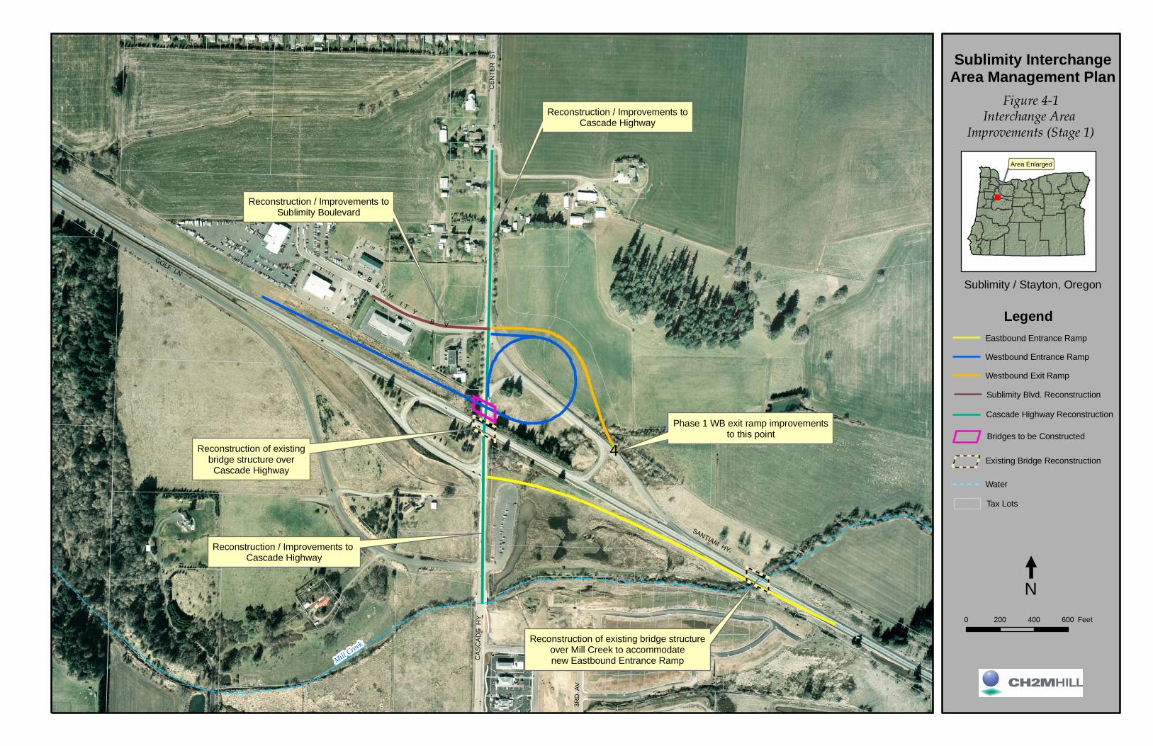
SU
BL
I MI T
YB V
Reconstruction / Improvements toCascade Highway
Reconstruction of existingbridge structure overCascade Highway
Reconstruction / Improvements toSublimity Boulevard
Reconstruction / Improvements toCascade Highway
Phase 1 WB exit ramp improvementsto this point
Reconstruction of existing bridge structureover Mill Creek to accommodatenew Eastbound Entrance RampMill Creek
SANTIAMHY
GOLF LN
CAS
CA
DE
HY
OAKM
ONT
LN
CEN
TER
ST
3RD
AV
Sublimity InterchangeArea Management Plan
0 200 400 600 Feet
Sublimity / Stayton, Oregon
Area Enlarged
'4
Figure 4-1Interchange Area
Improvements (Stage 1)
LegendEastbound Entrance Ramp
Westbound Entrance Ramp
Westbound Exit Ramp
Sublimity Blvd. Reconstruction
Cascade Highway Reconstruction
Bridges to be Constructed
Existing Bridge Reconstruction
Water
Tax Lots
N

MARTIN DR
1
2
3
45
6
9
14
091W03B00100
091W03BA03300
091W03BA03400
091W03BA03700
091W03B00500091W03B00700
091W03B01000
091W03A00300
091W03A00100
091W03A00200
091W03A00400
091W03B01200
091W03DB00200
091W03C00100
091W03C00200
091W03DB00300
091W03DB00400
091W03C00201
091W03B01501
091W03DC01900
091W03DC02000
091W03B01100
091W03B00200
091W03B00400
091W03B00600
091W03B00900
091W03B01300
7
11
12
13091W03BA03600
091W03BA03600
Interchange AccessManagement Limits,
1320' from ramp termini#
Interchange AccessManagement Limits,
1320' from ramp termini
#
8 10
091W03B00800
Mill Creek
Sublimity InterchangeArea Management Plan
Sublimity / Stayton, Oregon
Figure 4-2IAMP Access Inventory:
Approaches alongCascade Highway
Feet300 0 300 600
LegendAccess Management PlanAffected Tax Lots
Tax Lots
01010AB0101 Tax Lot ID #
ODOT AccessControl Line
11 Access List Inventory #
Area Enlarged
N

Improvements to Cascade Highway
Realign Golf Lane to Whitney Street, add driveway access
1320
'
Interchange AccessManagement Limits
Install traffic signal at Whitney Street and Cascade Highway
NOTESCascade Hwy Improvements (Applies to all alternatives)Stayton Access Alternative
Figure 4-3
Sublimity InterchangeArea Management Plan
Sublimity / Stayton, Oregon
Proposed Access Treatments (Stayton)
Area Enlarged
Existing Roadway/Driveway
Close / Remove
Proposed Signalized Intersection
N0 200 400 600 Feet
New Roadway/Driveway
Install traffic signal at Santiam Hwy Eastbound Off-Ramp and Cascade
Highway(Signal installed when warranted)
Install traffic signal at Sublimity Blvd and Cascade Highway
(Signal installed when warranted)
Legend
Eastbound Entrance Ramp
Westbound Exit Ramp
Westbound Entrance Ramp
Tax lots
Water
Bridges to be Constructed
City BoundaryInterchange AccessManagement Limits
1320
'
Improvements to Cascade Highway

Improvements to Cascade Highway
Realign Golf Lane to Whitney Street, provide driveway access to existing
properties
Westbound queue at Park-n-Ride
is less than 100 ft
Eastbound queue at Whitney Street
is less than 100 ft
Westbound queue at Martin Drive
is less than 100 ft
Northbound queue at Fern Ridge Road
is approximately 310 ft
D
B*
C
C*
0.75
Figure 4-4
Sublimity InterchangeArea Management Plan
Sublimity / Stayton, Oregon
Stayton Queues
Area Enlarged
Tax lots
Water
N0 200 400 600 Feet
New Roadway/Driveway
95th % Queue Length (ft)
Legend
0.76Intersection Volume to Capacity (v/c) ratio
CSignalized IntersectionLevel of Service
C* Unsignalized IntersectionWorst Approach Level of Service

Improvements to Cascade Highway
Realign Golf Lane to Whitney Street, provide driveway access to existing
properties
Westbound queue at Park-n-Ride
is less than 100 ft
Eastbound queue at Whitney Street
is less than 100 ft
Westbound queue at Martin Drive
is less than 100 ft
Northbound queue at Fern Ridge Road
is approximately 310 ft
D
B*
C
0.93
C*
Figure 4-5
Sublimity InterchangeArea Management Plan
Sublimity / Stayton, Oregon
Stayton Queues (Constrained Cascade Highway)
Area Enlarged
Tax lots
Water
N0 200 400 600 Feet
New Roadway/Driveway
95th % Queue Length (ft)
Legend
0.76Intersection Volume to Capacity (v/c) ratio
CSignalized IntersectionLevel of Service
C* Unsignalized IntersectionWorst Approach Level of Service

Improvements to Cascade Highway
Frontage road connecting existing property driveways
Construct new access roadbehind existing properties
NOTESCascade Hwy Improvements (Applies to all alternatives)Sublimity Access Alternative 1
Interchange Access Management Limits, 1320'
from ramp termini
Figure 4-6
Sublimity InterchangeArea Management Plan
Sublimity / Stayton, Oregon
Access Treatments (Sublimity): Alternative #1
Area Enlarged
Install traffic signal at Santiam Hwy Eastbound Off-Ramp and Cascade
Highway(Signal installed when warranted)
Install traffic signal at Sublimity Blvd and Cascade Highway
(Signal installed when warranted)
Legend
Existing Roadway/Driveway
Close / Remove
Eastbound Entrance Ramp
Westbound Exit Ramp
Westbound Entrance Ramp
Tax lots
Water
Bridges to be Constructed
N0 200 400 600 Feet
New Roadway/Driveway
Close Existing Driveway
New Access Intersection(unsignalized)
Proposed Signalized Intersection
City Boundary
Access road meets SublimityBlvd at new intersection
New intersection onCascade Highway Interchange Access
Management Limits, 1320' from ramp termini
Existing driveway accesses closed on Cascade Highway
Improvements to Cascade Highway

Improvements to Cascade Highway
Construct new access roadbehind existing properties
NOTESCascade Hwy Improvements (Applies to all alternatives)Sublimity Access Alternative 3
Frontage road connecting existing property driveways
Interchange Access Management Limits, 1320'
from ramp termini
Interchange Access Management Limits, 1320'
from ramp termini Figure 4-8
Sublimity InterchangeArea Management Plan
Sublimity / Stayton, Oregon
Access Treatments (Sublimity): Alternative #3
Legend
Area Enlarged
Existing Roadway/Driveway
Close / Remove
Eastbound Entrance Ramp
Westbound Exit Ramp
Westbound Entrance Ramp
Tax lots
Water
Bridges to be Constructed
N0 200 400 600 Feet
New Roadway/Driveway
Close Existing Driveway
New Access Intersection(unsignalized)
Proposed Signalized Intersection
Install traffic signal at Santiam Hwy Eastbound Off-Ramp and Cascade
Highway(Signal installed when warranted)
City Boundary
Install traffic signal at Sublimity Blvd and Cascade Highway
(Signal installed when warranted)
Improvements to Cascade Highway
Existing driveway accesses closed on Cascade Highway
Access road meets SublimityBlvd at new intersection
New intersection onCascade Highway

Improvements to Cascade Highway
Realign existing driveway to meet new access intersectioin
NOTESCascade Hwy Improvements (Applies to all alternatives)Sublimity Access Alternative 2
Align new access road to meet existing driveway, right-in, right-out access only
Interchange Access Management Limits, 1320'
from ramp termini
Interchange Access Management Limits, 1320'
from ramp termini Figure 4-7
Sublimity InterchangeArea Management Plan
Sublimity / Stayton, Oregon
Access Treatments (Sublimity): Alternative #2
Area Enlarged
Install traffic signal at Santiam Hwy Eastbound Off-Ramp and Cascade
Highway(Signal installed when warranted)
Legend
Existing Roadway/Driveway
Close / Remove
Eastbound Entrance Ramp
Westbound Exit Ramp
Westbound Entrance Ramp
Tax lots
Water
Bridges to be Constructed
N0 200 400 600 Feet
New Roadway/Driveway
Close Existing Driveway
New Access Intersection(unsignalized)
Proposed Signalized Intersection
City Boundary
Access road meets SublimityBlvd at new intersection
Construct new access roadbehind existing properties
New intersection onCascade Highway
Existing driveway to remain
Existing driveway accesses closed on Cascade Highway
Install traffic signal at Sublimity Blvd and Cascade Highway
(Signal installed when warranted)
Improvements to Cascade Highway

Improvements to Cascade Highway
Frontage road connecting existing property driveways
Existing driveway accesses closed on Cascade Highway
Install traffic signal at Sublimity Blvd and Cascade Highway
(Signal installed when warranted)
Install traffic signal at Santiam Hwy Eastbound Off-Ramp and Cascade
Highway(Signal installed when warranted)
NOTESCascade Hwy Improvements (Applies to all alternatives)Stayton Access AlternativeSublimity Preferred Alternative
Realign Golf Lane to Whitney Street, add driveway access
Install traffic signal at Whitney Street & Cascade Highway
Interchange Access Management Limits, 1320'
from ramp termini
Improvements to Cascade Highway
Figure 4-9
Sublimity InterchangeArea Management Plan
Sublimity / Stayton, Oregon
Access Treatments (Sublimity): Stakeholder Preferred Alternative
Legend
Area Enlarged
Existing Roadway/Driveway
Close / Remove
Eastbound Entrance Ramp
Westbound Exit Ramp
Westbound Entrance Ramp
Tax lots
Water
Bridges to be Constructed
N0 200 400 600 Feet
New Roadway/Driveway
Close Existing Driveway
New Access Intersection(unsignalized)
Proposed Signalized Intersection
City Boundary
Construct new driveways to access road
Construct new access roadbehind existing properties
(NOTE: Access road is conceptual)
Interchange Access Management Limits, 1320'
from ramp termini
New intersection onCascade Highway

PDX/052070004_USR.DOC 5-1
SECTION 5
Interchange Area Management Plan
This section of the report constitutes the agreement between ODOT, Marion County, the City of Stayton, and the City of Sublimity regarding how transportation facilities and land in the Sublimity Interchange study area will be managed. The project steering team, which included representatives from each of the aforementioned governments and agencies, agreed to a preferred alternative package to guide interchange management.
The Adoption and Implementation Plan contained here describes the actions that the applicable jurisdictions and agencies will be responsible for fulfilling prior to, and following, their respective adoption of this IAMP. These actions have been reviewed and agreed to by the project steering team.
Selected Alternative and Findings The preferred alternative package consists of:
• Access Management Plan • Physical Improvements Plan • Traffic Management Plan
Traffic management recommendations are also provided.16
Access Management Plan As part of the Sublimity IAMP, future access locations and public street connections were evaluated for properties along Cascade Highway. The intent of the Access Management Plan is to identify the location of driveways and internal circulation routes for properties whose accesses will need to be relocated to achieve the safety and mobility objectives of the Access Management Standards. The plan, as described in the following paragraphs, shall be applied by ODOT, Marion County, the City of Sublimity, and the City of Stayton in future land use decisions involving the properties located within the IAMP study area.
It should be noted that the strategies below mostly apply to areas of new development or redevelopment; existing accesses are allowed to remain as long as the land use does not change (subject to adoption of ordinance provisions by the City of Sublimity—see Appendix I). As a result, access management is a long-term process in which the desired access spacing to a street slowly evolves over time as redevelopment occurs. It should also be kept in mind that parcels cannot be landlocked, and must have some way of accessing the public street system. This may mean allowing shorter access spacing then would otherwise be allowed.
16 Unlike the access management plan, traffic management recommendations are provided in this section for guidance purposes only—they are not actions that any jurisdiction or agency is obliged to undertake.

SUBLIMITY INTERCHANGE AREA MANAGEMENT PLAN
5-2 PDX/052070004_USR.DOC
Access management strategies for approaches located within the Interchange Access Management Limit are described in this section.
Figure 5-1 shows a detailed inventory of all properties and approaches in the Access Management Plan area, with short and medium/long-term actions described for each. Figure 5-2 depicts corresponding approaches and properties.
Cascade Highway (West Side of Roadway, North of Oregon 22)
Short-Term Access Actions. Existing private driveway approaches will continue to be allowed individual access to Cascade Highway. Access deviations will be requested for all of these private approaches.
Sublimity Boulevard will continue to access Cascade Highway. An access deviation will be requested.
The City of Sublimity will adopt an Interchange Overlay Zone in its Development Code and amend sections of Code language. The new Overlay Zone will prohibit development from occurring at the properties on this part of Cascade Highway without the presence of an alternate roadway to access. Proposed changes to the City of Sublimity’s Development Code are provided as Appendix J.
Medium/Long-Term Access Management. Under the guidance of this IAMP, properties located on this part of Cascade Highway will take future access via the access backage road described in Section 4 of this report and illustrated on Figure 4-9. During the IAMP planning process, the PMT strongly considered whether this backage road should be constructed as a short-term improvement. The PMT concluded that the timing and precise route of this access road should be guided by the future development of the properties.
The backage access road (and new driveways necessary to connect to this access road) will be constructed as a condition of one or more commercial developments in the medium-to-long-term future.
Cascade Highway (West Side of Roadway, South of Oregon 22)
Short-Term Access Actions. Golf Lane will continue to access Cascade Highway. An access deviation will be requested.
Medium/Long-Term Access Management. Under an existing MOU between the City of Stayton and Marion County, Golf Lane will be realigned at such time that the existing Golf Lane and Cascade Highway intersection warrants signalization or fails to meet Marion County standards for safety or operations. The realigned Golf Lane approach would intersect with Cascade Highway directly across from Whitney Street, approximately 470 feet south of its existing location. This MOU is provided as Appendix K.
Cascade Highway (East Side of Roadway, South of Oregon 22)
Short-Term Access Actions. Whitney Street will continue to access Cascade Highway. An access deviation will be requested.
The park-and-ride lot will continue to be allowed access to Cascade Highway. An access deviation will be requested.

SUBLIMITY INTERCHANGE AREA MANAGEMENT PLAN
PDX/052070004_USR.DOC 5-3
Medium/Long-Term Access Management. As part of Stayton TSP physical improvements, a traffic signal will be installed at the Whitney Street and Cascade Highway intersection.
Cascade Highway (East Side of Roadway, North of Oregon 22)
Short-Term Access Actions. Approach 13 (see Figure 4-2) will be closed and alternate access will be provided via Approach 14. ODOT will construct a frontage road extending from the driveway at Approach 13 to the driveway at Approach 14 to allow for this consolidation of driveways.
Approach 14 will continue to be allowed access to Cascade Highway. An access deviation will be requested.
ODOT will purchase access control along entire property road frontage of Tax Lot 091W03A00100. This proposed line of access control purchase is depicted on Figure 5-2.
Medium/Long-Term Access Management. Approach 14 will be closed and alternate access will be provided via a frontage road that will access Cascade Highway at a new intersection located directly across from the new backage access road described earlier.
Access Management Deviations
In the short-term, IAMP actions reduce by one the number of approaches to Cascade Highway within the Interchange Access Management Limits. In the medium- to long-term, however, the actions performed as part of this IAMP will reduce the number of approaches by six. Under OAR 734-051-0135(5) the ODOT Region Access Management Engineer
shall require any deviation for an approach located in an interchange access management area as defined in the Oregon Highway Plan, to be evaluated over a 20-year horizon from the date of application and may approve a deviation for an approach located in an interchange access management area if:… (b) The approach is consistent with an access management plan for an interchange that includes plans to combine or remove approaches resulting in a net reduction of approaches to the highway.
Deviations identified in this IAMP are consistent with this statute.
Table 5-1 addresses all approach locations where access deviations will be required and provides a rationale for why the deviations should be granted. See Figure 4-2 for corresponding depiction of approach locations.
TABLE 5-1 IAMP Access Deviations
Approach Tax Lot(s) Served Deviation Request Rationale
1 091W03BA03300
2 091W03BA03400
As part of this IAMP, the City of Sublimity will be establishing an Interchange Overlay Zone, encompassing all of these properties. This zone will prohibit development that increases vehicle trip generation onto Cascade Highway and will require future development of any of these properties to access onto a local backage road in the rear of the property. This action moves in the

SUBLIMITY INTERCHANGE AREA MANAGEMENT PLAN
5-4 PDX/052070004_USR.DOC
TABLE 5-1 IAMP Access Deviations
Approach Tax Lot(s) Served Deviation Request Rationale
3 091W03BA03700
4 091W03B00500
5 091W03B00700
direction of ODOT Access Management Standards.
The aforementioned future backage road was considered as a potential physical improvement to be created as part of this IAMP. However, it was concluded that the precise route and construction timing of this future backage road should be guided by the development of these properties. Therefore, a deviation should be approved per OAR 734-051-0080(2), since these private accesses have no reasonable alternate access to their properties.
These properties currently produce very few vehicle trips. Analysis performed for this IAMP concluded that the presence of these approaches is consistent with the safety factors listed under OAR 734-051-0080(9). These approaches have only a slight effect on Cascade Highway safety and a negligible effect on mobility. Therefore, a deviation should be approved per OAR 734-051-0135(1).
6 Sublimity Blvd.
The intersection of Sublimity Boulevard and Cascade Highway was aligned with the westbound ramp terminal in the original design of the interchange. This location was selected after a review of alternatives, all of which were determined to be infeasible. The location was consistent with the access management rules in effect at the time and the layout was approved by ODOT and FHWA through the adoption of the Environmental Assessment and Finding of No Significant Impact (FONSI).
8 Golf Lane
An existing MOU between the City of Stayton and Marion County calls for the realignment of Golf Lane at such time that Golf Lane warrants signalization or fails to meet Marion County standards for safety or operations. The realigned Golf Lane approach would intersect with Cascade Highway directly across from Whitney Street, approximately 470 feet south of its existing location. By relocating an existing access point further from the interchange ramp terminal, this action moves in the direction of ODOT Access Management Standards.
Analysis performed for this IAMP concluded that the presence of this approach is consistent with the safety factors listed under OAR 734-051-0080(9). Therefore, a deviation should be approved per OAR 734-051-0135(1).
9 Whitney Street
The 2004 traffic study done for the City of Stayton TSP revealed that this intersection operates at LOS A and LOS C, respectively, for the southbound left and westbound approach. Whitney Street is identified as an integral part of Stayton's circulation system.
10 091W03DB00300; 091W03DB00200
This park-and-ride access provides a carpool alternative, helping to decrease the number of vehicles using the interchange at peak periods, thereby improving operational and safety conditions—the overall objective of Access Management Standards. Park-and-ride lots serve the multi-modal objectives of Goal 12. Alternate access to the park-and-ride lot is infeasible due to the existence of wetlands adjoining the lot.

SUBLIMITY INTERCHANGE AREA MANAGEMENT PLAN
PDX/052070004_USR.DOC 5-5
TABLE 5-1 IAMP Access Deviations
Approach Tax Lot(s) Served Deviation Request Rationale
14 091W03A00200; 091W03A00100
As part of this IAMP, Approach 13 will be closed and consolidated with Approach 14. Therefore, a deviation should be approved per OAR 734-051-0135(3)(b). Additionally, access control will be purchased along entire property road frontage of Tax Lot 091W03A00100.
Physical Improvements Plan Based on the level of traffic demand associated with the proposed development in Stayton and Sublimity, specific improvements are required by the design year, 2025. In their current configuration, the interchange exit ramps and westbound entrance ramp would operate beyond capacity by that time. In addition, all of the approaches to Cascade Highway would operate beyond mobility standards with the exception of Martin Drive which is restricted to right-in/right-out access.
The implementation of planned ODOT interchange improvements and City of Stayton Cascade Highway improvements would result in acceptable operations within the Sublimity IAMP study area.
ODOT physical improvements include plans to:
• Reconstruct the Oregon 22 entrance ramps to provide standard merge operations onto Oregon 22
• Signalize the Oregon 22 ramp termini and Sublimity Boulevard and Cascade Highway intersection (north of interchange) when signal warrants are met and signal approved by the State Traffic Engineer
• Signalize the Oregon 22 ramp termini and Cascade Highway intersection (south of intersection) when signal warrants are met and signal approved by the State Traffic Engineer
• When traffic demand requires, install a right-turn pocket on the eastbound Oregon 22 exit ramp approach to Cascade Highway
• When traffic demand requires, install right-turn pockets on the Shaff Road–Fern Ridge Road approaches to Cascade Highway
City of Stayton physical improvements include plans to:
• Widen Cascade Highway from and including Sublimity Boulevard through the Shaff Road–Fern Ridge Road intersection.
• Realign Golf Lane across from Whitney Street
• Signalize the Whitney Street–Golf Lane and Cascade Highway intersection
• Coordinate traffic signal operations along Cascade Highway

SUBLIMITY INTERCHANGE AREA MANAGEMENT PLAN
5-6 PDX/052070004_USR.DOC
Traffic Management Plan A park-and-ride facility is located within the IAMP area. Currently the facility is not served by bus routes or formal carpool programs. Expansion of service to this facility is not currently planned, but could aid in managing traffic demand through the IAMP area.
Another inherent traffic management mechanism is the availability of several accesses to the cities of Stayton and Sublimity. An additional access point to the cities of Stayton and Sublimity is provided at the Golf Club Road interchange to the west. Improvements to Golf Club Road are also programmed into the City of Stayton’s TSP, thus providing an alternative route to Stayton.
To a lesser extent, Fern Ridge Road provides an alternative access point along Oregon 22 to the east of the Sublimity Interchange. The Fern Ridge Road access should be modified or eliminated for both access management and safety improvement purposes.
Adoption and Implementation Plan Adoption and implementation of the Sublimity IAMP will occur at several levels of government. It is necessary for the City of Sublimity, the City of Stayton, and Marion County to amend their respective TSPs to incorporate the elements of the Sublimity IAMP. This amendment process will include Planning Commission/City Council hearings at the City level and Planning Commission/County Commission hearings at the County level. Following successful adoption at the City and County levels, the Sublimity IAMP will be presented to the OTC for review and approval.
ODOT IAMP adoption occurs when the OTC formally adopts the plan as an ODOT facility plan. Local government adoption should precede OTC adoption. Formal approval of the IAMP is required by the OTC prior to starting project construction.
Implementation Authority Implementation of this IAMP is determined by regulatory authority. Local agency authority comes through state statutes and city and county comprehensive plans and development codes. State of Oregon authority comes in the form of policy and administrative rules governing authority over federal and state systems, as granted through the following:
• State Agency Coordination Rule and Agreement (SAC 1990—OAR 731-015)—The purpose of this rule is to define which ODOT actions are land use actions and how ODOT will meet its responsibilities for coordinating these activities with the statewide land use planning program, other state agencies, and local government.
• Transportation Planning Rule (OAR 660-012) —This rule is one of several statewide planning rules that provides protection of the long-term livability of Oregon’s communities for future generations. The rule requires multi-modal transportation plans to be coordinated with land use plans. In satisfying the goal, state and local governments must satisfy requirements that lead to implementation of a transportation system that functions consistent with the planned land uses.

SUBLIMITY INTERCHANGE AREA MANAGEMENT PLAN
PDX/052070004_USR.DOC 5-7
• Access Management Rule (OAR 734-051) —This rule applies to the location, construction, maintenance, and use of approaches onto the state highway rights-of-way and properties under the jurisdiction of ODOT. These rules also govern closure of existing approaches, spacing standards, medians, deviations, appeal process, grants of access, and indentures of access.
Implementation Steps and Responsibilities This subsection documents the respective actions that will be undertaken by applicable jurisdictions to implement the transportation improvements included in this IAMP.
City of Sublimity Actions
The City of Sublimity will perform the following actions:
• Adopt IAMP, through City ordinance, as a refinement element to City’s TSP and Comprehensive Plan. This ordinance is provided as Appendix L.
• Amend Development Code, through City ordinance, to include a new chapter: Chapter 2.106. Chapter 2.106 will establish the creation of an Interchange Management Area Overlay Zone. This ordinance is provided as Appendix I.
• Amend Development Code Chapter 2.103.05, through City ordinance, to support the creation of an Interchange Management Area Overlay Zone and IAMP access recommendations. This ordinance is provided in Appendix L.
• Amend Development Code Chapter 2.202.03, through City ordinance, to support the creation of an Interchange Management Area Overlay Zone and IAMP access recommendations. This ordinance is provided in Appendix L.
• Amend City’s Zoning Map, through new City ordinance, to include the boundaries of the Interchange Management Area Overlay Zone. This ordinance is provided in Appendix L. The proposed boundary of the Interchange Management Overlay Zone is shown in Appendix M.
City of Stayton Actions
The City of Stayton will perform the following actions:
• Adopt IAMP, through City ordinance, as a refinement element to the City’s TSP and Comprehensive Plan. This ordinance is provided as Appendix N.
• Develop and fund applicable IAMP-identified transportation system improvements (see the Physical Improvements Plan contained in this section)
• Construct applicable IAMP-identified transportation system improvements (see the Physical Improvements Plan contained in this section)
Marion County Actions
Marion County will perform the following actions:
• Adopt IAMP, through new County ordinance, as a refinement element to County’s TSP and Comprehensive Plan. This ordinance is provided as Appendix O.

SUBLIMITY INTERCHANGE AREA MANAGEMENT PLAN
5-8 PDX/052070004_USR.DOC
Mid-Willamette Valley Council of Governments Actions
The Mid-Willamette Valley Council of Governments will perform the following actions:
• Provide comments and technical support as relevant
ODOT and State Actions
ODOT or the State of Oregon will perform the following actions:
• Adopt IAMP as a facility plan (OTC)
• Develop and fund applicable IAMP-identified transportation system improvements (see the Physical Improvements Plan contained in this section)
• Close identified approaches as described in the IAMP
• Consolidate identified approaches as described in the IAMP
• Construct applicable IAMP-identified transportation system improvements (see the Physical Improvements Plan contained in this section)
• Purchase access control along east side of Cascade Highway (north of interchange) from current point-of-access control northwards to encompass entirety of Interchange Access Management Limit area. This entails purchasing access rights from one private property owner (Tax Lot 091 W03A00100).
• Participate and comment on local land development actions with the potential to affect the interchange
Oregon Department of Land Conservation and Development (DLCD) Actions
DLCD will perform the following actions:
• Acknowledge any TSP refinements made as part of IAMP implementation
• Review IAMP

Figure 5-1 SUBLIMITY INTERCHANGE AREA MANAGEMENT PLAN ACCESS INVENTORY/ACTION LIST(APPROACHES AND PROPERTIES WITHIN 1,320' ACCESS MANAGEMENT AREA)
Created Revised Last Revised by
Key ID No: 13658 11/15/2005
City or County: Marion County/City of Sublimity/City of Stayton
Short-Term Medium/Long-Term
N 091W03B00100 Riesterer, Bernard F n/a 620 W Main, Sublimity OR 97385Single-Family Residence/
Commercial Farm_ _ _ _ n/a n/a n/a _ _ Right of way taking (for access road creation)
1 1.32 N 091W03BA03300 Riesterer, James R N 1021 S Center St., Sublimity, OR 97385Single-Family Residence/
Commercial Use_ _ _ _ N _ _ 25 Existing access remains; access deviation required. Connect to local access roadway^^
2 1.30 N 091W03BA03400 Burlison, Duane G N 1047 S Center St., Sublimity, OR 97385Single-Family Residence/
Commercial Use_ _ _ _ N _ _ 15 Existing access remains; access deviation required. Connect to local access roadway^^
3 1.26 N 091W03BA03700 Krieg, Karla N PO BOX 466 Sublimity, OR 97385 Commercial _ _ _ _ N _ _ 35 Existing access remains; access deviation required. Connect to local access roadway^^
N 091W03BA03600 Riesterer, Bernard F n/a 620 W Main St., Sublimity, OR 97385 Loft Barn _ _ _ _ n/a n/a n/a _ _ Potential right of way taking (for access road creation; dependent upon actual precise route of roadway)
N 091W03B00200 Riesterer, Bernard F n/a 620 W Main St., Sublimity, OR 97385 Farm (Land Only) _ _ _ _ n/a n/a n/a _ _ Potential right of way taking (for access road creation; dependent upon actual precise route of roadway)
4 1.21 N 091W03B00500 Aboud, Gerald L & Dee Anne N 836 E Kathy St., Stayton, OR 97383Single-Family Residence/
Commercial Use_ _ _ _ N _ _ 15 Existing access remains; access deviation required. Connect to local access roadway^^; take right of way for access road
5 1.20 N 091W03B00700 Cranston, Clarence R & Judi N N 372 SE Church St., Sublimity OR 97385Single-Family Residence/
Commercial Use_ _ _ _ N _ _ 25 Existing access remains; access deviation required. Connect to local access roadway^^
(no road frontage)
091W03B00600 Cranston, Clarence R & Judi N n/a 372 SE Church St., Sublimity OR 97385 Land Only _ _ _ _ n/a n/a n/a _ _ Potential right of way taking (for access road creation; dependent upon actual precise route of roadway)
N 091W03B00400 Koehnke Living Trust & n/a 635 W Main St., Sublimity OR 97385 Commercial _ _ _ _ n/a n/a n/a _ _ _ _
Y 091W03B00800 Koehnke, Jeff & Kim n/a 500 Sublimity Blvd., Sublimity OR 97385 Land Only _ _ _ _ n/a n/a n/a _ _ _ _
N 091W03B00900 Koehnke, Jeff & Kim n/a 500 Sublimity Blvd., Sublimity OR 97385 Land Only _ _ _ _ n/a n/a n/a _ _ Right of way taking (for access road creation); if property developed access will be to backage road (as will be required by
Sublimity Interchange Overlay ordinance).
Y 091W03B01000 Koehnke Living Trust & n/a 635 W Main St., Sublimity OR 97385 Land Only _ _ _ _ n/a n/a n/a _ _ If property developed access will be to backage road (as will be required by Sublimity Interchange Overlay ordinance).
6 1.10 n/a Sublimity Blvd. Marion County Public Works N5155 Silverton Rd NE, Salem, OR 97305
Public Road _ _ _ _ N _ _ 70 Existing access remains; access deviation required. Traffic signal to be installed at intersection. _ _
Y 091W03B01200 Sublimity Insurance Co. n/a 100 SW Sublimity Blvd. Sublimity, OR 97385 Commercial _ _ _ _ n/a n/a n/aConsolidate access on Sublimity Boulevard at parcel 091W03B01300 and provide access to parcel
091W03B01100_ _
Y 091W03B01100 Sublimity Insurance Co. n/a 100 SW Sublimity Blvd. Sublimity, OR 97385 Commercial _ _ _ _ n/a n/a n/a Consolidate access on Sublimity Boulevard at parcel 091W03B01300 through parcel 091W03B01200 _ _
N 091W03B01300 Scott, Wayne & Marlene n/a 1988 NE 19th Ave., Canby, OR 97013 Commercial _ _ _ _ n/a n/a n/aRight of way taking to accommodate consolidation driveway connection from parcels 091W03B01200 and
091W03B01100._ _
7 0.89 n/a OR-22 Ramp TerminalState of Oregon, Dept. of
TransportationN 506 State Highway Building; Salem, OR 97301 Public Road _ _ _ _ N _ _ 100 Existing access remains. Ramp terminal approach to be relocated just south of existing when new eastbound OR 22 exit ramp is built.
Y^^^ 091W03B01501State of Oregon, Dept. of
Transportationn/a 355 Capitol St. NE #411, Salem, OR 97301 Land Only _ _ _ _ n/a n/a n/a _ _ _ _
Y 091W03C00100 Van Handle ,Dale L n/a 12853 Golf Lane SE; Sublimity, OR 97385 Single-Family Residence _ _ _ _ n/a n/a n/a _ _ _ _
Y 091W03C00200 Bartosz, Doris M & n/a 10443 W. Stayton Rd., Aumsville, OR 97325 Land Only _ _ _ _ n/a n/a n/a _ _ _ _
8 0.83 n/a Golf Lane City of Stayton Public Works N 362 North Third Ave., Stayton, OR 97383 Public Road _ _ _ _ N _ _ 70 Existing access remains; deviation required.Golf Lane to be realigned further south from interchange ramp terminal to access Cascade Highway at a signalized
intersection directly across from Whitney Street.
N 091W03C00201 Bartosz, Doris M & n/a 10443 W. Stayton Rd., Aumsville, OR 97325Single-Family Residence/
Commercial Farm_ _ _ _ n/a n/a n/a _ _ _ _
Action(s)
Right-of-way Roll map number:
West Side of Roadway (North of OR-22)
No Approach
No Approach
West Side of Roadway (South of OR-22)
No Approach
No Approach
No Approach
No Approach
No Approach
No Approach
Permitting Authority: Marion County
Spacing standard per OAR 734-051-0115 to 0125: 1,320 feet
Roadway Owner: Marion County
Posted speed: 45 MPH (Cascade Highway within 1,320' Access Management Area)
Prepared by: Michael Hoffmann/CH2M HILL
Roadway Classification: Arterial* (outside city limits); Arterial** (inside Sublimity city limits); Principal Arterial***(inside Stayton city limits)
Figure 5-2 Approach #Access Control
Y/N
Project Name: Sublimity Interchange Area Management Plan
Project Leader or CPM: Dan Fricke
Expenditure Account: Mile point limits: 0.42 to 1.21
Roadway: Cascade Highway (Center Street/1st Street) [referred to as Center Street within Sublimity city limits; referred to as 1st Street within Stayton city limits]
No Approach
Permit NumberTax Lot Number Property Owner Permit Holder Y/N Property Owner Address
Business / Residential
AddressMile Point^
No Approach
No Approach
No Approach
No Approach
No Approach
No Approach
Approach Width (approx. distance in
feet)Permit Y/NBusiness
OwnerProperty Use

Short-Term Medium/Long-Term
Action(s)Figure 5-2 Approach #
Access Control
Y/NPermit NumberTax Lot Number Property Owner Permit
Holder Y/N Property Owner Address Business / Residential
AddressMile Point^
Approach Width (approx. distance in
feet)Permit Y/NBusiness
OwnerProperty Use
N 091W03DC02000 River Ranch Restaurants Inc. n/a 1465 25th St. SE, Salem, OR 97302 Restaurant _ _ _ _ n/a n/a n/a _ _ _ _
N 091W03DC01900 C R Properties LLC n/a 1465 25th St. SE, Salem, OR 97302 Apartment Complex _ _ _ _ n/a n/a n/a _ _ _ _
9 0.74 n/a Whitney Street City of Stayton Public Works N 362 North Third Ave., Stayton, OR 97383 Public Road _ _ _ _ N _ _ 75 Existing access remains; deviation required. City of Stayton to add traffic signal at intersection at such time that at least two traffic signal warrants are met.
N 091W03DB00400 Girod, Fred F n/a 101 Fern Ridge Rd., Stayton, OR 97383 Land Only _ _ _ _ n/a n/a n/a _ _ _ _
10 0.83 Y^^^091W03DB00300; 091W03DB00200
State of Oregon, Dept. of Transportation
N 355 Capitol St. NE #411, Salem, OR 97301 Park and Ride; Wetland Site _ _ _ _ N _ _ 65 Existing access remains; deviation required. _ _
11 1.03 n/a OR-22 Ramp TerminalState of Oregon, Dept. of
TransportationN 506 State Highway Building; Salem, OR 97301 Public Road _ _ _ _ N _ _ 90 Existing access (westbound entrance ramp) to be closed and relocated approximately 100 feet north. _ _
12 1.09 n/a OR-22 Ramp TerminalState of Oregon, Dept. of
TransportationN 506 State Highway Building; Salem, OR 97301 Public Road _ _ _ _ N _ _ 100
Existing access (westbound exit ramp) to be realigned to be directly across from Sublimity Blvd. Traffic signal to be installed at intersection.
_ _
Y 091W03A00400 Miller, Thomas L n/a 9254 Cascade Highway SE, Sublimity, OR 97385 Commercial Farm (Land
Only)_ _ _ _ n/a n/a n/a _ _ _ _
13 1.23 Y 091W03A00300 Beverly M Cox LT & N 1384 Kendell Ct., Salem, OR 97302Single-Family Residence/
Commercial Farm_ _ _ _ N _ _ 50
Existing access to be closed; access to be consolidated with access at 091W03A00100; frontage road to be built to allow access consolidation.
_ _
14 1.30 N091W03A00200; 091W03A00100
Miller, Thomas L &; Miller, Thomas L & Janice E
Y9252 Cascade Highway SE, Sublimity, OR 97385;
PO BOX 272 Sublimity, OR 97385Single-Family Residence;
Commercial Farm_ _ _ _ N
TL 200: #86-90 (08/01/86); TL 100: #D01-341
(10/03/01)40
Existing access remains; access to now additionally serve 091W03A00300; deviation required. ODOT to purchase access control along entirety of property boundary.
_ _
Sources:* Marion County Rural Transportation System Plan (1998)
** Stayton Transportation System Plan Final Draft (2004)
*** Sublimity Transportation System Plan (1998)
Notesn/a
^ Milepoint information is for Cascade Highway; provided by Mike McCarthy, Marion County Senior Engineer. Milepoint given represents approximate midpoint of approach along Cascade Highway.
^^
^^^ Access control via ODOT property ownership
The full long term-action entails creating a local access road to consolidate access points along Cascade Highway. The road would align with an access road on the east side of Cascade Highway (should one be needed in the Northeast Quadrant of the interchange). This access road will intersect with Cascade Highway approximately 1600 feet north of the interchange ramp termini. The IAMP preferred access road would extend south along the west side of tax lots 091W03B00100, 091W03BA03300, 091W03BA03400, 091W03BA03700, and 091W03B00700; the access road would extend through the eastern portions of both tax lot 091W03B00600 and tax lot 091W03B00900, necessitating the purchase of right of way from each.
not applicable
East Side of Roadway (North of OR-22)
No Approach
No Approach
No Approach
No Approach
East Side of Roadway (South of OR-22)

MARTIN DR
1
2
3
45
6
9
14
091W03B00100
091W03BA03300
091W03BA03400
091W03BA03700
091W03B00500091W03B00700
091W03B01000
091W03A00300
091W03A00100
091W03A00200
091W03A00400
091W03B01200
091W03DB00200
091W03C00100
091W03C00200
091W03DB00300
091W03DB00400
091W03C00201
091W03B01501
091W03DC01900
091W03DC02000
091W03B01100
091W03B00200
091W03B00400
091W03B00600
091W03B00900
091W03B01300
7
11
12
13091W03BA03600
091W03BA03600
Interchange AccessManagement Limits,
1320' from ramp termini#
Interchange AccessManagement Limits,
1320' from ramp termini
#
8 10
091W03B00800
Mill Creek
Sublimity InterchangeArea Management Plan
Sublimity / Stayton, Oregon
Figure 5-2IAMP Access Inventory:Approaches & Properties
Feet300 0 300 600
Area Enlarged
LegendAccess Management PlanAffected Tax Lots
Tax Lots
01010AB0101 Tax Lot ID #
ODOT AccessControl Line
Proposed ODOTAccess Control Line
11 Access Inventory ListApproach #
N

PDX/052070004_USR.DOC 6-1
SECTION 6
References
Cai, Qian. 2005. 2004 Oregon Population Report. Portland State University (PSU) Population Research Center. March.
David Evans and Associates, Inc., and Angelo Eaton & Associates. 2005. Interchange Area Management Plan Guidelines (Final Draft). October.
City of Stayton Comprehensive Plan. May 15, 1995.
City of Stayton Transportation System Plan. Final Draft. April 27, 2004.
City of Sublimity Transportation System Plan. 1998.
Marion County Rural Transportation System Plan. 2005.
Oregon Department of Transportation (ODOT). 1999. Oregon Highway Plan. Transportation Development Division, Planning Section. March.
Oregon Department of Transportation (ODOT). 2003. Oregon Highway Design Manual.
Oregon Department of Transportation (ODOT) and Federal Highway Administration (FHWA). 1995. Joseph Street—Stayton North City Limits Environmental Assessment. March.
Oregon Department of Transportation (ODOT) and Federal Highway Administration (FHWA). 1995. Joseph Street—Stayton North City Limits Revised Environmental Assessment. May.