study of bankstown cbd airspace constraints for planning
TRANSCRIPT

Study of Bankstown CBD Airspace Constraints for
Planning
PHASE 1
Bankstown CBD Airspace for Strategic Planning — Initial Height
Limits Report
Doc v1.4 FINAL 20 Oct 2016
by
strategic airspace

Prepared by Consultants:
strategic airspace
Strateg ic Ai rspace Pty L imited AB N: 60 097 85 7 4 15
PO Box 774, Potts Point NSW 1335 Au stra l ia
Tel : +61.2.9380 .9777
Emai l - Attn : [email protected]
Client:
Bankstown City Council
Bankstown Civ ic Tower 66-72 Rickard Rd
Bankstown NSW 2200 Au stra l ia
Note : S in ce th e formal amalgamat ion of Coun ci l s in May 2016 by the
NSW Govern ment, Ban kstown C ity Counc i l h as b ecome part o f th e greater City of Canterbury-Bankstown
and
NSW Department of Planning

Document Control
Document Number: 16.001-01-002 Version: Doc v1.4 FINAL
Document Title: Bankstown CBD Airspace for Strategic Planning — Initial Height Limits Report
Purpose / Abstract: This report assesses the current regulated height constraints over the Bankstown CBD, as a basis for completion of Phase 1 of the study, including ongoing discussions with planners, Bankstown Airport, other stakeholders and aviation regulators. Airspace height constraints that are not explicitly covered under the Airports (Protection of Airspace Regulations), such as ensuring protecting flying training and helicopter overflight activities, are only briefly considered in this report as they will be canvassed further following consultation with the airport and relevant stakeholders.
Contract: - StratAir Ref: 16.001

Change History
Version Versn Date Version By QA By Version / Change Description
1.0 DRAFT 22-Jul-2016 C. Pak-Poy J. McCarthy Initial version for review & comment
1.1 DRAFT 10-Aug-2016 C. Pak-Poy J. McCarthy Update includes consideration of Bankstown Airport (2013) OLS & PANS-OPS Airspace approved by the federal Department of Infrastructure (declared June 2016) and review of current status of the airspace plans for the proposed Western Sydney Airport (WSA).
1.2 DRAFT 16-Aug-2016 C. Pak-Poy J. McCarthy Restructure
1.3 22-Aug-2016 C. Pak-Poy J. McCarthy Minor edits. Final check against new AIP IFPs (eff 18-Aug-2016). Updates on status of similar projects (BCC)
1.4 FINAL 19-Oc-2016 J. McCarthy C. Pak-Poy New section 2.3.1 Prescribed & Declared Airspace & Other Current Published Charts inserted, plus new Appendix 3 — Extracts from the Airports (Protection of Airspace) Regulations 1996 Minor edits elsewhere
Distribution Control
Legend: Uncont Uncontrolled Document SACL Sydney Airport Limited Client Bankstown City Council & NSW
Department of Planning StratAir Strategic Airspace
APT Bankstown Airport (Metro Airports) AsA Airservices (formerly Airservices Australia)
CASA Civil Aviation Safety Authority Infrastructure/ DIRD
Department of Infrastructure & Regional Development (Cwlth)
Issue Version Issue Date Issue Purpose / Description Copy No Copy Recipient
1.0 DRAFT 25-Jul-2016 Distribution to client – deferred, pending receipt of Bankstown Airspace declared in 2016
Uncont StratAir internal
1.3 23-Aug-2016 Distribution to clients for review & approval Uncont StratAir, Bankstown CC, NSW Planning
1.4 FINAL 20-Oct-2016 Distribution to clients approval Uncont StratAir, Bankstown CC, NSW Planning
This document was prepared by Strategic Airspace Pty Limited on behalf of client Bankstown City Council & NSW Department of Planning.
Copyright © Strategic Airspace Pty Limited, 2016 All Rights Reserved. No part of this document or its entirety may be divulged, commercialised, translated, reproduced and/or copied in any form or by any means without the express and prior written permission of
the copyright holder. Whilst this document has been prepared using all due and customary care, StratAir reserves the right to
correct any errors, omissions or misrepresentations. The authorised recipient of the this document is hereby granted permission to use the contents of this
document and to make and transmit copies in a secure manner for the purposes of evaluation or the report contents; liaison with relevant State and/or international authorities for the purposes of verification,
regulatory and operational impact, and/or approvals; and any pursuant negotiation with StratAir as part of its procurement process.
In the event of translation for this purpose and any discrepancies between the translated and original versions, this original text will prevail.

Bankstown CBD Airspace for Strategic Planning — Initial Height Limits Report For Bankstown City Council & NSW Planning Report by Strategic Airspace
October 2016 i [1608-BankstownCC-CBD-AirspaceAssessment_HeightsRpt_v1.4-FINAL.DOCX]
Contents
Change History ................................................................................................. iv Distribution Control ........................................................................................... iv
1. Introduction & Executive Summary .............................................................. 1
2. Methodology .................................................................................................... 4 2.1 Methodology as Basis of Study ................................................................. 4 2.2 Location of the Proposed Development .................................................... 5 2.3 The Airspace .............................................................................................. 7
2.3.1 Prescribed & Declared Airspace & Other Current Published Charts .......... 7 2.3.2 Airspace Evaluation Matrix ........................................................................ 9
3. Obstacle Limitation Surfaces (OLS) ............................................................ 10 3.1 What is the OLS and What it’s For .......................................................... 10 3.2 OLS Analysis ........................................................................................... 10
3.2.1 Bankstown Airport’s OLS ......................................................................... 11 3.2.1 Sydney Airport’s OLS ............................................................................... 12 3.2.1 OLS of the Planned Western Sydney Airport (WSA) ............................... 12 3.2.2 Precedent Intrusions into the Restrictive OLS ......................................... 12
4. PANS-OPS Surfaces ..................................................................................... 13 4.1 PANS-OPS Surfaces & Instrument Flight Procedures (IFPs) ................. 13 4.2 Charts, Data & Information Referenced for PANS-OPS Analysis ........... 14
4.2.1 PANS-OPS Surfaces Charts .................................................................... 14 4.2.2 Published IFP Charts as per the AIP DAP ............................................... 14
4.3 Notes re Discrepancies between Published Data & Planned Changes by Airservices Australia ............................................................ 14 4.3.1 Airport Declared PANS-OPS Charts ........................................................ 14 4.3.2 Planned Changes to the Circling Minima ................................................. 15
4.4 PANS-OPS Analysis Results ................................................................... 15 4.4.1 PANS-OPS for Bankstown Airport ........................................................... 15
A Bankstown Airport’s PANS-OPS Surfaces Plan & Implications of the Departure Procedure.................................................................................................... 15
B Circling Minima Discrepancies between Bankstown Airport’s PANS-OPS Chart & Current IFP Limits ........................................................................................... 18
C Proposed Reduced Circling Minima: Future (Lower) Circling Minima Advised by Airservices Australia ................................................................................................ 18
D Summary of All Bankstown PANS-OPS Procedures ................................................... 19 4.4.2 PANS-OPS for Sydney Airport ................................................................. 19 4.4.3 PANS-OPS for Western Sydney Airport (WSA) ....................................... 20
5. Other Assessment Factors........................................................................... 21 5.1 Other Prescribed Airspace Factors ......................................................... 21 5.2 Non-Prescribed Airspace Factors ............................................................ 21
5.2.1 Local Flight Procedures: Flight Training & Other Visual Flight (Aircraft) ................................................................................................... 21
5.2.2 Visual Helicopter Procedures & Traffic .................................................... 22

Bankstown CBD Airspace for Strategic Planning — Initial Height Limits Report Report by Strategic Airspace For: Bankstown City Council & NSW Planning
ii October 2016 [1608-BankstownCC-CBD-AirspaceAssessment_HeightsRpt_v1.4-FINAL.DOCX]
6. Sector Height Limits related to Air Traffic Control .................................... 23 6.1 The Relevance of the Radar Terrain Clearance Chart (RTCC) &
Minimum Vector Altitudes (MVAs) ........................................................... 23 6.2 The RTCC/MVA Height Limits over the Bankstown CBD
Study Area ............................................................................................... 24
7. Other Airspace Planning Projects for Large-Scale Development Zones & Town Centres ................................................................................. 25 7.1 Brisbane CBD Airspace ........................................................................... 25 7.2 Others ...................................................................................................... 27
8. Current & Proposed Airspace ‘Canopy’ over the Study Area .................. 28 8.1 Summary of Airspace Limits over the Bankstown CBD Study Area ....... 28 8.2 Current Airspace Limits ........................................................................... 30 8.3 Recommended Ultimate Restriction imposed by the RTCC MVA .......... 30
APPENDICES
Appendix 1 — Abbreviations
Appendix 2 — PANS-OPS IFP Analysis (Bankstown)
Appendix 3 — Extracts from the Airports (Protection of Airspace) Regulations 1996

Bankstown CBD Airspace for Strategic Planning — Initial Height Limits Report For Bankstown City Council & NSW Planning Report by Strategic Airspace
October 2016 1 [1608-BankstownCC-CBD-AirspaceAssessment_HeightsRpt_v1.4-FINAL.DOCX]
1. Introduction & Executive Summary
Bankstown City Council 1 and the NSW Department of Planning have engaged Strategic Airspace to conduct a study of the airspace constraints over the Bankstown Central Business District (CBD) and a defined adjacent area to the south — as per the areas outlined in orange in Figure 1-1 below.
The principal objective of the study is to support master planning by Bankstown and NSW Planning, with the objectives to maximise the potential airspace volume available to future developments in the Bankstown Airspace Study Area (nominally referred to herein as the CBD, unless specified otherwise). This report is part of the work that will provide a basis for examining the airspace volume that could be potentially be achieved over the study area without adversely affecting the safety of aircraft operating over the area. The report also examines if and how the process for airspace height applications and approvals through the national infrastructure and aviation regulators and stakeholders can be simplified.
Figure 1-1: Study Area in relation to Bankstown Airport
Although the Bankstown CBD and environs is under and subject to the airspace protection provisions for Sydney and Bankstown Airports, as well as the future Western Sydney Airport, the proximity of the study area to Bankstown Airport (3-4 km) means that the airspace is most affected by air traffic to and from Bankstown Airport. Except for airspace protection for Air Traffic Controller (ATC) handling of air traffic over the Sydney and Western Sydney basin, instrument and visual flights to and from airports other than
1 Since May-2016, Bankstown City Council has become part of the amalgamated council of the
City of Canterbury-Bankstown.

Bankstown CBD Airspace for Strategic Planning — Initial Height Limits Report Report by Strategic Airspace For: Bankstown City Council & NSW Planning
2 October 2016 [1608-BankstownCC-CBD-AirspaceAssessment_HeightsRpt_v1.4-FINAL.DOCX]
Bankstown Airport are deemed irrelevant for the purposes of determining airspace height restrictions over the Bankstown CBD Study Area.
The airspace over the Bankstown CBD Study Area (‘the study area’) is most affected by Bankstown Airport’s Obstacle Limitation Surfaces (OLS), and the PANS-OPS surfaces which are defined to protect published instrument flight landing and departure procedures for the airport.
A number of other factors, which include visual helicopter flight paths and flying training activities, are considered but are not constraining in terms of height restrictions; ultimately their relevance must be examined in terms of a safety case which could only done after consultation with the relevant stakeholders.
The maximum height limits over the study area currently in effect are imposed by the rising surface related to a PANS-OPS departure procedure — starting from a height of approximately 124 m Australian Height Datum (AHD) at the south-eastern corner and rising across the site — and a PANS-OPS circling procedure (which is applicable over the northern and north-eastern portion of the study area).
The height of the latter — the circling area height restriction — is somewhat debatable due to discrepancies between:
135.9m AHD — as per the information published in Bankstown Airport’s recently approved and declared PANS-OPS Surfaces plan;
the circling altitudes in the currently Instrument Flight Procedure charts (as published by Airservices Australia); and
108.1m AHD — based on separate advice from the Instrument Flight Procedures section of Airservices Australia that they plan to reduce the circling altitude.
Regarding the latter, this would mean that the circling area height limit would be substantially below that indicated in Bankstown Airport’s PANS-OPS surfaces plan, and indeed it would be extremely constraining: in effect it would limit all developments in the study area to no higher than the proposed 108.1m AHD limit.
The consultants believe that the planned reduced value of the Circling Height can be challenged, especially as Bankstown Airport’s PANS-OPS chart (showing a circling height limit of 135.9m AHD) was approved and declared by DIRD as recently as June 2016.
Further to that, if Council wishes to seek a maximum development height that is higher than the airport’s 135.9m AHD circling area limit, it is possible that a case can be argued for a maximum height of 152.4m AHD (which is based on a limit applicable to airspace heights used air traffic controllers (ATCs) over the entire Sydney basin) — noting this will only be applicable in the northern portion of the area, as the limiting heights of the departure procedure will be more constraining over remaining southern portion.
Images depicting the two separate height limit scenarios across the study area — existing and potentially achievable — are shown in Figure 1-2 below. For larger versions of the alternate images, refer to Figure 4-3 (p17) and Figure 8-2 (p31).

Bankstown CBD Airspace for Strategic Planning — Initial Height Limits Report For Bankstown City Council & NSW Planning Report by Strategic Airspace
October 2016 3 [1608-BankstownCC-CBD-AirspaceAssessment_HeightsRpt_v1.4-FINAL.DOCX]
Figure 1-2: Height Limits across the Bankstown CBD Study Area: Existing and Maximum Potentially Achievable
Current
This preliminary report is for the purpose of supporting further planning and exploring maximum development heights in the study area that may be considered as technically and probably approvable under the Airports (Protection of Airspace) Regulations 1996 (APARs). The results and opinions are based on preliminary data only and would be subject to confirmation in a complete aeronautical impact study based on defined boundaries, and in relation to airspace operations and protection surfaces current (and known plans approved) at the time of any such future application.

Bankstown CBD Airspace for Strategic Planning — Initial Height Limits Report Report by Strategic Airspace For: Bankstown City Council & NSW Planning
4 October 2016 [1608-BankstownCC-CBD-AirspaceAssessment_HeightsRpt_v1.4-FINAL.DOCX]
2. Methodology
This report focusses on determining the current and likely future airspace height limits over the study area — by technical analysis of PANS-OPS and OLS surfaces — as defined by approved plans of the relevant airports, and the current PANS-OPS flight procedures (as published in the Aeronautical Information Publication (AIP) by Airservices Australia). Additional uses of the airspace relevant to the study area have also been considered to determine the degree to which these aspects may limit airspace heights over the CBD.
Preliminary conclusions of maximum heights achievable in the Bankstown CBD Study Area for long-term planning are based on the evaluation of the overall height assessments from all sources, and some preliminary consultation with Bankstown Airport’s General Manager Aviation and discussions with the Instrument Flight Procedures Section of ATM Service Support, Airservices Australia.
This first phase of the study will be used as a basis for further and more in-depth consultation with Bankstown Airport, airport operators and the Commonwealth government.
2.1 Methodology as Basis of Study
This study follows the standard methodology used by StratAir for most aeronautical impact studies, as outlined in Table 2-1 below, but with the specific objective of determining limiting heights across the study area.
The study was undertaken in phases, as described below:
Table 2-1 Methodology
# Phase Description
1 Obstacle Limitation Surfaces
The relevant Obstacle Limitation Surfaces were evaluated to determine the OLS height limits applicable to the study area. See section 3 p(10).
2 PANS-OPS Instrument Approach Procedures & Surfaces
The relevant PANS-OPS Surface charts, where published, and relevant instrument approach procedures (IFPs) as published by Airservices Australia were examined to determine what the limiting restrictions on the study area. See section 4 (p13).
3 Other Assessment Factors Including Air Traffic Control-related Height Constraints
Comments regarding other factors that would be assessed in a future detailed aeronautical impact study, the results of which will impact on the opinion concerning future approvability of the development. Some preliminary opinions are offered for guidance. See section 5 (p21). Airspace restrictions related to Air Traffic Control requirements was also examined. See section 6 (p23).

Bankstown CBD Airspace for Strategic Planning — Initial Height Limits Report For Bankstown City Council & NSW Planning Report by Strategic Airspace
October 2016 5 [1608-BankstownCC-CBD-AirspaceAssessment_HeightsRpt_v1.4-FINAL.DOCX]
# Phase Description
4 Other Relevant Airspace Planning Activities Elsewhere
Other long-term “area-based” airspace planning activities — which have been instigated by developers and councils elsewhere in Australia and are deemed relevant to this study — are outlined for background information. See section 7 (p25).
5 Summary of Current & Proposed Maximum Airspace Heights
The current and potentially proposed maximum heights were evaluated. Table 8-1 provides a summary of hierarchy of current airspace height restrictions over the Bankstown CBD Study Area. This section also canvasses the nature and quantum of maximum heights that could potentially be sought over the study area, especially given the fact that there are some discrepancies in a height limit over part of the study area. See section 8 (p28).
6 Summary & Conclusions
A summary of findings and next steps. See section 1 Introduction & Executive Summary (p1).
2.2 Location of the Proposed Development
Figure 2-1: Study Area in relation to Key Nearby Airports
The Bankstown CBD Study Area is within the operational airspace of the two (2) major civil airports (Bankstown Airport and Sydney International Airport), the proposed Western Sydney Airport, and additionally within the airspace of the RAAF Base Richmond and the small aerodrome used for training and recreation at Camden.

Bankstown CBD Airspace for Strategic Planning — Initial Height Limits Report Report by Strategic Airspace For: Bankstown City Council & NSW Planning
6 October 2016 [1608-BankstownCC-CBD-AirspaceAssessment_HeightsRpt_v1.4-FINAL.DOCX]
Table 2-2 Airports whose Airspace Covers the Study Area
Airport Code Airport Distance and Location
YSBK Bankstown Airport ~ 3.1 km (1.7 NM) to the SE corner ~ 4.4 km (2.3 NM) to the NE corner
YSSY Sydney International Airport
~13 km (7 NM)
— Western Sydney Airport ~29 km (15.6 NM)
YSCN Camden Airport ~34 km (18.5 NM) (not shown on diagram)
YSRI RAAF Base Richmond >40 km (22 NM) (not shown on diagram)
The close proximity of Bankstown Airport demanded detailed evaluation of its airspace constraints over the study area. Sydney Airport, as a core regulated airport and due to its proximity and interaction of flight procedures with those of Bankstown, was deemed to require detailed evaluation.
With regards to the proposed Western Sydney Airport: even though, based on the distance and relative location of the new airport to the study area, it was considered highly likely that the expected airspace and flight plans would not be constraining on the airspace over the study area. However, given that it is a major federal government project and that the planned airport is already defined in law as a core regulated airport, the current concept plans required review for potential impact.
The latter two, Richmond and Camden, based on distance and relative location, were anticipated to have no constraining effects, especially given the nature of the airports and the flight activities at those airports.
Figure 2-2: Study Area in relation to Bankstown Airport

Bankstown CBD Airspace for Strategic Planning — Initial Height Limits Report For Bankstown City Council & NSW Planning Report by Strategic Airspace
October 2016 7 [1608-BankstownCC-CBD-AirspaceAssessment_HeightsRpt_v1.4-FINAL.DOCX]
2.3 The Airspace
2.3.1 Prescribed & Declared Airspace & Other Current Published Charts
The protection of airspace above and around major airports in Australia — including Bankstown, Sydney and the future Western Sydney airports — is governed by the Airport (Protection of Airspace) Regulations 1996 (the Regulations). Extracts of relevant sections of the current compilation, effective from July 2015, are provided in Appendix 3 — Extracts from the Airports (Protection of Airspace) Regulations 1996.
Figure 2-3: The Regulations: Prescribed and Declared Airspace
PRESCRIBED AIRSPACE (Reg 4)Current Situation
at time of drafting
OLS (Obstacle Limitation Surfaces)
Based on Airport Geometry
PANS-OPS SurfacesBased on
the current (at the time of drafting) PANS-OPS Instrument Flight Procedures
(Approaches and departures to/from the Runways at the Airport
- as published in the Australian Aeronautical Information Publication (AIP)
and as per the charts used by pilots in the cockpit)
Usually subsumed into
DECLARED AIRSPACE (Reg 5)(Approval & Declaration by the Federal Department of Infrastructure & Regional Development)
DECLARED AIRSPACE(Reg 5.1. 5.2(b), 5.2(c))
Incorporating factors relevant to the Current Situation &
Approved Master Plans
Other Surfaces As requested by the Airport
May include surfaces to protect:
Radar & Other Surveillance FacilitiesGround-based Navigation AidsVisual Glide Slope IndicatorsApproach & Landing LightsMinimum Vector Altitudes
(from Radar Terrain Clearance Charts (RTCC))Communications Facilities
(Lines-of-Sight)High Velocity Gas Efflux
DECLARED AIRSPACE (Reg 5.2(a))Incorporating
Approved Master Plans
Future OLS (Obstacle Limitation Surfaces)
based on future approved airport layout / runways
Future PANS-OPS SurfacesBased on:
the current (at the time of drafting) PANS-OPS Instrument Flight Procedures and/or, where new or changed runways or other relevant changes are approved,
projected amendments to current PANS-OPS Procedures as relevant.
Airports (Protection of Airspace) Regulations 1996
Prescribed Airspace (Reg 6)
These regulations make provision for:
Prescribed airspace (Regulation 4) — ‘Fundamental’ (Fundamental: not specified in the Regulations this way, but implied) This is the airspace above certain types of airspace surfaces — either the specified OLS or PANS-OPS surface types (described further below), or other declared airspace — that is controlled for the purposes of protecting the safety, efficiency and regularity of air transport operations into and out of airports from permanent and temporary obstacles (such as physical structures or other items (eg, high-velocity gas efflux).
Declared airspace (Regulation 5) This is airspace that is not automatically specified in the Regulations as the fundamental elements of the prescribed airspace.
Amendments to the OLS and PANS-OPS surfaces for protecting airspace required to support approved airport master plans
Other surfaces for protecting airspace as deemed appropriate by the airport (eg, to protect the efficacy of navigation and landing aids, navigation and surveillance, etc)

Bankstown CBD Airspace for Strategic Planning — Initial Height Limits Report Report by Strategic Airspace For: Bankstown City Council & NSW Planning
8 October 2016 [1608-BankstownCC-CBD-AirspaceAssessment_HeightsRpt_v1.4-FINAL.DOCX]
As approved and declared by the Commonwealth Department of Infrastructure and Regional Development (DIRD)
Prescribed airspace (Regulation 6) — ‘As Declared’ (As Declared: the total prescribed airspace) In current practice, the term Declared Airspace (charts for which are published by some airports, such as Sydney, but not by all) is taken to mean the airspace prescribed as protected for meeting the future (approved) needs of the airport.
Note also that the prescribed/declared airspace charts produced by the airports are only current at the time they were produced, and experience shows that the frequency of update is generally no less than 5-yearly. This point relates specifically to the currency and relative integrity of the PANS-OPS surfaces (in relation to both Regulations 4 and 5), and may also be relevant to the Other Surfaces (as per Regulation 5). Adding to the time lag is the sometime extended period (can be up to one year) that it takes from the time of prepare of the initial drafts of such charts, through review and amendment by the airport and its consultants and stakeholders, to the time and duration required for review, approval and declaration by DIRD.
When commencing preparation of the PANS-OPS surfaces charts, the airport decides on an ‘effective amendment date’ for the information it will incorporate in its surfaces charts. However, the actual PANS-OPS instrument flight approach (IFP) and departure procedures (upon which the airport’s PANS-OPS surfaces are based) may change at any time according to needs assessment of the procedure design organisation in consultation with stakeholders — and so a PANS-OPS surfaces chart could be out-of-date before it is even finalised and submitted to DIRD. Such discrepancies are generally overlooked as part of the approval and declaration process.
The same kind of obsolescence can occur for other declared/prescribed airspace charts too. For example, Sydney Airport’s navigation surfaces protection chart (declared 2015) shows protection surfaces for a ground-based navigation aid that was removed well prior to the declaration and publication (by Sydney Airport, on their website) of that chart. The same kind of discrepancy can also occur if/when, for example, the air traffic controllers change airspace boundaries and minimum altitudes that they use. Further, there are now some other Performance Based Navigation (PBN) types of instrument flight procedures that are not included in the PANS-OPS document, but are specified in other ICAO documents.
In such cases, it is also important to refer to the current operational status, as reflected by knowledge of changes in facilities, and more commonly by reference to the contemporaneous data as reflected in material published by in the AIP and other authoritative sources. In this report, the term ‘published’ means, unless otherwise specified, current data and information as published in the AIP.
The most common requirement is to check the airspace protection requirements related to the currently published PANS-OPS and other PBN instrument flight procedures (these represent the procedure charts that pilots reference in the cockpit and which they select from their Flight Management Systems when approaching/landing and taking-off). In short, it is critical to assess airspace protection requirements related to flight procedures and airspace required for air traffic management that are current, and then to make expert assessments on how any discrepancies between those and that of the declared airspace affect height limitations that may be imposed by the aviation authorities in the future.

Bankstown CBD Airspace for Strategic Planning — Initial Height Limits Report For Bankstown City Council & NSW Planning Report by Strategic Airspace
October 2016 9 [1608-BankstownCC-CBD-AirspaceAssessment_HeightsRpt_v1.4-FINAL.DOCX]
2.3.2 Airspace Evaluation Matrix
The report considers the ‘prescribed airspace, as declared’ of:
Bankstown Airport (approved and declared by the federal Department of Infrastructure 2016, but based on 2013 charts) — comprising:
OLS Chart PANS-OPS Surfaces Chart
Note: Bankstown Airport advised in early August 2016 that they do not plan to commence looking at preparing updated ‘declared airspace’ charts until after the airspace plans for the future Western Sydney Airport have been declared (the date of which is unknown).
Sydney International Airport’s Declared Airspace (2015) — comprising
OLS Chart PANS-OPS Surfaces Chart Omnidirectional Departure Procedures Surfaces Chart
(PANS-OPS) RTCC Chart for the Sydney Basin;
and Various other charts which do not affect the Bankstown Study Area
— as well as:
The actual, current published PANS-OPS instrument flight procedures published in the AIP by Airservices Australia for Bankstown Airport — because the current PANS-OPS surfaces chart for Bankstown (dated 18-Dec-20132) does not accurately reflect the current operational environment
— plus other factors, including:
The local procedures for visual operations around Bankstown Airport;
Master plans for the upgrading of Bankstown Airport; and
The planned airspace for the proposed second Sydney internal airport, the Western Sydney Airport (WSA).
2 This and Bankstown Airport’s Future OLS chart (also Dec-2013) were approved and declared by the
Commonwealth Department of Infrastructure and Regional Development in mid-2016 as the Prescribed Airspace for Bankstown Airport to satisfy the airport’s current and known future needs. These charts have not been published but copies may be requested directly from Bankstown Airport.
Bankstown CBD Airspace for Strategic Planning — Initial Height Limits Report Report by Strategic Airspace For: Bankstown City Council & NSW Planning
10 October 2016 [1608-BankstownCC-CBD-AirspaceAssessment_HeightsRpt_v1.4-FINAL.DOCX]
3. Obstacle Limitation Surfaces (OLS)
3.1 What is the OLS and What it’s For
The Obstacle Limitation Surfaces are a set of surfaces — horizontal (flat) and rising slopes (as planar shapes to/from runways, and conical around the airport) — that are used as the fundamental threshold for the control and assessment of new or changed obstacles around an airport. An obstacle may be a permanent structure, such as a building or tree or antenna (or even high terrain, which is irrelevant for Bankstown). A temporary obstacle may be a structure such as a crane used for construction.
The OLS is defined by a set of rules related to Obstacle Restriction and Limitation in Annex 14 to the Convention on International Civil Aviation, a document published by the International Civil Aviation Organisation (ICAO) and adopted and tailored by each signatory country. In Australia, these standards are codified by the Civil Aviation Safety Regulations (CASR) Manual of Standards (CASR MOS) Part 1393, published by the Civil Aviation Safety Authority (CASA).
The OLS themselves rarely change because they are based on the geography and layout of the airport itself. The available OLS plans for both Bankstown and Sydney airports, which have been approved and declared by the Commonwealth Department of Infrastructure and Regional Development (DIRD), are based on master plans, and so take into account approved potential changes to the airports.
The OLS is used as a threshold for determining whether or not a proposed development, or temporary obstacle such as a crane, needs to be referred to the airport and aviation authorities for ‘airspace height’ approval. Under the Airports (Protection of Airspace Regulations) (the Regulations), if a planned permanent or temporary obstacle would penetrate an OLS, an airspace height application to DIRD must be submitted, via the closest airport. The fact that a proposed development would exceed the OLS height limit does not necessarily preclude the approval of the proposed development.
3.2 OLS Analysis
The OLS height limits related to Bankstown Airport — ranging from 51m to say 71m Australian Height Datum (AHD) — are the most constraining over the Bankstown CBD Study Area.
The height limit of Sydney Airport’s OLS is some 85m-105m higher than that of Bankstown’s — and thus for planning purposes Sydney Airport would not need to be consulted unless the maximum height planned for the study area were to exceed 156m AHD. The study area is outside the OLS that would be defined for the planned Western Sydney Airport.
3 CASA RPA, and Manual of Standards Part 139 — Aerodromes, Chapter 7 Obstacle Restriction and
Limitation, http://www.casa.gov.au/rules/1998casr/139/139m07.pdf

Bankstown CBD Airspace for Strategic Planning — Initial Height Limits Report For Bankstown City Council & NSW Planning Report by Strategic Airspace
October 2016 11 [1608-BankstownCC-CBD-AirspaceAssessment_HeightsRpt_v1.4-FINAL.DOCX]
Thus, for initial planning purposes, only Bankstown Airport is deemed to be relevant. Further, as the closest, Bankstown Airport would also be the airport to which any future height development applications under the Regulations would need to be submitted.
3.2.1 Bankstown Airport’s OLS
The prevailing OLS restriction on building heights over the majority of the Bankstown Study Area is the OLS Inner Horizontal Surface (IHS), at a height limit of 51m AHD: this covers approximately 75% of the western portion of the area, as indicated in Figure 3-1 below. East of that restriction and at the north-eastern portion of the site, the OLS Conical Surface rises at a slope of 5% to permit a maximum effective height limit of approximately 70m-71m AHD at the corner of Rickard Avenue and Stacey Street.
Note that these height limits would not necessarily be imposed as the maximum potential development height in the Bankstown Study area, especially given that there are already buildings in this area — in particular, in the heart of the Bankstown CBD — which already exceed these heights.
However, these surface heights are the limits beyond which any permanent or temporary obstacle would require prior approval under the Regulations.
Figure 3-1: Study Area in relation to the OLS of Bankstown Airport

Bankstown CBD Airspace for Strategic Planning — Initial Height Limits Report Report by Strategic Airspace For: Bankstown City Council & NSW Planning
12 October 2016 [1608-BankstownCC-CBD-AirspaceAssessment_HeightsRpt_v1.4-FINAL.DOCX]
3.2.1 Sydney Airport’s OLS
The Bankstown Study Area is under the extended canopy of Sydney Airport’s OLS, and thus any height applications under the Regulations would automatically be referred to Sydney International Airport.
However the height limit of Sydney Airport’s OLS over the study area is 156m AHD, as depicted in the image below (which is taken from an extract of the airport’s own declared OLS airspace chart). This means that the impact of this is negligible with regard to future planning — except to note that the constraint exists and that if any planned maximum heights were to exceed this value then Sydney Airport must be included in the consultation process.
Figure 3-2: Study Area in relation to the OLS of Sydney International Airport
3.2.1 OLS of the Planned Western Sydney Airport (WSA)
As the entire Bankstown Study Area is outside the 15km limit of any OLS that would be defined for the planned WSA, this can be discounted for any planning purposes.
3.2.2 Precedent Intrusions into the Restrictive OLS
There are existing buildings in the study area which exceed the current limits of the Bankstown OLS. Where future airspace applications are submitted for buildings in the study area, these may be used where they are relevant to help support the case for approval of planned developments.
However, for the purposes of the airspace planning study, they are not currently considered relevant. Particular cases may be referred to in future consultations with the airport, DIRD and aviation stakeholders if considered necessary to support future airspace planning proposals arising from this study.

Bankstown CBD Airspace for Strategic Planning — Initial Height Limits Report For Bankstown City Council & NSW Planning Report by Strategic Airspace
October 2016 13 [1608-BankstownCC-CBD-AirspaceAssessment_HeightsRpt_v1.4-FINAL.DOCX]
4. PANS-OPS Surfaces
4.1 PANS-OPS Surfaces & Instrument Flight Procedures (IFPs)
The PANS-OPS Surfaces used for prescribed airspace, as specified and used under the Airports (Protection of Airspace) Regulations, relate to the maximum permissible obstacle elevation — in heights expressed in the Australian Height Datum (AHD) — in areas covered by the protection surfaces for published Instrument Flight Procedures for approach and landing, and for departures (take-offs). These surfaces can be horizontal, sloping, conical and complex in nature, depending on type of procedure and the location within the protection area.
The Instrument Flight Procedures (IFPs) are flight paths designed to be flown using Instrument Flight Rules (IFR), and which are typically flown in Instrument Meteorological Conditions (IMC) and/or when it is deemed safer or more efficient to fly according to the charted flight paths. These flight procedures are designed according to the standards and guidelines specified in ICAO Document 8168 PANS-OPS, which are codified in Australia in CASR MOS Part 173 (published by CASA), and sometimes also in relation to related flight path design criteria such as Performance Based Navigation (PBN).
Except for some private procedures (which in this case is not relevant to Bankstown), all IFPs for civil use in Australia are published by Airservices Australia in the Australian Aeronautical Information Publication (AIP), specifically in the Departure and Approach Procedures (DAP) section of the AIP.
Flight procedures are sometimes subject to change — for any number of reasons, including to accommodate changes in the runways themselves; amendments to assure safe height margins over taller obstacles or obstacles not previously identified; to improve safety; to allow for different categories of aircraft; to allow for changes in airspace boundaries and changes in air traffic management requirements; to reduce noise and/or other environmental impacts; and so on. In Bankstown Airport’s case, a number of procedures have been changed in the last two years because of a change to the ground-based navigation instrument environment. The same has occurred at Sydney Airport, but with a greater frequency.
At the same time, airports only update and republish their PANS-OPS Surfaces plans relatively infrequently (eg, 3-5+ years) — which, according to the Airports (Protection of Airspace) Regulations, are supposed to reflect the current (and future) PANS-OPS flight procedures. This in effect means that there can be discrepancies between the declared PANS-OPS Surfaces protection charts used by airports and the actual protection requirements for protecting IFPs in effect at any time — including those times that applications for airspace approvals are made, and for studies like this one where the objective is to look at future planning for an area larger than a single proposed development site.

Bankstown CBD Airspace for Strategic Planning — Initial Height Limits Report Report by Strategic Airspace For: Bankstown City Council & NSW Planning
14 October 2016 [1608-BankstownCC-CBD-AirspaceAssessment_HeightsRpt_v1.4-FINAL.DOCX]
4.2 Charts, Data & Information Referenced for PANS-OPS Analysis
4.2.1 PANS-OPS Surfaces Charts
The declared PANS-OPS Surfaces Charts of both Bankstown and Sydney Airports were evaluated. No such charts exist for the other airports.
4.2.2 Published IFP Charts as per the AIP DAP
During the project thus far, the actual IFPs (as published in the DAP by Airservices Australia) evaluated included those published for a number of cyclical publishing periods: from DAP Amendment 145 (effective 12-Nov-2015 to 02-Mar-2016) to the one due to come into effect in the near future, DAP Amendment 148 (effective 18-Aug-2016 to 09-Nov-2016).
The IFPs for Bankstown Airport were reviewed and those assessed to be relevant were modelled in the consultant’s computerised PANS-OPS design and analysis in detail. The detailed results of these considerations are shown in Appendix 2 — PANS-OPS IFP Analysis (Bankstown).
The analysis of Sydney Airport’s declared PANS-OPS surfaces plan obviated detailed analysis of the published IFPs for Sydney. Additionally, despite the distance of Camden Airport from the study area, a quick high-level review of the single IFP for Camden was conducted; it was clear that that procedure did not warrant further detailed evaluation. The military IFPs for RAAF Base Richmond were not evaluated because of the distance from and location of that airport in relation to the study area. At the time of writing this report there were no published IFPs for the planned Western Sydney Airport to evaluate (see also section 4.4.3 PANS-OPS for Western Sydney Airport (WSA) (p20).
4.3 Notes re Discrepancies between Published Data & Planned Changes by Airservices Australia
4.3.1 Airport Declared PANS-OPS Charts
Bankstown Airport’s recently declared PANS-OPS chart was current as at 2013; it was developed based on IFPs current around 2012-2013. As such, it does not fully or accurately reflect the protection requirements of the current PANS-OPS IFPs for Bankstown Airport as published in the AIP at the time of this study. Further, the chart does not include protection height requirements for the missed approach segments of Approach Procedures, nor the height limits related to Departure Procedures. This means that it cannot be used solely to provide, with any confidence, an indication of the absolute maximum heights permissible.
Similarly, Sydney Airport’s declared PANS-OPS and Omnidirectional Departure charts do not wholly accurately depict the current status of the

Bankstown CBD Airspace for Strategic Planning — Initial Height Limits Report For Bankstown City Council & NSW Planning Report by Strategic Airspace
October 2016 15 [1608-BankstownCC-CBD-AirspaceAssessment_HeightsRpt_v1.4-FINAL.DOCX]
surfaces related to the current PANS-OPS procedures into and out of Sydney Airport, principally because of lack of currency. However, this is far less critical to this study given the location of the Bankstown CBD Study Area in relation to Sydney Airport and its PANS-OPS flight procedures.
The WSA does not yet have any declared PANS-OPS charts to protect planned flight procedures to/from this airport.
Details relevant to each airport are documented in section 4.4 PANS-OPS Analysis below.
4.3.2 Planned Changes to the Circling Minima
The currently published approach procedures show a Circling Minima which is known to be higher than that currently required by existing procedures and existing buildings. The withdrawal (deletion) of an approach procedure last year has meant that this Circling Minima can be reduced, and following a review of the circling conducted mid-2016 by Airservices Australia has recently indicated that this value will be reduced4 (which means that the effective height limit of this procedure, where relevant over the study area, will be more constraining than it currently is) and more constraining than the limit shown on Bankstown Airport’s PANS-OPS Surfaces chart, the most recent version of which was approved and declared as part of the airport’s prescribed airspace by DIRD in June 2016.
Note also that the published AIP DAP Approach Charts do not yet show the new lower values.
This particular subject is also further discussed in sections 4.4.1B and 4.4.1C (p18), and section 8 Current & Proposed Airspace ‘Canopy’ over the Study Area (p28).
4.4 PANS-OPS Analysis Results
4.4.1 PANS-OPS for Bankstown Airport
A Bankstown Airport ’s PANS-OPS Surfaces Plan & Implications of the Departure Procedure
The study area in relation to Bankstown Airport’s PANS-OPS Surfaces plan is depicted in Figure 4-1 below. This appears to indicate that the height limit applicable due to the PANS-OPS procedures to and from Bankstown Airport is a horizontal (flat) surface limit of 135.9m AHD across the entirety of the study area. Unfortunately this is not wholly accurate.
4 Steven Kreusser, Acting Chief Designer, Instrument Flight Procedures, ATM Service Support, Airservices
Australia: Email to Cathy Pak-Poy, Strategic Airspace — Bankstown (YSBK) Circling Minima, 22-Jun-2016

Bankstown CBD Airspace for Strategic Planning — Initial Height Limits Report Report by Strategic Airspace For: Bankstown City Council & NSW Planning
16 October 2016 [1608-BankstownCC-CBD-AirspaceAssessment_HeightsRpt_v1.4-FINAL.DOCX]
Figure 4-1: Study Area in relation to the Bankstown Airport’s Declared PANS-OPS Chart
As previously noted, the PANS-OPS Departure procedure from Bankstown’s Runway (RWY) 11C is not depicted on this chart, which means that the airport’s declared chart indicates a maximum height potentially achievable in locations where, after assessment by Airservices Australia in the event of a firm airspace height application, the actual heights permissible would be substantially lower (due to the need to protect the Departure procedure). Separate analysis by the consultants of the Departure procedure indicates that the protection requirements related to the Departure are more constraining over some areas of the site than indicated.
Figure 4-2 below shows the height limit contours (in light blue) of the Departure procedure alone.
Figure 4-3 below shows the combined effect of the RWY11C Departure procedure surface constraints with the Circling Minima height limit shown on Bankstown Airport’s PANS-OPS chart (the ‘declared Circling Height Limit’ — see also section 4.4.1B Circling Minima Discrepancies between Bankstown Airport’s PANS-OPS Chart & Current IFP Limits (p18). In this image, the limiting height contours of the Departure procedure are shown (again in light blue) up until they reach the point where Bankstown Airport’s declared Circling Height Limit becomes more restrictive.
Further, the chart does not include the protection areas and surface heights related to the missed approach legs of the approach procedures to RWY 11C. Evaluation of the IFPs, as published by Airservices Australia, shows however that these surfaces are not constraining; they are higher than those of the departure procedure.

Bankstown CBD Airspace for Strategic Planning — Initial Height Limits Report For Bankstown City Council & NSW Planning Report by Strategic Airspace
October 2016 17 [1608-BankstownCC-CBD-AirspaceAssessment_HeightsRpt_v1.4-FINAL.DOCX]
Figure 4-2: PANS-OPS Departure Surfaces Limit over the Bankstown Study Area (ignores Circling Height Constraints)
Figure 4-3: PANS-OPS Departure Surfaces Combined with Bankstown Airport’s Declared Circling Height Limit of 135.9m AHD

Bankstown CBD Airspace for Strategic Planning — Initial Height Limits Report Report by Strategic Airspace For: Bankstown City Council & NSW Planning
18 October 2016 [1608-BankstownCC-CBD-AirspaceAssessment_HeightsRpt_v1.4-FINAL.DOCX]
B Circl ing Minima Discrepancies between Bankstown Airport ’s PANS-OPS Chart & Current IFP Limi ts
As noted above, Bankstown Airport’s now approved and declared PANS-OPS Surfaces plan shows a Circling Minima height limit (for Category A and B aircraft) of 135.9m AHD.
Using PANS-OPS design principles and an additional 100ft allowance (for Remote Altimeter setting source, which is applied by Airservices in the PANS-OPS Approach Chart that is published in the AIP DAP), this would translate to an actual effective circling minima for pilots of around 840-850 feet.
However it is noted that the actual IFP Charts published in the DAP currently (and for several years) have shown a circling minima of 910 feet — which in turn (by reverse calculation) would translate to a Circling Surfaces Height Limit of 156.88m. This is some 21m higher than that currently indicated as the limit in the airport’s declared chart.
This discrepancy, and up until now potential for a developer to gain airspace height approval for a development higher than the limit shown in the airport’s chart, is now overshadowed by the fact that Airservices Australia has reviewed and intend to revise the Circling Height downwards to a value lower than that shown in the airport’s chart.
C Proposed Reduced Circl ing Minima: Future (Lower) Circl ing Minima Advised by Airserv ices Austral ia
As noted in 4.3.2 above (p15), Airservices Australia plans to reduce the circling minima below that already published —
to an altitude of 650ft which would mean that the new height restriction would be reduced substantially to 108.1m AHD,
27.8m below that currently published (by Airservices in the AIP) as the limiting height on Bankstown Airport’s newly approved and declared PANS-OPS Surfaces chart; and
Note also that because this height is lower than any of the Departure Surfaces, the 108.1m AHD height limit would be applicable over the entire Bankstown CBD Study Area
However, despite the fact that Airservices Australia has recently commenced using this limit internally, when evaluating new applications for airspace height approvals in the Bankstown and Liverpool areas, the viability of this most restrictive height limit is still to be confirmed because:
It is believed that Airservices ignored or failed to recognise the imprimatur of the approval and declaration of Bankstown Airport’s PANS-OPS Surfaces chart — this is an issue that will have to be taken up with the federal Department of Infrastructure; and
It appears, based on information provided by Bankstown Airport’s General Manager Aviation, that there may already be new or proposed developments already approved at heights that would exceed the new 108.1m restriction.
Bankstown CBD Airspace for Strategic Planning — Initial Height Limits Report For Bankstown City Council & NSW Planning Report by Strategic Airspace
October 2016 19 [1608-BankstownCC-CBD-AirspaceAssessment_HeightsRpt_v1.4-FINAL.DOCX]
D Summary of Al l Bankstown PANS-OPS Procedures
Notwithstanding the discrepancy of the Circling Height limit and the reduction planned by Airservices Australia, the Departure and Circling procedure surfaces together are the most restrictive of the PANS-OPS procedure surfaces relevant to the Bankstown CBD Study Area, The height limits of other procedures such as the two current NDB approach procedures, the RNAV(GNSS) approach procedure to RWY 11C and the Departure procedure from RWY 11C, are less restrictive.
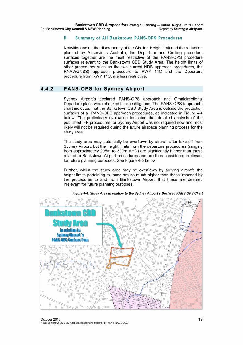
4.4.2 PANS-OPS for Sydney Airport
Sydney Airport’s declared PANS-OPS approach and Omnidirectional Departure plans were checked for due diligence. The PANS-OPS (approach) chart indicates that the Bankstown CBD Study Area is outside the protection surfaces of all PANS-OPS approach procedures, as indicated in Figure 4-4 below. The preliminary evaluation indicated that detailed analysis of the published IFP procedures for Sydney Airport was not required now and most likely will not be required during the future airspace planning process for the study area.
The study area may potentially be overflown by aircraft after take-off from Sydney Airport, but the height limits from the departure procedures (ranging from approximately 295m to 320m AHD) are significantly higher than those related to Bankstown Airport procedures and are thus considered irrelevant for future planning purposes. See Figure 4-5 below.
Further, whilst the study area may be overflown by arriving aircraft, the height limits pertaining to those are so much higher than those imposed by the procedures to and from Bankstown Airport, that these are deemed irrelevant for future planning purposes.
Figure 4-4: Study Area in relation to the Sydney Airport’s Declared PANS-OPS Chart

Bankstown CBD Airspace for Strategic Planning — Initial Height Limits Report Report by Strategic Airspace For: Bankstown City Council & NSW Planning
20 October 2016 [1608-BankstownCC-CBD-AirspaceAssessment_HeightsRpt_v1.4-FINAL.DOCX]
Figure 4-5: Study Area in relation to the Sydney Airport’s Declared Omnidirectional Departure Chart
4.4.3 PANS-OPS for Western Sydney Airport (WSA)
The instrument flight procedures for WSA have been published as concept designs and are not yet final. However, based on the location of the Bankstown CBD Study Area in relation to WSA, it is considered that WSA flight procedures can be considered irrelevant for the purposes of future airspace planning.
Information about this airport and the draft flight paths was sourced from:
Airport Plan: http://westernsydneyairport.gov.au/airport_plan/index.aspx
The Western Sydney Airport Draft Environmental Impact Statement 2015, which includes information about the planned airport and runway locations and the planned flight paths: http://westernsydneyairport.gov.au/resources/deis/index.aspx

Bankstown CBD Airspace for Strategic Planning — Initial Height Limits Report For Bankstown City Council & NSW Planning Report by Strategic Airspace
October 2016 21 [1608-BankstownCC-CBD-AirspaceAssessment_HeightsRpt_v1.4-FINAL.DOCX]
5. Other Assessment Factors
5.1 Other Prescribed Airspace Factors
Other potential prescribed airspace safety factors, those typically considered as part of an evaluation of any application under the Regulations, include:
Navaid impact — no declared airspace charts for navaids. Not anticipated to be a problem at the current heights nor those up to the circling height limit
Surveillance (eg, radar) — no adverse impact anticipated given the location of the Bankstown Study Area in relation to the Sydney radar sites.
Airline contingency procedures (eg, engine out performance) — no adverse impact anticipated due to the location.
These factors may require more detailed evaluation (and perhaps inclusion as part of a safety case) later in this project, depending on the maximum obstacle height(s) sought in the Bankstown CBD Study Area. However, for the three subject matters explicitly mentioned above, no further analysis is recommended at this stage.
5.2 Non-Prescribed Airspace Factors
5.2.1 Local Flight Procedures: Flight Training & Other Visual Flight (Aircraft)
Local flight training, whilst not a factor explicitly described in the Airports (Protection of Airspace) Regulations, must be considered as part of the evaluation of safety impact.
Pilots conducting flight training, in addition to practising instrument flight procedures, may also conduct visual fight circuits around the airport in between take-off and landing practice. These visual circuits must be performed in good weather conditions (Visual Meteorological Conditions, VMC) using Visual Flight Rules (VFR), which means according to the rules that the pilot must have a certain amount of visibility to see where they’re going and they are also responsible for avoiding obstacles such as tall buildings. Further, the circuits must be conducted with the defined circuit area, which is defined as being 2NM (3.7km) from the Aerodrome Reference Point (ARP). The extent of the Circuit Area is depicted in Figure 5-1 below. Pilots must fly at 1000ft (304.8m) when in the circuit (except when turning in to descent to the runway and similarly as they take-off and ascend through a turn to fly back parallel to the runway, at which time they must again be at the specified circuit altitude).
Subject to consultation with flight training providers who operate at Bankstown Airport, the consultants believe that these activities will not be an overly constraining factor on the maximum height (and where that will be) of the airspace over the study area.

Bankstown CBD Airspace for Strategic Planning — Initial Height Limits Report Report by Strategic Airspace For: Bankstown City Council & NSW Planning
22 October 2016 [1608-BankstownCC-CBD-AirspaceAssessment_HeightsRpt_v1.4-FINAL.DOCX]
Note however: One area of concern for flight training providers may be the edge of the circuit area which comes quite close (probably about 100m) to the south-east corner of the study area. At that location, the airspace is limited in height by the Departure Surfaces, such that the maximum height at the corner of Cambridge Ave and Northam Ave is about 123.5m AHD — which is less than half the stipulated circling altitude. Nevertheless, this particular issue should be discussed with flight training providers (and possibly others) with a view to assuring safety of those who use the visual circuits.
5.2.2 Visual Helicopter Procedures & Traffic
Helicopter traffic in the Bankstown Control Area (BK CTA) is well regulated, with ordinary traffic to and from the airport being structured by arrival and departure routes and constrained to upper and lower flight altitudes.
Figure 5-1: Helicopter Routes & Visual Circuit Area
Figure 5-1 above depicts the arrival and departure route to the airport: the route links to a waypoint called CHN which is to the north-north-west of the study area. Helicopters are generally to fly at 700ft (213m) using local

Bankstown CBD Airspace for Strategic Planning — Initial Height Limits Report For Bankstown City Council & NSW Planning Report by Strategic Airspace
October 2016 23 [1608-BankstownCC-CBD-AirspaceAssessment_HeightsRpt_v1.4-FINAL.DOCX]
pressure altitude (QNH) settings, unless otherwise advised by ATCs. And, as per the instructions in the AIP Aerodrome page for Bankstown Airport, they must not fly lower than 500ft (152.4m) if north of Marion Street (highlighted in the image).
Presently these routes can only be flown by helicopters using VFR, which means according to the rules that the pilot must have a certain amount of visibility to see where they’re going and they are also responsible for seeing and avoiding obstacles such as tall buildings.
The Police helicopter service also operate helicopters randomly anywhere in the Bankstown airspace. They also must fly according to VFR. However, it would be prudent to consult NSW Police once a final airspace proposal for the Bankstown CBD Study Area is agreed by Council and the NSW Department of Planning and Environment.
6. Sector Height Limits related to Air Traffic Control
6.1 The Relevance of the Radar Terrain Clearance Chart (RTCC) & Minimum Vector Altitudes (MVAs)
The minimum vector altitudes (MVAs) used by air traffic controllers (ATCs) are based on a Radar Terrain Clearance Chart (RTCC) which is maintained by Airservices Australia. Sydney Airport published an RTCC chart in 2015 as part of its declared airspace. This chart, which covers the entire Sydney basin, is what was used for analysis of the airspace height limits related to MVAs.
In an RTCC each sector (area) has a defined Lowest Safe Altitude (LSAlt) that can be used by an ATC when vectoring aircraft — also referred to as the sector MVA. The RTCC published by Sydney Airport shows the maximum permissible obstacle heights (in metres AHD) related to the various sector MVAs.
There are locations, typically further out from an airport rather than close in, where the PANS-OPS surfaces height limitation (which is normally described as the absolute height cap) is higher than that of the MVA. In such cases, the height limit of the MVA will become the absolute cap height for a proposed development.
This is because each RTCC/MVA sector is actually defined by adding 1000ft to the top of the tallest obstacle in an area, with the edge of the sector being no less than 3NM (5.56km) from the tallest obstacle. After the preliminary analysis, the sectors are rationalised to allow effective air traffic management (ATM). The sector that covers the Bankstown Study Area also covers the Sydney City CBD and Sydney Airport itself, as shown in Figure 6-1 below.

Bankstown CBD Airspace for Strategic Planning — Initial Height Limits Report Report by Strategic Airspace For: Bankstown City Council & NSW Planning
24 October 2016 [1608-BankstownCC-CBD-AirspaceAssessment_HeightsRpt_v1.4-FINAL.DOCX]
6.2 The RTCC/MVA Height Limits over the Bankstown CBD Study Area
The height limit imposed by the relevant RTCC/MVA sector is published in Sydney Airport’s declared RTCC chart as being 500ft (152m). We note that the limit of actually 500ft, which when converted precisely, equals 152.4m AHD.
As can be seen from the chart image below, any proposal for an area or obstacle airspace height taller than 152.4m AHD limit in this sector has the potential to impact the entire sector — and therefore has the potential to alter or disrupt the air traffic management (ATM) environment for both Sydney and Bankstown airports.
Thus, the height limit imposed by the RTCC/MVA should be considered as the absolute maximum height that could be considered potentially usable for airspace height planning in the Bankstown CBD study area.
Refer also to section 8.3 Recommended Ultimate Restriction imposed by the RTCC MVA (p30) and Figure 8-2 which demonstrate the impact of using the RTCC MVA height limit in conjunction with the height limits of existing PANS-OPS surfaces over the study area.
Figure 6-1: Height Limit related to RTCC/MVA for Air Traffic Control

Bankstown CBD Airspace for Strategic Planning — Initial Height Limits Report For Bankstown City Council & NSW Planning Report by Strategic Airspace
October 2016 25 [1608-BankstownCC-CBD-AirspaceAssessment_HeightsRpt_v1.4-FINAL.DOCX]
7. Other Airspace Planning Projects for Large-Scale Development Zones & Town Centres
7.1 Brisbane CBD Airspace
As a result of a review of the prescribed airspace plan for Brisbane Airport, in 2012 Brisbane City Council (BCC) started to consider the need for a longer term airspace plan that would give them (for zoning purposes) and developers greater certainty about realistically achievable development heights in the Brisbane CBD.
BCC engaged Strategic Airspace in 2012 to help them assess what heights were potentially achievable without compromising the safety of the airspace and flight procedures. Some of that earlier work also confirmed that there was potentially a greater volume of airspace (taller heights) available across most if not all of the CBD.
As a result, BCC challenged the airspace limitations imposed by Airservices over the Brisbane CBD. The current limiting height is 274m AHD; this limiting height is derived from the RTCC MVA of 1900ft. The Council’s objective is to increase that maximum possible usable height to at least 300m AHD — which would require raising the MVA by 100ft to an altitude of 2000ft. The proposal can now be implemented without any change of substance, or any reduction of current technical safety levels, to current and anticipated instrument flight procedures to and from the airport; the proposals at this level have already been approved as satisfactory by the Instrument Flight Procedures (IFP) section of Airservices Australia.
BCC asserts that the extra floor space this would provide in the CBD would add approximately $500 million per annum to the GDP of the CBD — this is the key imperative behind the proposal.
Technically, the proposed change is feasible as it does not diminish the current level of the two most critical assessment measures of potential impact — safety or regularity — on air transport operations to and from the airport. The two major domestic airlines consulted with thus far have claimed that it will have an impact on their efficiency; and in this regard they mean their economic efficiency (eg, fuel costs).
Airservices Australia’s Brisbane Centre Air Traffic Management Unit have also rejected the proposal (despite the acceptance of technical satisfaction by their Canberra-based IFP section), but been unable to provide any technically-justified reasons for not increasing the MVA over the CBD, instead citing arguments proffered by the airlines. As noted, both airlines have objected to the proposed change almost entirely on economic grounds, but without providing any substantive argument for objections on technical grounds nor disclosing any indications of the quantum of economic impact. Without the latter, it is difficult to measure the overall net cost or benefit of the proposal.
We also note that the potential impact on efficiency of air transport operations is the third criteria (after safety, which has primacy, and then regularity) of assessing an airspace change proposal under the Airports (Protection of Airspace) regulations. The consultants believe however that the original intent of ‘efficiency’ related principally if not totally to the

Bankstown CBD Airspace for Strategic Planning — Initial Height Limits Report Report by Strategic Airspace For: Bankstown City Council & NSW Planning
26 October 2016 [1608-BankstownCC-CBD-AirspaceAssessment_HeightsRpt_v1.4-FINAL.DOCX]
efficiency of the flight paths. In more recent years, particularly since the advent of the National Airports Safeguarding Framework (NASF 5 ) in 2012, the Department of Infrastructure and Regional Development and other stakeholders have attempted to take a more holistic approach to protecting airspace and assessing proposals. We note however that even these guidelines do not make reference to the economic efficiency of operators; nor do they consider the interests of cities and regions as economic stakeholders in the airspace and the need for balancing the rights of land-based stakeholders (other than wildlife and citizens potentially affected by noise and other environmental emissions).
Complicating the long-term consultative process undertaken by Brisbane City Council is the fact that Brisbane Airport is in the midst of upgrading the airport and constructing a new parallel runway (which is to go into operation in 2020). This means that the Brisbane City Council proposal has to face two assessment barriers: impact on the current airspace, flight procedures, airspace and air traffic management (ATM) environment, and the same factors as they will relate to the New Parallel Runway (NPR) environment. A further complication is that updating and fine-tuning of old concept master plans for the airspace and procedures is only just now commencing, and detailed design work is a long way off. Brisbane City Council has requested representation on the NPR airspace planning workgroup so that its interests can be included for consideration (if accepted Strategic Airspace will attend for an on behalf of Brisbane City Council as its airspace consultants and advisors).
The challenge was initiated at the political level (it was initiated by the former Premier by approaching the then Deputy Prime Minister and Minister for Infrastructure and Regional Development in 2014). Since that time, Brisbane City Council’s proposals and consultations have had the support of several Queensland departments, including those of the Premier’s Office, and the departments of planning and transport. Brisbane City Council has now approached several Federal Ministers, other major city mayors (via the Council of Capital City Lord Mayors, CCLM) and the Property Council of Australia (PCA) to try garner wider support in resolving the issue by getting the regulations amended so that they include consideration of the economic development of cities in the regulations. The method of incorporating longer-term planning heights approved in principle, which is currently in conflict with the way the regulations are written to deal with airspace height applications for proposed developments on case-by-case basis, has not been tackled in detail in such submissions (although Strategic Airspace already has already documented a proposed method). At present the focus of these submissions is recognition and incorporation of the rights of stakeholders representing cities and regions in the regulations.
This remains a two-pronged approach: firstly to seek a framework in which longer-term planning of the airspace with more certainty can be achieved, and secondly to achieve higher airspace than is currently available due to the MVA height constraint. Unfortunately, at present, the difficulty in having the latter accepted has delayed discussions of how the longer-term airspace planning approach can be incorporated with the current wording of the regulations. The Department of Infrastructure and Regional Development is aware of both objectives, having been party to the consultations. At this state they have remained neutral to the proposal, but have encouraged resolution with Brisbane Airport, Airservices Australia, CASA and the airlines. They remain open to further consultation. The project remains an ongoing process.
5 National Airports Safeguarding Framework (NASF) Overview:
https://infrastructure.gov.au/aviation/environmental/airport_safeguarding/nasf/ NASF Factsheet: https://infrastructure.gov.au/aviation/environmental/airport_safeguarding/nasf/framework_factsheet.aspx NASF Principles and Guidelines: https://infrastructure.gov.au/aviation/environmental/airport_safeguarding/nasf/nasf_principles_guidelines.aspx

Bankstown CBD Airspace for Strategic Planning — Initial Height Limits Report For Bankstown City Council & NSW Planning Report by Strategic Airspace
October 2016 27 [1608-BankstownCC-CBD-AirspaceAssessment_HeightsRpt_v1.4-FINAL.DOCX]
7.2 Others
There have also been other attempts to seek approval in principle for airspace heights in order to give greater assurance about potentially realistically achievable heights for future developments — again, in the knowledge that each proposed development (scheme or building) would need to have a separate application submitted, at the appropriate time in the development lifecycle, to the Department of Infrastructure and Regional Development for an airspace height approval under the Airports (Protection of Airspace) Regulations. These include:
Urban Growth NSW — Bays Precinct in Sydney
Urban Growth NSW (UGNSW) instigated a project to determine the maximum possible airspace heights for the Bays Precinct redevelopment area in Sydney. Apart from using this for planning purposes, they also wished to seek higher heights in some key areas so as to enable the development of one or two signature tower developments. UrbanGrowth NSW commenced initial discussions with the federal Department of Infrastructure. We are not aware of any application for the airspace height approval over the entire site having been made.
Parramatta
Parramatta Council in support of the Aspire development sought to push the maximum airspace heights for proposed developments in the Parramatta CBD to heights well in excess of those currently permitted (eg, well over 300m). Parramatta Council’s applications were deemed unsafe by CASA and other aviation referral bodies.
Adelaide
Adelaide City Council started examining city-wide airspace height limitations approximately 10 years ago, and in several projects has attempted to coordinate the city-wide plan and zoning with available airspace heights. This was done in consultation with Adelaide Airport. Due to the earlier detailed assessment work undertaken by Strategic Airspace in consultation with Council’s planning office, some airspace heights that were higher than might ordinarily have been considered possible were achieved in the plan. Changes in the handling of planning of major projects in South Australia has meant that Council is far less involved in this aspect these days as it is now managed by State planning.
Council of Capital City Lord Mayors (CCCLM)
The Council of Capital City Lord Mayors is aware and supportive of efforts by individual capital city councils and other major regional councils to coordinate with aviation authorities in order to seek greater confidence in potentially achievable airspace heights and coordinated city plans. Whilst there has been cooperation between the planning offices of some councils (eg, Brisbane and Adelaide), the CCCLM have not yet, as far as we are aware, instigated any firm projects to advance this issue with the federal Department of Infrastructure.
Bankstown CBD Airspace for Strategic Planning — Initial Height Limits Report Report by Strategic Airspace For: Bankstown City Council & NSW Planning
28 October 2016 [1608-BankstownCC-CBD-AirspaceAssessment_HeightsRpt_v1.4-FINAL.DOCX]
8. Current & Proposed Airspace ‘Canopy’ over the Study Area
This section looks at the actual (current) height limits and canvasses the maximum height limits that may be considered as the sought for strategic planning purposes.
Any maximum height that is higher than that already published in Bankstown Airport’s declared PANS-OPS Surfaces plan will need to be justified in advance in a report (that will probably also require a Safety Case) and used as the basis of ongoing consultation with Bankstown Airport, the federal Department of Infrastructure and Regional Development and referral agencies such as CASA and Airservices Australia.
8.1 Summary of Airspace Limits over the Bankstown CBD Study Area
Table 8-1 below summarises the relevant limiting heights over the Bankstown CBD Study Area in order of precedence. Apart from the OLS Height Limit of 51m AHD, all other heights are actual, approved and declared, planned, or potential maximum height limits — each of which has been discussed and documented in this report.
Limiting heights from procedures not included in the following table have been omitted because they are higher than those listed and not considered relevant for airspace planning purposes.

Bankstown CBD Airspace for Strategic Planning — Initial Height Limits Report For Bankstown City Council & NSW Planning Report by Strategic Airspace
October 2016 29 [1608-BankstownCC-CBD-AirspaceAssessment_HeightsRpt_v1.4-FINAL.DOCX]
Table 8-1 Summary — Hierarchy of Airspace Height Limits over the Study Area
Height Limit(s) Limit Source Limit Detail Comment
51 Bankstown’s OLS Chart (2013) — approved/declared 2016
OLS Inner Horizontal Surface
THRESHOLD HEIGHT limit: any development that would exceed this height (m AHD) requires a prior ‘airspace height’ approval from the Department of Infrastructure.
MAXIMUM HEIGHT LIMITS over STUDY AREA — as defined by PANS-OPS Surfaces & RTCC / MVA Sector Surface
124 increasing
to approx 158
or until the CIRCLING or RTCC/MVA limit reached
PANS-OPS IFP RWY 11C DEPARTURE Procedure Chart from AIP DAP
Rising height limit imposed by protection area of current PANS-OPS RWY11C DEPARTURE Instrument Flight Procedure as published
This is missing from Bankstown Airport’s declared PANS-OPS Surfaces plan. Refer also Figure 4-2 (p17)
108.1 Planned reduced Circling Area altitude/height limit — by IFP Section of Airservices Australia (Aug-2016)
Cat A & B CIRCLING: Reduced max permissible obstacle height limit — planned to be published in future (date TBA) New Circling Alt: 650ft (Actual QNH)
From late July/early August 2016, Airservices Australia commenced using this reduced height for its internal evaluations of new ‘airspace height’ applications under the Airports (Protection of Airspace) Regulations for proposed developments. This is based on analysis of the tallest buildings already in the circling area. NOTE: This height limit can probably be challenged because it is lower than the height limit of 135.9m (for the same airspace feature) that was recently approved and declared by the Department of Infrastructure for Bankstown Airport.
135.9 Bankstown’s PANS-OPS Surfaces Chart (2013) — approved & declared 2016
Cat A & B CIRCLING: Max permissible obstacle height limit
This height limit has been used by Bankstown Airport on its PANS-OPS Surfaces Charts since at least 2012. This chart is typically used by the airport itself for internal evaluations of ‘airspace height’ applications for proposed permanent and temporary obstacles.
152.4 RTCC / MVA Chart, Sydney Airport’s Declared Airspace 2015
RTCC / MVA sector: Max permissible obstacle height limit over the Study Area
NOTE: For planning purposes, proposed maximum heights in the study area should not exceed this height limit.
156.8 Current PANS-OPS IFP AIP DAP
Cat A & B CIRCLING: Max permissible obstacle height limit

Bankstown CBD Airspace for Strategic Planning — Initial Height Limits Report Report by Strategic Airspace For: Bankstown City Council & NSW Planning
30 October 2016 [1608-BankstownCC-CBD-AirspaceAssessment_HeightsRpt_v1.4-FINAL.DOCX]
8.2 Current Airspace Limits
Assuming that the maximum possible airspace height limit is as per that published in the Bankstown Airport PANS-OPS chart, the height constraints over the study area are as shown in the following figure.
Figure 8-1: PANS-OPS Departure Surfaces Combined with Bankstown Airport’s Declared Circling Height Limit of 135.9m AHD
8.3 Recommended Ultimate Restriction imposed by the RTCC MVA
Given the fact that the circling area height restriction (until the planned reduction by Airservices Australia comes into effect), was actually higher than that indicated in the Bankstown Airport PANS-OPS plan, the consultant’s believe that a higher height in the area not restricted by the Departure procedure surfaces can potentially be achieved.
If Council wishes to seek a maximum height taller than the Bankstown Airport limit of 135.9m AHD in the northern portion of the study area, the maximum recommended height limit would be 152.4m AHD – which is the limit imposed by the RTCC MVA (refer also Table 8-1 above).
In this case, the height limits across the study area would be as depicted in the figure below.

Bankstown CBD Airspace for Strategic Planning — Initial Height Limits Report For Bankstown City Council & NSW Planning Report by Strategic Airspace
October 2016 31 [1608-BankstownCC-CBD-AirspaceAssessment_HeightsRpt_v1.4-FINAL.DOCX]
This would have the effect of increasing the area where the sloping surfaces of the departure procedure are the most constraining (but still higher than the previous limit of 135.9m AHD), leaving the north-eastern section with a flat height limit of 152.4m AHD.
Figure 8-2: PANS-OPS Departure Surfaces Combined with the RTCC MVA Height Limit of 152.4m AHD


Bankstown CBD Airspace for Strategic Planning — Initial Height Limits Report For Bankstown City Council & NSW Planning Report by Strategic Airspace
October 2016 Appendix 1 — Abbreviations … 1 [1608-BankstownCC-CBD-AirspaceAssessment_HeightsRpt_v1.4-FINAL.DOCX]
APPENDIX 1 — ABBREVIATIONS

Bankstown CBD Airspace for Strategic Planning — Initial Height Limits Report Report by Strategic Airspace For: Bankstown City Council & NSW Planning
2 … Appendix 1 — Abbreviations October 2016 [1608-BankstownCC-CBD-AirspaceAssessment_HeightsRpt_v1.4-FINAL.DOCX]
Abbreviations used in this report and/or associated reference documents, and the meanings assigned to them for the purposes of this report are detailed in the following table:
Abbreviation Meaning
AC Advisory Circular (document supporting CAR 1998) ACFT Aircraft AD Aerodrome AGL Above Ground Level (Height) AHD Australian Height Datum AHT Aircraft Height AIP Aeronautical Information Publication Airports Act Airports Act 1996, as amended AIS Aeronautical Information Services ALARP As Low As Reasonably Practicable ALC Airport Lease Company Alt Altitude AMAC Australian Mayoral Aviation Council AMSL Above Minimum Sea Level ANEF Australian Noise Exposure Forecast ANSP Airspace and Navigation Service Provider APACL Australia Pacific Airports Corporation Limited, owner of Melbourne and
Launceston Airports APCH Approach APARs, or A(PofA)R
Airports (Protection of Airspace) Regulations, 1996 as amended
ARP Aerodrome Reference Point AsA Airservices Australia ASDA Accelerated Stop Distance Available ATC Air Traffic Control(ler) ATM Air Traffic Management BAC Brisbane Airport Corporation BCC Brisbane City Council CAO Civil Aviation Order CAR Civil Aviation Regulation CASA Civil Aviation Safety Authority CASR Civil Aviation Safety Regulation Cat Category CBD Central Business District CG Climb Gradient CNS/ATM Communications, Navigation, Surveillance / Air Traffic Management CPA Cairns Port Authority, Operators Of Cairns Airport DA Decision Altitude DAH Designated Airspace Handbook DAP Departure and Approach Procedures (published by AsA) DEP Departure DER Departure End (of the) Runway DEVELMT Development DH Decision Height DIRD Department of Infrastructure and Regional Development
(sometimes also abbreviated as Infrastructure) DME Distance Measuring Equipment Doc nn ICAO Document Number nn DoD Department of Defence DODPROPS Dependent Opposite Direction Parallel Runway OPerations

Bankstown CBD Airspace for Strategic Planning — Initial Height Limits Report For Bankstown City Council & NSW Planning Report by Strategic Airspace
October 2016 Appendix 1 — Abbreviations … 3 [1608-BankstownCC-CBD-AirspaceAssessment_HeightsRpt_v1.4-FINAL.DOCX]
Abbreviation Meaning
EIS Environmental Impact Study ELEV Elevation (above mean sea level) ENE East North East ERSA EnRoute Supplement Australia ESE East South East FAF Final Approach Fix FAP Final Approach Point Ft Feet GBAS Ground-Based Augmentation System, a GNSS augmentation system to
provide vertical guidance and additional precision to non-precision approaches — permits GLS Approaches
GLS GNSS Landing System – a precision landing system like ILS but based on augmented GNSS using ground and satellite systems.
GNSS Global Navigation Satellite System GP Glide Path HLS Helicopter Landing Site IAS Indicated Air Speed ICAO International Civil Aviation Organisation IFR Instrument Flight Rules IHS Inner Horizontal Surface, an Obstacle Limitation Surface ILS Instrument Landing System, a precision approach landing system IMC Instrument Meteorological Conditions IPA Integrated Planning Act 1997, Queensland State Government ISA International Standard Atmosphere IVA Independent Visual Approach Km Kilometres Kt Knot (one nautical mile per hour) LAT Latitude LDA Landing Distance Available LLZ Localizer LONG Longitude LSALT Lowest Safe ALTitude M Metres MAPt Missed Approach Point MDA Minimum Descent Altitude MDH Minimum Descent Height MDP Major Development Plan MGA94 Map Grid Australia 1994 MOC Minimum Obstacle Clearance MOCA Minimum Obstacle Clearance Altitude MOS Manual Of Standards, published by CASA MP Master Plan MVA Minimum Vector Altitude NASF National Airports Safeguarding Framework NDB Non-Directional Beacon NE North East NM Nautical Mile (= 1.852 km) nnDME Distance from the DME (in Nautical Miles) NNE North North East NNW North North West NOTAM NOTice to AirMen NPR New Parallel Runway (Project, Brisbane Airport)

Bankstown CBD Airspace for Strategic Planning — Initial Height Limits Report Report by Strategic Airspace For: Bankstown City Council & NSW Planning
4 … Appendix 1 — Abbreviations October 2016 [1608-BankstownCC-CBD-AirspaceAssessment_HeightsRpt_v1.4-FINAL.DOCX]
Abbreviation Meaning
OAR Office of Airspace Regulation OCA Obstacle Clearance Altitude (in this case, in AMSL) OCH Obstacle Clearance Height ODPROPS Opposite Direction Parallel Runway OPerations OHS Outer Horizontal Surface, an Obstacle Limitation Surface OLS Obstacle Limitation Surface, defined by ICAO Annex 14;
refer also CASA MOS Part 139 PANS-OPS Procedures for Air Navigation – Operations, ICAO Doc 8168;
refer also CASA MOS Part 173 PBN Performance Based Navigation PDG Procedure Design Gradient, the nominal minimum climb gradient for a
Departure Procedure PRM Precision Runway Monitor RAAF Royal Australian Air Force RAPAC Regional AirsPace users Advisory Committee REF Reference RL Relative Level RNAV aRea NAVigation RNP Required Navigation Performance RPA Rules and Practices for Aerodromes
— replaced by the MOS Part 139 — Aerodromes RPT Regular Public Transport RTCC Radar Terrain Clearance Chart (refer also MVA) RWY Runway SACL Sydney Airport Corporation Limited SID Standard Instrument Departure SODPROPS (Independent) Simultaneous Opposite Direction Parallel Runway OPerations SPP State Planning Policy, Queensland (specifically SPP 1/02: Development in
the Vicinity of Certain Airports and Aviation Facilities) SSR Secondary Surveillance Radar STAR STandard Arrival TAR Terminal Approach Radar TAS True Airspeed THR THReshold (of Runway) TMA TerMinal Area TNA Turn Altitude TODA Take-off Distance Available TORA Take-Off Runway Available VFR Visual Flight Rules VIS Visual VMC Visual Meteorological Conditions Vn Aircraft critical velocity reference VOR Very high frequency Omni-directional Range VSS Visual Segment Surface WAC Westralia Airports Corporation, operators of Perth Airport WAM Wide-Area Multilateration WNW West North West WSW West South West WGS84 World Geodetic System 1984 WSA Western Sydney Airport – the proposed second international airport for the
Sydney Basin
Bankstown CBD Airspace for Strategic Planning — Initial Height Limits Report For Bankstown City Council & NSW Planning Report by Strategic Airspace
October 2016 Appendix 2 — PANS-OPS IFP Analysis (Bankstown) … 1 [1608-BankstownCC-CBD-AirspaceAssessment_HeightsRpt_v1.4-FINAL.DOCX]
APPENDIX 2 — PANS-OPS IFP ANALYSIS (BANKSTOWN)

Bankstown CBD Airspace for Strategic Planning — Initial Height Limits Report Report by Strategic Airspace For: Bankstown City Council & NSW Planning
2 … Appendix 2 — PANS-OPS IFP Analysis (Bankstown) October 2016 [1608-BankstownCC-CBD-AirspaceAssessment_HeightsRpt_v1.4-FINAL.DOCX]
Calculations for the procedures are shown in the table below. Procedures reviewed from Airservices Australia AIP DAP 145 (effective 12-Nov-2015 to 02-Mar-2016) to 148 (effective 18-Aug-2016 to 09-Nov-2016). The tables below refer to procedures from the latest Amendment.
CIRCLING
Table 8-2 Circling Procedures, including Calculations
Procedure
Impact
Max Perm-issible Obstacl
Elev (mAHD) Comment
Cat A & B LIMITING height, except in those areas where the RWY11C Departure procedure surfaces are more constraining
156.8 AHD with 100ft tolerance
allowed for Remote QNH
Setting Source
Study area Inside the boundary of the Cat A & B Circling Area. The published minima of 910ft. Taking into account that the published value includes an additional tolerance of 100ft because aircraft will be using a QNH pressure reading based on a remote setting source, the actual value used by Airservices Australia when evaluating obstacle height applications is: 910 – 100 = 810ft = 246.8m AHD 246.8 – 90 Min Obstacle Clearance (MOC) 156.8m AHD Max Permissible Obst Elev. Note re Planned Change by Airservices Australia: Airservices Australia’s Instrument Flight Procedure Design section plans to reduce the circling minima in some future amendment (and have already started using this for any new ‘airspace height application’ evaluations) to an evaluation height of 650ft (with a published value of 710ft). (AsA email 22-Jun-2016) This means that the new obstacle height limit imposed by circling would be: 650ft = 198.1m AHD – 90m MOC 108.1m AHD Max Permissible Obst Elev. This reduced limit is: • 48m lower than the current limit; and • 27.8m lower than the 135.9m limit published
in Bankstown Airport’s declared PANS-OPS chart, which was only this year approved by the Department of Infrastructure. As the approved and declared Circling Height limit, 135.9m could be considered as an effective limit for planning purposes, but any applications based on this height would need justifications made in support.

Bankstown CBD Airspace for Strategic Planning — Initial Height Limits Report For Bankstown City Council & NSW Planning Report by Strategic Airspace
October 2016 Appendix 2 — PANS-OPS IFP Analysis (Bankstown) … 3 [1608-BankstownCC-CBD-AirspaceAssessment_HeightsRpt_v1.4-FINAL.DOCX]
APPROACHES & ARRIVALS
Table 8-3 Approach Procedure Obstacle Clearance, including Calculations
Procedure
Impact
Max Perm-issible Obstacl
Elev (mAHD) Comment
STARs — N/A
Approaches
Precision ILS Approaches (Planned for Future if/when RWY11C/29C Extended)
PROVISIONAL Assume RWY11C & RWY29C
Assumed to be under a future turning missed approach protection surface
UNKNOWN Provision for
future, so procedure not
designed. Missing from Bankstown
Airport’s PANS-OPS
Surfaces plan
Provision for future in the 2014 Airport Master Plan, so the procedure is not yet designed. The Bankstown Airport declared PANS-OPS Surfaces plan shows protection areas for a future final approach and straight portion of the missed approach, but does not include any surfaces for a missed approach. Any future procedure would need to take in account existing obstacles — as well as any pre-agreed airspace plan over the Bankstown CBD Study Area.
Non-Precision Approaches (Existing)
RNAV-Z (GNSS) RWY 11C
Under turning missed approach protection surfaces
> 160 AHD* A preliminary check of the Minimum Descent Altitude (MDA) for the approach procedure proved that it was unnecessary to make further detailed calculations, as the height constraints of the missed approach protection area over the Bankstown CBD Study Area would be higher than the limits imposed by the Departure and the Circling procedures. * Max Permissible Obstacle Height Note: >160m as the Max Permissible Obstacle Elevation is the result of calculating the MDA (680ft / 207.2m) and deducting 50m as the Minimum Obstacle Clearance (MOC) required in the Missed Approach Turn area. As this very preliminary check calculation makes no allowance for the fact that the Missed Approach Point (MAPt) is prior to the Threshold, the offset distance of the site from the MAPt, and the minimum climb gradient of 2.5%, the 160m indication is extremely conservative but sufficient to show that this procedure is less constraining than other airspace limits over the study area. Circling Area Note: Published with Circling Area minima of 910ft for Cat A & B aircraft for current and next amendment of the AIP DAP. See also Table 8-2 above (p2, this Appendix)

Bankstown CBD Airspace for Strategic Planning — Initial Height Limits Report Report by Strategic Airspace For: Bankstown City Council & NSW Planning
4 … Appendix 2 — PANS-OPS IFP Analysis (Bankstown) October 2016 [1608-BankstownCC-CBD-AirspaceAssessment_HeightsRpt_v1.4-FINAL.DOCX]
Procedure
Impact
Max Perm-issible Obstacl
Elev (mAHD) Comment
NDB RWY 11C Under turning missed approach protection surfaces
> 160 AHD* See comments for the RNAV-Z (GNSS) RWY 11C procedure. Impact is actually slightly less as the MAPt is further back from the landing threshold than that of the RNAV(GNSS) procedure. Circling Area Note: Published with Circling Area minima of 910ft for Cat A & B aircraft for current and next amendment of the AIP DAP. See also Table 8-2 above (p2, this Appendix)
NDB-A Under protection surface of final approach track to the NDB prior to circling
156.8 AHD with 100ft tolerance
allowed for Remote QNH
Setting Source
Based on the published chart, the protection area of the final approach path overlays the study area, towards the BK NDB navigation aid on the airport. The approach minima is based on the Circling Minima for Cat A & B aircraft. Circling Area Note: Published with Circling Area minima of 910ft for Cat A & B aircraft for current and next amendment of the AIP DAP. Because the landing minima for this particular approach is based solely on the Circling Minima, any changes to the circling minima will affect this approach. Currently this is higher than that indicated in Bankstown Airport’s declared PANS-OPS chart, and higher than the planned reduction by Airservices Australia (amendment date TBA). See also Table 8-2 above (p2, this Appendix)

Bankstown CBD Airspace for Strategic Planning — Initial Height Limits Report For Bankstown City Council & NSW Planning Report by Strategic Airspace
October 2016 Appendix 2 — PANS-OPS IFP Analysis (Bankstown) … 5 [1608-BankstownCC-CBD-AirspaceAssessment_HeightsRpt_v1.4-FINAL.DOCX]
DEPARTURES
Table 8-4 Departure Procedure Obstacle Clearance, including Calculations
Procedure
Impact
Max Perm-issible Obst
Elev (mAHD) Comment
SIDS
BANKSTOWN SIX DEPARTURE (SID)
RWY 11C LIMITING heights in some areas. The Study Area is entirely under the Departure surface protection area.
Rising over the site, from
~124 AHD in the south to
~158 AHD at the north-
eastern corner of the study
area
After an initial take-off to the east-south-east from RWY11C, and after reaching 500ft, the aircraft turns left/north (potentially overhead the study area) as the start of a ‘U-turn’ to ultimately fly the rest of the departure track to the west-north-west. The procedure design assumes that the aircraft may still be climbing as it overflies the study area.
RWY 29C Nil – outside the
protection area N/A


Bankstown CBD Airspace for Strategic Planning — Initial Height Limits Report For Bankstown City Council & NSW Planning Report by Strategic Airspace
October 2016 Appendix 3 — Extracts from the Airports (Protection of Airspace) Regulations 1996 … 1 [1608-BankstownCC-CBD-AirspaceAssessment_HeightsRpt_v1.4-FINAL.DOCX]
APPENDIX 3 — EXTRACTS FROM THE AIRPORTS
(PROTECTION OF AIRSPACE) REGULATIONS 1996

Bankstown CBD Airspace for Strategic Planning — Initial Height Limits Report Report by Strategic Airspace For: Bankstown City Council & NSW Planning
2 … Appendix 3 — Extracts from the Airports (Protection of Airspace) Regulations 1996 October 2016 [1608-BankstownCC-CBD-AirspaceAssessment_HeightsRpt_v1.4-FINAL.DOCX]
For the full document, please refer to:
https://www.legislation.gov.au/Details/F2015C00680
TEXT EXTRACTS RELATED TO PRESCRIBED & DECLARED AIRSPACE

Bankstown CBD Airspace for Strategic Planning — Initial Height Limits Report For Bankstown City Council & NSW Planning Report by Strategic Airspace
October 2016 Appendix 3 — Extracts from the Airports (Protection of Airspace) Regulations 1996 … 3 [1608-BankstownCC-CBD-AirspaceAssessment_HeightsRpt_v1.4-FINAL.DOCX]

Bankstown CBD Airspace for Strategic Planning — Initial Height Limits Report Report by Strategic Airspace For: Bankstown City Council & NSW Planning
4 … Appendix 3 — Extracts from the Airports (Protection of Airspace) Regulations 1996 October 2016 [1608-BankstownCC-CBD-AirspaceAssessment_HeightsRpt_v1.4-FINAL.DOCX]

Bankstown CBD Airspace for Strategic Planning — Initial Height Limits Report For Bankstown City Council & NSW Planning Report by Strategic Airspace
October 2016 Appendix 3 — Extracts from the Airports (Protection of Airspace) Regulations 1996 … 5 [1608-BankstownCC-CBD-AirspaceAssessment_HeightsRpt_v1.4-FINAL.DOCX]
PICTORIAL DEPICTION OF REGULATIONS 4, 5 & 6 Figure 8-3: The Regulations: Prescribed and Declared Airspace
PRESCRIBED AIRSPACE (Reg 4)Current Situation
at time of drafting
OLS (Obstacle Limitation Surfaces)
Based on Airport Geometry
PANS-OPS SurfacesBased on
the current (at the time of drafting) PANS-OPS Instrument Flight Procedures
(Approaches and departures to/from the Runways at the Airport
- as published in the Australian Aeronautical Information Publication (AIP)
and as per the charts used by pilots in the cockpit)
Usually subsumed into
DECLARED AIRSPACE (Reg 5)(Approval & Declaration by the Federal Department of Infrastructure & Regional Development)
DECLARED AIRSPACE(Reg 5.1. 5.2(b), 5.2(c))
Incorporating factors relevant to the Current Situation &
Approved Master Plans
Other Surfaces As requested by the Airport
May include surfaces to protect:
Radar & Other Surveillance FacilitiesGround-based Navigation AidsVisual Glide Slope IndicatorsApproach & Landing LightsMinimum Vector Altitudes
(from Radar Terrain Clearance Charts (RTCC))Communications Facilities
(Lines-of-Sight)High Velocity Gas Efflux
DECLARED AIRSPACE (Reg 5.2(a))Incorporating
Approved Master Plans
Future OLS (Obstacle Limitation Surfaces)
based on future approved airport layout / runways
Future PANS-OPS SurfacesBased on:
the current (at the time of drafting) PANS-OPS Instrument Flight Procedures and/or, where new or changed runways or other relevant changes are approved,
projected amendments to current PANS-OPS Procedures as relevant.
Airports (Protection of Airspace) Regulations 1996
Prescribed Airspace (Reg 6)