studies the roles of professional land surveyors in the
TRANSCRIPT

Studies the Roles of
Professional Land Surveyors
in the Emerging Trend of
Building Information
Modeling(BIM) – Final Draft
Aug 2014
PREPARED BY: MR. KENT LAM AND DR. CONRAD TANG

1
Disclaimer
Whilst reasonable efforts have been made to ensure the information contained in this report
is accurate, the authors nevertheless would like to remind readers that BIM development in
Hong Kong and worldwide is very dynamic. Information quoted in this report may quickly
become obsolete or out-of-date. Readers are encouraged to seek appropriate professional
advice and should not treat or rely on this report as the only source of information.
Acknowledge
We would like to express our sincere gratitude to the Hong Kong Institute of Surveying (HKIS)
for giving us the opportunity to prepare this report. BIM is certainly a hot and exciting topic
in Hong Kong. We sincerely hope that members of HKIS, especially from the land surveying
division, would benefit by reading the materials in the report and also share the vision that
we perceived.
We would like to thank Miss Alex Kong Nga Lai, graduate of the BSc (Hons) Surveying and
Geo-informatics programme offered by The Hong Kong Polytechnic Univeristy. She kindly
accepted our suggestion to study BIM’s impact on the land surveying profession as her final
year project. Some of her works were reproduced in this report. Throughout the
development of this report, we visited BIM consultants, land surveyors, hardware and
software vendors and construction project managers. We sincerely thank them for spending
valuable time with us and giving us valuable comments and advices. Last but not least, we
would like to thank the Department of Land Surveying and Geo-Informatics, The Hong Kong
Polytechnic University for providing an excellent platform for us to conduct the study.

2
About the Authors
Kent Lam received his surveying engineering education in Canada. After working for a few
years in Canada as GIS analyst, Mr. Lam joined the Department of Land Surveying and Geo-
informatics, the Hong Kong Polytechnic University, as academic staff for ten years. Before
re-joining LSGI in 2012 as a teaching fellow, he worked for different companies as GIS
consultant, chief operating officer and business development director specialized in GIS-T
product, project and business development.
Conrad Tang received his surveying engineering education in Canada and Hong Kong. Dr.
Conrad Tang works on digital cadaster, cadastral system and boundary survey since early
1990s. He is currently an associate professor in the Department of Land Surveying and Geo-
informatics, the Hong Kong Polytechnic University.

3
Table of Contents
1 Introduction ....................................................................................................................... 5
1.1 Project Background ..................................................................................................... 5
1.2 Project Objectives ....................................................................................................... 6
1.3 Organization of this Report ......................................................................................... 6
2 What is BIM? ...................................................................................................................... 7
2.1 Definition of BIM ......................................................................................................... 7
2.2 Why BIM? .................................................................................................................. 10
2.2.1 Owner’s Perception ............................................................................................ 12
2.2.2 AEC’s perception ................................................................................................ 14
2.2.3 Society’s perception ........................................................................................... 15
2.3 Advantages of BIM .................................................................................................... 16
2.4 Misconceptions and Extensions of BIM .................................................................... 17
2.4.1 3D Model vs 3D BIM Model ............................................................................... 19
2.4.2 Levels of BIM ...................................................................................................... 20
2.4.3 Dimensions of BIM ............................................................................................. 21
3 Technologies Driving BIM Development .......................................................................... 23
3.1 Building Modeling and BIM Construction Management Tools ................................. 23
3.2 Scanning Tools ........................................................................................................... 25
3.2.1 Five Steps in Laser Scanning Project .................................................................. 26
3.2.2 Laser Scanning Applications ............................................................................... 26
3.3 Geographic Information System ................................................................................ 30
3.3.1 GIS vs BIM .......................................................................................................... 32
3.3.2 BIM-GIS Integration............................................................................................ 33

4
3.3.3 IFC and CityGML for Interoperability between GIS and BIM ............................. 35
4 BIM Development in Hong Kong ...................................................................................... 39
4.1 BIM Adoption in AEC Industry ................................................................................... 40
4.2 BIM Adoption by the Government ............................................................................ 41
4.2.1 Implementation of BIM by Hong Kong Housing Authority ................................ 43
4.3 Education of BIM ....................................................................................................... 44
5 Opportunities for Land Surveyors .................................................................................... 46
5.1 Construction Surveys and BIM .................................................................................. 46
5.2 As-built Survey and BIM ............................................................................................ 48
5.3 3D Spatial Data Management and BIM ..................................................................... 49
5.4 Opportunities and Challenges ................................................................................... 51
6 The Steps Ahead .............................................................................................................. 53
7 References ........................................................................................................................ 56
8 Appendix A: BIM Education Offered by Hong Kong Tertiary Education Units ................. 63

5
1 Introduction
1.1 Project Background
AECOO (Architecture, Engineering, Construction, Owner and Operator industry) has been
going through a revolutionary change with the emerged of Building Information Modeling
(BIM). BIM’s impact is not just affecting the AECOO industry but also the land surveying
profession. The name, Building Information Modeling (BIM), may be miss-leading to those
who are new in this arena. This project is attempted to provide a clear concept of BIM by
reviewing the development of BIM in the world. In addition, the integration of BIM and
Geographic Information System (GIS) will also be explored. Through literature reviews,
interviews and discussions with industrial players, the project is attempted to clarify the
roles of professional land surveyors in BIM and the opportunities ahead.
Land surveying professionals have been in the leading roles in precise location
determination for various applications in Hong Kong such as land boundary determination,
establishment of geodetic control networks, map production and building & construction
surveying. Furthermore, with the development of Geographic Information System (GIS)
technologies, Land Information Center (LIC) of the Surveying and Mapping Office was
established and has been producing the most comprehensive digital map database of Hong
Kong. This database has been widely adopted by various government departments such as
Planning Department and Transport Department as their digital map base. Maintenance and
development of this core dataset has been one of the important roles of modern land
surveyors. Most recently, LIC has released 3D map data which can be used for urban
planning and to facilitate large scale infrastructure development in Hong Kong.
On the other hand, BIM technology has been widely discussed and adopted in the AECOO
industry for the last few years. The benefits of BIM technology and related business
practices are well-established oversea. The purpose of BIM is to support the planning,
design, fabrication and construction of new facilities and software products are optimized to
facilitate these processes (Przybyla, 2010). While building engineers are keen to use this
new technology for energy analysis, code compliance checking and cost estimating for

6
building projects; the functions of land surveyors in this technology evolution are not clearly
defined. RICS (RICS, 2012) quotes that BIM is an essential tool for property professionals
and is revolutionizing the surveying industry.
1.2 Project Objectives
The objectives of this study are to:
1. provide an overview of the BIM technologies; 2. review the current BIM development in Hong Kong; 3. investigate the impact of BIM technology in the land surveying profession; and 4. discuss the roles of land surveyors and the opportunities and challenges ahead.
1.3 Organization of this Report
To review the roles of land surveyors in the emerging trend of BIM, the definition and
knowledge of BIM are discussed first. The three important words: digital databases,
coordination and collaboration are the key focus of discussion. Then, the benefits of
adopting BIM in the construction industry are reviewed through three perspectives: project
owner, AEC industry and society. Further on, the advantages of BIM and some
misconceptions and extensions are discussed. Chapter 3 outlines the three major
technologies: BIM tools, scanning tools and GIS.
The current BIM development in Hong Kong is reviewed in Chapter 4. Chapter 5 analyzes
the possible roles of land surveyors in construction survey, as-built survey and 3D spatial
data management under the influence of BIM. Recommendations and action items are
summarized in Chapter 6.

7
2 What is BIM?
It has been generally agreed that the term Building Information Modeling (BIM) has been
accepted by the AEC industry when Autodesk released the white paper entitled, Building
Information Modeling, in 2003. In the white paper (Autodesk, 2003), it outlines the
characteristics of BIM with the words: digital databases, coordination and collaboration.
Building information is stored in a database in a coordinated matter through the
collaboration of the project team.
2.1 Definition of BIM
The National Building Information Model Standard (NBIMS) Project Committee defines
Building Information Modeling as
“Building Information Modeling (BIM) is a digital representation of physical and functional
characteristics of a facility. A BIM is a shared knowledge resource for information about a
facility forming a reliable basis for decisions during its life-cycle; defined as existing from
earliest conception to demolition.”
(Definition of BIM, NBIMS)
The digital database or digital representation of a building is further elaborated by Kymmell
(2008) as 3D models of the project components with links to all the required information
connected with the project planning, construction or operation and decommissioning.
In the recent report published by HKCIC (HKCIC, 2013b), BIM model composes of the
following five characteristics:
1. A parametric, relational database to store every object in a building and information far beyond design and construction details.
2. A “smart” model that a change to a component is reflected in all components and all levels of operation.
3. A constant 3D representation of a building which supports the generation of a 3D view, from any angle, at any section and at any time.
4. An intelligent tool that can be used to study and analysis across multiple

8
disciplines. 5. A permanent, living document.
From the surveyors’ perspective, RICS (RICS, 2012) states that BIM contains representations
of the actual parts and pieces being used to construct a building along with geometry,
spatial relationships, geographic information, quantities and properties of building
components. Combining the model with other essential elements such as time, cost,
performance, etc., BIM provides a common single structure in a coordinated environment to
support all stakeholders throughout the entire building lifecycle from the design stage to the
as-built stage. The virtual BIM 3D model created, with coordinated collaboration efforts by
all parties involved in the delivery process, would eventually become a “true” physical
representation of the building in space. The true building model can then be integrated to a
city wide information model to form part of the digital city. Sharkey and Young (2014) state
that when BIM coupled with geospatial data - an intelligent, 3D model driven environment
can be visualized as 3D city models.
For the purpose of this study, the following three key characteristics of BIM are highlighted:
A digital database. A 3D BIM building model database is a content rich virtual model embedded with geo-referenced building parts (building component objects), accurate geometric representation and implicit/explicit spatial relationship.
A model-centric coordinated process. BIM is a process based on a common single structure constructed in a coordinated environment. Information being updated in the database may affect the design and workflow of other parties. The process of updating must be managed in a coordinated matter so that the immediate benefits of BIM can be realized.
A collaborated effort by all parties. BIM’s success relies on the collaboration amongst all parties involved during the building lifecycle and extended to the as-built stage. The collaboration should not be ended when the project (building) is completed. The accurate virtual model should be transformed to a true model which can be used for future building operation and management, and integration to a city information model.
HKCIC (2013a) states that BIM is not only a drawing tool but a new management tool to
manage information relating to construction projects from preparatory stage, to
construction and operational stages.

9
“Building Information Modeling (BIM) is the process of generating and managing building
data during its design, construction and during the building or assets life cycle. Typically, the
process uses 3-dimensional building modeling software to increase productivity of
consultants and contractors during design and construction. The process produces the BIM,
which encompasses building geometry, spatial relationships, geographic information, and
quantities and properties of building elements. “
(Hong Kong BIM Standards, BIM PEP Draft 1, 2014)
BIM is more than just a tool. BIM brings transformation to construction industry and it
revolutionizes the industrial practice and changes the way how construction projects should
be managed. It is a major cultural change and much more intense compared with the
adoption of CAD for the replacement of manual drafting 20 years ago. Worldwide, there is
that “wait and see” mentality causing a slow adoption of BIM. As stated earlier, project
owners would be able to realize the immediate benefits of BIM but contractors and
engineers will have to first invest before they can enjoy the merits of BIM. The investments
are not limited to technology but also organization change, cultural change and people. The
MacLeamy Curve shown in Figure 2.1 demonstrates the shift of the BIM design process
towards the beginning of the project lifecycle when compared with the traditional design
process. Other than upfront investments and skepticism issues, 2D engineering plans with
very specific drawing standards are still required under the current legislative requirements
for plan submission. Contractors and engineers may have to duplicate their works to create
2D drawings for the fulfilment of the legislative requirements in addition to the
development and maintenance of the 3D BIM model. Ms. Ada Fung, Deputy Director of
Housing, in many vocations, shared Housing Authority (HA)’s experience in facing these
challenges. More discussion about the implementation of BIM in HA will be discussed later.

10
Figure 2.1. The MacLeamy Curve
2.2 Why BIM?
The Government Construction Strategy from the UK Cabinet Office states that for the
construction industry, the most compelling benefits arising from this strategy lie in the
immediate prospects for improved growth and in increased competitiveness: in eliminating
waste and inefficiency and stimulating higher levels of innovation that will make
construction more affordable for customers at home and create new opportunities abroad.
While the UK Government is expecting to achieve a minimum saving of 15% on
infrastructure cost, similar savings should be achieved across all construction sectors.
Other than the possible cost savings, in the report recently published by HKCIC on the
Roadmap for BIM Strategic Implementation in Hong Kong’s Construction Industry, there are
7 drivers pushing the construction industry to the adoption of BIM. The 7 drivers are:
1. Increase in Productivity and Effectiveness, 2. Cost Saving and Reduction in Wastage, 3. Better Quality and Integration, 4. Improvement of Public Understanding to a Proposal, 5. Better Management Control and Reduce Project Risk, 6. Public Client Initiatives, and 7. Private Client Initiatives.

11
Detail discussions on these drivers can be found in the report (HKCIC, 2013b). In Singapore,
one of the key driving forces is a labor shortage problem in the construction industry. With
the projected population estimation of 6.5-6.9 million by 2030, the Building and
Construction Authority (BCA) of Singapore aims that 80% of the construction industry will
use BIM by 2015. The target is to improve the construction industry’s productivity by up to
25% over the next decade. Zeiss (2013) also states that unprecedented rate of urbanization
globally and the increasing demand for energy efficient green buildings are the major drivers
for investment in BIM for the coming years. However, the implementation of BIM is not as
simple as the adoption of a new piece of software program. It requires the AEC industry to
revolutionize its practices which have been operational for many years. Different
participants have to start working together in a well-coordinated and collaborative manner
on the drawing board before the first peg even put into the construction site. Instead of
using the traditional construction supply chain model, all involved parties have to adopt a
shared project model as illustrated in Figure 2.2. Different participants can share and
exchange information on a common platform.
Figure 2.2. A Shared Project Model (Building Information Model) (Nederveen, et. al., 2010)
In order to encourage the construction industry to adopt the shared project model, various
participants must be able to perceive the benefits of BIM. These benefits can be short term
or long term, project based or city based, direct or indirect. If different stakeholders and

12
participants are able to realize these benefits, the adoption of BIM in the society can be
much faster and smoother.
HKCIC lists the benefits of BIM from project client’s perspective in its BIM: Fact Sheet.
Project clients include property developers, Government and public bodies.
(a) Provide multi-dimensional pictures and timely information of construction projects; (b) Allow testing on models and quickly generating options for better decision making in
respect of time, cost, process, and risk, etc, during the design phase to avoid site problems;
(c) Detect design faults (especially clashes) and minimize design change; (d) Improve site safety management and education; (e) Enhance financial risk management and minimize financial claims due to variation
delay; (f) Facilitate better project coordination by bringing all relevant disciplines of
participants in the construction project at an early stage; (g) Facilitate third party and even the public engagement by enhancing social awareness
with a view to soliciting the support of the community at project planning stage.
(BIM: Fact Sheet, HKCIC 2013a)
Other than the project client, the benefits of BIM can be reviewed from three perceptions:
owner’s perception, AEC industry’s perception and perception from society.
2.2.1 Owner’s Perception
Richard Humphrey, senior director of Autodesk (2014) states that a BIM model-based
process can achieve 30% more efficiency either through more productive or efficient design
or through better coordination and collaboration. The 30% efficient is being interpreted by
the potential owners (e.g. property developers) in the construction industry as 30%
reduction in construction cost. Possible cost saving is definitely the primary motive for the
adoption of BIM in the construction process by project owners.
Housing Department (HD), one of the pioneers in Hong Kong on the adoption of the BIM
technology in HD’s construction projects, reports to the Digital 21 Strategy Advisory
Committee (2013) that the benefits of using BIM in construction projects includes better

13
quality, coherent design, more effective construction cycle, reduction in construction waste
and improved site safety. For the recent projects, Ir. Fung (2013), architect of Housing
Department, discusses that HD used BIM as a visualization tool to understand the complex
geological condition, a management tool to resolve complex site constraints and to reduce
cost and time.
William Lichtig (2006), an attorney specializing in construction contracts, states that over the
past one hundred years, the design and construction industry has become increasingly
fragmented. Each specialized participant now tends to work in an isolated silo, with no real
integration of the participants’ collective wisdom. Project delivery methods developed over
the years have not been able to satisfy the increase demands from project owners. Project
owners have difficulties to visualize the project information based on the architectural
design model and the contractor’s 2D building plans. It would be even harder to realize if
the project is able to meet the goals (e.g. energy efficient) set by the owners until the
project is near its completion.
The BIM process creates an environment for the architect and contractors working together
in the pre-construction stage on a virtual building model. Possible conflicts can be found
and resolved in the model. Such a virtual design and construction process has the ability to
communicate design intent by providing 3D view of the project models, which also helped
the designer in the development of the project details (Kymmell, 2008). The capability of
the software tools to generate 2D construction plans from the 3D models ensures last
minute change in the model can be reflected in the construction documents. Project owners
can have the comfort to believe “what you see is what you get”. Furthermore, a geospatial
BIM model, when linking to a GIS system, provides unlimited capabilities for environmental
impact assessment.
In addition to the direct cost saving and 3D visualization capability, BIM process can reduce
the risk of project delays and increase project participants’ understanding of the details of a
project. Other client benefits from the BIM process are listed below.

14
Project Benefits Client Benefits
Reduction in the number of variation orders Better cost and time control
Minimisation of construction waste Becoming more environmental friendly
Enhancement of building project marketing presentation Better perception from society
There is no doubt that project clients are very excited about the technology and their
benefits are project based, immediate and direct. However, the successful adoption of BIM
process in construction projects realizes heavily on the AEC industry’s willingness to change
and transform.
2.2.2 AEC’s perception
As the BIM process tends to make the management process more transparent, project
owners are able to visualize how their project goals are being achieved by the project team.
Weaknesses and design problems of a project can easily be detected by processes and tools
such as clash detection and 3D visualization. Unfortunately, the project team, which
composes of team members from the AEC industry, would have a great difficult accustomed
to this transparent environment. Jernigan (2008) states that convincing the construction
industry to embrace new technology is a challenge – a cultural shift enormous resistance.
Apparently, the AEC industry is unable to gain any direct benefits on the adoption of BIM in
the construction process. Ironically, without the coordinated collaboration from the project
team members, the full benefits of the BIM process cannot be realized. Apparently, “sticks”
are given to the project team members but the project owners receive the “carrots”.
To encourage a wider adoption of BIM in the industry, BCA Singapore setups a BIM fund
(ENHANCED) to help firms adopt BIM technology into their work processes. Up to 50% of
the supportable items costs at scheme levels, the firm level scheme and the project
collaboration scheme, will be reimbursed. This BIM fund will certainly encourage AEC
industry in Singapore to adopt BIM in the construction process. In UK, the Government will
require fully collaborative 3D BIM on all centrally procured construction contracts by 2016.
In another words, all AEC industrial players in UK will have to deliver all centrally procured
public project information and documents at a minimum Level 2 BIM (refer to Section 2.4.2).

15
In both countries, the AEC industry has been pulled or pushed by their respective
Governments to quickly adopt the BIM process.
While the project team members may not be able to benefit from the BIM process
immediately during the pre-construction stage, indirect project benefits can be realized
throughout the construction stage. Project risk can be reduced or eliminated through better
communication and collaboration. Project cost can be reduced by the reduction of labor,
pre-identification of construction conflicts and higher level of prefabrication via 4D BIM.
Project time can be shortened with improved preconstruction planning and construction
scheduling via 4D and 5D BIM (refer to Section 2.4.3).
2.2.3 Society’s perception
Hugh public spending on infrastructure, shortage of labor in the construction industry,
growing demands on green buildings and construction; and increasing demands on public
project and government transparency are some of the drivers experienced by many
developed countries such as US, UK, Singapore and The Netherlands to push the investment
in BIM. Citizens and tax-payers would also be the beneficiaries.
With a potential of 15-20% saving on infrastructure cost as estimated by the Singapore and
UK Governments, the benefit in term of value spending on infrastructure development can
be perceived directly by the society. Accordingly to Quarterly Construction Cost Review, a
quarterly report published by LangdonSeah (1st quarter, 2014), the tender price indices in
Hong Kong have shown a high rate of increase. Both the Building Works Tender Price Index
and Building Services Tender Price Index had gone up more than 43% and 64% respectively
from end of 2009 to end of 2013. Shortage of construction workers continues to be one of
the contributors to the increase in the indices. By adoption the BIM process, optimum level
of workforce can be achieved and public spending on infrastructure development can be
controlled.
Last year, a record high global CO2 concentration sent a strong signal to the world. Buildings
16
use about 40% of global energy and emit approximately one-third of the global greenhouse
gas emissions (Zeiss, 2013). BIM has the potential to reduce unnecessary construction
wastage by optimizing the construction lifecycle and create environmental friendly buildings
which are sustainable and “green”.
MTR recent announcement of a 2-year delay for the Hong Kong to Guangzhou express rail
link project due to “unforeseen difficulties” shocked the local community. A 2-year delay in
completion had pushed back the opening of the HK$67 billion line to 2017 and it would be
billions of dollars over budget (SCMP, May 2014). With the advancement in wireless
communication, popularity of mobile devices and change in the political culture, the
demands for transparent public project and government spending have increased. Adopting
the BIM process in this kind of project may not be able to shorten the project delay but can
identify problems and resolve them in an early stage. With more timely and accurate
information such as cost and schedule variations, the management would have a better
control of the project and be able to manage the public expectation in a timely matter.
Stewart (2014) explains that in large scale projects, it is common for the public to have a fear
of the unknown because of a lack of understanding and knowledge of a project and its
perceived impact on the locality. In the Homan high speed railway project in Korea (Cho et al.
2011), 3D BIM project model was developed not just for construction purpose but also
public relations purpose as well. This is one of the indirect and intangible benefits using BIM.
2.3 Advantages of BIM
According to Kymmell (2008), the advantages of a BIM process can be organized under three
words: visualization, collaboration, and elimination. Visualization addresses the benefits that
are brought to individual so that the person has a better understanding of the project by
using BIM; collaboration refers to cooperation among different parties that is facilitated by
BIM; finally, elimination addresses the reduction of undesirable factors, such as conflicts,
waste, time, and risk. Based on this framework, the advantages are to be introduced
specifically in the following table.

17
Categories Advantages Brief Description
Visualization Better access to project
information
Easy to assess the
constructability
Easy to follow the construction
stage
Faster design plans and
alternatives formation
Improve design quality
People’s understanding towards
the projects is increased
through the BIM process, as
detailed information is
visualized and ‘seen’ on the 3D
model.
Collaboration Improved coordination and
collaboration
Avoid duplicated works
Easier project management
The BIM process facilitates
information exchange among
different parties throughout the
construction cycle.
Elimination Reduced risk
Reduced cost
Reduced time
Reduced waste
Risk can be minimized by clash
detection process; cost, time,
and waste are reduced by better
construction sequencing,
optimization analysis, or
reduction in re-works.
Table 2.1: The advantages of adopting BIM process under the classification method
(Kymmell, 2008)
2.4 Misconceptions and Extensions of BIM
During the early stage of BIM adoption in the construction industry, there were a lot of
misunderstandings and false expectations. Jernigan (2008) uses “BIM is not” as a way to
clarify some of the misunderstandings of BIM. Table 2.2 summarizes his ideas and other
misunderstandings in the industry.

18
BIM is "NOT" Explanation
a single building model or a single database
BIM is a process with a series of interconnected models and databases
a replacement for people People have to work smarter but not harder. People with different training and mindset are required.
automate you out of existence
BIM helps to streamline some processes with less effort but people still require gathering information, solving problems and communicating with project team members.
perfect BIM is as good as the quality of the information entered into the system.
Revit (or ArchiCad, or Bentley) BIM is not just a piece of software but a process. Software programs are essential tools but not the "BIM" solution.
just 3D or have to be 3D
3D models are essential in BIM. They helps project teams communicate and visualize problems effectively. Other standardized information can also be part of BIM, such as street addresses and zip code. This data can be imported into BIM and becomes part of BIM.
complete There is no need to wait for all standards and tools are ready before BIM can be successful.
clash detection
Clash detection is one of the tools in BIM software but it is not BIM. Clash detection tools help design and construction engineers anticipate and avoid potential problems before construction begins, and minimize expensive delays and rework (Soni, et. al. 2011).
GIS
BIM is not GIS. Both technologies handles spatial data but BIM focuses on the microscopic view of a building and GIS may only concern with the macroscopic view of the same building. Both technologies should work in an integrated matter.
Table 2.2 Misconceptions of BIM – BIM is “NOT”
In fact, similar misconceptions happened in the land surveying profession when geographic
information system (GIS) technology emerged and replaced the traditional manual map
drafting and production processes. In the eighth decade of last century, a big wave of
technological change catalyzed the creation of GIS, a significant product which has imposed
strong impact in all fields that use geographic information, in resource management, land-
use planning, transportation, marketing, and in many applications in the geosciences and
elsewhere (Bonham-carter, 2006). With over twenty years of development, land surveyors
19
fully understand that GIS can streamline some mapping processes and provide structured
information for decision making but the system is not perfect. GIS is a decision supporting
system and the quality of the information is as good as the quality of the information
entered into the system.
2.4.1 3D Model vs 3D BIM Model
There have been a lot of misconceptions that “BIM is 3D modeling” and “3D model is BIM”.
As discussed before, a 3D model is probably the most important element in a BIM process
but 3D model is not BIM. The 3D model referred is not just a geometric representative of a
building or a project only. It is also an important platform allows members of the project
team to share project information. While 3D models make valuable contributions, not all 3D
models qualify as BIM models since a 3D geometric representation is only part of the BIM
concept. In the GSA BIM Guide Series 01 (2007), it further elaborates the differences that
“3D geometric models contain very little intelligence. BIM models contain a high level of
intelligence. A 3D model includes a three-dimensional geometric representation of the
building, whereas a BIM is organized as a prototype of the building, in terms of building
floors, spaces, walls, doors, windows and a wide array of information associated with each
of these elements. A BIM can normally be viewed in 3D, but the model also includes
information used by other building analysis applications, such as cost estimating, energy
simulation, daylighting, computational fluid dynamics (CFD), and building code checking.”
Kymmell (2008) states that two types of models, surface model and solid model are being
used in BIM process but they have fundamental differences. Surface models consist only
surfaces (that have no thickness) to give a 3D look to their hollow forms and generally use
for visualization. Solid models are the actual representations of real objects in 3D space
contained the correct dimensions, location, and other information such as materials, energy
efficient factors, to be used for other qualitative analysis. 3D BIM model is the composite of
surface model (geometric model) and solid model. In fact, surface model can be generated
from solid model using BIM software tools (e.g. Navisworks) but not vice versa.
A 3D BIM model composes of many different components (objects) that are linked together

20
geometrically via a local system with a model origin. Other than dimension and location
information, each component (object) also stores parametric and linked information.
Objects such as walls, slabs, roofs are some of the examples. Parametric information is very
powerful in their flexibility and ease of use. Changes applied to the 3D BIM model can easily
accomplish by editing the parametric information.
Geometric model is easy to build and is very useful for crash detection analysis. Accuracy of
a geometric model will naturally improve through a construction lifecycle from the design
stage to the as-built stage. On the other hand, intelligent of a solid model will depend on
the levels of detail and accuracy of the information entered and stored in the objects within
the model.
2.4.2 Levels of BIM
The BIM Industry Working Group devises a BIM maturity model and defines the maturity
into 4 levels from 0 to 3 as illustrated in the following diagram. This BIM maturity ramp has
been used to categorize the adoption of BIM by different entities such as a company, a
project or a government organization. They are also being used as milestones for
achievement as the case in UK.
Figure 2.3. Levels of BIM (adopted from BIM Industry Working Group)

21
Level 0: lowest level of maturity with unmanaged CAD and rudimentary data exchange
mechanism.
Level 1 CAD data in 2D or 3D format with a collaborative file based environment, possible
with some data standards.
Level 2 a managed 3D environment with file based collaboration and library management,
possible extensions to 4D and 5D.
Level 3 a fully open process with full data integration environment complaint with
industrial standards and operated under a collaborative model server.
2.4.3 Dimensions of BIM
BIM is characterized by the availability and connectedness of all information that has
become part of the project, such as its dimensionality – 2D, 3D, 4D (time-related), 5D (cost-
related), and any other type of information (Kymmell, 2008). 3D models are extremely
useful for visual communication within the project team and project marketing to the senior
management and the public. 2D construction drawings or models are by-products of 3D
models. These drawings are generated from 3D models created for the purposes to compile
with local construction regulation or communicate with workers and engineers for
construction coordination. 4D models include information that can inform, analyze and
optimize project phasing, tenant sequencing, and construction scheduling. 5D models,
combined 4D models with cost, can be used for cost benefit analysis and project budgeting
optimization. Furthermore, BIM-based energy models allow project teams to conduct more
efficient, accurate, and reliable energy simulations to predict building performance during
facility operations (GSA, 2007).
3D model projected on a visualization tool is an excellent tool to coordinate all the various
system components as the project evolves through the design development phase (Kymmell,
2008). Clash detection and multi-view visualization of the virtual buildings cannot be
achieved without the 3D geometric model. BIM model is not just a geometric model with
properties. In the BIM handbook compiled by Eastman C, et al (2011), it states that “it
represents objects by parameters and rules that determine the geometry as well as some

22
non-geometric properties and features. The parameters and rules allow objects to
automatically update according to user control or changing contexts.”
Through the BIM process, project schedule can be integrated with the 3D geometric model.
Sequence of construction can be visualized via visualization and simulation tools (Figure 2.4).
4D models can be created to various levels of detail, from high-level zone analysis during the
design phase, to detailed sub-contractor coordination during construction. The same model
can be updated and maintained throughout the project based on the updated schedule and
3D model (The National 3D-4D-BIM Program, 2007).
Figure 2.4. 4D models link 3D components with activities in the phasing schedule (The National 3D-4D-BIM Program, 2007)

23
3 Technologies Driving BIM Development
Technologies play a very important role in the development of BIM. As discussed earlier,
Autodesk has been the major driving force promoting the idea of BIM to the construction
industry for many years.
Other than 3D modeling software tools, 3D laser scanning and Geographic Information
System technologies are complementary to BIM modeling software tools. BIM modeling
software provides the tools for the creation of virtual content-rich building models for new
buildings or sites. 3D laser scanning technology has been used to create as-built surface
building models and can also be used to monitor the construction process and play a major
role in 4D BIM. GIS technology provides a common geo-referencing platform for the
integration of BIM model and urban 3D city model. In the construction world, 3D modeling
and mode-based design, which integrate BIM, GIS and survey, and laser-scanning (LiDAR) in
a 3D visualization, are increasingly being used to improve the design and build phases of the
construction process (Zeiss, 2013).
BIM is certainly the most important technology in the AECOO industry in the foreseeable
future but vast majority of existing buildings were built before this BIM era. Creating a BIM
model for an existing building is both time consuming and expensive. Capturing 3D point
clouds data of existing structures using laser scanners is probably the most cost-effective
approach to create as-built structures in 3D. 3D point clouds data (or the transformed
building surface model) for existing buildings and the virtual 3D models for new buildings
form the basic building blocks for a city information model.
3.1 Building Modeling and BIM Construction Management Tools
This section gives an introduction on the common software tools of BIM. In fact, many tools
are being used in the entire construction lifecycle from the design stage to the as-built stage.
The software tools provide capabilities such as 3D modeling, workflow simulation, rendering,
performance analysis, collision check, visualization, scheduling, cost and material calculation,

24
etc… Some of these tools offer functions specifically designed for professional disciplines
such as MEP and structural analysis. Amongst all these tools, building modeling tools and
BIM construction management tools are discussed in these sections.
BIM technology is becoming more mature and the BIM software markets are also evolving
quickly. For examples, the popular point cloud data handling software, Pointools, were
acquired by Bentley Systems in 2011 and the functions of Pointools are fully integrated with
Bentley’s software platform. Similarly, Autodesk completed the acquisition of Navisworks in
2007 to extend Autodesk’s 3D software capability in the architecture, engineering,
construction, shipbuilding and plan design industries. Trimble, one of the largest surveying
and laser scanning equipment manufacturers in the world acquired Google Sketchup, Vico
and Tekla during the last few years. Table 3.1 summarizes the product characteristics of BIM
modeling tools offered by some of the BIM major vendors. Table 3.2 lists the BIM products
which provide the project scheduling capability for BIM.
Manufacturer /
Product(s)
Product characteristics
Autodesk /
Architecture,
Revit, MEP, Civil
3D
A solid modeler addressed the needs of various disciplines
A robust and reliable high-end product
Operating with a centralized database
Able to exchange scheduling information bi-directionally
Has the ability to export its model quantities to cost-estimating
software
Augmented with other software to create specialty components
in structure and MEP discipline.
Bentley / BIM
Suite
A solid modeler addressed the needs of various disciplines
A robust and reliable high-end product
Quite difficult to master
Operating with a federated database
Trimble /
SketchUp
A surface modeler
Components are collections of surfaces
Originally not invented as a BIM modeler
Very easy to use
Limited type of data to be accepted
Table 3.1. A summary of BIM software tools from different companies (adopted and
modified from Kymmell, 2009)

25
Manufacturer / Product(s) BIM Use
Autodesk / Navisworks Clash Detection
Project Scheduling
Bentley / ProjectWise Clash Detection
Project Scheduling
Trimble / Vico, Tekla Structure-centric Model
Schedule driven link
Coordinate
Eliminating
Table 3.2. BIM Construction Management and Scheduling Tools (adopted and modified from
Reinhardt, 2009)
KIA (2013) has recently conducted a comprehensive review of BIM software packages based
on assets management but information on the report is already out-of-date. The BIM
software marketing is changing rapidly and more new functions are rolling. For more up-to-
date information on the BIM software, it is a good idea to talk to the software manufacturers
directly.
3.2 Scanning Tools
Low-cost 3D laser scanning technology may change the ways how land surveyors practicing
professional surveying in the industry in the near future. A recent market research report
published by MarketsandMarkets (2013) forecasts that the global LiDAR market will grow by
more than 15% annually over the next few years, annualized market value reaching
US$551.3 million in 2018. The total market composes of product types such as: airborne,
terrestrial, mobile, and short range. The market growth will be driven by the increase
demands from the construction industry using terrestrial scanning for monitoring design
compliance and owners as as-built building records.
GSA (2009) also realizes the promises of 3D laser scanning and imaging in enhancing the
accuracy and efficiency of documenting existing conditions of capital assets. In the GSA BIM
Guide Series published by GSA, U.S., a special series 03 is exclusive documented for 3D
imaging. 3D BIM scanned products deliverables, specifications, data quality controls and

26
management processes are clearly defined. The guide has been prepared to assist the
project teams in contracting for and ensure quality in 3D imaging contracts (GSA 2009).
3.2.1 Five Steps in Laser Scanning Project
There are five major steps in any laser scanning projects: project planning, data acquisition,
data treatment, model creation and visualization. For the project planning step, depending
on the size and complexity of the site, scanning process may have to be conducted in one or
more scenes. Project planning is to ensure that the survey area (or object) can fully be
mapped in both the horizontal plain and vertical plain (in 3D). During data acquisition, laser
scanners are placed at the initial planned locations. The total project scanning time depends
on the number of planned locations, the density of point cloud and the time required to
complete one scanning scene (this is scanner dependent). A point cloud dataset is obtained
after the scanning process. Each point in a point cloud dataset composes of 3D coordinates
(x, y, z) and the intensity of the reflected signal. For a larger scale project, several point
clouds have to be fused and registered in one coordinate system with the help of pass points
or natural structures in the point clouds (Staiger, 2003).
In the data treatment step, any noise and unwanted points are eliminated. As large amount
of raw data is required to be processed simultaneously, a powerful computer is needed to
handle this task. An experience operator would be able to complete this task in a few hours.
After that, depending on the project requirement, geometric model or component object
models are created. The model or components created are only a surface model. The
operator will have to input the semantic information (if available) to create the model
intelligent. The model creation step is primarily a manual process. Researchers are still
working on point cloud features extraction to automate the model recreation process (Nagel,
Stadler, and Kolbe, 2012). The models created can be used to compare with a theoretical
model for the same reality. The final step is visualization. The treated data can be visualized
through multiple 3D viewing or the creation of a fly-through of the modeled scene.
3.2.2 Laser Scanning Applications

27
In the land surveying industry, LiDAR scanning technology has slowly been replacing the
traditional aerial photogrammetric process to create urban 3D city models. It provides the
most efficient means of defining the geometry and photo-realistic facades of a cityscape
since it can define all sides of buildings and rooflines (Jonas, 2014). Recently, Hong Kong
(Jonas, 2014) and London (DeVito, 2014) employed the technology to create their virtual 3D
city models. The models can be used to support complex urban planning scenarios and wide
variety of application areas such as urban planning, visualization, solar evaluations, urban
analysis, line-of-sight and shadow analysis.
In the construction world, laser scanning to create final as-builts, managing inventory, and
clash detection is thus expected to revolutionize the entire construction process
(Rachenbach, 2014). Existing facilities near a construction site such as buildings and road
infrastructures may need to be modeled in 3D space. If a 3D city model near the
construction site is not available, survey can be conducted using laser scanners to build the
model. This as-built model can be combined with the virtual BIM model of the project site
to perform environmental impact analysis and clash detection. As laser scanning technology
is becoming more reliable and cost effective, the speed of laser scanning easily rivals the
traditional topographic survey techniques to document and monitor construction progress
and site formation. Kymmell (2008) foresees that it can be used in new construction to
document as-built conditions and compare them to the design model to check installation
tolerances. Leica Geosystems recently announced an affordable entry-level scanner, Leica
ScanStation, which can be used for as-built and topographic surveying.
The so-called “scan-to-BIM” technology is gaining popular recently. The following examples
illustrate how the technology is being used for building renovations and cultural heritage
preservation.
3.2.2.1 Building Renovation
Scan-to-BIM technique is being used for both internal and external building renovation.
With the latest 3D scanning devices, scanning of an enclosed area in 360o would only take
approximately 10 minutes to complete. A photo-realistic 3D point clouds dataset will be

28
available immediately for visualization. This technique is also very using to capture facilities
with heavy MEP content. For example, the Shalford Project by Plowman Craven in UK
(Bennett, 2009) adopted the technique to evaluate the condition and replace any old pipe
and pump of the water treatment plant. Complicated piping networks are very difficult to
measure precisely and existing MEP plan may not accurately reflect the latest installation.
3D scanning technique can be used to capture the details. Even though 360o scanning may
not be possible for all circumstances, partial 3D geometric information of the pipes and
pumps would be sufficient for the engineer to re-create the 3D model using available
specifications. Figure 3.1 shows the photographic view, the scanned point cloud view and
the final 3D model view of the same water treatment plant pump.
Figure 3.1. Laser Scans and resulting BIM model of a water treatment plant pump
replacement (adopted from Bennett, 2009)
In fact, it is also common to apply this technique for renovation projects with accessibility
constraints such as space, safety and operational constraints. Hospital and airport are places
with many construction constraints. Figure 3.2 shows the renovation project of the Sutter
General Hospital in America. The hospital must keep operating before the construction
works start, so the as-built data must be recorded in a very limited of time.

29
Figure 3.2. Sutter General Hospital Renovation by Turner Construction in USA (adopted from
Kymmell, 2008)
3.2.2.2 Cultural Heritage Preservation
Traditional terrestrial photogrammetry technique has been used to document archaeological
structures using overlapping photographs and digital models created from stereo-pairs.
Unfortunately, it would be very difficult to recreate the object models when the targets have
irregular surface. 3D laser scanning technique would be able to collect high density point
cloud data (x, y, z) completed with object texture and spectral information automatically and
effectively. The capability of storing semantic inter-related information of BIM deserves
attention in existing buildings renovation, especially in cultural heritage preservation
(Garagnani and Manferdini, 2013). This non-contact based direct data acquisition method is
ideal for the fields of archaeology and architecture. The demand for 3D models of historical
objects is constantly rising (Karabork, et. al., 2007). Researches are looking into the
development of Architectural Information Modelling (AIM) (Pauwels et.al, 2008) from the
idea of BIM.
Cultural heritage preservation has different modeling requirements. A truthful photo-
realistic 3D model with accurate geometric representation provides the solid foundation for
archaeological investigation. Densely populated point cloud data depicts the reality with

30
high accuracy and is able to document the status of the object (site) for future restorations
(Figure 3.3). The effectiveness of this technique allows surveys to be conducted periodically
for doing comparisons, monitoring, maintenances and even restorations. After the creation
of a BIM model, a power documentation system is established for periodic checks, academic
researches and future restorations as well. National Museums Liverpool has been using 3D
laser scanning technique to document cultural artefacts for over 10 years (Rutland and
Pensee, 2010). By combining laser scanning technique with latest 3D printer technology, the
museum is able to create replica of the artefacts cost effectively for gallery demonstration
and education purposes. It is anticipated that 3D modeling (not necessary BIM), 3D laser
scanning and 3D printing techniques will soon be adopted by various disciplines for many
different applications.
Figure 3.3. Sant’ Apollinare Nuovo, the famous early Byzantine church (left image). The
registered point cloud data colloected by3D laser scanning surveys (right image). (adopted
from Garagnani and Manferdini, 2013)
3.3 Geographic Information System
GIS has been proven to be very useful technology for spatial data management. A spatial
data model composed of geo-referenced information (spatial and aspatial) forms the core of
the spatial data infrastructure of a city or a country. During the initial stage of GIS
technology adoption, land surveyors had to go through a tedious and painful process to
convert information from existing drawings and paper maps into digital form. Manual

31
drafting tasks were gradually replaced by computerized digital mapping tasks and technical
officers were re-trained to adopt the new technology and data processing environment.
With over twenty years of development, land surveyors have become the experts of this
technology.
Nowadays, GIS technology and geo-databases have been widely adopted by many different
applications via various different wire/wireless computing platforms. 3D GIS data capture
and visualization for city modeling is currently one of the hottest development topics thanks
to the emerging of technologies such as 3D city modeling software, LIDAR and laser scanning.
Campbell (2014) states that the boundaries between what is clearly BIM, CAD, GIS and
visualization, are becoming less distinct.
It is not necessary to define GIS in this report. The three words, Geographic Information
System, clearly outline the characteristics of this technology. Bonham-carter (2006) states
that the first character represents geographic, which implies the locations of the data are
concerned, and can be accurately expressed in coordinates. The second character stands for
information, suggesting that a pool of useful knowledge is gathered, organized, and
manipulated into different forms (pictorial, graphical, or tabularized) to cope with interactive
queries. The last character means system, which gives a direct impression that GIS composes
of a group of related parts working together. A GIS system composes of many functions to
facilitate data capture, input, manipulation, organization, transformation, visualization,
spatial query and analysis, modelling and output. Rajan (2012) comments that the most
significant strength of a GIS is the ability to work at any scale and this is the reason that it is
gaining importance in the BIM and Facilities Management space. GIS provides a platform to
bring spatial objects together under a common geo-referencing framework despite of their
size, dimension (2D/3D) and above ground/sub-surface. The detailed design elements
embedded in a BIM building model are very important for construction but only the 3D
shapes of building or building components are required for GIS systems (at least for the
current GIS applications). While BIM might focus on the microscopic view of a building, GIS
may only concern with the macroscopic view of the same building.

32
3.3.1 GIS vs BIM
GIS and BIM are the terms that easily trigger association of one another whenever one of
them is mentioned. If GIS stands for a system developed to manage spatial data, one can say
that BIM is developed to manage built features (Underwood & Isikdag, 2010). Information
embedded in objects of both GIS and BIM are vital for the successful adoption of the
technologies in their respectively industries. However, there are some fundamental
differences between them. Understanding their differences would help to take advantage of
the inherent spatial relationships in Geographic Information System allows building
information (BI) to be aggregated at all scales and integrated with other management
systems throughout the building lifecycle (Wallis, 2012). Table 3.3 summarizes the
differences between them.
GIS BIM
Modeling
Environment
Focuses mainly on outdoor
environment and extend to
underground.
Focuses mainly on indoor environment,
and 3D modeling of site utilities and
terrain modeling are also possible.
Reference
System
Spatial Objects are defined with
global coordinate system or map
projections. True coordinates are
concerned.
Building Objects are defined in their own
coordinate system and have a reference to
a global coordinate system. Relative
coordinates are often more valued.
Level of Details Focuses on a large place (e.g. a
district, or a city) in smaller scale with
lower level of details.
Focuses on one or one group of structure
in larger scale and with higher level of
details.
Application
Area
Focuses on not just urban areas but
sub-urban and rural areas.
Focuses on a project site.
3D Modeling Models in simple 2D shapes and 3D
objects.
Models in full 3D environment.
Feature
Representation
Represents in both vector and raster
formats.
Represents in vector format only.
Table 3.3 A comparison between GIS and BIM (Adopted and modified from Irizarry and
Karan, 2012)

33
There have been a lot of discussions about the potential merging of GIS and BIM
technologies. Or otherwise, a new system, City Information Model (CIM), will emerge to
handle all city related information in one single platform. From the technology point of view,
CIM is definitely on the horizon. In fact, enterprise GIS systems can be considered as the
elementary level of CIM but buildings and infrastructures are not yet represented in 3D and
detail semantic of buildings are not available. Rich and Davis (2010) comments that a GIS
does not replace or compete with CAC or BIM, but it is used to complement and extend their
capabilities on an enterprise level. They further elaborate that interoperability between GIS
and BIM enable harvesting of information from a variety of data sources to create systems
that platform well at large geographic scale, and yet link back to the source systems when
highly detailed information is necessary for specific requirements.
3.3.2 BIM-GIS Integration
Combining GIS with BIM serves as a perfect canvas on which a city's planners and engineers
can answer the two fundamental questions of building a sustainable future: are we doing
the right projects; and, are we doing the projects right (Sharkey and Young, 2014)? Figure
3.4 illustrates that BIM and GIS are used throughout the entire facility lifecycle. During initial
planning stage, GIS is being used to conceptualize the preliminary design and to plan and
visualize how the planned facility fitting into the surrounding environment in term of
transportation, utilities, land management, etc. Typically, GIS will be used throughout 50-
60% of design phase, before moving into detailed design (McElvaney, 2013). In the
operation and management stage, GIS can be used to visualize how the new facility connects
and interacts with the neighborhood and the environment. In the design, engineering and
construction stage, BIM plays a more important role for coordinated collaboration among all
project team members in the project. The curve between GIS and BIM may shift up or down
depending on the scale of the project from the realms of a single building, a site with
multiple buildings, a large scale infrastructure or an entire city. The importance of GIS for
the project increases as the project scale increases (curve will shift downward).

34
Figure 3.4. GIS and BIM involvement in a Construction Project Lifecycle
With 80% of urban information could be geo-referenced, seamless integration would not
only benefit the construction industry but also urban management. The above figure may
not be able to illustrate the importance of the integration between the two technologies
during the operation and management stage and benefits to urban management beyond the
project lifecycle. In the present, implementation of BIM is primarily focused on inside
features at one place and little analysis has been done on the whole locality. In order to
achieve real integration, it is necessary to bring the benefits of both technologies together
into a single and comprehensive model. In that case, GIS is responsible for spatial analysis
on the locality to complement the lack of this capability in BIM; BIM should take charge of
creating the building information to mend the “holes” in GIS. The utilization of the two
technologies together makes the value of both to be maximized (Irizarry and Karan, 2012).
Real integration between the two technologies cannot be achieved without addressing the
interoperability issue. Standards must be defined to achieve seamless information flow on
different data levels. One of the truly fascinating aspects of how GIS uses BIM technology
and data to design and manage the built environment is that the interoperability standard,
Industry Fountain Class (IFC), promulgated by US National BIM standard (NBIMS US) has
proved to be a format that readily works with the data models and relational database
technology power by GIS (Wallis, 2012).

35
3.3.3 IFC and CityGML for Interoperability between GIS and BIM
IFC has been published by the buildingSMART alliance as an International Organization for
Standardization (ISO). The latest version of IFC4 was released in March 2013. The Industry
Foundation Classes (IFC) data model developed by buildingSMART is an open, international
and standardized specification for Building Information Modelling (BIM) data that is
exchanged and shared among software applications used by the various participants in a
building, construction or facilities management project (buildingSmart, 2014). Figure 3.5
outlines the various domains that IFC intended to be served. To facilitate information
exchange, a machine readable modeling language, such as XML, is used to define various
conceptual and abstracted objects, materials, geometry, assemblies, processes and relations,
among other things. IFC is intended to address all building information for the entire
building lifecycle and facilitate information exchange among all project team members.
Definitions of building components (objects) such as walls, windows, stairs, doors can be
defined clearly using IFC. This is the AEC standard for BIM models. More information on IFC
can be found in www.buildingsmart.org.

36
Figure 3.5. IFC Data schema architecture with conceptual layers (adopted from
buildingSmart 2014)
In the GIS community, the Open Geospatial Consortium (OGC) has developed CityGML in
conjunction with the buildingSMART alliance to meet the goal of modeling building exteriors
at a neighborhood to regional scale (Rich and Davis, 2010). CityGML is defined as
“a common information model and XML-based encoding for the representation, storage,
and exchange of virtual 3D city and landscape models. CityGML provides a standard model
and mechanism for describing 3D objects with respect to their geometry, topology,
semantics and appearance, and defines five different levels of detail. Included are also
generalization hierarchies between thematic classes, aggregations, relations between
objects, and spatial properties.”
(www.citygml.org, 2014)

37
The latest version of CityGML (version 2.0.0) was released on April, 2012 with significant
changes compared with version 1.0.0. As described in the CityGML website
(www.citygml.org), CItyGML does not only represents the graphical appearance of city
models but especially takes care of the representation of the semantic representation,
thematic properties, taxonomies and aggregations of digital terrain models, sites (including
buildings, bridges, tunnels), vegetation, water bodies, transportation facilities, and city
furniture. The underlying model differentiates five consecutive levels of detail (LoD), where
objects become more detailed with increasing LoD regarding both geometry and thematic
differentiation. The five consecutive LoDs are (Kolbe, 2006):
LoD0: a two and a half dimensional digital terrain model (DTM), over which an aerial image or a map may be draped.
LoD1: block models, without any roof structures or textures.
LoD2: buildings have differentiated roof structures and textures. Vegetation objects may also be represented.
LoD3: detailed architectural models with wall and roof structures, balconies, bays and projections. High-resolution textures can be mapped onto these structures. In addition, detailed vegetation and transportation objects are components of a LoD3 model.
LoD4: “walkable” architecture model with LoD3 modeling features plus interior structures like rooms, interior doors, stairs, and furniture.
Models with different LoDs can be used for different applications. The integration with BIM
starts from LoD1 where buildings can be represented in the models in their simplest form.
The following table lists the different LoDs can be applied in different application areas.
Application Area Model LoD
Urban Planning LoD0-LoD3
Noise Pollution LoD1-LoD3
Disaster Management LoD3, LoD4
Traffic Management LoD1
Air pollution LoD0-LoD3
Table 3.4 Model LoD for different applications (adopted from Navaratil, 2010)
Figure 3.6 illustrates the relationship between different BIM objects and their corresponding
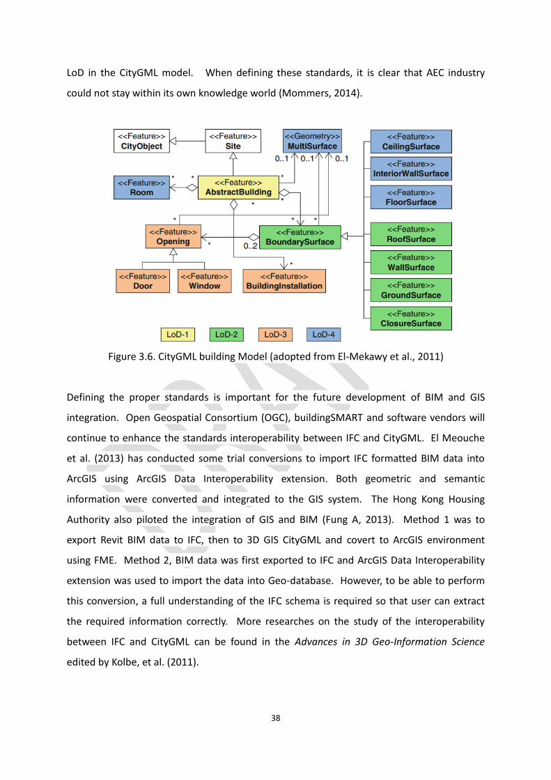
38
LoD in the CityGML model. When defining these standards, it is clear that AEC industry
could not stay within its own knowledge world (Mommers, 2014).
Figure 3.6. CityGML building Model (adopted from El-Mekawy et al., 2011)
Defining the proper standards is important for the future development of BIM and GIS
integration. Open Geospatial Consortium (OGC), buildingSMART and software vendors will
continue to enhance the standards interoperability between IFC and CityGML. El Meouche
et al. (2013) has conducted some trial conversions to import IFC formatted BIM data into
ArcGIS using ArcGIS Data Interoperability extension. Both geometric and semantic
information were converted and integrated to the GIS system. The Hong Kong Housing
Authority also piloted the integration of GIS and BIM (Fung A, 2013). Method 1 was to
export Revit BIM data to IFC, then to 3D GIS CityGML and covert to ArcGIS environment
using FME. Method 2, BIM data was first exported to IFC and ArcGIS Data Interoperability
extension was used to import the data into Geo-database. However, to be able to perform
this conversion, a full understanding of the IFC schema is required so that user can extract
the required information correctly. More researches on the study of the interoperability
between IFC and CityGML can be found in the Advances in 3D Geo-Information Science
edited by Kolbe, et al. (2011).

39
4 BIM Development in Hong Kong
In the BIM@CIC Conference 2013 organized by the Construction Industry Council, Mr. Lee
Shing-see (Chairman of Construction Industry Council), in his welcome remarks, comments
that “… BIM is now being discussed a lot more but Hong Kong is still lagging behind many of
its counterparts in the adoption of BIM. ….. Innovation is a new way, and BIM is the way to
go….” In the same conference, the keynote speaker, Mr. CHAN Mo-po, Paul, Secretary for
Development, Development Bureau, HKSAR, further addresses that “… it is important for
Hong Kong to keep pace with the global trend in BIM…. Task now is to establish a local BIM
standard. …” Ms. Ada Fung, Deputy Director of Housing, Hong Kong Housing Authority also
states that BIM will soon become a required technology, a trend that has been driven by
Hong Kong Housing Authority.
The above three speakers have already highlighted the current status of BIM development in
Hong Kong. During the last two years, many local conferences were organized with themes
which were related BIM. The local AECOO industry is certainly aware of the emerging of BIM.
Professional organizations such as The Hong Kong Institute of Surveyors (HKIS) hosted a BIM
conference in 2013 and various CPD talks focused on BIM. The Hong Kong Institute of
Building Information Modelling (HKIBIM), in working with academia from the tertiary
education units, drafted the frameworks for BIM professional training and certification in
Hong Kong. Furthermore, HKIBIM has been actively participated in compiling the first BIM
Standard in Hong Kong. The draft version of the standard was recently released and can be
downloaded from the www.hkibim.org.
Hong Kong is certainly moving into the right direction in the adoption of BIM in the
construction industry but slowly. In Singapore, BIM is identified as a key driver technology to
transform the construction industry. A BIM Steering Committee was set up in Singapore to
provide strategic direction and to address implementation issues. The Building and
Construction Authority (BCA) has given supporting fund up to SG$200,000 to help
companies adopt and implement BIM. All these activities are to support the milestone set
by the Singapore Government - from July 2015, architecture and engineering submissions

40
for all new building projects more than 5,000 sqm must submit a BIM model to the
government agency to get their plans approved.
During the development of this report, two important documents were published locally in
Hong Kong. The Final Draft Report of the Roadmap for BIM Strategic Implementation,
version 1 (BIM Roadmap Report) published in September 2013 by the Construction Industry
Council (CIC) outlines the current adoption of BIM in construction industry, the challenges
for the adoption and the major concern to be addressed. Information from the CIC report is
extracted and summarized in this report. The other document is the Hong Kong BIM
Standards, Building Information Model – Project Execution Plan (BIM PEP) Draft 1 published
by HKIBIM on June, 2014. The standard is intended to be used to define the scope of work
for a BIM process, the responsibilities of the project participants and the deliverables from
the BIM Process for the overall benefit of the project and the owner (HKIBIM, 2014).
4.1 BIM Adoption in AEC Industry
According to the BIM Roadmap Report, Hong Kong is lagging behind majority of developed
countries in the adoption of BIM. The evaluation was conducted by Dr. Calvin Kam, one of
the Director of Stanford University’s Center for Integrated Facilities Engineering, using the
Virtual Design and Construction (VDC) evaluation system. The VDC Scorecard evaluates the
maturity of Virtual Design and Construction in practice based on an industry performance
rating framework, and measures the degree of VDC innovation in planning, adoption,
technology, and performance (Stanford, n.d.). The overall score reveals the project’s ranking
among the others in the global market by a 5-level innovation ranking system, ranging from
‘conventional practice’ (without BIM) to ‘innovative practice’ (industry ‘firsts’).
The evaluation was based on the 10 award-winning project of 2012 Autodesk Hong Kong
BIM award. The median scores of the four Areas (Figure 4.1) indicate that all four Areas
were lagged behind the leading practice countries. In particular, the two Areas: Technology
and Performance, the scores are below the typical practice category. Lower score in
Technology indicates that BIM technology is not being used by AECOO industry throughout
the entire project lifecycle for visualization, documentation, performance analysis and
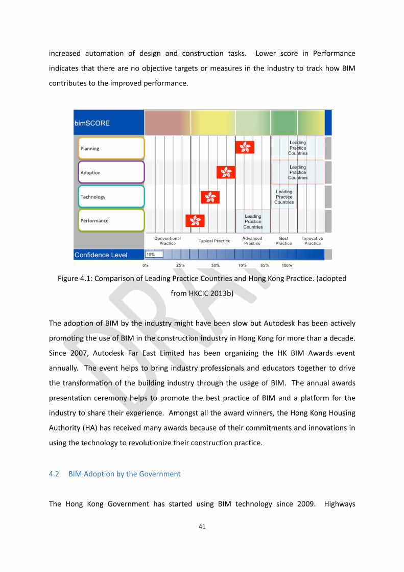
41
increased automation of design and construction tasks. Lower score in Performance
indicates that there are no objective targets or measures in the industry to track how BIM
contributes to the improved performance.
Figure 4.1: Comparison of Leading Practice Countries and Hong Kong Practice. (adopted
from HKCIC 2013b)
The adoption of BIM by the industry might have been slow but Autodesk has been actively
promoting the use of BIM in the construction industry in Hong Kong for more than a decade.
Since 2007, Autodesk Far East Limited has been organizing the HK BIM Awards event
annually. The event helps to bring industry professionals and educators together to drive
the transformation of the building industry through the usage of BIM. The annual awards
presentation ceremony helps to promote the best practice of BIM and a platform for the
industry to share their experience. Amongst all the award winners, the Hong Kong Housing
Authority (HA) has received many awards because of their commitments and innovations in
using the technology to revolutionize their construction practice.
4.2 BIM Adoption by the Government
The Hong Kong Government has started using BIM technology since 2009. Highways

42
Department pioneered the technology in the Improvement to Tuen Mun Road project and in
the Central-Wan Chai Bypass project. According to Mr. Paul Chan, the Secretary for
Development, the Government has developed a specific strategy to adopt BIM in public
works. The strategies include:
1. Extended trail of BIM technology for more public works projects such as bridges, tunnels, buildings and electrical and mechanical works in different construction stages,
2. Engaged and collaborated with various stakeholders including the CIC, software specialist consultants and contractors to explore the full potential of BIM in the construction industry, and
3. Launched a comprehensive staff training plan on BIM.
In the recent Digital 21 Strategy Advisory Committee meeting held in January 2014, BIM was
identified as one of the strategies for transforming and integrating public services in Hong
Kong. The Committee recommended that HA will implement BIM in all new projects starting
from 2014-15 and the Government is also using BIM in some works projects.
The CIC has represented the construction industry since 2007 and has been actively
promoting BIM technology to the construction industry in Hong Kong. In different events,
the CIC comments that Hong Kong has to catch up with the fast pace of the global trend in
the adoption of BIM in order to maintain the competitiveness of Hong Kong’s construction
industry in Asia Pacific Region and internationally in a long run. To purse industry-wide
implementation of BIM in Hong Kong, 16 recommended initiatives in 9 areas were proposed
in the BIM Roadmap Report. The three imminent actions are to:
1. compile local standards, 2. promote and increase the awareness of the programme, and 3. provide BIM training.
The CIC also named 2014 as the “BIM Year 2014” to promote BIM in the industry. A series of
promotional activities has been prepared throughout the year of 2014. After the release of
the BIM Roadmap Report last year, the CIC recently released the BIM Standards (Phase One)
for Hong Kong practice in collaboration with the industry stakeholders. It is the first
standard document prepared locally by the industry stakeholders and a very important
milestone towards a wide scale adoption of BIM in Hong Kong. However, this document is
not the first BIM related standard document published in Hong Kong. The Hong Kong
43
Housing Authority has prepared its in-house BIM standards, user guide, library component
design guide and references since 2009. These documents are essential for HA and their
partners to improve building quality by optimizing the designs, improving coordination and
reducing construction through the implementation of BIM in their projects. Copies of the
documents can be downloaded from the HA’s website: http://www.housingauthority.gov.hk/.
4.2.1 Implementation of BIM by Hong Kong Housing Authority
The Hong Kong Housing Authority is a statutory body with the mandate to develop and
implement a public housing programme to meet the housing needs of people who cannot
afford private rental housing. HA owns and maintains the largest stock of public housing
buildings in Hong Kong and continues to develop approximately 20,000 rental flats per year
to meet the public demand. HA recognizes the inherited benefits of BIM and has started
piloting BIM as early as 2006. According to Ms. Ada Fung, Deputy Director of Housing, HA
has introduced BIM in its development of public rental housing projects for many years.
More than 19 projects have already adopted BIM technology at various project stages,
ranging from feasibility study to construction stage. HA has the role as a developer and also
a facility manager. By adoption BIM, they can gain benefits in the entire building lifecycle
and extend to the operational management stage. Based on the experience of HA (Fung A.,
2013), they have used BIM for:
1. quick assembly of domestic blocks, 2. enhance quality of design, 3. enhance cost control and environmental protection, 4. better building services co-ordination, 5. optimize lighting design for energy saving, 6. improve site safety, and 7. better construction site planning.
Through the implementation of BIM, HA is able to optimize project designs, improve
coordination and reduce construction waste. In addition, if BIM is fully implemented in the
entire project lifecycle for their projects, HA will own the as-built models of the entire
project sites which provide both the accurate 3D representation of all the facilities as well as
the semantic information to facilitate the future operational and management of these
facilities. As recommended in the Digital21 strategy, HA will implement BIM in all new

44
projects starting from 2014-15.
4.3 Education of BIM
NATSPEC, an Australia not-for-profit organization that provides information to the Australian
design and construction industry, recently published a BIM Education – Global Report
summarized the current status of BIM education in a number of countries across the globe.
In the executive summary, it states that
“…It would appear that the majority of BIM education available to date focuses on training in
the use of particular BIM software packages. Training in openBIM concepts, BIM
management and working in collaborative BIM environments, appears to still be in its
infancy. …. tertiary education institutions, with the support of government and industry,
need to fully incorporate BIM education into their curricula, to provide the AEC industry with
the ‘BIM-ready’ graduates required for the collaborative BIM working environments to which
they will be part of in the future.”
(NATSPEC, 2014)
The above comment also reflects the current BIM education in Hong Kong. As the
technology was driven by software vendors such as Autodesk and Bentley Systems, initial
focus on BIM education has been in the use of BIM modeling software such as Revit, Civil3D,
etc. Technicians in the construction industry, especially those who have been doing 2D CAD
drafting, have received training in creating accuracy 3D models and the procedure to input
the semantic information of different construction components. In addition to 3D modeling
training, they also learned how to handle point cloud data captured from terrestrial laser
scanning and perform cash detection analysis using tools such as Pointools and Navisworks.
Other than the software vendors, CIC and IVE also provide structure courses on BIM. CIC
offers certificate course on Building Information Modeling Basic which introduces basic
concept of BIM and its applications and with hand-on experience using Revit software to
create models. IVE set up a BIM Training Centre at Morrison Hill since September, 2010.

45
BIM elements are incorporated in the curriculum of various Higher Diploma programmes in
construction. Other tertiary education units have already incorporated BIM into their
curriculum as listed in the Appendix A.
The Hong Kong Institute of Building Information Modelling developed three tiers BIM
curriculum for the training of local HKIBIM Certificated Experts in different levels. The first
tier, entry level course, covers the BIM basic knowledge and software operation. The second
tier, the intermediate level, encompasses three courses: Structure, MEP and Revit Families.
The third tier, the professional level, outlines the BIM knowledge as required for professional
practitioners in various professional disciplines to become BIM experts. Here are the six
courses in tier three:
• CEIII Architecture (Revit) Course • CEIII Structure (Revit) Course • CEIII MEP (Revit) Course • CEIII Construction Management Course • CEIII Cost Management Course • CEIII BIM Management Course
Details of the proposed course outline can be found in the following
http://www.hkibim.org/?page_id=80. The BIM curriculum outlines, in particular tier three,
are not yet finalized and details of the curriculum are not yet completed. As HKIBIM do not
offer the training courses, tertiary education units should work closely with HKIBIM to
finalize the details and offer the professional trainings as needed.

46
5 Opportunities for Land Surveyors
While the roots of BIM are in architecture, the basic principle of working from and on
accurate 3D digital models applies to nearly all infrastructure projects, including site work,
subdivisions, bridges, highways and all the other things that surveyors routinely stake out
(Bennett, 2009). All construction projects starts with the existing condition information in
3D and surveyors are the first to provide the essential information professionally for
preliminary design and project plan. During the completion of construction projects,
surveyors are there to conduct an accurate and up-to-date as-built survey for
documentation, issuing final project payment and capturing the accurate 3D model data for
the enterprise GIS system.
For a broader scope of land surveying industry in an urban environment, land surveyors
involve in data collection, data processing, plans and maps creation, and data management
in fields of land information management and construction/project data management.
Traditionally, land surveyors have been recognized as the experts in collecting raw data such
as distances and angles and transforming them to structured spatial data in the appropriate
accuracy and map scale. GIS and geo-database technologies have further extended
surveyors role to become spatial data managers to maintain, organize, classify and analyze
data stored in geo-databases.
In a construction site, surveyors assume the data management roles responsible for the
coordination all geometric data of site topography and facilities. In a citywide land
information center, surveyors assume the data administration roles responsible for the
coordination all urban spatial data. As BIM has created a buzz across AEC industry, its
impacts on land surveying profession have started filtering in construction survey, as-built
survey and 3D spatial data management.
5.1 Construction Surveys and BIM
For new construction projects, land surveyors are always the first arrived to the site to

47
produce quality terrain models and accurate topographic models. Table 5.1 summarizes the
duties of land surveyors during different stages of construction.
Construction
Project Stages
Surveyor Roles and Duties Purposes
Planning and
Design Stage
Site reconnaissance;
Control surveys;
Preliminary site data collection:
topography and existing as-built facilities.
Establish control networks;
Provide site information to
facilitate planning and
design.
Construction Stage Setting out;
Create plan, profile and cross-section;
Earthworks Calculation;
Taking interim measurements of
construction progress.
Confirm and monitor the
construction process;
Record and document the
construction process;
Quality control.
Completion Stage As-built survey;
Deformation survey (if needed).
Document and record the
completed facilities;
Verify the constructed with
the original design.
Table 5.1. Land Surveyors’ Duties in Construction Projects
Typical construction projects include roads construction, highway construction, sewer and
tunnel construction, culvert construction, building construction and other heavy
construction (such as dams, port facilities). As the scale and complexity of a project
increases, roles of surveyors increase so as project duration.
Information collected from project sites such as earthwork volume is being used by
contractors to monitor the project progression. To operate a construction project more
efficiently, planning, scheduling, and supervising of earthwork operations are crucial. In
addition, this information is also being used to determine partial payments based on the
construction progress and final payment based on completion and acceptance of the works.
Surveyors collect, calculate and record the information accurately with respect to dates,
times, locations, quantities, methods of measurement, personnel, design changes, and so on.
48
In fact, in a construction site, land surveyors have long assumed the role as project data
managers coordinating project information in collaboration with site engineers, owners and
contractors. The role of land surveyors have not changed significantly but land surveying
instruments and machine control systems are becoming more advanced and efficient. GPS,
motor driven scanners and ICT help reduce times spent on data collection but at the same
time, increase data volume and data processing time and efforts.
The introduction of BIM in a construction project has significantly changed how survey data
should be managed by land surveyors using the new tools. These changes are in terms of
quality and efficiency that more services can be delivered on the day-to-day activities with
higher accuracy after combining the usual practice with BIM (Speed, 2012). These changes
now require all stakeholders to both reassess the opportunities technology provides, and
consider changes to traditional processes, if the maximum value is to be realized (Australian
Institute of Architects, 2013). Traditionally, surveyors assume the project data manager role
but with the introduction of BIM in a construction project, surveyors’ role as project data
managers cannot just be assumed but has to be endorsed by stakeholders. A project data
manager in the BIM era may have a modern name called “BIM manager” but the roles of a
BIM manager are more than that of a project data manager. BIM manager requires to have
integrated knowledge of all professional disciplines participated in a construction project as
well as ICT skills. Surveyors are responsible to ensure that all project information is well-
coordinated in a collaborative matter. BIM provides a golden opportunity for land surveyors
to take up a new and major role in a construction project.
5.2 As-built Survey and BIM
As-built surveys involve data collection and processing of the existing condition. Land
surveyors have been doing as-built surveyors for mapping and cadastral survey purposes.
2D footprints and top view of buildings and infrastructures are captioned and stored in a
geo-databases but not the completed 3D model as outputted from BIM. For cadastral survey,
accurate and detail structure dimensions are presented clearly on cadastral plans. For
conservation purpose, accurate 3D surface models of historical buildings and monuments
are created. In some cases, both the interior and exterior structural surfaces are captioned

49
and modelled in 3D space. Adoptive reuse, the process of adopting old structures for new
purposes, is a very important concept and a coincidentally reached consensus in city
planning community all over the world. Bennett (2009) further indicates that there is a
change in consumer perception that people nowadays are inclined to live in an urban
community where old buildings are kept and reused, rather than demolished.
In US, in order to fulfil the demand of the tremendous retrofit market, high accuracy three
dimensional as-built data becomes a crucial component. For a retrofit construction project,
it is almost essential to have as-built data in order to plan the design with consideration of
the neighboring groups of buildings. After the retrieval of 3D as-built data, higher quality
documentation can be achieved, which is much more accurate when compared to
traditional 2D drawings. 3D digital models can be built for having a better visualization of the
target structures and doing analytical works. By simulation on a 3D platform, designs are
easier to optimize, facilitating the entire retrofit project.
In Hong Kong, retrofit construction project is not in high demand as the number of valuable
historical buildings and monuments is limited. Nevertheless, the adoption of BIM and
development of a complete CIM model bring positive impacts to the as-built survey market.
In the process of developing a BIM model for a new construction project, 3D as-built model
of buildings and infrastructures in the neighborhood are needed. To some extent, the
emergence of BIM can be deemed as a remote cause for the great demand of 3D as-built
data. A complete 3D representation of a project site (as-built 3D model and virtual 3D
model) can be used for construction scheduling optimization, clash detection, cost
estimation, feasibility analysis of construction workflow and environmental impact analysis,
etc... With most of the as-built records are incomplete or missing, surveyors are going to be
called upon to build that asset database. Land surveyors are spatial data collectors and
suppliers and undoubtedly stand at the forefront of a construction project.
5.3 3D Spatial Data Management and BIM
Land surveyors’ skills in spatial data handling have been recognized by many disciplines such

50
as urban planning, transport planning, environmental protection, emergency response and
rescue, etc… For example, the geo-database created and maintained by the Land
Information Centre of the Surveying and Mapping Office in Hong Kong has been used by
many Government departments, utility companies and land developers for various
applications. Spatial data from varieties of data sources, in different data formats, is entered
into the geo-database and then amalgamated and transformed into valuable information.
Land surveyors’ experience in managing GIS technology is an important asset in the
construction industry when considering the adoption of BIM in the construction process.
The following GIS skills are very valuable to surveyors:
Data and project management,
Data preparation and organization,
Data quality checking, verification and analysis
Information presentation and visualization,
Information sharing and communication, and
Applications development and deployment.
Owing to the similarity of the GIS and BIM, land surveyors’ GIS skills are a valuable asset for
the adoption of BIM in Hong Kong. Land surveyors with specialized skills in GIS can naturally
assume the role as BIM managers to manage BIM data in the entire project lifecycle. Loh,
the principle land surveyor at Housing and Development Board of Singapore, discusses that
it is also imperative to present the accurate 3D survey data as accurate 3D models to a BIM-
centric process as the land development industry embraces BIM. This is critically important
that land surveyors have to be able to present, document and communicate the information
as a 3D BIM model so that other members in the project team can work together in this
shared BIM model.
In the last decade, CAD software manufacturers attempted to integrate GIS into CAD
platform but the products were not accepted by either of the markets. It is uncertain if GIS
and BIM will merge together to form one single integrated software platform with seamless
boundary. The format and the level of integration will depend on the market demand, the
benefits perceived by the markets and the commercial decision from software
manufacturers. Others also worry that the present computing technology cannot keep pace
with the huge data storage space and the complexity of functions; and seamless integration
is unlikely to happen. In fact, the difficulties in data integration and data management make

51
the coordination works done by land surveyors more significant.
As discussed earlier, popularity of scanning technology and the adoption of BIM in
construction industry bring positive impacts to the as-built survey market. The initiative to
develop an enterprise 3D geo-database from Government will also expand the use of geo-
database and GIS technology in the construction lifecycle. With more existing buildings and
infrastructures are being mapped as 3D objects, the role of land surveyors will also increase.
5.4 Opportunities and Challenges
There are great opportunities for land surveyors in this BIM era as discussed. Land surveying
market in Hong Kong will expand as the maturity level of BIM adoption increases. To enable
this to happen, land surveyors have an important role to ensure that the issue of
interoperability between GIS and BIM must be resolved. Surveyors have to understand the
IFC standard and if possible, assist the industry to localize the IFC standard. Efforts to
enhance interoperability have been made in the AEC industry. For instances, Open Geospatial
Consortium (OGC), an international voluntary consensus standards organization, gathers
more than 360 commercial, governmental, non-profit and research organizations worldwide
to form a 3D information management working group which focuses heavily on the
convergence of AEC and geospatial trends and technologies (Underwood & Isikdag, 2010);
buildingSMART Alliance has launched a project since 2010 with a major intention to provide
the basis for an information relationship between the GIS and BIM environment and their
underlying databases (NIBS, n.d.). Surveyors can certainly take a leading role in this process.
In using new technology, ones must examine our work processes and how they may change,
and how those changes propagate downstream to the AEC ecosystem that relies on our
spatial expertise (Bennett, 2009). Even though land surveyors have assumed the role as
project data manager in a construction project, BIM and scanning technologies will certainly
change the present workflow. Surveyors must sharpen their professional skills in using these
technologies in the construction site and explore the integrated knowledge in the AECOO
industry and BIM. The integrated knowledge covers engineering concept, ICT knowledge
and construction knowledge. If land surveyors want to engage successfully in the BIM-

52
centric process, they must confront with the challenges and learn the extra skills. In short,
the role of surveyors in BIM may be expanding; it does not depend on what surveyors can do,
but on what surveyors want to do.

53
6 The Steps Ahead
Loh Suat Yen, Principal Land Surveyor of Housing & Development Board in Singapore (Loh,
2013) addresses that “land surveyors may need to evaluate the combination of more than
one survey techniques to measure the data and provide them in a format that best suits the
requirements of a project after advising the client accordingly. It is also imperative to
present the accurate 3D survey data as accurate 3D models to a BIM-centric process as the
land development industry embraces BIM.” Similar comment is shared by Bennett (2009)
that laser scanning combined with a BIM-centric process required a rethinking of traditional
processes. The demand for land surveyors to “think out of the box” is obvious. BIM
provides a common environment for all information about construction, not just size, shape
and coordinates, but includes design, time, costs, physical performance, logistics and more.
Surveyors must keep up with modern technological trend and be able to transform 3D
survey data to a 3D BIM model which can be used for communication amongst project team
members.
BIM is about digital databases, coordination and collaboration. Land surveyors have over
twenty years of experience in handling 2D and 3D geo-databases. Traditionally, surveyors
have assumed the role as a project data manager to coordinate project data and
collaborated with members in the project teams for project progress monitoring and
scheduling, quality checking and payment endorsement. Adopting BIM in surveying
profession might seem to be logical but as Bennett (2009) says clients may not realize that
surveyors have the skills and desire to help them far more than they have previously and
that surveyors are keen to do that. Surveyors certainly cannot take over the professional
roles of other members in the project team but surveyors can be the BIM manager to
coordinate information flow in a BIM-centric process.
BIM demands a steep learning curve and additional investment in staff training, new survey
equipment, new software and powerful hardware are required. Surveyors also need to step
up to learn more about the practices of the AECOO industry; to rethink the impacts of
modern technology such as laser scanning on the traditional processes; to

54
standardize/facilitate the seamless integration of BIM and GIS; and to market surveyors’
skills, willingness and readiness to take up the challenge.
To address the above issues, the following possible actions are suggested:
Items Major Issues Possible Actions
Technologies - Laser Scanning – use of laser scanning in BIM
- GIS and BIM integration and interoperability
- Develop operational guide to govern the use of laser scanning technology with BIM and other surveying tasks
- Investigate how GIS can be used in various construction stage
- Explore the integrate between GIS and BIM based on standards, data transformation and conversion; applications and analysis
Education and
Training
- Basic BIM and 3D modeling training
- Basic knowledge of
construction and engineering
- Professional certification and recognition
- Receive BIM and 3D modeling training to understand the BIM process and the creation of 3D BIM model
- Receive basic training in construction management and gain industry knowledge
- Work with academic institutions to offer Postgraduate Programme in BIM/GIS Management
- Collaborate with HKIBIM for professional recognition
Marketing and
Promotion
- Promote BIM to land and engineering surveyors
- Market land surveyors’ expertise in project data management to AECOO industry and project owners
- Participate in curriculum development with HKIBIM
- Offer CPD talks and seminars to professional land surveyors
- Organize conference with theme BIM - Land Surveying and Data Management and invite industry stakeholders to attend
- Work with HKIBIM to finalize the curriculum of BIM experts
Table 6.1 Recommendations for Follow-up Actions
The adoption of BIM technology in Hong Kong is only in its infancy stage. Opportunities for
land surveyors to strengthen our professional roles in the construction industry are present.

55
While other professional bodies are still skeptical about the technology and reluctant to
move the extra step to adopt BIM into their roles, land surveyors should move forward to
embrace BIM into our profession. Surveyors have confronted with various technology
challenges such as GIS, GPS, GSM and Remote Sensing in the last two decades but they were
able to turn all these challenges into opportunities. BIM is certainly the technology that
surveyors cannot overlook as it will transform the entire construction industry in these
coming years. RICS (2012) states that “BIM is not going to go away, and so we must,
therefore, learn to adopt and embrace or risk the threat of losing ground to other.”

56
7 References
Australian Institute of Architects (2013). BIM Outreach: 09 Surveying for BIM, Version 1.
Retrieved July 8, 2014 from https://revitall.files.wordpress.com/2014/06/o9-bim-for-surveying-aia-ca.pdf .
Autodesk (2003). Building Information Modeling. San Rafael, CA, Autodesk, Inc.
Bennett, T. D. (2009). BIM and laser scanning for as-built and adoptive reuse projects: The
opportunity for surveyors. The American Surveyor. Retrieved December 14, 2013 from
http://www.amerisurv.com/content/view/6364/153/
Bonham-carter, G. F. (2006). Geographic Information Systems for Geoscientists: Modelling
with GIS. Oxford: Elsevier Butterworth-Heinemann.
UK Cabinet Office (2011). Government Construction Strategy. Retrieved July 27, 2014 from
https://www.gov.uk/government/uploads/system/uploads/attachment_data/file/61152/Go
vernment-Construction-Strategy_0.pdf .
Campbell, B. (2014). A Tech-tonic Shift?. Geospatial World, Volume 04, Issue 08. pp. 34-36.
Cho, H., Lee, K. H., Lee, S. H., Lee, T., Cho, H. J., Kim, S. H., Nam, S. H. (2011). Introduction of
construction management integrated system using BIM in Homan high-speed railway lot no.
4-2, Report. Civil Engineering Technology Department, Ssangyong E and C, Seoul, Korea.
DeVito, R. (2014). A 3D View of London. Geospatial World, Volume 03, Issue 08 pp. 44-45.
Eastman, C, et al (2011). BIM Handbook: A Guide to Building Information Modeling for
Onwers, Managers, Designers, Engineers and Contractors, 2nd Edition, John Wiley & Sons, Inc.
El Meouche, R., Rexoung, M. and HIJAZI, I. (2013). Integrating and Managing BIM in GIS,
Software Review. International Archieves of the Photogrammetry, Remote Sensing and
Spatial Information Sciences, Volume XL-2/W2, ISPRS 8th 3DGeoInfo Conference & WG II/2

57
Workshop.
El-Mekawy, et al. (2011). Towards Interoperting CityGML and IFC Building Models: A Unifed
Model Based Approach. Advances in 3D Geo-Information Sciences, Lecture Notes in
Geoinformation and Cartography, Springer-Verlag Berlin Heidelberg 2011.
Fung, A. (2013). Integration of BIM in Public Housing Development. Presentation on the
International QS BIM Conference, November 9, 2013. Retrieved May 14, 2014 from
http://www.hkis.org.hk/hkis/general/events/bim2013/bim-2013af.pdf .
Fung, F. (2013). BIM Benefits Soar from Underground to Tower Cranes, Autodesk Hong Kong
BIM Awards 2013, Autodesk. pp. 19-26.
Garagnani, S. & Manferdini, A. M. (2013). Parametric accuracy: Building information
modeling process applied to the cultural heritage preservation. ISPRS - International Archives
of the Photogrammetry, Remote Sensing and Spatial Information Sciences, XL-5/W1 87-92.
General Services Administration (GSA), US (2007). GSA Building Information Modeling Guide
Series: 01 – Overview of GSA’s National 3D-4D-BIM Program, Version 0.6. Retrieved April 6,
2014 from http://www.gsa.gov/bim .
General Services Administration (GSA), US (2009). GSA Building Information Modeling Guide
Series: 03 – GSA BIM Guide for 3D Imaging, Version 1.0. Retrieved April 6, 2014 from
http://www.gsa.gov/bim .
HKCIC (2013a). BIM: Fact Sheet, Strategic Implementation of Building Information Modeling
(BIM) in Hong Kong’s Construction Industry. Retrieved March 22, 2014 from
http://www.hkcic.org/WorkArea/DownloadAsset.aspx?id=10628&langType=1033 .
HKCIC (2013b). Final Draft Report of the Roadmap for BIM Strategic Implementation in Hong
Kong’s Construction Industry. Retrieved Feb 26, 2014 from
http://www.hkcic.org/WorkArea/DownloadAsset.aspx?id=11234&langType=1033 .

58
HKIBIM (2014) Hong Kong BIM Standards: Building Information Model – Project Execution
Plan (BIM PEP) Draft 1, Retrieved June 30, 2014 from
http://www.slideshare.net/HKIBIM/cic-hk-bimstandardspepdraft1 .
Humphrey, R. (2014). BIM is changing the game for construction. Geospatial World, Volume
03, Issue 08 pp. 61-61.
Loh, S. Y. (2013). Challenges and Opportunities for Land Surveyors. Geospatial World, Volume
04, Issue 01 pp. 50-52.
Irizarry, J. & Karan, E. P. (2012). Optimizing location of tower cranes on construction sites
through GIS and BIM integration. In Journal of Information Technology in Construction,17.
Retrieved October 30, 2013 from http://www.itcon.org/2012/23 .
Jernigan, F. (2008). BIM BIM little bim, 2nd Edition, Site Press, Salisbury, MD.
Jonas, D. (2014). Digital City Model to Support Complex Planning Scenarios. Geospatial
World, Volume 03, Issue 08 pp. 40-41.
Karabork, H., et al. (2007). Modeling and visualization using laser scanning in documentation
of cultural heritage. Proceedings of the 21st CIPA Symposium: Anticipating the future of the
cultural past. ISPRS Archives – Volume XXXVI-5/C53, 2007. Retrieved September 29, 2013
from http://www.isprs.org/proceedings/xxxvi/5-c53/papers/FP081.pdf
Kemp, A.C. (2011). BIM isn’t Geospatial – or is it? Retrieved July 22, 2014 from
http://www.agi.org.uk/storage/GeoCommunity/AGI2011/Papers/AnneKempPaper.pdf
KIA, S. (2013). Review of Building Information Modeling (BIM) Software Packages Based on
Assets Management. Retrieved July 31, 2014 from
https://www.academia.edu/4144891/Review_of_Building_Information_Modeling_BIM_Soft
ware_Packages_Based_on_Assets_Management_Saeed_KIA .

59
Koble, T. Konig, G. and Nagel C. (2011). Advances in 3D Geo-Information Sciences, Springer-
Verlag Berlin Heidelberg 2011. Retrieved June 4, 2013 from
http://link.springer.com/book/10.1007%2F978-3-642-12670-3 .
Kymmell, W. (2008). Building information modeling: Planning and managing construction
projects with 4D CAD and simulations. United States of America: McGraw-Hill.
LangdonSeah (1st quarter 2014). Asia Construction Costs Summary - First Quarter 2014,
Retrieved July 27, 2014 from http://www.langdonseah.com/en/my/files/download/3480 .
Lichtig, W. A. (2006). The integrated Agreement for Lean Project Delivery. Construction
Lawyer, Vol. 26, No. 3, Summer 2006, published by the American Bar Association.
MarketsandMarkets (2013). LiDAR Market by Components (INS, Laser, GPS/GNSS, Camera,
MEMS), Product Types (Airborne, Mobile, Terrestrial), Applications (Corridor Mapping,
Forestry, Mining, Topographic Surveying, Volumetric Mapping) - Global Forecasts and
Analysis 2013 – 2018. Marketsandmarkets.com.
McElvaney, S. (2013). Integration of BIM & GIS is essential. Geospatial World. Volume 04,
Issue 01, pp. 92-93.
Mommers, B. (2014). The Crossover Revolution. Geospatial World, Volume 04, Issue 08, pp.
62-63.
Nagel, C., Stadler, A. & Kolbe, T. H. (2009). Conceptual requirements for the automatic
reconstruction of building information models from uninterpreted 3D model. In GeoWeb
2009 Academic Track - Cityscape,XXXVIII-3-4/C3. Retrieved November 9, 2013 from
Technische Universität, Institute for Geodesy and Geoinformation Science Web site:
http://www.isprs.org/proceedings/XXXVIII/3_4-
C3/Paper_GeoW09/paper26_Nagel_Stadler_Kolbe.pdf
NATSPEC (2014). BIM Education – Global –Summary Report – 2013. Retrieved July 24, 2014

60
from http://www.acif.com.au/acif-news/natspec-global-bim-education-report .
Rutland F. and Pensee A. (2010). Non-contact 3D laser scanning as a tool to aid identification
and interpretation of archaeological artefacts; the case of a Middle Bronze Age Hittite dice.
Retrieved Aug 5, 2014 from http://www.digitalclassicist.org/wip/wip2010-06al.pdf .
Navratil, G., Bulbul, R. and Frank. A. (2010). Maintainable 3D Models of Cities. Retrieved Aug
8, 2014 from http://www.academia.edu/393494/Maintainable_3D_Models_of_Cities .
Nederveen, S., Beheshti, R. & Gielingh, W. (2010). Modelling Concepts for BIM, Building
Information Modeling and Construction Informatics, Concept and Technologies, Information
Science Reference. pp. 1-18.
Pauwels, P., Verstaeten, R. & De Meyer, R. (2008). Architectural information modelling for
virtual heritage application, digital heritage. In (2008) Digital Heritage – Proceedings of the
14th International Conference on Virtual Systems and Multimedia. Retrieved November 28,
2013 from Ghent University, Department of Architecture and Urban Planning Web site:
https://biblio.ugent.be/publication/434809 .
Przybyla, J. (2010). The next frontier for BIM: Interoperability with GIS. Journal of Building
Information Modeling, Fall 2010 pp. 14-18.
Rachenbach, J. (2014). Revolutionising 3D Modelling for construction. Geospatial World,
Volume 04, Issue 11 pp. 16-19.
Rajan, D. (2012). What is BIM and where does GIS fit in? Retrieved June 6, 2014 from
http://communityhub.esriuk.com/journal/2012/5/23/what-is-bim-and-where-does-gis-fit-
in.html?printerFriendly=true .
Reinhardt, J. (2009). Appendix C: BIM Tools Matrix. The Contractor's Guide to BM. 2nd
ed. AGC of America, 2009. 57-67.
Rich, S. and Davis K. (2010). Geographic Information Systems (GIS) for Facility Management.

61
Retrieved July 23, 2014 from http://foundation.ifma.org/docs/default-
source/Whitepapers/foundation-geographic-information-systems-(gis)-
technology.pdf?sfvrsn=2 .
RICS (2012). What is BIM?. Retrieved September 16, 2013 from
http://www.rics.org/hk/footer/glossary/bim/ .
SCMP (May, 2014). High-speed rail link delay highlights need for MTR management shake-
up. South China Morning Post. Retrieved May 26, 2014 from
http://www.scmp.com/news/hong-kong/article/1507810/high-speed-rail-link-delay-
highlights-need-mtr-management-shake .
Speed, V. (2012). Next stop: A virtual jobsite. Retrieved December 17, 2013 from
http://www.leica-geosystems.us/en/UW.Station.virtual.tour.pdf
Staiger, R. (2003). Terrestrial laser scanning: Technology, systems and applications. Retrieved
January 15, 2014 from
http://www.fig.net/pub/morocco/proceedings/ts12/ts12_3_staiger.pdf
Sharkey, L. and Young B. (2014). Towards a Sustainable Future. Geospatial World, Volume 04,
Issue 11 pp. 28-30.
Soni, V., Yen K. Lasky T. and Ravani, B. (2011). Caltrans Workflow for NavisWorks. AHMCT
Research Report: UCD-APR-hh-10-31-01. Retrieved Aug 5, 2014 from
http://ahmct.ucdavis.edu/pdf/UCD-ARR-11-10-31-01.pdf
Stanford (n.d.). VDC and BIM scorecard: Measure your success . Retrieved February 19, 2014
from Stanford University, Web site: https://vdcscorecard.stanford.edu/content/vdc-
scorecard.
Stewart, P. (2014). An Overview of the Process from an Irish Construction Project
Mangaement Perspective. Retrieved April 24, 2014 from

62
http://www.irishconstruction.com/building_information_modelling_an_overview_of_the_p
rocess_from_an_irish_construction_project_management_perspective.PAGE3164.html .
The BIM Industry Working Group, UK (2011). BIM Management for Value, Cost & Carbon
Improvement. A Report for Government Construction Client Group Building Information
Modelling (BIM) Working Party Strategy Paper. Retrieved Feb 6, 2014 from
http://www.bimtaskgroup.org/wp-content/uploads/2012/03/BIS-BIM-strategy-Report.pdf .
Wallis, P. (2012). A More Practical BIM: Geospatially Re-structuring BIM to Sustain the Built
Environment. Practical BIM 2012 – Management, Implementation, Coordination, and
Evaluation. The USC BIM Symposium. pp. 243-252. Retrieved June 6, 2014 from
http://www-bcf.usc.edu/~kensek/Practical%20BIM%202012%20-
%20for%20personal%20use%20only.pdf .
Zeiss, G. (2013). Building on BIM. Geospatial World, Volume 04, Issue 01 pp. 24-32.
Underwood, J. & Isikdag, U. (2010). Building information modeling and construction
informatics: Concepts and technologies. New York: Information Science Reference.

63
8 Appendix A: BIM Education Offered by Hong Kong Tertiary
Education Units
School Department Class involve BIM Short Description
CUHK Department of
Architecture
BIM LAB Aims: Learn ‘all’ about BIM designing and practice, its tools and how to apply them; then use BIM in an design process Outcomes: BIM Software Skills, BIM Knowledge in Architectural Design and your own Design based on BIM.
Summer Design Elective
HKU
Department of Civil
Engineering
CIVL6059 Special Topic in Infrastructure Project Management -
Building Information Modelling (BIM): Theories, Development and Application
Department of Architecture
Introduction to Building Information Modeling and Management (BIM basic)
Students learn the basic concepts and workflows of BIM process in architecture through modeling and analyzing a project of their choice
Building Information Modeling in Architectural Practice (BIM Advanced)
Students learn the advanced concepts of parametric modeling, project management and building analysis through three design exercises
Construction Communication
The course focuses on the communication and documentation aspects of the BIM process and guides the students to produce a full schematic design documentation of a simple project
HKPU
Department of Building and Real Estate
Information Technology and Data Analysis
BIM in general; built up BIM models using Revit; NavisWork operations.
Work Training and BIM A BIM practicing and workshop training subject for the students to equip with more practical technical knowledge and skills
Individual & Integrated Project
This new Integrated Project will be BIM orientated. Integrated Project for engineering discipline includes design review, method statement and planning. Integrated Project for surveying discipline includes measurement, cost planning and valuation of variations etc.
Building Information Modeling
Understand the concept of BIM and the constituents of BIM models; Understand the functions and benefits of BIM in construction management; Use some typical software packages to build or operate basic BIM models; Apply BIM technology to building projects so as to solve some problems occurring in building projects.
Information Management for Construction
BIM in general to advance; Build up model;4D/5D in BIM models using Revit and Navis Work; BIM in collaborative works.
Department of Land Surveying
and Geo-Informatics
Programme: BSc (Hons) in Geomatics/HD in Geomatics Subject: Mapping
Basic concepts of SDI and BIM, importance of SDI and BIM for modern urban development and construction
Programme: BSc (Hons) in Geomatics/ HD in Geomatics Subject: Digital Terrain Modelling
Integrate BIM and DTM for 3D visualization and crash detection
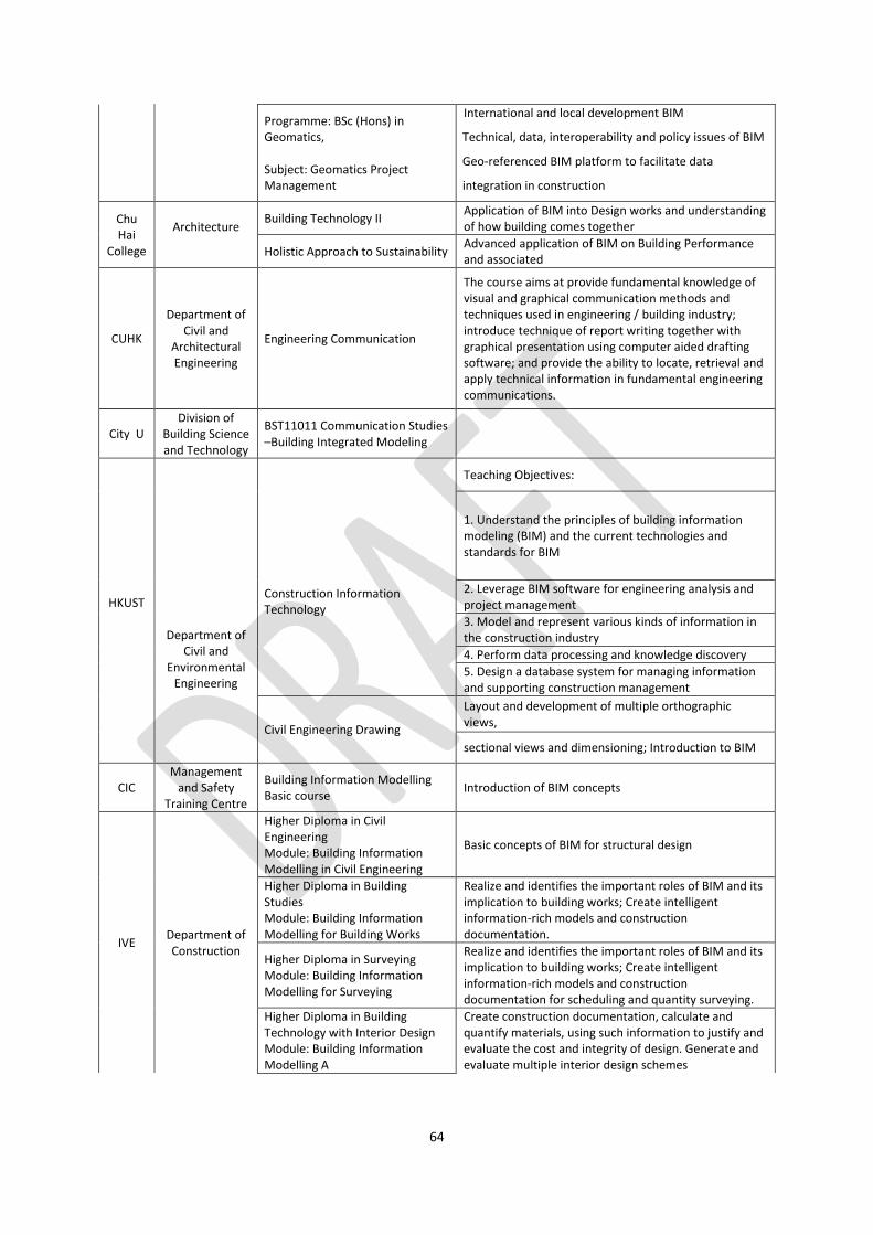
64
Programme: BSc (Hons) in Geomatics, Subject: Geomatics Project Management
International and local development BIM
Technical, data, interoperability and policy issues of BIM
Geo-referenced BIM platform to facilitate data
integration in construction
Chu Hai
College
Architecture
Building Technology II Application of BIM into Design works and understanding of how building comes together
Holistic Approach to Sustainability Advanced application of BIM on Building Performance and associated
CUHK
Department of Civil and
Architectural Engineering
Engineering Communication
The course aims at provide fundamental knowledge of visual and graphical communication methods and techniques used in engineering / building industry; introduce technique of report writing together with graphical presentation using computer aided drafting software; and provide the ability to locate, retrieval and apply technical information in fundamental engineering communications.
City U Division of
Building Science and Technology
BST11011 Communication Studies –Building Integrated Modeling
HKUST
Department of Civil and
Environmental Engineering
Construction Information Technology
Teaching Objectives:
1. Understand the principles of building information modeling (BIM) and the current technologies and standards for BIM
2. Leverage BIM software for engineering analysis and project management
3. Model and represent various kinds of information in the construction industry
4. Perform data processing and knowledge discovery
5. Design a database system for managing information and supporting construction management
Civil Engineering Drawing
Layout and development of multiple orthographic views,
sectional views and dimensioning; Introduction to BIM
CIC Management
and Safety Training Centre
Building Information Modelling Basic course
Introduction of BIM concepts
IVE Department of Construction
Higher Diploma in Civil Engineering Module: Building Information Modelling in Civil Engineering
Basic concepts of BIM for structural design
Higher Diploma in Building Studies Module: Building Information Modelling for Building Works
Realize and identifies the important roles of BIM and its implication to building works; Create intelligent information-rich models and construction documentation.
Higher Diploma in Surveying Module: Building Information Modelling for Surveying
Realize and identifies the important roles of BIM and its implication to building works; Create intelligent information-rich models and construction documentation for scheduling and quantity surveying.
Higher Diploma in Building Technology with Interior Design Module: Building Information Modelling A
Create construction documentation, calculate and quantify materials, using such information to justify and evaluate the cost and integrity of design. Generate and evaluate multiple interior design schemes
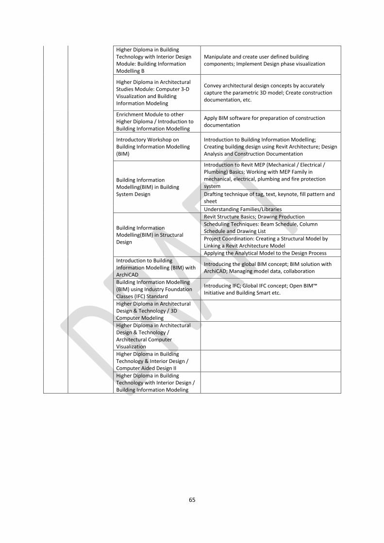
65
Higher Diploma in Building Technology with Interior Design Module: Building Information Modelling B
Manipulate and create user defined building components; Implement Design phase visualization
Higher Diploma in Architectural Studies Module: Computer 3-D Visualization and Building Information Modeling
Convey architectural design concepts by accurately capture the parametric 3D model; Create construction documentation, etc.
Enrichment Module to other Higher Diploma / Introduction to Building Information Modelling
Apply BIM software for preparation of construction documentation
Introductory Workshop on Building Information Modelling (BIM)
Introduction to Building Information Modelling; Creating building design using Revit Architecture; Design Analysis and Construction Documentation
Building Information Modelling(BIM) in Building System Design
Introduction to Revit MEP (Mechanical / Electrical / Plumbing) Basics; Working with MEP Family in mechanical, electrical, plumbing and fire protection system
Drafting technique of tag, text, keynote, fill pattern and sheet
Understanding Families/Libraries
Building Information Modelling(BIM) in Structural Design
Revit Structure Basics; Drawing Production
Scheduling Techniques: Beam Schedule, Column Schedule and Drawing List
Project Coordination: Creating a Structural Model by Linking a Revit Architecture Model
Applying the Analytical Model to the Design Process
Introduction to Building Information Modelling (BIM) with ArchiCAD
Introducing the global BIM concept; BIM solution with ArchiCAD; Managing model data, collaboration
Building Information Modelling (BIM) using Industry Foundation Classes (IFC) Standard
Introducing IFC; Global IFC concept; Open BIM™ Initiative and Building Smart etc.
Higher Diploma in Architectural Design & Technology / 3D Computer Modeling
Higher Diploma in Architectural Design & Technology / Architectural Computer Visualization
Higher Diploma in Building Technology & Interior Design / Computer Aided Design II
Higher Diploma in Building Technology with Interior Design / Building Information Modeling