strengthening community and ecosystem resilience against...
TRANSCRIPT

Vietnam Case Study from Field Testing an Operational Framework for Ecosystem-based Adaptation
© Vũ Long
Hanoi, 2013Hanoi, 2013
STRENGTHENING COMMUNITY AND ECOSYSTEMRESILIENCE AGAINST CLIMATE CHANGE IMPACTS

Project name “Strengthening Community and Ecosystem Resilience against Climate Change Impacts: Developing a Framework for Ecosystem-based Adaptation in Lao PDR and Viet Nam”, study in Viet Nam
Project partners ISPONRE, DONRE of Ben Tre, WWF
Citation ISPONRE, DONRE of Ben Tre, WWF, 2013. Viet Nam Case Study from Field Testing an Operational Framework for Ecosystem-based Adaptation
Project team Raji Dhital Barbara Pollini Kim Thi Thuy Ngoc Le Thi Le Quyen Doan Van Phuc Nguyen Thi Thuy Hoang Viet Tran Thi Mai Huong Tran Trung Kien Dang Thanh Ha
Project sponsored by The World Bank-Netherland Partnership Program
Contact The Institute of Strategy and Policy on Natural Resources and Environment No 479 Hoang Quoc Viet Street, Ha Noi, Viet Nam Tel: 844.37931627 www.isponre.gov.vn and WWF-Viet Nam D13, Thang Long International Village, Cau Giay district, Hanoi, Viet Nam Tel.: +84 4 37193049 www.panda.org/greatermekong.org
©W
WF-
Viet
Nam


4 | Vietnam Case Study from Field Testing an Operational Framework for Ecosystem based Adaptation
Table of contentsList of abbreviations 6Technical terms 7List of tables 9List of maps 10List of figures 11 1. Introduction 12 1.1. Background for the case study 12 1.2. Study Area 13
2. Methodology 15 2.1. Conceptual Framework 15 2.2. Methods 17 2.2.1. Secondary research and analysis 17 2.2.2. Stakeholder Consultation including community representatives 17 2.2.3. Focus Group Discussion 17 2.2.4. Seasonal Calendar 18 2.2.5. Historic climate Trend analysis 18 2.2.6. Participatory mapping 18 2.2.7. Scenario Analysis 18 2.2.8. Scenario analysis involving modeling tools for future vulnerability assessment 18 2.2.9. Expert Judgment 20 2.2.10. Vulnerability Matrix 20 2.2.11. Multi-Criteria Analysis 20 2.2.12. Cost effectiveness analysis 21
3. Understanding the local context 22 3.1. Framing and Setting the Context for Analysis 22 3.1.1. Setting up a social ecological system: 22 3.1.2. Geographic context 23 3.1.3. Socio-Economic Context 233.2. Recent and Historic Climate Change Patterns 253.3. Ecosystem Services and their Importance to Local Livelihoods 26
4. Results of vulnerability analysis 4.1. Current climate and development pressures to communities and ecosystems 30 4.1.1. Current climate pressures to communities and ecosystems 30 4.1.2. Current development pressures on to communities and ecosystems 32 4.2. Threats from Future Climate and Development Pressures to Communities and Ecosystems 33 4.2.1. Climate Change 33 4.2.2. Development activities 36 4.3. Summary of current and future pressures onto communities and ecosystems 37 4.4. Integrated risk assessment of ecosystem dependent livelihood activities 38 4.5. Community Developed Indicators for Vulnerability/Resilience 40 4.6. Assessing Exposure, Sensitivity and Adaptive Capacity 42 4.7. Current Coping Strategies to Climate and Non-Climate Related Hazards 44 4.8. Scenario Development and Reflection 46

Vietnam Case Study from Field Testing an Operational Framework for Ecosystem based Adaptation | 5
4.8.1. Business as Usual Scenario in 2020 46 4.8.2. Development Scenario in 2020 47 4.8.3. Conservation Scenario in 2020 48 4.9. Future Scenarios and Use of Models to Assess Future Vulnerability 49 4.9.1. Coastal Vulnerability 49 4.9.2. Coastal protection – Near shore wave erosion 51 4.9.3. Carbon Storage and Sequestration 52 4.9.4. Conclusions 57
5. Discussion on Adaptation Measures 59 5.1. Identifying Adaptation Measures 59 5.2. Prioritizing adaptation strategies - Cost effectiveness analysis (CEA) 62 5.2.1. Financial Cost effectiveness analysis 62 5.2.2. Estimation of Economic Value of Ecosystems Services 63 5.2.3. Cost Effectiveness Analysis (CEA) of CC adaptation options 65 5.2.4. Conclusions and Recommendations of CEA 66 5.2.5. Limitations of the cost effectiveness analysis 68
6. Finding conclusions and recommendations for EbA integration into policy development process 69
References 72

List of abbreviationsADB Asian Development Bank
CC Climate Change
CBD Convention on Biological Diversity
CEA Cost-Effectiveness Analysis
DARD Department of Agriculture and Rural Development
DONRE Department of Natural Resources and Environment
DOT Department of Transportation
DPI Department of Planning and Investment
EbA Ecosystem-based Adaptation to Climate change
FGD Focus Group Discussion
GIZ German International Cooperation and Development Agency
GMS Greater Mekong Sub-Region
IMHEN Institute of Meteo-hydrology and Environment
InVEST Integrated Valuation for Environmental Services and Trade-offs
IPCC Inter-Government Panel on Climate Change
ISPONRE Institute of Strategy and Policy on Natural Resources and Environment
IUCN International Union on Conservation of Nature
MARD Ministry of Agriculture and Rural Development
MONRE Ministry of Natural Resources and Environment
MOT Ministry of Transportation
MPI Ministry of Planning and Investment
M&E Monitoring and Evaluation
MCA Multi-criteria Analysis
NTP-RCC National Target Program to Respond to Climate change
PPC Provincial People’s Committee
SEDP Socio-Economic Development Plan
SID Swedish International Development Agency
SP-RCC Support Program to Respond to Climate Change
SWOT Strengths, Weakness, Opportunities, Threats
UNCC UnitedNationConventiononCombatingDesertification
UNFCC United National Framework Convention on Climate Change
WB World Bank
WWF World Wide Fund For Nature
6 | Vietnam Case Study from Field Testing an Operational Framework for Ecosystem based Adaptation

Adaptation: The adjustment in natural or human systems in response to actual or expected climatic stimuli or their effects, which moderates harm or exploitsbeneficialopportunities(IPCC2001).
Adaptive Capacity: The ability of a system to adjust toclimatechange(includingclimatevariabilityandextremes)tomoderatepotentialdamages,totakeadvantage of opportunities, or to cope with the consequences(IPCC2001).Adaptivecapacityofindividuals and communities are shaped by their access and control to important resources and assets, such as access to land, access to water etc.
Climate Change: Changes in climate over a pro-longedtime.TheIPCC(2011)definesclimatechangeas a change caused by natural internal processes or external forcings, or by persistent anthropogenic changes in the composition of the atmosphere or land use.
Climate Impacts: The consequences of climate change or climate hazards on natural and human systems.
Ecosystem-based Adaptation: is “the use of biodiversity and ecosystem services as part of an overall adaptation strategy to help people to adapt to theadverseeffectsofclimatechange”(CBD2013).Ecosystem-based Adaptation uses sustainable management, conservation, and restoration of ecosystems to build resilience and decrease the vulnerability of communities in the event of climate change.
Ecosystem services: Benefitsthatpeopleobtainfrom ecosystems. These include provisioning services such as food, water, timber, and fiber;regulatingservicesthataffectclimate,floods,disease,wastes, andwater quality; cultural services thatproviderecreational,aesthetic,andspiritualbenefits;and supporting services such as soil formation, photosynthesis, and nutrient cycling (MillenniumEcosystemAssessment2005).
Exposure: The level at which a country/region experiences the risks of climate change based on its geographic location. For example, coastal communities will have higher exposure to sea level rise and cyclones, while communities in semi-arid
areas may be most exposed to drought.
Hazard: Ahazard isdefinedasaharmfuleventthat affects communities or ecosystems. A climate hazard is an event cause by climatic changes with the potential to cause harm, such as heavy rainfall, drought, storm, or long-term change in climatic variables such as temperature and precipitation.
Multi Criteria Analysis (MCA): A structured approach used to determine overall preferences among different alternative options, where the options accomplish several objectives that may notalwayscomplementoneanother(Departmentfor communities and local government, London 2009).InMCA,desiredobjectivesarespecifiedandcorrespondingattributesorindicatorsareidentified.The measurement of these indicators is often based onaquantitativeanalysis(throughscoring,ranking,andweighting)ofawiderangeofqualitativeimpactcategories and criteria.
Risk: The likelihood of a hazard happening that will affect natural or human systems.
Scenario analysis: A method that describes the logical and internally consistent sequence of events to explore how the future might, could, or should evolvefromthepastandpresent(vanderSluijsetal.2004).
Sensitivity: The degree to which the community is affected by climatic stresses. Communities dependent on rain-fed agriculture are much more sensitive to changes in rainfall patterns than ones where the main livelihood strategy is labor in a mining facility, for instance.
Spatial analysis: A set of methods whose results change when the locations of the objects being analyzedchange(Longleyetal.2005).
Spatial planning: Amethodusedtoinfluencethefuturedistributionofactivities inspace(EuropeanCommission1997).Itgoesbeyondtraditionalland-use planning to integrate and bring together policies for the development of land-use and other policies andresponsesthatinfluencetheuseofland(OfficeofDisasterPreparednessandManagement,UK2005).Spatial planning is critical for delivering economic, social,andenvironmentalbenefitsbycreatingmore
Technical terms
Vietnam Case Study from Field Testing an Operational Framework for Ecosystem based Adaptation | 7
stable and predictable conditions for investment and development,bysecuringcommunitybenefitsfromdevelopment, and by promoting prudent use of land and natural resources for development.
System dynamics: An aspect of systems theory used to understand the dynamic behavior of complex systems. The basis of the method is the recognition that the structure of any system-and the many circular, interlocking, sometimes time-delayed relationships among its components-is often just as important in determining the system’s behavior as the individual components themselves.
Vulnerability: “The degree to which a system is susceptible to, or unable to cope with the adverse effects of climate change, including climate variability andextremes(IPCC2001).”Vulnerabilityisafunction
of the character, magnitude, and rate of climate variation to which a system is exposed, its sensitivity, and its adaptive capacity. In EbA the ecosystems and their vulnerabilities are included in the analysis together with the vulnerability of communities.
8 | Vietnam Case Study from Field Testing an Operational Framework for Ecosystem based Adaptation

List of tablesPage
Table 1. Field-Testing the Steps of the Framework 16Table 2. Administrative characteristics of Binh Dai, Ba Tri, and Thanh Phu districts of Ben Tre province, Viet Nam 23Table3.AgriculturalandfisheryproductioninBinhDai,BaTri,andThanhPhudistricts of Ben Tre province, Viet Nam 24Table 4. Key livelihood activities and ranking of dependence on the key ecosystems 28Table 5. Rating the impacts of climate-related hazards to the ecosystems and its dependent livelihoodsbycommunities(BinhDai/BaTri/ThanhPhu) 31Table 6. Projected climatic trends in the Mekong Delta in the next three decades 33Table7.Ratingofcoastalcommunitiesin3districts(BinhDai/BaTri/ThanhPhu)onimpacts of development activities on ecosystems and their livelihoods 36Table 8. Risk ranking of key ecosystems/habitats of three coastal communes in Ben Tre province 37Table 9. Integrated assessment of climate change and development pressures and hazards on key ecosystem dependent livelihood activities 39Table 10. List of Resiliency Indicators for Evaluating Vulnerability of Communities 41Table 11. Adaptive capacity ranking 42Table 12. Current Coping and Adaptation Activities to Climate Change Impacts in Three Coastal Districts,BenTre(Source:WWFfielddata,2013) 45Table13.Areastatisticsareaofmainlandcovertypesof3scenarios(Unit:Ha) 49Table 14. Recommendation for Future Adaptation Strategies to Projected Climate Related RisksintheCoastalDistrictsofBenTreProvince(Source:WWFfielddata,2013) 59Table 15. Proposed Adjustments to Behavior and Process to Address increasing Development PressuresinBenTreProvince(Source:WWF,fielddata2013) 60Table 16. Operating Cost of the Sea Dike System in Thanh Phu District 62Table 17. Major economic values of the ecosystem services of one hectare mangrove forest 64Table 18. Cost effectiveness analysis for low climate change risk with short-term adaptationoptions(10yearhorizon) 65Table 19. Cost effectiveness analysis for high climate change risk with long-term adaptation options(30yearhorizon) 66Table 20. Cost effectiveness of short and long-term climate change adaptation options in Ben Tre province under different interest rates 66
Vietnam Case Study from Field Testing an Operational Framework for Ecosystem based Adaptation | 9

©W
WF-
Viet
Nam
List of maps Page
Map 1. Map of Ben Tre province and study areas 13Map2.Inundationareasifsealevelraisedat75cmby2100,(BentreDONRE,2011) 34Map3.SalineintrusionprojectioninBenTreprovincein2050(Source:SIMHE,2010) 35Map 4. Current land use-land cover in Ben Tre provinces 46Map 5. Business as Usual scenario in 2020 in Ben Tre province 47Map 6. Rapid Development scenario in 2020 in Ben Tre province 47Map 7. Biodiversity Conservation scenario in 2020 in Ben Tre province 48Map 8. Vulnerability index of three scenarios in comparison with the current land cover 50Map 9. Land-points observation along the coastline in Ben Tre 51Map 10. Carbon Storage 2010, generated from Current Land-Cover Map 53Map 11. Carbon Storage and Sequestration under Business as Usual Scenario in 2020 54Map 12. Carbon Storage and Sequestration under Rapid Development Scenario in 2020 55Map 13. Carbon Storage and Sequestration under Conservation Scenario in 2020 56
10 | Vietnam Case Study from Field Testing an Operational Framework for Ecosystem based Adaptation
List of figures Page
Figure1.ProcessDiagramoftheProcessDefinedbytheDraftEbAFramework 15Figure 2: Land use in Ben Tre province Viet Nam 25Figure 3. Ranking of ecosystem services in Binh Dai, Ba Tri, and Thanh Phu districts 27Figure4.HistoricalhazardsinBenTre(Source:WWFfielddata,2013) 30Figure 5. Change in Land-Cover under three future scenarios versus baseline: (1)BAU,(2)Conservation,(3)Development. 49Figure 6. ReductionofWaveHeight(m)bycoastalhabitatsatLandpoint4underDifferentScenarios 52Figure 7. ReductionofWaveEnergy(%)bycoastalhabitatsatLandpoints4underDifferentScenarios 52Figure 8. Comparison Carbon Storage in Future 2020 with Current Carbon Storage by District 57
Vietnam Case Study from Field Testing an Operational Framework for Ecosystem based Adaptation | 11

1. INTRODUCTION1.1. Background for the case study
Ecosystem-basedAdaptation(EbA)istheuseofbiodiversityandecosystemservicesasapartofanoverallclimate change adaptation strategy to help people adapt to the adverse effects of climate change. The rich naturalcapitalendowmentandecosystemservicesintheGreaterMekongSub-region(GMS)havecontinuedtoplay a crucial role in supporting economic growth. Recognition of the role of ecosystem services and sustainable management of the natural resources play a key role in addressing emerging development and climate change adaptation challenges. Therefore, EbA has great potential to be an important part of the adaptation strategy for the GMS. EbA is still a relatively new concept. An operational framework for EbA could assist in the institutionalization of the concept in the region and help countries develop, implement, and mainstream EbA as a part of their development and adaptation strategies.
To respond to the needs in the GMS countries for more knowledge and expertise on EbA, a study was carried out injointcollaborationbetweentheWorldBankandtheWorldWildFundforNature(WWF).Thelong-termgoalofthis study was to contribute to the adoption of EbA as a part of the overall adaptation strategy in the GMS. The role of ecosystems in strengthening resilience against climate related hazard events is gaining recognition both in this region and on a worldwide level. However, there are still gaps in the available knowledge and practical applicationofEbAthatarerelevantandspecifictothenationalandsub-nationalcontext.Theprojecthasthefollowingspecificobjectivestofulfillthesegaps:
- Develop an operational framework(hereinreferredtoastheFramework),whichenablesgovern-ments to understand, consider, identify, develop and implement robust EbA solutions in response to climate change. Part of the Framework provides guidance in mainstreaming EbA solutions into plan-ning processes.
- Field-test the developed Framework in two critical landscapes in the GMS region – a wetland/forest catchment and a coastal area. Develop case studies and subsequently modify the framework based on lesson learned.
- Identify the entry points for using EbA framework as a tool to support the adaptation policy and plan-ning processes of sub-national governments in Laos and Viet Nam.
This report presents the process and results of the testing in Ben Tre province in Viet Nam. The results of the study have been used to contribute to the generic EbA framework and very importantly to elaborate the EbA customized framework for Viet Nam; which exists as a separate document.
Apart from helping to contextualize and improve the applicability of the framework for Viet Nam, the case study also meets the following objectives:
- Develop capacity and increase ownership of local government agencies and other stakeholders using EbA approaches to increase resilience of coastal communities in Ben Tre province.
- Select, based on systematic and evidence-based analysis, ecosystem based adaptation solutions for Ben Tre province.
- Identify the entry points for the EbA framework to support better and more explicit climate change adaptation strategies for Ben Tre province and provide evidence for EbA guidelines in Viet Nam.
ThiscasestudyhassubscribedtoseveralcoreprinciplesofbestpracticeEbA(assetoutinthedraftframework):
12 | Vietnam Case Study from Field Testing an Operational Framework for Ecosystem based Adaptation
1 ‘No-regrets’describesadaptationoptionsthatprovidebenefitsregardlessoffutureclimateconditions.Itallowsclimatechangeadaptationto start now with actions that reduce non-climate threats while building resilience and reducing exposure and sensitivity, otherwise known astheadaptationdeficit.2 See Footnote 1.
- Promote long-term and local innovations and solutions to improve outcomes for people and for maintainingnaturalcapital;
- Prioritize the application, by communities and/or other jurisdictional units, of no-regrets1 actions so as toavoidand/orreducetheadaptationdeficit2;thisincludesfocusingonreducingnon-climatestresses;
-Involvelocalcommunitiesinaddressinggovernanceandsocialandenvironmentaljusticeissues;
-Reflectmulti-partner,multi-sector,andmulti-scaleconsiderationsandapproaches;
-BuildonexistingNRMgoodpracticesandrecognizethattheclimateisnotstatic;
-Adoptadaptivemanagementapproaches;
-IntegratewithandembedEbAapproachesandactionswithinwiderclimateadaptationstrategies;and
- Promote communication and education, sharing and exchange.
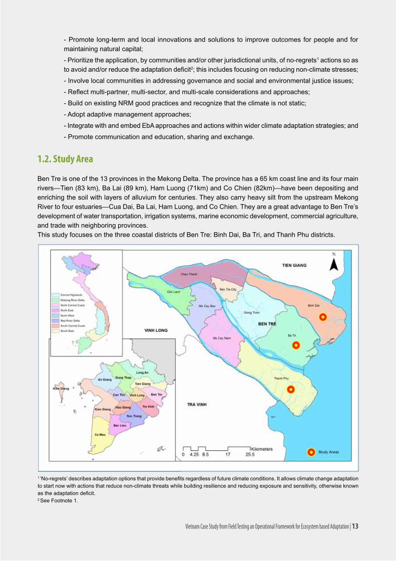
1.2. Study Area
Ben Tre is one of the 13 provinces in the Mekong Delta. The province has a 65 km coast line and its four main rivers—Tien(83km),BaLai(89km),HamLuong(71km)andCoChien(82km)—havebeendepositingandenriching the soil with layers of alluvium for centuries. They also carry heavy silt from the upstream Mekong River to four estuaries—Cua Dai, Ba Lai, Ham Luong, and Co Chien. They are a great advantage to Ben Tre’s development of water transportation, irrigation systems, marine economic development, commercial agriculture, and trade with neighboring provinces. This study focuses on the three coastal districts of Ben Tre: Binh Dai, Ba Tri, and Thanh Phu districts.
Vietnam Case Study from Field Testing an Operational Framework for Ecosystem based Adaptation | 13

ThepopulationinBenTrein2010decreasedby0.3percentifcomparedto2005(1,273,184people),whiletheaverage growth rate of Viet Nam was 1.2 percent. The decrease in population in Ben Tre is thought to be due to people migrating to bigger cities such as Ho Chi Minh, My Tho and Can Tho for living, working and running small businesses. Generally, between 2005-2010, employment within aquaculture in the whole Ben Tre province decreasedfrom47,570personsin2005to46,058personsin2010(BenTreStatisticoffice2011).
Of Ben Tre’s population, 93.3 percent live in rural areas. However, the urban population is slowly increasing withthemovefromagriculturetoindustryandcommercialbusiness.Morepeoplemoveintourbanareas(BenTreSEDP2011).
The population distribution in Ben Tre province is uneven. The coastal districts have relatively low population density with the majority of the population concentrated in Ben Tre city and the inland, freshwater districts of Chau Thanh, Cho Lach, North Mo Cay and South Mo Cay. This assessment focuses on the three coastal districts(BinhDai,BaTri,andThanhPhudistrict),whichhaveacombinedareaof1,194.5haandapopulationof447,812.BaTridistrictisthesmallestbutmostdense;thereforemanyofitsnaturalresourcesareunderpressure and/or over exploited.
14 | Vietnam Case Study from Field Testing an Operational Framework for Ecosystem based Adaptation

Comparative Analysis of di�erent Adaptation Optionsincluding Economic analysis
Adaptation Strategies identi�ed
Assessment of Vulnerability and Risksto Ecosystems and Communities
Analysis of role of ecosystemsin reducing vulnerabilities
Discussion with localgovernments and experts
Modeling, SpatialAnalysis
Mapping of Ecosystemsand their services
Consultation withfocus groups
2. METHODOLOGY2.1. Conceptual Framework
ThiscasestudyistheresultoftheapplicationofthedraftEbAframeworkpreparedpriortothefield-testing.The framework provides detailed guidance for 3 major stages and their component steps:
- Stage 1: Assessment of vulnerability of ecosystems, ecosystem services and dependent communi-ties/selectedsector(s).
- Stage 2:Identificationandprioritizationofecosystembasedadaptationoptions.- Stage 3: Recommendations for implementation and iterative monitoring and evaluation.
The framework also provides guidelines for mainstreaming EbA.
Stages1and2werefieldtestedtodevelopthiscasestudy.Thiscasestudyrepresentsarapidvulnerabilityassessmentasawayoffield-testingtheEbAframework.
Figure 1 displays the key elements of Stages 1-2: understanding the local context, assessing communities’ vulnerability to both climate change and development impacts, and developing effective adaptation strategies.
Thetablebelowsummarizesthefirst threestepsof theframeworkandhowtheywereoperationalizedforfield-testing.
Figure 1. Process Diagram of the Process Defined by the Draft EbA Framework
Vietnam Case Study from Field Testing an Operational Framework for Ecosystem based Adaptation | 15

Stages and steps in the framework Tools and Methods Revisions made and associated justifications
1. Vulnerability Analysis
1.1. Understanding the context of communities, their demographic, socioeconomic conditions, key sources of livelihood and how it is supported by the ecosystem services
Secondary data collection (populationdemographic,livelihood sources etc. Focus group discussions,Householdsurvey;Resource mapping.
The existing Rapid Integrated Vulnerability and Adaptation to CC Assessment in Ben Tre is an important reference.
Field data collection was carried out in-line with the framework.
1.2. Understanding and mapping ecosystem and ecosystem services in the study area
Field transects, expert judgment, consultation with stakeholders, community resource mapping, InVEST.
Understanding of the ecosystems and ecosystem services came primarily from existing project information, and also from community consultation through exercises such as resource mapping, ecosystem servicesidentification.Itwasnotpossibleto use InVEST prior to the analysis.
1.3. Understanding current threats or risks from climate change to the communities
Focus group discussion, Participatory hazard mapping, creating historical timeline.
Carried out in-line with the framework.
1.4. Understanding threats from non-climate risks and different socio economic dynamics including potential development plans to the communities
Policy review, key informant interviews, focus group discussion, household interviews, etc.
Carried out primarily through community discussions, secondary data, and policy review(SEDP;CCActionPlanofBenTreprovince)withadditionalinformationfromproject documents.
1.5. Understanding threats from current climate and non-climate risks to the ecosystems and ecosystem services
Secondary research, focus group discussion, expert judgment.
Dealt with as a full matrix of interactions between climate and non-climate risks, people and the ecosystems. There were few ecosystem services analyzed.
1.6. Creating Future Scenarios to identify future vulnerabilities to Climate and non-climate change
Expert judgment, focus group discussion.
InVEST and Marxan for spatial scenario analysis, land-change modeling.
Future scenarios have been developed in consultation with the local communities, governments, and governmental plan. InVEST and land-change modeling has been used to run the scenarios.
1.7 Assessing exposure, sensitivity and adaptive capacity
Data analysis, focus group discussion, expert judgment.
This could not be done very properly forthisfield-testing.ASWOTanalysisofinstitutions was carried out to understand institutional adaptive capacity and support to EbA.
1.8. Summarizing the information and creating vulnerability matrix
Data analysis, focus group discussion, expert judgment.
The development of different scenarios and quantifying changes in some ecosystemservicesproducefindingsonvulnerability.
2. Developing adaptation Strategies
Table 1. Field-Testing the Steps of the Framework
16 | Vietnam Case Study from Field Testing an Operational Framework for Ecosystem based Adaptation
2.2. Methods
2.2.1 Secondary research and analysis
Beforestartingworkinthefield/site,itisimportanttocollectthesecondarydataavailableatbothnationalandsubnationallevel.Anysecondarydataavailableonscientificinformationonclimatechange,typesofecosystemsinthestudyarea(suchasforesttype,informationontopography,geographyetc.)wouldbeuseful.Similarlydemographic and socioeconomic data of communities such as male/female ratio, major sources of livelihoods in the area etc. can be collected beforehand.
2.2.2. Stakeholder Consultation including community representatives
Stakeholder consultation process for EbA includes identifying and engaging key people and organizations that can either impact or are impacted by any part of EbA assessment. It is necessary to do a preliminary stakeholder assessment to identify key stakeholders that can help in initiating the discussion about the adaptation objective. At a subnational level it may involve:
(a)Nationalandsubnationalgovernmentalagencies,suchasministriesofnaturalresourcesandtheirprovincialanddistrictleveloffices,ministriesofplanningandinvestmentandtheirsubnationaloffices,sectoralministriessuchasagriculture,forestry,water,land-useandtheirsubnationaloffices.
(b)Technicalexpertsinclimatechangeanddifferentsectors.
(c)Nongovernmentalagenciesthatareengagedinclimatechangeandadaptationrelatedactivities
(d)Communityrepresentatives.
2.2.3. Focus Group Discussion
Focusgroupdiscussion(FGD)isoneofthemostcommonlyusedparticipatorymethodstounderstandconcernsand perceptions of the communities. A focus group is a small group of six to ten people led through an open discussion by a moderator. The moderator/researcher should establish a focus group based on some shared characteristics, so that the group is more or less homogenous, everyone feels equal and no member feels inhibited to speak. Focus group can be formed based on gender, livelihood groups, or other similarities to facilitate the discussion on common and individual concerns and perceptions.
Stages and steps in the framework Tools and Methods Revisions made and associated justifications
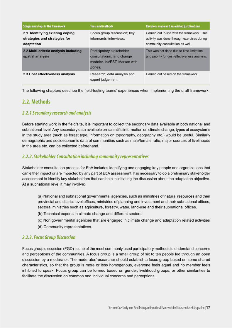
2.1. Identifying existing coping strategies and strategies for adaptation
Focusgroupdiscussion;keyinformants’ interviews.
Carried out in-line with the framework. This activity was done through exercises during community consultation as well.
2.2.Multi-criteria analysis including spatial analysis
Participatory stakeholder consultations, land change modeler, InVEST, Marxan with Zones.
This was not done due to time limitation and priority for cost-effectiveness analysis.
2.3 Cost effectiveness analysis Research;dataanalysisandexpert judgement.
Carried out based on the framework.
Thefollowingchaptersdescribethefield-testingteams’experienceswhenimplementingthedraftframework.
Vietnam Case Study from Field Testing an Operational Framework for Ecosystem based Adaptation | 17

Prepare a predetermined questionnaire to conduct a focus group discussion, but the discussion should be open-ended and semi-structured. The questionnaires should not be too long and the FGD should ideally be under two hours. To make analysis easier, the same questionnaire should be used with different focus groups where possible.OtherParticipatoryRuralAppraisal(PRA)toolssuchasaseasonalcalendar,historicaltimeline,orcommunity mapping can also be included as a part of FGD.
2.2.4. Seasonal Calendar
Thepurposeofgeneratingaseasonalcalendaristoidentifytheseasonalityofthe(a)weatherpatterns,i.e.summermonths,rainyseason,winteretc.;(b)thecommunity’slivelihoodactivities,whichareoftenconnectedtoresourceuseandresourceabundance;and(c)seasonalityofhazards.Communitiesidentifydifferentactivities(agriculture,aquaculture,seasonalmigration) thatoccur throughoutayearandtheguideddiscussionwillseek to identify how the climate change will affect overall activities and whether it will alter the seasonality of community’s livelihood activities. The discussion will also seek to understand historical changes in seasonality that the community has already experienced, and the social mechanisms that the community has employed to mitigate their effects.
2.2.5. Historic Climate Trend Analysis
Understanding the history of past extreme events and a community’s reaction to these events can serve as very important information for an adaptation plan. The historical trend analysis will give insight into past climate hazards, their trends, intensity, and impacts to ecosystem services and communities. The trend analysis can bedoneeitherjustthroughdiscussionorbydrawingalinetomarkthepassageoftime(10-20-30yearsbasedontheavailabledata).
2.2.6. Participatory mapping
Participatory mapping can be done either on a piece of paper, through actual maps of the study area, or as direct inputs in digital maps depending on the context. Participatory mapping can help in EbA by identifying: (a)keyecosystems,andecosystemservicesandtheirlocationinthestudyarea;(b)climatehazardsshowingthelocationsmorepronetohazards;and(c)locationofpopulationsthataremostvulnerableifapplicable,orpopulations with different livelihoods.
2.2.7. Scenario Analysis
A scenario analysis is a process of analyzing possible future events by considering alternative possible outcomes or alternate future developments. For EbA and/or other adaptation planning, the scenario analysis can provide useful insight on the future risks and vulnerability to both societies and ecosystems. Scenarios are developed based on certain criteria or assumptions about the future, for example, the level of infrastructure development, with or without climate change pressures among others. These criteria can either be collectively agreed upon or taken from existing and future development plans/policies.
2.2.8. Scenario analysis involving modeling tools for future vulnerability assessment
The assessment of the impact of climate change on the ecosystem services can be done through scenario analysis using tools such as InVEST, land change modeler, or hydrological models, for example. Data layers that reflectclimatechangescenarios(e.g.sealevelrise,changeinprecipitation)willbeusedasinputparametersin the models. WWF uses InVEST, mostly in large-scale assessments for valuation of ecosystem services.
18 | Vietnam Case Study from Field Testing an Operational Framework for Ecosystem based Adaptation

•WaveEnergy•CoastalVulnerability•CoastalProtection•MarineFishAquaculture•MarineAestheticQuality•MarineOverlapAnalysisModel:FisheriesandRecreation•MarineHabitatRiskAssessment•TerrestrialBiodiversity:HabitatQualityandRarity•CarbonStorageandSequestration•ReservoirHydropowerProduction•WaterPurification:NutrientRetention
•SedimentRetentionModel:AvoidedDredgingandWater Quality Regulation•ManageTimberProduction•CropPollination•WaveEnergy•CoastalVulnerability•CoastalProtection•MarineFishAquaculture•MarineAestheticQuality•Marine Overlap Analysis Model: Fisheries and Recreation•MarineHabitatRiskAssessment•Terrestrial Biodiversity: Habitat Quality and
InVEST is designed to inform decisions about natural resource management. Decision-makers, from governments tonon-profitstocorporations,oftenmanagelandsandwatersformultipleusesandinevitablymustevaluatetrade-offsamongtheseuses;InVEST’smulti-service,modulardesignprovidesaneffectivetoolforevaluatingthese trade-offs.
TheInVESTtoolsetincludesmodelsforquantifying,mapping,andvaluingthebenefitsprovidedbyterrestrial,freshwaterandmarinesystems.Specificallyitincludesmodelsfor:
Vietnam Case Study from Field Testing an Operational Framework for Ecosystem based Adaptation | 19

Inthisfieldtest,onlythreemodelswereusedtoquantifythemostimportantservicesofcoastalecosystems:Coastal Vulnerability, Coastal Protection and Erosion, and Carbon Storage and Sequestration.
2.2.9. Expert Judgment
Expert judgment is an approach for soliciting inputs from individuals with particular expertise on concepts related to EbA. Considering the complexity involved in EbA especially with regards to uncertainties and the impact of climate change on ecosystems, expert judgment can be used for rapid assessment and analysis of different aspects of vulnerability and adaptation prioritization of adaptation options. Expert judgment can be used in a variety of ways including a panel format for aggregating opinions, meetings, and workshops. It is important to realizethatspecificexpertisemaybenecessaryatdifferentphases.Expertconsultationmaybeneededindesigningtheproject,decidingthedatatobeincluded,andforanalyzingthedatarigorouslytocometoscientificand experience-based conclusions.
Theexpertsneededmayinclude:climatechangeandadaptationspecialists,hydrologists,ecologists(foresters,marinebiologists,etc.),speciesspecialist forparticularspecies,sociologists/socioeconomicspecialists,economists,andothersthatmaybeidentified.
2.2.10 Vulnerability Matrix
Creating a vulnerability matrix is one way of presenting the vulnerability analysis. The ultimate objective of the user should be to understand current and future risks and impacts from climate and non-climate risks in order to come up with effective adaptation strategies.
It is good to keep in mind that the “vulnerability of a system” is best understood by looking not only at individual pressures and impacts but also the altered interactions within the system—in this case, interactions between ecosystem and communities.
2.2.11. Multi-Criteria Analysis
Multi-CriteriaAnalysis(MCA)isadecision-makingtoolforcomplexproblemswheremultiplecriteriaareinvolved.Sinceitisimportanttoconsidermanysocial,economic,environmentalcriteriainselectingthefinaladaptationmeasure, MCA can be used to compare and make a decision on the best possible adaptation measure. The multi criteria decision support system will help in structuring the available information in a clear and concise way soastosupporttheidentificationofthemostsuitablealternative;withthisapproachthechoicesmadewillbeparticipatory,explicit,andjustified.MCAcanbedonewithorwithouttheuseofanysoftware/computerbasedtools.Inbothcases,stakeholderparticipationisextremelyimportanttodefinethecriteriausedinanalysis.
Process:
1)Collectivelyagreeonthemaincategoriesofeffectsoftheadaptationstrategiestobeconsidered:environmental,social,economic,etc.;
2)Identifythecriteria/indicatorstobeusedtomeasurethoseeffects(decreaseintheamountofsomeecosystem services, loss of natural habitats, decrease in agricultural areas, opportunity costs, capacity requirements,etc.).
3)Togetherwithstakeholders,settargetsforthedifferentindicatorsandassignweightage/penaltyfactors: how much agriculture areas, natural forest or other habitat types, etc.?
4)Followthepreviousstepsforeachadaptationstrategy;
5)Basedontargets,penaltyfactorsandcoststheoutcomewillbemapsshowingthebestarrangementofthezonesidentifiedattheminimalcostfortheadaptationalternatives;
20 | Vietnam Case Study from Field Testing an Operational Framework for Ecosystem based Adaptation

The MCA can also be done qualitatively without the use of any spatial tools, if needed, by collectively deciding on different criteria, giving weightage and ranking the adaptation strategies. This assessment is qualitative in nature but should be informed by interviews with local experts as well as published performance of these measures against current climate hazards. The table below provides an example of a simple multi-criteria analysis.
2.2.12. Cost Effectiveness Analysis
Costeffectivenessanalysis(CEA)isaneconomicdecision-makingtool.Itisusedtocomparetwoormoreoptionsforachievingthesame(orsimilar)outcome,thebenefitsofwhicharenoteasilymeasuredinmonetaryterms.
Aclassiccost-effectivenessanalysisstartsbystatingaspecificgoal,suchasreducingtheincidenceofadiseasein a town by 50 percent in four years, presents data on the expected cost of two or more methods of achieving thisgoalandthenselectstheleast-costalternative(WorldBank2010).
AnimportantaspectofCEAisthatthemainbenefitsofprojectsandinterventionsarenotevaluatedinmonetaryterms.Thesebenefitsarepresentedinnon-monetarymeasuresofeffectiveness,suchasnumbersof livessavedoryearswithoutmajorflooding.Bycomparingtheratioofcoststothemeasureofeffectiveness,optionsforinterventionscanberanked.Avoidinghavingtoestimateamonetaryvalueforanaspectofprojectbenefitis a key attraction of CEA.
Vietnam Case Study from Field Testing an Operational Framework for Ecosystem based Adaptation | 21
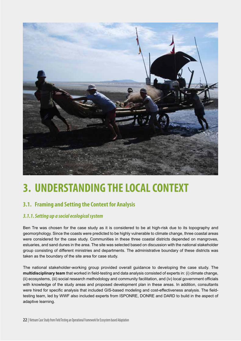
3. UNDERSTANDING THE LOCAL CONTEXT3.1. Framing and Setting the Context for Analysis
3.1.1. Setting up a social ecological system
Ben Tre was chosen for the case study as it is considered to be at high-risk due to its topography and geomorphology. Since the coasts were predicted to be highly vulnerable to climate change, three coastal areas were considered for the case study. Communities in these three coastal districts depended on mangroves, estuaries, and sand dunes in the area. The site was selected based on discussion with the national stakeholder group consisting of different ministries and departments. The administrative boundary of these districts was taken as the boundary of the site area for case study.
The national stakeholder-working group provided overall guidance to developing the case study. The multidisciplinary teamthatworkedinfield-testinganddataanalysisconsistedofexpertsin:(i)climatechange,(ii)ecosystems,(iii)socialresearchmethodologyandcommunityfacilitation,and(iv)localgovernmentofficialswith knowledge of the study areas and proposed development plan in these areas. In addition, consultants werehiredforspecificanalysisthatincludedGIS-basedmodelingandcost-effectivenessanalysis.Thefield-testing team, led by WWF also included experts from ISPONRE, DONRE and DARD to build in the aspect of adaptive learning.
22 | Vietnam Case Study from Field Testing an Operational Framework for Ecosystem based Adaptation

3.1.2. Geographic context
Topography: ThetopographyofBinhDai,BaTri,andThanhPhudistrictsisveryflat,withanaverageelevationof1-2metersabovesealevel(BenTreDARD,2009).Thereareseveralsanddunesystemsthatreachamaximum of 5 meters above sea level. Ben Tre can be divided into three main types of eco-elevation classes:
- Low-lying mangrove and alluvial flats:landelevationintheseareasislessthan1minheightandfloodedathightide,representing6.7percentofthetotalarea;
- Moderately higher semi-tidal flats: elevation in these areas averages 1-2 m and are only submerged during periods of high tide from September to November, including areas of garden land and rice land, accountingfor87.5percentofthetotalarea;
- Dunes systems: land elevation in these areas is 2-5 m and is generally composed of sand dunes, accounting for 5.8 percent of the area of coastal districts.
Salinity and tides: The boundaries of saline, brackish, and freshwater areas change over time. This depends on thetide,season,andupstreamhydrology.Salinitylevelswithintherivermouthfluctuatebetween3-17percent,especiallyinthedryseason.Salinitylevelshaveasignificanteffectontheestuaryecosystem.CoastalareasofBen Tre are greatly affected by the uneven dual tides of the East Sea. The tide rises and falls twice each day (everysixhours)andhasatidalrangeof2.5-3.0m.Eachmonth,therearetwohigh-tideperiods(the2nd - 3rd and 17th - 18thofthelunarcalendar)andtwolow-tideperiods(the7th- 8th and 21st - 23rdofthelunarcalendar).
Geomorphology: A large amount of alluvia is deposited into the sea from the rivers. The average suspended substances in river water are approximately 0.3-0.8 g/liter. Due to this deposit the Mekong Delta can extend 40-60 m into the sea each year, forming islets and islands near the river mouth. However, there has also been an increase in riverbank and coastal erosion. The coast in Ben Tre receives silt and other sediments from the MekongRiverviaitstributaries.Thecoast’smorphologicalfeaturesarestronglyinfluencedbychangeswithintheriverandtheseafromerosionandalluvialdepositsduetothenaturalinteractionofcurrentflows.
3.1.3. Socio-Economic Context
Population: The focal districts have relatively low population densities with the majority of the population concentrated in Ben Tre city and the inland freshwater districts.
Agriculture and aquaculture are the two primary livelihood activities of most of Ben Tre residents.
Insandduneareas,vegetableproduction(watermelon,whiteroots,bean,etc,)isthekeylivelihoodactivity.In
Name of District – City No. of town and ward/commune Area (km2) Population Density (people/km2)
Binh Dai district 1 town and 19 communes 410,5132.315
(129,125)*315
Ba Tri district 1 town and 23 communes 358,4187.835
(190,632)*524
Thanh Phu district 1 town and 17 communes 425,6127.662
(129,372)*300
Table 2. Administrative characteristics of Binh Dai, Ba Tri, and Thanh Phu districts of Ben Tre province, Viet Nam
* Population data from 2005 (Source: Ben Tre Department of Statistics 2011)
Vietnam Case Study from Field Testing an Operational Framework for Ecosystem based Adaptation | 23
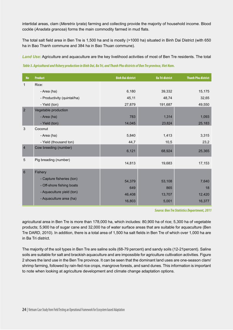
intertidalareas,clam(Meretrix lyrata)farmingandcollectingprovidethemajorityofhouseholdincome.Bloodcockle(Anadata granosa)formsthemaincommodityfarmedinmudflats.
ThetotalsaltfieldareainBenTreis1,500haandismostly(>1000ha)situatedinBinhDaiDistrict(with650hainBaoThanhcommuneand384hainBaoThuancommune).
Land Use: Agriculture and aquaculture are the key livelihood activities of most of Ben Tre residents. The total
No Product Binh Đai district Ba Tri district Thanh Phu district
1 Rice:
-Area(ha)
-Productivity(quintal/ha)
-Yield(ton)
6,180
45,11
27,879
39,332
48,74
191,687
15,175
32,65
49,5502 Vegetable production
-Area(ha)
-Yield(ton)
783
14,045
1,314
23,824
1,093
25,1833 Coconut
-Area(ha)
-Yield(thousandton)
5,840
44,7
1,413
10,5
3,315
23,24 Cowbreeding(number)
6,121 68,924 25,365
5 Pigbreading(number)14,813 19,683 17,153
6 Fishery
-Capturefisheries(ton)
-Off-shorefishingboats
-Aquacultureyield(ton)
-Aquaculturearea(ha)
54,379
649
46,408
16,803
53,108
865
13,707
5,001
7,640
18
12,420
16,377
Table 3. Agricultural and fishery production in Binh Dai, Ba Tri, and Thanh Phu districts of Ben Tre province, Viet Nam.
Source: Ben Tre Statistics Department, 2011
agriculturalareainBenTreismorethan178,000ha,whichincludes:80,900haofrice;5,300haofvegetableproducts;5,900haofsugarcaneand32,000haofwatersurfaceareasthataresuitableforaquaculture(BenTreDARD,2010).Inaddition,thereisatotalareaof1,500hasaltfieldsinBenTreofwhichover1,000haarein Ba Tri district.
ThemajorityofthesoiltypesinBenTrearesalinesoils(68-79percent)andsandysoils(12-21percent).Salinesoils are suitable for salt and brackish aquaculture and are impossible for agriculture cultivation activities. Figure 2 shows the land use in the Ben Tre province. It can be seen that the dominant land uses are one-season clam/shrimp farming, followed by rain-fed rice crops, mangrove forests, and sand dunes. This information is important to note when looking at agriculture development and climate change adaptation options.
24 | Vietnam Case Study from Field Testing an Operational Framework for Ecosystem based Adaptation

3.2. Recent and Historic Climate Change Patterns
Ben Tre has a tropical monsoon climate. Similar to other Mekong delta provinces, Ben Tre has two distinguishable seasons:thewetseason(earlyMayuntiltheendofOctoberorearlyNovember)andthedryseason.
There’sverylittlefluctuationoftheaveragetemperaturethroughouttheyear.Theprovincialtemperatureaverageis 27°C. April and May are the hottest months of the year with average daily temperatures up to 29°C, December is the coolest with an average temperature around 25°C. There is a large difference, however, between day and night time temperatures: in the dry season, the difference is around 14°C and around 11°C in rainy season. Yearly average humidity in Ben Tre is about 83 percent, with an average evaporation of 1,187 mm/year. Yearly average rainfall ranges from 1,200-1,500 mm with an average of 110 days of rain. Ben Tre city receives higher rainfall than the coastal areas, ranging from 1,400-1,500 mm on average. The yearly average rainfall in Binh Daidistrictis1,244mm,1,371.5mminBaTridistrict,and1,454mminThanhPhudistrict(CEE-CESC2009).Rainfall distribution is seasonally unequal with 75-95 percent of the total rain falling during the wet season, from early May to end of Oct. August, September and October receive the highest amount of rainfall, and January, February and March the lowest.
Ben Tre province is already experiencing climate change. Average temperature has risen by an estimated 0.05 - 0.15oC in each decade of the 20thcentury;between1990and2005,theannualaveragetemperaturesincreasedby an average of 0.3o. The trend in rainfall in Ben Tre has been inconsistent between 1990 and 2006, and can bedividedintotwomainphases:(1)from1990to1998,averageannualrainfallincreasedby319.28mmtotal,foranaverageannualincreaseof35.5mm/year;and(2)from1998to2006,averageannualrainfalldecreased
Figure 2: Land use in Ben Tre province Viet Nam
Vietnam Case Study from Field Testing an Operational Framework for Ecosystem based Adaptation | 25

to 161.2 mm total, for an average annual decrease of 17.9 mm/year3. The period of hurricane activity affecting the southern coast of Viet Nam is later than other areas in the country and is concentrated in November and December.Thefirstmonthsoftherainyseason(April-May),orevenearlier(JanuarytoMarch)mayalsoseeoceanic storm activity in the region. From 1961 to 2006, 12 hurricanes hit this southern coast.
In recent years, communities in the area have reported that they experience the effects of a changing climate. There has been an increase of adverse droughts, which cause a lack of fresh water and increased saltwater intrusion. The increase in salinity strongly impacts aquaculture activities often causing massive deaths in shrimp and clam farms. Additionally, more unseasonable rainfall has been observed in the coastal districts that were the focus of this study. More rain may be welcome in dry parts of the year but it can have negative impacts on vegetableproduction(particularlywatermelonproduction).
3.3. Ecosystem Services and their Importance to Local Livelihoods
Thefieldsurvey, interviewswithstakeholders,andreferencetopriorwork inthestudyarea identifiedfourkey ecosystems and their associated livelihood dependent activities. These ecosystems and their livelihood dependent activities are:
1. Estuarine ecosystem and captured fisheries;2. Mangrove ecosystem and extensive/intensive shrimp farming;3. Intertidal mudflats and sandbars ecosystem and bivalve farming;and4. Sand dune ecosystem and vegetable plantation.
Ageneralsignificancerankingoflocalecosystemserviceswasdoneviatwodifferentmethods:(i)consultationswithrepresentativecommunitygroupsinfocusgroupdiscussion,and(ii)interviewswithtechnicalofficers.
Figure3showsthesignificancerankingofecosystemservicesinBinhDai,BaTri,andThanhPhudistrictsof Ben Tre Province as assessed via semi-structured ranking exercises conducted during consultations with governmentofficialsandlocalresidents.
3 Nguyen Ky Phung et al. 2010. Building action plan to respond to climate change in Ben Tre province as part of the national target.
26 | Vietnam Case Study from Field Testing an Operational Framework for Ecosystem based Adaptation

Figure 3: Ranking of ecosystem services in Ba Tri, Binh Dai and Thanh Phu district of Ben Tre province.
Vietnam Case Study from Field Testing an Operational Framework for Ecosystem based Adaptation | 27
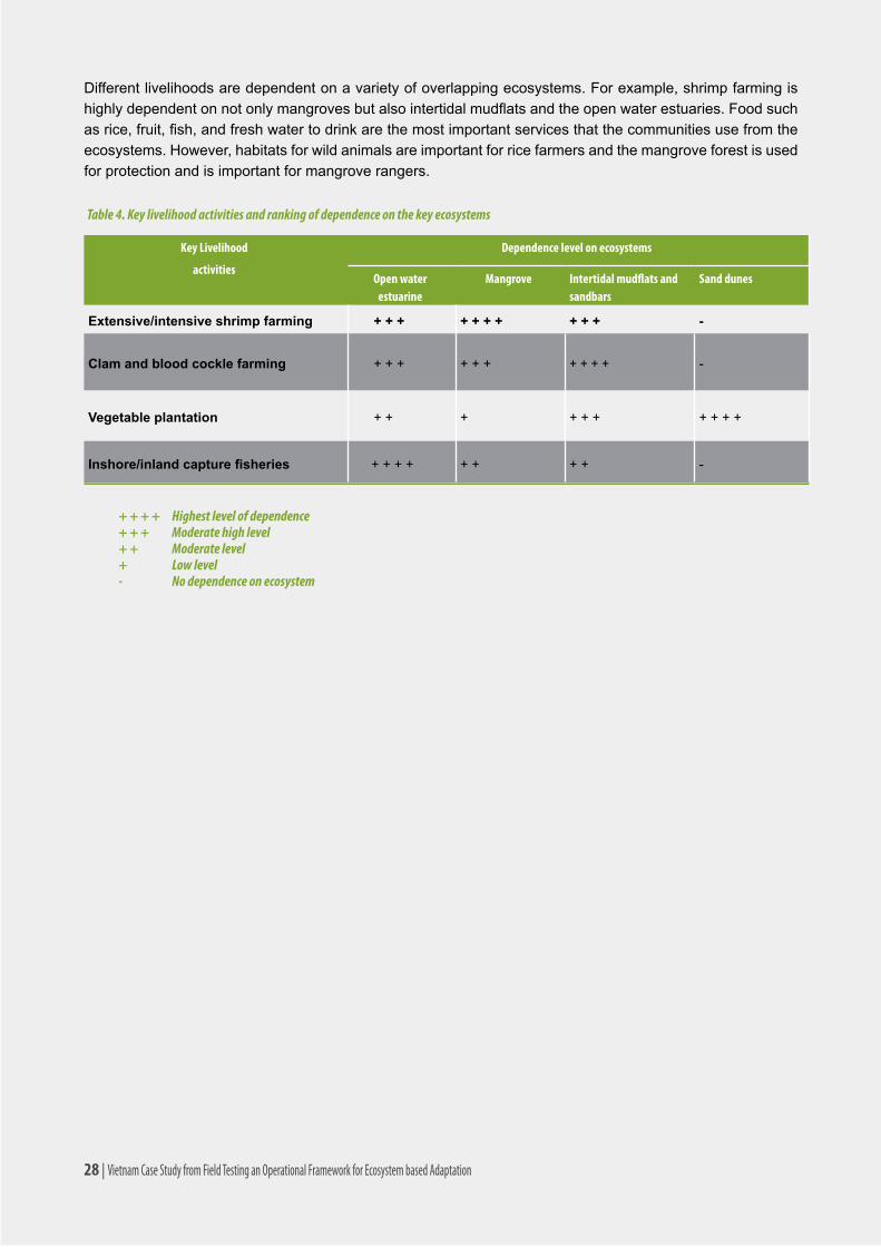
Different livelihoods are dependent on a variety of overlapping ecosystems. For example, shrimp farming is highlydependentonnotonlymangrovesbutalsointertidalmudflatsandtheopenwaterestuaries.Foodsuchasrice,fruit,fish,andfreshwatertodrinkarethemostimportantservicesthatthecommunitiesusefromtheecosystems. However, habitats for wild animals are important for rice farmers and the mangrove forest is used for protection and is important for mangrove rangers.
Key Livelihood
activities
Dependence level on ecosystems
Open water estuarine
Mangrove Intertidal mudflats and sandbars
Sand dunes
Extensive/intensive shrimp farming + + + + + + + + + + -
Clam and blood cockle farming + + + + + + + + + + -
Vegetable plantation + + + + + + + + + +
Inshore/inland capture fisheries + + + + + + + + -
Table 4. Key livelihood activities and ranking of dependence on the key ecosystems
+ + + + Highest level of dependence+ + + Moderate high level+ + Moderate level+ Low level- No dependence on ecosystem
28 | Vietnam Case Study from Field Testing an Operational Framework for Ecosystem based Adaptation

Vietnam Case Study from Field Testing an Operational Framework for Ecosystem based Adaptation | 29
4. RESULTS OF VULNERABILITY ANALYSISPrior tofieldactivities,a literaturereviewwasconductedtoassess:(i) thecurrent institutionalandpolicyarrangementsforclimatechangeadaptation;(ii)thefutureclimatetrendsforBenTreprovince,and(iii)thekeypotential development targets in the three focal districts. The results discussed in this section are based on boththisliteraturereviewandworkconductedinthefield.
4.1. Current climate and development pressures to communities and ecosystems
4.1.1. Current climate pressures to communities and ecosystems
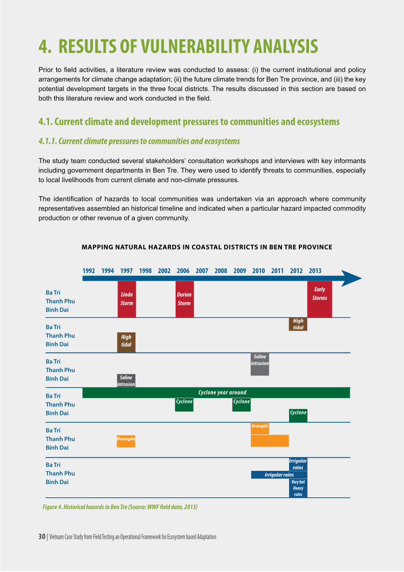
The study team conducted several stakeholders’ consultation workshops and interviews with key informants including government departments in Ben Tre. They were used to identify threats to communities, especially to local livelihoods from current climate and non-climate pressures.
The identification of hazards to local communitieswas undertaken via an approachwhere communityrepresentatives assembled an historical timeline and indicated when a particular hazard impacted commodity production or other revenue of a given community.
Figure 4. Historical hazards in Ben Tre (Source: WWF field data, 2013)
Ba TriThanh PhuBinh Dai
Ba TriThanh PhuBinh Dai
Ba TriThanh PhuBinh Dai
Ba TriThanh PhuBinh Dai
Ba TriThanh PhuBinh Dai
Ba TriThanh PhuBinh Dai
1992 1994 1997 1998 2002 2006 2007 2008 2009 2010 2011 2012 2013
LindaStorm
DurianStorm
EarlyStorms
Hightidal
Hightidal
Salineintrusion
Salineintrusion
Cyclone year aroundCyclone Cyclone
Cyclone
Drought
Drought
Irrigularrains
Irrigular rainsVery hot
Heavyrains
MAPPING NATURAL HAZARDS IN COASTAL DISTRICTS IN BEN TRE PROVINCE
30 | Vietnam Case Study from Field Testing an Operational Framework for Ecosystem based Adaptation

Fiveclimate-relatedhazardsandassociatedeventsthatsignificantlyaffectthestudydistrictsare:
i)Storms/stormsurges;
ii)Cyclones;
iii)Risingsealevels;
iv)Drought;
v)Irregularrainfallpatterns.
Among these, storms are considered the worst events for local communities. Storms affect multiple aspects of life at a very large scale. Communities directly on the coast are clearly the most vulnerable to storms. Two major storms in 1997 and 2006 caused extensive damage to public infrastructure and household assets. The most serious storm impacts occurred after storms subsided and included a lack of food and fresh water and disease outbreak. Given damages to infrastructure, communities often had to face these challenges with limited assistancefromthegovernmentorothercommunities.Responsesconsistedof(1)temporarilymoving(bothpeopleandassets)tosturdierhousesand/orinlandand(2)permanentmigrationtootherareas.
Higher spring tides and saline intrusion have also seriously impacted local communities and livelihoods. These impacts are particularly felt during the long dry season.
The increased drought periods in the dry season are also a big concern to the coastal communities. The shortage offreshwaterforcropsandotherdailyuses,andincreasedsaline intrusionaresignificantconsequences.Aquaculture, particularly shrimp farming, is the most impacted area by increased drought periods.
Hazards Mangroves Sand dune Intertidal area
Coastal sand dunes
Estuarine water
Brackish water ponds
Fresh water, crop
Storm -2/-2/-1 -1/-2/0 -2/-1/0 -1/-2/0 -1/-1/0 -2/-1/-1 -/-2/-
Tornado -1/-1/-1 0/-1/-1 0/0/0 0/0/0 0/0/0 0/0/0 -/-1/-
High tide/ sea level rise -1/+2/-1 -2/-2/-2 0/-1/0 0/-1/0 -1/-2/-1 -2/-2/-2 -/-2/-
The average annual rainfall is reduced
0/0/0 -1/-2/-1 0/0/0 0/-2/0 0/0/0 -1/-1/-1 -/-2/-
Unseasonal rain 0/0/0 -2/-1/-2 0/0/0 0/-1/0 0/0/0 -1/+1/-1 -/-1/-
Templature increase 0/-1/0 -1/-2/-1 -1/-1/-1 -1/-2/-1 0/-1/0 -1/-1/-1 -/-2/-
Drought (prolonged) -1/-1/-1 -2/-2/-2 -2/2/-2 -2/-2/-2 -1/-1/-1 -2/-1/-2 -/-2/-
Table 5. Rating the impacts of climate-related hazards to the ecosystems and its dependent livelihoods by communities (Binh Dai/Ba Tri/Thanh Phu)
Rating score: - 2: Very serious negative impacts -1: Moderate negative impacts 0: No impacts1: Positive impacts 2: Very positive impacts
Vietnam Case Study from Field Testing an Operational Framework for Ecosystem based Adaptation | 31

4.1.2. Current development pressures on communities and ecosystems4
i. Ba Lai sluice gate-dam constructed in 2000-2002 to make the Ba Lai river become a freshwater reservoir. Its gates opentwicepermonthatthelowtideperiodandstandopeninthefloodseason.Thedamhasalsobeen used for transportation between Ba Tri and Binh Dai districts, but it has caused many negative impacts on the two district communities. This big construction was built from 2000 to 2002. The sluice gate-damstopssalineintrusionandregulatesthefreshwaterflows,whichisimportantforfreshwatervegetable plantation and freshwater aquaculture. However, since the sluice gate acts as a barrier to thenaturalflowsoftheriver,itcausedchangesinthecoastalecosystemsandcoastalerosionduetoreductionofsedimentandriverflows.Italsohadaneffectonbrackishwateraquaculture.Manypeopleliving in this area have been forced to shift their livelihood from aquaculture to freshwater farming.
ii. Construction of sea and river dikes: Sea and river dikes are also important development activities in the coastalarea.Dikesareusedtopreventwaveenergy;hightidesandsaltwaterintrusionandimproveroad transportation. Those constructions resulted in resettlement of the farms and households on the sand dunes.
iii. Extensive aquaculture farming and changes in land use: Anothersignificantdevelopmentactivity inthecoastalareaisland-usedevelopmentfromricefieldstoaquaculturefarms.Recently,thelocalfarmershave been experiencing an increase of disease outbreak and massive death of shrimp. The higher intensive shrimp and other aquaculture farming are under many threats, including increased use of pesticide and fertilizers.
Literaturesalsoshowachangeinlandcover,from1989–2004,specificallymangrovesandshrimppondsinthethreecoastaldistrictsofBenTre.UsingTerra/ASTERdatasets(2004)andaLandsat/TMimage(1989)itwasfoundthattheareaofmangroveshasdecreasedby50percentandtheareaof shrimp ponds has increased three fold within the Ben Tre Province. Thanh Hai commune of Thanh PhuNatureReservehadthemostsignificantmangrovedestruction.Shrimpfarmingincreasedfrom5.4percent of land cover in 1989 to 36.5 percent in 2004, while the area of mangrove decreased sharply from 61.6 percent to 26.2 percent over the same period. This is the greatest threat to the ecosystems and community of the Ben Tre province.
The short- and long-term effects of mangrove destruction to make way for shrimp farming will outweigh thelong-termimpactofclimatechange.Furtherthelossofmangroveswillmakeitincreasinglydifficultto adapt to and mitigate climatic and development pressure. Adding further complication, the SEDP 2011-2015 outlines plans for the afforestation of mangrove ecosystems, however, the SEDP also outlines thefurtherdevelopmentoflargeshrimpaquaculturefarms,whichconflictswiththere-establishmentof mangrove forests.
iv. Dredging canals and sand excavation: These activities are aimed to improve waterway transportation and provide construction material for construction. However, water pollution has been observed increasingly as a consequence of these activities.
4 Impacts from upper stream project were not taken into consideration
32 | Vietnam Case Study from Field Testing an Operational Framework for Ecosystem based Adaptation

4.2. Threats from Future Climate and Development Pressures to Communities and Ecosystems
4.2.1. Climate Change
Ben Tre is one of the Mekong Delta provinces, it, therefore, has a same climate trends with the whole Delta, the table below is showing the expected climate trends in the Mekong Delta in next three decades.
Climate phenomenon Trend Main affected areas
Max, min, average temperature in dry season ÞAn Giang, Dong Thap, Long An, Can Tho, Soc Trang, Kien Giang
Number of days that temperature is above 35oC in dry season ÞAreas border with Cambodia, West of Hau river.
Rainfall at the beginning of the season (May, June, July) à The whole delta
Rainfall at the end of the season (August, September, October) Þ Coastal area of the delta
Frequency and duration of whirlwind – strong wind - thunderbolt
Þ Coastal areas, islands of the delta
Abnormal heavy rain (> 100 mm/day) ÞCoastal areas of Ca Mau peninsula, areas between Tien and Hau rivers.
Frequency and intensity of tropical low pressure and coastal storm
Þ Coastal areas of the Mekong Delta
Floods (flooded areas and days)4 Þ
Long Xuyen – Ha Tien quadrangular area, Dong ThapMuoi, area between Tien and Hau rivers.
Sea level rise – salt-water intrusion Þ Coastal provinces
Riverbank land sliding and erosion ÞCoastal provinces, area between Tien and Hau rivers
Flood-tidal impacts Þ The whole delta
Table 6. Projected climatic trends in the Mekong Delta in the next three decades (Source: Le Anh Tuan, 2010)
Theimpactsof thesechangesonBenTrewillbesignificant,greatlyaffectingecosystemsandagriculturalproductivity, as well as creating challenges for socio-economic development within the region. Ben Tre province willbemost impactedbysealevelrise. Inthewetseason, tides,floods,stormsandtropical low-pressuresystems contribute to frequent storm surges, adding to the impact of seas level rise. In the dry season, Ben Tre already experiences frequent, and often severe, increased saline intrusion due to droughts and sea level rise. The following section outlines the direct and indirect impacts of each climate change projection – temperature, precipitation and sea level rise.
Accordingtotheprovincialclimatechangescenarios(BenTreDONRE,20115),theclimateconditionsforBenTre are projected to be as follows:
•TemperatureinBenTrearepredictedtoincreaseby1.10C by 2050 and by up to 1.50C by 2070.
•Sealevelriseby30cmby2050,46cmby2070and75cmby2100inthemediumscenarios(B2)and33cmby2050,57cmby2070and100cmby2100inthehighscenarios(A1F16);
•Slightincreaseinfrequencyofstormsandtropicaldepressions/cyclonesandhigherintensity
5 Bentre DONRE, 2011. Climate change action action plan, sub-topic report : Climate change scenarios in the priod 2010 – 2100.6 IntergovernmentalPanelofClimateChange(IPCC)emissionscenarioshttps://www.ipcc.ch/pdf/special-reports/spm/sres-en.pdf
Vietnam Case Study from Field Testing an Operational Framework for Ecosystem based Adaptation | 33

Map 2. Inundation areas if sea level raise at 75cm by 2100, (Bentre DONRE, 2011)
AccordingtoNguyenKyPhungetal.(2010)longheavyrainwilltendtoincreaseinlateOctoberandearlyNovember, when denatured cold air with high intensity combines with the activities of tropical cyclones or ranges of tropical convergence.
Stormsdonotoftenhappenbutwilloccurwithstrongintensityandinflictheavydamage,whereasdroughtstend to occur more frequently and lead to deeper salinization in dry seasons.
Citedinthereport,amoderatesealevelrise(underB2scenario)of75cmwillmeanthat:
•90km2or23percentofThanhPhudistrictwillbepermanentlyinundatedbyseawater;
•170km2or46percentofBinhDaidistrictwillbepermanentlyinundatedbyseawater;
•175km2or51percentofBaTridistrictwillbepermanentlyinundatedbyseawater;and
•725km2 or 33 percent of the total Ben Tre province will be permanently inundated by sea water.
Thethreecoastaldistrictswillbehighlyaffectedbythesealevelrise(SLR)especiallyBaTriandBinhDaidistricts. The scenario of SLR up to 75 cm, 50 percent of the total area of both districts will be inundated, which means that the two coastal communes will be totally inundated. It is not clear from this rapid assessment and literature review which areas, livelihood activities, and ecosystems will be impacted by the SLR.
As sea levels rise and droughts worsen, saline water will enter both the ground and surface waters. In 2020, a
34 | Vietnam Case Study from Field Testing an Operational Framework for Ecosystem based Adaptation
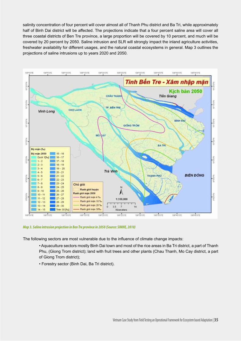
Map 3. Saline intrusion projection in Ben Tre province in 2050 (Source: SIMHE, 2010)
salinity concentration of four percent will cover almost all of Thanh Phu district and Ba Tri, while approximately half of Binh Dai district will be affected. The projections indicate that a four percent saline area will cover all three coastal districts of Ben Tre province, a large proportion will be covered by 10 percent, and much will be covered by 20 percent by 2050. Saline intrusion and SLR will strongly impact the inland agriculture activities, freshwater availability for different usages, and the natural coastal ecosystems in general. Map 3 outlines the projections of saline intrusions up to years 2020 and 2050.
Thefollowingsectorsaremostvulnerableduetotheinfluenceofclimatechangeimpacts:
•AquaculturesectorsmostlyBinhDaitownandmostofthericeareasinBaTridistrict,apartofThanhPhu,(GiongTromdistrict);landwithfruittreesandotherplants(ChauThanh,MoCaydistrict,apartofGiongTromdistrict);
•Forestrysector(BinhDai,BaTridistrict).
Vietnam Case Study from Field Testing an Operational Framework for Ecosystem based Adaptation | 35

4.2.2. Development activities
According to the socio-economic development plan of Ben Tre province up to the year 20207, there are important development targets at the three coastal districts:
• The total area of rice plantation will be decreased to make way for rotational rice-aquaculture farming. ThiswilloccurmainlyinBaTri,ThanhPhudistrictandpartlyinGiongTromandBinhDaidistrict;
•Developmentofprocessingindustries:fournewindustrialzonesinGiaoHoa(ChauThanh,BinhDaidistrict).AdditionallythereisapossibilityofanewindustrialzoneatthecurrentAnNhonindustrialzone(ThanhPhudistrict);
•ConstructionoftheHamLuongferryconnectingBaTriandThanhPhudistrictandcontinuanceofsluicegatesconstructionintheBaLaisluicedam;
•ConstructionofprovincialroadĐT.885(BaTridistrict);
•ConstructionofthecoastalroadconnectingBinhDai-BaTri-ThanhPhudistrict, which is around 38.6 kminlength;
•ConstructionofprovincialroadThanhHai-MyAnconnectingBaTri-ThanhPhudistrict,which isestimatedtobe16.5kminlength;
•Constructionof importantdistrict roads includingDH.173(East-West)connectingChauThanh-GiongTrom-BaTridistrict(around58.3km);DH.16connectingBinhDai-BaTri-ThanhPhudistrict,isconsideredacoastalpreventionroute(38.5km);
•Dikeconstructionprojectsinthreedistricts:completethesystemwithfreshwaterdikesinPhuLong,BinhDaidistrict;DikeconstructionbetweenHoaLoiandMyHungcommunesofThạnhPhudistrict.
Thecommunities ingeneralexpectpositivebenefitsfromtheproposeddevelopmentactivitiesbutpredictnegative impacts on ecosystems due to pollution and defragmentation.
7 Ben Tre Provincial People’s Committee, 2011. Master plan on Socio-Economic Development of Ben Tre province towards 2020.
Hazards Mangroves Sand dune Intertidal area
Coastal sand dunes
Estuarine water
Brackish water ponds
Fresh water, crop
Road 0/+1/-1 0/+2/-1 0/+1/-1 0/+1/0 0/+1/0 +1/+1/0 +1/+2
Bridge, 0/+1/0 0/+2/+2 +2/+1/+1 0/+1/0 +2/+1/0 +2/+2/-+1 +2/+2
Dike -1/+1/0 -1/+2/+2 0/0/+1 0/0/0 +2/0/+1 +2/+2/-+1 +2/+2
Urban expansion 0/-1/0 0/+1/-1 0/0/+1 +1/0/-1 0/0/-1 0/+1 0/+1
Industrial development 0/-2/0 0/-1/ 0/-2/ 0/-2/ -2/-1/ -1/-1/-1 -2/-2
Conversion of forest land to Agriculture / Fisheries
-2/-2/-2 -1/-1 0/-2/-1 0/-2/0 0/-1/-1 0/-1/0 0/-2
Tourism -/-/-1 -/-/-1 -/-/-1 -/-/-1 -/-/0 -/-/0
Table 7. Rating of coastal communities in 3 districts (Binh Dai/Ba Tri/Thanh Phu) on impacts of development activities on ecosystems and their livelihoods. (Binh Dai/Ba Tri/Thanh Phu)
Rating score: - 2: Very serious negative impacts 0: No impacts 1: Positive impacts -1: Moderate negative impacts 2: Very positive impacts
36 | Vietnam Case Study from Field Testing an Operational Framework for Ecosystem based Adaptation

4.3. Summary of current and future pressures on communities and ecosystems
The assessments of the ecosystems and their dependent livelihood activities have been synthesized to produce thefollowingriskrating,adaptivecapacity,andfinalvulnerabilityassessment.ConclusionsaresummarizedinTable 8 and in the balance of this section.
EcosystemsCurrent hazards (climate and non-climate related) Compiled projected future impacts
Final riskDescription Risk Description Risk
Estuarine areas
•Pollutedwaterresourceduetodaily life and production activities• Water infrastructure on riversuchasdams,harbors;• Transboundary impacts(hydropower, water pathway,irrigation projects in the upstream countries as China, Lao, Thai and Cambodia)thatreducessedimentandnutrientsinthewaterflows.
Medium -High
•SLRtogetherwithspringtide;•Unpredictablechangesofupstreamflows;•Alluvialchange;•Strongtropicalmonsoonwinds;•Bigwaves;• High risk of tropicaldepression and storms.
High Medium -High
Mangroves • Expansion of agricultureand aquaculture cultivation lands, increase of chemicals in agriculture activities that harm to ecosystems;• Deforestation and weak control and management of forest.
High •SLRtogetherwithspringtide increase forest land erosionpossibility;•Changeofwatersalinity;• Reduction of alluvialconcentration;• Increased storms andtyphoons.
Medium Medium-High
Intertidal areas
•The exploitation and production ofaquacultureandmudflatbarscause changes of flow regime,increasederosionprocess;•Water transportation vehiclesand transboundary impacts reduce sediment and nutrients in thewaterflows.
Low-Medium
•SLRtogetherwithspringtide;•Unpredictablechangeoflows;• High risk of tropicaldepression and storms.
Medium-High
Medium
Sand dunes •Populationgrowth;•Increaseofpollutedwaterandsoil;•Thepeopleat thesame timeexploit, and destroy, but also adjust and recover the natural resources.
Low- Medium
•CCincreasestemperatureand changes the rainfall distribution, which has an extreme effect on ecosystems and livelihood activities. However, the impacts will be really serious after the next 20 years;•Possiblelimitationoffreshwater access.
Medium Medium
Table 8. Risk ranking of key ecosystems/habitats of three coastal communes in Ben Tre province
Vietnam Case Study from Field Testing an Operational Framework for Ecosystem based Adaptation | 37
Coastal mangrove ecosystems are at moderately high risk from pressures of development and climate change. Current serious threats include the continued expansion of shrimp aquaculture as well as weak institutional control over and management of mangrove resources. Additionally, mangroves are both highly exposed and sensitive to inundation and erosion caused by SLR and increased storm activity.
Extensive/intensiveshrimpfarming(blacktigerprawnandwhite-leggedshrimp)haveamoderatelyhighriskfrom pressures related to development and climate change. Unsuitable management and unchecked expansion of shrimp farming will leave little natural food or habitat for shrimp, leaving the industry highly vulnerable to hazards such as disease and typhoons. Sea level rise, increased temperature and the associated increase in saltconcentrationswillleadtoanincreasednumberofwhite-leggedshrimpfarms(convertedfromthesalineintolerantblacktigerprawnfarms),furtherincreasingtheriskofspreadofdisease.
Intertidalalluvialmudflatandsandbarecosystemshaveamoderateriskfromfutureclimaticanddevelopmentpressures. These include permanent inundation due to SLR, and an increase in annual maximum temperature, increasing the risk of death to many benthic bivalves. In addition, port and dike construction planned for Ben Trewillhavesignificantimpactsontheseimportant,andexposed,ecosystems.
Clam(Meretrix lyrata)andbloodcockle(Anadatagranosa)farmingisatmoderatelyhighriskfromclimatechange and development hazards. An increase in maximum annual temperature, increased salinity, changes in upstream hydrology and sediment loads, and SLR inundation, will threaten the existence of the industry. Deeper analysis is needed to predict how the supporting ecosystem will respond to these changes. Open water estuarine ecosystem is also at moderately high risk from development and climate change hazards. The estuary is exposed and sensitive to the coastal erosion caused by SLR, an increase in storm events, and theprojectedincreaseinseasonalinflow,floodpulseandsedimentloads.Moreover,planneddikeandportdevelopment will create additional hazards causing changes in hydrology and sediment and habitat alteration. Theestuarinecapturefisheriesareatmoderateriskfromclimatechangeanddevelopmenthazards.
Sand dune system in Ben Tre has a moderate risk from further climate and development hazards. Sand dunes are particularly exposed and sensitive to erosive processes such as the predicted increases in storm activity, monsoonal rains, and the duration and intensity of rainfall. Furthermore, SLR and saline intrusion could contaminate sand dune dry season aquifers.
Increasedrainfallwillbothnegativelyandpositivelyimpactvegetableplantations(watermelon,Jicama,andbeans)andhaveamoderatelyhighriskfromclimatechangehazards.Watermeloncropsaresensitivetoanincreaseinrainfall.However,increasedrainfallandtemperaturewillallowothercropstoflourish.Adelayedwet season will also threaten current agricultural crops and production cycles.
4.4. Integrated risk assessment of ecosystem dependent livelihood activities
Thisassessmentcomprisesaholisticaccumulationofrisks includingtherisksto livelihood-activities; therisklevelofeachoftheecosystemservices;thefinalcompiledriskrankingfromcurrentandexpectedclimatechange and development impacts.
The criteria for the compiled impact ranking system also is qualitative but based on selected indicators:
o High level: The degree of adverse consequences from current and projected climate change and developmentactivitiesonthelivelihoodactivityisextremelybad(calculatedintoeconomicvaluebasedondiscussionresultsfromlocalcommunityworkshopsandsurveysaswellasfindingsfromtheconsultantteam);
38 | Vietnam Case Study from Field Testing an Operational Framework for Ecosystem based Adaptation

o Medium level: The degree of adverse consequences from current and projected climate change and developmentactivitiesonthe livelihoodactivity ishigh(calculated intoeconomicvaluebasedondiscussionresultsfromlocalcommunityworkshopsandsurveysaswellasfindingsfromconsultantteam);
o Low level: The degree of adverse consequences from current and projected climate change and development activities on the livelihood activity is very low or even the projected changes will likely providepositiveconditionforsustainable livelihooddevelopment(calculated intoeconomicvaluebasedondiscussionresultsfromlocalcommunityworkshopsandsurveysaswellasfindingsfromconsultantteam).
Ecosystem dependent livelihoods Final risk ranking of supporting ecosystems Final risk ranking of potential compiled impacts
Final accumulated risk
Key ecosystems supporting the livelihood activity
Final projected risk ranking of each ecosystem
Improved extensive/intensive shrimp farming
•Estuarineareas
•Mangroves
•High
•Medium•Medium-High •Medium-High
Clam farming •Mudflatbar
•Sandbars
•Medium-High
•Medium-High•Medium-High •Medium-High
Capture & offshore fisheries
•Estuarineareas •High •Low-Medium •Medium
Vegetable plantation on sand dunes
•Sanddunes •Medium •High •Medium-High
Table 9. Integrated assessment of climate change and development pressures and hazards on key ecosystem dependent livelihood activities.
Improved extensive/intensive shrimp farming (blacktigerprawnandwhite-leggedshrimp)haveamedium-high risk of impact from development and climate change. Unsuitable management and unchecked expansion of shrimp farming will leave little natural food or habitat for shrimp, leaving the industry highly exposed and sensitive to impacts such as disease and typhoons. Sea level rise, increased temperature and the associated increaseinsaltconcentrations,will leadtoanincreasednumberofwhite-leggedshrimpfarms(ratherthanblacktigerprawnfarms)andfurtherincreasetheriskofdiseaseandindustryfailure.
Clam (Meretrix lyrata) and blood cockle (Anadata granosa) farming is at medium–high risk from climate change and development hazards. An increase in maximum annual temperature, increased salinity, changes in upstream hydrology and sediment loads, and SLR inundation, will threaten the existence of the industry. It is hard to predict how the supporting ecosystem will respond to these changes.
The estuary capture fisheries are at medium risk of climate change and development hazards. There is an ongoinginvestmentincapturedfisheries.Thisincludesthedevelopmentofports,wholesalemarkets,boatshelters and seafood canning facility and industry. This continued, unsustainable, investment and development hasthepotentialtooverstretchthefisheries’populationsandcauseacollapseintheindustry.
Vegetable plantations(watermelon,Jicamaandbeans)andhaveamedium-high risk of climate change hazards. Watermelon crops are sensitive to an increase in rainfall. However, increased rainfall and temperature willallowothercropstoflourish.Adelayedwetseasonwillalsothreatencurrentagriculturalcropsandcropping
Vietnam Case Study from Field Testing an Operational Framework for Ecosystem based Adaptation | 39

cycles. Vegetableplantationsinthesanddunesregularlyfacedifficultiesincludingdroughtandflooding.Thisisexpectedtoincreasewithplanneddevelopmentsandclimatechangetrends.Likemudflats,thecommunitiesinthesanddues are used to living in dynamic environment and are adapted to the regular challenges that arise.
Someprojectedclimaticchangesmayhavebenefits.Unusualandunseasonalraininthedryseasoncanprovideneeded fresh water for trees, plants and crops, and reduce saline intrusion, as well as helping to reduce the riskofforestfires.
In most cases it can be noted that the risk from development is much greater for both livelihoods and ecosystems than from climate change. Much of the development is seen to be short-term economic gain that will quickly exploitresourcetoenhanceeconomicdevelopment.Thisincludestherapiddevelopmentofinfrastructure(ports,roads,andtransport),industry,andaquaculture.Mostofthesedevelopmentswillcomeattheexpenseoftheenvironment(mangroves,sanddune,intertidal,andestuarineecosystems)thatissupportingthecommunities,communes and provinces. If these ecosystems are not sustainably managed the economic and social gain will be short lived. It is also worth noting that each ecosystem depends on the other and the lost or degradation of one increases the risk to the others.
4.5. Community Developed Indicators for Vulnerability/Resilience
Thecoastalcommunitieshavebeenexperiencingparticularimpactsofanever-changingclimate.Theyfindthat habitats for wild animals and plants are decreasing and mangrove loss leads to erosion and salt intrusion, which affects productive land. They are facing a shortage of water, which is caused by increased long hot periods and drought seasons.
The agriculture sector is experiencing more climate change impacts and the local communities see that EbA solutions are highly suitable for the agriculture sector, including aquaculture. Shrimp farmers seem to be a vulnerablegroup.Theyaremoreexposedtoclimateeventssuchasstormsandfloodingandincreasedhotperiods. They also experience mangrove loss that leads to erosion and salt for their productive land.
40 | Vietnam Case Study from Field Testing an Operational Framework for Ecosystem based Adaptation

Indicator Ranges of evaluation Vulnerable
Income
<400,000 VND/person/month High
400,000-520,000/person/month Medium
>520,000/person/month Low
Livelihood diversity One livelihood/job High
More than 2 Low
Land for cultivation (Aquaculture & agriculture)
Low(None) High
Medium(Agricultureland/<0,5ha/Aquaculture<1ha) Medium
High(Agricultureland>0,5ha/Aquaculture>1ha) Low
Land locationHigh(Inside-dike:Salt&Fresh) Low
Low(Outsite-dike:None&Forest) Medium
Freshwater accessLow(Distancetofreshwatersources>2km) High
High(Distancetofreshwatersources<2km) Low
Housing condition
Low(Poorconstructedhouse) High
Medium(Semi-permanenthouse) Medium
High(Permanenthouse) Low
GenderFemale, elders, kids High
Male, mature Low
Table 10. List of Resiliency Indicators for Evaluating Vulnerability of Communities.
Source: WWF, 2013. Data from the field.
Ecosystemservicesmightvaluedifferencesbetweenstakeholdersdependingonperspectiveonbenefitsfromecosystem services as economic, social or ecological.
While communities recognized different impacts to different sectors, this case study also tried to assess how different individuals within the community show different vulnerabilities to climate change. For example, the communities discussed that women are more likely to be more vulnerable because they cannot swim as fast in the event of disasters and are also out collecting different services from the ecosystems. The other factors includedincome,diversityoflivelihood,landlocationetc.Table10summarizesresiliencyindicatorsasidentifiedin consultations with residents of the three coastal districts included in this study.
Vietnam Case Study from Field Testing an Operational Framework for Ecosystem based Adaptation | 41

4.6. Assessing Exposure, Sensitivity and Adaptive Capacity
The community adaptive capacity was determined by assessing the current coping strategies of the community, and the ecological and institutional ability to respond to hazards and risks. Table 11 summarizes the results from the adaptive capacity assessment.
Ecosystem | Livelihood activity
Adaptive Capacity
Ecological Community Institutional
Mudflat/sandbar|Clam and cockle farming Low Moderate Low
Mangrove| extensive/intensive shrimp Low /moderate Low /Moderate Low
Sanddune| Vegetable plantation High High Low
Estuarine| Capture/offshore fishery Low Low Low
Table 11. Adaptive capacity ranking
• Highadaptivecapacity:Communitymemberscanmanagetheimpactsofcurrentclimateandnon-climate related hazards very well and can adapt their livelihoods quickly when pressures increase. They are familiar with projected climate change scenarios and development plans and their current coping/adaptationstrategiesarelikelytoremainviableinthefuture;
• Moderateadaptivecapacity:Communitymemberscanmanagetheimpactsofcurrentclimateand non-climate related hazards and will recover gradually if pressures increase. They are somewhat familiar with projected climate change scenarios and development plans, and their current coping/adaptationstrategiesmightnotbeviableforcopingwithfuturehazards;
• Lowadaptivecapacity:Communitymembersarenotabletomanagetheimpactsofcurrentclimate and non-climate related hazards on their selected livelihoods and will not recover their livelihoods if pressures increase. They are unfamiliar with projected climate change scenarios and development plans, and their current coping/adaptation strategies will not be viable in the future.
Thefield-testingwasdoneinashortperiod,sothecommunity’sandecosystem’scapacityhavenotbeenanalyzed in detail. A SWOT analysis was carried out to understand the institutional adaptive capacity to climate change impacts in the coastal areas of Ben Tre.
42 | Vietnam Case Study from Field Testing an Operational Framework for Ecosystem based Adaptation

Strengths• The natural conditions inBen Tre province are favora-ble for ecosystem conserva-tion and agro-aquaculture cultivation;•There isastrongsupportfrom the provincial authority leaders for climate change adaptation capacity building and application
Weaknesses•Humanresourcesforclimatechangeareweakandlimitedofbothquantityand quality, especially at the local level. Raising awareness to adapt and cope withclimatechangeisachallengingproblem;•Thereistheweakawarenessofthewholesociety,atalllevels,frompolicymakersandthoseofficersindepartmentsandlocalsocialorganizationsaswellasthecommunityitselftheimpactofclimatechange;•Agriculturaldevelopmentbut ismainlybasedontheexploitationofnaturalresources-natural(land,water,forests,fisheries.)shouldeasilyleadtotheriskofexhaustionresourcesandenvironmentaldegradation;•Technical infrastructure inruralcoastalareas(roads,electricity,waterandsanitationaccess)hasbeentherecipientofagreatdealofinvestment,butisstill at weak state. A lack of synchronization may cause barriers in implementing adaptation strategies to climate changes.
Threats•Economicdevelopmentde-pends greatly on natural re-sources. The future projected increases in salinity, drought, storms, sea level rise etc. will likely strongly impact ecosys-tems and nature- dependent livelihoodexploitations;•Theincreasingpopulationpressure and environmental pollution are acting badly to the natural coastal environ-ment.
Opportunities•There isastandingofficeofNTP-RCCinBenTreprovinceworkingwithDONRE & DARD on Climate change action plans. Sectoral integration plans willbeinvestedandpilotedintheprovince;•MekongRiverDeltahasbeenidentifiedasoneofplacesfacingmanyseriouschallenges on climate change and sea level rise, in which Ben Tre is the top of ten most vulnerability provinces. This threat may be considered as an oppor-tunity for several studies on climate change impacts for Ben Tre from various researchinstitutionsandNGOsasaveryspecificcasestudy;•InBenTre,anumberofclimatechangeadaptationrelatedprojectsarebeingimplemented for developing a systematic and comprehensive understanding of the capacities of regional institutions to formulate and implement strategies of adaptation to climate change risks and the forecasted impacts of climate change on management of natural resources in coastal environments. There willbemorefinancialandtechnicalsupportsinclimatechangeadaptationforBen Tre province.
Vietnam Case Study from Field Testing an Operational Framework for Ecosystem based Adaptation | 43

Institutionaladaptivecapacity iscomplex including: institutionalcoordination;financialresources; legalandpoliticalpower;levelofinterestandmotivationofindividualactors;availabilityanddisseminationofknowledgeonincreasedrisksfromclimatechangeimpacts;andopennessandresponsiveness.Ananalysisoftheinstitutionaladaptive capacity to climate change impacts in the coastal areas of Ben Tre found that:
TheMekongRiverDeltahasbeenidentifiedasoneofplacesfacingmanyseriouschallengesonclimatechangeand sea level rise. Ben Tre is one of the top ten most vulnerable provinces. Recognition of this threat brought close attention to Ben Tre province. Several studies, investment, and technical support projects responding to climate change impacts conducted by various research institutions and NGOs have already started. This will help strengthen government and communities as well as policy.
There is a strong support from the provincial authority leaders for climate change adaptation capacity building and application. Human resources, however, for climate change adaptation are weak and limited in both quantity and quality, especially at the local level. Raising awareness and leading adaption and coping strategies are challenging.
Current institutional policies encourage agricultural development based on the exploitation of natural resources (land,water, forestsandfisheries), leadingtoexhaustedresourcesandenvironmentaldegradation.Thisincreases the risk of climate change and reduces the effectiveness of communities coping strategies and their ability to adapt to climate change.
There is weak awareness at all levels—from policy makers to the community—regarding the pressures and threats of climate change. Furthermore, there is a lack of communication and coordination between government departments,institutes,strategiesandpolices.Thismaycausebarriersandreducetheefficientandeffectivenessof implementing adaptation strategies to climate changes. There are, however, with the existence of the standing officeofNationalTargetProgramtoRespondtoClimateChange(NTP-RCC)inBenTreprovince,whichhasclosely working with both DONRE & DARD on climate change action plans. Moreover, the mainstreaming of climatechangeadaptationintosectorialintegrationplanswillbeinvestedandpilotedintheprovince;therewillbe more opportunities for strengthening the communication and collaboration among relevant departments, particularly DONRE and DARD.
4.7. Current Coping Strategies to Climate and Non-Climate Related Hazards
Local communities have implemented many initiatives to adapt to changes in climate and the coastal environment. Localcommunitiesagreedthatcopingstrategiesalsodependedonthevulnerabilityindicatorsidentifiedabove.Shrimp farming, one of the most important subsistence activities in the coastal area, is facing critical problems caused by both climate and non-climate hazards. One coping strategy that has been applied by local communities istoswitchfromraisingblacktigerprawnstowhite-legshrimp,whichhasreducedoverallfisherylossesandincreased the income for local communities. However, according to many aquaculture scientists, this is not a sustainable solution due to the low-quality of white-leg shrimp, which breed diseases and leaves antibiotic residue in the marine ecosystems.
There are some good coping strategies that would be effective in the future, which include using nets to cover cocklenurseriesfromthesun;clamfarmingatarangeofelevationstoreducetheriskoflossduetoprolongedhot periods, choosing alternative and suitable varieties of vegetables and watermelons for growing in the sand dunes,vegetablediversificationtoreducerisksofcropfailures,andmangrovere-generationandplantationactivities. However, these coping activities are not enough and the irregular rainfall patterns or prolonged hot periods currently still cause loss of crops.
Currentgovernmentadaptationstrategiesinclude:thedevelopmentofcoastaldikes;mangroveplantationand
44 | Vietnam Case Study from Field Testing an Operational Framework for Ecosystem based Adaptation

restoration;anddredgingactivitiesandresidentialresettlementplans.Governmentshaveimplementedthesestrategies and plan to continue these investments. The scale and scope of government strategies are usually larger than community-driven actions and are often implemented over a longer period of time. While coastal dikesordredgingactivitieswillprovideimmediateresults(particularlythedikesystem)theseconstructionscan damage natural resources and alter the ecological systems. In the long term, it may lead to maladaptation, therefore reducing the services to support livelihoods and very costly to restore the origin.
Table 12 summarizes the current coping activities that have been adopted by the local communities and the governments.
Climate change hazards Coping actions
Unseasonable rainfall
•Noreaction
Prolonged hot weather, drought
•Usingnetstoshieldcocklenurseriesfromthesun;•Scatteringclamfarmsatlowerelevationstoreducepopulationlossfromprolongedandconcentratedperiodsofheat;•Avoidingintensiveclamfarming;•Well-diggingtousegroundwaterfordomesticactivities(figure5.4);•Using nylon/plastic to avoid evaporation, weed growth, loss of fertilizers in crops.
Increased SLR and spring tide
• Developmentofcoastaldikestolimittheimpactofoceanwaves,SLR,windsandstorms;• Mangroveplantationandpreservationoutsideofcoastaldikes(forexample,project661from1998–2010).
Erosion and mon-soon winds
• Developmentofcoastaldikestolimittheimpactofoceanwaves,windsanderosion;• Mangrove plantation and restoration in coastal areas and core zone area of Thanh Phunaturalreserve;• Mangroveplantationandpreservationoutsideofcoastaldikes(forexample,project661from1998–2010);• Constructingstone/rockdikesystemsandconcretepipes;greyorwhitemangroveplantationstocopewitherosion;• Residentialresettlementawayfromcoastalareas;• Reductionofindustrialactivitiesandconstructionworks(mechanicalplants,boatandenginerepairingbases)nearthemangroveforestsandhigherosionareas;• Limitingtheexploitationofmangrovesforconstructionwoodandfirewood;• Plantingcoconutsinsanddunestolimittheimpactofheavywindsandstorms(andtoprovideasourceforroofingmaterial).
Increased frequency and intensity of tropical storm events
• Developmentofcoastaldikestolimittheimpactofoceanwaves,windsandstorms;
• Warning systems of tropical depressions and storms for local people through radio, TV, notice boards;
• Dredgingactivitiesontherivertomakeboatsheltersforoffshorefishermen;
• Limiting overexploitation of mangrove trees.
Table 12. Current Coping and Adaptation Activities to Climate Change Impacts in Three Coastal Districts, Ben Tre (Source: WWF field data, 2013)
Vietnam Case Study from Field Testing an Operational Framework for Ecosystem based Adaptation | 45

4.8. Scenario Development and Reflection
Scenariosrelatedtotheinfluenceofecosystemstatusonclimatechangeadaptationareheavilyinfluencedbyamountsandconfigurationofdifferent landuses.Giventhis,theanalysisteamestablishedabasemaprepresenting today’s land cover condition by combining a land use map provided by the Department of Natural ResourcesandEnvironmentwithsomerefinementstakenfromclassifying2010Spotsatelliteimagery.
Map 4. Current land use-land cover in Ben Tre provinces
With this map as a starting point, and using the assumptions in the following sections, three scenarios were developed representing what the land use/land cover condition of the area would likely look like in 2020 given various assumptions about agricultural, irrigation, and settlement patterns: business as usual, development, and conservation. Possible climate change-induced changes to the biophysical condition of each of these were held constant to facilitate comparison of factors that are/will be largely in the hands of decision-makers and individual and community behavior and land use on the ground.
4.8.1. Business as Usual Scenario in 2020
Assumptions: Socio-economicdevelopmentgrowthisextrapolatedfromtheprevious10-yearperiod;thecurrentprovincialland-useplanisfullyimplemented;andsealevelraisedat17cm.
Compared to the baseline scenario, the only two land-use/land-cover types increasing under this scenario are orchard(e.g.fruit trees)(+16percent)andbuilt-upareas(e.g.settlement, industry,etc.)(+31percent).Allotherlanduse/landcovertypesaredecreasedinextent—especiallyareasusedforaquaculture(-31percent),agriculture(-34percent)andforestry(-44percent).
46 | Vietnam Case Study from Field Testing an Operational Framework for Ecosystem based Adaptation

Map 5. Business as Usual scenario in 2020 in Ben Tre province
4.8.2. Development Scenario in 2020
Assumptions: Agricultureandaquacultureareexpandedandintensifiedasproposedbythecurrentlyproposedagricultural development plan and industry and infrastructure development as proposed by the ministry of industry, and sea level raised at 17cm.
Map 6. Rapid Development scenario in 2020 in Ben Tre province
Vietnam Case Study from Field Testing an Operational Framework for Ecosystem based Adaptation | 47

Compared to the baseline scenario, land-use changes under this scenario follow a similar trend to that of the businessasusualscenario(e.g.orchardarea+18percentandbuilt-uparea+58percent),whereasagricultureand aquaculture areas are reduced by 34 percent and 24 percent, respectively. However, in this scenario, salt marshareasaremostlyconvertedtootherlandusetypes(e.g.aquaculture)andtheforestryareaincreasesslightlyreflectingtheforestrydepartment’sreplantationplans(replantingmorethan100ha/yearfrom2010to2020).
4.8.3. Conservation Scenario in 2020
Assumptions:Newprotectedareasareestablished,mangrovecoverissignificantlyincreasedasperforestrecovery plans, and natural hydrological regimes are maintained, and sea level raised at 17cm.
In the conservation scenario, areas of forest, orchard, and built-up areas increase by 44 percent, 16 percent, and 30 percent, respectively. Areas of agriculture, aquaculture, and salt marsh decrease by 23 percent, 38 percent and 16 percent respectively.
The changes in key land cover types of different scenarios are shown in the graph and table below:
Map 7. Biodiversity Conservation scenario in 2020 in Ben Tre province
48 | Vietnam Case Study from Field Testing an Operational Framework for Ecosystem based Adaptation

Figure 4. Change in Land-Cover under three future scenarios versus baseline: (1) BAU, (2) Conservation, (3) Development.
Grouped Land use / land cover classes Baseline Business As Usual Conservation Development
Orchard 77,685.25 90,644.75 90,427.75 92,036.50
Agriculture 61,040.25 47,065.50 46,519.00 40,125.00
Forest 7,400.25 4,858.75 10,715.25 8,341.00
Aquaculture 42,956.75 29,601.50 26,432.25 33,949.50
Salt marsh 2,115.00 1,994.50 1,760.75 111.50
Buildup - resident area 15,037.50 19,741.75 19,669.50 23,780.50
Table 13. Area statistics area of main land cover types of 3 scenarios (Unit: Ha)
4.9. Future Scenarios and Use of Models to Assess Future Vulnerability
4.9.1. Coastal Vulnerability
Faced with a changing climate and a growing intensity of human activities and in order to make good choices about what climate change adaptation options will best serve them, coastal communities in Ben Tre province mustbetterunderstandhowmodificationsofthebiologicalandphysicalenvironment(i.e.directandindirectremovalofnaturalhabitatsforcoastaldevelopment)canaffecttheirexposuretostorm-inducederosionandflooding(inundation).TheInVESTCoastalVulnerabilitymodelproducesaqualitativeestimateofsuchexposurein terms of a Vulnerability Index, which differentiates areas with relatively high or low exposure to erosion and inundation during storms. By coupling these results with population information, model outputs show areas along a given coastline where humans are most vulnerable to storm waves and surge. The model does not take into account coastal processes that are unique to a region, nor does it predict long- or short-term changes inshorelinepositionorconfiguration.
Vietnam Case Study from Field Testing an Operational Framework for Ecosystem based Adaptation | 49
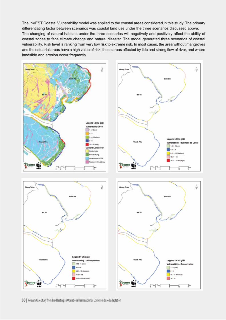
The InVEST Coastal Vulnerability model was applied to the coastal areas considered in this study. The primary differentiating factor between scenarios was coastal land use under the three scenarios discussed above. The changing of natural habitats under the three scenarios will negatively and positively affect the ability of coastal zones to face climate change and natural disaster. The model generated three scenarios of coastal vulnerability. Risk level is ranking from very low risk to extreme risk. In most cases, the area without mangroves andtheestuarialareashaveahighvalueofrisk;thoseareasaffectedbytideandstrongflowofriver,andwherelandslide and erosion occur frequently.
50 | Vietnam Case Study from Field Testing an Operational Framework for Ecosystem based Adaptation

Ingeneral,allofscenariosshowingthatthecoastalareasinBinhDaidistrict(lessandthinmangrovebelt)aremorevulnerabletostormsurgesandsealevelrisethanBaTriandThanhPhudistrict(withmoreandthickmangrovebelt).Therivermouthsthathavemangroveandsea/riverdike(BaTririvermouth)aremoreresilientthan the areas that do not have either mangroves or sea/river dikes. The coastal areas are more affected by northeast monsoon, especially the areas faced to the northeast, even in Thanh Phu mangrove reserve.
The coastal communities in the development scenario are more vulnerable to weather extreme events than in the business as usual and conservation scenarios in term of lost and damaged community properties and crops due to high population concentration and investment in farming.
4.9.2. Coastal protection – Near-shore wave erosion
Understanding the role that near-shore habitats play in the protection of coastal communities is increasingly important in the face of a changing climate and growing development pressure. The InVEST Erosion Protection modelquantifiestheprotectivebenefitsthatnaturalhabitatsprovideagainsterosionandinundation(flooding)innear-shoreenvironments.Itiscomposedoftwosub-models:aProfileGeneratorandaNear-ShoreWaveandErosionmodel.Intheabsenceoflocaldatadetailingtheprofileofthenear-shoreelevations,theProfileGeneratormodelhelpscombineinformationaboutthelocalbathymetryandbackshoretogenerateaone-dimensional(1D)cross-shore(perpendiculartotheshoreline)beachprofile.TheNear-ShoreWavesandErosionmodelusesthecross-shoreprofile(eitheruploadedorcreatedusingtheProfileGenerator)tocomputesummariesofnear-shore wave information, and outputs the total water level at the shore, the amount of shoreline erosion, and the amountofavoideddamagesduetoerosion(inlocalcurrency)fromagivenhabitatmanagementdecisionthataffectstheamountofnear-shoremarinehabitats(e.g.,coraloroysterreefs,vegetation,sanddunes)atagivensite. This information can help coastal managers, planners, landowners, and other stakeholders understand the coastal protection services provided by near shore habitats, which can in turn inform coastal development strategies and permitting.
In Ben Tre, seven landpoint observations along the coastlinewereusedtomakea land-seaprofilethenestimate the change of wave transmission from 50 km from sea to coastal line.
The coastal protection model is used to simulate the wave transmission based on the information of the tide and storm model integrated with seabed topology, habitat distribution, and biology. In most cases with mangroves existing, wave height and energy were reduced 85-95 percent when it reached the coastal line.
The observation shows that wave height and energy have been reduced 80-98 percent when it approached to the coastline thanks to the mangrove belt and sand dunes/bars, but simulated results are also illustrated that in different scenarios with different type of coastal habitatsandmanagementactionsreflectedtochangesof wave height and energy reduction levels.
Map 9. Land-points observation along the coastline in Ben Tre
Vietnam Case Study from Field Testing an Operational Framework for Ecosystem based Adaptation | 51

Figure 6. Reduction of Wave Height (m) by coastal habitats at Landpoint 4 under Different Scenarios
ThischartisthesimulatedresultfromInVESTmodelatlandpoint4.Theredline(no-habitat)meansthatifthere are no mangroves and sand dunes the wave will surge further to 300–400m inland. The current mangrove belt and sand dunes have reduced the wave height from 0.4m to 0.1m when it reached 100m inland. In the business as usual and cevelopment scenarios, the wave height reduced from 0.6m to 0.1m at 100m from the coastline to the sea. In the conservation scenarios, the wave height reduced from 0.7m to 0.1m at 300m from the coastline thanks to mangroves expansion and plantation of the dunes.
The wave energy is also reduced by 80 percent to 95 percent in different scenarios at seven observation landpoints. In most observation landpoints, wave energy under the conservation scenario is reduced by 92 to 95 percent. In the development scenario, the wave energy is ranging from 80 to 95 percent. Even in landpoint 7 the wave energy reduction is higher than conservation scenario due to building a sea dike behind the mangrove near the Co Chien river mouth.
Figure 7. Reduction of Wave Energy (%) by coastal habitats at Landpoints 4 under Different Scenarios
52 | Vietnam Case Study from Field Testing an Operational Framework for Ecosystem based Adaptation

4.9.3. Carbon Storage and Sequestration
Terrestrialecosystems,whichstoremorecarbonthantheatmosphere,arevitaltoinfluencingcarbondioxide-driven climate change. The InVEST model uses maps of land use and land cover types and data on wood harvestrates,harvestedproductdegradationrates,andstocksinfourcarbonpools(abovegroundbiomass,belowgroundbiomass,soil,deadorganicmatter)toestimatetheamountofcarboncurrentlystoredinalandscapeor the amount of carbon sequestered over time. Additional data on the market or social value of sequestered carbon and its annual rate of change, and a discount rate can be used in an optional model that estimates the valueofthisenvironmentalservicetosociety.Limitationsofthemodelincludeanoversimplifiedcarboncycle,an assumed linear change in carbon sequestration over time, and potentially inaccurate discounting rates. The carbon model was applied to calculate carbon storage from the current land cover map from 2010 and land-use planning maps with three scenarios.
Map 10. Carbon Storage 2010, generated from Current Land-Cover Map
The results of the carbon storage in future scenarios are compared with current carbon storage and calculate sequestration.
Vietnam Case Study from Field Testing an Operational Framework for Ecosystem based Adaptation | 53

Map 11. Carbon Storage and Sequestration under Business as Usual Scenario in 2020
54 | Vietnam Case Study from Field Testing an Operational Framework for Ecosystem based Adaptation
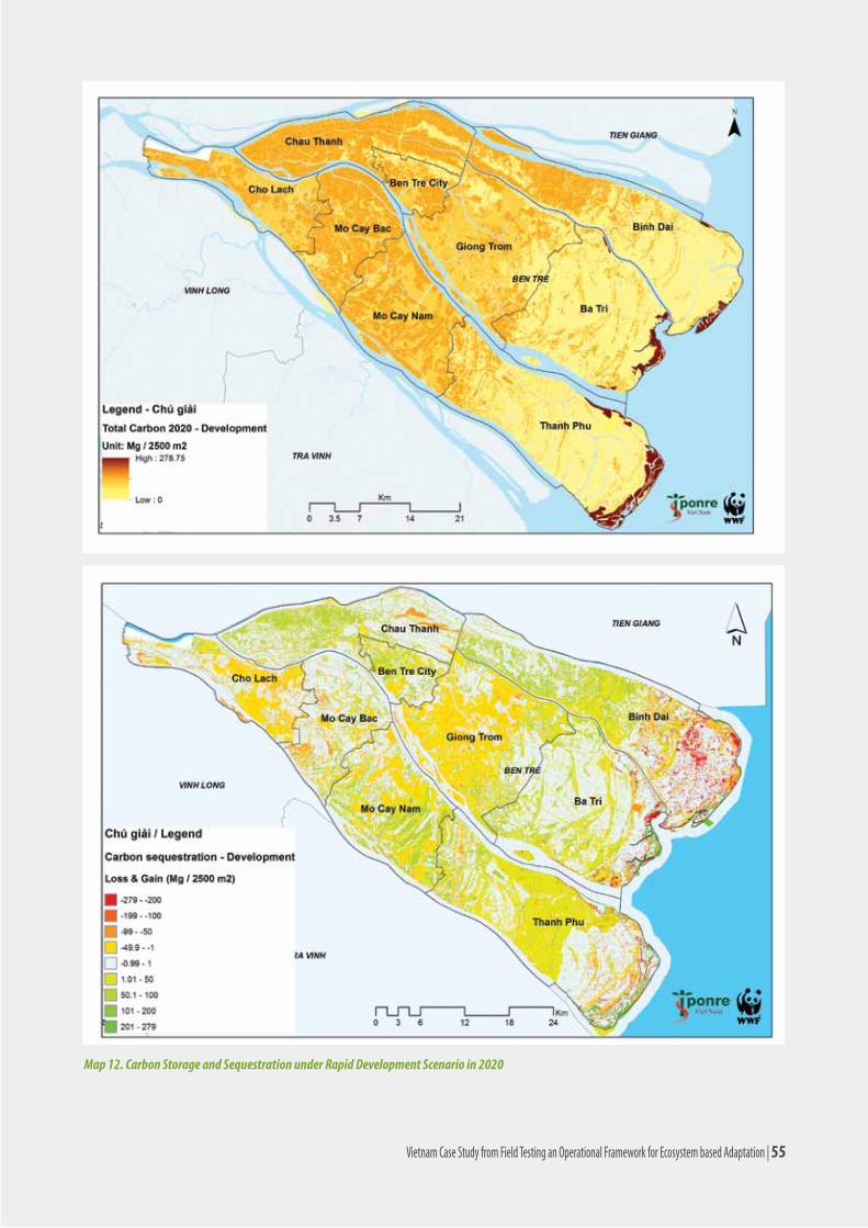
Map 12. Carbon Storage and Sequestration under Rapid Development Scenario in 2020
Vietnam Case Study from Field Testing an Operational Framework for Ecosystem based Adaptation | 55

Map 13. Carbon Storage and Sequestration under Conservation Scenario in 2020
56 | Vietnam Case Study from Field Testing an Operational Framework for Ecosystem based Adaptation

Figure 8. Comparison Carbon Storage in Future 2020 with Current Carbon Storage by District
Carbon storage in the conservation scenario is much higher than other scenarios throughout the province. In other scenarios, the carbon storage is also slightly increased in most of the province, except Cho Lach district duetotheincreasedbuildupareasforindustryandsettlement;whichmeansthedecreasedareaoffruitgarden.
4.9.4. Conclusions
Models developed that predict various future scenarios—a scenario analysis—for the coastal districts in Ben Tre shows that hard structures are not necessarily the most effective measures in reducing vulnerability against coastalerosionandfloods.Green infrastructuresorEbAmeasurescanworkequallywell.Thescenariosdevelopedandcomparedincludeabusinessasusualscenario(growthatthesamerate);high-developmentscenario(growthathigherratebasedoninfrastructuredevelopment)andconservationscenario(withhigherconservationthatincludedplantationofmangrovesandothervegetation).Theresultsoftheanalysiswere:
•Thecoastalvulnerabilitymodelshowedabout27percentlowervulnerabilityindexunderconservationscenario by 2020. The vulnerability index is a qualitative estimate gained by calculating the exposure ofcoastalcommunitiestostormsurgesforeachshorelinesegments;
Mo Cay Cho Lach Chau Thanh Ben Tre Town Giong Trom Binh Dai Thanh Phu Ba Tri
Vietnam Case Study from Field Testing an Operational Framework for Ecosystem based Adaptation | 57
•Theerosionprotectionmodelshowedthatwaveheightsinthecoastalareaswerereducedeitheratahigherpercentageundertheconservationscenario(57percent);oratthesamepercentage(29percent).Itisalsoshowedthatwiththedifferentkindofhabitatsandseadikes,thewaveenergieswerealsoreducedby92-95percent(inconservationscenario)and80-95percent(indevelopmentscenario)whenitreachedthecoastline.Thisindicatesthatgreeninfrastructuresuchasmangrovesand other vegetation can be as, if not more, effective than hard infrastructure to reduce wave heights. Inaddition,integratingsoftandhardinfrastructures(sea-dikebehindthemangrovebelt)willbemoreeffectiveinreducingwaveenergiesandcoastalerosion;
•Resultsfromthecarbonsequestrationmodelshowedthatifthemangrovecoverisincreasedby100percentoftheplannedforestryareas(mangrovecoveris59percentcurrently)asintheconservationscenario, the carbon sequestration is more than 24 percent of the total carbon storage in 2010, equivalent to 7,47 million tons in 10 years. If small mangrove areas are cleared for aquaculture and agriculture as the development scenario, the carbon sequestration is only three percent of the total carbon storage in 2010, equivalent to 1.47 million tons in 10 years.
58 | Vietnam Case Study from Field Testing an Operational Framework for Ecosystem based Adaptation
5. DISCUSSION ON ADAPTATION MEASURES5.1. Identifying Adaptation Measures
This chapter summarizes the analysis and assessment results from above sections. The long list of adaptation solutionsbuildsupon(i)thecurrentcopingactionsidentifiedinChapter4(i.e.whatarethecommunitiesreactionstochangesandtheirfeasibilityinthefuture);(ii)lookingatfuturescenarios;whatlocationswilllikelybemostvulnerabletoclimateandnon-climatenegative impacts;howchanges inecosystemservicesthatsupportthenaturalhealthandcommunitypropertyandlivelihoodswillaffectthosepropertyandlivelihoods;and(iii)discussions with communities on suitable adaptation strategies to mitigate the negative projected impacts and also maintain the ecosystem functions.
Having a long list of suggested adaptation strategies, the next step is to evaluate which strategies are urgently prioritized to immediately reduce projected impacts and also to secure the future sustainability. Conducting a multi criteria analysis helps to come up with a short list of prioritized solutions. In this case study, conducting the cost-effectiveness analysis has been chosen for adaptation solution prioritization.
Table 14 and 15 show the proposed solutions to projected increase extreme weather events caused by climate change and negative impacts caused by development targets from three coastal districts.
Hazards Other proposed solutions
Storms •Migratepeopletoshelters;
•Immediatesupportafterstorms(food&medicine);
•Upgradeseadikes;
•Constructionofpermanenthouses(well-constructedhouses);
•Tanksforfreshwaterstorage;
•Timelyinformation;
•Increasingareaoftreeplanting;
•Invention,replicationthekindofsafetyhouse.Tide andsaline intrusion •Proposedembankmenttoretainwater(tides);
•Supportforplantandanimalseedlings;
•Review,buildmoresluicegatestopreventsalineintrusion;
•Storefreshwater.Drought •Strengthenirrigationsystem;
•Investmentinpools,freshwaterreserves;
•Digginginternalcanals.Tornado/cyclone •Buildingpermanenthouses;
•Supporttheafterhazardsreallocation.
Unseasonal rain •Developmentofirrigationsystems;
•Drainagecanals.Disease •Medicine.
Coastal erosion •Treeplanting;
•Constructionofembankments.
Table 14. Recommendation for Future Adaptation Strategies to Projected Climate Related Risks in the Coastal Districts of Ben Tre Province
Source: WWF field data, 2013
Vietnam Case Study from Field Testing an Operational Framework for Ecosystem based Adaptation | 59

Local communities consulted in this process also expressed their proposed adjustments for addressing an increasing amount of development in the areas studied. These adjustments represent social concerns for maintaining and improving living standards and livelihoods in the coastal area.
Activities Proposed adjustments
Ba Lai Sluice-dam
•Freshwatertreatments(UsedChloraminedisinfection)
•Intercroppingfreshwatervegetableplantation
•PeriodicallydraindischargeSea, and river dikes to prevent saline intrusion (National defend dikes) (1999; upgraded 2012)
Land use change (spontaneous) from 2002
Reduction of rice-to more aquaculture area
•Moretechnicalassistanceonsustainableaquacultureproduction
•Reproductionfinancingsupport
•Bettermanagementofthefarmsandbreeds
•Strengtheningtheroleofagriculturalmanagement
Eco-tourism •Up-scaletheinvestment;providemorejobs
Other sluices (for agriculture) •Exploitingthecorrectposition
Sand exploitation•Faircompensationforreallocation
•Supportforjobchange
Industrial construction•Treeplanting
•Constructionofembankments
Residential resettlement •Faircompensation
Dredging canals •Keepmaintainingthecanaldredging
Table 15. Proposed Adjustments to Behavior and Process to Address increasing Development Pressures in Ben Tre Province (Source: WWF, field data 2013)
Oncethelonglistofadaptationmeasureswasidentifiedandthefuturescenariosofvulnerabilityweregenerated,there was a follow up discussion with communities and governments for a consolidated list of adaptation measures.Thissectionisthereflectionofholisticadaptationmeasuressuggestedbybothlocalcommunitiesand government agencies that:
i. Addresses programmatic aspects of adaptation including planning, monitoring, etc., as opposed to focusingonindividualhazardsandpressures;
ii. Is cognizant of the future land-use scenarios and their impacts on vulnerability - for business as usual,addeddevelopmentandconservation;
iii. Underscores the development goal of Ben Tre and is not only limited to the three coastal districts.
Adapting to climate change, which combines the expected changes in socio-ecological systems, is a holistic process of actions and need to be iterative as the projected climate change impacts are still at high uncertainty.
The list below is an indicative list for further analysis and assessments that synthesizes the discussions with the key stakeholders in Ben Tre. These include hard, soft, and EbA strategies:
i. Adjustments of current land-use plans - Reallocation/setback of construction planning of public works and coastal neighborhoods from high risk areas to climate change.
60 | Vietnam Case Study from Field Testing an Operational Framework for Ecosystem based Adaptation

ii. Integrating climate change issues into provincial strategies and development planning including: -TheActionProgramtoRespondtoClimateChange; -TheBiodiversityConservationPlanning; -TheSocio-EconomicDevelopmentPlanoftheprovince; - Communication programs.
iii. Maintenance of dam-dike systems to mitigate coastal and river erosion, impacts of SLR, and controlling saline intrusion: -CompletetheBaLaisluicegate-damtostopinfiltrationofsaltwaterandpreservefresh waterforfarmland; -CompletetheCauSapirrigationsystemtopreservefreshwater;reducesalineintrusion andimproveirrigationsystemforagricultureproductioninBaTriandGiongTromdistricts; -UpgradethedikesysteminPhuLongcommuneofBinhDaidistrict; - In-stream dike and drainage system from Hoa Loi to My Hung commune of Thanh Phu district. iv. Wise use and management of freshwater resources -Analysisofhydrologicalsystemsintheprovince,mappingofsurfacewaterandgroundwater; -Protectionandrestorationofwetlandstomaintainandprotectfreshwaterresources; -Collectingandstoringrainwater; - Coordinate with upstream areas to ensure fresh water for use and ecosystems downstream.
v. Conservation and restoration of natural habitats -Managementandprotectionofriparianvegetation,coastal; -Plantmoremangrovesinthecoastalareas; -Restorenaturalhydrologicalregimeinrivers; -Theestablishmentofthefisheriesmanagement(restorationofaquaticresources).
vi. Increased investment in biodiversity conservation -Managementandstrictprotectionofexistingprotectedareas; -Proposeandupgradenewprotectedareas; -Strengtheningcapacityofconservationareas; - Communication, increase awareness for local people.
vii. Climate resilient cultivation a. Growing vegetables: -Plantingwindbreaktrees,absorbvaporsalt,preventsurges; -Rainwaterharvesting,water-savingirrigation(dripirrigation); - Composting of organic waste. b. Aquaculture farming: -Improvedfarmingpractices(pondpreparation,seed,animalcalendar,harvestcare); -Forestrestorationincoastal; -Polyculture(shrimp-crab-fish-oysters). c. Rice farming: -Rotationshrimp-rice/fish-rice; -Research/tamethesalt-tolerantricevarieties,drought; - Increase / improve connectivity to the river to collect water and sediment.
viii. Strengthening Early Warning System -Buildanetworkofmonitoringstationsandcoastalforecasts; -Leveragingexistingradiosystems; - Send messages to mobile subscribers.
Vietnam Case Study from Field Testing an Operational Framework for Ecosystem based Adaptation | 61

5.2. Prioritizing adaptation strategies - Cost effectiveness analysis (CEA)
In this study, the CEA was applied to assess the effectiveness of EbA in building the resilience of communities in three coastal districts of Ben Tre province to the impacts of climate change, particularly in contrast to hard or engineered solutions with the construction of sea dyke systems.
1. Hard or engineered solution: Construction and upgrade of sea dykes in Thanh Phu, Ba Tri, and BinhĐaidistrict.Theseadikesystemwillpreventfloodingcausedbytides,typhoons,andsealevelriseinfavoroflocalcoastalcommunes;
2. EbA: adaptation measures include the reforestation and conservation of coastal forest ecosystem withatotalforestareaof5.000hainyear2020(ofwhichtheexistingforestareainyear2012isabout3.947haandareatobereforestedisabout1.053ha).
The CEA is conducted to assess the effectiveness of EbA options in both long-term and short-term periods in termsofincreasingenvironmentalprotectionfunction,returneconomicvalues,andbeneficiaries’equity.FinancialcostsforCEAwerecollectedfromsecondarysourcesfromprovinciallevelgovernmentoffices.
Specificobjectivesare:
1. Valuating economic values of major ecosystem services which are related to the EbA options in BenTreprovince;
2.EstimatingcostsforimplementingrecommendedEbAoptionsontheground;and
3. Assessing the effectiveness of EbA options in both long-term and short-term periods in terms of increasing environmental protection function and return to economic values.
5.2.1. Financial Cost effectiveness analysis
Sea Dike in Thanh Phu District
The sea dike planned for Thanh Phu district is about 52.4 km length with 16 sewers. It is designed to prevent floodingcausedbytides,typhoons,andsealevelrise.Thetotalplannedinvestmentforthisseadikesystemis US$144,66 million, with a construction period of six years. This investment is allocated with US$30,116,802 for the 1st and 2nd years, about US$55,134,742 for the 3rd and 4th years and about US$16,045,091 for the 5th and 6thyears(BenTreDARD2010).Operatingcostbeginsinthethirdyearofdikeconstruction,whichincludesthecostformaintenanceandmiscellaneouscosts(Table16).Theseadikewillhelpprotect37,370hectaresoflandfromfloodingandinvasivesaltwater.
Year 3 4 5 6 7 8 9 10 11-30
Expense (USD)
211,227 316,840 422,454 528,067 633,681 739,294 844,907 950,521 1,056,134
Table 16. Operating Cost of the Sea Dike System in Thanh Phu District
Source: Ben Tre DARD 2010.Sea Dike in Ba Tri District
TheseadikeinBaTridistrictis31kmlong.Thedikeinvestmentinthefirstperiodhasaninvestmentcostof237.181billionVND(financingsources:WB:159.773billionVND;fundingfromprovincialandnationalfund:77.408billVND).ConstructioninthefirstperiodwascompletedinDecember2012.Operatingcostisabout0.5billionVND/year.Theseadikewillhelpprotect10,728hectaresoflandfromfloodingandinvasivesaltwater.
62 | Vietnam Case Study from Field Testing an Operational Framework for Ecosystem based Adaptation

Sea Dike in Binh Dai District
TheseadikesysteminBinhDaidistrictis47kminlength.Theconstructioninthefirstperiodwasthecompletedseadikein2003.Thedikewasapprovedforinvestmentinthesecondphase(upgrading)withaninvestmentcostfortheperiodfrom2011-2020of2,259billionVND(Investmentcostfrom2011-2012:576billionVND;from2013-2016:636billionVND;from2017-2020:1047billionVND).Operatingcostbeginsisabout0.5billionVND/year. The sea dike will help protect 4,905 hectares of land.
5.2.2. Estimation of Economic Value of Ecosystems Services
Value of wood and firewood
Thevalueofwoodandfirewoodfrommangroveforestswasestimatedbymultiplyingthemeanannualincrement(MAI)withthepriceofwood.Thevalueofwoodandfirewoodisabout10,50millionVND/ha/year,whichwasestimated based on MAI of 15 units/ha/year and average price of 700.000 VND/unit.
Value of fishes, crabs, shrimps, clam, blood cockle
Thevalueoffishes,crabs,shrimps,andbloodcockleharvestedfromthemangroveforestwasestimatedusingdata generated from group discussion with local by stakeholders and in-deep interview with local farmers involvedinshrimp,crab,bloodcocklefarmingandfishermen.Thisvaluewasestimatedbycomputingthetotalnet value from harvesting of these products and then dividing it by the corresponding mangrove forest area. Theestimatedvalueoffishes,crabs,shrimps,andbloodcockleharvestedfromthelocalmangroveforestsisabout 27,20 million VND/ha/year.
Recreation Value
Data from the survey of 80 visitors in Con Bung tourist site was used to estimate a simple linear travel cost function. The estimated individual travel cost function is:
Vi = 1.35 - 0.0012*TCi + 0.002*INi
Where Vi is number of visits made by individual i in a year, TCi is travel cost of individual I, and INi is the annual household’s income of individual i.
The survey revealed that the average family income of the visitors is about 70 Mill VND/year and mean travel cost of about 350.000 VND/trip. The estimated consumer surplus is about 477.000 VND/visit. On the average, visitors rated 30 percent of their total satisfaction from the trip for the coastal forests landscape and 70 percent for the beach activities. The total number of visits was estimated based on group discussion with local stakeholders. Thetotalnumberofvisitstothetouristsite(119.300visits/year)wasderivedbasedontheestimationonvisitorrate for weekend and holidays and for weekdays in the wet and dry season. The mean annual recreational value per hectare of forests is estimated as follow:
Recreationalvalueperhectareofforests={consumersurpluspervisit*totalnumberofvisitsperyear*share(percent)ofCSforforest}/totalforestarea.Meanannualrecreationalvalueoftheforestwasestimatedat8.41million VND/ha/year.
Water quality maintenance for supporting commercial shrimp farming
The value of mangrove forest in maintaining water quality for supporting the aquaculture farming is estimated
Vietnam Case Study from Field Testing an Operational Framework for Ecosystem based Adaptation | 63

using data collected from the survey of 45 aquaculture farms in Thanh Phong commune in Thanh Phu district. On average, the interviewed farmers would pay about 84.500 VND per year for the conservation and development of the mangrove forest for maintaining water quality for aquaculture farming. The value of 1 ha of mangrove forest in maintaining water quality for supporting the aquaculture farming is estimated as follows: Value per 1 haofmangrove=(WTPperfarm*totalnumberoffarms)/totalforestarea.Theestimatedvalueofmangroveforests in maintaining water quality for supporting the aquaculture is about 0.159 million VND/ha/year.
Non-Use Value (historical, cultural, biodiversity)
The historical, cultural, and biodiversity values are non-use values of the local mangrove forests that were also estimated using the contingent valuation method. Results from the CVM survey revealed that the average WTP for the conservation of the historical, cultural, and biodiversity values of the local mangrove forests is about 20 percent of the WTP of the farmers for the conservation and development of the mangrove forest for maintaining water quality for aquaculture farming. On a hectare basis, the historical, cultural, and biodiversity values of the local mangrove forests is about 0.032 million VND/ha/year.
Carbon sequestration
Thecarbonsequestrationvalueoftheforestwascomputedusingbenefittransfermethod.Inthisstudy,resultsfromastudyoncarbonsequestrationconductedbyThoa(2012)inthesamestudysitewereusedtocomputethe carbon sequestration value of the local mangrove forests. The estimated total amount of carbon per hectare atageclass3isabout412.4tons/ha(Thoa,2012).Thustheestimatedsequestrationratesforafforestation/reforestation, in tons of carbon per hectare per year, are about 18.3 tons/ha/year. With the price of US$5/ton and an exchange rate of 21.000 VND/USD, the value of carbon sequestration per 1 ha of mangrove forest is about 1.92 million VND/ha/year. The values of the ecosystem services of the coastal forest ecosystem are summarized in Table 17.
Ecosystem products and services from mangrove forest Economic value of ES
(Mill VND/ha/year)
Value of wood and firewood 10.500
Value of fishes, crabs, shrimps, clam, blood cockle harvested from mangrove forests
27.200
Recreation value 8.411
Value of mangrove forests in maintaining water quality for supporting aquaculture farming
0.159
Non-use value (historical, cultural, biodiversity values) 0.032
Carbon sequestration value. 1.922
Total value* 48.224
Table 17. Major economic values of the ecosystem services of one hectare mangrove forest.
* This total value is the value of all benefits from manger ecosystem to be included in the CEA but not the total economic value of one-hectare mangrove forest.
64 | Vietnam Case Study from Field Testing an Operational Framework for Ecosystem based Adaptation

5.2.3. Cost Effectiveness Analysis (CEA) of CC adaptation options
CEA of the short-term adaptation option (Low CC scenario)
For computing CEA, an discount rate of 10 percent was used in this study. With the low climate change risk scenario, the cost effectiveness ratios were computed for a short-term period of 10 years. Table 4 summarizes thefinancialandeconomiccost-effectivenessanalysisoftheshort-termadaptationmeasurestoclimatechangerisk in three coastal districts, namely Thanh Phu, Ba Tri and Binh Dai district, and in Ben Tre province.
ResultsfromtheCEAshowedveryhighfinancialcostratiosforallhard-adaptationmeasureswiththeconstructionofseadykesinthreecoastaldistricts.Onaverage,thecostforapersonintheexpectedfloodedareabeingprotected with sea dyke systems in Ben Tre province from climate change risk is about 138.8 Mill VND/person. The cost is much lower the ecosystem based adaptation with coastal forest ecosystems which is about 1.7 mill VND/person.
District Adaptation options
Effectiveness measure (number of affecting residents protected)
Financial costs
(mill VND)
Financial cost effectiveness ratio(mill VND /person)
Other economic net benefits/costs (mill VND)
Total costs
(mill VND)
Total economic cost effectiveness ratio(Mill VND /person)
Thanh Phu
Sea dyke 14,806 2,390.5 161.5 2,390.5 161.5
EbA with mangroves
14,806 21.3 1.4 64.4 -43.1 -2.9
Ba TriSea dyke 10,070 190.3 18.9 190.3 18.9
EbA with mangroves
10,070 10.5 1.0 58.9 -48.4 -4.8
Binh DaiSea dyke 4,714 1,526.6 323.8 1,526.6 323.8
EbA with mangroves
4,714 17.3 3.7 105.4 -88.1 -18.7
Ben Tre province
Sea dyke 29,590 4,107.3 138.8 4,107.3 138.8
EbA with mangroves
29,590 49.1 1.7 228.7 -179.6 -6.1
Table 18. Cost effectiveness analysis for low climate change risk with short-term adaptation options (10 year horizon)
High CC risk and Long-term CEA
Forthehighclimatechangeriskscenario,thelong-termadaptationmeasureswithseadykesystemalone(hardsolution)andacombinedhardandsoftsolutionwithseadykesystemsandcoastalforestecosystems(EbA)were considered in the cost effectiveness analysis.
The cost for protecting a person from the negative impact of climate change risk by using the combined hard and soft adaptation options have a cost saving as compared to the hard adaptation option alone of about 10 percent, 125 percent, and 36 percent for Thanh Phu, Ba Tri, and Binh Dai district, respectively. For Ben Tre province, the combined option would have a cost saving of about 25 percent compared to the sea dyke solution alone.Combiningthesoftsolution(coastalforestecosystem)withtheseadykesystemhelpsnotonlyreducethecostperunitofbenefitbutalsoincreasethesecurityofthedykesystem.
Vietnam Case Study from Field Testing an Operational Framework for Ecosystem based Adaptation | 65

Sensitivity analysis
A sensitivity analysis was conducted to analyze the impact of changing interest rates on the cost effectiveness of the short and long-term climate change adaptation options. The cost effectiveness ratios of the EbA and hard adaptation options were computed with different interest rates, ranging from 6 percent to 16 percent. The results of the sensitivity analysis conducted for the whole Ben Tre province is summarized in Table 20. The results showed that for all interest rate scenarios, the ecosystem based adaptation options have much lower cost effectiveness ratio than that of the hard adaptation option with sea dyke system. Compared to the hard adaptation option, the EbA has a cost saving of more than 100 percent for the short-term time horizon and more than 24 percent for the long-term time horizon.
5.2.4. Conclusions and Recommendations of CEA
District
Adaptation options Effectiveness measure (number of affecting residents protected)
Financial costs
(mill VND)
Financial cost effectiveness ratio(mill VND /person)
Other economic net benefits/costs (mill VND)
Total costs
(mill VND)
Total economic cost effectiveness ratio(Mill VND /person)
Thanh Phu Sea dyke 15,011 2,469.8 164.5 2,469.8 164.5 Combined
Sea dyke with mangroves
15,011 2,500.6 166.6 278.2 2,222.3 148.0
Ba Tri Sea dyke 12,046 192.1 15.9 192.1 15.9 Combined
Sea dyke with mangroves
12,046 206.4 17.1 253.9 -47.5 -3.9
Binh Dai Sea dyke 6,050 1,528.4 252.6 1,528.4 252.6
Combined Sea dyke with
mangroves
6,050 1,552.2 256.6 566.6 985.6 162.9
Ben Tre province
Sea dyke 33,107 4,190.2 126.6 4,190.2 126.6
Combined Sea dyke with
mangroves
33,107 4,259.2 128.6 1,098.7 3,160.5 95.5
Table 19. Cost effectiveness analysis for high climate change risk with long-term adaptation options (30 year horizon)
Adaptation optionsTotal economic cost effectiveness ratio under different discount rates (Mill VND/person)
6% 8% 10% 12% 14% 16%
Short-term (10 year horizon)
1. Sea dyke 156 147 139 131 125 119
2. EbA (coastal forests) (8) (7) (6) (5) (5) (4)
Cost saving by EbA 105% 105% 104% 104% 104% 104%
Long-term (30 year horizon)
1. Sea dyke 144 135 127 119 113 107
2. EbA (combined sea dykeand coastal forests)
109 102 95 89 84 79
Cost saving by EbA 24% 24% 25% 25% 26% 27%
Table 20. Cost effectiveness of short and long-term climate change adaptation options in Ben Tre province under different interest rates.
66 | Vietnam Case Study from Field Testing an Operational Framework for Ecosystem based Adaptation
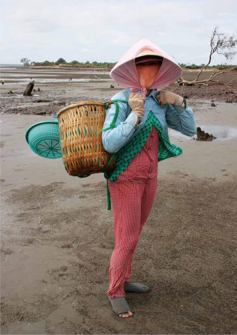
Vietnam Case Study from Field Testing an Operational Framework for Ecosystem based Adaptation | 67

ResultsfromtheCEAconductedforshort-termandlong-termadaptationoptionsshowedveryhighfinancialcostratios for all hard-adaptation measures with the construction of sea dikes in three coastal districts. The EbA for the short-term adaptation option using coastal forest ecosystems alone and for the long-term adaptation option asacombinedadaptationofhardsolution(seadikessystem)andsoftsolution(coastalforestecosystems)provide the lowest cost adaptation option for dealing with climate change risks. In addition to climate change adaptation, mangrove forests also provide many other goods along with ecosystem services that are crucial to the livelihoods of the local communities. EbA approaches requires an integrated management of the local coastal ecosystems so that they continue to provide these important services to local people and support them better adapt to the impacts of the climate change.
5.2.5. Limitations of the cost effectiveness analysis
Due to the lack of available data needed for the economic valuation and the CEA, there are limitations to this study:
•Inthisstudy,theeffectivenessisaquantitativemeasureforfloodprotection.Socialandenvironmentalvalueisnotreflectedintheeffectivenessmeasure;
•Thevalueofecosystemservicesdidnotincludethevalueofmangroveforestforsupportingnearshorefisheries,valueforcoasterosionprotection,andvaluefornutrientregulationandwastetreatment;
•IntheCEAoftheseadikesystem,theindirectbenefitssuchasthebenefitfromprotectingsalineintrusion and value for transportation were also not included due to lack of data for computing these values.
68 | Vietnam Case Study from Field Testing an Operational Framework for Ecosystem based Adaptation

6. FINDING CONCLUSIONS AND RECOMMENDATIONS FOR EBA INTEGRATION INTO POLICY DEVELOPMENT PROCESSParticipatory vulnerability assessment is the key to identify current climate and development pressures onto the communities and ecosystems. In Ben Tre province, the assessment results show that:
1.Improvedextensive/intensiveshrimpfarming(blacktigerprawnandwhite-leggedshrimp)haveamedium-highriskofimpactsfromdevelopmentandclimatechange;
2.Clam(Meretrixlyrata)andbloodcockle(Anadatagranosa)farmingisatmedium–highriskofclimatechange and development hazards. An increase in maximum annual temperature, increased salinity, changes in upstream hydrology and sediment loads, and SLR inundation, will threaten the existence oftheindustry;
3.Estuarycapturefisheriesareatmediumriskofclimatechangeanddevelopment.Thereisanongoinginvestmentincapturedfisheries.Thisincludesthedevelopmentofports,wholesalemarkets,boat shelters and seafood canning facility and industry. This continued, unsustainable, investment anddevelopmenthasthepotentialtooverstretchthefisheries’populationssandcauseacollapseintheindustry;and
4.Vegetableplantations(watermelon,Jicamaandbeans)andhaveamedium-highriskofclimatechange hazards. Watermelon crops are sensitive to an increase in rainfall. However, increased rainfall andtemperaturewillallowothercropstoflourish.Adelayedwetseasonwillalsothreatenthecurrentagricultural crops and cropping cycle.
Themethodsandtoolsusedduringthefield-testinghaveeffectivelyanalyzedbothspatialandnon-spatialdataand information that has been collected from many different sources to generate high quality and visualized results that can be used to inform decision makers on trade-offs that they have to consider when making any decisionsrelatedtoinvestmentsinclimatechangeadaptationoptions.However,somenewtools(e.g.GIS,environmentaleconomics,etc.)arestillcomplicatedordifficultforlocalgovernmentofficialsorthosewhodonot have background in these subjects.
EbAoranyadaptationmeasuresshouldbecoupledwithstrategiestoaddress“adaptationdeficits”bytacklingcurrent non-climate related problems that exacerbate vulnerability. One of the major causes for the decline of mangrove forests in Ben Tre is shrimp farming. Similarly population growth and unsustainable land-use for development activities have served to degrade the ecosystems. For example, the construction of sluice dams topreventsalinityintrusionhasinterferedwithecologicalflowaffectingestuariesandrelatedlivelihoods.
While hard engineering based solutions like sea-dykes are traditionally popular in coastal areas, EbA measures canplayasignificantroleinensuringsustainabilityofcoastalhabitatsthathelppeople.
TheprovincialgovernmentofficialsinDONRE,DARDandDPIareidentifiedastheprimarytargetusersoftheEbA operational framework. 2014 is the right time for implementing the EbA operational framework mainstream intoprovincialsocio-economicdevelopmentplansforthenextplanningcycle(2016-2020)andavisionto2030.The provincial government of Ben Tre was the target user for the draft EbA operational framework while conductingfield-testingactivitiesinBenTre.AsoneofthetwofirstpilotingprovincesoftheNTP-RCCprogram,Ben Tre province has made much advancement in implementing climate change adaptation activities.
Vietnam Case Study from Field Testing an Operational Framework for Ecosystem based Adaptation | 69

In the case of Ben Tre, the province has already produced a Provincial Climate change Action Plan and has conducted many studies and reports on climate change impact assessments. These include climate change impact assessments to the coastal communities and protected areas in 2011 and climate change impact assessment on tourism in Ben Tre province. However, the majority of adaptation solutions are hard/engineering options, which amount to about 90 percent of total investment for adaptation.
Among government agencies, DONRE is assessed as the most relevant in mandate and responsibility for implementation the EbA framework. Currently, DONRE is the focal point of the NTP-RCC program at the provincialleveloractingasprovincialstandingNTP-RCCoffice.Themandateofthisdepartmentistodevelop,coordinate, and implement the provincial climate change action plan. It is recommended that that:
- The EbA operational framework should be integrated into the next climate change action plan of Ben Treprovince;
- The EbA framework should be institutionalized by MONRE and passed to DONRE in different provinces to use a a tool for vulnerability assessment and adaptation planning for climate change actionplanatlocallevel;
-DONREisalsoresponsibleforbiodiversityconservationplan(BCP)development,whereEbAframeworkcanbescaledupandusedtostrengthenclimatechangeconservation;
-EbAframeworkshouldbeintegratedwiththelandusedevelopmentplan,whichisalsounderDONRE;
The provincial SEDP is another suitable policy for EbA framework integration. This policy guides directions forsocialandeconomicdevelopment.ThispolicyisundertheDepartmentofplanningandinvestment(DPI).It is recommended that: EbA framework should be integrated together with the concept of EbA as a part mainstreaming climate change.
AnothertargetuseroftheEbAframeworkistheDepartmentofAgricultureandRuralDevelopment(DARD).Itis recommended that:
EbA framework is used as a tool to assess adaptation options in:
a. Agriculture sector development plans: There is a national climate change action plan for the agriculture sector at the moment and some provinces are in the process of developing provincial level action plan. Ben Tre province, where the EbA framework was piloted is interested in using the EbA framework to develop the climate change action plan for the agriculture sector of Ben Tre province. It is strongly recommendedthattheexternalsupportfromthenationallevelandalsotechnicalandfinancialsupportfromNGOs,institutes,anddonorsworktogetherwiththeprovincefullyimplementtheEbAframework;
b.Forestrydevelopmentplans;
c.Irrigationdevelopmentplans;and
d.Aquacultureandfisheryaquacultureandfisherydevelopmentplans.
This EbA operational framework is an important technical guidance for the province at this time, especially theofficialsoftheenvironmentsub-departmentunderDONREandalsotheagriculturedepartment,whohavealready built their capacities by adaptive learning. In order to use and follow this guideline, however, the EbA frameworkneedstobeinstitutionalizedasanofficialguideline.Additionally,theimplementingagenciesalsoexpecttoreceivemoretechnicalsupportduringtheimplementationoftheframeworkforaspecificsector.In addition to the provincial plans, the mainstreaming of EbA is also necessary at the national level. At the nationallevelfollowingagenciesareidentifiedformainstreamingEbA:
- The national focal points working on climate change action plan development and coordination: the NationalTargetProgramtoResponsetoClimateChange(NTP-RCC)andtheSupportingProgramto
70 | Vietnam Case Study from Field Testing an Operational Framework for Ecosystem based Adaptation

RespondtoClimateChanage(SP-RCC);
- Planners and decision makers at central and local government levels, who are developing and approvingsocio-economicdevelopmentplan(MPI,DPI), land-useplan(MONRE,DONRE),andsectoralplans(e.g.MARD/DARD,MOT/DOT);
- The technical government and non-government institutions and organizations working in technical support for policy planning and climate change adaptation and mitigation in Viet Nam.
Vietnam Case Study from Field Testing an Operational Framework for Ecosystem based Adaptation | 71

Andrade Pérez, A., Herrera Fernandez, B. and Cazzolla Gatti,R. (eds.)2010.BuildingResilience toclimatechange: Ecosystem-based adaptation and lessons from thefield.Gland,Switzerland:IUCN.164pp.(online)URL:http://data.iucn.org/dbtw-wpd/edocs/2010-050.pdf.
Andrade,A;Córdoba,R;Dave,R.;Girot,P;Herrera-F.,B; Munroe, R; Oglethorpe, J; Paaby, P; Pramova,E;Watson,E;Vergar,W.2011.DraftPrinciplesandGuidelines for Integrating Ecosystem-based Approaches to adaptation in Project and Policy Design: a discussion document. IUCN- CEM, CATIE. Turrialba, Costa Rica. (online)URL:http://cmsdata.iucn.org/downloads/draft_guidelines_EbA_final.pdf.
Bentre Department of Statistics, 2011. Statistical data of Ben Tre province in 2011.
Ben Tre DONRE, 2010. Climate change scenarios for BenTreprovince,NTP-RCCstandingofficeofBenTreprovince,
Berkes, F., J. Colding and C. Folke (Eds.), 2003.Navigating Social–Ecological Systems: Building Resilience for Complexity and Change, Cambridge University Press, Cambridge, UK.
Bezuijen MR, Morgan C, Mather RJ. 2011. A Rapid Vulnerability Assessment of Coastal Habitats and Selected Species to Climate Risks in Chanthaburi and Trat(Thailand),KohKongandKampot(Cambodia),and Kien Giang, Ben Tre, Soc Trang and Can Gio (VietNam).Gland,Switzerland:IUCN.Bezuijenetal.2011.(online)URL:http://cmsdata.iucn.org/downloads/rapidassessmentspecies_mark_charlie_robert15_dec2011.pdf.
MONRE, 2012. Climate Change and Sea Level Rise Scenarios for Viet Nam.
CARE International. 2009. Climate Vulnerability and Capacity Handbook. CARE International. (online)URL:http://www.careclimatechange.org/cvca/CARE_CVCAHandbook.pdf.
Carew-Reid, J., Ketelsen, T., Kingsborough, A., and Porter, S. 2011. Climate Change Adaptation and Mitigation(CAM)MethodologyBrief.ICEM–InternationalCentre for Environmental Management. Hanoi, Viet Nam.(online)URL:http://www.icem.com.au/documents/climatechange/cam/CAM%20brief.pdf.
Chapin,III,F.S.,G.P.Kofinas,andC.Folke,editors.2009. Principles of ecosystem stewardship: resilience-based natural resource management in a changing
world. Springer, New York, New York, USA.
Convention on Biological Diversity. 2009. Connecting Biodiversity and climate change Mitigation and adaptation: Report of the Second Ad Hoc Technical Expert Group on Biodiversity and climate change. Montreal, Technical SeriesNo.41,126pages.(online)URL:http://www.cbd.int/doc/publications/cbd-ts-41-en.pdf.
Dodgson, JS, Spackman, M, Pearman, A and Phillips, LD(2009)Multi-criteriaanalysis:amanual.Departmentfor Communities and Local Government: London. ISBN 9781409810230
Doswald, N. and M. Otsi. 2011. Ecosystem-based approaches to adaptation and mitigation - good practice examples and lessons learned in Europe. Bundesamt fur Naturschutz (BfN) - FederalAgency for NatureConservation.Bonn,Germany. (online)URL:http://www.unep-wcmc.org/medialibrary/2012/08/01/397177f9/BfN%20EbAreport.pdf.
EcosystemsandLivelihoodsAdaptationNetwork(ELAN).2012. Integrating community and ecosystem-based approaches in climate change adaptation responses. (online)URL:http://www.careclimatechange.org/files/adaptation/ELAN_IntegratedApproach_150412.pdf.
European Commission, 2009.The EU compendium of spatial planning systems and policies. URL: http://commin.org/upload/Glossaries/European_Glossary/EU_compendium_No_28_of_1997.pdf
Folke, C. 2006. Resilience: The emergence of a perspective for social-ecological systems and analyses. GlobalEnvironmentalChange.16(3):253-267.(online)URL: http://www.sciencedirect.com/science/article/pii/S0959378006000379.
Gallopin, G. 2006. Linkages between vulnerability, resilience and adaptive capacity.Global Environmental Change.16:293-303.(online)URL:http://sustsci.aaas.org/files/GG%20on%20VRA%20linkages.pdf.
GEF(GlobalEnvironmentFacility).OperationalGuidelineson Ecosystem-based Approaches to Adaptation. GEF/LCDF.SCCF.13/Inf.06. 2012. (online) URL: http://www.thegef.org/gef/sites/thegef.org/files/documents/Operational%20Guidelines%20on%20Ecosystem-Based%20Approaches%20to%20Adaptation.pdf.
Gitay, H., A. Suarez, R. Watson. 2002. Climate Change and Biodiversity. IPCC Technical Paper V. (online)URL: http://www.ipcc.ch/pdf/technical-papers/climate-changes-biodiversity-en.pdf
REFERENCES
72 | Vietnam Case Study from Field Testing an Operational Framework for Ecosystem based Adaptation

Hirji,R.andDavis,R.2009.Environmentalflowsinwater resourcespolicy,plansandprojects: findingsand recommendations. The World Bank. Washington, DC.(online)URL:http://siteresources.worldbank.org/INTWAT/Resources/Env_Flows_Water_v1.pdf.
IPCC(IntergovernmentalPanelforClimateChange).2007. Summary for Policymakers. In M.L. Parry,O.F. Canziani, J.P. Palutikof, P.J. van der Linden, and C.E. Hanson, eds. climate change 2007: Impacts,adaptation, and Vulnerability . Contribution of Working Group II to the Fourth Assessment Report of the Intergovernmental Panel on climate change. Cambridge, UK:Cambridge University Press. (online) URL: http://www.ipcc.ch/publications_and_data/publications_ipcc_fourth_assessment_report_wg2_report_impacts_adaptation_and_vulnerability.htm.
IPCC. 2001. Annex B: Glossary of Terms. Climate Change:ThirdAssessmentReport.Synthesis(online)URL: http://www.ipcc.ch/pdf/glossary/tar-ipcc-terms-en.pdf.
ISPONRE and UNEP, 2009. Viet Nam Assessment Report on Climate Change. URL: http://www.unep.org/pdf/dtie/VTN_ASS_REP_CC.pdf
Janssen, M. A. 2007.An update on the scholarly networks on resilience, vulnerability, and adaptation within the human dimensions of global environmental change.EcologyandSociety12(2):9.[online]URL:http://www.ecologyandsociety.org/vol12/iss2/art9/.
Janssen, M.A., Schoon, M.L., Ke, W., and Börner, K. 2006.Scholarly networks on resilience, vulnerability and adaptation within the human dimensions of global environmental change.Global Environmental Change16: 230-252.
Kaphengst Timo, 2012, Assessment of the Potential of Ecosystem-based Approaches to climate change adaptation and Mitigation in Europe.
Lebel,L.,L.Li,C.Krittasudthacheewa,etal.,2012).Mainstreaming climate change adaptation into development planning. Bangkok: Adaptation Knowledge Platform and Stockholm Environment Institute. 32 pp.
Locatelli, B., Kanninen, M., Brockhaus, M., Colfer, C.J.P., Murdiyarso, D. and Santoso, H. 2008 Facing an uncertain future: How forests and people can adapt to climate change.Forest Perspectives no. 5. CIFOR, Bogor, Indonesia. (online)URL:http://www.cifor.org/publications/pdf_files/media/CIFOR_adaptation.pdf.
Longley P.A., M. F. Goodchild, D. J. Maguire and D. W. Rhind. 2005. Geographic Information Systems and Science. Second Edition. John Wiley, Chichester, 2005.
Munroe, R., N. Doswald, D. Roe, H. Reid, A. Giuliani, I. Castelli, and I. Möller. 2011. Does EbA work? A review of the evidence on the effectiveness of ecosystem-based approaches to adaptation.Cambridge,UK. (online)URL: http://www.environmentalevidencejournal.org/content/1/1/13.
Nathalie at el, 2011.Ecosystem-based approaches to adaptation and mitigation – good practice examples and lessons learned in Europe. URL: http://www.bfn.de/fileadmin/MDB/documents/service/Skript_306.pdf
Natural Capital Project, 2013. Integrated Valuation of Environmental Services and Trade-offs. Technical guidance on InVEST tools. Online (http://www.naturalcapitalproject.org)
Naumann, S., G. Anzaldua, P. Berry, S. Burch, M. Davis, A. Frelih-Larsen, H. Gerdes and M. Sanders. 2011. Assessment of the potential of ecosystem-based approaches to climate change adaptation and mitigation in Europe. Final report to the European Commission, DG Environment.Ecologic institute and Environmental Change Institute, Oxford University Centre for the Environment. (online)URL: http://www.eci.ox.ac.uk/publications/downloads/berry2011-finalreport.pdf.
Parry, M., Arnell, N., Berry, P., Dodman, D., Fankhouser, S., Hope, C., Kovats, S., Nicholls, R., Satterthwaite, D., Tiffin,R.,Wheeler,Tim.2009.AssessingtheCostsofAdaptation to Climate Change: A Review of the UNFCCC and Other Recent Estimates. International Institute for Environment and Development and Grantham Institute forClimateChange,London.(online)URL:http://pubs.iied.org/pdfs/11501IIED.pdf.
Peterson, G. 2010.Expansion of social ecological systems science.Reslilence Science: 16 April 2010.
Piran, C. L., White, J., Godbold, A., Solan, M., Wiegand, J., Holt, A. 2009. Ecosystem services and policy: a review of coastal wetland ecosystem services and anefficiency-basedframeworkfor implementingtheecosystem approach. Issues in Environmental Science and Technology.
Preston,B.L.andStafford-Smith,M.(2009).Framingvulnerability and adaptive capacity assessment: Discussion paper. CSIRO Climate Adaptation Flagship WorkingpaperNo.2.(online)URL:http://www.csiro.au/files/files/ppgt.pdf.
Phung N. K., 2010. Building action plan to respond to climate change in Ben Tre province, Project report.
Stokols, D., R. Perez Lejano, and J. Hipp. 2013. Enhancing the resilience of human–environment systems: a social–ecological perspective. Ecology and Society18(1):7.(online)URL:http://dx.doi.org/10.5751/
Vietnam Case Study from Field Testing an Operational Framework for Ecosystem based Adaptation | 73
ES-05301-180107.
TheWorldBank.2010(b).Economicsofadaptationtoclimate change: Synthesis Report. The World Bank, WashingtonD.C. (online)URL: http://siteresources.wor ldbank .o rg /EXTCC/Resources /EACC_FinalSynthesisReport0803_2010.pdf.
UNDP(UnitedNationsDevelopmentProgram).2010.Toolkit for Designing climate change adaptation Initiatives. (online) URL: http://ncsp.undp.org/sites/default/files/UNDP%20adaptation%20Toolkit%202010.pdf.
UNDP-UNEP, 2011.Mainstreaming climate change adaptation into Development Planning: A Guide for Practitioners. (online)URL:http://www.unep.org/pdf/mainstreaming-cc-adaptation-web.pdf.
UNEP(UnitedNationalEnvironmentProgramme).2009.The role of ecosystem management in climate change adaptation and disaster risk reduction. UNEP issues paper prepared for the Global Platform for disaster risk reduction.(online)URL:http://www.proactnetwork.org/proactwebsite/media/download/resources/Ecosystem-based-DRR/UNEP_Issues%20Paper_Ecosystem%20management%20in%20CCA%20and%20DRR_2009.pdf.
UNEP, 2011. Taking Steps Toward Marine and Coastal Ecosystem-Based Management – An Introductory Guide. (online)URL: http://www.preventionweb.net/english/professional/publications/v.php?id=20344.
UNEP, UNDP, IUCN. EbA. Flagship Policy Brief. Making the case for ecosystem-based adaptation: Building resilience to climate change. (online) URL: http://EbAflagship.org/images/ContentsForPublications/EbA%20policy%20brochure%20web.pdf.
UNEP, 2012 Ecosystem-based adaptation Guidance: Moving from principles to practice. Working Document. Unpublished.(April2012)
UNFCCC(UnitedNationsFrameworkConventiononClimateChange).2011.Ecosystem-basedapproachesto adaptation: compilation of information. Note by theSecretariattoSubsidiaryBodyforScientificandTechnologicalAdvice,Thirty-fifthsession,Durban,28November to 3 December 2011. Item 3 of the provisional agenda Nairobi work programme on impacts, vulnerability andadaptationtoclimatechange.(online)URL:http://unfccc.int/resource/docs/2011/sbsta/eng/inf08.pdf.
van de Sluijs J.P., et al, 2004. RIVM/MNP Guidance for Uncertainty Assessment and Communication: Tool Catalogue for Uncertainty Assessment. Report nr: NWS-E-2004-37. Netherlands Environmental Assessment Agency.
Viet Nam Central Communist Party Resolution 24/NQ-TW, 2013. Pro-active to respond to climate change, strengthen natural resources management and environmental protection.
Villanueva, P. 2011. Learning to ADAPT: monitoring and evaluating approaches in climate change adaptation and disaster risk reduction – challenges, gaps and waysforward.StrengtheningClimateResilience(SCR).(online) URL: http://community.eldis.org/.59d5ba58/SCR-Discussion-paper9.pdf.
WWF, 2009. The Greater Mekong and Climate Change: Biodiversity, Ecosystem Services and Development Risk. (online)URL:http://awsassets.panda.org/downloads/final_cc_reportlowres_3.pdf.
WWF, 2012. Rapid vulnerability assessement and Adaptation options for Ben Tre province. Project report
WWF, 2013. Ecosystem-based Adaptation to Climate change in Ben Tre province, Viet Nam. Project completion report.
WWF,2013.Fieldsurveydata(unpublished)
74 | Vietnam Case Study from Field Testing an Operational Framework for Ecosystem based Adaptation

Vietnam Case Study from Field Testing an Operational Framework for Ecosystem based Adaptation | 75

©W
WF-
Viet
Nam