stratigraphic architecture of solander basin records
TRANSCRIPT

Basin Research 2020001ndash24 | 1
EAGE
wileyonlinelibrarycomjournalbre
Received 28 January 2020 | Revised 22 April 2020 | Accepted 29 April 2020
DOI 101111bre12473
O R I G I N A L A R T I C L E
Stratigraphic architecture of Solander Basin records Southern Ocean currents and subduction initiation beneath southwest New Zealand
Jiten Patel1 | Rupert Sutherland1 | Michael Gurnis2 | Harm Van Avendonk3 | Sean P S Gulick34 | Brandon Shuck34 | Joann Stock2 | Erin Hightower2
copy 2020 The Authors Basin Research copy 2020 John Wiley amp Sons Ltd European Association of Geoscientists amp Engineers and International Association of Sedimentologists
The peer review history for this article is available at httpspublo nscompublo n101111bre12473
1SGEES Victoria University of Wellington Wellington New Zealand2Seismological Laboratory California Institute of Technology Pasadena CA USA3Jackson School of Geosciences University of Texas Institute for Geophysics Austin TX USA4Department of Geological Sciences Jackson School of Geosciences University of Texas at Austin Austin TX USA
CorrespondenceRupert Sutherland SGEES Victoria University of Wellington PO Box 600 Wellington 6140 New ZealandEmail rupertsutherlandvuwacnz
Funding informationNational Science Foundation USA GrantAward Number NSF-OCE-1654689 and NSF-OCE-1654766
AbstractSolander Basin is characterized by subduction initiation at the Pacific-Australia plate boundary where high biological productivity is found at the northern edge of the Antarctic Circumpolar Current Sedimentary architecture results from tectonic in-fluences on accommodation space sediment supply and ocean currents (via physi-ography) and climate influence on ocean currents and biological productivity We present the first seismic-stratigraphic analysis of Solander Basin based on high-fold seismic-reflection data (voyage MGL1803 SISIE) Solander Trough physiography formed by Eocene rifting but basinal strata are mostly younger than ca 17 Ma when we infer Puysegur Ridge formed and sheltered Solander Basin from bottom currents and mountain growth onshore increased sediment supply Initial inversion on the Tauru Fault started at ca 15 Ma but reverse faulting from 12 to ca 8 Ma on both the Tauru and Parara Faults was likely associated with reorganization and formation of the subduction thrust The new seabed topography forced sediment pathways to be-come channelized at low points or antecedent gorges Since 5 Ma southern Puysegur Ridge and Fiordland mountains spread out towards the east and Solander Anticline grew in response to ongoing subduction and growth of a slab Solander Basin had high sedimentation rates because (1) it is sheltered from bottom currents by Puysegur Ridge and (2) it has a mountainous land area that supplies sediment to its northern end Sedimentary architecture is asymmetric due to the Subtropical Front which moves pelagic and hemi-pelagic sediment including dilute parts of gravity flows eastward and accretes contourites to the shelf south of Stewart Island Levees scours drifts and ridges of folded sediment characterize western Solander Basin whereas hemi-pelagic drape and secondary gravity flows are found east of the meandering axial Solander Channel The high-resolution record of climate and tectonics that Solander Basin contains may yield excellent sites for future scientific ocean drilling
K E Y W O R D S
Antarctic Circumpolar Current Fiordland Puysegur subduction-related basins Subtropical Front tectonics and sedimentation
2 | EAGE
PATEL ET AL
1 | INTRODUCTION
The architecture of sedimentary basins results from an interplay between plate dynamic and climate processes Despite Solander Trough lying in a key region for un-derstanding global tectonic and climate processes previ-ous studies had mainly explored with seismic-reflection methods at its northern margin near the southern coast of New Zealand (Figure 1) Solander Trough lies adjacent to the Puysegur section of the active Pacific-Australia plate boundary which is unique in being close to a transi-tion from induced to self-sustaining subduction initiation (Gurnis Hall amp Lavier 2004) Solander Trough is swept by the largest oceanic current system the northern edge of the Antarctic Circumpolar Current (ACC) which affects pelagic and hemi-pelagic sedimentation and the architec-ture of sediment gravity flow deposits In this paper we present a stratigraphic framework developed from the first regional high-fold seismic-reflection and swathndashbathym-etry survey of Solander Trough (South Island Subduction Initiation Experiment SISIE) (Gurnis et al 2019) We use it to describe how tectonics and climate have influenced basin architecture and how sedimentary records from the region might provide new insights into tectonic mecha-nisms and climate history
The ACC is driven by strong westerly winds and sinking of cold saline bottom water formed at the Antarctic margin (Nowlin amp Klinck 1986 Rintoul Hughes amp Olbers 2001) The current likely initiated at the start of the Oligocene in response to opening of the Tasmanian deep ocean gateway (Carter McCave amp Carter 2004 Kennett 1977) though opening of Drake Passage adjacent to the Antarctic Peninsula may also have played some role in its development (Barker Filippelli Florindo Martin amp Scher 2007) The strong cur-rent system reworks abyssal bathyal and shelf sediment east-ward and northward over vast (gt1000 km) distances south and east of New Zealand (Figure 1) (Carter Carter McCave amp Gamble 1996) The Subtropical Front (STF) immediately southeast of New Zealand represents a water mass boundary between ACC water derived from high latitude with water pushed southward around the land area of New Zealand and the location and amount of mixing vary between glacial and interglacial cycles (Bostock Hayward Neil Sabaa amp Scott 2015 Carter McCave amp Williams 2008 Chiswell Bostock Sutton amp Williams 2015 McCave Carter amp Hall 2008) Solander Basin records the history of this ocean current variability
The Australian plate is obliquely converging with the Pacific plate at 36 mmyr at Puysegur Trench (MORVEL Figure 1) (DeMets et al 2010) A Wadati-Benioff zone of earthquake hypocentres to ca 200-km depth is recog-nized beneath Fiordland (Figure 1) (Eberhart-Phillips amp Reyners 2001) and the first subduction-related volcano
is exposed on Solander Island where volcanic rocks yield Quaternary ages (Mortimer et al 2013) Puysegur trench reaches maximum depths of ca 6300 m whereas Puysegur Ridge varies in depth from lt150 m deep at its southern end to a maximum of ca 2000 m in the Snares Zone where flat-topped erosional morphology suggests geologically recent subsidence from wave-base conditions (Collot et al 1995) An axial valley along Puysegur Ridge is inferred to be the location of a major active strikendashslip plate-boundary fault (Collot et al 1995) Solander Trough lies east of Puysegur Ridge and contains a record of deformation and topography associated with plate boundary development (Figure 1)
Solander Basin sedimentary architecture results from tec-tonic influence on accommodation space and ocean current systems (via physiography) and climate influence on ACC variability and biological productivity Solander Basin has anomalously high sedimentation rates compared to immedi-ately surrounding areas because (1) it is sheltered from strong bottom currents by Puysegur Ridge and (2) it has a tecton-ically active mountainous land area that supplies sediment at its northern end We describe and map the stratigraphic architecture of Solander Basin because it is of intrinsic in-terest for sedimentary basin processes and climate history and because it forms part of a broader coordinated effort to understand the structure and history of the nascent Puysegur subduction system
2 | REGIONAL SETTING
Solander Trough is a bathymetric low and sedimentary depocentre south of Fiordland southwest New Zealand
Highlightsbull Basin architecture results from combined effects of
subduction initiation nearby continental collision and development of the Antarctic Circumpolar Current
bull Growth of Puysegur Ridge increase in sediment supply and Tauru Fault inversion starting at ca 17 Ma caused sediment accumulation in southern Solander Trough
bull Reverse faulting at 12 to 8 Ma was associated with a time of high stress probably associated with subduction thrust propagation and channelized sediment pathways
bull Reverse faulting and widening of southern Puysegur Ridge and Fiordland mountains at 5 to 0 Ma was associated with increased subduction maturity and sediment supply
| 3EAGE
PATEL ET AL
(Figure 1) It is bound to the west by Puysegur Ridge and to the east by Campbell Plateau Solander Trough gently slopes to the south and merges with relatively flat abyssal seafloor of Emerald Basin (Carter amp McCave 1997) which is south of the surveyed area
The ACC consists of a number of circumpolar fronts which correspond to water mass boundaries as well as deep-reach-ing jets of eastward flow (Orsi Whitworth amp Nowlin 1995) Southern Ocean waters in the study area include subtropical and subantarctic waters The Subantarctic Front is a north-ern jet of the ACC that is deflected by Macquarie Ridge and Campbell Plateau (Carter amp McCave 1997 Schuur et al 1998) Farther north elevated chlorophyll-a concen-trations from photosynthesis in phytoplankton are observed along the STF which occur due to mixing of relatively warm saline macronutrient-deficient micronutrient-rich subtrop-ical water with cool less-saline macronutrient-rich micro-nutrient-poor subantarctic water (Deacon 1982 Lorrey et al 2012 Smith Vennell Bostock amp Williams 2013) This leads to high biological productivity around northern Solander Trough (Hassler et al 2014 Jitts 1965)
Solander Channel is the primary pathway for sediment gravity flows that descend along the axis of Solander Trough (Figures 1 and 2) It extends from the Stewart Island continen-tal shelf to beyond the study area where it merges into rela-tively flat floor of Emerald Basin south of Auckland Island (Schuur et al 1998) Bathymetry data acquired during voy-age MGL1803 (Gurnis et al 2019) reveal that the channel is up to 220 m deeper than adjacent levees Northern Solander Trough sediment is mainly composed of sand and mud but carbonate content reaches 40ndash60 in southern parts of Solander Trough (Bostock et al 2019) Solander Channel was most active during glacial low-stand conditions when sediment was supplied to the shelf edge and is inferred to have been inactive during the Holocene (Bostock et al 2015 Carter et al 1996 Jeromson 2016) There is little sediment in Solander Trough at latitudes south of Auckland Island (transition with Emerald Basin Figure 1) due to strong cur-rents of the Subantarctic Front which penetrates Macquarie Ridge at ca 535degS (Figure 1) (Bostock et al 2019 Carter amp McCave 1997) Southeast Tasman Ocean Crust which lies west of Puysegur Trench has only a thin veneer of sediment
F I G U R E 1 Location of Solander Trough Puysegur Ridge major faults (red lines) and survey MGL1803 (black bold lines) in southern New Zealand Abbreviations RR Resolution Ridge BB Balleny Sub-basin HF Hauroko Fault SF Solander Fault PaF Parara Fault SI Solander Island TF Tauru Fault EB Eastern Boundary Fault WB Western Boundary Fault SZ Snares Zone The relative plate motion vector is the MORVEL model (DeMets Gordon amp Argus 2010) Coloured dots are petroleum boreholes (yellow) and DSDP boreholes (green) Grey lines are previously acquired seismic data from petroleum exploration focused on shallow water sedimentary sequences The dashed line is Solander Channel the main gravity flow conduit from South Island to southern Solander Trough
4 | EAGE
PATEL ET AL
(Lamarche et al 1997 Wood Lamarche Herzer Delteil amp Davy 1996) due to strong erosive ACC bottom currents and proximity to the Carbonate Compensation Depth
Sedimentary basins at the northern end of Solander Trough have previously been mapped using petroleum in-dustry seismic-reflection data and two wells Parara-1 was drilled in 1975ndash1976 (Hunt International Petroleum Company 1976) and Solander-1 was drilled in 1985 (Engmann amp Fenton 1986) From west to east the Balleny Waitutu and Hautere sub-basins are bound at their western margins by Puysegur Bank the Hauroko Fault and Solander Anticline respectively (Turnbull amp Uruski 1993) These structural highs at the northern end of Solander Basin were created by Neogene reverse faulting and folding but there is clear stratigraphic evidence for reactivation of EocenendashOligocene orand Cretaceous normal faults (Sutherland Barnes amp Uruski 2006)
Solander Basin differs from other New Zealand sedi-mentary basins in that its southern plate boundary location meant it was subjected to high degrees of Eocene rifting before Oligocene and Neogene strikendashslip movement dis-placed and subducted the rifted crust to create the Puysegur subduction zone and Alpine Fault (Sutherland Davey amp Beavan 2000) The middle Eocene to lower Oligocene stratigraphy of Solander Basin is assigned to the high-level Haerenga Supergroup of the Zealandia Megasequence (Mortimer et al 2014) which is characterized by passive subsidence and transgression elsewhere in New Zealand but
is associated with normal faulting and active accommodation space creation in Solander Basin
Puysegur Bank is actively uplifting and being eroded during sea-level low-stand conditions but the southwestern end of the bank has deformed erosion surfaces that attest to a history of past uplift and relatively recent subsidence (Sutherland et al 2006) The deepest erosion surfaces are found in the Snares Zone (Figure 1) where they are as deep as 2000 m below sea level (Collot et al 1995 Lamarche amp Lebrun 2000) Farther south Puysegur Ridge has an eroded crest that is at ca 125-m depth at its southern end consistent with sea-level low-stand erosion at 20 ka but erosion sur-faces have subsided at the northern end of Puysegur Ridge where they are ca 625 m deep (Collot et al 1995)
Fiordland is composed of plutonic and meta-plu-tonic rocks with lesser amounts of metasedimentary rocks and deformed Cenozoic sedimentary basins along its eastern and southern margins (Turnbull Allibone amp Jongens 2010) Onshore Cenozoic basins adjacent to Fiordland attest to a history of EocenendashOligocene trans-ten-sion followed by a complex history of strikendashslip motion and Neogene basin inversion associated with a coarsen-ing-upward transition from marine mudstone to turbidites to marine and terrestrial conglomerates (Norris Carter amp Turnbull 1978 Norris amp Turnbull 1993 Turnbull amp Uruski 1993) In some places Cenozoic basins are su-perimposed on Cretaceous basins that record rifting from Gondwana and subsequent subsidence (Norris et al 1978
F I G U R E 2 Compilation map of bathymetric data from the South Tasman Sea Solander Trough region (a) (httpsniwaconzour-scien ceocean sbathy metry) with zooms (colour shows new MGL1803 swath data) of the northern (Snares) region (b) and southern (Puysegur Ridge) region (c) Note abyssal hill morphology of South Tasman Sea oceanic crust allows original spreading direction to be determined (shown with double-headed arrow) and confirms that pelagic sediment cover is thin and limited to interstitial valleys This is in contrast to the smooth seabed of Solander Trough which has channel features levees and faulted ridges
(a)
(b)
(c)
(b)
(c)
| 5EAGE
PATEL ET AL
Norris amp Turnbull 1993 Turnbull amp Uruski 1993) The elevated topography of Fiordland mountains (many peaks 1000ndash2000 m above sea level) and hence exhumation and relevance as a sediment source is related to dynamic forces associated with subduction initiation (House Gurnis Kamp amp Sutherland 2002) Themochronology data from Fiordland reveal that exhumation started locally in the southwest corner of Fiordland at ca 25ndash15 Ma the zone of exhumation spread northward up the western margin of Fiordland during the interval 15ndash5 Ma and then the zone of exhumation broadened eastward since 5 Ma (Klepeis et al 2019 Sutherland Gurnis Kamp amp House 2009)
Subduction-related volcanism is represented by Solander Island and Little Solander Island (Figure 1) which are extinct adakitic (Reay amp Parkinson 1997) volcanic remnants of a larger edifice (Mortimer et al 2013) Adakitic chemistry is classically interpreted as melting of a young subducted slab (eg as found at Adak Island in the Aleutian arc) and is also associated with highly oblique subduction and both factors are present in our case where young (lt40 Ma) Southeast Tasman Ocean Crust is being obliquely subducted (Lamarche et al 1997) but a range of other explanations might also exist that might shed new light on how the mantle wedge is metasomatized during subduction initiation (Castillo 2012) Mortimer et al (2013) determined the age of volcanism at Solander Island to be 350ndash100 ka and at Little Solander Island to be 50ndash20 ka Additional small volcanic features are evident in bathymetric maps and on seismic-reflection data farther west at the southern tip of Neogene Hauroko Fault activity but these features remain unsampled (Lamarche amp Lebrun 2000 Sutherland et al 2006)
3 | DATA
Petroleum exploration data from the northern end of Solander Trough were acquired in the 1970s and 1980s and are now publicly available under New Zealands open-file system (the ldquoExploration Databaserdquo at nzpamgovtnz) The Parara-1 well is near the southern extent of this dataset and is our most useful stratigraphic tie (Hunt International Petroleum Company 1976)
A single seismic line that crosses the region was acquired with an 8495-in3 (139 L) air-gun source array just south of Stewart Island in 1996 using RV Maurice Ewing (voyage EW9601) (Melhuish Sutherland Davey amp Lamarche 1999 Sutherland amp Melhuish 2000) We edited and reprocessed original field data for our work (Table 1)
The South Island Subduction Initiation Experiment (SISIE) involved acquisition of new swathndashbathymetry data (Figure 2) and 2D seismic reflection and refraction data including ocean-bottom seismometer observations during RV Marcus Langseth voyage MGL1803 in 2018 (Gurnis
et al 2019) Seismic reflection data were acquired with a 6600-in3 (108 L) source array and streamer that varied in length between 4 and 126 km Shot spacing was 50 m and streamer depth was between 10 and 18 m depending on swell conditions Our seismic processing workflow consisted of trace editing filtering velocity analysis radon multiple suppression and post-stack fndashk migration (Table 1) The re-sulting post-stack time images in combination with a seis-mic-well tie age model allow us to regionally interpret the stratigraphic evolution of Solander Trough
4 | SEISMIC STRATIGRAPHY
A seismic stratigraphy is developed based on subdivision into genetically related units inferred from internal seismic-reflection character stratal stacking pattern and termination relationships at bounding reflectors We do not assume that sequence or megasequence boundaries are directly linked to sea-level variations (Vail Mitchum amp Thompson 1977) but more simply that sequence definition is allostratigraphic in nature and reflects a variable combination of sediment sup-ply climate and tectonics and this is appropriate because most of the region we map is in a bathyal slope environment far from a shallow shelf (Catuneanu et al 2009)
Our primary tie for sequence and megasequence bound-aries is the Parara-1 well which penetrates a thick sequence of Neogene marine mudstone and sandstone a condensed sequence of Palaeogene upward-fining coaly sandstone mud-stone and limestone and a basal sandy conglomerate that is undated but could be of Cretaceous or Palaeogene age (Hunt International Petroleum Company 1976) (details in section 5)
Sedimentary and structural barriers affect continuity of mapping and hence correlations based on stratigraphic po-sition and seismic-reflection character are required to make regional interpretations In most cases this is straightfor-ward but the Tauru Fault is a major structure south of the Parara-1 borehole that introduces significant uncertainty
T A B L E 1 Seismic reflection processing sequence
Determine survey geometry and write headers
Trace edit
5ndash85 Hz Butterworth filter
Resample from 2 to 4 ms
Deconvolution (75 amp 24 ms gap 450 ms operator)
CDP sort (nominal 200-fold)
Velocity model manual picking (25-km spacing)
Radon demultiple
Stack (40-fold 4 km str 126-fold 126 km str)
FK migration (and scaled amplitude)
6 | EAGE
PATEL ET AL
in correlation due to large footwall accommodation space that was created during Neogene reverse fault activity that created Tauru High (Sutherland amp Melhuish 2000) Therefore we define separate stratigraphic units in sub-ba-sins north and south of the Tauru Fault and then discuss our preferred correlation We use nomenclature that makes this clear for example SLN3-2 refers to a unit in northern Solander sub-basin megasequence 3 sequence 2 We use prefix SLS for units south of the Tauru Fault We abbrevi-ate survey name MGL1803 to M18 (in line with convention used for S86)
41 | Seismic units north of Tauru Fault (SLN)
411 | SLN1-1 (Eocenendashlower Oligocene)
Internal reflections have low-continuity high-to-moderate amplitude and fan outwards towards the Tauru Fault and Parara Fault (Figure 3) The basal surface has variable am-plitude moderate or low continuity and local onlap The inferred dips of the Tauru Fault and Parara Fault in combina-tion with thickness variation and onlap imply normal fault-ing was occurring during deposition of SLN1-1
412 | SLN2-1 (Oligocenendashlower Miocene)
Internal reflections are parallel have moderate-to-low am-plitude and high continuity SLN2-1 thins toward the Tauru Fault and is absent from ca CDP 4000ndash12400 on line M18-17c (Figure 3) On line S86-34 (Figure 3) SLN2-1 thickens westward of the Parara Anticline in contrast to underlying SLN1-1 which is condensed and slightly thickens in the op-posite direction (Figure 3a ca CDP 0ndash3500 Figure 3b ca CDP 0ndash750)
SLN2-1 strata onlap basement north of Tauru High and on the southern limb of Parara Anticline (Figure 3) On the northern flank of Tauru High strata onlap a high-continu-ity high-amplitude positive-polarity reflector at the top of SLN1-1 Further onlap of SLN2-1 onto this reflector occurs north of Parara Anticline at ca CDP 14400 (line M18-17c Figure 3) However this reflector downlaps basement on the southern limb of the anticline where a relatively pla-nar surface from CDP 10000ndash12500 implies erosion of strata down to basement possibly due to uplift of the foot-wall of the fault during its extensional phase (Sutherland et al 2006) SLN2-1 strata onlap this basal reflector west of Parara Anticline and downlap it east of Parara Anticline (line S86-34 Figure 3) On line S86-34 the basal reflector is mapped as a high-continuity high-amplitude reflector
The relatively uniform thickness of megasequence SLN2 across Parara Anticline suggests the Parara Fault was not active during deposition
Onlap and downlap of SLN2-1 strata onto the basal re-flector and significant thickening towards Solander Anticline suggest accommodation space was being created by move-ment on the Solander Fault (we assume the anticline results from fault movement at depth) or another fault farther west during deposition of SLN2-1 or that accommodation space created earlier remained under-filled
413 | SLN2-2 (middle Miocene)
Internal reflections have moderate-to-low amplitude vari-able continuity and are parallel to each other but locally folded (Figure 3) On the northern flank of Tauru High (line M18-17c Figure 3) SLN2-2 onlaps a continuous high-amplitude reverse-polarity reflector SLN2-2 strata onlap this basal reflector west of Parara Anticline (line S86-34 Figure 3) and are conformable to the east On line M18-17c north of ca CDP 4200 SLN2-2 strata onlap basement Similar to SLN2-1 SLN2-2 thickens north of Tauru High and Parara Anticline which suggests an in-crease in sediment flux from the north during accumulation of megasequence SLN2 and initial inversion of the Tauru Fault
414 | SLN3-1 (middle to upper Miocene)
Internal reflections have moderate-to-high amplitude and low-to-moderate continuity between Tauru High and Parara Anticline A palaeochannel that originates at the base of the sequence is identified at ca CDP 5500 on line M18-17c (Figure 3) based on stratal truncations and local differences in amplitude North of this palaeochannel strata are continu-ous and parallel SLN3-1 is a relatively thin unit on line M18-17c though thickening occurs adjacent to Tauru High (CDP 1350ndash3800 Figure 3a) Thickness variations are evident at Parara-1 though interpretation is complicated by the sig-nificant palaeochannel at CDP ca 12000 on line M18-17c (Figure 3a) On line S86-34 strata are more continuous and parallel and downlap or onlap the basal surface SLN3-1 strata onlap the northern flank of Tauru High and a basement high at CDP 8400 line M18-17c (Figure 3a) The basal surface of SLN3-1 marks the onset of channel systems north of Tauru High (ca CDP 4700ndash7000 Figure 3) and adjacent to Parara Anticline We interpret the SLN3-1 thickness variations and localization of deposition into a channel system as recording the growth of seafloor topography caused by folding and re-verse faulting that guided sediment transport pathways
| 7EAGE
PATEL ET AL
415 | SLN3-2 (upper Miocenendash lower Pliocene)
Internal reflections have low-to-moderate amplitude and high continuity Slight thickening north (line M18-17c Figure 3) and
west (line S86-34 Figure 3) of Parara Anticline is observed The basal boundary with SLN3-1 becomes indistinct in palaeo-channels (Figure 3) Onlap onto a high-amplitude basal surface leads to assignment as a sequence boundary We assign this unit to megasequence SLN3 because thickness variations adjacent
F I G U R E 3 Seismic reflection profiles through the Parara-1 site northern sub-basin with seismic-stratigraphic sequences identified (coloured lines) Bold dashed lines show base of channel axis facies VE is vertical exaggeration See Figure 1 for location
8 | EAGE
PATEL ET AL
to Parara-1 have architecture similar to SLN3-1 Anticline growth may have continued during deposition of SLN3-2 but it is plausible (likely) that fault movement ceased during depo-sition of SLN3-1 leaving relict topography that influenced the facies and architecture of unit SLN3-2
416 | SLN4-1 (Pliocene)
Internal reflections have variable amplitude and high continu-ity The unit thickens north of Tauru High and south of Parara Anticline (line M18-17c Figure 3) and it pinches out west of Parara Anticline on line S86-34 (Figure 3) On line M18-17c a palaeochannel feature is identified at CDP 11500 (approx 15 s TWT Figure 3a) and similar high-amplitude reflections at CDP 1500 (125 s TWT) on line S86-34 may be part of the same channel system (Figure 3b) An active channel visible in seafloor morphology is inferred to be the modern depo-sitional analogue East of Solander Anticline (line S86-34) SLN4-1 strata onlap a low-continuity moderate-to-low am-plitude reflector We infer that folding at Solander Anticline caused tilting and onlap during deposition of SLN4-1 and hence deposition became localized into a channel whereas condensed pelagic or hemi-pelagic deposition occurred near the crest of Solander Anticline
417 | SLN4-2 (PliocenendashPleistocene)
SLN4-2 deposits underlying the modern continental slope between the southern end of line M18-17c and Parara-1 are of variable amplitude and high continuity By comparison below the modern continental shelf reflectors have moderate amplitude and low-to-moderate continuity The unit is trun-cated by a modern channel at CDP 1700ndash1920 on line S86-34 (Figure 3b) and is truncated by a modern channel at CDP 2500 on line M18-17c (Figure 3a) These are main tributar-ies of Solander Channel which can be traced gt300 km south-ward using our dataset (Figures 1 and 2) SLN4-2 is thickest to the north and east of Parara Anticline and it thins south-ward towards Tauru High and westward toward Solander Anticline (Figure 3) Minor onlap occurs onto the basal sur-face which can be mapped regionally
418 | SLN4-3 (Pleistocene)
SLN4-3 is differentiated from underlying SLN4-2 on the basis of higher continuity and lower amplitude reflectors It contains channels and levees that include active features evident in seafloor morphology Continental slope deposits of SLN4-2 are imaged as continuous low-amplitude paral-lel reflectors that transition into moderate-amplitude stacked
clinoforms beneath the continental shelf (north of CDP 12500 in Figure 3a east of CDP 800 in Figure 3b) SLN4-3 thins to the south and west
42 | Seismic units south of Tauru Fault (SLS)
421 | SLS1-1 (middle Eocenemdashlower Oligocene)
Internal reflections have low amplitude low-to-moderate continuity are locally folded on line M18-17b at ca CDP 8000 and onlap basement south of Tauru High (Figure 4) The top of SLS1-1 immediately south of Tauru High is an unconformity with downlap of overlying reflectors which have higher amplitude and continuity (M18-17b Figure 4) The intersection of line M18-17b and M18-01 occurs on a basement high with minimal sedimentary cover so the top of SLS1-1 farther south is based on continuity and thickness of younger units and the character of reflections in SLS1-1 low-to-moderate amplitude and moderate continuity
Farther south on line M18-23ab SLS1-1 comprises moderate-to-high amplitude reflections with high continuity Correlation and mapping between lines M18-01 M18-23ab and M18-14 (Figure 5) was on the basis of seismic-reflection character despite basement topography (ca CDP 28800ndash34000 on line M18-23ab and ca CDP 4200ndash6500 on line M18-14) SLS1-1 is variable in thickness and thickens locally in depressions (eg CDP 35500 line M18-23ab and ca CDP 7800 line M18-14)
The reflector at the base of SLS1-1 (seismic basement) has low continuity moderate amplitude and positive polarity Basement is poorly imaged within Tauru High (M18-17b ca CDP 9500ndash11500 Figure 4) though it is distinguished from overlying strata on the basis of internal reflection characteris-tics SLS1-1 onlaps basement on all southern lines
422 | SLS2-1 (Oligocenemdashmiddle Miocene)
Internal reflections have low-to-moderate amplitude and low-to-moderate continuity on line M18-17b (Figure 4a) The base of the unit is uncertain on line M18-01 (Figure 4b) due to correlation uncertainty with line M18-17b but re-flections on M18-01 have high continuity and low-to-mod-erate amplitude SLS2-1 can be mapped southward along line M18-23ab where reflections have moderate-to-high continuity and low-to-moderate amplitude SLS2-1 can be mapped west onto line M18-14 (Figure 5) where reflec-tions are continuous and have low-to-moderate amplitude and the sequence is folded on the eastern flank of Puysegur Ridge from ca CDP 11000ndash13750 (Figure 5b) SLS2-1 is
| 9EAGE
PATEL ET AL
thickest immediately south of Tauru High (Figure 4) and thins towards basement topography Onlap occurs onto volcanic or basement highs on lines M18-23ab and M18-14 (Figure 5) SLS2-1 downlaps its basal surface just south of Tauru High (Figure 4) suggesting sediment supply from the north
423 | SLS2-2 (middle to upper Miocene)
Internal reflections have low-to-moderate amplitude and high continuity SLS2-2 downlaps onto a continuous high-amplitude reverse-polarity basal reflector adjacent to Tauru High (ca CDP 9000 line M18-17b Figure 4a) Onlap onto
F I G U R E 4 Seismic reflection profiles in the northern part of the southern sub-basin (south of Tauru High) with seismic-stratigraphic sequences identified (coloured lines) Bold dashed lines show base of channel axis facies VE is vertical exaggeration See Figure 1 for location
10 | EAGE
PATEL ET AL
basement is observed on all lines The basal surface is as-signed sequence boundary status because overlying strata are conformable everywhere except for local downlap on line M18-17b near Tauru High
424 | SLS2-3 (upper Miocene)
Internal reflections have low-to-moderate amplitude and high continuity SLS2-3 is relatively thin on lines M18-17b
F I G U R E 5 Seismic reflection profiles in the southern part of the southern sub-basin with seismic-stratigraphic sequences identified (coloured lines) Bold dashed lines show base of channel axis facies VE is vertical exaggeration See Figure 1 for location
| 11EAGE
PATEL ET AL
and M18-01 (Figure 4) but thickens southward on line M18-23ab It thickens towards Puysegur Ridge on line M18-14 The basal surface is mostly conformable with underlying units but onlap is observed at ca CDP 9500 on line M18-17b on line M18-01 (Figure 4) and at ca CDP 15000 on line M18-23ab (Figure 5) SLS2-3 onlaps basement to the south of Tauru High on line M18-17b and to the west of the basin on line M18-01 and on line M18-23ab (CDP 4600ndash9300) The basal surface is picked on the basis of high conti-nuity and differences in stacking patterns within units above (SLS2-4) and below (SLS2-2)
425 | SLS2-4 (upper MiocenemdashPliocene)
Internal reflections have low-to-moderate amplitude and high continuity but local channels are interpreted from am-plitude and termination relationships (Figure 4) SLS2-4 is thickest on the east of line M18-01 and gently thins south-ward along the axis of Solander Trough (line M18-23ab) and eastward onto Puysegur Ridge SLS2-4 reflectors are mostly conformable with the basal reflector which is continuous and has moderate-to-high amplitude Minor onlap occurs on line M18-01 (CDP 37500 Figure 4) and east of Puysegur Ridge (line M18-14 CDP 11500 Figure 5b) and basement onlap is clear in the south (Figures 4 and 5)
426 | SLS3-1 (Pliocene)
Two facies are identified (Figure 4) SLS3-1a contains low-to-moderate amplitude reflectors with moderate-to-high continuity whereas SLS3-1b consists of higher amplitude reflections with lower continuity SLS3-1a is most widely recognized and is the main facies in the southern part of the region where continuity is highest Channel axis deposits are inferred from localized but vertically stacked high-amplitude reflectors and on line M18-23ab the steep channel mar-gins lead to broken continuity of reflectors Palaeochannel locations can be linked upwards to seabed expression (eg Figure 4)
Basal onlap is identified east of Puysegur Ridge on line M18-14 (Figure 5) on line M18-23ab in the basin axis (ca CDP 23000 and 32600) and farther west on line M18-01 (ca CDP 35750 and CDP 41000ndash41500 Figure 4) The unit is of relatively consistent thickness but thins onto Puysegur Ridge on line M18-14 (Figure 5) Megasequence status is justified from onlap and thickness variations that show SLS3-1 records growth of southern Puysegur Ridge The significant channel and levee deposits within this unit are recognized up to the seabed and provide evidence for a sedimentary regime similar to that of the upper Pleistocene throughout the unit
427 | SLS3-2 (PliocenemdashPleistocene)
Internal reflections have low-to-moderate amplitude and high continuity but channels drift deposits and local scouring are observed (eg the moat next to Puysegur Ridge) The unit has variable thickness across the southern study area Basal onlap onto a continuous low-amplitude reverse polarity re-flector is observed on line M18-14 (Figure 5) and line M18-01 (Figure 4) The onlap and dip of reflectors show that little or no growth of southern Puysegur Ridge occurred during deposition of SLS3-2 (Figure 5)
5 | PARARA ANTICLINE STRATIGRAPHY
51 | Parara-1 borehole
The Parara-1 borehole was drilled in 1975ndash1976 and is lo-cated 22 km ESE of Solander Island (Figure 1) in 148-m water depth (PPL 38206 Hunt International Petroleum Company 1976) The petroleum exploration target was the crest of Parara Anticline which is a west-verging asymmetric fold (Figure 3) Parara Anticline has a narrow (ca 1 km) and relatively steep (maximum dip ca 30deg) west limb and a broad (ca 5 km) east limb The throw on SLS2 strata is about 500 m and the anticline is rooted in a fault at depth that is inferred to have formed by Neogene reactivation of an Eocene (orand Cretaceous) extensional fault (eg Sutherland et al 2006 Turnbull amp Uruski 1993) Checkshot data give accurate con-version of two-way time to depth at Parara-1 (Tables 2ndash4) A summary of drilling results biostratigraphy and local seismic interpretation is shown in Figure 6
The Pleistocene to middle Miocene stratigraphy of Parara-1 comprises outer shelf to bathyal clay and silt with rare fine sand From the middle Miocene to Oligocene strata are fine-grained sandy shelf deposits with calcareous fossils and some limestone Older strata are terrestrial sands silt and coal The base of the borehole sampled amphibolite fa-cies metamorphic basement rock No significant petroleum was encountered and the well was plugged and abandoned at 38005 m below Kelly Bushing (BKB) which was the local rig vertical datum at 311 m above mean sea level (MSL)
52 | Eocene normal faulting
SLN1-1 fanning growth strata provide evidence for an initial phase of extension on the Parara Fault (Figure 3) SLN1-1 reaches a maximum thickness of ca 950 m adjacent to the Parara Fault with thinning and onlap onto basement nearby The top of unit SLN1-1 correlates with a downhole litho-logical change in Parara-1 from condensed mudstone and
12 | EAGE
PATEL ET AL
limestone to coaly sandstone Significant downhole changes at the megasequence boundary (top SLN1) are confirmed by gamma ray and resistivity logs
The upper part of SLN1-1 is dated from pollen to be ca 46ndash37 Ma but the lower part is poorly dated Phases of Cretaceous and Eocene normal faulting are regionally in-ferred from onshore stratigraphy and structural mapping (Norris amp Turnbull 1993 Turnbull amp Uruski 1993) We suggest that most extension at Parara-1 is of Eocene age
53 | Oligocene to lower Miocene condensed sequence
SLN2-1 Oligocene and lower Miocene limestone and mudstone have a thickness of ca 315 m at the crest of
Parara Anticline and ca 250 m just south of the anti-cline (line M18-17c) We infer that the Parara Fault was active as a normal fault during the late Eocene between ca 46 Ma and ca 37 Ma (SLN1-1) and then residual ac-commodation space associated with sediment compaction was filled during a time of generally low sediment supply (SLN2-1) Significant onlap adjacent to Solander Anticline (Figure 3b) during deposition of SLN2-1 likely reflects palaeo-topography created by earlier fault movement or ongoing fault activity farther west
54 | Middle Miocene increase in sediment supply
Biostratigraphic data from Parara-1 indicate a significant increase in mass accumulation rate (MAR) after ca 15 Ma (Figure 6 see Table 2 for NZ Stage ages) The downhole drop in value of the gamma ray log across the top of SLN2-1 probably reflects a downhole increase in carbonate content within the mud-dominated section SLN2-2 coarsens upward and is sand-dominated in its upper part
T A B L E 2 Biostratigraphic stage tops at Parara-1 after Hunt International Petroleum Company (1976)
Stage top Age (Ma)Depth (m BKB)
Quaternary 00 1786
Wm 24 8352
Wp 30 11369
Tk 53 15575
Tt 72 16855
Sw 110 18410
Sc 151 25725
Pl 159 26213
Po 187 27280
Lw 217 28346
Ld 252 29200
LWh 273 29413
Ak 346 29627
Dp 426 31480
Dt 560 33278
Note Stage name abbreviations and ages from Raine et al (2015) Depths are converted from feet below Kelly Bushing (BKB) which was a local rig datum 311 m above sea level
T A B L E 3 One-way time (OWT) observed checkshot data at Parara-1 (Hunt International Petroleum Company 1976) and calculated two-way time (TWT) below sea level (BSL)
Depth (m BSL)Observed OWT (s)
TWT vertical (ms BSL)
1478 197
2789 0175 361
5852 0318 649
8879 0472 957
11881 0611 1236
13497 0678 1370
15024 0737 1488
16468 0791 1596
17977 0848 1710
19501 0901 1816
21025 0953 1920
22549 1002 2018
24073 1049 2112
25597 1096 2206
27121 1142 2298
30169 1222 2458
31693 1259 2532
33217 1293 2600
34741 1323 2660
36265 1352 2718
36936 1364 2742
Note Shot horizontal offset was 381 m depth was 107 m BSL and a straight ray path approximation was used
T A B L E 4 Seismic reflectors at Parara-1
Unit top TWT (ms bsl) Depth (m BKB)Age (Ma)
SLN4-3 197 1786 00
SLN4-2 734 6998 19
SLN4-1 1058 10277 28
SLN3-2 1445 14778 49
SLN3-1 1624 17150 79
SLN2-2 1782 19323 115
SLN2-1 2240 26471 166
SLN1-1 2419 29737 351
| 13EAGE
PATEL ET AL
Unit SLN2-2 was deposited from ca 15ndash11 Ma Strata are parallel across Parara Anticline indicating that local inversion was not occurring during deposition (Figure 3b) North of Parara-1 SLN2-2 reaches a maximum thickness of gt1200 m whereas strata are lt900 m thick to the south Thickness variations and basal downlap relationships indi-cate an increase in sediment supply from the north at ca 15 Ma which is consistent with the regional basin history inferred from stratigraphy immediately east of southern
Fiordland (Norris et al 1978 Norris amp Turnbull 1993 Turnbull amp Uruski 1993)
55 | Anticline growth
The base of unit SLN3-1 corresponds to an uphole litho-logical change from sandstone to mudstone The top of SLN3-1 corresponds to a mappable reflector that correlates
F I G U R E 6 Summary of results from Parara-1 borehole (after Hunt International Petroleum Company 1976) New Zealand (NZ) stages and ages after (Raine et al 2015) Mass accumulation rate (MAR) calculated from Table 2 and compaction parameters for Taranaki mudstone (Funnell amp Allis 1996) Interval velocities calculated from checkshot survey (Table 3) Reflector depths from Table 4 See Figure 1 for location
14 | EAGE
PATEL ET AL
with notable anomalies in gamma ray and resistivity logs Biostratigraphic data show that the mass accumulation rate (MAR) value was much lower during deposition of SLN3-1 than SLN2-2 Thickness variations and onlap observed on seismic-reflection data (Figure 3) suggest growth of Parara Anticline during deposition of SLN3-1 Growth of the anti-cline resulted in local uplift of the Parara-1 site at the anti-cline crest resulting in lower local MAR values and channel development adjacent to the flank of the anticline to where sediment pathways were diverted (see eg CDP 13000 on line M18-17c Figure 3)
Parara Anticline growth and reconfiguration of sedi-ment distribution pathways occurred during deposition of unit SLN3-1 at ca 12ndash8 Ma (Table 4) Low MAR values at Parara-1 during deposition of SLN3-2 imply that the crest of the anticline remained emergent above the basin-floor depo-sitional system throughout this time interval It is unclear if faulting persisted during final burial of the anticline (SLN3-2) at ca 8ndash5 Ma or if thickness variations reflect infilling of topography that was generated during deposition of unit SLN3-1
56 | PliocenendashPleistocene
High regional sedimentation rates since ca 5 Ma were as-sociated with growth of mountainous source areas in the Southern Alps and Fiordland (Norris amp Turnbull 1993 Sutherland 1996 Sutherland et al 2009 Tippett amp Kamp 1993) Megasequence SLN4 was deposited with high MAR values (Figure 6)
SLN4-1 strata are undeformed at the Parara Anticline rel-ative to underlying strata (with only subtle thinning over the crest of the anticline that is probably related to differential compaction and relic topography) but strata onlap Solander Anticline and thickness variations suggest that growth of Solander Anticline started at ca 5 Ma Ongoing seismic ac-tivity seabed expression and Quaternary volcanism suggest that reverse activity on the Solander Fault may still be active (Melhuish et al 1999 Sutherland et al 2006 Turnbull amp Uruski 1993)
SLN4-2 was rapidly deposited and has the lowest interval velocities recorded in Parara-1 It represents shelf-slope mud-stone deposited at ca 28ndash19 Ma before the time of maxi-mum glacial intensity in South Island SLN4-3 at Parara-1 is the unit associated with late Quaternary shelf construction
6 | TAURU FAULT AND SLN TO SLS CORRELATION
Tauru High was created by a large throw on the Tauru Fault It is a barrier to sediment transport and stratal continuity
and is the reason for defining separate northern and southern stratigraphic units We infer the timing of movement on the Tauru Fault based on interpretation of stratigraphy (onlap thinning and tilting) northeast of Tauru High and ties to Parara-1 (Figure 7) and hence we correlate between northern and southern sub-basins based on our seismic interpretation of pre-inversion syn-inversion and post-inversion southern units
We identify SLS1-1 in isolated depressions south of the Tauru Fault We correlate this with units SLN1-1 and SLN2-1 because SLS1-1 reflector geometry suggests it is a rift and post-rift sequence The thin SLS1-1 correlative for SLN1-1 and SLN2-1 adjacent to the Tauru Fault suggests lit-tle accommodation space was available there possibly due to footwall uplift during Palaeogene normal fault movement Elsewhere in the southern sub-basin it is unclear how thick correlatives to these older units are because the top of SLS1-1 is gradational in southern depocentres and is hence difficult to correlate with northern sub-basin units However it seems to be much thinner than correlative units mapped near to the coast (Uruski amp Turnbull 1990)
Rapid deposition from ca 15 to 12 Ma resulted in a thick (ca 1 km) SLN2-2 unit north of the Tauru Fault that pre-dates inversion of the Parara Fault However SLN2-2 thins against and onlaps Tauru High suggesting a reversal in to-pography to that evident in SLN2-1 Early inversion on the Tauru Fault is hence inferred during the period of 15ndash12 Ma but seabed topography generation was slight based on the nearly complete coverage of SLN2-2 strata onto Tauru High Based on thickness in the depocentre north of Tauru High seismic reflection character (high continuity of reflectors) basal downlap and stratigraphic position beneath fault-scarp-derived mass-wasting deposits (Figure 7) we correlate SLS2-1 with SLN2-2
We interpret the high-amplitude reverse-polarity reflector at the top of SLS2-1 adjacent to the Tauru Fault to be the base of mass-wasting deposits derived from the collapsed fault scarp We suggest that the event recorded by this reflector is the fault overthrusting the seabed accompanied by collapse of the fault scarp Initial mass wasting of the growing seabed scarp likely occurred during deposition of SLS2-1 and before large-scale collapse We infer that inversion of the Tauru Fault continued during deposition of units SLS2-2 and SLS2-3 based on simi-larities in seismic character and thickness of post-inversion units above and on either side of Tauru High (Figure 7) Hence we correlate SLS2-2 and SLS2-3 with SLN3-1 the syn-tectonic inversion unit at Parara Anticline This is consistent with the es-tablishment of a stable channel system linked to an antecedent gorge that still cuts through Tauru High We infer that inversion on the Tauru Fault was complete by ca 8 Ma based on onlap and tilting relationships in the hanging wall (Figures 4a and 7) Seabed topography persisted during deposition of younger units and a subdued form remains today Solander Channel remains
| 15EAGE
PATEL ET AL
F I G U R E 7 Cartoon showing evolution of Tauru Fault and stratigraphic correlation VE is vertical exaggeration See Figure 1 for location
16 | EAGE
PATEL ET AL
embedded in a gorge through the barrier The top of SLN2-1 on Tauru High is at ca 23 s TWT but the top of unit SLS1-1 is at ca 57 s TWT adjacent to Tauru High Therefore a total fault throw of ca 43 km is implied
7 | PLEISTOCENE DEPOSITIONAL MECHANISMS
71 | Tasman Sea
South Tasman Ocean Crust (Figure 1) (Lamarche et al 1997) has a low sediment thickness even though it is an area of high biological productivity (Jitts 1965 Hassler et al 2014) and is adjacent to the mountainous plate boundary zone of South Island Pelagic sediment accumulates in drifts in shal-low (typically lt400 m) isolated depressions between abyssal
hills and in the lee of minor seamounts (Figure 2) (Gurnis et al 2019 Lamarche et al 1997 Melhuish et al 1999 Wood et al 1996)
Three factors are responsible for the small sediment thick-ness The physiography of the region contains barriers that prevent sediment gravity flows from reaching Southeast Tasman Ocean Crust Resolution Ridge stops sediment trans-port from western South Island and Puysegur Ridge is a barrier to sediment from southern and eastern South Island The South Tasman abyssal plain is characterized by water depths gt4000 m and is close to or beneath the Carbonate Compensation Depth (Paumllike et al 2012) but the Puysegur trench slope shallows to just 200ndash700-m depth and rough acoustically reflective seabed topography (Figure 2) and seis-mic-reflection data reveal it is also lacking a significant drape of pelagic sediment (Gurnis et al 2019) The strong flow of the northern part of the ACC scours the seabed and transports
F I G U R E 8 (a) Seismic reflection profile across the shelf at the Parara-1 site (b) Swathndashbathymetry data from the continental slope near the Parara-1 site (c) Seismic reflection data across the pockmarks VE is vertical exaggeration See Figure 1 for location
(a)
(b)
(c)
| 17EAGE
PATEL ET AL
sediment eastward meaning that pelagic and hemi-pelagic sediment is swept away from the area despite high levels of primary productivity near the STF (Chiswell et al 2015)
72 | Solander shelf and adjacent slope
Strata beneath the present-day continental shelf near Parara-1 have characteristic clinoform geometry that downlap a basal surface These clinoforms exhibit relatively thin upper and lower portions at shallow dips and a thicker central sec-tion (Figure 8) This shelf configuration implies a combina-tion of high sediment input and relatively static base level During high-stand conditions the shelf is a sediment reser-voir During low-stand conditions sediment that previously accumulated on the shelf is reworked to form a new clino-form slope deposit and the rest is transported down Solander Channel by gravity flow mechanisms (Bostock et al 2015)
The continental slope seabed on line M18-17c (SLN4-3) is characterized by oval pockmarks up to 200 m wide and 10s of m deep (Figure 8) Pockmarks are inferred to result from fluid escape from strata below (eg hydrocarbon volcanic or pore fluids) Hovland Gardner and Judd (2002) classify elongate pockmarks based on their asymmetry and suggest they are formed by interaction with strong bottom currents The observed northndashsouth elongation direction (Figure 8) is consistent with local southward flow of the STF ca 18 km southeast of Solander Island Gas associated with Solander Island volcano (Reay amp Parkinson 1997) may be one fluid source as might hydrothermal dewatering triggered by vol-canic heat input or normal burial Thermal maturation of Eocene or Cretaceous coal measures which are present in Solander-1 borehole (Shaheen amp Hutson 1989) may also be a contributing fluid source
73 | Solander Trough
There are two main types of sediment input to Solander Trough pelagic sediment associated with high biological productivity near the STF and terrigenous sediment derived from mountain building in the Southern Alps of South Island Sediment gravity flows move sediment southward down Solander Channel but the whole region is swept and affected by the STF
Scours and drifts are evident in pelagic and hemi-pelagic settings around structural highs for example in the east-ern Snares Zone (Figure 9a) where southeastward flow is implied by bedforms that show accretion was anchored to topographic barriers that locally divert the STF (Figure 10a) Deposition of sediment drifts in the northeastern Snares Zone
was at a high angle to moating (Figure 9a) and the lentic-ular concave-up bedforms (Figure 10a) can be classified as elongate mound drifts (Stow Faugegraveres Howe Pudsey amp Viana 2002)
Channel lag deposits or mass transport deposits probably sandy and pebbly are inferred from localized high-ampli-tude reflectors and allow determination of lateral migration of Solander Channel over time (Figures 3 4 5 and 10b) Growth of seabed topography during Neogene deformation has affected locations of channels by either pushing them sideways (eg near Parara Anticline or Solander Anticline) or locking them in position in an antecedent gorge (eg Tauru High)
Solander Channel has asymmetric bathymetric expres-sion with elevated levee deposits on its western margin (Figure 10b) STF flow direction is broadly eastward and Coriolis deflection of southward moving gravity flows would also be eastward We propose that as flows try to thin and spread out westward by gravity they are opposed by these two effects and hence levee aggradation is promoted in a nar-row zone of low current velocity west of the main channel A similar mechanism has been suggested for asymmetric levees adjacent to Bounty Channel which drains Campbell Plateau eastward (Carter amp Carter 1988)
Lateral spreading towards the east of gravity flows cen-tred on Solander Channel is promoted by STF flow and Coriolis effects resulting in hemi-pelagic deposition that is widely dispersed onto the western slope of Campbell Plateau The shelf south of Stewart Island (Figure 1) has no terrige-nous source area and we suggest that it accreted as a series of elongate drifts derived from sediment winnowed from Solander Trough by the STF that is in a fashion similar to the same shelf farther northeast (Fulthorpe amp Carter 1991 Lu Fulthorpe amp Mann 2003) because there is no other obvious terrigenous sediment source available Given that Solander Channel activity is mainly restricted to low-stand conditions (Jeromson 2016) it is likely that drift accretion to the shelf southeast of Stewart Island is most active during low-stand conditions
Active erosion by small-scale sediment gravity flows re-works hemi-pelagic and pelagic sediment deposited on the eastern marginal apron of Solander Trough and Campbell Plateau continental slope Bathymetry reveals erosive canyon features and shelf collapse near the shelf break slumped ma-terial is evident at the foot of the canyon system and rilled margins of small canyons imply erosion by gravity flows (Figure 9c) However seismic-reflection images show that there is net aggradation on the lower part of the slope apron (Figure 10c) We infer that local sediment gravity flows re-work sediment back towards Solander Channel and it ag-grades onto the lower continental slope and basin apron
18 | EAGE
PATEL ET AL
8 | BASIN HISTORY
Cretaceous rifting breakup and separation between Zealandia and Gondwana culminated in seafloor spread-ing that created the Tasman Basin (Gaina et al 1998 Laird amp Bradshaw 2004) Eocene plate boundary reconfigura-tion resulted in rifting Campbell Plateau from northwestern Zealandia formation of Emerald and Solander basins and
normal faulting in southern South Island which was close to the pole of Australia-Pacific relative rotation and hence avoided continental break-up (Sutherland 1995 Turnbull amp Uruski 1993) Eocene fluvial and lacustrine deposition dominated the onshore region (Turnbull amp Uruski 1993) Eocene strata in Parara-1 (SLN1-1) are kaolinitic sandstones with coal (Hunt International Petroleum Company 1976) consistent with a fluvial depositional environment Growth
F I G U R E 9 Swathndashbathymetry data from a transect across Solander Trough from the Snares Zone (a) to the central basin axis and Solander Channel (b) and the western slope of Campbell Plateau (c) See Figure 1 for location and Figure 10 for seismic interpretations
(a)
(b)
(c)
| 19EAGE
PATEL ET AL
strata against the Parara Fault and the Tauru Fault indicate deposition contemporaneous with normal faulting
Late Eocene and Oligocene deepening is inferred from an upward-fining sequence of turbiditic sands to bioclas-tic limestone and Oligocene transgression flooded the Fiordland region (Norris amp Turnbull 1993 Turnbull amp Uruski 1993) This sequence of upward-fining clastic to carbonate facies is observed onshore in Balleny Sub-basin (Norris amp Turnbull 1993) from dredge samples (Sutherland et al 2006) and the Solander-1 borehole (Engmann amp Fenton 1986) There was a greatly diminished source of ter-rigenous sediment during the Oligocene but an active dextral plate boundary near to Fiordland is inferred from regional analysis (Sutherland 1995) Deposition was localized in dep-ocentres associated with prior rifting (Unit SLN1-1)
Unit SLN2-1 (35ndash17 Ma) was deposited near to an ac-tive plate boundary but with only minor sediment sources available The only evidence for fault activity in Solander Basin during this interval is from onlap of SLN2-1 adjacent to the Solander Fault which indicates a normal component of throw Oligocene sedimentation rates were low and most of the accommodation space was likely generated during the late Eocene to Oligocene
The early Miocene saw a progressive increase in the rate of local plate motion a shift from local transtension to transpression and the onset of exhumation of southwestern
Fiordland adjacent to Balleny Basin (Sutherland 1995 Sutherland et al 2009) These tectonic changes resulted in the deposition of Miocene terrigenous sediments above Oligocene carbonate sequences that are now exposed onshore (Norris amp Turnbull 1993 Turnbull amp Uruski 1993) Lower Miocene bathyal mudstones (upper SLN2-1 and SLN2-2) were deposited at Parara-1 and Solander-1
The Palaeogene to lower Miocene megasequence south of Tauru High (SLS1) is condensed or missing and this may be due to a combination of factors (1) low terrigenous input due to limited exhumation and sediment capture in upstream basins (2) low primary biological productivity and (3) the ACC may have been unimpeded by topography and swept any fine-grained sediment eastward that is Puysegur Ridge had not yet formed
Onshore lower Miocene mudstone is overlain by a di-verse mixture of middle and upper Miocene mudstone sandstone and conglomerate with a generally coarsening-up-ward trend recorded in Waiau and Te Anau basins (Norris amp Turnbull 1993 Turnbull amp Uruski 1993) Stratigraphy at Parara-1 shows upward coarsening from mud-dominated to sand and mud (Hunt International Petroleum Company 1976) Solander-1 exhibits upward coarsening from mud to interbed-ded conglomerate and sand (Engmann amp Fenton 1986) The coarser sediment is inferred to be sourced from uplifted on-shore areas where thermochronology data reveal middle and
F I G U R E 1 0 Seismic reflection profiles corresponding to locations shown in Figure 9 with stratigraphic interpretation annotated VE is vertical exaggeration
20 | EAGE
PATEL ET AL
late Miocene exhumation of western Fiordland (Sutherland et al 2009)
SLN2-2 was deposited from ca 17 Ma to ca 12 Ma at a much higher sedimentation rate than SLN2-1 (Figure 6) Initial inversion of the Tauru Fault is inferred during deposi-tion of SLN2-2 initial uplift of Fiordland occurred at about this time (Sutherland et al 2009) and plate reconstructions suggest these events were associated with initial growth of Puysegur Ridge (Sutherland et al 2006) The onset of sedi-mentation south of Tauru High during this time may be due to combined effects of increased sediment supply and initial growth of Puysegur Ridge which provided protection from erosion by bottom currents
Reverse movement on the Parara and Tauru Faults oc-curred during deposition of SLN3-1 (12ndash8 Ma) and this forced sediment distribution into channelized pathways be-tween structures Onshore the Hump Fault which is the northern extension of the Solander Fault was active at about the same time (Turnbull amp Uruski 1993) but there is no evidence for offshore activity on the Solander or Hauroko Faults at this time (Sutherland et al 2006) Exhumation was focused in western Fiordland adjacent to the northward prop-agating subduction thrust (Sutherland et al 2009)
Upper Miocene onshore sediments are characterized by terrestrial deposition (Norris amp Turnbull 1993 Turnbull amp Uruski 1993) and sediment gravity flows transported large quantities of sediment southward down Solander Trough into deep water At Parara-1 and Solander-1 shelfal muds dominate the upper Miocenendashearliest Pliocene sequence (Engmann amp Fenton 1986 Hunt International Petroleum Company 1976) Tectonic activity in the offshore basin was relatively minor during the deposition of SLS3-2 (8ndash5 Ma)
During Pliocene to Pleistocene uplift spread eastward across Fiordland and glaciers shaped the modern topography (Sutherland et al 2009 Turnbull amp Uruski 1993) Solander Island was erupted (Reay amp Parkinson 1997) and other sub-duction-related volcanism included submarine volcanics imaged on seismic data at the southern tip of the Hauroko Fault (Sutherland et al 2006) Pliocene to Pleistocene sed-iments at Parara-1 comprise deep water claystones and silt-stones (Hunt International Petroleum Company 1976) The PliocenendashRecent sequence is condensed and not sampled at Solander-1 which is on the crest of an actively growing anti-cline (Engmann amp Fenton 1986)
Inversion of the Solander and Hauroko Faults is indicated by seabed topography and onlap of megasequence SLN4 (5ndash0 Ma) The relatively large post-Miocene throw associ-ated with the Solander Anticline (ca 1 km) suggests that deformation is ongoing This broadening of the Fiordland segment of the plate boundary is reflected in the onshore exhumation pattern coastal uplift and regression (Kim amp Sutherland 2004 Sutherland et al 2009) It is likely associ-ated with tectonic erosion of lithosphere in the hanging-wall
of the subduction zone as the slab grows in lateral and verti-cal extent and influences a progressively larger area It may also be that fluxing of fluids from the slab plays some role in weakening the crust above it Eastward broadening of south-ern Puysegur Ridge during deposition of SLS3-1 (5ndash3 Ma) may reflect a similar process of crustal thickening and litho-spheric adjustment to increasing subduction maturity In con-trast northern Puysegur Ridge and the Snares Zone appear to have undergone PliocenendashQuaternary subsidence which may reflect weakening of the subduction interface and an increase in slab pull (Gurnis et al 2019)
9 | CONCLUSIONS
We present a stratigraphy of Solander Basin that ties the MGL1803 2D seismic reflection survey and reprocessed EW9601 survey to the Parara-1 borehole and petroleum in-dustry seismic-reflection data in the coastal region Northern and southern Solander sub-basins are separated by the Tauru Fault (Sutherland amp Melhuish 2000) which accumulated ca 43 km of Neogene reverse throw but we are able to make a correlation of stratigraphy across this major structure Our new seismic reflection data and interpretation provide a basis for understanding the stratigraphic architecture of Solander Basin and hence future surveying and drilling targets may be identified and new observations made that are suitable to test climate or geodynamic models
Neogene basin-filling processes were controlled by three factors Tectonic processes modified basin physiography which includes growth of Puysegur Ridge along the west-ern margin and growth of several discrete highs associated with inversion of faults at depth beneath the Tauru Parara and Solander anticlines Changes in sediment supply at the northern end of the basin were affected at long time scales by tectonic mountain building in South Island and at short time scales by glacial-interglacial climate processes and sea-level variations Finally sediment gravity flow processes have in-teracted with easterly directed ocean currents (Figure 11) so the changing oceanography of the region has played a key role in producing the sedimentary architecture
Strata in Solander Basin provide a record of the timing of local tectonic events The tectonic evolution of the re-gion responded to changing Australia-Pacific plate motions that led to an evolving local stress state during initiation of oblique continental collision in the north and a subduction zone in the south (Cande amp Stock 2004 Sutherland 1995 Sutherland et al 2006 2009) Sedimentation rates increased rapidly after ca 17 Ma This reflects an influx of terrigenous sediment from South Island but we speculate that growth of Puysegur Ridge may also have been a significant factor because it provided shelter from bottom currents and con-strained the sediment pathways 12ndash8 Ma inversion of the
| 21EAGE
PATEL ET AL
Tauru and Parara structures was well developed and likely reflects a phase of plate boundary reorganization and subduc-tion initiation The final tectonic phase of fault reactivation since 5 Ma including Pleistocene volcanism reflects in-creasing maturity of subduction Tectonic inversion affected sediment pathways by pushing the proto-Solander Channel into low points (eg between the Parara and Solander anti-clines) and antecedent gorges (eg cutting through the Tauru High) Future surveys and drilling will allow the history of movement on various structures to be even better determined
Climate affected Solander Basin sedimentation and hence a record of climate history is recorded in this relatively high-resolution archive It is higher resolution than in most other Southern Hemisphere places for two reasons (1) it is adjacent to mountainous temperate land and hence had high terrigenous sediment supply and (2) it is sheltered from ACC bottom currents by Puysegur Ridge so sediment can accu-mulate In addition the region has high primary productivity (due to the STF) and relatively shallow depth (Figure 1) so there is a significant carbonate component to the sedimen-tary rock that has accumulated (Bostock et al 2019) mak-ing it perfect for analysis of past environments Sites with mixed hemi-pelagic clay and pelagic carbonate may be re-sistant to diagenesis and provide ideal material for coring The shelf area near Parara-1 offers the opportunity to obtain
high-resolution Quaternary records (Figure 8) with particu-lar focus on glacial periods during which the STF was prob-ably 3ndash5deg farther north (Bostock et al 2015) South of the Tauru Fault and Snares Zone (Figures 1 2 and 11) there is the possibility to obtain a complete record of change at the northern edge of the ACC
ACKNOWLEDGEMENTSWe thank the Captain and crew of RV Marcus G Langseth and the Editor Atle Rotevatn Nick Mortimer Mike Coffin Atle Rotevatn and one anonymous reviewer for constructive feedback Data were processed using Echos software from Paradigm and interpreted using Seisware Geophysics The voyage was funded by the National Science Foundation USA MG JS and EH were supported by NSF grant OCE-1654766 and HvA SG and BS by NSF-OCE-1654689 All seismic data will be made available via the Marine Geoscience Data System (httpwwwmarin e-geoorgcolle ction scolle ction Seism icsummary) UTIG contribution 3655
ORCIDJiten Patel httpsorcidorg0000-0001-6952-4708 Rupert Sutherland httpsorcidorg0000-0001-7430-0055 Brandon Shuck httpsorcidorg0000-0003-2543-721X
F I G U R E 1 1 Perspective view of Solander Trough (171 vertical exaggeration) showing how southward moving sediment gravity flows (grey shade) combined with pelagic and hemi-pelagic deposition produce the observed sedimentary architecture Puysegur Ridge shelters Solander Trough from the Subtropical Front (large blue arrows) but the dilute hemi-pelagic component of gravity flows is swept northeastward to construct a shelf south of Stewart Island Background ocean current flow introduces asymmetry to gravity flow deposits within the trough levees form on the western bank of an axial channel (red arrows) and secondary gravity flows remobilize sediment draped up the eastern flank of the trough The shelf area close to Solander Island volcano (SI) and the Parara-1 well (yellow-filled circle) acts as a sediment reservoir during interglacial times and most gravity flow activity is restricted to glacial periods when sediment supply was high and sea level was low
22 | EAGE
PATEL ET AL
REFERENCESBarker P F Filippelli G M Florindo F Martin E E amp Scher
H D (2007) Onset and role of the Antarctic Circumpolar Current Deep Sea Research Part II Topical Studies in Oceanography 54 2388ndash2398 httpsdoiorg101016jdsr2200707028
Bostock H C Hayward B W Neil H L Sabaa A T amp Scott G H (2015) Changes in the position of the Subtropical Front South of New Zealand since the last glacial period Paleoceanography 30 824ndash844 httpsdoiorg1010022014P A002652
Bostock H Jenkins C Mackay K Carter L Nodder S Orpin A hellip Wysoczanski R (2019) Distribution of surficial sed-iments in the ocean around New ZealandAotearoa Part A Continental slope and deep ocean New Zealand Journal of Geology and Geophysics 62 1ndash23 httpsdoiorg10108000288 30620181523198
Cande S C amp Stock J M (2004) PacificmdashAntarcticmdashAustralia motion and the formation of the Macquarie plate Geophysical Journal International 157 399ndash414 httpsdoiorg101111j1365-246X200402224x
Carter L amp Carter R (1988) Late Quaternary development of left-bank-dominant levees in the Bounty Trough New Zealand Marine Geology 78 185ndash197 httpsdoiorg1010160025-3227(88)90108 -9
Carter L Carter R M McCave I N amp Gamble J (1996) Regional sediment recycling in the abyssal Southwest Pacific Ocean Geology 24 735ndash738 httpsdoiorg1011300091-7613(1996)024lt0735RSRIT Agt23CO2
Carter L amp McCave I (1997) The sedimentary regime beneath the deep western boundary current inflow to the Southwest Pacific Ocean Journal of Sedimentary Research 67 1005ndash1017
Carter L McCave I amp Williams M J (2008) Circulation and water masses of the Southern Ocean A review Developments in Earth and Environmental Sciences 8 85ndash114
Carter R McCave I amp Carter L (2004) Leg 181 synthesis Fronts flows drifts volcanoes and the evolution of the southwestern gate-way to the Pacific Ocean Eastern New Zealand Proceedings of the Ocean Drilling Program Scientific Results 181 1ndash111
Castillo P R (2012) Adakite petrogenesis Lithos 134 304ndash316 httpsdoiorg101016jlithos201109013
Catuneanu O Abreu V Bhattacharya J P Blum M D Dalrymple R W Eriksson P G hellip Winker C (2009) Towards the standard-ization of sequence stratigraphy Earth-Science Reviews 92 1ndash33 httpsdoiorg101016jearsc irev200810003
Chiswell S M Bostock H C Sutton P J amp Williams M J (2015) Physical oceanography of the deep seas around New Zealand A re-view New Zealand Journal of Marine and Freshwater Research 49 286ndash317 httpsdoiorg10108000288 3302014992918
Collot J-Y Lamarche G Wood R Delteil J Sosson M Lebrun J-F amp Coffin M (1995) Morphostructure of an in-cipient subduction zone along a transform plate boundary Puysegur Ridge and Trench Geology 6 519ndash522 httpsdoiorg1011300091-7613(1995)023lt0519MOAIS Zgt23CO2
Deacon G (1982) Physical and biological zonation in the Southern Ocean Deep Sea Research Part A Oceanographic Research Papers 29 1ndash15 httpsdoiorg1010160198-0149(82)90058 -9
DeMets C Gordon R G amp Argus D F (2010) Geologically cur-rent plate motions Geophysical Journal International 181 1ndash80 httpsdoiorg101111j1365-246X200904491x
Eberhart-Phillips D amp Reyners M (2001) A complex young subduc-tion zone imaged by three-dimensional seismic velocity Fiordland
New Zealand Geophysical Journal International 146 731ndash746 httpsdoiorg101046j0956-540x200101485x
Engmann L A amp Fenton P H (1986) Well Completion Report Solander-1 Ppl 38206 Technical Report Ministry of Economic Development
Fulthorpe C S amp Carter R M (1991) Continental-shelf progradation by sediment-drift accretion Geological Society of America Bulletin 103 300ndash309 httpsdoiorg1011300016-7606(1991)103lt0300C-SPBS Dgt23CO2
Funnell R H amp Allis R G (1996) Hydrocarbon maturation potential of offshore Canterbury and Great South Basins 1996 New Zealand Petroleum Conference Ministry of Commerce Wellington New Zealand
Gaina C Muumlller D R Royer J Y Stock J Hardebeck J amp Symonds P (1998) The tectonic history of the Tasman Sea A puz-zle with 13 pieces Journal of Geophysical Research Solid Earth 103 12413ndash12433
Gurnis M Hall C E amp Lavier L L (2004) Evolving force bal-ance during incipient subduction Geochemistry Geophysics Geosystems 5 Q07001 httpsdoiorg1010292003G C000681
Gurnis M Van Avendonk H Gulick S P S Stock J Sutherland R Hightower E hellip Carrington L (2019) Incipient subduction at the contact with stretched continental crust The Puysegur Trench Earth and Planetary Science Letters 520 212ndash219 httpsdoiorg101016jepsl201905044
Hassler C S Ridgway K R Bowie A R Butler E C V Clementson L A Doblin M A hellip Ellwood M J (2014) Primary productivity induced by iron and nitrogen in the Tasman Sea An overview of the PINTS expedition Marine and Freshwater Research 65 517ndash537 httpsdoiorg101071MF13137
House M A Gurnis M Kamp P J J amp Sutherland R (2002) Uplift in the Fiordland Region New Zealand Implications for incip-ient subduction Science 297 2038ndash2041 httpsdoiorg101126scien ce1075328
Hovland M Gardner J V amp Judd A (2002) The signif-icance of pockmarks to understanding fluid flow pro-cesses and geohazards Geofluids 2 127ndash136 httpsdoiorg101046j1468-8123200200028x
Hunt International Petroleum Company (1976) Well Completion Report Parara-1 Technical Report Ministry of Economic Development
Jeromson M R (2016) The distribution and characteristics of Turbidites in the Solander Trough Auckland South of New Zealand University of Auckland
Jitts H (1965) The summer characteristics of primary productivity in the Tasman and Coral seas Marine and Freshwater Research 16 151ndash162 httpsdoiorg101071MF965 0151
Kennett J P (1977) Cenozoic evolution of Antarctic Glaciation Circum-Antarctic Ocean and their impact on global paleoceanog-raphy Journal of Geophysical Research-Oceans and Atmospheres 82 3843ndash3860
Kim K amp Sutherland R (2004) Uplift rate and landscape devel-opment in southwest Fiordland New Zealand determined using 10Be and 26Al exposure dating of marine terraces Geochimica et Cosmochimica Acta 68 2313ndash2319 httpsdoiorg101016jgca200311005
Klepeis K Webb L Blatchford H Jongens R Turnbull R amp Schwartz J (2019) The age and origin of Miocene-Pliocene Fault reactivations in the upper plate of an incipient subduction zone Puysegur Margin New Zealand Tectonics 38 3237ndash3260 httpsdoiorg1010292019T C005674
| 23EAGE
PATEL ET AL
Laird M amp Bradshaw J (2004) The break-up of a long-term relation-ship The cretaceous separation of New Zealand from Gondwana Gondwana Research 7 273ndash286 httpsdoiorg101016S1342 -937X(05)70325 -7
Lamarche G Collot J Y Wood R A Sosson M Sutherland R amp Delteil J (1997) The Oligocene-Miocene Pacific-Australia plate boundary south of New Zealand Evolution from oceanic spread-ing to strike-slip faulting Earth and Planetary Science Letters 148 129ndash139 httpsdoiorg101016S0012 -821X(97)00026 -5
Lamarche G amp Lebrun J-F (2000) Transition from strike-slip fault-ing to oblique subduction Active tectonics at the Puysegur Margin South New Zealand Tectonophysics 316 67ndash89 httpsdoiorg101016S0040 -1951(99)00232 -2
Lorrey A M Vandergoes M Almond P Renwick J Stephens T Bostock H hellip Ackerley D (2012) Palaeocirculation across New Zealand during the last glacial maximum at sim21 Ka Quaternary Science Reviews 36 189ndash213
Lu H Fulthorpe C S amp Mann P (2003) Three-dimensional archi-tecture of shelf-building sediment drifts in the offshore Canterbury Basin New Zealand Marine Geology 193 19ndash47 httpsdoiorg101016S0025 -3227(02)00612 -6
McCave I Carter L amp Hall I R (2008) Glacial-interglacial changes in water mass structure and flow in the SW Pacific Ocean Quaternary Science Reviews 27 1886ndash1908 httpsdoiorg101016jquasc irev200807010
Melhuish A Sutherland R Davey F J amp Lamarche G (1999) Crustal structure and neotectonics of the Puysegur oblique subduc-tion zone New Zealand Tectonophysics 313 335ndash362 httpsdoiorg101016S0040 -1951(99)00212 -7
Mortimer N Gans P Foley F Turner M Daczko N Robertson M amp Turnbull I (2013) Geology and age of Solander Volcano Fiordland New Zealand The Journal of Geology 121 475ndash487 httpsdoiorg101086671397
Mortimer N Rattenbury M S King P R Bland K J Barrell D Bache F hellip Turnbull R E (2014) High-level stratigraphic scheme for New Zealand rocks New Zealand Journal of Geology and Geophysics 57 402ndash419 httpsdoiorg10108000288 3062014946062
Norris R Carter R amp Turnbull I (1978) Cainozoic sedimentation in basins adjacent to a major continental transform boundary in south-ern New Zealand Journal of the Geological Society 135 191ndash205 httpsdoiorg101144gsjgs13520191
Norris R amp Turnbull I (1993) Cenozoic basins adjacent to an evolving transform plate boundary Southwest New Zealand In P F Ballance (Ed) South Pacific sedimentary basins Sedimentary basins of the world (pp 251ndash270) Amsterdam the Netherlands Elsevier Science Publishers BV
Nowlin W D Jr amp Klinck J M (1986) The physics of the Antarctic Circumpolar Current Reviews of Geophysics 24 469ndash491 httpsdoiorg101029RG024 i003p 00469
Orsi A H Whitworth T III amp Nowlin W D Jr (1995) On the meridional extent and fronts of the Antarctic Circumpolar Current Deep Sea Research Part I Oceanographic Research Papers 42 641ndash673 httpsdoiorg1010160967-0637(95)00021 -W
Paumllike H Lyle M W Nishi H Raffi I Ridgwell A Gamage K hellip Zeebe R E (2012) A Cenozoic record of the equatorial Pacific carbonate compensation depth Nature 488 609ndash614 httpsdoiorg101038natur e11360
Raine J I Beu A G Boyes A F Campbell H Cooper R A Crampton J S hellip Morgans H (2015) Revised calibration of the
New Zealand geological timescale Ntgt 20151 Wellington New Zealand GNS Science Lower Hutt
Reay A amp Parkinson D (1997) Adakites from Solander Island New Zealand New Zealand Journal of Geology and Geophysics 40 121ndash126 httpsdoiorg10108000288 30619979514746
Rintoul S Hughes C amp Olbers D (2001) The Antarctic Circumpolar Current system In G Siedler J Church amp J Gould (Eds) Ocean circulation and climate (pp 271ndash302) New York NY Academic Press
Schuur C L Coffin M F Frohlich C Massell C G Karner G D Ramsay D amp Caress D W (1998) Sedimentary regimes at the Macquarie Ridge Complex Interaction of Southern Ocean cir-culation and plate boundary bathymetry Paleoceanography 13 646ndash670 httpsdoiorg10102998PA0 2357
Shaheen E amp Hutson R J (1989) Petroleum Report 1489 Stratigraphic and structural interpretation using seismic attribute processing Ppl38206 Solander Basin South Island New Zealand Technical Report Ministry of Economic Development
Smith R O Vennell R Bostock H C amp Williams M J (2013) Interaction of the subtropical front with topography around southern New Zealand Deep Sea Research Part I Oceanographic Research Papers 76 13ndash26 httpsdoiorg101016jdsr201302007
Stow D A Faugegraveres J-C Howe J A Pudsey C J amp Viana A R (2002) Bottom currents contourites and deep-sea sediment drifts Current state-of-the-art Geological Society London Memoirs 22 7ndash20 httpsdoiorg101144GSLMEM20020220102
Sutherland R (1995) The Australia-Pacific boundary and Cenozoic plate motions in the SW Pacific Some constraints from Geosat data Tectonics 14 819ndash831 httpsdoiorg10102995TC0 0930
Sutherland R (1996) Transpressional development of the Australia-Pacific Boundary through southern South Island New Zealand Constraints from Miocene-Pliocene sediments Waiho-1 borehole South Westland New Zealand Journal of Geology and Geophysics 39 251ndash264 httpsdoiorg10108000288 30619969514709
Sutherland R Barnes P amp Uruski C (2006) Miocene-recent de-formation surface elevation and volcanic intrusion of the over-riding plate during subduction initiation offshore southern Fiordland Puysegur margin southwest New Zealand New Zealand Journal of Geology and Geophysics 49 131ndash149 httpsdoiorg10108000288 30620069515154
Sutherland R Davey F amp Beavan J (2000) Plate boundary defor-mation in South Island New Zealand is related to inherited litho-spheric structure Earth and Planetary Science Letters 177 141ndash151 httpsdoiorg101016S0012 -821X(00)00043 -1
Sutherland R Gurnis M Kamp P J amp House M A (2009) Regional Exhumation history of brittle crust during subduction initiation Fiordland southwest New Zealand and implications for thermochronologic sampling and analysis strategies Geosphere 5 409ndash425 httpsdoiorg101130GES00 225SA2
Sutherland R amp Melhuish A (2000) Formation and evolution of the Solander Basin southwestern South Island New Zealand controlled by a major fault in continental crust and upper mantle Tectonics 19 44ndash61 httpsdoiorg1010291999T C900048
Tippett J M amp Kamp P J J (1993) Fission track analysis of the Late Cenozoic vertical kinematics of continental pacific crust South Island New Zealand Journal of Geophysical Research 98(B9) 16119ndash16148 httpsdoiorg10102992JB0 2115
Turnbull I M Allibone A H amp Jongens R (2010) Geology of the Fiordland area Scale 1250000 Wellington New Zealand GNS Science Lower Hutt
24 | EAGE
PATEL ET AL
Turnbull I M amp Uruski C (1993) Cretaceous and cenozoic sedi-mentary basins of Western Southland South Island New Zealand Wellington New Zealand Institute of Geological amp Nuclear Sciences Monograph
Uruski C amp Turnbull I (1990) Stratigraphy and structural evolu-tion of the west Southland sedimentary basins New Zealand Oil Exploration Proceedings 1989 225ndash240
Vail P Mitchum R Jr amp Thompson S III (1977) Seismic stratigra-phy and global changes of sea level Part 4 Global cycles of relative changes of Sea Level Section 2 Application of seismic reflection configuration to stratigraphic interpretation American Association of Petroleum Geolists Memoir 26 83ndash97
Wood R A Lamarche G Herzer R H Delteil J amp Davy B (1996) Paleogene seafloor spreading in the southeast Tasman Sea Tectonics 15 966ndash975 httpsdoiorg10102996TC0 0129
How to cite this article PatelJ Sutherland R Gurnis M et al Stratigraphic architecture of Solander Basin records Southern Ocean currents and subduction initiation beneath southwest New Zealand Basin Res 2020001ndash24 httpsdoiorg101111bre12473
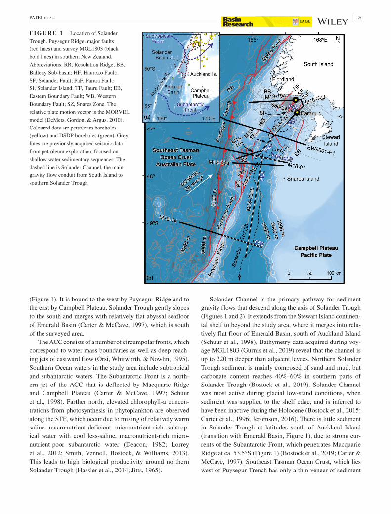
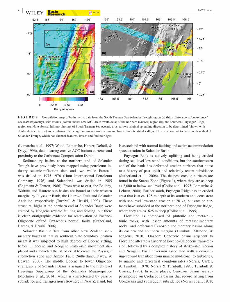
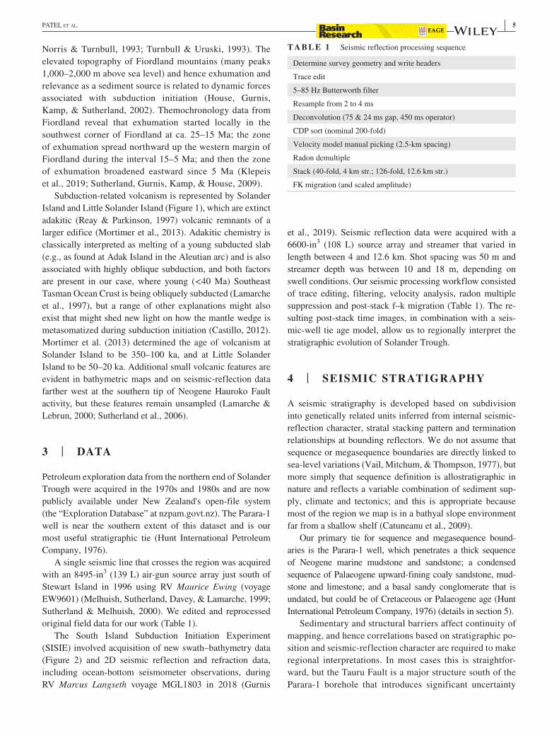
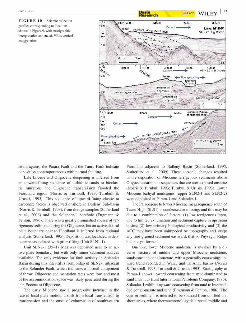