strathcona - ministry of environment & climate change ... list of photographs cover : the golden...
TRANSCRIPT


Canadian Cataloguing in Publication Data BC Parks. Strathcona District.
Strathcona Provincial Park master plan Cover title: Master plan for Strathcona Provincial
Park. ISBN 0-7726-1812-7 1. Parks - British Columbia - Planning. 2. Parks -
British Columbia - Management. 3. Strathcona Provincial Park (B.C.) I. Title. II. Title: Master plan for Strathcona Provincial Park.
FC3815.S87B32 1993 333.78’3’097112 C93-092207-7 F1089.S87B32 1993


This page left blank intentionally

The Golden Hinde seen from Limestone Cap
TABLE OF CONTENTS 1. PLAN HIGHLIGHTS .................................................................................................... vi 2. INTRODUCTION .............................................................................................................1
2.1 Purpose of the Plan ....................................................................................................3 2.2 Planning Issues ...........................................................................................................4 2.3 Background Summary ...............................................................................................5
3. THE ROLE OF THE PARK ...........................................................................................7
3.1 Regional and Provincial Significance ........................................................................7 3.2 Conservation Role ......................................................................................................7 3.3 Recreation Role ..........................................................................................................9
4. PARK ZONING ..............................................................................................................10
4.1 Wilderness Conservation Zone ................................................................................11 4.2 Wilderness Recreation Zone ....................................................................................12 4.3 Natural Environment Zone ......................................................................................12 4.4 Intensive Recreation Zone .......................................................................................13 4.5 Special Feature Zone ................................................................................................13
5. NATURAL AND CULTURAL RESOURCES MANAGEMENT .............................15
5.1 Land .........................................................................................................................15 5.1.1 Boundary ...................................................................................................15 5.1.2 Inholdings and Other Tenures ...................................................................22
5.2 Water ........................................................................................................................23 5.3 Vegetation ................................................................................................................25 5.4 Wildlife ....................................................................................................................27 5.5 Fish ...........................................................................................................................29 5.6 Cultural Resources ...................................................................................................30 5.7 Visual Resources ......................................................................................................31 5.8 Outdoor Recreation Features ...................................................................................32
iii
6. VISITOR SERVICES .....................................................................................................33
6.1 General Concept .......................................................................................................33 6.1.1 Travel Corridor ............................................................................................33 6.1.2 Outdoor Recreation Holiday Destination .....................................................34 6.1.3 Backcountry Recreation ...............................................................................35 6.1.4 Local Recreation ..........................................................................................35 6.1.5 Continuity of Experience .............................................................................35
6.2 Access Strategy ........................................................................................................36 6.3 Information Strategy ................................................................................................37 6.4 Marketing and Promotion ........................................................................................38 6.5 Management Services ..............................................................................................39 6.6 Outdoor Recreation Opportunities ...........................................................................40
6.6.1 Angling .......................................................................................................40 6.6.2 Boating .......................................................................................................41 6.6.3 Frontcountry Camping .................................................................................41 6.6.4 Backcountry Hiking .....................................................................................42 6.6.5 Mountaineering ............................................................................................45 6.6.6 Horse Use .....................................................................................................45 6.6.7 Mountain Biking ..........................................................................................46 6.6.8 Winter Recreation ........................................................................................47 6.6.9 Recreational Guiding ...................................................................................48 6.6.10 Resource Appreciation .................................................................................49 6.6.11 Sightseeing ...................................................................................................49 6.6.12 Day Use Opportunities .................................................................................50
7. PLAN IMPLEMENTATION ........................................................................................52 SUMMARY/ANALYSIS OF PUBLIC COMMENTS ON OPTIONS AND 1992 DRAFT MASTER PLAN ..............................................................56

iv
LIST OF PHOTOGRAPHS
Cover : The Golden Hinde seen from Limestone Cap. Page 6: Aerial view of Strathcona Park's mountain landscape from the
south-west. Page 9: Backpacking above Burman Lake. Page 14: Delta Falls. Page 18: Moyeha Bay, looking towards Tofino. Page 24: Buttle Lake and Mount Phillips, looking south. Page 34: Central Strathcona. Looking north from the summit of The Golden
Hinde. Page 38: Strathcona Park wilderness, with Mount Donner in the
background. Page 44: Cream Lake. Mount Septimus (left) and Mount Rosseau in the
background. Page 48: Recreational guiding. Hikers on the way to Comox Glacier from
Paradise Meadows. Page 51: Central Strathcona. Looking south from the summit of The
Golden Hinde. Page 55: Within Central Strathcona Nature Conservancy Area, hiker
camping en route. Page 59: Hiking in Paradise Meadows, with Mount Albert Edward in the
background

v
LIST OF FIGURES
Figure 1: Regional Setting 2
Figure 2: Nature Conservancy Areas 8
Figure 3: Proposed Additions and Study Areas 20
Figure 4: Zoning Insert
Figure 5: Development Plan Insert

vi
1. PLAN HIGHLIGHTS • Strathcona Provincial Park is the oldest provincial park in British Columbia. As the
largest park, and the only significant area of protected wilderness on Vancouver Island, it has a strong conservation role. It offers outstanding backcountry recreation opportunities, and also serves as a travel route and a holiday destination.
• In response to strong public support for a mostly wilderness designation for Strathcona
Park, 80% or 175,000 hectares has been zoned either for preservation as wilderness conservation or for wilderness recreation, which controls mechanized access and facility development. These areas will be designated as Nature Conservancy Areas under the Park Act.
• A Strathcona Park advisory committee, with public members, will be established. • BC Parks will strive to acquire recommended park additions to protect conservation
values, visual qualities, and recreation features. • The Bedwell Lake/Bedwell River, Price Creek and Della Falls trails are multi-day,
backcountry routes that provide moderate-difficulty hiking on marked trails. These routes through spectacular mountain terrain will be promoted to park visitors, and management will focus on maintaining the wilderness experience and protecting the environment.
• A new park headquarters facility will be developed for the Buttle Narrows area to provide
improved visitor services and an enhanced park staff presence. • On a trial basis, two areas have been designated for horse riding and other areas will be
reviewed. These locations have minimal conflict with other users and can withstand this type of use.
• In order to preserve the wilderness experience, aircraft landings will not be allowed
anywhere in the park except on Gold Lake and Buttle Lake. An Air Access policy with voluntary flight guidelines will be developed to control overflights.

vii
• Management plans will be prepared for fish, wildlife and cultural resources. Initiatives to meet wildlife requirements will be undertaken in conjunction with other government agencies.
• A Vegetation Management plan will be prepared in order to protect scenic values,
facilities and wildlife. New prescriptions will be considered for selected campsite areas in Natural Environment and Wilderness Recreation Zones too sensitive to sustain tent camping. A managed hut at Circlet lake will supplement tent camping, and a revegetation project will be undertaken.
• In recognition of a stated public need for improved access to Strathcona Park, roads to
Kunlin, Donner and Oshinow lakes will be improved. • New vehicle-accessible campgrounds at the south end of Oshinow Lake and north end of
Donner Lake, and a new, canoe-accessible campground at the south end of Donner Lake, will be developed.
• To maintain the integrity of the park and reduce pollution, motor boating will be
restricted to Buttle Lake. • Any significant changes to this Master Plan, proposed within the five year term of the
plan, will be subjected to a public review process.
This Plan sets out a clear direction for Strathcona Park. Immediate and future management actions are described and prioritized. How and when these actions will be fulfilled is dependent on the resources available to BC Parks.

This page left blank intentionally

1
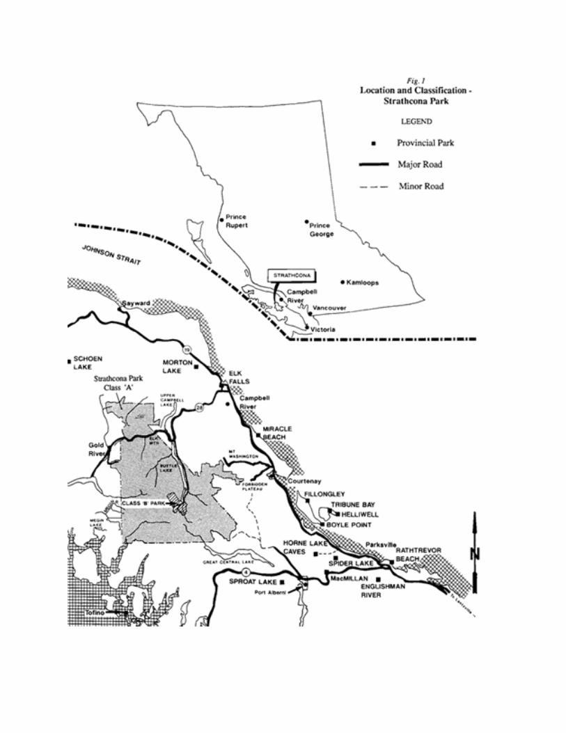
2. INTRODUCTION Strathcona Provincial Park (Figure 1) is British Columbia’s oldest park, and perhaps one of its least known. It is recognized for its conservation role in both protecting the unspoiled wilderness of the Vancouver Island Mountain Ranges and preserving special features such as The Golden Hinde, Vancouver Island’s highest peak; the Moyeha River valley, a complete and protected watershed from alpine to ocean; Comox Glacier, revered by the coast aboriginal peoples; and Della Falls, a cascade with the longest vertical drop in Canada. In the south-west region of British Columbia there are just a few large wilderness areas which offer a combination of mountains, lakes, alpine meadows, glaciers, river valleys and forest such as we find in Strathcona Park. On Vancouver Island there is no other. Though this great park has been the object of many resource developments during its 81 years, it has retained its wilderness characteristic. Along most of the park’s boundaries, steep one thousand metre mountainsides separate alpine backcountry from the routes along the valleys, making vehicle access impossible and trail access difficult. In all directions outside this natural boundary lies the evidence of human industry. The logging of Cruikshank valley, Oshinow Lake area, Burman River and Elk River valleys; the mining at Myra Creek, Bedwell valley, Oyster and Drinkwater river areas; and the hydro developments at Buttle, Thelwood and Upper Campbell Lakes attest to the pressures on this park area. Even within the park boundary, decisions have favoured industry requirements over park values, as in the hydro powerlines to Gold River. Though the man-made boundary has failed to preserve Strathcona as it was created, behind the park’s own, natural walls rests a huge and seldom-visited wilderness that even today shows few signs of human use. Within this backcountry, self-reliant and skilled hikers may travel for up to ten days in order to cross from one side of the park to the other. Their reward is to walk along ridges, climb peaks, - including the highest on Vancouver Island, - and camp by lakes which will never be seen by most park visitors. Only if these hikers leave nothing but footprints and take nothing but photographs, and if there are not too many each year, will this rugged and beautiful wilderness experience be sustained. Here it is also possible to experience the harsher realities of unforgiving, unmarked terrain. The less skilled or not self-reliant hiker should be wary of needing to navigate trail-free terrain by map and compass, especially when the west coast weather reduces visibility and comfort to zero.

3
Introduction (continued) Strathcona Park’s front country areas offer signed trails, day hikes and shorter overnight trips suitable for most visitors, especially families. The Buttle Lake corridor offers two provincial campgrounds and a boat launch, as well as fishing, swimming, hiking through mature forests and views of the mountains. Paradise Meadows is a sub-alpine area easily accessed by road from Courtenay and rich with outdoor recreation opportunities available throughout the year. Though Strathcona Park has much to offer any visitor, its greatest role as a park is to preserve a very significant area of wilderness; some of the last on Vancouver Island. The challenge is how to respect and preserve this wilderness, while, at the same time, provide for continued recreational use of the park. Some areas of the park can be impacted by careless or even frequent visitation, and may be protected only by limiting the number of visitors and reducing the impact of each visitor. Other areas of the park can accommodate high use and that is where recreation facilities will be developed. Whether for the wilderness areas or for the intensive recreation zones where most visitors go and where most facilities are located, management decisions need to be made which first and foremost protect the park. This plan details how this will be done. Because the choices made, whether to let be, protect, or alter are conscious decisions, this is by description a management plan. 2.1 Purpose of the Plan This master plan for Strathcona Park defines the role of the park and establishes the objectives and desired actions to guide the management and development in the future. It also provides direction for a number of key park issues such as proposed park additions, and includes recommendations on air access, wildlife management, mountain bike and horse management and outdoor recreation. This plan also clearly describes the public’s expectations for the park based on an extensive public involvement process, including strong support for the recognition and preservation of Strathcona Park’s wilderness characteristic. Park zoning and facility developments described in the plan are based on protecting the park’s natural and visual resources, and present a challenge to BC Park’s staff to provide recreation opportunities appropriate to the zoning objectives. The government appointed Strathcona Steering Committee, including three public advisory members, Peggy Carswell from Comox Valley, Anne Fiddick from Gold River and Jim Rutter from Victoria, worked with a team of BC Parks staff from South Coast Region, the Strathcona District and Victoria Headquarters, to produce this Master Plan with input from the general public and interest groups.

4
2.2 Planning Issues a) Role of the Park - Strathcona Provincial Park serves both conservation and recreation
roles established in the legislative mandate of BC Parks, namely to protect Representative Landscapes and Outstanding Recreation Resources. Through protecting a section of north central Vancouver Island, the park conserves both East and West Vancouver Island Mountain Regional Landscapes and their associated wildlife. The park also provides recreation opportunities for the travelling public, the holiday destination seeker and the wilderness adventurer. As land outside the park is modified, the protected wilderness in the park becomes more valuable for recreation and conservation. This Master Plan sets direction for managing this dual role with emphasis on the protection of wilderness.
b) Park Boundary - Generally the straight line boundaries of the park cut across natural
features and excludes areas of recreation and conservation interest. The Master Plan gives direction to address these straight line boundaries and protect features of recreation and conservation value.
c) Management of Park Resources - Strathcona was originally established to create a great
alpine park; a protected scenic setting that would attract tourists from distant areas to Vancouver Island. The Master Plan sets management guidelines to sustain wilderness and outdoor recreation opportunities. In addition, it gives direction for management of water, vegetation, wildlife and special features.
d) Management and Development of Recreational Opportunities - The park offers a
variety of outdoor recreation opportunities ranging from sightseeing and short hikes to multi-day excursions. The Master Plan establishes various recreation opportunities for the park, suitable locations and acceptable levels of use; particularly for horse riding, hiking, camping and winter recreation activities. It also addresses the role of aircraft and helicopters and provides direction for management of this means of access. Lastly, it outlines appropriate type and scale of acceptable commercial recreation services.
e) Strathcona\Westmin Park - This plan does not address Strathcona\Westmin Park,
which will be the focus of a separate but related master plan process.

5
2.3 Background Summary The Strathcona Background Report,1990, provides information towards understanding the rationale behind the master plan. Those who are unfamiliar with the park or who are reviewing this Master Plan for the first time may find it useful to read the Background Report, available from the South Coast Regional Office in North Vancouver, or the Strathcona District office at Parksville. Strathcona Park is located in the central mountainous area of Vancouver Island, and is Vancouver Island’s largest park. It hosts Vancouver Island’s highest mountains and Canada’s tallest water falls. Located approximately 48 kilometres west of Campbell River and 40 kilometres east of Gold River on Highway 28, it is alternately accessed by logging roads and by water from Great Central Lake and Herbert Inlet. It is British Columbia’s oldest park and fifth largest at 219,145 hectares. The park area has been noted since its early exploration in the late 1800’s as an area of exceptional beauty, with mountain peaks, glaciers, lakes and valleys incomparable on Vancouver Island. The park was British Columbia’s first, recognized as early as 1911 as an asset "reserved and set apart as a public park and pleasure-ground for the benefit, advantage and enjoyment of the people". The original Strathcona Park Act intended total protection in perpetuity from any resource exploitation. The name Strathcona was in honour of the First Baron Strathcona, who initially as a trader for 30 years with the Hudson Bay Company, rose to prominence, driving the last spike in the Canadian Pacific Railway in 1885. His motto of "perseverance" seems fitting in the fight for the preservation of a park of the size and significance of Strathcona Park. Strathcona Park is entirely within the Vancouver Island Range of the Vancouver Island Mountains; the Alberni Basin and the Estevan Coastal Plain are two lowland areas, one along the west coast and the other inland of Alberni Inlet, which complete the physiographic components of the Vancouver Island Mountains. Strathcona Park lies on the backbone ridges of the Vancouver Island Range. Numerous peaks exceed 1500 metres in elevation. The highest peaks are the Golden Hinde (2228 metres), Elkhorn Mountain (2195 metres) and Mount Colonel Foster (2134 metres). Buttle Lake lies almost in the centre of the park, and with a mean water level of 221 metres above sea level is the lowest inland elevation. As a result of the large and varied mountain landscapes, diverse recreation opportunities are available. The highway corridor receives the most use and provides the travelling public with superb mountain scenery, day-use activities, natural resource appreciation, and overnight accommodation. The park also provides outstanding backcountry recreation opportunities, such as hiking the Bedwell River Trail, cross-country skiing at Paradise Meadows or climbing Mt. Colonel Foster.

6
Strathcona Park’s Mountain Landscape
Strathcona has approximately 16,000 day-use visitors a year, with some 4,000 parties (average size, 2) registering at park campsites in the busiest month (August). With the Greater Victoria area less than a day’s drive away, some 20% of Strathcona Park’s visitors come from the south half of Vancouver Island. The district figures, in descending order, show that BC residents from Victoria, Vancouver area, Campbell River, Nanaimo, Courtenay-Comox, Port Alberni and Duncan were the most common visitors to parks in the district, with Alberta, Washington/Oregon/California and non-North Americans, in descending order, comprising 24.8% of the visitors. In 1987 the Master Plan process for Strathcona Park was put on hold, principally in response to strong criticism, from the public and from advocacy groups, of a provincial government decision to delete 30,431 hectares (approximately 65,000 acres) from the park without a recommended process of public hearings. A government appointed committee composed of public representatives, the Strathcona Park Advisory Committee chaired by Dr. Peter Larkin, produced a report in 1988 based on both research and public comment. It was strongly critical of the history of decisions made for Strathcona Park. This committee's report, "Restoring the Balance", and its recommendations was accepted by the government, and led to the creation of a steering committee composed of staff from B.C. Parks and three public advisory members. This Park Management Plan closely follows the recommendations in "Restoring the Balance" and public comment given in response to the questionnaire printed in a widely distributed Draft Management Options in 1991.

7
3. THE ROLE OF THE PARK 3.1 Regional and Provincial Significance Strathcona Park has long been acknowledged as an important conservation and outdoor recreation area. Its conservation and recreation role is made all the more important by the level of resource development on Vancouver Island which has eliminated most other opportunities to have roadless areas and wilderness designations. In addition to protecting two representative landscapes and regional ecological diversity, Strathcona also contains special features such as Comox Glacier, seen clearly from downtown Courtenay, and Mount Colonel Foster and Landslide Lake, within reach of day use hikers. Buttle Lake, a thirty kilometre body of fresh water bordered by forested slopes and mountain peaks, leads into the heart of Strathcona Park. These remarkable features and the available outdoor recreation opportunities are highly prized by the people regionally, and provincially. In achieving a provincial park system that reflects the needs and capabilities of the people it serves, BC Parks has developed a series of conservation and recreation goals, shown in Appendix A. As well as park zones there is a legislated designation of Nature Conservancy Area used to protect park areas. Strathcona Park plays a significant role in meeting these goals, as described below. 3.2 Conservation Role Over 175,000 hectares, or 80% of the park, is zoned as wilderness. In these areas, natural processes are allowed to continue without human interference, and a Nature Conservancy Area designation over 80% of the park will ensure protection. Nature Conservancy Areas (NCA) are established by Order-in-Council under the Park Act. NCAs are roadless, wilderness areas within Provincial Parks retained in a natural condition for the preservation of their ecological and scenic features. All forms of commercial activity and recreation dependent on combustion engine use, resource use and hunting are prohibited. Usually the NCA boundary coincides with the Wilderness Conservation Zone boundary. • BC Parks will pursue an Order-In-Council to describe Nature Conservancy Area status
for all Strathcona Park except the Intensive Recreation zone, the Wilderness Recreation zone at Donner Lake and mineral claims for which legal status has yet to be determined.
• To reflect the intent of NCA designation, fishing will not be allowed within the NCA.

8

9
Strathcona Park’s conservation role also ensures that: • The regional landscape of the Vancouver Island Mountain Range is partly represented. • Four of Vancouver Island’s five biogeoclimatic subzones are found within the park. • Special features such as the Burman Lake/Golden Hinde area, the Moyeha River
watershed and coastal estuary (the only completely protected coastal watershed on Vancouver Island), and the subalpine Paradise Meadows area are preserved.
• A no hunting policy is in place for the park.
3.3 Recreation Role • Outstanding backcountry adventures in the Vancouver Island Mountains are protected.
Relatively easy access to the alpine is offered to Forbidden Plateau from the Forbidden Plateau Ski Resort and at Paradise Meadows from the road to Mount Washington Ski Resort. Such opportunities attract regional, national and international visitors.
Backpacking Above Burman Lake

10
• Travellers on the Strathcona Parkway (Highway 28) and the Buttle Lake Parkway are treated to superb mountain scenery, roadside rest and picnic stops, educational displays, short hiking trails and camping opportunities. Strathcona Park contributes to local tourism through these attractions.
• An outdoor recreation holiday destination is available in Strathcona Park. As part of the
larger destination area of Vancouver Island and with opportunities for camping, short hikes, nature study, swimming, boating and fishing, the park makes an ideal family destination.
• Local recreation opportunities such as hiking, wildlife viewing, camping, fishing,
picnicking, nature study are available in the park and attract local visitors from the communities of Gold River, Campbell River, Comox Valley, Port Alberni and Tofino.
4. PARK ZONING In planning and managing parks, BC Parks relies on zoning, which divides a park into logical units to apply uniform and consistent management objectives. Through identification of natural and recreational values, and analysis of existing and projected patterns of access and recreation use, the zoning defines levels and criteria for resource and visitor services management. As indicated in Figure 4 (Insert), Strathcona Park is separated into five zones1 which include Wilderness Conservation, Wilderness Recreation, Natural Environment, Intensive Recreation and Special Feature. Given Strathcona’s conservation role, the areal extent of the wilderness designations, particularly the Wilderness Conservation Zone, is maximized to protect the wildlife and wilderness values of the area. Definitions of each zone type are general for the province, and for policy decisions specific to Strathcona Park it is necessary to refer to the recommendations in the appropriate sections of this Master Plan. Confusion is possible because an activity may be permitted in a provincial Zone description but not necessarily permitted in a particular park. This applies to a number of possible uses including horse riding, mountain biking and air access. Zoning to recognise trails will be kept to a minimum width. ________________________
1 The area of Indian Reserve Land at the Moyeha estuary is not subject to zoning.

11
4.1 Wilderness Conservation Zone The objective of this zone is to protect a remote, undisturbed natural landscape and to provide unassisted backcountry recreation opportunities dependent on a pristine environment where no motorized activities will be allowed. Development is nonexistent and management strategies are directed towards conservation of the resource while allowing wilderness recreation use. In short, areas designated as Wilderness Conservation are large natural areas free of any evidence of modern human activity, with very low use and without facilities. In Strathcona Park this zone covers most of the area north of Strathcona Parkway, (Highway 28) including Tlools Creek; the whole area south of Strathcona Parkway and west of Buttle Lake, except for the Donner Lake, the Westmin Mine area and specific, developed trails and sites on the periphery: and most of the remaining area of the park east and south of Buttle Lake, except for the Forbidden Plateau area, the east shoreline of Buttle Lake and some specific trail areas. The areas of this zone require special protection due to their sensitive nature, or have been designated Wilderness Conservation because of their undisturbed state. Approximately 165,000 hectares or 75% of the park is designated Wilderness Conservation Zone. All of this zone will be designated as Nature Conservancy Area and will increase the overall area of dedicated Nature Conservancy Area in the park from 123,000 hectares to 174,000 hectares. Specifically:
• Big Den Nature Conservancy Area will increase by 12,000 hectares, representing the Salmon River drainage, Tyee Mountain, Crest Mountain and Mount Flannigan.
• Central Strathcona Nature Conservancy Area will increase by 17,000 hectares, including
the Burman River, Mitla Creek, the Upper Moyeha River, Bedwell Lake, and the Upper Myra Creek.
• Comox Glacier Conservancy Area will increase by 21,000 hectares, including the
headwaters of Ralph River, Eric Creek, Ash River, Margaret Creek, Mount Septimus, Leader Lake, Beauty Lake and Capes Ridge.

12
4.2 Wilderness Recreation Zone The objective of this zone is to protect a remote, undisturbed natural landscape and to provide backcountry recreation opportunities dependent on a pristine environment. This zone is characterized by low use and the provision of solitary experiences. Facility development is minimal, and designed to protect the overall environment of the park while maintaining a wilderness atmosphere. Approved facilities include trails, trail signs, designated camping areas, and sanitary facilities. In summary, areas designated Wilderness Recreation are large natural areas where natural ecological processes occur largely uninfluenced by human activity, and where low levels of recreation use are permitted but confined to specific primitive facilities and sites and not generally visited on a day-use basis. This zone covers developed and signed hiking trails and attendant camping sites, including; Donner Lake, Elk River trail to Landslide Lake, Kings Peak trail, Marble Meadows trail, Augerpoint trail to Augerpoint Mountain, Bedwell River trail to Price Creek, Kookjai Mountain and Comox Glacier access trails, Century Sam Lake trail, Della Falls trail with a new trail connection to Oshinow Lake and Margaret Lake, and a new connection from the Thelwood valley to Price Creek linking Bedwell Lake to Cream Lake. Approximately 10,000 hectares or 5% of the park is designated Wilderness Recreation Zone. 4.3 Natural Environment Zone The objective of this zone is to protect scenic values and to provide for backcountry recreation opportunities in a largely undisturbed natural environment. The main management concern is encouraging backcountry use while keeping impacts below levels that will impair park resources or significantly reduce user satisfaction. In Strathcona Park, this zone encompasses the areas around Gold Lake, Crest Creek, Kunlin Lake, the canoe sites on the west shore of Buttle Lake, Oshinow Lake/Toy Lakes, and the majority of the area known as Forbidden Plateau. In general, proximity to roads, boats with motors and aircraft use will preclude a sense of wilderness isolation. Facilities in this area are moderately developed with trails, walk-in campsites and shelters. Approximately 17,000 hectares or 8% of the park is designated Natural Environment Zone.

13
4.4 Intensive Recreation Zone The objective of this zone is to provide for a variety of readily accessible, facility-oriented outdoor recreation opportunities. This includes areas of high facility development such as campgrounds, picnic and play areas, administrative buildings, and parking lots. The management intent of this designation is to accommodate high levels of vehicle-based users in as natural a setting as possible. In Strathcona Park, this zone encompasses the Strathcona Parkway (Highway 28) and Buttle Lake Parkway travel corridors which are the most heavily visited and developed parts of the park, and the road accessible areas at Kunlin Lake, Oshinow Lake and Thelwood Creek. Located in this zone are visitor services and facilities for day-use recreation opportunities, overnight camping, and parking at trail heads. Approximately 8,000 hectares or 4% of the park is designated Intensive Recreation Zone. 4.5 Special Feature Zone The objective of this zone is to preserve and present significant natural or cultural resources, features or processes because of their special character, fragility or heritage value. Management is oriented towards a high level of resource protection with ongoing monitoring. Visitor access may be restricted to preserve a high quality recreational and interpretive experience associated with sight-seeing and nature appreciation. This zone includes Karst Creek, the Golden Hinde, Della Falls, Myra Falls, the Augerpoint fire landscape, the whole of the Moyeha River watershed, Comox Glacier, Crown Mountain, Cream Lake, the fir trees of the Puntledge valley, Lady Falls, Landslide Lake, the karst scenery of Marble Meadows and Limestone Cap, and the fossil beds at Marblerock Creek canyon. Approximately 19,000 hectares or 8% of the park is designated Special Feature Zone. Other areas may be labelled as Special Feature as more becomes known about the park and similar areas outside the park are compromised by resource use.

14
Della Falls

15
5. NATURAL AND CULTURAL RESOURCES MANAGEMENT Strathcona Park has long been recognized in the province for its important conservation role. Its location across the north centre of Vancouver Island and almost coast to coast contributes to its significance as a natural area able to sustain ecological diversity. The increasing high profile of Strathcona, the increasing demand for backcountry recreation and the significance of park resources dictates that the park must be protected and managed wisely. To this end, the following section sets resource management objectives and describes actions to be undertaken to protect natural features and processes. The park shall be managed in a manner that will provide for the Province's fiduciary responsibility to aboriginal people. In particular, the master plan will recognize the traditional interests of affected aboriginal people with respect to their sustenance and ceremonial activities. 5.1 Land With the recent MacMillan Bloedel land exchange there are no significant tenures remaining in the park. However, it is likely that proposals for alienation of land interests will be forwarded during the five year term of the Master Plan, and these could be issued a Park Use Permit. Objective:
To ensure that only proposals for alienation of land interests which are necessary for the preservation or maintenance of the recreation values of the park, be approved.
Action:
Review, in a public forum, any proposal for a park use permit which involves land tenure. 5.1.1 Boundary Most of the park boundary established in 1911, 1913 and 1968, consists of straight lines. For the most part these boundaries include the significant features of the park, but because they do not describe whole valleys, and because they did not consider viewscapes, they exclude some areas of significance to Strathcona Park. The current boundaries of Strathcona are not able to adequately describe the park’s regional landscape roles. Proposed study areas, especially boundary extensions to the ocean shoreline on the west coast, will enhance Strathcona’s regional and provincial significance.

16
Timber harvesting is planned for a number of privately owned blocks, notably Elk Mountain, on the shore of Upper Campbell Lake. Because these areas appear to the park visitor to be a part of Strathcona Park there is an obvious conflict of values which must be resolved. In other areas logging outside the park boundaries affects the park values within; for example, logging in the Burman River valley which is visible from Greig Ridge in the very centre of Strathcona’s largest, most isolated and most pristine wilderness area; and, along the northern boundary of Forbidden Plateau. In fact, most of Strathcona Park’s boundaries will be faced with this conflict. The recreation, wildlife and aesthetic values of these boundary areas dictate that BC Parks work closely with the Ministry of Forests, industry and owners of private land. Two study areas were proposed in 1988 by the Strathcona Park Advisory Committee, namely; Mount Matchlee, and the White Ridge area. These areas were to be studied for designation as provincial parks in their own right. As well, three areas adjacent to the park boundary were recommended for interagency study and possible addition to the park: namely the Megin/Mitla, the Ursus and the lower Bedwell watersheds. Objectives:
To protect areas adjacent to park that have wildlife, recreation and aesthetic value through cooperative management. To protect the existing land area of the park while investigating expansion of park boundaries into adjacent areas that either have high park values or are valuable to the park to protect recreation and conservation values.
Actions: • Work with government agencies, regional districts, the public, industry and private land
holders to protect wildlife, recreation and aesthetic values along park boundaries and control access into wilderness areas.
• The decision as to which of the Megin River, Ursus Creek and lower Bedwell River
watersheds are to be protected has been resolved by the government’s decision on the Clayoquot Sound area. The Protected Area Strategy will now address what lands are to be placed under Park Act designation and which should be added to Strathcona Park.

17
• Strive to acquire the following areas as additions to the park: In 1988 the Larkin report “Strathcona Park, Restoring the Balance” recommended the addition to the park of 20 areas currently on the park boundary. Some of these areas have since been added as part of the 1900 process to designate Strathcona Park’s boundaries, notably the Bedwell River watershed deleted from the park in 1987. The remaining additions proposed by Larkin, some grouped together, were presented for public comment in the Draft Management Options paper of 1991 and the public were invited to demonstrate their priority selection of these additions using a point system. B.C. Parks is currently holding a dedicated land bank (the Strathcona Exchange Lands) as a result of lands deleted from Strathcona Park. This will be used firstly to remove existing alienations within the park, and then to help acquire new lands to add to the park. All lands to be added to the park will be negotiated with the appropriate owners. Wherever outright acquisition of land is not possible, private landowners will be encouraged to participate in joint management strategies which will be pursued in order to protect park values. Expropriation of privately owned lands is not government policy. On exhaustion of the current land bank, acquisitions will be made as part of the provincial Land Acquisition Program. The following list is ranked according to the results of a public survey (see Summary and Analysis, page 56). 1 Lower Drinkwater Creek area. (950 ha) Within TFL 44.
Extending from the present boundary to Great Central Lake, and including the adjacent slopes and the flat lowlands at the Western end of Great Central lake. Drinkwater Creek provides a hiking access route to the Della Falls area in Strathcona Park, and inclusion of this unit would permit the improvement and protection of trail access to the spectacular features at the head of Drinkwater Creek.
2 Lower lands adjacent to Moyeha Bay. (100 ha) Within TFL 44.
The Moyeha River Watershed is a major drainage system in the park, and it is entirely protected as a wilderness where it is within the much larger nature conservancy area. The estuary of the Moyeha River at tidewater is also within the park but the straight line park boundary excludes a small part of the estuary. This addition will ensure that the entire watershed retains its wilderness qualities.

18
Moyeha Bay 3 Elk Mountain. (1350 ha) Private land.
For visitors approaching the park from Campbell River their first major vista is of this mountain block across Upper Campbell Lake. It is commonly perceived by the public that these slopes are, or perhaps once were, part of the park, but this is not so. This large area lies immediately adjacent to the park boundary but it is privately owned and has been since before the park was created. At present, clear cutting dominates the lower slopes. The forest company is working with the public to develop a logging plan which will minimize the visual impact as viewed from the highway and the lodge on the other side of the lake. The area has been proposed as an addition to the park by proponents seeking to protect the view.

19
4 Areas adjacent to Forbidden Plateau. (2,500 ha) Private land.
These additions include the Divers and Rossiter Lakes area, the triangle of lands comprising about 6 sq. km southeast of Battleship Lake, the Wattaway Meadows area, the Alderman Lakes area, the upper portion of Beech Creek – situated west of Mount Becher, and the short length of the Becher trail at the south-eastern edge of the Forbidden Plateau area. These additions will better recognize the natural sub-alpine boundary of the Forbidden Plateau and protect it from the effects of industrial uses outside the park boundary.
5 All or part of McBride Creek Watershed. (2300 ha) Within TFL 44.
Only partly contained by the present boundary, this unit includes a low elevation lake, a meandering valley bottom stream, and adjacent alpine ridges. The priority portion is mainly the alpine ridge south of Leader Lake. By defining the boundary along topographic features, preferably on the southern side of the height of land, a more effective park boundary can be created.
6 Willemar and Forbush Lakes area. (1700 ha) Private land.
A relatively low elevation chain of lakes in a near-pristine state, with significant recreation and scenic values. There is no comparable area currently within the park. The lakes can serve as a gateway for hikers entering the adjacent wilderness of the Nature Conservancy Area. An old logging railway grade provides good access to Kookjai Mountain and the original trail to Comox Glacier.

20

21
7 Mount Adrian area. (4000 ha) Private land.
Designated by the Larkin committee as its highest priority addition, this unit encompasses Mount Adrian and its southwest slopes, Beadnell Lake and the alpine southward to Mount Adrian, Alexander Peak, and the slopes directly east of Buttle Lake. Though significant to the park in its own right, this area is critical to the park’s wilderness values in that it is largely within the viewscape of recreationists on Buttle Lake and from the ridges of the wilderness area, especially Marble Meadows, west of Buttle Lake.
8 Mount Flannigan area. (1200 ha) Private land.
This hillside is part of the viewscape for park visitors using the Gold River road, and would appear to them to be part of the park. This triangular piece of land prevents the park boundary from following a natural line which protects the visual integrity of the whole northwest side of Upper Campbell Lake. The addition’s most western segment is part of Tlools Creek valley, a significant elk route and winter range area.
9 Area of Pearl Lake, Norm Creek (1600 ha) Private land.
Viewed directly from the park’s most visited peak, Mount Albert Edward, this area is also the starting point for the trail to Gem Lake. Inclusion would allow the park boundary to be much more effective in protecting park, recreation and ecological values across the range of elevations around the recreationally significant landscape around Pearl Lake.
10 Capes – Idiens Lakes. (800 ha) Private land.
Integral to the park values currently contained by the straight line boundary. Can be included without conflicting with lower elevation areas with significant forest values.
11 Memory Lakes. (400 ha) Private land.
This addition would better protect the wilderness characteristic of the lake area, which currently has the park boundary nearby. The boundary can be redrawn at a lower elevation without compromising forestry values whilst creating an effective buffer zone.

22
12 Jessie Lake area. (350 ha) Private land.
Adjacent to the northern boundary of the park, at the north end of the Tlools Creek valley. Inclusion of this lake area would provide a buffer between forestry and the Nature Conservancy boundary.
13 Carey Lakes area. (350 ha) Private land.
The Carey Lakes area is a small, plateau-like hilltop with a cluster of small lakes. At present, most of this area is within the park’s boundaries and inclusion of the whole area would provide this cohesive unit with sufficient protection from conflicting uses.
5.1.2 Inholdings and Other Tenures Strathcona Park has a long and chequered history regarding inholdings and other tenures. As a result of the park being opened and closed to claimstaking at various times Strathcona has many mineral claims. There have also been old forest tenures (now eliminated) and there is still a privately-owned parcel at Moat Lake. Though B. C. Parks has been trying to acquire or eliminate these, there are still some inholdings in Strathcona Park. One major inholding has now been classified as a Class B park, namely the mineral claim and lease area of the Westmin Mine, and although this is technically managed as a separate area it will be reclaimed and returned to Strathcona Park when the mine closes. BC Hydro has a number of interests within Strathcona Park; namely, a permit for powerline through the Strathcona Parkway corridor, and permission to draw down Buttle Lake for hydro generation outside the park. Private lands at Buttle Narrows may provide opportunities for future private sector development. Objectives:
To manage non-conforming inholdings and tenures to meet the conservation role of the park. To reduce, where possible, and eventually eliminate the non-conforming uses.
Actions: • Acquire over time any inholdings, land or mineral tenures. • Rehabilitate disturbed areas to a natural state.

23
• Investigate opportunities to eliminate non-conforming tenures such as repeater stations and access roads.
• Work with the landholders at Buttle Narrows to negotiate for recreation development
appropriate to the park setting. • Develop powerline corridors for recreation opportunities such as mountain bike trails,
horse riding trails and cross-country ski routes. 5.2 Water Strathcona Park is the source of the domestic water supply for Port Alberni, Campbell River and Gold River, and it protects the headwaters of the Campbell River and its tributaries. Preservation of this river and other high quality water resources is an important component of the conservation and recreation role of the park. Buttle Lake has been an artificially regulated reservoir since 1957 with the construction of Strathcona Dam. It has an annual fluctuation between 5 metres and 7 metres, however maximum drawdown can be as much as 12 metres. The storage period is the summer, with drawdown in fall and winter. The impoundment level is 9 metres above original lake elevation, and has inundated nearly 90% of the lake’s tributary stream spawning areas. In addition, prior to raising the reservoir all timber was cut to 221 metres above sea level contour and the area cleared. Objectives:
To protect the pure, unpolluted quality of waters within the park. To minimize the seasonal water level fluctuations of Buttle and Upper Campbell Lakes in order to help re-establish shoreline and intertidal plant populations. To eliminate the existing reservoirs at Jim Mitchell, Thelwood and Tennent Lakes once these are no longer needed by Westmin, and to eliminate the Heber River diversion which channels water from the Heber to the Elk river.
Actions: • Monitor and protect from any interference the lakes, rivers and streams. • Prohibit water impoundments, diversions and future domestic use projects. • Ensure that sanitary facilities are properly designed and located.

24
• Develop contingency plans with the Provincial Emergency Program and Ministry of Transportation and Highways to address accidental spills along the Strathcona and Buttle Lake Parkways.
• Continue to have Westmin Mine’s water run-off monitored to ensure that standards of
water quality are met as defined by Waste Management Act and Regulations. These results will be made available to the public.
• Work with B.C. Hydro to develop a reservoir management plan which accommodates the
recreational and environmental requirements of Strathcona Park.
Buttle Lake

25
5.3 Vegetation Vegetation is the basis for wildlife habitats and contributes to the visual and recreational attractions of the park. Strathcona Park protects four2 of Vancouver Island’s five biogeoclimatic subzones and encompasses some special vegetation features such as the old growth Douglas Fir forest of the Puntledge River valley. The natural processes of fire, disease and insect infestations are fundamental in maintaining the complex forest ecosystem but may require management to protect important recreation values, facilities and commercial forests on adjacent lands. Objectives:
To identify and protect the park’s remaining old growth forest. To maintain native plant communities and species, with special attention to sensitive, rare, threatened or endangered plants. To maintain the established pattern of varied aged forest, reflecting the natural processes that occur in unmanaged forests. To maintain the diversity of wildlife vegetation habitats in the park. To encourage non-destructive scientific studies to improve what is known of the park.
To eliminate, and discourage the establishment of, non-native species.
Actions: • Develop a long term forest management strategy for the park. Key elements in this
strategy include: • forest resource inventory including forest types, the occurrence of rare plant species
and sensitive plant communities; • wildlife habitat inventory including critical wintering range; • campfires in backcountry areas; • fire suppression and management; • disease and insect infestations;
_______________________________
2
Of the five biogeoclimatic subzones represented in the classification system developed for Vancouver Island, four are found within Strathcona Park - the Coastal Alpine Tundra, Maritime Forested and Parkland Mountain Hemlock, Drier Maritime Coastal Western Hemlock and Wetter Maritime Coastal Western Hemlock (Klinka et al 1979). Several variants of all but the Alpine Tundra zone also exist depending on the characteristics differentiating them (e.g. mean precipitation of driest month, months with water deficit, etc.).

26
• vegetation management along the parkways; • land uses in adjacent areas; • a review of disturbed areas; and, • monitor areas most susceptible to non-native species.
• Promote no-trace camping and preservation of the environment, especially in the backcountry areas, by encouraging park users to carry campstoves and not make campfires except in emergencies.
• Prepare a fire management plan. Until the fire management plan is prepared, all wildfire is subject to initial attack either by the Forest Service or BC Parks.
• Protect sensitive or unique vegetation communities, including old growth forests, from adverse impacts of recreational uses, and consider designation as Ecological Reserves.
• Maintain close contact with the Ministry of Forests and industry in the review of the forest development plans for the various drainages leading to the park boundary to protect aesthetics, recreation and wilderness values.
• Retain trees and snags for wildlife habitat except those that present a hazard to people or facilities.
• Ban campfires in the Forbidden Plateau area.
• In conjunction with providing an overnight cabin at Circlet Lake, camping at that location will be relocated and a site reclamation and revegetation project will be undertaken.

27
5.4 Wildlife
Strathcona Provincial Park is home to a large variety of wildlife species including cougar, elk, wolf, deer, black bear, migrating Trumpeter swans and the Vancouver Island marmot3. The park is part of a larger area through which the movement of wide-ranging species, and migration between gene pools, occurs. Sufficient numbers of a genetically diverse population must be maintained in order to sustain viable populations over the long term. In addition, steps must be taken to preserve critical habitats and reduce mortalities as a result of highway traffic and poachers.
The variety of habitats and relative isolation from any population centre provides the potential for an abundance of numerous species of wildlife. However, some restrictions including rugged terrain, high elevation and a long winter season in the subalpine and alpine limit use. Logging and mining activity have also taken their toll on areas, particularly critical winter range for ungulates such as the low river valleys at the south end of Buttle Lake and at the west arm of Upper Campbell Lake, which has reduced populations in the park.
Wildlife viewing is not reliable in Strathcona, and for the most part occurs as chance sightings. These, however, often strengthen the bond visitors have with the park, especially to the foot traveller with time for a lengthy observation. It is imperative that the animals are not disturbed, particularly in times of physiological stress such as during winter or birth.
Objectives:
To maintain and protect the natural diversity of wildlife species and populations with special attention to sensitive, rare, threatened and endangered animals.
To protect critical habitats and enhance declining habitats where it is compatible with other park resource management and recreation use objectives.
To inform the public about non-consumptive appreciation of wildlife.
To encourage scientific research projects in the park, particularly those with direct management benefits.
__________________________
3 The Vancouver Island marmot is a different species to its mainland relative. No sightings have been made
in recent years and there is concern that the species may no longer be in the park.

28
Actions:
• Develop a long term management plan for wildlife in the park. Key elements in this strategy include:
• ongoing wildlife inventory; • inventory of habitat requirements of populations with particular reference to critical
habitats; • role of fire, insect and disease in terms of creating a range of habitats including snags
for various bird and animal species; • transboundary management; • opportunities for research programs; • minimizing negative encounters between people and animals; and, • how to deal with animals which have become a threat to the public.
• Develop a research project to study the wildlife, including mammals, amphibians, birds, reptiles and insects of the old growth forests of Strathcona Park.
• Ensure any future recreational development in the Intensive Recreation, Natural Environment and Wilderness Recreation Zones do not negatively affect wildlife.
• Keep park closed to hunting and trapping.
• Cooperate and establish common objectives with government agencies and park neighbours to manage trans-boundary populations and identify habitat requirements.
• Protect wildlife habitats by minimizing the impacts of park development and recreation use.
• Protect the park’s limited wetlands to maintain the natural environment and the diverse bird populations.
• Review and implement the wildlife viewing plan.

29
5.5 Fish At least ten species of fish are found in the park including five species of salmon; pink, chum, coho, sockeye, chinook (spring); and three species of trout and char; rainbow trout, cutthroat trout and Dolly Varden. Two species of non game fish have been identified, a sculpin and a stickleback. An inventory of non-game fish has not been undertaken. A report, Sport Fishery Management Plans for Strathcona Park and Recreation Area was prepared in 1979. Seven key fishing opportunities were identified; Buttle Lake, Elk River, Forbidden Plateau, Hiking Route Fisheries, Donner and Kunlin Lakes, Oshinow Lake, and Anadromous Sport Fisheries. For each, recommendations were made for management inventory and monitoring needs. Objective:
To conserve the existing diversity of indigenous fish species and to provide opportunities for recreational fishing.
Actions: • Review the Sport Fishery Management Plans report and ensure it is consistent with the
approved park zones. • Implement recommendations of the Sport Fishery Management Plans. Key actions are:
• Inventory spawning and rearing habitat and its utilization in the Buttle Lake system; and,
• Monitor angler use and demand.
• Except to restore indigenous populations, no enhancement or stocking will be undertaken
in the Wilderness Conservation Zone. Management of this zone will be restricted to limiting access to the resource through regulation.
• Encourage and promote fishing in the Intensive Recreation Zones. • Undertake a general survey of all fish species in the park. • Pursue restoration of Buttle Lake’s productivity through revegetation of the shoreline and
other measures for rehabilitation of fish productivity. • Prohibit fishing in the Nature Conservancy Areas.

30
5.6 Cultural Resources The aboriginal peoples of the Strathcona Park area are the Mowachaht/Muchalaht and Ahousaht Bands of the west coast, the Lekwiltok Tribes and Campbell River and Comox Bands of the east coast, and the Opetchesaht Band of the Great Central Lake and Sproat Lake area. At least two pre-contact cross-island routes are recorded; one by way of the Gold River through the Campbell Lakes system to Discovery Passage, and the other from Great Central Lake to Comox Harbour by way of Comox Lake. Salmon were harvested from a number of rivers draining the Park area, although primarily at the river mouth. However, territorial claims extended to headwaters and beyond. River flats provided yellow cedar for houseframes, planks, canoes and dozens of utensils. Yellow cedar at higher elevations provided bark from which clothing was manufactured. Yew was used for paddles and bows. Bear, deer, elk and marmot were hunted from coastal plateau to the subalpine. Berries, roots and other flora were also gathered in these same areas. Based on this traditional role, these ancestral lands are part of the land claims awaiting settlement. Objectives:
To preserve the cultural resource values which relate to the rich history of the park.
To provide information and education on the park’s heritage.
Actions: • Establish direct contact with the local aboriginal people to determine significance of the
Strathcona area in their culture. • Assess cultural resources for educational and recreational potential, for scientific needs,
and for protective status. • Develop appropriate management, information and education strategies in consultation
with aboriginal peoples. • Highlight the 1910 Ellison Expedition.

31
5.7 Visual Resources
The scenery in and around Strathcona Provincial Park is fundamental to the visitor’s experience. It is a particularly strong component along the Strathcona Parkway with its industrial traffic to and from Gold River, a power line corridor and logging operations. Visitors to the park’s wilderness areas view developments which, though outside the park boundary, conflict with any sought for sense of isolation. Objective:
To maintain views in and out of park so that the visual qualities and wilderness atmosphere of the park are protected.
Actions: • Recognize that the Intensive Recreation Zone encompassing the parkways is a modified
landscape where the naturally evolving system is interfered with to protect facilities and wildlife, and maintain scenic qualities. Manage the parkways in an environmentally sensitive manner, using every opportunity to benefit wildlife populations.
• Continue to provide and manage a variety of road-side interpretive viewpoints in the
Intensive Recreation Zone, including "the Elk" portal. • Work with other agencies including the Ministry of Forests, the Ministry of
Transportation and Highways, the regional districts, Westmin Mines, and BC Hydro to minimize impacts of activities (whether inside or outside the park boundary) such as logging, gravel pits, highway signs and development of private land, particularly where scenic values are considered important.
• Locate and design all park facilities in harmony with the visual setting and in accordance
with park zoning objectives.

32
5.8 Outdoor Recreation Features Strathcona Park protects outstanding recreation features such as the Bedwell River Trail and special features such as Paradise Meadows, Cream Lake, Comox Glacier and Marble Meadows, which also support recreation. All of these features contribute to Strathcona’s recreation and conservation role, but vary in terms of sensitivity and ability to support visitors and, consequently, require different management prescriptions. Strathcona Park safeguards the wilderness recreation opportunities not available in the larger complex of adjacent, unprotected areas. It also ensures a quality experience which may not be available on the private and Crown lands outside the park, which are managed primarily for resource utilization. Objective:
To ensure that resource management activities, visitor use and park development pose little threat to the park’s outdoor recreation features.
Actions: • Manage recreation use according to zoning. • Direct or limit use of sensitive features such as alpine meadows. • Locate and design all park facilities in harmony with the natural setting and in accordance
with park zoning objectives. • Ensure that recreation developments do not negatively affect the resource or the outdoor
recreation experience. • Develop hardened campsites in areas of high use, such as Forbidden Plateau, with
complementary restrictions on camping at other locations in the area.

33
6. VISITOR SERVICES 6.1 General Concept In providing services to the park visitor, BC Parks has four recreation system goals, listed below. Strathcona Park meets all four of these goals and also offers distinctive wilderness travel experiences readily associated with the park. These are discussed in the following sections. 6.1.1 Travel Corridor Strathcona Provincial Park is situated in the Vancouver Island Mountains of southwestern British Columbia, with its geographic centre mid-way between Vancouver Island’s two coasts and almost due west of the city of Courtenay. Access to the central part of the park is provided by Highway 28 (Strathcona Parkway), running between Campbell River on the east coast and Gold River on the west, and a southward extension along the eastern shore of Buttle Lake terminating at Myra Creek. The key experience associated with this goal is "driving the Buttle Lake Parkway". This road follows the eastern shore of Buttle Lake for 35 kilometres to its southern end and Myra Falls. The travel corridor offers spectacular mountain scenery, and visitors enjoy many opportunities along the route such as interpretive stops, lakeside picnic sites and viewpoints. The Parkway leads visitors to a campground at Ralph River as well as many recreational opportunities including short walking trails in mature forest and longer trails to the alpine. This Parkway is visited both on a day-use basis and for extended stays based out of provincial park campsites. The road to Gold River, known as the Strathcona Parkway, is also a spectacular, though busier, route. It follows the Elk and Heber river valleys, passing below high mountain peaks and through valley bottom elk habitat that sometimes provides the early, winter visitor with a sighting. A short trail from the parkway leads to the very spectacular Lady Falls, and the Elk Valley trailhead is marked where it leaves the corridor. Highway 19, extending from Victoria to Port Hardy, and closely following the east coast of Vancouver Island, is a popular tourist route bringing residents and visitors from mainland B.C. and Vancouver via ferry service to Nanaimo, from Victoria and the south of Vancouver Island, and from the Seattle and the United States via car ferry service to Victoria. The portion of the highway north of Victoria is in itself a significant source of recreational opportunities. Popular as a scenic drive, the route has a number of provincial parks, private resorts and several points of interest.

34
The communities in the immediate vicinity of the park, especially Campbell River and Courtenay, provide full services and facilities to visitors including food, fuel, shopping, entertainment, accommodations and medical services. As Courtenay is becoming a year round destination area, its influence on Strathcona Park has substantially increased. The recent expansion of Mount Washington Ski Resort village on the edge of the park, and its improved year round road access has dramatically made the alpine environment virtually accessible to large numbers of visitors including seniors and the disabled. 6.1.2 Outdoor Recreation Holiday Destination Along the Parkways, Buttle Lake and Ralph River campgrounds supply a base for highway travellers, particularly the visitors from elsewhere in British Columbia and from out of province, to explore the park. "Camping on the Shores of Buttle Lake" is the key experience associated with this goal. The
park is well-suited for the extended weekend or the family vacation. These two park campgrounds and five other marine campsites, meet most camping needs. The diverse day-use activities, from interpretive programs offered by park staff to day hikes and fishing, keep visitors busy through their stay.
View north, from The Golden Hinde

35
6.1.3 Backcountry Recreation
Just off the highway, the park has spectacular backcountry areas. From the open, sub-alpine meadows of Forbidden Plateau to a world class challenge climbing the 1,000 metre north-east face of Mt. Colonel Foster in mid-winter, novice hikers and wilderness seekers can fulfil their backcountry expectations in the park. Strathcona Park offers five levels of experience which fall under this goal: namely, day hiking, backpacking, long distance wilderness backpacking, mountain climbing and skiing. 6.1.4 Local Recreation Strathcona Park offers a number of day-use activities in a world-class setting that attract people from the neighbouring communities of Gold River, Campbell River, Courtenay, Port Alberni and Tofino. These activities include swimming, boating, hiking, rockclimbing, horse riding, on-road mountain biking, nature appreciation, picnicking and fishing. Logging roads leading to the park boundary serve residents of Gold River, Port Alberni and Courtenay, while many of Strathcona’s visitors use the year-round road access to Mount Washington and Forbidden Plateau ski resorts, on the park’s eastern boundary, as their jump-off point to Forbidden Plateau and its extensive system of hiking and ski trails. 6.1.5 Continuity of Experience In delivering these recreational experiences, BC Parks will manage for continuity of experience. From the time the visitors receive information on the park, a certain expectation is set. That expectation will be met from the time the visitors enter the park until the time they leave again. This includes the pre-trip information, onsite information, access, secure parking, appropriate trails for the activity and appropriate management of vegetation and wildlife along trails.

36
6.2 Access Strategy The primary access to Strathcona Park is Highway 28 (Strathcona Parkway) which cuts across the park from east to west, and its tributary, the Buttle Lake Parkway, running south along the east shore of Buttle Lake. Along these routes are a number of viewpoints, interpretive stops, picnic sites and campgrounds. This Travel Corridor also provides the main access to the backcountry. Numerous trails and routes leave the highway and lead into the interior of the park. Hikers can also access the park from the roads to Mount Washington and Forbidden Plateau ski resorts, from Port Alberni by way of Elsie Lake or boat across Great Central Lake, from Gold River by various logging roads, and from Tofino by water taxi to Bedwell Bay. In order to protect the integrity of the Wilderness Conservation and Wilderness Recreation Zones, access from outside the park must be controlled. • The entire park will be closed to aircraft landings except for float plane access to Gold
Lake and Buttle Lake. • An Air Access policy process will develop voluntary guidelines to control military,
commercial and private overflights and their effect on the wilderness experience of those travelling on the ground. The popularity of aircraft access over and in the vicinity of the park has affected the enjoyment of wilderness for many visitors.
• Commercial float plane landings on Gold Lake will require a Park Use Permit. • New vehicle-accessible campgrounds at the south end of Oshinow Lake and north end of
Donner Lake, and a new, canoe-accessible campground at the south end of Donner Lake, will be developed.

37
6.3 Information Strategy Strathcona Park represents an excellent opportunity for BC Parks to educate and inform both the visitors to Vancouver Island and the people of Vancouver Island. It is a major park located between four communities, each of which is increasingly aware of the park and its importance to local citizens, and to many others who live in Victoria, Vancouver or even further away. Consequently, the park has the potential to play an important role in providing tourism information, and informing visitors about the BC Parks system, and its conservation and recreation mandate. Objectives:
To create an awareness of the role of the park in achieving the goals of the provincial park system. To promote an understanding of and appreciation for the natural and cultural resources of the park and the surrounding region. To instill a sense of stewardship for the park and the park system. To provide visitors with information that will enhance their use and enjoyment of the park’s facilities and services.
Actions: • Develop a Communication Plan, to include:
• visitor program themes • facilities and signs, including information shelters, trail signs and road-side signs, will
be consistent and integrated to create a park identity; • interpretive and informational signs located in the Intensive Recreation Zone at
campgrounds, trailheads, and various viewpoints including the East Portal at Buttle Narrows, and the West Portal;
• interpretive strategies for Ralph River campsite and Paradise Meadows, and the day-
use trails such as Lady Falls, Upper Myra Falls and Elk River; and • a self-guiding interpretive trail at Paradise Meadows, and associated trailhead/shelter,
developed with minimal environmental impact. In the Wilderness Recreation Zones, information and safety signs will be used sparingly. The Wilderness Conservation Zones will remain in their natural state.

38
6.4 Marketing and Promotion The image of Strathcona results from its outstanding and unique experiences which are based on its special features, its wilderness character and the accessibility of a backcountry experience. BC Parks will work closely with the surrounding communities to enhance awareness of the park and its opportunities. Schools programs and special events such as Parks Day and Trails Day could increase the awareness of and garner support for the park and its role. Promotion will be directed at the park’s significance in conservation and at the holiday destination use of the park.
Wilderness Travel in Strathcona Park
BC Parks will continue to use the services of the tourism regions to inform the travelling public of the destination and day-use opportunities in the park. In recognizing that the majority of visitors are from Vancouver Island, promotion and marketing activities will be directed at the Vancouver Island market. BC Tourism will be encouraged to continue the services it provides distributing park information to visitors.

39
On the way to the park, highway signs are required that adequately inform visitors about the park. These signs should also be located at Victoria and Nanaimo in order to reach visitors preparing to drive up-island. Between Courtenay and Gold River, and at Port Alberni, highway signs identifying park access routes, and distances to park features and facilities, are required. BC Parks will work with Ministry of Highways and regional districts to ensure that Strathcona Park is featured to Vancouver Island visitors. 6.5 Management Services The park is administered under authority of the Park Act by BC Parks’ Strathcona District with a satellite office in Miracle Beach Park near Campbell River. During the last three years BC Parks has benefitted greatly in its administration of Strathcona Park from the participation of the three public advisory members. This has resulted in a much greater degree of public awareness, understanding and support for the park; in addition, it has resulted in a greater degree of awareness and understanding on the part of BC Parks of public concern and resolve that this park be managed in an open, sensitive and sensible manner as a "public trust" first and foremost. It is, therefore, mutually very beneficial for both the public and BC Parks that the Strathcona District Park office establish an ongoing public advisory committee for consultation, constructive critique, advice, encouragement and assistance. The committee will play an important advisory role in the development of management plans for the park. Objective:
To ensure that various management responsibilities are carried out according to the guidelines of this Master Plan and the established policy and procedures of the Ministry.
Actions: • Establish a Strathcona Park public advisory committee. • Liaise on a regular basis with hiking and other groups representing park users, to ensure
that park management concerns benefit from the greatest possible input. • Regulate public use to ensure safe and proper use of the park and its facilities. • Conduct work necessary to prevent user impacts and to protect vegetation, wildlife,
recreation resources and wilderness values. • Monitor activities within the Travel Corridor to limit impact on park environment. • Prepare Annual Management Plans that address implementation of approved
development and management actions presented in this Master Plan.

40
• Minimize impact of facilities and management activities such as helicopter flights and radio towers.
• Encourage volunteers. A seasonal backcountry ranger program is in place for the park. A public survey has shown that the presence of Park Ranger staff in the park is a welcome sight to visitors, and the staff’s conservation and education roles are considered to be very important in protecting the resources and enhancing the visitors experience. Consequently: • A new park headquarters facility will be developed for the Buttle Narrows area to provide
improved visitor services and an enhanced park staff presence. • A greater staff presence will be encouraged in order to meet the objectives of the plan.
6.6 Outdoor Recreation Opportunities Due to its outstanding natural resources, Strathcona Park has a long history of recreation use and continues to be a popular destination. However, recreation use must occur at a level that is not detrimental to the natural environment. The following section sets objectives for the provision of acceptable recreation opportunities and describes actions to be undertaken to provide these activities without compromising the natural resource. 6.6.1 Angling Recreational angling in Strathcona Park takes place at nine major lakes and nine rivers. To provide improved opportunities most of the low level lakes have at some time been stocked. Lakes in the Nature Conservancy Areas will be kept in their natural condition and not stocked or fished. Objective:
To provide angling opportunities for park visitors without detriment to native fish populations.
Actions: • Direct anglers to Buttle and Oshinow Lakes, and to appropriate rivers, through
information and better access. • Permit stocking, fish enhancement and angling facilities in the Natural Environment and
Intensive Recreation zones. • Leave all other waters in their natural state to preserve aquatic biological system.
41
6.6.2 Boating Boating opportunities include motor-boating, kayaking and canoeing. Limited motor-boating takes place on Buttle and Oshinow Lakes. Kayaking occurs on sections of the Elk River between the Elk River Trail and Upper Campbell Lake. Canoeing is a popular activity on Buttle Lake and marine camping sites with toilet facilities have been constructed on the west shore of the lake.
Objective:
To provide boating activities consistent with the natural setting of the park.
Actions: • Allow boating activities in the Travel Corridor Intensive Use Zone. • Encourage canoeing and kayaking on Buttle and Donner Lakes. • Restrict motor boating on all lakes except Buttle Lake.
6.6.3 Frontcountry Camping Strathcona Park has two campgrounds. Occasionally, these campgrounds receive more visitors than they can accommodate on weekends and holidays. Given the long driving distances to find alternate sites outside the park, some new sites will be considered.
Objective:
To provide sufficient camping opportunities and associated recreation activities.
Actions: • New vehicle-accessible campgrounds at the south end of Oshinow Lake and north end of
Donner Lake, and a new, canoe-accessible campground at the south end of Donner Lake, will be developed.
• Monitor campground use through satisfaction surveys, comments and user trends to
determine future development. • Develop campsites for tent use and for groups.

42
6.6.4 Backcountry Hiking Strathcona Park offers a variety of hiking, from short day hikes to backcountry trips to wilderness excursions that can lead almost coast to coast across Vancouver Island. Most of the backcountry use occurs on the trail to Mt. Albert Edward from Paradise Meadows, which may be over-used and not meeting the backcountry expectations of users, especially those expecting to camp at Circlet Lake. Day Hiking - Throughout the park there are trails suited to the visitor with a day to spend but not planning to camp overnight. Most of the trails at Forbidden Plateau lend themselves to day hiking. From the campsites at Buttle Lake a short drive brings the hiker to many trails which though used for longer trips can be enjoyed on a day return basis, such as the Flower Ridge trail and the Elk River trail. Backpacking - Being able to camp overnight opens up the backcountry to the hiking visitor. Most of the trails in Strathcona Park require a five hour effort to reach the rewards of alpine terrain, an isolated lake or the base of a mountain peak to be climbed. With a full day for travel and a commitment to stay overnight hikers can reach such places as Mount Albert Edward and Landslide Lake. Staying two nights requires no more equipment, and allows a visitor access to Rambler Peak, Kings Peak, Marble Meadows and Mt. McBride, Mt. Myra, Phillips Ridge, Bedwell Lake, Cream Lake, Comox Glacier and the Buttle Lake to Mt. Washington route via Augerpoint. The park also offers spectacular backcountry trails/routes requiring hikers to camp en-route for three nights or more. These include the Bedwell Trail (linking the Pacific Ocean at Bedwell Sound to Buttle Lake via the Bedwell River route and Bedwell Lake trail); the route between Buttle Lake and Paradise Meadows using the Augerpoint and Mount Albert Edward trails; and the Della Falls trail (between Great Central Lake and the head of the Drinkwater River valley). Long distance Wilderness Backpacking - Wilderness seekers ranging from local residents to international travellers find undisturbed wilderness in two main sections of Strathcona Park: the area west of Buttle Lake, and the area east of Buttle Lake and south of Mt. Albert Edward. So vast and rugged are these areas that most of the routes across demand a commitment of at least six days, and for most parties seven or eight would be realistic. Obviously, with air access not allowed, and campfires discouraged even when possible, hikers will begin their journey with maximum loads. Since there are no trails through this terrain, and it often even without cairns, visitors have to be excellent navigators with map and compass. They also have to be completely self-reliant, and able to handle steep rock, snowfields, and inclement weather.

43
Objectives:
To develop a range of hiking opportunities and related facilities within the Natural Environment and Wilderness Recreation Zones which minimize impact on the environment and conflicts between users. To ensure no park development within the Wilderness Conservation zones.
Actions: • Upgrade all existing trails and associated wilderness facilities to park standards. • Develop a backcountry management plan for the park to include: specific trail and
facility planning and development, day hike opportunities from campsites and fuel and firewood use.
• Develop indicators to measure user impacts (utilizing the Limits Of Acceptable Change
concept) and determine means to control user numbers accordingly. • Develop hiking trails as follows, and develop backcountry and support facilities as
needed and as appropriate to the Wilderness Recreation Zone:
• Complete the Margaret Lake trail linking Oshinow Lake and Margaret Lake; • Complete the Margaret Creek trail linking Margaret Lake with the Della Falls trail; • Complete the Oshinow Lake trail linking Oshinow Lake with the Della Falls trail; • Upgrade the north side access to Kings Peak to BC Parks standard. • Improve to Parks standard the Price Creek trail to Cream Lake. • In order to protect wilderness recreation values, develop a Class 4 trail between
Bedwell Lake and Cream Lake and rezone the trail to Wilderness Recreation. • Place signs at the Wilderness Conservation Zone boundaries to alert users to their
entering an area that is not supervised, possibly without trails and with strict environmental requirements such as no-trace camping and no campfires. Waste management guidelines should be posted to ensure that the highest standards are practised.

44
• Designate backcountry campsites at, or in the vicinity of, Douglas/Mackenzie Lakes, Circlet Lake, Kwai Lake, Bedwell Lake, Cream Lake, Margaret Lake, Drinkwater Creek, Della Falls, Arnica Lake, Elk River, Gold Lake, Donner Lake, Lake Helen Mackenzie and Marble Meadows.
Cream Lake
• Develop a management plan for a cabin at Circlet Lake to provide day-use and overnight
accommodation for hikers and skiers. Design and construct the cabin.

45
6.6.5 Mountaineering A number of peaks in Strathcona offer a serious challenge even to skilled and experienced climbers. These include Mt. Colonel Foster, Elkhorn (the island’s second highest peak), the west buttress of Rambler Peak and the east face of El Piveto. A winter ascent of the northeast face of Mt. Colonel Foster is recognized as a classic climb among the mountaineering fraternity and attracts climbers world-wide. Objective:
To continue to provide opportunities for challenging mountaineering.
Actions: • Manage climbing in Strathcona Park in accordance with the wilderness conservation
zoning. 6.6.6 Horse Use Historically, horses were ridden in the Forbidden Plateau area. As no trails were designated or constructed the consequent trail destruction resulted in a ban on horse use, and a legacy of very strong feeling (especially from hikers) against any reconsideration of horse use in the park. Recent public submissions have urged the provision of some horse riding opportunity in Strathcona in areas able to withstand the impact. Objective:
To provide opportunities for horse use which have minimal impact on the environment or conflict with other users.
Actions: • Permit horse use on the new logging road to the west of Gold Lake and on the section of
old logging road near Kunlin Lake which provides a connection between horse trails outside the park boundary.
• Study the potential of the Kunlin, Donner and Oshinow lakes areas to support horse use. • Develop as necessary, and in cooperation with local riders and the B.C. Horse Council,
management strategies to protect the environment.

46
6.6.7 Mountain Biking Mountain biking has become a popular outdoor recreation activity. However, the trails in the park were built for pedestrians and for the most part, are too steep, narrow or wet for bikes. Hence, there are currently no trails designated for mountain biking. Objective:
To provide opportunities for mountain biking that have minimal impact on the environment or conflict with other users.
Actions: • BC Parks will complete a feasibility study to determine if there may be areas within the
park that can accommodate mountain bike use. • Continue with the parkwide ban on off-road mountain bike use.

47
6.6.8 Winter Recreation Winter activities represent a small segment of recreational use in Strathcona. With the rugged terrain, mild climate and avalanche hazards, opportunities are limited to cross-country skiing, backcountry skiing, and snowshoeing. Private facilities outside the park at Forbidden Plateau and Mount Washington, and groomed cross-country ski trails developed within the park at Paradise Meadows and the northern part of Forbidden Plateau, serve the skiers. Backcountry skiers mostly use the Forbidden Plateau area, outside the cross country trail permit zone. A warming facility near the groomed trails is needed, and the signing of not-groomed ski routes is an issue. Objective:
To encourage winter recreation activities, including those based at Forbidden Plateau and Mount Washington Ski Resorts, while ensuring the integrity of the park is protected.
Actions: • Develop a strong liaison with Forbidden Plateau and Mount Washington ski areas, and
with organizations using the set ski track areas, to enhance winter enjoyment of the park. • Provide information about opportunities and hazards for skiing and snowshoeing in the
Paradise Meadows to Mount Albert Edward area. • Keep park closed to snowmobiling. • Permit commercial guided winter use, such as backcountry skiing. • Limit track-set cross-country ski trails to the current area. • Plan and construct a skiers meeting place/warming hut at Paradise Meadows to serve as a
summer facility for distribution of BC Parks information to the public. • Designate winter trails to Circlet Lake from Paradise Meadows and from Forbidden
Plateau.

48
6.6.9 Recreational Guiding
Guided services include hiking, camping, fishing, canoeing, and helicopter and float plane trips. To maintain the integrity of the park and provide opportunities for both local operators and visitors, there must be limits on commercial guiding activities. The level of guiding in the different zones will depend upon the type of activity, the duration, timing, size of group and the area in which this activity occurs.
Objective:
To continue to allow recreational guiding where compatible with social and environmental carrying capacity.
Actions: • Permits for recreational guiding will be issued with consideration for the social and
environmental carrying capacity of the areas involved. Applications will be assessed according to type, duration and frequency of activity, size of group, and sensitivity of area.
Recreational Guiding

49
6.6.10 Resource Appreciation Strathcona Park’s outstanding natural and historical resources have tremendous appreciation, interpretation and education potential. Activities, such as self-guided hikes and interpretive programs, are popular and can build an appreciation for historical and natural features of the park. In addition, they complement the tourism industry of the region and further enhance visitor opportunities, which are important to the elderly, non-hiking and special needs visitors. Lastly, these activities promote stewardship and support for the park and its resources. Objective:
To encourage greater visitor appreciation of the park’s natural and cultural heritage.
Actions: • Develop interpretive programs and information materials explaining the park’s natural
and cultural resources. • Develop and implement interpretive strategies for Ralph River campsite and Paradise
Meadows, and day-use trails such as Lady Falls, Upper Myra Falls and Elk River. • Develop nature study trails at Lupin Falls and Drum Lakes. • Review and implement the wildlife viewing plan. 6.6.11 Sightseeing The Strathcona Parkway (Highway 28) and Buttle Lake Parkway provide the principal road access to the park, exposing the traveller to some outstanding features such as the magnificent mountain scenery, Buttle Lake, Lady Falls, Lupin Falls, and the viewpoint of Mt. McBride. With 16,000 day use visitors a year, all of whom travel by car, sightseeing represents a significant portion of the visitor use. Objective:
To provide a pleasant, nature viewing experience to those travelling by car through the park.

50
Actions: • Continue to provide information and interpretive programs on the park and the province
to the travelling public as described in Section 6.3, Information Strategy, Communications Plan.
• Give high priority to the highway viewscape during planning processes. 6.6.12 Day Use Opportunities Many park users, especially from local communities, visit Strathcona Park on a day use basis. Their activities are mostly fishing, boating and hiking, and their requirements are a place to park the car.
Objectives:
To facilitate day users of the park. To expand the opportunities for day-use while minimizing environmental impact.
Actions: • Develop and inform campers of day use activities and visitor services available. • Establish a series of short trails in conjunction with campsites.
• Upgrade day-use trails and trailheads, including Crest Mountain, Forbidden Plateau, Karst Creek, Circlet Lake, Augerpoint, Wild Ginger, Shepherd Creek, Myra Falls and Upper Myra Falls.
• Investigate opportunities for the provision of other day-use activities.
• Ensure that day-use developments do not have a negative impact on existing uses and the environment.
• Improve road access to Kunlin, Oshinow and Donner Lakes.
• Establish day-use areas at Kunlin Lake, West Portal and Buttle Lake campground.

51
View south, from The Golden Hinde

52
7. PLAN IMPLEMENTATION
The complexity and size of Strathcona Park necessitates a phased program for implementing the number of resource and visitor management proposals over the five year term of the plan. Implementation must reflect the strong support for the recognition and preservation of Strathcona Park’s wilderness characteristic. This phasing has been divided into two parts to indicate priorities, though limited resources and other factors will determine what is completed. Phase 1 Resource Management • Work with government agencies, regional districts, the public, industry and private land
holders to protect wildlife, recreation and aesthetic values along park boundaries and control access into wilderness areas.
• Initiate the acquisition of the recommended park addition areas. • Initiate the acquisition of any inholdings, land or mineral tenures. • Investigate opportunities to eliminate non-conforming tenures such as repeater stations
and access roads. • Develop, in consultation with aboriginal peoples, appropriate management, information
and education strategies related to their history regarding the park area. • Develop contingency plans with the Provincial Emergency Program and Ministry of
Transportation and Highways to address accidental spills along the Strathcona and Buttle Lake Parkways.
• Initiate discussions with B.C. Hydro to develop a reservoir management plan which
accommodates the recreational and environmental requirements of the Park. • Develop a research project to study the wildlife, including mammals, amphibians, birds,
reptiles and insects of the old growth forests of Strathcona Park. • Review the Sport Fishery Management Plans report to ensure it is consistent with the
approved park zones, and implement its recommendations. • Protect the park’s limited wetlands to maintain the natural environment and the diverse
bird populations.

53
• Develop hardened campsites in areas of high use, such as Forbidden Plateau, with complementary restrictions on camping at other locations in the area.
• Develop and implement an air access strategy Visitor Services • Develop a Communication Plan, to include interpretive and informational facilities, signs
and trails. • Develop a backcountry management plan for the park.
• Complete a feasibility study to determine if there may be areas within the park that can accommodate mountain bike use.
• Study the potential of the Kunlin, Donner and Oshinow lakes areas to support horse use.
• Upgrade all existing trails and associated facilities to parks standard appropriate to the zoning objectives.
• Plan and construct a skiers meeting place/warming hut at Paradise Meadows to serve as a summer facility for distribution of BC Parks information to the public.
• Designate a winter trail to Circlet Lake from Mount Washington and from Forbidden Plateau.
• Place signs wherever trails enter Wilderness Conservation Zone boundaries to alert visitors to use guidelines for this zone.
• Designate backcountry campsites at high use or environmentally sensitive areas of the Wilderness Recreation Zone;
• Develop a management plan for a cabin at Circlet Lake, and design and build the cabin to meet the requirements of the area.
• Monitor campground use through satisfaction surveys, comments and user trends to determine future development.
• Develop hiking trails in the Wilderness Recreation Zone to provide a variety of day use and long distance routes.

54
• Provide information about opportunities and hazards for skiing and snowshoeing in the Paradise Meadows to Mount Albert Edward area.
• Develop campsites for tent use and for groups.
Phase 2
Resource Management
• Develop a long term forest management strategy for the park.
• Develop a long term management plan for wildlife in the park.
• Rehabilitate disturbed areas to a natural state.
• Provide and manage a variety of road-side interpretive viewpoints in the Intensive Recreation Zone.
• Work with the landholders at Buttle Narrows to negotiate for recreation development appropriate to the park setting.
• Undertake a general survey of all fish species in the park.
• Pursue restoration of Buttle Lake’s productivity through revegetation of the shoreline and other measures for rehabilitation of fish productivity.
Visitor Services
• Continue to upgrade all existing trails and associated facilities to parks standard appropriate to the zoning objectives.
• New vehicle-accessible campgrounds at the south end of Oshinow Lake and north end of Donner Lake, and a new, canoe-accessible campground at the south end of Donner Lake, will be developed.
• Develop and implement interpretive strategies for Ralph River campsite and Paradise Meadows, and the day-use trails such as Lady Falls, Upper Myra Falls and Elk River.
• Develop nature study trails at Lupin Falls, Toy Lakes and Drum Lakes.
• Improve road access to Kunlin, Oshinow and Donner Lakes.
• Establish a day-use area at Kunlin Lake.
• Complete the tasks in the Communications Plan.

55
Central Strathcona Nature Conservancy Area

56
SUMMARY/ANALYSIS OF PUBLIC COMMENTS
ON THE
STRATHCONA PARK DRAFT MASTER PLAN
In an effort to produce the best master plan possible for Strathcona Park that addresses the needs of the general public, BC Parks has provided opportunities for public involvement. PUBLIC PROCESS The planning process had several stages of public involvement; firstly, the Strathcona Steering Committee, both collectively and individually met with a variety of organized groups, government agencies, and the private sector prior to preparing draft management options for the park. Based on those discussions, a series of ten public meetings were held in March of 1991 in those communities most affected by the park. These communities included Campbell River, Courtenay, Duncan, Gold River, Nanaimo, Port Alberni, Port McNeill, Tofino, Vancouver and Victoria. Almost 600 people attended these meetings at which time they had the opportunity to express their views on the draft management options. Based on these meetings, the Steering Committee received almost 900 written responses in both questionnaire and brief form. As with any park master plan, certain issues dominate the planning process. In the Strathcona Park planning process, twelve issues were brought forward in the four major categories of Options, Zoning, Resources, and Visitor Opportunities. The public comments on each of the following issues are a synopsis of the written and verbal comments from the public meetings, letters, comment forms, and meetings that took place.

57
ISSUE: OPTIONS___________________________________________________________ PUBLIC COMMENT The Steering Committee wished to receive comments on three conceptual options for the park. Option X emphasized the desire to maximize wilderness in the park. Option Y portrayed a concept that would see the wilderness made more accessible by designated trails, backcountry facilities and aircraft. Option Z suggested that the park become more accessible with the construction of a north-south parkway linking Buttle Lake with the south end of the park via the Drinkwater Valley. Responses received from the general public favoured the park being maintaining principally as a wilderness area, using a limited number of clearly defined zones adjacent to existing development to encourage wider public use of trails, camping areas and other park facilities. There was considerable interest shown in providing road access to alpine areas. This would provide less energetic park users, or those with time limitations, an opportunity to enjoy viewpoints currently accessible only by foot. However, most surveys returned by the general public pointed out that a highway through the "heart" of Strathcona, as envisioned in Option Z , would create further disturbance to the Park’s wilderness, could only be built at a prohibitive cost, and would require winter travellers to follow a hazardous route through areas subject to heavy snowfall and threat of avalanche. There were suggestions made that alpine access would more easily be achieved through acquisition of private lands along the eastern boundary of the park where a system of roads is currently in place. This would permit park visitors to enjoy the alpine viewscape without creating additional impact on wilderness areas. A considerable number of park users, including horse and mountain bike riders, aircraft operators, nordic skiers and hikers requested development of facilities to meet their needs. However, the majority of respondents expressed concern about the impact of zoning large areas of Strathcona’s backcountry presented in Option Y.

58
ANALYSIS
Strathcona Park has been a park of compromise for all of its eighty years. For the most part, park development has followed resource development. This historic process is not uncommon on Vancouver Island and its result has been that there are few areas left on Vancouver Island that can hope to meet wilderness values.
PLAN RECOMMENDATION The plan recognizes that Strathcona Park affords the only area left in the mountains of Vancouver Island that has any potential to meet wilderness values and, as such, as proposed almost 80% or 175,000 hectares be zoned for wilderness. These areas will be designated as Nature Conservancy Areas under the Park Act. The plan also recognizes that parts of the park must become more accessible and proposes a series of park developments as well as improved road access to the park’s perimeter.

59
Hiking in Paradise Meadows
60
ISSUE: ZONING - AIR ACCESS WITHIN THE WILDERNESS RECREATION ZONE ______________________________________________________________
PUBLIC COMMENT The majority of comments reflected the view that wilderness values and aircraft, whether landing or sightseeing, were incompatible except in circumstances involving park management, search and rescue and disabled access. Those who felt that air access could be accommodated in the Wilderness Recreation Zone stressed the need for controls on time and location of access and flight patterns. Several areas were suggested for air access including Comox Glacier, Burman and Donner Lake, White Ridge and Marble Meadows. ANALYSIS The control of aircraft is essential to protecting the integrity of the park’s wilderness area. PLAN RECOMMENDATION The plan reflects the wilderness emphasis and restricts aircraft use to areas outside the nature conservancy areas. Policy will be developed to establish voluntary guidelines to control overflights and reflect air access to Gold Lake and Buttle Lake. All commercial aircraft will require a park use permit.

61
ISSUE: ZONING – HORSEBACK RIDING/MOUNTAIN BIKING IN NATURAL ENVIRONMENT ZONE _______________________________________________________ PUBLIC COMMENT A majority of the comments favoured restricting these two activities in the park because it was felt that abundant opportunities existed outside the park and that the impact of these opportunities would be significant. Those people favouring the activities suggested limiting the use to areas in the intensive recreation zone, separated from other park users, and to areas that were not subject to environmental damage. Several areas were suggested for trail use including Oshinow, Toy, and Junior Lakes area, old industrial use roads and the Westmin area. ANALYSIS Horseback riding and mountain biking are recognized as legitimate uses within the provincial parks system. As with other uses such as parkways and hiking trails, locations for these activities must be carefully chosen to ensure that the environmental impact will not negatively affect the park. Similarly, the facilities to enhance this use must be properly designed and constructed. PLAN RECOMMENDATION The plan recognizes these two activities may have a role in Strathcona Park. The plan proposes horse use on specific roads near Kunlin Lake and Gold Lake. Studies of the potential of the Kunlin, Donner and Oshinow Lakes areas for horse use are also recommended. A feasibility study on mountain biking opportunities is proposed.

62
ISSUES: ZONING - SPECIAL FEATURE ZONE ADDITIONS _____________________
PUBLIC COMMENT The objective of the Special Feature zone is to preserve and present significant natural or cultural resources, features, or processes because of their special character, fragility or heritage value. The draft management options suggested Karst Creek, Landslide Lake, the Golden Hinde, Marble Meadows, Della Falls, Myra Falls, the Augerpoint fire landscape and Cream Lake. A number of other locations for inclusion in this zone were suggested. PLAN RECOMMENDATION In addition to the areas included in the draft management plan, the Moyeha River Valley, Crown Mountain, the old growth forest of the Puntledge Valley, Forbidden Creek waterfalls, and the fossil beds of the Marblerock Creek canyon were also classified in the Special Feature zone. As more is learned of the park’s special features, additional areas will be included in this zone.

63
ISSUES: ZONING - HUTS IN WILDERNESS RECREATION ZONE ________________
PUBLIC COMMENT As with many of the issues, the comments reflected an almost-even split of favourable and unfavourable responses. Many people felt that huts encourage ill-prepared hikers and give them a false hope of security. The cost of upkeep was also a concern to some people. Respondents in favour of huts noted the reduced impact to the environment because of concentration of use. Several areas were suggested as being suitable for huts including Circlet Lake, Marble Meadows, Landslide Lake, Cream Lake and Burman Lake. ANALYSIS Like horse trails and mountain bikes, huts are a recognized development in the park system. When their location is carefully chosen and their need established, huts have the capability of directing and concentrating use and providing an alternative form of accommodation in the backcountry environment. PLAN RECOMMENDATION The plan recommends the retention of the hut at Marble Meadows and the construction of summer/winter huts at Paradise Meadows and Circlet Lake. The Circlet Lake hut would provide overnight accommodation. No huts would be established in the Wilderness Conservation zone.

64
ISSUE: ZONING - COMMERCIAL DEVELOPMENT IN INTENSIVE RECREATION ZONE ______________________________________________________________
PUBLIC COMMENT The majority of respondents did not favour commercial developments such as hotels, lodges, hostels, or service-related facilities such as gas stations, boat rentals or stores in the park. It was generally felt that these developments could be located outside the park and still be available to park visitors. Those few people who did favour some form of commercial development emphasized the need to control the design and architecture within the park. ANALYSIS For the most part, these types of developments are oriented outside the park system. The inclusion of commercial developments inside parks is restricted to demonstrated need and a lack of suitable alternatives. PLAN RECOMMENDATION The plan supports the development of commercial facilities in the communities surrounding the park and on lands outside the park boundary.
65
ISSUE: RESOURCES – FISH ___________________________________________________
PUBLIC COMMENT A number of people responded that areas of the park should be artificially restocked with native species. These areas included Buttle Lake, Upper Campbell Lake, Tennent Lake and Jim Mitchell Lake. Many people felt that the alpine lakes should be left in their natural condition.
ANALYSIS The management issue of stocking lakes is closely related to the zoning plan for a park. Generally, water bodies supporting fish populations are available for stocking in the non-wilderness zones. In an effort to meet wilderness objectives, fishing, as well as stocking, is not permitted in the Nature Conservancy Areas. PLAN RECOMMENDATION The plan reflects park policy in directing anglers, fish enhancement, and angling facilities to the areas of the park outside the Nature Conservancy Areas.

66
ISSUE: RESOURCES - ENHANCEMENT OF WATER RESOURCES ______________
PUBLIC COMMENT A majority of the participants recognized that the park’s water resources should be rehabilitated. Specifically, works noted as priorities included limiting fluctuation levels on Buttle, Tennent, Jim Mitchell and Thelwood Lakes, eliminating the Heber River diversion and protecting the deltas of Thelwood and Price Creeks. ANALYSIS The historic use of the park’s water resources for provision of hydro-electric power has had a significant impact on the park. Many of these decisions were made years ago when both the public and government agencies viewed parks and these projects in a different way. PLAN RECOMMENDATION The plan reflects the public comments and proposes the development of a reservoir management plan. The plan also recommends the elimination of the Heber diversion and that no further impoundments or diversions occur.

67
ISSUE: RESOURCES - ENHANCEMENT OF VEGETATION _____________________
PUBLIC COMMENT A majority of the comments supported reforesting or reclaiming sites that had been previously disturbed by resource or recreation use. The areas proposed for rehabilitation with native species included eroded trails, gravel pits, previously harvested areas and the abandoned mineral claims area. ANALYSIS With four of Vancouver Island’s five biogeoclimatic sub zones, Strathcona Park provides an excellent opportunity to preserve representative communities. To date, relatively little is known about the park’s complex array of forested ecosystem and its effect on other resource values. PLAN RECOMMENDATION The plan calls for a long term forest management strategy addressing such elements as forest inventory, occurrence of rare and endangered species, wildlife habitat, fire management, and land uses in adjacent areas.

68
ISSUE: RESOURCES - PARK USE PERMIT PUBLIC REVIEW ___________________
PUBLIC COMMENT The public review of proposed park use permits received the most support of all the issues. Some people proposed that the permit applications be widely advertised, that the review should extend to permit renewals and that a formal review process be established. ANALYSIS Land tenure proposals for commercial uses are required to be advertised by the Park Act. Other government ministries, such as Energy, Mines and Petroleum Resources, and BC Lands frequently review proposals in some type of public forum. PLAN RECOMMENDATION The plan proposes to review, in a public forum and before issuance, any proposal for a park use permit that involves land tenure. The Advisory Committee will regularly review the issuance and management of all park use permits.

69
ISSUE: RESOURCES - MANAGEMENT OF STRATHCONA (WESTMIN) PARK ___
PUBLIC COMMENT Currently, the area of Westmin Mines Ltd.’s lease is designated as Class B park. A number of comments were raised supporting the revision of the Park Act to define a "Non-Conforming Industrial Zone", thus eliminating a mine site receiving the designation of Park land. Public concerns included Westmin Mines Ltd.’s plans for reclamation, the low annual park use permit fee, noise generated by ventilation fans, and the need for additional water monitoring by independent sources. The general public continues to recognize the legal right to operate within the confines of the existing lease area, but remains firm in its conviction that no additional development be permitted, and that the mine operation should not be permitted to negatively impact wildlife or wilderness values in the Park. Suggestions included a public review of Westmin Mines Ltd.’s management and reclamation plans, accelerated clean-up and landscaping of areas inside the lease area, and the exploration of means by which a rehabilitation fund could be established to help with future costs of returning the mine area to park use. A large number of written responses were generated by an initiative undertaken by Westmin Mines Ltd. Families of employees and other community members were contacted by the company and encouraged to participate in the review of draft management options. Westmin Mines Ltd. provided survey forms similar to those distributed by the Ministry of Parks, but with space for additional comments affecting the mine operation. Several hundred of these forms were submitted to Parks. Many of the respondents expressed serious concern about their future as employees of the mining operation and requested that Parks not inhibit the operation of Westmin Mines Ltd.

70
ANALYSIS
This issue was addressed in the Strathcona Park Advisory Committee’s report Strathcona Park: Restoring the Balance. In dealing with the management of the Class B park, the report stated:
1. The Province should examine the adequacy of bonding measures and security mechanisms, relative to protecting environmental qualities over the long term and safeguarding the public from incurring financial impacts.
2. Westmin Mines Ltd. should accelerate its present program of re-disposal of acid
generating waste rock. 3. Westmin Mines Ltd. should reduce the noise level generated by the exhaust fans.
(* This has been achieved as of Fall, 1992.) PLAN RECOMMENDATION The Strathcona Park Master Plan does not deal with the management of the Class B park. A separate plan and process will be developed for Strathcona-Westmin Park.

71
ISSUE: VISITOR OPPORTUNITIES AND MANAGEMENT ______________________
PUBLIC COMMENT A wide variety of visitor opportunities and management techniques were suggested for the park. These included:
Boating
• promote kayaking from Clayoquot Sound • limit motor boats to Buttle and Upper Campbell Lakes • develop boat access to Buttle, Megin and Burman Lakes • encourage use of electric motors and sail
Front Country camping
• develop campgrounds at West Portal, Oshinow Lake and Price Creek
Backcountry hiking and mountaineering
• develop wilderness campsites at several sites on the Forbidden Plateau • develop short day use trails near campgrounds and marine campsites • develop trails in the valleys of the Wolf River, Phillips Creek and Myra Creek • develop alpine trails to Elkhorn, Golden Hinde, Mt. Septimus, Crown Mountain and
Albert Edward • develop trails from Margaret Lake to Oshinow Lake, from Oshinow Lake to the Della
Falls trail, from Elk River to Myra Creek and Marble Meadows
Winter recreation
• develop additional, marked, ungroomed nordic trails on Forbidden Plateau

72
Sightseeing
• improve road access inside the park to Jim Mitchell and Tennent Lakes and Mt. Flannigan
• acquire Rogers Ridge and construct road access • improve road access from surrounding communities • control industrial traffic or park roads
Park operations
• develop more outdoor education programs • establish information centres at park entrances • improve information • establish an ongoing Parks Advisory Committee • monitor use patterns and consider controlling use to sensitive park areas and
wilderness environments • consult with aboriginal bands on their concerns
ANALYSIS The proposed visitor opportunities and management techniques reflected experiences that the participants had in Strathcona Park as well as protected areas throughout the world. All of the proposals need to be considered in light of the conservation and recreation role of the park. PLAN RECOMMENDATION The plan tried to recognize a considerable number of the proposals in keeping with its role. However, some proposals were contrary to the park’s role and as such were not included in this master plan.

