strathcona county sustainable rural roads master plan
TRANSCRIPT

Strathcona County
Sustainable Rural Roads Master Plan August 2021
Prepared for:
August 2021 SRRMP 2021
- i -
2021
SR
RM
P FI
NAL
TABLE OF CONTENTS
Letter of Transmittal
Page No.
Corporate Authorization CA 1
Executive Summary ES 1
1.0 Project Overview 1
Introduction ............................................................................................................................................. 1
Methodology ........................................................................................................................................... 1
Data Sources .............................................................................................................................. 3
2.0 Road Safety 4
Traffic Safety Strategic Plan 2020 ......................................................................................................... 4
Safety Measures ..................................................................................................................................... 5
Rural Stop-Control Safety Enhancements ........................................................................................... 5
Stop Condition Measures Hierarchy ........................................................................................... 5
Other Mitigation Measures ......................................................................................................... 6
Mini Rural Roundabouts ........................................................................................................................ 7
3.0 Existing Data Inventory 8
Existing Roadway Classification Criteria and Standards ................................................................... 8
Traffic Volume Inventory ...................................................................................................................... 11
Surfacing Inventory .............................................................................................................................. 13
Road Width Inventory........................................................................................................................... 14
4.0 Historical Practices 17
Hot Mix Asphalt Roads......................................................................................................................... 17
Cold Mix Asphalt Roads ....................................................................................................................... 17
Gravel and Dust Abated Gravel Roads ............................................................................................... 17
5.0 Historical Budget Spending 19
6.0 Public Engagement 22
Public Engagement Goals ................................................................................................................... 22
2019 “Listen and Learn” ...................................................................................................................... 23
Public Engagement Information Gathering ............................................................................... 23
Summary of Findings ............................................................................................................... 23
2021 “Report Back” .............................................................................................................................. 29

August 2021 SRRMP 2021
- ii -
2021
SR
RM
P FI
NAL
Summary of Findings ............................................................................................................... 30
7.0 Value Analysis Session 31
Methodology ......................................................................................................................................... 31
Information Phase ................................................................................................................................ 31
Function Analysis Phase ..................................................................................................................... 31
Creativity Phase .................................................................................................................................... 32
Evaluation Phase .................................................................................................................................. 32
8.0 Review of Prioritization Matrix 34
Importance Factors .............................................................................................................................. 34
Proximity to Parallel Road of Higher Classification .................................................................. 34
Continuity Within the Network .................................................................................................. 34
Traffic Volumes ........................................................................................................................ 35
Industry/Commercial Users ...................................................................................................... 35
% Truck Traffic ......................................................................................................................... 35
Road Condition Factors ....................................................................................................................... 36
Structure Condition ................................................................................................................... 36
Road Width............................................................................................................................... 36
Vertical Alignment .................................................................................................................... 36
Horizontal Alignment ................................................................................................................ 36
Side Slope ................................................................................................................................ 36
Safety Issues ............................................................................................................................ 36
Applying the Matrix .............................................................................................................................. 37
9.0 Review of Network Model Based Functional Classification Plan 39
Review of the Class I Network Based on Traffic Model .................................................................... 39
10.0 Recommendations 41
Recommendation - Preservation of Investment ................................................................................ 41
Recommendation – Safety Measures ................................................................................................. 42
Recommendation - Rural Road Functional Classification and Design Standards ......................... 43
Recommendation – Develop Rehabilitation Design Guidelines (3R/4R) ......................................... 47
Recommendation – Funding Requirements....................................................................................... 48
11.0 Conclusion 49
Summary of Recommendations .......................................................................................................... 49
Closure .................................................................................................................................................. 50

August 2021 SRRMP 2021
- iii -
2021
SR
RM
P FI
NAL
TABLES
Table 1 - Traffic Volume Ranges by Road Class ..................................................................................................... 11 Table 2 - Surface Type by Road Class ..................................................................................................................... 13 Table 3 - Road Surface Width Distribution Within Each Road Class .................................................................... 14 Table 4 - Historical Budgets as % of Total Budgets ............................................................................................... 19 Table 5 - Rural Road Operating Budget Per Road Class ........................................................................................ 20 Table 6 - Rural Road Operating Budget per Road Class Per Kilometer ................................................................ 20 Table 7 - Priority Matrix Importance Factors ........................................................................................................... 35 Table 8 - Priority Matrix Road Condition Factors .................................................................................................... 37 Table 9 - Prioritization Matrix .................................................................................................................................... 38 Table 10 - Proposed Road Classification Nomenclature ........................................................................................ 44 Table 11 - Proposed Road Classification System Criteria ..................................................................................... 46 Table 12 – Improvement Matrix ................................................................................................................................. 47
FIGURES
Figure 1 – TSB Road Classification .......................................................................................................................... 10 Figure 2 - Traffic Volume vs Road Capacity ............................................................................................................ 12 Figure 3 - Rural Grid Road Widths ........................................................................................................................... 15 Figure 4 - Online Survey Participants Residing Location Within Strathcona County ......................................... 24 Figure 5 - Open House Attendance by Location ..................................................................................................... 25 Figure 6 - Satisfaction Level with County Rural Roads .......................................................................................... 25 Figure 7 - Feeling of Safety on County Rural Roads .............................................................................................. 26 Figure 8 - Satisfaction Level by Classification Level .............................................................................................. 26 Figure 9 - Feeling of Safety by Classification of Roadway Traveled ..................................................................... 27 Figure 10 - Prioritization for Improvements (Part 1) ............................................................................................... 27 Figure 11 - Prioritization for Improvements (Part 2) ............................................................................................... 28
APPENDICES
Appendix A – Standard Details for County Roads Appendix B – Photo Examples of Functional Road Classes Appendix C – Public Engagement Summary Report Appendix D – Value Analysis Summary Report

2021
SR
RM
P FI
NAL
File: 1197-00
Strathcona County 2001 Sherwood Drive Sherwood Park, AB T8A 3W7
Attention: Ryan Wilson, CET Manager, Transportation Operations
Sustainable Rural Roads Master Plan 2021Re: Final Submission
We are pleased to submit our Final Report of the Sustainable Rural Roads Master Plan 2021. The report summarizes our formal review and recommendations. We invite the opportunity to discuss the contents of the report with the Strathcona County staff and make any adjustments necessary prior to our final submission. If there are any questions or concerns with the document, please contact the undersigned. Regards, Al-Terra Engineering Ltd.
Fred Greenhough, P.Eng., RSP2I
Enclosures
August 20, 2021

August 2021 SRRMP 2021
- CA1 -
2021
SR
RM
P FI
NAL
CORPORATE AUTHORIZATION CA
This report entitled Strathcona County Rural Roads Master Plan 2021 was prepared by Al-Terra Engineering Ltd., under authorization and exclusive use of the Strathcona County.
The recommendations put forward reflect Al-Terra’s best judgment with the information available. Any use of this information in a manner not intended or with the knowledge that situations have changed shall not be the responsibility of Al-Terra Engineering Ltd.
Prepared by: Reviewed by: Fred Greenhough, P.Eng., RSP2I Sheldon Hudson, P.Eng., MBA
Corporate Permit
M59002August 20, 2021
August 2021 SRRMP 2021
- ES1 -
2021
SR
RM
P FI
NAL
EXECUTIVE SUMMARY ES
Overview The objective of the Sustainable Rural Roads Master Plan is to guide how Strathcona County’s rural road network is maintained and rehabilitated. The rural road network consists of 1314km of grid roads, including range roads and township roads, rural residential subdivision roads and roads within rural hamlets.
In the Fall of 2019, Strathcona County retained Al-Terra Engineering Ltd. to review the Sustainable Rural Roads Master Plan 2010 and to develop the Sustainable Rural Roads Master Plan 2021. To develop the report and recommendations the following key tasks were undertaken:
Technical review committee was assembled that was comprised of the project team and key County staff. The objective of the committee was to provide information regarding the current transportation maintenance and rehabilitation strategies, assist in the study planning process, provide advice, review technical challenges, and assist in formulating the study recommendations.
Current state analysis of the existing road network was conducted. This involved reviewing the current design standards, budget allocations and analyzing the existing road condition database for traffic volumes, road width, and surface type.
A review of the current maintenance and rehabilitation practices was completed. The review looked at the current practices being utilized by the County for the various road surface types.
Road safety program was reviewed, and short and long-term options were provided for collision mitigation strategies.
A public engagement program was developed to guide the process for engaging residents and stakeholders. Public engagement consisted of two phases. The goal of the first phase, held at the beginning of the project, was to engage the rural residents and stakeholders at a “Listen and Learn” level to gain an understanding of how residents felt about the rural road network, current maintenance and rehabilitation practices and road safety. Data gathered from the public engagement help inform the project team to understand the local conditions and experiences of the users that travel the roads each day. The second phase was held near the completion of the project and consisted of reporting back what was heard during the first phase and to gauge the level of support of the presented draft recommendations.
A value analysis workshop was held and was attended by the project team, County staff, staff from neighboring municipalities, and experts from outside consultants and contractors. The goal of the workshop was to identify innovative ways to develop, maintain, rehabilitate, and upgrade the rural roads in the County and provide the project team with options for further investigation. The key ideas that were developed were evaluated and several were incorporated into the recommendations.

August 2021 SRRMP 2021
- ES1 -
2021
SR
RM
P FI
NAL
Recommendations The Sustainable Rural Roads Master Plan identifies several strategic actions that will assist Strathcona County in continuing to manage an effective rural transportation network. A summary of the key recommendations is listed below.
Preservation of Investment Continue to invest in timely routine interim maintenance practices to increase the design life of
existing roads. Develop a formal process for trialing new products or construction methods. Site specific engineering and geotechnical work should be performed to identify the proper
rehabilitation or maintenance treatment. A cost benefit analysis should be used to evaluate the life cycle cost of proposed improvements
and maintenance. Technology should be used to capture a richer data set when completing traffic counts. Industry partners should be engaged about directing their employees to use specific routes for
employees and trucks. County staff should develop a regular communication and information sharing program with
neighboring municipalities.
Safety Measures A brushing program should be implemented where trees are cleared at intersections to increase
sightlines. Continue to collect the most comprehensive data available for collisions. Implement guidelines for additional safety measures at rural stop-controlled intersections. Consider rural roundabouts as potential intersection treatments. Keep the right-of-way mowed and clear of trees in animal corridors to reduce animal collisions. Intersecting roadways that have a gravel or dust-abated gravel surface should have asphalt.
paved a minimum of 30m from edge of roadway to allow for winter maintenance.
Rural Road Functional Classification and Design Standards Update road classification nomenclature. Update road classifications to divide the Class II roads into a Rural Major Collector and Rural
Minor Collector. Develop a functional classification plan based on the long-term network traffic model. Develop a formal Rural Industrial Road functional class.
Develop Rehabilitation Design Guidelines Develop rehabilitation design guidelines is to provide lower cost and lower impact design options
to sustainably extend the service life of the existing infrastructure.
Funding Requirements To address the backlog in the existing infrastructure deficit the capital budget will need to be
significantly increased.

August 2021 SRRMP 2021
- 1 -
2021
SR
RM
P FI
NAL
1.0 Project Overview
Introduction
Strathcona County has been one of the fastest growing communities in Alberta and has experienced a wide diversity of development over the last decade. To continue to accommodate the anticipated future demand Strathcona County is updating its Sustainable Rural Roads Master Plan (SRRMP) that was last updated in 2010. Regular updates to the SRRMP are important to capture and address changes in development patterns, population growth and budget priorities.
The purpose of the SRRMP is to guide how rural roads are maintained and rehabilitated in Strathcona County. The SRRMP encompasses 1,314km of roadways that include range roads and township roads, roads within rural residential subdivisions and roads within rural hamlets. Provincial highways and Sherwood Park urban roadways are excluded as they are maintained and upgraded outside of the scope of this document. In the Fall of 2019, the County retained Al-Terra Engineering Ltd. (Al-Terra) to review the SRRMP 2010 and to develop the Sustainable Rural Roads Master Plan 2021.
The governing concept for the work completed by Al-Terra on the SRRMP 2021 was to consider sustainability in the role economic prosperity, social responsibility, and environmental stewardship plays in the long-term management of the rural road network. This was accomplished by providing tools to focus resources on priorities that provide the highest value for the dollars spent, recommending strategies to provide a transportation system that follows the “Safer Systems” approach to reducing the risk and severity of collisions, and updating design standards and rehabilitation methods to reduce the environment footprint.
Methodology
The County’s principle guiding document is the Strategic Plan. The current Strategic Plan was approved by Council in April 2013 and refined in May 2018. The Strategic Plan provides guidance for governance, community development, infrastructure, and program and service delivery. It serves as the foundation on which the County’s corporate business plan, department business plans, master plans, and budgets are developed and approved.
Within the Strategic Plan, sustainability is defined as a primary goal. From the Strategic Plan:
A community’s vitality and long-term sustainability are linked to its ongoing investment in critical infrastructure. To ensure our economy remains competitive, long-term, we consciously invest in efficient and effective municipal infrastructure to meet the needs of our growing community. We also optimize and rehabilitate existing investments to ensure Strathcona County’s infrastructure is in good repair, and development programs are adequately funded.
The Strategic Plan originally included three complimentary frameworks designed to sustainably manage the growth of Strathcona County and to guide decision making. These frameworks are:
Social Sustainability Framework (2007) – Guides Strathcona County’s approach to supporting a caring and connected community. The Social Sustainability Framework (2007) has since been updated to the Social Framework (2017).
Environmental Sustainability Framework (2009) – Guides Strathcona County’s approach to protecting and conserving the natural environment. The Environmental Sustainability Framework (2009) has since been updated to the Environmental Framework (2021)
Economic Sustainability Framework (2011) – Guides Strathcona County’s approach to encouraging economic prosperity.

August 2021 SRRMP 2021
- 2 -
2021
SR
RM
P FI
NAL
The County’s Municipal Development Plan (MDP) is the tool for decision making pertaining to growth in the County and is a comprehensive document for sustainability planning. It describes sustainability as:
Developing in a manner that meets the needs of the present without compromising the ability of future generations to meet their own needs, while striking a balance between economic prosperity, social responsibility, and environmental stewardship.
To guide transportation and infrastructure decision making, The County has several levels of legislation and planning documents. The Transportation Systems Bylaw 2-2017 (TSB) is the primary legislation, and it establishes the classification of all roads within the County. The Integrated Transportation Master Plan (ITMP) is the highest-level transportation planning document within the County, and it guides how the County manages and invests in the entire transportation network including urban and rural roads, sidewalks, trails, and transit. The current ITMP was issued in 2012 and an update to the plan was initiated in 2021. The SRRMP is below the ITMP in the planning document hierarchy. There are other planning documents which impact transportation decision making in the County including:
Traffic Safety Strategic Plan Alberta Industrial Heartland Transportation Study Transit Master Plan Agriculture Master Plan
The SRRMP provides direction and guides decision making in the maintenance, rehabilitation, and improvements of the County’s rural road network. The rural road network is categorized into 6 functional classes that are covered in this plan. These classes are:
Class I (Arterial) Class II (Collector) Class III (Local) Class IV (Local) Rural Residential Subdivision Rural Hamlet Roads
The primary tasks that were conducted include:
Review and analysis of the principles and recommendations from the SRRMP 2010 Establish a technical review committee to ensure study is meeting County objectives Develop a public engagement program to better understand the local conditions and experiences
of the road users Host a value analysis session with outside experts Current state analysis of the existing rural road network Review of current maintenance practices and techniques Develop criteria for the rural road classification system Review road safety program Provide recommendations for the prioritization of upgrades and rehabilitation

August 2021 SRRMP 2021
- 3 -
2021
SR
RM
P FI
NAL
Data Sources
The primary source of data was Strathcona County, which provided the following form various internal sources:
Pavement Management Data from Road Matrix Database Collision Data GIS Mapping Budget information

August 2021 SRRMP 2021
- 4 -
2021
SR
RM
P FI
NAL
2.0 Road Safety
Traffic Safety Strategic Plan 2020
In 2014 the County implemented the Traffic Safety Strategic Plan 2020 (TSSP 2020) with the objective to serve as an internal guiding document for the County’s decision-making processes related to traffic safety through the year 2020. The TSSP 2020 is based on the Safe System philosophy. The Safe System philosophy is based on the belief that responsibility for road safety is shared between road users, designers, and regulators. Safe transport is recognized as the most important outcome of the road network. Although a Safe System requires alert, compliant and responsible road users, it also acknowledges that humans are prone to making errors, and advocates for vehicles and roads that are forgiving of human error.
Recognizing that the County would not be able to implement the full adoption of the Safe System approach, the County has adopted a “Safer Systems” approach, which incorporates the Safe System concepts without fully committing to the very significant investment that would be necessary to bring the entire road network into compliance. New transportation system improvements are to consider the safer systems approach into their designs.
The strategic plan covered both rural and urban roadways within the County. The guiding principles of the TSSP 2020 are:
Vision – No one is seriously injured or killed while travelling on Strathcona County’s road network.
Mission – Strathcona County is committed to the proactive implementation of integrated, evidence based and collaborative road safety strategies to create an increasingly safe and sustainable transportation environment.
The goals of the plan were:
1. For roads that are owned and maintained by Strathcona County, the average annual rate of combined fatal and major injury collisions per 100,000 population from 2018 to 2020 will be reduced by 15 percent compared to the average rate from 2011 to 2013. The average number of fatal and major injury collision from 2018 to 2020 will be reduced by 15 percent combined to the average number of collisions from 2011 to 2013.
2. For roads that are within the borders of the County but that are owned and maintained by the Province of Alberta: Strathcona County will work cooperatively with Alberta Transportation staff to improve traffic safety and help meet Provincial safety targets
There were 13 strategies identified as having the greatest potential to impact traffic safety within the County. These strategies ranged from already implemented and ongoing strategies to planned strategies, short term strategies and long-term strategies. The 13 identified strategies were:
Strategy 1: Traffic Safety Data Collection, Analysis and Management Program Strategy 2: Road Network Screening Program Strategy 3: Integrated Safety-Focused Enforcement Program Strategy 4: Integrated Public Education and Social Marketing Program Strategy 5: In-Service Road Safety Review Program Strategy 6: Neighbourhood Traffic Safety Strategy Strategy 7: Road Safety Audit Program Strategy 8: Intersection Safety Strategy Strategy 9: Rural Road Safety Strategy

August 2021 SRRMP 2021
- 5 -
2021
SR
RM
P FI
NAL
Strategy 10: Work Zone Safety Strategy Strategy 11: MARD/Older Adults Traffic Safety Strategy Strategy 12: Safe Vehicles Strategy Strategy 13: Corporate Traffic Safety Strategy
The County has been making progress on the implementation of these strategies with Strategies 1-8 and 10 having been implemented as of 2021, with Strategy 9 is actively being planned. Strategies 10-13 are still outstanding.
Safety Measures
Considering the Safer Systems Approach, recommendations that the County can implement to reduce the risk of collisions on the rural networks and to assist with rural road safety program have been developed and are included in Section 10.2. Included in these recommendations are the potential use of mini-rural roundabouts and the implementation of guidelines for additional safety measures at rural stop condition intersections. Addition information on these recommendations is provided in Section 2.3 Rural Stop Controlled Safety Enhancements and Section 2.4 – Mini Rural Roundabouts.
Rural Stop-Control Safety Enhancements
The basic treatment for a two-way stop control (TWSC) intersection along a two-lane undivided road typically includes a minimum of 600mm x 600mm stop signs for the minor road approaches. For more complex roads with higher traffic volumes and where operational and safety concerns are being observed, a hierarchal system of signing, markings, and other mitigation measures should be considered in developing appropriate intersection treatments. The use of a hierarchal system will help maintain the effectiveness of these treatments and prevents the overuse of traffic control devices.
Alberta Transportation’s “Safety Measures at Rural Stop-Controlled Intersections” and “Stop Sign Recommended Practices” were reviewed which have aided in the development of these guidelines.
Stop Condition Measures Hierarchy
Level 1 – Oversize Stop Signs 900mm x 900mm – Upgrading the stop sign to a 900mm x 900mm should be considered if an
intersection has been identified as a high collision location with three or more collisions or near misses involving stop sign violations in five years.
1200mm x 1200mm – If an intersection has been identified as a high collision location with three or more collisions involving stop sign violations in five years and a 900mm x 900mm stop sign has been installed and has proven ineffective, the installation of an oversize 1200mm x 1200mm stop sign should be considered.
Level 2 – Stop Ahead Sign A “Stop Ahead” sign could be introduced along stop-controlled approaches where stop sign
violations are frequently observed. Implementing this sign could be considered at intersections where oversize stop signs have proven to be ineffective.
Other instances where a “Stop Ahead” sign could be considered would be along roadways where sight distance is restricted, the roadway alignment rapidly changes, or the visual environment is complex which may divert the focus of a driver.

August 2021 SRRMP 2021
- 6 -
2021
SR
RM
P FI
NAL
Level 3 – Supplementary Pavement Markings Supplementary pavement markings such as “Stop” or “Stop Ahead” pavement messages could be considered at intersections where there are observed safety and operational concerns due to complex roadway geometry, or where the previous control and warning devices in Level 1 and 2 have proven to be ineffective. These pavement messages would be used as enhancements to the existing stop-control and warning devises such as an oversize stop sign and stop ahead sign. This would only be applicable to hot mix surfaced roads.
Level 4 – Flashing Red Lights and Rumble Strips Flashing red lights and transverse rumble strips are the highest level of safety enhancement to a stop-controlled intersection and should only be considered at locations where safety would be significantly improved and where oversize “Stop” signs, “Stop Ahead” signs, and pavement markings in the previous levels have proven to be ineffective in preventing collisions related to stop sign violations.
Flashing red lights are usually not cost effective on low volume roads as the potential for collisions is typically lower than roads with 500 vpd or more. The placement of transverse rumble strips needs to be site specific as there are noise concerns with their placement.
Other Mitigation Measures
Reflective Stop Sign Pole To increase the visibility of a stop sign, especially at unilluminated rural intersections, a reflective stop sign post could be considered. As per the Manual of Uniform Traffic Control Devices, the colour of the reflective strip should match the colour of the sign.
Durable Stop Bar On paved minor roads approaching a stop condition, durable stop bars could be considered to indicate the point at which a vehicle is required to stop. Durable stop bars are typically between 300mm and 600mm wide. Durable stop bars can aid in increasing driver awareness, and when combined with stop signs and pavement messages, it can act as an additional reminder for motorists to stop prior to proceeding. Increasing the width can provide additional emphasis.
Narrowed Stop Approach with Paint Lines Narrowing a stop-controlled approach through physical grading work or with paint lines creates a pinch point for vehicles, which can encourage drivers to slow down. Adjusting the paint lines to narrow the road width can influence a driver’s perception and can result in them reducing their speed.
This improvement applies to paved roads only. The narrowing of an existing paved road with paint lines would be a more feasible and cost-effective solution opposed to performing grading work.
Narrowed Stop Approach with Minor Road Splitter Island The Federal Highway Administration (FHWA) Office of Safety has discussed some safety concepts for two-way stop-controlled rural intersections that could be considered for rural roads within the County. One of the concepts is providing a splitter island along the stop-controlled minor road with two stop signs on the minor road, one installed on the median splitter island and another on the right-hand side of the stopped vehicle. This concept increases intersection awareness by providing additional signage and encourages vehicles to reduce their speed along the stop-controlled approach. Installing a concrete splitter island could potentially become an obstruction for snowplows in the winter.

August 2021 SRRMP 2021
- 7 -
2021
SR
RM
P FI
NAL
Transverse Pavement Markings Transverse pavement markings can be placed on the roadway to give the driver the impression that their speed is increasing. They can be used on approaches to curves, approaches to intersections, or along tangential segments, varying from side hatching to bars spanning across the entire lane width. This is a generally inexpensive application; however, line painting will need to be maintained.
Mini Rural Roundabouts
Left turn collisions at rural two-lane highways can be a safety concern as vehicles may misjudge the gaps or speed of vehicles in the oncoming lane, resulting in severe injury or fatal collisions. Roundabouts eliminate this risk as there is no need to turn left across oncoming traffic. Vehicles entering the intersection must yield to traffic already in the circle and proceed when there is a safe gap, in a reduced speed environment. Roundabouts also provide traffic calming benefits by lowering speeds through a corridor and reducing incidents of shortcutting. The application of mini rural roundabouts is very site specific and should only be implemented at intersections after a detailed engineering assessment has been conducted to determine the site suitability. The siting and design of roundabouts can have an impact on the passage of large vehicles, specifically agricultural equipment.
Roundabouts have the effect of reducing the number of high-speed collisions at rural intersections. The roundabout geometry is designed with raised channelization, reduced turning radii, and a raised circular island so that drivers must navigate through the intersection at speeds of 25km/hr to 40km/hr. Roundabouts require vehicles to yield and navigate around a raised, circular island which reduces the possibility of angle collisions. The Federal Highway Administration reports that roundabouts on rural two-lane highways have eliminated 83% of angle-type crashes and reduced overall crashes by up to 68% and injury crashes by up to 88%.
Smaller inscribed roundabout diameters help maintain lower travel speeds and therefore are preferred for overall safety. Mini roundabouts also have the least land impacts and require less right-of-way purchase and therefore, would have a lower overall cost compared to larger or multi-lane roundabouts. The Federal Highway Administration states that mini-roundabouts are typically designed with a 13-25m inscribed circle diameter, and the recommended maximum entry design speed is 25km/hr. Generally, the larger the roundabout inscribed diameter, the more flexibility there is to improve the approach geometry to reduce vehicle approach speeds. Larger inscribed diameters allow for reduced entrance angles between entering vehicles and circulating vehicles which leads to reduced entering-circulating crash rates.

August 2021 SRRMP 2021
- 8 -
2021
SR
RM
P FI
NAL
3.0 Existing Data Inventory
The following section outlines the review of the background information and data regarding the various aspects of the County’s rural road network based on the current roadway classifications and design standards. The criteria include:
Existing road classification and standards Traffic volumes Surface types Road widths
Existing Roadway Classification Criteria and Standards
The TSB approves the rural road classifications and defines the urban and rural service areas and the classification of each road. The Strathcona County Design and Construction Standards provides the specific design criteria and cross sections for each classification. The most up to date design standards are accessible at the following website:
https://www.strathcona.ca/files/files/tpe-strathcona-county-design-and-construction-standards.pdf
The details of the design standards for each functional road classification, including right-of-way, cross-section, structure (embankment, pavement, etc.), and other elements are described within the standards. The Transportation Association of Canada (TAC) Geometric Design Guide for Canadian Roads is referred to for horizontal and vertical alignment and clear zone requirements. Design speeds are provided for grid roads, but for rural hamlet and rural residential roads, only minor reference is made to the posted speed limit. The County’s standard cross-sections for rural roads are included in Appendix A and photographic examples are shown in Appendix B. A map showing the classification of rural roads is shown in Figure 1.
A summary of the design standards is described below:
Class I – Hot Mix Asphaltic Concrete Roadway:
Typically carry over 1,000 vehicles per day (vpd) Structural design life of 20 years 9.0m top width, sideslopes minimum of 4:1 Surfacing standard is hot mix asphalt Right-of-way of 40.0m
Class II - Cold Mix Asphaltic Concrete Roadway:
Typically carry between 250 vpd and 1,000 vpd Structural design life of 10 years 7.5m top width, sideslopes of 4:1 Surfacing standard is cold mix asphalt. The use of cold mix has been mostly discontinued and
replaced with hot mix as it is more economical, easier to construct, and easier to control quality. Standard right-of-way of 30.0m with additional backsloping agreements when required,
recommended right-of-way of 40m to avoid backsloping agreements and facilitate transition to Class I

August 2021 SRRMP 2021
- 9 -
2021
SR
RM
P FI
NAL
Class III Dust Abated Gravel Roadway:
Typically carry less than 250 vpd 7.5m top width Current surface standard is dust abated gravel surface consisting of oil bound gravel Standard right-of-way of 30.0m with additional backsloping agreements when required
Class IV – Gravel Roadway:
Typically carry less than 250 vpd 7.5m top width Current surface standard is gravel surface, with spot residential dust abatement for 150m at
residences Standard right-of-way of 30.0m with additional backsloping agreements when required
Rural Residential Subdivision (RRS) Roads:
No traffic volume requirement 8.5m or 7.5m top width Current surface standard is hot mix asphalt Standard right-of-way of 30.0m with additional backsloping agreements when required
Rural Hamlet Roads:
Located within the boundaries of rural hamlets, they are subdivided into two categories: roads in “high density parcel development” follow the urban service standards and shall have 9.0m gutter-to-gutter width, and 18.0m right-of-way; while roads in “low density parcel development” (also described as country residential or rural density) have 8.5m top width, and a 30.0m right-of-way. There is no typical traffic volume requirement for rural hamlet roads, and the current surface standard is hot mix.

August 2021 SRRMP 2021
- 10 -
2021
SR
RM
P FI
NAL
Figure 1 – TSB Road Classification

August 2021 SRRMP 2021
- 11 -
2021
SR
RM
P FI
NAL
Traffic Volume Inventory
One of the primary determinants for the classification, design criteria and surfacing standards of the County’s roadways is traffic volume. Traffic volumes are described in terms of vehicles per day (vpd), but current data does not classify vehicles between light duty (cars/pickups) and heavy duty (buses/semi-trucks). Traffic volumes are collected in three-year cycles with a different region of the county (south / central / north) being counted each year. Once collected, the counts are added to the database. Table 1 provides a more detailed breakdown of the traffic count volumes within each class of grid road (Class I, Class II, Class III, and Class IV). Figure 2 shows a map of road network with traffic volume versus road class capacity. Traffic data was analyzed from 2020 as it is more representative than traffic data from 2021 due to the public health measures that were in place in 2021.
A review of the data shows that the average traffic volumes on Class I roads are 2120 vpd, 550 vpd on Class II, 160 vpd on Class III, and 50 vpd on Class IV. This equates to Class I roads being the arterial roadway of the rural network, Class II roads the collectors, and Class III and Class IV the local roads.
6.9% (31km) of Class II roads have traffic volumes over 1000 vpd and based on existing criteria would be considered for improvements to Class I. 8.5% (23km) of Class III roads have over 250 vpd and based on existing criteria would be considered for upgrades to Class II. 4.1% (5km) of Class IV roads have over 250 vpd and based on existing criteria would be considered for upgrades to Class III or II. 38% (51km) of Class I roads are under 1000 vpd and 9.0% (12km) are under 500 vpd. 25% (109km) of Class II roads are under 250 vpd, and 5.2% (23km) are under 100 vpd. Roads that are under the minimum traffic volume for the class should have their position within the overall network evaluated and should have current traffic counts completed, during various seasons, prior to consideration for class downgrade.
Table 1 - Traffic Volume Ranges by Road Class
RURAL GRID ROADS
Km of Road in Given Vehicle Per Day Range
Vehicle Per Day Range
0-100 101-250 251-500 501-1000 1001-2000 2001+ Total km
Class I (km) 0.00 6.22 5.66 38.85 53.29 28.00 132.02
% 0.0% 4.7% 4.3% 29.4% 40.4% 21.2% 100.0%
Class II (km) 23.07 85.83 158.74 145.79 21.39 9.27 444.09
% 5.2% 19.3% 35.7% 32.8% 4.8% 2.1% 100%
Class III (km) 111.32 132.60 15.54 3.27 1.08 2.63 266.44
% 41.8% 49.8% 5.8% 1.2% 0.4% 1.0% 100%
Class IV (km) 103.98 8.70 4.87 0.00 0.00 0.00 117.54
% 88.5% 7.4% 4.1% 0.0% 0.0% 0.0% 100%
Total Class I to IV (km) 238.37 233.34 184.81 187.91 75.76 39.90 960.10
% 24.8% 24.3% 19.2% 19.6% 7.9% 4.2% 100%
Notes: Data obtained from Road Matrix 03-20-20

August 2021 SRRMP 2021
- 12 -
2021
SR
RM
P FI
NAL
Figure 2 - Traffic Volume vs Road Capacity

August 2021 SRRMP 2021
- 13 -
2021
SR
RM
P FI
NAL
Surfacing Inventory
There are four different road surface types used within the County:
Hot mix asphalt concrete pavement Cold mix asphalt concrete pavement Dust abated gravel Gravel
Table 2 shows the averages and ranges of traffic volumes for each of the six classes of rural roadways and the corresponding surface types.
Table 2 - Surface Type by Road Class
Functional Road Classification
Vehicles/day Average (Range)
Kilometres by Existing Surface Type (%)
Paved Hot Mix Asphalt
(km)
Paved Cold Mix Asphalt
(km)
Dust-Abated Gravel (km)
Gravel (km)
TOTAL
Class I Grid 2,120
(100 - 20,100) 78.29
(59.3%) 50.47
(38.2%) 2.46
(1.9%) 0.81
(0.6%) 132.03 (100%)
Class II Grid 550
(5 - 7,050) 67.57
(15.2%) 348.25 (78.5%)
26.36 (5.9%)
1.62 (0.4%)
443.80 (100%)
Class III Grid 160
(10 - 3,750) 5.90
(2.2%) 40.79
(15.2%) 221.63 (82.6%)
0 268.32 (100%)
Class IV Grid 50
(10 - 430) 1.67
(1.4%) 0.67
(0.6%) 5.20
(4.5%) 109.05 (93.5%)
116.59 (100%)
Subtotal Class I to IV Grid Roads 153.43 (13.6%)
440.18 (46.9%)
255.65 (27.7%)
111.48 (11.8%)
960.74 (100%)
Rural Residential 180
(10 - 620) 262.72 (82.4%)
56.12 (17.6%)
0 0 318.84 (100%)
Rural Hamlet 230
(10 - 1070) 29.79
(84.6%) 2.44
(7.0%) 1.91
(5.8%) 1.03
(2.6%) 35.02
(100%)
TOTAL RURAL ROADS 445.94 (33.9%)
498.74 (37.9%)
257.56 (19.6%)
112.51 (8.6%)
1314.75 (100%)
Notes: Data obtained from Road Matrix 07-19-21 Based on the current roadway classifications and design standards, the following observations are made from Table 2.
41% (54km) of Class I roads would need improvement in surface type, as the existing surface type is cold mix asphalt pavement or dust abated gravel, and the classification is for a hot mix asphalt concrete pavement.
6% (28km) of Class II roads would require improvement for surface type. No surface type improvements are required for the Class III or Class IV network. All Class III and
Class IV roads meet their respective minimum surface type per their classification.

August 2021 SRRMP 2021
- 14 -
2021
SR
RM
P FI
NAL
18% (56km) of rural residential subdivision roads would require improvement for surface type, as they have a surface type of cold mix asphalt concrete pavement while the classification calls for hot mix asphalt concrete pavement.
15% (5.4km) of rural hamlet roads require improvement for surface type as they have a surface type of cold mix asphalt concrete pavement while the classification calls for hot mix asphalt concrete pavement.
Road Width Inventory
Table 3 shows the breakdown of road surface type within each road classification. Within the road network, based on the current roadway classifications and design standards, there is a large percentage of roadways that do not meet the current road width standard for the class of roadway. One of the reasons is that many of the County’s rural roads were originally constructed prior to the development of standardized road classifications and have never been rebuilt. Another reason is that as roads are resurfaced the surface width decreases with each successive overlay to maintain consistent sideslopes. Refer to Figure 3 for the overall County map for rural road grid roads.
Table 3 - Road Surface Width Distribution Within Each Road Class
Road Class
Current Design
Road-top Width (m)
Current Design Road-top Width (m)
Less than 5.0 m
5.0-5.4 m
5.5-5.9 m
6.0-6.4 m
6.5-6.9 m
7.0-7.4 m
7.5-7.9 m
8.0-8.4 m
8.5-8.9 m
9.0-9.9 m
10.0 or
more m
Total Km
Class I (km) 9.0 0.0 0.0 0.0 3.3 26.4 21.0 20.9 5.2 4.9 24.7 25.6 132.0
% 0.0% 0.0% 0.0% 2.5% 20.0% 15.9% 15.8% 3.9% 3.7% 18.7% 19.4% 100.0%
Class II (km) 7.5 0.1 8.4 34.4 114.5 153.3 66.2 38.7 22.5 0.8 2.3 2.4 443.8
% 0.0% 1.9% 7.8% 25.8% 34.6% 14.9% 8.7% 5.1% 0.2% 0.5% 0.5% 100.0%
Class III (km) 7.5 0.3 3.1 26.3 77.8 99.2 30.2 11.6 13.8 3.1 2.9 0.0 268.3
% 0.1% 1.1% 9.8% 29.2% 37.0% 11.3% 4.3% 5.1% 1.1% 1.1% 0.0% 100.0%
Class IV (km) 7.5 9.2 16.6 23.2 28.7 14.8 12.8 4.7 2.4 3.5 0.8 1.2 117.5
% 7.8% 14.1% 19.7% 24.4% 12.6% 10.9% 4.0% 2.0% 3.0% 0.7% 1.0% 100.0%
Total Class I to IV (km) 8.3 28.1 83.9 224.3 293.7 130.2 75.9 43.9 12.3 30.7 29.2 960.5
% 0.9% 2.9% 8.7% 23.4% 30.6% 13.6% 7.9% 4.6% 1.3% 3.2% 3.0% 100.0%
CRS (km) 8.5 1.2 0.0 0.4 3.6 101.6 82.9 92.6 18.5 15.9 1.9 0.1 318.8
% 0.4% 0.0% 0.1% 1.1% 31.9% 26.0% 29.0% 5.8% 5.0% 0.6% 0.0% 100.0%
Hamlet (km) 9.0 1.0 2.4 2.4 1.9 1.0 3.3 17.8 0.3 0.1 4.2 1.0 35.2
% 3.0% 6.8% 6.8% 5.3% 2.7% 9.4% 50.5% 0.7% 0.2% 11.9% 2.7% 100.0%
TOTAL RURAL ROADS 10.6 30.5 86.7 229.8 396.3 216.4 186.3 62.7 28.2 36.8 30.3 1314.6
% 0.8% 2.3% 6.6% 17.5% 30.1% 16.5% 14.2% 4.8% 2.1% 2.8% 2.3% 100.0%
Notes: Data obtained from Road Matrix 07-19-21

August 2021 SRRMP 2021
- 15 -
2021
SR
RM
P FI
NAL
Figure 3 - Rural Grid Road Widths

August 2021 SRRMP 2021
- 16 -
2021
SR
RM
P FI
NAL
Based on the current roadway classifications and design standards, a review of the data in Table 3 allows the following points to be drawn:
62% (82km) of Class I roads are narrower than the width standard of 9.0m. 55% (72km) are more than 1m narrower, and 23% (30km) are greater than 2m narrower than the 9.0m design standard.
85% (377km) of Class II roads are narrower than the width standard of 7.5m. 36% (157km) are more than 1m narrower, and 2% (9km) are greater than 2m narrower than the 7.5m design standard.
89% (237km) of Class III roads are narrower than the width standard of 7.5m. 40% (107km) are more than 1m narrower, and 1.2% (3km) are greater than 2m narrower than the 7.5m design standard.
89% (104km) of Class IV roads are narrower than the width standard of 7.5m. 66% (76km) are more than 1m narrower, and 21% (25km) are greater than 2m narrower than the 7.5m design standard.
94% (301km) of Rural Residential roads are narrower than the width standard of 8.5m. 60% (190km) are more than 1m narrower, and 1.7% (5km) are greater than 2m narrower than the 8.5m design standard.
August 2021 SRRMP 2021
- 17 -
2021
SR
RM
P FI
NAL
4.0 Historical Practices
This section provides an overview of the current maintenance methods utilized by the County. To monitor and inspect all the County roads and pathways, two inspectors are utilized. Each inspector will typically complete the inspection in four weeks, with each road and pathway monitored every two weeks.
Roadways within future development areas including Bremner, North of Yellowhead and the Alberta Industrial Heartland are included in the regular maintenance program. These roadways, however, are not being considered for future upgrades due to the proposed future developments.
Hot Mix Asphalt Roads
The roadways within the network that have hot mix asphalt surface require limited maintenance. This surface type is utilized on roads within the Class I, Class II, Rural Hamlet, Rural Residential Subdivision, and Industrial networks. Regular maintenance involves crack filling, spray patching and seal coats. The hot mix asphalt roadways are performing well, with the entire network having a fair or higher rating.
Cold Mix Asphalt Roads
Cold mix asphalt roads are generally in the Class II network, with some roads in the Class I and Class III networks. The cold mix asphalt roadways require a higher level of maintenance than hot mix asphalt. The maintenance methods employed include:
Blade patching is utilized when areas start to show heaving or alligator cracking, but the base has not entirely failed. Crews will spread hot mix asphalt over the full width of the roadway, at the location of the failure, at a depth of approximately 25mm. The asphalt is spread with a grader and compacted with a combination smooth drum/rubber tire compactor.
Base repair is utilized for areas less than 60m2 when there is complete base failure. These locations are usually identified early in spring during the freeze-thaw cycles. Heaving, rutting, and alligator cracking are typical signs of the failures. Repairs involve excavating the asphalt and gravel base to approximately 300mm depth. The bottom of the excavation is then compacted. Plant mix soil cement is placed to a depth of 200mm and compacted. A 100mm lift of hot mix asphalt is placed on top with a skid steer and is levelled and compacted with a combination smooth drum/rubber tire compactor.
Pulverize / stabilize and pave is a treatment used when the base repair area is greater than 60m2 and there is a complete base failure or base failure over the majority of the area. The failed area is pulverized to a depth of 300mm and a minimum 18kg/m2 of Portland cement powder is added to stabilize the base. The area is allowed to cure for a minimum of 24 hours prior to a roll test. The repaired area is overlaid typically with 100mm hot mix asphalt.
Gravel and Dust Abated Gravel Roads
The dust abated gravel roads generally consist of roads in the Class III network and the gravel roads generally consist of roads in the Class IV network. The maintenance methods employed include:
Gravel blading is used to maintain the surface condition of gravel and dust abated gravel roads. The gravel road network is divided into four zones. Each zone is assigned a grader that monitors and blades the Class III and IV roads based on the scheduled rotation. Each road segment in the zone is covered once every two weeks. Areas that the inspectors consider a liability will be completed before the scheduled road section.
Spot base stabilization is used to address areas of localized failure. Base stabilization is determined by visual inspection. Treatment selection is prioritized by severity, vpd and

August 2021 SRRMP 2021
- 18 -
2021
SR
RM
P FI
NAL
scheduling logistic. Typically, base stabilization consists of pulverizing and stabilizing 150mm, with a 18kg/m2 of cement powder. Some areas within the County have required further cement, depending on the base material. Some smaller areas with moderate or minor base failure have been repaired by placement and compaction of 63mm recycle concrete crush.
Dust control is provided to all gravel roads with 100-250 vpd, any resident living on a road with 100 or less vpd will have 153m of dust control in front of the occupied residences. The typical application rate is 0.5L/m2 of SC250 oil for gravel roads with residual oil. Treatment is based on visual inspection or the gravel road network. The application of the product is determined by visual inspection of the surface. Any location that has unraveled or is producing dust will have the product applied during the season.
Re-gravel has moved from a fixed five-year rotation to priority based on road inspection, existing gravel depth and traffic volume. Typically, crews will add 1000t per mile of 20mm crush gravel when required.
Reshape and stabilization is based on a weighted system. Traffic volume, road conditions, road width and ditch slope determine which roads are selected. This is a contract service and typically consists of pulverizing the road, widening the road to achieving a 7m road top, base stabilization and 50mm of SC250 gravel overlay.
Since 2020, the County has changed its practice of rehabilitating the dust abated gravel roads. Previously, the dust abated surface was constructed by preparing the gravel on a road and using a distributor truck to spread oil on the surface of the gravel. The gravel was then mixed with a grader and compacted. The new method through County contracted services involves using oil bound gravel that is produced in an asphalt plant and placed on the road with an asphalt paver. The road base under the surface is typically prepared by pulverizing the existing surface and mixing it with 15-20kg/m2 of cement powder to stabilize it. Plant-mixed oil-bound gravel is a material similar in properties to cold mix asphalt. The switch to this method was made to increase the quality control and consistency of the placement and the product.
A concern with this construction method is with the design life. The product is being utilized with the expectation of achieving a seven-year design life, however, this may be difficult to achieve due to the use of a stiffer surface material, plant-mixed oil-bound gravel, on a weaker base, stabilized subgrade. The subgrade base is generally inconsistent and is a mix of the existing road surface, typically a combination of gravel, sand, and clay. The lack of a consistent base can lead to base weakness and the premature failure of the top surface.
Another concern with this technique, is that the public perception of this surface type is that it is similar to a hot mix asphalt due to its appearance and method of construction being very similar, however, the life expectancy, maintenance requirements and performance of the oil bound gravel is not at all similar to hot mix asphalt. This misconception has resulted in public complaints.

August 2021 SRRMP 2021
- 19 -
2021
SR
RM
P FI
NAL
5.0 Historical Budget Spending
To determine the County’s historical spending on rural roads data was obtained for the 10 last years from 2011-2020. The budget allocation for rural roads from 2011-2020 is presented in Table 4. The expenditures are divided between the operating (maintenance) budget and the capital (construction) budget and are compared to the overall County operating and capital budgets.
The operating budget for rural roads has ranged from $5.36 million to $10.03 million with a 10-year average of $6.86 million or 2.0% of the overall County operating budget. The rural road operating budget had consistent increases between 2011 to 2018 going from $5.36 million to $6.77 million, and then there was a significant increase in 2019 to $9.8 million. In the capital budget the expenditures have ranged from $5.13 million to $8.83 million with a 10-year average of $6.62 million or 9.8% of the overall County capital budget. The rural road capital budget also saw a significant increase in 2019, increasing approximately 25% from $6.78 million to $8.50 million. It should be noted that the overall capital budget for the County had a significant increase in 2020, increasing almost 12%.
Table 4 - Historical Budgets as % of Total Budgets
Historical Budgets as % of Total Budgets (Millions of $)
Fiscal Year
Operating Budget Capital Budget Total Budget
Rural Roads
Overall County
Rural Roads as % of County
Rural Roads
Overall County
Rural Roads as % of County
Rural Roads
Overall County
Rural Roads as % of County
2020 $10.03 $377.20 2.7% $8.83 $110.70 8.0% $18.85 $487.90 3.9%
2019 $9.78 $372.40 2.6% $8.50 $64.50 13.2% $18.28 $436.90 4.2%
2018 $6.77 $361.30 1.9% $6.78 $69.20 9.8% $13.54 $430.50 3.1%
2017 $6.48 $354.70 1.8% $7.45 $65.60 11.4% $13.94 $420.30 3.3%
2016 $6.75 $349.10 1.9% $6.15 $94.60 6.5% $12.90 $443.70 2.9%
2015 $6.13 $336.90 1.8% $6.36 66.00 9.6% $12.50 $402.90 3.1%
2014 $5.83 $323.50 1.8% $6.00 100.60 6.0% $11.80 $424.10 2.8%
2013 $5.80 $312.50 1.9% $5.71 129.60 4.4% $11.50 $442.10 2.6%
2012 $5.66 $301.10 1.9% $5.34 101.00 5.3% $11.0 $402.10 2.7%
2011 $5.36 $349.10 1.9% $5.13 52.70 9.7% 410.5 $334.90 3.13%
Average $6.86 $337.09 2.0% $6.62 $85.45 9.8% $13.48 $422.54 3.2%
The historical spending on the Operating Budget by the County by road classification was obtained and is presented in Table 5 for the years 2011-2020.

August 2021 SRRMP 2021
- 20 -
2021
SR
RM
P FI
NAL
Table 5 - Rural Road Operating Budget Per Road Class
Rural Road Operating Budget Per Road Class (Millions of $)
Fiscal Year Operating Budget
Class I Class II Class III/IV RRS Hamlet Misc.* Total
2020 $0.15 $3.21 $5.74 $0.26 $0.10 $0.57 $10.03
2019 $0.15 $3.16 $5.54 $0.26 $0.10 $0.57 $9.78
2018 $0.15 $2.96 $2.59 $0.26 $0.10 $0.70 $6.77
2017 $0.15 $2.70 $2.57 $0.26 $0.10 $0.70 $6.48
2016 $0.15 $2.62 $2.86 $0.31 $0.10 $0.71 $6.75
2015 $0.15 $1.82 $3.09 $0.42 $0.10 $0.56 $6.13
2014 $0.14 $1.62 $3.06 $0.37 $0.09 $0.55 $5.83
2013 $0.13 $1.52 $3.16 $0.36 $0.09 $0.54 $5.80
2012 $0.11 $1.63 $2.98 $0.38 $0.09 $0.48 $5.66
2011 $0.11 $1.55 $2.76 $0.37 $0.08 $0.49 $5.36
Average $0.14 $2.28 $3.43 $0.33 $0.09 $0.59 $6.86
* Includes drainage, ditches, and rural parking lots A summary of the average historical spending from 2011-2020 is further broken down by road class and expenditure by kilometer is shown in Table 6:
Table 6 - Rural Road Operating Budget per Road Class Per Kilometer
Rural Road Operating Budget Per Road Class Per Kilometer
Road Classification Network Length (km) Average Operating Budget (Millions $)
Average Expenditure per year (%)
Average Expenditure per year ($ per (km)
Class I 132 $0.14 2.0% $1,060
Class II 444 $2.28 33.2% $5,135
Class III/IV 384 $3.43 50.0% $8,932
Rural Residential 319 $0.33 4.8% $1,034
Rural Hamlet 35 $0.09 1.4% $2,571
Misc.* n/a $0.59 8.6% n/a
* Includes drainage, ditches, and rural parking lots

August 2021 SRRMP 2021
- 21 -
2021
SR
RM
P FI
NAL
The observations from the existing budget data presented in Tables 4, 5 and 6 are:
Operating budget for Class I roads increased between 2011 and 2015 and has been consistent since.
Operating budget for Hamlet roads has been consistent through the 10-year period. Operating budget for RRS roads has decreased through the 10-year period. Class III/IV roads operating budget allocation more than doubled starting in 2019. The majority of spending in the operating budget is directed to Class II and Class III/IV roads
with 83.2% of expenditures with only 8% of the operating budget allocated to Class I, RRS and rural Hamlet roads.

August 2021 SRRMP 2021
- 22 -
2021
SR
RM
P FI
NAL
6.0 Public Engagement
There were two phases to the public engagement. The first phase occurred in November and December of 2019 and was designed to engage rural residents and stakeholders at a “Listen and Learn” level regarding traffic safety and road maintenance concerns. The input from this phase was used to gain an understanding of how residents felt about the rural road network, the review and assessment of maintenance practices, classification, and prioritization criteria. The second phase of the public engagement was delayed due to public health measures related to COVID-19, with an online engagement occurring in April and May of 2021. During this phase of engagement, we reported back to the public on the 2019 SRRMP engagement, what was heard and how it was used to inform recommendations.
Public Engagement Goals
The goals of the public engagement were to:
Provide an open and accessible environment for two-way dialogue. Provide multiple opportunities to gather input / local knowledge. Create and understanding of the SRRMP, how it has been developed, why it is being updated,
how it will be used in the future, and how the public can provide their feedback. Gather local knowledge and input about current road maintenance and safety concerns. Gather local knowledge and input about effectiveness of current treatments that are used. Gather local knowledge and input about priorities for road maintenance and safety (do residents
have primary concerns about road width, sightlines, road conditions, maintenance, snow clearing?).
Gather local knowledge and input about corridor priorities. Share how the resident feedback will be used to develop the Rural Road Safety Strategy. Share information on the County’s other initiatives, include the Traffic Safety Strategic Plan 2020. Be open and transparent to build trust and confidence in the engagement process and how the
feedback will be used.
The following principals were implemented in the public engagement process:
Proactive: it is initiated early for participants to make informed decisions and impact outcomes. Relevant and Effective: the process is planned, effectively communicated, and implemented to
encourage appropriate public participation and contribution. Equitable: Members of the public are provided with a reasonable opportunity to contribute,
developing a balanced perspective. Clear and Focused: The County and the public understand their respective roles and level of
involvement in a public engagement process and how input will be used to inform decisions. Inclusive: It uses a range of methods to engage various audiences to maximize participation
and improve the quality of feedback. Increases Understanding: Mutual understanding is increased through two-way interaction,
where the information presented is easily understood by the intended audience. Responsive and Ongoing: Public engagement has an ongoing focus on relationship building,
active listening, and increased understanding. Builds Capacity: Staff, public and stakeholders are better equipped for future engagement. Accountable and Transparent: public engagement outcomes are measured, evaluated, and
reported in a timely manner.

August 2021 SRRMP 2021
- 23 -
2021
SR
RM
P FI
NAL
Citizens and stakeholders were engaged to provide input into local issues and decisions. The public engagement process involves the public to clarify issues, identify solutions or alternatives and partner in decision making. The public engagement process helps create sustainable decisions that balance perspectives.
2019 “Listen and Learn”
Public Engagement Information Gathering
Two methods were made available for the public to get involved in the decision-making process. First was the online survey that was made available from November to December 2019. The survey was available through the County’s Online Opinion Panel (SCOOP) platform, with a link to the survey on the County’s SRRMP webpage. The second method was the public engagement open houses. A total of six open houses were held in the following locations:
South Cooking Lake – November 20, 2019 Strathcona Olympiette Center – November 21, 2019 Antler Lake – November 25, 2019 Hastings Lake – November 27, 2019 Ardrossan Memorial – December 2, 2019 Josephburg Hall – December 4, 2019
The public was informed of the survey and open houses from roadside message boards, postcards sent to residents, newspaper advertisements, and social media, among others.
The open houses gave the public an opportunity to coordinate directly with the County, as well as the design engineers (Al-Terra) and provide in-person feedback on the current state of the rural roads within the County through the participant’s eyes.
Summary of Findings
The online survey and open houses posed multiple questions to the survey participants that gathered information on where the participants lived within the County, how satisfied and safe the participants felt, prioritization for improvements and maintenance, and anything additional that the participants wanted to share with the County regarding rural roads. The information provided by the public through the online surveys and open houses were combined and assessed to identify themes of public opinion on where they felt the most important areas for improvement were. The sample size for each question varies, as some questions asked for multiple inputs and some participants did not fully complete the survey.
August 2021 SRRMP 2021
- 24 -
2021
SR
RM
P FI
NAL
The following is a summary of the most common themes heard across all engagement activities and participant groups during step one of the plan generation process. These themes are discussed in further detail in the following sections.
The public generally felt satisfied and safe on the road network throughout the County. When applying class of road travelled on with satisfaction levels and feeling of safety, the
majority of unsatisfied/unsafe respondents primarily drive on Class II roadways. Condition of road, amount of traffic and road width were reported as the top three criteria to
consider for improvements and maintenance. Widen narrow roads, improve intersection sightlines, and improve steep sideslopes were
reported as the top three criteria for improvement priority. Maintenance and lifecycle of patches and pothole repairs is a concerning topic for the survey
participants. Size and visibility of stop signs is a concern of the survey participants. The survey participants felt that increasing the frequency of law enforcement vehicles on the
County’s rural roads will reduce the amount of speeding observed. Although outside of the scope of this report, the public expressed concern with the condition and
feeling of safety on provincial highways, most notably Highway 824 between Highway 14 and Highway 630.
Below is a summary of each of the questions asked in the questionnaires a summary of the results.
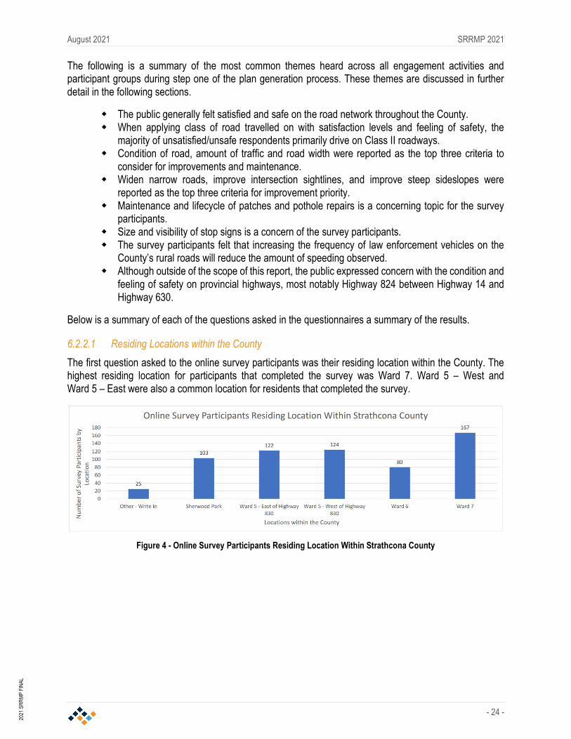
6.2.2.1 Residing Locations within the County
The first question asked to the online survey participants was their residing location within the County. The highest residing location for participants that completed the survey was Ward 7. Ward 5 – West and Ward 5 – East were also a common location for residents that completed the survey.
Figure 4 - Online Survey Participants Residing Location Within Strathcona County

August 2021 SRRMP 2021
- 25 -
2021
SR
RM
P FI
NAL
This question was not asked at the open houses. However, below is a distribution of the attendance at each open house by location.
6.2.2.2 Satisfaction and Feeling of Safety
The second question asked on the survey was a multi-part question. The question asked the residents and stakeholders their feeling of overall satisfaction and level of safety when travelling on these roadways. Overall, the public generally felt satisfied and safe on the County’s rural road network. Regarding satisfaction levels, only 21.3% of participants noted dissatisfaction with the current rural road network. Regarding feelings of safety, only 33.4% of participants noted feeling unsafe on the current road network.
Figure 5 - Open House Attendance by Location
Figure 6 - Satisfaction Level with County Rural Roads

August 2021 SRRMP 2021
- 26 -
2021
SR
RM
P FI
NAL
Further breaking down these survey responses, the participants provided the roads they travelled on frequently along with their feeling of safety and satisfaction with the rural road network. In reviewing this data, it became evident that the majority of dissatisfaction originated from survey participants that drove on Class II roadways. Additionally, Class III and IV roadways were a topic of concern with the participants. The sample size in this breakdown is larger than the overall satisfaction and safety question, as this question allowed participants to provide feedback on their three most travelled roadways within the County.
Figure 7 - Feeling of Safety on County Rural Roads
Figure 8 - Satisfaction Level by Classification Level

August 2021 SRRMP 2021
- 27 -
2021
SR
RM
P FI
NAL
The third and fourth questions asked on the survey were for the public to provide their input on which items should be the top priority when considering improvements. The question was posed in two ways. The first asked the public to assign a priority for the following when the County considers upgrades to the roads: condition of road, amount of traffic, road width, number of collisions, the roads as a link in the overall network, number of bad curves and hills, and number of public complaints. The survey participants noted the top three prioritization focuses for improvements were condition of road, amount of traffic and road width.
Figure 10 - Prioritization for Improvements (Part 1)
Figure 9 - Feeling of Safety by Classification of Roadway Traveled

August 2021 SRRMP 2021
- 28 -
2021
SR
RM
P FI
NAL
The second improvement prioritization question asked the participants to prioritize the following areas of concern when considering upgrades: widen narrow roads, improve intersection sightlines, improve steep sideslopes, improve horizontal sightlines, upgrade to asphalt, upgrade to dust controlled gravel, and improve vertical sightlines. The survey participants noted that the top three prioritizations for areas of concern were widening narrow roads, improve intersection sightlines and improve steep sideslopes.
6.2.2.3 Other Considerations
Finally, the survey participants were asked to provide any additional comments, considerations or concerns that were not included in the previous questions. The responses to these two questions varied considerably and produced 65 unique themes when grouping all responses. There were evident trends in the data that should be noted.
Snow clearing, maintenance, signage, large vehicles, and the condition of provincial highways were common themes. Additionally, combining the concerns of speed limits and enforcement escalates this concern to a common theme. Road width, steep sideslopes and condition will not be discussed in this section as they have previously been illustrated as the high priority items by the survey participants when considering improvements.
Snow clearing – Snow clearing was one of the most common topics in the online surveys. The survey participants generally felt that improvements in the snow clearing techniques and speed of clearing after a snowfall could be improved. Some of the improvements suggested were techniques of clearing when crossing driveways and minimizing snow ridges, increased priority of clearing on the subdivision/rural hamlet roadways and providing a wider cleared area when clearing the rural roads.
Maintenance – The public was generally dissatisfied with the quality of temporary repairs, such as pothole or patch repairs. Their concerns generally related to the short lifespan a patch or pothole repair has on the rural roads within the County. It was also noted in this topic that the participants were concerned with the quality of grading/resurfacing of the rural roads, most notably the continual overlays creating ridges at the driveway that are creating an increasing uneven transition into the resident’s driveways.
Signage – The participants were concerned with signage. The majority of signage related concerns was the visibility and size of stop signs within the County. They feel that at important intersections signage should be larger to draw the attention of the driver. Additionally, comments
Figure 11 - Prioritization for Improvements (Part 2)

August 2021 SRRMP 2021
- 29 -
2021
SR
RM
P FI
NAL
noted increased reflective markings on the stop signs would increase driver attention to the stop condition.
Large vehicles – The participants were generally concerned with the number of large vehicles on the County’s rural roads. With the industrial heartland and a large agricultural presence in the County, there are a considerable number of larger vehicles on the roadway which can create difficulty and an unsafe feeling when these vehicles are met on a narrow rural roadway.
Condition of provincial highways – Although outside of the scope of the SRRMP, a common theme in both the online surveys and open houses was the condition of provincial highways, most notably the condition of Highway 824 and the stop condition on Highway 830 at Township Road 550. The overall condition of Highway 824 has become a topic of concern for the participants. The deteriorating conditions is beginning to shift traffic to using adjacent range roads to bypass Highway 824 on their commutes. This creates added stress on the adjacent rural road network for the County to upgrade and maintain. The stop condition at Highway 830 and Township Road 550 is another topic of concern with the participants. It is counterintuitive to have the stop condition on Highway 830, when intersecting with a township road. Typically, in Alberta, the highway would have right-of-way through an intersection with a township road.
Speed limit and enforcement – The public was generally concerned with the number of speeding vehicles on the rural road network within the County. Survey participants and attendants at the open houses noted they felt increasing the frequency of law enforcement vehicles on the rural road network would improve the compliance to the speed limit.
It was noted that classifying roadways should not only consider AADT but vehicle class distribution on the roadways.
Continued overlay of paved rural roadways are creating difficulty for residents to maintain the grass adjacent to the road and creating ridges at driveways.
Trees are limiting visibility on rural roads. Railway crossings within the County were a safety concern for the public. Cyclist conflict with motor vehicles sharing the road was a common topic of concern (for both the
cyclists and the motor vehicle drivers).
2021 “Report Back”
The goal of this phase of engagement was to report back to the public on the 2019 SRRMP engagement, to understand the level of stakeholder support for the draft recommendations and identify any gaps in understanding of the draft recommendations by stakeholders.
The key messages heard in the 2019 SRRMP that were communicated in this round of engagement was that 78% of residents felt neutral, satisfied, or very satisfied with the County’s rural road network and the primary concerns residents had, related to the condition of the road surface, the volume of traffic and the existing road width. The feedback from the 2019 engagement helped guide the development of the draft recommendations by helping the design team to better understand the issues that the road users are experiencing. The level of satisfaction indicated that the rural road network was functioning well, however, there were areas that need to be improved.
The draft recommendations that were presented in the 2021 public engagement were:
Create framework for sustainability and budget allocation Redefine roadway classifications Develop rehabilitation standards to align with redefined classifications Review of maintenance methods and alternative methods Create a framework for prioritizing need

August 2021 SRRMP 2021
- 30 -
2021
SR
RM
P FI
NAL
Due to the public health measures put in place because of COVID-19, in person open houses were not possible; therefore, an online slide presentation with the ability for user feedback was utilized. The online presentation was hosted on the County’s website in April and May 2021 and information postcards directing residents to the online presentation were mailed out in early April 2021 to all rural residents prior to the presentation going live.
Summary of Findings
The online presentation provided the participants the opportunity to leave feedback. Comments were reviewed and questions raised by the participants were answered in email responses.
The following is a summary of the comments that were received from the online presentation feedback form. A total of 19 comments were provided and a summary of the themes are listed below. Some responses had multiple comments which have been separated and listed in multiple themes:
6 participants made comments regarding the need to upgrade specific roads. 7 participants commented on the need to accommodate cyclists and pedestrians. 5 participants had general comments on the SRRMP update. 3 participants commented on the narrow width of existing roads. 1 participant commented on the need to channel traffic away from local roads. 1 participant commented on maintenance operation. Although outside of the scope of this report, 2 comments expressed concern with the condition
of provincial highways.
The responses received in the “Report Back” phase followed the similar themes during the “Listen and Learn” phase. The majority of the comments received relate to items that are being address in the SRRMP 2021 or will be addressed in the ITMP update. There were no comments indicating opposition to any of the proposed recommendations or indicating topics that were missed. Overall, the level of engagement, the comments provided, and the lack of objection to the recommendations helps to validate the current direction of the project.

August 2021 SRRMP 2021
- 31 -
2021
SR
RM
P FI
NAL
7.0 Value Analysis Session
Updating the existing SRRMP is expected to garner significant public attention, therefore it was important that our process not only engage the public but expand our collective knowledge to access unique and innovative ideas that will address the functional requirements of the rural road network while addressing concerns from the local residents and stakeholders.
To create a transparent and defendable approach to the SRRMP update process, a formal (VA) session was completed. A VA session has the elements of a “focus group” but also includes technical expertise to create the necessary balance between competing interests.
The VA workshop was held on April 15 and 16, 2021. The workshop was held remotely through video conferencing and an online whiteboard collaboration. The workshop was hosted by Al-Terra Engineering and facilitated by SMA Consulting. Participants included staff from Strathcona County, Al-Terra Engineering, Leduc County, Parkland County, Sturgeon County, Park Paving, Carmack Enterprises, Thurber Engineering, and external experts. The goal of the workshop was to identify innovative ways to develop, maintain, rehabilitate, and upgrade the rural roads in the County. This also includes the refinement of classification and appropriate prioritization of upgrades.
Methodology
The methodology used in the workshop aligns with SAVE International’s standards for VA sessions. The workshop began with an introduction by Al-Terra’s Project Manager, Fred Greenhough, followed by SMA’s overview of the VA process. The project team presented a summary of the history and current state of the completed work. Participants then performed Function Analysis through function brainstorming and moved to small groups for a Creative Phase breakout session to identify new potential options. The workshop concluded with the Evaluation Phase, which involved a collaborative exercise to review and score the options and recommendations generated from the creative phase.
Information Phase
The information phase involved informing the participants of the history of the current SRRMP and the role it plays in guiding how rural roads are maintained and improved in the County. A presentation was made outlining the existing SRRMP, the existing state of the rural roads, and outlining the work that has been completed on the project. The presentation was followed with a Q and A session between the project team and the participants.
Function Analysis Phase
Following the Information phase, the participants were encouraged to come up with a list of functions that pertain to the delivery of the project. Key functions were identified and then were evaluated. The key functions were then used as trigger words during the creative phase to help generate as many ideas as possible. The key functions identified were:
Assign Priority Develop Classification Develop Standards Accommodate Volume Rehabilitate Road Upgrade Road

August 2021 SRRMP 2021
- 32 -
2021
SR
RM
P FI
NAL
Creativity Phase
Once the Information and Function Analysis phases were complete, the Creativity phase began. During the Creativity phase, participants were divided into two groups based on their areas of expertise and background. Each group had individuals from the County, Al-Terra, experts from other counties, contractors, and consultants. A technique called “World Café'' was used to increase the number of ideas generated. Each facilitator worked with a group for about an hour on each of the six major functions identified: Develop Standards, Develop Classification, Assign Priority, Accommodate Volume, Rehabilitate Road, and Upgrade Road. The facilitators rotated along with the two groups to generate more ideas for all six functions.
Evaluation Phase
During the Creativity phase, the ideas were captured using sticky notes on the online whiteboard. Participants were invited to evaluate the ideas and vote on the ones that they believed were worth further exploration. Using the 1-10 value index, participants scored the ideas for feasibility and benefit to the project. Ideas that were considered a seven and above were given a green dot, ideas that were three and below were given a red dot.
The session generated 80 ideas. The top nine key ideas that were thought to have the most potential included:
1. Explore economic efficiencies of scale on activities such as brushing, micro-surfacing, and others among municipalities and save cost by combining contracts.
2. Establish a program for sharing innovation and learnings among municipalities. Attend conferences such as the Regional Roads Forum held by Leduc County and WSP in late 2019/early 2020 and Alberta Municipal Supervisors Association (AMSA) Convention.
3. Trial projects for different applications through a project-based selection of technology, followed by revisit and documentation. Pilot projects in certain areas with specific products and methods before wide adoption, calculate the return on usage, and consider the risks involved for immediate repair. Improve and standardize piloting programs to allow for follow-ups and long-term studies, include signage and communication to the public. Be willing to test different technologies and accept some risk for potential success or failures.
4. Develop subclasses and allow flexibility in the criteria with local considerations to support realistic operation needs. Identify local context for roads that may not meet the standards but meet the needs of the local users. For example, gravel surface roads with Class III dust control in front of local farms would be insufficient for farm equipment. Balance the standards and bylaws with cost and flexibility.
5. Maintain collaboration and communication with contractors and be open to innovative improvements. Allow contractors to bring forward innovative ideas with transparent risk discussions and focus on the end result and road longevity. Consider contracting strategies that will make this easier such as integrated product delivery (IPD). Pursue up-front cost thinking prior to construction. Continue to work to develop relationships between the County and contractors.
6. Consider reducing right-of-way width to reduce land needs on Class I and II roads while keeping the backslopes at a good profile. Consider traffic volume and use. Standard right-of-way for 9m roads is 34m in Leduc County and 30m in Parkland County.

August 2021 SRRMP 2021
- 33 -
2021
SR
RM
P FI
NAL
7. Consider site specific design for specific uses/needs, geotechnical conditions vary across the county. Design the roadways in industrial areas specifically catering to heavy load and frequent use. Find an appropriate balance.
8. Plan upgrades and design to channel traffic to intended roads, and especially to avoid creating duplicate routes. Consider reducing Class I roads and having a robust network of Class II directing traffic to provincial highways. Take emergency access routes and highly populated areas into account.
The VA session was a valuable component of the design process. The VA session was able to validate some of proposed recommendations that had previously been developed by having experts with different roles within the transportation industry look at the challenges being addressed by this project and try to provide innovative ideas to solve them. The key ideas that were developed were evaluated and most have been incorporated into the recommendations. One of the themes that showed up in couple of the key ideas that were newly considered were the suggestions of greater collaboration between the regional municipalities. The sharing of information between municipalities has very little cost but the ability to learn from ‘lessons learned’ by others can have significant value in both dollars and time.
The Value Analysis Summary Report is included in Appendix D. The summary report includes the full list of value ideas beyond the top nine listed above. The full list includes many ideas that could provide additional value to the County. Some of these ideas include:
Educate the public on the different feels and looks of roads with different surface and on rural road qualities. For example, not all paving methods will result in a black surface, which can cause problems and complaints due to the lack of understanding from the public. In addition, urban residents who are driving in a rural setting may have unrealistic expectations. Educate and inform nonresident drivers and users when it comes to driving on rural roadways.
Improve wayfinding to specific rural destination to keep urban/infrequent users on the right roads. Explore methods to communicate with Google Maps and other wayfinding and mapping software to set up proper wayfinding for rural destinations

August 2021 SRRMP 2021
- 34 -
2021
SR
RM
P FI
NAL
8.0 Review of Prioritization Matrix
Current practice within the County for prioritizing projects is a process where candidate roads are evaluated based on the pavement condition, cross section, traffic volume, collision history, importance within the network and other factors. The concern with the current method is there are subjective elements, and it may not be optimally weighting the different factors. A method to improve the selection process is the use of a prioritization matrix. A prioritization matrix is a tool that, using specific criteria, is used to objectively compare potential projects and thus determine which projects should receive priority for funding.
Outlined below is a potential framework for a priority matrix that can assist in rating road segments to determine which candidate road segment should be rehabilitated. The matrix consists of 11 factors that each candidate road segment could be evaluated on, consisting of both importance factors and road condition factors. The importance factors relate to the role that the road segment plays within the overall road network and the condition factors relate to the quality and geometrics of the existing road segment. The factors used within the matrix can be developed overtime with the addition of new factors or removal of existing factors to optimize the matrix to the needs of the County.
Each factor is rated individually on a scale from 1-5, with 5 being the highest priority and 1 the lowest. Each factor can also be given a weighting so that specific factors can have a higher or lower importance than other factors within the matrix. The weighting of the factors can be determined as the matrix is refined.
Importance Factors
The importance factors are used to evaluate the value of the road in relation to the network and as described by the road classifications in the TSB and the recommended network model-based classification plan. These factors are constructed to provide a higher priority to roads that perform important roles within the network, such as providing access to municipalities, serving businesses, and carrying higher volumes of traffic. There are five importance factors included in the matrix consisting of:
Proximity to Parallel Road of Higher Classification Continuity within Network Traffic Volumes Industry/Commercial Users % Trucks
Proximity to Parallel Road of Higher Classification
This factor is used to rate where a road is spatially located in relation to other roads within the network. If there is a parallel road of higher classification in close proximity, it is desirable that traffic should be channeled and encouraged to use the higher classified road as it would be constructed to a higher design standard and designed to handle larger volumes of traffic. The closer the road segment is to a parallel road of higher classification, the lower the priority.
Continuity Within the Network
This factor is used to rate the importance of the road segment within the overall network and if it serves a role in connecting communities or roads of higher classification. This is a subjective rating, with roads providing a Provincial level continuity, such as between two provincial highways, given the higher priority, and roads providing limit access to properties given a lower priority.

August 2021 SRRMP 2021
- 35 -
2021
SR
RM
P FI
NAL
Refer to Table 7 for the importance factor rating criteria.
Table 7 - Priority Matrix Importance Factors
Priority Matrix Importance Factors
Proximity to Parallel Route of Higher Classification
Network Level Continuity
Traffic Volume (vpd) Industrial/ Commercial Users % Truck Rating
>4 Miles (6.4km) Provincial <2000 High Importance to Multiple Industrial/Commercial Users
>20% 5
<4 Miles (4.8-6.4km) Regional 1000-2000 High Importance to Single
Industrial/Commercial User 10-20% 4
<3 Miles (3.2-6.4km) Municipal 200-1000 Low Importance to Single Industrial/
Commercial User 5-10% 3
<2 Miles (3.2-6.4km) Local 50-200 Limited Industrial/ Commercial users 2-5% 2
<1 Miles (3.2km) Short <50 No Industrial/Commercial users <2% 1
Traffic Volumes
This factor is used to rate the volume of traffic on a road segment. Traffic volume is an important determinant in the classification, geometric design, and structural design of a road. Road segments that carry higher traffic volumes are given a higher priority.
Industry/Commercial Users
This factor is used to rate the importance of the road in providing access to industry and commercial businesses. Industrial and commercial business are generally higher generators of traffic. A road segment that is of high importance to multiple industrial or commercial business is given a higher priority, and road segments that do not serve any industrial or commercial business are given a lower priority.
% Truck Traffic
This factor is used to rate the volume of truck traffic on a road segment. High volumes of truck traffic impact the operation and the structural requirements of the roadway. Roads with higher volumes of truck traffic are given a higher priority.

August 2021 SRRMP 2021
- 36 -
2021
SR
RM
P FI
NAL
Road Condition Factors
The road condition factors are used to evaluate the quality and condition of the existing road infrastructure. These factors give higher priority to roads which have a lower condition rating and have geometrics which are further below design standards. There are six road condition factors included in the matrix consisting of:
Structure Condition Road Width Vertical Alignment Horizontal Alignment Side Slope Safety Issues
Structure Condition
This factor is used to rate the condition of the pavement structure. The County uses the Road Matrix database to manage pavement assets and each road segment is evaluated on various factors to produce a pavement quality index (PQI) value. The structural rating is to be evaluated from the PQI value. A higher PQI value would indicate a lower priority, and lower value a higher priority.
Road Width
This factor is used to rate the width of the existing road. Road width is a factor in road users feeling of safety and narrow roads can lead to higher collision risk when associated with higher traffic volumes, higher truck traffic, and poor road geometrics. The road width is evaluated based on existing design standards with higher priority given to roadways that are most narrow.
Vertical Alignment
This factor is used to rate how the existing geometry compares to design standards. The vertical alignment refers to the sharpness of vertical curves and relates to available sightlines, safety and driving comfort. Roads with a higher number of vertical curves that do not meet design standards are given a higher priority.
Horizontal Alignment
This factor is used to rate how the existing geometry compares to design standards. The horizontal alignment refers to the sharpness of horizontal curves and relates to safety and driving comfort. Roads with a higher number of horizontal curves that do not meet design standards are given a higher priority.
Side Slope
This factor is used to rate the steepness of the slope of the road adjacent to the pavement compared to the design standards. The steepness of the sideslope impacts the ability of a vehicle to recover if it leaves the road. Steeper sideslopes have a higher collision risk and are given a higher priority.
Safety Issues
This factor is used to rate the road segment on identified safety issues. Safety issues can be identified through identifying trends in the collision data or from public comments. Roads with identified safety issues are given a higher priority.

August 2021 SRRMP 2021
- 37 -
2021
SR
RM
P FI
NAL
Table 8 - Priority Matrix Road Condition Factors
Priority Matrix Road Condition Factors
Structure (PQI)
Road Width Vertical Alignment Horizontal Alignment
Side Slopes Safety Issues
Rating
Less than 40
Greater Than 1.5m Below Design
Standards
Greater Than 3 Locations/km Below Design Standards
Greater Than 3 Locations/km Below Design Standards
Less than 100% of Road Greater than 3:1 Slopes
Major Safety Issues
5
40-55 Greater Than 1.0m
Below Design Standards
3 Locations/km Below Design
Standards
3 Locations/km Below Design
Standards
100% of Road Greater Than
3:1 Slopes 4
55-70 Less Than 1.0m Below Design
Standards
2 Locations/km Below Design
Standards
2 Locations/km Below Design
Standards
50% of Road Greater Than
4:1 Slopes
Minor Safety Issues
3
70-85 Less Than 0.5m Below Design
Standards
1 Location/km Below Design Standards
1 Location/km Below Design Standards
75% of Road Greater Than
4:1 Slopes 2
85-100 Meets Design
Standards Meets Design
Standards Meets Design
Standards
100% of Road Greater Than
4:1 Slopes
No Safety Issues
1
Applying the Matrix
The matrix should be applied once candidate road segments have been selected. The candidate road segments would be placed in the matrix shown in Table 9. Each road segment would be assess based on the ranking criteria presented in Tables 7 and 8 with a weighting and rating assigned for each importance and condition factor.
The factor weighting determines the relative importance of each factor. A larger weighting value is given to factors that are considered to be of higher importance and a lower factor is given to factors of lower importance. The base value for weighting would be 1.0. For example, when comparing roadways of a higher road classification, the width of the road may be deemed more critical than the % Trucks. In this instance a weighting of 2.0 may be given to the Road Width and 0.5 to % Trucks, and a weighting of 1.0 for the remaining factors. The weighting values are subjective and are dependent on the specific roads being analyzed. The weighting criteria can be developed as the priority matrix is refined.
The output from the priority matrix would be the Priority Number. A road segment with a higher Priority Number would be evaluated as the higher priority.

Traffic Volume
Ratin
g
Wei
ghte
d Ra
ting
% Trucks
Ratin
g
Wei
ghte
d Ra
ting Proximity to
Parallel Road of Higher Class Ra
ting
Wei
ghte
d Ra
ting
Continuity
Ratin
g
Wei
ghte
d Ra
ting Industrial/
Commercial Users Ra
ting
Wei
ghte
d Ra
ting Structural Condition Ra
ting
Wei
ghte
d Ra
ting
Road Width
Ratin
g
Wei
ghte
d Ra
ting Vertical
Alignment Ratin
g
Wei
ghte
d Ra
ting Horizontal
Alignment Ratin
g
Wei
ghte
d Ra
ting
Side Slope
Ratin
g
Wei
ghte
d Ra
ting
Safety Issues
Ratin
g
Wei
ghte
d Ra
ting
Prio
rity
Scor
e
Section # Road Start Finish Length Classification Surface Type 1.0 1.0 2.0 0.5 1.0 1.0 1.0 1.0 1.0 1.0 1.0
5 5 5 5 5 5 5 5 5 5 5
4 4 4 4 4 4 4 4 4 4 4
3 3 3 3 3 3 3 3 3 3 3
2 2 2 2 2 2 2 2 2 2 2
1 1 1 1 1 1 1 1 1 1 1
TABLE 9 - DRAFT PRIORITIZATION MATRIX
Weighting WeightingWeighting Weighting Weighting Weighting Weighting WeightingWeighting Weighting
Road Information
Weighting
Major Safety Issues
Minor Safety Issues
No Safety Issues
Greater Than 3 Locations/km Below Design Standards
Greater Than 2 Locations/km Below Design Standards
2 Locations/km Below Design Standards
1 Location/km Below Design Standards
Meets Design Standards
Less than 100% of Road Greater than 3:1 Slopes
100% of Road Greater Than 3:1 Slopes
50% of Road Greater Than 4:1 Slopes
75% of Road Greater Than 4:1 Slopes
100% of Road Greater Than 4:1 Slopes
Greater Than 1.0m Below Design Standards
Less Than 1.0m Below Design Standards
Less Than 0.5m Below Design Standards
Meets Rehabilitation Guidelines
Meets Design Standards
Greater Than 3 Locations/km Below Design Standards
Greater Than 2 Locations/km Below Design Standards
2 Locations/km Below Design Standards
1 Location/km Below Design Standards
Meets Design Standards
High Importance to Multiple Commerical Users
High Importance to Single Commercial User
Low Importance to Single Commercial User
Limited Commerical users
No Commerical users
PQI Less than 40
PQI 40-55
PQI 55-70
PQI 70-85
PQI 85-100
>4 Miles (6.4km)
<4 Miles (4.8-6.4km)
<3 Miles (3.2-6.4km)
<2 Miles (3.2-6.4km)
<1 Miles (3.2km)
Provincial
Regional
Municipal
Local
Short
200-1000 vpd
50-200 vpd
<50 vpd
>20%
10-20%
5-10%
2-5%
<2%
<2000 vpd
1000-2000 vpd

August 2021 SRRMP 2021
- 39 -
2021
SR
RM
P FI
NAL
9.0 Review of Network Model Based Functional Classification Plan
Identifying and defining a hierarchy of roadway classifications is an integral part of transportation planning. It allows for clear identification of the future roadway network and how road users will be able to move around. Roads should not be classified solely by traffic volumes, but by the intended role within the overall road network. To do this the functional classification of roads should instead be based on a network model, which accounts for factors such as the role of the road within the overall network, development of corridors to channel traffic away from local roads to roads of higher classification, providing connections to municipalities and connections to the provincial highway network. The development of the TSB took into consideration the role of network connectivity and other factors in assigning road classifications. The network model based functional classification plan will complete the work started in the TSB.
The County has developed a long-range traffic model of the rural road network that models the future traffic demand from future growth areas such as Bremner, North of Yellowhead, Ardrossan, and highway expansions including Highway 16 and Highway 15. The network model incorporates the existing road capacities and existing and future traffic generators to provide insight as to where future upgrades will be required. This long-range traffic model should be used in developing a future rural road functional classification plan.
The rural road functional classification plan should outline where the future arterial and collector roadways will be required to meet the long-term requirements of the County. This will benefit the prioritization process by taking a long-range view and focusing improvements on the parts of the network that will provide the best long-term value, and to identify areas of the County where improvements are required to complete the rural road network and complete transportation links.
For this study the existing provincial highway network and Class I networks were reviewed at a high level with the goal of identifying deficiencies in the network. To fully develop the functional classification plan further study will be required to fully define the Class I and Class II network. The study should look at the existing road classifications of the entire network to determine the most appropriate classifications for the future.
Review of the Class I Network Based on Traffic Model
The network of provincial highways in the County is the backbone of the transportation system which primarily moves people and goods quickly around the County and into the capital region. The provincial highway network is typically served by higher speed highway facilities including high volume divided highways, that can move people quickly and efficiently. The Class I network compliments the provincial highway network by providing roads capable of carrying higher volumes in areas not served by the Provincial network.
The County’s network traffic model was used to review the existing Class I road network. The network model was reviewed at the long-term scenario (full build-out of MDP) and did not include the impact of the potential Northeast River Crossing project. There were two primary objectives. The first was to identify corridors that are expected to have high future traffic demands and would be candidates to be classified as Class I roads. The second objective was to identify a network plan that provided all County properties access to either a provincial highway or a Class I road to within four miles.
Today the provincial highway network and the Class I network provides extensive coverage over the higher density areas of the County south of Highway 16. South of Highway 16, the only location that should be considered for upgrades would be Township Road 530, from Range Road 213 to Range Road 211, and Range Road 211, from Highway 16 to Township Road 530. These upgrades would provide a connection from existing Class I network at Township Road 530 and Range Road 213 to the planned interchange at Highway 16 and Range Road 211.

August 2021 SRRMP 2021
- 40 -
2021
SR
RM
P FI
NAL
North of Highway 16 there are several areas that will require upgrades to provide a complete network. The only existing north-south highway or Class I corridors are Highway 21 and Highway 830. East of Highway 830 there will be demand for an additional north-south corridor. Range Road 210/211 would be the likely candidate. At the south end, there is a planned interchange at Highway 16, and at the north end it would join the north-south Highway 830 and intersect the east-west Highway 15. The road name changes at Township Road 550 due to the correction line. Due to the correction line, the corridor is named Range Road 210 north of Township 550 and Range Road 211 to the south. The corridor is continuous.
Between Highway 16 and Highway 15 there are no east-west provincial highways and there is only a short section of Township Road 550 designated as a Class I road. There are 14 miles between Highway 16 and Highway 15 and would likely need two east-west corridors to complete the network. Continuing Township Road 550 to the east County boundary as a Class I road would be viable option as it provides access into the City of Fort Saskatchewan. The model does not indicate that the traffic demand will exist east of Highway 830; however, it would provide a northern connection between Range Road 210 and Highway 830. To complete the network there would need to be an additional east-west corridor at either Township Road 542 or 540. Either location would be acceptably spaced between Highway 16 and Township Road 550. The model does not indicate that the traffic demand will exist east of Highway 830, however, it would complete the Class I network and would provide a connection to the future Bremner Development.
The future development area of Bremner presents challenges in predicting the future road requirements. The road network between Bremner and the City of Fort Saskatchewan will require significant upgrades to handle the expected traffic volumes as some roads are predicted to have over 10,000 vpd. For this area recommendations have not been provided as they are highly dependent on the future area structure plan.
The Industrial Heartland also presents challenges in planning the road network. Specific recommendations were not made for the Industrial Heartland area as the developments are typically very large and traffic demand is highly dependent on where the development occurs and where the access points are and therefore need to be addressed as development occurs.

August 2021 SRRMP 2021
- 41 -
2021
SR
RM
P FI
NAL
10.0 Recommendations
To meet the County’s sustainability and safety goals, strategies are needed to guide the efficient use of resources for both the capital and operating budgets. To meet these goals, the following recommendation were developed and are outlined in the following sections. The key areas for recommendations are:
Preservation of Investment Safety Measures Roadway Classification and Design Standards Development of Rehabilitation Design Standards Funding Requirements
Recommendation - Preservation of Investment
The County provides its residents a highly developed rural road network. Resources for the expansion and maintenance of the network is limited; therefore, it is important to allocate available resources in the most efficient and sustainable manner possible. The following recommendations are proposed to address the overall network. The recommendations are generally high-level recommendations and County staff and Council will need to have flexibility to address specific situations that may arise or are not identified within this plan.
1. The County has made significant investment over the years to construct the network that currently exists. The most cost-effective way to maintain that investment is timely and effective maintenance. Proper maintenance can help delay the more expensive rehabilitation methods, such as overlays and reconstruction, and is therefore key in maintaining a sustainable road network. It is recommended to continue to invest in timely routine interim maintenance practices to increase the design life of existing roads.
2. Develop a prioritization matrix, using defined importance and condition factors, to assist in rating road segments to determine which candidate road segment should be rehabilitated. The importance factors relate to the role that the road segment plays within the overall road network and the condition factors relate to the quality and geometrics of the existing road segment. The benefit of the prioritization matrix is that it is a subjective way to evaluate potential projects.
3. Develop a formal process for trialing new products or construction methods. A formal process with specific public program goals, public communication, and long-term testing and evaluation schedules will allow for better assessment. Within the current system new products and construction methods are being utilized but without scheduled long-term follow up and evaluation it is difficult to confirm the actual design life and life cycle costs. Public communication is critical when implementing a trial section. The public needs to be informed of the process so that they can be aware of the possible outcomes.
4. Each road is unique and has specific soil and surface conditions, and the ‘one size fits all’ approach could lead to some roads not meeting expectation of the road users. Site specific engineering and geotechnical work should be performed to identify the proper rehabilitation or maintenance treatment and to design a surface that will be able meet the expected traffic uses.
5. Use a cost benefit analysis to evaluate the life cycle cost of proposed improvements and maintenance. Cost savings could be realized by analyzing different rehabilitation and maintenance method costs versus their expected design life. Some construction methods may have large upfront costs but by analyzing them over the entire design life and factoring in long-term maintenance costs, the economics may be competitive.

August 2021 SRRMP 2021
- 42 -
2021
SR
RM
P FI
NAL
6. Use technology to capture a richer data set when completing traffic counts. Video analysis can be used for completing traffic counts which also allows for determining the composition of traffic (passenger vehicles, trucks, buses, etc.) and for determining the peak volume periods. This additional information. Trucks and heavy vehicles have a significant impact on the pavement structures of roads and additional information will allow for better pavement designs. Funding should also be provided to acquire additional traffic counts for all roads that are being considered for upgrade, and multi seasonal counts should be completed for roadways that are being considered for downgraded. The regular collection of traffic counts will be necessary to maintain an up-to-date network traffic model.
7. There are roads within the County that are experiencing higher volumes due to shortcutting. The County should talk to industry partners about directing their employees to use specific routes for employees and trucks. Shortcutting leads to higher traffic volumes and higher speeds on lower class roadways that are not designed for those levels of traffic. the County can also communicate with traffic mapping software companies, such as Apple and Google, to direct routing to major roadway and avoid the minor roads.
8. County staff should develop a regular communication and information sharing program with neighboring municipalities. The challenges faced by the County to maintain their road network is similar to other municipalities and there are opportunities to learn from each other.
9. With the potential of changing weather patterns there is an increased risk in extreme weather events occurring including rain events with higher precipitation and more extreme temperatures variations. These increased risks can impact existing infrastructure. Increased frequency and severity of rain events can result in an increased risk of flooding, soil erosion, and soil instability. Greater temperature extremes can result in an increase in stress to asphalt structures resulting in a decrease in service life and increase in maintenance costs. To have a transportation system that is sustainable it is important for infrastructure to be designed and constructed to be resilient to environmental impacts.
Recommendation – Safety Measures
Considering the Safer Systems Approach, listed below are recommendations that the County can implement to reduce the risk of collisions on the rural networks and to assist with rural road safety program.
1. A common theme that was noted from the public engagement sessions was concerns about sightlines at intersections. The County has large areas that are generally forested and if roads have a narrow right-of-way, sightlines can be compromised by vegetation. A brushing program should be implemented where trees are cleared at intersections to increase sightlines. Adjacent landowners should also be approach if trees need to be cleared on private property.
2. Good data collection and analysis is critical in being able to evaluate the safety performance of transportation infrastructure. Accurate and comprehensive data helps to understand the nature and causes of vehicle collisions and allows for the implementation of effective countermeasures. The County should continue to collect the most comprehensive data available for collisions.
3. In the five-year period between 2015 and 2019, approximately 40% of fatal and injury collisions on rural roads in the County occurred at intersections. To reduce the number of collisions due to stop sign violations, the County should implement guidelines for additional safety measures at rural stop-controlled intersections. Alberta Transportation’s “Safety Measures at Rural Stop-Controlled Intersections” is an effective guideline and is outlined in Section 8.3.

August 2021 SRRMP 2021
- 43 -
2021
SR
RM
P FI
NAL
4. Current County practice is to install centerline and edge line painting on a road specific basis. Line painting should be expanded to include roads of any functional classification that have a hot mix asphalt surface, width over 8.5m and over 500 vpd.
5. Mini rural roundabouts can be an effective countermeasure for reducing the severity of collisions at intersections by reducing the number of high-speed collisions. They can also be effective at reducing speeding and reducing shortcutting. The application of mini rural roundabouts is very site specific and should only be implemented at intersections after a detailed engineering assessment has been conducted to determine the site suitability. The design and siting of mini rural roundabouts is critical as they can have an impact on the passage of large vehicles, specifically agricultural equipment. The County has numerous roundabouts in the urban and urban fringe areas so most drivers should be familiar with navigating them. If a suitable site is identified, the County should consider a trial project with a mini rural roundabout. Additional information on mini rural roundabouts is included in Section 8.4.
6. There is a high rate of animal collisions within the County. In the 5-year period between 2015 and 2019, approximately 40% of collisions on rural roads were animal collisions. The most effective treatments to reducing the number of animal collisions is to keep the right-of-way mowed and clear of trees. If specific and problematic wildlife corridors are identified, warning signs should be installed.
7. When roads are being upgraded to a hot mix asphalt surface, intersecting roadways that have a gravel or dust-abated gravel surface should have asphalt paved a minimum of 30m from edge of roadway to facilitate road sanding and salting during winter maintenance. A gravel or dust abated gravel road surface is damaged if salt or sand is applied.
Recommendation - Rural Road Functional Classification and Design Standards
The County’s existing functional road classification system is defined in the TSB and further described in the design standards which are broadly outlined in Section 3. A review of the functional classification system and design standards was completed with the goal of identifying if there were any areas to recommend for improvement. Within the functional classification system and design standards several items for improvement were identified. These items are:
1. Inconsistent Road Classification System Nomenclature – Roadways are typically classified by the function they serve within the transportation system. The industry standard classification system divides roadways into three categories: arterial, collector and local. The current functional classification system nomenclature used in the County for the rural road network are the terms Class I, Class II, Class III, and Class IV which describe what are essentially arterial, collector and local roads. This nomenclature is inconsistent with what is used within the County for urban roadways, neighboring municipalities, and Transportation Association of Canada, which use the arterial, collector, local road nomenclature. The use of standard and descriptive naming conventions allows for clearer communication and understanding of the road classes when comparing to other jurisdictions or design standards. The TSB has included the use of arterial, collector and local in conjunction with Class I-IV and it is recommended that the County fully adopt the changes shown in Table 10 which is better aligned with industry standards.

August 2021 SRRMP 2021
- 44 -
2021
SR
RM
P FI
NAL
Table 10 - Proposed Road Classification Nomenclature
Current Nomenclature Proposed Nomenclature
Class I Rural Arterial
Class II Rural Major Collector/ Rural Minor Collector
Class III Rural Local - Dust Abated
Class IV Rural Local - Gravel
Rural Residential Subdivision Rural Residential Subdivision
Rural Hamlet Rural Hamlet
Industrial Collector Rural Industrial Collector
Industrial Local Rural Industrial Local
2. Revised Road Classifications - In reviewing the functional road classifications and design
standards it was noted that there is a significant difference in the minimum design standards between the Class I and Class II functional classes. Class I roads are intended for roads with traffic volumes over 1000 vpd and Class II roads for traffic volumes of 250-1000 vpd; however, the geometric standards for the Class II roads are more similar to the Class III and Class IV roads, which are local roads with traffic volumes under 250 vpd. The design requirements for the roads that experience volumes approaching 1000 vpd are quite different than roads with traffic volumes of 250 vpd and require different design criteria to meet the needs of the road users. The Class II network acts as the collector roads within the County’s rural road network and serve a wide variety of roles within the overall network; however, the existing design standards are not able to accommodate this. From the public engagement it was noted that the Class II road network had the greatest levels of dissatisfaction among residents of the functional road classes. There are likely several factors that play into this, including the overall size of the network and the variable traffic volumes, road conditions, cross sections and surfacing types that exist within the class. The Class II network is the largest road class with 444km of road and 46% of the entire rural road network, and almost 40% of Class II roads have traffic volumes over 500 vpd.
The County should consider changes to the Class II road classification criteria by developing an additional classification by splitting the Class II network into two different classifications. These two new classifications would serve the role of a Major Collector and a Minor Collector. The Major Collector classification would be applicable for the higher volume Class II roads, and Minor Collectors would cover the lower volume roads of the existing Class II classification.
The Rural Major Collector road classification would be applicable for roadways between 500 vpd and 1000 vpd, with a pavement width of 8.5m. The increase in pavement width will better accommodate the traffic volumes, provide a safer road for the higher traffic volumes, and would allow for future asphalt overlays without narrowing the road below an acceptable width.
The Rural Minor Collector road classification would be applicable to roadways between 200 vpd and 500 vpd with a pavement width of 8.0m. The increase in pavement width from the existing 7.5m standard will better accommodate the traffic volumes, will provide a safer road, and will allow for future asphalt overlays without narrowing the road below an acceptable width.

August 2021 SRRMP 2021
- 45 -
2021
SR
RM
P FI
NAL
The Rural Local–Dust Abated classification would replace the existing Class III classification and would be applicable to roadways between 50 and 200 vpd with a width of 7.5m. The design criteria would be similar to the existing Class III criteria with the exception of the reduced volume range.
The Rural Local–Gravel classification would replace the Class IV classification and would be applicable to roadways between 0 and 50 vpd with a road surface width of 7.0m. The road surface width is reduced from the existing Class IV design criteria. This reflects the lower traffic limits of this class and reflects the role this class would serve in the overall network.
The Rural Industrial Collector classification is a new classification. This classification would be applicable for roadways with high truck traffic in the range of 20% and primary purpose is to provide traffic movement and access to local properties.
The Rural Industrial Local classification is a new classification. This classification would be applicable for roadways with high truck traffic in the range of 20% and primary purpose is to provide access to local properties.
Refer to Table 11 for a breakdown of the proposed classification criteria and proposed design standards.
3. Network Model Based Classification Plan – The County has developed a long-range traffic model of the rural road network that models the future traffic demand from future growth areas such as Bremner, North of Yellowhead, Ardrossan, and improvements to provincial highways. The network model incorporates the existing road capacities and existing and future traffic generators to provide insight as to where future upgrades will be required. This long-range traffic model should be used in creating a future County wide rural road functional classification plan.
4. Rural Industrial Road Functional Road Classification – In the 2010 SRRMP report a recommendation was provided to create a new classification to deal with heavy industrial traffic. The Alberta Industrial Heartland Transportation Study developed some design criteria and cross sections for that area. The Strathcona County Design and Construction Standards also include cross sections for industrial road however, the cross sections are inconsistent. A formal, consistent rural industrial road classification should be developed.

Existing DescriptionClass I Class II Class II Class III – Dust-Abated Class IV - Gravel Rural Residential
Subdivision RoadwayRural Hamlet Roads
Proposed DescriptionRural Arterial Rural Major Collector Rural Minor Collector Rural Local - Dust
AbatedRural Local-Gravel Rural Residential
SubdivisionRural Hamlet Rural Industrial
CollectorRural Industrial Local
Traffic Volume and Type
Traffic volume (vpd) and proportion of truck traffic.
Greater than 1,000 vpd, moderate to high
proportion of truck (SUT and MUT) traffic.
500 vpd to 1,000 vpd, moderate proportion of
truck (SU and TT) traffic.
200 vpd to 500 vpd, moderate proportion of
truck (SU and TT) traffic.
Less than 50-200 vpd, expect low proportion of truck (SU and TT) traffic
.
Less than 50 vpd, expect low proportion of truck (SU and TT) traffic .
Up to 500 vpd Very low proportion of truck (SU
and TT) traffic .
Up to 500 vpd Very low proportion of truck (SU
and TT) traffic.
Traffic volumes vary, but expect a high proportion
of truck (SU and TT) traffic (greater than 20%)
in all volumes.
Traffic volumes vary, but expect a high proportion
of truck (SU and TT) traffic (greater than 20%)
in all volumes.
Road Width Design width of finished road surface
9.0m 8.5m 8.0m 7.5m 7.0m 7.5m to 8.5m See Urban Design Standards
Vol. 1 Sec 4.1, Roads
11.5 9.5
Right-of Way Width Minimum right of width 40m 30m 30m 30m 20m 30m 30m 30m 30mFunction Primary purpose of functional road
classTtraffic movement Traffic movement and
access have similar importance
Traffic movement and access have similar
importance
Access to adjacent properties
Access to adjacent properties
Access to adjacent properties
Access to adjacent properties
Traffic movement and access have similar
importance
Access to adjacent properties
Spatial Hierarchical System
Description of the primary purpose fo the road and the role that it serves within the overall road
network
Provides connection from lower class
roadways to a provincial highway or to an urban
center
Provides connection from lower class
roadways to a provincial highway or to an urban
center
Provides connection from local roads to an
arterial roadway or provincial highway.
Provides access from properties to higher class
roadways.
Provides access from properties to higher class
roadways.
Provides connection from rural subdivisions to
the main rural road network.
Provides connection from local hamlet road network to the to the
main rural road network.
Provides access to the industrial subdivision
from a higher classification of road.
Provides connection to other internal industrial subdivision roads and
properties
Notes: vpd - Vehicles per day SUT - Single Unit Truck MUT - Tractor Trailer Truck
TABLE 11: PROPOSED CLASSIFICATION SYSTEM CRITERIA
Factor or Characteristic

August 2021 SRRMP 2021
- 47 -
2021
SR
RM
P FI
NAL
Recommendation – Develop Rehabilitation Design Guidelines (3R/4R)
One of the challenges in maintaining the existing road network is the high cost of reconstructing roads. To provide flexibility to road designers when rehabilitating roadways, the County should develop rehabilitation design guidelines. The goal of rehabilitation design guidelines is to provide lower cost and lower impact design options to sustainably extend the service life of the existing infrastructure as major reconstruction projects are cost and time intensive and are not required for every roadway.
The rehabilitation design guidelines could be developed similar to Alberta Transportations 3R/4R guidelines or Transportation Association of Canada’s 3R/4R Guidelines. 3R/4R refers to projects the involve resurfacing, restoration, or rehabilitation (3R) or some limited reconstruction (4R). The rehabilitation guidelines would formalize the County’s current practices on rehabilitating and maintaining roads in which roads are rehabilitated to criteria that are below the new construction standards. The guidelines would provide flexibility when rehabilitating a roadway to consider design parameters that would satisfy best practices but may not meet the higher standards required in existing design standards for new construction. This would be specifically applicable on roadways where land acquisition may present challenges. Some design criteria that could be considered to have lower minimums than the new construction standards, while still meeting engineering best practices, include narrower pavement widths, narrower right of way widths, and reduced vertical and horizontal curve minimums. Table 12 shows which improvements would be completed using the rehabilitation design guidelines and which would be completed using new construction standards.
Table 12 – Improvement Matrix
Road Surface Operating Budget Improvements
(Rehabilitation Design Guidelines)
Capital Budget Improvements
(New Construction Design Standards)
Regular
Maintenance Minor Repair
(Localized repairs) Rehabilitation Reconstruction
Hot Mix Asphalt Crack filling, spray
patching, seal coats
Base repair – remove and replace with soil cement and asphalt
Asphalt overlay, full depth reclamation (foamed asphalt,
cement stabilization)
Full rebuild, grade widening Cold Mix Asphalt Blade patching
Base repair – remove and replace with soil cement and asphalt
Pulverize and cement stabilize base
Gravel and Dust Abated
Gravel blading – 2-week cycle
Spot base stabilization, remove and replace with 63mm recycled concrete
Cement stabilize base and re-gravel

August 2021 SRRMP 2021
- 48 -
2021
SR
RM
P FI
NAL
Recommendation – Funding Requirements
To get a scope of the budget implications of the current expenditures a review of the existing road data was completed in Section 3. This review shows that a very large infrastructure deficit exists in the County. Accounting for only the roads that are deficient in width there are over 1100km of roadway that are below new construction design standards. In budget terms, at a cost of $1.5 million per km for reconstruction, that results in a deficit of $1.650 billion dollars. If you only look at the roads that are greater than 1.0m narrower compared to the new construction design standard, which would compare to a rehabilitation design standard, that still leaves over 610km of roads that are deficient in width. In budget terms, at a cost of $1.5 million per km for reconstruction, that still results in a deficit of $915 million dollars.
Table 4 shows the operating and capital budgets for the rural road network. Over the last five years the average capital budget has been $7.5 million per year, with the most recent year of 2020 at $8.83 million. The current capital budgets are not sufficient to address the infrastructure deficit. To address the backlog in the existing infrastructure deficit over the next 20 years, to just the roads that would fall under the 3R/4R design guidelines, the capital budget will need to be increased by a factor of five. This does not take into account capital expenditures that will be required for future growth.
The increase in spending on the capital budget should have positive impacts on operating budget. In Table 6 the total expenditure per road class is shown. From this table it is evident that the higher road classifications, which typically have a higher quality surface are requiring less budget to maintain. As roads are reconstructed and have their surface types improved this will result in lower operating cost for those improved roads.

August 2021 SRRMP 2021
- 49 -
2021
SR
RM
P FI
NAL
11.0 Conclusion
Summary of Recommendations
This section summarizes the key recommendations presented in this report. For detailed information regarding the recommendations refer to Section 10.
Preservation of Investment
Maintenance should be kept up on the road sections that may appear to be candidates for overlays.
Develop a formal process for trialing new products or construction methods. Site specific engineering and geotechnical work should be performed to identify the proper
rehabilitation or maintenance treatment. A cost benefit analysis should be used to evaluate the life cycle cost of proposed improvements
and maintenance. Technology should be used to capture a richer data set when completing traffic counts. Industry partners should be engaged about directing their employees to use specific routes for
employees and trucks. County staff should develop a regular communication and information sharing program with
neighboring municipalities.
Safety Measures
A brushing program should be implemented where trees are cleared at intersections to increase sightlines.
Continue to collect the most comprehensive data available for collisions. Implement guidelines for additional safety measures at rural stop-controlled intersections. Consider rural roundabouts as potential intersection treatments Keep the right-of-way mowed and clear of trees in animal corridors reduce animal collisions Intersecting roadways that have a gravel or dust-abated gravel surface should have asphalt
paved a minimum of 30m from edge of roadway to allow for winter maintenance.
Rural Road Functional Classification and Design Standards
Update road classification nomenclature. Update road classifications to divide the Class II roads into a Rural Major Collector and Rural
Minor Collector. Develop a functional classification plan based on the long-term network traffic model. Develop a formal Rural Industrial Road functional class.
Develop Rehabilitation Design Guidelines
Develop rehabilitation design guidelines is to provide lower cost and lower impact design options to sustainably extend the service life of the existing infrastructure.
Funding Requirements
To address the backlog in the existing infrastructure deficit the capital budget will need to be significantly increased.

August 2021 SRRMP 2021
- 50 -
2021
SR
RM
P FI
NAL
Closure
In conclusion, Al-Terra Engineering believes that the analysis and recommendations provided in the Sustainable Rural Roads Master Plan 2021 provides the tools and direction for Strathcona County to successfully manage the rural road network in a manner compatible with economic, social, and environmental sustainability.

Appendix A
Standard Details for County Roads


Fi g ur e N o.
Cli e nt/ Pr oj e ct
Titl e
S T R A T H C O N A C O U N T Y
2 0 1 6 A L B E R T A I N D U S T RI A L H E A R T L A N D
T R A N S P O R T A TI O N S T U D Y U P D A T E
1 1 3 5 1 1 6 6 1
0 4/ 2 0 1 6
w w w.st a nt e c. c o m
1 0 1 6 0 - 1 1 2t h Str e et
E d m o nt o n A B
3. 5 6. 0V A RI E S 1. 5 3. 5 3. 56. 0 V A RI E S1. 53. 5
4 0. 0 R O W
3. 5 6. 0V A RI E S 1. 5 3. 5 3. 56. 01. 53. 5
T Y PI C A L C L A S S 1 B C R O S S- S E C TI O N
1 4. 6 T O 1 9. 6
2. 0 1. 0
T Y PI C A L C L A S S 1 A DI VI D E D C R O S S- S E C TI O N
5 0 T O 6 0 R O W
1 4. 6 T O 1 9. 6
2. 01. 0
N O T E: B A C K S L O PI N G B E Y O N D P R O P E R T Y LI N E S
M A Y B E R E Q UI R E D I N S P E CI A L C A S E S.
L A N E
T H R U
L A N E
L T T U R N
L A N E
T H R U
L A N E
T U R N
R T
( N A R R O W D E P R E S S E D M E DI A N)
4:1
3:1 3:1
5:1
4:14:1
3:1 3:1
4:14:1
4:15:1
( A T T E E I N T E R S E C TI O N)
T Y PI C A L C L A S S 1 B C R O S S- S E C TI O N
3. 5 3. 5 V A RI E S
5 0. 0 R O W
3. 7 3. 7 3. 73. 7
2 0. 8
1 3. 4
FI G U R E 4. 2
T Y PI C A L C R O S S- S E C TI O N S
Fi g ur e 4. 2 T y pi c al Cr o s s S e cti o n s

18
.0
0 R
IG
HT
-O
F-W
AY
3.5
59
.0
0 F
.O
.C
T
O F
.O
.C
.5
.4
5
4.0
0 E
AS
EM
EN
T4
.0
0 E
AS
EM
EN
T
1.2
0
8.0
55
.9
53
.0
01
.0
0
1.2
0
PROPERTY LINE
0.1
50
.1
5
1.2
0
1.5
01
.5
01
.4
5
SIDEWALK
1.0
0
3.0
0
3.0
0
13
0m
m
PA
RA
BO
LIC
CR
OW
N
SE
E D
RA
WIN
G
41
21
2 F
OR
L
OW
PR
OF
IL
E C
UR
B
AN
D G
UT
TE
R
SE
E
DR
AW
IN
G
41
21
4
FIRE HYDRANT/
TRANSFORMER
0.6
5
AL
IG
NM
EN
T O
F L
IG
HT
S
TA
ND
AR
DS
, T
RE
ES
&
P
ED
ES
TA
LS
1.5
0
0.8
0
SUMP PUMP
DISCHARGE
COLLECTION MAIN
CURB COCK
SIDEWALK
GAS LINE
PROPERTY LINE
BURIED CABLE
STORM SEWER
SANITARY SEWER
BURIED CABLE /
WATER MAIN
GAS LINE
CURB COCK
SUMP PUMP
DISCHARGE
COLLECTION MAIN
3%
S
LO
PE
3%
S
LO
PE
09-OCT-2015 ADDED 50mm CONDUIT, WICK DRAIN NOTE D. LEGROW
21-DEC-2015 S. ENGLEDER
DATE DETAILS DRAWN
APPROVED:
CHECKED:
2001 SHERWOOD DRIVE, SHERWOOD PARK
ALBERTA, T8A 3W7, CANADA
2019
DATE: 08-JAN-1997SCALE: N.T.S. DRAWN: R. DEKKER, C.E.T.
REVISIONS
12-JAN-2017 D. LEGROW K. COLE, P. ENG.
S. JOHNSON, P.TECH. (ENG.)
DRAWING NUMBER
41102
TRANSPORTATION PLANNING & ENGINEERING DEPARTMENT
26-APR-2018 S. ENGLEDER
13-SEP-2018 REVISED DRAWING NUMBERS S. ENGLEDER
WICK DRAIN LOCATION, REMOVED 50mm CONDUIT
LOCAL RESIDENTIAL ROADWAY
18.0m RIGHT-OF-WAY, 9.0m SURFACE, SEPARATE SIDEWALK
REVISED ROAD STRUCTURE
REVISED ROAD STRUCTURE
NO
TE
S:
1.
TR
AN
SF
OR
ME
RS
A
ND
S
WIT
CH
BO
XE
S M
US
T B
E L
OC
AT
ED
O
UT
SID
E O
F S
IG
HT
L
IN
ES
A
T IN
TE
RS
EC
TIO
NS
, A
ND
A
S C
LO
SE
T
O P
RO
PE
RT
Y
LIN
ES
A
S IS
P
RA
CT
IC
AL
.
2.
FO
R R
OA
D S
TR
UC
TU
RE
A
ND
W
IC
K D
RA
IN
D
ET
AIL
S S
EE
D
RA
WIN
G 4
11
08
.
3.
AL
L D
IM
EN
SIO
NS
A
RE
IN
M
ET
RE
S (m
), U
NL
ES
S O
TH
ER
WIS
E N
OT
ED
.

18
.0
0 R
IG
HT
-O
F-W
AY
3.5
59
.0
0 F
.O
.C
. T
O F
.O
.C
.5
.4
5
4.0
0
EA
SE
ME
NT
4.0
0
EA
SE
ME
NT
GASLINE
BURIED CABLE
STORM SEWER
SANITARY SEWER
WATER MAIN / BURIED CABLE
GASLINE
8.0
55
.9
53
.0
01
.0
0
PROPERTY LINE
3%
S
LO
PE
0.1
5
CURB COCK
CURB COCK
0.1
5
1.7
01
.8
51
.7
51
.8
5
0.5
0
1.3
5
1.2
0
3.0
0
COLLECTION MAIN
1.2
0
3.0
0
SUMP PUMP DISCHARGE
1.2
0
NO
TE
S:
1.
TR
AN
SF
OR
ME
R T
O B
E C
EN
TE
RE
D 1
.3
5m
A
WA
Y F
RO
M B
AC
K O
F W
AL
K.
2.
AL
IG
NM
EN
T O
F L
IG
HT
S
TA
ND
AR
DS
A
ND
U
TIL
IT
Y P
ED
ES
TA
LS
T
O B
E M
IN
IM
UM
0
.5
0m
A
WA
Y F
RO
M B
AC
K O
F W
AL
K.
3.
AL
L D
IM
EN
SIO
NS
A
RE
IN
M
ET
RE
S (m
), U
NL
ES
S O
TH
ER
WIS
E N
OT
ED
.
4.
FO
R R
OA
D S
TR
UC
TU
RE
A
ND
W
IC
K D
RA
IN
D
ET
AIL
S S
EE
D
RA
WIN
G 4
11
08
.
FIRE HYDRANT/
TRANSFORMER
AL
IG
NM
EN
T O
F L
IG
HT
S
TA
ND
AR
DS
, T
RE
ES
&
PE
DE
ST
AL
S
13
0m
m
PA
RA
BO
LIC
CR
OW
N
0.9
50
.9
0
PROPERTY LINE
COLLECTION MAIN
SUMP PUMP DISCHARGE
SE
E D
RA
WIN
G 4
12
15
O
R 4
12
16
09-OCT-2015 ADDED 50mm CONDUIT, WICK DRAIN NOTE D. LEGROW
21-DEC-2015 S. ENGLEDER
DATE DETAILS DRAWN
APPROVED:
CHECKED:
2001 SHERWOOD DRIVE, SHERWOOD PARK
ALBERTA, T8A 3W7, CANADA
2019
DATE: 01-AUG-1997SCALE: N.T.S. DRAWN: R. DEKKER, C.E.T.
REVISIONS
30-NOV-2016 D. LEGROW K. COLE, P. ENG.
S. JOHNSON, P.TECH. (ENG.)
DRAWING NUMBER
41103
TRANSPORTATION PLANNING & ENGINEERING DEPARTMENT
01-AUG-2018 S. ENGLEDER
13-SEP-2018 REVISED DWG NUMBERS, ADDED REF. TO DWG 41216S. ENGLEDER
WICK DRAIN LOCATION, REMOVED 50mm CONDUIT
LOCAL RESIDENTIAL ROADWAY
18.0m RIGHT-OF-WAY, 9.0m SURFACE, MONOLITHIC SIDEWALK
REVISED ROAD STRUCTURE
CORRECTED MONOWALK DRAWING
REFERENCE, REVISED ROAD STRUCTURE

18
.0
0 R
IG
HT
-O
F-W
AY
9.5
0 F
.O
.C
. T
O F
.O
.C
.5
.2
0
4.0
0
EA
SE
ME
NT
4.0
0
EA
SE
ME
NT
GASLINE
BURIED CABLE
STORM SEWER
SANITARY SEWER
WATER MAIN / BURIED CABLE
GASLINE
8.0
55
.9
53
.0
01
.0
0
PROPERTY LINE
3%
S
LO
PE
0.1
5
CURB COCK
CURB COCK
0.1
5
1.5
01
.2
0
0.2
0
1.5
01
.5
0
1.2
0
0.2
0
SIDEWALK
SIDEWALK
1.2
0
1.0
0
3.0
0
COLLECTION MAIN
1.2
0
3.0
0
SUMP PUMP DISCHARGE
NO
TE
S:
1.
TR
AN
SF
OR
ME
RS
A
ND
S
WIT
CH
BO
XE
S M
US
T B
E L
OC
AT
ED
O
UT
SID
E O
F S
IG
HT
L
IN
ES
A
T IN
TE
RS
EC
TIO
NS
, A
ND
A
S C
LO
SE
T
O P
RO
PE
RT
Y L
IN
ES
A
S IS
PR
AC
TIC
AL
.
2.
AL
L D
IM
EN
SIO
NS
A
RE
IN
M
ET
RE
S (m
), U
NL
ES
S O
TH
ER
WIS
E N
OT
ED
.
3.
FO
R R
OA
D S
TR
UC
TU
RE
A
ND
W
IC
K D
RA
IN
D
ET
AIL
S S
EE
D
RA
WIN
G 4
11
08
.
FIRE HYDRANT/
TRANSFORMER1
30
mm
PA
RA
BO
LIC
CR
OW
N
AL
IG
NM
EN
T O
F L
IG
HT
S
TA
ND
AR
DS
, T
RE
ES
&
PE
DE
ST
AL
S
0.8
0
SE
E
DR
AW
IN
G
41
21
4
SE
E D
RA
WIN
G 4
12
12
F
OR
L
OW
PR
OF
IL
E C
UR
B A
ND
G
UT
TE
R
0.4
0
3.3
0
PROPERTY LINE
COLLECTION MAIN
SUMP PUMP DISCHARGE
09-OCT-2015 ADDED 50mm CONDUIT, WICK DRAIN NOTE D. LEGROW
21-JAN-2015 S. ENGLEDER
DATE DETAILS DRAWN
APPROVED:
CHECKED:
2001 SHERWOOD DRIVE, SHERWOOD PARK
ALBERTA, T8A 3W7, CANADA
2019
DATE: 01-AUG-1997SCALE: N.T.S. DRAWN: R. DEKKER, C.E.T.
REVISIONS
12-JAN-2017 D. LEGROW K. COLE, P. ENG.
S. JOHNSON, P.TECH. (ENG.)
DRAWING NUMBER
41104
TRANSPORTATION PLANNING & ENGINEERING DEPARTMENT
01-AUG-2018 S. ENGLEDER
14-SEP-2018 REVISED DRAWING NUMBERS S. ENGLEDER
WICK DRAIN LOCATION, REMOVED 50mm CONDUIT
LOCAL RESIDENTIAL ROADWAY
18.0m RIGHT-OF-WAY, 9.5m SURFACE, SEPARATE SIDEWALK
REVISED ROAD STRUCTURE
REVISED ROAD STRUCTURE

18
.0
0 R
IG
HT
-O
F-W
AY
3.3
09
.5
0 F
.O
.C
. T
O F
.O
.C
.5
.2
0
4.0
0
EA
SE
ME
NT
4.0
0
EA
SE
ME
NT
8.0
55
.9
53
.0
01
.0
0
0.1
50
.1
5
1.4
51
.8
5
1.7
5
1.8
5
0.5
0
1.2
00
.9
0
3.0
0
1.2
0
3.0
0
NO
TE
S:
1.
TR
AN
SF
OR
ME
R T
O B
E C
EN
TE
RE
D 1
.0
0m
A
WA
Y F
RO
M B
AC
K O
F W
AL
K.
2.
AL
IG
NM
EN
T O
F L
IG
HT
S
TA
ND
AR
DS
A
ND
U
TIL
IT
Y P
ED
ES
TA
LS
T
O B
E 0
.5
0m
A
WA
Y F
RO
M B
AC
K O
F W
AL
K.
3.
AL
L D
IM
EN
SIO
NS
A
RE
IN
M
ET
RE
S (m
), U
NL
ES
S O
TH
ER
WIS
E N
OT
ED
.
4.
FO
R R
OA
D S
TR
UC
TU
RE
A
ND
W
IC
K D
RA
IN
D
ET
AIL
S S
EE
D
RA
WIN
G 4
11
08
.
GASLINE
BURIED CABLE
STORM SEWER
SANITARY SEWER
WATER MAIN / BURIED CABLE
GASLINE
PROPERTY LINE
3%
S
LO
PE
CURB COCK
CURB COCK
COLLECTION MAIN
SUMP PUMP DISCHARGE
FIRE HYDRANT/
TRANSFORMER
SE
E D
RA
WIN
G 4
12
15
O
R 4
12
16
13
0m
m
PA
RA
BO
LIC
CR
OW
N
AL
IG
NM
EN
T O
F L
IG
HT
S
TA
ND
AR
DS
, T
RE
ES
&
PE
DE
ST
AL
S
1.0
0
0.60
PROPERTY LINE
SUMP PUMP DISCHARGE
COLLECTION MAIN
09-OCT-2015 ADDED 50mm CONDUIT, WICK DRAIN NOTE D. LEGROW
21-JAN-2015 S. ENGLEDER
DATE DETAILS DRAWN
APPROVED:
CHECKED:
2001 SHERWOOD DRIVE, SHERWOOD PARK
ALBERTA, T8A 3W7, CANADA
2019
DATE: 05-OCT-1997SCALE: N.T.S. DRAWN: R. DEKKER, C.E.T.
REVISIONS
12-JAN-2017 D. LEGROW K. COLE, P. ENG.
S. JOHNSON, P.TECH. (ENG.)
DRAWING NUMBER
41105
TRANSPORTATION PLANNING & ENGINEERING DEPARTMENT
08-AUG-2018 S. ENGLEDER
14-SEP-2018 REVISED DWG NUMBERS, ADDED REF. TO DWG 41216S. ENGLEDER
WICK DRAIN LOCATION, REMOVED 50mm CONDUIT
LOCAL RESIDENTIAL ROADWAY
18.0m RIGHT-OF-WAY, 9.5m SURFACE, MONOLITHIC SIDEWALK
REVISED ROAD STRUCTURE
REVISED ROAD STRUCTURE

1.0
0
CURB COCK
1.2
0
PROPERTY LINE
GASLINE
0.1
5
4.0
0
EA
SE
ME
NT
15
.0
m R
AD
IU
S R
IG
HT
-O
F-W
AY
WIT
HO
UT
S
ID
EW
AL
K
8.0
0 F
.O
.C
. T
O F
.O
.C
.
12
.0
0Ø
IS
LA
ND
16
.3
5m
R
AD
IU
S R
IG
HT
-O
F-W
AY
WH
EN
S
ID
EW
AL
K IN
CL
UD
ED
1.8
5
1.2
0
0.1
5
4.0
0
EA
SE
ME
NT
8.0
0 F
.O
.C
. T
O F
.O
.C
.
PROPERTY LINE
GASLINE
CURB COCK
SIDEWALK
0.5
NO
TE
S:
1.
LIG
HT
S
TA
ND
AR
D A
ND
U
TIL
IT
Y P
ED
ES
TA
LS
/T
RA
NS
FO
RM
ER
S A
RE
T
O B
E L
OC
AT
ED
IN
T
HE
IS
LA
ND
.
2.
PO
WE
R, C
AB
LE
T
V, A
ND
T
EL
EP
HO
NE
L
IN
ES
T
O R
AD
IA
TE
O
UT
WA
RD
F
RO
M IS
LA
ND
T
O E
AC
H R
ES
ID
EN
TIA
L L
OT
IN
C
ON
DU
IT
.
3.
WH
EN
C
UL
-D
E-S
AC
B
UL
B C
ON
NE
CT
S T
O A
P
.U
.L
. W
IT
H A
W
AL
KW
AY
/T
RA
IL
, E
NS
UR
E T
HA
T A
S
ID
EW
AL
K E
XT
EN
DS
T
O T
HE
W
AL
KW
AY
/T
RA
IL
, A
ND
PR
OP
ER
TY
A
ND
G
AS
L
IN
ES
M
AIN
TA
IN
P
RO
PE
R C
LE
AR
AN
CE
F
RO
M S
ID
EW
AL
K. IF
T
HE
RE
IS
N
O P
.U
.L
., O
R IF
T
HE
P
.U
.L
. D
OE
S N
OT
C
ON
TA
IN
A
WA
LK
WA
Y/T
RA
IL
, T
HE
S
ID
EW
AL
K S
HA
LL
T
ER
MIN
AT
E A
T/A
RO
UN
D T
HE
M
ID
-P
OIN
T O
F T
HE
R
ET
UR
N R
AD
IU
S O
F T
HE
C
UL
-D
E-S
AC
B
UL
B. S
EE
D
RA
WIN
GS
41
01
2 A
ND
4
10
13
F
OR
M
OR
E D
ET
AIL
S.
4.
FO
R R
OA
D S
TR
UC
TU
RE
A
ND
W
IC
K D
RA
IN
D
ET
AIL
S S
EE
D
RA
WIN
G 4
11
08
.
5.
AL
L D
IM
EN
SIO
NS
A
RE
IN
M
ET
RE
S (m
), U
NL
ES
S O
TH
ER
WIS
E N
OT
ED
.
SE
E D
RA
WIN
G 4
12
15
O
R 4
12
16
2.5%
C
RO
SS
S
LO
PE
SE
E D
RA
WIN
G 4
12
10
SE
E D
RA
WIN
G 4
12
12
21-APR-2011 REVISED DRAWING NUMBERS J. ORR
21-DEC-2015 S. ENGLEDER
DATE DETAILS DRAWN
APPROVED:
CHECKED:
2001 SHERWOOD DRIVE, SHERWOOD PARK
ALBERTA, T8A 3W7, CANADA
2019
DATE: 05-JUN-2003SCALE: N.T.S. DRAWN: R. DEKKER, C.E.T.
REVISIONS
22-DEC-2016 D. LEGROW K. COLE, P. ENG.
S. JOHNSON, P.TECH. (ENG.)
DRAWING NUMBER
41106
TRANSPORTATION PLANNING & ENGINEERING DEPARTMENT
29-MAR-2017 D. LEGROW
14-SEP-2018
REVISED DRAWING NUMBERS, CHANGED TITLE, ADDED
S. ENGLEDER
UPDATED DRAWING REFERENCES
LOCAL RESIDENTIAL ROADWAY
CUL-DE-SAC BULB - CROSS SECTION
ADDED SIDEWALK AND NOTE
DOUBLE - HEAD LIGHT STANDARD IN ISLAND
REFERENCE TO DWG 41216

Appendix B
Photo Examples of Functional Road Classes

Class I road with old hot mix surface
Class II road with old cold mix surface

Class III road with new dust abated surface
Class IV road with loose gravel surface

Rural residential rubdivision road with hot mix asphalt surface
Rural hamlet road with hot mix asphalt surface

Appendix C
Public Engagement Summary Report

July 2021
Prepared for: Strathcona County
Sustainable Rural Roads Master Plan Public Engagement Summary Report

SRRMP 2021 July 2021 Public Engagement Summary Report
- ii -
TABLE OF CONTENTS
Page No.
1.0 Project Overview 1
2.0 Public Engagement 2
2.1 Public Engagement Introduction ............................................................................................ 2
3.0 2019 “Listen and Learn” 3
3.1 Public Engagement Information Gathering ........................................................................... 3
3.2 Summary of Survey Participants Input .................................................................................. 4
3.3 Residing Locations Within the County .................................................................................. 4
3.4 Satisfaction and Feeling of Safety .......................................................................................... 5
3.5 Improvement Prioritization ...................................................................................................... 7
3.6 Other Considerations .............................................................................................................. 8
4.0 2021 “Report Back” 11
4.1 Summary of Findings ............................................................................................................ 11

SRRMP 2021 July 2021 Public Engagement Summary Report
- 1 -
1.0 Project Overview
Strathcona County’s Transportation and Agriculture Services (TAS) branch is updating the 2010 Sustainable Rural Roads Master Plan.
The Sustainable Rural Roads Master Plan (SRRMP) guides how rural roads are maintained and rehabilitated in Strathcona County. The Master Plan encompasses approximately 1,300km or roadways that include range and township (grid) roads, roads within country residential subdivisions and roadways within rural hamlets. Provincial highways within Strathcona County and Sherwood Park roadways are not included in this master plan, as they are maintained and upgraded outside of the scope of the SRRMP.
In the Fall of 2019, Strathcona County engaged Al-Terra Engineering to update the SRRMP. As a part of this project, it is important to understand the local conditions and experiences of the users that travel the roads each day. The public engagement program engaged rural residents and stakeholders at “Listen and Learn” level regarding all traffic safety and road maintenance concerns. The input received will be used in the review and assessment of maintenance practices, treatment options, classification and prioritization criteria as well as in the development of a broader rural roads safety strategy.
Figure 1 – Project Boundary Map
Figure 2 – Provincial Highways – Shown in Red

SRRMP 2021 July 2021 Public Engagement Summary Report
- 2 -
2.0 Public Engagement
2.1 Public Engagement Introduction
There were two phases to the public engagement. The first phase occurred in the November and December of 2019 and was designed to engage rural residents and stakeholders at a “Listen and Learn” level regarding all traffic safety and road maintenance concerns. The input from this phase was used to gain an understanding of how residents felt about the rural road network and in the review and assessment of maintenance practices, classification and prioritization criteria. The second phase of the public engagement was delayed due to public health measures related to COVID-19, with an online engagement occurring in April and May of 2021. During this phase of engagement, we reported back to the public on the 2019 SRRMP engagement, what was heard and how it was used to informed recommendations.
The goals of the public engagement were to:
Provide an open and accessible environment for two-way dialogue. Provide multiple opportunities to gather input / local knowledge. Create and understanding of the SRRMP, how it has been developed, why it is being updated, how
it will be used in the future and how the public can provide their feedback. Gather local knowledge and input about current road maintenance and safety concerns. Gather local knowledge and input about effectiveness of current treatments that are used Gather local knowledge and input about priorities for road maintenance and safety (Do residents
have primary concerns about road width, sightlines, road conditions, maintenance, snow clearing?). Gather local knowledge and input about corridor priorities. Share how the resident feedback will be used to develop the Rural Road Safety Strategy. Share information on the County’s other initiatives, include the Traffic Safety Plan 2020. Be open and transparent to build trust and confidence in the engagement process and how the
feedback will be used.
The following principals were implemented in the public engagement process:
PROACTIVE: it is initiated early for participants to make informed decisions and impact outcomes. RELEVANT and EFFECTIVE: the process is planned, effectively communicated and implemented
to encourage appropriate public participation and contribution. EQUITABLE: Members of the public are provided with a reasonable opportunity to contribute,
developing a balanced perspective. CLEAR and FOCUSED: The County and the public understand their respective roles and level of
involvement in a public engagement process and how input will be used to inform decisions. INCLUSIVE: It uses a range of methods to engage various audiences to maximize participation and
improve the quality of feedback. INCREASES UNDERSTANDING: Mutual understanding is increased through two-way interaction,
where the information presented is easily understood by the intended audience. RESPONSIVE and ONGOING: Public engagement has an ongoing focus on relationship building,
active listening, and increased understanding. BUILDS CAPACITY: Staff, public and stakeholders are better equipped for future engagement. ACCOUNTABLE and TRANSPARENT: public engagement outcomes are measured, evaluated
and reported in a timely manner.

SRRMP 2021 July 2021 Public Engagement Summary Report
- 3 -
Citizens and stakeholders were engaged to provide input into local issues and decisions. The public engagement process involves the public to clarify issues, identify solutions or alternatives and partner in decision making. The public engagement process helps create sustainable decisions that balance perspectives.
The resident and local stakeholder input was gathered and will be used to help inform the development of a broader Rural Road Safety Strategy. Resident understanding of the SRRMP will be critical to resident and Council support.
3.0 2019 “Listen and Learn”
3.1 Public Engagement Information Gathering
Two methods were made available for the public to get involved in the decision making process. First was the online survey that made available from November to December 2019. The survey was available through Strathcona County’s Online Opinion Panel (SCOOP) platform, with a link to the survey on Strathcona County’s Sustainable Rural Roads Master Plan webpage. The second method was the public engagement open houses. A total of 6 open houses were held in the following locations:
South Cooking Lake – November 20, 2019 Strathcona Olympiette Center – November 21, 2019 Antler Lake – November 25, 2019 Hastings Lake – November 27, 2019 Ardrossan Memorial – December 2, 2019 Josephburg Hall – December 4, 2019
The public was informed of the survey and open houses from roadside message boards, postcards sent to residents, newspaper advertisements, and social media, among others.
The open houses gave the public an opportunity to coordinate directly with the County, as well as the design engineers (Al-Terra) and provide in-person feedback on the current state of the rural roads within Strathcona County through the participant’s eyes.

SRRMP 2021 July 2021 Public Engagement Summary Report
- 4 -
3.2 Summary of Survey Participants Input
The online survey and open houses posed multiple questions to the survey participants that gathered information on where the participants lived within the county, how satisfied and safe the participants felt, prioritization for improvements and maintenance, and anything additional that the participants wanted to share with the county regarding rural roads. The information provided by the public through the online surveys and open houses were combined and assessed to identify themes of public opinion on where they felt the most important areas for improvement were. The sample size for each question varies, as some questions asked for multiple inputs and some participants did not fully complete the survey.
The following is a summary of the most common themes heard across all engagement activities and participant groups during step one of the plan generation process. These themes are discussed in further detail in the following sections.
Common Themes:
The public generally feels satisfied and safe on the road network throughout Strathcona County. When applying class of road travelled on with satisfaction levels and feeling of safety, the majority of
unsatisfied/unsafe respondents primarily drive on Class 2 roadways. Condition of road, amount of traffic and road width were reported as the top three criteria to consider
for improvements and maintenance. Widen narrow roads, improve intersection sightlines, and improve steep sideslopes were reported
as the top three criteria for improvement priority. Maintenance and lifecycle of patches and pothole repairs is a concerning topic for the survey
participants. Size and visibility of stop signs is a concern of the survey participants. The survey participants feel that increasing the frequency of law enforcement vehicles on Strathcona
County’s rural roads will reduce the amount of speeding observed. Although outside of the scope of this report, the public expressed concern with the condition and
feeling of safety on Provincial Highways, most notably Highway 824.
3.3 Residing Locations Within the County
The first question asked to the online survey participants was their residing location within the county. The highest residing location for participants that completed the survey was Ward 7. Ward 5 – West and Ward 5 – East were also a common location for residents that completed the survey.
Figure 3 - Online Survey Participants Residing Location Within Strathcona County

SRRMP 2021 July 2021 Public Engagement Summary Report
- 5 -
This question was not asked at the open houses. However, below is a distribution of the attendance at each open house by location.
Figure 4 - Open House Attendance by Location
3.4 Satisfaction and Feeling of Safety
The second question asked on the survey was a multi-part question. The question asked the residents and stakeholders their feeling of overall satisfaction and level of safety when travelling on these roadways. Overall, the public felt generally satisfied and safe on the County’s rural road network. In regard to satisfaction levels, only 21.3% of participants noted dissatisfaction with the current rural road network. In regard to feeling of safety, only 33.4% of participants noted feeling unsafe on the current road network.
Figure 5 – Survey Participant’s Satisfaction Level on Strathcona County Rural Roads

SRRMP 2021 July 2021 Public Engagement Summary Report
- 6 -
Figure 6 - Survey Participant's Feeling of Safety on Strathcona County Rural Roads
Further breaking down these survey responses, the participants provided the roads they travelled on frequently along with their feeling of safety and satisfaction with the rural road network. In reviewing this data, it became evident that the majority of dissatisfaction originated from survey participants that drove on Class 2 roadways. Additionally, Class 3/4 roadways were a topic of concern with the participants. The sample size in this breakdown is larger than the overall satisfaction and safety as this question allowed participants to provide feedback on their three most travelled roadways within the county.
Figure 7 - Summary of Participant’s Satisfaction Level by Classification of Roadway Travelled

SRRMP 2021 July 2021 Public Engagement Summary Report
- 7 -
Figure 8 - Summary of Participant's Feeling of Safety by Classification of Roadway Travelled
3.5 Improvement Prioritization
The third and fourth question asked on the survey was for the public to provide their input on which items should be the top priority when considering improvements. The question was posed in two ways. The first asked the public to assign a priority for the following when Strathcona County considers upgrades to the roads: condition of road, amount of traffic, road width, number of collisions, the roads as a link in the overall network, number of bad curves and hills, and number of public complaints. The survey participants noted the top three prioritization focuses for improvements were condition of road, amount of traffic and road width.
Figure 9 - Survey Participants Prioritization for Improvements – Part 1
The second improvement prioritization question asked the participants to prioritize the following areas of concern when considering upgrades: widen narrow roads, improve intersection sightlines, improve steep sideslopes, improve horizontal sightlines, upgrade to asphalt, upgrade to dust controlled gravel, and improve vertical sightlines. The survey participants noted that the top three prioritizations for areas of concern were widening narrow roads, improve intersection sightlines and improve steep sideslopes.

SRRMP 2021 July 2021 Public Engagement Summary Report
- 8 -
Figure 10 - Survey Participants Prioritization for Improvements – Part 2
3.6 Other Considerations
Finally, the survey participants were asked to provide any additional comments on considerations or concerns that were not included in the previous questions. The responses to these two questions varied considerably and produced 65 unique themes when grouping all responses. There were evident trends in the data that should be noted. Below are three tables that illustrate the responses the participants provided.
Table 1 – Topic of Concern – In-Person Map Comments
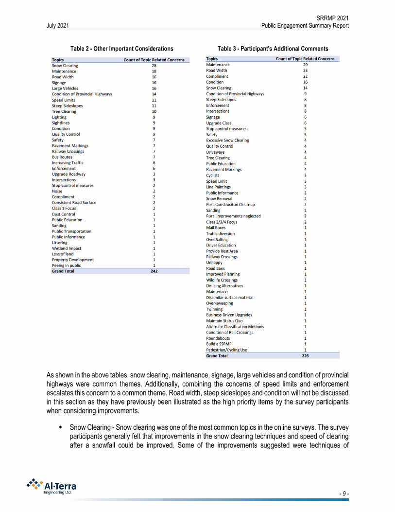
SRRMP 2021 July 2021 Public Engagement Summary Report
- 9 -
Table 2 - Other Important Considerations
Table 3 - Participant's Additional Comments
As shown in the above tables, snow clearing, maintenance, signage, large vehicles and condition of provincial highways were common themes. Additionally, combining the concerns of speed limits and enforcement escalates this concern to a common theme. Road width, steep sideslopes and condition will not be discussed in this section as they have previously been illustrated as the high priority items by the survey participants when considering improvements.
Snow Clearing - Snow clearing was one of the most common topics in the online surveys. The survey participants generally felt that improvements in the snow clearing techniques and speed of clearing after a snowfall could be improved. Some of the improvements suggested were techniques of
SRRMP 2021 July 2021 Public Engagement Summary Report
- 10 -
clearing when crossing driveways and minimizing snow ridges, increased priority of clearing on the subdivision/rural hamlet roadways and providing a wider cleared area when clearing the rural roads.
Maintenance - The public is generally dissatisfied with the quality of temporary repairs, such as pothole or patch repairs. Their concerns generally related to the short lifespan a patch or pothole repair has on the rural roads within the county. It was also noted in this topic that the participants were concerned with the quality of grading/resurfacing of the rural roads, most notably the continual overlays creating ridges at the driveway that are creating an increasing uneven transition into the resident’s driveways.
Signage - The participants are concerned with signage. The majority of signage related concerns was the visibility and size of stop signs within the county. They feel that at important intersections signage should be larger to draw the attention of the driver. Additionally, comments noted increased reflective markings on the stop signs will increase driver attention to the stop condition.
Large Vehicles - The participants are generally concerned with the number of large vehicles on Strathcona County’s rural roads. With the industrial heartland, and a large agricultural presence in Strathcona County, there are a considerable number of larger vehicles on the roadway which can create difficulty and an unsafe feeling when these vehicles are met on a narrow rural roadway.
Condition of Provincial Highways - Although outside of the scope of the Sustainable Rural Roads Master Plan, a common theme in both the online surveys and open houses was the condition of provincial highways, most notably the condition of Highway 824 and the stop condition on Highway 830 at Township Road 550. The overall condition of Highway 824 has become a topic of concern for the participants. The deteriorating conditions is beginning to shift traffic to using adjacent Range Roads to bypass Highway 824 on their commutes. This creates added stress on the adjacent rural road network for Strathcona County to upgrade and maintain. The stop condition at Highway 830 and Township Road 550 is another topic of concern with the participants. It is counterintuitive to have the stop condition on Highway 830, when intersecting with a Township Road. Typically, in Alberta, the Highway would have right-of-way through an intersection with a Township Road.
Speed Limits and Enforcement - The public is generally concerned with the number of speeding vehicles on the rural road network within Strathcona County. Survey participants and attendants at the open houses noted they felt increasing the frequency of law enforcement vehicles on the rural road network would improve the compliance to the speed limit.
It was noted that classifying roadways should not only consider AADT but vehicle class distribution on the roadways.
Continued overlay of paved rural roadways are creating difficulty for residents to maintain the grass adjacent to the road and creating ridges at driveways.
Trees are limiting visibility on rural roads. Railways crossings within the County are displacing and creating safety concerns for the public. Cyclist conflict with motor vehicles sharing the road was a common topic of concern (for both the
cyclists and the motor vehicle drivers).

SRRMP 2021 July 2021 Public Engagement Summary Report
- 11 -
4.0 2021 “Report Back”
The goal of this phase of engagement was to report back to the public on the 2019 SRRMP engagement, to understand the level of stakeholder support for the draft recommendations and identify any gaps in understanding of the draft recommendations by stakeholders.
The key messages heard in the 2019 SRRMP that were communicated in this round of engagement was that 78% of residents felt neutral, satisfied, or very satisfied with Strathcona County’s rural road network and the primary concerns residents had related to the condition of the road surface, the volume of traffic and the existing road width. The feedback from the 2019 engagement helped guide the development of the draft recommendations by helping the design team to better understand the issues that the road users are experiencing. The level of satisfaction indicated that the rural road network was functioning well, however there were areas that need to be improved. The draft recommendations that were presented in the public engagement were:
Create framework for sustainability and budget allocation Redefine roadway classifications Develop rehabilitation standards to align with redefined classifications Review of Maintenance methods and alternative methods Create a framework for prioritizing need
Due to the public health measures put in place because of COVID-19, in person open houses were not possible; therefore, an online slide presentation with the ability for user feedback was utilized. The online presentation was hosted on Strathcona County’s website in April and May 2021 and information postcards directing residents to the online presentation were mailed out in early April 2021 to all rural residents prior to the presentation going live.
4.1 Summary of Findings
The online presentation provided the participants the opportunity to leave feedback. Comments were reviewed and questions raised by the participants were answered in email responses.
The following is a summary of the comments that were received from the online presentation feedback form. A total of 19 comments were provided and a summary of the themes are listed below. Some responses had multiple comments which have been separated and listed in multiple themes:
6 participants made comments regarding the need to upgrade specific roads. 7 participants commented on the need to accommodate cyclists and pedestrians. 5 participants had general comments on the SRRMP update. 3 participants commented on the narrow width of existing roads. 1 participant commented on the need to channel traffic away from local roads. 1 participant commented on maintenance operation. Although outside of the scope of this report, 2 comments expressed concern with the condition
of provincial highways.
The responses received in the “Report Back” phase followed the similar themes during the “Listen and Learn” phase. The majority of the comments received relate to items that are being address in the SRRMP 2021 or will be addressed in the ITMP update. There were no comments indicating opposition to any of the proposed recommendations or indicating topics that were missed. Overall, the level of engagement, the comments provided, and the lack of objection to the recommendations helps to validate the current direction of the project.

Appendix D
Value Analysis Summary Report

DATE 2021-05-07
PREPARED BY SMA Consulting Ltd 10374 172 Street NW Edmonton AB T5S 1G9 (780) 484-3313www.smaconsulting.ca
Strathcona County Sustainable Rural Roads Master Plan UpdateStrathcona County
Value Analysis Workshop Documentation Report

Strathcona County SRRMP Update Value Analysis Workshop Report 1
Statement of Limitations
● SMA warrants that its services were rendered with the degree of care, skill, anddiligence normally provided on work of similar nature. The results of SMA’s assessmentof likely outcomes of a risk assessment should not be taken to indicate certainty ofactual future outcomes; new information may arise which would invalidate priorassumptions and low-probability events may occur.
● The Client agrees that it retains full responsibility for acting upon any of the suggestionsor information that may arise from this assignment. The Client agrees to indemnify andsave harmless SMA Consulting from any and all actions arising from the execution ofany and all of the suggestions or information that may arise from the assignment.
Confidentiality and copyright © 2021
This document is for the sole use of the addressee and S.M.A. Consulting Ltd. The document contains proprietary and confidential information that shall not be reproduced in any manner or
disclosed to or discussed with any other parties without the expressed written permission of S.M.A. Consulting Ltd. Information in this document is considered the intellectual property of the
S.M.A. Consulting Ltd. in accordance with Canadian Copyright Law.

Strathcona County SRRMP Update Value Analysis Workshop Report 2
Executive Summary The Strathcona County Sustainable Rural Roads Master Plan (SRRMP) Update Value Analysis (VA) Workshop was held on April 15 and 16, 2021. The workshop was held remotely through the use of video conferencing and the online whiteboard tool Miro. Industry experts from various municipalities, consultants, and contractors attended the workshop, which was facilitated by SMA Consulting. The goal of the VA session was to review, validate, and refine the pre-existing SRRMP and plan for its update. Discussions were carried out surrounding the classification of the rural road standards, innovative new paving technology, the potential for future partnerships, and other ideas to improve the SRRMP in its upcoming update. Ideas were generated to develop the standards, refine the classification, accommodate the volume of traffic, discuss methods of road rehabilitation and upgrading, and assign priorities. A total of 184 ideas were developed during the session. After removing duplicates and synthesizing the information, 79 ideas were gathered and organized by appropriate categories. There are 30 priority ideas with two votes or more to be explored in further detail.

Strathcona County SRRMP Update Value Analysis Workshop Report 3
Table of ContentsExecutive Summary 2
Introduction 4
Project Overview 4
Value Analysis Methodology 6
Information Phase 7
Function Analysis Phase 10
Creative Phase 10
Evaluation Phase 11
Presentation Phase 15
Conclusion and Next Steps 15
Appendix A – Workshop Prepackage & List of Participants
Appendix B – Information Phase Discussion
Appendix C – Value Analysis Idea Register

Strathcona County SRRMP Update Value Analysis Workshop Report 4
Introduction The Strathcona County Sustainable Rural Roads Master Plan (SRRMP) Update Value Analysis Workshop was held on April 15 and 16, 2021. The workshop was held remotely through video conferencing and online whiteboard collaboration. The workshop was hosted by Al-Terra Engineering and facilitated by SMA Consulting. Participants include Strathcona County, Al-Terra, Leduc County, Parkland County, Sturgeon County, Park Paving, Carmack Enterprises, and other external experts. The goal of the workshop was to identify innovative ways to develop, maintain, rehabilitate, and upgrade the rural roads in Strathcona County. This also includes the refinement of the classification, strategy to channel traffic, and appropriate prioritization of upgrades. Appendix A includes the workshop prepackage, the list of participants, and an overview of the value analysis methodology. Appendix B includes details of the information phase discussion, with an informal Q&A. Appendix C includes the full list of ideas generated during the workshop along with diagrams and participant evaluation.
Project Overview The Strathcona County Sustainable Rural Roads Master Plan (SSRMP) documents the guidelines by which the County develops, maintains, rehabilitates, and upgrades the approximately 1300 km of rural roads in its jurisdiction. The SSRMP was last updated in 2010 and is due for an update to capture the current conditions of existing roads and the planning of future developments.
The goals of the update include:
● Create framework for sustainability and budget allocation
● Review current maintenance practices and techniques and develop guidance fortreatments, standards, and guidelines
● Develop criteria for the rural road classification system as well as their priority includingrecommendations on funding allocation and review
● Create a framework for the prioritization of need
● Develop rehabilitation standards to align with the redefined road classifications

Strathcona County SRRMP Update Value Analysis Workshop Report 5
Figure 1. Draft of Current Traffic Volume vs. Road Class Capacity (courtesy Al-Terra
Engineering)

Strathcona County SRRMP Update Value Analysis Workshop Report 6
Public engagement findings from Q4 2019 to Q2 2020 show that approximately 60% of the respondents are satisfied or very satisfied with the current state of the rural roads, and that more than 50% of the respondents felt safe or somewhat safe on these roads. The top three priorities are road conditions, traffic volume, and road width. The majority of the public dissatisfaction comes from respondents who primarily drive on Class II roadways with high volumes and unimproved surface and width. The upgrades to be considered include:
● Widen narrow roads ● Improve intersection sightlines ● Improve steel side slopes ● Maintenance and lifecycle patches and pothole repairs
The current classification standards are presented below in Table 1.
Table 1. Strathcona County Rural Road Classes
Classification Vehicles Per Day (vpd)
Top Width (m)
Surface Standard
Standard Right-of-Way (m)
Class I - Hot Mix Asphaltic Concrete Roadway
1000 9.0 Hot Mix 40.0
Class II - Cold Mix Asphaltic Concrete Roadway
250 - 1000 7.5 Cold Mix 40.0 (30.0 minimum)
Class III - Dust Abated Gravel Roadway
< 250 7.5 Dust Abated Gravel Surface
30.0
Class IV - Gravel Roadway < 250 7.5 Gravel Surface
30.0
Value Analysis Methodology The methodology used in the workshop aligns with SAVE International’s standards for Value Analysis sessions. An overview of the process and methodology used is presented in Appendix A.
The workshop began with an introduction by Al-Terra’s Project Manager Fred Greenhough, followed by SMA’s overview of the Value Analysis process. The Strathcona County SRRMP update project team presented a summary of the history and current state of the plan. Participants then performed Function Analysis through function brainstorming and moved to small groups for a Creative Phase breakout session to identify new potential options. The workshop concluded with the Evaluation Phase, which involves a collaborative exercise to review and score the options and recommendations generated from the creative phase.

Strathcona County SRRMP Update Value Analysis Workshop Report 7
Information Phase The Sustainable Rural Roads Master Plan (SRRMP), which was last updated in 2010, guides how rural roads are maintained and improved in Strathcona County. The Plan includes all range roads, township roads, and grid roads within residential areas. In November 2019, public engagement had begun for the next round of the SRRMP update. In 2020, the public engagement results went through technical review and were reported back to the public. The key areas of focus for the upcoming SRRMP update includes:
● Analysis of current state ● Develop criteria for classification ● Review alternatives for special maintenance and short term upgrade ● Review current maintenance practices and techniques
COMMENTS & QUESTIONS
Additional discussions were carried out following the presentation, which included an informal Q&A between the participants and the SRRMP update project team. See Appendix B for full details.
SRRMP Development & Classification
The current system divides roads into four classes with upgrades determined by vehicles per day. Costs for upgrade are driven largely by land acquisition; many Class II-IV roads already do not have the full right of way for their class type. The classification is described in the 2017 Strathcona County Transportation Systems Bylaw. Previous prioritization focused more on specific roads, rather than a “system” approach, but given the work that has been done since the last SRRMP this may be changing. Upgrading to Class I is costly, approximately $3.4M per mile. Rebuilding Class I roads is approximately $2M+ per mile, reconstruction is approximately $600k - $1.5M per mile, and minor rehabilitation is approximately $250k per mile. Safety Concerns
There is a safety concern with regards to road width with all classes, as a viable shoulder is necessary on higher speed roads to maintain traffic volume while allowing some vehicles to be pulled over. 7.5 m width with two-way traffic will be difficult to allow for vehicles to be pulled over on the shoulder. 9 m wide roads are 100 kph roads per Alberta provincial law; however, as a municipality, the speed limit is lowered to 80 kph. This does mean that some users perceive that Class I roadways are meant for a 100 kph speed limit.
Traffic Channeling
Participants discussed the “urban” approach to traffic, which is to plan for channeling traffic to higher-traffic roads, rather than upgrading on a usage basis. There may be quite a bit of benefit

Strathcona County SRRMP Update Value Analysis Workshop Report 8
in taking a more system-wide approach to upgrades, considering cut-through traffic and intended uses, and planning to upgrade roads and intersections in such a way to drive traffic toward existing provincial highways. For example, Range Road 222 is currently being used as a “secondary highway” with less than desirable road conditions. It would also be useful to generate a “break even” number for vehicles per day for construction and maintenance costs, from a lifecycle costing perspective. Traffic Counts
Current rural traffic counts are done at a three-year cycle (north, central, and south portions of the County) with current resources. Any change would require a capital outlay of increase to equipment and/or manpower.
Road Conditions, Usage, and Other Considerations
● Currently, bridges on gravel roads are not always built to handle farm equipment. ● Drainage is a major concern when it comes to paving. On rural roads, there are a lot of
low-lying roads that are difficult to establish drainage due to environmental constraints. Having the pavement structure free of water or building a french drainage system, aside from culverts, could be considered. There are innovative systems that are being used on golf courses that could be adopted.
● Changes in farming equipment will impact the roads, for example, water haulers have impacted the roads significantly as they are being run 100% now in winter.
● More mixed-use is being observed during the COVID-19 pandemic
Paving and Surface Treatment Technologies
There was general discussion around paving and surface treatment technologies.
● For gravel roads at the dust control stage, the County used to use a bound surface spray with three-wheeled path, which works well from a maintenance perspective but not from a customer perspective.
● The performance of cold mix roads has been good. ● Hot mix is sometimes used instead of cold mix based on performance and cost.
Establishing a hard-bound service that the County does not have to touch for four to five years is difficult. Hot mix reduces the risks of rainy weather ruining the surface and the hot mix surface that was put down last year is performing well.
● Graded aggregate is used sometimes on higher volume rural roads, some are used as a double chipsealed approach on gravel roads. Parkland County is leveraging a grant to put forward graded aggregate/chipseal use.
● For dust control, the current methods are not very satisfactory. Volatile organic compounds from oil and oil byproducts are typically no longer used for environmental reasons.
● For the surface material selection, there is a tradeoff between harder and more durable materials and the ability to maintain and replace through lift and replace. Hot Mix or Cold Mix gravel roadways sometimes end up with potholes due to their material properties.

Strathcona County SRRMP Update Value Analysis Workshop Report 9
● Different soil will require different treatments. A cross-section across the County is easy to determine; however, geotechnical conditions are much more specific to the road condition. Site-specific design is done on some roads while others receive generic treatments. Falling weight deflectometer (FWD) tests are conducted on some roads. There are efforts to evolve from one-size-fits-all solutions.
Public and Political Considerations
Strathcona County faces some unique challenges as Sherwood Park is relatively urban, while the remainder of the county is rural. This can lead to issues with levels of acceptance from Council or from urban residents who move out into the county. For example, a “three-wheel” gravel road is a practical solution that is not currently politically acceptable. In general, signage and communication to the public is important, and the County tries to indicate where specific road types are chosen for specific reasons that might not be immediately apparent, e.g. a truck route that needs a higher class of road. However, public perception remains an issue and the visible example of “paved” remains a challenge -- residents complain when recycled products that do not show up as black are used. In addition, some residents do not want upgrades due to the potential for increased traffic or speeding. Future Changes
The longer-term effects of the COVID-19 pandemic remain to be seen. The need for infrastructure growth in the capital region has been reduced due to local residents working from home, but the need for better rural internet connectivity has become apparent. Lessons Learned and Collaboration Opportunities With Other Municipalities
The workshop included representation from Parkland County as well as Leduc County. Collaborations between Counties and sharing results and learnings across regional partners could be greatly beneficial for all parties.
● Parkland County sets aside a budget for innovation. Piloting with trail projects is sometimes done.
● Rehabilitation methods used at Parkland County are largely a function of the type of road. Strathcona County would largely be classified as Type I roads with Asphalt Concrete Overlay (ACP). Mill and overlay is typically done for gravel roads in Parkland County.
● Parkland County uses the Pavement Preservation and Recycling Alliance website (roadresource.org) to determine the appropriate surface treatment.
● Municipalities should triage some of the shared concerns and create partnerships to resolve problems. Pilot projects collaboratively and set everyone up for success. Standardized testing and other measures across municipalities would help ease the process.

Strathcona County SRRMP Update Value Analysis Workshop Report 10
Function Analysis Phase Following the Information phase, the participants were encouraged to come up with a list of functions that pertain to the delivery of the project. Key functions were identified and are shown in bold, and then the high-cost functions were evaluated, using stars to approximate cost, where more stars indicate higher cost. The key functions were then used as trigger words during the creative phase to help generate as many ideas as possible. The list of functions is presented below with the key functions bolded:
● Improve Network ● Manage Network ● Engage Public ● Minimize Maintenance ● Support Development ● Develop Program ● Recommend Funding ● Assign Priority ● Develop Classification
● Forecast Use ● Analyze Use ● Develop System ● Develop Standards ● Accommodate Vehicles
(Weight) ● Accommodate Vehicles
(Width, Length) ● Accommodate Volume
● Improve Safety ● Manage Drainage ● Identify Conditions ● Address Treatment ● Maintain Road ● Rehab Road ● Upgrade Road
Creative Phase Once the Information and Function Analysis phases were complete, the Creativity phase began. During the Creativity phase, participants were divided into two groups based on their areas of expertise and background. Each group has individuals from Strathcona County, Al-Terra, experts from other counties, contractors, and consultants. A technique called “World Café'' was used to increase the number of ideas generated. Each facilitator worked with a group for about an hour on each of the six major functions identified: Develop Standards, Develop Classification, Assign Priority; and Accommodate Volume, Rehab Road, and Upgrade Road. The facilitators rotated along with the two groups to generate more ideas for all six functions. The full list of ideas post organization can be found in Appendix C.
EXPERIENCES FROM OTHER MUNICIPALITIES
Leduc County
The standard ROW width at Leduc County is 34 m for road top width of 9 - 10 m. The width of the roads are sometimes adjusted based on traffic volume and user needs. Road development strategies will vary when it comes to local farm roads, major arterials, fair weather roads, industrial roads, and country residential roads. Bridges are found to be challenging.
Currently, cold mix asphalt is being phased out at Leduc County and hot mix asphalt is used instead for the full rehabilitation projects that are being planned. The cold mix can be mixed into the cement stabilizer to be used in the subgrade or stored and used for minor repair work.

Strathcona County SRRMP Update Value Analysis Workshop Report 11
Leduc has successfully trialed the use of cement stabilizer on gravel road bed followed by a full geogrid, granular base course (GBC), then ACP over the topsoil -- this technique helps to prevent reflective cracking and does not require extensive reconstruction.
Techniques such as microcracking are used to extend the project lifetime. Calcium treatments are used on gravel roads for dust. The lifecycle of the surface treatment is dependent on the truck traffic volume. Upgrades that are being considered in the County include improving the side slope profiles by making them flatter. Drainage improvements include using cross drainage tubes in very wet areas to avoid settlement issues. Large cell products such as geocells are being used on marshy lands, which has yet to yield much success.
Leduc County has hired trainers for the grader operators for rural gravel roads to achieve better camber. This initiative has achieved significant success and improved drainage and soft spot issues on rural roads. Leduc County’s Rural Road Gravel Initiatives is a great program for spot fixing and maintaining gravel roads. The Regional Roads Forum (Leduc County and WSP in late 2019/early 2020) is a great opportunity to learn about innovative paving and surface treatment technologies and to engage with industry experts. Alberta Municipal Supervisors Association (AMSA) has hold conventions on road maintenance and upgrades.
Parkland County
Parkland County’s standard is 10 m width for main roads and 8.5 m width for rural collector roads, with 30 m for the ROW for both. Parkland has used both cold mix and emulsion, and uses cold mix as part of base strengthening. Rural collector roads start with cold mix, while some are Asphalt Concrete Pavement (ACP). Typically, Asphalt Stabilized Based Course (ASBC) with overlay is done. Chipseal for gravel surface is an intermediate option as per Parkland County’s experience
Currently, dust control is sprayed on and mixed with a grader blade; however, this program will be terminated and Parkland County is going back to calcium. There is an “innovation budget” to explore innovative technologies and prototyping and Parkland County has plans to trial microsurfacing instead of chipseal.
Evaluation Phase During the creative phase, the ideas were captured using sticky notes on the online whiteboard. Participants were invited to evaluate the ideas and vote on ideas that they believed were worth further exploration. Using the 1-10 holistic value index (Appendix A) and the “Dotmocracy” method, participants scored the ideas for feasibility and benefit to the project. Ideas that were considered a 7 and above were given a green dot, ideas that were 3 and below were given a red dot. Table 1 presents the ideas and their respective scoring.

Strathcona County SRRMP Update Value Analysis Workshop Report 12
Table 2. Value Ideas Organized by Category and Number of Votes
Category Value Ideas ● ●Collaboration ‐Outreach
Explore economic efficiencies of scale on activities such as brushing,microsurfacing, and others among municipalities and save cost bycombining contracts.
*
Collaboration ‐Outreach
Establish a program for sharing innovation and learnings amongmunicipalities. Attend conferences such as the Regional RoadsForum held by Leduc County and WSP in late 2019/early 2020 andAlberta Municipal Supervisors Association (AMSA) Conventions.
*
Technologies Trial projects for different applications through a project basedselection of technology, followed by revisit and documentation.Pilot projects in certain areas with specific products and methodsbefore wide adoption, calculate the return on usage and considerthe risks involved for immediate repair. Improve and standardizepiloting programs to allow for follow‐ups and long term studies,include signage and communication to the public. Be willing to testdifferent technologies and accept some risk for potential success orfailure.
9
Design standards ‐flexible
Develop subclasses and allow flexibility in the criteria with localconsiderations to support realistic operation needs. Identify localcontext for roads that may not meet the standards but meet theneeds of the local users. For example, gravel surface roads withClass III dust control in front of local farms would be insufficient forfarm equipment. Balance the standards and bylaws with cost andflexibility.
8
Collaboration ‐contractors
Maintain collaboration and communication with contractors and beopen to innovative improvements. Allow contractors to bringforward innovative ideas with transparent risk discussions andfocus on end result and road longevity. Consider contractingstrategies that will make this easier such as IPD. Pursue up‐frontcost thinking prior to construction. Continue to work to developrelationships between the County and contractors.
7
Design standards Consider reducing ROWwidth to reduce land needs in Class I and IIroads while keeping the backslopes at a good profile. Considertraffic volume and use. Standard ROW for 9m roads is 34m in LeducCounty and 30m in Parkland County.
7
Design standards Consider site specific design for specific uses/needs, geotechnicalconditions vary across the county. Design the roadways in industrialareas specifically catering to heavy load and frequent use. Find anappropriate balance.
7
Prioritizationmethods ‐ Trafficchanneling
Plan upgrades and design to channel traffic to intended roads, andespecially to avoid creating duplicate routes. Consider reducingClass I roads and having a robust network of Class II directing trafficto Provincial highways. Take emergency access routes and highlypopulated areas into account.
6

Strathcona County SRRMP Update Value Analysis Workshop Report 13
Category Value Ideas ● ●Prioritizationmethods
Stage upgrades and improvements with consideration of gettingthe best quality of service from the dollar value to accommodatetraffic needs.
5
Technologies ‐Microsurfacing
Adopt reclaimed asphalt pavement (RAP) with bituminousadditives. Prototype of microsurfaced 100% RAP product with abitumen mix lasted 14 years without the need for resurfacing.
5
Budget Defer upgrading and commit to a brushing program to clear treeencroachment for better sightlines and road safety, which willsignificantly improve user experience at reduced costs
4
Design standards ‐flexible
Plan for more investigations during road upgrades to allow fornuance within each classification.
4
Design standards ‐flexible
Add Class II‐A and Class II‐B classifications to allow for upgradesthat do not meet Class I criteria. Expand the classification to includestandards for lower class road upgrades.
4
Prioritizationmethods
Rehabilitation should be driven by surface condition, safety, trafficvolume, road width, collision data, and drainage if the road isselected.
4
Communicationand Education
Work to establish mutual understanding of stakeholder wants andneeds, County priorities and limitations, and political desires, to bereferenced during design. Determine expectations from public andCouncil and work to "sell the story" for rural roads.
3
Communicationand Education
Educate the public on the different feels and looks of roads withdifferent surface and on rural road qualities. For example, not allpaving methods will result in a black surface, which can causeproblems and complaints due to the lack of understanding from thepublic. In addition, urban residents who are driving in a rural settingmay have unrealistic expectations. Educate and inform non‐resident drivers and users when it comes to driving on ruralroadways.
3
Operator training Establish training initiatives to help transfer knowledge fromexperienced operators for succession planning. Many experiencedoperators are reaching retirement age. Explore other types ofspecialized training for operators and consider sharing with othermunicipalities. Leduc experience: hired a trainer for graderoperators on rural gravel roads to achieve better camber andperformance.
3
Prioritizationmethods ‐ Trafficchanneling
Creative use of road ban and dictate weight restrictions to avoidheavy use in areas that are not prioritized for preservation
3
Prioritizationmethods ‐ Trafficchanneling
Use the network model when considering upgrades for similarcondition/safety roads, and consider future planned landdevelopment.
3
Technologies Adopt innovative/progressive methods for development,maintenance and rehabilitation, such as microcracking or using asecond lift of asphalt.
3

Strathcona County SRRMP Update Value Analysis Workshop Report 14
Category Value Ideas ● ●Technologies ‐Microsurfacing
Microsurfacing on top will protect paved material from crackingand oxidation. However, it is important to note that microsurfacing,cold mix or emulsion roads/ mixed matrix with higher voids aremore susceptible to moisture. Microsurfacing may be moretolerable than chipseal. Strathcona County has used it on hardsurface and Parkland County has plans to trial microsurfacing.
3
Data collection Perform regular inspection on gravel roads; currently the rural areainspections are done every two weeks and there is a map used tocapture road status and information.
2
Design standards Have different strategies categorizing and focusing on local farmroads, major arterial, fair weather roads, industrial roads, andcountry residential roads.
2
Design standards The major challenges for ROW upgrade are land availability andprice
2
Design standards Improve side slopes and make them flatter where possible andbuild open, wider ROW and clear zones.
2
Design standards Consider using backslope agreements or easements instead ofactual land acquisiton for ROW. Backsloping and easements weredone historically but have fallen out of favour due to competinginterest and issues from different groups. The downside ofbacksloping agreements is that they may cause drainage issues.
2
Pilot studies Develop a systematic approach for piloting innovation and testingthrough partnerships. Set a specific budget for innovation toexplore new technologies.
2
Preservation Explore preservation treatments, such as those that keep moistureout to extend the life of the paving. Stretch maintenance and rehabdollars by looking into methods to extend the lives of differentsurface pavings.
2
Prioritizationmethods
Gravel roads are the easiest to maintain and have the potential forupgrades.
2
Technologies Explore opportunities on using emulsion vs. cutback for differentperformances. Not that different types of oils are used in Class III.There are different emulsions (e.g. Norway) that can be used, withmix‐in‐place options available. Consider cold mix with cutback oremulsion. Cutback is typically softer with more movability, whileemulsions are stiffer and harder and could lead to potholes.
2
* These ideas were highlighted and discussed during the wrap-up discussion of the workshop. The participants identified and agreed upon the importance and feasibility of these ideas after the scoring exercise.

Strathcona County SRRMP Update Value Analysis Workshop Report 15
After the evaluation phase, a follow-up discussion was carried out to determine the one takeaway from the workshop. The Strathcona County SRRMP update team identified that a brushing program to clear tree encroachment should be carried out. This is a simple upgrade measure that greatly improves sightlines and safety on rural roads, it will also significantly improve user experience. For economic efficiencies on brushing, microsurfacing, and other upgrade activities, municipalities could consider combining contracts to save on cost. The municipalities should also consider establishing a program to share innovations and learnings with one another, this includes partnering on pilot projects and attending conferences and conventions to share experiences.
Presentation Phase After the workshop, the facilitation team organized the ideas into categories to help remove any duplicates information. The 184 ideas have been collected, combined, and synthesized into 79 ideas. The list of organized value ideas has been collated and presented in Appendix C. The SRRMP update team at Strathcona County will use these ideas and their evaluation scores to identify options that are worth exploring.
Conclusion and Next Steps The Value Analysis workshop for the Strathcona County SRRMP brought experts in rural road development, rehabilitation, and upgrading to discuss the issues regarding the classification of the rural road standards, innovative new paving technology, the potential for future partnerships, and other ideas to improve the SRRMP in its upcoming update. The workshop was centered around generating ideas for the development of classifications and standards, assigning priority to maintenance and upgrades, finding ways to measure and accommodate traffic volume, and innovative technologies to be used in road upgrades and rehabilitation. The next step will involve further discussion of the high-scoring value ideas and feasibility of carrying them out, as well as the inclusion of the ideas into the next SRRMP update.

Strathcona County SRRMP Update Value Analysis Workshop Report
Appendix A Workshop Prepackages & List of Participants

1©SMAConsulting
Ltd.
©SMAConsulting
Ltd.
+Projec
tBac
kgroun
d
+Projec
tGoa
ls
+Value
Analys
isProc
ess
STRA
THCO
NACO
UNTY
SUSTAINA
BLERU
RALR
OADS
MAS
TERPLAN
UPDA
TE�VALUE
ANAL
YSISWOR
KSHO
PPR
EPAC
KAGE
+Worksho
pLo
catio
n
+Worksho
pTime
+Worksho
pAge
nda
+Worksho
pGoa
ls
Worksho
pLo
cation
ProjectBackgroun
dVa
lueAn
alys
isProcess
0102
03To
pics

2©SMAConsulting
Ltd.
WOR
KSHO
PLO
CATION
&TIME
Whe
n:1p
m–5p
m,T
hursda
y,April15,2021&
8:30am
-12p
m,F
riday,A
pril16,202
1
Whe
re:
OnlineTe
amsMeetin
g,Roo
mlin
kprov
ided
ininvite
Youarecordially
invitedto
attend
theup
comingVa
lueAn
alys
isworksho
psessions
forthe
Strathcona
CountySu
staina
bleRuralRoa
dsMasterP
lanUpd
ateProject.Th
isworksho
pserie
sisbe
ingun
derta
kenby
theStrathcona
Countyan
dAl-Terra
andfacilitated
bySM
A.
Ifyouha
vean
yfurth
erqu
estions
orcommen
ts,p
leasedo
noth
esitateto
contactm
e.Welook
forwardto
aproductivesession.
HollyPa
rkis,C
VS,P
MP
Facilitator

3©SMAConsulting
Ltd.
WOR
KSHO
POV
ERVIEW
Thego
alof
theworksho
pse
ssionisto
perfo
rma
Value
Ana
lysisse
ssionto
review
,refinean
dev
alua
tethestrategy.A
l-Terra
willpres
enta
numbe
rof
area
sof
focu
sforu
pdates
totheSus
tainab
leRural
Roa
dMas
terP
lan.
Theworksho
pwillde
term
inethemos
tfav
orab
leplan
optio
nsto
carryforw
ardforfurther
inve
stigation
give
nthefunc
tions
andgo
alsrequ
ired.
Theop
tions
willbe
compa
reddu
ringtheworksho
pse
ssions
throug
htheva
luemetho
dology
with
afocu
son
key
func
tions
andtheev
alua
tioncrite
ria.
Atta
ched
design
inform
ationfollows;
plea
sereview
theinform
ationan
den
sure
youarefamiliar
with
the
projec
tbac
kgroun
din
prep
arationforthe
worksho
ps.F
urther
detailedinform
ationab
outthe
strategy
andtheke
yarea
sford
iscu
ssionis
includ
edwith
theattach
edpa
ckag
efro
mAl-T
erra.
Worksho
pGoa
ls&Age
nda
ValueAna
lysisWorksho
pAge
nda:
Ford
etailson
theworksho
pmetho
dology,p
leas
ese
etheattach
edVAproc
esssh
eet
1.ParticipantIntrodu
ction
2.VA
ProcessIntro
duction
3.DesignPresen
tationof
theCurrent
Status
4.Q&A
Session
5.Fu
nctionAna
lysisPhase
6.Creativity
Pha
se
7.EvaluationPha
se
8.Closeup
&NextS
teps
Discussion
DraftStra
thcona
CountyRuralRoa
dClassificationMap.Imag
eCourte
syof
Al-Terra
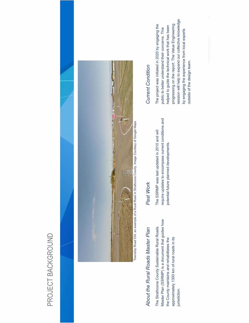
4©SMAConsulting
Ltd.
PROJ
ECTBA
CKGR
OUND
Abou
tthe
Rural
Roa
dsMas
terP
lan
TheStrathcona
Cou
ntySustainab
leRuralRoa
dsMasterP
lan(SSRMP)
isado
cumen
tthatg
uide
sho
wtheCou
ntymaintains
andreha
bilitates
the
approximately13
00km
ofruralroa
dsinits
jurisdiction.
Past
Work
TheSSR
MPwas
lastup
datedin20
10an
dwill
requ
ireup
datestoen
compa
sscurrentcon
ditions
and
potentialfutureplan
nedde
velopm
ents.
Current
Con
ditio
n
Theprojectw
asinitiated
in20
20by
enga
ging
the
publictobe
tteru
nderstan
dtheirc
oncerns.Th
ishelped
togu
idethetechnicalw
orkthat
hasbe
enprogressingon
therepo
rt.Th
eVa
lueEn
gine
ering
sessionwillhe
lpto
expa
ndou
rcollectiveknow
ledg
eby
enga
ging
theexpe
riencefro
mlocalexperts
outsideofthedesign
team
.
TownshipRoa
d53
4,an
exam
pleof
aRuralRoa
dinStra
thcona
County.Im
ageCou
rtesy
ofGoogleMaps

5©SMAConsulting
Ltd.
5
1.Createfra
mew
orkfors
ustainab
ility
andbu
dget
alloca
tion
2.Rev
iewcu
rrent
mainten
ance
prac
tices
andtech
niqu
esan
dde
velop
guidan
cefortreatmen
ts,s
tand
ards
,and
guidelines
3.Dev
elop
crite
riaforthe
ruralroa
dclas
sificationsystem
aswella
stheir
priorityinclud
ingreco
mmen
datio
nson
fund
ingalloca
tionan
dreview
4.Createafra
mew
orkforthe
prioritizationof
need
5.Dev
elop
reha
bilitationstan
dardsto
alignwith
therede
fined
road
clas
sifications
DraftCurrent
Traffic
Volumevs
Roa
dClass
Capacity.Imageprovided
byAl-Terra
PROJ
ECTGO
ALS
©SMAConsulting
Ltd.

6©SMAConsulting
Ltd.
VALUEEN
GINE
ERING/VALU
EAN
ALYS
ISPR
OCES
S
TheInform
ationPh
aseinvo
lves
unde
rstand
ingthecu
rrent
stateof
the
projec
t:theop
portu
nitie
san
dco
nstra
ints
that
willinflu
ence
decision
mak
ing.
Com
mon
activities
includ
ereview
ingan
ddiscus
sing
projec
tdata,
determ
iningprojec
tan
dworksho
pob
jectives
,and
discus
sing
stak
eholde
rs,p
roject
issu
es,a
ndke
yco
nstra
ints.A
succes
sful
inform
ationph
ase
brings
theteam
toaco
mmon
unde
rstand
ingof
theprojec
t.
TheFu
nctio
nAna
lysisPh
aseistargeted
atun
derstand
ingthe“solution:”w
hatm
ust
aprojec
taccom
plishto
besu
cces
sful?
Com
mon
activities
includ
ediscus
sing
and
clas
sifyingfunc
tions
,dev
elop
ingfunc
tion
mod
elsan
dFA
STdiag
rams,
and
dimen
sion
ingfunc
tions
with
cost
andris
k(th
atis,d
eterminingho
wmuc
hitco
ststo
deliver
agive
nfunc
tion).
TheCreativity
Phaseiswhe
retheteam
uses
theiru
nderstan
ding
oftheprojec
tand
ofthefunc
tions
requ
iredto
brains
torm
spo
tentialsolutions
tode
liver
thos
efunc
tions
moreeffectivelyan
dwith
less
cost.T
his
phas
emay
invo
lvegrou
pbrea
kout
sessions
orothe
ractivities
.The
goal
isto
workco
llabo
rativelyto
deve
lopalarge
quan
tityof
solutio
ns,w
ithno
pre-judg
men
tof
idea
s.
DuringtheEv
alua
tionPh
ase,
theidea
swhich
have
been
prod
uced
arediscus
sed
andprioritized
forfuturede
velopm
ent.
Com
mon
activities
may
includ
efilterin
gwith
ascalesu
chas
the“gut
feel
inde
x”(G
FI),
perfo
rman
ceof
diffe
rentialriskan
alysis,o
rde
velopm
ento
fweigh
tedev
alua
tioncrite
riaan
dscoringof
optio
nsin
detail.
TheDev
elop
men
tPha
seco
nsists
oftaking
thos
eop
tions
which
werese
lected
forfuturede
velopm
enta
ndan
alyzingthem
furth
er.T
hismay
invo
lvemod
eling,
rese
arch
,cos
t/ben
efitan
alysis,
deve
lopm
ento
fsch
edules
orlifecycle
costing,
orfeas
ibility
stud
ies.
Furth
erev
alua
tionmay
occu
rafte
rthisph
aseon
cead
ditio
nalinformationha
sbe
enga
thered
.
Fina
lly,d
uringthePres
entatio
nPh
asethe
selected
valuesu
gges
tions
arepres
ented
tode
cision
-mak
ersforimplem
entatio
n.Th
isph
aseco
nclude
swith
aform
alrepo
rt.
ValueEn
gine
eringor
ValueAna
lysis(VEor
VA)isde
fined
bySAV
EInternationa
lasaglob
allyreco
gnized
structured
proc
essforimprov
ingthe
func
tionan
dop
timizingtheco
stof
projec
ts,p
roce
sses
,orp
rodu
cts.A
multid
isciplinaryteam
uses
theproc
essto
unde
rstand
keyprojec
tfun
ctions
,ge
nerate
crea
tiveidea
s,an
dev
alua
tesu
gges
tions
tode
term
inetheop
timal
approa
ch.V
E/VA
isalso
ave
ryeffectivede
cision
supp
ortm
etho
dology.T
hesa
mestructured
proc
essisus
edin
allcas
es:p
repa
ratio
npriortothe
worksho
p,asix-step
JobPlandu
ringtheworksho
p,an
dpo
st-w
orksho
pan
alysisan
drepo
rting
.
©SMAConsulting
Ltd.

L L L6 U R R 6 V EO 5 U O 5R V 0 V U 3O 8S 9 O US L
1 P 2U R
P R RWE HG F R W
D GH RWREHG D N DYL J
LD JKH D PDFN WH S L H
FH DWH R 6W DWKFR D R W
RG KR GD R 6W DWKFR D R W
R RN H D JL HH L J
HG HH KR JK H D JL HH L J
R D NL 60 R WL J
-RK 0DF R D G D N DYL J
-RK 1J H 6W DWKFR D R W
-R HSK FD H D JL HH L J
D R L D DJJH W 6W DWKFR D R W
K K G R DI DL HG F R W
HR D G , GHSH GH W R WD W
L 5H 60 R WL J
5LFKD G HNNH 6W DWKFR D R W
5RE GH HH D N D G R W
5 D GH 6W DWKFR D R W
5 D L R 6W DWKFR D R W
6FRWW 6L H 6W DWKFR D R W
HG 1H WR 6W JHR R W

Strathcona County SRRMP Update Value Analysis Workshop Report
Appendix B Information Phase Discussion and Q&A

Strathcona County SRRMP Update Value Analysis Workshop Report
SRRMP Development & Classification
● Develop the SRRMP with the most value for money. Find out why higher volumeroadways are higher in volume. Is there a regional perspective to finding a centralroadway to be improved to carry the majority of traffic in that area?
● Separate Class III and dust control. Reduce classification in certain areas to push theuse of higher classification roadways through traffic channeling.
● Q: Is Class III the focus for upgrades or are we looking at all classes?A: We are looking at all classes. Previous versions of the SRRMP have focused onClass I roads, which have been built out well and do not need as much attention. ClassIII and Class IV are facing major problems. Only 2 miles of Class I has been upgradedsince 2010. The cost is now up to approximately $3.4M / mile on Class II to Class Iupgrade. The next Class I upgrade project is stalled in the budget.
● Q: What are the factors that drive the cost behind Class I road upgrades to be $3.4M /mile?A: The upgrade requires approximately 20m of additional land for ROW. Are there anyengineered cost reductions to be explored? Currently, the County is not looking atreconstruction, more focusing on rehabilitation and maintenance.
● In terms of system development, take into account the prioritization within the systemand what the specifications (e.g. width, surface type) would be.
● The Class I structure is currently sufficient, with Class II to IV to be stabilized, but little isengineered. Class IV surface is gravel with 150m of dust abatement in front of theoccupied approaches.
● The 2017 Strathcona County Transportation Systems Bylaw can be found here and itshows the rural classification network.
● The cost to rebuild Class I roads is approximately $2M+ per mile, reconstruction isapproximately $600k - $1.5M per mile, and minor rehabilitation is approximately $250kper mile.
● In the Heartland Region, there is a Class I road with a 10 m top width and an even largerROW, but this is currently not in the standards.
● Class I roads saw a considerable increase in the 2010s when it comes to regionalconnections and major corridors to primary highways. A lot of improvements have beenmade for connectivity and movement potential. Alberta Transportation’s future changesfor highway closures are being considered. Functional studies for any and all futuredevelopments are seeing the threshold being triggered for access. Some roads are notgoing to be upgraded if their access to the highway is going to be closed. Standards inthe 2010 master plan speak to potential evolutions, which were unfortunately stricken.

Strathcona County SRRMP Update Value Analysis Workshop Report
Considerable amounts of work were done to the update since the 1994 initial master plan.
Safety Concerns
● Consider users who typically drive in rural areas versus those who typically drive inurban areas. It is potentially unexpected road conditions for those who are not used tothe rural level of service.
● There is a safety concern with regards to road width, as a viable shoulder is necessaryon higher speed roads to maintain traffic volume while allowing some vehicles to bepulled over. 7.5 m width with two-way traffic will be difficult to allow for vehicles to bepulled over on the shoulder. 9 m wide roads are 100 kph roads per Alberta provinciallaw; however, as a municipality, the speed limit is lowered to 80 kph. Some userperceives that Class I roadways are meant for a 100 kph speed limit.
Traffic Channeling
● Q: Road upgrade is up to debate as a break-even number is needed between the totalinitial construction cost and maintenance costs. What is the break-even number ofvehicles per day (vpd) to justify the upgrade?A: There is no exact number as per policy. The break-even number is approximately 400vpd. It would be a good idea to calculate the numbers to determine where does theCounty break-even for construction/maintenance costs and using lifecycle costing todetermine value.
● Consider cut-through traffic and intended users. The model may need to be modernizedwith some urban user perspective.
● Consider the intersection type or the design of a route on a shortcutting route.
● Current rural traffic counts are done at a three-year cycle (north, central, and southportions of the County) with current resources. Any change would require a capitaloutlay of increase to equipment and/or manpower.
Road Conditions and Considerations
● Range Road 222 is currently being used as a secondary highway with less thandesirable road conditions.
● Currently, bridges on gravel roads are not always built to handle farm equipment.
● Drainage is a major concern when it comes to paving. On rural roads, there are a lot oflow-lying roads that are difficult to establish drainage due to environmental constraints.Having the pavement structure free of water or building a french drainage system, asidefrom culverts, could be considered. There are innovative systems that are being used ongolf courses that could be adopted.

Strathcona County SRRMP Update Value Analysis Workshop Report
● Changes in farming equipment will impact the roads, for example, water haulers haveimpacted the roads significantly as they are being run 100% now in winter.
● Falling weight deflectometer (FWD) tests are conducted on some roads. There areefforts to evolve from one-size-fits-all solutions.
Paving and Surface Treatment Technologies
● Q: Other than cost, is there a reason for preferring cold mix over hot mix, and with whatintention?A: For gravel roads at the dust control stage, it used to be a bound surface spray withthree-wheeled path, which works well from a maintenance perspective but not from acustomer perspective. The performance of cold mix roads has been good. Hot mix issometimes used instead of cold mix based on performance and cost. Establishing ahard-bound service that the County does not have to touch for four to five years isdifficult. Hot mix reduces the risks of rainy weather ruining the surface and the hot mixsurface that was put down last year is performing well.
● Q: Are graded aggregate or chipseal being used?A: Graded aggregate is used sometimes on higher volume rural roads, some are usedas a double chipsealed approach on gravel roads. Parkland County is leveraging a grantto put forward graded aggregate/chipseal use. Volatile organic compounds from oil andoil byproducts are typically no longer used as they are sometimes frowned upon by themunicipalities.
● For the surface material selection, harder and more durable materials are typicallypreferred. However, they might be more difficult to maintain and replace through lift andreplace. In this case, the more pliable materials are preferred. Hot Mix or Cold Mix gravelroadways sometimes end up with potholes due to their material properties.
● Foamed asphalt with chipseal may last up to four years.
● Lifecycle on ACP subdivision roads will be able to do microsurfacing. May try tointroduce graded aggregate mix in subdivision roads to allow for microsurfacingrehabilitation.
● Consider cold mix with cutback or emulsion. Cutback is typically softer with moremovability, while emulsions are stiffer and harder and could lead to potholes.
● Any clay pulled up into foamed asphalt would render it useless. The County needs toavoid picking the wrong treatment for the right road with regards to design. The Countygoes from clay to good clay till in the southern portion, which requires a different supportsystem.
● Different soil will require different treatments. A cross-section across the County is easyto determine; however, geotechnical conditions are much more specific to the road

Strathcona County SRRMP Update Value Analysis Workshop Report
condition. Site-specific design is done on some roads while others receive generic treatments.
Public and Political Considerations
● Q: What are the potential political constraints?A: The level of acceptance from the Council is different than rural user’s expectationsand requests. E.g. the three-wheeled path is a practical solution that is not currentlypolitically acceptable.
● Strathcona County is unique in that it has both urban and rural components. Preservingexisting infrastructure to extend its lifecycle is typically not acceptable in urban settings.The city of Edmonton has done microsurfacing in their neighbourhoods, unsure whatlevel of engagement was done to get resident approval. Strathcona County might wantto look into preservation measures that are effective and are accepted by the public.
● More mixed-use is being observed during the COVID-19 pandemic
● Due to local residents working from home during the COVID-19 pandemic in rural areas,the need for infrastructure growth in the capital region has been reduced. Currently, theeffects and needs of rural internet support and telecommuting are being explored.
● Public perception will not be kind to poorly designed systems. The visible example ofwhat is a paved road is fixed in public perception. Education of the public is difficult. Forexample, recycled products that do not show up black (show up grey due to lower levelsof bitumen) are not believed to be paved properly and had to be redone.
● Signage and communication to the public would be valuable.
● There have been urban Strathcona County residents who move into rural areas wherethere is no asphalt to their front door and infrequent snow plowing. The difference inservice presents a challenge when it comes to managing expectations.
● Q: Is there feedback from residents regarding not wanting road improvements due tonew pavement impacting traffic?A: Paving will bring the speed of the road up to 80 - 100kph from 60kph on gravel roads.Some residents do not want paved roads or changes that will introduce more traffic athigher speeds. There are some segments of the rural road that have been held back oneclassification for this specific reason. Recent upgrades to introduce asphalt in a ruralarea, the residents mentioned that the benefits of better safety and increasedmaintenance to the road. Any impacts of speeding or higher traffic volume have yet to bereported/quantified.
Lessons Learned From and Collaboration Opportunities With Other Municipalities
● Parkland County sets aside a budget for innovation. Piloting with trail projects issometimes done. Collaborations between Counties and sharing results and learningsacross regional partners could be greatly beneficial for all parties.

Strathcona County SRRMP Update Value Analysis Workshop Report
● Rehabilitation methods used at Parkland County are largely a function of the type ofroad. Strathcona County would largely be classified as Type I roads with AsphaltConcrete Overlay (ACP). Mill and overlay is typically done for gravel roads in ParklandCounty.
● Parkland County uses roadsource.org to determine the appropriate surface treatment.
● Municipalities should triage some of the shared concerns and create partnerships toresolve problems. Pilot projects collaboratively and set everyone up for success.Standardize testing and other measures across municipalities would help ease theprocess.

Strathcona County SRRMP Update Value Analysis Workshop Report
Appendix C Value Analysis Idea Register

V ● ●
t WD D
d d
W
/
/
///
D
/W W
Kt / //
KtW
Wd
W
/ //W d

V ● ●W
dD
WW W
W
// ///
W
t
/
D
Wd
Wd
h
d

V ● ●dD
D,
D
WW
,
d Kt
/Kt
Kt
d
W
W
W '
dE ///
d E
/D
d
' /

V ● ●' d D h
W
Kt
h
d
d
E
W h W W D
/
W W
/
W W /

V ● ●d h
Wd /
W
t
/
' D
h
// WKt
/
Kt
W Kt
W / DW
W /// //
Kt D //
W '

V ● ●W W d
W
h
' W
,
E
d
W t //
d h
h
d W
d
d Wd W
Wd W
Wd Wd
dD
WD