strategy appraisal report - scarborough.gov.uk
TRANSCRIPT

Strategy Appraisal Report
Authority scheme reference
SBC??
Defra/WAG LDW number
??
Promoting authority
Scarborough Borough Council
Strategy name
Filey and Cayton Bay Coastal Strategy (White Nab to Speeton)
Shallow Landsliding at Cayton Cliffs
Date March 2016
Version 1.0

Title Filey and Cayton Bay Coastal Strategy
No. ?? Status: Version 1.0 Issue Date: March 2016 Page i
StAR for Filey and Cayton Bay Coastal Strategy
Version Status Signed off by: Date signed Date issued
1.0 Submission to LPRG S Rowe ?? ??
Template version – April 2011

Title Filey and Cayton Bay Coastal Strategy
No. ?? Status: Version 1.0 Issue Date: March 2016 Page ii
CONTENTS
For technical approval of the business case ................................................................. iv Approval history sheet ................................................................................................... v Non-financial scheme of delegation ............................................................................. ivi
1 EXECUTIVE SUMMARY .............................................................................................. 7
1.1 Introduction and Background ............................................................................... 7 1.2 Problem ............................................................................................................... 8 1.3 Options Considered ............................................................................................. 9 1.4 Preferred Options ............................................................................................... 10 1.5 Recommendation ............................................................................................... 15 1.6 Key Plans ............................................................................................................. 8
2 INTRODUCTION AND BACKGROUND .................................................................... 19
2.1 Purpose of this report ......................................................................................... 19 2.2 Background ........................................................................................................ 19 2.3 Current approach to flood risk management ...................................................... 28
3 PROBLEM DEFINITION AND OBJECTIVES ............................................................ 30
3.1 Outline of the problem ........................................................................................ 30 3.2 Consequences of doing nothing ......................................................................... 30 3.3 Strategic issues .................................................................................................. 32 3.4 Key constraints and opportunities ...................................................................... 36 3.5 Objectives .......................................................................................................... 38
4 OPTIONS FOR MANAGING FLOOD RISK ............................................................... 39
4.1 Potential FCERM measures ............................................................................... 39 4.2 Long list of options ............................................................................................. 40 4.3 Options rejected at preliminary stage ................................................................. 42 4.4 Options short-listed for appraisal ........................................................................ 42
5 OPTIONS APPRAISAL AND COMPARISON ............................................................ 44
5.1 Technical issues ................................................................................................ 44 5.2 Environmental assessment ................................................................................ 45 5.3 Social and community impacts ........................................................................... 49 5.4 Option costs ....................................................................................................... 49 5.5 Options benefits (Damages avoided) ................................................................. 50
6 SELECTION AND DETAILS OF THE PREFERRED OPTIONS ................................. 54
6.1 Selecting the preferred options .......................................................................... 54 6.2 Sensitivity testing ............................................................................................... 55 6.3 Details of the preferred option ............................................................................ 55 6.4 Summary of preferred strategy ........................................................................... 89
7 IMPLEMENTATION ................................................................................................... 90
7.1 Project planning ................................................................................................. 90 7.2 Procurement strategy ......................................................................................... 92 7.3 Delivery risks ..................................................................................................... 93 7.4 Recommendation ............................................................................................... 94

Title Filey and Cayton Bay Coastal Strategy
No. ?? Status: Version 1.0 Issue Date: March 2016 Page iii
TABLES
Table 1.1 Summary of Options and their Economic Appraisal Table 1.2 Preferred Strategy Options Table 4.1 Long List of Management Options for Managing the Risks Table 4.2 Long List of Management Options for Managing the Residual Risks in Areas of
Adaptation to Coastal Chnage Table 4.3 Options Rejected at Preliminary Stages Table 4.4 Short-listed Options for Each Policy Unit Table 5.1 Environmentally Preferred Option for Each Policy Unit Table 5.2 Properties at Risk over the 100 Year Appraisal Period Table 5.3 Summary of Do Nothing Damages Table 6.1 Preferred Strategy Options and their Economic Appraisal Table 6.2 Hazard Warning System Table 6.3 Preferred Strategy Options Table 7.1 Projected cash expenditure profile on capital projects Table 7.2 Medium term outcome measures contributions Table 7.3 Principal delivery risks and risk management APPENDICES Appendix A Project Appraisal Data Sheet – not used (yet) Appendix B List of Reports Produced Appendix C Photographs Appendix D Figures Appendix E Details of Proposed Works Appendix F Indicative Landscape Plans Appendix G Economic Appraisal Appendix H Cost Breakdown Appendix I Expenditure Profile and FDGiA Calculator Appendix J Project Programme – not used Appendix K Technical Reports Appendix L Risk Register – not used Appendix M List of Consultees and Consultation Responses Appendix N Environmental Reports Appendix O Natural England Letter of Support Appendix P Site Waste Management Plan – not used Appendix Q Carbon Calculator – not used Appendix R Procurement Strategy Appendix S Sustainability Register – not used Appendix T Project Steering Group Meetings Appendix U Appraisal Summary Tables

Title Filey and Cayton Bay Coastal Strategy
No. ?? Status: Version 1.0 Issue Date: March 2016 Page iv
For technical approval of the business case
Scarborough Borough Council: Project name: Filey and Cayton Bay Coastal Strategy
(White Nab to Speeton) Approval Value: £0.5M Sponsoring Director: Jim Dillon Strategic Director
Non-financial scheme of delegation
Part 11 of the Non-financial scheme of delegation states that approval of FCERM Strategies/Complex Change Projects, following recommendation for approval from the Large Projects Review Group, is required from the Regional Director or Director, Wales and Director of Operations.

Title Filey and Cayton Bay Coastal Strategy
No. ?? Status: Version 1.0 Issue Date: March 2016 Page v
Approval history sheet APPROVAL HISTORY SHEET (AHS)
1. Submission for review (to be completed by team)
Project Title: Filey and Cayton Bay Coastal Strategy (White Nab to Speeton)
Project Code: ???
Project Manager: Stewart Rowe Date of Submission: March 2016
Lead Authority: Scarborough Borough Council Version No: 1.0
Consultant Project Manager: Nick Cooper Consultant: Royal HaskoningDHV
The following confirm that the documentation is ready for submission to PAB or LPRG. The Project Executive has ensured that relevant parties have been consulted in the production of this submission.
Position Name Signature Date
Project Executive Chris Bourne
Job Title:
2. Review by: Large Projects Review Group (LPRG)
Date of Meeting(s): Chairman:
Recommended for approval:
In the sum of £: Date: Version No:
3. Environment Agency NFSoD approval Officers in accordance with the NFSoD.
Version No: Date:
Project Approval By:
In the sum of: £ Date:
4. Defra or WAG approval (Delete as appropriate)
Submitted to Defra / WAG or Not Applicable (as appropriate) Date:
Version No. (if different):
Defra/ WAG Approval: or Not applicable (as appropriate) Date:
Comments:

Title Filey and Cayton Bay Coastal Strategy
No. ?? Status: Version 1.0 Issue Date: March 2016 Page vi
NON FINANCIAL SCHEME OF DELEGATION (NFSoD) COVERSHEET FOR A FCRM COMPLEX CHANGE PROJECT / STRATEGIC PLAN
1. Project name
Filey and Cayton Bay Coastal Strategy (White Nab to Speeton)
Start date March 2016
End date March 2116
Business unit
Programme
Project ref. Regional SoD ref.
Head Office SoD ref.
-
2. Role Name Post Title
Project Sponsor Chris Ashcroft
Project Executive Chris Bourne
Project Manager Stewart Rowe
3. Risk Potential Assessment (RPA) Category Low Medium High
4. NFSoD value £??k
Whole Life Costs (WLC) of Complex Change Project / Strategic Plan £??k
5. Required level of Environmental Impact Assessment (EIA) N/A
Low
Medium
High
6. NFSoD approver name Post title Signature Date
Regional Director/Director Wales
Director of Operations
NFSoD consultee name Post title Signature Date
LPRG Chair

Title Filey and Cayton Bay Coastal Strategy
No. ?? Status: Version 1.0 Issue Date: March 2016 Page 7
1 Executive summary
1.1 Introduction and Background
Location and background
1.1..1 This Strategy Appraisal Report (StAR) presents the Flood and Coastal Erosion Risk Management (FCERM) ‘business case’ for investment in a strategic programme of future capital schemes and coastal management activities between White Nab and Speeton in North Yorkshire (Key Plan 1). The overall aim is to enable sustainable management of the risks to people and the developed, natural and historic environments from sea flooding, coastal erosion and coastal slope instability over the next 100 years.
1.1..2 The StAR builds from the River Tyne to Flamborough Head Shoreline Management Plan 2 (formally approved by the Environment Agency in 2009), the earlier detailed Cayton Bay Coastal Strategy (published in 2002), the earlier detailed Filey Bay Coastal Strategy (published in 2002) and a comprehensive suite of local monitoring, investigations and studies. Due to this extensive previous work, a ‘lite-touch’ approach has been adopted to the StAR, building upon the previous work in light of new guidance, data and environmental legislation that has emerged since the two previous Coastal Strategies in 2002.
1.1..3 The Study Area covers approximately 21 kilometres of North Yorkshire’s coastline between White Nab and Speeton. For the purposes of developing the Filey and Cayton Bay Coastal Strategy, the Study Area has been sub-divided into a number of coastal Management Areas (MAs) and Policy Units (PUs) that are consistent with those used in the SMP2 (see Key Plans 2a and 2b).
1.1..4 The Study Area is highly renowned for its landscape and geological setting, with dramatic clifflines, sweeping sandy beaches, and small but bustling local coastal communities.
1.1..5 Considerable tourism and amenity value is associated with the seascape and landscape aesthetics of the Study Area’s coastline, especially at Filey but also at a series of holiday villages at various locations within the Study Area. The majority of the coastline is bordered by formal public footpaths including the Cleveland Way National Trail, the Yorkshire Wolds Way National Trail, the Centenary Way and the Headland Way. Works are currently underway on the design and implementation of the England Coast Path under Part 9 of the Marine and Coastal Access Act 2009.
1.1..6 There are also important heritage assets within the Study Area including three Scheduled Monuments and one Listed Building. There is one Conservation Area within the Study Area, which is located at Filey. In addition, there are three Listed Buildings and various archaeological features located wholly or partly within, or immediately adjacent to, the Study Area.
1.1..7 There are a number of European or Internationally designated sites for nature conservation within the Study Area, and a recommended Marine Conservation Zone (rMCZ) located within the northern section of the frontage (designation of the rMCZ is currently ‘on hold’ however). There are four Sites of Special Scientific Interest (SSSI)

Title Filey and Cayton Bay Coastal Strategy
No. ?? Status: Version 1.0 Issue Date: March 2016 Page 8
within the study area, designated for their ornithological, bioloigical and geological interest. There are also parts of a Heritage Coast within the Study Area, reflecting its landscape importance.
1.1..8 We [Scarborough Borough Council] plan to implement the recommended capital works arising from the Filey and Cayton Bay Coastal Strategy in a prioritised manner using our permissive powers under the Coast Protection Act (1949).
History of Erosion, Instability and Sea Flooding
1.1..9 Cliff erosion and coastal slope instability are ongoing at natural rates throughout much of the Study Area due to the absence of coastal defences (except for at Cayton Bay Pump House and access steps, Filey Sailing Club and Filey town, where defences are present).
1.1..10 Areas subject to recent significant episodes of erosion and cliff instability principally include:
Cayton Cliff – there is ongoing shallow sliding of the headscarp at the Knipe Point Drive estate, and a deep-seated re-activation of the Cayton Cliff coastal landslide complex occurred on 1st April 2008, resulting in the loss of three properties.
Filey Town - the coastal slopes behind the seawall at Filey have been subject to relatively recent slope failures and instability. On 18th July 2007 a number of landslides were triggered on the coastal slopes.
Flat Cliffs – there are ongoing gradual ground movements associated with settlement, translation and rotational movements within the landslip complex, and specific periods of more measurable landsliding activity associated with North Sea storms that act to erode the base of the cliff and remove support from the toe, triggering movement. At present the single access road to the Flat Cliffs community is at imminent risk of loss due to landslip at the headscarp, exacerbated by erosion at the toe.
1.1..11 Other frontages within the Study Area also experience ongoing erosion and episodes of landsliding, but assets are not currently at risk.
1.2 Problem
1.2..1 The principal problems in the Study Area are associated with coastal erosion and coastal slope instability. At some locations these processes are interdependent whilst at others they are (largely) independent and care must be taken at each frontage to ensure than an adequate appreciation of the problem(s) is ascertained. With changes in sea level and rainfall patterns associated with global climate change, these problems could increase during the 100-year horizon of the Coastal Strategy.
1.2..2 Wave overtopping and sea flooding is not (presently) a major problem in the majority of the Study Area due to the form and topography of the coastline, except at Filey town where such a risk does exist. With sea level rise associated with global climate change, it could become more problematic in selected areas (e.g. Filey town) during the 100-year horizon of the Coastal Strategy.

Title Filey and Cayton Bay Coastal Strategy
No. ?? Status: Version 1.0 Issue Date: March 2016 Page 9
1.2..3 The most critical problem areas, where existing coastal defences are in poorest condition or where existing coastal slopes are near their threshold for failure and where assets would be at risk are located at Cayton Bay (Policy Units 29.2 and 29.3), Filey town (Policy Unit 31.2) and Flat Cliffs (Policy Unit 32.1). Other (longer term) issues are likely to arise at Humnaby Gap (Policy Unit 32.2) and Reighton Gap (Policy Unit 32.3) in particular.
1.3 Options Considered
1.3..1 The risks to people and the developed, natural and historic environments from coastal erosion, coastal slope instability and (for Filey town) sea flooding can be managed by various FCERM approaches, or various combinations of FCERM approaches. These can be grouped generally as either:
measures to avoid the risks – e.g. through land use development and planning control
measures to manage the probability of the risk – e.g. measures to protect the cliff toe or stabilise the slopes
measures to manage the consequence of the risk – e.g. adaptation to coastal change, involving removal or relocation of people and assets at risk
1.3.2 The FCERM options considered to manage the risks were as follows:
Do nothing – the base case against which all other options were considered
Do minimum – monitoring and inspection to provide information that informs minor reactive maintenance and provision of advice to private owners on the risks, enabling them to adapt to those risks
Maintain the Standard of Service (SoS) of existing coastal defences (where these are present) – through capital works to improve structural condition
Sustain the Standard of Service (SoS) of existing coastal defences (where these are present) - through capital works to improve structural condition and design performance in light of projected sea level rise over the next century
Managed realignment of existing coastal defences – removal and modification of existing structures
Adaptation to coastal change – due to the timescales before this policy can be delivered, this option also involves options for managing the residual risk in the interim, including Do minimum prior to coastal adaptation and Limited intervention prior to coastal adaptation.
Notes:
Where isolated (often privately-owned) assets are at risk (e.g. individual residential or holiday properties, pumping stations, caravan park manager’s accommodation, caravan park toilet blocks, boat slipways, etc.), their demolition, removal or relocation is deemed to fall under a Do Minimum approach. The role of the coast protection authority is to advise

Title Filey and Cayton Bay Coastal Strategy
No. ?? Status: Version 1.0 Issue Date: March 2016 Page 10
the private owner on the risks from erosion and slope instability and the timescales within which they will need to adapt. This approach is also relevant to larger groupings of more mobile assets (such as static caravans).
Where whole residential communities are at risk (for example at Cayton Cliff, Flat Cliffs and (in the longer term) at Hunmanby Gap and Reighton Gap), their physical relocation to areas outwith the risk zone is deemed to fall under an Adaptation to Coastal Change approach.
1.4 Preferred Options
Description
1.4..1 In developing the preferred options of the Filey and Cayton Bay Coastal Strategy, technical, environmental and economic appraisals were undertaken in accordance with Environment Agency Appraisal Guidance, and social aspects were incorporated based on comments received from the PSG members.
1.4..2 The draft preferred options of the Filey and Cayton Bay Coastal Strategy were also subjected to a three month public consultation process running between December 2015 and March 2016 and comments on the draft preferred options were [will be] received and reviewed before finalisation of the preferred options and completion of this StAR at the end of March 2016.
1.4..3 In many cases, this StAR (a FCERM business case) has identified that FCERM Grant-in-Aid from central government would not be likely (due to either low benefit – cost ratios or, in some cases, no present mechanism for funding coastal adaptation approaches (e.g. rollback) from FCERM Grant-in-Aid) but in these cases it will be necessary to find additional funding from alternative sources to implement the preferred option.
Environmental Considerations
1.4..4 Although not a statutory requirement, Defra and Environment Agency guidance strongly recommends that a Strategic Environmental Assessment (SEA) is undertaken for Flood and Coastal Erosion Risk Management Strategies, in accordance with European Directive 2001/42/EC.
1.4..5 As part of the SEA process, a Scoping Consultation Document was issued in June 2015 to statutory consultees (namely Environment Agency, Natural England, Historic England) and key stakeholders (namely Marine Management Organisation and Scarborough Borough Council). Scoping responses from these organisations, where provided, were then incorporated into the development of the SEA Environmental Report issued in November 2015 for a three-month consultation to accompany the Strategy. An Indicative Landscape Plan has also been produced.
Benefits
1.4..6 The economic damages to people and the developed, natural and historic environments arising from coastal erosion, slope instability and sea flooding associated with an option of Do Nothing have been assessed across the Study Area. The economic benefits resulting from implementation of various options across the Study Area have then been derived as the damages avoided under that specific option.

Title Filey and Cayton Bay Coastal Strategy
No. ?? Status: Version 1.0 Issue Date: March 2016 Page 11
1.4..7 Damages have been calculated using the Multi Coloured Manual (MCM) and the Green Book (HM Treasury, 2003). These documents have been used in combination with the Defra FCERM-AG series and Supplementary Guidance Notes. Damages have been calculated for the 100 year appraisal period and discount rates starting at 3.5% and reducing to 2.5% have been applied. All damages accrue from Year 0. The base date for the economics in the StAR is 2015 Q3. All damages have been updated to this price date using the Consumer Price Index.
1.4..8 The total Do Nothing damages for the Strategy over the 100 years appraisal period are £63.8 million, with 93% of the total damages located in just three areas; Cayton Cliffs (Policy Unit 29.2), Filey town, (Policy Unit 31.2), and Flat Cliffs (Policy Unit 32.1).
Costs
1.4..9 For Policy Units where coastal defences or slope stabilisation works are considered as short listed options, outline cost estimates have been developed. These have either been derived from the extensive previous studies (and increased based on reported annual rates of inflation in the UK) or have been built up as whole life cost estimates over the 100 year appraisal period of the Coastal Strategy.
Economic summary, outcome measures and priority
1.4..10 Management options have been established for each individual Policy Unit within the frontage. A summary of the options considered and their economic appraisal is presented below.
Table 1.1 Summary of Options and their Economic Appraisal
Policy Unit Option PV
Damages
PV
Benefits
PV
Costs BCR Unquantified Benefits
29.1 Cornelian Bay
1 Do Nothing £67k - - -
2 Do Minimum £67k £0k £0k -
29.2a Cayton Bay –
Knipe Point
1 Do Nothing £3,022k - - -
2 Do Minimum prior to
coastal adaptation £3,022k £0k £0k -
Risk to Life reduced
compared to Do Nothing
29.2b Cayton Bay –
Tenants’ Cliff
1 Do Nothing £0k - - -
2 Do Minimum £0k £0k £0k -
29.2c Cayton Bay –
Killerby Cliff
1 Do Nothing £228k - - -
2 Do Minimum £228k £0k £0k - Risk to life reduced
compared to Do Nothing
29.3 Cayton Bay –
Pump House
1 Do Nothing £256k - - -
2 Do Minimum £256k £0k £0k - Risk to Life reduced
compared to Do Nothing
3 Managed
Realignment £50k £206k £676k 0.30
4 Maintain Standard of
Service £50k £206k £1,046k 0.20
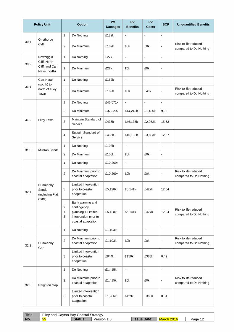
Title Filey and Cayton Bay Coastal Strategy
No. ?? Status: Version 1.0 Issue Date: March 2016 Page 12
Policy Unit Option PV
Damages
PV
Benefits
PV
Costs BCR Unquantified Benefits
30.1 Gristhorpe
Cliff
1 Do Nothing £182k - - -
2 Do Minimum £182k £0k £0k - Risk to life reduced
compared to Do Nothing
30.2
Newbiggin
Cliff, North
Cliff, and Carr
Nase (north)
1 Do Nothing £27k - - -
2 Do Minimum £27k £0k £0k -
31.1
Carr Nase
(south) to
north of Filey
Town
1 Do Nothing £182k - - -
2 Do Minimum £182k £0k £49k - Risk to life reduced
compared to Do Nothing
31.2 Filey Town
1 Do Nothing £46,571k - - -
2 Do Minimum £32,329k £14,242k £1,436k 9.92
3 Maintain Standard of
Service £436k £46,135k £2,952k 15.63
4 Sustain Standard of
Service £436k £46,135k £3,583k 12.87
31.3 Muston Sands
1 Do Nothing £108k - - -
2 Do Minimum £108k £0k £0k -
32.1
Hunmanby
Sands
(including Flat
Cliffs)
1 Do Nothing £10,269k - - -
2 Do Minimum prior to
coastal adaptation £10,269k £0k £0k -
Risk to life reduced
compared to Do Nothing
3
Limited intervention
prior to coastal
adaptation
£5,128k £5,141k £427k 12.04
2
+
3
Early warning and
contingency
planning + Limited
intervention prior to
coastal adaptation
£5,128k £5,141k £427k 12.04 Risk to life reduced
compared to Do Nothing
32.2 Hunmanby
Gap
1 Do Nothing £1,103k - - -
2 Do Minimum prior to
coastal adaptation £1,103k £0k £0k -
Risk to life reduced
compared to Do Nothing
3
Limited intervention
prior to coastal
adaptation
£944k £159k £383k 0.42
32.3 Reighton Gap
1 Do Nothing £1,415k - - -
2 Do Minimum prior to
coastal adaptation £1,415k £0k £0k -
Risk to life reduced
compared to Do Nothing
3
Limited intervention
prior to coastal
adaptation
£1,286k £129k £383k 0.34

Title Filey and Cayton Bay Coastal Strategy
No. ?? Status: Version 1.0 Issue Date: March 2016 Page 13
Policy Unit Option PV
Damages
PV
Benefits
PV
Costs BCR Unquantified Benefits
33.1
Speeton
Sands
1 Do Nothing £111k - - -
2 Do Minimum £111k £0k £0k -
1.4..11 Throughout the Study Area the following approaches are recommended:
Appropriate control of future development applications in line with current land use planning guidance on flood and coastal erosion risk (including consideration of landslide potential).
Responding appropriately to flood warnings in accordance with existing Emergency Plans when alerted by the Environment Agency via the North East Tidal Flood Forecasting Service.
Responding appropriately to early warnings in accordance with recommended Contingency Plans at Knipe Point and Flat Cliffs (and in the longer term at Hunmanby Gap and Reighton Gap) when alerted by the instrumentation installed in the coastal slopes or when certain thresholds are met through monitoring and inspection.
Public relations exercises to raise awareness amongst individual property owners, coastal communities, asset owners/operators and land owners (e.g. caravan parks, golf course, sailing club) of the risks from erosion and landsliding and the need for adaptation to coastal change over appropriate timescales.
Maintenance of existing coastal defences, where present.
Maintenance of existing cliff drainage and slope stabilisation measures, where present.
Analysis of data from the Cell 1 Regional Coastal Monitoring Programme and the Local Coastal Slope Monitoring to update understanding of coastal change and coastal processes.
Maintain awareness of latest climate change science and guidance.
Review the Filey and Cayton Bay Coastal Strategy in line with appropriate timescales
1.4..12 In addition to the above general approaches, a summary of the preferred Strategy options for each Policy Unit is provided below.
Table 1.2 Preferred Strategy Options
Policy Unit SMP2 Policy
Preferred Strategy Option
Comments
29.1 Cornelian Bay NAI Do minimum Relocation of pumping station in the longer term
29.2 Cayton Bay (excl. Pump House and Access)
NAI Adaptation to coastal change
Management of residual risk in the interim prior to adaptation through visual inspection, best practice for slope management, formalised emergency planning and PR exercises. Lobby central government for funding/enabling mechanisms for adaptation. Relocation of residents through
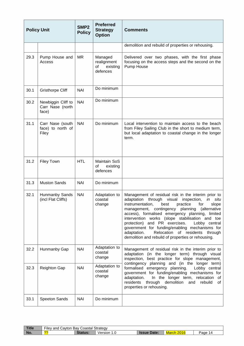
Title Filey and Cayton Bay Coastal Strategy
No. ?? Status: Version 1.0 Issue Date: March 2016 Page 14
Policy Unit SMP2 Policy
Preferred Strategy Option
Comments
demolition and rebuild of properties or rehousing.
29.3 Pump House and Access
MR Managed realignment of existing defences
Delivered over two phases, with the first phase focusing on the access steps and the second on the Pump House
30.1 Gristhorpe Cliff NAI Do minimum
30.2 Newbiggin Cliff to Carr Nase (north face)
NAI Do minimum
31.1 Carr Nase (south face) to north of Filey
NAI Do minimum Local intervention to maintain access to the beach from Filey Sailing Club in the short to medium term, but local adaptation to coastal change in the longer term.
31.2 Filey Town HTL Maintain SoS of existing defences
31.3 Muston Sands NAI Do minimum
32.1 Hunmanby Sands (incl Flat Cliffs)
NAI Adaptation to coastal change
Management of residual risk in the interim prior to adaptation through visual inspection, in situ instrumentation, best practice for slope management, contingency planning (alternative access), formalised emergency planning, limited intervention works (slope stabilisation and toe protection) and PR exercises. Lobby central government for funding/enabling mechanisms for adaptation. Relocation of residents through demolition and rebuild of properties or rehousing.
32.2 Hunmanby Gap NAI Adaptation to
coastal
change
Management of residual risk in the interim prior to adaptation (in the longer term) through visual inspection, best practice for slope management, contingency planning and (in the longer term) formalised emergency planning. Lobby central government for funding/enabling mechanisms for adaptation. In the longer term, relocation of residents through demolition and rebuild of properties or rehousing.
32.3 Reighton Gap NAI Adaptation to
coastal
change
33.1 Speeton Sands NAI Do minimum

Title Filey and Cayton Bay Coastal Strategy
No. ?? Status: Version 1.0 Issue Date: March 2016 Page 15
Funding and contributions
1.4.13 The whole life cash cost of the capital investment, including optimism bias of 60%, is £3.2million, of which £2.5million is considered eligible for consideration of FCERM Grant-in-Aid under present funding regimes and £0.7million will require alternative funding sources.
1.4.14 The StAR has demonstrated that the two schemes for capital works within the first five years of the Strategy, namely the capital works at Filey seawall (Policy Unit 31.2) and limited intervention works at Flat Cliffs access road (Policy Unit 32.1), are both likely to be eligible for consideration of FCERM Grant-in-Aid.
1.4.15 The Partnership Funding calculator indicates that both of these schemes could potentially be eligible for 100% FCERM Grant-in-Aid. Notwithstanding this, individual Project Appraisal Reports (PARs) (or equivalent replacement business case approaches) prepared for each scheme ought to give consideration to potential contributory funding from the main beneficiaries of the works, who are Scarborough Borough Council, North Yorkshire County Council, Flat Cliffs residents, Environment Agency (non-FCERM budgets) and Yorkshire Water.
Key delivery risks
1.4.16 The principal delivery risk associated with the preferred options in the Strategy is the present absence of a means of facilitating ‘Adaptation to coastal change’ where this is identified as the preferred option. Due to this, it is necessary for the relevant authorities and individuals to lobby central government (Defra) and appropriate non-departmental public bodies (Environment Agency) for suitable means of implementing this approach to become eligible for consideration for FCERM Grant in Aid.
1.5 Recommendation
1.5..1 The Filey and Cayton Bay Coastal Strategy is recommended for Approval in Principle for FCERM-eligible capital expenditure of £0.5million, including optimism bias of 60%, over the first five years.
1.5..2 It is also recommended that central government (Defra) is lobbied for suitable means of implementing ‘Adaptation to coastal change’ as an eligible and (in some manner) fundable approach within the FCERM portfolio of sustainable management options.
1.6 Key Plans
Key Plan 1 – Location Plan
Key Plan 2a – Management Areas and Policy Units within the Study Area
Key Plan 2b – Management Areas and Policy Units within the Study Area

Title Filey and Cayton Bay Coastal Strategy
No. ?? Status: Version 1.0 Issue Date: March 2016 Page 16
Key Plan 1 – Location Plan

Title Filey and Cayton Bay Coastal Strategy
No. ?? Status: Version 1.0 Issue Date: March 2016 Page 17
Key Plan 2a – Management Areas and Policy Units within the Study Area

Title Filey and Cayton Bay Coastal Strategy
No. ?? Status: Version 1.0 Issue Date: March 2016 Page 18
Key Plan 2b – Management Areas and Policy Units within the Study Area

Title Filey and Cayton Bay Coastal Strategy
No. ?? Status: Version 1.0 Issue Date: March 2016 Page 19
2 Introduction and background
2.1 Purpose of this report
2.1..1 This Strategy Appraisal Report (StAR) presents the Flood and Coastal Erosion Risk Management (FCERM) ‘business case’ for investment in a strategic programme of future capital schemes and management activities to manage the risks to people and the developed, natural and historic environments from coastal erosion, coastal slope instability and (specifically at Filey town) sea flooding over the next 100 years.
2.1..2 In some parts of the Study Area the risks from coastal erosion at the toe of the cliffs or slopes and the risks from instability in the face or headscarp of the cliffs or slopes are interdependent and therefore fully integrated coast protection and slope stability solutions are required at those locations. In other locations the risks from instability in the face or headscarp of the cliffs or slopes is less directly affected by marine processes and instead is predominantly governed by sub-aerial processes and groundwater flow. In those specific locations, slope stabilisation works (if required to protect assets) are unlikely to received funding contributions from central government in the form of FCERM Grant-in-Aid.
2.1..3 The StAR summarises the key risks in the Study Area from these sources and is seeking approval from the Environment Agency’s Large Projects Review Group (LPRG) for our plans to manage them. Once approval of the StAR has been received, we shall begin to implement the recommendations.
2.1..4 The StAR has been undertaken in accordance with latest Environment Agency FCERM Appraisal Guidance and associated Environment Agency policies and procedures. It has also been informed by outputs from the recent evaluation study, published by the Joint Defra and Environment Agency FCERM Research and Development Programme, of the Defra Coastal Change Pathfinder programme.
2.1..5 We [Scarborough Borough Council] plan to implement the recommended capital works and coastal management activities arising from the Filey and Cayton Bay Coastal Strategy in a prioritised manner using our permissive powers under the Coast Protection Act (1949).
2.2 Background
Strategic and legislative framework
2.2..1 The original Shoreline Management Plan (SMP) covering the Study Area was completed in 1997. This was followed in 2002 by publication of both the original Cayton Bay Coastal Strategy (extending from Knipe Point to the southern end of Cayton Sands) and the original Filey Bay Coastal Strategy (extending from Filey Brigg to Flamborough Head). The original SMP and both previous Coastal Strategy documents were received and duly noted by the central government body with FCERM responsibilities at that time (namely the Ministry of Agriculture Fisheries and Food (MAFF) for the SMP and the Department for Environment, Food and Rural Affairs (DEFRA) for the two Coastal Strategies).

Title Filey and Cayton Bay Coastal Strategy
No. ?? Status: Version 1.0 Issue Date: March 2016 Page 20
2.2..2 The two previous Coastal Strategy documents identified particular problems with the instability of the cliffs in certain sections of the frontage, due to both sub-aerial weathering and coastal erosion. Particular concerns were raised at Cayton Cliffs (Cayton Bay), Tenants’ Cliff (Cayton Bay), Filey Brigg (Filey Bay), Filey town (Filey Bay), Flat Cliffs (Filey Bay), Hunmanby Gap (Filey Bay) and Reighton Sands (Filey Bay).
2.2..3 The River Tyne to Flamborough Head Shoreline Management Plan 2 (SMP2) was published in 2007, confirming the two previous Coastal Strategies’ findings. The SMP2 was formally approved by the Environment Agency in July 2009.
2.2..4 The two previous Coastal Strategies are now being updated as a single document, extending between White Nab and Speeton in North Yorkshire, before any further capital investment is made in future flood and coastal risk management schemes and before any future management activity is undertaken because:
Coastal Strategies are live documents that need to be kept up to date
New national guidance has emerged since the previous Coastal Strategies were published in 2002 relating to funding and assessment procedures for FCERM schemes
National and regional pressures and priorities have changed to reflect economic circumstances
Awareness of local community needs has increased as views and opinions have been expressed through the development of various studies over the past decade
Understanding of coastal evolution has improved as we have continued to investigate and monitor the coast
Scientific understanding of climate change and sea level rise has improved since 2002 and the latest scientific outputs and Environment Agency advice needs to be incorporated
There is improved understanding of the barriers and constraints to implementing adaptation to coastal change arising from the recent evaluation study of the Defra Coastal Change Pathfinder programme, together with recommendations from that work for adaptation approaches to be considered for funding under FCERM Grant-in-Aid given a proven beneficial case from a broad scale economic assessment
There are new legal processes that need to be considered as strategic options are developed, particularly those concerning environmental assessment (such as the Water Framework Directive 2000/60/EC and the Strategic Environmental Appraisal (SEA) Directive 2001/42/EC)
There are planned changes in the boundaries of various environmentally designated sites within the Study Area which need to be reflected in updated management plans.
2.2..5 Our update of the two previous Coastal Strategies from 2002 is called the Filey and Cayton Bay Coastal Strategy and was undertaken in 2015/16. Its purpose is to:
Complete the gaps (between White Nab and Knipe Point and between the southern end of Cayton Sands and Filey Brigg) in the otherwise strategic management of the coastline by including these frontages
Provide an up to date assessment of the risks from coastal erosion, slope instability and sea flooding, especially those which directly affect people and the developed, natural and historic environments
Identify and assess various options for managing these risks over the next hundred years

Title Filey and Cayton Bay Coastal Strategy
No. ?? Status: Version 1.0 Issue Date: March 2016 Page 21
Consult with the public and other interested bodies on those options, leading to identification of a preferred set of management options across the Study Area
Develop a long term plan for future investment in sustainable management activities across the Study Area
Previous studies
Strategy Area
2.2..6 The original Cayton Bay Coastal Strategy (dated 2002) and the original Filey Bay Coastal Strategy (dated 2002) both provided a robust and thorough assessment of the key problems and appraisal of the management options within much of the present Study Area. These Coastal Strategies were developed following a number of bespoke surveys and investigations, including:
Topographic survey
Bathymetric survey
Sampling and analysis of beach surface sediments
Modelling of the wave climate
Modelling of the sediment transport processes
Condition assessment of the coastal defences (where present)
Condition assessment of the coastal cliffs and slopes, incorporating detailed geomorphological mapping and assessment
Ground Investigation and geotechnical stability analysis at Flat Cliffs
2.2..7 Ongoing since 2008, beach profile surveys and beach topographic surveys have been collected along Cayton Bay and Filey Bay as part of the wider Cell 1 Regional Coastal Monitoring Programme, with bathymetric surveys in both bays having also been undertaken on one occasion to date. This programme has also obtained aerial photography and Lidar data in 2010, 2012 and 2015 across the whole Study Area and collected cliff recession rates from a series of ‘virtual’ (GPS defined) marker points along the cliff tops since 2008 in Cornelian Bay (5 no.), Cayton Bay (8 no.) and Filey Bay (23 no., with 5 no. further points added in 2011 to make a total of 28 no. in the present day). The location of the beach profile, beach topographic and cliff top marker points is shown in Appendix D. The present Cell 1 Regional Coastal Monitoring Programme runs to 2016, with planned 5 yearly rolling extensions (each subject to their own funding approval process). The programme for 2016 – 2021 is currently (July 2015) under review by the Large Projects Review Group of the Environment Agency with the expectation of approval being received in 2015.
2.2..8 Walkover inspections of the condition of the coastal defences and natural assets (cliffs, slopes and beaches) have also been undertaken as part of previous surveys in 2002, 2005, 2008, 2009, 2012 and 2014. Those surveys in 2008 and since were part of the Cell 1 Regional Coastal Monitoring Programme. These inspections give an excellent appreciation of the mechanisms and rates of change in the defence assets and natural cliffs and slopes.
2.2..9 A programme of Local Coastal Slope Monitoring has also been undertaken at Knipe Point on Cayton Cliffs (in Cayton Bay) and at Filey town and Flat Cliffs (both in Filey Bay) since 2008, involving rainfall collection, inclinometers and piezometers to monitor ground movements. The main objective of the programme is to provide property-owners and landowners with information on stability risk in vulnerable areas. It should be noted that the Knipe Point monitoring ceased in 2013, partly due to instrument damage during natural ground movements. Further details of the Local Coastal Slope Monitoring at each site are provided below.

Title Filey and Cayton Bay Coastal Strategy
No. ?? Status: Version 1.0 Issue Date: March 2016 Page 22
2.2..10 At Knipe Point on Cayton Cliffs, piezometers were installed at 6 locations (3 no. within the land owned and occupied by Knipe Point Drive estate residents, 2 no. within the SSSI owned by The National Trust and 1 no. in the verge of the former A165 owned by North Yorkshire County Council). The three piezometers within the Knipe Point Drive estate have become blocked or have collapsed due to ground movements. Furthermore, 14 no. headscarp recession markers at Knipe Point were physically installed as part of the local monitoring programme but all have since become removed by persons other than the Council. Also, the Knipe Point weather station was removed by the Council at the request of the Chairman of the Knipe Point Residents Association. A series of 9 no. further headscarp recession markers along the former A165 road verge showed no signs of movement. Due to the failure of some equipment and the removal of other, Scarborough Borough Council decided in 2013 to discontinue the monitoring at Knipe Point, advising both The National Trust and the Knipe Point Residents Association of their decision and their reasons.
2.2..11 The Local Coastal Slope Monitoring has been more successful at Filey town and Flat Cliffs and continues to the present day, with separate contracts for the data collection and data analysis. At Filey town it comprises 4 no. inclinometers and 24 no. piezometers while at Flat Cliffs it comprises 4 no. inclinometers, 4 no. piezometers and 1 weather station. In addition, Loughborough University has installed 1 no. acoustic inclinometer. The location of these instruments is shown in Appendix D. The present Local Coastal Slope Monitoring runs to 2017, with future extensions subject to the availability of funding from the Environment Agency and contributions from Scarborough Borough Council.
2.2..12 In addition, detailed investigations and studies have been undertaken in both Cayton Bay (specifically at Knipe Point on Cayton Cliff) and Filey Bay (especially at Filey Brigg, Filey town and Flat Cliffs). Further details of these investigations and studies are provided for each area below.
Cayton Bay
2.2..13 Following publication of the original Cayton Bay Coastal Strategy in 2002 and the identification of slope instability as a potential risk to people, property and the natural environment, two further detailed studies have been undertaken at Knipe Point on Cayton Cliff:
Cayton Bay Cliff Stability Assessment – Ground Investigation and Appraisal of Engineering Stabilisation Options – April 2009
Knipe Point Landslide Assessment – July 2009
2.2..14 In addition, the frontage has been the focus of much professional and academic interests for the management challenges posed in this area of active landslip and a number of papers and MSc theses have been published or presented:
Fish, Moore & Carey (2006) Landslide geomorphology of Cayton Bay, North Yorkshire, UK
Johnson & Fish (2012) Reactivation of the coastal landslide system at Cayton bay, North Yorkshire, UK
Walker (2011) Engineering geological characterisation of landslides at the north of Knipe Point
Siddle, Rowe & Moore (2015) Adaptation to coastal cliff instability and erosion and property loss: case study into the Knipe Point cliff retreat Coastal Change Pathfinder project

Title Filey and Cayton Bay Coastal Strategy
No. ?? Status: Version 1.0 Issue Date: March 2016 Page 23
2.2..15 In 2009, Scarborough Borough Council applied for a grant from Defra under the Coastal Change Pathfinder programme to help with an urgent problem at Knipe Point on Cayton Cliff where traditional engineering solutions were not suitable. The problem related to instability of a coastal slope threatening individual cliff top properties (in the short term) and the sustainability of a whole coastal community (in the longer term). Structural solutions to stabilise the coastal slope and cliff-top land at Knipe Point were deemed environmentally unacceptable due to the need for a continuation of natural processes of erosion in the coastal slope to maintain the condition of the Site of Special Scientific Interest (SSSI) for which it was designated. In addition, the estimated cost of the technical solutions to the complex challenge posed by the coastal slope instability considerably outweighed the potential benefits of any such scheme. [It should be noted that at that the time of the above considerations, the FCERM Grant-in-Aid mechanism provided 100% funding for eligible schemes, whereas in the present day the regime has changed to a partnership funding approach. This enables central government funding to contribute towards a larger number of schemes than was otherwise achievable under the former system, although usually to only proportion of the overall scheme costs and with third parties (often scheme beneficiaries) contributing the remaining funding. Notwithstanding this change in funding approach, the costs of intervention at Knipe Point would remain disproportionately high with respect to the economic benefits.]
2.2..16 The Coastal Change Pathfinder project at Knipe Point involved the sourcing and purchase of land at an alternative location to allow residents at immediate risk of land instability to rebuild their properties through insurance pay-outs at a site which was not at risk of coastal erosion or land instability. The Coastal Change Pathfinder project covered the fifteen properties in the Knipe Point community that were considered to be at immediate risk of being lost through land instability. The Coastal Change Pathfinder project was undertaken in a manner that allowed constant evolution and development of the original scope in order to bring the adaptation concept into fruition. The project was based around the concept of ‘land banking’; providing land which affected residents could then rebuild their properties on, using insurance pay-outs.
2.2..17 The concept of the land bank solution was devised in order to address an imbalance within property insurance. Currently in England, insurance is only offered against physical property loss and not the land on which it occupies. This form of insurance works well in cases such as property loss due to fire, as it is possible to rebuild upon the same plot. However with cliff retreat due to erosion and landsliding the land is partially or wholly lost so an on-site rebuild is either not possible or is undesirable given the risk. It is important to note that it is not possible to insure against coastal erosion in England, and therefore this approach was only suitable at Knipe Point as the properties were at risk from land instability rather than erosion.
2.2..18 The first stage of the project was to obtain an independent valuation of the land on which the properties currently sat at Knipe Point, assuming a risk free market value, to provide a guide as to the sum available to purchase a new site. An assessment was then carried out to identify suitable sites through the Council’s Housing Allocation Development Plan, taking account of the size of land required, sum available for land purchase and the servicing requirements. The suitable sites were discussed with the affected residents, who rejected Scarborough Borough Council’s preferred site. An agreement was eventually reached on a site within the Borough of Scarborough. An application submitted by the residents to vary the planning permission for this site has been approved to allow year round permanent residential occupation instead of holiday accommodation not exceeding one month. Completion of the purchase of the site occurred in January 2015. It is anticipated that identified residents will begin to move to the site once insurance pay-outs have been made.

Title Filey and Cayton Bay Coastal Strategy
No. ?? Status: Version 1.0 Issue Date: March 2016 Page 24
2.2..19 The original intention was to exclude second home owners from the project. However, this was revised during the course of the Coastal Change Pathfinder because a traditional structural coast protection or coastal slope stabilisation scheme would have benefitted the entire coastal community at Knipe Point regardless of the property ownership status, and therefore it was felt to be discriminatory to differentiate between different types of residents for the Coastal Change Pathfinder project. A restriction was placed on the length of ownership, only allowing residents who purchased their properties prior to 2009 to participate, in order to avoid profiteering.
2.2..20 As part of the agreements with the residents participating in the Coastal Change Pathfinder project it was intended to place restrictions on the land that would be allocated to residents, such as the planning permission reverting to holiday occupancy only on resale of the property (unless sold on to another affected Knipe Point resident). However these were subsequently dropped as unfeasible, mainly due to the fact that the residents were contributing a larger proportion of costs towards the rebuild of their properties.
2.2..21 The Coastal Change Pathfinder project remains ongoing. A suitable plot of land at an alternative site within the Borough of Scarborough has been agreed between Scarborough Borough Council and the affected residents. An application submitted by the residents to vary the planning permission for the site has been approved to allow year round permanent residential occupation instead of holiday accommodation not exceeding one month. Completion of the purchase of the occurred in January 2015. It is anticipated that identified residents will begin to move to the site once insurance pay-outs have been made.
2.2..22 In parallel with the initiatives under the Coastal Change Pathfinder project, a Cayton Bay Cliff Landslide Response Plan was prepared in 2012 as a multi-agency Site Specific Contingency Plan in the event of a future landslide event occurring. This document was effective until March 2015 (and now is in need of updating).
Filey Bay
2.2..23 Following publication of the original Filey Bay Coastal Strategy in 2002 and the identification of slope instability as a potential risk to people, property and the natural environment, further detailed studies have been undertaken at Filey Brigg, Filey town and Flat Cliffs:
Evolution of Filey Brigg – April 2012
Filey Town Ground Investigation – Analysis of Monitoring Data – August 2012
Filey Town Ground Investigation – Analysis of Cliff Monitoring Data – January 2013
Flat Cliffs Stability Assessment and Management Plan – Ground Investigation and Monitoring Report - May 2012
Flat Cliffs Ground Investigation – Analysis of Cliff Monitoring Data – January 2013
Location and designations
2.2..24 The Study Area of the Filey and Cayton Bay Coastal Strategy covers approximately 21 kilometres of North Yorkshire’s coastline between White Nab and Speeton (see Key Plan 1). For the purposes of developing the Coastal Strategy, the Study Area has been

Title Filey and Cayton Bay Coastal Strategy
No. ?? Status: Version 1.0 Issue Date: March 2016 Page 25
sub-divided into a number of coastal Management Areas (MAs) and Policy Units (PUs) that are consistent with those used in the SMP2 (see Key Plans 2a and 2b).
2.2..25 The Study Area is highly renowned for its landscape and geological setting, with dramatic clifflines, sweeping sandy beaches, and small but bustling local coastal communities.
2.2..26 Considerable tourism and amenity value is associated with the seascape and landscape aesthetics of the Study Area’s coastline, especially at Filey but also at a series of holiday villages at various locations within the Study Area. The majority of the coastline is bordered by formal public footpaths including the Cleveland Way National Trail, the Yorkshire Wolds Way National Trail, the Centenary Way and the Headland Way. Works are currently underway on the design and implementation of the England Coast Path under Part 9 of the Marine and Coastal Access Act 2009.
2.2..27 There are also important heritage assets including three Scheduled Monuments and one Conservation Area at Filey. In addition, there are three Listed Buildings and various archaeological features located wholly or partially within, or immediately adjacent to, the Study Area.
2.2..28 There are a number of European or Internationally designated sites for nature conservation within, or close to, the Study Area (namely the Flamborough Head Special Area of Conservation (SAC), Flamborough Head and Bempton Cliffs Special Protection Area (SPA) and a recommended Marine Conservation Zone (rMCZ) (designation of the rMCZ is currently on hold however).
2.2..29 There are four Sites of Special Scientific Interest (SSSI) within, or close to, the study area (namely Cayton, Cornelian and South Bays SSSI, Filey Brigg SSSI, Flamborough Head SSSI and Gristhorpe and Red Cliff SSSI), designated for their ornithological, biological and geological interest, as well as a Local Nature Reserve near to the study area at Flamborough Head. Natural England is currently reviewing SSSIs on the East Yorkshire Coast from Bridlington to Scarborough. This involves considering proposals to extend the Flamborough Head SSSI northwards along the coast to the southern end of Filey town, and merging and extending Cayton, Cornelian and South Bays SSSI, Gristhorpe and Red Cliff SSSI and Filey Brigg SSSI. The proposed new SSSIs would extend inland to include an area of predicted coastal recession.
2.2..30 Natural England submitted a report to the Secretary of State for Environment, Food and Rural Affairs during 2013 setting out proposals to extend the existing Flamborough Head and Bempton Cliffs SPA. The proposed site has been renamed the Flamborough and Filey Coast potential SPA (pSPA). It is also proposed to revise the landward boundary of the Flamborough Head SAC to ensure that predicted coastal change does not result in the interest features of these sites being unprotected in the future.
2.2..31 There are also parts of a Heritage Coast within the Study Area, reflecting its landscape importance.
2.2..32 Three designated bathing beaches are located within the Study Area. These are located at Cayton Bay, Filey and Reighton.
2.2..33 Other than short, discrete, sections of coastal defence at Tenants’ Cliff (Cayton Bay), Filey Sailing Club (Filey Bay) and Filey town (Filey Bay), the coastline is undefended, comprising natural sea cliffs and coastal slopes. In some places, especially in residential communities, the cliffs and slopes have some drainage and, to a lesser

Title Filey and Cayton Bay Coastal Strategy
No. ?? Status: Version 1.0 Issue Date: March 2016 Page 26
extent, stabilisation works. Mapping of both the cliff types and coastal defences present within the Study Area is provided in Appendix D.
2.2..34 There are also a small number of locations where access steps or ramps and other features (e.g. Yorkshire Water outfalls) are locally present in the otherwise undefended coastline.
History of Erosion, Instability and Sea Flooding
2.2..35 Coastal erosion and cliff or slope instability arises as a consequence of either: (i) no coastal management being present; or, where such management is present, (ii) the structures and management approaches failing to perform their intended function, or being affected by physical conditions that exceed their design thresholds.
2.2..36 It is important to understand the structural condition and performance of existing defences and other management approaches (e.g. slope drainage or slope stabilisation), where they are present, in order to fully identify the potential risks that exist across the Study Area.
2.2..37 Walkover inspections of the formal coastal defences within the Study Area were first undertaken in 2002 as part of the original Coastal Strategies and repeated in 2008, 2009, 2012 and 2014 as part of the Cell 1 Regional Coastal Monitoring Programme. This has provided a good overview of baseline condition and any further deterioration over a period of more than a decade.
2.2..38 In addition, more detailed ground investigations, including intrusive techniques, have been undertaken at Cayton Bay, Filey town and Flat Cliffs to consider drainage and instability issues.
2.2..39 Due to the availability of this extensive previous information, a Walkover Survey was undertaken in June 2015 to bring the previous assessments of coastal defence and cliff and slope condition fully up to date to inform the present Coastal Strategy (Appendix K). An accompanying Photographic Record is available on CD-rom in Appendix C.
2.2..40 Additionally, a ground investigation comprising window sampling was undertaken at the toe of the Filey seawall in September 2015 to ascertain the level of the underlying bedrock. Original construction drawings of the Victorian section of the Filey seawall, that are stored in the archives of Filey Town Hall, were also examined in detail.
2.2..41 Results from these activities identified that there are some coastal structures in less than optimum condition and these are in need of capital investment, most notably the Filey town seawall in Filey Bay and the (privately-owned) defences fronting the Pump House and also the defences around the access steps at Tenants’ Cliff in Cayton Bay. Additionally, there are several areas of coastal cliff or slope where instability issues present an imminent or short term risk to individual properties or wider communities, as well as many areas where medium or long term risks are present.
Erosion and Instability
2.2..42 Coastal erosion and coastal slope instability largely remains ongoing at natural rates within the Study Area due to the absence of coastal defences throughout much of the frontage. Whilst some cliffs are typically subject to relatively slow rates of ongoing coastal recession, others are formed in a more complex manner and are subject to periods of relative stability followed by episodic landslips that can cut the cliff line back by many metres or many tens of metres during a single event.

Title Filey and Cayton Bay Coastal Strategy
No. ?? Status: Version 1.0 Issue Date: March 2016 Page 27
2.2..43 Cayton Cliff – There is ongoing shallow sliding of the headscarp at the Knipe Point Drive estate (this predominantly is occurring along the headscarp on the Cayton Bay side of the Osgodby Point headland, but is also occurring at a ‘pinch point’ immediately to the Cornelian Bay side of the headland, also affecting properties). In addition, deep-seated re-activation of the Cayton Cliff coastal landslide complex occurred on 1st April 2008, resulting in the loss of three properties at Knipe Point Drive estate. This followed localised headscarp failures adjacent to the properties, beginning in late autumn 2007. The landslide re-activation included headscarp recession, shallow mudslides and debris flows, and deeper-seated ground displacement leading to tension cracking and toe uplift.
2.2..44 Filey Town – In addition to ongoing coastal erosion and cliff instability to the undefended north and south of Filey town, the coastal slopes behind the seawall have also been subject to slope failures and instability. On 18th July 2007 a number of landslides were triggered on the coastal slopes as a result of an intense rainstorm and associated localised flooding (see Appendix C). These floods and landslides caused significant damage to infrastructure and property and were widely reported in the media. The rainstorm resulted in flood water cascading over the coastal cliffs, along key access roads and paths, down the deeply incised ravines (Martin’s Ravine and Church Ravine), and across the Promenade. This led to a number of people being trapped by the flood waters on the lower slopes who had to be rescued. Furthermore, beach drawdown at the toe of the Filey seawall can, on occasion, lead to exposure of the concrete toe foundation, increasing the risk of structural damage to the toe and of further lowering of the clay substrate leading to undermining of the wall itself. Beach drawdown to such an extent to expose the concrete toe last occurred during the storms of winter 2013/14 (see Appendix C).
2.2..45 Flat Cliffs – Investigations into erosion and land instability were first undertaken in 2001 to inform the development of the original Filey Bay Coastal Strategy (Halcrow, 2002). At that time there was evidence of cracking and subsidence in the access road and heave of the pipeline along the shoreline. During inspections in July 2004 there was evidence of damage to both property and infrastructure throughout Flat Cliffs, most pronounced in extent and severity at the north end of the complex, as evidence of a non-rotational mudslide failure with characteristics of differential rates of backtilting and downslope translation. By September 2009 there was evidence of localised toe erosion of the cliffs and fresh cracking in the access road. Recent cliff stability analyses (Halcrow, 2012) indicate that the northern section of Flat Cliffs is marginally unstable (factor of safety ≈ 0.9) and that the central and southern section of Flat Cliffs is
marginally stable (factor of safety ≈ 1.1 – 2.0). The stability analyses indicate that the
cliff stability would be reduced significantly in the event of a rise in ground water levels or toe erosion of the cliff. Aerial photographs show that long-term (1940-2010) cliff-top recession has varied from 0.19m/year to 0.35m/year and cliff-toe recession between 0.05m/year and 0.13m/year. Overall, Flat Cliffs experiences both ongoing gradual ground movements associated with settlement, translation and rotational movements, and specific periods of more measurable landslip activity associated with occasional storms that act to erode the cliff and remove support from the toe of the undercliff, and intense rainfall and surface water infiltration raising groundwater levels and porewater pressures that then trigger movement. These effects are likely to worsen through the lifetime of the Coastal Strategy due to the effects of sea level rise and changes in winter rainfall patterns projected as a consequence of global climate change.
2.2..46 Further information about the cliffs and slopes within the Study Area, including their characterisation and an assessment of their general condition based on a walkover inspection is provided in Appendix K3. An overview of the previous geotechnical information at Cayton Cliff, Filey town and Flat Cliffs is provided in Appendix K4.

Title Filey and Cayton Bay Coastal Strategy
No. ?? Status: Version 1.0 Issue Date: March 2016 Page 28
Wave Overtopping
2.2..47 Local sea flooding due to wave overtopping is not known to be a significant problem within the Study Area, although there is potential for this to occur at Filey town.
2.3 Current approach to flood risk management
Measures to manage the probability of flood and erosion risk
2.3..1 Throughout much of the Study Area the probability of coastal erosion and slope instability is unmanaged. Exceptions are at the Pump House and access steps in Cayton Bay, the Filey Sailing Club and Filey town itself, where coastal defences are present at each location. Details of these coastal defence structures are provided in Appendix K5. At some locations, such as Cayton Cliff, Flat Cliffs and Hunmanby Gap, local drainage and stabilisation works are used to reduce the probability of instability in the slopes.
Measures to manage the consequences of flood and erosion risk
2.3..2 The Study Area is served by the Environment Agency’s North East Tidal Flood Forecasting Service and operational alerts are raised by the Environment Agency to Scarborough Borough Council when trigger thresholds that may lead to significant overtopping or sea flooding are exceeded. This is of most relevance to Filey town.
2.3..3 Some coastal slopes within the Study Area are comprised of glacial till and are highly susceptible to landslips. In the most vulnerable areas, a network of instrumentation is installed, enabling any mass movements in the slopes to be identified and appropriate remedial or evacuation action to be undertaken. A Landslide Response Plan exists for Cayton Bay and is shared with the emergency services to provide a means of managing the consequences of landslip. An (informal) plan has also been developed for Flat Cliffs as part of a recent consultancy report (although this is not of the same formal ‘contingency plan’ status as that which exists for Cayton Bay).
2.3..4 In some undefended sections of cliff, an approach of adapting to ongoing coastal change has been adopted. This has included demolishing bungalows at risk of imminent collapse due to landslip at Knipe Point and re-locating residents to a new plot of land away from ‘at risk’ areas (as part of a Defra Coastal Change Pathfinder project), re-routing a section of the A165 highway in the vicinity of Cornelian Bay further inland, holiday park owners moving caravans as cliff recession continues, public footpaths being diverted inland and a golf club re-designing the layout of its course accordingly to accommodate ongoing recession.
Approach to developing the Filey and Cayton Bay Coastal Strategy
2.3..5 Robust and reliable information is available from the two original Coastal Strategies plus a comprehensive suite of subsequent surveys and investigations that extend across the Study Area in general and focus on ‘hot spots’ of concern in particular. Due to this, the Filey and Cayton Bay Coastal Strategy has adopted an approach of:
Making best use of available data from previous surveys and investigations
Focusing new studies and investigations only on areas highlighted as key remaining uncertainties or potential constraints in need of further consideration

Title Filey and Cayton Bay Coastal Strategy
No. ?? Status: Version 1.0 Issue Date: March 2016 Page 29
Undertaking the necessary level of recommended environmental assessment through the Strategic Environmental Appraisal (SEA) and Water Framework Directive (WFD) assessment processes
Adopting a ‘lite-touch’ approach by reporting the findings within the context of a StAR rather than additionally having a separate Coastal Strategy document
2.3..6 In line with the above philosophy, the Filey and Cayton Bay Coastal Strategy adopted a two-stage approach to its development.
2.3..7 Stage 1 involved Data Gathering and Analysis and incorporated the following:
Aerial Photography Mapping (Appendix K1) – Acquisition (from English Heritage’s National Monuments Record) and analysis of aerial photography from the 1940s, 1960s and 1980s to compare against the recent 2012 geo-rectified aerial photography available from the Cell 1 Regional Coastal Monitoring Programme. The purpose was to assess historic locations and, where possible, rates of change in the position of the cliffs and coastal slopes. Outputs were used to inform development of the Cliffs and Coastal Slopes Overview (see Appendix K3)
Coastal Processes Overview (Appendix K2) – Updating the previous two Coastal Strategies’ findings (including modelling results) with results from new surveys undertaken as part of the Cell 1 Regional Coastal Monitoring Programme, more detailed local investigations at particular sites, and outputs from the Cell 1 Sediment Transport Study.
Cliffs and Coastal Slopes Overview (Appendix K3) – Undertaking a desk-review of previous geomorphological mapping and assessment, and updating this with results from the Cell 1 Regional Coastal Monitoring Programme and a new walk-over survey in 2015 to identify signs of mass movement or erosion since previous surveys. The work was also supported by aerial photography analysis of changes in cliff position.
Geotechnical Overview (Appendix K4) - Undertaking a desk-review of previous ground investigations and slope stability assessments from Cayton Cliff, Filey town and Flat Cliffs.
Coastal Defences Overview (Appendix K5) – Undertaking a desk-review of previous condition assessments, and updating this with results from a walk-over survey in 2015 to identify signs of deterioration or repair since previous surveys.
Adapting to Climate Change (Appendix K6) – Undertaking a review of the latest credible published science on climate change from the United Kingdom Climate Projections 2009 (UKCP09) in light of the Environment Agency advice note from 2011 on Adapting to Climate Change: Advice for Flood and Coastal Erosion Risk Management Authorities.
Adapting to Coastal Change (Appendix K7) – Undertaking a review of the latest evaluation research study outputs of projects within Defra’s Coastal Change Pathfinder programme to highlight barriers and constraints to coastal adaptation and identify lessons learnt from the programme that can inform policy at local and national levels.
2.3..8 Stage 2 involved Strategy Development and incorporated technical, economic and environmental assessments in accordance with latest Flood and Coastal Erosion Risk Management Appraisal Guidance and SEA Regulations (The Environmental Assessment of Plans and Programmes Regulations 2004 (Statutory Instrument 2004 No. 1633)). Consideration was also given to the Environment Agency’s advice on Adapting to Climate Change (September 2011) and outputs from the latest evaluation of projects within Defra’s Coastal Change Pathfinder programme.

Title Filey and Cayton Bay Coastal Strategy
No. ?? Status: Version 1.0 Issue Date: March 2016 Page 30
3 Problem definition and objectives
3.1 Outline of the problem
3.1..1 The principal problems in the Study Area are associated with coastal erosion and coastal slope instability. At some locations these processes are interdependent whilst at others they are (largely) independent and care must be taken at each frontage to ensure than an adequate appreciation of the problem(s) is ascertained. With changes in sea level and rainfall patterns associated with global climate change, these problems could increase during the 100-year horizon of the Coastal Strategy.
3.1..2 Wave overtopping and sea flooding is not (presently) a major problem in the majority of the Study Area due to the form and topography of the coastline, except at Filey town where such a risk does exist. With sea level rise associated with global climate change, it could become more problematic in selected areas (e.g. Filey town) during the 100-year horizon of the Coastal Strategy.
3.1..3 The most critical problem areas, where existing coastal defences are in poorest condition or where existing coastal slopes are near their threshold for failure and where assets would be at risk are located at Cayton Bay (Policy Units 29.2 and 29.3), Filey town (Policy Unit 31.2) and Flat Cliffs (Policy Unit 32.1). Other (longer term) issues are likely to arise at Humnaby Gap (Policy Unit 32.2) and Reighton Gap (Policy Unit 32.3) in particular.
3.2 Consequences of doing nothing
3.2..1 In areas where there are no coastal defences, but where there are few assets at risk, doing nothing (in terms of FCERM) does not present a significant concern as existing land uses can be locally adapted, for example through local realignment of footpaths, redesign of the layout of golf courses or relocation of caravans within the boundaries of existing holiday villages or within newly extended landward areas.
3.2..2 In areas where there are coastal defences, and hence where there are assets at risk, doing nothing is of more concern. If no further FCERM investment was made in managing the risks of erosion, instability and sea flooding within the Study Area, existing defences and other management assets (e.g. slope drainage) would deteriorate in condition over time and ultimately fail. Subsequent erosion and episodic landslips would put lives, property and infrastructure at high risk. This scenario applies to the Pump House and access steps in Cayton Bay and the Filey Sailing Club in Filey Bay, but most especially is of concern at Filey town itself.
3.2..3 At Filey, the town has been developed on relict cliffs formed from glacial sediments (tills including lenses of sands, gravels and clays) and is protected by a seawall that has prevented erosion of the frontage since its construction. However the seawall is subject to: (i) deterioration in condition (primarily due to abrasion); (ii) undermining at the toe during periods of low beach levels; and (iii) outflanking at either end as the adjacent undefended coast continues to erode. Despite their relative present-day stability (notwithstanding shallow slips following periods of excessive rainfall), the backing slopes are characterised by pre-existing landslides and failed ground which have the

Title Filey and Cayton Bay Coastal Strategy
No. ?? Status: Version 1.0 Issue Date: March 2016 Page 31
potential for re-activation. Under a Do Nothing scenario, outflanking will remain ongoing at either end of the seawall. At the northern end, the outflanking will start to cause property losses along the length of Coble Landing. These losses will be progressive, working from north to south, over an envisaged timeframe of 15 years, although the loss of function of the RNLI launch slipway will occur once the outflanking causes structural collapse at the seaward end. A similar process will occur at the southern end of the seawall, with property losses along the promenade progressively occurring, working from the south to the north, over an envisaged timeframe of 15 years. However, outflanking at the southern end will also affect the existing coastal slope, increasing the probability of destabilisation and failure at the toe leading to a larger landslip. A number of cliff top properties would be at increased risk compared to the present day from this process. Ultimately the seawall will fail due to a combination of progressive outflanking and deterioration of the condition of the structure. It has been assumed in the economic appraisal that this failure would occur by year 30, at which time landsliding in the backing slopes will become fully re-activated, causing initial rapid coastal retreat until the presently advanced shoreline position is returned to in line with that of the adjacent coastlines, whereupon general characteristics of landslip and erosion will continue.
3.2..4 There are other areas within the Study Area which do not neatly fall into either of the above categories and which are unusual in terms of Coastal Strategy development. These are areas which are presently undefended (from a coastal defence point of view) but are managed, to varying degrees, from a slope stability point of view and where there are lives, properties and infrastructure at risk. The two most notable areas in this regard are Knipe Point on Cayton Cliff (in Cayton Bay) and Flat Cliffs (in Filey Bay).
3.2..5 At Cayton Cliff, the consequences of doing nothing are that the ongoing cliff instability and ground movements, linked primarily to groundwater flow and porewater pressure but exacerbated to an extent by coastal erosion at the toe, will lead to continued and worsening damage to the 56 properties (and their associated services and utilities) on the Knipe Point Drive estate over future years and decades. There is real concern that the 15 properties along the seaward edge of the estate are at immediate risk due to their proximity to the cliff edge (although the intention remains to relocate residents and demolish these properties as part of the Defra Coastal Change Pathfinder project). Over the next 20 - 50 years occupation of the estate on Cayton Cliffs is unlikely to be sustainable due to the risk of slope instability.
3.2..6 At Flat Cliffs, the consequences of doing nothing are that the ongoing cliff instability and ground movements, linked to both coastal erosion at the cliff toe and ground movements within the undercliff landslide complex, will lead to continued and worsening damage to property, services, buildings and the access road over the next 20 years. In fact, there is real concern that the access road could collapse at any time, which would prevent vehicular access into and out of Flat Cliffs. One local resident has already attempted to counter loss of a section of the access road by constructing his own ‘retaining wall’ comprised from scaffold poles and corrugated tin sheeting. Over the next 20 - 50 years occupation of Lower Flat Cliffs is unlikely to be sustainable due to the risk of coastal erosion and slope instability and this situation will extend to Upper Flat Cliffs in 50 – 100 years.
3.2..7 In the longer term, there are also likely to be losses to a small number of residential properties associated with erosion and landslip at Hunmanby Gap and Reighton Gap.
3.2..8 Our assessments have shown that there are 869 residential and 204 commercial properties at risk from coastal erosion or slope instability over the 100 year appraisal period, many of which are located in Filey town and are currently protected by the seawall and slope stabilisation works. In addition, there is 1 residential property and 31

Title Filey and Cayton Bay Coastal Strategy
No. ?? Status: Version 1.0 Issue Date: March 2016 Page 32
non-residential properties in Filey town at risk of sea flooding during 1 in 200 year return period extreme tidal events under this scenario in the present day.
3.2..9 Erosion resulting from a Do Nothing option would also cause the loss of parts of several caravan parks/holiday villages, a RNLI lifeboat station at Filey, Yorkshire Water assets, including two pumping stations, and agricultural land. Sections of National Trails and local clifftop footpaths would also be lost and, based on the results from a Contingent Valuation Study (CVS) at Filey town, there would be measureable amenity and tourism damages if the Filey seawall was to fail. Much of the tourist appeal is irreplaceable due to the unique nature of key assets within the frontage (e.g. Carr Nase and Filey Brigg).
3.2..10 From a natural and historic environment perspective, the Do Nothing option would result in the loss of historic assets, including parts of two Scheduled Monuments, listed buildings and loss of land within the Filey Conservation Area. There would also be a loss of tourism and amenity value, associated with the loss of coastal public footpaths, Filey golf course and Filey sailing club.
3.2..11 Under a Do Nothing option, the ongoing erosion would, however, positively assist in maintaining the interest features of some SSSIs designated for geological, ornithological and biological interest features.
3.3 Strategic issues
3.3..1 The River Tyne to Flamborough Head Shoreline Management Plan 2 (published in 2007) provides high level shoreline management policy for the coastal frontage within the Study Area. In summary, the SMP2 generally recommends a policy of No Active Intervention in areas where there are presently no coastal defences, and Hold the Line at Filey town where defences currently are present. It also recommends a policy of Managed Realignment at the access to Cayton Bay near the Pump House as the cliffs either side erode over time. The SMP2 states that its policy of No Active Intervention along the frontage to the north of Filey town does not preclude local intervention at the Filey Sailing Club as this would not have a detrimental effect in the long term on coastal processes operating there.
3.3..2 However, a policy of No Active Intervention (in terms of shoreline management activities) at some locations within the Study Area, especially at Knipe Point (Cayton Bay) and Flat Cliffs (Filey Bay) but also in the longer term at Hunmanby Gap and Reighton Gap (both Filey Bay), does not in itself manage the risks which persist due to erosion or slope instability; it merely indicates that there is planned to be no capital investment in FCERM activities to provide shoreline defences. Due to this, the authorities with duty of care responsibilities to those communities require strategic guidance on how to continue to manage the risk whilst remaining consistent (if it remains appropriate to do so) with the approved intent of SMP2.
3.3..3 Key strategic challenges in this regard are:
(1) encouraging adaptation to coastal change over the short, medium or long term epochs (as appropriate) to remove people, property and infrastructure from areas that are at risk; and
(2) suitably managing the residual risks in the interim (given that delivery mechanisms for the above adaptations do not currently readily exist).

Title Filey and Cayton Bay Coastal Strategy
No. ?? Status: Version 1.0 Issue Date: March 2016 Page 33
Each of these key challenges is discussed further in following sections.
Adaptation to coastal change
3.3..4 New and innovative approaches to planning for and adapting to coastal change in locations where a SMP recommends a policy of managed realignment or no active intervention have been widely explored at a number of locations in England since 2009, when Defra launched its Coastal Change Pathfinder programme. In particular, consideration was given to whether rollback and buy/leaseback are feasible, desirable and replicable options for coast protection authorities where local communities are affected by coastal change.
Rollback – This is the physical movement of assets at risk from coastal change such as erosion or land instability. Assets are relocated to areas inland, away from the eroding or unstable coastline. It can be implemented by relocating the occupants and then demolishing the asset at risk and constructing a like for like replacement in an out of risk area or physically moving/transporting the asset to an out of risk area (e.g. mobile homes, heritage buildings, etc.).
Buy/leaseback – This is the process of purchasing a property that is deemed at risk and leasing it back to an occupier for the remainder of its economic or structural life or until it becomes threatened by erosion or land instability. This is predominantly considered for permanent residential and commercial properties, maintaining the asset as a facility for its residual life before demolishing the asset.
3.3..5 The Defra Coastal Change Pathfinder programme focused on issues associated with adaptation to coastal change at sites within the jurisdictions of the coast protection authorities of Scarborough Borough Council, East Riding of Yorkshire Council, North Norfolk District Council, Tendring District Council, Waverney District Council and, on a smaller scale, Great Yarmouth Borough Council. The project led by Scarborough Borough Council focused on the issues at Knipe Point, as previously described in Section 2.2.
3.3..6 In 2014, a study was commissioned by Defra, Environment Agency, Welsh Government and Natural Resources Wales to evaluate the outcomes (successful or otherwise) of projects within the Defra Coastal Change Pathfinder programme comprising rollback and buy/leaseback approaches and identify what lessons can be learnt from these schemes and how this can be used to inform policy at local and national levels. This evaluation also included an economic analysis of the costs and benefits of rollback and leaseback for four scenarios used within some of the individual Coastal Change Pathfinder projects within the overall programme.
3.3..7 Outcomes from the recent evaluation research are intended to recognise the concerns raised in local coastal communities and provide opportunities to help those communities adapt to coastal change. A full review of the study outputs is provided in Appendix K7, but of most relevance to the Filey and Cayton Bay Coastal Strategy are the following outcomes:
Rollback is a feasible adaptation option that is desirable from the perspective of the local authority and the individuals at imminent risk of coastal erosion and where the SMP policy is for managed realignment or no active intervention.
Rollback options may be cost-beneficial, based on the economic assessment undertaken
Title Filey and Cayton Bay Coastal Strategy
No. ?? Status: Version 1.0 Issue Date: March 2016 Page 34
Buy-in at the community level can be difficult to achieve, but effective communication can increase awareness and understanding of the situation and thus increase the desirability of rollback.
Rollback is likely to require long term planning before it can be implemented
3.3..8 There was concern amongst coast protection authorities participating in the Defra Coastal Change Pathfinder programme that FCERM Grant-in-Aid does not (presently) offer funding for adaptation initiatives in areas identified as managed realignment or no active intervention within SMPs.
3.3..9 The evaluation research project concluded that rollback could be economically worthwhile and, hence, strongly recommended that there should be opportunities for rollback (and adaptation more widely) to be considered for funding under FCERM Grant-in-Aid.
3.3..10 Defra and the Environment Agency has not yet implemented such a recommendation and there therefore remains a policy and funding vacuum, meaning that people, property, services and infrastructure remain in areas at risk of erosion and landsliding at some parts of the Study Area. Furthermore, recognising one of the key findings from the evaluation research project that rollback is likely to require long term planning before it can be implemented, there is a need to manage the residual risks in the interim before adaptation can be delivered.
Managing the residual risks in the interim
3.3..11 The approaches to managing the residual risks in the interim before adaptation can be delivered may include: (i) land use planning and development control; (ii) contingency planning to enable warnings and (if necessary) evacuations during landslip events; and, potentially, (iii) localised and time-limited (i.e. temporary) intervention measures to buy more time to enable adaptation before losses are incurred.
3.3..12 Where, within developing the Coastal Strategy, there may be changes in terms of either the detailed SMP2 policy or the specific timing of the way in which the SMP2 policy is applied, there remains a need to work within the broader scale intent of management set out in the SMP2, addressing the issues it has previously raised in terms of funding, social justice or impact on adjacent values of the coastline.
3.3..13 The potential consideration of local, time-limited, intervention works to delay losses presents a conundrum. There is often a desire from those affected by erosion, landslip or sea flooding in locations that ultimately cannot be sustained, for local (temporary) intervention measures to be used in attempt to slow erosion or reduce the risk of a landslip or flood event in order to ‘buy more time’ before the inevitable adaption to coastal change occurs. There is often a counter desire from other stakeholders, such as nature conservation bodies, to argue against such measures because of the perceived concern about their perpetuation, either spatially along the coast or in time beyond their intended initial horizon for use.
3.3..14 Indeed, based upon the growing experiences from around England and Wales of where local coastal communities are identified as ultimately being situated in unsustainable locations due to various combinations of coastal erosion, coastal cliff instability or sea flooding risk, the use of local, time-limited, intervention measures can lead to:

Title Filey and Cayton Bay Coastal Strategy
No. ?? Status: Version 1.0 Issue Date: March 2016 Page 35
A false sense of security about the residual risk which remains (especially in situations where the risk is manifest through episodic events following periods of relative stability rather than observable progressive change);
A raised expectation that the local ‘temporary measures’ will be maintained for a longer duration, especially if they are considered to be having some (perceived or actual) positive effect;
Conflict between landowners/property owners and environmental bodies in locations where ongoing dynamism in the cliffs and slopes is important to maintain the features for which a site may have been designated as being of importance for nature conservation;
Procrastination and delay over planning and delivering the coastal adaptation that ultimately is needed, thereby, in fact, actually prolonging the exposure of people and assets to the risk rather than removing them from it.
3.3..15 Whilst it remains the right of the individual landowners or property owners to implement their own measures to locally intervene and ‘buy more time’ (as long as such intervention is in accordance with the statutory instruments prevailing at the time), the Coastal Strategy will preferentially be looking to provide a vision in these challenging areas of the need to adapt to coastal change and hence enabling a more definite basis for planning for that change.
3.3..16 However, there is no mechanism at present in England and Wales for those affected by coastal change to implement adaptation to that change other than through their own private initiatives. Whilst Defra and the Environment Agency have received the findings from the review of their commissioned evaluation of the Coastal Change Pathfinder programme, they have not (at the time of writing) announced plans for embedding any of the approaches, findings or recommendations into central government policy for FCERM. Therefore delivering coastal adaptation is presently down to individuals. In the absence of a means or desire to achieve this, people, property and infrastructure is likely to remain within areas of (increasing) risk, with a resultant duty of care incumbent on the local authorities.
3.3..17 Under present approaches, the only options to manage this risk would be for early warning and contingency plans to evacuate people when specific hazards are identified and for the building control department of North Yorkshire County Council to apply for a Magistrates court for an Order to classify a building or structure as ‘dangerous’ under Section 77 of the Building Act 1984 when erosion or land movements threaten its loss. If the court is satisfied that the danger exists then an Order is given and the owner would then have a responsibility to demolish the building within a stated time period. If the person does not carry out the work in the stated time, the County Council can carry out the work and get back costs from that person. Also, the person may be given a fine for not to complying with the original order. In situations where action needs to be taken right away the County Council is empowered under Section 78 of the Building Act 1984 to carry out work to remove the danger and reclaim the costs from the owner, subject to the court being satisfied that the Council could not reasonably have gone ahead under Section 77.
3.3..18 Following permanent evacuation of residents and demolition of their residential property, Scarborough Borough Council then has a duty of care under the Housing Act 2004 to provide temporary emergency housing and then long-term settled housing to anyone who becomes legally homeless through no intention of their own. Any council

Title Filey and Cayton Bay Coastal Strategy
No. ?? Status: Version 1.0 Issue Date: March 2016 Page 36
must treat cases as a priority need if someone has had to leave their home because of any disaster or emergency such as landslip.
3.3..19 In developing the Coastal Strategy, it has become immediately apparent, through the involvement of both the Knipe Point Residents’ Association and the Flat Cliffs Residents’ Association, that affected residents do have a clear and accurate picture of the risk that their communities face. However, there remains an obvious anticipation at both locations that local intervention works may ‘buy more time’. Whilst this view is likely to be valid (acknowledging the probabilistic nature of landslide events and therefore a major event occurring in the short term cannot necessarily be totally discounted) it is difficult to reliably quantify the benefits (e.g. in terms of delay of property damages and loss) and, in any case, such benefits in most cases are likely to be small in relation to the costs. Nonetheless, the Coastal Strategy has considered this option and its eligibility for FCERM Grant-in-Aid, in terms of discounted time delay resulting from any local intervention works, at appropriate locations within the Study Area. The attitude of the Coastal Strategy, however, focusses on the potential increased capacity to adapt to change brought about by any such minor local interventions, rather than offering such solutions as a panacea to the problems faced. The benefits of local intervention, when considered within the context of a broader vision for coastal adaptation, include improved opportunity and reduced cost of planned relocation, the potential reduction in stress and the reduced need for emergency response.
3.3..20 This Coastal Strategy is therefore adopting a strategic approach from the FCERM perspective of encouraging an “attitude of change” (as set out in the intent of management defined by the SMP2). It is intending to build upon the positive work undertaken at Knipe Point by the Defra-funded Coastal Change Pathfinder and move away from a philosophy of buying time until change occurs (which may itself become a barrier to change) to using local intervention as an opportunity to develop and then implement an approach that enables adaptation to coastal change. Therefore, the focus is not on “buying time” by preserving the existing situation but may better be described as “buying (time) opportunity” to allow change to occur in a cost effective and managed manner; hence any options of local intervention are considered part of a longer term management process of delivering coastal adaptation.
3.3..21 A further strategic consideration in the Coastal Strategy is the future evolution of Filey Brigg. This is because the headland has an important influence over the evolution of the coastline in Filey Bay (to around Speeton) through the control it exerts over wave diffraction (creating some areas of wave shelter and influencing the incoming wave trains elsewhere) and hence long-term embayment formation. Detailed supporting work (Halcrow, 2012) has confirmed that the cliffs and shore platform at Filey Brigg will continue to strongly exert this influence over the lifetime of the Coastal Strategy despite the erosion will it will inevitably experience.
3.4 Key constraints and opportunities
3.4..1 The main technical constraints within the Study Area are:
Combined physical pressures from marine processes, groundwater and surface water
Complex cliff geology and geomorphology, including some areas of relict landslip and other areas of active landslip and ongoing erosion
Interconnectivity of coastal erosion and land instability issues

Title Filey and Cayton Bay Coastal Strategy
No. ?? Status: Version 1.0 Issue Date: March 2016 Page 37
Episodes of toe erosion, shallow landslips and mudslides, and deeper-seated landslips.
3.4..2 The main economic constraints within the Study Area are:
The small number of isolated properties or assets in some parts of the Study Area
The imbalance between the benefits and costs of intervention in areas of highly complex and inter-related technical challenges
The lack of a central government FCERM funding mechanism for implementing adaptation to coastal change (other than through the Defra Coastal Change Pathfinder project for 15 no. defined properties at Knipe Point)
The absence of compensation for property owners for losses due to coastal erosion
The present ‘Partnership Funding’ arrangements for FCERM works whereby third party funding contributors, often the beneficiaries, are likely to be required to contribute to all or part of the costs of any promoted scheme
3.4..3 The main environmental constraints within the Study Area are:
The Study Area is of high amenity and cultural value, attracting a large amount of day-visiting and long-stay tourists. Recreational and amenity resources within the Study Area include long distance footpaths (Cleveland Way National Trail, the Yorkshire Wolds Way National Trail, the Centenary Way and the Headland Way), Filey Golf Club, Filey Sailing Club, and open sandy beaches and water bodies (i.e. the North Sea) which provide opportunities for water sports.
The Study Area is located within and directly adjacent to areas of important natural habitats, predominantly comprising intertidal sandy and rocky foreshore, largely backed by steep cliffs. The nature of these habitats and the species they sustain are best expressed in terms of the nature conservation designations; the sites are designated for geological, biological and ornithological interest features. These nature conservation designations are of key significance to the coastal strategy in terms of the legal protection which they are afforded and thus the measures which need to be taken to safeguard them.
The Study Area contains three Scheduled Monuments and a listed building. Parts of the Study Area are also within a Conservation Area. An offshore wreck is also located at Filey Bay.
There are three areas designated as Bathing Waters within the Study Area. These are located at Cayton Bay, Filey and Reighton.
3.4..4 In addition to these constraints, the opportunities that exist include:
Improving awareness of the risks from erosion and instability within the Study Area and formalising emergency response plans (where not already in existence) or updating them (where they do exist)
Encouraging management of the risks from erosion and instability through ‘adaptation to coastal change’ in advance of land loss where coastal defences are proven to be not technically feasible, economically viable or environmentally acceptable.
Improving access to Cayton Bay, where the existing steps are at risk of outflanking and there are public safety issues associated with the very poor condition of some assets.
Improving facilities for beach users at a further set of (smaller) access steps to Cayton Bay by a surf shop and parking area.
Improving the condition and/or performance of defences at Filey town, especially in relation to potential outflanking at either end.

Title Filey and Cayton Bay Coastal Strategy
No. ?? Status: Version 1.0 Issue Date: March 2016 Page 38
3.4..5 Opportunities for third party partnership funding (or ‘in kind’ contributions) exist from the Local Authority (Scarborough Borough Council), local residents (individually or through Residents’ Associations), Yorkshire Water, North Yorkshire County Council, Environment Agency (local levy), owners of private holiday villages, Natural England, RSPB, The National Trust, Trinity House, Historic England, RNLI, Filey Town Council, Filey Sailing Club and Filey Golf Club.
3.5 Objectives
3.5..1 The aim of Filey and Cayton Bay Coastal Strategy is to manage the risks to people and the developed, natural and historic environments from coastal erosion, coastal slope instability and (at Filey town) sea flooding over the next 100 years, with an emphasis on allowing adaptive change to happen.
3.5..2 In pursuance of this aim, the specific objectives are:
To ensure that the risks from coastal erosion, coastal slope instability and (where applicable) sea flooding are identified and fully understood over the next 100 years.
To ensure that a full range of management options has been considered, at appropriate levels of detail, to address these risks, taking on board latest guidance and advice from central government and its agencies on the appraisal and selection of FCERM options and recommendations from the latest research evaluating the outcomes of Defra’s Coastal Change Pathfinder programme.
To ensure that the preferred management options are technically feasible, environmentally and socially acceptable, and economically viable and represent a robust and sustainable investment strategy for the Study Area.
To ensure that there is appropriate statutory and public consultation on the findings and recommendations of the Coastal Strategy and that feedback is appropriately considered.
To ensure that, where possible, opportunities for environmental and economic enhancement have been considered.
To ensure that a collaborative approach between the respective organisations is adopted throughout development of the Coastal Strategy, seeking to secure funding contributions and maximise ‘win-win’ outcomes.
3.5..3 The above objectives have been set by a Project Steering Group (PSG) that comprised representatives from: Scarborough Borough Council, Filey Town Council, North Yorkshire County Council, Knipe Point Residents’ Association, Flat Cliffs Residents’ Association, Environment Agency and Natural England. In setting the objectives, views from a wider range of organisations, such as the Marine Management Organisation, English Heritage and members of the public, were also taken on board by the PSG via consultation approaches.

Title Filey and Cayton Bay Coastal Strategy
No. ?? Status: Version 1.0 Issue Date: March 2016 Page 39
4 Options for managing flood risk
4.1 Potential FCERM measures
4.1..1 The risks to people and the developed, natural and historic environments from coastal erosion, coastal slope instability and (for Filey town) sea flooding can be managed by various FCERM approaches, or various combinations of FCERM approaches. These can be grouped generally as either:
measures to avoid the risks
measures to manage the probability of the risk
measures to manage the consequence of the risk, including adaptive management, mitigating the impact of change.
4.1..2 Measures can be delivered as either a high level, strategic solution applied across all or much of the Study Area, or as a solution across a small sub-section of the Study Area, such as an individual Policy Unit.
4.1..3 The most effective and sustainable coastal management approach is to avoid risks by removing the receptor(s) from the at risk locations. Whilst many assets located in areas at risk from erosion or slope instability are already in existence, it still remains important that risks are not exacerbated in the future through inappropriate land use development. Examples include new development directly in areas that are projected to be at risk of coastal erosion and coastal slope instability over the next century or development in areas not directly affected but which, due to their close proximity, otherwise have the potential to enable coastal adaptation to ongoing change. The latter might be development in areas adjacent to existing caravan parks or golf courses which may ultimately be used to enable re-design of layouts to more landward locations to offset land losses at the cliff top. Going forward, therefore, risks can be avoided through appropriate development control. For those receptors already in existence and located in areas at current or projected future risk, the risks can be avoided by relocating the assets to other areas through adapting to coastal change.
4.1..4 A key recommendation of this Coastal Strategy is that future land use planning decisions must be made with full appreciation of the risks from coastal erosion and slope instability over the next century and on the basis that new development in areas projected to be (or become) at risk would be unlikely to secure the necessary funding and approvals for new coastal defences or slope stabilisation works.
4.1..5 In locations where there are existing assets at risk, and where it is not practicable to avoid the risk through either immediate or longer term relocation, the probability or the consequence of the risk (or both jointly) must be managed.

Title Filey and Cayton Bay Coastal Strategy
No. ?? Status: Version 1.0 Issue Date: March 2016 Page 40
4.2 Long list of options
4.2..1 Having understood the particular characteristics, attributes, problems and opportunities within the Study Area, a long-list of FCERM options to manage the risks was established (Table 4.1). This long list particularly applies to those frontages where there are no existing defences and few assets at risk or where coastal defences are already present (i.e. all Policy Units except PU29.2 and PU 32.1).
Table 4.1 Long List of Management Options for Managing the Risks Option Description
Do nothing No maintenance or capital works will be undertaken.
Do minimum
Monitoring and inspection of existing cliffs and coastal slopes and (where present) coastal defences to provide information to inform planning and provision of:
(i) minor reactive maintenance works; and
(ii) advice to owners of isolated private assets (including individual properties) that are at risk from coastal erosion on timescales for their loss (thus necessitating planning and delivery of the demolition, removal or relocation of the assets by the owner in advance of their loss to erosion or landslip).
Reactive clearance of natural or man-made debris for reasons of public safety. Realignment of footpaths when sections are lost due to coastal recession.
Slope stabilisation Manage the probability of the risks occurring using an extensive network of deep vertical and horizontal drains, slope re-grading, vegetation planting and soil nailing to stabilise the slopes to delay the loss of assets.
New coastal defences – shoreline barrier
Manage the probability of the risks occurring using a seawall, rock revetment, concrete revetment or similar at the toe of the slopes to provide protection against wave-attack.
New coastal defences – offshore barrier
Manage the probability of the risks occurring using an offshore breakwater to help protect the beach and toe of the slopes against wave-attack and help build and re-shape beach levels.
New coastal defences – beach control structures
Manage the probability of the risks occurring using groynes to help build and re-shape beach levels to an extent that will help protect the toe of the slopes against wave-attack.
New coastal defences – beach recharge
Manage the probability of the risks occurring using beach recharge to help protect the toe of the slopes against wave-attack and help build and re-shape beach levels. Can be implemented alone or in combination with a shoreline barrier, offshore barrier or beach control structures.
Maintain Standard of Service (SoS) of coastal defences
Manage the probability of the risks occurring through works to existing defences (where present) to repair defects and damage and maintain the present-day standard of service.
Sustain Standard of Service (SoS) of coastal defences
Manage the probability of the risks occurring through works to existing defences (where present) to repair defects and damage and raise the crest level to sustain the present-day standard of service in light of sea level rise.
Managed realignment of existing defences
Manage the probability of the risks occurring by removing or modifying existing coastal defences in line with ongoing recession or landslips.
Adaptation to coastal change
The physical movement of whole communities and the demolition or relocation of their properties away from areas that are at risk of coastal change due to erosion and/or land instability to areas further inland.
4.2..2 In some Policy Units within the Study Area, namely PU29.2 (Cayton Bay) and PU 32.1 (Hunmanby Sands including Flat Cliffs) there are immediate threats posed by erosion and land instability but the communities at risk are ultimately unsustainable due to the complex nature of the coastlines under consideration. Similar, but longer term issues also arise at PU32.2 (Hunmanby Gap) and PU 32.3 (Reighton Gap). In these cases, there is a clear, default need for adaptation to coastal change.

Title Filey and Cayton Bay Coastal Strategy
No. ?? Status: Version 1.0 Issue Date: March 2016 Page 41
4.2..3 For these frontages, the Coastal Strategy necessarily adopts a different approach to the ‘conventional’ FCERM appraisal process since adaptation to coastal change This will involve proactively adapting land uses in advance of losses due to erosion or landslip. However, as there is no present mechanism for delivering this through central government funded FCERM approaches, a residual risk remains which needs to be managed. At these areas, therefore, the Coastal Strategy’s vision is for adaptation, but in the interim the options listed in Table 4.2 have been considered.
Table 4.2 Long List of Management Options for Managing the Residual Risk in Areas of Adaptation to Coastal Change
Option Description
Do nothing prior to coastal adaptation
No maintenance or capital works will be undertaken.
Do minimum prior to coastal adaptation
Monitoring and inspection of existing cliffs and coastal slopes and (where present) coastal defences to provide information to inform planning and provision of:
(i) minor reactive maintenance works in the interim period prior to coastal adaptation;
(ii) contingency planning for emergency evacuations of coastal communities and property, services or infrastructure demolition or decommissioning in advance of loss due to erosion or landslips in situations of immediate or imminent risk;
(iii) strategic planning for the delivery of adaptation to coastal change of coastal communities over appropriate timescales (contingent upon the findings from the monitoring and inspections) , involving relocation of residents, services and infrastructure and demolition of property and assets in advance of their loss to erosion or landslip.
Reactive clearance of natural or man-made debris for reasons of public safety. Realignment of footpaths when sections are lost due to coastal recession.
Limited intervention prior to coastal adaptation
Manage the probability of the risks occurring in the interim period prior to coastal adaptation using shallow drainage ditches, local stabilisation works or ‘soft engineering’ toe defence works to slow, but not stop, the recession processes and delay the loss of assets.
Importantly, this option would also include strategic planning for the delivery of adaptation to coastal change over appropriate timescales (contingent upon the findings from the monitoring and inspections) , involving relocation of residents, services and infrastructure and demolition of property and assets in advance of their loss to erosion or landslip.

Title Filey and Cayton Bay Coastal Strategy
No. ?? Status: Version 1.0 Issue Date: March 2016 Page 42
4.3 Options rejected at preliminary stage
4.3..1 From the long list of options, the following were rejected at the preliminary stage (Table 4.3).
Table 4.3 Options Rejected at Preliminary Stage Option Discussion of Applicability Reason
Slope stabilisation works
Construction of appropriate major stabilisation works
would be technically challenging due to the complexity of
the landslip units and prohibitively costly in proportion to
the value of the assets at risk from landslip. In some
locations such intervention would also be environmentally
unacceptable.
Technically unfeasible,
economically unviable
and environmentally
unacceptable
New coastal defences – shoreline barrier Construction of new (permanent) coastal defences would
not necessarily be technically effective (since landslip
processes would continue). They would also be
prohibitively costly in proportion to the value of the assets
at risk from landslip. In some locations such intervention
would also be environmentally unacceptable. The
introduction of new coastal defences where there are
currently no defences present would also be contrary to
SMP2 policy.
Technically unfeasible,
economically unviable
and environmentally
unacceptable
New coastal defences – offshore barrier
New coastal defences – beach control structures
New coastal defences – beach recharge
4.4 Options short-listed for appraisal
4.4..1 Not all of the options short-listed for appraisal are applicable to each location; for example some relate to existing coastal defences and these would not be applicable to Policy Units where these are not present. The short listed options and their applicability for specific Management Units is shown in Table 4.4.
Table 4.4 Short-listed Options for each Policy Unit Option Applicability Reason
Do nothing All Policy Units The base case against which all options are
assessed.
Do minimum All Policy Units
The minimum ‘do something’ case against which all
options are assessed.
Maintain SoS of coastal defences
Policy Units PU29.3 (Cayton Bay Pump House and access), PU31.1 (Carr Nase (south) to North of Filey), PU31.2 (Filey Town)
Contain existing coastal defences
Sustain SoS of coastal defences
Policy Units PU29.3 (Cayton Bay Pump House and access), PU31.1 (Carr Nase (south) to North of Filey), PU31.2 (Filey Town)
Contain existing coastal defences
Managed realignment of
Policy Units PU29.3 (Cayton Bay Pump House
Contain existing coastal defences

Title Filey and Cayton Bay Coastal Strategy
No. ?? Status: Version 1.0 Issue Date: March 2016 Page 43
Option Applicability Reason
existing defences and access), PU31.1 (Carr Nase (south) to North of Filey), PU31.2 (Filey Town)
Adaptation to coastal change
PU29.2 (Cayton Bay), PU 32.1 (Hunmanby Sands including Flat Cliffs), PU32.2 (Hunmanby Gap), PU 32.3 (Reighton Gap)
Contain communities at risk from erosion but where
coastal management and/or slope stabilition works
are unsustainable.
Notes:
Where isolated (often privately-owned) assets are at risk (e.g. individual residential or holiday properties, pumping stations, caravan park manager’s accommodation, caravan park toilet blocks, boat slipways, etc.), their demolition, removal or relocation is deemed to fall under a Do Minimum approach. The role of the coast protection authority is to advise the private owner on the risks from erosion and slope instability and the timescales within which they will need to adapt. This approach is also relevant to larger groupings of more mobile assets (such as static caravans).
Where whole residential communities are at risk, their physical relocation to areas outwith the risk zone is deemed to fall under an Adaptation to Coastal Change approach.
4.4..2 For the frontages which have a need for adaptation to coastal change, the means of managing the residual risk to the communities in the interim period in advance of adaptation have not been shortened from the long list previously presented in Table 4.2.
4.4..3 For all options except Do Nothing, it is recommended that monitoring and inspection remains ongoing. Where such activities fall within the auspices of either the Cell 1 Regional Coastal Monitoring Programme or the Local Slope Monitoring Programme, their costs and benefits have not been included in this Strategy in order to avoid double-counting. This is because both monitoring programmes are funded based upon their own stand-alone Business Cases and the inclusion of their costs and benefits in the Coastal Strategy appraisal would represent double-counting.
4.4..4 For any options involving capital intervention in existing defences, consideration will primarily be given to addressing toe undermining and wave and extreme sea level overtopping issues using an Adaptive Management Approach unless the risks warrant a Precautionary Approach. That means if the Standard of Service (SoS) offered in the present day is sufficient against toe undermining, wave overtopping and sea flooding, then no works to improve the SoS will be undertaken now, but such works may be incorporated in future decades if sea level rise warrants such intervention (e.g. if beach volatility is increased at the toe of the seawall or if overtopping is increased at the crest of the seawall).

Title Filey and Cayton Bay Coastal Strategy
No. ?? Status: Version 1.0 Issue Date: March 2016 Page 44
5 Options appraisal and comparison
5.1 Technical issues
5.1..1 A considerable amount of technical work has been undertaken to help define the characteristic behaviour of the cliffs and slopes within the Study Area and support development of the Coastal Strategy. This has included geomorphological mapping, cliff inspection and monitoring, ground investigation and slope stability analysis. Further supporting work has involved analysis of aerial photographs, understanding coastal processes, assessing existing coastal defences and considering climate change and adaptation to coastal change. An overview of this supporting work is presented as a series of notes within Appendix K.
5.1..2 At Knipe Point, after the landslip in 2008, possible engineering stabilisation options were considered in attempt to prevent deep-seated and shallow failures, of which the preferred option considered at the time was installation of deep drainage to control the groundwater level and construction of a contiguous bored pile wall at Knipe Point (Halcrow, 2009). The Knipe Point Landowners’ Association then commissioned a report (Webber Associates, 2009) which concurred with the deep drainage but preferred soil nailing at the headscarp to the bored pile wall. These works were not implemented because the Defra-funded Coastal Change Pathfinder project then occurred as a means of mitigating risk for its participating 15 properties, although other properties remain at risk.
5.1..3 At Filey Brigg, consideration has been given to future evolution of the headland, confirming that it will continue to play a significant role in influencing the plan form evolution of Filey Bay.
5.1..4 Previous technical work at Filey town (Halcrow, 2012) made recommendations for a pro-active approach to cliff management in areas of low landslide risk, involving annual walkover inspection survey. In areas of medium landslide risk, manual monitoring of permanent ground surface markers was recommended, whilst in areas of high landslide risk, automated landslide monitoring using devices such as piezometers, crackmeters, tiltmeters and settlement cells were identified as the preferred approach. Potential slope stabilisation options for areas of high landslide risk were also noted, including soil nailing or slope re-profiling. Of critical importance, in addition to this slope monitoring and stabilisation, is maintenance of the seawall. The small margin of stability apparent in the present day for the slopes is entirely due to the protection afforded to the toe by the seawall.
5.1..5 At Flat Cliffs, technical works has focused on implementing appropriate planning and building controls to ensure new development is not at risk of land instability, nor exacerbates instability on neighbouring property, undertaking visual inspection and in situ slope monitoring, implementing a hazard warning system and recommending the preparation of a formal emergency evacuation plan by the County Council (although the latter has not yet been undertaken).
5.1..6 At Hunmanby Gap, a slope evaluation was undertaken in July 2010 (Arc Environmental, 2010) following installation of a new underground communication service which resulted in removal of sections of the base of the coastal slope. It was recommended that the slope be reinstated back to its original condition or that a form of coastal erosion

Title Filey and Cayton Bay Coastal Strategy
No. ?? Status: Version 1.0 Issue Date: March 2016 Page 45
protection, such as gabion baskets, be placed. There are presently some failed gabion baskets on the foreshore fronting a highly localised section of slope indicating that this was the preferred approach, and that ongoing marine erosion has caused these defences to fail.
5.1..7 The technical issues within the Study Area have been review and appraised by coastal engineers, geotechnical engineers, coastal geomorphologists and engineering geologists with experience in coastal defences and slope stabilisation techniques. Furthermore, experience with technical issues relating to adaptation to coastal change has been gained at first hand through the Defra Coastal Change Pathfinder project at Knipe Point, from 2009 to date.
5.2 Environmental assessment
5.2..1 Although not a statutory requirement, Defra and Environment Agency guidance strongly recommends that a Strategic Environmental Assessment (SEA) is undertaken for Flood and Coastal Erosion Risk Management Strategies, in accordance with European Directive 2001/42/EC.
5.2..2 In recognition of this, environmental assessment and consultation has been integral to the identification, short-listing and appraisal of options as the Filey and Cayton Bay Coastal Strategy has been developed.
5.2..3 This has involved initial public consultation at the outset of the Study to raise awareness of the Strategy’s development, further public consultation as part of the Contingent Valuation Study to gain views on perceived values of residents and visitors to Filey town, and a three month public consultation on the draft Strategy (ongoing December 2015 – March 2016) to gain feedback on the draft preferred options.
5.2..4 Also, as part of the SEA process, a Scoping Consultation Document was issued in June 2015 to Scarborough Borough Council, East Riding of Yorkshire Council, Environment Agency, Natural England, Historic England, Marine Management Organisation, North Yorkshire County Council, North Eastern Inshore Sea Fisheries and Conservation Authority (Appendix N1).
5.2..5 Scoping responses from these organisations, where provided, were then incorporated into the development of the SEA Environmental Report (Appendix N2) issued in December 2015 for a three-month consultation to accompany the Coastal Strategy.
5.2..6 Additionally, due to the potential sensitivities associated with a short listed option for consideration at PU32.1 (Hunmanby Sands including Flat Cliffs) of ‘Limited intervention prior to coastal adaptation’, specific consultation on this matter was undertaken with Natural England between July and August 2015 (see Appendix O).
5.2..7 The Environmental Assessment of Plans and Programmes Regulations identify environmental receptors that must be initially considered for all SEAs. These include:
population and human health, including critical infrastructure and material assets;
biodiversity, flora and fauna;
air and climatic factors;
water;

Title Filey and Cayton Bay Coastal Strategy
No. ?? Status: Version 1.0 Issue Date: March 2016 Page 46
landscape and seascape;
historic environment; and,
soil.
5.2..8 It is also necessary to consider the interactions between the above receptors.
5.2..9 For each of the Policy Units, the feasible coastal management options were appraised against a set of SEA assessment criteria. The magnitude of the impact and the sensitivity of the receptor were considered to determine the likely significance of the impact. The potential classifications range from major beneficial to major adverse.
5.2..10 This assessment identified an environmentally preferred option for each Policy Unit within the Study Area (Table 5.1) to inform selection of an overall preferred option, and to assess the overall environmental impacts (positive and negative) of the preferred approaches in the Coastal Strategy.

Title Filey and Cayton Bay Coastal Strategy
No. ?? Status: Version 1.0 Issue Date: March 2016 Page 47
Table 5.1 Environmentally preferred option for each policy unit
PU Environmentally
preferred option
Comments
29.1 Do minimum Do Minimum would ensure that access to coastal areas is retained by realigning the coastal footpath as required. Reactive clearance of debris would
minimise the potential for reductions in visual amenity value. There would be loss of approximately 6ha of Grade 3 agricultural land, inland migration of
maritime cliff and slope BAP habitat and erosion / slumping of the Cayton, Cornelian and South Bays SSSI, however such processes are naturally occurring
within this undefended section of coastline.
29.2 Adaptation to
coastal change
Adaptation is considered the most sustainable solution, as lives, properties and infrastructure would be removed from areas at risk of erosion. Reductions in
the landscape, seascape and visual amenity value associated with the degradation and loss of properties, underground services and parts of the A165
access road over the cliff and onto the foreshore would be avoided. Adaptation to coastal change would also allow the natural roll back of the frontage,
resulting in inland migration of BAP habitat and the Cayton, Cornelian and South Bays SSSI.
29.3 MR This would allow the natural roll back of the high water mark where the existing degraded defences are removed. This option would provide continued
erosion protection to the landward assets (including the Yorkshire Water pumping station, residential property and agricultural land), currently protected by
the existing good quality defences as these defences would remain until the end of their residual life (at which point they would be removed). Managed
realignment would also prevent coastal squeeze of the Cayton, Cornelian and South Bays SSSI, as the high water mark would be allowed to roll back; this
has potential to result in exposure of previously unidentified geological deposits. T
30.1 Do Minimum Do Minimum would allow for the continued use of the Cleveland Way National Trail (through local relocation as required), allowing continued access to
coastal areas. The Do Minimum option would also allow for the inland migration of the caravans within Cliff Top Caravan Park and three properties within its
boundaries. Reactive maintenance and clearance of debris on the foreshore would reduce the potential for reductions in visual amenity and public safety
risks.
30.2 Do Minimum Do minimum would allow for the natural erosion of the coast and would not represent a significant change to the present day management. This option
would ensure the continued use of the Cleveland Way National Trail and prevent health and safety incidents to users of the frontage as the National Trail
would be relocated landward as required. This is the main differentiator between the Do Nothing and Do Minimum options.
31.1 Do Minimum The environmentally preferred option for the unit as a whole is Do Minimum, as the Do Nothing option is considered to be environmentally unacceptable.
The Do Nothing option would result in local reductions in landscape, visual and seascape value as the existing defences degrade, which would result in the
loss of the Sailing Club. Loss of the Sailing Club would have obvious implications for the recreational and amenity value of the area. Under the Do
Minimum option, appropriate measures would be taken to ensure public safety, including relocation of a section of Centenary Way. The Do Minimum option
would also provide monitoring information which would inform future decision making regarding the long term relocation of the Sailing Club.
31.2 Maintain SoS of
existing defences
This option would provide protection to the assets within Filey, without impacting upon the long term landscape, seascape and visual amenity value. Do
Nothing and Do Minimum are considered to be environmentally unacceptable as the risks to people and property (including listed buildings) from coastal
erosion would remain. The Do Nothing and Do Minimum options would also have significant implications upon the existing landscape, visual amenity and
seascape value of the area. The Managed Realignment option would result in significant disruption to users of the foreshore during the demolition of the
existing wall and construction of a new wall in a more landward position; this option would also go against the policy within the SMP which is HTL for this
section of frontage.
31.3 Do Minimum This unit is currently undefended, and this option would not change the present management of the coast. The option would allow local realignment of
footpaths (a local footpath and a section of the Centenary Way), the Filey Golf Course and The Folds Sewage Pumping Station as required as the coastline
erodes. These are the main differentiating factors between the Do Minimum and the Do Nothing option.

Title Filey and Cayton Bay Coastal Strategy
No. ?? Status: Version 1.0 Issue Date: March 2016 Page 48
PU Environmentally
preferred option
Comments
32.1 Adaptation to
coastal change.
Limited
intervention to
manage the
immediate risk to
people and
property
Assets currently at risk of coastal erosion would be moved landward, preventing reductions in the landscape and visual amenity value (which would occur
under all other options considered for this unit due to degradation and eventual collapse of property and the access road over the cliff and onto the
foreshore). Consequent reductions in water quality would also be avoided as a result of adaptation. The main factor in selecting this option as the preferred
environmentally, is the protection this option will afford to residents at Flat Cliffs. The residual risk to properties would be managed through limited
intervention measures.
32.2 Adaptation to
coastal change
The Do Nothing option is considered to be environmentally unacceptable due to loss of property, sections of cycle route and footpath, public conveniences
and likely reductions in bathing water quality at Reighton. The adaptation to coastal change option would prevent the loss of these features, by relocating
them outside of the erosion / landslip zone. Adaptation allow continued recreational use of the frontage as assets would be relocated outside of the erosion
zone, whilst allowing the natural evolution of the coastline. 32.3
33.1 Do Minimum Do minimum would allow continued use of coastal footpaths and would provide continued access to coastal areas through local realignment of the Headland
Way as required. This is the main differentiating factor between the Do Nothing and Do Minimum options for this unit.

Title Filey and Cayton Bay Coastal Strategy
No. ?? Status: Version 1.0 Issue Date: March 2016 Page 49
5.3 Social and community impacts
5.3..1 The principal social and community impacts within the Study Area are undoubtedly associated with the risks from coastal erosion and slope instability imminently faced by the residents at Knipe Point (Cayton Bay) and Flat Cliffs (Filey Bay) and, in the longer term and on a smaller scale, at Hunmanby Gap and Reighton Gap. It is intended that by defining a clear and consistent approach in the Coastal Strategy the residents will have a sound basis on which to plan for adapting to coastal change, rather than perpetuating any forlorn hope that intervention works can safeguard their communities against inevitable losses. It is hoped that such clarity will reduce the stress and anxiety associated with uncertainty, although of course it brings its own attendant issues in terms of needing to implement the coastal adaptation.
5.3..2 Similar, but smaller scale issues will also be encountered at a number of holiday parks, golf courses, pumping stations, beach access steps, cliff top car parks, and public footpaths associated with their need for adaptation in response to coastal change.
5.3..3 A Contingent Valuation Study (CVS) was undertaken, based around an ‘on site’ questionnaire survey undertaken at Filey town in August 2015. This was extremely useful in determining perceptions and observations from the local community as well as visitors to the town, and identified that the aesthetics of the coastal environment were critical factors in determining their enjoyment from living and visiting the town.
5.3..4 Furthermore, it was strongly observed that for a significant proportion of people, the value of the coastal environment was immeasurable and if this area was to decline, then they would be likely to visit less often, or not at all, without necessarily visiting alternative destinations instead. This demonstrates a value to the UK economy, not only the regional or local economy, and is largely due to a generational lineage and strong childhood memories of the unique seascape aspect of the Filey coast, strongly associated with promenading along the seafront towards Filey Brigg, which tended to dictate a large number of repeat visits.
5.4 Option costs
5.4..1 For Policy Units where coastal defences or slope stabilisation works are considered as short listed options, outline cost estimates have been developed. These have either been derived from the extensive previous studies and increased based on reported annual rates of inflation in the UK or been built up as whole life cost estimates over the 100 year appraisal period of the Coastal Strategy to incorporate:
surveys, studies and investigations
design
environmental studies
capital scheme costs for any coastal defence or slope stabilisation works
construction supervision
inspection and monitoring
general maintenance

Title Filey and Cayton Bay Coastal Strategy
No. ?? Status: Version 1.0 Issue Date: March 2016 Page 50
preventative repairs
damage repairs
costs for subsequent structural modifications and adaptations (where necessary under a Managed Adaptive Approach)
5.4..2 After discounting the above elements to Present Value costs (PVc) an optimism bias of 60% has been applied, as is common for economic appraisal at the Strategy level (see Defra’s Flood and Coastal Defence Project Appraisal Guidance Supplementary note to Operating Authorities dated March 2003 entitled Revisions to economic appraisal procedures arising from the new HM Treasury “Green Book”).
5.4..3 Where cost estimates have been built up for the Coastal Strategy they have generally been based on an assessment of unit cost rates, derived from recent scheme experience and Spon's Civil Engineering and Highway Works Price Book (2015).
5.4..4 For Policy Units where there is a need for adaptation to coastal change, broad scale estimates of removal and demolition costs have been made, with the assumption that the property owner will remain liable for meeting the costs of rebuild on land not at risk.
5.4..5 The costs for all of the options short-listed in each Policy Unit are provided in Appendix H and are summarised in the later Table 5.3 alongside the benefits for ease of comparison.
5.5 Options benefits (Damages avoided)
5.5..1 The economic damages to people and the developed, natural and historic environments arising from coastal erosion, slope instability and sea flooding associated with an option of Do Nothing have been assessed across the Study Area. The economic benefits resulting from implementation of various options across the Study Area have then been derived as the damages avoided under that specific option.
5.5..2 Damages have been calculated using the Multi Coloured Manual (MCM) and the Green Book (HM Treasury, 2003). These documents have been used in combination with the Defra FCERM-AG series and Supplementary Guidance Notes. Damages have been calculated for the 100 year appraisal period and discount rates starting at 3.5% and reducing to 2.5% have been applied. All damages accrue from Year 0. The base date for the economics in the StAR is 2015 Q3. All damages have been updated to this price date using the Consumer Price Index.
5.5..3 Details of the methodology and assumptions for the economic assessment can be found in Appendix G.
5.5..4 To calculate the damages that may be incurred over the lifetime of the Coastal Strategy from coastal recession, the cliffs and slopes have been considered in terms of the relative contributions of coastal erosion and landsliding to the overall recession value to determine coastal erosion lines over the next 20, 50 and 100 years. For cliffs subject to purely coastal erosion, an annual average erosion rate has been applied (scaled up incrementally over the next century to account for projected sea level rise). For cliffs subject predominantly to episodic landsliding, a nominal annual average erosion rate of 0.1m/yr has been applied (scaled up incrementally over the next century to account for projected sea level rise) together with episodic losses of cliff top land due to landsliding

Title Filey and Cayton Bay Coastal Strategy
No. ?? Status: Version 1.0 Issue Date: March 2016 Page 51
events. In addition, a buffer of 5m has been added to the lines to account for the need for properties and assets to be relocated in advance of actual loss due to erosion.
5.5..5 Based on the erosion lines created, the properties at risk over the 100 year appraisal period have been identified using GIS-based property datasets which have been filtered to remove property data-points which could overestimate the damages. There are 702 residential and 193 non-residential properties at risk over the 100 year appraisal period. The damages have been derived by discounting the market value of the property at risk according to the year of loss.
Table 5.2 Properties at risk over the 100 year appraisal period
Recession Zone
0 Years 20 Years
50 Years
100 Years
Total
Residential 57 19 207 419 702
Commercial 38 1 65 89 193
Total 95 20 272 508 895
5.5..6 This stretch of coastline is a key tourist destination and has a lot of holiday parks of varying sizes to accommodate visitors. Several of the holiday parks are located on land which is at risk of cliff recession. Caravans/static/mobile homes are by their nature moveable ahead of cliff recession and therefore are unlikely to be lost. Due to the number of static caravans involved the holiday parks would not be able to accommodate them on existing pitches elsewhere within their site boundaries. Therefore it is likely that additional land would have to be purchased and new pitches created (including access, hard standings, and services) before the static caravans could be relocated. The relocation costs are discounted according to the year of loss. There are 475 static caravans at risk within the study area over the 100 year appraisal period.
5.5..7 The current lifeboat station in Filey is at risk of erosion should the seawall fail. The RNLI are currently rebuilding the lifeboat station in Scarborough at a cost of £3 million. It is anticipated that should the Filey lifeboat station be lost to erosion it would be rebuilt in a new location, and to a similar specification to the new Scarborough station. The damages have therefore been taken as the £3 million rebuild cost for a new lifeboat station, discounted to the year of loss.
5.5..8 There are a range of important Yorkshire Water assets at risk within the study area. The asset data, including the valuation, has been provided by Yorkshire Water. The assets serve a wider area than just the properties which are also at risk of loss, and therefore would need to be replaced. The cost of replacing the assets has been discounted according to the estimated year of loss for each asset.
5.5..9 There is 145ha of agricultural land at risk of cliff recession over the 100 year appraisal period. As the land will be permanently lost the damages are based on the market value of the land, minus an allowance for annual income support payment (farming subsidies) in line with the methodology recommended in the MCM. The value of the land at risk of cliff recession is discounted according to year of loss to estimate the damages.

Title Filey and Cayton Bay Coastal Strategy
No. ?? Status: Version 1.0 Issue Date: March 2016 Page 52
5.5..10 Although there are sections of road at risk of cliff recession they are local access roads to communities or holiday parks which are also at risk of cliff recession. Therefore loss of the road would not inconvenience any properties or communities which would otherwise not be affected by cliff recession. The main route which was at risk of loss with the potential to cause significant disruption was the A165 Filey to Scarborough road. However, the road has already been set-back from the coastal edge in the area around Osgodby where it was at greatest risk, and consequently is now located outside of the predicted 100 year cliff recession zone.
5.5..11 The properties at risk of tidal flooding have been identified from the Environment Agency’s Flood Zone 2 (1 in 200 year flood event), and are all located within Filey town. There are 31 non-residential properties and one residential property at risk of tidal flooding in the 1 in 200 year event. All of these properties are also at risk of coastal erosion should the seawall at Filey fail. The Do Nothing damages for tidal flooding are £436k over the 100 year appraisal period. However as these properties are already at risk for coastal erosion should the seawall at Filey fail then in order to avoid double counting of damages they are not included within the overall Do Nothing scenario present value damages. Under the Do Minimum and Do Something scenarios however, assuming the seawall at Filey continues to be present without any changes, then the tidal flooding damages will be accrued.
5.5..12 Recognising the importance of the Study Area to the UK economy in terms of its tourism and recreational value, driven by its unique visitor product and tourist appeal, a Contingent Valuation Study was undertaken. This identified the annual economic revenue from tourism and recreation, the perceived ‘equivalent value’ enjoyed by visitors to the Study Area, and the response of visitors should that value be adversely affected by deteriorating coastal defences under a Do Nothing option.
5.5..13 A summary of the Do Nothing scenario is presented below for each of the Policy Units. The total Do Nothing damages for the Strategy over the 100 years appraisal period are £63.8 million, with 93% of the total damages located in just three areas; Cayton Cliffs (Policy Unit 29.2), Filey town, (Policy Unit 31.2), and Flat Cliffs (Policy Unit 32.1).
Table 5.3 Summary of Do Nothing Damages
Policy Unit
Property Agriculture Utilities Holiday Parks
Tourism & Amenity
Total
29.1 - £27,058 £39,482 - - £66,540
29.2 £3,198,440 £41,951 £9,440 - - £3,249,831
29.3 £253,546 £2,344 - - - £255,890
30.1 £24,358 £30,754 - £126,613 - £181,725
30.2 - £26,667 - - £26,667
31.1 £10,849 £4,678 £387,664 - - £403,191
31.2 £24,793,101 - £2,710,200 - £19,068,000 £46,571,300
31.3 - £25,405 £82,738 - £108,143

Title Filey and Cayton Bay Coastal Strategy
No. ?? Status: Version 1.0 Issue Date: March 2016 Page 53
Policy Unit
Property Agriculture Utilities Holiday Parks
Tourism & Amenity
Total
32.1 £9,620,793 - £620,241 £28,323 - £10,269,357
32.2 £947,022 £28,553 £127,101 - - £1,102,677
32.3 £897,617 £93,985 - £423,637 - £1,415,239
33.1 - £111,360 - - - £111,360
Total £39,745,726 £392,755 £3,976,866 £578,573 £19,068,000 £63,761,920
5.5..14 The residual damages have been assessed for the options based on the delay to the onset of the Do Nothing damages achieved by the options. Comparing the residual damages to the Do Nothing damages allows the potential benefits of the options to be estimated. The impact of the options on the delay to the onset of the Do Nothing damages have been assessed on a site specific basis, and details of the assumptions made for each policy unit can be found in the Economic Appraisal Report in Appendix G.

Title Filey and Cayton Bay Coastal Strategy
No. ?? Status: Version 1.0 Issue Date: March 2016 Page 54
6 Selection and details of the preferred options
6.1 Selecting the preferred options
6.1..1 In developing the preferred options of the Filey and Cayton Bay Coastal Strategy, technical, environmental and economic appraisals were undertaken in accordance with Environment Agency Appraisal Guidance, and social aspects were incorporated based on comments received from the PSG members.
6.1..2 The draft preferred options of the Filey and Cayton Bay Coastal Strategy were also subjected to a three month public consultation process running between December 2015 and March 2016 and comments on the draft preferred options were [will be] received and reviewed before finalisation of the preferred options and completion of this StAR at the end of March 2016. The consultation comments received and the responses and/or changes made to the final StAR are documented in Appendix M.
6.1..3 Significant issues raised during the public consultation process include:
At the outset of consultation, East Riding of Yorkshire Council requested that the study area (originally planned to be White Nab to Flamborough Head) be revised to cover the frontage between White Nab and Speeton only (i.e. excluding their frontage and focusing exclusively on Scarborough Borough Council’s frontage). [Note several of the appendices to the StAR are developed based on the original study area, but the main StAR document covers the revised study area only.]
XX
XX
6.1..4 A summary of the appraisal process for each Policy Unit within the Study Area is provided in the Appraisal Summary Tables in Appendix U, with a description of the preferred approach and an overall summary of the preferred strategy presented later in this section.
6.1..5 In some locations the preferred technical option was also the preferred environmental option and the preferred economic option, and was deemed to be socially acceptable based on consultation exercises. In such cases selection of the preferred option was a clear and obvious decision.
6.1..6 In some other locations there was a difference in preferred option according to technical, economic or environmental criteria or social considerations and in these cases the role of the StAR was to achieve a best overall outcome.
6.1..7 In some of these cases the preferred option choice was driven by lowest present value (PV) costs, providing that technical performance was still effective and environmental and social impacts were minimised to acceptable levels.
6.1..8 In many cases, this StAR (a FCERM business case) has identified that FCERM Grant-in-Aid from central government would not be likely (due to either low benefit – cost

Title Filey and Cayton Bay Coastal Strategy
No. ?? Status: Version 1.0 Issue Date: March 2016 Page 55
ratios or, in some cases, no present mechanism for funding coastal adaptation approaches (e.g. rollback) from FCERM Grant-in-Aid) but in these cases it will be necessary to find additional funding from alternative sources to implement the preferred option.
6.2 Sensitivity testing
6.2..1 There is some uncertainty over the residual life of the seawall at Filey under the Do Nothing scenario, as there are many factors which can affect its structural stability, including the frequency and severity of storms. Sensitivity testing on the timing of the loss of the main seawall has been carried out, looking at the impact on the economic case should the seawall fail either earlier or later. Details of the sensitivity testing can be found in the Economic Assessment Report in Appendix G. Option 3: Maintain Standard of Service remains the most economic option regardless of the timing of the failure of the main seawall at Filey. The sensitivity testing shows that even if the timing of the seawall failure is much further in the future than currently anticipated the scheme remains economically justifiable. Earlier failure of the seawall would increase the economic case for a scheme. The sensitivity testing therefore supports the selection of Option 3 as the preferred option.
6.3 Details of the preferred option
6.3..1 Throughout the Study Area the following approaches are recommended:
Appropriate control of future development applications in line with current land use planning guidance on flood and coastal erosion risk (including consideration of landslide potential).
Responding appropriately to flood warnings in accordance with existing Emergency Plans when alerted by the Environment Agency via the North East Tidal Flood Forecasting Service.
Responding appropriately to early warnings in accordance with recommended Contingency Plans at Knipe Point and Flat Cliffs (and in the longer term at Hunmanby Gap and Reighton Gap) when alerted by the instrumentation installed in the coastal slopes or when certain thresholds are met through monitoring and inspection.
Public relations exercises to raise awareness amongst individual property owners, coastal communities, asset owners/operators and land owners (e.g. caravan parks, golf course, sailing club) of the risks from erosion and landsliding and the need for adaptation to coastal change over appropriate timescales.
Maintenance of existing coastal defences, where present.
Maintenance of existing cliff drainage and slope stabilisation measures, where present.
Analysis of data from the Cell 1 Regional Coastal Monitoring Programme and the Local Coastal Slope Monitoring to update understanding of coastal change and coastal processes.
Maintain awareness of latest climate change science and guidance.
Lobby central government (Defra) and appropriate non-departmental public bodies (Environment Agency) for suitable means of implementing adaptation to coastal change to become eligible for consideration for FCERM Grant in Aid.

Title Filey and Cayton Bay Coastal Strategy
No. ?? Status: Version 1.0 Issue Date: March 2016 Page 56
Review the Filey and Cayton Bay Coastal Strategy in line with appropriate timescales
6.3..2 In addition, preferred management options have been established for each individual Policy Unit within the frontage. A summary of the options considered and their economic appraisal is presented below.
Table 6.1 Summary of Options and their Economic Appraisal
Policy Unit Option PV
Damages
PV
Benefits
PV
Costs BCR Unquantified Benefits
29.1 Cornelian Bay
1 Do Nothing £67k - - -
2 Do Minimum £67k £0k £0k -
29.2a Cayton Bay –
Knipe Point
1 Do Nothing £3,022k - - -
2 Do Minimum prior to
coastal adaptation £3,022k £0k £0k -
Risk to Life reduced
compared to Do Nothing
29.2b Cayton Bay –
Tenants’ Cliff
1 Do Nothing £0k - - -
2 Do Minimum £0k £0k £0k -
29.2c Cayton Bay –
Killerby Cliff
1 Do Nothing £228k - - -
2 Do Minimum £228k £0k £0k - Risk to life reduced
compared to Do Nothing
29.3 Cayton Bay –
Pump House
1 Do Nothing £256k - - -
2 Do Minimum £256k £0k £0k - Risk to Life reduced
compared to Do Nothing
3 Managed
Realignment £50k £206k £676k 0.30
4 Maintain Standard of
Service £50k £206k £1,046k 0.20
30.1 Gristhorpe
Cliff
1 Do Nothing £182k - - -
2 Do Minimum £182k £0k £0k - Risk to life reduced
compared to Do Nothing
30.2
Newbiggin
Cliff, North
Cliff, and Carr
Nase (north)
1 Do Nothing £27k - - -
2 Do Minimum £27k £0k £0k -
31.1
Carr Nase
(south) to
north of Filey
Town
1 Do Nothing £182k - - -
2 Do Minimum £182k £0k £49k - Risk to life reduced
compared to Do Nothing
31.2 Filey Town
1 Do Nothing £46,571k - - -
2 Do Minimum £32,329k £14,242k £1,436k 9.92
3 Maintain Standard of
Service £436k £46,135k £2,952k 15.63

Title Filey and Cayton Bay Coastal Strategy
No. ?? Status: Version 1.0 Issue Date: March 2016 Page 57
Policy Unit Option PV
Damages
PV
Benefits
PV
Costs BCR Unquantified Benefits
4 Sustain Standard of
Service £436k £46,135k £3,583k 12.87
31.3 Muston Sands
1 Do Nothing £108k - - -
2
Do Minimum
£108k £0k £0k -
32.1
Hunmanby
Sands
(including Flat
Cliffs)
1 Do Nothing £10,269k - - -
2 Do Minimum prior to
coastal adaptation £10,269k £0k £0k -
Risk to life reduced
compared to Do Nothing
3
Limited intervention
prior to coastal
adaptation
£5,128k £5,141k £427k 12.04
2
+
3
Early warning and
contingency
planning + Limited
intervention prior to
coastal adaptation
£5,128k £5,141k £427k 12.04 Risk to life reduced
compared to Do Nothing
32.2 Hunmanby
Gap
1 Do Nothing £1,103k - - -
2 Do Minimum prior to
coastal adaptation £1,103k £0k £0k -
Risk to life reduced
compared to Do Nothing
3
Limited intervention
prior to coastal
adaptation
£944k £159k £383k 0.42
32.3 Reighton Gap
1 Do Nothing £1,415k - - -
2 Do Minimum prior to
coastal adaptation £1,415k £0k £0k -
Risk to life reduced
compared to Do Nothing
3
Limited intervention
prior to coastal
adaptation
£1,286k £129k £383k 0.34
33.1 Speeton
Sands
1 Do Nothing £111k - - -
2 Do Minimum £111k £0k £0k -

Title Filey and Cayton Bay Coastal Strategy
No. ?? Status: Version 1.0 Issue Date: March 2016 Page 58
Policy Unit 29.1 – Cornelian Bay
6.3..3 Cornelian Bay is composed of simple landslide cliffs of Scalby Formation sandstone and mudstone overlain by a glacial till cap.
6.3..4 Yorkshire Water’s Wheatcroft waste water pumping station is located in the north of Cornelian Bay, connected to a 1.8km long outfall pipe which runs along the southern side of White Nab and discharges to sea. Pipe repairs and patch lining was undertaken in 2015 and there are plans to construct a new, extended (2.5km long) outfall parallel to the existing structure, offset to the south by around 100m, and abandon the existing outfall when the new one comes into operation.
6.3..5 The Cleveland Way public footpath runs along the top of Frank Cliff, extending across the whole length of Cornelian Bay. There are 5.9ha of grade 3 agricultural land at risk of erosion within the appraisal period.
6.3..6 At the southern end of Cornelian Bay, ongoing shallow landslip is causing loss of the northern-most properties within the Knipe Point Drive estate (in contrast to other properties at Knipe Point which are suffering from landsliding from the Cayton Cliffs side of Osgodby Point). Erosion rates at this ‘pinch point’ are predicted to be around 1m/year.
6.3..7 The SMP2 policy for this undefended cliff frontage is No Active Intervention, but recognising that this would lead to the loss of the Yorkshire Water pumping station to the northern end of Cornelian Bay in the longer term.
6.3..8 The intent of this policy has been confirmed by the present Coastal Strategy which recommends its implementation through a preferred option of Do Minimum (but including local adaptation to coastal change in the longer term involving relocation of the Yorkshire Water pumping station). This will involve no capital FCERM works along the frontage, meaning that erosion of the cliffs will continue and therefore measures will be needed to ensure public safety, with sections of the Cleveland Way footpath re-aligned as and when necessary. The Yorkshire Water pumping station would need to be relocated in the longer term.
6.3..9 The issues relating to the properties within the Knipe Point Drive estate at the ‘pinch point’ at the southern end of Cornelian Bay have been addressed collectively with the issues facing the rest of the Knipe Point Drive estate within Policy Unit 29.2.
6.3..10 Do Minimum is preferred technically and environmentally over the lower cost Do Nothing so that information is available from monitoring and inspections to provide up to date information on recession rates and enable appropriate measures to be taken to ensure public safety, enable footpath re-alignment, and re-assess the timing of the necessary works to relocate the Yorkshire Water pumping station. No other management options were considered as being potentially realistically applicable for this frontage.
6.3..11 This StAR (FCERM business case) identifies that delivery of the preferred option will need to be funded from sources other than FCERM Grant-in-Aid from central government, with the most likely being:
Monitoring and inspection – funded to 2016 (and on an envisaged ongoing basis) by central government via the Cell 1 Regional Coastal Monitoring Programme

Title Filey and Cayton Bay Coastal Strategy
No. ?? Status: Version 1.0 Issue Date: March 2016 Page 59
Raising awareness of erosion risk with landowners and asset owners – Scarborough Borough Council
Cleveland Way footpath realignment – Natural England
Relocation of Wheatcroft Pumping Station – Yorkshire Water.
6.3..12 The recommended monitoring and inspections will remain ongoing as part of the Cell 1 Regional Coastal Monitoring Programme (which is subject to a separate funding allocation from FCERM Grant-in-Aid).
Policy Unit 29.2 – Cayton Bay (excluding Pump House and Access)
6.3..13 Cayton Bay comprises three main cliff areas: Cayton Cliff, Tenant’s Cliff and Killerby Cliff.
6.3..14 Cayton Cliff is a cliff landslide complex between Osgodby Point and Tenants’ Cliff, comprising a series of active rotational slides developed primarily in the till, with a deep-seated basal shear surface within the Oxford Clay Formation. The cliff top land is occupied by the privately owned residential Knipe Point Drive estate but the cliffs and slopes are owned by The National Trust as part of their Cayton Bay estate and are managed as a Site of Special Scientific Interest (SSSI). The National and Local Government Officers' Association (NALGO) holiday camp was operational at the cliff top between 1933 and 1974 comprising 124 wooden bungalows. It was sold in 1976 and some of the bungalows became permanent residential homes in 1985 when a planning restriction limiting the site to holiday homes was overruled following an appeal by the owner of the site. The community is self-regulated by the Knipe Point Owners' Association which negotiated the purchase of the freehold of the land in 2002. The National Property Database records 57 residential properties (bungalows) at the Knipe Point Drive estate, some with associated land and garages. About half of the bungalows are permanent residents, the others remaining holiday homes. The Cayton Cliff is subject to continuing surface landslips; potentially quite major at times. The 2008 landslide received national media attention due to the demolition of three homes which became unsafe for habitation following the event.
6.3..15 Tenants’ Cliff is a very different character, formed as a complex cliff of terraced landslips in the Oxford Clay Formation and Lower Calcareous Grit Formation. The cliffs and slopes are owned by The National Trust as part of their Cayton Bay estate. The landslide contains a series of elongate 5-10m high ridges parallel to the shoreline seaward of a 25-30m high vertical cliff. The entire complex is about 80m high and slopes at approximately 19o with a steep head scarp of between 30o and 40o. The main mechanism of failure is translational, along one or a number of linear shear surfaces, and not rotational along a curved shear surface. While Cayton Cliff is subject to continuing surface landslips, Tenants’ Cliff is considered more stable, held by the build-up of displaced blocks of rock at the toe. There is uncertainty about the frequency and magnitude of future landslips at this location and monitoring has demonstrated the complex to be stable at the present time.
6.3..16 Killerby Cliff is composed of glacial till and characterised by simple landsliding behaviour. Major sporadic slumping occurs, with the regression of a steep head scarp (approximately 3m high). As these failures occur, the toe of the new coastal slope is being eroded by marine action. Localised slumping of till also occurs across the upper and lower slopes caused by the build-up of excess groundwater pressures in sand layers within the till. In the centre of Killerby Cliffs, the cliff line is further seaward caused by the presence of the nearshore Calf Allen Rocks; a section of outcropping

Title Filey and Cayton Bay Coastal Strategy
No. ?? Status: Version 1.0 Issue Date: March 2016 Page 60
rock about 400m seaward of the cliff line. Immediately behind these rocks, the cliff, while still subject to landsliding, has been able to adopt a slightly shallower slope.
6.3..17 At Cayton Cliff, there are 45 properties (some with associated land and garages) at risk from coastal erosion and slope instability within the Knipe Point Drive estate over the lifetime of the Strategy, plus (potentially) one property along the seaward side of Filey Road. Around 25 of these are considered to be most vulnerable and, of these, 15 properties are participating in the Defra-funded Coastal Change Pathfinder scheme (so have been excluded from the economic appraisal to avoid double counting since they will be demolished and the residents will relocate to new land upon which they will build replacement properties). There is also the Yorkshire Water Cayton Bay sewage pumping station at risk by the end of the appraisal period.
6.3..18 At Tenants’ Cliff, it has been assumed, using best presently-available information, that the landslide complex will remain stable and the headscarp will only experience minor ongoing erosion throughout the lifetime of the Coastal Strategy. Since the coastal highway which runs along the landward edge of the headscarp has been realigned to a more landward position, the economic damages from small-scale headscarp recession are minimal. However, the potential for a deep-seated landslip in this area has previously been identified (Halcrow, 2002), despite the present stability in the complex. Such an event could, potentially affect numerous residential properties (142 residential and 6 non-residential) at Osgodby and an isolated property at Osgodby Hill, as well as the ‘old’ coastal highway. Ongoing monitong of rates of headscarp change and evidience of land movements within the complex will help inform the potential for a deep-seated landslip over time.
6.3..19 A property called Clifton Crag (at an isolated location at the southern end of Tenant’s Cliff, to the west of the access to Cayton Bay) is identified as potentially being at risk from erosion in the medium term, but with up to eight further properties along Killerby Cliff (to the east of the access) potentially at risk in the longer term, depending on erosion rates.
6.3..20 The Cleveland Way long distance footpath runs through the National Trust-owned landslide complex at Cayton Cliff and Tenants’ Cliff and then along the clifftop at Killerby Cliffs. Sections of this National Trail are likely to become affected by erosion and landsliding over the lifetime of the Strategy. There are 8.3ha of grade 3 agricultural land at risk of erosion within the appraisal period.
6.3..21 The SMP2 policy for the undefended frontages of Cayton Cliff, Tenants’ Cliff and Killerby Cliff, all within Cayton Bay, is No Active Intervention, allowing the natural development of the coast. The SMP2 particularly considered that any coastal defence works or major slope stabilisation works would have a serious detrimental impact on the designated natural environment, especially the geo-diversity and bio-diversity. It identified the need for improved risk communication, monitoring and evacuation planning, which has since been undertaken at the Knipe Point Drive estate by the local authority (Scarborough Borough Council) under its general duty of care. Initially the Cayton Bay Cliff Stability Assessment (Halcrow, 2009) was undertaken and then the Cayton Bay Cliff Landslide Response Plan was prepared in 2012 as a multi-agency Site Specific Contingency Plan in the event of a future landslide event occurring. This document was effective until March 2015 (and has not yet been updated).
6.3..22 At Knipe Point, after the landslip in 2008, possible engineering stabilisation options were considered to prevent deep-seated and shallow failures, of which the preferred option considered at the time was installation of deep drainage to control the groundwater level and construction of a contiguous bored pile wall at Knipe Point (Halcrow, 2009). The

Title Filey and Cayton Bay Coastal Strategy
No. ?? Status: Version 1.0 Issue Date: March 2016 Page 61
Knipe Point Landowners’ Association then commissioned a report (Webber Associates, 2009) which concurred with the deep drainage but preferred soil nailing at the headscarp to the bored pile wall. These works were not implemented at the time, primarily because of significant economic and environmental challenges.
6.3..23 Furthermore, the Defra-funded Coastal Change Pathfinder project commenced in 2009 as a means of mitigating risk for its participating properties, although other properties remain at risk. This project is currently enabling 15 properties, those considered to be at greatest risk, to be demolished (at each owner’s cost) and the property owners relocated to a different plot of land outside of the areas at risk (funded by the Defra Coastal Change Pathfinder project) to enable replacement properties to be newly built (at each owner’s cost). However, 45 remaining properties at Knipe Point are still at risk of land instability.
6.3..24 Under present day arrangements, there is potential that should a further landslide occur then all or some of the remaining residents may be issued with a ‘dangerous building’ order by North Yorkshire County Council under provisions of the Building Act 1984, thereby enabling the County Council to demolish properties at risk and recharge the costs back to each resident accordingly. Scarborough Borough Council would then have a duty of care under the Housing Act 2004 to provide temporary emergency housing and then long-term settled housing to anyone who becomes legally homeless through no intention of their own.
6.3..25 During the development of the present Coastal Strategy, the Knipe Point Residents’ Association indicated that improved local stabilisation and drainage works to the Cayton Cliff where landsliding and erosion has cut the headscarp back to within a very short distance of some properties may assist in ‘buying more time’ before the inevitable losses are incurred, enabling adaptation plans to be developed and implemented by each individual affected.
6.3..26 It remains the right of the individual landowners or property owners to implement their own measures to locally intervene in such a manner (as long as such intervention is in accordance with the statutory instruments prevailing at the time). In the absence of a means from central government for facilitating the necessary adaptation to coastal change at Cayton Cliffs, it is also possible that local intervention works could be justified based upon the time delay secured before the inevitable damages are incurred.
6.3..27 The technical challenges faced at Cayton Cliffs are complex since in addition to the shallower mudslides, there is also risk of deep-seated rotational landslides occurring, potentially triggered by unloading of the toe of the landslide complex by marine erosion. Slope stabilisation solutions that permanently address all of these sources of potential instability, together with protection of the toe, would be technically complex, inordinately costly (~£16M) given the benefit provided (~£2M) and (arguably) environmentally unacceptable.
6.3..28 Therefore the vision of the Coastal Strategy for Cayton Cliffs remains in line with the SMP2 as one of adaptation to coastal change. This is the preferred option since it is the most sustainable approach, removing lives, properties and infrastructure from the areas at risk. Selection of this option is intended to helps focus attention of residents of Knipe Point Drive estate on the need to adapt to coastal change and enables a more definite basis for planning for that change.
6.3..29 In addition, it would not be economically viable to protect the small number of properties at Killerby Cliff that will become at risk in the medium to longer term. Whilst the landsliding processes at Tenants’ Cliff are more uncertain, and could potentially affect

Title Filey and Cayton Bay Coastal Strategy
No. ?? Status: Version 1.0 Issue Date: March 2016 Page 62
properties at Osgodby, the landslip complex has been stable in recent historical time and presently shows no signs of recent or new movement. Any risks that become manifest due to reinitiating of landsliding processes are likely to be medium to longer term and could be addressed adequately by future reviews of this Coastal Strategy, informed by ongoing cliff top monitoring and visual inspections within the landslide complex. Due to this, a policy of adaptation to coastal change is also recommended for Tenants’ Cliff and Killerby Cliff.
6.3..30 In all cases where adaptation to coastal change is required, it is recommended that this is planned and implemented by affected residents, with technical and administrative advice and support from the local authorities (North Yorkshire County Council and Scarborough Borough Council).
6.3..31 However, as stated earlier in this Coastal Strategy, there is presently no mechanism in place from central government to facilitate adaptation to coastal change (other than the Defra Coastal Change Pathfinder programme which is already benefiting the 15 properties deemed to be at greatest risk on the Knipe Point Drive estate).
6.3..32 Furthermore, the first of the remaining properties (outwith the Defra Coastal Change Pathfinder project) at Knipe Point Drive estate are projected to become directly at risk in the short term, with others being at medium or longer term risk. Therefore there is potential to both sustain part of the community for a longer duration and provide them with (time) opportunity to adapt to coastal change in a pro-active manner if the recession potential could be reduced.
6.3..33 In developing the Coastal Strategy, therefore, consideration has been given to the following options specifically for the residual risks that will remain to the residents at Knipe Point Drive estate on Cayton Cliffs (after completion of the Defra Coastal Change Pathfinder project), prior to them implementing the necessary adaptation to coastal change:
Do nothing – This will in no way manage the situation and lives will be at risk. Property, services and infrastructure will be lost to erosion and the break-up of these assets as they fall over the cliff top onto the foreshore will cause unwanted aesthetic and environmental damage and present public health and safety risks. This option has, therefore, been discounted from further practical consideration.
Do minimum prior to coastal adaptation – This, in effect, is the present day approach, involving visual inspections, implementing best practice for slope management (e.g. ensuring drains run freely) and raising awareness of the risks amongst the residents via the Knipe Point Landowners’ Association . Given the site logistical issues and cliff landsliding risks that are specific to Cayton Cliffs, this option also should also include the review and updating of the Cayton Bay Cliff Landslide Response Plan as a multi-agency Site Specific Contingency Plan in the event of a future landslide event occurring (note that the version prepared in 2012 is now out of date). The responsibility for this Plan’s update and, if necessary, implementation during an emergency situation would rest with North Yorkshire County Council, but with input from numerous other bodies and agencies. Part of the contingency planning should include the provision of early warning through, as a minimum, visual inspection by the local residents (noting that previous attempts at in situ monitoring were unsuccessful due to natural ground movements and instrument damage).
Limited intervention prior to coastal adaptation – This would involve local management measures at the headscarp. Such works would be intended to reduce the likelihood of slope instability at this point and therefore prolong the duration before loss

Title Filey and Cayton Bay Coastal Strategy
No. ?? Status: Version 1.0 Issue Date: March 2016 Page 63
of properties, but it is acknowledged that recession processes would continue to a degree and therefore maintain the nature conservation and earth science heritage value of the site. The solution, therefore, is a temporary one, intended to provide (time) opportunity for residents to plan for adapting to coastal change and implementing the necessary relocation and removal activities to withdraw themselves and their assets from the areas at risk. A public relations exercise would necessarily precede delivery of the intervention works so that it is recognised that the preferred option remains for adaptation to coastal change. This will help ensure that the limited intervention works do not engender a false sense of security nor raise expectations of avoiding the need for adaptation. Indeed, it should be clearly spelled out that under present arrangements if adaptation is not delivered in sufficient time by each resident then the previously mentioned provisions of the Building Act 1984 would be used to enable North Yorkshire County Council to demolish properties at risk and hence deemed ‘dangerous’ and the costs to be recharged back to each resident accordingly.
6.3..34 Within the above context, the limited intervention prior to coastal adaptation could involve local slope stabilisation works at the headscarp or within the landslip complex, such as (see Halcrow, 2009 and Webber Associates, 2009 for further technical details):
Stabilisation of the headscarp – for example through contiguous concrete bored piles or soil nailing
Control of surface water to reduce risk of shallow mudslides – installation and maintenance of a surface drainage network
Control of deep groundwater to reduce risk of episodic deep remobilisation – installation and maintenance of circa 120 no. deep drainage wells (gravity drains, pumping or siphon wells).
6.3..35 Limited intervention has been considered as an option in the appraisal process. This would involve local scale works designed to delay the onset of erosion or landslip but not stop it completely. Whilst it is likely to be valid that such local, privately-funded, intervention works will help to ‘buy more time’ (acknowledging the probabilistic nature of landslide events and therefore a major event occurring in the short term cannot necessarily be totally discounted) it is difficult to reliably quantify the benefits of such an approach (e.g. in terms of delay of property damages and loss). The technical challenges faced at Cayton Cliffs in particular are complex since in addition to the shallower mudslides, there is also risk of deep-seated rotational landslides occurring. Slope stabilisation solutions that address all of these sources of potential instability would be complex and costly. ‘Temporary’ coastal defence works may assist in reducing erosion which otherwise would lead to unloading and oversteepening at the toe but these too would be largely ineffectual should groundwater conditions trigger a shallow mudslide or larger landslide within the slopes. Furthermore, there is potential in the present day that residents may be evacuated from part or all of the Knipe Point Drive estate and be unable to return due to the levels of residual risk which remain. Due to the low economic benefit, limited intervention is not deemed sufficiently viable to warrant FCERM Grant-in-Aid, although such initiatives may be promoted by individual property owners or the community as a whole, if they receive the necessary approvals from land use planning and development control procedures prevalent at the time.
6.3..36 The Coastal Strategy’s vision is for Adaptation to Coastal Change. It is recognised that this will take some time and planning to implement and, in the absence of a funding or enabling mechanism from central government, there will remain a residual risk to people, property, services and infrastructure in the interim. This residual risk will be managed by a combination of the following measures:

Title Filey and Cayton Bay Coastal Strategy
No. ?? Status: Version 1.0 Issue Date: March 2016 Page 64
Visual inspection by residents of changes in cliff position and slope condition to provide early warning of landslides, informing contingency plans and emergency response plans
Implementation of best practice for slope management (e.g. ensuring drains run freely)
Formalised emergency response planning (with immediate effect at Knipe Point Drive estate on Cayton Cliffs and for the longer term at Tenants’ Cliff and Killerby Cliff if erosion or landsliding starts to threaten properties)
Public relations exercise at Knipe Point Drive estate on Cayton Cliffs to explain the preferred approach of adaptation to coastal change and the need for residents to relocate and owners to remove their assets, either imminently or within a likely timescale of 0 - 20 years or 20 – 50 years, as appropriate given the projected erosion and landsliding behaviour.
Lobby central government for funding or enabling mechanisms to facilitate planning and delivery of adaptation to coastal change, involving: (i) relocation of permanent residents from areas at risk of coastal erosion and landslide and subsequent demolition of residential properties and removal of assets; (ii) abandonment and demolition or relocation (if feasible) of properties used as holiday homes.
6.3..37 The Strategy does not preclude the option of residents, either individually or collectively, funding their own further local intervention works, but their approvals and construction would need to be subject to statutory controls and regulations prevalent at the time. The Strategy does, however, highlight this as an unsustainable approach and instead advocates investment in avoiding the risks from erosion and landsliding through relocation.
6.3..38 In parallel with the above measures for managing the residual risk, the following activities are needed with some urgency for the Knipe Point Drive estate within Cayton Cliff:
Planning for and implementation of relocation of permanent residents from areas at risk of coastal erosion and landslide to locations that are considered not to be at risk and subsequent removal of properties
Planning for and implementation of abandonment and removal of properties used as holiday homes.
6.3..39 This StAR (FCERM business case) identifies that delivery of the preferred option will need to be funded from sources other than FCERM Grant-in-Aid from central government, with the most likely being:
Monitoring and inspection – funded to 2016 (and on an envisaged ongoing basis) by central government via the Cell 1 Regional Coastal Monitoring Programme
Raising awareness of erosion risk with landowners and asset owners – Scarborough Borough Council
Cleveland Way footpath realignment – Natural England and/or The National Trust
Recording of archaeological interest – Historic England.

Title Filey and Cayton Bay Coastal Strategy
No. ?? Status: Version 1.0 Issue Date: March 2016 Page 65
Visual inspection of changes in cliff position and slope condition – private residents
Implementation of best practice for slope management – private residents
Formalised emergency response planning – North Yorkshire County Council with support from other local government bodies and the emergency services
Public relations exercise at Knipe Point Drive estate - Local Authority (Scarborough Borough Council).
Lobby central government for funding or enabling mechanisms to facilitate planning and delivery of adaptation to coastal change – Environment Agency and Local Authority (Scarborough Borough Council) via Local Government Association.
Pro-active relocation of residents and demolition of properties in planned manner – Private residents
Reactive relocation of residents and demolition of properties in emergency situation - North Yorkshire County Council (recharged to Private residents) and Local Authority (Scarborough Borough Council).
Policy Unit 29.3 – Cayton Bay Pump House and Access (see Appendix D, Figure 8)
6.3..40 The old Pump House (now a residential property) and beach access steps are protected by coastal defences which mark the transition from cliffs of Lower Calcareous Grit Formation to the northwest and till cliffs to the southeast. There is also a small lifeguard station to the immediate east of the access steps.
6.3..41 A privately-owned seawall protects the former Pump House. The wall crest is made from red bricks which sit on top of larger sandstone blockwork or concrete, with a concrete apron at the toe. The wall extends a length of 67m. The condition of this asset varies markedly but overall is fair. There is evidence of numerous ad hoc patch repairs, some of which appear more of cosmetic than structural value. Undermining of the toe apron has been observed when beach levels have been low. It is feasible that in the absence of ongoing maintenance, defects could rapidly expand and destabilise the structure. North of here is a further 34m length of privately-owned masonry blockwork seawall with a curved coping stone and a large concrete toe apron. It appears to be of more recent construction than the adjacent wall and ties into the eroding cliffs to the north with a mixture of bricks, stone blocks and concrete. The wall itself is in fair condition, but the concrete toe apron is undermined in places with voids.
6.3..42 Between the southern end of the former Pump House defences and the access steps there is a derelict length of defence which extends 32m and exhibits major undercutting, blockwork washout, missing parts of the upper wall and significant overall damage, including several large voids in the surface decking. Despite repairs by Scarborough Borough Council in 2001, the southern-most part of the defence has once again failed (very poor condition), and should be made safe or removed in the interests of public safety. The remainder of the defence is in poor condition.
6.3..43 The last section of defence extends 20m and is a concrete wall/apron supporting a concrete landing in the vicinity of the beach access steps. This is in a very poor (failed) condition with large cracks and voids throughout. Repair work consisting of poured concrete skim has been undertaken in recent years to make the surface safer for pedestrians, but slumps in the cliffs behind the structure are threatening the access onto

Title Filey and Cayton Bay Coastal Strategy
No. ?? Status: Version 1.0 Issue Date: March 2016 Page 66
the structure and recommendations have previously been made for its demolition and replacement with a simple, safer public access ramp set further back.
6.3..44 The SMP2 policy for this presently defended steep cliff frontage is Managed Realignment, with debris from the failing sections adjacent to the access steps being cleared away but with consideration of how access can be maintained along an eroding coastline. Maintenance of the defences in front of the old Pump House could be possible over the next 50 years and this would not be seen as unsustainable nor contrary to the SMP2 policy since at the end of their operational life, new defences are unlikely to be feasible.
6.3..45 This Policy Unit contains a problematic frontage in terms of management. The existing defences, both at the Pump House at the access steps landing and also in the area in between, have protected the backing cliffs so that they have become stabilised. If all, or part, of these defences were to be removed, either under a shoreline management policy of Managed Realignment or due to natural deterioration leading to failure, then it is likely that reactivation of landsliding and toe erosion will occur, cutting the shoreline back initially quite rapidly until it comes to a position commensurate with the undefended cliffs either side. However, this process could result in loss of: residential property and its associated land; private access to the property public access to the beach; and the physical loss of the lifeguard station and its function.
6.3..46 The problems in developing a sustainable management solution within this Policy Unit are compounded by the fact that the Pump House defences are in fair condition and protect a (privately-owned) residential asset and could conceivably have a residual life extending over the next 50 years (if appropriate maintenance works are privately undertaken) whilst, in contrast, the other defences are in very poor (failed) or poor condition and patch-work maintenance repairs are barely keeping pace with damage and deterioration.
6.3..47 An option of ‘Do nothing’ at this location would not be satisfactory since the access steps will become undermined and the public safety risk will not be actively managed. Also, an option of ‘Sustain SoS of coastal defences’ would not be appropriate as, in the longer term, the SMP2 deems this as unsustainable. Consequently, there are three potential management options available for this complex frontage:
6.3..48 Do minimum - The defences at the landing of the access steps and between there and the Pump House defences could be abandoned by Scarborough Borough Council, leaving the private owner to maintain the Pump House defences and deal with any (expected) outflanking issues and (expected) land slippages below the private access to the property associated with ongoing deterioration of the defences further south. These defences will progressively fail over time, but the concrete debris will provide some protection at the toe of the cliffs as it falls to the beach. There would be potential environmental (aesthetics) and public safety issues associated with this if the debris were not cleared away, but if the debris was removed then the cliff recession would be more rapid, potentially affecting the private access to the residential property. Public access to the beach at this location would be prohibited, instead making the access point near the surf shop the principal access to the bay (note: this access point is only 300m further south). This would require some (minor) works at the alternative access, since there are currently failed gabion baskets at the toe of the steps. The lifeguard station could be relocated from its present location to the concrete platform at the alternative access.
6.3..49 Managed realignment - The defences at the landing of the access steps and between there and the Pump House defences could be physically removed by Scarborough

Title Filey and Cayton Bay Coastal Strategy
No. ?? Status: Version 1.0 Issue Date: March 2016 Page 67
Borough Council. Works, probably in the form of rock armour, would then be required to prevent outflanking of the Pump House defences and to reduce the risk of failure of the (otherwise newly undefended) slopes below the private access to the residential property. A new set of access steps would be required at this location to provide continued access to the foreshore. This option presents some technical challenges since the cliffs at the interface of the Pump House defences and the defences planned to be removed are steep. Consequently any rock armour may have a disproportionately large footprint in order to create a stable cross-section gradient. Furthermore, the access steps will need to zig-zag down the steep slope.
6.3..50 Maintain SoS of Coastal Defences – Due to the poor condition of the defences at the landing of the access steps and between there and the Pump House defences, they would need to be broken out and replaced. The existing Pump House defences are in fair and serviceable condition and could remain effective for a further 50 years with sufficient (private) maintenance. New defence construction to replace the failing (or failed) defences at the access steps could provide an opportunity for amenity enhancement of the area and would also enable continued public access to the beach,.
6.3..51 ‘Do minimum’ may become the default position in the event that more proactive options are not achievable due to funding issues, but there is a high probability that this option could worsen the risks to the private owner of the Pump House in terms of outflanking potential of the defences and landslip potential of the cliffs below the private access to the property. Also, there would be adverse environmental and public safety issues associated with the debris from the failing structures. ‘Maintain SoS of Coastal Defences’ would be contrary to the present SMP2 policy (although this could conceivably be altered through the ‘SMP Change Process’ if a justifiable argument could be presented) and could facilitate aesthetic improvements.
6.3..52 ‘Managed Realignment’ is preferred environmentally over other options for the access steps and landing (and their associated defences) so that access can be maintained without the need for ongoing (unsustainable) defence of a fixed shoreline position. However, there would be associated technical and economic challenges, not least in ensuring that the approach does not worsen risk to the owners of the Pump House and in securing funding for such works with only small tangible economic benefit (although the intangible benefits of improved amenity and aesthetics would exist).
6.3..53 Due to the extensive residual life in the Pump House defences, the preferred long term policy of Managed Realignment can be delayed at this location and the full remaining asset life should be attained (with private maintenance a necessary means of achieving this) in the interim (short and medium term). Ultimately the defences and the Pump House will need to be removed, at which time cliff erosion processes will be fully re-established.
6.3..54 The above tends towards an option of Managed Realignment for the Policy Unit, implemented in two distinct phases: Phase 1 – Managed realignment of the access steps and its associated defence structures; and Phase 2 - Managed realignment of the Pump House and associated coastal defences.
6.3..55 This StAR (FCERM business case) identifies that delivery of the preferred option will need to be funded from sources other than FCERM Grant-in-Aid from central government, with the most likely being:
Monitoring and inspection – funded to 2016 (and on an envisaged ongoing basis) by central government via the Cell 1 Regional Coastal Monitoring Programme

Title Filey and Cayton Bay Coastal Strategy
No. ?? Status: Version 1.0 Issue Date: March 2016 Page 68
Raising awareness of erosion risk with landowners and asset owners – Scarborough Borough Council
Managed realignment phase 1 – removal of defences at the access steps and provision of outflanking protection and slope stabilisation, with new access steps provided – Local Authority (Scarborough Borough Council) duty of care and County Authority (North Yorkshire County Council) recreation and access revenue budgets.
Maintaining Pump House defences (short to medium term) – private owners of the Pump House.
Managed realignment phase 2 – removal of Pump House defences and Pump House (longer term) – private owners of the Pump House.
Policy Unit 30.1 – Gristhorpe Cliff
6.3..56 The strata in Gristhorpe Cliff gently dip to the east, exposing gradually younger geological units at beach level in an easterly direction. The cliff at beach level comprises a variety of lithologies, including mudstones, sandstones and limestones.
6.3..57 The Lower Calcareous Grit Formation tops the cliff but is not exposed at beach level. The cliff height reduces gradually towards the east and they are capped by thick glacial till (composite cliffs).
6.3..58 Cliff Top Caravan Park (Gristhorpe) and three permanent buildings within its boundaries will be affected by ongoing coastal erosion. The nearby Crows’ Nest Caravan Park and Blue Dolphin Holiday Park are likely to remain unaffected by coastal erosion throughout the lifetime of the Strategy. The Cleveland Way long distance footpath runs along the clifftop through the whole frontage. There are 8.5ha of grade 3 agricultural land at risk of erosion within the appraisal period.
6.3..59 The SMP2 policy for this undefended steep cliff frontage is No Active Intervention, allowing the natural development of the coast.
6.3..60 The intent of this policy has been confirmed by the present Coastal Strategy which recommends its implementation through a preferred option of Do Minimum. This will involve no FCERM capital works along the frontage, meaning that erosion of the cliffs will continue and therefore measures will be needed to ensure public safety, with sections of the Cleveland Way long distance footpath re-aligned as and when necessary. The caravans within Cliff Top Caravan Park will need to be relocated landwards progressively over time and the three permanent buildings may need to be removed by the owners in the longer term (dependent upon erosion rates).
6.3..61 Do Minimum is preferred technically and environmentally over the lower cost Do Nothing so that information is available from monitoring and inspections to provide up to date information on recession rates and enable appropriate measures to be taken to ensure public safety, enable footpath re-alignment, and enable relocation of caravans. No other management options were considered as being potentially realistically applicable for this frontage.
6.3..62 This StAR (FCERM business case) identifies that delivery of the preferred option will need to be funded from sources other than FCERM Grant-in-Aid from central government, with the most likely being:

Title Filey and Cayton Bay Coastal Strategy
No. ?? Status: Version 1.0 Issue Date: March 2016 Page 69
Monitoring and inspection – funded to 2016 (and on an envisaged ongoing basis) by central government via the Cell 1 Regional Coastal Monitoring Programme
Raising awareness of erosion risk with landowners and asset owners – Scarborough Borough Council
Cleveland Way footpath realignment – Natural England
Relocation of caravans / buildings – Cliff Top Caravan Park.
Policy Unit 30.2 – Newbiggin Cliff, North Cliff and Carr Nase (north)
6.3..63 Newbiggin Cliff continues the geological sequence east from Gristhorpe Cliff. Here the cliffs comprise mudstone of the Oxford Clay Formation (thinning to the east as it dips in that direction) at beach level overlain by sandstone of the Lower Calcareous Grit Formation. The Oxford Clay Formation eventually dips below the beach to expose Lower Calcareous Grit Formation at beach level (at North Cliff). The cliffs are capped by a thick cap of glacial till (composite cliffs).
6.3..64 Along North Cliff, the sandstone of the Lower Calcareous Grit Formation is overlain by the limestone and sandstone of the Coralline Oolite Formation, all overlain by a thick cap of glacial till (composite cliffs).
6.3..65 Along the north coast of Carr Nase the Lower Calcareous Grit Formation (sandstone and limestone) gradually disappears below beach level to leave younger geological units exposed in the cliffs. Here the limestone and sandstone of the Coralline Oolite Formation outcrops, including the Yedmandale Member, lower leaf of the Hambleton Oolite Member, Bindsall Calcareous Grit Member and the upper leaf of the Hambleton Oolite Member. This bedrock is overlain by glacial till.
6.3..66 Filey Brigg is a narrow low-lying shore platform, joined to the eastern end of Carr Nase, which forms a notable promontory. It is composed of the Bindsall Calcareous Grit Member. It is about 800m long from the tip of Carr Nase and about 200m wide at low tide with an elevation of less than 3m ODN. Together, Carr Nase and Filey Brigg define the northern boundary of Filey Bay and exert an important influence over its long term evolution.
6.3..67 The only assets at risk from ongoing slow erosion are 9.1ha of grade 3 agricultural land and the faint rectangular earthwork which represents the site of Filey Roman Signal Station on Carr Nase. This was the southern-most signal station of five along the Yorkshire coast, and was in use from roughly 375-410 AD; it was manned by a small garrison of soldiers, with the rocky enclave below the cliffs being used as a natural harbour for Roman sailing vessels. In a recent landslip around two-thirds of the earthwork (at the eastern edge) disappeared over the cliff and the rest of the site remains at risk.
6.3..68 The SMP2 policy for this undefended steep cliff frontage is No Active Intervention, allowing the natural development of the coast.
6.3..69 The intent of this policy has been confirmed by the present Coastal Strategy which recommends its implementation through a preferred option of Do Minimum. This will involve no FCERM capital works along the frontage, meaning that erosion of the cliffs will continue and therefore measures will be needed to ensure public safety, with sections of the Cleveland Way footpath re-aligned as and when necessary. Records

Title Filey and Cayton Bay Coastal Strategy
No. ?? Status: Version 1.0 Issue Date: March 2016 Page 70
should also be taken of the remain sections of the earthwork on Carr Nase representing the site of Filey Roman Signal Station before it is finally lost due to erosion.
6.3..70 Do Minimum is preferred technically and environmentally over the lower cost Do Nothing so that information is available from monitoring and inspections to provide up to date information on recession rates and enable appropriate measures to be taken to ensure public safety (especially on Carr Nase), enable footpath re-alignment, and recording of the archaeological interest on Carr Nase. No other management options were considered as being potentially realistically applicable for this frontage.
6.3..71 This StAR (FCERM business case) identifies that delivery of the preferred option will need to be funded from sources other than FCERM Grant-in-Aid from central government, with the most likely being:
Monitoring and inspection – funded to 2016 (and on an envisaged ongoing basis) by central government via the Cell 1 Regional Coastal Monitoring Programme
Raising awareness of erosion risk with landowners and asset owners – Scarborough Borough Council
Cleveland Way footpath realignment – Natural England
Recording of archaeological interest – Historic England.
Policy Unit 31.1 – Carr Nase (south) to north of Filey Town
6.3..72 The south coast of Carr Nase is composed of composite cliffs up to 47m high, composed predominantly of glacial till with a less than 2-4m high underlying cliff of Hambleton Oolite to beach level. These cliffs, which slope with gradients greater than 30o, are characterised by a continuous series of simple mudslides that each have arcuate head scarps and elongate flow tracks. Most of the mudslides are actively eroding through a combination of direct wave action, rainfall, surface runoff and erosion, and excess groundwater levels. The active head scarps on the south side of Carr Nase have almost coalesced in places with those on the north side of Carr Nase to form narrow sections of the cliff-top plateau (in situ till), that are 5m wide.
6.3..73 The cliffs then extending between Carr Nase and the beginning of the sea wall at Filey town are composed of glacial till. The till is underlain by bedrock but it is not exposed above beach level. The till comprises firm to stiff clay with variable amounts of sand and gravel with intermittent layers of clay and sand. The cliffs can be categorised as simple landslides.
6.3..74 The only structure present along this frontage is in front of Filey Sailing Club and its associated boat storage yard. This provides access from the yard to the foreshore and comprises a concrete slipway and steel sheet piling. The club leases the land from Scarborough Borough Council, who has an ongoing liability to maintain the structure.
6.3..75 Immediately north of the piled section, was formerly a coastal defence structure comprising timber breastwork retaining rubble. This defence failed prior to 2012 and is now totally ineffective, with rubble debris scattered on the beach.

Title Filey and Cayton Bay Coastal Strategy
No. ?? Status: Version 1.0 Issue Date: March 2016 Page 71
6.3..76 Further north of this failed defence the boat storage yard is undefended, although previous efforts were made to stabilise the cliffs under the yard using geotextile material which has since failed and is deposited as debris on the beach.
6.3..77 The access slipway and steel sheet piles at the Sailing Club are generally in very poor condition and are likely to be subject to outflanking as erosion and land slippage continues on either side.
6.3..78 The car park and access roads of the North Cliff Country Park may become affected by erosion in the longer term and the Centenary Way local footpath runs along the top of the slopes throughout this frontage. There are also 1.2ha of grade 3 agricultural land at risk of erosion within the appraisal period. The Yorkshire Water pipeline running to the Filey Brigg Low Water Outfall runs parallel to the shoreline. However, the principal asset at risk is the Filey Sailing Club, its associated boat storage yard and the launch access.
6.3..79 The SMP2 policy for this frontage is No Active Intervention, but recognising that local work could be taken to maintain the access to the beach from the Filey Sailing Club since this would not have a significant detrimental effect on the adjacent coastlines or coastal processes.
6.3..80 The intent of this policy has been confirmed by the present Coastal Strategy which recommends its implementation through a preferred option of Do Minimum. This will involve no FCERM capital works along the frontage, meaning that erosion of the cliffs will continue and therefore measures will be needed to ensure public safety, prevent outflanking of the Filey town seawall in Policy Unit 31.2, with sections of the Centenary Way footpath re-aligned as and when necessary. In keeping with the intent of the SMP policy, local intervention measures to maintain access to the beach from Filey Sailing Club could be taken in the short to medium terms without overall detrimental effect on coastal processes or the natural environment, but ultimately Filey Sailing Club (and its associated boat storage and access slipway) will require relocation to a new location as landslides continue either side of the defences and outflank the existing arrangements.
6.3..81 Do Minimum is preferred technically and environmentally over the lower cost Do Nothing so that information is available from monitoring and inspections to provide up to date information on recession rates and enable appropriate measures to be taken to ensure public safety, enable footpath re-alignment, and enable planning for, and ultimately delivery of, relocation of Filey Sailing Club. The existing structure at Filey Sailing Club is considered an access slipway rather than a coastal defence structure. This can be maintained in the short and medium terms, but will require removal or relocation in the longer term.
6.3..82 This StAR (FCERM business case) identifies that delivery of the preferred option will need to be funded from sources other than FCERM Grant-in-Aid from central government, with the most likely being:
Monitoring and inspection – funded to 2016 (and on an envisaged ongoing basis) by central government via the Cell 1 Regional Coastal Monitoring Programme
Raising awareness of erosion risk with landowners and asset owners – Scarborough Borough Council
Local footpath realignment – North Yorkshire County Council (recreation and access)

Title Filey and Cayton Bay Coastal Strategy
No. ?? Status: Version 1.0 Issue Date: March 2016 Page 72
Maintain sailing club access slipway (short to medium term) – Scarborough Borough Council (on behalf of Filey Sailing Club)
Planning to relocate assets due to coastal change – Yorkshire Water / Filey Sailing Club / North Cliff Country Park
Demolition (and if desired relocation) of Filey Sailing Club building and boat yard - Filey Sailing Club
Removal of defences and access slipway at Filey Sailing Club - Scarborough Borough Council.
Policy Unit 31.2 – Filey Town
6.3..83 Filey town represents the principal residential area within the whole Study Area. The frontage is defended by a seawall and promenade which runs the length between Coble Landing in the north and Martin’s Gill in the south.
6.3..84 Note: The ongoing Filey Flood Alleviation Scheme (FAS) is planned to comprise flood embankments, flood storage ponds, channels and culverts. Some of these will discharge into the existing Yorkshire Water drainage system and some will discharge into Arndale Ravine and subsequently to the North Sea, but the Filey FAS will not materially affect the development of the Coastal Strategy.
6.3..85 Filey was promoted as a Spa seaside resort under a development initiative in the 1930s and sea defences were constructed at that time, initially consisting of a timber frame with stone filing. However, these were mostly swept away during a storm in 1850 but were replaced by a shorter section of wall a few years later. Over subsequent years and decades, plans for a seawall were made and after various significant financial and contractual delays the contract to construct a seawall along much of the frontage was made in 1892, preliminaries began in October 1893 and construction commenced in April 1893. Consequently, the main section of the present day seawall is Victorian in era, being completed and officially opened in June 1894.
6.3..86 Original construction drawings of the Victorian seawall are available to view from Filey Town Hall archives and a facsimile copy of the souvenir booklet which commemorated the official opening of the Victorian seawall on 19th June 1894 is available from Filey Tourist Information.
6.3..87 The extension of the Victorian seawall to the Coble Landing (in the north) was built in the 1930s, replacing an earlier timber piled and breastwork structure. A new section of seawall to the south, locally referred to as the ‘new seawall’, was built in the 1950s after the great 1953 storm surge destroyed the previous timber breastwork.
6.3..88 Despite its age and exposure, the wall is mostly in fair condition due to the maintenance activities that are undertaken. However, there are some signs of deterioration in condition and, during significant storm events, beach level drawdown can expose the concrete toe foundations. Trial pit investigations undertaken to support the original Coastal Strategy established the level of the underlying clay at approximately +0.6 to +0.7m ODN, although the foundation level of the wall could not be established. It is however assumed that the wall is dependent upon the clay for its stability.

Title Filey and Cayton Bay Coastal Strategy
No. ?? Status: Version 1.0 Issue Date: March 2016 Page 73
6.3..89 The greatest issue is associated with ongoing outflanking of the seawall at both the northern and (especially) southern ends. Rock revetment at the southern end is in poor condition and requires improvement.
6.3..90 Improving the condition of the seawall (including works to prevent outflanking) is important because the structure provides protection against coastal erosion to the backing degraded coastal slopes and relict landslips. If the seawall were to fail, then the consequences in terms of catastrophic property loss (538 residential and 141 non-residential) and risk to life due to renewed landslip and ground movement would be significant. In addition five Yorkshire Water assets, including sewage pumping stations, would be lost.
6.3..91 The SMP2 policy for this defended frontage is Hold the Existing Line of Defence.
6.3..92 The intent of this policy has been confirmed by the present Coastal Strategy which recommends its implementation through a preferred option of Maintain the SoS of the Existing Defences. This will involve capital works along the frontage to improve the present structural condition and to prevent outflanking. The outflanking works may extend marginally into Policy Unit 31.1 (in the north) and Policy Unit 31.3 (in the south) as described in the SMP2. At the present time, no works are deemed necessary under an Adaptive Management Approach (as opposed to a Precautionary Approach) to raise the crest of the defences or deepen the foundations at the toe (and hence Sustain the SoS of the Existing Defences was ruled out at the present time), but such works may be identified in future reviews of the Strategy when awareness of both projected climate changes (especially sea level rise) and beach volatility is improved based upon longer running scientific research and monitoring programmes. In order to develop the necessary capital works, a Project Appraisal Report (PAR) would be needed to present a more detailed business case for approval, and then investigations, detailed design and construction activities would be required.
6.3..93 This StAR (FCERM business case) identifies that delivery of this option would potentially be eligible for funding via FCERM Grant-in-Aid from central government but additional third party ‘partnership’ funding contributions would also be likely to be required. Potential contributors include Filey Town Council, Scarborough Borough Council, North Yorkshire County Council, Environment Agency (Local Levy), Yorkshire Water, RNLI, private residential property owners, private business owners.
Policy Unit 31.3 – Muston Sands
6.3..94 The coastline between the southern end of the sea wall at Filey town and Mile Haven comprises glacial till cliffs. The till is underlain by bedrock which is not exposed above beach level.
6.3..95 The cliffs can be categorised as simple landslides and are up to 40m high with characteristically steep slopes. They have bench and scarp topography similar to the till cliffs north of Filey town.
6.3..96 The frontage is undefended and other than the Fold Sewage Pumping Station (Yorkshire Water), 5.9ha of grade 3 agricultural land, and small sections of the course of Filey Golf Club golf course, which is laid out on the cliff top, there are no other assets at risk from coastal erosion or slope instability during the lifetime of the Coastal Strategy (although ongoing erosion at the northern end may lead to outflanking of the seawall in Policy Unit 31.2).

Title Filey and Cayton Bay Coastal Strategy
No. ?? Status: Version 1.0 Issue Date: March 2016 Page 74
6.3..97 The SMP2 policy for this undefended cliff frontage is No Active Intervention, allowing the natural development of the coast.
6.3..98 The intent of this policy has been confirmed by the present Coastal Strategy which recommends its implementation through a preferred option of Do Minimum. This will involve no FCERM capital works along the frontage, meaning that erosion of the cliffs will continue and therefore measures will be needed to ensure public safety, with sections of the local cliff top footpath re-aligned as and when necessary and the course of Filey Golf Club similarly reconfiguration in response to coastal change.
6.3..99 Do Minimum is preferred technically and environmentally over the lower cost Do Nothing so that information is available from monitoring and inspections to provide up to date information on recession rates and enable appropriate measures to be taken to ensure public safety, enable footpath re-alignment, and enable reconfiguration of the course of Filey Golf Club. No other management options were considered as being potentially realistically applicable for this frontage.
6.3..100 This StAR (FCERM business case) identifies that delivery of the preferred option will need to be funded from sources other than FCERM Grant-in-Aid from central government, with the most likely being:
Monitoring and inspection – funded to 2016 (and on an envisaged ongoing basis) by central government via the Cell 1 Regional Coastal Monitoring Programme
Raising awareness of erosion risk with landowners and asset owners – Scarborough Borough Council
Relocation of The Folds Sewage Pumping Station – Yorkshire Water
Local footpath realignment – North Yorkshire County Council (recreation and access)
Reconfiguration of golf course – Filey Golf Club.
Policy Unit 32.1 – Hunmanby Sands (including Flat Cliffs)
6.3..101 The Hunmanby Sands frontage extends from the Primrose Valley Holiday Village, a caravan and holiday park with an associated residential area located just south of Mile Haven, along the shoreline to Butcher’s Haven. Just to the north of Butcher’s Haven a recent development called The Bay has been constructed on part of the site of the former Butlins holiday camp at Amtree Park. Another part of the land formerly owned by The Bay was sold to Bourne Leisure, who has since received planning permission for its development. The Bay is a 600-home holiday housing development and is one of the largest coastal developments of this kind in the UK, with the first homes completed in 2007 and the site opening in 2008. The Bay has its own private access ramp from the properties to the beach, but the development itself is set sufficiently landward of the cliff line not to be at risk from erosion or instability throughout the lifetime of the Strategy.
6.3..102 The principal focus of risk within this frontage is at Flat Cliffs, a privately-owned residential settlement of 44 properties located within the upper and lower terraces of an extensive undercliff landslide system that comprises tiers of linear, discontinuous flat benches of less than 5o generally sloping seawards. The benches are separated by steep scarps that are typically over 20o, but up to 35o in places. The landslide complex is disconnected from the inland flat slopes by a continuous, steep head scarp of around 30o from which the benches have moved downslope. The toe of the undercliff complex

Title Filey and Cayton Bay Coastal Strategy
No. ?? Status: Version 1.0 Issue Date: March 2016 Page 75
forms a steep sea cliff that is typically over 30o and locally up to 45o. In the north, the sea cliff slope is much wider and a series of mudslides have developed that extend almost to the main head scarp.
6.3..103 The whole cliff is formed in glacial till and, under existing conditions, is marginally unstable in the north and marginally stable in the centre and south. However, the slopes are very sensitive to both groundwater rise and toe erosion, both associated with wet and stormy winter periods. The most likely scenario for ground movement in the north is for the pre-existing mudslide at this location to reactivate, most likely in association with a period of sustained and intense rainfall and/or a storm coincident with high tides that causes significant cliff erosion.
6.3..104 The settlement contains around 44 homes, some of which are permanent residences, and which have utilities services connections, and a Yorkshire Water pumping station. Properties began to be constructed within the landslide terraces in the late 1920s. The settlement is served by a single access road through a privately-owned holiday park at Primrose Park Holiday Village and then down through the landslip complex. The access road is privately-owned and maintained and is not an adopted highway by the local authority. The most distinctive property, and a local landmark, is the 1930s art deco White House, which was once owned by Billy Butlin and is now let as a holiday apartment.
6.3..105 In addition to the community at Flat Cliffs, there are some residential properties at The Fold in Primrose Valley (immediately to the south of Mile Haven) and some parts of the Primrose Valley Holiday Village (including some of the permanent buildings which house core facilities) that will become at risk from erosion and landsliding in the medium to longer term. It is likely that in the medium to longer term there will need to be local adaptation (rather than defence) of the access slope to the beach from The Bay. Several World War 2 pill boxes have already fallen onto the beach as the landsliding has continued along this section.
6.3..106 The overall management intent within the SMP2 for this frontage, including the undefended undercliff landslide system at Flat Cliffs, is to allow the coast to develop as naturally as possible but encouraging the development of a plan for adaptation to this approach. The SMP2 policy from the short term onward over the period of the SMP2 is for No Active Intervention. However the SMP2 acknowledged that to achieve this, thought needs to be given to address the current expectations and use of the frontage in terms of the important regional issues of the residential communities and tourism. In particular this necessitated developing plans in the short term for the initial (potentially imminent) loss of access to Flat Cliffs and the subsequent (still short term in the first instance but extending across the medium and longer term) loss of land and properties. Due to this, it is worth transcribing the full discussion of detailed policy development relating to this frontage from the SMP2, thus:
“The issues relating to Flat Cliffs [and to a lesser degree Hunmanby Gap and Reighton Gap] are recongised to be very difficult, both in terms of the residential communities and in terms of broader value to the region of the large holiday parks. In the longer term, over the 100 year period and beyond, hard linear defence of these areas, which is what would be required to stabilise the cliff and prevent any property loss, would be considered unsustainable. This area is significantly further outwith the direct influence of Filey Brigg than is the Filey town frontage and, as such, to hold this position over time would require increasingly more effort, with increasingly greater influence on the whole development of the bay. In effect, heavy protection of Primrose Valley and Flat Cliffs would have the effect of creating a totally separate bay system, virtually independent of that created by the

Title Filey and Cayton Bay Coastal Strategy
No. ?? Status: Version 1.0 Issue Date: March 2016 Page 76
influence of Filey Brigg. Protection in this area may, over the longer term, actually increase rates of erosion at Hunmanby Gap as the coast adjusts to a new line of equilibrium. Therefore, despite the significant economic loss at Flat Cliffs and the impact on Primrose Valley Holiday Village, the long term policy for the area should be one of no active intervention. To achieve this, but still allow adaptation in respect of both residents and the more general land use of the area, requires prompt realistic thought and discussion as to how the threat to people, property, infrastructure and business is to be managed; over the next few years in terms of access to the properties at Flat Cliffs; over the next 5 – 20 years with respect to the actual loss to properties and the management of safe access between the cliff top and the beach; and, over the longer term, as to the impact and future operation of the holiday park.
The [2002] strategy has determined over a 50 year time frame only a very marginal benefit cost ratio for long term defence of the Flat Cliff area and, certainly, the approach of a substantial rock revetment would tend to drive management of the frontage along a longer term policy of defence and unsustainability. Other options for a more temporary approach to defence were also considered by the [2002] strategy. While over the short term it was not considered that minor works would have any significant impact on the natural environment, view accepted by the SMP2, such works were found to have virtually no economic benefit and would not be justified in terms of public funding. A continuing concern with such an option would also be the recognised difficulty of gaining strict acceptance to the concept that such work would provide only temporary additional protection. Extension of protection over the medium term and long term would have an increasing impact on the management of the bay. The [2002] strategy made recommendations for rapid response monitoring covering the area of the access to Flat Cliff. While associated with the monitoring is a recommendation that the council develop an evacuation contingency plan, a more broadly based management approach is felt to be more appropriate. It is recommended that this be considered by the community of Flat Cliff. The actual implications of abandoning property within the relatively short period of time allowed for by the monitoring needs to be established in more detail with residents. The need to maintain an important access to the beach associated with the holiday use of the area and the longer term needs of the holiday park also needs to be considered from a planning perspective. Furthermore discussion is needed with respect to the continued access to and operation of the pump station and pipeline. The loss of this infrastructure clearly has potential implications over the extent of Filey Bay and these issues have to be addressed under the preferred policy of the frontage. The current approach of monitoring is felt to provide, potentially, only limited warning time and those affected by failure of the coastal slope need, therefore, to realise that this is likely to provide merely an immediate warning of failure of the over-steepened access length. The short term policy from the SMP2 is for no active intervention, confirming the previous SMP policy and that concluded from the [2002] strategy. The medium and longer term policy is similarly for no active intervention.”
6.3..107 Whilst no capital works have been undertaken as FCERM activities along the frontage since publication of the SMP2, the local authority (Scarborough Borough Council) has, under its general duty of care, prepared the Flat Cliffs Stability Assessment and Management Plan (Halcrow, 2012) to inform residents of the expected levels of risk and

Title Filey and Cayton Bay Coastal Strategy
No. ?? Status: Version 1.0 Issue Date: March 2016 Page 77
to help them take an adaptive approach to the risks they face from coastal erosion and slope instability.
6.3..108 This work involved a ground investigation in 2011 to develop a better understanding of the risks posed by ground instability and coastal erosion to the residents and assets within Flat Cliffs. It also made recommendations for ongoing in situ monitoring to provide forewarning of ground movement and for the preparation of an evacuation plan for the local authority and emergency services in the event of a significant landslip event.
6.3..109 Based upon information that has become available since production of the SMP2, primarily from the above study, it is considered that the northern section of the Flat Cliff frontage (containing the sole access route to and from the hamlet) is marginally unstable, while the central and southern sections are marginally stable to stable.
6.3..110 The coastal change projections along the frontage based upon the latest understanding of coastal recession processes and rates suggest that:
the access road is under threat in the present day
the first properties (mostly Lower Flat Cliff) are likely to be lost in 20-50 years
the remaining properties (mostly Upper Flat Cliff) are likely to be lost in 50-100 years.
6.3..111 If the access road were to be severed, there is no alternative means of the residents gaining access/egress to/from their properties and, in effect, the community is lost even if their properties remain (for the time being) unaffected directly by erosion. If people elect to remain living there, there is no means for emergency services to access the site. Also, Yorkshire Water would not be able to access the site to maintain its pumping station, which serves much of Filey Bay.
6.3..112 Consequently, a SMP2 policy of No Active Intervention is not suitable for managing the residual risk that remains to lives, property and infrastructure at Flat Cliff prior to the eventual (medium or longer term) loss of properties under a Do Nothing scenario or prior to adaptation to coastal change through relocation of residents, services and infrastructure and demolition of property and assets.
6.3..113 The management strategy recommended by the Flat Cliffs Stability Assessment and Management Plan (Halcrow, 2012) involved the following risk management approaches which partly address the residual risk:
Implement appropriate planning and building controls to ensure new development is not at risk of land instability, nor exacerbates instability on neighbouring property
Day-to-day visual inspection by residents and reporting (to other residents and, depending on circumstances, to the local authority) of any changes in site conditions
Residents to implement best practice for slope management (e.g. ensuring all properties’ drains are functioning correctly)
Maintenance and routine analysis of in situ slope monitoring by the local authority under the auspices of its duty of care

Title Filey and Cayton Bay Coastal Strategy
No. ?? Status: Version 1.0 Issue Date: March 2016 Page 78
Implementation and review of a hazard warning system (Table 6.2), with actions linked to pre-defined thresholds, to alert residents of prevailing site conditions and actions to be taken given the risk level of cliff instability and ground movement observed
Development of an emergency response plan for Flat Cliffs (similar to that which was developed for Cayton Cliffs) to co-ordinate the actions and responsibilities of the local authority and emergency services, given concerns about the current instability risk (especially in the northern part of the site which contains the only access road to the settlement). This recommendation has not yet been implemented.
Table 6.2 - Hazard warning system (source: Halcrow, 2012)
Hazard Warning Level
Ground stability conditions Proposed actions
1
Ground stability conditions are stable. Rainfall and/or coastal erosion over the preceding month has been low or below average.
Residents to be vigilant and regularly inspect known areas and features of instability and report any new observations to the local authority through the Flat Cliffs Residents’ Association. Continue monitoring of automated instruments and bi-annual review of inclinometers. Conduct annual inspection and damage survey of the site and re-survey the permanent ground markers. Analyse all data and identify trends and relationships between key parameters. Publish findings to inform stakeholders.
2
Ground stability conditions are
stable. Rainfall and/or coastal
erosion over the preceding
month has been high or above
average.
In addition to the above, increase the frequency of inspections and review of monitoring data to monthly. If two or more consecutive months of above average rainfall or erosion occur, inspection of the site by a local authority officer is recommended. They should assess the hazard warning level based on site observations and analysis of the monitoring data and recommend further inspection and follow-up as appropriate.
3
Ground stability conditions are
unstable. Localised evidence
of instability may include cliff
failure and erosion,
groundwater seepage, new
and open tension cracks,
settlement of the road and/or
property.
In addition to the above, increase the frequency of inspections and review of monitoring data to weekly. Seek expert advice as appropriate. Undertake monitoring of inclinometers, a damage survey, and re-survey of permanent ground markers. Define the areas most at risk and consider evacuation of any elderly or inform residents from the area at risk.
4
Ground stability conditions are
actively unstable and
developing. The scale and
rate of ground movement is
serious and threatens
property, buildings, the access
road and services.
Alert the emergency services. Evacuate residents from properties and buildings affected by landslip. If there is danger of losing the access road, evacuate the entire community provided it is safe to do so. Otherwise seek refuge in the designated refuge area (at the southern end of the settlement, near the toe of the undercliff – see Appendix D, Figure X) and await evacuation by the emergency services. [Note that a safe escape route from the refuge area to the beach is not possible at high tide.] Seek expert advice; conduct daily site inspection and review of monitoring data. Assess the risks of re-occupation of the area and individual properties.

Title Filey and Cayton Bay Coastal Strategy
No. ?? Status: Version 1.0 Issue Date: March 2016 Page 79
6.3..114 However, the Flat Cliffs Stability Assessment and Management Plan (Halcrow, 2012) does not provide advice on either: (i) promoting private coastal defences, slope stabilisation works or slope drainage systems (as interim measures to reduce the risk); or (ii) planning for and implementing coastal adaptation in order to avoid the risk, given the inevitable loss of access, property and services that will occur at Flat Cliffs.
6.3..115 Instead, the report recommended that the Flat Cliffs Residents’ Association co-ordinate risk communication, manage potential future landslip events, plan possible private coastal defences and drainage schemes, and plan alternative access routes to and from Flat Cliffs. Therefore even under the recommendations of the Flat Cliffs Stability Assessment and Management Plan (Halcrow, 2012), there remains an unacceptable level of residual risk to lives, properties and infrastructure.
6.3..116 In response to ongoing instability in the slope in the northern section of frontage, where shallow failures at the headscarp have come closest to affecting the access road, near its entrance to the hamlet of Flat Cliffs from Primrose Valley Holiday Village, the property owner of the closest residential property has constructed his own makeshift retaining wall from scaffold poles and corrugated tin sheeting.
6.3..117 Furthermore, there is potential in the present day that, under Threshold 4 of the hazard warning system, residents may be evacuated from part or all of the settlement and be unable to return due to the levels of residual risk which remain.
6.3..118 During the development of the present Coastal Strategy, the Flat Cliffs Residents’ Association indicated that improved local stabilisation and drainage works to the ‘pinch point’ where shallow landsliding has cut the headscarp back to within a very short distance of the access road, potentially together with some form of temporary ‘soft engineering’ defence at the cliff toe at this location may assist in ‘buying more time’ before the inevitable losses are incurred, enabling adaptation plans to be developed and implemented by each individual affected.
6.3..119 It remains the right of the individual landowners or property owners to implement their own measures to locally intervene in such a manner (as long as such intervention is in accordance with the statutory instruments prevailing at the time). In the absence of a means from central government for facilitating the necessary adaptation to coastal change at Flat Cliffs, it is also possible that local intervention works could be justified based upon the time delay secured before the inevitable damages are incurred.
6.3..120 The technical challenges faced at Flat Cliffs are complex since in addition to the shallower mudslides, there is also risk of non-rotational landslides and relatively deep-seated rotational landslides occurring, all potentially triggered by unloading of the toe of the landslide complex by marine erosion. Slope stabilisation solutions that permanently address all of these sources of potential instability, together with protection of the toe, would be complex and costly.
6.3..121 Therefore the vision of the Coastal Strategy remains in line with the SMP2 as one of Adaptation to Coastal Change. This is the preferred option since it is the most sustainable approach, removing lives, properties and infrastructure from the areas at risk. Selection of this option is intended to helps focus attention of residents of Flat Cliffs and Yorkshire Water on the need to adapt to coastal change and enables a more definite basis for planning for that change. In addition, it would not be economically viable to protect the small number of properties at Primrose Valley that will become at risk in the medium to longer term, whilst the Primrose Valley Holiday Village contains assets that can be relocated or rebuilt elsewhere within the complex, moving them away from the areas at risk.

Title Filey and Cayton Bay Coastal Strategy
No. ?? Status: Version 1.0 Issue Date: March 2016 Page 80
6.3..122 However, as stated earlier in this Coastal Strategy, there is presently no mechanism in place from central government to facilitate adaptation to coastal change. Furthermore, the first properties at Flat Cliffs are not projected to become directly at risk until 20 – 50 years from the present day. Therefore there is potential to both sustain the community for at least two decades and provide them with (time) opportunity to adapt to coastal change in a pro-active manner if the access road can be sustained.
6.3..123 In developing the Coastal Strategy, therefore, consideration has been given to the following options specifically for the residual risks that will remain at Flat Cliffs prior to implementing the necessary adaptation to coastal change:
Do nothing – This will in no way manage the situation and lives will be at risk. Property, services and infrastructure will be lost to erosion and the break-up of these assets as they fall over the cliff top onto the foreshore will cause unwanted aesthetic and environmental damage and present public health and safety risks. This option has, therefore, been discounted from further practical consideration.
Do minimum prior to coastal adaptation – This includes the present day approach of visual inspections, in situ monitoring, implementing best practice for slope management (e.g. ensuring drains run freely), and implementing the aforementioned hazard warning system. However, evacuation of residents to the designated refuge area is flawed if either a landslip damages part of the access road or if the evacuation is at time of high tide since people would either not reach the refuge area or not be rescued from it. Due to this limitation, and given the site logistical issues that are specific to Flat Cliffs, including its steep topography, single access road and proximity of the refuge area to the shore, this option would also include the development of a more formal emergency response plan for Flat Cliffs (similar to that which was developed for Cayton Cliffs) to co-ordinate the actions and responsibilities of the local authority and emergency services. This was a recommendation of the Flat Cliffs Stability Assessment and Management Plan (Halcrow, 2012) but has not yet been implemented and therefore should form part of the Do minimum approach. The responsibility for the Plan’s development and, if necessary, implementation during an emergency situation would rest with North Yorkshire County Council, but with input from numerous other bodies and agencies. Part of the contingency planning should also include consideration of the provision of a second (complementary) access route to the Flat Cliffs hamlet, perhaps via the land owned but yet to be developed by Bourne Leisure.
Limited intervention prior to coastal adaptation – This would involve local management measures at the pinch point where the access road is at threat of imminent loss. Such works would be intended to reduce the likelihood of slope instability and/or toe erosion (leading to triggering of slope instability) at this point and therefore prolong the duration before its loss, but it is acknowledged that recession processes would continue to a degree. The solution, therefore, is a temporary one, intended to provide (time) opportunity for residents and Yorkshire Water to plan for adapting to coastal change and implementing the necessary relocation and removal activities to withdraw themselves and their assets from the areas at risk. A public relations exercise would necessarily precede delivery of the intervention works so that it is recognised that the preferred option remains for adaptation to coastal change. This will help ensure that the limited intervention works do not engender a false sense of security nor raise expectations of avoiding the need for adaptation. Indeed, it should be clearly spelled out that under present arrangements if adaptation is not delivered in sufficient time by each resident then the previously mentioned provisions of the Building Act 1984 would be used to enable North Yorkshire County Council to demolish properties at risk and hence deemed ‘dangerous’ and the costs to be recharged back to each resident accordingly.

Title Filey and Cayton Bay Coastal Strategy
No. ?? Status: Version 1.0 Issue Date: March 2016 Page 81
6.3..124 Within the above context, the limited intervention prior to coastal adaptation could involve local slope stabilisation works at the pinch point of the access road, such as:
Retaining walls at the headscarp – contiguous bored pile wall or driven sheet pile wall located on the seaward side of the access road
Horizontal drains – installation and maintenance of drains (~10° to the horizontal) by drilling
Soil nailing – rows of soil nails installaed at a regular spacing, fixed ~15-20° to the horizontal, with a flexible mesh facing system
6.3..125 In addition, toe protection works in association with the above slope stabilisation works could also help reduce the risks of future landslips at this point.
Sand-filled geotextiles bags – these degrade over time and the sand falls to the beach. They have been assumed to have an effective life of 10 years and their use in year 1 and replacement in year 10 will hence delay the onset of damages (associated with loss of the access road) by 20 years, at which time the first properties are likely to become affected
Gabion baskets – these have been assumed to have an effective life of 7.5 years and their use in year 1, replacement in year 8 and further replacement in year 22 will hence delay the onset of damages (associated with loss of the access road) by 20 years, at which time the first properties are likely to become affected
‘Sacrificial’ clay berm – the marine erosion gradually washes away the clay, which is of the same material type as that released from the cliff - this has been assumed to have an effective life of 10 years and hence will delay the onset of damages (associated with loss of the access road) by this timeframe
Concrete anti-tank blocks – these have been assumed to have an effective life of 15 years and hence will delay the onset of damages (associated with loss of the access road) by this timeframe
6.3..126 Consideration was also given in developing the Coastal Strategy to extending these slope stabilisation works and/or toe protection works across a wider frontage of about 500m fronting the Flat Cliff hamlet, but this was deemed contrary to the intent of the SMP2 and, furthermore, Natural England expressed strong objections on environmental grounds to such considerations.
6.3..127 The Coastal Strategy’s vision is for Adaptation to Coastal Change. It is recognised that this will take some time and planning to implement and, in the absence of a funding or enabling mechanism from central government, there will remain a residual risk to people, property, services and infrastructure in the interim. This residual risk will be managed by a combination of the following measures:
Monitoring and inspection of changes in cliff position and slope condition
In situ instrumentation at Flat Cliffs to provide early warning of landslides, informing contingency plans and emergency response plans

Title Filey and Cayton Bay Coastal Strategy
No. ?? Status: Version 1.0 Issue Date: March 2016 Page 82
Implementation of best practice for slope management (e.g. ensuring drains run freely)
Contingency planning (including seeking provision of a second access to the hamlet of Flat Cliffs and an additional area of refuge in the event of a landslide occurring)
Formalised emergency response planning (with immediate effect at Flat Cliffs and for the longer term at Primrose Valley)
Limited intervention prior to coastal adaptation in the form of soil nailing at the headscarp and sand-filled geotextile bags at the toe
Public relations exercise to explain the preferred approach of adaptation to coastal change and the need for residents to relocate and owners to remove their assets within a likely timescale of 20 years at Lower Flat Cliffs and 50 years at Upper Flat Cliffs, Primrose Valley and Primrose Valley Holiday Village.
Lobby central government for funding or enabling mechanisms to facilitate planning and delivery of adaptation to coastal change, involving: (i) relocation of permanent residents from areas at risk of coastal erosion and landslide and subsequent demolition of residential properties and removal of assets; (ii) abandonment and demolition or relocation (if feasible) of properties used as holiday homes.
6.3..128 The Strategy does not preclude the option of residents, either individually or collectively, funding their own further local intervention works, but their approvals and construction would need to be subject to statutory controls and regulations prevalent at the time. The Strategy does, however, highlight this as an unsustainable approach and instead advocates investment in avoiding the risks from erosion and landsliding through relocation.
6.3..129 This StAR (FCERM business case) identifies that delivery of the preferred option will need to be funded from sources other than FCERM Grant-in-Aid from central government, with the most likely being:
Monitoring and inspection – funded to 2016 (and on an envisaged ongoing basis) by central government via the Cell 1 Regional Coastal Monitoring Programme
Raising awareness of erosion risk with landowners and asset owners – Scarborough Borough Council
Monitoring and inspection of changes in cliff position and slope condition – Local residents
In situ instrumentation at Flat Cliffs to provide early warning of landslides – Local Authority (Scarborough Borough Council), subject to Environment Agency funding
Implementation of best practice for slope management (e.g. ensuring drains run freely) – Local residents
Contingency planning (including seeking provision of a second access to the hamlet of Flat Cliffs and an additional area of refuge in the event of a landslide occurring) – North Yorkshire County Council and local residents

Title Filey and Cayton Bay Coastal Strategy
No. ?? Status: Version 1.0 Issue Date: March 2016 Page 83
Formalised emergency response planning – North Yorkshire County Council with support from other local government bodies and the emergency services
Limited intervention prior to coastal adaptation in the form of soil nailing at the headscarp and sand-filled geotextile bags at the toe
Public relations exercise at Flat Cliffs, Primrose Valley and Primrose Valley Holiday Village - Local Authority (Scarborough Borough Council).
Lobby central government for funding or enabling mechanisms to facilitate planning and delivery of adaptation to coastal change – Environment Agency and Local Authority (Scarborough Borough Council) via Local Government Association.
Pro-active relocation of residents and demolition of properties in planned manner – Private residents
Reactive relocation of residents and demolition of properties in emergency situation - North Yorkshire County Council (recharged to Private residents) and Local Authority (Scarborough Borough Council).
Relocation of assets and facilities within the holiday park – Primrose Valley Holiday Village
Local adaptation of the access slope to the beach - The Bay
Policy Units 32.2 and 32.3 – Hunmanby Gap and Reighton Gap
6.3..130 The coastline between Butcher Haven and Speeton encompasses Hunmanby Gap and Reighton Gap and comprises high (10 - 90m) glacial till cliffs with variable slopes (20 - 80o). The till is underlain by bedrock that is not exposed above beach level. The cliffs can be categorised as simple landslides.
6.3..131 The cliffs between Butcher Haven and Hunmanby Gap are generally steeper than at Flat Cliffs, to the north, and are characterised by head scarp recession and common areas of intense erosion. The toes of these cliffs are particularly active with slumping and sliding of sediment on to the beach. At Hunmanby Gap the cliffs are relatively shallow and well vegetated. Reighton Gill discharges through the ravine of Hunmanby Gap and then through a culvert to discharge to sea. An access slope and steps run alongside the culvert to the foreshore. There is localised erosion at the toe of the cliffs at Hunmanby Gap and some sliding and cracking mid-slope and from 2003 to 2010 there was a notable increase in mudslide activity and cliff recession, including along the ravine which runs inland.
6.3..132 Immediately south of Hunmanby Gap, along Reighton Sands, the steep cliffs are affected by intense erosion throughout most of their height. The head scarp is retreating and there is some slumping onto the beach. Further south, at Reighton Sands, there is recession of the head scarp, common areas of intense erosion in the mid-slopes and steep eroding toes. In 1999 and 2003, aerial photographs show a mudslide run-out lobe present on the beach but by 2008 this had been eroded away by marine action. At Reighton Gap and Reighton Sands Holiday Village, there is more limited vegetation cover, with active mudslides and toe erosion leading to head scarp recession and debris lobes on the beach.

Title Filey and Cayton Bay Coastal Strategy
No. ?? Status: Version 1.0 Issue Date: March 2016 Page 84
6.3..133 At Hunmanby Gap there are a small number of residential properties (15 in total), a beach café, a Yorkshire Water sewage pumping station, public conveniences and a public car park at potential risk from erosion or instability. The greatest risk (in the short to medium term) is to those properties which sit within the landslide complex, below the headscarp. Other properties which may be at risk in the medium to longer term are largely located to the landward side of the ravine and therefore there is considerable uncertainty about future rates of change at this location. The headwall of the Reighton Gill culvert is currently being outflanked by erosion. Past efforts to locally improve drainage and protect part of the toe of the cliffs (directly to the east of the ravine) using gabion baskets have proven largely ineffective and failed remains of these works are evident locally on the foreshore. A local footpath runs along the cliff top along most of the frontage. There are 6.6ha of grade 3 agricultural land at risk of erosion within the appraisal period.
6.3..134 At Reighton Gap there are a small number of residential properties at risk from erosion in the short to medium term, increasing in number in the longer term (26 in total). Also in the longer term, an electricity substation and the whole seaward margin of the Reighton Sands Holiday Village (affecting 350 caravans) will become at risk. Local footpaths run along the cliff top and provide access from the holiday village to the beach. There are remnants of a former double line of concrete anti-tank blocks of World War 2 vintage on the upper beach near the toe of the eroding cliffs. There are 29.2ha of grade 3 agricultural land at risk of erosion within the appraisal period.
6.3..135 The SMP2 policy for these undefended and active cliff frontages is No Active Intervention, allowing the natural development of the coast but developing plans imminently for the (longer term) loss of land and properties at Hunmanby Gap, Reighton Gap and Reighton Sands Holiday Village over the next 100 years.
6.3..136 The intent of this policy has been confirmed by the present Coastal Strategy which recommends its implementation through a preferred option of Adaptation to Coastal Change for both Policy Units. This will involve no capital FECRM works along the frontage, meaning that erosion of the cliffs will continue, but in contrast to an option of Do Minimum, the management approach will allow awareness raising of the risks from coastal erosion and landsliding to property owners at Hunmanby Gap and Reighton Gap and will also enable the owners of Reighton Sands Holiday Village to plan for redesign of its layout, either with fewer facilities or through relocation of some of its properties to more landward locations, in advance of the anticipated coastal change.
6.3..137 This StAR (FCERM business case) identifies that delivery of the preferred option will need to be funded from sources other than FCERM Grant-in-Aid from central government, with the most likely being:
Monitoring and inspection – funded to 2016 (and on an envisaged ongoing basis) by central government via the Cell 1 Regional Coastal Monitoring Programme
Monitoring and inspection – Local residents
Implementation of best practice for slope management (e.g. ensuring drains run freely) – Local residents
Raising awareness of erosion risk with landowners and asset owners – Scarborough Borough Council

Title Filey and Cayton Bay Coastal Strategy
No. ?? Status: Version 1.0 Issue Date: March 2016 Page 85
Monitoring and contingency planning (in the short and medium term) – Local Authority (Scarborough Borough Council)
Formalised emergency response planning (in the longer term) – North Yorkshire County Council with support from other local government bodies and the emergency services
Relocation of residents and removal of properties at Hunmanby Gap and Reighton Gap (in the longer term) – Private residents / Local Authority (Scarborough Borough Council)
Relocation of sewage pumping station (in the longer term) – Yorkshire Water
Relocation of assets and facilities within the holiday park (in the longer term) – Reighton Sands Valley Holiday Village
Local footpath realignment (in the short, medium and longer term) – North Yorkshire County Council (recreation and access) / Reighton Sands Valley Holiday Village
Policy Unit 33.1 – Speeton Sands
6.3..138 The cliffs along Speeton Sands mark the zone of transition between the glacial till cliffs of Reighton Gap and the Chalk cliffs that extend from Speeton Moor to Flamborough Head.
6.3..139 The frontage is undefended and other than 12.6ha of grade 3 and 17.5ha of grade 4 agricultural land, earthworks which mark the site of a Roman enclosure on the cliff top and, along part but not the entire frontage, a section of the local Headland Way footpath, there are no other assets at risk from coastal erosion or slope instability during the lifetime of the Coastal Strategy.
6.3..140 The SMP2 policy for this undefended cliff frontage is No Active Intervention, allowing the natural development of the coast.
6.3..141 The intent of this policy has been confirmed by the present Coastal Strategy which recommends its implementation through a preferred option of Do Minimum. This will involve no FCERM capital works along the frontage, meaning that erosion of the cliffs will continue and therefore measures will be needed to ensure public safety, with sections of the local cliff top footpath re-aligned as and when necessary. Records should also be taken of the remain sections of the earthwork on the cliff top representing the site of a Roman enclosure, before it is finally lost due to erosion.
6.3..142 Do Minimum is preferred technically and environmentally over the lower cost Do Nothing so that information is available from monitoring and inspections to provide up to date information on recession rates and enable appropriate measures to be taken to ensure public safety, enable footpath re-alignment, and enable recording of the archaeological interest. No other management options were considered as being potentially realistically applicable for this frontage.
6.3..143 This StAR (FCERM business case) identifies that delivery of the preferred option will need to be funded from sources other than FCERM Grant-in-Aid from central government, with the most likely being:

Title Filey and Cayton Bay Coastal Strategy
No. ?? Status: Version 1.0 Issue Date: March 2016 Page 86
Monitoring and inspection – funded to 2016 (and on an envisaged ongoing basis) by central government via the Cell 1 Regional Coastal Monitoring Programme
Raising awareness of erosion risk with landowners and asset owners – Scarborough Borough Council
Local footpath realignment – North Yorkshire County Council (recreation and access)
Recording of archaeological interest - Historic England.
Strategic Environmental Appraisal of Preferred Options
6.3..144 The main potential environmental effects of the Strategy, as identified through the SEA process are summarised below. Receptors where no significant effects have been identified have been omitted.
Population and Human Health
6.3..145 The Strategy will manage the risks from erosion and landslip and (at Filey town) sea flooding to people, property and infrastructure and the natural and historic environments through a combination of Do Minimum, Maintain SoS of coastal defences, Managed realignment of existing defences and Adaptation to coastal change.
6.3..146 It is recognised that prior to the implementation of the Strategy options, there is an immediate risk to property, lives and critical infrastructure (e.g. the access road to Flat Cliffs) associated with coastal erosion and / or landslips, particularly at Flat Cliffs (PU32.1) and Cayton Cliffs (Knipe Point) (PU29.2). This residual risk would be managed through limited intervention measures at Flat Cliffs (which would provide property owners with time to enable adaptation before losses are incurred), and contingency planning for emergency evacuations at Knipe Point.
6.3..147 The Strategy will ensure the continued use of recreational assets, including coastal footpaths, Filey Sailing Club and Filey golf course by either maintaining existing defences or realigning the location of these recreational assets as required as the coastline retreats. Access to the coastline and opportunities for recreation would therefore be maintained as a result of the Strategy.
Biodiversity, fauna and flora
6.3..148 In general, the Strategy will allow for the natural evolution of the coastline (with the exception of Filey town where existing defences would be maintained). Such natural erosion of the coastline would result in inland migration of maritime cliff and slope BAP habitat, Cayton Cornelian and South Bays SSSI, Gristhorpe and Red Cliff SSSI, Filey Brigg SSSI, Flamborough Head SSSI, Flamborough Head and Bempton Cliffs SPA, Flamborough and Filey Coast pSPA, Flamborough Head SAC, Flamborough Head pSAC and Flamborough Outer Headland LNR. Such impacts on these designated sites are the result of natural coastal erosion processes however.
6.3..149 The maintenance of existing defences at Filey town (PU31.2) is likely to result in the loss of a small section of intertidal habitat as sea level rises (coastal squeeze). The sandy intertidal habitat that would be ‘lost’ as a result of coastal squeeze is considered to be of relatively low biodiversity value however.

Title Filey and Cayton Bay Coastal Strategy
No. ?? Status: Version 1.0 Issue Date: March 2016 Page 87
6.3..150 The limited intervention measures proposed at Flat Cliffs (within PU32.1) has potential to directly impact upon the proposed extension to the Flamborough Head SSSI. Natural England stated during August 2015 that “temporary toe protection measures may be acceptable, especially measures that will degrade over time in an environmentally acceptable manner”. Further, detailed survey and assessment of potential environmental impacts to the Flamborough Head SSSI will be required at scheme level prior to implementation of the limited intervention works.
6.3..151 The HRA screening identified that there will be no likely significant effect on any of the European sites and therefore it was considered that an Appropriate Assessment was not required for the Strategy.
Water
6.3..152 The findings of the WFD compliance assessment show that the Strategy is not considered to have a significant effect on the coastal, groundwater or surface water bodies present within the Study Area. Adverse effects on water quality (including bathing water quality) are not anticipated.
Landscape and seascape
6.3..153 Overall, the Strategy is considered to have a neutral effect on landscape and seascape character, as the present day management of the coastline will continue over the entire length of the frontage (the only exceptions being the proposed managed realignment of a small length of existing defence within Pump House and Access (PU29.3) and the temporary limited intervention works at Flat Cliffs (PU32.1)). The natural evolution of the coastline would therefore be permitted along the vast majority of the coastline.
6.3..154 The degradation and eventual loss of property, buildings and access roads, which would occur under a Do Nothing option (and would consequently result in significant adverse effects on the landscape and seascape value), would be avoided as a result of the Strategy options.
Historic Environment
6.3..155 The Strategy would result in the loss of footprint with the boundary of two Scheduled Monuments, namely Roman Signal Station, Carr Scheduled Monument in PU30.2 and PU31.1, and Danes Dkye Scheduled Monument in PU33.2. Maintenance of the existing sea wall at Filey town (PU31.2) and minor works to prevent outflanking would provide continued erosion protection to listed buildings within the town of Filey itself, as well as the Filey Conservation Area.
Soils and geology
6.3..156 The implementation of the Strategy will result in the loss of 145ha of agricultural land over the 100 year appraisal period. This loss would occur as a result of natural coastal erosion, of the largely undefended frontage and this loss is therefore an unavoidable consequence of the Strategy. Properties which are to be demolished (prior to their loss to the sea) and reconstructed outside of the erosion / landslip zone should be cited on previously developed land where possible (therefore minimising the loss of agricultural land).
6.3..157 The Strategy will result in the continued inland migration / slumping of the geologically designated SSSIs along the frontage, as the coastline erodes. This erosion is an ongoing natural process and is not considered to be detrimental to the condition of the SSSI. The Strategy of Do Minimum and adaptive management along the majority of the

Title Filey and Cayton Bay Coastal Strategy
No. ?? Status: Version 1.0 Issue Date: March 2016 Page 88
frontage is considered to be of benefit to geologically designated SSSIs. Natural erosion of geologically designated SSSIs also has potential to expose additional geological interest features.
Coastal processes
6.3..158 The Strategy will allow for the continued natural erosion of the coastline where there are currently no defences in place, whilst maintaining existing defences where they are present at Filey town (PU31.2). The Strategy will therefore have no impact upon existing management of the coastline or ongoing coastal processes.
6.3..159 Exceptions to this general principal will apply locally at Flat Cliffs (within PU32.1) where limited intervention is recommended within a currently undefended frontage, and managed realignment is recommended at Cayton Bay Pump House and Access (PU29.3). Given the temporary nature of the limited intervention measures over a highly localised area of frontage, a significant effect on coastal processes is not anticipated. The proposed managed realignment of existing defences at PU29.3 is considered to be of benefit to coastal processes, as natural erosion processes would occur following removal of defences.

Title Filey and Cayton Bay Coastal Strategy
No. ?? Status: Version 1.0 Issue Date: March 2016 Page 89
6.4 Summary of preferred strategy
6.4..1 A summary of the preferred Strategy options for each Policy Unit is provided below.
Table 6.3 Preferred Strategy Options
Policy Unit SMP2 Policy
Preferred Strategy Option
Comments
29.1 Cornelian Bay NAI Do minimum Relocation of pumping station in the longer term
29.2 Cayton Bay (excl. Pump House and Access)
NAI Adaptation to coastal change
Management of residual risk in the interim prior to adaptation through visual inspection, best practice for slope management, formalised emergency planning and PR exercises. Lobby central government for funding/enabling mechanisms for adaptation. Relocation of residents through demolition and rebuild of properties or rehousing.
29.3 Pump House and Access
MR Managed realignment of existing defences
Delivered over two phases, with the first phase focusing on the access steps and the second on the Pump House
30.1 Gristhorpe Cliff NAI Do minimum
30.2 Newbiggin Cliff to Carr Nase (north face)
NAI Do minimum
31.1 Carr Nase (south face) to north of Filey
NAI Do minimum Local intervention to maintain access to the beach from Filey Sailing Club in the short to medium term, but local adaptation to coastal change in the longer term.
31.2 Filey Town HTL Maintain SoS of existing defences
31.3 Muston Sands NAI Do minimum
32.1 Hunmanby Sands (incl Flat Cliffs)
NAI Adaptation to coastal change
Management of residual risk in the interim prior to adaptation through visual inspection, in situ instrumentation, best practice for slope management, contingency planning (alternative access), formalised emergency planning, limited intervention works (slope stabilisation and toe protection) and PR exercises. Lobby central government for funding/enabling mechanisms for adaptation. Relocation of residents through demolition and rebuild of properties or rehousing.
32.2 Hunmanby Gap NAI Adaptation to
coastal change
Management of residual risk in the interim prior to adaptation (in the longer term) through visual inspection, best practice for slope management, contingency planning and (in the longer term) formalised emergency planning. Lobby central government for funding/enabling mechanisms for adaptation. In the longer term, relocation of residents through demolition and rebuild of properties or rehousing.
32.3 Reighton Gap NAI Adaptation to
coastal change
33.1 Speeton Sands NAI Do minimum

Title Filey and Cayton Bay Coastal Strategy
No. ?? Status: Version 1.0 Issue Date: March 2016 Page 90
7 Implementation
7.1 Project planning
7.1.1 The preferred options presented in the Filey and Cayton Bay Coastal Strategy to manage risks to people and the developed, natural and historic environments from coastal erosion, slope instability and (specifically for Filey town) sea flooding fall into one of three main categories:
(1) Do minimum
(2) Adaptation to coastal change (necessarily with management of the residual risk before adaptation can be (or is needed to be) implemented)
(3) Maintain standard of service or managed realignment of existing defences – for the
small number of locations within the Study Area where defences are currently present.
7.1.2 The Filey and Cayton Bay Coastal Strategy has identified the following as key priorities over the next 5 years:
Planning and delivery of adaptation to coastal change at Cayton Bay, with management of the residual risk in the interim (Policy Unit 29.2)
Managed realignment of the defences at the access steps to Cayton Bay (adjacent to the Pump House) (Policy Unit 29.3)
Capital works to prevent outflanking and improve the condition of Filey seawall (Policy Unit 31.2)
Planning for adaptation to coastal change at Flat Cliffs, with management of the residual risk in the interim to include local intervention works to reduce the risks of loss of the single access road into the community (Policy Unit 32.1)
7.1.3 The StAR has demonstrated that the schemes for capital works at Filey seawall (Policy Unit 31.2) and limited intervention works at Flat Cliffs access road (Policy Unit 32.1) are both likely to be eligible for consideration of FCERM Grant-in-Aid.
7.1.4 The Partnership Funding calculator indicates that both schemes could potentially be eligible for 100% FCERM Grant-in-Aid. Notwithstanding this, individual Project Appraisal Reports (PARs) (or equivalent replacement business case approaches) which should be prepared for each scheme ought to give consideration to potential contributory funding from the main beneficiaries of the works, who are Scarborough Borough Council, North Yorkshire County Council, Flat Cliffs residents, Environment Agency (non-FCERM budgets) and Yorkshire Water.
7.1.5 Managed realignment of the defences at the access steps to Cayton Bay (adjacent to the Pump House) (Policy Unit 29.3) is highly unlikely to receive FCERM Grant-in-Aid since the asset provides principally amenity value with additional (partial) protection to a privately-owned asset in the Pump House and its grounds. Works at this location are urgently required, however, because the current defence at the access steps is failed and presents a significant public safety risk.

Title Filey and Cayton Bay Coastal Strategy
No. ?? Status: Version 1.0 Issue Date: March 2016 Page 91
7.1.6 At several locations within the Study Area adaptation to coastal change is the preferred option. Where this is required immediately or in the short-term, management of the residual risk is required in the interim and (for options other than limited intervention at Flat Cliffs) will need to be funded by sources other than FCERM Grant-in-Aid (e.g. private residents, Scarborough Borough Council, North Yorkshire County Council and emergency services). At present there is no mechanism from central government (other than the now closed Defra Coastal Change Pathfinder programme) for funding of adaptation to coastal change so delivery of this option will need to be funded by residents. It is however recommended that representation is made to government for the inclusion of adaptation to coastal change as a formal and (wholly or partly) fundable management option under FCERM Grant-in-Aid, in keeping with the recent review of the completed Defra Coastal Change Pathfinder projects (see Appendix K7).
7.1.7 The projected cash expenditure profile for capital costs (FCERM-eligible), non-capital costs over the next 5 years are provided in Table 7.1 to inform Medium Term Planning.
Table 7.1 Projected cash expenditure profile on capital projects
2016/17 2017/18 2018/19 2019/20 2020/21 Future
Eligible FCERM Capital Costs** 235.5 15.4 231.7 2,035.5 2,518.1 482.6
Non-eligible FCERM Capital Costs*** 400.1 282.4 682.5 400.1
Maintenance Costs 42.0 41.9 42.5 42.0 42.5 3,971.5 4,182.4 210.9
TOTAL 277.5 442.0 57.9 273.7 42.5 6,289.4 7,383.0 1,093.6
Notes:
* Cash costs including Optimism Bias
** Capital works incl. design, surveys (e.g. SI) and construction
*** Non-capital works incl. emergency works, preventative repairs, and 10 yearly Strategy reviews
Cash* Expenditure Profile (£k) TotalFirst 5
Years
Year
7.1.8 The prioritisation and expenditure profile for FCERM capital schemes arising from the Filey and Cayton Bay Coastal Strategy over the next 100 years is provided in Appendix I. The programme for delivery is provided in Appendix J.
Outcome measures contributions
7.1.9 FCERM-eligible capital schemes within the first five years of the implementation programme arising from the Filey and Cayton Bay Coastal Strategy have been put through the Partnership Funding calculator to determine the outcome measures and FCERM Grant-in Aid contribution these schemes would attract.
7.1.10 The outcome measures are presented in Table 7.2 for each of the first five years of the Strategy and the future years. The outcome measures for the capital schemes have been allocated to the year the construction of the scheme would be complete, the policy units that contribute to each year are listed below the table. A full breakdown of the FCERM GiA calculation for the policy units which have a preferred option of a capital scheme can be found in Appendix I, along with an explanation of the assumptions used in the calculation of the FCERM GiA in the Economic Assessment Report in Appendix G.

Title Filey and Cayton Bay Coastal Strategy
No. ?? Status: Version 1.0 Issue Date: March 2016 Page 92
Table 7.2 Medium term outcome measures contributions
20% most
deprieved
areas
21-40% most
deprived
areas
60% least
deprived
areas
20% most
deprieved
areas
21-40% most
deprived
areas
60% least
deprived
areas
Number 44
Qualifying Benefits (£k) 2,565,839 485,184
FDGiA Contribution (£k) 142,547 145,555
Number
Qualifying Benefits (£k)
FDGiA Contribution (£k)
Number
Qualifying Benefits (£k)
FDGiA Contribution (£k)
Number 264
Qualifying Benefits (£k) 19,115,631 7,715,542
FDGiA Contribution (£k) 1,061,980 2,314,663
Number
Qualifying Benefits (£k)
FDGiA Contribution (£k)
Number
Qualifying Benefits (£k) ########## 8,200,726
FDGiA Contribution (£k) 732,963 2,460,218
Number - - - - 308 -
Qualifying Benefits (£k) ########## - - - - 16,401,452 - -
FDGiA Contribution (£k) 1,937,490 - - - - 4,920,436 - -
Note: Policy Units which contribute to Outcome Measures
2016/17: PU 32.1 Flat Cliffs limited intervention works
2019/20: PU 31.2 Filey Town outflanking and seawall repair works
Future Years: PU32.1 Flat Cliffs repeat toe protection works and PU 31.2 Filey Town slope stabilistaion and seawall toe protection works
Year Calculation
6,857,925 677% -
3,193,181 761% 0Future Years
TOTAL
288,102 120% 0
Cost saving
and/or
external
contribution
required (£k)
2016/17
2017/18
2018/19
2019/20
2020/21
3,376,642 247% 0
OM2 (Households better protected
against flooding)
OM3 (Households better protected
against coastal erosion)OM1
(Economic
Benefit)
OM4
(Statutory
Environmental
Obligations
met)
Maximum
FDGiA
Contribution
(£k)
Raw OM
Score
7.1.11 Over the 100 year life of the Strategy the capital schemes would benefit 308 households at risk of coastal erosion. These schemes could attract 100% FDGiA funding towards the total present value cost of £1,012k.
7.1.12 External contributions will be sought from the beneficiaries for each scheme as they progress beyond the StAR. As the schemes recommended by the Strategy begin to be progressed contributions will be sought from the major beneficiaries for each specific project. These are likely to include SBC, NYCC, Filey Town Council, local businesses, service providers and utility companies, and other interested parties. Agreement in principle will be obtained from the contributors prior to the Project Appraisal Report being submitted for each scheme.
7.2 Procurement strategy
7.2.1 The procurement of Consultant services to develop Project Appraisal Reports (or equivalent replacement business case models) for schemes arising from the Filey and Cayton Bay Coastal Strategy will be through the YorConsult Framework, which covers the Yorkshire and Humber region and includes specialist services under a ‘Coastal Lot’.
7.2.2 The procurement of Contractors to design and construct schemes arising from the Project Appraisal Reports will be through the YorCivils Framework, which covers the Yorkshire and Humber region.
7.2.3 Our [Scarborough Borough Council] procurement philosophy and approach is described in more detail in Appendix R. This entails a partnership approach based upon the principles of Latham’s ‘Constructing the Team’ and Egan’s ‘Rethinking Construction’ reports, as enshrined in the philosophy of the New Engineering Contract. Where appropriate (i.e. based on scale and complexity of the work or where timescales demand), we will adopt Early Contractor Involvement (ECI) and typically tend to favour Design and Build contracts so that lines of liability are clearly defined between the Client and Designer/Contractor. Where smaller and straightforward jobs arise the design and construction elements may be separated.
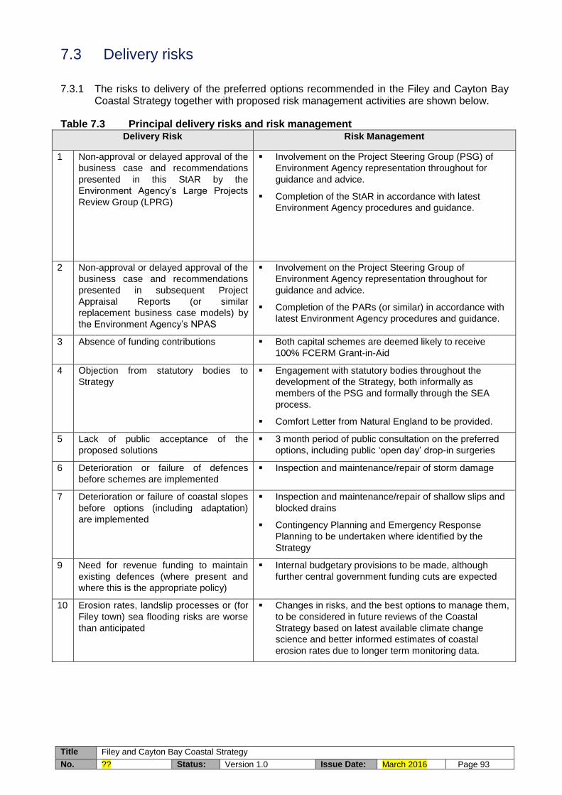
Title Filey and Cayton Bay Coastal Strategy
No. ?? Status: Version 1.0 Issue Date: March 2016 Page 93
7.3 Delivery risks
7.3.1 The risks to delivery of the preferred options recommended in the Filey and Cayton Bay Coastal Strategy together with proposed risk management activities are shown below.
Table 7.3 Principal delivery risks and risk management Delivery Risk Risk Management
1 Non-approval or delayed approval of the
business case and recommendations
presented in this StAR by the
Environment Agency’s Large Projects
Review Group (LPRG)
Involvement on the Project Steering Group (PSG) of
Environment Agency representation throughout for
guidance and advice.
Completion of the StAR in accordance with latest
Environment Agency procedures and guidance.
2 Non-approval or delayed approval of the
business case and recommendations
presented in subsequent Project
Appraisal Reports (or similar
replacement business case models) by
the Environment Agency’s NPAS
Involvement on the Project Steering Group of
Environment Agency representation throughout for
guidance and advice.
Completion of the PARs (or similar) in accordance with
latest Environment Agency procedures and guidance.
3 Absence of funding contributions Both capital schemes are deemed likely to receive
100% FCERM Grant-in-Aid
4 Objection from statutory bodies to
Strategy
Engagement with statutory bodies throughout the
development of the Strategy, both informally as
members of the PSG and formally through the SEA
process.
Comfort Letter from Natural England to be provided.
5 Lack of public acceptance of the
proposed solutions
3 month period of public consultation on the preferred
options, including public ‘open day’ drop-in surgeries
6 Deterioration or failure of defences
before schemes are implemented
Inspection and maintenance/repair of storm damage
7 Deterioration or failure of coastal slopes
before options (including adaptation)
are implemented
Inspection and maintenance/repair of shallow slips and
blocked drains
Contingency Planning and Emergency Response
Planning to be undertaken where identified by the
Strategy
9 Need for revenue funding to maintain
existing defences (where present and
where this is the appropriate policy)
Internal budgetary provisions to be made, although
further central government funding cuts are expected
10 Erosion rates, landslip processes or (for
Filey town) sea flooding risks are worse
than anticipated
Changes in risks, and the best options to manage them,
to be considered in future reviews of the Coastal
Strategy based on latest available climate change
science and better informed estimates of coastal
erosion rates due to longer term monitoring data.

Title Filey and Cayton Bay Coastal Strategy
No. ?? Status: Version 1.0 Issue Date: March 2016 Page 94
7.4 Recommendation
7.4.1 The whole life cash cost of the capital investment, including optimism bias of 60%, is £3.2million, of which £2.5million is considered eligible for consideration of FCERM Grant-in-Aid under present funding regimes and £0.7million will require alternative funding sources.
7.4.2 The strategy is recommended for Approval in Principle for FCERM-eligible capital expenditure of £0.5million, including optimism bias of 60%, over the first five years.