strategies to improve radiation fog forecasting at elmira, ny (kelm) robert mundschenk, michael...
Post on 21-Dec-2015
214 views
TRANSCRIPT

Strategies to Improve Strategies to Improve Radiation Fog Forecasting at Radiation Fog Forecasting at
Elmira, NY (KELM) Elmira, NY (KELM)
Robert Mundschenk, Michael Evans, Michael L. Robert Mundschenk, Michael Evans, Michael L. Jurewicz, Sr., and Ron Murphy – WFO Jurewicz, Sr., and Ron Murphy – WFO
Binghamton, NYBinghamton, NY
Aviation Sub-Regional WorkshopAviation Sub-Regional WorkshopSeptember 16, 2008September 16, 2008

OutlineOutline
• MotivationMotivation
• MethodologyMethodology
• Study ResultsStudy Results
• A New Forecaster ToolA New Forecaster Tool
• SummarySummary

Motivation for ResearchMotivation for Research
• KELM experiences radiation fog KELM experiences radiation fog frequently with resultant IFR / LIFR / frequently with resultant IFR / LIFR / VLIFR conditions VLIFR conditions
• Historically, this has been a challenging Historically, this has been a challenging site for aviation forecasters site for aviation forecasters – Unexpected dense fog developmentUnexpected dense fog development– Overly pessimistic forecasts (lighter fog Overly pessimistic forecasts (lighter fog
than expected) than expected)

Favorable Location for FogFavorable Location for Fog
KELM
Chemung River Valley
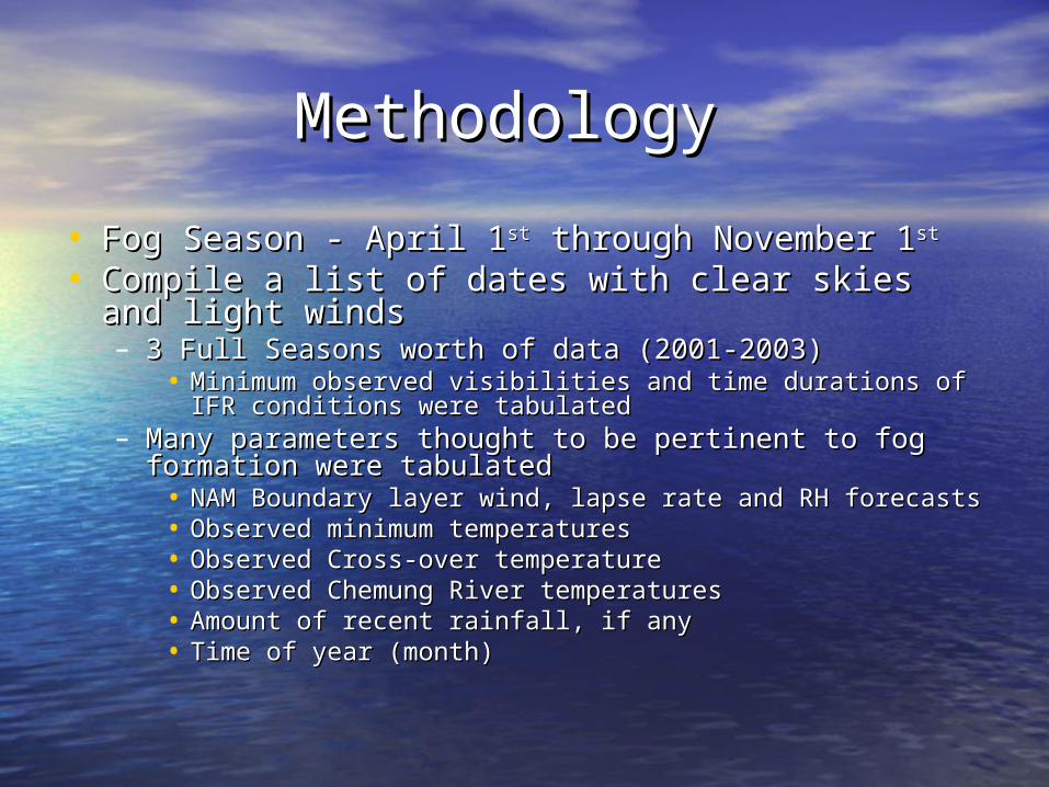
Methodology Methodology
• Fog Season - April 1Fog Season - April 1stst through November 1 through November 1stst • Compile a list of dates with clear skies and light Compile a list of dates with clear skies and light
windswinds– 3 Full Seasons worth of data (2001-2003)3 Full Seasons worth of data (2001-2003)
• Minimum observed visibilities and time durations of IFR Minimum observed visibilities and time durations of IFR conditions were tabulated conditions were tabulated
– Many parameters thought to be pertinent to fog Many parameters thought to be pertinent to fog formation were tabulatedformation were tabulated• NAM Boundary layer wind, lapse rate and RH forecastsNAM Boundary layer wind, lapse rate and RH forecasts• Observed minimum temperaturesObserved minimum temperatures• Observed Cross-over temperatureObserved Cross-over temperature• Observed Chemung River temperatures Observed Chemung River temperatures • Amount of recent rainfall, if any Amount of recent rainfall, if any • Time of year (month)Time of year (month)

ResultsResults
• Most reliable indicators of low visibilities (dense Most reliable indicators of low visibilities (dense fog):fog):
• Light wind speeds (< 13 kts) around 950 mb (700 feet AGL) Light wind speeds (< 13 kts) around 950 mb (700 feet AGL) from NAM BUFKIT soundingsfrom NAM BUFKIT soundings
• Overnight low temperature colder than the cross-over Overnight low temperature colder than the cross-over temperaturetemperature
• Large differences between the observed Chemung River Large differences between the observed Chemung River temperatures and the minimum air temperature (air temperatures and the minimum air temperature (air temperature at least 20 degree F colder than the river temperature at least 20 degree F colder than the river temperature).temperature).
• Heavy rain during the period 4 to 10 days prior to the event in Heavy rain during the period 4 to 10 days prior to the event in question question
• Model low-level RH and lapse rate correlated weakly with fog Model low-level RH and lapse rate correlated weakly with fog occurrenceoccurrence

Composite MSLP for Dense Fog Composite MSLP for Dense Fog Cases at 0600 UTCCases at 0600 UTC

Composite MSLP for Lighter Composite MSLP for Lighter Fog Cases (BR) at 0600 UTCFog Cases (BR) at 0600 UTC

Composite 850 mb for Dense Composite 850 mb for Dense Fog Cases at 0600 UTCFog Cases at 0600 UTC

Composite 850 mb for Lighter Composite 850 mb for Lighter Fog Cases (BR) at 0600 UTCFog Cases (BR) at 0600 UTC

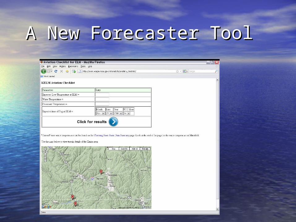
A New Forecaster ToolA New Forecaster Tool
• Based on study results, a “pattern Based on study results, a “pattern recognition” tool was developedrecognition” tool was developed– Data inputs from BUFKIT soundings, Data inputs from BUFKIT soundings,
observed data and forecaster inputobserved data and forecaster input– Help forecasters better differentiate Help forecasters better differentiate
between favorable and unfavorable between favorable and unfavorable nights for fog formation nights for fog formation
– Provides links to past events that most Provides links to past events that most closely match the set of expected closely match the set of expected conditions conditions
A New Forecaster ToolA New Forecaster Tool

A New Forecaster ToolA New Forecaster Tool
Final ThoughtsFinal Thoughts
• This tool allows forecasters to use pattern This tool allows forecasters to use pattern recognition to forecast fogrecognition to forecast fog
• The tool promotes a probabilistic approach The tool promotes a probabilistic approach to fog forecastingto fog forecasting
• Similar tools can be developed for other Similar tools can be developed for other TAF sitesTAF sites
• Verification will be done next summerVerification will be done next summer• We still need to know more about what We still need to know more about what
parameters can help us to forecast fog parameters can help us to forecast fog