strategies for state policies and...
TRANSCRIPT

March 1, 2010 Andrew Hayes ForeSite Associates, Inc. 208 Delaware Street New Castle, DE 19720 RE: PLUS review – 2009-11-04; Deats Farm Dear Mr. Hayes: Thank you for meeting with State agency planners on January 27, 2010 to discuss the proposed plans for the Deats Farm project to be located at 4564 Summit Bridge Road near Middletown, Delaware. According to the information received, you are seeking a rezoning of 168.76 acres from S to OR for a mixed use office, retail and residential development. According to the submitted application you are planning 410 stacked townhomes, 55 townhomes, 44 duplex homes, 872 condo units, 600,000 sq. ft. office and 267,000 sq. ft. of retail space. Please note that changes to the plan, other than those suggested in this letter, could result in additional comments from the State. Additionally, these comments reflect only issues that are the responsibility of the agencies represented at the meeting. The developers will also need to comply with any Federal, State and local regulations regarding this property. We also note that as New Castle County is the governing authority over this land, the developers will need to comply with any and all regulations/restrictions set forth by the County. Strategies for State Policies and Spending This property is located in a Level 3 area according to the Strategies for State Policies and Spending. Investment Level 3 reflects areas where growth is anticipated by local, county, and state plans in the longer term future, or areas that may have environmental or other constraints to development. State investments will support growth in these areas, but please be advised that the State may have other priorities in the near term future.

PLUS – 2009-11-04 Page 2 of 19 As we understand it, the project as proposed, would require a rezoning from S to OR. The overall project is a 169 acre, mixed use development with the prospect of purchasing a farm east of SR 1 to remove development rights in conjunction of developing this site, similar to a Transfer of Development Rights (TDR) program. This is certainly an intriguing project that presents some very positive aspects for what we are trying to accomplish at the state level toward developing more living options for our residents. Good as these aspects are, a project of this magnitude has to be approached in well thought out process that encompasses all those potentially impacted by such a development. This part of the County is already the subject of several high level planning activities including the Southern New Castle County master planning project, a joint effort between New Castle County, various state agencies and the three municipalities; Route 301 development planning; and the pending update to the New Castle County 2007 comprehensive plan. At this point it would be our recommendation to talk to the County about how and when this particular project could be included in such planning activities. Code Requirements/Agency Permitting Requirements DelDOT
• DelDOT estimates that 600,000 square feet of general office space would generate about 5,300 trips per day. Therefore, even allowing for significant internal capture between the proposed office, residential and retail uses, the estimate of 2,779 trips per day found in Item 38 of the PLUS application seems low. Regardless, the application states that the traffic impact study (TIS) process is underway. Technically, that statement is correct; a scope of work was set in October 2009 and the developer requested proposals to have the work done by consultants working for DelDOT. However, Choptank Road (New Castle Road 435) is closed for construction between Bethel Church Road (New Castle Road 433) and Clayton Manor Drive until sometime this spring. While it may be possible to do some preliminary work using existing traffic counts, most of the TIS must wait for that road to reopen so that current counts can be obtained. Whether they wait for the road to reopen or not, the developer will still need to obtain updated proposals from the consultants if they wish to have them do the TIS. DelDOT looks forward to working with the developer in the course of this study.
State Historic Preservation Office
• Historic farms such as these often have a family cemetery, so there is a possibility for unmarked human remains on the parcel. Please be aware of the Delaware Unmarked Human Remains Act of 1987, outlined in Chapter 54 of Title 7 of the Delaware Code, which pertains to the discovery and disposition of such remains. The unexpected discovery of unmarked human remains during construction can result in significant delays while the process is carried out. Therefore, prior to any demolition or ground-disturbing activities, the developer may want to

PLUS – 2009-11-04 Page 3 of 19
consider hiring an archaeological consultant to examine the parcel for archaeological sites, including a cemetery or unmarked human remains. In addition, our Division request that the development include sufficient landscaping to screen the development from the view of the other existing historic buildings. If you have any questions, or would like to discuss these comments further, please contact Terence Burns at 302-736-7404.
Delaware State Fire Marshals Office At the time of formal submittal, the applicant shall provide; completed application, fee, and three sets of plans depicting the following in accordance with the Delaware State Fire Prevention Regulation (DSFPR):
a. Fire Protection Water Requirements: Water distribution system capable of delivering at least 1500 gpm for 2-
hour duration, at 20-psi residual pressure is required. Fire hydrants with 800 feet spacing on centers.
Where a water distribution system is proposed for Mixed Use sites that include Mercantile occupancies, the infrastructure for fire protection water shall be provided, including the size of water mains for fire hydrants and sprinkler systems.
b. Fire Protection Features:
All structures over 10,000 sq. ft. aggregate will require automatic sprinkler protection installed.
Buildings greater than 10,000 sq.ft., 3-stories or more, over 35 feet, or classified as High Hazard, are required to meet fire lane marking requirements
Show Fire Department Connection location (Must be within 300 feet of fire hydrant), and detail as shown in the DSFPR.
Show Fire Lanes and Sign Detail as shown in DSFPR
c. Accessibility All premises, which the fire department may be called upon to protect in
case of fire, and which are not readily accessible from public roads, shall be provided with suitable gates and access roads, and fire lanes so that all buildings on the premises are accessible to fire apparatus. This means that the access road to the subdivision from the main thoroughfare must be constructed so fire department apparatus may negotiate it.
Fire department access shall be provided in such a manner so that fire apparatus will be able to locate within 100 ft. of the front door.
Any dead end road more than 300 feet in length shall be provided with a turn-around or cul-de-sac arranged such that fire apparatus will be able to turn around by making not more than one backing maneuver. The minimum paved radius of the cul-de-sac shall be 38 feet. The dimensions of the cul-de-sac or turn-around shall be shown on the final plans. Also,

PLUS – 2009-11-04 Page 4 of 19
please be advised that parking is prohibited in the cul-de-sac or turn around.
The use of speed bumps or other methods of traffic speed reduction must be in accordance with Department of Transportation requirements.
The local Fire Chief, prior to any submission to our Agency, shall approve in writing the use of gates that limit fire department access into and out of the development or property.
d. Gas Piping and System Information:
Provide type of fuel proposed, and show locations of bulk containers on plan.
e. Required Notes: Provide a note on the final plans submitted for review to read “ All fire
lanes, fire hydrants, and fire department connections shall be marked in accordance with the Delaware State Fire Prevention Regulations”
Proposed Use Alpha or Numerical Labels for each building/unit for sites with multiple
buildings/units Square footage of each structure (Total of all Floors) National Fire Protection Association (NFPA) Construction Type Maximum Height of Buildings (including number of stories) Note indicating if building is to be sprinklered Name of Water Provider Letter from Water Provider approving the system layout Townhouse 2-hr separation wall details shall be shown on site plans Provide Lock Box Note (as detailed in DSFPR) if Building is to be
sprinklered Provide Road Names, even for County Roads
Preliminary meetings with fire protection specialists are encouraged prior to formal submittal. Please call for appointment. Applications and brochures can be downloaded from our website: www.statefiremarshal.delaware.gov, technical services link, plan review, applications or brochures. DNREC
• Sediment and Stormwater Program. A detailed sediment and stormwater plan will be required prior to any land disturbing activity taking place on the site. Contact the reviewing agency to schedule a pre-application meeting to discuss the sediment and erosion control and stormwater management components of the plan as soon as practicable. The site topography, soils mapping, pre- and post-development runoff, and proposed method(s) and location(s) of stormwater management should be brought to the meeting for discussion. The plan review and approval as well as construction inspection will be coordinated through the New Castle County Department of Land Use, Engineering Section. Contact the

PLUS – 2009-11-04 Page 5 of 19
Department of Land Use at (302) 395-5470 for details regarding submittal requirements and fees.
• Wetlands. The applicant is responsible for determining whether any State-regulated wetlands (regulated pursuant to 7 Del.C. Chapter 66 and the Wetlands Regulations) are present on the property. This determination can only be made by contacting the Division of Water Resources’ Wetlands and Subaqueous Lands Section at 302/739-9943 and consulting the State’s official wetland regulatory maps, which depict the extent of State jurisdiction. The area regulated by State law may be very different from the area under federal authority. No activity may take place in State-regulated wetlands without a permit from DNREC’s Wetlands Section.
• In addition, most perennial streams and ditches and many intermittent streams and
ditches are regulated pursuant to the Subaqueous Lands Act (7 Del.C. Chapter 72) and the Regulations Governing the Use of Subaqueous Lands. Ponds which are connected to other waters are also regulated, while isolated ponds are not. Any work in regulated streams, ditches or ponds requires a permit from the Wetlands and Subaqueous Lands Section. An on-site jurisdictional determination is recommended in order to determine whether any regulated watercourses exist on the property. Please contact the Wetlands and Subaqueous Lands Section at 302/739-9943 to schedule an on-site visit. Such appointments can usually be scheduled within 2 to 3 weeks.
• The applicant should also be reminded that they must avoid construction/filling activities in those areas containing wetlands or wetland associated hydric soils as they are subject to regulatory jurisdiction under Federal 404 provisions of the Clean Water Act. A site-specific field wetlands delineation using the methodology described in the 1987 United States Army Corps of Engineers (USACE or “the Corps”) manual is the acceptable basis for making a jurisdictional wetland determination for nontidal wetlands in Delaware. The applicant is forewarned that the Corps views the use of the National Wetlands Inventory (NWI) mapping or the Statewide Wetlands Mapping Project (SWMP) mapping as an unacceptable substitute for making such delineations. To ensure compliance with said Corps regulatory requirements, it is strongly recommended that a field wetlands delineation using the above-referenced methodology be performed on this parcel before commencing any construction activities. It is further recommended that the Corps be given the opportunity to officially approve the completed delineation. In circumstances where the applicant or applicant’s consultant delineates what they believe are nonjurisdictional isolated (SWANCC) wetlands, the Corps must be contacted to evaluate and assess the jurisdictional validity of such a delineation. The final jurisdictional authority for making isolated wetlands determinations rests with the Corps; they can be reached by phone at 736-9763.

PLUS – 2009-11-04 Page 6 of 19
• Water Supply. Should an on-site public well be needed, a minimum isolation distance of 150 feet is required between the well and any potential source of contamination, such as a septic tank and sewage disposal area, furthermore, they must be located at least 150 feet from the outermost boundaries of the project(s).
• Should dewatering points be needed during any phase of construction, a
dewatering well construction permit must be obtained from the Water Supply Section prior to construction of the well points. In addition, a water allocation permit will be needed if the pumping rate will exceed 50,000 gallons per day at any time during operation.
All well permit applications must be prepared and signed by licensed water well contractors, and only licensed well drillers may construct the wells. Please factor in the necessary time for processing the well permit applications into the construction schedule. Dewatering well permit applications typically take approximately four weeks to process, which allows the necessary time for technical review and advertising.
• Hazardous Waste Site. Based on the previous industrial use of the SIRB site, which may have involved the use of hazardous substances, SIRB recommends that a Phase I Environmental Site Assessment be performed prior to development on the proposed property. In addition, should a release or imminent threat of a release of hazardous substances be discovered during the course of development (e.g., contaminated water or soil), construction activities should be discontinued immediately and DNREC should be notified at the 24-hour emergency number (800-662-8802). SIRB should also be contacted as soon as possible at 302-395-2600 for further instructions. Krystal Stanley - (302) 395-2644, [email protected]
• Tank Management Branch. Should any underground storage tanks or petroleum contaminated soil be discovered by any person during construction, the DNREC-TMB at (302) 395-2500 and the DNREC Emergency Response Hotline at (800) 662-8802 must be notified within 24 hours.
Should any contamination be encountered, PVC pipe materials will have to be replaced with ductile steel and nitrile rubber gaskets in the contaminated areas. Also, please note that if any aboveground storage tanks (ASTs) less than 12,500 gallons are installed, they must be registered with the TMB. If any ASTs greater than 12,500 gallons are installed, they are also subject to installation approval by the TMB. Elizabeth Wolff - (302) 395-2500, [email protected]
• Air Quality. The applicant shall comply with all applicable Delaware air quality regulations. These regulations include:

PLUS – 2009-11-04 Page 7 of 19
Regulation 6 -Particulate Emissions from Construction and Materials Handling
• Using dust suppressants and measures to prevent transport of dust off-site from material stockpile, material movement and use of unpaved roads.
• Using covers on trucks that transport material to and from site to prevent visible emissions.
Regulation 1113 – Open Burning
• Prohibiting open burns statewide during the Ozone Season from May 1-Sept. 30 each year.
• Prohibiting the burning of land clearing debris.
• Prohibiting the burning of trash or building materials/debris.
Regulation 1145 – Excessive Idling of Heavy Duty Vehicles
• Restricting idling time for trucks and buses having a gross vehicle weight of over 8,500 pounds to no more than three minutes.
Recommendations/Additional Information DNREC Soil and Water Drainage Program. The existing ditches will need periodic maintenance and/or reconstruction to remove blockages and sediment buildup. While the proposed stormwater management ponds may contain the sediment from the site the existing ditches will receive sediment from offsite. The engineer should develop a ditch maintenance plan and show access points and spoil disposal areas.
The Drainage Program requests that the engineer take precautions to ensure the project does not hinder any off site drainage upstream of the project or create any off site drainage problems downstream by the release of onsite stormwater. The Drainage Program requests that the engineer check existing downstream ditches and pipes for function and blockages prior to the construction. Notify downstream landowners of the change in volume of water released on them. Sediment/Stormwater and Drainage comments provided by James Sullivan - (302) 739-9921, [email protected]

PLUS – 2009-11-04 Page 8 of 19 Water Resources Soils Assessment. Based on the New Castle County soil survey update, Matapeake, Woodstown, and Othello were mapped in the immediate vicinity of the proposed project. Matapeake (MeA & MeB2) is a well-drained upland soil that, generally, has few limitations for development. Woodstown (WsA) is a moderately well-drained soil of low-lying uplands and has moderate limitations for development. Othello (Ot) is a poorly-drained wetland associated (hydric) soil that has severe limitations for development and should be avoided (Figure 1).
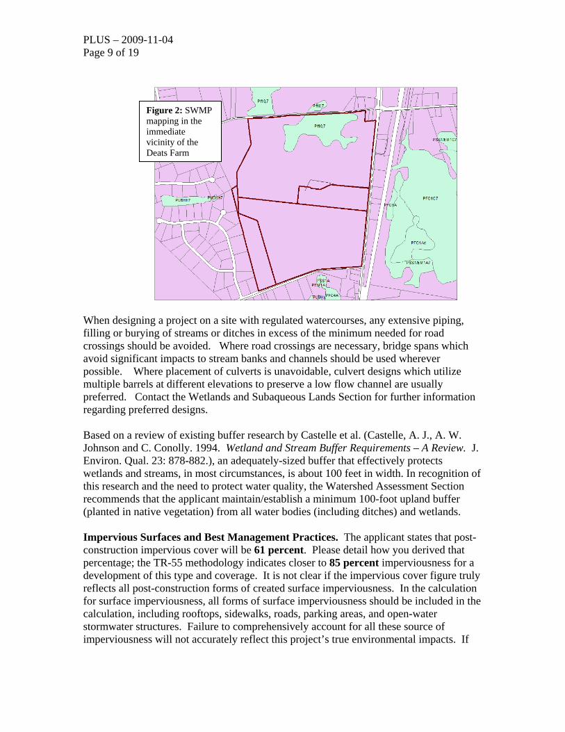
Wetlands. According to the Statewide Wetland Mapping Project (SWMP) maps, palustrine riparian wetlands (Pf 10,7) were mapped over much of the project’s northern tier. Some unmapped jurisdictional wetlands may be present as in the wooded area(s) of the parcel as well (Figure 2). The parcel is bisected by a headwater stream flowing directionally from the northeast to the southwest.
Figure 1: NRCS soil survey mapping in the vicinity of the Deats farm
PLUS – 2009-11-04 Page 9 of 19
When designing a project on a site with regulated watercourses, any extensive piping, filling or burying of streams or ditches in excess of the minimum needed for road crossings should be avoided. Where road crossings are necessary, bridge spans which avoid significant impacts to stream banks and channels should be used wherever possible. Where placement of culverts is unavoidable, culvert designs which utilize multiple barrels at different elevations to preserve a low flow channel are usually preferred. Contact the Wetlands and Subaqueous Lands Section for further information regarding preferred designs. Based on a review of existing buffer research by Castelle et al. (Castelle, A. J., A. W. Johnson and C. Conolly. 1994. Wetland and Stream Buffer Requirements – A Review. J. Environ. Qual. 23: 878-882.), an adequately-sized buffer that effectively protects wetlands and streams, in most circumstances, is about 100 feet in width. In recognition of this research and the need to protect water quality, the Watershed Assessment Section recommends that the applicant maintain/establish a minimum 100-foot upland buffer (planted in native vegetation) from all water bodies (including ditches) and wetlands. Impervious Surfaces and Best Management Practices. The applicant states that post-construction impervious cover will be 61 percent. Please detail how you derived that percentage; the TR-55 methodology indicates closer to 85 percent imperviousness for a development of this type and coverage. It is not clear if the impervious cover figure truly reflects all post-construction forms of created surface imperviousness. In the calculation for surface imperviousness, all forms of surface imperviousness should be included in the calculation, including rooftops, sidewalks, roads, parking areas, and open-water stormwater structures. Failure to comprehensively account for all these source of imperviousness will not accurately reflect this project’s true environmental impacts. If
Figure 2: SWMP mapping in the immediate vicinity of the Deats Farm

PLUS – 2009-11-04 Page 10 of 19 this calculation does not reflect all of the aforementioned forms of post-construction surface imperviousness, please recalculate it. Studies have shown a strong relationship between increases in impervious cover to decreases in a watershed’s overall water quality. It is strongly recommended that the applicant implement best management practices (BMPs) that reduce or mitigate some of its most likely adverse impacts. Reducing the amount of surface imperviousness through the use of pervious paving materials (“pervious pavers”) in lieu of asphalt or concrete in conjunction with an increase in forest cover preservation (or establishment of additional forest cover acreage) are some examples of practical BMPs that could easily be implemented to help reduce surface imperviousness. We further suggest the use of pervious paving materials for at least 50% of the total paved surface area(s) in the commercial portion of this project. TMDLs. Total Maximum Daily Load (TMDL) reduction requirements for nutrients or other pollutants have not yet been developed for the Elk River watershed. However, the applicant should still strive to implement best management practices (BMPs) that reduce surface imperviousness (e.g., use of pervious paving materials where practicable). The applicant should also strive to increase the amount and width of passive wooded open space and buffers while employing - wherever possible - the use of green-technology stormwater management treatment trains in lieu of open-water stormwater management structures. The applicant should also employ pervious paving materials in lieu of conventional paving materials wherever possible. Soils, wetlands, subaqueous lands and TMDL comments provided by John Martin, Watershed Assessment Section, (302) 739-9939, [email protected] Water Supply. The information is unclear on which Public Utility Company will be used to provide water for the proposed project(s). Our records indicate that part of this project (Parcel Identification #’s 13-012.00-050 and 13-012.00-096) is located in an area where public water service is not available; however, the other part of this project (Parcel Identification #’s 13-012.00-022 and 13-012.00-107) is located within the public water service area granted to Artesian Water Company under CPCN 05-CPCN-03. Information on CPCN requirements and applications can be obtained by contacting the Public Service Commission at (302)736-7547. The Division of Water Resources will consider applications for the construction of on-site wells provided the wells can be located and constructed in compliance with all requirements of the Regulations Governing the Construction and Use of Wells. A well construction permit must be obtained prior to constructing any wells. Ricardo Rios - (302) 739-9944, [email protected] Water Resource Protection Areas. The DNREC Water Supply Section, Ground Water protection Branch (GWPB) has determined that a significant portion of the project falls within an excellent ground-water recharge area for New Castle County (see attached map).

PLUS – 2009-11-04 Page 11 of 19 New Castle County (NCC) refers to excellent ground-water recharge potential areas as ‘recharge areas’. Recharge areas are characterized as deposits of coarser grained material that have the best ability to transmit water vertically through the unsaturated zone to the water table. The NCC recharge areas were mapped using the methods described in the Delaware Geological Survey Open File Report No. 34, "Methodology for Mapping Ground-Water Recharge Areas in Delaware’s Coastal Plain" (Andres, 1991), and depicted in a series of maps prepared by the Delaware Geological Survey (Butoryak and Tally, 1993). Water Resource Protection Areas. The DNREC Groundwater Protection Branch recommends that the portion of the new development within the excellent ground-water recharge area not exceed 20% impervious cover. Some allowance for augmenting ground-water recharge should be implemented if the impervious cover exceeds 20% but is less than 50% of that portion of the parcel within this area. However, the development should not exceed 50% regardless (DNREC, 2005). A water balance calculation (environmental assessment) will be necessary to determine the quantity of clean water to be recharged via a recharge basin (Thornthwaite, 1957). The purpose of an impervious cover threshold is to minimize loss of recharge (and associated increases in storm water) and protect the quality and quantity of ground water.
These DNREC recommendations appear to be consistent with NCC Unified Code Sections: 40.10.380 (B), 40.10.384 (A), 40.10.385, and 40.10.410.
The proposed development would change the impervious cover from 1.22% to approximately 74.38% for the portion of the development within the recharge area. The developer on the PLUS application provided these numbers. A large percentage of this is parking and roadways. This land use produces petroleum hydrocarbons, other organics, metals, and other inorganic constituents (DNREC, 1999). These contaminants are associated with this land use could easily infiltrate the unconfined aquifer and compromise water quality. DNREC recommends:
• Reduce impervious cover to less than 50% • Perform an environmental assessment report showing that water quality as
well as water quantity of post development recharge is equal to or greater than pre-development recharge (Kaufmann, 2005).
• Quantify amount of recharge lost due to impervious cover and provide for
onsite infiltration of water at least equal to or greater than pre-development recharge (Kaufmann, 2005).
• Pretreatment of parking area runoff to remove chemical and nutrient loads

PLUS – 2009-11-04 Page 12 of 19 The site plans show a stormwater management pond within the area of excellent ground-water recharge potential. The construction phase of this type of pond requires excavation, hauling, and grading. The heavy equipment used in this phase has the capacity to compact and degrade the structure of the strata that defines the area as an excellent ground water recharge area (Schueler, 2000a). Changes to the structural soil properties may cause significant reduction in recharge capacity. Installing storm-water management ponds in excellent ground-water recharge areas has the potential to contaminate the ground water beneath it and infiltrate into the aquifer (Schueler, 2000b). In addition, because the excellent ground water recharge area can so quickly affect the underlying aquifer if contaminants are spilled or discharged across the area, the storage of hazardous substances or wastes should not be allowed within the area unless specific approval is obtained from the relevant state, federal, or local program. References Andres, A. Scott, 1991, Methodology for Mapping Ground-Water Recharge Areas in
Delaware's Coastal Plain: Delaware Geological Survey Open File Report No. 34, p. 18.
Butoryak, Kathleen R. , and Talley, John H., 1993, Delineation of Ground-Water
Recharge Resource Protection Areas in the Coastal Plain of New Castle County, Delaware: Delaware Geological Survey Project Report for the Water Resources Agency for New Castle County, p. 26.
Delaware Department of Natural Resources and Environmental Control (2005): Source
Water Protection Guidance Manual for the Local Governments of Delaware: Dover, DE., 144 p. http://www.wr.udel.edu/publications/SWAPP/swapp_manual_final/swapp
guidanace_manual_final.pdf Delaware Department of Natural Resources and Environmental Control. (1999). The
State of Delaware Source Water Assessment Plan: Dover, DE, p. 301. http://www.wr.udel.edu/swaphome/publications.html Kauffman, G.J., Wozniak, S.L., and Vonck, K.J., 2005, Delaware Ground-Water
Recharge Design Manual: Newark, DE, Water Resources Agency, University of Delaware, p. 31. http://www.wr.udel.edu/swaphome/Publications/SWPguidancemanual.html
Schueler, T. R., 2000a, The Compaction of Urban Soils, in Schueler, T.R., and Holland, H.K., eds., The Practice of Watershed Protection: Ellicott City, MD, Center for Watershed Protection, p. 210 - 218.

PLUS – 2009-11-04 Page 13 of 19 Schueler, T. R., 2000b, Pollutant Dynamics of Pond Muck, in Schueler, T.R., and
Holland, H.K., eds., The Practice of Watershed Protection: Ellicott City, MD, Center for Watershed Protection, p. 453 - 460.
Thornthwaite, C. W., and Mather, J. R., 1957, Instructions and Tables for Computing
Potential Evapotranspiration and the Water Balance, Volume x, Drexel Institute of Technology, Laboratory of Climatology.
Anne Mundel - (302) 739-9945, [email protected]
PLUS – 2009-11-04 Page 14 of 19 Air and Waste Air Quality. Housing developments may unnecessarily emit, or cause to be emitted, significant amounts of air contaminants into Delaware’s air, which will negatively impact public health, safety and welfare. These negative impacts are attributable to:
• Emissions that form ozone and fine particulate matter; two pollutants relative to which Delaware currently violates federal health-based air quality standards,
• The emission of greenhouse gases which are associated with climate change, and • The emission of air toxics.
Air emissions generated from housing developments include emissions from:
• Area sources like painting, lawn and garden equipment and the use of consumer products like roof coatings and roof primers.
• The generation of electricity needed to support the homes in your development, and
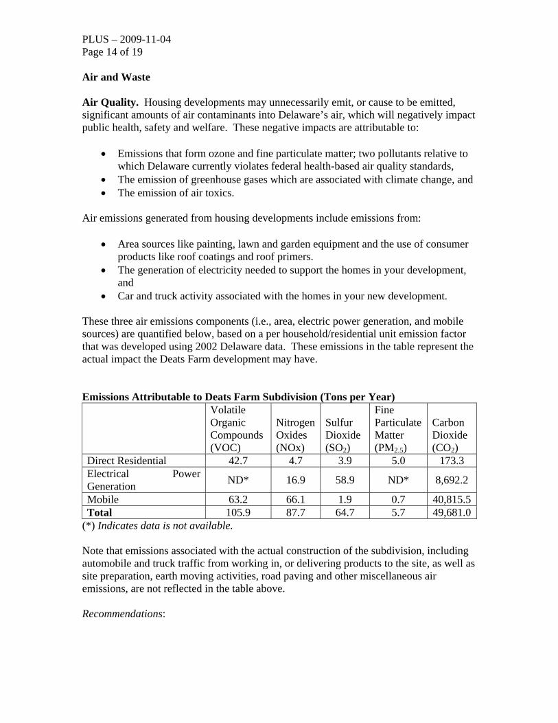
• Car and truck activity associated with the homes in your new development. These three air emissions components (i.e., area, electric power generation, and mobile sources) are quantified below, based on a per household/residential unit emission factor that was developed using 2002 Delaware data. These emissions in the table represent the actual impact the Deats Farm development may have. Emissions Attributable to Deats Farm Subdivision (Tons per Year) Volatile
Organic Compounds (VOC)
Nitrogen Oxides (NOx)
Sulfur Dioxide (SO2)
Fine Particulate Matter (PM2.5)
Carbon Dioxide (CO2)
Direct Residential 42.7 4.7 3.9 5.0 173.3 Electrical Power Generation ND* 16.9 58.9 ND* 8,692.2
Mobile 63.2 66.1 1.9 0.7 40,815.5Total 105.9 87.7 64.7 5.7 49,681.0
(*) Indicates data is not available. Note that emissions associated with the actual construction of the subdivision, including automobile and truck traffic from working in, or delivering products to the site, as well as site preparation, earth moving activities, road paving and other miscellaneous air emissions, are not reflected in the table above. Recommendations:

PLUS – 2009-11-04 Page 15 of 19 Additional measures may be taken to substantially reduce the air emissions identified above. These measures include:
• Constructing only energy efficient homes. Energy Star qualified homes are up to 30% more energy efficient than typical homes. These savings come from building envelope upgrades, high performance windows, controlled air infiltration, upgraded heating and air conditioning systems, tight duct systems and upgraded water-heating equipment. Every percentage of increased energy efficiency translates into a percent reduction in pollution. The Energy Star Program is excellent way to save on energy costs and reduce air pollution.
• Offering geothermal and/or photo voltaic energy options. These systems can significantly reduce emissions from electrical generation, and from the use of oil or gas heating equipment.
• Providing tie-ins to the nearest bike paths and links to any nearby mass
transport system. These measures can significantly reduce mobile source emissions.
• Funding a lawnmower exchange program. New lawn and garden equipment
emits significantly less than equipment as little as 7 years old, and may significantly reduce emissions from this new development. The builder could fund such a program for the new occupants.
Additionally, the following measures will reduce emissions associated with the actual construction phase of the development:
• Using retrofitted diesel engines during construction. This includes equipment that are on-site as well as equipment used to transport materials to and from site.
• Using pre-painted/pre-coated flooring, cabinets, fencing, etc. These measures
can significantly reduce the emission of VOCs from typical architectural coating operations.
• Planting trees at residential units and in vegetative buffer areas. Trees reduce
emissions by trapping dust particles and by replenishing oxygen. Trees also reduce energy emissions by cooling during the summer and by providing wind breaks in the winter, whereby reducing air conditioning needs by up to 30 percent and saving 20 to 50 percent on fuel costs.
This is a partial list, and there are additional things that can be done to reduce the impact of the development on air quality. The applicant should submit a plan to the DNREC Air Quality Management Section which address the above listed measures, and that details all of the specific emission mitigation measures that will be incorporated into the Deats Farm development. Deanna Morozowich - (302) 739-9402, [email protected]

PLUS – 2009-11-04 Page 16 of 19 Hazardous Waste Sites. One Site Investigation & Restoration Branch (SIRB) sites were found within a half mile radius of the proposed site: Deats Farm located 0.18 miles north-east of the proposed development. The Deats Farms site was once the location of a waste oil recycling plant. The plant shut down in 1983. Leaking tanks and drums were found on the property during the investigation and were later removed as part of the remediation. The property was capped with clay and top soil and an Operations and Maintenance Plan was put in place. The site currently undergoes yearly groundwater monitoring for nickel. Tank Management Branch. There are two (2) inactive LUST projects located within a quarter mile from the proposed development. Name: Summit Bridge Shopping Center (Inactive) Facility ID: 3-001650 Project: N9508200 Name: Shore Stop #271 (Inactive) Facility ID: 3-001309 Project: N0201008 DelDOT DelDOT recognizes that the plan presented is only an exploratory sketch and that the internal streets are proposed to be private. Nonetheless, they offer the following advisory comments regarding them:
a) Most of the proposed roundabouts appear to have either no splitter islands
or non-standard ones. We recommend that standard splitter islands be provided to properly direct drivers around the roundabouts.
b) We recommend against the proposed one-way pair with the northbound and south directions reversed behind the supermarket. Such an arrangement is unexpected and therefore of concern; drivers unfamiliar with the development could too easily go the wrong way or otherwise be surprised by vehicles making unexpected movements. If it is essential that the supermarket be placed as proposed, then we recommend that the road network be redesigned to allow tractor-trailers to drive past it and make a wide U-turn to reach the loading bays.
c) South of the wet ponds that would divide the site, there is a crossover
proposed on the main boulevard that is significantly off-set east of the cross-street it would serve. We recommend that it be shifted west to allow for cross-traffic. Depending on the expected volume of cross-traffic, a roundabout may be appropriate there.

PLUS – 2009-11-04 Page 17 of 19
d) Regarding the second roundabout south of Churchtown Road, locating
parking spaces close to a roundabout, as proposed, is undesirable especially on the lanes exiting the roundabouts. With such an arrangement, drivers making parking maneuvers can obstruct the operation of the roundabout and are at risk for being hit by drivers exiting the roundabout. We recommend eliminating about five parking spaces in each direction.
e) As a general comment, DelDOT recommends that the internal street
network be designed to meet State standards. They recommend this primarily because they believe the standards produce a good product. Secondarily, they note that in many cases residents of developments with private streets eventually seek State maintenance for them. Designing the streets to meet State standards now would make it easier for them to achieve that.
1) DelDOT sees that there are two existing residences on the south side of
Churchtown Road near Summit Bridge Road that are not part of the proposed development. Given the position of the houses on their lots and the fact that additional road improvements will likely be needed on Churchtown Road to support this development, we recommend that the developer consider how they might either provide access to these properties through the proposed development or acquire them and incorporate them into their plans. All or part of the State-owned parcel adjoining them may be available for that purpose but the land would have to be purchased. Ms. Kathie Enright in our Real Estate Section can provide information on how to begin that process. Ms, Enright may be reached at (302) 760-2237.
2) Because the proposed development is near the Summit Airport, we will likely recommend that the County require an aviation nuisance easement and non-suit covenant. The applicant should contact Ms. Roberta Geier, at (302) 760-2119 of DelDOT’s Statewide and Regional Planning Section for more information about these documents and to determine whether the proposed development is within the Runway Protection Zone. If it is, additional regulations may apply.
3) DelDOT recommends that the developer have their engineer contact the DelDOT Subdivision Manager for the south part of New Castle County, Mr. Pao Lin, for more detailed comments on the site plan as they develop it further. Mr. Lin may be reached at (302) 760-2157.
State Historic Preservation Office The developer needs to be aware that there is one historic property on this parcel and two 20th-century houses (N-12018 and N-12019) along with scattered outbuildings nearby,

PLUS – 2009-11-04 Page 18 of 19 near the corner of Churchtown Road and Summit Bridge Road (Route 71/301). The historic property that is on this parcel is a 19th-century historic farm with scattered outbuildings, Mt. Pleasant Farm, which has been determined eligible for the National Register of Historic Places. The 1849 Rea & Price Atlas, the 1868 Pomeroy & Beers Atlas, and the Wilmington USGS Topographic Map of 1906 all show this farm. In addition, Delaware Department of Agriculture The Delaware Department of Agriculture has no objections to the proposed project. The Strategies for State Policies and Spending encourages environmentally responsible development in Investment Level 3 areas.
A large portion of this site has been designated as having “excellent” ground-water recharge potential. DNREC has mapped all ground-water recharge-potential recharge areas for the state, and an “excellent” rating designates an area as having important groundwater recharge qualities.
Maintaining pervious cover in excellent and good recharge areas is crucial for the overall environmental health of our state and extremely important to efforts which ensure a safe drinking water supply for future generations. Retention of pervious cover to ensure an adequate future water supply is also important for the future viability of agriculture in the First State. The loss of every acre of land designated as “excellent” and “good” recharge areas adversely impacts the future prospects for agriculture in Delaware. The developer should make every effort to protect and maintain valuable ground-water recharge potential areas. Right Tree for the Right Place The Delaware Department of Agriculture Forest Service encourages the developer to use the “Right Tree for the Right Place” for any design considerations. This concept allows for the proper placement of trees to increase property values in upwards of 25% of appraised value and will reduce heating and cooling costs on average by 20 to 35 dollars per month. In addition, a landscape design that encompasses this approach will avoid future maintenance cost to the property owner and ensure a lasting forest resource.
Do Not Plant List
Due to the high risk of mortality from insects and disease, the Delaware Forest Service does not recommend planting any of the following species:
Callery Pear Leyland Cypress Red Oak (except for Willow Oak) Ash Trees

PLUS – 2009-11-04 Page 19 of 19 Please contact the Delaware Forest Service for more information at (302) 698-4500. Following receipt of this letter and upon filing of an application with the local jurisdiction, the applicant shall provide to the local jurisdiction and the Office of State Planning Coordination a written response to comments received as a result of the pre-application process, noting whether comments were incorporated into the project design or not and the reason therefore. Thank you for the opportunity to review this project. If you have any questions, please contact me at 302-739-3090. Sincerely,
Constance C. Holland, AICP Director CC: New Castle County Town of Middletown