strategic program implementation plan - yurok tribe
TRANSCRIPT

Strategic Project Implementation Plan for the Yurok Tribe
Under the
Native American Lands Environmental Mitigation Program
Draft March 2004
Prepared for: The Yurok Tribal Council
Klamath, California
and
U.S. Department of Defense U.S. Army Corps of Engineers
Sacramento, California
Prepared By Yurok Tribe Environmental Program
Kevin McKernan, Director Laura Mayo, Environmental Coordinator

Strategic Project Implementation Plan, Yurok Tribe Draft, March 2004
Executive Summary
The Yurok Tribe, in coordination with the USDOD, the USEPA, the State of California, and the County of Del Norte, determined that potential environmental impacts existed as a result of Department of Defense (DoD) activities at the Requa Air Force Station on Requa Hill near Klamath, California, at the mouth of the Klamath River. These impacts include lead- and asbestos-based building materials contamination, contamination from PCB’s, solvents, and other materials, overall site instability, and releases from above-ground and underground storage tanks. This Strategic Project Implementation Plan (SPIP) identifies potential impacts of DoD activities at RAFS, as well as off-site issues relating to the RAFS which affect the Tribe. The potential impacts from DoD activities affect the unique physical and cultural resources of the Yurok Tribe. The Klamath River is the focal point of Yurok cultural and subsistence needs; environmental impacts to the river impact the Tribe. Environmental impacts resulting from former DoD activities and their potential environmental impacts are defined in detail. The Yurok Tribe has been impacted by former DoD activities. These activities have impacted the physical and cultural resources of the reservation and represent impacts to the physical environment as well as potential human health risks. The Formerly Used Defense Site (FUDS) at RAFS represents the potential for various soil and water contaminants and human health risks, described herein.
ii

Strategic Project Implementation Plan, Yurok Tribe Draft, March 2004
Table of Contents
Executive Summary................................................................................................................. ii Acronyms and Abbreviations ................................................................................................. iv 1.0 Introduction.................................................................................................................. 1 2.0 Strategic Project Implementation Plan ........................................................................ 3 SPIP Organization................................................................................................................... 3 3.0 Research Resources and Techniques ........................................................................... 4 4.0 Use of this Document .................................................................................................. 7 Relationship to Other Planning & Governing Documents, and to Cultural Practices ........... 7 5.0 Former Department of Defense Activities Affecting the Yurok Tribe........................ 8 5.1 DoD Use of the Requa Air Force Station .................................................................... 9 5.1.1 Background and History .................................................................................. 9 5.1.2 Potential Environmental Effects .................................................................... 10 Potential Environmental Hazards ......................................................................................... 10 Environmental, Cultural, and Subsistence Effects ................................................................ 10 5.1.3 Mitigation ...................................................................................................... 11 Air .......................................................................................................................................... 11 Surface Water ........................................................................................................................ 11 Groundwater.......................................................................................................................... 11 Soil ......................................................................................................................................... 11 Human Health........................................................................................................................ 12 Cultural Resources ................................................................................................................ 12
iii

Strategic Project Implementation Plan, Yurok Tribe Draft, March 2004
Acronyms and Abbreviations
AST Above-ground Storage Tank BIA Bureau of Indian Affairs CCC California Conservation Corps CEQA California Environmental Quality Act CoC Chemical of Concern DoD United States Department of Defense DTSC Department of Toxic Substances Control (State of California) EIR Environmental Impact Report EIS Environmental Impact Statement FAA Federal Aeronautical Administration FUDS Formerly Used Defense Sites GSA General Services Administration NAETS Native American Environmental Tracking System NALEMP Native American Lands Environmental Mitigation Program NCRWQCB North Coast Regional Water Quality Control Board NEPA National Environmental Policy Act NPS National Park Service NRCS Natural Resource Conservation Service (U.S. Department of
Agriculture) RAFS Requa Air Force Station RCRA Resource Conservation and Recovery Act RNP Redwood National Park SPIP Strategic Project Implementation Plan USACE United States Army Corps of Engineers USAF United States Air Force UST Underground Storage Tank YIR Yurok Indian Reservation YTEP Yurok Tribe Environmental Program
iv

Strategic Project Implementation Plan, Yurok Tribe Draft, March 2004
1.0 Introduction
Yurok People have inhabited lands of the Lower Klamath and Trinity Rivers, as well as along the Pacific Coast extending from Damnation Creek in Del Norte County south to the Little River in Humboldt County and east to Bluff Creek in Humboldt County, for thousands of years. These ancestral lands encompass an area of approximately 360,000 acres. The natural resources of the Klamath River, its surrounding lands, and the Pacific Ocean have been central to the lives of Yurok People since time immemorial; fulfilling subsistence, commercial, cultural, and ceremonial needs. When non-native settlement of the area began in earnest in the 1840’s, it brought about a period of intense conflict between native peoples and immigrants to the area. At least three-fourths of the Yurok people were lost in a series of skirmishes and unprovoked massacres. In an attempt to bring about peace, representatives of the President of the United States negotiated a treaty with the Tribes along the lower Trinity and Klamath Rivers in 1851. This treaty, which would have provided a reservation and related services for the Tribes, was never ratified by Congress. In 1855, the President issued an Executive Order creating the Klamath River Reserve, extending one mile on each side of the Klamath River from the mouth upriver for 20 miles, and ordered the local indigenous people confined to that reservation. In 1864 the Hoopa Valley Indian Reservation was created. This 12-mile square was created for Hoopa, Yurok, and landless Indians in northern California. In 1891, the Hoopa Valley Indian Reservation was extended to include the former Klamath River Reserve, to create a corridor from the mouth of the Klamath River nearly 50 miles inland and encompassed the river, its bed, and lands for one mile on each side. Many acres of land within these boundaries were sold off to non-Indians in the 1890’s through the Allotment Act, which gave calculated acreages to each Tribal member and declared the remainder of the lands “surplus.” In 1988, Congress enacted Public Law 100-580, the Hoopa-Yurok Settlement Act, which created separate reservations for the Hoopa and Yurok people. Today, the Yurok Tribe is the largest Federally Recognized Tribe within the state of California with over 4,600 enrolled members. The YIR is located along the Klamath River, consisting of lands roughly one mile on either side of the river from the mouth up to the confluence of the Klamath and Trinity Rivers, totaling approximately 55,000 acres. The YIR spans two counties, with the upriver portion lying in Humboldt County and including the communities of Weitchpec, Cappell, and Wautek, and the downriver portion lying in Del Norte County and including the communities of Klamath Glen, Klamath, and Requa. For a map of the YIR, please see Appendix A. Dating to 1949, the RAFS, once a defense site and now property of RNP, is located at the mouth of the Klamath River atop the bluffs overlooking the Pacific Ocean. Surrounding areas are forested and mountainous. The former RAFS is located entirely within the boundaries of the YIR.
1

Strategic Project Implementation Plan, Yurok Tribe Draft, March 2004
The RAFS was established by the USAF and activated on 1 June 1949. The property was originally leased and later acquired through condemnation in 1955 from the fee property owner; total land transferred was 43 acres, with an additional 10 acres of easement interests. Over time, the USAF constructed a total of 64 buildings and 27 homes at the RAFS. As radar functions were transferred from the USAF to the FAA, the RAFS was determined to be excess property and was reported to the GSA for disposal in 1981. Two fee acres were transferred to the FAA for the establishment of a Joint Surveillance System site, and the remaining 41 acres were transferred to the NPS in 1983. The last USAF personnel vacated RAFS in 1990. At present, RNP and the CCC use the RAFS site and facilities for storage of equipment, as maintenance shops, administrative offices, among other uses. Lands at the former RAFS are valued by RNP as wildlife habitat. The potential impacts from FUDS affect the unique physical and cultural resources of the YIR. The Klamath River is the focal point of Yurok Tribal cultural and subsistence activities; environmental effects to the river and surrounding lands impact the Tribe. Environmental effects resulting from former DoD activities and their potential impacts are shown in Table 1-1. These activities have impacted the physical and cultural resources of the reservation and represent impacts to the physical environment which may also represent risks to human health. The FUDS location at Requa represents the potential for various soil and water contaminants and human health risks. Table 1-1. Environmental Effects on Tribal Culture and Subsistence
DoD Activity Potential Environmental Effect Effects on Culture & Subsistence Air Force Station Construction and Operation
Residual Contaminants may include: Asbestos, lead, TPH-d and TPH-g, PCBs, metals, and various solvents.
Contaminated groundwater in close proximity to residences and the Klamath River; impact to soil and plants; possible air quality impacts; inability to utilize the property for cultural purposes due to contamination’s threat to human health. Facilities constructed in a potentially unstable area, presenting erosional threats to local water quality.
2

Strategic Project Implementation Plan, Yurok Tribe Draft, March 2004
2.0 Strategic Project Implementation Plan
The Office of the Deputy Under Secretary of Defense (Installations and Environment) developed the NAETS database to track and maintain information on potential impacts to Native American Lands. NAETS is an integral part of the NALEMP. NALEMP provides a process by which DoD and Federally Recognized Tribes are able to consult, communicate and coordinate to address environmental impacts from past DoD activities. The SPIP component of NALEMP is a program tool to assist the Tribe and DoD in making decisions and addressing DoD impacts. The SPIP serves as the Tribe’s planning document and will be periodically reviewed and updated to reflect changes in the Tribe’s mitigation activities. The Yurok Tribe has identified and is tracking one DoD activity on NAETS that may have contributed to environmental effects on the YIR; this activity is identified as the “Requa Air Force Station.” A copy of the NAETS listing for RAFS is included in Appendix B. This SPIP addresses former DoD activities and a non-DoD activity that affect the culture and environment of the Yurok Tribe and the YIR. Some of the effects of DoD activities may also affect Tribal planning and the SPIP is designed as a planning tool, integral to the evaluation of planning implementation. SPIP Organization
The SPIP is organized to provide programmatic and Tribal background and facilitates updates to individual environmental projects and track site investigations and mitigation programs. Sections 1.0, 2.0, 3.0, and 4.0 provide background on the Yurok Tribe, the reservation background, and the environmental programs that have lead to the compilation of this SPIP. The background is not intended to be all-inclusive, but provides the general readership and Tribal planners with enough information to describe an environmental, historical and cultural setting. There are numerous historical, environmental and legal documents that fully describe the background and setting of the YIR. These documents are available through YTEP. Section 5.0 addresses the affected site. This section is structured to describe site background, location, DoD activity, potential environmental effects and proposed investigation and/or mitigation measures. This site evaluation may be used by Tribal planners and the DoD or other federal agencies to identify work scopes and funding sources. As new sites or activities are identified, they can be added to the SPIP and addressed in the same way as those included in the original document.
3

Strategic Project Implementation Plan, Yurok Tribe Draft, March 2004
3.0 Research Resources and Techniques
This SPIP was prepared primarily based upon prior documents prepared by the Yurok Tribe, the USACE, and the NPS on file at YTEP.
To meet the objectives of a SPIP, operational and activity-specific information needed to be acquired and evaluated to assess potential environmental impact and recommend mitigation planning. Issues identified as requiring further investigation and potential data sources are shown in Table 3-1. As the only known impacts at Requa from DoD activities are associated with facilities and infrastructure, and as the facilities and infrastructure remained in situ at the Requa site into the present day, locations of other potential contaminants are known. Contents of storage tanks were unknown, and testing of residual materials produced this needed information. Specific information about site activities during the time that RAFS was an active Air Force Station have not been located by YTEP at the time of preparation of this report. Building histories, including past building designations, can be used to infer site activities (for example, “Ceramic Shop” implies a certain activity set, separate from “Boiler House”). A Building Use Summary for structures at the RAFS is provided in Appendix C. In the future, potential sources of such data may include the National Archives and Records Administration, College Park, Maryland, National Archives and Records Administration San Bruno, California; and local and statewide Historical Societies or clearinghouses. The data presented in this SPIP were collected from numerous sources and include correspondence with and from USACE, the USEPA, Del Norte County, and the NCRWQCB. In addition to the USAF activities at RAFS, the Yurok Tribe identified other activities which have threatened their subsistence and/or cultural activities, or which have the potential for environmental or health-related impacts.
4

Strategic Project Implementation Plan, Yurok Tribe Draft, March 2004
Table 3-1 Department of Defense and Other Issues That Affect the Subsistence and Environment of the Yurok Indian Reservation Activity or Facility Data Requirement Data Source 4023 Facility was an automobile service rack. Investigate
potential contamination from oil, fuel, and solvent. NPS
4098 Certify cleanup of asbestos and lead-containing materials, waste diesel, oil/water separator, unused transformer, and PCB spill; identify extent of UST contamination and remediation alternatives.
USACE
4099 Certify removal of asbestos-containing ductwork. USACE
4100 Certify cleanup of asbestos and lead-containing materials and compressors.
USACE
4101 Examine potential UST contamination from 50-gallon gasoline UST removed in 2002. Confirm no releases of chlorine to surrounding soils from water treatment overspill. NPS documentation indicates there were two USTs near buildings 101/105, but only one was removed. Investigate existence of second UST.
USACE
4102 Certify cleanup of asbestos and lead-containing materials. Resolve issue of possible buried 2” pressurized diesel line outside of building.
USACE
4105 Examine potential UST contamination from 50-gallon UST removed in 2002. NPS documentation indicates there were two USTs near buildings 101/105, but only one was removed. Investigate existence of second UST.
NPS, USACE
4106, 4109 Certify cleanup of asbestos-containing materials. NPS 4107 Certify cleanup of asbestos and lead-containing materials;
identify extent of UST contamination and remediation alternatives.
USACE
4108, 4109, 4112, 4114, 4116, 4118, 4198, 4199, 4200, 4201, 4202, 4208, 4210, 4212, 4213, 4217, 4218, 4310, 4311, 4312, 1003
Certify cleanup of asbestos and lead-containing materials. USACE
4110 Facility was formerly used as an automotive shop. Investigate potential contamination from oil, fuel, and solvents.
NPS
4114 Identify extent of UST contamination and remediation alternatives. Investigate potential contamination at former transformer laydown yard.
NPS, USACE
4120/4121 Certify cleanup of asbestos and lead-containing materials; identify extent of UST and AST contamination and remediation alternatives.
USACE
4124 Test soils and groundwater for traces of former leaking oil tank, which was removed previously. One of three tanks, located at 4120 and 4124 was noted to be leaky.
USACE
4150, 4218 Identify extent of UST contamination and remediation alternatives.
NPS, USACE
4214 Certify cleanup of asbestos and lead-containing materials and boilers; identify extent of UST contamination and remediation alternatives.
USACE
5

Strategic Project Implementation Plan, Yurok Tribe Draft, March 2004
4216 Facility was formerly used as a paint and oil shed, as well
as for ammunition storage. Investigate potential contamination from all of these materials.
NPS
1000 Confirm removal and identify potential contamination from former UST at this site.
NPS
PCB Yard Conduct soils and groundwater testing at the former PCB yard to identify possible contamination.
USACE
RAFS Conduct cleanup of all site debris, especially debris which is potentially hazardous.
USACE, NPS, FAA
RAFS Conduct geotechnical analysis of property to determine site stability.
Yurok Tribe, NPS, USACE
RAFS Confirm adequate function of the wastewater treatment operation.
NPS, USACE
RAFS Conduct a culturally-oriented restoration of the site. Yurok Tribe, NPS Requa Community Perform drinking water assessment and upgrade drinking
water system, possibly providing interconnection with National Park Service system.
Yurok Tribe
6

Strategic Project Implementation Plan, Yurok Tribe Draft, March 2004
4.0 Use of this Document
In accordance with NALEMP implementation procedures, a SPIP is intended as a “living document” reflective of individual tribes and their environmental mitigation priorities. This SPIP, developed with assistance from DoD, provides a comprehensive picture of DoD environmental impacts on the Yurok Indian Reservation and outlines the tasks required to mitigate those impacts. The SPIP is a program tool to assist the Yurok Tribe and DoD in making decisions on the Cooperative Agreement and how to address DoD impacts. This SPIP is intended to serve as a planning document that can be updated to reflect changes in, or additions to, the Tribe’s mitigation activities with the goal to provide sufficient background and detail to allow the Tribe to prioritize its mitigation programs.
This SPIP catalogs environmental impacts attributable to DoD activities and recommends mitigation measures to address effects. It includes non-DoD activities and environmental impacts that the Tribe determined require mitigation to protect environmental and cultural resources. The objective of the SPIP is to identify DoD and non-DoD activities that affect Tribal subsistence and that may have caused an environmental impact. The information developed in this SPIP is shared with Tribal leaders, Tribal planning staff and appropriate federal agencies to help assess environmental impacts and determine mitigation programs. The data in this SPIP can be used to begin a Work Plan that serves as a program tool and outlines the tasks and activities associated with executing mitigation work.
Relationship to Other Planning & Governing Documents, and to Cultural Practices
To the greatest extent possible, this document will complement other planning documents prepared by or for the Yurok Tribe. This document will also be consistent with current Tribal and Federal laws, as well as with Yurok traditions.
7

Strategic Project Implementation Plan, Yurok Tribe Draft, March 2004
5.0 Former Department of Defense Activities Affecting the Yurok Tribe
The following sections describe Department of Defense activities that have, or may have, affected the Yurok Tribe. In overview:
• A 1984 report by the USACE described the necessity of removing 3,300 linear feet of asbestos insulated steam lines, 1,200 feet of steam line, asbestos-insulated hot water tanks, valves, and other appurtenances associated with heating and hot water systems, 3 empty oil tanks and appurtenances, 30 square feet of blanket asbestos duct insulation, 150 feet of duct work, two air handling system compressors and associated asbestos-insulated lines, and one swimming pool and pool outbuildings. It is not noted whether this project was completed.
• In 1991, through a contract from USACE, The Earth Technology Corporation
performed an Inventory Project Report under the Defense Environmental Restoration Program for Formerly Used Defense Sites. The inventory identified seven underground storage tanks (USTs) and fourteen above-ground storage tanks (ASTs) containing varying quantities of gasoline, lube oil, diesel fuel, and solvents. It was identified that all tanks excepting two ASTs had been abandoned since DOD vacated the site. The report also identified 1,590 feet of pipelines associated with the various tanks which were eligible for removal.
• In 1992, Paradiso Construction Company removed one 4,000-gallon UST from the
FAA site at RAFS. Soil sampling from the excavation indicated that there was significant soil contamination remaining at the site.
• In 1994, through a contract from USACE, IT Corporation performed an inspection
and removal of an unknown quantity of transformers and drums from Requa.
• In 2000, through a contract from USACE, Cape Environmental Management inspected and removed the contents of seven USTs at Requa.
• In 2000, Raytheon Service Company prepared a Phase I Environmental Due
Diligence Audit on the FAA site. Among the issues identified in this report were asbestos- and lead-containing materials, a malfunctioning oil/water separator, PCB spillage, a discarded transformer, and a possible buried pressure line supplying diesel to a nearby building. Additionally, this report seems to assume that the 4,000-gallon UST identified as removed in 1992 is still in place.
• In 2002, through a contract from USACE, CAPE Environmental Management
cleaned and removed the seven USTs drained in 2000, and additionally cleaned and removed three ASTs and removed 1,590 feet of pipeline. During removal, contaminated soils were found associated with 6 tanks.
• In 2003, vertical profiling conducted indicated soil contamination from the bottom of
tank excavation sites to the groundwater table, as well as groundwater contamination
8

Strategic Project Implementation Plan, Yurok Tribe Draft, March 2004
in the area of the ASTs and four of the USTs removed. The report recommended further investigation to assess the potential for the spread of groundwater contamination and to determine if further remediation at the sites is warranted.
A more detailed record of correspondence on file at YTEP concerning RAFS is included in Appendix D. 5.1 DoD Use of the Requa Air Force Station
The Yurok Tribe believes that known contamination at the Requa Air Force Station must be remediated, and that the possibility of other sources of soil, air, and water contamination must be investigated to assure that the health and welfare of the Yurok Tribe is not being impacted by the site.
5.1.1 Background and History
The Requa Air Force Station was established and activated on 1 June 1949. The property was originally leased and later acquired through condemnation in 1955 from the fee property owner; total land transferred was 43 acres, with an additional 10 acres of easement interests. Over time, the Air Force constructed a total of 64 buildings and 27 homes at Requa. As radar functions were transferred from the Air Force to the FAA, the Requa site was determined to be an excess property and was reported to the General Services Administration for disposal in 1981. Two fee acres were transferred to the FAA for the establishment of a Joint Surveillance System site, and the remaining 41 acres were transferred to the National Park Service in 1983. The last Air Force personnel vacated Requa in 1990.
At present, Redwood National Park uses the Requa site for storage of NPS and California Conservation Corps (CCC) equipment, as maintenance shops, and administrative offices, among other uses.
9

Strategic Project Implementation Plan, Yurok Tribe Draft, March 2004
5.1.2 Potential Environmental Effects
Potential Environmental Hazards
Potential environmental hazards include impacts to the following media: Air – impacts to local air quality from asbestos. Surface Water – impacts to surface water from contaminated runoff resulting from PCBs, diesel fuel and gasoline, oil, and solvents. As facility ages, there is an increased chance of sediment delivery to surface waters resulting from infrastructure failure (such as the wastewater treatment plant, hillslope stabilization structures, roads, and culverts). Exposed soils following construction which remain unvegetated additionally increase sediment delivery to surface waters. Miscellaneous debris stored on the ground throughout the RAFS may have the potential to impact surface waters. Groundwater – impacts to ground water from PCBs, diesel fuel and gasoline, oil, and solvents. Miscellaneous debris stored on the ground throughout the RAFS may have the potential to impact groundwaters. Soil – impacts to soil from PCBs, diesel fuel and gasoline, oil, lead, and solvents. Increased site instability from past site construction, roadway subsidence, and runoff from roads and parking lots. Exposed soils following construction which remain unvegetated additionally present an erosional hazard. Human Health – human health hazards from asbestos- and lead-containing materials, from drinking contaminated groundwater, and safety hazards resulting from unstable structures and general waste around the site. Environmental, Cultural, and Subsistence Effects
Air – asbestos contamination prevents access to portions of the RAFS. Surface Water – impacts to surface water negatively affect Tribal subsistence activities such as fishing, eeling, and the collection of shellfish. Additional impacts from subsurface flow into streams such as Cannery Creek may impact Tribal members who drink surface water from these creeks. In addition, impacts to surface water may affect plant and animal species utilized by Tribal members in cultural and subsistence activities, as well as limit the ability of Tribal members to conduct water-related cultural activities. Groundwater – impacts to groundwater negatively affect Tribal members who utilize groundwater for household drinking water. Additional impacts from subsurface flow into streams such as Cannery Creek may impact Tribal members who drink surface water from these creeks. In addition, impacts to groundwater may affect plant species utilized by Tribal members in cultural and subsistence activities. Soil – impacts to soil health negatively affect Tribal members by limiting their ability to collect plant and animal species utilized in cultural and subsistence activities, as well as limit the ability of Tribal members to access certain portions of the RAFS. Erosion and site instability limit restoration activities and future use of the site.
10
Strategic Project Implementation Plan, Yurok Tribe Draft, March 2004
5.1.3 Mitigation
Air
USACE or NPS should provide evidence that all facilities have been tested for asbestos. Where existing, asbestos should be removed from all facilities at RAFS. In facilities where contamination is too great to justify removal, structures should be demolished and materials disposed of in an approved manner. Surface Water
The former transformer storage site and buildings 4124, 4101/105, 4110, 4216, and 1000 should be tested for potential contamination from past site use (including oil, gas, paint, solvents, and other materials). Tank removal should be confirmed at buildings 4101/105 and 1000. The existence of a diesel fuel line near building 4102 should be investigated. An assessment of facility infrastructure should be prepared, including an estimated lifespan for existing hillslope stabilization structures, culverts, and drains. The former FAA site should be recontoured and revegetated. Miscellaneous debris on property should be removed. Future demolition work should include recontouring and revegetation of impacted sites. A geotechnical assessment should be conducted to evaluate overall site stability. Surface waters throughout the Requa area should be evaluated for potential influence from contaminated surface, subsurface, or groundwater flow. Groundwater
The former transformer storage site and building 4124 should be tested for potential contamination from leakage. The extent of groundwater contamination should be investigated, including remediation alternatives. If available, such remediation should be undertaken. Miscellaneous debris on the property should be removed. Soil
The former transformer storage site and buildings 4124, 4101/105, 4110, 4216, and 1000 should be tested for potential contamination from past site use (including oil, gas, paint, solvents, and other materials). Tank removal should be confirmed at buildings 4101/105 and 1000. The existence of a diesel fuel line near building 4102 should be investigated. The extent of soil contamination at all known sites should be investigated, including remediation alternatives. If available, such remediation should be undertaken. An assessment of facility infrastructure should be prepared, including an estimated lifespan for existing hillslope stabilization structures, culverts, and drains. The former FAA site should be recontoured and revegetated. Future demolition work should include recontouring and revegetation of impacted sites. A geotechnical assessment should be conducted to evaluate overall site stability.
11

Strategic Project Implementation Plan, Yurok Tribe Draft, March 2004
Human Health
USACE should provide evidence that all facilities have been tested for asbestos and lead. Asbestos- and lead-containing materials should be removed from all facilities where identified. Unstable structures should be fortified or demolished. A comprehensive assessment of drinking water sources for all residents of the Requa area should be conducted. If it is identified that residents may have consumed contaminated water, appropriate health investigations should be conducted. In addition, a sourcewater assessment for the Requa community drinking water system should be prepared based upon known local groundwater contamination. The Requa drinking water system treatment plant and distribution system should be updated, and new connections should be provided to any residents not currently connected to the system. The potential for interconnection between NPS and the community system should be investigated. Cultural Resources
The site should be recontoured and revegetated to the greatest extent possible. Site restoration should be conducted in close collaboration with the Yurok Tribe Cultural Department and Cultural Committee. All ground-disturbing site work should be cleared through the Tribal Historic Preservation Office.
12

Appendix A – Site Maps

Appendix B – NAETS Listing

Appendix C – Building Use Summary

Building Use Summary Number 1 Base Flagpole Date: 1951, 1970 Dimensions: 50 feet tall Cost: $500 Other: 50-foot wooden pole erected in July 1951 for $500. Replaced in 1970 with a metal pole.1 Number 3 “Arctic” Radar Tower Date: 1951 Dimensions: 25 feet tall Other: 25-foot steel tower with antenna sail, driving mechanism, and platform erected in 1951. Transferred elsewhere by USAF in 1958 or 1959.2 Number 10 Civil Engineer Covered Storage Date: unknown Square Footage: 80 Foundation: Walls: Wood frame, walls finished in asbestos shingles Roofing: shed roof covered with roll roofing. Other: Temporary, skid-mounted wood frame structure. This structure is now gone.3 Number 98 Radome Tower (AN/FPS-27 Tower) Date: 1963 Square Footage: 11,038 Cost: $387,079 Walls: Structural Steel, sheet metal insulated siding. This square, four-story building was topped with a radome bubble to protect the radar antenna.4One groundwater and five soil samples were taken at this location to a depth of 25 feet. TPH-d was detected at 5 feet, and metals were detected at all levels in soil samples. Metals were detected in the groundwater sample. Previous samples at this location revealed a suite of contaminants, including toluene, tce, naphthalene, trimethylbenzene, TPH-d, TPH-g, TOG, m,p-xylene, and bis (2-ethylhexyl) phthalate.5A 2,000-gallon Convault AST with a concrete catch basin was located on a concrete slab adjacent to this building. Both the AST and adjacent area were free from petroleum stains and odors. A pad-mounted electric transformer was located on the west side of the building and appeared to be in good condition with no evidence of leakage. An abandoned-in-place oil and water separator (OWS) is located beneath 1 NPS, 1986 2 NPS, 1986 3 NPS, 1986 4 NPS, 1986 5 USACE, 2003

the pavement on the south side of this building. The outfall from the OWS is located just beyond the edge of the pavement, south of the building. NO strong, pungent, or noxious odors were detected in the outfall area. The hydraulic elevator was served by a reservoir located on the north side of the building. This reservoir showed no evidence of staining or odors. The engine-generator room floor showed signs of staining. Additionally, 8 5-gallon cans of antifreeze and engine oil were stored in this room on a wooden pallet. There was no evidence of staining or leakage around these stored items. Four lead-acid batteries were located on a metal rack at the east end of the room. No leakage or staining was observed around these stored items. In a storage room on the first floor were stored five empty 5-gallon engine and mineral oil cans, dating from 1968 and 1995. White scale and rust rings were present on the floor adjacent to the cans. Handwritten labels on the wall of the storage room indicate that the following materials were stored here: 80-weight ARSR antenna oil, exposed gear oil, 140W oil, 120W oil, multipurpose grease, lube oil, gear oil, and cleaners. Six cardboard boxes in good condition contained 6 empty 1-gallon antifreeze jugs each. A sump pit is located on the floor, with no strong odors emanating. The second and third floors were offices, equipment rooms, lavatories, and a kitchen. The fourth floor houses the radar electronic equipment, which had been cannibalized in the past. The flooring on the fourth floor had two oil stains present on the wooden subfloor adjacent to the equipment cabinets. The antenna deck (above the fourth floor), was housed within a fiberglass radome. Two metal pans at the base of the antenna catch gear oil which dripped from the rotary motors. Recovered gear oil drained from the pans into two 1-gallon metal cans located at the lower corners of each pan. The concrete base immediately beneath the antenna was heavily oil stained. Five 5-gallon plastic buckets of gear oil were stored on the floor of the antenna deck, which was stained in that area.6It is reported that this building contained asbestos-containing building materials.7A 4,000-gallon UST and a 1,000-gallon AST are located at this site. An oil/water separator is located appurtenant to the UST. Free product was observed in the engine generator vault during inspection. The separator contained water, fuel/water emulsion, and phase separated fuel. Oil spilled within the Radome facility was found to contain PCBs. Lead-based and lead-containing paints were applied to numerous surfaces within the building.8The 4,000-gallon UST was removed in 1992. The tank held diesel fuel. “Based on analytical results of soil samples collected from the underground fuel storage tank pit, there does appear to be significant soil contamination remaining at the site.”9
This building was removed in 2003.10
6 FAA, 2003 7 FAA, 2000 8 FAA, 2000 9 Paradiso Construction Corresp., 1992 10 FAA, 2003

Number 99 Radome Tower (AN-FPS-26A [Simplex]) Date: 1962 Square Footage: 2,116 Cost: $248,638 Walls: Structural steel Other: While shorter than Number 98, this structure had similar construction. By 1986, the bubble had been removed to Number 104. A shed roof was added over the entry in 1964.11
Building contains 50 feet of ductwork, possibly containing asbestos.12
Number 100 Operations Building Date: 1950-1951 Walls: Concrete block Roofing: nearly flat composition and gravel roof This structure was the complex’s key building. This building housed a Semi-Automatic Ground Environment (SAGE) computerized radar system based on a Burroughs digital computer, which generated sufficient heat to require two additions in 1956 and 1964 to install air conditioning units to cool the facility.13
Building contains asbestos and two 25-ton compressors, asbestos-insulated Freon lines, and air handling appurtenances.14
Number 101 Water Service Pump House and Water Treatment Plant Date: 1951 Square Footage: 460 Cost: $44,061.10 Foundation/floors: concrete Walls: Concrete block Roofing: Concrete Other: Contained a water pump and chlorinator for the base’s water supply.15
1991 USACE inventory identified that there was a 50-gallon gasoline UST associated with this structure.16
11 NPS, 1986 12 USACE, 1984 13 NPS, 1986 14 USACE, 1984 15 NPS, 1986 16 USACE, 1991

Number 102 Base Power House; Multi-Purpose Squadron Headquarters; Base Supply and Equipment Warehouse; Academic Classroom; Unit Supply Date: 1950 or 1951 (195117) Dimensions: Square Footage: 256 Foundation/floors: Concrete Walls: Concrete block Roofing: Insulation and 4-ply roofing Other: Was the original 300kW power house for the base. This building was converted in 1960 to “Multi-Purpose Squadron Headquarters” when a new power house was built. In June 1961 the building was converted again to Base Supply and Equipment Warehouse; the engine foundations were removed to other uses in 1962. In 1964, USAF converted the building to Academic Classroom for training and briefings. In 1967, the building was converted to Unit Supply for the radar squadron manning the base.18
Also identified as Number 106.19
Also identified as FAA Storage. FAA documents indicate that this building was a one-story garage used for vehicle parking and maintenance. FAA-owned surplus electronic equipment was stored in a storage room at the southern end of the building. NPS stored surplus lavatory fixtures, metal bed frames, building materials, wood working equipment, and cable spools in the garage bay.20
It is reported that this structure contained asbestos-containing building materials, as well as lead-based and lead-containing paints.21
This building was removed in 2003.22
Number 103/1025 Water Tank Date: 1950 or 1951 Dimensions: 25-foot diameter cylindrical tank Cost: $10,000 Other: Originally Number 103, converted to number 1025, this tank is a sister facility to number 1024. Cylindrical water tank with 75,000 gallons of capacity.23
17 FAA, 2003 18 NPS, 1986 19 USACE, Date? 20 FAA, 2003 21 FAA, 2000 22 FAA, 2003 23 NPS, 1986

Number 104 Radome (Radar Tower Platform, Radome Tower Building – AB/199); Base Supply and Equipment Warehouse; Radar Tower Date: 1952 Square Footage: 3,550 Foundation: Concrete Walls: Steel Other: A.K.A. “Arctic Tower AB199A FPS-3” manufactured by Dresser-IDECO Company for USAF to house an AN/FPS-3A radar. This structure was designed to support a pressure-supported radome (bubble) to cover the antenna. Structure was vacated in 1964, and the radome was removed and replaced with a built-up roof. The use of the structure was changed in 1964 to Base Supply and Equipment Warehouse, and again in 1977 back to a radar tower. With the 1977 reclassification of the structure, USAF installed a rigid dome and made minor facility alterations. By 1979 the tower had an AN/FPS-27A radar, which was removed in 1979 and replaced by an AN/FPS-64A radar. This installation was intended to operate as an unmanned facility.24
Also identified as “FPS116/Supply; AB199 Tower.” By 2003, the concrete pad of this installation was covered with a thin layer of organic growth and debris. No petroleum stains were present.25
Number 105 Base Supply and Equipment Warehouse; Storage Date: 1955 Square Footage: 16 Foundation: Concrete Walls: Metal Roofing: Metal Other: Constructed by the local telephone company along with two underground storage tanks. USAF assumed ownership of the facility for $1.00 and converted it into a storage building.26
A 50-gallon UST was adjacent to this building.27 The 50-gallon UST was removed by USACE in 2002.28
24 NPS, 1986 25 FAA, 2003 26 NPS, 1986 27 USACE, Date? 28 USACE, Date?

Number 106 Supply and Administration Building; Base Supply and Equipment Warehouse; Material Control/Supply Administration Date: 1951 (197129) Dimensions: 64’ x 24’ Square Footage: 1,600 Cost: Foundation: Concrete block-and-post Walls: Balloon Frame, exterior covered in transite (asbestos-concrete) shingles Roofing: Shallow-pitched wooden hip roof covered in roll roofing Other: Facility was redesignated by USAF in 1961 to Base Supply and Equipment Warehouse, and again in 1967 to Material Control/Supply Administration.30
Also identified as “FAA Dormitory.” This building was reportedly renovated in 1995-6 prior to FAA’s use. The dormitory had five bedrooms, a storage room, kitchen, living room, and two bathrooms.31
This building was removed in 2003.32
Number 107 Transmitter Building; Base Supply and Equipment Warehouse; Commissary Store Date: 1951 Square Footage: 754 Cost: $29.475.31 Foundation/Floors: Concrete/Concrete Walls: 12-inch concrete block Roofing: shallow-pitched concrete and insulation Other: Originally, the building contained 754 square feet; two shed additions expanded that space to 859 square feet. In 1960, the building was redesignated Base Supply and Equipment Warehouse, and in 1963 to Commissary Store, adding two walk-in coolers in 1964. A third addition to the building in 1972 increased the area to 1,756 square feet.33
A 550-gallon UST was adjacent to this building.34 This UST was removed in 2002.35
One groundwater and seven soil samples were taken at this location to a depth of 45 feet. Ethylbenzene, m,p-xylene, TPH-d, TPH-g, and metals were detected throughout the soil column. Benzene, ethylbenzene, o-xylene, TPH-d, TPH-g, and metals were detected in the groundwater sample. Building contains asbestos.36
29 FAA, 2003 30 NPS, 1986 31 FAA, 2003 32 FAA, 2003 33 NPS, 1986 34 USACE, Date? 35 USACE, Date? 36 USACE, 1984

Number 108 Officers’ Quarters (Bachelor Officers’ Quarters, Officers Open Mess and Officers Quarters); Dental Clinic Date: 1951 Dimensions: 64’8” x 32’ Square Footage: 2,069 Cost: $30,833.94 Foundation/Floor: Concrete wall and pier/Wood with asbestos tile Walls: Wooden balloon frame finished on the exterior with asbestos shingles Roofing: Shallow-pitched hop roof finished with roll roofing Other: In 1959, 159 square feet of interior space was redesignated Dental Clinic. In 1961 the open mess was eliminated, turning the building into Officers’ Quarters, Men (Bachelor Officers’ Quarters).37
Identified as Number 4108, “BOQ Barracks.”38
Building contains asbestos.39
Number 109 Automotive Maintenance Administration; Civil Engineer Storage Facility Date: around 1960 Walls: Plywood Roofing: Plywood finished with tar paper Other: This plywood skid-mounted structure was a temporary installation. USAF added exterior asbestos shingles in 1963 or 1964, and in 1964 added a foundation of concrete block piers. In 1968 it was converted to Civil Engineer Storage Facility.40
Identified as Number 4109, “NPS Maintenance Shop – Road & Trails.”41
Number 110 - First Provost Marshal’s Office Date: unknown Dimensions: 9’ x 9’ x 8’ Square Footage: 81 Walls: Wood finished with asbestos shingles Other: The building was removed by 1971, when the number was reassigned.42
37 NPS, 1986 38 USACE, Date? 39 USACE, 1984 40 NPS, 1986 41 USACE, Date? 42 NPS, 1986

Number 110 – Second Automotive Workshop (Recreational Workshop, Automotive Hobby Shop) Date: 1971 Dimensions: 30’ x 32’ Square Footage: 960 Cost: $20,843.50 Foundation/Floor: Concrete/Concrete Walls: Metal Roofing: Metal Other: This building was “fireproof.”43
Number 112 Base Headquarters; Bachelor Officers’ Quarters; Airmen’s Dormitory Date: 1951 Dimensions: 64’8” x 32’ Square Footage: 2,069 Cost: $42,354.56 Foundation/floor: Concrete wall and pier/wood finished with asbestos tile Walls: Balloon frame walls finished with transite exterior shingles Roofing: Shallow-pitched hip frame with roll roofing Other: This structure was the original base and squadron headquarters. The building was converted within two years to Bachelor Officers’ Quarters. By 1962 it had been redesignated to an Airmen’s Dormitory.44
Building contains asbestos.45
Number 113 Gate House; Traffic Check House Date: 1951 Cost: $2,775.13 Foundation/Floor: Concrete/concrete Walls: Wood Roofing: Wood finished with tar and gravel Other: This small, shed-roofed building was constructed to provide shelter to security guards at the main gate. The building was redesignated in 1968 as “Traffic Check House.”46
Identified as number 4113, “Entrance,” in the USACE’s Tank Removal Document.47
43 NPS, 1986 44 NPS, 1986 45 USACE, 1984 46 NPS, 1986 47 USACE, Date?
Number 114 Communications Facility Annex Date: 1951 Dimensions: 18’8” x 46’ Square Footage: 859 Cost: $23,430.34 Foundation/Floor: Concrete/Concrete Walls: 12-inch concrete block Roofing: Concrete Slab Other: This building was the original GATR/GATOR facility, located on a separately fenced plot of land on a ridge approximately ¼ mile southeast of the operations complex. Initially only a receiver building, the facility was redesignated in 1960 as a transmitter building. In 1961, a 300-square foot addition was made. USAF phased out the building between 1978 and 1980, and had NPS remove four of the wooden telephone-like antenna poles in 1981.48
One 750-gallon UST located near this building; also 17 transformers.49 This UST was removed in 2002.50
One groundwater and 8 soil samples were taken at this location to a depth of 40 feet. Ethylbenzene, TPH-d, and TPH-g were detected in soils down to 35 feet. Metals were detected in soils at all levels in soil samples, as well as in the groundwater sample.51
Building contains asbestos.52
1991 USACE inventory identified a 275-gallon diesel UST associated with this building.53
Number 116 (4116) Church Not identified in NPS documents.54
Number 118 Guard House – Air Police Date: 1958 Dimensions: 8’ x 10’ Square Footage: 80 Cost: $1,197.81 Foundation/Floor: Wood/Plywood Walls: Frame Roofing: Shed finished with tar paper Other: Constructed to provide Air Police security, control, and identification at the entrance to the secure area at the summit of the hill.55
48 NPS, 1986 49 USACE, Date? 50 USACE, Date? 51 USACE, 2003 52 USACE, 1984 53 USACE, 1991 54 USACE, Date? 55 NPS, 1986

Number 116 Radio (MARS) Building; Church; Jail; Air Police Control and Identification Building Date: 1952 Dimensions: 12’ x 26’ Square Footage: Cost: $2,114.86 Foundation: Concrete Walls: Plywood, finished with exterior asbestos shingles Roofing: Composition Other: This facility housed a MARS communication facility and was located about 30 feet from the Orderly Room. In later years, the building served as a church and a jail. In 1957, a lean-to addition was made. In 1961, the building was redesignated Air Police Control and Identification Building.56
Number 117 Ammunition Storage; Base Oil and Grease Storage Date: 1953 Dimensions: 4’ x 6’ Square Footage: 24 Floor: Concrete Slab Walls: Wood Frame, finished with asbestos shingle siding Roofing: Shed roof with asbestos roofing Other: In 1960, USAF redesignated the building “Base Oil and Grease Storage.” The building was removed shortly thereafter.57
Number 118 Technical Training Building; Squadron Headquarters; Exchange Sales Store (Base Exchange) Date: 1955 Dimensions: 25’ x 50’ Square Footage: 1,250 Cost: $15,799.20 Foundation: Concrete Walls: Wood balloon frame finished with asbestos-concrete exterior shingles Roofing: Shallow-pitched hip Other: In 1961, the building was redesignated Squadron Headquarters, and again in 1965 as Base Exchange (Exchange Sales Store). In 1978 a 60-square foot latrine addition was made.58
56 NPS, 1986 57 NPS, 1986 58 NPS, 1986

Number 120 Electric Power Station Building (Power Plant Building) Date: 1960 Dimensions: Square Footage: 7,047 Foundation/Floor: Concrete/Concrete and metal grate Walls: Concrete Block and Bituminous Coated Corrugated Steel Roofing: Steel Decking with ridge ventilator, finished with gravel atop five-ply asphalt. Other: The 2-story building housed two sets of GPF diesel generators. Associated with this building were two aboveground oil storage tanks, 25 feet in diameter by 18 feet high, with a capacity of 1,500 barrels (63,000 gallons) each, plus one underground 8-foot diameter by 25 foot, 10 inch long 10,000 gallon tank. This building superseded the original power plant with was near the summit of the hill in the operations area (Building Number 102).59
Nearby were one 10,150-gallon UST and one 1,000-gallon UST, as well as one 42,000-gallon AST, and two 63,000-gallon ASTs.60
One groundwater and twelve soil samples were taken at this location to a depth of 85 feet. These samples were identified as Requa B1. At this site, ethylbenzene, m,p-xylene, o-xylene, TPH-d, TPH-g were detected in soil samples between 5 and 35 feet. Metals were detected at all levels. TPH-d and metals were detected in the groundwater sample.61 A second sampling effort in this vicinity, identified as Requa B2, was taken to a depth of 70 feet. At this site, TPH-d was detected in soil samples between 15 and 20 feet. Previously (during tank removal), TPH-g, toluene, ethylbenzene, and xylenes were detected at this location. Metals were detected at all levels. M,p-xylene, TPH-d, TPH-g, and metals were detected in the groundwater sample.62
Three empty oil tanks located near 4120 were slated for removal in 1984 (but not removed at that time). It was noted that one of the tanks was leaking, but which one was not identified.63
1991 USACE inventory identified that there was a 10,150-gallon diesel, a 1,000-gallon diesel, and a 1,000-gallon lube oil UST, as well as a 500-gallon empty AST, two 500-gallon diesel ASTs, two 500-gallon lube oil ASTs, two 1,000-gallon gasoline ASTs, a 1,500-gallon empty AST, a 42,000-gallon diesel tank, and two 63,000-gallon diesel tanks.64
In 2002, USACE removed one 10,150-gallon UST, one 1,00-gallon UST, two 63,000-gallon ASTs, and one 42,000-gallon AST.65
59 NPS, 1986 60 USACE, Date? 61 USACE, 2003 62 USACE, 2003 63 USACE, 1984 64 USACE, 1991 65 USACE, Date?

Number 121 Liquid Fuel Pump Station Date: 1960 Dimensions: 13’4” x 19’4” Square Footage: 256 Cost: $12,041 Floor: 6-inch concrete floor on an 8-inch drain rack Walls: Concrete block Roofing: Shed Roof made of 5-inch reinforced concrete with five-ply graveled asphalt Other: This facility served the power station (Building Number 120).66 Number 122 Fire Hose House Date: 1972 Dimensions: 6’ x 7’ Cost: $530 Foundation/Floor: Concrete Block/Concrete Walls: Wood Roofing: Wood Other: Located near standpipes.67 Number 123 Fire Hose House Date: 1972 Dimensions: 6’ x 7’ Cost: $530 Foundation/Floor: Concrete Block/Concrete Walls: Wood Roofing: Wood Other: Located near standpipes.68 Number 124 Fire Hose House Date: 1972 Dimensions: 6’ x 7’ Cost: $530 Foundation/Floor: Concrete Block/Concrete Walls: Wood Roofing: Wood Other: Located near standpipes.69 66 NPS, 1986 67 NPS, 1986 68 NPS, 1986 69 NPS, 1986

Number 125 Fire Hose House Date: 1972 Dimensions: 6’ x 7’ Cost: $530 Foundation/Floor: Concrete Block/Concrete Walls: Wood Roofing: Wood Other: Located near standpipes.70 Number 126 Fire Hose House Date: 1972 Dimensions: 6’ x 7’ Cost: $530 Foundation/Floor: Concrete Block/Concrete Walls: Wood Roofing: Wood Other: Located near standpipes.71 Number 127 Fire Hose House Date: 1972 Dimensions: 6’ x 7’ Cost: $530 Foundation/Floor: Concrete Block/Concrete Walls: Wood Roofing: Wood Other: Located near standpipes.72 Number 128 Fire Hose House Date: 1972 Dimensions: 6’ x 7’ Cost: $530 Foundation/Floor: Concrete Block/Concrete Walls: Wood Roofing: Wood Other: Located near standpipes.73
70 NPS, 1986 71 NPS, 1986 72 NPS, 1986 73 NPS, 1986

Number 129 Fire Hose House Date: 1972 Dimensions: 6’ x 7’ Cost: $530 Foundation/Floor: Concrete Block/Concrete Walls: Wood Roofing: Wood Other: Located near standpipes.74 Number 150 Receiver Building (Communications Receiver, GATR, or GATOR System); Hobby Shop, Arts and Crafts Date: 1960 Square Footage: 1,204 Other: Built to house part of the communications system of the base. Nearby were at least 11 antenna poles made of peeled lumber. Around 1975, the receiver was moved into and consolidated with Building Number 114. At that time this building was reclassified as Hobby Shop, Arts and Crafts, which meant, among other things, a ceramic shop.75
Identified as Number 4150. Nearby was one 300-gallon UST.76 This UST was removed in 2002.77
One groundwater and five soil samples were taken at this location to a depth of 30 feet. Metals were detected at all levels, in both soils and groundwater. Previously, TPH-d was detected at this location during tank removal.78
1991 USACE inventory identified that there was a 500-gallon diesel UST and two 250-gallon diesel ASTs associated with this building.79
Number 160 Temporary Lodging Facility Date: 1973 Other: This building was apparently a mobile home, size and description unknown. It has since been removed from the property.80
74 NPS, 1986 75 NPS, 1986 76 USACE, Date? 77 USACE, Date? 78 USACE, 2003 79 USACE, 1991 80 NPS, 1986

Number 180 B.E. Storage Shed Date: 1973 Square Footage: 126 Cost: $1,260 Foundation/Floor: Concrete/Concrete Walls: Wood Roofing: Built-up shed roof Other: This building appears on property records in 1973. The building has since been removed from the property.81
Number 198 Post Exchange and Recreation (Gymnasium); Multi-Purpose Recreation and NCO Mess; Multi-Purpose Recreation Date: 1956 Square Footage: 2,760 Foundation: Concrete Walls: Wood with transite asbestos-concrete exterior shingles Roofing: Gabled Other: This building was used for recreational and post exchange purposes. In 1960, the post exchange function moved elsewhere, and the building was reclassified as Multi-Purpose Recreational Building. In 1965, pending the completion of Building 210, the Non-Commissioned Officers’ Mess was installed in the north end of the building, and the building was redesignated to reflect both uses. In 1968, the building had again been redesignated Multi-Purpose Recreation, though it is not clear that the Mess function moved to Building 210, because that same year a patio surrounded by a redwood fence was added to the exterior, implying continued use as a mess.82
Identified as Number 4198, “NCO Gym.”83
Building contains asbestos.84
Number 199 Bowling Alley and Tennis Court Date: 1954 (Tennis Court), 1962 (Bowling Alley) Dimensions: Bowling Alley: 102’6” x 12’8” Foundation: Concrete Walls: Wood Roofing: Shed Other: Tennis Courts consisted of asphalt paving with poles and nets. USAF built a 10 foot by 15 foot, 8 inch addition to the bowling alley in 1971.85
Identified as Number 4199.86
Building contains asbestos.87
81 NPS, 1986 82 NPS, 1986 83 USACE, Date? 84 USACE, 1984 85 NPS, 1986 86 USACE, Date?

Number 200 (originally Number 5a) Non-Commissioned Officer Bachelor Quarters; C Barracks; Multipurpose (Barracks and outpatient clinic) Date: 1951 Dimensions: 94’4” x 29’4” Square Footage: 5,709 Foundation/floors: Concrete/wood finished with asbestos tile Walls: Finished with transite asbestos-concrete exterior shingles Roofing: Hip Other: This two-story hip-roofed building was part of the earliest installation. In 1977, USAF remodeled the building with redwood siding exterior furred out over insulation applied on top of the existing transite shingles, leaving the shingles intact below the siding. In 1961, 530 square feet were reassigned as a military outpatient clinic and the building’s primary purpose was redesignated to Multipurpose to accommodate that use.88 Identified as Number 4200, “NPS Offices Maintenance Division.”89
Building contains asbestos.90
Number 201 Hobby Shop; NCO Open Mess; Multi-Purpose Recreational Building; Sign Shop Date: 1953 Dimensions: 24’ x 50’ Cost: $12,262.76 Foundation/Floors: Concrete/Concrete Walls: wood frame finished with transite asbestos-concrete exterior shingles Roofing: Shallow-pitched hip roof finished in roll roofing Other: This facility was the original base hobby shop. In 1964, USAF converted the building to a Non-Commissioned Officer’s Open Mess, the hobby shop function having moved to Building Number 213. In 1965, USAF changed the building’s function to Multi-purpose Recreational Building. Today it serves as the NPS Sign Shop.91
Identified as Number 4201, “Sign Shop.”92
Building contains asbestos.93
87 USACE, 1984 88 NPS, 1986 89 USACE, Date? 90 USACE, 1984 91 NPS, 1986 92 USACE, Date? 93 USACE, 1984

Number 202 (Originally 5b) NCO Bachelor Quarters; B Barracks Date: 1951 Dimensions: 94’4” x 29’4” Square Footage: 5,709 Foundation/floors: Concrete/wood finished with asbestos tile Walls: Finished with transite asbestos-concrete exterior shingles Roofing: Hip Other: This two-story hip-roofed building was part of the earliest installation. In 1977, USAF remodeled the building with redwood siding exterior furred out over insulation applied on top of the existing transite shingles, leaving the shingles intact below the siding. By 1978, the building had been converted into an airmen’s dormitory.94
Identified as 4202, “Barracks.”95
Building contains asbestos.96
Number 203 B.E. Storage Shed Date: 1975 Dimensions: 24’ x 44’ Cost: $1,287.33 Square Footage: Foundation/floors: Concrete pier Walls: Roofing: plywood sheathing mounted on posts Other: This open-sided shed has been used to store, among other things, boats.97
Number 208 (Originally Number 11) NCO Bachelor Quarters; A Barracks Date: 1951 Dimensions: 62’8” x 29’4” Cost: $44,965.39 Square Footage: 5,709 Foundation/floors: Concrete/wood finished with asbestos tile Walls: Finished with transite asbestos-concrete exterior shingles Roofing: Hip Other: This two-story hip-roofed building was part of the earliest installation. In 1977, USAF remodeled the building with redwood siding exterior furred out over insulation applied on top of the existing transite shingles, leaving the shingles intact below the siding.98
Identified as 4208, “Barracks.”99
Building contains asbestos.100
94 NPS, 1986 95 USACE, Date? 96 USACE, 1984 97 NPS, 1986 98 NPS, 1986 99 USACE, Date?
Number 210 (Originally Number 7) Airmen’s Dining Hall Date: 1951 Cost: $71,352.81 Foundation/floors: Concrete/Concrete finished with asbestos tile Walls: Wood-frame walls, portions with asbestos exterior shingles and portions with lap siding Roofing: Extremely shallow-pitched wood Frame with roll roofing Other: This building contains a kitchen and mess hall.101
Building contains asbestos.102
Number 212 (Originally Number 12) Administration and Recreation Supply; Squadron Headquarters; Multi-Purpose Recreational Building Date: 1952 or 1958 (conflicting records – NPS) Dimensions: 25’4” x 104’8” Foundation/floors: Concrete/wood and concrete Walls: Wood frame, finished in transite asbestos-concrete siding Roofing: Hip, with roll roofing Other: This building was redesignated in 1960 as Squadron Headquarters and again in 1961 as a Multi-Purpose Recreational Building. In 1962, its day-room was converted into an auditorium. In 1965 it again served as Squadron Headquarters.103
Building contains asbestos.104
Number 213 Base Supply and Equipment Warehouse; Recreational Workshop Date: 191953 Dimensions: 28’8” x 50’ Cost: $8,725.23 Foundation/floors: Concrete/Concrete Walls: Balloon Frame Walls with asbestos-concrete siding Roofing: Wooden Hip Roof with roll roofing Other: In 1961, USAF changed the building’s function to Recreational Workshop (Hobby Shop). During 1962, a photographic laboratory was installed, as well as fans to vent woodworking machinery.105
Identified as Number 4213, “Hobby House.”106
Building contains asbestos.107
100 USACE, 1984 101 NPS, 1986 102 USACE, 1984 103 NPS, 1986 104 USACE, 1984 105 NPS, 1986 106 USACE, Date? 107 USACE, 1984

Number 214 (Originally Number 4) Central Heating Plant Date: 1951 Dimensions: 28’8” x 30’ Cost: $40,593.00 Square Footage: 860 Foundation/floors: Concrete/Concrete Walls: Concrete Block Roofing: Flat finished in tar and gravel Other: This building fed steam into an exterior system of above-ground pipes carried overhead on a system of trestles to the various buildings for heating purposes. As the base expanded, USAF completed in 1964 a 14’8” by 30’ addition which expanded the interior by 440 square feet at a cost of $16,946.108
Identified as 4124. Had an adjacent 3000-gallon UST, as well as 2 55-gallon drums.109 These were removed in 2002.110
One groundwater and eight soil samples were taken at this location to a depth of 60 feet. Ethylbenzene, o-xylene, TPH-d, and TPH-g were detected in soil samples between 11 and 30 feet. Metals were detected in soils at all levels. Ethylbenzene, m,p-xylene, TPH-d, TPH-g, and metals were detected in the groundwater sample.111
Building contains asbestos and two steam boilers.112
1991 USACE inventory identified the adjacent UST as a 9,400-gallon tank which contained diesel fuel. The inventory also identified a 55-gallon drum of cleaner and two empty 55-gallon drums.113
Number 215 Swimming Pool and Bath House Date: 1974 Cost: $30,942 (pool); $12,052.60 (bath house) Square Footage: 720 (pool); 360 (bath house) Foundation/floors: Wood Walls: Wood Roofing: Wood Other: The pool was a temporary type of prefabricated membrane-lined pool largely aboveground with a wooden framework. These structures were removed in 1984.114
108 NPS, 1986 109 USACE, Date? 110 USACE, Date? 111 USACE, 2003 112 USACE, 1984 113 USACE, 1991 114 NPS, 1986

Number 216 Paint and Oil Storage Shed; Paint and Dope Storage; Base Small Arms Ammunition Storage Date: 1952 Dimensions: 10’ x 10’ Square Footage: 100 Foundation/floors: Concrete Slab Walls: Concrete block Roofing: Flat, finished with composition roofing Other: In 1953, a 39-foot walkway was added to connect the building to the roadway. Although in 1965 it was still listed as “Paint and Dope Storage,” it had begun to be used as an ammunition magazine, and was redesignated thus in 1965. The structure and sidewalk were razed at an unknown date.115
Number 217 AIO Shop and Service Stock Building; Base Engineer Maintenance Shop Date: 1955 Cost: $19,349.96 Square Footage: 1,550 Foundation/floors: Concrete/Concrete Walls: Wood, finished with asbestos exterior shingles Roofing: Shallow pitched hip roof Other: Also used as the Base Engineer Maintenance Shop, in 1963 USAF enlarged the building with a 25-foot square addition with hip roof for $3,407.11.116
Building contains asbestos.117
115 NPS, 1986 116 NPS, 1986 117 USACE, 1984

Number 218 Motor Pool; Automotive Maintenance Shop; Multi-Purpose Building Date: 1960 Cost: $22,275 Square Footage: 1,984 Foundation/floors: Concrete/Concrete Walls: Corrugated Steel Roofing: Steel Gable Other: This was a prefabricated “Butler Building” in the form of a 3-stall garage, intended as a motor pool and vehicle repair building. In 1975, an office with a dispatch window was added in the easternmost of the three stalls for $1,371.97; the building had been redesignated by then as “multi-purpose building.”118
Identified as Number 4217, “Carpenter Shop.” A 1200-gallon fuel tank is adjacent to this building and was not removed.119
One groundwater and five soil samples were taken at this location to a depth of 25 feet to test “background levels.” TPH-d and metals were detected throughout the soil samples, metals were detected in the groundwater sample.120 Building contains asbestos.121
1991 USACE inventory identified a 1,500-gallon diesel tank associated with this building.122
Number 222 Fire Hose House Date: 1972 Dimensions: 6’ x 7’ Cost: $530 Foundation/Floor: Concrete Block/Concrete Walls: Wood Roofing: Wood Other: Located near standpipes.123
Number 223 Fire Hose House Date: 1972 Dimensions: 6’ x 7’ Cost: $530 Foundation/Floor: Concrete Block/Concrete Walls: Wood Roofing: Wood Other: Located near standpipes.124
118 NPS, 1986 119 USACE, Date? 120 USACE, 2003 121 USACE, 1984 122 USACE, 1991 123 NPS, 1986 124 NPS, 1986

Number 224 Fire Hose House Date: 1972 Dimensions: 6’ x 7’ Cost: $530 Foundation/Floor: Concrete Block/Concrete Walls: Wood Roofing: Wood Other: Located near standpipes.125
Number 225 Fire Hose House Date: 1972 Dimensions: 6’ x 7’ Cost: $530 Foundation/Floor: Concrete Block/Concrete Walls: Wood Roofing: Wood Other: Located near standpipes.126
Number 226 Fire Hose House Date: 1972 Dimensions: 6’ x 7’ Cost: $530 Foundation/Floor: Concrete Block/Concrete Walls: Wood Roofing: Wood Other: Located near standpipes. Number 227 Fire Hose House Date: 1972 Dimensions: 6’ x 7’ Cost: $530 Foundation/Floor: Concrete Block/Concrete Walls: Wood Roofing: Wood Other: Located near standpipes.127
125 NPS, 1986 126 NPS, 1986 127 NPS, 1986

Number 228 Fire Hose House Date: 1972 Dimensions: 6’ x 7’ Cost: $530 Foundation/Floor: Concrete Block/Concrete Walls: Wood Roofing: Wood Other: Located near standpipes.128
Number 301 Airmen’s Family Housing, Fourplex Date: 1961 Cost: $58,731.75 Square Footage: 6,773 Foundation/floors: Concrete/Wood and asphalt tile Walls: Wood Frame Roofing: Mineral surface roll roofing Other: Each unit in the Quadriplex consisted of a two-story residence atop a basement garage.129
Number 302 Airmen’s Family Housing, Fourplex Date: 1961 Cost: $58,731.75 Square Footage: 6,773 Foundation/floors: Concrete/Wood and asphalt tile Walls: Wood Frame Roofing: Mineral surface roll roofing Other: Each unit in the Quadriplex consisted of a two-story residence atop a basement garage.130
Number 303 Airmen’s Family Housing, Fourplex Date: 1961 Cost: $58,731.75 Square Footage: 6,773 Foundation/floors: Concrete/Wood and asphalt tile Walls: Wood Frame Roofing: Mineral surface roll roofing Other: Each unit in the Quadriplex consisted of a two-story residence atop a basement garage.131
128 NPS, 1986 129 NPS, 1986 130 NPS, 1986 131 NPS, 1986

Number 304 Airmen’s Family Housing, Fourplex Date: 1961 Cost: $58,731.75 Square Footage: 6,773 Foundation/floors: Concrete/Wood and asphalt tile Walls: Wood Frame Roofing: Mineral surface roll roofing Other: Each unit in the Quadriplex consisted of a two-story residence atop a basement garage.132
Number 310 Officer’s Family Housing, Duplex Date: 1961 Cost: $38,955 per unit Square Footage: 2,940 per unit, not including garage Foundation/floors: Concrete/Wood and asbestos tile Walls: Wood Frame Roofing: Mineral Roll Roofing atop shallow pitched gable roofs Other: This is a single story duplex connected by a pair of garages.133
Number 311 Officer’s Family Housing, Duplex Date: 1961 Cost: $38,955 per unit Square Footage: 2,940 per unit, not including garage Foundation/floors: Concrete/Wood and asbestos tile Walls: Wood Frame Roofing: Mineral Roll Roofing atop shallow pitched gable roofs Other: This is a single story duplex connected by a pair of garages.134
Number 312 Officer’s Family Housing, Duplex Date: 1961 Cost: $38,955 per unit Square Footage: 2,940 per unit, not including garage Foundation/floors: Concrete/Wood and asbestos tile Walls: Wood Frame Roofing: Mineral Roll Roofing atop shallow pitched gable roofs Other: This is a single story duplex connected by a pair of garages.135
132 NPS, 1986 133 NPS, 1986 134 NPS, 1986 135 NPS, 1986

Number 313 Commanding Officer’s Residence; Base Commander’s Residence Date: 1961 Cost: $31,915.35 Square Footage: 1,653 Foundation/floors: Concrete/Wood and asphalt tile Walls: Wood frame Roofing: Shallow pitched gable roof finished with mineral surface roll roofing Other: Similar to Buildings 310, 311, and 312, except that this is a single residence.136
Number 315 Fire Hose House Date: unknown Dimensions: 6’ x 6’ Square Feet: 36 Cost: $540 Foundation/Floor: Concrete Block/Concrete Walls: Wood Roofing: Wood with built-up tarpaper covering Other: Located near standpipes.137
Number 316 Fire Hose House Date: unknown Dimensions: 6’ x 6’ Square Feet: 36 Cost: $540 Foundation/Floor: Concrete Block/Concrete Walls: Wood Roofing: Wood with built-up tarpaper covering Other: Located near standpipes.138
Number 317 Fire Hose House Date: unknown Dimensions: 6’ x 6’ Square Feet: 36 Cost: $540 Foundation/Floor: Concrete Block/Concrete Walls: Wood Roofing: Wood with built-up tarpaper covering Other: Located near standpipes.139
136 NPS, 1986 137 NPS, 1986 138 NPS, 1986

Number 1000 Base Diesel Fuel Storage Date: 1962 Dimensions: 202-barrel capacity – 43,000 gallon fuel oil tank Cost: $7,000 Other: This tank is believed to have been removed.140
Number 1003 Steam Heat Mains Dimensions: 2,837 linear feet Other: Exterior mains were conveyed between buildings on overhead trestles, constituting one of the most visually unique features of the complex. USAF constructed a 90-foot extension to the bowling alley in 1962. Also in 1962, USAF jacketed the distribution and condensate lines with asbestos and aluminum. Since that date, the pipes have been altered and the asbestos removed. Additionally, interior pipes within some buildings have been removed with the advent of other heating mechanisms at the facility.141
Number 1010 Security Fence Date: 1951 Dimensions: 1,583 linear feet Other: Chain link fence topped with 3-strand barbed wire, along with two gates, was installed to separate the operations complex from the remainder of the facility. Number 1016 Recreational Court Date: 1954 Dimensions: 60’ x 120’ Cost: $8,588 Other: Associated with Building Number 199.142
Number 1020 Boundary Fence Date: 1951 Dimensions: 6,672 linear feet Cost: $36,382 Other: This fence surrounded the facility. An additional 284 feet of fencing was installed in 1961.143
139 NPS, 1986 140 NPS, 1986 141 NPS, 1986 142 NPS, 1986 143 NPS, 1986

Number 1024 Water Tank Date: 1959 Dimensions: 25’ diameter Cost: $17.988.59 Volume: 75,000 gallons Other: This tank was a steel cylinder. Located near Number 118, near the top of the hill, this structure was visually prominent. Painted silver in the past, in recent years it has been painted white.144
Number 1025 (Originally Number 103) Water Tank Date: 1950 or 1951 Dimensions: 25’ diameter Cost: $10,000 Volume: 75,000 gallons Other: A sister facility to Number 1024.145
Number 1030 Navaid Tower Date: 1950 or 1951 Other: This steel antenna tower was constructed to carry a radar antenna for navigational aid purposes. This antenna was removed in 1962 after completion of the new FPS-26 tower.146
Number 1031 Radar Tower Date: unknown Cost: $40,000 Foundation: Concrete Other: This structure was an open framework steel tower, tapering towards the top, with an area below the top platform enclosed with corrugated steel siding. It had a steel top deck and mounted an FPS-90 radar. This structure was removed around 1979.147
Number 4022 Billboard Dimensions: 60” wide x 45”high Cost: $123.36 Other: This sign is located outside of the boundary fence and identified the facility as the Klamath Air Force Station.148
144 NPS, 1986 145 NPS, 1986 146 NPS, 1986 147 NPS, 1986 148 NPS, 1986

Number 4023 Auto Service Rack; Grease Rack Date: 1968 Dimensions: 30’ x 12’ Cost: $561 Foundation/floors: 10-inch peeled poles, possibly salvaged from the GATR Complex. Walls: A crib retained soil at the edge of the road. Other: This structure stood about five feet above grade. The rack had four upright poles, two cross posts, and four stringers of ten foot poles, covered with four-inch planks.149
Number 5000 Road – narrow asphalt road serving the facility. Number XX Sidewalks, Curbs Number XX Gasoline Pump Erected in front of Building Number 212 in 1951.150
Number XX Sewage Treatment Plant Number XX Baseball Diamond
149 NPS, 1986 150 NPS, 1986

References National Park Service National Register of Historic Places Inventory – Nomination Form, Prepared by Gordon Chappell, Regional Historian, February 1986. United States Army Corps of Engineers Site Survey Report for RAFS, Project No. J08CA000300, December 1984 United States Army Corps of Engineers Inventory Project Report for RAFS, site No. J09CA000300, July 1991. United States Army Corps of Engineers Supplemental Vertical Profiling, Requa Air Force Station, Formerly Used Defense Site, Klamath, California, February 2003. FAA Phase I Environmental Due Diligence Audit, March 2000 Paradiso Construction, miscellaneous correspondence with Del Norte County Health Department and Raytheon Service Co, 1992.

Appendix D – Correspondence Concerning RAFS

Correspondence concerning RAFS on file at YTEP Comments are shown in italics. If your agency has any follow-up information on an unresolved item, please forward it to YTEP as soon as possible. Key: Year, Month, Day, From – To Concerning 1984, December, USACE Site survey report for RAFS, Project No. J08CA000300. Project entails the removal of asbestos-insulated steam pipes, oil tanks and appurtenances, boilers and appurtenances, and a swimming pool and outbuildings. Removal of 3,000 feet of interior asbestos-insulated steam lines and 1,200 feet of interior steam return line, asbestos-insulated hot water tanks and appurtenances in the following buildings: 4217, 4218, 4201, 4202, 4208, 4210, 4212, 4214, 4112, 4108, 4200, 4213, 4199, 4100, 4107, 4198, and 4114. Removal of 300 feet of building-to-building steam lines (asbestos-insulated) at the lower western end of the RAFS complex. Removal of 3 steam boilers from 4214, along with asbestos insulation. Removal of three empty oil tanks at/near 4120 and 4124. Removal of 30 square feet of blanket asbestos duct insulation in the WWII Observation Post (northernmost building). Removal of 50 feet of ductwork in 4099. Removal of two 25-ton compressors, asbestos-insulated Freon lines, and air handling appurtenances from 4100. Removal of swimming pool and outbuildings. Notes that one of the large oil tanks is leaking, though which one is not known. Asbestos removal was not completed. 1989, October 20, Del Norte County – RNSP Bill for USTs at RAFS (7 tanks). 1990, March 22, NPS – Del Norte County USACE informs NPS that they are not scheduled to remove the 6 USTs at RAFS this fiscal year. 1990, April 5, Del Norte County – USACE Reminds USACE of their responsibility for 7 USTs at RAFS, including payment of appropriate fees, annual pressure testing of USTs, and licensing or removal of USTs. Requests response by 8 May 1990. 1990, August 13, USACE – Del Norte County USACE has not completed a report on the status of the USTs at RAFS, nor can USACE verify ownership. If the tanks do ultimately belong to DoD, they will comply with all applicable Federal, State, and local guidance. 1991, July, USACE Inventory Project Report for RAFS, Site No. J09CA000300, prepared by Earth Technology Corporation, Long Beach, CA. Identifies seven UST and fourteen AST. UST (Building number, building name, volume, product): 4214, Boiler House, 9,400, Diesel; 4101, Water Distribution Center, 50, gasoline; 4120, Power House, 10.150, Diesel; 4120, Power House, 1,000, Diesel; 4120, Power House, 1,000, Lube Oil; 4150, Ceramic Shop, 500, Diesel; GATR, 275, Diesel. AST: 4120, Power House, 500, empty; 4120, Power House, 500, Diesel; 4120, Power House, 500, Diesel; 4120, Power House, 500, lube oil; 4120, Power House, 500, lube oil; 4120, Power House, 1,000, gasoline; 4120, Power House, 1,000, gasoline; 4120, Power House, 1,500, empty; 4120, Power House, 42,000, diesel; 4120, Power House, 63,000, diesel; 4120, Power House, 63,000, Diesel; 4150, Ceramic Shop, 250, Diesel; 4150, Ceramic Shop, 250, Diesel; 4218, Road & Trails Shop, 1,500, Diesel; 4214, Boiler House, 55(Drum), cleaner; 4214, Boiler House, 55(two drums), empty.

1992, August 14, NCRWQCB – USACE RWQCB received a report of 7 USTs and 14 ASTs at RAFS. Notes that RAFS is funded for the 1992-1993 Defense Environmental Restoration Program Work. Requests schedule for removal by 30 September 1992. 1992, September 22, Paradiso Construction – Del Norte County Health Application for closure of UST at FAA-ARSR Site. Tank was 4,000 gallons, and 11 years old. Tank held diesel fuel. Soil samples were sent to Sequoia Analytical Lab, 415-364-9222. 1992, October 15, Unknown Handwritten memo indicating that Paradiso Construction Company removed one 4,000-gallon UST from FAA on 10/15/92. Indicates tank was in good condition with no leaks. There was some staining at fill hole from over-filling. Excavated materials showed no sign of staining, and no groundwater was present at the bottom of the excavation. Tank was removed to San Francisco for scrap. 1992, December 14, Paradiso Construction Co. – Raytheon Service Co. Report summarizing information and activities at the FAA site Tank Closure. Two soil samples were taken from the tank bottom at a total depth of 12 feet below grade. Samples were collected from excavated materials. Soil samples consisted of silty sand and fill dirt. All samples were analyzed by Sequoia Analytical Laboratory in Concord for TPH-g, TPH-d, benzene, toluene, xylene, and ethylbenzene. “Based on analytical results of soil samples collected from the underground fuel storage tank pit, there does appear to be significant soil contamination remaining at the site.” However, NCRWQCB “Closed” this file in 1996, indicating that it was all OK; did some remediation occur at the site that is not noted, or is further investigation and remediation necessary? 1993, April 6, Del Norte County – NPS NPS owes annual fees for their UST permit as of 31 July 1993. 1993, June 18, NPS – Del Norte County Identifies that a bill for UST fees was mistakenly sent to NPS, bill should be sent to USACE. 1993, July 13, Del Norte County – USACE USACE owes annual fees for their UST permit as of 31 July 1993. 1993, August 11, NPS – Del Norte County Identifies that a bill for UST fees was mistakenly sent to NPS, bill should be sent to USACE. 1993, August 23, Del Norte County – USACE USACE is delinquent in annual fees for their UST permit as of 31 July 1993. 1994, October 18, NCRWQCB – USACE RWQCB has not yet received a statement of work for geophysical work to locate tanks. Additionally requests workplan for removal of tanks by 31 October 1994. 1994, December 13, DTSC – USACE DTSC is the lead agency for DoD facility cleanups.

1995, March 17, NCRWQCB – USACE Regarding RAFS, Case No. 1TDN041, records that they discussed the RAFS on 24 February 1995, and that the report for field work conducted in October of 1994 to locate and sample the contents of USTs will be submitted to NCRWQCB by 3 May 1995. Additionally, the workplan for removal of USTs will be submitted by 3 June 1995. A report of field activities will be submitted by 3 May 1995. 1995, June 5, NCRWQCB – USACE RWQCB and DTSC have reviewed a Site Investigation Report developed by International Technology Corporation for the RAFS. This letter is one of comment on the report. A limited subsurface investigation was performed using a backhoe to uncover USTs. Once the tanks were uncovered, measured, and sampled, the excavated material was returned to the excavation. The report does not indicate that the materials were sampled for contamination, and the returning of contaminated materials to an excavation is a violation of the CA Water Code. There is no response from USACE on this issue. Building 4214 Drums reports that a 55-gallon drum was sampled and indicates that it contained cleaning compounds. Future soil sampling in this area will need to include VOCs. Need to investigate whether VOCs were sampled at all near Building 4214, the Boiler House. 1996, January 25, NCRWQCB – FAA Regarding 1405 PJ Murphy Drive, Klamath. Pursuant to a study by SWRCB and Lawrence Livermore National Laboratory, the WB is investigating the initiation of a program which will prioritize the review and closure of low-impact cases where tanks have been removed. Advises that the WB will contact with further information in the coming months. 1996, September 30, Del Norte County – USACE Requests that USACE advise DNCo when the removal of the USTs begins. 1996, October 22, NCRWQCB – FAA Confirms completion of site investigation and remedial action for USTs located at FAA Requa, 1405 PJ Murphy Memorial Drive, Klamath (Case No. 1TDN104). Indicates that based on available information, no further action is required related to the UST release. 1996, October 24, USACE – Del Norte County Indicates that USACE completed design for removal in 1995. Since there is no evidence of environmental impact at Requa, the site is ranked at a low priority. Project is programmed for 2001. 1996, October 30, NCRWQCB – USACE Letter stating that RWQCB understands USACE will soon be sending a time schedule for removal of USTs at RAFS. 1998, January 5, Del Norte County – USACE Have not received a copy of design for removal of USTs at RAFS. 1999, July 20, RNSP – THPO Request review and comment on EA from Cal North Cellular to upgrade cellular site at RAFS. 1999, October 20, Del Norte County – Paul Hagen, Deputy District Attorney DNCo refers the recalcitrant UST Site to the DA’s office for formal enforcement: Former RAFS, 1409 PJ Murphy Drive, Klamath. Responsible Party is identified as USACE.

1999, October 20, Del Norte County – USACE Due to lack of response, issue has been forwarded to the Deputy DA for formal enforcement. 1999, December 15, NCRWQCB – USACE Files do not indicate a response to a 10/20/99 letter from DNCo. DNCo and YT have voiced concerns about site. Schedule for action needs to be submitted by 12/20/1999. 2000, February 18, NCRWQCB – USACE RWQCB Staff were notified by DNCo Staff that USTs at RAFS have not been removed as required by State law. Requires that USACE submit a time schedule for removal of USTs and a time schedule for addressing other areas requiring investigation. Insufficient information exists to declare this site a low priority. State Water Code requires response with submittals by 30 March 2000. 2000, February 22, Del Norte County – USEPA Copies UST Facility File for RAFS, 1409 PJ Murphy Road, Klamath. 2000, March, Raytheon Service Company – FAA Phase I Environmental Due Diligence Audit, concerning FAA ARSR Crescent City Facility. DRAFT REPORT. FAA ARSR Facility, AKA Crescent City Radar Facility, was being prepared for transfer to NPS for equipment storage. This report was prepared to assess the likelihood of site contamination. Report included site reconnaissance, regulatory file review, site record review, interviews with site managers, and data evaluation. “The Klamath River estuary is the nearest receptor for surface runoff.” Site was taken over from USAF by FAA in 1978. Six buildings are not maintained, CCC and USFS are using site for equipment storage. Structures consist of one ARSR building (#98), a QS building (#106), a service garage building (#102), and two existing concrete slabs. One AST (in operation) and one UST (out of service) are immediately adjacent to Building 98. There is “waste diesel in Building 98.” Was this dealt with? The cooling tower east of Building 98 has been dismantled, and the foundation of Building 104, formerly AB199 Tower) remains. The former transformer yard at the west side of the site, immediately east of Building 100, has been dismantled, and the transformers removed from the property. An oil/water separator is located immediately south of Building 98. “Oil staining on the inside of the separator indicates fluctuations in level above the level of the drain, indicating that water entered the separator faster than it could leave.” The 4000 gallon UST was installed in 1981 to supply diesel to a generator for Building 98. As of 2000, there was no access to the tank, and the former vent had been removed. The 1000 gallon AST at the northwest corner of Building 98 is a CONVAULT double-walled tank with containment. There is one small transformer at the site at the west side of Building 98, marked “non-PCB.” At the former transformer yard, there is no evidence of staining or potential releases. Was the Transformer disposed of? Was there ever any chemical testing done at the former transformer yard? A December 1998 survey for asbestos identified asbestos in Building 98 and Building 102. Was this properly dealt with? These materials were to be removed upon demolition, but no such demolition took place. Materials identified included sealant in the floor joints and roof of Building 98, as well as unidentified materials at the garage. Lead-based and –containing paints are applied to numerous surfaces within Building 98 and 102. Was this material properly dealt with? Additionally, an interview with former site employees identified a 2-inch pressure line crossing the property, which is still in place, which supplied diesel to the heating plant. A conflicting oral report identified the line as a former above-ground steam line. The discrepancy was never resolved. Was this discrepancy ever resolved?

A wastewater engineer examined the assembly of the oil/water separator, installed in 1981, and believed the design was flawed; requiring continuous inspection and maintenance of the separator are required. Was the separator adequately maintained? Is it still in place? Samples of oil spill waste in Building 98 were found to contain PCBs. “We recommend that Federal and State Agencies be notified if releases of hazardous or toxic materials or chemicals from the site are confirmed during demolition/renovation and that waste materials be tested and properly handled, disposed, and/or recycled during site demolition/renovation.” Were such agencies notified? Was this material dealt with? Report concludes that “there is a real potential for contamination of site soils by chronic low-volume releases from the oil/water separator…presence of a diesel pipeline cannot be ruled out…potentially hazardous building materials, including asbestos, lead-based paint, and PCBs are present at the site.” 2000, May 2, USEPA – USACE EPA will conduct a compliance inspection at RAFS on 5/9/00. 2000, December 14, NCRWQCB – USACE Letter of understanding that tanks at RAFS are to be emptied in the near future. Also notes that tanks are scheduled for removal in 2005. Requests a time schedule for completion of the domestic supply survey by 2/1/01 (survey of any domestic water supplies within 0.5 miles of facility). This was not completed. 2001, November, USACE Project Work Plan, Removal of Eight Underground Storage Tanks, RAFS. Prepared by Cape Environmental Management, Inc., Tustin, CA. Describes each of the 8 tanks, including volume and capacity, as well as condition (if known). 2002, January 25, Yurok Tribe – Tecumseh Professional Associates Contains responses to NALEMP questions regarding RAFS. 2002, March, USACE Notice from USACE Sacramento District, Status of Environmental Issues at and/or near the Former Requa Air Force Station. 2002, March 9, USACE – YTEP Address of comment received on Draft Project Work Plan for removal of 8 UST at RAFS. 2002, March 9, USACE – USEPA Address of comment received on Draft Project Work Plan for removal of 8 UST at RAFS. 2002, March 9, USACE – NCRWQCB Address of comment received on Draft Project Work Plan for removal of 8 UST at RAFS. 2002, March 20, Del Norte County – USEPA Del Norte County agrees to serve as the lead agency for tank removal at RAFS, understands that EPA agrees with this assumption of authority. 2002, March 21, Del Norte County – CAPE Environmental Management Encloses UST removal permit for 8 UST at RAFS.

2002, June 3, USEPA – USACE Identifies that RAFS is within Indian Country, and therefore within the jurisdiction of EPA. This jurisdiction requires that USACE involve the Tribe and consider the Tribe’s comments with respect to work planned at the site. 2003, February 18, USACE – YTEP Transmission of Draft Supplemental Vertical Profiling. “Based on the results of the original tank removals and this supplemental vertical investigation further DoD actions are recommended at the Requa site…Low levels of soil contamination…from the bottom of the tank to the groundwater table in borings completed in the area of the ASTs as well as Tanks 2, 3, 6, and 9. Groundwater contamination was found in the area of the ASTs; Tanks 2 and 3; Tank 6; and Tank 9. Further investigations are recommended to assess the potential for the spread of groundwater contamination and to determine if further remedial actions are required.”

Appendix E – Site Photos

Figure 1 The RAFS is located on a hilltop overlooking the Pacific Ocean and the Mouth of the Klamath River. Here, the entrance signs.
Figure 2 The mouth of the Klamath River as seen from the RAFS.
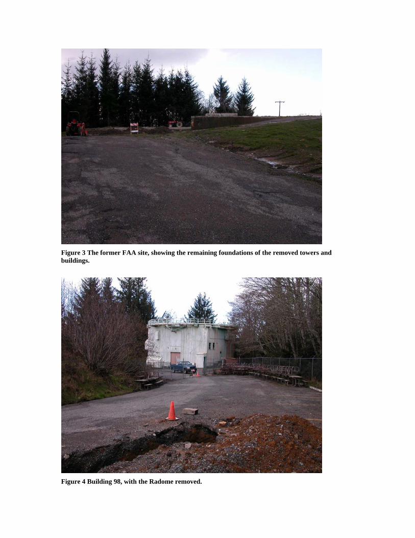
Figure 3 The former FAA site, showing the remaining foundations of the removed towers and buildings.
Figure 4 Building 98, with the Radome removed.

Figure 5 One of the many Fire Hose Houses throughout the RAFS
Figure 6 The water towers (Buildings 1024 and 1025), as well as the remains of the trestled water system which used to criscross the property

Figure 7 Building 108, as well as cracking hillslope stabilization material
Figure 8 Building 109, closed due to asbestos contamination

Figure 9 Building 120, the Power House; note ASTs in the background
Figure 10 Building 150, the Ceramic Shop; note site debris surrounding building

Figure 11 Site debris near building 120
Figure 12 The Vehicle Maintenance ramp

Figure 13 Building 200, now the National Park Offices
Figure 14 The CCCs facility, Building 300 in the foreground

Figure 15 One of the residential duplexes
Figure 16 An example of site instability - roadways are subsiding throughout the property

Figure 17 The RAFS is perched atop Requa Hill - steep slopes are common
Figure 18 The GATR facility; note site debris