strategic implementation plan (sip) for evolution of … implementation plan (sip) for evolution of...
TRANSCRIPT

1
Strategic Implementation Plan (SIP) for Evolution of NGGPS to a National Unified Modeling System
Version 4 (updated Dec 5, 2017)
INTRODUCTION
COMMUNITY STRATEGY AND DEFINITIONS
GOVERNANCE
COMMUNICATIONS AND OUTREACH
ANNEXES FOR PROJECT PLANS
ANNEX 1: NGGPS GLOBAL MODEL SUITES PLANNED FOR NCEP/EMC OPERATIONS Project 1.1: FV3-Global Forecast System (FV3-GFS): Project 1.2: FV3-Global Ensemble Forecast System (FV3-GEFS): Project 1.3: FV3-Seasonal Forecast System (FV3-SFS):
ANNEX 2: SYSTEM ARCHITECTURE Project 2.1a: Base support for ESMF and the NUOPC Layer Project 2.1b: Community Mediator Development Project 2.1c: Support for FV3-GFS Coupling Projects Project 2.2: System Architecture Implications of Nesting Project 2.3: System Architecture Implications of Deep Atmosphere Extension
ANNEX 3: INFRASTRUCTURE Project 3.1: Community Research and Operations Workflow (CROW) Project 3.2: Repositories Project 3.3: Documentation, Training, and Support Materials
ANNEX 4: DYNAMICS AND NESTING Project 4.1: Stand-Alone Regional FV3 and Static High-Resolution Nests for Global FV3 Project 4.2: Moving Nest for FV3 Hurricane Applications (AOML Approach) Project 4.3: FV3 based hurricane model developments: Moving nests and coupling to other earth system components (EMC approach) Project 4.4: Development of Deep Atmospheric Dynamics (DAD) for FV3 for Whole Atmosphere Model (WAM) and coupling to Ionosphere Plasmasphere and Electrodynamics Model (IPE)
ANNEX 5: MODEL PHYSICS Project 5.1: Advanced physical parameterization suite for NGGPS Project 5.2: Establishment of unified metrics covering synoptic to seasonal time scales Project 5.3: Collaborative framework for developing physical parameterizations
ANNEX 6: DATA ASSIMILATION Project 6.1: JEDI Unified Forward Operator (UFO) Project 6.2: JEDI Interface for Observation Data Access (IODA) Project 6.3: JEDI Data Assimilation System Project 6.4: 3D Rapid Updating RTMA/URMA Systems
ANNEX 7: CONVECTION-ALLOWING MODELS (CAM) Project 7.1: FV3-based Regional/Mesoscale Forecast System (FV3-Regional) Project 7.2: FV3-based Regional Ensemble Forecast System (REFS)

2
Project 7.3: FV3-based Regional Hourly Updated Storm-scale Ensemble Data Assimilation and Forecast System Project 7.4: Future CAM Ensembles and Data Assimilation
ANNEX 8: MARINE MODELS Project 8.1: Ocean Data Assimilation (NCODA) to support RTOFS Project 8.2(a): FV3 based Hurricane Model developments: Moving nests and coupling to other Earth System Components Project 8.2(b): Development of a Global Coupled Unified Model Project 8.2(c): Coupling wave models to Atmosphere systems Project 8.3: Integrated Water Prediction (IWP) Project 8.4(a): NexGen Ocean Model Project 8.4(b): A community-based Ocean Data Assimilation Framework
ANNEX 9: LAND SURFACE MODELS (LSM) AND HYDROLOGY Project 9.1: Operational Global Land Data Assimilation System (GLDAS) Development Project 9.2: NCEP Unified Land Data Assimilation System (NULDAS) Development Project 9.3: Land surface model physics and system evaluation and selection Project 9.4: Collaborative Development with National Water Model (NWM) Project 9.5: Land-hydrology model system coupling with other earth-system model components
ANNEX 10: AEROSOLS AND ATMOSPHERIC COMPOSITION Project 10.1: Development of an atmospheric composition component model and coupler Project 10.2: Data Assimilation for Atmospheric Composition Project 10.3: Atmospheric composition emissions capability
ANNEX 11: ENSEMBLES Project 11.1: FV3-GEFS implementation Project 11.2: High-resolution global ensemble forecast system (HRGEFS) Project 11.3: Ensuring consistency between global and regional ensemble systems Project 11.4: Improve uncertainty treatments in the ensemble system to make them suitable for sub-seasonal forecasts and for a full spectrum of environmental prediction needs (mostly in planning).
ANNEX 12: POST-PROCESSING Project 12.1: Transition NOAA Operational Post Processing packages (ModPP, DiagPP, and StatPP) to support FV3 Project 12.2: Review NOAA’s organizational approach, data sources, post-processing tools, data formats and model levels, and dissemination of post-processed output Project 12.3: Improve the accuracy of post-processed guidance through better science and better data Project 12.4: Comparison and Validation of Post-Processing Techniques. Testbed for Post-Processing
ANNEX 13: VERIFICATION Project 13.1: Unified verification and validation system based on MET+ Project 13.2: Robust METViewer for operational and community applications Project 13.3: T&E for demonstration of operational readiness of prediction systems Project 13.4: Develop MET+ interface for other NGGPS community packages. Project 13.5: Develop protocol for community contribution to authoritative code repository

3
INTRODUCTION
The overall goal of this effort is to create a multi-year implementation plan to document the effort of the community participants that will work together to evolve the Next Generation Global Prediction System (NGGPS) towards a national unified Earth system modeling system for operations and research, to the mutual benefit of both. The ultimate end-state is planned to be a unified modeling system that functions on temporal scales from seasonal to sub-seasonal (S2S) on the order of months, down to short-term weather prediction on the order of hours to days. Likewise, the unified system will also function across spatial scales, from global-scale predictions down to high-resolution, convection-resolving local/regional scales. As such, all major development efforts will be undertaken with those goals in mind. In addition, the community effort will be focused along the following additional specific goals or approaches:
● Intermediate/transitional steps may be made for specific subsets of a unified system, provided that the ultimate goal of a unified system is part of the long-term plan. One primary example is progress on mesoscale/convective resolving models in the short-term, which could help with goal of reducing complexity of the NCEP modeling suite. In addition, we also need to address the need for consistency in the prediction system across scales.
● While the end goal will be a unified Earth system model, we recognize that in the near-term much of the focus will be on the Next Generation Global Prediction System (NGGPS).
COMMUNITY STRATEGY AND DEFINITIONS
The new unified model will be designed as a community model that involves NOAA, other federal partners (e.g., NASA, DoD, JCSDA, etc.), and the broader research and academic community at large. Only with appropriate contributions from the entire U.S. modeling community will we be able to build the best national modeling system possible. The definition of “community” is important, and not all community efforts will be identical. We will learn from prior and ongoing community modeling efforts (WRF, CESM, WW3, MOM6, etc.) and apply best practices that best meet our specific situation.
The unified modeling system will be built to support the needs of both operations and research. Without that linkage, the incentives will not be there for the research community to help make improvements that will benefit operations. Building a community model involves both give and take from the operational and research sides. Lessons learned, such as from the Developmental Testbed Center (DTC), have shown us that the community will expect sufficient training, full support (including help desk), and acceptance of scientific advances that will help NOAA build this modeling system. As such, we need to start early to build that infrastructure into the Unified Modeling System.
Community organization: Different layers of community partners will be established, with specific roles/responsibilities for each.
● Researchers should be engaged through Announcements of Opportunity (AOs) in order to increase the human capacity needed for long term (i.e., research funding supports students who will be skilled in the unified modeling technology and environment. For example, AOs from the Hurricane Forecast Improvement Program (HFIP) tripled the research community involvement in development of the Hurricane WRF (HWRF) model.
● Core development partners (that regularly make substantial contributions) will be granted different roles and access than “users” that may run the model but not typically directly or actively contribute to its development.

4
● Trusted super-users may be established as a special, limited category that allow greater, early access than normal research users to, in order to conduct early “beta” testing on the next model version still under development but not yet released to the full community.
● Operations, due to its constraints on reliability, timeliness, and security, will require a unique operational version of the modeling system. A significant goal will be to ensure that the overarching modeling system, while having different variants for research and operations, will have a consistent architecture and infrastructure that will allow improvements made on the research side to be smoothly transitioned into operations.
Also, while not directly contributing to the code development itself, stakeholders can still convey their needs for the predictions to be produced by the modeling system. Therefore, so long as the stakeholder needs fit within the overall mission space of the core development partners, they can help drive the direction of development, resources allocations and prioritization. This could also include a role for basic research partners, such as the National Science Foundation (NSF).
GOVERNANCE
In order to effectively coordinate the activities of the community partners, as well as to manage the collaborative projects of those partners, a robust community governance structure is being put in place that is based on several core principles and values:
- Commitment by core development partners: The Unified Forecast System (UFS) will be a National system where all core partners are truly invested and empowered (i.e., even though a main goal is to improve NCEP’s modeling suite, NCEP/EMC is not the only stakeholder or decision authority). As such, each core partner will consider their role on the national team a fundamental and enduring priority for their respective organization. That means that all core partners will have a voice in making strategic decisions, not just the operational center(s).
- Informed practices: The governance structure will leverage successful practices from “tried and true” structures from prior and existing community modeling systems.
- Community Values: The community will be engaged via the following common values: ● Promotes environment for individuals to succeed
○ Recognizes talent in diverse communities ○ Assures efforts are credited and rewarded ○ Has transparent and documented processes for career advancement ○ Provides incentives to make decisions in context of community and system
requirements (collaborative rather than individual decision making) ● Evidence-based Decision Making ● Requirements Driven ● Considers the balance of cost, requirements, scientific credibility, user experience ● Supports a Scientific Organization (Rather than an Organization of Scientists) ● Committed to Process Improvement
○ Accuracy (Testing, Checking) ○ Documentation ○ Reduce redundant systems ○ Optimization of resources (human, computational, etc.)
● Trust ● Transparency
5
The complete strategy, processes and procedures for the overall governance structure is provided in a separate draft Governance Document. COMMUNICATIONS AND OUTREACH
Given the wide community interactions between numerous agencies, scientific disciplines, and diverse stakeholder groups, a Communications and Outreach Plan is being developed to ensure the most consistent and effective messaging with the community. The complete strategy is provided in the draft Communications and Outreach Plan. Four major goals drive this communication plan:
1. Establish, maintain, monitor, and assess a range of channels that promote multidirectional communication and convey content related to the UFS.
2. Provide the means and protocols for integrated decision making through community engagement.
3. Promote and enable collaborative development through open access to information and resources.
4. Create and sustain an Identity through branding for the UFS, working through and with NOAA Communications and other parallel offices in partner organizations.
Scope: This plan encompasses communication related to the UFS. It seeks to provide a careful and thoughtful set of proposed mechanisms to meet specific information, decision making, and community building needs. It specifies particular types of necessary content, which will be provided by working groups and other contributors. We take as priorities both the need to undertake critical system development and the need to inform and be guided by community participants.
Interdependencies: The Communication and Outreach WG supports all of the other WGs and the community at large. This Plan is integrally important to the success of UFS governance and product implementation. The Communication and Outreach Plan is to be informed by and closely coordinated with the “Governance Model for Unified Forecast System for NCEP’s Product Suite”. We recommend that direction of the execution of this plan should reside under the auspices of the governance process as embodied by the UFS-SC. Furthermore, much of the process described in this plan will be enabled by the Infrastructure WG (where objects and activities such as technical documents and training reside), this is another critical dependency. ANNEXES FOR PROJECT PLANS
Given that NGGPS will be the foundation upon which a community Earth-system modeling system is being built, it is important to start from the planned/funded NGGPS capabilities and timelines, so as to ensure that other additional community efforts are properly synchronized. Therefore the first annex will lay out the broad program deliverables and schedule for NGGPS functionality to be implemented at NCEP/EMC, to be followed by additional annexes for each community SIP Working Group’s specific plan for additional exploratory or development project.

6
ANNEX 1: NGGPS GLOBAL MODEL SUITES PLANNED FOR NCEP/EMC OPERATIONS
Given that NGGPS will be the foundation upon which a community Earth-system modeling system is being built, it is important to start from the planned/funded NGGPS capabilities and timelines, so as to ensure that other additional community efforts are properly synchronized. Therefore this first annex will lay out the broad program deliverables and schedule for NGGPS functionality to be implemented at NCEP/EMC, to be followed by additional annexes for each community SIP Working Group’s specific plan for additional exploratory or development project.
The first major NGGPS model package will be to replace EMC’s legacy Global Forecast System (GFS) model, based on the Global Spectral Model (GSM) dynamic core, with a new version of the GFS that is based on FV3 dynamic core. As such, this new system is referred to as FV3-GFS. There is an early prototype of the FV3-GFS planned for FY18; the first operational version of the FV3-GFS is planned for FY19, with additional upgrades planned on an annual basis starting in FY20.
The second major NGGPS model package will be to replace EMC’s legacy Global Ensemble Forecast System (GEFS), based on the Global Spectral Model (GSM) dynamic core, with a new version of the GEFS that is based on FV3 dynamic core. As such, this new system is referred to as FV3-GEFS. The first operational version will follow the implementation of the first operational FV3-GFS in FY19. In addition to replacing the legacy GEFS, the forecast length for the new FV3-GEFS will be extended to approximately 35 days, therefore making it an operational Sub-Seasonal ensemble prediction system.
The third major NGGPS model package will be to replace EMC’s legacy Climate Forecast System (CFS), a fully coupled seasonal-scale model based on the Global Spectral Model (GSM) dynamic core, with a new version that is based on FV3 dynamic core. Given that the old CFS name is a misnomer in that is provides predictions on seasonal scales, and not to long-range climate scales as the name implies, the “climate” part of the name will be dropped and replaced with the more accurate “seasonal” descriptor; as such, this new system will be referred to as the FV3-SFS.

7
The next sections will cover the implementation activities of the three NGGPS global modeling systems targeted for operations at NCEP/EMC, to be followed by functional components of the broader community development efforts organized under the SIP Working Groups.
Project 1.1: FV3-Global Forecast System (FV3-GFS):
Project overview: The NGGPS mission and objectives include NOAA/NWS/NCEP being the world's best and most trusted provider of deterministic and probabilistic forecast guidance across all spatial and temporal scales. Fundamental and central to this mission is the FV3-GFS and associated FV3 based Global Data Assimilation System (GDAS). The NOAA Environmental Modeling System (NEMS) framework will provide the infrastructure for developing the FV3-GFS, and will become the core component of the National Unified Modeling System. Apart from providing forecast guidance over different time scales, the FV3-GFS also provides initial and boundary conditions for regional atmospheric and ocean models, space weather models, air quality models, and various other NCEP production suite applications. To properly service the customers, the forecasts must be available reliably and at the appropriate time within available resources.
Major Risks and Issues: • Computational resources dedicated for model development and for operations • Documentation, training, code management and access of codes by core partners and community
• Demonstration of superior performance of FV3-GFS from scientific evaluation
• Alignment with Unified Model Development strategy
Major resources requirements: • Personnel:
• EMC (21 FTE): FV3-GFS Model development, physics, and DA
• ESRL (2 FTE); GFDL (3 FTE) • HPC for development: ~20M CPU hrs per month on WCOSS, Theia, Jet and Gaea; ~500 TB scratch
space and ~2 PB HPSS storage prior to implementation
Dependencies/linkages with other projects: • NEMS/ESMF framework advancements • ESRL/PSD DA integration including stochastic physics • Readiness and availability of data from GOES-16, JPSS and COSMIC-2
• GFDL IPDv4; DTC/GMTB CCPP (not in the critical path) • Advanced Physics options recommended by SIP Physics Working Group
• MET based verification and validation
• Refactored NCEP POST (UPP) and product generation
• Unified Workflow (CROW) • Transition to VLab and Code Management/Governance
• Joint Effort for DA Integration (JEDI)
Core development partners and their roles: • NCEP/EMC: Model development (including physics and data assimilation), integration into NEMS
framework and unified workflow, code management, retrospective and real-time experiments, testing and evaluation, transition to operations
• GFDL: Utilities for FV3 Grid Structure and I/O; Model diagnostics and troubleshooting; NEMS Integration Support; Documentation and Training; Advanced physics connections to IPDv4
• ESRL/PSD and JCSDA: DA development support

8
• ESRL/GSD; DTC/GMTB: Physics development and T&E
• ESRL/NESII: The NOAA Environmental Software Infrastructure and Interoperability (NESII) team provides ESMF/NUOPC advances and NEMS development and integration support.
• NGGPS funded PIs for R2O
Major Milestones: • Q3FY17: Prepare FV3 dynamic core for GFS: Develop extensive documentation and training
material, establish code management, code build and optimization procedures; assemble tools for pre-processing and post-processing tools; develop libraries and utilities;
• Q2FY18: Implement FV3 dynamic core and physics driver into NEMS framework: Add FV3 cap to NEMS; develop FV3 write component; enable hourly output; develop regridding tools and NETCDF I/O
• Q3FY18: Pre- and Post- Processing; verification and validation: Refactor NCEP Post (UPP); transition verification software to MET; generate downstream products and evaluate impacts on production suite dependencies
• Q3FY18: Initial performance evaluation of FV3-GFS: Couple FV3 dynamic core with IPDv4; conduct forecast experiments; code optimization; performance evaluation; and real-time demonstration. Prepare for experimental implementation of FV3-GFS (matching the current operational GFS configuration) for operations and provide real-time forecasts to the field
• Q2FY19: Advanced model configuration of FV3-GFS for transition to operations: Increase model resolution to ~10km 128L; implement advanced and scale-aware physics; perform retrospective and real-time evaluation of various configurations; integrate into unified workflow; conduct pre-implementation T&E; and prepare model for transition to operations
Other Milestones associated with this project:
FV3-GDAS: • Q2FY18: Adopt 4D-Hybrid DA for FV3-GFS: Prepare tools to develop initial conditions for FV3-GFS
using NEMS-GSM analysis fields; transition the 4D-Hybrid En-Var data assimilation framework for FV3-GFS; configure and optimize the cycled data assimilation experiments including EnKF and stochastic physics
• Q2FY18: Assimilation of GOES-16, JPSS and COSMIC-2 data: Prepare FV3-GFS for assimilating new satellite datasets as they become available
• Q2FY19: Advanced high-resolution DA for FV3-GFS: Increase the horizontal and vertical resolutions for DA configurations in support of FV3-GFS implementation.
• Q2FY19: Integrate into JEDI framework: Transition FV3-GDAS developments into JEDI framework, and implement any available JEDI contributions into operational FV3-GDAS. Implement forward operator on native cubed-sphere grid using JEDI Unified Forward Operator (UFO, see Annexe 6, Project 1).
Unified Workflow: • Q2FY19: Modular and object oriented workflow design: Develop and implement Community and
Operations Workflow (CROW) with object oriented scripting and automation tools.
Unification of Global Wavemodel into FV3-GFS: • Q2FY19: Couple FV3-GFS to WaveWatchIII: Integrate the wave model into FV3-GFS using
NEMS/NUOPC coupler; test the impacts of two-way interactive wave physics; replace global wave model products with the wave coupled FV3-GFS.

9
Unification of NCEP Global Aerosol Model into FV3-GFS: • Q2FY19: Couple Aerosol Model to FV3-GFS: Integrate the aerosol chemistry module (GOCART or
MAM7) into FV3-GFS using NEMS/NUOPC coupler; test the impacts of two-way interactive aerosol chemistry; implement aerosol data assimilation; replace operational NGAC products with the aerosol coupled FV3-GFS

10
FV3-GFS (FY17-20)
Data Assimilation for FV3-GFS (FY17-20)

11
Project 1.2: FV3-Global Ensemble Forecast System (FV3-GEFS):
Project overview: The FV3-GEFS project will assemble, test, and prepare for the implementation of an upgraded Global Ensemble Forecast System (FV3-GEFS) which will extend the weather forecast guidance to weeks 3&4 (35 days). The FV3-GEFS implementation will be accompanied by a ~20-year reanalysis and reforecast. The FV3-GEFS will be implemented within the NEMS framework using the FV3 dynamic core and IPDv4, and is consistent with the development and implementation plans for the FV3-GFS supported by NGGPS and CPO. The FV3-GEFS project will have close coordination with the FV3-GFS project, and the ESRL/PSD reanalysis project to ensure timely execution of the reforecasts leading to implementation of FV3-GEFS in operations. The model configuration for FV3-GEFS will have possible options to include coupling the atmospheric model to Ocean (GFDL Modular Ocean Model MOM6), Sea-Ice (CICE), and Land (Noah Land Surface Model) components. The data assimilation systems for the component models will be uncoupled. The FV3-GEFS reforecast experiments will rely on ESRL/PSD’s atmospheric initial conditions based on the ~20-year atmospheric reanalysis project.
Major Risks and Issues: • Computational resources dedicated for model development, tuning, and for operations, including
procurement of disk space for reanalysis/reforecast ($150K to be sent to NCO for NOMADS disk augmentation in early FY2018).
• The reanalysis planned for the GEFS will be atmosphere-only and uncoupled with the ocean. It is possible that the lack of coupling may lead to sub-optimal coupled ocean forecasts with numerical transients. At the earliest possible time, tests of the coupled GEFS prediction system initialized with uncoupled atmospheric ocean and atmospheric analyses should be tested and evaluated.
• Successful development of atmosphere-ocean-wave-sea ice coupled system based on FV3-GFS, MOM6, Wavewatch III, and CICE within the NEMS framework and ready for testing in the week 3&4 time scales.
• Coupled FV3-GEFS forecast skill for weather scales, especially for weeks 1-2 show sufficient improvement over the uncoupled FV3-GEFS as well as the operational GEFS V11 (and CFS V2) forecast skill in order to justify the cost of coupling. If a coupled system is not ready, we will need an alternative, simpler approach, be it the existing approach of damping perturbations toward climatology, a transplantation of SST anomalies from CFS v2, ocean evolution by a linear-inverse model, or some other approach.
• Timely execution of reanalysis/reforecast project, which in turn depends on computational resource availability and the stability of the FV3 model and data assimilation system. When the reanalysis is generated (using FV3), the FV3 system should be as close as possible to the eventual operational version.
Major resources requirements: • Personnel:
• EMC (18 FTE): Ensemble model development, coupled system development, Reforecasts, T&E and transition to operations
• ESRL/PSD (~6 FTE): Reanalysis/reforecast and GEFS development in FY2017. • GFDL (TBD)
• HPC for development: ~25 M of CPU/month; ~500TB of disk space; ~5 PB of archive (tape) space
Dependencies/linkages with other projects: • NEMS/ESMF framework advancements. • Via collaboration with DA team, a stable, agreed-upon procedure for atmospheric ensemble
initialization, via presumably 4D-En-Var system. We will need resolution of whether EnKF used in

12
4D-En-Var will be moved from the late to the early DA cycle, and then whether GEFS atmospheric initial conditions will be initialized from analysis perturbations (EnKF in early cycle) or from 6-h forecast perturbations (EnKF in late cycle).
• Via collaboration with coupling team, readiness of GFDL MOM6; CICE; and DA for component models; i.e., if coupled ocean/ice/land/atmosphere is expected for the forecast, the GEFS project will depend on the existence of a stable, well-tested coupled prediction system. If coupled is not expected, then the forecasts will have dependencies on other methodologies such as transplantation of CFSv2 forecast anomalies.
• Via collaboration with land-surface team, agreement on the procedure for control land-state initialization in the GEFS in advance of reforecast production (roughly 1 July 2018). Will the control state be supplied by the GLDAS, and if so, to what extent will GLDAS use forcings from FV3. What approach will be used to deal with the latency of the GLDAS system.
• Reanalyses and reforecasts are available, data sent to key partners (MDL, CPC, NWC) prior to ops. • Agreement on the procedure for initialization of land-state initial perturbations, in collaboration
with ESRL/PSD. • ESRL/PSD stochastic physics methods successfully ported, tested, and verified in the FV3/NEMS
framework (ESRL/PSD in collaboration with EMC staff). • In collaboration with physics working group, advanced physics options recommended by, with
specifics delivered by 1 April 2018 so they can be used in reanalysis production. • MET based verification and validation; process-oriented metrics for ensemble evaluation
• Refactored NCEP POST (UPP) and product generation
• Unified Workflow
• Transition to VLab and Code Management/Governance for coupled system components
Core development partners and their roles: • NCEP/EMC: Ensemble Model development (including integration into NEMS framework and
unified workflow); partner with ESRL (NESII) on integration of land, ocean, waves and sea-ice model components into NEMS and couple to FV3-GFS using NUOPC mediator; test ensemble perturbation methods (SPPT, SKEB, SHUM and land surface parameter perturbations); test representation of process-level uncertainty in physics; ~20-year reforecasts including extension to weeks 3&4; determine optimal configuration for ensemble size and resolution; develop post-processing, bias corrections, and products for FV3-GEFS; conduct retrospective and real-time experiments, testing and evaluation, and transition to operations
• GFDL: MOM6 and CICE development • GSD/NESII: Partner in development and integration of land, ocean, waves and sea-ice model
components within NEMS and coupling to FV3-GFS using NUOPC mediator. • ESRL/PSD: Reanalysis project; development of stochastic physics methods; methods for treating
land-surface related uncertainties, methods for postprocessing of model guidance in the National Blend of Models project.
• NCAR, NCEP/CPC, and others: Evaluation metrics and support for verification and validation
Major Milestones: • Q2FY18: Prepare FV3-GFS for reanalysis project: Develop and test low-resolution version of FV3-
GFS and FV3-GDAS, and configure the model for reanalysis project. • Q3FY18: Determine ensemble configuration for FV3-GEFS: Configure for optimum no. of ensemble
members, resolution, physics, and coupling to ocean, ice, land and wave models using NEMS/ NUOPC mediator; conduct preliminary testing for quality assurance and computational efficiency.
13
• Q2FY19: Produce ~20-year reanalysis datasets: Mainly ESRL/PSD activity. Determine configuration of the reanalysis system; develop observational database for reanalysis; prepare observational inputs; and produce reanalysis suitable for reforecasts and calibration.
• Q3FY19: Produce ~20-year reforecast datasets for FV3-GEFS: Finalize ensemble configuration and produce reforecasts consistent with the reanalysis data; extend the reforecast length to 35 days
• Q4FY19: Transition FV3-GEFS into operations: Conduct pre-implementation T&E; transition the system for operational implementation
Other Milestones associated with this project:
MOM6 and CICE in NEMS: • Q2FY18: Couple MOM6 and CICE models with FV3-GFS: Couple MOM6 and CICE models with FV3-
GFS in NEMS using NUOPC mediator and caps; configure the ocean and ice models for weather-scale applications; test, evaluation and benchmark the coupled model performance for 0-35 days; develop data assimilation methods for the coupled components; configure the coupled FV3-GFS model for weeks 3&4 ensemble forecast applications
Unified Workflow: • Q2FY19: Modular and object oriented workflow design: Develop and implement Community and
Operations Workflow (CROW) with object oriented scripting and automation tools for all coupled system components and the ensemble system.
Unification of Global Wave Ensembles into FV3-GFS: • Q2FY19: Couple FV3-GEFS to Wave Watch III ensembles: Integrate the wave model ensembles into
FV3-GEFS using NEMS/NUOPC coupler; test the impacts of two-way interactive wave physics; replace global wave model products with the wave coupled FV3-GEFS.
FV3-GEFS (FY17-20)

14

15
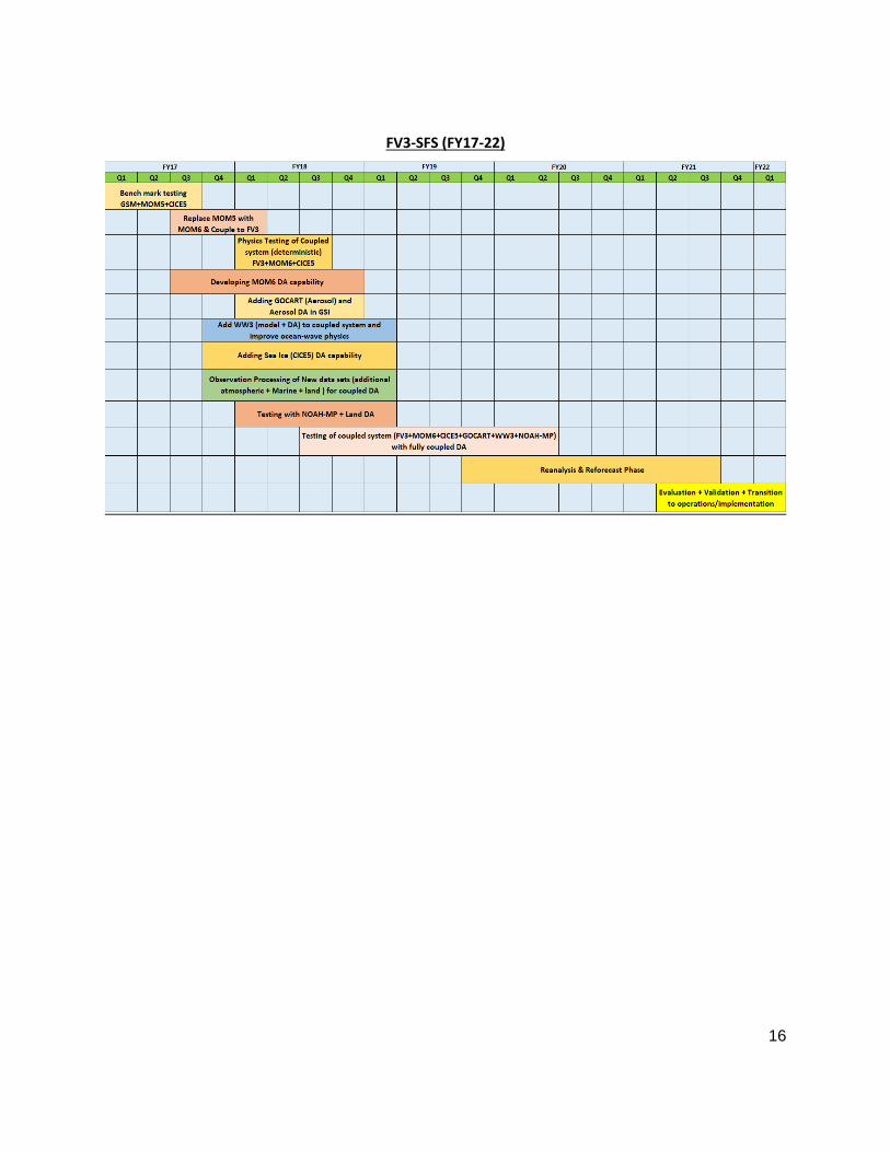
Project 1.3: FV3-Seasonal Forecast System (FV3-SFS):
Project overview: The FV3-SFS project will develop the next generation seasonal forecast system based on the FV3 dycore. The seasonal forecast system will provide model guidance out to 9 months. FV3-SFS will include all the components that are being developed for the FV3-GEFS system (coupling between FV3, MOM6, WAVEWATCH III, CICE5) with focus on processes that occur at longer time scales than those for FV3-GEFS. (Note: There is a lot of overlap in processes at the week 3&4 scale of FV3-GEFS and the longer time scale of FV3-SFS and developments will be leveraged for both systems). The ensemble perturbations will be expanded to the ocean model to provide greater spread for the coupled system. The initialization of the other components (land, aerosol waves, ice) will also be developed.
Major Risks and Issues: • Computational resources for model development • New physics algorithms for coupled systems require extensive testing • Data assimilation techniques for ice still at early stage of development
Major resources requirements: • Personnel: TBD
• HPC for development: TBD
Dependencies/linkages with other projects: • Development for FV3-GEFS will feed into this system
• NEMS / NUOPC infrastructure for the component models needs to be ready; requirements need to be communicated
Core development partners and their roles: • NCEP/EMC: Partner with ESRL (NESII) to develop the coupled system in the NEMS framework
including coupling the MOM6, WAVEWATCH III, CICE5 and GOCART components; develop the DA framework for each of the components; testing new physics algorithms for coupled systems
• GFDL: Partner with EMC in developing wave and ocean coupled mixing parameterization. GFDL is also providing expertise in FV3 development and ocean modeling. The FV3-SFS development has numerous similarities with the CM4 model being developed by GFDL, and as such GFDL will provide their expertise knowledge in coupling FV3 with MOM6.
• GSD/NESII: Partner with EMC and GFDL on developing the coupled system in the NEMS framework. The NESII team led development of the NEMS mediator and previous coupling of atmosphere, MOM5, CICE5, and WAVEWATCH III.
Major Milestones: • Q3FY18: Prototype coupled system with FV3-MOM6-WAVEWATCHIII-NOAH-CICE5 with
initialization for the individual components • Q4FY18: Upgrade to NOAH-MP land model • Q4FY19: Include new physics processes for coupled components, including testing alternative
atmospheric algorithms for seasonal scales • Q1FY20: Freeze system and begin 30-year reanalyses and reforecasts • Q1FY21: Final validation and evaluation; and preparation for transition to operations • Q1FY22: Operational implementation of FV3-SFS
16
FV3-SFS (FY17-22)

17
ANNEX 2: SYSTEM ARCHITECTURE
System architecture can be defined as “the fundamental organization of a system, embodied in its components, their relationships to each other and the environment, and the principles that govern its design and evolution.”[1],[2] The system architecture used by the National Weather Service (NWS) at NCEP/EMC is critical because it serves as the backbone of a unified modeling system, and must provide high performance, reliable technical and scientific functions for a range of different forecast products. The design of the architecture is relevant to research community partners because it must make it easy for them to perform runs and experiments, and participate as full partners in model development. The system architecture (SA) should conform to the set of principles developed by the System Architecture Working Group, available in an initial report, System Architecture for Operational Needs and Research Collaborations.
An initial conception of the system architecture (Fig. 1) is a layered, component-based structure, divided into (1) a Workflow Environment that includes a user interface and database of experiment metadata for previous runs, including metadata about input datasets and observations/analyses used for verification, (2) a Prediction Package layer that consists of a sequence of pre-processing, data assimilation, forecast, and post-processing jobs, (3) a Modeling and Data Assimilation Application layer that includes the coupling framework (the NOAA Environmental Modeling System, or NEMS), a prescribed interface between atmospheric physics and dynamics, model components, and data assimilation components, and (4) a layer of Libraries and Utilities. Each layer utilizes components, which can be defined as “composable” software elements that have a clear function and interface. The system architecture includes elements that are complete and others that are still in progress. The portion of the system diagram that relates to coupled modeling applications is shown in teal and black. NEMS is shown in teal and includes a main coupler, a space weather coupler, a driver, and tools for building applications and running specific cases.
At an early stage, it is important to prioritize the scientific agenda. Many questions with a bearing on system architecture require scientific research, with the answers relating either to Earth system processes and their interactions or to the impact on predictability and prediction skill as a function of lead time; e.g., intra- and inter-component interactions (aerosols in 3D interface; atmospheric columns shading each other at high resolution; coupling ocean and sea ice as “fast” process; lateral water movement at and below the land surface). All have a bearing on R2O and O2R (support). In addition to prioritizing the scientific agenda, the following are example critical-path projects that are needed to establish the SA in conformance with the principles articulated above.

18
Figure 1. Diagram showing the four main layers in the unified modeling system architecture: Libraries
and Utilities, Modeling and Data Assimilation Applications, Prediction Packages, and Workflow
Environment. Purple boxes indicate parts of the Workflow Environment and databases, with thick light
blue lines indicating sequence. Red boxes indicate executables while the thin lines around them
represent scripts that invoke the executables. Teal boxes show NEMS infrastructure. Black boxes
represent science components, caps, and mediator components. Orange boxes show subcomponents of
the atmosphere model component. Pink boxes show parts of the data assimilation system. Blue boxes
show utilities and libraries. The Prediction Package sequence shown is typical; it may change for
different applications.
[1] See for example IEEE/ISO/IEC 42010-2011. [2] The system architecture should be distinguished from the software infrastructure. The software
infrastructure is a set of technical building blocks that represent a wide range of implementation
options. The system architecture defines what choices are made and what is built; the software
infrastructure is a set of tools for building it.

19
Project 2.1: Support for Coupling Infrastructure and Component Integration
Many of the projects in the SIP require coupling infrastructure and expertise. The NGGPS global model suites in development (Annex 1) use ESMF and the NUOPC Layer, which are well-established community software packages for building and coupling models. Other SIP projects, such as coupling of upper atmosphere to ionosphere (Annex 4), have also developed coupled systems using ESMF and the NUOPC Layer. These packages offer advanced features that are not available in other U.S. frameworks, including general grid representation and parallel remapping (2D and 3D), run-time sequencing of components, extensive documentation, and a large user base that includes federal centers and data/viz products like NCL and UV-CDAT. The ESRL/GSD NESII team coordinates the development and distribution of ESMF and the NUOPC Layer.
Development of the UFS creates demand for integration of new model components, the need to transfer component code with minimal code changes among GFDL, NCAR, EMC, NASA, and Navy centers, requests to add new features (such as specific output formats), requests for coupled system optimization, and requests for user support. This demand creates work for the NESII development and support team in three areas, defined here as three subprojects: 1) base support (routine questions, features, release preparation, installation, etc.), 2) development of a shared NUOPC-based mediator that can support the scientifically different CESM and GFDL coupling strategies, and 3) component integration projects.
Project 2.1a: Base support for ESMF and the NUOPC Layer
Project overview: ESMF and the NUOPC Layer are mature, portable, high-performance software packages. Although major development is complete, the continued viability of the software requires adding new feature requests, porting to new platforms, adapting to emerging computing architectures and new scientific directions, addressing user requests, running a training program, preparing releases, and offering extensive documentation. Base support for ESMF and the NUOPC Layer has been provided through contributions from multiple agencies, including NOAA. NEMSMajor Risks and Issues:
● Demand for ESMF and NUOPC Layer expertise for projects 1b and 1c directs resources away from basic development team activities like porting, testing, adding features, and releasing software. At the same time it creates additional demands for these core functions.
Major resources requirements: ● Personnel:
○ ESRL/GSD/NESII (3 FTE): This is normally 2, with in-kind contributions from NASA and Navy to make a standing core team of about 6
● HPC for development: TBD
Dependencies/linkages with other projects: ● NGGPS and other Annex projects that require coupling, see Project 1c.
Core development partners and their roles: ● GSD/NESII: Coordinates development of the ESMF/NUOPC software. ● NCEP/EMC: Communicates requirements; uses and tests the ESMF/NUOPC software. ● NCAR: Communicates requirements; uses and tests the ESMF/NUOPC software. ● GFDL: Communicates requirements. ● NRL: Communicates requirements; uses and tests the ESMF/NUOPC software. ● NASA: Communicates requirements; uses and tests the ESMF software.
20
● DOE: Provides finite element mesh frameworks used in ESMF; uses the ESMF regridding software; ANL DOE partner in ESMF optimization project
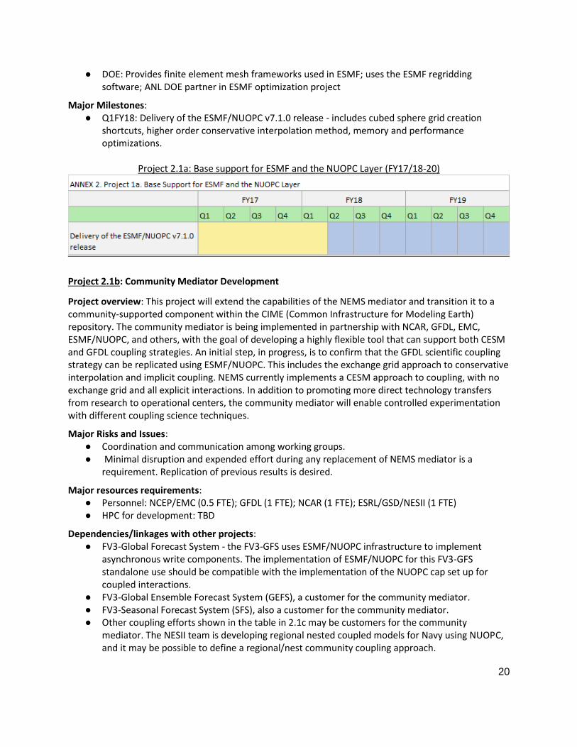
Major Milestones: ● Q1FY18: Delivery of the ESMF/NUOPC v7.1.0 release - includes cubed sphere grid creation
shortcuts, higher order conservative interpolation method, memory and performance optimizations.
Project 2.1a: Base support for ESMF and the NUOPC Layer (FY17/18-20)
Project 2.1b: Community Mediator Development
Project overview: This project will extend the capabilities of the NEMS mediator and transition it to a community-supported component within the CIME (Common Infrastructure for Modeling Earth) repository. The community mediator is being implemented in partnership with NCAR, GFDL, EMC, ESMF/NUOPC, and others, with the goal of developing a highly flexible tool that can support both CESM and GFDL coupling strategies. An initial step, in progress, is to confirm that the GFDL scientific coupling strategy can be replicated using ESMF/NUOPC. This includes the exchange grid approach to conservative interpolation and implicit coupling. NEMS currently implements a CESM approach to coupling, with no exchange grid and all explicit interactions. In addition to promoting more direct technology transfers from research to operational centers, the community mediator will enable controlled experimentation with different coupling science techniques.
Major Risks and Issues: ● Coordination and communication among working groups. ● Minimal disruption and expended effort during any replacement of NEMS mediator is a
requirement. Replication of previous results is desired.
Major resources requirements: ● Personnel: NCEP/EMC (0.5 FTE); GFDL (1 FTE); NCAR (1 FTE); ESRL/GSD/NESII (1 FTE) ● HPC for development: TBD
Dependencies/linkages with other projects: ● FV3-Global Forecast System - the FV3-GFS uses ESMF/NUOPC infrastructure to implement
asynchronous write components. The implementation of ESMF/NUOPC for this FV3-GFS standalone use should be compatible with the implementation of the NUOPC cap set up for coupled interactions.
● FV3-Global Ensemble Forecast System (GEFS), a customer for the community mediator. ● FV3-Seasonal Forecast System (SFS), also a customer for the community mediator. ● Other coupling efforts shown in the table in 2.1c may be customers for the community
mediator. The NESII team is developing regional nested coupled models for Navy using NUOPC, and it may be possible to define a regional/nest community coupling approach.

21
Core development partners and their roles: ● NCEP/EMC: Integration and testing of the community mediator in the NEMS environment;
communication of EMC requirements; contributions to design and implementation. ● ESRL/GSD (NESII): Development of the underlying ESMF/NUOPC framework; partner in design
and implementation of the community mediator. ● NCAR: Partner in design and implementation of the community mediator; communication of
NCAR requirements; integration and testing of the community mediator in the CIME environment; development and support of CIME.
● GFDL: Partner in design and implementation of the community mediator; communication of GFDL requirements; integration and testing of the community mediator in the GFDL environment.
Major Milestones: ● Q4FY17: Couple CIME data components with the community mediator. ● Q2FY18: Run the community mediator with all active CESM components. ● Q3FY18: Demonstrate that ESMF/NUOPC Layer can replicate all GFDL coupling functions. ● Q3FY18: Develop and document a governance strategy for the community mediator. ● Q4FY18: Demonstrate that the community mediator can replicate all NEMS coupling functions,
and replace the NEMS mediator with the community mediator.
Project 2.1b: Community Mediator Development (FY17/18-20)
Project 2.1c: Support for FV3-GFS Coupling Projects
Project overview: There are multiple projects defined by other working groups which will integrate the FV3-GFS with additional components within the NEMS framework. Developing these coupled applications to conform to a unified modeling system architecture will require ongoing coordination across working groups, evaluation of the system architecture, and refinements to the architecture. This project introduces practices which help to ensure that near- and mid-term decisions made by working groups that relate to the system architecture are open, informed, and evidence-based. This activity will require coordination with the governance working group.
Major Risks and Issues: ● Coordination among working groups.

22
● Open and informed planning and decision making. ● Closer coupling of ice and ocean model components is anticipated in the next five years, and
may require merging these components.
Major resources requirements and
Dependencies/linkages with other projects ESRL/GSD (NESII) coupling infrastructure team (or equivalent expertise):
FTE Annex, Project Task
.5 FTE Annex 1, P1 FV3-Global Forecast System - Participation in design and implementation of the asynchronous write component, starting to include aspects of post-processing.
.5 FTE Annex 1, P2 and P3 Annex 8, 2b
FV3 Global Ensemble Forecast System and FV3-Seasonal Forecast System - assistance with integration of FV3-GFS, MOM6, CICE5 and later WAVEWATCHIII, and GOCART, assistance with specialized initialization and run sequences. Coupling demonstrated in NEMS with previous atmosphere.
.2 FTE Annex 4, P1 and Annex 7, P1
Design participation in development of the FV3-Regional standalone system; may lead to further tasks. Annex 7, P1 not sure of connection; looks like it requested NESII input.
.2 FTE Annex 4, P2 and P3 Annex 8, P1 Annex 2, P2
Annex 4, P2 and P3 and Annex 8, P1: Design participation in FV3-based regional forecast systems with moving nests; may lead to further tasks. Nesting and coupling demonstrated in NEMS with previous atmosphere but design may need to change significantly for new atmosphere. May use FMS or hybrid - this requires careful consideration of ESMF and FMS capabilities, timelines, and future coupling scenarios.
1 FTE Annex 4, P4 Annex 2, P3
3D coupling of upper atmosphere with IPE ionosphere model. Demonstration of one way 3D coupling in NEMS with previous atmosphere is scheduled to transition to operations. Working on two-way coupling and generalization of space weather mediator for FV3-GFS. Contributions to coordination and analysis as well as infrastructure.
.2 FTE (ongoing)
Annex 5, P3, Annex 9, P5
Coordination with the physics team, on chemistry, land, and radiation components that are concurrency/remapping - curious and have or will have ESMF interface options; may lead to further tasks.
.1 FTE (ongoing)
Annex 6, P1 Help using and optimizing ESMF grid remapping in the JEDI unified forward operator - demonstrated desired remapping, currently assisting with multi-threading optimization.
0 FTE Annex 8, P2c FV3-GFS and WAVEWATCH III coupling - EMC did most of the work on

23
a demonstration of wave-atmosphere coupling in NEMS with the previous atmosphere, and can switch atmospheres themselves.
.2 FTE (ongoing)
Annex 8, P3 and Annex 9, P5
Integrated water modeling - NESII will complete a demonstration of separate LIS land and WRF-hydro hydrology components with coupled atmosphere-ocean as a step toward the unified modeling goal. This is linked to questions of disposition of the land model. This also includes support for Coastal Act coupling of ADCIRC and WAVEWATCHIII.
.5 FTE (3 months)
Annex 10, P1 Integration of unified GOCART chemistry component with FV3-GFS.
HPC for development: TBD
Core development partners and their roles: ● NCEP/EMC: Integration of components within the NEMS framework; communication of
requirements. ● GFDL: Expertise in the science of component coupling; coupling of FV3 with MOM5/6 and ice. ● GSD/NESII: Partner in development of coupled systems within NEMS, including integration of
CICE5, MOM5, and WAVEWATCH; expertise in ESMF/NUOPC and the NEMS mediator. ● NCAR: Expertise in the science of component coupling; coupling of FV3 with CESM components;
expertise in community support.
Major Milestones: ● 3QFY17 - Formation of project teams that include coupling infrastructure, workflow, and other
relevant expertise (with AAC, V&V, and other working groups) ● 1QFY18 - In conjunction with the governance working group, definition of design and
implementation review processes for conformance with the unified modeling system architecture.
● Major milestones involving coupled system infrastructure as outlined under Major Resource Requirements.
Project 2.1c: Support for FV3-GFS Coupling Projects (FY17/18-20)

24
Project 2.2: System Architecture Implications of Nesting
Project overview: One of the more challenging unified modeling system architectural issues relates to nesting. Multiple moving nests in a single component require specialized and efficient infrastructure. The requirements on the infrastructure become more complex when that component is coupled to others, which may also be nested. There are up-front considerations that include the treatment of boundary values, capabilities of the grid remapping package and the component representation, the interaction of nests with land, ocean, wave, and potentially hydrologic components, and considerations of using one primary or multiple frameworks. This project entails engaging with the dynamics and nesting group to understand architectural implications of these issues, and to assess alternatives with subject matter experts.
Major Risks and Issues: ● Coordination among working groups ● Open and informed planning and decision making.
Major resources requirements: ● Personnel: See table in project 2.1c ● HPC for development: TBD
Dependencies/linkages with other projects: ● FV3 static and moving nesting projects, including Moving Nests for FV3 (EMC Approach, includes
development of DA and coupling to ocean/waves for hurricanes) (FY17/18-20)
Core development partners and their roles: ● AOML: ● GFDL: ● EMC: ● ESRL/GSD (NESII):
Major Milestones: ● Q12018: Assess framework and infrastructure requirements, capabilities, and gaps with respect
to possible development paths. This interaction should include experts on the frameworks being discussed as well as experts in dynamics and nesting. Delivery of design document for moving nests.
Project 2.2: System Architecture Implications of Nesting Extension (FY17/18-20)

25
Project 2.3: System Architecture Implications of Deep Atmosphere Extension
Project overview: Another challenging unified modeling system architectural issue relates to coupling of the upper atmosphere to the ionosphere. This is challenging because it is volumetric and dynamic, and because the cells in a discretization based on magnetic flux tubes can be highly attenuated. This project entails engaging with the dynamics and nesting group to understand architectural implications of this issue, and to assess alternatives with subject matter experts.
Major Risks and Issues: ● Coordination among working groups ● Open and informed planning and decision making.
Major resources requirements: ● Personnel: See table in 1c. ● HPC for development: TBD
Dependencies/linkages with other projects: ● Development of Deep Atmospheric Dynamics for FV3 for Whole Atmosphere Model (WAM) and
coupling to Ionosphere Plasmasphere and Electrodynamics Model (IPE) (see Annex 4, Project 4.
Core development partners and their roles: ● SWPC: ● AOML: ● GFDL: ● EMC: ● ESRL/GSD (NESII):
Major Milestones:
● Q12018: Assess framework and infrastructure requirements, capabilities, and gaps with respect to possible development paths.
Project 2.3: System Architecture Implications of Deep Atmosphere Extension (FY17/18-20)

26
ANNEX 3: INFRASTRUCTURE
The Software Infrastructure Working Group (SIWG) was formed to help EMC develop plans to improve its infrastructure to enable interactions with the community in developing the NGGPS. The SIWG sees its role as complementary to the Software Architecture Working Group whose mandate is the technology associated with coupling different earth system components in a unified modeling system. The SIWG mandate is to handle the remainder of the needs of the Unified Global Modeling System to foster the community participation in the process of building the nation’s forecast system.
The key focus areas for the SIWG were repository design, workflow, documentation and training, and testbeds. Each of these will be discussed in detail below. The workflow discussions were extremely fortuitous as these occurred at the same time EMC was developing a detailed plan for a next generation unified workflow to serve both operations and research community, and SIWG was able to provide considerable input to EMC on their plans.

27
Project 3.1: Community Research and Operations Workflow (CROW)
Project overview: The purpose of this project is to replace the existing myriad of model dependent workflows currently used in production by a single unified system that is reusable for multiple models in operations and serves the needs of the research community. The key features of this new system will have to include:
● The ability to be run in research mode (with minimal arguments) in non-NCEP environments ● The ability to handle all use cases : operations, serial and parallel computing environments,
multiple compilers, batch systems for single and multi-component tests, large scale retrospectives, case studies, one off experiments
● Use only high-reliability, cross-platform, software ● Any software must have source code provided, or be available via a vendor (for future
portability)
● Be seamlessly integratable (and removable) from the NCEP operational environment
The workflow project is a major undertaking at EMC and its development will use the agile development environment where rapid prototyping will be done in parallel with developing use cases and requirements gathering (both within and outside EMC). The starting point for this workflow is the current existing workflow for the NEMS-FV3GFS forecast system [initial condition creation; build system (acquire source & compile); run configuration; workspace creation; forecast with offline DA; post-processing; product delivery; configuration capture (insertion into database)] and will then evolve into adding more systems.
One key aspect of this project is the scripting language to be used. Using the criteria of portability and versatility the unanimous opinion of the SIWG was that this workflow should be based on Python 3. It should be emphasized that at this moment EMC has a development plan, not a final design. For a final design that is simple, modular and flexible enough to serve the operational (and experimental) needs of both EMC and their research partners, it is critical that the workflow development team remains engaged with the community. This can either be done through the SIWG or as a separate Working Group established and tasked to provide guidance.
Major Risks and Issues: ● Insufficient use cases and input by user communities could lead to a poor system design that
can worsen our current situation. ● Insufficient support or maintenance personnel can make even a good design unusable. ● If a technology underlying the system is no longer supported, or no longer actively maintained,
the system may need to be redesigned to use other technology.
Major resources requirements: ● Personnel:
o 4-6 quasi-permanent core developers o 0-12 short-term subject matter experts to implement portions of system
● HPC for development: o Jul-Oct: 200k core-hours/month, 10 TB disk
o Nov-Feb: 1200k core-hours, 40 TB disk
Dependencies/linkages with other projects: • Software Architecture Working Group
• Ensembles Working Group

28
• Post-Processing Working Group
Core development partners and their roles:
• NCAR, NCO, GMTB, GFDL and representatives of SIWG or its counterpart Working Group
Major Milestones:
• Q4 FY17: Requirements document and Technology prospects document • Q1 FY18: Prototype system suitable for widespread use
• Q1 FY18: Umbrella build system that compiles all executables and dependencies except software found on typical HPC clusters (e.g. netcdf libraries)
• Q2 FY18: Full-featured workflow system
• Q3 FY18: Transition to NCO for operational parallel • Q4 FY18 / Q1 FY19: Community release of system (exact date will be discussed with stakeholders) • 2019 - operational GFS system and begin incorporation into other modeling systems
Project 3.1: CROW (FY17/18-20) Insert image of Gantt chart here

29
Project 3.2: Repositories
Project overview: At the major U.S. global modeling centers (GFDL, NASA, NCAR), the individual components comprising the earth system models are managed via a revision control system which houses the various components and libraries developed and/or modified in-house for the specific purpose of the modeling center. The goal of the Unified Modeling System (UMS) is to create the support infrastructure for the United States global models comprised of the best components from U.S. operational and research institutions. Many of the components that will be used to build the UMS forecast model are already available via authoritative repositories and have robust governance structures in place, but not all components that will make up the forecast model are mature or have the necessary policies in place to foster healthy community development.
The repositories project from the Software Infrastructure Working Group (SIWG) seeks to provide guidelines on how a centralized repository, similar to that used at leading institutions, can encompass the existing component authoritative repositories, while bridging the gap and providing the proper structure and policies for the less mature components to provide the appearance of a single centralized authoritative repository for the whole of the UMS.
To accomplish this, one must first choose a robust and mature revision control system and the SIWG recommends Git, a mature and widely used standard with a rich featureset. Git is a natural choice due to its premise of distributed development.
While NOAA could design and build a centralized repository system with linkages to the distributed component repositories from scratch, this has been accomplished by multiple entities. The SIWG recommends partnering with an existing group that has the proper resources and expertise to manage and support an effort to build a publicly-available, centralized repository of this nature.
Major Risks and Issues: • Location and availability requirements of “centralized” repository
• Governance associated with currently unmanaged software components • Interacting with managed and/or controlled access authoritative repositories (registration,
passwords, etc.) • Overall UMS forecast system governance and policies (new software projects, unmanaged
projects, etc.) • Agreements for partnering approach
• Open-source vs supported repository systems (GitHub, BitBucket, etc) • Documentation
• Operational mirroring for disaster recovery
Major resources requirements: • Personnel:
• If managed in-house, 2 FTEs + 4 1-year TERM positions. • If partnering, will need 2 internal FTEs to ensure proper mirroring for disaster recovery.
• HPC for development: N/A
• Long-term funding for in-house managed personnel, partnered management, and/or supported platforms
Dependencies/linkages with other projects: • UMS Governance
• System Architecture WG
• All current and future authoritative repositories for use by the UMS

30
Core development partners and their roles:
• NCEP/EMC - needs to ensure proper components are encompassed within the repository system
• NCO - operational entity and disaster recovery
• NCAR - IF this organization is utilized as the management partner based on experience and support capabilities
Major Milestones:
• Decision on partnering or building, managing, and supporting via in-house personnel • Designing the repository structure with inputs from authoritative holders, governance team, and
partners (if any) • Q1 FY2018: Requirements for NCO and NCEP/EMC
• Q2 FY2018: Centralized repository design w/ prototyping exercises complete
• Q3 FY2018: Go live in conjunction with initial parallel operational system
Project 3.2: Repositories (FY17/18-20)
Insert image of Gantt chart here

31
Project 3.3: Documentation, Training, and Support Materials
Project overview: Documentation, training, and support materials are an important part of any but the simplest applications. Often, it is the lack of access to training and support that prevent the users from the academic community and private sector to take advantage of the existing capabilities. Documentation includes the technical documentation, scientific description, and user documents. It is important for the code documents associated with the source code (i.e., technical documentation) to be thorough, but not so verbose that it becomes overly time-consuming and difficult to maintain. Technical documentation may be used by developers, testers, and users in the academia and private sector. The scientific documentation describes the governing equations, physical parameterizations, and numerical algorithms. The user documents or user manuals will describe how to use the code. A tutorial approach is considered the most useful for a new user. A training program of one week offered every year for graduate students will help feed the pipeline. Supporting materials should include a discussion forum and/or help desk, and FAQs.
Major Risks and Issues: • Users do not have access to the operating systems without affecting application functionality
• Lack of coordination/leadership for providing a unified documentation
• Materials can easily get outdated if people don’t adhere to policies and procedures
Major resources requirements: • Personnel:
• 1 FTE (preferable API writer) for documentation and support materials; • 1 FTE for training (logistics); 2 FTEs for help desk
• HPC access for training sessions (summer school) for users and early developers
Dependencies/linkages with other projects: • Documentation will be coordinated with System Architecture, Dynamics and Nesting, Model
Physics, CAM, Marine Models, Land, Aerosol and Atmospheric Composition, and Post-Processing
• Training will be coordinated with the Communication and Outreach group
Core development partners and their roles: • NCEP/EMC: coordination of activity
• GFDL: MOM6 and FV3 documentation
• NCAR: Training coordination • Testbeds: coordinate with academia the scientific validation of the coupled system
Major Milestones: • Q4FY17 Set up the discussion forum or help desk, identify the topics, and assign the leads • Q3FY18 Provide online text-based materials, which is the most accessible format • Q4FY18 Define the support policy • Q2FY19 Identify the venue and format of the one week training program • Q2FY18 Define the scientific working groups

32
Project 3.3: Documentation, Training, and Support Materials (FY17/18-20)
FY17 FY18 FY19 FY20
Q1 Q2 Q3 Q4 Q1 Q2 Q3 Q4 Q1 Q2 Q3 Q4 Q1 Q2 Q3 Q4
Online text-based user support and documentation
Discussion forum, help desk
Define and refine user support policy
1st Training school preparations
2nd Training school preparations
Establish scientific working groups for each of the systems*
* These working groups should have an annual meeting with all groups participating. The meeting to be coordinated with testbeds.

33
ANNEX 4: DYNAMICS AND NESTING
The Dynamics and Nesting (D&N) WG is established to explore incremental steps that can be taken over the next ~2-3 years to both improve the dynamics and related nesting capabilities for the currently planned NGGPS uncoupled atmospheric weather model, as well as to build upon that to also improve shared community capabilities for coupled models on S2S time scales, thereby improving the entire span of the future unified modeling system. The D&N WG is charged with recommending pathways and strategies for development nesting techniques for incorporating high-resolution convective allowing model (CAM) applications, and hurricane forecast capabilities that include moving nests (single, multiple, and telescopic) within the FV3 global (or regional) model. Other major area of emphasis for D&N WG is on vertical extension of the global model to provide forecast capabilities for Whole Atmosphere Model (WAM) and coupling to Ionosphere - Plasmasphere - Electrodynamics (IPE) to address the Space Weather Prediction capabilities. It is expected that a combination of GFDL Flexible Modeling System (FMS) and NOAA Environmental Modeling System (NEMS) frameworks will be used to accomplish the objectives of D&N WG. Critical dependencies identified by D&N WG are:
● Strategy for stand-alone FV3 regional development must take into consideration global-meso unification priorities along with physics and data assimilation strategies.
● Development of moving nests for FV3 is critically dependent on choice of framework, feasibility in operational settings, and computational efficiency.
● 3D physics development for space weather applications might need a separate strategy than that is pursued by Physics WG
● The current data assimilation does not support nested meshes, which needs to be accounted for in the JEDI development.
● Access to the model and model documentation/training needs to be easy in order to enable the community to participate. In addition, funding needs to be available to allow for community participation.
● Code (and configuration) management, governance, and decision making process need to be transparent.

34
Project 4.1: Stand-Alone Regional FV3 and Static High-Resolution Nests for Global FV3
As the NWS transitions to an FV3-based Unified Modeling system, the best method(s) must be found to
replace the current operational models’ generation of high resolution guidance. At this time the only
way to generate high resolution forecasts over selected regions of the globe with FV3 is to stretch the
entire cube to enhance resolution over a desired area, or to use the model’s nesting capability with a
global parent, or a combination of both. An additional option not yet available would be to run a
standalone regional version of FV3 over any location without having to integrate over the entire globe.
Such a limited area domain could cover the specific region of interest or it could be larger and contain
nests to target desired locations. For these reasons a regional version of FV3 is being constructed.
When completed, it will be tested as a single domain and as a parent to higher resolution nests for
comparisons with similar runs using a global parent. Such comparisons will determine which approach is
most advantageous in terms of computational speed and resources in meeting NCEP requirements for
high resolution forecasts. Chemical/aerosol/emissions should be considered in the nesting approach
given the potential impact on FV3-Chem, FV3-GOCART, and NAQFC. (POC: Tom Black, NCEP/EMC)
Major Risks and Issues: ● Construction of a standalone region FV3 will involve some significant modifications and
additions to both the pre-processing and to the model code, and the underlying framework(s) (FMS and ESMF).
● Comprehensive testing must be done to determine if the standalone FV3 with or without nests is superior to the global FV3 with nests for high resolution forecast requirements.
● Computational efficiency is a major determining factor for identifying the optimal strategy for FV3 nests
Major resource requirements: ● EMC: 2 FTE for development; additional 2 FTE for testing ● GFDL: 0.5 FTE for development and 0.5 FTE and support ● ESRL/GSD: 2 FTE to assist with regional stand-alone development and testing
Dependencies/linkages with other projects: ● GFDL IPDv4; Refactored NCEP Advanced Physics options recommended by SIP Physics Working
Group ● Post (UPP) and product generation for limited area domains ● NEMS and FMS framework advancements ● CAM and Ensemble WGs who need standalone/nested FV3 for developing REFS and HRGEFS
Core development partners and their roles:: ● NCEP/EMC: Construction of standalone regional FV3 capability; followup testing and
comparison to global FV3 with nests for high resolution forecasts ● GFDL: Provide guidance and assistance to NCEP in building standalone capability as well as
nest(s) spanning edges and corners of the cube. ● ESRL/GSD; DTC/GMTB: Physics development and T&E
Major Milestones: ● Q4FY17: Ability to run multiple static nests that can lie on edges/corners of the cube (from
GFDL) ● Q1FY18: Standalone regional FV3 is functional

35
● Q3FY18: Static nests can run on regional FV3 domain ● Q4FY18: Decision - Use global parent w/nests or regional parent w/nests or regional domains
with no parent ● Q1FY20: Transition of static high resolution setup to operations
Project 4.1: Stand-Alone Regional FV3 and Static High-Resolution Nests for Global FV3 (FY17/18-20)

36
Project 4.2: Moving Nest for FV3 Hurricane Applications (AOML Approach)
Project overview: Although the FV3 model itself is fully tested and cloud resolving, certain aspects of its nesting capability prevent its use for hurricanes. Apart from two way interactive grid nesting, hurricane application requires storm following, telescopic nests at about 1-2 km resolution that can be located anywhere in the globe. Such requirements cannot be fulfilled by the current nesting capability of the FV3 model, and the nature of FV3’s ‘cubed sphere’ domain may pose a significant technical challenge to unrestricted nest movement internal to FV3. AOML has been working with GFDL and EMC to explore approaches to achieve this goal. At this time at least a couple of prototypes have been proposed that have potential but need further research and developments. It is recommended that a simplified, idealized framework be used for basic developments of moving nest algorithm before advancing further with more advanced developments (e.g., nest motion over steep terrain and hurricane tracking algorithms). As a part of the unification strategy, HWRF may be replaced with FV3 once the capacity can be developed. Currently targeting end of 2020 for functionality. (POC: Gopal, AOML)
Major Risks and Issues: • Although NOAA has the required expertise of seamlessly integrating high resolution nest in
regional models, impacts of two-way interactive moving nest on global solutions is yet unknown. • Exchange of data between parent and moving nested grids is critically dependent on the
infrastructure. Since neither FMS nor NEMS were originally developed with moving nest capability as an option, some infrastructure exploration may be required.
• This is a high risk high gain effort for NOAA. • After Year 1, AOML, EMC and GFDL will work on unifying Projects 2 and 3 for a single
development strategy.
Major resources requirements: • Personnel: AOML (2 FTE); GFDL (1 FTE); EMC (0.5 FTE); ESRL/GSD/NESII (0.5 FTE for Year 1) • HPC for development: Dedicated NOAA HPC for this R&D effort (about 2M hours/month)
Dependencies/linkages with other projects: • FMS and/or NEMS framework support is highly required
• A developer’s workshop for FV3 detailing the existing infrastructure and dynamics is recommended.
Core development partners and their roles: • AOML: Will work with GFDL and explore details on the existing FMS infrastructure. A prototype,
grid, dynamical model independent, coupled nesting approach based on the NEMS framework, called Next Generation Global Nesting Framework (NGGNF), was created by the group under NGGPS. The goal here would be to work with the FMS group and find how this approach may be extended to FV3. There is another evolutionary approach proposed by EMC. Once one of these approaches may be demonstrated as a feasible pathway by moving the nest in a simplified framework (e.g. idealized model option within FV3), AOML and EMC will work with GFDL and NESII and advise the SIP group on the further use of FMS and/or NEMS or a hybrid framework (similar to NGGNF) for developing moving nest. The AOML, EMC, and GFDL teams will work on advancing one approach further. AOML will lead the T&E.
• GFDL: Implementation of required functionality in FV3, including additional flexibility for nest placement (multiple nests, telescoping nests, nests over cube edges/corners).
• EMC: Regional Nesting Project • GSD/NESII: Consultation on NEMS/ESMF

37
Major Milestones: • Q4FY17: Set up a stand-alone idealized version of FV3
• Q1FY18: Start advancing the moving nest technique for FV3 within the idealized framework based on the prototype developed at AOML and EMC.
• Q4FY18: AOML and EMC will work with GFDL and NESII and advise the SIP group on the further use of FMS and/or NEMS or a hybrid framework (similar to NGGNF) for developing moving nest. There will be only one approach at the end of this quarter.
• *Q1FY19: Start transitioning the moving nest technique to real FV3 framework. • Q2FY19: Develop appropriate preprocessing modules including high-resolution terrain treatment
and other terrestrial components • Q4FY19: Develop modules for mass adjustment, feedback strategy, and moving algorithm;
Develop and transition post- processing for nesting and hurricane applications. • Q1FY20: Start testing FV3 with multiple nests. • Q2FY20: Start working with the DA group on hurricane initialization. • Q3FY20: Start working with the physics group on testing the available physics suite for hurricane
moving nest • Q4FY20: Moving nest ready for T&E.
*After Year 1, AOML, EMC and GFDL will work on unifying Projects 2 and 3 for a single development strategy.
Project 4.2: Moving Nest for FV3 Hurricane Applications (AOML Approach) (FY17/18-20)

38
Project 4.3: FV3 based hurricane model developments: Moving nests and coupling to other earth system components (EMC approach)
Project Overview: Moving nests in the operational HWRF and HMON hurricane forecast systems are associated with their parent domains in such a way that the nests always remain oriented to the same map projection as that of the parent. A critical result of this is that immediately following a shift in position only the leading edge of the nest must be regenerated through interpolation of all the dynamical and physical fields whereas the vast majority of the nest’s area needs no interpolation to account for the shift. Interpolation can lead to degradation so minimizing it when nests move is a very important feature provided by so-called parent-oriented nests. In addition the cost of generating new interpolation weights following shifts is limited to only those few points along the leading edge. Given the inherent benefit of this type of parent-nest association and that EMC developers have considerable experience with it through HWRF and HMON, EMC proposes using this same fundamental approach for building a moving nest capability in FV3.
The existing nesting framework in FV3 successfully uses FMS for all interactions between static nests and their parents. The same can then be done for moving nests and parents after completion of upcoming FMS enhancements that include allowing multiple nests on a parent as well as permitting a nest to lie on edges and corners of FV3’s cubed sphere. A parent-oriented moving nest crossing an edge will then lead to nothing more than following the change in orientation that occurs at every edge of the cubed sphere. Crossing a cube’s corner will lead to a concave kink in the nest domain which of course disappears as the nest domain moves beyond the corner (Rancic et al., 2015).
When coupling an atmospheric parent-nest system to other earth system component models (e.g., ocean, sea ice, waves, land, storm surge) FMS could also be used. It provides the capability to couple various earth system component models lying on different logically rectangular grids and is designed to conserve fluxes between those systems (including mass and momentum flux adjustments). An alternative to FMS for coupling would be to explore use of NEMS (NOAA Environmental Modeling System) which provides an infrastructure underlying a coupled modeling system that supports predictions of Earth's environment at a range of time scales. Coupling of other earth system components to FV3 would then be accomplished using the NEMS mediator. NEMS coupling infrastructure is based on the Earth System Modeling Framework (ESMF) and National Unified Operational Prediction Capability (NUOPC) Layer code and conventions. ESMF provides utilities like generation of interpolation weights and utilities for calendar and time management, and wrappers that create a standard component calling interface. Any NUOPC enabled physics package (IPDv4) would also be available for parent/child nest applications. (POC: Avichal Mehra, EMC)
Major resources requirements: • Personnel: EMC (2 FTE); ESRL/GSD/NESII (0.5 FTE); GFDL (0.5 FTE) • HPC for development: ~2M CPU hours per month; ~100 TB of storage
Dependencies/linkages with other projects: • Developments for Global FV3 • Static FV3 nests (CAM WG) • FMS and/or NEMS framework support is highly required
Core development partners and their roles: • EMC: Lead, moving nest alternatives in FV3 • GFDL: Implementation of required functionality in FV3, including additional flexibility for nest placement (multiple nests, telescoping nests, nests over cube edges/corners).

39
• NSSL: Static Nests within FV3 • AOML: Moving nests in FV3 • ESRL/GSD (NESII): Support for ESMF and NUOPC/NEMS functionality
Major Milestones: • Q3FY18: Identify/transfer relevant static nest initialization routines to moving nest integration
routines (assumes personnel available to begin this work in Q2FY18). • Q1FY19: Complete methods for updating moving nest boundaries. • Q4FY19: Complete methods for updating full fields in moving nests. • Q2FY20: Complete handling of moving nests crossing edges and corners of FV3 cube.
Project 4.3: Moving Nests for FV3 (EMC Approach, includes development of DA and coupling to
ocean/waves for hurricanes) (FY17/18-20)

40
Project 4.4: Development of Deep Atmospheric Dynamics (DAD) for FV3 for Whole Atmosphere Model (WAM) and coupling to Ionosphere Plasmasphere and Electrodynamics Model (IPE)
Project overview: FV3 is a non-hydrostatic dynamics model, beyond non-hydrostatic dynamics is non-approximated deep-atmosphere dynamics. Developing deep-atmosphere dynamics (DAD) for FV3 is an essential step which is not only to move model dynamic into fully non-approximation to benefit all applications including weather and climate but also to support SWPC on whole atmosphere modeling to couple with SWPC IPE. The implementation of our DAD emphasizes on accuracy on top of non-approximation, especially starting from generalized multiple-constituent formulation for thermodynamics. Due to the consideration of accurate thermodynamics and DAD hydrostatic relation etc., the relation formulation used in model physics, data assimilation, pre-processing, and post processing have to be modified for DAD ready, which leads to a DAD modeling in parallel development on WAM for SWPC IPE. In other words, while DAD works on model physics for WAM, DAD modeling benefit to improve accuracy of thermodynamics in model physics, the same for data assimilation and post processor etc. Thus, the DAD modeling will eventually provide non-approximated, accurate, and better dynamics for all other components on weather and climate modeling. (POC: Henry Juang, EMC)
Major Risks and Issues: ● Deep-atmosphere dynamics involves dynamic core modification, though the idea of scaled
prognostic variable (the so-called smile space) minimizes the changes of the dynamic core, the stability of the deep-atmosphere dynamic core has to be examined and tested (e.g., tolerance to T>2000, V ~1000 m/s, W ~100 m/s; impact of non-hydrostatics on IPE). Further numerical techniques may be necessary.
● Vertical extension from 60km to 600km requires implementation of WAMGSM column physics, e.g., radiation, diffusion, ion drag, etc., and stability tests.
● Implement implicit 2D horizontal diffusion in dynamical code (explicit may be an option of very small time steps ~1-10 s are tolerated).
● IPE couple issues ---Modify existing WAM-IPE ESMF mediator and 3D re-gridding, develop FV3WAM-CAP, implement one-way and possible two-way coupling.
● Data assimilation issues – implement IAU and existing 6-hr cycling. Extend GSI to 100 km, and implement 1-hr cycling window.
Major resources requirements: ● Personnel: EMC (1 FTE for development, 2FTE for testing); SWPC (1 FTE for development, 2 FTE
for testing); and GFDL (Xi Chen for discussion and unified code management) ● HPC for development: 250K CPU per month on Theia and 50 TB disk space
Dependencies/linkages with other projects: ● ANNEX 3 (system architecture): requires coupling techniques through NESII group with
NEMS/NUOPC and ESMF modification of existing coupling scheme (mediator) ● ANNEX 5 (model physics): requires deep-atmosphere physics with physics project– import WAM
column physics using IPD. ● ANNEX 6 (data assimilation): requires data assimilation project – higher cadence and extended
altitude range. ● ANNEX 10 (aerosol and composition): requires to link to atmospheric composition on applying
multiple- gases thermodynamics ● ANNEX 12 (post processing): requires to modify post-processor for deep-atmosphere dynamics. ● ANNEX 13 (verification): requires verification including deep-atmosphere dynamics, WAM, and
IPE related capabilities.

41
Core development partners and their roles: ● Including multiple gases and deep-atmosphere dynamics ● Extension vertical domain with physics modification with implementation and tuning GW
parameterization and others. ● Data assimilation – extend GSI to 100 km resolution, 1-hr cycling. ● Couple with IPE– one and possible two-way coupling through NESII NEMS.
Major Milestones: ● Q4FY17: Add multiple-constituent treatment into thermodynamics equation
● Q1FY18: Extending vertical domain to WAM and updated physics for WAM
● Q2FY18: Implement 2D implicit horizontal diffusion
● Q3FY18: Add deep-atmosphere dynamics ● Q4FY18: Validate standalone WAMFV3 against WAMGSM at similar resolution
● Q1FY19: Data assimilation -- implement IAU into WAMFV3 and test cycling
● Q2FY19: WAMFV3-IPE one-way coupling, validate against WAMGSM-IPE
● Q1FY20: WAMFV3-IPE two-way coupling
● Q4FY20: DA with 1-hr cycling and extended altitude range; implement space weather drivers; test.
Project 4.4: Development of Deep Atmospheric Dynamics for FV3 for Whole Atmosphere Model (WAM)
and coupling to Ionosphere Plasmasphere and Electrodynamics Model (IPE) (FY17/18-20)

42
ANNEX 5: MODEL PHYSICS
Model physics describes the grid-scale changes in forecast variables due to sub-grid scale diabatic processes, as well as resolved-scale physical processes. Physical parameterization development has been a critical driver of increased forecast accuracy of global and regional models, as more processes are accounted for with sophistication appropriate for the model resolution and vertical domain. Key atmospheric processes that are parameterized in current global models include subgrid turbulent mixing in and above the boundary layer, cloud microphysics and ‘macrophysics’ (subgrid cloud variability), cumulus convection, radiative heating, and gravity wave drag. Parameterizations of surface heat, moisture, and momentum fluxes over both ocean and land, subgrid mixing within the ocean due to top and bottom boundary layers, gravity waves and unresolved eddies, land surface and sea ice properties are also important on weather and seasonal time scales.
Accurately yet efficiently incorporating this diversity of diabatic effects in a global or regional forecast model is extremely demanding, requiring careful parameterization design that respects physical realism and supports the range of model resolutions that will be used and a diagnosis of initialization and forecast errors that is tightly connected with the data assimilation system. Moreover, the interactions between various physical parameterizations play a major role in system forecast performance.
The ultimate goal of this SIP Physics WG is to support the development of a unified atmospheric physical parameterization suite that can be applied with minimal modification across convective-permitting to sub-seasonal to seasonal scales, to be used in all EMC operational atmospheric forecast models. We recognize that the physical parameterization needs for short range forecasts with regional convection allowing models (CAMs) with grids of 3 km or less are different than global weather forecast models with 10-20 km resolution or seasonal forecast models with 50 km resolution. Thus, a priority must be to design, test (at multiple resolutions) and carefully tune scale-aware parameterizations for processes such as microphysics, cumulus convection and gravity wave drag that are sensitive to this range of grid resolutions. Since the GFS has already been used as the starting point for developing past versions of NCEP’s Coupled Forecast System (CFS), a natural first step is to include seasonal coupled forecast skill at CFS-like grid resolution as well as the standard weather metrics currently used at EMC as an important criterion in judging whether candidate parameterizations should be included in upgrades to the operational GFS. This Physics WG will need to work together with the CAM WG on a strategy for how to unify physical parameterizations between GFS and future EMC operational CAM models.
Unified metrics and scorecards need to be established that address short-range convective scales to sub-seasonal and seasonal scales, as well as metrics for coupled model applications. Procedures to conduct evidence-based test need to be established as well, to allow for the transparent assessment of physical parameterizations and suites. Interface with relevant testbeds, such as the Global Model Test Bed (GMTB), to provide guidance and recommendations on physics evaluation protocols and testing.
Another important issue this Physics WG will need to address in collaboration with the Ensembles WG is a strategy for advancing stochastic physics within this unified modeling framework. In particular, how strong a priority should be placed on making individual parameterizations stochastic vs. using an after-the-fact strategy such as stochastically perturbed parameterization tendencies (SPPT) to develop reasonable ensemble spread.
A central strategic goal of NCEP and NGGPS is to harness the ideas and expertise of the broader U. S. research community for physics development and testing. For this to be effective, that community needs an efficient, easy to access, operationally-relevant physics development and testing environment that can help facilitate the R2O transition. The Common Community Physics Package (CCPP; a vetted,

43
model-agnostic collection of physical parameterization and suites being developed for NGGPS) is one possible way to more easily share and transition physics codes between the research community and operational centers. It is critical for the operational centers and community testbeds to have sufficient computational resources including storage, ease of access, and documentation to meet the demands of full testing and evaluation of the physics in uncoupled and coupled applications. Adequate funding resources are needed to foster collaborations between operations and research, and to leverage new research related to physical parameterizations in the community at large.
Here we highlight three projects related physical parameterizations for NGGPS.
● Project 5.1 focuses on new atmospheric physics parameterization development for GFS over the next three years, with a near-term focus on cloud microphysics.
● Project 5.2 involves the design and implementation of unified metrics for weather, sub-seasonal and seasonal forecast model skill.
● Project 5.3 involves further development of CCPP as a software framework for testing alternative physical parameterization approaches for NOAA’s operational models.

44
Project 5.1: Advanced physical parameterization suite for NGGPS
Project overview: In planning for future forecasting systems NOAA/NCEP has embraced the idea of a multi-stage approach. The initial priority is operational implementation of FV3-GFS in 2018. This serves as the platform for all further physical parameterization developments. Effort in the medium term (roughly 2019) will be focused on upgrading the GFS cloud microphysics, radiation, and boundary layer parameterizations, with the goal of improving precipitation skill scores and reducing cloud, radiation and surface wind stress biases that contribute to seasonal forecast bias without degrading other metrics of weather forecast skill such as 500 hPa anomaly correlation. In the following year, a more extensive set of next-generation parameterizations currently under development will be assessed for operational readiness. (POCs: Jim Doyle and Georg Grell)
One promising microphysics parameterization option to replace the outdated Zhao-Carr scheme is the GFDL-MP microphysics, a one-moment scheme which has already been tested within an FV3-GFS configuration. Two other options under development at EMC with external collaborators are the Morrison-Gettelman scheme, originally been developed for global climate modeling, and the Thompson scheme which is used extensively and operationally for storm-scale forecasting. A modified Thompson scheme recently developed at EMC is a possible competitor and is being tested in FV3-GFS. Two other medium-term parameterization goals are replacement of the RRTMG radiation parameterization by a new version under development by Robert Pincus, RRTMGP, with improved software engineering, and improvement of the EMC-developed GFS EDMF boundary layer scheme to better handle cloud-topped boundary-layer turbulence.
Efforts are underway to develop a unified gravity wave drag parameterizations that includes orographic and non-orographic sources. Additionally, the NRL ozone photochemistry parameterization and associated databases have been implemented within GFS and is ready for testing and possible transition to operations. This also includes a new representation for stratospheric water vapor.
The Dec. 2016 NGGPS workshop identified several candidate parameterizations currently under development for an advanced physics suite for FV3-GFS that would including more sweeping changes. These include new convection schemes, such as a scale-aware version of SAS, scale and aerosol-aware Grell-Freitas scheme, or the Chikira-Sugiyama scheme, and new boundary layer schemes such as Simplified Higher-Order Closure (SHOC) or the EDMF/MYNN scheme used in HRRR.
The selection of an advanced physics suite should be completed by the end of 2018, to allow rigorous tuning to be performed with the complete package. It is recognized that all of the physics schemes will likely need further development and calibration prior and during extensive testing. This testing will need to start by early 2019 to allow for a fair evaluation of the options. The choice of the physical parameterizations to be included in the advanced physics suite is consequential. Project 2 (below) demands unified standardized metrics to help aid this decision.
To achieve the goal of involving the broader community in the development, testing, and assessment of physical parameterizations, the NWS has established the Global Model Testbed (GMTB). The GMTB is tasked, among other things, with creating a software and governance framework to facilitate R2O of community contributions and with providing support for testing candidate physics suites. Ideally this includes defining a hierarchy of tests (model configuration, initial conditions, etc.); exercising each candidate physics configuration over the tests iteratively, and providing assessments in an open manner – tasks which are also needed for the development of unified metrics as described below. The testing process at GMTB is imagined to be iterative, with developers refining their suites at each stage.

45
Major Risks and Issues: ● The Unified Modeling workflow should be assessed for maturity and relevance for NCEP
decision making. It may require augmentation including additional computation resources and/or closer cooperation with EMC to establish, for example, workflows for FV3.
● Effective physical parameterization development demands sustained and adequately resourced close collaboration between EMC scientists and external collaborators, supported by a clear set of NCEP strategic priorities and goals focused on improving important aspects of unified forecast model skill.
● Access to adequate supercomputing resources has historically been quite a challenge; this project cannot proceed in the absence of those resources.
Major resource requirements: ● Personnel: EMC (10 FTE); DTC/GMTB (3 FTE); GFDL (TBD); ESRL (TBD) ● HPC for development: 2M hours per month on RDHPCS.
Dependencies/linkages with other projects: ● Infrastructure WG: Community Research and Operations Workflow (CROW) ● Model Physics WG: Project 2: Establishment of unified metrics covering synoptic to seasonal
time scales; Project 3: Collaborative framework for developing physical parameterizations ● Ensembles WG: Project 5: Develop, test, and implement codes for more physically based
stochastic parameterizations Core development partners and their roles:
● EMC: Development. integration, tuning, testing and evaluation, transition to operations of advanced physical parameterizations
● DTC/GMTB: ● ESRL/GSD: ● GFDL:
Major Milestones: ● Year 1
o Definition and implementation of initial set of hierarchical physics tests, building from existing efforts and GMTB and drawing on EMC experience
o Finish funded implementation of MYNN/EDMF (from HRRR physics) in GFS physics using IPDV4 (funded from NGGPS).
o Visit of ESRL/GSD scientists at EMC to discuss tests and evaluation experiments of proposed convective and more complete representations of clouds and boundary layers (funded from NGGPS).
o Definition of initial metrics used for evaluation (see also Annex 5, project 2 and implementation as web pages or similar.
o Development of model versions suitable for testing. ● Year 2
o End-to-end results of testing new physics parameterizations for the medium-term (‘evolved’) physics suite
o Tuning and evaluation of Thompson, GFDL, and Morrison-Gettelman microphysics in FV3-GFS through GMTB, using RRTMGP radiation and evolved GFS EDMF boundary layer scheme if available, including comparison to existing model versions.
o Testing and evaluation of the unified gravity wave drag physics.
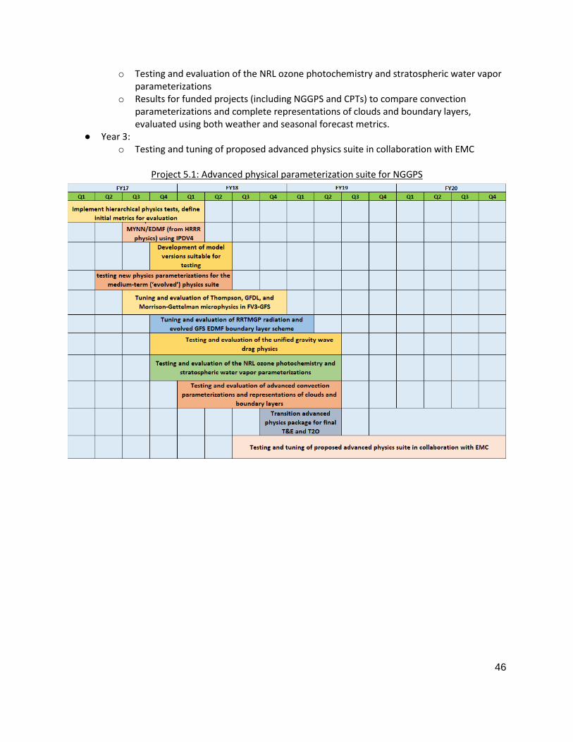
46
o Testing and evaluation of the NRL ozone photochemistry and stratospheric water vapor parameterizations
o Results for funded projects (including NGGPS and CPTs) to compare convection parameterizations and complete representations of clouds and boundary layers, evaluated using both weather and seasonal forecast metrics.
● Year 3: o Testing and tuning of proposed advanced physics suite in collaboration with EMC
Project 5.1: Advanced physical parameterization suite for NGGPS

47
Project 5.2: Establishment of unified metrics covering synoptic to seasonal time scales
Project overview: A key element of the NGGPS/NCEP vision is development of a unified modeling framework for all forecast scales (temporal and spatial) from high-resolution short-range regional to low-resolution long-range seasonal predictions. Here we focus on the more limited goal of a single global model that can be used for weather and, in ocean-coupled mode, for sub-seasonal and seasonal forecasting. To develop such a model and assess whether potential improvements are ready for operational implementation, we need a unified suite of metrics that covers all these scales. Here ‘metrics’ mean a small set of quantitative measures that can be reliably computed from observational analyses and which together encompass key aspects of the global model forecast performance. The metrics should be displayable in a simple ‘dashboard’ format that can easily be compared with other model versions including the baseline, and an attempt should be made to combine the metrics into one or two overall combined skill scores that summarize the overall model performance integrated over all the relevant forecast timescales. (POCs: Jack Kain/Jason Levit; EMC)
Unified model development will thrive only with an appropriate set of unified meso-synoptic-seasonal forecast metrics that reward model developments that improve performance across this entire range of timescales. Thus, an accelerated effort to define and implement unified metrics need to be a high priority for NGGPS and NCEP.
(1) A committee of EMC and external community members should be convened to propose a set of metrics and possible ways of combining them into a dashboard format and a summary skill score. This could be organized through the SIP WGs, but needs to have the full experience and buy-in of NCEP to be successful. The development of seasonal forecast metrics involves specification of a ‘test harness’ of seasonal ocean-coupled hindcasts from which metrics (e. g. NINO3.4 SST anomaly, mean SST drift during months 1-3, CONUS T and precipitation anomalies) can be extracted, and should involve ensemble forecasts. A simple seasonal test harness was developed for CFSv2 by EMC that could serve as a prototype.
(2) The metrics approach must be implemented at NCEP and the GMTB so that the metrics are computed as a routine step in model development, and broadly shared across the NGGPS development community as a web page or similar format
(3) A key aspect is how to weight weather and seasonal forecast metrics to make an overall judgement as to whether a new model version should be adopted. Without an objective approach to this, it will be very hard for the outside community to contribute to a model development process that they do not ‘own’. This will surely require experience with the new metrics suite and an iterative approach to refine to everyone’s satisfaction.
Major Risks and Issues: ● Achieving consensus on a computationally reasonable seasonal ‘test harness’ that can be run at
GMTB and on a small set of summary metrics may not be easy. ● There is a risk that the unified metrics will be ignored in favor of ‘business as usual’ in which the
current weather forecast metrics are the sole basis for decisions about operationalizing new model versions.
● End-to-end workflow, coupled model, and relevant datasets need to be available outside of NOAA firewall or community involvement will be compromised.
● Need strong connection to Verification WG, with possible use of MET (or MET+) based software.
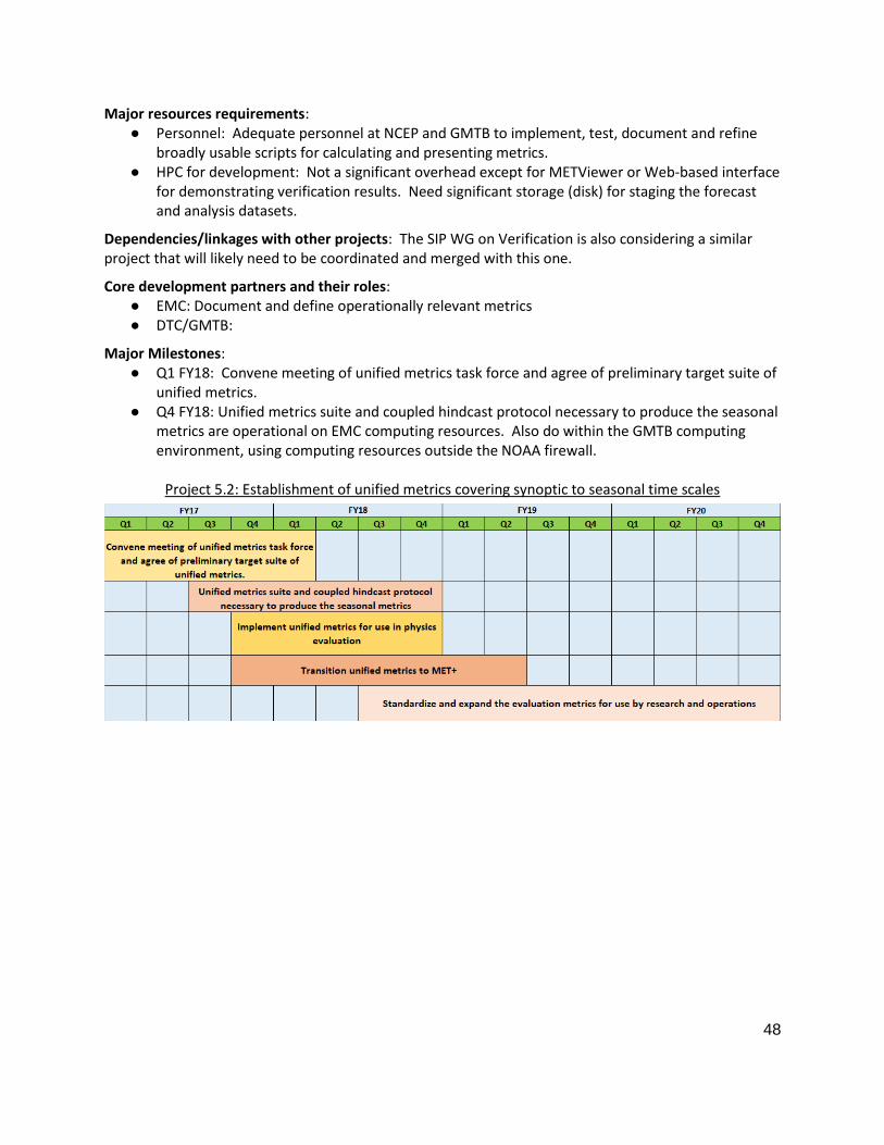
48
Major resources requirements: ● Personnel: Adequate personnel at NCEP and GMTB to implement, test, document and refine
broadly usable scripts for calculating and presenting metrics. ● HPC for development: Not a significant overhead except for METViewer or Web-based interface
for demonstrating verification results. Need significant storage (disk) for staging the forecast and analysis datasets.
Dependencies/linkages with other projects: The SIP WG on Verification is also considering a similar project that will likely need to be coordinated and merged with this one.
Core development partners and their roles: ● EMC: Document and define operationally relevant metrics ● DTC/GMTB:
Major Milestones: ● Q1 FY18: Convene meeting of unified metrics task force and agree of preliminary target suite of
unified metrics. ● Q4 FY18: Unified metrics suite and coupled hindcast protocol necessary to produce the seasonal
metrics are operational on EMC computing resources. Also do within the GMTB computing environment, using computing resources outside the NOAA firewall.
Project 5.2: Establishment of unified metrics covering synoptic to seasonal time scales

49
Project 5.3: Collaborative framework for developing physical parameterizations
Project overview: Participants of the November 2016 NGGPS Physics workshop identified the need for putting in place an effective collaborative framework for physics development (link to workshop report). A key element of this framework is a community library of parameterizations (the Common Community Physics Package, or CCPP) with clearly defined interfaces for facilitating its use by the general community. A second key element is an Interoperable Physics Driver to connect the CCPP-compliant parameterizations to any model, therefore enabling a large number of scientist and institutions to run experiments with the same physics suites.
With NGGPS funding, GMTB (in collaboration with EMC and GFDL) has completed the development of the IPD (IPDv4 with an extension for CCPP use) and connected it to FV3 and to the GMTB single-column model. This project aims at continuing development of the CCPP so that it contains the current operational GFS physics, the candidates for the advanced physics suite, and new physics developments to be used in future operational implementations. GMTB is already funded to write caps to make the parameterizations of the GFS suite become compliant with the IPD and CCPP architectures. Non-GMTB community collaborators have committed funds to make additional parameterizations CCPP-compliant for conducting experiments. The long-term vision is that the CCPP ecosystem will support many levels of engagement: users, developers, core partners, and operations.
To provide CCPP-compliant physics, the task of providing caps is primarily one of making explicit lists of all the physics arguments that are passed to and from the atmosphere driver and among the physics schemes. These lists would be table-like text files documenting the names, meanings and units of the variables. The purpose of the CCPP layer is to be a pass-through layer that can use these lists to generate calls to the physics during the running of the Atmosphere Driver (e.g. FV3) and that does no conversions or functions of its own. Given the CCPP-specific lists (that depend on the physics suite), the linking of an Atmosphere Driver to the CCPP will be one of filling the necessary inputs and processing the outputs in a way that the atmospheric model requires. This matching of variables would occur in a specific Atmosphere Driver cap that calls the CCPP layer. Having individual caps for each parameterization, instead of calling groups of parameterizations together, will enable the ability of switching an individual scheme (e.g., the deep convection scheme), therefore enabling tests to be conducted.
In addition to the development of software, documentation, and training for the CCPP, this project also aims at the establishment of the CCPP governance. It is envisioned that there will be a small set of CCPP suites and parameterizations that will be supported to the general community, namely the operational suite and candidates for advancements. It is important to control the number of parameterizations in the supported CCPP such as not to overburden the CCPP users and funding agencies. Therefore, a governance structure must be established to determine programmatic, scientific, and technical criteria for inclusion in the supported CCPP. It is also anticipated that there will be parameterizations that are CCPP-compliant but not supported, for example those that are under development and testing by the general community.
Major Risks and Issues: ● The target to have GFS Physics in the CCPP is the end of calendar year 2017. As it is currently
under development, the CCPP may not be fully functional in 2017 for conducting tests. If that is the case, tests should be conducted outside of the CCPP framework while its development progresses. This is being mitigated by focusing GMTB work on CCPP development.
● CCPP could be developed but not adopted by EMC due to perceived overhead of using a more general code whose functionality extends beyond FV3. This is being addressed by frequent

50
meetings and exchange of planning information and materials between the core group (GMTB and EMC), as well as with a larger community (NUOPC Physics Interoperability Team and EMC SIP Physics Team).
Major resources requirements: ● Personnel: Adequate personnel at GMTB to document and train the community in the use of
CCPP, as well as to make the GFS Physics CCPP-compliant (already funded). ● HPC: TBD
Dependencies/linkages with other projects: ● Software Architecture Working Group: also considering physics-dynamics interface
● Verification Working Group: involved in development of metrics for inclusion in the CCPP
Core development partners and their roles: ● GMTB: Write caps so GFS Physics is CCPP compliant; document and train in CCPP protocols. ● EMC: Participate in CCPP Governance and use. ● Physics scientists: Contribute CCPP-compliant cap for parameterizations that are candidate for
operationalization
Major Milestones: ● Q1 FY18: Initial CCPP capability working in FV3 with GFS operational Physics ● Q2 FY18: Candidates to the advanced physics suite made CCPP-compliant. CCPP governance in
place for assessment of which suites will become part of the supported physics package. ● Q3 FY18: Established process for adding parameterizations to supported CCPP and for NCEP to
utilize CCPP as a source for innovations in physics.
Project 5.3: Collaborative framework for developing physical parameterizations

51
ANNEX 6: DATA ASSIMILATION
The NCAR/JCSDA ‘Blueprints for Data Assimilation Workshop’ in 2016 identified the following grand science challenges:
● Coupled data assimilation across the Earth System. ● Multi-scale data assimilation across temporal and spatial scales, from global to convective. ● Dealing with massive increases in the volume of obs, particularly all-sky radiances and radar. ● Representation of model uncertainty in ensemble systems. ● Dealing with non-linearity and non-Gaussianity in background and observation errors.
Efficiently transitioning research to address these challenges into operations requires a new object-oriented software framework that facilitates ‘separation of concerns’1 and enables efficient collaboration. The ‘Joint Effort for Data Assimilation Integration’ (JEDI) project was initiated to develop this framework. A planning meeting was held in April 2017 to discuss the scope, priorities and requirements for JEDI. The initial milestones will focus on development of a Unified Forward Operator (UFO) library, and Interface for Observational Data Access (IODA), and implementation of these capabilities into the operational FV3-based atmospheric global data assimilation system. The first step for each of these milestones is to define high-level abstract interfaces between the components of the system (such as the UFO, IODA and the data assimilation solver). Once these interfaces have been defined, existing codes will be adapted to use these interfaces. The ultimate goal is to develop a community-oriented development model whereby contributions from the research community addressing the grand science challenges can be efficiently implemented and tested, and if the results warrant, transitioned into the operational system.
The projects listed below focus on the development of the JEDI framework. JEDI is enabling technology that will allow the operational and research community to work together on addressing the long-term grand science challenges, but also will facilitate addressing more immediate operational challenges including (see NGGPS DA plan for details).
● Improvement of forward models (including cloudy radiances and the development of operators for new instruments), GPS-RO operators, radar reflectivity and Doppler winds.
● Improvements to quality control and monitoring. ● Improvements in observation error representation (including the effects of correlated
observation error and errors of representivity). ● Improvements in background-error modelling (including the treatment of sampling error in the
estimation of ensemble-based covariances, i.e. localization). ● Data assimilation for the coupled state (land/ocean/atmosphere/chemistry/aerosols/sea ice). ● Improvements in observation and background bias correction techniques. ● Improvements to observation impact estimation techniques (e.g. EFSOI). ● Code optimization and improvements in scaling. ● Improved representation of model uncertainty in ensemble background forecasts.
A detailed transition plan from the current GSI-based operational data assimilation system to a JEDI-based system is needed by Q1FY18 (see project 3 below).
1 In a well-designed architecture, teams can develop different aspects in parallel without interfering with
other teams work and without breaking the components they are not working on. Scientists can be more efficient focusing on their area of expertise without having to understand everything at once.

52
Project 6.1: JEDI Unified Forward Operator (UFO)
Project overview: Observation operators (a.k.a. forward operators) simulate what an observation should be given a known state of a system. They comprise two steps: an interpolation of the state values to the location of the observation and then the simulation of the observed quantity from those interpolated model variables. The first part (interpolation) is model dependent but the second is not. The goal of this task is to isolate the two aspects so that the scientific part of the observation operators can be shared between models.
Major Risks and Issues: ● Observation operators are an area where many years of experience have accumulated in
existing codes. Care will be taken not to lose existing knowledge or capability.
Major resources requirements: ● Personnel: 5 FTE
● HPC for development: access to multiple platforms for testing
Dependencies/linkages with other projects: ● Require access to GSI and FV3 source codes and test cases
Core development partners and their roles: ● JCSDA, OAR/ESRL, NASA/GMAO, NRL
Major Milestones: ● Q1FY18: Encapsulated interpolations from FV3 cube-sphere grid to observation locations ● Q1FY18: Fully encapsulated observation operators (from GSI) for two observation types (no
quality control or bias correction) ● Q2-Q4FY18: Add quality control and bias correction
● Q4FY18: Optimized interpolations ● Q4FY18: Integrate science advances in forward operators, including improvements to the CRTM
and for all-sky/all-surface radiance assimilation
● Q2FY19: Add all operational GDAS observations types and integrate into FV3/GDAS suite
● FY19: Extend to other Earth-system components
Dependencies/linkages with other projects: ● The implementation of a FV3-based 4D-EnVar atmospheric data assimilation system is ongoing
and included under ANNEX 1 (NGGPS GLOBAL MODEL SUITES PLANNED FOR NCEP/EMC OPERATIONS). This includes the implementation of the JEDI forward operator library in the operational FV3 GDAS in Q2FY19.
● Annex 13 (Verification) requires the use of the UFO for observation-space verification. ● Annexes 4, 8, 9 and 10: UFO must be flexible enough to deal with observation operators that
span coupled state components, including radar operators, aerosol and chemistry operators, as well ocean, land, hydrology, space-weather, sea-ice and wave observation operators.

53
Project 6.2: JEDI Interface for Observation Data Access (IODA)
Project overview: The goal of the project is to create unified high level interfaces to access observation-related data so that scientific code can be written independently of data structures and technology used for the actual data handling. The benefits are that scientist can focus on scientific aspects of the code, while software specialists can develop appropriate solution for data handling. This is especially important at a time when computer technology might change rapidly and achieving good scalability might require changes in data handling solutions.
Major Risks and Issues: ● Complexity and variety of observation types used in modern DA systems
Major resources requirements: ● Personnel: 1-2 FTE
● HPC for development: access to multiple platforms for testing
Dependencies/linkages with other projects: ● Observation pre-processing should be adapted to generate data in a IODA compatible format ● Downstream applications should be adapted to access data through IODA interfaces
Core development partners and their roles: ● JCSDA, NASA/GMAO, NRL, OAR/ESRL, NWS/EMC
Major Milestones: ● Implement preliminary IODA-0 (NetCDF) optional output in GSI: Q4FY17
● Implement options for GSI to start from IODA-0 format: Q2FY18
● Based on preliminary implementation and review of other existing solutions, design format-independent interface for observation data access (IODA-1): FY18
● Implement IODA-1 format independent interface in UFO and provide one concrete IODA-1 implementation: FY19
● Optimize IODA implementation: FY20
Dependencies/linkages with other projects: ● Annex 13 (Verification) requires IODA to obtain observations for observation space verification. ● Annexes 4, 8, 9 and 10: IODA must be flexible enough to handle high-density radar
observations, aerosol and chemistry observations, as well as ocean, land, hydrology, space-weather, sea-ice and wave observations.
54
Project 6.3: JEDI Data Assimilation System
Project overview: All data assimilation algorithms will be written in model independent object-oriented framework, using the UFO interfaces and similar abstract interfaces developed for other model-dependent components of the data assimilation system.
Major Risks and Issues: ● Depends on successful UFO implementation. Other components of the data assimilation system
are comparatively easier to interface and carry less risk. ● Computational efficiency will be a constant topic of attention throughout the project
Major resources requirements: ● Personnel: 1-2 FTE
● HPC for development: access to multiple platforms for testing
Dependencies/linkages with other projects: ● Relies on UFO implementation
Core development partners and their roles: ● JCSDA: ● NOAA/ESRL:
Major Milestones: ● Definition of abstract interfaces required for variational and ensemble DA algorithms: Q1-
Q3FY18
● A detailed plan for transitioning the operational GSI-based atmospheric DA system to the JEDI framework: Q1FY18.
● Implementation of abstract interfaces for non-UFO components of the DA system: Q2FY18-Q2FY19
● Capability to produce operational analyses within operational constraints: Q4FY19
Dependencies/linkages with other projects: ● Annex 3 (Infrastructure) - a community accessible code repository and flexible workflow that
can execute JEDI-based applications in cycling DA mode. ● Annex 2 (System Architecture) - the ability to advance forecast models from within JEDI is
needed. ● Annex 4 (Dynamics and nesting) - the capability to calculate analysis increments on variable-
resolution meshes and/or nested domains within JEDI is needed. Higher-cadence assimilation and incremental analysis update capabilities are needed for space weather applications.
● Annex 5 (Physics) - stochastic physics schemes that can represent uncertainty are needed for accurate background-error covariance estimates in JEDI-based ensemble DA solvers.
● Annex 8 (Marine Models - DA for coupled atmosphere/ocean/wave states is needed
● Annex 11 (Ensembles) - Ensemble DA solvers in JEDI are needed to initialize ensemble forecasts. ● Annex 7 (Convective Allowing Models/CAMs) - the capability to calculate analysis increments on
variable-resolution meshes and/or nested domains on a rapid cadence is needed within JEDI. Multi-scale localization methods for dealing with sampling errors on convective and global scales is needed for initializing CAMs on continental and larger scale domains.
● Annex 10 (Aerosols) - DA for coupled atmosphere/chemistry/aerosol states is needed.
55
Project 6.4: 3D Rapid Updating RTMA/URMA Systems
Project overview: This project is a collaborative effort among scientists from ESRL/GSD, NCEP/EMC, JCSDA, and NSSL, who will extend the existing 2-D Real-Time Mesoscale Analysis (RTMA) and UnRestricted Mesoscale Analysis (URMA) to three dimensions, assimilate in-situ and remote observations from a variety of platforms with a high-resolution very-short- range model background, and synthesize the output to produce new 3-D analysis products with a short latency and very frequent sub-hourly updates. Furthermore, this project is intended to facilitate the unification of NOAA nowcasting capabilities to meet needs for situational awareness information and forecast verification.
The sub-hourly 3D RTMA/URMA system will build upon the operational 2D, hourly RTMA/URMA system, which is currently limited to fields that correspond to official National Weather Service (NWS) gridded forecasts, mostly surface fields. Extending the 2D hourly RTMA/URMA to three dimensions allows for the creation of highly useful nowcasting products, including full-column representation of standard meteorological fields such as temperature, water vapor, and wind, as well as hydrometeors (i.e., clouds, precipitation of all forms), and eventually aerosols. The 3D system will also include 2-D land-surface diagnostics (e.g., soil moisture, snow state from multi-level land-surface fields), and convective (e.g., hail size, supercell rotation tracks) fields, developed through collaboration with the Office of Water Prediction (OWP) and National Severe Storms Laboratory (NSSL), respectively. This effort will also lead to improved analysis fields that will benefit NOAA’s National Blend of Models (NBM) project.
As a pathway to the 3D system, this effort will focus initially on improvements to the 2D RTMA/URMA system in Year 1 to meet outstanding issues in support of the NBM. Such advancements will also benefit the 3D system. The 3D RTMA/URMA and near-term 2D RTMA/URMA enhancement are critical for quality of NOAA’s National Blend of Models (NBM).
Major Risks and Issues: ● HPC priority for fast, low latency turn-around for real time products ● Science issues with model errors and limited observational network may limit quality of 3-D
analysis, potentially limiting usefulness ● Governance/oversight for effective unification of a variety of products
Major resources requirements: ● Personnel: EMC (9 FTE); ESRL (3 FTE) ● HPC for development: 500K CPU hours/month on WCOSS, Theia, and Jet; 50 TB scratch space
and 500 TB HPSS storage prior to implementation
Dependencies/linkages with other projects: ● National Blend of Models (NBM) ● NCEP/AWC Ceiling & Visibility Project and Helicopter Emergency Medical Services ● Observation Processing
● An available convection-allowing ensemble for DA (Annex 7) ● An available convection-allowing model for background (Annex 7) ● Satisfactory evaluations from stakeholders and partners
o e.g., SPC, AWC, WPC - Evaluation of severe weather, aviation, precipitation fields, respectively. Assist in product development. SPC efforts will include intercomparison of the 3D RTMA with its Mesoscale Analysis.
● Unified Workflow (CROW) ● Transition to VLab and Code Management/Governance
● JEDI (JEDI is part of the Q2FY19 milestone for FV3-GDAS in Annex 1.)

56
Core development partners and their roles: ● EMC: DA, workflow, obs processing, QC, background errors, implementations ● ESRL/GSD: DA, QC, background errors
Major Milestones: ● Q1FY18-Q4FY18: Continue introducing enhancements to existing 2D RTMA/URMA via
improvements in quality control, specification of background errors, etc. ● Q1FY18-Q3FY19: Initial operating capacity of 3D RTMA/URMA with sub-hourly updates over
CONUS. Run in experimental mode and compare against existing RTMA/URMA. ● Q3FY18-Q3FY19: Extend 3D RTMA/URMA to Alaska and test/evaluate. ● Q3FY18-Q1FY20: Pursuant to comparable or better performance relative to existing 2D
RTMA/URMA, consider implementing 3D RTMA/URMA system(s). ● Q4FY19-Q4FY20: Test and evaluate available convection-allowing ensemble from Annex 7 in
hybrid 3D RTMA/URMA analysis. ● FY21+: Pursuant to satisfactory evaluation, consider implementation of hybrid EnVar 3D
RTMA/URMA system(s) into operations.
Project 6.4: 3D Rapid Updating RTMA/URMA Systems (FY18-20)

57
ANNEX 7: CONVECTION-ALLOWING MODELS (CAM)
This Annex lays out the broad program deliverables and schedule for replacement of NCEP's myriad mesoscale modeling systems with new systems based on the FV3 dynamic core. The current NCEP mesoscale modeling suite currently consists of the following components:
● North American Mesoscale (NAM) system: NAM runs on the Non-hydrostatic Multiscale Model on B-Grid (NMMB). The NAM consists of a North American 12 km parent domain run to 3.5 days and 4 non-moving nests run to 2.5 days at 3 km resolution over the CONUS, Alaska, Puerto Rico, and Hawaii. A “placeable” nest at 1.5 km resolution is run inside the 3 km CONUS/Alaska nests primarily for Fire Weather support runs to 36-h.
● High-Resolution Window (HiResW): As of September 2017, the HiResW system will consist of ~ 3km runs of the NMMB model and two configurations of the ARW model over the CONUS, Alaska, Hawaii, and Puerto Rico.
● High-Resolution Ensemble Forecast (HREF) system: Current and time-lagged HiResW and NAM CONUS nests run to generate ensemble products. As of Sep 2017, version 2 of the HREF (HREFv2) will be an 8-member ensemble for CONUS, and also will be run over Alaska, Hawaii, and Puerto Rico as a purely HiResW 6-member ensemble. Continued development of this system and its possible replacement will be discussed in project #2 of this Annex.
● Short-range Ensemble Forecast (SREF) system: runs at 16 km over North America, currently consists of 26 members (13 NMMB, 13 ARW) with physics/initial condition diversity. The replacement of the SREF and deterministic NAM systems will be based on whether they can be replaced by improved forecast guidance from the FV3-GFS and FV3-GEFS.
● Rapid Refresh (RAP) and High-Resolution Rapid Refresh (HRRR): The RAP and HRRR are run hourly out to 21-hr and 18-hr, respectively. RAP is run at 13-km resolution over North America (identical to the NAM parent domain), while HRRR is run at 3-km over CONUS. For the planned upgrade to the RAPv4/HRRRv3 in Feb 2018, the 00/06/12/18z HRRR cycles will be extended to 36-hr, and the 03/09/15/21z RAP cycles will be extended to 39-hr. A HRRR-Alaska system will also be added. Future plans for this system and a potential transition to a storm-scale ensemble during the next three years will be discussed in project #3 of this Annex.
The HRRRv3 replacement will focus on short-range prediction during the first day. These "day 1" CAM ensembles use sophisticated (and somewhat expensive) data assimilation techniques like CAM ensemble Kalman Filters that utilize frequently-updating, high-resolution radar and satellite observations. The impact of assimilating these data sets may only last 6-12 h, but they are important for several sectors of the US NWP enterprise, particularly in the aviation and severe weather communities (esp. Warn-on-forecast) and by the WPC metwatch desk. Some customers require high-frequency output (<=15 min) with hourly-updated cycled forecasts, which are most efficiently met by a limited-area stand-alone regional system.
The replacement of HREFv2 will focus on shorter-range prediction on days two and three. These "days 2-3" CAM ensembles have O(10) members that must spin-up smaller-scales of motion in the first 6-12 hrs due to their lack of 3-km cycling or data assimilation. Their emphasis is on providing guidance beyond 9 hrs out as far as 72 hrs, where frequent-updating becomes far less significant due to the characteristic drop off in NWP skill with forecast range and the loss in retention of smaller-scale information from the observations. Two-to-four runs per day of the “days 2-3” CAM ensembles would meet many community applications, such as severe weather, winter weather, and flash flood forecasts.

58
Future upgrades to regional systems currently assume a nominal two-year date of completion beyond the previous implementation, which means that the replacement for HREFv2 is tentatively planned for Q4FY19 and the replacement for RAPv4/HRRRv3 (name TBD) is tentatively planned for Q2FY20. The replacement for RAPv4/HRRRv3 will be an hourly updated CAM ensemble initialized using storm-scale ensemble data assimilation and run out to forecast ranges no greater than 18 h in support of aviation applications, the Real-Time Mesoscale Analysis and Unrestricted Mesoscale Analysis (RTMA/URMA), and future Warn-on-Forecast (WoF) applications. The replacement for HREFv2 will be a regional CAM ensemble system run every once 6 to 12 h, providing forecasts out as long as 72 h in support of high-impact weather outlooks and situational awareness over CONUS and Alaska. These two major systems will serve as the backbone for regional forecast guidance entering the next decade, as represented by the three projects in this Annex. The forecast length for the replacement of the RAPv4/HRRRv3 will be determined by when it becomes less skillful (in a probabilistic sense) compared to the replacement of the HREFv2. Project #1 will focus on the construction of a regional FV3-based modeling system as a functional replacement for the operational NAM, and it will also serve as a component for a candidate FV3-based regional ensemble to be developed and tested in Project #2. Project #2 will do research and development (R&D) of the next regional ensemble system to replace HREFv2 (and likely the SREF too), in which several possible configurations will be evaluated. Project #3 will develop the next storm-scale ensemble system to replace RAPv4/HRRRv3. Project #4 focuses R&D beyond the 3-year horizon. Each of these projects will proceed in parallel with each other, and common to all of them is a shift in R&D around the FV3 dynamical core, with EMC, ESRL, GFDL, and NSSL working more closely work together to develop a unified modeling system. The decisions to implement these R&D systems into operations will be based on whether they meet the following factors.
● Do they outperform current operational products and provide improved forecast guidance?
● Are they affordable and can they be implemented from available HPC resources? If they are more expensive, are the forecast benefit(s) worth the added cost?
● Can the forecast products meet operational delivery times? The determination of forecast improvements is itself an enormous effort that will involve objective verification statistics, and for the ensemble systems in projects #2 and #3 that includes, probabilistic verification statistics, as well as evaluation of novel probabilistic methods being developed between the OAR labs, NCAR, and EMC. Table 1 summarizes the verification metrics needed to make evidence-based decisions. It will require close collaboration with the Verification group (Annex #13). The MET verification system will serve as a common tool used by various groups. At the same time, experimental forecasts from each of the systems will also be evaluated through forecaster feedback in the various NCEP testbeds, EMC MEG reviews, and MEG-STI activities centered around these CAM systems through collaborations with several NCEP service centers (including EMC), NWS offices, and the model development groups at GFDL, ESRL, NSSL. The NCEP testbeds include the Hazardous Weather Testbed (HWT) during the SPC/NSSL Spring Experiment, the Flash Flood and Intense Rainfall (FFaiR) experiment at WPC, the Winter Weather Experiment (WWE) at WPC, and the Aviation Weather Testbed (AWT) at AWC.
Table 1. CAM verification metrics ● Aspects unique to convection
○ Surrogate severe - use updraft helicity (UH) and vorticity (low-level rotation) vs. observed storm reports
○ Ability to capture convective initiation, evolution, and mode; systematic biases in

59
intensity/coverage, timing and location errors ● Other high-impact weather events
○ Winter weather - precipitation type, snowfall amounts and intensity ○ Excessive rainfall - short-term flash flood guidance, excessive rainfall outlooks
● Objective verification ○ Upper-air verification of standard meteorological fields against raobs, aircraft ○ Low-level T, Td, winds, shear (applicable to all seasons); CAPE (warm season) ○ Precipitation - use FSS or other scale-dependent measure ○ Reflectivity - use Fractional Skill Score (FSS) or other scale-dependent measures ○ Identify appropriate scales on which to verify neighborhood methods for precipitation and
reflectivity ○ Cloud ceiling heights and cloud amounts, and other aviation-related fields verified against
satellite observations and RTMA/URMA. ● Summarize all of the information, as well as computational resource requirements, into a
consolidated scorecard.
A detailed timeline for the first three projects in the FY16-20 time frame is provided in the following Gantt chart followed by individual CAM project descriptions.

60
Project 7.1: FV3-based Regional/Mesoscale Forecast System (FV3-Regional)
Project overview: The NGGPS mission and objectives include NOAA/NWS/NCEP being the world's best and most trusted provider of deterministic and probabilistic forecast guidance across all spatial and temporal scales. As part of the NWS commitment to move towards a National Unified Modeling System, NCEP's Regional/Mesoscale Modeling Suite will transition to use a high-resolution version of the FV3 dynamic core, both for the modeling and data assimilation components (FV3-Regional DA). The precise configuration of the regional/mesoscale system using FV3 is still under consideration. As of this writing, a regional “standalone” system using FV3 does not exist and will be developed by EMC, GSD and GFDL scientists. In addition, NSSL and SPC will compare performance of global FV3/3 km CONUS nest to emerging stand-alone regional FV3 in daily real-time forecasts to ensure internal consistency. The milestones and decision points for the way forward are presented below. The goal of the project is for the FV3-Regional system to provide high-resolution deterministic and ensemble guidance at convective-allowing scales. To properly service the customers, the forecasts must be available reliably and at the appropriate time within available resources.
Major Risks and Issues: ● Computational resources dedicated for model development and for operations ● Documentation, training, code management and access of codes by core partners and
community
● Demonstration of superior performance of FV3-Meso from scientific evaluation
● Alignment with Unified Model Development strategy
Major resources requirements: ● Personnel:
o EMC: 9 FTE (FV3-Meso Model Development (nesting), physics, DA) o ESRL (3 FTE); GFDL (2 FTE); NSSL (2 FTE)
● HPC for development: ~40M CPU hours per month on WCOSS, Theia, Jet and Gaea; ~1000 TB scratch space and ~6 PB HPSS storage prior to implementation
Dependencies/linkages with other projects: ● NEMS/ESMF framework advancements ● Regional DA, ESRL/PSD DA integration
● Availability of EMC and ESRL/GSD mesoscale physics for use with FV3 dynamics ● NSSL/SPC forecaster assessment of performance
● MET based verification and validation
● Refactored NCEP POST (UPP) and product generation
● Unified Workflow
● Transition to VLab and Code Management/Governance
Core development partners and their roles: ● NCEP/EMC: Model development (including physics and data assimilation), integration into NEMS
framework and unified workflow, code management, retrospective and real-time experiments, testing and evaluation, transition to operations
● ESRL/GSD: Model development including physics and DA; retrospective and real-time experiments, testing and evaluation NSSL and SPC: Daily real-time forecasting and evaluation based on applications for severe-weather prediction at SPC and elsewhere
● GFDL: Utilities for FV3 Grid Structure and I/O; Model diagnostics and troubleshooting; NEMS Integration Support; Documentation and Training; Advanced physics connections to IPDv4

61
● ESRL/PSD and JCSDA: DA development support
Research and Development (R&D)/Testing and Evaluation (T&E) Milestones: ● Q2FY17 - Q1FY18: In the absence of a regional FV3 system, begin test runs with a global FV3
with a 3 km CONUS nest on a stretched cube using GFS physics. Build preliminary graphics tools to examine output on the stretched cube.
● Q4FY17- Q4FY18: Assemble tools for pre-processing and post-processing; develop libraries and utilities; when capability is available, begin tests with multiple nests on a cube face
● Q1FY18: Begin testing with a regional “standalone” limited area FV3 domain at convective-allowing model (CAM) resolution of ~3 km, develop utilities for initial/boundary condition generation; begin assessment on suitability of regional high-resolution FV3 versus a high-resolution nest inside a global FV3 parent
● Begin real-time forecast and evaluation exercises at NSSL and SPC
● Q1FY18 - Q4FY18: Begin porting/testing of advanced physics in the regional FV3 nests ● Q2FY18 - Q2FY19: Begin sensitivity tests of different advanced physics packages in a CAM
resolution FV3 static (non-moving) nest under three different configurations: 1) Regional FV3 parent with CAM resolution nests 2) Global FV3 parent with CAM resolution nests 3) “Standalone” CAM resolution nests with no FV3 parent; boundary conditions from GFS
● Q2FY19: Based on tests of different FV3-Regional configurations in Q3FY18, make decision on which configuration gives the best results and optimizes HPC resources.
● Begin systematic comparisons of global and stand-alone regional configurations at NSSL and SPC to ensure consistency in model behavior

62
Project 7.2: FV3-based Regional Ensemble Forecast System (REFS)
Project overview: Another aspect of the National Unified Modeling System is to potentially replace NCEP's Regional/Mesoscale Modeling Suite with regional ensemble-based systems that provide probabilistic guidance. During the FY18-20 period, two possible configurations of a “days 2-3” CAM ensemble will be considered to replace the HREFv2, which will serve as the operational baseline. The regional ensemble is anticipated to include roughly 10 (or so) members run at 3-km horizontal resolution with hourly output out to as far as 72 h over CONUS and Alaska either four times per day (00Z, 06Z, 12Z, & 18Z), or if compute resources are limited a continuation of alternating runs over CONUS (00Z, 12Z cycles) and Alaska (06Z, 18Z) as with the HREFv2.
A potential alternative to providing days 2-3 forecast guidance with a REFS may be to provide guidance instead from a higher-resolution global ensemble (see Annex 11, Ensembles, project 2). Ideally, prototypes of both higher-resolution global ensembles and a REFS will be developed, and the ultimate decisions about which will be deployed will be based on an intercomparison.
The first configuration will test whether to continue to run different model cores and different operational physics packages as with the current HREFv2, which was found to perform well in the HWT Community-Leveraged Unified Ensemble (CLUE). Plans will include one or more FV3-based CAM runs, adding extended runs of the HRRR (e.g. every 6 h), increasing the number of members, and keeping only the best performing configurations.
The second configuration will test using the regional nesting capability within FV3, possibly coupled with the FV3-GEFS under a unified framework. If insufficient resources are available or delivery times are delayed, then another option will test regional FV3 nests within coarser-resolution global runs. Initial condition perturbations will be provided from the FV3-GEFS and (if available) from an FV3-based regional EnKF data assimilation system. Multiple stochastic physics methods (STTP, SKEB, etc.), random perturbations in the land surface states (soil moisture and temperature), and (possibly) multiple physics options will be evaluated. This part of the project will collaborate closely with the FV3- GEFS.
Testing and evaluation of these two configurations alongside a prototype of a higher resolution prototype global ensemble system will involve collaborations with the FV3-regional project, the Ensembles team (see Annex 11), OAR partners, and other members of the Meso/CAM SIP WG. Ensemble-based post processing methods will continue to be developed and evaluated within both configurations. Extensive probabilistic-based verification statistics will be used to provide the evidence needed to decide which CAM or global ensemble configuration performs the best for the available HPC resources, along with forecaster evaluations through the NCEP testbeds, EMC MEG, and the MEG-STI CAM team. The final configuration must also provide forecast improvements over HREFv2. Additional domains over Hawaii and Puerto Rico were not considered in the current plan.
Major Risks and Issues: ● Computational resources dedicated for model development and for operations ● Successful development of FV3-GFS, FV3-CAM and FV3-NCEP Post ● Performances (to outperform SREF and HREF) ● Insufficient development and test resources to support the simultaneous co-development of
both regional and global ensemble systems.
Major resources requirements: ● Personnel:
○ EMC (3.0 FTE): Ensemble configuration and testing, ensemble product, evaluation and transition to operation

63
○ ESRL/GSD (1 FTE); ESRL/PSD (TBD); GFDL (TBD) ● HPC for development: ~150 nodes per member on WCOSS-Cray
Dependencies/linkages with other projects: ● FV3-GFS/GEFS (Annex 11) and other FV3-regional projects ● ESRL/PSD stochastic parameterization methods to treat model uncertainty. ● Advanced Physics options recommended by SIP Physics Working Group (?) ● MET based verification and validation; process-oriented metrics for ensemble evaluation
● NCEP Unified Post Processor (UPP) and product generator ● Unified Workflow
● Transition to VLab and Code Management
Core development partners and their roles: ● NCEP/EMC: Ensemble Model development and testing (IC, physics and possibly land surface
perturbations) , ensemble products, ensemble evaluation, and transition to operation
● ESRL/GSD: Model development including physics; ensemble products and evaluation, retrospective experiments, testing and evaluation
● GFDL: Providing necessary technical support ● ESRL/PSD: Development of stochastic parameterization methods, testing of global ensemble
predictions. ● NSSL and SPC: Evaluation in severe-weather forecasting applications, including real-time
operations and the Spring Forecasting Experiment ● WPC: Evaluation in Winter Weather and Flash Flood experiments ● AWC: Evaluation in winter and summer aviation testbeds
Major Milestones: ● Q3-Q4 FY18: Build a beta version of the regional FV3 ensemble (second configuration), include
one or more regional FV3 runs in the multi-core ensemble (first configuration). ● Q4FY18-Q2FY19. Evaluate the forecast performance of the two configurations to determine the
most skillful system. ● Q2-Q4FY19: Provide forecasts from the most skillful configuration for evaluation by various
NCEP testbeds, such as WPC’s Winter Weather and Flash Flood experiments, SPC’s Spring Experiment, and AWC’s winter and summer aviation experiments.

64
Project 7.3: FV3-based Regional Hourly Updated Storm-scale Ensemble Data Assimilation and Forecast System
Project overview: During FY18-20, an hourly-updating HRRR (WRF-ARW) 3-km ensemble will be tested using storm-scale ensemble data assimilation. Cycling of O(40) CAM members using a GSI-based Ensemble Kalman filter will assimilate conventional, radar, satellite and other observations each hour. A nine-member HRRR ensemble will produce 18-h “day 1” forecasts over CONUS. Multiple stochastic physics methods (STTP, SKEB, etc.), random perturbations in the land surface states (soil moisture and temperature), lateral boundary perturbations and inflation during the cycled data assimilation will promote spread and represent both initial condition and model forecast uncertainties. A RAPv5 deterministic mesoscale system will serve to provide periodic re-centering to the hourly-cycling CAM ensemble mean for inclusion of larger-scale information as well as providing HRRR ensemble lateral boundary conditions. As with project #2, ensemble-based post-processing methods will produce probabilities for all-season weather hazards. The 40-member data assimilation ensemble will also be used in hybrid ensemble/variational data assimilation to initialize a HRRRv4 for hourly-updating 3-km deterministic prediction. The RAPv5/HRRRv4 storm-scale data assimilation and forecast ensemble will be delivered to EMC in Q3FY19 for a Q2FY20 operational implementation pending evidence-based support from testbeds and other objective verification measures along with sufficient computing resources. This hourly-updating ensemble system would also provide the foundation for future Warn-on-Forecast (WoF) capabilities described in project #4. An FV3-based regional standalone HRRR, developed in part through project #1 and using EnKF hourly data assimilation and stochastic physics will also be developed in parallel to the ARW-based system during FY18-20 for eventual transition to operations after FY20 to replace the hourly-updating ARW-based storm-scale ensemble data assimilation and forecast system including a recommended IPD physics package.
Major Risks and Issues: ● Computational resources dedicated for model development and for operations ● Successful development of FV3-GFS, FV3-CAM, FV3-NCEP Post ● Successful development of stand-alone regional FV3
● Performances (to outperform SREF and HREF)
Major resources requirements: ● Personnel:
○ ESRL/GSD: 8 FTE (Ensemble configuration and testing, ensemble product, evaluation and transition to operation)
○ EMC: 3 FTE (Operational transition) ○ NSSL: (TBD); GFDL: (TBD)
● HPC for development: 800 nodes on WCOSS-Cray
Dependencies/linkages with other projects: ● FV3-GFS/GEFS and other FV3-regional projects ● ESRL/PSD stochastic-based ensemble perturbation methods ● Advanced Physics options recommended by SIP Physics Working Group
● Integration of mesoscale physics packages into IPD
● Interaction with data assimilation testing at PSU and OU/NSSL/CAPS
● MET based verification and validation; process-oriented metrics for ensemble evaluation
● NCEP POST (UPP) and product generator
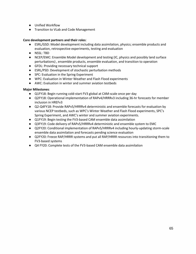
65
● Unified Workflow
● Transition to VLab and Code Management
Core development partners and their roles: ● ESRL/GSD: Model development including data assimilation, physics; ensemble products and
evaluation, retrospective experiments, testing and evaluation ● NSSL: TBD
● NCEP/EMC: Ensemble Model development and testing (IC, physics and possibly land surface perturbations) , ensemble products, ensemble evaluation, and transition to operation
● GFDL: Providing necessary technical support ● ESRL/PSD: Development of stochastic perturbation methods ● SPC: Evaluation in the Spring Experiment ● WPC: Evaluation in Winter Weather and Flash Flood experiments ● AWC: Evaluation in winter and summer aviation testbeds
Major Milestones: ● Q1FY18: Begin running cold-start FV3 global at CAM-scale once per day
● Q2FY18: Operational implementation of RAPv4/HRRRv3 including 36-hr forecasts for member inclusion in HREFv3
● Q2-Q4FY18: Provide RAPv5/HRRRv4 deterministic and ensemble forecasts for evaluation by various NCEP testbeds, such as WPC’s Winter Weather and Flash Flood experiments, SPC’s Spring Experiment, and AWC’s winter and summer aviation experiments.
● Q1FY19: Begin testing the FV3-based CAM ensemble data assimilation
● Q3FY19: Code delivery of RAPv5/HRRRv4 deterministic and ensemble system to EMC
● Q2FY20: Conditional implementation of RAPv5/HRRRv4 including hourly-updating storm-scale ensemble data assimilation and forecasts pending science evaluation
● Q2FY20: Freeze RAP/HRRR systems and put all RAP/HRRR resources into transitioning them to FV3-based systems
● Q4 FY20: Complete tests of the FV3-based CAM ensemble data assimilation

66
Project 7.4: Future CAM Ensembles and Data Assimilation
Project Overview: Projects 2 and 3 focus upon development, testing, and implementation of new CAM ensembles for NOAA within the next 3 years, but there remain a host of questions regarding ensemble design and ensemble data assimilation that call for an extended period of development, testing, and experimentation. Some of these questions will be partially addressed within the scope of the two previous projects, but a longer-term effort is needed to design a robust and reliable CAM ensemble for NOAA forecast needs. Questions that should be addressed include:
● Minimum number of ensemble members needed for reliable forecasts; minimum number of ensemble members for data assimilation;
● Optimal resolution for the data assimilation ensemble and/or analysis; ● Best approach to physics perturbations (e.g., different physics schemes, stochastic physics
methods, physics parameter perturbations, or a mix) and improvements to physics schemes; ● Best approach for data assimilation (ensemble or hybrid or combination of both); ● Observation impact for CAM ensembles (which data to assimilate, determined through OSEs,
OSSEs); ● At what lead time does the value added by convection-allowing resolution, as determined using
CAM verification metrics, diminish to the point where it is no longer justified by its added
expense (e.g., 48h? 72h? 96?)?
● Land surface perturbation approach; ● Connecting CONUS CAM ensemble to embedded Warn-on-Forecast (WoF) ensemble; ● Warn on Forecast (WoF) issues:
○ optimal resolution, update frequency, observational input, and domain size ○ Improve analysis of convective environment using, e.g., GOES-R, profilers, GPS
soundings, surface mesonets ○ Data assimilation: what method(s) will allow us to optimize use of trade space between
skill (DA and forecast) and cost? ○ Improve physical parameterizations (reduction of model error to improve ensemble DA
as well as prediction): (a) scale-aware PBL; (b) microphysics: how much complexity is needed? How can we most effectively assimilate dual-pol data?; (c) short/longwave radiation schemes: how can we maximize impact of GOES-R? (d) Detailed understanding of land surface interaction with PBL
● Effective ensemble post-processing methods; ● Verification approaches for CAM ensembles; ● CAM ensemble design that is reliable for 1-h to 24-h forecast periods and for different forecast
parameters. ● Potential for a global-to-regional refined CAM and medium-range to seasonal prediction explicit
prediction of convective-scale motions. This approach opens the way towards unification of global and regional ensembles.
● Other questions may arise as this project evolves
Major risks and issues: ● Computational requirements for running large CAM ensemble test cases. ● Need to develop a defined set of test cases that include GOES-R observations. ● Finding effective approaches to partner with universities to speed up development. ● Choosing and implementing effective multi-disciplinary approaches for engaging NWS

67
forecasters to ensure operational relevance
Major resources requirements: ● Personnel:
○ EMC (1 FTE): FV3-Meso Model Development (nesting), physics, DA ○ NSSL (15 FTE); ESRL (10 FTE); GFDL (1 FTE) ○ University Community, NCAR, etc. (12 FTE)
● HPC for development: TBD
Dependencies/linkages with other projects: Projects 7.1 – 7.3 above
● ESRL development of CONUS-scale CAM ensemble (project #3) ● Ensemble WG, Project 3 ● NSSL/GSD WoF development and optimization of sub-hourly update capabilities ● NSSL/SPC/WFO forecaster assessment of performance ● Readiness and availability of data from GOES-16, JPSS and COSMIC-2 (?) ● MET-based verification and validation
Core development partners and their roles: ● ESRL/GSD: Development, optimization, and implementation of hourly updating, CONUS-scale
CAM ensemble system ● NSSL: Coordinated development of WoF convection allowing/resolving EPS ● ESRL/PSD and JCSDA: DA development support ● University community, NCAR, and others: foundational research on all science questions
highlighted above ● DTC: optimization of verification strategies
Major Milestones: TBD

68
ANNEX 8: MARINE MODELS
The Marine Modeling WG has outlined the following projects for this SIP document. These include projects which have a well-defined path for the next 3-5 years and those which are targeted towards delivering a long-term (5-10 years) strategy that will later result in new capabilities. The latter projects require further inputs and analysis from the community.
● Ocean Data Assimilation (NCODA) to support RTOFS (FY17/18-20) ● Marine Models coupling:
○ FV3 based Hurricane Model developments: Moving nests and coupling to other Earth System Components (FY18-20)
○ Development of a Global Coupled Unified Model (FY17/18-22) ○ Coupling wave models to Atmosphere systems (FY17-19)
● Integrated Water Prediction (IWP) (next 5-10 years) ● Long-term strategy for NextGen Ocean Modeling and Data Assimilation (next 5-10 years) ● Ecosystems and Eco-Forecasting (next 5-10 years)

69
Project 8.1: Ocean Data Assimilation (NCODA) to support RTOFS
Project overview: In 2013, EMC signed a Memorandum of Understanding (MOU) with NRL to port NCODA to EMC. Having NCODA implemented at EMC will eliminate the need for a daily data feed from NRL to EMC, as well as the need for EMC to remain in lockstep with NAVO/NRL with respect to model development. The transfer of data assimilation (DA) approaches for real-time ocean analysis at NCEP will allow support of applications in the planned unified modeling framework.
The main goals for the first two years under R2O are twofold: 1) Implement NCODA at EMC, and 2) Provide ocean initialization/analysis fields for RTOFS/HYCOM based applications. As NCODA reaches implementation at EMC, development and research priorities will be addressed. The third year (FY20) will be spend on improvements for NCODA including new observations (Sea Ice thickness, SSS, etc.)
POCs: Arun Chawla (EMC) and Ilya Rivin (EMC)
Priority: High
Major Risks and Issues: ● System delivered from NRL was with missing documentation, test cases, operational protocols,
scripts and supporting codes ● NCEP is under-resourced for marine observation processing
Major resources requirements: ● Personnel: EMC (3.5 FTE); NRL (1 FTE) ● HPC for development: 2 Million CPU-hours on WCOSS; 50 TB of disc
Dependencies/linkages with other projects: ● ANNEX 6 (Data Assimilation) Processing of marine/ocean observations ● ANNEX 6 (Data Assimilation) Monitoring/evaluation of ocean observations
Core development partners and their roles: ● US Navy (to support transitioning of NCODA capabilities to NCEP/EMC)
Major Milestones: ● FY18Q1: Develop and test interface between NCEP operational data tanks and NCODA QC. ● FY18Q3: Implement global NCODA+HYCOM; test and cycle using canned data as input ● FY19Q1: Real time end-to-end NCODA parallel for RTOFS Global for evaluation ● FY19Q2: Pre-operational testing; transition to NCO ● FY20Q2: Further advancement of NCODA, including new data sources

70
Project 8.1: Ocean Data Assimilation (NCODA) to support RTOFS
Implementation Plan for NCEP NCODA (FY18 - 20)
NCODA
FY18 FY19 FY20
Q1 Q2 Q3 Q4 Q1 Q2 Q3 Q4 Q1 Q2
NCODA QC
Develop and test interface between NCEP operational data tanks and NCODA QC.
NCODA 3DVAR
Implement global NCODA + HYCOM; test and cycle using canned data as input
Real-time experiment, evaluation
Implement global NCODA+HYCOM; test and cycle using canned data as input
Pre-operational testing
Transition to NCO
Advanced NCODA
Further advancement of NCODA, including new data sources

71
Project 8.2(a): FV3 based Hurricane Model developments: Moving nests and coupling to other Earth System Components
Project overview: Moving nests in the operational HWRF and HMON hurricane forecast systems are associated with their parent domains in such a way that the nests always remain oriented to the same map projection as that of the parent. A critical result of this is that immediately following a shift in position only the leading edge of the nest must be regenerated through interpolation of all the dynamical and physical fields whereas the vast majority of the nest’s area needs no interpolation to account for the shift. Interpolation can lead to degradation so minimizing it when nests move is a very important feature provided by so-called parent-oriented nests. In addition the cost of generating new interpolation weights following shifts is limited to only those few points along the leading edge. Given the inherent benefit of this type of parent-nest association and that EMC developers have considerable experience with it through HWRF and HMON, EMC proposes using this same fundamental approach for building a moving nest capability in FV3.
The existing nesting framework in FV3 successfully uses FMS for all interactions between static nests and their parents. The same can then be done for moving nests and parents after completion of upcoming FMS enhancements that include allowing multiple nests on a parent as well as permitting a nest to lie on edges and corners of FV3’s cubed sphere. A parent-oriented moving nest crossing an edge will then lead to nothing more than following the change in orientation that occurs at every edge of the cubed sphere. Crossing a cube’s corner will lead to a concave kink in the nest domain which of course disappears as the nest domain moves beyond the corner (Rancic et al., 2015).
When coupling an atmospheric parent-nest system to other earth system component models (e.g., ocean, sea ice, waves, land, storm surge) FMS could also be used. It provides the capability to couple various earth system component models lying on different logically rectangular grids and is designed to conserve fluxes between those systems (including mass and momentum flux adjustments). An alternative to FMS for coupling would be to explore use of NEMS (NOAA Environmental Modeling System) which provides an infrastructure underlying a coupled modeling system that supports predictions of Earth's environment at a range of time scales. Coupling of other earth system components to FV3 would then be accomplished using the NEMS mediator. NEMS coupling infrastructure is based on the Earth System Modeling Framework (ESMF) and National Unified Operational Prediction Capability (NUOPC) Layer code and conventions. ESMF provides utilities like generation of interpolation weights and utilities for calendar and time management, and wrappers that create a standard component calling interface. Any NUOPC enabled physics package (IPDv4) would also be available for parent/child nest applications. (POC: Avichal Mehra, EMC)
(Note: This project is also listed under the Dynamics and Nesting Annex of this draft SIP. Only the milestones and Gantt chart are different).
Major resources requirements: ● Personnel: EMC (2 FTE); ESRL/GSD/NESII (0.5 FTE); GFDL (0.5 FTE) ● HPC for development: 2M hours/month; 100 TB of storage
Dependencies/linkages with other projects: ● Developments for Global FV3 ● Static FV3 nests (CAM WG) ● FMS and/or NEMS framework support is highly required

72
Core development partners and their roles: ● EMC (Lead, moving nest alternatives in FV3) ● GFDL: Implementation of required functionality in FV3, including additional flexibility for nest
placement (multiple nests, telescoping nests, nests over cube edges/corners). ● NSSL (Static Nests within FV3) ● AOML (Moving nests in FV3) ● NESII/GSD (support for ESMF and NUOPC/NEMS functionality)
Major Milestones: ● FY18Q3: Build FMS or NEMS based coupler between FV3 and marine models for regional nests ● FY19Q3: Test coupler for a moving nest within FV3 for a single storm ● FY19Q4: Test coupler for a moving nest within FV3 for multiple storms ● FY19Q4: Perform retrospective testing of this coupled system for skill assessment ● FY20Q4: Run a parallel real-time experiment in an operational configuration
Project 8.2(a): FV3-based Hurricane Model developments: Moving nests and coupling to other Earth System Components (FY18-20)
FV3Nest
FY18 FY19 FY20
Q1 Q2 Q3 Q4 Q1 Q2 Q3 Q4 Q1 Q2 Q3 Q4
Build Coupler Build NEMS based coupler between FV3 and Marine Models for regional nests
Test Coupler Test coupler for a moving nest within FV3 for a single storm
Test Coupler Test coupler for a moving nest within FV3 for multiple storms
Skill Assessment
Perform retrospective testing of this coupled system for skill assessment
Pre-operational testing
Run a parallel real-time experiment in an operational configuration

73
Project 8.2(b): Development of a Global Coupled Unified Model
Project overview: The FV3-SFS project will develop the next generation seasonal forecast system based on the FV3 dycore. The seasonal forecast system will provide model guidance out to 9 months. FV3-SFS will include all the components that are being developed for the FV3-GEFS system (coupling between FV3, MOM6, WAVEWATCH III, CICE5) with focus on processes that occur at longer time scales than those for FV3-GEFS. (Note: There is a lot of overlap in processes at the week 3&4 scale of FV3-GEFS and the longer time scale of FV3-SFS and developments will be leveraged for both systems).
The ensemble perturbations will be expanded to the ocean model to provide greater spread for the coupled system. The initialization of the other components (land, aerosol waves, ice) will also be developed. (POCs: Arun Chawla and Suranjana Saha, EMC)
(Note: This project is also listed under the NGGPS Global Model Suites annex of this SIP as FV3-SFS)
Major Risks and Issues: ● Computational resources for model development ● New physics algorithms for coupled systems require extensive testing ● Data assimilation techniques for ice still at early stage of development
Major resources requirements: ● Personnel: EMC (9 FTEs); ESRL/GSD/NESII (TBD); GFDL (TBD) ● HPC for development: TBD
Dependencies/linkages with other projects: ● Development for FV3-GEFS will feed into this system
● Annex 2 (SOFTWARE ARCHITECTURE): NEMS / NUOPC infrastructure for the component models needs to be ready; requirements need to be communicated
● Unified Workflow (CROW) ● Transition to VLab and Code Management/Governance
● JEDI (JEDI is part of the Q2FY19 milestone for FV3-GDAS in Annex 1.)
Core development partners and their roles: ● NCEP/EMC: Partner with NESII to develop the coupled system in the NEMS framework including
coupling the MOM6, WAVEWATCH III, CICE5 and GOCART components; developing the DA framework for each of the components; testing new physics algorithms for coupled systems
● GFDL: Partnering with EMC in developing wave and ocean coupled mixing parameterization. GFDL is also providing expertise in FV3 development and ocean modeling. The FV3-SFS development has numerous similarities with the CM4 model being developed by GFDL, and as such GFDL will provide their expertise knowledge in coupling FV3 with MOM6.
● ESRL/GSD (NESII): Partnering with EMC and GFDL on developing the coupled system in the NEMS framework. The NESII team led development of the NEMS mediator and previous coupling of atmosphere, MOM5, CICE5, and WAVEWATCH III.
Major Milestones: ● Q3FY18: Prototype coupled system with FV3-MOM6-WAVEWATCHIII-NOAH-CICE5 with
initialization for the individual components ● Q4FY18: Upgrading to NOAH-MP land model ● Q4FY19: Including new physics processes for coupled components, including testing alternative
atmospheric algorithms for seasonal scales ● Q1FY20: Freeze system and begin 30 year reanalyses and reforecasts
74
● Q1FY21: Final validation and evaluation; and preparation for transition to operations ● Q1FY22: Operational implementation of FV3-SFS
FV3-SFS (FY17-22)

75
Project 8.2(c): Coupling wave models to Atmosphere systems
Project overview: There are two main objectives for this project: 1. Couple WAVEWATCH III in NEMS two-way with atmospheric model to account for wave induced
surface roughness in the atmospheric boundary layer and evaluate coupled model skill. 2. Development of Wave Data Assimilation Systems based on GSI and LETKF.
POC: Jessica Meixner (EMC)
Major risks and issues: ● For the wave DA the available GSI/LETKF for circulation models required major updates and as
such is modified and updated accordingly. ● Limited Ensemble spreading for LETKF and GSI-EnKF. ● FV3 needs physics updates to accept z0 from wave model. ● Needs workflow development for cycling tests.
Major resources requirements: ● Personnel: 2 FTE per year (one for wave coupling and physics, one for wave DA) ● HPC for development: 1 Million cu-hours on WCOSS, 25 TB of disc
Dependencies/linkages with other projects: ● ANNEX 5 (PHYSICS): Developments for FV3-GEFS and FV3-GFS physics ● ANNEX 2 (SOFTWARE ARCHITECTURE): NEMS / NUOPC infrastructure for the component models
needs to be ready; requirements need to be communicated
Core development partners and their roles: ● NCEP/EMC: Partner with ESRL/GSD (NESII) to develop the coupled system in NEMS framework
including coupling the MOM6, WAVEWATCH III, CICE5 and GOCART components; developing the DA framework for each of the components; testing new physics algorithms for coupled systems
● GSD/NESII: Partnering with EMC and GFDL on developing the coupled system in the NEMS framework. The NESII team led development of the NEMS mediator and previous coupling of atmosphere, MOM5, CICE5, and WAVEWATCH III.
● NRL: Further development of the NUOPC cap for multi-grid WW3 as well as coupled physics for wave - atmosphere and wave - ice interactions. NRL is also working in developing technical improvements to the wave model.
Major Milestones: ● Q1FY18: Physics testing with cycled GFS coupled to WW3
● Q1FY18: Coupled to FV3 cap with new physics ● Q2FY18: Add wave DA capability to GSI ● Q3FY18: Add WW3 to FV3 based GEFS
● Q3FY18: Transition to WW3 Multi-grids ● Q1FY19: Add WW3 to FV3 based GFS

76
Project 8.2(c): Coupling wave models to Atmosphere systems(FY17-19)
FY17 FY18 FY19
Q1 Q2 Q3 Q4 Q1 Q2 Q3 Q4 Q1 Q2 Q3 Q4
Two way coupling
between GSM and WW3
Physics Testing with Cycled
runs
Move to FV3 cap
with new physics
Add to GEFS
Adding Wave DA capability to GSI
and LETKF
Transition to multi-grid
WW3
Add to GFS
77
Project 8.3: Integrated Water Prediction (IWP)
Project overview: NOAA has embarked on a comprehensive NOAA Water Initiative, designed to give people and governments better access to the water information they need for their unique circumstances, so that they may take appropriate actions to address water-related risks and manage their water resources more efficiently and effectively. NOAA is actively working with its partners in academic, non-governmental, and private sector organizations to develop and deliver services focused on next-generation water prediction, sustained decision support, and delivery of timely, accurate, and actionable water information services, based on a deep understanding of user needs. The NOAA Water Initiative is guided by one overarching common goal - to transform water information service delivery to better meet and support evolving societal needs. This goal directly supports NOAA’s mission to protect life and property from extreme events and to create and strengthen resilience in ecosystems, communities, and economies. A strategic implementation plan to revolutionize water modeling, forecasting and precipitation prediction is key to transforming NOAA’s current water prediction services to provide integrated water modeling and prediction across a range of timescales and watershed sizes, with the appropriate timeliness, resolution, reliability, and accuracy required to help inform decision making. The pillars of this modeling work are:
● Transforming NOAA’s inland and coastal hydrology prediction services through ongoing improvements to existing hydrologic services, including coastal mapping, the continued implementation and utilization of the Hydrologic Ensemble Forecast Service (HEFS), and the continued development of the National Water Model (NWM);
● Transforming NOAA’s quantitative precipitation forecasting capabilities at time scales necessary to support water supply and water resource management —from daily to weekly to seasonal — through research into key underlying physical processes, including sources of predictability, and the development of subseasonal to seasonal forecasting tools;
● Recognizing water as habitat by integrating physical and ecological modeling of water quantity and water quality (e.g., temperature, salinity, ocean color, etc.) to inform effective management of riverine, estuarine, and marine ecological functions and processes in support of a wide variety of human uses and community needs; and
● Evolving NOAA’s water modeling efforts in support of the longer range goal of integrated Earth system modeling in the context of a unified modeling approach, where best practices in process understanding, model development, data assimilation, post-processing, and product dissemination will be leveraged across disciplinary boundaries.
Major Risks and Issues: ● Sustained Federal appropriations are needed to fully realize the vision outlined above
● Decision on which storm surge model(s) will be supported is needed. The NOAA Water Team will communicate this decision in FY18.
Major resources requirements: ● Personnel (TBD): NWS (OWP, NCEP, NHC), NOS (CO-OPS, OCS, IOOS), OAR (GLERL, GFDL) ● HPC for development and operations: a) Increased allocation needed for NWM and 2D/3D
coastal models and b) seamless access to Federal systems to support advancements of external modeling communities
Dependencies/linkages with other projects: ● Land/Hydrology (ANNEX 9): Advancements are dependent on the continued development of the
NWM ● NOS: Full buildout of NOS’ Operational Forecast Systems

78
● NOS: COASTAL Act supporting coupling of ESTOFS (ADCIRC) with WaveWatch III. Note that coupling will take place within NEMS to facilitate the sharing of model parameters.
● OAR: Coordination with MOM6 development
Core development partners and their roles: ● NOAA (Lead) ● USGS ● FEMA ● Navy ● Academia
Major Milestones: ● The Multi-Year Strategic Science and Services Plan is the proposed multi-year timeline to
achieve the outcomes of this initiative. Dedicated funding through new appropriations from Congress will be needed to fully realize the goals of this plan.
● Funding has been received through FY17 appropriations and through FEMA in support of the COASTAL Act. Initial work being supported is coupling of ADCIRC with WaveWatch III and coupling of ESTOFS with NWM using middleware called Deltares D-FLOW on a local, and then regional/national scale to support flash-flood and urban water prediction and total water levels during storm events. Final coupling of NWM and ADCIRC will take place within NEMS.
● Investments are needed to improve quantitative precipitation forecasts from the short-time scale through seasonal prediction to improve precipitation forecasting products.
● Efforts to couple NWM with coastal OFS models are long-term goals to support total water level, drought and water quality objectives will be developed as funding is received.
Implementation Plan for Integrated Water Prediction (FY18-20)
Integrated
Water
Prediction
FY18 FY19 FY20
Q1 Q2 Q3 Q4 Q1 Q2 Q3 Q4 Q1 Q2 Q3 Q4
Future Models Decision on future Storm Surge
models
Local coupling Coupling of NWM and
ESTOFS (ADCIRC) on a local
scale
Coupling of ESTOFS with
WaveWatch III

79
Implementation Plan for Integrated Water Prediction (FY21-23)
Integrated
Water
Prediction
FY21 FY22 FY23
Q1 Q2 Q3 Q4 Q1 Q2 Q3 Q4 Q1 Q2 Q3 Q4
National
Coupling Coupling of NWM and
ESTOFS on a national
scale
Precipitation
Forecasts
Delivery of improved
precipitation forecasting
products
Coupling to
coast
circulation
models
Coupling of NWM and 3D
coastal/lake models (ROMS,
FVCOM) to support water
quality and
biogeochemical needs

80
Project 8.4: Long-term strategy for NextGen Ocean Modeling and Data Assimilation
Project 8.4(a): NexGen Ocean Model
Project Overview: Recently, two community workshops have been held (October 2016, May 2017) to consider development of the NexGen ocean model based on Arbitrary Lagrangian Eulerian (ALE) coordinates along with the feasibility of a common ocean model framework for operations and research, suitable for both high-resolution, short time scale work as well as coarser resolution, longer time scale modeling. The first workshop in 2016 outlined a number of recommendations for future action. These recommendations fall into four broad categories: Code Sharing, Community Building, Code Merger and Performance and Future Development. Based on these initial recommendations, the 2017 workshop decided on a notional list of requirements for a common community ALE-based ocean modeling effort, which should:
● support as many agencies / modeling centers as possible, testable by each center’s own metrics ● be an efficient, scalable code to permit high resolution modeling ● be a global multi-scale effort, capable of supporting nests for regional modeling ● consist of modular code so that ALE modeling groups in NASA GISS and DOE LANL could
exchange modules, and thus enhance development ● allow many eyes throughout the community to look at the model, leading to model
improvements
A key point that emerged from both these workshops is that ALE is versatile and permits general vertical coordinates including traditional z, isopycnal, and terrain-following coordinates, as well as hybrid combinations of the former and other creative treatments yet to be formulated and explored. The group agreed on the need to converge to a single, modular ocean modeling framework for all time scales. NWS/NCEP would benefit significantly from this approach by adopting this framework for all its ocean-based operational applications since they currently use both HYCOM- MOM-based systems.
Major resources requirements: ● Personnel: NRL (1 FTE), NOAA/GFDL (TBD), Univ. of Michigan (TBD), NOAA/NCEP (1 FTE Base) ● HPC for development: Allocations on research R&D resources (Theia, Gaea, S4)
Dependencies/linkages with other projects: ● Advancements are dependent on the continued development of the NexGen ocean model
framework
Core development partners and their roles: ● NOAA/GFDL (Co-lead) ● US Navy (Co-lead) ● NOAA/NCEP ● University of Michigan

81
Project 8.4(b): A community-based Ocean Data Assimilation Framework
Project Overview: Recently, a Joint Effort for Data Assimilation Integration (JEDI) has been announced by JCSDA (Joint Center for Satellite Data Assimilation) which has the following goals:
● Next-generation unified data assimilation system ● Increase R2O transition rate (from academia to operations) ● Increase science productivity and code performance
JEDI proposes to adopt the following strategic elements to build this next generation data assimilation framework:
● Modular code for flexibility, robustness and optimization ● Mutualize model-agnostic components across (a) Applications (atmosphere, ocean, strongly
coupled, etc.); (b) Models & Grids (operational/research, regional/global models); and (c) Observations (past, current and future)
● Collective reduction of entropy (of assimilation software proliferation) JEDI will be constructed using a modular design for its primary components: Observation pre-processor, unified forward-operator and the solver all using a common CODBMS (Community Observation DataBase Management System). It is envisaged as a multi-level community repository with data assimilation components for Atmosphere, Ocean, Waves, Sea-ice, Land, Aerosols, Chemistry, Hydrology and Ionosphere. The primary benefits for the proposed unified system are that the same framework would provide multiple options for observations, operators, solvers etc.; would serve multiple applications (research, OSSE’s, reanalysis, operational etc.); and allow for multiple levels of engagement ranging from academia to real-time operational use.
Major resources requirements: ● Personnel: NOAA/NWS (1 FTE Base), JCSDA (2 FTE), NOAA/OAR (TBD), NOAA/NESDIS (TBD), US
Navy (TBD), NASA (TBD) ● HPC for development: Allocations on research R&D resources (Theia, Gaea, S4)
Dependencies/linkages with other projects: ● ANNEX 6 (Projects 1, 2 and 3): Advancements are dependent on continued development of JEDI
framework
Core development partners and their roles: ● JCSDA (Lead) ● NOAA (NWS, OAR, NESDIS) ● NASA ● US Navy ● US Air Force

82
Project 8.4: NextGen Ocean Modeling and Ocean Data Assimilation
Implementation Plan for NexGen Ocean Model and Ocean Data Assimilation
NextGen Ocean
Model FY18 FY19 FY20
Q1 Q2 Q3 Q4 Q1 Q2 Q3 Q4 Q1 Q2 Q3 Q4
Higher-resolution
tests
Test ALE model framework
for high-resolution short-
term ocean forecasts
Build Coupler and
DA capability
Build coupling and Data
Assimilation infrastructure
for NexGen Ocean Model
Quasi-
operational
testing
Test NextGen ocean model
in a quasi-operational
environment for future T2O

83
Project 8.5: Ecosystems and Eco-Forecasting
Project Description: Introduction and NOAA’s Eco-Forecasting Roadmap (EFR) Strategy: Ecological forecasts are used by NOAA to predict likely changes in ecosystems components in response to environmental drivers and resulting impacts on people, economies and communities that depend on ecosystem services. Ecological forecasts provide early warnings of the possible effects of ecosystem changes on coastal systems, and on any possible human health and or regional economies with sufficient lead time to allow mitigation strategies to be developed and corrective actions to be taken. NOAA has adopted an Eco Forecasting Roadmap which provides guidelines to leverage resources and coordinated activities amongst multiple activities for development of a multi-disciplinary capacity for priority habitat/species ecological forecast models that support integrated habitat and living marine resource management. This Roadmap defines NOAA priority habitat science needs and couples how data, models and products from fulfilling those requirements will support ecological forecasts that predict how changes in habitat influences species’ distributions, abundances, and productivity.
NWS/NCEP’s role within EFR Strategy: Amongst the outlined strategic goals for Eco-Forecasting are core capabilities and cross-cuts that are essential for all the ecological forecasts. These include but are not limited to: ongoing observations and data collection from various platforms and in situ sensors; integration and application of atmospheric, physical oceanographic, chemical, and ecological models; data management and analysis; computational capacity; test beds; capacity to develop and test new algorithms; delivery mechanisms; etc.
A holistic view of national infrastructure requirements allows NOAA to be more effective in pursuing and applying its resources. NWS/NCEP along with other core partners both within and outside NWS can play a key role in providing this needed national infrastructure in support of the outlined Eco-Forecasting roadmap and objectives. The primary goal of this national infrastructure would be to help evolve NOAA’s research, technology, people, processes and systems to support ecological forecasting at a national scale, which can then be applied and delivered regionally. Some of these specific objectives of such an infrastructure could include:
● Establish a corporate enterprise framework that builds on NWS/NCEP’s existing systems and capacities to support an ecological forecasting infrastructure. These capacities include models, observations, data integration and analysis, product generation, dissemination and archival.
● Develop and advance a strategy to improve and operationalize observational and modeling capabilities for ecological forecasting, with a focus on incorporating ecological forecasting requirements and time frames into existing products.
● Ensure ecological forecasting research and model development are aligned with service delivery needs and actively support the transition of new products and services to applications.
● Incorporate NWS/NCEP and partner regional assets (e.g. IOOS Regional Associations) into the operational framework for forecasting to create an efficient business model for forecast development and delivery.
● Formalize agreements required for sustained operational forecast production and delivery. ● Mobilize and sustain a highly skilled and motivated workforce across all Line Offices to meet EF
mission objectives. ● Establish mechanisms for information technology (IT) support of cross-Line Office products and
data streams.
Major resources requirements: ● Personnel (TBD): NOAA (NWS, NOS, OAR, NESDIS, NMFS), EPA, USGS ● HPC for development: Allocations on NOAA research R&D resources (Theia, Gaea, S4)

84
Dependencies/linkages with other projects: ● Advancements are dependent on the NOAAs overall strategy for Eco-Forecasting
Core development partners and their roles: ● NOAA (Lead agency) (NWS, NOS, OAR, NESDIS, NMFS) ● EPA ● USGS
Project 8.5: Eco-systems and Eco-forecasting
Implementation Plan for Ecosystems and Eco-forecasting
Ecosystems and
Eco-forecasting
FY18 FY19 FY20
Q1 Q2 Q3 Q4 Q1 Q2 Q3 Q4 Q1 Q2 Q3 Q4
Collect
requirements
Collect User requirements
and conduct cost-benefit
analysis
Build Coupler and
DA capability
Construct a transition plan for
a scenario eco-forecast
Quasi-operational
testing
- Transition to operations a scenario
forecast using NCEP infrastructure and
process

85
ANNEX 9: LAND SURFACE MODELS (LSM) AND HYDROLOGY
The current NCEP production suite contains both uncoupled and coupled modeling systems that include several different land surface and hydrological models. There are three uncoupled systems: the North American Land Data Assimilation System (NLDAS) and the Global Land Data Assimilation System (GLDAS, part of CFS), both NLDAS and GLDAS utilize the Noah land surface model (LSM); and the National Water Model (NWM), which is based on WRF-Hydro and utilizes the Noah-MP LSM. The coupled systems include the CFS seasonal forecasting system, the GFS/GEFS, NAM, RAP/HRRR and HWRF/HMON, which again use the Noah LSM, and RUC LSM in the case of RAP/HRRR.
Modern land models simulate many quantities that potentially can be exploited to improve short- to medium-range weather forecasts and to expand the range of NCEP forecast products. With respect to forecast skill, predictability from the land comes from: (1) soil moisture, (2) snow pack/snow cover, and (3) vegetation phenology (the timing of leaf out and leaf senescence), all of which can significantly impact surface fluxes, boundary-layer development, and thus interaction with the atmosphere. Predictability is on short- to medium-range weather as well as longer-term (sub-seasonal to seasonal) time scales. Crop and irrigation modeling (as simple as regions identified from land-use maps) can capture the impact of intense land-use, which also has a significant impact on surface fluxes.
Modern land models are also making advances with respect to the representation of sub-grid soil moisture heterogeneity that, again, impact surface fluxes. The ground hydrology and the lateral redistribution of water within and between model grid cells is also important in representing the hydrological cycle and must occur at the spatial and temporal scales necessary to resolve streamflow in small channels and water bodies. The latter occurs in the current operational NWM, and will be simulated by components of the NWM, which will be integrated into a more fully-coupled earth system model in a future iteration of this effort. Other examples of land model capabilities include (1) dust, Biogenic Volatile Organic Compounds (VOCs), and fire emissions, which have relevance for air quality forecasting, (2) urban modeling, which can capture differences in minimum and maximum diurnal temperatures in urban versus rural locations as well as the effect on the surface water budget/hydrological cycle, and (3) 1-D lake modeling. A need exists as well to develop an enhanced LSM that better integrates chemical surface-atmosphere exchange processes (emissions, deposition, canopy effects, etc.) that are relevant for Chem/Aerosol modeling.
Characterization of surface conditions is important for land-hydrology models, i.e. land-use and soil type, slope, surface radiation characteristics (albedo, emissivity), vegetation cover and density, soil moisture (including frozen), and snow pack/snow cover. Some of these quantities are state variables (e.g. soil moisture, snow), while others are specified as static (land-use and soil type) though may be time-varying (e.g. monthly surface albedo, and near-realtime weekly green vegetation fraction). Quantities that can be assimilated include snow cover (currently daily direct replacement is used), snow depth, streamflow, inundation, soil moisture (exploring the use of remotely-sensed soil moisture products), and vegetation (in a future version of the Noah LSM with prognostic vegetation phenology). Finally, long-term data sets necessary for reanalysis (e.g. CFS) require that especially the multi-decade snow and vegetation products be re-evaluated.

86
Project 9.1: Operational Global Land Data Assimilation System (GLDAS) Development
Project overview: A stand-alone GLDAS will provide initial land conditions for NCEP atmospheric models (land component under NGGPS program), utilizing the NASA Land Information System (LIS) (currently a part of NEMS), which allows use of the multiple LSM model physics versions (e.g., Noah, Noah-MP, and RUC from the WRF Noah LSM repository), land model structures, land data sets, land data assimilation techniques, and LIS validation tools, thus unifying land modeling in NCEP models.
Major Risks and Issues: ● NCEP Climate Prediction Center global 0.25-deg daily precip product no yet in dcom. ● GLDAS offline “spin-up” multi-year runs can take a few months. ● Adequate downscaling techniques needed to provide initial land conditions for higher-resolution
nest/CAM-scale models.
Major resources requirements: ● Personnel: 7 FTE (physics, land data assimilation, land data sets, coupling, GLDAS system
infrastructure/LIS) ● HPC for development: not significant. Gaea time under the “GLDAS” project available.
Dependencies/linkages with other projects: ● FS/GEFS (GLDAS as upstream component) ● Coupling/infrastructure required to connect systems under NEMS ● DA (future unification under weakly vs strongly coupled DA) ● SFS (GLDAS a future component)
Core development partners and their roles: ● NASA Goddard: LIS developers, LDAS partner ● NESDIS: land data sets for ingest and land data assimilation, e.g. snow, vegetation, soil moisture ● NCAR, NOAA ESRL & GFDL, and other partners: model physics development and related
development issues. ● NWS/OWP: potential development of common forcing data sets (e.g., precipitation), and work
on cross-pollination of hydrologic model components between NWM and GLDAS.
Major Milestones: ● FY17Q4: Upgrade GLDAS within LIS/NEMS ● FY18Q1: Transition LIS to FV3/NEMS ● FY18Q2: Test upgrades to Noah LSM physics, new land data sets, land DA ● FY18Q3: Optimize GLDAS system ● FY18Q4: Evaluation/Validation in FV3/NEMS

87
Project 9.1: GLDAS (FY17/18)

88
Project 9.2: NCEP Unified Land Data Assimilation System (NULDAS) Development
Project overview: Merge the GLDAS and North American (CONUS) Land Data Assimilation System (NLDAS) into a “NULDAS” system at higher resolution (than the global model), e.g. on the order of 4-km. NULDAS can then provide initial land conditions for all NCEP coupled weather and seasonal prediction systems, and provide support for e.g. CPC Drought Outlook and the water resources community more generally. Additionally, hydrologic components from the National Water Model will be leveraged in order to provide a global hydrology component and river-routing capability for fully-coupled earth system modeling.
Major Risks and Issues: ● Dependencies on NCEP Climate Prediction Center and NESDIS for upgraded/higher-solution land
data sets, e.g. global precip (CPC), and static land-use/soils, near-realtime vegetation, snow pack/snow cover, etc., as well as multi-decadal land data sets (NESDIS).
● NULDAS offline “spin-up” multi-year runs can take a few months, several months for much longer 30+ year NULDAS “climate” spin-up runs.
● Adequate downscaling techniques needed to provide initial land conditions for higher-resolution nest/CAM-scale models, as well as for the atmospheric forcing for NULDAS.
● Collaboration with OWP (to leverage common hydrologic components where possible) on extending the NWM hydrology and river-routing capability globally requires additional development and testing.
Major resources requirements: ● Personnel: 7 FTE (physics, land data assimilation, land data sets, coupling, NULDAS system
infrastructure/LIS); ~3-5 FTE additional for downscaling work and NWM module integration. ● HPC for development: Could be significant depending on resolution. Gaea time under the
“GLDAS” project may also be available in the future.
Dependencies/linkages with other projects: ● GFS/GEFS (NULDAS as upstream component), Coupling/infrastructure required to connect
systems under NEMS, DA (future unification under weakly vs strongly coupled DA), SFS (NULDAS a future component).
Core development partners and their roles: ● NASA Goddard: LIS developers, LDAS partner ● NESDIS: land data sets for ingest and land data assimilation, e.g. snow, vegetation, soil moisture ● NCAR, NOAA ESRL & GFDL, and other partners: model physics development and related
development issues. ● NWS/OWP: potential development of common forcing data sets (e.g. precip), and work on
cross-pollination of hydrologic model components between NWM and NULDAS.
Major Milestones: ● FY17Q4: Upgrade GLDAS within LIS/NEMS ● FY18Q1: Transition LIS to FV3/NEMS ● FY19Q2: Test upgrades to Noah LSM physics, new land data sets, land DA ● FY19Q3: Unification of NLDAS and GLDAS (into NULDAS), tests of river-routing scheme,
leveraging of NWM hydrologic modules where appropriate ● FY19Q4: Optimize land physics and full NULDAS system test ● FY20Q1: Evaluation/Validation in FV3/NEMS

89
Project 9.2: NULDAS (FY18-20)
90
Project 9.3: Land surface model physics and system evaluation and selection
Project overview: Evaluate various land-hydrology model choices to address (and possibly select) the land-hydrology model system that yields the best performance, linking the atmosphere with the land-hydrology (to ocean) components. Evaluations should be relevant to regional and global systems as well as short-medium range (hours-weeks, e.g., HRRR/RAP, GFS) and longer term (weeks-months, e.g., CFS) scales with the goal to include modern physics and software design and support flexibility with respect to parameterizations, complexity, and spatial discretization.
Performance includes evaluating surface fluxes, land states (soil moisture, frozen soils possibly including permafrost, soil temperature, snow, vegetation), hydrology/water (rivers, lakes, reservoirs, groundwater), in offline land-hydrology-only testing with appropriate process-level and computational benchmarks for land-hydrology modeling, e.g. surface-layer exchanges (input to surface fluxes), surface energy partition, plant (including carbon and other biogeochemical cycles), and soil thermodynamic and hydraulic processes (heat and moisture movement in the soil), runoff, groundwater and stream-flow/river routing, freshwater discharge to oceans (water movement, including lateral movement). Tradeoffs in complexity and skill will be evaluated. NASA Land Information System (and Land Validation Toolkit), as well as GEWEX/GLASS PALS/PLUMBER, ESM-SnowMIP, OWP/NCAR, climate community ILAMB protocols to be used, along with other focus-area specific benchmarks from collaborators. Physics selections should be revisited and reevaluated on a regular basis.
Major Risks and Issues: ● Sufficient alignment with land and hydrology research and model development communities,
and associated FTEs. ● Sufficient data sets for testing all aspects of land-hydrology modeling at the process level, e.g.
significant “data mining” will be necessary.
Major resources requirements: ● Personnel: 2-4 FTEs working on land-hydrology-related testing, evaluation, and benchmarking ● HPC for development: current levels from WCOSS, NOAA R&D, and other HPC systems should
be sufficient.
Dependencies/linkages with other projects: ● Sufficient alignment with land and hydrology research and model development communities ● For fully-coupled earth system testing, see project 5.
Core development partners and their roles: ● See projects 9.1 and 9.2.
Major Milestones: ● FY18Q1: Agreed upon land-hydrology benchmarks for process-level study and associated data
sets. ● FY18Q3: Land-hydrology models available, tested and evaluated in LIS and/or other testing
platforms. ● FY18Q4: Land-hydrology models available for fully-coupled earth system testing. ● FY19Q1 (and into FY20): Operational implementation of selected land-hydrology model system
in “LDAS” mode. ● FY19Q2 (and beyond): Operational implementation of selected land-hydrology model system in
fully-coupled earth system mode (see project 9.5).

91
Project 9.3: Land Physics (FY18-19)

92
Project 9.4: Collaborative Development with National Water Model (NWM)
Project overview: As a significant step forward in transforming NOAA’s water prediction capabilities, OWP, NCAR and NCEP implemented the first version of the National Water Model into operations in May 2016. The NWM represents NOAA’s first foray into high performance computing for water prediction and expands NOAA’s current water quantity forecasts from approximately 4,000 U.S. Geological Survey (USGS) stream gage sites across the country to forecasts of flow at 2.7 million stream reaches nationwide. The NWM provides hourly streamflow forecasts at those 2.7 million river reaches and other hydrologic information on 1km2 and 250m2 grids. Other NWM output includes high-resolution, spatially-continuous forecasts of soil moisture, evapotranspiration, runoff, snow water equivalent, and other parameters. These outputs are generated over the CONUS, but will soon include coverage for Hawaii. In addition, because land areas in Canada that drain into the Great Lakes are crucial for the overall water budget of the lakes, efforts are in progress to include these areas in the domain of the NWM.
Stakeholder needs within the water resource and emergency response communities along with congressionally mandated NWM enhancements for the FY18-20 SIP period necessitate the continued development of a NWM separate from the proposed regional and global unified systems. However, significant cross-pollination is essential to ensure that the global and regional coupled systems contain the hydrologic capabilities needed to accurately capture hydrologic-atmospheric feedbacks. In particular, NWM hydrologic components will be integrated into NULDAS and NGGPS where appropriate. Model component co-development activities will also proceed in instances where use is possible across hydrologic scales, and validation and forcing generation techniques will be cross-leveraged as well. There exists the potential for state/information transfer between the high-resolution NWM and the 3km NULDAS system. This overall approach will ensure that stakeholder needs and congressional mandates are met while overlap and stove-piping are minimized wherever possible.
Over time, continued NWM enhancements will improve the NWS's ability to deliver impact-based decision support services nationwide through the provision of short through extended range, high fidelity “street level” water forecasts, and through linkages with other earth system modeling components. Many of these linkages are explicitly called out in Annex 8 which includes a section on NOAA Integrated Water Prediction activities.
Major Risks and Issues: ● Congressional mandates are driving NWM enhancements at an extremely rapid pace. This may
complicate cross-pollination efforts ● Uncertainty exists in terms of which hydrologic components are suitable for use across scales
Major resources requirements: ● Personnel: OWP and NCAR FTEs and contractors. Additional EMC and NASA GFSC staff TBD. ● HPC for development: NOAA WCOSS and NCAR Yellowstone development environments
Dependencies/linkages with other projects: ● NULDAS, GLDAS, NGGPS, Unified models, Ocean and estuary models, NEMS
Core development partners and their roles: ● OWP and NCAR: NWM governance, development, validation and R2O activities, co-
development and transfer of modules to/from NWM and NULDAS/NGGPS as appropriate ● NCEP EMC: Co-development and transfer of modules to/from NWM and NULDAS/NGGPS as
appropriate

93
● NASA GSFC: Co-development and transfer of modules to/from NWM and NULDAS/NGGPS as appropriate
Major Milestones: Planned out-year enhancements to the NWM are guided by a series of 5-year overlapping research to operations (R2O) OWP initiatives. These include:
● Centralized Water Forecasting (FY15-FY19) ● Flash Flood and Urban Hydrology (FY16-FY20) ● Total Water Level and Coastal Inundation (FY17-FY21) ● Drought and Post-Fire (FY18-FY22) ● Water Quality (FY19-FY23)
Highlights of these initiatives include the expanded assimilation of anthropogenic water management data, the incorporation of enhanced forcings, the provision of real-time flood forecast inundation maps, an operational nest to provide higher resolution forecasts needed to account for the built environment in urban areas, two-way coupling of the NWM with coastal estuary models for “total water level” forecasts in coastal zones, coupling with more advanced groundwater models to improve forecasts of low flow and drought, and tackling deeper challenges associated with water quality.
In order to accomplish these initiatives, OWP and NCAR have developed a strategic plan aimed at advancing NWM development in high priority development and improvement areas. This strategic plan, which builds on near-term NWM version 1.1 and 1.2 upgrades advances development along a trajectory consistent with the R2O initiatives, will culminate in NWM version 4.0 by 2020. It is anticipated that NWM version 4.0 will include at a minimum:
● Implementation of hyper-resolution (~10 meter effective resolution), limited area nesting capabilities within the NWM for detailed flood inundation impacts predictions
● Enabling model physics linkages (i.e. coupling) to estuary and coastal models ● Enabling model physics linkages to 2D hydraulic models ● Building and improving model capabilities to represent the Great Lakes tributary hydrologic
system within the NWM ● Developing operational prediction capabilities for Hawaii, Alaska and Puerto Rico ● Implementation of more complete groundwater representation ● Advancing data assimilation capabilities for the ingest of snow, vegetation, soil moisture and
groundwater data ● Development of expanded and improved ensemble forecasting capabilities ● Improved and advanced calibration
This strategic plan will improve the ‘total water accounting’ capabilities within the NWM by improving representation of the spatial and temporal distribution of water in the terrestrial system and by improving the linkages between the NWM and other components of the Earth System (e.g. coasts and lakes). Inclusion of regions outside of the CONUS will ensure that the entire Nation is provided with equitable water forecasting services. Lastly, improving data assimilation and ensemble forecasting capabilities will help ensure that the NWM is incorporating several of the latest scientific advances in environmental forecasting methodologies.

94
Project 9.4: NWM Collaboration (FY17-20)

95
Project 9.5: Land-hydrology model system coupling with other earth-system model components
Project overview: Evaluate coupling of land-hydrology components with other earth-system model components, including atmosphere, ocean, and atmospheric chemistry. Land surface model (LSM) choices (e.g., NOAH, NOAH-MP, RUC, LM, CLM, CLSM) to address (and possibly select) the LSM that yields the best performance based on multiple criteria, linking the atmosphere with the land-hydrology (coupled to oceans). Tests include surface fluxes, BVOC and dust emissions, land states (soil moisture, frozen soils including permafrost, soil temperature, snow, vegetation), hydrology/water (rivers, lakes, reservoirs, groundwater, water quality), initially in offline land-only testing with appropriate process-level benchmarks, e.g. surface energy partition, river discharge, etc.; then progressively coupled in a hierarchical manner with relevant benchmarks (e.g. 500mb AC scores, regional circulation, seasonal snowpack, groundwater, ENSO indices, etc.) for a fully-coupled system, but also including process level benchmarks. Hierarchy: land-hydrology, land-atmosphere (with/without aerosols/chemistry), land-marine, land-hydrology-atmosphere, etc., up to fully-coupled earth system tests.
Major Risks and Issues: ● Sufficient alignment with land and hydrology communities. ● Sufficient connection with Model Physics, Marine, and Aerosols & Atmospheric Composition. ● In the operational GFS and CFS systems, the land surface component model is internal to the
atmospheric component, where it is internal to the sub-grid physical parameterizations module. In some applications and for research purposes, it will be necessary for the land surface component to be a separate component. ESRL/GSD (NESII) and EMC have produced prototypes of a separate land component in NEMS, using the NOAH model accessed through the NASA Land Information System (LIS). A question is whether this project will continue the necessary changes to the coupled system architecture to enable a flexible land surface model (LSM) component that addresses the other issues listed below.
● Implicit vs. explicit coupling. The land surface has both fast and slow processes that interact with the atmosphere dynamically, thermodynamically and chemically. A choice must be made in implementing the LSM that represents those processes: it can be coupled to the atmosphere either tightly with an implicit scheme or loosely/asynchronously. There are pros and cons to both types of coupling. The SA should be flexible to support both types of coupling.
● Water sub-components of LSM. The land surface contains water in liquid and solid phases, and in many different landforms. The presence of water on the landscape in the form of soil moisture is commonly treated in LSMs. In addition, there are bodies of water with different characteristics: rivers that transport water mass and sediments over the landscape, thereby introducing a delayed hydrological effect complicating the relationship between precipitation, runoff and transport from the land surface to the ocean; lakes that provide reservoirs for storage of water and large surface area for evaporation; and estuaries that mingle fresh water from the land surface with saline water from the ocean. Often these water bodies occupy much less area than a grid box of the coupled model, so interactions between rivers, lakes, estuaries, ocean and atmosphere must be treated as sub-grid physical processes. Furthermore, NOAA has launched a major initiative to predict river flow at millions of gauge stations – the National Water Model (NWM) – so an interface between the LSM and the NWM is needed.
● Interaction with aerosols/dust/GHG emissions. The land surface acts as both a source and a sink for aerosols and dust as well as greenhouse gases, primarily carbon dioxide and methane. The vegetation on the land surface interacts with several of these constituents of atmospheric composition. The representation of the land surface, the vegetation, and the exchange of aerosols, dust and GHG with the atmosphere must be consistent across component models

96
within the coupled system. If the land is tightly coupled, aerosol and chemistry may also need to be tightly coupled to keep the synergies for correctness. Transition to an integrated LSM with chemical surface-atmosphere exchange processes (deposition, emissions, canopy effects, etc.) should be considered.
Major resources requirements: ● Personnel: 2-4 FTEs from land-hydrology; 8-10+ FTEs to work on coupled physics to fully-
coupled earth-system model testing. ● HPC for development: increasingly more resources required as more fully-coupled earth-system
models are tested.
Dependencies/linkages with other projects: ● See projects 9.1 - 9.4. ● Model Physics: radiation, PBL, convection/microphysics, surface layer. ● System Architecture: land-atmosphere coupling, implicit/explicit, tiles, consistency,
Interoperable Physics Driver development, etc. ● Aerosols and Atmospheric Composition: BVOC emissions, dust emissions, deposition, fire
emissions, strategy for integrating atmospheric chemistry module into coupled applications. ● Marine: freshwater boundary conditions, NOAA Total Water Initiative (see Annex 8) ● Verification: Land process, and application-oriented verification metrics and benchmarks
Core development partners and their roles: ● See projects 9.1, 9.2, and 9.3. ● Members from other model physics projects (per project overview).
Major Milestones: ● FY18Q2: Agreed upon uncoupled and coupled benchmarks for process-level study and
associated data sets. ● FY18Q4: Multiple models to be made available, tested and evaluated in LIS and/or other
uncoupled testing platforms following Project 9.3 above. ● FY19Q2: Single coupled testing and evaluation (e.g., land-atmosphere, land-marine) - will need
to address questions of implicit and/or explicit coupling options. ● FY19Q4 (and into FY20): Multi-component testing (e.g. land-atmosphere-chemistry; land-
atmosphere-marine) ● FY20Q2 (and beyond): Full system testing and evaluation

97
Project 9.5: Land-hydrology model system coupling with other Earth-system model components (FY17/18-20)

98
ANNEX 10: AEROSOLS AND ATMOSPHERIC COMPOSITION
This Strategic Implementation Plan identifies key capabilities, issues and a roadmap for expanding NGGPS from a global atmospheric composition model to a unified modeling system across spatial and temporal scales, and to establish the unified modeling system as a community model that meets the needs of operations as well as the R&D community. There are several reasons to include aerosol and gaseous composition in a Numerical Weather Prediction (NWP) model:
● Improve weather forecasts and climate predictions by taking into account trace gas effects on radiation as well as aerosol effects on radiation and clouds
● Improve the handling of satellite observations by properly accounting for aerosol and trace gas effects during the data assimilation
● Provide aerosol and trace gas (lateral and upper) boundary conditions for regional air quality predictions
● Produce quality aerosol and trace gas information that address societal needs and stakeholder requirements, e.g., air quality, health professionals, policy makers, climate scientists, and solar energy plant managers
The Next Generation Atmospheric Composition Model (NGACM) should address a full range of scales from from high-resolution, convective-resolving to global, and be applicable to forecasting needs from short-range forecasts (hours-days) to the seasonal to subseasonal scales (weeks-months).
The NGACM should maintain and improve quality of current operational products/services from the NWS operational atmospheric composition modeling suite: 1. Global Aerosols: NEMS Global Aerosol Capability: T126 2x/day to 5 days: GOCART aerosols (dust,
smoke, sea salt, sulfate), Lu, et al. (2016) 2. Global stratospheric ozone in GFS: T1534, 4x/day, 3. Ozone/PM: NAM-CMAQ: 12 km, 2x/day to 72 hrs, 155 species, Lee, et al. (2016) 4. Dispersion: NAM/GFS-HYSPLIT Smoke: 0.2°, 06z to 72 hrs, 1 specie; Dust: 2x/day CONUS; Volcanic
Ash, radiological Global; chemical emergencies, CONUS, Stein, et al. (2015)
The following identifies the key component projects that should be addressed for developing a general unified atmospheric composition modeling system. These projects will evolve to account for current and anticipated future applications related to aerosols and atmospheric composition. Key projects include the development of system architecture and a chemistry component that allows for coupling with model dynamics and physics, development of aerosol and atmospheric composition data assimilation capabilities, provision of anthropogenic and natural sources of emissions, verification and postprocessing. These projects would address the needs of aerosol and atmospheric composition model development, regional, high resolution air quality modeling and atmospheric dispersion modeling. A detailed summary of essential and desired components of an NGACM developed by the WG is found here: https://drive.google.com/drive/u/0/folders/0B_-GJGdRdReTbGFTZmVYQU0zZGM The development of NGAC at NCEP has leveraged the expertise experiences from the ICAP (International Cooperative for Aerosol Prediction) working group. The development of aerosol component in NGACM will continue leveraging ICAP’s expertise in aerosol modeling/processes, aerosol data assimilation, global emission estimates, and verification.
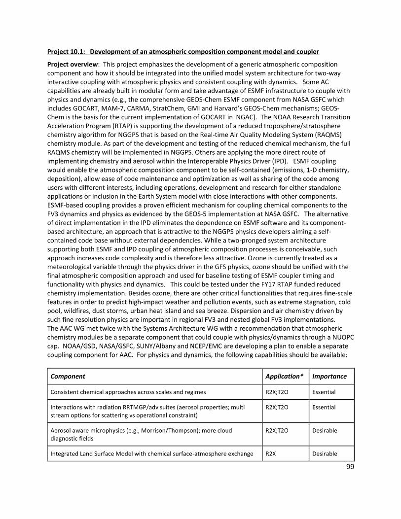
99
Project 10.1: Development of an atmospheric composition component model and coupler
Project overview: This project emphasizes the development of a generic atmospheric composition component and how it should be integrated into the unified model system architecture for two-way interactive coupling with atmospheric physics and consistent coupling with dynamics. Some AC capabilities are already built in modular form and take advantage of ESMF infrastructure to couple with physics and dynamics (e.g., the comprehensive GEOS-Chem ESMF component from NASA GSFC which includes GOCART, MAM-7, CARMA, StratChem, GMI and Harvard’s GEOS-Chem mechanisms; GEOS-Chem is the basis for the current implementation of GOCART in NGAC). The NOAA Research Transition Acceleration Program (RTAP) is supporting the development of a reduced troposphere/stratosphere chemistry algorithm for NGGPS that is based on the Real-time Air Quality Modeling System (RAQMS) chemistry module. As part of the development and testing of the reduced chemical mechanism, the full RAQMS chemistry will be implemented in NGGPS. Others are applying the more direct route of implementing chemistry and aerosol within the Interoperable Physics Driver (IPD). ESMF coupling would enable the atmospheric composition component to be self-contained (emissions, 1-D chemistry, deposition), allow ease of code maintenance and optimization as well as sharing of the code among users with different interests, including operations, development and research for either standalone applications or inclusion in the Earth System model with close interactions with other components. ESMF-based coupling provides a proven efficient mechanism for coupling chemical components to the FV3 dynamics and physics as evidenced by the GEOS-5 implementation at NASA GSFC. The alternative of direct implementation in the IPD eliminates the dependence on ESMF software and its component-based architecture, an approach that is attractive to the NGGPS physics developers aiming a self-contained code base without external dependencies. While a two-pronged system architecture supporting both ESMF and IPD coupling of atmospheric composition processes is conceivable, such approach increases code complexity and is therefore less attractive. Ozone is currently treated as a meteorological variable through the physics driver in the GFS physics, ozone should be unified with the final atmospheric composition approach and used for baseline testing of ESMF coupler timing and functionality with physics and dynamics. This could be tested under the FY17 RTAP funded reduced chemistry implementation. Besides ozone, there are other critical functionalities that requires fine-scale features in order to predict high-impact weather and pollution events, such as extreme stagnation, cold pool, wildfires, dust storms, urban heat island and sea breeze. Dispersion and air chemistry driven by such fine resolution physics are important in regional FV3 and nested global FV3 implementations. The AAC WG met twice with the Systems Architecture WG with a recommendation that atmospheric chemistry modules be a separate component that could couple with physics/dynamics through a NUOPC cap. NOAA/GSD, NASA/GSFC, SUNY/Albany and NCEP/EMC are developing a plan to enable a separate coupling component for AAC. For physics and dynamics, the following capabilities should be available:
Component Application* Importance
Consistent chemical approaches across scales and regimes R2X;T2O Essential
Interactions with radiation RRTMGP/adv suites (aerosol properties; multi stream options for scattering vs operational constraint)
R2X;T2O Essential
Aerosol aware microphysics (e.g., Morrison/Thompson); more cloud diagnostic fields
R2X;T2O Desirable
Integrated Land Surface Model with chemical surface-atmosphere exchange R2X Desirable
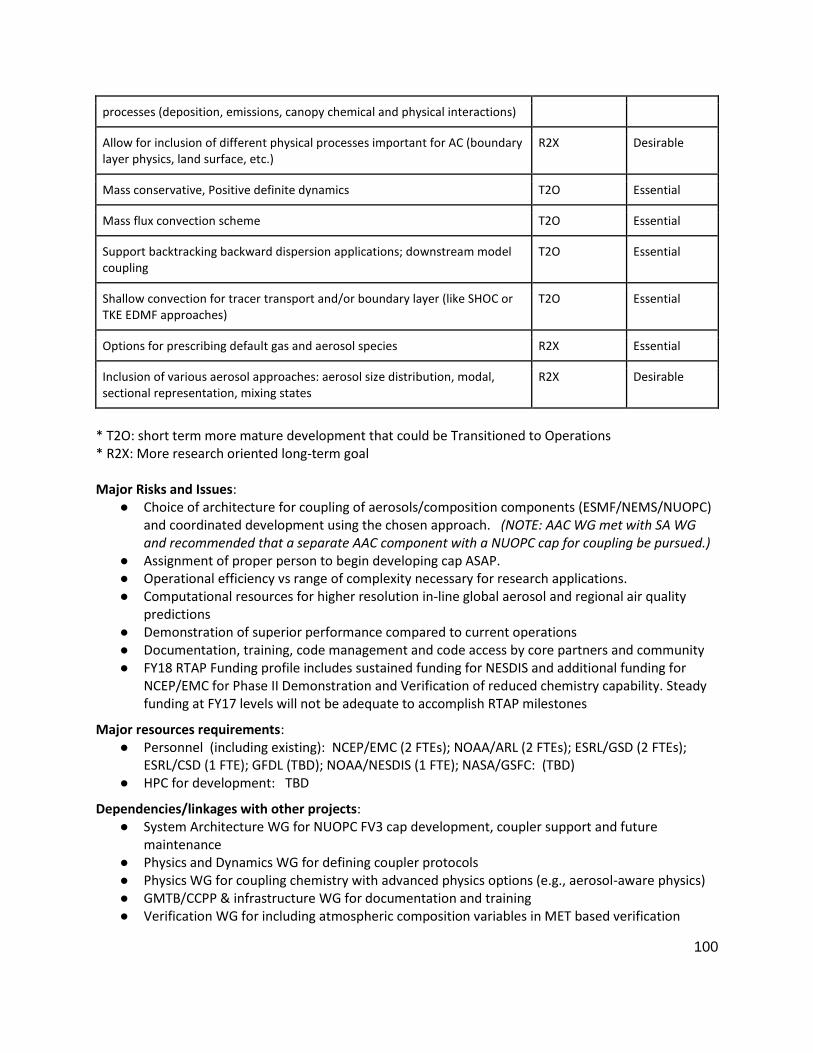
100
processes (deposition, emissions, canopy chemical and physical interactions)
Allow for inclusion of different physical processes important for AC (boundary layer physics, land surface, etc.)
R2X Desirable
Mass conservative, Positive definite dynamics T2O Essential
Mass flux convection scheme T2O Essential
Support backtracking backward dispersion applications; downstream model coupling
T2O Essential
Shallow convection for tracer transport and/or boundary layer (like SHOC or TKE EDMF approaches)
T2O Essential
Options for prescribing default gas and aerosol species R2X Essential
Inclusion of various aerosol approaches: aerosol size distribution, modal, sectional representation, mixing states
R2X Desirable
* T2O: short term more mature development that could be Transitioned to Operations * R2X: More research oriented long-term goal Major Risks and Issues:
● Choice of architecture for coupling of aerosols/composition components (ESMF/NEMS/NUOPC) and coordinated development using the chosen approach. (NOTE: AAC WG met with SA WG and recommended that a separate AAC component with a NUOPC cap for coupling be pursued.)
● Assignment of proper person to begin developing cap ASAP. ● Operational efficiency vs range of complexity necessary for research applications. ● Computational resources for higher resolution in-line global aerosol and regional air quality
predictions ● Demonstration of superior performance compared to current operations ● Documentation, training, code management and code access by core partners and community ● FY18 RTAP Funding profile includes sustained funding for NESDIS and additional funding for
NCEP/EMC for Phase II Demonstration and Verification of reduced chemistry capability. Steady funding at FY17 levels will not be adequate to accomplish RTAP milestones
Major resources requirements: ● Personnel (including existing): NCEP/EMC (2 FTEs); NOAA/ARL (2 FTEs); ESRL/GSD (2 FTEs);
ESRL/CSD (1 FTE); GFDL (TBD); NOAA/NESDIS (1 FTE); NASA/GSFC: (TBD) ● HPC for development: TBD
Dependencies/linkages with other projects: ● System Architecture WG for NUOPC FV3 cap development, coupler support and future
maintenance ● Physics and Dynamics WG for defining coupler protocols ● Physics WG for coupling chemistry with advanced physics options (e.g., aerosol-aware physics) ● GMTB/CCPP & infrastructure WG for documentation and training ● Verification WG for including atmospheric composition variables in MET based verification

101
● Post-Processing WG for extending NCEP post for atmospheric composition parameters ● Transition to VLab and Code Management/Governance ● Land Surface Models WG (land-hydrology model system coupling) ● Dynamics and Nesting WG (nesting configurations)
Core development partners and their roles: ● NCEP/EMC to help develop coupler for atmospheric composition component and transitioning
chemistry modules in the AC component to operations ● NOAA/GFDL to transitioning their key chemistry modules into the AC component (eg: GOCART... ● NASA/GSFC for transitioning their key chemistry modules into the AC component (eg: GEOS-
Chem, MAM-7…) ● NOAA/ESRL/GSD and NOAA/ARL for developing and transitioning the EPA CMAQ chemistry
modules into the AC component and for providing aerosol aware physics packages ● NOAA/ARL to develop HYSPLIT coupling; ● NOAA/ARL to test coastal and/or complex terrain and/or pollution scenarios over selected air-
sheds ● NOAA/NESDIS for developing and transitioning RAQMS full and reduced chemistry modules into
the AC component ● NOAA/CSD for process studies and model evaluation ● NCAR for providing aerosol aware physics packages
Major Milestones: ● Q1FY18: Develop common chemistry component coupler template for FV3-Chem ● Q2FY18: Move GFS ozone module into FV3-Chem ● Q2FY18: Identify any performance penalties with ESMF coupler ● Q3FY18: Develop chemistry based pre (emissions) and post-processing capabilities; ● Q4FY18: Move atmospheric composition verification to MET; include GOCART aerosols,
regional CMAQ and RAQMS full and reduced chemistry in FV3- Chem component ● Q1FY19: Evaluate global ozone and aerosol in-line predictions; Test interactions with radiation
and microphysics via chemical component coupler ● Q2FY19: HYSPLIT off-line coupling with global FV3 (hybrid and P levels) and Regional FV3 (3 km) ● Q2FY19: Compare the decided regional-model driven air composition to that by NAQFC ● Q3FY19: Optimization, testing, retrospective and real time evaluation of global FV3-Chem at
higher resolution (~ 30kmL127); Implement FV3-Chem aerosols in FV3-GFS ● Q4FY19: Perform regional FV3chem retrospective and real-time. Evaluate regional in-line
carbon bond chemistry at ~10 kmL35; test regional aerosol interactions with radiation and microphysics
● FY20: Integrate initial global (GOCART), regional atmospheric composition (CB-VI), and global (GEOS-Chem/RAQMS) configurations into workflow; conduct pre-implementation T&E and prepare GOCART and regional AC capabilities for transition to operations

102
Project 10.1 Development of FV3-chem component and coupler (FY17/18-20)
Implementation Plan for Global FV3-Chem (FY2017-2020)
FV3Chem FY17 FY18 FY19 FY20
Q1 Q2 Q3 Q4 Q1 Q2 Q3 Q4 Q1 Q2 Q3 Q4 Q1 Q2 Q3 Q4
FV3-Chem
Development
Develop NEMS
coupler and chem
component and
test 100 km
resolution global
FV3-Chem
Glb FV3-Chem
Configuration
Configure global FV3-Chem,
resolution, coupling
physics/dynamics, and increase
horizontal resolution to 30 km
FV3-Chem Data
Assimilation
development
Produce 1-year
reanalysis with
VIIRS AOD
assimilation into
GSI for FV3-Chem
FV3-Chem
Evaluation
Finalize FV3-Chem
configuration* &
perform 1 yr retros
and real-time runs
Glb FV3- Chem
Implementation
Transition glb
FV3-Chem into
operations
Reg FV3-Chem
Configuration,
Evaluation
Configure/Finalize
Reg-Chem (CB-VI) w/
Reg-FV3, 2 month
retros & real-time
runs
Advancement of
FV3-Chem
Further
advancements of
Global FV3-Chem
and implementation
of Regional FV3-
Chem (10 km)
* Proposed changes for FV3-NGAC: 1) Couple with updated FV3-GFS physics/dynamics; 2)
Increase horizontal resolution to 35 km L127; and 3) Assimilate VIIRS AOD
* Proposed changes for Reg FV3-chem(CB-VI): (1) Couple with advanced physics with reg.
stand-alone FV3; (2) Test inline and offline approaches; (3) Update emissions to current year
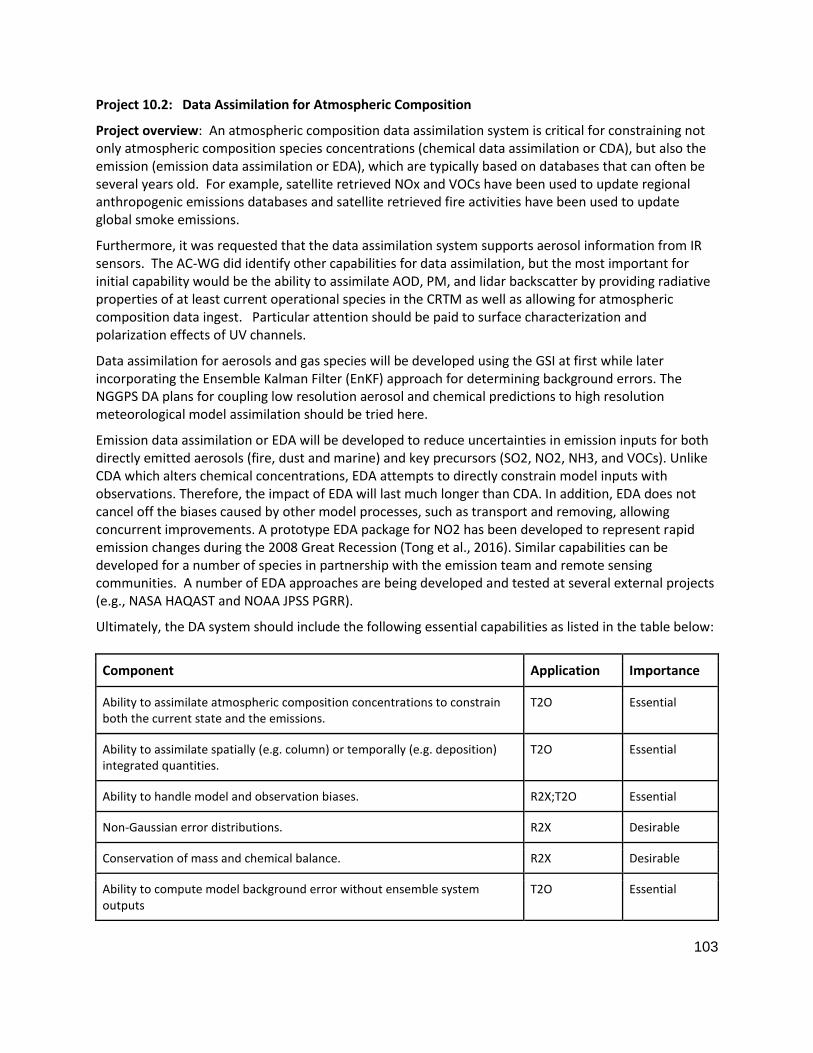
103
Project 10.2: Data Assimilation for Atmospheric Composition
Project overview: An atmospheric composition data assimilation system is critical for constraining not only atmospheric composition species concentrations (chemical data assimilation or CDA), but also the emission (emission data assimilation or EDA), which are typically based on databases that can often be several years old. For example, satellite retrieved NOx and VOCs have been used to update regional anthropogenic emissions databases and satellite retrieved fire activities have been used to update global smoke emissions.
Furthermore, it was requested that the data assimilation system supports aerosol information from IR sensors. The AC-WG did identify other capabilities for data assimilation, but the most important for initial capability would be the ability to assimilate AOD, PM, and lidar backscatter by providing radiative properties of at least current operational species in the CRTM as well as allowing for atmospheric composition data ingest. Particular attention should be paid to surface characterization and polarization effects of UV channels.
Data assimilation for aerosols and gas species will be developed using the GSI at first while later incorporating the Ensemble Kalman Filter (EnKF) approach for determining background errors. The NGGPS DA plans for coupling low resolution aerosol and chemical predictions to high resolution meteorological model assimilation should be tried here.
Emission data assimilation or EDA will be developed to reduce uncertainties in emission inputs for both directly emitted aerosols (fire, dust and marine) and key precursors (SO2, NO2, NH3, and VOCs). Unlike CDA which alters chemical concentrations, EDA attempts to directly constrain model inputs with observations. Therefore, the impact of EDA will last much longer than CDA. In addition, EDA does not cancel off the biases caused by other model processes, such as transport and removing, allowing concurrent improvements. A prototype EDA package for NO2 has been developed to represent rapid emission changes during the 2008 Great Recession (Tong et al., 2016). Similar capabilities can be developed for a number of species in partnership with the emission team and remote sensing communities. A number of EDA approaches are being developed and tested at several external projects (e.g., NASA HAQAST and NOAA JPSS PGRR).
Ultimately, the DA system should include the following essential capabilities as listed in the table below:
Component Application Importance
Ability to assimilate atmospheric composition concentrations to constrain both the current state and the emissions.
T2O Essential
Ability to assimilate spatially (e.g. column) or temporally (e.g. deposition) integrated quantities.
T2O Essential
Ability to handle model and observation biases. R2X;T2O Essential
Non-Gaussian error distributions. R2X Desirable
Conservation of mass and chemical balance. R2X Desirable
Ability to compute model background error without ensemble system outputs
T2O Essential

104
Ability to assimilate AOD, PM, and backscatter: -- development of CRTM for new sensors -- data ingest -- specification of obs errors
T2O Essential
Consistency in the specification of aerosol optical properties (e.g., refractive index) in model physics, data assimilation and post-processing
R2X;T2O Essential
Coupling of assimilation of aerosol and gaseous composition with meteorological data assimilation
R2X Desirable
Ability to assimilate trace gas (NO2, O3, CO, N2O, CH4) retrievals -- Development of observation operators -- Specification of observation errors -- Data ingest -- Background Error Covariances
R2X;T2O Essential
CRTM updates to incorporate aerosol and trace gas information into IR radiance assimilation
R2X Desirable
Major Risks and Issues:
● Only simple GOCART type aerosol properties have been included in the Community Radiative Transfer Model (CRTM)
● Timely availability of input datasets through operational data flow
Major resources requirements: ● Personnel: NWS/NCEP/EMC (1 FTE); NESDIS (1 FTE); NOAA/ARL (1 FTE); NOAA/ESRL/GSD (1 FTE) ● HPC for development: TBD CPU hours per month; 200 TB
Dependencies/linkages with other projects: ● JEDI ● JPSS data products ● Readiness and availability of data from GOES-16, JPSS ● NUOPC FV3 cap ● DTC/GMTB CCPP ● Advanced physics options recommended by SIP Physics Working Group ● MET based verification ● Transition to VLab and Code Management/Governance
Core development partners and their roles: ● NWS/NCEP/EMC: Transfer/integration of DA capabilities into NCEP, code management,
retrospective and real-time experiment testing and evaluation, transition to operations ● NESDIS: Development of trace gas DA capabilities, incorporation of averaging kernels in JPSS
trace gas products, satellite data distribution and QC in BUFR ● OAR/ARL: Development of emission DA capabilities; test and implement these packages with
NCEP; evaluate and choose proper satellite products for EDA
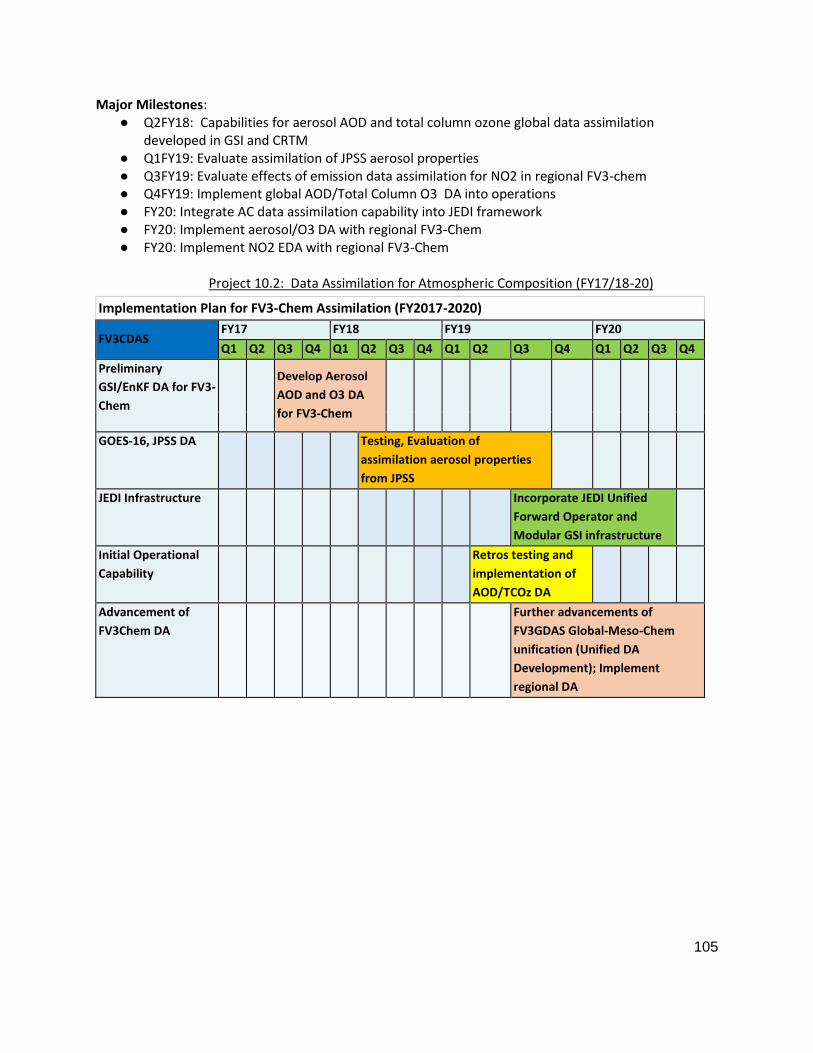
105
Major Milestones: ● Q2FY18: Capabilities for aerosol AOD and total column ozone global data assimilation
developed in GSI and CRTM ● Q1FY19: Evaluate assimilation of JPSS aerosol properties ● Q3FY19: Evaluate effects of emission data assimilation for NO2 in regional FV3-chem ● Q4FY19: Implement global AOD/Total Column O3 DA into operations ● FY20: Integrate AC data assimilation capability into JEDI framework ● FY20: Implement aerosol/O3 DA with regional FV3-Chem ● FY20: Implement NO2 EDA with regional FV3-Chem
Project 10.2: Data Assimilation for Atmospheric Composition (FY17/18-20)
Implementation Plan for FV3-Chem Assimilation (FY2017-2020)
FV3CDAS FY17 FY18 FY19 FY20
Q1 Q2 Q3 Q4 Q1 Q2 Q3 Q4 Q1 Q2 Q3 Q4 Q1 Q2 Q3 Q4
Preliminary
GSI/EnKF DA for FV3-
Chem
Develop Aerosol
AOD and O3 DA
for FV3-Chem
GOES-16, JPSS DA
Testing, Evaluation of
assimilation aerosol properties
from JPSS
JEDI Infrastructure
Incorporate JEDI Unified
Forward Operator and
Modular GSI infrastructure
Initial Operational
Capability
Retros testing and
implementation of
AOD/TCOz DA
Advancement of
FV3Chem DA
Further advancements of
FV3GDAS Global-Meso-Chem
unification (Unified DA
Development); Implement
regional DA

106
Project 10.3: Atmospheric composition emissions capability
Project overview: A unified emission system with the capability of providing model-ready, global anthropogenic and natural source emissions inputs for aerosol and gas phase atmospheric composition across scales is needed. A key capability of the emissions system is the “forecasting” of emissions based on existing emissions inventories, FV3-predicted meteorology, assimilation of near-real-time satellite and in-situ data (emission data assimilation, in conjunction with Project 2 efforts), and economic and energy use projections. The emissions modeling system will provide the best available estimate of emissions of gases and particles, or “forecast-ready emissions”, suitable for forecasting applications. The system should be capable of three key capabilities, including: (1) ingestion of anthropogenic emission inventories; (2) prediction of natural source emissions not included in emission inventories; and (3) timely update of emission data through emission data assimilation or other approaches.
The first capability is to ingest data for anthropogenic emission sources characterized as either points (e.g., large power generation and industrial facilities), mobile (including transportation sources on roads, rails, seas, and in the air), or area (generally distributed smaller sources such as residences, agriculture, etc). Initial FV3-GOCART/Chem aerosol treatments will require information about anthropogenic sources of sulfate, nitrate, ammonia, fugitive dust, black carbon and organic carbon. Future FV3-Chem versions will incorporate fuller treatments of gas- and aerosol-phase chemistry and will require a broader speciation of emissions. Gas phase emissions will need to be compatible with and easily convertible between multiple chemical mechanisms and aerosol modules and would include nitrogen oxides, sulfur dioxide, ammonia, carbon monoxide, speciated volatile organic compounds (anthropogenic and biogenic), and carbon dioxide (and other compounds, depending on particular applications). Anthropogenic emissions inputs to FV3-Chem can be provided by the Community Emissions Data System (CEDS, http://www.globalchange.umd.edu/CEDS/), a flexible and regularly updated framework developed at the U. Maryland/PNNL’s Joint Global Change Research Institute that generates global anthropogenic emission estimates in near-model-ready format. Regional emission datasets will be synchronized with CEDS when necessary.
The system will apply various emission models/datasets to represent natural source emissions. Emissions of windblown dust will be predicted by algorithms within FV3-GOCART/Chem, incorporating near-real-time surface properties (NDVI, soil moisture, etc.) derived from satellite data and coupled to FV3-predicted meteorology. Particles and gas-phase compounds in wildfire smoke will be derived from near-real-time satellite detections of fire locations and fire radiative power, along with off-line information about fuel loading and emissions speciation, and coupled to algorithms using FV3-predicted meteorology to model fire plume rise. Emissions from biomass burning have much room for improvement. This includes the development of a quality control system for biomass burning emissions, implement time consistency when clouds prohibit satellites from seeing the fires, implement dependencies on impact of rain, develop ensemble ideas for fire emissions in sub-seasonal forecasting. Volcanic emissions derived from satellite data should be compatible as input to FV3-GOCART/Chem. Biogenic emissions from land vegetation will be predicted by algorithms driven by FV3 meteorology constrained by the NGGPS land surface model processes and satellite-derived vegetation phenology. Examples of possible biogenic emissions models for implementation include the Model of Emissions of Gases and Aerosols from Nature (MEGAN, http://lar.wsu.edu/megan/index.html), and the Biogenic Emission Inventory System (BEIS, https://www.epa.gov/air-emissions-modeling/biogenic-emission-inventory-system-beis). Marine emissions of sea salt, organic aerosols, volatile organic compounds (e.g., isoprene), halogens and biogenic sulfur (DMS, MSA) will be predicted by algorithms driven by FV3-predicted meteorology, ocean color data from S-NPP and future JPSS satellites, and other marine data

107
sources. Estimates of marine emissions also require spatial and temporal distribution of phytoplankton species that may be made available from the ecosystem forecasting (using a ten-year climatology from satellite detection now).
The third capability ensures that the system is capable of projecting anthropogenic emissions from a reference inventory year to near-real-time, based on updated information from remotely-sensed measurements (e.g. satellite trend data), in situ measurements or other validated emission information.
Future versions of the emissions modeling system should be intimately linked with an integrated LSM with chemical surface-atmosphere exchange processes (emissions, deposition, canopy effects, etc.) to provide chemical, physical and biological consistency among these processes for forecasting and earth-system model applications.
Finally, it is important to establish reliable QA/QC procedures for new emission dataset to be implemented in the system. Methods to blend high fidelity regional emission inventories (e.g., North American) and country-based global emission data will be critical. The development of FV3 emissions should accommodate multiple chemistry modules and flexible chemical speciation for VOCs, NOx, and aerosols. Hence it should be able to provide merged emissions as well as sector-based emission inputs to allow accurate speciation. Information of spatial and temporal allocation is essential to properly distribute country-level emissions into individual model grids in order to resolve fine-scale features such as urban ozone plumes and secondary aerosol formation.
Important emission systems capabilities are summarized in the following table:
Capability Application Importance
Easily accessible, regularly updated, global anthropogenic emission databases in model-ready format
Global; T2O Regional; R2X
Essential Desirable
Near-real-time biomass burning emissions Global, Regional; T2O Essential
Natural and anthropogenic dust emission algorithms with coupling to FV3 dynamics/physics suites
Global, Regional; T2O Essential
Volcanic, radioactive tracer capability Global, Regional; T2O Desirable
Coupling NGGPS land surface and ecosystem model processes with dynamic emission processes (biogenic, dust, ocean, etc.)
Regional; Global; R2X Essential
Rapid emission update capability through assimilating near-real-time observations (in-situ, surface and satellite) for aerosols and key precursors (NO2, SO2 and NH3)
Regional; Global; R2X Essential
Marine emissions (sea salt and organic aerosols, isoprene, halogens, biogenic sulfur) with coupling to FV3 meteorology and satellite-derived data
Global; T2O Regional: R2X
Essential Desirable
Option for climatological smoke, dust, marine emissions Regional; Global; T2O Desirable
Compatibility/synchronization of global inventory with info. Global Desirable
108
from detailed regional inventories (e.g., U.S. EPA NEI) Regional
Major Risks and Issues:
● The CEDS emissions system is relatively new and not extensively tested as a source of emissions data for global or regional forecasting operations
● Development of emission data assimilation packages for aerosols, NO2, SO2, and NH3 ● Improved methods for inclusion of wildfire smoke emissions and injection heights, and crop
residual burning emissions over agricultural regions ● Detailed accounting of aerosols and reactive gases emissions from the oceans (OC, DMS,
halogen, etc.); split sea salt into inorganic and organic components to better predict CCN and ice nucleation in FV3
● Methods to account for agricultural emissions besides NH3 (trace gases and aerosols); ● Tools to quickly incorporate new/high-impacting emission sources (volcano eruption, radiative
leaking, oil spill, etc.) ● Impact of various natural forcing terms on sub-seasonal to seasonal prediction (wildfire smoke,
dust, marine) ● Methods for incorporating elevated point sources ● Methods for incorporating diurnal profiles of global anthropogenic emissions ● More near-real-time anthropogenic emissions using in situ and remotely sensed data for
adjustment to forecast-ready emissions ● Compatibility/synchronization of global inventory with information from detailed regional
inventories.
Major resources requirements: ● Personnel: ESRL/CSD (1 FTE); ESRL/GSD (0.5 FTE); NOAA/ARL (2 FTE); GFDL (TBD); NCEP/EMC
(0.5 FTE); NESDIS (1 FTE) ● HPC for development: CPU hours per month (TBD); Storage (~200 TB)
Dependencies/linkages with other projects: ● All emission data assimilation packages (aerosols, NO2, SO2, and NH3) require data supply by
NOAA satellite programs (JPSS and GOES-R) or other agencies; ● GMTB/CCPP & infrastructure for documentation, training and providing a data portal ● MET based verification development for atmospheric composition variables ● Transition to VLab and Code Management/Governance ● NUOPC FV3 cap ● UMD/PNNL JGCRI for Community Emissions Data System
○ Regional emissions for NWS/NAQFC. ○ Emission measurements from NOAA/NESDIS, NASA, EPA etc.
Core development partners and their roles:
● NCEP/EMC: Emission capability transition to and implementation in the operational environment

109
● NOAA/ESRL/CSD: Process CEDS anthropogenic emissions and provide model-ready gridded inputs
● NOAA/ESRL/GSD: Assist in anthropogenic emissions processing. Predict fire emissions. ● NOAA/ARL: Project anthropogenic emissions to near-real-time using satellite and in situ data;
process-based emission models to estimate natural source emissions; regional emission forecasting for NAQFC.
Major Milestones: ● Q1FY18: Develop CEDS anthropogenic emissions inputs compatible with FV3-Global Chem. ● Q3FY18: Evaluate CEDS emissions with NAQFC benchmark dataset over CONUS. ● Q3FY18: Develop CEDS anthropogenic gas-phase emissions inputs for FV3-Reg Chem. ● Q3FY18: Develop emission rapid updating capability for NO2; ● Q4FY18: Develop and test wild-fire smoke emissions for FV3-Global Chem ● Q2FY19: Develop forecast-ready emission dataset, with emission rapid refreshing capability, for
regional FV3-Reg Chem. ● Q4FY18: Develop and test marine emissions (isoprene, DMS, and primary organic aerosols) for
FV3-Global Chem ● Q3FY19: Implement global emissions in FV3-global Chem ● Q4FY19: Develop and test wild-fire smoke emissions for FV3-Reg Chem ● FY20: Unify emissions, increase resolution, more frequent emission update with satellite
retrievals
Project 3 Atmospheric Composition Emissions Capability (FY17/18-20)
Implementation Plan for FV3-Chem Emissions (FY 2017-2020)
FV3CHEM FY17 FY18 FY19 FY20
Q1 Q2 Q3 Q4 Q1 Q2 Q3 Q4 Q1 Q2 Q3 Q4 Q1 Q2 Q3 Q4
Global anthro emissions
Develop Global CEDS emissions
Evaluate CEDS with NAQFC
Regional anthropogenic emissions
Develop regional CEDS emissions for FV3-Chem
Global natural emissions
Couple global wild-fire smoke, dust emissions systems (eg: GBBEPx, QFED..)
Regional natural emissions
Couple regional wild-fire smoke, dust emissions systems (e.g., FRP, USFS BlueSky)

110
FV3-Chem Implementation
Global FV3-Chem ops
Regional FV3-Chem ops
Advancement of FV3Chem emissions
Further advancements of FV3-Chem emissions: real-time updates from satellites; higher resolution; unification of Global-Meso where possible
REFERENCES Lee. P., McQueen, J.T., Stajner, I., J. Huang, Li Pan, D. Tong, H-C Kim, Y. Tang , S. Kondragunta, M. Ruminski, S. Lu, E. Rogers, R. Saylor, P. Shafran, H-C Huang, J. Gorline, S. Upadhayay, and R. Artz, 2016: NAQFC developmental forecast guidance for fine particulate matter (PM2.5). Wea. Forec. DOI: http://dx.doi.org/10.1175/WAF-D-15-0163.1. Lu, C.-H., da Silva, A., Wang, J., Moorthi, S., Chin, M., Colarco, P., Tang, Y., Bhattacharjee, P. S., Chen, S.-P., Chuang, H.-Y., Juang, H.-M. H., McQueen, J., and Iredell, M.: The implementation of NEMS GFS Aerosol Component (NGAC) Version 1.0 for global dust forecasting at NOAA/NCEP, Geosci. Model Dev., 9, 1905-1919, doi:10.5194/gmd-9-1905-2016, 2016. Stein, A.F., Draxler, R.R, Rolph, G.D., Stunder, B.J.B., Cohen, M.D., and Ngan, F., (2015). NOAA's HYSPLIT atmospheric transport and dispersion modeling system, Bull. Amer. Meteor. Soc., 96, 2059-2077,
http://dx.doi.org/10.1175/BAMS-D-14-00110.1

111
ANNEX 11: ENSEMBLES
The intent of improved ensemble predictions are to directly provide sharp (specific) forecasts that are reliable (i.e., the event occurs 80% of the time when an 80% probability is forecast) and that provide situation-dependent estimates of the forecast uncertainty. These can be used to provide improved decision support for a large variety of customers. Ensembles are now also commonly used to provide improved estimates of forecast-error covariances in data assimilation methods, thereby improving the quality of the initial condition and subsequent deterministic and ensemble forecast accuracy.
There are two sources of forecast uncertainty that should be modeled accurately in ensemble prediction systems. The first is initial-condition uncertainty. An ensemble should be initialized with samples from the distribution of plausible analysis states. The second is model uncertainty, which can bias the mean forecast and limit the spread of simulations, resulting in an overconfident ensemble, especially for surface-related variables (e.g., surface temperature and precipitation) and tropical forecasts such as hurricane tracks. These contributions to forecast error can be attributed to model deficiencies as well as from deterministic assumptions built into the forecast models’ components, such as parameterizations. As NOAA moves to more fully utilize coupled forecast models (atmosphere/ocean/land/ice, and perhaps more), the challenges of estimating forecast uncertainty will extend to estimating the coupled initial-state uncertainty and sources of model uncertainty in the coupled prediction system.
Addressing the atmospheric initial-condition uncertainty has progressed in recent years more than the model uncertainty. With ensemble Kalman filters and hybrid data assimilation methods, there is now a direct method for producing ensembles of initial conditions that represent samples from the distribution of analysis uncertainty. The accuracy of such methods, however, depends critically on ensemble size, the treatment of model uncertainty in the data assimilation cycle, the extent of non-linearity and non-Gaussianity of error statistics, and the chosen methods for dealing with position errors of coherent features. While intimately related to ensemble prediction, NGGPS development activities related to improving atmospheric ensemble initial conditions are primarily managed through the Data Assimilation working group (see Annex 6).
The second source of forecast uncertainty is model uncertainty. This can be manifested as forecast bias and a lack of spread in ensembles, leading to unreliable, over-confident forecasts. General forecast biases such as consistently biased forecasts of land-surface temperatures or consistent misrepresentations of tropical deep convection and its associated circulations should and will be addressed directly, such as through model improvements; see the Model Physics portion of the SIP (Annex 5) and the land-surface plan (Annex 9) for implementation plans to address these.
Even if a parameterization produces unbiased simulations, its formulation can still contribute to a lack of spread in ensemble predictions. For example, convective parameterizations as currently formulated are deterministic. The amount of convective rainfall and the tendencies of temperature, humidity, and winds are completely determined by the column’s vertical profile of temperature, humidity, and wind components, taking no account of possible sub-gridscale variability. In reality, the convective response may depend on the unresolved detail; two grid cells with identical vertical profiles but differing sub-grid detail may have completely different realizations of deep convection. Hence, deep convection and many other parameterizations that are currently treated deterministically need to be reformulated in ensembles to be stochastic rather than deterministic, in ways that are physically based, i.e., consistent with our knowledge of the sources of uncertainty.
The state of current research into stochastic parameterization to address model uncertainty is less advanced than research into initial-condition uncertainty. There are first-generation techniques under

112
development that are scheduled for implementation (with NGGPS funding). Ultimately, we want to address the uncertainty at the process level, with physically based stochastic processes introduced into each parameterization.
A new challenge will also occur as we migrate to the use of coupled models. Imperfections in the interactions of the coupled state components will also need to be simulated properly.
Ensemble predictions are increasingly being used for providing situational awareness of high-impact weather forecast events, informing the forecaster of the range of possible weather scenarios, especially after statistical postprocessing (Annex 12). Ensembles are now also commonly used to provide estimates of forecast-error covariances in data assimilation methods.
Project 11.1: FV3-GEFS implementation
This is the highest-priority project for the next few years, the development of the next-generation global ensemble forecast system using the FV3 dynamical core. This project is described now in ANNEX 1 (Global Systems); the reader is referred to this section for details, including dependencies.

113
Project 11.2: High-resolution global ensemble forecast system (HRGEFS)
Project Overview: (Note: this project is planning stages, so not yet authorized by NGGPS to commence). The desired intent, if possible, is to deploy a higher-resolution global ensemble system that produces output to several days, with the intent of producing guidance of such quality that it can supplant regional multi-day ensembles. This system is being planned for because the UMAC recommends that NCEP reduced the complexity of its production suite. “The large number of modeling systems maintained by NCEP is overwhelming NCEP personnel, computer resources and stakeholders. It greatly reduces the ability of individual NCEP modeling systems to achieve excellence. A strategy for the phasing out of redundant or obsolescent models needs to be put in place.” A key recommendation by UMAC (2015) for ensemble and post-processing states specifically the following: “Ensemble product generation from the SREF should be moved over to the GEFS, and the SREF should be discontinued after careful evaluation of GEFS for providing useful shorter range regional ensemble information.”
This desire for production suite simplification around global models is in tension with user desire for higher-resolution regional ensemble guidance to several days. Prototypes of multi-day regional ensembles at convection permitting grid spacing have been generally well received by the community.
Accordingly, under this project the HRGEFS system will be developed and evaluated for replacement of the legacy SREF system. Likewise, the prototype of a convection-permitting regional ensemble forecast system (i.e., the FV3-based Regional Ensemble Forecast System, or REFS), will be developed and evaluated for replacement of the legacy HREF system. The ultimate decision about whether to operationally deploy a HRGEFS, the REFS, both, or neither, will be made after both systems have been developed and compared. See annex 7, Convection-Allowing Models, project 2, for more on the REFS.
Plans and milestones for potential deployment of a HRGEFS: We envision a three-year project with three phases (preliminary development, validation, and pre-operational development. There would be two major decision points. The first would come following a comparative evaluation against the SREF system in development. The decision would be whether to proceed with pre-operational testing of a HRGEFS presuming an eventual implementation. The third phase, conditioned upon a decision to go forward, consists of formal pre-implementation parallel runs, including the archive of these current and any retrospective simulations as training data for statistical postprocessing.
Ideally, development would start soon, e.g., Q1 of FY2018. To be flexible, the Gantt chart below simply provides milestones relative to whatever start date is chosen.

114
After a successful operational implementation, it is possible that the deterministic GFS system may be decommissioned, and future implementations would be with the HRGEFS system at decreasing grid spacing. The specific details of this are omitted, as they are in the more distant future.
Challenges and critical issues:
HPC resources: ● For short term plan (0-3 years), the HPC pool will be known, though whether available resources
are used for a HRGEFS and/or REFS (see Annex 7 on CAMs) is TBD. ● For mid- to long-term planning (3-10 years), pending resolution increases to provide greater
accuracy, we will need to estimate required HPC and storage resources and make sure these are reflected in HPC purchases.
Workforce: ● Much would be similar between the HRGEFS and GEFS systems, so GEFS developmental talent
can largely be leveraged. There may be some system differences, however, such as the use of an uncoupled prediction for the HRGEFS vs. coupled for GEFS that will require 1-2 staff beyond those currently developing the GEFS. These might potentially be staff working on the SREF and/or CAMs, pending the decision on the REFS.
Science and implementation issues: ● Is coupling required and justified given the increased computational expense. Coupling may
include coupled ocean, sea-ice, wave and aerosol states. ● The production suite is typically more crowded around and just after synoptic times (00, 06, 12,
18 UTC). When are the appropriate periods for HRGEFS computations? Should they be run 4x/day, 8x/day, or other? At certain times of day (e.g., 12, 00 UTC) should ensembles be run to a longer lead time?
● To what extent are reforecasts and associated reanalyses needed for this system? Will those users requiring extensive reforecasts be requested to use the GEFS system, such that a HRGEFS is more “nimble” and implementations can happen on a quicker pace with fewer retrospective simulations required? Or are product requirements such that extensive retrospectives are needed for the HRGEFS system as well.

115
Project 11.3: Ensuring consistency between global and regional ensemble systems
Project Overview: (Note: this project is planning stages, so not yet authorized by NGGPS to commence). NWS is expected to provide a “seamless suite” of forecasts, i.e., ones where the forecast quality and character does not change with forecast lead time. Such abrupt changes are possible if products depend on both regional and global ensemble systems -- unless they are carefully co-developed. To provide this seamlessness in the future, for example, the ideal suite of ensemble systems would have characteristics such as (1) lateral boundary conditions for a regional ensemble system would be provided by the global ensemble system; (2) the regional and global system would share dynamical cores and suites of scale-aware parameterizations, so that biases were similar; (3) methods for dealing with model uncertainty in the ensemble systems would be treated in very similar ways.
At this point, development of a regional, high-resolution, rapidly updating ensemble system is occurring without extensive coordination with global system development. This new project would ensure that the regional and global ensemble development is well coordinated, and is meant as a potential complement to ensembles project 2, as discussed above. That project is intended to determine whether a regional ensemble system is needed for forecast lead times of several days. This project is intended to make sure that any regional ensemble system, including a convection-permitting ensemble for leads of 1 day, are as consistent as possible with the global ensemble systems in development.
Major Risks and Issues: ● Major changes to regional ensemble systems are likely needed to achieve consistency. There is
a different paradigm in current high-res regional ensembles, where multiple dynamical cores and physical parameterizations are used to increase ensemble diversity. This is different from the approach used with global models, where the same model and parameterization suite is used for all members, and reliability is more generally achieved with statistical postprocessing. This was done to lessen the amount of prediction software to maintain, and to ensure that error characteristics were similar for all members to make downstream product development easier. Unification of regional and global ensemble systems will be difficult unless regional systems adapt to the paradigm of the global system, using a single dycore and parameterization suite.
● Regional, very-high resolution ensemble systems can be computationally expensive, especially if updated and run hourly. Computational resources may not be adequate unless compromises are made, such as the use of few ensemble members or small domains. Such compromises may to limit the quality of products generated from the regional ensemble system.
Major resources requirements: ● Personnel: TBD pending agreement that the project should be undertaken. As this project
involves mostly coordination, it is anticipated that personnel resources are minimal. ● HPC for development: Minimal, presuming the actual HPC requirements are already reflected in
other projects such as the REFS development. Dependencies/linkages with other projects:
● Dependency upon successful development of the FV3 GEFS and perhaps the HRGEFS, previously discussed.
Core development partners and their roles: ● Global ensemble system developers (ESRL/PSD, EMC) will need to partner with the developers
of regional ensembles, including NSSL, ESRL/GSD, and perhaps NCAR, Navy, and universities. ● We will also need the input of major product users such as the NCEP Storm Prediction Center.
Major Milestones: This is a coordination function only, and so the milestones should be reflected instead in the actual development of other projects.

116
Project 11.4: Improve uncertainty treatments in the ensemble system to make them suitable for sub-seasonal forecasts and for a full spectrum of environmental prediction needs (mostly in planning).
Project Overview: (Note: this project is planning stages). The current GEFS system provides forecasts to only +16 days. To extend the useful skill of forecasts to leads up to +35 days, improvements to the GEFS system will be necessary; what skill may be realized in weeks +3 and +4 may depend on physically realistic coupling to the more slowly varying ocean, land, and sea-ice states, and modeling the uncertainty in that coupling. Future requirements may extend to providing sub-seasonal forecasts including the upper atmosphere, and full coupling to other environmental states such as ocean waves. This project envisions four sub-projects, described separately below. These include: (a) providing improved estimates of the uncertainty related to the imperfections in the dynamical core; (b) providing improved and more physically based stochastic parameterizations; (c) modeling the uncertainty of the coupled state, which may include ocean, sea-ice, and land (for +30 day applications), upper atmosphere (for space-weather forecast applications), and ocean waves and storm surge (for marine and coastal inundation applications). Sub-project 1: Dry dynamical core uncertainty. The finite resolution of the dynamical core and the necessity of numerical diffusion for model computational stability reduce the spread in ensemble forecasts. We seek in this project to realistically model the uncertainty due to these causes, increasing spread in the ensemble prediction system in a manner that is physically realistic. Project activities will include: (a) determine the extent to which finite resolution and imperfections in the dynamical core formulation are contributing to a lack of spread in ensemble prediction systems; (b) develop and test methods for increasing the ensemble spread in physically realistic ways that account for the finite resolution and dycore imperfections; and (c) pending improvement in spread with no increase in error, publish results and implement.
Major risks and issues: Given success at ESRL/PSD with early software versions, the risk is minimal.
Major resources requirements: ● Personnel: ~0.5 FTE x 2 years. ● HPC for development: TBD, but moderate.
Dependencies/linkages with other projects: Dependency upon successful development of the NEMS version of the FV3 GEFS, which will be the standard for comparison.
Core development partners and their roles: Global ensemble system developers (ESRL/PSD, EMC). Jeff Whitaker (ESRL/PSD) has already done some advanced development.
Major Milestones: Milestones and GANTT chart TBD pending interest in the project.
Sub-project 2: Develop, test, and implement codes for more physically based stochastic parameterizations. The current GEFS system is being upgraded for version 12 with a suite of stochastic parameterizations that improve system performance, including spread. However, these new methods are less physically based than desirable and represent an interim step toward stochastic procedures that are more physically realistic and potentially more accurate. Accordingly, this task proposes to add stochastic elements within the advanced physics suite being developed by EMC and collaborators in order to increase ensemble spread and decrease mean error in physically realistic ways. Improved parameterizations to which stochastic elements may be added include the Simplified Higher Order Closure (SHOC) scheme for boundary-layer turbulence and shallow convection and the scale-aware
117
Chikira-Sugiyama and Grell-Freitas deep convection schemes). This overall project is envisioned as likely two or more funded projects. One project has begun, a shorter-term development and implementation to add stochastic elements to deep convective parameterizations and one or more that addresses some more fundamental issues in stochastic parameterization of the boundary layer, microphysics, or other key parameterizations.
Major resources requirements: ● Personnel: For the first project, we anticipate 1 FTE x 3 years. $173K was allocated in FY17, and
follow-on funding will be solicited in FY18 for advanced testing and implementation pending improved performance. Similar personnel resources should be anticipated for secondary, tertiary projects. POC: Jian-Wen Bao, ESRL/PSD
● HPC for development: TBD, but moderate. Dependencies/linkages with other projects: Dependency upon successful development of the FV3 GEFS, discussed above. This system will provide a benchmark for performance.
Core development partners and their roles: Global ensemble system developers (ESRL/PSD, EMC). Perhaps universities or NCAR for secondary, tertiary projects. There is a project in progress at ESRL/PSD addressing the stochastification of deep convective parameterizations.
Major Milestones: Initial milestones for preliminary development and validation phases for the project in progress are shown below. A Gantt chart is shown below; milestones include:
● Q3FY17: Establish a baseline in the NEMS/FV3 framework using first-generation stochastic parameterizations (see task 5.4.1 above).
● Q1FY18: Conduct analysis of observations and large-eddy-simulation data sets to define probability density functions of sub-grid variability in convection and PBL mixing.
● Q3FY18: Demonstrate an initial stochastic physics capability in the advanced physics suite and provide comparisons against the baseline simulations previously generated. Pending a successful demonstration during the research phase, there would be a subsequent pre-operational development phase requiring resources.

118
Sub-project 3: Develop and implement methodologies for a future coupled FV3-based GEFS system to make its forecasts suitable for the full 0-30 day prediction period (in planning, not yet authorized). Several activities are possible under this task. They could include: (a) development and implementation of a methodology for a estimation of coupled state ensemble of initial perturbations, suitable for coupled forecast model initial condition (land/atmosphere, ocean/atmosphere, ice/ocean/atmosphere) [possibly under the DA component of the plan] (b) Development and implementation of advanced methodologies for estimation of coupled state model uncertainties, such as how model uncertainty in the ocean model can be estimated in such a way as to have realistic effects on atmospheric uncertainty estimated from ensembles.
Major resources requirements: ● Personnel: Unknown, but probably best handled through a grant process to labs or universities;
this topic is at a lower TRL. If such a project demonstrated potential, subsequent funding including EMC and OAR for advanced development and implementation would be solicited.
● HPC for development: TBD, but large, given that many simulations will be necessary to monthly time scales.
Dependencies/linkages with other projects: Coupled DA would presumably occur through the JEDI DA infrastructure, hence a dependency on this.
Core development partners and their roles: ESRL/PSD, other government labs, universities, EMC.
Major Milestones: TBD, based on grant proposals. Sub-project 4: Develop and implement a comprehensive extended ensemble prediction system addressing a wider range of environmental prediction needs (e.g., ocean waves, space weather). [in planning, not yet authorized]. These may include activities such as: (a) development of modifications to the basic GEFS system to make the prediction system suitable for space-weather applications, (b)

119
development of modifications to the GEFS system to provide coupled wave and coastal inundation forecasts. (c) other modifications as needed for extension to other high-priority needs.
Major resources requirements: ● Personnel: Unknown, but substantial. ● HPC for development: TBD.
Dependencies/linkages with other projects: TBD.
Core development partners and their roles: TBD.
Major Milestones: TBD, based on grant proposals.

120
ANNEX 12: POST-PROCESSING
This annex will guide the development and implementation of the post-processing portions of NGGPS. As with the other components of NGGPS, NOAA seeks to engage with the public, private, and academic sectors of the weather enterprise to develop and advance a world-class post-processing system. To this end, NOAA has recruited a team of experts from throughout the weather enterprise to create this SIP Annex. Also note that this Annex is complementary to the prior NGGPS post-processing strategy, which included additional science-oriented content for the NGGPS global model.
In operational meteorology, the term post-processing refers to one or more scientific software processes that capture the output from a Numerical Weather Prediction (NWP) system and enhance its value in some way. For NGGPS, the NWP will be NOAA’s operational Global Forecast System (GFS) based on the Finite-Volume Cubed-Sphere Dynamical Core (FV3; GFSFV3).
Post-processing algorithms can be used to generate traditional meteorological variables (e.g., temperature, visibility, precipitation amount) and/or weather-dependent variables that are either not forecast or are poorly forecast by NWP models (e.g., road conditions, optimal evacuation path, crop disease susceptibility, renewable energy production). Often, these techniques generate or improve expressions of uncertainty (e.g., event probabilities, probability distributions).
Post-processing can be said to include the following three broad areas: (Please note, we consider these categories to be informative rather than restrictive. Techniques exist that clearly span the boundaries suggested by these definitions.)
Model Post-processing (ModPP): A post-processing step that interprets NWP output in native model coordinates (e.g. sigma levels, spherical harmonic coefficients) and produces output in coordinates more familiar to human meteorologists (e.g., isobaric levels and regularly-spaced grids)
Diagnostic Post-processing (DiagPP): A post-processing step that applies interpretive algorithms without training (e.g., the BUFKIT application, ensemble relative frequency) to NWP output
Statistical Post-processing (StatPP): A post-processing step that uses statistical inference based on current NWP output, past forecasts, observations/analyses, and other data sets to create new or improved forecast quantities. Examples include Model Output Statistics (MOS) and multi-model blending.
NOAA’s operations are currently supported by a number of post-processing techniques that are distributed across a broad swath of organizations and computing platforms. They employ a variety of techniques, software infrastructures, and purpose-built data formats. The exchange of information among research, development, and operational entities is generally problematic because of these disparities. The process of migrating research to operations and vice versa often suffers unnecessarily because of these disparities.
NGGPS provides an opportunity for seminal change. This annex to the SIP outlines steps that NOAA will follow to evolve operational post-processing towards a community approach. Representatives from across the weather enterprise were invited to contribute to this SIP in hope that the resultant software will invite participation from a broad base of contributors and realize the vision of NGGPS.
Historically, collaboration within the post-processing community has lagged behind collaboration in the NWP community. Thus, this annex calls for progress that is much more rudimentary than that which is described in other annexes.

121

122
Project 12.1: Transition NOAA Operational Post Processing packages (ModPP, DiagPP, and StatPP) to support FV3
Project overview: NOAA is required to support existing operational products during each model upgrade and that includes the transition to FV3. NOAA does have a process to remove or replace legacy products but that often requires 30 days to three months of notice to NOAA’s customers.
EMC is building new Model Post-processing (ModPP and DiagPP) interfaces to efficiently interpolate FV3 model output from cube-sphere grid onto regular orthogonal grids. The objective is to facilitate a smooth transition of data interfaces from GFS to FV3 for NOAA’s internal (e.g., MDL, SPC, and WPC) and external (e.g., AWI and academia) users.
However, organizations that use this output in downstream applications may still need to adjust the scientific algorithms in their post-processing software due to changes in the underlying science. The SIP WG noted that NOAA includes a number of organizations that operate StatPP techniques that must be transitioned to FV3. (The WG heard directly from EMC, MDL, AWC, CPC, SPC, and WPC. There are likely others). Some of the techniques will also depend on reforecast datasets.
The GFSFV3 model output will include native model output in netCDF format as well as post processed output in GRIB2 to improve conformance with community standards and to facilitate data exchanges with the rest of the weather enterprise.
There will also be opportunities for generating new products with EMC’s plan to transition to more sophisticated microphysics schemes with FV3. For example, EMC may be able to start outputting simulated radar reflectivity, graupel, and new unified dominant precipitation type for the Global Model. There has been a long standing request for NOAA Global Model output simulating radar reflectivity from NOAA internal and external customers.
Post Processing group also recommends testing and evaluating new post processing techniques that have potentials to be implemented into NOAA operations, as outlined in Annex 12, Project 4. DTC is proposed to be the main testbed for Phase I. However, EMC may be able to facilitate simple testing while transitioning and re-engineering all EMC’s post processing packages to support FV3, pending approval from EMC management.
Priority: This project impacts NWS operations. It will have the highest priority.
Major Risks and Issues: • Lack of familiarity with netCDF format at EMC. • Risk of degraded efficiency when creating or ingesting netCDF output. • Substantial efforts for all EMC to provide extensive FV3 output and for NOAA organizations to
test these output in their downstream applications. • Some organizations may need to change their StatPP techniques significantly
• Evolving data formatting standards.
Major resource requirements: • Personnel: various from EMC, MDL, AWC, CPC, SPC, WPC, and DTC. EMC has identified FTEs to
start this project. • HPC for development: NOAA’s WCOSS for EMC and other local platforms for MDL, AWC, CPC,
SPC, and WPC. DTC will test UPP on various platforms.
Dependencies/linkages with other projects: • Annex 12, Projects 2 (Unify model and post-processing data formats), 3 and 4.

123
• Annex 1, Projects 1, 2, 3
• Annex 3, Project 1
• Annex 4, Projects 1 and 4
• Annex 7, Projects 1, 2, 3
• Annex 10, Project 1
• Annex 13, Project 4
• Receipt of one year worth of retrospective runs by MDL with sufficient time to do no harm testing by MDL (eg GFS MOS {running MOSPrep step while generating retrospectives would be very helpful to speed MDL response}).
Core development partners and their roles: • EMC will update ModPP and DiagPP to interface with FV3 output in netCDF format. • EMC will provide FV3 output to NOAA organization for testing in their downstream applications
as soon as possible. The output will include existing operational products and possibly new products such as simulated radar reflectivity, graupel, and riming factor.
• MDL, AWC, CPC, SPC, and WPC will test FV3 output provided by EMC in their downstream applications and adjust their algorithms if necessary. They will also evaluate aforementioned new products.
• MDL to test impact on GFS Station MOS [and GFS Gridded MOS (GMOS)], Station LAMP and Gridded LAMP (GLMP).
• NOAA external customers: evaluation of new FV3 data set during NCO 30 day testing. • DTC will support new UPP (ModPP) on multiple platforms to community users so they can post
process new FV3 output pending funding. • EMC may have opportunity to test simple new post processing techniques while transitioning
and re-engineering all post processing packages to support FV3.
Major Milestones: • Q1FY18: EMC modifies ModPP and DiagPP to read new FV3 output in netCDF format • Q3FY18: EMC distributes FV3-GFS output to MDL, NCEP (AWC, CPC, SPC, and WPC) for testing
their downstream applications and for evaluating new products (e.g., simulated radar reflectivity, new dominant precipitation type)
• Q4FY18: MDL and NCEP provide feedback about their evaluation results on FV3-GFS
• Q1FY19: DTC distributes new UPP that reads FV3 output, pending funding • Q2FY19: EMC and NCO distribute FV3 GFS output to external users • Q3FY19: EMC distributes FV3 GEFS output to CPC and MDL (?) for evaluation
• Q4FY19: CPC and MDL provides feedback on evaluation of FV3 GEFS output • FY20: EMC tests new simple post processing techniques during transitioning and re-engineering
of all its post processing packages to support FV3, pending funding
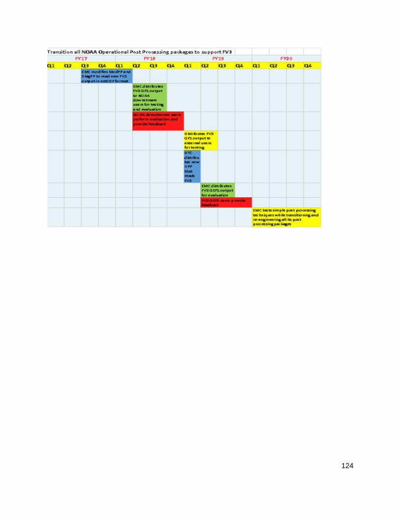
124

125
Project 12.2: Review NOAA’s organizational approach, data sources, post-processing tools, data formats and model levels, and dissemination of post-processed output
Project overview: NOAA’s post-processing organizations likely can gain efficiency and accelerate progress by improving their coordination and collaboration. These cooperative efforts will ideally include scientific and software approaches and internal data formats. The NGGPS Post-processing Working Group will identify the various areas for potential improvement, select one or more sub-groups to examine these issues, and develop a strategic plan that can be recommended to these organizations.
Priority: Needed, but not urgent
Major Risks and Issues: • The evaluation of many of these issues will be outside the skill set of many WG members
• The current practices are likely rooted in corporate culture, and may not change quickly. • Changes of this nature can be resource-intensive. Development organizations may delay adoption
of the recommended best practices. • NOAA organizations that develop post-processing techniques may choose to ignore the findings
and recommendations of the WG
Major resource requirements: • Personnel: sufficient expert assistance to conduct the analysis of current practices
• HPC for development: little, if any
Dependencies/linkages with other projects: • None
Core development partners and their roles: • NOAA’s post-processing organizations
Major Milestones: • Q2FY18: Post-processing WG develops a schedule of review topics • Q3FY18: Post-processing WG forms first review team
126
Project 12.3: Improve the accuracy of post-processed guidance through better science and better data
Project overview: Many of the algorithms that form the mainstay of NOAA’s post-processed guidance may be sub-optimal. Existing algorithms such as multiple linear regression may not provide the highest quality guidance. Existing algorithm may be geared for weather applications, but may not be extensible to needed, longer-lead, sub-seasonal forecast products. Also, somewhat specialized post-processing methods may provide higher-quality guidance for certain products such as severe-weather probabilities, precipitation typing, or aviation hazards.
The underlying data sources are evolving. Previous algorithms may have been developed with short training data sets and station data. Now, with longer training data sets and improved quality analyses, alternative techniques may provide improved guidance if they leverage these.
This project, then, covers future scientific and data improvements to post-processed guidance in NOAA. We envision many possible sub-projects that may concentrate on various weather and climate elements of interest, such as one project for extended-range severe weather, another for hurricane intensity, and so forth. Such projects might be solicited under future requests for proposals through programs like NGGPS, CPO/MAPP, or JTTI. An expectation is that as potential new methods are developed, they will be compared against the current most skillful reference standard.
Priority: Important
Major Risks and Issues: • A lack of a community post-processing software infrastructure mentioned in previous projects, if
not developed, will slow development efforts here, as each project scientist will have to build their own infrastructure to read in data, validate forecasts, and so forth.
Major resource requirements: • Personnel: TBD. We anticipate future funding opportunities will allow investigators to scope
out the particular personnel requirements for the project they propose. • HPC for development: For conventional postprocessing (i.e., not machine learning),
requirements are moderate. Some machine learning projects, if proposed, may have higher HPC requirements.
Dependencies/linkages with other projects: • Potentially upon existence of retrospective forecast training data sets such as the reforecast
data set for the GEFS system (see Annex 1). • PP Testbed project in Annex 12.
Core development partners and their roles: • These projects may be especially suitable for lab and university partners. NWS can provide the
training data, and these partners can then develop algorithms to a state of maturity where they are ready for technology transfer.
Major Milestones: • TBD, will depend on each funded project.

127
Project 12.4: Comparison and Validation of Post-Processing Techniques. Testbed for Post-Processing
Project overview: Numerous post-processing approaches exist within NOAA and the broader community, but there has been no organized way to test the various approaches. This will require testing new techniques, selecting appropriate proxies for truth, selecting appropriate metrics for evaluation, and actually conducting the comparison and validation. This is a challenging problem, since testing post-processing approaches requires relatively large model datasets over at least a year or two as well as the various observational and or (re)analysis datasets. There is currently no easy way for the community to share such large datasets. Therefore, we need a “walk before we can run” approach by using existing infrastructure to start (phase 1), and then hopefully expand to a more efficient system (phase2: perhaps using cloud computing) that will allow outside users to plug and play (host data, workflow and test techniques). We need a group to own the effort to start, so the Developmental Testbed Center (DTC) should be the organization to lead the testbed effort in collaboration with relevant NOAA laboratories (e.g., MDL, EMC,...).
Priority: Not urgent, but greater than most people realize.
Major Risks and Issues: • Comparisons/Validation of this nature can be resource-intensive. Need to likely use existing
infrastructure, which is not adequate for a plug and play approach, for various groups to test their post-processing. HPC access to others outside of NCEP to help test is limited.
• Testing of various post-processing approaches typically require a year or two of model data (e.g., FV3-GFS), from a model that is relatively static, available to the community.
• Requires coordination between groups, such as DTC, NOAA (MDL, EMC, etc.) and other groups (universities and private sector).
• NOAA organizations may not have a clear path to implement the various post-processing techniques. One important metric of success is whether the post-processing approaches are transitioned to NOAA operations.
• It may be difficult to forge a small number of reference “truths” and verification metrics.
Major resource requirements: • Personnel: Would require at least one person at DTC dedicated to getting the data, gathering
post-processing approaches, and establishing a testing framework that is open to the community.
• Funding: Would benefit by having an active visiting scholar program at DTC or NOAA operations around this issue.
• HPC resources: Requires disk space for the models and observations. Cloud computing may be helpful for phase 2.
Dependencies/linkages with other projects: • Verification and Ensemble WGs • There is a strong linkage to Annex 12, projects 2 and 3, since data formats, data dissemination,
and new post-processing approaches will come from these other efforts.
Core development partners and their roles: • DTC should host the initial testbed effort provided adequate resources (e.g., funding, personnel,
compute, storage) • DTC collaborates with NOAA post-processing organizations • NCAR/RAL and other non-NOAA entities contribute as opportunities arise

128
Major Milestones: • Q3FY18: DTC begins to establish the infrastructure for initial post-processing comparisons. • Q1FY19: Identify appropriate methods for evaluating PP techniques. Make recommendation for
consolidation of post processing techniques. • Q2FY19: Begin development of phase2 of testbed system so other groups can participate more
easily. • Q1FY20: Phase2 ready to be implemented

129
ANNEX 13: VERIFICATION
As NGGPS prepares to replace much of the operational numerical weather prediction suite, an evidence-based evaluation of all components will be needed to ensure the new modeling systems are better than those being replaced. There will be a need to construct optimal verification methods and tools to evaluate the performance of the NGGPS model at both global and meso scales and consider the spectrum of user needs including applications in aviation, severe storms, space weather, tropical storms, and precipitation forecasting. Ultimately, it is intended that this system will lead the way towards unifying verification across the user community and create common metrics for multiple applications, to provide consistent verification approaches.
Under the auspices of the Next Generation Global Predictions System (NGGPS) program, a unification of the verification system based on the community Model Evaluation Tools (MET+) developed at NCAR is currently ongoing. MET+ is a flexible suite of verification tools supported to the community through the Developmental Testbed Center (DTC). It is envisioned that this effort will expand to development of a unified verification system that will encompass a variety of spatial scales (from convective to global), temporal scales (from minutes to seasonal predictions) as well as provide a basis for evaluation of individual earth system component models (including atmosphere, atmospheric composition, land, ocean, ice and waves) and of the entire earth system model including coupling among system components and linkages with assimilation of observations. In order to enable more efficient use of operational prediction systems in research environments and more efficient transition of promising research into NWS operations, the unified verification system incorporates community input in its design and development.
As part of the initial NGGPS unification project, a group of scientists and engineers from NCAR, ESRL and DTC met with NCEP staff, including EMC, WPC, OPC, CPC and NCO to assess current capabilities as well as near-term and long-term needs. A requirements document was written and made available to EMC management in September 2016. It can be found on a Google Drive in this NGGPS_V&V_Reqs_Status directory: https://drive.google.com/drive/folders/0BwjqxMjULl-DZzF3MlNHRnhHUWs?usp=sharing and provides the foundation for the FY17-FY19 unification activities. Additional thoughts and requirements were gathered from the SIP V&V members. These will be used to augment the requirements for the system.

130
Project 13.1: Unified verification and validation system based on MET+
Project overview: The transition of EMC to a MET+ based system requires replication of some critical functionality within the system. Verification procedures addressed with this project include those for global to meso- to storm scale phenomena, cyclones (both tropical and extra-tropical), and atmospheric composition and air quality, and others represented by the other 12 SIP working groups. This process began in FY17 and requires additional development to meet the expected timelines. The transition is needed to establish a unified system and free up resources to define the optimal verification methods and tools to enact the critical evaluation of the NGGPS. Several of the components (e.g. Marine, Hydrology, Land Surface Model, Sub-Seasonal to Seasonal) have well established packages that need to be integrated into MET+. If the method is not currently available in MET+, enhancements to the system will be made to ensure that the capability exists. This effort will also expand to validation of the fully coupled system, including visual inspection of high-frequency data (i.e. fluxes), process oriented methods. Effort will be made to include these capabilities in the next 3 years but this will likely require additional effort beyond FY20.
Major Risks and Issues: • MET+ may become difficult to compile/configure and hence unwieldy
• Lengthy list of development tasks – need sufficient resources for development and training
• Several components already have well established pkgs • Lengthy list of milestones that may be difficult to track on a quad chart – may need to determine
how to break into 2 projects
Major resources requirements (per year): • Personnel: EMC (2 FTE); NCAR (1.5 FTE); ESRL (0.5 FTE) • HPC for development: MET+ is designed to run on a single processor and be “parallelized”
through a workflow manager such as Rocoto or ECFlow. There is minimal HPC requirement.
Dependencies/linkages with other projects: • MET-based verification and validation for the FV3-GFS
• MET-based verification and validation for the FV3-GEFS with process-oriented metrics for ensemble evaluation
• MET-based verification and validation for convection-allowing ensembles • MET-based verification and validation for aerosols and atmospheric composition models • MET-based verification and validation for marine models • MET-based verification and validation for land-surface models and hydrology
• MET-based verification for Space-Weather • MET-based verification for S2S Prediction
• MET-based verification for Seasonal Prediction
Core development partners and their roles: • NCAR: provide MET development and enhancement, based on needs of the verification
community. • EMC: Verification Branch will lead verification and evaluation efforts for the FV3 applications.
The Model Evaluation Group (MEG) will lead evaluations of individual modeling systems. • ESRL: Provide additional MET and MET+ development • NCEP (WPC, SPC, OPC, CPC): Provide additional MET+ tools and visualization capability

131
Major Milestones: • Q2FY18: Initial real-time MET+ system running on WCOSS in parallel to VSDB system
• Q3FY18: MET+ accepted for FV3 verification
• Q3FY18: Establish Cython API for MET+ to allow MET C++ code to communicate with Python scripts
• Q4FY18: MET+ accepted for FV3 aerosol, atmospheric composition and air quality verification
• Q3FY19: MET+ accepted for FV3 CAM verification and linked to Marine, Land Surface Model, Hydrology and Sub-Seasonal packages
• Q4FY20: MET+ major release with coupled system requirements met, including basic evaluation capability for space weather
Project 13.1: Unified MET+ Verification System (FY17/18-20)

132
Project 13.2: Robust METViewer for operational and community applications
Project overview: METViewer is the companion database and display system to the MET verification package. It reads in both MET statistics files as well as legacy EMC Verification Statistics Database (VSDB) files. A prototype system has been established by NCO on the Interactive Data Protocol (IDP) development framework. Some initial needed improvements have been identified prior to METViewer going through the formal IDP on-boarding procedure.
Major Risks and Issues: • Significant dependency on the process of approval and scheduling for IDP On-boarding,
including the initial IDP Development version. To reach milestones, METViewer onboarding must receive a high priority and may incur up-front costs and yearly maintenance costs
• Software solutions outside the realm of what is hosted on the current RedHat Linux OS version, an enterprise support solution must also be provided (with an additional cost)
• EMC has stated that there is a requirement to keep decades of data on disk for plotting of historical performance, an efficient solution must be found to achieve this goal
• As with all databases, once a schema and indexing is established, additional work will need to be performed to load non-standard output (e.g. from verification software that has not yet been coupled with MET+)
• Enhancement requests may overwhelm current staff – sufficient resources need to be available
• Developers would benefit greatly from METViewer batch engine capability on HPCs such as WCOSS/Theia – need to figure out how
Major resources requirements: • Personnel: NCAR (1.0 FTE); ESRL (1.4 FTE); EMC (0.5 FTE?) • HPC for development: Nominal resources required • IDP onboarding: $300K initially, $50-$75K yearly
• Disk space: ~2-5 TB per year for near-term archives
Dependencies/linkages with other projects: • JEDI IODA
• Text output from other verification components
Core development partners and their roles: • NCAR: Provide MET development and enhancement, based on needs of the verification
community. • ESRL: Database developers • EMC: The Verification Branch will lead verification and evaluation efforts for FV3 applications.
The Model Evaluation Group (MEG) will lead evaluations of individual modeling systems.
Major Milestones: • Q1FY18: Complete redesign of new METViewer Database
• Q2FY18: METViewer UI upgraded to work with new database
• Q3FY18: Quasi-operational METViewer available for use in MET+ system
• Q1FY19: Less complex UI (METViewer-lite) to provide quicker selection of plots (for those who require this) available for testing
• Q2FY19: Upgraded UI to provide better user experience as per EMC user feedback
• Q4FY19: METViewer fully onboarded in IDP operational environment and available to the community
• Q2FY20: METViewer minor release with community required upgrades

133
• Q4FY20: METViewer major release with community required upgrades
Project 13.2: METViewer for Operational and Community Use (FY17/18-20)

134
Project 13.3: T&E for demonstration of operational readiness of prediction systems
Project overview: This project will also entail continuing to engage the community both independently and through the Governance and Communications WG to determine a set of methods and common metrics that can be used in all verification efforts. Ultimately, there will be an established and well-documented T&E testing procedure that may be executed using the MET+ system. With the recent paradigm shift to model evaluations occurring much earlier in the implementation schedule, EMC’s Model Evaluation Group (MEG) has taken on the role of leading evaluations of major model upgrades. Evaluations had previously been performed by NCEP and NWS stakeholders over a short 30-day period immediately prior to NCEP director approval immediately prior to the operational implementation, but this was found to be an insufficient time period and also allowed for the possibility of NCO building their parallel system only to have the evaluators reject the proposed upgrade. The new paradigm has the developers running an early parallel system and the MEG leading the evaluation with frequent updates given to developers, researchers and forecasters at the group’s weekly webinars. The evaluations consist of a combination of statistical evidence as well as case studies and reviews of daily inspections of critical forecast parameters. Statistical evidence and forecast examples from retrospective runs are also presented. As part of an STI initiative, three MEG sub-teams, consisting of members from the NCEP and NWS SOO community were established to assist with evaluations of global and high-resolution FV3 runs and to assist with the challenge of disseminating parallel data to the field. It is planned for the global and dissemination teams to merge in late FY17, with the single group focused both on evaluation of FV3GFS and FV3GEFS and getting test data to the field. This MEG-STI global team will play a critical role in providing neutrality and forecast expertise in assessing the day-to-day forecast utility of the new systems. The MEG will lead the writing of the test plan for the FV3-based systems with input from the community and organizations such as the Developmental Testbed Center (DTC), Global Model Test Bed (GMTB) and Community Earth System Modeling (CESM) group. The test plan will not only be based on statistics and metrics but also on subjective evaluations by the EMC MEG, the MEG-STI global group, NWS Regions, NCEP Centers, and other customers and stakeholders. The metrics will not be unified across all scales, and engagement with the forecaster and verification community will be critical in identifying scale-appropriate metrics for each system. Once written, the test plan will be used to conduct the formal evaluations by the MEG, the listed organizations and the community.
Major Risks and Issues: • Reaching consensus on the correct fields, measures and display methods as well as the
minimum sample size for effective T&E will be challenging to achieve. • There is potential for evaluations of multiple major modeling systems to be needed
simultaneously, which will severely tax limited MEG resources.
Major resources requirements (per year): • Personnel: EMC ($ FTE + STI SOO-based team); NCAR (0.25 FTE + GMTB staff); ESRL (GMTB staff) • HPC: There is minimal HPC requirement.
Dependencies/linkages with other projects: • Governance and Communication WGs to gather community input on metrics • All WGs for metrics that are meaningful within their specific groups • Evaluation of the FV3-GFS needed. • Evaluation of the FV3-GEFS needed. • Evaluation of CAM ensemble system needed.

135
Core development partners and their roles: • NCAR: Provide MET development and enhancement, based on needs of the verification
community. • EMC: Model Evaluation Group will lead the evaluations/validations of major modeling systems.
Major Milestones: • Q1FY18: complete merging of SOO-based global evaluation and dissemination teams into a
single FV3-Global team
• Q1FY18: SOO-based CAM team completes HRRRv3 evaluation so that it can focus its efforts on working with the CAM Ensemble working group
• Q2FY18: Identify cases to examine in retrospective FV3-GFS and FV3-GEFS run
• Q2FY18: Identify new MET capabilities needed to assist with group’s efforts • Q4FY18: Test plan identified for use in evaluation (in coordination with Governance WG) • Q2FY19: Complete FV3-GFS evaluation as part of transition to operations • Q4FY19: Complete FV3-GEFS evaluation as part of transition to operations • Q4FY20: Complete FV3 evaluation as part of transition to operations
Project 13.3: T&E to Demonstrate Operational Readiness (FY17/18-20)

136
Project 13.4: Develop MET+ interface for other NGGPS community packages.
Project overview: The unified verification capability will need to leverage capability from other NGGPS community packages so redundancy is eliminated. The Joint Effort for Data assimilation Integration (JEDI), Unified Post-Processor (UPP), Statistical Post-Processing System and Community Research to Operations Workflow (CROW)) are examples of community packages that may provide beneficial capabilities to MET+. The observation database and forward operators envisioned for JEDI will be crucial for computing appropriate observation and analysis fields for verification purposes. Coupling with the Unified Post-Processor will allow for derivation of complex parameters (e.g. visibility, CAPE, PBL height) as well as an initial capability of verifying model native grids without generating a new file. Finally, integrating with the Unified Workflow is crucial for verification in an operational setting.
Major Risks and Issues: • Other tools may not develop on a complementary timeline
• Interface between tools may be complicated
• Compilation of verification system may become very complex • Ensuring compatibility and ability to be incorporated into FV3 CROW Unified Workflow but also
stand alone for community code releases
Major resources requirements: • Personnel: NCAR (1 FTE); ESRL (0.25 FTE); EMC (0.25 FTE) • HPC for development: Nominal resources required
Dependencies/linkages with other projects: • System Architecture WG plans for Coupled System
• Refactored NCEP POST (UPP) and product generation
• Unified Workflow (CROW) • JEDI IODA and UFO
• NWS/MDL Weather Information Statistical Processing System (WISPS)
Core development partners and their roles: • NCAR: Provide MET+ development and enhancement, based on needs of the verification
community. • EMC: Primary developer of UPP and CROW
• JSCDA: Primary developer of JEDI IODA and UFO
• ESRL: MET+ Python developer
Major Milestones: • Q4FY17: Develop MET+ dependency on UPP for deriving fields from observations reported in
PrepBUFR files • Q1FY18: Expand use of UPP for deriving fields • Q1FY18: MET+ workflow management requirements identified for efficient coupling with CROW
Unified Workflow
• Q2FY18: MET+ available to be called by CROW Unified Workflow
• Q3FY18: Identify development needed to interface with JEDI IODA and UFO, Post Processing packages
• Q2FY19: MET+ ready to couple with IODA and UFO and Post Processing packages • Q4FY20: MET+ enhanced to fully leverage CROW, IODA, UFO and UPP
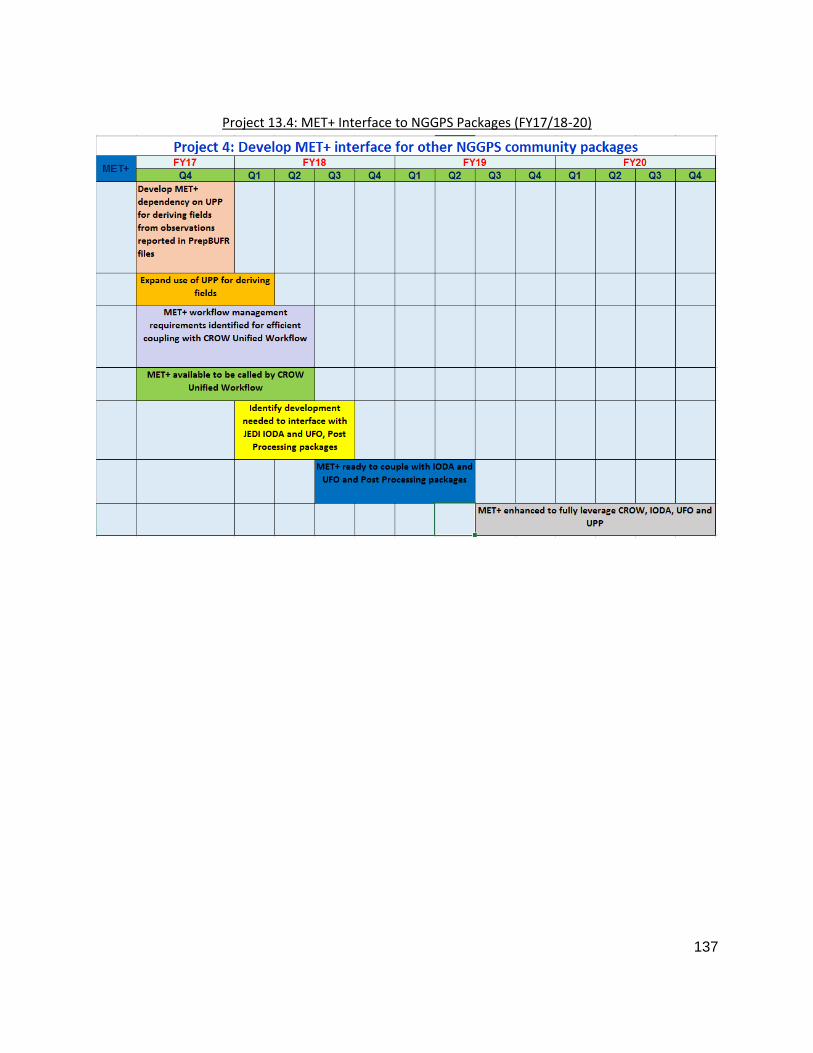
137
Project 13.4: MET+ Interface to NGGPS Packages (FY17/18-20)

138
Project 13.5: Develop protocol for community contribution to authoritative code repository
Project overview: The Infrastructure WG has specified the initial requirements to participate as an authoritative repository for the NGGPS system include having an established code base with help desk, open to the community, governance, documentation, and regression testing. MET+ has three components to the codebase. MET is currently available to the community via download from the DTC website and help desk is provided through DTC. METViewer and the MET+ python framework are available via a closed repository on Github. All three come with documentation, with MET being the most comprehensive. Regression testing has already been established for MET and will be established soon for METViewer and MET+ python. Work that still needs to be done is moving MET to Github and making the entire repository open via some controlled mechanism to meet ITAR and FISMA mandates. Governance and guidelines for community contribution need to also be established.
Major Risks and Issues: • Making sure International Traffic in Arms Regulation (ITAR) and Federal Information and
Security Management Act (FISMA) requirements are met for the community repository
• Identifying governance that needs to be in place to successfully manage the maintenance and growth of MET+
• Balance between GitHub and VLab
Major resources requirements: • Personnel: NCAR (0.25 FTE); EMC (0.15 FTE); ESRL (0.1 FTE) • HPC for development: TBD
Dependencies/linkages with other projects: • Infrastructure project: Establish authoritative community repository
• JEDI: To remain consistent with their governance
• CROW: To remain consistent with their governance
• UPP: To remain consistent with their governance
Core development partners and their roles: • NCAR: As part of DTC establish and maintain MET+ repository and maintain help desk • EMC: Help define governance and maintain help desk
• ESRL: As part of DTC establish and maintain MET+ repository and maintain help desk
Major Milestones: • Q4FY17: Move MET codebase to Github repository
• Q3FY18: Establish committee to develop governance of repository
• Q1FY19: Identify way to manage Github that meets FISMA requirements • Q2FY19: Governance and community contribution procedures established and MET+ repository
open • Q2FY20: Review governance and community contribution procedures and adjust as necessary
• Q4FY20: Publish MET+ governance and community contribution procedures on NGGPS website
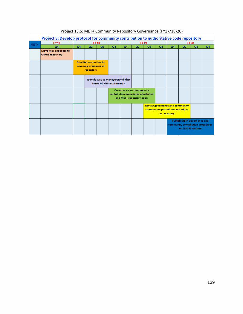
139
Project 13.5: MET+ Community Repository Governance (FY17/18-20)