strategic flood risk assessment - county kildare...
TRANSCRIPT

STRATEGIC FLOOD RISK ASSESSMENT
Clane
Draft Local Area Plan 2017
Dréachtphlean Cheantair Áitiúil Claonadh
Planning Department
Kildare County Council
September 2016
STRATEGIC FLOOD RISK ASSESSMENT
Draft Local Area Plan 2017-2023
Dréachtphlean Cheantair Áitiúil Claonadh

Comhairle Bhaile Chill Dara
Kildare County Council
DRAFT STRATEGIC FLOOD RISK ASSESSMENT
DRAFT CLANE LOCAL AREA PLAN 2017 TO 2023
Kildare County Council
Planning Department
Aras Chill Dara
Devoy Park
Naas
County Kildare
Kilgallen & Partners
Consulting Engineers
Well Road,
Kylekiproe
Portlaoise
Co. Laois
11049-LAP Clane
Issue No.6

Amendments to Clane Local Area Plan Kildare County Council
Draft Strategic Flood Risk Assessment
11049-LAP Clane_Issue No. 6 - Page i
REVISION HISTORY
Project:
Title:
CLANE LOCAL AREA PLAN 2017 TO 2023
DRAFT STRATEGIC FLOOD RISK ASSESSMENT
Date Description Origin Checked Approved Issue
31.07.12 Initial Issue HS PB No. 1
10.03.15 Revised following detailed
FRA
PB MK No. 2
05.07.16 Revised following publication of CFRAM mapping
PB MK No. 3
05.09.16 Miscellaneous revisions PB MK No. 4
08.09.16 Strategic reserve incorporated PB MK No. 5
23.09.16 Miscellaneous revisions PB MK No. 6

Draft Clane Local Area Plan 2017 to 2023 Kildare County Council
Draft Strategic Flood Risk Assessment
11049-LAP Clane_Issue No. 6 - Page ii
INDEX
Page
1.0 INTRODUCTION 1
1.1 Requirement for Flood Risk Assessment
1.2 The Planning Guidelines and Flood Risk Management
1.3 Structure of a Flood Risk Assessment (FRA)
1.4 The Flood Risk Assessment Process for The Planning Authority
1.5 Key Outputs from the SFRA
2.0 FLOOD RISK 6
2.1 Components of Flood Risk
2.2 Source – Pathway – Receptor Model
3.0 EUROPEAN, NATIONAL AND REGIONAL POLICY 7
3.1 European Policy
3.2 National Policy
3.3 Regional Policy
4.0 STRATEGIC FLOOD RISK ASSESSMENTS – CLANE LOCAL AREA PLAN 12
4.1 Introduction
4.2 Available Flood Risk Data
4.3 Flood Risk Indicators
4.4 Recommendations for modification to or additional assessment of land-
use proposals
4.5 Forthcoming Information to Inform Future Flood Risk Consideration
5.0 MONITORING AND REVIEW 18

Draft Clane Local Area Plan 2017 to 2023 Kildare County Council
Draft Strategic Flood Risk Assessment
11049-LAP Clane_Issue No. 6 - Page iii
APPENDICES
Appendix I Initial Draft Land-Use Map
Appendix II Records of Justification Tests
Appendix III Maps showing findings of SFRA including those areas for which Site-
Specific Flood Risk Assessment is recommended
Appendix IV Draft Land-Use Map for Clane Local Area Plan 2017 to 2023
LIST OF FIGURES
Figure 1: Source-Pathway-Receptor Model Page 6
(adapted from www.floodsite.net)
LIST OF TABLES
Table 1: Flood Risk Indicators for Clane Page 14

Draft Clane Local Area Plan Kildare County Council
Draft Strategic Flood Risk Assessment
11049-LAP Clane_Issue No. 6 - Page 1
1.0 INTRODUCTION
1.1 Requirement for Flood Risk Assessment
Kildare County Council is in the process of preparing the Clane Local Area Plan 2017 to
2023 in accordance with the Core Strategy and the requirements and provisions of the
Planning and Development Act 2000 (as amended).
In accordance with Section 28 of the Planning and Development Act 2000 as amended,
the planning authority shall have regard to any guidelines issued by the Minister of the
Environment, Heritage and Local Government to planning authorities in the performance
of their functions including the preparation of Development Plans.
In response to the recommendations of the National Flood Policy Review Group the
Minister published statutory planning guidelines entitled “The Planning System and Flood
Risk Management – Guidelines for Planning Authorities” on 30 November 2009 [‘the
Guidelines’] which incorporate flood risk assessment and management into the planning
system. The Guidelines focus on providing for comprehensive consideration of flood risk
in preparing Regional Plans, Development Plans and Local Area Plans, and in
determining applications for planning permission.
The Guidelines were issued under Section 28 of the Planning and Development Act 2000
as amended, and require Planning Authorities to introduce flood risk assessment as an
integral and leading element of their development planning functions. This is achieved
by ensuring that the various steps in the process of making or varying a development
plan, together with the associated Strategic Environmental Assessment (SEA), are
supported by an appropriate Strategic Flood Risk Assessment (SFRA).
Kilgallen and Partners Consulting Engineers have been appointed by Kildare County
Council to undertake a Strategic Flood Risk Assessment (SFRA) for the Clane Local Area
Plan 2017 to 2023 in accordance with the Core Strategy and in accordance with the
Guidelines referenced above.
It is recommended that the SFRA is adopted as a ‘Living Document’ and reviewed
regularly and updated with any new relevant information that may become available
during the lifetime of the Clane Local Area Plan.
It is the responsibility of each applicant for planning permission to determine the flood
risk pertaining to the lands on which development is proposed and to include
appropriate mitigation works as part of the proposed development for which permission
is sought.
Draft Clane Local Area Plan 2017 to 2023 Kildare County Council
Draft Strategic Flood Risk Assessment
11049-LAP Clane_Issue No. 6 - Page 2
1.2 The Planning Guidelines and Flood Risk Management
The assessment of flood risk requires an understanding of the source of the floodwaters,
the process and direction of flow and the people and assets affected by flooding. The
Guidelines introduce the mechanism of Flood Risk Assessment (FRA) into the planning
process by the incorporation of flood risk identification, assessment and management.
The core objectives of the Guidelines are to:
Avoid inappropriate development in areas at risk of flooding;
Avoid new developments increasing flood risk elsewhere, including that which
may arise from surface water run-off;
Ensure effective management of residual risks for development permitted in
floodplains;
Avoid unnecessary restriction of national, regional or local economic growth;
Improve the understanding of flood risk among relevant stakeholders;
Ensure that the requirements of the EU and national law in relation to the natural
environment and nature conservation are complied with at all stages of flood risk
management.
These core objectives are achieved through the process of Flood Risk Assessments. The
level of detail required for a Flood Risk Assessment depends on the purpose of the FRA.
In the subject case of the Clane Local Area Plan, a Strategic Flood Risk Assessment
(SFRA) is required to inform the plan making process.
To achieve the objectives of the Guidelines, the following principles are applied:
Avoid the risk, where possible
Substitute less vulnerable uses where avoidance is not possible, and
Mitigate and manage the risk, where avoidance and substitution is not possible.

Draft Clane Local Area Plan 2017 to 2023 Kildare County Council
Draft Strategic Flood Risk Assessment
11049-LAP Clane_Issue No. 6 - Page 3
1.3 Structure of a Flood Risk Assessment (FRA)
The Guidelines recommend that a staged approach is adopted when undertaking a Flood
Risk Assessment (FRA). The recommended stages are briefly described below:
Stage 1 ~ Flood Risk Identification
To identify whether there may be any flooding or surface water management
issues that will require further investigation. This stage mainly comprises a
comprehensive desk study of available information to establish whether a flood
risk issue exists or whether one may exist in the future.
Stage 2 ~ Initial Flood Risk Assessment
If a flood risk issue is deemed to exist arising from the Stage 1 Flood Risk
Identification process, the assessment proceeds to Stage 2 which confirms the
sources of flooding, appraises the adequacy of existing information and
determines the extent of additional surveys and the degree of modelling that will
be required. Stage 2 must be sufficiently detailed to allow the application of the
sequential approach (as described in Section 1.4.2 herein) within the flood risk
zone.
Stage 3 ~ Detailed Flood Risk Assessment
Where Stages 1 and 2 indicate that a proposed area of possible zoning or
development may be subject to a significant flood risk, a Stage 3 Detailed Flood
Risk Assessment must be undertaken.
1.4 The Flood Risk Assessment Process for the Planning Authority
1.4.1 Scales of Flood Risk Assessments
Flood Risk Assessments are undertaken at different scales by different organisations for
many different purposes. The scales are as follows:
Regional Flood Risk Appraisal (RFRA): A Regional Flood Risk Appraisal provides a
broad overview of the source and significance of all types of flood risk across a
region and highlights areas where more detailed study will be required. These
appraisals are undertaken by regional authorities.
Strategic Flood Risk Assessment (SFRA): A Strategic Flood Risk Assessment
provides a broad (area-wide or county-wide) assessment of all types of flood risk
to inform strategic land use planning decisions. The SFRA allows the Planning
Authority to undertake the sequential approach (described below) and identify
how flood risk can be reduced as part of the development plan process.
Site Flood Risk Assessment (Site FRA): A Site FRA is undertaken to assess all
types of flood risk for a new development. This requires identification of the
sources of flood risk, the effects of climate change on the flood risk, the impact
of the proposed development, the effectiveness of flood mitigation and
management measures and the residual risks that then remain.

Draft Clane Local Area Plan 2017 to 2023 Kildare County Council
Draft Strategic Flood Risk Assessment
11049-LAP Clane_Issue No. 6 - Page 4
1.4.2 The Sequential Approach
The sequential approach in terms of flood risk management is based on the following
principles: AVOID - SUBSTITUTE - JUSTIFY - MITIGATE – PROCEED.
The primary objective of the sequential approach is that development is primarily
directed towards land that is at low risk of flooding (AVOID).
The next stage is to ensure that the type of development proposed is not especially
vulnerable to the adverse impacts of flooding (SUBSTITUTION).
The Justification Test is designed to rigorously assess the appropriateness, or otherwise,
of particular developments that, for various reasons, are being considered in areas of
moderate or high flood risk (JUSTIFICATION). The test is comprised of two processes,
namely The Plan-Making Justification Test and The Development Management
Justification Test. Only the former (Plan-Making Justification Test) is relevant to a
Strategic Flood Risk Assessment for a Development Plan, and this is described as
follows.
The Plan-Making Justification Test
Where, as part of the preparation and adoption of a development / local area plan, a
planning authority is considering the future development of areas in an urban settlement
that are at moderate or high risk of flooding, for uses or development vulnerable to
flooding that would generally be inappropriate as set out in the Guidelines, all of the
criteria listed below, as stated in the Guidelines, must be satisfied. This is referred to as
the “Justification Test For Development Plans”:
(I) The urban settlement is targeted for growth under the National Spatial Strategy,
regional planning guidelines, statutory plans as defined above or under the
Planning Guidelines or Planning Directives provisions of the Planning and
Development Act 2000, a amended.
(II) The zoning or designation of the lands for the particular use or development type
is required to achieve the proper and sustainable planning of the urban
settlement and in particular:
(i) Is essential to facilitate regeneration and/or expansion of the centre of
the urban settlement;
(ii) Comprises significant previously developed and/or under-utilised lands;
(iii) Is within or adjoining the core of an established or designated urban
settlement;
(iv) Will be essential in achieving compact or sustainable urban growth;
(v) There are no suitable alternative lands for the particular use or
development type, in areas at lower risk of flooding within or adjoining
the core of the urban settlement.
(III) A flood risk assessment to an appropriate level of detail has been carried out as
part of the Strategic Environmental Assessment as part of the development plan
preparation process, which demonstrates that flood risk to the development can
be adequately managed and the use or development of the lands will not cause
unacceptable adverse impacts elsewhere.
Draft Clane Local Area Plan 2017 to 2023 Kildare County Council
Draft Strategic Flood Risk Assessment
11049-LAP Clane_Issue No. 6 - Page 5
N.B. The acceptability or otherwise of levels of any residual risk should be made with
consideration for the proposed development and the local context and should be
described in the relevant flood risk assessment.”
MITIGATION is the process where the flood risk is reduced to acceptable levels by
means of land use strategies or by means of detailed proposals for the management of
flood risk and surface water, all as addressed in the Flood Risk Assessment.
The decision to PROCEED should only be taken after the Justification Test has been
passed.
1.5 Key Outputs from the SFRA
The key outputs are:
To provide for an improved understanding of flood risk issues within the
Development Plan and development management process, and to communicate
this to a wide range of stakeholders;
To produce an assessment of existing flood defence infrastructure and the
consequences of failure of that infrastructure and to identify areas of natural
floodplain to be safeguarded;
To produce a suitably detailed flood risk assessment that supports the application
of the sequential approach in key areas where there may be tension between
development pressures and avoidance of flood risk;
To inform, where necessary, the application of the Justification Test;
To conclude whether measures to deal with flood risks to the area proposed for
development can satisfactorily reduce the risks to an acceptable level while not
increasing flood risk elsewhere;
To produce guidance on mitigation measures, how surface water should be
managed and appropriate criteria.

Draft Clane Local Area Plan 2017 to 2023 Kildare County Council
Draft Strategic Flood Risk Assessment
11049-LAP Clane_Issue No. 6 - Page 6
2.0 FLOOD RISK
2.1 Components of Flood Risk
Flood Risk is defined as a combination of the likelihood of flooding occurring and the
potential consequences arising from that flooding.
The likelihood of flooding is defined in the Guidelines as follows:
“Likelihood of flooding is normally defined as the percentage probability of a flood of a
given magnitude or severity occurring or being exceeded in any given year.”
The consequences of flooding depend on the following:
“Consequences of flooding depend on the hazards associated with the flooding (e.g.
depth of water, speed of flow, rate of onset, duration, wave action effects, water
quality), and the vulnerability of people, property and the environment potentially
affected by a flood (e.g. the age profile of the population, the type of development,
presence and reliability of mitigation measures etc).”
2.2 Source-Pathway-Receptor Model
The Source – Pathway – Receptor Model (SPR Model) is a widely applied model which is
used to assess and inform the management of environmental risk.
Source - The origin of a hazard (for example, heavy rainfall, strong winds, surge
etc).
Pathway - Route that a hazard takes to reach Receptors. A pathway must exist
for a Hazard to be realised.
Receptor - Receptor refers to the entity that may be harmed (a person,
property, habitat etc.).
For example, in the event of heavy rainfall (the source) flood water may propagate
across the flood plain (the pathway) and inundate housing (the receptor). The
vulnerability of a receptor can be modified by increasing its resilience to flooding.
Figure 1: Source-Pathway-Receptor Model (adapted from www.floodsite.net)

Draft Clane Local Area Plan 2017 to 2023 Kildare County Council
Draft Strategic Flood Risk Assessment
11049-LAP Clane_Issue No. 6 - Page 7
3.0 EUROPEAN, NATIONAL AND REGIONAL POLICY
3.1 European Policy
3.1.1 EU Floods Directive
http://ec.europa.eu/environment/water/flood_risk/index.htm
Directive 2007/60/EC on the assessment and management of flood risks became
operative on 26th November 2007. This Directive requires Member States to assess the
risks of flooding along all watercourses and coast lines. It also requires Member States
to map the extent of potential flooding in each case, determine the assets and humans
at risk in the areas and to take adequate and coordinated measures to reduce this flood
risk. The aim of the Directive is to reduce and manage the risks posed by flooding to
human health, the environment, cultural heritage and economic activity.
Member States are required by 2011 to carry out a preliminary assessment identifying
the river basins and the coastal areas at risk of flooding. For such zones, flood risk maps
are required to be drawn up by 2013 and Member States are required to establish flood
risk management plans focused on prevention, protection and preparedness by 2015.
The Directive applies to inland waters and to all coastal waters across the whole territory
of the EU.
3.1.2 EU Water Framework Directive
www.wfdireland.ie
The Water Framework Directive, which came into force on December 22nd 2000,
established a new and integrated approach to the protection, improvement and
sustainable use of Europe’s rivers, lakes, estuaries, coastal waters and groundwater. It
impacts on the management of water quality and water resources and affects
conservation, fisheries, flood defence, planning and environmental monitoring.
The primary focus of the Directive is to achieve 'good' ecological status for all waters by
2015.

Draft Clane Local Area Plan 2017 to 2023 Kildare County Council
Draft Strategic Flood Risk Assessment
11049-LAP Clane_Issue No. 6 - Page 8
3.2 National Policy
3.2.1 Planning Guidelines “The Planning System and Flood Risk
Management”
The Planning System and Flood Risk Management Guidelines were prepared in response
to the recommendations of the National Flood Policy Review Group and focused on
providing for comprehensive consideration of flood risk in preparing Regional Plans,
Development Plans and Local Area Plans, and in determining applications for planning
permission.
The Guidelines generally require that development should not be permitted in flood risk
areas, particularly floodplains, except where there are no alternative and appropriate
sites available in lower risk areas that are consistent with the objectives of proper
planning and sustainable development.
3.2.2 Transposition and Implementation of the EU Floods Directive
On 19th March 2010, the Statutory Instrument transposing the EU 'Floods' Directive was
signed into Irish law. The Statutory Instrument appointed the Commissioners of Public
Works in Ireland as the Competent Authority under the Directive. The Statutory
Instrument also identified roles for other organisations, such as the Local Authorities,
Waterways Ireland and ESB, to undertake certain duties with respect to flood risk within
their existing areas of responsibility.
3.2.3 Office of Public Works
The Office of Public Works is the lead agency for flood risk management in Ireland and
is responsible for the coordination and implementation of Government policy on this
issue. It is the primary agency responsible for ensuring Ireland’s compliance with the EU
Floods Directive and particularly for the preparation of a preliminary assessment by
2011, preparation of flood risk mapping by 2013 and preparation of flood risk
management plans by 2015. It is the principal agency involved in the preparation of
Catchment Flood Risk Assessment and Management Studies.

Draft Clane Local Area Plan 2017 to 2023 Kildare County Council
Draft Strategic Flood Risk Assessment
11049-LAP Clane_Issue No. 6 - Page 9
3.3 Regional Policy
3.3.1 Introduction
For the purposes of regional planning, the Mid-East Regional Authority and the Dublin
Regional Authority have partnered to produce Regional Planning Guidelines for the
Greater Dublin Area (www.rpg.ie).
On the 15th of June 2010, Regional Planning Guidelines for the Greater Dublin Area
2010~2022 were made. The guidelines give regional effect to the National Spatial
Strategy and guide the development plans in each Local Authority area. The guidelines
have effect for six years.
The guidelines contain a Regional Flood Risk Appraisal (RFRA), which is a high-level
broad-brush appraisal of flood risk across an entire regional authority area, based on
existing readily available information.
Paragraphs 3.3.2 to 3.3.5 herein present a summary of the Regional Flood Risk
Appraisal together with an outline of the main outputs of relevance to the Clane Local
Area Plan.
3.3.2 Regional Flood Risk Appraisal Process
The RFRA process examines the issue of major flood risk from river, estuarine and
coastal flooding and does not examine groundwater or artificial drainage flood events.
The process of preparing the RFRA involved the mapping of historical flood events in the
Greater Dublin Area (GDA) to provide a general indication at a regional scale of where
flood vulnerable locations are located in the GDA.
The mapping of alluvial soils indicating flood plain locations in the GDA was also
examined at a regional level.
The studies indicate that significant sections of the built up area of Dublin together with
key towns in the GDA are vulnerable to flooding, particularly along the coast, near
estuaries and lands proximate to the rivers flowing through the region.
3.3.3 Strategic Policies and Recommendations for Regional Flood Risk
Management
Strategic Policy FP1: That flood risk be managed pro-actively at all stages in
the planning process by avoiding development in flood risk areas where possible
and by reducing the risks of flooding to and from existing and future
development.
Strategic Recommendation FR1: New development should be avoided in
areas at risk of flooding. Alongside this, the Regional Flood Risk Appraisal
recognises the need for continuing investment and development within the urban
Draft Clane Local Area Plan 2017 to 2023 Kildare County Council
Draft Strategic Flood Risk Assessment
11049-LAP Clane_Issue No. 6 - Page 10
centres of flood vulnerable designated growth towns and the City and for this to
take place in tandem with the completion of Catchment Flood Risk Assessment
and Management (CFRAM) Studies and investment in comprehensive flood
protection and management.
Strategic Recommendation FR2: Development and Local Area Plans should
include a Strategic Flood Risk Assessment and all future zoning of land for
development in areas at risk of flooding should follow the sequential approach
set out in the Departmental Guidance on Flood Risk Management. All Flood Risk
Assessments and CFRAM studies should take place in coordination and
consultation with adjoining local authorities and regions and in coordination with
the relevant River Basin Management Plans.
Strategic Recommendation FR3: Local authorities should take the
opportunities presented to optimise improvements in biodiversity and amenity
when including policies and actions in development plans/local area plans (such
as flood plain protection and SuDS) for existing and future developments.
Strategic Recommendation FR4: Plans and projects associated with flood
risk management that have the potential to negatively impact on Natura 2000
sites will be subject to a Habitats Directive Assessment (HDA) according to Article
6 of the habitats directive and in accordance with best practice and guidance.
3.3.4 Role of Local Authorities (from RFRA)
Local Authorities must take account of the issues raised in this Regional Flood Risk
Appraisal and undertake Strategic Flood Risk Assessment for future Development and
Local Area Plans in line with the Department’s Guidance on the Planning System and
Flood Risk Management Guidelines. Local Authorities should ensure that they adhere to
the principles of avoiding risk where possible in preparing such future Plans.
The Regional Planning Guidelines seek to emphasise the need to protect across the
Greater Dublin Area the natural flood plains and riparian corridors of all rivers that have
not already been built on, and seek that this is explicitly stated and spatially designated
in all future Development and Local Area plans following the completion of CFRAM
studies for the area in question. In the absence of the CFRAM studies, Planning
Authorities should identify the areas at risk using other data such as data that is
available from the OPW, available historical information (mapped or otherwise), and if
necessary, through additional studies or investigations.
Land required for current and future flood management should be safeguarded from
development.
Allocation of future areas for development as extensions to existing built up areas,
villages or towns should follow a sequential approach; be within the lowest risk sites
appropriate for the development; and should include adequate provision for adaptation
to, or protection against, the projected impacts of climate change.

Draft Clane Local Area Plan 2017 to 2023 Kildare County Council
Draft Strategic Flood Risk Assessment
11049-LAP Clane_Issue No. 6 - Page 11
3.3.5 Recommendations from Regional Flood Risk Appraisals
In the preparation of future Development and Local Area Plans, Local Authorities are
advised to:
Identify and consider at the earliest stage in the planning process flood hazard
and potential risk.
Identify flood risk areas on the Development Plan and Local Area Plan maps.
Review existing Development Plans and Local Area Plans to ensure that the issue
of Flood Risk has been addressed in a manner consistent with the Flood Risk
Management Guidelines.
Where lands are already zoned for housing or other vulnerable development in
flood risk areas, the Planning Authority should undertake a re-examination of the
zoning in accordance with the sequential approach. Regional Planning Guidelines
may need to identify Plans which will require a variation to take account of flood
risk assessments.
Include policies which ensure that flood risk areas targeted for development
following the sequential approach should be planned, designed and constructed
to reduce and manage flood risk and be adaptable to changes in climate.
Include policies to ensure that flood risk and impact is considered as a key
element in the assessment of future waste and mineral planning strategies and
developments.
Include policies that ensure that the location of key infrastructure will be subject
to flood risk assessment.
Include policies on the importance of the inclusion of Sustainable Drainage
Systems (SuDS) in future developments, in accordance with the
recommendations of the Greater Dublin Strategic Drainage Study Guidelines and
Appendix B of the Planning System and Flood Risk Management Guidelines.
Flooding events, whether widespread or localised, can cause serious damage to key
infrastructure (e.g. power stations, sub-stations, communication hubs, wastewater
treatment plants etc.). The cost of such disruption is significant to business, causes
hardship to residents and also can place people in “at risk” situations. For this reason, it
is recommended that on completion of Catchment Flood Risk Assessment and
Management Studies and upon identification of areas of high flood risk in each Planning
Authority area, that key infrastructure suppliers are advised of the risk to such
installations and encouraged to assess current infrastructure for risk and stress test
future projects against flood risk, where this has not been previously undertaken.
Draft Clane Local Area Plan 2017 to 2023 Kildare County Council
Draft Strategic Flood Risk Assessment
11049-LAP Clane_Issue No. 6 - Page 12
4.0 STRATEGIC FLOOD RISK ASSESSMENTS–CLANE LOCAL AREA PLAN
4.1 Introduction
The Strategic Flood Risk Assessment provides an appraisal and assessment of available
flood risk data for the land-use proposals within the boundaries of the Clane Local Area
Plan. This process identifies flood risk indicators in each area and, where it is
demonstrated that lands may be at risk of flooding, recommends modifications to land-
use proposals or the carrying out of more detailed flood risk assessment as appropriate.
4.2 Available Flood Risk Data
Most of the data utilised is historically derived, not prescriptive in relation to flood return
periods and not yet predictive or inclusive for climate change analysis.
4.2.1 Flood Records on Floodmaps.ie
As part of the National Flood Risk Management Policy, the OPW developed the
www.floodmaps.ie web based data set, which contains information concerning historical
flood data and displays related mapped information and provides tools to search for and
display information about selected flood events. (A summary report from this website
for Clane Local Area Plan is reproduced in the Appendices).
Additional mapped information, such as the Ordnance Survey of Ireland background
maps, rivers, hydrometric gauge stations, drainage districts and land benefiting from
drainage schemes is included as additional contextual information.
4.2.2 Catchment Flood Risk Assessment and Management (CFRAM)
Ireland is required under the EU Floods Directive to carry out Preliminary Flood Risk
Assessments of its river basins and associated coastal zones. The OPW has developed a
Catchment Flood Risk Assessment and Management (CFRAM) Programme, which lies at
the core of the assessment of flood risk and the long-term planning of the flood risk
management measures throughout the country, including capital structural and non-
structural measures.
As part of this programme, flood maps for Areas of Potentially Significant Risk have been
produced. Although not final and subject to modification, the CFRAM mapping is
considered an important flood-risk indicator.

Draft Clane Local Area Plan 2017 to 2023 Kildare County Council
Draft Strategic Flood Risk Assessment
11049-LAP Clane_Issue No. 6 - Page 13
4.2.3 6” (1:10560) Ordnance Survey Maps
6” Ordnance Survey maps include areas which are marked as being “Liable to Floods”.
Generally, these areas are only shown identified indicatively and suggest historical
flooding, usually recurrent. In addition, the maps indicate areas of wet or hummocky
ground, bog, marsh, springs, rises and wells as well as surface water features including
rivers, streams, bridges, weirs and dams.
4.2.4 Local Authority Personnel
Detailed consultations were held with Local Authority personnel regarding historical
flooding and any flood relief works which either have been carried out or are proposed
for the areas encompassed by the boundaries of the Clane Local Area Plan.
4.2.5 Flood Studies, Reports and Flood Relief Schemes
Flood reports have been completed for a number of areas within County Kildare and
many areas with a history of flooding have undergone flood relief works in the recent
past. A number of surface water / flood alleviation schemes are listed in the Capital
Programme 2016 ~ 2018.
4.3 Flood Risk Indicators
The extent of Clane Local Area Plan, as defined by the boundaries of the draft Local
Area Plan, has been assessed for the presence of flood risk indicators by reference to
the datasets described in Section 4.2. Table 1 provides a matrix showing these
indicators at various locations throughout Clane Local Area Plan.
Draft Clane Local Area Plan 2017 to 2023 Kildare County Council
Draft Strategic Flood Risk Assessment
11049-LAP Clane_Issue No. 6 - Page 14
Location
Available data (by source)
www.floodmaps.ie / CFRAM Maps Local Authority 25” & 6" OS maps Other
Lands at northern
boundary of LAP
(townland of Mainham)
CFRAM shows localised flooding in
lands immediately north, adjacent to
the Gollymochy River.
Area of land within
Loughbollard adjacent to
College Road East
(townland of
Loughbollard Commons)
Floodmaps website refers to repeated
flooding at a location in Loughbollard
along the Clane to Kilcock Road (Flood
ID 1293).
CFRAM mapping shows 1% and .1%
AEP flood risk in lands adjoining the
Gollymochy River
Clane Area Engineer has recorded previous
flooding incidents in this low lying area.
25” mapping indicates springs, open drains and the
Gollymochy River in the immediate proximity of these lands.
A spring is mapped north of the lands.
Soils underlying the lands are mapped by the
EPA as Poorly Drained topsoil whose parent
material is Limestone Till.
Lands north and south of
the Butterstream within
the LAP boundary
(townlands of
Hoganswood East, Clane
and Crockaun Commons)
CFRAM mapping indicates lands north
of the Prosperous Road and as being
affected by 1% and .1% AEP flood
risk.
Floodmaps website refers to repeated
flooding in Commons, Clane (Flood ID
1285) by the Butterstream and
flooding on the Millicent Road at a low
lying area due to inadequate and
frequently blocked drainage (Flood ID
1291).
The Butterstream Flood Alleviation Scheme has
been completed. There has been a history of
flooding in this area.
Extensive drainage features are mapped on the OS 6” and
25” Historic Mapping on lands around the Butterstream
including rises, land drains and springs.
There has been a history of flooding in this
area. Of particular note was the flooding
which occurred in November/December 2009
when the nearby nursing home was
evacuated.
Lands south of the Clane
to Prosperous Road and
lands east of the Clane to
Sallins Road south of the
Roman Catholic Church
CFRAM mapping indicates these lands
as being affected b 1% and .1% AEP
flood risk
Numerous springs and drainage features including the
Butterstream are mapped within this area.
Lands along the River
Liffey within the LAP
boundary (townlands of
Carrigeen, Abbeyland
(Clane By),Blackhall (Ed
Bodenstown) and
Capdoo)
CFRAM mapping indicates a likelihood
of significant flooding, with up to 10%
AEP, within large portions of these
lands.
Floodmaps website refers to significant
flood event around Alexandra Bridge in
1954.
The Butterstream enters the Liffey near Alexandra Bridge.
Numerous open drains, springs, wells and rises are mapped
on the OS 25” Historic Mapping. An area mapped as
‘including water’ lies north of the Liffey within the townland
of Abbeyland near Clane Abbey.
Extensive development has occurred
throughout large portions of these lands in
recent years.
Extensive lands within the
LAP boundary east of
lands zoned Town Centre
CFRAM mapping indicates a likelihood
of significant flooding, with up to 10%
AEP, within large portions of these
OS 6” and 25” Historic Mapping indicates that these lands
contain extensive drainage features including numerous
springs and rises, wells, open field drains and small streams.
Extensive development of land areas east of
Clane has occurred.
Draft Clane Local Area Plan 2017 to 2023 Kildare County Council
Draft Strategic Flood Risk Assessment
11049-LAP Clane_Issue No. 6 - Page 15
Table 1: Flood Risk Indicators for Clane
(including lands lying
within townlands of
Capdoo Commons,
Castlebrown or
Clongowes north of the
Celbridge Road and lands
east and west of the
recently constructed link
road between the
Celbridge Road and the
Sallins Road)
lands.

Draft Clane Local Area Plan 2017 to 2023 Kildare County Council
Draft Strategic Flood Risk Assessment
11049-LAP Clane_Issue No. 6 - Page 16
4.4 Recommendations for modification to or additional assessment of land-
use proposals
The SFRA carried out an Initial Flood Risk Assessment based on the flood risk indicators
listed in Table 1 in relation to the land-use proposals contained in the initial draft Local
Area Plan (shown in Appendix I).
Clane has been subject to repeated historical flooding as well as more recent flood
events. Prior to the damming of the River Liffey, Clane experienced regular extensive
flooding. The Butterstream in Clane has flooded in recent times.
Historical indicators suggested the potential for minor localised flooding at several
locations. OPW flood-mapping also identified a recurrent flooding problem arising from
inadequacies in the surface water drainage infrastructure and low-lying lands.
In those areas where the Initial Assessment indicated a risk of minor localised flooding
of undeveloped or partially developed lands, the SFRA recommended that Site-Specific
Flood Risk Assessment (SSFRA) be carried out for any proposals for development of
these lands. The SFRA also recommended SSFRA for development proposals (i.e. re-
development) of lands that are already developed but found by the Initial Assessment to
be at risk of Flooding. All SSFRA should be appropriate to the nature and scale of the
development being proposed.
In a number of cases, the Initial Assessment indicated a more significant flood risk in
undeveloped or partially developed lands which were being considered for types of
development not generally compatible with flood risk areas (i.e. development classed as
vulnerable in accordance with the criteria set out in the Planning System and Flood Risk
Management Guidelines). The SFRA recommended that Detailed Flood Risk Assessment
(Detailed FRA) be carried out for these lands (areas where Detailed FRA was carried out
are shown on the Drawing included in Appendix III).
Detailed FRA was carried out for these areas in accordance with the Guidelines and
Flood Zones established for the 1 in 100year and 1 in 1000year flood events (Flood
Zones A and B respectively). Land parcels being considered for types of development
not generally compatible with flood risk were found to be located within Flood Zones A
and B. In accordance with the Guidelines, the Justification Test was carried out for each
land parcel where the encroachment of Flood Zones A and B was considered to be
significant relative to the scale of the parcel. Records of these Justifications Tests are
reproduced in Appendix II.
The Drawing included in Appendix III show the recommendations of the SFRA further to
completion of this Detailed Flood Risk Assessment together with the flood risk zones
established by the Detailed FRA.
The Land-Use Map for the draft Clane Local Area Plan 2017 to 2023, as amended inter-
alia by the SFRA process, is provided in Appendix IV.

Draft Clane Local Area Plan 2017 to 2023 Kildare County Council
Draft Strategic Flood Risk Assessment
11049-LAP Clane Issue No. 6 - Page 17
It is recommended that Development proposals in Clane have regard to the general
policies, requirements and objectives which are set out in Chapter 7 (Water, Drainage
and Environmental Services) of the County Development Plan.
4.5 Forthcoming Information to Inform Future Flood Risk Consideration
This SFRA is based on currently available data and in accordance with its status as a
“living document” it will be subject to modification by emerging datasets of maps and
plans as they become available.
5.0 MONITORING AND REVIEW
The catchment-based Flood Planning Groups will monitor and review progress in
addressing flood risk in the County with reference to the “The Planning System and
Flood Risk Management Guidelines”, the EU Floods Directive and this Strategic Flood
Risk Assessment together with other data sources as they become available.
It is recommended that the relevant statutory bodies and the catchment based Flood
Planning Groups are consulted, and that their progress in implementation of the
requirements of the EU Flood Directive be reviewed prior to the preparation of any new
Clane Local Area Plan.

Draft Strategic Flood Risk Assessment
11049-LAP Clane_Issue No. 6 - Page A-1
APPENDIX I
INITIAL DRAFT LAND-USE MAP
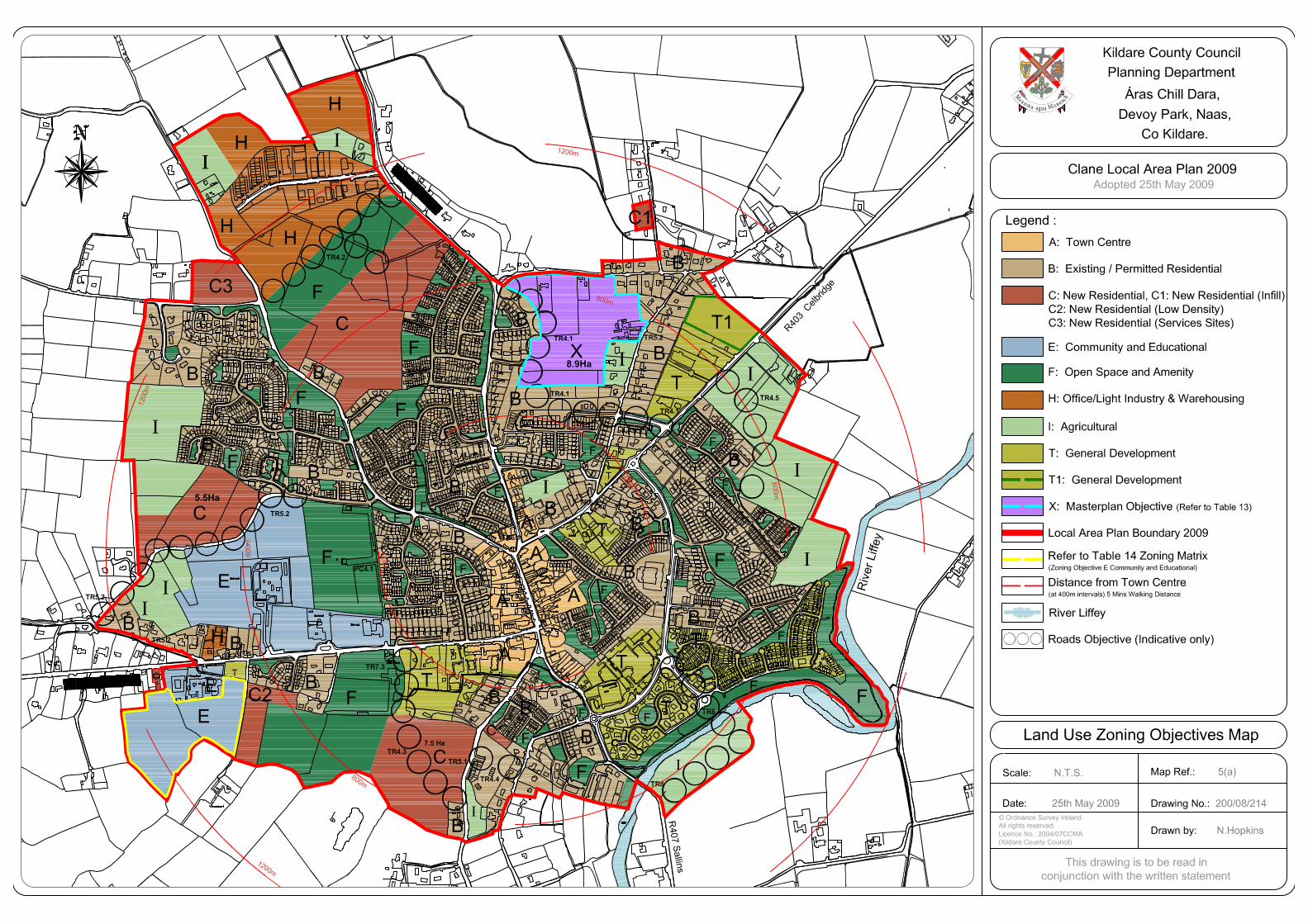
© Ordnance Survey Ireland.
All rights reserved.Licence No.: 2004/07CCMA
(Kildare County Council)
This drawing is to be read in
conjunction with the written statement
Scale: N.T.S. Map Ref.: 5(a)
Drawing No.: 200/08/214
Legend :
A: Town Centre
B: Existing / Permitted Residential
C: New Residential, C1: New Residential (Infill)
C2: New Residential (Low Density)
C3: New Residential (Services Sites)
E: Community and Educational
F: Open Space and Amenity
H: Office/Light Industry & Warehousing
I: Agricultural
Kildare County Council
Planning Department
Áras Chill Dara,
Devoy Park, Naas,
Co Kildare.
Drawn by: N.Hopkins
h
ca
ensiMsuga
am
na
eM
River Liffey
Local Area Plan Boundary 2009
Distance from Town Centre
(at 400m intervals) 5 Mins Walking Distance
N
T: General Development
X: Masterplan Objective (Refer to Table 13)
Date: 25th May 2009
Clane Local Area Plan 2009
Adopted 25th May 2009
Roads Objective (Indicative only)
Land Use Zoning Objectives Map
Refer to Table 14 Zoning Matrix(Zoning Objective E Community and Educational)
T1: General Development
7.5 Ha
A
A
A
B
B
BB
BB
B
B
BB
B
B
B
C
C
H
H
E
T
T
F
E
B
F
F
FB
F FF
FB
E
B
B
B
GAA ClubClane
F
I
I
I
I
A
A
C
GS
ES
School
Church
Convent
Presb.
Library
School
School
School
Hospital
Viewmount
T
T
T
R403
Celbr
idge
R407 Sa
llins
R407 K
ilcock
R403 Prosperous
F
FF
F
F
I
H
H
I River L
iffey
F
F
F
F
F
I
F
F
F
B
B
B
E
B
T
T
T
I
E
C
X8.9Ha
5.5Ha
I
Weir
F
F
400m
400m
I
TC 6
PC4.1
TR4.2
TR4.1
TR5.2
TR6.1
TR6.2
PC4.3
TR4.3
TR5.1
TR7.3
TR5.2
TR8
TR5.2
TR5.2
TR4.4
TR4.5
TR4.1
TR4.1
TR8
400m
I
C3
IA
C2
H
I
T1
C1
800m
1200m
800m
1200m
800m
1200m
800m
C400m
Draft Strategic Flood Risk Assessment
11049-LAP Clane_Issue No. 6 - Page A-2
APPENDIX II
RECORDS OF JUSTIFICATION TESTS

1
Clane Local Area Plan 2017-2023 Site A: Lands previously zoned Office / Light Industry
and Warehousing (H) To the north of the town on
the Kilcock Road
1 The Regional Planning Guidelines for the
Greater Dublin Area 2010-2022 set out
the planned direction for growth within
the Greater Dublin Area up to 2022 by
giving regional effect to national planning
policy under the National Spatial Strategy
(NSS). The RPG’s have not designated
Clane but it is a Small Town under the
Kildare County Development Plan 2011-
2017 and proposed draft Kildare CDP
2017-2023.
Clane as a Small Town is intended to support the
development of small locally-financed business, and
other economic investment opportunities are to be
supported where sustainable
Arising from the RPGs and the draft County
Development Plan 2017-2023, a growth target of an
additional 780 residential units is prescribed for Clane
during the lifetime of the plan.
The Council will seek to encourage new local
employment opportunities at a scale appropriate to
the town’s role and growth, to assist in reducing long
distance commuting patterns and thus creating more
sustainable communities.
2 The zoning or designation of the lands for
the particular use or development type is
required to achieve the proper planning
and sustainable development of the
urban settlement and in particular:
The lands were zoned ‘H’ Office/Light Industry and
Warehousing under the 2009 Clane LAP. This zoning
provides for employment generating uses such as
light industry, manufacturing, warehousing.
It is considered that, while the zoning of some lands
for Light Industrial/Warehousing is required, it is not
evident that these specific lands present the optimum
location. This site is currently undeveloped and
located on the outskirts of the town. The Clane
Business Park and other such zoned lands are located
to the south of the site, and parts of this remain
undeveloped.
(i) Is essential to facilitate regeneration
and / or expansion of the centre of the
urban settlement;
The lands are approximately 1.5 from the centre of
Clane. Given their location they would not facilitate
regeneration or expansion of the centre of Clane.
(ii) Comprises significant previously
developed and / or underutilized lands;
The lands are undeveloped; there is no planning
history on the site.
(iii) Is within or adjoining the core of an
established or designated urban
settlement;
The lands are not within or adjoining the core of the
settlement.
(iv) Will be essential in achieving compact Other lands in closer proximity to the town centre are

2
and sustainable urban growth; and
available for development and would provide more
compact growth.
(v) There are no suitable alternative lands
for the particular use or development
type, in areas at lower risk of flooding
within or adjoining the core of the urban
settlement.
As stated, there are other lands available in closer
proximity to the town centre which are of lesser risk
of flooding.
SFRA
3 SFRA must demonstrate that flood risk to
the development can be adequately
managed and the use or development of
the lands will not cause unacceptable
adverse impacts elsewhere.
A significant portion of the site is affected by flood
risk. However the depth of floodwater is generally
shallow.
Given that the site failed to pass other elements of
the Justification Test, the SFRA recommends that the
subject lands be reclassified for water compatible
development only in accordance with the Flood Risk
Management Guidelines.
Development of the lands for water compatible uses
must include such mitigation measure as are required
to ensure that:
(i) There is no net reduction in the volume of
floodplain storage contained within the lands being
developed:
(ii) Existing flow paths will not be compromised;
(iii) Surface water runoff from development to
be limited to the existing Greenfield run off from the
site in accordance with the GDSDS.

3
Clane Local Area Plan 2017-2023 Site No B: Lands zoned Business & Technology and
Community & Institutional to the east of the town
on the Celbridge Road.
1 The Regional Planning Guidelines for the
Greater Dublin Area 2010-2022 set out
the planned direction for growth within
the Greater Dublin Area up to 2022 by
giving regional effect to national planning
policy under the National Spatial Strategy
(NSS). The RPG’s have not designated
Clane but it is a Small Town under the
Kildare County Development Plan 2011-
2017 and proposed draft Kildare CDP
2017-2023.
Clane as a Small Town is intended to support the
development of small locally-financed business, and
other economic investment opportunities are to be
supported where sustainable
Arising from the RPGs and the draft County
Development Plan 2017-2023, a growth target of an
additional 780 residential units is prescribed for Clane
during the lifetime of the plan.
The Council will seek to encourage new local
employment opportunities at a scale appropriate to
the towns role and growth, to assist in reducing long
distance commuting patterns and thus creating more
sustainable communities.
The river Gollymochy stream runs to the north of the
site and is a tributary of the River Liffey. It appears
that a portion of the site could be impacted by a flood
event, particularly the portion of the site to the north
west adjacent residential properties.
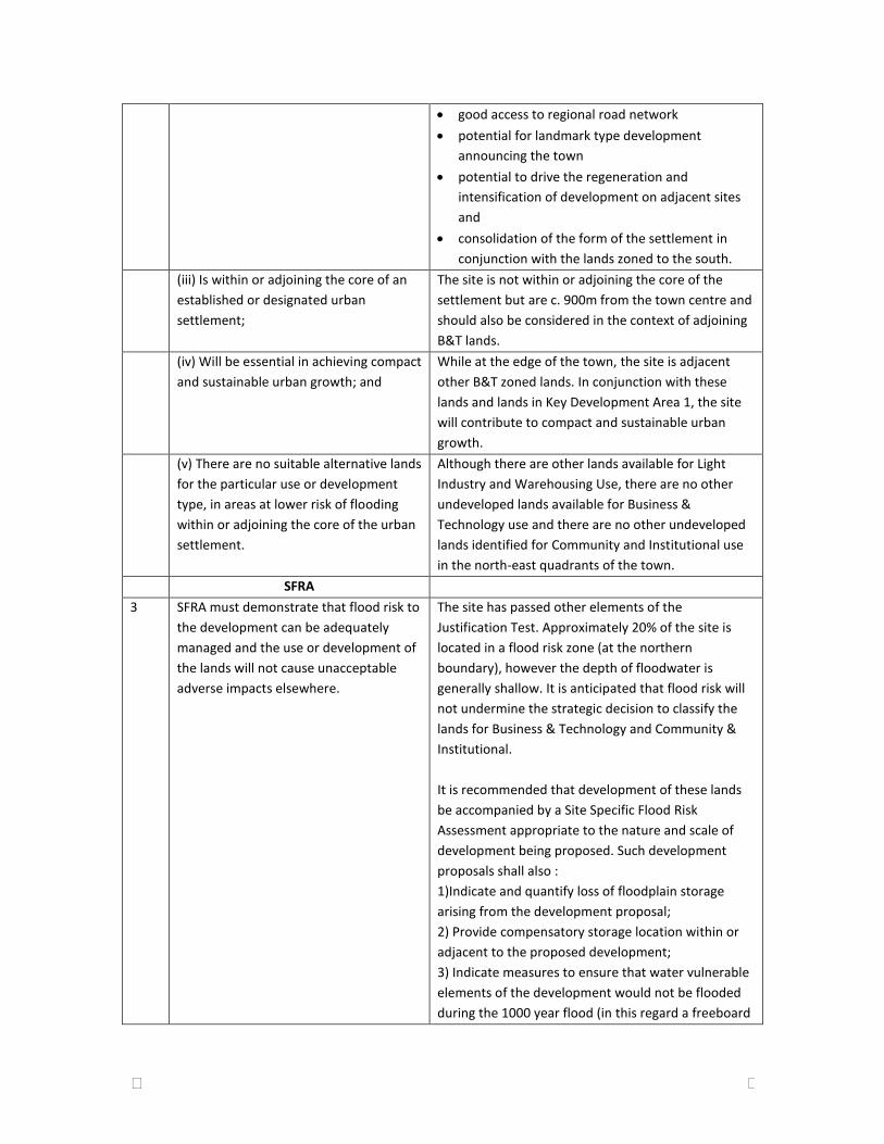
2 The zoning or designation of the lands for
the particular use or development type is
required to achieve the proper planning
and sustainable development of the
urban settlement and in particular:
This site was included for ‘T1’ General Development
in the 2009 Clane Local Area Plan. The site is zoned
for Business & Technology and Community &
Institutional under the draft LAP. These zonings are
intended to provide for employment generating uses
(such as offices and high technology) and a childcare
facility. There are no other undeveloped lands zoned
for B&T in the LAP area.
The site has advantages in terms of access,
opportunity to provide a landmark development,
potential to drive the intensification of development
on adjacent sites and (in conjunction with Key
Development Area 1, strategic reserves and strategic
open space) would consolidate the form of the
settlement.
(i) Is essential to facilitate regeneration
and / or expansion of the centre of the
urban settlement;
The subject site is not within the centre of the
settlement but is within 1km of same.
(ii) Comprises significant previously
developed and / or underutilized lands;
There is no planning history on the site. The lands are
considered underutilised in the following context:
4
good access to regional road network
potential for landmark type development
announcing the town
potential to drive the regeneration and
intensification of development on adjacent sites
and
consolidation of the form of the settlement in
conjunction with the lands zoned to the south.
(iii) Is within or adjoining the core of an
established or designated urban
settlement;
The site is not within or adjoining the core of the
settlement but are c. 900m from the town centre and
should also be considered in the context of adjoining
B&T lands.
(iv) Will be essential in achieving compact
and sustainable urban growth; and
While at the edge of the town, the site is adjacent
other B&T zoned lands. In conjunction with these
lands and lands in Key Development Area 1, the site
will contribute to compact and sustainable urban
growth.
(v) There are no suitable alternative lands
for the particular use or development
type, in areas at lower risk of flooding
within or adjoining the core of the urban
settlement.
Although there are other lands available for Light
Industry and Warehousing Use, there are no other
undeveloped lands available for Business &
Technology use and there are no other undeveloped
lands identified for Community and Institutional use
in the north-east quadrants of the town.
SFRA
3 SFRA must demonstrate that flood risk to
the development can be adequately
managed and the use or development of
the lands will not cause unacceptable
adverse impacts elsewhere.
The site has passed other elements of the
Justification Test. Approximately 20% of the site is
located in a flood risk zone (at the northern
boundary), however the depth of floodwater is
generally shallow. It is anticipated that flood risk will
not undermine the strategic decision to classify the
lands for Business & Technology and Community &
Institutional.
It is recommended that development of these lands
be accompanied by a Site Specific Flood Risk
Assessment appropriate to the nature and scale of
development being proposed. Such development
proposals shall also :
1)Indicate and quantify loss of floodplain storage
arising from the development proposal;
2) Provide compensatory storage location within or
adjacent to the proposed development;
3) Indicate measures to ensure that water vulnerable
elements of the development would not be flooded
during the 1000 year flood (in this regard a freeboard

5
of 500m shall be provided)
4) Ensure that existing flow paths for flood water will
not be compromised.

6
Clane Local Area Plan 2017-2023 Site No C: Lands formerly zoned Community and
Educational, to the west of the town on the
Prosperous Road.
1 The Regional Planning Guidelines for the
Greater Dublin Area 2010-2022 set out
the planned direction for growth within
the Greater Dublin Area up to 2022 by
giving regional effect to national planning
policy under the National Spatial Strategy
(NSS). The RPG’s have not designated
Clane but it is a Small Town under the
Kildare County Development Plan 2011-
2017 and proposed draft Kildare CDP
2017-2023.
Note: The majority of these lands are no longer
proposed to be zoned for Community and Education,
other than that portion containing the existing
hospital and nursing home. As such a justification is
not required for them. However, a justification test
was carried out on these lands as part of the initial
assessment of all lands zoned in the previous LAP and
is retained in this report as part of the record of SFRA
carried out.
Clane as a Small Town is intended to support the
development of small locally-financed business, and
other economic investment opportunities are to be
supported where sustainable. Arising from the RPGs
and the draft County Development Plan 2017-2023, a
growth target of an additional 780 residential units is
prescribed for Clane during the lifetime of the plan.
The Council will seek to encourage new local
employment opportunities at a scale appropriate to
the towns role and growth, to assist in reducing long
distance commuting patterns and thus creating more
sustainable communities and will support and
facilitate improvements to existing educational,
childcare and healthcare facilities supporting the local
community.
The subject site is located in close proximity to the
Butterstream which flows into the Liffey further to
the east.
The lands were zoned Community and Educational
under the 2009 Clane LAP. This location reflected
community uses (hospital and nursing home) at the
location and identified land to the rear of the hospital
intended for further healthcare-related development
with the requirement that any housing be ancillary to
community/educational uses.
2 The zoning or designation of the lands for
the particular use or development type is
required to achieve the proper planning
and sustainable development of the
The need for an extensive amount of lands for further
Community/Institutional development adjacent the
hospital has not been demonstrated and there is no
specific objective to intensify such uses in Clane.

7
urban settlement and in particular:
(i) Is essential to facilitate regeneration
and / or expansion of the centre of the
urban settlement;
The lands are located at the edge of the town and
would not contribute to expansion or regeneration of
the core.
(ii) Comprises significant previously
developed and / or underutilized lands;
The lands are undeveloped. While there have been a
number of planning permissions on the site of the
existing healthcare facilities, no development
proposals have been made on the subject lands.
(iii) Is within or adjoining the core of an
established or designated urban
settlement
The site is located on the outskirts of the town on the
Prosperous Road.
(iv) Will be essential in achieving compact
and sustainable urban growth; and
It has not been demonstrated that there is a need for
the lands for expansion of healthcare facilities or
associated residential development. As such the lands
are not essential for compact/sustainable growth.
(v) There are no suitable alternative lands
for the particular use or development
type, in areas at lower risk of flooding
within or adjoining the core of the urban
settlement.
There are other lands zoned for Community and
Institutional development with lower risk of flooding
and there is scope for the intensification of
healthcare uses within its current site.
SFRA
3 SFRA must demonstrate that flood risk to
the development can be adequately
managed and the use or development of
the lands will not cause unacceptable
adverse impacts elsewhere.
A section of the stream flowing through the site is
culverted. It is considered that the capacity of this
culvert will not be sufficient to carry flows in the
stream during rainfall events of higher return periods.
It is recommended that this culvert be replaced with
a culvert of sufficient capacity and that the capacity
of the channel be determined and increased if
required.
It is recommended that development of these lands
be accompanied by a Site Specific Flood Risk
Assessment appropriate to the nature and scale of
development being proposed. Such development
proposals shall also :
1)Indicate and quantify loss of floodplain storage
arising from the development proposal;
2) Provide compensatory storage location within or
adjacent to the proposed development;
3) Indicate measures to ensure that water vulnerable
elements of the development would not be flooded
during the 1000 year flood (in this regard a freeboard
of 500m shall be provided)
4) Ensure that existing flow paths for flood water will
not be compromised.

8
Clane Local Area Plan 2017-2023 Site No D: Lands between the Prosperous and
Millicent Roads, beside the GAA grounds.
1 The Regional Planning Guidelines for the
Greater Dublin Area 2010-2022 set out
the planned direction for growth within
the Greater Dublin Area up to 2022 by
giving regional effect to national planning
policy under the National Spatial Strategy
(NSS). The RPG’s have not designated
Clane but it is a Small Town under the
Kildare County Development Plan 2011-
2017 and proposed draft Kildare CDP
2017-2023.
Arising from the RPGs and the draft County
Development Plan 2017-2023, a growth target of an
additional 780 residential units is prescribed for Clane
during the lifetime of the plan.
Clane as a Small Town is intended to support the
development of small locally-financed business, and
other economic investment opportunities are to be
supported where sustainable
The subject site had two zoning objectives (T General
Development and C New Residential) under the 2009
LAP. The lands are zoned New Residential under the
draft LAP, with small portions zoned Existing
Residential/Infill and Town Centre.
The subject site is located in close proximity to the
Butterstream which flows into the Liffey further to
the east.
2 The zoning or designation of the lands for
the particular use or development type is
required to achieve the proper planning
and sustainable development of the
urban settlement and in particular:
The majority of the lands are zoned for New
Residential development. Parts zoned Existing
Residential and Town centre reflect existing
development.
The zoning of adequate lands for residential
development is necessary in order to enable the
growth of Clane in compliance with the Core Strategy
of the CDP. The zoning of these specific lands is in
accordance with proper planning and sustainable
development as they are sequentially the closest
landbank to the town centre, are adjacent amenities
and offer the best opportunity for sustainable
residential development.
(i) Is essential to facilitate regeneration
and / or expansion of the centre of the
urban settlement;
The zoning of these lands is necessary for the
sustainable development of the town and the
development of a compact urban structure as these
sites are in close proximity to the Main Street. The
currently undeveloped new residential lands are
located adjacent to existing residential development,
amenity facilities and education facilities.
(ii) Comprises significant previously
developed and / or underutilized lands;
The lands were not previously developed. Permission
was refused in 2010 on part of these lands due to
insufficient capacity in the wastewater treatment
9
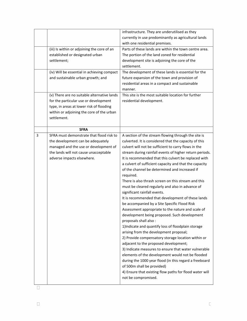
infrastructure. They are underutilised as they
currently in use predominantly as agricultural lands
with one residential premises.
(iii) Is within or adjoining the core of an
established or designated urban
settlement;
Parts of these lands are within the town centre area.
The portion of the land zoned for residential
development site is adjoining the core of the
settlement.
(iv) Will be essential in achieving compact
and sustainable urban growth; and
The development of these lands is essential for the
future expansion of the town and provision of
residential areas in a compact and sustainable
manner.
(v) There are no suitable alternative lands
for the particular use or development
type, in areas at lower risk of flooding
within or adjoining the core of the urban
settlement.
This site is the most suitable location for further
residential development.
SFRA
3 SFRA must demonstrate that flood risk to
the development can be adequately
managed and the use or development of
the lands will not cause unacceptable
adverse impacts elsewhere.
A section of the stream flowing through the site is
culverted. It is considered that the capacity of this
culvert will not be sufficient to carry flows in the
stream during rainfall events of higher return periods.
It is recommended that this culvert be replaced with
a culvert of sufficient capacity and that the capacity
of the channel be determined and increased if
required.
There is also thrash screen on this stream and this
must be cleared regularly and also in advance of
significant rainfall events.
It is recommended that development of these lands
be accompanied by a Site Specific Flood Risk
Assessment appropriate to the nature and scale of
development being proposed. Such development
proposals shall also :
1)Indicate and quantify loss of floodplain storage
arising from the development proposal;
2) Provide compensatory storage location within or
adjacent to the proposed development;
3) Indicate measures to ensure that water vulnerable
elements of the development would not be flooded
during the 1000 year flood (in this regard a freeboard
of 500m shall be provided)
4) Ensure that existing flow paths for flood water will
not be compromised.

Draft Strategic Flood Risk Assessment
11049-LAP Clane_Issue No. 6 - Page A-3
APPENDIX III
Maps showing findings of SFRA including those areas for which site-
specific flood risk assessment is recommended

Determination of flood lines does not take
into account the culvert in the hospital
grounds. This culvert must be replaced as
part of future development on these lands.
Determination of flood lines does not
take this culvert into account. This
culvert must be replaced as part of
future development on these lands.
NOTES A1
KYLEKIPROE, WELL ROAD, PORTLAOISE, CO. LAOIS
KILGALLEN & PARTNERS
CONSULTING ENGINEERS
E-mail: [email protected], Web: www.kilgallen.ie
Tel: +353 57 86 62860, Fax: +353 57 86 62861
DRAFT REPORT
KILDARE COUNTY COUNCIL
STRATEGIC FLOOD RISK ASSESSMENT
CLANE DRAFT LOCAL AREA PLAN
2017- 2023
RECOMMENDATIONS OF SFRA
FLOOD RISK ZONES WHERE ESTABLISHED BY DETAILED FRA
DQ
PB
1:5000 @ A1
06.07.16
11049-CLA-102 DR5
N
KILDARE COUNTY COUNCIL
Comhairle Chontae Chill Dara
LEGEND
Development proposals for lands outlined thus are to be the
subject of site-specific Flood Risk Assessment appropriate
to the type and scale of the development being proposed.
Such Development Proposals shall also:
· Indicate and quantify loss of floodplain storage arising
from the development proposal;
· Provide compensatory storage located within or
adjacent to the proposed development;
· Indicate measures to ensure that water-vulnerable
elements of the Development would not be flooded
during the 1000year flood;
· Ensure that existing flow paths for flood waters will not
be compromised.
Development Plan boundary
Outline of areas which were subject to
Detailed Flood Risk Assessment
(Flood risk zones have only been established
within those areas which were the subject of
Detailed Flood Risk Assessment )
1000year flood zone established by Detailed Flood
Risk Assessment
Extent of 100year flood zone established by
Detailed Flood Risk Assessment

Draft Strategic Flood Risk Assessment
11049-LAP Clane_Issue No. 6 - Page A-4
APPENDIX IV
DRAFT CLANE LOCAL AREA PLAN 2017 TO 2023 - LAND-USE MAP

F
Castle(Site of)
Blackhall
Pond
AlexandraAlexandra Manor
20
1
5
UND
34-3
6
30
AB
BE
Y P
AR
K C
OU
RT
AB
BE
Y P
AR
K C
OU
RT
25
31-33
4545
UN
D
7864
9016
124-131133-13841
59 516458 C
R
6116-123
Alexandra WalkAlexandra Walk3753
835984
28
River Liffey11 1-8 1071-7
3 UN
D
ALEXANDRA WALK
ALEXANDRA WALK
199
331Alexandra ParkAlexandra Park65-67
CR
Green Acres
CD
CF
UN
D
Tk
FF
CF
Bridge BridgeGollymochyGollymochy
Gollym
och
y Rive
r
The P
ale
F
F
F
F
FF
R40
3 C
elbr
idge
F
F
Riv
er
Liffe
y
F
F
F
FF
F
F
R403 Prosperous
R407 Kilcock
R407 S
allin
s
F
F
F
A
A
B
B
B
B
C
C
C
B
B
B
B
B
B
B
B
B
E
E
E
B
H
B
B
H B
B
400m
400m
400m
1200m
800m
1200m
1200m
800m
400m
I
A
A
A
B
B
F2
F2
Strategic Open Space
Q
Q
1600m
F
Strate
gic Open S
pace
F2
B
Q5.2 Ha
The Avenue
The Avenue
56Ballinagappa WoodBallinagappa Wood
6328 1
12654The LawnsThe Lawns
9
Capdoo CourtCapdoo Court34A
1917 223619 2311 Meadow CourtMeadow Court37 19
418 1810317A
1 78 CAPDOO PARKCAPDOO PARK 5831 11211 10 131A44 1016
Centre
Central Park
Central Park
Health19
9
1 26
School
Library
Are
a u
nder co
nstru
ction
Liffey Lawns
Liffey Lawns
Bank
1
Central Park Avenue
Central Park Avenue
11 Ramps
20
MA
IN S
TR
EE
T
MA
IN S
TR
EE
T
ChurchPO
750
2230
Central P
ark Way
Central P
ark Way
287
GroundBurial
127Bank
1
43 16132
LawnsLawnsLiffeyLiffey 138
18
3
1Ottomy GroveOttomy Grove 22School 11
152226
22 14
CLANE 29Ottomy CrescentOttomy CrescentSports Ground 14
1Ottomy GroveOttomy Grove
119
623
172026 712 18 1 Beech Court2
Ottomy AvenueOttomy Avenue 14
10 1515
Butter Stream
School
1317School
CF
CD
CF
UND
UND
UN
D
Clane Business Park
Gollymochy River
56
The GroveThe Grove
41
40
49
CR
TheTheCresentCresent
48
25
89
16
33
The A
venue
The A
venue
24
12
32
126
184
The The Lawn Lawn
17
Mast
29 17
Clonwood HeightsClonwood Heights
15
Well
6 5
The O
rchard
The O
rchard
UND
1
165
174
170
Area under construction
172
173
CR
Colle
ge R
oad
Colle
ge R
oad
UND
Mainham WoodMainham Wood
14
CR
Spring
CR
105The RiseThe Rise
THE RISETHE RISE
114 152Ard na GappaghArd na Gappagh 130129115
104
The GreenThe Green111
15712812723
113 The CloseThe Close67
8 57 164Lough Bollard
149
155
160
159
1
COLLEGE ROAD EAST
COLLEGE ROAD EAST
8
Spring
Spring
The WalkThe Walk1
BALLINAGAPPA ROAD
BALLINAGAPPA ROAD
The DriveThe Drive
79The DriveThe Drive14814718 139The MeadowsThe Meadows18 146
88112
14
1813831 68 15123
13178114
8The CrescentThe Crescent 1 1 CAPDOO AVENUECAPDOO AVENUE
The CloseThe Close 343938151619Hillview GreenHillview Green 911346 1
1-4 21-24126 13-1630 1492 40 46
The Meadows
The Meadows12 17-2045The GroveThe Grove HeightsHeights
7 2021HillviewHillview 33
8Spring32
1354162
2041 152042 1349 27
29-32 The Elms The Elms38
61
9-125-8
114115
134
127
College Wood ManorCollege Wood Manor
73
83
72
69
65
56
37
53
40
1
52
Dispensary
19
72 Credit Union120472046 TerraceTerrace2048 St Brigids'St Brigids'
MuireCollege GroveCollege Grove102036 Cluain
17 1343
56 20451 1348
St.Brigid'sParkPark6 627 OatfieldOatfield169-1
211
HillviewHillview
17-20
OaksOaksThe CourtyardThe Courtyard 1 2050 TheThe
1612
427
ManorManor 68College WoodCollege Wood 341
2610 Spring
The CloistersThe Cloisters
48
32
4240 GS
1
Abbey WoodAbbey Wood56
3410
10Ottomy DriveOttomy Drive
35Ottomy Close
Ottomy Close
51
Sports Ground
10A3
12A1 1
Ottomy LawnsOttomy Lawns
8
F2
Castle(Site of)
Blackhall
Pond
AlexandraAlexandra Manor
20
1
5
UND
34-3
6
30
AB
BE
Y P
AR
K C
OU
RT
AB
BE
Y P
AR
K C
OU
RT
25
31-33
4545
UN
D
7864
9016
124-131133-13841
59 516458 C
R
6116-123
Alexandra WalkAlexandra Walk3753
835984
28
River Liffey11 1-8 1071-7
3 UN
D
ALEXANDRA WALK
ALEXANDRA WALK
199
331Alexandra ParkAlexandra Park65-67
CR
17
6
9
1
Grave Yard
16
25
Alexandra ManorAlexandra Manor
13 ChurchfieldChurchfield6 1
1041 1
2 3 4
Grave YardTk
Site of MonasteryAbbey CourtAbbey Court 16
Car Park
Yew Tree SquareYew Tree SquareBellaville
12
4 (in ruins)Bullán
Clane Abbey
Abbeylands Shopping Centre9
12
But
ters
trea
m L
awn
But
ters
trea
m L
awn
8
8
2
1
Butters
tream
Drive
Butters
tream
Drive
17
1
ParkConneff
ClaneGAA Club
BridgeBridgeHalfmileHalfmile
Hospital
Base ofStone Cross
(Wart Stone)
1
MIL
LIC
EN
T R
OAD
MIL
LIC
EN
T R
OAD
1
Park ViewPark View7
50
14
15
43
42
22
34
27
3333A
43 Motte
WellWellSunday'sSunday's 21
Hemingway Park Hemingway Park15
An CrocánAn Crocán
17
Blo
ck 4
Liffe
y
Block 1 Motte
Bridge
Blo
ck 3
Mill
icent
Alexandra13-18
34
UN
D7-121-237-38
4-3
39-40Cois AbhainnCois Abhainn
1-6Area under construction
PondWeir
Viewmount
UN
D
Blo
ck 5
Ale
xandra
Blo
ck 2
Abbey
RathKavanagh's
CR
UN
D
CR
UN
D
Riv
er L
iffey
Clubhouse
HouseMoatfield
Mound
Pond
CR
Pond
Golf Course
SchoolHewetson
(Dept of Defence)
Firmount House
C 2.0Ha
F2
1600m
C
B
KDA-4
KDA-3
KDA-2
KDA-1
KDA-5
F
C
C
I
SR
F2
100m
100m
F2
I
SR
F27.0Ha
SR
SR
E
E
CR
CR
UNDHoleWogan's
UNDCR
19
BrooklandsBrooklands18
46
13
152
Abbey Park Glen
Abbey Park Glen
15 4020
631
Abbeylands73
CR1 1
115
ManorManor
3141 18 1 832830 ALE
XA
ND
RA
WA
LK
ALE
XA
ND
RA
WA
LK
42-61 40 20 99Abbey Park
Court
Abbey Park
Court
651784
Abbey Park Green
Abbey Park Green
AbbeylandsAbbeylandsAbbey P
ark Grove
Abbey Park G
rove
10 GreeenGreeenAbbey ParkAbbey Park
16
134The Lawn, AbbeylandsThe Lawn, Abbeylands1
80AbbeylandsAbbeylandsThe LodgeThe Lodge 10314
10013 77Abbey Park Orchard
Abbey Park Orchard
23
7019 871729
FF
CD
CR
UN
D
CF
FF
0.91m FF CS
FF
UND
CR
Capdoo Business Park
Spring
UN
D
26
33
25
5
10
4041-64
1
11
81 65-8
0
UND
1 CR
140
305-8 98
121-4
15121 38
164
Abbey P
ark
Abbey P
ark
110
141
135
Abbey P
ark V
iew
Abbey P
ark V
iew
UND
0.0 250 500
Ordnance Survey Ireland. All rights
reserved.LicenceNo.:2004/07CCMA
(Kildare County Council)
This drawing is to be read in
conjunction with the written statement
Land Use Zoning Objectives Map
Scale: N.T.S. Map Ref.: 13.1
Drawing No.: 200/16/1000
Kildare County Council
Planning Department
Áras Chill Dara,
Devoy Park, Naas,
Co Kildare.
Drawn by: B.Ryan
hcaensiMsugaamnaeM
Clane Local Area Plan 2017 - 2023
Proposed Draft
A: Town Centre
B: Existing Residential
I: Agriculture
Local Area Plan Boundary
C: New Residential
Legend
H: Light Industry & Warehousing
River Liffey
Roads Objective (Indicative only)
Distance from Town Centre(at 400m intervals) 5 Mins Walking Distance
Q: Business and Technology
E: Community and Institutional
SR: Strategic Reserve
KDA:Key Development Areas
F: Open Space and Amenity
F2: Strategic Open Space
Date: September 2016
(KDA 1 to 5)