strategic environmental assessment of a landscape...
TRANSCRIPT

Strategic Environmental Assessment of a
Landscape Plan: A Case Study Concerning
Sardinia, an Italian Region
Sabrina Lai and Corrado Zoppi
Dipartimento di Ingegneria del Territorio, Sezione di Urbanistica, University of
Cagliari, Via Marengo, 3 - 09123 Cagliari, Italy
tel.: +39 (0)70 6755200-6755216, telefax: +39 (0)70 6755215; e-mail: [email protected] - [email protected]

Introduction
Privileged stakeholders and the Regional Landscape Plan A qualitative approach
The making of the interviews
Findings: the Sardinian RLP and sustainability
Local communities and the Regional Landscape Plan The conflict between the city of Sinnai and the Sardinian regional
administration
A case study based on a CV-MCA approach: methodology and findings
Discussion
A Foresterian analysis
Conclusion
Paper layout

Introduction: participation and
sustainability
Integration of expectations, preferences, needs in planning policies … Necessary condition for the sustainability of strategic planning processes
formal & informal
organizations strong
stakeholders
planning
choices
expectation,
preferences,
needs
local
communities
regional planning
policies

Introduction: the Regional
Landscape Plan for Sardinia 2006: approval of the Regional Landscape Plan (RLP) for Sardinia. The RLP:
Establishes the directions for nearly any future planning activity in Sardinia.
Requires that sectoral plans, local plans, and plans for protected areas be changed to comply with its directions.
This mandatory adjustment process can cause conflicts, if disagreement arises.
Two issues concerning public participation in the Sardinian RLP:
1. On what extent integration of different stakeholders was looked for in the plan preparation? What are the likely consequences of this degree of participation?
One-to-one semi-structured interviews.
Informed insight provided by professionals involved in the making of the plan.
Among the topics:
Sustainability and level of participation (cooperation, integration, inclusiveness).
Possible consequences of inconsistencies between the RLP and local master plans in the implementation of the RLP.
2. How can local communities participate in the implementation process of the RLP?
Built on an empirical study on conflictual issues concerning the Sardinian RLP.
Disparities brought out by the application of MCA and CV selection of criteria.
Criteria usually identified by experts.
What if the choice of criteria were open to public participation?
Results arising from the views of privileged stakeholders and local communities are compared.
Some lessons that can be learned from the intermix of the two approaches are identified.

The Regional Landscape Plan for
Sardinia
The Sardinian RLP is a statutory landscape plan. Its statutory character stems from:
The National Code of Cultural Heritage and Landscape, which required that each regional administration should approve a landscape plan.
The Regional Law no. 8 (of Nov. 25th 2004), which required that the Sardinian RLP for the coastal areas be approved within one year since the approval of the regional law.
The first part of the plan focuses on the coastal zone, because of:
The amount of resources needed to prepare a RLP for the whole island.
The complexity of conflicts arising from tourism and other types of development in the coastal areas.
The fact that 13 out of the 14 previous landscape plans covering coastal areas had been quashed in 2003 in a court decision.
After the approval of the plan, restrictions and prohibitions on development of land and on certain changes in land uses are in force, in order to protect a part of the island considered economically strategic and environmentally sensitive.
Restrictions and prohibitions are set out by the plan by means of a system of rules.

Why a qualitative approach?
Starting point: we cannot think of a “logically ordered, objective reality that we can come to
know” (Babbie, 1998) when we talk about sustainability.
Instead, we focus on “how people interpret the world.” (May, 2001)
Therefore, we look for information from privileged observers with a “high degree of credibility”
and “in a special position ‘to know’.” (Denscombe, 1998)
We attempt to “see things from that person’s [an expert] point of view” (Bogdan and Taylor), as they
only can:
o Provide an “in-depth insight to the topic” (Denscombe, 1998), because of the technical and
complex language and structure of the plan.
o Add extra information about the preparation of the plan, beyond that which can be
understood from the documents.
o Understand the plan, its complexity, and the relationship to the wider planning system.
As a result, this research relies on the collection of “data based on privileged information”
(Babbie, 1998) and is socially and culturally grounded.

The interviews
Five privileged testimonies (academics and public officers), members of the technical team which prepared the plan were interviewed.
Three concerns in the selection of the interviewees and in the subsequent interviewing process :
1. Biased contribution: since all of the interviewees were involved in the making of the plan, there was a risk that their opinion could be somewhat sympathetic towards the plan, and that they would tend to justify its choices, rather than provide an objective insight.
2. Issue of power relations (Valentine, 2005): some informants, taking advantage of their positions and authority (they were senior officers and managers) could have tried to control access to information.
3. Impact of the interviewer’s identity (Denscombe, 1998), caused by the fact that the interviewees were previously known by the researchers.
The five selected interviewees were architects, engineers and planners, involved in the plan preparation with different roles and responsibilities.
Three of them were selected from the working groups dealing respectively with natural assets, cultural heritage and built environment, while the other two are an academic and a senior public officer of the regional administration, who had worked on a coordination scheme, set up to link contributions from the thematic groups.

The making of the interviews
Five interviews were carried out in August, 2007. They were conducted in the interviewees’ workplaces, therefore neither issues of safety nor concerns of limited resources and travel cost affected the research, since all the offices are based in the same city.
The method chosen was that of one-to-one semi-structured interviews, with “a general plan of enquiry but not a specific set of questions that must be asked in particular words and with a particular order” (Babbie, 1998). This type of interview…
Allows to collect “an in-depth insight to the topic.” (Denscombe, 1998)
Is not carried out on the basis of a specific and rigid set of questions to be asked in a certain order and with particular words.
Is extremely flexible (Babbie, 1998), since it lets the interviewee free to explain “all the complexities and contradictions” (Valentine, 2005) of the phenomenon observed and to raise issues which were not thought of by the researchers.
Each participant was asked for freely given informed consent to take part in the research. All the respondents, prior to the interview, were read a form that included the following points:
The interview was being done for research purposes only.
For each specific question, the interviewees could choose whether to answer.
Their consensus could be withdrawn in any moment.
Anonymity would be guaranteed, not only with reference to their name, but also to their professional role, which could have given away their identity.
The interview would be recorded for the sole reason of easing the analysis of the materials and no one, apart from the researchers, would have access to the recordings.

Design of the interviews and
questions asked (1)
A general list of topics of interest and some questions were prepared prior to the interviews.
General framework for the topics covered and the questions raised:
First topic: the treatment of sustainability in the plan (preceded with a reading of article 3 of the PIC, which advocates “a balance between social needs, economic activities and environment”)
What kind of sustainability does the plan pursue?
Does the code only affirm a theoretical principle, or does it provide the means to put this statement into practice?
On the basis of individual responses to the previous question, a series of detailed questions were then asked, to allow the respondents to expand upon the topic, to give reasons for their answers and, when possible, to make reference to specific examples. Among these questions:
How did the plan address the issue of consumption of renewable/non renewable resources, protection of biodiversity and safeguard of the landscape?
How were economic activities considered by the plan?
How were participation and information sought?
Why was a Strategic Environmental Assessment (SEA) not performed?
Does a plan for the landscape really need to tackle economic, social and environmental problems?

Design of the interviews
and questions asked (2)
Second topic: the plan preparation process of the Sardinian RLP, especially the decision-making process, by examining to what extent participation and integration of different stakeholders in the making of the plan were sought
This topic was developed by means of a series of specific questions, depending on the responsibilities of each respondent in the preparation and implementation of the plan.
The relation, or conflict, between “technical knowledge” and “common knowledge” in deciding upon the meaning, quality, and future of places and spaces was also investigated.
Among these questions:
In what phases of the plan-preparation, and in what ways, were municipalities, provinces, private sector and other stakeholders involved?
What level of participation has been achieved? Was it appropriate?

Design of the interviews
and questions asked (3)
Third topic: the idea of governance reflected in the RLP
The relationship between the RLP, the provincial plans and the local masterplans is here assumed to be a reflection of the relationship between different administrative tiers, that is region, provinces and municipalities.
Three of the interviewees, who are also working on the implementation of the plan, were asked to talk about the consequences of inconsistencies between the Sardinian RLP and the local masterplans, and to explain possible conflicts between the regional and the municipal administrations, where possible providing specific examples they had encountered.
The other two interviewees, who took part in the preparation of the plan but not in its implementation, were given by the interviewer some of those examples as inputs, so as to stimulate a theoretical reflection on the relation between different tiers of government as implied by the RLP.
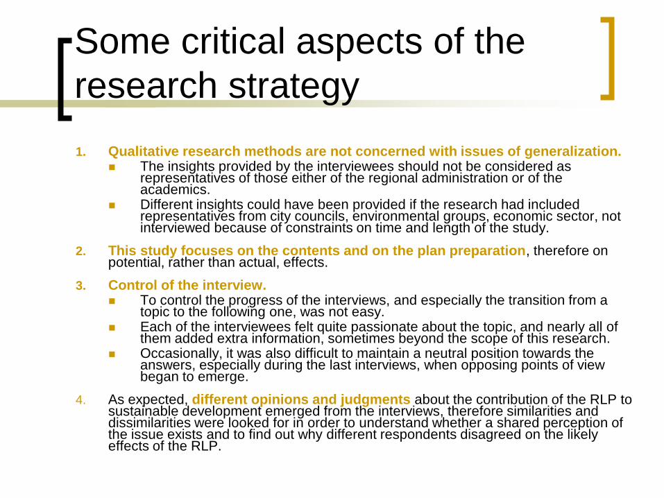
Some critical aspects of the
research strategy
1. Qualitative research methods are not concerned with issues of generalization. The insights provided by the interviewees should not be considered as
representatives of those either of the regional administration or of the academics.
Different insights could have been provided if the research had included representatives from city councils, environmental groups, economic sector, not interviewed because of constraints on time and length of the study.
2. This study focuses on the contents and on the plan preparation, therefore on potential, rather than actual, effects.
3. Control of the interview. To control the progress of the interviews, and especially the transition from a
topic to the following one, was not easy. Each of the interviewees felt quite passionate about the topic, and nearly all of
them added extra information, sometimes beyond the scope of this research. Occasionally, it was also difficult to maintain a neutral position towards the
answers, especially during the last interviews, when opposing points of view began to emerge.
4. As expected, different opinions and judgments about the contribution of the RLP to sustainable development emerged from the interviews, therefore similarities and dissimilarities were looked for in order to understand whether a shared perception of the issue exists and to find out why different respondents disagreed on the likely effects of the RLP.

Environmental sustainability (1)
The regional law which preceded and required the preparation and approval of the Sardinian RLP, as well as the plan itself, makes explicit reference to sustainable development, and to its three traditional components.
How is this commitment put into practice?
Is a landscape plan an appropriate means of delivering balanced, sustainable development?
From a mere reading of the documents of the plan, it is not clear how this formal commitment relates to policies and rules contained in the plan.
This ambiguity was reflected in the interviewees’ answers, since the respondents provided different, and sometimes opposing point of views, which can be grouped into two categories.

Should a landscape plan pursue
sustainable development?
Social and economic development lie beyond the scope of a landscape plan, which has to be restricted to environmental objectives, aesthetic concerns, and land-use related issues.
A careful selection of principles deriving from the European Spatial Development Perspective and from the European Landscape Convention was therefore necessary.
This selection had to leave out other principles not directly related with the aim of a landscape plan - that of laying down “basic emphases, general principles and strategic choices by which decisions on landscape protection, management and planning are to be guided.”
Among the principles set by the Sardinian RLP, and whose application was believed to contribute to sustainability, interviewees made explicit reference to:
Safeguarding of habitats (Interviewee A).
Prevention of consumption of non-renewable resources (Interviewees B&C), especially water and land.
For example, it was emphasized that:
Many of the rules contained in the Sardinian RLP prohibit new developments in greenfield sites, and demand that new housing supply, if needed, should be generated primarily by means of urban renewal.
This entails regeneration of abandoned areas and buildings (interviewee B), especially in town centers, thus indirectly contributing to economic development and social aims.
Greenfield sites can be developed under very restrictive conditions only when the regeneration of previously developed land is demonstrated to be insufficient to meet the needs for new houses.
These measures, which prevail over the zoning system of local masterplans, act as a tool to prevent urban sprawl and consumption of land.
To sum up, a plan for the landscape should not be considered a comprehensive planning tool, since its scope would be restricted to environmental and aesthetic matters. As a consequence, rules and policies contained in the plan are considered to be effective in promoting environmental sustainability.
FIR
ST
GR
OU
P

Environmental sustainability (2)
General idea:
The plan is somewhat ineffective if reference is made to sustainability in general.
The plan is stronger in terms of environmental sustainability.
Some positive aspects of the plan identified - many omissions and failures highlighted:
“Strong” analysis of the elements which constitute Sardinian natural environment and landscape.
Commitment to protection of current levels of quality of places consistently put into practice by means of a series of rules aimed at preventing loss of natural assets and cultural heritage, and at preserving or recreating identity and vibrancy in town centers.
The plan pursues “landscape protection” rather than “landscape management”: rules and policies of the Sardinian RLP “freeze” natural and built landscapes (Interviewee D) by “impeding that any transformation could take place” (Interviewee E).
This kind of approach can be tolerated only in a context, such as the Sardinian one, where environmental problems are not serious (with only few, circumscribed exceptions) and diffuse (Interviewee E).
In other regions of Italy, where widespread environmental risks exist, this commitment to protect the present situation of places rather than to manage their change can produce adverse effects and exacerbate the situation: “the more environmentally sensitive and fragile a landscape is, the more you need to give directions and rules to guide processes of transformation” (Interviewee E).
The plan lacked an SEA. An appraisal procedure was said to have been studied (Interviewees A&E), but the study was not completed. Lack of time (Interviewee B) and absence of legal requirement (Interviewee A) were put forward as an explanation. This latter justification stems from the absence, at the time the Sardinian RLP was approved, of a national law requiring a formal assessment of the effects of plans on the environment; however, it was also admitted that there was a statutory requirement, deriving from the Directive no. 42/2001/EC of the European Union, even in the absence of a national law (Interviewee A).
SE
CO
ND
GR
OU
P

Economic sustainability
3 main deficiencies:
Absence of any reference to economic issues:
Only exception: some economic data contained in the reports concerning the economic structure of the landscape units (Interviewee D).
These data, however, are “a mere repetition of data already available in any report published by the National Census” (Interviewee D).
Selection of the more appropriate type of plan:
Regional governments are required by the National Code of CH&L to approve either a “Regional Spatial Plan for Land Management with Specific Consideration of Landscape Values,” or a “Plan for the Landscape” - the choice of which one is left to the discretion of the regions.
The former is more capable of envisioning and guiding transformation and development, while the latter is more focused on protecting and enhancing landscape (Interviewee E).
The very choice of the type of plan has led towards a poor consideration of economic issues.
This weakness is, therefore, embedded in the very early stages of the planning process.
Lack of coordination between the RLP and the Plan for Sustainable Tourism Development (PSTD):
Tourism is a strategic and risky sector for the economic growth of the island: tourists are attracted by distinguishing nature, environment, and cultural identity of Sardinia, but tourism activities are mainly concentrated in coastal areas and in summer.
Along the coastline, private houses for rent accommodate four times as many tourists as hotels and resorts, contributing significantly to a particular kind of informal economy of the island which, in the absence of proper plans or of their enforcement, results in consumption of land and “strip development.”
For this reason. the Sardinian RLP had to be prepared together with a plan aimed at controlling tourism activities and impacts.
However, the two plans eventually followed two different paths, and the PSTD was presented for its approval several months after the approval of the RLP (Interviewee D).
Therefore, the RLP lacks one necessary ingredient: an appraisal of the impacts of economic and social activities in general, and of tourism in particular, on landscape and environment (Interviewee D).
The making of the plan itself is undermined by this deficiency.
SE
CO
ND
GR
OU
P

Social sustainability
The most challenging topic!
Aims and objectives of the plan have been defined in a political and technical process which involved the Regional Administration only (Interviewees A&C).
Lower tiers of government and other stakeholders were involved in public meetings (the so-called “conferenze di co-pianificazione”: “cooperative-planning conferences”) only after the adoption of the plan (however, before its approval).
The aim of the meetings was more informative than participative (Interviewee C): the consultation phase consisted of explaining principles, aims and contents of the Sardinian RLP to those key actors whose cooperation was needed for the implementation of the plan, that is, municipalities.
Why such a restricted interpretation of participation?
Lack of time (Interviewees B,C&E) - the plan had to be approved within the space of a year.
Issues of institutional competences (Interviewee E): the regional government would be the only responsible for the definition of regional policies and rules.
The character of the RLP itself (Interviewee B) - participation was not required because the RLP would simply set rules for other plans, and in particular for municipal masterplans; as a result, wider participation would be required only when it comes to adjusting masterplans, and especially their zoning schemes, to the RLP, because only in this phase would interests and expectations be affected in concrete terms.
The process of adjustment of the municipal masterplans to the rules of the Sardinian RLP, through which policies and rules contained in the regional plan are to be implemented, would compensate for the lack of consultation during the making of the regional plan (Interviewees B,C&E).

Implementing the RLP: normative
vs participatory approach
Article 11 of the PIC:
The Sardinian RLP is to be implemented by means of other plans (such as municipal and provincial
plans) and by means of individual agreements (the so-called “intese”) between regional, provincial and local governments.
The plan relies on other planning tools to implements its policies:
Technical support and financial resources are available to allow every municipality to prepare a new masterplan (Interviewees B&C).
All the municipalities whose territory overlaps the coastal areas (around 100) are entitled to these funds, made available in December 2006.
As of August 2007, only 5 municipalities had made request for these resources (Interviewee B).
Why? Because local governments are obliged to approve their masterplans in compliance with the Sardinian RLP within one year of the funds being granted.
This does not mean that municipalities can apply the rules of the RLP only if they wish: if they do not modify their plans, almost any development of land is forbidden by the regional plan, whose rules become immediately effective in the absence of a compliant land use plan (Interviewee B), and they have to come to an agreement with the regional administration to allow each new development project by means of the intese.
Rather than drawing on consensus and wide participation, considered as ordinary tools to facilitate the implementation of a spatial plan, the delivery of the Sardinian RLP relies on a normative approach.
The effectiveness of this approach as a tool to implement a regional strategy has been questioned (Interviewee E) on the basis of an historical precedent, that of the small number of municipal masterplans approved in compliance with the former landscape plans in force in Sardinia.

Implementing the RLP: what
participation can be envisioned?
According to the interviewees, participation would take two different forms:
Involvement of the general public in the making/adjustment of local masterplans.
Cooperation and integration between different administrative tiers and stakeholders in the mechanism of the intese.
The Sardinian RLP is not a plan aimed to simply control land uses:
“The Sardinian RLP does not spatially allocate land uses, thus it should not be qualified as a plan.” (Interviewee A)
“The fact that somebody says that the [Sardinian] RLP is not a ‘plan’ doesn’t surprise me, because it is, in fact, a ‘meta-plan’ [that is, a plan which controls other plans], although it is a rather weak meta-plan… When it affirms its principles, it mentions sectoral policies and plans, local masterplans and provincial plans. But, when it comes to practice, it is only concerned about municipal masterplans, land-use plans. (Interviewee E)
In fact, when asked about the impact of the RLP on other policies or plan, all the interviewees automatically referred to urban masterplans, as if the RLP were a framework for land-use plans only.
Public participation during the making of city masterplans in Italy is, by law, carried out in the form of written comments on an adopted draft of the plan, so there appears to be the risk of a limited involvement of stakeholders and general public in the implementation of the Sardinian RLP, which would parallel that occurred in the preparation.
However, since an SEA has to be carried out when preparing/adjusting a masterplan, it has been argued that wide public participation will be sought in accordance to good practice established for the SEA. (Interviewee B)
Municipalities should organize public meetings (e.g. fora and workshops); allegedly, though, the same municipal governments who complained about not being involved in the making of the RLP seem not to be willing to allow their citizens to take part in the making of their masterplans. (Interviewee C)
AD
JU
ST
ME
NT
OF
MA
ST
ER
PL
AN
S

Implementing the RLP: what
participation can be envisioned?
Both positive and negative sides of the intese, and of their consequences on relations between regional, provincial and municipal governments, have been pointed out by the interviewees:
The RLP provides only a few rules concerning landscape protection and prohibition of activities,
and omits to give rules concerning transformation of land (Interviewees D&E).
This absence of a formal, standard, and complete set of rules to guide transformation, management, and development of land in compliance with the principles and aims set by the Sardinian RLP would force municipal administrations to make compromises about the contents of their masterplans.
The intese risk allowing the regional administration to interfere with the making of municipal masterplans.
As a consequence, there might be a risk that the regional administration exerts absolute power on spatial planning, retaining its own power on spatial strategies and compelling both municipalities and provinces to negotiate their plans with the regional administration.
This also entails a risk of social inequality, because results of such compromises could be different for each municipality or province (Interviewee D), if affected by their bargaining powers and political or economic strength.
The intese allow for an effective integration between regional and municipal governments.
Inconsistencies between masterplans and the Sardinian RLP can be justified on both technical and political grounds (Interviewee B) and development plans not allowed by the regional plan can justify their assumptions, methodologies, choices.
The intese address an issue of scale, since the Sardinian RLP based its policies and rules on analyses at the regional scale, while local masterplans and development plans carry out their analyses at a much more detailed scale.
Therefore, the intese, far from constraining municipal powers, would help preserve them.
TH
E “
INT
ES
E” –
assessm
ent
ca
rrie
d o
ut
on a
case-b
y-c
ase b
asis
to a
ppro
ve s
pecific
p
roje
cts
and d
evelo
pm
ent
pla
ns
DR
AW
BA
CK
S
AD
VA
NTA
GE
S
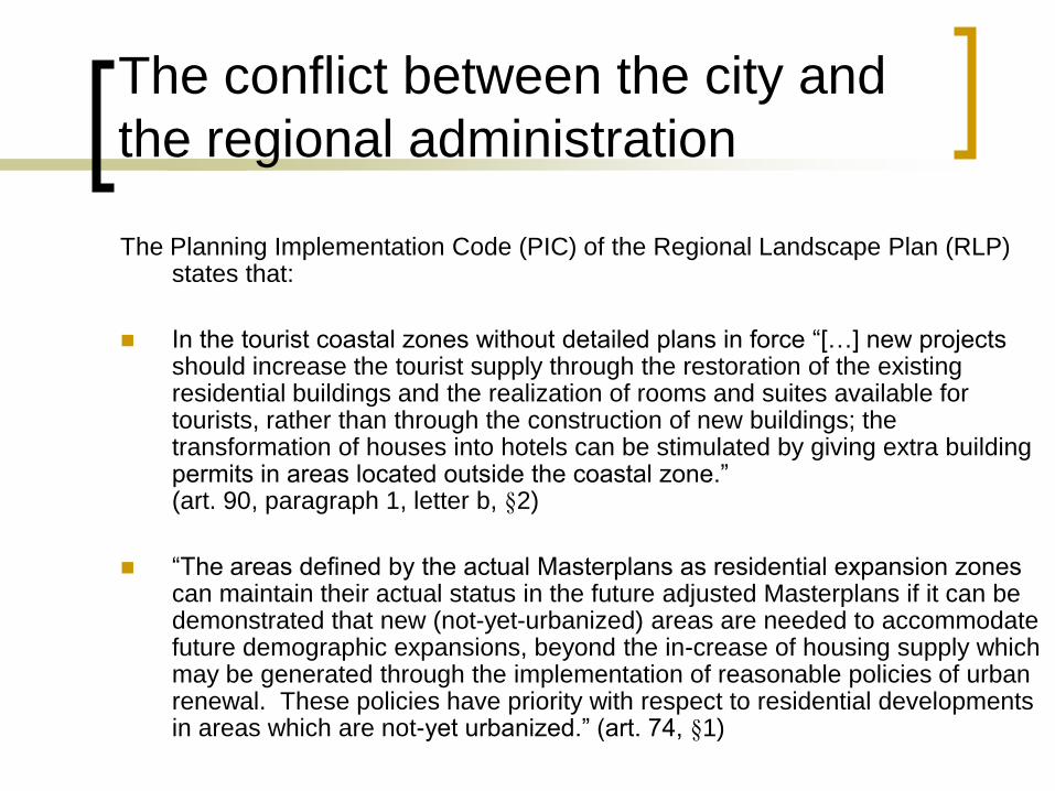
The conflict between the city and
the regional administration
The Planning Implementation Code (PIC) of the Regional Landscape Plan (RLP) states that:
In the tourist coastal zones without detailed plans in force “[…] new projects should increase the tourist supply through the restoration of the existing residential buildings and the realization of rooms and suites available for tourists, rather than through the construction of new buildings; the transformation of houses into hotels can be stimulated by giving extra building permits in areas located outside the coastal zone.” (art. 90, paragraph 1, letter b, §2)
“The areas defined by the actual Masterplans as residential expansion zones can maintain their actual status in the future adjusted Masterplans if it can be demonstrated that new (not-yet-urbanized) areas are needed to accommodate future demographic expansions, beyond the in-crease of housing supply which may be generated through the implementation of reasonable policies of urban renewal. These policies have priority with respect to residential developments in areas which are not-yet urbanized.” (art. 74, §1)

The conflict between the city and
the regional administration
As a consequence of the adjustment process of the MPS to the RLP, the most part of the building capacity of the coastal tourist zones of Sinnai, and of the other Sardinian coastal cities, would be lost in the same way, which may possibly hinder the development of coastal tourism, and generate a stark institutional conflict between the cities and the regional administration.
It is easy to show that, using the data published in the actual MPS, no areas defined as residential expansion zones which are not-yet urbanized can maintain their status in the future adjusted MPS, which may possibly generate a stark institutional conflict between the cities and the regional administration.

The conflict between the city and
the regional administration
The MPS divides the tourist coastal zone of the administrative island of Solanas into several zoning sections.
The residual building capacity (houses and hotels) established by the MPS is about 100.000 m3, which is almost totally lost according to the PIC of the RLP.
Sinnai should lose about 66 hectares of residential areas and about 500.000 m3 of housing units. It is evident that the city would be in big troubles, if it had to set up a new MPS which states that no new houses would be allowed in areas where new developments could have taken place before the RLP.

The local community and the regional
administration: MPS or RLP?
Two future planning scenarios consistent with the PIC of the
RLP are defined for two areas of Sinnai classified as not-yet
urbanized residential expansion zone and tourist expansion
zone.
In these areas new residential developments are not
allowed, according to the PIC of the RLP.
The planning scenarios are proposed to the local community
in order to investigate if the Sinnai citizens agree on the RLP
policy for the areas.

Area in the northern part of
the municipality of Sinnai
designated as a residential
expansion zone by the
Masterplan of Sinnai
a peripheral and almost
completely undeveloped area

Plan Proposal A1
New residential settlement
(consistent with the MPS rules)
Plan Proposal B1
New city park
(consistent with the PIC rules)
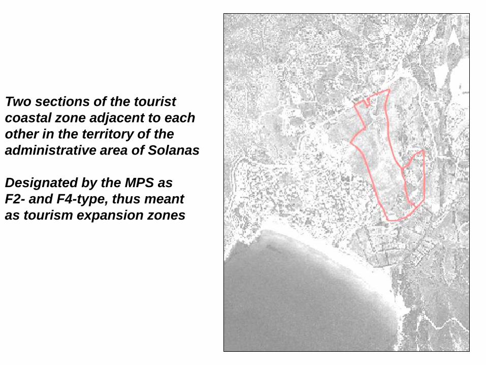
Two sections of the tourist
coastal zone adjacent to each
other in the territory of the
administrative area of Solanas
Designated by the MPS as
F2- and F4-type, thus meant
as tourism expansion zones

Plan Proposal A2
New tourist settlement
(consistent with the MPS rules)
Plan Proposal B2
New recreation park
(consistent with the PIC rules)

Methodology
Contingent valuation – “Dichotomous
choice with follow-up” technique
Multicriteria Analysis – “Analytic
Hierarchy Process”
Criterion Measure Plan A Plan B
CRI1 m2, area of the open spaces net of
streets suitable for vehicles and
public parking lots
75.712 139.980
CRI2 m, distance of the entrance of the
closest planned parking lot which
serves a planned open space plot
from the section of the closest
external street suitable for vehicles;
in case of multiple open spaces or
parking lots, this measure is
identified by the weighted average of
the distances; the weight is the area
of the open space net of streets
suitable for vehicles
194 0
CRI3 m3, total volume of the new houses 1.836 0
CRI4 m2, total area devoted to food,
including parking lots and green
areas
1.635 6.289
CRI5 m2, total area devoted to hotels,
residences and camping sites,
including parking lots and green
areas
27.928 0
CRI6 m2, total area for private uses
(services and residences), including
parking lots and green areas
44.204 0
CRI7 Qualitative assessment expressed
through the SSS (see Table 2) – 1 =
The planning proposals contribute
equally to the property; 9 = The
evidence favoring one planning
proposal over another is one of the
highest possible order of affirmation
Qualitative assessment
CRI8 m, distance of the entrance of the
entrance of the planned residential
plot from the section of the closest
external street suitable for vehicles;
in case of multiple residential plots,
this measure is identified by the
weighted average of the distances;
the weight is the volume of the
building planned in the residential
plot
221 0
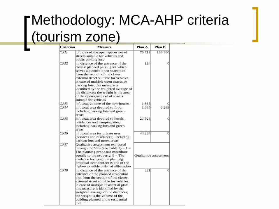
Methodology: MCA-AHP criteria
(tourism zone)

Criterion Measure Plan A Plan B
CRI1 m2, area of the open spaces net of streets
suitable for vehicles and public parking lots
43.119 107.980
CRI2 m, distance of the entrance of the closest
planned parking lot which serves a planned
open space plot from the section of the closest external street suitable for vehicles;
in case of multiple open spaces or parking
lots, this measure is identified by the
weighted average of the distances; the weight is the area of the open space net of
streets suitable for vehicles
120 60
CRI3 m3, total volume of the new houses 99.966 0
CRI4 m2, total area devoted to restaurant courts, including parking lots and green areas
993 1.635
CRI5 m2, total area for private uses (services and
residences), including parking lots and green
areas
53.337 0
CRI6 Qualitative assessment expressed through
the SSS (see Table 2) – 1 = The planning
proposals contribute equally to the property; 9 = The evidence favoring one planning
proposal over another is one of the highest
possible order of affirmation
Qualitative assessment
CRI7 m, distance of the entrance of the entrance of the planned residential plot from the section
of the closest external street suitable for
vehicles; in case of multiple residential
plots, this measure is identified by the weighted average of the distances; the
weight is the volume of the building planned
in the residential plot
298 60
Methodology: MCA-AHP criteria
(residential expansion zone)

Criterion Score Norm. value
CRI1 1839 6,69
CRI2 1806 6,57
CRI3 1718 6,25
CRI4 1503 5,47
CRI5 1095 3,98
CRI6 1270 4,62
CRI7 1419 5,31
CRI8 1159 4,21
Methodology: criteria taxonomy

Methodology: variables CV-DCFU
Variable Description
Offerta Monetary bid, Euros ETA Age of the interviewed person
SEX
Dummy- Sex of the interviewed person (1 if it is male)
FAM3 Dummy- Three-people family
FAM4 Dummy- Four-people family
FAM5 Dummy- Five-or-more-people family
COMP13 Dummy- People under the age of 13
LICSUP Dummy- High school graduate
LAUREA Dummy- University graduate
IMP Dummy- White or blue collar
AUTLIB Dummy- Practitioner, craftsman
PENS Dummy- Retired person
GESTMIX
Dummy- Preference for mixed public-non-profit park management
GESTNP Dummy- Preference for non-profit park management
REDD1020
Dummy- Annual household disposable income
between 10.000 and 20.000 Euros
REDD2030
Dummy- Annual household disposable income between 20.000 and 30.000 Euros
REDD30
Dummy- Annual household disposable income
gretare than 30.000 Euros
CONOSC
Dummy- The respondent knows very well the area of the park

Findings: CV-DCFU
Plan proposal B1
Average willingness to pay (normal distribution) - 19.688
Average willingness to pay (distribution normalized in the interval 0 € - 100 €) 4.068
Median willingness to pay (distribution truncated at 100 €) - 19.688
Plan proposal B2 Average willingness to pay (normal distribution) - 0.861
Average willingness to pay (distribution normalized in the interval 0 € - 100 €) 12.314
Median willingness to pay (distribution truncated at 100 €) - 0.827

Findings: AMC-AHP
The ranking of the four plans which derives from their local weights and from the criteria ranking reveals a strong preference for Plan B over Plan A. The implied global weight of the former is about 69 percent versus a 31 percent of the latter.
In other words, the respondents are most in favor of urban recreation parks and green areas, and less in favor of new houses.
This is problematic with respect to the CV results, which indicates a significant disagreement to Plan B.

Discussion – Comparison between
MCA and CV Results
The CV results show that the residents of Sinnai would disagree with the classification change which the adjustment of the MPS to the RLP would imply. Definitely, residents seem to prefer the MPS rules over the PIC, that is new residential developments (Plans A) over a new urban recreation park (Plans B).
The same respondents revealed a very different attitude toward new settlements and new parks when asked to classify seven criteria to assess future city planning scenarios. If applied to rank Plan A and Plan B through MCA-AHP technique, the criteria weights based on respondents’ classifications would reveal a strong preference of Plan B over Plan A.

Discussion – Differences between CV and
MCA results indicate that the chosen criteria
are not the best choice
From this point of view, this paper demonstrates how the results from the CV method can be used to improve upon the objectivity and accuracy of MCA.
The application of this method allows for a comparison of the results between the CV method and the MCA, which can be used by the economists or planners to determine whether the criteria were appropriately defined.
In this respect, this paper makes an important methodological contribution. By applying the method developed in this paper, economists and planners can better ensure that the policies they advocate are the ones actually desired by local communities.

Discussion – The choice of criteria is
fundamental
The deep differences between the MCA and CV results indicate that the MCA evaluation problem is not well-defined.
The chosen criteria should be integrated within a larger set which should take account of the negative short- and medium-run social and economic impacts which may come from the adjustment process of the MPS to the RLP, that is:
Dramatic decrease in land value;
Decline of the financial resources for public services and infrastructure that would come from the impact fees paid by the developers;
Decrease of payments of the communal tax for real estate which includes and property;
Crisis of the local construction industry;
Lack of competition between supply of newly-built houses and supply of restored houses in the consolidated urban fabric of the city.

Discussion – The local community should
participate in the criterion-choice process
If the choice of the criteria were open to
public discussion and participation, it would
be possible to implement decision
processes on public policies where experts
and the local community would share and
possibly build common expectations on the
future of their city environment, as the
experience of Sustainable Seattle (1998)
has shown.

A Foresterian analysis: how the regional
administration sees the role of the cities
“First, I would like to point out that landscape protection is a constitutional
principle, that is, it comes from the Italian Constitution, and represents the most
important objective of our legislative and ruling tasks. I would like that you
consider this question out of discussion with respect to the approach the
regional administration is taking to define the Regional Landscape Plan.”
“We have to recognize frankly that in the past the definition and implementation
of regional and local planning processes did not consider the landscape values
as predominant over all the others.”
These two passages are drawn from the introductory address of the first conference given by a member of the Sardinian
regional government (pp. 3-4 of the account of the first conference, available on the Internet at
http://www.sardegnaterritorio.it/pianificazione/pianopaesaggistico/conferenze.html [last access: August 1, 2008]).

A Foresterian analysis: how the
representatives of the local communities
see their role
“What was the role of an urban masterplan before the RLP? It ruled over the
whole city territory. Since it was the only type of planning instrument, the cities
were responsible for defining planning policies and rules for the whole territory
under their jurisdiction [that is, urban and extra-urban]. Now, things have
changed, since the RLP rules over the whole Sardinian region. Certainly, the
RLP has substituted the urban masterplans for the extra-urban territory.”
“Urban masterplans can now take over their original meaning, which consists of
planning and defining rules for the urban part of the city territory. On the other
hand, they should not plan the whole city territory. Should they plan the whole
territory, they should be named territorial masterplans.”
“[In the RLP] We are proposing directions. The cities will implement the
decision-making processes, provided that the choices are consistent with these
directions.”
The first passage is drawn from the introductory address of the first conference given by a member of the Sardinian regional
government; the second passage is drawn from the introductory address of the sixteenth conference given by a member of the
Sardinian regional government; the third passage is drawn from a reflection proposed by a member of the Sardinian regional
government during the second conference (p. 5 of the account of the first conference; p. 9 of the account of the sixteenth
conference; p. 23 of the account of the second conference; accounts available on the Internet).
A Foresterian analysis: how the
representatives of the local communities
see their role
“We [The City of Golfo Aranci, the local administration of a coastal village
located in the north-east of Sardinia] have a heavy load of requests of building
permits concerning new developments which are really amazing, since it is still
possible to have a building permit in our city until the RLP is approved [the RLP
was approved about seven months later]. Do you [the regional administration]
think it reasonable that in one year we released the building permits we would
have released in ten years, if the law-which-saves-the-coasts [this is the
nickname of the Regional Law no. 8 of November 25, 2004] was not established
and the RLP was not going to be approved, since everybody fears that
everything will be blocked in the very short run[?]”
This passage is drawn from a reflection proposed by a representative of the City of Golfo Aranci during the sixteenth
conference (p. 32 of the account of the sixteenth conference; account available on the Internet).
A Foresterian analysis: how the cities see
the role of the regional administration
[A representative of a coastal town raises a question to a regional administrator]
“What is the limit, the watershed between the already-established residential-
expansion implementation plans? Take account that for a few of these plans
the regional administration has already released a consistency certification.
Your answer to this question is very important for us, because it is really not
clear what the limit is.”
[A representative of a coastal town criticizes the regional administration] “I
raised two questions and the answers totally missed the point. If the members
of regional administration had not considered the members of the city
government of Golfo Aranci inept, and they had come to Golfo Aranci, it would
have been easy for us to make clear our points concerning new developments
[for residences and services.]”
Both passages are drawn from the sixteenth conference (p. 38 and p. 26 of the account of the sixteenth conference;
account available on the Internet). With reference to first passage, it has to be put in evidence that it was not clear at
the time the sixteenth cooperative-planning conference was held what would have happened to the already-established
residential expansion plans once the RLP was approved. Would they remain valid or cease?

Conclusion 1: an unbalanced
vision of sustainability
Drawing on interviews with privileged testimonies, the first part of this paper has discussed how the RLP understands and pursues sustainability.
As the first regional plan prepared under new national legislation, the RLP was innovating within a new policy context.
Although there was little or no agreement among the five interviewees on whether a plan for the landscape should pursue all the three components of sustainability, it can be concluded, from the opinions of privileged interviewees, that the plan is unbalanced towards environmental objectives.
Environmental sustainability of the Sardinian RLP was primarily meant as potential effectiveness in protecting non-renewable resources and habitats, due to its of rules aimed at contrasting consumption of land.
However, such rules show an underlying conservative approach and understanding of landscape as something which needs protecting rather than managing; for this reason, they were believed not to be effective in addressing environmental problems and risks in sensitive contexts.
Economic issues, although considered in the very beginning of the preparation of the plan, appear to have been overlooked, both because of the choice of the type of plan and because of the lack of coordination of the Sardinian RLP with a sectoral plan aimed at controlling tourism activities.

Conclusion 1: an unbalanced
vision of sustainability
Social sustainability, here explored only with reference to issues of participation, integration and coordination, evidence suggests that participation in the making of the plan:
Was limited to those organizations required by law to implement the RLP.
Was in the form of information giving, rather than consultation, a simple delivery of information, in a top-down process.
Municipalities and other actors had extremely limited chance to influence the plan. Such a dominant role of the regional administration is only partly justifiable on the grounds of competences and powers stemming from the laws, and risks both interfering with powers of lower tiers of government and tailoring rules to specific situations.
Institutional coordination has been moved from the plan preparation to its implementation, in the form of:
Adjustment of the masterplans.
Intese, a technical and political mechanism aimed at approving specific projects and development plans by means of an assessment carried out on a case-by-case basis.
The intese allowed an opt-out clause, enabling specific developments to proceed in sensitive areas, thus possibly weakening the plan. They have a controversial nature, being judged both as a mechanism to bypass the rules contained in the regional plan and as a means to include institutional cooperation in the application of the Sardinian RLP.
A greater involvement of the general public is envisioned in the implementation of the plan, both in the SEA process and in the modification of local masterplans. Until a more robust participatory approach which involves wider consultation is adopted, such a tool may prove to be a relatively insensitive instrument in plan implementations.
Conclusion 2: an overturned
subsidiarity
With reference to planning, the Sardinian regional administration maintains an overturned concept of subsidiarity.
This passage of the regional-law proposal titled “New rules for the use of the regional territory” (Law proposal no. 204 of January 3, 2006; not-yet discussed by the Sardinian Regional Parliament) enlightens this point: “The goals of the preceding paragraph [The goals of the planning activity of the cities, provinces, and the regional administration] are pursued, on the basis of the principles of subsidiarity, adequacy and efficiency, by means of: a) the attribution to the cities of all the functions concerning territorial government which are not expressly attributed by this or other laws to the region and the provinces; […].”
This overturns the concept of subsidiarity of the Italian legislation (Italian Law no. 59/97 titled “Law which delegates the Italian government to establish the procedures to attribute administrative tasks and functions to the regional and local administrations, in order to reform the public administration and to simplify the administrative procedures”, article 4, paragraph 3, letter a), which states that: “[The attributions of functions] have to observe the principle of subsidiarity. The most of tasks and administrative functions should be attributed to the cities, provinces and mountain communities, on the basis of their territorial size, and community and organizational complexity, with the only exclusion of the functions inconsistent with these size and complexity. Public responsibilities are also attributed to the part of the public administration closest to the citizens in order to help families, organized groups and communities, to take on social tasks and functions; […].”

Conclusion 2: an overturned
subsidiarity
This overturned concept of subsidiarity puts in evidence how much far from an effective co-operative approach is the adjustment process to the RLP of the masterplans of the coastal cities of Sardinia. The PIC establishes that the contribution of the cities to the adjustment process consists of the following tasks:
1. they have to cooperate to design, implement and update the regional geographic information system, which is fundamental “for the definition and coordination of the landscape protection and revaluation policies”;
2. they have to identify precisely the landscape goods (buildings or areas) defined according to articles 136, 142 and 143 of the National Code of Cultural Heritage and Landscape. These goods have already been approximately identified in the RLP cartography, with reference to the environmental, historic-cultural and settlement structures of the regional territory;
3. they have to adjust their masterplans to observe the prescriptive and proposal contents of the RLP related to all the structures of the regional territory. Even though these contents can hardly be translated into masterplan rules, however they are both detailed and debatable at once, which gives the regional administration a strong discretional power in the approval processes of the adjusted masterplans. This not only may generate, and is generating indeed as we put in evidence above, never-ending conflicts between the regional ad-ministration and the cities, but may also cause a continuous lack of transparency in their relations concerning the definition, implementation and management of the regional and urban planning processes.
So, the role of the cities is very ancillary, since they have just to complete what cannot be done by the regional administration in terms of geographic, economic and social information.
They have just to provide this information, so that the regional administration may govern and manage the regional, province and city planning activity in the most efficient way.
The only role of the cities is to support the regional administration.

Thank you!
Sabrina Lai and Corrado Zoppi
Dipartimento di Ingegneria del Territorio, Sezione di Urbanistica, University of
Cagliari, Via Marengo, 3 - 09123 Cagliari, Italy
tel.: +39 (0)70 6755200-6755216, telefax: +39 (0)70 6755215; e-mail: [email protected] - [email protected]